C9 Dredge Management Plan - Brisbane Airport · C9 Dredge Management Plan C9-304 CONTENTS 9.1...
50
VOLUME C: MIDDLE BANKS, MORETON BAY Dredge Management Plan C9 C9 VOLUME C: MIDDLE BANKS, MORETON BAY Dredge Management Plan NEW PARALLEL RUNWAY DRAFT EIS/MDP FOR PUBLIC COMMENT C9-303
Transcript of C9 Dredge Management Plan - Brisbane Airport · C9 Dredge Management Plan C9-304 CONTENTS 9.1...
VOLUME C: MIDDLE BANKS, MORETON BAY
Dredge Management PlanC9
C9 VOLUME C: MIDDLE BANKS, MORETON BAY
Dredge Management Plan
NEW PARALLEL RUNWAY DRAFT EIS/MDP FOR PUBLIC COMMENT C9-303

VOLUME C: MIDDLE BANKS, MORETON BAY
Dredge Management PlanC9
C9-304
CONTENTS
9.1 Background and Scope of DMP 306
9.1.1 Introduction 306
9.1.2 Purpose of the DMP 306
9.1.3 Structure of the DMP 306
9.1.4 Project Overview 307
9.1.5 Site Location and Context 307
9.1.6 Moreton Bay Sand ExtractionStudy (MBSES) 310
9.2 Description of Sand Extraction and Associated Development 311
9.2.1 Key Activities Under the DMP 311
9.2.2 Sand Extraction at Middle Banks 313
9.2.3 Dredge Plant andVessel Operations 317
9.2.4 Vessel Operations at thePump-out Facility 320
9.2.5 Alternative intake oftransport water 321
9.2.6 General Vessel Operations and Environmental Management 322
9.3 Pump-out Operations at Luggage Point (Construction of the Mooring Facilityand Pipeline) 322
9.3.1 Introduction 322
9.3.2 Construction of theMooring structure 322
9.3.3 Construction of the Pipeline 326
9.4 Legislation andStatutory Obligations 327
9.4.1 Commonwealth Legislation 327
9.4.2 State Legislation 327
9.4.3 Other relevant documents,guidelines, codes andbest practice 328
9.4.4 Permits and Licence Approvals 328
9.5 Environmental Management Processand Responsibilities 329
9.5.1 Responsibilities for DMP (Draft) 329
9.5.2 Responsibilities for DMP(Dredge Operations) 330
9.6 Environment and Coastalmanagement issues 331
9.6.1 Assessment of impacts 331
9.6.2 Environmental Management 340
NEW PARALLEL RUNWAY DRAFT EIS/MDPFOR PUBLIC COMMENT

VOLUME C: MIDDLE BANKS, MORETON BAY
Dredge Management PlanC9
FIGURES AND TABLES
Figures
Figure 9.1a: Location of Middle Banks
Figure 9.1b: Location of Existing Commercial Extraction Permit Areas, Dredge Placement Sites and Maintained Shipping Channels in Moreton Bay
Figure 9.2a: Plan of Proposed Dredge Footprint
Figure 9.2b: Interpreted Thickness of Sediment Between the Pleistocene Surface and Existing SurveyedSea Floor
Figure 9.2c: Schematic of a Trailer Suction Hopper Dredge at Work
Figure 9.2d: Schematic of an ‘Environmental’ or ‘Green’ Valve
Figure 9.2e: Large TSHD and Mooring Piles
Figure 9.3a: Proposed Mooring Structure
Figure 9.3b: Proposed Pipeline Route from Luggage Point Mooring Site to Brisbane Airport
Figure 9.3c: Trestle Structure over Luggage Point Outfall
Tables
Table 9.2a: Development Activities Associated with the NPR and Their Purpose
Table 9.2b: TSHDs of a Suitable Class for the Reclamation Work at Brisbane Airport
Table 9.2c: Design Dredge Specification
Table 9.2d: Declared Channel Depths
Table 9.4a: Permits and Approvals
Table 9.6a: Policies of Coastal Plans Relevant to Sand Extraction at Middle Banks
Table 9.6b: Policies of Coastal Plans Relevant to Vessel Operation
Table 9.6c: Policies of Coastal Plans Relevant to Construction of the Mooring Structure and Pipeline
Table 9.6d: DMP Topics
NEW PARALLEL RUNWAY DRAFT EIS/MDP FOR PUBLIC COMMENT C9-305

9.1 Background and Scope of DMP
9.1.1 Introduction
This draft Dredge Management Plan (DMP) is part of the Major Development Plan (MDP) and Environmental Impact Statement (EIS) for the NPR project. This DMP seeks to address the environmental issues identified for the sand extraction activities at Middle Banks andassociated work.
This associated work includes the construction and operation of a mooring structure and pipeline to convey the dredged material from the mooring location at Luggage Point to the proposed reclamation site on Brisbane Airport.
Much of the information presented in the DMP is already covered in other sections within the EIS/MDP document leading to the duplication of some information, figures and text. This has been done because it is intended that the DMP be a stand-alone document for the purpose of Queensland Government assessment and approvals following the Australian Government’s consideration of the EIS/MDP documents. This includes approval under the Coastal Protection and Management Act 1995 and supporting applications under the Environmental Protection Act 1994, Integrated Planning Act 1997 and Marine Parks Act 2004.
The DMP will also be part of BAC’s tender documentation for selecting a dredging contractor following completion of the EIS/MDP process.
9.1.2 Purpose of the DMP
The DMP is a tool to help meet the requirements of applicable environmental legislation, achieve best practice environmental management, and to aid in achieving the environmental requirements of relevant authorities for the works. It is a written description of proposed measures to be implemented to help achieve and maintain acceptable levels of environmental impact.
Broadly, the objectives of the DMP are to:
• Provide evidence of practical and achievable plans for the management of the project such
that environmental requirements are complied with, by producing an integrated planning framework which provides for monitoring and control of the dredging impacts;
• Provide BAC and the regulatory authorities with a framework to confirm compliance with environmental policies and requirements; and
• Provide the community with evidence of the management of the project in an environmentally acceptable manner.
The DMP complements the material presented in the main body of the EIS/MDP as it brings together activity-specific environmental management and protection measures currently under consideration.
This draft DMP is prepared as an initial framework document. A final DMP will be prepared at the conclusion of the EIS/MDP process, taking into account public and agency comments on the draft EIS/MDP.
The final DMP will:
1. Provide the framework for the preparation of a detailed operational DMP that will be developed by the dredge contractor prior to the commencement of the work [DMP(Dredge Operation)]; and
2. Be submitted to address approval requirements under Queensland State legislation such as the Coastal Protection and Management Act 1995.
9.1.3 Structure of the DMP
The draft DMP document has been structured to address the major construction and operational activities associated with the extraction of sand from Middle Banks and associated activities.
The DMP comprises the following:
• A description of the proposed sand extraction operation and associated development;
• An overview of relevant legislative requirements associated with undertaking the work;
• A summary of the potential environmental impacts from the project;
• Environmental management measures which will be addressed during the proposed works; and
C9-306
VOLUME C: MIDDLE BANKS, MORETON BAY
Dredge Management PlanC9
C9-306NEW PARALLEL RUNWAY DRAFT EIS/MDP
FOR PUBLIC COMMENT

NEW PARALLEL RUNWAY DRAFT EIS/MDPFOR PUBLIC COMMENT
C9-307
• Roles and responsibilities for implementation of the DMP and reporting requirements
To this end, the structure of the environmental management plans in this DMP(Draft) have been prepared in accordance with relevant Queensland EPA guidelines, namely:
• ‘Coastal Development Approval of a Dredge Management Plan EPA’;
• ‘Environmental Impact Assessment. Preparing environmental management plans’;
• ‘Environmental Operations, Streamlined development approval for dredging material – ERA 19’ (Information Sheet).
9.1.4 Project Overview
Brisbane Airport Corporation (BAC) intends to construct a new parallel runway at Brisbane Airport, at a location 2,000 m west of the airport’s existing main runway. The new runway will have a design length of 3,600 m and width of 60 m, with twin parallel taxiways designed to accommodate very large (Code F) aircraft.
The works require the dredging and reclamation of a volume of approximately 15 Mm3 cubic metres of unconsolidated marine sand from Middle Banks, Moreton Bay. The placement of this sand will be for three purposes:
• To consolidate the soft compressible soils found on the project site;
• To provide a stable platform to enable the construction of the runway pavements; and
• To elevate the site to provide flood immunity.
The dredging phase of the project requires a specialist vessel and skilled labour that will have to be sourced internationally. Following placement of the fill and surcharge on the runway site, various ground treatment processes will then be established and the areas left to consolidate (settle) for a minimum of two years. When the required consolidation has been achieved the surcharge sand will be reshaped to the final embankment levels for the final phase of the project which involves a series of civil works to construct and open the runway for aircraft.
The process for the sand reclamation phase will be:
• Extraction of sand from Middle Banks (Moreton Bay) with a trailer suction hopper dredge;
• Transportation of sand from Middle Banks to a designated mooring site, in the Brisbane River. This is proposed to be located adjacent to Luggage Point Sewage Treatment Plant;
• Delivering the sand to the NPR site by hydraulic placement via pipeline;
• Rehandling of some sand in local areas that can not be placed by hydraulic placement. This includes the final fill of end areas in the reclamation, where turbulence of the water mixture could damage the containment bunds by scouring; and
• Leaving sand in place for a minimum of two years to enable consolidation of theground below.
9.1.5 Site Location and Context
Middle Banks is located approximately 20 km north-east of the mouth of the Brisbane River and 4 km due west of Tangalooma Point on Moreton Island. Sediment in the eastern Bay region is dominated by sand of marine origin.
All sand at Middle Banks is sub-tidal between depths of - 4 m and - 30 m LAT. The seabed at Middle Banks is unallocated State Land and designated as General Use Zone in the Moreton Bay Marine Park.
Figure 9.1a shows the location of Middle Banks in Moreton Bay in relation to Moreton Island and Brisbane Airport.
Figure 9.1b shows the main shipping channels in relation to Middle Banks, the location of existing commercial sand extraction operations and areas for dredge spoil disposal in Moreton Bay.

NEW PARALLEL RUNWAY DRAFT EIS/MDPFOR PUBLIC COMMENT
C9-308
Figure 9.1a: Location of Middle Banks.
Mid
dle B
anksD
redge Footp
rint
MID
DLE
BA
NK
S
MO
RE
TO
NB
AY
MO
RE
TO
NIS
LAN
D
Port of B
risbane
Luggage Point
Pum
p-O
ut Berth
Brisb
ane Airp
ort
Kilo
metres
01
24
N

NEW PARALLEL RUNWAY DRAFT EIS/MDPFOR PUBLIC COMMENT
C9-309
Figure 9.1b: Location of Existing Commercial Extraction Permit Areas, Dredge Placement Sites and Maintained Shipping Channels in Moreton Bay (Source: Moreton Bay Sand Extraction Study - Phase 1 Report).
BRISBANE
CALOUNDRA
CABOOLTURE
REDLAND
LOGAN
REDCLIFFE
LoganLogan
DunwichDunwich
BrisbaneBrisbane
Redcliffe
ClevelandCleveland
Caloundra
CabooltureCaboolture
BribieBribie Island
Moreton
Island
North
Stradbroke
Island
North
Stradbroke
Island
Caloundra
Redcliffe
Dredging
Shipping Channels
Dredge Material Placement Sites for Beach Nourishment Purposes
Dredge Material Placement Sites
Current Sand Extraction Areas
Local Government Areas
DATA SOURCESMajor streams: NRMLocal Government Areas (Aug 2002): DCILGPSExtractive resources (Nov 02): Bureau of Mining and Petroleum Current Sand Extraction Areas: WBM Oceanics Australia
Km0 10 20
N

NEW PARALLEL RUNWAY DRAFT EIS/MDPFOR PUBLIC COMMENT
C9-310
Middle Banks lies between the dredged Main and East Shipping Channels. It has been the source of sand for two previous dredging works undertaken for the Brisbane Airport including the original airport dredging of approximately 16 Mm3 of sand (1983) and the dredging undertaken as part of the International Terminal development of approximately 4 Mm3 of sand (1991).
Both of these projects were undertaken by commercial dredging contractors using a rehandling basin at Boggy Creek at the mouth of the Brisbane River. The dredging involved a dredge vessel (trailer suction hopper dredge or TSHD) extracting sand from Middle Banks and bottom dumping the extracted sand into an engineered basin constructed in Boggy Creek. From the basin, sand was pumped by a second dredge (cutter suction dredge or CSD) onto the respective project sites. This process was continuous until all the required sand was transported to the site. The rehandling basin at Boggy Creek was left by the Contractor in 1983 and reused during the International Terminal development in 1991. Since 1991 it has notbeen used.
The dredging techniques proposed for this project differ from those undertaken previously following changes and innovations in the dredging industry since 1991. In particular, the use of a rehandling basin for this project has been discounted due to:
• Improvements in dredging technology and size of dredger that enables the dredger to pump-out directly to the site up to a distance of some 6 – 7 km; and
• The need to minimise the dredging requirements in the Brisbane River to establish the pump-out berth and the subsequent land based disposal of fine river silts / clays and contaminated sediments.
9.1.6 Moreton Bay Sand ExtractionStudy (MBSES)
In anticipation of the increased future regional demand for sand, Queensland Government agencies initiated the MBSES (the Study) in 1999/2000 in conjunction with key stakeholder groups.
The Study was established as a result of the need to look holistically at the cumulative impacts of large scale dredging proposals for the northern bay including the Port expansion, the parallel runway and the construction industry needs. It examined the environmental, economic, cultural and social impacts of sand extraction, and various alternatives to bay sand, such as land based extraction and manufactured sands.
The Study was undertaken in two principal phases. The first was a comprehensive review of all available information related to sand extraction both within Moreton Bay and from land based sources, and sought to identify both the current state of knowledge and identify data gaps.
Based on this work, five separate specialist investigations1 were subsequently undertaken in phase two of the Study including: Results of the studies are included in final reports available from the Queensland Environmental Protection Agency (EPA) website: www.epa.qld.gov.au
• Economic analysis of sand extraction from marine and land-based sources in South East Queensland;
• Sediment geochemistry processes within the northern Moreton Bay sand banks and potential impacts to water quality;
• Benthic fauna and fisheries;
• Indigenous cultural heritage; and
• Tidal current and wave penetration numerical modelling of northern Moreton Bay.
Overall, the scientific studies indicated that large-scale sand extraction in Northern Moreton Bay was highly unlikely to result in major environmental impacts.
A scientific panel, established under the auspices of the Moreton Bay Waterways and Catchments Partnership and led by a eminent University of Queensland Professor, assessed key scientific reports making up the Moreton Bay Sand Extraction Study. The expert panel endorsed the scientific integrity of the reports, noting that the scientific studies indicated no major environmental impacts
1 Results of the studies are included in final reports available from the Queensland Environmental Protection Agency (EPA) website:www.epa.qld.gov.au

NEW PARALLEL RUNWAY DRAFT EIS/MDPFOR PUBLIC COMMENT
C9-311
would be expected for the sand extraction scenarios considered in the Study. Sand extraction of 15 Mm3
from Middle Banks for the NPR project was one of the scenarios that the Study investigated.
The 2005 Queensland Government document entitled, Moreton Bay Sand Extraction – Summary of Findings, summarises the key outcomes of the study and is available from the EPA’s website along with other information sheets about the MBSES.
A Sand Extraction Strategy was completed by the Queensland Government in late 2004 to coincide with the release of the Study. The Strategy defines a coordinated approach for sand to be extracted from northern Moreton Bay to address regional demand for sand. In particular, the Strategy set out that:
“From a total available sand resource in Moreton Bay of approximately 3,770 Mm3, the Government has made a decision that over the next 20 years it will support:
• Extraction of up to 40 Mm3 (less than 1.1 percent of the total sand resource) of sand for development of Australia TradeCoast projects, including the expansion of the Brisbane Airport and the Port of Brisbane.
• Extraction of up to 20 Mm3 (less than 0.6 percent of the total sand resource) of sand for use within the construction sector.
• Locating the majority of future sand extraction to supplement a major shipping channel straightening project in the northern part of Moreton Bay.
• In addition to sand extraction to supplement channel straightening, increased sand extraction will be allowed in the Middle Banks area of the bay (subject to environmental impact) with priority to be given to the Brisbane Airport Corporation.”
9.2 Description of Sand Extraction and Associated Development
9.2.1 Key Activities Under the DMP
The key development activities covered under this DMP include:
• Sand extraction at Middle Banks;
• Dredge plant and vessel operation (Middle Banks and at Luggage Point pump-out); and
• Pump out operations at Luggage Point (construction of the mooring facility and pipeline).
In terms of timing of the works, the construction of the mooring facility and the laying of the pipeline will be required prior to the commencement of the sand extraction by the dredge vessel.
A number of other early works to prepare the runway site for receiving the sand will also need to be carried out on Brisbane Airport such as the construction of bunds, the excavation of the main drainage channels, and the clearing of existing vegetation (including mangroves). These matters are not specifically dealt with in this dredge management plan and development approvals and/or permissions under the relevant legislation will be sought separately for these development activities. For the EIS/MDP, these matters are principally dealt with in Volume B, Airport and Surrounds, and in particular the Environmental Management Framework (EMF) for that Chapter (B14). The split between the activities dealt with in the EMF and those activities dealt with in the DMP (this document) are contained in Table 9.2a.

NEW PARALLEL RUNWAY DRAFT EIS/MDPFOR PUBLIC COMMENT
C9-312
Table 9.2a: Development Activities Associated with the NPR and their Purpose.
Development activity Purpose Duration
Act
ivit
ies
cove
red
by
the
DM
P
Cha
pte
r C
9
Extraction of sand from Middle Banks The dredge vessel removes the material from Middle
Banks and transports the material to a defined
mooring facility for pump-out
Temporary
Construction of a mooring jetty in the
vicinity of Luggage Point
Allows the dredge vessel operating at Middle Banks
to moor and pump-out the collected sand from
Middle Banks to the Airport site where the new
runway is to be constructed.
Temporary
Alignment of the dredge pipeline from
the mooring jetty to the Airport site1
1 Construction and operational issues relevant to the dredge pipeline are described in Chapter A5 and converted in the EMF, Chapter B14.
The pipeline conveys the sand (in a water-sand
slurry) from the dredge vessel to the areas required
to be filled for the new runway on Airport.
Temporary
Act
ivit
ies
cove
red
by
the
EM
F
Cha
pte
r B
14
Construction of two tidal discharge
channels into Kedron Brook Floodway
and Serpentine Inlet (Bramble Bay)
The drainage channels will convey tailwater
(associated with the dredge operation) and
stormwater off the Airport site during construction
and operational phases of the project.
Permanent
Re-construction of a seawall along a
portion of the northern coastline of the
airport site
To upgrade the existing poor quality seawall to
protect the runway system from erosion from the sea
particularly in storm events.
Permanent
Construction of an approach lighting
structure extending into Bramble Bay
To provide approach lighting to aircraft landing on the
new runway when operating over Moreton Bay.
Permanent
Construction of a dredge pipeline and
associated maintenance road from the
mooring jetty to the Airport site
The pipeline conveys the sand (in a water-sand
slurry) from the dredge vessel to the areas required
to be filled for a new runway on Airport.
The maintenance road is required for establishment,
monitoring and maintenance of the pipeline whilst in
operation.
Temporary
Construction of bunds and
embankments to prevent run-off from
the site during construction
Removing casuarina and mangrove
vegetation contained within the new
runway footprint
To prepare the site for receiving the dredged sand
from Middle Banks, Moreton Bay.
Temporary
Permanent
Filling of land and waterways for the
new runway
To fill the ground area where the new runway and
associated facilities are proposed.
A range of ground treatment methods (eg,
surcharge, wick drains) will be implemented to
ensure that the site settles uniformly prior to
commencing the civil works stage.
Permanent
Construction of the runway, taxiways,
associated aviation facilities, access
roads and stormwater drainage
infrastructure.
This final stage of civil works will facilitate the opening
of the runway for air traffic.
Permanent

NEW PARALLEL RUNWAY DRAFT EIS/MDPFOR PUBLIC COMMENT
C9-313
9.2.2 Sand Extraction at Middle Banks
9.2.2.1 Introduction
This section of the DMP provides details of the proposed approach to sand extraction at Middle Banks. Section 9.2.2.2 refers to the dredge footprint and how it was chosen, section 9.2.2.3 and 9.2.2.4 outlines the results of hydrographic and geotechnical investigations undertaken at Middle Banks. Section 9.2.2.5 describes the quantity of material to be removed from Middle Banks and the timing and rate of that removal.
9.2.2.2 Description of Work – Dredge Footprint
Figure 9.2a provides a plan of the proposed footprint where the sand extraction at Middle Banks is to occur.
The dredge footprint is located in the north-eastern quadrant of Middle Banks running along the western edge of the East Channel. This proposed footprint has been selected based on the following:
• Targeting Holocene (clean) sand deposits that will produce superior quality fill material.
• Avoiding or minimising impacts to marine ecology.
• Logistical advantages to the dredge contractor.
• Avoiding potential conflicts with other users of the Bay.
• Maintaining water quality.
• Minimising impacts to coastal processes.
• Avoiding potential impacts on cultural heritage.
The shape of the selected footprint has also been modified to avoid sand with high silt content, which is not considered suitable for the purpose.
A full discussion of these matters is contained in Chapter C1 of the EIS/MDP document.
Details of the proposed equipment used during the dredge operation is discussed in section 9.2.3.
9.2.2.3 Results of Bathymetric and Seismic Investigations
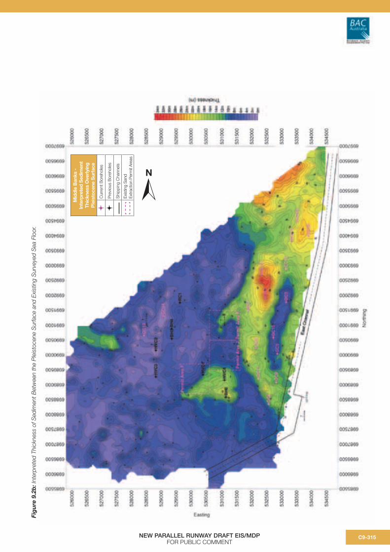
Hydrographic survey investigations comprising bathymetry, high resolution marine seismic reflection profiling and magnetometer screening were undertaken in late 2005 for the Middle Banks investigation area, including the shoal areas adjacent to Moreton Island east of the East Channel.
Middle Banks bathymetry was surveyed at a 1:5000 scale. The survey has identified variable sea floor levels over the investigation area with the predominant features represented by Middle Banks in the east and Four Fathom Banks to the west with the bank areas rising to about -3.6 m LAT to -9 m LAT respectively. Deeper areas are located in the eastern flank of the Middle Banks area within and adjacent to the East Channel
A sub bottom seismic profiling survey of the Middle Banks investigation area on a 250 m grid was also undertaken in late 2005. The seismic survey has successfully identified the Pleistocene surface below the sea floor and generally agrees with previous investigations and intersects with results from geotechnical investigations.
The interpreted thickness of sediment between the Pleistocene surface and existing surveyed sea floor is presented in Figure 9.2b. The interpreted Pleistocene surface is generally higher in the western areas of Middle Banks while the far eastern and northern extents of Middle Banks provide greater volumes of Holocene sediment. Deeper dredging can be conducted in these areas without intersecting the Pleistocene surface which is characterised by stiffer clay, mud and silt material that is undesirable for the intended use of the sediment for filling.

NEW PARALLEL RUNWAY DRAFT EIS/MDPFOR PUBLIC COMMENT
C9-314
Figure 9.2a: Plan of Proposed Dredge Footprint.
m0 250 500 1,000
Approximate volume of dredge footprint is 18.94 Mm3. A maximum of 15 Mm3 will be sourced from the dredge footprint. Average dredging depth is -21.5 mCD.
NMiddle Banks -Proposed Dredging
Footprint
Bores
Channel Markers
Top of Dredged Slope
Toe of Dredged Slope
Shipping Channels
Trawl Area - Northern Limit (as identified in MBSES Phase 1 report)
Middle Banks - 10 mCD Contour
Existing Sand Extraction Permit Areas
Middle Banks Seagrass Survey (WBM 2005)
No Seagrass Present
Seagrass Present
Seagrass Extent (WBM 2005)
High : -0.653
Low : -33.222
Elevation (mCD)
NEW PARALLEL RUNWAY DRAFT EIS/MDPFOR PUBLIC COMMENT
C9-315
Fig
ure
9.2
b: I
nter
pret
ed T
hick
ness
of S
edim
ent B
etw
een
the
Ple
isto
cene
Sur
face
and
Exi
stin
g S
urve
yed
Sea
Flo
or.
Mid
dle
Ban
ks -
Inte
rpre
ted
Sed
imen
t Th
ickn
ess
Ove
rlyi
ng
Ple
isto
cene
Sur
face
Cur
rent
Bor
ehol
es
Pre
viou
s B
oreh
oles
Shi
ppin
g C
hann
els
Exis
ting
San
d Ex
tract
ion
Per
mit
Are
as
N
NEW PARALLEL RUNWAY DRAFT EIS/MDPFOR PUBLIC COMMENT
C9-316
9.2.2.4 Results of Geotechnical Investigations
A comprehensive assessment of the sand banks occupying the northern end of Moreton Bay was given in the Moreton Bay Marine Park Extractive Industry Strategy Sand Resource Study (PPK 1998). This and a number of earlier studies have identified that banks in the Northern Delta (including Middle Banks) are elements within an extensive flood delta that has developed in the Northern Entrance of Moreton Bay since the Holocene sand ca. 6,500 years ago. The banks are commonly underlain by pre-Holocene substrate composed of both white and humic (coffee) sands and stiff mottled clays of Pleistocene origin.
A number of previous studies have undertaken drilling and coring at Middle Banks including six boreholes by Coffey and Hollingsworth Pty Ltd (1972), a single borehole at Four Fathom Bank undertaken as part of the PPK study mentioned above (1998) and four boreholes in the Western areas of Middle Banks as part of a study conducted by Harris in 1989. These previous borehole locations are shown on Figure 9.2b.
Additional and more comprehensive borehole investigations were undertaken for the NPR project by Geocoastal Australia in late 2005 and early 2006 using continuous vibro-coring. A total of 16 sites were cored at Middle Banks down to an average depth of 10.4 m. Core sites were selected based on the seismic survey plans and core locations are shown on Figure 9.2b using a “GC” designation.
For a full description of the core methodology and results, refer to Chapter 2, Volume C of the EIS/MDP.
The majority of the core sites conducted on Middle Banks were located along the eastern margin of Middle Banks which (according to the seismic investigations) was considered the most prospective for extraction. In the central section of Middle Banks, there are existing extractive industry permit areas and previous studies had identified the western section of Middle Banks as being underlain by shallow Pleistocene-age sediments.
The two sites located on the western banks (GC 13 and GC 14) confirmed the presence of Pleistocene facies close to the surface in the form of greenish grey sands with a mature clay matrix as well as coffee sands at 30 cm below the seafloor.
Borehole GC 10 on the eastern flank of Middle Banks was situated to target a Pleistocene topographic high identified in the seismic record and encountered a stiff brownish clay substrate 5.1 m into the sedimentary section (-21.7 m LAT). Sediments in this particular area are to be avoided in the context of the dredge footprint on the basis of its higher percentage of mud and silt content. Avoidance of areas with fine sediments will reduce turbidity impacts at the borrow site and when the dredge supernatant tailwater is released back into the marine environment during the reclamation process.
The cored Holocene stratigraphy of the eastern Middle Banks is remarkably uniform and is characterised by predominantly well-sorted, fine/medium ranging to very fine sized, quartzose sand. Only an average of 16 percent of this sand falls within the coarser 0.3 mm to 0.475 mm range (mid-medium size).
The only significant change in the sedimentary character of the Holocene sequence that justifies a separate facies classification is consistently muddier sand in the deeper south-eastern sector (GC 8). Silty clay content in these sediments are to be avoided in the dredge footprint for the reasons identified above.
Sediment samples recovered were also screened to determine their acid sulfate soil (ASS) potential. Screening of samples of sediments from GC 13 and 14 in the western Middle Banks indicated some small amount of actual acidity and substantial potential is present in the sample of sediment analysed. The ‘net acidity’ varied considerably, but is generally high where in situ acid neutralising capacity (ANC) is not adequate to supply natural buffering capacity. Screening results for the eastern coring locations in Middle Banks indicated an absence of actual and potential acid sulfate soils with negligible net acidity which may be due to natural buffering capacity derived from fine calcareous material present throughout the soil profile or a lack of pyretic fines (PASS).

NEW PARALLEL RUNWAY DRAFT EIS/MDPFOR PUBLIC COMMENT
C9-317
Borehole samples at GC 7, 9, 15, 16, 24 and 25 were also selected for porewater analyses and tested for nutrients and toxicant concentrations. Results of this analysis are shown in Chapter C2 of the Draft EIS/MDP.
9.2.2.5 Quantity and Rate of Removal of Sand
The project will involve the removal of 15 Mm3 of material from Middle Banks. The proposed footprint equates to an area that is roughly 1 km wide by 6 km long and up to 8 m below existing seabed (grading to existing bed levels). The average water depth across the footprint following completion of the proposed dredging would be approximately -21.5 m CD.
Geotechnical investigations undertaken as part of the EIS/MDP stage have identified several areas at Middle Banks that contain material with higher proportions of mud, silt or clay content. These areas have been avoided from the selected dredge footprint. Prior to selecting a dredge contractor, further geotechnical investigations will be undertaken within the approved dredge footprint at Middle Banks. This will define at a more detailed scale, any other areas unsuitable for extraction. In case the further investigations find that there are other areas of unsuitable material within the footprint, the footprint area and volume identified for EIS/MDP purposes is slightly larger than the target volume of 15 Mm3. However, no more than the required 15 Mm3 would be sourced from Middle Banks as part of the actual operation.
The dredging will commence following preparatory works (vegetation clearance, drainage works, construction of bunds etc.) at the reclamation site on Airport and the construction of the associated pipeline and mooring facility at Luggage Point.
The extraction of sand from Middle Banks, transportation to the mooring location, discharging of sand from the dredge and the vessel returning to Middle Banks will occur in an eight hour cycle, 24 hours per day, over a 12 to 18 month period (depending upon size of available dredge). Details of the dredge plant are discussed in section 9.2.3.1. Continuous operation of the vessel will be dependant on weather conditions and other storm events and planned maintenance of the vessel and equipment.
9.2.3 Dredge Plant and Vessel Operations
9.2.3.1 Dredge Plant and Equipment
The measured distance from the centroid of the sand resource at Middle Bank to the pump-out location at Luggage Point is approximately 15 nautical miles. Such a distance rules out the use of Cutter Suction Dredgers, with booster pumps and associated floating pipelines for pumping sand directly into the reclamation area. The same distance to the reclamation area and the nature of the material at Middle Banks also rules out other dredging methods, such as the use of mechanical dredgers (grab and backhoe dredgers), which are more suitable for dredging broken rock and stiff clays. It is considered that a Trailer Suction Hopper Dredge will be the most efficient dredge for this type and scale of project (refer Figure 9.2c). To work efficiently, the Trailer Hopper Suction Method of dredging requires long and straight stretches of seabed with water depth in excess of the draft of the vessel.
Figure 9.2c: Schematic of a trailer suction hopper dredge at work, (Source: figure courtesy of Baggerman Associates).
A (non-exhaustive) list of suitable TSHD’s that could be used for dredging sand from the Middle Banks in Moreton Bay and direct pumping from Luggage Point to the NPR reclamation areas can be found in Table 9.2b.
dredging
suction head

NEW PARALLEL RUNWAY DRAFT EIS/MDPFOR PUBLIC COMMENT
C9-318
Table 9.2b: TSHDs of a Suitable Class for the Reclamation Work at Brisbane Airport.
* - TSHD, which have worked in Australia previously are marked by *
Class of TSHD
Vessel Name Operating Company
Hopper Volume (cubic
metres)
Dredging Mark Draught
(metres)
Dredge pumps kW discharging
Length overall
(metres)
Jumbo Vasco Da Gama Jan De Nul 33,125 14.60 16,000 200.66
Jumbo
TSHD
WD Fairway * Boskalis 35,508 12-15 10,000 232.35
Large
TSHD
Queen of the
Netherlands *
Boskalis 22,258 10-12 12,000 171.60
Large Pearl River (new)
Pearl River (old) *
Dredging
International
24,000 (new)
17,000 (old)
10.8 14,000 182.00
Large Queen of Penta-
Ocean
Penta Ocean 24,000 10.5 12,000 166.70
Large HAM 318 Van Oord 23,000 13.00 11,000 176.00
Large Rotterdam Van Oord 21,656 11.33 12,000 180.40
Large Volvox Terranova Van Oord 20,016 11.20 12,200 164.10
Medium Gerardus Mercator Jan de Nul 18,047 11.51 14,000 152.20
Medium Nile River Dredging
International
16,989 10.59 13,786 149.43
Medium Amsterdam Van Oord 16,830 10.37 10,400 159.65
Source: Baggerman Associates
Notes:
• TSHD Pearl River has been enlarged to 24,000 m3 in recent times. Before extensions, the dredge worked on the Fisherman Islands Reclamation Contract in 1994.
• TSHD WD Fairway will be undertaking the Port Corporation of Queensland work in Dalrymple Bay during 2006.
• TSHD Queen of the Netherlands was involved in large scale trial dredging for the Port of Melbourne Corporation during 2005.
Based on the pumping distance required from Luggage Point, small and medium TSHD with less than 10000 kW pump power will not be able to be used for the project without a booster pump.
Jumbo class TSHDs are too big to access the port at low tide when fully loaded and are limited in number, which also decreases the likelihood of availability. However, the Jumbo Class TSHD is not being completely discounted on the basis that it could operate at the proposed pump-out location (given its operating depth) under set conditions which would involve the use of a part loaded Jumbo dredger during low tides and fully loaded dredgers during high tide.
BAC’s preference is the use of a Medium to Large TSHD with a hopper capacity between 15,000 and 25,000 m3, which can access the pump-out berth at all stages of the tide, when fully loaded and have
enough pump capacity to reach 7,200 m without a booster station, provided that:
• The d50 grain size is less than 250 microns. (This is discussed further in Chapter 5, Volume A);
• Pipeline distance is almost straight without too many bends, dips and rises;
• Delivery height does not exceed 10 m above ground level; and
• Efficient pipe diameters are used for pump power, grainsize and delivery distances.
It should be noted that selection of a dredge will be determined as part of a tendering process following completion of the assessment and approvals process. However, for the purposes of the EIS/MDP and DMP, a design dredge specification has been nominated as detailed below.

NEW PARALLEL RUNWAY DRAFT EIS/MDPFOR PUBLIC COMMENT
C9-319
Table 9.2c: Design Dredge Specification.
Type Large TSHD
Pump power 10000+ kW
Total capacity 15 – 25,000 m3 (Hopper size)
Sand Carrying Capacity 10 – 17,500 m3
Cycles per day 2.5 – 3. [Dredging can start and finish at any time during the tidal cycle]
Length (max) 180 - 230 m
Draft (max) 13 m
9.2.3.2 Vessel Operation at Middle Banks
The dredge will work within the identified footprint area at Middle Banks and will operate in long runs of between 3 km and 4 km. When dredging, the dredge will lower its two drag heads to the sea floor, each removing a layer of sand, approximately 300 to 400 mm thick.
The drag head is connected to the vessel with a suction tube that transports the sand from the sea floor and into the vessel’s hopper. The dredge is expected to be travelling at approximately 1 to 2 knots, with the hopper filling to capacity in about 1.75 (15,000 cubic metres hopper size) to 2.5 hours (25,000 m3 hopper size) (refer Table 9.2c).
The sand/water mixture is captured in the hopper of the dredge, where the sand component will rapidly settle, forming two distinct layers in the hopper – one sand and the other salt water.
Loading 10,000 to 17,500 m3 of sand will require approximately 75,000 to 100,000 m3 of fluidisation seawater of which a nominal 3,000 to 6,000 m3
will remain on board entrapped within the pores between the sand grains during transport. The balance of the transport water will be discharged via the overflow tubes at a nominal depth of 8 to 12 m at the keel level of the dredge in the dredging areas depending on the stage of the load.
The dredge may be able to be equipped with an ‘environmental’ or ‘green valve’ (refer Figure 9.2d)whereby an adjustable valve chokes the flow to reduce the air that is taken down in the overflow mixture leaving the hopper. The result is a denser particle stream, causing less turbulence, and taking the overflow sediments more quickly to the seabottom.
A small fraction, mainly only fine particles, is caught in the turbulence around the vessel. This fraction
is spread out when the vessel’s propellers pass through and settles slowly afterwards.
The valve is controlled automatically: a set-point is entered dictating the maximum ‘water layer’ above the overflow. When the water level inside the hopper well reaches this set-point, the valve will be opened more. Use of a green valve will be investigated further as part of the tender process.
Figure 9.2d: Schematic of an ‘Environmental’ or ‘Green Valve’. (Source: figure courtesy of Jan De Nul Dredging and Land Reclamation)
Once full, the dredge will travel back to the Brisbane River and moor, prior to unloading the sand at the project site. From Middle Banks, the dredge is expected to travel directly via the East Channel to the mooring site at approximately 10 - 15 knots (subject to any Port speed restrictions) and will take approximately 2 hours to travel from Middle Banks to the Brisbane River mouth.
While cruising, the Dredge Master/Operator dredge captain will have to abide by all normal shipping protocols and directions from the Harbour Master. All of the Shipping Channels would remain in operation for vessel traffic throughout the sand extraction operation.
LOAD
OVERFLOWWATER ADJUSTABLE
FUNNEL
SOIL
FIXEDFUNNEL
ENVIRONMENTALVALVE
BOTTOM OF THE VESSEL
TO SEABED
The vessel needs to navigate through the channel system in Moreton Bay and into the Brisbane River. Figure 9.1b shows the location of the Maintained Shipping Channels. The declared channel depths of Moreton Bay (refer Table 9.2d) indicate that the vessel should have a maximum draft of 13 m when fully loaded.
Table 9.2d: Declared Channel Depths.
Location PoBC
Depth Lowest
Astronomical Tide (m)
AHS Charts Depth to
Chart Datum
(m)
North West Channel 13.5 14.7
Spitfire Channel 14.0 14.7
East Channel 14.0 14.7
Bar Cutting 13.0 14.0
Fisherman Island Swing Basin 13.0 14.0
Pelican Banks Cutting to Hamilton Reach 9.1 9.1
(Source: Port of Brisbane website and Australian Hydrographic Service – Charts Aus 236 and 237))
9.2.4 Vessel Operations at thePump-out Facility
It should be noted that the final mooring arrangements will be determined as part of further negotiations with the Harbour Master and with input from the Dredge Contractor. However, an indicative outline of the vessel operations at the pump-out facility are noted here.
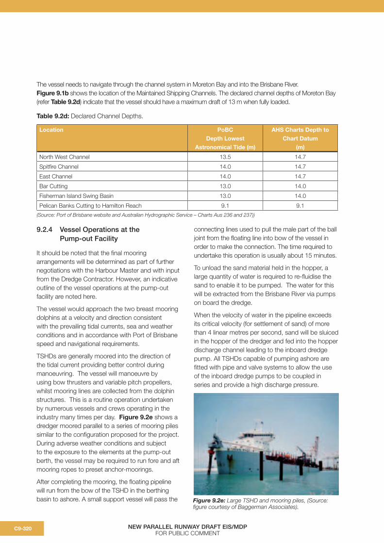
The vessel would approach the two breast mooring dolphins at a velocity and direction consistent with the prevailing tidal currents, sea and weather conditions and in accordance with Port of Brisbane speed and navigational requirements.
TSHDs are generally moored into the direction of the tidal current providing better control during manoeuvring. The vessel will manoeuvre by using bow thrusters and variable pitch propellers, whilst mooring lines are collected from the dolphin structures. This is a routine operation undertaken by numerous vessels and crews operating in the industry many times per day. Figure 9.2e shows a dredger moored parallel to a series of mooring piles similar to the configuration proposed for the project. During adverse weather conditions and subject to the exposure to the elements at the pump-out berth, the vessel may be required to run fore and aft mooring ropes to preset anchor-moorings.
After completing the mooring, the floating pipeline will run from the bow of the TSHD in the berthing basin to ashore. A small support vessel will pass the
connecting lines used to pull the male part of the ball joint from the floating line into bow of the vessel in order to make the connection. The time required to undertake this operation is usually about 15 minutes.
To unload the sand material held in the hopper, a large quantity of water is required to re-fluidise the sand to enable it to be pumped. The water for this will be extracted from the Brisbane River via pumps on board the dredge.
When the velocity of water in the pipeline exceeds its critical velocity (for settlement of sand) of more than 4 linear metres per second, sand will be sluiced in the hopper of the dredger and fed into the hopper discharge channel leading to the inboard dredge pump. All TSHDs capable of pumping ashore are fitted with pipe and valve systems to allow the use of the inboard dredge pumps to be coupled in series and provide a high discharge pressure.
NEW PARALLEL RUNWAY DRAFT EIS/MDPFOR PUBLIC COMMENT
C9-320
Figure 9.2e: Large TSHD and mooring piles, (Source: figure courtesy of Baggerman Associates).

NEW PARALLEL RUNWAY DRAFT EIS/MDPFOR PUBLIC COMMENT
C9-321
In general, a high sand to water ratio of approximately 1 to 4 i.e. 25 percent sand, 75 percent water will require greater pumping effort than a low sand to water ratio of 1 to 8 i.e. 12.5 percent sand, 87.5 percent water. For the purposes of the indicative design, a ratio of 15 percent sand, 85 percent water has been adopted to enable the dredge to pump sand to the majority of the project site although in practice, this will pulse between 0 and 50 percent.
All THSDs with adequate pump-out power (more than 10,000 kW) can reach the far corners of the reclamation of 6.0 km if the average grainsize remains below 250 microns and adequate pipe diameter has been installed without increasing friction losses by bends and bad connections.
To provide adequate fluidisation water (nominal 115,000 m3 each cycle), the end of the discharge channel in the hopper is open to a sea-inlet. This volume includes allowances for:
a) Charging the pipe system with water and achieving the transport velocity in the pipeline to the discharge point on the reclamation at the commencement of the pump-out period;
b) Clean-up (discharge) cycle of the hopper compartment at the end of the unloading to remove as much sand as possible from the hopper (except for a small rest load of 300 to 600 m3); and
c) Changing between reclamation sub-sections by opening and closing valves with water-flow only which avoids the blockage of the pipeline.
Notwithstanding that the process is steered automatically by computers, it is unavoidable that a small volume of hopper water including suspended fines escapes underneath the dredger due to occasionally the flow being reversed as a consequence of higher water level in the hopper compartment and valve settings. Typically, this volume is rather small and could be measured between 0 to 5000 m3 of hopper water per cycle.
As a result, there may be some minor turbidity from the hopper discharge system of the vessel to the surroundings in the swing basin during this process.
Similar to any other vessel using the port cooling water from the vessels engines will be discharged into the river which is not considered to be a significant issue.
When the hopper is empty, pumping will continue until only clean seawater remains in the pipeline. This will avoid the blockage of the pipeline, when starting-up with the next discharge cycle. After stopping the pump process, onshore valves are shut, the bow connection will be broken and the male ball joint part will be lowered in the water. Whist the dredge is at Middle Banks, clean seawater will be held in the discharge pipeline to the reclamation by valves. These will seal off the water in the pipe from returning.
When uncoupling is complete, the vessel will let go her spring lines and any other moorings and navigate through the Port under the direction of the Harbour Master and Port Control.
The large TSHD will navigate clear of the floating pipe connection, breast dolphins and return to the dredging area at Middle Banks.
Vessel movement at the mooring site will be carefully managed in consultation with the Maritime Safety Queensland Regional Harbour Master to ensure maritime safety for vessels arriving or departing Port of Brisbane berths at Fisherman Islands, the adjacent BP oil tanker berth or passing river traffic.
9.2.5 Alternative intake of transport water
For TSHD vessels, transport (e.g. fluidisation) water is designed to be taken from inlets immediately adjacent to the centre-keel of the dredger.
Given the water quality at the preferred pump-out location at Luggage Point, the project examined the feasibility of obtaining transport water from a remote location to the dredger. This approach has not been pursued for the project on the basis that:
• Obtaining transport water from another location would require a specially-designed remote pump set (similar to a floating booster pump) with over pressure to compensate for the delivery distance from the intake to the dredger;

NEW PARALLEL RUNWAY DRAFT EIS/MDPFOR PUBLIC COMMENT
C9-322
• Transport water quality at locations upstream and downstream of the Luggage Point pump-out area that could be accessed by a remote intake strategy is not significantly different or improved;
• There would be a substantial cost penalty added to the project to install additional piping to source transport water at some distance from the vessel and for the booster pump arrangement;
• Additional time would be required for each pump-out operation (reducing the visits to the borrow area at Middle Banks in a 24-hour period and increasing the overall programme for dredging to a period greater than 18 months).
9.2.6 General Vessel Operations and Environmental Management
Vessel-based environmental management issues to be addressed in this dredge management plan include:
• Water quality from operation of the dredge whilst dredging, at the pump-out location and in-transit between Middle Banks and the pump-out;
• Waste management (solid waste and sewage);
• Storage and handling of hazardous substances; and
• Quarantine and Ballast Water.
These matters are addressed in the framework tables in Section 9.6 and will be dealt with in detail by the dredging contractor as part of the DMP (dredge operations).
9.3 Pump-out Operations at Luggage Point (Construction of the Mooring Facility and Pipeline)
9.3.1 Introduction
The Luggage Point mooring site is located at the edge of the swing basin for the Port of Brisbane, between Brisbane City Council’s (BCC) wastewater treatment plant outfall and the BP crude oil tanker wharf at the mouth of the Brisbane River as shown in Figure 9.3a and 9.3b.
The swing basin is a localised area of deep water (approximately 14 m below LAT) that ships use to perform turning manoeuvres. In the location of the dredge mooring, the swing basin is close to the shoreline, enabling large vessels to approach close to the shore without running aground.
The geometry of the river in this location indicate that additional dredging in the river will not be required to establish a safe mooring for the dredge vessel. This has been confirmed by bathymetric surveys undertaken for the project in 2005 by Mapping and Hydrographic Surveys.
9.3.2 Construction of theMooring structure
9.3.2.1 Description of work
A temporary mooring structure is required at Luggage Point to allow the dredger to berth and discharge the sand into the pipeline. While the Contractor may design the actual dredge mooring to suit the adopted dredge, a concept design has been prepared as shown in Figure 9.3a.
As described above, the proposed discharge berth is located on the northwest side of the port swing basin at Luggage Point, downstream of the BP Crude oil Wharf. [Approx. 27° 22.87” S, long 153° 9.40” E]
The design is suitable for large trailer suction hopper dredges, up to the size permitted by the maintained depth leading to the Port of Brisbane. The concept design has been based on a notional dredge with an overall length of 173 m and a hopper capacity of 23,400 m3. The arrangement of the berth could be modified to suit a particular dredge up to an overall length of 200 m or more.
The dredge berth is constructed from two similar breasting dolphins that provide the mooring for the dredge during discharge.
Each dolphin will compromise twelve, 1 m diameter vertical steel tube piles, connected with twin steel load transfer frames. Each dolphin will support a soft twin cone parallel motion fender to minimise the berthing loads on the dolphin in the light of the expected poor foundation conditions at the site.

NEW PARALLEL RUNWAY DRAFT EIS/MDPFOR PUBLIC COMMENT
NEW PARALLEL RUNWAY DRAFT EIS/MDPFOR PUBLIC COMMENT
N
0 100 200 250 m
0 40 80 100 m20 60
Scale A
Scale B
Figure 9.3a: Proposed Mooring Structure.
C9-323

NEW PARALLEL RUNWAY DRAFT EIS/MDPFOR PUBLIC COMMENT
NEW PARALLEL RUNWAY DRAFT EIS/MDPFOR PUBLIC COMMENT
Figure 9.3b: Proposed Pipeline Route from Luggage Point Mooring Site to Brisbane Airport.
N
Proposed Pipeline Route
Access Road
Stormwater Drain
T Truck Washdown Area
C9-323C9-324
NEW PARALLEL RUNWAY DRAFT EIS/MDPFOR PUBLIC COMMENT
C9-325
Other proposed design features of theBerth include:
• Fentak SCN1600 twin cone parallel motion fender installed to each dolphin to reduce the magnitude of berthing reactions on the dolphins;
• Each dolphin will require a 150 tonne capacity bollard for mooring of the dredge, mounted on the upper transfer frame; and
• Each dolphin will require a top platform and access ladder for handling of mooring lines and maintenance.
Lighting of the mooring dolphins during the hours of darkness will be to the requirements of the Harbour Master incorporating standard solar powered flashing lights.
The design of the piles and pile cap allow for ease of construction and removal. When the dredge operation is complete, the piles will be extracted using a piling barge and the frame dismantled.
9.3.2.2 Geotechnical conditions
Geo Coastal Australia undertook an investigation of the ground conditions near Luggage Point in February 2006. Further details are presented in Volume B, Chapter B3 of the EIS/MDP.
These boreholes show the site is underlain by recent Holocene sediments to the depth probed comprising a muddy sand surface layer about 1 m deep (possibly recent siltation) and a muddy sand fluvial delta deposit up to 7 m deep overlying deep estuarine silt/clay deposit. These materials are prevalent in the lower Brisbane River area and are extremely weak in engineering terms. The expected Standard Penetration Test (SPT) values of the muddy sand deposit are between zero and five. The consistency of the underlying silt/clay deposit varies between soft and firm.
9.3.2.3 Construction methodology
Taking into account the geotechnical condition of the area, the design of the breasting dolphins includes the use of driven vertical steel tubular piles. These would be driven in from a piling barge. Each proposed dolphin comprises twelve 1000 m diameter by 16 mm wall thickness Grade 350 steel piles driven to a minimum depth of 16 m or to a suitable set.
As these dolphins are temporary structures, no concrete pile caps are proposed and twin steel frames will hold the piles in place and transfer the dredge berthing loads to the piles.
9.3.2.4 Other considerations: Maritime safety and navigation issue and Brisbane City Council Sewer Main
As shown in Figure 9.3a, two navigational lead marks No. 3F and No. 3R define the channel in the Pelican Banks Reach at the northern end and form an important part of the navigational aids system for vessels using this part of the Brisbane River.
These are located close to the proposed discharge berth location.
The mooring design concept outlined in this draft DMP has been discussed with the Regional Harbour Master, and the mooring has been located to ensure no impact to these two navigational aids. Further discussion will be held with the Regional Harbour Master once a dredger is selected and a final design of the mooring is complete.
The BP Crude Oil Wharf is located approximately 350 m upstream of the proposed berth. The berth has been located and designed to enable dredge movements to occur without any impact on the BP Wharf.
In discussions with Brisbane City Council (BCC), it is known that a sewer rising main crosses the Brisbane River at Luggage Point. This rising main is located below ground and parallel to the effluent channels to the Luggage Point WWTP. The dredge discharge pipeline will need to cross the rising main although no additional protection is foreseenat present.
NEW PARALLEL RUNWAY DRAFT EIS/MDPFOR PUBLIC COMMENT
C9-326
9.3.3 Construction of the Pipeline
The dredged sand will be transported to the reclamation site for the New Runway through a sealed pipeline. Figure 9.3b illustrates the proposed pipeline route from the Luggage Point mooring site to the Brisbane Airport boundary.
As part of the preliminary design, the pipeline specification has been determined as follows:
• Maximum pipeline diameter of 1,000 mm;
• The flanged pipeline will be constructed from 12 m to 15 m lengths of pipe supplied by truck;
• The pipe lengths will be bolted and the joints sealed by gaskets;
• The pipeline will be most efficient when laid straight and with a minimum number of bends;
• The pipeline will be rotated at regular intervals during the delivery phase by conventional excavators or cranes when maintenance periods to dredge and pipeline are planned; and
• The pipeline will be laid on a 5 m wide gravel formation and will require a 5 m wide access track to be constructed along its entire length suitable for installation, maintenance, inspection and rotation of the pipeline.
Between the land based pipeline and the pump-out berth, the pipeline will branch in a Y-configuration with valves and steel sections, as well as flexible floating pipelines leading to each of the mooring dolphins. The length of the floating line will be in the order of 100 to 150 m and sufficient to reach either end of the pump-out berth pocket, allowing for the dredge to berth in either direction against the mooring dolphins depending on tidal current conditions. A single anchor pile or anchor buoy is also required on or near the toe of the swing basin to secure the connection end of the floating discharge pipeline when the dredge is absent.
The end of the floating pipeline will be fitted with a ball-joint connection piece, which will ultimately be lifted into a bow-socket fitted at the overboard discharge point on the dredger. Typical bow connections used by large TSHD and flexible rubber floating line connecting to the foreshore are shown in the photographs below.
Construction of the pipeline route includes the construction of an access track and low height embankment to stabilise the structure for the length of the pipeline. The low height embankment and access track will be constructed from granular materials sourced from land based quarries or able to be recycled from in situ material. The embankment will enable the pipeline components to be delivered to the site and assembled in a raised condition, allowing access to the bottom flange bolts. During operations it will allow daily inspections of the pipe for faults and damage. The access track will not be constructed on land below high water mark.
The pipeline also needs to cross the Jubilee creek drain which has a line of established mangroves on each side. A strip approximately 10 m wide will have to be cleared and removed to enable construction.
Discussions with Brisbane City Council are on-going to ensure no impacts from the pipeline route on the Luggage Point Wastewater Treatment Plant facility (WWTP). BAC has committed to taking all practical steps to reduce the risk of damage to the existing waste water treatment plant during the design, construction and operation of pump-out facility including investigating the need for stabilisation works to protect Council infrastructure. Council has agreed in principle to allowing the pipeline across its WWTP reserve subject to further considerations.
Within the WWTP reserve, the dredge discharge pipeline will have to cross two concrete effluent channels. To avoid any adverse impact, it is proposed that the pipeline will be supported above the effluent channels as shown in Figure 9.3c. This will either be done by elevating the pipeline on embankments to span the channels or supporting the pipeline on a bridge or trestle structure. Both designs will feature a 500 mm minimum clearance over the effluent channels. The former may require a thicker pipe to allow for the fact that the pipeline will not be able to be rotated hence a greater abrasion effect.
In addition, a steel pedestrian bridge with security fence and gate will be required alongside the pipeline for inspection purposes and to enable dredging personnel to cross the channels.

NEW PARALLEL RUNWAY DRAFT EIS/MDPFOR PUBLIC COMMENT
C9-327
Further details of these options are presented in Chapter 5, Volume A of the EIS/MDP.
All works would be temporary in nature, and upon completion of sand delivery, the pipeline will be recovered and removed with trucks and excavators and taken from the site. The pipeline will remain the property of the contractor. The pipeline gravel embankment, including the 5 m wide access road will be salvaged as the disestablishment process proceeds and the gravel materials recycled and reused in the construction of the runway.
The rehabilitation of the pipeline corridor will be undertaken following removal of the pipeline and embankment earthworks. Any mangroves removed from the Jubilee Creek drain will be reinstated from seedlings collected from the area and the grassland areas will be topsoiled and reseeded.
9.4 Legislation andStatutory Obligations
9.4.1 Commonwealth Legislation
The following Commonwealth legislation is relevant to the proposed dredging, sand reclamation and establishment of dredge pipeline.
• Airports Act 1996 and Regulations21
• Environmental Protection and Biodiversity Conservation Act 1999
9.4.2 State Legislation
The following State legislation may be relevant to the proposed dredging.
• Coastal Protection and Management Act 1995 and Coastal Management Plans
• Environmental Protection Act 1994 and Environmental Protection Policies
• Fisheries Act 1994 and Regulations
• Marine Parks Act 2004 and Marine Parks (Moreton Bay) Zoning Plan 1997
• Transport Operations (Marine Safety) Act 1994and Regulations
• Aboriginal Cultural Heritage Act 2003
• Nature Conservation Act 1992 and Conservation Plans
• Integrated Planning Act 1997 and Regulations
Figure 9.3c: Trestle Structure over Luggage Point Outfall.
2 Building approval under the Airport (Building Control) Regulations will be required for the part of the dredge pipeline and access track that is on Airport land including the construction of a culvert under the alpha-delta link taxiway.

NEW PARALLEL RUNWAY DRAFT EIS/MDPFOR PUBLIC COMMENT
C9-328
9.4.3 Other relevant documents, guidelines, codes and best practice
The following documents have been used when preparing the Dredge Management Plan.
• Dredging, Extraction and Spoil Disposal Activities, Fish Habitat Management Operational Policy FHMOP 004, July 1998, DPIF.
• Approval of a Dredge Management Plan, Environmental Protection Agency
• Streamlined development approval for dredging material – ERA19, Environmental Protection Agency
• Brisbane Airport Environment Strategy (2004)
9.4.4 Permits and Licence Approvals
The following table presents the relevant approvals requirements that may apply to the works.
Table 9.4a: Permits and Approvals.
Approval Administering
Agency
Activities Relevant to
DMP
Legislation
Dredging at Middle Banks:
1 Marine Park Permission to
Enter and Use
Environmental
Protection Agency
Dredging Marine Parks Act 2004
Marine Parks Regulation 1990
Marine Parks (Moreton Bay)
Zoning Plan 1997
2 Approved Dredge
Management Plan (DMP)
Environmental
Protection Agency
Dredging Coastal Protection and
Management Act 1995 (CPMA)
3 Development Permit
for Material Change of
Use for Environmentally
Relevant Activity
Environmental
Protection Agency
Port of Brisbane
Corporation
ERA 19 - Dredging Environmental Protection Act 1994
Integrated Planning Act 1997
Integrated Planning Regulation
1998
Transport Infrastructure Act 1994
4 Registration Certificate for
Environmentally Relevant
Activity
Environmental
Protection Agency
ERA 19 - Dredging Environmental Protection Act 1994
Dredge Pump-out at Luggage Point and Dredge Pipeline:
5 Permit to Occupy Department of Natural
Resources, Mines and
Water
Location of dredge pump-
out pipeline through
Unallocated State Land
Land Act 1994
6 Development Permit for
material change
of use
Brisbane City Council Commencement of a new
use assessable against the
Brisbane City Plan 2000
Integrated Planning Act 1997
Integrated Planning
Regulation 1998
7 Development Permit for
Operational Works
Brisbane City Council Filling and excavation
assessable against the
Brisbane City Plan 2000
Integrated Planning Act 1997
Integrated Planning
Regulation 1998

NEW PARALLEL RUNWAY DRAFT EIS/MDPFOR PUBLIC COMMENT
C9-329
Approval Administering
Agency
Activities Relevant to
DMP
Legislation
8 Development Permit for
Operational Works (that is
tidal works or prescribed
tidal works)
Brisbane City Council
(prescribed tidal works
code)
Environmental
Protection Agency
Maritime Safety
Queensland Harbour
Master
Port of Brisbane
Corporation
Works associated with
the construction of the
mooring dolphin (and all
its components) and the
pipeline structure on land
under tidal water.
Coastal Protection and
Management Act 1995
and Regulations
Integrated Planning Act 1997
Integrated Planning
Regulation 1998
Transport Operation (Marine
Safety) Act 1994
Transport Infrastructure Act 1994
9 Development Permit for
Operational Works (that is
the removal, destruction
or damage of a marine
plant
Department of
Primary Industries and
Fisheries
Removal of any marine
plants required for
construction of mooring
dolphin (and all its
components) and the
pipeline (and all its
components).
Fisheries Act 1994
Integrated Planning Act 1997
Integrated Planning
Regulation 1998
10 Development Permit
for Operational Works
involving interference with
quarry material on State
Coastal land in a coastal
management district
Environmental
Protection Agency
Placement of pipeline
in area adjacent to
foreshore.
Coastal Protection Management
Act 1995
Integrated Planning Act 1997
11 Building approval Department of
Transport and
Regional Services
Airport Building
Controller (ABC) and
Airport Environment
Officer (AEO)
Placement of dredge
pipeline and construction
of an access track on the
Airport Land.
Construction of a culvert
under the proposed
alpha-delta taxiway link.
Airports Act 1996
Airport (Building Control)
Regulation 1997
Airport (Environmental
Protection) Regulation 1997
9.5 Environmental Management Process and Responsibilities
9.5.1 Responsibilities for DMP (Draft)
9.5.1.1 Regulatory bodies
The DMP (Draft) complements the material presented in the main body of the EIS/MDP for the NPR as it brings together activity-specific environmental management and protection measures currently under consideration.
A final DMP will be prepared at the conclusion of the EIS/MDP process, taking into account comments on the draft EIS/MDP. The DMP (Final) will:
1. Provide the framework for the preparation of a detailed operational DMP that will be developed by the dredge contractor prior to the commencement of the work [DMP (Dredge Operation)]; and
2. Be submitted to address approval requirements under Queensland State legislation such as the Coastal Protection and Management Act 1995.
9.5.1.2 BAC
Once a final dredge management plan has been prepared, a ‘BAC Project Manager’ would be appointed to oversee the tendering process and liaison with the Dredge Contractor during the operational phase of the project.

NEW PARALLEL RUNWAY DRAFT EIS/MDPFOR PUBLIC COMMENT
C9-330
The BAC Project Manager will generally be responsible to:
• Ensure all supervisory and management staff are aware of and understand their responsibilities under the DMP;
• Ensure periodic reviews of environmental performance are conducted;
• Ensure the development and implementation of best practice environmental management procedures;
• Report back to BAC on environmental performance and any major environmental incidents that may have a significant impact on the environment;
• Ensure appropriate and adequate resources are allocated to implement and monitor the DMP;
• Ensure the Dredge Contractor is aware of and has knowledge of the methods required to ensure environmentally sound practices are implemented in relation to the various elements of the DMP;
• Ensure the dredging contractor has emergency procedures and equipment in place to respond to an emergency or environmental incident; and
• Ensure compliance with all regulatoryapproval conditions.
There are environmental management processes required by BAC under its Environmental Management System (EMS) for all development projects on Brisbane Airport and particular issues that need to be addressed to mitigate adverse environmental impact associated with the proposed development, in terms of construction and operational works.
9.5.2 Responsibilities for DMP(Dredge Operations)
9.5.2.1 Preparation and Approvals
The Dredge Contractor will need to prepare a DMP (Dredge Operations) consistent with the environmental management framework and conditions of the DMP (Final), as well as Queensland Government approval permits and any conditions.
In addition to the legislative requirements, the Dredge Contractor is to also have regard for the following when writing the DMP and before commencing work:
• BAC’s Guidelines for Environmental Management Plans;
• Airport Environment Strategy (AES);
• Environmental Management System (EMS);
• Any best practice measures as prescribed by State agencies such as the Department of Primary Industries and Fisheries and Environmental Protection Agency; and
• Harbour Master of Maritime Safety Queensland and Port of Brisbane requirements in terms of vessel movement and maritime safety;
9.5.2.2 Operation and Monitoring
In addition to the items noted in section 9.5.2.6, Contingency planning and emergency response, the dredge contractor will be responsible for:
• Liaising with the Vessel Master/Dredge Operator to implement and monitor the DMP (Dredge Operations);
• Complying with all the provisions of the DMP as applicable; and
• Regularly inspect and monitor all activities for adherence to proper environmental safeguards.
This will include routine inspections of the works, reports and/or correspondence relating to site environmental management issues.
9.5.2.3 Reporting
The Dredge Contractor will be responsible for establishing an Environmental Management File (EM File) for the dredging operation that would contain all documentation pertaining to environmental management of the works.
The EM File may take the form of a traditional correspondence file or a readily retrievable, upgradeable and suitably protected computer file.

NEW PARALLEL RUNWAY DRAFT EIS/MDPFOR PUBLIC COMMENT
C9-331
9.5.2.4 Review, update and improvementof DMP
A copy of the DMP(Dredge Operations) will be kept on-site and should be easily obtainable at all times. During dredging, the BAC Project Manager would hold an additional copy. The Operational DMP will be regularly reviewed in relation to conditions encountered and updated as appropriate.
9.5.2.5 Competence, Training and Awareness
This DMP outlines the required measures to be undertaken to prevent harm to the environment during project works. In order for these measures to be implemented effectively it is necessary for all staff, contractors and subcontractors be made aware of the existence of the DMP and its requirements. This is to include the following:
General Induction
Prior to the commencement of works on the site, all staff are to undergo induction training outlining all aspects of:
• Safety and security;
• Responsibilities on-site;
• Housekeeping in relation to the construction compound;
• Equipment operation;
• First aid;
• Work procedures;
• Spill response training; and
• Awareness of the DMP.
Environmental Responsibilities Training
Environmental training for all staff should be carried out prior to commencement of the works. The training will as a minimum address the following issues:
• The importance of conformance with procedures outlined in the DMP;
• The environmental impacts (actual and potential) of their work activities;
• The environmental benefits of improved performance;
• Their role and responsibility in the DMP; and
• The potential consequences of departure from specified operating procedures.
9.6 Environment and Coastal management issues
9.6.1 Assessment of impacts
This section of the document summarises the environmental and coastal management issues associated with the proposal. A full discussion of the environmental impacts of the project is included in Volume B (Airport and Surrounds) and Volume C (Middle Banks) of the EIS/MDP. Rather than repeat those sections here, the relevant information has been provided under headings that relate to the assessment considerations for a dredge management plan under the Coastal Protection and Management Act 1995and in particular, the State Coastal Management Plan (2001) and South East Queensland Regional Coastal Management Plan (2006) prepared under that Act.
The text is separated into the three main development activities under the DMPalready discussed;
1. Sand extraction at Middle Banks;
2. Dredge plant and operation (Middle Banks and at Luggage Point pump-out); and
3. Pump-out operations at Luggage Point (construction of the mooring facility and pipeline).
9.6.1.1 Sand Extraction at Middle Banks
Summary of Impacts
For a full discussion of the environmental impacts of the sand extraction, refer Chapters 3, 4 and 5 of Volume C of the EIS/MDP document. The following sub-sections provide a summary of the key environmental impacts at Middle Banks as they relate to coastal processes, water quality and marine ecology:
Coastal processes
Impacts on the hydrodynamics are likely to be of significance only in the immediate local Middle Banks and East Channel area. There will be only isolated local changes in wave heights in the vicinity
NEW PARALLEL RUNWAY DRAFT EIS/MDPFOR PUBLIC COMMENT
C9-332
of Middle Banks, typically less than 10 percent at the nearby shoals, and less than 0.25 percent with respect to the predominant local wind wave heights at adjacent Moreton Island shoreline. The impacts on tidal currents are likely to increase the rate of southward sand transport in the East Channel immediately to the south and north of the dredged area, such impact reducing northward towards Cowan Cowan Point, with no likely adverse impact on the shoreline of Moreton Island.
There will be a substantial increase (by up to 100 percent) in the rate of net sand transport in the local undredged section of East Channel immediately south of the dredged footprint. This will result in a tendency for seabed erosion there and increased movement of sand to the southern ‘drop-over’ margin of the Middle Banks shoal locally there. Southward migration of the ‘drop-over’ margin may increase from the existing 5 - 8 m/yr to around 10 - 15 m/yr until a new equilibrium balance is achieved, a process that could extend over several decades.
Both the survey of the previous dredging and the modelling undertaken for this study suggest that a slow morphological response to the proposed dredging will occur and that the seabed bathymetry essentially as formed by the dredging is likely to persist for many years. Nevertheless, the sand forming the seabed will continue to be mobile and transported by the prevailing tidal currents with a net southward movement. Mobile seabed ripple and dune forms will continue to be a feature of the area, as at present.
Water quality including environmental values and water quality objectives
Based on both detailed modelling assessments and reviews of previous studies into sand extraction at Middle Banks, it is likely that water quality impacts from dredging will be relatively minor and temporary, with sediment plumes dissipating rapidly as distance from the active dredging increases. Long term effects are anticipated to be negligible once dredging is completed as modelling has indicated that the plume from previous dredging cycles will be indistinguishable from background concentrations when the next dredging cycle is to commence.
The extent of the plume (defined as being where concentrations of total suspended solids, total nitrogen and/or total phosphorus is greater than 10 percent above background) is governed by the direction of the dredge relative to tidal movements. This is to be expected in that the spread of the plume will be dictated by current speed relative to the dredge, hence when the dredge is moving in the same direction as the tidal movement, the effective ‘relative’ speed will be very low. The plume in this case would be expected to drift with the dredge and concentrations would therefore be higher due to reduced mixing with surrounding waters and continued discharging of turbid waters ‘into’ the plume.
The analysis also showed that both Nitrogen and Phosphorus concentrations exhibited no variation from background concentrations at several model analysis points and it is expected that the Water Quality Objective for each parameter will be achieved in those areas west of the dredging location (where the WQOs are applicable). This is consistent with the EPA’s Moreton Bay Sand Extraction Study – Phase 2 which states that only minimal effects are likely beyond the visible plume and may be minimal even within the zone of the visible plume.
The suspended solids results indicated that theremay be a slight increase in concentrations at monitoring points immediately to the west of the dredge track, at very low concentrations. The increases suggested by the modelling are not likely to be detectable via current monitoring techniques for suspended solids, which usually have detection limits between 1-5mg/L. Of note though is that while suspended solids concentrations may be very low, an observable plume will be present due to increased turbidity associated with the fines from the material being extracted, though once again, the previous reports state that the turbidity plume post-dredging was within 10 percent of background levels within 40 m of dredging and that a plume from a dredging pass 4 hours earlier was still visible, even though concentrations were effectively down to background levels.

NEW PARALLEL RUNWAY DRAFT EIS/MDPFOR PUBLIC COMMENT
C9-333
To the east of the dredge area, the Queensland Environmental Protection Agency has declared this an area of High Ecological Value (HEV). The requirements of the HEV areas are that there is to be no change in existing water quality in the short, medium or long term, as demonstrated by compliance with 20th, 50th and 80th percentile water quality objectives.
However, some short term impacts are allowable according to guidance given on compliance as contained in the Environmental Protection (Water) Amendment Policy (No. 1) 2006 Explanatory notes. These state that:
Where activities such as dredging are conducted near waters of high ecological value, the natural action of winds and tides could carry transient suspended sediment plumes into these adjacent waters even with best practice management for the activity in accord with approval conditions.
The transient impacts of temporary sediment plumes from the above mentioned activities are not considered to be detrimental to the maintenance of the values of adjacent high ecological waters and their long term natural physico-chemical and biological variability. The existence of intact high ecological values in waters adjacent to areas where such activities have been conducted in Moreton Bay for many years, confirms the transient nature of the impacts.
For both total nitrogen and total phosphorus, there is negligible change observed from the modelling within the HEV areas and hence it is anticipated that the HEV requirements will be met.
For total suspended solids, the model predicted a small increase in concentrations within a portion of the HEV area for the duration of dredging, however this is likely to be undetectable by conventional monitoring due to the very low change in concentration anticipated. As stated above, an observable plume would be present within the HEV area even though concentrations would be at background concentrations. This is consistent with the Water Amendment Policy Explanatory Notes as stated above, where it is expected that some short term impacts may be present, however they are likely to be transitory in nature and “are not considered to
be detrimental to the maintenance of the values of adjacent high ecological waters and their long term natural physico-chemical and biological variability”.
Marine ecology
The key physical processes controlling ecological communities (seagrass, microalgae, benthic macroinvertebrates, fish etc.), habitats and ecosystem functioning in eastern Moreton Bay are tidal currents and wave action. The proposed works are unlikely to measurably alter tidal current and wave patterns and processes (at spatial scales measured in kilometres. However, local scale modifications in the degree of wave disturbance will occur within the sand extraction footprint, as a result of the lowering of the seafloor i.e. increasing water depths.
The benthic communities that recolonise the deeper dredged area will be subject to lower levels of wave disturbance compared to present, potentially providing more stable conditions for benthic organisms. However, the high levels of sediment movement caused by currents, which is also likely to exert strong influence on benthic community structure, is unlikely to be measurably altered within the dredge footprint. Major changes in community structure and functioning are therefore not expected as a result of dredging.
The main water quality impact associated with the proposed works is the creation of a turbid plume by the dredger. Flow-on effects to primary productivity from the dredge plume are unlikely to be measurably altered at spatial scales measured at greater than 100’s of metres. Some localised, short term impacts to benthic microflora and possibly seagrass within the immediate vicinity (within 200 m) of the plume may occur, although this is not expected to result in changes to ecological functioning at all but these highly localised spatial scales.
The population status, ecological functions and ecosystem services provided by ecologically important ‘keystone’ species is unlikely to be measurably altered at all but highly localised spatial scales (i.e. within the dredge footprint, at spatial scales measured in 100’s of metres, to possibly kilometres). However, relative abundances of certain species are expected to be altered (i.e. increase and decrease/loss) within the dredged area as a result of a reduction in water depths, notably:

NEW PARALLEL RUNWAY DRAFT EIS/MDPFOR PUBLIC COMMENT
C9-334
• Relative abundances of benthic microalgae species may decline in the dredge footprint, particularly in deeper waters;
• Abundances of large burrowing invertebrate species are unlikely to be greatly altered within the dredge footprint in the longer-term. The high degree of physical disturbance and sediment working within the dredge footprint does not provide particularly optimal conditions for large burrowing species. No major changes in abundances are expected to occur as a result of a reduction in water depths.
• Most nektobenthic predators are widespread throughout eastern Moreton Bay, and have diets that comprise a wide variety of prey items. The population status of these nektobenthic species, and the ecological functions that they provide, is unlikely to be measurably altered at all but highly localised spatial scales (i.e. within the dredge footprint).
• Seagrass can represent a keystone species in areas where it reaches high abundances. The ecological role of patchy seagrass within the wider Middle Banks area is not known. The dredge footprint has been positioned such that it
avoids seagrass beds, hence habitat conditions supporting seagrass will not be directly affected. However, it is possible that dredge plumes may result in impacts to light availability, potentially resulting in short term impacts to biomass and cover. These seagrass beds are expected to quickly recolonise following any impacts.
Overall, the proposed works are highly unlikely to result in the loss of ecosystem functions, or result in changes in key components that maintain ecosystem functioning. Changes in the relative abundance of keystone species (increases and decreases) are expected to occur within the dredge footprint, although impacts are expected to be highly localised (measured in 100s of metres, to kilometres).
Policy Assessment Against Coastal Management Plans
Table 9.6a identifies the specific policies relevant to the proposed sand extraction at Middle Banks. A summary of the key management issues is included, organised under the policy headings of the State Coastal Management Plan and South East Queensland Regional Coastal Plan prepared under the (Qld) Coastal Protection and Management Act 1995.
Table 9.6a: Policies of Coastal Plans Relevant to Sand Extraction at Middle Banks.
Policy
Number
Policy Name Relevance
2.1.1 Areas of State
(Significance
Social and
Economic)
The sand extraction operation will not affect any areas of State significance (social and
economic).
The extraction at Middle Banks will not impact on existing vessel operations in the East or
Main Channel.
2.1.6 Extractive
Industry
Volume C, Middle Banks of the EIS/MDP provides:
1) An overview of the proposed dredge footprint at Middle Banks including identification of environmental and socio-economic constraints (Chapter C1);
2) An assessment of potential impacts to coastal processes including any effects on neighbouring shorelines (Chapter C3);
3) An assessment of the potential impacts to water quality from turbidity and nutrient plumes (Chapter C4);
4) An assessment of potential impacts to other Bay users in the vicinity of Middle Banks (Chapter C7);
5) An assessment of impacts to marine ecology including fisheries values and seagrass habitat (Chapter C5);
6) Details of the Cultural Heritage Management Plan and other matters related to cultural heritage (Chapter C6).
2.1.10 Tourism and
recreational
activities
Middle Banks is situated in the General Use Zone of the Moreton Bay Marine Park. Any
tourism or recreational uses of the area could continue during and after the dredging has
been completed.

NEW PARALLEL RUNWAY DRAFT EIS/MDPFOR PUBLIC COMMENT
C9-335
Policy
Number
Policy Name Relevance
2.3.1 Future need for
access
As above. The extraction operation would not be an exclusive use of the Middle Banks
area, with consideration of safe passage of vessels.
2.4.1 Water quality
management
See summary section on Water Quality above and in Chapter C4 of the EIS/MDP.
2.4.6 Acid sulfate soils An analysis of the potential acidity of the material at Middle Banks was carried out as part
of geotechnical investigations to support the EIS/MDP.
Where the sand extraction footprint is located, the screening results indicated an absence
of acid sulfate soils in the sand deposits. Any potential acid sulfate soil capacity in the
material showed negligible “net acidity” on the basis of the natural buffering capacity
derived from the fine calcareous material present in the soil profile. Refer Chapter C2 in the
EIS/MDP for further information.
2.5 Indigenous
Traditional
Owner cultural
resources
As part of the EIS/MDP, the BAC notified an intention to develop a Cultural Heritage
Management Plan (CHMP) for the Middle Banks area. The respondents to the notification,
the Minjerribah -Moorgumpin Elders in Council, have liaised with BAC in developing the
CHMP which has been approved under the Aboriginal Cultural Heritage Act. This CHMP
will be implemented and remain current during the life of the project.
The proposed extraction operation will also avoid dredging below the Holocene/Pleistocene
interface. Given the Pleistocene landscape has been submerged under a considerable depth
of Holocene sand and mud for (at least) 6,000 years, there is potential for the remains of
human occupation sites to exist at that depth. However, given the rapid (in comparison to the
Pleistocene deposition history) and repeated deposition of Holocene sands and mud across
Moreton Bay there seems to be a very low potential for there to be Holocene evidence of
human occupation located within the Holocene deposits across the seabed at Middle Banks.
2.6 Cultural
heritage
No historic cultural heritage items or places are recorded at or near Middle Banks. From a
predictive perspective, there is the remote possibility that a shipwreck of some kind might occur
within the dredge zone. However, the likelihood of this occurring is low considering the area to
be dredged is similar to the area dredged during the 1980s for the original airport development.
2.7 Coastal
landscapes
There are no areas of State significance (scenic coastal landscapes) under the regional plan
associated with Middle Banks. Negligible visual or landscape impacts are expected given
that large vessels already traverse this area via the East Channel en-route to and from the
Port of Brisbane.
2.8.1 Areas of State
significance
(natural
resources)
Middle Banks is situated outside the boundaries of the Moreton Bay Ramsar Site and is
not located in any other area of State significance (natural resources).
Middle Banks is situated in a general use zone of the Moreton Bay Marine Park where
extractive industry is permitted with regulatory approval. No amendments of the zoning
plan would be required to undertake the works.
The extraction operation at Middle Banks will not have any impacts on the conservation
values of the Moreton Island National Park (the closest protected area to the borrow site).
Further information on marine ecology issues are outlined above and in Chapter C5.
2.8.2 Coastal
wetlands
The area of Middle Banks is not considered to be a coastal wetland due to its depth and
location offshore from Moreton Island.
Further information on marine ecology issues are contained above and in Chapter C5.
2.8.3 Biodiversity Further information on marine ecology issues relevant to this policy are outlined above and
in Chapter C5.

NEW PARALLEL RUNWAY DRAFT EIS/MDPFOR PUBLIC COMMENT
C9-336
9.6.1.2 Dredge plant and operation (Middle Banks and at Luggage Point pump-out)
Table 9.6b identifies the specific policies relevant to vessel operation at the pump-out location at Luggage Point and in-transit between the pump-out and Middle Banks. A summary of the key management issues is included in the table below, organised under the policy headings of the State Coastal Management Plan and SEQ Regional Coastal Plan prepared under the (Qld) Coastal Protection and Management Act 1995.
Table 9.6b: Policies of Coastal Plans Relevant to Vessel Operation.
Policy Number
Policy Name Relevance
2.1.1 Areas of State
(Significance
Social and
Economic)
The location of the mooring is adjacent to the Port of Brisbane swing basin and in close
proximity to the BP oil tanker berth. The operation of the dredge vessel at the
pump-out will not adversely affect the operation of the Port or the oil berth.
Relevant maritime safety protocols will be developed in consultation with the Port of
Brisbane and Regional Harbour Master as part of the DMP (dredge operations).
The moored dredge will not interfere with the view to the existing Pelican Banks Reach
exit leads.
2.4 Water quality
management
Waste disposal
facilities
The DMP (dredge operations) prepared by the dredge contractor will be required to provide
details about the management of solid waste and sewage from the dredge vessel.
Best practice management for these issues will be required from the contractor (no
marine disposal).
2.8.5 Pest species
management
Importation of marine pests as part of ballast water management will be required to be
included as part of the DMP (dredge operations) prepared by the dredge contractor.
Best practice management for these issues will be required from the contractor in
accordance with AQIS requirements.
NEW PARALLEL RUNWAY DRAFT EIS/MDPFOR PUBLIC COMMENT
C9-337
9.6.1.3 Pump-out operations at Luggage Point (construction of the mooring facility and pipeline)
For a full discussion of the environmental impacts of the mooring structure and pipeline, refer Volume B (Airport and Surrounds) of the EIS/MDP document.
A summary of the key management issues is included in the table below, organised under the policy headings of the State Coastal Management Plan and SEQ Regional Coastal Plan prepared under the (Qld) Coastal Protection and Management Act 1995.
Table 9.6c below identifies the specific policies relevant to the construction of the mooring structure and pipeline.
Table 9.6c: Policies of Coastal Plans Relevant to Construction of the Mooring Structure and Pipeline.
Policy Number
Policy Name Relevance
2.1.1 Areas of State
(Significance
Social and
Economic)
The location of the mooring abuts the Port of Brisbane swing basin. The construction of
the mooring facility and pipeline will not adversely affect the operation of the Port as an area
of State significance identified under the Regional Plan.
The moored dredge will not interfere with the view to the existing Pelican Banks Reach exit leads.
2.1.5 Maritime
infrastructure
The mooring location was the preferred option following an analysis of economic, logistic
and environmental impacts of pump-out operations at the mouth of the Brisbane River.
Refer to Chapter B1 of the EIS/MDP for further information.
The policy allows the construction of maritime infrastructure on State coastal land for major
private infrastructure of State economic importance.
The mooring structure is proposed in an area of foreshore designated under the SEQ
regional coastal management plan as being suitable for private maritime infrastructure eg.
developed tidal waterway.
2.1.8 Dredging No capital dredging will be required to establish the mooring basin, the mooring structure
and pipeline.
2.2.2 Erosion prone
areas
The erosion prone area at the mouth of the River is likely to be a distance of 40 m from the
high water mark. Generally the area is a low energy environment, protected from wind and
waves by Luggage and Juno Points.
The mooring structure and pipeline will not increase the vulnerability of the foreshore at that
location to erosion.
The shoreline at the pump-out site is presently subject to some wave and current forces
associated with tidal action, local wind and a range of shipping and boating activity and has
adapted to those processes.
The movements and pump-out activities of the dredge will not cause increases in those
forces on the shoreline. However, there may be some agitation stress or scour by the
manoeuvring of the dredge on the deeper underwater part of the channel side-slope at the
edge of the dredged swing basin. This may require some protective measures if excessive
erosion occurs.

NEW PARALLEL RUNWAY DRAFT EIS/MDPFOR PUBLIC COMMENT
C9-338
Policy Number
Policy Name Relevance
2.3.1 Future need
for access
(see also
policy 2.1.10
– Tourism and
recreational
activities)
This policy permits loss of public access to the foreshore where the infrastructure is of state
economic importance.
The area where the mooring structure is proposed abuts environmental reserve under the
control of the Brisbane City Council.
The coastline along Luggage Point is not identified as an important or noteworthy public
access point or recreation area. Other than due consideration of public safety and
operation of the facility while the dredge vessel is present, access at the foreshore at this
location would not be unduly restricted. The mooring facility is temporary for the 12 – 18
month reclamation phase of the project and will be removed following completion.
Pre-lodgement consultation with the Queensland Seafood Industry Association (QSIA) and
the Moreton Bay Seafood Industry Association (MBSIA) identified concerns regarding loss
of access for beam trawlers from the proposed pump-out facility during its operation
(12 – 18 months).
Available logbook data from the Department of Primary Industries and Fisheries are not of
a sufficiently detailed spatial scale to ascertain exactly where within the endorsed fishery
area vessels fish, although advice from QSIA and MBSIA indicate that a significant number
of operators currently use the area in the vicinity of the proposed pump-out locations. It
is understood that this potential loss of access is exacerbated by factors external to the
airport development, namely, a reduction in area of operation due to fisheries management
planning (East Coast Trawl Fishery Management Plan 1999), developments in the Brisbane
River in general, and recently a requirement for all vessels to stay 50 m away from all port
facilities.
2.4.1 Water quality
management
There are no water quality impacts expected as a result of the construction of the mooring
facility and pipeline.
2.4.6 Acid sulfate
soils
The establishment of the mooring will not involve excavation works, other than the
placement of marine piles.
The pipeline will be laid along a small embankment and the accompanying access road
will involve the importation of gravel and other material that will be placed on the existing
ground surface. Some minor excavation may be required in the Luggage Point spoil heap
to reduce bends in the pipeline. Any acid sulfate soils present will be treated in accordance
with the acid sulfate soil management plan presented in Chapter 14 (Environmental
Management Plan), Volume B of the EIS/MDP.
2.5 Indigenous
Traditional
Owner cultural
resources
As part of the EIS/MDP, the BAC has prepared a Cultural Heritage Management Plan with
the participation of relevant aboriginal parties under the Aboriginal Cultural Heritage Act
2003. This plan will be implemented and remain current during the life of the project.
2.6 Cultural
heritage
No historic cultural heritage items or places are recorded near the proposed pump-out
location.
2.7 Coastal
landscapes
There are no areas of State significance (scenic coastal landscapes) identified in the area of
the pump-out facility. No visual or landscape impacts are expected given that the industrial
nature of the surrounding land.

NEW PARALLEL RUNWAY DRAFT EIS/MDPFOR PUBLIC COMMENT
C9-339
Policy Number
Policy Name Relevance
2.8.1 Areas of State
significance
(natural
resources)
The Luggage Point pump-out location and pipeline are situated outside the boundaries of
the Moreton Bay Ramsar Site.
The Luggage Point pump-out location and pipeline are not within the boundaries of the
Moreton Bay Marine Park.
The Luggage Point pipeline route abuts (but is not contained within) an area identified as
a significant coastal wetland under the SEQ Regional Coastal Management Plan. It is
not expected that the construction or operation of the pipeline will have impacts on the
neighbouring wetland area.
The Luggage Point pipeline route abuts (but is not contained within) an area identified as State
significance under the SEQ Biodiversity Planning Assessment. It is not expected that the
construction or operation of the pipeline will have impacts on the neighbouring wetland area.
2.8.2 Coastal
wetlands
The pipeline will traverse a narrow band of mangroves that fringe an artificial drain
that feeds into Jubilee Creek and sparse areas of salt couch observed as part of field
investigations. A development approval for disturbance of marine plants will be obtained for
the works. Disturbed mangroves will be rehabilitated following completion of the pump-out
operation.
No other wetlands are adversely affected by the construction of the mooring and
placement of pipeline.
2.8.3 Biodiversity The route of the pipeline between the mooring at the BAC site traverses land on the Waste
Water Treatment Reserve which is highly disturbed and has limited ecological values. The
route avoids direct disturbance of the high value mangroves and wader habitat at Juno
Point. Mitigation strategies (i.e. visual screening) will be implemented to minimise the
potential for disturbance to wader birds that roost in the adjacent wetland.
2.9.4 Private use of
State land on
the coast
The matters dealt with in this policy are covered in other policy headings included above,
as they relate to public access, recreational use, protecting coastal resources, coastal
processes and protecting landscape values.

NEW PARALLEL RUNWAY DRAFT EIS/MDPFOR PUBLIC COMMENT
C9-340
9.6.1.4 Potential Impacts on amenity
In addition to the policies of coastal plans shown above, vessel operation at Middle Banks and the Pump Out facility at Luggage Point has also been assessed as part of the EIS/MDP to determine any adverse impacts on amenity issues including, noise, air emissions and visual impacts.
The findings of the EIS/MDP in relation to these matters are as follows:
• Noise from 24-hour dredging operation at Middle Banks has been predicted to comply with all established criteria at all residential receivers including Tangalooma Resort on Moreton Island (refer Chapter B11).
• Based on noise monitoring data, noise from the dredge conducting pump-out operations at Luggage Point represents a relatively minor contribution to total noise levels at any residence in the local area and is in compliance with day, evening and nighttime noise standards.
• Visual impacts of the dredge operating at Middle Banks will be itinerant during the 12 - 18 months operation (dredging will entail three two-hour
visits in a 24 hour period) and negligible given normal shipping traffic along the East Channel.
• Visual impacts at the pump-out operation (including light impacts) are highly unlikely as the few residences in the area are buffered from the operations by distance and intervening land uses.
• Negligible air quality impacts are anticipated assuming the dredger’s engines are maintained in good working order in accordance with best practice.
9.6.2 Environmental Management
The key environmental management planning issues that will be addressed by the DMP are included in this section. These elements make up the environmental management for the sand extraction works at Middle Banks and associated construction and operation of the pump-out facility at Luggage Point.
Management responsibilities for the various elements of the DMP are discussed in full in section 9.5. Table 9.6d provides a summary of environmental management for each DMP topic.
Table 9.6d: DMP Topics.
No. Management issue Scope
9.6.2.1 Water Quality
Generation and migration of
turbid plumes at Middle Banks
Management of water quality at Middle Banks.
Water quality at the pump-out
site
Control of potential spills (i.e. discharge water containing sediment) when
coupling or uncoupling discharge pipe.
9.6.2.2 Ecology
Flora and fauna at Middle Banks Management of seagrass and marine megafauna.
Flora and fauna associated with
the construction of the mooring
facility and pipeline
Management of migratory shorebirds.
9.6.2.3 Noise
Noise and hours of operation Management of noise from the dredging at Middle Banks and at the
pump-out.
9.6.2.4 Air Emissions
Air emissions Management of air emissions at Middle Banks and at the pump-out facility.
9.6.2.5 Maritime Safety
Vessel navigation and
maritime safety
Operation of the dredging vessel and the other waterway users, i.e. port
operations, commercial and recreational fisheries, BP Oil tanker and local users.

NEW PARALLEL RUNWAY DRAFT EIS/MDPFOR PUBLIC COMMENT
C9-341
No. Management issue Scope
9.6.2.6 Vessel Operation
Waste management Storage and handling of waste material on board the dredge vessel
including solid waste (i.e. rubbish and plastic) and sewage treatment.
Storage and handling of
hazardous substances
Storage and handling of hazardous substances on board the dredger.
Ballast Water and Quarantine Ballast and De-ballast procedures.
9.6.2.7 Contingency Planning and
Emergency Response
Emergency Preparedness Contingency measures to manage any of the following:
• Marine collision at Middle Banks
• Marine collision from mooring failure
• Hydrocarbon and chemical spills from the vessel
• Fire on the vessel
• Pipeline failure at mooring or pipeline connection point (release of slurry into ambient environment)
• Wildlife incident
• Cultural heritage discovery
• Weather and climactic events.

NEW PARALLEL RUNWAY DRAFT EIS/MDPFOR PUBLIC COMMENT
C9-342
9.6.2.1 Water quality
Topic Generation and migration of turbidity plumes at Middle Banks
Management Objective
To ensure that water quality in areas surrounding the dredging footprint are not unduly affected by dredging operations.
Statutory Requirement
• Environmental Protection Act 1994 and Environmental Protection (Water) Policy 1997
• Marine Parks Act 2004 and Marine Park (Moreton Bay) Zoning Plan 1996
• Coastal Protection and Management Act 1995 and Coastal Management Plans
• Fisheries Act 1994
Performance Criteria
• Water Quality Objectives are maintained for Total Nitrogen and Total Phosphorus and Water Quality Objectives for Turbidity are not exceeded by 10 percent for the duration of dredging.
Implementation Strategy
• Vessel may be configured with a green valve to further reduce sediment and turbidity plumes.
• Dredge to operate at all time within the approved footprint.
Monitoring • Dredge plume monitoring at 5 arbitrary locations within the plume (within 50 m of dredge, at the north/south limit of the visible plume, at plume centre and East and West extents of the plume), once per day (approximately 1 hour after active dredging commences) for turbidity and total suspended solids for a period of 1 month. A separate boat will be used for this, launched from the mainland.
• Conducting real time turbidity monitoring (through buoy mounted instrument) at Middle Banks seagrass area and HEV area.
• Weekly monitoring (grab samples) at Middle Banks seagrass area and within HEV area for total suspended solids, total nitrogen, total phosphorus and toluene for a period of 1 month to validate modelling. These samples would be analysed at the laboratory.
• Continuous monitoring of vessel position.
Auditing and Reporting
• Weekly summary reporting of turbidity and monthly reporting of remaining parameters to BAC Works Manager or relevant delegate.
Corrective Action • No dredging corrective action is deemed appropriate and/or practical.
Responsibility • Dredge Contractor.
• BAC Project Manager.
Timing • Timing of monitoring as stated above.
Topic Water quality at pump-out site
Management
Objective
To ensure appropriate management of water quality at the pump-out site.
Statutory
Requirement
• Environmental Protection Act 1994 and Environmental Protection (Water) Policy
• Coastal Protection and Management Act 1995 and Coastal Management Plans
Performance
Criteria
• Spills (i.e. discharge water containing sediment) limited as far as practicable when coupling or uncoupling discharge pipe.
Implementation
Strategy
• Establish procedures which minimise potential for sediment discharge into receiving waters at the pump-out location.
Monitoring • Record incidences of spillage.
Auditing and
Reporting
• Incidences of spillage to be reported to BAC Project Manager on a weekly basis.
Corrective Action • Examine incident and revise operational procedures as necessary.
Responsibility • Dredge Contractor.
• BAC Project Manager.
Timing • On-going.

NEW PARALLEL RUNWAY DRAFT EIS/MDPFOR PUBLIC COMMENT
C9-343
9.6.2.2 Ecology
Topic Management of Flora and Fauna - Sand extraction at Middle Banks
Management
Objective
To ensure that marine flora and fauna, and their habitats, are not adversely affected by
dredging operations.
Statutory
Requirement
• Marine Parks Act 2004 and Moreton Bay Marine Park Zoning Plan 1997
• Coastal Protection and Management Act 1995 and Coastal Management Plans
• Fisheries Act 1994
• Nature Conservation Act 1992 and conservation plans
Performance
Criteria
• Avoidance of seagrass habitats within Middle Banks.
• No turtle, dugong or cetacean mortalities occur during the dredging campaign.
Implementation
Strategy
Seagrass
• Dredge travel and sand extraction within the nominated dredge footprint and avoid area less
than -10 m LAT where seagrass could be present.
Marine Megafauna
• During daylight hours, regular (pre-dredging, during dredging) inspections by a spotter on the
dredge to identify marine megafauna in the vicinity of the dredger.
• If very large marine megafauna, such as whales, are identified in the vicinity of the dredger
path, the dredger will wherever possible be re-positioned to avoid potential interactions. Any
collisions to be recorded and reported immediately.
• Turtle exclusion devices are to be fitted to the dredge head in accordance with best practice.
• Initiate measures to reduce the risk of harm to turtles when the dredge head is not in contact with
the seabed (i.e. when the pumps are in operation and the dredge head is not in contact with the
bed, pump speed can be reduced and dredge jets (if fitted) left on to minimise risk of turtle injury).
Monitoring • Marine megafauna observation information/data to be collected on each dredge trip.
• Continuous monitoring of vessel position.
Auditing and
Reporting
• The Vessel Master/Dredge Operator will report any marine megafauna injury or mortality
immediately to the Dredge Contractor. The Dredge Contractor will notify the BAC Project Manager.
• The BAC Project Manager must report any turtle, dugong or cetacean injury or mortality to the
relevant regulatory agencies (Queensland Parks and Wildlife Service and Department of the
Environment and Heritage) within 24 hours.
• Dredge position tracks to be reviewed to ensure compliance with requirement.
Corrective Action • If collision occurs, BAC Project Manager liaise with EPA immediately to identify rescue options
and develop future corrective strategy.
• If dugong/turtles are regularly recorded in observations to be in close proximity to extraction
operations (within 100 m), the BAC Project Manager is to contact QPWS for advice on any
necessary modification to operations.
Responsibility • The Dredging Contractor in consultation with the Vessel Master/Dredge Operator to undertake
observations for marine megafauna.
• BAC Project Manager to review observation or incident data and report to the relevant authority
if required.
Timing • Megafauna observation results to be provided to the BAC Project Manager on a monthly basis.

NEW PARALLEL RUNWAY DRAFT EIS/MDPFOR PUBLIC COMMENT
C9-344
Topic Management of Flora and Fauna - Construction of the mooring facility and pipeline
Management Objective
To ensure that flora and fauna, and their habitats, are not adversely affected by dredging operations.
Statutory Requirement
• Nature Conservation Act 1992
• Environment Protection and Biodiversity Conservation Act 1999
Performance Criteria • Prevention of injury/disturbance to migratory shorebirds.
Implementation Strategy
Shorebirds
• Maintenance of temporary fencing which provides a visual buffer between construction activity and clay pan roost sites at the Luggage Point sewage treatment site.
• Implement an observation program to assess potential shorebird response to construction and operations and develop, if required, further mitigation strategies to ensure minimal impact to feeding shorebird activity and feeding habitat quality.
Monitoring • With respect to migratory shorebirds, monthly observation events of usage of intertidal habitats at and adjacent to the pipeline to be conducted during construction and maintenance activities including incidence of any disturbance.
Auditing and Reporting
Shorebirds
• The Construction Contractor (Environmental Specialist) will keep records of monthly observations of the specified areas. The Environmental Specialist will report any non-compliance incidents and required corrective actions on an Environmental Incident Checklist.
• Construction Contractor (Environmental Specialist) to provide reports of observation program to the BAC Project Manager.
Corrective Action • BAC Project Manager to review migratory shorebird observation data and review/implement new mitigation strategies if required.
• If injury to migratory shorebirds occur, the BAC Project Manager must liaise with EPA immediately to identify rescue/rehabilitation options and develop a future corrective strategy.
Responsibility • Contractor to undertake observations and prepare reports.
• BAC Project Manager to review migratory shorebird observation data and review/implement new mitigation strategies if required.
Timing • Duration of construction and maintenance period.
• Monitoring results to be provided to the BAC Project Manager on a six monthly basis.

NEW PARALLEL RUNWAY DRAFT EIS/MDPFOR PUBLIC COMMENT
C9-345
9.6.2.3 Noise
Topic Noise and hours of operation
Management Objective
To reduce or minimise nuisance noise on surrounding facilities, users and visitors associated with the dredging at Middle Banks and pump-out operations at Luggage Point.
Statutory Requirement
• Environmental Protection Act 1994
• Environmental Protection (Noise) Policy 1997
• Airport (Environment Protection) Regulation 1997
Performance Criteria • Absence of complaints from persons directly affected by dredging noise or frompump-out operations.
Implementation Strategy
• Ensure that engines and equipment on board the dredge are properly maintained in good working order.
• Maintain and operate all equipment on board the dredge in a safe and efficient manner.
• Carry out non-essential maintenance during day-light hours.
• Ensure noise does not exceed levels specified in the Environmental Protection (Noise) Policy, 1997.
• Set up a noise complaint telephone service related to the dredging, pump-out operation and other on-airport construction activities.
Monitoring • Maintain a record of any noise complaints in a log book, including the date and time of complaint, name of complainant and location (if relevant), the nature of complaint and follow-up action.
Auditing and Reporting
• All complaints to be reported to the Dredge Contractor and BAC Project Manager.
• Noise complaints to be recorded in a log book.
Corrective Action • All complaints to be responded to within 24 hours following lodgement.
• Frequent or repeating noise complaints to be discussed with the Dredge Contractor.
• Maintain all equipment so that noise levels do not exceed specified guidelines.
Responsibility • Dredge Contractor / BAC Project Manager responsible for logging and actioning any noise complaints.
Timing • Management procedures established prior to commencement.
• Implementation and monitoring during life of the dredging works.

NEW PARALLEL RUNWAY DRAFT EIS/MDPFOR PUBLIC COMMENT
C9-346
9.6.2.4 Air Emissions
Topic Air Emissions
Management Objective
To minimise the air emissions produced during dredging operations and thereby minimise potential effects on the natural airshed.
Statutory Requirement
• Environmental Protection Act 1994
• Environmental Protection (Air) Policy 1997
Performance Criteria • Absence of complaints from persons about air emissions.
• Compliance with air quality guidelines and requirements.
Implementation Strategy
• Ensure that engines and equipment on board the dredge are properly maintained in good working order.
• Ensure emission controls on engines and machinery are in place and working.
• Set up a nuisance complaint telephone service for complaints about air emissions.
Monitoring • Nil proposed
Auditing and Reporting
• Observations of air emissions to be logged and reported to the BAC Project Manager.
• Maintain a record of any complaints and report to the BAC Project Manager.
Corrective Action • Service and maintain engines and emission control devices so that air emissions comply with relevant guidelines and requirements.
• Any complaints to be responded to following lodgement.
• Frequent or repeating air emission complaints to be discussed with the Dredge Contractor.
Responsibility • Dredging Contractor responsible for logging and actioning any emission complaints.
• Dredge Contractor/Vessel Master responsible for undertaking visual observations of emissions and scheduling required maintenance and service of engines and emission control devices.
Timing • Management procedures established prior to commencement.
• Implementation and monitoring during life of the dredging works.

NEW PARALLEL RUNWAY DRAFT EIS/MDPFOR PUBLIC COMMENT
C9-347
9.6.2.5 Maritime Safety
Topic Vessel navigation and maritime safety
Management Objectives
Ensure that dredge operations in Moreton Bay and at the pump-out location at Luggage Point do not unduly interfere with vessel movements in the Port or East Channel at the borrow site at Middle Banks.
Minimise risk of a collision or other maritime safety incident from unauthorised vessels operating too close to the dredge vessel at Middle Banks.
Statutory Requirement
• Transport Operations (Marine Safety) Act and Regulations 1994
Performance Criteria
• Any complaints received about shipping access to and from the Port or BP oil berth during the pump-out operation are addressed and resolved in consultation with the Harbour Master.
Implementation Strategy
• Maritime Safety Queensland Harbour Master to provide a notice to mariners advising the commencement of the dredging and pump-out operations and the expected duration of operations.
• Placement of a public notice by the BAC Project Manager prior to commencement of the operation.
• Dredge Contractor and Vessel Master/Dredge Operator to liaise with the Harbour Master prior to commencement and throughout the operation.
Monitoring • Dredge Contractor to report any incidents to the BAC Project Manager to take up with the Harbour Master and discuss additional measures that could be implemented to improve maritime safety.
Auditing and Reporting
• Dredge Contractor and/or Maritime Safety Queensland Harbour Master to advise the BAC Project Manager of any complaints or incidents.
Corrective Action • Liaise with the Regional Harbour Master to discuss additional measures that could be implemented to improve maritime safety.
Responsibility • BAC Project Manager and Dredge Contractor responsible for informing MSQ to prepare a notice to mariners.
• Dredge Contractor responsible for liaising with the Harbour Master about vessel movements.
Timing • Notice to Mariners produced prior to commencement.
• Management procedures established prior to commencement.
• Implementation and monitoring during life of the dredging works.

NEW PARALLEL RUNWAY DRAFT EIS/MDPFOR PUBLIC COMMENT
C9-348
9.6.2.6 Vessel Operation
Topic Vessel Operation - Waste Management
Management Objectives
To ensure best practice management for the handling and storage of all waste materials on board the dredge.
Statutory Requirement
• Transport Operation (Marine Pollution) Act and Regulations 1995
• Marine Parks Act and Marine Park (Moreton Bay) Zoning Plan 1997
• MARPOL 73/78 Annex I and V
Performance Criteria
• All waste materials are handled and stored in a safe and appropriate manner.
• There is no environmental impact on, and disturbance to, the surrounding marine area at Middle Banks or at the Luggage Point pump-out site from vessel-based waste.
Implementation Strategy
• Ensure that all rubbish is contained within bins or other appropriate containers on the vessel.
• Ensure the removal of all rubbish and other waste from the dredge to an appropriate location at the cessation of the dredging or periodically by transfer arrangement at the pump-out location.
• Ensure all domestic wastewater is collected and transferred ashore for disposal.
• Vessel personnel understand and comply with the procedures.
• Store sewerage in a holding tank on board of the dredge.
• The tank will be emptied at 2 or 3 weeks intervals by pumping into sewerage road-tankers provided by licensed companies, whilst alongside to take on fuel, water, consumables and perform routine preventative maintenance.
Monitoring • The Dredge Contractor will monitor and log the storage of waste materials and the disposal of waste from on-board the dredge.
• The Dredge Contractor shall report any incident of waste spillage into the marine environment to the BAC Project Manager and implement appropriate spill clean-up procedures.
Auditing and Reporting
• In the event of a release of wastes into the marine environment, the Dredge Contractor will complete an Incident Report and Corrective Action Report and forward to the BAC Project Manager.
Corrective Action • Dredge Contractor to implement appropriate management and preventative measures to reduce the potential for an environmental incident.
Responsibility • Dredge Contractor.
Timing • Management procedures established prior to commencement.
• Implementation and monitoring during life of the dredging works.

NEW PARALLEL RUNWAY DRAFT EIS/MDPFOR PUBLIC COMMENT
C9-349
Topic Vessel Operation - Storage and handling of hazardous substances
Management Objective
To minimise the potential for environmental harm from the release of hydrocarbons from the dredge to the surrounding marine environment.
Statutory Requirement
• Transport Operation (Marine Pollution) Act and Regulations 1995
Performance Criteria
• No contamination of marine waters from the dredge at Middle Banks and the dredge pump-out facility at Luggage Point (including during bunkering of fuel).
Implementation Strategy
• Hazardous substances handling is to be carried out by suitably trained personnel.
• Only essential maintenance to be undertaken when on-site. Fuel transfer to be monitored and any spills or leaks reported immediately.
• Contain all wastes and hydrocarbon spillages and implement appropriate storage anddisposal practices.
• Ensure training is provided for handling and storage of hazardous substances to all personnel working on the dredge and in the fuel transfer process.
• All hazardous waste (eg. waste oil) is retained in secure containers on the dredge and removed to an appropriate location for disposal at a licensed facility.
• The Dredge Contractor to provide on-site spill clean up kits as per International Maritime Organisation (IMO). All personnel on the dredge to be made familiar with the use of the kits and disposal of waste in the prescribed manner.
Monitoring • The Dredge Contractor in consultation with the Vessel Master/Dredge Operator to regularly visually monitor the area around the dredge for hydrocarbon spillage or contamination.
Auditing and Reporting
• In the event of a release of hydrocarbons into the marine environment, the Dredge Contractor will complete an Incident Report and Corrective Action Report and forward to the BAC Project Manager and IMO.
Corrective Action • Maintain the hazardous goods storage area in a clean, safe and environmentallyacceptable manner.
• Prevent on-site spillages to the greatest extent practicable. Spilt hazardous substances are to be contained on the dredge using appropriate corrective measures rather and not hosed or washed away.
• Report any incidents to the BAC Project Manager in accordance with agreed procedures.
Responsibility • Dredge Contractor is responsible for monitoring waters at Middle Banks and at the pump-out location for hydrocarbon spillages.
Timing • Management procedures established prior to commencement.
• Implementation and monitoring during life of the dredging works.
NEW PARALLEL RUNWAY DRAFT EIS/MDPFOR PUBLIC COMMENT
C9-350
Topic Vessel Operation - Ballast Water and Quarantine issues
Management Objective
To ensure the risk of translocation of organisms in ballast water by the dredge vessel is minimised.
Statutory Requirement
• AQIS Regulations for ballast water.
Performance Criteria
• Ensure ballast water discharge is in accordance with AQIS requirements.
• No introduction of exotic/pest marine animal and plants into Moreton Bay from the dredge vessel.
Implementation Strategy
• Ensure that the dredge vessel undertakes best practice procedures prior to arriving at the site to commence the work. Procedures at the port of origin include washing of the hopper, flushing the discharge pipes, and inspection of the hopper, pipes and dredge head to ensure no material which may transport organisms is retained.
• Ensure that dredge vessel undertakes appropriate ballast water management practices in transit from the port of origin to the project area in Moreton Bay (eg. exchange ballast water, suction, discharge pipes and hopper water whilst offshore away from coastal areas).
• Records to be kept in special logs and the ship’s official logbook.
• All personnel and equipment transferred through Brisbane follow normal quarantine procedures.
• During the operation, ensure that no ballast water is released from tanks into the dredge area or pump-out location and that a record is kept of ballasting and de-ballasting operations to fulfil the requirements of the AQIS. One reason for this potential exchange of ballast water is for stability and reasons.
Monitoring • Dredge Contractor to confirm appropriate ballast water measures have been undertaken prior to commencing work.
• The exchanging of ballast water, prior to arrival, as per AQIS, must be recorded in the appropriate log books.
• Dredge Contractor to review the log of ballasting and de-ballasting throughout the operation to fulfil the requirements of the AQIS.
Auditing and Reporting
• Vessel Master/Dredge Operator to provide the Dredge Contractor with a log of ballasting and de-ballasting throughout the operation to fulfil the requirements of the AQIS.
Corrective Action • Dredge Contractor to report any incidents to the BAC Project Manager in accordance with agreed procedures for action/remediation.
Responsibility • Dredge Contractor to ensure practices are in place to minimise risk and procedures are documented in logs.
Timing • Management procedures established prior to commencement.
• Implementation and monitoring during life of the dredging works.

NEW PARALLEL RUNWAY DRAFT EIS/MDPFOR PUBLIC COMMENT
C9-351
9.6.2.7 Contingency Planning and Emergency Response
Topic Emergency preparedness
Management Objective
To identify and reduce the potential for an environmental incident before it occurs so as to prevent damage to the surrounding marine environment and the public.
To respond quickly and effectively in the event of an emergency or environmental incident.
Statutory Requirement
N/A
Performance Criteria • Maintain public and navigational safety.
• Maintain the ecological integrity of the surrounding marine environment.
• Minimise the potential for an environmental or emergency incident.
• Emergency response procedures are in place and in the event of an incident, procedures are implemented in a timely and effective manner.
Implementation Strategy
• The high risk environmental incidents that could occur associated with the dredging aspects of the project are as follows:
o Marine collision at Middle Banks
o Failure at the pump-out mooring resulting in collision with another vessel, running aground or damage to the BP oil pipeline
o Hydrocarbon and chemical spills from the vessel
o Fire on the vessel
o Pipeline failure at the pump-out mooring or pipeline connection point (release of slurry into ambient environment)
o Wildlife incident
o Cultural heritage discovery (shipwreck or other significant archaeological matter).
• The Dredge Contractor will document the procedure for dealing with an environmental emergency situation with details including contact organisation, names and telephone numbers.
• The Vessel Master/Dredge Operator, Mates, as well as Engineers to be trained in these procedures in order to be able to take immediate action to rectify the cause of the incident, if safe to do so.
• Dredge operations will be suspended, relocated or amended immediately if an environmental incident occurs that may be aggravated by continued dredging operations.
Monitoring • Monitor and record incidents including “near hits” and incorporate into DMP review and update.
Auditing and Reporting
• The Dredge Contractor to notify the BAC Project Manager immediately if an environmental incident occurs.
Corrective Action • The BAC Project Manager in consultation with the Dredge Contractor will determine the appropriate emergency response and corrective actions to be implemented depending on the type and magnitude of the event.
• Establish 24 hour contact details for the BAC Project Manager and Dredge Contractor (mobile phone and pager) during the life of the project.
Responsibility • The Dredge Contractor is responsible for monitoring and providing an immediate response to all environmental or emergency incidents under the direction of the BAC Project Manager.
Timing • Management procedures established prior to commencement.
• Implementation and monitoring during life of the dredging works.

NEW PARALLEL RUNWAY DRAFT EIS/MDPFOR PUBLIC COMMENT
C9-352
This page has been left blank intentionally.