C o w a l G o l d O p e r a t i o n s · cowal gold operations rehabilitation management plan...
110
September 7 201 C o w a l G o l d O p e r a t i o n s MININ Rehabilitation Management Plan
Transcript of C o w a l G o l d O p e r a t i o n s · cowal gold operations rehabilitation management plan...

September 7201
C o w a l G o l d O p e r a t i o n s
MININ
Rehabilitation Management Plan
COWAL GOLD OPERATIONS REHABILITATION MANAGEMENT PLAN
AUGUST 2017
Project No. HAL-02-07 Document No. RMP-E (00868998)

Cowal Gold Operations – Rehabilitation Management Plan
870437 i Evolution Mining (Cowal) Pty Limited
Revision Status Register
Section/Page/
Annexure Revision Number Amendment/Addition Distribution Approval Date
All ROMP-F (July 2010)
Document No. 356199
Original Rehabilitation and Offset Management Plan
(ROMP).
DECCW, NOW and BSC
NA (consultation version)
All ROMP-G (Dec 2010)
Document No. 356199
Amendments to address DECCW and NOW comments
dated 18 August 2010 and 27 August 2010 respectively.
DII and DP&I DII approved the ROMP on 18 August 2010
DP&I comments provided 14 August 2012
All ROMP-H
Document No. 685070
Amendment to address DP&I comments provided on
14 August 2012.
EPA, NOW, BSC and OEH
Approval of the ROMP remained pending up until the NSW Minister for Planning granted approval of the CGO’s modified Development Consent on 22 July 2014.
All RMP-C
Document No. 653534
New Rehabilitation Management Plan (RMP) required to be prepared to
reflect Development Consent as modified on 22 July 2014.
DP&E, NOW, OEH, DPI, BSC and CEMCC
NA (consultation version)
Sections 1.1, 3.2, 3.3.4, 3.3.7, 3.5, 4.8, 4.11 and 5.1,
and new Attachment 1
RMP-D
Document No. 668250
Updated to address review comments from DPI and OEH.
DRE -
All RMP-E
Document No. 868998
Revised to reflect Development Consent as modified on
7 February 2017
DRG -

Cowal Gold Operations – Rehabilitation Management Plan
870437 i Evolution Mining (Cowal) Pty Limited
TABLE OF CONTENTS Section Page
1 INTRODUCTION 1
1.1 PURPOSE AND SCOPE 4 1.2 STRUCTURE OF THIS RMP 4
2 STATUTORY REQUIREMENTS 6
2.1 DEVELOPMENT CONSENT CONDITIONS 6 2.2 ML 1535 CONDITIONS OF AUTHORITY 8 2.3 REGULATORY CONSULTATION 9 2.4 POLICIES/PLANS/GUIDELINES 10
3 REHABILITATION PLANNING AND MANAGEMENT 12
3.1 REHABILITATION PRINCIPLES AND OBJECTIVES 12 3.2 LONG-TERM LAND USE STRATEGY 13 3.3 FINAL LANDFORM CONCEPTS AND REHABILITATION DOMAINS 17
3.3.1 Domain 1A – Final Void 21 3.3.2 Domain 2B – Permanent Water Management Infrastructure 21 3.3.3 Domain 3C – Infrastructure Areas 22 3.3.4 Domain 4D – Tailings Storage Facilities 25 3.3.5 Domain 5D – Waste Rock Emplacements 31 3.3.6 Domain 6D – Woodland Corridor 34 3.3.7 Domain 7E – New Lake Foreshore 34
3.4 REHABILITATION PHASES 35 3.5 INTEGRATION WITH BIODIVERSITY OFFSET STRATEGY 36
4 KEY REHABILITATION PRACTICES AND MEASURES 39
4.1 PROGRESSIVE AND INTERIM REHABILITATION 39 4.2 VEGETATION CLEARANCE PROTOCOL AND HABITAT ENHANCEMENT 39 4.3 SEED COLLECTION 41 4.4 SOIL STRIPPING, MANAGEMENT AND AMELIORATION 41 4.5 PLANT SPECIES SELECTION FOR REVEGETATION 44 4.6 EROSION AND SEDIMENT CONTROL 44 4.7 WEED AND PEST CONTROL 45 4.8 ACCESS CONTROL 47 4.9 MANAGEMENT OF GRAZING AND AGRICULTURE 47 4.10 VISUAL MANAGEMENT 47 4.11 BUSHFIRE MANAGEMENT 48
5 REHABILITATION MONITORING PROGRAMME 50
5.1 MONITORING METHODOLOGY 50 5.2 REFERENCE SITES 52 5.3 REHABILITATION MONITORING AREAS 55

Cowal Gold Operations – Rehabilitation Management Plan
TABLE OF CONTENTS (Continued)
870437 ii Evolution Mining (Cowal) Pty Limited
6 REHABILITATION PERFORMANCE INDICATORS AND COMPLETION CRITERIA 57
7 POTENTIAL RISKS AND RISK TREATMENT/CONTINGENCY MEASURES 59
8 REHABILITATION TRIALS AND RESEARCH 64
9 REPORTING 69
9.1 REHABILITATION MONITORING REPORT 69 9.2 ANNUAL REVIEW 70
10 AUDITING AND REVIEW 71
10.1 EXTERNAL AUDITS 71 10.1.1 Independent Environmental Audit 71 10.1.2 Independent Monitoring Panel 71
10.2 REVIEW OF THIS RMP 72
11 STAKEHOLDER CONSULTATION 73
11.1 COMMUNITY ENVIRONMENTAL MONITORING AND CONSULTATIVE COMMITTEE 73
12 MINE CLOSURE AND LEASE RELINQUISHMENT 74
13 REFERENCES 75
14 LIST OF ABBREVIATIONS AND ACRONYMS 78
LIST OF TABLES
Table 1 Development Consent Requirements Relevant to this RMP
Table 2 CGO Rehabilitation Domains
Table 3 Description of Reference Sites
Table 4 Rehabilitation Performance Indicators and Completion Criteria
Table 5 Rehabilitation Trigger Action Response Plan

Cowal Gold Operations – Rehabilitation Management Plan
TABLE OF CONTENTS (Continued)
870437 iii Evolution Mining (Cowal) Pty Limited
LIST OF FIGURES
Figure 1 CGO Locality
Figure 2 Current General Arrangement of Approved CGO
Figure 3 Conceptual Final Landform and Proposed Final Land Use Areas
Figure 4 Conceptual General Arrangement Post-mining
Figure 5 CGO Rehabilitation Domains
Figure 6 Conceptual Cross Section through the Lake Isolation System
Figure 7 Conceptual Embankment Section of Northern Tailings Storage Facility
Figure 8 Conceptual Embankment Section of Tailings Storage Facility Connector Embankment
Figure 9 Conceptual Embankment Section of Northern Waste Rock Emplacement
Figure 10 Vegetation Communities within the Wider Locality
Figure 11 Vegetation Clearance Protocol
Figure 12 Location of Reference Sites and Rehabilitation, Offset and RVEP Monitoring Sites
Figure 13 Northern Waste Rock Emplacement Rehabilitation Trial Design
LIST OF APPENDICES
Appendix A NSW Office of Water Guidelines for laying pipes and cables in watercourses on waterfront land
Appendix B Provisional Revegetation Species Lists
Appendix C Quantitative Rehabilitation Performance Indicators and Completion Criteria
LIST OF ATTACHMENTS
Attachment 1 CGO Environmental Management System
Cowal Gold Operations – Rehabilitation Management Plan
870437 1 Evolution Mining (Cowal) Pty Limited
1 INTRODUCTION The Cowal Gold Operations (the CGO) is located approximately 38 kilometres (km) north-east of West Wyalong in New South Wales (NSW) (Figure 1). Evolution Mining (Cowal) Pty Limited (Evolution) is the owner and operator of the CGO. Evolution acquired the CGO from Barrick (Cowal) Pty Ltd (Barrick) in July 2015. Development Consent (DA 14/98) for the CGO (including the Bland Creek Palaeochannel Borefield water supply pipeline) was granted by the NSW Minister for Urban Affairs and Planning under Part 4 of the NSW Environmental Planning and Assessment Act, 1979 (EP&A Act) on 26 February 1999. Development Consent (DA 2011/64) for the operation of the Eastern Saline Borefield was granted by the Forbes Shire Council on 20 December 2010. The NSW Minister for Planning granted approval to modify the Development Consent (DA 14/98) for the Cowal Gold Mine Extension Modification under Section 75W of the EP&A Act on 22 July 2014. The Cowal Gold Mine Extension Modification involves the continuation and extension of open pit mining and processing operations for an additional operational life of approximately 5 years (i.e. to 2024). On 7 February 2017, Development Consent (DA 14/98) was again modified by the NSW Minister for Planning under Section 75W of the EP&A Act to allow continued operations at the existing CGO for a further 8 years (i.e. to 2032) to allow an additional 1.7 million ounces of gold production. The current general arrangement of the approved CGO is provided in Figure 2. A copy of the Development Consent (DA 14/98) for the CGO (as modified on 7 February 2017) is available on Evolution’s website (www.evolutionmining.com.au). A Rehabilitation and Offset Management Plan (ROMP) has previously been prepared by Barrick in 2010 to reflect the Development Consent (DA 14/98) as modified in March 2010. The ROMP was prepared in 2010 in consultation with the NSW Environment Protection Authority (EPA), NSW Office of Environment and Heritage (OEH), (then) NSW Office of Water (NOW), Bland Shire Council (BSC) and to the satisfaction of the then NSW Department of Industry and Investment (DII). Comments on the ROMP were not received from the then NSW Department of Planning and Infrastructure (DP&I) until 14 August 2012. The ROMP was subsequently revised to address the DP&I’s comments and submitted to the DP&I for approval in August 2013. Approval of the ROMP by the NSW Department of Planning Environment (DP&E) remained pending up until the NSW Minister for Planning granted approval of the modified Development Consent on 22 July 2014. This revised Rehabilitation Management Plan (RMP) has been prepared to reflect the Development Consent as modified on 7 February 2017, and supersedes the former ROMP and all former RMP revisions.

EURABBA STATEFOREST
WEDDIN STATE FOREST
WEDDIN MOUNTAINSNATIONAL PARK
BIMBI STATEFOREST
GUNNINGBLAND STATE FOREST
BLOW CLEAR WEST STATE FOREST
Cre
ek
RIVER
NERANGCOWAL
Cree
k
LACHLAN
Bundaburrah Creek
Bland
Creek
BurrangongCreek
Barm
edm
an
FORBES
CONDOBOLIN
WESTWYALONG
WEDDIN
WYALONG
Sandy
BARMEDMAN
LAKECOWAL
JemalongWeir
NEWELL HIGHWAY -
Lachlan
The
Way
HIGHWAY
HIGHWAY
Way
HIGHWAY
MID WESTERN
NEWE
LL
Valley
Mary Gilmore
Way
Goldfields
MID WESTERN
Goobang
Creek
Parkes Condobolin
Road
West
Wyalo
ngCo
ndob
olin
Road
NEWE
LL
HIGH
WAY
Ooma Creek
MONUMEA GAPSTATE FOREST
E 52
5 000
E 55
0 000
N 6 225 000 N 6 225 000
N 6 250 000 N 6 250 000
N 6 275 000 N 6 275 000
N 6 300 000 N 6 300 000
N 6 325 000
E 52
5 000
E 55
0 000
0 20
Kilometres
LEGEND
Mining Lease Boundary (ML 1535)RoadRailwayElectricity Transmission LineLocal Government Area BoundaryNSW State Forest/ReserveIrrigation ChannelMine Water Supply PipelineBland Creek Palaeochannel BorefieldEastern Saline Borefield
GRID DATUM MGA 94 ZONE 55
Cowal GoldOperations
Temora30km
WEST W
YALON
G B
URCH
ER
RAILWAY
RAILWAY
STOC
KINBIN
GAL
PARK
ES
RAILWAYORANGE BROKEN HILL
EUGLO SOUTHSTATE FOREST
NERANG COWALSTATE FOREST
WYRRASTATE FOREST
BOXALLSSTATE FOREST
BACK CREEKSTATE FOREST
HIAWATHASTATE FOREST
BUDDIGOWERNATURERESERVE
BUDDIGOWERSTATE FOREST
CURRABURRAMASTATE FOREST
BUGGAJOOLSTATE FOREST
PULLABOOKASTATE FOREST
CARAWANDOOLSTATE FOREST
MANNASTATE FOREST
CLEAR RIDGESTATE FOREST
WILBERTROYSTATE FOREST
WEELAHSTATE FOREST
CARAGABALSTATE FOREST
CORRINGLESTATE FOREST
EAST COOKEYS PLAINSSTATE FOREST
CONDOBOLIN AGRICULTURALRESEARCH STATION SCIENTIFIC RESERVE
WEST COOKEYS PLAINSSTATE FOREST
MURDASTATE FOREST
LACHLAN
FORBES
BLAND
COOTAMUNDRA
LAKE CARGELLIGO
RAILWAY
WEDDIN
N 6 325 000
LAKE VIEWSTATE FOREST
BLOW CLEARSTATE FOREST
JINGERANGLESTATE FOREST
BARBINGALSTATE FOREST
LITTLE CARAGABALSTATE FOREST
GUNNING GAPSTATE FOREST
TOWYAL STATE FOREST
CARROBOBLIN STATE FOREST
EDOLS STATE FOREST
BLUE MALLEESTATE FOREST
WYALONGSTATE FOREST
LITTLE BLOW CLEARSTATE FOREST
WARREGALSTATE FOREST
BEREWOMBENIASTATE FOREST
CALLEENSTATE FOREST
THE CHARCOAL TANKNATURE RESERVE
SYDNEY
QUEENSLAND
NEW SOUTH WALES
VICTORIA
FORBES
ACT
WEST WYALONG
CONDOBOLIN
COWAL GOLD OPERATIONS
BLOW CLEAR
BOGANDILLONSWAMP
WAMBOYNEMOUNTAIN
MANNA MOUNTAIN
BILLYS LOOKOUT
Source: Evolution(2013); Topographic Base (Forbes and Cootamundra); Geoscience Australia (2007)
R E H A B I L I T A T I O N M A N A G E M E N T P L A N
CGO LocalityFIGURE 1
HAL-02-07 CGO MP 2017_RMP_101A

Cowal Gold Operations – Rehabilitation Management Plan
870437 4 Evolution Mining (Cowal) Pty Limited
1.1 PURPOSE AND SCOPE This RMP has been prepared by Evolution in accordance with the requirements of Condition 2.4(c) of the Development Consent and to reflect the approved rehabilitation strategy described in the CGO Mine Life Modification Environmental Assessment Rehabilitation Proposal (Evolution, 2016). This RMP is relevant to rehabilitation of the CGO within Mining Lease (ML) 1535 and associated infrastructure including the Bland Creek Palaeochannel Borefield and Eastern Saline Borefield (Figure 1). The objectives of this RMP are to fulfil the relevant requirements of the Development Consent Conditions (Section 2.1) and the Conditions of Authority for ML 1535 (Section 2.2) by providing a comprehensive guide and clear plan for the rehabilitation of the CGO. The RMP also aims to support the Cowal Gold Operations Mining Operations Plan (CGO MOP). The RMP forms a part of the CGO’s Environmental Management Strategy prepared in accordance with Development Consent Condition 9.1(a). A plan showing the CGO’s environmental management system including the relationship between the environmental management plans and monitoring programmes is provided in Attachment 1. In accordance with the requirements of Development Consent Condition 2.4(c), the Division of Resources and Energy (DRE) (now the Department of Resources and Geoscience [DRG] within the NSW Department of Planning & Environment), NSW Department of Primary Industries – Water (DPI-Water), OEH, Department of Primary Industries (DPI), BSC and the Community Environmental Monitoring and Consultative Committee (CEMCC) have been consulted during the preparation of this RMP.
1.2 STRUCTURE OF THIS RMP The remainder of this RMP is structured as follows: Section 2: Identifies the statutory requirements relevant to rehabilitation at the CGO and the
consultation conducted during preparation of the RMP.
Section 3: Outlines the key rehabilitation planning concepts and strategies, including the rehabilitation principles and objectives, the long-term land use strategy, final landform concepts, rehabilitation domains and phases and how rehabilitation of the CGO will be integrated with the CGO offset strategy.
Section 4: Describes the key rehabilitation practices and measures that will be implemented at the CGO.
Section 5: Outlines the monitoring programme methodology to evaluate rehabilitation performance and the effectiveness and success of the rehabilitation programme.
Section 6: Describes the rehabilitation performance indicators and completion criteria for the CGO.
Section 7: Identifies the potential risks or threats to rehabilitation success at the CGO and provides the trigger action response plan including risk treatment measures or contingency measures to mitigate these risks.
Section 8: Provides an overview of the results of rehabilitation trials and research conducted to date and describes the proposed studies and trials that will be conducted to inform the CGO rehabilitation programme.

Cowal Gold Operations – Rehabilitation Management Plan
870437 5 Evolution Mining (Cowal) Pty Limited
Section 9: Outlines reporting requirements for issues relating to rehabilitation.
Section 10: Outlines auditing and review requirements.
Section 11: Details the community consultation mechanism in place at the CGO and provides a description of its role in review of the RMP.
Section 12: Describes the mine closure and lease relinquishment goals for the CGO and outlines the requirements for the CGO Mine Workforce Phase Out Plan.
Section 13: Lists the references cited within this RMP.
Section 14: Lists the abbreviations and acronyms cited within this RMP.

Cowal Gold Operations – Rehabilitation Management Plan
870437 6 Evolution Mining (Cowal) Pty Limited
2 STATUTORY REQUIREMENTS The statutory requirements relevant to this RMP are contained in: • the conditions of Development Consent (DA 14/98); and
• the Conditions of Authority for ML 1535. Details of the above requirements and the regulatory agency consultation requirements relevant to this RMP are described in Sections 2.1 to 2.3. In addition, a number of regional, state and commonwealth policies, plans and guidelines relevant to this RMP are summarised in Section 2.4.
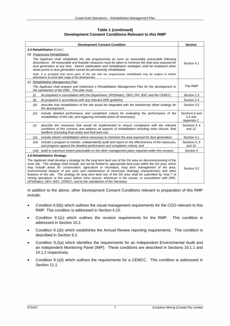
2.1 DEVELOPMENT CONSENT CONDITIONS This RMP has been prepared in accordance with the requirements of Development Consent Condition 2.4(c). Conditions 2.4(a) and (b) and Condition 3.8 are also relevant to this RMP. The requirements of the Development Consent are summarised in Table 1, along with the relevant section of this RMP in which the requirements are addressed.
Table 1 Development Consent Conditions Relevant to this RMP
Development Consent Condition Section
2.4 Rehabilitation
(a) Rehabilitation Objectives
The Applicant shall rehabilitate the site to the satisfaction of the DRE. This rehabilitation must be generally consistent with the proposed rehabilitation in the EIS (which is depicted in the Figure in Appendix 2) as amended by the approved rehabilitation strategy (see condition 3.8), and comply with the objectives in Table 1.
Table 1: Rehabilitation objectives
Sections 3.1 and 3.2
Feature Objectives
Mine site (as a whole)
• Safe, stable and non-polluting Sections 3.1 and 3.3
• Final landforms designed to incorporate micro-relief and integrate with surrounding natural landforms
Section 3.3
• Constructed landforms are to generally drain to the final void Section 3.3
• Minimise long term groundwater seepage zones Section 3.3.4
• Minimise visual impact of final landforms as far as is reasonable and feasible
Sections 4.9 and 4.1
Final void
• Minimise to the greatest extent practicable:
- the size and depth of final void
- the drainage catchment of final void
- risk of flood interaction for all flood events up to and including the Probable Maximum Flood
Section 3.3.1
• To be permanently separated from Lake Cowal by the Lake Protection Bund
• Highwall to be long-term stable
Surface infrastructure • To be decommissioned and removed, unless DRE agrees otherwise Section 3.3.3
Agriculture • Restore or maintain land capability generally as described in the EIS Sections 3, 4 and 6
Rehabilitation areas and other vegetated land
• Restore ecosystem function, including maintaining or establishing self-sustaining ecosystems
Sections 3.1 and 3.3
Community • Ensure public safety Sections 3.1 and 12 • Minimise adverse socio-economic effects associated with mine closure
Cowal Gold Operations – Rehabilitation Management Plan
870437 7 Evolution Mining (Cowal) Pty Limited
Table 1 (continued) Development Consent Conditions Relevant to this RMP
Development Consent Condition Section
2.4 Rehabilitation (Cont.)
(b) Progressive Rehabilitation
The Applicant shall rehabilitate the site progressively as soon as reasonably practicable following disturbance. All reasonable and feasible measures must be taken to minimise the total area exposed for dust generation at any time. Interim stabilization and rehabilitation strategies shall be employed when areas prone to dust generation cannot be permanently rehabilitated. Note: It is accepted that some parts of the site that are progressively rehabilitated may be subject to further disturbance at some later stage of the development.
Section 4.1
(c) Rehabilitation Management Plan
The Applicant shall prepare and implement a Rehabilitation Management Plan for the development to the satisfaction of the DRE. This plan must:
This RMP
(i) be prepared in consultation with the Department, DPI(Water), OEH, DPI, BSC and the CEMCC; Section 2.3
(ii) be prepared in accordance with any relevant DRE guideline; Section 2.4
(iii) describe how rehabilitation of the site would be integrated with the biodiversity offset strategy for the development;
Section 3.5
(iv) include detailed performance and completion criteria for evaluating the performance of the rehabilitation of the site, and triggering remedial action (if necessary);
Sections 6 and 3.4 and
Appendix C
(v) describe the measures that would be implemented to ensure compliance with the relevant conditions of this consent, and address all aspects of rehabilitation including mine closure, final landform (including final voids) and final land use;
Sections 3, 4 and 12
(vi) include interim rehabilitation where necessary to minimise the area exposed for dust generation; Section 4.1
(vii) include a program to monitor, independently audit and report on the effectiveness of the measures, and progress against the detailed performance and completion criteria; and
Sections 5, 9 and 10
(viii) build to maximum extent practicable on the other management plans required under this consent. Section 4
3.8 Rehabilitation Strategy
The Applicant shall develop a strategy for the long term land use of the DA area on decommissioning of the mine site. This strategy shall include, but not be limited to: appropriate land uses within the DA area, which may include areas for conservation, agriculture or recreation, long term management of the area, environmental impacts of any uses and maintenance of necessary drainage characteristics and other features of the site. The strategy for long term land use of the DA area shall be submitted by Year 7 of mining operations or five years before mine closure, whichever is the sooner, in consultation with DRE, DPI(Water), OEH, BSC, CEMCC, and to the satisfaction of the Secretary.
Section 3.2
In addition to the above, other Development Consent Conditions relevant to preparation of this RMP include: • Condition 6.5(b) which outlines the visual management requirements for the CGO relevant to this
RMP. This condition is addressed in Section 4.10.
• Condition 9.1(c) which outlines the revision requirements for the RMP. This condition is addressed in Section 10.2.
• Condition 9.1(b) which establishes the Annual Review reporting requirements. This condition is described in Section 9.2.
• Condition 9.2(a) which identifies the requirements for an Independent Environmental Audit and an Independent Monitoring Panel (IMP). These conditions are described in Sections 10.1.1 and 10.1.2 respectively.
• Condition 9.1(d) which outlines the requirements for a CEMCC. This condition is addressed in Section 11.1.

Cowal Gold Operations – Rehabilitation Management Plan
870437 8 Evolution Mining (Cowal) Pty Limited
2.2 ML 1535 CONDITIONS OF AUTHORITY The DRG, regulates the requirements in the Conditions of Authority for ML 1535 that relate to rehabilitation. The Conditions of Authority relevant to this RMP relate to rehabilitation, prevention of soil erosion and pollution, rehabilitation of roads and the Annual Environmental Management Report (AEMR) (now the Annual Review) and are provided below.
Rehabilitation 12. (a) Land disturbed must be rehabilitated to a stable and permanent form suitable for a subsequent
land use acceptable to the Director-General and in accordance with the Mining Operations Plan so that:-
• there is no adverse environmental effect outside the disturbed area and that the land is properly drained and protected from soil erosion.
• the state of the land is compatible with the surrounding land and land use requirements.
• the landforms, soils, hydrology and flora require no greater maintenance than that in the surrounding land.
• in cases where revegetation is required and native vegetation has been removed or damaged, the original species must be re-established with close reference to the flora survey included in the Mining Operations Plan. If the original vegetation was not native, any re-established vegetation must be appropriate to the area and at an acceptable density.
• the land does not pose a threat to public safety.
(b) Any topsoil that is removed must be stored and maintained in a manner acceptable to the Director-General.
13. The lease holder must comply with any direction given by the Director-General regarding the
stabilisation and revegetation of any mine residues, tailings or overburden dumps situated on the lease area.
These Conditions of Authority are addressed in Sections 3 and 4 of this RMP.
Prevention of Soil Erosion and Pollution
14. Operations must be carried out in a manner that does not cause or aggravate air pollution, water
pollution (including sedimentation) or soil contamination or erosion, unless otherwise authorised by a relevant approval, and in accordance with an accepted Mining Operations Plan. For the purpose of this condition, water shall be taken to include any watercourse, waterbody or groundwaters. The lease holder must observe and perform any instructions given by the Director-General in this regard.
This Condition of Authority is addressed in Section 4.6 of this RMP.
Roads
18. Access tracks must be kept to a minimum and positioned so that they do not cause any unnecessary damage to the land. Temporary access tracks must be ripped, topsoiled and revegetated as soon as possible after they are no longer required for mining operations. The design and construction of the access tracks must be in accordance with specifications fixed by the Department of Land and Water Conservation.
This Condition of Authority is addressed in Section 3.3.3 of this RMP.

Cowal Gold Operations – Rehabilitation Management Plan
870437 9 Evolution Mining (Cowal) Pty Limited
Annual Environmental Management Report (AEMR)
26. (1) Within 12 months of the commencement of mining operations and thereafter annually or, at such other times as may be allowed by the Director-General, the lease holder must lodge an Annual Environmental Management Report (AEMR) with the Director-General.
(2) The AEMR must be prepared in accordance with the Director-General’s guidelines current at the time of reporting and contain a review and forecast of performance for the preceding and ensuing twelve months in terms of:
(a) the accepted Mining Operations Plan;
(b) development consent requirements and conditions;
(c) Environment Protection Authority and Department of Land and Water Conservation licences and approvals;
(d) any other statutory environmental requirements;
(e) details of any variations to environmental approvals applicable to the lease area; and
(f) where relevant, progress towards final rehabilitation objectives.
(3) After considering an AEMR the Director-General may, by notice in writing, direct the lease holder to undertake operations, remedial actions or supplementary studies in the manner and within the period specified in the notice to ensure that operations on the lease area are conducted in accordance with sound mining and environmental practice.
(4) The lease holder shall, as and when directed by the Minister, cooperate with the Director-General to conduct and facilitate review of the AEMR involving other government agencies and the local council.
The CGO’s Development Consent (as modified on 7 February 2017) now requires an Annual Review (formerly the AEMR) to be prepared and includes contemporary reporting requirements as detailed in Development Consent Condition 9.1(b). This condition is addressed is Section 9.2. The contemporary Development Consent requirements are similar to the AEMR requirements under the Conditions of Authority for ML 1535. The requirements relevant to preparation of a MOP within the Conditions of Authority for ML 1535 are addressed in the CGO’s MOP. 2.3 REGULATORY CONSULTATION As described in Section 1 of this RMP, the former ROMP was prepared in 2010 in consultation with the EPA, OEH, NOW, BSC and to the satisfaction of the former DII. Comments on the ROMP were not received from the then DP&I until 14 August 2012. The ROMP was subsequently revised to address the DP&I’s comments and submitted to the DP&I for approval in August 2013. Approval of the ROMP by the DP&E remained pending up until the NSW Minister for Planning granted approval of the modified Development Consent on 22 July 2014. This RMP supersedes the former ROMP, and in accordance with the requirements of Condition 2.4(c)(i) of the Development Consent, this RMP has been prepared in consultation with the DRG, DPI(Water), OEH, the DPI, the BSC and the CGO’s CEMCC. The DRG is the relevant approval authority for this RMP. Evolution will consult with these and any other relevant stakeholders over the life of the mine to ensure the best possible overall rehabilitation outcome.
Cowal Gold Operations – Rehabilitation Management Plan
870437 10 Evolution Mining (Cowal) Pty Limited
2.4 POLICIES/PLANS/GUIDELINES A number of regional, state and commonwealth policies, plans and guidelines are relevant to this RMP including those summarised below. The integration of this RMP with these regional, state and commonwealth policies, plans and guidelines is recognised as important. Where practicable and appropriate, management recommendations resulting from the policies/plans/guidelines have been incorporated into this RMP. It is the responsibility of Evolution employees and its contractors to maintain up to date versions of these documents on file and be cognisant of their content. Policies NSW Wetlands Policy, 2010 The NSW Wetlands Policy, 2010 aims to provide for the protection, ecologically sustainable use and management of NSW wetlands (Department of Environment, Climate Change and Water [DECCW], 2010). The policy provides a set of guiding principles that all government agencies will adopt, and all stakeholders can refer to when making decisions on wetland management and conservation. The principles relevant to this RMP include: natural wetlands should not be destroyed or degraded; degraded wetlands and their habitats should be rehabilitated and their ecological processes improved as far as is practicable; and the conservation and management of wetlands are most appropriately considered at the catchment scale. Section 3.3.7 of this RMP describes the rehabilitation concepts for the New Lake Foreshore. In particular, the objectives of the rehabilitation programme (Section 3.1) include the expansion of habitat opportunities for wetland and terrestrial fauna species. This includes the design and implementation of rehabilitation works at the New Lake Foreshore in a manner consistent with the NSW Wetlands Policy, 2010. Policy and Guidelines for Fish Habitat Conservation and Management (Update 2013) The DPI’s (2013) Policy and Guidelines for Fish Habitat Conservation Management outlines the policies and guidelines aimed at maintaining and enhancing fish habitat for the benefit of native fish species, including threatened species, in marine, estuarine and freshwater environments. In relation to this RMP, the policy outlines key concepts for habitat rehabilitation. As described above, Section 3.3.7 of this RMP describes the rehabilitation concepts for the New Lake Foreshore and Section 3.1 identifies that a key objective of the CGO rehabilitation programme is the expansion of habitat opportunities for wetland (and terrestrial) fauna species. Plans/Strategies Evolution is required to take into consideration the latest versions of the Jemalong Land and Water Management Plan, the Lake Cowal Land and Water Management Plan, the Mid Lachlan Regional Vegetation Management Plan, and any future catchment/land and water management plans that may become relevant to the area in accordance with the requirements of Development Consent Condition 4.6. However, the Mid Lachlan Regional Vegetation Management Plan, referred to in Condition 4.6, was repealed with effect from 1 December 2005. The Mid Lachlan Regional Vegetation Management Plan was however considered during the development of the Lachlan Catchment Action Plan (Lachlan Catchment Management Authority, 2006). The Lachlan Catchment Action Plan and the Jemalong Land and Water Management Plan and Lake Cowal Land and Water Management Plan are described further below.

Cowal Gold Operations – Rehabilitation Management Plan
870437 11 Evolution Mining (Cowal) Pty Limited
Jemalong Land and Water Management Plan The Jemalong Land and Water Management Plan (Jemalong Land and Water Management Plan Steering Plan Committee [JLWMPSPC], 2000) provides for the alleviation of land and water degradation, improvement of natural resource management and sustainability of agriculture and the environment in the Jemalong Irrigation District. The Plan recommends the remediation of any degraded lands and the reduction of water erosion and sedimentation to reduce salinisation of land and waterbodies (JLWMPSPC, 2000). This RMP details the measures relevant to rehabilitation of disturbed land within ML 1535 in Sections 3 and 4 and specifically the management of water erosion and sedimentation in Section 4.6. Lake Cowal Land and Water Management Plan The Lake Cowal Land and Water Management Plan (Australian Water Technologies Pty Ltd, 1999) aims include maintaining vegetation cover and maintaining soil structure of Lake Cowal’s ecosystem. Measures that will be implemented to revegetate/regenerate the New Lake Foreshore within ML 1535 are detailed in Sections 3.3.7 and 4.5 of this RMP. Section 4.4 describes measures that will be implemented to manage and ameliorate the CGO’s stockpiled soil resources within ML 1535. Lachlan Catchment Action Plan The Lachlan Catchment Action Plan provides a framework for the investment in works, projects, planning and research that are considered necessary to achieve sustainable and productive landscapes in the catchment (Lachlan Catchment Management Authority, 2006). Consistent with the Natural Resources Commission Standards, the Lachlan Catchment Action Plan provides specific catchment and management targets, which reflect broader state-based targets (Lachlan Catchment Management Authority, 2006). The themes underpinning Lachlan Catchment Action Plan management targets relevant to the RMP include biodiversity and native vegetation, water and aquatic ecosystems and land management. The rehabilitation concepts and measures outlined in Sections 3 and 4 of this RMP are considered to address these themes. An updated Lachlan Catchment Action Plan was submitted to the Minister for Primary Industries on 1 February 2013. Guidelines ESG3: Mining Operations Plan (MOP) Guidelines As required by Development Consent Condition 2.4(c)(ii), the RMP must be prepared in accordance with any relevant DRE guideline. The DRE’s (2013) ESG3: Mining Operations Plan (MOP) Guidelines (the MOP Guidelines) includes specific requirements and concepts relevant to rehabilitation planning and implementation for NSW mining operations. The MOP Guidelines’ key rehabilitation planning concepts including rehabilitation domains, rehabilitation phasing and rehabilitation performance indicator and completion criteria have been developed for the CGO and incorporated into the RMP in Sections 3.3 and 6.
Cowal Gold Operations – Rehabilitation Management Plan
870437 12 Evolution Mining (Cowal) Pty Limited
3 REHABILITATION PLANNING AND MANAGEMENT The CGO’s rehabilitation strategy has been continuously developed throughout the CGO approval process. The Rehabilitation Proposal described in the approved Cowal Gold Operations Mine Life Modification Environmental Assessment (the CGO Mine Life Modification EA) (Evolution, 2016) and the approved Cowal Gold Mine Extension Modification Environmental Assessment (Barrick, 2013a) detail the CGO’s approved rehabilitation strategy. The CGO’s rehabilitation philosophy, principles and objectives, final landform and revegetation concepts, rehabilitation domains, management and mitigation measures and rehabilitation monitoring programme detailed in the Rehabilitation Proposal have been used in the development of this RMP and are reflected in this section.
3.1 REHABILITATION PRINCIPLES AND OBJECTIVES The approved CGO rehabilitation philosophy is to operate as a non-intrusive land user and to create stable rehabilitated landforms that increase the areas of endemic vegetation in the mine area and the status of land-lake habitats (Barrick, 2013a). The above philosophy remains unchanged and has led to the rehabilitation principles and objectives described below. Rehabilitation Principles The CGO’s rehabilitation programme includes the following general principles (Evolution, 2016): • The rehabilitation of landforms is to be progressive and conducted in accordance with approved,
verified plans.
• Final landforms are to be stable in the long-term and include native and/or endemic vegetation characteristic of remnant vegetation within the surrounding landscape.
• Endemic groundcover, understorey, tree seeds and seedlings are to be cultivated and used in the rehabilitation programme.
• Rehabilitation concepts are to be flexible to allow for adjustments, based on investigations, to improve the rehabilitation programme.
• The annual rehabilitation programme and budget is to be prepared by a site team incorporating senior management representatives.
Rehabilitation Objectives The rehabilitation objectives for the CGO’s rehabilitation programme include (Evolution, 2016): • The water quality of Lake Cowal is not detrimentally affected by CGO landforms.
• Revegetating CGO landforms with selected native and/or endemic vegetation that is suited to the physiographic and hydrological features of each landform, and which expand on the areas of remnant endemic vegetation in the surrounding landscape.
• Designing final landforms so that they are stable and include revegetation growth materials that are suited to the landform and support self-sustaining vegetation.
• The placement (wherever possible) of soils on final landforms to enable the progressive establishment of vegetation.

Cowal Gold Operations – Rehabilitation Management Plan
870437 13 Evolution Mining (Cowal) Pty Limited
• The expansion of habitat opportunities for wetland and terrestrial fauna species. This includes the design and implementation of rehabilitation works at the New Lake Foreshore in a manner consistent with the NSW Wetlands Policy (DECCW, 2010).
• The selection of revegetation species in accordance with accepted principles of long-term sustainability (e.g. genotypic variation, vegetation succession, water/drought tolerances).
• Grazing of land within ML 1535 to be excluded during operations and during rehabilitation of the site. At lease relinquishment, rehabilitated final landforms are excluded from grazing, with some areas suitable for grazing surrounding the rehabilitated final landforms.
Specific rehabilitation objectives have been developed for the CGO’s rehabilitation domains and final landforms which consider the results of rehabilitation investigations and trials undertaken at the CGO to date. These objectives are described in Section 3.3. In addition to the above, the CGO’s modified Development Consent includes defined rehabilitation objectives for the CGO. In accordance with Development Consent Condition 2.4(a) Evolution will rehabilitate the CGO in accordance with these objectives. Table 1 outlines where these Development Consent rehabilitation objectives have been addressed within this RMP.
3.2 LONG-TERM LAND USE STRATEGY In accordance with Development Consent Condition 3.8 (Section 2.1), a long-term land use strategy has been developed for the CGO and is described below. The strategy is relevant to land within ML 1535, the Bland Creek Paleochannel water supply pipeline and borefield and Eastern Saline Borefield and Evolution-owned land outside ML 1535. As required by Condition 3.8, the long-term land use strategy includes a description of: • the proposed long-term land uses;
• the potential environmental impacts associated with the proposed long-term land uses; and
• the long-term management measures. The proposed long-term land uses described in this strategy are considered to: • improve wildlife values within ML 1535 and around Lake Cowal in the long-term;
• be compatible with pre-mining and existing land uses in the Lake Cowal region; and
• be sustainable in the long-term. Proposed Long-term Land Uses The land within ML 1535 is former cleared and semi-cleared farmland that was used for grazing of native and improved pastures by livestock. Prior to the development of the CGO, the original native tree cover within ML 1535 had largely been removed except for scattered individual trees or small stands and the tree cover on the former Cowal West Hill which had been retained due to its shallow soils and poorer grazing potential. The landscape surrounding the CGO (including Evolution-owned lands outside ML 1535) is predominantly used for agriculture (e.g. broad-acre cropping) and grazing over relatively large landholdings. Current (and historical) uses of Lake Cowal include commercial and recreational fishing when inundated, and agricultural production including grazing by livestock when dry.

Cowal Gold Operations – Rehabilitation Management Plan
870437 14 Evolution Mining (Cowal) Pty Limited
As described in the CGO’s Flora and Fauna Management Plan (FFMP) and consistent with the CGO’s rehabilitation objectives, rehabilitation of ML 1535 disturbance areas will aim to enhance and expand wildlife habitat values within ML 1535 and around Lake Cowal. Evolution also recognises that the former land use within ML 1535 included grazing of cleared and semi-cleared areas of predominantly native pastures by livestock. Therefore it is proposed that at lease relinquishment, land use within ML 1535 would include fenced rehabilitation areas with grazing excluded and areas suitable for agricultural production including commercial and recreational fishing of lake areas or managed grazing by livestock (Figure 3). Evolution-owned land outside ML 1535 (with the exception of the Compensatory Wetland and Northern and Southern Offset Areas) would continue to be used for farming/agricultural production by Evolution and/or licensees that sign agreements to conduct agricultural activities on Evolution-owned land. It is anticipated that areas of lakebed country would be available for commercial and recreational fishing when inundated, and may be used for cropping and/or managed livestock grazing when dry, consistent with existing and historical uses of Lake Cowal. Consistent with Development Consent Condition 3.4(b) and the CGO’s Biodiversity Offset Management Plan (BOMP), long-term protection of the CGO Offset Areas would be provided by a Voluntary Planning Agreement registered on the title of the offset lands. Consistent with the CGO’s Land Management Plan (LMP), the Remnant Vegetation Enhancement Programme (RVEP) Areas (Figure 3) would continue to be maintained for the term of Evolution’s tenure of the land. Some infrastructure may be retained and transferred to local landholders for use following lease relinquishment including electricity infrastructure, water storages, pipelines, bores and associated pump stations, if agreed with the DRG. If it is agreed with the DRG and the ultimate landholder that the CGO’s Bland Creek Palaeochannel Borefield, Eastern Saline Borefield and the saline groundwater bores within ML 1535 be retained for local use, the pipelines would remain in place (Evolution, 2016). Alternatively, if the infrastructure is not required for local use, the bores would be plugged, capped and decommissioned in accordance with relevant regulatory guidelines, the pump stations would be removed and the pipelines raised and dismantled for recycling (Evolution, 2016). Further detail of the proposed decommissioning procedures is provided in Section 3.3.3. A Social Impact Assessment (SIA) was commissioned by Barrick and undertaken by URS (2013) to assess the impacts of the CGO on key social aspects (including amenity, community identity, economy, education, social infrastructure and the indigenous community) and to assess the potential impacts of closure of the CGO. Future social closure planning will continue to inform the long-term land uses, particularly in regard to the transfer of Evolution-owned infrastructure to local landholders post-mining. Long-term land uses would ultimately be subject to consultation with relevant regulatory authorities (including the DP&E, DRG, OEH, DPI-Water and DPI-Fisheries) and key stakeholders including surrounding landholders. A description of the long-term land use areas is provided below. Rehabilitation Areas Rehabilitated final landforms including the waste rock emplacements, tailings storage facilities, final void, Compensatory Wetland, former process plant area (including decommissioned and rehabilitated contained water storages) and the former ore stockpile areas will be fenced with grazing excluded, with some areas suitable for grazing surrounding the rehabilitated final landforms (Figure 3).

#
BlowClear Road
Bonehams
Lane
Butte
nsha
ws La
ne
UncleBills
Road
Lake Cow al Road
LakeCowal
Road
Travelling Stock Reserve
Eucalypt Woodland Corridor(Grazing and Agricultural
Production excluded)
Eucalypt Woodland(Grazing and Agricultural
Production excluded)
Area Suitable for
Agricultural Production
Riverine and Eucalypt Woodland(Grazing and Agricultural
Production excluded)
Scattered Eucalypt Woodlandand native pasture species(Area suitable for grazing)
"
Up-catchment Diversion System
"
RehabilitatedNorthern Waste RockEmplacement
"
Rehabilitated Perimeter Waste Rock Emplacement
"New Lake Foreshore
"
RehabilitatedSouthern Waste RockEmplacement
"
RelocatedCrown Reserve
RehabilitatedNorthern TailingsStorage Facility
RehabilitatedSouthern TailingsStorage Facility
"RVEP Area 1
Southern OffsetArea
NorthernOffsetArea
"RVEP Area 3
"RVEP Area 2
"
RVEP Area 4
"
LAKE COWAL
#Fellmans Hill
Voluntary Planning Agreement to be registered on the
Title of the lands
Voluntary Planning Agreement to be registered on the
Title of the lands
Compensatory Wetland comprisingRiverine Woodland and Freshwater
Communities (Grazing and AgriculturalProduction excluded)
WEST WYALONG BURCHER RAILWAY
WAMBOYNEMOUNTAIN
535000
5350
00
540000
5400
00
6270000 6270000
6275000 6275000
6280000 6280000
6285000 6285000
HAL-02-07 CGO MP 2017_RMP_201A
Source: Evolution (2016)
GRID DATUM MGA94 ZONE 55
0 1 2
Kilometres
Conceptual Final Landform andProposed Final Land Use Areas
FIGURE 3
R E H A B I L I T A T I O N M A N A G E M E N T P L A N
LEGEND
CGO Offset AreaRemnant Vegetation Enchancement Programme (RVEP) Area(Management of these areas would be maintained for theterm of Evolution's tenure of the land)
Cowal Gold Operations – Rehabilitation Management Plan
870437 16 Evolution Mining (Cowal) Pty Limited
In accordance with rehabilitation concepts provided in the Cowal Gold Mine Environmental Impact Statement (North Limited, 1998), a woodland corridor will also be provided between the rehabilitated Northern Waste Rock Emplacement and the rehabilitated Northern Tailings Storage Facility (Figure 3). Exclusion of grazing of these areas is proposed to protect revegetation and natural regeneration and to maintain the long-term stability of the final landforms. Permanent drainage features within ML 1535 including the Up-catchment Diversion System (UCDS) and drainage lines associated with the permanent catchment divide would remain to manage surface water runoff around the rehabilitated CGO area. Areas Suitable for Grazing/Agricultural Production The remaining areas of land within ML 1535 level with the natural ground surface disturbed by mining operations (e.g. former soil stockpile areas and former explosive storage areas) would be rehabilitated to include vegetation which expands on the areas of remnant endemic vegetation that currently exists in the region and include native pasture species. It is expected that once sufficiently mature vegetation communities have been established, these areas would be suitable for managed livestock grazing (Figure 3). A suitable stocking rate for these areas would be determined in consultation with the relevant regulatory authorities based on the performance of the revegetation following closure of the mine. The relocated travelling stock reserve formed around the western boundary of ML 1535 (Figure 3) would be retained. Consistent with the CGO’s LMP, at lease relinquishment, areas of Evolution-owned land (with the exception of Compensatory Wetland and Northern and Southern Offset Areas) (Figure 3) will continue to be used for farming/agricultural production by Evolution and/or licensees that sign agreements to conduct agricultural activities on Evolution-owned land. It is anticipated that areas of lakebed country would be available for commercial and recreational fishing when inundated, and may be used for managed livestock grazing when dry, consistent with existing and historical uses of Lake Cowal. Other Infrastructure Surface infrastructure will mostly be decommissioned, dismantled and removed from site, and either transferred to another Evolution operation or sold. In accordance with Development Consent Condition 4.4(b) a Strategy for Decommissioning of the Cowal Gold Operations Water Management Structures has been developed and is incorporated within the CGO Water Management Plan. Some infrastructure may however be retained and transferred to regional landholders for use following mine closure (e.g. electricity infrastructure, water storages, pipelines, bores and associated pump stations) if agreed with the DRG and the ultimate landholder. Further detail regarding decommissioning and rehabilitation of the infrastructure areas is provided in Section 3.3.3. Potential Environmental Impacts Associated with Proposed Long-term Land Uses Potential environmental impacts associated with the long-term land uses may include: • failure of revegetation within grazed areas due to over grazing by livestock;
• increased potential for soil erosion within grazed areas;
• increased potential for spread of weeds and pests; and
• potential for final landform instability and damage to revegetation due to access by stray livestock and/or unauthorised access.

Cowal Gold Operations – Rehabilitation Management Plan
870437 17 Evolution Mining (Cowal) Pty Limited
The potential environmental impacts of the long-term land uses are generally considered similar to the land use impacts that would have existed pre-mining. Notwithstanding, with the implementation of the long-term management measures described below (and implementation of the CGO LMP), the potential impacts of proposed land uses would be minimised. Long-term Management Measures The following management measures would be undertaken post-closure to facilitate implementation of the long-term land use strategy and mitigate potential environmental impacts: • livestock management;
• maintenance of fencing surrounding rehabilitation areas;
• bushfire prevention and fuel management;
• weed and pest control;
• control of erosion and sedimentation;
• management of vehicle and unauthorised access; and
• monitoring of revegetation and regeneration including supplementary planting and/or seeding if necessary.
A detailed description of the measures that would be implemented in the long-term will be provided in a Mine Closure Plan, or final MOP, prepared in consultation with the DRG and other relevant regulatory agencies and key stakeholders. The long-term management measures would be implemented for the period following mine closure until the lease relinquishment criteria (including rehabilitation completion criteria) have been met (Sections 6 and 12).
3.3 FINAL LANDFORM CONCEPTS AND REHABILITATION DOMAINS Figure 3 shows the conceptual final landform for the approved CGO. The CGO final landforms would be: • designed wherever possible to be compatible with regional landscape features;
• progressively constructed as a ROM operation wherever possible and left with untrimmed surface roughness to lower runoff coefficients and promote water absorption and storage; and
• revegetated with endemic vegetation communities, selected specifically for their suitability to the created elevation, aspect, substrate conditions and the overriding objective of re-establishing a greater extent of endemic vegetation within ML 1535.
Key features of the final landform include (Evolution, 2016) (Figure 3): • a final void;
• rehabilitated waste rock emplacements surrounding the final void to the north, east and south;
• two rehabilitated tailings storage facilities located near the western extent of ML 1535;
• a woodland corridor between the rehabilitated Northern Waste Rock Emplacement and rehabilitated Northern Tailings Storage Facility;

Cowal Gold Operations – Rehabilitation Management Plan
870437 18 Evolution Mining (Cowal) Pty Limited
• areas surrounding the rehabilitated waste rock emplacements and tailings storage facilities associated with rehabilitated site infrastructure areas (i.e. the former process plant area and former soil stockpile areas);
• permanent water management features including the UCDS and low mounds associated with the Internal Catchment Drainage System (ICDS); and
• permanent lake isolation embankments to hydrologically separate the open pit development area and Lake Cowal during mining and post-mining.
The CGO Mine Life Modification (Evolution, 2016) introduced the processing of mineralised material and therefore the mineralised material stockpile has been removed as a component of the northern waste rock emplacement landform. Figure 4 shows the conceptual general arrangement post-mining. Consistent with contemporary rehabilitation guidelines and rehabilitation planning best practice, conceptual rehabilitation domains have been developed based on the above key features of the CGO final landform. In consideration of the DRE’s MOP Guidelines (DRE, 2013), Table 2 outlines the primary and secondary domains relevant to the CGO.
Table 2
CGO Rehabilitation Domains
Code Primary Domains Code Secondary Domains
1 Void A Final Void
2 Permanent Water Management Infrastructure B Permanent Water Management Infrastructure
3 Infrastructure Area C Grassland/Scattered Eucalypt Woodland
4 Tailings Storage Facilities D Eucalypt Woodland
5 Waste Rock Emplacements E Riverine Woodland/Freshwater Communities
6 Woodland Corridor
7 New Lake Foreshore
In summary, the following conceptual rehabilitation domains have been developed for the CGO and are shown on Figure 5: • Domain 1A – Final Void;
• Domain 2B – Permanent Water Management Infrastructure;
• Domain 3C – Infrastructure Area – Grassland/Scattered Eucalypt Woodland;
• Domain 4D – Tailings Storage Facilities – Eucalypt Woodland;
• Domain 5D – Waste Rock Emplacements – Eucalypt Woodland;
• Domain 6D – Woodland Corridor – Eucalypt Woodland; and
• Domain 7E – New Lake Foreshore – Riverine Woodland/Freshwater Communities. A description of the rehabilitation concepts and rehabilitation objectives for each of the rehabilitation domains is provided in Sections 3.3.1 to 3.3.7 below, and are consistent with the rehabilitation principles and rehabilitation objectives for the CGO (Section 3.1). These concepts (and the long-term land use strategy) may be revised and refined if necessary throughout the life of the mine based on the outcomes of ongoing consultation with relevant regulatory authorities, stakeholders and the results of ongoing rehabilitation investigations and trials.


Cowal Gold Operations – Rehabilitation Management Plan
870437 21 Evolution Mining (Cowal) Pty Limited
3.3.1 Domain 1A – Final Void The rehabilitation objectives for the final void are to (Barrick, 2013a): • create habitat opportunities for waterbirds at the approximate level at which void water will reach
equilibrium, where feasible; and
• leave the void surrounds safe (for humans and stray stock). At the completion of mining, the final void will be surrounded on three sides by the revegetated mine waste rock emplacements. The approved surface area of the final void will be approximately 131 ha, and at the end of mining, the void is approved to a maximum depth of approximately -331 metres (m) Australian Height Datum (AHD) (i.e. approximately 540 m below the natural surface level). The berm widths and slope angles will continue to be reviewed and monitored through ongoing geotechnical studies and data collection during mine development. Modelling indicates that the approved final void would reach an estimated equilibrium water level below 130 m AHD (approximately 80 m below spill level) (Hydro Engineering and Consulting, 2016). Predictions of average void salinity confirm that salt concentrations in void waters would slowly increase towards hyper-salinity (Hydro Engineering and Consulting, 2016). A bund will be constructed around the perimeter of the final void which will be planted with an initial cover crop (to assist in stabilising the bund following construction) and will be seeded with native and/or endemic Eucalypt woodland species. The final void will be screened from public views on Lake Cowal Road by the tailings storage facilities and waste rock emplacements and will be fenced upon completion of mining. Signposted warnings to the public will also be placed along the fence. A strategy for the long-term management of the final void (and the lake protection bund) has been prepared in accordance with Development Consent Condition 4.4(b) and is included in the CGO Water Management Plan. Rehabilitation concepts for the final void may be revised following the outcomes of trials and investigations undertaken.
3.3.2 Domain 2B – Permanent Water Management Infrastructure The rehabilitation objective for the permanent water management structures is to create stable systems (i.e. acceptably low risk of environmental harm to Lake Cowal). The permanent water management structures for the CGO comprise: • UCDS; and
• ICDS (including the existing low mounds associated with the permanent catchment divide). The UCDS has been constructed to simulate endemic drainage features in the region and includes a low flow drainage path within a wider floodplain (approximately 65 m wide). The channel includes constructed features such as low flow and overbank zones, meanders and pool/riffle sequences. The northern extent of the UCDS includes constructed rock outfalls at confluences with existing natural drainage lines to minimise erosion. At the completion of construction, the UCDS was revegetated with riparian vegetation including rapid germinating pasture species to assist in stabilising the channel.

Cowal Gold Operations – Rehabilitation Management Plan
870437 22 Evolution Mining (Cowal) Pty Limited
The UCDS will remain to facilitate permanent drainage of adjacent areas upslope of the site to Lake Cowal and the low mounds associated with the ICDS will remain to contain runoff generated within the site catchment. The Lake Isolation System (including the Temporary Isolation Bund, Lake Protection Bund and Perimeter Waste Rock Emplacement) has also been constructed to hydrologically isolate the open pit and Lake Cowal during mining and post-mining. A conceptual cross-section of the Lake Isolation System is shown on Figure 6. Although some components of the Lake Isolation System are permanent water management features, a separate Rehabilitation Domain (7E) has been developed for the New Lake Foreshore (Section 3.3.7) considering the rehabilitation objectives for the New Lake Foreshore are different from the rehabilitation objectives for the UCDS and ICDS. The remainder of the Perimeter Waste Rock Emplacement (i.e. excluding the first outer batter) will be incorporated within Rehabilitation Domain 5D (Waste Rock Emplacements) (Section 3.3.5).
3.3.3 Domain 3C – Infrastructure Areas Post-operations, the rehabilitation objectives for the infrastructure areas are to: • remove all infrastructure to ensure the site is safe and free of hazardous materials (unless an
alternative arrangement is agreed by Evolution, the ultimate landholder and relevant regulatory authorities); and
• establish vegetative communities (including scattered Eucalypt woodland species and native pasture species) that are endemic to the region and suitable for managed grazing.
The rehabilitation concepts and procedures for the key CGO infrastructure areas are outlined below. The long-term objectives for site infrastructure features will be discussed during the life of the CGO and will be specifically reviewed in consultation with the CEMCC and relevant regulatory authorities prior to the final year of mine operations. Mine Fleet Workshop At the completion of mining, the mine fleet will be demobilised and the contractors’ workshop dismantled. The footprint area will be tested for contamination from fuels and lubricants and any contaminated soils removed for proper disposal in accordance with the EPA requirements. The area will then be contour ripped, topsoiled and revegetated with endemic Eucalypt Woodland and native pasture species. Reagent and Fuel Storage Areas Unused reagents and fuels at the completion of processing will be returned to the supplier in accordance with all relevant safety and handling procedures. Storage areas will be tested for contamination from fuels and lubricants and any contaminated soils removed for proper disposal in accordance with the EPA requirements. The area will then be contour ripped, topsoiled and revegetated with endemic Eucalypt Woodland and native pasture species. Process Plant and Administration Area The process plant and administration area buildings will be dismantled and removed following the cessation of processing.


Cowal Gold Operations – Rehabilitation Management Plan
870437 24 Evolution Mining (Cowal) Pty Limited
The foundations and floors will be excavated for disposal at the base of the void or as buried landfill in an approved manner. The area will then be contour ripped, topsoiled and revegetated with endemic Eucalypt Woodland and native pasture species. Alternatively, the foundations and floors may be retained if a suitable alternative use is agreed with the ultimate landholder. Internal powerlines and pipelines associated with the administration area and the explosives magazine will be dismantled and removed. Internal Access Road and Other Roads All internal roads will be contour ripped, topsoiled and revegetated with endemic Eucalypt Woodland and native pasture species, unless otherwise agreed with the ultimate landholder. Transmission Line and Substation At the end of the mine life, the electricity transmission line (from Temora to the CGO) would be the property of the electricity utility and would likely remain in place. Water Supply Infrastructure The Bland Creek Paleochannel bores and associated pump stations (including the Eastern Pump Station and diesel tank) may be transferred to regional landholders or, alternatively, dismantled and the bores plugged, capped and decommissioned in accordance with the Minimum Construction Requirements for Water Bores in Australia February 2012 (National Uniform Drillers Licensing Committee [NUDLC], 2012). The pipeline would either be raised and dismantled for recycling or kept in place if required for local use. If dismantled, the section of pipeline in the bed of Lake Cowal would be raised when the lake is dry and disturbed areas revegetated with endemic species, subject to strict environmental management procedures (including consideration of the NOW’s Controlled Activity on Waterfront Land – Guidelines for laying pipes and cable in watercourses on waterfront land [NOW, 2012]) (Appendix A). If this is not possible due to successive high rainfall seasons, any decision to remove the pipeline would be discussed with the relevant regulatory authorities. However, given the likely maintenance period for CGO rehabilitation, it is likely that Lake Cowal would be sufficiently dry at some stage during this period. Given the water supply from the saline groundwater supply bores within ML 1535 and the Eastern Saline Borefield is highly saline, it is unlikely that these bores would be suitable and/or requested for ongoing future use by local landholders post-closure of the CGO. Notwithstanding, consultation would include discussions between Evolution and local landholders regarding potential transfer of the saline groundwater supply borefield infrastructure for private use. It is expected that saline groundwater supply bores and its associated pipeline would be dismantled and the bores plugged, capped and decommissioned in accordance with the Minimum Construction Requirements for Water Bores in Australia February 2012 (NUDLC, 2012). Similar to the procedure for decommissioning and removal of the Bland Creek Palaeochannel pipeline, the saline groundwater pipeline within ML 1535 would be dismantled and removed during dry lake conditions and disturbed areas revegetated with endemic species. Alternatively, if agreed with the DRG, the water supply infrastructure may be retained and transferred to a local landholder.
Cowal Gold Operations – Rehabilitation Management Plan
870437 25 Evolution Mining (Cowal) Pty Limited
Contained Water Storages Rehabilitation objectives for the contained water storages (i.e. D1 to D10) are to either decommission the infrastructure or retain the infrastructure for landholder use. Decommissioning of the contained water storages would be undertaken to the satisfaction of relevant regulatory authorities including the DRG, EPA and DPI-Water. Alternatively, the contained water storages may be retained for local landholder use upon agreement by Evolution and the regulatory authorities. A strategy for the decommissioning of water management structures (including water storages both in and around the mine site and the water pipeline from the Bland Creek Palaeochannel Borefield and Eastern Saline Borefield) has been prepared in accordance with Development Consent Condition 4.4(b) and is included in the CGO’s Water Management Plan. Exploration Areas All exploration drillholes would be plugged, capped and decommissioned in accordance with the procedures outlined in the EL 7750 Review of Environmental Factors (Evolution, 2015) at the completion of exploration activities. Access tracks and areas disturbed by exploration activities would be revegetated in accordance with the procedures adopted for the internal site roads.
3.3.4 Domain 4D – Tailings Storage Facilities The rehabilitation objectives for the tailings storage facilities are to (Evolution, 2016): • establish permanently stable landforms;
• during operations, stabilise batters so that they provide minimal habitat value for bird life (i.e. rock mulch or pasture cover);
• post-operations, to establish vegetative communities (including Eucalypt and Riverine Woodland species and understorey species such as Rush species and pasture species) which are suited to the hydrological features and substrate materials of the landform; and
• exclude grazing and agricultural production. Rehabilitation Concepts The approximate final heights of the Northern and Southern Tailings Storage Facilities will be 264 m AHD and 272 m AHD respectively. The approved CGO Mine Life Modification modified the design of the tailings storage facilities to convert the area between the existing northern and southern tailings storage facilities into a new storage area and place a rock fill buttress over the outer slopes of the tailings storage facilities embankments. Consistent with the currently approved design, the overall slope of the tailings storage facilities embankments would be 1 Vertical(V):4.8 Horizontal(H) for the Northern Tailings Storage Facility, 1V:4.5H for the Southern Tailings Storage Facility and 1V:3.6H for the central connector embankments. Following tailings deposition, supernatant water drains to the central pond and decant towers. An underdrainage pipe network has also been installed to facilitate drainage of the tailings mass. The bulk of the water from each tailings storage drains from the surface of the tailings and collects in the centre of each storage. This water, as well as underdrainage water, is reclaimed and used within the process plant. The decant system (including access causeway) is progressively raised during development of the tailings storage facilities.

Cowal Gold Operations – Rehabilitation Management Plan
870437 26 Evolution Mining (Cowal) Pty Limited
A number of seepage control measures have been incorporated into the design of the CGO tailings storage facilities to minimise long-term groundwater seepage, including: • the pre-stripping of surficial soils beneath the embankment footprint;
• construction of a moisture-conditioned and compacted-low-permeability storage floor, where necessary, to achieve permeability criteria;
• excavation of a central cut-off trench along the length of the starter embankment to a nominal 2.5 m below surface level or to the depth of a low-permeability clay layer, and backfilled with compacted and moisture-conditioned low permeability clay; and
• installation of an underdrainage and decant network. As described in the approved Rehabilitation Strategy for the CGO, the tailings storage facilities will be rehabilitated as follows (Evolution, 2016): • The decant areas will be allowed to dry and the decant towers will be permanently capped with fill
and/or a concrete plug.
• The underdrains (which previously conveyed decanted water to the reclaim dam) will be grouted.
• The tailings discharge pipes and monitoring systems will be dismantled for re-use or disposal with the bulk of CGO infrastructure.
The tailings storage facilities have already been fenced, which will remain post-mining to exclude grazing and agriculture production. Embankment Construction The tailings storage facilities will continue to be stage constructed with the height of the embankments raised in advance of the storage requirements. As the storages fill, the embankments will be raised in a series of upstream lifts, at a rate not more than approximately 5 m per year. Each lift will comprise and earth/rock fill embankment, with a clay basal zone, supported by the dry tailings beach. Construction of each lift will also involve placement of an interim rock buttress cover on the outer slope of the embankment to enhance stability of the embankments during construction of the tailings storage facilities. Rehabilitation materials (e.g. rock mulch and topsoil) on the existing tailings storage facility embankments will be stripped prior to placement of the interim rock buttress. The stripped rehabilitation materials will be either transferred to a new rehabilitation area or stockpiled proximal to the tailings storages facilities for use during final rehabilitation activities. The top surfaces of the tailings storage facilities will form a low, internally draining landform, with drainage affected by controlled placement of cover materials and a number of shallow swales. The tailings storage facilities surfaces will form contained catchments. The outer batters of the tailings storage facility embankments will be constructed with an overall slope of 1 Vertical(V):4.8 Horizontal(H) for the northern tailings storage facility, 1V:4.5H for the southern tailings storage facility and 1V:3.6H for the central connector embankments, and will include a rock fill buttress on the lower embankments to provide long-term stability of the landform. The buttress will be designed to meet the requirements of Evolution’s seismic design standard (i.e. for a 1:5,000 year maximum design earthquake event) and to meet the NSW Dams Safety Committee’s (DSC’s) and the Australian National Committee of Large Dams’ requirements for tailings dam design.

Cowal Gold Operations – Rehabilitation Management Plan
870437 27 Evolution Mining (Cowal) Pty Limited
Once the final embankment of both tailings storage facilities has been constructed, a final rock buttress will be placed over the outer slopes of the TSF embankments to provide long-term stability. To accommodate the final rock buttress, a minor extension of the tailings storage facility footprints would occur within currently approved surface disturbance areas. Figures 7 and 8 show conceptual cross-sections of the Northern Tailings Storage Facility and Central Connector Embankment, respectively. The conceptual cross-section of the Northern Tailings Storage Facility shown on Figure 7 is also representative of the concept for the Southern Tailings Storage Facility. Rehabilitation Cover System Based on the results of rehabilitation investigations and trials conducted to date (Section 8), the rehabilitation cover system for the tailing storage facilities outer batters will include: • benign (primary) rock mulch;
• low salinity and gypsum-treated topsoil; and
• a patchwork layer or rows of seed bearing native pasture hay (or clean wheaten hay) placed on north and west facing slopes (as these aspects are subject to prevailing conditions).
The rock mulch and topsoil layers will be applied with approximately 10 tonnes per hectare (t/ha) gypsum, followed by seeding with an initial sterile cover crop (e.g. Rye Grass) and/or direct seeding with select pasture species and/or planting native and/or endemic shallow-rooted species. A layer (approximately 5 centimetres [cm] deep) of locally harvested seed bearing native pasture hay (or clean wheaten hay) will then be spread on north and west facing slopes to assist soil protection and vegetation establishment. The top surfaces of the tailings storage facilities would form a low, internally draining landform, with drainage affected by controlled placement of cover materials and a number of shallow swales. The tailings storage facility surfaces would form contained catchments to minimise surface water runoff from the top surface down the batters. The rehabilitation cover system materials for the top surfaces will include a capillary break layer of rock to restrict the upwards migration of tailings salts and a thick layer of gypsum-treated soil to provide for moisture/absorption and storage, and a plant rooting medium. During operations, the tailings storage facility embankments would be constructed so that they provide minimal habitat value for bird life (i.e. rock mulch or pasture cover only). Revegetation Concepts Revegetation of the tailings storage facilities will use a combination of native and/or endemic plant species and pasture species to rapidly stabilise landforms in the initial period following construction (Barrick, 2013a). Similar to the revegetation concepts for the waste rock emplacements (Section 3.3.5), the revegetation concepts for the tailings storage facilities would include selecting species suited to the hydrological features and substrate materials of the landform and would be based on the results of rehabilitation investigations and trials in consultation with regulatory authorities (Evolution, 2016). A description of the rehabilitation trials that will be undertaken relevant to the tailings storage facilities is provided in Section 8.


Cowal Gold Operations – Rehabilitation Management Plan
870437 30 Evolution Mining (Cowal) Pty Limited
The vegetation growth trials undertaken to date indicate that salt tolerant tree species including Belah (Casuarina cristata), Grey Box (Eucalyptus microcarpa), Bimble Box or Poplar Box (Eucalyptus populnea), Mugga Ironbark (Eucalyptus sideroxylon) and Buloke (Allocasuarina luehmannii) and shrub species including Green Wattle (Acacia deanei), Western Golden Wattle (Acacia decora), Weeping Myall (Acacia pendula), Wedge-leaf Hop-bush (Dodonaea viscose ssp. cuneata) and Nitre Goosefoot (Chenopodium nitrariaceum) may be suitable for revegetation of the tailings storage facility top surfaces (Evolution, 2016). Post-operations, the tailings storage facilities will be revegetated with plant species that may include (Evolution, 2016): • In the central, occasionally wet area, planting species such as River Red Gum (Eucalyptus
camaldulensis) and understorey species such as Rush.
• On the remainder of the covered storage surface, planting salt tolerant Eucalypt and Riverine Woodland species (which may include Belah, Grey Box, Bimble Box, Mugga Ironbark and Buloke and shrub species including Green Wattle, Western Golden Wattle, Weeping Myall, Wedge-leaf Hop-bush and Nitre Goosefoot).
• On the tailings storage facility embankments, planting species suited to the slope and substrate materials of the embankment.
Rehabilitation trials will continue to be undertaken to determine the most suitable revegetation species for the top surfaces of the tailings storage facilities. Revegetation concepts will consider the results of hydrological modelling predictions for the tailings storage facilities (i.e. plant species will be selected that are suited to the hydrological conditions of the storages such as inundated areas, dry areas and swales). Revegetation methods for the final rock buttress cover of the tailings storage facilities may include: • on longer slopes, spreading seed laden topsoil down slope using a dozer; and
• on steeper slopes, either pushing seed laden topsoil over the crest of the slope and/or hydromulching the slope, or mixing seed laden topsoil with rock during placement of the outermost rock buttress material.
Mixing seed through topsoil stocks would be undertaken in parallel with soil stockpile management measures (Section 4.4) and would involve: • deep-ripping and applying gypsum to soil stockpiles;
• spraying a pre-emergent or post-emergent herbicide treatment to control Wimmera Ryegrass (Lolium rigidum);
• applying select seed mix to the treated soil surface;
• stripping the surface layer of the soil stockpile (up to approximately 1 m deep); and
• applying the seed laden topsoil to the rehabilitation area. Evolution proposes to conduct research and implement a trial to investigate the most effective methods for revegetating the final tailings storage facility embankments and determine the species most suited to the final slopes and rehabilitation media (Section 8). Revegetation methods for the final rock buttress cover would be described in detail in future MOPs which would be prepared in consultation with and subject to approval by the DRG.

Cowal Gold Operations – Rehabilitation Management Plan
870437 31 Evolution Mining (Cowal) Pty Limited
3.3.5 Domain 5D – Waste Rock Emplacements The rehabilitation objectives for the waste rock emplacements are to (Evolution, 2016): • stabilise batter slopes with rock armour (primary waste rock mulch) to control surface water runoff
downslope and reduce erosion potential in the long-term;
• provide a stable plant growth medium able to support long-term vegetation growth including native and/or endemic Eucalypt Woodland, shrubland and grassland species suited to slope and elevated positions similar to those remnants in the surrounding landscape; and
• exclude grazing and agricultural production. The CGO Mine Life Modification (Evolution, 2016) involves the processing of mineralised material and would therefore remove the mineralised material stockpile as a component of the northern waste rock emplacement landform. Rehabilitation Concepts The waste rock emplacements will continue to be designed to meet the long-term goal of directing potential seepage generated from waste rock emplacement areas toward the open pit during operation and post-closure. The topography of the waste rock emplacement footprints has been altered by stripping topsoil and subsoil from the footprint area. This concept will continue to be used for construction of the modified Northern Waste Rock Emplacement. Oxide waste rock will be placed and compacted (using haul truck movements) in the footprint resulting in the emplacement basement sloping towards the open pit and providing drainage control (i.e. the base drainage control zone). Any waters permeating through the emplacements are expected to be intercepted by this layer and preferentially flow towards the open pit. In accordance with the CGO’s EPL, the waste rock emplacements include a base drainage control zone with a minimum slope towards the open pit of 1V:200H. The approximate final heights of the Northern, Southern and Perimeter Waste Rock Emplacements will be 308 m AHD, 283 m AHD and 223 m AHD, respectively. Consistent with the current design, outer batter slopes of the waste rock emplacements will be 1V:5H. The waste rock emplacement batter slopes will be rock armoured with primary waste rock mulch to provide long-term slope stability, control surface water runoff downslope and reduce erosion potential. A conceptual cross-section of the modified Northern Waste Rock Emplacement is shown on Figure 9. The conceptual cross-section shown on Figure 9 is also representative of the concept for the Southern Waste Rock Emplacement. Drainage on the top surfaces of the waste rock emplacements will be managed via a series of small shallow basins (depressions) and a rehabilitation cover system (including gypsum-treated subsoil and topsoil) that absorbs rainfall and comprises woodland vegetation (Barrick, 2013a). The use of depressions aims to maximise internal drainage without creating permanent ponding during normal and heavy rainfall events (Barrick, 2013a). As described in Section 8, a layer of gypsum and then primary waste rock will be placed over oxide waste rock areas on the top surface (and batters) of the southern waste rock emplacement (which has largely been constructed of oxide waste rock material) to assist with stabilising the sodic and dispersive characteristics of the oxide material. A bund around the perimeter of the top surfaces of the waste rock emplacement will also be constructed to provide a contained catchment and minimise surface water runoff from the top surface down the batters.


Cowal Gold Operations – Rehabilitation Management Plan
870437 33 Evolution Mining (Cowal) Pty Limited
Rehabilitation Cover System – Batters As described in Section 8, the results of rehabilitation investigations and trials undertaken to date indicate that a surface cover including rock mulch, topsoil and seed bearing native pasture hay (or clean wheaten hay) is likely to provide long-term stability of the CGO’s final landform slopes and likely to support long-term vegetation growth (Barrick, 2013a). As a result, the rehabilitation cover system for the waste rock emplacement batters will include: • benign (primary) rock mulch; and
• low salinity and gypsum-treated topsoil. The rock mulch and topsoil layers would be cross-ripped with approximately 10 t/ha gypsum, followed by seeding and/or planting with tubestock including native and/or endemic tree and shrub species during suitable seasonal conditions. To stabilise areas where an adequate vegetation cover has yet not established, a layer of locally harvested seed bearing native pasture hay (or clean wheaten hay) would be spread to provide soil protection and soil stability for vegetation establishment. Cross-ripping along the contour of the slope is proposed to create ‘troughs and banks’ to minimise the potential for erosion downslope and enhance vegetation establishment within the troughs. The benign (primary) rock mulch used in the cover system would be sourced from development of the open pit and would include suitable non-saline material. Results of rehabilitation trials will continue to inform and refine CGO rehabilitation concepts including rehabilitation materials and revegetation species. It is expected that the Northern Waste Rock Emplacement rehabilitation trial will inform the most suitable applications (i.e. material depths) of rock mulch, topsoil and hay and the plant species suited to the substrate materials. Revegetation Concepts Revegetation of the waste rock emplacements will aim to re-establish endemic woodland, shrub and grassland communities similar to those on similar landforms in the regional landscape (e.g. Womboyne Mountain, Fellmans Hill and Billy’s Lookout). Suitability of revegetation species would include consideration of the physiographic and hydrological features of the landform and performance relative to both stability and surface cover materials. Results of rehabilitation trials (in particular the trial on the Northern Waste Rock Emplacement [Section 8]), will continue to be used to determine the revegetation species suited to the cover system materials for the waste rock emplacement batters and top surfaces. Revegetation species considered suitable for revegetation of the CGO waste rock emplacements (and for inclusion in the CGO’s site rehabilitation programme) has been developed by DnA Environmental (2016a) with assistance from Diversity Native Seeds (a local seed supplier) and is provided in Appendix B. These species are associated with woodlands on low ridges and hills in the local landscape. A selection of these species has been used in the Northern Waste Rock Emplacement rehabilitation trial and would also be used in the large scale vegetation growth trials (Section 8). Revegetation species lists developed for the waste rock emplacements may be refined in consultation with regulatory authorities based on the results of rehabilitation investigations and trials (Barrick, 2013a). Revegetation species will be selected following consideration of their suitability and performance relative to both stability and ecosystem reconstruction (subject to availability).

Cowal Gold Operations – Rehabilitation Management Plan
870437 34 Evolution Mining (Cowal) Pty Limited
3.3.6 Domain 6D – Woodland Corridor During the mine closure phase, a woodland corridor will be established between the rehabilitated Northern Waste Rock Emplacement and the rehabilitated Northern Tailings Storage Facility (Figures 3 and 5) to provide connectivity between the rehabilitated landforms and facilitate fauna movement between the rehabilitated landforms, with grazing and agricultural production excluded. The rehabilitation objectives for the woodland corridor (post-operations) are to: • establish native and/or endemic woodland species characteristic of remnant woodland
communities in the surrounding landscape to provide connectivity between the rehabilitated landforms and facilitate fauna movement between the rehabilitated landforms; and
• exclude grazing and agricultural production.
3.3.7 Domain 7E – New Lake Foreshore The New Lake Foreshore comprises the Temporary Isolation Bund, Lake Protection Bund and the first batter of the Perimeter Waste Rock Emplacement. Similar to the design of the northern and southern waste rock emplacements, the outer batter slope of the perimeter waste rock emplacement and the temporary isolation bund would be maintained at 1V:5H. A conceptual cross-section through the lake isolation system is shown in Figure 6. Construction of the lake isolation embankments has been completed and the Temporary Isolation Bund and the Lake Protection Bund have been topsoiled and revegetated with native and exotic grass species including scattered aquatic species such as Lignum, Rush sp., River Cooba and River Red Gums. The outer batter slopes of the lake protection bund have been rock armoured to further protect against wave action from lake level rises. The approved Rehabilitation Strategy for the New Lake Foreshore involves reworking (breaching) the Temporary Isolation Bund with light machinery (i.e. small excavator and bob cat) at the completion of operations when the level of the lake is lower than the bund, to create a series of low mounds (Barrick, 2013a). The mounds would comprise a mixture of the inert bund rock and lakebed sediments (Barrick, 2013a). Once the Temporary Isolation Bund has been reworked during the post-closure phase, the New Lake Foreshore would then comprise the Lake Protection Bund and the first batter of the Perimeter Waste Rock Emplacement. Notwithstanding the approved Rehabilitation Strategy for the New Lake Foreshore, the CGO’s IMP has indicated in their 10th Annual Report (dated October 2014) that the proposal to re-work/breach the Temporary Isolation Bund be reconsidered given: • the natural recruitment of native species (including River Red Gum [Eucalyptus camaldulensis])
along the Temporary Isolation Bund foreshore; and
• the ephemeral wetland that has developed between the Temporary Isolation Bund and the Lake Protection Bund.
The IMP’s recommendation will be the subject of ongoing review and discussion with relevant regulatory agencies as post-closure concepts are developed for the CGO (Section 12). Consistent with the Long-term Land Use Strategy (Section 3.2), the Compensatory Wetland will be fenced and excluded from grazing and agricultural production (including commercial and recreational fishing) in the long-term, post-mine closure.

Cowal Gold Operations – Rehabilitation Management Plan
870437 35 Evolution Mining (Cowal) Pty Limited
Rehabilitation of the New Lake Foreshore will be an iterative process and revegetation species will continue to be selected in consideration of: • Lake Cowal’s hydrological regime (wetting and drying cycles);
• species occurring in relevant reference sites (including lake and slope woodland communities);
• species performance during revegetation trials; and
• suitability to substrate conditions. Subject to these parameters, species may be selected from the following vegetative suites: • fringing lake vegetation on foreshore batters (i.e. Eucalypt dominated woodland including River
Red Gum [Eucalyptus camaldulensis], River Cooba [Acacia stenophylla], Wilga [Geijera parviflora], Kurrajong [Brachychiton populneus], Green Wattle [Acacia deanei] and Grey Box [Eucalyptus microcarpa]); and
• freshwater habitats (i.e. Foxtail [Austrostipa densiflora], Rush, Cane Grass [Eragrostis australasica] and Lignum).
Revegetation concepts and methods for the New Lake Foreshore are described in detail in the Compensatory Wetland Management Plan (CWMP). Planting of terrestrial vegetation commenced in 2005 after construction of the New Lake Foreshore. Planting will continue to be conducted opportunistically, when edaphic conditions (i.e. soil moisture content, lake level and season) are suitable. Monitoring of the New Lake Foreshore revegetation will continue to be undertaken in accordance with the methodology described in Section 5 and in accordance with the CWMP. Revegetation trials that have been undertaken on the New Lake Foreshore have included native grass establishment, hand broadcasting of Red River Gum seed and planting of wetland species such as Lignum and Rushes from tubestock and cuttings (Appendix B). DnA Environmental (2016b) has observed that since 2015 there has been a significant increase in ecological function in the lake foreshore rehabilitation sites largely due to the increase in ground cover from plants which have established as a result of seed dispersal from flood events, natural regeneration from the topsoil stored seed bank as well as seed applied by hand broadcasting. DnA Environmental (2016b) notes that monitoring results indicate that the two rehabilitated lake foreshore sites were ecologically functional and largely comparable to their relevant reference sites in 2015.
3.4 REHABILITATION PHASES In accordance with DRE’s rehabilitation planning methodology in the MOP Guidelines (DRE, 2013), the rehabilitation phase status of each of the CGO rehabilitation domains is provided in the CGO MOP. The DRE’s key rehabilitation phases include: • decommissioning;
• landform establishment;
• growth medium development;
• ecosystem and land use establishment;
• ecosystem and land use sustainability; and

Cowal Gold Operations – Rehabilitation Management Plan
870437 36 Evolution Mining (Cowal) Pty Limited
• relinquishment. A detailed description of the objectives, performance indicators and completion criteria for each rehabilitation phase for each rehabilitation domain is included in Section 6 of the CGO MOP. The progress of the domains through each rehabilitation phase will be reported in the Annual Review and described in each revision of the CGO MOP.
3.5 INTEGRATION WITH BIODIVERSITY OFFSET STRATEGY The CGO’s two offset areas are located approximately 1 km north of the CGO and approximately 3 km south of the CGO (viz. the Northern and Southern Offset Areas) (Figure 3). The Northern Offset Area is located adjacent to the western side of Lake Cowal and comprises mainly of Spear Grass – Windmill Grass Grassland with patches of Weeping Myall – Belah – Poplar Box Shrubland and Woodland, Inland Grey Box – Belah – Poplar Box Woodland and Sedgeland/Herbfield (Figure 10). The majority of the Northern Offset Area is considered by Australian Museum Business Services (AMBS) (2012) to represent the derived grassland form of the Myall Woodland in the Darling Riverine Plains, Brigalow Belt South, Cobar Peneplain, Murray-Darling Depression, Riverina and NSW South Western Slopes bioregions endangered ecological community (Myall Woodland Endangered Ecological Community [EEC]) listed under the NSW Threatened Species Conservation Act, 1995 (TSC Act) (Figure 10). The small patch of the Weeping Myall – Belah – Poplar Box Shrubland and Woodland located on the western boundary of the Northern Offset Area (Figure 10) is however considered by AMBS (2012) to meet the criteria for the Myall Woodland EEC listed under the Commonwealth Environment Protection and Biodiversity Conservation Act, 1999 (EPBC Act). The Northern Offset Area provides the opportunity to increase the area of Myall Woodland in the landscape through natural regeneration and revegetation (Cenwest Environmental Services, 2009). The Southern Offset Area comprises extensive areas of Spear Grass – Windmill Grass Grassland and a large area of Dwyer’s Red Gum – Black Cypress Pine Woodland located on Fellmans Hill (Figure 10). Patches of Inland Grey Box – Belah – Poplar Box Woodland, Weeping Myall – Belah – Poplar Box Shrubland and Woodland, Sedgeland/Herbfield and plantings also occur (Figure 10). A large proportion of the Southern Offset Area includes the Grey Box (Eucalyptus microcarpa) Grassy Woodlands and Derived Native Grasslands of South-eastern Australia EEC listed under the EPBC Act (Figure 10). The Southern Offset Area also includes patches of Myall Woodland EEC listed under the TSC Act and the EPBC Act (Figure 10). The Southern Offset Area remnant hill vegetation has a relatively high conservation value in the context of the Lake Cowal landscape because of its relatively large area and the scarcity of other similar remnants (Cenwest Environmental Services, 2009). As described in Sections 3.1 and 4.5, a key rehabilitation objective for the CGO includes revegetating the new landforms with selected native and/or endemic vegetation that is suited to the physiographic and hydrological features of each landform, and which expand on the areas of remnant endemic vegetation in the surrounding landscape. Accordingly, the revegetation species lists for the CGO rehabilitation programme have been developed to include common local endemic species generally associated with remnant hill and slope vegetation communities which occur in the Southern Offset Area (and other areas in the local landscape) (e.g. Dwyer’s Red Gum [Eucalyptus dwyeri], Black Cypress Pine [Callitris endlicheri] and Mugga Ironbark [Eucalyptus sideroxylon]) (Appendix B). Other species characteristic of the vegetation communities within the offset areas are also included in revegetation species lists for the CGO including Grey Box (Eucalyptus microcarpa), Bimble Box or Poplar Box (Eucalyptus populnea), Wilga (Geijera parviflora), Western Rosewood (Alectryon oleifolius), Hooked Needlewood (Hakea tephrosperma), Spear Grass (Austrostipa scabra subsp. falcata and scabra) and Windmill Grass (Chloris truncata).

WEST WYALONG BURCHERRAILW
AY
Lake CowalRoad ML 1535
535000
5350
00
540000
5400
00
6270000 6270000
6275000 6275000
6280000 6280000
6285000 6285000
HAL-02-07 CGO MP 2017_RMP_202A
Vegetation Communities within the Wider Locality
FIGURE 10
LAKE COWAL
0 2000
Metres
Source: AMBS (2012); Evolution (2016)Date of Orthophoto: April 2013
GRID DATUM MGA94 ZONE 55
LEGENDMining Lease Boundary (ML 1535)Approximate Extent of Approved Surface DevelopmentCowal Gold Operations Offset Area
NorthernOffset Area
Southern Offset Area
Grey Box Woodlands EEC (EPBC Act)
Weeping Myall Woodland EEC (TSC Act)
Weeping Myall Woodland EEC (TSC Act and EPBC Act)
THREATENED ECOLOGICAL COMMUNITIESGrasslands
Grassy Woodlands
Cultivated LandPlanting
Rushes and Sedges
Other Map Units
VEGETATION COMMUNITIES
Semi-arid Woodlands
Coolah Grass – Blue Grass GrasslandSpear Grass – Windmill Grass GrasslandWallaby Grass – Spear Grass – Windmill Grass Grassland
Inland Grey Box – Belah – Poplar Box WoodlandRiver Red Gum Woodland and Forest
Dwyer’s Red Gum – Black Cypress Pine WoodlandMugga Ironbark – Dwyer’s Red Gum – White Cypress Pine WoodlandWeeping Myall – Belah – Poplar Box Shrublandand Woodland
Sedgeland/Herbfield
Dam
RelocatedCrown
Reserve
"
0 200m
INSET
Bonehams Lane
Blow Clear Road
Uncle Bills
Road
Lake
Cow
al
Road
WAMBOYNEMOUNTAIN
Refer Inset
R E H A B I L I T A T I O N M A N A G E M E N T P L A N

Cowal Gold Operations – Rehabilitation Management Plan
870437 38 Evolution Mining (Cowal) Pty Limited
Areas of remnant vegetation on slope and hill areas within Southern Offset Area and grassland areas within and surrounding the Southern Offset Area have been selected as a suitable reference or analogue site against which the performance of rehabilitation of the CGO’s key final landforms will be assessed (Section 5.2). Dwyer’s Red Gum (Eucalyptus dwyeri), Grey Box (Eucalyptus microcarpa), Mugga Ironbark [Eucalyptus sideroxylon], Green Wattle (Acacia deanei), Spearwood (Acacia doratoxylon) and Wedge-leaf Hopbush (Dodonaea viscosa subsp. cuneata) which are typical of the vegetation communities occurring on hill and slope areas of Fellmans Hill within and north of the Southern Offset Area have also been used in the Northern Waste Rock Emplacement Rehabilitation Trial (Section 8). The above mentioned measures will aim to integrate rehabilitation of the CGO with the CGO’s Biodiversity Offset Strategy and provide continuity between the CGO’s rehabilitated final landforms and the offset areas. Implementation of the Biodiversity Offset Strategy is described in detail in the CGO’s BOMP.
Cowal Gold Operations – Rehabilitation Management Plan
870437 39 Evolution Mining (Cowal) Pty Limited
4 KEY REHABILITATION PRACTICES AND MEASURES
4.1 PROGRESSIVE AND INTERIM REHABILITATION In accordance with Development Consent Condition 2.4(b), rehabilitation of final landforms or disturbed areas will be undertaken progressively as soon as reasonably practicable following disturbance. Progressive rehabilitation will aim to minimise erosion and sedimentation potential and to minimise visual impacts of CGO landforms. Details of progressive rehabilitation works are detailed in the CGO MOP in accordance with the requirements of DRE’s MOP Guidelines (Section 2.4) and the Conditions of Authority for ML 1535 (Section 2.2). The status of progressive rehabilitation works will be reported annually within the CGO’s Annual Review (Section 9.2). Interim rehabilitation measures that will be implemented to minimise the area exposed for dust generation will include the topsoiling and establishment of a cover crop on landforms/areas and on long-term soil stockpiles to minimise area exposed for dust generation. Rock mulch will also be applied as soon as practicable following the completion of landform shaping to minimise the potential for windblown dust from the surface waste rock and to reduce the potential for soil erosion from rainfall. Furthermore, following re-profiling works and rock mulch and topsoil application, native pasture hay (or clean wheaten hay) will be applied on areas where the initial cover crop has not yet established to assist with stabilising and minimising the loss of topsoil resources. In addition to these measures, the safeguards and dust management controls described in the CGO’s Air Quality Management Plan will be implemented to minimise dust generated from exposed areas and from general mining activities.
4.2 VEGETATION CLEARANCE PROTOCOL AND HABITAT ENHANCEMENT A Vegetation Clearance Protocol (VCP) has been developed for the CGO. A flowchart detailing the VCP procedures and measures is provided on Figure 11. As shown on Figure 11, the VCP includes a preliminary habitat assessment that involves the inspection of all trees and potential habitat features located within proposed disturbance areas for features with the potential to provide roosting and/or nesting resources for birds, bats and arboreal mammals (e.g. hollows, openings, cracks and/or loose bark). In the event that any threatened species are observed during the preliminary or secondary habitat assessments, the Threatened Species Management Protocol (TSMP) will be initiated. The TSMP (and associated Threatened Species Management Strategies) are described in detail in the FFMP. Where practicable, vegetation clearance operations will be managed to maximise the re-use of cleared vegetative material and habitat resources/features. Habitat resources/features such as logs and hollows will be clearly marked (with flagging tape or similar) for salvage/relocation in the CGO’s rehabilitation programme (or for use within the CGO’s offset enhancement areas or RVEP areas). Vegetative material unsuitable for the rehabilitation programme or for habitat enhancement may be mulched and stockpiled.

DELINEATION OF DISTURBANCE AREAS
Delineation of areas to be cleared of native remnant vegetation. Remnantnative vegetation immediately adjoining proposed clearance areas to beclearly marked or fenced to prevent accidental damage during vegetation
clearance activities or construction works.
PRE-CLEARANCE SURVEYS
Stage 1 - Preliminary Habitat AssessmentInspection of individual trees located within the proposed disturbance area for features with
the potential to provide roosting and/or nesting resources for birds, bats and arborealmammals (defined as 'habitat trees'). Each habitat tree identified is to be clearly marked.
Information recorded may include (but not necessarily be limited to) habitat treecharacteristics and fauna observations.
Stage 2 Secondary Habitat AssessmentUtilising information recorded by the preliminary habitat assessment, habitat trees may be
surveyed further to assess their usage by birds, bats and/or arboreal mammals. This stage mayinclude (but not necessarily be limited to) spotlighting for arboreal mammals, observations ofhollows and nests for nesting bird species or bat surveys using Anabat electronic detectors. This
stage to be conducted with consideration of seasonal and temporal factors.
Habitat tree utilised by non- threatenedfauna as a roosting and/or nesting resource.
FAUNA MANAGEMENT STRATEGIES
Identification of management strategies to minimise the impact of clearing activities onresident fauna in the short-term and minimise the loss of habitat in the long-term(initiatives to be incorporated into the rehabilitation and enhancement programmes).
Short-term management strategies may include:
� observations of hollows;� capture and release of fauna;� bat roost relocation;� timing of vegetation clearance;� alternative felling methods;� modification of the disturbance area; and/or� a combination of management measures.
Long-term management strategies may include:
� the placement of nesting boxes in suitable habitat for birds and arboreal mammals;� the placement of roosting boxes in suitable habitat for bats; and� inclusion of hollow-developing tree species in the rehabilitation programme.
VEGETATION CLEARANCE
Vegetation clearance activities undertaken with consideration of seasonal factors(wherever practicable, vegetation clearance to be undertaken during late
summer/early autumn).
Inspection of trees felled for the presence of fauna. Injured fauna to be collectedand temporarily cared for in accordance with the plans for the rescue and
rehabilitation of wildlife, detailed in the FFMP. Uninjured fauna to be releasedinto nearby suitable habitat at an appropriate time of day.
Where practicable, habitat features (eg. hollows) to be salvaged for utilisation inthe rehabilitation or habitat enhancement programmes.
Maximise the harvesting of valuable timber resources and to effectively recycle ordispose of other vegetative parts.
YES NO
VEGETATION CLEARANCE PROTOCOL
FIGURE 11
Vegetation Clearance Protocol
HAL-02-07_CGO MP 2017_RMP_001A
R E H A B I L I TAT I O N M A N A G E M E N T P L A N
THREATENED SPECIESMANAGEMENT PROTOCOL
(TSMP)Threatened Species Management
Strategy Phase of the TSMPto be initiated.
Threatened flora or fauna species
identified during pre-clearance surveys
Threatened flora or fauna species
identified during pre-clearance surveys

Cowal Gold Operations – Rehabilitation Management Plan
870437 41 Evolution Mining (Cowal) Pty Limited
4.3 SEED COLLECTION As a component of the Vegetation Clearance Protocol, during the preliminary habitat assessment phase, trees may be examined for their provision of seed to be used in the rehabilitation programme. Where available, seed would be collected at the time of vegetation clearance activities and habitat features (i.e. hollows and logs) would be salvaged for use in rehabilitation or habitat enhancement programmes within ML 1535 and/or within the CGO’s offset areas and RVEP areas (Figure 3). In addition to the above, Evolution proposes to engage an external consultant to prepare a seed supply and planting implementation strategy for the CGO’s rehabilitation programme within ML 1535 and for implementation of the CGO’s offset strategy. The strategy will include implementation plans/programmes for: • seed collection/harvesting and seed processing and storage;
• seed propagation;
• site preparation and planting; and
• maintenance (including supplementary plantings and weed and pest control). The strategy will include an assessment of the potential risks associated with the seed supply and planting implementation programme.
4.4 SOIL STRIPPING, MANAGEMENT AND AMELIORATION Soil Stripping Procedures and Soil Stockpile Management The protocols, strategies and objectives for management of the soil resources are detailed in the Soil Stripping Management Plan (SSMP). Key protocols include: • characterisation of the suitability of material for rehabilitation works prior to stripping;
• stripping and storing soil resources selectively according to their suitability for rehabilitation purposes;
• providing sufficient subsoil and topsoil resources for rehabilitation purposes;
• progressively rehabilitating final landforms as soon as practical once constructed to final landform design; and
• stripping and storing soil resources in such a manner that their long-term viability is maintained. As described in Section 3.3, rehabilitation materials (e.g. rock mulch and topsoil) on the existing tailings storage facility embankments would be stripped prior to buttressing of the embankments. The stripped rehabilitation materials would then be either directly transferred to a new rehabilitation area or stockpiled proximal to the tailings storage facilities for use during final rehabilitation activities. The currently approved general protocol for management of stockpiled soils includes soil handling measures that optimise the retention of soil characteristics (in terms of nutrients and micro-organisms) favourable to plant growth. The SSMP protocol includes: • leaving the surface of the completed soil stockpiles in a “rough” condition to help promote water
infiltration and minimise erosion prior to vegetation establishment;
• deep ripping soil stockpiles and seeding (if necessary) to maintain soil organic matter levels, soil structure and microbial activity;

Cowal Gold Operations – Rehabilitation Management Plan
870437 42 Evolution Mining (Cowal) Pty Limited
• treating soil stockpiles with gypsum to reduce dispersiveness during stockpiling;
• installing signposts for all soil stockpiles with the date of construction and type of soil; and
• recording details of all soil stockpiles on a site database which includes the location and volume of each stockpile and the stockpile maintenance records (e.g. ameliorative treatment, weed control, seeding).
Where practicable, soil will be stripped from one area and immediately transferred to an active rehabilitation area for direct placement. Long-term topsoil stockpiles will be constructed up to 3 m in height with slopes at a maximum acceptable angle to resist erosion. Subsoil stockpiles vary in height as determined by storage volumes and available space within approved disturbance areas. Revegetation of soil stockpiles will principally be undertaken to provide surface stability and an effective means of controlling dust and erosion potential. Following construction and if adequate unassisted revegetation has not occurred, soil stockpiles will be sown with suitable annual or select grass and legume species to maintain soil condition for future revegetation/rehabilitation works, minimise erosion and discourage opportunistic weed growth. Soil stockpiles will be inspected by the Environmental and Social Responsibility (ESR) Manager or their delegate on an annual basis, with regard to vegetation cover, weed and erosion and sedimentation issues. The following soil stockpile maintenance procedures identified in the SSMP will be conducted where ongoing monitoring indicates the need: • fertiliser or gypsum application;
• additional erosion control and stabilisation;
• re-sowing of seed mix; and
• weed control as necessary.
Further details of soil stockpile management and soil replacement during rehabilitation are provided in the SSMP. The strategies and measures described above and in the SSMP are considered generally in accordance with the erosion and sediment control strategies and techniques in the Department of Environment and Climate Change (DECC) (2008) guideline Managing Urban Stormwater – Soils and Construction Volume 2E Mines and quarries. A soil inventory will be maintained to track soil resource stocks available for rehabilitation. Details of estimated soil resource accounting (availability and requirements for rehabilitation) would continue to be detailed in the CGO MOP. Soil Amelioration A comprehensive sampling programme of the CGO’s stockpiled topsoil and subsoil resources has been undertaken by McKenzie Soil Management to characterise the available soil resources, assess their suitability for rehabilitation use and to determine the most effective amelioration or treatment measures required to improve the soil as a plant growth medium. Various soil amelioration methods will be implemented at the CGO based on recommendations provided in McKenzie Soil Management’s Cowal Gold Mine Soil Stockpile Characterisation Assessment (2013). These methods include (McKenzie Soil Management, 2013): • deep-ripping and applying gypsum (or other relevant treatment) to existing and proposed soil
stockpiles;
• applying gypsum to soil during re-application on rehabilitation areas;

Cowal Gold Operations – Rehabilitation Management Plan
870437 43 Evolution Mining (Cowal) Pty Limited
• spreading gypsum on the surface of original soil profiles prior to soil stripping; or
• treating strongly sodic and dispersive soil stocks with gypsum in a dedicated soil amelioration farm.
Evolution will also commence a study into the detailed design of the soil amelioration farm concept recommended by McKenzie Soil Management (2013). Details of the soil amelioration farm concept and the gypsum (and/or lime treatment) application rate requirements for each soil stockpile are provided in McKenzie Soil Management’s Cowal Gold Mine Soil Stockpile Characterisation Assessment (2013). A summary of the proposed soil amelioration methods is provided below. Treatment of Soil Stockpiles Based on McKenzie Soil Management’s recommendations, soil stockpiles will be deep-ripped with gypsum (or lime, or a gypsum-lime blend) and applied at the approximate rates relevant to each soil stockpile (McKenzie Soil Management, 2013). Based on the results of soil testing, the surface layer of the soil stockpile (up to approximately 1 m deep) will be stripped for rehabilitation use. The new surface of the stockpile will then be deep ripped with gypsum (or other relevant treatment) (at a rate determined from soil testing results). This process will be repeated until all soil within the stockpile has been treated. Treatment of Soil on Rehabilitation Areas Gypsum will continue to be applied to soil used on rehabilitation areas. The rate of gypsum application will be based on soil testing results and will consider the prior treatment of the soil (i.e. while stockpiled or if treated within a soil amelioration farm). Based on McKenzie Soil Management’s recommendations, soil re-application activities will include: • deep-ripping the landform surface to minimise compaction;
• applying coarse grade gypsum at approximately 10 t/ha to rehabilitation areas to provide a prolonged source of electrolyte to minimise dispersion of surface soils for as long as possible and to assist with the revegetation establishment; and
• applying native pasture hay on north and west facing slopes to protect the surface soil and provide slow-release nutrients to encourage native plant growth.
Treatment of Original Soil Profile McKenzie Soil Management has indicated that the most effective way of ameliorating soil is by spreading gypsum on the surface of original soil profiles prior to soil stripping (McKenzie Soil Management, 2013). Accordingly, where practicable, gypsum will be applied to the surface of proposed disturbance areas prior to soil stripping. Stripped soil will be transferred for re-application on available rehabilitation areas, or alternatively, to approved soil stockpile locations. Soil sampling and testing will be undertaken prior to stripping to characterise the soil and determine appropriate gypsum application rates.

Cowal Gold Operations – Rehabilitation Management Plan
870437 44 Evolution Mining (Cowal) Pty Limited
4.5 PLANT SPECIES SELECTION FOR REVEGETATION Revegetation of the final landforms will include endemic vegetation communities, selected specifically for their suitability to the created elevation, substrate conditions and the overriding objective of re-establishing a greater extent of endemic vegetation within ML 1535. Lists of species considered suitable for use as tubestock and in a native seed mix for the CGO’s rehabilitation programme have been developed by DnA Environmental in conjunction with Diversity Native Seeds and are provided in Appendix B. These lists consider the common local endemic vegetation species present in the landscape surrounding the CGO (DnA Environmental, 2016a). The revegetation concepts for the final landforms are described in Section 3.3 and will continue to be informed by the results of the rehabilitation investigations, trials (Section 8) and rehabilitation monitoring results. Based on these results, the CGO rehabilitation programme (including revegetation species lists for each rehabilitation domain) will be refined in consultation with relevant regulatory agencies. Additionally, as described in Section 7.4 of the CWMP, Cumbungi (Typha sp.) will not be used in the rehabilitation programme for the New Lake Foreshore due to concerns raised by local landholders.
4.6 EROSION AND SEDIMENT CONTROL An Erosion and Sediment Control Management Plan (ESCMP) has been developed for the CGO in accordance with Condition 3.5(a) of the Development Consent. The ESCMP details the erosion and sediment control systems in place at the CGO and the programme used to monitor and report on the effectiveness of these systems. The CGO’s erosion and sediment control systems include: • Lake Isolation System;
• UCDS;
• ICDS; and
• other structures including sediment control dams. The objectives of the ESCMP are to: • control the movement of sediment and salinity from areas disturbed by mining activities; and
• maintain downstream (Lake) water quality. In addition, the effectiveness of the erosion and sediment control systems and the performance of those systems will be reported against the objectives for erosion and sediment control which include: • the protection of Lake water quality (via the separation of flows into the ICDS and the UCDS);
and
• the prevention of sediment-laden runoff from the mine site. The programme for reporting on the effectiveness and performance of the erosion and sediment control systems will include: • Maintaining a site erosion, sediment and salinity database recording the condition of erosion and
sediment control systems, maintenance requirements (where maintenance has been conducted) including instructive actions, and how/when the instructive actions had been implemented. The database will be maintained by the Environmental department.

Cowal Gold Operations – Rehabilitation Management Plan
870437 45 Evolution Mining (Cowal) Pty Limited
• Ongoing monitoring and review of water quality results from the Surface Water, Groundwater, Meteorological and Biological Monitoring Programme (i.e. total suspended solids).
• Reporting of site erosion, sediment and salinity database records and water quality monitoring results in the Annual Review.
As described in Section 5.1, the CGO rehabilitation monitoring programme also includes monitoring and reporting of erosion incidence on rehabilitation areas (including erosion type and severity).
4.7 WEED AND PEST CONTROL Controlling Weeds Weeds will be managed at the CGO in accordance with measures described in Section 6 of the LMP (and Section 9.8 of the FFMP and Section 4.3.5 of the BOMP). The weed management programme is aimed at minimising the possibility of new weed incursion and controlling the spread of any existing noxious weeds on-site and on all Evolution-owned land. The weed management programme described in the LMP includes the following measures: • identification of weeds by annual site inspections and recording weed presence in an annual
weed survey report;
• communication with other landholders/leaseholders and regulatory authorities to keep weed management practices in line with regional weed control activities;
• mechanical removal of identified noxious weeds and/or the application of approved herbicides in authorised areas (herbicide use in wetland areas will be strictly controlled);
• implementing follow-up site inspections to determine the effectiveness of the weed control measures; and
• where practicable, prevention of the establishment of new weeds on Evolution-owned land by minimising seed transport of weed species (measures may include the use of a vehicle hygiene/wash down procedures).
The CGO’s rehabilitation monitoring programme includes monitoring and recording weed presence within the rehabilitation areas. As described in Section 9.1, rehabilitation monitoring results will be detailed in an annual rehabilitation monitoring report, and any weed control measures conducted will be reported in the Annual Review. Contingency measures or remedial works (Section 7) such as supplementary seeding or planting will be implemented where rehabilitation monitoring indicates significant revegetation damage or failure due to weed infestation. Rehabilitation monitoring at the approved CGO also evaluates floristic diversity and documents the presence of exotic plant species in the rehabilitation areas. If present, weed incursion is recorded and control measures implemented where necessary. In addition, an annual weed survey is also conducted across ML 1535 and all Evolution-owned lands which includes a detailed description of any weeds present, its location (including a photographic record) and recommended management/control measures. The weed survey includes inspections of the CGO’s soil stockpiles. Should any significant weed infestations of soil stockpiles be identified, appropriate maintenance/control measures will be undertaken (e.g. spraying or manual removal). Any maintenance measures conducted will be recorded in the CGO soil stockpile register.
Cowal Gold Operations – Rehabilitation Management Plan
870437 46 Evolution Mining (Cowal) Pty Limited
As described in Section 7.2 of the CWMP, the use of herbicides in the Compensatory Wetland will be strictly controlled. Within these areas, physical removal methods will be employed, where practicable. Where physical control methods are not suitable, a herbicide registered for use in aquatic situations by the Australian Pesticides and Veterinary Medicines Authority will be utilised. Pest Control Evolution will undertake pest control activities at the CGO in accordance with the procedures detailed in Section 7 of the LMP (and Section 9.9 of the FFMP and Section 4.3.5 of the BOMP). The pest control activities described in the LMP includes the following measures: • regular inspections to assess the status of pest populations within ML 1535 and on all
Evolution-owned land;
• mandatory pest control for declared pests (i.e. rabbits, feral pigs, wild dogs and foxes) in accordance with Pest Control Orders under the NSW Local Land Services Act, 2013, and management of plague locust species including the Australian Plague Locust (Chortoicetes terminifera), Migratory Locust (Locusta migratoria) and the Spur-throated Locust (Austracris guttulosa);
• inspections to assess the effectiveness of control measures implemented and review these if necessary; and
• documenting pest sightings and control measures in a Pest Register Where inspections identify damage or failure of revegetation due to pests, contingency measures (Section 7) would be implemented to remediate the area. Evolution will undertake pest control activities in conjunction with adjacent landholders for more effective pest control. This process will be facilitated via consultation with local landholders and landholder groups through the CEMCC process (Section 11). The DPI (2014) Vertebrate Pest Control Manual will be used as a guide for pest control activities in consultation with the Riverina Local Land Services (LLS) and NSW DPI(Agriculture) when necessary. The Threat Abatement Plan for Predation by Feral Cats (Commonwealth Department of the Environment, Water, Heritage and the Arts [DEWHA], 2008a) and the Model Code of Practice for the Humane Control of Feral Cats (Sharp and Saunders, 2012) will be used as a guide for the humane control of feral cats within ML 1535. The Threat Abatement Plan for Predation by the European Red Fox (DEWHA, 2008b) will be used to guide fox control within ML 1535. As described in Section 7.3 of the CWMP to minimise the risks to the wetland, poisoning of vertebrate pests will not be employed in the Compensatory Wetland area unless Evolution is specifically directed to do so by the Riverina LLS in accordance with relevant permits and requirements of the Local Land Services Act, 2013, NSW Pesticides Act, 1999 and Commonwealth Agricultural and Veterinary Chemicals Code Act, 1994 and the subsequent Agricultural and Veterinary Chemicals Code Amendment Bill, 2010. Weed and pest control activities implemented within ML 1535 will be reported in the Annual Review (Section 9.2).

Cowal Gold Operations – Rehabilitation Management Plan
870437 47 Evolution Mining (Cowal) Pty Limited
4.8 ACCESS CONTROL A fence has been constructed around the boundary of ML 1535, in accordance with Development Consent Condition 2.3, which requires the mine site to be secured. A fauna exclusion fence has also been constructed around the perimeter of the tailings storage facilities in accordance with requirements of Development Consent Condition 3.2(b)(v). Signage has been placed on the access gates to the tailings storage facilities informing that the gates are to be shut at all times. The ML 1535 perimeter fenceline and the tailings storage facility perimeter fenceline will be subject to inspections and maintenance (when required) to restrict livestock, medium to large terrestrial fauna and unauthorised access and will be subject to ongoing firebreak management/maintenance activities. Both fences will be retained in the long-term during operations and rehabilitation of the CGO. However, the ML boundary fence may be removed at lease relinquishment.
4.9 MANAGEMENT OF GRAZING AND AGRICULTURE In accordance with the LMP, grazing and cropping activities will be excluded within ML 1535 during operation and rehabilitation of the CGO. The fence along the perimeter boundary of ML 1535 will be maintained to prevent access by stock and minimise the potential for damage to rehabilitation areas. As described in Sections 3.1 and 3.2, rehabilitation objectives and long-term land use objectives for the waste rock emplacements and tailings storage facilities involves exclusion of grazing and agricultural production from these areas post-mining. These areas will therefore be fenced to restrict grazing and access post-mining. For the remaining areas of land within ML 1535 level with the natural ground surface disturbed by mining operations (e.g. former soil stockpile areas and infrastructure areas), it is expected that once sufficiently mature vegetation communities have been established, these areas would be suitable for managed livestock grazing (Figure 3). A suitable stocking rate for these areas will be determined in consultation with the relevant regulatory authorities based on the performance of the revegetation following closure of the mine. The relocated travelling stock reserve formed around the western boundary of ML 1535 (Figure 3) will also be retained. Evolution-owned land outside the CGO area (with the exception of the offset areas, Compensatory Wetland and RVEP Enhancement Areas) will continue to be used for farming/agricultural production by Evolution and/or licensees that sign agreements to conduct agricultural activities on Evolution-owned land. Section 4 of the LMP details the grazing regimes and pasture management measures implemented for all Evolution-owned land.
4.10 VISUAL MANAGEMENT Progressive rehabilitation of CGO waste rock emplacements and tailings storage facilities will be undertaken in accordance with the concepts and measures in this RMP (once construction is complete and the area is available for rehabilitation) to reduce the contrast between the CGO landforms and the surrounding landscape. This includes progressive rehabilitation with selected grass, shrub and/or tree species. Vegetation screens have been planted along sections of the western and northern boundaries of ML 1535 to shield continuous views of the CGO from Lake Cowal Road. The vegetation screens include endemic plants that are compatible with the existing surrounding vegetation.

Cowal Gold Operations – Rehabilitation Management Plan
870437 48 Evolution Mining (Cowal) Pty Limited
Regular inspections of the screens will be undertaken and maintenance measures (e.g. replacement of plant losses and/or fertilizer application) conducted where necessary. An increase in screening effect over time as plants grow would continue as a result. Other Visual Management Measures – Night Lighting Strategies/Control Measures Consistent with the requirements of Development Consent Condition 6.5(b), Evolution will use the following lighting strategies/control measures to minimise visual impacts associated with the CGO: • scheduling of mining operations, where practicable, so that evening and night-time operations on
the Northern and Southern Waste Rock Emplacements would be located to reduce the potential for direct lighting impacts to locations outside of ML 1535;
• restriction of night-lighting to the minimum required for operations and safety requirements, where appropriate;
• plan lighting layout to avoid potential for direct views of lights from the public road (i.e. direct lights inward towards the centre of the ML where practicable);
• direct fixed outdoor lights to shine below horizontal and below the building or structure line;
• use light shields to limit the spill of lighting;
• direct in-pit mobile lighting to shine below the pit wall and below the horizontal (where practicable); and
• installation of external lighting at the CGO is generally in accordance with AS 4282-1997 Control of Obtrusive Effects of Outdoor Lighting.
4.11 BUSHFIRE MANAGEMENT Bushfire management at the CGO includes fuel management strategies, planning and implementation procedures for hazard reduction and strategies for reducing fire hazards and related risks on-site and on Evolution-owned land. These strategies and procedures include maintenance of fire-breaks around the ML boundary (including the Compensatory Wetland and Travelling Stock Reserve) and tailings storage facility perimeter fencelines, water supply borefields, tree screen plantings along the ML boundary and around remnant forested areas on Evolution-owned land in consultation with the NSW Rural Fire Service, Riverina LLS and BSC. Bushfire prevention measures will include: • educating employees and contractors on general fire awareness and response procedures;
• fire track and fire break maintenance;
• annual inspections to identify areas requiring bushfire control measures including assessment of fuel loads; and
• fuel management (e.g. hazard reduction burns) in consultation with the NSW Rural Fire Service. Appropriate fuel management strategies that may be implemented include: • fuel management by means other than burning, including methods such as slashing, pruning,
mulching or other operations (i.e. ploughing, herbicide application and rolling);
• fuel management via burning where conventional fuel management strategies are inappropriate, impractical or not successful (undertaken in consultation with relevant authorities); and
• maintaining designated fire breaks.

Cowal Gold Operations – Rehabilitation Management Plan
870437 49 Evolution Mining (Cowal) Pty Limited
Any bushfire prevention or fuel management measures will consider the potential impact to EEC areas located on Evolution-owned land.

Cowal Gold Operations – Rehabilitation Management Plan
870437 50 Evolution Mining (Cowal) Pty Limited
5 REHABILITATION MONITORING PROGRAMME
5.1 MONITORING METHODOLOGY A rehabilitation monitoring methodology has been independently developed to assess the performance of the CGO’s rehabilitation areas (and to assess regeneration [and revegetation] performance within the CGO’s Offset and RVEP Areas). The rehabilitation monitoring methodology includes a combination of (DnA Environmental, 2011): • Landscape Function Analysis (LFA) indicators (which includes measurement of soil erosion type
and severity);
• accredited soil analyses indicators; and
• an assessment of ecosystem characteristics using an adaptation of methodologies derived by the Commonwealth Scientific and Industrial Research Organisation (CSIRO) Methodology for the Grassy Box Woodlands Benchmarking Project in Southern NSW Murray-Darling Basin (Gibbons, 2002) and the associated Biometric Model Rapidly quantifying reference conditions in modified landscapes (Gibbons et al., 2008).
The methodology has been prepared in consideration of the former DII’s (2011) draft Rehabilitation and Environmental Management Plan (REMP) Guidelines. The methodology includes qualitative performance indicators and completion criteria (Section 6) and quantitative performance indicators and completion criteria developed from relevant reference sites representative of the CGO final landforms and long-term land use strategy. DnA Environmental (2011) has prepared a report Rehabilitation monitoring methodology and determination of completion criteria: ecosystem sustainability for the Cowal Gold Mine January 2011 which provides a detailed description of the methodology. Aspects of the rehabilitation monitoring methodology will be refined to reflect the CGO Mien Life Modification Rehabilitation Proposal (Evolution, 2016) and to align with the methodology within the DRE’s new (2013) MOP Guidelines (e.g. incorporation of the conceptual rehabilitation domains). Once revision of the methodology is complete, this RMP will be revised to incorporate any changes. A summary of the monitoring methodology components is provided below. Landscape Function Analysis LFA is one of three components of the Ecosystem Function Analysis (EFA) tool developed by the CSIRO that aims to measure the progression of revegetation/rehabilitation towards a self-sustaining ecosystem. LFA indices can be used to demonstrate that an area is on a trajectory towards a self-sustaining landscape, that is, the landscape contains processes operating to maintain the biogeochemical ‘engine-room’ of a landscape (Tongway and Hindley, 2004). The EFA methodology is described in detail in Assessing Rehabilitation Success Version 1.1 (Tongway, 2001), Landscape Function Analysis: Procedures for Monitoring and Assessing Landscapes with Special Reference to Minesites and Rangelands Version 3.1 (Tongway and Hindley, 2004), and Landscape Function Analysis Field Procedures (Tongway, 2008). In accordance with the LFA methodology, the LFA monitoring results will be used to assess whether rehabilitation areas are on a trajectory towards a self-sustaining landscape. Relevant LFA performance indicators and completion criteria are detailed in Section 6.

Cowal Gold Operations – Rehabilitation Management Plan
870437 51 Evolution Mining (Cowal) Pty Limited
Soil Analyses Soil samples are taken using a core sampler within a monitoring quadrat at each rehabilitation monitoring site. At least 12 cores are taken at each site and soil samples sent to a National Association of Testing Authorities accredited laboratory for analysis. Soil samples are analysed for the following parameters: pH, electrical conductivity, available calcium, magnesium, potassium, ammonia, sulphur, organic matter, exchangeable sodium, calcium, magnesium, potassium, hydrogen, aluminium, cation exchange capacity, available and extractable phosphorus, micronutrients (zinc, manganese, iron, copper, boron) and total carbon and nitrogen. Exchangeable sodium percentages are also calculated as a measure of sodicity or dispersion. Ecological Assessment In addition to LFA, various biodiversity components are assessed to monitor the successional phases/changes of plant development and to identify the requirements for ameliorative measures and guide adaptive management. The rapid ecological assessment provides quantitative data that measures changes in: • floristic diversity including species area curves and growth forms (using full floristic sampling);
• ground cover diversity and abundance;
• vegetation structure and habitat characteristics (including ground cover, cryptogams, logs, rocks, litter, projected foliage cover at various height increments);
• understorey density and growth (including established shrubs, direct seeding and tubestock plantings and tree regeneration);
• overstorey characteristics including tree density, health and survival; and
• other habitat attributes such as the presence of hollows, mistletoe and the production of buds, flowers and fruit.
Permanent transects and photo-points (as described below) have been established to record changes in these attributes over time. These ecological assessment components will be described in detail in the annual rehabilitation monitoring report. The monitoring methodology described above may be revised (in consultation with relevant regulatory authorities) should an alternative method be required to adequately assess rehabilitation performance. Monitoring Quadrats The monitoring methodology components described above are undertaken within 20 m x 50 m monitoring quadrats established at each rehabilitation monitoring site and reference site. An LFA transect is established along the 20 m downslope boundary of the quadrat. Vegetation monitoring is undertaken within 1 m x 1 m subquadrats at 5 m intervals along the 50 m transect which runs perpendicular to the LFA transect. The transect and quadrat boundary points are marked with pegs (and flagging tape) and global positioning system details recorded at each peg to ensure the location of the quadrat and transects is consistent over time.

Cowal Gold Operations – Rehabilitation Management Plan
870437 52 Evolution Mining (Cowal) Pty Limited
Permanent photopoints have been established at the monitoring quadrats to monitor the changes that occur over time. The methodology for photographic monitoring is consistent with the NSW National Parks and Wildlife Service (2003) Conservation Management Note 9 – Photographic Monitoring. Photos are taken annually during spring and during a similar time of day (for consistence of light conditions). After each photographic monitoring event, the photographs will be compared to the photographs from the previous monitoring periods. The following elements will be noted: • plant establishment;
• the status of weeds;
• natural regeneration of species; and
• presence of habitat features (e.g. logs, litter, rocks). A review of aerial photography may also be used to show enhancement of vegetation connectivity.
5.2 REFERENCE SITES The following four broad vegetation community types have been identified by DnA Environmental as representative of the CGO final landforms (DnA Environmental, 2011): • lake – woodlands occurring within the lake and lake foreshores (relevant to the New Lake
Foreshore [Domain 7]);
• slopes – woodlands occurring on flat to gently undulating slopes (relevant to lower slopes of the waste rock emplacements [Domain 5]);
• hills – woodlands occurring on low ridges, hills and elevated land (relevant to upper slopes and top surfaces of the waste rock emplacements [Domain 5]); and
• grasslands – cleared native grasslands, predominantly occurring on flat to gently undulating slopes (relevant to infrastructure areas [Domain 3] and slopes of the tailings storage facilities [during operations] [Domain 4]).
Reference sites relevant to each of the four broad vegetation communities listed above were established in the landscape surrounding the CGO in 2010 and include the following: • RLake 01 and RLake 02 – woodlands occurring within the lake and lake foreshores;
• RSlope 01 and RSlope 02 – woodlands occurring on flat to gently undulating slopes;
• RHill 02, RHill 03 and RHill 06 – woodlands occurring on low ridges, hills and elevated land; and
• RGrass 01 and RGrass 03 – cleared native grasslands, predominantly occurring on flat to gently undulating slopes.
A description of the reference sites is provided in Table 3. The location of the reference sites and rehabilitation monitoring sites at the CGO are shown on Figure 12.
Cowal Gold Operations – Rehabilitation Management Plan
870437 53 Evolution Mining (Cowal) Pty Limited
Table 3 Description of Reference Sites
Reference Site 1 Description
RLake 01 This site is situated to the north of ML 1535 east of the Northern Offset Area on the lake foreshore. It contains sparsely scattered old growth Eucalyptus camaldulensis trees with a significant area of E. camaldulensis regeneration occurring in the grassy clearings. There is scattered Lignum and a variety of semi-aquatic plants. There is good ground cover and a high diversity of ground cover species, including numerous annual exotic species and native grasses and E. camaldulensis regeneration.
RLake 02 This site has been established and monitored since 2005 as part of the CGO’s Compensatory Wetland monitoring program. This site is located on the western bank of Lake Cowal, near the southern boundary of ML 1535. It has several old growth E. camaldulensis and two mature Acacia stenophylla trees including substantial regeneration of Acacia stenophylla. In 2010, the site had significantly increased in abundance and diversity of live plants, in particular exotic annual species, resulting in an increase in ground cover. In 2011 and 2012, the lower half of the monitoring plot was inundated with water, while the upper half was drier and lower in plant diversity. In 2013 the annual grasses and weeds had colonised the previously inundated areas.
RSlope 01 Regrowth A. pendula woodland situated amongst some gilgais depressions on a section of the Travelling Stock Route south of ML 1535. The understorey is variable with patches of bare compacted soil, and tall scattered tussocks of Austrostipa blackii. Atriplex semibaccata, Enchylaena tomentosa and Einadia nutans were dominant, but Rhodanthe corymbifolia and Ptilotus exaltatus were common. There were stockcamps beneath the trees and the site is grazed intermittently by travelling stock. In 2011 the site was drier and lower in plant diversity. The dry conditions have persisted into 2013 and combined with increased grazing pressure by macropods the site was lower in plant diversity.
RSlope 02 This site is situated within the Wilga Woodland area on ML 1535 and has been fenced off since 2004. The site is open regrowth woodland dominated by various age classes of Casuarina cristata and A. pendula, including one old growth C. cristata tree and some scattered A. pendula regeneration. Water filled gilgais are common and these are dominated by Lachnagrostis filiformis and Eleocharis species. There are bare patches surrounding the A. pendula saplings and various chenopods are beginning to colonise beneath the C. cristata trees. In 2011 the site was drier and lower in plant diversity. The dry conditions have persisted into 2013 and combined with increased grazing pressure by macropods the site was lower in plant diversity.
RHill 02 This site is located on the western side of Fellmans Hill at the transition from bushland to grassland. The site has a small stand of Eucalyptus sideroxylon at one end and with the remainder being open grassland with some scattered shrubs. Austrostipa scabra is dominant within the understorey with some bare crusted soil between the tussocks. The extent of the bare patches is declining and the shrubs have grown as the site recovers from heavy grazing pressure. In 2013 the shrubs have continued to grow and despite the prolonged dry it continued to have a good cover of a diverse range of native grasses and forbs.
RHill 03 This site is located on the north west side of Fellmans Hill north of the Southern Offset Area. It is open woodland dominated by E. dwyeri and Acacia doratoxylon. The understorey is dominated by Austrostipa densiflora and Gonocarpus elatus but in good seasons it may contain a range of native wildflowers. The site has not been grazed since 2004 with scattered grass tussocks and a lot of leaf litter covering the ground but has shown signs of extreme stress as a result of the continuing drought up until 2010. While species diversity improved in 2010, the sites were very dry and low in diversity in 2011 and 2012 but there were some A. doratoxylon seedlings. Kangaroos continued to create a lot of disturbance and combined with the dry conditions species diversity was very low.
RHill 06 This site is located within Grey Box woodland on the Travelling Stock Route along Blow Clear Road, immediately west of Spring Creek and the Clear Ridge Road intersection. First established in 2013 as a reference site, it is open woodland with scattered mature E. microcarpa, Callitris glaucophylla and Geijera parviflora which are in variable health. There is scattered but sparse shrub cover which is dominated by Senna artemisioides along with some Callitris glaucophylla regeneration. The site has an excellent diversity of native grasses with 15 different species identified in 2013. The site is grazed sporadically by travelling stock.
RGrass 01 This derived grassland is situated in an old horse paddock immediately north of the Southern Offset Area northern boundary. It is an un-cropped native grassland dominated by Stipa nodosa but Lolium sp. and Trifolium arvense are also common. There are scattered Maireana microphylla and isolated occurrences of Echium plantagineum. The summer grasses such as Eriochloa pseudoacrotricha are beginning to actively grow. There is minimal bare ground and cryptogams are extensive, indicating positive successional recovery. In 2011 and 2012 the site was drier and lower in plant diversity. In 2013, plant diversity has declined even further but the site maintained relatively good plant cover.
RGrass 03 This site was established in 2013 as it was considered to be more representative of the local grasslands and this was the area in which native grass seed is being harvested which will be used on CGO rehabilitation areas. The site is almost entirely dominated by Austrostipa nodosa and contains the occasional native forb and weed.
Source: DnA Environmental (2014). 1
Figure 12

Cowal Gold Operations – Rehabilitation Management Plan
870437 55 Evolution Mining (Cowal) Pty Limited
All reference sites have been subjected to some form of former disturbance, in particular clearing and grazing and most sites have suffered some invasion from introduced species (DnA Environmental, 2011). Despite the prior disturbance, these reference sites are typical of the local area and are considered representative of the pre-mining environment (DnA Environmental, 2011). Monitoring data obtained from the reference sites has been used to develop performance indicator and completion criteria values relevant to the four broad vegetation community types. Upper and lower values, or range values, of the performance indicators have been identified by DnA Environmental to reflect seasonal conditional and disturbance events. The rehabilitation performance indicators and completion criteria developed for CGO rehabilitation areas are detailed in Section 6 and Appendix C.
5.3 REHABILITATION MONITORING AREAS As progressive rehabilitation of completed landform features (e.g. batter slopes) occurs, additional rehabilitation monitoring sites will be included in the monitoring programme to assess the performance of the rehabilitation areas. The CGO’s rehabilitation programme will be undertaken annually (generally in October/November). It is expected that rehabilitation monitoring will be undertaken annually during operations and for five years following mine closure. At this time, a review of the monitoring frequency will be undertaken based on the performance of the revegetation and an appropriate monitoring frequency determined. The frequency will be determined by a suitably qualified person(s) and in consultation with the relevant regulatory authorities. A summary of the current rehabilitation areas is provided below. The location of current rehabilitation monitoring sites is shown on Figure 12. Tailings Storage Facilities and Waste Rock Emplacements Rehabilitation trial areas have been established on the outer batter slopes of the waste rock emplacements and tailing storage facilities to assess surface cover treatments likely to achieve the rehabilitation objectives (Section 3.1) and therefore would be suitable for use in final landform rehabilitation. Rehabilitation trials were established in 2009 on the outer slopes of the tailings storage facilities to assess slope stability and native grassland establishment across a variety of rehabilitation treatments. Three monitoring sites have been established on the outer slopes of the CGO tailings storage facilities rehabilitation trial areas, including NTSF01 and NTSF02 on the northern slopes of the Northern Tailings Storage Facility and STSF01 on the northern slope of the Southern Tailings Storage Facility (Figure 12). The monitoring site ‘SWE Trial’ (Figure 12) was established in 2009 in the rehabilitation trial area implemented the southern outer slope of the Southern Waste Rock Emplacement to assess the performance of plots including long continuous slope angles compared to tiered slopes with and without different mulch cover treatments. A new monitoring site ‘NWE Trial’ (Figure 12) will be established within the rehabilitation trial area on the northern outer slope of the Northern Waste Rock Emplacement to assess the performance of a cover treatment including rock mulch and topsoil (ripped with gypsum) and native pasture hay.

Cowal Gold Operations – Rehabilitation Management Plan
870437 56 Evolution Mining (Cowal) Pty Limited
Monitoring of the waste rock emplacements and tailing storage facilities trial areas will continue to be undertaken to assess the performance of the rehabilitation cover treatments and to assist in determining the materials suitable for use in final landform rehabilitation. A detailed description of the rehabilitation trials being undertaken at the CGO is provided in Section 8. New Lake Foreshore The revegetation concepts for the New Lake Foreshore are described in Section 3.3.7. Six monitoring quadrats (CWT1 to CWT6) were established along the New Lake Foreshore rehabilitation trial areas in 2005. Annual monitoring of the six quadrats between 2005 and 2008 indicated that the sites were characteristically very similar and subsequently three sites were removed. Monitoring is also conducted at several other locations within the Compensatory Wetland, the Remaining Wetland (i.e. the area east of the Compensatory Wetland up to the ML 1535 boundary and in grazed areas outside of ML 1535) as a part of the Compensatory Wetland monitoring programme (consistent with the CWMP). Monitoring will continue to be conducted at three monitoring quadrats (CWT3, CWT2 and CWT6) (Figure 12) along the New Lake Foreshore rehabilitation trial areas (and other Compensatory Wetland monitoring programme sites) to assess the performance of revegetation and/or regeneration and to determine the need for any maintenance and/or contingency measures (such as the requirement for supplementary plantings, erosion control or weed and pest control). The quadrats will be monitored annually (when the area is not inundated) to obtain quantitative data on species diversity and abundance in accordance with the monitoring methodology described in Section 5.1. Visual observations will also be made on a regular basis to assess plant development and health. Offset Areas and Remnant Vegetation Monitoring Programme Areas As described in the BOMP, monitoring of the Northern and Southern Offset Areas and RVEP Enhancement areas will be conducted to: • assess the progress of natural regeneration;
• determine whether vegetation planted within the enhancement areas is establishing; and
• determine the need for maintenance and/or contingency measures (such as the requirement for revegetation, supplementary plantings and weed control).
A number of monitoring quadrats have been established within the offset and RVEP enhancement areas to obtain quantitative data on plant species diversity and abundance. Reference monitoring sites have also been established within these areas against which regeneration and/or revegetation and enhancement measures can be assessed. The same monitoring methodology applied for the CGO rehabilitation areas (Section 5.1) will be conducted annually and visual observations will be made on a regular basis to assess regeneration success and to assess the health of the vegetation. An annual report will be prepared detailing the results of the offset and RVEP monitoring programme. The report will identify any requirements for maintenance and/or contingency measures. A summary of the results from the offset and RVEP monitoring programmes will be provided annually in the Annual Review.

Cowal Gold Operations – Rehabilitation Management Plan
870437 57 Evolution Mining (Cowal) Pty Limited
6 REHABILITATION PERFORMANCE INDICATORS AND COMPLETION CRITERIA Table 4 outlines the qualitative rehabilitation performance indicators and completion criteria which have been developed by DnA Environmental (2011) to assess rehabilitation performance at the CGO.
Table 4 Rehabilitation Performance Indicators and Completion Criteria
Stage of
Ecosystem Development
Aspect or Ecosystem Component Completion Criteria Performance Indicators
Landform establishment and stability
Landform slope, gradient
Landform suitable for final land use and generally compatible with surrounding topography
Slope angle consistent with design
Landform function Landform is functional and indicative of a landscape on a trajectory towards a self-sustaining ecosystem
LFA Stability; LFA Infiltration; LFA Nutrient Cycling; and LFA Landscape Organisation
Action erosion Areas of active erosion are limited Number of rills/gullies; cross-sectional area of rills
Presence/absence of sheet erosion
Growth medium development
Soil chemical and physical properties and amelioration
Soil properties are suitable for the establishment and maintenance of selected vegetation species
pH; Electrical Conductivity; Organic Matter; Phosphorus; Nitrate; Cation Exchange Capacity; and Exchangeable Sodium Percentage
Ecosystem establishment
Vegetation diversity Vegetation contains a diversity of species comparable to that of the local remnant vegetation
Diversity of shrubs and juvenile trees; total species richness; native species richness; exotic species richness
Vegetation density Vegetation contains a density of species comparable to that of the local remnant vegetation
Density of shrubs and juvenile trees
Ecosystem composition The vegetation is comprised by a range of growth forms comparable to that of the local remnant vegetation
Trees; shrubs; sub-shrubs; herbs; grasses; reeds; ferns; aquatic
Ecosystem development and habitat complexity
Protective ground cover Ground layer contains protective ground cover and habitat structure comparable to that of the local remnant vegetation
Litter cover; annual plants; cryptogam cover; rock; log; bare ground; perennial plant cover (<0.5 m); total ground cover
Ground cover diversity Vegetation contains a diversity of species per square metre comparable to that of the local remnant vegetation
Native understorey abundance; exotic understorey abundance
Native ground cover abundance is comparable to that of the local remnant vegetation
Percent ground cover provided by native vegetation <0.5 m tall
Ecosystem growth and natural recruitment
The vegetation is maturing and/or natural recruitment is occurring at rates similar to those of the local remnant vegetation
Shrubs and juvenile trees 0-0.5 m in height; Shrubs and juvenile trees 0.5-1 m in height; Shrubs and juvenile trees 1-1.5 m in height; Shrubs and juvenile trees 1.5-2 m in height; Shrubs and juvenile trees >2.0 m in height
Ecosystem stability
Ecosystem structure The vegetation is developing in structure and complexity comparable to that of the local remnant vegetation
Foliage cover 0.5-2 m; foliage cover 2-4 m; foliage cover 4-6 m; foliage cover >6 m
Tree diversity Vegetation contains a diversity of maturing tree and shrub species comparable to that of the local remnant vegetation
Tree diversity
Tree density Vegetation contains a density of maturing tree and shrub species comparable to that of the local remnant vegetation
Tree density; average diameter at breast height
Ecosystem health The vegetation is in a condition comparable to that of the local remnant vegetation
Live trees; healthy trees; medium health; advanced dieback; dead trees; mistletoe; flowers/fruit (trees)
After: DnA Environmental (2011).

Cowal Gold Operations – Rehabilitation Management Plan
870437 58 Evolution Mining (Cowal) Pty Limited
The indicator and criteria set has been based on the five major stages of ecosystem development consistent with the former DII’s (2010) Rehabilitation and Environmental Management Plan (REMP) Guidelines Consultation Draft V2.0 June 2010 (draft REMP Guidelines). The five ‘stages of ecosystem development’ as described in the draft REMP Guidelines (DII, 2010) have since been revised by the then DRE to include six ‘rehabilitation phases’. Evolution proposes to revise the structure of its rehabilitation performance indicators and completion criteria set (Table 4) to align with and reflect the rehabilitation phases as defined in the DRE’s (2013) MOP Guidelines. This RMP will be revised to incorporate the revised indicator and criteria set, once complete. Monitoring results from the selected reference sites representative of four broad vegetation community types relevant to the CGO final landforms (i.e. lake, slopes, hills and grasslands) (Section 5.2) have been used to develop quantitative performance indicator and completion criteria values against which monitoring data from rehabilitation sites is compared. These quantitative performance indicators and completion criteria are detailed in Appendix C. In developing the set of indicators and completion criteria, DnA Environmental has identified Completion Performance Indicators and Desirable Performance Indicators. Completion Performance Indicators are the completion criteria required to be met at lease relinquishment and are directly relevant to rehabilitation objectives. Desirable Performance Indicators are not considered fundamental in achieving rehabilitation objectives (and are unlikely to impact meeting completion criteria), however provide an indication of desirable ranges. For example, rehabilitation monitoring results may not yet fall within reference site ranges but may be within desirable levels. It is also important to note that the criteria against which rehabilitation sites are assessed against will be dynamic throughout time, to best represent seasonal and climatic conditions. Rehabilitation performance at the CGO will be considered to be satisfactory when the monitoring data indicates the completion criteria have been met, or when the relevant Minister(s) otherwise accepts the rehabilitation status.

Cowal Gold Operations – Rehabilitation Management Plan
870437 59 Evolution Mining (Cowal) Pty Limited
7 POTENTIAL RISKS AND RISK TREATMENT/CONTINGENCY MEASURES In 2008, a Rehabilitation Risk Assessment (RRA) was conducted for the tailings storage facilities and waste rock emplacements that evaluated the risks associated with reclamation and closure of the tailings storage facilities and waste rock emplacements (Barrick, 2008). Since the RRA in 2008, Evolution has undertaken numerous rehabilitation studies and rehabilitation trials to address the recommendations of the RRA workshop team. A summary of the rehabilitation studies and trials that have been undertaken to date is provided in Section 8. A review of the CGO rehabilitation programme was undertaken in 2014 to evaluate rehabilitation performance and rehabilitation trial results to date and to identify any key emerging risks to rehabilitation success at the CGO. A Trigger Action Response Plan (TARP) (Table 5) has been developed based on the key outcomes from the review. The TARP identifies key risks or threats to rehabilitation success at the CGO and details the risk treatment measures or contingency measures that will be undertaken to mitigate these risks. The triggers identified in the TARP will be reviewed and updated (if necessary) following implementation of the rehabilitation monitoring programme and/or evaluation of the rehabilitation monitoring programme results in the Annual Review. Other general contingency measures that will be implemented where rehabilitation monitoring results identify a requirement for maintenance or remedial works include: • repair of erosion (i.e. regrading of eroded areas);
• repair of drainage structures and de-silting of sediment control structures;
• supplementary seeding or planting;
• application of fertiliser;
• application of gypsum or lime to control pH and improve soil structure;
• bushfire management activities; and
• implementation of weed and pest control measures. The effectiveness of the remedial works will be regularly monitored and the results reported in the Annual Review and used to inform and refine the rehabilitation programme.

Cowal Gold Operations – Rehabilitation Management Plan
870437 60 Evolution Mining (Cowal) Pty Limited
Table 5 Rehabilitation Trigger Action Response Plan
Domain Major Threats to Rehabilitation Success Trigger Action/Response Justification for
Action/Response
Measures to Mitigate, Remediate and/or Compensate any
Identified Impacts
How Impact will be Monitored
Notification Protocol
Domains 4D, 5D and 7E
Landform Design
Reverse graded berms on waste rock emplacements results in significant tunnel erosion on berm at base of batter resulting in localised failure of berm.
Rehabilitation monitoring indicates active tunnel erosion on berms.
• Backfill eroded area with waste rock, apply gypsum to stabilise surface material and apply rock mulch.
Results of rehabilitation trials to date.
Apply gypsum to berms comprised of oxide waste rock (prior to application of cover system) to minimise dispersive nature of oxide waste rock.
Daily visual inspection of remediated area and ongoing rehabilitation monitoring.
Reporting in Annual Review and in annual Rehabilitation Monitoring Report.
Localised seepage from waste rock emplacement (mid slope) resulting in localised slope and berm instability.
Visual inspection identifies seep.
• Restrict access.
• Rip and re-shape affected area and re-apply rock and topsoil and plant salt tolerant revegetation species.
Results of rehabilitation trials to date.
Former waste rock emplacement haul roads to be ripped (during re-shaping works) to minimise compaction.
Daily visual inspection of remediated area and ongoing rehabilitation monitoring.
Reporting in Annual Review and in annual Rehabilitation Monitoring Report.
Localised saline seepage from tailings storage facility embankment resulting in localised surface water ponding at toe of facility.
Visual inspection identifies seep.
• Restrict access, where necessary.
• Conduct pH test.
• Install drainage system, toe drains and sumps
Actions/management measures implemented to manage embankment seepage and runoff in the short-term.
Conduct drainage works and rehabilitate tailings storage facility embankments as soon as embankment construction works are complete.
Daily visual inspection of remediated area and ongoing rehabilitation monitoring.
Reporting in Annual Review.
Growth Media Failure of batter slope stability and failure of revegetation due to unstable (i.e. dispersive) rehabilitation materials.
Rehabilitation monitoring indicates active erosion on landform slopes and failure of revegetation in erosion areas.
• Apply a minimum of 10t/ha gypsum to topsoil. Apply 300 mm deep layer of rock mulch, then cross rip materials. Then apply hay mulch to further protect topsoil and improve stability.
Results of rehabilitation trials to date.
Apply McKenzie Soil Management’s (2013) recommended gypsum rates to stockpiles prior to using soil on rehabilitation areas.
Daily visual inspection of remediated area and ongoing rehabilitation monitoring.
Reporting in Annual Review and in annual Rehabilitation Monitoring Report.
Soil stocks are sodic and dispersive and without treatment unsuitable as a plant growth medium.
Rehabilitation monitoring indicates active erosion on rehabilitation areas and soil testing results indicate soil sodicity and dispersion.
• Treat soil stocks with gypsum in accordance with McKenzie Soil Management’s (2013) recommended gypsum rates.
McKenzie Soil Management (2013) Soil Stockpile Characterisation Assessment.
As per Action/Response.
Ongoing rehabilitation monitoring and testing of soil stockpiles following gypsum application.
Reporting in Annual Review and in annual Rehabilitation Monitoring Report.

Cowal Gold Operations – Rehabilitation Management Plan
870437 61 Evolution Mining (Cowal) Pty Limited
Table 5 (Continued) Rehabilitation Trigger Action Response Plan
Domain Major Threats to Rehabilitation Success Trigger Action/Response Justification for
Action/Response
Measures to Mitigate, Remediate and/or Compensate any
Identified Impacts
How Impact will be Monitored
Notification Protocol
Domains 4D, 5D and 7E
Growth Media (continued)
Sediment accumulation on berms on final landform slopes (resulting from upslope erosion) results in surface water runoff and/or active erosion downslope.
Rehabilitation monitoring indicates sediment accumulation on berms and active erosion downslope of affected area.
• Remediate any active erosion gullies/rills with waste rock and apply gypsum-treated topsoil and rock mulch approximately 300 mm deep along the contour of the slope.
CGO ESCMP and results of rehabilitation trials to date.
• Continue to conduct rehabilitation trial to determine depth of rock mulch likely to stabilise landform slopes during high rainfall events.
• Apply McKenzie Soil Management’s (2013) recommended gypsum rates to stockpiles prior to using soil on rehabilitation areas.
Daily visual inspection of remediated area and ongoing rehabilitation monitoring.
Reporting in Annual Review and in annual Rehabilitation Monitoring Report.
Revegetation Revegetation is not successfully established.
Trigger 1: Monitoring indicates widespread failure (i.e. less than 50% survival) of seed germination and/or plantings (i.e. seed germination or tuubestock survival is less than 50% of planted area).
• Conduct field inspections and implement remediation works which may include additional or ameliorated growth medium, additional plantings or further actions following planting such as application of fertilizer or watering of rehabilitation areas.
• Seek specialist advice and liaise with government agencies to determine a remediation plan.
• Prepare an appropriate mitigation / remediation plan relating to the particular cause.
Cowal Gold Operations Mining Operations Plan 1 September 2016 – 31 August 2018 (Evolution, 2016).
Review rehabilitation concepts and principles in consultation with appropriate specialist and DRG.
Visual inspections of remediated area and ongoing rehabilitation monitoring.
Notify DRG.
Reporting in Annual Review.

Cowal Gold Operations – Rehabilitation Management Plan
870437 62 Evolution Mining (Cowal) Pty Limited
Table 5 (Continued) Rehabilitation Trigger Action Response Plan
Domain Major Threats to Rehabilitation Success Trigger Action/Response Justification for
Action/Response
Measures to Mitigate, Remediate and/or Compensate any Identified Impacts
How Impact will be
Monitored
Notification Protocol
Domains 3C, 4D, 6D, 8D and 7E
Revegetation (continued)
Revegetation is not successfully established (continued).
Trigger 2: During ecosystem establishment and development phase, monitoring indicates that species diversity, species density or ecosystem composition in some areas does not correspond with reference site(s) (i.e. monitoring results over 5 consecutive years indicate species density or ecosystem composition values outside the ranges in Appendix C and which are on a downward trend).
• Conduct field inspections and implement remediation works which may include additional plantings or further actions following planting such as application of fertilizer or watering of rehabilitation areas.
Cowal Gold Operations Mining Operations Plan 1 September 2016 – 31 August 2018 (Evolution, 2016).
Evolution and rehabilitation specialist to review revegetation concepts and revegetation methods and revise if necessary in consultation with DRG.
Obtain expert opinions if required.
Visual inspections of remediated area and ongoing rehabilitation monitoring.
Reporting in Annual Review.
Dominance of exotic grass species on rehabilitation areas in limiting development of the desired ecological communities in the rehabilitation areas.
During ecosystem establishment phase, monitoring results over 3 consecutive years indicate low native groundcover diversity and abundance values outside the ranges in Appendix C and high exotic groundcover abundance values outside the ranges in Appendix C
• Removal of some areas of exotic grass and re-plant/re-seed area with native grass species (if necessary).
• Rip and seed soil stockpiles with native grass species.
• Only use native pasture hay as cover material for rehabilitation areas and limit/restrict use of wheaten straw hay due to potential for presence of exotic grass species.
CGO RMP. As per Action/Response measures.
Ongoing implementation of rehabilitation monitoring programme.
Reporting in Annual Review.

Cowal Gold Operations – Rehabilitation Management Plan
870437 63 Evolution Mining (Cowal) Pty Limited
Table 5 (Continued) Rehabilitation Trigger Action Response Plan
Domain Major Threats to Rehabilitation Success Trigger Action/Response Justification for
Action/Response
Measures to Mitigate, Remediate and/or Compensate
any Identified Impacts
How Impact will be
Monitored
Notification Protocol
Domains 3C, 4D, 6D, 8D and 7E (continued)
Revegetation (continued)
Weed invasion limiting development/enhancement of the desired ecological communities in the rehabilitation areas.
Monitoring indicates high density of weed species when compared to reference sites.
• Implement weed control.
• Re-plant or re-seed areas if necessary.
• Identify any potential source of exotic weed introduction and implement appropriate treatments/ controls.
CGO RMP. As per Action/Response measures.
Ongoing implementation of CGO weed survey and rehabilitation monitoring programme.
Reporting in Annual Review.
Drought Severe and/or prolonged drought leading to widespread failure of revegetation/rehabilitation.
Monitoring indicates failure or poor vegetation health (e.g. die-back, small plant size and low species diversity and abundance) across more than 50% of the revegetation area.
• Implement remediation measures which may include application of additional native pasture hay to protect growth medium materials, or additional revegetation campaign or watering rehabilitation areas (subject to suitable conditions).
• Ongoing monitoring of vegetation health indicators.
CGO RMP. As per Action/Response measures.
Review rehabilitation concepts and principles in consultation with appropriate specialist and DRG.
Ongoing implementation of rehabilitation monitoring programme.
Reporting in Annual Review.
Domain 7E New Lake Foreshore
High Rainfall Event
High rainfall event results in inundation of Lake Cowal which causes wave action erosion on outer slope of Temporary Isolation Bund and damage to new lake foreshore revegetation.
Visual inspection indicates active erosion on outer slope of Temporary Isolation Bund and widespread damage to new lake foreshore revegetation (i.e. more than 50% of the new lake foreshore revegetation has failed and is unlikely to re-establish following lake waters receding).
Implementation of stabilisation works (e.g. rock armouring TIB).
Cowal Gold Operations Mining Operations Plan 1 September 2016 – 31 August 2018 (Evolution, 2016).
Incorporation of rock armouring materials into rehabilitation design of new lake foreshore, and replanting/reseeding as necessary.
Visual inspections and ongoing implementation of rehabilitation monitoring programme.
Reporting in Annual Review.

Cowal Gold Operations – Rehabilitation Management Plan
870437 64 Evolution Mining (Cowal) Pty Limited
8 REHABILITATION TRIALS AND RESEARCH Rehabilitation will continue to be an iterative process, whereby the results of the revegetation trials and monitoring will be used to provide feedback into the most appropriate species, revegetation and propagation methods, and substrate suitability for the rehabilitation of the CGO components. A detailed description of the rehabilitation trials undertaken to date at the CGO is provided in the Rehabilitation Proposal of the CGO Mine Life Modification EA (Evolution, 2016). Key findings of the rehabilitation investigations and trials conducted at the CGO to date include the following (Evolution, 2016): • The surface cover treatment most likely to stabilise final landform slopes and support long-term
vegetation growth includes (DnA Environmental, 2013a; 2013b; 2015):
- rock mulch and gypsum-treated topsoil cross-ripped along the contour of the slope; and
- a light to medium application of native pasture hay or clean wheaten straw hay as an immediate protective soil cover, should such actions be required.
• The annual exotic grass Wimmera Ryegrass (Lolium rigidum) present in the topsoil seed bank establishes rapidly in high abundance across rehabilitation areas, providing extensive vegetation cover and soil/surface protection, and a mulch/litter cover once it desists. As a result, hay mulch is only considered necessary in areas where Wimmera Ryegrass has not established.
• Research is proposed to determine the most effective methods for direct seeding rehabilitation areas following the establishment of the initial Wimmera Ryegrass cover crop.
• At this stage, no obvious effects have been observed on the growth rates of the tubestock in the Northern Waste Rock Emplacement trial as a result of the different topsoil depths or mulch treatments or underlying waste rock substrate types.
• Primary waste rock is suitable for use as rock armour (or rock mulch) on landform slopes due to the material being typically non-saline and non-acid forming (Geo-Environmental Management Pty Ltd [GEM], 2008; 2013; 2016). However, primary waste rock materials with higher reactive sulphide contents (greater than 0.5% sulphur) are likely to present a risk of developing saline conditions when oxidised and these materials should either be excluded from use as rock armour or blended with the lower sulphur material in order to dilute the reactive sulphides (GEM, 2008; 2013; 2016).
• Due to the expected salinity and sodicity of the oxidised waste rock, this material is not suitable for armouring the batter slopes of the waste rock emplacements and tailings storage facilities.
• Due to the sodic and dispersive nature of the oxide waste rock material, gypsum should be spread on the surface of oxide waste rock material (i.e. in particular on the Southern Waste Rock Emplacement) prior to the application of the rehabilitation cover materials (e.g. rock mulch and gypsum-treated topsoil) to assist with stabilising the underlying substrate material.
• The inclusion of rock mulch in the surface cover placed on CGO landform slopes would provide resistance to erosion and would reduce surface water flow velocities on landform slopes during high rainfall events (Gilbert and Associates, 2009).
• The majority of stockpiled soil resources at the CGO are typically sodic and dispersive and therefore require treatment with gypsum to improve the soil structure and suitability for plant growth (some soil stocks however require treatment with lime or a gypsum-lime blend to reduce the acidity of the soil) (McKenzie Soil Management, 2013). To enhance the suitability of topsoil stocks for plant growth, gypsum application rates ranging between 0 and approximately 35 tonnes per hectare per metre (t/ha/m) have been recommended, and to enhance the suitability of subsoil stocks for plant growth, gypsum application rates ranging between approximately 73 and 153 t/ha/m have been recommended (McKenzie Soil Management, 2013).

Cowal Gold Operations – Rehabilitation Management Plan
870437 65 Evolution Mining (Cowal) Pty Limited
• Various methods for treating or ameliorating soil at the CGO have been recommended by McKenzie Soil Management (2013), including treating soil stockpiles with gypsum (or other relevant treatment material); treating strongly sodic and dispersive soil stocks with gypsum in a dedicated soil amelioration farm; treating soil when re-applied to rehabilitation areas; and spreading gypsum on the surface of original soil profiles prior to soil stripping.
• Establishment of a dedicated soil amelioration farm has been recommended by McKenzie Soil Management (2013) to treat/ameliorate sodic and dispersive subsoil with gypsum so that the soil would be more suitable for plant growth and rehabilitation use.
• Ameliorated soils are anticipated to improve revegetation outcomes for the CGO final landforms (due to improved soil properties for plant growth) and may increase the number and diversity of revegetation species able to be used in the CGO rehabilitation programme (i.e. additional species could be used that are typically less tolerant to deficient soils) (McKenzie Soil Management, 2013). Soil conditioning (with gypsum) and the application of surface cover treatments improves the effectiveness of revegetation techniques including direct seeding and tubestock planting (DnA Environmental, 2013a).
• The results from vegetation growth trials undertaken to date indicate that seedlings of select salt tolerant tree species continued to grow when planted in a substrate including CGO oxide and sulphide tailings (Barrick, 2013b). As a result, it is considered salt tolerant tree species would likely establish and develop when planted on the top surfaces of the tailings storage facilities.
• The root systems of two year old tree species planted in substrates including topsoil and oxide waste rock and topsoil, subsoil and oxide waste rock continued to grow through the substrate profile (except for one plant where the root system desisted once entering oxide waste rock) (DnA Environmental, 2013b). Despite the small sampling size, there was no conclusive evidence to suggest these substrates would be a significant constraint to plant growth (DnA Environmental, 2013b).
Ongoing rehabilitation trials and research will be an extension of the trials undertaken to date and will include: • Material Amelioration – Continued investigation into the chemical and physical properties of soil
resources and the optimum rates of gypsum application to improve suitability for plant growth and use on rehabilitation areas.
• Rehabilitation Media – Northern Waste Rock Emplacement trial – continued monitoring of the effectiveness of various applications associated with the rock mulch, topsoil and hay cover materials stabilising landform slopes (i.e. controlling erosion) and providing a suitable medium for revegetation.
• Revegetation – Ongoing trials and research to determine the most appropriate revegetation species suited to substrate materials of the CGO’s final landforms including:
- Implementation of new vegetation growth trials to investigate revegetation species suited to the top surface rehabilitation materials of CGO final landforms, including the TSFs and waste rock emplacements, to refine revegetation objectives;
- Investigations and implementation of a trial to determine the most effective methods for direct seeding rehabilitation areas following the establishment of the initial Wimmera Ryegrass cover crop; and
- Implementation of research and a revegetation trial to investigate revegetation methods and species suited to the final slopes and rehabilitation media of the TSF embankments.

Cowal Gold Operations – Rehabilitation Management Plan
870437 66 Evolution Mining (Cowal) Pty Limited
• Water Management and Erosion Control on Landform Slopes – Continued investigation into water management and erosion control concepts including hydrological and hydraulic modelling of different CGO landform slope designs (i.e. single slope compared with tiered slope) and different surface treatments (i.e. rock mulch or without rock mulch surface treatments) under various rainfall events.
A summary of the proposed rehabilitation investigations and trials is provided below. Material Amelioration Research into the detailed design concepts, implementation and ongoing management of a soil amelioration farm, and long-term soil stockpile management practices, is proposed to be undertaken. Evolution will continue to engage relevant independent specialists to guide the research in consultation with relevant regulatory authorities. Rehabilitation Media A rehabilitation trial area has been established on the northern slopes of the Northern Waste Rock Emplacement which includes various applications associated with the rock mulch, topsoil and hay cover system. The trial area includes plots trialling different topsoil depths, applications of seed bearing native pasture hay compared with clean wheaten straw hay and plots planted with a selection of native tubestock. The conceptual design of the Northern Waste Rock Emplacement Trial area is provided on Figure 13. Results from this trial are anticipated to inform the most effective application methods associated with the rock mulch, topsoil and hay cover system and assess the performance of selected Eucalypt and Acacia revegetation species. Erosion incidence will be monitored and assessed to confirm the effectiveness of the cover materials in stabilising landform slopes in the long-term. To assess the performance of the current rock mulch, topsoil and hay cover system on western facing slopes, a monitoring site will be established in the 6 ha rehabilitation area on the western facing slopes of the Southern Waste Rock Emplacement, once the area becomes available for rehabilitation.

120 m 30 m 120 m
20 m
350 m
40 m
80 m
80 m
80 m
20 m
80 m
2012/2013 Trial Area 2014 Trial Area
Topsoil 300 mm Topsoil 200 mm Topsoil 150 mm Topsoil 300 mm Topsoil 150 mm
4
3
2
1
4
3
2
1
4
3
2
1
Laye r 2 - Hay Mu l c h
T
T
T
T
Batter
Batter
Batter
Batter
Batter
Batter
Batter
Batter
Batter
Batter
Batter
Batter
Laye r 1 - Topso i l
Laye r 3 - Revege ta t i on
Rock mulch 300 mm
Base Laye r - Ro ck Mu l chBatter 4
Batter 3
Batter 2
Batter 1
T
T
T
T
T
T
T
T
T
T
T
T
T
T
T
T
T
T
T
T
T
T
T
T
T
T
T
T
T
T
T
T
T
T
T
T
T
T
T
T
T
T
T
T
T
T
T
T
T
T
T
T
T
T
T
T
T
T
T
T
T
T
T
T
T
T
T
T
NH SH SH
NPH
SH
NPH
NHNH NH
SH SH
SH SH
NPH NPH
NPH
NPH
SH
C
C
C
C
T
NPH
SH
NH
C
LEGEND
Tubestock including Eucalyptus Acacia and Dodonea species
Native Pasture Hay
Straw Hay
No Hay
Control
HAL-02-07_CGO MP 2017_RMP_002A
Not to Scale After: DnA Environmental (2016)
R E H A B I L I TAT I O N M A N A G E M E N T P L A N
FIGURE 13
Northern Waste Rock EmplacementRehabilitation Trial Design

Cowal Gold Operations – Rehabilitation Management Plan
870437 68 Evolution Mining (Cowal) Pty Limited
Revegetation Revegetation trials will continue to be undertaken to assess the performance of select tree and shrub species in various CGO substrate materials including tailings and waste rock. Large scale vegetation growth trials are proposed to be undertaken for the Modification to expand on the trials that have been conducted to date. The proposed vegetation growth trials would use 1 m x 1 m wide boxes, approximately 1.5 m in depth, including various topsoil, subsoil and tailings material depths and various tailings types (e.g. oxide tailings and sulphide tailings) compared with a control (topsoil only). Up to four selected species would be planted in each box (e.g. two shallow-rooted shrub species and two deep-rooted tree species). The objective of this trial would be similar to previous vegetation growth trials and would assess the performance of select revegetation species in various materials associated with the tailings storage facility and waste rock emplacement top surfaces. Given the CGO tailings storage facilities and waste rock emplacements will continue to be operational and dynamic landforms, the opportunity to implement rehabilitation trials on the top surfaces of these landforms is currently unavailable. Therefore, the proposed trial boxes, will be placed proximal to the waste rock emplacements and tailings storage facilities, in an effort to replicate the top surface conditions associated with these landforms. However, as the southern waste rock emplacement would reach its final height in 2018, the revegetation trial would be implemented on an area on the top surface of the emplacement, negating the need to use the trial boxes. Detailed design of the proposed trial and ongoing monitoring results will be reported in the Annual Review.

Cowal Gold Operations – Rehabilitation Management Plan
870437 69 Evolution Mining (Cowal) Pty Limited
9 REPORTING
9.1 REHABILITATION MONITORING REPORT Evolution will continue to engage independent rehabilitation specialists to conduct an annual rehabilitation monitoring programme in accordance with this RMP and to prepare an annual rehabilitation monitoring report. The annual rehabilitation monitoring report will include (but not be limited to): • an overview of the rehabilitation monitoring programme methodology;
• a detailed description of the rehabilitation monitoring results for all rehabilitation sites/areas;
• a comparison of the rehabilitation monitoring results against the RMP rehabilitation performance indictors and completion criteria;
• a discussion of any trends in the monitoring data; and
• any recommendations to improve rehabilitation performance and any remedial or contingency measures required.
Evolution’s ESR Manager (and other site managers) will use the rehabilitation monitoring report to: • track rehabilitation and/or revegetation progress against performance indicators and completion
criteria;
• assess the performance of final landform design concepts and rehabilitation concepts;
• evaluate the effectiveness of the CGO’s rehabilitation practices and measures; and
• identify the requirement for intervention or contingency measures. The annual rehabilitation monitoring report will also be used to inform the CGO’s external reporting and review requirements including: • the Annual Review reporting requirements;
• the Independent Environmental Audit process;
• the IMP inspection, review and reporting process;
• the CEMCC; and
• the CGO MOP. These processes are described in more detail in Section 9.2 below and Sections 10 and 11. The review requirements for this RMP are provided in Section 10.2.

Cowal Gold Operations – Rehabilitation Management Plan
870437 70 Evolution Mining (Cowal) Pty Limited
9.2 ANNUAL REVIEW An Annual Review will be prepared in accordance with the requirements of Consent Condition 9.1 and will be submitted to the Secretary of the DP&E by the end of July each year, or as otherwise agreed with the Secretary. Development Consent Condition 9.1 is reproduced below:
9.1 Environmental Management
b) Annual Review
By the end of July each year, or as otherwise agreed with the Secretary, the Applicant shall review the environmental performance of the development to the satisfaction of the Secretary. This review must:
(i) describe the development that was carried out in the previous calendar year, and the development that is proposed to be carried out over the next year;
(ii) include a comprehensive review of the monitoring results and complaints records of the development over the previous calendar year, which includes a comparison of these results against the:
• the relevant statutory requirements, limits or performance measures/criteria;
• the monitoring results of previous years; and
• the relevant predictions in the EIS;
(iii) identify any non-compliance over the last year, and describe what actions were (or are being) taken to ensure compliance;
(iv) identify any trends in the monitoring data over the life of the development,
(v) identify any discrepancies between the predicted and actual impacts of the development, and analyse the potential cause of any significant discrepancies; and
(vi) describe what measures will be implemented over the next year to improve the environmental performance of the development.
The Annual Review will report on the following aspects relevant to this RMP: • rehabilitation works conducted during the previous calendar year and the works proposed for the
next reporting period;
• results of rehabilitation monitoring and the status of rehabilitation against the performance indicator and completion criteria;
• any maintenance or contingency measures implemented during the previous calendar year to remediate poor rehabilitation performance; and
• any trends occurring in the performance of rehabilitation and the effectiveness of the CGO’s rehabilitation concepts, practices and measures.
In accordance with Development Consent Condition 9.4(a)(vii), the Annual Review will be made publicly available on Evolution’s website.

Cowal Gold Operations – Rehabilitation Management Plan
870437 71 Evolution Mining (Cowal) Pty Limited
10 AUDITING AND REVIEW
10.1 EXTERNAL AUDITS
10.1.1 Independent Environmental Audit An Independent Environmental Audit will be conducted in accordance with Development Consent Condition 9.2(a) and may include rehabilitation related issues. The condition is reproduced below:
9.2 Independent Auditing and Review
(a) Independent Environmental Audit
(i) By the end of July 2016, and every 3 years thereafter, unless the Secretary directs otherwise, the Applicant shall commission and pay the full cost of an Independent Environmental Audit of the development. This audit must:
• Be conducted by a suitably qualified, experienced and independent team of experts whose appointment has been endorsed by the Secretary;
• Include consultation with relevant regulatory agencies, BSC and CEMCC;
• Assess the environmental performance of the development and assess whether it is complying with the requirements in this consent and any other relevant approvals (such as environment protection licences and/or mining lease (including any assessment, plan or program required under this consent);
• Review the adequacy of any approved strategy, plan or program required under this consent or the abovementioned approvals; and
• Recommend measures or actions to improve the environmental performance of the development, and/or strategy, plan or program required under this consent.
Note: This audit team must be led by a suitably qualified auditor, and include ecology and rehabilitation experts, and any other fields specified by the Secretary.
(ii) Within 3 months of commissioning this audit, or as otherwise agreed by the Secretary, the
Applicant shall submit a copy of the audit report to the Secretary, together with its response to any recommendations contained in the audit report, and a timetable for the implementation of these recommendations as required. The applicant must implement these recommendations, to the satisfaction of the Secretary.
In accordance with the recommendations from the IMP’s Third Annual Report of the Independent Monitoring Panel for the Cowal Gold Project (October 2007), Evolution will continue to conduct Independent Environmental Audit’s annually, instead of triennially as defined in Condition 9.2(a)(i).
10.1.2 Independent Monitoring Panel The IMP will, among other things, review the Independent Environmental Audits (Section 10.1.1), Annual Reviews (Section 9.2) and all environmental monitoring procedures (including rehabilitation monitoring results) as required by Development Consent Condition 9.2(b). The condition is reproduced below:

Cowal Gold Operations – Rehabilitation Management Plan
870437 72 Evolution Mining (Cowal) Pty Limited
9.2 Independent Auditing and Review
(b) Independent Monitoring Panel
(i) The Applicant shall at its own cost establish an Independent Monitoring Panel prior to commencement of construction. The Applicant shall contribute $30,000 per annum for the functioning of the Panel, unless otherwise agreed by the Secretary. The annual payment shall be indexed according to the Consumer Price Index (CPI) at the time of payment. The first payment shall be paid by the date of commencement of construction and annually thereafter. Selection of the Panel representatives shall be agreed by the Secretary in consultation with relevant government agencies and the CEMCC. The Panel shall at least comprise two duly qualified independent environmental scientists and a representative of the Secretary.
(ii) (ii) The panel shall:
• provide an overview of the annual reviews and independent audits required by conditions 9.1(b) and 9.2(a) above;
• regularly review all environmental monitoring procedures undertaken by the Applicant, and monitoring results; and
• provide an Annual State of the Environment Report for Lake Cowal with particular reference to the on-going interaction between the mine and the Lake and any requirements of the Secretary. The first report shall be prepared one year after commencement of construction. The report shall be prepared annually thereafter unless otherwise directed by the Secretary and made publicly available on the Applicant’s website for the development within two weeks of the report’s completion.
10.2 REVIEW OF THIS RMP In accordance with the requirements of Development Condition 9.1(c), this RMP will be reviewed within three months of the submission of: • an Annual Review under Condition 9.1(b);
• an incident report under Condition 9.3(a);
• an audit under Condition 9.2(a);
• an Annual State of the Environment Report (prepared by the IMP) under Condition 9.2(b);
• the approval of any modification to the conditions of the Development Consent; or
• any direction of the Secretary under Condition 1.1(c). Where this review leads to revisions of the RMP, then within 4 weeks of the review, the revised RMP will be submitted for the approval of the Secretary of the DP&E (unless otherwise agreed with the Secretary). The revision status of this RMP is indicated on the title page of this RMP. This RMP will be made publicly available on Evolution’s website (www.evolutionmining.com.au), in accordance with Condition 9.4(a)(iii) of the Development Consent. A hard copy of the RMP will also be kept at the CGO. Further to the above, the RMP may be revised if a review of monitoring results and rehabilitation monitoring report trends by the ESR Manager (and other site managers) indicate that existing practices and measures are ineffective, or if any potential risks to successful rehabilitation change.

Cowal Gold Operations – Rehabilitation Management Plan
870437 73 Evolution Mining (Cowal) Pty Limited
11 STAKEHOLDER CONSULTATION
11.1 COMMUNITY ENVIRONMENTAL MONITORING AND CONSULTATIVE COMMITTEE A CEMCC has been established for the CGO in accordance with Development Consent Condition 9.1(d). The condition is reproduced below:
9.1 Environmental Management
(d) Community Environmental Monitoring and Consultative Committee
(i) The Applicant shall establish and operate a Community Environmental Monitoring and Consultative Committee (CEMCC) for the development to the satisfaction of the Secretary. This CEMCC must:
• be comprised of an independent chair and at least 2 representatives of the Applicant, 1 representative of BSC, 1 representative of the Lake Cowal Environmental Trust (but not a Trust representative of the Applicant), 4 community representatives (including one member of the Lake Cowal Landholders Association);
• be operated in general accordance with the Guidelines for Establishing and Operating Community Consultative Committees for Mining Projects (Department of Planning, 2007, or its latest version).
• monitor compliance with conditions of this consent and other matters relevant to the operation of the mine during the term of the consent.
Note: The CEMCC is an advisory committee. The Department and other relevant agencies are responsible for ensuring that the Applicant complies with this consent.
(ii) The Applicant shall establish a trust fund to be managed by the Chair of the CEMCC to facilitate the functioning of the CEMCC, and pay $2000 per annum to the fund for the duration of gold processing operations. The annual payment shall be indexed according to the Consumer Price lndex (CPl) at the time of payment. The first payment shall be made by the date of the first Committee meeting. The Applicant shall also contribute to the Trust Fund reasonable funds for payment of the independent Chairperson, to the satisfaction of the Secretary.
As required by Development Consent Condition 9.1(d)(i), the CEMCC comprises an independent chair, one representative of each of the BSC, Forbes Shire Council and Lachlan Shire Council, a representative of the Wiradjuri Condobolin Corporation, a representative of the Lake Cowal Foundation, two Evolution representatives and four community representatives including one from the Lake Cowal Landholders Association. The CEMCC will continue to provide opportunities for members of the community to attend CEMCC meetings to discuss specific issues relevant to them (including rehabilitation related issues). This will be achieved by landholders making a request to the CEMCC regarding a particular issue, or by the landowner registering a complaint in the complaints register. Landowners who register complaints will be invited to join in discussion of the issue at the next CEMCC meeting. Items of discussion at these meetings will include (but not be limited to) mine progress, rehabilitation activities, environmental monitoring reporting, complaints, and any environmental assessments undertaken.

Cowal Gold Operations – Rehabilitation Management Plan
870437 74 Evolution Mining (Cowal) Pty Limited
12 MINE CLOSURE AND LEASE RELINQUISHMENT Upon the cessation of mining operations, tenure of ML 1535 will be maintained by Evolution until such a time when lease relinquishment criteria have been met and rehabilitation is to the satisfaction of relevant regulatory authorities including the DRG and the DP&E. It is anticipated that lease relinquishment criteria would include: • Rehabilitated landforms are stable and consistent with the nominated post-mining land use which
has been developed in consultation with relevant regulatory agencies and key stakeholders.
• The water quality of Lake Cowal has not been detrimentally affected by the final landforms.
• Rehabilitated final landforms are indicative of a landscape on a trajectory towards a self-sustaining ecosystem and comprise self-sustaining native and/or endemic species characteristic of remnant vegetation communities in the surrounding landscape.
• All Mining Lease conditions (including public safety considerations) have been satisfied.
• Hard-stand areas and infrastructure have been removed (unless otherwise agreed with the ultimate landholder).
In accordance with Evolution internal requirements and standards, a Mine Closure Plan has been developed for the CGO and has been prepared in consideration of the Strategic Framework for Mine Closure published by the Australian and New Zealand Minerals and Energy Council and Mineral Resources Council of Australia (2000). The CGO’s Mine Closure Plan will be updated to reflect the approved modified CGO and will include proposed mine closure concepts and decommissioning management measures. Mine closure concepts and management measures will continue to be developed via the CGO MOP in consultation with the DRG and other relevant regulatory agencies. Mine Workforce Phase Out Plan As required by Development Consent Condition 9.1(d)(iii), at least four years prior to mine closure, a Mine Workforce Phase Out Plan will be developed in consultation with the CEMCC. The Plan will identify and describe post-mining issues, particularly in relation to reduced employment and the consequent impacts on West Wyalong. As described in Section 3.2, a SIA was undertaken for the CGO by URS Australia Pty Ltd in 2013. The SIA assessed potential closure impacts associated with the withdrawal of economic and community benefits of the CGO including reduced employment opportunities. The SIA outcomes will be used to inform the Mine Workforce Phase Out Plan and will also be used to prepare a Social Closure Management Plan in accordance with Evolution internal standard requirements.
Cowal Gold Operations – Rehabilitation Management Plan
870437 75 Evolution Mining (Cowal) Pty Limited
13 REFERENCES Australian and New Zealand Minerals and Energy Council and Minerals Resources Council of
Australia (2000) Strategic Framework for Mine Closure.
Australian Museum Business Services (2012) Cowal Gold Mine and Surrounds Flora Survey.
Australian Water Technologies Pty Ltd (1999) Land and Water Management Plan for Lake Cowal and Associated Wetlands. Prepared for the Jemalong Land and Water Management Plan Steering Committee.
Barrick Australia Limited (2008) Rehabilitation Risk Assessment Overview – Tailings Storage Facilities and Waste Emplacements.
Barrick (Cowal) Limited (2013a) Cowal Gold Mine Extension Modification Environmental Assessment.
Barrick (Cowal) Limited (2013b) Cowal Gold Mine Summary of Vegetation Growth Trial Results.
Cenwest Environmental Services (2009) Cowal Gold Mine E42 Modification – Modified Request Fauna Assessment.
Department of Environment and Climate Change (2008) Managing Urban Stormwater – Soils and Construction Volume 2E Mines and Quarries.
Department of Environment, Climate Change and Water (2010) New South Wales Wetlands Policy.
Department of Industry and Investment (2011) Rehabilitation and Environmental Management Plan (REMP) Guidelines Consultation Draft V2.0 June 2010.
Department of the Environment, Water, Heritage and the Arts (2008a) Threat Abatement Plan for Predation by Feral Cats.
Department of the Environment, Water, Heritage and the Arts (2008b) Threat Abatement Plan for Predation by the European Red Fox. Commonwealth of Australia, Canberra.
Department of Primary Industries (2013) Policy and Guidelines for Fish Habitat Conservation Management.
Department of Primary Industries (2014) Vertebrate Pest Control Manual.
Department of Trade and Investment, Regional Infrastructure and Services – Division of Resources and Energy (2013) ESG3: Mining Operations Plan (MOP) Guidelines September 2013.
DnA Environmental (2011) Rehabilitation monitoring methodology and determination of completion criteria: ecosystem sustainability for Cowal Gold Mine.
DnA Environmental (2013a) Northern Waste Emplacement Trials: Experimental Design.
DnA Environmental (2013b) Cowal Gold Mine 2012 Rehabilitation Monitoring Report.
DnA Environmental (2014) 2013 Rehabilitation Monitoring Report for Cowal Gold Mine (February 2014).
DnA Environmental (2015) 2014 Rehabilitation Monitoring Report.
DnA Environmental (2016a) Northern Waste Rock Emplacement Rehabilitation Trials.

Cowal Gold Operations – Rehabilitation Management Plan
870437 76 Evolution Mining (Cowal) Pty Limited
DnA Environmental (2016b) 2015 Rehabilitation Monitoring Report.
DnA Environmental (2017) Draft 2016 Rehabilitation Monitoring Report.
Evolution Mining (Cowal) Pty Ltd (2015) EL 7750 Review of Environmental Factors.
Evolution Mining (Cowal) Pty Limited (2016) Cowal Gold Operations Mine Life Modification Environmental Assessment.
Evolution Mining (Cowal) Pty Limited (2016) Cowal Gold Operations Mining Operations Plan 1 September 2016 – 31 August 2018.
Geo-Environmental Management Pty Ltd (2008) Rock Armour Suitability Geochemical Assessment for the Cowal Gold Mine.
Geo-Environmental Management Pty Ltd (2013) Cowal Gold Mine Extension Modification Environmental Geochemistry Assessment of Waste Rock and Tailings.
Geo-Environmental Management Pty Ltd (2016) Cowal Gold Operations Mine Life Modification Environmental Geochemistry Assessment of Waste Rock and Tailings.
Gibbons (2002) Methodology for the Grassy Box Woodlands Benchmarking Project in southern NSW Murray-Darling Basin. CSIRO, Canberra.
Gibbons, P., Briggs, S.V., Ayers, D.A., Doyle, S., Seddon, J., McElhinny, C., Jones, N. Simes, R. and Doody, J.S. (2008). Rapidly quantifying reference conditions in modified landscapes. Journal of Biological Conservation.
Gilbert and Associates (2009) Review of Rehabilitation and Water Management Concepts for the Mine Waste Rock Dumps and Lake Isolation Bund at the Cowal Gold Project.
Gilbert and Associates (2013) Cowal Gold Mine Extension Modification Hydrological Assessment.
Hydro Engineering and Consulting (2016) Cowal Gold Operations Mine Life Modification Hydrological Assessment.
Jemalong Land and Water Management Plan Steering Committee (2000) Jemalong Land and Water Management Plan.
Lachlan Catchment Management Authority (2006) Lachlan Catchment Action Plan.
McKenzie Soil Management Pty Ltd (2013) Cowal Gold Mine Soil Stockpile Characterisation Assessment.
NSW National Parks and Wildlife Service (2003) Conservation Management Note 9 – Photographic Monitoring. Commonwealth of Australia, Canberra.
National Uniform Drillers Licensing Committee (2012) Minimum Construction Requirements for Water Bores in Australia February 2012.
North Limited (1998) Cowal Gold Project: Environmental Impact Statement. Prepared by Resource Strategies Pty Ltd.

Cowal Gold Operations – Rehabilitation Management Plan
870437 77 Evolution Mining (Cowal) Pty Limited
NSW Office of Water (2012) Controlled Activities on Waterfront Land - Guidelines for laying pipes and cables in watercourses on waterfront land. Website: http://www.water.nsw.gov.au/Water-licensing/Approvals/Controlled-activities/ Controlled-activities Date accessed: October 2014.
Sharp, T. and Saunders, G. (2012) Model Code of Practice for the Humane Control of Feral Cats. NSW Department of Primary Industries.
Tongway, D. (2001) Assessing Rehabilitation Success Version 1.1.
Tongway, D.J. (2008) Landscape Function Analysis Field Procedures.
Tongway, D.J. and Hindley, N.L (2004) Landscape Function Analysis: Procedures for Monitoring and Assessing Landscapes with Special Reference to Minesites and Rangelands Version 3.1.
URS Australia Pty Ltd (2013) Barrick Cowal Gold Mine Social Impact Assessment 2013.

Cowal Gold Operations – Rehabilitation Management Plan
870437 78 Evolution Mining (Cowal) Pty Limited
14 LIST OF ABBREVIATIONS AND ACRONYMS AEMR Annual Environmental Management Report
AHD Australian Height Datum
AMBS Australia Museum Business Services
Barrick Barrick (Cowal) Pty Ltd
BOMP Biodiversity Offset Management Plan
BSC Bland Shire Council
cm centimetre
CEMCC Community Environmental Monitoring and Consultative Committee
CGO Cowal Gold Operations
CSIRO Commonwealth Scientific and Industrial Research Organisation
CWMP Compensatory Wetland Management Plan
DA Development Application
DECC NSW Department of Environment and Climate Change (former)
DECCW NSW Department of Environment, Climate Change and Water (former)
DEWHA Commonwealth Department of the Environment, Water, Heritage and the Arts (former)
DII NSW Department of Industry and Investment (former)
DP&E NSW Department of Planning and Environment
DPI NSW Department of Primary Industries
DRE Division of Resources and Energy within the NSW Department of Trade and Investment, Regional Infrastructure and Services
DRG Division of Resources and Geoscience within the NSW Department of Planning and Environment
DSC NSW Dams Safety Committee
EA Environmental Assessment
EEC Endangered Ecological Community
EFA Ecosystem Function Analysis
EP&A Act NSW Environment Planning & Assessment Act, 1979
EPA Environment Protection Authority

Cowal Gold Operations – Rehabilitation Management Plan
870437 79 Evolution Mining (Cowal) Pty Limited
EPL Environment Protection Licence
ESCMP Erosion and Sediment Control Management Plan
ESR Environment and Social Responsibility
FFMP Flora and Fauna Management Plan
ha hectare
ICDS Internal Catchment Drainage System
JLWMPSPC Jemalong Land and Water Management Plan Steering Plan Committee
km kilometre
LFA Landscape Function Analysis
LLS Local Land Services
LMP Land Management Plan
m metre
mm millimetre
ML Mining Lease
MOP Mining Operations Plan
NOW NSW Office of Water
NSW New South Wales
NTSF Northern Tailings Storage Facility
NUDLC National Uniform Drillers Licensing Committee
NWE Northern Waste Emplacement
OEH NSW Office of Environment and Heritage
REMP Rehabilitation and Environmental Management Plan
RMP Rehabilitation Management Plan
RRA Rehabilitation Risk Assessment
RVEP Remnant Vegetation Enhancement Programme
SIA Social Impact Assessment
sp. species
SSMP Soil Stripping Management Plan

Cowal Gold Operations – Rehabilitation Management Plan
870437 80 Evolution Mining (Cowal) Pty Limited
STSF Southern Tailings Storage Facility
SWE Southern Waste Emplacement
TARP Trigger Action Response Plan
t/ha tonnes per hectare
t/ha/m tonnes per hectare per metre
TSMP Threatened Species Management Protocol
UCDS Up-Catchment Diversion System
V:H Vertical:Horizontal
VCP Vegetation Clearance Protocol
< less than
> more than
% percent

Cowal Gold Operations – Rehabilitation Management Plan
870437 Evolution Mining (Cowal) Pty Limited
APPENDIX A
NSW OFFICE OF WATER GUIDELINES FOR LAYING PIPES AND CABLES IN WATERCOURSES ON
WATERFRONT LAND

CONTROLLED ACTIVITIES ON WATERFRONT LAND
Guidelines for laying pipes and cables in watercourses on waterfront land These guidelines relate to the laying of pipes and cables in or across watercourses and adjoining waterfront land for utilities such as sewerage, water, gas, electricity and communications.
The laying of pipes and cables in or across a watercourse is a controlled activity under the Water Management Act 2000 (WM Act). The NSW Office of Water administers the WM Act and is required to assess the impact of any proposed controlled activity to ensure that no more than minimal harm will be done to waterfront land as a consequence of carrying out the controlled activity.
Waterfront land includes the bed and bank of any river, lake or estuary and all land within 40 metres of the highest bank of the river, lake or estuary.
This means that a controlled activity approval must be obtained from the NSW Office of Water before commencing the controlled activity.
What are the aims and objectives for laying pipes and cables? The design and construction footprint and extent of disturbance associated with the placement of pipes and cables across a watercourse or on waterfront land should be minimised.
Rehabilitation of disturbed areas post installation should restore bed and bank stability and the integrity of any existing vegetation on the waterfront land.
Consultation with relevant government agencies at the concept stage of development and during the design phase is recommended so that good outcomes can be identified, planned for and achieved.
What are the relevant design considerations? The design and installation of pipes and cables on waterfront land should consider, but not be limited to, the following:
Identify the width of the riparian corridor in accordance with the NSW Office of Water guidelines for riparian corridors.
Consider the full width of the riparian corridor and its functions in the location and installation of any pipes and cables. Where possible, the design should accommodate fully structured native vegetation.
Minimise the design and construction footprint and proposed extent of disturbance to soil and vegetation within the watercourse or waterfront land.
Utilise existing easements. Pipes and cables should be incorporated within existing cleared or disturbed areas with or adjacent to other crossing points such as roads, particularly if future maintenance and on-going access is required.
Maintain existing or natural hydraulic, hydrologic, geomorphic and ecological functions of the watercourse. Demonstrate that the pipe and cable installations will not have a detrimental impact on these functions.
Identify alternative options for works and detail the reasons for selecting the preferred option or options.

Controlled activities on waterfront land – Guidelines for laying pipes and cables in watercourses on waterfront land
Directional boring under a watercourse is preferred to trenching through a watercourse.
Proposals for directional boring should seek to:
o minimise or avoid disturbance to channel bed and banks
o minimise or avoid rehabilitation, maintenance and on-going costs after construction
o minimise risks associated with cave-ins, bed collapse or frac-outs during boring
o ensure depth does not result in exposure of assets if channel experiences bed or bank degradation
o locate bore entry and exit points outside designated riparian corridors and existing vegetation
o address the recovery and removal of construction plant and materials, including drilling mud.
Proposals for trenching should:
o prepare rehabilitation plans for disturbed bed and banks
o locate or lay pipes or cables across the watercourse on the downstream side of channel bedrock outcrops and through the drop deposit zone if a plunge pool is present
o avoid outside bends. Choose a straight section of the watercourse to cross
o place infrastructure below calculated bankfull flow scour depths and allow a safety margin
o avoid concrete caps and casings at shallow depths which may become exposed by bed lowering
o ensure backfilling restores the channel shape and bed level to preconstruction condition
o ensure a trench is open for the minimal length of time
o avoid stopping the flow of a permanent watercourse by staging the trench across the channel or minimise the time involved in stopping or intercepting flows
o address additional disturbances from temporary coffer dams or diversion of flows around work site, vehicle or machinery access and crossings and material stockpiles
o prevent potential water quality issues such as turbidity or spills
o address the recovery and removal of construction plant and materials.
What information should be submitted for assessment? When seeking approval to install pipes or cables across a watercourse or waterfront land, the NSW Office of Water will rely on the above information to undertake its assessment and to determine if the activity should be approved. All works and activities within watercourses should be designed by suitably qualified persons.
The following additional information may also be required:
Detailed design drawings of proposed works and structures including engineering certification.
Detailed design drawings which include a surveyed plan, cross sections across the watercourse and a long section of the watercourse showing proposed works relative to existing and proposed bed and bank profiles and water levels. The cross section is to extend to the landward limit of the identified riparian corridor. All plans must include a scale bar.
Detailed report of pre and post construction hydraulic, hydrologic and geomorphic conditions.
Detailed plans of any permanent bed and bank stabilisation works for scour protection.
Photographs of the site should be supplied. To assist with future monitoring and reporting, all photo points should be identified by GPS coordinates or by survey. This is particularly important for large scale earthworks or extractive industries.
Sediment and erosion control plan.
A vegetation management plan prepared in accordance with the NSW Office of Water guidelines for vegetation management plans.
A site management plan incorporating a works schedule, sequence and duration of works, contingencies such as in case of flooding, erosion and sediment controls and proposed monitoring and reporting periods.
Costing of all works including materials and labour and stages of works including channel stabilisation and rehabilitation.
Copies of other relevant approvals, for example land owner’s consent or development consent.
2 NSW Office of Water, July 2012

Controlled activities on waterfront land – Guidelines for laying pipes and cables in watercourses on waterfront land
3 NSW Office of Water, July 2012
Will a maintenance period be necessary? Applicants will also need to provide for a maintenance period of between three and five years after practical completion of each stage or until site is stable. The maintenance period will depend on the scope, size and level of risk. Engineering certification may be required at the end of the maintenance period. Maintenance includes sediment and erosion control; the replacement of any works, vegetation or areas damaged or destroyed by flows and flooding or vandalism; and any other requirements necessary to ensure a naturalised stable watercourse system is functioning by the end of the maintenance period.
Will a security deposit be required? Applicants should note that if the likelihood of significant impact on the watercourse or waterfront land is identified, security (as bank guarantees) may be required before the controlled activity is commenced. The amount of security is usually based on the costings provided.
Where do I go for additional information?
Find out more about controlled activities at the Office of Water website www.water.nsw.gov.au.
Contact us
Contact a water regulatory officer as listed on the Office of Water website www.water.nsw.gov.au, free call the licensing information on 1800 353 104 or email [email protected].
© State of New South Wales through the Department of Trade and Investment, Regional Infrastructure and Services 2012. You may copy, distribute and otherwise freely deal with this publication for any purpose, provided that you attribute the Department of Trade and Investment, Regional Infrastructure and Services as the owner.
Disclaimer: The information contained in this publication is based on knowledge and understanding at the time of writing (June 2012). However, because of advances in knowledge, users are reminded of the need to ensure that information upon which they rely is up to date and to check currency of the information with the appropriate officer of the Department of Primary Industries or the user’s independent adviser.
Published by the Department of Primary Industries, a division of NSW Department of Trade and Investment, Regional Infrastructure and Services.
NOW 12_136_c

CONTROLLED ACTIVITIES ON WATERFRONT LAND
Guidelines for riparian corridors on waterfront land Controlled activities carried out in, on or under waterfront land are regulated by the Water Management Act 2000 (WM Act). The NSW Office of Water administers the WM Act and is required to assess the impact of any proposed controlled activity to ensure that no more than minimal harm will be done to waterfront land as a consequence of carrying out the controlled activity.
Waterfront land includes the bed and bank of any river, lake or estuary and all land within 40 metres of the highest bank of the river, lake or estuary.
This means that a controlled activity approval must be obtained from the Office of Water before commencing the controlled activity.
What is a riparian corridor? A riparian corridor (RC) forms a transition zone between the land, also known as the terrestrial environment, and the river or watercourse or aquatic environment. Riparian corridors perform a range of important environmental functions such as:
providing bed and bank stability and reducing bank and channel erosion
protecting water quality by trapping sediment, nutrients and other contaminants
providing diversity of habitat for terrestrial, riparian and aquatic plants (flora) and animals (fauna)
providing connectivity between wildlife habitats
conveying flood flows and controlling the direction of flood flows
providing an interface or buffer between developments and waterways
providing passive recreational uses.
The protection, restoration or rehabilitation of vegetated riparian corridors is important for maintaining or improving the shape, stability (or geomorphic form) and ecological functions of a watercourse.
Changes to controlled activities within riparian corridors On 1 July 2012 new rules commenced regarding controlled activities within riparian corridors. The new rules amend the riparian corridor widths that apply to watercourses, providing more flexibility in how riparian corridors can be used and making it easier for applicants to determine the Office of Water controlled activity approval requirements. Key aspects of the changes include:
Provision of greater flexibility in the allowable uses and works permitted within riparian corridors.
The core riparian zone and vegetated buffer have been combined into a single vegetated riparian zone (VRZ).
The width of the VRZ within the riparian corridor has been pre-determined and standardised for first, second, third and fourth order and greater watercourses.
Where suitable, applicants may undertake non-riparian corridor works or development within the outer 50 per cent of a VRZ, as long as they offset this activity by connecting an equivalent area to the RC within the development site.
A new ‘riparian corridors matrix’ enables applicants to determine what activities can be considered in riparian corridors.

Controlled activities on waterfront land - Guidelines for riparian corridors on waterfront land
These changes will simplify the controlled activities application and assessment process, provide greater flexibility, help make more land available for housing, support floodplain, stormwater and bush fire management, and allow riparian corridors to be used for public amenity whilst continuing to deliver environmental outcomes required under the WM Act.
The riparian corridor consists of:
the channel which comprises the bed and banks of the watercourse (to the highest bank) and
the vegetated riparian zone (VRZ) adjoining the channel.
Figure 1. The riparian corridor
Riparian corridor widths The Officer of Water recommends a VRZ width based on watercourse order as classified under the Strahler System of ordering watercourses and using current 1:25 000 topographic maps (see Figure 2 and Table 1). The width of the VRZ should be measured from the top of the highest bank on both sides of the watercourse.
Figure 2. The Strahler System Table 1. Recommended riparian corridor (RC) widths
Watercourse type
VRZ width
(each side of watercourse)
Total RC width
1st order 10 metres 20 m + channel width
2nd order 20 metres 40 m + channel width
3rd order 30 metres 60 m + channel width
4th order and greater (includes estuaries, wetlands and any parts of rivers influenced by tidal waters)
40 metres 80 m + channel width
Note: where a watercourse does not exhibit the features of a defined channel with bed and banks, the Office of Water may determine that the watercourse is not waterfront land for the purposes of the WM Act
2 NSW Office of Water, July 2012

Controlled activities on waterfront land - Guidelines for riparian corridors on waterfront land
Objectives for riparian corridor management The overarching objective of the controlled activities provisions of the WM Act is to establish and preserve the integrity of riparian corridors.
Ideally the environmental functions of riparian corridors should be maintained or rehabilitated by applying the following principles:
Identify whether or not there is a watercourse present and determine its order in accordance with the Strahler System.
If a watercourse is present, define the RC/VRZ on a map in accordance with Table 1.
Seek to maintain or rehabilitate a RC/VRZ with fully structured native vegetation in accordance with Table 1.
Seek to minimise disturbance and harm to the recommended RC/VRZ.
Minimise the number of creek crossings and provide perimeter road separating development from the RC/VRZ.
Locate services and infrastructure outside of the RC/VRZ. Within the RC/VRZ provide multiple service easements and/or utilise road crossings where possible.
Treat stormwater run-off before discharging into the RC/VRZ.
The Office of Water however, does allow for a range of works and activities on waterfront land and in riparian corridors to better meet the needs of the community, so long as they cause minimal harm as outlined in the riparian corridor matrix below.
Riparian corridor matrix The riparian corridor matrix enables applicants to identify certain works and activities that can occur on waterfront land and in riparian corridors. Applicants should note that the matrix relates to controlled activity approvals under the WM Act only. They are still required to comply with other relevant government legislation, such as threatened species, flood planning levels and fisheries guidelines.
Table 2. Riparian corridor matrix
Detention basins
Road crossings Stream order
Vegetated Riparian
Zone (VRZ)
RC off-setting for non
RC uses
Cyclewaysand paths
Only within 50% outer VRZ
Online
Stormwater outlet
structures and
essential services
Stream
realignment
Any Culvert Bridge
1st 10m ● ● ● ● ● ● ●
2nd 20m ● ● ● ● ● ●
3rd 30m ● ● ● ● ● ●
4th + 40m ● ● ● ● ● ●
Key
Stream order: The watercourse order as classified under the Strahler System based on 1:25,000, 1:50,000 or 1:100,000 topographic maps whichever is the smallest scale available. A full list is provided at Part 2, Schedule 2 of the Water Management (General) Regulation 2011.
Vegetated riparian zone (VRZ): The required width of the VRZ measured from the top of the high bank on each side of the watercourse.
Riparian corridor (RC) off-setting for non RC uses: Non-riparian uses, such as Asset Protection Zones
are allowed within the outer 50 per cent of the VRZ, so long as offsets are provided in accordance with the
averaging rule as seen in Figure 3.
3 NSW Office of Water, July 2012

Controlled activities on waterfront land - Guidelines for riparian corridors on waterfront land
Cycleways and paths: Cycleways or paths no wider than four metres total disturbance footprint can be built in the outer 50 per cent of the VRZ.
Detention basins: Detention basins can be built in the outer 50 per cent of the VRZ or online where
indicated. Refer to the Office of Water’s Controlled activities. Guidelines for outlet structures and
Controlled activities. Guidelines for instream works. Online basins must:
be dry and vegetated
be for temporary flood detention only with no permanent water holding
have an equivalent VRZ for the corresponding watercourse order
not be used for water quality treatment purposes.
Stormwater outlet structures and essential services: Stormwater outlets or essential services are allowed in the RC. Works for essential services on a fourth order or greater stream are to be undertaken by directional drilling or tied to existing crossings. Refer to the Office of Water’s Controlled activities.
Guidelines for laying pipes and cables in watercourses and Controlled activities. Guidelines for outlet
structures.
Stream realignment: Indicates that a watercourse may be realigned. Refer to the Office of Water’s
Controlled activities. Guidelines for instream works.
Road crossings: Indicates permitted road crossing methods. Refer to the Office of Water’s Controlled activities. Guidelines for watercourse crossings and NSW DPI policy and guidelines for fish friendly waterway crossings for Class 1 and 2 waterways.
What is the averaging rule? Non riparian corridor works and activities can be authorised within the outer riparian corridor, so long as the average width of the vegetated riparian zone can be achieved over the length of the watercourse within the development site. That is, where appropriate 50 per cent of the outer vegetated riparian zone width may be used for non-riparian uses including asset protection zones, recreational areas, roads, development lots and infrastructure. However, an equivalent area connected to the riparian corridor must be offset on the site (see Figure 3) and the inner 50 per cent of the vegetated riparian zone must be fully protected and vegetated with native endemic riparian plant species.
Bridges, cycleways, paths, stormwater oulets and other essential services do not need to be offset, but must comply with the requirements set out in the riparian corridor matrix (Table 2) and other relevant Office of Water controlled activities guidelines. Offline detention basins do not need to be offset so long as there is an equivalent VRZ for the corresponding watercourse and they are built in compliance with the Office of Water’s Controlled activities: Guidelines for watercourse crossings and Controlled activities: Guidelines for in-stream works. If a proposed basin will not have an equivalent VRZ for the corresponding watercourse, it may still be built in the outer 50 per cent of the VRZ but must be offset.
The averaging rule should generally be applied to cleared waterfront land. Development proposals involving waterfront lands that contain existing native vegetation should seek to preserve that riparian vegetation in accordance with the minimum riparian corridor requirements outlined in Table 1.
Figure 3. Averaging rule
4 NSW Office of Water, July 2012

Controlled activities on waterfront land - Guidelines for riparian corridors on waterfront land
5 NSW Office of Water, July 2012
Applications for controlled activity approvals Applications for controlled activities approvals should be informed by the riparian corridor matrix shown in Table 2 and prepared using the Application for a Controlled Activity Approval for works on waterfront land form and the Guideline for completing an application for a Controlled Activity Approval.
Other controlled activity guidelines are available on the Office of Water website and outline relevant considerations for applicants when proposing activities and works on waterfront lands.
Streamlined assessment
Where applications are presented in accordance with the riparian corridor matrix (Table 2) and other Office of Water controlled activity guidelines, they will be assessed under a streamlined process. This may decrease the amount of time it takes the Office of Water to make a determination, saving applicants time and money.
Applications that do not conform to the matrix and/or relevant Office of Water controlled activity guidelines will continue to be subject to merit assessment to ensure that the proposals meet the requirements of the WM Act. All applications will still need to demonstrate that minimal harm will occur to waterfront land before a controlled activity approval will be issued.
Where do I go for additional information?
Find out more about controlled activities at the Office of Water website www.water.nsw.gov.au.
Contact us
Contact a water regulatory officer as listed on the Office of Water website www.water.nsw.gov.au, free call the licensing information on 1800 353 104 or email [email protected].
© State of New South Wales through the Department of Trade and Investment, Regional Infrastructure and Services 2012. You may copy, distribute and otherwise freely deal with this publication for any purpose, provided that you attribute the Department of Trade and Investment, Regional Infrastructure and Services as the owner.
Disclaimer: The information contained in this publication is based on knowledge and understanding at the time of writing (June 2012). However, because of advances in knowledge, users are reminded of the need to ensure that information upon which they rely is up to date and to check currency of the information with the appropriate officer of the Department of Primary Industries or the user’s independent adviser.
Published by the Department of Primary Industries, a division of NSW Department of Trade and Investment, Regional Infrastructure and Services.
NOW 12_136_e

CONTROLLED ACTIVITIES ON WATERFRONT LAND
Guidelines for vegetation management plans on waterfront land Controlled activities carried out in, on or under waterfront land are regulated by the Water Management Act 2000 (WM Act). The NSW Office of Water administers the WM Act and is required to assess the impact of any proposed controlled activity to ensure that no more than minimal harm will be done to waterfront land.
Waterfront land includes the bed and bank of any river, lake or estuary and all land within 40 metres of the highest bank of the river, lake or estuary.
This means that a controlled activity approval must be obtained from the NSW Office of Water before commencing the controlled activity.
Why is a vegetation plan required? When a proposed controlled activity disturbs or substantially modifies the riparian corridor, its restoration or rehabilitation will be a requirement of the controlled activity approval. A vegetation management plan (VMP) details how the restoration or rehabilitation will be carried out.
The main objective of a VMP is to provide a stable watercourse and riparian corridor which will emulate local native vegetation communities.
Figure 1. Typical riparian cross section - Adapted from Rivercare: Guidelines for Ecological Sustainable Management of Rivers and Riparian Vegetation: Raine, A.W & Gardiner, J.N, (1995), Land and Water Resources Research and Development Corporation, Canberra.

Controlled activities on waterfront land – Guidelines for vegetation management plans on waterfront land
How should a vegetation management plan be prepared? A VMP should be prepared by a suitably qualified person and should clearly address the following criteria.
An appropriate width for the riparian corridor should be identified by consulting either the development consent, the relevant environmental planning instrument or the NSW Office of Water guidelines for riparian corridors. The VMP should consider the full width of the riparian corridor and its functions including accommodating fully structured native vegetation.
Maps or diagrams which clearly identify the riparian corridor; the existing vegetation; the vegetation to be retained; the vegetation to be cleared; the footprint of construction activities; and areas of proposed revegetation etc. should be prepared.
The location of the bed and banks or foreshore of waterfront land and the footprint of the riparian corridor should be clearly identified. Vegetated riparian zones must be indicated.
Photographs of the site should be supplied and photo points should be identified. To assist with future monitoring and reporting requirements, the photo points should be identified by GPS coordinates or by survey. This is particularly important for large scale earthworks or extractive industries.
Measures for controlling long term access and encroachments (bollards, fences, etc.) into the riparian corridor should be identified.
Vegetation species composition, planting layout and densities should be identified. The required mix of plant species relates to the actual community to be emulated and the size of the area or areas to be rehabilitated but mature vegetation communities are generally well structured, comprising trees, shrubs and groundcovers species. Planting densities should achieve quick vegetative cover and root mass to maximise bed and bank stability along the subject watercourse.
Costs associated with high density planting will be recovered through reduced maintenance costs for weeding or replacement planting in the maintenance period specified in the controlled activity approval (CAA).
Seed or plant sources should be identified. Where possible, native plants and seed sources of local provenance should be used.
Exotic vegetation should be avoided. The use of exotic species for temporary soil stabilisation is permitted provided they are sterile, non-invasive and easily eradicated when permanent vegetation is established.
Details of the planting program, rehabilitation methods and staging should be provided. Techniques such as hydro-seeding, direct seeding, brush matting or assisted natural regeneration may be considered.
Maintenance requirements should extend for a minimum of two years after the completion of works or until such time as a minimum 80 per cent survival rate of each species planted and a maximum 5 per cent weed cover for the treated riparian corridor controlled activity is achieved.
Project tasks should be defined and described, including a schedule detailing the sequence and duration of works necessary for the implementation of the VMP.
Costings for the implementation of all components and stages of the work including materials, labour, watering, maintenance which includes plant replacement, monitoring and reporting should be prepared.
Processes for monitoring and review, including a method of performance evaluation should be identified. This should include replacing plant losses, addressing deficiencies, problems, climatic conditions and successful completion of works.
Regular reporting on the implementation and status of works covering progress, success or failures and completion should be provided. The number and duration of reporting periods will be identified in the CAA. Works as executed plans and reports detailing how the components of the VMP have been implemented will be required prior to the release of any security held by the NSW Office of Water.
Security such as bank guarantees may be required before a controlled activity involving the implementation of a VMP is commenced. The amount of security is usually based on the costings provided.
2 NSW Office of Water, July 2012

Controlled activities on waterfront land – Guidelines for vegetation management plans on waterfront land
3 NSW Office of Water, July 2012
Where do I go for additional information?
Find out more about controlled activities at the Office of Water website www.water.nsw.gov.au.
Contact us
Contact a water regulatory officer as listed on the Office of Water website www.water.nsw.gov.au, free call the licensing information on 1800 353 104 or email [email protected].
© State of New South Wales through the Department of Trade and Investment, Regional Infrastructure and Services 2012. You may copy, distribute and otherwise freely deal with this publication for any purpose, provided that you attribute the Department of Trade and Investment, Regional Infrastructure and Services as the owner.
Disclaimer: The information contained in this publication is based on knowledge and understanding at the time of writing (June 2012). However, because of advances in knowledge, users are reminded of the need to ensure that information upon which they rely is up to date and to check currency of the information with the appropriate officer of the Department of Primary Industries or the user’s independent adviser.
Published by the Department of Primary Industries, a division of NSW Department of Trade and Investment, Regional Infrastructure and Services.
NOW 12_136_f
Cowal Gold Operations – Rehabilitation Management Plan
870437 Evolution Mining (Cowal) Pty Limited
APPENDIX B
PROVISIONAL REVEGETATION SPECIES LISTS

Cowal Gold Operations – Rehabilitation Management Plan
870437 B-1 Evolution Mining (Cowal) Pty Limited
Table B-1 List of Species Suitable for Use as Tubestock
Scientific Name Common Name Type
Callitris endlicheri Black Cypress Pine Tree
Allocasuarina leuhmannii Buloke Tree Eucalyptus dwyeri Dwyer's Red Gum Tree Eucalyptus microcarpa Grey Box Tree Eucalyptus populnea Bimble Box Tree Eucalyptus sideroxylon Mugga Ironbark Tree Geijera parviflora Wilga Tree Alectryon oleifolius Western Rosewood Tree Brachychiton populneus Kurrajong Tree Apophyllum anomalum Warrior Bush Shrub/sub-shrub
Allocasuarina verticillata Drooping Sheoak Shrub/sub-shrub
Chenopodium nitrariaceum Nitre Goosefoot Shrub/sub-shrub
Senna artemisioides subsp. Silver Cassia Shrub/sub-shrub
Indigofera australis Australian Indigo Shrub/sub-shrub
Acacia deanei Green Wattle Shrub/sub-shrub
Acacia doratoxylon Spearwood Shrub/sub-shrub
Acacia hakeoides Hakea Wattle Shrub/sub-shrub
Acacia oswaldii Miljee Shrub/sub-shrub
Acacia parviflora Wattle Shrub/sub-shrub
Eremophila longifolia Emubush Shrub/sub-shrub
Eremophila mitchellii Budda Shrub/sub-shrub
Myoporum montanum Western Boobialla Shrub/sub-shrub
Pittosporum angustifolium Butterbush Shrub/sub-shrub
Hakea tephrosperma Hooked Needlewood Shrub/sub-shrub
Santalum acuminatum Sweet Quandong Shrub/sub-shrub
Dodonaea viscosa subsp. cuneata Wedge-leaf Hop-bush Shrub/sub-shrub Source: Evolution (2016)

Cowal Gold Operations – Rehabilitation Management Plan
870437 B-2 Evolution Mining (Cowal) Pty Limited
Table B-2 List of Species Suitable for Use in Native Seed Mix – Upper Slopes
Landform Slope Scientific Name Common Name Type
Upper Slopes Eucalyptus dwyeri Dwyer's Red Gum Dominant Tree Eucalyptus dealbata Tumbledown Red Gum Dominant Tree
Eucalyptus sideroxylon Mugga Ironbark Dominant Tree Brachychiton populneus Kurrajong Sub-dominant Tree Callitris endlicheri Black Cypress Pine Sub-dominant Tree
Geijera parviflora Wilga Sub-dominant Tree Pittosporum angustifolium Butterbush Sub-dominant Tree
Acacia doratoxylon Spearwood Sub-dominant Tree Allocasuarina verticillata Drooping Sheoak Sub-dominant Tree
Acacia deanei Green Wattle Shrub Acacia hakeoides Hakea Wattle Shrub Indigofera australis Australian Indigo Shrub Acacia decora Western Silver Wattle Shrub Acacia parviflora Wattle Shrub
Hardenbergia violacea False Sarsparilla Shrub
Cassinia laevis Cough Bush Shrub
Dodonaea truncatiales Angular Hopbush Shrub
Senna artemesioides subsp. zygophylla - Shrub
Ajuga australis Austral Bugle Forb/Sub-shrub
Arthropodium minus Small Vanilla Lily Forb/Sub-shrub
Atriplex semibaccata Creeping Saltbush Forb/Sub-shrub
Atriplex spinebractea Spiny-fruited Saltbush Forb/Sub-shrub
Calotis cuneifolia Purple Burr-daisy Forb/Sub-shrub
Calotis lappulacea Yellow Burr-daisy Forb/Sub-shrub
Chenopodium desertorum Desert Goosefoot Forb/Sub-shrub
Chrysocephalum semipapposum Clustered Everlasting Forb/Sub-shrub Einadia hastata Berry Saltbush Forb/Sub-shrub Einadia nutans Climbing Saltbush Forb/Sub-shrub
Enchylaena tomentosa Ruby Saltbush Forb/Sub-shrub
Gonocarpus tetragynus Common Raspwort Forb/Sub-shrub
Podolepis neglecta Copper Wire Daisy Forb/Sub-shrub
Pomax umbellata Pomax Forb/Sub-shrub
Rhodanthe corymbiflora Small White Sunray Forb/Sub-shrub Swainsona galegifolia Smooth Darling-pea Forb/Sub-shrub
Vittadinia sp. Fuzzweed Forb/Sub-shrub Wahlenbergia sp. Bluebell Forb/Sub-shrub Xerochrysum bracteatum Golden Everlasting Forb/Sub-shrub
Xerochrysum viscosum Sticky Everlasting Forb/Sub-shrub
Austrostipa densiflora Foxtail Speargrass Grass Austrostipa scabra Speargrass Grass Austrostipa spp. - Grass Bothriochloa macra Red-leg Grass Grass Chloris truncata Windmill Grass Grass Panicum effusum Hairy Panic Grass Austrodanthonia sp. Wallaby Grass Grass
Elymus scaber Common Wheatgrass Grass Microlaena stipoides Weeping Grass Grass
Table B-2

Cowal Gold Operations – Rehabilitation Management Plan
870437 B-3 Evolution Mining (Cowal) Pty Limited
List of Species Suitable for Use in Native Seed Mix – Upper Slopes Themeda australis Kangaroo Grass Grass Walwhalleya proluta Rigid Panic Grass Source: Evolution (2016)

Cowal Gold Operations – Rehabilitation Management Plan
870437 B-4 Evolution Mining (Cowal) Pty Limited
Table B-3 List of Species Suitable for Use in Native Seed Mix – Lower Slopes
Landform Slope Scientific Name Common Name Type
Lower Slopes Eucalyptus dwyeri Dwyer's Red Gum Dominant Tree Eucalyptus microcarpa Grey Box Dominant Tree
Eucalyptus populnea Bimble Box Dominant Tree
Eucalyptus sideroxylon Mugga Ironbark Dominant Tree Brachychiton populneus Kurrajong Sub-dominant Tree Callitris glaucophylla White Cypress Pine Sub-dominant Tree
Geijera parviflora Wilga Sub-dominant Tree Pittosporum angustifolium Butterbush Sub-dominant Tree
Acacia doratoxylon Spearwood Sub-dominant Tree Acacia pendula Weeping Myall Sub-dominant Tree
Allocasuarina leuhmannii Buloke Sub-dominant Tree Acacia cardiophylla Wyalong Wattle Shrub Acacia deanei Green Wattle Shrub Acacia hakeoides Hakea Wattle Shrub Acacia rigens Needle Wattle Shrub Indigofera australis Australian Indigo Shrub Acacia decora Western Silver Wattle Shrub Acacia lineata Streaked Wattle Shrub
Acacia oswaldii Miljee Shrub Acacia parviflora Wattle Shrub
Hardenbergia violacea False Sarsparilla Shrub
Cassinia laevis Cough Bush Shrub
Dodonaea truncatiales Angular Hopbush Shrub
Dodonaea viscosa subsp. cuneata Wedge-leaf Hop-bush Shrub Myoporum montanum Western Boobialla Shrub Senna artemesioides subsp. zygophylla - Shrub
Ajuga australis Austral Bugle Forb/Sub-shrub
Arthropodium minus Small Vanilla Lily Forb/Sub-shrub
Atriplex semibaccata Creeping Saltbush Forb/Sub-shrub
Atriplex spinebractea Spiny-fruited Saltbush Forb/Sub-shrub
Calotis cuneifolia Purple Burr-daisy Forb/Sub-shrub
Calotis lappulacea Yellow Burr-daisy Forb/Sub-shrub
Chenopodium desertorum Desert Goosefoot Forb/Sub-shrub
Chenopodium nitrariaceum Nitre Goosefoot Forb/Sub-shrub
Chrysocephalum semipapposum Clustered Everlasting Forb/Sub-shrub Einadia hastata Berry Saltbush Forb/Sub-shrub Einadia nutans Climbing Saltbush Forb/Sub-shrub
Enchylaena tomentosa Ruby Saltbush Forb/Sub-shrub
Podolepis neglecta Copper Wire Daisy Forb/Sub-shrub
Pomax umbellata Pomax Forb/Sub-shrub
Rhodanthe corymbiflora Small White Sunray Forb/Sub-shrub Swainsona galegifolia Smooth Darling-pea Forb/Sub-shrub
Vittadinia spp. Fuzzweed Forb/Sub-shrub Wahlenbergia spp. Bluebell Forb/Sub-shrub Xerochrysum bracteatum Golden Everlasting Forb/Sub-shrub
Xerochrysum viscosum Sticky Everlasting Forb/Sub-shrub
Austrostipa densiflora Foxtail Speargrass Grass Austrostipa scabra Speargrass Grass

Cowal Gold Operations – Rehabilitation Management Plan
870437 B-5 Evolution Mining (Cowal) Pty Limited
Table B-3 List of Species Suitable for Use in Native Seed Mix – Lower Slopes
Landform Slope Scientific Name Common Name Type
Austrostipa spp. - Grass Bothriochloa macra Red-leg Grass Grass
Chloris truncata Windmill Grass Grass Digitaria brownii Cotton Panic Grass Grass
Digitaria coenicola Finger Panic Grass Grass
Digitaria divaricatissima Umbrella Grass Grass
Eragrostis spp. Lovegrasses Grass Panicum effusum Hairy Panic Grass Paspalidium constrictum Knottybutt Grass Grass Austrodanthonia sp. Wallaby Grass Grass
Dichanthium sericeum Queensland Bluegrass Grass Elymus scaber Common Wheatgrass Grass Enteropogon acicularis Curly Windmill Grass Grass Eriochloa crebra Cup Grass Grass Eulalia aurea Silky Browntop Grass Microlaena stipoides Weeping Grass Grass Sporobolus carolii Fairy Grass Grass Sporobolus creber Western Rat-tail Grass Grass Themeda australis Kangaroo Grass Grass Walwhalleya proluta Rigid Panic Grass Source: Evolution (2016)
Cowal Gold Operations – Rehabilitation Management Plan
870437 Evolution Mining (Cowal) Pty Limited
APPENDIX C
QUANTITATIVE REHABILITATION PERFORMANCE INDICATORS AND COMPLETION CRITERIA

Cowal Gold Operations – Rehabilitation Management Plan
870437 C-1 Evolution Mining (Cowal) Pty Limited
Table C-1 Quantitative Rehabilitation Performance Indicators and Completion Criteria
Rehabilitation Phase
Aspect or Ecosystem Component Completion Criteria Performance
Indicators Unit of
Measurement
Lake Foreshore Ecosystem Range
2015
Grassland Ecosystem Range
2016
Hill Ecosystem Range 2016
Slopes Ecosystem Range 2016
Performance indicators are quantified by the range of values obtained from replicated reference sites Lower Upper Lower Upper Lower Upper Lower Upper
Landform establishment
Landform slope, gradient
Landform suitable for final land use and generally compatible with surrounding topography
Slope Degrees 1 5 4 6 2 7 1 4
Active erosion Areas of active erosion are limited
Number of rills/gullies
Number 0 0 0 0 0 0 0 0
Cross-sectional area of rills/gullies
m2 0 0 0 0 0 0 0 0
Growth medium development
Soil chemical, physical properties and amelioration
Soil properties are suitable for the establishment and maintenance of selected vegetation species
pH pH 6.65 6.80 6.0 6.5 4.5 6.0 7.78 8.27
EC <dS/m 0.047 0.082 0.037 0.045 0.034 0.054 0.235 0.448
Organic Matter % 1.8 1.8 3.4 3.5 3.8 13.9 2.7 4.4
Phosphorous ppm 11.5 26.0 9.3 24.0 12.8 19.6 10.9 22.4
Nitrate ppm 2.2 2.9 0.3 1.8 0.1 2.2 1.5 2.3
Cation Exchange Capacity
Cmol+/kg 7.4 20.3 8.9 14.6 8.7 12.1 33.0 35.0
Exchangeable Sodium Percentage
% 2.1 5.4 2.9 3.3 0.8 4.8 1.3 9.6
Ecosystem and Land Use Establishment
LFA Landform Stability and Landscape Organisation indices
Landform is stable and performing as was designed to do
LFA Stability % 58.7 78.0 70.5 76.0 73.5 74.3 58.3 73.0
LFA Landscape Organisation
% 84 100 100 100 100 100 54 100
Vegetation diversity Vegetation contains a diversity of species comparable to that of the local remnant vegetation
Diversity of shrubs and juvenile trees
Species/area 4 5 1 1 1 4 3 4
% population 100 100 100 100 97 100 97 100
Total species richness
Number/area 38 50 30 33 28 55 45 46
Native species richness
>Number/area 24 40 17 22 22 43 34 39
Exotic species richness
<Number/area 10 14 11 13 6 14 7 11
Vegetation density Vegetation contains a density of species comparable to that of the local remnant vegetation
Density of shrubs and juvenile trees
Number/area 167 220 1 1 36 48 33 52
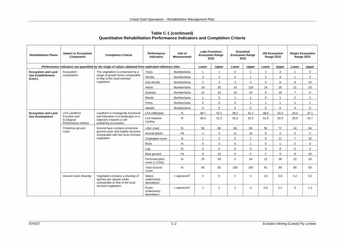
Cowal Gold Operations – Rehabilitation Management Plan
870437 C-2 Evolution Mining (Cowal) Pty Limited
Table C-1 (continued) Quantitative Rehabilitation Performance Indicators and Completion Criteria
Rehabilitation Phase Aspect or Ecosystem Component Completion Criteria Performance
Indicators Unit of
Measurement
Lake Foreshore Ecosystem Range
2015
Grassland Ecosystem Range
2015
Hill Ecosystem Range 2015
Slopes Ecosystem Range 2015
Performance indicators are quantified by the range of values obtained from replicated reference sites Lower Upper Lower Upper Lower Upper Lower Upper
Ecosystem and Land Use Establishment (Cont.)
Ecosystem composition
The vegetation is comprised by a range of growth forms comparable to that of the local remnant vegetation
Trees Number/area 1 1 0 1 1 4 1 3
Shrubs Number/area 3 4 0 1 2 3 1 2
Sub-shrubs Number/area 2 4 2 4 0 8 8 10
Herbs Number/area 19 26 14 118 14 25 21 23
Grasses Number/area 12 13 10 10 9 16 7 9
Reeds Number/area 1 2 1 1 0 1 2 2
Ferns Number/area 0 0 0 1 1 1 1 1
Aquatic Number/area 0 0 0 0 0 0 0 0
Ecosystem and Land Use Development
LFA Landform Function and Ecological Performance indices
Landform is ecologically functional and indicative of a landscape on a trajectory towards a self-sustaining ecosystem
LFA Infiltration % 48.7 52.1 38.2 41.1 38.6 53.3 29.4 37.1
LFA Nutrient Cycling
% 36.9 51.3 42.3 42.3 41.8 52.8 29.9 43.7
Protective ground cover
Ground layer contains protective ground cover and habitat structure comparable with the local remnant vegetation
Litter cover % 56 66 68 84 56 71 44 64
Annual plants <% 1 3 11 16 0 2 0 2
Cryptogam cover % 1 2 0 1 0 11 7 10
Rock % 0 0 0 1 0 1 0 0
Log % 0 0 0 0 3 8 0 2
Bare ground <% 9 10 0 0 2 9 8 20
Perennial plant cover (< 0.5m)
% 25 29 6 16 12 36 22 24
Total Ground Cover
% 90 92 100 100 91 99 80 93
Ground cover diversity Vegetation contains a diversity of species per square meter comparable to that of the local remnant vegetation
Native understorey abundance
> species/m2 3 5 2 4 2.6 6.8 4.2 5.2
Exotic understorey abundance
< species/m2 1 2 2 3 0.6 2.2 0 1.2

Cowal Gold Operations – Rehabilitation Management Plan
870437 C-3 Evolution Mining (Cowal) Pty Limited
Table C-1 (continued) Quantitative Rehabilitation Performance Indicators and Completion Criteria
Rehabilitation Phase Aspect or
Ecosystem Component
Completion Criteria Performance Indicators
Unit of Measurement
Lake Foreshore Ecosystem Range
2015
Grassland Ecosystem Range
2015
Hill Ecosystem Range 2015
Slopes Ecosystem Range 2015
Performance indicators are quantified by the range of values obtained from replicated reference sites Lower Upper Lower Upper Lower Upper Lower Upper
Ecosystem and Land Use Development (Cont.)
Native ground cover abundance
Native ground cover abundance is comparable to that of the local remnant vegetation
Percent ground cover provided by native vegetation <0.5m tall
% 68.2 83.3 48 54 63 93 83 98
Ecosystem growth and natural recruitment
The vegetation is maturing and/or natural recruitment is occurring at rates similar to those of the local remnant vegetation
shrubs and juvenile trees 0 - 0.5m in height
No./area 32 56 1 1 2 13 3 8
shrubs and juvenile trees 0.5 - 1m in height
No./area 59 80 0 0 0 14 6 8
shrubs and juvenile trees 1 - 1.5m in height
No./area 28 66 0 0 0 7 7 9
shrubs and juvenile trees 1.5 - 2m in height
No./area 14 28 0 0 0 2 1 9
shrubs and juvenile trees >2m in height
No./area 10 14 0 0 0 43 16 18
Ecosystem structure
The vegetation is developing in structure and complexity comparable to that of the local remnant vegetation
Foliage cover 0.5 - 2 m % cover 2 3 0 0 0 11 3 12
Foliage cover 2 - 4m % cover 0 0 0 0 0 13 6 10
Foliage cover 4 - 6m % cover 0 3 0 0 0 11 0 6
Foliage cover >6m % cover 0 12 0 0 0 26 0 15
Tree diversity Vegetation contains a diversity of maturing tree and shrubs species comparable to that of the local remnant vegetation
Tree diversity species/area 1 2 0 0 2 5 1 2
% 100 100 0 0 100 100 100 100
Tree density Vegetation contains a density of maturing tree and shrubs species comparable to that of the local remnant vegetation
Tree density No./area 1 12 0 0 6 53 5 24
Average dbh cm 24 94 0 0 11 50 13 17
Ecosystem health The vegetation is in a condition comparable to that of the local remnant vegetation
Live trees % population 100 100 0 0 57 100 80 88
Healthy trees % population 0 50 0 0 14 83 40 46
Medium health % population 42 100 0 0 17 58 20 42
Advanced dieback % population 0 8 0 0 0 7 0 20
Dead Trees % population 0 0 0 0 0 43 0 13
Mistletoe % population 0 0 0 0 0 0 0 0
Flowers/fruit: Trees % population 0 0 0 0 15 83 0 0
Hollows: Trees % population 0 100 0 0 0 33 0 8
Source: DnA Environmental (2016b; 2017)

Cowal Gold Operations – Rehabilitation Management Plan
870437 Evolution Mining (Cowal) Pty Limited
ATTACHMENT 1
CGO ENVIRONMENTAL MANAGEMENT SYSTEM

Environmental Management StrategyEnvironmental Management Strategy
Monitoring Plan
Noise Management Plan
Noise Monitoring Program
Blast Management PlanBlast Management Plan
Blast Monitoring Program
Air Quality Management Plan
Air Quality Monitoring Program
Water Management Plan
Surface Water Monitoring Program
Emergency Response Plan
Hazardous Waste and ChemicalManagement Plan
Hazardous Waste and ChemicalManagement Plan
Cyanide Management Plan
Transport of Hazardous Materials Study
Indigenous Archaeology andCultural Heritage Management Plan
Indigenous Archaeology andCultural Heritage Management Plan
Heritage Management PlanHeritage Management PlanSurface Water, Groundwater,Meteorological and Biological
Monitoring Programme
Surface Water, Groundwater,Meteorological and Biological
Monitoring Programme
Groundwater Monitoring Program
Monitoring Programme for Lake ProtectionBund, Water Storage and Tailings Structures
and Pit-void Walls
Monitoring Programme for Lake ProtectionBund, Water Storage and Tailings Structures
and Pit-void Walls
Rehabilitation Management Planincluding Rehabilitation and
Landscape Strategy
Rehabilitation Management Planincluding Rehabilitation and
Landscape Strategy
Rehabilitation Monitoring Program
Flora and Fauna Management Plan
Threatened Species Management Protocol
Land Management Plan
Soil Stripping Management Plan
Erosion and Sediment ControlManagement Plan
Erosion and Sediment ControlManagement Plan
Biodiversity Offset Management Planincluding Offset Strategy
Biodiversity Offset Management Planincluding Offset Strategy
Offset Monitoring Program
Threatened Species Management Strategies
Cowal Gold Project EIS (1998)
DA (14/98)
Notification of Modification (Mod 13)(February 2017)
Notification of Modification (Mod 13)(February 2017)
Annual Review
Independent Environmental Audit
EPL 11912
ML 1535
DA (2011/64)(Eastern Saline Borefield)
DA (2011/64)(Eastern Saline Borefield)
Independent Monitoring Panel Review
Compensatory WetlandManagement Plan
Compensatory WetlandManagement Plan
Mining Operations Plan
R E H A B I L I TAT I O N M A N A G E M E N T S T R AT E G Y
HAL-02-07 CGO MP 2017_RMP_003B
CGO EnvironmentalManagement System
ATTACHMENT 1