C Flood History Table · PDF file · 2015-11-20C Flood History Table ... (report)...
46
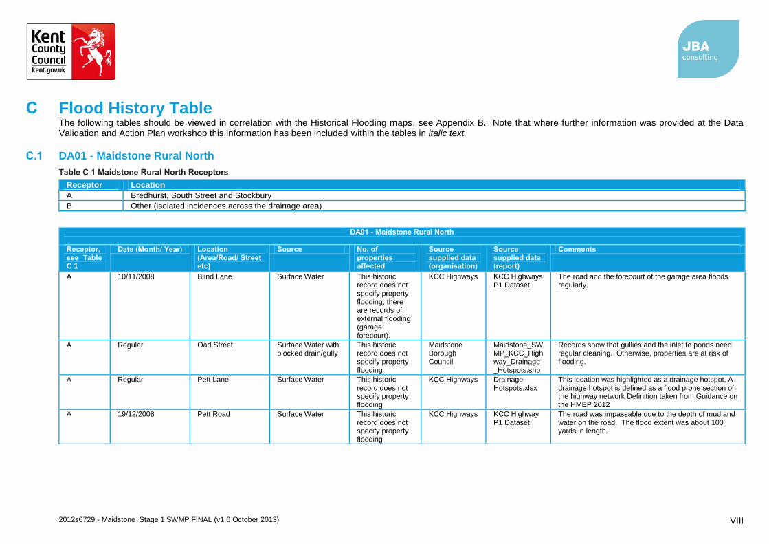
2012s6729 - Maidstone Stage 1 SWMP FINAL (v1.0 October 2013) VIII C Flood History Table The following tables should be viewed in correlation with the Historical Flooding maps, see Appendix B. Note that where further information was provided at the Data Validation and Action Plan workshop this information has been included within the tables in italic text. C.1 DA01 - Maidstone Rural North Table C 1 Maidstone Rural North Receptors Receptor Location A Bredhurst, South Street and Stockbury B Other (isolated incidences across the drainage area) DA01 - Maidstone Rural North Receptor, see Table C 1 Date (Month/ Year) Location (Area/Road/ Street etc) Source No. of properties affected Source supplied data (organisation) Source supplied data (report) Comments A 10/11/2008 Blind Lane Surface Water This historic record does not specify property flooding; there are records of external flooding (garage forecourt). KCC Highways KCC Highways P1 Dataset The road and the forecourt of the garage area floods regularly. A Regular Oad Street Surface Water with blocked drain/gully This historic record does not specify property flooding Maidstone Borough Council Maidstone_SW MP_KCC_High way_Drainage _Hotspots.shp Records show that gullies and the inlet to ponds need regular cleaning. Otherwise, properties are at risk of flooding. A Regular Pett Lane Surface Water This historic record does not specify property flooding KCC Highways Drainage Hotspots.xlsx This location was highlighted as a drainage hotspot, A drainage hotspot is defined as a flood prone section of the highway network Definition taken from Guidance on the HMEP 2012 A 19/12/2008 Pett Road Surface Water This historic record does not specify property flooding KCC Highways KCC Highway P1 Dataset The road was impassable due to the depth of mud and water on the road. The flood extent was about 100 yards in length.
Transcript of C Flood History Table · PDF file · 2015-11-20C Flood History Table ... (report)...
2012s6729 - Maidstone Stage 1 SWMP FINAL (v1.0 October 2013) VIII
C Flood History Table The following tables should be viewed in correlation with the Historical Flooding maps, see Appendix B. Note that where further information was provided at the Data Validation and Action Plan workshop this information has been included within the tables in italic text.
C.1 DA01 - Maidstone Rural North
Table C 1 Maidstone Rural North Receptors
Receptor Location
A Bredhurst, South Street and Stockbury
B Other (isolated incidences across the drainage area)
DA01 - Maidstone Rural North
Receptor, see Table C 1
Date (Month/ Year) Location (Area/Road/ Street etc)
Source No. of properties affected
Source supplied data (organisation)
Source supplied data (report)
Comments
A 10/11/2008 Blind Lane Surface Water This historic record does not specify property flooding; there are records of external flooding (garage forecourt).
KCC Highways KCC Highways P1 Dataset
The road and the forecourt of the garage area floods regularly.
A Regular Oad Street Surface Water with blocked drain/gully
This historic record does not specify property flooding
Maidstone Borough Council
Maidstone_SWMP_KCC_Highway_Drainage_Hotspots.shp
Records show that gullies and the inlet to ponds need regular cleaning. Otherwise, properties are at risk of flooding.
A Regular Pett Lane Surface Water This historic record does not specify property flooding
KCC Highways Drainage Hotspots.xlsx
This location was highlighted as a drainage hotspot, A drainage hotspot is defined as a flood prone section of the highway network Definition taken from Guidance on the HMEP 2012
A 19/12/2008 Pett Road Surface Water This historic record does not specify property flooding
KCC Highways KCC Highway P1 Dataset
The road was impassable due to the depth of mud and water on the road. The flood extent was about 100 yards in length.
2012s6729 - Maidstone Stage 1 SWMP FINAL (v1.0 October 2013) IX
DA01 - Maidstone Rural North
Receptor, see Table C 1
Date (Month/ Year) Location (Area/Road/ Street etc)
Source No. of properties affected
Source supplied data (organisation)
Source supplied data (report)
Comments
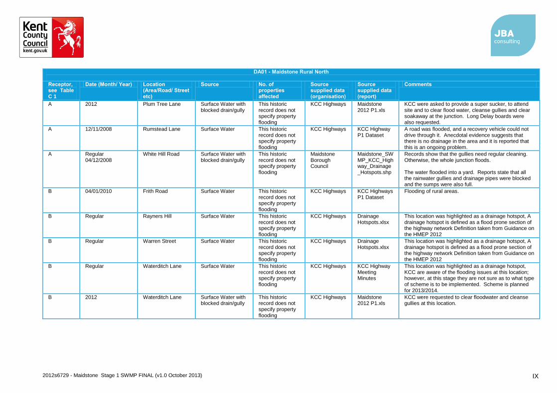
A 2012 Plum Tree Lane Surface Water with blocked drain/gully
This historic record does not specify property flooding
KCC Highways Maidstone 2012 P1.xls
KCC were asked to provide a super sucker, to attend site and to clear flood water, cleanse gullies and clear soakaway at the junction. Long Delay boards were also requested.
A 12/11/2008 Rumstead Lane Surface Water This historic record does not specify property flooding
KCC Highways KCC Highway P1 Dataset
A road was flooded, and a recovery vehicle could not drive through it. Anecdotal evidence suggests that there is no drainage in the area and it is reported that this is an ongoing problem.
A Regular 04/12/2008
White Hill Road Surface Water with blocked drain/gully
This historic record does not specify property flooding
Maidstone Borough Council
Maidstone_SWMP_KCC_Highway_Drainage_Hotspots.shp
Records show that the gullies need regular cleaning. Otherwise, the whole junction floods. The water flooded into a yard. Reports state that all the rainwater gullies and drainage pipes were blocked and the sumps were also full.
B 04/01/2010 Frith Road Surface Water This historic record does not specify property flooding
KCC Highways KCC Highways P1 Dataset
Flooding of rural areas.
B Regular Rayners Hill Surface Water This historic record does not specify property flooding
KCC Highways Drainage Hotspots.xlsx
This location was highlighted as a drainage hotspot, A drainage hotspot is defined as a flood prone section of the highway network Definition taken from Guidance on the HMEP 2012
B Regular Warren Street Surface Water This historic record does not specify property flooding
KCC Highways Drainage Hotspots.xlsx
This location was highlighted as a drainage hotspot, A drainage hotspot is defined as a flood prone section of the highway network Definition taken from Guidance on the HMEP 2012
B Regular Waterditch Lane Surface Water This historic record does not specify property flooding
KCC Highways KCC Highway Meeting Minutes
This location was highlighted as a drainage hotspot, KCC are aware of the flooding issues at this location; however, at this stage they are not sure as to what type of scheme is to be implemented. Scheme is planned for 2013/2014.
B 2012 Waterditch Lane Surface Water with blocked drain/gully
This historic record does not specify property flooding
KCC Highways Maidstone 2012 P1.xls
KCC were requested to clear floodwater and cleanse gullies at this location.
2012s6729 - Maidstone Stage 1 SWMP FINAL (v1.0 October 2013) X
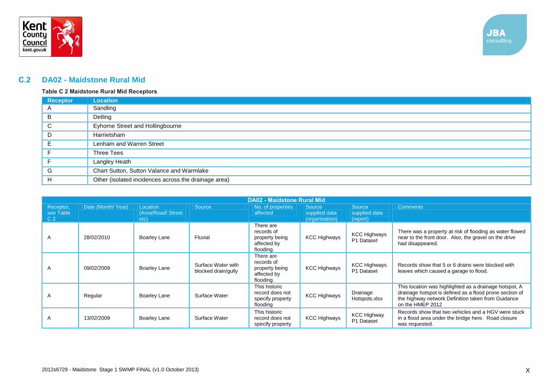
C.2 DA02 - Maidstone Rural Mid
Table C 2 Maidstone Rural Mid Receptors
Receptor Location
A Sandling
B Detling
C Eyhorne Street and Hollingbourne
D Harrietsham
E Lenham and Warren Street
F Three Tees
F Langley Heath
G Chart Sutton, Sutton Valance and Warmlake
H Other (isolated incidences across the drainage area)
DA02 - Maidstone Rural Mid Receptor, see Table C 2
Date (Month/ Year) Location (Area/Road/ Street etc)
Source No. of properties affected
Source supplied data (organisation)
Source supplied data (report)
Comments
A 28/02/2010 Boarley Lane Fluvial
There are records of property being affected by flooding.
KCC Highways KCC Highways P1 Dataset
There was a property at risk of flooding as water flowed near to the front door. Also, the gravel on the drive had disappeared.
A 09/02/2009 Boarley Lane Surface Water with blocked drain/gully
There are records of property being affected by flooding.
KCC Highways KCC Highways P1 Dataset
Records show that 5 or 6 drains were blocked with leaves which caused a garage to flood.
A Regular Boarley Lane Surface Water
This historic record does not specify property flooding
KCC Highways Drainage Hotspots.xlsx
This location was highlighted as a drainage hotspot, A drainage hotspot is defined as a flood prone section of the highway network Definition taken from Guidance on the HMEP 2012
A 13/02/2009 Boarley Lane Surface Water This historic record does not specify property
KCC Highways KCC Highway P1 Dataset
Records show that two vehicles and a HGV were stuck in a flood area under the bridge here. Road closure was requested.
2012s6729 - Maidstone Stage 1 SWMP FINAL (v1.0 October 2013) XI
DA02 - Maidstone Rural Mid Receptor, see Table C 2
Date (Month/ Year) Location (Area/Road/ Street etc)
Source No. of properties affected
Source supplied data (organisation)
Source supplied data (report)
Comments
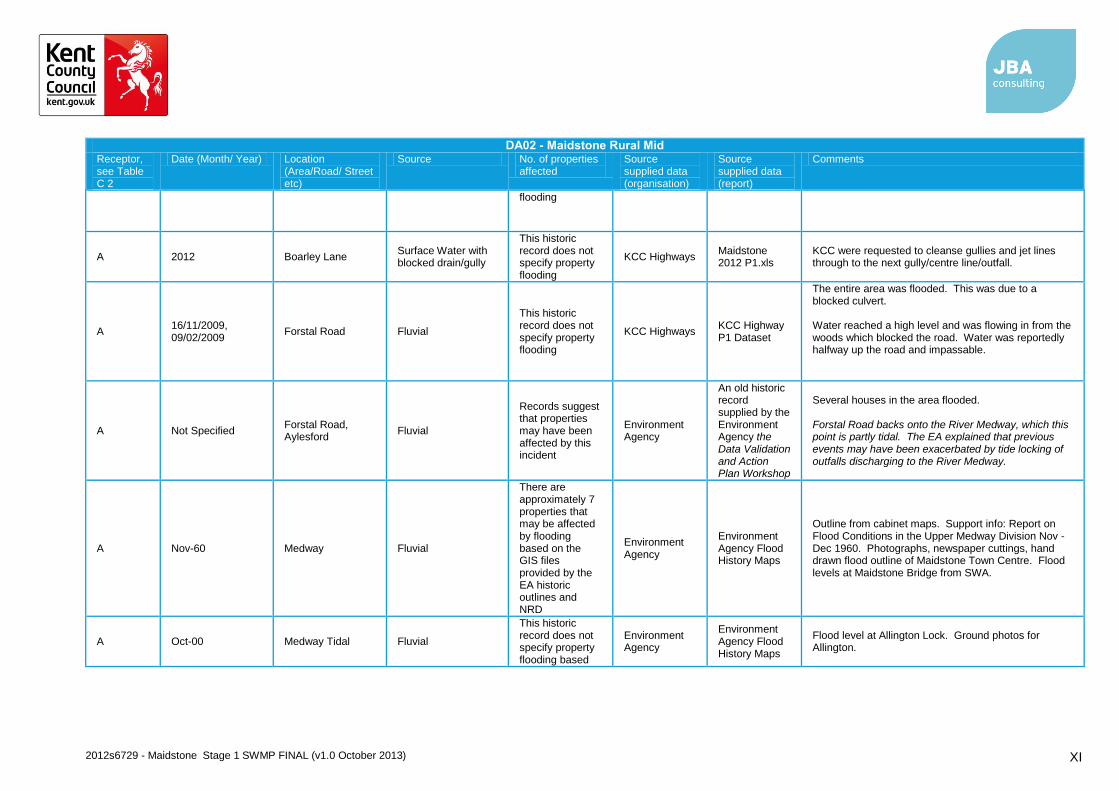
flooding
A 2012 Boarley Lane Surface Water with blocked drain/gully
This historic record does not specify property flooding
KCC Highways Maidstone 2012 P1.xls
KCC were requested to cleanse gullies and jet lines through to the next gully/centre line/outfall.
A 16/11/2009, 09/02/2009
Forstal Road Fluvial
This historic record does not specify property flooding
KCC Highways KCC Highway P1 Dataset
The entire area was flooded. This was due to a blocked culvert. Water reached a high level and was flowing in from the woods which blocked the road. Water was reportedly halfway up the road and impassable.
A Not Specified Forstal Road, Aylesford
Fluvial
Records suggest that properties may have been affected by this incident
Environment Agency
An old historic record supplied by the Environment Agency the Data Validation and Action Plan Workshop
Several houses in the area flooded. Forstal Road backs onto the River Medway, which this point is partly tidal. The EA explained that previous events may have been exacerbated by tide locking of outfalls discharging to the River Medway.
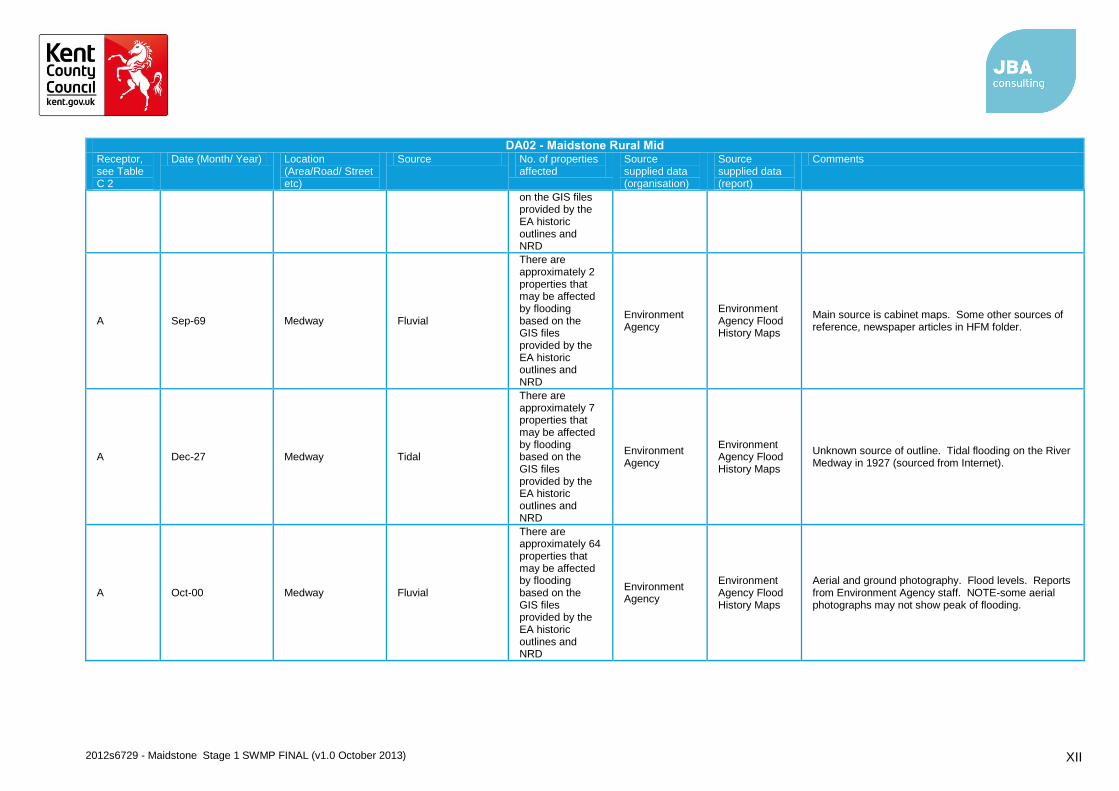
A Nov-60 Medway Fluvial
There are approximately 7 properties that may be affected by flooding based on the GIS files provided by the EA historic outlines and NRD
Environment Agency
Environment Agency Flood History Maps
Outline from cabinet maps. Support info: Report on Flood Conditions in the Upper Medway Division Nov - Dec 1960. Photographs, newspaper cuttings, hand drawn flood outline of Maidstone Town Centre. Flood levels at Maidstone Bridge from SWA.
A Oct-00 Medway Tidal Fluvial
This historic record does not specify property flooding based
Environment Agency
Environment Agency Flood History Maps
Flood level at Allington Lock. Ground photos for Allington.
2012s6729 - Maidstone Stage 1 SWMP FINAL (v1.0 October 2013) XII
DA02 - Maidstone Rural Mid Receptor, see Table C 2
Date (Month/ Year) Location (Area/Road/ Street etc)
Source No. of properties affected
Source supplied data (organisation)
Source supplied data (report)
Comments
on the GIS files provided by the EA historic outlines and NRD
A Sep-69 Medway Fluvial
There are approximately 2 properties that may be affected by flooding based on the GIS files provided by the EA historic outlines and NRD
Environment Agency
Environment Agency Flood History Maps
Main source is cabinet maps. Some other sources of reference, newspaper articles in HFM folder.
A Dec-27 Medway Tidal
There are approximately 7 properties that may be affected by flooding based on the GIS files provided by the EA historic outlines and NRD
Environment Agency
Environment Agency Flood History Maps
Unknown source of outline. Tidal flooding on the River Medway in 1927 (sourced from Internet).
A Oct-00 Medway Fluvial
There are approximately 64 properties that may be affected by flooding based on the GIS files provided by the EA historic outlines and NRD
Environment Agency
Environment Agency Flood History Maps
Aerial and ground photography. Flood levels. Reports from Environment Agency staff. NOTE-some aerial photographs may not show peak of flooding.

2012s6729 - Maidstone Stage 1 SWMP FINAL (v1.0 October 2013) XIII
DA02 - Maidstone Rural Mid Receptor, see Table C 2
Date (Month/ Year) Location (Area/Road/ Street etc)
Source No. of properties affected
Source supplied data (organisation)
Source supplied data (report)
Comments
B 2000 Detling Other/ Unknown
This historic record does not specific property flooding
Maidstone Borough Council
Maidstone Borough Council Meeting Minutes
This area was affected by flooding in 2000.
B 15/01/2009 Detling Hill Other/ Unknown
This historic record does not specify property flooding
KCC Highways KCC Highways P1 dataset
Reports state that water was flowing down a bank and onto the road. It was unclear where the water was coming from.
B 2012 Hermitage Lane Surface Water
This historic record does not specify property flooding
KCC Highways Maidstone 2012 P1.xls
KCC were asked to provide a tanker to remove flood water.
B 10/11/2008 Pilgrims Way Surface Water with blocked drain/gully
This historic record does not specify property flooding
KCC Highways KCC Highway P1 Dataset
A drain was blocked opposite Jay's crossing.
B Regular Scragged Oak Road
Surface Water
There are records of property being affected by flooding in the past.
KCC Highways KCC Highway Meeting Minutes
KCC suggests this road requires a CCTV survey to investigate the issues within the gullies.
B 2012 Scragged Oak Road
Surface Water with blocked drain/gully
This historic record does not specify property flooding
KCC Highways Maidstone 2012 P1.xls
KCC were asked to provide a combo, to attend site and clear flood water and cleanse gullies. They were also requested to jet the lines through to the next gully/main line.
B 01/11/2008 Scragged Oak Road
Surface Water
There are records of property being affected by flooding in the past.
KCC Highways KCC Highway P1 Dataset
Water was reportedly overflowing out of a drain and flooded the road. There has been property damage in this area in the past.
B Regular Scragged Oak Road
Surface Water
This historic record does not specify property flooding
KCC Highways Drainage Hotspots.xlsx
This location was highlighted as a drainage hotspot, A drainage hotspot is defined as a flood prone section of the highway network Definition taken from Guidance on the HMEP 2012
2012s6729 - Maidstone Stage 1 SWMP FINAL (v1.0 October 2013) XIV
DA02 - Maidstone Rural Mid Receptor, see Table C 2
Date (Month/ Year) Location (Area/Road/ Street etc)
Source No. of properties affected
Source supplied data (organisation)
Source supplied data (report)
Comments
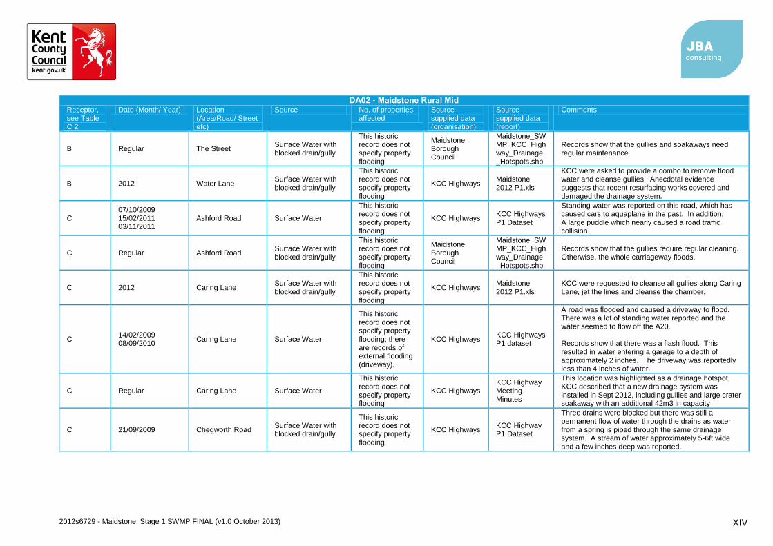
B Regular The Street Surface Water with blocked drain/gully
This historic record does not specify property flooding
Maidstone Borough Council
Maidstone_SWMP_KCC_Highway_Drainage_Hotspots.shp
Records show that the gullies and soakaways need regular maintenance.
B 2012 Water Lane Surface Water with blocked drain/gully
This historic record does not specify property flooding
KCC Highways Maidstone 2012 P1.xls
KCC were asked to provide a combo to remove flood water and cleanse gullies. Anecdotal evidence suggests that recent resurfacing works covered and damaged the drainage system.
C 07/10/2009 15/02/2011 03/11/2011
Ashford Road Surface Water
This historic record does not specify property flooding
KCC Highways KCC Highways P1 Dataset
Standing water was reported on this road, which has caused cars to aquaplane in the past. In addition, A large puddle which nearly caused a road traffic collision.
C Regular Ashford Road Surface Water with blocked drain/gully
This historic record does not specify property flooding
Maidstone Borough Council
Maidstone_SWMP_KCC_Highway_Drainage_Hotspots.shp
Records show that the gullies require regular cleaning. Otherwise, the whole carriageway floods.
C 2012 Caring Lane Surface Water with blocked drain/gully
This historic record does not specify property flooding
KCC Highways Maidstone 2012 P1.xls
KCC were requested to cleanse all gullies along Caring Lane, jet the lines and cleanse the chamber.
C 14/02/2009 08/09/2010
Caring Lane Surface Water
This historic record does not specify property flooding; there are records of external flooding (driveway).
KCC Highways KCC Highways P1 dataset
A road was flooded and caused a driveway to flood. There was a lot of standing water reported and the water seemed to flow off the A20. Records show that there was a flash flood. This resulted in water entering a garage to a depth of approximately 2 inches. The driveway was reportedly less than 4 inches of water.
C Regular Caring Lane Surface Water
This historic record does not specify property flooding
KCC Highways KCC Highway Meeting Minutes
This location was highlighted as a drainage hotspot, KCC described that a new drainage system was installed in Sept 2012, including gullies and large crater soakaway with an additional 42m3 in capacity
C 21/09/2009 Chegworth Road Surface Water with blocked drain/gully
This historic record does not specify property flooding
KCC Highways KCC Highway P1 Dataset
Three drains were blocked but there was still a permanent flow of water through the drains as water from a spring is piped through the same drainage system. A stream of water approximately 5-6ft wide and a few inches deep was reported.

2012s6729 - Maidstone Stage 1 SWMP FINAL (v1.0 October 2013) XV
DA02 - Maidstone Rural Mid Receptor, see Table C 2
Date (Month/ Year) Location (Area/Road/ Street etc)
Source No. of properties affected
Source supplied data (organisation)
Source supplied data (report)
Comments
C 08/09/2010 Eyhorne Street in Eyhorne Street
Surface Water with blocked drain/gully
There are records of property being affected by flooding.
KCC Highways KCC Highways P1 Dataset
Both storm drains were blocked with silt and were unable to drain the water away. This caused flooding and water entered a property via the front and back doors.
C Not Specified Eyhorne Street, Hollingbourne
Surface Water
This historic record does not specific property flooding
Maidstone Borough Council
Maidstone Borough Council Meeting Minutes and the Data Validation and Action Plan Workshop
There is a small ditch that flows through Eyhorne Street which has caused issues in the past. The EA at the Data Validation and Action Plan Workshop described that the watercourses in this area are spring fed and arecharacterized by small channels The ditch is the responsibility of the landowner.
C 11/11/2008 Eyhorne Street, Hollingbourne
Surface Water
This historic record does not specify property flooding
KCC Highways KCC Highways P1 dataset
Flooding was recorded at this location.
C 16/01/2010 Lower Street Fluvial
This historic record does not specify property flooding
KCC Highways KCC Highway P1 Dataset
The B2163 (Lower Street) was flooded on both sides of the carriageway. The water was quite deep and one car broke down after going through it (near a small stream).
C 2012 Lower Street Surface Water
This historic record does not specify property flooding
KCC Highways Maidstone 2012 P1.xls
KCC were asked to provide a tanker to clear flood water.
C Regular Lower Street Surface Water
This historic record does not specify property flooding
KCC Highways Drainage Hotspots.xlsx
This location was highlighted as a drainage hotspot, A drainage hotspot is defined as a flood prone section of the highway network Definition taken from Guidance on the HMEP(Highways Maintenance Efficiency Programme) 2012
C 28/02/2010 Old Mill Road Surface Water
This historic record does not specify property flooding
KCC Highways KCC Highway P1 Dataset
A privately owned fishing lake was overflowing near a commercial property on Old Mill Road.
C 2012 Old Mill Road Surface Water This historic record does not specify property
KCC Highways Maidstone 2012 P1.xls
KCC were requested to erect flood boards on either side of the flood by the lake (near Old Mill Farm), Old Mill Road, Leeds, Maidstone (Incident Make Safe)

2012s6729 - Maidstone Stage 1 SWMP FINAL (v1.0 October 2013) XVI
DA02 - Maidstone Rural Mid Receptor, see Table C 2
Date (Month/ Year) Location (Area/Road/ Street etc)
Source No. of properties affected
Source supplied data (organisation)
Source supplied data (report)
Comments
flooding
C 11/11/2008 Penfold Hill Fluvial
This historic record does not specify property flooding
KCC Highways KCC Highway P1 Dataset
There was flooding at this location.
C 2009 Queensway Sewer
This historic record does not specify property flooding
Southern Water
initial_summary.csv
Hydraulic overload of foul sewer.
D 13/11/2009 Ashford Road Surface Water
This historic record does not specify property flooding
KCC Highways KCC Highways P1 Dataset
The water was reportedly 12 inches deep at this location.
D Regular Ashford Road Surface Water with blocked drain/gully
This historic record does not specify property flooding
Maidstone Borough Council
Maidstone_SWMP_KCC_Highway_Drainage_Hotspots.shp
Records show that the gullies needed cleaning. Otherwise, the whole carriageway would be flooded.
D Not Specified Ashford Road, Harrietsham
Surface Water
This historic record does not specify property flooding
Maidstone Borough Council
Maidstone Borough Council SFRA
There was 1 incident of flooding at this location. Records suggest that the cause of flooding is surface water run off from an impermeable surface. The main receptor is highway.
D Not Specified Ashford Road, Harrietsham
Surface Water
This historic record does not specify property flooding
KCC and Environment Agency
Data Validation and Action Plan Workshop
The EA explained that the watercourse is spring fed and is easily blocked.
D Not Specified Chippendale Drive Surface Water
This historic record does not specify property flooding
Maidstone Borough Council
Maidstone Borough Council SFRA
There were 2 incidents of blocked culverts due to increased runoff from a new development which caused flooding on the Highway and some gardens.
D 10/02/2009 Church Road Surface Water
This historic record does not specify property flooding
KCC Highways KCC Highways P1 dataset
The road was flooded and the water depth was approximately 1.5ft.
D Not Specified Church Road Surface Water This historic record does not specific property
Maidstone Borough Council
Maidstone Borough Council
The attenuation pond off of Church Road is not maintained may exacerbate flooding during extreme events
2012s6729 - Maidstone Stage 1 SWMP FINAL (v1.0 October 2013) XVII
DA02 - Maidstone Rural Mid Receptor, see Table C 2
Date (Month/ Year) Location (Area/Road/ Street etc)
Source No. of properties affected
Source supplied data (organisation)
Source supplied data (report)
Comments
flooding Meeting Minutes
D Not Specified Church Road / Court Lodge Lane
Surface Water
There are records of a property being affected by flooding
Maidstone Borough Council
Maidstone Borough Council SFRA
There have been 2 incidents of surface water flooding at this location due to blocked gullies and high intensity rainfall which has caused the highway and a garage to flood.
D 02/02/2010 East Street Surface Water
This historic record does not specify property flooding
KCC Highways KCC Highways P1 Dataset
There was standing water on the road and the footpath which did not drain away. Records show that the water was approximately 2-3 inches deep and about 8 houses in length. This has been an ongoing problem for the last few years.
D Not Specified East Street Fluvial
This historic record does not specify property flooding
Maidstone Borough Council
Maidstone Borough Council SFRA
There was 1 incident of a tributary overtopping due to blockages.
D 2012 Fairbourne Lane Surface Water with blocked drain/gully
This historic record does not specify property flooding
KCC Highways Maidstone 2012 P1.xls
KCC were requested to clear blocked gullies and jet connecting pipelines through. There was a burst water main but due to blocked gullies, the water had nowhere to go.
D Not Specified Fairbourne Lane Surface Water
This historic record does not specify property flooding
Maidstone Borough Council
Maidstone Borough Council SFRA
Runoff from fields which affected a highway.
D 10/11/2008 Forge Meadow Surface Water
This historic record does not specify property flooding
KCC Highways KCC Highways P1 dataset
The road was flooded to the lip of the kerb. There are sloping driveways in the area and there were concerns that they could be flooded.
D 14/11/2008 30/11/2009
Goddington Lane Surface Water
This historic record does not specify property flooding
KCC Highways KCC Highways P1 Dataset
Records show that drains were overflowing onto the road. The lane was flooded. There was a constant stream of water flowing down the road and water was getting very close to the properties.
D Not Specified Goddington Lane Surface Water with blocked drain/gully
This historic record does not specify property
Maidstone Borough Council
Maidstone Borough Council SFRA
There was 1 incident of blocked gullies at this location and insufficient culver capacity which resulted in the highway being flooded.
2012s6729 - Maidstone Stage 1 SWMP FINAL (v1.0 October 2013) XVIII
DA02 - Maidstone Rural Mid Receptor, see Table C 2
Date (Month/ Year) Location (Area/Road/ Street etc)
Source No. of properties affected
Source supplied data (organisation)
Source supplied data (report)
Comments
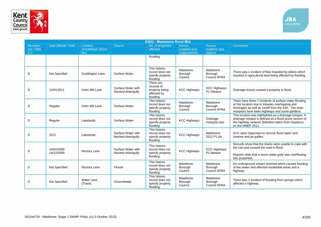
flooding
D Not Specified Goddington Lane Surface Water
This historic record does not specify property flooding
Maidstone Borough Council
Maidstone Borough Council SFRA
There was 1 incident of flow impeded by debris which resulted in agricultural land being affected by flooding.
D 12/01/2011 Holm Mill Lane Surface Water with blocked drain/gully
There are records of property being affected by flooding.
KCC Highways KCC Highways P1 Dataset
Drainage issues caused a property to flood.
D Regular Holm Mill Lane Surface Water
This historic record does not specify property flooding
Maidstone Borough Council
Maidstone Borough Council SFRA
There have been 7 incidents of surface water flooding at this location due to tributary overtopping and blockages as well as runoff from the A20. The main receptors have been highways and some gardens.
D Regular Lakelands Surface Water
This historic record does not specify property flooding
KCC Highways Drainage Hotspots.xlsx
This location was highlighted as a drainage hotspot, A drainage hotspot is defined as a flood prone section of the highway network Definition taken from Guidance on the HMEP 2012
D 2012 Lakelands Surface Water with blocked drain/gully
This historic record does not specify property flooding
KCC Highways Maidstone 2012 P1.xls
KCC were requested to remove flood water and cleanse and jet gullies.
D 10/02/2009 14/12/2009
Rectory Lane Surface Water with blocked drain/gully
This historic record does not specify property flooding
KCC Highways KCC Highways P1 dataset
Records show that the drains were unable to cope with the rain and caused the road to flood. Reports state that a storm water gully was overflowing into properties.
D Not Specified Rectory Lane Fluvial
This historic record does not specify property flooding
Maidstone Borough Council
Maidstone Borough Council SFRA
An underground stream diverted which caused flooding of the sewer and affected residential areas and a highway.
D Not Specified Water Lane (Track)
Groundwater
This historic record does not specify property flooding
Maidstone Borough Council
Maidstone Borough Council SFRA
There was 1 incident of flooding from springs which affected a highway.

2012s6729 - Maidstone Stage 1 SWMP FINAL (v1.0 October 2013) XIX
DA02 - Maidstone Rural Mid Receptor, see Table C 2
Date (Month/ Year) Location (Area/Road/ Street etc)
Source No. of properties affected
Source supplied data (organisation)
Source supplied data (report)
Comments
D Not Specified West Street Surface Water
This historic record does not specify property flooding
Maidstone Borough Council
Maidstone Borough Council SFRA
There was 1 incident of blocked culverts due to increased runoff from a new development which caused flooding on the Highway and some gardens.
D,E 01/11/2008 A20, Ashford Road, Harrietsham
Surface Water
This historic record does not specify property flooding
KCC Highways KCC Highway P1 Dataset
The road was flooded and the water depth was approximately 1ft.
E 2012 Ashford Road Surface Water with blocked drain/gully
This historic record does not specify property flooding
KCC Highways Maidstone 2012 P1.xls
KCC were requested to remove floodwater, cleanse and jet any gullies as required to prevent further flooding.
E Regular Ashford Road Surface Water
This historic record does not specify property flooding
Maidstone Borough Council
Maidstone_SWMP_KCC_Highway_Drainage_Hotspots.shp
Insufficient soakaways in a verge caused flooding on the A20.
E 17/01/2011 03/11/2011
Ashford Road Surface Water
This historic record does not specify property flooding
KCC Highways KCC Highways P1 Dataset
The road was flooded. No additional comments of the scale of flooding were provided. There was a large puddle with a depth of approximately 1ft which caused an obstruction on the road.
E Not specified Court Lodge Sewer
This historic record does not specify property flooding
Maidstone Borough Council
Maidstone Borough Council SFRA
No further comment was provided
E 02/11/2008 Ham Lane Surface Water
This historic record does not specify property flooding
KCC Highways KCC Highway P1 Dataset
The whole road was flooded curb to curb. The water depth was approximately 4-5 inches.
E 28/02/2010 Headcorn Road Surface Water with blocked drain/gully
This historic record does not specify property flooding
KCC Highways KCC Highways P1 Dataset
An overflowing gully caused the carriageway to flood. The water flowed onto the embankment then flowed onto the M20.
E 2012 Headcorn Road Surface Water with blocked drain/gully
This historic record does not specify property flooding
KCC Highways Maidstone 2012 P1.xls
KCC were requested to clear floodwater and cleanse gullies and jet the lines through to the next gully/centre line.

2012s6729 - Maidstone Stage 1 SWMP FINAL (v1.0 October 2013) XX
DA02 - Maidstone Rural Mid Receptor, see Table C 2
Date (Month/ Year) Location (Area/Road/ Street etc)
Source No. of properties affected
Source supplied data (organisation)
Source supplied data (report)
Comments
E 29/07/2008 Headcorn Road near Grafty Green
Surface Water
This historic record does not specify property flooding
KCC Highways KCC Highway P1 Dataset
The road was flooded to a depth of approximately 1.5ft.
E Not specified High Street, Lenham
Sewer
This historic record does not specify property flooding
Maidstone Borough Council
Maidstone Borough Council SFRA
No further comment was provided
E Not specified High Street, Lenham
Sewer A property was affected by flooding
Maidstone Borough Council
Maidstone Borough Council SFRA
A damage sewer flooded a property, this record did not indicate whether the flooding was internal or external
E 30/11/2009 Honywood Road Surface Water
This historic record does not specify property flooding; there are records of external flooding (pathway).
KCC Highways KCC Highways P1 Dataset
The road was flooded and water overflowed onto the pathway.
E Not specified Robins Close Sewer
This historic record does not specify property flooding
Maidstone Borough Council
Maidstone Borough Council SFRA
No further comment was provided
E 23/02/2010 The Square Other/ Unknown
This historic record does not specify property flooding
KCC Highways KCC Highway P1 Dataset
No additional comments provided.
E Not specified Westwood Surface Water No property was affected by this incident
Maidstone Borough Council
Maidstone Borough Council SFRA
The cause of flooding was as a result of poor drainage and topography
F 28/02/2010 Honey Lane Surface Water with blocked drain/gully
There are records of property being affected by flooding.
KCC Highways KCC Highways P1 Dataset
A blocked drain surcharged and water entered a property.
F 14/11/2009 08/09/2010
Honey Lane Surface Water There are records of property being affected by
KCC Highways KCC Highways P1 Dataset
The road was flooded and reports suggest that a front garden and garage were at risk and may have flooded. A garage was flooded again. This has been an

2012s6729 - Maidstone Stage 1 SWMP FINAL (v1.0 October 2013) XXI
DA02 - Maidstone Rural Mid Receptor, see Table C 2
Date (Month/ Year) Location (Area/Road/ Street etc)
Source No. of properties affected
Source supplied data (organisation)
Source supplied data (report)
Comments
flooding. ongoing issue for the previous 18 months and the last time it happened, prior to this event, the house was flooded.
G Regular Amber Lane Surface Water This historic record does not specify property flooding
Maidstone Borough Council
Maidstone_SWMP_KCC_Highway_Drainage_Hotspots.shp
This area has been highlighted as a drainage hotspot.
G 2012 Chart Hill Road Surface Water This historic record does not specify property flooding
KCC Highways Maidstone 2012 P1.xls
KCC were requested to provide a tanker to clear flood water and pump out trench line.
G Not Specified Chart Sutton Surface Water This historic record does not specific property flooding
Maidstone Borough Council
Maidstone Borough Council Meeting Minutes
The highway floods as a result of poor roadside drainage.
G 2012 Heath Road Sewer Records describe the curtilage of one property being affected
Southern Water
initial_summary.xlsx
Hydraulic overload of foul sewer
G 22/02/2010 Leeds Road Surface Water This historic record does not specify property flooding
KCC Highways KCC Highways P1 Dataset
This area has ongoing flooding problems. The road was flooded and there was an accident at this location. Reports state that the water was very deep.
G Regular Maidstone Road Surface Water This historic record does not specify property flooding
KCC Highways Drainage Hotspots.xlsx
This location was highlighted as a drainage hotspot, KCC described that drains located on the A274 require an investigation.
G Not Specified Marshall's corner, Chart Sutton
Surface Water This historic record does not specify property flooding
Environment Agency
An old historic record supplied by the Environment Agency
An unclassified road at Marshall's corner flooded at Chart Sutton.
G 10/02/2009 Norton Road Surface Water This historic record does not specify property flooding
KCC Highways KCC Highway P1 Dataset
Records show that a large stretch of road was flooded as a result of water flowing off the fields.

2012s6729 - Maidstone Stage 1 SWMP FINAL (v1.0 October 2013) XXII
DA02 - Maidstone Rural Mid Receptor, see Table C 2
Date (Month/ Year) Location (Area/Road/ Street etc)
Source No. of properties affected
Source supplied data (organisation)
Source supplied data (report)
Comments
G 2012 Pleasure House Lane
Surface Water with blocked drain/gully
This historic record does not specify property flooding
KCC Highways Maidstone 2012 P1.xls
KCC were requested to clear flood water and cleanse and jet drainage system to prevent further flooding.
G 10/02/2009 Plough Wents Road
Surface Water This historic record does not specify property flooding
KCC Highways KCC Highways P1 Dataset
Flooding was reportedly worse than usual.
G 10/11/2008 2012
Plough Wents Road
Surface Water with blocked drain/gully
This historic record does not specify property flooding
KCC Highways KCC Highways P1 Dataset
Records show that a ditch was blocked and water threatened to flood a property as the water levels were rising quickly. Flooding in rural areas. KCC were asked to provide a combo to clear floodwater, empty gullies and jet lines through to the next gully/main line.
G Regular Plough Wents Road
Surface Water This historic record does not specify property flooding
Maidstone Borough Council
Maidstone_SWMP_KCC_Highway_Drainage_Hotspots.shp
Reports state that flooding was observed and further investigation was needed.
G Regular Plough Wents Road
Surface Water This historic record does not specify property flooding
KCC Highways Drainage Hotspots.xlsx
This location was highlighted as a drainage hotspot, A drainage hotspot is defined as a flood prone section of the highway network Definition taken from Guidance on the HMEP 2012
G Not Specified Sutton Valance Surface Water This historic record does not specific property flooding
Maidstone Borough Council
Maidstone Borough Council Meeting Minutes
The drains at this location would benefit from more frequent maintenance.
G Not Specified Warmlake Crossroads, Sutton Valence
Surface Water This historic record does not specify property flooding
Environment Agency
An old historic record supplied by the Environment Agency
Flooding was recorded on A274. The existing soakaways did not function due to lack of permeable strata.
G Regular Warmlake Road Surface Water with blocked drain/gully
This historic record does not specify property flooding
Maidstone Borough Council
Maidstone_SWMP_KCC_Highway_Drainage_Hotspots.shp
Gullies and soakaways in a verge needed cleaning as they pose a flood risk to properties.
2012s6729 - Maidstone Stage 1 SWMP FINAL (v1.0 October 2013) XXIII
DA02 - Maidstone Rural Mid Receptor, see Table C 2
Date (Month/ Year) Location (Area/Road/ Street etc)
Source No. of properties affected
Source supplied data (organisation)
Source supplied data (report)
Comments
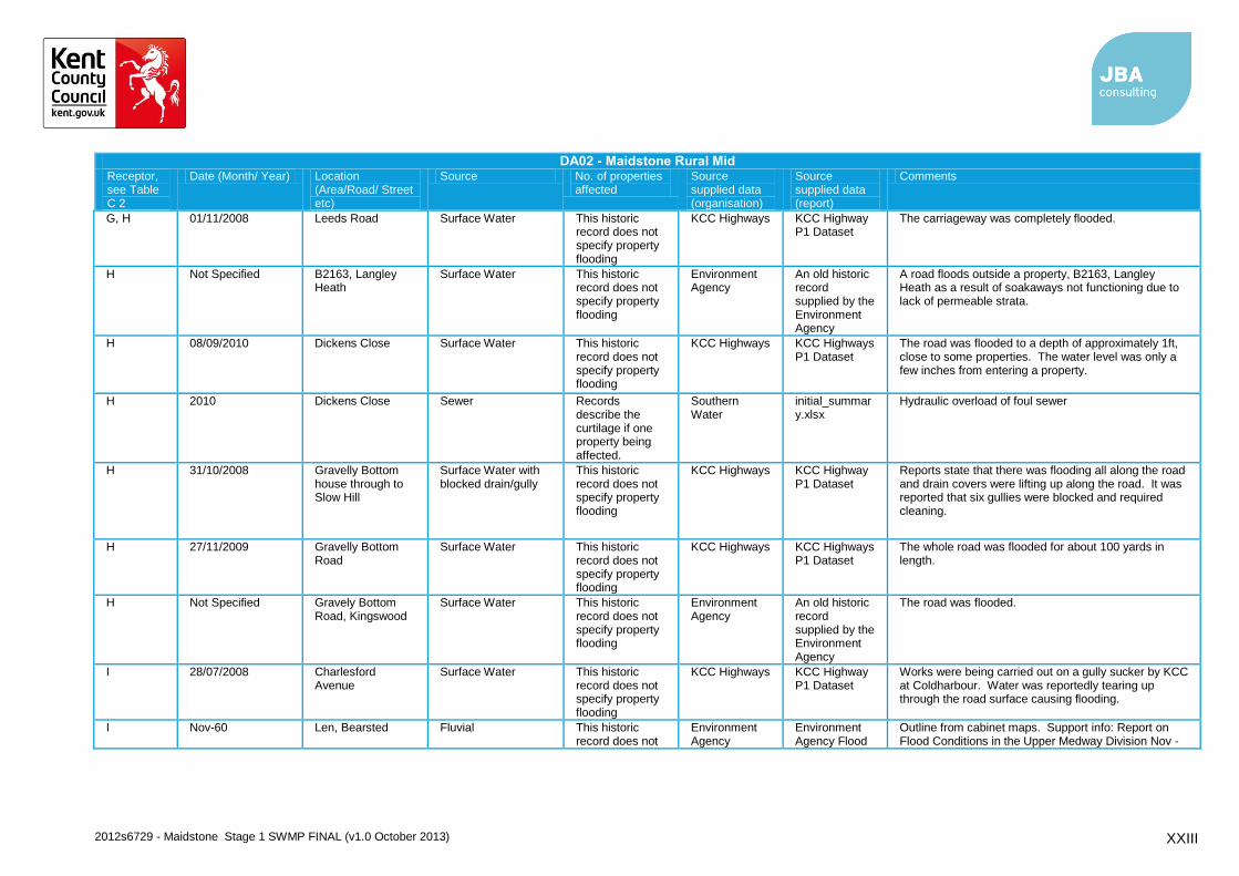
G, H 01/11/2008 Leeds Road Surface Water This historic record does not specify property flooding
KCC Highways KCC Highway P1 Dataset
The carriageway was completely flooded.
H Not Specified B2163, Langley Heath
Surface Water This historic record does not specify property flooding
Environment Agency
An old historic record supplied by the Environment Agency
A road floods outside a property, B2163, Langley Heath as a result of soakaways not functioning due to lack of permeable strata.
H 08/09/2010 Dickens Close Surface Water This historic record does not specify property flooding
KCC Highways KCC Highways P1 Dataset
The road was flooded to a depth of approximately 1ft, close to some properties. The water level was only a few inches from entering a property.
H 2010 Dickens Close Sewer Records describe the curtilage if one property being affected.
Southern Water
initial_summary.xlsx
Hydraulic overload of foul sewer
H 31/10/2008 Gravelly Bottom house through to Slow Hill
Surface Water with blocked drain/gully
This historic record does not specify property flooding
KCC Highways KCC Highway P1 Dataset
Reports state that there was flooding all along the road and drain covers were lifting up along the road. It was reported that six gullies were blocked and required cleaning.
H 27/11/2009 Gravelly Bottom Road
Surface Water This historic record does not specify property flooding
KCC Highways KCC Highways P1 Dataset
The whole road was flooded for about 100 yards in length.
H Not Specified Gravely Bottom Road, Kingswood
Surface Water This historic record does not specify property flooding
Environment Agency
An old historic record supplied by the Environment Agency
The road was flooded.
I 28/07/2008 Charlesford Avenue
Surface Water This historic record does not specify property flooding
KCC Highways KCC Highway P1 Dataset
Works were being carried out on a gully sucker by KCC at Coldharbour. Water was reportedly tearing up through the road surface causing flooding.
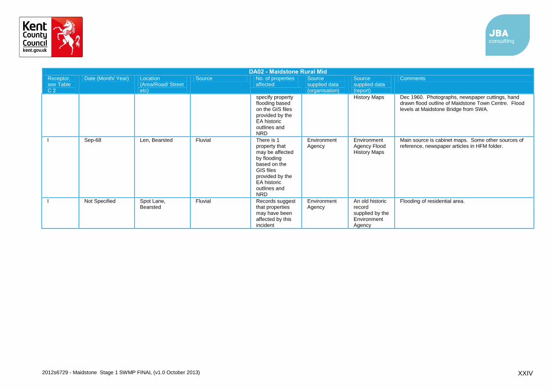
I Nov-60 Len, Bearsted Fluvial This historic record does not
Environment Agency
Environment Agency Flood
Outline from cabinet maps. Support info: Report on Flood Conditions in the Upper Medway Division Nov -
2012s6729 - Maidstone Stage 1 SWMP FINAL (v1.0 October 2013) XXIV
DA02 - Maidstone Rural Mid Receptor, see Table C 2
Date (Month/ Year) Location (Area/Road/ Street etc)
Source No. of properties affected
Source supplied data (organisation)
Source supplied data (report)
Comments
specify property flooding based on the GIS files provided by the EA historic outlines and NRD
History Maps Dec 1960. Photographs, newspaper cuttings, hand drawn flood outline of Maidstone Town Centre. Flood levels at Maidstone Bridge from SWA.
I Sep-68 Len, Bearsted Fluvial There is 1 property that may be affected by flooding based on the GIS files provided by the EA historic outlines and NRD
Environment Agency
Environment Agency Flood History Maps
Main source is cabinet maps. Some other sources of reference, newspaper articles in HFM folder.
I Not Specified Spot Lane, Bearsted
Fluvial Records suggest that properties may have been affected by this incident
Environment Agency
An old historic record supplied by the Environment Agency
Flooding of residential area.
2012s6729 - Maidstone Stage 1 SWMP FINAL (v1.0 October 2013) XXV
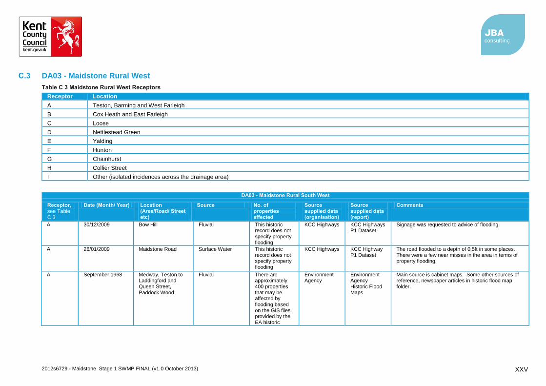
C.3 DA03 - Maidstone Rural West
Table C 3 Maidstone Rural West Receptors
Receptor Location
A Teston, Barming and West Farleigh
B Cox Heath and East Farleigh
C Loose
D Nettlestead Green
E Yalding
F Hunton
G Chainhurst
H Collier Street
I Other (isolated incidences across the drainage area)
DA03 - Maidstone Rural South West
Receptor, see Table C 3
Date (Month/ Year) Location (Area/Road/ Street etc)
Source No. of properties affected
Source supplied data (organisation)
Source supplied data (report)
Comments
A 30/12/2009 Bow Hill Fluvial This historic record does not specify property flooding
KCC Highways KCC Highways P1 Dataset
Signage was requested to advice of flooding.
A 26/01/2009 Maidstone Road Surface Water This historic record does not specify property flooding
KCC Highways KCC Highway P1 Dataset
The road flooded to a depth of 0.5ft in some places. There were a few near misses in the area in terms of property flooding.
A September 1968 Medway, Teston to Laddingford and Queen Street, Paddock Wood
Fluvial There are approximately 400 properties that may be affected by flooding based on the GIS files provided by the EA historic
Environment Agency
Environment Agency Historic Flood Maps
Main source is cabinet maps. Some other sources of reference, newspaper articles in historic flood map folder.
2012s6729 - Maidstone Stage 1 SWMP FINAL (v1.0 October 2013) XXVI
DA03 - Maidstone Rural South West
Receptor, see Table C 3
Date (Month/ Year) Location (Area/Road/ Street etc)
Source No. of properties affected
Source supplied data (organisation)
Source supplied data (report)
Comments
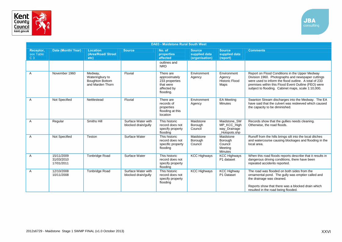
outlines and NRD
A November 1960 Medway, Wateringbury to Boughton Bottom and Marden Thorn
Fluvial There are approximately 233 properties that were affected by flooding.
Environment Agency
Environment Agency Historic Flood Maps
Report on Flood Conditions in the Upper Medway Division 1960. Photographs and newspaper cuttings were used to inform the flood outline. A total of 233 premises within this Flood Event Outline (FEO) were subject to flooding. Cabinet maps, scale 1:10,000.
A Not Specified Nettlestead Fluvial There are records of properties flooding at this location
Environment Agency
EA Meeting Minutes
Swanton Stream discharges into the Medway. The EA have said that the culvert was resleeved which caused the capacity to be diminished.
A Regular Smiths Hill Surface Water with blocked drain/gully
This historic record does not specify property flooding
Maidstone Borough Council
Maidstone_SWMP_KCC_Highway_Drainage_Hotspots.shp
Records show that the gullies needs cleaning. Otherwise, the road floods.
A Not Specified Teston Surface Water This historic record does not specific property flooding
Maidstone Borough Council
Maidstone Borough Council Meeting Minutes
Runoff from the hills brings silt into the local ditches and watercourse causing blockages and flooding in the local area.
A 15/11/2009 31/03/2010 17/01/2011
Tonbridge Road Surface Water This historic record does not specify property flooding
KCC Highways KCC Highways P1 dataset
When this road floods reports describe that it results in dangerous driving conditions, there have been repeated accidents reported.
A 12/10/2008 10/11/2008
Tonbridge Road Surface Water with blocked drain/gully
This historic record does not specify property flooding
KCC Highways KCC Highway P1 Dataset
The road was flooded on both sides from the ornamental pond. The gully was emptier called and the drainage was cleaned. Reports show that there was a blocked drain which resulted in the road being flooded.
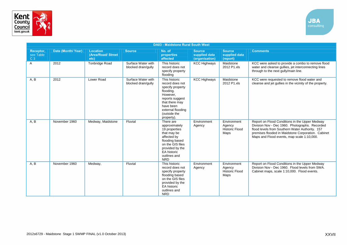
2012s6729 - Maidstone Stage 1 SWMP FINAL (v1.0 October 2013) XXVII
DA03 - Maidstone Rural South West
Receptor, see Table C 3
Date (Month/ Year) Location (Area/Road/ Street etc)
Source No. of properties affected
Source supplied data (organisation)
Source supplied data (report)
Comments
A 2012 Tonbridge Road Surface Water with blocked drain/gully
This historic record does not specify property flooding
KCC Highways Maidstone 2012 P1.xls
KCC were asked to provide a combo to remove flood water and cleanse gullies, jet interconnecting lines through to the next gully/main line.
A, B 2012 Lower Road Surface Water with blocked drain/gully
This historic record does not specify property flooding. However, reports suggest that there may have been external flooding (outside the property).
KCC Highways Maidstone 2012 P1.xls
KCC were requested to remove flood water and cleanse and jet gullies in the vicinity of the property.
A, B November 1960 Medway, Maidstone Fluvial There are approximately 19 properties that may be affected by flooding based on the GIS files provided by the EA historic outlines and NRD
Environment Agency
Environment Agency Historic Flood Maps
Report on Flood Conditions in the Upper Medway Division Nov - Dec 1960. Photographs. Recorded flood levels from Southern Water Authority. 157 premises flooded in Maidstone Corporation. Cabinet Maps and Flood events, map scale 1:10,000.
A, B November 1960 Medway, Fluvial This historic record does not specify property flooding based on the GIS files provided by the EA historic outlines and NRD
Environment Agency
Environment Agency Historic Flood Maps
Report on Flood Conditions in the Upper Medway Division Nov - Dec 1960. Flood levels from SWA. Cabinet maps, scale 1:10,000. Flood events.
2012s6729 - Maidstone Stage 1 SWMP FINAL (v1.0 October 2013) XXVIII
DA03 - Maidstone Rural South West
Receptor, see Table C 3
Date (Month/ Year) Location (Area/Road/ Street etc)
Source No. of properties affected
Source supplied data (organisation)
Source supplied data (report)
Comments
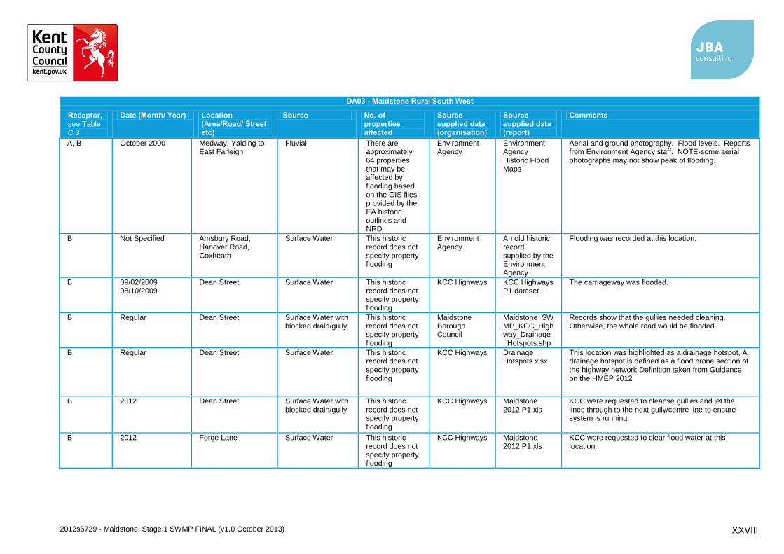
A, B October 2000 Medway, Yalding to East Farleigh
Fluvial There are approximately 64 properties that may be affected by flooding based on the GIS files provided by the EA historic outlines and NRD
Environment Agency
Environment Agency Historic Flood Maps
Aerial and ground photography. Flood levels. Reports from Environment Agency staff. NOTE-some aerial photographs may not show peak of flooding.
B Not Specified Amsbury Road, Hanover Road, Coxheath
Surface Water This historic record does not specify property flooding
Environment Agency
An old historic record supplied by the Environment Agency
Flooding was recorded at this location.
B 09/02/2009 08/10/2009
Dean Street Surface Water This historic record does not specify property flooding
KCC Highways KCC Highways P1 dataset
The carriageway was flooded.
B Regular Dean Street Surface Water with blocked drain/gully
This historic record does not specify property flooding
Maidstone Borough Council
Maidstone_SWMP_KCC_Highway_Drainage_Hotspots.shp
Records show that the gullies needed cleaning. Otherwise, the whole road would be flooded.
B Regular Dean Street Surface Water This historic record does not specify property flooding
KCC Highways Drainage Hotspots.xlsx
This location was highlighted as a drainage hotspot, A drainage hotspot is defined as a flood prone section of the highway network Definition taken from Guidance on the HMEP 2012
B 2012 Dean Street Surface Water with blocked drain/gully
This historic record does not specify property flooding
KCC Highways Maidstone 2012 P1.xls
KCC were requested to cleanse gullies and jet the lines through to the next gully/centre line to ensure system is running.
B 2012 Forge Lane Surface Water This historic record does not specify property flooding
KCC Highways Maidstone 2012 P1.xls
KCC were requested to clear flood water at this location.

2012s6729 - Maidstone Stage 1 SWMP FINAL (v1.0 October 2013) XXIX
DA03 - Maidstone Rural South West
Receptor, see Table C 3
Date (Month/ Year) Location (Area/Road/ Street etc)
Source No. of properties affected
Source supplied data (organisation)
Source supplied data (report)
Comments
B 19/11/2011 Heath Road Surface Water This historic record does not specify property flooding
KCC Highways KCC Highways P1 Dataset
There was a hole in the road which was 1.5ft in width and an inch deep. Water was bubbling from the hole.
B 12/11/2008 Vicarage Lane Surface Water This historic record does not specify property flooding
KCC Highways KCC Highway P1 Dataset
A road was flooded in this location.
B 07/10/2009 Workhouse Lane Surface Water with blocked drain/gully
This historic record does not specify property flooding; there are records of external flooding (outside the property).
KCC Highways KCC Highways P1 Dataset
The road was flooded and the water was posing a risk to property. The resident is unable to get out the front door.
B 07/07/2008 10/06/2009
Workhouse Lane Surface Water This historic record does not specify property flooding
KCC Highways KCC Highways P1 Dataset
. Records show that this area is prone to flooding.
B Not Specified Workhouse Lane, East Farleigh
Surface Water This historic record does not specify property flooding
Environment Agency
An old historic record supplied by the Environment Agency
The road flooded at this location.
C 2012 Haste Hill Road Surface Water with blocked drain/gully
This historic record does not specify property flooding
KCC Highways Maidstone 2012 P1.xls
KCC were asked to provide a combo to remove flood water and cleanse and jet gullies.
C Regular Heath Road Surface Water with blocked drain/gully
This historic record does not specify property flooding
Maidstone Borough Council
Maidstone_SWMP_KCC_Highway_Drainage_Hotspots.shp
Gullies and catchpits need regular cleaning and two catchpits are located within school grounds.
C Regular Linton Road Surface Water with blocked drain/gully
This historic record does not specify property flooding
Maidstone Borough Council
Maidstone_SWMP_KCC_Highway_Drainage_Hotspots.shp
Records show that the gullies needed cleaning. Otherwise, the road would flood.
2012s6729 - Maidstone Stage 1 SWMP FINAL (v1.0 October 2013) XXX
DA03 - Maidstone Rural South West
Receptor, see Table C 3
Date (Month/ Year) Location (Area/Road/ Street etc)
Source No. of properties affected
Source supplied data (organisation)
Source supplied data (report)
Comments
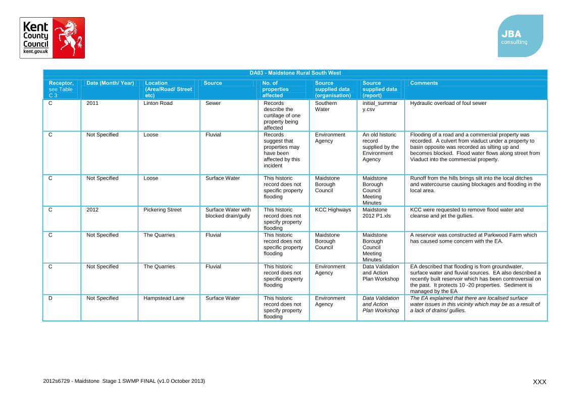
C 2011 Linton Road Sewer Records describe the curtilage of one property being affected
Southern Water
initial_summary.csv
Hydraulic overload of foul sewer
C Not Specified Loose Fluvial Records suggest that properties may have been affected by this incident
Environment Agency
An old historic record supplied by the Environment Agency
Flooding of a road and a commercial property was recorded. A culvert from viaduct under a property to basin opposite was recorded as silting up and becomes blocked. Flood water flows along street from Viaduct into the commercial property.
C Not Specified Loose Surface Water This historic record does not specific property flooding
Maidstone Borough Council
Maidstone Borough Council Meeting Minutes
Runoff from the hills brings silt into the local ditches and watercourse causing blockages and flooding in the local area.
C 2012 Pickering Street Surface Water with blocked drain/gully
This historic record does not specify property flooding
KCC Highways Maidstone 2012 P1.xls
KCC were requested to remove flood water and cleanse and jet the gullies.
C Not Specified The Quarries Fluvial This historic record does not specific property flooding
Maidstone Borough Council
Maidstone Borough Council Meeting Minutes
A reservoir was constructed at Parkwood Farm which has caused some concern with the EA.
C Not Specified The Quarries Fluvial This historic record does not specific property flooding
Environment Agency
Data Validation and Action Plan Workshop
EA described that flooding is from groundwater, surface water and fluvial sources. EA also described a recently built reservoir which has been controversial on the past. It protects 10 -20 properties. Sediment is managed by the EA
D Not Specified Hampstead Lane Surface Water This historic record does not specify property flooding
Environment Agency
Data Validation and Action Plan Workshop
The EA explained that there are localised surface water issues in this vicinity which may be as a result of a lack of drains/ gullies.

2012s6729 - Maidstone Stage 1 SWMP FINAL (v1.0 October 2013) XXXI
DA03 - Maidstone Rural South West
Receptor, see Table C 3
Date (Month/ Year) Location (Area/Road/ Street etc)
Source No. of properties affected
Source supplied data (organisation)
Source supplied data (report)
Comments
D Not Specified Hampstead Lane Fluvial This historic record does not specify property flooding
Environment Agency
Data Validation and Action Plan Workshop
The EA suggested a flap valve at where the drain outfalls into the River Medway, may potentially alleviate local flooding
D 02/03/2010 Hampstead Lane Sewer
This historic record does not specify property flooding
KCC Highways KCC Highways P1 Dataset
Reports show that Southern Water had emptied a cesspit but it still kept overflowing. Flooding in rural areas.
D 2012 Hampstead Lane Surface Water
This historic record does not specify property flooding
KCC Highways
Maidstone 2012 P1.xls and Data Validation and Action Plan Workshop
KCC were requested to erect flood boards at the junction with Maidstone Road. EA explained at the Data Validation and Action Plan Workshop, that the water depth was enough to take out a vehicle.
D 2009 Kenward Road Sewer
This historic record does not specific property flooding
Southern Water
initial_summary.csv
Overloaded pumping station
D 09/02/2009 Maidstone Road Surface Water
This historic record does not specify property flooding
KCC Highways KCC Highways P1 Dataset
Reports show that there was surface water on the road.
D Oct-00 Medway, Yalding to East Farleigh
Fluvial
There are approximately 60properties that may be affected by flooding based on the GIS files provided by the EA historic outlines and NRD
Environment Agency
Environment Agency Historic Flood Maps
Aerial and ground photography. Flood levels. Reports from Environment Agency staff. NOTE-some aerial photographs may not show peak of flooding.
D Not Specified Nettlestead Green Other/ Unknown
This historic record does not specific property flooding
Maidstone Borough Council
Maidstone Borough Council Meeting Minutes
This area has been affected by flooding in the past due to the low-lying nature of the ground.
2012s6729 - Maidstone Stage 1 SWMP FINAL (v1.0 October 2013) XXXII
DA03 - Maidstone Rural South West
Receptor, see Table C 3
Date (Month/ Year) Location (Area/Road/ Street etc)
Source No. of properties affected
Source supplied data (organisation)
Source supplied data (report)
Comments
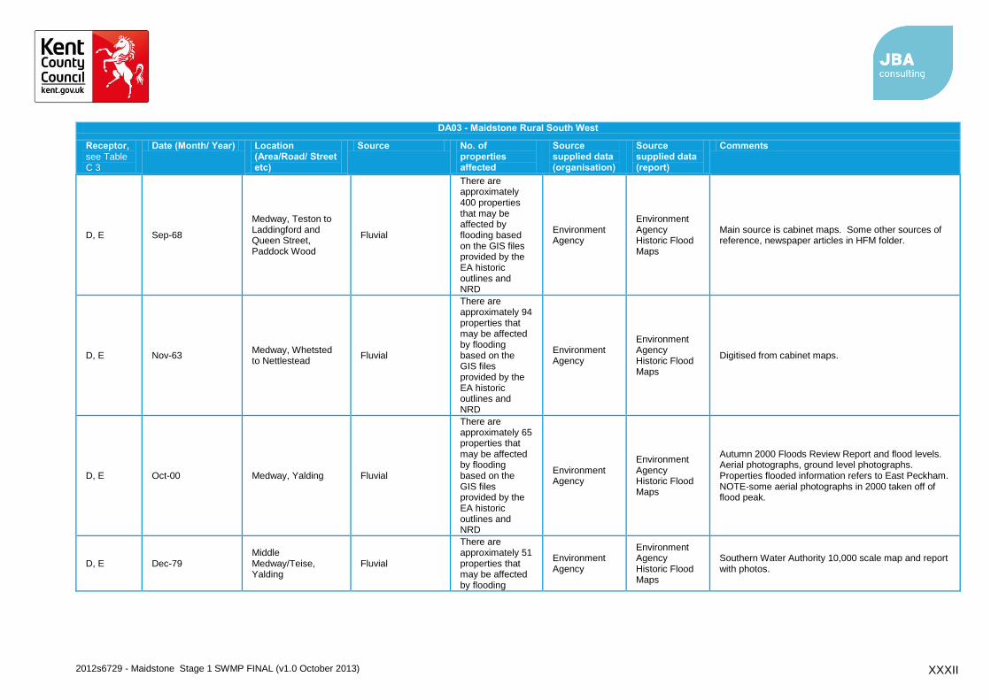
D, E Sep-68
Medway, Teston to Laddingford and Queen Street, Paddock Wood
Fluvial
There are approximately 400 properties that may be affected by flooding based on the GIS files provided by the EA historic outlines and NRD
Environment Agency
Environment Agency Historic Flood Maps
Main source is cabinet maps. Some other sources of reference, newspaper articles in HFM folder.
D, E Nov-63 Medway, Whetsted to Nettlestead
Fluvial
There are approximately 94 properties that may be affected by flooding based on the GIS files provided by the EA historic outlines and NRD
Environment Agency
Environment Agency Historic Flood Maps
Digitised from cabinet maps.
D, E Oct-00 Medway, Yalding Fluvial
There are approximately 65 properties that may be affected by flooding based on the GIS files provided by the EA historic outlines and NRD
Environment Agency
Environment Agency Historic Flood Maps
Autumn 2000 Floods Review Report and flood levels. Aerial photographs, ground level photographs. Properties flooded information refers to East Peckham. NOTE-some aerial photographs in 2000 taken off of flood peak.
D, E Dec-79 Middle Medway/Teise, Yalding
Fluvial
There are approximately 51 properties that may be affected by flooding
Environment Agency
Environment Agency Historic Flood Maps
Southern Water Authority 10,000 scale map and report with photos.

2012s6729 - Maidstone Stage 1 SWMP FINAL (v1.0 October 2013) XXXIII
DA03 - Maidstone Rural South West
Receptor, see Table C 3
Date (Month/ Year) Location (Area/Road/ Street etc)
Source No. of properties affected
Source supplied data (organisation)
Source supplied data (report)
Comments
based on the GIS files provided by the EA historic outlines and NRD
D, E, F, G, H, I
Nov-60
Medway, Wateringbury to Boughton Bottom and Marden Thorn
Fluvial
There are approximately 1046 properties that may be affected by flooding based on the GIS files provided by the EA historic outlines and NRD
Environment Agency
Environment Agency Historic Flood Maps
Report on Flood Conditions in the Upper Medway Division 1960. Flood levels from SWA. Photographs and newspaper cuttings. Total of 233 premises within this FEO subject to flooding. Cabinet maps, scale 1:10,000.
E 26/01/2009 Benover Road Surface Water with blocked drain/gully
This historic record does not specify property flooding
KCC Highways KCC Highway P1 Dataset
Flooding problems were recorded at this location. Dykes were infilled prior to the event so the water was unable to go anywhere else. A large amount of standing water was described on site.
E Regular Benover Road, Forge Lane and Jarmons Lane.
Fluvial No property was indicated as flooded
Upper Medway IDB
UMIDB Meeting Minutes
UMIDB reported that the roads that have been affected in the past are Benover Road, Forge Lane and Jarmons Lane.
E 10/02/2009 Vicarage Road Surface Water
This historic record does not specify property flooding
KCC Highways KCC Highway P1 Dataset
Reports state that a car was stuck in floodwater with no hazard lights.
E Not Specified Yalding Fluvial
The EA described that there is ~325 properties at risk and a population of ~700 residents overall
Environment Agency
EA Meeting Minutes
The EA explained that Collier Street and Yalding have flooding issues as they are situated on the confluence of a number of rivers (River Medway, River Beult, River Teise and the Lesser Teise. PLP had been implemented to protect properties from flooding

2012s6729 - Maidstone Stage 1 SWMP FINAL (v1.0 October 2013) XXXIV
DA03 - Maidstone Rural South West
Receptor, see Table C 3
Date (Month/ Year) Location (Area/Road/ Street etc)
Source No. of properties affected
Source supplied data (organisation)
Source supplied data (report)
Comments
E 09/02/2009 Yalding Hill Surface Water
This historic record does not specify property flooding
KCC Highways KCC Highway P1 Dataset
Flood boards were needed to slow traffic as the carriageway was flooded.
E, F, G, H Oct-00 Beult, Yalding to Collier Street and Headcorn
Fluvial
There are approximately 252 properties that may be affected by flooding based on the GIS files provided by the EA historic outlines and NRD
Environment Agency
Environment Agency Historic Flood Maps
Autumn 2000 Floods Review, flood levels. Aerial and ground photographs. NOTE-not all aerial photographs may have been taken on peak. Numbers of properties above are for the Beult catchment.
E,F 10/02/2009 West Street Surface Water with blocked drain/gully
This historic record does not specify property flooding
KCC Highways KCC Highway P1 Dataset
The drains were blocked and the stream opposite was overflowing. Water flowed right up to the property although no property flooding was reported.
F 30/12/2009 East Street Fluvial
This historic record does not specify property flooding
KCC Highways KCC Highways P1 Dataset
The river burst its banks and flooded the carriageway. The road flooded to a depth of approximately 3-4 inches.
F 10/11/2008 East Street Surface Water
This historic record does not specify property flooding; there are records of external flooding (outside the property).
KCC Highways KCC Highway P1 Dataset
Records show that there was flooding outside a property and the water depth was approximately 1ft across the carriageway, ever since the catch pits had been fitted. Flood boards were also requested.
F 2012 East Street Surface Water with blocked drain/gully
This historic record does not specify property flooding
KCC Highways Maidstone 2012 P1.xls
KCC were asked to provide a combo to clear flood water and cleanse gullies.
F Not Specified Hunton Other/ Unknown This historic record does not specific property
Maidstone Borough Council
Maidstone Borough Council
This area has been affected by flooding in the past due to the low-lying nature of the ground.

2012s6729 - Maidstone Stage 1 SWMP FINAL (v1.0 October 2013) XXXV
DA03 - Maidstone Rural South West
Receptor, see Table C 3
Date (Month/ Year) Location (Area/Road/ Street etc)
Source No. of properties affected
Source supplied data (organisation)
Source supplied data (report)
Comments
flooding Meeting Minutes
F 10/11/2008 West Street Surface Water
This historic record does not specify property flooding
KCC Highways KCC Highways P1 Dataset
The road was flooded to a depth of approximately four inches.
F,G 27/01/2009 Hunton Road Surface Water
There are records of property being affected by flooding.
KCC Highways KCC Highway P1 Dataset
A garden of a property was flooded after water flowed up the drive. The side of the garage was also flooded.
G Not Specified Chainhurst Other/ Unknown
This historic record does not specific property flooding
Maidstone Borough Council
Maidstone Borough Council Meeting Minutes
This area has been affected by flooding in the past due to the low-lying nature of the ground.
H Not Specified Collier Street Other/ Unknown
This historic record does not specific property flooding
Maidstone Borough Council
Maidstone Borough Council Meeting Minutes
This area is a hotspot due to its low lying flat land.
H Not Specified Collier Street Fluvial
The EA described that there is ~325 properties at risk and a population of ~700 residents overall
Environment Agency
EA Meeting Minutes and Data Validation and Action Plan Workshop
The EA explained that Collier Street and Yalding have flooding issues as they are situated on the confluence of a number of rivers (River Medway, River Beult, River Teise and the Lesser Teise). Residents of Collier Street have their own property protection level scheme. The last recorded dated event was in 2003.
H 28/02/2010 Green Lane Fluvial
This historic record does not specify property flooding
KCC Highways KCC Highways P1 Dataset
The carriageway was flooded to a depth of approximately 10 inches. There were concerns that water could enter properties when lorries drove past.

2012s6729 - Maidstone Stage 1 SWMP FINAL (v1.0 October 2013) XXXVI
DA03 - Maidstone Rural South West
Receptor, see Table C 3
Date (Month/ Year) Location (Area/Road/ Street etc)
Source No. of properties affected
Source supplied data (organisation)
Source supplied data (report)
Comments
H 10/02/2009 Green Lane Fluvial
This historic record does not specify property flooding; there are records of external flooding (outside the property).
KCC Highways KCC Highways P1 Dataset
This area was flooded. Sandbags were placed against a property but passing traffic on the road created large waves that were lapping up against the property.
H 2008 Green Lane Fluvial
Reports indicate that property may have been affected in the past
Upper Medway IDB
UMIDB Meeting Minutes
Haviker Street and Green Lane both flooded in 2008. Also residents of Haviker Street and Green Lane have built flood walls around their properties to prevent the ingress of flood waters
H 2008 Haviker Street Fluvial
Reports indicate that property may have been affected in the past
Upper Medway IDB
UMIDB Meeting Minutes
Haviker Street and Green Lane both flooded in 2008. Also residents of Haviker Street and Green Lane have built flood walls around their properties to prevent the ingress of flood waters
I 10/11/2008 Gravelly Ways Surface Water
This historic record does not specify property flooding; there are records of external flooding (footpath).
KCC Highways KCC Highway P1 Dataset
The road was flooded and in some places, overflowed onto the footpath.
I 2010 Laddingford Sewer The curtilage of one property was affected
Southern Water
initial_summary.csv
Hydraulic overload of foul sewers
I 11/11/2008 Lees Road Fluvial
This historic record does not specify property flooding
KCC Highways KCC Highway P1 Dataset
There was flooding at this location.
I 2011 Lees Road Sewer
This historic record does not specific property flooding
Southern Water
initial_summary.csv
Hydraulic overload of foul sewers

2012s6729 - Maidstone Stage 1 SWMP FINAL (v1.0 October 2013) XXXVII
DA03 - Maidstone Rural South West
Receptor, see Table C 3
Date (Month/ Year) Location (Area/Road/ Street etc)
Source No. of properties affected
Source supplied data (organisation)
Source supplied data (report)
Comments
I 10/02/2009 Sheephurst Lane Fluvial
This historic record does not specify property flooding
KCC Highways KCC Highway P1 Dataset
There was a lot of flooding in this area.
2012s6729 - Maidstone Stage 1 SWMP FINAL (v1.0 October 2013) XXXVIII
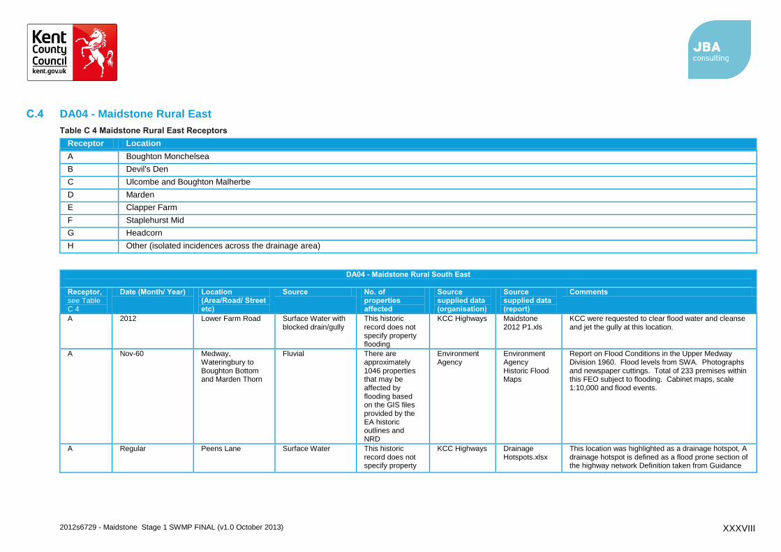
C.4 DA04 - Maidstone Rural East
Table C 4 Maidstone Rural East Receptors
Receptor Location
A Boughton Monchelsea
B Devil's Den
C Ulcombe and Boughton Malherbe
D Marden
E Clapper Farm
F Staplehurst Mid
G Headcorn
H Other (isolated incidences across the drainage area)
DA04 - Maidstone Rural South East
Receptor, see Table C 4
Date (Month/ Year) Location (Area/Road/ Street etc)
Source No. of properties affected
Source supplied data (organisation)
Source supplied data (report)
Comments
A 2012 Lower Farm Road Surface Water with blocked drain/gully
This historic record does not specify property flooding
KCC Highways Maidstone 2012 P1.xls
KCC were requested to clear flood water and cleanse and jet the gully at this location.
A Nov-60 Medway, Wateringbury to Boughton Bottom and Marden Thorn
Fluvial There are approximately 1046 properties that may be affected by flooding based on the GIS files provided by the EA historic outlines and NRD
Environment Agency
Environment Agency Historic Flood Maps
Report on Flood Conditions in the Upper Medway Division 1960. Flood levels from SWA. Photographs and newspaper cuttings. Total of 233 premises within this FEO subject to flooding. Cabinet maps, scale 1:10,000 and flood events.
A Regular Peens Lane Surface Water This historic record does not specify property
KCC Highways Drainage Hotspots.xlsx
This location was highlighted as a drainage hotspot, A drainage hotspot is defined as a flood prone section of the highway network Definition taken from Guidance
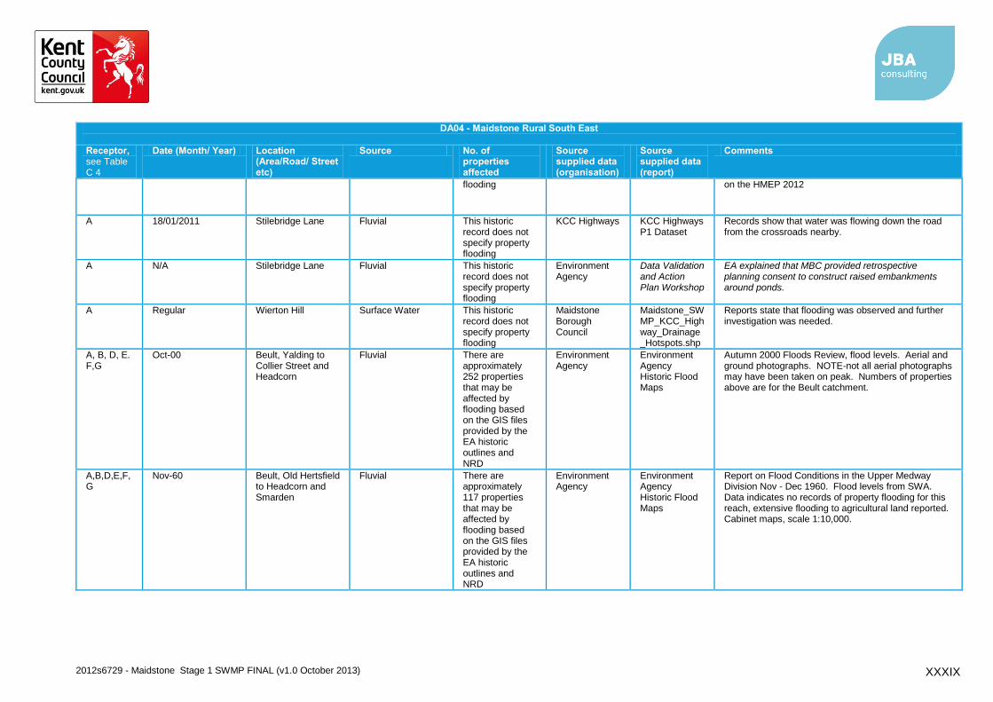
2012s6729 - Maidstone Stage 1 SWMP FINAL (v1.0 October 2013) XXXIX
DA04 - Maidstone Rural South East
Receptor, see Table C 4
Date (Month/ Year) Location (Area/Road/ Street etc)
Source No. of properties affected
Source supplied data (organisation)
Source supplied data (report)
Comments
flooding on the HMEP 2012
A 18/01/2011 Stilebridge Lane Fluvial This historic record does not specify property flooding
KCC Highways KCC Highways P1 Dataset
Records show that water was flowing down the road from the crossroads nearby.
A N/A Stilebridge Lane Fluvial This historic record does not specify property flooding
Environment Agency
Data Validation and Action Plan Workshop
EA explained that MBC provided retrospective planning consent to construct raised embankments around ponds.
A Regular Wierton Hill Surface Water This historic record does not specify property flooding
Maidstone Borough Council
Maidstone_SWMP_KCC_Highway_Drainage_Hotspots.shp
Reports state that flooding was observed and further investigation was needed.
A, B, D, E. F,G
Oct-00 Beult, Yalding to Collier Street and Headcorn
Fluvial There are approximately 252 properties that may be affected by flooding based on the GIS files provided by the EA historic outlines and NRD
Environment Agency
Environment Agency Historic Flood Maps
Autumn 2000 Floods Review, flood levels. Aerial and ground photographs. NOTE-not all aerial photographs may have been taken on peak. Numbers of properties above are for the Beult catchment.
A,B,D,E,F,G
Nov-60 Beult, Old Hertsfield to Headcorn and Smarden
Fluvial There are approximately 117 properties that may be affected by flooding based on the GIS files provided by the EA historic outlines and NRD
Environment Agency
Environment Agency Historic Flood Maps
Report on Flood Conditions in the Upper Medway Division Nov - Dec 1960. Flood levels from SWA. Data indicates no records of property flooding for this reach, extensive flooding to agricultural land reported. Cabinet maps, scale 1:10,000.
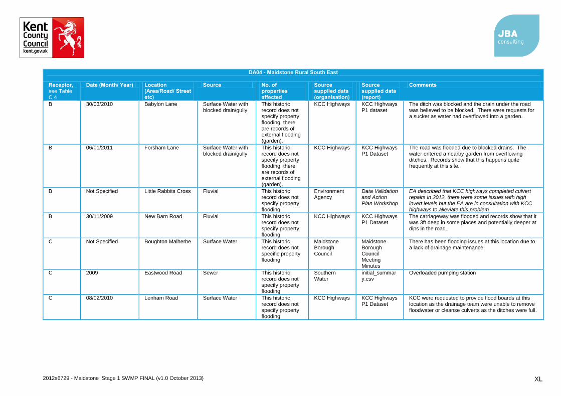
2012s6729 - Maidstone Stage 1 SWMP FINAL (v1.0 October 2013) XL
DA04 - Maidstone Rural South East
Receptor, see Table C 4
Date (Month/ Year) Location (Area/Road/ Street etc)
Source No. of properties affected
Source supplied data (organisation)
Source supplied data (report)
Comments
B 30/03/2010 Babylon Lane Surface Water with blocked drain/gully
This historic record does not specify property flooding; there are records of external flooding (garden).
KCC Highways KCC Highways P1 dataset
The ditch was blocked and the drain under the road was believed to be blocked. There were requests for a sucker as water had overflowed into a garden.
B 06/01/2011 Forsham Lane Surface Water with blocked drain/gully
This historic record does not specify property flooding; there are records of external flooding (garden).
KCC Highways KCC Highways P1 Dataset
The road was flooded due to blocked drains. The water entered a nearby garden from overflowing ditches. Records show that this happens quite frequently at this site.
B Not Specified Little Rabbits Cross Fluvial This historic record does not specify property flooding
Environment Agency
Data Validation and Action Plan Workshop
EA described that KCC highways completed culvert repairs in 2012, there were some issues with high invert levels but the EA are in consultation with KCC highways to alleviate this problem
B 30/11/2009 New Barn Road Fluvial This historic record does not specify property flooding
KCC Highways KCC Highways P1 Dataset
The carriageway was flooded and records show that it was 3ft deep in some places and potentially deeper at dips in the road.
C Not Specified Boughton Malherbe Surface Water This historic record does not specific property flooding
Maidstone Borough Council
Maidstone Borough Council Meeting Minutes
There has been flooding issues at this location due to a lack of drainage maintenance.
C 2009 Eastwood Road Sewer This historic record does not specify property flooding
Southern Water
initial_summary.csv
Overloaded pumping station
C 08/02/2010 Lenham Road Surface Water This historic record does not specify property flooding
KCC Highways KCC Highways P1 Dataset
KCC were requested to provide flood boards at this location as the drainage team were unable to remove floodwater or cleanse culverts as the ditches were full.

2012s6729 - Maidstone Stage 1 SWMP FINAL (v1.0 October 2013) XLI
DA04 - Maidstone Rural South East
Receptor, see Table C 4
Date (Month/ Year) Location (Area/Road/ Street etc)
Source No. of properties affected
Source supplied data (organisation)
Source supplied data (report)
Comments
C Regular Sandway Surface Water This historic record does not specify property flooding
KCC Highways Drainage Hotspots.xlsx
This location was highlighted as a drainage hotspot, A drainage hotspot is defined as a flood prone section of the highway network Definition taken from Guidance on the HMEP 2012
C 30/11/2009 Stickfast Lane Fluvial This historic record does not specify property flooding
KCC Highways KCC Highways P1 Dataset
The water was reportedly 1ft deep and there were requests for flood warning signs.
C 09/02/2009 The Street Surface Water This historic record does not specify property flooding
KCC Highways KCC Highways P1 Dataset
Records show that a manhole cover on the pavement was lifting and water was flowing out of it.
C 02/12/2009 The Street Surface Water with blocked drain/gully
This historic record does not specify property flooding; there are records of external flooding (outside the property).
KCC Highways KCC Highways P1 Dataset
The road was flooded and was reportedly lapping up against properties. Records show that this is an ongoing problem in this area.
D 2012 Albion Road Surface Water with blocked drain/gully
This historic record does not specify property flooding
KCC Highways Maidstone 2012 P1.xls
KCC were requested to remove floodwater and cleanse drainage to prevent further flooding.
D Regular Copper Lane Surface Water Residential properties and highways were recorded as affected
Maidstone Borough Council
Maidstone Borough Council SFRA
Flooding was reported to be caused by heavy rainfall and poor drainage.
D 2012 Goudhurst Road Sewer The curtilage of nine properties were affected
Southern Water
initial_summary.csv
Hydraulic overload of foul sewer
D Regular Goudhurst Road Surface Water Residential properties and highways were recorded as affected
Maidstone Borough Council
Maidstone Borough Council SFRA and Data Validation and
Flooding was reported to be caused by heavy rainfall and poor drainage. EA explained that residents here have their own property level protection scheme.
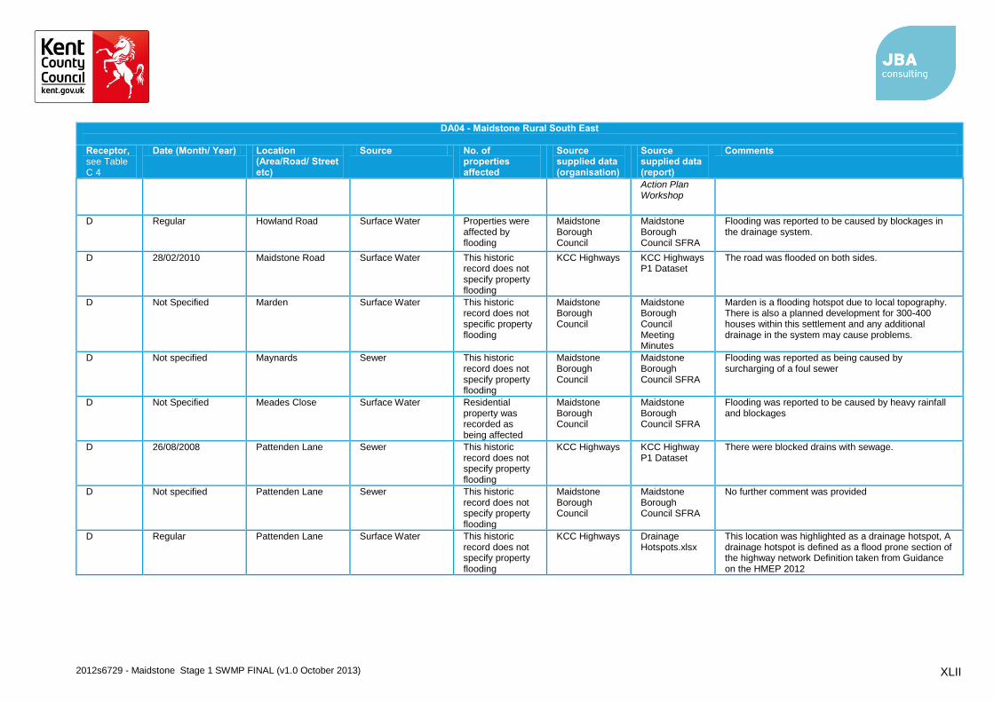
2012s6729 - Maidstone Stage 1 SWMP FINAL (v1.0 October 2013) XLII
DA04 - Maidstone Rural South East
Receptor, see Table C 4
Date (Month/ Year) Location (Area/Road/ Street etc)
Source No. of properties affected
Source supplied data (organisation)
Source supplied data (report)
Comments
Action Plan Workshop
D Regular Howland Road Surface Water Properties were affected by flooding
Maidstone Borough Council
Maidstone Borough Council SFRA
Flooding was reported to be caused by blockages in the drainage system.
D 28/02/2010 Maidstone Road Surface Water This historic record does not specify property flooding
KCC Highways KCC Highways P1 Dataset
The road was flooded on both sides.
D Not Specified Marden Surface Water This historic record does not specific property flooding
Maidstone Borough Council
Maidstone Borough Council Meeting Minutes
Marden is a flooding hotspot due to local topography. There is also a planned development for 300-400 houses within this settlement and any additional drainage in the system may cause problems.
D Not specified Maynards Sewer This historic record does not specify property flooding
Maidstone Borough Council
Maidstone Borough Council SFRA
Flooding was reported as being caused by surcharging of a foul sewer
D Not Specified Meades Close Surface Water Residential property was recorded as being affected
Maidstone Borough Council
Maidstone Borough Council SFRA
Flooding was reported to be caused by heavy rainfall and blockages
D 26/08/2008 Pattenden Lane Sewer This historic record does not specify property flooding
KCC Highways KCC Highway P1 Dataset
There were blocked drains with sewage.
D Not specified Pattenden Lane Sewer This historic record does not specify property flooding
Maidstone Borough Council
Maidstone Borough Council SFRA
No further comment was provided
D Regular Pattenden Lane Surface Water This historic record does not specify property flooding
KCC Highways Drainage Hotspots.xlsx
This location was highlighted as a drainage hotspot, A drainage hotspot is defined as a flood prone section of the highway network Definition taken from Guidance on the HMEP 2012

2012s6729 - Maidstone Stage 1 SWMP FINAL (v1.0 October 2013) XLIII
DA04 - Maidstone Rural South East
Receptor, see Table C 4
Date (Month/ Year) Location (Area/Road/ Street etc)
Source No. of properties affected
Source supplied data (organisation)
Source supplied data (report)
Comments
D None Specified Pattenden Lane Surface Water This historic record does not specify property flooding
Environment Agency
EA Meeting Minutes
Records show that this road suffers from surface water flooding due to surface water being unable to discharge to the watercourse and the presence of hard standing.
D 2012 Pattenden Lane Surface Water with blocked drain/gully
This historic record does not specify property flooding
KCC Highways Maidstone 2012 P1.xls
KCC were requested to clear flood water and cleanse and jet gullies to prevent further flooding.
D Not specified Sovereigns Way Sewer This historic record does not specify property flooding
Maidstone Borough Council
Maidstone Borough Council SFRA
No further comment was provided
D Not Specified The Cockpit Sewer Property was not specified as being affected
Environment Agency
Data Validation and Action Plan Workshop
EA described that this housing estate had problems with flooding, it was thought that this was due to surface water and sewers, however the EA were not certain of the source of the flooding.
D Not Specified The Cockpit Surface Water Residential properties and highways were recorded as affected
Maidstone Borough Council
Maidstone Borough Council SFRA
Flooding was reported to be caused by heavy rainfall and poor drainage.
D Not Specified The Cockpit Sewer This historic record does not specify property flooding
Environment Agency
Data Validation and Action Plan Workshop
The EA described there are combined sewer problems in this area.
D 2000/2001 The Plain Fluvial There are records of properties flooding
Environment Agency
Data Validation and Action Plan Workshop
The EA described flooding to properties
D Regular Thorn Road Surface Water Residential properties and highways were recorded as affected
Maidstone Borough Council
Maidstone Borough Council SFRA
Flooding was reported to be caused by heavy rainfall and poor drainage.
E Not Specified Abbotsleigh Surface Water This historic record does not specify property
Maidstone Borough Council
Maidstone Borough Council SFRA
Runoff from development site which has resulted in residential areas being affected by flooding.

2012s6729 - Maidstone Stage 1 SWMP FINAL (v1.0 October 2013) XLIV
DA04 - Maidstone Rural South East
Receptor, see Table C 4
Date (Month/ Year) Location (Area/Road/ Street etc)
Source No. of properties affected
Source supplied data (organisation)
Source supplied data (report)
Comments
flooding
E 30/12/2009 26/02/2010
Clapper Lane Fluvial This historic record does not specify property flooding
KCC Highways KCC Highways P1 Dataset
Reports show that water was approximately 2-3 ft deep on the road. Anecdotal evidence suggests that the carriageway was flooded to 'knee height' and 'waist height' in some areas.
E Not Specified Clapper Lane Fluvial Records suggest properties were affected
Environment Agency
EA Meeting Minutes
Flooding from IDB No 16 (IDB Drain Reference) and has caused flooding in the past.
E 2009 Clapper Lane
Sewer The curtilage of three properties were recorded as being affected
Southern Water
initial_summary.csv
Hydraulic overload of foul sewer
E 30/11/2009 Clapper Lane Surface Water There are records of property being affected by flooding.
KCC Highways KCC Highways P1 Dataset
Records state that two pumps diverted water away from a property but warned that any further rainfall could result in the property being flooded.
E Regular Clapper Lane / Grave Lane
Surface Water This historic record does not specify property flooding
Maidstone Borough Council
Maidstone Borough Council SFRA
There have been 4 incidents of surface water flooding at this location due to blocked drainage ditches which has caused flooding on the highway.
E 2010 Couchman Green Lane
Sewer The curtilage of one property was recorded as a being affected.
Southern Water
initial_summary.csv
Hydraulic overload of foul sewer
E 30/11/2009 Couchman Green Lane
Surface Water This historic record does not specify property flooding
KCC Highways KCC Highways P1 Dataset
Records show that a drain was overflowing on Couchman Green Lane (off the A229) which caused the water depth to increase.
E 2009 Maidstone Road Sewer The curtilage of one property was recorded as a being affected.
Southern Water
initial_summary.csv
Hydraulic overload of foul sewer
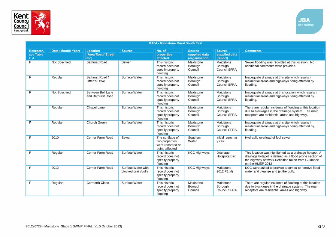
2012s6729 - Maidstone Stage 1 SWMP FINAL (v1.0 October 2013) XLV
DA04 - Maidstone Rural South East
Receptor, see Table C 4
Date (Month/ Year) Location (Area/Road/ Street etc)
Source No. of properties affected
Source supplied data (organisation)
Source supplied data (report)
Comments
F Not Specified Bathurst Road Sewer This historic record does not specify property flooding
Maidstone Borough Council
Maidstone Borough Council SFRA
Sewer flooding was recorded at this location. No additional comments were provided.
F Regular Bathurst Road / Offen's Drive
Surface Water This historic record does not specify property flooding
Maidstone Borough Council
Maidstone Borough Council SFRA
Inadequate drainage at this site which results in residential areas and highways being affected by flooding.
F Not Specified Between Bell Lane and Bathurst Road
Surface Water This historic record does not specify property flooding
Maidstone Borough Council
Maidstone Borough Council SFRA
Inadequate drainage at this location which results in residential areas and highways being affected by flooding.
F Regular Chapel Lane Surface Water This historic record does not specify property flooding
Maidstone Borough Council
Maidstone Borough Council SFRA
There are regular incidents of flooding at this location due to blockages in the drainage system. The main receptors are residential areas and highway.
F Regular Church Green Surface Water This historic record does not specify property flooding
Maidstone Borough Council
Maidstone Borough Council SFRA
Inadequate drainage at this site which results in residential areas and highways being affected by flooding.
F 2010 Corner Farm Road Sewer The curtilage of two properties were recorded as being affected
Southern Water
initial_summary.csv
Hydraulic overload of foul sewer
F Regular Corner Farm Road Surface Water This historic record does not specify property flooding
KCC Highways Drainage Hotspots.xlsx
This location was highlighted as a drainage hotspot, A drainage hotspot is defined as a flood prone section of the highway network Definition taken from Guidance on the HMEP 2012
F 2012 Corner Farm Road Surface Water with blocked drain/gully
This historic record does not specify property flooding
KCC Highways Maidstone 2012 P1.xls
KCC were asked to provide a combo to remove flood water and cleanse and jet the gully.
F Regular Cornforth Close Surface Water This historic record does not specify property flooding
Maidstone Borough Council
Maidstone Borough Council SFRA
There are regular incidents of flooding at this location due to blockages in the drainage system. The main receptors are residential areas and highway.

2012s6729 - Maidstone Stage 1 SWMP FINAL (v1.0 October 2013) XLVI
DA04 - Maidstone Rural South East
Receptor, see Table C 4
Date (Month/ Year) Location (Area/Road/ Street etc)
Source No. of properties affected
Source supplied data (organisation)
Source supplied data (report)
Comments
F 2012 Cradducks Lane Surface Water This historic record does not specify property flooding
KCC Highways Maidstone 2012 P1.xls
KCC were asked to provide a jetter to jet the pipe that caused flooding across the carriageway.
F Not Specified Cranbrook Road Sewer This historic record does not specify property flooding
Maidstone Borough Council
Maidstone Borough Council SFRA
Sewer flooding was recorded at this location. No additional comments were provided.
F 2012 Cranbrook Road Surface Water with blocked drain/gully
This historic record does not specify property flooding
KCC Highways Maidstone 2012 P1.xls
KCC were asked to provide a combo to clear flood water and cleanse and jet gullies.
F Not Specified Cranbrook Road / Pinnock Lane
Other/ Unknown This historic record does not specify property flooding
Maidstone Borough Council
Maidstone Borough Council SFRA
Flooding was recorded at this location. No additional comments were provided.
F Not Specified Fir Tree Close Sewer This historic record does not specify property flooding
Maidstone Borough Council
Maidstone Borough Council SFRA
Sewer flooding was recorded at this location. No additional comments were provided.
F Not Specified Fishers Road Sewer This historic record does not specify property flooding
Maidstone Borough Council
Maidstone Borough Council SFRA
Sewer flooding was recorded at this location. No additional comments were provided.
F Regular Fletcher Road Surface Water This historic record does not specify property flooding
Maidstone Borough Council
Maidstone Borough Council SFRA
Inadequate drainage at this site which results in residential areas and highways being affected by flooding.
F 2008 Frittenden Road Sewer This historic record does not specify property flooding
Southern Water
initial_summary.csv
Overloaded pumping station
F Not Specified Frittenden Road Surface Water This historic record does not specify property flooding
Maidstone Borough Council
Maidstone Borough Council SFRA
There are regular incidents of flooding at this location due to blockages in the drainage system. The main receptors are residential areas and highway.
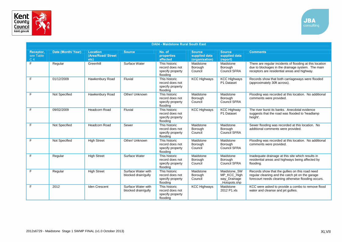
2012s6729 - Maidstone Stage 1 SWMP FINAL (v1.0 October 2013) XLVII
DA04 - Maidstone Rural South East
Receptor, see Table C 4
Date (Month/ Year) Location (Area/Road/ Street etc)
Source No. of properties affected
Source supplied data (organisation)
Source supplied data (report)
Comments
F Regular Greenhill Surface Water This historic record does not specify property flooding
Maidstone Borough Council
Maidstone Borough Council SFRA
There are regular incidents of flooding at this location due to blockages in the drainage system. The main receptors are residential areas and highway.
F 01/12/2009 Hawkenbury Road Fluvial This historic record does not specify property flooding
KCC Highways KCC Highways P1 Dataset
Records show that both carriageways were flooded (approximately 30ft across).
F Not Specified Hawkenbury Road Other/ Unknown This historic record does not specify property flooding
Maidstone Borough Council
Maidstone Borough Council SFRA
Flooding was recorded at this location. No additional comments were provided.
F 09/02/2009 Headcorn Road Fluvial This historic record does not specify property flooding
KCC Highways KCC Highway P1 Dataset
The river burst its banks. Anecdotal evidence suggests that the road was flooded to 'headlamp height'.
F Not Specified Headcorn Road Sewer This historic record does not specify property flooding
Maidstone Borough Council
Maidstone Borough Council SFRA
Sewer flooding was recorded at this location. No additional comments were provided.
F Not Specified High Street Other/ Unknown This historic record does not specify property flooding
Maidstone Borough Council
Maidstone Borough Council SFRA
Flooding was recorded at this location. No additional comments were provided.
F Regular High Street Surface Water This historic record does not specify property flooding
Maidstone Borough Council
Maidstone Borough Council SFRA
Inadequate drainage at this site which results in residential areas and highways being affected by flooding.
F Regular High Street Surface Water with blocked drain/gully
This historic record does not specify property flooding
Maidstone Borough Council
Maidstone_SWMP_KCC_Highway_Drainage_Hotspots.shp
Records show that the gullies on this road need regular cleaning and the catch pit on the garage forecourt needs cleaning otherwise flooding occurs.
F 2012 Iden Crescent Surface Water with blocked drain/gully
This historic record does not specify property flooding
KCC Highways Maidstone 2012 P1.xls
KCC were asked to provide a combo to remove flood water and cleanse and jet gullies.

2012s6729 - Maidstone Stage 1 SWMP FINAL (v1.0 October 2013) XLVIII
DA04 - Maidstone Rural South East
Receptor, see Table C 4
Date (Month/ Year) Location (Area/Road/ Street etc)
Source No. of properties affected
Source supplied data (organisation)
Source supplied data (report)
Comments
F Not Specified Knoxbridge Fluvial Several properties were recorded as flooding
Environment Agency
EA Meeting Minutes
EA described flooding, across this area there are problems with caravan sites camping in flood risk areas.
F Not Specified Marden Road Sewer This historic record does not specify property flooding
Maidstone Borough Council
Maidstone Borough Council SFRA
Sewer flooding was recorded at this location. No additional comments were provided.
F 2009 Marden Road Sewer The curtilage of one property was recorded as being affected
Southern Water
initial_summary.csv
Hydraulic overload of foul sewer
F 22/01/2009 Marden Road Surface Water This historic record does not specify property flooding
KCC Highways KCC Highways P1 Dataset
The carriageway was flooded. The flood extent was approximately 45-50 metres in length and 1-1.5ft deep.
F Not Specified Marden Road Surface Water This historic record does not specify property flooding
Maidstone Borough Council
Maidstone Borough Council SFRA
Inadequate drainage at this location which results in residential areas and highways being affected by flooding.
F Not Specified Marian Square Sewer This historic record does not specify property flooding
Maidstone Borough Council
Maidstone Borough Council SFRA
Sewer flooding was recorded at this location. No additional comments were provided.
F 2010 Marian Square Sewer A garage of one property and the curtilage of two properties were recorded as being affected
Southern Water
initial_summary.csv
Hydraulic overload of foul sewer
F Regular Newlyn Drive Surface Water This historic record does not specify property flooding
Maidstone Borough Council
Maidstone Borough Council SFRA
There are regular incidents of flooding at this location due to blockages in the drainage system. The main receptors are residential areas and highway.
F Not Specified Offen's Drive Sewer This historic record does not specify property
Maidstone Borough Council
Maidstone Borough Council SFRA
Sewer flooding was recorded at this location. No additional comments were provided.
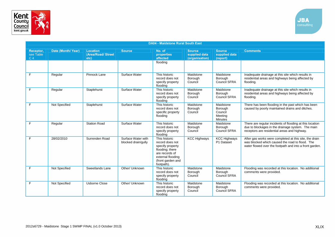
2012s6729 - Maidstone Stage 1 SWMP FINAL (v1.0 October 2013) XLIX
DA04 - Maidstone Rural South East
Receptor, see Table C 4
Date (Month/ Year) Location (Area/Road/ Street etc)
Source No. of properties affected
Source supplied data (organisation)
Source supplied data (report)
Comments
flooding
F Regular Pinnock Lane Surface Water This historic record does not specify property flooding
Maidstone Borough Council
Maidstone Borough Council SFRA
Inadequate drainage at this site which results in residential areas and highways being affected by flooding.
F Regular Staplehurst Surface Water This historic record does not specify property flooding
Maidstone Borough Council
Maidstone Borough Council SFRA
Inadequate drainage at this site which results in residential areas and highways being affected by flooding.
F Not Specified Staplehurst Surface Water This historic record does not specific property flooding
Maidstone Borough Council
Maidstone Borough Council Meeting Minutes
There has been flooding in the past which has been caused by poorly maintained drains and ditches.
F Regular Station Road Surface Water This historic record does not specify property flooding
Maidstone Borough Council
Maidstone Borough Council SFRA
There are regular incidents of flooding at this location due to blockages in the drainage system. The main receptors are residential areas and highway.
F 28/02/2010 Surrenden Road Surface Water with blocked drain/gully
This historic record does not specify property flooding; there are records of external flooding (front garden and footpath).
KCC Highways KCC Highways P1 Dataset
After gas works were completed at this site, the drain was blocked which caused the road to flood. The water flowed over the footpath and into a front garden.
F Not Specified Sweetlands Lane Other/ Unknown This historic record does not specify property flooding
Maidstone Borough Council
Maidstone Borough Council SFRA
Flooding was recorded at this location. No additional comments were provided.
F Not Specified Usborne Close Other/ Unknown This historic record does not specify property flooding
Maidstone Borough Council
Maidstone Borough Council SFRA
Flooding was recorded at this location. No additional comments were provided.

2012s6729 - Maidstone Stage 1 SWMP FINAL (v1.0 October 2013) L
DA04 - Maidstone Rural South East
Receptor, see Table C 4
Date (Month/ Year) Location (Area/Road/ Street etc)
Source No. of properties affected
Source supplied data (organisation)
Source supplied data (report)
Comments
F 2009 Winchs Garth Sewer The curtilage of one property was recorded as being affected
Southern Water
initial_summary.csv
Hydraulic overload of foul sewer
G 30/11/2009 Biddenden Road Surface Water This historic record does not specify property flooding
KCC Highways KCC Highways P1 dataset
The road was flooded and there was no warning. The water was at least 1ft deep. There were requests for flood signs to be put up or for the road to be closed.
G Not Specified Bletchenden Fluvial Records suggest ~ 20 properties were affected
Environment Agency
EA Meeting Minutes
EA described flooding from the Hammer Stream
G Not Specified Headcorn Fluvial Records suggest ~ 20 properties were affected
Environment Agency
EA Meeting Minutes
EA described that flooding occurs due to insufficient culvert capacity
G Not Specified Headcorn Surface Water This historic record does not specify property flooding
Environment Agency
EA Meeting Minutes
EA described there is a surface water and sewer problem at this location which has caused flooding in the past
G Not Specified Headcorn Surface Water This historic record does not specific property flooding
Maidstone Borough Council
Maidstone Borough Council Meeting Minutes
There has been flooding in this area which is probably a result of poor maintenance of drains and ditches.
G 09/01/2009 Kings Road Other/ Unknown This historic record does not specify property flooding
KCC Highways KCC Highway P1 Dataset
Records show that there was a burst water main.
G Not Specified Kings Road Other/ Unknown This historic record does not specify property flooding
Maidstone Borough Council
Maidstone Borough Council SFRA
No further comment was provided
G Not Specified Kings Road Sewer This historic record does not specify property flooding
Maidstone Borough Council
Maidstone Borough Council SFRA
The cause of flooding was due to a surcharging sewer during a flood event

2012s6729 - Maidstone Stage 1 SWMP FINAL (v1.0 October 2013) LI
DA04 - Maidstone Rural South East
Receptor, see Table C 4
Date (Month/ Year) Location (Area/Road/ Street etc)
Source No. of properties affected
Source supplied data (organisation)
Source supplied data (report)
Comments
G 2000, 2002 and 2003
Kings Road, Moat Road, North Street and Mill Bank
Fluvial Records suggest properties were affected
Environment Agency
Comments on Draft Stage 1 SWMP
Properties were flooded at this location in 2000 and 2002/3
G Not Specified Knaves Acre Surface Water with blocked drain/gully
This historic record does not specify property flooding
Maidstone Borough Council
Maidstone Borough Council SFRA
The cause of flooding was as a result of blocked drainage channels.
G Not Specified Lenham Road Other/ Unknown This historic record does not specify property flooding
Maidstone Borough Council
Maidstone Borough Council SFRA
Two location identified, no further comment was provided within the SFRA
G 2012 Maidstone Road Surface Water with blocked drain/gully
This historic record does not specify property flooding
KCC Highways Maidstone 2012 P1.xls
KCC were requested to clear flood water and cleanse gully/jet lines through to prevent further flooding.
G Not Specified Mill Bank Other/ Unknown This historic record does not specify property flooding
Maidstone Borough Council
Maidstone Borough Council SFRA
No further comment was provided
G Not Specified Mill Bank Sewer This historic record does not specify property flooding
Maidstone Borough Council
Maidstone Borough Council SFRA
The cause of flooding was due to a surcharging sewer during a flood event
G 30/11/2009 Moat Road Fluvial This historic record does not specify property flooding
KCC Highways KCC Highways P1 Dataset
Anecdotal evidence suggests that the road flooded to approximately 'knee depth' in various places. The police were unable to gain access.
G 2012 Moat Road Sewer The curtilage of five properties were recorded as being affected
Southern Water
initial_summary.csv
Hydraulic overload of foul sewer
G 23/02/2010 New House Lane Fluvial This historic record does not specify property flooding
KCC Highways KCC Highways P1 Dataset
Carriageway flooded.
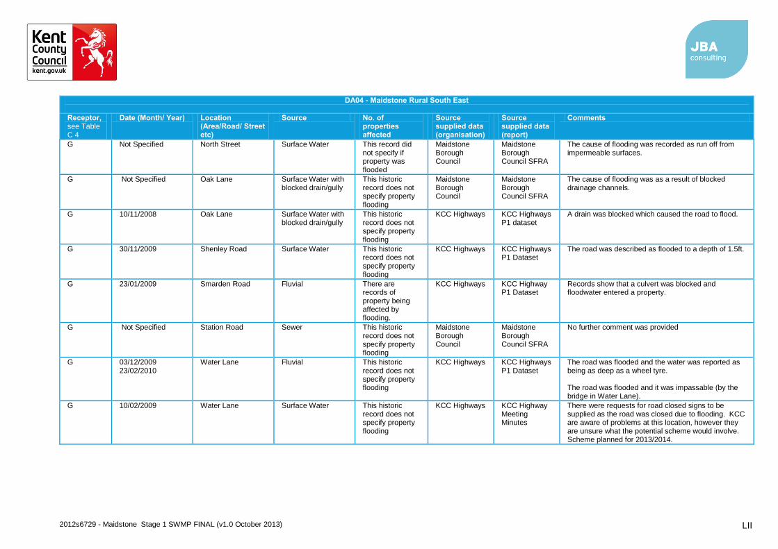
2012s6729 - Maidstone Stage 1 SWMP FINAL (v1.0 October 2013) LII
DA04 - Maidstone Rural South East
Receptor, see Table C 4
Date (Month/ Year) Location (Area/Road/ Street etc)
Source No. of properties affected
Source supplied data (organisation)
Source supplied data (report)
Comments
G Not Specified North Street Surface Water This record did not specify if property was flooded
Maidstone Borough Council
Maidstone Borough Council SFRA
The cause of flooding was recorded as run off from impermeable surfaces.
G Not Specified Oak Lane Surface Water with blocked drain/gully
This historic record does not specify property flooding
Maidstone Borough Council
Maidstone Borough Council SFRA
The cause of flooding was as a result of blocked drainage channels.
G 10/11/2008 Oak Lane Surface Water with blocked drain/gully
This historic record does not specify property flooding
KCC Highways KCC Highways P1 dataset
A drain was blocked which caused the road to flood.
G 30/11/2009 Shenley Road Surface Water This historic record does not specify property flooding
KCC Highways KCC Highways P1 Dataset
The road was described as flooded to a depth of 1.5ft.
G 23/01/2009 Smarden Road Fluvial There are records of property being affected by flooding.
KCC Highways KCC Highway P1 Dataset
Records show that a culvert was blocked and floodwater entered a property.
G Not Specified Station Road Sewer This historic record does not specify property flooding
Maidstone Borough Council
Maidstone Borough Council SFRA
No further comment was provided
G 03/12/2009 23/02/2010
Water Lane Fluvial This historic record does not specify property flooding
KCC Highways KCC Highways P1 Dataset
The road was flooded and the water was reported as being as deep as a wheel tyre. The road was flooded and it was impassable (by the bridge in Water Lane).
G 10/02/2009 Water Lane Surface Water This historic record does not specify property flooding
KCC Highways KCC Highway Meeting Minutes
There were requests for road closed signs to be supplied as the road was closed due to flooding. KCC are aware of problems at this location, however they are unsure what the potential scheme would involve. Scheme planned for 2013/2014.
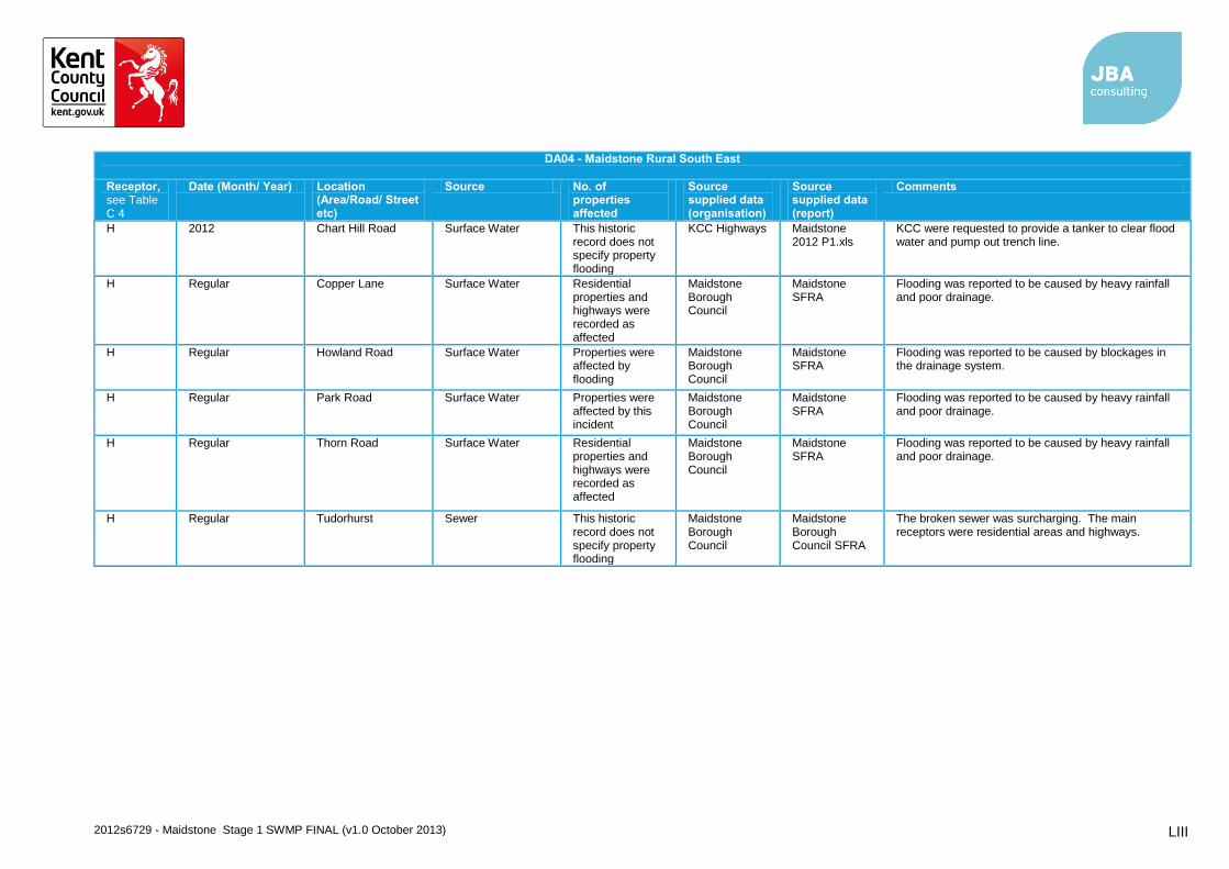
2012s6729 - Maidstone Stage 1 SWMP FINAL (v1.0 October 2013) LIII
DA04 - Maidstone Rural South East
Receptor, see Table C 4
Date (Month/ Year) Location (Area/Road/ Street etc)
Source No. of properties affected
Source supplied data (organisation)
Source supplied data (report)
Comments
H 2012 Chart Hill Road Surface Water This historic record does not specify property flooding
KCC Highways Maidstone 2012 P1.xls
KCC were requested to provide a tanker to clear flood water and pump out trench line.
H Regular Copper Lane Surface Water Residential properties and highways were recorded as affected
Maidstone Borough Council
Maidstone SFRA
Flooding was reported to be caused by heavy rainfall and poor drainage.
H Regular Howland Road Surface Water Properties were affected by flooding
Maidstone Borough Council
Maidstone SFRA
Flooding was reported to be caused by blockages in the drainage system.
H Regular Park Road Surface Water Properties were affected by this incident
Maidstone Borough Council
Maidstone SFRA
Flooding was reported to be caused by heavy rainfall and poor drainage.
H Regular Thorn Road Surface Water Residential properties and highways were recorded as affected
Maidstone Borough Council
Maidstone SFRA
Flooding was reported to be caused by heavy rainfall and poor drainage.
H Regular Tudorhurst Sewer This historic record does not specify property flooding
Maidstone Borough Council
Maidstone Borough Council SFRA
The broken sewer was surcharging. The main receptors were residential areas and highways.


![Eco villages%20&%20c bed[1]](https://static.fdocuments.us/doc/165x107/554ad9e2b4c905b5238b56cf/eco-villages2020c-bed1.jpg)