C COOOONNGGIIEE LLAAKKEESS RRaammssaarr ... LLAAKKEESS RRaammssaarr WWEETTLLAANNDDSS AA PPllaann...
62
C C O O O O N N G G I I E E L L A A K K E E S S R R a a m m s s a a r r W W E E T T L L A A N N D D S S A A P P l l a a n n f f o o r r W W i i s s e e U U s s e e DRAFT for PUBLIC CONSULTATION NOVEMBER 1999
Transcript of C COOOONNGGIIEE LLAAKKEESS RRaammssaarr ... LLAAKKEESS RRaammssaarr WWEETTLLAANNDDSS AA PPllaann...

CCOOOONNGGIIEE LLAAKKEESS RRaammss aa rrWWEETTLLAANNDDSS
AA PP ll aann ff oo rr WWii ss ee UUss ee
D R A F T f o r P U B L I C C O N S U L T A T I O N
NOVEMBER 1999
Published by the Department for Environment, Heritage and Aboriginal AffairsAdelaide, South AustraliaNovember 1999
© Department for Environment, Heritage and Aboriginal Affairs
ISBN: 0 7308 5876 6
Prepared by North RegionHeritage & Biodiversity DivisionDepartment for Environment, Heritage and Aboriginal Affairs
© Copyright Planning SA, Department for Transport, Urban Planning and the Arts 1997.All rights reserved. All works and information displayed in Figures 2,3 and 13 are subject to copyright.For the reproduction or publication beyond that permitted by the Copyright Act 1968 (Commonwealth)written permission must be sought from the Department.
Although every effort has been made to ensure the accuracy of the information displayed in Figures 2 and 3the Department, its agents, officers and employees make no representations, either express or implied,that the information displayed is accurate or fit for any purpose and expressly disclaims all liability for loss or damagearising from reliance upon the information displayed.

iii
TABLE OF CONTENTS
FOREWORD ..................................................................................................................................................11 SUMMARY......................................................................................................................................................22 WHERE AND WHAT ARE THE COONGIE LAKES RAMSAR WETLANDS? ........................4
Where? ..............................................................................................................................................................4What? ………………………………………………………………………………………………………………………………….4
3 WHAT IS THE RAMSAR CONVENTION ?..........................................................................................9Wise Use.........................................................................................................................................................10Ecological Character .....................................................................................................................................11
4 WHY PLAN FOR WISE USE ?................................................................................................................12The Ramsar Planning Process .....................................................................................................................13
5 VISION...........................................................................................................................................................146 AIM …………………………………………………………………………………………………………………………………..147 OUR COMMITMENTS..............................................................................................................................15
ONE Naturally Flowing Cooper Creek......................................................................................................15TWO Wise Use..........................................................................................................................................15THREE Conserving Biodiversity and Heritage.................................................................................................15FOUR Better Understanding ........................................................................................................................15FIVE Working Together ............................................................................................................................15Principles for Wise Use and Planning........................................................................................................16
8 RESPONSIBILITY AND CARE...............................................................................................................17Community......................................................................................................................................................17Industry ...........................................................................................................................................................18Governments..................................................................................................................................................19
9 VALUING THE COONGIE LAKES Ramsar WETLANDS..............................................................22Significance.....................................................................................................................................................22Benefits ...........................................................................................................................................................27Natural Resource Use...................................................................................................................................29Values..............................................................................................................................................................33
10 THE WAY AHEAD....................................................................................................................................37Naturally Flowing Cooper Creek........................................................................................................................37Wise Use ...........................................................................................................................................................39Conserving Biodiversity and Heritage...................................................................................................................42Better Understanding..........................................................................................................................................47Working Together..............................................................................................................................................50
11 ACTION PLAN............................................................................................................................................5212 END NOTES................................................................................................................................................56
LIST OF FIGURESFigure 1 Location of the Coongie Lakes Ramsar Wetlands site within the Lake Eyre Basin .............................4
Figure 2 Wetlands features and Land Systems ..........................................................................................................6
Figure 3 Areas of conservation significance within the Coongie Lakes Ramsar Wetlands...............................43

iv
ACKNOWLEDGEMENTSThe Steering Committee for the production of this plan was Lindsay Best, Brenton Arnold, and Bernice Cohen ofDEHAA and Liz Thorburn of Environment Australia.Jenny Bourne of the Department for Environment, Heritage and Aboriginal Affairs co-ordinated, compiled andprepared this plan.The following people from the Department for Environment, Heritage and Aboriginal Affairs contributed in variousways to the development of this plan: Lindsay Best, Bernice Cohen, Anne Jensen, Brenton Arnold, Colin Harris,Rick Barratt, Robert Brandel, Helen Owens, Sue Barker, Alex McDonald, Brian Moore, Christina Smith, PearceDougherty, Christine Crafter, Heidi Crow, Diana Smith, Martin Brine, Duncan Ross-Watt, Scott Evans and GraemeBlair.Support from Environment Australia came from Liz Thorburn, Alison Sheperd, Brendan Edgar and Tom Scotney ofthe Wetlands, Waterways and Waterbirds Unit and Tom Baker of the Water Policy Unit.Issues Papers were prepared as background to the development of this plan. The following people provided inputto the development of the issues papers:
Aboriginal Issues: Annie Nicholson of Culture and Heritage consulted a range of organisations, heritage groupsand native title claimant groups that included: the North East Aboriginal Lands Heritage Committee, the DieriMitha Council claimant group, the Goolburri Aboriginal Corporation Land Council representing theYandruwandha people claimant group, the Dieri and Yandruwandha people claimant group, the Wangkangurruand Yarluyandi claimant group. Government agencies that were consulted include the Department forEnvironment, Heritage and Aboriginal Affairs Division of State Aboriginal Affairs (DoSAA), National Parksand Wildlife Broken Hill NSW, and NPW Birdsville Queensland.Conservation Issues: Penny Paton, Conservation Council of SA; Jim Puckridge, Friends of the Lake Eyre Basin; DrDavid Close, SA Ornithological Association; Ali Ben Khan, Nature Conservation Society of SA; MichelleGrady, Arid Lands Coalition; Vera Hughes, The Wilderness Society; David Noonan, Australian ConservationFoundation.Pastoral Land Use Issues: The pastoral land managers of the Coongie Lakes Wetlands Ramsar site prepared apastoral issues paper. The people involved were Graham and Marree Morton, Innamincka Station; David andJane Morton, Pandie Pandie Station; Daryl Bell, representative for Pandie Pandie Station; Mary Oldfield,Mungerannie Station; John Fargher and Charlie Drew for Mulka Station, Pam Reick, Merty Merty Station; RickBarratt for the Pastoral Board of South Australia, and Peter Day , South Australian Farmers Federation.Petroleum and Minerals Industries Issues The petroleum and minerals industries issues working group consisted ofthe following people and organisations: Dave Cockshell and Iris Dobrzinski, Primary Industries and ResourcesSouth Australia; Steve Tunstill and John Hudson, Santos; Doug Roberts, South Australian Chamber of Minesand Energy.Tourism and Recreation Issues The tourism and recreation issues working group consisted of the following peopleand organisations: Mick Davies, Innamincka Progress Association; Pearce Dougherty, National Parks & WildlifeSouth Australia; Andrew Beare, Flinders Ranges and Outback South Australian Tourism; Gordon Porter, SouthAustralian Tourism Commisssion; Don Ransom and Garry Thompson, South Australian Association of FourWheel Drive Clubs; John Winwood, South Australian Recreational Fishing Advisory Council.Water Resources Issues A subcommittee of the Arid Areas Water resources Committee prepared a water resourcesissues paper. The subcommittee was chaired by Carolyn Ireland with members Lynne Brake, Ali Ben Kahn,Steve Tunstill and Shane Olfield.
Expert advice and data was provided by Julian Reid, Visiting Scientist CSIRO Division of Wildlife and Ecology;Jim Puckridge and Fran Sheldon, Department of Environmental Biology University of Adelaide and HaraldEhmann.The Adelaide consultation workshop was facilitated by Jim Hirsch of Primary Indusries and Resources SA.Map Production The maps in this report were produced by Jason Phillips of Planning South Australia and AlunHoggett Project officer for the Lake Eyre Basin Integrated Information System, located at the Department ofNatural Resources Longreach QueenslandCorporate Support Santos provided meeting venues and accomodation for two pastoral and petroleum industrysecotr meetings at Moomba and travel assistance for industry representative attendance at the workshop held inAdelaide.Funding for the development of the Draft Coongie Lakes Ramsar Wetlands plan for wise use was provided by theCommonwealth Government of Australia.

Coongie Lakes Ramsar Wetlands A Plan for Wise Use
DRAFT FOR COMMENT
1
FOREWORDCoongie Lakes Wetlands as Wetlands of International Importance in June
1987 has provided recognition of their substantial biological, social and economic value to SouthAustralia, Australia and the world.
The Convention on Wetlands of International Importance Especially as Waterfowl Habitat, betterknown as the Ramsar Convention advocates wise use of wetlands while at the same timemaintaining their ecological character. These principles are compatible with those of SouthAustralia’s National Parks and Wildlife Act Regional Reserve classification under which asignificant proportion of these wetlands are also managed.
The Ramsar Convention’s wise use principles provide a framework for the protection of thebiodiversity values of the area and a stimulus for improved environmental management whileallowing for the generation of significant wealth from the area. There is significant evidence that weare achieving these aims in the Coongie Lakes Ramsar Wetlands.
Essential ingredients for the continued protection of the ecological character and concurrent wise use ofthe Coongie Lakes Ramsar Wetlands will be
• maintenance of the near natural flows of the Cooper Creek,
• continued enhancement of land management practices,
• development and implementation of conservation strategies,
• increased understanding and knowledge of the ecological and hydrological functioning of thewetlands and,
• combined and co-operative effort of the local and wider community, industry and governmentsto achieve these goals.
I look forward to the community’s support in the future management of these internationallyimportant wetlands. I have much pleasure in releasing this report to the community for discussionand comment.
HON DOROTHY KOTZ MP
MINISTER FOR ENVIRONMENT AND HERITAGEMINISTER FOR ABORIGINAL AFFAIRS
Coongie Lakes Ramsar Wetlands A Plan for Wise Use
DRAFT FOR COMMENT
2
1 SUMMARY1. Australia became the first signatory to the Convention on Wetlands of International Importance Especially as
Waterfowl Habitat (commonly called the Ramsar convention) in December 1975.2. The Coongie Lakes were designated to the list of wetlands on International Importance on June
15th, 1987.3. The Wise Use guidelines of the convention call upon the contracting parties to develop integrated
management plans for designated wetlands.4. Wise Use is sustainable utilisation for the benefit of humankind in a way compatible with the
maintenance of the natural properties of the ecosystem.5. State and Commonwealth Governments recognise the obligations of international conventions and
domestic and intergovernmental Agreements. In relation to the Coongie Lakes Ramsar Wetlandsspecific obligations are to the Ramsar Convention on Wetlands, the Heads of Agreement inRelation to the Lake Eyre Basin, the Inter-governmental Agreement on the Environment and theCOAG Water Reform Framework.
6. In developing this draft plan of management, the local community, industry and interest groupswere consulted and prepared issues papers. A workshop was convened of all interested parties todiscuss a draft of this plan.
7. The VISION for the Coongie Lakes Wetlands of International Importance is: Maintenance of theecological and hydrological character of the wetland while utilising the natural resources of the area in a sustainablemanner.
8. The AIM of this Plan for Wise Use is: To document a framework and process for the coordinated managementof the Coongie Lakes Ramsar Wetlands.
9. Our five COMMITMENTS to the Coongie Lakes Wetlands are:
• Naturally Flowing Cooper Creek
• Wise Use
• Conserving Biodiversity and Heritage
• Better Understanding, and
• Working Together10. The RESPONSIBILITY AND CARE for the wise use and conservation of the wetlands lies with
Government, industry and the community. There are many mechanisms established under SouthAustralian law to make decisions about and implement wise use. There are also many communitybased groups that influence the management of the region in different ways. This plan recognisesthese pre-existing structures and arrangements.
11. The Coongie Lakes Ramsar Wetlands are valued for a wide range of benefits:The wetlands are very diverse, both biologically and hydrologically and retain their ecologicalintegrity. The water bird diversity is high for an arid wetland with 74 waterbird species and 11other wetland dependant species recorded for the area. The freshwater fish community of theCoongie Lakes and Cooper Creek is representative of, and unique to the Lake Eyre Basin. Itincludes 12 native fish species, two of which are endemic. There are only two introduced fishspecies.The hydrological diversity of the area stems from the arid and variable nature of the Coopersystem. The Cooper Creek and Coongie Lakes are a complex mosaic of lakes, channels, internaldeltas and interdune floodouts that provide a wide variety of habitats. It is also a relativelyunaltered and unpolluted catchment with natural flows. This contrasts with the large basins inAustralia that have been extensively modified for domestic and agricultural purposes.The Yandruwandha, Yauraworka, Deiri, Wangkangurru and Wangkumara Aboriginal people claimaffinity with sections of this Ramsar site. There are also significant places relating to the early non-

Coongie Lakes Ramsar Wetlands A Plan for Wise Use
DRAFT FOR COMMENT
3
aboriginal history of the area, particularly the infamous Burke and Wills expedition and theAustralian Inland Mission.The wetlands are underlain by oil and gas reserves that provide energy requirements and economicbenefits to South Australia and New South Wales.The area is attracting an increasing number of tourists, estimated to be currently in the order of30 000 to 50 000 visitor nights per annum. The tourism industry provides significant economicgains for the region.The pastoral industry has been operating in the area for over 100 years. The high qualityfloodplain pastures allows the production of premium, chemical free beef that sells on both theAustralian and international markets.The Cooper Creek system is a well known and popular recreational fishing destination. There isone miscellaneous fishery licence for the harvest of Lake Eyre Callop in the Cooper system inSouth Australia.The area has been formally recognised by the Australian community for its existence, aesthetic andbequest values by the listing of various places within the wetlands on the Register of the NationalEstate, the State Heritage Register, by proclamation of Innamincka Regional Reserve under theNational Parks and Wildlife Act 1972 and by special purpose fencing and zoning to protect sensitivehabitats.
12. The outcomes of this plan for wise use are:Naturally Flowing Cooper Creek
1) Continuation of the hydrological diversity of the Cooper Creek flowing into South Australia byensuring water allocations that are consistent with the Heads of Agreement and the Council ofAustralian Governments Water Reform Framework.
Wise Use2) A defined boundary to the wetlands that appropriately reflects the diversity of ecological and
hydrological characteristics of the Coongie Lakes Ramsar site.3) The wetlands zoned as (1) core (frequently flooded) wetland, (2) greater wetland system and
(3) non-wetland area. Each zone to have proscribed activities, management prescriptions andspecific resource-use codes of practice that tailor management to the characteristics of thesezones, so that their wetland values are protected, thus allowing for Wise Use of the resourceswithin the Ramsar wetlands.
Conserving Biodiversity and Heritage4) The maintenance of the near natural hydrological and ecological functioning of the Coongie
Lakes Ramsar Wetlands.5) Preservation of the cultural landscape.6) Continuation and enhancement of the living culture of the wetland area.
Better Understanding7) An expanding knowledge base to improve understanding of wetland functions.
Working Together8) People working together to achieve conservation and wise use of this wetland and community
support for the outcomes and actions of this plan.
13. This plan is now open for public comment. Submissions made during the public commentphase will be considered in the final drafting of the plan.

Coongie Lakes Ramsar Wetlands A Plan for Wise Use
DRAFT FOR COMMENT
4
2 WHERE AND WHAT ARETHE COONGIE LAKES RAMSAR WETLANDS?
Where?The Coongie Lakes Ramsar Wetlands are located in the far north-east of the State of South Australia.They are wetlands and floodouts of the Cooper Creek that has its headwaters in Queensland and flowsinto South Australia near Innamincka township. The Ramsar site includes the Cooper Creek systemfrom the South Australian – Queensland border downstream to Lake Hope (L. Pando Penunie), theNorth-west Branch of Cooper Creek, the Northern overflow and their many waterholes and terminallakes. The Cooper Creek catchment is part of the Lake Eyre Basin catchment (LEB). The LEB drainsinternally to Lake Eyre, a large saline playa lake in central Australia.
Figure 1 Location of the Coongie Lakes Ramsar Wetlands site within the Lake Eyre Basin
Coongie Lakes Ramsar Wetlands A Plan for Wise Use
DRAFT FOR COMMENT
5
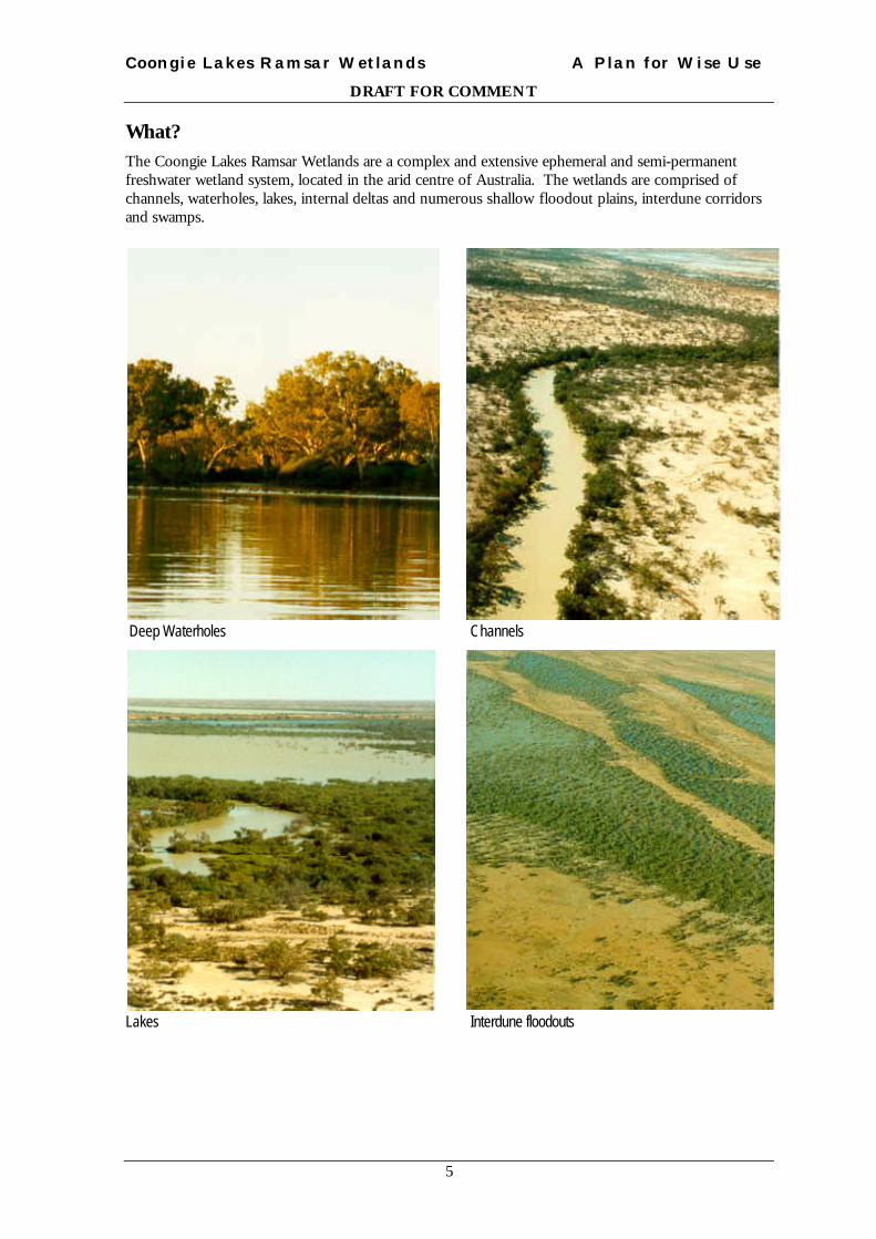
What?The Coongie Lakes Ramsar Wetlands are a complex and extensive ephemeral and semi-permanentfreshwater wetland system, located in the arid centre of Australia. The wetlands are comprised ofchannels, waterholes, lakes, internal deltas and numerous shallow floodout plains, interdune corridorsand swamps.
Deep Waterholes Channels
Lakes Interdune floodouts

Coongie Lakes Ramsar Wetlands A Plan for Wise Use
DRAFT FOR COMMENT
6
Figure 2 Wetlands features and Land Systems
Coongie Lakes Ramsar Wetlands A Plan for Wise Use
DRAFT FOR COMMENT
7
WATER COURSES AND OUTWASH PLAINS
Cr Cooper
Channels/ lakes/ swamps and crabhole flats of Cooper Creek floodplain. Main channels with coolibah/ river red gum (upstreamchannels)/ bean tree/ river cooba/ river emubush/ Broughton willow and lignum; swamps with Queensland bluebush/canegrass/ old man saltbush/ samphire and lignum; lakes lined with coolibah/ river couch and rushes; crabhole flats withcopperburrs and herbs; pale dunes and sand plains with whitewood/ sandhill wattle and sandhill canegrass; red longitudinal duneswith sandhill wattle and sandhill canegrass; interdune flats with variable soils and vegetation.
Cy Cooryaninna
Dm Diamantina
Fm Frome
Kc Kachumba
Mg Mulligan
Ps Paradise
Wr Warburton
GIBBER PLAINS/TABLELAND AND MESES
Mr Merninie
Gibber tableland and mesas of eastern Innamincka. Tableland and low hills with Mitchell grass/ neverfail and copperburrs; mesaswith emubushes/ gidgee and mulga over bladder saltbush; drainage lines with red mulga/ gidgee and river red gum; alluvial plainswith Mitchell grass/ copperburrs and forbs.
Kn Koonchera
Gently undulating gibber plains with Mitchell grass/ katoora and bladder saltbush. Run on depressions and swamps withQueensland bluebush/ cottonbush/ canegrass and neverfail; scattered long red sand dunes with sandhill, canegrass and desertcynanchum; drainage lines with coolibah/ plum bush /river emubush and river cooba.
Blo Bloodwood
Fl Flint
Ht Hermit
Kl Kalatinka
Kp Kopi
Lm Lamamour
Mp Mumpie
Oo Oodnadatta
Ss Sturts
SAND DUNES AND SAND PLAINS
Kt Kertietoonga
Dunefields/ swamps and lakes of Pandie Pandie/ western Cordillo Downs and northern Innamincka. Long red dunes with lobedspinifex/ sandhill, canegrass and scattered sandhill wattle and norrowleaf hopbush; variable interdune flats with blackbush/starbush neverfail on clay flats and lobed spinifex on sandy flats; swamps with canegrass and lignum; lakes fringed with samphireand copperburrs on lake beds.
Sz Strzelecki
Dunefields of the Strzelecki Desert. Red dunes with whitewood/ malga/ sandhill wattle/ sandhill canegrass and lobed withspinifex; sandyinterdune flats with colony wattle/ straggly corkbark over copperburrs and annual grasses; clay swales with Mitchell grass/ neverfailandplate grass.
Ep Eulpa
Jj Jeljendi
Kk Kallakoopah

Coongie Lakes Ramsar Wetlands A Plan for Wise Use
DRAFT FOR COMMENT
8
Tr Tirari
Wg Wirringina
Wk Wongianguru
Mq Marqualpie
De Della
LAKE COUNRTY
Ey Eyre
Bc Blanche
Lakes
Swamps and floodplains
Coongie Lakes wetlands of international importance (Ramsar Convention)
Public roads
- - - - - Vehicle track
Drainage
----- -- State border
Coongie Lakes Ramsar Wetlands A Plan for Wise Use
DRAFT FOR COMMENT
9
3 WHAT IS THE RAMSAR CONVENTION ?Concerned at the rapidity with which large stretches of marshland and wetlands in Europe were beingreclaimed or otherwise destroyed, the International Union for the Conservation of Nature and NaturalResources (IUCN) joined forces with the International Waterfowl Research Bureau (IWRB) and theInternational Council for Bird Preservation (ICBP) to launch in 1962 a programme to increaseawareness of the importance of wetlands to humanity and to contribute to their conservation.1
Successive meetings over the next eight years lead to the development of the text of the Convention onWetlands of International Importance Especially as Waterfowl Habitat. This text, adopted in Ramsar, a smalltown in Iran, in February 1971 is known as the Convention on Wetlands (Ramsar Iran, 1971) andpopularly, as the “Ramsar Convention”2.
The official name of the treaty reflects the original emphasis upon the conservation and wise use ofwetlands primarily as habitat for waterbirds. Over the years, however, the Convention has broadenedits scope to cover all aspects of wetland conservation and wise use, recognizing wetlands asecosystems that are extremely important for biodiversity conservation and for the well-being of humancommunities2.
Australia became the first signatory to the Convention in December 1975.
The Coongie Lakes Ramsar Wetlands was designated to the list of Wetlands of InternationalImportance on the 15th June 1987 (See original Ramsar Information Sheet Appendix A).
The Australian Government as a Contracting Party to the Ramsar Convention has undertaken to:
• designate at least one wetland for inclusion in the list of Wetlands of International Importanceand maintain its ecological character
• formulate and implement planning so as to promote Wise Use of all wetlands
• promote Wise Use of all wetlands through formulation and implementation of plans
• promote the conservation of wetlands by:• establishing nature reserves at wetlands whether or not they are Ramsar sites• the exchange of data and publication regarding wetlands• training in the fields of wetland research, management and wardening, and
• consult about implementation of the Convention especially with regards transfrontier sharedwater systems, shared species and development aid for wetland projects 3.
The Wise Use Guidelines call upon Contracting Parties to:
• adopt national wetland policies involving review of existing legislation and institutionalarrangements to deal with wetland matters
• develop programs of wetland inventory, monitoring, research, training and public awareness,and
• take action at wetland sites, involving the development of integrated management plans4.

Coongie Lakes Ramsar Wetlands A Plan for Wise Use
DRAFT FOR COMMENT
10
Wise UseWetlands worldwide support a very large number of human activities which depend directly on theproper functioning of the wetland ecosystem. Such activities, which contribute to a Nation’s grossnational product and to the welfare of local people, are totally dependent on the maintenance of theecological character of the wetlands.5
The concept of Wise Use is central to all aspects of the convention6 including the development ofintegrated management plans for wetlands listed under the Ramsar convention.
Wise Use of wetlands is7:
their sustainable utilisation for the benefit of humankindin a way compatible with the maintenance ofthe natural properties of the ecosystem.
Sustainable utilisation is:
human use of a wetland so that it may yieldthe greatest continuous benefit to present generationswhile maintaining its potential to meet the needs and aspirations of future generations
Natural Properties are:
those physical, biological or chemical components,such as soil, water, plants, animals and nutrientsand the interactions between them.
The implementation of the Wise Use principle at National, State and site level involves:
• establishment of mechanisms and procedures for an integrated, multidisciplinary approach toplanning and the implementation of projects concerning wetlands
• review of existing legislation and government policies including their application and adoption
• increasing knowledge and awareness of wetlands and their values
• review of the status of wetlands in the National context and the compilation of a National wetlandsinventory
• addressing the problems of a particular wetlands site by integrating environmental considerationsinto their management, regulated utilisation, establishment of management plans, establishment ofnature reserves and, if necessary, restoration8.

Coongie Lakes Ramsar Wetlands A Plan for Wise Use
DRAFT FOR COMMENT
11
Ecological CharacterThe principal undertaking of Contracting Parties with respect to listed wetlands is to promote theirconservation with the aim of preventing changes to their ecological character.
Ecological character is:
the structure and inter-relationships betweenthe biological, chemical and physical components of the wetland.These derive from the interactions ofindividual processes, functions and values of the ecosystem(s).
Change in ecological character of a wetland is:
the impairment or imbalance in any of those processes and functionswhich maintain the wetland and its products, attributes and values.
Processes are changes or reactions which occur naturally within wetland ecosystems. They may bephysical, chemical or biological.
Functions are activities or actions that occur naturally in wetlands as a product of the interactionsbetween the ecosystem structure and processes. Functions include flood water control, nutrient,sediment and contaminant retention, food web support, shoreline stabilization and erosion controls,storm protection, and stabilization of local climatic conditions, particularly rainfall and temperature.
Products generated by wetlands include wildlife resources, fisheries, forest resources, forageresources, agricultural resources and water supply. These products are generated by the interactionsbetween the biological, chemical and physical components of a wetland.
Attributes of a wetland include biological diversity and unique cultural heritage features. Theseattributes may lead to certain uses or the derivation of particular products, but they may also haveintrinsic, unquantifiable importance.
Values are the perceived benefits to society, either direct or indirect, that result from wetlandfunctions. These values include human welfare, environmental quality and wildlife support.

Coongie Lakes Ramsar Wetlands A Plan for Wise Use
DRAFT FOR COMMENT
12
4 WHY PLAN FOR WISE USE ?While the wetlands are often resilient to human use they should not be used in a way which wouldjeopardise their ecological character and benefit for future generations. The consistent message fromcase studies on wetlands around the world is that to conserve and protect these wetlands for futuregenerations, we require political will, best use of existing knowledge, coordination of management,research, training and evaluation of current management.
The Coongie Lakes Ramsar Wetlands has substantial social, biological and economic value to SouthAustralia, Australia and the world. The river processes of the Cooper Creek support a diverse range ofriver, lake and floodplain ecosystems, which in turn support a diversity of land uses. The land usesinclude biodiversity and cultural heritage conservation, petroleum and mineral exploration andproduction, pastoral land use, fishing, tourism and recreation. In the past these uses were addressedsectorally, giving a piecemeal approach to the conservation and Wise Use of the resources. Howeverin the recent past the level of integration of use has improved with cooperation between major landusers. This level of integrated management is achieved through a shared vision and a commitment byall people and industries involved to work together and to continue to improve our understanding ofthese wetlands, in order to maintain their ecological character and conserve their biodiversity andheritage values.
Although there is no statutory basis for this plan, the South Australian and CommonwealthGovernments recognise the obligations of international conventions, and domestic andintergovernmental agreements. Several of these are of particular relevance to this plan: the RamsarConvention, The Heads of Agreement in relation to the Lake Eyre Basin, the Inter-governmentalAgreement on the Environment (1992) and the Council of Australian Governments (COAG) WaterReform Framework.
The Ramsar Convention on Wetlands
The listing of Coongie Lakes Ramsar Wetlands under this Convention is recognition of the significanceof the wetland to South Australia, Australia and internationally.
The Heads of Agreement in Relation to the Lake Eyre Basin
The South Australian, Queensland and Commonwealth Governments have adopted a Heads ofAgreement in relation to the management of the Lake Eyre Basin. This Agreement is a statement ofacknowledgment, understanding and intention to establish an institutional structure that will providefor:
• high level interaction between the respective Governments, community involvement, scientific andtechnical input and the views of the Lake Eyre Basin Coordinating Group
• the development and adoption of management plans or policies for flow management regimes thatreflect current near natural and variable flows of the river systems, objectives for land and watermanagement, catchment management strategies to ensure that the objectives are met, research andmonitoring requirements and programs to meet those requirements.
These governments are working towards finalization of a formal Agreement, the provisions of whichwill be ratified by enabling legislation.
The 1992 Inter-governmental Agreement on the Environment
The 1992 Inter-governmental Agreement on the Environment acknowledges the importance ofadopting sound practices as a basis for ecologically sustainable development for the benefit of both theenvironment and the community. This agreement also describes the various roles and responsibilitiesof the Commonwealth and State and Territory Governemnts.
The COAG Water Reform Framework
In 1994 the Council of Australian Governments (COAG) agreed to a Water Reform Framework. Thisframework sets out a strategic package of interrelated economic and environmental reforms for

Coongie Lakes Ramsar Wetlands A Plan for Wise Use
DRAFT FOR COMMENT
13
management of Australian water resources. The framework includes provisions for water entitlementsand trading, environmental requirements, institutional reform, public consultation and education, waterpricing and research9.
The Ramsar Planning ProcessWith support from the Commonwealth, the Government of South Australia appointed a project officerto undertake a community consultation process and develop this draft plan for public comment.
The consultation process involved the establishment of six working groups, representing the six keysector interests in the area namely: conservation, water resources, Aboriginal, pastoral, tourism andrecreation, and petroleum and mineral exploration and production. These working groups eachprepared an issues paper that outlined the sector’s vision, aims, values, issues and best managementpractices and made recommendations for the future management of the area.
The issues papers were then used as a basis for the development of a Workshop Draft Coongie LakesWetlands Plan for Wise Use. That draft was commented on by industry sectors, edited and a secondworkshop draft prepared and issued to all those invited to the subsequent workshop including workinggroups, Environment Australia, and Division of State Aboriginal Affairs. These workshop draftsprovided information as a basis for discussions between the land managers and interested parties on amanagement framework for the wetlands. At a workshop held in Adelaide, those on the workinggroups and some other stakeholders were invited to edit the second workshop draft and agree on thetext of this draft for public consultation.
This Draft for CommentThis draft plan of management for the Coongie Lakes Ramsar Wetlands is open for public comment fora minimum period of three months. Comments received during this phase of consultation will beconsidered in the preparation of the final Coongie Lakes Ramsar Wetlands – Plan for Wise Use.

Coongie Lakes Ramsar Wetlands A Plan for Wise Use
DRAFT FOR COMMENT
14
5 VISION
The VISION for the COONGIE LAKES WETLANDS of internationalimportance is:
the maintenance of the ecological and hydrological character of the wetlandwhile utilizing the natural resources of the area in an ecologically sustainablemanner.
6 AIMThe AIM of theCOONGIE LAKES WETLANDS Plan for Wise Use is:
to document a framework and process for the coordinated management of theCoongie Lakes Ramsar Wetlands to ensure:
• maintenance of hydrological integrity and integration of the management of these wetlands withthat of the catchment
• Wise Use of the resources, and recognition of existing uses
• maintenance of biological diversity and productivity
• government, industry, local and wider community involvement
• improved understanding of the wetland system

Coongie Lakes Ramsar Wetlands A Plan for Wise Use
DRAFT FOR COMMENT
15
7 OUR COMMITMENTSThe COONGIE LAKES Ramsar WETLANDS PLAN FOR WISE USE
identifies strategies and actions to achieve five major committments
ONE Naturally Flowing Cooper CreekThe maintenance of the current near natural and variable flows of the Cooper Creek isessential to the ecological integrity of the Coongie Lakes Ramsar Wetlands. Anyincreased extraction or diversion of water from the catchment would pose a risk to theecological and hydrological integrity of the wetlands.
TWO Wise UseThe Coongie Lakes Ramsar Wetlands site supports industries of great economicimportance to the region, the State and the Nation. The principles of Wise Use underpinsthe way in which the wetlands are managed, developed and conserved. Resource usersand governments have developed policies and codes of practice which recognise theseinternationally accepted principles. These policies and codes need regular review andupdate to take account of new knowledge and technologies.
THREE Conserving Biodiversity and HeritageA foundation for this Wise Use plan is the conservation of the biological and culturalheritage of the Coongie Lakes Ramsar Wetlands. Our management needs to protect thebiological diversity and processes fundamental to maintaining ecological character and thecultural heritage of these wetlands. Our commitment to the conservation of the wetlandand to Wise Use principles will also ensure the ecological sustainability of industry in thearea. A basic level of monitoring of key wetland values is a prerequisite to realization ofthis commitment.
FOUR Better UnderstandingThe Coongie Lakes Ramsar Wetlands are ecologically, culturally and economicallyimportant wetlands nationally and internationally. Improving our understanding andmonitoring of ecosystem processes, habitats and ecological responses to resource use isessential for maintaining the natural, cultural and economic values of the wetlands. Goodinformation supports community understanding, and leads to well informed planning anddevelopment decisions about ecologically sustainable use of aquatic and land resourcesand the relationship between the two.
FIVE Working TogetherThe whole community has a stake in the condition and future management of theenvironment. Partnerships between government, industry and the local and widercommunity will help maintain the transparency of management processes, sharing ofgovernance where appropriate, sharing of knowledge and data and effective coordinationand integration of activities, in the Coongie Lakes Ramsar Wetlands. With the opportunityto have a say in the common property resources of the area comes responsibility, anopenness to debate, recognition that there may be varying opinions and a collective dutyof care.

Coongie Lakes Ramsar Wetlands A Plan for Wise Use
DRAFT FOR COMMENT
16
Principles for Wise Use and Planning.The following principles are a foundation of this plan and should act as a guide to the development ofsubsequent action plans.
BiologicalDiversity
Biodiversity and ecological processes provide critical services for quality of lifeand must be protected and maintained.
ExistenceValue
Living organisms, earth processes and ecosystems may have value beyond thesocial, economic or cultural values held by humans.
UncertaintyPrinciple
Our knowledge of natural heritage and the processes affecting it is incomplete,and the full potential significance or value of natural heritage remains unknownbecause of this uncertain state of knowledge.
Wise Use The use of natural resources must be compatible with Wise Use.
CommonResource
The Coongie Lakes Ramsar Wetlands are a common resource that hasenvironmental, economic, cultural, scientific and recreation attributes.
AboriginalPeople
Aboriginal people have sites of significance in, and rights of access to these areas.
Inter-generationalEquity
The present generation should ensure that the health, diversity and productivityof the environment is maintained or enhanced for the benefit of futuregenerations.
Rights ofTenure
Various tenures issued by the Government of South Australia provide to theholders of those tenures rights of use and set conditions for such use.
Compensation Holders of tenures are entitled to full and fair compensation for loss of tenurerights or expenses associated with implementing management requirementsbeyond that required by these tenures.
Co-operation While the South Australian and Commonwealth Governments have clearresponsibility for the management and conservation of the wetlands, thecooperation and participation of the Queensland Government, resource users,indigenous peoples, conservation groups and the local and wider community iscritical to wellbeing of these wetlands.
CatchmentManagement
Total catchment management is necessary to conserve the environmental,economic, cultural, scientific and recreational values of the wetlands.
DecisionMaking
Effective decision-making requires transparent processes and integration of bothlong and short-term economic, environmental, and social and equityconsiderations; and the sharing and use of best available scientific information.
AdaptiveManagement
Management should be based around the development of evolutionary andinnovative management policies that respond to the understandings gained frommanipulative and experimental environmental and resource research conducted atrelevant landscape scales.
PrecautionaryPrinciple
Where there are threats of serious or irreversible environmental damage, lack offull scientific certainty should not be used as a reason for postponing measures toprevent environmental degradation.

Coongie Lakes Ramsar Wetlands A Plan for Wise Use
DRAFT FOR COMMENT
17
8 RESPONSIBILITY AND CARE
Wetlands constitute a resourceof great economic, cultural, scientific and recreational value to human
life;wetlands and people are ultimately interdependent.
CommunityDeveloping and implementing public policies is invariably enhanced by community consultation andcommitment. There are several communities with interests in the area. There is the local community;those who live, work and invest their livelihoods in the area. The local community has obligations tothe well-being of the environment and each other, and is involved in the various local self-managementcommittees which provide local empowerment.
The wider community consists of people who may live external to the area but who visit, conductbusiness or hold an interest in the features, values and well-being of the Coongie Lakes RamsarWetlands environment. This wider community includes scientists, conservationists and outbacktravellers who take a strong interest in the well-being of the area and their interest has beeninstrumental in achieving the current level of recognition and formal conservation status of thewetlands. The wider community contributes towards the Wise Use of the area, its conservation,monitoring and information collection, information dissemination, discussion about the regionswellbeing, and is actively involved in appropriate planning processes.
There is a need for all interests to both recognize and respect each others stake in the region.
Community based groups that influence integrated management within the Coongie Lakes Ramsar Wetlands
Australian Conservation FoundationConservation Council of South AustraliaCooper Creek Catchment Committee (a cross-border community integrated catchment management committee)Great Artesian Basin Consultative Council (Advisory council to State and Commonwealth governments on issues
relating to and the management of Great Artesian Basin water.)Far Northern Consultative Committee (Advisory Committee to Minister for Environment and Heritage)Innamincka Progress AssociationLake Eyre Basin Coordinating Group (peak coordinating group for integrated catchment management committees in
the Lake Eyre Basin)Nature Conservation SocietyNorth-East Lands Aboriginal CorporationSouth Australian Association of Four Wheel Drive ClubsSouth Australian Recreational Fishing Advisory CouncilThe Wilderness Society

Coongie Lakes Ramsar Wetlands A Plan for Wise Use
DRAFT FOR COMMENT
18
IndustryThis plan for Wise Use recognises industry’s role in the use of the Coongie Lakes Ramsar Wetlandsarea to generate wealth and employment opportunities. Petroleum exploration and production, tourismand recreation, pastoralism and fishing are part of the fabric of the region and have made significanteconomic and social investments in the area. These industries hold extensive access and use rightswithin the Coongie Lakes Ramsar Wetlands through tenures issued by the State Government. Thesetenures also specify conditions of use that include requirements to maintain the renewable resourcesand yield in the case of pastoralism and fishing, and to avoid or minimise any adverse impact on theenvironment in the case of petroleum operations.
Industry based groups that influenceintegrated management within the Coongie Lakes Ramsar Wetlands.
Cooper Basin Joint Venture (oil and gas producers)Environmental Review Group (Review of codes of environmental practice and exploration and production applications
in the Cooper Basin)Flinders Ranges and Outback South Australia Tourism CommitteeInland Fisheries Management Committee (advises and makes recommendations to the Minister and or Director
Fisheries on the Fisheries Act, regulations and administration of the Act and other matters)South Australian Chamber of Mines and EnergySouth Australian Farmers FederationSouth Australian Fishing Industry CouncilPetroleum and mining companies which may be granted tenements

Coongie Lakes Ramsar Wetlands A Plan for Wise Use
DRAFT FOR COMMENT
19
GovernmentsThe local and international significance of the Coongie Lakes Ramsar Wetlands and the extent ofcommunity interest in the area affect a continuing policy setting and management role for both Stateand Commonwealth governments.
South Australian Government has made laws, administrative arrangements and pursued research anddevelopment programs affecting management of the Coongie Lakes Ramsar Wetlands. Particularlyrelevant are the various statutory bodies that promote community and industry decision making andaction to meet government, industry and community objectives. This plan for Wise Use aims tointegrate those diverse and in some instances, complex arrangements to provide a strategic approachand clearer outcomes for government, industry, sector groups and community in the Wise Use of theCoongie Lakes Ramsar Wetlands.
The goal of the wetlands policy of the Commonwealth of Australia is to conserve, repair andmanage wetlands wisely.
The Commonwealth is a Contracting Party to the Ramsar Convention on Wetlands whichprovides a framework for cooperative intergovernmental action at the global level to stem theprogressive encroachment on and loss of wetlands and take measures for Wise Use of wetlandresources.
The policy of the South Australian Government provide that the Coongie Lakes RamsarWetlands, as part of the Lake Eyre Basin is an area of great environmental and economic significance toSouth Australia.
The South Australian Government10 will:• ensure that the Basin’s value as an aquatic system is enhanced,• ensure full protection of the Coongie Lakes region,• seek active cooperation with other States and the Northern Territory in the total catchment
management of the Lake Eyre Basin,• ensure the long term future of the Lake Eyre Basin by continuing to work with the Queensland
and Commonwealth governments to ensure that the provisions of the Heads of Agreement inrelation to management of the Lake Eyre Basin are worked through to develop legislativelybinding integrated catchment management and water resources management regimes.
Statutory Bodies that influenceintegrated management within the Coongie Lakes Ramsar Wetlands.
Arid Areas Water Resources CommitteeNative Vegetation Council (implementation of the Native Vegetation Act)Pastoral Board (implementation of the Pastoral Land Management and Conservation Act)Soil Conservation Council of South Australia and the Marree Soil Conservation Board (implementation of
the Soil Conservation and Land Care Act)South Australian National Parks and Wildlife CouncilState Aboriginal Heritage CommitteeState Heritage AuthorityTourism South Australia

Coongie Lakes Ramsar Wetlands A Plan for Wise Use
DRAFT FOR COMMENT
20
International Treaties, State and Commonwealth Policies and Legislation
that influence how obligations are managed in the Coongie Lakes RamsarWetlands.
SOUTH AUSTRALIAN GOVERNMENTPolicy of the Liberal Party of SA – Focus on our Environment and Natural ResourcesTourism South Australia-Environmental Code of PracticeAboriginal Heritage Act, 1988Animal and Plant Protection (Agricultural and other Purposes) Act, 1986Development Act 1993Environmental Protection Act 1988Cooper Basin (Ratification) Act, 1975Fisheries Act 1982Heritage Act, 1993Mining Act 1971National Parks and Wildlife Act, 1972Native Title (SA) Act, 1994Native Vegetation Act, 1991Pastoral Land Management and Conservation Act, 1989Petroleum Act, 1940Soil Conservation and Land Care Act, 1989Water Resources Act 1997Wilderness Protection Act, 1992
COMMONWEALTH GOVERNMENTInter-governmental Agreement on the EnvironmentNational Water Reform Agreement - Council of Australian GovernmentsWetlands Policy of the Commonwealth of Australia 1997National Strategy for Ecologically Sustainable DevelopmentNational Strategy for the Conservation of Australia’s BiodiversityNational Principles for the Provision of Water for EcosystemsNational Water Quality Management StrategyNational Weeds StrategyNational Eco-tourism StrategyAboriginal and Torres Strait Islander Heritage Act 1984Australian Heritage Commission Act, 1975Endangered Species Protection Act 1992Native Title Act 1993Racial Discrimination Act 1975
INTERNATIONAL AGREEMENTSAgreement between the Government of Australia and the Government of the People’s Republic of China for the
Protection of Migratory Birds in their Environment (CAMBA)Agreement between the Government of Australia and the Government of Japan for the Protection of Migratory
Birds and Birds in Danger of Extinction and their Habitats (JAMBA)Convention on Wetlands of International Significance Especially as Waterfowl Habitat (Ramsar Convention)Charter for the Conservation of Places of Cultural Significance (Burra Charter)Convention on Biological DiversityConservation of Migratory Species of Wild Animals (Bonn Convention)Convention on International Trade in Endangered Species of flora and fauna (CITES)Rio Declaration on Environment and DevelopmentInternational Covenant on Civil and Political RightsInternational Covenant on Economic, Social and Cultural Rights


Coongie Lakes Ramsar Wetlands A Plan for Wise UseDRAFT FOR COMMENT
22
9 VALUING THE COONGIE LAKES Ramsar WETLANDSSignificance, Benefits, Uses and ValuesThe Coongie Lakes Ramsar Wetlands region contributes to SouthAustralia’s biodiversity and geodiversity, environmental quality, social andcultural life, and economic wealth. The significance, benefits and valuesascribed to these wetlands are many and varied. They include biodiversity,geodiversity, cultural heritage and petroleum industry and products,recreation opportunities, tourism industry, pastoral industry and beefproduction, commercial and recreational fishery, intrinsic, bequest andaesthetic values.
Natural Significancemeans the importance ofecosystems, biologicaldiversity and geodiversityfor their existence value,or for present or futuregenerations in terms oftheir scientific, social,aesthetic and life-supportvalue11.
Benefits meanscharacteristics both singlyor in combination, thatgive rise to benefits.Benefits may befunctions, uses orattributes12.
Values are the perceivedbenefits to society, eitherdirect or indirect, thatresult from wetlandfunctions. These valuesinclude human welfare,environmental quality andwildlife support13.
SIGNIFICANCEThis is based upon the ecological character of the wetlands.
BiodiversityThe lower Cooper Creek floodout and Coongie Lakes are near naturalwetlands within the Channel Country Biogeographic Region and play asubstantial role in the ecological and hydrological functioning of theCooper Creek Basin. The variability of flows, rainfall and the complexfloodplain landscape give rise to a great variety of floodplain and aquatichabitats. Sixty wetland habitats based on the levels and frequency ofinundation, soil types and vegetation species and structure have beendescribed within the Cooper System14. The aquatic habitats of thesewetlands are also diverse both spatially and temporally.
Species biodiversity of the Coongie Lakes Ramsar Wetlands is outlined inthe following pages, with more detailed information provided in theRamsar Information Sheet (see Appendix B).
Mammals: An isolated population of the water rat occurs in the CooperChannel and some of the lakes and swamps of the Coongie system.
Birds: Seventy-four waterbird species and 13 other wetland dependantspecies have been recorded within the Coongie Lakes Ramsar WetlandsRamsar area. Forty-five waterbird and a further 10 wetland dependantspecies are known to breed in the area. Twenty -six species of waterbirdoccurring in the area are listed under treaties, 17 species are migratory and2 vagrant. Fourteen species are listed as rare, endangered, or vulnerable inSouth Australia. Large congregations of waterbirds on the lakes occur, forexample 35 000 ducks in 1987, and a breeding colony of more than 50 000
Biodiversity means thevariety of life forms: thedifferent plants, animalsand microorganisms, thegenes they contain andthe ecosystems they arepart of11.
Geodiversity means therange of earth features,systems and processes.These include geological,hydrological, soil,geomorphological andatmospheric features,systems and earthprocesses11.
The process of evolutionmeans that the pool ofliving diversity isdynamic: it increaseswhen new geneticvariation is produced, anew species is created ora novel ecosystemformed; it decreases whenthe genetic variationwithin a species
Coongie Lakes Ramsar Wetlands A Plan for Wise UseDRAFT FOR COMMENT
23
Australian Pelicans in 1992. A conservative estimate15 of 250 000waterbirds was recorded for the central wetlands for November 1997. It isconsidered likely that total waterbird abundance may exceed 500 000 attimes during big flood events such as 1974-76 and 1989-91, but this isdependent on external factors like rainfall and flooding elsewhere in inlandAustralia.
Raptors The Cooper and Strzelecki Creeks support a major assemblage ofraptors in Australia consisting of 18 species, of which 16 breed locally.
Fish The fish community of the Coongie Lakes region includes 12 nativefish, two of which are endemic to the Cooper Catchment: the Lake Eyrecallop and the Cooper Creek catfish.
Amphibians Ten frog species have been recorded in the area, a rich frogcommunity for central Australia.
Reptiles The wetland contains a morphologically distinct form of thefreshwater turtle. The red naped snake, woma python and black-headedgoanna all have an uncertain abundance and small or sparse range thatincludes the Coongie Lakes Ramsar Wetlands.
Macroinvertebrates Studies16show that many of the taxa found within theCooper/Coongie system are also found elsewhere (Diamantina River andMurray-Darling Basin), but the Cooper/Coongie system shows a high levelof within-site diversity which is not apparent in the more developedcatchments of the Murray-Darling Basin17b&c. Molluscs are abundant andwidespread, with Velesunio wilsonii ubiquitous on the more frequentlyinundated waters and a variety of gastropods - particularly Austropeplealessoni, Glyptophysa gibbosa and Notopala sublineata - form a significant biomassin the highly vegetated littoral zones. These populations of gastropods aresignificant as comparable populations in the heavily developed Murray-Darling Basin are severely threatened if not extinct 17a. This makes therivers of the Lake Eyre region the last refuge for many of these large rivergastropod taxa. Gabbia australis seems to be characteristic of ephemeralwater bodies. The composition of the fauna appears to vary with durationof inundation and on lotic-lentic axis, distinguishing channel and lakehabitats16.
Flora Approximately 350 species of plant have been identified from theCoongie Lakes area18 including 4 species listed as rare (r) or endangered.(e)at the State (S) or National (N) level. These are Osteocarpum pentapterum (Se),Frankenia cupularis (Sr, Nr), Echinochloa inundata (Sr), and Goodenia lobata (Sr,Nr).
The apparent small number of threatened species is likely to reflect ourlack of knowledge about the distribution and abundance of the rarerspecies in the region.
decreases, a speciesbecomes extinct or anecosystem complex islost. The conceptemphasizes theinterrelated nature of theliving world and itsprocesses19.
Lotic – relating toactively flowing watersuch as currents.
Lentic – relating to slowmoving or stagnant watersuch as lakes or swamps.
HabitatsRiparian The river red gum dominated riparian woodlands occur as anarrow strand along the banks of the Kudriemitchie and TirrawarraWaterholes. The vegetation is floristically and structurally more diversethan the coolibah riparian woodland of the lakes and inter-lake channels.Some of the smaller tree species that occur in these riparian woodland
Riparian – pertaining towatercourse andincluding the watercourseits banks and alluvialplains.

Coongie Lakes Ramsar Wetlands A Plan for Wise UseDRAFT FOR COMMENT
24
communities are Queensland bean-tree, Broughton willow, river coobah,plum bush and the occasional stand of sour plum18.
Open to sparse coolibah woodlands are scattered through the district’sfloodplain environment, often associated with dry lake beds, or markingprevious high water levels around the outer margins of floodplains. Thesesupport a relatively rich bird community although densities are much lowerthan for the riparian woodlands18.
Lignum occurs as shrublands, sometimes co-dominant with Queenslandbluebush, and/or as a shrub layer under a woodland canopy. This habitatalso supports a suite of terrestrial animals and birds and is refugial habitatfor the ‘plague’ long-haired rat Rattus villosissimus18. The Lake Eyre Callopis known to breed in Tirrawarra Swamp an intricate network of steep-sidedchannels lined with coolibah and lignum20.
Most of the floodplain carries sparse, low vegetation of variablecomposition, dominated by ephemeral or short-lived perennial species.Cover and species composition change through the year and betweenyears, with heavy rains producing a spurt of dense growth, the compositionof which is determined by the season in which the rain falls18.
An important and distinctive habitat in the district’s range of floodplainenvironments is the densely vegetated normally dry lake-bed. LakeApachirie, immediately west of Lake Coongie is a good example. Theselakes receive water from the Cooper Creek only occasionally and arecharacterised by rich, friable, deeply cracking clays. 18.
Dune field habitats can be divided into two forms, Kertietoonga LandSystem and Strzelecki Land System (see Figure 2). Kertitoonga LandSystem consists of red dune fields with semi mobile crests in places and aperennial cover of sandhill canegrass and lobed spinifex; interduneswamps contain starbush, blackbush and neverfail. Interdune drainage andlakes are ephemeral, lakes support coolibah over samphire or lignumshrubland.
The Strzelecki land system describes the dunefields of the StrezeleckiDesert in the south-east of the Ramsar site. The desert consists of reddunes which support scattered low trees and shrubs including whitewood,mulga and sandhill wattle over sandhill canegrass and lobed spinifex.Sandy interdune flats support low trees including colony wattle andstraggly corkbark with a ground cover of copperburrs and annual grasses.Clay interdune swales support Mitchell grass, neverfail and plate grass.
Gibber Plains The Koonchera land system occurs in the north of theRamsar site (see Figure 2). It consists of gently undulating gibber plainscrossed by major drainage and run-on depressions and swamps and limitedoccurrences of red dunes. The gibber plains support vegetation dominatedby Mitchell grass, katoora and bladder saltbush; run-on depressions andswamps are vegetated with Queensland bluebush, cottonbush, canegrassand neverfail; creek channels are lined with coolibah, plum bush, riveremubush and river cooba and long red sand dunes are dominated bysandhill canegrass.
Gibber plains – plainswith a covering of desertvarnished stone.

Coongie Lakes Ramsar Wetlands A Plan for Wise UseDRAFT FOR COMMENT
25
RefugiaThe Coongie Lakes Ramsar Wetlands has been identified as a highlysignificant refuge. The wetland system provides habitat for an extensiverange of plants and vertebrate and invertebrate animals, both aquatic andterrestrial, in an otherwise arid and waterless environment21.
The diversity and changeability of habitat has resulted in a moderately richaquatic biota characterised by spectacular fluctuations in abundance, highdispersal and colonising capabilities, tolerance of extreme conditions andflexible opportunistic life histories22.
The Coongie Lakes region supports a highly diverse and at times abundantbird population. With over 205 species reliably recorded, the region mayhave a higher bird species diversity than any other truly arid region inAustralia22.
Flooding is the most crucial factor in shaping the life-history patterns ofaquatic biota in the region. Waterbirds move between the lakes tocapitalise on habitats that suit their dietary needs, foraging methods orreproductive condition that change as the lakes fill and recede. The fishpopulations of the system also respond to flooding in various ways.Juveniles undertake downstream colonising migrations, and adults of mostspecies spawn during floods, some such as the Lake Eyre Callop, afterupstream migration to breed in the lignum swamps. The breedingbehaviours of most species are more flexible, however, than their southernAustralian counterparts. The highly variable flooding regime also enablesadaptations to drier conditions. Crustaceans such as the shield shrimp, theclam shrimps and the fairy shrimps hatch from drought resistant eggs andlive through an accelerated life cycle. The inland crab and the burrowingfrog survive long droughts by sealing themselves in burrows22.
Refuge – a region inwhich certain organismssurvive during a period inwhich most of theiroriginal geographic rangebecomes uninhabitable.Thus, species may retreatto refugia because ofclimatic change,unsuitable climatic orecological conditionssuch as drought or flood,or because ofenvironmental changesset in train by humanoccupation21.
Ecological IntegrityThe integrity of the natural functioning of the Cooper Creek system hasintrinsic value.
The flora and fauna of the area are believed to be largely unaltered.However all but one of the original medium sized native mammals (aboutten species) are extinct at the site. Without an adequate benchmark itcannot be verified, but it is believed that many changes to the abundanceand dynamics of individual species’ populations and the communities theyform have occurred historically, largely as a result of introduced grazinganimals23.
Relatively few (6%) alien plant species occur in the Coongie LakesWetlands34. There are some weed problems in the area for exampleMexican poppy and couch grass.
The fish fauna of the wetland is largely unaltered in its ecology andpopulation structure. There are at least two exotic fishes in the site, thegold fish and the plague minnow (and perhaps the Murray Cod) although
Ecological integrity – thegeneral health andresilience of natural life-support systems,including their ability toassimilate wastes andwithstand stresses such asclimate change and ozonedepletion 24.

Coongie Lakes Ramsar Wetlands A Plan for Wise UseDRAFT FOR COMMENT
26
the native fishes are numerically dominant.
Introduced and feral terrestrial animal species in the wetland area includerabbits, pigs, wild horses, donkeys, camels, house mice, house sparrows,common starlings, foxes and cats. Introduced animals of course includethe cattle and horses of the pastoral livestock industry.
Hydrological DiversityThe variety and significance of the geological and hydrological featuresand processes are derived from the arid and variable nature of the Coopersystem. The Cooper Creek and Coongie Lakes form a complex mosaic oflakes, channels, internal deltas and interdune floodouts providing a greatvariety of habitats. It is also a relatively unaltered and unpollutedcatchment with natural flows.
The Lake Eyre Basin, of which the Cooper is a major catchment, is thebest example of, and one of the largest endorheic regions in the world 25.The Cooper Creek and Coongie Lakes are unusual in their entirely arid andsemi-arid catchment, in their endorheism, in their exceptionally variablehydrology, the occurrence of numerous disjunctions and their terminationin a large saline playas, Lakes Eyre and Blanche26, 27. It is a typicalexample of an influent or losing river system, where water just ceases toflow, reaching neither a playa nor the sea.
The Lower Cooper floodout and Coongie Lakes are a near-natural wetlandwithin the Channel Country Biogeographic Region 28. Compared withother wetlands of the Channel Country Biogeographical Region the CooperCreek and Coongie Lakes system is located in a more arid region and isgeomorphically different. The Coongie Lakes are also less regularly filledand are much more extensive than the lakes of the Paroo, Diamantina andDarling systems.
Geodiversity – the rangeof earth features , systemsand processes. Theseinclude geological,hydrological, soil,geomorphological andatmospheric features,systems and earthprocesses11.
Endorheic/endorheism –draining to an inlandwater body, in this caseLake Eyre.
Influent or losingstreams- streams orreaches of a river in whichthere is a net loss ofsurface water from thesystem due to evaporationor soakage.
Biogeographicregionalisation – anecologically meaningfulregionalisation whichdefines the majorecosystems of Australia9.
The climate of the region is arid to semi-arid, and the distribution ofrainfall is exceptionally variable, both spatially and temporally. Thevariability of rainfall in the Cooper Creek catchment in turn gives rise tovery high hydrological variability over very long time scales and results inerratic alternations of wetland flooding and drying. The large size of thecatchment and the low gradient and relief give rise to extensive floodplainsover which alternate flooding and drying occur.
The interaction between the surrounding dunefields, the highly variableflows of the Cooper Creek and the highly variable local rainfall produces acomplex floodplain landscape with varying frequency, timing and durationof inundation, flow rates, balance of rainfall and river inputs, shorelinedevelopment, vegetation density and structure, and water chemistry. Thereare deep permanent river channel reaches, freshwater and saline lakes,internal deltas, swamps, braided channel systems, flooded woodlands andgrasslands and samphire claypans. The intricacy of inundation patterntogether with the dune topography provides for a high degree of landscapepatchiness and density of edge effects or riparian ecotones that contributeto the diversity of habitat. The innumerable flow ponding areas providedby this landscape are likely to act as nutrient traps and therefore as sites ofhigh productivity and as drought refugia29.
As with biodiversity, there is a need to develop accurate models of the
Wetlands – areas ofmarsh, fen, peatland, orwater, whether natural orartificial, permanent ortemporary, with waterthat is static or flowing,fresh or brackinsh or salt,including areas of marinewater the depth of whichat low tides does notexceed six metres.Wetlands may incorporateriparian and coastal zonesadjacent to the wetlands,and islands or bodies ofmarine water deeper than

Coongie Lakes Ramsar Wetlands A Plan for Wise UseDRAFT FOR COMMENT
27
hydrology, particularly with respect to filling sequences, lateral spread andflood depth of the site’s numerous lakes, other wetlands and floodplains.The model that is eventually developed needs to be sensitively calibratedto the many rainfall gauging stations and the few flow and height gaugingstations available throughout the Cooper Catchment. Such accuratemodelling and predictive forecasting capabilities will be a prerequisite tosound conservation management and wise use.
six metres as low tidelying within thewetlands30.
BENEFITSBenefits provided by the biodiversity of the wetland are various.Identified benefits are listed below in three groups: ecosystem services,biological resources and social benefits.
Ecosystem functions and processes include water purification by wetlandprocesses, flood mitigation, soil formation processes, nutrient storage andcycling, pollution breakdown and absorption.
Ecosystem functions and processes identified as valuable by thecommunity are:
• flooding of the wetland provides water and nutrient inputs thatresult in the phenomenal breeding and migratory events ofinvertebrates, fish and waterbirds
• receding water levels after flooding and high flows promote thegrowth of highly nutrient native pastures
• permanent and near permanent high quality water resources• drought refugia for biota in the arid zone.
Biological resources (products) include high quality water used for bothdomestic and stock water, fish harvested by recreational fishers and by oneopportunistic commercial fishery, firewood utilised by locals and visitors,pastures utilised for livestock production and timber products harvestedfor traditional uses by Aboriginal people.
The biodiversity of the area may also yield medicinal resources in thefuture. In the future, other resources are likely to be discovered asknowledge improves.
Biological diversity is an intrinsic part of the value of the wetland fortourism and recreation purposes. The cultural value of biological diversityfor present and future generations is an important reason for conserving ittoday. The natural environment provides for many of the inspirational,aesthetic, spiritual and educational needs of people.
The many values of biological diversity and its importance fordevelopment differ from traditional nature conservation. Biologicaldiversity conservation entails a shift from a reactive posture – protectingnature from the impacts of development – to a proactive effort to meet
Benefits may be eitherfunctions, products, usesor attributes12.
Functions are activities oractions which occurnaturally in wetlands as aproduct of theinteractions between theecosystem structure andprocesses13.
Processes are changes orreactions which occurnaturally within wetlandecosystems. They may bephysical, chemical orbiological13.
Products are generated bythe interactions betweenthe biological, chemicaland physical componentsof a wetland. Theyinclude wildlife resources,fisheries, woodlandresources, agriculturalresources and watersupply13
Attributes –characteristicsor combinations ofcharacteristics which donot necessarily provide afunction or support a use,but which are valued by a

Coongie Lakes Ramsar Wetlands A Plan for Wise UseDRAFT FOR COMMENT
28
peoples’ needs from biological resources while ensuring the long-termecological sustainability of Earth’s biotic wealth31.
Social Benefits (attributes) such as research, education and monitoring.There is still much to learn about how to get better use from biologicalresources, how to maintain the genetic base of harvested biologicalresources and how to rehabilitate degraded ecosystems. Natural areasprovide excellent living laboratories for such studies, for comparison withother areas under different systems of use and for valuable research intoecology and evolution. Unaltered habitats are often essential for certainresearch approaches, providing controls against which the changes boughtabout by different management regimes may be measured and addressed.
The Coongie Lakes Ramsar Wetlands sustains a poorly understood biota.Knowledge of the functioning of this large and mostly unregulatedcatchment may help repair and better manage highly modified anddegraded catchments such as the Murray-Darling Basin.
group within society.They may lead to certainuses or the derivation ofparticular products, andmay have intrinsic,unquantifiableimportance. Attributesinclude biologicaldiversity and uniquecultural heritage features12,13.
Natural Capital – thestock of productive soil,fresh water, clean air,vegetation and otherrenewable resources thatunderpin the survival,health and prosperity ofhuman communities32.

Coongie Lakes Ramsar Wetlands A Plan for Wise UseDRAFT FOR COMMENT
29
NATURAL RESOURCE USE
Petroleum industry and products
The Coongie Lakes Wetlands partly overlies the Cooper Basin, which isthe most significant, wholly onshore, petroleum (oil and gas) resource inAustralia. It is estimated that the Coongie Lakes Wetlands Ramsar areacovers 30% of the known resources within the South Australian portion ofthe Cooper Basin. The oil and gas resources from this region provide theraw material for petroleum products for manufacturing and are of strategicimportance to South Australia and New South Wales.
The economic wealth generated by these petroleum resources for 1996were (in 1996 A$):
Exploration expenditure $ 21 millionDevelopment capital expenditure $100 millionRevenue $196 millionRoyalties $ 13 million.Additional household income $ 7.6 millionValue adding impact $ 20 millionDirectly supported jobs 274 FTEAdditional indirect jobs 357 FTE
Future prospects for petroleum exploration and production activity in theregion depends on the life of the wells currently known or in production,and the potential to find and exploit new resources. With considerableexpenditure on exploration and new technologies and geoscientificunderstanding of the area, the likelihood of further significant discoveriesremains high. It is estimated that undiscovered reserves of 60 to 1100petajoules of Sales Gas and 800 to 6300 megalitres of oil may still occurwithin the Ramsar area.
There is moreover yet untapped potential to exploit other energy resourcesin the region. These include in-situ coal gasification and geothermalenergy.
The petroleum industry contributes to the fabric of the region through themaintenance and building of new roads and tracks, provision of access tomedical services and support for other land users, social facilities andactivities33.
Petajoule – a unit ofenergy. The energydemand for SouthAustralia in 1996 was 80petajoules.
Mineral IndustryBorrow pits for extraction of soil for road construction is currently theonly mineral extraction activity in the region. The potential of the area formineral exploration is unknown although some interest in exploration hasbeen recently expressed by mineral exploration companies.
Recreation and TourismThe Coongie Lakes Ramsar Wetlands is a tourist destination for anincreasing number of visitors. Visitor numbers fluctuate with season andhave increased from approximately 5 000 in 1985 to 16 000 visitor nights in1986 and 25 000 visitor nights in 198734. An estimate derived from recent
Coongie Lakes Ramsar Wetlands A Plan for Wise UseDRAFT FOR COMMENT
30
visitor counts conducted by the National Parks and Wildlife SouthAustralia put visitor nights at Cooper Creek in Innamincka RegionalReserve at between 30 000 and 50 000. The increase in visitor numbers isattributed in part to media coverage and in part to improvements to roadaccess to the area.
Visitors are generally seeking a remote outback and ‘soft’ adventureexperience. Many people are attracted by the wide-open spaces and thebeauty of the landscape that includes dunes, great expanses of water in thelakes, and tree-lined waterholes and creeks.
The wetlands provide a variety of recreational opportunities. The diversebird life attracts the interest of bird watchers, recreational fishing isrewarding and passive water sports including swimming and canoeing arerefreshing in the otherwise arid landscape and sites of historic significanceprovide a focus for the visitor.
The Australian Inland Mission building opened in 1929 provided a medicalservice to the community until 1951. This building, a ruin for over 40years was reopened in 1994 as the National Parks and Wildlife SA office,visitor interpretation centre and staff accommodation.
The benefits to the local and wider community of recreation and tourisminclude:
• opportunities to experience the wetlands and the diversity of wildlife• space for people to relax contributing to the physical and spiritual
health of the community• opportunities for social activities such as the Innamincka Races• income to the region based upon average visitor numbers of 15,000 per
annum was estimated to be $7.5 million per annum36
• provision of jobs for about 30 local people per annum36
• opportunities for business, including services such as food andaccommodation, vehicle repairs and tours including fly-in, fly-out tours,cruises, and tag-a-long tours36.

Coongie Lakes Ramsar Wetlands A Plan for Wise UseDRAFT FOR COMMENT
31
Pastoral livestock industry and productsThe Coongie Lakes and Cooper Creek waterholes provide domestic andstock water and extensive areas of naturally irrigated native pasture that isthe basis of the pastoral industry in the area. The high quality of thefloodplain pastures allows the production of premium, chemical-free beef,which sells on both the Australian and international markets.
Income and employment benefits derived from pastoralism within theCoongie Lakes Ramsar site are difficult to estimate since the siteboundaries do not accord with the boundaries of pastoral leases. Theprofile of such benefits published for the Innamincka pastoral enterprise35
36 can however be extrapolated to the larger area of the Coongie LakesRamsar Wetlands site as a guide. At a district average stocking rate of 0.8cattle per square kilometre, the Coongie Lakes Wetlands Ramsar area areestimated to support 16 000 cattle, average an annual $2.8 million in grosscash receipts and employ 20 people. Spending on goods and services of$1.3 million annually supports a range of businesses and other serviceproviders in the wider region. Approximately $450 000 is paid annually tothe Commonwealth and State Governments in taxes and charges. Thesefigures do not include any multiplier effect or pastoral production outsidethe boundaries of the Coongie Lakes Wetlands Ramsar site.The pastoral occupation of this vast landscape provides additional benefitsto the community. Pastoral people provide the core management supportfor the area; control of feral animals, off-road vehicle use, community andtraveller safety, policing illegal activities including the taking of wildlife,and provide a base for research and monitoring in the region. The localcommunity also organises and supports a range of social and communitystructures and functions such as the Innamincka Picnic Races and theRoyal Flying Doctor Service. Much Australian folklore is also attached topastoral activities in the region.
Recreational and Commercial FisheryThe Cooper Creek system is a well known and popular recreational fishingdestination. Improvements to roads and visitor facilities at Innamincka andtracks around the waterways have increased to potential for recreationalfishing in the area. There are no figures available for the current orhistorical levels of recreational involvement or the economic value of thisfishery but a large percentage of visitors to the area are thought toundertake recreational fishing. It is known that approximately 3% of SouthAustralia’s 453,000 anglers fish regularly in freshwaters other than theRiver Murray 37. It could be deduced that much of this effort is directedat the Cooper Creek given the scarcity of freshwater fishing opportunitiesin the State. Anecdotal evidence indicates that the recreational fishingeffort is concentrated over the school holidays.
Anecdotal evidence also indicates that the main recreational target finfishspecies is Lake Eyre Callop (undescribed species Maquaria sp B). Otherspecies including catfish (Family Plotosidae) and grunters (Family

Coongie Lakes Ramsar Wetlands A Plan for Wise UseDRAFT FOR COMMENT
32
Teraponidae) are also taken. It is thought that yabbies are also a majorrecreational species in the system.
In 1992 a miscellaneous fishery licence for the harvest of Lake Eyre callop(Maquaria sp B) was issued to the holder of Mulka Station. This is the onlycommercial fishing licence in the South Australian portion of the CooperCreek system and permits fishing activity to occur only in the waters ofthe Mulka Pastoral Leases (See Figure ?? map ).
When the fishery is operating, fish are mostly taken from Lake PandoPenunie (formerly Lake Hope) and Red Lake. These rarely filledephemeral lakes of the lower Cooper Creek have a flood frequency of 1 in31 years. During periods of flood the lakes are restocked with aquaticspecies from deep, virtually permanent waterholes further up the Coopersystem. When dry the aquatic species become locally extinct.
The lakes on Mulka Pastoral Lease were successively filled by floodwatersfrom three flood events between 1989 and 1991 following which the lakewas isolated from the remainder of the Cooper system.
When the fishery was operating (May 1992 until March 1994) the licenceholder harvested 309 tonnes of Lake Eyre Callop from Red Lake and LakePando-Penunie (L. Hope). A consultant studying the fishery estimated thisas 4% of the biomass of Lake Eyre Callop in the isolated lakes38.
Economic information for the commercial fishing operation has not beenassessed and the indirect financial benefits through research, processing,transport, and sales industries have not been calculated. During theperiods of fishing activity, several people are directly employed.

Coongie Lakes Ramsar Wetlands A Plan for Wise UseDRAFT FOR COMMENT
33
VALUES
Heritage and Cultural ValuesThe Yandruwandha, Yauraworka, Dieri, Wangkangurru and WangkumaraAboriginal groups have an association with the wetlands contained withinthe Coongie Lakes Ramsar Wetlands area. Their contemporary associationis reflected in the three Native Title claims over parts of the area.
Early historic accounts indicate that the region was densely settled. Thebanks of Cooper Creek are described as lined with huts, graves and well-trodden paths with permanent camps established at the more reliablewaterholes. People moved up and down the creek channels and betweenlakes during flood cycles, exploiting the abundant resources of thewetlands. Fish, turtles, waterbirds, mussels and frogs were all eatentogether with a range of marsupials and reptiles. Nets and weirs were usedto trap fish, yabbies and waterbirds. Plant foods, particularly the seedsfrom grasses, acacia and nardoo were collected from the floodplains andwere ground to a paste using grindstones available from local quarries39.
The first European in the area was the explorer Captain Charles Sturt in1845, at the time Surveyor-General of South Australia. Sturt ventured upthe Strzelecki Creek, which he named after the Polish explorer, andbeyond to the Stony Desert, and the Cooper, a ‘magnificent channelcovered with waterfowl’. He named it after Charles Cooper, later SouthAustralia's first Chief Justice.
Cooper Creek became well known to the colonies in 1861. It was here thatHowitt discovered the bodies of the missing explorers Burke and Willsafter their ill-fated expedition to the Gulf of Carpentaria. Howitt markedthe places where he buried Burke and Wills by blazing nearby trees.Another search party, led by John McKinlay from Adelaide, discoverednon-aboriginal human remains at Lake Massacre, north of the CooperCreek area.
These explorers were quickly followed by the establishment of thepastoral industry, and then by service industries and the settlement ofInnamincka.
The first pastoral enterprises in the area were established in 1873 and thelong and dramatic pastoral history of the area, recorded in art, poetry andhistory, forms a significant part of the cultural heritage of the region andAustralia.
The settlement of Innamincka was surveyed as a town in 1890. Thetownship at the time consisted of a hotel, store, police station, blacksmithand later Australian Inland Mission (AIM) Nursing Home. The townprovided services and supplies to the local population and droving teamstravelling with stock from the north to southern railheads at Farina andMarree in South Australia. During this period, alienation from land andresources, and the availability of Government rations, led Aboriginalpeople to congregate in large camps around the township of Innamincka.
However, following droughts and floods in 1949-50, the township wasabandoned. The AIM Nursing Home closed in 1952, followed by theclosure of the police station. Innamincka township was deserted until 1971when an aluminium-cladding store and hotel were erected near the ruin ofthe nursing home. Subsequently an increasing number of tourists, many of
Cultural significancemeans aesthetic, historic,scientific, or social valuefor past, present or futuregenerations41.
Cultural Heritage – sitesimportant indemonstrating theprincipal characteristicsof the range of humanactivities in the AustralianEnvironment includingway of life, custom,process, land use,function, design,technique.

Coongie Lakes Ramsar Wetlands A Plan for Wise UseDRAFT FOR COMMENT
34
whom are interested in the area’s links to the Burke and Wills expeditionof 1860-61, started to visit the area40. The annual Innamincka picnic racemeeting has become a South Australian ‘bush icon’ and is attended by localpeople and many visitors.
Listed Cultural Sites The Innamincka township area has a knowncollection of sites including, campsites, mythological/ceremonial sites,quarries, as well as the burial sites many of which are important tosurviving relatives. In 1991, an item called ‘Innamincka Aboriginal Sites’was listed on the Register of the National Estate. This registrationrecognises that Innamincka was an important focus for Aboriginalsettlement especially in historic times.
The Aboriginal Heritage Act 1988 provides protection to Aboriginal sites,objects and remains that are of significance according to Aboriginaltradition or of significance to Aboriginal archaeology, anthropology orhistory. The Register lists 127 such sites for Innamincka Regional Reserve.Recorded categories include archaeological sites (occupation sites), burials,art sites, ritually significant locations, tool manufacturing sites, grindstonequarries, remains of wiltjas, early historic campsites, and stonearrangements. The majority of these sites were recorded between 1982 and1986 and are near Innamincka and at Coongie Lakes. Several hundredmore sites have been reported to the Division of State Aboriginal Affairsbut these have not yet been assessed for addition to the Register.
Many sites and areas are significant according to criteria under theAustralian Heritage Commission’s Register of the National Estate and theAustralian ICOMOS Charter for the Conservation of Places of CulturalSignificance (Burra Charter).
Wiltja – a shelter
The significance of the European settlement of the area is recorded on theState Heritage register (SH) and the National Estate (NE). The placeslisted are:1. the former AIM Nursing Home in Innamincka township (SH, NE).
This building was renovated as the Regional Reserve office andreopened in 1994.
2. Gray’s Tree, Lake Massacre (SH, NE). This tree is believed to markthe site of the death and burial of Charles Gray on 17 April 1861. It isone of only two known and tangible pieces of evidence in SouthAustralia of the Burke and Wills Expedition.
3. Innamincka Cooper Creek State Heritage Area (see Figure 3 page 42).Sites within this area related to the fate of Burke and Wills include:• Burke’s Tree (SH, NE) near Innamincka marks the vicinity where
Howitt found Burke’s body buried. The body was later exhumedfor a hero’s burial in Melbourne in January 1863. Sand drift hascovered the trunk of this tree bearing the large blaze.
• The site of Wills’ Tree (SH, NE) near which Wills died in awurlie, and where King buried him with sand and rushes.Howitt’s party collected the remains and interred them at this site.This tree does not appear to exist any longer.
• A recently erected cairn, and tree blazed with King’s name (a laterevent also) mark where King was discovered by Howitt (SH).This tree was broken and killed in a windstorm in 1987. Theremains of the tree trunk were pieced together, mounted on abase, and reinstalled at the site in 1989.
• The site of Howitt’s camp (SH, NE) by Cullyamurra waterhole has
National Estate – listingmeans that the place hasheritage value of national,state or local significance.

Coongie Lakes Ramsar Wetlands A Plan for Wise UseDRAFT FOR COMMENT
35
been marked by a cairn erected on the basis of information fromHowitt’s Journal.
4. Innamincka Historic Reserve which includes Aboriginal rockengravings (NE), campsites and graves and the first gravesite of Burke.
Aesthetic Value
The area is highly regarded for its aesthetic value. It contains natural andcultural features and landscapes with outstanding scenic and evocativequalities and associated meanings. The area articulates an expression ofthe desert oasis aesthetic established in Australian art and literature.Visitors, spending upwards of 30 000 visitor nights a year, are attracted tothis remote locality to experience its aesthetic appeal, unusual and rarelandforms, biodiversity and important landmarks in Australia’s explorationhistory and cultural identity. The beauty of this outback oasis attractsvisitors to the area. Art and photography is an important part of therecreation experience with photographic works depicting these outbackicons available as postcards, in calendars and as photographic essays andcoffee table books. The Coongie Lakes have also provided the inspirationfor landscape and spiritual paintings.
Aesthetic Value — is theresponse derived from theexperience of theenvironment or ofparticular natural andcultural attributes withinit. This response can beeither to visual or non-visual elements and canembrace emotionalresponse, sense of place,sound, smell and anyother factors having astrong impact on humanthoughts, feelings andattitudes42.

Coongie Lakes Ramsar Wetlands A Plan for Wise UseDRAFT FOR COMMENT
36
Existence and Bequest ValuesThe community has expressed a willingness to retain both existence andbequest values of this wetland. As discussed previously, the area is wellregarded for its many intrinsic values and the numbers of visitors to thearea reflects this.
The government and industry has recognised the wider community’sinterest by(see Figure 3 page 42) :--
• listing two (nested) areas on the Register of the National Estate• State Heritage listing of the Cooper Creek,• the proclamation of Innamincka Regional Reserve,• special zoning of the Coongie Lakes Control Zone• conservation (cattle exclusion)fencing of Cullyamurra Waterhole
and portion of the Coongie Lakes complex..
The area also has bequest value to Pastoral Leaseholders of the area asinheritance for their children.
Existence and bequestvalues – non-use values,values not derived fromuse benefits but from theintrinsic nature of theplace or thing.
Existence value – thewelfare obtained from theknowledge that anenvironmental resourceexists without necessarilyhaving intentions to usethe resource43.
Bequest value – thewillingness to retainsomething or place forthe benefit of futuregenerations43.

Coongie Lakes Ramsar Wetlands A Plan for Wise UseDRAFT FOR COMMENT
37
10 THE WAY AHEADThe way ahead for the Coongie Lakes Ramsar Wetlands has been largely defined by existing administrativestructures. These structures, which are sectorial, with an added emphasis on integration and the provision ofscientific and technical advice, can support adequate management and meet the Wise Use objectives of theRamsar Convention.
This chapter identifies preferred outcomes and a range of actions for the way ahead to meet our commitmentsto the Coongie Lakes Ramsar Wetlands.
Naturally Flowing Cooper Creek
Current SituationThe Cooper Creek remains a largely unregulated watercourse system, typifying an arid internally draining andbraided river where flows decline and diverge downstream. Natural flow regimes are inherently variable andsupport ecological communities and industries that are adapted to and dependent on variable flows. It isamong a dwindling number of the world’s rivers with near-natural flow regimes and substantially unalteredecosystem processes.
The Government of Queensland has developed a draft water management plan for the water resources of theCooper system upstream in Queensland44. This plan proposes maximum harvest rates in excess of 400 000Mlper annum – which approximates the median flow rate of the Cooper Creek into South Australia (seeAppendix B, Annex A).
South Australia sources a significant amount of its water supply from the River Murray which also has itsheadwaters interstate. The excessive diversions from the Murray Darling system have resulted in growing andas yet unknown dimensions of land and water degradation which are managed by the cross jurisdictionalforum, the Murray Darling Basin Commission. The Cooper system, on the other hand, being in a largelyunmodified state, provides an opportunity to develop a best practice model for environmental and naturalresource management for large river basins.
ImperativeTo maintain the ecological character of the Cooper Creek and the Coongie Lakes Ramsar Wetlands, the flowregime into South Australia needs to be maintained in its current near natural and variable state.
There is overwhelming national and international evidence that excessive water resource development onrivers can severely impacts on dependant aquatic ecosystems such as terminal and lateral wetlands leading toloss of biological diversity and abundance45.
The threat to the integrity of the wetland is not only about loss of water flows. The diversions of water in theupper reaches of the catchment are destined to lead to different and more intensive land uses. These in turncould lead to soil and water salinisation, the introduction of fertilizers and chemicals to the catchment andchanged soil, vegetation and water catchment characteristics. There is a risk that these changes will impactdownstream in the Coongie Lakes Ramsar Wetlands. The imperative therefore, is to establish a process forintegrated catchment-wide planning and management of the Cooper System that recognises cross-jurisdictionalissues.

Coongie Lakes Ramsar Wetlands A Plan for Wise UseDRAFT FOR COMMENT
38
OutcomeContinuation of the hydrological diversity of the Cooper Creek flowing into South Australia by ensuring waterallocations that are consistent with the Heads of Agreement and the Council of Australian GovernmentsWater Reform Framework.
Actions1 Continue negotiations between the Queensland, South Australian and Commonwealth Governments to
develop a cross border Agreement that provide a framework for managing cross-border water resourceissues.
2 Pending finalization of the Agreement, request that the Queensland Government allocate no additionalwater from the Cooper Creek and insist that the catchment be managed within the spirit and intent of the‘Heads of Agreement in Relation to the Management of the Lake Eyre Basin’ and other relevant strategiesand agreements.
3 Continue input into Queensland’s Water Management Plan for the Cooper Creek to ensure themaintenance of the existing hydrological character of the wetlands.
4 Establish appropriate ecological, hydrological and physical water quality benchmarks.
A naturally flowing Cooper Creek is essentialto the ecological integrity of the Coongie Lakes Wetlands

Coongie Lakes Ramsar Wetlands A Plan for Wise UseDRAFT FOR COMMENT
39
Wise UseWise Use of wetlands is their sustainable utilisation for the benefit of humankind in a way compatible with the maintenance ofthe natural properties of the ecosystem.
There are two main issues with regard to Wise Use in the Coongie Lakes Ramsar Wetlands:
Ramsar Site Boundary
Current SituationThe definition of the Coongie Lakes Wetlands Site in 1987 was only a broad indication of the general area andarguably, does not delineate all the wetlands that have Ramsar values, while including some non-wetlandareas. Stakeholders and interest groups have expressed the view hat that the boundary of the Coongie LakesRamsar site should be redefined to better reflect the ecological character of the site.
The Articles of the Convention relating to boundary changes only address the case of urgent national interest:‘Any Contracting Party shall have the right…..because of its urgent national interests, to delete or restrict theboundaries of wetlands already included by it on the List…’(Article 2.5). However the Convention providesno guidance on defining urgent national interest and there have been very few cases in the history of theRamsar Convention where the boundaries of Ramsar sites have been deleted or restricted due to theContracting Parties urgent national interest. Article 4.2 of the Ramsar Convention states that ‘Where aContracting Party in its urgent national interest, delete or restricts the boundaries of a wetland included in theList, it should as far as possible compensate for any loss of wetland resources, and in particular it shouldcreate additional nature reserves for waterfowl and for the protection, either in the same area or elsewhere, ofan adequate portion of the original habitat’.
At the 7th Conference of the Contracting Parties to the Convention on Wetlands a resolution recognising theneed for the Convention to provide guidance to Contracting Parties on Articles 2.5 and 4.2 was passed. Theresolution also addresses situations where site boundaries may need further definition but are not in theurgent national interest. The Conference of Parties agreed to Australia bringong forward a study for thedevelopment of a more generalised approach for consideration at the 8th Conference of Parties in 2002.
ImperativeThe boundary of the Coongie Lakes Ramsar site needs to reflect the ecological and hydrological character ofthe site and promote the Wise Use of the wetland.
OutcomeA defined boundary to the wetlands that appropriately reflects the diversity of ecological and hydrologicalcharacteristics of the Coongie Lakes Ramsar site.
Actions1 Support the Commonwealth Government’s case study to redefine the bounday of the Coongie Lakes
Ramsar site.
Zoning
Current SituationThe resources in the area covered by the Ramsar wetland that are utilised for the benefit of humankindinclude petroleum products, native pastures used for livestock production, an inland fishery, and theaesthetic, existence and bequest values that attract tourists and have inspired a strong conservationcommitment from the local and wider community. The Ramsar Convention gives support to the Wise Use ofthe resources of the Coongie Lakes Ramsar Wetlands.
Coongie Lakes Ramsar Wetlands A Plan for Wise UseDRAFT FOR COMMENT
40
The community in the main, believes that the existing frameworks and management mechanisms can ensurethat management meets Wise Use and ecologically sustainable development principles. There are howeversome sites where the objectives and activities of different land uses may be in conflict. The Ramsarconvention promotes the use of zoning to address such issues. Also in these situations technical andscientific information and an integrated approach to decision making is required.
The South Australian and Commonwealth Government’s strategy for balancing the various community andenvironmental needs has been through the passing of Acts of Parliament. The implementation of thislegislation is through government departments, community based boards, consultation and education.National and State strategies and policies have been developed to guide the activities of these boards andgovernment agencies.
These administrative structures and their functions are listed in the boxes in the section on Responsibility andCare. Over the last few years these groups have put considerable effort into development of managementplans and codes of environmental practice. These processes have been and continue to be supported byState and Commonwealth Governments. Government also supports the implementation of the plans andguidelines and ensures the audit their effectiveness. The plans and codes provide criteria and managementguidelines for the various land types and wetland zones within the Coongie Lakes Ramsar Wetlands46.
Further to, and complementary with, these statutory regional plans, individual businesses including somepastoral businesses and petroleum producers have developed their own resource management plans, propertymanagement plans and codes of practice.
The main portion of the wetland is within the Innamincka Regional Reserve administered by National Parksand Wildlife South Australia for conservation of wildlife and use of natural resources. The entire area of theReserve is leased for pastoral production and portions of the reserve for oil and gas exploration andproduction.
Visitor access is mainly limited to areas of the Cooper Creek and Coongie Lakes within the InnaminckaRegional Reserve and to the Innamincka township precinct. Within the Reserve, National Parks and WildlifeSA are responsible for managing visitor impacts and behaviour. National Parks & Wildlife provide visitorservices, facilities and interpret the hydrological and ecological diversity of the area for the enlightenment ofthe wider community.
The remainder of the Coongie Lakes Ramsar Wetlands site is held under pastoral leases administered by thePastoral Board. Some areas are also held under various petroleum and mineral exploration licences andpetroleum production licences administered by Primary Industries and Resources South Australia.

Coongie Lakes Ramsar Wetlands A Plan for Wise UseDRAFT FOR COMMENT
41
ImperativeIt is necessary to achieve a balance between the needs of the various users, occupiers and interests in theCoongie Lakes Ramsar Wetlands. It is also necessary to balance resource use with conservation andprotection of the ecological and cultural character.
Threats to the ecological and cultural integrity of the wetland by resource utilisation do exist. These threatsinclude vegetation removal and habitat destruction, disturbance to wildlife, disturbance to cultural sites andthe collection of artifacts, pollution and introduction of alien plant and animal species. These threats need tobe documented and Wise Use management prescriptions and abatement programs defined in an equitable andmeaningful way.
It is essential that Government agencies maintain and where appropriate expand commitments to research,monitoring and the development of management guidelines and codes of practice for the various industries.Such guidelines and codes need to be reviewed and updated to take account of new knowledge and lowimpact technologies. In particular policies and guidelines for the management of the Cooper Creek fishery areurgently needed.
Visitor access is another issue that can impact on the management and enjoyment of the area. It is necessaryto manage visitor access so that it does not interfere with industry operations and such that the visitorwilderness and aesthetic experience is maintained.
To limit the impact of visitor access on non-tourism based businesses in the area, visitors need to be directedto those areas where there are appropriate facilities, services and access management structures. Strategies forenhancing visitor experience and managing visitor impacts need to be included in a revision of the Plan ofManagement for Innamincka Regional Reserve.
To ensure the Wise Use of this wetland, threats to biodiversity conservation and to sustainable viableindustries in the area need to be identified and minimised. Zoning is one mechanism that could be utilised togreater effect in these circumstances.
OutcomeThe wetlands zoned as (1) core (frequently flooded) wetland, (2) greater wetland system and (3) non-wetlandarea. Each are to have proscribed activities, management prescriptions and specific resource use codes ofpractice that tailor management to the characteristics of these zones so that wetland values are protected thethus allowing for Wise Use of the resources within the Ramsar wetlands.
Actions1 Establish a task-force and set terms of reference for the task force to determine zones.2 Establish a task-force and set terms of reference for the task force to determine proscribed activities for
the defined zones3 Utilize resource focus groups to determine and regularly review management prescriptions and codes of
practice for land use within the wetland zones.4 Adopt as South Australian Government Policy the zones, proscribed activities and procedures for review
of management prescriptions.5 Include these zones, the proscribed activities and procedures for review of management prescriptions in
the revised Plan of Management for Innamincka Regional Reserve.
Wise Use is the sensitive, responsive and responsibleuse of the wetlands by all users.

Coongie Lakes Ramsar Wetlands A Plan for Wise UseDRAFT FOR COMMENT
42
Conserving Biodiversity and Heritage
Current SituationMany of the structures already in place to ensure Wise Use also provide mechanisms to protect and conservebiodiversity and cultural heritage from threatening processes. Additional conservation structures include:
• National Estate and State Heritage listing,• Innamincka Regional Reserve provides a conservation framework over a significant portion of the
Coongie Lakes Ramsar Wetlands,• Coongie Lake and Cullyamurra Waterhole conservation paddocks within the Innamincka Regional
Reserve are stock free exclosures around the most frequently inundated sites (drought refugia) of theWetlands.
• The Aboriginal Site Conservation Strategy for South Australia is a program of determining andimplementing site conservation requirements.
It can be argued that these structures do not provide sufficient protection to the values of theseinternationally significant wetlands. The dedicated conservation areas - Coongie and Cullyamurra Waterholeconservation paddocks – provide examples of the most frequently wet habitats and drought refugia for aquaticorganisms, but they do not include all habitats in this category. Appropriate Wise Use for the less frequentlyflooded wetland habitats needs to be considered.
It may be that pastoral livestock production, a land use in the area for over 100 years and focussing selectivegrazing on wet environments and some plant species, has or could be altering plant community structures andputting some species and plant communities at risk. This impact needs to be quantified.
At present a task force is facilitating a process to determine the appropriate level of protection required fromimpacts of petroleum exploration and extraction activities in the Coongie Lakes area.
Weeds are not yet a significant problem in the Coongie Lakes Ramsar Wetlands. However couch grass andMexican poppy are apparent recent introductions that have pest plant potential. These weeds may present asproblems in the future. Other species, such as prickly acacia, are a major problem in the upper reaches of theCooper system.
The introduction of exotic fish, invertebrates or diseases to the wetland poses a threat to the ecologicalintegrity of aquatic fauna and dependent waterbirds and needs to be guarded vigilantly against.
The research and application of the Rabbit Calicivirus Disease (RCD) has reduced although not removed thesignificant impact of the rabbit on the ecology of the area.
There are many sites of significance to Aboriginal people, including and in addition to sites of archaeologicaland anthropological significance and historic sites in the region. Threats to these sites vary but includesouvenir collecting, vehicle and pedestrian damage. The Aboriginal Heritage Act, 1988 provides protection tosites and artifacts. It is important that visitors to the area are informed about cultural significance to avoidinadvertent damage.

Coongie Lakes Ramsar Wetlands A Plan for Wise UseDRAFT FOR COMMENT
43
Figure 3 Areas of Conservation Significance within the Coongie Lakes Ramsar Wetlands
Coongie Lakes Ramsar Wetlands
Cooper Creek and Adjacent area, National Estate
Cooper Creek Floodplain, National Estate
Koonchera Dune Area, National Estate
Innamincka Historic Area/Cooper Creek State Heritage Area
Regional Reserves

Coongie Lakes Ramsar Wetlands A Plan for Wise UseDRAFT FOR COMMENT
44
Coongie Lakes wetlands of international importance (Ramsar Convention)
Coongie lakes Control Zone
Coongie exclosure
Cullyamurra exclosure
------ Pastoral lease boundary
Roads
Drainage

Coongie Lakes Ramsar Wetlands A Plan for Wise UseDRAFT FOR COMMENT
45
ImperativeThe Australian community has made a commitment to protecting this wetland, its ecological character,biodiversity and hydrological diversity. We are also committed to protecting sites of cultural significancewithin these wetlands.
The imperative is the identification and management of threats to biodiversity and heritage conservationincluding:
• regular audit and monitoring of land use and impacts on wetland values• a catchment approach to weed identification, planning, risk analysis and plan implementation• a regional approach to pest animal control• the development and implementation of strategies to exclude exotic diseases of fish• the development of arrangements necessary to preserve the cultural ties of Aboriginal people with
places of significance to them• a regional approach to the ongoing survey of the Aboriginal cultural landscape and compilation of the
archaeological record.
OutcomeThe maintenance of the near natural hydrological and ecologically functioning of Coongie Lakes RamsarWetlands.
Actions1. Support the processes of negotiation with the Queensland and Commonwealth Governments that aim to
maintain the current near natural and variable flows of the Cooper Creek.
2. Ensure that “Wise Use Codes of Practice” minimise risk of negative impacts threatening hydrological andecological values of the Coongie Lakes Ramsar Wetlands.
3. Ensure that revisions of existing resource management plans and development of new resourcemanagement plans address effective control of pest animals, weeds and exotic diseases.

Coongie Lakes Ramsar Wetlands A Plan for Wise UseDRAFT FOR COMMENT
46
OutcomePreservation of the cultural landscape.
Actions1. Ensure that regional assessments of cultural heritage identify sites and places of cultural heritage
significance.
2. Ensure that plans are developed and implemented for the protection, management and conservation ofAboriginal and non-aboriginal heritage sites within the Coongie Lakes Ramsar Wetlands.
3. Ensure that interpretive materials acceptable to the traditional custodians are available to the local andwider community about the natural and cultural heritage of the wetlands.
4. Ensure that, prior to any development in the region, developers consult with appropriate Aboriginalinterest groups so that the development activity may avoid affecting sites or places of significance tothem.
5. Ensure that prior to any development in the region, developers comply with any native title obligationswhich may be applicable.
OutcomeContinuation and enhancement of the living culture of the wetland area.
Actions1. Facilitate the development of access arrangements necessary to preserve the cultural ties of Aboriginal
people with places of significance.
2. Facilitate actions to support the social fabric of the region.
It is important that we conserve for future generationsthe biodiversity of the wetlands,
the hydrological processes on which life dependsand the cultural heritage values of the area.

Coongie Lakes Ramsar Wetlands A Plan for Wise UseDRAFT FOR COMMENT
47
Better Understanding
Current SituationThe Coongie Lakes Ramsar Wetlands has a diverse range of permanent and ephemeral aquatic habitats. Thepastoral and tourism industries in the region are dependant on these habitats and the flows and floods thatmaintain them. The wider community appreciates the area’s aesthetic, cultural, heritage, biodiversity,geodiversity, existence and bequest values.We have some understanding of most of the impacts of resource use on the Coongie Lakes Ramsar Wetlands,however there is more to learn if we are to maintain the ecological character and productivity of the area forfuture generations.Rare, endangered, and endemic species require specific management strategies. Critical habitats for breedingand rearing young and the key ecological processes that sustain these habitats are currently either not knownor not well understood. Knowledge and status of aquatic species is limited. Status of waterbird species isbetter known but understanding of requirements for breeding is poorly known.There is also still much to learn on how to get better output from biological resources, how to maintain thegenetic base of harvested biological resources, how to rehabilitate degraded ecosystems and how to combatthreats from feral animals and weeds. Knowledge of the functioning of this large and mostly unregulatedcatchment may help to repair and better manage highly modified and degraded catchments such as theMurray-Darling Basin.Better knowledge and understanding of the characteristics of the variety of wetland habitats and therequirements of species, will assist in the development and application of lower impact strategies andtechnologies. Factual information about the wetland will support community understanding of the values ofthe wetland, and the principles of its management.Current and recently completed research and monitoring on the wetlands is summarised below.Water Quality Monitoring - Cooper Creek at Cullyamurra waterhole is monitored for ambient and biologicalwater quality attributes as part of the Australian River Assessment Program (AUSRIVAS). This work aims to:
• improve the knowledge of the ecological health of our rivers and streams• assess the impact of pollution and other human induced impacts on our rivers and streams• assess the effectiveness of water and catchment management actions in the future• develop predictive models to assist in planning and pollution management.
Hydrological Monitoring and Modelling - Water levels are monitored at Cullyamurra waterhole. This data is usedto calculate flows in the lower reaches of Cooper Creek. Some basic water quality data is also collectedduring gauging station maintenance and downloading. Daily flow heights using depth indicators at theInnamincka causeway have also been collected during floods.
Hydrological and Ecological Modelling - Research into the relationship between Cooper Creek flows andecological responses in the South Australian Cooper floodplains and Coongie Lakes has been compiled into adescriptive, analytical and predictive model called DRY WET. This model describes some of the majorprocesses governing the hydrology and aquatic ecology of lower Cooper Creek and of arid zone river systemsgenerally47.
A further project titled ARIDFLO is proposed to test the predictions of DRYWET in a two-yearmultidisciplinary sampling program in arid and semi-arid rivers of the Lake Eyre Basin in both South Australiaand Queensland. A part of ARIDFLO will be a more fully developed hydrological model (IMAGHYD).
Fishery Research and Monitoring - Research by the South Australian Research and Development Institute(SARDI) and the former Department of Fisheries has focussed on:
• determining the species diversity (genetic status) of the fish stock• identifying drought refuges for fish in the region• determining habitat preference and requirements of fish species• developing methodologies for measuring fish abundance and composition as an ongoing index of resource
health, and

Coongie Lakes Ramsar Wetlands A Plan for Wise UseDRAFT FOR COMMENT
48
• developing an understanding of post flood dynamics of waterhole fish stocks.This data will assist in the development of a fishery management plan and data collection and resourcemonitoring should continue.
Water Bird Surveys - Waterbird surveys have been carried out in the wetland as part of comprehensivebiological surveys and on an ad hoc basis. A summary of the waterbird diversity and abundance data isappended to the Ramsar Information Sheet (Appendix B).
Cultural Heritage, Archaeological and Anthropological survey - Cultural heritage and archaeological survey is anecessary precursor to any development in the area. These surveys need to be undertaken in a manner thatinsures the meaningful preservation of the cultural landscape. Areas of cultural sensitivity that are identifiedare avoided and recorded. A program for further assessment needs to be developed to better understand theregional cultural heritage and its conservation requirements.
Petroleum Exploration and Production Impact Assessment and Monitoring - Primary Industries and Resources SouthAustralia inspect petroleum operations and assess compliance with Codes of Environmental Practice. Anynon-compliance or likelihood of long term impact was identified and remedied by the operator. Informationand experience gained from these audits, industry and government staff and specific studies have been used inthe evolution of improved environmental planning, assessment and minimisation of impacts from petroleumoperations and the regular update of Codes of Environmental Practice.
Pastoral Lease AssessmentThe Pastoral Board assesses all pastoral leases within the Ramsar site and the Innamincka Pastoral enterprise.The assessment program assesses and monitors fixed sites for trends in rangeland condition. At these sitessoil surface stability and vegetation vigor and diversity are assessed. This assessment program and otherLandcare projects are promoting and supporting rangeland condition assessment by pastoral land managers.In addition to grazed sites some ungrazed sites and stock and/or rabbit exclosures are also monitored asreference sites and for comparison with grazed sites.
Another project – Sustainable Grazing on the Channel Country Floodplains - aims to identify for the channelcountry floodplain grazing systems which are ecologically sustainable, and to support and encourage channelcountry beef producers to manage their herds in accordance with such grazing systems.
ImperativeThe Coongie Lakes Ramsar Wetlands region is of great ecological, cultural and economic importance to theState. Understanding and monitoring the fundamental ecosystem processes and habitats that produce andmaintain these resources is essential for maintaining the natural heritage and resource base of the wetlandenvironment. Acquiring this knowledge provides the basis for conserving and managing these values inaccordance with the Ramsar and other legislative and treaty commitments (see box page 20).We are gaining an increasing knowledge about the hydrology and biology of the wetlands and their inter-relationships. To better understand the likely impacts if further extraction of water from the Cooper systemwere permitted, research needs to be extended to include more upstream data and more species. In addition,the biology of known rare, endangered and endemic species and species that have potential for commercialexploitation needs to examined.There are other threats to this important ecosystem. These include introduced aquatic and terrestrial plants,animals and diseases, pollution, vegetation removal and habitat fragmentation and noise disturbance to wildlifeparticularly when breeding. There is a need to better understand each of these threats and to develop meansto avoid and/or ameliorate them.Any such research and monitoring needs to take a collaborative approach and proactively involve researchers,community, industry and government.
There is a need for greater coordination and dissemination of results and knowledge between researchprograms and between researchers, land managers and decision makers. The acquired knowledge ofresearchers and land managers needs to be readily available and widely distributed.It is important that the need for research and monitoring is recognised as necessary to guide resourcemanagement, biodiversity conservation and pollution management.

Coongie Lakes Ramsar Wetlands A Plan for Wise UseDRAFT FOR COMMENT
49
OutcomeAn expanding knowledge base to improve understanding of wetland functions.
Actions1. Identify sensitive and accurate indicators of wetland values to measure wetland health.
2. Encourage further research, monitoring and data refinement as a cooperative enterprise betweengovernment, research institutions and other stakeholders to improve knowledge of the Cooper Creeksystem.
3. Ensure the continued gauging of Cooper Creek flows at Cullyamurra Waterhole and investigate theestablishment of gauging stations on the Main and North-West Branches of Cooper Creek to improveunderstanding of the flow rates to the core wetlands.
4. Identify the range of habitats, and their importance to the life cycles of the biota of the region.
5. Improve modelling of hydrology to enable the prediction of flow rates and those areas inundated.
6. Develop and implement monitoring and evaluation procedures for riparian and wetland zones to assessimpacts of resource uses on biodiversity values.
7. Support the development and distribution of information to inform the community better about thenatural and resource values of the wetlands and requirements and processes for their protection andmanagement. The information needs to be presented in forms that are both understandable andaccessible to a broad cross section of the community.
Our growing understanding of the ecological characterof this and other wetland systems
will improve our decision making about Wise Use

Coongie Lakes Ramsar Wetlands A Plan for Wise UseDRAFT FOR COMMENT
50
Working Together
Current SituationThe community actually living and working within the Coongie Lakes Ramsar Wetlands is small. Peoplecontributing to the administration of industry and conservation in the area largely live outside the region. Theworkforce of the petroleum industry works on a fly-in, fly-out roster, with many staff having a longassociation with the area.This small local community, as well as the staff of various administrative services and other stakeholders andinterest groups contributes a great deal of their time and energy to working together for the benefit of theregion.Community and industry co-operative action occurs through various boards, committees and groups (seeboxes in the Responsibility and Care section) developed to assess, plan and implement sustainable land, waterand biodiversity management practices.Aboriginal people with an interest in the Ramsar area and living external to the site want to be consulted inregard to activities in the area. There are several Native Title claims over sections of the wetland, whichprovide an indication of Aboriginal people’s association with the area. Agreements developed as aconsequence of the Native Title legislation will form a basis for co-operative action between claimant groups,industry and the wider community.In the last few years community consultation throughout the Cooper Creek Catchment and wider Lake EyreBasin has led to the establishment of the Lake Eyre Basin Coordinating Group and the Cooper CreekCatchment Committee. These newly formed cross-jurisdictional advisory groups have no statutory authoritybut have the support and involvement of South Australian, Queensland and Commonwealth Governments.The groups are currently developing their roles, terms of reference, a Catchment Strategy and Action Plans.
ImperativeThe area of the Coongie Lakes Ramsar Wetlands is either Leasehold Land or Regional Reserve over whichthere are various leases to individuals and companies to carry out resource utilization. The local and widercommunity has a right, through defined avenues, to be informed and involved in decisions on use andresource allocation. Associated with these rights are responsibilities for protection and stewardship of theresource. All users need to acknowledge that they have a role and responsibility to care for the CoongieLakes Ramsar Wetlands. This principle needs strong reinforcement by government, industry and community.Community consultation considerably enhances the preparation and application of public policies. Discussionof the issues generates increased confidence and understanding about management actions. Such consultationneeds to provide mechanisms for all interested parties to have input, for the integration of decision makingacross resource users, and for the proper consideration and application of scientific and technical information.There needs to be recognition of the association and interest of Aboriginal people with the Coongie LakesRamsar Wetlands along with facilitation of Aboriginal involvement in decision making and activities in thearea, subject to South Australian Government policy relating to the resolution of native title claims.A better-informed community develops from the teaching of children and adults about the natural values ofthe wetland environment and by providing information in readily available forms and providing opportunitiesfor taking responsibility for resource protection and management.
It is also important that where changes to land management are necessary for the conservation of habitats orspecies cost effective and flexible policy instruments which uphold the principles of full and faircompensation are be adopted.
There needs to be clear management arrangements for implementation of the actions prescribed in this plan.
OutcomePeople working together to achieve conservation and wise use of this wetland and community support for theoutcomes and actions of this plan.

Coongie Lakes Ramsar Wetlands A Plan for Wise UseDRAFT FOR COMMENT
51
Actions1. Ensure adequate fora are provided for people with legitimate interests in the area to be actively involved
in implementing the actions of this plan.
2. Support the Lake Eyre Basin Coordinating Group and the Cooper Creek Catchment Committee (non-statutory cross-border advisory committees) in the development and implementation of catchmentstrategies and action plans for the Cooper Creek Catchment.
3. Develop a scientific and technical group to provide advice and to successfully integrate scientificunderstanding with resource management and decision making.
4. Provide support for and constructive input into the various management boards and committees (seeboxes in the Responsibility and Care section of this plan) that audit, plan and manage resource use in theCoongie Lakes Ramsar Wetlands.
5. Support the development of mutually acceptable Agreements between Native Title claimants and industrygroups and National Parks & Wildlife SA to form a basis for cooperative action in the region.
Working together for the Coongie Lakes Wetlandsmeans being committed to their Wise Use and
recognising the rights and interests of all people concerned.

Coongie Lakes Ramsar Wetlands A Plan for Wise UseDRAFT FOR COMMENT
52
11 ACTION PLANCommitment Outcome Action Who is responsible? Who else is to be
involved?
1. Continue negotiations between the Queensland, South Australian andCommonwealth Governments to develop a cross border Agreement to provide aframework for managing cross-border water resource issues.
South Australian Ministerfor Environment andHeritage
Queensland Ministerfor Environment,
CommonwealthMinister forEnvironment
2. Pending finalization of the Agreement, request that the Queensland Governmentallocate no additional water from the Cooper Creek and insist that the catchment bemanaged within the spirit and intent of the ‘Heads of Agreement in Relation to theManagement of the Lake Eyre Basin’ and other relevant strategies and agreements.
South Australian Ministerfor Environment andHeritage
3. Continue input into Queensland’s Water Management Plan for the Cooper Creek toensure the maintenance of the existing hydrological character of the wetlands.
Environment PolicyDivision of DEHAA
NaturallyFlowingCooper Creek
Continuation of the hydrologicaldiversity of the Cooper Creekflowing into South Australia byensuring water allocations that areconsistent with the Heads ofAgreement and the Council ofAustralian Governments WaterReform Framework.
4. Establish appropriate ecological, hydrological and physical water quality benchmarks. Heritage & Biodiversity andEnvironment ProtectionDivisions of DEHAA
Site Boundary A definedboundary to the wetlands thatappropriately reflects the diversityof ecological and hydrologicalcharacteristics of the CoongieLakes Ramsar site.
1. Support the Commonwealth Government’s case study to redefine the boundary ofthe Coongie Lakes Ramsar site.
Environment Australia DEHAAWise Use
Zoning The wetlands zonedto (1) core (frequently flooded)wetland,(2) greater wetlandsystem and (3) non-wetland areas.Each to have proscribed activities,management prescriptions andspecific resource use codes ofpractice that tailor management tothe characteristics of these zonesso that the wetland values areprotected thus allowing for WiseUse of the resources within theRamsar wetlands.
1. Establish a task-force and set terms of reference for the task force to determinezones.
Department forEnvironment Heritage andAboriginal Affairs(DEHAA)
Representatives fromindustries,community, PIRSA,Commonwealth

Coongie Lakes Ramsar Wetlands A Plan for Wise UseDRAFT FOR COMMENT
53
Commitment Outcome Action Who is responsible? Who else is to beinvolved?
2. Establish a task-force and set terms of reference for the task force to determineproscribed activities for the defined zones.
DEHAA and PrimaryIndustries and ResourcesSouth Australia (PIRSA)initiated task force
Industry andcommunityinvolvement
3. Utilize resource focus groups to determine and regularly review managementprescriptions and codes of practice for land use within the wetland zones.
DEHAA and PIRSAinitiated task force
Industry andcommunityinvolvement
4. Adopt as South Australian Government Policy the zones, proscribed activities andprocedures for review of management prescriptions.
South AustralianGovernment
5. Include these zones, the proscribed activities and procedures for review ofmanagement prescriptions in the revised Plan of Management for Innamincka RegionalReserve.
National Parks and WildlifeSA (NP&W SA) division ofDEHAA
1. Support the processes of negotiation with the Queensland and CommonwealthGovernments that aim to maintain the current near natural and variable flows of theCooper Creek.
Environmental ProtectionAgency and Heritage andBiodiversity Division
Arid Areas WaterResourcesCommittee orsubsequent WaterCatchment Boards
2. Ensure that “Wise Use Codes of Practice” minimise risk of negative impactsthreatening hydrological and ecological values of the Coongie Lakes Ramsar Wetlands.
DEHAA
The maintenance of the nearnatural hydrological andecological functioning of CoongieLakes Ramsar Wetlands.
3. Ensure that revisions of existing resource management plans and development ofnew resource management plans address effective control of pest animals, weeds andexotic diseases.
Specific Statutory Bodies aslisted in Responsibility andCare section.
1. Ensure that regional assessments of cultural heritage identify sites and places ofcultural heritage significance.
Aboriginal Affairs and StateHeritage Divisions ofDEHAA
2. Ensure that plans are developed and implemented for the protection, managementand conservation of Aboriginal and non-aboriginal heritage sites within the CoongieLakes Ramsar Wetlands.
Aboriginal Affairs and StateHeritage Divisions ofDEHA
National HeritageDivision
3. Ensure that interpretive materials acceptable to the traditional custodians are availableto the local and wider community about the natural and cultural heritage of thewetlands.
NP&W SA Community
ConservingBiodiversityand Heritage
Preservation of cultural landscape.
4. Ensure that, prior to any development in the region, developers consult withappropriate Aboriginal interest groups so that the development activity may avoidaffecting sites or places of significance to them.
Industry Groups andNP&W
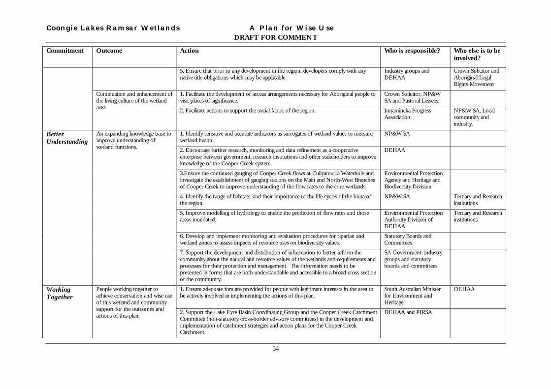
Coongie Lakes Ramsar Wetlands A Plan for Wise UseDRAFT FOR COMMENT
54
Commitment Outcome Action Who is responsible? Who else is to beinvolved?
5. Ensure that prior to any development in the region, developers comply with anynative title obligations which may be applicable.
Industry groups andDEHAA
Crown Solicitor andAboriginal LegalRights Movement
1. Facilitate the development of access arrangements necessary for Aboriginal people tovisit places of significance.
Crown Solicitor, NP&WSA and Pastoral Lessees.
Continuation and enhancement ofthe living culture of the wetlandarea. 2. Facilitate actions to support the social fabric of the region. Innamincka Progress
AssociationNP&W SA, Localcommunity andindustry.
1. Identify sensitive and accurate indicators as surrogates of wetland values to measurewetland health.
NP&W SA
2. Encourage further research, monitoring and data refinement as a cooperativeenterprise between government, research institutions and other stakeholders to improveknowledge of the Cooper Creek system.
DEHAA
3.Ensure the continued gauging of Cooper Creek flows at Cullyamurra Waterhole andinvestigate the establishment of gauging stations on the Main and North-West Branchesof Cooper Creek to improve understanding of the flow rates to the core wetlands.
Environmental ProtectionAgency and Heritage andBiodiversity Division
4. Identify the range of habitats, and their importance to the life cycles of the biota ofthe region.
NP&W SA Tertiary and Researchinstitutions
5. Improve modelling of hydrology to enable the prediction of flow rates and thoseareas inundated.
Environmental ProtectionAuthority Division ofDEHAA
Tertiary and Researchinstitutions
6. Develop and implement monitoring and evaluation procedures for riparian andwetland zones to assess impacts of resource uses on biodiversity values.
Statutory Boards andCommittees
BetterUnderstanding
An expanding knowledge base toimprove understanding ofwetland functions.
7. Support the development and distribution of information to better inform thecommunity about the natural and resource values of the wetlands and requirements andprocesses for their protection and management. The information needs to bepresented in forms that are both understandable and accessible to a broad cross sectionof the community.
SA Government, industrygroups and statutoryboards and committees
1. Ensure adequate fora are provided for people with legitimate interests in the area tobe actively involved in implementing the actions of this plan.
South Australian Ministerfor Environment andHeritage
DEHAAWorkingTogether
People working together toachieve conservation and wise useof this wetland and communitysupport for the outcomes andactions of this plan. 2. Support the Lake Eyre Basin Coordinating Group and the Cooper Creek Catchment
Committee (non-statutory cross-border advisory committees) in the development andimplementation of catchment strategies and action plans for the Cooper CreekCatchment.
DEHAA and PIRSA

Coongie Lakes Ramsar Wetlands A Plan for Wise UseDRAFT FOR COMMENT
55
Commitment Outcome Action Who is responsible? Who else is to beinvolved?
3. Develop a scientific and technical group to provide advice and to successfullyintegrate scientific understanding with resource management and decision making.
NP&W Council
4. Provide support for and constructive input into the various management boards andcommittees (see boxes in the Responsibility and Care section of this plan) that audit,plan and manage resource use in the Coongie Lakes Ramsar Wetlands.
South AustralianGovernment
5. Support the development of mutually acceptable Agreements between Native Titleclaimants and tenure holders within the wetland to form a basis for cooperative actionin the wetlands.
DEHAA Crown Solicitor

Coongie Lakes Ramsar Wetlands A Plan for Wise Use
DRAFT FOR COMMENT
56
12 END NOTES 1 The Legal Development of the Ramsar Convention - on Wetlands of International Importance Especially as
Waterfowl Habitat by Cyril De Klemm and Isabelle Creteaux. Ramsar Convention Bureau 1995.2 The Ramsar Convention Manual Section 1.1. 2nd Edition Ramsar Convention Bureau 19973 The Ramsar Convention Manual ib. id. Section 1.74 The Ramsar Convention Manual ib. id Section 4.25 Towards the Wise Use of Wetlands page 6 Ed by TJ Davis Ramsar Convention Bureau 19936 The Ramsar Convention Manual op sit Appendix 12 and 137 The Ramsar Convention Manual op sit Section 4.2.1.8 Towards the Wise Use of Wetlands op sit page 9 and 109 Council of Australian Governments Water Reform Framework Appendix 310 Policy of the Liberal Party of South Australia 1997 Focus on our Environment and Natural Resources11 Australian Natural Heritage Charter – Standards and Principles for the conservation of places of natural heritage
significance. Australian Heritage Commission and the Australian Committee for IUCN12 Claridge G (1991) An Overview of Wetland Values – a necessary preliminary to Wise Use. In Educating and
Managing for Wetlands Conservation Proceedings of the Wetlands Conservation and Management Workshop.Eds R Donohue and B Phillips, Australian National Parks and Wildlife Service.
13 The Ramsar Convention Manual op sit. Appendix 1014 Mollenmans et al 1984 Biological Survey of the Cooper Creek Environmental Association South Australia.
Department of Environment and Planning15 Reid JRW (1999) Monitoring Bird Populations on the Coongie Lakes, Innamincka Regional Reserve. Report to
Department for Environment, Heritage and Aboriginal Affairs South Australia16 Puckridge J and Drewien M (1987) Ch 5 The Aquatic Fauna of the North-west Branch of Cooper Creek. In The
Coongie Lakes Study Eds J Reid and J Gillen. Department of Environment and Planning.17 a Sheldon, F. and K.F. Walker (1993) Pipelines as refuge for freshwater snails, Regul. Riv. 8:295-299.
b Sheldon, F. and J.T. Puckridge (1998) Macroinvertebrates of Goyder Lagoon, Diamantina River, South Australia,Transactions of the Royal Society of South Australia 122: 17-31
c Sheldon, F. and K.F. Walker (1998) Spatial distribution of littoral invertebrates in the lower Murray-Darling Riversystem, Australia, Marine and Freshwater Research 49: 171-182
18 Reid JRW and JT Puckridge Chapter 10 Coongie Lakes. In Natural History of the North East Deserts. Eds MJTyler, CR Twidale, M Davies and CB Wells. Royal Geographic Society of South Australia Inc
19 Biodiversity and its value. Biodiversity series, Paper No 1 Biodiversity Unit Commonwealth Department ofEnvironment, Sport and Territories.
20 Barratt R (1987) Coongie Lakes Control Zone Terrain-Vegetation Land Units National Parks and Wildlife SouthAustralia
21 Morton SR, J Short and RD Barker (1995) Refugia for Biological Diversity in Arid and Semi-arid Australia.Biodiversity Series Paper No4 Biodiversity Unit Department of the Environment, Sport and Territories.
22 Australia’s Biodiversity – an overview of selected significant components Biodiversity Series No 2 Biodiversity UnitDepartment of the Environment, Sports and Territories.
23 Reid J and Puckridge J (1992)Innamincka Regional Reserve – a mismanaged multiple land-use reserve. Proc 7th
Biennial Conf. Aust. Rangel. Soc. Cobar, NSW. pp 370 – 373.24 State of the Environment Australia 1996 Executive Summary Op Sit page 925 Hammer UT (1986) Saline Lake Ecosystems of the World. Dr. W Junk, The Hague.

Coongie Lakes Ramsar Wetlands A Plan for Wise Use
DRAFT FOR COMMENT
57
26 Morton SR, MD Doherty and RD Barker (1995) Natural heritage Values of the Lake Eyre Basin in South Australia –
World Heritage Assessment. CSIRO Division on Wildlife Ecology, Canberra27 Knighton AD and Nanson GC (1994) Flow transmission along an arid zone anastomosing river, Cooper Creek ,
Australia. Hydrological Processes 8: 137 – 54
Knighton AD and Nanson GC (1997) Distinctiveness, diversity and uniqueness in arid zone river systems Ch 10 pp185 – 203 In Thomas DSG (ed) Arid Zone Geomorphology: Process, Form and Change in Drylands 2nd EdJohn Wiley and Sons, New York.
28 Thackway R and ID Cresswell (1995) An Interim bioregionalisation for Australia: A framework for setting prioritieson the national reserves system cooperative program. Nature Conservation Agency Canberra.
29 SR Morton, MD Doherty and RD Barker (1995) Natural Heritage Values of the Lake Eyre Basin on South Australia– World Heritage Assessment CSIRO Division of Wildlife and Ecology, Canberra
30 The Ramsar Convention Manual op sit. Section 1.231 Biodiversity and its Value. (1993) Biodiversity Series No 1 Published by the Department for Environment, Sport and
Territories Commonwealth of Australia32 State of the Environment Australia 1996 Executive Summary. State of the Environment Advisory Council.33 Coongie Lakes Wetlands Ramsar Management Plan – Petroleum and Minerals Issues Paper. Petroleum and Mineral
Industries Stakeholder Working Group.34 Reid, J and J Gillen (1988) The Coongie Lakes Study. South Australian Dept of Environment and Planning.35 Campbell G – Innamincka Regional Reserve Review, Grazing Enterprise Innamincka Pastoral Company.
Submission to the Review of Innamincka Regional Reserve.36 A Review of Innamincka Regional Reserve 1988 – 1998.
Department for Environment, Heritage and Aboriginal Affairs, Government of South Australia.37 Cuerpicki S, Riquier C and Kennedy R (1994) Recreational Fishing Survey, South Australia. Marketing Science
Centre, University of South Australia and Primary Industries and Resources South Australia –Fisheries.38 Turner DB (1994) An investigtion of a fish kill and the catch history of the Mulka Fishery, North-east desert region,
South Australia. Aquasearch South Australia.39 Nicholson A (1998) Aboriginal Issues Paper for the Coongie Lakes Wetlands Ramsar management Plan. Report to
the Department for Environment Heritage and Aboriginal Affairs.40 Iwanicki 1984 Cooper Creek – Innamincka Heritage Area, Files of the South Australian Heriatage Committee.41 The Burra Charter –The Australian Charter for the Conservation of Places of Cultural Significance.42 More than Meets the Eye – Identifying and Assessing Aesthetic Value. Report of the Aesthetic Value Workshop
held at the University of Melbourne on 27 October 1993. Technical Workshop Series No.7. Page 8143 Report of the Environmental Valuation Working Group. Government of South Australia.44 Department of Natural Resources, Queensland Government (1998)
Draft water management plan for Cooper Creek and technical paper.45 See Kingsford RT, AJ Boulton and JT Puckridge (1998) Challenges in managing dryland rivers crossing political
boundaries: Lessons from the Cooper Creek and Paroo River. Aquatic Conservation Marine and FreshwaterEcosystems 8: 361-378
46 Plans and Codes include:
• The Marree Soil Conservation District Plan by the Marree Soil Conservation Board
• Statement of Environmental Objectives for Seismic Operations in the Cooper and Eromanga Basins SouthAustralia. Primary Industries and Resources SA
• Field guide for the environmental assessment of abandoned petroleum wellsites in the Cooper Basin SouthAustralia. Primary Industries and Resources South Australia
• Code of Environmental Practice – Seismic Operations. Santos

Coongie Lakes Ramsar Wetlands A Plan for Wise Use
DRAFT FOR COMMENT
58
• Environmental Procedures for Borrow pit management and Well leases location, construction, restoration.Santos
• Environmental incident reporting and investigation procedure. Santos47 Dry/Wet User’s Guide (v2.0, 1999) Puckridge JT, JF Costello and KF Walker.
National Wetlands Research and Development program.