![C:UsersYusuf SachaDesktopasmar jild 12-13AH - Volume - 13 … · 2016. 7. 14. · o9ùãö+(Ýç×ÃÖ]é†Û$䉅‚Ú å´I Y c*&+ZÔôgÄÔZHON ^‰Ðäâi°»~kZìo9ù³ãö+](https://static.fdocuments.us/doc/165x107/60e7be5d89cd7a7d17705245/cusersyusuf-sachadesktopasmar-jild-12-13ah-volume-13-2016-7-14-o9faaa.jpg)
C ÃÖ ½½ CÙ » EÝãç Ùù N ãçÙ ½ AÙ PLAN.pdf · non-profit organization, Great Land...
29
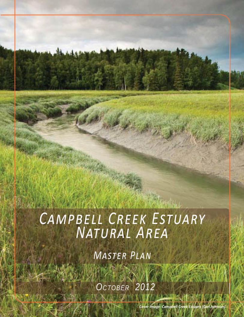
C ÃÖ½½ C Ù» E ÝãçÙù N ãçÙ½ A Ù M ÝãÙ P ½Ä O CTOBER 2012 Cover Image: Campbell Creek Estuary (Carl Johnson).
Transcript of C ÃÖ ½½ CÙ » EÝãç Ùù N ãçÙ ½ AÙ PLAN.pdf · non-profit organization, Great Land...
C C EN A
M P
OCTOBER 2012
Cover Image: Campbell Creek Estuary (Carl Johnson).


The creation of this Master Plan for the Campbell Creek Estuary Natural Area was made possible by the time and energy from the individuals listed below, the organizations they represent, as well as numerous members of the public. Their visions for the Campbell Creek Estuary property developed this plan and set a foundation for the future of this unique place. Their time and input is sincerely appreciated.
Great Land Trust Board of DirectorsRichard LeFebvre
John BakerShelda Duff
Cathie StraubGary BaughGreg Jones
Molly McCammonCaryn Rea
Marty RutherfordCorinne SmithJim StrattonKen Taylor
StakeholdersBarbara Carlson, Friends of the Anchorage Coastal
Wildlife RefugeDave Carter, Bayshore/Klatt Community Council
David Moore, Sand Lake Community CouncilDavid Wigglesworth, US Fish and Wildlife Service
Eric McCallum, former Parks CommissionerErnie Hall, Chair Anchorage Assembly
Gary Baugh, Campbell Lake Homeowners Assn., Great Land Trust Board
Leonard Hyde, Neighbor
Stakeholders Cont.Tammy Massie, Alaska Department of Fish and GameVivian Mendenhall, Friends of the Anchorage Coastal
Wildlife RefugeWayne Pichon, Bayshore/Klatt Community Council/
Anchorage Assembly
Parks & Recreation CommissionCarl A. Propes, Jr.Harlow RobinsonJames WinchesterJoey Caterinichio
Jon DysonMarion G. DavisPeter Murphy
Richard T. Mystrom
Planning & Zoning CommissionBruce Phelps
Connie Yoshimura Dana Pruhs
James Fergusson Peter Mulcahy
Ray Hickel Stacey Dean
Tyler Robinson Terry Parks
I T

T C O | P 5 L H O S R C E P | P 9
B
V S | P 11 D M | P 13 L I R P S : L A C | P 19 P S I | P 21 P
M P

Image 1: Sedge in the estuary.
P I | P 23 S I M R S A | P 26 S A 1 S A 2
A A
R R | P 22 P C | P 22

The Campbell Creek Estuary Natural Area is a large intact natural property within an Anchorage residential neighborhood. Its rich abundance of coastal wetlands, views, and upland habitats is a refuge for indigenous flora and fauna and migrating waterfowl. In 2001, a discussion was started between property owners and the local non-profit organization, Great Land Trust (GLT), about the potential to conserve Anchorage’s last unprotected estuary. Ten years later, the ownership transferred to the Municipality of Anchorage (MOA) with GLT as holder of a Conservation Easement, a document that provides strict controls over use and development of the property in perpetuity. Now the joint owner and holder, the MOA and GLT, are looking to make this unique property, the Campbell Creek Estuary Natural Area (CCENA), accessible to the public while preserving those values that the Conservation Easement seeks to protect.
BImage 2: Views of the estuary from the bluff.

P 5
Map 2: Neighborhood Context Map.The CCENA property is located on the coast of Anchorage. The property is bordered to the north, northwest and east by residential properties, and to the south and west by the ACWR.
Map 1: Anchorage Context Map.
P
A , A
Anchorage Coastal Wildlife Refuge
CCENA M P
Landscape & HistoryThe Campbell Creek Estuary Natural Area (CCENA) is a 60.71 acre site on the coast of southwest Anchorage (Map 1, pg.5). Relatively undeveloped, this property borders an urban neighborhood to the north, and the Anchorage Coastal Wildlife Refuge (ACWR) to the south. (Map 2, pg.5)
The southern half of the property is an estuarine intertidal emergent wetland ecosystem where fresh groundwater, inlet tides, and Campbell Creek come together. The National Wetland Conservation Plan regards this as a “declining wetland community” (GLT, Baseline). Bordering the wetland is a 25 to 45 degree slope covered by a deciduous canopy and understory. The remainder of the property consists of relatively flat uplands with native deciduous woodlands, a
Overview
B : O
spruce forest, herbaceous vegetation, a spruce bog and an open meadow. Its location and land formation make the site ideal for views into the estuary, out to the inlet, and beyond to the surrounding mountains.

P 6
CCENA M P
Image 3: Aspen stand in northwest corner of meadow.
B : O
The property is a home and gateway to an abundance of terrestrial wildlife, birds, and aquatic species. The National Audubon Society considers the estuary one of two “Important Bird Areas” in Anchorage serving as migratory grounds and habitat to multiple species of shorebird. Sandhill Cranes migrate and nest within the area. Beluga whales, listed as endangered in 2008 under the Endangered Species Act, have been observed feeding on runs of salmon that spawn up Campbell Creek. The intact forest is forage and bedding grounds for moose and habitat for other local mammals.
Traces of modern human inhabitants are seen in the meadow, where goats, hogs, sled dogs, and horses were once kept, along with bare ground where volunteers removed vacant structures. Structures included a house, a small barn, Quonset huts, and shipping containers. The house and barn were built in the 1930’s and 1940’s when it was known as the Olly Olson Homestead. Shipping containers, quonset huts and a dirt road that traverses the property to the adjacent 5-acre parcel, were added by subsequent owners.
This background information is derived from Campbell Creek Estuary Anchorage, Alaska Baseline
Documentation for a Conservation Easement which provides comprehensive information on the history, geology, wildlife, vegetation and existing conditions.
Ownership & StewardshipIn November of 2010 the title of the property shifted from the previous owners to the Municipality of Anchorage (MOA). Great Land Trust worked with the MOA to establish conditions that would protect the site’s resources and establish standards for development. The result was a Conservation Easement that established values and restrictions on the property. As “owner”, MOA will facilitate development of appropriate public access and maintenance while the GLT will act as stewards of the established values, in perpetuity, to ensure the resources are not compromised.
Assets of the site have led to diverse funding sources from both private and governmental organizations which include, U.S. Fish and Wildlife Service, National Oceanic and Atmospheric Administration, Alaska Sustainable Salmon Fund, U.S. Army of Corps Engineers, the Coastal Impact Assistance Program, The Nature Conservancy, Rasmuson Foundation, Ducks Unlimited, ConocoPhillips, National Fish and Wildlife Foundation, and numerous private individuals. This array of support comes from the common vision that this property is worth protecting for conservation purposes, public education, and enjoyment.
It is legally required that the property be maintained and used in accordance to the standards set by the easement and those parties that have contributed to the acquisition, protection, and maintenance of CCENA. Violating any of those standards could result in legal action by the funding agency.

P 7
CCENA M P
Map 3: Preliminary Site Assessment Map. This map was created during the summer of 2012 prior to the public involvement process to show the zones designated by the Conservation Easement and main features of the property such as existing social trails and views.
MMAAmmttttppddCCaappss
B : O
Role of the Conservation Easement The Conservation Easement legally establishes possibilities for development and future activities based on conservation values of existing resources. CCENA’s wildlife resources, water resources, forest and woodland resources, scenic resources, and the potential for public education and appropriate wildlife viewing are considered valued assets worth preserving. The easement addresses the protection of these resources with specific objectives to:• Protect upland and estuarine habitat by keeping it in an undisturbed state• Protect quality of water resources for infiltration, detention, storm water, and habitat• Promote biologic diversity of unfragmented forest/woodland, meadow, coastal bluff and wetlands• Protect native species and continuous canopy
• Prevent establishment of non-native species• Store carbon and offset by-products of burning fossil fuels and particulate production• Protect large habitat patches, increasing species health and survival • Maintain habitat connectivity to the Anchorage Coastal Wildlife Refuge• Protect scenic vistas• Provide opportunity for an outdoor classroom for area schools
To achieve these objectives the Conservation Easement has specific potential uses based on three zones: Resource Protection Area (RPA), Restricted Use Area (RUA), and Limited Development Area (LDA). Creating three areas appropriately distributes activity where it will have minimal impacts. (See Map 3 below and Map 5 on pg.24 for zone delineation)

P 8
CCENA M P
Table 1: This is a summary of potential improvements that can take place in each zone delineated by the Conservation Easement. Improvements not listed are likely prohibited or subject to review and the Conservation Easement and grants awarded for the property should be referenced. See Map 3 on pg.7 for zone delineation.
B : O
Potential Improvements per Conservation EasementZone Description Permitted Subject to Review
ResourceProtection Area
(RPA)
As the mostsensitive habitat
zone theeasement allows
minimalimprovements.
Regulatory signsBird housesBat housesEmergency vehicle useRemoval of invasive
speciesSeasonal closure
Fences, walls or gates thatmaintain or improve conservationvalues
Trails (porous or boardwalk inwet areas)
Restoration activitiesEnhancement/restoration of wet
areasRestricted Use
Area (RUA)This upland areaprovides not only
a variety ofhabitats worthprotecting but
providesopportunity forpublic access.
Everything permitted in the RPARemoval of existing debrisSigns, not including regulatory
signs (limited to maximum 8 sq.ft. per sign; total amount of signsnot exceed 20)
Fertilizers that don’t affecthabitat adversely
TrailsFences
Cutting of trees to create andmaintain two viewpoint/outlookareas
Removal of vegetation tomaintain meadow/edge habitat
Piling of brush & vegetation
LimitedDevelopment
Area (LDA)
These zonesprovide space for
vehicular entryand a formaleducational
gathering point.
Everything permitted in the RPAand RUA
Utility improvementsInterpretive signsAccess roadGatesFencesBollardsParking areasGazebosOuthousesKiosks
Paved surfaces
This list is extracted from the language in the Conservation Easement. Please reference that document forprecise descriptions of allowed improvements and activities.

P 9
CCENA M P
The RPA consists of the wetlands in the southern half of the property where Campbell Creek meets the inlet. Because wetlands are such a sensitive ecosystem the easement has prohibited nearly all development. (See Table 1 and the Conservation Easement for specific improvement possibilities)
The uplands not including two rectangular zones along the north property line is the RUA. Consisting of diverse ecosystems, this area provides various habitat types and has the potential to provide for carefully-considered human access. This zone has a dirt road within an access easement that runs from the end of Selkirk Drive through a deciduous forest and spruce forest to a private 5-acre parcel in the southeast. An additional access easement is set on the east property line for a potential future road connecting the 5-acre parcel to Lennox Drive. (See Table 1 and the Conservation Easement for specific improvement possibilities)
The LDA includes two rectangular zones, 31,500 sq. ft. each, at the end of Selkirk Drive and Lennox Drive. The purpose of these zones is to provide access and amenities that complement appropriate activities within the site while maintaining conservation values. (See Table 1 and the Conservation Easement for specific improvement possibilities)
B : O P
Image 4: Public meeting site walk.
Process
Great Land Trust and the Municipality hired USKH to produce a Master Plan for CCENA in the effort to maintain the conservation values while making the property publicly accessible. Developing the master plan included an initial environmental site analysis and a public outreach program (see Appendix A for a summary of the public process). The goal of the planning process was to engage the public to create a comprehensive strategy for development that embraces the values of the Conservation Easement. The result is a synthesized plan that reflects objectives of the owners and desires of the public.

The master plan for the Campbell Creek Estuary Natural Area includes a physical design with management suggestions, resource protection strategies, and a prioritized list of improvements. The Master Plan is generated from layering the baseline document research, Conservation Easement values and constraints, the environmental assessment, and public input. This is a living document that can be updated in perpetuity.
M PImage 5: Campbell Creek Estuary (Carl Johnson).

P 11
Vision Statement
Developed during the public involvement process the following is a Vision Statement for the Campbell Creek Estuary Natural Area. This statement acts as a guiding philosophy for design and management decisions.
•Provides unfragmented upland and coastal habitats directly connected to the Anchorage Coastal Wildlife Refuge
•Provides undisturbed habitat for the proliferation of native plants and animals
•Provides spectacular views of resources within the property and to
mountains, the coast, and Campbell Creek Estuary
•Provides an outdoor learning opportunity for estuary visitors now and for future generations
Campbell Creek Estuary Natural Area is a unique community asset that in perpetuity:
CCENA M P
Image 6: Sedge in the estuary.

pW
EST
DECI
DUO
US
WO
ODL
ANDS
REST
RICT
ED U
SE A
REA
(RUA
)AR
EA T
O R
EMAI
N N
ATU
RAL
EAST
SPR
UCE
FO
REST
, BO
G &
HE
RBAC
EOU
S AR
EARE
STRI
CTED
USE
ARE
A (R
UA)
AREA
TO
REM
AIN
NAT
URA
L
CAM
PBEL
L CR
EEK
ESTU
ARY
RESO
URC
E PR
OTEC
TIO
N A
REA
(RPA
)AR
EA T
O R
EMAI
N N
ATU
RAL
MEA
DOW
TO R
ETAI
N E
XIST
ING
CON
DITI
ON
PARK
ING
LOT
WIT
H N
ATIV
E BU
FFER
FR
OM
NEI
GHBO
RHO
OD
ENTR
ANCE
ACCE
SS F
ROM
SEL
KIRK
TRAIL
1
TRAI
L 3
TRAI
L 1
TRAI
L 2
OVE
RLO
OK
3
OVE
RLO
OK
1
OVE
RLO
OK
2
p
OVER
LOOK
S
LEGE
ND
TRAI
LS
RUST
IC FE
NCE
VIEW
S WITH
BI
RD BL
IND
VIEW
S
PARK
ING
LOT
SELE
CTIV
E TR
EE
REM
OVA
L TO
EN
HAN
CE V
IEW
ANCH
ORA
GE C
OAS
TAL
WIL
DLIF
E RE
FUGE
TRAI
L HE
AD
Map
4: C
CEN
A m
aste
r pla
n.
C C
E N
AM
P

P 13
CCENA M P
Design & Management
The following section lists and describes development recommendations for specific features, design elements and management strategies for the property. These suggestions evolved from public input to ensure the community’s desires are balanced with the property’s conservation goals.
CharacterThe design and development of the Campbell Creek Estuary Natural Area should maintain the existing natural quality of the site. Disturbances from human development that occurred before land acquisition (i.e. debris and social trails) that do not overlap with new paths and structures should be removed or remedied with revegetation methods (see sub-section revegetation for suggestions). It is recommended that the design elements remain relatively natural.
The viewing platform and structures for information should be predominately made of wood or other natural looking materials. Security features and circulation controls should use native vegetation, boulders, rustic fencing, or signs.
EntranceThe most appropriate entrance to CCENA is from the end of Selkirk Drive, as decided through the public involvement process. A new unpaved road will extend from the end of Selkirk. This road should avoid overlapping with the existing unpaved road that has an access easement. A lockable gate should be placed near the entrance for security. Additionally, a sign with the site’s final name should be placed near the entry and fit the natural character. (See Diagram 1 pg.14 for entrance layout concept).
Image 7: Campbell Creek in the estuary.
M P : D M

P 14
CCENA M P
Parking LotThe goal of the parking area is to allow sufficient car space with the least amount of construction alteration, to be secure and secluded, and to meet easement requirements. (See Diagram 1 above for parking lot layout concept and dimensions).
The concept layout was done to demonstrate the space the parking lot could potentially take up in the Limited Development Area. The parking lot should be gravel and consist of ten spaces, one of them being accessible. This concept provides the largest possible natural buffer between the parking lot and neighbors. The design and parking lot layout should meet municipal standards. Amenities to include: port-a-potty with enclosure, bear proof trash receptacle, caretaker space and bike rack. Boulders
should be placed along the edge for security and to delineate the parking from the paths. Water runoff from the parking area should be mitigated using Best Management Practices (BMPs such as “rain gardens” as described in the Conservation Easement and encouraged from the Municipality of Anchorage).
TrailheadThe trailhead would be located adjacent to the parking area. A kiosk should include rules, a map, educational information, list of funding sources and volunteers, information about prohibited areas, and resource protection information. A wide enough space should be provided to accommodate a class-sized group to gather along with a few benches.
Diagram 1: Parking lot concept configuration.
M P : D M

P 15
CCENA M P
Trail 1The main trail through the site would start at the Selkirk parking lot, go through the west deciduous woodlands, continue into the meadow with a southeast vista, and follow the bluff’s vegetative edge to overlook 1 (Map 4: CCENA master plan, pg.12).The trail would continue along the meadow’s north edge back to the parking lot. The trail would be offset from the existing road to avoid pedestrian access to the private road. The preferred material would be woodchips and gravel over dry soils, and boardwalk in wet and formal rest areas such as the overlooks. The path would be consistently 36 inches with 60 inch x 60 inch passing space at 200’ intervals. All improvements for this trail would need to comply fully with ADA recommendations:• Minimum of 36” width• Cross slope maximum 2%• Passing space interval maximum 200 ft.• Rest area maximum 900 ft. • Maximum running grade of 5%
Overlook 1A small viewing platform with railings and benches at the southern point of the bluff is proposed to provide views over the estuary, refuge, inlet, and to distant surrounding mountains (Map 4: CCENA master plan, pg.12). The design concept would provide a cantilevered deck to reduce the amount of clearing required. Trees should be selectively removed to enhance the view. The overlook should remain intimate. Educational material should be located here (See Interpretive suggestions).
Trail 2Access to the second overlook location would be via a second trail. It is recommended that the trail meet ADA code as long as the environmental quality can be
maintained, the easement is not compromised, and the vision statement is met (Map 4: CCENA master plan, pg.12).
Overlook 2A second viewing platform is proposed east of the main overlook. This would be a more secluded location within the dense vegetation. The goal of the second overlook with bird-blind is to provide a formal location to view birds and estuarine habitat without disturbing nesting birds. Not providing a formal access point for the public could encourage social paths and lead to unwanted harm to the surrounding habitat.
Trail 3The third trail would connect trail 1 to the third overlook. It is important that the trail design does not compromise slope stability, prevent unnecessary erosion, significantly disrupt the bluff canopy or impede on the large mammal corridor that runs along the edge of the bluff (Map 4: CCENA master plan, pg.12).
Overlook 3The third proposed viewing platform is west of the first at the foot of the bluff. The intention of this platform is to experience the estuary, provide up close views of the creek and vegetation, and the broader diversity of birds and other wildlife that use the ecotone transition area between marsh and uplands. The primary concerns are to protect estuary soils, existing vegetation, and to avoid disturbing the existing mammal corridor (Map 4: CCENA master plan, pg.12).
Image 7
M P : D M

P 16
CCENA M P
Rustic FenceTo protect the bluff slope and control circulation, it is recommended that a rustic fence extend from the southwest edge of the meadow to the first overlook at the southeast corner, then extend to the 3rd overlook.
Because of the sensitive estuary ecosystem and crane nesting habitat it is also recommended that a rustic fence be placed along the east edge of the meadow, blocking the existing trail down into the estuary at the southeast end of the bluff. (Map 4: CCENA master plan, pg.12).
Signs educating visitors on why access is discouraged should be included along the fence. This is an opportunity to reference the property’s developmental history by overlapping the new fence with the fence that historically existed in some areas and visually suggest the fence as a relic of the homestead era.
Security With any public space a level of security should be maintained to protect the health and safety of the community. Given the necessity of some 24-hour presence to deter late-night intrusions, a caretaker was determined to be appropriate. Natural barriers and appropriate signage should be placed throughout the site to control access.
On-Site CaretakerSpace should be provided for a seasonal on site caretaker in the Limited Development Area (LDA) adjacent to parking. The agreement for a caretaker is mirrored after other programs used in Anchorage; the caretaker is provided space for a trailer/camper with the responsibility of maintaining security of the site.
PoliciesThe following rules are suggested to maintain quality and regulate its character. Displaying these requirements at the entrance in an entry kiosk is appropriate. Please:• Respect wildlife• Respect other visitors • Keep noise level down• Use provided restroom • Dispose all trash in appropriate receptacleProhibited:• Accessing restricted zones • Bikes from March-December• Motor vehicles• Domesticated animals * (Please see Dog & Domesticated Animal Policy section for specifics) Closures:• Time closures should comply with MOA standards (Title 25, Public Lands)• Seasonal: as required to recognize habitat concerns
West Deciduous Woodlands This area is currently compromised by social trails coming from the intersection of Jade Street and Byrd Lane (both at the park boundary and where
Image 8: Eagle’s nest in bluff canopy.
M P : D M

P 17
CCENA M P
the trail meets the meadow). Access should be detoured from this area because of the sensitive eagle and crane habitat, and currently disturbed areas should be repaired with planting moose browse vegetation. Additionally, boulders and signs should be placed near entries to the social trails to block access. The forest should be managed in accordance with Best Management Practices as described in the Conservation Easement.
East Spruce Forest, Bog & Herbaceous Area This habitat area does not lend itself to trails and access due to the dense vegetation and moose activity. In order to maintain the vital habitat for large mammals, the area should remain undeveloped. Its characteristics should be discussed in interpretive material at the entry or overlooks. The forest should be managed in accordance with Best Management Practices as described in the Conservation Easement and should be monitored for the incursion of social trails.
Estuary The estuarine habitat provides an undoubtedly unique scene. The dramatic seasonal colors of the sedges and wildlife viewing opportunities make experiencing this habitat priceless any season. It is
necessary to balance public access with habitat conservation for this fragile portion of the property. It is recommended that this balance be met with access directed to specific locations for minimal impact. These locations include Overlook 2 and 3 as shown on the master plan (Map 4: CCENA master plan, pg.12). Overlook 2 would provide the public with an elevated vantage point while Overlook 3 would provide access to an additional vantage point at the toe of the bluff.
Because of the sensitive nature of the estuary’s wet soils, vegetation, and nesting birds, access by the public to the wetland habitat would be discouraged from April through October. Some use would be discouraged until there is good snow and ice cover to protect the habitat (e.g. bicycles access). It is possible that a seasonal closure of part or all of the property may be necessary in order for GLT and the MOA to follow through on their responsibilities to protect the conservation values of this valuable property. Wildlife viewing blinds would be included at both Overlooks 2 and 3 and signage on the property would address the importance of the coastal wetland habitat and the rationale for the restrictions by including information about the susceptibility of the soil, vegetation, and nesting birds to disturbance. Signs may also include educational information about the estuary habitat, enjoying its birds and wildlife, conservation needs, and respect for the valuable habitat in the adjacent Anchorage Coastal Wildlife Refuge.
Meadow It is rare to find open meadow in the Anchorage bowl. Although the meadow is the result from previous human practices it is recommended that the meadow be maintained to its current form
Image 9: Current state of the meadow area.
M P : D M

P 18
CCENA M P
and condition. This will preserve the edge habitat and the unique aesthetic quality. Invasive species should be identified and removed appropriately. Native woody species may be managed to maintain meadow habitat.
Interpretive Suggestions Educational material should be presented at the trailhead, and at the overlooks. Signs should meet the standards from the Conservation Easement and maintain a natural character. Potential topics: history of human influence on the property, geology, wildlife, human relationships with nature, aspen stands, moose bark peeling, estuary ecosystem, water cycle, Sandhill Cranes and overall ecosystems in the area.
RevegetationRevegetation is recommended in disturbed areas where development will not be taking place. Because moose browse is decreasing in the Anchorage bowl enhancing moose browse of willow, aspen and birch shrubs is recommended. Plantings should be transplants, propagated cuttings from on-site, native grasses present on-site or native vegetative mats. Areas with compacted soils should be scarified. Planting should incorporate humus and mulch to add moisture and nutrients to disturbed soils.
Partnerships Development of this plan and the overall vision of the site have been due to the numerous citizens and groups that have dedicated their time. Relationships should continue to be cultivated to guide future construction, maintenance and management, and educational programs which users will help create over time.
Image 10: Estuary during the winter
Existing Trail into the Estuary An existing trail runs down the southeast bluff to the estuary. Due to the proximity of the trail to Sandhill Crane nesting habitat it is recommended that the trail be closed and revegetated. A rustic fence at the top of the slope should deter visitors from access.
Dog & Domestic Animal PolicyDue to the sensitive habitat it is recommended that domestic animals be prohibited. Doing so would maintain the goals of the vision statement and Conservation Easement by protecting wildlife and would reflect the public’s desire as determined through public involvement (Diagram 2, pg.25). This management recommendation will require an additional MOA legislative process—namely, the Assembly will have to adopt an ordinance to prohibit dogs and domestic animals on the property.
Winter AccessIt is recommended that winter access into the estuary wetlands not be advertised or maintained at this site. If access is maintained in the winter people might access the area during nesting and migrating seasons. Also creating any new access points for winter use will leave a construction footprint that could be abused in the summer.
M P : D M

P 19
CCENA M P
Resource Protection Strategy Limits of Acceptable ChangePhilosophyThe potential for degradation of resources and amenities is a reality in making CCENA publicly accessible. Vandalism, littering, entering off-limit areas, and basic overuse that comes with time are potential impacts and planning for them is vital.The Limits of Acceptable Change (LAC) is a framework used by federal agencies as a means to maintain desired conditions of recreational natural areas (Stankey, 1985). The LAC method of management defines desired characteristics of a recreational area, determines what resources and social conditions give the area its preferred character, establishes qualitative limits of change at which the conditions are compromised, and a method to manage the issue. This concept was used as reference to develop a modified LAC for CCENA.
Strategy The goal of opening CCENA is to provide walking, wildlife viewing, access to scenery, and education while minimally impacting the natural environment. This natural area has specific conditions, both natural and social, that create a desired atmosphere. At some point these conditions may be compromised and action should be taken to heal or resolve the issue. This LAC provides limits of change for when action should be taken.
The process to set standards came from answering four questions:• What resource and social conditions create quality and character of place? (Factor)• At what point is the character of that factor compromised? (Indicator/Standard)
• What caused the issue? (Evaluation)• What are appropriate solutions to protect the resource? (Proposed Management Approaches)
Responses are categorized by factor, given multiple indicators with standards, a list of possible reasons for damage and a list of possible solutions.
This LAC can be used to evaluate site conditions, prescribe solutions, and take action. For example, if during scheduled yearly inspection by GLT under the easement requirements, numerous social trails have developed in the west woodland and the issue is lack of information and an under-defined trail; a prescription could be native plantings, obstacles on the social trail, a rustic fence and signs that tell visitors that off trail walking is prohibited.
Another example would be if the on-site caretaker saw paths going out to the estuary during the summer. Actions could include adding additional signs and fencing or restricting the area to docent led tours only.
This method of analyzing conditions is recommended in conjunction with the requirements in the Conservation Easement. The evaluation and recommended prescriptions for the LAC indicators are speculative and any future obstruction of standards should consider possibilities and solutions not listed. Budget will play a big factor into what solution is most appropriate.
M P : R P S

P 20
CCENA M P
Table 2: Limits of acceptable change table.
M P : R P S
Limits of Acceptable Change TableFactor Indicator/Standard Evaluation & Proposed Management Approaches
TrailCondition
BraidingTrail WideningSocial trails in upland
areas
Trail failureToo many peoplePeople want better access
Reinforce trail structureAdd signageMaintain new pathAdd rustic fence
ParkingSpace
Excessive street parking More visitors than predicted Expand parkingDocent led toursRestrict hours or days
openWasteControl
Littering/Dumping Receptacle not maintainedReceptacle not convenient
Increase maintenanceIncrease number of
receptaclesChange locationAdd signageAdopt A Park Program
Protectionof Estuary
Social trails into wetlandSigns of Disturbance
Barriers aren’t sufficientPeople want better access
Extend rustic fenceAdd signsClosures beyond
established periodsChange/modify access
pointsMonitor more
frequentlyDocent led tours
Noise Noise pollution frompark – complaints byneighborhood (disturbingboth neighbors andwildlife)
Noise (from parking lot)Excessive visitorsVandalism
Move trail headChange hoursMonitor more
frequentlyDocent led tours
Relativesolitude
Large numbers of peoplein the area at once
More visitors than predicted Decrease parking spaceDocent led toursAdd visitor restrictionsIncrease number of
trails

P 21
CCENA M P
Implementation
Image 11: Existing road with summer vegetation.
Priorities The improvements proposed by this master plan are listed in order of priority of development starting with basic maintenance, then the necessary amenities for public access and enjoyment, and finally long term development strategies. Improvements are slated to begin during the 2013 construction season with the goal of opening the area to the public in 2013. Ordering improvements by priority provides structure for development with flexibility to change based on public input and budget.
• YEP improvements (removal of invasives, revegetation of social trails)• Entrance drive with utilities • Parking lot with amenities • Signs• Trail 1/Overlook 1• Rustic fence• Trail 2/Overlook 2 • Trail 3/Overlook 3• On-site Caretaker• Expand CCENA by acquiring 5-acre parcel to the southeast. (This is a privately owned parcel currently occupied by a tenant. Expanding CCENA would provide space to develop additional amenities, strengthen preservation of the intact bluff canopy, and enhance overall conservation of the area.)
Design and construction of the overlook structures will require an additional approval process to receive the necessary permits and is subject to approval by the Parks and Recreation Commission. This process will allow opportunity for agency and public input on construction details.
M P : P

P 22
CCENA M P
ResourcesGreat Land Trust, Inc. Conservation Easement. Anchorage: November 30, 2010.
Great Land Trust, Inc. Campbell Creek Estuary Anchorage, Alaska Baseline Documentation for a Conservation Easement. Anchorage: November 11, 2010.
Stankey, George H.; Cole, David N.; Lucas, Robert C.; Petersen, Margaret E.; Frissell, Sidney S. The Limits of Acceptable Change (LAC) System for Wilderness Planning. General Technical Report INT-176. Ogden, UT: U.S. Department of Agriculture, Forest Service, Intermountain Forest and Range Experiment Station; 1985. 37 p.
United States Access Board. Regulatory Assessment Accessibility Guidelines for Outdoor Developed Areas. Washington, DC: April 2007.
Wright, Stoney J. A Revegetation Manual For Alaska. Palmer, Alaska: Division of Agriculture, Alaska Department of Natural Resources, August 2008. 64 p.
Photo CreditCover Image
Image 1Image 2Image 3Image 4Image 5 Image 6Image 7Image 8Image 9
Image 10Image 11Image 12
Carl JohnsonBaseline Documentation for a Conservation Easement, GLTBaseline Documentation for a Conservation Easement, GLTUSKHUSKH Carl JohnsonBaseline Documentation for a Conservation Easement, GLTBaseline Documentation for a Conservation Easement, GLTUSKHBaseline Documentation for a Conservation Easement, GLTUSKHBaseline Documentation for a Conservation Easement, GLTUSKH
R

P 23
CCENA M P
Table 3: Public Meeting Schedule
• Anchorage Assembly• Campbell Lake Homeowners Assn.• Neighbors• Alaska Department of Fish and Game• Rasmuson Foundation• ConocoPhillips
The task of the stakeholder group was to represent the interest of their constituents, ensure plans were consistent with the easement, and help develop plans for CCENA.
Throughout the process the public meeting minutes, relevant project documents and public input summaries were posted on GLT and Parks & Recreation project web sites to keep the public updated.
Appendix APublic Involvement The public involvement process was used as a forum to notify the public about the project, receive comments and concerns, and develop the plan as a community. The public was integral in creating a vision statement, schematic alternatives and the final plan. A total of three stakeholder group meetings and two public meetings were conducted in the summer of 2012 at the Bayshore Club House in southwest Anchorage.
The stakeholder advisory group included representatives from:• Friends of the Anchorage Coastal Wildlife Refuge• Bayshore/Klatt Community Council• Sand Lake Community Council• US Fish and Wildlife Service• MOA Parks
Date Meeting AttendeeQty.
Topics Covered
May 30, 2012 1st stakeholder meeting 11 Project “kick off”,Visions for the
propertyMay 31, 2012 1st Public Meeting 66 110* Issues &
Opportunities, Sitewalk, Brain storming
session.June 13, 2012 2nd Public Meeting 35 55* Design charrette
with spectrums ofdevelopment and
concept site layoutJune 27, 2012 2nd stakeholder
meeting14 Refine schematic
design, and visionstatement
August 7,2012
3rd stakeholdermeeting
14 Site walk, designfinalization.
* Both public meetings had a large turnout; the low attendance numberreflects those who signed –in and the top quantity is based on a head count.
Image 12: Public meeting group discussion.
A A: P I

P 24
CCENA M P
Map 5: Conservation easement & environmental map. This map was presented at the first public meeting to spark discussion on where development should occur.
Initial Meetings and Results Curious citizens and neighbors came out to the first public meeting, held on May 31, 2012. Phil Shephard, the executive director of Great Land Trust, led the first half with a site tour. Attendees walked existing paths while Phil discussed history and key landscape features. After the site walk, the group participated in a workshop at the Bayshore Clubhouse where the environmental analysis was presented (Map 5 pg.24) sparking debate on what type of uses and where development is appropriate.
Small groups then discussed opportunities and concerns for the site. Comments were collected during group discussions and input forms and then consolidated and reformatted into two exercises for the second public meeting held on June 13th.
The second meeting engaged the public in a spectrum of development exercise. Potentials and issues outlined at the first meeting were categorized into 10 topics. Each topic was given four options ranging from least developed to most developed. (See Diagram 2 for the spectrum of choices)
This spectrum of choices was distributed to 10 groups of 3-8 people at the second public meeting. Their task was to individually vote by placing a dot in the option they felt most appropriate for the category. Where opinion differed with options additional choices were written in. (See Diagram 2 for voting results) Although there were outlying votes, the majority of votes favored the less developed end of the spectrum.
A A: P I

P 25
CCENA M P
Diagram 2: Spectrum exercise results.
A A: P I

P 26
CCENA M P
Map 6: Working Draft: Consolidated public input schematic. This graphic was developed from the second public meeting. It is included in this appendix to show how development locations were determined by informed citizens.
Schematic Alternative 1The second exercise was to draw physical plans on the site map. Groups drew trails, outlooks, fences, parking lots and other amenities they envisioned. The schematic drawing (Map 6, pg.26) is the combination of each group’s design in a graphic format. Consensus is represented by larger graphic symbols while conflicts are highlighted with a red circle.
The features most drawn include:• One main loop around the meadow• The outlook at the edge of the bluff• 10 car parking lot at the end of Selkirk with a buffer from neighbors
Features of conflict:• Parking at Lennox• Boardwalk into the estuary
Despite some differences, many drawings reflected a similar level of development, showing a few trails and outlook spots. Attendees shared a concern to protect the crane-nesting site and ensure the easement values were not compromised.
A A: P I

P 27
CCENA M P
Map 7: Working Draft: Consolidated stakeholder schematic. This diagram was used to discuss areas of uncertainty and concern (where question marks are located).
A A: P I
Schematic Alternative 2The consolidated map from the public meeting was presented to the stakeholder group. (Map 7, pg. 27) This provided an opportunity to critique proposals and resolve conflict areas (graphically noted with question marks). Points of accord included: creating one main trail to one outlook, a single parking lot with 10 spaces, an entry kiosk with interpretive material and rules, an enclosed port-a-potty, seasonal caretaker, bike racks, trash receptacle, and lockable gate.
The two conflict areas were quickly resolved. The first, the access from Lennox Drive was dismissed as a viable proposal. This road already has drainage issues and access might intrude in moose bed down area.
The second conflict, access down into the estuary was determined as inappropriate considering the sensitive crane habitat. Instead, the stakeholder group thought deterring people from that area with a rustic fence to be the most appropriate solution.
Results and ConcernsThe final preferred schematic, which became the master plan, was the result of the third stakeholder meeting. This consisted of an on-site evaluation of potential development areas and discussion over management and implementation strategies.


![vp bêPOT á^fà ˚ (‚ßeçm ^m†Ò‡ Ý ç×ÃÖ]…] èf× Ö p çß Š Ö]…^fj ...darululoomzakariyya.com/results/dorahadith.pdf · °°ZÝ°ZvZp bêPOT á^fà ˚ (‚ßeçm](https://static.fdocuments.us/doc/165x107/5a74caba7f8b9a93088bdf0a/vp-bepot-afa-ssecm-mo-y-caoe-ef-oe-p-css-s-oefj.jpg)

![ëçߊÖ] †è†ÏjÖ] <](https://static.fdocuments.us/doc/165x107/600f3c989159dc0ed93d3879/-aaj-.jpg)