HYPACK HARDWARE CONFIGURATION. HYPACK ® HARDWARE: Combined HYPACK HARDWARE, HYSWEEP HARDWARE & SIDE…

South Florida Water Management District
3301 Gun Club Road West Palm Beach, Florida 33406
C-51 Canal Sediment Trap Lake Worth Lagoon Hydrographic Survey Report
July 11, 2013
C-51 Canal Sediment Trap July 11, 2013
South Florida Water Management District
2
Table of Contents Background ..................................................................................................................................... 3
Location Map .................................................................................................................................. 4
Methodology ................................................................................................................................... 5
Surveyor’s Notes ..................................................................................................................... 5
Field Work ............................................................................................................................... 6
Data Processing ....................................................................................................................... 7
Results ............................................................................................................................................. 8
Conclusion ..................................................................................................................................... 11
Certification................................................................................................................................... 11
Appendix ....................................................................................................................................... 12
Photos ........................................................................................................................................... 13
References:
• Sea Diversified, Inc. surveys done in 2007, 2008, 2009, and 2010 (provided by Palm Beach
County)
• Sea Diversified, Inc. report completed April 25, 2011
• SFWMD survey completed July 8, 2013
CD Includes:
• Report Copy
• Survey Drawing
• AutoCAD eTransmit file
• Field Notes
• Photographs
C-51 Canal Sediment Trap July 11, 2013
South Florida Water Management District
3
Background The C-51 Canal Sediment Management Project began in January of 2006, a collaboration between the
South Florida Water Management District (SFWMD), Palm Beach County Department of Environmental
Resources Management (PBC), and the City of West Palm Beach, to construct and monitor a sediment
trap on a yearly basis. Construction was completed in July 2007.
Sea Diversified, Inc. (SDI) was contracted by PBC to perform hydrographic surveys from 2007-2010. The
original survey conducted in 2007 reached from Forest Hill Blvd. to the S-155 Water Control Structure.
In 2008 this area was extended from Congress Ave. to S-155. This extension was requested to obtain a
better awareness of erosion and accretion occurring in the sediment trap. By conducting these surveys
on a yearly basis PBC and SFWMD would like to define if maintenance for the sediment trap is required.
Hydrographic surveys done by SDI:
2007 – Original baseline survey between Forest Hill Blvd. and S-155
2008 – Project extended to be between Congress Ave. and S-155
2009 – Congress Ave. to S-155
2010 – Congress Ave. to S-155
SDI performed an in-depth analysis comparing the surveys to the 2007/2008 baseline. Part of SDI’s
investigation includes examining if there was a correlation between the amount of discharge at S-155 to
erosion and accretion along C-51. By examining DBHYDRO data SDI determined that erosion and
accretion could have a connection to the amount of water being discharged from S-155. SDI
recommended that monitoring surveys continue to help in understanding the movement of sediments
through the C-51 Canal.
No surveys were performed in 2011 or 2012 for this project. In May 2013 PBC approached SFWMD to
continue the monitoring of the sediment trap. It is understood that not having surveys for 2011/2012
will make it impossible to correlate any erosion or accretion to any particular rain event or dry period.
This will however, be able to aid in showing if a maintenance dredging schedule should be done for the
sediment trap or if the trap does not accumulate enough sediment to warrant a maintenance cycle.

C-51 Canal Sediment Trap July 11, 2013
South Florida Water Management District
4
Location Map For the 2007 survey, the area only encompassed from Forest Hill Blvd. to S-155. Starting in 2008 the
survey area covers the east side of Congress Ave. to the west side of S-155 to evaluate possible
sediment sources.
To maintain consistency with the report done by SDI the project is broken into four segments.
Reach A: Congress Ave. – Summit Blvd.
Reach B: Summit Blvd. – Forest Hill Blvd.
Reach C: Forest Hill Blvd. – Interstate 95
Reach D: Interstate 95 – S-155 Structure
A
B
C
D
Cong
ress
Ave
.
Summit Blvd.
N
C-51 Canal Sediment Trap July 11, 2013
South Florida Water Management District
5
Methodology The hydrographic survey meets the applicable minimum technical standards for surveys in Florida
Administrative Code 5J-17.051 set forth by the Florida Board of Surveyors and Mappers pursuant to
section 472.027 Florida State Statutes.
Surveyor’s Notes 1. The purpose of this hydrographic survey is to establish elevations of C-51 Canal from Congress
Ave. to S-155 located in Sections 4, 5, 8, 9, 15, 16, & 17, Township 44 South, Range 43 East; Palm Beach County, Florida.
2. All measurements herein are in U.S. Survey Feet and decimal thereof, unless otherwise specified.
3. The bottom depths were collected using an Odom HydroTrac echo sounder in conjunction with
a 200 KHz transducer and a laptop computer operating HyPack 2013.
4. This survey report is not valid without the signature and the original raised seal of a Florida Licensed Surveyor and Mapper.
5. Additions or deletions to this survey report by any other than the signing party (or parties) is
prohibited without written consent of the signing party (or parties).
6. Date of last field work: June 27, 2013.
7. The coordinates, bearings, and distances refer to the Florida State Coordinate System, Transverse Mercator Projection, Florida East Zone, North American Datum of 1983 (NAD 83). Coordinates were obtained with a Trimble SPS351 DGPS Receiver providing sub-meter precision.
8. Elevations shown hereon refer to the North American Vertical Datum of 1988 (NAVD88). To
convert to NGVD29 add +1.52’. Conversion calculated using CORPSCON Ver. 6.0.1
9. The vertical control points are as follows: FCE3521 USACOE brass disk set in top of a 10” round concrete cylinder, from the Southwest corner of the fence surrounding the parking lot of the S-155 building on the North side of the S-155 structure, go North along the West fence line 25 feet ±, thence West 5 feet ± to bench mark, stamped “FCE3521 1971”. Elevation (NAVD88) = 15.030’ SUMMIT 10 Palm Beach County aluminum disk set in the Northwest corner of a concrete bridge over C-51 Canal at Summit Blvd., stamped “SUM – 10” Elevation (NAVD88) = 16.901’
10. No boundary survey was performed as part of this survey.
C-51 Canal Sediment Trap July 11, 2013
South Florida Water Management District
6
11. Underground utilities were not located as part of this survey.
12. The aerial imagery shown hereon is the 2011 Palm Beach County quarter foot pixel resolution. It is shown for informational purposes only and is not part of this survey.
13. The C-51 Canal centerline stationing, created by SFWMD, is for reference only.
14. Surveys done by Sea Diversified, Inc. (2007, 2008, 2009, and 2010) in NGVD 29 were converted to NAVD 88 by using the conversion factor in Note 8.
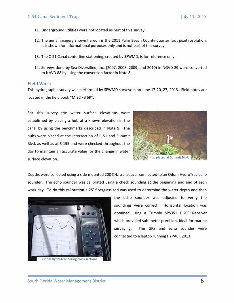
Field Work This hydrographic survey was performed by SFWMD surveyors on June 17-20, 27, 2013. Field notes are
located in the field book “MISC FB 6R”.
For this survey the water surface elevations were
established by placing a hub at a known elevation in the
canal by using the benchmarks described in Note 9. The
hubs were placed at the intersection of C-51 and Summit
Blvd. as well as at S-155 and were checked throughout the
day to maintain an accurate value for the change in water
surface elevation.
Depths were collected using a side mounted 200 KHz transducer connected to an Odom HydroTrac echo
sounder. The echo sounder was calibrated using a check sounding at the beginning and end of each
work day. To do this calibration a 25’ fiberglass rod was used to determine the water depth and then
the echo sounder was adjusted to verify the
soundings were correct. Horizontal location was
obtained using a Trimble SPS351 DGPS Receiver
which provided sub-meter precision, ideal for marine
surveying. The GPS and echo sounder were
connected to a laptop running HYPACK 2013.
Hub placed at Summit Blvd.
Odom HydroTrac during cross sections

C-51 Canal Sediment Trap July 11, 2013
South Florida Water Management District
7
To maintain similarities with the surveys completed by Sea Diversified Inc. the cross section work was
located at approximately fifty (50) feet, along lines previously run by SDI and were obtained as close to
the bank as feasible. Obstacles such as aquatic vegetation, docks, and irrigation pipes effected the
extents of many of the cross sections. Three (3) profile lines were also acquired to benefit the survey,
with the addition of two (2) more located inside of the sediment trap to increase coverage in the wider
segment of C-51.
Data Processing Before loading the files into AutoCAD, the raw data files were processed using standard SFWMD
techniques. Tide files were created for each day to change the depths into NAVD 88 elevations. Each
raw file was then examined to remove any errant data collection points. Once each raw file was edited
using HYPACK’s Single Beam Editor, a sorted file was created selecting an edited sounding every five (5)
feet. The five (5) feet distance is the typical SFWMD sorted distance used to create surfaces in CAD. The
sorted data files were then exported
into an YXZ file. The surveys done by
Sea Diversified, Inc. were obtained in a
XYZ NGVD 29 format and were
converted into NAVD 88 using the
value shown in Note 8; no other
editing was done to SDI’s data.
Typical data collection lines shown in HYPACK (color by depth)
Typical cross section before editing
C-51 Canal Sediment Trap July 11, 2013
South Florida Water Management District
8
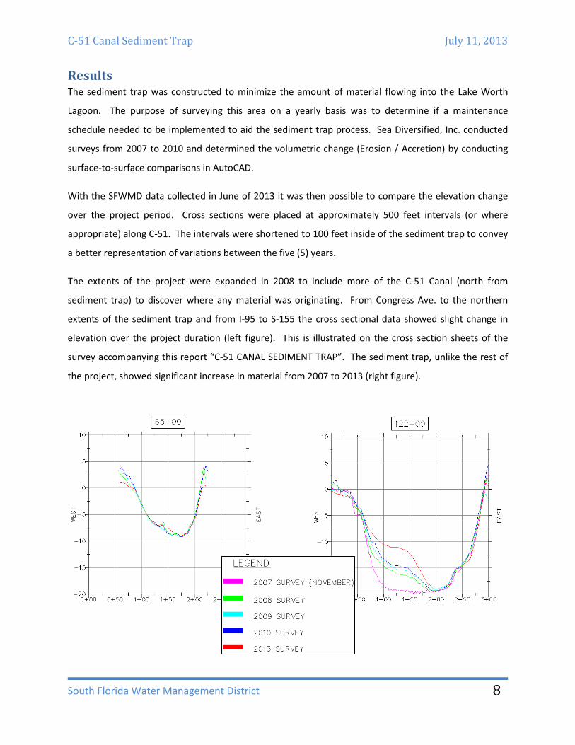
Results The sediment trap was constructed to minimize the amount of material flowing into the Lake Worth
Lagoon. The purpose of surveying this area on a yearly basis was to determine if a maintenance
schedule needed to be implemented to aid the sediment trap process. Sea Diversified, Inc. conducted
surveys from 2007 to 2010 and determined the volumetric change (Erosion / Accretion) by conducting
surface-to-surface comparisons in AutoCAD.
With the SFWMD data collected in June of 2013 it was then possible to compare the elevation change
over the project period. Cross sections were placed at approximately 500 feet intervals (or where
appropriate) along C-51. The intervals were shortened to 100 feet inside of the sediment trap to convey
a better representation of variations between the five (5) years.
The extents of the project were expanded in 2008 to include more of the C-51 Canal (north from
sediment trap) to discover where any material was originating. From Congress Ave. to the northern
extents of the sediment trap and from I-95 to S-155 the cross sectional data showed slight change in
elevation over the project duration (left figure). This is illustrated on the cross section sheets of the
survey accompanying this report “C-51 CANAL SEDIMENT TRAP”. The sediment trap, unlike the rest of
the project, showed significant increase in material from 2007 to 2013 (right figure).

C-51 Canal Sediment Trap July 11, 2013
South Florida Water Management District
9
A volume calculation was done for the sediment trap only because of the minor changes in the cross
section elevations for the remainder of the C-51 Canal survey. The comparison can be clearly seen on
the “2007 AND 2013 VOLUME CALCULATIONS” page of the survey. As shown in the surface comparison
and cross section views, the majority of material build up is located along the West and South of the
sediment trap. The amount of erosion/accretion is shown in the following table:
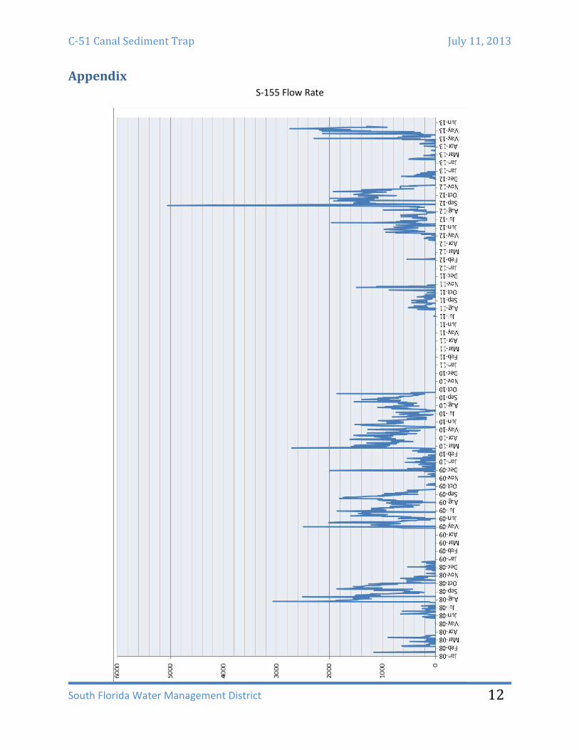
DBHYDRO data was compiled to decide if the flow rate throughout C-51 had any effect on the amount of
material build up in the sediment trap. By doing so it could be possible to attribute erosion and
accretion to the flow rate of S-155 over the years. For the SFWMD survey there are two (2) years where
no survey was completed. As shown in the table below, the flow rate during 2011 and 2012 were at
complete opposite ends of the spectrum. During 2011 the lowest amount of cubic feet per second (cfs)
was discharged over the study period, while 2012 had an active hurricane season and with the amount
of water brought by storms such as Tropical Storm Isaac, S-155 saw greatly increased flow rates.
(A larger graph appears in the appendix.)
Volume Summary Erosion
Cubic Yards Accretion
Cubic Yards Net
Cubic Yards
4,257 29,779 25,522
Spike attributed to Tropical Storm Isaac
C-51 Canal Sediment Trap July 11, 2013
South Florida Water Management District
10
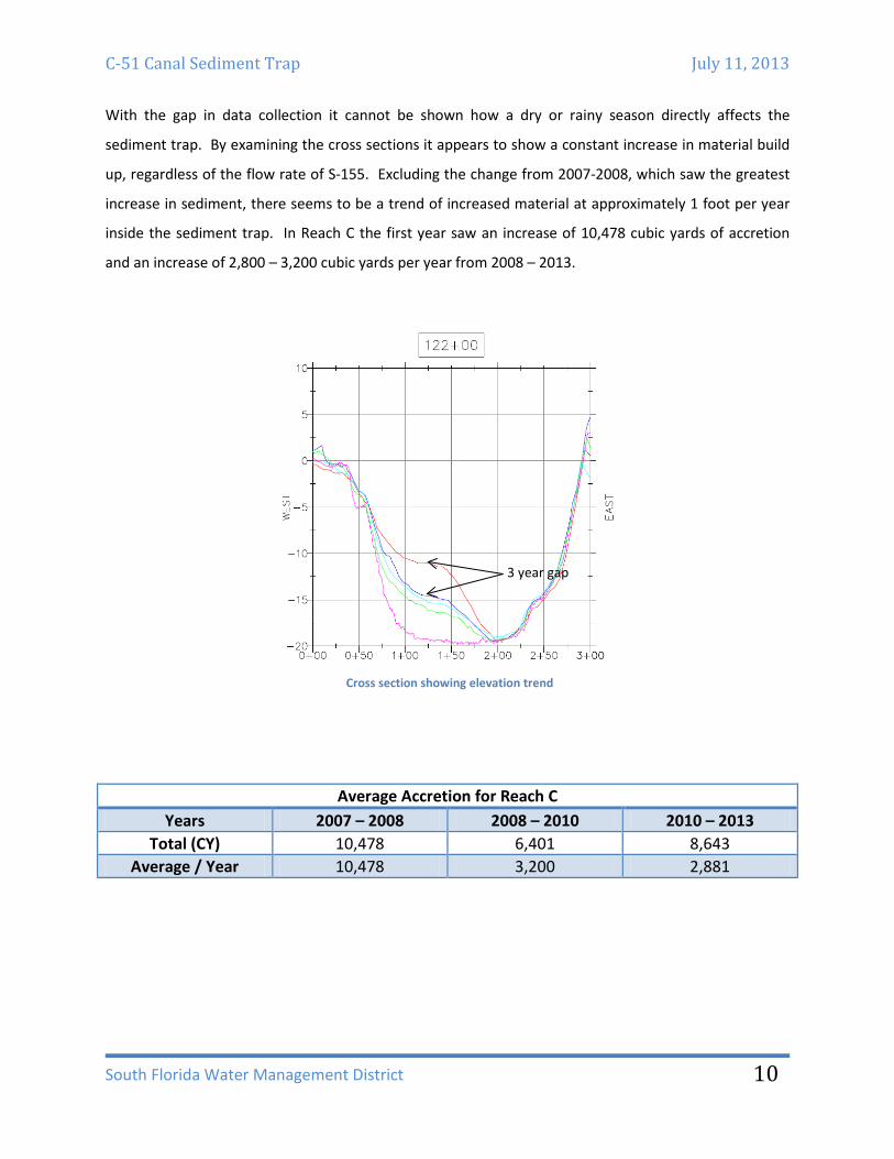
With the gap in data collection it cannot be shown how a dry or rainy season directly affects the
sediment trap. By examining the cross sections it appears to show a constant increase in material build
up, regardless of the flow rate of S-155. Excluding the change from 2007-2008, which saw the greatest
increase in sediment, there seems to be a trend of increased material at approximately 1 foot per year
inside the sediment trap. In Reach C the first year saw an increase of 10,478 cubic yards of accretion
and an increase of 2,800 – 3,200 cubic yards per year from 2008 – 2013.
Average Accretion for Reach C Years 2007 – 2008 2008 – 2010 2010 – 2013
Total (CY) 10,478 6,401 8,643 Average / Year 10,478 3,200 2,881
Cross section showing elevation trend
3 year gap

C-51 Canal Sediment Trap July 11, 2013
South Florida Water Management District
11
Conclusion The purpose of this survey was to determine if a maintenance schedule needed to be implemented to
maintain the effectiveness of the sediment trap. An attempt was also made to correlate the flow rate of
S-155 to material build up. By comparing the results from multiple surveys this shows that the sediment
trap is indeed collecting sediment brought through C-51. This build up appears to increase, regardless of
the cfs being discharged through S-155, at a pace of approximately 1 foot in elevation change or 2,800 –
3,200 cubic yards of accretion per year.
Certification This survey report was prepared for:
Rod Braun Principal Scientist South Florida Water Management District 3301 Gun Club Road West Palm Beach, FL 33406
Unless it bears the signature and the original raised seal of the Florida Licensed Surveyor and Mapper,
this report is for informational purposes only and is not valid.
I hereby certify that this hydrographic survey was made under my responsible charge and meets the
applicable minimum technical standards for surveys as set forth by the Florida Board of Land Surveyors
in Chapter 5J-17.051, Florida Administrative Code, pursuant to Section 472.027, Florida State Statues.
Richard E Barnes, Jr. Date Professional Surveyor and Mapper Florida Certificate No. 5173
C-51 Canal Sediment Trap July 11, 2013
South Florida Water Management District
12
Appendix S-155 Flow Rate

C-51 Canal Sediment Trap July 11, 2013
South Florida Water Management District
13
Photos Discharge from S-155
Aquatic vegetation and tree overhang

C-51 Canal Sediment Trap July 11, 2013
South Florida Water Management District
14
Aquatic vegetation
C-51 (looking south to Forest Hill Blvd.)
C-51 Canal Sediment Trap July 11, 2013
South Florida Water Management District
15
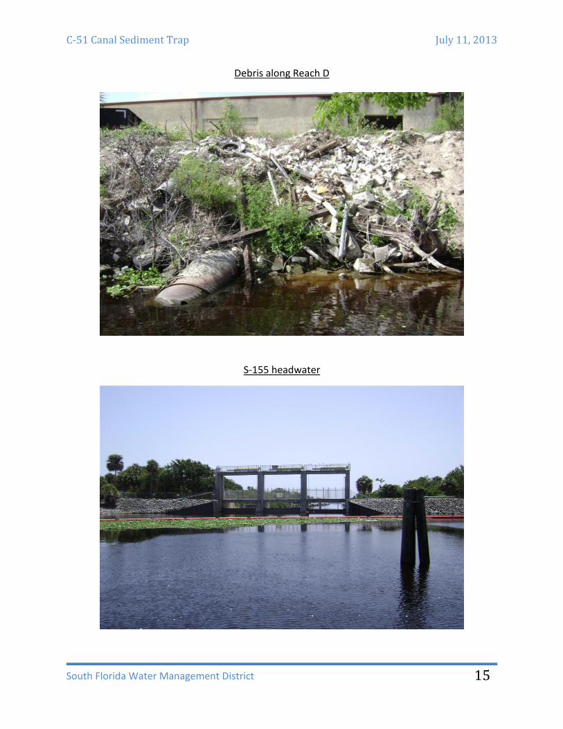
Debris along Reach D
S-155 headwater


![HYPACK MAX - Knudsen Eng · 2019-04-18 · HYPACK® MAX sounding data super-imposed on a Microstation DGN file. [DGN file courtesy USACE – Tuscaloosa] Display from HYPACK® MAX’s](https://static.fdocuments.us/doc/165x107/5e90e9587c4e3f6689675b27/hypack-max-knudsen-eng-2019-04-18-hypack-max-sounding-data-super-imposed-on.jpg)