Bway Study Parsons 198702
39
-
Upload
da-morales -
Category
Documents
-
view
162 -
download
1
description
1987 Broadway Corridor Study, Parsons-Brinckerhoff, 1987 (~2MB, 39 pages, PDF format, not searchable) -- analysis of then-current conditions on Broadway between downtown and Houghton Road, and what can be done to meet projected 2005 traffic loads. Table 3 on page "10" (15th page of document) contains table of LOS for eleven intersections on Broadway and how they would fare under each of the ten suggested "remedies".
Transcript of Bway Study Parsons 198702


Lewis C. Murphy Rodolfo Bejarano Brent L. Davis George Miller Charles Ford Roy Law Tom Volgy doel D. Yald-WiUiam G. Ealy
Huwie E. Davis Priscilla Sawyer Corndo, P.E. Antonio C. Paez, P.E. Marc Soronson David G. Marshall EUen Saltzman Christina Avenetti
Jim Begley, Eugene Caywood
Mayor Councll - Ward 1 Council - Ward 2 Council - Ward 3 Council - Ward 4 Council - Ward 5 Councfl - Ward 6
City ManagerDepuv City Manager
Director Deputy Director
Transportation Phnnlng Administrator Principal Planner
Transportation Planner Transportstion Planner
Secretary, Transportation Pknning and Programming Division
Cithen Transportation Advisory Commit tee

BROADWAY COBIUDOR STUDY PHASE I
FMAL BEPUBT
Prepared For:
TEIE CITY OF TUCSON
Prepared By:
PARSONS BaMCKERBOFP QUADE & DOUGLAS, INC.
In Association With:
RILLlTO COHSULTINQ GROUP ROGERS GLADWIN & HARMONY, mC.
C 0 m CORPORATION GBHE COX AHD ASSOCfAT&S
BGA BHGXNEEZUHG COECPORATlON
February, 1987
D R A F T
This project was financed in part by a grant from the U.S. Departrnent of Transportation Urban Mass Transportation Adrninistr ation

EXEC- SUMMARY
TABLEOF CORTBNTS'
-PAGE

WST OF TmLm
Nefghbathood and Community Group Meetings
Response Form Summaries
Year 2005 PM Peak Hour Intersection Level of Service
Estimated Weskday Transit Ridership for Year 2005
Comparison of Cities with, or Evaluating, LRT Systems
Appraisers Market Vahae Along Broadway
Estimated Roadway Construction Casts
Landscaping Costs
Transit Capital Casts
Total Capital Costs
TOWAnnualized Costs
Five Year CIP Summary
L m OF PIG-
Broadway Corridor Lacation
1984 Traffic Flow Map
Alternative LRT Alignments to the CBD
Pennhgton Street Transit Mall
Transit Statfan at Major htersection
Landscape Concept Pkn for Broadway Boulevard
CFQSSSection of hndscape Plan
Alternative Median neatments with LBT
ROW & Cross-Sec tion Requbements
UMTA Project Development Process
EXECIlTZVE SUMMARY
The purpose of the Broadway Corridor Study was to identify transit, roadway, and
transportation system management a1ternatives which wiU accommodate Year 2005
travel needs. The Pima Association of Governments1 population and employment
forecasts and the adopted Regional Transportation Plan components and goals were used as a basis for the study. In addition to meeting transportation needs, the comprehensive nature of the Broadway Corridor Study also includes an mlysis and
study of urban design themes and methods for improving pedestrian movement Concepts were developed for landscaping and buffering schemes within the context of
the Urban h n d InstitutelAmerican Institute of Architects identification of Broadway
as a Gateway Route and the concepts developed by the Urban Design Cornmidon for Pi ma County.
As Illustrated in Fi~ureI, the study corridor is one mile wide, centered on Broadway Boulevard and extending from 1-10 on the west ta Boughton Road on the east, a
distance of twelve miles The study also ineluded S th/6th Streets from Stone Avenue to Wilrnot Road. tn the section of Broadway Boulevard between i-10 and Euclid
Avenue, only the transit concepb were evaluated since the roadway concepts were previausly adopted durfng the Aviation Corridor Study and the Downtown CIrculation and Parking Study.
The Broadway Corridor Study was sponsored by the City of Tucson, administered by the Clty Department o t Transportation, and financed through a grant from the Urban
Mass Transportation Administration (UMTA)and by the City of Tucson.


The Broadway Corridor comprises a wide amortrnent of transportstion system management concepts and design themes. The corridor varies from a two-lane roadway to six traveI lanes plus two diamond lanes. The right-of-way varies from 70
feet to 200 feet. Revarsible travel Lanes operate to increase peak-period capacities on
Broadway Boulevard between Euelid Avenue and Gun- Club Road and on 5 th16th
Streets between Stone Avenue and Alvernon Wag. Present auto QccuQancy on
Broadway B o u l e v d during the peak period is approximately f .2 persons per auto.
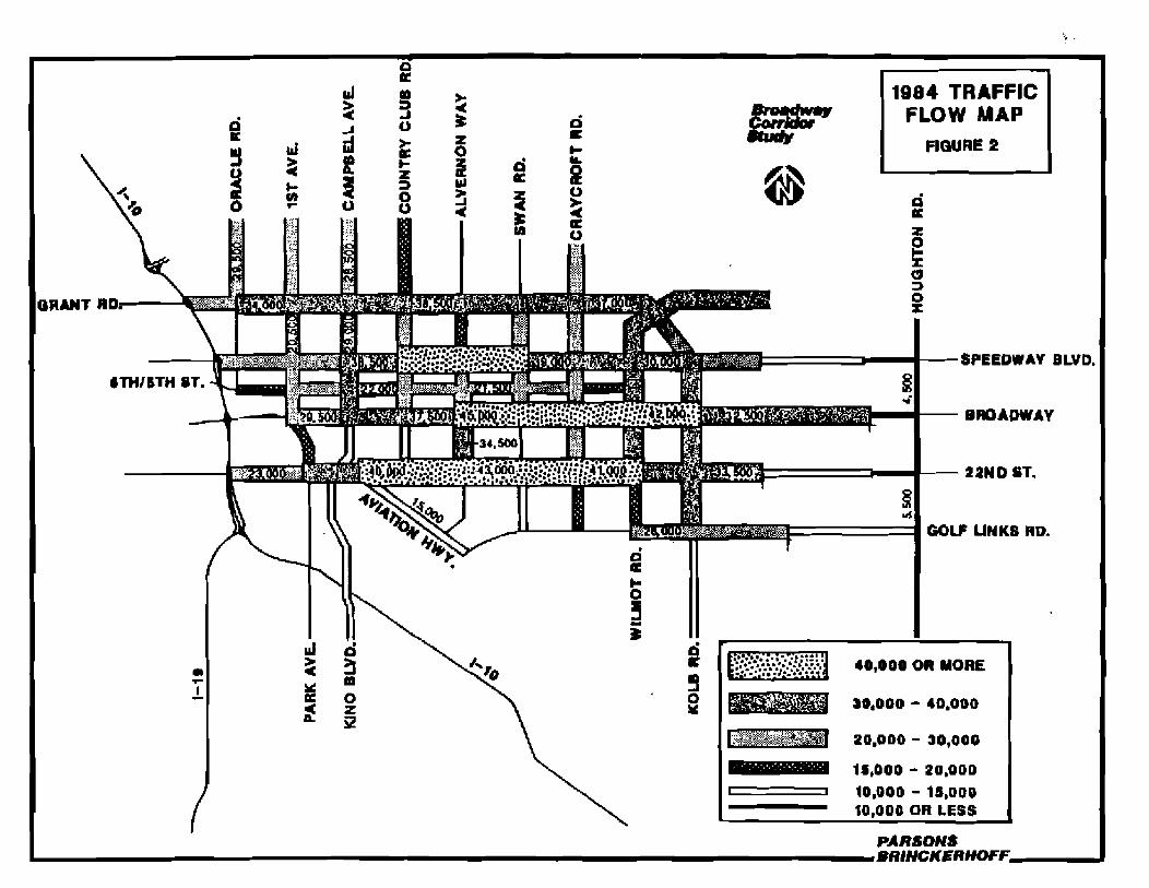
Today, Broadway Boulevard has average daily twffic (ADTI volumes ranging from
9,000 on the far east end to 45,000 midtown, with 30,000 ADT on the west end.
Interssct3on levels at service vary from "8" to "Fndtring the peak hours. In addition,
5 t h / 6 t h Street is presently carrying 16,000-22,000 ADT with peak+our htemection levels of aewice in the "Bnto "FW rarrge as weL Figure 2 is a traffic flow m a p of streets m and adjacent to the Brmdway Corridor.
There are many design themes within the Broadway Corridor. The conidor ctmnets a network of major activity cutters and borders a variety of established residential neiglborhoods, The urbm texture abng Broadway is varied and includes residential useq historic buildings, strip commercial, neigmorhood commercial, and regional
cornmereid uses, and ksdeveluped areas A variety of landscaping treatments r q i n g Prom natural demrt to heavily l a n d s c ~ e dareas using natural and nondesert
plant palletteq to areas of Uttle or no landscaping e x M In the cornidor. The City of
Tucson has c&ructed and maintains a system of landscaped medianq which enjoy
pquIar support, from Country Cia Rmd to Camino Seca
Future publie transit requirements were also a major component of the corridor study.
In FY 1904-85, the existing Route 8 (part of which runs along Broadway Boulevard)
carried approximately 26% of the SunTran system's total daily ridership and was by far the most productive route with 34% of the costa covered by farebox revenues. This
co- to a systemwide farebox recovery ratio of 27%. Regular transit Is also
supplemented by peak-period express transit sewice in the c~flidor*
3
d
'PM 1
da
3A
VU
3
AV
M N
ON
tl3hlV
'QY82113 A
YA
Hll0
3
3A
V 173861Y
W3
Q

Community participation was a major element of the study. The components of the
community participation ICP) program included the formation and involvement of a
Community Coordination Forum comprised of 35 individuals representing
neighborhood, business, and community interests in the corridor; the distr&utfon of a
pubUc information brochure and other materials; the conduet of s w e d w orkrhops and
prlblic meetings; and the attendance at over 40 neighborhood and community group meetings as identified in Table 1, For each of the public meetings and for the
neighorhod meetings held Dwember 10-17, 1986, epprodmately 25,000 notices were maibd io reddents and bdnessea within the Broadway Gomidor. Total attendance for aU meetings has clxcecdcd 1,600 indfvidusb to date. The evolution of the study reflects the input received from the community as issues were identified and
addressed.
10-30-85 3 Modern Transit Society of Tucson 12-19-85 7 Modern Transit Society of Tucson 2-2-86 (65 1 Broadmwt Neighborhood 2-1 2-86 115 1 Bushess representatives between Tucson Boulevard
and Coun?ryChb Drive 2-25-86 (40 ) San Clemente Neighborhood
3-12-86 10 Sam Hughes Neighborhood 3-20-86 50 Rosernont West Neighborhood
4-1 1-86 5 2 Tucson High Twelve Club
5-6-86 15 Miles and San Antonio NeigMorhoods 5-13-86 I1 Business representatives and property owners between
Campbell Avenue and Country Club Drive 5-1 4-86 6 Business representatives and property owners between
Euclid Avenue and Campbell Avenue 5-1 8-8 6 3 Bushess representativ es and property owners batween
1-10 and Euclid Avenue
(1)Numbers in ( ) are approximate.

TABLE 1
Citizen's Advisory Planning Comrnittee Sam Hughes Neighborhood Cobnia Solana Neighborhood Modern Transit Society of Tucson
Design Forum, American lnstitu te ol Architscl
MCE, Student Chapter, tl of A Developers to discuss land w / L R T relatiomhips Pie Allen Neighborhood Architectural Review Board
Lions Club Broadmoor and Sam HughesNeighborhaods Pan- East md Houghton Neighborhoods El Encanto and Colonia Solana Neighborhoods San Cbmente, El Montevideo, and Howell SchooI N ebborhods
American Institute ofArchitects Casa h m a , Glen Heather, Khgston KnolllGreen Hills, San Raphael Pool, and V i s t a del Sehuluo Neighborhoods Wilshire Heights, Highland Vista, Rosemant West, and Lama Linda NeighbarhoodsMiles Enst & West, Bincon Heights, Pie Wen, Iron Horse, and Barrio San Antonio Neighborhoods Downtown Development Corporation American Institute of Architects Broadmom and Sam Hughes Neighborhoods
Residents h Vista del %hum halltion at Kob Avenue and Broadway Boulevard All Neighktorh66dsAll Neighborhoods Kiwenis Club of the Desert All Ne igMmrhoods
El Encanto and Cobnia Solana Neighborhoods Bosmont West Southern Arizom Transportation Council
Cithents Advisory Planning Comrnittee South Tucson Lions Club Armory Park Nelghborhd Cithen9 Transportation Advisory Comrnfttee
( I ) Numbers in ( 1 arc approximate. d-

- - - - -
In addition to documenting the comments of the public a t each informational meeting,
questionnaires were distributed at the July, October, and December public meetings in
an effort to further s public sentiment on several issues The results of these~ s
questionnaires are presented in Table 2. Generally, the survey responses indicated that the public was very supportive of improving the appearance of Broadway through
the provision of mil transit (LRT), although only 3 0 4 0 % indicated that they might actually we any bansit provided In the Corridor. Finally, thwe appears to be
&
significant acceptance of gmde separated interseetfans. Further documentation and---. \-
-mmrtWlh document text
TABLE2
B I 5 P O m FORM SUMMA-
m G D A T W Q m O M AGREE DBAGBEE NOAN!3WEIL
Ju$9,1986 Fublie Meethq (TotalResponses: 152)
1, Upg~adeappearance of Broadway 2. Prvor landsceping and buffering 3. Prefer grade separations over congestion 4. Like LRT system concept 5. Might we 2-3 times per week for work trips:
Bus LPT Monorail
6. Might we 2-3 times per week for shopping/ recreation trips:
Bus LRT Monorail
October 1988 Neighborhood Meetinprs [Total Responses: 185)
1. Landscaping concepts are acceptable 2. Like concept of providing noise walls 3. Residual right-f-way should be used for:
Landscaped buffer Private redevelopment Purchase by adjacent propertg owners
TABLE 2 a&spamseFORM SUMMA-
(Coa*eal
December 1986 Neghbarhood Meetinm (Total Responses: 134
I',Grade separations CGSI) are acceptable 72% 2. Design of GSI as in model is acceptable 70% 3. A mix of commercial and residential uses on Broadway is acceptable 71%
4. Increase @ansituse through more density 44%
A list of fiftem prellminarg transit, roadway, end transportstion systems management
(TSM) alternatives were identified 8s potentiam feasible for meeting the future transportation needs in the Br~adwayCorridor. For each preliminary alternative, conceptdevel cost estirnates and operational ehractedstics were fdentified and
p~asenttdt o the me&- of tne Carnmudty Coordlnaflon Forum and separately t o
the general public for their mndderation and input. Based on technical mnsidemtions and public input, a refined list of alternative3 was developed for detailed study.
The nine alternatives developed for detailed study included four transit alternatives,
three roadway consmction altemtiires, one TSM alternative, and a "Do Nothingn
altensative for comparison. Excludhg the "Do NothhqRalternative, each alternative
a h included a Vasem condition which involves expanding the transit system significantly, access modifications to irnptwe roadway capacity, and m h r intersection improvements. The nine alternatives evaluated in detail were:
1. Do Nothing - No improvements a c e p t implement Short Range Trawit Plan
2. Base Conditians - High Bus Improvements and T S M
3. Reversible 5 W6th Street and Base Conditions 4. Intersection Widening and Base Conditions
5. Widen Broadway and Base Conditions
6. Grade Separations and Base Conditions

7. High Occupency Vehicle (HOV) Lanes and Base Conditions
8. Light Rail Transit ILRT) and Base Conditions 9. Automated Guideway Transit IAGT) (monorail) and Base Conditions
Travel demand forecasts for the Year 2005 were developed for each alternative based on the adopted population and employment projections for the region and on the asntmption that dl components of the adopted Regional Transportstion Plan would be
achieved. h this analysis each regional transportation facility (roadway and transit),
inchding Broadway, is carrying only its "fair &aren of regional travel and not
attract& travel from other facilities. By the Year 2005, regional population is
projected to increase to 1.I million and regional employment to 460,000 jobs. In the
Broadway corridor, population is forecasted to increase 44% by the Year 2005, while
employment is forecasted to increase 106%.
Two t y p e of lravel forecasts were conducted Vehicular trlp making by link was
developed by the Pima Association of Governmmts/Transpor&tion Planning Division.
Transit trip making was developed using the pivot point procedure which uses a
mathematical formula and t r ip making varibles based on criteria identified in the
1983 SurtTran survey affecting mode choice as it relates to transit uulge.
Prior to the forecast of fubre travel, transit and roadway operational plans were developed for each alternative. The operational plans identified transit mutings and
headways and toadway confwrations and capacities as they related to each alternative tested.
Level of service is a technical term used to denote the ability of a roadway t o
accommodate traffic volumes. Levels of service range from "An to "FW,w i t h levels of
sewice "Dtr or better are generally considered acceptable for urban roadways during

p e a travel times, and levels "Ewor "Pq considered unacceptable. Based on the traffic
forecasts, Table 3 shows the p.m. peak-hour level of service for each major
intersection on Broadway Boulevard and on 5th/6th Street for each of the alternatives
Based on the informa tion in Table 3, the only alternadves that provide acceptable
levels of sewice at most intersections are Alternatives 4 and 6. In Alternative 4,
intersections were widened as necessary and in order to provide an acceptable level of
service. To achieve an aeceptabb level of sewice, Broadway Boulevard would have to be widened to 14 to 16 lanes at the inte~ectionsproposed for the widening.
Alternative 6 grwides for grade separations on Broadway Boulevard at Euclid,
Campbell, Alvernoa, Swan, Craycroft, Wiimot, and Kob. Although acceptable levels ofsewice are provided at the interseetionq the number of existing lanes on Broadway
Boulevard between Eudid and Campbell are not adequate b accommodate the
forecast link traffic volumes. Therefore, Alternative 6, by itseu, does not provide an
acceptable level of service for tmfflc volumes throughout the length of Broadway.
However, if Alternative 6 is combined with either Alternative 5, 7, or 8, adequate
capacity is provide&
BroadwaylEucUd Broadway/Carnpbell Broadway/Country Club BroadwaylAlvwnon BroadwayRwan BroadwaylCray croft BroadwayMilmot BroadwaylK olb BroadwaylCamino Seco Broadway/Harrison BroadwaylHoughton 6th/Euclid 6thlCampbeU SthjCountrg Club 5 thlAlvernon SthBwan 5 th/Craycroft Sth/Wilmot

The altemativ es are:
Do Nothing - No improvements except implement Short Range Transit Phn Base Conditions - High Bus Improvements and TSM
Reversible S th/6th Street and Base Conditions Intersection Widening and Base Conditions
Widen Broadway and Base Conditions Grade Separations and Base Conditions High Occupancy Vehicle (HOV) Lanes and Base Conditions
Light Rail Transit (LRT)and Base Canditions
Automated Guideway Tramit (AGT)(monorail) and Base Conditions
Based on the results of the tTavel demand forecasting, the daily transit trips and transit boaidiws by alternative are shown in Table 4 along with the existifqg ridership.
The number of lransit V i p s is the total number of individuals using transit. Whereas, the number of boardirtgs is larger and includes individuals who transfer from one
transit vehicle to another. The %oard£rtgsnare considered to be "ridersn.
Alternative I projects the increased transit ridemhip attributable to implementation
of the short-rqe transit plan and to increases in population and employment by the
Year 2005. The increase represents a 65% increwe in total dally transit boarding%
The increased boardings under Alternative 2 represent the changes that can be
antic ipated if an improved ievel of bus transit service is provided When compared to
Alternative 1, a 20% increase in transit boardings occurs.
The numbera under Alternatives 8 and 9 can be compared to Alternative 2 to measure the difference in transit riders between bus sewice and a high technology system such as LRT and/or AGT systems. The LRT system w i t h a spur Line to the University of Arizona (Alternative 88) provides the highest ridership, which is a 11% increase wer
the improved bus senrice. I t should be noted that w i th Alternatives 8 and 9, a local bus on Broadway Boulevard is required to transport passengers to and from the major
transit stations which are approximately one mile apart.

TABLE 4
E3TKMATED WEEKDAY TRANSIT BIDERSHIP FOR YEAR 2005
- -
TOT4L TOTAL PEBCEWT I N C W E DAILY DAILY IH BOARDINGS
TUHSlT TWumIT 0-ALTERHATIYE TarPS BOARDINGS f985 hLT. 2
Existing (198 51
1 IsRTP) 2 h e - H i g h Bus & TSM) 3 Eth, 6th one way)
8 4 (Intemection Widening) 5 (Widening Broadway)
6 (Grade Separations) 7A @us/HOV, 6 l a n d
?B@us/HOV, 4 Ianed 7C Cl3us/HOV p h s U of A) aA (LILT)
88 (LETplus U of A) 9A (AGT)
9B (AGT plus U of A)
Andy& of LRT
From the an4et of the Broadway Corridor Study, public interest in transit, particularly light rail transit (LRT),was substantial. As the study progressed, It bemrne necessary to ensure that opporlunitiss were not precluded if the City of Tucson w a s to proceed with an LRT system in theBroadway Corridor a t wme paint in the future, In order t4
gah hrther insight on how Iight rail sensit is being implemented, information was
obtained from cities where Light rail trsnsit has either been constmeted or is presently
being evaluated, Table 5 identifies various demographic and qstem characteristics pertaining to nine cities including the City ofTucson.

An LRT system on Broadway was wduated as part of the corridor study, The system
that was modelled for ridership characteristfcs and cost estimations operated between
Kob Road and 1-1 0 with stops at Kolb Road, Park Mall, Williams Center, Swan Road, El Con Mall, Campbell Avenue, 6th Avenue, Church Sleet , and Central Avenue. The
system operated with tw-ar frains having a seated capacity of 200, 10-minute
headways, and a connection to the University of Arizona
The heation of the Southern Pacific Railroad and Aviation Parkway, in the area of Broadway Boulevard, required additional analysis in order to identify options for providing a direct and efficient eonneetion between an LRT system on Broadway and the downtown transit center. Three options were identified as illustrated in Figure 3.
Based on preliminary engineering wahatfons and discusions with the Tucson
Department of Transportation, Option A was identified as meeting the qstem needs
mast efficiently. I t has an estimated construction cost of $20 minion in 1986 dollars.
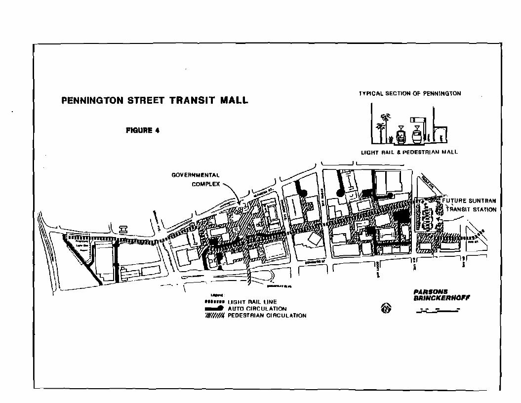
The recommended optIan would have the LRT system drop below grade on Broadway at
Euclid; turn north and cross SR 210, the SPRR, and Toole Avenue in a tunnel and return to grade in the area of the downtown transit center. The LRT system would be incorporated irito the downtown transit center a t 6th Avenue and Pennington Street and then proceed west on Pexmington in an exchrsive mall environment to the
gwernmental complex and to a storage and maintenance facility east of I-10. Figure 4 illustrates the r e c o m m e n d 4 alignment In the downtown.
Finally, severa1 LRT alignments were evahiated which would extend the system east to
Pantano Road and/or have the system operate on the north side of Broadway between
El Con Mail and EucUd Avenue rather than in the mcdlan. Preliminary analysis
indicates that the extension to Pantano Road couM increase ridership modestly. An
evaluation of the alignment on the north side of Broadway between El Con M a l l and
Euclid Avenue suggests that the operational, pedestrian, noise, visual impacts, and
access problems outweigh the cost and other benefita However, both concepts should
be evaluated more fully in the next study phase.


TABLE 5
COMPARISON OF CPftE3 WITH, OR EYALUATIWG, LRT SYSTBMS
EXLSTING DOWNTOWN LRT SYSTEM CHARACTERISTICS POPULATIOH* EMPLOYMENT
METRO DAnY BOARDIHGS I10W CITY CITY AREA PBBSENTPROdEClTD =ATUS LENGTH PROJECTED ACTUAL FUNDED
Austin, TX 345,000 0.5 million 41,000 48,000 AA/DEIS 8-25 mi. 15-24,000 - TED Underway
Denver, CO 492,000 1.6 mllllon 110,000
Milwaukee, W I 836,000 1.4 million 85,[100
Portland, O R 366,000 1.2 million 115,000
Sacramento, CA 276,000 1 . 0 million 00,000
Salt Lake City, 164,000 0.9 million 51,000 UT
San Diego,CA 876,000 1.9 million 55,000
Sen Jose,C A 630,000 1.3 milllon 14,000
Tucson, A 2 331,000 0.5 miliion 13,000
160,000 Prel, Studies 46 rnj
100,000 Prel. Studies 14 mi
125,000 Open 1986 15 mi
- Open 1987 15 mi
81,000 AA/DEJS 13 mi Underway
02,000 Open 1982 16 mi
43,000 Open 1988 20 mi
27,00Q Prel. Studies 8 mi
TED
TBD
ISF
ISP
TBD
State
State/ Federal
1980 Census* * Revised Opening Day Estimate [SF Interstate Substitution Funds TBU To Be Deterrnlned; no funding source available at present.

L-CAPTNG AHD BUFFERWG
The urban design elements for landscaping the Broadway Corridor are consistent with
the ULVAIA report for Broadway Boulevard, the Urban Design Commissionls Report,
and the Major Streets and Routes P l a h The four main elements of the bndscaping
plan developed for the Broadway Corridor are:
1 transit and pedertrian nodes,
21 a landscape theme which connects the transit nudes abng the corridor,
3) walls tobuffer neigtrborhMs and mitigate traffic noise, and
4) a design to channel the views of the mountains
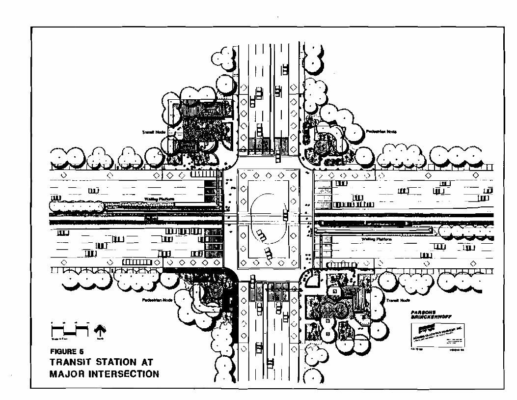
The m s i t and pedestrian nodes occur at major intersections, commercial areas,
and/or transit stations They should have a strong sense of place or identity reinforced by the repeated use of 8 plant palIett and specielity paving materials. Figure 5
illustrates a @pied intersection concept with LRT.
The mid-section landscaping theme, as illusatrated in Figures 6 and 7, would be
designed to connect the n d e s and create a landscaping theme which responds to the
vegetation changes, architecture, and character of the adjoining neighborhood&
In the section between Euclid Avenue and Columbus Boulevard, where some existing proper@ fronting on Broadway Boulevard would be removed to accommodate widening,
adjacent residential artas would be buffered by a 30-foot landscaping strip. WaUs and
berming would be u s d to buffer and re* t road noise md, along with the landscaping concepts, to improve the aesthetics and identity of Broadway. The height of the noise walls would be datemined based on a series of location-sgecific detailed noise
analyses conducted at the time of project tmplernen&tian.
M e d h treatments are aha a critical concern of the public. Figure 8 Illustrates three
options for incorporating a transit system with the median. It should be noted that the
options ate based on preliminary engineering and involve operational tradedffs.
Further study and p&Uc input are necessary prior to a definitive sebction and design.
As in all landscaping elements, emphasis would be placed on the use of native and
drought tolerant plants and materials to minimize water consumption.


SECTMM -K BUS TRANSIT OPTION
P4RSONdLIGHT RAIL TRANSIT OPTION BCIINCKERHOFC -. .--
CROSS SECTION OF LANDSCAPE PLAN .-.-aFIGURE 7 .-l l l m


c m ESTIMATES
The costs associated with each alternative include right-f-way and relocation, roadway constructfon, landscaping casts, transit aapital and transit operating, and total project cost.
Except for the "DoNothingnalternative, all of .the alternatives rquire the acquisition
of right4-way b e t w m Euclid Avenue and Columbus Boulevard in order to
accomplish the necessary design. Minimum requirements for widening are illustrated in Figure 9 and are based on the adopted Major Stttets and Routes plan. The 150'
minimum ahtlof-way wfdth is required to accommodate fuhre corridor travel with m y of the transit components. This right-of-way width is typical between Columbus Boulevard and Camino Seco, but addtional right-fway Is required between Euclid
Avenue and Columbus BwIevard
Table 6 identifies the r i g h t ~ f v a ycasts attributable to widming the nexsary
oeetion between Euclid and Calumbus plus a section just east of Wilmot. These costs
are shown in 1986 dollars and were calcuhted by a certified appraiser as par t af this
study.
APPRbESBR'S MARK= VALUE ALONG BROKDWAY (Cost in 1986 $ Millions)
AREA ALOHG BROADWAY 8fGHTdP-WAY REIACATIOH
Northside Euclid ta Courttry Club
Southside Euclid ta Country Club
Northside Country Club to Dodge
Southside Dodge to Columbus
Southside Melville to Longfellow
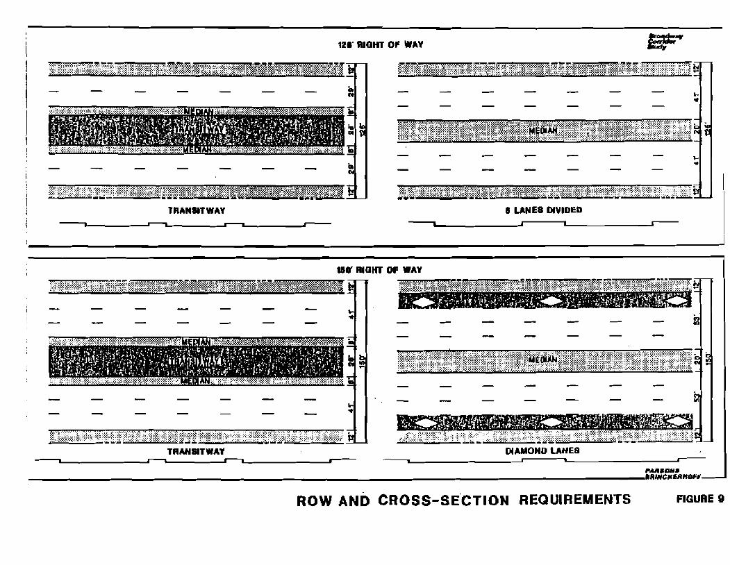
12I' WQHT OF WAY
I I R A W ~ TWAY I LANES D ~ V I D E ~ J I 1 I
1#RIGHT OF WAY I
TRANWTWAV DlAMOHO LANES n n 1 I s L A PARSWSI I I # C M S R M F
FIGURE 9R O W AND CROSS-SE'CTION REQUIREMENTS
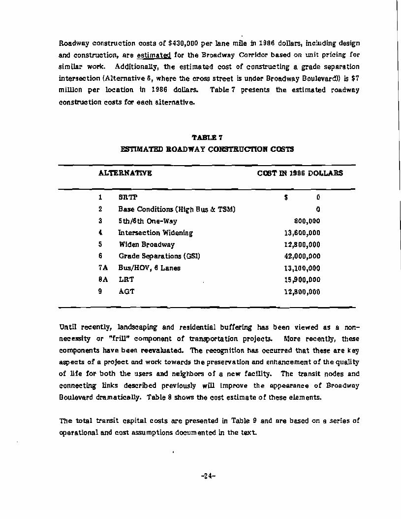
Roadway construction costs of $430,000 per lane mile in 1986 dollem, inchding design
and construction, are estimated for the Broadway Corridor based on unit pricing for
similar work. Additionally, the estimated cost of constructing a grade separation intersection (Alternative 6, where the cross street is under Broadway Boulevard)) is $7 rniLUon per location Ln 1986 dollars. Table 7 presents the estimated roadwsy
construetion costs fm each alternative.
SRTP
Base Conditions (High Bus & TSM)
Sthfith meW8y Intersection Widening Widen Broadway
Grade Separations (GS1)
Bus/HOV, 8 Lanes LRT
AGT
Until recently, landscaping and residential buffering has been viewed as a non-necessity or Rfrillncomponent of transportation projects. More recently, these
components have been reevaluated. 'Ihe reognition has occurred that these are key aspects of a project and work towards the presewation and enhancement of the quality of fife for both the users and neighbors of a new facflity. The transit nodes and
connecting links described previously will Improve the appearance of Broadway
Boulevard dramatically. Table 8 shows the cost estimate of these elements.
The totaI transit capital costs are presented in Table 9 and are based on a series of operational and cost assumptions documented in the text.
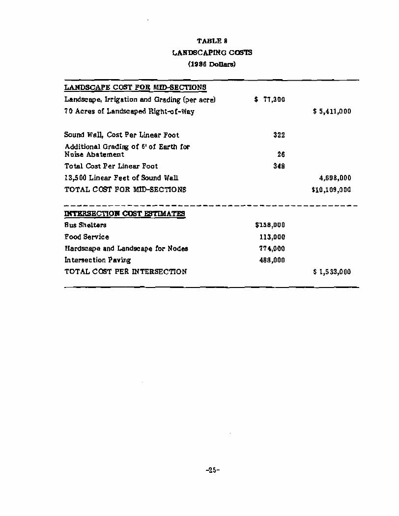
LANDSCAPE COST FOE MIDSECTIONS
Landscape, Irrigation and Grading (per acre) $ 77,300
70 Acres of Landscaped Bight-f-Way $ 5,411,000
Sound Wall, &st Per Linear Foot
Additional Grading of 6' of Earth for Noise Abatement Total Cost Per Linear Foot
13,500 Linear Feet of Sound WaIl
TOTAL COST FOR W-SECTIONS
Bus Shelters
F w d Setvice Hardscape and Landscape for Nodes lntersection Paving TOTAL C05T PER INTERSECTION


- - - -
The total capital cost for each alternative includes right-of-way and relocation,
roadway construction, and transit capital costs, Table 1U presents the estimated
capital cost for each alternative.
TABLE 10
TOTAL CAPITAL CmTS
(1986 $ Thmsandsl
ROADWAY dr T E m a T TOTAL ROW & LAHDgCAPING CAPITAL CAPITAL
ALT BELOCATIOI COBT C m CQsT
1 -SRTP 2 - High BuslTSM 3 - 5th/6th 4 - Widen lnt. 5 - Widen Btway. 6 - GSI 7A - HOV16 L 70* PC - HOV/U of A SA - LRT 8B - LRT,U of A 9 A - AGT 9B - AGT, U of A
*Not Applicable
**Transitway from Broadway to the U of A assumed to occur within existing ROW.
Table 11 illustrates the annualized capital costs for each alternative uslng the U.S.
Department of Transportation guidelines which include a 10% discount rate for capital
and cknstruction costs and an economic life of 12 years for bus facilities, 20 years for
roadway facilities and landscaping, 30 years for rail facilities, and 100 years for right-
of-way. The total annualized costs also include the annual transit operation and
maintenance cost estimates which are based on a series of assumptions documented in
the text.

TABLE 11
TOTAL ANNUALIZED COB=
(rsss$ -1
- - - p p p p p
AWNUAL AnlTUAL AImUAL ROW & TRAHSlT ROADWAY TOTAL
O&M BELOCATOW CAPITAL COHSTRUCTIONAHNWAL ALT COB= CmTS CllBTS CCIBTS CmTS
1 -SRTP $15,100 2 - Bus/TSM 18,400 3 - 5th/6th 18,50D 4 -WidenInt 18,400 5 - Widen Wway 18,400 6 - GSI 18,400 7 A - HOV/G L 18,900 7B
C - H O V / U o f A 19,500 BA - LRT L9,9 00 8B-LRT/Uof A 21,400 9 A - AGT 20,400 9B-AGT/Uof A 22,800
$1, too 3,800 3,800 3,800 3,800 3,800 4,200
*Not Applicable
FUNDING
The sources of funding available to the City of Tucson for capital projects include
Highway User Revenue Funds (HURFI, revenue bonds repaid with HURF monies,
general obligation bonds financed through property and sales taxes, state and federal
monies, essessment district fees, and other misceheous sources. Table 22 illustrates
the fiv eyear cap1tal improvement program (CIP)expenditures for the entire City
Transportation Department based on the adopted Five Year CIP. For more detail, see
the City of Tucson Adopted Five Year Capital Irnpmement Program, Fiscal Years:
1986-87 through 1990-91. By law, expenditures match revenues.

TABLE 12
FIVE YEAR CIP SUMMABY
(1986 $ Thamands)
FBCAL YEAR
1986-87 1987-88 1988619 190940 199031 TOTAL
* Adopted FY 1986-87 capital budget.
Under present funding conditions, construction of any of the Broadway Corridor Study
alternatives wil t r q u i r e mywhere from 30% to 100% of the present capital budget for the entire City Transportation Department for each year necessary to amortize the
project Moreover, the annual cost for operation and meintenence of the transit
component of the alternatives ($15.1 to $22.8 mifiord exceeds the present transit operating expendituresof $13.6 million in FY 1986-87.
Implementation of any of the proposed alternatives In the Broadway Corridor wil l require additional funding m r c e s for both construetkn and operation, or a
reallocation ofcapital expenditures.
Federal monies through the Urban Mess Transportation Administration (UMTA) may be
available for the transit componenb if the UMTA Project Development process Is followed The process requires that for detailed study, certain threshold criteria be
met, and that the UMTA Proje t Development process be followed prior to selection
of Tucson as a fixed guideway candidate city- The UMTA Project Development
process is illustrated in Figure 10. Preliminary analysis shows that the Broadway Corridor LRT alternative meet the threshold criteria for fur* er study and UMTA
involvem ent in the Project Develaprnent process. This study would constitute a
portion of the System Plaming phase. However, a regionwide systems study may be
necessary to identify Broadway as the paramount transi: corridor in the future.

w
URBAN MASS TRANSPORTATION ADMINISTRATION (UMTA) PROJECT DEVELOPMENT PROCESS
I
1. Oyatmm Planning
2. Alt8rnmtivmm Analyrla / brmlt €IS
I -3. Prwllmlnmry Englnmmrlng
Final El$ I 1
4. Final Dmrlnm
# Oanotar local
0 0mnoR*m UYTI d-~lmion
rmt l r l t l rm Cundmd by UYTA'
5. Conmtructlon
Assuming funding was available to study the corridor following the federal guideline%
there are no guarantees that funding would be available for construction of a f l e d
guideway system. Since the early 198Q1s,the amount of Section 3 discretionary new
start funds available has averaged nationwide about $400 miWon a year. These funds have been allocated to between 8 and 1 2 projects annually, with another 20 to 30
projects going unfunded. The pressure for diminishing federal transit resources
requires that UMTA ensure that l imited resources be utilized In the most prudent and
cost-ffectfve manner. Therefore, there are no guarantees that Tucson would be able
to fund a fixed guideway system with any federal monies Additionally, bcal financial commitment is a factor used to order projects that rate similarly in terms of cost-
eifectiveness. The statutory minimum requirement is 20% local monies. However, it
has been proposedby Congress that if f ederaI funding far e fixed guideway is required,
suggests a non-federal match of 50% is required
Additional local monies could be raised through property or sales taxes or possibly other murces. The City of Tucson does have the option to bypass the federal system
altogether and use state and local monies (assuming they were available) to fund
construction of a fixed guideway system, This has occurred in San Dkgo with the
construction of the S w t h Line LRT system at a total capital cost of apprwcirnately
$118 miUion. However, it should be noted that this relatively low cost was
accomplished in part by utilizing existing railroad right-f-way and tracks for much of
the route distance. For this system, nearly 9 0%. of the capital funding was derived
from California State gas tax revenues (State Transit Assistance Act). The remainder
was cbtained from state sales tax revenues (Transporhtion Development ~ c t ) - I
Curren t state legislation permits Pima Camty residents to vote on increasing the sales
tax by one+alf cent with the revenues dedicated to both transit and road
improvements. This source of monies would facilitate implementation of any of the
transit alternatives. However, at this time, the transit one+alf cent election cannot
occur until after the passage of a one-half percent increase in the sales tax dedicated
almost entirely to roadway improvemen 1s.
l ~ a nDiego Trolley: The First Three Years, SANDAG, November 1984, pg. 10.

The fmdings of the Broadway Corridor Study are summarized as follows:
a The metropolitan population and employment is projected lo double over existing
levels by the Year 2005.
Of the nine alternatives studied, no single alternative done meets the future
transportation needs of the corridor.
If Alternative 6 ( w d e separations and the transit component ofAlternative 21 is
combined with Alternative 5 (widen Broadway Boulevard), or AIternat ive 7 (HOV lanes), or Alternative 8 (LRm, or Alternative 9 (AGT), the Year 2005 Wave1
demands will be met.
a Ontheresponse forms~ce ivedf i~mtheDecember1986publ i cmeet ings ,72%
of the rewondents favored grabs-separated interchanges as a method to provide adequate roadway capacity.
a On the respanse forms received from the July 1986 public meeting, the LRT
system concept received a 47% favorable response. Between 19% and 35% of
the respondents noted that they would use some form of transit (bus, LRT, or
ACT) two to three times per week for work or shoppinglrecreatian trips
No matter' which transit technology is selected, the section of Broadway Boulevard between Euclid Avenue and Columbus Boubvard wiU need to b e
widened to a minimum 150' right-l-way to accommodate the lransit component
and projmted traffic vohmes. The right*[-way cosb associated with this are
approximately $46 maion in 1986 dollars.
In order to minimize right-fway (ROW) costs and disruption to historic
buildings, the section of Broadway Boulevard between Euclid Avenue and
Country Club Road should be widened on the north side and the entire roadway shifted to the north to provide additional ROW on the south side for landscaping, improved perking, access control opportunities, and redevelopment of proper tier

Preliminary plans for developing a divided roadway with a transitway in the
center ere shown at the end of this report. Also presented at the end of this
report are illustrations of the various landseeping, transit technology, and grede
separation model concepts which were developed as an integral component of the Broadway Corridor Study.
r Landscaping and residential buffering are key components of the corridor
package, and a minimum 30' area adjacent to residential neiglborhoods should be
used for buffering homes which are not presently adjacent to the roadway.
Public opinion on the use of residual right-f-way varies. However, there w a s a
clear consensus that there should be no raonings to allow higher density
development.
a The LRT transit technology (Alternative 8 ) meets the UMTA minimum
requkements far further study.
a Without new sources of funding or e major revision of the cepital improvement
program, the City of Tucson does not have the resources to implement any of the
alternatives necessary t o meet Year 2005 travel needs in the Broadway Corridor.