BUSHFIRE MANAGEMENT · Management Manual, or by integrating the material relevant to bushfires into...
42
BUSHFIRE MANAGEMENT NATIONAL GOOD PRACTICE OPERATIONAL GUIDELINES FOR THE AUSTRALIAN WATER INDUSTRY a
Transcript of BUSHFIRE MANAGEMENT · Management Manual, or by integrating the material relevant to bushfires into...

BUSHFIRE MANAGEMENTNATIONAL GOOD PRACTICE OPERATIONAL GUIDELINES FOR THE AUSTRALIAN WATER INDUSTRY
a

Bushfire managementNational good practice operational guidelines for the Australian Water IndustryMay 2020
About WSAA
The Water Services Association of Australia (WSAA) is the peak industry body representing the urban water industry. Our members provide water and sewerage services to over 20 million customers in Australia and New Zealand and many of Australia’s largest industrial and commercial enterprises.
Disclaimer
This report is issued by the Water Services Association of Australia Ltd and individual contributors are not responsible for the results of any action taken on the basis of information in this report, nor any errors or omissions. While every effort has been made to ensure the accuracy of that information, the Water Services Association of Australia (WSAA) does not make any claim, express or implied, regarding it.
Copyright
This document is copyrighted. Apart from any use as permitted under the Copyright Act 1968, no part of this document may be reproduced or transmitted in any form or by any means, electronically or mechanical, for any purpose, without the express written permission of the Water Services Association of Australia Ltd.
More information
Please contact [email protected]
© Water Services Association of Australia Ltd, 2020
ALL RIGHTS RESERVED
Additional information
Report contact Arran Canning
T: +61 458 585 347 E: [email protected]
Citation Canning, A., Ryan, G., et al., 2020. National good practice operational guidelines for bushfire management for the Australian water industry, Water Services Association of Australia.
Project director Greg Ryan
Project owner Water Services Association of Australia
Project name National good practice operational guidelines for bushfire management for the Australian water industry
Document version
Version 3

Acknowledgement
WSAA and the Department of Home Affairs acknowledge the leadership of the Water Sector Services Group in supporting the development of these guidelines, to improve the resilience of the Australian Water Sector.
In preparing this report, the Water Services Association of Australia has benefited extensively from discussions with various stakeholders. Special thanks go to Barwon Water, City West Water, Coliban Water, Gippsland Water, Goulburn Valley Water, Icon Water, Lower Murray Water, Melbourne Water, North East Water, South Australia Water, South East Water, Sydney Water, TasWater, Toowoomba Region Council, Urban Utilities, and Water Corporation for sharing knowledge and perspectives. We also acknowledge the contributions from the Queensland Water Directorate and the Water Directorate NSW, along with several of their members. The conclusions drawn are the Association’s own.
Document co-authors and contributors
DOCUMENT AUTHOR AND CONTRIBUTOR ORGANISATION
Michael Watson Barwon Water
William Buchanan Barwon Water
Prakash Rao City West Water
Darren Masters Coliban Water
David Sheehan Coliban Water
Luke Haynes Goulburn Valley Water
Guy Richardson Icon Water
Muneeb Sunna Lower Murray Water
Denise Fontana Melbourne Water
John Day North East Water
Brendan Guiney NSW Water Directorate
Luke Sawtell Queensland Urban Utilities
David Cameron Queensland Water Directorate
Shane Pritchard SA Water
Zoe Hines South East Water
Rebecca Gonzalez Sydney Water
Luc Richard TasWater
Steve MacCarthy Water Corporation
Arran Canning Water Futures (engaged by WSAA)
Dan Deere Water Futures (engaged by WSAA)
Greg Ryan Water Services Association of Australia (WSAA)
1
Contents
1 Introduction and background 3
2 Bushfire and water quality overview 4
2.1 Fire intensity 4
2.2 Potential contaminants 5
2.3 Summary 6
3 Document structure 7
4 Prevention and planning 8
4.1 Planning 8
4.2 Critical functions and infrastructure 12
4.3 Bushfire risk and impacts 12
4.4 Bushfire mitigations best practices 12
4.5 Prescribed burns 13
4.6 Fire breaks 13
4.7 Asset protection zones 13
4.8 Asset standards 14
4.9 Integrating bushfire management with existing 15 systems and processes
4.10 Challenges in conducting bushfire mitigation 15
4.11 Collaboration and partnerships 15
4.12 Expert panel 16
4.13 Planning checklist 16
5 Preparedness 18
5.1 Preparedness checklist 20
6 Bushfire response 21
6.1 Response checklist 22
7 Bushfire recovery 23
7.1 A framework for predicting post-fire water contamination risks 26
7.2 Catchment rapid risk assessment 28
7.3 Tools for assessment 29
7.4 Water quality monitoring 32
7.5 Mitigation options 32
7.6 Recovery checklist 38
References 39
Appendices
All case studies available at WSAA website wsaa.asn.au/publication/national-good-practice-operational-guidelines-bushfire-management-australian-water
Appendix A North East Water critical infrastructure rating (CIR)
Appendix B Hydrodynamic modelling for bushfire management and recovery in the catchment from Melbourne Water
Appendix C North East Victoria & Gippsland Bushfire Rapid Risk Assessment Team report from the 2013 Alpine fires
Appendix D SA Water experience with the application for coir logs
Appendix E Melbourne Water’s experience with the application of debris racks and sediment dams
Appendix F Managing water quality in the Huon River catchment
Appendix G Drought, fires, floods and water quality
Appendix H Monitoring water quality and managing turbidity after the Perth Hills bushfire
Appendix I Lindfield Park Road rehydration project
Appendix J Getting started on bushfire recovery2

1 Introduction and background
The devastating fires in Australia over the 2019-2020 period highlighted the need for the water industry to have practical guidance ready at hand for the management of drinking water supplies during such events.
Over 12 million hectares of bush was burnt across the Australian landscape, and vast areas of drinking water catchments in NSW and Victoria were impacted. This was exacerbated by record-breaking temperatures, severe drought and high winds. The increase in bushfires is a trend that is expected to increase into the future as a result of climatic change and other factors. Through the experience of previous bushfires in drinking water catchments, some water utilities have a good understanding of the risks that they pose, including risks to water quality and impacts to infrastructure. In future these risks will become relevant to more water utilities.
The intent of this National Good Practice Operational Guideline for Bushfire Management for the Australian Water Industry (‘the Guideline’) is to utilise the current knowledge and experience in the industry to provide practical guidance across the water sector on bushfire and water quality management. The Guideline includes a number of case studies from water utilities around Australia.
The Guideline aims to provide support to planning and operational staff within a water utility so that they can plan, respond and recover from a bushfire emergency based on sound practical experience. The Guideline is not intended to be used in isolation and should be used to support existing Incident and Emergency Response Plans, through either the development of a Bushfire Management Manual, or by integrating the material relevant to bushfires into existing management plans, such as an Incident and Emergency Plan, Drinking Water Quality Management Plan, Environmental Management Plan or Asset Management Plan. Across the state and territory jurisdictions in Australia there are existing pieces of legislation, regulations, codes of practice and supporting documents for bushfire management. This Guideline represents good practice across the broader water utility industry, based on experience, but it does not take precedence over federal, state or local legislative requirements.
3

2 Bushfire and water quality overview
The impact of bushfires on drinking water catchments can compromise water quality both in the short term and in the long term, for months to years afterwards, by causing a change in the water balance and catchment landscape.
During active fires, forest litter is replaced by an ash and charcoal layer, with ash settling on lakes and reservoirs. Rainfall events post-fire can have a significant effect on water quality, from increased rates of erosion, increased sediments and turbidity, and the introduction of a range of chemicals and precursors into the water supply. The degree to which a bushfire has negative impacts on water quality depends on multiple factors, such as the intensity of the fire, post-fire precipitation, catchment topology and local ecology.
2.1 Fire intensity
The intensity of the bushfire determines the severity of the water quality consequences. Low-intensity fires that do not burn the crown of the forest lead to increased leaf litter, which during post-fire rainfall lead to increased dissolved organic carbon (DOC) concentrations in water storages. If the leaf litter ends up in streams this can result in an increase in microbial activity, reduced dissolved oxygen levels and the release of metals, such as manganese, from the sediments. On the other hand, high-intensity fires, which burn the above ground matter and soils, can result in a different range of issues.
Due to the extreme heat generated by these fires, most of the organic matter is volatilised, resulting in the inorganic nutrients in the leaves leaching out and passing into the soil. As a result, following rainfall, there will be an increase in phosphorus and nitrogen entering waterways and reservoirs. The increase in phosphorous can lead to future algal blooms. High-intensity fires can also lead to the leaching of trace elements, such as copper, lead and chromium, and in particular the volatilisation of mercury, which can reabsorb and be released as methylmercury. High-intensity fires can also result in the loss of riparian vegetation that supports the banks of rivers and streams. With the loss of these trees and their root systems, over time this can result in land disturbance and erosion, causing an influx of sediments, nutrients, ash and burnt organic material into raw water supplies. High intensity burns not only have a water quality impact, but can have a water quantity impact, leading to increased water yields from the catchment in the short term, by a combination of hydrologic processes, including dramatic decreases of evaporative losses (interception of precipitation and transpiration) from the forest canopy, and increases in soil moisture and runoff generation from hillslopes. These, in turn, can produce greater storm runoff, including large peak flows and an overall increase in water production from fire-affected landscapes.
4
2.2 Potential contaminants
Based on previous bushfire experiences in Australia, and across the globe, water quality issues have been divided into two main categories: Priority 1 and Priority 2.
Priority 1 covers the most commonly reported issues from bushfires that can cause significant water quality concerns and disruption to supply.
Priority 2 includes issues that have occurred at lesser frequencies or the consequences are considered less severe.
2.2.1 Priority 1
2.2.1.1 Suspended solids
Suspended solids input into waterways following fires and rain events leads to increases in the turbidity and colour of the water, while also transporting other particle-associated contaminants. The magnitude of impacts from suspended solids entering waterways is highly variable and dependent on the intensity, magnitude and frequency of rainfall events following bushfires, and a range of factors that influence post-fire erosion. It has been reported that up to 500 times the background sediment loads have been measured following fires and associated rainfall. Most of this was attributed to channel erosion and incision of unchannelised drainage lines, following short duration high-intensity summer storms. An example of this is after the Cotter fire in Canberra in 2003 where 482 km2 of catchment burned and the maximum turbidity increase was 30 times higher than the previous maximum. It can take up to two years for reservoirs to return to pre-fire conditions. However, in other cases, some reservoirs were not noticeably impacted following large fires and associated rainfall, and this can be due to the capacity of the reservoir to mitigate the impacts of the contaminated inflows.
2.2.1.2 Nutrients
The impacts from nutrients, particularly nitrogen and phosphorus, can be a major issue associated with bushfires in drinking water catchments. Some studies have shown more than one order magnitude increase in background concentrations after fires, while others show minimal impacts. Factors that affect the variability of impact are burn severity, erosion processes, the extent of delivery to streams, soil and forest vegetation types, and storage and retention of nutrients. The immediate major source of phosphorus comes from leaching of ash deposits, while atmospheric deposition is the dominant source of nitrogen. In the medium term, erosion through the loss of bank stabilisation can also lead to the transport of nutrients into waterways. It can take up to three years for nutrient levels in reservoirs to return to pre-fire levels following a large burn and subsequent major rainfall event. Although there may be some peripheral issues with nutrients entering waterways following bushfires, such as the presence of ammonia, nitrate and nitrite, the predominant issue and concern is indirect – the increase in phosphorus leading to the growth of cyanobacteria. With cyanobacterial blooms come risks from cyanotoxins, as well as taste and odour compounds, particularly 2-methylisoborneol (MIB) and geosmin.
2.2.1.3 Organic carbon
Fires can have a major impact on forest floor and surface soil organic matter levels. Through runoff and erosion, the carbon can be exported into waterways. Increases in carbon, as DOC, while in itself not a major concern, is a precursor to disinfection by-products (DBPs), such as trihalomethanes (THMs) and haloacetic acids (HAAs). Following fires nitrogenated DBPs can also form, such as haloacetonitriles (HAN) and halonitromethanes. Any impact is difficult to predict since the formation of DBPs are dependent on carbon speciation, background levels of DOC and water treatment processes. A change in the levels and speciation of DOC in raw water can have an impact on water treatment processes, requiring optimisation of coagulants to remove higher organic fractions from the water. This may prove challenging and could undermine water treatment processes.
2.2.1.4 Metals
The contamination of waterways from metals is mostly an aesthetic issue, relating to the presence of iron and manganese transported from burnt soil or released from rivers due to waterways becoming anoxic from a reduction of dissolved oxygen. However, there have been examples where other metals, such as chromium, arsenic, lead, mercury and copper have been released for soils at concentrations that have exceeded the health-based guideline values in the Australian Drinking Water Guidelines (ADWG) following post-fire inflows.
5

2.2.2 Priority 2
There are a number of other documented water quality issues that may arise from catchment fires. While these are important for water quality managers to be aware of, it is very difficult to predict whether or not they will be an issue so they have been given a second level priority. These include the following.
2.2.2.1 Cyanide
Cyanide can form from the combustion of organic material and present in ash or deposits from the atmosphere. Impacts are most likely short-lived and confined to the initial post fire rainfall events.
2.2.2.2 Organic combustion products
Polycyclic aromatic hydrocarbons (PAH), polychlorinated biphenyls (PCB) and polychlorinated dibenzo-p-dioxins and dibenzofurans (PCDD/F) may be produced during combustion in forest fires and released into the atmosphere or deposited in ash and soil. The concern around these chemicals is that they are potentially carcinogenic and can persist in the environment, and tend to bioaccumulate. However, in sampling studies undertaken, levels are generally low and within ADWG guideline values.
2.2.2.3 Anions and cations
Anions and cations released from soils during intense burns can enter waterways following rainfall events. These include sodium, magnesium, calcium, potassium, chloride and sulphate. While there may be small increases in TDS concentrations, the impact is likely to be minimal.
2.3 Summary
The severity of the fire has an effect on the water quality risks that are present. Table 2.1 summarises these issues for low and high-intensity fires, along with the water quality priority. There is a five-scale severity rating used in Australia to rate fires, which is explained in more detail in Section 7.3.1. In terms of water quality impacts, they are generally described only in terms of low and high severity fires. Therefore, some precaution should be taken when trying to assess the relationship between fire severity and water quality impacts. Recent research has shown there is not always a linear relationship between fire severity (i.e., temperature) and contaminants.
TABLE 2.1 WATER QUALITY RISK AND FIRE INTENSITY
PRIORITY PARAMETERLOW SEVERITY
HIGH SEVERITY
Priority 1 Suspended solids circle
Nutrients circle
Organic carbon circle
Metals circle circle
Priority 2 Cyanide circle
PAHs, PCBs, PCDD/F circle
Anion cations circle
6

3 Document structure
This document and the methodology to manage the bushfire risk to the water industry, is based on the well-established four-phase disaster management approach of prevention (planning), preparedness, response and recovery.
This approach aims to minimise losses in the event of an emergency, by helping water utilities anticipate potential impacts to their business and to be prepared during and after the emergency. The four phases are described as:
Preventionand planningTake actions to reduce or eliminate the likelihood or e�ects of an incident
PreparednessTake steps before an incident to ensure e�ective response and recovery
RecoveryTake steps to minimise disruption and recovery times
ResponseContain, control or minimise the impacts of an incident
� �
� �
7

4 Prevention and planning
4.1 Planning
1 National Disaster Risk Reduction Framework (2018) homeaffairs.gov.au/emergency/files/national-disaster-risk-reduction-framework.pdf
The prevention and planning phase represents actions that should be taken well in advance of any future bushfire threat. These activities should be part of the normal planning and operational practices of a water utility. This phase focuses on creating a concrete plan for bushfire management, which includes risk assessment, development of response plans, implementing mitigations, training and exercises.
Table 4.1 describes a systematic approach to prevention and planning for bushfire threats. This chapter also provides additional supporting information to assist in undertaking the assessment and for the planning of mitigation actions.
Investment in risk reduction and resilience can deliver a triple dividend:1
• Avoid loss and suffering
• Reduce future disaster costs
• Unlock economic opportunities and broader economic and social benefits to be realised even in the absence of a natural hazard.
FIGURE 4.1 BUSHFIRE PLANNING PROCESS MAP
sitemap cctv bell routeMAP CRITICAL FUNCTIONS
IDENTIFY AND MONITOR THREATS
RISK AND VULNERABILITY ANALYSIS
DEVELOP PLANS
shield
8
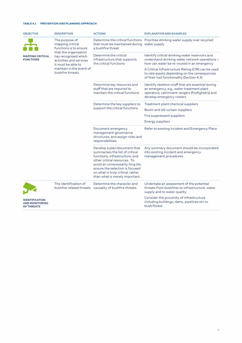
TABLE 4.1 PREVENTION AND PLANNING APPROACH
OBJECTIVE DESCRIPTION ACTIONS EXPLANATION AND EXAMPLES
sitemapMAPPING CRITICAL FUNCTIONS
The purpose of mapping critical functions is to ensure that the organisation has recognised which activities and services it must be able to maintain in the event of bushfire threats
Determine the critical functions that must be maintained during a bushfire threat
Prioritise drinking water supply over recycled water supply
Determine the critical infrastructure that supports the critical functions
Identify critical drinking water reservoirs and understand drinking water network operations – how can water be re-routed in an emergency
A Critical Infrastructure Rating (CIR) can be used to rate assets depending on the consequences of their lost functionality (Section 4.2)
Determine key resources and staff that are required to maintain the critical functions
Identify skeleton staff that are essential during an emergency, e.g., water treatment plant operators, catchment rangers (firefighters) and develop emergency rosters
Determine the key suppliers to support the critical functions
Treatment plant chemical suppliers
Boom and silt curtain suppliers
Fire suppressant suppliers
Energy suppliers
Document emergency management governance structures, and assign roles and responsibilities
Refer to existing Incident and Emergency Plans
Develop a plan/document that summarises the list of critical functions, infrastructure, and other critical resources. To avoid an unnecessarily long list, ensure the selection is focused on what is truly critical, rather than what is merely important
Any summary document should be incorporated into existing incident and emergency management procedures
cctvIDENTIFICATION AND MONITORING OF THREATS
The identification of bushfire related threats
Determine the character and causality of bushfire threats
Undertake an assessment of the potential threats from bushfires to infrastructure, water supply and to water quality
Consider the proximity of infrastructure including buildings, dams, pipelines etc to bush/forest
9

OBJECTIVE DESCRIPTION ACTIONS EXPLANATION AND EXAMPLES
cctvIDENTIFICATION AND MONITORING OF THREATS
bellRISK AND VULNERABILITY ANALYSIS
The identification of bushfire related threats
Understand the risks that utilities face in the event of bushfires, and assess current mitigation and controls
Assess the current threat picture
Check if there is a current risk assessment or reference in Incident and Emergency Plans relating to bushfire risks
What does the threat picture look like at different timeframes, e.g., next season, 5 years, 10 years
Consider different scenarios, such as the impact of climate change, new infrastructure, changes in land use, drought, development
What has recent experience told us?
Has the water utility had recent bushfire experience? What has been learnt? What went right or wrong?
Develop bushfire threat scenarios and incidents that the organisation wants to prepare itself for
Using the information from above, create bushfire threat scenarios based on what is probable under different current and future scenarios
Undertake risk identification, based on scenarios above
Determine types of hazardous events from bushfires, e.g.:
Catchment fires leading to poor water quality
Catchment fires leading to untreatable raw water
Fires leading to loss of critical infrastructure
Fires leading to inaccessible infrastructure
Fires leading to impact on resources and workforce
Section 4.3 provides a list of additional
bellRISK AND VULNERABILITY ANALYSIS
Understand the risks that utilities face in the event of bushfire and assess current mitigation and controls
Risk assessment. Assess the likelihood and consequence of the identified risks, without controls
Undertake a qualitative risk assessment based on the organisation’s risk framework, assessing likelihood and consequence. The risk assessment should be done in accordance with the organisation’s risk framework and the Australian/New Zealand Standard for risk management, ISO 31000. This should be performed without current controls in place.
The identification and documentation of identified improvement in a plan to reduce risks to acceptable levels
Capability assessment- assess current mitigations to manage the risks identified above and determine if there are gaps in capability, by:
Determining the current mitigations for each risk
Reassess risks with the current mitigation and controls in place
Additional analysis may be required to assess capability
Mitigations could include:
Prescribed burn program
Establishment of asset protection zones
Alternative water supplies
Powder Activated Carbon dosing at WTP
Protection of chemical lines in fire-prone areas by encasing in a double sheath
Deployment of silt curtains
Agreements in place for chemical suppliers
Rosters for critical staff
Vulnerability analysis – vulnerability analysis will highlight the risks that do not have sufficient treatment for a water quality issue, or that critical infrastructure is in high-risk zones. This should drive the organisation’s resource and planning on those specific issues
For example, the risk assessment might show that:
There is no treatment for potential algal blooms in a reservoir
There are no hazard reduction programs around vulnerable infrastructure
There are no alternative water supplies if the water supply is contaminated
Document the risk assessment and ensure that it is readily available and updated on a routine basis
It is recommended that an all hazards bushfire risk assessment is developed, but specific risks, such as water quality, are translated into the drinking water quality risk assessment. This would be applicable for other hazard areas, such as environment, assets etc.
10

OBJECTIVE DESCRIPTION ACTIONS EXPLANATION AND EXAMPLES
routeDEVELOP PLANS
Update incident and emergency management plans
Engage with your State’s fire management agency to discuss risks and mitigation activities
Establish clear processes for communication during all phases of fire management (planning, preparedness, response and recovery)
Define roles and responsibilities within the organisation, the responsible external agencies and determine the lead agency for different scenarios
Agree with health and/or water regulatory on boil water protocols during and post bushfire, and document in incident management plans and drinking water quality management plans
Consider how the organisation’s incident and emergency liaison officer is represented on external incident management teams
Document and include in the organisations Incident and Emergency Management Process
Ensure staff are trained in incident and emergency management plans and procedures
Determine which fire management agencies are responsible for managing bushfire in your catchments
Understand if these agencies can offer any additional support (e.g. fire severity mapping or rapid risk assessments)
Request that your utilities critical assets are included in the fire agencies risk mitigation plans so that they can be monitored during active fires
Training of staff could include:
Incident and emergency training for incident management teams
Liaison officer training for deployment into fire control centres
Fire training for field staff (e.g., rangers)
Fire awareness training for operational staff (e.g., maintenance staff entering fire zones post-fire)
Develop improvement plans - the identification and documentation of identified improvement to reduce risks to acceptable levels
If the residual risk after current mitigations is still unacceptable explore additional controls.
Produce prioritised list of improvements based on residual risks
Assign responsibilities and timeframes for implementation
Additional controls could include:
Installation of PAC dosing to manage algal bloom metabolites
Prescribed burning or creating of fire breaks to protect critical infrastructure
Development of incident management and contingency plans
•
11
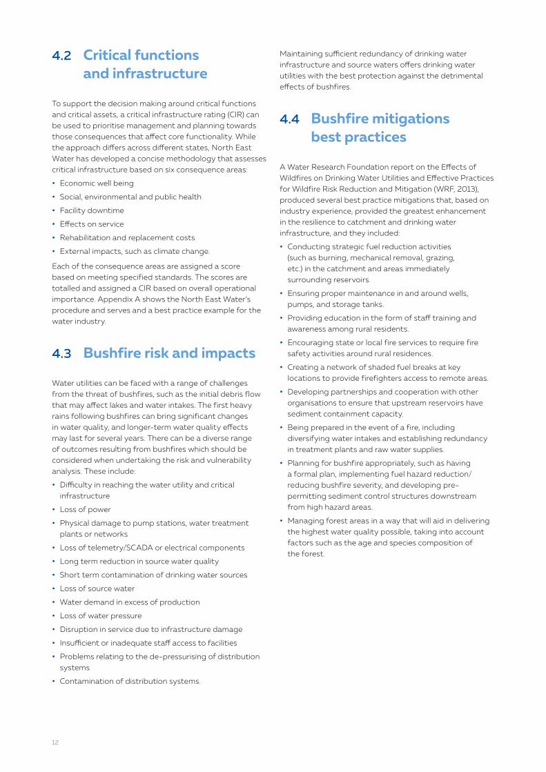
4.2 Critical functions and infrastructure
To support the decision making around critical functions and critical assets, a critical infrastructure rating (CIR) can be used to prioritise management and planning towards those consequences that affect core functionality. While the approach differs across different states, North East Water has developed a concise methodology that assesses critical infrastructure based on six consequence areas:
• Economic well being
• Social, environmental and public health
• Facility downtime
• Effects on service
• Rehabilitation and replacement costs
• External impacts, such as climate change.
Each of the consequence areas are assigned a score based on meeting specified standards. The scores are totalled and assigned a CIR based on overall operational importance. Appendix A shows the North East Water’s procedure and serves and a best practice example for the water industry.
4.3 Bushfire risk and impacts
Water utilities can be faced with a range of challenges from the threat of bushfires, such as the initial debris flow that may affect lakes and water intakes. The first heavy rains following bushfires can bring significant changes in water quality, and longer-term water quality effects may last for several years. There can be a diverse range of outcomes resulting from bushfires which should be considered when undertaking the risk and vulnerability analysis. These include:
• Difficulty in reaching the water utility and critical infrastructure
• Loss of power
• Physical damage to pump stations, water treatment plants or networks
• Loss of telemetry/SCADA or electrical components
• Long term reduction in source water quality
• Short term contamination of drinking water sources
• Loss of source water
• Water demand in excess of production
• Loss of water pressure
• Disruption in service due to infrastructure damage
• Insufficient or inadequate staff access to facilities
• Problems relating to the de-pressurising of distribution systems
• Contamination of distribution systems.
Maintaining sufficient redundancy of drinking water infrastructure and source waters offers drinking water utilities with the best protection against the detrimental effects of bushfires.
4.4 Bushfire mitigations best practices
A Water Research Foundation report on the Effects of Wildfires on Drinking Water Utilities and Effective Practices for Wildfire Risk Reduction and Mitigation (WRF, 2013), produced several best practice mitigations that, based on industry experience, provided the greatest enhancement in the resilience to catchment and drinking water infrastructure, and they included:
• Conducting strategic fuel reduction activities (such as burning, mechanical removal, grazing, etc.) in the catchment and areas immediately surrounding reservoirs.
• Ensuring proper maintenance in and around wells, pumps, and storage tanks.
• Providing education in the form of staff training and awareness among rural residents.
• Encouraging state or local fire services to require fire safety activities around rural residences.
• Creating a network of shaded fuel breaks at key locations to provide firefighters access to remote areas.
• Developing partnerships and cooperation with other organisations to ensure that upstream reservoirs have sediment containment capacity.
• Being prepared in the event of a fire, including diversifying water intakes and establishing redundancy in treatment plants and raw water supplies.
• Planning for bushfire appropriately, such as having a formal plan, implementing fuel hazard reduction/reducing bushfire severity, and developing pre-permitting sediment control structures downstream from high hazard areas.
• Managing forest areas in a way that will aid in delivering the highest water quality possible, taking into account factors such as the age and species composition of the forest.
12

4.5 Prescribed burns
Prescribed or planned burning is the controlled use of fire in the landscape with the intent of reducing fuel hazards, managing native vegetation and protecting biodiversity. Many water utilities use prescribed burns in drinking water catchments and around infrastructure to reduce the risk from bushfires. Prescribed burning is a mitigation tool that could be used to reduce potential risk.
The best conditions to undertake controlled burning is when the conditions suit safe fire lighting. The timing and intensity of burns are highly dependent on weather conditions, such as wind, and the times that are the best suited for native plants and animals. The use of techniques such as mosaic burning patterns can improve biodiversity and ecological values for native flora and fauna.
Catchments should be prioritised each year to ensure those with the highest bushfire risk are completed first. When planning the annual burn program water utilities should work closely with their state fire authority, local rural fire brigades and local councils.
4.6 Fire breaks
Fire breaks are strips of land that have been intentionally cleared of all trees, shrubs, grasses and other combustible material, thus providing a fuel-free area. Removal of combustible material includes the pruning of dead branches on plants, slashing dry/dead vegetation, removal of deadwood that is not ecologically important, removal of litter and weed control. The purpose of firebreaks is to allow access for firefighting and maintenance vehicles, and therefore they should be maintained in a state that allows for vehicles to move unhindered. Fire breaks can have the benefit of reducing the spread of low-intensity fires, but should not be relied upon to prevent the spread of all fires.
Fire breaks can be prepared using several techniques such as:
• Ploughed breaks
• Herbicide treated breaks
• Grazed breaks
• Burnt breaks.
The Western Australian Department of Fire and Emergency Services provides a detailed guide to constructing and maintaining fire breaks (DFES).
4.7 Asset protection zones
Asset protection zones (APZs) are areas around built assets where the fuel load has been reduced. An APZ provides.
• A buffer zone between a bushfire hazard and an asset
• An area of reduced bushfire fuel that allows suppression of fire
• An area from which back-burning may be conducted
• An area which allows emergency services access and provides a relatively safe area for firefighters to defend property.
Asset protection zones can be established as a method to reduce the impact of bushfire on critical infrastructure and therefore reduced the impact on critical services and functions.
APZs fall under a broader category of Fire Management Zones (FMZs), which are classifications used by fire authorities. Other sub-categories of FMZs include;
• Bushfire moderation zones: an area where fuel is managed to reduce the speed and intensity of fires, and for the protection of nearby assets, particularly from ember attack in the event of a bushfire.
• Landscape management zones: an area where fuel is managed to reduce the residual risk and improve ecosystem resilience for other purposes, such as tree species regeneration.
• Planed Burning Exclusion Zones: an area where planned burning is avoided, mainly because the vegetation cannot tolerate fire, or because it cannot be burnt safely. Examples include freshwater or saline wetlands, riverine rainforests and cultural heritage areas.
13

4.8 Asset standards
Critical infrastructure that is present in bushfire-prone locations should meet certain asset standards to limit fire-related damage and to ensure business continuity. When undertaking vulnerability analysis, it is worth considering an assessment against a set of standards. The bushfire risk assessment should be undertaken by a qualified bushfire risk assessor experienced in infrastructure assets.
The following provides an example of such a standard and is an extract from the Water Corporation asset standard for construction in bushfire prone zones.
The following building elements are generally required on Water Corporation Assets constructed in bushfire-prone areas, with the overarching principles and requirements of AS3959 leading the outcomes, noting that AS3959 is a residential bushfire standard and critical infrastructure design outcomes should exceed AS3959 objectives:
A Buildings must be built on the ground, i.e. no raised floors with exposed sub-floor areas.
B The exposed components of outer walls shall be of non-combustible material. All joints in the external surface material shall be covered, sealed, overlapped, backed or butt jointed.
C Roofs are to be gabled, or of sufficient pitch to shed any leaf litter or debris easily. Rooflines to be clean with no valleys or un-protected vents.
D Where required, eaves linings shall be a fibre-cement sheet, a minimum 4.5mm in thickness. All penetrations into the eaves shall be designed with non-combustible elements to prevent ingress of embers.
E Where sarking is required, it shall have a flammability index of not more than 5 when tested to AS1530.2
F No gutters or downpipes.
G External personnel doors to be a solid core with a minimum thickness of 35mm with approved bushfire-rated weather strips or sealing to prevent ingress of embers all around.
H External large access doors shall be either hinged solid core timber doors, or roller doors with suitable weather strips or draught excluders with a flammability index of not more than 5 when tested to AS1530.2, to ensure protection against ember ingress.
I No windows, or where this is not possible, the windows must be protected with a rated Clearshield™ or approved equivalent, security and ember protection screen.
j Weep holes, vents and louvres must be screened with a rated ember protection screen. Note that design allowance for restricted airflow through ember protection screens will need to be considered.
K The trafficable surfaces of decking, stairs, ramps or landings shall be of non-combustible material.
L Where practicable there shall be no above-ground water pipes, gas pipes and electrical conduits external to the building or structure. Where exposed pipes or conduits cannot be avoided, they shall be of metal construction and shielded to reduce the risk of radiant heat impact.
M External Shielding (structures/fencing/panels) must only be considered where other protection elements are not available and must be approved by the Manager Corporate Security and/or Asset Management Services Security Consultant.
When undertaking an assessment, the structural elements are to be determined after the appropriate land clearances are achieved (30 metres as a minimum is always the target from an ‘assessed fire fuel load”).
14

4.9 Integrating bushfire management with existing systems and processes
4.9.1 Incident management
The guidance from this manual must be integrated into existing management systems, in particular into corporate incident and emergency management plans. Like most incident and emergency management plans this document is segregated into planning, preparedness, response and recovery and, therefore, should become a companion document and, if possible, integrated into existing systems.
4.9.2 Australian drinking water guidelines
The Australian Drinking Water Guidelines (ADWG) is the main point of reference for drinking water management in Australia, which State and Territory Acts and Regulations refer to, or are consistent with. As a result, potential water quality risks that arise from bushfires should be integrated into existing drinking water quality management. The risk identification and risk assessment approach described in Section 4.1 is consistent with the ADWG Framework for Management of Drinking Water Quality and, therefore, specific bushfire risks that are related to drinking water quality should be included in drinking water quality risk assessments. Similarly, where residual risks are not reduced to acceptable levels, the residual risks should be communicated to senior management and additional controls included in the drinking water quality management improvement plan.
Following a detailed risk assessment, preventive measures such as critical control points could be updated to include the management of risks from bushfires, particularly following subsequent rainfall events. These amendments could comprise of:
• Including critical limits on raw water supplies for turbidity or visual observations, to temporarily shut down water treatment plants following inflows of highly turbid water caused by ash and sediments.
• Modifying coagulation processes to enhance removal of increased turbidity or organics.
• Triggers to deploy silt curtains or booms in dams to contain ash.
• Triggers based on rainfall post-bushfire that would initiate a targeted water quality monitoring program
• Boil water advisory conditions for issuing and lifting. These should be agreed and documented, if possible, with health and/or water regulators.
4.10 Challenges in conducting bushfire mitigation
Drinking water utilities face a variety of challenges that affect their ability to implement effective bushfire mitigation activities. The following barriers should be considered when planning for bushfire mitigations:
• Being unable to access parts of a catchment area as a result of land ownership.
• Obtaining buy-in for bushfire mitigation activities from other organisations, government entities, and stakeholders with interest in bushfire mitigation activities.
• Acquiring permits to implement bushfire mitigation activities in catchments in a timely and low-cost manner.
• Gaining access to funding, or other types of resources, such as staff time and institutional understanding of the drinking water system’s risk to bushfire.
• Availability of resources during national or state-wide bushfire events, such as silt curtains and coir logs.
It is therefore highly recommended that you establish a strong relationship with your State’s fire management agencies in your area to seek support and advice.
4.11 Collaboration and partnerships
Collaboration among a variety of stakeholders can promote effective bushfire risk mitigation activities and also leverage funding for rehabilitation efforts by:
• Using partnerships with other organisations or drinking water utilities to evaluate bushfire risk and implement a comprehensive strategy for protecting critical catchments and infrastructure.
• Working with regulating entities to restrict land use activities or conduct other mitigation activities in critical catchments or critical infrastructure.
• Building collaborative forest management groups to educate communities about bushfire risk and employ mitigation techniques across several groups.
• Collaborating with regulating entities to gain approval to conduct mitigation activities.
• Partnering with landowners, and federal, state, local, and private stakeholders to implement bushfire mitigation activities in areas that are not owned by the water utility.
• Working in partnership with the community to leverage utility funds through grant programs.
15

4.11.1 Australian water sector mutual aid guidelines
Collaboration within the water industry in Australia is strongly encouraged and supported through the Australian Water Sector Mutual Aid Guidelines (WSSG, 2020). The guidelines are administered by the Water Services Sector Group (WSSG) and endorsed by WSAA, and they have been developed to ensure that in times of disasters and emergencies, water utilities are able to restore and sustain services more effectively by drawing on available resources from other unaffected areas of Australia. Support includes the provision of equipment, skills and the sharing of knowledge and experience.
To be eligible for assistance, the requesting water authority must be situated within, or have services within, or be providing services to a disaster/emergency area. Requests can be made by any officer authorised by the CEO/MD of the water utility. The guidelines provide a series of templates and guidance for water utilities on how to request assistance and how that will then be coordinated.
For all phases of bushfire management, water utilities should be aware that these arrangements exist and that they are included in incident and emergency planning plans.
4.11.2 The Water Service Sector Group
The Water Services Sector Group (WSSG) provides a forum for water utilities to share knowledge and develop capability in the areas of security, business continuity, incident and emergency management, and critical infrastructure resilience. The group comprises of the subject matter experts in these fields from across the national water sector. The WSSG is the representative group for the water industry under the Australian Government’s Trusted Information Sharing Network (TISN) for Critical Infrastructure Resilience, coordinated by the Department of Home Affairs. The TISN is made up of similar groups from all critical infrastructure sectors which work collaboratively with government to improve critical infrastructure resilience and security. Contact WSAA for further information and or to request group membership.
A key role for the WSSG during bushfire emergencies is the coordination of mutual aid through the WSSG Executive, in accordance with the Australian Water Sector Mutual Aid Guidelines and in consultation with affected and supporting water utilities.
4.12 Expert panel
Not all experts will be held within a water utility, and with the infrequent nature of bushfires, over time knowledge and skills can be lost. Water utilities should consider establishing an expert panel to support bushfire management decisions. The role of the expert panel could include the following:
• Be established in the prevention and planning phase to review risks and vulnerability assessments and risk mitigations.
• Be involved in the preparedness phase to prepare and review incident and emergency scenario training exercises.
• Be available and on-call during the response phase to provide immediate advice to incident managers on bushfire related issues.
• Provide advice on mitigation strategies in the recovery phase.
While this panel may primarily be established within the relevant jurisdiction, water utilities can also utilise the Australian Water Sector Mutual Aid Guidelines to coordinate this type of sector-specific expertise, as required.
4.13 Planning checklist
The development of checklists are a useful way ensuring that planning checks are undertaken. The following example is a checklist adapted from the US EPA Incident Action List for Wildfires.
16

TABLE 4.1 PLANNING CHECKLIST FROM THE US EPA (ADAPTED FOR THIS GUIDELINE).
TASKS
square-full Conduct a hazard vulnerability analysis in which you review historical records to understand the past frequency and intensity of bushfires and how your utility may have been impacted. Consider taking actions to mitigate bushfire impacts on the utility.
square-full Identify essential personnel and ensure they are trained to perform critical duties in an emergency (and possibly without communication), including the shutdown and start-up of the system.
square-full Identify priority water customers (e.g., hospitals) obtain their contact information, map their locations and develop a plan to restore those customers first, in case of water service interruptions.
square-full Establish communication procedures with essential and non-essential personnel. Ensure all personnel are familiar with emergency evacuation and shelter in place procedures.
square-full Develop an emergency drinking water supply plan and establish response partner contacts (potentially through your local or state emergency management agency or mutual aid network) to discuss procedures, which may include bulk water hauling, mobile treatment units or temporary supply lines, as well as storage and distribution.
square-full Consider how evacuations or limited staffing due to transportation issues (potentially all utility personnel) will impact your response procedures.
square-full Meet with the fire agency with authority in your utility’s area. This could include a local fire department, state conservation and forestry offices. Review plans, discuss response activities (e.g., fire suppression chemical use) and identify hazards and vulnerabilities at your utility.
square-full Confirm and document generator connection type, capacity load and fuel consumption. Test regularly, exercise under load and service backup generators.
square-full Collaborate with your local power provider and EOC to ensure that your water utility is on the critical facilities list for priority electrical power restoration, generators and emergency fuel.
square-full Understand how the local and utility emergency operations centre (EOC) will be activated and what your utility may be called on to do, as well as how local emergency responders and the local EOC can support your utility during a response. If your utility has assets outside of the local jurisdictions, consider coordination or preparedness efforts that should be done in those areas.
square-full Develop outreach materials to provide your customers with information they will need during a bushfire (e.g., clarification about water advisories, instructions for private bore and septic system maintenance, and information about fire prevention and mitigation).
square-full Review public information protocols with local emergency management agency (EMA) and public health/water regulators. These protocols should include developing water advisory messages (e.g., boil water) and distributing them to customers using appropriate mechanisms.
square-full Develop a GIS map of all system components and prepare a list of coordinates for each facility.
square-full Practice mechanical thinning, weed control, selective harvesting, controlled burns and creation of fire breaks on utility managed property, and encourage these practices on property that may directly impact the utility, its water supply and/or water quality.
square-full Create a zone of defensible space (APZ) for utility equipment and facilities (e.g., bore heads, structures, reservoirs, supports to wires and transformers). Consult with your local fire department for specific recommendations or requirements.
square-full Develop and maintain regular relationships with key agencies including telecommunications, energy providers, and Department of Health.
square-full Assess the possibility of, and procedures for, using reclaimed water for fire suppression (prepare public notice and talking points).
17
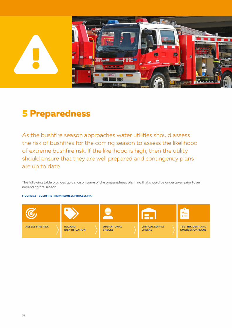
5 Preparedness
As the bushfire season approaches water utilities should assess the risk of bushfires for the coming season to assess the likelihood of extreme bushfire risk. If the likelihood is high, then the utility should ensure that they are well prepared and contingency plans are up to date.
The following table provides guidance on some of the preparedness planning that should be undertaken prior to an impending fire season.
FIGURE 5.1 BUSHFIRE PREPAREDNESS PROCESS MAP
radar tags user-hard-hat warehouse-alt clipboard-list-checkASSESS FIRE RISK HAZARD
IDENTIFICATIONOPERATIONAL CHECKS
CRITICAL SUPPLY CHECKS
TEST INCIDENT AND EMERGENCY PLANS
exclamation-triangle
18

TABLE 5.1 PREPAREDNESS FOR EACH BUSHFIRE SEASON
ACTION DESCRIPTION DETAILS AND EXAMPLES RESOURCES
radarASSESS FIRE RISK
Reassess bushfire risk assessment using the latest information
Bureau of Meteorology forecasts
Bushfire & Natural Hazards CRC seasonal bushfire outlook
State Fire advice
Climatic factors such as the Indian Ocean Dipole (IOD), Southern Annular Mode (SAM) and the El Niño Southern Oscillation (ENSO)
BOM, Fire Weather Knowledge Centre
Bushfire & Natural Hazards CRC - Australian Seasonal Bushfire Outlook
tagsHAZARD IDENTIFICATION
Immediately before fire danger period inspect the surrounds of infrastructure such as buildings, reservoirs and pump stations to assess the fuel hazards
If the facility and/or surrounding land and property are assessed as a high risk, a suitable hazard reduction program should be undertaken
Hazard reduction could consist of slashing, the application of herbicides or controlled burning, depending on the extent of hazard
Controlled burning should only be undertaken under suitable conditions and following consultation with the local fire service
CFA Victoria, Roadside Fire Management Guidelines
user-hard-hatOPERATIONAL CHECKS
Check that assets are performing as expected and emergency and backup equipment is ready
Test critical equipment, such as generators, and UPS devices
Investigate options that would allow water treatment plants to operate at reduced flow rates to better manage solid loads
Pre-determine staging locations for the relocation of equipment, such as generators and spares from fire-prone areas
Be aware of all critical control points and ensure that online monitoring is working effectively
Where online monitoring is not available, plan to increase the frequency of grab sample testing
Ensure on-call rosters and key contact numbers are up to date
Water quality management plans
Asset condition assessments
Incident and emergency management plans
warehouse-altCHECK CRITICAL SUPPLIES
Ensure that critical supplies are readily available
Check chemical supplies and supply contracts
Determine if additional controls are required, such as booms, silt curtains, coir logs, and ensure that they are either in stock or readily available when required
Ensure the water testing laboratory has all the correct sampling bottles
clipboard-list-checkTEST INCIDENT AND EMERGENCY PLANS
Run scenarios to practice and test incident and emergency response plans
Review and test existing emergency response plans
Modify plans if required based on learnings
Engage with your State’s fire management agencies to review plan
Ensure water utility liaison officers are trained to be deployed to the state or regional emergency operations centre (EOC)
Undertake multiple agency incident and emergency scenario testing
19

5.1 Preparedness checklist
The development of checklists are a useful way ensuring that preparedness checks are undertaken. The following example is a checklist adapted from the US EPA Incident Action List for Wildfires.
TABLE 5.2 PREPAREDNESS CHECKLIST FROM THE US EPA (ADAPTED FOR THIS GUIDELINE).
TASKS
square-full Actively monitor fire and weather conditions and be aware of regional bushfires.
square-full Check inventory and order extra equipment and supplies, as needed.
square-full Review and update your utility’s emergency response plan (ERP) and ensure all emergency contacts are current
square-full Ensure communication equipment (e.g., radios, satellite phones) work and are fully charged.
square-full Conduct briefings, training and exercises to ensure utility staff are aware of all preparedness, response and recovery procedures.
square-full Address and, if possible, remove vegetation from around facilities located in medium to high fire danger zones. Consider replacing flammable vegetation with fire-resistant landscaping.
square-full Update priority water customers (e.g., hospitals) obtain their contact information, map their locations and develop a plan to restore those customers first, in case of water service interruptions.
square-full Evaluate the condition of electrical panels to accept generators; inspect connections and switches.
square-full Review and update fire management plans, including contingency plans for system operation if critical facilities are impacted by bushfire and access is limited or not possible.
square-full Fill fuel tanks to full capacity and ensure that you have the ability to manually pump the fuel in the event of a power outage. Ensure this equipment and other hazardous materials are located in a safe zone.
square-full Ensure proper safety gear is available for field employees.
20

6 Bushfire response
This section is not designed to replace the existing incident and emergency response plans of an organisation, but rather to provide supporting considerations in relation to bushfire risks. Generally, during bushfire emergencies, the response is coordinated through state agencies such as State Disaster Management Centres.
The scope of this guideline does not cover the management of active fires, but only the considerations relating to water supplies.
Considerations that need to be addressed during an active bushfire emergency include:
• Rapidly determining the scale and complexity of the disaster.
• Identifying the severity, root causes and interdependencies of impacts to basic critical life-saving and life-sustaining services within impacted areas.
• Develop operational priorities and objectives that focus response efforts on the delivery of the water services by the most effective means possible.
• Communicate disaster-related information across all levels of the public, private and non-profit sectors, using commonly understood and plain language.
If established, water utility incident and emergency managers should rely on advice from an expert advisory panel to support decision making. The figure below represents a generic incident response process; however, each water utility will have their own incident and emergency response plan, and that should be adopted, considering an all-hazards approach during the response phase of an active incident.
FIGURE 6.1 BUSHFIRE RESPONSE PROCESS MAP
radar sort-amount-up siren-on user-plus check-circleASSESS INITIAL CONDITION AND ASSIGN STATUS
ESTABLISH PRIORITIES BASED ON RISK AREAS
ORGANISE RESPONSE ACTIVITIES TO ADDRESS PRIORITIES
ESTABLISH ADDITIONAL LOGISTICS AND RESOURCE REQUIREMENTS
REASSESS CONDITION AND STATUS
fire
21

6.1 Response checklist
The development of checklists are a useful way of ensuring that response checks are undertaken. The following example is a checklist adapted from the US EPA Incident Action List for Wildfires.
TABLE 6.1 RESPONSE CHECKLIST FROM THE US EPA (ADAPTED FOR THIS GUIDELINE).
TASKS
square-full Assign a representative of the utility to the incident command post or the local/state EOC.
square-full If needed, request or offer assistance (e.g., equipment, personnel) through mutual aid networks, such as the Australian Water Sector Mutual Aid Guidelines.
square-full Prepare and deploy equipment as needed to support firefighting operations, such as tanker trucks and related pumping equipment, as well as bulldozers for the construction of firebreaks.
square-full Account for all personnel and provide emergency care, if needed. If personnel are in the field, communicate with the Bureau of Meteorology (BOM) on local wind conditions in the fire area, so staff are aware of how quickly winds are shifting and if evacuation from facilities is required.
square-full If possible, refill treated water storage tanks each day to ensure maximum storage for demand, including fire suppression.
square-full Keep intakes and access hatches clear of debris.
square-full Work with the local emergency management authorities to identify passable access roads and to ensure that utility facilities in forested areas are clearly identified.
square-full Monitor raw water quality, develop a sampling plan and adjust treatment as necessary.
square-full Utilise pre-established emergency connections or setup temporary connections to nearby communities, as needed. Alternatively, implement plans to draw emergency water from predetermined tanks or hydrants. Notify employees of the activated sites.
square-full Notify regulatory/primacy agency if operations and/or water quality or quantity are affected.
square-full Notify customers of any water advisories and consider collaborating with local media (television, radio, newspaper, social media, etc.) to distribute the message. If emergency water is being supplied, provide information on the distribution locations.
square-full Use backup generators, as needed, to supply power to system components.
square-full Maintain contact with your electricity provider for power outage duration estimates.
square-full Monitor and plan for additional fuel needs in advance; coordinate fuel deliveries to generators.
22

7 Bushfire recovery
The purpose of this section is to describe and provide a systematic process for the recovery phase of a bushfire emergency for a water utility. The content of this section builds on learnings from water utilities and government agencies, as well as including practical case studies.
The recovery phase provides strategic level guidance, as well as detailed practical information and resources, to support water managers post bushfire emergencies.
This section has a primary focus on water quality impacts but also considers recovery aspects for other areas, such as environment and cultural heritage.
FIGURE 7.1 BUSHFIRE RECOVERY PROCESS MAP
search digging medkit tree-alt user-hard-hatIMMEDIATE ASSESSMENT TO DETERMINE RISK PROFILE
MANAGE ADDITIONAL THREATS TO PREVENT FURTHER DAMAGE OR RISKS
RECOVER AND PRESERVE
REHABILITATION AND RECOVERY
RESTORE, IMPROVING RESILIENCE AND ADAPTABILITY
hand-holding-seedling
23

TABLE 7.1 BUSHFIRE RECOVERY RESPONSE PHASE GUIDANCE
TIMEFRAME RESPONSE DETAILS
searchIMMEDIATE ASSESSMENT TO DETERMINE RISK PROFILE
IMMEDIATELY
DAYS-WEEKS
Inspection of catchment and infrastructure
The earlier that an inspection can occur of the affected catchment or infrastructure, the higher the likelihood that additional measures can be implemented to manage threats or prevent further damage.
The assessment of catchments is crucial so that the extent of the damage can be determined and, therefore, the likely outcomes can be predicted. Fire severity is an important factor to determine so that the risk to water quality with post-bushfire rains can be estimated. It is important to work closely with other agencies such as National Parks in your state to assist in fire intensity mapping.
Assessment of infrastructure, such as reservoirs (roofing, linings, vermin proofing), network piping and telemetry should be undertaken.
Implement water quality monitoring program
Implement a baseline water quality monitoring program to be ready to deploy immediately after post-rain events (Section 7.4).
Undertake a risk assessment to determine management options
Based on the inspection of the catchment and infrastructure a rapid risk assessment should be undertaken of the affected catchment, (Sections 7.1 and 7.2).
This should include an assessment of fire severity, infrastructure risks, water quality, environmental and cultural heritage risks.
diggingMANAGE ADDITIONAL THREATS TO PREVENT FURTHER DAMAGE OR RISKS
SHORT TERM
1-6 MONTHS
Flood erosion and mitigation works
Fires result in loss of groundcover and water-repellent soils that can lead to increased runoff, erosion and discharge into waterways from subsequent rainfall. Measures include increasing interception and infiltration through mulching, erosion netting, re-vegetation and emergency bank stabilisation works (Section 7.5.1).
Sediment control measures
Increased sediment and nutrient mobilisation from burnt vegetation can be carried into rivers by runoff following rain, particularly in riparian zones. Measures include straw bales, silt fences and traps, rock walls, log barriers, de-silting of weirs, sediment curtains and booms, and coir logs in drainage lines (Section 7.5.2).
Emergency repairs to existing flood mitigation infrastructure
Existing flood mitigation infrastructure may be impacted or damaged by fire and be compromised in its effectiveness in managing impacts of subsequent floods.
Establish a longer-term water quality monitoring program
Bushfires can result in increased nutrient loads, increased water temperatures, decreased dissolved oxygen concentrations, cyanobacteria proliferation (algal blooms) and chemical contamination. Water quality monitoring will help to understand changes to water quality and how these changes impact its use and treatability (Section 7.4).
Debris removal Remove debris that is obstructing the passage of water or is posing a threat to infrastructure from subsequent flooding. Some post-fire debris is beneficial for providing habitat and refuge.
Weed and pest control Many weeds and pests respond positively to fires and can recover faster than native species. Control measures are needed to ensure that they do not out-compete native species.
Remove dead stock Stock that have died close to waterways can be a significant threat to water quality and present a disease vector if not removed quickly after a fire.
Installation of temporary stock exclusion fencing. Riparian fencing can easily be damaged by fire allowing unrestricted access by stock to possibly sensitive riparian environments. Temporary fencing will help to preserve these areas until long-term repairs take place.
Re-instate off-stream watering points: Any damaged off-stream watering points need to be reinstated with stock exclusion to provide livestock with access to water without damaging waterways.
Education and engagement with farmers about the increased risk of water quality impacts.
Reducing the load on wastewater treatment facilities
Remove debris that is obstructing the passage of water or is posing a threat to infrastructure from subsequent flooding. Some post-fire debris is beneficial for providing habitat and refuge.
24

TIMEFRAME RESPONSE DETAILS
medkitRECOVER AND PRESERVE
MEDIUM TERM
6-18 MONTHS
Recovery and relocation of threatened species
Many weeds and pests respond positively to fires and can recover faster than native species. Control measures are needed to ensure that they do not out-compete native species.
Recovery and relocation of cultural heritage artefacts
Permanently or temporarily relocate artefacts at risk of further damage.
tree-altREHABILITATION AND RECOVERY
LONG TERM
Re-establish and re-vegetate riparian vegetation buffer zone
Reinstate any damaged riparian areas through re-vegetation and structural works.
Post-fire recovery monitoring
Undertake a specific water quality sampling program targeted at parameters of concern that could cause long term issues, such as nutrients and cyanobacteria. Adapt the monitoring program based on results to date.
Re-vegetation Some plant species cannot regenerate after a fire, so targeted re-vegetation is required to restore vegetation communities. Additional actions, such as contour scarification, can be used to enhance seeding and promote infiltration of rainfall.
Recovery of habitats Restore habitat conditions for fauna species where natural recovery may be slow or inhibited.
Repair and replace damaged fencing
Including replacing temporary fencing with permanent fencing.
user-hard-hatRESTORE, IMPROVING RESILIENCE AND ADAPTABILITY
Identify opportunities to use changes in channel capacity to re-engage floodplain
Increased sediment supply from burnt areas provides an opportunity to infill incised gullies and re-engage floodplains. Measures include the installation of pile fields.
Fuel reduction regimes Employ systematic fuel reduction activities to reduce the risk and intensity of subsequent fires. This should be carried out in accordance with specific strategies and plans.
Establishing well-designed fuel reduction regimes is particularly important because of the changing climate. Increased temperature and dry periods are causing an increase in the duration of fire seasons within south-east Australia and a decrease in the opportunity to reduce fuel through control burning. Opportune conditions for control burning are decreasing and increased dry periods are likely to increase available fuel (Climate Council Australia, 2013).
Asset standards Review and apply appropriate asset standards for buildings and infrastructure (Section 16)
The above table was adapted from the ACT and Regional Catchment Post-Emergency Recovery Plan (ACT, 2018).
25

7.1 A framework for predicting post-fire water contamination risks
Post-fire water quality contamination risks, as described in Section 2, are driven by several factors which include:
• Fire intensity
• Fuel characteristics
• Mobilisation governed by hydrological processes such as:
• Precipitation
• Infiltration
• Runoff
• Erosion
Mitigations and interventions exist at multiple opportunities in the management of bushfires. Figure 7.2 shows a model that can be used for predicting post-fire contamination risks. The framework can be used to support post-fire risk assessments to evaluate the sensitivity of a water asset, such as a dam or a water treatment plant, to a contamination event resulting from specific events, such as storms. The risk of contamination events occurring is dependent on the occurrence of fires with the relevant severity to produce sufficient contaminant loads, combined with the likelihood of different rain events, with the potential consequence being dependent on transport pathways, resident times of contaminants and the dilution capacity of water bodies, such as lakes and reservoirs.
This framework provides a structured approach to identifying mitigating strategies and undertaking risk assessments and is consistent with the ADWG risk management Framework. The framework has been adapted to incorporate the key ADWG Framework elements. It is recommended that any new process for managing water quality risks from bushfires should be consistent with existing drinking water management plans, as discussed in Section 4.9.2.
Throughout this guideline mitigating strategies can be implemented at the various phases to manage risk.
PHASE MITIGATING STRATEGIES
Prevention/Planning
Preparedness
Effective fuel management that helps reduce the likelihood of severe bushfires
Response Fire suppression, limiting the spread of fires, particularly to sensitive areas
Recovery Post-fire emergency measures can mitigate the mobilisation and transport of contaminants to water assets
Treatment plants can be modified to meet specific decontamination needs
26

FIGURE 7.2 AN ADAPTATION FROM THE WORK OF NUNES, (2018), WHO PROPOSED THE FRAMEWORK FOR PREDICTING CONTAMINATION RISKS.P
reve
ntat
ive
mea
sure
s
Fuel management
Suppressant strategies
Erosion mitigation
Water treatment
Mapping dominant pathways
Understanding contaminant mobilisation
Identifying contaminants of concern
Con
trol
mea
sure
s
Ris
k as
sess
men
t
Fire-prone/fire-managed catchment
Generation of contaminants of concern
Fram
ewor
k fo
r eva
luat
ing
pos
t-fi
re w
ater
co
ntam
inat
ion
risk
Mit
igat
ing
op
por
tuni
ties
Hydrological and erosion processes
Fire
Mobilisation tokey water assets
7.1.1 Identifying contaminants and water asset of concern
The contaminants of concern are discussed in Section 2 and should be identified well before any fire, through the planning phase risk assessment and vulnerability analysis. As highlighted previously, these contaminants can include a wide range chemicals and physical characteristics such as suspended solids, ash, nutrients, organic carbon, pyrolytic products and metals.
7.1.2 Understanding contaminant mobilisation
Contaminants can be mobilised by wind and water erosion, debris flow, mass failure and dissolution in water. Specific processes can be responsible for the majority of a particular contaminant. It is important to try and understand which rainfall and associated rainfall events could trigger fire-induced water contamination so that the probability of a contaminant adversely affecting a water supply system can be estimated given the magnitude of a rain event and its duration.
TABLE 7.2 EFFECT OF RAINFALL EVENTS ON CONTAMINANT MOBILISATION
RAINFALL EVENT EFFECTCONTAMINANT EXAMPLES
High intensity, short duration
Runoff related processes such as erosion, debris flow
Suspended solids
Debris
Saturating rainfall Mass failure of steep banks and slopes decreasing the soils bulk strength
Turbidity
DOC
Saturating rainfall Non-erosional processes such as subsurface mobilisation of contaminants
DOC
Nutrients
Other factors that need to be considered when assessing the mobilisation of contaminants include:
• Topography
• The severity of fire and presence of on-ground material, such as ash
• Existence of, or loss of, buffers between fires and waterways.
27

7.1.3 Mapping dominant pathways
Water managers require support from a multidisciplinary team to accurately quantify the post-fire contamination risk, with the team having skills in hydrology, soils and chemistry. However, in the context of responding to a disaster and informing immediate mitigation options, mapping dominant pathways can also be qualitative. This includes assessing the potential direction of water runoff from the affected areas into rivers and streams, and ultimately lakes and reservoirs, to determine the potential for contamination, so that mitigation measures can be placed in the appropriate locations. If possible, an estimation of the time taken for contaminants to reach water bodies and intakes should be undertaken, so that mitigation measures can be applied in a timely manner. Factors that can influence the dominant pathways for contaminant transport include:
• The existence of trails and internal roads in the catchment that can direct the flow
• Major burnt gullies that direct contaminants to water supplies
• Movement of contamination across lakes or reservoirs during inflow events, based on experience.
Best practise in this area includes modelling approaches to estimate the impact of potential contamination following post-bushfire rainfall events. An example of this is provided in Appendix B: Hydrodynamic modelling for bushfire management and recovery in the catchment from Melbourne Water.
7.2 Catchment rapid risk assessment
Recovery is an integral component of fire management. Fires cause both immediate impacts and delayed impacts. Immediate impacts, driven by fire severity, location and topography can generate a range of future risks such as erosion, landslips and soil movement. These can be intensified by storms and flooding. Built infrastructure, such as roads and buildings, can also be affected by the secondary impacts, as well as endangered species, sensitive ecological communities and habitats. The deployment of a suitably qualified bushfire rapid risk assessment team (RRAT) should occur as soon as it is safe to do so. In some cases, where access is not possible, a desktop RRAP can be undertaken. The makeup of the RRAT will be dependent on the water utility’s priorities and responsibilities. It may be required to deploy a multidisciplinary team to assess the range of water quality, environmental, cultural heritage and engineering risks.
The RRAT could include members that have expertise in the following areas:
Water quality
Identify water quality impacts as a result of the bushfires
Flooding and erosion
Identify flooding and erosion risks that have emerged as a result of the bushfire
Biodiversity
Identify the positive and negative effects of the bushfire and suppression activities on flora and fauna. Determine risks that have emerged, as well as future risks
Assets/engineering
Identify built assets that have been burnt by the bushfire or affected by suppression activities
Catchment management and operation
Identify forest and catchment management risks
GIS
Develop, maintain and analyse maps and spatial data for the BRRAT fieldwork, risk assessment and reporting.
The objective of the team is to assess impact so that recovery options can be planned and implemented to avoid future risks. Data sources that would be beneficial for the assessment would include:
• Satellite-derived remotely sensed imagery of before and after the fire
• Fire intensity rating based on satellite imagery or aircraft footage
• Previously modelled erosion risk potential
• Asset information databases
• Threatened species mapping
• GIS layers
• Vegetation communities.
A conventional risk assessment approach should be adopted to record hazards and hazardous events, and the likelihood and consequence of those events being realised. The existence of current mitigating strategies and controls should also be assessed. This process will highlight the highest risks and, therefore, allow for the prioritisation of mitigating actions.
7.2.1 Water quality risks
To support the assessment of water quality risks the framework described in Section 7.1 should be utilised. By using the framework for predicting post-fire contamination risks the assessment will identify contaminants of concern and assist with understanding contaminant mobilisation and map dominant pathways. Once the risk to potential contamination has been established, then the appropriate mitigation measures (Section 7.5) can be applied with the aim of reducing risks to acceptable levels.
28

7.2.2 Support and further information
Some jurisdictions across the country have State and Territory agencies that provide support for the rapid risk assessment process.
• The ASCT/NSW Inter-agency Rapid Risk Assessment Team (RRAT)
• The Victorian Bushfire Rapid Risk Assessment Team (RRAT)
In Victoria, DELWP coordinates the RRAT process, by forming multi-agency, multi-disciplinary, specialist teams that are deployed to rapidly evaluate post-emergency risk to the environment and recommend prioritised, and costed mitigation strategies. This model is scalable and adaptable to any large-scale emergency event, and draws team members from across government, including professional land managers, policy experts, and scientific and technical experts. DELWP’s RRAT program has a national profile and has been deployed interstate on several occasions to support emergency management and recovery functions. Not all States and Territories have government lead RRATs, however, the process to undertake a rapid risk assessment is based on conventional risk assessment principles and the following examples represents good practice that can be utilised for other jurisdictions.
• Victorian approach is the North East Victoria & Gippsland Bushfire Rapid Risk Assessment Team report from the 2013 Alpine fires. (Appendix C).
• All hazards rapid risk assessment from an ACT perspective is the Orroral Valley Fire Rapid Risk Assessment Namadgi National Park.
https://www.environment.act.gov.au/__data/assets/pdf_file/0003/1495236/orroral-valley-fire-rapid-risk-assessment-namadgi-national-park.pdf
7.3 Tools for assessment
7.3.1 Fire intensity/severity mapping
The mapping of the severity of bushfires in drinking water catchments is one of the most important assessment tools as it can provide the basis for current and future risk profiles.
It is recommended that water utilities work closely with their State public land management agencies that have this capability. Table 7.1 provides some guidance from the Bushfire CRC and NSW Parks and Wildlife Services on the bushfire severity rating scales used in Australia, while Table 7.2 shows examples photos and simple illustration of the severity classes.
Table 7.3 is a list of the current State agencies that provide this Fire Severity Mapping service as well as additional resources that will assist in the assessment.
29

TABLE 7.1 FIRE SEVERITY CLASSES AND DESCRIPTIONS
SEVERITY CLASS DESCRIPTION FEATURES % FOLIAGE AFFECTED
Unburnt to patchy Scorch height ≤ 2 m The ground material is not affected by fire
The height of the scorched leaves are no higher than 2 m
0% canopy and understory burnt
Low Scorch height ≤ 2 m Burnt understory with unburnt canopy
All of the ground cover material is affected by fire
The height of the scorched leaves is no higher than 2 m.
>10% burnt understory
>90% green canopy
Moderate Scorched height 2-5m Partial canopy scorch
All ground material affected by fire
Leaf scorch height is >2m but ≤ 5 m.
All or most mid-story canopy leave are scorched
Upper canopy leaves may be partially scorched
20-90% canopy scorched
High Complete canopy scorch Full canopy scorch/partial consumption
All ground material affected by fire
All mid-story leaves scotched
All upper canopy leaves
>90% canopy scorched
<50% biomass consumed
Extreme Completely charred Full canopy consumption
Ground, mid-story and upper canopy are completely affected by fire, most leaf material is removed or charred
>50% canopy biomass consumed
30

TABLE 7.2 IMAGES REPRESENTING FIRE SEVERITY SCALE, BFCRC (2015)
FIRE SEVERITY EXAMPLE SIMPLIFIED ILLUSTRATION
Patchy
Low
Moderate
High
Extreme
TABLE 7.3 ADDITIONAL FIRE SEVERITY MAPPING RESOURCES
STATE DESCRIPTION WEBLINK
NSW NSW Government Fire Extent and Severity Mapping (FESM)
datasets.seed.nsw.gov.au/dataset/fire-extent-and-severity-mapping-fesm
Victoria DELWP Bushfire Response and Recovery - Spatial Data Coordination
www2.delwp.vic.gov.au/maps/news/bushfire-response-and-recovery-useful-spatial-data-resources
Bushfire CRC Case study of bushfire severity mapping library.dbca.wa.gov.au/static/Journals/917929/917929-92.pdf
31
https://www2.delwp.vic.gov.au/maps/news/bushfire-response-and-recovery-useful-spatial-data-resources

7.4 Water quality monitoring
Depending on the scale of the fires in the drinking water catchment sampling programs may be required to understand the change in the risk profile of the raw water. In terms of priority, ease and value for money a preliminary sampling program would include:
• Turbidity/total suspended solids
• Dissolved organic carbon (DOC)
• Nutrient suite
• Total metal scan (including mercury).
Based on the risk assessment or if a water utility was concerned with other parameters, the sampling program could be extended to include:
• PAH, PCB, and PCDD/F
• Cyanide.
While a baseline monitoring program may be useful before initial post-fire rainfall, the priority should be to undertake sampling following significant rainfall events, such as > 50 mm in 24 hours.
For the sampling of rivers and streams, sampling should be undertaken during the ‘first flush’ or by the use of an automated event peak sampler, or composite sampler over the duration of the event. For lakes or reservoirs, samples should be taken at several depths as during inflow events the incoming water may travel beneath the surface at the same temperature as the incoming water.
Note that when interpreting results, consideration should be given to the duration of potential customer exposure as discussed in Khan et al., 2016.
If water quality issues are observed post rainfall, then it may be useful to consider a longer-term monitoring program. When water catchments and storages are adversely affected by contaminants, it can take up to five years for water bodies to return to pre-fire conditions. In some cases, adverse effects are not seen for months following bushfires, and this is particularly relevant for cyanobacterial blooms that can arise from an increase in nutrients in source waters.
The Water Corporation case study discusses their experience with water quality monitoring and the management of turbidity, resulting from the Perth Hills bushfire in 2005 (Appendix D – Water Corporation experience with water quality monitoring and turbidity management post-bushfire).
7.5 Mitigation options
7.5.1 Erosion mitigation
Whatever can be done to slow the movement of surface water on the fire ground will lead to an improved outcome. There are several mitigation options shown in Table 7.4, that if installed strategically on drainage lines and hillsides, will be beneficial.
Erosion mitigation is the process of minimising sediment loss from hillslope erosion. Possible treatments include mulching, re-vegetation and bank stabilisation. There are a number of considerations that need to be assessed during the rapid risk assessment so that the appropriate treatment areas and methods are identified, such as burn extent and severity, and the likelihood of erosion. Practical considerations should also be considered such as accessibility and the coordination of works with local landholders.
A better outcome will be achieved by landowners on the same slope or within the same sub-catchment coordinating works, rather than working in isolation or not at all. Targeted slopes with good access may be suitable for hydro-mulching or hand application of straw. Upper catchment slopes are generally more important and more effective to treat than lower slopes. Treating upper catchment slopes can reduce flow distances and interrupt overland flow before it hits lower slopes and washes away mulch cover.
7.5.2 Sediment control measures
Post bushfire rainfall can lead to the mobilisation of debris, sediments, ash and contaminants into waterways in both the short term and the long term. Several mitigation options can be used to reduce the impact of these issues and they are discussed in more detail in this section.
With the loss of ground cover and the natural attenuation that it provides, in combination with steep slopes and gullies, this will lead to increased mobilisation of sediments. Bush tracks can be the biggest source of sediment and erosive water flow paths. Track surfaces are mostly impermeable and tend to concentrate flows into drains that de-water into the adjoining bushland, where the vegetation normally reduces the energy of flows and entrains sediment. Post-bushfires, with the loss of ground cover, even in moderately severe fires, the lack of vegetation results in further mobilisation of sediments.
The use of physical barriers such as tree logs, coir logs, hay bales and silt fences can be used to control the mobilisation of sediments and debris. Table 7.4 discusses the methodologies and advantage of each method.
32

A South Australian study had the following practical recommendations to assist managers in locating and designing sediment traps for bushfire events (Morris, 2008).
• Planning prior to any fire event can alleviate rushed decisions. Review both location and sediment structure designs for a variety of fire scenarios.
• Before a fire occurring, prepare models of catchment processes including both flow velocity and potential erosion.
• Site location details that need consideration following a bushfire include fire severity, erosion potential, vegetation cover, slope length, slope gradient, drainage patterns, road drainage, site access and proximity to a reservoir.
• Source and determine expected delivery times for trap material. Also, have contingency plans in the event the material cannot be obtained.
• Build traps of an appropriate size for the volume of sediment and water likely to reach the trap.
• Determine the period of time traps will be required. Hay bales are a short term (6 months) solution. Silt trap or coir logs should be used for longer time frames.
• Develop clear guides, with both written and illustrated examples of trap designs and effectiveness. These guides need to be tailored to local conditions.
• Silt fence traps need sufficient support to prevent the trap from failing or, alternatively more traps need to be built in the area to reduce water velocity.
• Use geotextile bags to minimise weed spread, prevent fauna damage and prevent bale breakage. These bags add to cost, construction time and future clean up.
• Use minimal star pickets due to the problem of removal and the potential for boats to hit submerged pickets.
• Allocate resources to monitor and maintain any sediment traps that are constructed.
Two case studies that describe the practical experience in using sediment control technology are:
Appendix E SA Water experience with the application for coir logs
Appendix F Melbourne Waters experience with the application of debris racks and sediment dams
7.5.2.1 In stream control - silt curtains and booms
Silt curtains and booms can be installed to reduce and slow contaminants such as ash and turbidity and encourage them to be deposited as sediment. These should ideally be installed on the incoming rivers and streams into a lake, dam or reservoir.
Floating silt curtains consist of a curtain of geotextile that is supported in a water body by floats and weights. They are only suitable in areas of low-velocity flows. When installing floating silt curtains in a channel, ensure that the float width equals the channel width. The geotextile curtain sides should be graduated downwards to match the channel sides. This will inhibit erosion of the sides of the channel.
7.5.3 Re-establish and re-vegetate riparian vegetation buffer zone
Fire is a serious threat to the integrity of most riparian vegetation. Most riparian vegetation is mesic, that is, it prefers moist environments and is highly susceptible to fires. Fire impacts the riparian areas by increasing sediment runoff into streams in the short term – due to the loss of its buffering capacity, and in the long term – due to an increase in localised erosion of the stream banks. In some cases, prior to re-vegetation, stream banks may become destabilised due to the loss of tree root systems. This may require bank stabilisation techniques. There are several useful references that detail bank stability and riparian re-vegetation, such as:
• CRC for Catchment Hydrology Guidelines for Stabilising Streambanks with Riparian Vegetation in 1999 (CRC Hydrology, 1999).
• Soil Conservation guidelines for Queensland – Chapter 11 Stream stability (DSITI, 2015).
33
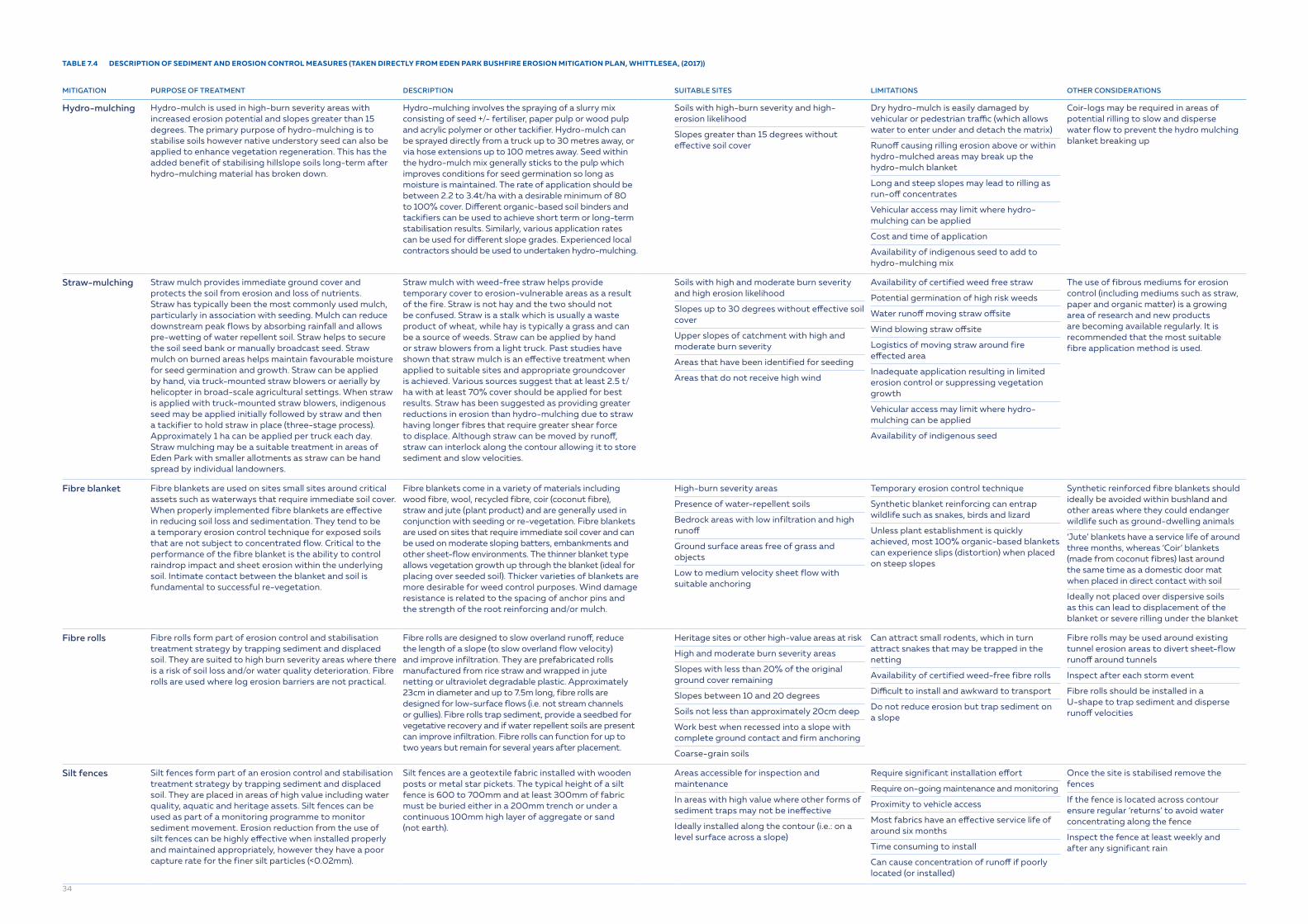
TABLE 7.4 DESCRIPTION OF SEDIMENT AND EROSION CONTROL MEASURES (TAKEN DIRECTLY FROM EDEN PARK BUSHFIRE EROSION MITIGATION PLAN, WHITTLESEA, (2017))
MITIGATION PURPOSE OF TREATMENT DESCRIPTION SUITABLE SITES LIMITATIONS OTHER CONSIDERATIONS
Hydro-mulching Hydro-mulch is used in high-burn severity areas with increased erosion potential and slopes greater than 15 degrees. The primary purpose of hydro-mulching is to stabilise soils however native understory seed can also be applied to enhance vegetation regeneration. This has the added benefit of stabilising hillslope soils long-term after hydro-mulching material has broken down.
Hydro-mulching involves the spraying of a slurry mix consisting of seed +/- fertiliser, paper pulp or wood pulp and acrylic polymer or other tackifier. Hydro-mulch can be sprayed directly from a truck up to 30 metres away, or via hose extensions up to 100 metres away. Seed within the hydro-mulch mix generally sticks to the pulp which improves conditions for seed germination so long as moisture is maintained. The rate of application should be between 2.2 to 3.4t/ha with a desirable minimum of 80 to 100% cover. Different organic-based soil binders and tackifiers can be used to achieve short term or long-term stabilisation results. Similarly, various application rates can be used for different slope grades. Experienced local contractors should be used to undertaken hydro-mulching.
Soils with high-burn severity and high-erosion likelihood
Slopes greater than 15 degrees without effective soil cover
Dry hydro-mulch is easily damaged by vehicular or pedestrian traffic (which allows water to enter under and detach the matrix)
Runoff causing rilling erosion above or within hydro-mulched areas may break up the hydro-mulch blanket
Long and steep slopes may lead to rilling as run-off concentrates
Vehicular access may limit where hydro-mulching can be applied
Cost and time of application
Availability of indigenous seed to add to hydro-mulching mix
Coir-logs may be required in areas of potential rilling to slow and disperse water flow to prevent the hydro mulching blanket breaking up
Straw-mulching Straw mulch provides immediate ground cover and protects the soil from erosion and loss of nutrients. Straw has typically been the most commonly used mulch, particularly in association with seeding. Mulch can reduce downstream peak flows by absorbing rainfall and allows pre-wetting of water repellent soil. Straw helps to secure the soil seed bank or manually broadcast seed. Straw mulch on burned areas helps maintain favourable moisture for seed germination and growth. Straw can be applied by hand, via truck-mounted straw blowers or aerially by helicopter in broad-scale agricultural settings. When straw is applied with truck-mounted straw blowers, indigenous seed may be applied initially followed by straw and then a tackifier to hold straw in place (three-stage process). Approximately 1 ha can be applied per truck each day. Straw mulching may be a suitable treatment in areas of Eden Park with smaller allotments as straw can be hand spread by individual landowners.
Straw mulch with weed-free straw helps provide temporary cover to erosion-vulnerable areas as a result of the fire. Straw is not hay and the two should not be confused. Straw is a stalk which is usually a waste product of wheat, while hay is typically a grass and can be a source of weeds. Straw can be applied by hand or straw blowers from a light truck. Past studies have shown that straw mulch is an effective treatment when applied to suitable sites and appropriate groundcover is achieved. Various sources suggest that at least 2.5 t/ha with at least 70% cover should be applied for best results. Straw has been suggested as providing greater reductions in erosion than hydro-mulching due to straw having longer fibres that require greater shear force to displace. Although straw can be moved by runoff, straw can interlock along the contour allowing it to store sediment and slow velocities.
Soils with high and moderate burn severity and high erosion likelihood
Slopes up to 30 degrees without effective soil cover
Upper slopes of catchment with high and moderate burn severity
Areas that have been identified for seeding
Areas that do not receive high wind
Availability of certified weed free straw
Potential germination of high risk weeds
Water runoff moving straw offsite
Wind blowing straw offsite
Logistics of moving straw around fire effected area
Inadequate application resulting in limited erosion control or suppressing vegetation growth
Vehicular access may limit where hydro-mulching can be applied
Availability of indigenous seed
The use of fibrous mediums for erosion control (including mediums such as straw, paper and organic matter) is a growing area of research and new products are becoming available regularly. It is recommended that the most suitable fibre application method is used.
Fibre blanket Fibre blankets are used on sites small sites around critical assets such as waterways that require immediate soil cover. When properly implemented fibre blankets are effective in reducing soil loss and sedimentation. They tend to be a temporary erosion control technique for exposed soils that are not subject to concentrated flow. Critical to the performance of the fibre blanket is the ability to control raindrop impact and sheet erosion within the underlying soil. Intimate contact between the blanket and soil is fundamental to successful re-vegetation.
Fibre blankets come in a variety of materials including wood fibre, wool, recycled fibre, coir (coconut fibre), straw and jute (plant product) and are generally used in conjunction with seeding or re-vegetation. Fibre blankets are used on sites that require immediate soil cover and can be used on moderate sloping batters, embankments and other sheet-flow environments. The thinner blanket type allows vegetation growth up through the blanket (ideal for placing over seeded soil). Thicker varieties of blankets are more desirable for weed control purposes. Wind damage resistance is related to the spacing of anchor pins and the strength of the root reinforcing and/or mulch.
High-burn severity areas
Presence of water-repellent soils
Bedrock areas with low infiltration and high runoff
Ground surface areas free of grass and objects
Low to medium velocity sheet flow with suitable anchoring
Temporary erosion control technique
Synthetic blanket reinforcing can entrap wildlife such as snakes, birds and lizard
Unless plant establishment is quickly achieved, most 100% organic-based blankets can experience slips (distortion) when placed on steep slopes
Synthetic reinforced fibre blankets should ideally be avoided within bushland and other areas where they could endanger wildlife such as ground-dwelling animals
‘Jute’ blankets have a service life of around three months, whereas ‘Coir’ blankets (made from coconut fibres) last around the same time as a domestic door mat when placed in direct contact with soil
Ideally not placed over dispersive soils as this can lead to displacement of the blanket or severe rilling under the blanket
Fibre rolls Fibre rolls form part of erosion control and stabilisation treatment strategy by trapping sediment and displaced soil. They are suited to high burn severity areas where there is a risk of soil loss and/or water quality deterioration. Fibre rolls are used where log erosion barriers are not practical.
Fibre rolls are designed to slow overland runoff, reduce the length of a slope (to slow overland flow velocity) and improve infiltration. They are prefabricated rolls manufactured from rice straw and wrapped in jute netting or ultraviolet degradable plastic. Approximately 23cm in diameter and up to 7.5m long, fibre rolls are designed for low-surface flows (i.e. not stream channels or gullies). Fibre rolls trap sediment, provide a seedbed for vegetative recovery and if water repellent soils are present can improve infiltration. Fibre rolls can function for up to two years but remain for several years after placement.
Heritage sites or other high-value areas at risk
High and moderate burn severity areas
Slopes with less than 20% of the original ground cover remaining
Slopes between 10 and 20 degrees
Soils not less than approximately 20cm deep
Work best when recessed into a slope with complete ground contact and firm anchoring
Coarse-grain soils
Can attract small rodents, which in turn attract snakes that may be trapped in the netting
Availability of certified weed-free fibre rolls
Difficult to install and awkward to transport
Do not reduce erosion but trap sediment on a slope
Fibre rolls may be used around existing tunnel erosion areas to divert sheet-flow runoff around tunnels
Inspect after each storm event
Fibre rolls should be installed in a U-shape to trap sediment and disperse runoff velocities
Silt fences Silt fences form part of an erosion control and stabilisation treatment strategy by trapping sediment and displaced soil. They are placed in areas of high value including water quality, aquatic and heritage assets. Silt fences can be used as part of a monitoring programme to monitor sediment movement. Erosion reduction from the use of silt fences can be highly effective when installed properly and maintained appropriately, however they have a poor capture rate for the finer silt particles (<0.02mm).
Silt fences are a geotextile fabric installed with wooden posts or metal star pickets. The typical height of a silt fence is 600 to 700mm and at least 300mm of fabric must be buried either in a 200mm trench or under a continuous 100mm high layer of aggregate or sand (not earth).
Areas accessible for inspection and maintenance
In areas with high value where other forms of sediment traps may not be ineffective
Ideally installed along the contour (i.e.: on a level surface across a slope)
Require significant installation effort
Require on-going maintenance and monitoring
Proximity to vehicle access
Most fabrics have an effective service life of around six months
Time consuming to install
Can cause concentration of runoff if poorly located (or installed)
Once the site is stabilised remove the fences
If the fence is located across contour ensure regular ‘returns’ to avoid water concentrating along the fence
Inspect the fence at least weekly and after any significant rain
34

MITIGATION PURPOSE OF TREATMENT DESCRIPTION SUITABLE SITES LIMITATIONS OTHER CONSIDERATIONS
Log erosion barrier
Log erosion barriers (LEBs) are used in moderate and high burn severity forested areas where hillslope erosion rates are increased significantly from fire. They reduce erosion by shortening slope length, improving infiltration, trapping sediment and increasing surface roughness. LEBs can be installed using fallen timber and can provide important ground-dwelling habitat after a fire event.
LEBs are logs that are placed in a shallow trench or on the contour of a slope (see Plate 17) and trap sediment if laid in a bricklayer pattern. The volume of retained sediment is dependent upon the slope, the size and length of the trees and upon correct implementation. Those LEBs with soil end berms trap more sediment. End berms can be earthen or made out of coir logs and are placed at the end of logs and run up-slope to trap sediment and prevent terminal scouring.
Slopes between 15 and 30 degrees
Slopes with moderate and high burn severity
Catchments with high values at risk
Water repellent soils are present
Soil depths, rainfall intensity and soil water holding capacity can dictate LEB effectiveness
Areas with rocks can hinder correct installation of LEB and result in erosion
Ensure correct implementation as trees improperly bedded can cause runoff and erosion under or (for those not placed on the contour) at the ends of the log
Untrimmed limbs can prevent ground contact and result in erosion
Catch drains Catch drains can be used to direct stormwater runoff around disturbed soil or an unstable slope. They are designed to collect sheet flow runoff from an unstable slope before it causes rill erosion. Catch drains can collect sediment laden runoff downslope of a disturbance and direct it to a sediment trap.
Catch drains are small open channels formed at regular intervals down a slope, or immediately down-slope or upslope of sensitive areas. These channels are usually excavated with U-shaped excavation tools or a grader blade. They typically have standardised cross-sectional dimensions. ‘Push-down’ (channel-bank) catch drains are formed by pushing the excavated material downslope of the drain. Catch drains are relatively quick and inexpensive to establish (or re-establish if disturbed).
Low gradient
Upslope of batters
Intermittently down long, exposed slopes
Upslope of sensitive areas located within an overland flow path
Only suitable for relatively small flow rates
Can cause flow concentration and significant erosion problems if overtopped during heavy storms
Short to medium term solution
Heavy earth moving equipment required
Not suitable for dispersive soils
Catch drains must be designed for local hydrological and soil conditions
If earth-lined catch drains discharge to an unstable outlet then erosion can occur downstream of the outlet (commonly experienced when cut into dispersive soils)
Subsoil erosion-resistance should be investigated before planning or designing
A suitable sediment trap should be included in plans if the diverted water is expected to contain sediment
Maintenance schedules should include regular inspection of all catch drains and in particular, after storm events
Floating silt curtains
Silt curtains are designed to control the settling of silt suspended in water by providing a controlled area of containment. The boom allows water to flow freely, while acting as a barrier against sediments and other materials.
Silt curtains are floating containment barriers with a foam or air buoyancy chamber supporting a deep, permeable skirt. The skirt acts as a barrier to prevent the spread of silt, sediment and fine suspended solids whilst allowing water to still pass through. The air-filled floatation chambers are best for short-term deployment, ease of storage and low-cost freight options. Foam-filled chambers are most suitable when long-term deployment is required. The silt booms are available in a variety of sizes and materials.
Streams and rivers
Water depth of at least 0.8m
Specialist advice is required if placing in waters with a velocity great than 0.15 m/s
Can be limited to a wave height less than 150mm
In all but exceptional circumstance (e.g. post bushfire) silt curtains should not be placed across the full width of a flowing channel or waterway
Wherever practicable, the bottom of the silt curtain must be anchored to the bed of the water body to prevent sediment-laden water passing under the fabric
Inspections should be undertaken to inspect turbid blooms outside the silt curtain
Periodic checks of the anchoring system should be undertaken
7.5.4 Treatment mitigations
Once contaminants have reached raw water intakes, then the last barrier for their management is the water treatment plant. This section describes some of the main contaminants that if increased can result in treatment challenges.
7.5.4.1 Turbidity
Following a bushfire, source water turbidity can vary significantly from pre-fire levels. Turbidity levels can increase up to 500-fold and concentrations post-fire have been seen above 4000 NTU. Under these extreme conditions, it may be infeasible to treat the raw water and the best option is to shut off the raw water supply and rely on network storages or alternative sources.
Under these circumstances, water utilities should immediately discuss options with their regulators and health departments, and if they are a bulk service provider, with their customers.
Treatability will be dependent on the design and capability of the water treatment plant. Less extreme turbidity levels in the raw water can be removed through the normal conventional treatment processes of flocculation, sedimentation and filtration.
However, increased turbidity may result in reduced flow through the treatment process, increased coagulant use and increased sludge production. Several recommendations should be considered:
• Jar testing should be used regularly to support decision making during extreme weather events. Water utilities that use and practice jar testing regularly on-site during normal conditions will be better able to respond to extreme events, avoiding consequences such as turbidity breakthroughs of filters and potential boil water advisories.
• It is important to closely monitor changes in coagulant demand and coagulation pH, as large water quality variations will increase the coagulant dose in most cases. It is important to monitor the usages and available stock of coagulant and pH adjustment chemicals, such as lime or sodium hydroxide during extreme events.
• Due to increased coagulant usage, it may be necessary to install or have on stand-by, additional chemical dosing pumps to increase the dosing capacity for coagulant chemicals.
• With increased residuals production, there may be a risk of bottlenecks in the solids handling processes. Increases in solids disposal should be considered, as well as the need for notification to environmental regulators.
• For unfiltered supplies, once turbidity increases above 1 NTU, then there is an increased risk to the efficacy of disinfection processes and therefore a risk of pathogen contamination. It is possible that boil water advisories may be triggered. Health agencies should be alerted to this possibility.
• At all times, critical control points should be monitored closely, and the existing critical limits and corrective actions diligently applied.
7.5.4.2 Nutrients
There is little to be done practically to manage nutrients once they have entered waterways. The increase in nutrients, especially phosphorus, leads to the risk of cyanobacterial blooms and their metabolites: cyanotoxins, and taste and odour compounds. In the absence of ozone/GAC/BAC the most effective way to manage the risks from these metabolites in the short-term is through the addition of powdered activated carbon (PAC) to adsorb the compounds upstream of filtration. However other options are available in the shorter term and the longer term. Table 7.5 summaries some of these options along with the advantages and disadvantages of each option.
35

TABLE 7.5 TREATMENT OPTIONS FOR CYANOBACTERIAL METABOLITES
CONTROL PROS CONS
Phosphorus binding
There are several products capable of binding and precipitating phosphorus, these include, aluminium sulphate, ferric chloride, ferric sulphate, modified clays and lime. Performance is highly dependent on hydrodynamics, water quality and the chemistry of the system.
Phoslock, a lanthanum modified bentonite clay, has been promoted as a potential material to bind phosphorus.
Immediately effective in stripping phosphorus from the water column
Effective at suppressing the release of phosphorus from sediments even under low dissolved oxygen concentrations
Agents are buried by additional sediment inputs and regular reapplication may be required
Phoslock and similar lanthanum containing products are limited in use due to ADWG health-based guideline value for lanthanum of 0.002 mg/L
Mixing There are generally two main types of devices used for mixing: bubble-plume aerators and mechanical mixers. Both have been shown to be effective in assisting in the management of stratification. Their success is highly dependent on the size of the reservoir, its water quality, and the prevailing conditions. They work by limiting access of phytoplankton to light and nutrients, thus limiting cyanobacterial growth.
Moderate CAPEX costs Evidence is not strong of the ability to reduce cyanobacteria numbers
Not effective in shallow or very large storages
Potentially high energy solution
Design is critical to success
Algicides Algicides cause the death (lysis) of algal cells. The most common algicide used has been copper sulphate and its use dates back to 1890. Other complexes of copper have also been used, such as forms of copper-ethanolamine. Copper compounds work by a range of physiological and biochemical effects within cells after the copper (II) ion is taken up, leading to cell death and rupture.
Shown to be effective to control algal populations in the short term
Strict environmental regulations on its use (prohibited in some states)
Unwanted environmental impacts on other species, such as zooplankton and fish
Risk of increased organic carbon due to die-off of algae
Release of intracellular toxins and odour compounds
Accumulation of algicides in sediments with long-term ecological implications
Implications for the removal of residual algicide through the water treatment process
Shut down supply
Shut down of water treatment on triggers, such as cyanobacterial cell count, biovolume concentration or toxins concentration.
Highly effective, eliminating the risk to consumers
Ceasing water supply has direct impacts on water availability. This is only an effective strategy if there is alternative raw water and/or treated water source.
Powdered Activated Carbon (PAC)
Powder activated carbon has been successfully used in the water industry to remove most cyanotoxins and reduce the taste and odour compounds, MIB and geosmin. The PAC dose concentration is dependent on toxin type and toxin concentration. Similarly, the dose concertation of PAC for MIB and geosmin is dependent on metabolite concentration. In addition, different PAC types, such as wood-based, coal-based, coconut-based, chemically activated or steam activated, have different performance characteristics for each metabolite (toxin type, MIB/geosmin). Recommended dose rates can range from 5-50 mg/L.
Well established treatment process
Effective for most toxins and taste and odour compounds
Moderate CAPEX
High contact time to be effective
High OPEX if used often
Can be operator intensive and hazardous to apply in the plant
36
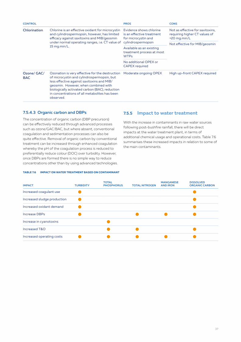
CONTROL PROS CONS
Chlorination Chlorine is an effective oxidant for microcystin and cylindrospermopsin, however, has limited efficacy against saxitoxins and MIB/geosmin under normal operating ranges, i.e. CT value of 15 mg.min/L.
Evidence shows chlorine is an effective treatment for microcystin and cylindrospermopsin
Available as an existing treatment process at most WTPs
No additional OPEX or CAPEX required
Not as effective for saxitoxins, requiring higher CT values of >20 mg.min/L
Not effective for MIB/geosmin
Ozone/ GAC/ BAC
Ozonation is very effective for the destruction of microcystin and cylindrospermopsin, but less effective against saxitoxins and MIB/geosmin. However, when combined with biologically activated carbon (BAC), reduction in concentrations of all metabolites has been observed.
Moderate ongoing OPEX High up-front CAPEX required
7.5.4.3 Organic carbon and DBPs
The concentration of organic carbon (DBP precursors) can be effectively reduced through advanced processes such as ozone/GAC/BAC, but where absent, conventional coagulation and sedimentation processes can also be quite effective. Removal of organic carbon by conventional treatment can be increased through enhanced coagulation whereby the pH of the coagulation process is reduced to preferentially reduce colour (DOC) over turbidity. However, once DBPs are formed there is no simple way to reduce concentrations other than by using advanced technologies.
7.5.5 Impact to water treatment
With the increase in contaminants in raw water sources following post-bushfire rainfall, there will be direct impacts at the water treatment plant, in terms of additional chemical usage and operational costs. Table 7.6 summarises these increased impacts in relation to some of the main contaminants.
TABLE 7.6 IMPACT ON WATER TREATMENT BASED ON CONTAMINANT
IMPACT TURBIDITYTOTAL PHOSPHORUS TOTAL NITROGEN
MANGANESE AND IRON
DISSOLVED ORGANIC CARBON
Increased coagulant use circle circle
Increased sludge production circle circle
Increased oxidant demand circle circle
Increase DBPs circle circle circle circle
Increase in cyanotoxins circle
Increased T&O circle circle circle
Increased operating costs circle circle circle circle circle
37
7.6 Recovery checklist
The development of checklists are a useful way ensuring that recovery checks are undertaken. The following example is a checklist adapted from the US EPA Incident Action List for Wildfires.
TASKS
square-full Undertake a rapid risk assessment of the affected areas (Complete damage assessments).
square-full Assign a utility representative to continue to communicate with customers concerning a timeline for recovery and other pertinent information.
square-full Continue work with response partners to obtain funding, equipment, etc.
square-full Complete permanent repairs, replace depleted supplies and return to service.
square-full Coordinate with landowners and other partners to restore and treat burned areas.
square-full Compile damage assessment forms and cost documentation into a single report to facilitate the sharing of information and the completion of state and federal funding applications.
square-full Identify mitigation and long-term adaptation measures that can prevent damage and increase utility resilience. Consider impacts related to future climate conditions and the increased frequency of bushfires when planning for system upgrades (e.g., installing buffer strips, removing hazardous fuels).
square-full Develop a lessons learned document and/ or an after-action report (AAR) to keep a record of your response activities. Update your vulnerability assessment, ERP, fire models and fire management plans.
square-full Consider implementing the following mitigation measures to prepare for possible flash flooding events following a bushfire:
Obtain and use burn severity mapping to help determine catchment risk and mitigation strategies.
Monitor the catchment, as conditions may be different post-fire. Identify potential failure points within your service area: ensure culverts can handle increased flow, and determine runoff points and areas where water will now collect
Install a rain gauge upstream of intake for early warning of heavy precipitation that could lead to high turbidity water and sensors to monitor the amount of debris and sediment coming downstream.
Consider instituting erosion control measures to protect against runoff and sediment concerns that occur during suppression and precipitation.
38

References
ACT, (2018). ACT and Regional Catchment Post-Emergency Recovery Plan – Reference Guides, 2018. ACT Government
BOM, Fire Weather Knowledge Centrewww.bom.gov.au/weather-services/fire-weather-centre/index.shtml
Bushfire & Natural Hazards CRC. Australian Seasonal Bushfire Outlookhttps://www.bnhcrc.com.au/hazardnotes/68
CFA Victoria, Roadside Fire Management Guidelines.www.cfa.vic.gov.au/documents/20143/202133/roadside_guide.pdf/2097aff0-3050-46d3-89de-8a01c9f8d04f
CRC Catchment Hydrology, (1999), Guidelines for Stabilising Streambanks with Riparian Vegetation, September 1999.ewater.org.au/archive/crcch/archive/pubs/pdfs/technical199910.pdf
DFES WA, A Guide to Constructing and Maintaining Firebreaks, Department of Fire & Emergency Services, A Guide to Constructing and Maintaining Fire-breaks.www.dfes.wa.gov.au/safetyinformation/fire/bushfire/BushfireManualsandGuides/Constructing-Firebreaks-Brochure.pdf.
DSITI, (2105). Soil Conservation Guidelines – Chapter 11: Stream Stability, Queensland Government Department of Science, Information Technology and Innovation, 2015.www.publications.qld.gov.au/dataset/soil-conservation-guidelines/resource/3caa7ed2-5b54-4ba4-bb23-c28b754cab41
Kahn, S., Deere, D., Leusch F.D.L., Humpage, A., Jenkins, M., and Cunliffe, D., Identify and Assess the Water Quality Risks from Extreme Events, Water Research Australia Report 1063 (2016).
Morris, R., Calliss, S., Frizenschaf, J., Blason, M., Dragovich, D., Henderson, M. and Ostendorf, B. Controlling sediment movement following bushfire – a case study in managing water quality, Mount Bold, South Australia. Water Down Under 2008, April 2008, Adelaide, Australia.www.researchgate.net/publication/258113618_Controlling_sediment_movement_following_bushfire_-_a_case_study_in_managing_water_quality_Mount_Bold_South_Australia
Nunes, J.P, Doerr, S.H., Sheridan, G., Neris, J., Santín, C., Emelko, M. B., Silins, U., Robichaud, P. R., Elliot, W. J. and Keizer, J. Assessing water contamination risk from vegetation fires: Challenges, opportunities and a framework for progress. Hydrological Processes, 32, (2018), 687 – 694.
Whittlesea, (2017). Eden Park Bushfire: Erosion Mitigation Plan. City of Whttlesea, Victoria, 2017.www.whittlesea.vic.gov.au/media/3231/k-partnerships-communications-_public-temp-katrina-website-eden-park_bushfire-erosion-mitigation-plan.pdf
WSSG (2020). Australian Water Sector Mutual Aid Guidelines, Water Services Sector Group, January 2020.
WRF (2013), Report on the Effects of Wildfire on Drinking Water Utilities and Effective Practices for Wildfire Risk Reduction and Mitigation, August 2013. Project #4482, Water research Foundationwww.waterrf.org/research/projects/effects-wildfire-drinking-water-utilities-and-best-practices-wildfire-risk
Appendices
All case studies available at WSAA website wsaa.asn.au/publication/national-good-practice-operational-guidelines-bushfire-management-australian-water
Appendix A North East Water critical infrastructure rating (CIR)
Appendix B Hydrodynamic modelling for bushfire management and recovery in the catchment from Melbourne Water
Appendix C North East Victoria & Gippsland Bushfire Rapid Risk Assessment Team report from the 2013 Alpine fires
Appendix D SA Water experience with the application for coir logs
Appendix E Melbourne Water’s experience with the application of debris racks and sediment dams
Appendix F Managing water quality in the Huon River catchment
Appendix G Drought, fires, floods and water quality
Appendix H Monitoring water quality and managing turbidity after the Perth Hills bushfire
Appendix I Lindfield Park Road rehydration project
Appendix J Getting started on bushfire recovery39