
Burtonsville Commercial Crossroads Neighborhood Plan Scope
22
Transcript of Burtonsville Commercial Crossroads Neighborhood Plan Scope

Sector Plan

burtonsville commercial crossroads neighborhood planning study
Scope of Work
Abstract
This Scope of Work examines community issues in the Burtonsville Crossroads at US 29 and MD 198, outlines the outreach process that will be used to understand those issues, and determines a schedule for setting strategies that will address them.
Source of copies
The Maryland-National Capital Park and Planning Commission8787 Georgia AvenueSilver Spring, MD 20910
Online at: montgomeryplanning.org/community/burtonsville

Burtonsville Commercial Crossroads Neighborhood Planning Study • January 2011 • Scope of Work
burtonsville commercial crossroads neighborhood planning study
Scope of Work
Prepared by the Montgomery County Planning DepartmentJanuary 2011
MontgomeryPlanning.org


Burtonsville Commercial Crossroads Neighborhood Planning Study • January 2011 • Scope of Work
Introduction 4
Purpose 5 Study Area Boundary 5 Planning Framework 8 Burtonsville Today 10 Challenges 12 Connectivity 12 Design 12 Diversity 13 Environment 13
Outreach 14
Next Steps 15
Resources 18
Maps
Planning Study Area Location 4 Planning Study Area Boundary 5 Regional Area 7
contents

4 Burtonsville Commercial Crossroads Neighborhood Planning Study • January 2011 • Scope of Work
Montgomery County is growing and evolving and so are its neighborhoods. If the County is to continue to prosper, sound neighborhood planning must provide the elements that create quality places. A great neighborhood provides access to a full range of commercial services, safe and lively streets, gathering places, and is recognized for its unique character.
The Planning Department has targeted the Burtonsville commercial area, which has been impacted by the realignment of US 29. This Scope of Work outlines the issues that have been created by that realignment. It also schedules the tasks for analyzing those issues and developing strategies to address them.
The issues that this Burtonsville Commercial Crossroads Neighborhood Planning Study will focus on are the design, connectivity, diversity, and environment of the commercial crossroads of MD 198 and US 29. The process will include up-front community engagement, an evaluation of the issues and alternatives (including those developed by previous planning efforts), and a final recommendation of strategies to resolve the circulation and redevelopment issues at the commercial crossroads.
introductionThe Burtonsville Commercial Crossroads Neighborhood Planning Study will address community issues that don’t rise to the level of a complete master or sector plan effort because the issue is confined to a specific neighborhood or is limited in scope. It will not examine the full range of topics normally covered in a master plan.
The County Council approved the Burtonsville study to identify and address problems in the commercial area along MD 198 without a lengthy comprehensive planning process. The findings presented to the Planning Board in spring 2011 will evaluate and make preliminary recommendations for the commercial area. As a focused planning effort, the recommendations may require further implementation strategies, such as a plan amendment, zoning text amendment, or a design or economic study, which don’t require County Council approval.
5Burtonsville Commercial Crossroads Neighborhood Planning Study • January 2011 • Scope of Work
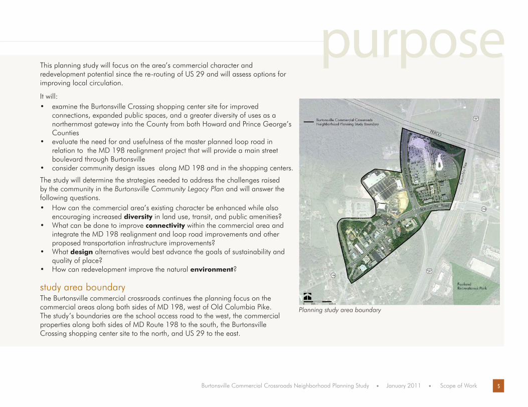
This planning study will focus on the area’s commercial character and redevelopment potential since the re-routing of US 29 and will assess options for improving local circulation.
It will:examine the Burtonsville Crossing shopping center site for improved • connections, expanded public spaces, and a greater diversity of uses as a northernmost gateway into the County from both Howard and Prince George’s Counties evaluate the need for and usefulness of the master planned loop road in • relation to the MD 198 realignment project that will provide a main street boulevard through Burtonsville consider community design issues along MD 198 and in the shopping centers.•
The study will determine the strategies needed to address the challenges raised by the community in the Burtonsville Community Legacy Plan and will answer the following questions.
How can the commercial area’s existing character be enhanced while also • encouraging increased diversity in land use, transit, and public amenities?What can be done to improve • connectivity within the commercial area and integrate the MD 198 realignment and loop road improvements and other proposed transportation infrastructure improvements?What • design alternatives would best advance the goals of sustainability and quality of place?How can redevelopment improve the natural • environment?
study area boundaryThe Burtonsville commercial crossroads continues the planning focus on the commercial areas along both sides of MD 198, west of Old Columbia Pike. The study’s boundaries are the school access road to the west, the commercial properties along both sides of MD Route 198 to the south, the Burtonsville Crossing shopping center site to the north, and US 29 to the east.
purpose
Planning study area boundary

6 Burtonsville Commercial Crossroads Neighborhood Planning Study • January 2011 • Scope of Work
Historically, the rural community of Burtonsville, originally called Burton’s, takes its name from Isaac Burton, who in 1825 bought out his siblings’ shares of his father’s land and became the area’s major landowner. The community itself grew around the intersection of Old Columbia Pike and the road to Sandy Spring. In the 1850s, Isaac Burton became the first postmaster of the newly established post office, which operated out of his store at the intersection.
Burtonsville’s commercial and business core continues to center around the intersection of MD 198 and US 29. The commercial area provides local services to nearby residential communities and includes two established neighborhood-scale shopping centers (Burtonsville Crossing and Burtonsville Town Square), a variety of ethnic restaurants, offices, and light industrial uses. The area is zoned C-1 and C-2, Euclidean commercial zones that allow primarily local-serving retail uses.
Courtesy of Sandra Wright and the Sandy Spring Museum MD 198, looking west Timothy Hyman, Maryland State Highway Administration

7Burtonsville Commercial Crossroads Neighborhood Planning Study • January 2011 • Scope of Work
The commercial area is served by Metro bus service at the bus transit center/park-and-ride lot. By automobile, it is convenient to the major employment centers of Rockville, Silver Spring, Columbia, Laurel-Ft. Meade, and other centers along the Baltimore-Washington I-95 corridor.
Regional Area

8 Burtonsville Commercial Crossroads Neighborhood Planning Study • January 2011 • Scope of Work
planning frameworkBurtonsville has been the subject of previous plans and studies. The 1997 Fairland Master Plan noted that “access to the stores and businesses by car and on foot is hampered by traffic congestion and lack of sidewalks” (p. 67) and in response, the Plan’s goal was to improve circulation, define boundaries, and encourage redevelopment (p. 69). Its recommendations encouraged “cohesive development and redevelopment in the Burtonsville commercial area including vehicular circulation, streetscaping, and sidewalks” (p.69)
Since the 1997 Plan, the commercial crossroads properties at MD 198 and US 29 have seen redevelopment and circulation changes that have many area local merchants and property owners questioning the area’s future economic viability.
In 2002, SHA’s MD 28/MD 198 Corridor Improvement Study examined the roadway with the goals of relieving locally generating congestion; improving safety and traffic operations for motorists, bicyclists, and pedestrians; and preserving the road’s rural and suburban character. The study has a number of alternative options, but recognizes the benefits of creating a “main street” character through Burtonsville and considers the utility of the 1997 Plan’s recommended loop road.
In 2007, the Montgomery County Department of Housing and Community Affairs (DHCA) and the Department of Economic Development (DED) undertook the Burtonsville Market Study and Consumer Shopping Survey, which examined what residents and business owners envision for Burtonsville, examined the impact of US 29 and MD 198 re-routing, and assessed future retail directions and opportunities.
In 2008, DHCA’s Burtonsville Community Legacy Plan identified challenges in the commercial area voiced during the community meetings, including poor access to local businesses, high traffic volumes and speeds, limited connections between the two shopping centers, store vacancies, inadequate sidewalks, cluttered overhead utility wires and signage, limited redevelopment and façade maintenance, parking and property impacts from two future road projects, lack of a community gathering spot, and no design continuity within the commercial area.
9Burtonsville Commercial Crossroads Neighborhood Planning Study • January 2011 • Scope of Work
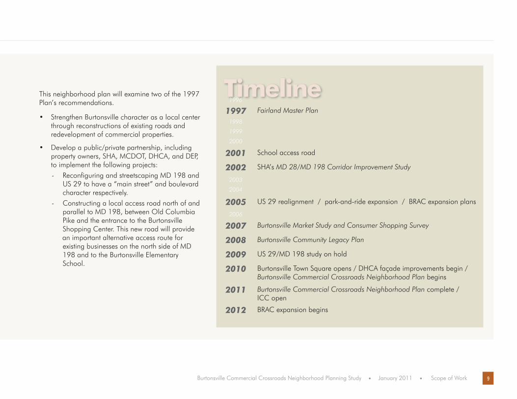
This neighborhood plan will examine two of the 1997 Plan’s recommendations.
Strengthen Burtonsville character as a local center • through reconstructions of existing roads and redevelopment of commercial properties.
Develop a public/private partnership, including • property owners, SHA, MCDOT, DHCA, and DEP, to implement the following projects: - Reconfiguring and streetscaping MD 198 and US 29 to have a “main street” and boulevard character respectively. - Constructing a local access road north of and parallel to MD 198, between Old Columbia Pike and the entrance to the Burtonsville Shopping Center. This new road will provide an important alternative access route for existing businesses on the north side of MD 198 and to the Burtonsville Elementary School.
Timeline1996
1997 Fairland Master Plan
1998
1999
2000
2001 School access road
2002 SHA’s MD 28/MD 198 Corridor Improvement Study
2003
2004
2005 US 29 realignment / park-and-ride expansion / BRAC expansion plans
2006
2007 Burtonsville Market Study and Consumer Shopping Survey
2008 Burtonsville Community Legacy Plan
2009 US 29/MD 198 study on hold
2010 Burtonsville Town Square opens / DHCA façade improvements begin / Burtonsville Commercial Crossroads Neighborhood Plan begins
2011 Burtonsville Commercial Crossroads Neighborhood Plan complete / ICC open
2012 BRAC expansion begins

10 Burtonsville Commercial Crossroads Neighborhood Planning Study • January 2011 • Scope of Work
Park-n-Ride Lot
Burtonsville Elementary
Facade and street improvements
US 29 interchange project
burtonsville today Many changes since the 1997 Plan have transformed the Burtonsville area over the last decade.

11Burtonsville Commercial Crossroads Neighborhood Planning Study • January 2011 • Scope of Work
Burtonsville Crossing Shopping Center
Burtonsville Town Square Shopping Center
School Access Road
The 2005 completion of the State Highway Administration’s US Route 29 interchange project rebuilt portions of MD 198 including modifications to the intersection of Old Columbia Pike and MD 198, a new diamond interchange at US 29 and MD 198, a partial diamond interchange at US 29 and Dustin Road, a roundabout at Dustin Road and Old Columbia Pike and a major expansion of the Burtonsville Park-n-Ride Lot including ramps to and from US 29 to the expanded park-n-ride lot.
The 2001 completion of the school access road, a segment of the master planned local access road. The planned loop road, north of and parallel to MD 198, was proposed in the 1997 Plan as a secondary access road for businesses on the north side of MD 198. Some property owners see the unbuilt portion of the loop road (to the rear of their commercial properties) as unnecessary since a future SHA project will provide improved access for cars, pedestrians, and bicyclists. The plans for the loop road have been shelved due to funding limits. If this study confirms the need for a loop road and the road is funded, the plans will need to be changed to meet changes in the stormwater management regulations.
The Burtonsville Town Square Shopping Center is located in the northwest corner of the intersection of MD 198 and the access road from Old Columbia Pike. Originally the site of the Dutch Farmer’s Market, the shopping center was renamed and renovated in 2010 to include 260,000 square feet of retail, including a new site for the Giant store formerly located across US 29 at the Burtonsville Crossing shopping center.
The Burtonsville Crossing Shopping Center is located in the northeast corner of the intersection of MD 198 and US 29. During the fall 2010, the suburban-style shopping center lost its anchor, a 55,000 square foot Giant food store, to Burtonsville Town Square across the street. More than two-thirds of the 129,726-square foot shopping center is empty. With Giant’s departure, the center has ten vacancies.
Maryland Route 200 (MD 200), the Intercounty Connector or ICC, will open in 2011 and will provide an east-west connection across Montgomery County. The ICC is a 18-mile toll freeway under construction in Maryland and when completed, it will run between Gaithersburg in Montgomery County and Laurel in Prince George’s County. The ICC will provide some relief to the four-lane MD 198 through Burtonsville but the federal expansion of Fort Meade is projected to increase traffic.
Timothy Hyman, Maryland State Highway Administration
The County’s Department of Housing and Community Affairs (DHCA) is working on several projects that have an impact on the commercial area. The projects are based on the Burtonsville Market Study and, the Burtonsville Community Legacy Plan, and are being implemented through the County’s Capital Improvements Program for façade and street improvements in Burtonsville. In addition, the Department also has grants for gateway signage and small business site improvements including landscaping, restriping parking, and signage improvements.
The federal Base Realignment and Closure (BRAC) at Fort George G. Meade, located on MD 198 in Laurel will impact Burtonsville. Ft. Meade is planning for an increase of approximately 5,400 military, DOD civilian, and contract employees with approximately 4,900 employees and family members living and working on Fort Meade. An estimated three to seven thousand employees will serve as contractors and service the needs of the base. These additional personnel will occupy facilities in and around the local communities. The additional base jobs, services, and housing will likely make MD 198 a well-traveled corridor.

12 Burtonsville Commercial Crossroads Neighborhood Planning Study • January 2011 • Scope of Work
challengesDespite these federal, state, local, and private plans and projects, challenges remain in pulling Burtonsville together as a cohesive commercial center.
ConnectivityThe delay of the anticipated SHA’s MD 28/MD 198 Corridor Improvement Study• Heavy vehicular congestion continues along MD 198 in the commercial core during peak travel times• Limited infrastructure in the commercial area for pedestrians and bicyclists• No formal community gathering place• Limited vehicular connections between businesses• A wider than needed Old Columbia Pike acts as a barrier between the two large shopping centers• Lack of connections between businesses on the north and south sides of MD 198 and across US 29 between the • shopping centers No direct connection for park-n-ride users to Burtonsville Crossing stores.•
DesignIncompatibility of redevelopment with the existing character of Burtonsville• Lack of pedestrian-oriented public space for the entire commercial area• Too many curb cuts along MD 198• Lack of uniform signage for the small businesses along MD 198• Cluttered overhead power lines along the main boulevard of MD 198 through Burtonsville• Substandard parking and landscaping for the small businesses along MD 198•

13Burtonsville Commercial Crossroads Neighborhood Planning Study • January 2011 • Scope of Work
DiversityA variety of property owners along MD 198 with different needs and goals • Giant Foods, Inc. has the right of first refusal over the next tenant in its previous anchor space in the • Burtonsville Crossing Shopping Center. The contract reinforces the requirement for a “non-grocery store tenant” in that spaceLoss of “mom and pop” businesses and the need to retain and expand local retail and neighborhood serving • uses Limited commercial uses in the C-1 Zone for a variety of uses•
EnvironmentLocated in an environmental preservation area (described as a low to very low density area in the 1997 Plan), • the Plan’s proposed boundary is in close proximity to the Patuxent Watershed Protection areaJust outside the Upper Paint Branch Special Protection Area• Much of the commercial area is impervious (parking rooftops, sidewalks, etc.) with little to no sediment and • erosion controls. Future development will be subject to current stormwater regulationsNeed for further protections of stream quality in the upper Paint Branch watershed • Sustainable development should be incorporated into all future redevelopment •

14 Burtonsville Commercial Crossroads Neighborhood Planning Study • January 2011 • Scope of Work
Members of the project team will work with residents and other community stakeholders to develop a working partnership to outline a process for addressing the problems in the Burtonsville commercial core.
A community meeting on November 30, 2010 kicked off the plan. In addition to M-NCPPC staff presenting, the State Highway Administration and the Montgomery County’s departments of Transportation (MCDOT), and Housing and Community Affairs (DHCA) staff also described their work in the area.
Additional outreach efforts will be tailored to the community and will include:enlisting County agencies to address existing problems raised by the community and other stakeholders during the planning • processregular meetings and community forums with area residents and stakeholders throughout the planning process• attending local community group and community association meetings, as requested• updating the East County Citizens Advisory Board, neighboring communities, neighborhood associations, and local • businessesstaff presence at Burtonsville Day, September 2010 and September 2011• using the Burtonsville montgomeryplanning.org website to provide updates, meeting notices, and plan progress • maintaining an emailing group for direct communication of upcoming events• using the East County Regional Services email list for larger information sharing opportunities.•
outreach

15Burtonsville Commercial Crossroads Neighborhood Planning Study • January 2011 • Scope of Work
After Planning Board approval of the Scope of Work, staff will begin working with residents and other community stakeholders in early 2011 to assess options for improving circulation and encouraging redevelopment in the Burtonsville commercial core.
The planning team was chosen in December 2010. Meetings with agencies and property owners began in December and will continue in January. A series of open houses with residents and property owners will be offered in the early winter through the spring 2011to confirm the issues. By spring, staff will draft preliminary ideas for the Board’s initial review with recommendations of strategies to resolve the issues in the summer.
Unlike a traditional master planning process, this effort is meant to focus analysis and public discussion on known issues. Final recommendations may require further review from the Planning Board and a public process with the County Council. Recommendations may include a master plan amendment, limited plan amendment, local map amendment, or zoning text amendment. These actions require review and approval from County Council.
Phase 1: Scope Project (Fall 2010-January 2011)
Assemble project team• Hold organizational meetings • Prepare draft Scope of Work • Determine Plan area boundary•
Product: boundary map, schedule, budget program element, draft work scopeBackground research • Create master parcel file•
Product: master parcel file, land use maps Community outreach and public engagement (ongoing) • Community open house • Website and email list development • Develop public participation program•
Product: final Scope of Work including community outreach plan, existing conditions maps
next steps

16 Burtonsville Commercial Crossroads Neighborhood Planning Study • January 2011 • Scope of Work
Phase 2: Identify Issues and Alternatives, and Develop Strategies (January-May 2011)Identify and confirm the issues and alternatives• Conduct community and stakeholder meetings • Analyze design, circulation, and zoning issues • Discuss preliminary staff recommendation with community•
Product: preliminary staff recommendations
Phase 3: Refine Recommendations and Strategies (May-July 2011)Refine staff recommendations • Discuss staff recommendations with Board • Incorporate Planning Board feedback and finalize recommendations•
Product: staff recommendations and design concepts for discussion with the Planning Board
Phase 4: Review and Implementation (August 2011) Depending on the study’s recommendations, work will proceed and time will be scheduled with the County Executive and County Council. Implementation efforts are scheduled in the Planning Department’s work program through November 2011.
17Burtonsville Commercial Crossroads Neighborhood Planning Study • January 2011 • Scope of Work
BURTONSVILLE CROSSROADS COMMUNITY PLANNING STUDY , PROPOSED SCHEDULE
2010 2011
apr may june july aug sept oct nov dec jan feb mar apr may june july aug sept oct nov dec
phase 1
community engagement
scope project and background research
scope of work approved
phase 2
identify issues and alternatives
community and stakeholder meetings
analyze design, circulation, and zoning
present preliminary recommendations
finalize recommendations
phase 3
refine staff recommendations
present staff recommendations
finalize recommendations
phase 4 implementation*
apr may june july aug sept oct nov dec jan feb mar apr may june july aug sept oct nov dec
Staff work Planning Board Community meetings
*Depending on the study’s recommendations, time will be scehduled with the County Executive and County Council

18 Burtonsville Commercial Crossroads Neighborhood Planning Study • January 2011 • Scope of Work
The approved Planning Department work program commits 2.5 work years to this project in FY11. No funds have been reserved for consultant services, including translation services, studies, or renderings.
For more information:
Kristin O’[email protected]
John [email protected]
MontgomeryPlanning.org/community/burtonsville
resources

January 2011
burtonsville commercial crossroads neighborhood planning study
Scope of Work
Montgomery County Planning DepartmentMaryland-National Capital Park and Planning Commission
MontgomeryPlanning.org
1210000031