BURMA GAZETTEER AKYAB DISTRICT ... - Myanmar Law Library
267
BURMA GAZETTEER AKYAB DISTRICT VOLUME A COMPILED BY MR. R. B. SMART (DY. COMMISSIONER), SETTLEMENT OFFICER, AKYAB SUPDT., GOVT. PRINTING AND STATY., UNION OF BURMA RANGOON
Transcript of BURMA GAZETTEER AKYAB DISTRICT ... - Myanmar Law Library
BURMA GAZETTEER
AKYAB
DISTRICT
VOLUME A
COMPILED BY
MR. R. B. SMART (DY. COMMISSIONER), SETTLEMENT OFFICER, AKYAB
SUPDT., GOVT. PRINTING AND STATY., UNION OF BURMA RANGOON
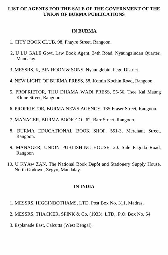
LIST OF AGENTS FOR THE SALE OF THE GOVERNMENT OF THE UNION OF BURMA PUBLICATIONS
IN BURMA
1. CITY BOOK CLUB. 98, Phayre Street, Rangoon. 2. U LU GALE Govt, Law Book Agent, 34th Road. Nyaungzindan Quarter,
Mandalay. 3. MESSRS, K, BIN HOON & SONS. Nyaunglebin, Pegu District. 4. NEW LIGHT OF BURMA PRESS, 58, Komin Kochin Road, Rangoon. 5. PROPRIETOR, THU DHAMA WADI PRESS, 55-56, Tsee Kai Maung
Khine Street, Rangoon. 6. PROPRIETOR, BURMA NEWS AGENCY. 135 Fraser Street, Rangoon. 7. MANAGER, BURMA BOOK CO.. 62. Barr Street. Rangoon. 8. BURMA EDUCATIONAL BOOK SHOP. 551-3, Merchant Street,
Rangoon. 9. MANAGER, UNION PUBLISHING HOUSE. 20. Sule Pagoda Road,
Rangoon 10. U KYAw ZAN, The National Book Depôt and Stationery Supply House,
North Godown, Zegyo, Mandalay.
IN INDIA 1. MESSRS, HIGGINBOTHAMS, LTD. Post Box No. 311, Madras. 2. MESSRS, THACKER, SPINK & Co, (1933), LTD., P.O. Box No. 54 3. Esplanade East, Calcutta (West Bengal),
PREFACE THANKS are due to the many officials and others · who have supplied
materials for the compilation of this Gazetteer and particularly to those mentioned below :-
Mr. A. H. M. Barrington, Deputy Conservator of Forests, Arakan Division,
for the Chapter on Forests and the paragraphs on the Flora of the district. Mr. W. S. Thom, Deputy Commissioner, Hill District of Arakan, for the
paragraph on Fauna. Mr, Saw Chin Hin, B.A., Inspector of Schools, Arakan Circle, for the
Chapter on Education. Mr. A. Williamson, M.A., I.C.S., Assistant Settlement Officer, Akyab, for
the Chapters on Local Self Government and Public Health. Captain H. H. Batten, I.A, Assistant Settlement Officer, Akyab, for much
useful information collected especially for the Chapters on Revenue and General Administration.
Mr. H. Munro, Superintendent of Excise, Akyab, for the paragraphs on
Excise and Opium.
R. B. SMART, (Deputy Commissioner)
Settlement Officer, Akyab. MAYMYO, 21st April 1917.
CONTENTS.
CHAPTER I.
Physical Description. Akyab district, area and situation; Boundaries; Head quarters: Administrative divisions; Natural divisions: Situation and physical features of townships; Hills; Lakes; Rivers and Streams;Geology; Climate; Rainfall; Cyclones; Soils; Flora; Fauna; Fish
CHAPTER II.
History and Archaeology.
Early history; Portuguese adventurers; First Burmese war; Archæology of towns and pagodas
CHAPTER III.
The People. Population; Density; Races; Customs; Laws; Missions; Emigration and Immigration; Average income and expenditure and standard of living of agriculturists; Food and other items of expenditure; Houses and other buildings; Indebtedness; Co-operative Credit Societies; Agriculturists' loans
CHAPTER IV.
Agriculture and Irrigation.
Occupied and other areas; Areas under various crops; Rice; Crops other than rice; Disappearance of old and introduction of new staples; Description of soils; Suitability of Climate for agriculture; Extent of fallowing and liability to crop failure: Insects and other crop pests;
PAGE
1-17
18-80
80-105

II Contents. Irrigation and protective works; Methods of cultivating rice; Crops other than rice; Implements; Manures; Agricultural customs; Improvements in agricultural methods; Disposal of agricultural produce; Method of sale and transport; Cattle; Hire and sale of cattle; Method of feeding and tending cattle; Grazing grounds; Diseases and mortality among cattle, sheep, ponies, goats and pigs; Individual and family ownership; Average size of estates; Area owned by agriculturists and non-agriculturists; Area sold and sale values; Areas mortgaged and mortgage values; Tenancies; Rental values.
CHAPTER V.
Forests and Minerals. Forests; Area of forests ; Legal position of forests; Types of forests; History of administration; Clerical establishment; Personnel of officers; Revenue and expenditure; Progress; Reservation of forests; Development of new markets; Teak plantations; Minerals; Petroleum; Salt; Coal and other minerals
CHAPTER VI.
Occupations and Trade. Agriculture; Trade in foodstuffs; Other occupations; Rice milling; Carrying trade; Labourers; Former industries; Weaving; Gold and silver smiths; Carpentering; Boat building; Shoemaking; Pottery; Iron work; Mat making; Dani palm; Early trade; Trade from 1830 on wards
CHAPTER VII.
Means of Communications. Waterways; Steam communication by water in the Akyab district; Government steam vessels; Landing stages;
105-125
125-137
137-144
PAGE
Contents. III Roads; Suggested improvements to communications; Railways; Trade routes; Posts; Telegraphs; Rest houses; Camping grounds; Light houses
CHAPTER VIII.
Famine. Nil.
CHAPTER IX.
General Administration. Early Administration; 1863-1876; 1877 to date; Criminal Justice; Civil Justice; Military and Marine; Military Police; Civil Police; Jails; Registration; Public Works; Roads; Buildings; Landing stages; Outstation buildings.
CHAPTER X.
Revenue Administration. Land tenure in Burmese times; Land tenure from 1826 to 1875; Lower Burma Land and Revenue Act II of 1876; Waste Land Grants; Revenue system in Burmese times; Early assessments after British occupation; standards of land measurement; Introduction of land tax on standard measurements; Tentative introduction of kwin unit system; Original Settlement 1865-66; Revision of rates; Cyclone of 1857; Lower Burma Land and Revenue Act II of 1876; Professional survey by Survey of India 1879-80; Revision Settlement 1879-80; First Regular Settlement 1885-88; Season 1885-86; Fallow rate;Assessment rates proposed; Season 1886-87; Fallow rate on unculturable portions of holdings; Season 1887-88; Summary of three years 1885-86 to 1887-88; Revision Settlement 1901-03; Season 1901-02; Assessment of areas fallowed for grazing and of unculturable portions of holdings; Season 1902-03; Summary of two years 1901-02 and 1902-03; Season
144-153
153
153-171
PAGE
IV Contents. 1903-04 ; Revision Settlement 1913-16; Tracting and soil classification; Proposed enhancement of demand; Capitation tax; Land rate in lieu of capitation tax; Fishery revenue; Income tax; Stamp revenue; District Cess Fund; Excise; Opium
CHAPTER XI.
Local Self Government. Akyab Muncipality; Constitution; Conservancy; Roads; Water supply; Lighting; Fire protection; Bazaars; Schools; Hospitals; Finance
CHAPTER XII.
Education. Literacy; Public and private schools; Establishment of lay schools; Monastic schools; Urdu schools; Anglo. Vernacular schools; Female educatioin; Model schools; Summary of schools; Administration.
CHAPTER XIII.
Public Health. Cholera; Small pox and vaccination; Malaria; Tuberculosis; Beri-Beri and Plague; Hospitals; Sanitation.
CHAPTER XIV.
Minor Articles Description of towns and villages.
APPENDIX. List of Deputy Commissioners since 1866. List of Commissioners since 1866. Bibliography.
171-202
202-207
207-211
211-214
214-236
239-242243
237-239
PAGE
BURMA GAZETTEER
AKYAB DISTRICT
VOLUME A
CHAPTER I.
Physical Description. Akyab district, area and situation;
Boundaries; Headquarters; Administrative divisions; Natural divisions; Situation and physical features of townships; Hills; Lakes; Rivers and streams; Geology; Climate; Rainfall; Cyclones; Soils; Flora; Fauna; Fish.
Akyab district; area and situation.
Akyab is one of the four districts forming the Arakan Division of Lower Burma. Its area is 5,136 square miles and it lies between the Arakan Yomas and the Bay of Bengal. The district is between 19º47´ and 21º 27´ north latitude and 92° 11´ and 93° 58´ east longitude.
Boundaries.
It is bounded on the north by Chittagong and the Hill District of Arakan, on
the east by the Hill District of Arakan and the Arakan Yoma mountains, on the south-east by the Kyaukpyu district, on the south by the Bay of Bengal and on the west by the Bay of Bengal and the Naaf estuary.
Headquarters
The town of Akyab, after which the district is named is the headquarters of
the district and of the Arakan Division. It is situated on the sea coast at the mouth of the Kaladan river in 20° 8´ north and 92° 55´ east.
Administrative divisions.
The district is divided into four subdivisions comprising nine townships,
viz.:-
Akyab subdivision Akyab, Rathedaung and Pônnagyun townships. Minbya Pauktaw and Minbya townships. Kyautktaw Kyauktaw and Myohaung townships. Buthidaung Buthidaung and Maungdaw townships.
Natural divisions.
The subdivisions and townships take their names from the towns and
illages at which their headquarters are situated.
2 Akyab District. Along the eastern border of the district run the ArakanYoma mountains,
the western spurs of which rangeform a strip of broken country. To the west of thisbroken country, lie the valleys of the Lemyo and Kaladanrivers, narrow at the north and widening out in the southof the district to an extensive level plain intersected bya network of tidal creeks. The banks of the Lemyo and Kaladan rivers in the upper reaches are high and the land generally above flood level, but where the valleys widen out into the level plain the rivers overflow their bauks during certain seasons of the year and still lower down large areas have to be protected by low embankments to keep out the brackish tidal water. Thecountry is cut up into innumerable islands fringed withbelts of mangrove jungle or dani cultivation which shut offthe view from the creeks and rivers of the paddy fieldslying hidden beyond. Dotted here and there over thislevel plain are a number of low ranges of hills, never exceeding a few hundred feet in height. To the south ofthe level plain three steep ranges of hills, the Barongas, runsouthward into the sea. Between the Kaladan and Mayurivers two parallel ranges of hills run north and south to within 20 miles of Akyab on the coast. The countryimmediately to the south of these two ranges, comprisingthe bulk of the Pônnagyun township and the Akyabtownship, is broken at first by spurs of hills andgradually subsides into low sandy ridges which continueto the sea coast. Akyab stands at the extremity ofthis stretch of sandy ridges. This country forms thewatershed between the lower portions of the Kaladanand Maya rivers. It is nevertheless intersected by tidal creeks, dividing the country into numerous islands,a peculiarity of the creeks here being that the ebb and flow of the tide over each half takes place in opposite directions. The upper portion of the valley of the Mayu, called here the Kalapanzin, is very narrow with high banks,the hills on either side coming in places right up to thewater's edge. Lower down the va1ley widens out some what but never to more than 15 miles in breadth. Hereagain the country is cut up by several streams, all tidal,but not to the same extent as the delta of the Kaladan andLemyo. To the west of the Mayu valley lies the Mayu range forming the eastern boundary of the Maungdaw township, a narrow strip of country about 90 miles in length with an average width of 5 miles. The northern portion of the township is covered with jungle and low hills and the south is fairly level but sandy. This plain is even less cut up by streams than the Mayu valley.
Akyab District. 3
Situation and physical features of town ships. The Akyab subdivision, comprising the Akyab, Rathedaung and
Pônnagyun townships, is triangular in shape, bounded on the north by hills and the Buthidaung township, on the east by the Yo chaung, a tributary oft he Kaladan and the Kaladan river and on the west by the sea and the Mayu range of hills. The Pônnagyun township occupies the north-eastern corner of this triangle, the Akyab township forms the apex and the Rathedaung township occupies the north-western corner. Except for a level stretch of country between the Yo chaung and the hills to the west the Pônnagyun township is either hilly or broken country with stretches of sandy ridges. The whole of the Akyab township is a continuation of the broken sandy ridges. The eastern border of the Rathedaung township is hilly and broken and the southern promontory, between the estuaries of the Mayu and Mozi rivers, a level plain dotted with the usual low ranges of hills. The strip along the foot of the Mayu hill slopes gently from west to east, the portion bordering the Mayu being subject to inundation.
The Minbya subdivision, consisting of the Pauktaw and Minbya townships,
lies to the east of the Kaladan and takes up the whole of tile south-eastern portion of the district constituting the valley of the Lemyo river and the delta to the Kaladan and Lemyo rivers. The Pauktaw township is low lying, especially the southern portion, and large areas are protected by embankments. A few small hills rise abruptly out of the level plain and the three detached ranges of the Barongas shoot out southwards into the Bay of Bengal. The Minbya township runs from north to south along the valley of the Lemyo, narrow in the north and widening out to the south. All the country to the east of the Lemyo is made up of the western spurs of the Yomas and that to the west is level; a few small hills stand out here and there.
The Kyauktaw subdivision contains the Kyauktaw and Myohaung
townships and occupies the whole of the north-eastern portion of the district forming the valley of the Kaladan and of its tributaries, the Yanwa, Yan, Thaye and Pe chaungs and the eastern bank of the Yo chaung. The eastern, northern and western boundaries of the Kyauktaw township are hills. in between these hills lies the main portion of the township which is a level fertile plain above tide level, with a few small hills dotted about. The Kaladan flows from north to south, dividing the township in half. To the south-east of the Kyauktaw township stretches the Myohaung township extending to the Yomas on the east and the Pauktaw and Minbya townships to the south. A strip along the eastern border of the township is cut up by the spurs of the Yomas which extend to the road running north and south leading
4 Akyab District. from the famous Mahamuni shrine to Myohaung and on to the market village of Myaungbwe. To the west of this road the township is a level plain with an almost imperceptible drop from north to south.
The Buthidaung subdivision, made up of the Buthidaung and Maungdaw
townships, is situated in the north-western corner of the district. The Buthidaung township is long and narrow, extending from the hills in the north to the Rathedaung township in the south and follows the valley of the upper Mayu with hills along the east and the Mayu range on the west. Towards the south, where the valley widens out a little, there is a level stretch of country, otherwise the whole township is broken up and hilly. The Maungdaw township is a narrow strip of country lying to the west of the Mayu hills bordering on the Naaf, which separates it from the Chittagong district. The northern portion is hilly and the rest of the township is fairly level but sandy. Hills. The northern portion of the district, bordering on the Hill District of Arakan and Chittagong, is very hilly. Along the east run the Arakan Yomas, the eastern border of the district being cut up by the spurs of this range. In the centre of the district standing cut of the level deltaic plain are numerous small ranges of hills rising to only a few hundred feet in height with precipitous sides. To the south of the district are the Barongas, three detached ranges of low hills running southward into the sea. In the west, between the Naaf and Mayu rivers and terminating near the mouth of the latter, is the steep Mayu range, the southern portion of which lies parallel with and not far from the coast. Between the Kaladan and Mayu rivers two similar ridges run parallel to each other to within 20 miles of Akyab on the coast, throwing out spurs into the valley of the Mayu and Pônnagyun township but with steep sides on the Kaladan side. Lakes
There are no lakes in the district but there are several expanses of water in
the Myohaung township which would be more correctly described as marshes. These ins are shallow and some of them dry up during the hot months.
Rivers and streams.
The principal rivers are the Lemyo, Kaladan, Mayu and Naaf, which flow
in general from north to south and are separated from each other by abrupt high watersheds, except the lower reaches of the Lemyo and Kaladan after they emerge into the low level plain where they are connected up by numerous tidal streams. The Kaladan the largest and most important river in the disttrict, rises in the Chin Hills in the Yahow country and is known there as the Boinu. Its course first is south-wards, then northwards, bending westwards, it passes.
Akyab District. 5
through a portion of the Lushai Hills and then turning south again, enters Northern Arakan at its northern end, and flows down the western side of the district, past Paletwa, the headquarters, which lies on its western bank. Further south it enters Akyab district, and continuing in a southerly direction, empties itself after a course of nearly 300 miles into the Bay of Bengla at Akyab, where its estuary is 6 miles in breadth. It is a picturesque river, navigable for steam traffic as high as Paletwa, nearly 100 miles from the sea. The Lemyo receives the drainage of the western slope of the Arakan Yomas, passes along the eastern side of the Hill District of Arakan and Akyab district and flows into the Bay of Bengal by several mouths under different names. The Mayu. rises in the hills to the north of the district, flows southward parallel to the Mayu range of hills and empties itself in a wide estuary into the Bay of Bengal about 10 miles north of Akyab. The estuary of this river is connected with that of the Kaladan by tidal creeks. The Naaf forms the boundary between Akyab and Chittagong.
The principal tributaries of the Kaladan on the east bank are the Thaye
chaung the Yanwa chaung and the Yan chaung, which fed by several smaller streams on the way down, and changes its name many times, till it enters the Kaladan in a wide estuary known as the Kalabôn river. On the west bank the chief tributaries are the Pe and Yu chaungs. All these tributaries are navigable by launches of 6 feet draft almost to their sources. The chief tributaries of the Lemyo river in the district are the Panmyaung and Taywe stream which unite and join the Lemyo where it changes to the Yamaung river shortly before it breaks up into several channels main stream connecting the Lemyo with the Kaladan is the Yede river, which changes its name as it. proceeds and is Joined by numerous small streams, finally entering the Kaladan in a wide estuary known as the Kywegu river, into which flows one of the mouths of the Lemyo. The upper portion of the Mayu, known as the Kalaparzin river, is joined by numerous streams rising in the hills to the east; the chief of these are the Sidin and Myaw chaungs. Lower down the Ngasanbaw, Rathedaung and Ngan-a-bya chaungs, also on the east, join the Mayu. The Kywide river, known, higher up as the Mozi river, empties into the estuary of the Mayu, a few miles from the sea. The Mozi river is called higher up the Tawbya river; it flows between hills and is navigable for a considerable distance by launches. The Kyaungdaung, Kamaingdôn and Gwedauk, chaungs are the only tributaries of importance on the West of the Mayu.
6 Akyab District.
The Pyun, Myothit, Sabebinyin, Ushingya, Mingalagyi, Pyinbyu, Kamyin, Tat, Letwedet and Hnakaungdo and chaungs are largest of the streams which flow from the Mayu hills through the Maungdaw township into the Naaf river. Geology
Geologically the district, beyond the allumium which skirts the coast, may be divided into three distinct belts : namely, the Cretaceous (Mai group) embracing the outer spurs of the Yoma; the Eocene of the Lower Tertiary (Negrais rocks); and the Triassic beds (axial group), forming the crest of the Yoma, with an outcrop on the western side of about 10 miles in breadth. These three classes of rocks are very closely allied. They are all composed of shales and sandstones intersected by bands of limestone, but the cretaceous beds are less hardened and metamorphosed than the other two. Climate
The average maximum temperature of the Akyab district for the whole year is 86 degrees and the average minimum 74 degrees, the average mean being 78 degrees. It will be seen therefore that there are no great extremes of heat and cold and even the hottest months, March to May, are made quite bearable by the cool sea breeze that springs up during the early afternoon. There is little of that mugginess which usually makes the climate of Lower Burma so trying. The average rainfall for the past 20 years has been 209 inches. It is not as wearisome however, during the rainy season, June to October, as the high rainfall figure would lead one to suppose, as there are occasional breaks of a few days and even during rainy spells a few, hours of sunshine, almost daily, break the monotony of the gloom. The cold season, November to February, is cool and pleasant. The prevailing winds during the greater portion of the year are light northerly breezes in the morning, veering round to a strong south-westerly wind, which springs up soon after noon, and lasts until sunset. During the monsoon the breeze settles in the south-west, Unfortunately a very severe type of jungle fever is prevalent in both town and district and is the one great drawback to what would otherwise be one of the most delightful districts in Burma. Rainfall
There are five rain recording stations at present in the district, the one at Pabru, near Minbya, having been closed in April 1915. The rainfall varies from an average of 209 inches at Akyab to 180 inches at Rathedaung, 176 inches at Buthidaung, 165 inches at Maungdaw, 159 inches at Kyanktaw and 156 inches at Minbya. It will thus be seen that it is more abundant on the sea coast' and decreases as one proceeds further inland. The cultivators divide the
Akyab District. 7
rainfall into the early, middle and late rains which are ample all over the district for rice cultivation. Ordinarily it is timely, but irregularities, especially during the late rains, have their effect on the ontturn. During the first four months of the year the rainfall seldom exceeds 5 inches. May is a fairly wet month, but the bulk of the rainfall is obtained during June, July and August, July being generally the wettest month in the year. There is a sharp drop in the rainfall month by month during September, October and November, till in December it practically ceases. The year 1914 yielded the record rainfall for the previous 20 years,and this record was broken in 1915 when 248 inches fell, only to be exceeded again during 1916 when the total reached 268 inches.
Cyclones
The Akyab district is frequently visited by cyclones, some of great violence, which cause damage to life and property. The cyclone of November 13th, 1867, is spoken of as being the severest experienced in the memory of living man. It was accompanied by a tidal wave which swept up the rivers, flooding and destroying everything that came in its way. The loss of life was considerable and only the most substantial houses withstood the violence of the storm. On May 17th, 1884, a cyclone of very similar character caused great destruction of property. There was a severe storm in April 1895, another in November,1908 and a third in May 1915, but the damage caused was not as great as in 1884.
Soils.
The soils of the district are chiefly loams, more or less sandy; very few clays are found. Along the banks of rivers there are in places narrow stretches of alluvial formations. These are, as a rule, not fit for cultivation till the level of the land rises nearly to flood level, when, by the aid of protecting bunds, they can be brought trader cultivation. The banks of the lower reaches of the large rivers and surrounding tidal creeks are low and the adjoining country subject to inundation. The water in these parts being brackish the floods leave deposits of salt which are not beneficial to cultivation. If, however, the salt water is effectively excluded for a year or two the fertility of the soil improves. Over the whole of the Akyab township and in rafts of the Maungdaw, Rathedaung and Pônnagyun townships the soil is more sandy than in the remainder of the district. Rice is the staple, and over the whole district it was observed that the lowlying lands, provided they do not get too much water, and are securely protected against inroads of salt water, produce the best crops as they receive the drainage and silt from the adjoining higher lands. The slightly higher and the less securely protected lands
Akyab District. 8 come next in order of fer5tility and the highest, the lowest or flooded areas, and the badly protected lands are the poorest. On this basis the soils were classified during the settlement operations undertaken during the years 1913-16. Flora
Regarding the flora of the district Mr. A. H. M. Barrington, Deputy Conservator of Forests, Arakan Division, writes as follows: - General survey
"The most prominent feature of the vegetation is a 'single stemmed' bamboo locally known as kayin; the scientific name, which seems to be provisional, is Melocanna bambusoides. This bamboo covers the greater part of the hill masses of Arakan, part of Assam, and has even spread over the watershed into the Irrawaddy valley. It is not a mere undergrowth; in the shade of tree forests it makes little headway; but by dint of taking advantage of every gap in the overhead cover it gradually usurps the place of trees and the thickets formed by it are so dense that seedlings can seldom pierce them. The spread of the bamboo is facilitated by a rhizome, or underground stem, which branches in all directions and sends up shoots at intervals of rather less than two feet; its fruit is heavy, similar in shape and size to a pear, and not only rolls clown the hills in all directions but provides for the young seedlings an exceptionally rich store of nutriment. The natural advantages of kayin are therefore considerable; the rhizome is capable of great expansion; in most bamboos it is dwarfed into a compact clump: the fruit is large and heavy; in most bamboos it is small and light; further kayin is ever green and mature plants are self protected against fire. With so great natural advantages the bamboo would have spread without assistance but the actual rate of extension has been materially quickened by man. The population of hill valleys is small but diffuse; each hamlet clears a considerable patch of forest every year; provided kayin is in the neighbourhood its rhizome extends into the clearing and gradually takes possession; the more frequently a plot be cultivated the more certainly is the bamboo encouraged at the expense of the trees. And as villages migrate, coalesce and divide, new areas are cleared until all but the very steepest slopes have been cultivated. At the present time nearly all Slopes ever cultivated are under kayin, and the more frequent the cultivation the fewer the trees. The compensations for this wholesale substitution of bamboo for tree forest are that the trees were not, in general, of any great value and that the bamboo has the property of so holding the soil that cultivation every four or five years has no obviously injurious results. If deterioration takes place it is exceedingly gradual."
Akyab District. 9 "On the high ridges of the east, in the valleys of the Wet and Than streams,
there are small patches of high mixed forest. These consist of scattered oaks (Quercus polystacha) and such trees as Schima noronhae, usually in conjunction with the ubiquitous kayin. A type of evergreen forest once common through out the district is that formerly classed as 'tropical.' Predominant trees are invariably thinbaung (Buchanania lancifolia) and various kinds of kanyin (Dipterocarpus spp.) but in the north and east of the district many other species are found with them. The undergrowth is typically canes and palms. The only extensive forest of this class is in the west of the district and there the overwood consists almost entirely of the trees named; elsewhere patches occur on the hills and, more frequently, along hillside spates and rocky valleys; in the west the type was once predominant but is now slowly yielding to the invincible kayin. The main mass of the hills supported a deciduous mixed forest containing various species of Eugenia, Gardenia, Dillenia, Careya, and Vitex. Few of these trees are of economic importance and much of the forest is difficult of access. The type is found in a virgin state only on slopes too steep for cultivation, elsewhere it is represented by seattered trees in a sea of bamboo. On low foothills at the edge of the plains are patches and strips of deciduous forest, of which pyinkado (Xylia dolabriformis) is usually, the predominant species; in places it is, however, replaced by taukkyan (Terminalia tomenlosa). Pyinkado forest is common east of the Kaladan river and also in the Saingdin valley; but it is nowhere more than a strip and the trees are seldom of good quality. Along hill streams there are narrow belts of timber forest containing such trees as thitkado (Cedrela toona), thingan (Hopea spp.) thitpôk (Tetrameles nudiflora), and feinne (Artocarpus Chaplasha) this type merges into the evergreen forest already described. Wherever valleys widen out into the semblance of level ground kamaung (Lagerstrcemia fios reginae) tends to become the predominant tree; it is sometimes found with letpan(Bombax malaharicum), rein (Stepnegyne diversifolia), and zinbyun (Dillenia sp.) frequently it forms almost pure forest. The chief kamaung forests were destroyed to make way for permanent cultivation; the few strips along narrow valleys seem likely to disappear before the joint exertions of the timber traders and hill tribes. On sandy dunes and links there are patches of Casurina equisetifolia. In the narrow strips which represent the once extensive tidal forests (now largely reclaimed for cultivation)there are mangroves, sundri (Haritiera minor), and other species typical of sea swamps. Finally in clearings in
10 Akyab District. evergreen forest there are groves of wild plantains which dispute the sway of the bamboo." Timber trees.
"The most important timber trees of the district are as follows : Lagerstroemia flosreginae (kamaung) A tough timber which lasts fairly
well in exposed situations and very well if protected from the weather. It is not seriously attacked by white ants. Used for buildings of a better class and for boat ribs. Supplies are dwindling fast but it is still the most important timber of the district.
Xylia dolabriformis (pyinkado). A hard timber, very suitable for house posts, sleepers, or any work exposed to the weather. Used also for piles, etc., in salt water. There is a fair supply in the Akyab district but the rates demanded by local sawyers are so high that most of the local demand is met from Sandoway.
Dipterocatpus spp. (kanyin), Excellent planking timber, but for use in the open needs special treatment. There is a local impression that timber felled in the open season and sawn green can be effectively treated by a few days' immersion in salt water. There is a large supply in the district but the only demand is from Bengal. Consequently extraction is largely confined to the forests of the Naaf. Kanyin oil was formerly much used but has been displaced by cheap kerosene from Burma.
Tetrameles nudiflora (lhitpôk) and Dysoxylum binec tariferum (aukchinsa) are used for cheap planking.
Hopea spp. (thingan). Much used for the hulls of large boats. One species (thingannet) is a good building timber, sometimes substituted for kamaung.
Artocarpus Chaplasha (peinnè) is commonly used for 'dugout' canoes, less frequently for hulls of larger boats built up on a 'dugout' hull.
Vitex pubescens (kyetyo)and Heritiera minor (sundri or razo) are good durable timbers; in Akyab district the trees are seldom large enough to be used for anything but posts.
Ceriops Rhoxburgiana (kabaing) is equally good for posts but does not reach the size of either of the above.
Michelin Champaca (sanga) is a very useful timber but scarce. Mesua ferrea (gangaw) is heavier and harder than pyinkado. Very scarce. Cedrely Toona (thitkado). An excellent furniture wood. Scented, easily
worked, and of beautiful colour and grain. Though not common it seeds freely and, with encouragement, may increase.
Akyab District. 11 The only trees which occur on a scale consistent with an export trade are the kanyin and thindaung (Buchanania lancifolia). The latter has been suggested for many purposes but, so far, has been rejected with contempt." Bamboos
The only bamboo which occurs on a commercial scale is Melocanna
bambusoides. It is said to have flowered in 1864. In 1902 specimens were collected but no considerable flowering occurred till 1909. In Akyab district the main flowering took place between 1910 and 1913, both years inclusive, but flowers had been collected much earlier and may be expected with certainty in 1916 and probably very much later. The bamboo flowers over irregular plots or patches which, in the main flowering years, cover several square miles. The fruit is ripe in May and June and often takes root before it falls from the parent tree. The seeding plants die and the seedlings form a dense thicket in which, by the end of the growing season (November),individual stems are as much as ten feet high. Cultivation in these young thickets kills the bamboo. fires starting from clearings sometimes kill it, but unless every plant on a given area is dead before the bamboo seedlings are a year old nothing short of deliberate and repeated cutting and burning is likely to have any lasting effect. Areas on which the bamboo has been exterminated are, at present, largely covered with plantains or herbaceous weeds. Unless the bamboo can manage to intrude there seems to be every possibility of extensions of the areas covered by plantains and genuine, tree forest, pônzo. As there are no reliable data for the radius of a mature bamboo plant it is impossible to guess how large a clearing can be filled from the sides. In many directions flowering has extended the sphere of the bamboo, the heavy fruit having rolled down slopes to land previousiy occupied by tree forest or elephant grass. The mature bamboo is evergreen and self protected from fire.
The recent flowering of the bamboo had important results. Directly the
amount of vegetation available for hill crops was reduced, indirectly crops were even more affected by hordes of rats, displaced from their usual feeding grounds and forced to devour whatever they could find. Game of all kinds was driven to the low forests near villages, took to destroying crops, and was followed by tigers, Some of the latter, under the usual temptation, turned cattle thieves and even maneaters. The difficulties of the hill tribes were most acute in 1912 and 1913; in 1915 there was abundant rain, game seemed to be retreating, and the only serious difficulty was the abnormal growth of young bamboo, and weeds of all kinds. The supply of bamboos, indispensable for both hill and plains villages, is still very scattered and
12 Akyab District.
hardly equal to the demand. The price in Akyab town is nearly double the normal. Other bamboos occur in very small quantities and are usually confined to the banks of streams.
They are Mraw a new species of Schizostachyum. Madé-Gigantochloa
macrostaehya. Prauklin Cephalostachyum pergracile. Kyakat. Bambusa arundinaeea only known in cultivation.
Other products The only other product likely to be extracted on a large scale is plantain
fibre. A small packet of fibre from wild plantains from Kaladan was sent to London in 1914 and divided into qualities valued at £19 to £ 24 per ton." Fauna
Mr. W. S. Thom, Deputy Commissioner, Hill District of Arakan, has contributed the following regarding the Fauna of the Akyab district : Animals
"The commonest varieties of wild animals met with practically all over the Akyab district are pig, sambur (Cervus unicolor), hog, barking deer (Cervus percinus and Cervus munjac), leopard, tiger, several species of wild cat and the jackal. In the out of the way uninhabited hilly and thickly wooded portions of the Minbya, Myohaung, Pauk-taw and Maungdaw townships, where they abut on unadministerd territory, the Arakan Hill Tracts and Chittagong, large game, such as gaur (Bos gaurus), elephant, and two species of rhinoceros (Rhinocers sendaicus and Rhinocers Sumatrensis), are occasionally met with. Leopard and tiger often appear where they are least expected and prey upon either the people or their cattle, doing sometimes a deal of damage. The rhinoceros is however a difficult animal for the European sportsman to come up with at any time unless discovered wallowing in pools of mud, as they often cover miles of country over steep hills and impenetrable bamboo jungle, whilst they invariably feed and travel at night or during the small hours of the morning. R. Sumatrensis is the smallest and most hairy of all known living rhinoceroses. These animals are much sought after for the sake of their blood and horns. The former is said to be worth its weight in silver, whilst a horn of, say, 12 inches, which is a little beyond the average length of the horns of both species, would realize about Rs. 200. The Chinese, in particular, and the Burmans value these commodities which are said to possess valuable properties, when taken internally, both as an aphrodiziae and from a medicinal point of view. When an animal is shot the stomach is cut open as soon as possible in order that all the blood may be collected in bamboos before
Akyab District. 13
it cools. The blood as it gushes straight from the arteries of the heart is considered to be the most precious and efficacious. The open end of the bamboo is then plugged up with leaves, after which it is smoked over a slow fire until the contents are partly cooked, the bamboo being more or less charred in the process. This is done to preserve the blood which would otherwise putrefy. The result is that these animals are ruthlessly hunted down and shot by native hunters and will become extinct in the near future if not preserved. A Chin or Burman hunter, with a small bag of rice, will follow and sleep on the tracks of a rhino for days together until he comes up with it either asleep or in its wallow. The hilly impenetrable bamboo covered stretches of Northern Arakan are among the few localities in Burma where the rhinoceros is still fairly plentiful. Bears are not plentiful anywhere in Arakan but there are two species of these animals to be found in the densely wooded and rocky parts of the northern, western and eastern portions of Arakan proper. These are the Malay bear (Ursus Malayanus)and the Himalayan black bear (Ursus terquatus). Some damage used to be done by these animals to the fruit gardens situated along the banks of the Lemyo river in the vicinity of the Lehnyindaung. The red Arakan serow, the law seik and law. .myin of the Burmans, the rha of the Arakanese and the Burmese goat, antelope and ' Nomerhoedus Sumatrensis ' of naturalists, are more plentiful in Northern Arakan and the Chin Hills than in the Akyab district. They are nevertheless found in some parts of the district, such as for instance the rocky precipitous range of hills known as the Mawdôk range which runs into the Kyauktaw township parallel with and to the west of the Pe chaung. Indeed they are to be met with on any bold, high, well wooded, rocky, precipitous hill provided there are no human habitations in the near vicinity. The red serow is as a rule solitary, and is seldom seen in pairs except during the breeding season in March, April or May. They are shy, keensighted, retiring creatures, and may sometimes be seen resting under the shade of a stunted tree down a precipitous slope in the mornings or evenings lying stretched out at full length, and it is astonishing to see how, when alarmed, they plunge away and disappear from the face of what appears to be an almost sheer cliff, after uttering their loud, weird, whistling, hoarse bark or call of alarm. The goral does not exist in the Akyab district although it is found in the adjacent district of Northern Arakan.
The netting of game, such as pig, barking deer and sambur, is carried on
throughout the district, wherever the
14 Akyab District.
conditions are favourable, to a considerable extent by the Chittagonians as well as by the Chaungthas and Arakanese. However reprehensible the practice may be it is the only means whereby the people are able to supplement their food supply and, in the absence of guns, keep game out of their crops." Birds.
"Among game birds jungle fowl, imperial pigeon, two varieties of snipe, the pin and the fantail and several varieties of green pigeon are fairly plentiful. Of pheasants, the black, the silver and the argus are to be met with in hilly localities where growths of bamboo predominate. There are also two varieties of quail. Peafowl and geese are conspicuous by their absence. Several kinds of teal and duck, which include the naukta are also to be met with in the 'jheels' and on the long stretches of swamp and inland waters in which Akyab abounds.
Of predatory birds there are a large number of hawks, kites and fish eagles;
they are too numerous to name. Of owls there are one or two kinds, viz, the large horned owl, or didôk, and the small screech owl known as the zigwet, " Reptiles
Deaths from snake bite are not of frequent occurrence although poisonous snakes are not uncommon in the district. The varieties of poisonous snakes met with in the district are the cobra and varieties of the hamadryad, bungarus and Russell's viper.
The species of crocodile found in the district is essentially an inhabitant of
tidal waters and estuaries, and as the district is a network of tidal creeks and rivers crocodiles are to be found in abundance. An occasional maneater may be met with; as a rule, however, they, so wary and suspicious that they are very difficult to approach. Fish.
The Bay of Bengal, bounding the district on the west, teems with fish of many varieties, as do the great rivers of Akyab, the Naaf, Mayu, Kaladan and the Lemyo, with their many tributaries and connecting creeks. A full list of the kinds of fish found in salt water only, of those to be found both in salt and fresh water, and of purely fresh water fish is appended. Amongst the fish for which Akyab is famous are the pomfret and the hilsa; these delicacies are some compensation, in the opinion of epicures, for the discomfort of the voyage that brings them to Akyab. Oysters in plenty are to be had at Oyster Island, a few hours' steam out to sea,. and the inspection of the lighthouse there may be made an opportunity of securing a barrelful. Besides the sea, rivers and creeks, fish make their way into inland tanks, ins, watercourses and even paddy fields, during the wet months of the year. The fish which ascend the smaller
Akyab District. 15
watercourses for spawning purposes during the flood season are trapped in various ingenious ways. It is a common sight in the hot months of April and May, when the tanks and ins are at their 1owest, to see scores of villagers delving in the mud for the fish which have then little chance of escape.
Fish forms the main animal food of the people of the district, both in its
fresh and preserved state. Preservation is attained by making the fish into one or other of two kinds of nga-pi, viz., nga-pi-gaung and nga-pi-daung. In making the first the fish are split into two or more pieces into which salt is rubbed; they are then washed, dried in the sun and placed in a jar. If nga-pi-,gaung is required in large quantities the split fish are laid in large baskets in alternate layers of fish and salt. Nga-pi-daung, is usually made of shrimps (hmyin); these are cleaned and pounded with salt in a mortar and dried in the sun; the product also goes by the name of hmyin-nga-pi. Fish is also sometimes simply sun-dried or smoked.
Professional fishermen are, as a rule, either Madrassis or Chittagonian
"Doms"; Arakanese rarely follow this profession, contenting themselves with catching fish for their own consumption in the vicinity of their villages, which are seldom far from a creek or river :
(a) Fresh water fish.
1. Wallago attu, Bloch Nga-bat. 2. Saccobranchus fossilis, Bloch Nga-gye. 3. Ophiocephalus lencopunctalus Nga-yan. 4.O.Barca Do. 5. O.Stewartii Do. 6. O. Micropaltes Do. 7. Callichrons Sindensis Nga-nuthan. 8. C. Pabo Do. 9. C. Ppabda Do. 10. Plotosus canius Nga-nu. 11. P. Arab Do. 12. Labeo Nandina Nga-dein. 13. L. Macronotus Do. 14. Notopterus Kapirat Nga-pè. 15. N. Chitala Do. 16. Anabus Scandans Dald Nga-byema. 17. Catla Buchanani C. & V Nga-thaing. 18. Barbus Goniosma Nga-nyanma. 19. B. Chola Do 20. B. Dubius Nga-yitma. 21. B. Carnations Do. 22. B. Micropozon Do.
(b) Fresh and salt water fish.
1. Mugil Speighri Nga-kanbyaing. 2. M. Carinatus Do. 3. M. Waigiensis Nga-kanbyaing. 4. Macrones Vittatus Nga-zin. 5. M. Gulis Do.
16 Akyab District. 6. Engranlis Commersonianus Nga-nangyaung. 7. Megalops Cundinga Nga-gyebauknaing 8. Pseudentropius Taakree, Sykes Nga-myin. 9. Clarias Magur, H. B Nga-nu. 10. Macrones Carcio, Ham. Buch. Nga-hminyaing. 11. Lares Calcarifer Nga-thadit. 12. Myriprist's Botche Nga-wet. 13. Holocentrum Andamanense Do. 14. Ballsles Stellatus Nga-panni. 15. B. Mitis Do. 16 Engranlis Kammalensis Nga-pa. 17. E. Hamiltonii Do. 18. E. Malabaricus Do. 19. Gagata Typus Ngt-dan.
(c) Sea fish. 1. Mugil Corsula Nga-gin. 2. Cynoglossus Elongatus Nga-kwegya. 3. Solea Heterorluna Do. 4. Plagusia Marmorata Do. 5. Variola Lonti Nga-ôn. 6. Anthias Multidens Do. 7. Gerres Setifer Nga.wetsat. 8. G. Oyena Do. 9. Polynemus Puradicens Nga-letkwa. 10. P. Sextarius Do. 11 Urnbrina Dussumieri Nga-sapa. 12. U. Ressellii Do. 13. Stromatens Cincerns Nga-shuzena. 14. S. Niger Nga-shuzena-thanbu. 15. Chipea Palasab. C. & V Nga-thalauk 16. Arius Acutirostris Nga-yôk. 17. A Platystomus Nga-yingôn. 18. Trichiurus Savala Nga-thanshe-mingya. 19. T. Muticus Do. 20. caranx Kurra Nga.gyigan. 21. C. Gymnostethoides Do. 22. Chorinemus Toloo Nga-kinpa. 23. Trachynotus Bailloni Do. 24, Equala Edentula Nga-tanga. 25. Mene Maculata Nga-auk-thadama. 26 Scomber Microlepidotus Nga-atpôn 27. Elacata Nigra Nga-kyauktaing. 28 Gobius Aenti Pinnis Nga-aungdaung-matha. 29. G. Mosoni Do. 30.Gobisides Anguillaris Nga-yetkya. 31. G. Buchanani Do. 32. Harpodon Nicherens Do. 33. Prygon Sepken Leik-kyauk-tin-kun. 34 T. Bleekeii Leik-kyauk-yinmè. 35. Trygon Uarriak Leik-kyauk-hnamaungdo. 36, T. Walga Leik-kyauktamin-nè. 37. Atobatis Narinari Leik-kyauk-sun. 38. Dicerobatis Bregoodoo Leik kyauk-sun-him-thauk. 39. Trygon Kuhlii Leik kyauk-sun-maung-shin. 40. Rhinobatus Halaxi Nga-man-ka.
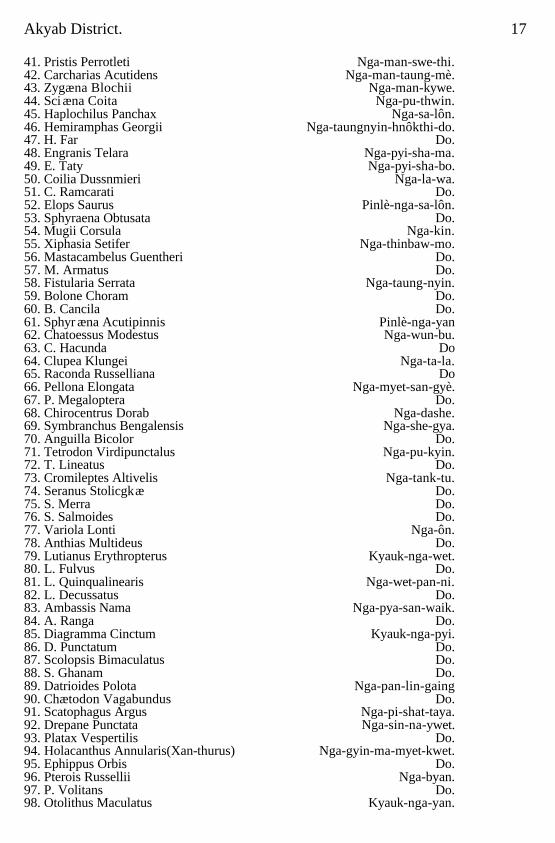
Akyab District. 17 41. Pristis Perrotleti Nga-man-swe-thi. 42. Carcharias Acutidens Nga-man-taung-mè. 43. Zygæna Blochii Nga-man-kywe. 44. Sci æna Coita Nga-pu-thwin. 45. Haplochilus Panchax Nga-sa-lôn. 46. Hemiramphas Georgii Nga-taungnyin-hnôkthi-do. 47. H. Far Do. 48. Engranis Telara Nga-pyi-sha-ma. 49. E. Taty Nga-pyi-sha-bo. 50. Coilia Dussnmieri Nga-la-wa. 51. C. Ramcarati Do. 52. Elops Saurus Pinlè-nga-sa-lôn. 53. Sphyraena Obtusata Do. 54. Mugii Corsula Nga-kin. 55. Xiphasia Setifer Nga-thinbaw-mo. 56. Mastacambelus Guentheri Do. 57. M. Armatus Do. 58. Fistularia Serrata Nga-taung-nyin. 59. Bolone Choram Do. 60. B. Cancila Do. 61. Sphyr æna Acutipinnis Pinlè-nga-yan 62. Chatoessus Modestus Nga-wun-bu. 63. C. Hacunda Do 64. Clupea Klungei Nga-ta-la. 65. Raconda Russelliana Do 66. Pellona Elongata Nga-myet-san-gyè. 67. P. Megaloptera Do. 68. Chirocentrus Dorab Nga-dashe. 69. Symbranchus Bengalensis Nga-she-gya. 70. Anguilla Bicolor Do. 71. Tetrodon Virdipunctalus Nga-pu-kyin. 72. T. Lineatus Do. 73. Cromileptes Altivelis Nga-tank-tu. 74. Seranus Stolicgkæ Do. 75. S. Merra Do. 76. S. Salmoides Do. 77. Variola Lonti Nga-ôn. 78. Anthias Multideus Do. 79. Lutianus Erythropterus Kyauk-nga-wet. 80. L. Fulvus Do. 81. L. Quinqualinearis Nga-wet-pan-ni. 82. L. Decussatus Do. 83. Ambassis Nama Nga-pya-san-waik. 84. A. Ranga Do. 85. Diagramma Cinctum Kyauk-nga-pyi. 86. D. Punctatum Do. 87. Scolopsis Bimaculatus Do. 88. S. Ghanam Do. 89. Datrioides Polota Nga-pan-lin-gaing 90. Chætodon Vagabundus Do. 91. Scatophagus Argus Nga-pi-shat-taya. 92. Drepane Punctata Nga-sin-na-ywet. 93. Platax Vespertilis Do. 94. Holacanthus Annularis(Xan-thurus) Nga-gyin-ma-myet-kwet. 95. Ephippus Orbis Do. 96. Pterois Russellii Nga-byan. 97. P. Volitans Do. 98. Otolithus Maculatus Kyauk-nga-yan.
18 Akyab District.
CHAPTER II.
History and Archaeology.
Early history; 788 A.D. to 1018 A.D.; 1018 to 1404 A.D.: 1404 A.D, to 1783 A.D.;
Portuguese Adventurers ,; 1784 A.D, to 1823 A.D.; 1824 A.D, to 1826 A.D.: First Burmese -War; 1827 A.D, to 1870 A.D. ; 1870 A.D. to 1916 A.D. Archæology; Akyab;
Urittaung Pagoda; Camuttawdhat and Uritdat; U Kindaw Zedi; Linyedaw Zedi; Mahâmuni; Mrunchaungwa Pagoda; Selâgîri Zedi; Myohaung; Myohaung Palace; Shitthaung Pagoda; Amdaw Pagoda; Ratanabôn Pagoda; Dukkhanthein and Lemyethna Pagodas; Dukkhan-thein Pagoda; Lemyethna Pagoda; Pitakataik; Burmese wall; Linbanhmaung Pagoda; Dipayôn Shrine; Mingalamaraung Pagoda; Anormâ Pagoda; Setkyamaraung Pagoda ; Ratana-maraung Pagoda; Shwedaung Pagoda; Wunticeti Shrine (Hindu); Santikan Mosque; Jinamaraung Pagoda; Môkdaw Pagoda; Letkyodat Pagoda; Kotanzi Pagoda; Shwegya-thein; Lokamû Pagoda; Parabo Pagoda; Mahâtî; Paungdat Pagoda; Mahâtî Pagoda; Kauknyo Image; Laungkyets; Nandawgôn Launggyet ; Legend of King Mindi; Mingalo-para; Zitkethein; Kadothein; Ukundaw Zedi; Ruins ot Sigunmyo; Ruins of Kyeikmyo; Minbya.
The greater portion of this chapter has been exiracted from the" British
Burma Gazetteer," 1879, Volume II, the History of the Royal Indian Marine, and the Report on the Antiquities of Arakan (anonymous).
Early history.
The early history of the Country is involved in mist ;the existing records,
compiled by the Arakanese, are filled with impossible stories invented in many cases, in others based on tradition but so embellished as almost to conceal their foundation and all made to show forth the glories of the race and of the Buddhist religion. Ramawadi, near the present Sandoway in the south of the Arakan Division, was, the chroniclers relate, the capital of a kingdom over which reigned Thamudi-dewa, who was tributary to the King of Baranathi (Benares). Many ages later Setgya-wadi, who in a future life was to become the Buddha Gotama, reigned in Baranathi, and to his fourth son, Kanmyin. he allotted "all the countries inhabited by the Burman, Shan and Malay races" from Manipur to the borders of China. Kanmyin came. to Ramawadi and, dispossessing the descendants of Thamudi-dewa, married a princess of that race named Thu-wun-na-ka-lya, while Maha-razin-nya, a male desceridant of Thamudi-dewa, was sent to
Akyab District. 19 govern the city of Wethail, in Arakan Proper.* King Kanmyin peopled his dominions with various tribes, and amongst the rest appear the progenitors of the Arakanese as being now brought to the country for the first time.
The names of these tribes are Thet,Chin, (a tribe living amongst the Yoma mountains), Myo (the Mroos, now nearly extinct, inhabiting the hills), Kyit (a small tribe near 2 Manipur), Shandu (a tribe in the northern hills), Mudu, Pru (a name by which a portion of the Burmese nation was formerly distinguished), Mekali (a Shan tribe), Zinmè, Lin, Tantinthaye (a tribe said to live on the borders of China), Asin (the Malays), Linke (a tribe in the hills north-west of Arakan Proper), Pyanlaung (a Shan tribe), Kathè (Manipuris), Kanran (said to be the present Rakaing race or a portion them called Kyaungthas), Thudun, Talaing, Katikamyun, Lawaik and Lagun† (said to be the ancestors of the (Siames). The dynasty thus established reigned for an indefinite period, which the chroniclers describe as lasting a term indicated by a unit followed by one hundred and forty cyphers: even up to a comparatively late period the palm leaf histories are filled with equally incredible statements. Continual wars and rebellions in which one side or the other was miraculously aided fill up the accounts and it is not till the end of the eighth century that any approach to accuracy seems to be made. 788 A.D., to 1018 A.D.
About 788 A.D. Mahataing Sandaya ascended the throne, founded a new city on the site of the old Ramawadi and died after a reign of twenty-two years. In his reign several ships were wrecked on Ramree Island and the crews, said to have been Mahomedans, were sent to Arakan Proper and settled in villages. The ninth king, who lived during the tenth century, made an expedition into Bengal and set up a pillar at Chittagong‡ which, according t o the Arakanese, is a corruption of tim Burmese "Sit-ta-gaung," and was so named from the king abandoning his conquest saying, somewhat late; that to make war was improper. Towards the end of the tenth century the Pru king of
* Sir Arthur Phayre calls the country known to Burmans as Rakaing-pyi,
which comprised the Akyab district and part of Kyaukpyu, "Arakan Proper." The existing Arakan Division, together with that portion of Bassein which lies west of the Arakan Yomas, was known as Rakaing-pyi-gyi, or "the great Arakan country," that is the Arakanese dominions.
† There is a tract of this name in Zinmè, east of the Salween. ‡ Citta or Cittra means, in Pali or Sanskrit, "variegated," and gong, which
is derived from the Pali gama and Sanskrit grama, signi-fies "a village." The word gong is now spelt gaung, according to the Hunterfan system of transliteration. Chittagong, therefore, means "a town of variegated hues."
20 Akyab District.
Prome invaded the kingdom, but was unable to bring his army across the Yoma mountains, and a few years later the capital was removed to Arakan (or Myohaung). In 976 A.D. a Shan prince conquered the country and took the capital, withdrawing with much spoil after eighteen years' occupation. Just about this time the king of Pagan invaded Arakan but was forced to retreat. In 994 a son of the king who had advanced into Bengal ascended the throne and removed the capital to Sanbowel on the Lemyo river, but was killed during a second invasion by the king of Pagan after reigning for twenty-four years: he was succeeded in 1018 A.D. by Kettathin, of the same family, who established his capital at Pinsa. 1318 A.D.to 1404 A.D.
The further history of the country, up to 1404 A.D. may be related in the
words of Sir Arthur Phayre. Ketta-thin reigned for ten years and was succeeded in 1028 by his brother Sandathin. Four of his descendants reigned in succession. In the reign of the fifth, named Minpyugyi, a noble usurped the throne; another noble deposed him, but in the year 423 (1051 A.D.) the son of Minpyugyi, named Minnanthu, ascended the throne and reigned five years. The third in descent from him, named Minbilu, was slain by a rebellious noble named Thinkaya, who usurped the throne in the year 440 (1078 A.D.). The heir apparent, Min-re-baya, escaped to the court of Kyansittia, king of Pagan (Pagan) The usurper reigned fourteen years; his son Minthan succeeded him in 454 (1092 A.D.) and reigned eight years; on his death his son Min Padi ascended the throne. Daring this period the rightful heir to the throne, Min-re-baya, was. residing unnoticed at Pagan (Pagan); he had married his own sister Su-pauk-ngyo, and there was born to them a son named Leiya-min-nan. The exiled king died without being able to procure assistance from the Pugan (Pagan) court for the recovery of this throne. At length the king of that country, Alaung-si-thu, the grandson of Kyan-sit-tha, sent an army of 100,000 Pyus and 100,000 Talaings to place Letya-minnan upon the throne. This army marched in the year464 (ll02 A.D.), and after one repulse the usurper Min Padi was slain and Letya-minnan restored to the throne of his ancestors in 465. A Burmese inscription on a stone discovered at Buddhagaya serves to confirm the account given in this history of the restoration of Letya-minnan, or, as he is called in the stone inscription, Pyn-ta-thin-min, i.e., Lord of a hundred thousand Pyus. It is evident, from the tenor both of the history and the inscription, that the Arakan prince was regarded as a dependant of the Pugan (Pagan) king, to whom he had
Akyab District 21 from his birth been a supplicant for aid: in return for the assistance granted him for the recovery of his grandfather's throne he was to aid in rebuilding the temple at Buddhagaya, in the name of the Pagan (Pagan) sovereign. The royal capital was established at Laungkyet, but that site proving unhealthy, the city of was built in the year 468 (1106 A.D.). Four kings followed in quick succession, after whom Gâtnlaya ascended the throne in 495 (1133 A.D.). He is described as a prince of great power, to whom the kings of Bengal, Pegu, Pugan (Pagan) and Siam did homage, but his chief claim to distinction lies in his having built the temple of Mahâti, a few miles south of the present town of Arakan, the idol in which was, in sanctity, inferior only to that of Mahâmuni. This temple and image were destroyed during the late war (the first Burmese war), the height on which they stood being occupied as a post by the Burmese forces. This king died after a reign of twenty years in 515 (1153 A.D.). He was succeeded by his son Dasa Râjâ, who upheld his father's name, and repaired Mahâmuni temple which, since its partial destruction by the Pyu array in Letya-minnan's time, had remained neglected; the idol which had been mutilated was also restored, the tribtttary kings being employed upon the work. This king died after a reign of twelve years in 527 (1165 A.D.). He was suceeded by his son Anan-thi-ri, a prince who grievously oppressed his people, and, neglecting the affairs of Government, passed his days in riot and debauchery. He lost the extensive empire possessed by his father and grandfather, neglected religious duties, and extorted large sums of money from the people, till the whole country, says the historian, cursing him in their hearts, a general rising recurred: he was deposed and killed, and his younger brother, Minpunsa, reigned in his stead. In the year 529 (1167 A.D.) this prince established his capital at Chit, on the river Lemyo. A Shan army attempting to invade the kingdom was defeated in the Yoma mountains, and a number were taken prisoners and settled in two villages in the tract of country in Arakan Proper now known as Taungbet. This king died after a prosperous reign of seven years.
In the reign of his grandson, Cams-yu-ban, a noble named Sa-lin-kabo
usurped the throne, but proving oppressive, was murdered in the first year of his usurpation. Midzu-thin, the younger brother of Gama-yu-ban, was now raised to the throne;he removed the capital to Pinsa, close to the present town of Arakan. The Arakanese coins extant, having the emblems of royalty engraved upon them, but without any date or inscription, are traditionally said to
Akyab District 22 have been struck during this reign. This prince was surnamed Tainggyit, or country beloved.' With characteristic extravagance he is said to have reigned over the present Burmese dominions and a great part of India as far as the river Naringana, and to the borders of Nipal. The succeeding ten kings pass like shadows, without anything worthy of notice except their short reigns. The five last of them reigned only for one year each, and by their oppression and neglect of religious duties the people were dissatisfied, while sickness and famine desolated the country. The nats or spirits of the seasons withheld their aid: the earth no longer yielded her fruits, and general misery prevailed. The last of these wicked kings was deposed, and his son, Letyagyi, ascended the throne in 572 (1210 A.D.), and by his mild government restored the prosperity of the country. In the year 599 (1237 A.D.) Alan-mapyu succeeded to the throne, and removed the capital to Laungkyet in 601 . This king made war upon the Pugan (Pagan) sovereign, and received tribute from the king of Bengal. He died after a reign of six years. His son, Raza-thugyi, succeeded. In this reign the Talaings invaded the southern portion of the kingdom, but were repulsed by the Arakanese general, Ananthugyi. Nothing worthy of notice occurs until the reign of Nan-kyagyi, who ascended the throne in the year 630 (1268 A.D.). This king oppressed the people with heavy taxes, and levied contributions of goods which he stored up in his palace. By various acts of tyranny he incurred the hatred of many influential men; and even the priests, whose religion forbids them to notice worldly affairs, are repre-sented as inimical to him. Eventually he was killed in the fourth year of his reign, and was succeeded by his son Minbilu, who married the daughter of the Si-tba-bin, or commander of the bodyguard, the conspirator against the former sovereign. This prince is described as being, if possible, more hateful than his father. Being jealous of the supposed high destinies of his infant son, Mindi, he ordered him to be cast into the river, but the child was miraculously preserved, rescued by some fishermen, and was sent to a remote part of the kingdom. These and other similar acts inflaming the mind of the people against the king, he was slain in a conspiracy headed by the Si-tha-bin after a reign of four years. Si-tha-bin, the king-maker, now usurped the throne, but was himself killed in the third year of his reign The son of Minbilu, named Mindi, was then raised to the throne, but he was only seven years of age. This king gave general satisfaction, and enjoyed a long and prosperous reign. In the year 656 (1294 A.D.)the Shans invaded the kingdom but were
Akyab District. 23 repulsed. The king of Thuratan, * or (Eastern) Bengal named Nga-pu-kin (Bahadur Khan ?), courted his alliance and sent presents of elephants and horses. After this his dominions again being attacked in various quarters by the Shans, the Burmese, the Talaings, and the Thet tribe in the north, the king went to the Mâhamuni temple, and, depositing his rosary before the idol, vowed to rid the country of its enemies. In pursuance of this vow, he marched in person in the year 674 (1312 A.D.) to repel the Talaings, who had possessed themselves of the country south of the town of Thandwè (Sandoway). His uncle, Uza-na-gyi, was sent with an army to attack Pugan (Pagan). Salingathu, his brother-in-law, advanced into Pegu, and the general, Raza-thin-gyan, was sent against the Thet tribe. The city of Pugan (Pagan) was taken, the Talaings were overawed and the expedition against the Thet, after being once repulsed, was eventually crowned with success. After this the general, Raza-thin-gyan, subdued the country along the sea coast as far as the Brahmaputra river. In the year 689 (1327 A.D.), the Pugan (Pagan) sovereign made an attack upon the island of Ranbyè (Ramree), and carried away a number of the inhabitants who were planted upon the ManipUr frontier. After this, the Thandwè (Sandoway) viceroy having gained possession of a relic of Gotama brought from Ceylon, by virtue of which he expected to obtain sovereignty, rose in rebellion, but was finally reduced to obedience. Soon after this, Mindi died, after a reign of 106 years, at the age of 113. Nothing worthy of notice occurred until 756 (1394 A.D.) when the reigning sovereign marched to attack the Pugan (Pagan) empire, the capital of which was established at Inwa, or Ava. During his absence the governor of Thandwè (Sandoway) revolted, and seizing the boats which had conveyed the king's army along the sea-coast, and were now left on the shore for his return, made the best of his way to Laungkyet, the capital, where he set up the king's infant son, Raza-thu. The king returned without delay, but his army deserting him he was slain and his son proclaimed. The Si-tha-bin, as the rebellious governor was called, not long after sent the young king to the southern extremity of the kingdom, and governed in his name: but, becoming unpopular, he was after two years, deposed and killed by a noble named Myin-saing-gyi, who in his turn became disliked and had to fly to the Burmese * Sonargaon, now called Painam, the capital of the eastern district of Bengal when it first revolted from the Delhi Empire, A D. 1279 Thuratan is a corrupted form of the word 'Sultan,' or king (of Bengal)
24 Akyab District dominions, when the lawful king Raza-thu was restored. He was succeeded by his younger brother, Thin-gathu. This prince, after a reign of three years, was murdered by the chief priest of the country in a monastery, with the connivance of his nephew, Min-saw-mun, who then succeeded to the throne in the year 766 (1404 A.D.). 1404 A.D. to 1783 A.D.
Worn out by his cruelties the people rose against him and called in the aid
of Ming-shwe, king of Ava, who despatched a force of 30,000 men trader his son. Min-saw-mun fled to Bengal and found refuge with the ruler of Thuratan, who being himself engaged in war, could render no assistance. At this period, the empire of Delhi was torn to pieces by an ambitious aristocracy and many of the subordinate governors had declared themselves independent. The Arakanese histories state that when Min-saw-mun was in Bengal the king of Delhi came to attack the chief or king of Thuratan who was greatly assisted by the fugitive;this most probably refers to the invasion of Bengal by Sultan Ibraham of Joanpur.
The king of Ava had no intention of resigning his grasp on Arakan, whilst the Arakanese had no intention of allowing him to remain in possession of the country; aided by the Talaings they made constant endearours to drive out the Burmese, and in 1426 A.D. they were com-pletely successful. In the meanwhile Min-saw-mun by his crafty devices had, as noticed above, greatly assisted the ruler of Thuratan and in gratitude an army was sent to restore him to his kingdom. After some reverses it was successful, and in 1430 A.D. Min-saw-mun reascended the throne of his fathers amidst the acclamations of his subjects, who, with the usual fickleness of Eastern nations, rejoiced that a descendant of their ancient line of kings, whom they themselves had expelled for his cruelty, was restored to them.
After his return Min-saw-mun determined on changing the site of his
capital and was, the native histories state, miraculously guided to Myauku, now called Old Arakan or Mrohaung; the real cause of the selection of the situation may more reasonably be found in the strength of the position and the facility with which its natural advantages for defence could be added to. When Min-saw-mun found his end approaching, as his sons were infants, he appointed his brother, Min Kati, heir to the throne, and closed his chequered career in the fourth year of his restoration, aged fifty-three years. From this time the Arakan kingdom, undisturbed by its eastern neighbours who were at continual war with each other, continued to flourish. In 1531 A.D. the twelfth king, Minba, worried
Akyab District. 25 by tile aggressiveness of the Burmese and fearing the Portuguese adventurers who had settled on the coast, surrounded his capital with a stone wall eighteen feet high with six gates, and a devout Buddhist erected therein a pagoda, the remains of which still exist called tile Shit-Thaung-Para, from the eighty thousand images cut out of soft stone) which he is supposed to have placed in and, around it : very many, but all more or less injured, are still in existence and vary in height from six feet to one inch. During the next few years the kings of Arakan extended their conquests westward and between I560 and 1570 made themselves masters of Chittagong. In 1571 Min Thalaung excavated lakes round old Arakan, building raised causeways across them, to protect his capital from surprise by the Burmese and by the hill tribes, who made incursions into the country plundering villages and carrying off their inhabitants as slaves. His son, Min-nala was governor of Chittagong. Portuguese adventurers
The turbulent conduct of the Portuguese adventurers who were independent of the Portuguese Viceroy at Goa, led Min-Raza-gyi, the son and successor of Min Thalaung, to drive them from his dominions and in 1609 he resumed the land which had been granted to them and attacked them in force. Many were killed but some succeeded in escaping and took possession of the islands in the mouth of the Ganges, living by piracy. Sebastian Gonsales was elected as their chief, and in a short time he collected a formidable force and established a regular Government on Sundeep Island. In the same year a brother of the king, having been guilty of some offence, escaped to Gonsels and persuaded him to attempt an attack on Arakan which failed. The following year the Arakanese, who were now aided by the Portuguese, took possession of the country in the neighbourhood of Luckimpoor, but were eventually driven off with great slaughter, the king effecting his escape with considerable difficulty. Gonsales immediately turned on him, seized his boats, and proceeding down the coast, took and plundered the towns and villages and even advanced on the capital, but was defeated and forced to retire. He then sent to the Portuguese Viceroy at Goa, Don Hierome de Azvedo suggesting an attack on Arakan and promising an annual tribute. An expedition was fitted out and the command given to Don Francis de Meneses, .who proceeded to the mouth of the Kaladan. Here he was unsuccessfully attacked by the king aided by the Dutch and held his own for a month, till November, when he was joined by Gonsales, who bitterly reproached him for not waiting for him. The two commanders proceeded up the river and Were signally
Akyab District. 26 defeated. Don Meneses was killed in the action which took place, and Gonsales, retiring to Sundeep, was abandoned by a large number of his followers.
In the following year the king of Arakan took possession of Sundeep, and for some years the Arakanese regularly invaded and plundered the lower parts of Bengal, carrying off numerous captives.
In the meanwhile the country was in great disorder. Min Raja-gyi was
succeeded by his son Min Kanaung, who, after a reign of thirteen years, was poisoned by his queen and her paramour, Maung Kui-tha, the governor of Laungkyet. Maung Kut-tha was imprisoned and Min-sa-gwe, the son of the murdered sovereign, proclaimed king, but only to be poisoned within seven days by his mother, who by her intrigues succeeded in effecting the release of Maung Kut-tha, whom she married, and who ascended the throne and reigned for seven years.
In 1661 Shah Shuja having been utterly defeated by his brother Aurungzeb
was driven to seek refuge in Arakan. On the frontier he was received by an envoy who assured him of welcome, and on nearing the capital he and his family. and followers were met by an escort who conducted them to quarters set apart for them. At first he was well treated, but in a short time the king, either instigated by Aurungzeb's lieutenant in Bengal or excited by reports of the beauty of Shah Shuja's daughter, demanded her in marriage. That a Musulmani, a descendant of kings, should be asked for by a Kafir, was intolerable and Shah Shujia sent back a haughty refusal. His destruction was then determined on, his party was attacked, he himself made captive and drowned and the ladies of his household carried prisoners to the palace. The princess, the cause of her father's death, stabbed herself sooner than submit to the embraces of the king; her brothers, one a lad of sixteen and the other an infant, were killed, two of her sisters poisoned themselves, and a third, forced to wed the Arakanese monarch died of grief: not one of Shah Shuja's family remained, and when the news was brought to his father, the dethroned Shah Jehan, he exclaimed: "Could not the cursed infidel have left one son alive to avenge the wrongs of his grandfather ?"
From the death of the usurper Kui-tha twelve kings reigned till circa 1701
A.D. For some years before this the kingdom had been in a very disturbed state, and Kyet-sing, near the mouth of the Lemro, and other places were seized by robber chiefs Whose gangs devastated the country. Thaungnyo, a man of low origin but of strong will, having more by good lack than by anything else, defeated one of these gangs and gained over the inhabitants of the capital
Akyab District 27 declared himself king and justified his authority by clearing the country of the dacoits who infested it. He repaired the Mahâmuni, Mahâti and the walls of the city, built himself a new palace, and ravaged the lower parts of Bengal with his armies, taking advantage of the disturbances which rose on the accession of Jehandar Shah.
He died in 1731 and was succeeded by ten kings, all of whom except Narapaya had short reigns. The country was gradually falling into anarchy. In 1775 A.D. one In-sun, a native of Ramree, dethroned the reigning sovereign Wimala Râjâ and proclaimed himself king, and having put down a rebellion which shortly broke out, was succeeded, in 1783 A.D., by his son-in-law Thamada Râjâ. the last independent sovereign of Arakan. 1784 A.D. to 1813 A.D
The following year, when Bodaw Para was king of Burma, the
discontented Arakanese who hated their Ramree ruler invited the Burmans to aid them in dethroning him. A large Burman force assembled at Prome under three royal princes and invaded Arakan by three different routes. After some severe fighting the Arakanese army was defeated near Kyaukpyu, and the Burmans advanced on the capital and took possession, meeting with hardly any resistance; the country was annexed and Thamada Râjâ was carried prisoner to Ava, where he shortly afterwards died.
This acquisition brought the Burmans into contact with the British and
disputes soon arose. Large numbers of the inhabitants escaped from the cruelties of the Burmans and settled in Chittagong and in other parts of Lower Bengal. Chinbyan who is usually styled King herring in the official accounts of this period-the son of the man who had invited the Burmans into Arakan, twice raised a revolt, and his standard was joined by most of the respectable Arakanese families; but the rising was finally suppressed and those who could do so escaped to Chittagong. Here Chinbyan continued his intrigues till he died in 1815, and the differences which arose in consequence between the-two Governments and the retaliatory irruptions of the Burmese, who attacked and carried off the East India Company's elephant hunters, together with the attitude assumed and the demands made by the Burmese court not only regarding this part of the country but also in connection with the northern frontier in Manipur, led eventually to an open rupture. 1824 A.D. to 1826 A.D First Burmese War
In 1824 war was declared and the Burmese dominions were invaded, a
force under General Morrison move on First Arakan and another under Sir Archibald Campbell operated by way of the valley of the Irrawaddy. General Morrison's ,
28 Akyab District. force consisted of the 1st, 2nd and 5th brigades of the British army, with Brigadier General McBean second in command and Brigadiers W. Richards, 26th Native Infantry; C. Grant, C.B. (54th Regiment), and Fair (10th Madras Native Infantry). The troops consisted of His Majesty's 44th and 54th Regiments the 26th, 42nd, 62nd, and 49th Bengal Native Infantry; the 10th and 16th Madras Native Infantry; Bengal Artillery, eight 9 pounders, four 12pounders, four 5 inch howitzers, Madras Artillery, four 9 pounders; also six companies of Pioneers; levy. of Mngh Pioneers; 1st and 2nd Light Infantry Battalions, and 2nd Regiment Local Horse. The total of effective fighting men numbered nine thousand three hundred and forty-three. The naval force, which was placed under the command of Commodore John Hayes, consisted of the following ships and gunboats :The '' Vestal," ten-gun brig; the surveying ships" Research" and "Investigator" fitted with ten guns; the six-gun brigs "Helen," "Henry Meriton" "Planet," "Sophia" and "Asseerghur" the "Trusty," ketch, six guns, and. steam gun-vessel" Pluto," six guns; ten pinnaces each carrying two guns, and eight divisions of gunboats each of ten-gun-boats, carrying a 12 pounder carronade besides transports and country boats. In addition to their crews, the vessels and boats carried a flotilla marine, about six hundred strong.
A portion of General Morrison's force proceeded in January 1825 to Cox's
Bazaar, where the flotilla under Commodore Hayes also rendezvoused. A detachment made the four marches from Cox's Bazaar to the grand estuary of the Naaf, and the heavy artillery and the greater portion of the infantry were conveyed thither by the flotilla. A delay arose in the arrival of the latter, due to a heavy gale of wind which it encountered, when some of the native boats and gunboats were stranded, and one officer and some men were drowned. The force continued in camp at Tet Naaf, opposite the extensive stockades, of Maungdaw, the first Arakan post, at which it was supposed the enemy would make a stand, until the 31st of January 1825, just a month from the period of quitting Chittagong. Before this date the troops on board the ships and vessels had arrived, also those which had followed by land. On the evening of the 1st February orders appeared for a force to hold themselves in readiness to cross the estuary of the Naaf. This force was divided into two divisions: the first, under General Morrison, was to proceed to the Maungdaw creek and storm the stockades, whilst the other, under Brigadier General McBean, was to land lower down and intercept the fugitives,
Akyab District 29 or act as circumstances might render necessary. On the British force effecting a landing on the opposite shore of the estuary of the Naaf, the Burmese, acting on the well known Hudibrastic maxim, beat a hasty retreat over the mountains, leaving the invaders to take undisputed possession of their stockades at Maungdaw. Here were found the great quantity of grain, several war-boats, one about ninety feet long, and a small ship pa the stocks. A considerable force was sent in pursuit of the flying Burmese through the forests, but without avail. After a halt of many days at Maungdaw, General Morrison pushed on through dense forest and grass plains, or by the sea-shore, to the Mayu river near its embouchere, where it is some three or four miles broad.
Commodore Hayes left Maungdaw on the 16th Feb-ruary having arranged with General Morrison that he was to take on the major part of the fleet, including half the gunboats, to the Arakan river, with General McBean and Brigadier Fair's brigade. The other half of the gunboats and Mugh boats were directed to proceed to the Arakan river for the purpose of joining General Morrison, who was proceeding to its entrance with the main body of the army.
On the morning of the 17th, the Commodore cleared the Naaf to join the
transport ships destined to convey the above mentioned advance brigade to Arakan, but, at one p.m., a violent storm commenced from the northward, which raged round the compass until the morning of the 19th and prevented the embarkation of the troops in question. Commodore Hayes, before quitting Maungdaw, had despatched on the 10th instant a small squadron of vessels under command of Lieutenant Armstrong, to explore the entrances to the Mayu and Arakan rivers in communication with General Morrison, and, feeling anxious for their safety, he proceeded in quest of them.
On the 21st he was joined to the eastward of the Mayu by Lieutenant
Armstrong, who reported as follows in a letter dated the 21st February 1825 :- " I proceeded with the vessels to the supposed latitude of Morque Point
(20° 14´) and finding the entrance of a river,which, from the correct information we possessed, led me to believe it to be the Arakan river, I entered, crossing Over a bar one and three-quarters two fathoms low water and after a slight survey, discovered a stockade that might give annoyance to the vessels in passing. I landed with Lieutenant Coote, a detachment of His Majesty's 54th Regiment, a party of the Bombay Marine Battalion and the European crew of the "Pluto." On perceiving us, the enemy fled; it was situated in a strong position, being on a
30 Akyab District point with a jungle in the rear. On the 16th the spies belonging to the Quartermaster General's department, being closely pursued by the Burmese, were obliged to retreat to the vessels. They informed us we were in the Mayu river, on which information I proceeded to the south-eastward in quest of the Arkan river, which we entered on the same night. On examining river the pilot I had obtained informed me of a new stockade commancling the channel, about eight miles from the entrance, to which we proceeded with the "Aseerghur," u Pluto," and gunboats. After firing a few shots we landed, and found it deserted. It was not quite finished, in a very strong position, and, had, the day before, been garrisoned by five hundred men and had employed the villagers around two hundred days to build it.
It is 100 yards square and full of barracks, the whole of which we burnt (named by the villagers Patinga). On the 20th the spies gave me information that the Governor of Arakan, with 100 war-boats and two thousands men, was comming down the river to attack us that night. I moved out into the centre of the river, and kept the people under arms all night. This morning hearing guns in the offing I proceeded out to join the fleet. Morque Point is situated in
latitude 20° 5´ 40´ north, being nine miles to the south of the situation given by
the "East India Directory," which is 20° 15´ north about east-south-east from the Mayu river".
Lieutenant Armstrong reported to the Commodore that. the people were
much alarmed, and insisted on being taken off, and as it was requisite to give them immediate support and protection for the general good of the service Commodore Hayes determined to proceed into the Arakan dyer without loss of time, and accordingly entered it the same evening. On the 22nd, the Commodore was joined by a Munshi, employed by Captain Drummond to procure intelligence of the enemy's proceeding, who informed him there was a stockade half way to Arakan, called Chamballa or Chaungpila, erected by the Burmans to defend approach to the capital: that it contained only one thousand Burmese fighting men and would easily fall if speedily attacked; that the principal Mugh chieftains were confined in the stockade as pledges for fidelity and good behaviour of the inhabitants and that, if liberated, all the country would make common cause with the British, thus greatly facilitating military operations. Believing the information to be correct, the Commodore determined, with the small means. at his command, to attempt the capture of the place, and despatched a messenger to General Morrison with an, intimation to that effect.
Akyab District. 31
Accordingly on the 23rd, he stood up the Proorn pura Khione, or branch leading from the Urittaung river to Arakan, with a squadron consisting of the "Research" with the gunboats "Vestal, "" Asseerghur,"" Helen." "Trusty," "Pluto," "Asia," "Osprey," "Thames," "Gunga Saugor" and "Africa." There was also embarked in the two transports, a detachment of the 54th Regiment and details of Native Infantry. At 2 p.m. they came in sight of the enemy's works at Chaungpila, which immediately opened a heavy fire upon the" Gunga Saugor" and "Vestal," the headmost vessels. The "Research," with the Commodore on Board, was soon within half-pistol shot, and commenced a heavy cannonade and fire of musketry upon the stockade and breastwork which was returned by the enemy with great regularity and spirit. On ranging to the northern end of the stockade, with intent to anchor and and flank it, as well as to allow the other vessels to come into action, the Commodore found his ship raked from the forward by another stronger battery and stockade, of which he had no previous information and the strepgth of the enemy was greater than had been anticipated, amounting, as was subsequently ascertained, to three thousand men, commanded by the son of the Rajah of Arakan, and other chiefs of rank. After a severe engagement of hours' duration, the tide beginning to fall Commodore Hayes was obliged to veer round and drop down the river. The "Research," "Asseerghur," "Asia Felixe" and" Isabella" took the ground and remained fast for several hours near the batteries; but the enemy made no attempt to fire at or molest them. In this action two officers and four men were killed and thirty-two wounded, of whom five died. The Commodore attributed his failure to the unexpected number and strength of the stockades, regarding which he had been deceived, his information inducing him to believe there was only one;also to the tide falling in the course of the engagement and the breadth of the river diminishing in consequence, the vessels were cramped for room to manœuvre, which resulted in some running aground.
After several routes for the march on Arakan had been discussed, it was at last determined that the army except the portion, including the 54th Regiment, on board the vessels in the Urittaung should proceed in the gunboats and other craft from the Mayu to the plains on the left bank of the Arakan river. Accordingly on the 4th of March the General and staff embarked, and leading the way in the "Osprey" pinnace, crossed the broad waters of the Mayu and entered the Arakan river near the Urittaung Pagoda, a
32 Akyab District. large Buddhist temple, which occupies the summit of an eminence, and is visible at some distance from the coast: on the arrival of the troops it was found that some of Commodore Hayes' seamen had taken possession of the temple by hoisting the Union Jack on its highest point. A portion of the force was disembarked on the island of Chankrein, opposite to which lay the Commodore's ship with the other cruisers and transports at anchor. On the 25th March the entire army consisting of eight regiments, with artillery, was assembled at Kray Kengdong, a few miles distant, excepting the 5th, or Madras, Berigade and the small column left at Chankrein.
The following were the final arrangements for the cooperation of the marine in the advance upon the Burmese provincial capital of Arakan, made by Commodore Hayes in conjunction with General Morrison :The "Helen," six guns, "Trusty," six guns, and half of the 5th division of gun-boats were stationed at the southern portion of the Chaung pits Reach, to support the troops left in posses of · Chankrein Island eventually to take possession of the Chaungpila stockades on the enemy's moving towards Arakan. The "Sophia," six-gun brig, with the other half of the 5th division of gunboats, was left to support the detail of troops left at Kray Kengdong, and to protect the transports; the 8th division boats and "Pluto", steam-vessel, six guns, were stationed under Captain Craw ford, in advance with Brigadier Grant. The 1st and 7th divisions of gunboats, under Commodore Hayes' personal command, with the" Research "and" Asseerghur" and the transports" Isabella,"" Brougham,"" Goliath,"" Jessy," and four commissariat sloops, with the guns, atnmunition and provisions, were to proceed up the river and form a junction with the army at Mahâti, near the capital. On entering the river the Commodore received a despatch from Mr. Higgins, commanding the detachment of the flotilla in the Chaungpila Reach, stating that the enemy had evacuated the stockades, and that he had, agreeably to his order, occupied them, and awaited further instructions. In consequence, Commodore Hayes directed the "Sophia" and gunboats at Kray Kengdong, immediately to join Mr. Higgins, and instructed the latter officer to proceed with the whole detachment up the Chaungpila Reach to Arakan, and cause a diversion in that quarter.
In the direct road between the British army and Arakan lay a low range of
wooded hills, through which ran a narrow defile, called the pass of Paduah; this debouched near au open plain intersected by two or more rivers, and fronting the strongly fortified post of Mahâti. Here at Paduah
Akyab District. 33 resistance was expected, and the General determined to force the pass and advance on the capital without further delay. The whole of the troops were consequently divided at Kray Kengdong, into four columns, and advanced on the morning of the 26th March. The first column, under Brigadier Grant, was instructed to force the right pass; the second under General Morrison to attack the centre;the third, commanded by Captain Leslie, His Majesty's 54th Regiment, was ordered to proceed in the gunboats and turn the enemy's position and intercept their rotten.; the fourth column, under Brigadier Walker, 54th Regiment, was instructed to act as a reserve. Some sharp fighting took place with the enemy at the foot of the hills, and the troops crossing the bed of the tidal river finally took post behind some works, in a large plain opposite Mahâti, designed by the Burmese as a great bulwark to defend the land route to the capital as the stockades of Chaungpila were to protect the water approach. Buddhist temples and other religious structures crowned the heights within the peninsula of Mahâti, the horseshoe edge or outer line of which was defended by trenches, embankments and abattis. On the morning of the 27th of March the whole force, in battle array, marched down to attack this position. After some sharp firing on both sides, the enemy were dislodged; and joined their comrades across the river. As the columns advanced the Burmans opened a fire of cannon musketry and jingals with little effect, which was returned by the British artillery, the flotilla under Captain Crawford participating with equal rein and effect- Thus firing, the main body of the troops steadily moved up to the brink of the river, which separated them from the Burmese lines. In a short time General Morrison ordered Brigadier Grant to ford the river with his Brigade, and attack the right and rear of the enemy's position, which was done with alacrity, and soon the Burmese were in full flight.
The only pass through the hills to the town was at the northern extremity of
the line of defence, .and this was protected by severa1 guns and four thousand muskets: the total garrison was nine thousand men. The ground in front was clear and open, and the only cover was a belt of jungle which ran along the base of the hills, whilst beyond this again the ground was fully exposed to the enemy's fire. On the morning of the 29th March the storming party, under Brigadier General McBean, advanced to attack the pass. It consisted of the light company of the 54th Regiment, four companies of the 2nd Regiment L.I., the light companies of the 10th and 16th M.N.I, and the rifle company of the
Akyab District. 34 Mugh Levy, and was supported by six companies of the 16th Regiment M.N.I. Under the well directed and steady fire of the Burmese and the avalanche of stones which they poured down upon the heads of the troops the British were repulsed, and at last, when Captain French of the 16th Regiment M.N.I. had been killed and all the remaining officers wounded, the storming party retreated. The plan of attack was then changed and it was determined to attempt to turn the right flank of the Burmese whilst their attention was occupied by an attack on their front. On the 30th March a battery was erected to play upon the works commanding the pass, and on the 31st it opened fire. At about eight in the evening a force under Brigadier Richards left the camp. It consisted of six companies of the 44th Regi ment, three of the 26th and three of the 49th Native Infantry, thirty seamen under Lieutenant Armstrong of the "Research" and thirty dismounted troopers of Gardener's Horse. The hill was nearly five hundred feet high and the ascent steep and winding. All remained quiet till shortly after eleven, when a shot from the hill showed that the enemy had discovered the approach of 'Brigadier Richards' party. This single shot was followed by a short fire, when the Burmans turned and the hill was in possession of the British. The next day a six-pounder was dragged up the hill and fire was opened on the heights commanding the pass, while at the same time Brigadier Richards moved against it from the position he had taken the night before and Brigadier McBean along his original line of advance; the Burmese, after a feeble defence, abandoned all the works and the town. The capture of Arakan ended the war as far as the Arakan province was concerned ;the Burmese troops at once abandoned Ramree and Sandoway and retreated across the moutains into Pegu; and the steady a vance of Sir Archibald Campbell the valley of the Irrawaddy, driving the Burmese forces before him, prevented any attempt on their part to disturb our possession. This advance ended at Yandabo, where a treaty was signed on the 24th February 1826 which Arakan and Tenasserim became British territory. 1827 A.D to 1870 A.D.
When shortly afterwards the main body of the British troops was withdrawn, one regiment was left in Arakan and a local battalion was raised, partly to keep order and partly to repel the incursions of the wild tribes occupying the hills. For several years the country was more or less in a disturbed state and within two years the establishment of a native dynasty was plotted for. The leaders were three men named Aung Gyaw Ri, a brother in law of Chinbyan, Aung Gyaw San, his nephew, both of whom had
Akyab District. 35 rendered assistance to the Britidh army and had received appointments uneder the British Government, and Shwe Pan, also a British official, who had escaped or been allowed to return from Ava whither his father had been carried captive. In 1827 attempts were made to tamper with the men of the local battalion; the flame was smothered for a time, Aung Gyaw Ri and Tun Kyaw San were dismissed for cruelty, and malpractices and the latter was sentenced to seven years' rigorous imprisonment for seriously wounding a police daroga. In 1836 the rebellion broke out but was suppressed before it had developed into anything further than a series of datcoities: the instigators believed that the British Government would retire and accept a yearly tribute in lieu of full occupation. 1870 A.D. to 1916 A.D.
The country remained quiet till the year 1870-71 when the Myohaung township of the Akyab district was disturbed by the appearance of a dacoit leader, Maung U Pyu, who styled himself a Minlaung. He and his followers were promptly arrested and punished. In the year 1888 an attempt to raise a rebellion was made by a grantee,. Shan Maung Baing, and Bo Nga Ta. Two pongyis (priests) went about the country tattooing men to render them gun-proof. These men were to join the rising when called on to do so. Bo Nga Te, who took the most. active part in stirring up strife, was a Burman from Sedôktaya, Upper Burma. He frequently crossed over to Upper Burma and on the last occasion brought with him a royal order, duly sealed, on palm leaf from the Hmetkaya Prince appointing him Bo of Arakan. The rising was to commence on the 16th or 17th April 1888 when over 120 Burmans we · to come over the hills and join the Bo at the Nagara grant. Bo Nga Ta, emboldened by the success he had attained, started enlisting follwoers openly. Information was conveyed to the Township Officer, Myohaung. who arrested Bo Nga Ta and his followers a few days before the combined movement was to take place, and kept them in confinement in the police station at Myohaung. A party of about twenty Shans from Nagara armed with swords, determined on recovering their leader,attacked the police station at midnight on the 8th April, released the prisoners and marched back to their village, taking with them some police guns. They burnt the police station and seventy-six houses at Myohaung and killed and wounded a few police constables and villagers. On the 14th April the Deputy Commissioner and his party met the dacoits at Palechaung; some resistance was offered, but the dacoits were either killed, wounded or arrested during the engagement and the rising was at an end.
36 Akyab District
In 1890 the Rathedaung Kaladan (Kyauktaw) and Myohaung townships of the district disturbed by the appearance of several gangs of dacoits. Kya Tun, Shwe Hla and Laba, who styled themselves Bos, committed many dacoities in the Rathedaung township but were killed, by the villagers. A gang of dacoits, headed by Bo Kyaw Wa, after having committed many dacoities in the Sandoway district moved into the Myohaung township. The enlisted men in many villages to join in a rising and moved about the Kaladan (Kyauktaw) and Myohaung townships for several months committing dacoities and burning villages. Bo Kyaw Wa was at length captured and peace was restored.
In September 1891 one Paw Aung, who proclaimed himself Arakan
Minlaung, and his father Chin Po attempted to raise a rebellion. They lived in the hills near the Mayu river for some time but were arrested in February 1892. According to common report many of the Arakaanese believed Paw Aung to be endowed with supernatural powers. Whilst he and his father were confined in the Akyab jail as under trial prisoners a conspiracy was hatched among the inmates of the jail. A body of 70 or 80 prisoners entered the main jail and took Paw Aung and Chin Po out of the dormitory in which they were confined. They broke open the locks of the gates, entered the shed where the jailor was inspecting, dragged him outside and killed him. Many of the prisoners took off their fetters, some armed themselves with tools from the smithy and others attempted to escape by the back gate. The outbreak was promptly suppressed and the rioters were criminally tried and convicted. Archaeology, Akyab
The town of Akyab is a modern place and owes its origin and growth chiefly to the removal in the year 1826 of the British garrison from Myohaung (Myauk-U), the climate of which proved pestilential to the troops, to a small fishing village at the mouth of the Kaladan river,. now developed into the capital of the Arakan Division. There are, however, some hazy traditions still lingering among the Arakanese Which connect four small pagodas situated on a low sandy ridge to the north-west of Akyab town with the famous Selâgîri tradition of Gotama ;they are called the Awkyeik or Akyattaw (from the latter is derived the name "Akyab"), the Thingyittawdat, the Letyathalôndaw, and the Letwètha-lôndaw pagoda, or the shrine of the back part of Gotama's jaw, that of the thigh of Buddha, that of the right shin-bone, and that of the left shin-bone of Gotama. The ridge on
Akyab District. 37 which they stand is known as the Akyatkundaw. The erection of the original pagodas, the traces of which are still seen, is said to date back to the 16th century; they fell into disrepair and lately new temples ,were erected on the old foundations. The Akyattaw pagoda is built on the circular fundament, measuring 113 feet in circumference, of the old stone temple of the same name; the superstructure erected in 1873 by Po Tha Zan of Akyab is all brickwork ; its height is ten feet. There are no niches, images, flowered or any other designs on them or the rest of these four pagodas, which have probably few equals in Burma in point of ugliness and total want of any feature of art, architecture, or archaeological interest.
There are a few modern temples in Akyab which are interesting, inasmuch as their architectural style is a mixture of the Burmese turreted pagoda and the Mahomedan four cornered minaret structure surmounted by a hemispherical cupola. The worship, too, is mixed; beth temples are visited by Mahomedans and Buddhists, and the Buddermokan has also its Hindu votaries. The Buddermokan is said to have been rounded in A.D. 1756 by the Mussulmans in memory of one Budder Auliab, whom they regard as an eminent saint. Colonel Nelson Davies, in 1876 Deputy Commissioner of Akyab, gives the following account in a record preserved in the office of the Commissioner of Arakan: "On the southern side of the island of Akyab, near the eastern shore of the bay, there is a group of masonry buildings, one of which, in its style of construction, resembles an Indian mosque; the other is a cave, constructed of stone on the bare rock, which superstructure once served as a hermit's cell. The spot where these buildings are situated is called Buddermokan; Budder being the name of a saint of Islam, and Mokan, a place of abode. It is said that 140 years ago or thereabouts two brothers named Manick and Chan, traders from Chittagong, while returning from Cape Negrais in a vessel with turmeric called at Akyab for water, and the vessel anchored off the Buddermokan rocks. On the following night, after Chan and Manick had procured water near these rocks,. Manick had a dream that the saint Budder Auliab desired him to construct a cave or a place of abode at the locality where they procured the water. Manick replied that he had no means wherewith he could comply with the request. Budder then said that all his (Manick's) turmeric would turn into gold, and that he should therefore endeavour to erect the building from the proceeds thereof. When morning came Manick, observing that all the turmeric had been transformed into gold, consulted his brother Chan on the subject of the dream and they conjointly
38 Akyab District. constructed a cave and also dug a well at the locality now known as Buddermokan.
"There are orders in Persian in the Deputy Commissioner's Court at Akyab
dated 1834 from William Dampier, Esq., Commissioner of Chittagong, and also from T. Dickenson, Esq., Commissioner of Arakan, to the effect that one Hussain Ally (then the thugyi of Budamaw Circle) was to have charge of the Buddermokan in token of his good services rendered to the British force in 1825, and to enjoy any sums that he might collect on account of alms and offerings.
"In 1849 Mr. R. C. Raikes, the officiating Magistrate at Akyab, ordered
that Hussain Ally was to have charge of the Buddermokan buildings, and granted permission to one Ma Min Aung, a female fakir, to erect a building; accordingly in 1849 the present masonry buildings were constructed by her; she also redug the tank.
"The expenditure for the whole work came to about Rs. 2,000. After
Hussain Ally's death his son Abdoolah had charge, and after the death of the latter his sister Me Moorrazamal, the wife of Abdool Marein, Pleader, took charge."
There are really two caves, one on the top of the rocks; it has an entrance
on the north and the south sides; the arch is vaulted and so is the inner chamber; the exterior of the cave is 9 feet 3 inches wide, 11 feet 6 inches long and 8 feet 6 inches high; the inner chamber measures 7 feet by 5 feet 8 inches; height 6 feet 5 inches; the material is partly stone, partly brick plastered over; the whole is absolutely devoid of decorative designs. The other cave is similarly constructed, only the floor is the bare rock, slightly slanting towards the south entrance; it is still smaller than the preceding cave. The principal mosque stands on a platform; a flight. of brick and stone stairs leads up to it; the east front of the temple measures 28 feet 6 inches, the south 26 feet 6 inches; the chamber is 16 feet 9 inches long and 13 feet wide; the ceiling is a cupola; on the west side is a niche; let 1 foot into the wall, with a pointed arch and a pillaster on each side; over it hangs a copy in Persian of the grant mentioned above. A small prayer hall, also quadrangular, with a low cupola, is pressed in between the rocks close by all the buildings are in good order. The curiously shaped rocks capped by these buildings form a very picturesque group. The principal mosque has become the prototype for many Buddhist temples; a pagoda in Akyab is the most perfect type of the blending of Indian mosque and the Burmese turreted spire.
Akyab District 39 Urittaung Pagoda
The Urittaung pagoda is situated on a low, but steep and rocky hill opposite
the village of -Pônnagyun in the Pônnagyun township. On this hill Gotama once lived in a former existence as a Brahman of high birth. "After my death," says Buddha in his discourse held on the Selâgîri, " my skull (i.e., the skull of the once Brahman) will be found on this hill and a pagoda will be erected over it." In the native records it is not stated who founded the original temple; the first mention of it is made in the year 883 B.E. (A.D. 1521), when King Gajapati, of the Myauk-U dynasty, descended the Kacchabhanadi (Kaladan) and repaired the pagoda; this was replaced by a larger temple erected by order of the King Minpalaung in the year B.E. 953 (A.D. 1591). The Râjavamsa gives the following account of the event :-" In this golden land of Arakan King Dhammâsoka of olden days built zedis wherein he enshrined some of the Sariradhâtu (body relics) of the Buddha encased in a precious receptacle. King Minpalaung ordered all such temples to be repaired. Before the king set out leading an army into the Mrun country he promised to repair the Urittaung pagoda on the Selâpabbata if he came back triumphant; he conquered the Mrun country and, on his return, to redeem his promise he had the summit of the Selâpabbata levelled and cleared of rubbish lying thereon. He then engaged numerous masons and architects whom he left under the supervision of his son, the Governor of Urittaung. A pagoda, whose girth at the base was 80 imperial lans (1 lan= 4 cubits), was built of deep green stone. After the compilation the king made preparation for a charitable offering like the great Asatissadâna; he embarked on the royal floating palace surrounded by a great number of boats and descended the river Kacchabha. In due course he reached the mount of the Lanpaikchaung, situated between the Urittaungdhat and up his temporary residence. he had large tanks dug to offerings; the Brahmans and sions."
The distance between the Camuttawdhat, where he took On both banks of
the stream provide water for charitable Rahans received liberal provide temporary royal residence and the platform of the Urittaung pagoda measured 90 ussabhas (12,600 cubits); the king connected the two points with a good road, so that the elephants, horses, chariots, and foot soldiers might pass over it with ease. In the intervening space, between the Camuttawdhat and the Urittaungdhat, a large hall was constructed; along the roads representations of the 101 races of men, of scenes in the 550 jatakas, of aquatic monsters were paraded. The streets were decorated with banners and streams, vases and water jars holding
40 Akyab District likes. On Sunday, the first day of the waning moon of Tagu Sakkaraj 953, or 2135 of the era of religion, was celebrated the festival in honour of the relic receptacle (i.e., the festival attending the ceremony of depositing the relic in relic chamber). At its conclusion the eight kinds of priestly utensils were offered to thousands of priests ;for seven days the festivals lasted and offerings to the value of nine lakhs were given away. Then Minpalaung, the great lord of life and death, returned to his capital. He died on Sunday, the 6th waxing of Wazo Sakkaraj 955 in his 59th year.
In the year B.E. 1010 (A,D. 164) the Urittaung pagoda was again repaired by King Thado (Urintara)and once more by King Varadhammarâja in B.E. 1050 (A.D. 1688).
In the year A.D. 1882 a new ti was put on the gilded spire; it cost Rs.
10,000. The money was raised by a general subscription. In 1884 the temple underwent through repairs and was gilded by Ma Myat U, wife of Zayattaga Maung Chin Daung, of Mawliet village, in the Akyab district, who spent more than Rs. 15,000. An inscription on a slab of alabaster set up close to the pagoda records this meritorious deed. Since then funds are constantly being collected to defray the expenses of regilding, keeping the shrine and approaches in order, and effecting minor improvements and additions.
The Urittaung pagoda is gradually becoming the most frequented and most
sacred shrine in Arakan. The religious affection of the people revived and now centres round this temple since the spoliation of the Mahâmuni shrine had produced religious indifference.
The hill upon which the pagoda stands is very precipitous and rocky on the
north-west and east sides I towards the south the elevation slopes gradually towards the plain; at the southern extremity stood the temporary residence of King Minpalaung. The whole ridge is levelled at the top, indicating the road constructed by the monarch. The pagoda is situated at the northernmost extremity of the hill. The ground plan of the structure is simply a circle: there are no niches, porches, or ornamental designs on the central pagoda itself; the base is circular with a girth of 387 feet, and rises perpendicular to the height of 8 feet; a succession of concentric rings follows, each succeeding .narrower than the one below it; the bell or ,garbha comes next and tapers off at a height of 190 feet; the lower parrot the spire is not gilded; the gilding begins at the garbha or bell.; the base consists of well hewn stones 10 inches broad by 6 inches high, the upper part of bricks, the whole pagoda has a coating of ingate (plaster); here and there the
Akyab District. 41
plaster has been inlaid with square pieces of mirror glass. On the north and east sides of the pagoda are two small brick. buildings plastered and whitewashed, their backtouching the base of the former; they are.8 feet high, 12 feet long and 9 feet deep; the .ceiling of the room is flat, so also the roof the edges only are relieved by amundulating line; two entrances, finishing in a pointed arch, lead from the front side to the quadrangular chamber which contains nothing but a small brick altar, whereon flowers and other offerings are deposited; they hold no images. These structures are imitations of the Small Hindu temples so common in Arakan ; they are modern and replace the beautiful turreted lazaungs which stand on the four cardinal points .of all larger temples in the Irrawaddy valley.
The platform is level, but not paved; contour very irregular and not marked by a wall. On the east side. is a modern, zinc roofed zayat (resthouse);in front of it stands, between two stone pillars, the alabaster slab, bearing the inscription referred to above ; the stone measures iabove the socket 3 feet 7 inches by 2 feet 4 inches broad and 5 inches thick; the head piece of the stone shows good carving, and the tops of the lateral pillars (also alabaster) are cut into lotus flowers.
In the north-east coner of the platform stands a Garuntring, i;e.,Garuda
bird, made of wood, mounted on a high pole; at the base of the latter are four wooden figures on wooden post; the figures are nearly life-size, finely carved and gilded, the fringes of their garments and head dress being inlaid with small piecess of variously coloured glass. On the north side a flight of stairs leads in a straight line from the foot of the hall to the platform; it was built by Minpalaung and is now in a very dilapidated condition; the staircase is 4 feet wide,with a brick wall 1 foot 6 inches high on either side; the steps are also constructed with bricks set on their ends in rows.
A stone image of Gotama, 4 feet high, sitting with legs crossed under the
body, stands in a small shrine on the south side of the platform. The absence of ornamentation, even of floral designs in stucco, so common
in all religious buildings east of the Arakan Yomas,characterizes the Mahâmuni, Urittaung, and nearly all other pagodas repaired within the last fifty years in Arakan. Decorative art, either executed on stone, in plaster, wood or metal, has become, nearly extinct on the west coast of Burma, though it had there attained to a high state of development in the 15th and 16th centuries.
42 Akyab District.
Camuttawdhat and Uritdhat. Of the Camuttawdhat and the original Uritdhat pagodas no traces are left,
unless it be a small dilapidated zedi on the north side of the hill; a few clay tablets of unknown date were found; one tablet, 8 inches broad, 6 inches high, had the surface divided into small regular fields of about an inch square with the image of Buddha, in the usual sitting posture, stamped in relief. Kinsdaw Zedi.
This small pagoda stands on a precipitous rock on the west side of
Rathedaung at the confluence of Mayu river and the Rathechaung. The following is an extract from the discourse of Gotama on the Selâgîri :- "To the west of Urittaung and at a distance. of about three leagues there is a
river called Mallâyu (now Mayu); on the east bank of this river is the Râjapabbata (now Rathedaung); on this hill I lived during one of my births as a Chaddanta elephant (i.e., an elephant with six tusks); when I die the frontal bone of this elephant will be found and enshrined in a tabernacle bearing the name U Kindaw zedi (Kumbha zedi)."
The native chronicles do not report the name of the original founder of the
pagoda: it was rebuilt by Minpalaung in the year 955 B.E. (A.D. 1591) at the same time when the Urittaung pagoda was being repaired by him. The spire is built of blocks of sandstone, is circular at the base, and rises to a height of about 80 feet in a succession of concentric rings narrowing in at the top; an iron ti surmounts the spire; it is constructed exactly in the same style as the Urittaung Zedi, only a small scale. the top of the hill is too narrow for a temple court : no ornamental designs of any kind; it is kept in tolerably good repair by the inhabitants of Rathedaung. A few small and modern pagodas crown the top of the hilt to the north-east.
Linyodaw Zedi.
This pagoda is on the hilt range which separates the Mayu valley from the
ocean, about 7 miles to the west of Buthidaung, close to the load leading to Maungdaw. The classical name of the hill range is Kasinapabbata, and here Gotama passed, according to the Selâgîri tradition, one of his existences as the King of peacocks. "On my death my neckbone will be discovered and enshrined there in a pagoda to be called the Linyodaw Zedi Tradition and native records afford no other information; it is not now known who built it. The pagoda has completely fallen to ruins; it must have been a small circular stone pyramid to judge from the traces left. The same fate was shared by the pagodas on the Mallâpabbata. the Veluvanâpabbata. Gandhagîri, and Sandalamaya, which are mentioned in the Selâgîri tradition.
Akyab District 43
Mahâmuni. The Mahâmuni shrine is situated within 8 miles of the Kaladan river and 48
miles north of Mrohaung, the once famous capital of the Arakanese Kings. The dim outlines of the history of Arakan appears with Candrasûriya or
Mahâcandrasûri. The monarch erected a new city and a palace on the site of old Dhaññavatî, and to this ruler history and tradition unanimously ascribe the foundation of the original Mahâmuni shrine intended to receive the brazen image of Gotama. The records of Farther India make Candrasûriya a contemporary of Mahâmuni, the great sage. Buddhism as it now prevails in Burma is decidedly, an offshoot of the southern Buddhist school. In the 11th and 12th centuries the priests of Pagan united their church with the mother church of Ceylon. In the 10th Century, Buddhism, established in Burma by Sons and Uttara, who were sent by Asoka, must have become nearly extinct. Manuha, King of the Talaings, Was brought captive to Pagan by Anawrata (10th century); he was, however, allowed to build a residence for himself and in this palace nearly all is Indian art and Trimurtni reigned supreme, as is evident from the stone sculptures still preserved in the edifice. (See report on Pagan.)
The religious zeal of Anawrata and Narapatijeyasura, again secured
supremacy to Buddhism. But there are old Buddhist traditions among the Talaings and Arakanese, traditions which could not have originated with the southern Buddhist school, but are the remnants of the old Northern Buddhism, which reached Arakan from the Ganges when India was mainly Buddhistic; they form a substratum cropping up here and there apparently without any connection; its centre is the Mahâmuni pagoda, the most important remains of ancient Buddhism in Burma, antedating in this province both Buddhism and Brahmanism of the southern Buddhist school, The legends assert that during the reign of Candrasûriya, King of Dhaññatî (Northern Arakan), Gotama Buddha came with many of his followers to this country.
There are two traditions regarding the visit of Gotama to Dhaññavatî, the
old Northern Buddhistic tradition and the legend of the modern Burmese historian. The south Buddhist chroniclers although recording Gotama's visit to Ceylon make no mention of his coming to Râmaññadesa (Burma). All these traditions are equally trustworthy or the contrary. But it is immaterial to our enquiry whether or not Gotama sojourned in Dhaññavtî or whether he was personally present at the casting of his image on the Sirigutta hilt on which Candrasûriya erected the Mahâmuni shrine in commemoration of both events; it suffices to know
44 Akyab District that the strange tradition, unrecorded in the Tipitaka, is not an after thought, conceived in modern times, of which we have so many instances in the history of Burma.
The tradition is intimately connected with the religious history of Arakan
and Burma in general; it is as old as Buddhism itself in that province. Nearly all pagodas within the confines of Dhaññavatî and on the banks of the Irrawaddy owe their origin to it. For this legend see "Antiquities of Arakan." After tile original building was completed, the native histories pass over many centuries in silence. They resume the history of the shrine in the 8th century of our era thus: In the year 152 B.E. (A.D. 789) the new city of Vesâlî was founded by the King Mahataingcandra on the site where the old town had stood. During the reign of this king the Mahâmuni shrine was twice rebuilt. He also erected a new Stone altar for the image; while consecrating the shirne he was miraculously presented with the celestial Areindama spear (i.e., the spear of victory the fortunate possessor of which could not be defeated in arms). In Sakkaraj 172 (A.D.810) King Suriyataingcandra rebuilt the image house, which had been destroyed by fire one year before his father's death; he placed the image in a new altar made of marble finely carved-the spires of the shrine were coated with brass plates. Priests from Burma and Ceylon came to worship at the temple.
During the reign of Sanhataing-Candra (B.E. 299-313, A.D 935-951), the
King of Pagan sent two ministers called Lasaka and Magalôn to the Mahâmuni pagoda with instructions to replace the stone figures of nats with images of Buddha-but the King of Vesâlî opposed this change and only two of the nat figures were allowed to be chiselled into images of Buddha :--these two figures stand on the east of the second platform: they show traces of the old original nat figures chiselled clumsily into Buddhas.
For the next 8½ centuries the Mahâmuni pagoda passed through many
vicissitudes, being destroyed and rebuilt no less than seven times and repairs and additions were effected by various kings both of Arakan and Burma, among whom the names of Anawrata and Alaungsithu are notable.
The Kings of Pagan, Prome and Pegu invaded Arakan froth various times
often, with no other intention than to obtain possession of the sacred image of Gotama preserved in the Mahâmuni shrine. The first attempt recorded in native histories is that of King Supanna, who reigned in Prome in the latter half of the first century of the Christian era.
Akyab District. 45 In the year A. D. 1784 the Burmese King Bodawpaya Conquered Arakan
the great national image of Arakan called Mahâmuni was sent across the mountains by the Taungup pass, was received by the king with great honour and was set up in a building specially erected for it to the north of the city of Amarapura. Until the removal of the Candasa image the Mahâmuni pagoda was the most sacred shrine in Indo-China: the entire religious history of Buddhistic Arakan centres round this younger brother of Gotama; the loss of this relic sank deeper into the hearts of the people than the loss of their liberty and the extinction of their royal house. It will one day be brought back again, the Arakanese fondly hope. The abolishment of this strong-hold of Buddhism has been followed by a general decline of this religion through Arakan. The natives totally neglected this shrine: wild jungle overgrow the precincts; in due time the place became haunted and shunned.
In the year 1867 a Shan from Lankavatî in Kamboja arrived with his
relatives at the abandoned shrine to pay homage. He cleared the jungle, erected a square image house, in which he placed some stone images found in the neighbourhood, and paved the topmost terrace. He also effected the restoration of the bell. We now proceed to a description of the temple. Tradition says that the Mahâmuni pagoda was built in the north-east Corner of the ancient city of Dhaññavatî. The Walls of the town are still partly traceable; one runs due west from the shrine forming the southern bank of the creek known as the Mahâmuni mraung (myaung). The wall extends to the west wall of the Tharekyaung; there stands still an ancient pagoda called now the Mrunkyaungwa shrine, from a newly founded Mro village of the same name: the length of the embankment, consisting partly of earth, partly of roughly hewn blocks of sandstone, is three miles: the east wall can be traced for two miles from the north-east corner. It is overgrown with jungle and represents a succession of irregular elevations having an average height of 12 feet with a breadth of 10 to 12 feet at the top and 16 to 18 feet at the base: no other remains of Dhaññavatî could be found except a few old tanks and here and there a broken stone image of a Buddha.
The pagoda stands transversely across the inner angle of the north-east
corner of the old city walls; it is erected on a Small eminence, the Sirigurtta hill, which has been levelled on the top and the sites cut into terraces, walled in with square cut blocks of granular sandstone. The whole Structure represents three enclosures, one within the other; the second raised 30 feet above the first, and the third platform 30 feet above the second. The first entermost platform
46 Akyab District
measures from east to southwest 685 feet, from north to south-east 472 feet. On each side is an entrance leading to the topmost platform in a straight ascent 10 feet wide. wailed in on both stoles. The stone wall protruding on both sides of the entrance is 10 feet high and 7 feet 6 inches thick, having a niche on each side which probably contained images of Buddha. Within the first enclosure there are (1 ) a library built by King Minkari A.D. 1439,(2) two solid brick pagodas one round and the other square built by Burmans at the close of the last century of very ordinary type, (3) a large tank dug by Candasûriya, in this reservoir the head of the Candasara image was washed, (4) smaller tank walled in with stones, (5) the ruins of an old stone pagoda, (6) an Upasampadâ hall where priests received ordination. The two roads leading to Vesalî and Myohaung were constructed by Minzawmin A.D. 1430. On the north stole of the West entrance lies a huge stone block bearing an inscription almost entirely defaced the few words that can be read are in the Burmese (Arakanese) language and letters and appear to belong to the 15th century, All other parts of the first platform are overgrown with dense jungle. A dilapidated stone staircase leads on each cardinal point to the second platform which measures 211 feet. The north-east corner is in tolerable good preservation: it contains a tree altar consisting of a layer of square stone block, 17 feet long by 18 feet broad and 4 feet high, arranged round the trunk of a high banyan tree; towards the east is attached a stone postab with a porch 4 feet 4 inches wide and 5 feet high, a new modern wooden images of Buddhas have been placed in it. Tradition reports that Gotama rested under the tree while his image was beingcast. In the south-west corner is a stone slab bearing a modern inscription set up by the Shan Saya Maung Shwe Hmôn of Lankavatî Kamboja in the year 1228 B.E. The text is in Burmese. For translation see "Antiquities of Arakan." A walled in flight of steps leads to the third platform. This newly paved with stones and bricks, also the work of the devoted Maung Shwe Hmôn it measures 127 feet by 98 feet; nearly in the centre stands the image house built 18 years ago; it is27 feet broad and 39 feet 1 inch long inclusive of the portale to the east which protrudes feet 3 inches; on the east side a passage 6 feet 3 inches vide and 13 feet 10 inches long leads to a rectangular chamber 13 feet 3 inches wide, 15 feet 2 inches deep and 14 feet high; three stone images of Buddha are seated on a stone altar constructed of materials taken from the dilapidated walls of the lower terraces: the central image is 8 feet high, the two others 5 feet: they sit with the legs crossed under them, the left hand resting on the lap with the palm turned
Akyab District. 47
up; the right hangs over the right knee, the back of the hand turned up: they wear short crisp hair, very curly, like all images made in imitation of the original brass image. The image house itself is a clumsy brick and plaster structure 18 feet high with a flat roof; on this are built five small pagodas, the largest in the centre and a smaller one on each corner: they are badly gilded and each wears an iron umbrella covered with gold leaf. The passage to the inner chamber is a pointed arch: two stone altars on which offerings are placed stand in front of the entrance. In the north-east corner is the mysterious Yatara bell, an object of ominous fear to all Arakanese. No one ever touches it. After the first Anglo Burmese war the bell was removed to Akyab where it was placed under the court house. The Shan Says Maung Shwe Hmôn effected its removal to the Mahâmuni shrine: it hangs suspended from a beam, one end of which rests in the axle of the tree, the other on the outer wall of the platform. The bell bears the date Sakkaraj 1905. The Yatara bell inscription is referred to in Arakanese history long before the casting of the bell that now bears the name Yatara; there must have been an older one, now destroyed or removed. The text itself consists, with the exception of a few lines made up of mystic symbols and words in Burmese, Pali and San serif (all written in Burmese letters), of 8 large and 38 smaller astrological tables; the former are each divided into 64 (8 by 8) or 81 (9 by 9) fields, the latter into 9 (3 by 3) or 16 (4 by 4) fields: each field contains a letter or a numeral, being signs for constellations and the calculations connected with it. As the key of these mystical figures has been lost the deciphering and interpretation of the inscription offered considerable difficulties. The translation or interpretation given in "Antiquities of Arakan" may according to the Sarvasthanapararana, an ancient Arakanese manuscript, be considered fairly correct. It begins as follows (but is too long to be fully given here).
To prevent the inroads of the enemies from foreign towns and villages, let
offerings of flowers, parched corn and lamps be made day and night at the Thitthangnu Mwedawngazat and the Myotiparathit pagodas.
To cause the ruler of the towns and the villages in the four cardinal
directions to be panic stricken, let a pagoda provided with four archways (facing the four cardinal points) be constructed over the Gôndawdat (uHkawmf"mwf) at Gôntalan: and let the Yatara bell be hung and Struck at the eastern archway, and the enemies from the east will be panic stricken and quit by flight. Let the bell be hung at the southern archway anti the enemies
48 Akyab District.
from the South will be panic-stricken and run away. Let it be hung and struck at the western archway and the enemies from the west will be panic stricken and fly away: let it be hung; and struck at the northern archway and the enemies from the north wilt be panic stricken and depart. Further mores let lamps and parched corn be offered to the holy relic on the hill night and day: let also the Yatara bidauk drum be struck at the relic chambers of Buddha. By these means foreign invaders will be seized by fear and take to flight.
The inscription continues giving detailed instructions as to how to compass
the destruction of Udarat, Pathan, Maunggot (Mogul Empire), Kulas (Western foreigners), PalaungS (the English are called in Arakan Palaungs, a corruption of Feringi ) ,Yodaya (Siam), Muttama (Martaban), Pegu, the Muns (Talaings), Thanlyin (Syriam), Pre(Prome), Taungngu (Toungoo), Pugan (Pagan), Ava Aukthas (Burmans of the delta and south of Sandoway), Shans, Saks (an Arakanese tribe).
The kings of Arakan firmly believing in the promises of the bell, erected
pagodas and dug tanks on the spots pointed out by the inscription. No other objects of interest could be found at the Mahamuni shrine, except
the stone figures placed, according to tradition by Candrasûriya, towards the eight cardinal points of the original shrine; nothing remains the age of the various buildings and inscriptions has been given in the preceding pages. It is only the massive stone walls which form the first, second and third terraces enclosing the shrine. the large tank in the south-east corner of the first enclosure and the stone figures mentioned above which are left of Candrasûriya's temple. There are in Lower Burma no other remains which are so well preserved from so remote a date.
Chaungwa Pagoda
The Mrunchaungwa pagoda is a small shrine three miles west of Mahâuni
on the top of a hill which appears to have formed or stood within the north-west corner of ancient Dhafiññavatî. The north wall can be traced to this pagoda: it is a circular small temple built of square blocks of sandstone l foot 2 inches thick: there are really two walls constructed of stones with an interspace of 8 inches. The latter is filled with rounded bricks; the thickness of the wall is 3 feet. The roof has fallen in and the images in the circular central chamber are half buried under debris: the largest image is of stone and 6 feet high. It represents a Buddha sitting cross legged in the usual attitude: to the east a passage with a semicircular arch 5 feet high, 3 feet wide and 8 feet long leads to the chamber the latter measures 9 feet across. No designs whatever on the pagoda. The shrine is old, but
Akyab District. 49
decorative, nothing is known Of its history except that it was repaired by order of King Sîrisûriyacandra in the year 535 B.E. Tradition ascribes the foundation of this pagoda to the pious Buddhist kings of old Dhaññavatî.
Selâgîri Zedi
Opposite the town of Kyauktaw on the east bank of the Kaladan rises a low
but rocky range of hills known as the Selâgirî (the Pali for the Sanscrit Sailagiri, rock hill). Here on the summit of the hill Gotama gave, according to tradition, his discourse on previous existences during which he dwelled in Dhaññavatî and Dvârâvatî. After Buddha had departed from the capital of Candrasûriya, the king erected a small pagoda on the Selâgîri. History reports nothing further of the temple till the reign of Sîridhamma Râjâ; this king repaired the Zedi in the year 986 B.E. (A.D. 1624);it fell into a state of disrepair again. A recent attempt to repair the pagoda was declared to have been ill mened on account of the death of the man who headed the movement and was abandoned, so all that remains of the pagoda is the circular base of the projected new temple raised to the height of 15 feet. A few broken images lie about. On a block of sandstone which probably once formed part of the throne of the image an inscription 1 foot long was found; the characters are Nagari and the inscription is the oldest of its kind as yet found in Burma.
To the south of Kyauktaw are a rambet of small pagodas built of stone,
usually with a central chamber and a Vaulted passage opening towards the east. Numerous tanks and traces of old walls and roads show the place to have once been the site of a considerable town. From Kyauktaw to Urittaung no archæological remains of any importance are to be found. Myohaung
The most important archæological remains in Arakan are found in
Mrohaung, the capital of the once powerful Myauk-U King. The Mahâmuni and other temples of the Selâgîri tradition are remembered
and visited for worship by Arakanese and Burmans, but for the splendid temples of Mrohaung the natives have more superstitious awe than religious reverence. They seldom worship at these shrines and they have allowed them to fall into disrepair.
The architectural style of the Shitthaung and Dukkhan-thein pagodas is
probably unique in India. They were built by Hindu architects and Hindu sculptors, and the mixture of sculptural representation from, the Buddhist cultus and the Hindu Pantheon is very noticeable.
The ruins of the old city of Mrohaung as we now see them date from the
15th and 16th centuries. The palace is
50 Akyab District.
situated on the top of the Taungnyo hill and consists of three enclosures, one within the other, each successive one higher than the preceding ; the topmost being about 50 feet above the level of the first or lowest platform. The ground plan is similar to that of the Mahâtmuni pagoda.
The measurements are as follows : Terrace from north to south-west line
1,606 feet, east line 1,203 feet, from west to cast 1,740 feet. The walls are constructed Of sandstone well hewn and cemented with
mortar which possesses great adhesiveness. The walls are 7 feet thick at the base, 4 feet at the top; in a few places the height of the stone walls has been increased by 2 to 3 feet of bricks an addition made by the Burmans after they had conquered Arakan. The first wall has, in many places, disappeared, the stones having been used to construct the stone quay of Akyab harbour. The village of Nyaungbinze flanks the north side. The north gave is called Mathataga on account of the royal funeral processions. leaving the palace through this gate to the cemetery. The space between the first and second enclosures on the west side was once filled by a clear sheet of water, on which in former times the queen and princesses would of an evening disport themselves gaily on the water in their gilded royal boats,
The gates are all completely demolished with the exception of one at the
South-east corner; first enclosure; the entrance is 10 feet wide; on the other side the wall protrudes 8 feet with a thickness of 71/2 feet and a height of 12 feet on the inner side of the wall a thick stone slab is firmly inserted in the wall a bout 1 foot above ground and a second similar one above it at a height of 8 feet in the centre of each stone is a hole of 5 inches diameter no doubt intended to receive the two ends of a beam to which a swinging door was attached. Close to the south side of the gate is a stone slab 4 feet 6 inehes high, 2 feet 10 inches broad and 6 inches thick on one side a square 'is marked out, Subdivided into 9 by 9=81 smaller fields, each containing incised one or two numerals. Nothing is written on the reverse, and the stone is damaged in the left upper corner. In the north-east corner of the second enclosure is large tank; well laid out with bricks and stones surrounded by a wall with entrances on each cardinal side and Stairs leading to the water edge it is an old tank but was repaired during the Burmese occupation of Arakan. On the south side lies a well polished stone slab 4 feet 7 inches high from the socket 2 feet 7 inches broad,6 inches thick. The inscription is, in Burmese, very neatly engraved. For translation see." Antiquities of Arakan," page 17. The wall which circumyallates the third and highest terrace rises on the
Akyab District 51 north and east side to a height of 30 feet above the second terrace and 20 to 30 feet over the level of the third platform. Nothing of interest can be found except three stone slabs, all bearing in bold relief the life size effigy of King Pazamin (B.E. 1014-1045), also called Candasudhamma at foot of the monument is engraved his name in Burmese characters.
Myohaung Palace
Of the old palace itself only traces of the walls remain. Passing through the
north gate (Mathataga) of the fortress and the village of Nyaungbinze a steep rocky hill is reached about 500 feet from the north-west corner of the palace; on its rocky but levelled summit is the small Udrit (Udrit) pagoda and a tank sunk into the rocks. The stupa is square at the base and circular above the bell (Garbha). It was built in the middle of last century by King Nara-apaya "to destroy the enemies to the north," a remedy suggested as already mentioned in the Mandras of the mysterious Yatara bell of Mahâmuni. Shitthaung Pagoda
About half a mile north of the palace is the "Shitthaung Pagoda," i.e, the
shrine of 80,000 images, the entire structure of which is alien to the native architectural style.
The Shitthaung Pura is more a fortress than a pagoda and its obvious
purpose was to serve the royal family as a place of refuge. The main temple is built on a promontory half way up lo the west side of the hill.
In old Arakanese forts and fortified pagodas such as the Mahâmuni) it is
always the north and east side which are rendered the strongest; the Mros, Thets, Shans, Burmans and Talaings usually attacked from these quarters But when Minbin erected the Shitthaung Para the cannons of the Dutch and Portuguese had already been heard and felt in the Myauk-U capital, being in the words of the Viceroy of Goa "both rich and weak and therefore desirable." The inner passages in the pagoda lead through well cemonted stone walls of 6 to 15 feet thickness and open towards the hills; the vaulted stone roof and all parts of the pagoda facing the west are in addition covered with layers of bricks 6 to 10 feet high; the outer watt forms a rampart overlocking and commanding the valley; the temple premises can hold a large garrison.
On the southern most end a flight of stairs lined with strong sandstone,
walls leads to the first platform 16 feet above the valley; a wall 480 feet long runs to the north and meets the south side of the central structure; to the left hand of the entrance a square stone pillar rises to the height of 11 feet from the socket; each side is 2 feet 4 inches broad; three sides are covered with inscriptions in Nagari characters; that facing the east is almost entirely defaced and the text cannot be recovered. The inscription on the
Akyab District 52 north side is also much damaged, the lines are very irregular and the letters badly engraved. That on the west side is best preserved; the south side of the pillar has not been inscribed; the stone exhibits no ornamental designs. Opposite the inscription is an octagonal stone pillar 8 feet 10 inches high above ground. The circumference of the base measures 72 inches (9 inches to each side; the decorative designs near the top are in relief). The pillar contains no inscriptions; the shaft and base are roughly hewn.
Close to the inscribed pillar lies a stone slab 12 feet long, 4 feet 2 inches
broad and 10 to 12 inches thick; at the lower end is depicted, in relief, a conch with the convolution to the right; a lotus flower grows out of the aperture; the tip of the petals touch the outer rim of the "Dhammacakka, the wheel of the law," The design (wrought as already stated by Hindus) appears to be emblematic of Brahmanism (the conch) which produced Buddhism (the lotus fiower), the Dhammacakka.
At the upper end of the latter a square hole is sunk into the stone 5 inches
deep, 2 feet 4 inches long and 2 feet 8 inches broad; next follows circular cuplike hole 4 feet deep and 6 inches across: the reverse of the stone shows only a rough hewn surface. As the sides of the inscribed pillar measure also 2 feet 4 inches the stone slab which must have been from 18 to 20 feet long, but is broken off above the cuplike hollow, apparently served originally as a lintel or architrave; the square pole capped the inscribed pillar forming the left-hand post of the entrance gate. The circular hole received the revolving axis of the swinging door; that portion of the lintel which exhibits the Dhammacakka protruded over the north side of the inscribed pillar to counterbalance the weight of the opposite part of the slab (now broken off) which formed the actual lintel over the entrance; the octagonal pillar constituted the right hand post of the entrance. The construction of the gate forcibly recall to mind the famous phrase "Dham-macakkain pavatteti "(the turning of the wheel of the law).
The first platform appears to have contained a number of small shrines all
built of stone; but they are nearly all in ruins covered with the dêbris Of the walls and pagodas fallen down from the upper temple court and overgrown with dense jungle; one image shrine only has escaped total destruction; it is circular at the base, with the passage towards the west leading to a central chamber, also circular and dome shaped. The chamber contains a few broken stone images; the shrine has a diameter of 32 feet and a height of 48 feet. Close by are the ruins of another small pagoda; it is octagonal; the sides are concave and the entrance faces
Akyab District 53
the east;the inner chamber is filled with the dgêbris of the fallen in roof. Before entering the principal platform of the pagoda the way leads through
a vaulted gateway 7 feet wide and 10 feet high to a terrace 60 feet long and from 20 to 30 feet wide; it is 30 feet above the level of the first court; the walls to the west and south are 9 feet thick, built of stone, and must have been originally 12 feet high; the terrace contains nothing of interest; the east side of the whole edifice is protected by the steep, almost inaccessible hill.
The central temple court measures from south to north 140 feet from east to
west 225 feet; the circumambient wall rises 40 feet about the lower enclosures to the south and north, 60 feet to the west about the level of the valley, and on the side facing the shrine 4 to 6 feet above the terrace. On the north and south walls stand at irregular intervals circular, turret like pagodas, 7 feet high with a circumference of 20 feet; they are built of bricks; between each turret (there are 13 on each Side) a stone slab, measuring ,in height 3 feet 8 inches, in breadth 2 feet 10 inches, in thickness I foot 10 inches, is let upright into the wall; both sides of the stone contain sculptures in bold relief, the side facing the inner temple usually represents a Buddha in various attitudes, the outer side an ogre, naga, or cannibal with hideously distorted features, one depicts a cobra with spreading hood, holding a lotus flower in its mouth; there were originally 24 stone slabs, but most of them have fallen over the wall on the platform below and are now buried in heaps of stones and bricks; the small pagodas have all been undermined by treasure hunters and are in a very dilapidated condition.
The shrine itself contains an inner temple court, a gallery all round the
structure, intricate secret passages and chambers in the body of the pagoda, and a central image chamber with a passage opening from the east. A full description of these will be found in the "Report on the Antiquities of Arakan." The thickness of the walls and the coverings over the roof was due, no doubt, to protect the vault from the telling shots of the white Kulas. The temple fortress was twice bombarded, in A.D. 1784 by the Burmans and in 1825 by tim British. The external appearance of the pagoda, especially the western portion, has suffered much in consequence. Viewed from outside it represents an almost shapeless heap of bricks and stones.
The mixture of soulplural representations from the Buddhist cultus and
Hindu Pantheon, the prominent position assigned to the Brahman instead of to the Buddhist priest, and the absence of all images of former Buddhas are peculiar to the Shitthaung pagoda; there are no columns
Akyab District 54 and but few decorative designs; the images of Gotama have always the same aspect and differ only in size; the legs are crossed; the right hand hangs with the palm downward over the right knee, the left rests, with the palm turned up, in the lap. The palm of the hand and the sole of the upturned foot show no lines or lineaments which chiromancy could interpret; many images in Pagan distinctly bear some of the 32 marks which characterize great men (Mahâpûri-salakkhanâ); the figures, the thumb excepted, are all of the same length; the tightly fitting upper garment leaves the right shoulder and arm uncovered; the garb shows no folds; the ears are large, especially the upper portion; the ear lobe is narrow and pierced, but does not rest upon the shoulder as is the case in many images in the Irrawaddy valley; the nostrils are broad, the ridge of the nose runs in a straight line; the Chin is well rounded and protrudes some what; a benignant smile touches the month ;the eyelids are lowered, the axis of the eyes straight, the arched eyebrows semicircular; the forehead more broad than high; the greates breadth of the face is over the eyes; the hair is worn in short curls, gathered in a hemispherical knot on the top; the whole figure depicts the meek aspect of meditative repose.
Andaw Pagoda
The Andaw pagoda, the receptacle of a tooth relic of Gotama, stands at a
distance of 86 feet to the north-east of the Shitthatung pagoda. This pagoda was built between the year B.E. 897 and 905 (A.D. 1534-1542) by the 12 th king of the Myauk-U dynasty, King Minbin. It is, like the Shitthaung pagoda, a temple fortress and place of refuge. Though built by Indian workmen, it contains, in its images and sculptures, not the slightest. admixture from the Hindu Pantheon; the images represent Buddha in his usual sitting attitude; they exhibit no variation in type from the Mahâmuni.
The central tower once contained a tooth relic of Gotama, said to have been
obtained from Ceylon. About forty years ago a Bengali broke into the relic chamber and abstracted a golden casket containing the tooth; the then Myoôk of Myohaung succeeded in getting back the tooth relic minus its receptacle and deposited it for safe custody in the monastery near the Lokamû pagoda. The tooth is 3½ inches long, an inch broad, and nearly as thick, it is thickly gilded, the graining cannot be distinctly seen. It must be borne in mind that a relic of Gotama does not necessarily imply a part of his body during his last existence only; it may be the remnant of the mortal coil of any of his previous existences. According to the Jâtakas Buddha was born four times as an ox or bull; according to the Selâgîri discourse he passed one of his bovine existences near
Akyab District 55
Dvârâvatî, the present Sandoway. The tooth relic enclosed in the Andaw pagoda is not the tooth of the horno Gotama,, but of the bos Bodhisatto, which the devout believers profess to have found in the pasture grounds in which, according to his own statement, he lived an animal life of lower order ages ago. Again, the Urittaung pagoda does not contain the skull of Gotama but the cranium of Bodhisat who passed one of his former existences as a rich Brahman in Pônnagyun. The same applies to many other relics both in India and Burma; later generations, forgetting the original nature of the sacred remnants and the traditions connected with them, pronounced them to be relics of the body of the Buddha, in which he lived out his last existence. The extra ordinary size of Gotama's tooth relics the Burmans explain by maintaining that the stature of the Great Teacher was eight cubits high and that the jaws of the men of Iris generation were provided with such teeth. Ratanabôn and Pagoda.
Forty feet to the north of the outer wall of the Andaw shrine rises the enclosure of the Rattanabôn pagoda. It was erected by King Minpalaung, who reigned over Arakan from A.D. 1571 to 1593, Indian art has not touched this structure; the main temple is circular at the base, measures 336 feet in circumference, and is constructed of blocks of sandstone; it rises in a number of concentric tiers, of which the upper recedes from the one lying beneath it, to a height of about 200 feet ;the uppermost portion his fallen down. The building imposes by its massiveness; in style it represents the ordinary Burmese pagoda but the barrenness of decorative designs and the absence of structural skill characterize it as peculiarly ArakaneSe, and it differs only in size from the many utterly tasteless pagodas built by the Arakanese branch of the Tibeto Burman family. The Ratanabôn was erected for purposes of defence and forms a link in the system of fortifications which protect the approaches to the palace from the north. DukkanDukkan Lemyethna Pagodas
Opposite, and about 300 feet to the north-west of the entrance to the Shitthaung pagoda. rises on a tow elevation the Dukkanthein and Lemyethna temples. They were,like the Shitthaung and Andaw shrines, erected by King Minbin. between the years A.D. 1531 1533; they are also temple fortresse and places of refuge in war, chiefly for Buddhist priests, who resided in numerous monasteries built for them by the same king in the vicinity of the shrine, both are constructed of massive stone blocks and layers of bricks over the roof. Dukkanthein Pagoda
The Dukkanthein stand on an elevation 30 feet high, it measures 190feet
from north to south and 200 feet from east to west, and is walled in all sides, a staircase, 8 feet broad,
56 Akyab District. leads from the northan and east lo the platform, which. is 22 feet above the base of the wall, each step originally consisted of a stone block 8 feet long, 2 feet thick, and 2 to 3 feet broad, some are now broken, and the position of all is curiously distorted the effects, the natives assert, of the vehement seismotic disturbances in A.D. 1761. The platform is the carefully levelled surface of a low hill, it is not paved and contains nothing of interest. The main body of the temple runs in a straight line 106 feet from north to south, and the same distance from east to west, the west side, however, bulges out into a semicircle, and an additional chamber connects the pagoda with the outer wall, the substructure rises, slightly slanting, to a height of 18 feet, the material is stone, then follow three cupolar superstructures one above the other, the whole is capped by a circular turret, the total height of the pagoda from the top to the platform is 84 feet, viewing file west side, the outlines of the temple appear distinctly, on the east side the succession of semi circular contours of the roof are broken by the dimensions of inner chambers and straight flights of staircases which lead from the platform over the outside of the building to a vaulted chamber on the top, the inner chambers and passages of the temple are all constructed with Well fitting and cemented stones, the upper parts of the structure have, especially towards the west protective layers of bricks, often from 10 to 15 feet thickness. Over each of the four corners of the lowest terrace stand the remains of a small circular brick turret or pagoda, solid throughout the platform is densely overgrown with jungle. The shrine is a labyrinth of passages and chambers which have been described in detail in the Report on the Antiquities of Arakan."
No use whatever is made of this temple fortress, the natives do not venture
to enter the labyrinth, a superstitious awe impels them to avoid even approaching it. The peculiar features of the Dukkhanthein, or "shrine of misery, " are the absence of decorative designs. the intricate construction of the interior and the means employed to render the shrine indestructible. · Lemyethna Pagoda.
To the north-west of the Dukkhanthein at a distance of 150 feet is the
Lemyethna or "the four side pagoda." It was erected by order of King Minbin between the years A.D. 1531 and 1553. It is a square structure, with a far protruding portal towards each cardinal point: the interior room is octagonal: in the centre, of the latter is an octahedral column intended to support the circular tower erected. over the centre of the roof over each corner of the latter a smaller circular tower or pagoda has been built: the whole structure is enclosed by a wall, leaving a spacious platform,
Akyab District 57
now overgrown with jungle the exterior of the pagoda is much damaged, the interior in fairly good order. At present no use is made of this pagoda.
The Andaw, Shitthaung and Dukkanthein pagodas are structures peculiar to
Myohaung they cannot be assigned to any known prototype, not even in Pagan can a structure of this nature be found. The Ratanabôn may have for its pattern the ordinary Talaing pagoda. such aS the Shwesandaw in Pegu city and the Shwe Dagon pagoda in Rangoon; the Lemyethna is an imitation of temples of a similar style common in the ancient and modern capitals of Burmese monarchs.
We now pass over to a more modern group of pagodas in Myohaung their
architectural style is the same as that of the ordinary Burmese temple east of the Arakan Yoma. There is, however, that marked difference between the pagodas of Myohaung and their Burmese prototype that the former are built of stone, the latter of bricks all ornamental designs on the former are wrought on the unplastered Stone, whereas on the latter decoration is executed on the plaster-coating of the bricks while it is still soft. In durability, architectural Skill, and ornamentation, the Myohaung temples far surpass;those on the banks of the Irrawaddy.
King Narapatigyi, who reigned between the years A.D. 1638 and 1645, and
King Candasudhamma, the 23rd of the Myauk-U dynasty, who ruled between' A.D. 1652 and 1684, erected. the following temples : The Pitakataik (a receptacle for the Buddhist scriptures), the Mingalamaraung, Jinama-raung, Setkyamaraung, Ratanamaraung, Lokamaraung, Dipayôn pagoda, Linbanhmaung and the Anoma shrine. Of these temples the Pitakataik, the Linbanhmaung, Dipayôn, Anoma and Mingalamaung are situated in the same valley as the Shitthaung pagoda and to the north of the latter. Pitakataik
About haft a mile to the north of the Dukkhanthein is the Pitakataik. The
building was used as a depository for the Buddhist scriptures, it measures 14 feet from the east to west and 10 feet from north to south, it is built entirely of stones height from ground to roof 9 feet. Only the north wall is now standing the other three sides and the roof have fallen in the latter, to judge from the shape of the stones scattered about, must originally have been a hemispherical cupola. The Buddhist scriptures, commetaries and scholia, which Narapatigyi had received from Ceylon, were deposited in this receptacle. Burmese Wall.
Fifty feet to the north of the Pitakataik is a brick wall about 4 feet high and
2 feet thick; it runs from south-east to north-west across the bottom of the valley between the base
Akyab District 58
of the eastern and western hill range; the wall is very dilapidated and was erected by the Burmans during the first war with the British, after the latter had occupied the heights of Shwedaung and the palace ruins;they made their last stand behind this defence and then fled through the Chinkait gate, which closes the north side of the valley. Lin-ban-hmaung Pagoda.
A few yards to the north of the wall begins the enclosure of the Linbanhmaung pagoda, also called the Lindan-Pyaungpara. The wall which surrounds the spacious but now jungle covered temple-court, is built of stone blocks; the Outer surface of it is divided into square fields by a series of perpendicular lines, formed by the stones projecting an inch cut of the wall; in the centre of each is a rosette, consisting of eight Coloured clay tablets; the wall is still in tolerably good repair. An opening from the east and one from the west leads to the platform raised about 6 feet above the level of the surrounding ground the court is not paved. The massive stone pagoda in the centre is an octagonal pyramid each side measures at the base 33 feet and rises in ever receding tiers to a height of about 120 feet there is no ti on the top and not a single ornamental design on the body of the pagoda. On the first tier, in the middle of each of the eight sides, stood originally a porch consisting of two square pillars forming the sides of the porch each niche contained an imaage of Gotama, but they have been removed. The outer surface of the appendage displays an exquisite pattern of carving in stone the design is in the main features the same as the ornamental plaster work on shrines built by Burmans or Talaings. The pagoda has no other openings or niches, it is in fairly good order: no use of it is made at present. The Dipayôn Shrine.
Fifty steps to the north are tim ruins of the Dipayôn shrine; the base is
octagonal; the material is stone; the spacious temple court is surrounded by a wall in disrepair; to the east is a tank, now filled with rubbish and vegetation, and the traces of the walls of a square sima, or ordination halt for Buddhist priests. Mingala-maraung Pagoda.
Half a mile to the west Of the Dipayôn shrine is an octagonal solid stone
spire, without porches, niches or ornamental work; it is overgrown With dense jungle. The pagoda was built by Narapatigyi between the years 1638 and I645 A.D. On the south side of the stupa are four stone slabs covered On one side with Burmese inscriptions; one is completely defaced; the other three are tolerably well preserved. The records bear the date B.E. 1078 and 1080 (A.D. 1720 and 1722) and were set up by King Candavijaya, the 34th of the Myauk-U dynasty; though in Arakanese history called an usurper, he styles himself in the inscription "great-great grandson of Narapatigyi" who erected the Mingahmaraung pagoda.
Akyab District. 59 Anoma Pagoda.
A stone's throw to the east of the Dipayôn shrine is a partly ruined pagoda
with enclosing wall; the base and first four tiers are octagonal; the next four are square and the topmost circular; no ti surmounts the apex; the circumference of the pagoda measures 160 feet; it is devoid of all ornamentation. This pagoda stands at the base of the eastern hill range; and the valley from this point to the north gate was once the camping ground of the Arakanese main army.
The ground along the foot of the hill is levelled into a broad platform; to
the east rises a projecting, sharp, and rocky ridge. The platform is covered here and there with the ruins of small pagodas and shrines the summits are crowned with small massive shrines without porches. niches or ornamental designs;they served as look cuts to the guards the place is now a wild chaos of broken images, stones, demolished pedestals, pillars, etc. This spot was the scene of the fiercest struggle between the Burmans and the Arakanese, Towards the north and nearly three miles from the palace, the ends of the two parallel hill ranges converge to within a distance of about 300 feet; across the opening runs due east and west a huge rampart of earth about, 50 feet high; on it stands a stone wall, 5 to 6 feet in height and 3 feet thick, pierced with, loopholes for small arms and cannon. Beyond it is the Panzemraung, a dismal morass; which, stretches in a bowline from the north-west of the town to the north-east; on the opposite side, it is lined by two ranges of the hills, leaving a flat bottomed valley half a mile broad, covered with water through the rainy season, in the hot season, it is a fever breeding pestilential swamp, where even buffaloes refuse to Wallow; the natives also shun the place. Until the beginning of the 15th century, a branch of the Lemyo river flowed through this volley; King Minkari, who reigned during the years A.D. 1434 to 1459, erected extensive embankments to the north-east of the town, stopping the influx of the river. Setya-maraung Pagoda.
The erection of the Setkyamaraung pagoda is ascribed to King
Candasndhamma, the 23rd of the Myank-U dynasty, he reigned between the years A.D. 1652 and 1684. The out line of the base is peculiar and probably the only instance of the kind in Lower Burma it represents eight braces joined to an irregular octagon,the braces on the sides on the four cardinal points are wider than the intermediate ones. From the first tier upward, the structure becomes octagonal, the sides over the four main braces pass into a straight line, those over the intermediate braces into a
60 Akyab District chevroned or zigzag design after the ninth tier, the outline of the spire becomes circular and continues so to the top; a li appears to have originally surmounted it, since the ti. yo (iron support in centre of a ti ) is still seen protruding from the apex. On each side of the second and third tier stands a porch containing a sitting stone image of Gotama. The face of the porch exhibits ornamental designs similar to those of the Linbanpyaung pagoda. The circumference of the pagoda measures at the base 280 feet, the whole structure is of solid stone work throughout and is still in a fairly good State of preservation. The spacious temple court contains no other building or object of interest and is overgrown with weeds. The enclosing stone wall of simple construction has an opening towards the east and west and is still welt preserved, no worship takes place at this shrine. Ratanamaraung Pagoda.
The Ratanamaraung pagoda is also ascribed to King Candasudhamma. It is
a solid stone structure, octagonal from the base to the top, and measures round the base 344 feet, there are no niches, porches, openings, or decorative designs, on the main body of the structure. To the east is a small square building with a protruding portal, the passage to the interior chamber is arched, the latter being square with a vaulted roof; in the background is a seated image of Gotama, 8 feet high, of the ordinary Mahâmunîtype : the shrine is constructed of a block of sandstone and is still in good order. In the north-west corner of the enclosure is an oblong quadrangular thein or sima, 36 feet long by 22 feet broad; the roof is vaulted but partly in ruins. The inner chamber, which is likewise vaulted, has a stone floor; through its centre runs longitudinally a stone groove, 2 feet wide and 8 feet deep ;this shrine, which contains neither image nor ornamentation, is said to have served as a confessional to Buddhist nuns: the groove was filled with water and the nuns made their fortnightly confession of the priest standing on the other side of the groove. There are a few other small shrines on the platform and in the neighbourhood, but they are completely ruined. The temple court is Covered with jungle; the central pagoda is in fair preservation; the ti has fallen down.
To the east of the palace are the Alèze and Thayetôk villages; on the
surrounding low but steep hills stand small stone pagodas, octagonal or square at the base and usually provided with a small porch facing to the east. These shrines were constructed by order of King Minbin, whose royal title was Sîrisûriyacandamahâdhammarajâ; he was the 12th of the Myauk-U dynasty and reigned between the years A.D. 1531 and 1553. Near Thayetôk (1 1/2 miles from the palace) is the Nibbuddhapabbata, with the ruins of the
Akyab District 61 small Nibbuddha shrine on its summit. Near this is an inscribed slab, but the legend is undecipherable. Shwedaung Pagoda.
To the south-east of Alézeywa (3/4 mile east of the palace) rises the steep
Shwedaung hill crowned by the Shwedaung pagoda; this is circular from base to apex; the ti has fallen down, and the shrine, unimportant in itself, has much suffered from shots. During the first Anglo Burmese War, the Burmans had erected some earth works, well mounted with guns, which inflicted, some loss upon the British forces; portions of the earthworks are still standing. Wunticeti Shrine (Hindu).
Half a mile due north of the Shwedaung pays is another small hill; the sides
are covered with stones that once formed part of an ancient Hindu shrine crowning the top; on the latter are a number of small sculptures appertaining to the Hindu Pantheon; they constituted the contents of the temple. The hill is called tile Wuntitaung, and the shrine Wunticeti. This shrine is of unknown age :in native records it is first mentioned in connection with King Amrathu, son of Candadevi: he was a chief of the Mro tribe and is said to have erected a palace on the Kyettharetaung in Myauk-U (Myohaung) in the year B.E. 320 (A.D. 958). Close to the images, which include male and female figures, and the figures of animals,lies a stone with a badly executed Burmese inscription bearing the date B.E. 833 (A.D. 1521) ;the letters are partly defaced and record, it appears, the repair of the temple by King Minraja, who reigned at Myauk-U at the time indicated by the inscription. This inscription is one of the oldest Burmese records found in Arakan; its spelling follows that of the contempo-taty Talaing Burmese inscriptions, such as those at the Shwe Dagôn.
Santikan Mosque.
Two and a half miles east-south-east of the palace ,is another non-
Buddhistic temple. It is a Mahomedan mosque, called Santikan, built by the followers of King Minzawmun after he had returned from 24 years of exile in the Suratan (Sultan) country from A.D. 1406 to 1430 South of the road which leads to Alezeywa are two large tanks with stone embankments ; between them is the mosque surrounded ) by a low stone wall. The temple court measures 65 feet from north' to south and 82 feet from east to west; the shrine is a rectangular structure 33 feet by 47 feet ;it consists of an ante room, and an inner chamber which is 19 feet square. Passages lead into the ante room from the temple court from the north south, and east, while from west side of the ante room a passage leads in to the tuner and principal chamber; the passages are vaulted the arch consisting of a Series of wedge Shaped stones. The inner chamber is lighted by narrow openings in the north
62 Akyab District. and south walls; the ante room is vaulted, but outside the roof over it is a slanting plane from the cupcla Of the central chamber to the eastern front wall of the building which is only 9 feet high; the ceiling of the chamber is a hemispherical low cupola constructed on the same principle as the domes in the Shitthaung and Dukkanthein pagodas.
The whole shrine is built of well cut stone blocks, but it is absolutely bare
of all decorative designs or anything else of interest. The temple has of late years been put to some extent in repair by Mahomedan tradesmen of Myohaung and is now in their custody: a Mussulman lives on the premises to keep them in order and the place is used as a place of worship. Jina-maraung Pagoda.
The name Jinamaraung implies the shrine where Jina (Buddha) overcomes
the King of Death (Mara). It was erected by King Candasudhamma between the years 1652 and 1684 A.D. The pagoda stands on a low steep hill, half a mile to the south of the palace; a dilapidated brick staircase leads over the eastern and western slopes; the temple court is surrounded by a quadrangular brick wall; the platform is overgrown with jungle. The stupa is octagonal and measures 296 feet round the base. Towards the east is a porch, which leads to the chamber occupying the centre of the pagoda: the centre of the west side of the chamber has an altar constructed with roughly hewn stone blocks without ornamental designs; upon it are seated three stone images of Gotama in sitting attitude; they are all broken ; the ceiling is vaulted. The facade of the porch exhibits some good carving in stone. Each of the eight corners of the pagoda is protected by a lion or griffin; the body is double, the single head shows fierce whiskers and a long beard. The clumsy figure of these griffins is cut out of a single block of sandstone; the height of the front is 3 feet and the breadth across hindquarters 9 feet; among the natives it is called "Sihamanussa," or lion man ;its prototype is probably a similar sculpture found near old Talaing pagodas.
In the Amberst district, especially in Ayetthema aand aikkula. At the latter
place, the first Buddhist missionaries, Sona and Uttara, are supposed to have landed two centuries before Christ; they met With opposition; an ogress, who with her retinue subsisted on human flesh. threatened to kill and devour the inhabitants of, the town. "The men," records the Kalyani inscription, "seeing her cried out with fear. Then the two Theras, seeing that the ogress, with her attendants, had assumed the surpassingly frightful appearance of lions. created by their magical powers monsters of the Same frightful appearance but twice the number of those accompanying the ogress; they closed
Akyab District. 63 in upon them and obstructed their further progress. When the pisacas saw themselves confronted by double their own number of like monsters created by the Theras, they cried out, We shall be devoured by them,' and ned frightened towards the sea.
To shield all new-born infants from the danger of the ogress, bracelets, or
palm leaves, on which were traced the supernatural appearance (the lion with two bodies) created by the Theras, were placed on their heads ;a stone on which the same figure was sculptured was set up on the top of the hill upon which stood the north-eastern portion of the town; tiffs stone may be seen to this day."
Among the Talaings, the children even now wear a circular fiat piece of
silver or tin fastened (with a string round the neck and with the double bodied lion traced upon it. The Sihamanussa of the Jinamaraung pagoda iS said to be the only one of its kind in Arakan.
The shrine is constructed entirely of stone and is surmounted by an iron it
still in passably good order; the garbha has been broken in at several places and looted. The pagoda is totally neglected and is no longer used for worship. Close by are two small brick pagodas, one octagonal the other square, with a small porch, to the east; in front of one stands an altar upon which cfferings were placed ; it is there feet high and cut out of a single block of stone. Mokdaw pagoda
Half a mile south-West of the palace is the ancient Môkdaw pagoda, now
completely demolished ;nothing but the octagonal stone basement and a few broken images remain. Crossing the Zechaung, a low line of hills rises; the Summits are crowned with small pagodas of ordinary type and Without interest. Close to the bank "of the creek right opposite the Mokdaw pagodas, stands a large stone image of Buddha sitting cross legged on the throne construtted of blocks of stone;the image is of the usual Mahamuni type; it measures 10 feet 6 inches in height (Without the throne) and 7 feet 6 inches from knee to knee; there are no ornamental designs; the body of the stone image is hollow and opens at the back by removing a square stone Slab inserted in the aperture;the front of the altar bears a defaced inscription in Burmese, with a short reference to King Zo Mingathu, who governed in Myohaung from 1464 to 1501 A.D. In the immediate neighbourhood are the dilapidated remains of small shrines of no importance. To the west of the palace are also numerous temples, most of them in ruins; the terrain is intersected by many creeks. Ten minutes' walk brings us to Waze village; an ancient stone
64 Akyab District. wall (called the Kariyo from its constructor Min Kari, 1494 to 1051 A.D.) extends about 400 feet from east to west; in many places it is 40 to 50 feet high with a rampart on the top 10 to 15 feet broad; it is built of stone. On the north side of the wall is the large Fônwa tank: west of the Wazo village rises a steep narrow and rocky ridge, with five small stone pagodas on the top, all more or less in ruins and architecturally of no interest. The central stupa has a small porch facing east;tradition reports that the bone of the fourth finger of Gotama is here enshrined, and is therefore called Letkyodatpara a steep staircase, 5 feet broad and constructed of bricks leads from the base of the hill to the summit.
Letkyo-dat Pagoda Kotanzi Pagoda.
On the Peinnegun, another small hill to the north-west of the Wazo village,
is the Kotanzi pagoda, so called from its founder, a Burmese official of the last century; the stupa is solid throughout, square at the base, pyramid type, small and unimportant. The north-west of the base of the hill is covered with the ruins of the bulidings of small dimensions. Shwegya thein.
Shwegya thein. among then the Shwegyathein deserves mention for the
stone carving over the facade of the temple. The image shrine was built by King Candasudhamma (A.D. 1652 to 1684); it is a small square structure of stone, 15 by 18 toot. The roof has fallen in; the height of the walls is 16 feet. On the east, there is a porch, with an arched passage leading, to the image room, which measures 13 feet by 10 feet 8 inches; on the west side of this chamber is a large stone image of Buddha, 6 feet high, sitting cross legged on a rouhgly hewn stone altar; it is of the ordinary Mahamuni type. The facade of the porch is cut into ornamental designs; the pillar; so rare in Arakan, appears here at least in conception; on each side of the entrance, a pilaster stands out in bas relief an inch high; the nature of the ornamental designs above the capital is unfortunately no longer discernible: no use is at present made of the shrine, which is fast falling to pieces. Lokamu Pagoda.
West of the Shwegyathein is the Byinze village, and north of the latter is
the Kyankyit Village ;between these two villages is the Lokamû or Lokamaraung pagoda. This temple was also built by King Candasudhamma. In the spacious temple court, shaded by mango and tamarind trees, the pilgrims used to assemble who intended to visit the distant Mahamuni pagoda (48 miles north); the o1d road to Visale and Mahamuni begins here. Near Mahamuni, at least, this old road is double, and the remains are still known as the gold road and the silver road. The shrine is constructed of stone blocks, well hewn and cemented; it is square at the base, each side measuring
Akyab District. 65
74 feet; the firSt four tiers are also square ; in the centre of each side of the tiers stands a porch containing an image of Buddha; the side of the porch are stone slabs ;the architrave is similar to that of the Linbanpyaung over the surfaces of the porches. Unfortunately, the villagers during recent repairs covered the outside of the pagoda with plaster and then whitewashed the whole, thereby obliterathing the decorative designs. Over each corner of the first four tiers stands a small circular pagoda, solid and without niches or appendages; the lowest is 10 feet high, that on the last of the four belts only 4 feet. From the garbha upwards, the Central spire is Circular; the apex is crowned with an iron ti, once gilded and still in passably good order. The east facade of the pagoda has a portal 20 feet high, protruding 2 feet from the main wall; a vaulted passage leads to a central chamber, which contains a stone image of Buddha, 7 feet high, sitting cross legged on a plain stone altar; the ceiling is a hemispherical dome; the apex is 16 feet from the ground.
In front of the entrance a large bamboo shed has been erected; towards the
enclosing stone wall, the temple court is overgrown with jungle. The Lokamû and Parabo pagodas are the only temples built in MYohaung during the reign of Arakanese kings which still receive some attention and care from the present inhabitants of the place. They worship here occasionally ;it is to be regretted that the deteriorated taste of the present generation induced the natives to hide the tasteful designs on the porches under plaster and whitewash.
Patabo Pagoda.
Crossing the Parabochaung we reach another group of pagodas and image
house, most of them in ruins. The largest and most important is the Parabo pagoda standing on the bank of the tidal creek.
The temple was built by Minrazagyi, the 17th King of the Myauk-U
dynasty, in the year B.E. 965 and was, repaired by the first Burmese Myowun of Myohaung in 1786 A.D. It is constructed of bricks; the base is a square; the walls rise perpendicular to a height of 20 feet; then follow four tiers, one above the other, a circular dome shaped garbha and then a succession of twelve concentric bells or rings, gradually tapering off to a point; a rusty iron ti surmounts the whole; the entire structure is 70 feet high; the east side of the square base measure 48 feet. To the north, east and south a portal protrudes; a passage with a pointed arch leads to a central room; a throne is built against the west wall of the chamber and on it is seated a large stone image of Buddha of the ordinary Mahamuni type. A number of small stone and Wooden images are grouped round the
66 Akyab District. central figure; they represent Buddhas, male and female rahans; one exhibits the prostrate figure of the Brahman Sumedha in the act of bridging over the unfinished portion of the way over which the Buddha Dipankara was to walk, On the temple court stand a few small pagodas of modern Burmese type lately erected by the inhabitants of Pinze village. On each side of the three entrances is seated a stone image of Gotama, 3 to 4 feet high on a plain stone or brick pedestal.
In front of the east entrance rises a cone, 15 feet high and 9 feet round the base; it is cut out of a single block of stone; the surface is divided into a series of belts girdling the stone: each band is subdivided into a number of small fields containing in bas relief images of Buddha in standing and sitting attitude. A similar monument is found close to a monastery on the south side of the Prome Pagoda hill. The temple court is partly paved with bricks and is in good order.
This shrine is now usually visited by pilgrims to the Mahâmuni pagoda,
who also have of late effected some repairs. The principal entrance to the platform is guarded by two griffins of the modern Burmese type.
An ordination hall for priests stood originally outside and to the east of the
enclosure of the Parabo pagoda; nothing now is left of it except traces of the wall and a few stone images of Buddha. There are also six small pagodas along the banks of the creek; they are of recent date and all that can be said of them is that they are conical heaps of bricks plastered over and whitewashed. There are a number of other small pagodas in Myohaung, which are of no interest; they are diminutive imitation of the Mingilamaraung pagoda massive stone work throughout, with a porch to the east; their history and even their very names are forgotten.
Myauk-U, or Myohaung, has at all times been an unhealthy place; the plain
on which the town now stands has in ancient times been often selected as a site for the capital, but as often abandoned owing, as the Arakanese chronicles state, "men, elephants, horses and cattle dying of pestilential fever." Kings Minzawmun and Min Kati had extensive bunds erected, extending between the Parabo-chaung and the Lemyo river; they were to regulate the influx and efflux of the tides from both Kaladan and the Lemyo. The Anoma and other lakes were originally deep valleys, with steep hills between them, opening towards the north. Minzawmun had the apertures closed by immense bunds which retained the surface water of the monsoon pouring down from the hills: the brackish water of the
Akyab District. 67 plains and swamps around could not contaminate these lakes; superstition prevents the natives of today from making any use of these artificial lakes.
Mahâtî.
The Mahâtî pagoda stands on a low hill at the junction of the Launggyet
creek, in the Launggyet circle of the Myohaung township, 10 miles south of Myohaung. On the southern most spur of the Bawzotaung and Maurgshwe-taung hills, which run south-south-east from Myohaung, stands the Kyauknyo, or Mahâtî shrine and image; au old road, paved with stone blocks, follows the western base of the hill range connecting the Mahâtî and the intermediate villages directly with Myohaung. The ridge, which has three summits, is known in the old history of Arakan as the Cûlapabbata. Each of the three hillocks is crowned by a shrine; the northernmost, a mile to the north of Mahâtî village, is of ancient date, being the remains of the Paungdawdat pagoda. Paung-dawdat Pagoda
Paung-dawdat Pagoda erected by Culataing-candra in the year 316 B.E. (954 A.D.). According to tradition the famous Anandathera passed one of his former existences on this hill as a hermit; his thigh bone was found there and a shrine erected over it; in the year 953 B.E. (1591 A.D.) the stupa was repaired by Minpalaung, the 16th ruler of the Myauk-U dynasty. The pagoda itself is completely in ruins, nothing being left save a formless heap of stones and a few broken images of Buddha; the shrine was but a small one. Mahâtî Pagoda.
The Mahâtî pagoda stands on the central hill which rises beihind the village
of the same name; an old road, paved with stones of various sizes and here and there with bricks, leads from the river bank to the hill; at the base of the letter are large tanks walled in with stones or bricks; a staircase of 52 steps, 8 feet broad with lateral walls 7 feet high, connects the road with the platform of the pagoda. The pagoda is a square structure with a protruding portal towards the east, and a central chamber; each side of the square measures 25 feet 2 inches; the walls rise perpendicular to a height of 12 feet; then follow three tiers of bricks, also square, with indented corners, gradually narrowing in as they rise, one above the other; the structure finishes off in a circular gardha and an iron ti gilded; the entire stupa is 40 feet high; a vaulted passage leads to the central square room of which each side measures 15 feet; at the height of 12 feet the walls begin to converge and meet in an apex 18 feet above the floor of the chamber. The vault of the passage and the ceiling of the chamber are constructed on a principle different from the one followed in the construction of the vaults and cupolas in Myohaung; in the former the arch is formed by allowing the edge of each succeeding brick to overtop the
68 Akyab District. one immediately beneath it by about an inch till the two sides finally meet. This mode of building arches has been adopted from the Burmans and Talaings; vaults and roofs thus constructed have little stability as the superincumbent weight lies upon the arch without the perpendicular sides sharing much in resisting the stress. On the west side of the Chamber is a pedestal, 2 feet high, 14 feet 10 inches broad and 8 feet thick, apparently cut out. of a solid stone block; its outline is circular, the front side is Smooth, the other parts roughly hewn without any ornamental design on either. The stone image seated on the pedestal is of the ordinary Mahâmuni type; it measures 7 feet 9 inches from knee to knee, and 8 feet in height: it is gilded all over. The shrine as it now stands is only 60 years old, having been built by two merchants of Akyab, Maung Maung and his son Maung Shwe Po. During the first Anglo-Burmese war the Burmans, to guard the approach to Myohaung had taken up a position on the hill; during the engagement with the British forces the temple was destroyed and the image much damaged. The sides of the wall are covered with fragments of images, stone inscriptions, and the dèbris of the old pagoda. The new shrine is built of bricks and covered with plaster; no ornamental designs except a waving line round the garbha and an egg and tongue design near the ti, all traced in plaster.
The platform spreads over the whole of the levelled surface of the hill; it
appears once to have been paved with stone slabs and bricks. The wall which surrounds the temple court is dilapidated and the latter covered in most places with the ruins of small pagodas and image houses. Two new but important pagodas have been erected in the same temple court to the south of the Malhâtî: they are built of bricks covered with plaster and whitewashed. On the north side of the platform are also three small new shrines with porches to the east, in Which images of wood and stone found about the premises have been placed Some of the images represent Buddhas sitting cross legged on a throne with a naga spreading its hood over his head; others depict rahans in kneeling attitude of adoration; most are cut out of pieces of a dark sandstone; a few consist of alabaster and are modern importations from Mandalay. The Kyauk-nyo Image.
The celebrated Kyauknyo image (dusky stone), which is said to have been
set up by King Goliye in the year 495 B.E. (1133 A.D.), is to be found on the top of the southern-most hill. The shrine which contained the image was totally destroyed during the first Anglo Burmese war and the head of the image was knocked off; ever since, the
Akyab District. 69 statue has stood unprotected on the hill. Latterly a bamboo shed was erected over it, and the head set on the body, while the stones forming the throne were replaced, the image gilded, and the jungle removed from the platform.
The statue is seated cross legged; the right hand hangs over the right knee,
and the left lies open in the lap, the palm turned upward; against the common custom, the robes cover both shoulders and close tightly round the neck; the lobes of the ears touch the shoulders; the expression of the face is altogether peculiar; the eyelids and eye brows are raised; the eyes have a fixed stare; the nose is broad at the end, the nostrils largely developed, the bridge rather flat; the mouth has a complacent, self contained expression; the chin is broad and doubled, the cheeks well rounded the neck short and thickly set ; the hair curly and gathered in a knot on the top of the head; the latter is gilded all over; the image measures 5 feet 4 inches from knee to knee and is 6 feet 6 inches high.
We have seen that the Paungdawdat pagoda north of Mahâtî is said to
contain the thigh bone of Ananda, or rather of the recluse who in the subsequent existence became Ananda, the famous pupil of Gotama. The expression of the face suggests more Ananda, the "joyful,'' than Gotama; the deviation from the usual cast of the features is the more remarkable as all other images about Mahâtî and in Arakan in general are close imitations of the Mahâmuni representation of Gotama.
The stone throne is 5 feet 4 inches high; the circumference round the top is
27 feet, and at the base 38 feet 5 inches. It consists of nine tiers of stone block, the outer surface of which is cut into designs of flowers, and of figures of human beings and animals; these designs are on the third and fourth rows from the base; there are in all 44 figures arranged so that a block with a floral design and a block with a figure follows , alternately; the figures include ogres, dancers, a doe, a crow, a lion, a pigeon, a horse, goat, elephant, parrot, dove, peacock, and nude male and female figures, as well as fabulous creatures.
The pedestal appears to have been demolished, the stones subsequently
collected and loosely set together in that order which appeared proper to the repairer, but can hardly be the same as that of the original plain. The figures are in bold relief, 4 to 5 feet high. There are still traces of a temple court and of enclosing walls, but they are now overgrown with jungle. The Mahâtî village was once the site of a considerable town. During the reign of
70 Akyab District. Minpalaung, roads were constructed along the river and paved with bricks and stone slabs; the remains still exist; the numerous tanks along the base of the hill are also ascribed to the same king; he reigned from 1571 to 1593 A.D. The following tradition is connected with the Kyauknyo or "dusky stone" image :King Goliya, the 6th king of the Parin,dynasty, who ruled from 1133 to 1153 A.D., dreamt that in the bed of the Launggyet river was a massive stone, from which he was to from an image of the Buddha. He caused Search to be made by divers and such a stone of dusky hue was found. This was raised with red silk cords and image carved therefrom. Launggyet.
In the year 440 B.E. (1078 A.D.) Min Bilu, the 12th king of the Pin-za dynasty, was killed by Thankaya, an Arakanese nobel, who usurped the throne. The son of the murdered king fled with his wife to Pagan, where he was received by King Kyansittha. For 25 years the royal family remained in exile Minrebaya, the son of Min Bilu, had a male heir born to him,known in history as Letyamin-nan. The father having died, the reigning King of Pagan, Aungsithu, determined to place the son on the throne of Arakan. According to popular tradition, handed down in song, an army of 100,000 Pyus and 100,000 Talaings was sent to Arakan by sea and land at the close of the rainy season. The usurper's grandson, Minpadi, offered stout resistance, and it was not until the following year, 1102 A.D., that the restoration was effected.
Minthan, the son of the usurper, destroyed the Mahâmuni pagoda, which
the Pagan King Alaungsithu had rebuilt; he then erected in its place a new shrine; the Talaings and Pyus retaliated this act by demolishing Minthan's shrine: fifty years later, Dasarâjâ the 7 th ruler of the Parin dynasty, restored the temple. Letyaminnan rounded the city of Launggyet in the year 465 B.E. (1103 A.D.), but the site proved so unhealthy that it was abandoned after three years. He rounded another capital three miles further north, on the west bank of the Lemyo, and called it Parin; traces of walls and of stone and brick buildings still exist. Here he and his descendants reigned till 1165 A.D.
Launggyet was again chosen as the site of the royal residence. In the year
1239 A.D. Alanmapyu, the son of Nganalun, rebuilt Launggyet and it continued with few interruptions to be the capital of the Arakanese till 1401 A.D.
Shans appeared on the Lemyo river in 1294 A.D. and again in 1334: they appear not to have succeeded in
71 Akyab District conquering the place; they moved further to the south and took Ramri conjointly with the Burmans. In the year 1395 the Talaings conquered Launggyet; Razathumin, the then king, fled, but returned two years later and put to flight the Talaing Governor, Mintheingyi, and his countrymen, Sangathu, the brother and successor of Razathu, established in the year 1404 the office of a Sangharâjâgyi, or supreme bishop over the Buddhist clergy, the first of the kind in Arakan.
In 1406 A.D. the Burmans invaded the country, drove the King
Miuzawmun into exile and captured Launggyet. on Minzawmun's return in 1430, he removed the seat of government further inland to Myohaung. In the meantime the Talaings drove the Burmans out of Launggyet (1407 A.D.) and the King of Pegu, Rajâdhirit, placed a noble, Maung Kwin, over it as Governor. But in 1408 the Burmans, reinforced by troops from Sandoway, ascended the Lemyo, attacked the unfortunate city and gained possession of it after a sanguinary engagement; the Talaings again gave battle, worsted the Burmans and forced them to retire to Ramri. A few years later the Talaing Governors, Ulukin and Uzeka, removed the seat of government te Parin, which city had been abandoned since 1165; Ulukin rebuilt the town ; in the year 1429 A.D. he was killed by two emissaries from the court of Delhi, and, immediately after, Minzawmun, the protègè of the Sultan, appeared in Launggyet, but resolved, following the advice of his astrologer Canindarâjâ to build a new capital, the Myauk-U city, the present Myohaung. Lannggyet then gradually drops Out of Arakanese history. Minpalaung, crowned 1571 A.D., attempted to · rebuild it, but the insalubrity of the climate ever stood in tha way of Laurggyet rising to an important and populous place. King Narapatigyi (crowned at Myauk-U 1638 A.D.) was recommended by his astrologers to set up a large number of images of Gotama about Launggyet to expel the fever; the statues, black with age and exposure, still sit in the paddy fields about Nankya, but the climate is as bad as ever.
The dominion of the Launggyet dynasty was bounded on the east by the
Lemyo river, on the south by the Nyaungbwè, on the west and north-west by the Launggyet creck With the exception of a low hill on the northern extremity, the island is a perfectly level plain, studded with numerous tanks and fringed along the banks of the Water courses with fruit trees and villages; the interior is an expanse of paddy, with hardly any other vegetation.
72 Akyab District
Of archæological remains there are few; on the summit of the hill to the north, are a few small pagodas built of brick with a small porch to the east ;they are built in recent times on the site of older but ruined pagodas, and have since been wholly neglected. The Nan-dawgôn,Launggyet
To the south of the hill is the Nandawgôn, a square enclosure containing
once the royal residence and the city of Launggyet; it must have been a small town: the walls are 20 feet high constructed of earth mixed with stone, hale a mile long from north to south and hardly a thousand feet from east to west; here and there are heaps of brick and stone, indicating probably the site of the ruined pagodas; the whole place is overgrown with dense shrubby jungle. South of the enclosure paddy fields begin. Large images of Buddha, 8 feet high and 6 feet from knee to knee, seated on pedestals 3 feet to 4 feet high(unprotected by any shelter, stand here and there as melancholy solitary guardians in the open fields; we have seen that they were placed there by King Narapatigyi (1640 A.D.). The statues are imitations of the Mahâmuni image and are all of stone. King Mindi's Pagodas.
On the southern extremity of Nankya village, and close to the bank of the
Lemyo river, is a shrine constructed of stone, the only building partially preserved in the northern half of the island. It was constructed by Mindi, the 9th King of the Launggyet dynasty; he was crowned in the year 1297 A.D. The form of the shrine is ellipsoidal and measures (excluding the portal)24 feet from east to west and 17 feet from north to south;it contains only one chamber, which is entered, by way of a vaulted passage, from a portal protruding to the east ; the vaulted arch of the passage is constructed in the same way as in the Shitthaung and Dukkhanthein in Myohaung.
The entire temple is constructed of stone blocks (dark sandstone), each
being 1 foot 7 inches square and 8 inches thick; the stones are well hewn and cemented together ; the roof of the chamber has fallen down; to judge from the shape of the stones, which once constructed the roof, it must have been a vault, as one end of the blocks is narrower than the opposite one; the walls average 18 feet in height; the narrow unpaved temple court is surrounded by a low stone wall, in dilapidated condition.
Along the wall of the chamber are placed nine stone pedestals, four on each
side, and the ninth, the largest one, on the west end; upon them are seated images of Buddha, cross legged, in the usual attitude of the Mahâmuni prototype; they are all of stone and the largest is 10 feet high and 8 feet from knee to knee; these statues have, however, one peculiar feature: the right hand has only four fingers,
73 Akyab District the forefinger being wanting. The followig in legend is con-nected with these four fingered images :- Legend of King Mindi.
"King Mindi (who reigned from 1279 to 1385 A.D.) well known for his
stern justice, had a new palace erected. As his betel-chewing subjects are in the habit of cleaning, after removing lime from the box and 1aying it on the betel-leaf, their soiled forefingers on the door posts or other convenient places the king issued the order that the door posts of his new palace were not tobe soiled in this manner; any one infringing the rule was to have the offending finger cut off. After some time the king, forgetful of his own order, cleaned his finger on one of the palace door posts. The attending ministers made a careful note of it, writing down the date and hour when it occurred but did not remove the lime from the post. A few days later the king observed the spot on the palace door and angrily ordered his ministers to ascertain the offender and see the punishment for such au offence inflicted upon him. When the ministers produced the proof of his own guilt, the king , with his own sword, out off his forfinger, saying 'that even a khlg should not issue orders for himself to break with impunity '. To commemorate the event he had the image house erected, and instructed the sculptors to allow only tour fingers to the right hand of the image of Buddha." Mingalo-para.
About 8 miles south of Launggyet is another small pagoda, the
Mingalopara; this was also built by King Mindi, at the close of the 13th century; the shrine is oblong (20 feet by 12 feet and 10 feet high); the roof has fallen in; in the quadrangular room stands an image of Buddha, 8 feet high ;a portal with a vaulted passage opens towards the east; the structure is wholly built of stone, roughly hewn and barren of all ornamental designs; the shrine stands at the corner of a large walled in tank. built by the same king. Zitkethein.
Near the village Thanbyingyi is the Zitkethein built towards the end of the
18th century by an Arakanese noble man; the pagoda is square; each side measures 32 feet; the walls rise a perpendicular to a height of 24 feet; on the roof rises a conical spire, with the remains of an iron ti over the apex. The structure is hollow ; through each of the four sides an arched passage leads to the central chamber with vaulted roof. Five stone images, representing the five Buddhas of this kalpa, are seated on brick stones ;the features and attitude are alike in all. The only object of interest in the pagoda is a stone pillar which stands in front of the central image; it is 3 feet high above the stcck; the latter is buried in the ground; the shaft is octagonal, slightly
74 Akyab District tapering and 2 feet high; the next four inches of the shaft are circular in the outline, then square for another four inches; each of the four sides contains, in relief, the image of Buddha in the usual attitude; the remaining four inches of the shaft are cut into a series of circular concentric rings, gradually tapering to a point at the top.
The pagada is built of bricks, the plaster has fallen off, the walls have
gaping fissures, the temple court is covered with jungle, and the enclosing wall is in a dilapidated condition; the shrine has long been abandoned to neglect and ruin. Kado-thein.
The gem of the art of stone sculpture in Arakan in the Kado shrine, in the
Launggyet circle a mile north of Kamaungdat village, and ten miles due south of Launggyet. Till about the year 1890 this shrine remained buried in the jungle and its very existence appears to have been forgotten, till the villagers of Kamaungdat discovered it;the surrounding jungle was cleared and the shrine was repaired by the villagers as well as they could without much outlay to themselves; a shed was built over it, so naarrow and low as to preclude photographs being taken of the shrine.
Kadothein was erected by order of King Canda Vijaya (1710-1731 A.D.) in
the year Sakkaraj 1085; two well executed stone inscriptions in the temple court record the meritorious deed and the grant of land which he settled upon the adjoining monasteries for the support of their inmates.
The inscriptions record the boundaries of the paddy lands so granted, and detail the supernatural punishment called down on those who destroy the shrine or monasteries, etc.; they are written on a lightgrey sandstone; letters and language are Burmese.
The Kadothein is constructed entirely cf stone; it is square with corners
indented; from base to roof it is 9 feet high, from the roof to the central apex 7 feet 8 inches; thus, the whole height of the shrine is only 16 feet 8 inches; each side of the square measures 12 feet. A vaulted passage, 2 feet wide, 5 feet 4 inches high and 3 feet 4 inches long, opens towards the east and leads to chamber; the roof is a hemispherical cupola, the stone being laid in concentric courses as in the Shitthaung pagoda in Myohaung.
The entire outer surface of the shrine is covered with oranmental designs of
the Pagan type; it is constructed on the same plan as the Pitakataik, north of the Lemyethna pagoda; the upper portion of the building does not, however, protrude so much over the base as in the latter, but still it is top heavy; .deep and long rents in the walls
75 Akyab District leave no doubt that it will share the fate of its prototype in Myohaung, unless it be put in thorough repair, which could be done with little cost.
The inner chamber is 7 feet 6 inches high, 5 feet 6 inches deep and 7 feet
wide; on the west side is a throne nearly circular in the outline and 2 feet high; upn it is seated an ordinary stone image of Gotama, 2 feet high; on either side of the throne are small niches in the wall, each containing an image of a Buddha. Three other and partly broken sculptures lie about the floor of the room; the images to the right and left of the throne are respectively 10 and 8 inches high; they are clumsily cut out of the white limestone; these kinds of sculptures are common in pagodas on the Salween and Sittang rivers and are of Shan origin; it is probable that they found their way to Arakan through the Talaings or Shans when they occupied Launggyet. The inner chamber walls and the throne and niches are barren of decorative designs; the whole exierior of the sima was originally gilded. The shrine is surrounded by a double stone wall; the inner temple court measures 24 feet from north to south and 29 feet from east to west; it is paved with tiles a little over an inch thick and roughly 8 inches square; the upper side is viirified, coloured blue, green, or brown with floral designs, figures of birds and other animals drawn in white lines on the surface; the material of the tiles is burned clay; they are now nearly all broken and covered with earth and rubbish. The stones of the shrine were originally cemented with mortar; the outer court measures 88 feet from north to south and 94 feet from east to west; it is not paved ;both walls are in a dilapidated condition and are constructed of sandstone blocks loosely set together; outside the enclosures are here and there stone images of Buddha in life size standing amidst the ruined roofless walls of the shrines which formerly enclosed and protected them. The villagers of Kamaungdat some years ago built a small monastery near the Kado shrine where a pôngyi resides during the rainy season. It is hoped that the shrine will by his care be preserved from further destruction.
On the west bank of the Launggyet creek, where the Pataw. Myaungbwe
joins the latter, is Pataw; village; two miles inland rises a low hill range about five tulles long running from north to south; in ancient times it was known as the Gandhapabbata.
On the highest peak in the centre of the hill range Ukundaw stands the
small Ukundaw Zedi, a shrine said to contain Zedi. the skull of the snake, in which form Gotama passed one of his former existences in tiffs place; the stupa is built of stone, square at the base and circular from the
76 Akyab District
garbha upward; an iron li crowns the apex; a small porch protrudes to the east, but contains no image; the structure was of late years repaired, covered with plaster and white washed by the villagers of Pataw; it is wholly barren of ornament or any other point of interest. Ruins of Sigunmyo.
Along the eastern base of the hill are numerous tanks, embankments, traces
of buildings and other vestiges indicating the site of a once important city known in Arakan as Sigunmyo;it was built by King Gajapati, the 9th of the Myauk-U dynasty; he ruled between the years 1523 and 1525. "Four miles to the north-west of Pataw, at the foot of that portion of the hill range known as Udukinzein, is a rock 11 feet long and 4 feet 2 inches high; the side facing the east is covered with Burmess letters; the inscription is dated Sakkaraj 886 (1524 A.D.); the language is Burmese. Most of the letters are too defaced to enable restoration of the text.
Further up the hillside are several other stones with dressed surface but no
inscriptions; they have contained figures in relief but all these have been chipped off; a few mutilated stone images of Buddha lie about and traces of the fundamer of pagodas are met with all along the hill; the ruins are buried in almost impenetrable jungle. Close by is a settlement of Kwemis, lately come down from the hill tracts; they say that a tree-nat has his being near the inscribed stone, so to secure his good wilt, they stuck gold leaves on the stone and dug a hole near by till they struck water; so now the long neglected sylvan deity enjoys a clear pool of sweet water wherewith to quench his thirst and often he finds plantains and rice on stone, an offering from the cautious children of the forest. Two miles further south the base of the hill is lined with huge boulders of ferruginous sandstone; on all is distinctly traceable the corrosive action of the flowing water. Ages ago, a river, or the ocean probably, washed the foot of the hill. The boulders are, however, of great interest to the antiquarian; rude figures are engraved on the surface. of eight of them ;the position of the rocks has evidently been selected with the object of giving the proper sequence to the story which the figures cut upon them record in a language which cannot be misinterpreted.
This story is interpreted by the learned author of" The Antiquities of
Arakan "as follows; the same volume gives a reproduction of these rock engravings (Plate XL):
First stone: on the side facing the north are rude outlines of a ship sailing
due west toward the mountain. Second stone: strangers step ashore; the natives oppose them: they come,
however, to an agreement, which is expressed by the two parties stretching out an arm towards
Akyab District 77 each other, pressing thumb against thumb, the little finger against the little finger, the knuckles of the three other fingers meeting each other.
Third stone: the stranger, becomes violent and oppressive; with his knwee
on the breast of the prostrate native, he has taken hold of the latter's head with one hand and swings a sword in the other.
Fourth stone: the stranger has cut off the head of his victim and is dancing
with exultation. Fifth stone: this stone has a slope to the west ,and one to the east; it is
intruded to represent the hill range; the images are defaced in some places; the stranger is in exclusive possession of the eastern side of the hill and make himself at home: the native was driven across the hill and alights on tigers and elephants, with whom he has to share his new home; he is represented as having fallen with his full length upon the back of what appears to be an elephant, with his head towards the tail of the animal.
Sixth stone: here the figures are very indistinct; one represents the ship of
intruder; above it are two waving lines, which probably should intimate that the vessel of the enemy had been sunk to the bottom of the river or sea; the natives recover courage.
Seventh stone:the naked emaciated figure of the ejected native is shown
standing by a tree in the attitude of making an oath (most of the uncivilised tribes in Burma swear to this day by a particular tree); the trunk has two eyes and the three additional lines above it may indicate the number of the kindred tribes who entered into a solemn compact to attack and eject the intruder, whose main strength lay in his ship, of which, however, he is now deprived.
The eight rock depicts the stranger in the act of departing in an undignified
hurry; his right hand holds a stout walking stick, the left hand a tiny bundle of" free luggage," which will not impede his swift journey to the south; he is scantily dressed, a strip of cloth round the loins being his only vestment;the hair hangs down over the back and the shoulder in a single plait, tied at the end with a string; flying arrows and stones bless his departure. The outlines of this figure are cut half an inch deep into the rock.
Absolutely nothing is known as to the date and authorship of these rock
carvings; not even a legend is afloat concerning them. It may here be pointed out that at the very dawn of Arakanese history certain appellations were given to mountains according to images or figures found engraved on rocks or stones about them.
78 Akyab District Close to the picture rocks are several large stone images of Gotama of the
usual type; also pedestals with fine decorative designs engraved upon them, the thorny bamboo jungle is here so dense that no photographs could possibly be taken, while sketching is made impossible owing to the soldier ant, the pest of this kind of jungle. Ruins of Kyeik-myo. Minbya.
At the base of the hill are numerous old tanks; the place is the site of the
old Kyeikmyo, destroyed by the Talaings; it was the capital of the Kyeik dynasty.
Four miles to the south-east of Padaw rises a hill running three miles from
north to south-east; its original name was Renusarapabbata; it is now called Myotaung (city hill) or Pamwetaung, because a small pagoda on the southern portion of the hill is said to contain a hair from the Cheeks of Gotama. The eastern and western base of the hill are lined with large tanks; there are also traces of walls, pagodas, and other brick and stone structures. On the north-west end of the range is the site of Themyo, rounded in the year 689 B.E. (1328 A.D.) by King Mindi, the 9th of the Launggyet dynasty; it was soon after destroyed by the Shans. During the Burmese regimè the place was selected as the residence of a Myoza or Governor of the town; numerous pagodas and image houses were built, which in part still exist, but are of no interest, as they are all constructed in the ordinary modern Burmese style; they consist of a solid cone of brickwork with a porch on the square base upon which the cone rests; the villagers of Atheywa, Ngapi in and Talin-gyi villages close by do nothing for the preservation of the ruins; they have built a small pagoda of their own where they worship. On the north-east base of the hill once stood Campavakmyo, rounded by King Kinnarupo, the third ruler of the Kyeik dynasty in 1178 A.D. Arakanese, Shans, Burmans, and Talaings struggled alternately for its possession; after the founding of Launggyet the site was abandoned. Campavak is of historical importance, but no remains are left of it to interest us here.
The northern summit of the hill range was in ages past the burial ground of
the Mros, an indigenous tribe, which once occupied all the western hill ranges of Arakan and had always been a source of danger to the stability of the dynasties which ruled at Vesalî, Dhannavatî, Launggyet and Myauk-U. Like the Chins and kindred tribes they burned their dead, collected the ashes in a pot of burned clay. and deposited it on the summit of a secluded hill of difficult access. The burial ground above Atheywa occupies several acres of ground on the wooded mountain top; each grave consists of an urn filled with a hard, greyish yellow substance, the ashes of the departed mixed with earth and sans the pots
Akyab District 79 are of various shapes and sizes, from 8 inches to 1½ feet high and 1½ to 3 feet in circumference round the widest girth. They were found buried close to the surface of the ground, the spot where an urn lies is indicated by a layer of bricks or stones, roughly hewn, arranged radiately round the mouth of the pot; some were enclosed with a second circle 3 to 4 feet from the centre, consisting of unhewn stones and fragments of bricks; the urns are usually barren of decorative designs upon them, save occasionally a few waving lines round the rim. The age of this burial ground is unknown and there are no clues to even approximately ascertain it. While Parin (east of Myohaung) was the capital of the Arakanese kings, the Mros are described as invading the royal dominions from the north; King Goliya (1133-1155 A.D,) led his armies up the Lemyo river to punish the marauding Mros; from this it may be inferred that already eight centuries ago they had been driven back to the headwaters of the Lemyo river, and that they buried their cimmerial urns on the Minbya mountain, lying so far south, during a period which antedates the foundation of Parin (1103 A.D.).
On the summit of the southern portion of the hill range stand a group of
small pagodas known as Kyeindaw-shin-pars; the spot is the site of an old shrine which has lain in ruins until the late Myoôk of Minbya rebuilt and white washed it, and set up six smaller pagodas of the ordinary conical type with a proch to the east.
From an antiquarian or artist's point of view these pagodas deserve no
notice. The history of the old shrine is not known. From the summit of the hill a staircase leads straight down to the base of the hill; the total length is 930 feet, the steps, 650 in all, are 5 feet wide; a wall, 2 feet high and 1½ feet thick, closes the staircase in on either side; the entrance below is guarded by two small griffins; the whole structure is built of bricks;it is the longest staircase in Burma, and there are few like it in the world; the cost of the material and construction amounted to Rs 12,000 paid by the late Myoôk of Minbya. It is distressing to know that it cost so much since nobody ever ascends it, the few worshippers preferring the shady and easy forest path to reach the top.
The numerous tanks between the base of the hill and Minbya town were
dug by the order of King Canda Vijaya. who reigned in Myauk-U between the years 1710 and 1731 A.D. Here and there lie the ruins of small shrines and the fragments of images in the dark shade of the ancient mango tree; groups of lagerstrœmias and coco palms indicate land formerly cultivated. Near the village of Bu-bin, two miles south-west of Minbya, is an old image house of
80 Akyab District an unique type; the main body is circular and measures 36 feet in circumference; the walls are perpendicular to a height of 7 feet; then follow seven concentric graduated tiers, each succeeding one a few inches narrower than the one immediately beneath it; cn the apex stands a pinnacle representing a lotus flower and stalk with rudiments of leaves at the base; the ornament is carved out of stone. On the west side of the building protrudes a postal 5 feet long on the outside and 6 feet high; a passage with a pointedly vaulted roof, 2 feet wide and 5 feet high, leads to a central chamber also circular; the ceiling is graduated like the roof outside.
The room holds an alabaster image of Gotama, 2 feet high, sitting cross
legged on a stone pedestal; the statue is of the modern Burmese type, and has but lately been placed into the shrine; of the latter's age or history nothing could be ascertained; it may be three to four centuries old.
CHAPTER III.
The People.
Population; Density; Races; Arakanese; Burmese and Yanbyès;
Mahomedans; Hindus; Thinkyis; Hill Tribes; Chins; Taung-thas; Khami; Mro; Daingnet ; Chaungtha; Manners and Customs of Hill Tribes; Dancing; Marriage; Tabooing: Customs; Laws; Oaths; Europeans and Anglo Indians Chinese; Church of England; Roman Catholic Missions; Emigration and Immigration ;. Average income and expenditure and standard of living of agriculturists; Food and other items of expenditure; Houses and other buildings; Indebtedness; Co-operative Credit Societies; Agiculturists' loans.
Portions of this chapter have been extracted from the "British Burma
Gazetteer," 1879. Volume II, and the Census Report, 1911. Population.
In 1831, when the Akyab district included the present Hill District of
Arakan and a part of the Myebôn township-of Kyaukpyu. the inhabitants numbered 95,098 souls; the following year the number had risen to 109,645, and
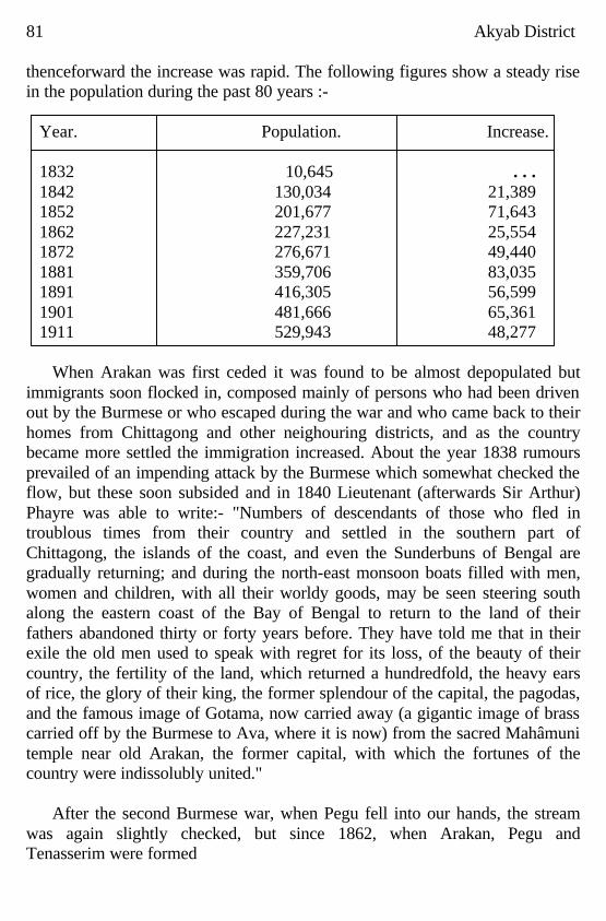
81 Akyab District thenceforward the increase was rapid. The following figures show a steady rise in the population during the past 80 years :-
Year. Population. Increase. 1832 10,645 . . . 1842 130,034 21,389 1852 201,677 71,643 1862 227,231 25,554 1872 276,671 49,440 1881 359,706 83,035 1891 416,305 56,599 1901 481,666 65,361 1911 529,943 48,277
When Arakan was first ceded it was found to be almost depopulated but
immigrants soon flocked in, composed mainly of persons who had been driven out by the Burmese or who escaped during the war and who came back to their homes from Chittagong and other neighouring districts, and as the country became more settled the immigration increased. About the year 1838 rumours prevailed of an impending attack by the Burmese which somewhat checked the flow, but these soon subsided and in 1840 Lieutenant (afterwards Sir Arthur) Phayre was able to write:- "Numbers of descendants of those who fled in troublous times from their country and settled in the southern part of Chittagong, the islands of the coast, and even the Sunderbuns of Bengal are gradually returning; and during the north-east monsoon boats filled with men, women and children, with all their worldy goods, may be seen steering south along the eastern coast of the Bay of Bengal to return to the land of their fathers abandoned thirty or forty years before. They have told me that in their exile the old men used to speak with regret for its loss, of the beauty of their country, the fertility of the land, which returned a hundredfold, the heavy ears of rice, the glory of their king, the former splendour of the capital, the pagodas, and the famous image of Gotama, now carried away (a gigantic image of brass carried off by the Burmese to Ava, where it is now) from the sacred Mahâmuni temple near old Arakan, the former capital, with which the fortunes of the country were indissolubly united."
After the second Burmese war, when Pegu fell into our hands, the stream
was again slightly checked, but since 1862, when Arakan, Pegu and Tenasserim were formed
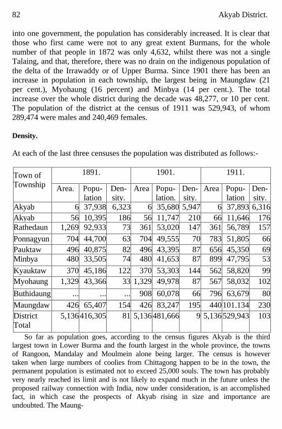
82 Akyab District. into one government, the population has considerably increased. It is clear that those who first came were not to any great extent Burmans, for the whole number of that people in 1872 was only 4,632, whilst there was not a single Talaing, and that, therefore, there was no drain on the indigenous population of the delta of the Irrawaddy or of Upper Burma. Since 1901 there has been an increase in population in each township, the largest being in Maungdaw (21 per cent.), Myohaung (16 percent) and Minbya (14 per cent.). The total increase over the whole district during the decade was 48,277, or 10 per cent. The population of the district at the census of 1911 was 529,943, of whom 289,474 were males and 240,469 females. Density. At each of the last three censuses the population was distributed as follows:-
1891.
1901.
1911.
Town of Township
Area. Popu-lation
Den- sity.
Area Popu-lation.
Den- sity.
Area Popu-lation
Den-sity.
Akyab 6 37,938 6,323 6 35,680 5,947 6 37,893 6,316 Akyab 56 10,395 186 56 11,747 210 66 11,646 176 Rathedaung
1,269 92,933 73 361 53,020 147 361 56,789 157
Ponnagyun 704 44,700 63 704 49,555 70 783 51,805 66 Pauktaw 496 40,875 82 496 43,395 87 656 45,350 69 Minbya 480 33,505 74 480 41,653 87 899 47,795 53
Kyauktaw 370 45,186 122 370 53,303 144 562 58,820 99 Myohaung 1,329 43,366 33 1,329 49,978 87 567 58,032 102
Buthidaung ... ... ... 908 60,078 66 796 63,679 80
Maungdaw 426 65,407 154 426 83,247 195 440 101.134 230 District Total
5,136 416,305 81 5,136 481,666 9 5,136 529,943 103
So far as population goes, according to the census figures Akyab is the third largest town in Lower Burma and the fourth largest in the whole province, the towns of Rangoon, Mandalay and Moulmein alone being larger. The census is however taken when large numbers of coolies from Chittagong happen to be in the town, the permanent population is estimated not to exceed 25,000 souls. The town has probably very nearly reached its limit and is not likely to expand much in the future unless the proposed railway connection with India, now under consideration, is an accomplished fact, in which case the prospects of Akyab rising in size and importance are undoubted. The Maung-
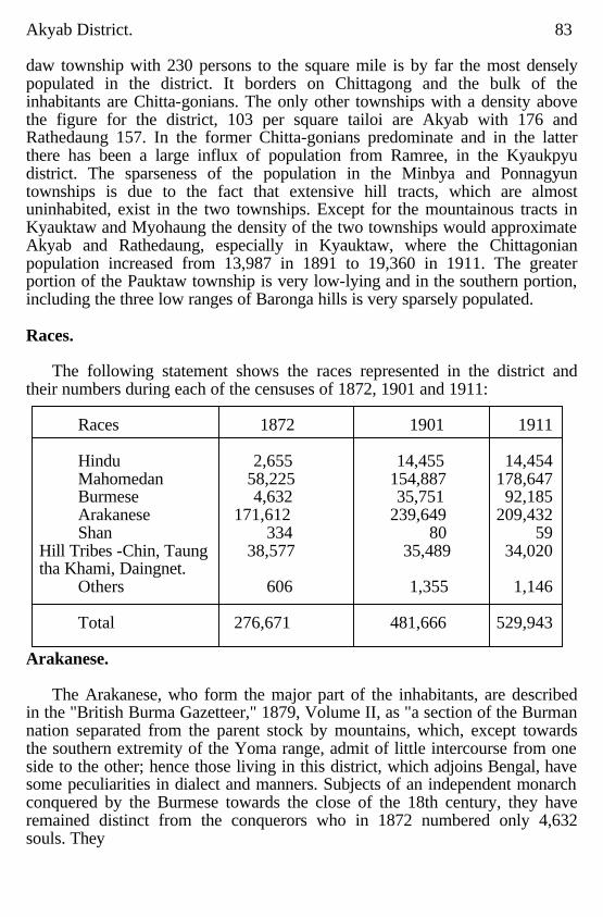
Akyab District. 83 daw township with 230 persons to the square mile is by far the most densely populated in the district. It borders on Chittagong and the bulk of the inhabitants are Chitta-gonians. The only other townships with a density above the figure for the district, 103 per square tailoi are Akyab with 176 and Rathedaung 157. In the former Chitta-gonians predominate and in the latter there has been a large influx of population from Ramree, in the Kyaukpyu district. The sparseness of the population in the Minbya and Ponnagyun townships is due to the fact that extensive hill tracts, which are almost uninhabited, exist in the two townships. Except for the mountainous tracts in Kyauktaw and Myohaung the density of the two townships would approximate Akyab and Rathedaung, especially in Kyauktaw, where the Chittagonian population increased from 13,987 in 1891 to 19,360 in 1911. The greater portion of the Pauktaw township is very low-lying and in the southern portion, including the three low ranges of Baronga hills is very sparsely populated. Races.
The following statement shows the races represented in the district and
their numbers during each of the censuses of 1872, 1901 and 1911:
Races 1872 1901 1911 Hindu 2,655 14,455 14,454 Mahomedan 58,225 154,887 178,647 Burmese 4,632 35,751 92,185 Arakanese 171,612 239,649 209,432 Shan 334 80 59
Hill Tribes -Chin, Taung 38,577 35,489 34,020 tha Khami, Daingnet.
Others 606 1,355 1,146 Total 276,671 481,666 529,943
Arakanese.
The Arakanese, who form the major part of the inhabitants, are described
in the "British Burma Gazetteer," 1879, Volume II, as "a section of the Burman nation separated from the parent stock by mountains, which, except towards the southern extremity of the Yoma range, admit of little intercourse from one side to the other; hence those living in this district, which adjoins Bengal, have some peculiarities in dialect and manners. Subjects of an independent monarch conquered by the Burmese towards the close of the 18th century, they have remained distinct from the conquerors who in 1872 numbered only 4,632 souls. They
84 Akyab District. appear to have gradually imbibed some of the physical as well as the moral and social characteristics of the natives of India, with whom they have, for at least centuries, much intermixed. They are darker than the Talaings, and perhaps rather darker than the Burmans, and the type of countenance is as much Aryan as Mongolia.. Morally, too, they, are, I think (writes Colonel Stevenson), more like natives of India than Burnams are, and they appear to be sliding into Indian habits and social usages. They are a coarser, more violent tempered people than the Burmese, and have more of the pride of race and concomitant indolence. To some extent, ,note especially among the higher classes, the Indian custom of secluding the females has been adopted and early marriages of girls are now by no means uncommon."
During the decade 1901-11 there has been a falling off in the number of
Arakanese, and in the Census Report for 1911 Mr. Morgan Webb writes as follows:- "There is a large decline in the number of persons recorded as speaking Arakanese. It is doubtful how far this is a genuine decrease caused by the spread of the Burmese language, and how far it is a nominal decrease due to the cause which leads a Tavoyan to record his language as Burmese. Both of these influences have probably had their effect. Burmese in making headway both in prestige and in actual fact. Mr. Lowis recorded the opinion, despite an increase in the figures he was reviewing, that Arakanese is bound eventually to disappear and that after another decennial census or two, it will probably be possible to calculate fairly accuratety the date by which it will have vanished off the face of Burma. A decrease of 15.5 per cent is a perceptible step in this direction. A still more significant indication of the general decay of the language is the fact that the number using it is less than the number of the Arakanese race. A progressive language goes in advance of the race by which it is spoken. A language which cannot count in the number of its speakers the full total of the correspondings race is in a stage of retrogression"
A very noticeable characteristic of the Arakanese is that they appear to pay
very little attention to religious duties and in fact may be said to be almost without religion. Many of their villages are without monasteries and in others the pôngyis are accommodated in very inferior buildings Instances are not uncommon of young upazins residing in villages for short periods and returning to their original monasteries in disgust or discarding their robes entirely owing to the failure of the villagers to maintain them in even moderate comfort. The pôngyis themselves are less
Akyab District. 85 educated and polished than their brethren in Burma and many are ordained late in life after being married and bringing up a large family. In one monastery a father and son were met as pôngyi and upazin. Except at Akyab and Myohaung, and an occasional village, pagodas either do not exist or are in a lamentable state of disrepair. The condition of religious buildings and monasteries in some of the pooreat parts of Upper Burma is in marked contrast to that in the wealthy Akyab district. The settlers from the Kyaukpyu and Sandoway districts and the arrivals from Burma proper are clearly distinguishable from the Arakanese in the matter of religion. Their pôngyis are well cared for and housed and the religious buildings are kept in repair. Whereas Arakanese villages give one the impression that the people live an aimless sort of existence the life in Yanbyè villages appears to be more real. That the Arakanese are gradually being pushed out of Arakan before the steady wave of Chittagonian immigration from the west is only too well known. The reason why they cannot with stand this pressure is that they are extravagant and hire more labour than is necessary rather than do a fair share of work themselves. Among the reasons brought forward by the Arakanese for not doing manual labour are that no two Arakanese can agree among themselves or trust each other and one will not take orders from another even a son will not listen to his parents, and should the latter attempt to chastise him he would not hesitate to retaliate; children cannot thus be taught to do manual labour: before the pressure on the land became acute each man's holding was large enough to ensure a substantial balance in spite of the amount paid in wages and there was no necessity for the Arakanese to work; wages have risen steadily and holdings have decreased in size and the balance now available, after meeting costs of cultivation, is net sufficient to maintain the owner; the Arakanese not having been accustomed to hard manual labour for generations cannot and will not do it now; it has been brought home to him that if he will not do more himself he must give way to the thrifty and hard working Chittagonian and his only reply is to move on; he has lived better and worked less than the despicable kula and he does not mean to alter his ways now. The pressure from the Kyaukpyu and Sandoway districts must not be forgotten, and between the Chittagonian and the Yanbyè the Arakanese proper are not likely to survive long. Burmese and Yan-byès.
The Burmese population in 1872 numbered only 4,632; by I911 it had risen
to 92,185. The increase has been partly explained in the paragraph above, but there has also
86 Akyab District. been a large influx of population, chiefly from the Sandoway and Kyaukpyu districts. These two districts are in the Arakan Division, but the residents, at least those who have emigrated to the Akyab district, commonly called Yanbyès, claim to be Burmans, not Arakanese. The term Yanbyès is a corruption of 'Ramree tha,' the majority of the original immigrants from the south having come from the island of Ramree in the Kyaukpyu district. They are more industrious than the Arakanese and have supplanted them in many localities. When labour has to be engaged they prefer to employ their own kind to Chittagonian coolies, and even where they have come in contact with the Chittagonian they have held their own for some time, although there are undoubted signs of their giving way in some tracts. Their village sites are well selected, carefully laid out with usable roads, nicely wooded, the trees proriding shade and producing fruit for consumption and sale, the houses are fairly substantially built, their monasteries and religious buildings are looked after, the people trust one another and Yanbyè villages generally give one the impression of a well-established community. Mahomedans.
The Mahomedans, who in 1872 numbered 58,255, had by the year 1911 risen to 178,647. Many are men who come down for the working season only from Chittagong and are included in the census returns, but are not, properly speaking, inhabitants of the country. In 1879 it was recorded that those who were bonâ fide residents, though recruited by immigrants from Bengal, were, for the most part, descendants of slaves captured by the Arakanese and Burmese in their wars with their neighbours. The Arakan kings in former times had possessions all along the coast as far as Chittagong and Dacca, and many Mahomedans were sent to Arakan as slaves. Large numbers are said to have been brought by Min Raja-gyi after his first expedition to Sundeep, and the local histories relate that in the ninth century several ships were wrecked on Ramree Island and the Mussalman crews sent to Arakan and placed in villages there. They differ but little from the Arakanese except in their religion and in the social customs which their religion directs; in writing they use Burmese, but amongst themselves employ colloquially the language of their ancestors. Long residence in this enervating climate and the example set them by the people among whom they have resided for generations have had the effect of rendering these people almost as indolent and extravagant as the Arakanese themselves. They have so got out of the habit of doing hard manual labour that they are now absolutely dependent on the Chittagonian coolies to help them over the most
Akyab District. 87 arduous of their agricultural operations, ploughing, reaping and earthwork. Since 1879 immigration has taken place on a much larger scale and the descendants of the slaves are resident, for the most part, in the Kyanktaw and Myohaung townships. Maungdaw township has been overrun by Chittagonian immigrants. Buthidaung is not far behind and new arrivals will be found in almost every part of the district. The later settlers, who have not been sapped of their vitality, not only do their own labour but it is not uncommon to find them hurrying on their own operations to enable such as can be spared to proceed elsewhere to add to their earnings by working as agricultural labourers, boat-men or mill coolies. Hindus
In 1872 there were only 2,655 Hindus in the district, and it was recorded that the Hindus, that is those who are permanent residents, whose numbers are to some very slight extent increased yearly by immigration, have been in the country for many generations; some of these are Manipuri Brahmans brought by the BUrmese astrologers, and others, also Brahmans, are descendants of colonists from Bengal brought by the Arakanese kings. Amongst these are a few Doms (a very low caste of Hindu, utterly despised, and supposed to have sprung from a Tiar father and a Baiti mother; in India they are basket makers) whose history is thus related by Sir Arthur Phayre:- "The Doms, it would appear, were brought from Bengal to act as paya-kyun or pagoda slaves. It is a strange anomaly in the Buddhist religion (as it prevails in Burma) that the servitors of the temple are invariably out castes, with whom the rest of the community will hold no intercourse. In Burma proper pagoda slaves are pardoned convicts or persons condemned to the employment on account of crimes. The kings of Arakan, finding in Bengal a number of degraded castes ready made to their hands, imported these and their families as perpetual and hereditary pagoda slaves. These people of course, are now released from their compulsory servitude, and have become cultivators, but in consequence of their former condition, they are regarded by the people with as much disgust as they would be from their low caste by Hindus." By 1911 the number of Hindus in the district had risen to 14,454 brought about chiefly by yearly immigration. The Mahomedan population differs in many important particulars from the Hindu population:one noticeable difference is that Mahomedans intermarry freely with the women of the country who, nominally at least, become Mussulmans, whilst the former rarely do, as they could not associate and eat with their wives and children without losing caste: one of the results ,is shown in the
88 Akyab District. paucity of Hindu children. Another important difference. pointed out in the Census Report of 1911, is the resistance offered by Mahomedans to absorption by Buddhist races. This is manifested in the race and religion of the issue of mixed marriages, whereas the children of mixed marriages between Hindus and Burmese tend to become assimilated by the Burmese in the first or second generation, the children of mixed marriages between Mahomedans and Burmans generally adopt the Mahomedan religion. The result of this is that, whereas the Hindu community is recruited mainly by immigration, the immigration of previous generations having been absorbed by Buddhism, the Mahomedan community has a much more lengthy association with the province. Thinkyis.
There is a village containing about 400 inhabitants, situated a few miles out
of Akyab, of which the residents are reported to be descended from slaves said to have been brought to the country by the Burmese conquerors. These people are agriculturists and appear to be willing to earn an honest livelihood at any trade or profession but they are looked down upon and treated with the utmost contempt by the Arakanese. No resident from an adjoining village would think of residing in this village for a night or accept food or drink at the hands of one of these unfortunate people. Intermarriage with one of these thinkyis, as they are called, is looked upon as a disgrace. Hill Tribes
The hill tribes have, since 1872, shown a slow but steady tendency to decrease in numbers. The chief among these tribes are the Chins who in 1911 numbered 19,081; the Taungthas, 10,517; Khami, 2,727: Daingnet, 954; Chaung-tha, 412, and Mro, 195. The following are extracts from the" British Burma Gazetteer" regarding these hill tribes :- Chins.
The Chins are the most widely spread of all the tribes and inhabit the
Arakan Yoma mountain range east of the Lemro river, that divides Arakan from Burma, and extends from far south down into the Sandoway district and across. the Yomas into the Pegu Division. Though all acknowledge that they are of the same family and universally tattoo the faces of their women, a practice peculiar to their tribe, yet there is a great difference between the dialects of those who are brought captives from the east side and of those who inhabit the hills: generally speaking they are shy and averse to improvement, cultivating neither cotton or tobacco for sale. They are divided into numerous clans, each of which is located on certain tracts sufficiently large to supply them with cultivation, the boundaries of which they never exceed.
Akyab District. 89 It has been said that they adopted the custom of tattooing the women's faces to prevent their being taken by the Burmese rulers, and this is the explanation almost universally accepted in the plains and in the Pegu Division: but the reason may have been as suggested by Mr. St. John, that they mark them thus so as to know them when carried away by other tribes and also to enable them to conceal the women of other tribes carried off by them. Their language, though not understood by other Khami or Mro, has many words in common with theirs. The men knot their hair over the forehead and the waist cloth is, in these hill tracts, reduced to the smallest possible dimensions; in fact it can hardly be said to have the smallest pretensions to decency. Those of the tribe who live east of the Yoma mountains dress somewhat differently.
The women wear a short waist cloth but open on both sides and a smock
frock like that worn by the Karen but very short; the clans further south wear it long. Taungthas.
In the census of 1911 the Taungthas, who in the census of 1901 were
recorded as Chins unspecified, were distinguished from the surrounding Chins. Mr. Morgan Webb remarks :-" The extremely large increase in the numbers of Taungthas recorded at the census of 1911 as compared with those recorded in 1901 is due to a difference in the exact meaning of the term. In the Pakôkku district the Taungthas are a distinct Chin tribe who have adopted Buddhism and intermarried to a certain extent with the Burmese. In the Akyab district they are purely Chin and indeed the term is sometimes rather loosely attributed to certain Chin tribes simply because they dwell entirely in the hills. To what extent the Taungthas of the Pakôkku and Akyab disttricts are allied has never been determined. Until the degree of relationship, or separation, between the two sections of the Taungthas is determined it is difficult to make a correct classification." Khami.
The Khami, or, as they are more commonly called, the Kwe-myi, three or
four generations ago dwelt on the mountain ranges to the north-east of the hill district of Arakan, but, having quarrelled with their neighbours the Shandu, they were driven down towards the Kaladan. gradually pushing before them the Mro and the Chaungtha who formerly dwelt there. They are divided, like all hill people, into clans, and doubtless in their former habitat bad their own lands and obeyed influential bead of clans; but their forced immigration has destroyed all this and now they are scattered and confused though keeping together in villages composed for the most part of members of the same clan under a headman or taung-min whose office is generally
90 Akyab District. hereditary. "Taung-min" is a Burmese word clerived from-"taung," a hill, and "min," a chief: their own word for chief is "araing." The name "Khamie" is the one by which they call themselves, and means "man" (homo); the Burmese, however, as is their wont, have seized upon the peculiarity of their dress which hangs down behind like a tail and adapting the word "Khamie" to their own language make it into "Kwemyi " from "Kwe," a dog, andmyi," a tail. In features, language and manners they are of the same family as the Mramma. The dress of the male Khami is a long home spun cotton cloth, about one foot in width, which is passed several times round the waist and once between the legs, the coloured ends hanging down in front and behind; the hair is knotted over the front part of the head and a long twisted white cloth is bound round the head so as to make a turban standing well up over the forehead; this adds to the height and sets them off to great advantage. They are generally well set up and muscular but vary greatly in stature ; they are wary and occasionally deceitful; "their distrust is the result of their dealings with people who they know deceive them and if once convinced that you will keep your word they will always trust you." Generally speaking they are more open to improvement than any of the other tribes not even excepting the Chaungthas, and there can be no doubt but they are now fully able to understand the benefits of peace and trade and are desirous of changing their former predatory habits.
The Mro (whom Mr. St. John is inclined to consider as a sept of the
Khami) wear but a small blue waist cloth about four inches wide, and are not particular as to their headdress or personal appearance; their houses, too, are small and the desire for improvement is not so great. The women of both tribes dress almost exactly alike. A short dark blue cloth reaching to the knee and open at the side is fastened round the waist with a belt of cords covered either with large beads or copper rings; over the breast. is worn a small strip of cloth. Unlike the men they are very squarely built but the habit of carrying very heavy weights on their backs in baskets with a band passing over the fore-head up the precipitous hill paths makes them walk with a constrained and waddling gait. Some when young are good looking, but constant labour soon destroys their personal appearance. This tribe lives on the Mi, a tributary of the Kaladan, and on some streams to the south, and appears to be looked upon by the others as. inferior to themselves. It was their custom to form a nest, as nearly musketproof as they could make it, in some high tree

Akyab District. 91 connected with the ground by a bamboo ladder, in which meu, women and children took refuge in case of attack, cutting the ladder after they had gone up. The practice has died out owing to the freedom from danger which they now enjoy. Daingnet.
The Daingnets have been described by Mr. Page, Subdivisional Officer of Buthidaung, as follows : As far as can be ascertained the Daingnets appear to be of Tibeto Burma origin with a strain of Chittagonian blood and speaking Bengali. In features they are some what like the Goorkas of Nepal and differ from the hill tribes of Arakan. They dress in White and wear their hair at the back of the head and do not tattoo their bodies. They do not intermarry with other races, speak a corrupted Bengali, and are descendants of Mussulman slaves of the King of Arakan. The Daingnets are decreasing in numbers, an indication that they are gradually ceasing to exist as a Separate tribe and are being absorbed into the general Chin community. Chaungtha.
The Chaungthas, or children of the stream, are descendants of Pyu and Mun of Burma. The story relates that in A.D. 1596 the King Min Rajagyi of Arakan having rendered assistance to the King of Taung-u in investing the capital of Pyu and defeating the Shans and driving thein off from the country, he received a portion of the treasure and a princess of the supreme king. Thousands of Pyu and Talaing people were sent along with the princess to Arakan The King Of Arakan made the princeSS a queen and settled her followers on the east of the Kaladan river near Taywe-chaung. The princess was Styled Pègupyu Minthami. Her followers were said to be mostly soldiers and archers who were divided into two divisions under the command of the Theme Legyaw and Ledet Legyaw. Whilst staying near Taywe-chaung they proved themselves useful in suppressing the rising of the Chins near the Yomas. When the Shandu chiefs Muntin and Munprun rose in rebellion in the upper Kaladan the two Talaing chiefs were sent there to suppress the rising. In course of time these Talaings and Pyus became homesick and many of them ran away back to their own country. When the king knew about if, he removed them to the west of the Kaladan river and settled them in the following localities in the hills which extend as far as Chittagong Hill Tracts. They were sent to the hills for their reputed bravery and hardiness to control the hill tribes. In manners and customs they differ but little from the Arakanese and Burmese, they have straight black hair, high cheek-bones, oblique eyes and Scanty beard. They are Buddhist and worship ,nats
92 Akyab District. and all customs common to primitive tribes are strictly observed. Manners and customs of Hill Tribes.
Though there may be a few minor differences in the manners and customs of these tribes yet on the whole there is great similarity. The religion of all is spirit worship of the most primitive kind and consists in paying a sacrifice of blood to the spirits of the hills and rivers as a means of averting evil; the smallest act cannot be performed without shedding the blood of some kind of animal or bird.
In the year there are two important ceremonies for the propitiation of the
ka-nie or spirit, viz., at the time of sowing seed and before harvest. At the first a fowl or pig is taken alive to the place to be sown, a small heap of rice seed is placed on the ground and the blood from the animal is poured on it; the flesh is taken home and eaten. The second is performed when the rice plant is well grown but before the ear has come up; a fowl, pig or dog is killed at home and the blood is smeared on long bamboos decorated by shaving round the joints so as to leave tassels or tufts hanging from them; these bamboos are then taken to the field and stuck up in various parts of it.
There is also another annual feast, in honour of departed spirits who are
called palaw. This custom is followed by the Khami and Chaungtha but not by the Mro. The ceremony is performed by the Khami after the harvest and is called ta-praungpa-aung or the opening of the dead house. When a person dies and has been burnt the ashes are collected and placed in a small house in the forest, together with his spear or gun which has first been broken in pieces. These small houses are generally placed in groups near a village, for which they are sometimes numberous enough to be mistaken. After the harvest the whole of the deceased's relatives cook various kinds of dishes and rice and take them with pots of a-mu (liquor made from rice) to the small houses where the ashes repose; the doors of the house are opened and food having been placed for the departed are reclosed: the relatives then weep, eat and drink and return home in the evening. Chaungtha perform this ceremony thrice a year', but with them it consists simply of setting aside food and drink for the departed for a short time and then throwing it away into the river.
During the dry weather numerous feasts are given at which large numbers
of cattle are killed and eaten and rice beer and spirits consumed. It is a mark of distinction amongst thein to have it said that they have killed so many head at a feast; the largest number Mr. St. John heard of was 150 killed at one feast by a headman (a-raing) and his

Akyab District. 93 son. The gayals, buffaloes and oxen are tied up to a post and speared behind the right shoulder, but other animals have their throats cut. Dogs are castrated young for use at feasts. The post used by the Mro is Y shaped; and just below the fork carved so as to represent two or more beasts. There is some peculiar, but at present unknown, significance attached to this symbol both by Mro and Khami, and it is often carved on the posts of headmen's houses and on the house ladder. The Khami and Chin do not carve their posts but set them up rough; in the Chin villages some rough stones are set up.
At the feasts there is always a drinking of kaung or rice beer, which is made by soaking rice with certain ferment causing roots in a large pot: this pot is then put away till required and then filled to the brim with water; a reed with two little holes cut at the side above the bottom joint having been thrust clown into the liquor it is sucked up, and when the first man has drunk his quantum he marks it with a slip of bamboo and fills up with water for the next comer. One pot is sufficient for a large number of men. When five or six posts are put in a row the drinkers are supposed to commence at one and move on up the line until they come to the other. This liquor is not disagreeable and is moderately intoxicating. Dancing.
Dancing must be seen to be clearly understood: it is more of a side-closing
step than a dance. the line being headed by drummers, small gong players, wind-instrument blowers, and then armed with spears, wa-raik (a peculiar-brass handled sword said to be made by the Shandus and much prized), muskets and shields. The step consists of closing two steps to the right and one to the left in time to the music and at the same time bending the body so as to throw the posteriors outwards: the young men commence it and then drag in the girls between them. to whom they make love and whom they stimulate with ardent spirits. "I have seen," writes Mr. St. John, "a young man thus dancing away and murmuring a love song into the ears of two girls at the same time, one on each side, with his arms round their necks." Before commencing, the faces of all are often smeared with a mixture of saffron and rice flour which is supposed to ward off the bad effects of drinking. Occasionally they dance a wild sort of war dance with das and shields, and there is also a very clever dance something resembling the sword dance of Scotland but between two heavy rice pounders which are clapped together by two other men to the sound of a drum; if the dancer is not very agile or exact he is liable to get his leg broken between the pounders.
94 Akyab District.
Marriage. Till marriage, intercourse between the Sexes is perfectly free and
unrestrained; and it is considered highly proper to marry a girl great with child though it be that of another man; ii, however, a girl bring forth before marriage the child is, it is said, exposed. Marriage is a simple contract consequent on making valuable presents to the parents. It is insult to a girl to tel1 her that the young men will not sleep in her house. Tabooing. The ceremony of ya for tabooing is strictly observed on the following occasions :- First.-When any person belonging to the village is killed by a tiger or
crocodile, when the body of any person so killed is brought into a village, or when any woman of the village dies in child birth, all intercourse with other villages is cut off until the appearance of the next new moon.
Second.-When a village or house is burnt, or when a new village is erected, intercourse is forbidden for the period of three days.
Third.-when any epidemic breaks out, intercourse is forbidden with that village until the disease has disappeared.
Fourth.- When the rice plants are well up and require weeding, intercourse is forbidden for seven days.
Fifth.-When a villager dies by accident, intercourse is forbidden for one day. Any person breaking this custom is fined by the head-men of the
neighbouring villages. To show that a village is tabooed strings or canes are suspended across the road. At harvest time the people are forbidden to eat flesh or fish; and any person who has killed another or been wounded by a tiger or crocodile is obliged to abstain from flesh for a period extending from one month to one year. It is also considered wrong to take money for a tiger's skin. Customs.
When the inhabitants of a village have been successful in a raid or in
repelling an attack, a sacrifice is offered to the kathe or guardian spirit; all the men dancing a war dance with spears and shields round the village post. When a person dies the body is laid out in the house and a feast made; food is set apart for the ghost which is supposed to remain in the house as long as the body is there. Seven bundles of rice for a man and six for a woman are left at the place of cremation for the ghost to feed on, and neglect of this custom is a bar to inheritance.
According to the hill custom all offences or injuries are remedial by tine
only, and this fine is called in the Burmese gaungbo or head money, by the Mro it is called aloo-wang, and by the Khami loo-wang. If the fine or debt be not paid means are first fallen to try and recover
Akyab District. 95 the money by restraining the person, and if this be ineffectual the judgment debtor becomes the slave of the injured party who either keeps him in his house to work or sells him. In cases where it is impossible to apprehend the party Or recover the amount due, the creditor will bide his time and when least expected a raid will be committed on the village of the debtor. As the gaung-bo is constantly demanded for purely imaginary reasons, and in a very arbitrary manner, raids are Sometimes committed and feuds established on very frivolous pretences; for instance the feud between the Shandu and the Karay clan of the Khami, who formerly lived in the Palook valley, is said to have originated in a dispute concerning a bamboo pipe head, an article of but small value, and has resulted in the expulsion of the whole of the Khami from that valley. In another case a young Mro found the body of a small deer that had been killed by a tiger and threw it into the forest near another man's field at a great distance from the village; this came to the knowledge of the owner of the joom or patch of cultivation, and one of his children dying shortly afterwards he attributed it to the act and demanded gaung-bo from the young man. The village elders admitted the claim and a small forfeit was paid and it was thought that the matter was fully settled, but about a year afterwards another child died and its death was, by some curious process of reasoning, attributed to the same act and another demand of larger value was made; this was too much and the person of whom the demand was made fled to the Superintendent for succour. Laws.
The following is an abstract of the Hill Laws as given by Mr. Davis and
quoted by Mr. St. John, two successive Superintendents : CRIMINAL.
I. Murder or Homicide. If. a person commit murder he should be fined the value of two slaves and several spears, swords and gongs, say in all about Rs. 600. If death be caused accidentally the fine should be half the above. II. Raid. When a village is; plundered by a body of raiders the leader alone is to be held responsible, and if apprehended is bound to return the value Of all the property taken (including the head money of persons killed) and also to pay a fine. III. Raid and Arson. If a village is burnt down in committing a raid the leader is bound to make good the damage done and to pay a fine in addition. IV. Theft.-A person who commits theft is bound to return the property, or its value, and to pay a fine not exceeding Rs. 30.
96 Akyab District.
V. Grievous hurt. A person who causes grievous hurt may be fined Rs. 100. VI. Assault. If a person assault another he is to pay a fine not exceeding Rs. 30. VII. Rape.-If rape be committed oil a married woman the husband is entitled to demand a sum not exceeding Rs, 60. Rape of an unmarried woman is to be punished by a fine not exceeding Rs. 30.
Besides the fine the offender has to pay for the animal (pig) slain to make
the agreement binding. When murder is committed in a raid any raiders caught red handed are at once beheaded and the heads stuck up in the village. A woman may not receive a fine but a male relative may receive it for her.
CIVIL.
I. Ordeal.-If two persons dispute about a debt or other matter and neither can produce evidence they are obliged to go through the ordeal of ducking the head in water, and the decision is given in favour of him who keeps under longest. II. Execution.- If a debt be not paid and the debtor is not apprehended the creditor's party, if strong enough, attacks the debtor's village and carries off as many captives as it can. III. Interesl.-The interest on a debt is double the principal if one year be allowed to expire from the date on which it was contracted. IV. Sons liable for father.-The debts of the father must be paid by the sons. V. No male issue. If a man die without male issue his property is claimed by his nearest male relative; he, therefore, is responsible for the debts of the deceased whether there be property or not. VI. Minority.--Should a man die who is a minor the nearest male relative acts as guardian until minority ceases on marriage when he is bound to give account of his stewardship. VII. Women.- A woman cannot inherit and is, therefore, not responsible for a debt. VIII. Division or Inheritance. If a man die leaving two or more sons the property is divided as follows : If there are only two they divide equally: if there be more than two the eldest and youngest take two shares each and the others one share each. IX. Customs to be observed. On the death of his father the eldest son must give his maternal uncle a full

Akyab District. 97 grown buffalo or the value. On the death of the mother the youngest son must give a paternal uncle a full grown buffalo or the value. If this cannot be done a son should be given.
X. Bequeathing sons.-If a man be on the point of death and cannot pay his debts he must leave a son to the creditor to work it off. XI. Slaves. Slaves do not inherit. unless adopted according to rule; if inheriting as having been adopted they will be held responsible for debts. If a slave, however, be adopted by a master who has sons he cannot inherit. XII. Marriage. There is no fixed age for marriage, nor any constraint used to influence choice. Marriage is contracted on consent of the woman's parents after payment of the fixed dowry by the suitor. XIII. Divorce. (a) If a husband wish to divorce his wife he may do so and take all the children; but in so doing he will forfeit claim to dowry. (b) If a woman have children by a former husband she is entitled to them on divorce. (c) A divorced woman must, until remarried, be supported by the male relative who received her dowry or by his heir. XIV. Dowry. (a) No female can receive dowry; it must be received by the nearest male relative. (b) If a husband chastise or ill treat his wife and she absconds in consequence he is nevertheless entitled to receive back the dowry. (c) If a wife abuse or ill-treat her husband he may chastise her: but if on that account he divorce her he for-feits claian to dowry. XV. Adultery. (a) It the husband divorce the wife for proved adultery he is entitled to receive the dowry paid by him and may also demand a sum equal to the dowry from the adulterer in addition to fine and costs. (b) Ii a man commit adultery the wife has no redress. XVI. Should a woman die in giving birth to a child before marriage the reputed father must pay her value to her father or nearest male relative.
Oaths.
Oath is usually taken by swearing to tell the truth on a musket, spear,
sword, tiger's tusk, crocodile's tooth, and stone hatchet (supposed to be a meteoric stone, they are occasionally found when cutting jungle); these are all held together in the hands whilst repeating the oaths. This is not much feared and it is said that the Khami consider an oath taken on the skull of a cat or tiger more binding.
98 Akyab District. Some Mro say that an oath taken on the praying mantis is binding, whilst this is denied by others. Europeans and Anglo-Indians.
The Europeans and Anglo Indians are for the most part Government
officials, merchants and their assistants engaged in the paddy trade and clerks employed in the Government and mercantile offices. Chinese.
The bulk of the Chinamen are carpenters, shoe-makers and traders in
Akyab town. Church of England.
The earliest record of the Anglican Church in this district goes back to
1843 when the Rev. W. T. Humphrey was appointed by the Deputy Governor of Bengal to be Assistant Chaplain at Kyaukpyu and Akyab in Arakan. The British troops being stationed at Kyaukpyu at the time that station was made the headquarters of the Chaplain and Akyab was an outstation, although the latter place contained a large Civil Christian population and was the headquarters of the Civil Administration. No church existed at Akyab and in 1844 a subscription list was opened. for the construction of a building. Subscriptions continued to be slowly collected till on the 26th November 1850 the corner stone of the present building "St. Marks" was laid by the Bishop of Calcutta. The church was completed towards the end of 1853 and consecrated on the 10th November 1855. Owing to the removal of the troops from' Kyaukpyu in 1850 the Chaplain was transferred to Akyab in 1851 and Kyaukpyu with Ramree and Sandoway became outstations. Shortly after this the appointment of Chaplains to Akyab became very irregular and in fact for several years the place was visited only occasionally by Chaplains from Rangoon and Chittagong. In 1864 a Chaplain of the Additional Clergy Society was appointed to Akyab for the first time, and ever since the Chaplaincy, when filled, has been held by Chaplains of that Society. In 1866 an attempt was made to start missionary work among the natives of the country, when it was reported that Akyab with its hybrid, migratory native population did not present at all a promising field for missionary enterprise. The American Baptists, who had been at work here for a few years, abandoned the place in despair. About 1878 the control of the church at Akyab was transferred from Calcutta to Rangoon and the Bishop of Rangoon visited Akyab for the first time. At intervals, sometimes for long periods, it has not been found possible to spare the services of a Chaplain for Akyab. The smallness of the Anglican congregation has also rendered the maintenance of a Chaplain at this place at times a matter of some difficulty, although Government helps with a handsome contribution of half his salary.
Akyab District. 99
Roman Catholic Missions. Sir Arthur Phayre writes that "Father Sebastian Man-rigue of the
Augustinian Order came to Bengal and Arakan with several of his brethren where there was already a flourishing mission in 1612.
Prom that time till the second half of the nineteenth century little is known
of the progress of Christianity in these parts. The Arakan Mission in the last mentioned period has often changed hands, at one time being under the jurisdiction of the Vicar Apostolic of Bengal and again under the Vicar Apostolic of Pegu and Ava, the well known Mgr. P. Bigandet of the Foreign Missions of Paris, and for the past thirty years c r more again under the Vicar Apostolic of Eastern Bengal, since the organization of the Catholic Hierarchy in India in 1886 styled the Bishop of Dacca. About the year 1860 the Arakan Mission was in charge of a missionary belonging to the Congregation of the Holy Cross. In 1878, owing to the death of several missionaries, this society handed over the mission to the Benedictine Fathers from Belgium, of whom Father Amaddoline, O.S.B., was the first resident missionary. In 1888, at the request of His Holiness Leo XIII, the Fathers of the Congregation of the Holy Cross once more assumed charge of the mission and have since continued to look after it.
In 1889 a Convent School was started at Akyab by the Sisters of the
Congregation of the Holy Cross. Its first Superior, Sister Mary Fidelis, died of cholera contracted in nursing a cholera-stricken English sailor. The nuns suffered considerably owing to the unhealthiness of the place, and after they had loss several of their number they were in 1895 replaced by German sisters from Rome. These nuns also could not withstand the climate and were succeeded by the Sisters of Our Lady of the Mission of Lyons, France. Small as is the Christian population of Akyab the school has filled a much needed want and has done very creditably. There are at present 12 nuns and 171 pupils in the school, of whom a large number, 39, are orphans. Christianity has made Very little headway among the Arakanese, who are either too intolerant or too careless about religious matters to make many or good converts. Emigration and Immigration
It is difficult to obtain accurate figures for immigrants; the Deputy Commissioner, Akyab, recently estimated the number at about 25,000 during the crop reaping season alone. About the same number come to assist in ploughing operations and to work at the mills and in the carrying trade. A total of 50,000 immigrants annually is probably not far from the mark. The agriculture of the district is entirely dependent on hired labour, and to meet the demand large number of coolies come from Chittagong, Kyaukpyu
100 Akyab District. and Sandoway districts. The first lot that come arrive in time for the ploughing season and, with the exception of a few who obtain further employment, return to their homes. The next lot, and by far the larger number, arrive in time for the reaping, transport and hannling of the paddy at the mills ,and in the port of Akyab. Those from Kyaukpyu and Sandoway travel chiefly by the launches of the Arakan Flotilla Company and by country boat. They engage in a portion of the carrying trade in addition to the reaping. The labourers from Chittagong come partly by the direct steamers of the British India Steam Navigation Company to Akyab, by Messrs. Turner, Morrison and Company's steamers to Maungdaw, by the Arakan Flotilla steamer down the Naaf to Maungdaw or just across the Naaf into the Maungdaw township. Large numbers also come by boat from Chittagong ports to engage in the carrying trade. A few boatmen from the Madras and Bombay coasts are also to be met with. The arrivals at Maungdaw spread by various routes to all parts of the district and they are joined by the Chittagonian settlersresident for the most part in the north-western quarter of the district. After the reaping the labourers execute such earthwork as has to be done, some proceed to the mills or find employment on boats, while others return home. By the middle of May the season at Akyab is over and thereafter only a few stragglers remain. No emigration takes place from among the permanent residents of the district. Average income and expenditure and standard of living of Agriculturists.
At the Settlement operations undertaken during the years 1913-16 it was ascertained that the average income per family of agriculturists was Rs. 413 per annum of which Rs. 311 represented the net income from agriculture and Rs. 102 from non-agricultural sources. The agricultural income in the Maungdaw township and the Mayu valley and in two hill tracts was below the average for the district, and in the greater portion of the east of the district it was above the average. The incomes in the Myohaung township, where rice holdings are still fairly large, are particularly high. According to races the Arakanese, who still possess the largest holdings, derive the largest agricultural incomes, followed by the Yanbyés, Hillmen and Chittagonians, the last mentioned working the smallest areas. The average number of persons per household is 6.21, ranging from 5.73 and 5.87 among the Arakanese and Yanbyès to 6.46 and 7.55 among tim Hill Tribes and Chittagonians. The total cost of living per household is, except for the Hill-men who spend least, exactly the reverse. The incidence of the cost per head is Rs. 42, and per acre Rs. 12. The people in the west of the district live more frugally than
Akyab District. 101 those in the east. In no part of the district are there any signs of distress. The disorganization of trade owing to the recent great European war has undoubtedly made inroads on savings. Except for a few wealthy men, met with here and there, there are no signs of great wealth, but the country is generally prospercus and the people live in fairly easy circumstances. Food and other items of expenditure.
Rice is the staple food grain. The average annual consumption of unhusked
rice per family is 5,340 lb. valued at Rs. 127. Chittagonians and Hillmen, with their large families, consume a little more than others. Other food costs only Rs. 33 per family. Fresh fish, which abound in all the many waterways, and imported salt fish are the principal animal food consumed. Vegetables are, for the most part, grown locally, but large quantities are imported from lndia for the Akyab market. Oil, cooking butter (ghi), peas, spices and condiments (except chillies) are practically all imported. Oil and cooking butter are ordinarily used only at Akyab and some of the larger villages; in the district, except on the feast days, the bulk of the people seldom use these commodities, not perhaps from preference but because they are not available. The Chittagonian appears to exist in his home on half-cooked rice and a little chilly, with vegetables or fish when readily procurable. When engaged as a labourer he demands fish and vegetables cooked in oil in addition to the indispensable dole of chilly. Tobacco and betel are used all over the district. The large Burmese se leik is not often seen here. The Burman races smoke the se byin leik, those made of locally grown tobacco being very much milder than the ordinary Burma cheroot. The Chittagonians use the hookah (an Indian pipe) very largely. They also chew tobacco with their betel, a practice fairly common along the other races as well. The fermented juice of the dani palm is very largely drunk in all Arakanese villages. Opium is remarkably plentiful in all parts of the district, and in spite of the vigilance of the Excise authorities the unlimited facilities for smuggling are difficult to overcome and it is certain many unregistered consumers get a regular supply. House-hold requisites cost Rs. 17 only, clothing and bedding Rs. 30 and an average of Rs. 10 is spent on construction and repairs. The amount spent on festivals and charity is small. An occasional pongyi byan, boat races and wrestling matches comprise the principal amusements of the Burman races. The Arakanese have taken to soccer football and every township headquarters boasts its XI, the annual Competition for outstation teams at Akyab being looked forward to with the keenest interest. Nothing rouses
102 Akyab District. the steady, sober sided, business like Coittagonian to mirth and merriment so much as the prospect of witnessing a good buffalo fight. The contending animals are often driven many miles Collecting backers from the villages through which they pass till they meet in some stretch of open paddy fields. Here they are surrounded by cheering, swaying crowds till one animal is defeated and bursts through the ring of spectators followed by the other. The miracle is that serious accidents do not occur at these entertainments more often than they do. The miscellaneous expenditure, amounting to Rs. 11, is made up largely of capitation tax. Houses and other buildings.
At township headquarters and at most villages of any size or importance a
few brick houses are to be found. These larger villages also have a fair number of wooden houses with thatch (dani) or corrugated iron roofs The commonest pattern of house to be met with in Arakanese, Yanbyè or Burman villages is built on legs, the height off the ground being regulated according to the high-water level mark in the locality, with bamboo floor, mat or thatch walls and thatch roofs. The houses are large, the roofs are built at a fairly steep angle and the eaves project several feet, giving the houses a dark and gloomy appearance. This style of house is rendered necessary owing to the excessive rainfall and the high breezes so prevalent in the district during the monsoon. The hill tribes build themselves remarkably commodious houses on very tall legs (constructed often of bundles of bamboos or thin posts) as a protection against wild animals, and a notched pole to serve as a ladder. in Chittagonian villages the houses are usually built on the ground with thatch or mud walls and thatch roof. The women being kept in seclusion, especially the girls of marriageable age, the houses are separated by walls. Bamboos and dani are very plentiful in the district and the average expenditure per family on construction and repairs is only Rs. 10 per annum.
Judging from the archæological remains found in the district the place
must, at one time, have been very rich in pagodas and other religious buildings. In most present day Arakanese villages these edifices are conspicuous by their absence and the older buildings are in a very neglected condition. Each Yanbyè or Burman village generally has its own pagoda and pongyi-kyaung, and the Mussalman Chittagonians are never without their mosque.
The zayats in the district are execrable, generally a small shed, about 10
feet square, with a rotten floor and a leaky roof. They are maintained for the use of the Chittagonian cooly, without whose aid the agriculture of the
Akyab District. 103 district could not be carried on, but anything is considered good enough for him. In Chittagonian villages zayats do not exist. Indebtedness.
The average indebtedness per agricultural household is Rs. 218 and per
family in debt Rs. 292; indebtedness is on the increase. The people have got into the habit of working on borrowed capital without making any attempt to reserve some of their earnings to meet the following year's expenses. All over the district the majority of the cultivators borrow almost up to the lull extent of their net agricultural incomes. Loans taken in produce represent only 18 per cent of the total borrowings, the balance being taken in cash. Principal and interest are repayable in cash in about 88 per cent of the loans, principal in cash and interest in kind in 9 per cent and both principal and interest in kind in 3 per cent. The rates of cash interest range from 12 to 60 per cent. The bulk of the loans pay interest at rates ranging from 24 to 35 per cent followed closely by loans bearing interest from 36 to 47 per cent. Higher rates are charged on small loans for short periods and on loans in which the Security is not considered good. The smaller money lenders in out of the way villages usually demand higher interest than the regular money lenders, who do not advance money except on good security. The rates of interest are generally higher in the west than in the east of the district. The few loans which pay no interest are small sums borrowed for short periods from relatives or neighbours just before the crops are reaped. Repayment of interest in kind is more common among the Yanbyès and Mahomedans The letter are not supposed to take interest, and ease their consciences by taking it in kind. The majority of the loans which are repayable, both principal and interest in kind, are arrears of rent. Banks.
A branch of the Bank of Bengal is established at Akyab, and up to a year
ago the Chartered Bank of India, Australia and China opened a branch here for a few months during the busy season. There are also the U Rèi Gyaw Thu Bank, a few cherry firms and a number of monied men with a certain amount of Capital at Akyab. At the outstations, especially the township headquarters, there are also a few money lenders with a limited capital. Among the latter are a fair number of Hindu shopkeepers. With the exception of the two European Banks, all the others lend to the cultivators direct to the full extent of their means, and if they require more money it is taken from the banks. The loans given out at Akyab bear interest at rates ranging, from 12 to 30 per cent. generally according to the security offered; most Of the loans taken from outside money lenders bear
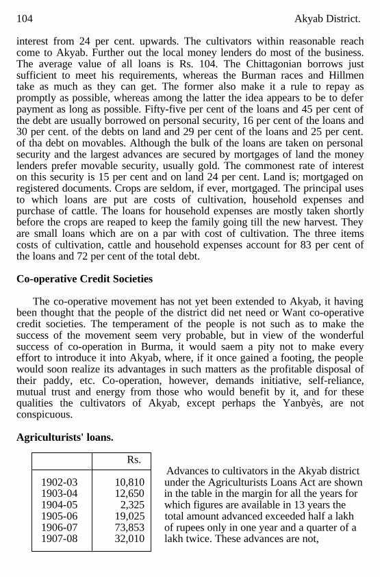
104 Akyab District. interest from 24 per cent. upwards. The cultivators within reasonable reach come to Akyab. Further out the local money lenders do most of the business. The average value of all loans is Rs. 104. The Chittagonian borrows just sufficient to meet his requirements, whereas the Burman races and Hillmen take as much as they can get. The former also make it a rule to repay as promptly as possible, whereas among the latter the idea appears to be to defer payment as long as possible. Fifty-five per cent of the loans and 45 per cent of the debt are usually borrowed on personal security, 16 per cent of the loans and 30 per cent. of the debts on land and 29 per cent of the loans and 25 per cent. of tha debt on movables. Although the bulk of the loans are taken on personal security and the largest advances are secured by mortgages of land the money lenders prefer movable security, usually gold. The commonest rate of interest on this security is 15 per cent and on land 24 per cent. Land is; mortgaged on registered documents. Crops are seldom, if ever, mortgaged. The principal uses to which loans are put are costs of cultivation, household expenses and purchase of cattle. The loans for household expenses are mostly taken shortly before the crops are reaped to keep the family going till the new harvest. They are small loans which are on a par with cost of cultivation. The three items costs of cultivation, cattle and household expenses account for 83 per cent of the loans and 72 per cent of the total debt. Co-operative Credit Societies
The co-operative movement has not yet been extended to Akyab, it having
been thought that the people of the district did net need or Want co-operative credit societies. The temperament of the people is not such as to make the success of the movement seem very probable, but in view of the wonderful success of co-operation in Burma, it would saem a pity not to make every effort to introduce it into Akyab, where, if it once gained a footing, the people would soon realize its advantages in such matters as the profitable disposal of their paddy, etc. Co-operation, however, demands initiative, self-reliance, mutual trust and energy from those who would benefit by it, and for these qualities the cultivators of Akyab, except perhaps the Yanbyès, are not conspicuous. Agriculturists' loans.
Rs. Advances to cultivators in the Akyab district
1902-03 10,810 under the Agriculturists Loans Act are shown 1903-04 12,650 in the table in the margin for all the years for 1904-05 2,325 which figures are available in 13 years the 1905-06 19,025 total amount advanced exceeded half a lakh 1906-07 73,853 of rupees only in one year and a quarter of a 1907-08 32,010 lakh twice. These advances are not,
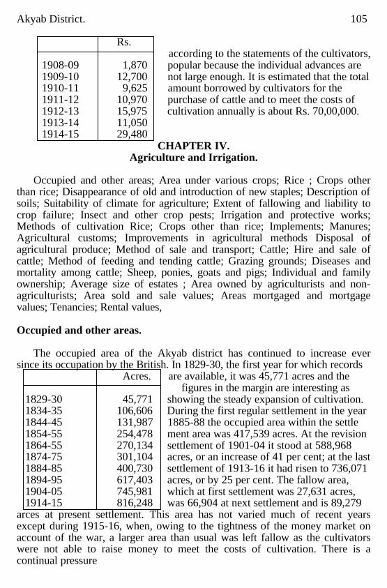
Akyab District. 105
Rs. according to the statements of the cultivators,
1908-09 1,870 popular because the individual advances are 1909-10 12,700 not large enough. It is estimated that the total 1910-11 9,625 amount borrowed by cultivators for the 1911-12 10,970 purchase of cattle and to meet the costs of 1912-13 15,975 cultivation annually is about Rs. 70,00,000. 1913-14 11,050 1914-15 29,480
CHAPTER IV. Agriculture and Irrigation.
Occupied and other areas; Area under various crops; Rice ; Crops other
than rice; Disappearance of old and introduction of new staples; Description of soils; Suitability of climate for agriculture; Extent of fallowing and liability to crop failure; Insect and other crop pests; Irrigation and protective works; Methods of cultivation Rice; Crops other than rice; Implements; Manures; Agricultural customs; Improvements in agricultural methods Disposal of agricultural produce; Method of sale and transport; Cattle; Hire and sale of cattle; Method of feeding and tending cattle; Grazing grounds; Diseases and mortality among cattle; Sheep, ponies, goats and pigs; Individual and family ownership; Average size of estates ; Area owned by agriculturists and non-agriculturists; Area sold and sale values; Areas mortgaged and mortgage values; Tenancies; Rental values,
Occupied and other areas.
The occupied area of the Akyab district has continued to increase ever
since its occupation by the British. In 1829-30, the first year for which records Acres. are available, it was 45,771 acres and the
figures in the margin are interesting as 1829-30 45,771 showing the steady expansion of cultivation. 1834-35 106,606 During the first regular settlement in the year 1844-45 131,987 1885-88 the occupied area within the settle 1854-55 254,478 ment area was 417,539 acres. At the revision 1864-55 270,134 settlement of 1901-04 it stood at 588,968 1874-75 301,104 acres, or an increase of 41 per cent; at the last 1884-85 400,730 settlement of 1913-16 it had risen to 736,071 1894-95 617,403 acres, or by 25 per cent. The fallow area, 1904-05 745,981 which at first settlement was 27,631 acres, 1914-15 816,248 was 66,904 at next settlement and is 89,279
arces at present settlement. This area has not varied much of recent years except during 1915-16, when, owing to the tightness of the money market on account of the war, a larger area than usual was left fallow as the cultivators were not able to raise money to meet the costs of cultivation. There is a continual pressure
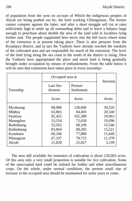
106 Akyab District. of population from the west on account of Which the indigenous peoples of Akyab are being pushed out by, the hard working Chittagonian. The former cannot compete against the latter, and after a short struggle sell cut at rates sufficiently high to settle up all outstanding debts and to leave a balance large enough to prurchase about double the area of the land sold in localities lying further east. The people supplanted here move into the hill tracts where some of the extension is at present taking place. There is also pressure from the Kyaukpyu district, and in tact the Yanbyès have already reached the outskirts of the cultivated area and are responsible for much of the extension. The level of the land lying along the sea coast in the south of the district is rising. Here the Yanbyès have appropriated the place and much land is being gradually brought under occupation by means of embankments. From the table below it will be seen that extensions have taken place in every township:-
Occupied area at
Increase. Last Set- Present Township tlement. Settlement. Acres Acres Acres Myohaung 98,086 128,606 30,520 Minbya 63,865 84,405 20,540 Pauktaw 82,425 102,388 19,963 Maungdaw 53,554 72,650 19,096 Buthidaung 52,563 68,109 15,546 Rathedaung 83,064 98,285 15,221 Kyauktaw 66,246 77,886 11,640 Pônnagyun 67,337 78,715 11,378 Akyab 21,828 25,027 3,199
The area still available for extension of cultivation is about 230,003 acres.
Of this area only a very small proportion is suitable for rice cultivation. Some of the unoccupied land could be utilized for fodder and other miscellaneous crops. On the whole, under normal conditions, the present small rate of increase in the occupied area should be maintained for some years to come.
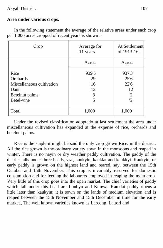
Akyab District. 107 Area under various crops.
In the following statement the average of the relative areas under each crop
per 1,000 acres cropped of recent years is shown :- Crop Average for At Settlement 11 years of 1913-16. Acres. Acres.
Rice 939'5 937'3 Orchards 29 25'6 Miscellaneous cultivation 16 22'6 Dani 12 12 Betelnut palms 3 2 Betel-vine 5 '5 Total 1,000 1,000
Under the revised classification adoptedo at last settlement the area under
miscellaneous cultivation has expanded at the expense of rice, orchards and betelnut palms.
Rice is the staple it might be said the only crop grown Rice. in the district.
All the rice grown is the ordinary variety sown in the monsoons and reaped in winter. There is no nayin or dry weather paddy cultivation. The paddy of the district falls under three heads, viz., kaukyin, kauklat and kaukkyi. Kaukyin, or early paddy is grown on the highest land and reared, say, between the 15th October and 15th November. This crop is invariably reserved for domestic consumption and for feeding the labourers employed in reaping the main crop. Very little of this crop goes into the open market. The chief varieties of paddy which fall under this head are Lonbyu and Kunwa. Kauklat paddy ripens a little later than kaukyin; it is sown on the lands of medium elevation and is reaped between the 15th November and 15th December in time for the early market., The well known varieties known as Larcong, Lattori and
108 Akyab District.
Zanbwet are included in this category. Laroong is in some localities called a kaukyin paddy, but it is more correctly an early kauklat; it is the first paddy the millers lock out for. Zanbwet has a reddish grain which detracts from its value for export purposes. Kaukkyi is the main crop, grown on the lowest, and consequently most productive land; it is this crop that provides the great bulk of the paddy available for sale and export. It is reaped between the 15th December and 15th January. The varieties of kaukkyi paddy grown are very numerous, the best known being Ngacreinthi, Sabasi and Ngayabo. The two former are good milling qualities; Ngayabo is preferred for domestic consumption, the grain is too brittle to mill well. There are no gaps between the three crops, the kaukyin reaping runs into the kauklat and the kauklat into the kaukkyi, and it cannot be said with certainty when one ends and another begins, e.g., the well known Laroong may be called a late kaukyin or an early kauklat and Zanbwet may similarly be called a late kauklat or an early kaukkyi. The dates given above merely represent the periods during which the bulk of each crop is reaped. The holdings are moreover mixed and often contain all three varieties of paddy, at all events holdings growing two varieties are very common, The area under kaukyin is negligible, that under kauklat is considerable, especially in certain tracts, and kaukkyi provides the main crop. According to the European millers 'two principal varieties of paddy are cultivated in the Akyab district, namely, Laroong, an early species, and Ngacreinthi, which matures later, and of the two the latter furnishes the bulk of the paddy crop of the district and is preferred by the European millers for expert to Europe.' The two varieties correspond to the kanklat and kaukkyi crops and the names given by the European millers are merely those of the best known kinds of paddy grown during each of these seasons. The boatmen who bring the grain to Akyab delight in blending the many kinds of paddy grown in the district to pass the tests applied for Laroong and Ngaorcinthi. Some of the softer or smaller kinds of grain, which are infinitely preferred to the harder or larger grain for home consumption, do not find favour with the millers as they do not mill satisfactorily. Crops other than rice.
Cultivation other than rice does not exist on a large scale in this district.
Small areas are planted with orchard gardens, betelnut palms, miscellaneous cultivation, dani and betel-vine. The garden cultivation over the greater part of the district consists of homestead plots planted with a few fruit trees, mostly mango and jack. Here and there miscellaneous orchard gardens have been met with
Akyab District. 109 growing on the sides of hills. In some parts of the district the gardens are extensive and valuable and contain betel-nut palms, limes, sweet limes, oranges, pomelo, jack, mango, guava, custard apple, pine apple, marian, kanasothis, papaya, plantain, danyin, and other fruit trees growing in wild profusion. Gardens growing only betelnut palms are more valuable than ordinary orchard gardens. The miscellaneous crops are chiefly chillies, mustard and vegetables, grown in small patches just outside villages, for home consumption mainly, and occasionally a little sugarcane and tobacco. Dani is found along the banks of almost all the creeks in low lying portions of the district. Betel-vine cultivation is carried on for the most part on the sandy ridges, wherever they occur, or on slightly raised ground at the foot of hills. Disappearance of old and introduction of newstaples.
Cultivators continue to grow the varieties of rice which they have grown
for years; no varieties of recent introducq tion have been met with. In 1873 Carolina rice was experimented with in the jail garden and produced 115 lb. per lb. of seed; it was found to do well in the climate of Akyab, bat the cultivators did not take to it, as it ripened earlier than other rice and suffered severely from the depredations of birds. Moulmein paddy was given out some years ago and, except in Buthidaung township, where it still appear to be doing fairly well, it is not heard of. it will not grow where the water is at all brackish. Tea was once grown at Paungdawbyin, a Waste Land Grant in the Buthidaung township, by Messrs. Mountjoy and Company over an area of 40 acres; the quality and flavour were good, but the firm did not make a commercial success of it. A few shrubs are still to be found growing on the grant. One of the grantees in the Pauktaw township has tried experiments with rubber cultivation but, judging from the look of the plants, it is not likely to be a success. Description of soils.
The soils of the district are looms, more or less sandy; very few class are
found. In the upland tracts the lands lying in the valleys are considerably enriched by the silt brought down from the hills and at the expense of the fields situated on the slopes, which are gradually denuded of their surface soil and deteriorate in consequence. The level tracts in the upper reaches of the large rivers are enriched by the fresh water in undations which take place during the rains. Along the banks of the rivers there are in places narrow stretches of alluvial formations. In the upper reaches these appear after the rains when the rivers have fallen. They are generally good silt and are particularly fertile under miscellaneous cultivation. Lower down, the formations are, as a rule, not fit for cultivation till the level
110 Akyab District. of the land rises nearly to flood level, when, by the aid of protecting bunds they can be worked. The banks of the lower reaches of the large rivers and surreunding tidal creeks are low and the adjoining country liable to inunda, tion. The water in these parts being brackish the floods leave deposits of salt which are not beneficial to cultivation. If, however, the salt water is excluded for a year or two the fertility of the soil improves. The river silt itself is perhaps as good as it should be, but where the salt water has got in no sowing can take place till the recently formed or other low lying land is securely protected and there has been enough rain to wash out the salt. A shortage in the early rains is therefore a disadvantage in such localities. The fertility of the soil in these parts is therefore entirely dependent on protection and it is necessary, once the crops are on the ground, to exclude the salt water effectively. Crabs and fish often cause damage by boring holes in the embankments. Over the greater portion of the Akyab township and in parts of the Pônnagyun, Rathedaung and Maungdaw townships the soil is more sandy than in the remainder of the district. The sandy ridges occurring in these parts provide excellent grazing, but the soil is too porous to permit of successful rice cultivation. Betel-vine cultivation thrives on these Sandy ridges and fodder crops, if introduced, should do well here. Suitability of climate fo ragriculture
Owing to the heavy rainfall the district is essentialiy a good rice-growing
district. A total failure of the rice crop has never been known, although damage is frequently caused owing to the rainfall being untimely or by floods or by storms. In a year when the rainfall is evenly distributed the crop is always good, When the early rains are short the high lands and the very low lying lands, subject to inroads of salt water, suffer the most. The former are worked earlier than the low lands and need a good early rainfall, as the water soon dries up and the fields and the young plants suffer from drought ; the latter cannot be planted till the rain water has washed the salt out of the soil. July and August are the wettest months and the middle rains can always be depended on. The late rains are important and most damage is caused when these are either excessive, causing floods or spoiling the grain when ripening, or very short, causing the grain to thresh out light on account of drought. Cyclones and storms are of frequent occurrence on tim Arakan coast and are responsible for a considerable amount of damage. Miscellaneous crops are grown during the winter months after the rainy season is over. These crops do better after a season of good rainfall. Gardens also yield very much more sails-
Akyab District. 111 fatorily when the rainfall has been copious after the drought of 1914 the gardens all over the district barely fruited at all. The betel-vine is planted during the monsoons and begins yielding at the close of the rains. The vines are irrigated from wells which dry up early after a poor rainy season. Extent of fallowing and liability to crop failure.
The fallow area of the district is large, the yearly average for the past few years being 97,131 acres, or 13 per cent of the occupied area. The area shown as having failed during the same period is particularly small, an average of 464 acres per annum. The reason given for fallowing land in this district is usualy to provide grazing for cattle. The present tendency among the Arakanese is to work as large a holding as possible by means of hired labour, regardless of some portions of their land being in need of rest. Land is not periodically fallowed. The reason given for this is that revenue is assessed at full rates on fallow land and, after allowing for the needs of the plough cattle, the balance has in consequence to be worked to pay the revenue. The chief enemies of paddy in this district are salt water and irregular rainfall, i.e., when the brackish. water gets into :the fields and impregnates them with salt and when there is too much or too little rain and the crops are either drowned or scorched b): the sun. Judging from exceedingly small remissions ordinarily granted the crops are remarkably free from hability to failure. Insect and other crop pests.
The damage done by insects is said not to be very extensive. There appear to be several varieties of insect pests, but the name commonly given to all of them is ' saba-po.' he names of some of the varieties which appear occasionally are daungdè-po, kapeik-po, nwalauk-po, yin-po, gaungpyu-po and ku.
In the vicinity of hills and jungle damage is caused yearly by wild pigs,
deer, rats, monkeys and even elephants in some parts of the district. Pigs make their raids by night. Efforts are made to keep these beasts off by shouts and other noises, but they ofen pay little or no attention and the villagers are afraid to venture down from their look out sheds, built on tall legs, owing to the prevalence of tigers anti other wild animals which abound in all hill tracts in this district. It is not uncommon for cultiva-tops to be deterred from cultivating or perhaps reaping out-lying fields owing to the presence of tigers. The kayin wa (bamboo) has been flowering in the district for the past few years and rats Lave been particularly destluctive of late. When rats appear by day among the crops they can easily be driven away, but during the night they are unmolested
112 Akyab District. and cause most damage. In granaries they are very destructive and grain is stacked by preference out in the open at the risk of being damaged by rain to being stored in a granary owing to the havoc caused by rats. Crabs and fish often cause damage by boring holes in the embankments in the southern portion of the district. Among birds, parrots, sparrows and doves cause most damage in the order named. When the paddy is first sown they cause a little damage by picking up the seed, but the greatest damage is done when the grain is ripening. Birds are scared from the fields by day by clappers constructed of bamboo or tins; they do no damage by night. A descent of parrots on afield is a sight worth seeing; they hop about over one another and the field looks for the time being like a mattress of green about a foot or more in depth. When the birds rise the damage done is distinctly visible even at a distance. Irrigation and protective works.
No irrigation works are needed or maintained by either Government or by private enterprise in the district. The protective works in existence are all maintained by private individuals. In the upper reaches of the rivers where the water is fresh and such inundations as take place are beneficial no protecting bunds are erected, but lower down the first indication of brackish water is an exaggerated kazin along the borders of cultivation. These embankments increase in height the further south one proceeds, till in the lowest lying localities they rise to a few feet in height. The areas protected by these bunds are large, and it is seldom the cost of construction will be round to exceed Rs. 5 per acre. Instances of smaller areas protected at considerably greater cost have been met with, but not often. It must be admitted that, when once completed, not much energy is displayed in the maintenance of these works. Culitivators who have been questioned on this point say that those who have their holding slightly inland, but who nevertheless reap the benefit of protection, cannot be induced to lend a helping hand regularly and it is only when the band is breached, or on the brink of bursting, that they realize their loss or peril and offer personal assistance or a dole of money. The mistrust of one another is so great among the Arakanese, or among the various races who live alongside one another, that co-operation is frustrated and more is really spent on repairs than need be. Methods of cultivation. Rice.
The method of rice cultivation practised in this district differs from that in
most other parts of Burma, inasmuch as transplanting is the exception and not the rule. Ploughing is carried on for two months, most of it being done during the months of June and July. The soil in turned
Akyab District. 113 over twice with a tè, or plough, the furrows of the second ploughing being at right angles to those of the first. After these two ploughings the clods are smoothed down with a kyandôn, which consists of two wooden bars about five feet long fastened together in a parallel position by several short pieces about a foot long. This is dragged broadside over the field like a double harrow without teeth. This is followed by another ploughing and the application of the kyandôn, and these two processes are repeated once again. In all four ploughings and three applications of the kyandôn are the rule, but the number of ploughings sometimes varies according to the nature of the soil or the energy of the cultivator. On very soft alluvial soil the crop is sown without ploughing, and fields which are somewhat firmer do quite well with one or two ploughings and no application of the kyandôn. Numerous fields have been met with which should have been ploughed oftener but which, from laziness or want of time, received only half the attention they should have had. These fields are easily distinguishable, as the crops are poorer and the fields present a very rough surface. The seed is sown broadcast immediately after the ploughing, the whole crop being on the ground by the middle of August as a rule. Transplanting is only resorted to to fill in gaps in fields where the sowing has failed or for the purpose of thinning and evening out broadcasted fields; this process is completed by the middle of September. Reaping operations being about the middle of October and continue to the middle of January, but the bulk of the rice crop is reaped between the last week in November and the first week in January. A field situated in the holding is generally selected as a threshing floor and the grain is trodden out by cattle as in other districts in Burma. The merchants have good ground for complaint as regards winnowing; the ordinary method is for the grain to be thrown from a basket from the height of the raised arms, depending on the daily sea breeze to blow away the chaff. Crops other than rice.
The ordinary homestead plot gardens are not extensive and not much method is followed in their maintenance. A tree is put down now and again to replace windfalls. The better gardens, in certain localities, are dense and need some attention. The undergrowth is cleared twice a year, once just before the rains set in and again at the end of the rains. Young plants are put down where needed and kept free of weeds till they are high enough to escape being choked. On the whole, however, very little care is devoted to gardens. Miscellaneous crops, such as vegetables, mustard and chillles, are put down in the winter months and there is nothing to note in connection with them. The
114 Akyab District. tobacco grown on the banks of the upper Kaladan and its tributaries is famous for its quality. It is sown broadcast on the alluvial deposits after the fall of the river in November, the weeds having previousiy been cut down and burnt. The seedlings are not transplanted but are well weeded and thinned out. The crop is to some extent dependent on the season as the plants require a little rain, though the heavy mists help them. When the plants are about two feet high the shoots and the lower leaves are removed to allow the good leaves to grow larger. In April and May the leaves are plucked and strung through the stalk on a thin bamboo skewer about one cubit in length; about 20 to 30 1elves are strung on the one skewer and then hung up in the roof of the house to dry. After five or six days they are taken down and shaken to prevent the leaves from adhering to each other. They are then hung up again and, when they are thoroughly dry, after another six or seven days they are placed in a large basket, where they are subjected to heavy pressure. Six weeks later, when the rains have begun, they are taken out and sorted into bundles; the leaves are not exposed to the sun and are kept till the rains to make them pliant for sorting. To make the tobacco fit for use it is kept for two years; the cultivators themselves do not know how to cure it. About 30 years ago an experimental farm was started at Myauktaung, north of Kyauktaw, under the supervision of au European expert. Hayanna and Manilla seed were sown but the experiment proved to be a failure. Dani cultivation needs little attention. The plants, where they exist, spread of themselves. The leaf is cut about February to April, after which the plantation is cleaned; no further attention is needed till the following season. The dani roots act as a curtain for holding up the river silt and when, after a few years, the dani plants have spread a portion of the plantation is cleared for paddy cultivation. The fruit stalk of the plant is tapped in the same manner as the toddy palm. The juice, when fermented, is intoxicating and is largely consumed by the Arakanese. There is nothing exceptional about the method of rearing: the betel-vine except that it has to be protected during the rains by a roof. Implements.
There is nothing particuhar to note in Connection with implements. in use
in this district, Colonies of Hindu Bengali blacksmiths have set up at various centres and they are responsible for the manufacture of practically all the metal parts of the various agricultural implements. The wooden parts are manufactured locally and are obtained at very reasonable rates. The share in use is small and costs only, Rs. 1-8-0.
Akyab District. 115 Manures.
Except in Chittagonian villages no attempt is made to improve lands by
manuring, and even here manure is not as freely used as it might be except for miscellaneous cultivation. The main cause for the omission is probably the absence of stall feeding and inability to collect manure which Would be rendered possible by the maintenance of cattle pens. That the soil can be improved very considerably by mannring is evidenced by the fact that the fields used as threshing floors during the previous season or two yield better than the surrounding fields. Very little straw is stored for the use of cattle and as a result only the tops of the plants arereaped. The stubble left on the ground is long, and after the cattle have grazed on it for a month the balance is burnt. The ashes improve the soil somewhat and the villagers claim that the burning of the stubble destroys all insects liable to do damage to the crop. Agricultural customs.
The following customs relating to agriculture are of interest: The gyakazin,
or embankment between two conterminous holdings, has to be kept in repair by the owners of both holdings and neither has an exclusive right to it. Where one holding is higher than the other the owner of the former is allowed to cut a passage through the gykaazin to let out excess water from his fields.
Amongst the wily Chittagonian cultivators in Maungdaw and Buthidaung
cases have occurred where a conterminous holding has been encroached on by the plan of cutting away earth from one side of the gyakazin and heaping it upon the other. In regard to the priority of right in taking up waste land for cultivation, the owner of a holding adjoining a strip of waste land has the first claim to it. It is his lè-u-lè-deik, called by the Arakanese gaungta to kyesin and by the Chittagonian matakela. Waste land situated elsewhere is the dama-ugya of the man who first clears and works it. In regard to solitary fruit trees owned by a person other than the owner of the land on which they stand; it is not usual for the land owner to charge the tree owner any rent, nor does the former get a share of the fruit. The atet-lè auklè custom of Burma does not prevail here, and cultiva tots in the interior of a kwin have no claim to right of way for their cattle after the outer holdings have been planted. If a cultivator in the interior of a kwin is unavoidably late with his ploughing, the owners of the outer holdings usually do allow him a path for his cattle, but he, cannot claim this as a right. It is not usual to graze cattle on the kazins when the crops are on the ground, but after reaping, cattle graze anywhere in the kwins without restriction. Waste lands round a village are invariably used as
116 Akyab District. grazing grounds for the cattle of that particular village only. The villagers recognise no restrictions as to the appropriation of timber and other spontaneous products on waste lands. Cattle paths to grazing grounds are protected under the Revenue rules. Encroachments on other cattle paths, set aside as such by the villagers themselves, are prevented by the headmen, whose orders are generally obeyed, and it is seldom necessary to move the Township Officers in these matters. There is no annual redistribution of island lands usually submerged by the river during the rainy season as there are no kyun or mye-nu-kyun, baw lands in the district. In the upper Kalapanzin, where the chaungs are continually shifting, small accretions are claimed as lè-u-lè-daik. When the new formations are large, they are alloited under pottas. There are no village communal (athi lands in the district. Land within the site of a village is not alloited for cultivation, but it is apportioned among new settlers for house sites by the headman under the provisions of the Village Act. There are no public canals, embankments or other irrigation or protective works in the district. Village tanks exist and these, when the yegantaga or his near relatives neglect them, are kept fenced and in order by the villagers under the orders of the headman. The yegantaga or, after his death, his widow and children are supposed to keep the tank in repair, but the rule is seldom or never observed, and if the water supply of the tank is good, the villagers attend to it. The general principle as to the distribution of water generally, and in particular the right cf the owner of the ' upper ' and ' lower' fields, is that the upper fields supply the lower ones with water when the latter requite it; but the owner of an upper holding can drain off any excess of water only at a time when no damage will be done to a lower holding. Among the Buddhists, and most of the Chittagonian culti-vators settled in the district any length of time, it is usual before ploughing, sowing and reaping operations are begun to consult a fortuneteller as to the most propitious day on which each operation should be commenced. The first furrow has always to be run from west to east, and if even a single furrow is made on the appointed day it is sufficient to bring good luck; so with sowing. the sprinkling of a handful of seed fulfils conditions and on the day appointed for reaping at least seven ears of grain have to be plucked. Improvements in agricultural methods.
Some attempt at seed selection is undoubtedly made in all parts of the
district, but varieties of rice which for generations have been grown in certain localities, continue to be worked and no attempts to introduce new and perhaps more suitable varieties have been noticed. Much
Akyab District. 117 could be done to improve the present system of rice cultivation and in fact the difference between the conditions prevailing in the west, where Chittagonians predcminate, and the east is marked. The fields are better manured, tilled and weeded and transplanting is carried on to some extent in the former locality, whereas in the latter the minimum amount of ploughing is done and fields are seldom manured, weeded or transplanted. Although the soil is undoubtedly inferior in the Maungdaw township to that in most other parts of the district the former yields quite as well. The primary aim in the eastern portion of the district, where holdings are large, is to get as large an area as possible raider rice. So far the land has yielded a handsome profit, but with the increase in the rates of wages and the cost of living the pinch is beginning to be felt and it cannot be long before ways and means of improving the outturn will have to be sought after to make ends meet. Unfortunately, owing to the distance of this district from the rest of the Province, the Agricultural Department have not had the opportunity to devote any of its energies to this locality. In course of time, especially if the railway to Burma is constructed, it is to be hoped some attention will be paid to the improvement of agricultural methods here. Disposal of agricultural produce.
Akyab is the central market for the rice crop of the whole district except
the Maungdaw township, for which Maungdaw is the market. Akyab is connected with all parts of the district by waterways and, with the exception of a very small mill at Kyauktaw, which mills for local consumption, all the rice mills are situated at Akyab, Much of the garden produce from the Lemyo also finds its way to Akyab. The market village of Maungbwè is still the distributing centre for the garden produce from this locality. Most of the miscell moons products, chiefly vegetables, are disposed of at the Government bazaar at township head quarters and at other villages.
Method of sale and transport.
Paddy is always sold on the threshing floor to boatmen. These boatmen are
in reality petty brokers; they borrow boat and finances at Akyab and spread all over the district purchasing as chearly as possible. They meet all expenses of transit from the threshing floor to Akyab and sell again at as high a price as they can obtain. As in the case of paddy, so also with minor agricultural produce, boatmen go to the cultivators of gardens, betel-vines and other miscel-laneous crops and purchase wholesale. The retail sale of the produce is undertaken by the boatmen themselves enroute to the bazaars or at the bazaars. None of this minor produce finds its way out of the district.
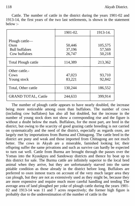
118 Akyab District.
Cattle. The number of cattle in the district during the years 1901-02 and 1913-14, the first years of the two last settlements, is shown in the statement below :- 1901-02. 1913-14.
Plough cattle— Oxen 50,446 105,575 Bull buffaloes 37,196 57,569 Cow buffaloes 26,747 50,218 Total Plough cattle 114,389 213,362 Other cattle.- Cows 47,023 93,710 Young stock 83,221 92,842 Total, Other cattle 130,244 186,552 GRAND TOTAL, Cattle 244,633 399,914
The number of plough cattle appears to have nearly doubled, the increase
being more noticeable among oxen than buffaloes. The number of cows (including cow buffaloes) has also all but doubled, but the increase in the number of young stock does not show a corresponding rise and the figure is without a doubt below the mark. Buffaloes, for the most part, are bred in the district, but owing to the scarcity of good grazing cattle breeding is not carried on systematically and the need of the district, especially as regards oxen, are largely met by importations from Burma and Chittagong. The cattle bred in the district are puny and weak and those imported from Chittagong are not much better. The cows in Akyab are a miserable, famished looking lot; their offspring suffer the same privations and such as survive can hardly be expected to turn oat well. Cattle from Burma are brought through the passes over the Yomas into the Kyaukpyu and Sandoway districts and thence by boat up to this district for sale. The Burma cattle are infinitely superior to the local bred animal when they arrive, but they are unfortunately starved into the same pitiable condition as those already in the district before long. Buffaloes are preferred to oxen inmost tracts on account of the very much larger area they can plough, but they are not as extensively used as they might be, because they are more expensive and require much more careful handling and tending The average area of land ploughed per yoke of plough cattle during the years 1901-02 and 1913-14 was 11 and 7 acres respectively; the former high figure is probably due to the underestimation of the number of cattle in the
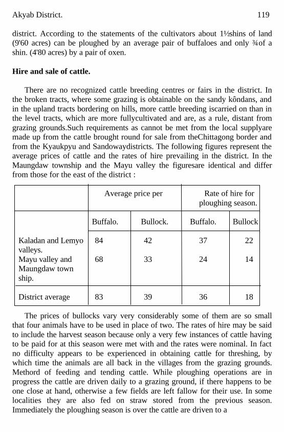
Akyab District. 119 district. According to the statements of the cultivators about 1½ shins of land (9'60 acres) can be ploughed by an average pair of buffaloes and only ¾ of a shin. (4'80 acres) by a pair of oxen. Hire and sale of cattle.
There are no recognized cattle breeding centres or fairs in the district. In the broken tracts, where some grazing is obtainable on the sandy kôndans, and in the upland tracts bordering on hills, more cattle breeding iscarried on than in the level tracts, which are more fullycultivated and are, as a rule, distant from grazing grounds.Such requirements as cannot be met from the local supplyare made up from the cattle brought round for sale from theChittagong border and from the Kyaukpyu and Sandowaydistricts. The following figures represent the average prices of cattle and the rates of hire prevailing in the district. In the Maungdaw township and the Mayu valley the figuresare identical and differ from those for the east of the district :
Average price per Rate of hire for ploughing season. Buffalo. Bullock. Buffalo. Bullock
Kaladan and Lemyo 84 42 37 22 valleys. Mayu valley and 68 33 24 14 Maungdaw town ship. District average 83 39 36 18
The prices of bullocks vary very considerably some of them are so small
that four animals have to be used in place of two. The rates of hire may be said to include the harvest season because only a very few instances of cattle having to be paid for at this season were met with and the rates were nominal. In fact no difficulty appears to be experienced in obtaining cattle for threshing, by which time the animals are all back in the villages from the grazing grounds. Methord of feeding and tending cattle. While ploughing operations are in progress the cattle are driven daily to a grazing ground, if there happens to be one close at hand, otherwise a few fields are left fallow for their use. In some localities they are also fed on straw stored from the previous season. Immediately the ploughing season is over the cattle are driven to a
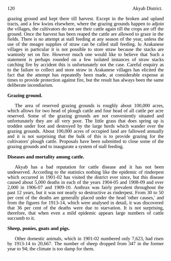
120 Akyab District. grazing ground and kept there till harvest. Except in the broken and upland tracts, and a few kwins elsewhere, where the grazing grounds happen to adjoin the villages, the cultivators do not see their cattle again till the crops are off the ground. Once the harvest has been reaped the cattle are allowed to graze in the fields. There is no attempt at stall feeding at any season of the year, unless the use of the meagre supplies of straw can be called stall feeding. lu Arakanese villages in particular it is not possible to store straw because the stacks are wantonly set on fire. However much one would like to believe that Such a statement is perhaps rounded on a few isolated instances of straw stacks catching fire by accident this is unfortunately not the case. Careful enquiry as to the failure to collect and store straw in Arakanese villages has elicited the fact that the attempt has repeatedly been made, at considerable expense at times to provide protection against fire, but the result has always been the same deliberate incendiarism. Grazing ground.
The area of reserved grazing grounds is roughly about 100,000 acres,
which allows for two head of plough cattle and four head of all cattle per acre reserved. Some of the grazing grounds are not conveniently situated and unfortunately they are all very poor. The little grass that does spring up is trodden under foot and destroyed by the large herds which wander over the grazing grounds. About 100,000 acres of occupied land are fallowed annually and it is not surprising that the bulk of this is to provide grazing for the cultivators' plough cattle. Proposals have been submitted to close some of the grazing grounds and to inaugurate a system of stall feeding. Diseases and mortality among cattle.
Akyab has a bad reputation for cattle disease and it has not been undeserved. According to the statistics nothing like the epidemic of rinderpest which occurred in 1901-02 has visited the district ever since, but this disease caused about 5,000 deaths in each of the years 1904-05 and 1908-09 and over 2,000 in 1906-07 and 1909-10. Anthrax was fairly prevalent throughout the past 12 years, but it was not nearly so destructive as rinderpest. From 30 to 50 per cent of the deaths are generally placed under the head 'other causes,' and from the figures for 1913-14, which were analysed in detail, it was discovered that 36 per cent of the deaths were due to starvation. It is not surprising, therefore, that when even a mild epidemic appears large numbers of cattle succumb to it. Sheep, ponies, goats and pigs.
Other domestic animals, which in 1901-02 numbered only 7,623, had risen
by 1913-14 to 20,667. The number of sheep dropped from 347 in the former year to 94; the climate is too damp for them.
Akyab District. 121
Horses and ponies have risen from 359 to 720, the increase will probably be found in Akyab town. There has been an extraordinary increase in the number of goats. from 6,917 to 19,853. These hardy animals thrive in spite of the excessive rainfall, and with the gradual increase in the Native of India population may be expected to continue to multiply. Statistics regarding pigs have recently been included in the returns. They are largely bred by all the hill tribes and number about 6,000. They are used by the hillmen at all their feasts and pork is also appreciated by the Arakanese whenever procurable. Individual and family ownership
Inheritances are seldom left long undivided and most of the laud in the
district is held by individuals, a notable exception being the large U Rè Gyaw Thu estate, the heirs to which have formed themselves into a cornpany. The effect of subdivision among the Buddhist races has not so far been to reduce holdings to very small dimensions because either one heir buys the others out, or, if the subdivision reduces a share to a very small area · and more land is net procurable in the vicinity, it is sold and a larger area taken up elsewhere. Among the Chittagonians subdivision is carried on to extreme limits. On the decease of a landholder, instead of his estate being distributed in the largest blocks possible among his heirs, each holding is separately subdivided among all the heirs, however many they may be. The result may be seen from a glance at any mad of a kwin in the Maugdaw township. A single person often owns ten holdings in a kwin, many only a fraction of an acre in area. Average size of estates.
The following figures show the average size of rice holdings by townships
and are a fair indication of the conditions prevailing in various parts of the district :
Average size of Population per Township. rice holdings. square mile of occupied area. Acres. Maungdaw 2.33 637 Akyab 4.79 1,270 Rathedaung 5.42 363 Buthidaung 5.81 388 Pônnagyun 6.45 359 Kyauktaw 6.76 392 Minbya 8.64 326 Myohaung 11.55 270 Pauktaw 12.16 276
122 Akyab Distrlct.
Area sold and sale values. These figures represent merely the number of separate plots of land held by
individuals divided into the occupied area. It has not been found possible to collect all the holdings in the possession of each person in the same or in various kwins. As it is the exception to find a cultivator with less than two or more plots of land the areas given above may safely be doubled and yet not be an exaggeration of the size of individual estates. In the western townships, where Indians predominate or are to be found in large numbers, holdings are very much smaller than else where. A few wealthy money lenders, scattered all over the district, own large estates acquired by foreclosure of mortgages. There are at least 53 estates in the district exceeding 300 acres in extent, of which one exceeds 2,000 acres, two exceed 1,000 acres, ten exceed 500 acres and twelve exceed 400 acres.
Area owned by agriculturists and non-agriculturists.
Eighty-six per cent of the occupied area is still in the hands of
agriculturists, 5 per cent in the hands of resident and 9 per cent of non-resident non-agriculturists. The area of land which has passed out of the hands of agriculturists is thus not very great. Instances may be quoted of fairly large estates which are in the hands of the U Rè Gyaw Thu Company, or individual members of his family and of many other money lenders. During the past two years in particular much land has passed into the hands of money lenders. The latter are not, as a rule, keen on acquiring land. The Hindu shopkeepers are an exception. They try by every possible means to get possession of land, in the vicinity of their villages. Money lending is much more profitable and less troublesome than managing land, and the latter is not taken over, especially by large money lenders, except when the money lender sees no prospect of recouping himself in any other manner. The bad season during 1914-15 with the disorgmization of the market during the past two years owing to the war have been the cause of the money lenders being compelled to tie up money on land, but is to be hoped when conditions become normal much of this land will revert to agriculturists. If the retention of the owner as the tenant may be taken to signify anything it may safely be assumed that it is apparently the present intention of the money lenders to reinstate the owners when their money is assured.
The number of sales of rice land shows a large increase from 3,211 in
1902-03 to 5,728 in 1912-13; the percentage of the occupied area sold has remained practically the same. Sale values declined during the first period of five years, particularly so in parts of Maungdaw, Buthidaung and Rathedaung townships, but since then they have risen and
Akyab District. 123
rice land is now worth more than twice as much as it was in the earlier year mentioned above. The value of land is higher in the accessible parts of the three western townships and in parts of Minbya and Akyab, where Chitta-gonians abound, than in the rest of the district. The better gardens, miscellaneous land and dani cultivation are valued slightly more than second class rice land, betel-vine cultivation a little more than the above and betel-palm gardens are far more valuable than the best rice land. Yaung paung transactions, which have been described in Chapter X, were met with over the greater portion of the district. They are most common throughout the Pônnagyun and Pauktaw townships and in parts of Rathedaung and Buthidaung. The recorded yaung paung values are generally higher than those of mortgages without possession and lower than those of sales and mortgages with possession. Areas mortgaged and mortgage values.
The area of rice land mortgaged has increased year by year, the percentage
of the occupied area mortgaged having risen from 2 in 1902-03 to 5 in 1915-16. The total area of land in mortgage during the latter period was only 8 per cent of the occupied area. The area under mortgage is thus by no means large. As in the case of sales, mortgage values fell during the first five years but have risen steadily since in almost all parts of the district. Only 24 per cent of the number of mortgages, and 8 per cent of the area under mortgage, are with possession; in the Maungdaw township alone are these mortgages more numerous than mortgages without possession. For main kinds other than rice there are only a few transactions which call for no remark. Tenancies.
The total number of tenants for all main kinds recorded during the
Settlement operations in the years 1913-16 was 28,910, working an area of 254,103 acres or 35 per cent of the occupied area. Of these 27,411 tenants of rice land worked 36 per cent of the occupied area under that main kind, the other main kinds are seldom let to tenants. Although partnership tenancies were met within in 14 out of the 28 tracts in the district the total number of such tenants and the area worked by them are negligible, being less than one per cent of the total. Share produce tenancies were met with in only seven tracts, practically all of which fall in three tracts in the Maungdaw township. As the figures stand these tenancies represent 73 per cent of the area let to tenants. The Maungdaw figures are however misleading. It is not usual in that township to employ this form of tenancy. During 1915-16, the settlement year for this township, considerable damage was caused by inundations of salt water. The damaged lands were originally let at
124 Akyab District.
fixed produce rents. When it was discovered that owing to damage tenants were unable to pay the rents fixed upon, the landlords agreed to accept half the produce The actual rents paid having been recorded by tile settlement the number of share produce tenancies, has been unduly exaggerated. Fixed cash tenancies were met with in every tract but the total area of such tenancies is only 5'56 per cent of the area worked by tenants. The bulk of the area let to tenants, 93 per cent of the total, is at fixed produce rentals. This rent varies considerably from tract to tract, and even within the tract to some extent according to the quality of the soil. The proportion of the gross produce taken over the whole district averages about one third. It generally exceeds this fraction in tracts in which Natives of India predominate. Forty per cent of the land worked by tenants is owned by non-agricultural landlords, mostly money lenders, and the balance by agriculturists who possess more land than they can work themselves, or who for convenience let their own lands and take up other land nearer their own dwellings. Rents are regulated according to those prevailing in the locality, but it has been noticed that wherever land has passed into the hands of a Native of India, and particularly a Hindu shopkeeper, there is a tendency for the rent to be raised beyond the gradual rise which is taking place in keeping with the steady pressure on the land, Each of the many races prefers, as a rule, to let to tenants of their own kind. It seems however to be generally accepted that for original clearing of land, whether in the hills or in the swamps, the hill tribes are the most successful. After the land has been got into working order Chittagonians are recognized as the most capable of development and some Arakanese landlords have expressed the view that Chittagonians are preferable as tenants to any other races, both because they are willing to pay a better rent, and because they try to improve the land. Of the total rented area 43 per cent had been worked by the same tenant for one year, 18 per cent for two years, 12 per cent for three years, 7 per cent for four years and 20 per cent for five or more years. Exproprietary tenants are under 3 per cent of the total number of tenants. The revenue is usually paid by the landlord. With the exception of a few fixed cash rents, which are paid in advance, the rent is always paid after harvest. Fixed produce rants are invariably payable on the threshing floor. Owners sometimes send their own boats to take away the produce but more often authorize the tenant to sell the grain with his own and to pay him his rent in cash. It is the custom, in all parts of the district to make concessions when
Akyab District. 125 the tenant has suffered unavoidable loss through floods, storms, destruction of crops by insect and other pests. No instances were met with of other services being demanded by landlords. The condition of the tenants is on the whole satisfactory. Rents are fixed according to those in force in the locality. The rents paid are not excessive and tenants usually have sufficient to maintain them in comfort.
Landlords and tenants live on equal terms, and as conditions are at present
there appears to be no necessity for protective legislation. Rental values.
Since 1902-03 rents have risen steadily over the whole district up to the
year 1913-14. They declined during the two following years owing to the unprecedentedly bad season of 1914-15, the effects of the war and the somewhat unfavourable season of 1915-16. The rental value per acre of each main kind over the whole settlement area is Rs. 9'02 for rice land, Rs. 8'87 gardens, Rs. 8'09 miscellaneous cultivation, Rs. 9'29 dani, Rs. 34'19 betel-vines, and Rs. 76'92 betelnut palms. The rents paid on rice land vary very considerably from Rs. 5'12 per acre in au out of the way, land locked tract in the northen extremity of Maungdaw township and Rs. 6'33 per acre in a marshy tract in the south of the Minbya township to Rs. 12'68 and Rs. 13'47 per acre in the centre of the Buthidaung and Maungdaw townships respectively. Rents are higher in the west than in the east of the district owing to the pressure of population and the competition of the Chittagonians. In all parts of the district in which the latter have obtained a footing the rents are generally higher than elsewhere.
CHAPTER V.
Forest and Minerals.
Forests: Area of forests; Legal position of forests; Types of forest; History of Administration; Clerical establishment; Personnel of officers; Revenue and Expenditure; Progress ; Reservation of forests; Development of new markets; Teak plantations ; Mincrals; Petroleum; Salt; Coal and other Minerals.
Forests. The following paragraphs on Forest Administration in the Akyab
district have been contributed by Mr. A. H. M. Barrington, Deputy Conservator of Forests, Arakan Division :-
"There is no direct method of calculating the forest area. Area of Aceepting
the latest figures for the total area of the district, fores s. and the acreage of cultivation from the Season and Crop reports concerned, the tract under forest has dwindled from 4,067 square miles on the 30th june 1902 to 3,872 square
126 Akyab District miles on the 30th June 1914. This decrease, averaging 16'2 square miles per annum, is solely due to extensions of the cultivated area; and as there is some reason to suppose that the latter has been underestimated the figures for the tract under forest are probably too high.
Legal position of the forests.
No forest reserve has yet been gazetted. A block of some 300 acres has
been formally proposed for reservation and larger tracts will be proposed after rough survey; the final area of reserved forests is not likely to exceed 300 square miles. The only special protection afforded to defined areas is a general prohibition against felling roadside trees on land at the disposal of Government. Certain tracts were suggested for closure against shifting cultivation, but the proposals were rounded on insufficient data and consequently withdrawn. In addition to teak, which is not indigenous in Arakan, the following trees are reserved throughout Lower Burma :
Pentacme burmanira, all species of Hopea, all species of Cedrela,
Cinnamomum inunctum, Fargræa fragrans, Bassia longifolia, Casurina equisetifolia, Xylia dolabriformis, Acacia cutechu, Parashorea stellata, Pterocarpus indicus and macrocarpus Albizzia Lebbek, practically all species of Dipterocarpus except D. tuberculatus, and Lagerstroemia macrocarpa, tomentosa and flosreginæ. Of these Acacia catechu (cutch) and Pterocarpus spp. (padauk) do not occur in the district.
The legal protection conferred by reservation is considerable. On land at
the disposal of Government, or about 99 per cent of the forest area of the district, no person may injure, fell, or kill any reserved tree except in accordance with the provisions of such license as may have been actually issued to him, or, in the case of very small trees only, clearing land for cultivation. In actual practice numbers of reserved trees are destroyed every year, both on cultivation and near villages, and the penalties imposed are generally light. But in the case of timber traders the law is strictly enforced, their licenses are worded so as to prohibit the felling of immature trees and waste of marketable timber, and flagrant offences have been severely punished. Recently special protection has been given to Xylis dolabriformis (pyinkado) throughout Arakan; since the 25th March 1914 it has been unlawful to make clearings for shifting cultivation within a chain of any such tree over 3 feet in grith. It is too early to estimate the effect of this rule as it is not widely known and has not yet been enforced. Types of forest
The composition of the forest is discussed in detail under another heading
(see Flora Chapter I). The natural forest may be divided into four main types; on land below the
Akyab District. 127 level of the sea there were extensive tidal swamps with such trees as mangrove (Rhizophrra spp) and sundri (Heritiera minor); on the delta plains, and along hill valleys, there was a valuable timber forest consisting largely of kamaung or pyinma Largerstrœmia flosreginæ); in the west of the district there were evergreen forests with thinbaung (Buchanania lancifolia), kayin (Dipterocarpus spp.), canes, and palms, and in the north and east the hills were largely covered with a struggling growth of softwoods. The plains are now cultivated; most of the tidal swamps have been reclaimed; and the timber from them was want only destroyed. Of tidal forest there remains but a fringe along some of the delta creeks. There is still some moribund kamaung in the outlying fields, and along hill valleys as much as the trader and the shifting cultivator have so far spared. It would be idle to regret the disappearance of timber from the plains, though even there much was destroyed which might have been utilized, but along hill streams, on land never likely to be cultivated permanently, the waste of timber is balanced by no appreciable gain. TO save kamaung effective forest administration was established too late: so far as Akyab district is concerned there are dwindling suppilies of mature timber fast receding towards inaccessible forests; and there is little hope that the few young trees will survive to yield marketable timber. The kanyin forests of the west have fared better. They are confined to tha hills and have been cleared only by hill tribes or for lowland pasture; yet they two have disappeared from the more populous valleys and, failing reservation, seem doomed to extinction. The softwood forest of the north and east have almost ceased to exist. A virile 'single stemmed' bamboo, provisionally named Melocanna bambusoides, entered Arakan from the north, is rapidly covering the main mass of the hills, and even forcing its way into the evergreen forest of the west. It spreads by means of an underground stem or rhizome and the culms sent up are separated, in the case of mature bamboos, by a distance of two or more feet. The area covered by a single plant is unknown but must be considerable. The bamboo, locally known as kayin does not thrive under the shade of trees and would probably have made little headway were not successive plots, amounting over long periods to 75 per cent of the softwood forest, cleared by hill tribes for the purpose of shifting cultivation. Such clearings offer ideal conditions for the spread of the bamboo and it seized the opportunity with relentless vigour. Eastablished on the border of virgin forest it gradnally intrudes, taking advantage of every gap formed by death or windfall; and it is
128 Akyab District likely finally to occupy all remaining tracts of softwood forest. Not that kayin forest is destitute of trees; typically there are about as many as in a shady pasture in England; many of them may well be survivals from the original forest, some have certainly managed to force their way through thebamboo :but in any case repeated clearings at such short intervals as five or even three years must tend to eliminate the trees and thereby encourage the bamboo. At the same time the area actually required for a rotation of the pônzo is a very small fraction of that now covered by kayin; either villages have migrated at frequent intervals or the hill population was once much greater than at present. Much of the jungle which is obviously pônzo (or secondary growth derived from hill clearings) is now far remote from any village; Kayin, like all bamboos, flowers and dies after reaching some definite age. The last flowering is said to have taken place in 1864, the present one may be given as 1912 but it started as long ago as 1902 and cover large areas of Arakan in 1909, 1910, 1911, 1912 and 1913; further flowering occurred in 1914, is taken place in 1915, and will probably continue for years, but the areas which remained unaffected after 1913 were inconsiderable. To what extent this wholesale flowering will modify the distribution of the bamboo is at present uncertain; on some hills the young seedlings have undoubtedly been destroyed, usually by clearings but in some cases by fire, but it is probable that kayin will be able to recover the lost ground before tree growth has been established. On hills where the bamboo had not reached the lower slopes its heavy fruit is likely to assist its extension even better than the creeping rhizome.
Apart from the above types there is deciduous forest with a high percentage
of pyinkado (Xylia dolabriformis) along the foothills of the east and also in a few small valleys. of the north and west. There are various classes of plains and low hill forest which occur on a small scale, often containing such trees as letpan (Bombax malabaricum), tein (Nauclea parvifolia), and taukkyan (Terminalia tomentosa). Wild plantains occur on the banks of streams and often spring up in abandoned clearings; normally this does not take place in kayin jungle, but recently plantains have in some cases usurped the place of young bamboo seedlings destroyed by fire.; it seems improbable that the change is a permanent one. Teak, the principal tree of Burma is not indigenous; it has been planted on a small scale and in general has not done well; but there are indications, especially in Northern Arakan, that on hillsides remote from the excessive rainfall of the coast it will thrive as well as in the plantations of Lower Burma. Exceptional trees have attained girths of 9 feet in so short a period as forty years.
Akyab District. 129 History of Administration.
Tentative steps towards the conservation of valuable timber were taken long before any special forest administration was started. In 1865 the Chief Commissioner of Burma issued some 'Amended Rules for cutting Ironwood in Arakan '; the rules were probably evaded but their issue shows that Government had already appreciated the need for protecting small trees of pyinkado and was collecting some revenue from timber traders. In 1869 all Assistant Conservator of Forests (now Sir Wa. Schlich, K.C.I.E.) was deputed from Burma to examine the forest of Arakan. His report, which deals chiefly with the southern half of the division, was published in 1870 and contains proposals for a skeleton forest establishment; he estimated that an immediate surplus of Rs. 30,000 would result from managemeat on the lines he suggested; and in a view of what occurred later this forecast was probably correct; But the proposals were not sanctioned. In 1881 teak and seven other species (padauk, thitka, thitkado, thingan, kanyin, pyinkado, and kamaung) were declared reserved trees. In the same year, Mr. J. Nisbet then an Assistant Conservator, toured in Akyab and Northern Arakan with a view to formulating proposals for the establishment of revenue stations. He decided in favour of a purely subordinate establishment supervised by township officers. In 1883, after an interview between the Conservator and the Chief Commissioner, it was decided 'tomake no change as regards the trees which are to be considered reserved trees in the Arakan Division, to establish no revenue stations in the division, to exempt Arakan from the rules applicable to the remainder of the province, and to make for Arakan merely a few brief rules providing for issue of licenses by the Deputy Commissioner for the extraction of timber of the reserved kinds.
On the 1st January 1893 all firewood taken into Akyab town, or used on
steamboats, etc., became liable to duty. On the 10th March a temporary establishment of one than on Rs. 70, two on Rs. 20 and three on Rs. 12, was sanctioned for the town of Akyab. The man on Rs. 70 reverted on the l5th August to his post in the Deputy Commissioner's Office and the post was not again filled. During the period 10th March 1893 to 31st March 1894 the revenue collected in Akyab town was Rs. 4,105 as against an expenditure of Rs. 1,278. On the 15th August 1894 the original establishment was changed to one of three men on Rs. 40 and remained without further modification until handed over to the Forest Department on the 5th February 1903. Till that date all payments and receipts were entered on the books of the Rangoon DepOt and Agency Division; and until 1st April 1905 the forest officer
130 Akyab District. in charge of Arakan (arrived 15th August 1902)was subordinate to the same division. The delay in transferring the control of the firewood establishment to the local forest officer seems to have been due to doubts regarding the permanency of his stay in Arakan. Duty on firewood leviable outside Akyab town prior to August 1902 was collected, if at all, by township officers. No establishment other than the above was entertained in Akyab district before 1902.
In 1903 the Divisional Forest Officer at Chittagong (Mr. E. B. Stebbing,
Deputy Conservator of Forests)paid a flying visit to Akyab to confer with the Deputy Commissioner regarding the extraction of timber, without payment of duty, from Akyab district. Mr. Stebbing returned overland and based his account on what he then saw and on the two reports already noticed; his report is a plea for effective control under departmental officers; and to some extent it was successful. With effect from the 15th August 1902. Arakan became a subdivision of the Depôt and Agency Forest Division at Rangoon. The unpensionable posts in Akyab and Northern Arakan were handed over to the Forest Department early in 1903 and abolished. In their place, with effect from 1st September 1902, there were two deputy rangers, two foresters and four forest guards for the whole of Arakan. The right to collect duty on firewood entering Akyab town was sold every year by public auction. The new pensionable posts were eked out by the addition of new temporary posts until 1905, when Arakan was made an independent charge (i.e. a forest division) with a pensionable staff of 48 men; this establishment seems to have absorbed all temporary posts then in existence. With the exception of a slight increase in the years 1910-12 the number of 48 permanent postsfremained constant until November 1914, when it was increased, by the absorption Of 64 temporary posts and an addition of 29 new ones, to 141. The number of unpensionable (temporary) posts had gradually increased since 1906 to that absorbed in 1914.
For nearly three years the Divisional Officer was expected to control the
vast division without any assistance; on the 7th August 1908 he was given a subdivisional officer at Sandoway (in charge of Sandoway and Kyaukpyu districts) ;and since the 18th July in the same year all officers in permanent charge of the division have been members of the Imperial Forest Service. The Divisional Officer has always been in direct charge of Akyab and Northern Arakan districts. In 1902 this tract formed one of the two ranges; in 1905 it was still a range but divided into three subranges; these soon became ranges and, with
Akyab District 131 a few boundary alterations, remained practically unchanged till October 1913. In that month the largest of the three ranges was divided into two and some slight alterations were made in the boundary of a third; with effect from 1st February 1915 a fifth range was formed and certain boundaries modified. Pending reservation on a large scale no further changes are contemplated. But the split of Arakan into two forest divisions is acknowledged to be urgent and is not likely to be delayed many months. The executive staff has already been allotted to the subdivisions; Akyab and Northern Arakan receive 54 superior and 30 menial executive officers; of these 84 men, about 70 have duties largely or entirely in Akyab district; this figure corresponds with 50 in 1913 and 4 in 1903.
The relations between Forest and Civil authorities have always been
intimate. Up to the 15th October 1894 all forest administration was in the hands of Deputy Commissioners; and from that date to 15th August 1902 the only exception to the same rule was that the Collector of Customs was responsible for collections of duty on firewood in Akyab town. Till so recent a date as the 25th March 1914 all civil officers were exofficio forest officers; for some time previously most of them had done little but issue forest licenses; this power they still retain, and the Deputy Commissioner of Northern Arakan is empowered to compound forest offences. Clerical establishment.
The clerical establishment of the divisional office, which is likely to be
somewhat enlarged for the new Northern Arakan division, consists of one clerk on Rs. 100-150, one on Rs. 80-100, two on Rs. 60-80, one on Rs. 40-60 and one on Rs. 40. There is also a durwan, five peons, and the usual complement of punkah pullers, etc. Since March 1907, a steam launch has been at the disposal of the Divisional Officer. Personnel of officers.
The following officers have been in charge of the forest administration of
Arakan : Mr. C. H. H. Haldane, Extra Assistant. afterwards Extra Deputy Conservator of Forests; from 15th October 1902 to 17th July 1908.
Mr. J. C. Hopwood, Deputy Conservator of Forests; from 18th July 1908 to 17th May 1910.
Mr. C. H. Philipp, Deputy Conservator of Forests; from 18th May to 31st August 1910.
(Mr. J. D. Hamilton, Extra Assistant Conservator of Forests; in charge of current duties from 1st to 13th September 1910.)
Mr. H. C. Walker, Deputy Conservator of Forests; from 14th September 1910 to 12th May 1913.
132 Akyab District. Mr. A. H. M. Barrington, Deputy Conservator of Forests; from 13th May
1913 to date. Since the 7th August 1908, Mr. Hamilton hen been in charge of the
Kyaukpyu subdivision, with headquarters at Sandoway.
Revenue and Expenditure. The gross revenue of Arakan forests has increased from Rs. 16,455 in
1901-02, the last forest year of civil control, to Rs. 1,79,557 in 1913-14 ;. the expenditure rose from Rs. 9,798 to Rs. 85,640 in the same period. Akyab and Northern Arakan together form a convenient trait; for them the revenue in 1913-14 was Rs. 87,318 and the expenditure Rs. 41,624. Akyab district alone has been credited with a revenue of Rs. 7,238 in 1901-02, rising to Rs. 57,274 in 1908-09 and falling again to Rs. 49,603 in 1913-14. To some extent the decrease, at a time when the revenue for the whole subdivision was rapidly rising, is due to more correct classification between the districts. but undoubtedly it also represents the increased difficulty of obtaining timber near the town of Akyab, exploitation of the higher reaches of the rivers, and consequently of Northern Arakan rather than Akyab. The expenditure incurred on forest control was Rs. 1,440 in 1901-02 and is given as Rs. 28,875 in 1913-14; the last figure is based on necessarily arbitrary data and is not very reliable. Progress.
The efficiency of tile forest staff as a revenue collecting agency is reflected
in the figures given in the above paragraph. It has been stated on high authority that the met revenue of a forest division has not reached its maximum unless the expenditure is at least equal to it; on this and other grounds it seems probable that the gross revenue can be greatly increased without any change in the methods or scope of the existing trade. And revenue collection is not everything. Till quite recently future supplies of timber were menaced by wholesale removal of young trees; round posts of reserved kinds were openly extracted;and the price was ridiculously cheap. Though control is still far from perfect the price of pyinkado pests is now almost prohibitive, and so many traders have been caught with young kamaung (for boat ribs) that there are cogent reasons against the continuance of the practice. Reserved trees are still destroyed in hill clearings and for grazing grounds, but forest rules are being enforced, with increasing rigour, on the timber trader. It is often stated that timber prices in Akyab are unduly high. There is no doubt that they are high in comparison with those ruling before forest control had become effective; had extraction and waste long continued there must have been a genuine timber famine; but the prices of indigenous timbers in Akyab are not higher
Akyab District. 133 than those in large towns on the Burma coast. That they are high at all is due to the primitive and unenterprising methods of timber traders rather than to the difficulty or cost of extraction. Reservation of forests.
As already stated very little progress has been made in the direction of
protecting defined forests. The division is so vast that two gazetted officers can only struggle through the ordinary routine; detailed examination of remote forests must await the arrival of additional assistants. There is no doubt that reservation is urgently necessary, not only to conserve valuable timber but also to ensure an equable and permanent flow in the hill streams. On the coast between the Naaf and Mayu there are already signs that the rainfall is less effective than formerly. The higher terraces of old fields were not even cultivated in 1914, a year of exceptionally heavy rain, and a cyclonic disturbance towards the end of the year seems to have flooded some of the villages. The evidence may not be complete but it suggests that rain rims rapidly from the denuded valleys and, if equal in total amount, is less beneficial than it was formerly. Development of new markets.
An important duty of the department is the development of new markets;
Since 1912 much has been done. The present revenue from the 10,000 square miles of kayin forest in Arakan is some Rs. 35,000; samples of paper made from the bamboo were received in 1913 and in the next year a responsible agent of a large Calcutta firm toured in the division with a view to ascertaining local conditions; he professed himself delighted with what he saw and his firm at once applied for a concession. Conditions are still being discussed, but it seems probable that a factory will be established and that the Lemyo forests, a mere fraction of the total area available, will yield a revenue of Rs. 1,00,000 to Rs, 5,00,000 from this source alone. Of that part of the Lemyo drainage at present administered rather less than half falls in the Akyab district. In other directions thinbaung planks have been suggested for packing cases in Bengal; sundri has already a brisk sale in Calcutta and might probably be exported; plantain fibre is being tested at Dacca, an expert has been engaged to value the tanning products of mangrove; kanyin is already exported on a small scale and, pending reservation of the more important forests, the trade at this stage needs restriction rather than encouragement. All products which occur on any considerable scale are being tested and brought to the notice of those likely to be interested. Many, unfortunately, though known to be valuable, do not occur on a scale sufficiently large to supply even the local demand.
134 Akyab District. Teak plantations.
So far the only attempt to improve the value of forest property in Akyab and Northern Arakan has taken the form of teak planting. The first plantations, one in Northern Arakan and two in Sandoway, were made in or before 1844. In 1872 the Superintendent of the Arakan Hill Tracts (now Hill District of Arakan) distributed seed, ordered planting at police outposts, and gave a stimulus to teak plantation by private enterprise. From 1869 to date, plantation on a small scale has continued; but from 1873 to 1909 the only action taken by Government was the acquisition of teak already planted in Northern Arakan. Experimental sowings were carried out by the Forest Department in 1910, 1912 and 1913. In 1914 some 400 acres were planted and Government sanctioned the expenditure of Rs. 25,000 to be spread over five years. Nine small blocks have been proposed for reservation (one only lies wholly in Akyab district) and these will be planted as rapidly as funds permit. After the lapse of the five-year period there is every reason to expect that the rate of planting will be greatly accelerated."
Petroleum.
Minerals: The existence of petroleum in the district was first drawn
attention to at the Akyab Exhibition of 1875. The oil beds are situated in the Eastern Baronga Island and are tertiary in age. The oilbearing area became the subject of two main concessions, the history of each of which is rather chequered. Operations were first begun by Mr. W. Savage, who obtained a prospecting license in 1877. He struck oil in 1878 and at first the natural flow of the oil produced about 40 gallons a day, but this soon fell off. Mr. Savage obtained a lease for one square mile for thirty years in 1879. No rent was charged for the first three years, but thereafter a royalty of 5 per cent on the value of the crude oil was to be paid. Boring operations were commenced with native labour and tools and plant of local manufacture and fifteen wells were succesfully bored. The two best of these wells were known as "Bogyi" and "Lugyi." The first was 160 feet deep and yielded an average of 180 gallons a day by hand pumping. The second well was 180 feet deep and out of it five gallons were pumped each morning and then boring was resumed.
In 1888 the lease was transferred to Ma Cho, the wife of Mr. Savage, under
the orders of the Chief Commissioner. At this period the output of oil per annum exceeded 55,000 gallons, but this rate was not maintained owing to the caring in of the wells or the exhaustion of the oil beds. In 1909 the lease expired and Government declined to renew it. In the same year a lease for this area was applied for by a Mr. Mansfield of Liverpool. His
Akyab District. 135 application was successful and a lease for 568.91 acres, which was found on measurement to be the actual area of the concession, was granted to him. The surface rent was fixed at Rs. 569, at the rate of Re. 1 per acre, and royalty at 8 annas per 40 gallons of crude oil. The lessee has not yet however started operations.
The second concession had been granted in 1878 to the Baronga Oil
Refining Co., Ltd. (represented in India by Messrs. Gillam & Co.) over an area of four square miles for a period of 30 years. This company had a subscribed capital of £30,000 and employed Canadian workmen and engineers. The output did not exceed 40,000 gallons per annum and the royalty fixed was the same as in the case of Mr. Savage's concession. The best well, named "Gillinto," struck a spring of water at a depth of 1,000 feet and had to be abandoned. The company failed and a Mr. Senior, of London, took over the property. In 1894, under the orders of the Government of India, Mr Senior sold the lease to the South Australian Petroleum Fields Co., Ltd., but this company also failed and a Mr. W. H. Haley applied for the lease. As the conditions of this lease had not been observed it was resumed by Government and a fresh lease was prepared and issued to Mr. Haley in December 1902. The area covered by this lease measured 1,167 acres and in 1903 the oil obtained amounted to 40,000 gallons. In this year 13,069 gallons of oil were won on the neighbouring concession.
In both cases steam power was used for boring, while the usual method of
raising the oil was to let down a metal cylinder with a valve in the base. When the cylinder had filled with oil it was raised to the surface and emptied. Water was allowed to run off and then the oil was stored pending transport to Akyab by boat. The oil was not refined as it could be disposed of locally fur use in native lamps.
On the death of Mr. Haley in 1907 his lease was transferred, with the
sanction of the Local Government, to Messrs. Ezekiel & Co., of Akyab. The latter pay surface rent at Re. 1 per acre, amounting to Rs. 1,167 per annum, and also royalty at the rate of 8 annas for every 40 gallons of crude oil won. Messrs. Ezekiel & Co. applied on the l4th September 1910 for permission to transfer the lease to the Arakan Oil Prospecting Syndicate and obtained sanction from the Local Government in December of the same year. Some hitch occurred, however, in the arrangements for the transfer and Messrs. Ezekiel & Co. are still working the concession and paying revenue on it.
136 Akyab District. During 1909-10 and 1910-11 many applications for licenses to prospect for oil in the district were made. In one case a license to prospect over four square miles in the Minbya township was applied for; this area includes the Kyeindaung Hill, on which stands the Kyein golden pagoda near Minbya town. The application was with drawn however, on an unfavourable report from the geologist. The same applicant made a bid for an area of about 22 square miles in Kyauktaw township, including the whole of the Pyuma-Leikma Waste Land Grant. But again withdrew his application for the same reason as in the first instance. This application raised an important point as to the rights over minerals of a Waste Land Grantee. It was held that the grantee was entitled to minerals in his grant.
Licenses to prospect over portions of the Western Baronga Island were
issued to three applicants, and two others successively were granted a license for the area lying between Mr. Mansfeld's and Messrs. Ezekiel's concessions on the Eastern Baronga. None of these, however, came to anything, and at present the only prospecting licenses in force are two held by the same individuals, one in Rathedaung township and the other covering the hilly portion of the Western Baronga Island.
The revenue derived from petroleum amounted in 1902-03 to Rs. 623 ; in
1907-08 to Rs. 1,234, and in 1912-13 to Rs. 2,925. The sum of Rs. 2,000 was first exceeded in 1910-11, since when the revenue from this source has not been less than that amount.
Salt.
The only source of salt in the district is sea-water and its manufacture
provides employment for a few persons residing near the coast;but owing to the heavy tax on salt production the amount manufactured falls far short of the needs of the district. The mode of manufacture is simple. The upper layer of earth which the tide has impregnated with salt is collected and then treated with salt water to dissolve the brine. This salt water is then boiled down till it has evaporated, leaving a deposit of salt in the pan. The resulting salt is of good quality and is preferred to the European product.
The revenue derived from salt is negligible and is steadily decreasing. In
1903-04 it amounted to Rs. 2,430, but by 1907-08 it had dropped to Rs. 1,860. In 1909-10 it dropped for the first time below Rs. 1,000, being only Rs. 660, and in 1912-13 the amount of revenue realized was only Rs. 456. Coal and other minerals.
Coal is found in the district but is of inferior quality. Laterite and sandstone
occur in many places and about 1,300 tons are quarried annually for road-making. Clay is
Akyab District. 137 not very common but suffices for the making of bricks and rough pottery. Owing to the scarcity of good road metal broken bricks are much used for surfacing roads in Akyab and elsewhere in the district. The modus operandi has been described by a layman as "taking some mud, making it into bricks. breaking up the bricks and laying the product on the road, where it soon becomes muk again." There has as yet been no detailed geological survey of the district, but tradition has it that there are gold and sliver mines. The whereabouts of these have remained unknown.
CHAPTER VI.
Occupations and Trade. Agriculture; Trade in food stuffs; Other occupations; Rice milling Carrying
trade; Labourers; Former industries; Weaving; Gold and silver smiths; Carpentering; Boat-building; Shoe-making; Pottery; Iron work; Mat-making; Dani palm; Early trade ; Trade from 1830 onwards.
Agriculture.
The Akyab district is dependent entirely on agriculture; all the other
occupations are subsidiary to, or exist for the maintenance of, the agricultural population. Of the total population according to the census returns of 1911, 392,319 or 74 per cent were occupied in agriculture or pasturing, the actual workers numbering 213,908 and their dependents 178,411. The agricultural conditions of the district have been fully described in Chapter IV. Trade in food stuffs.
The next in order of numbers are those engaged in trade in food stuffs,
22,063, viz., sellers of cardamom, betel-leaf, vegetables, fruit, areca nut, fish dealers, grocers, sellers of vegetable oils, salt and other condiments, milk, butter, ghee, poultry, eggs, sweetmeats, sugar molasses, grain and pulse dealers, tobacco, opium and ganja sellers. Other occupations.
The third in respect of numbers are shopkeepers, who number 14,181,
followed by persons engaged in transport by water 11,251 and by road 10,409. wood workers 8,808, food industries, i.e., rice pounders, bakers, butchers, sweet meat makers, manufacturers of tobacco, opium and ganja 7,963. Fisherman, the bulk of whom are Madrassis and Chittagonians, number 5,528. Further particulars regarding the fishery industry will be found in Chapter X. Rice milling
The district has no manufactures of importance ;the only factory industry is
rice milling. The rice trade was started about 1850 and for many years was confined to the
138 Akyab District.
export of hand-cleaned rice. In course of time, with the increase in this trade, power mills were built and for many years there were 11 such mills in Akyab turning out about 3,200 tons of cargo rice a day of 12 hours. Early in the development of the trade it was found more suitable for the European demand to substitute for cleaned rice a partially cleaned quality known as cargo rice, which could be remilled by the European importer to suit the different markets, which they, in return, supplied. The export of rice to Europe for the last twenty years or more has been entirely of this quality. There is generally a fair. demand for white rice in Bombay and the manufacture of this quality has been chiefly limited to meet this demand, and to small quantities for the Malabar Coast and Calcutta. As a general result the cost of white rice is higher in Akyab than in any other part of Burma, though Akyab district is practically one vast paddy field.
Carrying trade.
The carrying trade, which is practically confined to waterways, is in the hands chiefly of Chittagonian boat-men, who come down for the season each year, January to May. These men purchase paddy on the spot from the cultivators to whom they pay cash and sell in the Akyab market.
Labourers.
The Arakanese cultivator pays the Chittagonian cooly liberal wages to help in cultivation, and, in many cases, to do all the cultivation this in addition to letting the Chittagonian reap all the profits to be made by the sale of his produce in the Akyab market. It is not surprising, therefore, to find that the Arakanese are slowly but surely being ousted by the Chittagonians in every walk of life.
Former industries.
In ancient times the people of Arakan were divided into castes according to profession, and various industries existed. The art of manufacturing war material, such as cannon, guns and ammunition, was acquired. The archæological remains in the district, described in Chapter II, are evidence of oldtime arts and industries, but the constant wars and dynastic struggles that disturbed Arakan for over a century before its incorporation into the British Indian Empire caused these almost entirely to disappear. Now a days there are no organised industries and arts, and crafts do not exist to any great extent. A certain amount of gold and sliver work, carpentering, shoe making and pottery are to be met with; these may be classed with silk and cotton weaving as hand-industries.
Weaving.
Weaving is entirely a home industry and is carried on by women and girls in almost every family. Locally made hand looms are employed and the fabrics are of coarse but serviceable texture. The silk and cotton cloths made in Akyab are famous for their durability and a considerable
Akyab District. 139
quantity finds its way to Burma proper. The cloth is woven either entirely of silk, Which is imported from Bengal, or of cotton or of silk and Cotton mixed. The cloth is usually woven in short lengths sufficient for a single lôngyi in stripe or check patterns. Arakanese women invariably wear lôngyis of the former and men of the latter pattern. Fine silk and woollen fabrics are imported from abroad.
Gold and sliver smiths.
With the exception of a few Natives of India the gold and sliver smiths are Arakanese, They turf out earrings, necklaces, bangles, rings, etc., with designs peculiar to the district. The workmanship is not to be compared with that of the Burmese jewellers, being rougher and lacking finish; especially is this the case with silver work.
Carpentering.
The carpenters are Arakanese, Chinese and Natives of India; of these the Chinese are considered to be the most reliable and proficient. The work trained out by the Arakanese carpenters is of the roughest and the wages demanded are exorbitant.
Boat building.
Boats are built by Arakanese and Natives of India; cargo boats of a capacity of 1,000 to 3,000 Akyab baskets (roughly 406 to 1,200 Government standard 9 gallon baskets) of paddy are built at Akyab. The cargo boats in the district are not sufficient for the paddy trade, but the deficiency is made up by boats from the Kyaukpyu and Sandoway districts, from Chittagong and even from the further coasts of India; the supply is quite equal to the demand. Throughout the district 'dug outs' of all sizes are turned out; the Chaungthas are most expert in their construction. Complaints are often heard of the lack of suitable timber for the construction of these craft, but this is not to be wondered at considering the waste which has been allowed to take place in felling of forest growth. Chinese carpenters have the monopoly of sampan building; these handy little craft are very suitable for the waterways of Akyab and are used by the thousand.
Shoe making
The shoe-makers are Chinamen or Natives of India. The shoes they make are for native wear and not of good quality, the leather being Indian country leather.
Pottery
The ordinary earthenware pots, made by Chittagonians in Akyab town and by Chittagonians and Yanbyès in the district, are of poor quality and cannot compare with those imported from Chittagong and the Madras coast or even from Kyaukpyu and Sandoway. The reason for this is that clay is not easily procurable in the district and such as is available is not suitable for pot-making.
140 Akyab District. Ironwork.
Hindu Chittagonians monopolise the blacksmiths' business; the articles
manufactured are chiefly agricultural implements, such as das, various digging implements, sickles; teeth for ploughs, axes, etc. These are of rough finish. Mat-making.
Mats are made of an aloe like, plant, which flourishes in a wild state all
over the district. These mats are soft and are used chiefly for domestic purposes. The usual bamboo mats are used on the threshing floors. Dani palm.
The dani palm, which fringes all the creeks in the lower portion of the
district, serves a double purpose. In town and district alike the dani leaf is used aS thatch for roofing houses. Just after the paddy is reared large numbers Of men, women and children are employed in weaving the dani leaves into thatch; the price of 1,000 lengths is usually Rs. 7-8-0 at the place of manufacture; at Akyab it is about Rs. 12. The place of toddy, so common in most parts of Burma proper, is taken in Akyab by the fermented juice of the dani palm, of which the Arakanese are inordinately fond. No trade, occupation or business, however, approaches even remotely the paddy and rice business in importance.
Early trade.
The trade of the district centres almost entirely inAkyab town. Originally it
was a fishing village and itsimportance as a trade centre dates from the time it waschosen to be the capital of the Arakan division after thefirst Burmese war came to an end in 1826. Its position is eminently suitable for the great export trade of rice which has sprung up; situated on the harbour formed by themouth of the Kaladan, it is equally accessible for the trading boats which use the vast system of internal waterways andfor ocean going steamships. From time immemorial, so the historians of Arakandeclare, there was trade between Arakan and the shores of Burma proper, Ceylon and India. Inland trade with India followed the route which leads to Chittagong and Dacca andtraders obtained access by land to Burma by way of the An and Nai passes across the Arakan Yoma. Long beforethe annexation larger sea going boats from old Arakan (Myohaung) visited the ports of Bengal and returned witharticles of British manufacture, such as muslins, woollen,cotton, and silk piece goods, glass, crockery, etc., whilst asmall trade was carried on with the other Burma ports tothe east. After the annexation and the selection of Akyabas the capital of Arakan, trade began gradually to increase.Goods imported from India were sold locally and partly exported to Sandoway and Kyaukpyu districts and to Upper Burma. The trade between Akyab and Upper Burma
141 Akyab District. passed through the market town of Myaungbwè, ten miles to the north of Minbya, where, on account of its connection with Burma, there is a large colony of Upper Burmans. Myaungbwè is on the decline, the trade with Kyaukpyu, Sandoway and Upper Burma has, for the past twenty years, been gradually intercepted at Minbya, the headquarters of the township and subdivision of the same name, which is growing in size and importance at the expense of Myaung-bwè, many of the Burman traders having shifted from the latter to the former place.
The principal articles of export to India were ivory, hides and horns, bees'
wax, cutch, raw cotton and timber, the cotton having been obtained from the people of the hill tribes in exchange for grain. Goods destined for export to Upper Burma were taken up the An rivet, which is navigable for boats of medium size as far as An, 25 miles from the mouth. Here the traders from Arakan were met by the traders from Upper Burma, with goods transported across the mountains on pack bullocks. Such goods usually consisted of jaggery (palm sugar), sesamum oil, cutch, silk, das, palm leaves, lacquered ware, brass utensils, bullocks, buffaloes and ponies. For these the Arakanese gave in exchange Bengal betel-nut, and tobacco and ngapi. The annual volume of this trade over tha An pass to Ngape, 25 miles on the eastern side of the Yoma, is estimated to have been 5,000 to 6,000 bullock loads of 170 lb. each, valued at half to one lakh of rupees. Government built and maintained a road for this traffic. Trade from 1830 onwards
In 1830-31, during the shipping season, 140 square rigged vessels visited
Akyab with cargoes valued at Rs. 73,780; by 1833 the number of vessels had increased to 178 and the value of the cargoes to Rs. 93,110. In 1835 Captain B. Pemberton reported as follows :-
"The shops in the town are well supplied with the different varieties of
grain which are in use among the inhabitants of Bengal, from whence they are imported, and British cloths consisting of piece goods, broad cloths and muslins, cutlery, glassware and native manufactures are all exposed for sale, and are principally imported by the inhabitants of the province in the sea going boats which have already been described."
In 1840-41 the number of vessels cleared was 709, with a tonnage of
82,111. In 1846-47 twenty vessels of 6,481 tons loaded with rice left for Europe, 264 vessels of 36,089 tons were despatched to Madras and 35 vessels of 8,424 tons sailed for China and the Straits Settlements. The rice exported to Madras was reexported to Europe as Madras; rice. In 1850 the vessels arriving at the port numbered
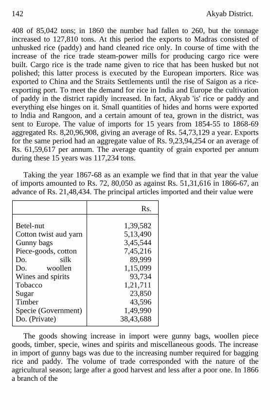
142 Akyab District. 408 of 85,042 tons; in 1860 the number had fallen to 260, but the tonnage increased to 127,810 tons. At this period the exports to Madras consisted of unhusked rice (paddy) and hand cleaned rice only. In course of time with the increase of the rice trade steam-power mills for producing cargo rice were built. Cargo rice is the trade name given to rice that has been husked but not polished; this latter process is executed by the European importers. Rice was exported to China and the Straits Settlements until the rise of Saigon as a rice-exporting port. To meet the demand for rice in India and Europe the cultivation of paddy in the district rapidly increased. In fact, Akyab 'is' rice or paddy and everything else hinges on it. Small quantities of hides and horns were exported to lndia and Rangoon, and a certain amount of tea, grown in the district, was sent to Europe. The value of imports for 15 years from 1854-55 to 1868-69 aggregated Rs. 8,20,96,908, giving an average of Rs. 54,73,129 a year. Exports for the same period had an aggregate value of Rs. 9,23,94,254 or an average of Rs. 61,59,617 per annum. The average quantity of grain exported per annum during these 15 years was 117,234 tons.
Taking the year 1867-68 as an example we find that in that year the value
of imports amounted to Rs. 72, 80,050 as against Rs. 51,31,616 in 1866-67, an advance of Rs. 21,48,434. The principal articles imported and their value were
Rs. Betel-nut 1,39,582 Cotton twist aud yarn 5,13,490 Gunny bags 3,45,544 Piece-goods, cotton 7,45,216 Do. silk 89,999 Do. woollen 1,15,099 Wines and spirits 93,734 Tobacco 1,21,711 Sugar 23,850 Timber 43,596 Specie (Government) 1,49,990 Do. (Private) 38,43,688
The goods showing increase in import were gunny bags, woollen piece
goods, timber, specie, wines and spirits and miscellaneous goods. The increase in import of gunny bags was due to the increasing number required for bagging rice and paddy. The volume of trade corresponded with the nature of the agricultural season; large after a good harvest and less after a poor one. In 1866 a branch of the
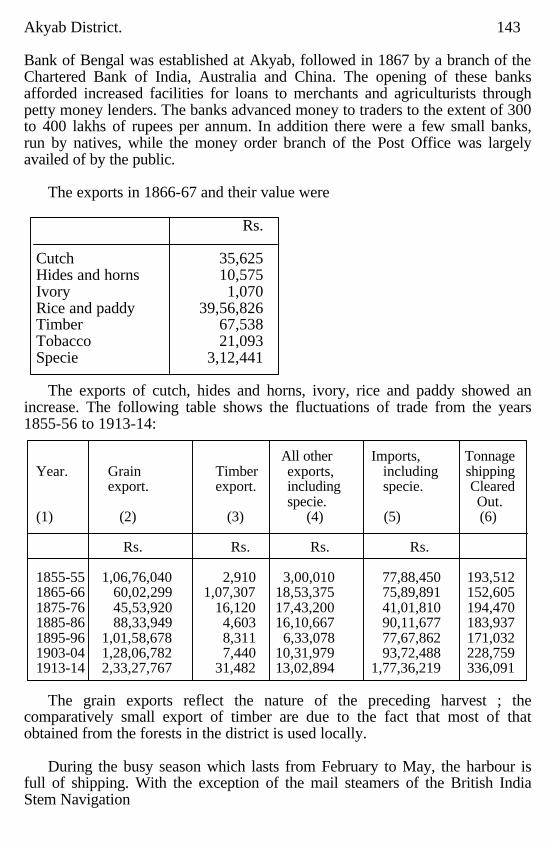
Akyab District. 143 Bank of Bengal was established at Akyab, followed in 1867 by a branch of the Chartered Bank of India, Australia and China. The opening of these banks afforded increased facilities for loans to merchants and agriculturists through petty money lenders. The banks advanced money to traders to the extent of 300 to 400 lakhs of rupees per annum. In addition there were a few small banks, run by natives, while the money order branch of the Post Office was largely availed of by the public.
The exports in 1866-67 and their value were
Rs.
Cutch 35,625 Hides and horns 10,575 Ivory 1,070 Rice and paddy 39,56,826 Timber 67,538 Tobacco 21,093 Specie 3,12,441
The exports of cutch, hides and horns, ivory, rice and paddy showed an
increase. The following table shows the fluctuations of trade from the years 1855-56 to 1913-14:
All other Imports, Tonnage
Year. Grain Timber exports, including shipping export. export. including specie. Cleared specie. Out. (1) (2) (3) (4) (5) (6) Rs. Rs. Rs. Rs. 1855-55 1,06,76,040 2,910 3,00,010 77,88,450 193,512 1865-66 60,02,299 1,07,307 18,53,375 75,89,891 152,605 1875-76 45,53,920 16,120 17,43,200 41,01,810 194,470 1885-86 88,33,949 4,603 16,10,667 90,11,677 183,937 1895-96 1,01,58,678 8,311 6,33,078 77,67,862 171,032 1903-04 1,28,06,782 7,440 10,31,979 93,72,488 228,759 1913-14 2,33,27,767 31,482 13,02,894 1,77,36,219 336,091
The grain exports reflect the nature of the preceding harvest ; the
comparatively small export of timber are due to the fact that most of that obtained from the forests in the district is used locally.
During the busy season which lasts from February to May, the harbour is
full of shipping. With the exception of the mail steamers of the British India Stem Navigation
144 Akyab District. Company, on the regular run from Calcutta to Rangoon and back, the whole of the vessels which visit Akyab do so for the purpose of loading rice or paddy.
Internal trade in the district centres principally round the Municipal and
Government bazaars. Akyab town possesses many shops, while every village of any size throughout the district has its petty shops, mostly kept by Natives of India. These shops cater to the local demand and in some cases create the demand. They are supplemented by hawkers who travel everywhere in boats selling piece goods and other wares, such as kerosene oil, salt fish and other food stuffs. These boat traders (largely from the Kyaukpyu and Sandoway districts), are in many cases money lenders on a small scale, advancing money to agriculturists on 'on demand' promissory notes, with landed security, at rates of interest varying from 36 to 60 per cent per annum.
Large quantities of cheap piece goods and general merchandise of
European manufacture are brought from Rangoon and Calcutta; a small local trade is carried on with Kyaukpyu and Sandoway, but during the monsoon months trade with these districts is confined to the inland creeks and waterways. The overland trade with Burma by way of the Au pass has decreased considerably. Natives of India practically monopolise the petty trade of the district, though it is exploited as well by Europeans, Chinese and the Arakanese themselves.
CHAPTER VII.
Means of Communications. waterways; Steam communication by water in the Akyab district;
Government steam vessels; Ferries; Landing stages; Roads; Suggested improvements to communications; Railways; Trade routes; Posts; Telegraphs; Rest houses; Camping grounds-; Light houses.
Waterways.
The facilities afforded by the rivers and creeks of Akyab for travelling by
boat or launch to every part of the district could hardly be excelled. All the rivers, such as the Kaladan, the Lemyo, the Mayu and the Naaf, can be traversed by steam launches for as much of their courses as are contained in the district, and the same can be said of most of their main tributaries. Where steam launches cannot penetrate motor boats and sampans or country boats can be used. The tide, too, affects nearly all the waterways of the
Akyab District. 145 district and makes it possible for boats of all descriptions to reach their destinations with certainty. The Arakan Flotilla Company's launches ply all over the inland waters of the district and by them communication is kept up between Akyab and every township headquarters (including Maungdaw partly by road) This company also maintains services between Akyab and Paletwa, the headquarters of the Hill District of Arakan, and the districts of Kyaukpyu and Sandoway. Launches are also run between Akyab and the principal villages in the district by native firms. Latterly, too, ferry services in the the district have been started by private individuals with motor boats. One for instance carries passengers to Kyauktaw every morning from the villages along the Kaladan for about 12 miles downstream, and takes them back in the evening; another plies regularly down the Yo chaung and on to Akyab, and a third from Nagwegyi to Akyab. These motor bo ts are mostly imported from Great Britain and are of a very serviceable type, using kerosene fuel, and there is every likelihood of a great increase in their numbers.
Steam communication by water in the Akyab district.
The following particulars regarding the development of steam
communication by water in the Akyab district have been obtained through the courtesy of Mr. R. A. Scott, V.D., Manager of the Arakan Flotilla Company:
As recently as 1887 the Government maintained a service of slow paddle
steamers between Akyab and Buthi. daung and Akyab and Paletwa. These steamers called at certain appointed stations for passenger traffic and did not accommodate the public by stopping at villages en route. For the overhaul of these vessels a slipway and workshop were maintained at the mouth of the creek between the present Circuit house and tim residence of the Port Officer. About the year 1889 the Government paddle steamers, which had apparently been in use a very long time, and had become unserviceable, were replaced by a flotilla owned and run by Mr. Dawson, of Moulmein. About the same time a Parsi gentleman introduced a fast launch to run in opposition to Mr. Dawson, but, owing to mismanagement, the venture soon failed. The creek in which the slipway, constructed by Government, stood silted up and local repairs to launches were effected with difficulty. There were also annoying shortages in the delivery of coal from Calcutta which handicapped Mr. Dawson. The Government subsidy for the conveyance of mails was meagre and Mr. Dawson apparently only just managed to struggle along. In 1893 a Captain Backman, late of the Irrawaddy Flotilla Company, started in opposition to Mr. Dawson. Both concerns did badly and before long
146 Akyab District. amalgamated. Owing to the want of docking accommodation the launches of the company gradually went from bad to worse. Mr. Dawson died in 1899 and about the same time the best launch of the flotilla was wrecked in the Sabata creek through the indecision of the serang in selecting the correct channel. The business was by this time in a tottering condition. The whole concern was, however, through the instrumentality of Mr. R. A. Scott, taken over by the present Arakan Flotilla Company with effect from the 1st January 1900. The fleet consisted, at the time, of the steam launches "Pinlay," "Myinwa" and "Kaladan" with the" Myingan" in dock at Moulmein, all in very poor working order. It was exceedingly uphill work for the Arakan Flotilla during the early years of their enterprise; they often despaired of success and even considered abandoning their venture, which, fortunately for the Arakan division, they did not persist in. A substantial slipway was provided in the Satyogya creek at a cost of Rs. 25,000 and a suitable workshop constructed. The fleet was gradually strengthened and now comprises, in addition to the four old vessels mentioned above, which have been renovated, ten new ones, improved and more powerful launches being added from time to time. The Arakan Flotilla Company now maintain regular mail services between Akyab and all township headquarters and with Paletwe, Kyaukpyu and Sandoway. They also keep up a ferry service on the Naaf which renders it possible to mainlain direct communication with India throughout the year three times a week. Thanks to this service, when the rest of Burma was cut off from India for a time during the recent European War, the Arakan division received its mails regularly and the Post was also instrumental, through the Value Payable system, in providing a means of obtaining certain supplies and comforts which would otherwise have been unprocurable. The company has undoubtedly contributed towards the opening up of the country, and the outlying districts of Kyaukpyu and Sandoway, in particular, have been brought into closer touch with Akyab, more especially during the monsoons. By means of their services the thousands of agricultural labourers, who immigrate yearly and whose presence in the division is essential are able to move about freely. With the development of the province the energies of the company are often taxed to breaking point to cope with the traffic. Of recent veers certain Native firms have run occasional steam and motor boats in opposition to the Arakan Flotilla Company, but the latter are firmly established and have earned the gratitude of the Government and the travelling public.
Akyab Distrlct. 147 Government steam vessels
In 1889 the only Government steam vessel in the Arakan division was the
Port Buoy steamer "Dolphin" Government officials were obliged to tour by native craft or by Government owned jolly boat. The "Dolphin" was replaced by the "Wanderer" in 1892. The first launch provided by Government for touring purposes in the inland waters of the Akyab district was the "Mildred," for the use of the Deputy Commissioner, in the year 1894, followed some eight years later by the Police launch "Ferret." Subsequently several vessels were added and at the present moment most of the Heads of Departments have a launch at their disposal. Other officers have provided themselves with motor boats, with Kelvin engines, which have proved serviceable and well adapted to the needs of the district. The choppy seas often encountered in the many vast estuaries with which the district abounds render journeys by small boats highly unenticing and uncomfortable if not positively unsafe, and although the small motor driven craft cannot always face the conditions prevailing they have the advantage of being able to make quickly for narrow waters till the weather improves. Moreover, under ordinary conditions they are not dependent on tides and are a great improvement on the slow hand propelled beats in use hitherto. As compared with conditions prevailing only a few years ago travelling has been rendered expeditious and comfortable for Government officers, although a few more craft are needed to meet all requirements. Ferries
There are 55 recognised ferries in the district, and the average revenue
derived from them by the District Fund is about Rs. 12,000 per annum. A great number of these ferries fill the gaps in District Fund and other roads caused by rivers and creeks, while others are between villages on opposite banks. The distance of water to be traversed varies from a few yards to five miles. In most districts boats used for ferrying have to be up to a fixed standard and have load lines marked, etc,; in Akyab the oldest dug out in the village seems usually to be selected for the purpose. Ferry landings either do not exist or are generally very unsatisfactory; if the tide be low the traveller has, as a rule, to wade up to his knees in soft mud. Landing stages.
The main wharf at Akyab is an iron structure with pier 608 feet in length
and has a depth of 23 feet of water at low tide. There is a jetty called the Bazaar pier close by the Municipal bazaar and north of the main wharf where goods brought in by native boats are landed. There is also a stone pier to the south of the main wharf used for the inland passenger traffic and for Government purposes during the fair season. Several landing stages exist in the Satyogya
148 Akyab District. creek, in the north of Akyab town, the busiest waterway in the whole district, all the rice mills being situated along the banks of this creek. Landing stages either on wooden or iron piles or pontoons have been provided. Roads.
The only roads in the district comprise 51 miles of road maintained :from
Provincial Funds by the Public WOrks Department and 164 miles maintained from District Funds. Of the former 9½ miles, Akyab to Yechanbyin, are metalled; the remainder are bridle paths across hill tracts or slightly raised footpaths. The bridges along these roads are, more often than not, quite unusable and the paths themselves are for long distances swamps and less negotiable than the adjoining paddy field bunds. The best that can be said of these roads is that some are not so bad as the others. Communication by road is not therefore adequate or satisfactory, Ponies are of little use in the district ewing to the numerous creeks, and carts cannot be used except in the Akyab township, and in a few places, for carting paddy from the threshing floor to the river bank. The district is badly provided with communication between villages for foot passengers, and so early as 1886, during the first regular settlement of the district, the Settlement Officer, Mr. (now Sir Harvey) Adamson, I.C.S., wrote :" Roads from village to village are mere foot tracks without any bunding or formation. Small creeks are crossed by bridges of the rudest description, consisting generally of a couple cf bamboos or a single log. To the European traveller, who cannot cling by his feet, these bridges present an appalling appearance. Use has made me callous, and I can now cross most of them without fear, but at the beginning of the season it was with anything but a steady pulse that I used to find myself, perhaps half a ;dozen times in the morning, oscillating on a bamboo 24 feet above a muddy creek with a probable crocodile waiting below to receive me. Where the creeks. are too broad for bridging. there are in the most frequented routes public ferries, though not leased by Government, the stock in hand consisting of a small leaky dinghy, the plier of which receives generally a yearly contribution of paddy or' money from the villages concerned. In consequence of the difficulty of travelling, European officers rarely or never visit the interior of the district. Their tours consist of trips by boat or steamer, by which means of travelling, as I have already pointed out, nothing can be seen. and of halts in the villages, few and far between, which are provided with rest houses or comfortable zayats. Thugyis living even within a few miles of Akyab informed me that their circles had never been visited by an European officer. I think something should be done by Government to improve
Akyab District. 149 communication by way of building foot bridges. Much could be done at very little cost, and the Rural Committees recently formed would be the agency to carry it out. They might decide which route it would be most important to improve, and then the township officers through the thugyis could easily arrange to have strong and durable foot bridges put up; a little money should not be grudged for this purpose. We have held Akyab for 60 years, during which time we have taken from the land a comparatively much heavier revenue than in other parts of Burma, and yet one may travel far and wide throughout the district without seeing indications of a single rupee ever having been spent for the improvement of the country or for the benefit of the people." We have now occupied Arakan for close on 100 years, but the improvement and maintenance of land communications has never been seriously considered owing to the multiplicity of waterways. Suggested mprovements to communications.
Some of the existing roads are too ambitious for a country of the nature of
Akyab where their use is restricted to foot traffic. Narrow inter village footpaths, practically wide kazins, raised above flood level, and crossing creeks by means of wire suspension or some other durable but light type of bridges, such as used by the Telegraph Department, would be a great boon to both villagers and officials. If they existed, officials could visit every portion of the district, using bicycles in combination with launches or motor boats. Regular cart roads with wide bridges are not required, all transport being by water. Where ferries. have to be crossed narrow stone causeways from the top of the bank to the lowest tide level should be constructed. Jetties are not suitable owing to the rise and fall of the tide. Railways.
There are no railways proper in the district at present. A steam tramline is
being constructed between Buthidaung on the Mayu, and Maungdaw on the Naaf, by the Arakan Flotilla Company with the object of connecting up their steamer services on these two rivers. The Indo-Burma Connection Railway Survey were at work in the district during 1914-15. These surveys will raise the question of three lines, .viz.-
(1) The through Indo-Burma connection from Chittagong to Prome or Minbu, with a branch line into Akyab. (2) A tine from Chittagong to Akyab and terminating there with, possibly, (3) A branch line from Akyab up the Kaladan River valley. Numbers 2 and 3 appear to be the more likely to be constructed.
150 Akyab District. Trade routes
The main trade routes are those connecting Akyab with Burma proper on
the one side and with Chittagong on the other. The trade along the former is brought through passes in the Yomas by way of the Sandoway and Kyaukpyu districts and thence by boat to Minbya and Myaungbwè in the south-eastern corner of the Akyab district, from whence it is distributed. This route was much frequented and was of greater importance before the British occupation. The merchandise is comprised chiefly of jaggery (palm sugar), silk, cutch and sesamum oil. Plough cattle are also largely imported by this route.
The connection with Chittagong is important inasmuch as along this line
large numbers of agricultural labourers and mill coolies, without whose help the agriculture of the district would collapse, find their way into the district. The route passes through Maungdaw, where it branches; some of the immigrant coolies proceed south by a road running along the foot of the Mayu range, then cross the Mayu river at its mouth, and so overland to Akyab; others take the Government road to Buthidaung, where the road again divides; the majority use the many waterways to spread. themselves over the whole district, while a few proceed. across the unsurveyed hills by a Government bridle path in the direction of Kyauktaw. This influx of immigrants occurs twice a year, once at the ploughing season, and again at the reaping, the number arriving at the latter season. being much greater than at the ploughing. On the return journey, when these labourers are more affluent, they prefer to travel by the British India steamers or Arakan launches, to taking the tiresome overland route. Posts. The district is fairly well provided with postal communication. The head office is situated at Akyab town, with nine sub offices and eleven branch offices scattered all over the district. Of the sub offices two are in Akyab town and one each at the township headquarters of Kyauktaw, Myohaung, Minbya, Pônnagyun, Rathedaung, Buthidaung, Maundawg; the branch offices are situated at the villages of Apaukwa, Mahamuni, Myaungbwè, Pauktaw, Thègan, Natraung, Ramjupara, Taung Bazaar, Bali Bazaar, Ngakura Bazaar and Alèthangyaw. Letters are distributed from these offices and delivered at the more important villages by village postmen. Money orders, including telegraphic money orders, are received and paid at all the post offices in the district except Thègan and Natraung.
The mails for Rangoon and Calcutta leave and arrive at Akyab twice a week, by British India steamer, during the open season, from the first week of October to the middle of May. During the monsoon there is only one steamer a
Akyab District. 151 week to and from Caclutta and Rangoon; in addition, two outward and three inward mails a week are carried by an inland route to India. During the monsoons these mails are carried by the Arakan Flotilla launch to Buthidaung, thence overland to Maungdaw, on by the Arakan Flootilla ferry steamer to Taungbyôn village, in the Akyab district, overland again to Cox's Bazaar, in the Chittagong district, then by the steamers of the Retriever Company to Chittagong, and thence by train and train ferry steamer te Calcutta. During the fair weather, the portion of the journey from Maungdaw to Chittagong is done by a line of small steamers direct instead of by the overland route viâ Taungbyôn. It takes between 48 and 60 hours for letters to arrive at Rangoon and from 40 to 48 hours at Calcutta. Mails to and from London are 19 days in transit.
The mails within the district are carried several times a week to all the sub
and branch offices by the Contract launches of the Arakan Flotilla Company, those for the Maungdaw township being taken overland from Buthidaung.
The Akyab district is controlled by the Superintendent of Post Offices of
the Arakan division, with head quarters at Akyab. The postal staff of the district consists of one Inspector in charge of the Akyab Postal subdivision, one mail overseer, one head postmaster, one deputy postmaster, nine sub postmasters, eleven branch postmasters, twenty clerks. Twenty-four village postmen, fourteen runners, three office peons, sixteen postmen, two packers, one sweeper, three punkah pullers, six messengers, two mail peons, one mail guard, one letter box peon and one durwan. Telegraph
The telegraph line to Akyab was constructed in the year 1864 to connect
Calcutta with Rangoon; this line affords one of the main overland connections between india and Burma and as such is very important; a few years later Kyaukppu was connected with the main line, but this connection was subsequently abandoned and was not renewed again till the year 1905. The other district head quarters, viz. at Sandoway and Paletwa, were connected by branch lines in 1905 and 1908 respectively. In the Akyab district there are combined post and telegraph offices at Buthidaung, Rathedaung, Pônnagyun, Kyauktaw, Myohaung and Minbya, which are all township headquarters. In the Kyaukpyu district there are combined offices at Myebôn, Ramree and An, which are the principal township headquarters. At Maungdaw, Pabru, Kwegu and Taungup departmental telegraph offices are maintained, but these are required chiefly for telegraph line testing and observation purposes. The Akyab office is the main distributing centre
152 Akyab District. of the Arakan section and has direct communicaticn with Calcutta, Rangoon and Chittagong. It is also a translation station for the Calcutta Rangoon traffic and is fitted with all the latest apparatus. The main telegraph line runs from Ramu in the Bengal Province to Prome viâ Taungup. Telegraph rest houses are provided about every ten miles or so, and a pathway under the line is maintained where the land is not cultivated. On the hill section between Taungup and Nyaungchidauk, which is 24 miles from Prome, the line follows the cart road generally. This section is practically uninhabited and there is no cultivation to speak of. Wire suspension bridges have been constructed over all the smaller creeks on the western section. The road mentioned is unmetalled and unbridged. Cart traffic is therefore suspended during the rains.
The traffic in Arakan has all along shown a steady increase. During the last
five years the increase in sent messages averages about 10 per cent, in received about 15 per cent and in transit about 50 per cent. There is a telephone exchange at Akyab connected to all the chief officials in the station. to the majority of the mills and to the chief local firms. The total number of connections on the 1st January 1915 was 67. The Arakan Civil Division forms part of the charge of the Superintendent, Telegraph Engineering, Akyab division, whose present headquarters are at Akyab. Rest house
The Public Works Department maintain only two inspection bungalows in
the district; these are at Buthidaung and Maungdaw. The District Fund maintains rest houses at these two places as well as at all other township headquarters and at important centres, 18 all told. Those at headquarters of townships are in charge of a durwan and are furnished and provided with crockery and glass; the remainder are unfurnished and are in charge of the head man of the village. There are no Forest Department rest houses. Elsewhere travellers have to depend on tents or zayats. These latter are poor and do not compare with the zayats in Burma proper. Camping grounds
There are nu regular camping grounds, but good sites for tents can be
found in many villages, shade being provided, as a rule, by fruit trees. Owing to the excessively heavy rainfall in the district the use of tents is only practicable between the months of January and April. Light houses
There are two light houses connected with Akyab, viz., the Savage Island
light house at the entrance to Akyab harbour and the Oyster Reef light house on a most dangerous shoal of rocks called the ' Oyster Reef, ' north-west of the port of Akyab. The former is a stone structure 138 feet
Akyab District. 153 high, built in 1844 and raised to its present height in 1891. Oil fuel is used and the light is visible for 14 miles. Prior to the construction of this light house a light used to be shown from the small structure now in existence at 'The Point, ' the southernmost extremity of Akyab town, believed to be the first light house erected in Burma. The Oyster Reef light house was constructed in 1876 on iron screw piles.
CHAPTER VIII.
Famine.
The Akyab district is deltaic, the rainfall is abundant and a fair rice crop is
ordinarily assured. The year 1914-15 has been the poorest for a whole generation or more, and in the same year the great European War adversely affected the rice market. With all this there were no signs of scarcity. The district is secure against famine.
CHAPTER IX.
General Administration.
Early Administration; 1863 to 1876; 1877 to date; Criminal Justice; Civil
Justice; Military and Marine; Military Police; Civil Police; Jail; Registration; Public Works; Roads; Buildings; Landing stages;
Outstation buildings.
Early Administration When Arakan was ceded to the British in 1826 by the Treaty of Yandabo it
was found that the Burmese Government had divided the country into the four Governorships of Akyab, Ramri, Sandoway and An. Akyab had its headquarters at Arakan town (Myohaung), the capital of the former kingdom of Arakan which had been conquered and annexed to the Burmese dominions towards the end of the 18th century. At first the British Government retained these divisions, and placed each in charge of a district officer; these officers were subordinate to one special and two local Commissioners; in the course of time the whole of
154 Akyab District. Arakan was placed in charge of a Superintendent, subordinate to the Commissioner of Revenue and Circuit of Chittagong; this official visited Arakan periodically in the Government pinnace "Osprey." Before long, however, Arakan had its own Commissioner and this vessel was placed at his disposal. The An district was abolished for a short time, one portion of it being added to the Akyab district and another to the Sandoway district; An was made a separate district again in 1833 and was composed of 17 circles taken from the districts of Akyab, Ramri and Sandoway. In 1852 the An and Ramri districts, were amalgamated and headquarters established at Kyaukpyu. In those days the Akyab district included the Arakan Hill Tracts (now known as the Hill District of Arakan) and a portion of the present Myebôn township of the Kyaukpyu district.
The system adopted by the British Government for the management of the
country is thus described by Lieutenant (afterwards Sir Arthur) Phayre, who for many years was in civil employ in Arakan and subsequently Chief Commissioner of the Province of Burma :
"Arakan (that is the Akyab district to which this name is properly speaking
restricted) is divided into 160 circles, of which 148 are denominated kyun or islands, being situated in the lowlands, and 12 are called chaung or streams, being in the hill districts They contain a total of 960 villages. Each of these circles is placed under an officer designated kyunôk (pronounced as one syllable-kyôk), or chaung-ôk, according to the locality of the charge. The duties of kyun-ôk are to collect the revenue, preserve order in his circle and to assist the Police in the apprehension of criminals; through him are made all statistical inquiries, and to him are referred many disputes concerning land; he is paid 15 per cent upon his collections. In each circle there are from 3 or 4 to 15 or 20 villages; the revenue collected by the different kyun-ôks varies from Rs. 200 to Rs. 10,000. This great difference results from the rapid increase within a few years of some circles compared with others, consequent on superiority or fertility of soil, more convenient locality for exporting grain, and other causes. The office of kyun-ôk is not hereditary, but the son of any man who has rendered essential services generally succeeds on his father's demise. Next to the kyun-ôk is the ywa-gaung, or village head. This officer · is elected by the villagers themselves; if there are two or more candidates for the appointment the villagers meet and sign their names to a document containing the name of him they vote for; these lists are then forwarded
Akyab District. 155 by the kyun-ôk to the officer in charge of the district (called myo-wun) who appoints him that had a majority of votes, unless, indeed, there be some good reason for rejecting him. The ywa-gaung collects the revenue of his village and delivers it to the kyun-ôk, who carries it to the Government treasury. He is paid 4 per cent on his collections. A village of 30 houses is entitled to a ywa-gaung, that is, to a stipendiary one. If a village has less than that number of houses they pay their tax to a neighbouring gaung; but if the villagers, as frequently happens, dislike this arrangement and elect a gaung of their own, the proceeding is confirmed, but they pay him themselves. Their object then is to induce settlers to come among them whereby their village may be raised to the privileged standard of 30 houses. Under the orders of the village gaung is the ywa-saye, or village scribe. He is paid 2 per cent on the village collections. The appointment is usually held by the son or by some relation of the ywa-gaung. His duties are to prepare, under the orders of the gaung, the village sayin, a register containing the name of each householder in the village, with the amount of the tax demandable from him upon each item. There are no agents of police in the village, the village officers being held responsible for the preservation of order and the seizure of criminals.
Throughout the district there are six policestations at which the police
ordinarily remain until information being given by a village officer or other person of any occurrence requiring their presence, they proceed to the spot; nearly all the communication in the district is carried on by water.
The European functionary in charge is styled a Senior Assistant to the
Commissioner of Arakan (by the people, myo-wun). To conduct all revenue affairs, there is an officer styled myo-thugyi, whose office under the Arakan and Burman Governments was considered the most important in the country. He then apportioned to each the amount of revenue demanded by the Government; his duty now is, under the orders of the Senior Assistant, to superintend all the kyun-ôks, and to inspect and report upon the annual registers of their circles; this office still carries with it a great deal of importance in the minds of the people. This officer is paid a fixed salary and resides at the chief town of the district.
The District Officer, styled Senior Assistant to the Commissioner of
Arakan, and now called Deputy Commis-sioner, performed the duties of a District Magistrate, Judge and Collector; under him was a junior Assistant Commis-sioner, who exercised similar powers, except those of hearing appeals, civil, criminal and revenue; there was also a
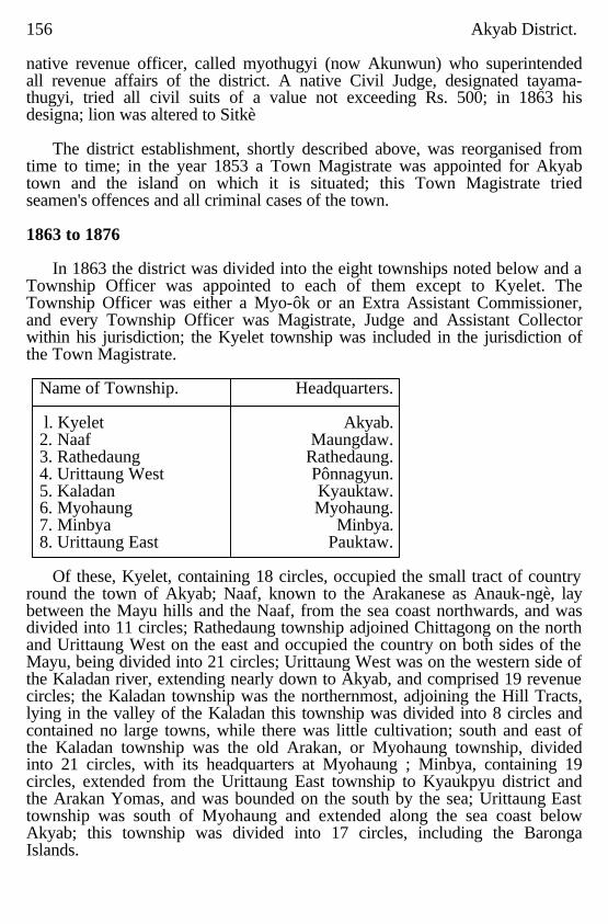
156 Akyab District. native revenue officer, called myothugyi (now Akunwun) who superintended all revenue affairs of the district. A native Civil Judge, designated tayama-thugyi, tried all civil suits of a value not exceeding Rs. 500; in 1863 his designa; lion was altered to Sitkè
The district establishment, shortly described above, was reorganised from
time to time; in the year 1853 a Town Magistrate was appointed for Akyab town and the island on which it is situated; this Town Magistrate tried seamen's offences and all criminal cases of the town. 1863 to 1876
In 1863 the district was divided into the eight townships noted below and a
Township Officer was appointed to each of them except to Kyelet. The Township Officer was either a Myo-ôk or an Extra Assistant Commissioner, and every Township Officer was Magistrate, Judge and Assistant Collector within his jurisdiction; the Kyelet township was included in the jurisdiction of the Town Magistrate.
Name of Township. Headquarters. l. Kyelet Akyab. 2. Naaf Maungdaw. 3. Rathedaung Rathedaung. 4. Urittaung West Pônnagyun. 5. Kaladan Kyauktaw. 6. Myohaung Myohaung. 7. Minbya Minbya. 8. Urittaung East Pauktaw.
Of these, Kyelet, containing 18 circles, occupied the small tract of country
round the town of Akyab; Naaf, known to the Arakanese as Anauk-ngè, lay between the Mayu hills and the Naaf, from the sea coast northwards, and was divided into 11 circles; Rathedaung township adjoined Chittagong on the north and Urittaung West on the east and occupied the country on both sides of the Mayu, being divided into 21 circles; Urittaung West was on the western side of the Kaladan river, extending nearly down to Akyab, and comprised 19 revenue circles; the Kaladan township was the northernmost, adjoining the Hill Tracts, lying in the valley of the Kaladan this township was divided into 8 circles and contained no large towns, while there was little cultivation; south and east of the Kaladan township was the old Arakan, or Myohaung township, divided into 21 circles, with its headquarters at Myohaung ; Minbya, containing 19 circles, extended from the Urittaung East township to Kyaukpyu district and the Arakan Yomas, and was bounded on the south by the sea; Urittaung East township was south of Myohaung and extended along the sea coast below Akyab; this township was divided into 17 circles, including the Baronga Islands.
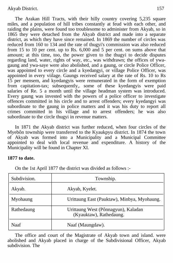
Akyab District. 157
The Arakan Hill Tracts, with their hilly country covering 5,235 square miles, and a population of hill tribes constantly at feud with each other, and raiding the plains, were found too troublesome to administer from Akyab, so in 1865 they were detached from the Akyab district and made into a separate district, as which they have since remained. In 1869 the number of circles was reduced from 160 to 134 and the rate of thugyi's commission was also reduced from 15 to 10 per cent. up to Rs. 6,000 and 5 per cent. on sums above that amount; at this time, too, the power given to the thugyi to decide disputes regarding land, water, rights of way, etc., was withdrawn; the offices of ywa-gaung and ywa-saye were also abolished, and a gaung, or circle Police Officer, was appointed to every circle and a kyedangyi, or village Police Officer, was appointed in every viilage. Gaungs received salary at the rate of Rs. 10 to Rs 15 per mensem, and kyedangyis were remunerated in the form of exemption from capitation-tax; subsequently,. some of these kyedangyis were paid salaries of Re. 5 a month until the village headman system was introduced. Every gaung was invested with the powers of a police officer to investigate offences committed in his circle and to arrest offenders; every kyedangyi was subordinate to the gaung in police matters and it was his duty to report all crimes committed in his village and to arrest offenders; he was also subordinate to the circle thugyi in revenue matters.
In 1871 the Akyab district was further reduced, when four circles of the
Myebôn township were transferred to the Kyaukpyu district. In 1874 the town of Akyab was formed into a Municipality and a Municipal Committee appointed to deal with local revenue and expenditure. A history of the Municipality will be found in Chapter XI. 1877 to date.
On the 1st April 1877 the district was divided as follows :-
Subdivision. Township. Akyab. Akyab, Kyelet. Myohaung Urittaung East (Pauktaw), Minbya, Myohaung. Rathedaung Urittaung West (Pônnagyun), Kaladan (Kyauktaw), Rathedaung. Naaf Naaf (Maungdaw).
The office and court of the Magistrate of Akyab town and island. were
abolished and Akyab placed in charge of the Subdivisional Officer, Akyab subdivision. The
158 Akyab District jurisdiction of the Town Magistrate had extended over Akyab island, within which the other officers had no criminal judicial authority; the Deputy Commissioner and the Assistant and Extra Assistant Commissioners were the judges, magistrates and revenue officials within their respective juridications; the "layamathugyi" an Extra Assistant Commissioner, stationed at Akyab, had civil jurisdiction over Akyab island and was Judge of the Court of Small Causes, with final jurisdiction up to Rs. 100.
In 1880 the Myauktaung circle o£ the Arakan Hill Tracts was transferred to
the Akyab district; this circle lies on either bank of the Kaladan river just below where it issues from the Arakan Hill Tracts. It had been originally hoped that this tract would serve as a haven for members of the hill tribes who sought for our protection, but this expectation was not realised.
The system of administration existing in 1880, when the "British Burma
Gazetteer" was compiled. was but a development of that first adopted, as described by Sir Arthur Phayre. The office of kyun-ôk (now called thugyi) still existed but the incumbents no longer had regular police duties and were paid by a much smaller percentage on their collections; the gaungs were village police officers, appointed by the Government, who received a fixed salary and had little or nothing to do with the revenue, and a regular police force had been established. The superior officers of the Civil administration consisted of the Deputy Commissioner, an Assistant Commissioner, eight Extra Assistant Commissioners, an Akunwun, a Superintendent of Police, a Civil Surgeon, also in charge of the Gaol, an Executive Engineer, a Collector of Customs, a Master Attendant, a Deputy Inspector of Schools, a Superintendent of the Telegraph Department and a Post Master.
On the representation of the Officer in charge of the Original Settlement of
the Akyab district, 1885-88, that the circle system was found to be impracticable in many respects the Local Government sanctioned the reduction of the number of circles to 57, and this process of reduction, through amalgamation, was carried on as opportunity offered, and the number of circle headmen gradually decresed.
In 1889 came the Lower Burma Village Act. in consequence of which the
village became the unit of administration; a headman was appointed to every village and gaungs and kyedangyis were discontinued.
On the 1st April 1890 the name of the Urittaung East township was changed to Pauktaw and that of Urittaung West to Urittaung.
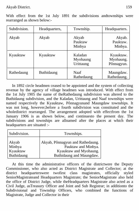
Akyab District. 159 With effect from the 1st July 1891 the subdivisions andtownships were rearranged as shown below:-
Subdivision. Headquarters, Township. Headquarters. Akyab Akyab Akyab Akyab. Pauktaw Pauktaw. Minbya Minbya. Kyauktaw Kyauktaw Kaladan Kyauktaw. Myohaung Myohaung. Urittaung Pônnagyun. Rathedaung Buthidaung Naaf Maungdaw. Rathedaung Rathedaung.
In 1892 circle headmen ceased to be appointed and the system of collecting
revenue by the agency of village headmen was introduced. With effect from the 1st July 1905 the name of theRathedaung subdivision was altered to the Buthidaung subdivision, and the Kaladan, Urittaung and Naaf townships were named respectively the Kyauktaw, Pônnagyunand Maungdaw townships. It was not long, however,before a fourth subdivision was constituted and the wholedistrict rearranged. The arrangement adopted with effectfrom the 1st January 1906 is as shown below, and continuesto the present day. The subdivisions and townships are allnamed after the places at which their headquarters are situated :-
Subdivision. Townships. Akyab Akyab, Pônnagyun and Rathedaung. Minbya Pauktaw and Minbya. Kyauktaw Kyauktaw and Myohaung. Buthidaung Buthidaung and Maungdaw.
At this time the administrative officers of the districtwere the Deputy
Commissioner, who also acted as District Magistrate and Collector; at the district headquarterswere twofirst class magistrates, officially styled SeniorMagistrateand Headquarters Magistrate; the SeniorMagistrate also held the office of District Judge, while theHeadquarters Magistrate also acted as a Civil Judge, asTreasury Officer and Joint and Sub Registrar; in additionto the Subdivisional and Township Officers, who combined the functions of Magistrate, Judge and Collector in their
160 Akyab District. respective jurisdictions there was a Civil Judge (a Myo-ôk) at both Rathedaung and Kyauktaw who undertook the greater part of the civil judicial work of the subdivisions to which they were posted.
At the time of writing, 1914, there are at the district headquarters, Akyab,
the Commissioner of the Arakan Division, who acts as Divisional and Sessions judge ;the Deputy Commissioner; the District Judge, who also acts as Assistant SeSsions Judge for the Arakan Division ;a Superintendent of Land Records; Superintendent of Excise; an Akunwun; Treasury Officer and Headquarters Magistrate; the Port Officer, who is also Collector of Customs, Superintendent of Mercantile Marine and Assistant Superintendent of Light houses and the senior officers of the District Police Force, Forests, Public Works, Medical, Education, Post Office and Telegraph Departments. Akyab is also the headquarters of the Akyab subdivision, and of the Akyab township, which is confined to the island of Akyab; in addition to the Subdivisional and Township Officers of Akyab there is a Township Judge, with Small Cause powers up to Rs. 100; this officer also acts as Additional Magistrate.
Each of the other subdivisions and townships is in dharge of the usual
Subdivisional and Township Officer, while three Judicial Myoôks are appointed to take up Civil Judicial work in the townships of Rathedaung and Pôn-nagyun, Minbya and Myohaung, and Buthidaung and Maungdaw, respectively. Criminal Justice
On the 1st January 1914 Criminal Justice was administered in the Akyab
district by twenty stipendiary magistrates and a Bench of Honorary Magistrates, numbering eleven, who sit in Akyab town. At, the head of these is the District Magistrate, with special powers under section 30, Criminal Procedure Code; he is assisted by the Senior Magistrate (in the person of the District Judge), who also has these powers; the District MagiStrate and the Senior Magistrate can try all offences not punishable with death; those so punishable are tried by the Sessions Judge, the Commissioner of the Arakan Division, on their being committed for trial by the subordinate magistrates concerned. At Akyab itself, are also the courts of the Subdivisional Magistrate, the Headquarters Magistrate, the Township Magistrate and an Additional Magistrate The Sub divisional and Township Officers are magistrates within their jurisdiotions, assisted by the whole time. Township Judges, when necessary. The Subdivisional Magistrates have, as a rule, first class powers, while the powers of the Township Magistrates vary from first to third class, according
Akyab District. 161 to their seniority and qualifications. In Akyab town eases are distributed among the Town Magistrates by the Headquarters Magistrate; other cases are tried by the Subdivisional Magistrate or distributed by him to Township Magistrates on a territorial basis.
In 1906 two magistrates were added to the permanent staff of the district by
the creation of the Minbya subdivision and the Buthidaung township, while the number of magistrates actually employed in the district is occasionally increased by the posting of junior officers to Akyab for training. The District Magistrate, the Senior Magistrate and at least one of the Subdivisional Magistrates are almost invariably Europeans; the majority of the other magistrates are Arakanese, more than one of whom are entitled to style themselves "B.A."
The Bench of Honorary Magistrates is entirely Native, being selected from
among the prominent citizens of the town; their work has often been favourably commented on in the annual reports. The powers of the Bench are regulated by the rules published in Judicial Department Notification No. 1, dated the 6th January 1886, and No. 130, dated the 30th July 1889. The history of the Bench date back to 1863 when Mr. James Bulloch and Mr. John Ogilvy Hay were appointed Honorary Magistrates and Justices of the Peace for the Town and District of Akyab; they were invested with the full powers of a District Magistrate. Since then the composition and scope of the Bench have altered ;it is at present occupied chiefly with summarily disposing of a large number of petty offences, arising within the town limits, and mostly punishable under the Municipal and Police Acts.
The most common offences in the district are those against the person,
notably grievous hurt, theft, house breaking and breaches of the Opium, Excise and Gambling Laws. Dacoity and cattle theft, so rife in Lower Burma, are not serious in Akyab. Dacoity is as yet carried out by amateurs, without organisation;while cattle theft, to be successful on a large scale, requires a good line of retreat for the thieves and their plunder; stolen cattle cannot easily be removed and disposed of in Akyab with its great main boundaries, the Bay of Bengal and the Arakan Yoma mountains. and its internal network of unfordable creeks. As to grievous hurt, the District Magistrate in the Annual Report for 1913 points out that this class of crime tends to increase after a good harvest, with its aftermath of drink and pwès. Lack of education and of self control and the common practice of carrying clasp knives (legally held not to be "arms" but the bugbear of all executive officers in
162 Akyab District. Burma) are contributory causes. Pwès are mentioned as a factor in causing crime owing to the disturbing effect they produce in the minds of the Arakanese or Burmese; they may be compared to the "cinema shows" at home; the light, the noise, the crowd seem to have an exciting effect which persists after the pwè is over; it is then that the clasp knife, carried open up the sleeve or in the fold of its owner's paso, comes into play.
In Criminal, as in Civil Justice, the Chittagonian element makes itself
unpleasantly felt; these litigious people from Bengal make free use of the courts to vent their malice on their enemies and false cases and prosecutions for criminal breach of trust are their delight but the Magistrates' bane. Civil Justice.
The present civil judicial staff of the district consists of the District Judge,
five whole time Township Judges, the Subdivisional Officers of Minbya, Kyauktaw and Buthidaung, and the Township Officer, Pauktaw, who act ex-officio as Subdivisional Judges and Township Judge respectively. The Subdivisional and Township Officers, Akyab, Rathedaung, Pônnagyun, Minbya, Kyauktaw, Myohaung, Buthidaung and Mungdaw exercise no civil Judicial powers. The District Judge is an officer other than the Deputy Commissioner and exercises the functions also of Additional Sessions Judge and Senior Magistrate. The five whole time Township Judges are distributed as follows : One each Akyab and Kyauktaw, one for Rathedaung and Pônnagyun townships with headquarters at Rathedaung, one for Minbya and Myohaung townships with headquaters at Minbya, and one for Buthidaung and Maungdaw townships. The Township Judges for Rathedaung and Pônnagyun, Minbya and Myohaung, and Buthidaung and Maungdaw are peripatetic. The whole time Township Judges at Akyab, Kyauktaw and Myohaung are invested with Small Cause Court powers up to Rs. 100 within the townships named. Township Judges take up suits of a value not exceeding Rs. 500, Subdivisional Judges try suits of values above Rs. 500 and not more than Rs. 3,000, the District Judge, Akyab, tries all cases from Rs. 509 upwards which arise in Akyab subdivision and all cases from Rs 3.000 upwards that arise elsewhere in the district, he also hears appeals from the decrees and orders of Township Judges.
Appeals from the Subdivisional Courts lie to the Divisional Judge, which
office is held ex-officio by the Commissioner of the Arakan Division ;the Divisional Judge also hears appeals from the Court of the District Judge, in the case of suits not exceeding Rs. 5,000 in value.
Akyab District. 163
The number of judges in the district has been increased from time to time to cope with the ever increasing amount. of litigation; the last increase was effected in 1907, when the number of whole time Township Judges was increased from three to five, the Township Court of Rathedaung being removed from the charge of the Township Judge Buthidaung and Maungdaw, and linked with Pônnagyun, while the Myohaung Township Court was taken from the Township Judge, Kyauktaw, and linked with Minbya, which was removed from thk charge of the Township Judge, Akyab.
In 1907 the total number of suits institnted in the. district was 3,559; this
high number is said to have been due to favourable agricultural conditions, causing a brisket demand for land, there being a marked rise in the number of mortgage suits and suits for immovable property. Since that year, with the exception of 1,909 when the number of suits fell to 2,940, the number has been well over 3,000 each year; the volume and nature of litigation would seem to be affected principally by the nature of the agricultural season ;after a poor year suits for the recovery of loans are common, while after a good year mortgage suits increase with the demand for land. Other factors which will inevitably tend to increase litigation in the district are the continuous influx of Bengali Chittagonian settlers, these belonging to a notorlously litigious race, and the steady rise in the value of land. In connection with the litigious character of Chittagonians, it is interesting to note the remarks of the District Judge, writing in 1913, to the effect that in the Buthidaung subdivision, bordering Chittagong, where there is the greatest number of immigrants, the Chittagonian population stands to the Arakanese in the proportion of two to one, but six-sevenths of the litigation in the Subdivisional Judge's Court is initiated by Chittagonians; this state of affairs is hardly likely to be improved by the opening of the light railway between Buthidaung and Maungdaw, on the Chittagong border. In one case, in the Township Court of Kyauktaw, thirteen appeals were filled by one notoriously litigious person (Ramzan Ali) with different co-appellants in each case, a11 arising out of one transaction between the said Ramzan Ali and a Chetry firm.
For some years past the necessity of affording some relief to the District
Judge by appointing either an Additional District Judge or a Subdivisional Jndge for Akyab subdivision has been recognised and even approved by the Honourable Judges of the Chief Court and by the Local Government, but the proposal has so far been shelved for want of funds the usual reason given in Burma. Mean while the Court of the District Judge is congested with
164 Akyab District. cases,varying in amount from Rs. 501 to half a lakh or more, both type of cases taking an equal amount of the Judge's time in many instances.
Another impediment to Civil Justice is the e se with which evidence can be
suborned, notably among Chittagonians. The District Judge writing in 1913 of promissory note cases says : "There is no doubt that when suits of this nature are (as is often the case) keenly contested there often remains in the mind of the judge an uncomfortable feeling that his decision may have cansed a miscarriage of justice. If the evidence of attesting witnesses is, despite protracted Cross examination, free trom discrepancies, and the transaction deposed to is, say, two years old, it is almost certain that the witnesses have been 'tutored' Similarly, even if the witnesses contradict each other on many points, it does not by any means follow that their evidence is false. It is on suits on promissory notes most of all that difficulty of obtaining a test of veracity arises; the cause of action is so simple that a single rehearsal should ensure perfect coherence." To meet this difficulty the District Judge suggests the use of finger prints in place of signatures; also, that promissory notes be registered, and money lenders licensed and registered, the licenses being cancelled if the lender is shown to have instituted a false case. He adds that in Arakan the parties are generally Chittagonians and quite unscrupulous in the bringing of false cases and urges the experimental introduction of the finger print system suggested. These instances and quotation are given to impart some idea of the difficulties in the way of those who have to administer Civil Justice in Akyab. Military and Marine.
The Treaty of Yandabo, by which Arakan and Tenasserim were ceded to
the British, was signed on the 24th February 1826, and shortly after the main body of the British troops engaged in the occupation of the country (see Chapter II) was withdrawn. One regiment was left at Arakan Myo.haung and a local battalion was raised partly to keep order and also to assist in repelling the incursions of the wild hill tribes. At this time British troops were also garrisoned at Sandoway, Ramri and Cheduba, with headquarters at Sandoway, and Ingu, or Amherst island, was made the Marine or Naval headquarters station for British Burma. The troops from Myohaung were shifted before long, owing to the unhealthiness of the place, to Akyab, which has since remained the headquarters of the Akyab district and the Arakan Division. From May 1827 up to the year 1865-66, there were maintained at Akyab four small gun boats, two row boats, two accommodation boats, a pinnace and a cutter, or ten boats in all, with 157 men and a number of
Akyab District. 165 troop flats. Owing to its proximity to the An pass, which leads to Upper Burma, Kyaukpyu was regarded an important station from a strategic point of view, and in 1829 the troops stationed at Sandoway, Ramri and Cheduba were withdrawn and Kyaukpyu was constituted the Military Cantonment, as which it remained to the year 1850. A regiment of Native Infantry and a detail of artillery were garrisoned there. The Government flotilla stationed at Sandoway were also moved to Kyaukpyu along with the troops. They consisted of two new gun boats, the "Tickler" and the "Trimmer," two new three masted schooners, the "Petrel" and the ''Curiew," and a two masted schooner, the "Swift," with several row boats and flats. in 1841 when war with Burma was threatened the garrison at Kyaukpyu was strengthened by an additional regiment of Bengal Native Infantry and a detail of European foot artillery. In 1850, however, all the troops were with drawn from Kyaukpyu and the headquarters of the Marine Assistant Commissioner and all Government boats together with all marine stores were removed to Akyab. In 1852 just before the Second Burmese War a regiment of sepoys and a battery of artillery were reposted to Kyaukpyu. They were withdrawn again in 1855 after Pegu had been annexed by the British. The local battalion at Akyab was subsequently abolished and in its place a new police system was introduced in 1861. Akyab ceased thereafter to be a military centre. A detachment of Military Police from the Rangoon Battalion has been maintained at Akyab ever since. The formation of a local Volunteer corps at Akyab was smctioned in 1879 which was designated" The Akyab Volunteer Rifle Corps." The number on the rolls on the 31st March 1880 was 100. ln November 1883 "The Akyab Volunteer Rifles" were incorporated as a company of the "Rangoon Volunteer Rifles," and since that date has been designated the "Akyab Detachment, Rangoon Volunteer Rifles." The headquarters building is a substantial one with a large drill hall and an armoury. The number on the rolls at the close of the year 1904-05 was 42 active volunteers and 15 reservists, the strength at the close of the season 1914-15 being 70 active volunteers and one reservist. Military Police
The Rangoon Battalion of Military Police supplies a detachment, 220
strong tinder the command of one Subadar and two Jemadars, for service in the district. Of these 120 men are stationed in parties of 15 at the combined Civil Police stations and Military Police Pests at Rathedaung, Pônnagyun, Pauktaw, Minbya, Kyauktaw, Myohaung, Buthidaung and Maungdaw; the remainder are Stationed at Akyab for headquarters' duty and as a reserve. The

166 Akyab District. district being unsuitable for mounted men these have never been maintained either by the Civil or Military Police. The main duties of the Military Police are to provide guards over lookups and treasuries and to escort prisoners and treasure.
In October 1906 an Assistant Adjutant of the Rangoon Battalion was first
permanently stationed at Akyab, his principal duty being to inspect the Military Police Posts throughout the Arakan Division and keep the men up to the mark in the matter of drill, etc.; this inspection duty had hitherto been performed periodically by the officers of the battalion stationed at Rangoon. Civil Police.
When the First Burmese War came to an end with the signing of the Treaty
of Yandabo on the 24th February 1826, the main body of the British troops was withdrawn, one regiment was left in Arakan, and a local battalion was raised partly to keep order and partly to repel the incursions of the hill tribes; this battalion was distributed throughout the division in posts of varying strength according to requirements; in Akyab district such posts were at Akyab, Myohaung (old Arakan), Minbya and Buthidaung; the number of posts was reduced in 1828, and in July 1829 the Arakan Provincial Battalion was disbanded and an additional company for the Mugh levy under Captain Boscowen was raised; while to undertake the duties hitherto performed by the Arakan Provincial Batta-lion an establishment of 103 constables, 11 native officers and a bugler was formed and made available for general police duties. At this time the district was divided into circles, under taikthugyis, part of whose duty it was to preserve order and assist the police in the apprehension of offenders; in each circle, too, was a rural police gaung, on a salary of Rs. 10 to Rs. 15 a month, while every village was provided with a kyedangyi to assist police and revenue officers.
A new police force was organised for the whole of Lower Burma in the
year 1861 and placed under the Inspector General of Police; in Akyab this new: police force took the place of the old local police and the local battalion. The strength of this force varied from time to time ;in 1875 the establishment consisted of a District Superintendent of Police, 32 subordinate officers and 419 men. Till 1865, when the Arakan Hill Tracts were made into a separate district, the police were largely engaged in repelling the attacks of, and punishing, the raiding parties from the hill tribes in the north; after that event they took up their regular duties in the suppression and detection of crime. In 1905 the District Superintendent of Police had
Akyab District. 167 under his control a force of 3 Assistant Superintendents of Police, 10 head constables, 19 sergeants and 305 constables, or a total of 337. Besides these there were the 1,200 odd village headmen, with certain police powers, with their ten house gaungs, also possessed of petty police powers as rural policemen. Each township headquarters held a police station, usually in charge of a head constable; in addition to these there were eight outposts, commended by a sergeant or first grade constable. At Akyab headquarters a police training school had been established for the training of recruits, and this school each constable in the district had to attend annually for one month's training. By 1914 the strength of the Civil Police force had been increased to 450, comprising a District, an Assistant and a Deputy Superintendent of Police, a inspectors, 1 European sergeant, 27 sub inspectors. 41 head constables and 372 consables. Civil Police stations were maintained at the township headquarters at Akyab, Rathedung, Pônnagyun, Pauktaw, Minbya, Kyauktaw, Myohaung, Buthidaung and Maungdaw, and eight outposts located at Satyogya, Tawpya, Letmaseik, Pônthawa: Myoungbwè, Teikwabyin, Thegan and Myomichaung. Jails.
There is a first class district jail in Akyab. When originally built, on Akyab
being made the headquarters of the district in 1827, it consisted of wooden buildings built on piles, surrounded by a palisade with accommodation for 464 prisoners. The palisading around the old jail was replaced by a 15 foot brick wall in 1873 and the jail extended to its present size in 1875; new wards were then built. The old buildings are utihsed for jail workshops. In 1913-14 bullet proof doors and windows were put in, the walls were pierced with loop holes, and other provisions for defence made so that the jail might be a place of refuge in case of emergency.
In the early days jail labour was largely used in Akyab for the draining of
swampy ground, making raised roads and other work in connection with the building of a new station. Akyab is only 15 feet above sea level and in those days hired labour was difficult to obtain and expensive. Now a days, the prisoners are employed in making furniture, coir rope and mats, stone breaking, cotton spinning and weaving; the proceeds of their work tends considerably to reduce the cost of their maintenance. In 1855 the average cost per prisoner amounted to Rs. 111-12-0 per annum; in 1857 Rs. 79-12-0; in 1901 it had fallen to Rs. 50, and since then the annual average cost has been in the neighbourhood of that amount. In this year the issue of animal food to prisoners was practically stopped. This is one of the main
168 Akyab District. reasons of the decrease in the cost of maintenance. At the same time the health of the prisoners has improved since the introduction of this measure. The jail has its own hospital and in 1914 a new ward for the accommodation of six female prisoners was added to the main portion of the jail. the usual vegetable garden provides green stuff for the prisoners and the vegetables grown in it may also be pur-chased by the public. The jail is seldom filled to its maximum capacity of 619. The Civil Surgeon is in charge and receives jail allowance of Rs. 150 per month. Quarters are provided for a head jailor, three deputy jailors and a sub assistant surgeon with their families; there are three quarters for married men and a guard room for 34 warders; this staff is assisted by convict officers, as in other jails..
From 1891 to 1900 the average jail mortality was 49'9 per thousand per
annum; from 1901 to 1910 it was 25'7 per thousand; in 1902 and 1903 it rose to 47 and 58 per thousand: this high mortality was due to successive epidemics of dysentery, cholera and cerebo and spinal meningitis. From 1910 to 1914 the mortality rate has been reduced to 15'44. Registration.
The following history of registration in taken from the Burma Registration
of Deeds Manual, corrected up to the 1st May 1914 : Rules for the Registry of Deeds in the Province of Pegu, which were issued
by the Commissioner and Agent to the Governor General in that province on the 10th August 1861, are reproduced at page 34 of "Memoranda for the use of Officers of Government in the Arakan Division of British Burma" (Akyab Press, 1864). On the 1st August 1863 these rules were made applicable to the whole of British Burma of that time by Order 23 of that date of the Chief Commissioner of British Burma. They were reproduced again in the authoritative "Hand book for British Burma" which was compiled by Captain G. E. Fryer and published at Moulmein in 1867.
These rules provided a system of registration of all deeds of sale or gift or
mortgage of lands, houses or other immovable property. Rule 17 directed that except in the town and suburbs of Rangoon a duly registered and authentic deed of sale or gift should invalidate any prior or subsequent unregistered deed or gift of the same property, and that a duly registered mortgage should take precedence of any prior or subsequent mortgage of the same property not so registered. This rule took effect from the 1st January 1862 in the province of Pegu; presumably it took effect in the rest of British Burma (including Arakan) from the 1st August 1863,. the date of extension of the order to the latter province.
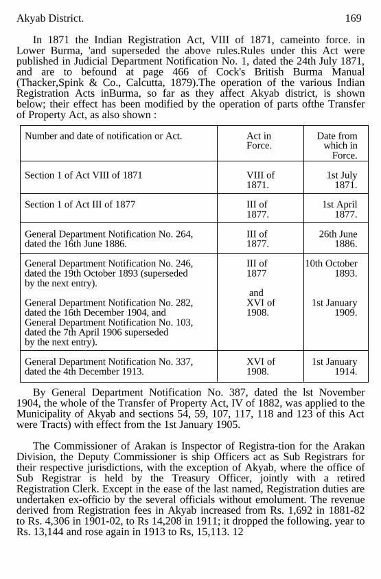
Akyab District. 169
In 1871 the Indian Registration Act, VIII of 1871, cameinto force. in Lower Burma, 'and superseded the above rules.Rules under this Act were published in Judicial Department Notification No. 1, dated the 24th July 1871, and are to befound at page 466 of Cock's British Burma Manual (Thacker,Spink & Co., Calcutta, 1879).The operation of the various Indian Registration Acts inBurma, so far as they affect Akyab district, is shown below; their effect has been modified by the operation of parts ofthe Transfer of Property Act, as also shown :
Number and date of notification or Act. Act in Date from Force. which in Force. Section 1 of Act VIII of 1871 VIII of 1st July 1871. 1871. Section 1 of Act III of 1877 III of 1st April 1877. 1877. General Department Notification No. 264, III of 26th June dated the 16th June 1886. 1877. 1886. General Department Notification No. 246, III of 10th October dated the 19th October 1893 (superseded 1877 1893. by the next entry). and General Department Notification No. 282, XVI of 1st January dated the 16th December 1904, and 1908. 1909. General Department Notification No. 103, dated the 7th April 1906 superseded by the next entry). General Department Notification No. 337, XVI of 1st January dated the 4th December 1913. 1908. 1914.
By General Department Notification No. 387, dated the lst November
1904, the whole of the Transfer of Property Act, IV of 1882, was applied to the Municipality of Akyab and sections 54, 59, 107, 117, 118 and 123 of this Act were Tracts) with effect from the 1st January 1905.
The Commissioner of Arakan is Inspector of Registra-tion for the Arakan
Division, the Deputy Commissioner is ship Officers act as Sub Registrars for their respective jurisdictions, with the exception of Akyab, where the office of Sub Registrar is held by the Treasury Officer, jointly with a retired Registration Clerk. Except in the ease of the last named, Registration duties are undertaken ex-officio by the several officials without emolument. The revenue derived from Registration fees in Akyab increased from Rs. 1,692 in 1881-82 to Rs. 4,306 in 1901-02, to Rs 14,208 in 1911; it dropped the following. year to Rs. 13,144 and rose again in 1913 to Rs, 15,113. 12
170 Akyab District.
The number of documents of all kinds registered in 1909 was 2,924, and in 1913 the number had risen to 3,903. Of these by far the greater number are docurments which are compulsorily registered. Documents voluntarily, registered average about 400 a year and practically all these are powers of attorney.
Public Works.
The Akyab Public Works Division embraces the district of Akyab and the Hill District of Arakan. The division is in charge of an Executive Engineer, whose headquarters are at Akyab and who is responsible to the Superinténding Erigineer, Maritime Circle, at Rangoon. The division is divided into two subdivisions known as the Akyab and Eastern subdivisions,
Roads.
The principal metalled roads are the Akyab to Yechan-byin road, known as the Mayu Ghat road, 11 miles long, and the Buthidaung-Maungdaw road, known as the Naaf-Mayu road, 14½ miles long; the latter road has practically ceased to exist, as the Buthidaung-Maungdaw Light Railway, at present under construction, has been run along it. There are several other roads in the division, more or less metalled but communication is mainly by water.
Buildings.
The chief public offices in Akyab are the Commissicner's and District Court houses arid the Port office: all are of masonry. The former was completed in 1902 at a cost of Rs. 43,100, the District Court house in 1872 at a cost of Rs. 1,30,682, additions costing Rs. 10,250 have since been added, and the Port Office, formerly used as the District Court, in 1867 at a cost of Rs. 30,000 The style of the court houses is mote of the Indian Khtchery style than that at present in vogue in the rest of Burma, probably due to the former connection of Arakan with Bengal. Other public buildings are the Hospital, about to be practically rebuilt at a cost of one and a half lakhs, the Telegraph Office, the Municipal Office, the Executive Engineer's Office, the Forest Office and the Post Office, which is about to be rebuilt.
All Government officers have not been provided with house accommodation; at present there are quarters for the Deputy Commissioner, the Distrlct Judge, the Executive Engineer, the Divisional Forest Officer, the Inspector of Schools, the Superintendent of Telegraphs, the Deputy Superintendent of Telegraphs, the Superintendent of Post Offices and the Port Officer. Quarters for the Commissioner of Arakan Division and the District Superintendent of Police are nearing completion. Other than the above mentioned officers there are ten Government officers who have to rely on privately owned houses for residences.
The Public Works Department is also in charge of the Jail at Akyab. The buildings are mostly of timber, the chief
Akyab District. 171 exceptions being two blocks of cells built in 1886 and 1906. The whole is surrounded by a brick wall 15 feet high. Lately four new pukka workshops have been sanctioned and are under construction to replace the eight built in 1876, and an up to date steam cooking apparatus is about to be installed. A female ward has also lately been built. A drainage scheme, estimated to cost about live lakhs of rupees, for the more thickly populated portion of the town of Akyab has lately been taken in hand. This will provide some 25 miles of open drains of the latest pattern calculated for a run off of one inch per hour. Landing stages.
There are a main wharf and two smaller jetties in the harbour. The former
has a timber floor on screw piles; it is 608 feet long with a T head. The two jetties are of rubble With a swing bridge on a pontoon The one near the post office is 655 feet long and the other at the back of the bazaar is 158 feet long. Landing stages either on iron or wooden piles exist at all township headquarters. Outstation buildings.
In the district there are a court house, an Inspection bungalow and a
defensible police station at every township and subdivisional headquarters, also combined Post and Telegraph Office buildings at all the above places except Pauktaw, eleven district bungalows at various large villages, seven police Outposts and fourteen bazaars. Small dispensaries exist at all township headquarters except Pônnagyun and Pauktaw.
CHAPTER X.
Revenue Administration.
Land Tenure in Burmese times; Land tenure from 1826 to 1875; Lower
Burma Land and Revenue Act, II of 1876; Waste Land Grants; Revenue system in Burmese times; Early assessments after British occupation; Standards of land measurement; Introduction of land tax on standard measurements; Tentative introduction of kwin unit system; Original Settlement, 1865-66; Revision of rates; Cyclone of 1867; Lower Burma Land and Revenue Act, II of 1876; Professional survey by Survey of India, 1879-80; Revision Settlement, 1879-80; First Regular Settlement, 1885-88; Season 1885-86; Fallow rate; Assessment rates proposed; Season 1886-87; Fallow rate on unculturable portions of holdings; Season 1887-88; Summary of three years, 1885-86 to 1887-88; Revision Settlement, 1901-03; Season 1901-02; Assessment of areas fallowed for grazing and of unculturable portions of holdings; Season 1902-03; Summary of two years 1901-02 and 1902-03; Season 1903-04; Revision Settlement, 1913-16; Tracttug
172 Akyab District. and soil classification ; Proposed enhancement of demand; "Capitation tax; Land rate in lieu of capitation tax; Fishery revenue; Income tax; Stamp revenue; District Cess Fund; Excise; Opium.
The materials for the first few paragraphs of this chapter have been
extracted chiefly from Volume I of the Burma Settlement Manual, 1908. Land Tenure in Burmese times.
The following account of the land tenure in Burmese times was written of
Pegu, but, so far as is known, it is equally applicable to Arakan which was held by the Burmese kings for 42 years before we annexed it from the latter in 1826, and prior to that period the two countries had been in constant intercourse :
The traditional origin of Land Tenure in Burma appears to be exactly the
reverse of that in India. In the latter country the sovereign has always been considered the Lord paramount over, and the chief proprietor of the soil. In Burma, although the chief ruler is considered to be entitled to a share of the produce, his title to it rests on a different foundation. He acquired such share only by the gift of the people who voluntarily surrendered to him a tenth part of their produce in consideration of his Under taking the government of the country. The idea of the supreme ruler being also the supreme landlord has not obtained here the same fixity which it has in India. In the Indian Buddhist Code, which, under the title of the Laws of Manu (which have nothing in common with the Indian" Institutes of Manu" ), the Burmans have altered and adapted to the necessities of their own country, there are said to be seven ways of acquiring a title to land; they are :-
First-By royal gift, made only to soldiers and civil officers; Second-By inheritance; Third-By allotment by Government officers; Fouth-By purchase; Fifth-By reclaiming from forest; Sixth-By gift; Seventh-By unchallenged occupation, for ten years, of lands which formerly had no other owner. Of these, the first two are said to be perfect and the remainder imperfect,
i.e., disputable tenures. In practice there may be said to be but one original foundation for land tenures in Burma, namely, that the clearer of cultivated land acquires an absolute dominion over soil, subject only to contribution for the service of the State. He can alienate it by gift or sale, and, in default of his doing so, it descends to his heirs in the usual order of
Akyab District. 173 succession. The title to land, therefore, is essentially allodial. Land has always been held in fee simple, the whole right and title being vested in the owner, i.e., the original occupier and his heirs and assigns. The right of private property in land has always been as fixed and certain and as absolute as it can be in any oriental despotism, where the lives and property of every subject are entirely dependent on the will of a single autocrat. The attachment of the people to the arable portion of their landed property has always been strong. As long as a family continue to reside in the vicinity of their ancestral land they will never wholly relinquish their title to it. Land, under Burman rule, was never sold in the usual acceptation of the term. It was frequently conveyed for a price from one person to another, and though the transaction was styled a sale and not a mortgage, it was fully understood that the vendor retained a right to repurchase the land at any time he liked and that the emptor could not resell the land without the consent of the original vendor. (The practice here referred to survives to the present day in the Akyab district in the form of the transaction known as "yaung-paung" or mortgage sale; whether or not the original vendor can obtain repossession of the land depends on the good faith of the emptor ; if the latter repudiates the transaction, as often happens, the vendor has no redress in the courts, as the latter are bound to regard only the sale transaction which takes place when the land is transferred, and cannot admit evidence as to the verbal agreement for restoration of the land which accompanies it.)
Few cases, however, can be found in which landed property has remained
for many generations in the same family. This result, which at first sight seems incompatible with a strong attachment on the part of the people to the soil, is due to the constant state of anarchy rising from wars and rebellions, and the imperfect control exercised over the provincial governors ever since the downfall of the Pagan kingdom (1298 A.D.). The ever recurring social disorders impelled the people to constant changes of residence, and one governor, in order to increase the population of his district, would offer rewards to encourage people to desert his neighbours' jurisdictions. (In this connection, it is inter eating to note that one of the conditions of grants given to encourage the spread of cultivation in the Akyab district during the early days of British administation was that the grantee was bound to obtain his tenants from outside the district this system of grants will be referred to later.)
To the general allodial tenure on which lands were held there were two
insignificant exceptions. A portion of
174 Akyab District. the fields in some village tracts was assigned for the maintenance of the village thugyi and was known as the thugyi sa fields. The thugyi, for the time being, could cultivate these or let them to anyone he liked.
Lands known as bhanda or Crown lands (literally Treasury lands) also
existed; such lands were the private property of the Crown and were cultivated either by lamaing (Crown prodial slaves) or by the people of the vicinity without remuneration, the whole of the proceeds belonging to the king,
Under the Burman government, therefore, there existed only the following
land tenures :- First-Petty allodial properties;the owners cultivating their own lands or letting them to tenants, the owner being subject to payment of yearly revenue, either to the State or to the custodian of any sacred buildings to which lands, might have been dedicated. Second-Thugyi-sa tenures. Third-Bhanda tenures. Of these the second still exists in a modified form, while bhanda tenures
have disappeared, under British rule. Under the Burmese customary law, lapse of time per se does not appear to
have been considered sufficient to bar a claim to land. A person who had once cleared or had been in possession of land, could, by proving such fact, establish. his title to recover unless the parties in possession had been for ten years in unchallenged enjoyment of it.
In brief, the description may be summerised as follows :- (1) The right of subjects to land was always subordinate to the reservation
of Government right to a share of the produce. (2) In practice, the land was held by individual cultivators in plots (usually
styled holdings); the cultivators held these quite independently of each other, and whatever may be the theory of the ownership of the land, the great mass of the cultivators were practically proprietors of the soil, subject to the payment of revenue to Government.
The distinctive feature of land tenure and land assessment in Lower Burma
(including Arakan)was originally, and is now, individual proprietorship and individual dealings with Government. There was never anything corresponding to the malguzari tenure of India, and though attempts were made to introduce a modified malguzari system they fortunately failed, and the existing individual proprietary system prevailed.
Akyab District. 175 Land Tenure from 1826 to 1875.
After the annexation there were three classes of tenure, in Arakan, viz. :- (1) The "ryotwari" system under which the vale of land revenue was fixed
by Government for a fixed period. (2) Temporary settlement coming under (1), where the rent was fixed for a
term of years. (3) "Zemindari" system; grants originally of waste land, a mixture of
"zemindari" and settlement, whereby grant holders obtained leases for terms from 8 to 64 years, according to the class of land on certain conditions, involving the bringing under cultivation a stipulated portion of their grants within a fixed period and the payment of fixed annual revenue to Government.
The land in classes (1) and (2) were leased or granted under the Land
Revenue Rules of 1865, and the rules issued in previous years, and since under the Lower Burma Land and Revenue Act, 1876, and the rules fromed thereunder. Leases of waste land of large areas under class (3) were granted under the rules for granting leases of waste land in Arakan of 1839 and 1841, and under the Pegu Waste Land Grant Rules of 1865. Lower Burma Land and Revenue Act, II of 1876.
In 1876 the Lower Burma Land and Revenue Act, II of 1876, came into
force and is in force to the present day. Under this Act the Government is recognized as the paramount landlord and all rights possessed by people over their lands are of a subordinate character, acquired by them from the Government on the condition of payment by them of land revenue. On the other hand, landholders have heritable and transferable right of use and occupancy, Waste Land Grants.
Waste Land Grants were issued by GoVernment under the Arakan Waste
Land Grant Rules of 1839 and 1841 and the Pegu Waste Land Grant Rules of 1865 with the object of causing an influx of population and extension of cultivation in Arakan by new settlers. Candidates for grants were required to enter into an agreement not to entice into their estates, or allow to settle there, any of the present cultivators of the province under the penalty of forfeiture of their grants, or such portions of them as might be deemed proper. In 1880-81 the boundaries of circles, kwins and waste land grants in the Akyab district were demarcated and surveyed, and in March 1882 Mr. J. C. Mitchell was appointed Settlement Officer to determine the boundaries of waste land grants in Arakan. The original survey had been faulty in the extreme and in some cases no survey had been attempted. In some cases the differences between the original and present areas were very great, the latter being
Akyab District. 176 three and four times the original amount. In some instances it was found that the grantees had encroached on Government land. The Settlement Officer excluded the area on which the grantees had encroached and called Ga the latter to pay excess revenue due Ga such areas. The grantees contended that the Government had no right to enter upon their had and measure it, till after the full period of total and patrtial exemption, and that under the grantdeed, read with section 10 of the rules, the Government had no power to increase their assessment, no matter what their area may be found to be, until the whole period of total and partial exemption had elapsed and the time for a new settlement had been reached. They further claimed the whole area within the boundaries of their grants, and insisted that the Government must adhere to the amount quoted in their deeds as regards revenue, no matter what the actual area was found to be. The Settlement Officer and the Commissioner, Arakan Division, made many suggestions for settling these grants. It was finally decided by the Local Government that, as there had been laxity and mistakes in the procedure under which the grants had been originally made, the case as between the State (or Public Treasury) and the grantees should be compromised. The Settlement Officer was authorised, accordingly, to propose compromises, under the direction of the Commissioner of the Arakan Division, to the grantees who held areas much larger than the acreage named in the original documents. The basis on which such compromises were offered was as follows :-
In regard to the very great discrepancies between the nominal and actual
areas of most of the grants, the grantees were allowed to choose whether they would have-
(a) the areas enclosed within the boundaries described in the deeds of grant, so far as such boundaries could be identifide by the Boundary Officer; or (b) the acreage specified in their deeds of grant.
The grantees were held to be liable to pay revenue at the rates per acre and
on the proportion of area mentioned in the kistabundis attached to their deeds on any land which they elected to retain. A grantee was not permitted to claim to retain the larger, and in some cases the very much larger, area enclosed within the boundaries specified in his deed, and at the same time pay revenue on the smaller area as described "more or less" in the deed. The Settlement Officer was empowered to offer the grantees revised assessments in the following form :- .
(a) lower rates than those specified in the deed of grant; or
Akyab District. 177
(b) lower proportion of assessable area than that stipulated in the deed of grant; or
(c) both lower rates and a lower proportion of assessable area than stipulated in
the deed of grant. The revised assessments offered were regulated so as not to press heavily
on or prove disastrous to any of the grantees. No success, however, attended the efforts of the Settlement Officer to effect compromises on these lines;many applications were made, and some negotiations took place, but the grantees were never in earnest, and made applications only to gain time and defer the period when revenue would become payable. The Local Government therefore fixed the 31st May 1885 as the latest date up to which proposals for compromise would be entertained, and issued orders that, in cases where no compromises were preferred by that date or in which proposals made before that date came to nothing, the strict letter of the rules and of the grants should be enforced. After this order was issued, many grantees accepted the compromises offered, and new leases were issued ;the grants of recalcitrant grantees were assessed on the ascertained area under the rules and terms stipulated in the original documents or grant deeds.
The boundaries of each grant had been correctly demarcated and boundary
pillars erected. Sense of the grantees relinquished their grants, because they could not pay the land revenue assessed on the ascertained area. After this revision there remained 43 grants. Under the Waste Land Grant Rules and under the terms of the Grant deeds the grantees are entitled to renewal of their leases on the expiration on the term of the existing leases. There are at present 42 grants in the district covering an area of 95,544 acres. Fifteen grants are situated in the Maungdaw township, nine in Buthidaung and the others are scattered over five townships, there being none in either Rathedaung or Pônnagyun. Revenue system in Burmese times.
The British Government first acquired territory from the Burmese in the
year 1826, when the provinces of Arakan and Tenasserim were ceded by the treaty of Yandabo at the conclusion of the First Burmese War. When Arakan was taken, the existing rovenue system was formal to be very different from anything known in India. Under the Burmese régime the country was parcelled out into governorships or myos, and a fixed amount of revenue was demanded from each governorship; the latter was divided into circles and the circles into villages (what now would be called village tracts). The principal tax was one upon families, who were generally assessed by the village officers according to their reputed wealth, the land cultivated by each being taken as a guide. This tax in fact corresponded
Akyab District 178. to the thathameda tax of Upper Burma, and, so far as it was paid by cultivators, was really a form of land revenue. Direct land revenue was not taken by the Burmese Government in all districts, but, where it was established, it took the form of a fixed amount in silver per plough or yoke of oxen, or a produce tax of (nominally) 10 per cent of the gross produce, which had to be paid in kind and conveyed by the cultivators to the Government granaries. In practice, the produce tax was arbitrarily assessed. Only very scanty records existed to show the method of assessing the family tax, or the amount collected on account of that item or on account of the land tax. There were, besides, many other imposts, among which were a tax on brokerage, transit dues, dues on sale of cattle, varying dues on various kinds of produce, dues levied on fishermen, etc. These dues were not all levied in the same governorship but some in one and some in others. Then there were, in addition fees in lawsuits and criminal fines and special remittance to be made to the capital as presents from the Myosa (town, ship governor) and the local officials to the king at the commencement of each year, the cost of which was wrung from the people. Besides this, each tract had to support the men who were annually called out to protect the frontier, or specially for more particular duty. The local officials received no regular salary but were paid by a portion of these tees and dues and it was to their interest to squeeze from the people as much as they could or dared. Added to all this there were extraordinary contributions to the Crown, called for on public emergencies, the amount being fixed by the king's government at the capital; e.g., in 1798, when a call of 33 1/3 ticals of silver was made from every house, this took two years to collect and produced about 6 lakhs. No doubt the amount levied from the people. was much larger. Early assessmerist after British occupation.
After the British occupation of Arakan, the land tax was levied by rate
being placed on each plough or yoke of cattle. At first the assessments were not made directly on the people, but the thugyis were dealt with as large land holders owning their circles. This, no doubt, arose from a misconception ,of the real status of thugyis, due to Indian ideas, and was an imitation of the Indian malguzari system. The system continued only to 1828, in which year the thugyis were no longer allowed to collect what they liked, but only the amount due, according to the rate fixed on the number of ploughs used and .they were remunerated by being allowed a commission of 10 per cent on their collections. The unit of assessment was the thugyis circle (these men were what are now known as circle or
179 Akyab District taik-thugyis) and the assessment varied annually with the number of ploughs used. The plough tax was only a temporary expedient, and it was soon decided that the assessment should be on the area of land cultivated. The question then arose how to adjust the rates levied on the plough to the standard of land measure adopted. Standard of land measurement.
In Arakan the standard of land measure adopted was the doon, equivalent
roughly to 6'40 acres. The doon was equal to what the people considered could be worked by one pair of bullocks or buffaloes; the word doon is of Indian origin, shin being the Burmese equivalent. Both words are used in Akyab, according to the locality and the preponderance of Chittagonians or Arakanese, as the case may be; kyat means the same and is used chiefly in parts of Myohaung, Pônnagyun and Minbya townships. The following subdivisions of the doon, shin or kyat may be of interest :
3 Krants = 1 Cowri. 12 hands square = 1 wa 4 Cowris = 1 Gunda. (18 feet square) (1 bamboo). 5 Grndas = 1 Kuni. 800 was = 1 shin or 4 Knnis = 1 Kani. kyat, 16 Kanis = 1 Doon.
These divisions seem to reflect the temperament of the races who employ
them, the "canny" Chittagonian, who cultivates every hole and corner of his land, and the thriftless Arakanese, with his lordly ideas as to manual labour. Introduction of land tax on standard measurement.
The circle thugyis were called on to state what rates per doon the lands of
their circles could bear. and rates were fixed accordingly; apparently no standard proportion of the gross outturn was considered when these rates were fixed. The result was that large tracts of country had a certain rate per doon (or unit) imposed on them as the rate of tax for all cultivation payable to Government. The change of the system of assessment from the plough tax to the doon, or acre assessment, was made in Arakan by Sir A. Bogle. The plan of assessment at certain rates per doon, applying to whole circles, was perhaps at the time the only one practicable, as there was no agency by which thorough investigation might have been made into the nature and fertility of the land, and it was essentially necessary to come rapidly to some determination in order to start collecting revenue at all. The rates per doon were fixed on exceedingly vague data, if the opinions of the thugyis can be described as data at all ; and to show the exceedingly rough nature of the first arrangement, it is sufficient to mention that the same rates were imposed throughout tracts of country from 50 to 60 miles long and from 15 to 20 miles broad, and there ,were only three rates in all, namely, Rs. 6,.
Akyab District 180. Rs. 8 and Rs. 10 per doon. The system of assessment at one rate per doon throughout a whole circle continued practically till about 1865. The number of doons were estimated or surveyed annually by the thugyis and the revenue rolls prepared accordingly. Each cultivator was dealt with separately and was responsible only for the area of his own holding.
Captain (afterwards Sir Arthur) Phayre first came to Arakan in the year
1837: his attention was called to the anomalous nature of the circle unit system of assessment by occasionally seeing tracts of country remaining uncultivated, and being assured by the peasantry that they were unable to cultivate them at the rate fixed on the whole land of the circle. The system was not so anomalous in Akyab as it might have been in another district, as there was a general similarity in the soil throughout its extent, consisting, as it did, of the rich alluvium of a delta, and there was, too, owing to the multiplicity of waterways, not much difference in the facility of access to markets. These considerations and the fact that the rates fixed per doon were generally low, and that there was no check on the area returned by the thugyis, are given by Captain Phayre as the reasons why cultivation extended in Akyab notwithstanding the anomalous character of the assessment. Tentative introduction of kwin unit system.
Major Phayre was appointed Commissioner of Arakan in 1850, and
commenced to introduce an assessment by kwins and one circle in Akyab was settled by him on that principle; in 1852 Major Phayre was transferred to Pegu, and the assessments in Arakan continued to be on the doon rate and circle system up to the year 1865 Kwin unit system.
The kwin system of assessment had been first introduced in Tenasserim in 1847 by Captain Phayre, with the concurrence of the Commissioner, Mr. Colvin, to whom he was Personal Assistant; he settled two townships on this system, which he subsequently introduced into Akyab. It was held desirable that an enquiry should be made into the fertility of the soil of the various village tracts, and that a brief record should be drawn up of the various local circumstances bearing upon the value of the produce of each place where a separate land assessment was designed to be fixed, and that rough maps should accompany this record, showing the position in each township of the tracts of land on which the separate rates of assessment were fixed. In the course of the settlement on these lines, it was found that the village tracts contained natural or well marked divisions of country recognized by the inhabitants, having generally distinctive names, and called kwins. As these tracts were generally of convenient size, bounded by streams
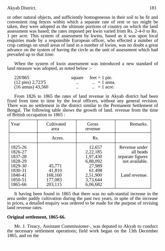
Akyab District. 181 or other natural objects, and sufficiently homogeneous in their soil to be fit and convenient ring fences within which a separate rate of rent or tax might be taken, they were adopted as the ultimate portions of country on which the land assessment was based; the rates imposed per kwin varied from Rs. 2-4-0 to Re. 1 per acre. This system of assessment by kwins, based as it was upon local enquiries made by a responsible European officer, who effected a number of crop cuttings on small areas of land in a number of kwins, was no doubt a great advance on the system of having the circle as the unit of assessment which had prevailed up to that time.
When the system of kwin assessment was introduced a new standard of
land measure was adopted, as noted below :- 226'865 square feet = 1 pie. (12 pies) 2,723'5 .. .. = 1 anna. (16 annas) 43,560 .. .. = 1 acre. From 1826 to 1865 the rates of land revenue in Akyab district had been
fixed from time to time by the local officers, without any general revision. There was no settlement in the district similar to the Permanent Settlement of Bengal. The following table shows the growth of land. revenue from the time of British occupation to 1865 :
Year Cultivated Gross Remarks. area revenue Acres. Rs. 1825-26 12,657 Revenue under 1826-27 2,22,185 all heads 1837-28 1,97,430 separate figures 1828-29 6,88,092 not available. 1829-30 45,771 27,989 1830-31 41,810 61.498 1840-41 168,160 2,51,900 Land revenue. 1850-51 177,083 3,73,644 1865-66 203,115 6,06,682
It having been found in 1865 that there was no sub-stantial increase in the
area under paddy cultivation during the past two years, in spite of the increase in prices, a detailed enquiry was ordered to be made for the purpose of revising land revenue rates. Original settlement, 1865-66.
Mr. J. Treacy, Assistant Commissioner-, was deputed to Akyab to conduct
the necessary settlement operations; field work began on the 13th December 1865, and on the
182 Akyab District. 6th January 1866 Mr. Hind, Assistant Commissioner of Akyab, was deputed to assist in the settlement. The field work was completed by the 27th April 1866; the settlement operations. covered 129 circles, forming a tract of country 132 miles long by 56 broad, situated in the south-western portion of the district; this area, roughly about 5,000 square miles, comprised the level plain portion of the distrlct; the balance of the district, about 6,000 square miles, was of a hilly forested nature, peopled by hill tribes and not fit for paddy cultivation.
As to the quality of the land the Settlement Officer reported as follows:-" The land is everywhere of most excellent quality, averaging generally 50 bushels to the acre; the outturn appears to be much more uniform than in the Pegu Division, where some portions yield much more and some very much less, resulting, I think, from the different formation of the country." Describing the different quality of land in various parts of the district Mr. Treacy writes :-
"The most inferior portion of the district is the south-east along the Lemyo
river. Where not badly flooded, the hills here approach each other so closely, that but small space is left for paddy; what there is is often in small patches, often with difficult roads, and inaccessible to boats. Considerable reductions have been proposed, not with the idea of relieving the cultivators from an undue pressure, than with any expectation of great increase in the cultivation. West of this is the valley of the Kaladan, opening out into large plains as it approaches the sea, and intersected in every direction by tidal creeks in its northern portion. It contains old Arakan (Myohaung) and Mahâmuni, beyond which there is little ground fit for paddy, and its southern portion is Akyab itself, and the Baronga Islands, only one of which, the middle Baronga, has much cultivation, the others being almost entirely hill. This is the most valuable part of but the level of the western country, but on its eastern bank the amount of cultivation is comparatively small; the soil does not appear as rich as elsewhere, and is more suited for plantations than for paddy.
Many of the cultivators are immigrants from Ramri, poor and with few
cattle their cultivation is of the most wretched description ; some reductions are here proposed. The only tea plantation in the district is in the upper part of this river.
It appears to be flourishing and is on a very large scale.
Akyab District. 183
The east bank of the Naaf river is perhaps the best cultivated part of the district ; this is ewing to the superior industry and aptitude for cultivation of the Bengal population, who are in possession of the greater part of ii. Below the month of the Naaf is a long tract between the hills and the sea, almost destitute of cultivation; the soil here is apparently a slightly raised sen beach and so full of sand that it is unsuited for paddy. At present it is chiefly used as a grazing ground for the cattle of the valley of the Mayu."
Revision of rates.
The Settlement Officer submitted a proposal to revise the existing
assessment rates by retaining those prevailing in some kwins and reducing them in others. As regards the result of the reassessment he reported as follows: "126 circles in 8 townships containing 1,398 kwins have been visited and enquired into; the kwins contain an area of 915,318 acres, of which, in 1864-65, 244,704 acres are actually under the plough and 171,675 acres are Supposed to be capable of also being cultivated with paddy : the larger portion of this available waste is contained in 707 kwins in which the rates are recommended for reduction of tax. The revenue from paddy land in these circles in 1864-65 was Rs. 5,22,704. Had the proposed rates been in force, the amount would have been Rs. 4,93,443, and loss of revenue from remission would have been RS. 29,261 or about 5'60 per cent." The outturn was found to be from 60 to 136 baskets per acre, but the size of the baskets was not stated (presumably the basket was the village basket peculiar to Arakan, of which 100 are equal to 36'78 Government standard 9 gallon baskets); an average outturn of 90 baskets per acre was assumed.
The rates prevailing before this settlement, viz., Rs. 2-4-0 and Rs. 2 per
acre, had remained unchanged since they were imposed 20 years before; the result of the settlement enquiries showed that although these rates were suitable for the more fertile lands and those with favourable situations, much land remained uncultivated owing to the prevailing rates being too high. The maximum rate of land revenue on paddy lands in Burma had been fixed at 20 per cent of the value of the gross produce; in revising the rates: in Akyab, this principle was adhered to; in some tracts, the prevailing rates were found to be obstructive on account of the poorness of the soil and they were reduced to Rs. 1-12-0, Rs. 1-8-0, Rs 1-4-0, Re. 1-0-0, annas 12 and annas 8 per acre. This reduced the amount of the demand of land revenue, but it was hoped that the cultivators, who from 1839 to 1858 exhibited such agricultural enterprise and industry, would expand their cultivation and there by increase
184 Akyab District.
the revenue. The new rates came into force in 1866-67, in which year the area under cultivation was 300,125 acres and the revenue demand amounted to Rs. 5,81,860.
On completion of the revision of rates, an officer was specially deputed to Akyab district for the purpose of inducing the cultivators to accept leases of land; his efforts resulted in 74,000 acres being leased to individuals.
Cyclone of 1867.
In 1867-68 land revenue suffered owing to the cyclone which occurred on the 13th November 1867. The injury done to land and crops was immense; the prevalence of cattle disease on the one hand and the scarcity of labourers, due to an epidemic of cholera, on the other, added to the harmful effect of the cyclone and it took six years for the people to recover from the disaster. In 1870-71 the land revenue stood at Rs. 5,51,572; by 1874-75 it had gradually risen to Rs. 5,93,925.
Lower Burma Land and Revenue Act II of 1876.
In 1876 the Lower Burma Land and Revenue Act, II of 1876, came into force, and legalised the assessment and collection of land revenue and other taxes, and defined the powers of revenue officers.
Professional survey by Survey of India,1879-80.
In 1879-80 the revenue demand had risen to Rs. 6,72,978 while the area under cultivation had been extended to 353,538 acres. By this time the professional survey of Burma by the Survey of India had been commenced, super seding the old haphazard and unreliable method of accepting thugyis' estimates of area by which much injustice had been caused to some, while Government had lost considerable revenue.
Revision Settlement, 1879-80.
During the year 1879-80 a revision of rates in Akyab was effected, after the usual settlement enquiries had been made; this revision was undertaken in consequence of a proposal of Colonel Sladen to raise rates all round 25 per cent on account of the greatly enhanced price of produce, paddy being then sold in Akyab at Rs. 45 for 100 baskets. This revision settlement was carried out by Mr. Hodgkinson, Commissioner of Arakan, assisted by Mr. Courneuve, Extra Assistant Commissioner, and resulted in an average general increase of rates of 4 annas an acre; these rates came into force with the year 1881-82. At this period the area under cultivation was 368,893 acres, and the revenue demand Rs. 7,68,363.
First Regular Settlement. 1885-88.
After the completion of the cadastral survey of that part of the district that lies in the plains, the first regular settle. meat was commenced in 1885 by Mr. (now Sir Harvey) Adamson, I.C.S.; the settlement was carried through in the years 1885-86, 1886-87 and 1887-88. In 1887 supplementary survey was first introduced into the district.
Akyab District. 185 Season,1885-86.
The area dealt with in, the first year of the settlement, 1885-86, consisted
of 41 circle in the Kyelet (Akyab), Urittaung West, Rathedaung, -Naaf and Urittaung East townships, in extent about 664 square miles. The resclution of the Local Government on the Settlement Officer's report and the review thereof by the Commissioner of Araken, were to the following effect :-"The correct measurements of the survey show that the area under rice cultivation is about 22 per cent in excess of the area returned in the thugyis' assessment rolls. Although, in a sense, the people may be said to be fairly well off on the whole and there is nothing to indicate their condition is one of decreasing comfort, still their standard of living compares unfavourably with that of the population of the districts in the Irrawaddy delta. The land is poorer and the grain they raise is inferior. The Settlement Officer finds that the people in Akyab are paying as much revenue as the people in Tharrawaddy and Prome if not more, though their land is no more fertile. The Chief Commissioner concurs with the Settlement Officer in considering that there should not be any general enhancement of rates in Akyab. The existing land revenue seems as much as the people can at present afford to pay. The chief cause of the heavy pressure of the present rates is the indiscriminate assessment at a single rate of all lands, good, bad and indifferent, in a kwin. The unequal pressure of rates caused by this indiscriminate method of assessment was aggravated by the summary enhancement up to 25 per cent made for special financial reasons in 1879. This inequality of incidence has been remedied in the proposed settlement and rates have been assessed on the land after a careful classification of the soil and tracts.
Fallow rate.
"The evils arising from the inequality of incidence have been greatly
increased by the omission to introduce into the district the rule that land left fallow should only pay a nominal rate of 2 annas an acre. In Akyab it seems to have remained the custom that lands, both cultivated and fallow, should be assessed at full rates. It is manifest that the indulgence of a low fallow rate is especially needed in the case of inferior lands, which more frequently require temporary rest, and which are especially dependent for their yield on favourable conditions of climate. Thus, out of the 12,938 acres of land, which have been shown by the Settlement Officer in the lowest class, no less than 3,511 are described as fallow. The relief which will be afforded to holders of land in this class by the settlement now proposed may be estimated from the following: The annual revenue previously levied on this land was about
186 Akyab District. Rs. 25,000. The new demand, with the fallow rate of 2 annas per acre, will be Rs. 9,866." Assessment rates proposed.
The rates proposed by the Settlement Officer and sanctioned were from Rs.
2-8-0 to Re. 1 per acre for paddy land; for other cultivation the rates were Rs. 2 for garden and dani cultivation, Re. 1 for miscellaneous cultivation and 4 annas for solitary fruit trees. The resulting total assessment at the new rates was Rs. 3,64,159 as compared with Rs. 3,66,673 at the old rates; the decrease of Rs. 2,514 was apparent only as the survey had omitted to mark some garden and dani cultivation. The Settlement Officer devised a scheme for the amalgamation of circles, as vacancies in thugyi ships occurred; this was accepted and the demarcation and reservation of grazing grounds was also ordered by the Local Government. Season, 1886-87.
In 1886-87 that portion of the valley of the Naaf river which lies in Arakan
and the valleys of the Kaladan and Lemyo rivers as far north as Myohaung were settled, together with a few kwins in the north of the Mayu valley, which had been omitted in the previous season's work, owing to the survey maps being incomplete. This area was divided by the Settlement Officer into two tracts, the Naaf and the Kaladan tract. The Kaladan tract was similar to the scene of the settlement of the previous year, but the Naaf tract presented new features in the greater density of population, the preponderance of Bengalis, the greater value of land, the better condition of the cultivators, the higher rent of tenants' holdings and the larger amount of land let to tenants. The measurement of the survey showed that the area under rice cultivation was 21 per cent above the area returned by the thugyis. The condition of the Arakanese was the same as those inhabiting the country settled the previous year. The Bengalis were more thrifty and hard working and consequently more prosperous. It appeared that the Arakanese were unable to hold their own against the Bengalis, and that land was gradually passing into the hands of the latter. The Settlement Officer proposed, and the Local Government sanctioned, for the Naaf valley a maximum rate of Rs. 3 per acre, which was higher than any other part of Akyab district. A maximum rate of Rs. 2-8-0 was sanctioned for the Kaladan tract. The increase in revenue on paddy cultivation amounted lo Rs. 35,851. The Local Government was disposed to favour proposals for attracting Bengali immigrants. Fallow rate on unculturable portions of holdings.
During the course of this year's settlement operations there arose an
important question as to grazing grounds. The Settlement Officer found that in some parts of the
Akyab District. 187 district small areas of high-lying uncultivated grazing land, adjoining holdings, were, in possession of the owner of the holding. The possession had in many eases ripened into ownership under Part II of the Revenue Act. The thugyi had nominally assessed the cultivator at full rates on both the cultivated and unculturable parts of his holding. The assessment was described as nominal because it was generally found that the total area of the thugyi did not exceed the settlement area of the cultivated part of the holding. On the question as to how these unculturable grazing grounds were to be assessed the following correspondence took place :
Remarks by Deputy Commissioner, Akyab, on a petition requesting
permission to leave part of a holding uncultivated, and assessed at two anna rate:
"Forwarded to the Settlement Officer. I shall be obliged if you will kindly
let me know what action I should take on this. Heretofore, I have sent such petitions to the thugyis under Rule 88, but during my recent tour I found that much land which is not fallow is likely to be brought surreptitiously under the fallow rate and I have not been able to decide what policy to follow. I am afraid on the one hand to discourage the keeping of sufficient grazing grounds by cultivators, or on the other hand to give undue advantages to eager Chittagonians who have possessed themselves of much of the really unculturable lands round villages, and who may breed cattle and sell them to their more indolent neighbours. I have met instances of Chittagonians subletting grazing lands at very profitable rates and yet paying full kwin rates themselves for the land or for a great portion of it." .
On this the Settlement Officer remarked : "The petitioner owns a certain area of land, part of which he wishes to
leave uncultivated and to have assessed at the two anna rate. I think the Deputy Commissioner has no option but to adopt the procedure of Revenue Rule 88. If the land is generally sublet it may be assessed at full rates. If net, it must be assessed at two annas. This is a question of fact for the Deputy Commissioner to decide. It is quite true that in some parts of the district people possess unculturable lands from which they make a profit by letting them for grazing. Rights to unculturable lands may be acquired by Part II of the Land and Revenue Act. But only culturable land is assessable under Part II of the Act (vide section 23). It was not intended by the Act that if a person owned a holding, part of which was culturable and part unculturable, he should have to pay a tax on the
188 Akyab District. unculturable part even if he might get some profit out of it. This is shown by the fact that no tax on grazing land was imposed by the Act. Grazing grounds are allotted free, and though villages adjacent to a good grazing ground can make a handsome profit by breeding cattle, no additional tax is imposed upon them on account of this profit.
"It is true that much of the unculturable land used for grazing can be taxed
under the clause of section 20, which provides that 'all land assessed to land revenue when the Act came into force' is still assessable, but I think the spirit of the Act and of the Revenue Rules requires that this should be the nominal two anna rate; and not only as a matter of law, but as a matter of policy, in a country where cattle disease creates such havoc, and where the breeders of cattle are conferring a boon on the whole agricultural community, a heavy tax on grazing, which would in fact be a tax on cattle breeding, would, in my opinion, be very injudicious. My action under the circumstances stated by the DepUty Commissioner would be to carry out the two anna rate as far as Rule 88 allows and not to grudge cattle breeders their full profits." Season, 1887-88.
The settlement of the district was brought to a close with the season 1887-
88; in this year the tract settled comprised the upper part of the valley of the Kaladan and Lemyo, near where the plains merge into the hills. The area was 386 square miles. Summary of 3 years,1885-86 to1887-88.
The total area of the district was 5,535 square miles, and the area of the
cadastral survey and settlement was 1,838'90 square miles. The district was divided into nine townships and 101 circles. Previous to the introduction of the settlement in 1885-86, there were 112 circles, but under the scheme. for the gradual amalgamation of Circles, the whole district was to be divided into 59 circles. During the three years of the settlement the total area dealt with amounted to 1,838'90 square miles or 1,176,909.69 acres. Of these 374,311 acres were under paddy cultivation, 27,809 acres were fallow land, 5,446 acres were given up to miscellaneous cultivation, 10,071 to garden land, and 12,349 to culturable and 10,704 to unculturable grazing lands; 41,940 acres had been thrown out of cultivation, and the remainder of the area was accounted for by village sites, monastery and pagoda lands, roads, canals, tanks, jungle, culturable or not, grants and water. Grants accounted for 110,083 acres, while the area under water was calculated at 108,213 acres. The settlement area embraced the whole of the plains with the exception of some scattered pieces of dense jungle not cadastrally surveyed containing an

Akyab District. 189 aggregate of 17,750 acres of rice cultivation. The increase of assessment throughout the district since 1866-67 is shown below :-
Rs.
Assessment in 1866-67 4,99,862 Assessment in 1879-80 6,31,100 Assessment in 1882-83 7,71,021 Assessment in 1887-88 8,72,690
The figures for 1887-88 are for the area under settlement only, while the
others are for the whole district. The increase during the past 20 years between former and present cultivated areas as measured by thugyis throughout the district amounted to 61 per cent. During the three years of the settlement. the average. acre outturn was assumed to be 76 baskets (Akyab baskets equal to 44 of the Government standard basket). The Settlement Officer brought to notice the deteriora-tion of Akyab cargo rice, with the result that the collection of land revenue was delayed, and the merchants deferred the opening of the paddy market in order to give the cultivators ample time to let the grain dry before disposing of it. The settlement resulted financially in a revenue demand of as. 7,93,179 as against Rs. 7,54,912 under the expiring rates; the actual monetary increase was trifling, but the Settlement Officer's object was to distribute the demand more equitably, necessitating, in some cases, a decrease of rates, but this was more than counterbalanced by the correct survey of the area under cultivation liable to revenue. The rates under the foregoing settlement were fixed for a term of 15 years dating from the conclusion of the settlement of each part of the district. in the three years 1885-86 to 1887-88. Revision Settlement, 1902-03.
Mr. W. E. Lowry, I.C.S, was entrusted with the revision settlement of the
district, which became due in 1901-02; in this and the following year Mr. Lowry dealt with the whole settled area of the district. Season, 1901-02.
During the first year of the revision settlement, 1901-02, the area dealt with
included the whole of the valleys of the Naaf and Mayu, composing the Rathedaung subdivision, and so much of the Lower Kaladan, as was settled in 1885-86, viz., parts of Akyab (or Kyelet), Panktaw and Urittaung townships; the number of kwins resettled during the year was 520, covering an area of 809'51 square miles, of which nine were new kwins, and 13 kwins, aggregating 21'16 square miles, which had been formerly waste land grants.
Akyab District. 190 but have been now resumed by Government; thus the total number of kwins dealt with was 593, measuring 830'67 square miles.
Since original settlement the area under paddy had been extended from
218,375 acres to 270,248 acres, or about 23 per cent; the chief extensions were found in Pauktaw township and towards the hills in the valleys of the Naaf and the Mayu; during the same period miscellaneous cultivation had increased from 3,782 acres to 4,828 acres, or roughly 27 ½ percent.
The new rates proposed by the Settlement Officer, equivalent roughly to
one-seventh of the net produce, were approved of and were sanctioned for a period of 17 years so as to cover the whole of the period before the next revision settlement. The financial effect of the new rates was to raise the amount of revenue on all cultivation from Rs. 5,30,745 to Rs. 6,86,477, an increase of 29'34 per cent. The new rates were introduced with effect from the lst July 1903.
Assessment of areas fallowed for grazing and of unculturable portion of holdings. The question of the assessment of portions of holdings fallowed for grazing
and unculturable lands included in holdings again came into consideration; a local enquiry had been held in 1896, from which it appeared that landholders frequently rented these grazing areas to others at rates varying from Re. 1 to Rs. 4 per head of cattle an d that the private grazing grounds were a source of annoyance to neighbouring people. It was therefore held desirable not to encourage them and orders were issued that privileged fallow rates were not to be allowed on such lands. Again, in the Resolution on the Report on the Land Revenue Administration of Burma for the 15 months ending on 30th June 1902, the Financial Commissioner was informed that the Lieutenant-Governor was unable to agree in the proposal that full revenue rates should not be assessed on the large fallow areas regularly occupied for grazing purposes.
The Settlement Officer noted in his report that the Deputy Commissioner
had recently authorized the assessment of half rates on fallow lands owned by persons who keep such lands for grazing their own cattle only (apparently a very small class), and recommended that the concession should also be allowed to bonâ fide tenants who cultivate not less than two-thirds of their holding, and derive no profit from the remaining fallow area; the Settlement Officer proposed that this concession should take the form of a fixed assessment of Re. 1 per acre in lieu of the half full rates in cases where such half rate was already levied, while the full rate should continue to be assessed in all other cases where land was left fallow for grazing. On
Akyab District. 191 the other hand the Settlement Commissioner, in conference, and the Financial Commissioner recommended that a fixed Re. 1 rate should usually be imposed on all fallow lands set apart for grazing. The Local Government finally ordered that the privilegedrate to cultivators who graze only their own cattle on thefallow area, and to tenants, as proposed, by the SettlementOfficer, should be conceded, while it was decided thatunculturable land included in a paddy holding for grazing purposes should be assessed at full rates. Season 1902-03.
In 1902-03 Mr. Lowry completed the revision of Mr.Adamson's settlement,
dealing with those circles of the Urittaung and Pauktaw townships which were left over from the year before, and the whole of Minbya, Kaladan (now called Kyauktaw) and Myohaung. The original settlement of this part of the district was carried out during the two seasons 1886-87 and 1887-88. The total area was 864'52 square miles and was divided up into 439 kwins; besides these there were ten waste land grants covering an area of 22 98 square miles. Paddy cultivation had increased, since settlement, from 184,469 acres to 282,342 acres, or roughly 53 per Cent. This increase was general throughout the tract, but wasgreatest in the circles most distant from Akyab. In Myauk taung and Tawdan circles the area had expanded over 200 per cent and had more than doubled itself in Myohaung, Launggyet, Kamigywe and Pyisogyi. The total increase of all kinds of cultivation other than paddy was from 6,192 acres to 15,272 acres, or about 147 per cent., though the true increase was more than that shown by the settlement figures. The financial effect of the resettlement of the area covered by the operations of the settlement of 1902-03 was to raise the revenue assessment on all kinds of cultivation from Rs. 5,46,575 to Rs. 7,27,097, an increase of Rs. 1,80,522 or 33'03 per cent. The new rates were brought into force on 1st July 1904. Summary of two years, 1901-02 and 1902-03.
The result of the two years revision settlement over the district as a whole was an increase from Rs. 10,77,320 to Rs. 14,13,574, or 31'21 per cent in the land revenue assessment. The normal price of paddy in Akyab during the currency of the expiring settlement was taken to he Rs. 84 per 100 standard 9 gallon baskets. Mr. Lowry recognized only two classes of soil in each tract and be formed price tracts on the basis of the distance of the tract concerned from the export market of Akyab. It was found, that the population had largely increased since settlement and was entirely agricultural; and those who were
192 Akyab District. not agriculturists themselves were engaged in employments dependent on agriculture. The people on the whole were well off and might have been more so if they were willing to do more work themselves in place of employing hired labour for nearly all agricultural processes.
The increase of revenue was found to be justified for the following reasons:
(1) The rates fixed at last settlement gave little enhancement; (2) Prices of produce had increased largely; (3) The average tenant rate was more than double the rate at settlement; and (4) The people were well off and able to pay enhanced rates.
Season, 1903-04.
During the season 1903-04 three circ1es in the south-east of the district
adjoining the area brought under revision settlement in the season 1902-03 were summarily settled by Myoôk Maung Pan Hla. This tract, measuring about 72 square miles, was cadastrally surveyed in 1894-95, and the land had been assessed at varying acre rates since that time, but no settlement had hitherto been made. The area consisted of the Palaungbyin, Pyunshe and Ngazinyaing circles of the Minbya township. This settlement was conducted on the same lines as Mr. Lowry's revision settlement; the rates finally sanctioned produced a total revenue demand for the three circles of Rs. 57,451 as compared with the existing demand of Rs. 27,282, an increase of Rs. 10,170 or 37 per cent. The rates were imposed for a period of 14 years from the 1st July 1905 so as to expire simultaneously with the rates in the adjoining settled tract. Revision settlement 1913-16.
The next revision settlement of the district was under-taken by Mr. R. B.
Smart during the years 1913-16. The entire settlement area was dealt with as a whole and not in parts as at previous settlements. The settlements covered the portion of the district under Supplementary Survey and the area dealt with rose from 1,789 square miles at last settlement to 1,950 square miles, or by 9 per cent. Of this rite occupied and cultivated areas were 736,071 and 646,792 acres respectively against 588,968 and 522,064 acres at previous settlement. Of the balance 207,898 acres are classed as culturable, but most of this land, although suited to misellaneous and fodder crops, will net grow rice, the staple crop of the district. It is estimated that about 20,000 acres, in scattered plots, on the borders of the settlement tract are still available for rice cultivation. In the south of the district the land is slowly rising above sea level and being brought under rice cultivation by mean s of embankments. Proposals have also been submitted for the gradual
Akyab District. 193 closing of reserved grazing grounds portions of which are suited to rice. It is anticipated that the small annual increase in the occupied area which has taken place in the past will be maintained for some years to come. Tracting and soil classification.
For rice cultivation the settlement area was divided into 28 tracts by
townships. The hilly, undulating and level kwins were first separted. The tracts were then based on position, homogeniety of soil, immunity from floods, liability to inundations of salt or fresh water and a consideration of the proportion of the many races of people found in the district inhabiting the various localities. The tracts being small and communication by water excellent, no further subdivision into price tracts was necessary and the 28 primary tracts were also the assessment tracts. After the tracting had been done the interior classification of the soil depended on practically the same general conditions in all parts of the district. The low lying lands, provided they do not get too much water, were found to be the most fertile. the slightly higher and the less securely protected low lands came next in order of fertility and the highest, the lowest or flooded areas and the badly protected lands were the poorest. Only two soil classes were found to be necessary in one tract, four in another tract and the remaining 26 tracts had only three soil classes. Mixed garden and miscellaneous cultivation in certain of the tracts formed for rice cultivation were found to be more valuable than in the rest of the district, These were placed in a separate tract and there were thus two tracts for these main kinds. Betel-palm gardens, betel-vine cultivation and dani were treated separately from other gardens and needed no tracting or soil classification. Proposed enhancement of demand.
An assumed wholesale market price of Rs. 118 per 100 Government
standard 9 gallon baskets of unhusked rice was adopted for the central markets of Akyab and Maungdaw, and from this deductions ranging from Rs. 11 to 35 were made for the various tracts on account of cost of carriage and merchants' profits. The assumed outturns of unhusked rice, after throwing out abnormal plots and making an allowance of 8 per cent on account of dryage, ranged from 18 to 46 baskets per acre. The assumed cost of rice cultivation varied from Rs. 15 per acre in the west of the district to Rs. 27 per acre in the east The assessment rates proposed approximate one-fifth of the net produce for first class rice land and one-fourth of the net produce for second Class land. The lowest rates were framed on a consideration of the prevailing rates and the tenancy statistics. For main kinds other than rice the rates proposed are regulated so as not to press heavily on these
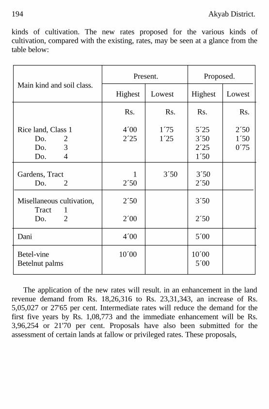
194 Akyab District. kinds of cultivation. The new rates proposed for the various kinds of cultivation, compared with the existing, rates, may be seen at a glance from the table below:
Present. Proposed. Main kind and soil class. Highest Lowest Highest Lowest Rs. Rs. Rs. Rs. Rice land, Class 1 4´00 1´75 5´25 2´50 Do. 2 2´25 1´25 3´50 1´50 Do. 3 2´25 0´75 Do. 4 1´50 Gardens, Tract 1 3´50 3´50 Do. 2 2´50 2´50 Misellaneous cultivation, 2´50 3´50 Tract 1 Do. 2 2´00 2´50 Dani 4´00 5´00 Betel-vine 10´00 10´00 Betelnut palms 5´00
The application of the new rates will result. in an enhancement in the land
revenue demand from Rs. 18,26,316 to Rs. 23,31,343, an increase of Rs. 5,05,027 or 27'65 per cent. Intermediate rates will reduce the demand for the first five years by Rs. 1,08,773 and the immediate enhancement will be Rs. 3,96,254 or 21'70 per cent. Proposals have also been submitted for the assessment of certain lands at fallow or privileged rates. These proposals,
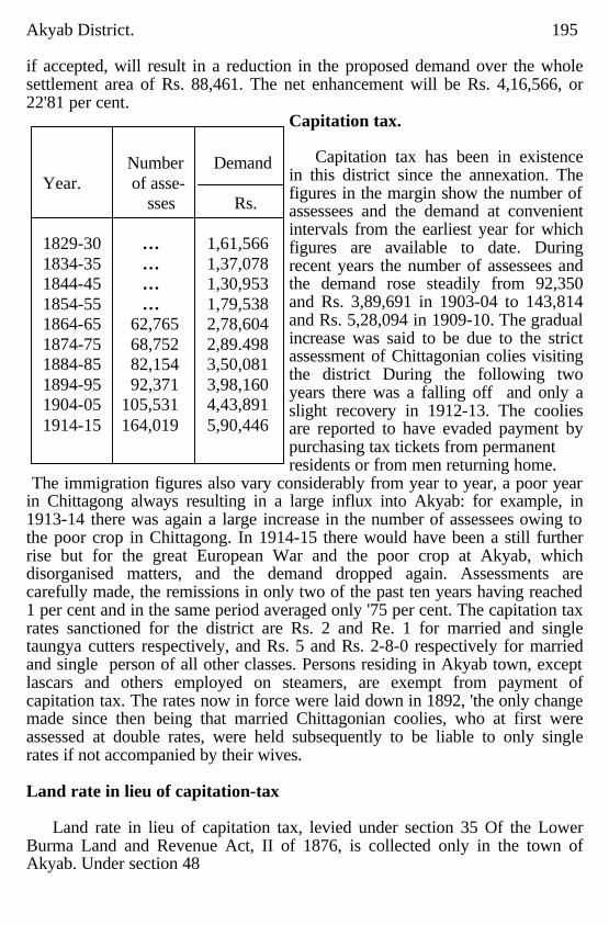
Akyab District. 195 if accepted, will result in a reduction in the proposed demand over the whole settlement area of Rs. 88,461. The net enhancement will be Rs. 4,16,566, or 22'81 per cent.
Capitation tax.
Capitation tax has been in existence in this district since the annexation. The figures in the margin show the number of assessees and the demand at convenient intervals from the earliest year for which figures are available to date. During recent years the number of assessees and the demand rose steadily from 92,350 and Rs. 3,89,691 in 1903-04 to 143,814 and Rs. 5,28,094 in 1909-10. The gradual increase was said to be due to the strict assessment of Chittagonian colies visiting the district During the following two years there was a falling off and only a slight recovery in 1912-13. The coolies are reported to have evaded payment by purchasing tax tickets from permanent residents or from men returning home.
The immigration figures also vary considerably from year to year, a poor year in Chittagong always resulting in a large influx into Akyab: for example, in 1913-14 there was again a large increase in the number of assessees owing to the poor crop in Chittagong. In 1914-15 there would have been a still further rise but for the great European War and the poor crop at Akyab, which disorganised matters, and the demand dropped again. Assessments are carefully made, the remissions in only two of the past ten years having reached 1 per cent and in the same period averaged only '75 per cent. The capitation tax rates sanctioned for the district are Rs. 2 and Re. 1 for married and single taungya cutters respectively, and Rs. 5 and Rs. 2-8-0 respectively for married and single person of all other classes. Persons residing in Akyab town, except lascars and others employed on steamers, are exempt from payment of capitation tax. The rates now in force were laid down in 1892, 'the only change made since then being that married Chittagonian coolies, who at first were assessed at double rates, were held subsequently to be liable to only single rates if not accompanied by their wives. Land rate in lieu of capitation-tax
Land rate in lieu of capitation tax, levied under section 35 Of the Lower
Burma Land and Revenue Act, II of 1876, is collected only in the town of Akyab. Under section 48
Number Demand Year. of asse- sses Rs. 1829-30 … 1,61,566 1834-35 … 1,37,078 1844-45 … 1,30,953 1854-55 … 1,79,538 1864-65 62,765 2,78,604 1874-75 68,752 2,89.498 1884-85 82,154 3,50,081 1894-95 92,371 3,98,160 1904-05 105,531 4,43,891 1914-15 164,019 5,90,446
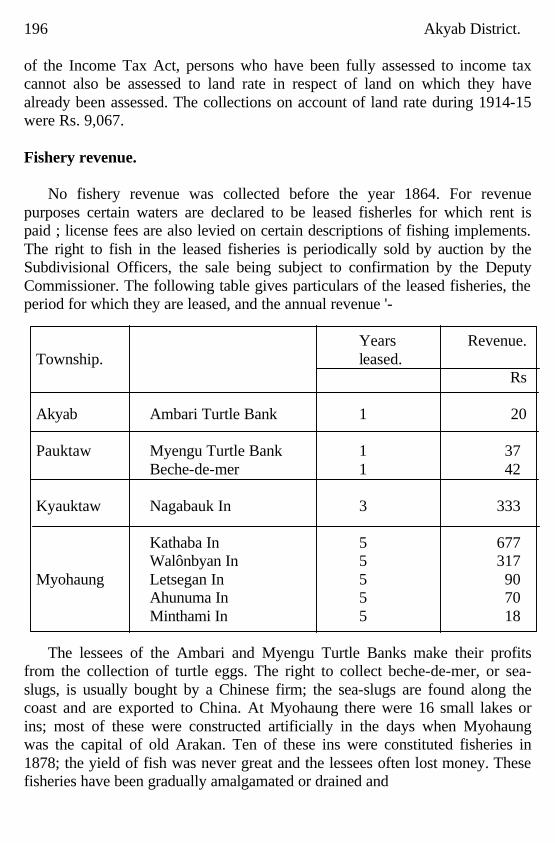
196 Akyab District.
of the Income Tax Act, persons who have been fully assessed to income tax cannot also be assessed to land rate in respect of land on which they have already been assessed. The collections on account of land rate during 1914-15 were Rs. 9,067. Fishery revenue.
No fishery revenue was collected before the year 1864. For revenue
purposes certain waters are declared to be leased fisherles for which rent is paid ; license fees are also levied on certain descriptions of fishing implements. The right to fish in the leased fisheries is periodically sold by auction by the Subdivisional Officers, the sale being subject to confirmation by the Deputy Commissioner. The following table gives particulars of the leased fisheries, the period for which they are leased, and the annual revenue '-
Years Revenue.
Township. leased. Rs Akyab Ambari Turtle Bank 1 20 Pauktaw Myengu Turtle Bank 1 37 Beche-de-mer 1 42 Kyauktaw Nagabauk In 3 333 Kathaba In 5 677 Walônbyan In 5 317 Myohaung Letsegan In 5 90 Ahunuma In 5 70 Minthami In 5 18
The lessees of the Ambari and Myengu Turtle Banks make their profits
from the collection of turtle eggs. The right to collect beche-de-mer, or sea-slugs, is usually bought by a Chinese firm; the sea-slugs are found along the coast and are exported to China. At Myohaung there were 16 small lakes or ins; most of these were constructed artificially in the days when Myohaung was the capital of old Arakan. Ten of these ins were constituted fisheries in 1878; the yield of fish was never great and the lessees often lost money. These fisheries have been gradually amalgamated or drained and
Akyab District. 197 thrown open to cultivation, till only five remain, those mentioned above. All other waters (and there is very little fresh water in the district as compared with salt or brackish water) are free to the public, but the use of Certain fishing implements is regulated by the issue of annual licenses, the fees for which are collected by the Township Officers.
Fixed obstructions, or engines, are not allowed to interfere with navigation,
and in order to afford a close time to fish at the spawning seasons, fishing instruments compelety closing a stream or creek may not be used between the full moon of Tagu (April) and the first waxing of Tawthalin (August). No license is required for the small fishing implements known as hmyôn, yethè and kun unless the last named exceeds six cubits in length. These three are most commonly used in catching fish for domestic consumption and may be described as follows :
Kun is the circular casting net used all over the world; its circumference is
weighted with leads and it is drawn in with a rope fastened to the centre. It is thrown with a swing of the body and some of the fishermen who use it habitually have magnificent torsos. It is nsed in shallow water, ground bait being often used to atfract fish, while it is also used a good deal at night when the fish are less likely to catch sight of the fisherman.
Yetthè is a scoop, triangular in shape, made of split bamboos measuring
two cubits by one cubit; it is employed in very shallow water and paddy fields where small fish congregate; women and children may often be seen using this implement.
Hmyôn is a cylindrical trap made of split bamboos; the entrance is guarded
by sharp pointed bamboos, so arranged that the fish can enter but not pass out again; size two cubits by one cubit.
The professional fishermen, who are almost entirely Chittagonians or
Madrassis, use larger and more elaborate contrivances, which require license fees, according to their size and description. Amongst these may be noted-
Chanlamu . A line of screens or a bamboo fence, enclosing a space where
fish are stranded at low water, either on the shore of the sea or rivers. This instrument is taxed at Re. 1 per 50 cubits or part thereof, if it exceeds 30 cubits in length. Another similar instrument known as chanlamu chaungpeik is taxed at Rs. 5 per ten cubits or part thereof.
Paikkyi or paikdamin. This is a bag shaped net, fixed with its mouth
stretched open in a vertical plane, transverse to the current by attaching it to posts or bamboos planted or anchored in the bed of the stream; these vary in size
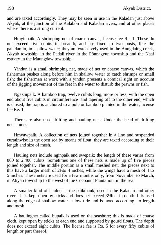
198 Akyab District. and are taxed accordingly. They may be seen in use in the Kaladan just above Akyab, at the junction of the Kalabôn and Kaladan rivers, and at other places where there is a strong current.
Hmyinpaik. A shrimping not of coarse canvas; license fee Re. 1. These do
not exceed five cubits in breadth, and are fixed to two posts, like the paikdamin, in shallow water; they are extensively used in the Aungdaing creek, Akyab township, in the Padali river in the Pônnagyun township and the Naaf estuary in the Maungdaw township.
Yindun is a small shrimping net, made of net or coarse canvas, which the
fisherman pushes along before him in shallow water to catch shrimps or small fish; the fisherman at work with a yindun presents a comical sight on account of the jigging movement of the feet in the water to disturb the prawns or fish.
Ngazinpaik. A bamboo trap, twelve cubits long, more or less, with the open
end about five cubits in circumference and tapering off to the other end, which is closed; the trap is anchored to a pole or bamboo planted in the water; license fee Re. 1.
There are also used drifting and hauling nets. Under the head of drifting
nets comes Hmyawpaik. A collection of nets joined together in a line and suspended
curtainwise in the open sea by means of float; they are taxed according to their length and size of mesh.
Hauling nets include nginpaik and swepaik; the length of these varies from
800 to 2,400 cubits. Sometimes one of these nets is made up of five pieces joined together. The middle portion is a small meshed net; the pieces next to this have a larger mesh of 2½ to 4 inches, while the wings have a mesh of 4 to 5 inches. These nets are used for a few months only, from November to March, in Akyab township to the west of the Cocoanut Plantation, in the sea.
A smaller kind of haulnet is the paikthauk, used in the Kaladan and other
rivers; it is kept open by sticks and does net exceed 3½ feet in depth. It is used along the edge of shallow water at low tide and is taxed according to length and mesh.
A haulingnet called bupaik is used on the seashore; this is made of coarse
cloth, kept open by sticks at each end and supported by gourd floats. The depth does not exceed eight cubits. The license fee is Rs. 5 for every fifty cubits of length or part thereof.
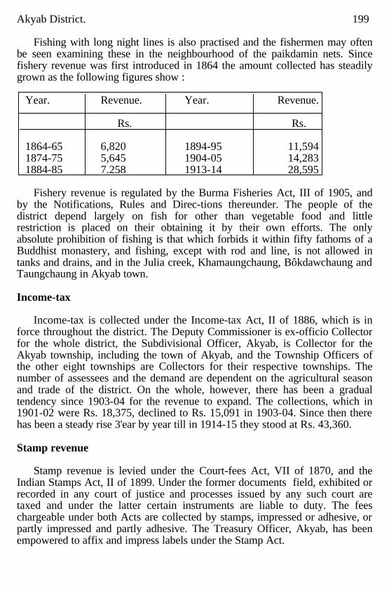
Akyab District. 199 Fishing with long night lines is also practised and the fishermen may often
be seen examining these in the neighbourhood of the paikdamin nets. Since fishery revenue was first introduced in 1864 the amount collected has steadily grown as the following figures show :
Year. Revenue. Year. Revenue. Rs. Rs. 1864-65 6,820 1894-95 11,594 1874-75 5,645 1904-05 14,283 1884-85 7.258 1913-14 28,595
Fishery revenue is regulated by the Burma Fisheries Act, III of 1905, and
by the Notifications, Rules and Direc-tions thereunder. The people of the district depend largely on fish for other than vegetable food and little restriction is placed on their obtaining it by their own efforts. The only absolute prohibition of fishing is that which forbids it within fifty fathoms of a Buddhist monastery, and fishing, except with rod and line, is not allowed in tanks and drains, and in the Julia creek, Khamaungchaung, Bôkdawchaung and Taungchaung in Akyab town. Income-tax
Income-tax is collected under the Income-tax Act, II of 1886, which is in
force throughout the district. The Deputy Commissioner is ex-officio Collector for the whole district, the Subdivisional Officer, Akyab, is Collector for the Akyab township, including the town of Akyab, and the Township Officers of the other eight townships are Collectors for their respective townships. The number of assessees and the demand are dependent on the agricultural season and trade of the district. On the whole, however, there has been a gradual tendency since 1903-04 for the revenue to expand. The collections, which in 1901-02 were Rs. 18,375, declined to Rs. 15,091 in 1903-04. Since then there has been a steady rise 3'ear by year till in 1914-15 they stood at Rs. 43,360. Stamp revenue
Stamp revenue is levied under the Court-fees Act, VII of 1870, and the
Indian Stamps Act, II of 1899. Under the former documents field, exhibited or recorded in any court of justice and processes issued by any such court are taxed and under the latter certain instruments are liable to duty. The fees chargeable under both Acts are collected by stamps, impressed or adhesive, or partly impressed and partly adhesive. The Treasury Officer, Akyab, has been empowered to affix and impress labels under the Stamp Act.
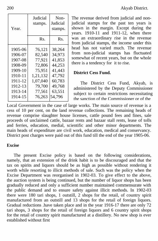
200 Akyab District.
The revenue derived from judicial and non-judicial stamps for the past ten years is shown in the margin. Except during the years. 1910-11 and 1911-12, when there was an extraordinary rise in the revenue from judicial stamps, the income under this head has not varied much. The revenue from non-judicial stamps has fluctuated somewhat of recent years, but on the whole there is a tendency for it to rise.
Local Government in the case of large works. The main source of revenue is a cess of 10 per cent, on the land revenue collections. The remaining heads of revenue comprise slaughter house licenses, cattle pound fees and fines, sale proceeds of unclaimed cattle, bazaar rents and bazaar stall rents, lease of tolls and ferries, education, medial, scientific and other minor departments. The main heads of expenditure are civil work, education, medical and conservancy. District post charges were paid out of this fund till the end of the year 1905-06. Excise
The present Excise policy is based on the following considerations,
namely, that an extension of the drink habit is to be discouraged and that the tax on spirits and liquors should be as high as possible without rendering it worth while resorting to illicit methods of sale. Such was the policy when the Excise Department was reorganised in 1902-03. To give effect to the above, the auction system is being continued, but the number of liquor shops has been gradually reduced and only a sufficient number maintained commensurate with the public demand and to ensure safety against illicit methods. In 1902-03 tbere were 180 tari shops, 1 outstill, 2 shops for the retail, of country spirit manufactured from an outstill and 13 shops for the retail of foreign liquors. Gradual reductions .have taken place and in the year 1916-17 there are only 72 tari shops, 3 shops for the retail of foreign liquors and 6 country spirit shops for the retail of country spirit manufactured at a distillery. No new shop is ever established without first
Judicial Non- stamps. Judicial
Year. stamps. Rs. Rs. 1905-06 76,121 38,264 1906-07 82,540 34,973 1907-08 77,921 41,853 1908-09 72,806 44,253 1909-10 75,951 41,443 1910-11 1,21,132 47,792 1911-12 1,07,040 60,783 1912-13 79,700 49,768 1913-14 77,561 63,551 1914-15 76,263 54,796
District Cess Fund. The District Cess Fund, Akyab, is
administered by the Deputy Commissioner subject to certain restrictions necessitating the sanction of the Commissioner or of the
Akyab District. 201 consulting local opinion. In Akyab an Advisory Excise Committee of six members was formed in the year 1908. This committee consisted of the Deputy Commissioner, District Superintendent of Police, Superintendent of Excise and three outsiders The committee has been further expanded: the whole Municipal committee now forms the Excise Advisory Board. In towns where there is a Town Committee the latter now form an advisory beard. The committee is fully consulted in all excise matters. On the whole the Akyab district is free from illicit distillation on an extensive scale. Liquors are sold illicitly only at places remote from liquor shops. Tari is looked upon as a national drink by the Arakanese and is drunk by the bulk of the poorer classes. It is obtainable only during the dry weather. The better class of Arakanese prefer whisky, gin and brandy In 1902-03 the total receipts from liquor were Rs. 38,747. By 1915-16 they had risen to Rs. 74,971, showing an increase of Rs. 36,224 when compared with the first year the Excise Department was reorganised. The revenue increased notwithstanding the large reductions in the number of liquor shops. Opium.
Prior to the inception of the present Opium policy, an opium shop for the sale of opium was established at Akyab for the whole district. It was sold annually by auction to the highest bidder and possession of opium by unregistered Burmans was not made illegal until the year 1893, when it was found that the habit was spreading fast amongst them. Registration of Burman consumers was then opened and possession of opium by Burmans, other than those registered, was rendered illegal. To suppress opinmsmuggling and prevent the spread of the habit amongst the Burmans, a small staff consisting of one Superintendent, one Assistant Inspector, three sergeants, four peons, two boat tindals and eleven lasears was maintained. It was found that this small staff was inadequate and that the restrictiVe policy was failing owing to the large arerunt of contraband opium which was smuggled into and through this district and which was alike obtainable by the non-registered as well as the registered Burman opium consumer. In order, if possible, to kill this illicit traffic and render effective the policy of prohibition a change in measures, involving the reopening of registration of Burman opium consumers, an increase in the number of licensed shops, abolition of the auction system, supervision over the shops by Excise Officers and additions to the, executive staff were introduced tentatively in the year 1902-03. The increase in the number of opium shops was at first from 1 to 8, situated at Akyab, Pauktaw, Minbya, MyohAung, Kyauktaw,
202 Akyab District. Pônnagyun, Rathedaung and Maungdaw. As the number of shops was still found insufficient to meet the requirements of consumers, three additional shops were sanctioned later, one each at Buthidaung, Thegan and Letmaseik. The last mentoined shop was considered unnecessary and abolished a few years later. The staff then sanctioned was one Superintendent, two Inspectors, six Sub Inspectors, nine Resident Excise Officers, nineteen peons and eleven lascars. As the number of Excise Inspectors was still inadequate, two additional men were sanctioned in the year 1906. The staff was brought on to a permanent footing in 1913-14 and further strengthened by two Inspectors, nine Sub Inspectors and eleven peons. The new measures appear to have had the effect of reducing the opium revenue for the first two years. When compared with the year 1901-02 the receipts from opium fell from Rs. 4,11,957 to Rs. 1,73,457 in 1902-03, but recovered somewhat in 1903-04 when they reached Rs. 3,49,075. This was apparently due to the majority of the consumers preferring to get their opium from the smugglers. In 1904-05 receipts from opium rose to Rs. 4.73,075. After this the revenue gradually fell owing to an executive order issued in 1905-06 restricting the amount purchasable by each individual consumer. No person is at present permitted to buy more than the actual or probable amount he is able to consume. Prior to this each consumer could purchase his three tolas daily.
CHAPTER XI.
Local Self Government.
Akyab Municipality; Constitution; Comervancy; Roads; Water supply;
Lighting; Fire protection; Bazaars; Schools; Hospital Finance.
Akyab Municipality The British Burma Municipal Act was extended to Akyab on 1st October
1874. Prior to that date there had been a Municipal Fund to provide for local requirements such as roads, bazaars, police and sanitation, but this fund was administered by the Town Magistrate subject to the control of the Commissioner of Arakan. Constitution
The committee which was appointed in 1874 consisted of six officials and
five non-officials, but only three of the -officials held their seats ex-officio-viz., the Commissioner of Arakan, the Civil Surgeon and the Town Magistrate, who was President. This body was responsible for and managed police, roads, bazaars. hospitals, conservancy and
Akyab District. 203 Water supply within the limits of the town. The committee continued to be a nominated body till the year 1882, when the elective principle was partially applied to Akyab by a notification of the Chief Commissioner dated 30th May 1882. Twelve seats were allotted as follows : Europeans 3, Arakanese 4, Mahomedans 3, and Hindus 2. In addition there were four ex-officio members the Port Officer, the Executive Engineer, the Civil Surgeon, and the Deputy Commissioner, who was President. The town of Akyab had cease to be an independent charge under a Town Magistrate in 1880. While the electoral principle was still novel, considerable interest was taken in the elections, but there has long been much apathy evinced, particularly by the European community. Elections excite little interest and few contests, and members have frequently to be appointed by Government. The Committee as newly constituted in 1882 was relieved of charges for pulice and was entrusted with additional responsibilities and powers in respect of schools, hospitals, vaccination and similar charges. In 1908 one additional seat was allotted to Mahomedans. At present the committee consist of three ex-officio. Members the Deputy Commissioner who is President, the Civil Surgeon who is Vice President, and the Exective Engineer two members nominated by Government and twelve members elected as follows : Eurnpean community 2, Buddhist community 4, Mahomedan community 4, Hindu community 2.
Conservancy and Sanitation.
The delegation of powers to a Municipal Committee did not result
immediately in improvement in sanitation. The President addressing the committee in 1880 said that the state of the roads, of the water supply and the filthy and insanitary condition of the town after half a century of occupation was scandalous. It would scarcely be believed by any one outside Akyab that in fifty years not one single Pucca drain had been made with the exception of a few yards made by the Town Magistrate before Municipalities were known. The consequence was that the dwellings of the people were surrounded by dismal fetid swamps.
It is only within recent years that the committee has come within
reasonable distance of a solution of the drainage problem, a problem rendered mere difficult by a heavy rainfall and by the low level of the southern part of the town. In 1912 the Sanitary Engineer prepared plans for a system of surface drains. The project is at present being carried out by the Public Works Department with funds supplied by the Local Government.
Conservancy is now the heaviest item in Municipal expenditure. A night
conservancy system was established
204 Akyab District. in 1894 and its scope was extended in 1899. At present less than half of the houses in the town receive Municipal service. Roads.
Thirty miles of roads were made over to the Municipality in 1874. These
had been constructed by convict labour with Bombay stone. Owing, however, to the with drawal of convict labour and to the substitution of sailing vessels by steam ships with water ballast, the condition of roads rapidly deteriorated. With the expansion of the resources of the Municipality, however, the chief roads have been improved and at present some 42'10 miles of road are maintained under conditions of considerable difficutly a very heavy rainfall and inferior road metal. Watersupply.
The question of water supply was one of the earliest problems the
Municipality had to face. Until recent years the town depended entirely on wells and tanks for its water, and, though attempts were made to protect these from pollution, there can be no doubt but that contamination of the water supply was largely responsible for frequent outbreaks of cholera. At first it was proposed to obtain a supply of drinking water from artesian wells, but, as geological conditions were found to be unfavourable, a project for a reservoir supply was considered in 1899 and finally approved in 1905. A loan of three lakhs was sanctioned by Government. Work was begun in 1906 and was completed in 1909 at a cost of Rs. 4,00,815. The water is obtained from a tank, three miles distant, filled by direct rainfall with no catchment area. It is free from pollution, but is rather heavily loaded with organic matter. There is no system of filtration. The water is distributed throughout the town by gravitation. In 1912 the pipeline was extended from 7½ to 15 miles at a further cost of Rs. 64,536. Lighting.
The town is lighted by kerosine oil lamps. Originally lighting was a charge
on the General Fund, but in 1901 a Lighting Tax Fund was established and a lighting fax at ¼ pie per square foot on land covered by buildings in the street where lamps were erected was imposed. Lighting has, however, always been inadequate. From time to time various projects have been considered, only to be dropped on the score of expense. It is recognised. however, that if the present system is maintained it must be improved. Fire protection.
Partly owing to climate, partly as a result of the measures adopted, Akyab
has net in recent years suffered from the disastrous fires that are only too frequent in some towns in the Province. it has not, however, always, been immune. On the 22nd March 1879 the greater part of the town was destroyed by a fire that burned, not only the
Akyab District. 205
Municipal bazaar, police station and barracks, but also the fireengine shed and the recently purchased fireengine itself. To prevent the recurrence of such a disaster a pucca area was shortly afterwards notified, and a semipucca area has since been added. A manual fireengine was purchased in 1912. It is manned by the Police.
Bazaars.
There are two Municipal markets, one in Myoma ward, one m Shwebya. The latter was made over to the Municipality when it was constituted in 1874. The former, originally a private bazaar, was purchased for Rs. 15,000 from Messrs. Bulloch Bros. in 1876. It was destroyed by the fire of 1879 and rebuilt. It is now one of the Chief sources of income of the Municipality, yielding with the smaller Shwebya bazaar an annual income of over Rs 70,000.
Schools.
When the Municipal Committee was reconstituted in 1882, it was entrusted with the control of schools within its limits. In 1913, however, it was relieved by Government of its responsibility for the Municipal High School, and the School Fund is now devoted to the support of private institutions controlled by the Education Department.
Hospitals.
The General Hospital and Shwebya Dispensary maintained by the Municipality at an annual cost of over Rs. 30,000 are dealt with in Chapter XIII.
Finance.
The Committee in 1874 took over from the Municipal Fund a balance of Rs. 11,716, but, as there were loans outstanding of Rs. 12,000 and Rs. 16,000 to the District and Port Funds respectively, there was really a debit balance of Rs. 16,283. The chief sources of revenue of the old Municipal Fund had been wholesale and retail hcenses, slaughter house license, hack caariage and passenger boat licenses, tolls on ferries, bazaar rents, fees and lines and a grant of Rs. 409 per mensem from the house tax in lieu of capitation tax first sanctioned by the Government of Bengal in 1853 when life convicts were remove from Akyab. and it became necessary to make other arrangements for the maintenance of roads and bridges. The Committee imposed a Municipal house tax of one pie per square foot on covered area and at the Same time received an annual grant of Rs. 7,200 from the Port Fund and also the full amount of the house tax in lieu of capitation tax. In 1889 in Akyab, as elsewhere, the house tax in lieu of capitation tax and Excise license fees were commuted for fixed money grants for two years, as it was considered that the Municipality being no longer in its infancy did not require such liberal grants as formerly. In 1893, owing to the withdrawal of Government grants it became necessary to levy a scavenging tax. This was levied at the rate of half pie per square foot on land covered by buildings and yielded Rs. 7,850
206 Akyab District. for the first fail year of its collection. A contribution of Rs. 3,000 from the District Cess Fund towards the General Hospital was also received. From the 1st October 1894 the scavenging tax was raised to two pies per square foot on the area under the nightly house-to-house conservancy scheme the half pie rate being maintained in the remaining portion of the Municipality. It was further recognised that it was inequitable to draw from the General Fund the money spent on lighting which was confined to only a part of the town, and from 1st April 1901 a lighting tax at ¼ pie per square foot on land covered by buildings in the streets where lamps were erected was levied. In 1905 the standard of the assessment of the house tax in the pucca and semipucca area was altered from an area to a rental value basis and a rate of 5 per cent of annual rental value was imposed. In 1908 a water tax of 1 1/4 pies per square foot per annum on lands covered by buildings in the scheduled area was levied on the completion of the water works.
By 1912, however, it was found that Municipal income. was inadequate to
provide for a proper expansion of Municipal activities. At first there was considerable opposition to proposals to increase taxation, but in 1913 the system of assessment was completely revised with the object of obtaining an increased and expanding revenue while lightening the burdens imposed on the poorer classes. In place of the one pie house tax a tax at the rate of 5 per cent of the annual rental value of houses in the scheduled area was imposed. Outside the scheduled area a tax at rates varying from one pie to two pies per square foot was levied. Similarly a water rate of 5 per cent per annum of the annual rental value of lands and buildings in the scheduled area was imposed. while outside that area rates were fixed varying from 1 3/4 to 2 3/4 pies per square foot.
The lighting tax was altered to ¾ per cent rental value in the scheduled area
but was maintained at ¼ pie elsewhere. At the same time the scavenging tax became 6 per cent in the scheduled area and 2½ pies elsewhere, while a latrine tax of 1½ pies was imposed on lands covered by buildings, not assessed to scavenging tax.
The incidence of taxation per head of population has risen in the last three
decades from Rs. 0-11-3 in 1885, through Rs. 1-2-1 in 1894, Rs 2-3-3 in 1905 to Rs. 5-8-7 in 1915. The population of Akyab, however, fluctuates with the paddy season. The figure obtained at the 1911 census in the busy season was 31,597, whereas the permanent population ascertained by a Municipal census in 1915 was 23,855, On this basis the incidence of Municipal taxation is Rs. 7-5-4 instead of Rs. 5-8-7.
Akyab District. 207
Like the majority of Municipalities in the Province, however, Akyab depends largely on its bazaars for solvency. These yielded Rs. 73,463 in 1915. Other sources of revenue are license fees, fines and grants from Government and Local Funds. The total income for the year 1915 was Rs. 2,98,099.
On the expenditure side conservancy, the first duty of a Municipality, is the
heaviest item, Rs. 65,071. In the same year (1915) the maintenance of roads cost Rs. 34,504, hospitals and dispensaries Rs. 38,626, Municipal assignment to education Rs. 7,837, lighting Rs. 5,036, interest on loans Rs. 13,629 and general administration charges Rs. 18,945.
The Municipality is now in a very strong financial position. It closed the
year 1914-15 with a balance of Rs. 1,03,813. With an expanding income it should be able to enlarge the scope and increase the efficiency of its activities.
CHAPTER XII.
Education.
Literacy; Public and private schools; Establishment of lay schools;
Monastic schools; Urdu schools; Anglo Vernacular schools; Female education; Model schools; Summary of schools; Administration.
Literacy.
Mr. Saw Chin Htin, B.A., Inspector of Schools, Arakan Circle, has
contributed the following chapter on Education in the Akyab district. The standard of literacy in the Akyab district is low as compared with that
of the whole Province. At the census of 1901, 25'7 per cent of the Buddhist, 4'7 per cent of the Mahomedan and 25'7 per cent of the Hindu population were found to be literate, and at the census of 1911 the percentages of literacy for these races were 22'4, 3'6 and 26 9 respectively, so that during a period of ten years the district has made no progress in education. The indifference of the people, due to ignorance, of the advantages of education, and the want of facilities on account of the lack of competent teachers stand in the way of progress. The highest standard of literacy is attained in Ponnagyun township, which has a number of large villages where lay teachers have opened schools and have done much to spread primary education. Next come Rathedaung, Minbya, and Pauktaw. Buthidaung and Maungdaw are the most backward townships because they have a large Mahomedan population who are mostly agriculturists and take little interest in education.
208 Akyab District. Public and Private schools.
Schools are classed as " Public" and "Private." Public schools are those which conform to the rules of the department and are regularly inspected and examined. They are given grants in money known as equipment, building,salary and results grants. The last of these is the most important and is awarded in the form of a sum per capita on the passes obtained at the yearly examinations held by the Inspecting Staff. All other schools are termed "Private" and are not recognized by the Education Department. They are visited and advised by the Educational Officers but not assisted in any way. In 1903 there were 267 public schools with 7,438 pupils and 217 private schools with 3,196 pupils. In 1913 there were 165 public schools with 6,198 pupils and 421 private schools with 5,201 pupils. Establishment of lay schools.
The task of fostering education in the Province was taken up by
Government in 1866, and four years later in l870 the first Deputy Inspector of the district was appointed. At that time the only schools in existence were the monastic schools. They were supplied with simple text books by Government. Assistant teachers were also sent to them to introduce the teaching or new subject prescribed by the Education Department. Grants of money were not given to pongyis (piests) as they were prohibited by the rules of vinaya from receiving them. Little good, however, was done under this system. Education continued to be of a most fragmentary nature, as school sessions were not continuous and pongyis would not interest themselves in the teaching of the new subjects. Government there upon decided to encourage the establishment of lay schools in which it would be easy to insist on the prescribed subjects being taught, But it: order not to suppress pongyi kyaungs altogether, grants of money were given to the tagas (founders) of those which, though not following the course of studies prescribed by Government, yet imparted sound instruction on their own traditional lines. Very slow progress was made in the direction of establishing lay schools owing to the lack of teachers and the innovation of charging school fees. the fees usually charged being two annas a month in the Lower Primary, four annas in the Upper Primary, and eight annas in the Middle standards. In 1893-94 there were only 21 lay schools established, in I903 there were only 39, and in 1913 there were 75. Though the establishing of lay schools has not caused a decrease in the number of monastic schools, it has taken pupils away from them, and has made some of them adopt the curriculum prescribed by the Education Department. In 1903 there were 421 monastic schools with 8,302 boys,
Akyab District. 209 as against 63 lay schools with 2,332 pupils; in 1913 there were 496 monastic schools with 7,025 boys as against 90 lay schools with 4,374 pupils. Monastic schools.
In Burmese times pongyi kyaungs (monasteries) were the only schools
where village boys learnt to read and write, although no regular school sessions were held. As has already been pointed out, the first attempt was made in 1870 to induce the monastic school managers to teach the subjects prescribed by Government. It met with a formidable opposition at the beginning and little good was done. Through the skilful persuasion of the Deputy Inspector in charge of the district monastic schools were gradually won over, and by the year 1894 there were 70 of them conforming to the rules of the department with an attendance of 1,1637 pupils. In 1913 there were 88 public monastic schools with 1,970 pupils. Another attempt which was recently made to enlist the sympathy of menastic school managers to the Government system of education has met with fair success. Several monastic schools have been added to those already on the Public List. Urdu schools.
In 1894 there were only 9 Urdu schools with 330 boys and 45 girls These
schools were then under the control of the Deputy Inspector of Burmese schools. The appointment of a special Deputy Inspector of Mahomedan schools gave an impetus to Mahomedan education in this district. In 1902 the number of schools rose to 72 and that of boys and girls attending them to 1,474 and 104 respectively. Mahomedan education then began to retrograde as the Deputy Inspector, being in charge of the whole Province, naturally neglected this district where communication is bad, and devoted his time to other districts where travelling is convenient The result was that both schools and pupils decreased year by year till 1912,when a Deputy Inspector of Mahomedan schools was appointed for Arakan Division. With the appointment of this officer. a new lease of life was given to Mahomedan education. The number of schools rose rapidly to 68 and boys and girls attending them to 1,849 and 179 respectively. The year 1912 also witnessed the establishment of two Distric. Cess Mahomedan school at Manngdaw and Fweda. The latter has since been removed to Kaungdauk, where a new school building has lust been erected at a cost of Rs. 1,500, of which Rs. 300 was contributed by the villagers. In 1894 there were 187 private schools with 1,055 pupils, and in 1913 the return shows 175 schools with 2,839 pupils. Anglo Vernacular Schools.
In this district there are only two Anglo Vernacular Schools, viz., the
Government High School and St. Anne's School. Both are in Akyab town. The first was estab
210 Akyab District. lished by Government in 1846 and made over to the Municipality in 1879. It was however taken over by Government in November 1913. It teaches up to the local High School Final and Matriculation Standard of the Calcutta University. It had 343 pupils in 1903. The present attendance is 564. Attached to it is a hostel which is selfsupporting. A new hostel to accommodate 75 boarders will shortly be built. The other school was started by the Roman Catholic Mission in 1890 as an Anglo Vernacular School A separate department for European children was opened in March 1908. The Anglo Vernacular Department teaches up to the Seventh Standard and is attended by 144 pupils. It receives an annual grant of Rs. 3,000 from Government. The European Department prepares pupils up to the High School Final Standard, and has an attendance of 71 pupils. Government gives it a yearly grant of Rs. 2,400. There is. a Boarding Establishment attached to this school also. Female education.
The number of schools conducted by schoolmistresses remained the same
during the last 20 years, but the number of girls attending school has risen from 335 in 1894 to 1,047 in 1913. The progress though slow is steady and continuous. Female education has been a good deal hampered by early marriage and the semipurda system of seclusion on the one band, and the want of qualified female teachers on the other hand. During 1913 an attempt was made to open an Elementary Training Class for girls in the Government Vernacular School, Akyab, but it had to be given up for want of pupils. The district can boast of only one female teacher with secondary grade qualifications. There are about half a dozen mistresses with primary grade qualifications. There is no school exclusively for girls. The Government Vernacular Girls' School at Akyab is no exception to this rule. There are many girls who attend boys' schools. The Burmans, unlike the Indians, have no objection to co-education of boys and girls. Model schools.
The chief feature in the recent history of education in the district is the
establishment of District Cess Model Schools at each township headquarters, viz., Maungdaw, Minbya, Pauktaw, Rathedaung, Pônnagayun, Kyauktaw, Myohaung, Buthidaung. The first seven schools were opened on the 1st April 1909, and the last on the 1st July 1912. Besides these there is the Government Vernacular Model Girls' School at Akyab town. It was opened in October 1905. A Technical School was also opened at Akyab early in 1914. Summary of schools.
Including the nine model schools, there were, in 1913, 20 Middle schools
with 2,048 pupils, 75 Upper Primary schools with 2,600 pupils, and 70 Lower Primary schools with 1,550 pupils. This gives a total of 165 schools with
Akyab District. 211 6,198 pupils which teach the Government courses. In addition there were 421 Private schools with 5,201 pupils which may be graded as Elementary schools. Finally there are two Anglo Vernacular schools with 724 pupils. Thus the total number of schools was 588 and the total number of pupils was 12,123. There were 267 "Public" schools with 7,438 pupils in 1903, as against 165 "Public" schools with 6,198 pupils in 1913. The decrease in schools and pupils is due to the abolition of the Itinerant Teacher system followed rapidly by the introduction of the new curriculum, which requires the teaching of one optional compulsory subject and the reduction of the results grants by 25 per cent. Many of the monastic schools, which had hitherto been retained on the public list, found that they could not teach the new curriculum without the assistance of the Itinerant Teachers and had therefore to be transferred to the Private list. Several lay school managers who had been eking out a hand-to-mouth existence had to give up teaching when the results grants were reduced Now that the special recurring educational grants given by the Government of India have enabled the department not only to restore the old rate of grants but also to give liberal equipment, bnilding and other grants, both schools and pupils have increased steadily. Administration.
The Arakan Division belonged to the Education circle, in charge of the Inspector of Schools, with headquarters at Bassein In 1912 it was formed into a separate circle with headquarters at Akyab. In the same year a special Deputy Inspector for Mahomedan schools was appointed, whose charge extends over the whole division; Akyab district was also subdivided into twe sub circles, each of which was placed in charge of a Deputy Inspector.
CHAPTER XIII.
Public Health
Cholera; Small pox and Vaccination; Malaria; Tuberculosis, Bert-beri and
Plague; Hospitals; Sanitation. The most serious diseases of the district are cholera and small pox, though
malaria is by far the most prevalent and, in addition to having the highest mortality, causes an immense amount of disability. Cholera.
Cholera is endemic, though in the year 1916 it has been much less virulent
than hitherto. In 1915 there were 1,671 deaths reported from this cause, or 3'41 per mille of the population. Throughout the district the water supply is
212 Akyab District.
from tanks, shallow wells and creeks. Most of these sources are liable to human and animal pollution. Strict isolation of infected villages by their neighbours does, however, assist in checking the spread of the disease.
Smallpox and Vaccination.
Smallpox is present every year, but is not nearly so Prevalent as cholera, and in most cases the usual source of infection is the unprotected Chittagonian cooly immigrant. The Vaccination Act providing for compulsory infantile vaccination was applied to Akyab town in 1883. In the rest of the district vaccination is voluntary. Two vaccinators are employed in the town, and in rural areas one is provided for each township. Their work is supervised by a native superintendent. Inoculation though prohibited is undoubtedly performed.
Malaria.
No part of the district is free from malaria, though there is some ground for the belief that the disease is less prevalent on the Maungdaw coast, where the soil is dry and sandy, than in the rest of the district where the soil is water logged for six months of the year and dries up slowly. No. exact statistics of the prevalence of the disease can be obtained, but the bulk of the 6,805 deaths attributed to "fevers" in 1915 must have been caused by malaria. In a district where the average rainfall exceeds 200 inches practicable measures of protection on a large scale are out of the question. In Akyab town, however, a small staff of four coolies and an overseer is employed on antimalarial measures. Tanks and pools are filled in, and kutcha drains cleared and levelled. Throughout the district efforts have been made to extend the sale of quinine, and in the year 1915, 4,704 packets were sold.
Tuberculosis, Beri-beri and Plague.
Tubercular diseases are not uncommon, while the Civil Surgeon is of the opinion that cases of beri-beri are on the increase. From the statistics it would appear that the latter disorder is confined to areas near the sea coast. Plague is unknown in the district.
Hospitals.
There are at present seven hospitals and one dispensary in the district. Two new dispensaries are under construction at Pauktaw and Ponnagyun. so that each township head quarters will have its hospital or dispensary. The present Akyab Hospital is not the original building. In 1864 there was a hospitql consisting of two rooms raised on posts and connected by a covered causeway, one room for Europeans and one for Indians. The present buildings were put up in 1879 with accommodation for 46 beds. extensions were added in 1895-96-97-98, 1905 and 1906, increasing the number of beds from 46 to 120. Attendances have increased from 2,450 in 1874 to 27,472 in 1915. The present building is of wood, the main building of two storeys, the
Akyab District. 213
lower storey with a cement floor; all other wards are of one storey built on piles. Besides officers and out patient rooms there are five wards for men and a military police ward built from Municipal funds; a European ward built partly from Port funds, partly from Municipal funds; an up-to-date operation theatre built from Provincial funds; and a female ward and lying ill ward built mainly by the generosity of Mr. Maracan and the late U Rè Gyaw Thu. In 1914 the Local Government sanctioned a scheme for providing new wards, nurses' quaters and other improvements at a cost of Rs. 1,90,000 In this programme aseptic ward of 16 beets, a mortuary and an isolation ward for infectious cases have been completed. Work is in progress on the medical and surgical blocks, X ray installation, quarters for nurses, compounders and dressers and a dhobi khana. The staff of the hospital and Shwebya dispensary under the Civil Surgeon consists of one Assistant Surgeon, two Sub Assistant Sureons, one female Sub Assistant Surgeon and 32 others. In the year 1915 the expenditure incurred in the hospital was Rs. 28,866, not including a sum of Rs. 25,139 spent on buildings and repairs. With the exception of a contribution of Rs. 3,000 from Government and Rs. 8,400 from Local Funds, the Municipal Fund is responsible for this expenditure.
While the Akyab General Hospital is maintained by the Municipality the
six hospitals at township headquarters are a charge on the District Cess Fund. Each is provided with a sub assistant surgeon, while under a recent scheme ward assistants trained in Akyab have been attached to all hospitals. The Maungdaw Hospital with six beds was opened in 1885. A new ward of six beds built by the generosity of All Hussain, headman of Ngakura, and Kazi Abdul Ali has just been completed at a cost of Rs. 4,000. The daily average of attendances indoor and outdoor in 1915 was 9 and 45 respectively. The Buthidaung Hospital with ten beds was opened in 1904. The Building, which was erected by private enterprise, is unsuitable and proposals for its reconstruction are under consideration. In 1915 the average attendance of indoor and outdoor patients was 6 and 39. Kyauktaw Hospital was opened in 1907 and has daily averages of 8 and 53 for indoor and outdoor patients. Minbya Hospital was opened in 1908. Rathedaung and Myohaung had model dispensaries erected in 1910. At Myohaung an indoor hospital of eight beds has just been added by U Tha Baw at a cost of Rs. 8,000, while an indoor hospital of 12 beds has been provided at Rathedaung. Sanitation.
The southern part of Akyab lawn is built on sandy soil well above sea
level. In the north of the town, however,
214 Akyab District. there is clay and alluvial deposit, much of which is below the level of spring tides. In consequence the south of the town is fairly healthy, but the north end suffers terribly, from malarial and water borne diseases. The town was originally laid out by jail labour with well raised roads and stone paved drains. About 1845 this source of labour was stopped. Free labour was expensive and the Municipal resources were slender. In consequence sanitation suffered, and the place acquired an evil reputation for unhealthiness. In recent years, however, with an increase of Municipal revenue much useful sanitary work has been done. In 1909 pipewater was laid on from a large reservoir 3 1/2 miles away. A Government grant of Rs. 60,000 was spent in clearing jungle and cleaning up insanitary villages within Municipal limits. Work is in progress on a drainage scheme to which the Local Government is contributing Rs. 3,50,000. The conservancy establishment is under the direct supervision of an Assistant Health Officer whose work is controlled by the Civil Surgeon as Health Officer, In rural areas little is done for the protection of public health, At township headquarters gangs of coolies are provided by the District Cess Fund for surface clearing, opening drains and cutting down vegetation, while there are also two qualified sanitary inspectors and one man of local training employed in the district in adopting preventive measures on the occurrence of infectious and contagious diseases and in instructing villagers in simple sanitary methods.
CHAPTER XIV.
Minor Articles.
Akyab subdivision; Akyab township; Akyab town; Rathedaung township;
Angumaw; Atetnarya; Kudaung; Myinbu; Pethadu; Pyachaung; Rathedaung; Thayetchaung; Zigaing; Pônnagyun township; Kundaung North; Pônnagyun; Porebyin; Minbya subdivision; Pauktaw township; Bawdaliywa (Sindamaw); Kyauktaung; Pauktaw; Paduale; Pôn nagyi; Minbya township; Minbu; Minbya; Kyauktaw subdivision: Kyauktaw township; Apaukwa; Kyamingan; Kyauktalôn or Thayettabin; Kyauktaw; Lamutabin; Paiktheywa; Shwepye; Taungdaung-Haya; Myeohaung township; Kyaukkyat; Myaungbwè; Myohaung; Teinnyo; Buthidaung subdivision; Buthidaung township; Aungtungyaw; Badaga; Buthidaung; Cwazô; Migyaunggyi; Paungdawbyin; Payabyin (Dodan); Pônnyoleik; Sangotin; Senihmyinbya; Sudaung; Teminchaung;
Akyab District. 215 Theindaung; Zaditaung , Maungdaw township; Aseikkya; Paguna; Gritchaung (Bawle); India; Intala; Karnaurgseik ; Labawza; Laingthe; Laungdôn; Maungdula ; Maunghnama; Mingalagyi; Myinhlut; Myothugyi; Ngakura; Nyaungchaung; Pandawbyin; Saingdaung; Satônbôk; Shweza; Tatchaung (Maungdan); Tettobyin; Thawinchaung; Thazegôn; Theikaingnya; Udaung; Ushingya; Yedwingyun; Yenaukngatha (Maungpushe); Ribinehaung. Akyab subdivision.
The headquarters subdivision of the district, comprising the Akyab,
Rathedaung and Pônnagyun townhips, was constituted as it stands at present in the year 1906. With the exception of a narrow strip of country lying between the Mayu range of hills and the Mayu river and another narrow strip along the Yo chaung, the subdivision forms the watershed between the lower Kaladan and Mayu rivers. It is bounded on the north by the Buthidaung township and by hills, on the east by the Yo chaung, the Kywehn chaung and the Kaladan, converges to a point in the south at the mouth of the Kaladan and has on the west the sea and the Mayu hills. It borders on the Kyauktaw township in the north-east, with the Yo chaung and the Kywelan chaung in between; the Myohaung and Pauktaw townships lie along the east of the Kaladan; the Mayu hills separate the Maungdaw township from the north-western corner of the subdivision, and the portion of the Buthidaung township which adjoins the Akyab subdivision is separated by a number of winding little streams and a portion of the Mayu river. Akyab township.
This is a small township with an area of only 72 square miles and
population of 49.539 in 1911, of which 37,893 resided in Akyab town. The township is an island separated on the north and north-east from the Pônnagyun township by the Mingan chaung; the wide estuary of the Kaladan, constituting the Akyab harbour, lies to the east, the Bay of Bengal to the west and the estuary of the Mayu to the north-west. Akyab lies at the southern-extremity of this island with a harbour on one side and the open sea on the other. The Arakanese are in the minority in this locality, no tess than 60 per cent being Natives of India, mostly Chittagonians. Unlike the rest of the district this township is not out up by tidal creeks, all portions being accessible by road. A road 11 miles long, which is metalled for about half its length, tuns through the township from north to south and there are unmetalled branch roads is all directions. The township as it stands at present, was constituted in 1891. The country is undulating, being broken up by sandy ridges. The soil is porous and not
216 Akyab District. suited to good paddy cultivation and large areas are left fallow for grazing.: Large herds of cattle exist in the villages and a fair amount of cattle breeding and dairy farming, which are non-existent in most parts of the district owing to the scarcity of fodder, are carried on. In the villages within easy reach of Akyab the Chittagonian cultivators grow vegetables to meet the demand in the town. Akyab town.
The headquarters of the Arakan Division and of Akyab district, Lower
Burma, situated in 20°8' North and 92° 55' East, at the mouth of the Kaladan river. Akyab ranks fourth among the towns of the Province. The population was 19,230 in 1872, 33,989 in 1881, 37,938 in 1891, 35,680 in 1901 and 37,893 in 1911. The decrease in 1901 is attributed to an unwanted paucity of coolies from outside, at the time of the census. The population is mixed, comprising Buddhists ( 12,864, chiefly Arakanese), Hindus and Mahomedans, notably Bengalis from the Chittagong coast (24,103) and other denominations (926). The permanent resident population of the town is only, about 25,000.
The Origin of the name Akyab is unknown. Some authorities allege that it
is a corruption of Akyab, the name of a pagoda which is supposed to be the shrine of the jawbone of Buddha, and was built by one of the ancient Arakanese kings. The Arakanese name of the town is Sittwe (literally, where the war began). There are no legends connected with the origin of this name. Until the British occupation Akyab was merely a small fishing village, the capital of Arakan being Myohaung After the annexation of Arakan, in 1826, Akyab was made the capital of the new province, and has since ranked as its chief port. The town is situated on well wooded low lying ground between the sea face and the Kaladan, which, flowing down from the north, opens out as it reaches the sea into an ample road stead, partially protected from the monsoons by the Baronga and Savage islands. The latter of these lies at the seaward end of the port and is surmounted by a light house. The harbour has an outer and inner bar. At high water vessels of any draught can safely enter or leave, but at low water a pilot is needed. The harbour is provided with au iron wharf, a small stone pier, and several smaller wooden jetties. The town is traingular in shape and about 5 square miles in extent. Two sides of the traingle run in a south-erly direction to where the river meets the sea, and the apex is known locally as 'The Point.' The houses of the European residents are built in the southern portion of this wedge, along the western shore of the harbour as far as the stone pier. The native town fills the north of the
Akyab District. 217 triangle between the pier, and. the Cherogea creek, which forms the northern boundary of the town proper, and along both banks of which the rice mills are situated. The town is unhealthy, being subject to regular epidemics of cholera as well as to malarial fever, which formerly earned for Akyab, the not unmerited sobriquet of 'the white man's grave .'
The principal public buildings are the Government offices, the Hospital,
the Government High School, and the Jail. There are Anglican and Roman Catholic Churches, and the latter has a convent and a school attached to it. Most of the dwelling house are built of wood or mat, with thatched roofs, but the number cf brick buildings is yearly on the increase. A clock tower commemorates the first Jubilee of Queen Victoria, but a race stand which was built to commemorate the second Jubilee has been demolished by a cyclone. The jail is a first class District jail, with accommodation for 619 prisoners. It was the scene of a serious outbreak in 1892, during the course of which the European jailor was killed by the convicts.
There are eleven steampower mills in the town, of which five mill white
rice, and the remainder what is known as ' cargo rice.' From May to December most of the mills close, opening again in January. The rice trade is carried on extensively by Natives of India. Besides the rice mills there are no factories in the town deserving of note, except a saw mill and a tannery, both of which are owned and worked by Chinamen, and another tannery worked by Natives of India. There are two banks in the town and a third opens for a few months during the busy season, several printing presses and local newspapers All, or nearly all, the unskilled labourers are imported from Chittagong. They usually return to their homes at the close of the busy season in April or May. Nearly all the skilled workmen are Indians. There are, however, a few Arakanese artisans, chiefly gold and silver workers. The Indian appears to be gradually ousting the indigenous handicraftsman here as elsewhere.
Practically the whole of the trade of the district passes through Akyab port
full particulars will be found in Chapter IV. Akyab was constituted a Municipality in 1874. An account of the Municipality has been given in Chapter XI, of the medical and sanitary arrangements in Chapter XIII, and of the Municipal School, which was taken over by Government m 1913, in Chapter XII. Rathedaung township.
The Rathedaung township was a township of the Buthidaung subdivision
up to the 1st January 1906, when it was transferred to the Akyab subdivision. It is bounded
Akyab District. 218
on the north by the Buthidaung subdivision. on the east by unsurveyed hills, the Peiunèmyaung chaung and the Mozi river,on the south by the Kywide river and the sea, and on the west by the sea and the Mayu hills. It comprises the valley of the lower Mayu which nowhere exceeds 12 miles in width. The eastern and western borders adjoining the hills are broken but, the greater portion of the township is a fertile level plain with small detached ranges of hills dotted about the level plain. The area of the township is 361 square miles and the population in 1911 was 56,789, giving a density of 157 per square mile. A large proportion of the inhabitants style themselves Yanbyès and Mozi thas, descendants of settlers from the Kyaukpyu district, who appear to be able to hold their own against the Chittagonian emigrants better than the less industrious Arakanese. The Chittagonians in the township so far number only 10,718, There are also 999 hillmen, such as Chaungthas, Chins Mros and Kwemis.
Angumaw.
Situated at the mouth of the Mayu river at the southern extremity of the Mayu range of hills. The village has 257 houses and a population of 1,107, of whom 434 are Chittagonians and the remainder Yanbyès. The residents are largely agricultural. Some salt manufacture is carried on during the hot months and there are a few fishermen in the village. Betel-vine cultivation is carried on the sandy kândans. A district bungalow is located here. The road from Maungdaw to Akyab passes through the village.
Atetnanya.
Situated about live miles from the mouth of the Kamaung-dôn creek, a tributary of the Mayu on its right bank. The village has 228 houses and a population of 1,051, of whom about 600 are Chittagonians, 400 Chaungthas and a few Kwemis. They are all dependent on agriculture.
Kudaung.
A large well wooded village situated a couple of miles inland at the northern end of the Mozi kyun (island), · about six miles to the south of Rathedaung. A small hill alongside the village, known as the "Ku-daung," after which the village is named, contains caves out into the reeks. In 1911 were there 420 houses with a population of 1,679, most of whom are descendants of the early settlers from Ramri in the Kyaukpyu district, now called Mozi-thas on account of t heir long residence on this island, with a few Chittagonians. These Mozi-thas for a long time withstood the emigration from Chittagong, but they have at last succumbed. The people are mostly dependent on agriculture. The Akyab Ratheduang road runs through the Village.
Myinbu.
Situated about ten miles from the mouth of the Pya chaung, a tributary of the Mayu on its right bank. The village has 259 houses and a population of 1,156, the
Akyab District. 219
majority of whom are Mozi-thas and Yanbyès with a few Chittagonians. They are all dependent on agriculture. A bi-weekly, bazaars is held at the village.
Pethadu.
Situated about nine miles up the Ngasanbaw Chaung, a tributary on the left bank of the Mayu. The village has 266 houses and a population of 1,295, of whom about 600 are Chaungthas, 500 Kwemis and Chins and 200 Chitta-gonians. The majority are lowland cultivators and the rest taungya cutters.
Pyachaung.
ituated about a mile from the mouth of the Pya chaung, a tributary on the right bank of the Mayu. The village has 281 houses and a population of 1,318, practically all Mozi-thas and Yanbyès. Their occupation is chiefly agricultural; there are a few fishermen and traders in the village.
Rathedaung
The headquarters of the township of the same name, situated at the mouth of the Rathedaung chaung, a tributary of the Mayu on its left bank. There are 439 houses in the village with a population of 1,675, almost entirely Yanbyès. There are no special industries, most of the residents being dependent on agriculture. The township Court, Civil Police station, Military Police post, Post and Telegraph offices, a daily bazaar, district bungalow, Government Vernacular VII Standard School and dispensary are located at the place. The steamers of the Arakan Flotilla Company touch regularly at Rathedaung on their way to and from Buthidaung and Akyab.
Thayetchaung.
A well wooded village of 244 houses and a population of 1,287 settlers from Ramri, situated at the foot of the Maya hills, about three miles up the Pya chaung, a tributary of the Mayu river. The villages are agriculturists: besides paddy a little betel-vine cultivation is carried on.
Zigaing.
Situated about two miles inland at the southern end of the Mozi-kyun (island), and about 14 miles from Rathedaung. The population of 1,359, resident in 345 houses, are Mozi-thas, descendants of settlers from Ramri, and are largely agriculturists. Some pottery is also done and there are a few petty traders who travel round in boats selling their wares.
Pônnagyun township.
In 1890 the name of this township was changed from Urittaung West to Urittaung; it then constituted a township of the Buthidaung subdivision. In 1891, it was transferred to the Kyauktaw subdivision, and in 1905 the name was altered to Pônnagyun township. In 1906 it was transferred to the Akyab subdivision. The township is bounded on the north by hills, on the north-east it is separated from the Kyauktaw township by the Yo and Kywelan chaungs and the Kaladan, the eastern boundary is
Akyab District 220.
the Kaladan dividing it from the Myohaung and Pauktaw townships; along the south is the Mingan chaung separating it from Akyab township, and the boundary between Pônnagyun and the Rathedaung townships on the west consists of the Kywide and Mozi rivers and the Peinnè-myaung chaung. The area of the township is 783 square miles and the population in 1911 was 51,805, of whom 44,554 were returned as Buddhists, there being quite as many settlers from Ramri in the Kyaukpyu district as Arakanese, 5,315 Hillmen and only 1,905 Native of India. The strip of country lying on both banks of the Yo chaung is a level plain. To the west of this plain the country is very hilly and immediately to the south of these hills occur low sandy ridges continuing into the Akyab township. Here, as in the Akyab township, the soil is poor; as a result large areas are left fallow for grazing and a fair amount of cattle breeding is carried on.
Kundaung North.
A village of 274 houses with a population of 1,015. situated on the Alègyun chaung and about a mile from the Myinwa river. The villagers are almost entirely Yanbyès. The village is situated on a sandy ridge and the village site is ,well wooded and shady. In addition to the cultivation of paddy the villagers engage largely in betel-vine cultivation, which cloes excellently on the sandy ridges, water being obtainable from shallow wells.
Pônnagyun.
The headquarters of the township of the same name, situated near the mouth of the King chaung, just off the Kaladan river, about 16 miles to the north of Akyab. The village has 225 houses and a population of 888. There are located at the place the Township Court, Civil and Military Police posts, Post and Telegraph offices and a district bungalow. There is also a Govermnent school. Pônnagyun is a regular port of call for all steamers of the Arakan Flotilla Company and other steamers going up and down the Kaladan. Opposite Pônnagyun is the famous Urittaung Pagoda referred to in Chapter II.
Porebyin.
A well wooded Chaungtha village on the right bank of the Tawbya river, situated in the hills in the north of the Pônnagyun township. There are 225 houses and a population of 1,006. Besides paddy, grown in the valleys, the villagers go in for taungya cutting and betel-vine cultivation. After the paddy season is over the villagers cut and raft down bamboos and timber for sale as far south as Akyab. There is a forest revenue station at the village.
Minbya subdivision.
This subdivision occupies the south-western quarter of the Akyab district and comprises the Pauktaw and Minbya townships. The subdivision was constituted on the 1st January 1906; previous to that Pauktaw and Minbya were
Akyab District. 221 townships of the Akyab subdivision. The portion of the subdivision to the east of the Lemyo and Kyatsin rivers is hilly, being situated among the spurs of the Arakan Yomas; the rest of the subdivision is the usual deltaic plain narrow to the north and widening out to the south. From the south-western corner of the subdivision the three steep ranges of Baronga Hills jut out into the Bay of Bengal. The subdivision goes up to a point to the north, being bounded by a portion of the Myohaung township. The Arakan Yomas form the eastern boundary. On the south a portion of the Kyaukpyu district adjoins and the rest of the southern boundary is the sea. The Kaladan river separates the subdivision on the west from the Akyab sub division up to the Kalabôn river from whence the boundary tuns in a north-easterly direction, being separated from the Myohaung township by the Kalabôn, Yinkaya and Wingyun rivers, the Pyundo, Teindaing and Myaungbwè chaungs and the Lemyo river. Pauktaw township.
A township of the Minbya subdivision, with an area of 656 square miles and a population in 1911 of 45,350, of whom 40,371 were Buddhists. The Native of India population was only 4,341. In 1877 it was known as the Urittaung East township and formed a portion of the Myohaung sub division. In 1890 the name was changed to Pauktaw and the township was transferred to the Akyab subdivision in 1891, being transferred again on the 1st January 1906 to the present subdivision on its constitution. On the north the Kalabôn. Yinkaya and Wingyun rivers from the boundary between the Pauktaw and Myohaung townships, along the east the Yedè, Sunyè, Kywègu, and Paukseingya rivers separate this township from Minbya, the south is bounded by Hunter's Bay and the Bay of Bengal, and on the west lies the Bay of Bengal and the Kaladan river, the latter separating the township from the Akyab subdivision. The whole township is low lying and subject to inundations of salt water, large areas of cultivation being protected by 1ow embankments. Bawdaliywa (Sindamaw).
A large village of 439 houses with a population of 1,832, situated on the
Sindamaw river on the western side of the Middle Baronga range of hills, about seven miles to the south of Akyab. There is a legend connected with the name Sindamaw, but it is very lengthy and far fetched. The village is densely shaded, the house sites being gardens planted chiefly with betelnut palms; it is in three groups inhabited by Chittagonians, Arakanese and Chins respectively, the Chittagonnians predominating. The area available for rice cultivation in this locality is not sufficient to maintain this large village, and the betelnut palms,
222 Akyab District.
orchards and vegetable cultivation add substantially to the means of sustenance. There are also a large number of fishermen in the village. The proximity to Akyab ensures a ready sale for garden produce and fish.
Kyauktaung.
Situated about three miles from the mouth of the Yanbu chaung, a tributary of the Peinnechaung river on the west bank, 14 miles from Pauktaw at the foot of the eastern slopes of the Middle Barongas. The village has 287 houses and a population of 1,069, largely dependent on agriculture. There are also a few petty traders. The village was first established about the year 1,770 by settlers from Ramri. As the village expanded five other small hamlets were established in convenient localities one of these, now the largest of the group, is Kyauktaung.
Pauktaw.
The headquarters of the Pauktaw township, situated on the wide Kywegu river, as one of the mouths of the Lemyo is called before it joins the Kaladan, 12 miles to the east of Akyab. The village has 158 houses with a population of 632, largely Arakanese. There are situated at the place the Township Court, Civil and Military Police posts, Post Office, bazaar, district bungalow and a Government school. The steamers of the Arakan Flotilla Company touch at Pauktaw on their way to or from Minbya A large sailing boat plys daily with passengers between Akyab and Pauktaw and during the fair weather a motor boat service is maintained.
Paduale.
Situated at the foot of the Middle Baronga range on an arm of the sea, known as the Padu river, between the Eastern and the Middle Barongas, about 20 miles south of Pauktaw. The village has 265 houses and a population of 1,187, fouuded by settlers from the Kyaukpyu district. The peak of the Baronga Hills alongside the village is called the Padu taung, on the top of which is a pagoda in which a relic of Gotama Buddha, know as the Wanlet dat, is enshrined. Of the residents about 110 are fishermen, 120 boat traders, 80 firewood cutters and the remainder dependent on agriculture. The village is on the decline.
Pônnagyi.
Situated three miles inland from the Sinbaik river on the small Pônnagyi chaung, a branch of the Sinbaik river on the east, and eight miles distant to the south-east of Pauktaw. Prior to the establishment of the village two famous Pônna brothers lived in this locality and manufactured salt; the sites of their work even now pointed out. The elder brother lived near the stream called after him the Pônnagyi chaung. The younger brother resided near an adjoining stream called after him the Pônnangè chaung. About the year 1812 a village, called after the streams, was established by Yanbyè settlers on the banks of each of these streams.
Akyab District. 223 Pônnagyi village now contains 225 houses and a population of 1,181 dependent on agriculture. There are of course the usual petty traders and shopkeepers found in every large village. Minbya township
A township of the Minbya subdivision; it formed a township of the
Myohaung subdivision from 1877 to 1891, when it was transferred to the Akyab subdivision, being finally transferred to the present subdivision on the 1st January 1906. It has an area of 899 square miles and had a population of 47,795 in I911, of whom 33,789 were Buddhists, 8,381 Animists (chiefly Chins and 5,619 Natives of India. the township is bounded on the north by a portion of the Myohaung township, oil the east by the Arakan Yomas, on the south by the Kyaukpyu district, and on the west it is separated from the Pauktaw and Myohaung townships by the Paukseingya, Nyaungkyidauk, Kywègu, Sunyè and Yedè rivers, the Teindaing and Myaungbwè chaungs and the Lemyo river. The eastern portion of the township is hilly, situated among the western spurs of the Yomas, the cultivation being in valleys and open spaces between hills. The western portion is a fertile level plain, narrow at the north and widening out to the south, with the small Kyein range of hills rising abruptly out of the plain near Minbya. Minbu.
A village on the right bank of the Panmyaunggyi chaung, a tributary of the
Lemyo, about 14 miles to the north-east of Minbya. The village was established in 1886 by settlers from Ramri in the Kyaukpyu district. In 1911 the village had 186 houses and a population of 1,172, all of whom are dependent on agriculture. Minbya.
The headquarters of the subdivision and township of the same name,
situated 38 miles to the north-east of Akyab on the Sanbale chaung, a creek branching off from the Lemyo river some miles above Minbya and joining the same river again a mile below the town. Minbya was notified a town under Revenue Department Notification No. 95, dated the 28th November 1911. There were 506 houses ands population of 1,894 in 1911. The usual Snbdivisional and Township Courts are situated here; and there are a CiVil Police station, Military Police post, Post and Telegraph offices, a bazaar, district bungalow, and a small hospital with accomodation for 12 in patients. The bazaar is large and growing in importance daily at the expense of Myaungbwè a village ten miles to the north, which up to recently was the centre from which the merchandise (principaily jaggery, sessamum oil, cutch and silk) imported from Burma through the An and Tanngup passes was distributed: The steamers of the Arakan Flotilla .Company ply regularly between
Akyab District. 224 Minbya and Akyab and the town is also a port of call for the steamers of the same company which run between Akyab and Kyaukpyu. A Native company have also started a service to and from Akyab of late. Motor-boats ply for passenger traffic in all directions to suit the travelling public at various seasons of the year.
Kyauktaw subdivision.
Kyauktaw subdivision occupies the north-eastern corner of the district, and
was first constituted in the year 1891. It was then composed of the Kaladan, Myohaung and Urittaung townships. In 1905 the name of the Kaladan township was changed to Kyauktaw township and the Urittaung township became the Pônnagyun township. In 1906 the Pônnagyun township was taken from Kyauktaw subdivision and added to Akyab subdivision, since when the Kyauktaw subdivision has consisted of the Kyauktaw and Myohaung townships. The subdivision is bounded on the north by the Hill Distrot of Arakan, on the east by he Hill District of Arakan and the Minbya subdivision, on the south by portions of the Minbya and Akyab subdivisions, and on the west by unsurveyed hills, beyond which lie the Rathedaung township and the Hill District of Arakan. The Kaladan flows north and south down the centre of the subdivision and three most important tributaries of the Kaladan, the Pe chaung and and Yo chaung on the west, and the Thaye chaung on the east, drain large portions of its area.
Kyauktaw township.
This is the headquarters township of the Kyauktaw subdivision with an
area of 562 square miles and a population in 1911 of 55,280. The township lies on either bank of the upper Kaladan and extends some distance up the Pe chaung, an important tributary of the Kaladan; in the south-west the township touches the Yo chaung, by which it is divided from the Pônnagyun township of the Akyab subdivision; further south-west and south these two townships are separated by the Kaladan. On the south-east and east the township marches with the Myohaung township. Along the north-east, north and north-west the Hill District of Arakan, and on the west unsurveyed hills. The greater portion of the township consists of level paddy plains, the greatest unbroken stretch being that lying immediately to the west of Kyauktaw itself. Behind this lies a striking line of hills, parallel to the Kaladan and Pe chaung, of which the two most prominent peaks are known as Akadaung and Minthadaing. All over the township, and especially towards the north, isolated ranges and groups of low hills rise abruptly from the plaint; these are mostly of a dark sandstone with a slight covering of earth. All round
Akyab District. 225 the northern horizon lie the greater hills, the spurs of the Arakan Yoma, which in turn are the southern extremity of the Chin Hills.
Of the population about half are Arakanese; Chittagonians and other
Natives of India number about 20,000 and nearly 7,000 are Mros and Kwemis. Chittagonians have made certain villages on the banks of the Kaladan their home for generations, and their numbers are constantly being increased by fresh immigrants. Mros, a race cognale with the Chins, prefer the neighbourhood of hills, as befits a hill people, and are therefore to be found on the fringes of the township, north, east and west. Arakanese do not favour any particular locality, but, as a rule, their villages are purely Arakanese and smaller than Chittagonian villages. There are one or two small colonies of Burmans in the township, while a variety of Burmans, who call themselves Chaungthas, are also met with. while paddy forms the great bulk of the crops grown in Kyauktaw township, and realizes the best price of any grown in the district, a fair quantity of vegetables and other miscellaneous crops are cultivated along the bar, ks of the Kaladan and the Pe chaung. Apaukwa.
A village on the right bank of the Kaladan, about 12 miles south of
Kyanktaw; 195 houses and a population of 1,003, of whom about one-half are Arakanese and the remainder descendants of the early Chittagonian settlers. There are a few wealthy paddy merchants but the bulk of the people are agriculturists. The village is a wide spreading one with numbers of fruit trees and tanks. with the exception of a ferry crossing over a Pegauk chaung, Kyauktaw is accessible from this village by road, but communication is rendered easier by the maintenance of a daily motor-boat service. There is a sub post office at Apankwa and the river steamers of the Arakan Flotilla Company call here on their way up and down stream. Contiguous to Apaukwa on the north is the large village of Pyabet, the two villages being separated by a small creek. Kyaningan.
A village of 199 houses with a population of 1,045, situated on the Leikma
chaung in the Pyuma leikma grant. The residents are all Chittagonian cultivators employed on the grant. Kvauktalôn orThayettabin.
A large village of 310 houses, on the Thaye chaung, about one mile from
the famous shrine at Mahâmuni. Out of a population of 1,447 souls, 824 are Arakanese, 550 Mahomedans, 30 Hindus and 43 Mros. Most of the villagers are agriculturists but there are also a good many shopkeepers, who cater to the needs of the pilgrims visiting the
Akyab District. 226 Mahâmuni shrine. These come in the greatest numbers at the time of the Burmese New Year, and at such times even the agriculturists accommodate visitors in their houses and sell them candles and goldleaf for offerings at the shrine. There is a road, six miles long, metalled with bricks, from Lanmadaw, opposite Kyauktaw, to Mahâmuni; on this road and near Kyauktalôn, there are a district bungalow and a sub post office. The Arakan Flotilla Company run their steamers during festivals to Kyauktalôn from Akyab, by way of Myohaung; latterly, tool a Native company have also run in opposition and several motor-boats convey pil: grims from all directions. A description of the Mahâmuni shrine is given in Chapter II.
Kyauktaw.
The headquarters of the Kyauktaw subdivision and township, with the
usual court houses, police station, bazaar, post and telegraph offices; there is a good district bangalow on the river bank; the hospital has accommodation for 12 inpatients. Kyauktaw was notified a town under Revenue Department Notification No. 100, dated the 29th December 1908. The town extends some way along the right bank of the Kaladan, opposite the pagoda crowned Kyauktaw Hill on the left bank. Adjoining Kyauktaw on the north and south are smaller villages which run in an unbroken line for several miles along this bank of the river. There are 608 houses iu the town and the population in 1,911 was 2,494, of whom 1,847 were Buddhists, 478 Mahomedans and 116 Hindus. There are a fair number of land owners, merchants and shopkeepers resident at Kyauktaw, not to mention several money lenders, who finance the cultivators of the neighbourhood. The bazaar attracts crowds from all the neighbouring villages daily; conspicuous amongst these are the Mros and Kwemis, hill people, with their peculiar attire for rather went of it, in the ease of the men !). There is a small rice mill near Kyauktaw, on the other bank, which was originally erected with the object of supplying milled rice to the Hill District of Arakan. The outturn, however, is not sufficient to meet the demand from Kyauktaw and adjoining villages and the mill is about to be enlarged. The steamers of the Arakan Flotilla Company and of a Native Company ply several times a week between Kyauktaw and Akyab, while motor-boats also ply for passengers between Kyauktaw and neighouring villages, one going as far as Myohaung, and, during festivals, to Mahâmuni. To the west of Kyauktaw lies an unbroken expanse of paddy land, as fertile as any in the district: the paddy can be taken in two tides by cargo boat to Akyab.
Akyab District. 227
Lamutabin.
Situated on the left bank of the Kaladan, about 10 miles below Kyauktaw; a well Wooded village of 190 houses stretching along the bank; the population of 1,013 is mostly Chittagonian. The sole occupation of the villagers is agriculture. The Kyauktaw daily motor-boat service touches at this place.
Paiktheywa.
This village of 238 houses adjoins Kyauktaw and is a continuation of the village to the south. Seventy-five per cent of the population of 1,200 is Chittagonian, descended from the early settlers. The people are agriculturists; the house plots are gardens, the produce being readily sold in the Kyauktaw bazaar. Vegetables are also largely grown on the alluvial land along the bank of the river.
Shwepye.
Situated at a bend of the Kaladan, on the left bank, about four miles north of Kyauktaw. The village has 369 houses and the census of 1911 showed the population of 1,876 persons to be almost entirely Chittagonian, descendants of the early settlers. The homestead plots are worked as gardens and the people are agriculturists. A road runs from this village to Lanmadaw, from where there is a ferry to Kyauktaw on the opposite bank.
Taungdaung-Haya.
A spread out village of 182 houses running north and south along the Pyaing chaungs, which joins the Pe chaung, a tributary of the Kaladan, about five miles north-west of Kyauktaw, with which there is also connection by road. Chittagonians number 874 out of a total population of 1,016. The village is practically one large garden, like most of those in this locality, and the people are agrieulturists.
Myohaung township.
A township of the Kyauktaw subdivision, with an area of 567 square miles and a population in 1911 of 58,032. Up to the year 1891 and was a township of the Myohaung subdivision, when it was transferred to the newly constituted Kyauktaw subdivision where it has since remained. The north and north-eastern boundaries of the township are the Hill District of Arakan; it then marches with the Minbya township, first with the Lemyo and then with the Yedè river between; the Pauktaw township lies to the south separated by the Wingyun, Yinkaya and Kalabôn rivers. Along the south-west of the township flows the Kaladan river dividing it from the Akyab subdivison, and higher up the western boundary is the Thaye chaung, beyond which lies the Kyauktaw township. About one-third of the township lying to the east of the road running from the Mahâmuni shrine in the north in a south-easterly direction through Myohaung to within a few miles of the market town of Myaungbwè in the south is comprised of broken country formed by the western spurs of the Yomas. The cultivation exists in valleys and in open spaces between the
Akyab District. 228 hills. Streams flow among these hills and practically every kwin has communication by water. The remainder of the township is a large level, fertile paddy plain with a network of tidal creeks and rivers and an occasional small hill rising abruptly out of the plain. In the north-eastern come: of the township exists an excellent garden tract, where, growing in wild profusion, are to be found betelnut palms, betel-vines, lime, sweet lime. orange, pomelo, mango. jack, guava, custard apple, pine apple, danyin, kanazothi, plantain, marian, papaya and other fruit trees.
The bulk of the population, 77 per cent., is Buddhist, a fair proportion of
these being settlers from the Kyaukpyu district, but Chittagonians are to be found scattered over the whole township, with a sprinkling of hillmen, chiefly along the eastern border, and a few Burmans. The township is named after the town of Myohaung, old Arakan or Myauk-U, the capital of the Arakanese kingdom before its conquest by the Burmese towards the close of the eighteenth century. The town is described below and the antiquities of the place have been recorded in Chapter II. Kyaukkyat.
Situated on the Thaye chaung, about three miles to the south of the
Mahfirnuni shrine. There are 219 houses in the village and the population is 1,094, most of whom are Chittagonians. The kwin in which the village is situated used to be a waste land grant but it has been resumed by Government. Many of the Chittagonians were originally imported to work on the grant and have since settled down as cultivators. Myaungbwè.
Situated at the mouth of the Myaungbwè stream where it branches off from
the Lemyo river. In 1911 the village contained 272 houses with a population of 893. It is noted as a trade centre but has been on the decline for the past 20 years. A large proportion of the residents are Burmans and the trade from Burma through the Taungup and An Passes used to be brought to this village for distribution over the rest of the district. This trade consisted of sessamum oil, cutch, jaggery and silk principally. Minbya, the headquaters of a subdivision and township of the same name lower down the Lemyo, has appropriated most of this trade but Myaungbwe still gets a small share and also carries on a trade in articles of European manufacture and exports betelnut, limes, and other fruit produced in its magnificent gardens. There are a police outpost, district bungalow, post office and a privately owned bazaar, which pays a revenue of Rs. 400 per annum to Government, at the village and also a grant in aid school with well over fifty pupils. One of the two remaining Circle thugis in the district has his headquarters at Myaungbwè A
Akyab District. 229 weekly service with Akyab is run by the Arakan Flotilla Company and at certain seasons of the year motor-boat services between: Minbya and Myohaung touch at Myaung-bwè. Myohaung ("Old town").
The headquarters of the township of the same name, situated in 20º 35´ N
and 93°12´ E on the Shwenatpyin chaung, a branch of the Kaladan, about 40 miles from Akyab and the Bay of Bengal. This village was formerly the capital of the ancient kingdom of Arakan. The seat of Government is said to have been moved here from Dwarawadi, further south in the Sandoway district, about the close of the tenth century, in consequence of aggressions across the Arakan Yoma from the kingdom of Prome; and Myohaung remained the capital till Arakan was finally absorbed into the kingdom of Ava at the close of the eighteenth century. In the First Burmese War Myohaung was one of the earliest points of attack (see Chapter II). It was besieged by a British division which had come by land from Bengal, and was captured after a stubborn resistance at the end of March 1825. On Arakan passing under British rule at the close of the war, the official headquarters were not located in the ancient capital, but in the more accessible Akyab, at the mouth of the Kaladan, and Myohaung is now little more than a village. The ruins of the fort are still in existence; they consist of three square enclosures, one within the other, surrounded by masonry walls of very considerable thickness, built of stone and brick set in cement. The openings in the hills surrounding the town also contain remains of defences. In the town itself the site of the old palace is still traceable. The antiquities of Myohaung are described in Chapter II.
In 1911 there were 726 houses and the population was 2,882 the majority
of whom were Arakanese, Natives of India numbering only 434. There are at Myohaung the Township Court house, Civil and Military Police posts, a combined Post and Telearaph office, bazaar, district bungalow and a dispensary. The steamers of the Arakan Flotilla Company run regularly between Akyab, Myohaung and Kyauktaw. The launches of a Native owned company have started a service of late to Myohaung and on to Kyauktaw in opposition to the Arakan Flotilla Company. There are also motor-boat services at certain seasons of the year for passenger traffic between Myohaung and surrounding villages as far as Kyauktaw and Mahâmuni to the north and Minbya to the south. There are a few cultivators in Myohaung but the place ranks more as the chief market for the purchase of household requirements for the locality.
230 Akyab District.
Teinnyo.
Situated on the Yan chaung, about ten miles north of Myohaung, a village of 223 houses with a population of 1,008 most of whom are settlers from Ramri in the Kyaukpyu district. The villagers are chiefly cultivators but also go in for the manufacture of Burmese umbrellas. The handle and ribs of the umbrella are of bamboo and the covers are Of thin cloth covered with oiled paper.
Buthidaung subdivision
The Buthidaung subdivision, comprising the Buthidaung and Maungdaw townships, occupies the north-western quarter of the Akyab district. The subdivision was constituted as it stands at present in the year 1906. It is bounded on the north by the Chittagong Hill Tracts, on the east by hills, on the south by the Rathedaung township of the Akyab subdivision, and on the west by the Bay of Bengal and the Naaf river which separates it from Chittagong.
Buthidaung. township.
This is the eastern of the two townships of the Buthidaung subdivision, separated from the Maungdaw, township by the Mayu range of hills. It has an area of 796 square miles with a population of 63,679 or only 80 per square mile. No less than 33,850 or 53 per cent. of the population are Chittagonians. The Kalapanzin river, as the upper portion of the Mayu is called, flows through the township from north to south. The greater portion of the township is comprised of hills and this accounts for the apparent sparsehess of population. The culturable, or habitable, part of the township lies along the valley of the Kalapanzin, narrow in the north and widening out to the south but never to more than a width of nine miles. This valley is very fertile and densely populated.
Aung tungyaw.
Situated on the Sindin chaung in the hills to the east of Buthidaung. The village has 280 houses and the residents number 1,269 of whom the majority are Mros, with a few Chaungthas, dependent on paddy and taungya cultivation.
Badnga.
Situated about six miles to the north of Buthidaung on the right bank of the Kalapanzin river. There are 486 houses in the village and a population of 2,254, of whom 1,308 are Chittagonians, 533 Chaungthas and 414 Arakanese. Agriculture is the main occupation; the Chaungthas also go in for some taungya cultivation. Buthidaung.
The headquarters of the subdivision and township of the same name, situated on the right bank of the Kalapanzin river, by which name the upper portion of the Mayu river is known, at the foot of the Mayu hills. It was constituted a town under Revenue Department Notification No. 100, dated the 29th December 1908. In 1911 the town contained only 281 houses and a population of 1,123, but since the construction of the Buthidaung-Maungdaw steam
Akyab District. 231
tramway it has grown in size and importance. About one-third of the residents are Natives of India and the rest Arakanese, of whom very few are agriculturists. There are situated at the place the Subdivisional and Township Courts, Civil and Military Police posts, Post and Telegraph offices, a daily bazaar, a district and a Public Works bungalow, a dispensary with accommodationfor ten inpatients and a Government VII Standard Vernacular School. The steamers of the Arakan Flotilla Company run regularly to and from Akyab, the overland mails to India going by this route. A road over the Mayu hills connects Buthidaung with Maungdaw; a steam tramway is under construction by the Arakan Flotilla Company, between these two places.
Gwazôn. Situated at the bend of the Mayu, where it changes its name to the
Kalapanzin river; a village of 255 households with a population of 1,287. A police outpost and a branch post office are located at the village. The residents are Chitagonians and Arakanese, in equal numbers, and are dependent chiefly on agriculture. There are a few wealthy traders and land owners.
Migyaunggyi. This village is situated in the Paungdawbyin Waste Laud Grant, a mile or
two to the north of Buthidaung. It has 257 houses and a purely Chittagonian population of 1,616 employed on cultivation on the grant.
Paungdawbyin. Situated in the large waste land grant of the same name, a few miles to the
north of Buthidaung. The village contains 182 houses with a population of 1,081, all Chittagonians, engaged in agriculture on the grant.
Payabyin (Dodan). Situated on the right bank of the Kalapanzin river, about 15 miles to the
south of Buthidaung. A village of 279 houses with a population of 1,436 established about the year 1864 by settlers, Arakanese and Chittagonians, driven from the Maungdaw township by the pressure of immigration from Chittagong. It is interesting to note that after a further period of 50 years many of these settlers have now migrated to the Yo chaung for the same reason. Two-thirds of the residents are Chittagonians. and with the exception of a few Chaungthas and Arakanese, the rest are Yanbyès.
Pôunyoleik. A large village of 410 houses with a population of 2,301, I situated on the
Sindin chaung, about eight miles to the south-last of Buthidaung. There are 1,592 Chittagonians in the village and the rest are principally Yanbyès. The village was established about the year 1842. Agriculture is the main occupation, but as in all large villages there are the usual merchants and petty traders.
Sangotin. A village of 188 houses and a population of 1,016, situate; Sindanbwe
chaung, a tributary on the east bank of the Mayu, about ten miles south-east of Buthidaung. Half
232 Akyab District. the villagers are Chittagonians and the other half Arakanese and Chaungthas; they are all dependent on agriculture. Seinhmyinbya.
Situated on the right bank of the Kalapanzin, about three miles to the south of Buthidaung, inhabited by 1,145 residents, of whom the majority are Chittagonian Cultivators. There are also a tow petty traders. Sudaung.
This is another village situated in the Paungdawbyin Grant. There are 195 houses in the village and a population of 1,249, all Chittagonians employed on the grant. Tetminchaung.
Situated inland about five miles north-west of Buthidaung. Pratically all the residents, numbering 1,110, are Chittagonian cultivators. There are 189 houses in the village. Theindaung.
Situated on the left bank of the Kalapanzin, about 5 miles south of Buthidaung. There are 133 houses with a population of 1,002 in the village, most of whom are Chittagonians with a few Chaungthas, all dependent On agriculture. Zaditaung.
Situated on the Kalapanzin, 18 miles to the north of Buthidaung in the Yinma Waste Land Grant. There are 232 houses and the residents, 1,259 in number, are all Chittagonian agriculturists. Maungdaw township.
This township is a narrow strip of country lying between the Mayu hills and the Naaf river Its area is 440 square miles and the population in 1911 was 1,31,134, giving a density of 230 per square mile, the highest in the district. The northern portion is very hilly, most of the cultivation lying along the valley of the Myothit chaung, the main tributary of the Naaf on the left bank. The lower half of the township is a long narrow plain worked to its utmost capacity. Of the total population no less than 77 per cent are Chittagonians. The influx from Chittagong is still continuing gradually driving the natives of Arakan further east. The indolent Arakanese cannot hold out against these hard working and thrifty people, and if the former continue in their idle. extravagant ways it will not be long before the whole of the Akyab district will be in the hands of the Chittagonians as is the case at present in the Maungdaw township. Aseikkya.
A village of 224 households with a population of 1,453,-mostly Chittagonians with a few Arakanese, situated about seven miles to the north of Maungdaw, a little way off the Ywetnyodaung chaung. The village is the headquarters of a Revenue Surveyor. The Chittagonian residents are. mostly agriculturists and the Arakanese fishermen. Baguna.
A large agricultural village of 265 houses and a population of 1,588, about four miles to the south-east of Maungdaw on the road to Akyab, which runs along the foot of the
Akyab District. 233 Mayu range, The population is almost entirely Chittagonian with a sprinkling of Arakanese. The locality used to be infested with tigers (called by the Chittagonians "bagh "), hence the derivation of the name. Gritchaung (Bawle).
Has 235 houses with a population of 1,294, situated on the Myothit chaung in the Aungzeikpyin Grant. The people are mostly Chittagonian cultivators, but the village contains the Bawle bazaar, which is the trade centre of Myothit chaung. There are a number of Hindu black and silver smiths at the bazaar. There is postal communication between this village and Maungdaw. Indin.
An agricultural village of 218 houses with a population of 1,240, of whom more than half are Chittagonians and the rest Arakanese, situated on the seashore about thirty miles south of Maungdaw. There is a district bungalow at the village. Intula.
This village is situated on the hills at the northern extremity of the Maungdaw township on the Yokat chaung, a continuation of the Myothit chaung. It was established about the year 1852. There are 208 houses and the population of 1,031 consists of Chaungthas and Chittagonians, the former being twice as numerous as the latter. About half the trade from this locality is with the Chittagong Hill District which adjoins, Maungdaw being very distant and communication poor. Kamaungseik.
Established about the year 1842, is situated on the Myothit chaung in the West Weladaung Grant, has 353 houses and a population of 1,904, mostly Chittagonians and a few Chaungthas. The people are agriculturists who cultivate, in addition to paddy, sugarcane, chillies, onions, potatoes and mustard. The Chaungthas weave bamboo mats and baskets. The village has a private triweekly bazaar for the benefit of the surrounding villages at which principally articles of food are exposed for sale. Labawza.
A village of 223 houses and a population of 1,403, practically all of whom are Chittagonians, situated just off the Kamyin chaung, three miles north of Maungdaw. The people are agriculturists. Laingthe.
Situated in the north of the Maungdaw township on the Laingthe chaung; a large village of 340 houses with a population of 1,657, mostly Chittagonians, who are cultivators, and a few "Thets," a Buddhist hill tribe, who are taungya cutters. Chillies, potatoes, onions, mustard and sugarcane are grown in this village in addition to paddy. Laungdon.
Situated in the Laungdon Waste Land Grant, on the Kyeik chaung. The village has 170 houses with a popula tion of 1,064, mostly Chittagonians and a few Arakanese. Their occupation is agriculture.
Akyab District. 234 Aungtla
A village of 199 houses and a population of 1,076, entirely Chittagonian agriculturists. The village is situated on the road to Akyab, about 12 miles to the south of Maungdaw. A biweekly bazaar for the sale of local food stuffs is held. Maunghnama.
Situated in the Ngaugyaing Waste Land Grant at the foot of the Mayu hills, about ten miles to the north of Maungdaw. There are 185 houses with a population of 1,094, mostly Chittagonian agriculturists. Mingalagyi.
Situated at the mouth of the Mingalagyi chaung on the Naaf river, six miles to the north of Maungdaw. The village takes its name from the stream on which it is situated, which in turn takes its name from a spur of the Mayu hills on which a Burmese fort, known as the Mingalagyi fort, was located. The village was originally founded by Arakanese who were gradually ousted by settlers from Chittagong. There are 206 houses and a Chittagonian population of 1,253, who are chiefly agriculturists. There islla bazaar managed by Hindus and there are a few black and silver smiths who manufacture das and ornaments. Myinhlut.
About 18 miles to the south of Maungdaw, just off the road to Akyab. It has 293 houses and a population of 1,815, mostly Chittagonian agriculturists. Myothugyi
A large agriculturalvillage, 2½ miles to the east of Maungdaw on the road to Buthidaung. The village is said to have been established about 1774 and was the residence of a Myothugyi up to the year 1848. The original Arakanese residents have gradually given way before the pressure from the west and none now remain. There are 286 houses and a population of 1,763, mostly Chittagonians, who are agriculturists, and a few Chaungthas who weave bamboo mats and baskets. Ngakura.
A large village of 370 houses and a population of 2,174, near the mouth of the Myothit chaung, about 15 miles to the north of Maungdaw. The residents, mostly Chittagonians, with a few Arakanese, are largely agriculturists; there are some Arakanese fishermen. The village has a post office and a biweekly bazaar. Nyaungchaung.
About three miles to the south-east of Maungdaw on the Akyab road; has 195 houses and a population of 1,078, Chittagonians with a few Arakanese, all dependent on agriculture. Pandawbyin.
Situated just off the Akyab road, about three miles to the south-east of Maungdaw; has 235 houses and 1,304 residents, of whom about 450 are Arakanese and Yanbyès and the remainder Chittagonians, all agriculturists.
Akyab District. 235
Saingdaung. Situated in a waste land grant of the same name; has 221 houses ands
population of 1,551, all of whom are Chittagonian agriculturists.
Satônbôk. About 1½ miles to the north-east of Maungdaw; has 162 houses and a
population of 1,009, who are all Chittagonians dependent on agriculture.
Shweza. On the Kanyin chaung in the immediate vicinity of Maungdaw; is a village
of 236 houses with a population of 1,397, said to have been established by one Maung Shwe Za about the year 1674. With the exception of a few Indian silversmiths, the village consists of Chittagonian cultivators.
Tatchaung (Maungdaw). Situated about a mile from the Naaf river on the Tat chaung. The village
used to be the frontier post of the Burmese Government and was surrendered to the British without resistance at the outbreak of the First Burmese War. It was constituted a town by Revenue Department Notification No. 100, dated the 29th December 1908. In 1911 there were 420 houses in the place and a population of 2,023, chiefly Chittagonians and Arakanese. There are located at the place the Township Court, a Civil Police station, a Military Police post, Post and Telegraph offices, a bazaar, a district and a Public Works Department bungalow, a Government school and a hospital with accommodation for eight inpatients. Maungdaw is the trade centre of the township; there are no particular handicrafts. Communication with Buthidaung, which is by means of a Government road over the Mayu hills is to be replaced by a steam tramway under construction by the Arakan Flotilla Company. A daily ferry service on the Naaf, run by the Arakan Flotilla Company, between Maundaw and Taungbyôn connects up communication with Chittagong. A triweekly mail service is maintained during the monsoons between India and Akyab by this route. During the fair weather Messrs. Turner Morrison & Co., of Calcutta, run steamers between Chittagong and Maungdaw, which carry the mails.
Tettobin. An agricultural village, about 18 miles to the south of Maungdaw, near the
Akyab Maungdaw road. There are 195 house s and the population of 1,180 is comprised mainly of Chittagonians, with a fair number of Yanbyès. A Burmese fort used to exist near this village.
Thawinchaung. An agricultural village of 193 houses, situated at the very southern
extremity of the Maungdaw township, with a population of 1,031,of whom the greater number are Chittagonians with a few Yanbyès.
Thazegôn. Constituted about the year 1887 on the Pyinbyu chaung, about five miles to
the north of Maungdaw. The village contains 204 houses, the residents numbering 1,299, of
236 Akyab District.
whom over a thousand are Chittagonians and the rest Arakanese, all dependent on agriculture.
Thekaingya.
A village of 203 houses in the East Weladaung Grant, established in 1842 by settlers from a village of the same name in Chittagong. The population of 1,034 is entirely Chittagonian. Chillles, onions, potatoes, mustard and sugarcane are grown in addition to paddy.
Udaung.
An agricultural Chittagonian village of 1,581 inhabitants living in 240 houses, situated on the Udaung chaung, about 14 miles to the south of Maungdaw established in the year 1834. A hill of the same name lies half a mile to the north-east of the village. Gotama Buddha is said to have resided at one time on this hill.
Ushingya.
A village of 159 houses, situated on the Ushingya chaung 12 miles to the north of Maungdaw; is a Chittagonian village of 1,013 inhabitants who are cultivators. It was originally rounded by Arakanese in 1854, but after 20 years they were supplanted by Chittagonians and not a single Arakanese resident now remains. A bi-weekly bazaar for the sale of local food stuffs is held.
Yedwingyun.
The village has 132 houses and a Chittagonian population of 1,130, all agriculturists. It is situated at the mouth of the Ushingya chaung, about l2 miles to the north of Maungdaw. The village was established in 1824 by Arakanese, who subsequently migrated, and the site was taken up by Chittagonian settlers.
Yenaukngatha (Maungpushe).
Situated in the East Weladaung Grant on the eastern bank of the upper reaches of the Myothit chaung; established in 1849. There are 235 houses and a population of 1,185. The water in the Myothit chaung at this point is not clear (ye-nauk) and happens to team with fish (nga-tha) the more so the dirtier the water during the rains (hence the name yo-nauk-nga-tha). The residents are mostly Chittagonians, with a sprinkling of Arakanese. They are dependent on agriculture and cultivate chillies, onions, potatoes, sugarcane and mustard in addition to paddy.
Zibinchaung.
Situated a little way off the Naaf, about 20 miles to the north of Maungdaw. The village was established in 1854. There are 193 houses and the inhabitants, numbering 1,156 are all Chittagonians dependent on agriculture.
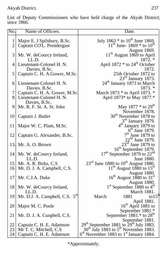
Akyab District. 237
List of Deputy Commissioners who have held charge of the Akyab District; since 1866.
No. Name of Officers. Date. 1 Major E. J Spilsbury, B.Sc. July 1863 * to 10th June 1869. 2 Captain CO'L. Prendergast 11th June- 1869 * to 10th August 1869. 3 Mr. W. deCourcy Ireland, 11th August 1869 to April LL.D. 1872. * 4 Lieutenant-Colonel H. N. April 1872 * to 24th October Davies, B.Sc. 1872. 5 Captain C. H. A.Gower, M.Sc. 25th October 1872 to 23rd January 1873. 6 Lieutenant-Colonel H. N. 24th January 1873 to March Davies. B.Sc. 1873. * 7 Captain C. H. A. Gower, M.Sc. March 1873 * to April 1873. * 8 Lieutenant-Colonel H. N. April 1873* to May 1877.* Davies, B.Sc. 9 Mr. R. F. St. A. St. John May 1877 * to 29th November 1878. 10 Captain J. Butler 30th November 1878 to 3rd January 1879. 11 Major W. C. Plant, M.Sc. 4th January 1879 to 6th June 1879. 12 Captain G. Alexander, B.Sc. 7th June 1879 to 22nd June 1879. 13. Mr. A. O. Brown 23rd June 1879 to 16th September 1879. 14 Mr. W. deCourcy Ireland, 17th September 1879 to 22nd LL.D. June 1880. 15 Mr. A. R. Birks, C.S 23rd June 1880 to 10th August 1880. 16 Mr. D. J. A. Campbell, C.S. 11th August 1880 to 15th August 1880. 17 Mr. C.J.A. Duke 16th August 1880 to 31st August 1880. 18 Mr. W. deCourcy Ireland, 1st September 1880 to 4th LL.D. March 1881. 19 Mr. D.J. A. Campbell, C.S. 5th March 1881 to15th April 1881. 20 Major M. C. Poole 16th April 1881 to September 1881.* 21 Mr. D. J. A. Cunpbell, C.S. September 1881.* to 28th September 1881. 22 Captain C. H. E. Adamson 29th September 1881 to 29th July 1883. 23 Mr T. C. Mitchell, C.S 30th July 1883 to 5th November 1883. 24 Captain C. H. E. Adamson 6th November 1883 to 1st January 1884.
*Approximately.
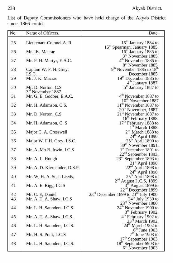
238 Akyab District. List of Deputy Commissioners who have held charge of the Akyab District since. 1866-contd.
No. Name of Officers. Date.
25 Lieutenant-Colonel A. R 15th January 1884 to 15th Spearman. January 1885. 26 Mr.J.K. Macrae 16th January 1885 to 3rd November 1885. 27 Mr. P. H. Martyr, E.A.C. 4th November 1885 to 8th November 1885. 28 Captain W. F. H. Grey, 9th November 1885 to 18th I.S.C. December 1885. 29 Mr. J. K. Macrae 19th December 1885 to 4th January 1887. 30 Mr. D. Norton, C.S 5th January 1887 to 3rd November 1887. 31 Mr. G. E. Godber, E.A.C. 4th November 1887 to 10th November 1887 32 Mr. H. Adamson, C.S. 11th November 1887 to 20th November, 1887. 33 Mr. D. Norton, C.S. 21st November 1887 to 16th February 1888. 34 Mr. H. Adamson, C. S 17th February 1888 to 1st March 1888. 35 Major C. A. Cresswell 2nd March 1888 to 24th April 1890. 36 Major W. F.H. Grey, I.S.C. 25th April 1890 to 30th November 1891. 37 Mr. A. Mo B. Irwin, I.C.S. 1st December 1891 to 22nd September 1893. 38 Mr. A. L. Hough 23rd September 1893 to 21st April 1898. 39 Mr. A. D. Kiernander, D.S.P. 22nd April 1898 to 24th April 1898. 40 Mr. W, H. A. St, J. Leeds, 25th April 1898 to 2nd August I .C.S, 1899. 41 Mr. A. E. Rigg, I.C.S 3rd August 1899 to 22nd December 1899. 42 Mr. C. E, Daniel 23rd December 1899 to 23rd July 1900. 43 Mr. A. T. A. Shaw, I.C.S 24th July 1930 to 23rd November 1900. 44 Mr. L. H. Saunders, I.C.S. 24th November 1900 to 3rd February 1902. 45 Mr. A. T. A. Shaw, I.C.S. 4th February 1902 to 23rd March 1902. 46 Mr. L. H. Saunders, I.C.S. 24th March 1902 to 6th June 1903. 47 Mr. H. S. Pratt, I .C.S 7th June 1903 to 17th September 1903. 48 Mr. L. H. Saunders, I.C.S. 18th September 5903 to 6th November 1903.
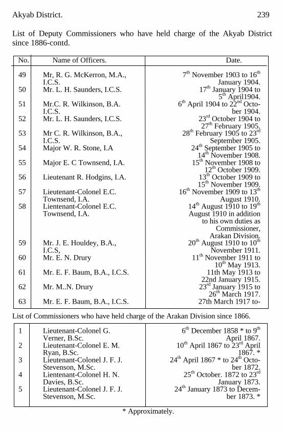
Akyab District. 239 List of Deputy Commissioners who have held charge of the Akyab District since 1886-contd. No. Name of Officers. Date.
49 Mr, R. G. McKerron, M.A., 7th November 1903 to 16th I.C.S. January 1904. 50 Mr. L. H. Saunders, I.C.S. 17th January 1904 to 5th April1904. 51 Mr.C. R. Wilkinson, B.A. 6th April 1904 to 22nd Octo- I.C.S. ber 1904. 52 Mr. L. H. Saunders, I.C.S. 23rd October 1904 to 27th February 1905. 53 Mr C. R. Wilkinson, B.A., 28th February 1905 to 23rd I.C.S. September 1905. 54 Major W. R. Stone, I.A 24th September 1905 to 14th November 1908. 55 Major E. C Townsend, I.A. 15th November 1908 to 12th October 1909. 56 Lieutenant R. Hodgins, I.A. 13th October 1909 to 15th November 1909. 57 Lieutenant-Colonel E.C. 16th November 1909 to 13th Townsend, I.A. August 1910. 58 Lientenant-Colonel E.C. 14th August 1910 to 19th Townsend, I.A. August 1910 in addition to his own duties as Commissioner, Arakan Division. 59 Mr. J. E. Houldey, B.A., 20th August 1910 to 10th I.C.S, November 1911. 60 Mr. E. N. Drury 11th November 1911 to 10th May 1913. 61 Mr. E. F. Baum, B.A., I.C.S. 11th May 1913 to 22nd January 1915. 62 Mr. M..N. Drury 23rd January 1915 to 26th March 1917. 63 Mr. E. F. Baum, B.A., I.C.S. 27th March 1917 to-
List of Commissioners who have held charge of the Arakan Division since 1866.
1 Lieutenant-Colonel G. 6th December 1858 * to 9th Verner, B.Sc. April 1867. 2 Lieutenant-Colonel E. M. 10th April 1867 to 23rd April Ryan, B.Sc. 1867. * 3 Lieutenant-Colonel J. F. J. 24th April 1867 * to 24th Octo- Stevenson, M.Sc. ber 1872. 4 Lientenant-Colonel H. N. 25th October. 1872 to 23rd Davies, B.Sc. January 1873. 5 Lieutenant-Colonel J. F. J. 24th January 1873 to Decem- Stevenson, M.Sc. ber 1873. *
* Approximately.
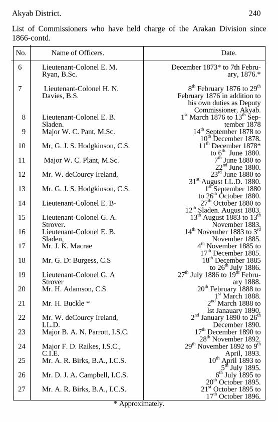
Akyab District. 240 List of Commissioners who have held charge of the Arakan Division since 1866-contd. No. Name of Officers. Date.
6 Lieutenant-Colonel E. M. December 1873* to 7th Febru- Ryan, B.Sc. ary, 1876.* 7 Lieutenant-Colonel H. N. 8th February 1876 to 29th
Davies, B.S. February 1876 in addition to his own duties as Deputy Commissioner, Akyab. 8 Lieutenant-Colonel E. B. 1st March 1876 to 13th Sep- Sladen. tember 1878 9 Major W. C. Pant, M.Sc. 14th September 1878 to 10th December 1878. 10 Mr, G. J. S. Hodgkinson, C.S. 11th December 1878* to 6th June 1880. 11 Major W. C. Plant, M.Sc. 7th June 1880 to 22nd June 1880. 12 Mr. W. deCourcy Ireland, 23rd June 1880 to 31st August LL.D. 1880. 13 Mr. G. J. S. Hodgkinson, C.S. 1st September 1880 to 26th October 1880. 14 Lieutenant-Colonel E. B- 27th October 1880 to 12th Sladen. August 1883. 15 Lieutenant-Colonel G. A. 13th August 1883 to 13th Strover. November 1883. 16 Lieutenant-Colonel E. B. 14th November 1883 to 3rd Sladen, November 1885. 17 Mr. J. K. Macrae 4th November 1885 to 17th December 1885. 18 Mr. G. D: Burgess, C.S 18th December 1885 to 26th July 1886. 19 Lieutenant-Colonel G. A 27th July 1886 to 19th Febru- Strover ary 1888. 20 Mr. H. Adamson, C.S 20th February 1888 to 1st March 1888. 21 Mr. H. Buckle * 2nd March 1888 to lst Janauary 1890. 22 Mr. W. deCourcy Ireland, 2nd January 1890 to 26th LL.D. December 1890. 23 Major B. A. N. Parrott, I.S.C. 17th December 1890 to 28th November 1892. 24 Major F. D. Raikes, I.S.C., 29th November 1892 to 9th C.I.E. April, 1893. 25 Mr. A. R. Birks, B.A., I.C.S. 10th April 1893 to 5th July 1895. 26 Mr. D. J. A. Campbell, I.C.S. 6th July 1895 to 20th October 1895. 27 Mr. A. R. Birks, B.A., I.C.S. 21st October 1895 to 17th October 1896.
* Approximately.
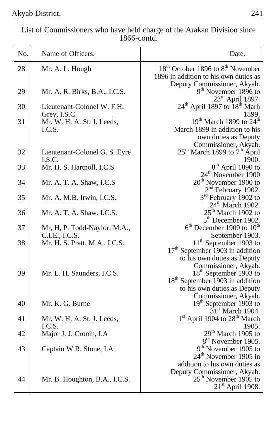
Akyab District. 241
List of Commissioners who have held charge of the Arakan Division since 1866-contd.
No. Name of Officers. Date. 28 Mr. A. L. Hough 18th October 1896 to 8th November 1896 in addition to his own duties as Deputy Commissioner, Akyab. 29 Mr. A. R. Birks, B.A., I.C.S. 9th November 1896 to 23rd April 1897. 30 Lieutenant-Colonel W. F.H. 24th April 1897 to 18th Marh Grey, I.S.C. 1899. 31 Mr. W. H. A. St. J. Leeds, 19th March 1899 to 24th I.C.S. March 1899 in addition to his own duties as Deputy Commissioner, Akyab. 32 Lieutenant-Colonel G. S. Eyre 25th March 1899 to 7th April I.S.C. 1900. 33 Mr. H. S. Hartnoll, I.C.S 8th April 1890 to 24th November 1900 34 Mr. A. T. A. Shaw, I.C.S 20th November 1900 to 2nd February 1902. 35 Mr. A. M.B. Irwin, I.C.S. 3rd February 1902 to 24th March 1902. 36 Mr. A. T. A. Shaw. I.C.S. 25th March 1902 to 5th December 1902. 37 Mr, H, P. Todd-Naylor, M.A., 6th December 1900 to 10th C.I.E., I.C.S. September 1903. 38 Mr. H. S. Pratt. M.A., I.C.S. 11th September 1903 to 17th September 1903 in addition to his own duties as Deputy Commissioner, Akyab. 39 Mr. L. H. Saunders, I.C.S. 18th September 1903 to 18th September 1903 in addition to his own duties as Deputy Commissioner, Akyab. 40 Mr. K. G. Burne 19th September 1903 to 31st March 1904. 41 Mr. W. H. A. St. J. Leeds, 1st April 1904 to 28th March I.C.S. 1905. 42 Major J. J. Cronin, I.A 29th March 1905 to 8th November 1905. 43 Captain W.R. Stone, I.A 9th November 1905 to 24th November 1905 in addition to his own duties as Deputy Commissioner, Akyab. 44 Mr. B. Houghton, B.A., I.C.S. 25th November 1905 to 21st April 1908.
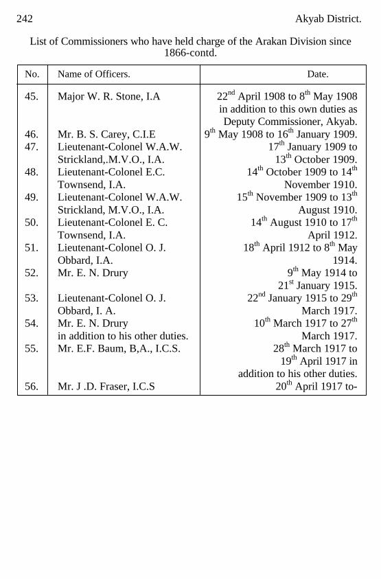
242 Akyab District.
List of Commissioners who have held charge of the Arakan Division since 1866-contd.
No. Name of Officers. Date. 45. Major W. R. Stone, I.A 22nd April 1908 to 8th May 1908 in addition to this own duties as Deputy Commissioner, Akyab. 46. Mr. B. S. Carey, C.I.E 9th May 1908 to 16th January 1909. 47. Lieutenant-Colonel W.A.W. 17th January 1909 to Strickland,.M.V.O., I.A. 13th October 1909. 48. Lieutenant-Colonel E.C. 14th October 1909 to 14th
Townsend, I.A. November 1910. 49. Lieutenant-Colonel W.A.W. 15th November 1909 to 13th
Strickland, M.V.O., I.A. August 1910. 50. Lieutenant-Colonel E. C. 14th August 1910 to 17th Townsend, I.A. April 1912. 51. Lieutenant-Colonel O. J. 18th April 1912 to 8th May Obbard, I.A. 1914. 52. Mr. E. N. Drury 9th May 1914 to 21st January 1915. 53. Lieutenant-Colonel O. J. 22nd January 1915 to 29th Obbard, I. A. March 1917. 54. Mr. E. N. Drury 10th March 1917 to 27th in addition to his other duties. March 1917. 55. Mr. E.F. Baum, B,A., I.C.S. 28th March 1917 to 19th April 1917 in addition to his other duties. 56. Mr. J .D. Fraser, I.C.S 20th April 1917 to-
BIBLIOGRAPHY. British Burma Gazettee 1879 Report on the Settlement Operations in the Akyab District by H. Adamson, MA., I.C.S.
1885-86 1887 1886-87 1888 1887-88 1888
Report on the Antiquities of Arakan 1892 General Department File No.c.-2 of the Deputy Commissioner's Office,Akyab 1902 General Department File No. C.-1 of the Deputy commissioner's Officer, Akyab 1905 Miscellaneous files in the District and Commissioner's Record Rooms at Akyab … Report on the Revision Settlement Operations in the Akyab District by W. E. Lowry, I.C.S.
1901-02 1903 1902-03 l903
Report on the Summary Settlement of three Circles in the Akyab District by Maung Pan Hla 1905 Imperial Gazetteer of India, Burma, Volume II, by C.C. Lowis,I.C .S. 1908 Burma Settlement Manual, Volume I 1908 Report, on the Census of Burma, 1872, 1881 1891,1901 and 1911 … Report on the Revision Settlement Operations in the Akyab District by R.B. Smart 1917 Annual Administration Reports of the various Government Departments …
INDEX.
A Administration of Forests. History of 129 Administration.General 115 Administration.Revenue 171 Administrative divisions of Akyab district 1 Agricultural customs 115 Agricultural produce.Disposal of 117 Agriculture and Irrigation 137 Agriculture. Suitability of climate for 110 Agriculturists' loans 104 Akyab Archæology of 36 Akyab district. Area,situation and boundaries of 1 Akyab Municipality 202 Akyab subdivision 215 Akyab town 216 Akyab township 215 Andaw Pagoda 54 Anglo-Indians,Europeans and 98 Anglo-Vernacular schools 209 Angumaw 218 Animals 12 Anoma Pagoda 59 Anthrax 125 Apaukwa 225 Arakan serow 13 Arakan yomas 1, 4, 5, 43, 87, 146 Arakanese population 83 Archæology. History and 18,36 Area mortgaged and mortgage values 123 Area owned by agriculturists and non-agriculturists 122 Area,situation and boundaries of Akyab district 1 Area sold and sale values 122 Artocarpus Choplasha 9,11 Aseikkya 232
246 INDEX. A-concld. PAGES Assessmemts after British occupation. Early 178 Assessment rates proposed 186 Atet-nan-ya 218 Aukchinsa (Dysoxylum binectariferum) 10 Aungtungyaw 230 Average income and expenditure and 100 standard of living of agriculturists
B Badaga 230 Baguna 232 Bamboos 11 Banks 103 Barking deer 12 Barongas range of hills 2, 3, 4, 86 Bawdaliywa 221 Bazaars 205 Bears 13 Beri-Beri 212 Bctclnut palms 111,128, 201 Betel-vine 111,114, 119, 128,201 Birds 14 Boat building 139 Boinu river 5 Bos-gaurus 12 Boundaries, Area, situation and of Akyab district 1 Buildings.Houses and other 170 Bull,Buffaloes 122 Bungarus 15 Burmese population 85 Burmese wall 57 Burmese war First 29,146 Buthidaung subdivision 230 Buthidaung township 302
C Camping grounds 152 Camuttawdhat Pagoda 43
INDEX. 247 C-concld. PAGES Capitation-tax 195 Carpentering 139 Carrying trade 138 Cattle 118 Cervus munjac 12 Cervus percinus 12 Cervus unicolor 12 Chaungthas.Race of 1 Chinese 98 Chin hills 5 Chins 88 Cholera 219 Church of England 98 Civil Justice 162 Civil Police 166 Classification. Tracting and soil 200 Clerical establishment (Forests) 131 Climate 6 Climate,Suitability of for agriculture 114 Coal 136 Cobras 15 Commissioners.List of 239,242 Communication.Means of 150 Conservancy and sanitation 203 Co-operative Credit Societies 104 Cow,Buffaloes 122 Cows 122 Criminal Justice 160 Crocodiles 15 Crops.Area under various 111 Crops other than rice 108, 113 Cultivation. Methods of 117 Customs. Agricultural 115 Customs and manners of Hill Tribes 94 Cyclones 7, 184
D Daingnets. Race of 91 Dancing of Hill Tribes 93
248 INDEX. D-concld. PAGES Dani 140 Deer 12, 115 Density, of population 82 Deputy Commissioners.List of 237,239 Development of new markets (Forests) 133 Dipayon Shrine 58 Disappearance of old and introduction of new staples 109 Diseases and mortality among cattle 120 Disposal of agricultural produce 117 District Cess Fund 200 Drainage 177 Ducks 14 Dukkanthein Pagoda 55
E Eagles 14 Early administration 153 Early assessments after British occupation 178 Early History 18 Early Trade 140 Education 214, 217 Elephants 12, 115 Emigration and Immigration 99 Enhancement of demand. Proposed 193 Estates. Average size of 121 Europeans and Anglno-Indians 98 Excise 200 Expenditure. Revenue and (Forest) 132
F
Fallow area 115 Fallow rate 85, 86 Family ownership.Individual and 126 Famine 85, 86 Fantail snipe 14 Fauna 12
INDEX. 249 F-concld. PAGES Feeding, Method of and tending cattle 24 Female education 210 Ferries 147 Finance 205 Fire protection 204 First Burmese war 27 Fish 14 Fishery revenue 196 Fishing methods 204 Flora 8 Food,and other items of expenditure 101 Foodstuffs. Trade in 137 Forests and minerals 130 Forests.Legal position of the 126 Forests.Reservation of 133 Forests.Types of 126 Former industries 138
G Gaur (Bos gaurua) 12 General Administration 159 General survey 6 Geology 8 Goats 6 Gold 120 Gold and silver smiths 142 Government steam vessels 139 Grazing grounds 153 Green pigeons 120 Grit chaung 233 Gwazôn 231 Gwedauk chaung 6
H Hamadryad 15 Hawka 14 Headquarters of Akyab district 1 Health Public 219
250 INDEX. H-concld. PAGES Hills 4 Hill Tribes 88 Hill Tribes Manners and customs of 95 Himalayan Bear 13 Hindu population 87 Hire and Sale of cattle 119 History and archæology 18 History of administration of Forests 129 Hnakaungdo chaung 6 Hog deer 12 Horses 125 Hospitals 205,212 Houses and other buildings 102
I ImmigratiOn and emigration 103 Iperial pigeons 14 Implements 114 Improvements in agricultural methods 116 Improvements to communications. Suggested 149 Income and expenditure and standard of 104 living of agriculturists. Average Income tax 199 Indcbtedness 103 lndin 233 Individual and family ownership 121 Industries. Former 144 Insects and other crop pests 111 Introduction of kwin unit system. Tentative 140 Introduction of land tax on standard measurements 179 Introduction of new staples. Disappearance of old and 113 Intula 233 Iron work 140 Irrigation. Agriculture and 112
J Jackals 2 Jails 167 Jinamaraung Pagoda 62
251 INDEX. J concld. PAGES Jungle fever 6 Jungle fowl 14 Justice. Civil 168 Justice, Criminal 166
K Kabaing (Ceriops Rhoxburgiana) 11 Kado shrine 74 Kalabôn river 5 Kaladan river 2, 3, 4, 5, 9, 15, 38,44, 124, 146, 150, 189, 193, 195 Kaladan township 164 Kalapanzin (Upper portion of the Mayu river) 2,5,120 Kamaingdôn chaung 6 Kamaung (Lagerstroemia flosreginae) 10,132 Kamaungseik 233 Kamyin chaung 6 Kanyin (Dipterocarpus spp,) 9,10,11,132 Kayin (single stemmed bamboo) 8,132 Khami or Kwemyi. Race of— 89 Kindaw Zedi 42 King Mindi's Pagoda 72 Kites 14 Kotanzi Pagoda 64 Kudaung 218 Kundaung North 220 Kwin unit system 180 Kyaket (Bambusa arundinacea) 12 Kyaningan 225 Kyauk-kyat 228 Kyauknyo Image 68 Kyauktalôn 225 Kyauktaung 222 Kyauktaw subdivision 224,226 Kyauktaw township 224 Kyaungdaung chaung 6 Kyeikmyo. Ruins of 31 Kyelet township 164
INDEX. 252 K- concld. PAGES Kyetyo (Vitex pubescens) 11 Kywègu river 5 Kywide river 5
L Labawza 233 Labourers 238 Laing the 233 Lakes 4 Lamutabin 227 Land measuremnt. Standards of 186 Land rate in lieu of capitation tax 195 Land tax on standard measurements. Introduction of 186 Land tenure 172,175 Landing stages 147,171 Laungdôn 233 Launggyet. City of 70 Laws of Hill Tribes 95 Lay schools. Establishment of 208 Legal position of the forests 131 Legend of King Mindi 73 Lemyethna Pagoda 55,56 Lemyo river 2,3,4,5,15,122,124,150,189,193,195 Leopards 12 Letkyodat Pagoda 64 Letpan (Bombax malabaricum) 10,134 Letwedet channg 6 Liability to crop failure. Extent of fallowing, and 115 Light houses 152 Lighting 204 Limbanhmaung Pagoda 58 Linyodaw Zedi 42 Literacy 207 Loans. Agriculturists— 109 Local Self Government 209 Lokamu Pagoda 64 Lower Burma Land and Revenue Act II of 1876 175, 184 Lushai hills 5
253 INDEX. M PAGE
Madè (Gigantochloa macrostachya) 12 Mahamuni shrine 43 Mahati Pagoda 67 Mahomedan population 86 Malaria 212 Malay bear 13 Mangroves 10,132 Manners and customs of Hill Tribes 92 Manures 115 Markets Developement of new (Forests) 138 Marriages of Hilt Tribes 94 Mat making 140 Maungdaw township 232 Maungdula 234 Maunghnama 234 Mawdôk range of hills 14 Mayu range of hills 4,5,6,156 Mayu river 2,3,443,124,150,155,156,189,193,197,5,15, Methods of culitvation 112 Methods of feeding and tending cattle 119 Methods of sale and transport 117 Migyaunggyi 231 Military and Marine 164 Military Police 165 Minbu 223 Minbya subdivision 220 Minbya township 78,223 Mindi's Pagoda. King 75 Minerals. Forests and 136 Mingalagyi 234 Mingalagyi chaung 6 Mingalamaraung Pagoda 58 Mingalopara Pagoda 73 Minor articles 222 Miscellaneous cultivation 111,115,118,201 Model schools 210 Môkdaw Pagoda 63 Monastic schools 209 Monkeys 115 Mortality among cattle, Diseases and 125
INDEX. 254 M- concld. PAGES Mortgage values. Areas mortgaged and— 128 Mozi river 3,6 Mraw (Schizostachyum) 12 Mro, Race of 90 Mrunchaungwa Pagoda 48 Municipality Akyab 202 Myaungbwe market village 228 Myaw chaung 5 Myinhlut 234 Myinbu 218 Myohaung Palace 51 Myohaung subdivision 164 Myohaung township 49,227,229 Myothit chaung 6 Myothagyi (Village) 234
N Naaf river 1,4,5,6,10,15,150,155,190,193,197 Naaf subdivision 164 Nandawgôn Launggyet 72 Natural divisions of Akyab district 1 Ngakura 234 Ngasanbaw-chaung 5 Ngaw-a-bya- chaung 5 Nyaung chaung 234
O
Oaks 9 Oaths of Hill Tribes 97 Occupation and Trade 137 Occupied and other areas 105 Opium 201 Orchards 111 Original Settlement, 1865-66 181 Outstation buildings 171 Owls 14 Ownership. Individualand family— 126 Oxen 122
255 INDEX.
P Pabru 7 Paddy 111,122,198 Paduale 222 Paiktheywa 227 Paletwa headquarters 5,151 Pandawbyin 234 Panmyaung stream 5 Parabo Pagoda 65 Pataw village 7 Pauktaw township 221,222 Paungdawbyin 231 Paungdawdat Pagoda 67 Payabyin 231 Pe-chaung 3,5,14 Peinne (Artocarpus Chaplasha) 9,11 People 83 Personnel of Officers (Forests) 131 Pethadu 219 Petroleum 134 Pheasants 14 Pigs (Domestic) 120 Pigs (Wild) 12,115 Pintail snipe 14 Pitakataik Pagoda 57 Plague 212 Plantain fibre 12 Poisonous snakes 15 Police 161,172 Ponies 120 Pônnagyi 222 Pônnagyun township 219,200 Pônnyoleik 231 Population 80 Porebyin 220 Portuguese adventurers 25 Posts 150 Pottery 139 Prauktin (Cephalostachyum pergracile) 12 Produce Disposal of agricultural 121
INDEX. 256 P- concld. PAGES Professional survey by Survey of India, 1879 80 184 Progress (Forests) 132 Protective works. Irrigation and 116,120 Public and private schools 208 Public health 219 Public Works Department 170 Pya chaung 219 Pyinbyu chaung 6 Pyinkado 9,10,133 Pyun chaung 6
Q Quails 14
R Races, Statement of 83 Railways 149 Rainfall 6 Ratanamaraung Pagoda 60 Ratanabôn Pagoda 55 Rates, Revision of 190 Rathedaung chaung 5,43 Rathedaung subdivision 164,197 Rathedaung township 217,219 Rats 115 Red serow 14 Registration 168 Regular Settlement, 1885-88. First 184 Rental values 125 Reptiles 14 Reservation of forests 138 Rest houses 152 Revenue Administration 178 Revenue and expenditure (Forests) 132 Revenue system in Burmese times 177
257 INDEX.
R-concld. PAGES Revision of rates 183 Revision Settlement, 1879-80 184 Revision Settlement, 1901-03 189 Revision Settlement; 1913-16 192 Rhinoceros 12 Rice 107,112 Rice milling 137 Rinderpest 125 Rivers and streams 4 Road. 148,170,204 Roman Catholic Missions 99 Routes Trade 156 Ruins of Kyeitmyo 78 Ruins of Sigunmyo 76 Russell's viper 15
S Sabebinyin chaung 6 Saingdaung 235 Saingdin valley 9 Sate and transport. Methods of— 122 Sale, Hire and ot cattle 123 Sale values. Area sold and. 127 Salt 136 Sambur (Cervus unicolor) 12 Sanga (Michelia Champaca) 11 Sangotin 231 Sanitation 213 Santikan Mosque 61 Satônbôk 235 Schools 205 Seinhmyinbya 232 Selagiri Zedi 49 Self Government. Local 209 Setkyamaraung Pagoda 59 Settlement, 1885-88.First Regular 184 Settlement, 1865-66.Original 189 Settlement, 1879-80.Revision 184
INDEX 258 S -concld. PAGES Settlement, 1901-03. Revision 189 Settlement, 1913-16. Revision 191 Sheep 120 Shitthaung Pagoda 51 Shoe-making 139 Shwedaung Pagoda 61 Shwegyathein Temple 64 Shwepye 227 Shweza 235 Sidin chaung 5 SigunmyoRuins of 79 Silver 142 Sindamaw 229 Situation and physical features of townships 3 Situations. Area, and bet ndaries of Akyab district 1 Size of estates. Average 126 Small-pox and vaccination 212 Snipe 14 Soils 7 Soil classification. Tracting and 200 Soils. Description of 109 Stamp Revenue 199 Standards of land measurement 179 Standard of living of agriculturists 104 Staples. Disappearance of old and introduction of new— 113 Steam communication by water in the Akyab district 145 Steam vessels. Government 147 Storms 115,130 Streams and rivers 4 Subdivisions 164 Sudaung 232 summary of schools 210 Sundri (Heritiera minor) 10,11,133 Survey Professional by Survey of India, 1879-80 191
T Tabooing of Hill Tribes 94 Tat chaung 235
259 INDEX T -concld. PAGES Taukkyan Terminalia tomentosa) 9,134 Taungdaung Haya 227 Taungthas. Race of 89 Tawbya river 6 Taywe stream 5 Teak 134 Teal 14 Tein (Stepnegyne diversifolia) 10,130 Teinnyo 230 Telegraphs 151 Telephone exchange 158 Tenancies 123 Tending cattle.Method of feeding and 124 Terrain chaung 232 Tettobyin 235 Than stream 9 Thawin chaung 235 Thaye chaung 3,5 Thayet chaung 219 Thayet tabin 225 Thazegôn 215 Theindaung 240 Thetkaingnya 236 Thinbôn (Buchanania lancifolia) 9,11,132 Thingan (Hopea spp.) 9,10 Thingannet 10 Thinkyis. Race of 88 Thitkado (Cedrela toona) 9,11 Thitpôk (Tetrameles nudiflora) 9,10 Tigers 12,116 Timber trees 10,132 Tobacco 118 Toddy 146 Townships. Situation and physical features of 3 Tracting and soil classification 193 Trade. Occupations and 142 Trade. ,routes 150 Transport. Method of sale and 122 Tuberculosis 212
INDEX 260 U PAGES Udaung 236 Ukundaw Zedi 75 Urdu schools 209 Uritdhat Pagoda 43 Urittaung East township 164,198 Urittaung West township 164,198 Urittaung Pagoda 39,42 Ursus malayanus 13 Ursus terquatus 13 Ushinkya chaung 6 Ushinkya 236
V Vaccination. Small pox and 219 Values. Area sold and sale 127 Values. Rental 130 Various crops. Area under 111 Vernacular schools. Anglo 217
W Waste land grants 175 Water supply 204 Waterways 144 Weaving 133 Wet stream 9 Wild cats 12 Wunticeti shrine 61
Y Yahow country 5 Yamaung river 5 Yan chaung 3,5 Yanbye population 85 Yanwa chaung 3,5
261 INDEX Y-concld. PAGES Yedè river Yedwingyun 236 Yenaukngatha 236 Yo chaung 3,5 Young stock(Cattle) 122
Z Zaditaung 232 Zibin chaung 236 Zigaing 219 Zinbyun (Dillenia spp.) 10 Zitke shrine 73 G.U.B.C.P.O. No.16, C.S.L.R 2-9-57-500-VIII.