Bulgaria – is a member of - EU Science...
13
10/22/2013 1 Technical Workshop on Crop Yield Forecasting in SEE 30-31 May 2013, Skopje Bulgarian Academy of Sciences (BAS) Space Research and Technology Institute (SRTI-BAS) Remote Sensing and GIS Department Presenter: Chief Asst. Lachezar Filchev, Ph.D. SRTI-BAS Bulgaria – is a member of: Already • 2007 - European Union (EU) and 2005 - NATO (political and economical) • Joint Research Centre (JRC) (scientific) • 1952 - World Meteorological Organization (WMO) • 2004 - EUMETSAT (meteorological satellites) Pending • Group on Earth Observation (GEO) • European Space Agency (ESA) Skopje, FYROM 30-31 May 2013 Technical Workshop on Crop Yield Forecasting in SEE 2
Transcript of Bulgaria – is a member of - EU Science...

10/22/2013
1
Technical Workshop on Crop Yield Forecasting in SEE30-31 May 2013, Skopje
Bulgarian Academy of Sciences (BAS)
Space Research and Technology Institute (SRTI-BAS)
Remote Sensing and GIS Department Presenter : Chief Asst. Lachezar Filchev, Ph.D.SRTI-BAS
Bulgaria – is a member of:
Already• 2007 - European Union (EU) and
2005 - NATO (political and economical)
• Joint Research Centre (JRC) (scientific)
• 1952 - World Meteorological Organization (WMO)
• 2004 - EUMETSAT (meteorological satellites)
Pending• Group on Earth Observation
(GEO)• European Space Agency (ESA)
Skopje, FYROM30-31 May 2013
Technical Workshop on Crop Yield Forecasting in SEE2
10/22/2013
2
Outline & timeline
1988-90 - National Program “Space-Earth”; 1980-85 National Program under the Project “Meteor-Priroda –
Bulgaria-1300-ІІ” –– preparation, conducting and processing of the results obtained from the experiments; National Program “Remote Aero- and Space Methods for
Studying Earth Resources, Ecology and Public Economy", 1976-1980; National Program for the Mission of the
Second Bulgarian Astronaut –- Design and Conducting of the Experiments “Shipka”, “Georesource”, “Thrace”, “Moesia”, “Les”, “Balkan”, and “Earth”,1987–1990;
National Program for the Mission of the First Bulgarian Astronaut –– Design and Conducting of the Experiments
“Balkan” and “Biosphere”,1978–1979.
1990s – public to privately owned lands; from planned and centralized into marked oriented economy; land-use/land-cover studies on the territory of Bulgaria (CORINE 1990
/1991-1993/); MARS-MERA project (1994-1997); International synchronous ground-based and airplane experiments carried out on test sites on the territory of Bulgaria – Patriarch Evtimovo – 1977; Popova, Novi
Pazar - 1980; Belozem – 1977, 1978; Bolyarino 1983, 1984, 1985; 1988, 1989, 1990, 1995; Knezha – 1981;
Pleven – 1986, 1987 - Intercosmos International Program, Work Group on Remote Sensing of the Earth.
21st century – CORINE 2000 and CORINE 2006 (interchange), CORINE 2010; projects, JRC MARS
(Agri4cast, LUCAS, Geoland2 etc.), Scientific Information Complex (SIC) for the Bulgarian Aerospace Test Sites
(BAs-TS); PROAGROBURO
Future prospects – an unified approach and a nationwide system for crop monitoring and yield forecasting based on
satellite data and products; closer intra- and inter-institutional co-operation; international co-operation with
SEE countries and JRC.
Skopje, FYROM30-31 May 2013 3
Technical Workshop on Crop Yield Forecasting in SEE
1974 – USDA, NOAA, NASA - USA
experiment LACIE (phase I - /1974-75; phase II – 1975-76,
and phase III – 1976-1977)
1975 - FAO’s Global Information and Early
Warning System (GIEWS)
1984 – CORINE Land Cover
1988 - the Monitoring of Agriculture with Remote Sensing (MARS) project
1998 – GMES (Copernicus)
USDA Production Estimates and Crop Assessment Division
(PECAD) – Crop Explorer
INTERCOSMOS InternationalProgramme (1975-1990)
� 1974 – on a meeting in GDR theINTERCOSMOS RemoteSensing of the Earth group wasestablished;
� 1975 – first meeting of the RSgroup in Baku. Long-termprogrammes in RS;
� 1981 – within INTERCOSMOS-Bulgaria 1300 and Meteor-Priroda-6 (Meteor-Nature) theearth resources were studied withthe Tangra aparatus complex (4-band radiometer and 32 channelspectrophotometer).
Skopje, FYROM30-31 May 2013 4
Technical Workshop on Crop Yield Forecasting in SEE

10/22/2013
3
For conducting the sub-satelliteexperiments in 1977 and 1978were used developed at SpaceResearch and TechnologyInstitute (SRTI-BAS)instrumentation for groundmeasurements: spectralreflectance of natural formations(ISOH 010 and ISOH 020),temperature profiles in thesurface layer and topsoil;gradient topsoil and probe forrapid measurement of moisturein the topsoil
Skopje, FYROM30-31 May 2013 5
Technical Workshop on Crop Yield Forecasting in SEE
Trace data from Spektar-15MC
1979 - during the flight of the first Bulgarian astronaut Georgi Ivanovonboard of Souyz-Salut 6 space station a total of 19 spaceexperiments were planned among which:
� Experiment Balkan (spectrometry of different LU/LC types (includingdifferent crop types) from space using Spektar-15K and ISOH-020from airplane /developed at SRTI-BAS/ and multispectral photographyusing MKF-6M (Serafimov 1979);
� Experiment Biosphere-B space photography of geology featuresand geography phenomenon, ecology, soils etc. Using Hasselblad-500E photocamera (Serafimov 1979);
� Experiment Nature – onboard Soyuz-Salut 6 radiometer Icarus,synthetic aperture side-looking radar (SAR), IR radiometer,spectrometric system and onboard digital processing unit;
� Project Geosystem – spectrometer (MKS-M2, IR radiometer ITS-7Dand photometer EFO-I as well as multispectral photocamera MKF-6Mwith stabilized platform (Stoyanov 1988).
20 February 1987 - the Shipka space programme - consisting of 33scientific experiments during the second Bulgarian astronaut missionto the MIR space station.
� Spektar 256 C – 256 channel specroradiometer – non imaging,Spektar- 15 and Spektar – 15 M, along with the 32 channel SMP-32.The KATE-140 and Hasselblat photocameras onboard the MIR spacestation. On board of the airplane laboratories the Spektar-15 MC andRM-1S (РМ-1С), with the IR radiometer worked synchronously withthe MIR’s instruments in a sub-satellite experiment setting.
� The data was recorded and processed with the MIK-16microcomputer system developed by the Institute for TechnicalCybernetics and Robotics at the BAS (Stoyanov, 1988)
Skopje, FYROM30-31 May 2013 6
Technical Workshop on Crop Yield Forecasting in SEE

10/22/2013
4
Development of a Universal Mobile Ground Station for Synchronous
and Complex Space and Geonomic Investigations - Intercosmos
International Program, Work Group on Remote Sensing of the Earth.
Skopje, FYROM30-31 May 2013
Technical Workshop on Crop Yield Forecasting in SEE7
Experiment “Agriculturallands” for assessment ofthe information value ofmultispectral aerial imagesacquired by the cameraMKF-6 MC and“Fragment" C-500.
Skopje, FYROM30-31 May 2013 8
Deep water (Maritza river)Corn field (harvested)Alfa alfaRice padCorn fieldArable land (Chromic luvisols)Arable land (Alluvial soils)Shallow water
Technical Workshop on Crop Yield Forecasting in SEE
Distribution of the surface soil moisture (%)measured by RM-1C at 11:30 AM on14.10.1983, the Bolyarino test site,Bulgaria.

10/22/2013
5
Ultra high-frequency (UHF) passive microwave radiometry (PMR) at 4, 5, 18,and 21 cm for soil moisture monitoring since 1985 (Institute of electronics atBAS, Institute of hydrotechnics and melioration and Soil Institute atAgricultural Academy (AA) “Nikola Pushkarov”). The UHF radiometers weremounted onboard of An-14 and An-2. (Mkrtchan et al. 1988, )
(1989-1990) soil mineralization and salinity near sea coastlines andriverbanks – within a contract between the Institute of oceanology, Institute ofelectronics at BAS; and Institute of Radioengineering and Electronics (IRE)at Russian Academy of Sciences (Shutko and Krapvin, 2011).
RS measurements are used also for determination of irrigation schedules,early disease mapping (Kazandjiev and Ilieva, 1994; Kazandjiev andGeorgiev, 1994).
9Technical Workshop on Crop Yield Forecasting in SEESkopje, FYROM
30-31 May 2013
The RS data and satellite images component of the proposedAgrometeorological Integrated Information System (AIIS) developed at theNIMH-BAS “is one of the main components for express evaluation of crop statusand disease development” (Kazandjiev et al. 1994; Georgiev 1998); The AIIS wasdeveloped to work on UNIX platform (server) and the client was DOS based;
Authomated laser system (modification of Ulbricht sphere based on He-Ne laser)developed within scientific cooperation of Institute of Soils “Nikola Pushkarov” andAgrophysical Institute in Sankt Petersburgh (Ilieva and Lisker, 1996);
Spectrometer Agrospektar – developed at NIMH-BAS are used in three modes:1) laboratory, 2) field, and 3) aerospace for RS applications in agrometeorologysuch as multitemporal measurements of stress (Zaharinov and Ilieva, 2003).
Skopje, FYROM30-31 May 2013 10
Technical Workshop on Crop Yield Forecasting in SEE

10/22/2013
6
FAO project TCP/BUL/8922 “Strengthening Capacity in
Agricultural Development through Remote Sensing and GIS”
14 land cover maps at 1:50 000 scale for selected test areas of the country, covering 5 600 km2.
These maps were prepared using Landsat satellite data, acquired in 1998 and 1999 as the main data source and thus represent the land cover existing at that time.
The land cover classification was performed using the FAO Land Cover Classification System (LCCS) (Travaglia at al, 2001).
Remote Sensing Applications Center (ReSAC) have been established – a private non-for-profit organization.
Skopje, FYROM30-31 May 2013
Technical Workshop on Crop Yield Forecasting in SEE11
Skopje, FYROM30-31 May 2013
Technical Workshop on Crop Yield Forecasting in SEE12
Land Parcel Identification System (LPIS) in Bulgaria
Pilot Project for Control with remote Sensing/CwRS/ of the Agricultural Subsidies, financedby JRC in 2005, and Second Pilot Project onPreparation of the LPIS for Bulgaria, financed byMAF, Agency for Sustainable Development andEurointegration (ASDE)/ReSAC;
Soil Resources Agency to Ministry of Agriculture and Food (MAF) (Kapnias, 2008)

10/22/2013
7
1996 - Project Nature – radiometer R 400 onboard theMIR space station upon its reentry in 2001;
CORINE 1990, 2000; 2006, 2010 interchange (ongoing);
MERA '92 (MARS and Environmental Related Applications) Project (1994-96);
MERA '95 (MARS and Environmental Related Applications) - A multi-country project for rapid environmental agricultural monitoring and statistics in the PHARE Countries (1996-1998).
Skopje, FYROM30-31 May 2013
Technical Workshop on Crop Yield Forecasting in SEE13
MOSAIC OF BULGARIA, COMPOSED USING 11 SCENES OF LANDSAT TM SATELLITE
AEROSPACE TEST SITES ON THE TERRITORY OF BULGARIA
AEROSPACE
POLYGONS OF THE
REPUBLIC OF
BULGARIA
Contract N-НИК-003/07: Establishment of a Scientific-Information Complex for Aerospace Polygons on the
Territory of Republic of Bulgaria. Contract between the SRTI-BAS and the Scientific Research Fund at the
Ministry of Education and Science.
Technical Workshop on Crop Yield Forecasting in SEE14
Skopje, FYROM30-31 May 2013
10/22/2013
8
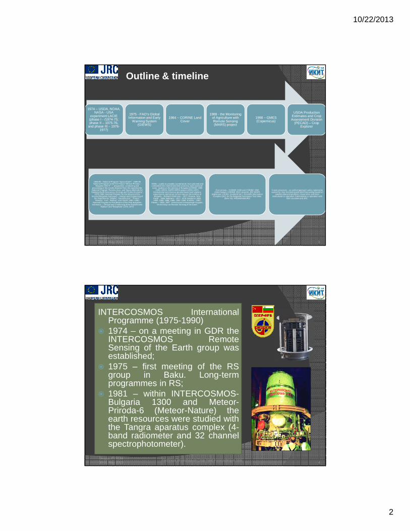
Contract No. ДВ 08/001.12.06.2008: Development of Methodology and Creating a National Data Base for
NDVI, NPP and LAI Based on Satellite Data from NOAA AVHRR and MODIS. Contract, between SRTI-BAS
and Kontrax Company, June 2008 – September 2008.
within PHARE BG Programme 2005/017-684-02 for Provision ofEquipment: Support for sustainable management of crises atcentral and local level
� Objectives:
� (i) developing methods for satellite-based monitoring of winter crops (winter wheat and winterbarley) in Bulgaria; and
� (ii) apply the developed methods to the winter crops for two agricultural years, namely 2006–2007 and 2007–2008, which are known for their drought and favourable growth conditions,respectively (Roumenina et al. 2011).
Skopje, FYROM30-31 May 2013 15
Technical Workshop on Crop Yield Forecasting in SEE
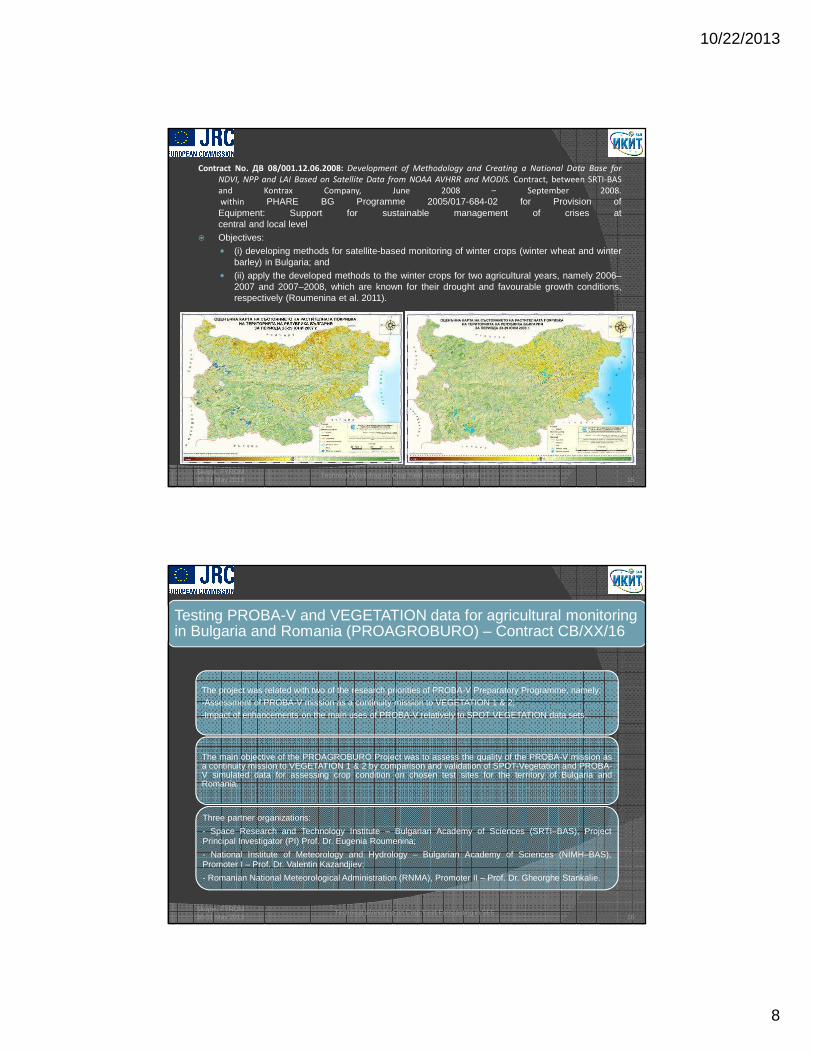
Testing PROBA-V and VEGETATION data for agricultural monitoring in Bulgaria and Romania (PROAGROBURO) – Contract CB/XX/16
The project was related with two of the research priorities of PROBA-V Preparatory Programme, namely:-Assessment of PROBA-V mission as a continuity mission to VEGETATION 1 & 2;-Impact of enhancements on the main uses of PROBA-V relatively to SPOT VEGETATION data sets.
The main objective of the PROAGROBURO Project was to assess the quality of the PROBA-V mission asa continuity mission to VEGETATION 1 & 2 by comparison and validation of SPOT-Vegetation and PROBA-V simulated data for assessing crop condition on chosen test sites for the territory of Bulgaria andRomania.
Three partner organizations:
- Space Research and Technology Institute – Bulgarian Academy of Sciences (SRTI–BAS), ProjectPrincipal Investigator (PI) Prof. Dr. Eugenia Roumenina;
- National Institute of Meteorology and Hydrology – Bulgarian Academy of Sciences (NIMH–BAS),Promoter I – Prof. Dr. Valentin Kazandjiev;
- Romanian National Meteorological Administration (RNMA), Promoter II – Prof. Dr. Gheorghe Stankalie.
Skopje, FYROM30-31 May 2013 16
Technical Workshop on Crop Yield Forecasting in SEE

10/22/2013
9
Study area
17
Zhiten, Bulgaria Fundulea, Romania
10.02.2011 24.01.2011
Technical Workshop on Crop Yield Forecasting in SEESkopje, FYROM30-31 May 2013
PROAGROBURO - Results and deliverables
Established correlations between ground observations ofdifferent phenological stages and spectral indices NDVI,NDWI and LAI from SPOT-VEGETATION images andPROBA-V simulated data using biophysical surfaceparameter maps;
Validated SPOT Vegetation and PROBA-V derived indiceswith biophysical data on the chosen test fields;
Comparison and assessment of the enhanced spatialresolution of PROBA-V compared to SPOTVEGETATION spectroradiometer based on spatialstatistics and pattern analysis of derived vegetationindices and LU/LC maps;
A prototype of a web-based GIS system forPROAGROBURO;
Methodological requirements for the PROAGROBUROProject, project website, conference presentations,journal articles etc.
Skopje, FYROM30-31 May 2013 18
Technical workshop on Crop Yield Forecasting in SEE
Spatial distribution of the reference sites in the test fields of Zhiten
test area (Bulgaria) (a), and Fundulea test area (Romania) (b). Four
sub-satellite experiments were conducted for Zhiten test area and
three for Fundulea test area
Supervised MLC of LU/LC on PROBA-V SD and SPOT VEGETATION
images for Zhiten test area (Bulgaria) (a) and Fundulea test area
(Romania) (b)

10/22/2013
10
UN/FAO regional training seminar on remote sensing applications for land resources, 16-26 September 1981, Sofia, Bulgaria - 31 papers from the SRTI-BAS scientific staff on various land resources applications (including agriculture) (UN/FAO regional training seminar..., 1981). The seminar was intended “mainly for the benefit of developing countries in the economic Commission for Western Asia and Mediterranean regions” (Yearbook of the UN, Part one, Chapter II, 1981);
FAO/ESA/BASA Workshop for Decision-Makers on Remote Sensing/GIS Applications to Agricultural and Environmental Management . St. Kyrick complex, Assenovgrad, 10-14 November 1997.
Technical Workshop on Crop Yield Forecasting in SEESkopje, FYROM30-31 May 2013 19
Enhancing the Qualification and Retaining a Young Scholars ' Team in theField of Aerosapace Technologies as a Prerequisite for Moni toring andPreservation of the Environment and Prevention of Damages C aused byNatural Disasters . Contract No. ВG051РО001/07/3.3-02/63/170608 between theSRI-BAS and the Scientific Research Fund at the Ministry of E ducation of theRep. of Bulgaria under the Human Resource Development Opera tiveProgramme, 2008–2010.
Beneficiaries of the project were 11 Ph.D. students and post-docs from SRTI-BAS and Institute of Oceanology FridtjofNansen at the BAS (IO-BAS)
http://young.sci.space.bas.bg/index.html
Project web site
Skopje, FYROM30-31 May 2013
Technical Workshop on Crop Yield Forecasting in SEE20

10/22/2013
11
Future prospects
� National:� The RS methods are used in crop area
estimation for European subsidy offarmers;
� The crop monitoring and yield forecastingis still lacking RS derived and assimilateddata for precise crop-grow modelling;
� Stronger cooperation efforts between thestakeholders to further develop, redesignor build from scratch the AIIS (search forbids, calls etc.).
� International:� Scientific cooperation, capacity building,
and knowledge exchange with the SEEcountries and JRC in developing aregional SEE and/or national cropmonitoring and yield forecastingsystems based on RS data and productsassimilation;
� Active participation in GMES(COPERNICUS) for algorithm developmentand products validation of satellite dataand products;
Skopje, FYROM30-31 May 2013
Technical Workshop on Crop Yield Forecasting in SEE21
The initial AIIS components after (Georgiev 1998)
References
1. Craciunescu V., G. Stancalie, E. Roumenina,V. Kazandjiev, G. Jelev, L. Filchev, E. Savin, and S. Catana.2012. Interactive Web-Mapping System for Satellite Based Agricultural Applications in Bulgaria andRomania. In: Proceedings of 4th International Conference on Cartography and GIS, vol. 1, 18–22 June,2012, Albena, Bulgaria. Publisher: Bulgarian Cartographic Association, ISSN 1314-0604, pp. 429–439.
2. Georgiev, G. 1998. An integrated agrometeorological forecasting system for Bulgaria. In: LandInformation Systems: Developments for planning the sustainable use of land resources. H.J. Heineke, W.Eckelmann, A.J. Thomasson, R.J.A. Jones, L. Montanarella, B. Buckley (eds.) EUROPEAN SOILBUREAU - RESEARCH REPORT NO. 4, Section 4: Techniques and Technologies, EUR 17729 EN,(1998), 546pp. Office for Official Publications of the European Communities, Luxembourg.
3. Iliev, I., S. Nedyalkov, E. Roumenina, and N. Pelova. 1994. Characteristic of Spectral Reflection Capacityof Leached Chernozem-Smolnizas in Bulgaria, Soil Science Agrochemistry and Ecology, Vol. 29, No 3,11-16. (in Bulgarian)
4. Ilieva, V. and I. Lisker. 1996. Authomated Laser System for Optical Characteristics Measurements ofPlant Leaves, In: XXVI Annual Meeting of ESNA, Romania.
5. Kapnias, D. 2008. Implementation and maintenance of the Land Parcel Identification System in Bulgaria,JRC Scientific and Technical Reports. EUR 23691EN -2008. ISSN 1018-5593 DOI:http://dx.doi.org/10.2788/66833
6. Kazandjiev, V. S. 1984. Decoding of factors which influence on the reflectance characteristics of soil andplants, Proceedings ol'Agricultural meteorology Vol. 2, pp. 174-181, Sofia (In Bulgarian).
7. Kazandjiev, V. S. 1989. Determination some parameters of maize crops using remote sensingMultispectral data, in Agricultural meteorology v. Ill, pp. 142-147, Sofia (In Bulgarian)
8. Kazandjiev, V. S. 1993. Remote Sensing Soil Research in Visible and NIR Range Waves and Estimationof Soil Moisture, Bulgarian Journal of Meteorology and Hydrology, Vol. 3, No. 5, Sofia.
9. Kazandjiev, V. S. 1992. Decoding dynamically properties (characteristics) of soils through coefficients ofspectral brightness, In: 4th Symposium "Physics and agriculture" Central Institute of Science andTechnical Information - Central Science and Technical Library, No ND 220/92, Sofia, (In Bulgarian).
Skopje, FYROM30-31 May 2013
Technical Workshop on Crop Yield Forecasting in SEE22

10/22/2013
12
10. Kazandjiev, V. and V. Ilieva. 1994. Application of Remote Sensed Measurement for earlydiagnostic of diseases Erysiphe graminis and Puccinia graminis on wheat. In: Proceeding of the5th National Symposium on Physics and Agriculture, November, Sofia, pp. 98-105.
11. Kazandjiev, V. and Georgiev G. 1994. Operational management of irrigation schedules andinformation services using conventional and remote sensing data, In: Proceedings of 17th
European Regional Conference on Irrigation and Drainage, 16-22 May 1994. v. 2, pp. 267, Varna.
12. Kazandjiev, V., 2001. COST ACTION 718 “Meteorological Applications for Agriculture” - Applicationof remote sensing data for agriculture - paper on MCM3, Larnaca, Cyprus, 21-23, March 2001.
13. Kazandjiev, V. 2008. Phenological observations in Bulgaria. In: Collection ‘‘Phenologicalobservations in Europe.’’ Edited by J. Nekovar and T. Spark. COST 725, Brussels, Belgium. p.200.
14. Mkrtchan, F. A. Reutov, E. Shutko, A. Kostov, K. Michalev, M. Nedeltchev, N. Spasov, A. and Vichev, B.1988. Experiments in Bulgaria for determination of soil moisture in the top one-meter using microwaveradiometry and a priori information, Proceedings of IGARSS’88 Int’l Symposium, ESA SP-284, pp. 665-666. DOI: http://dx.doi.org/10.1109/IGARSS.1988.570405
15. Roumenina, E., L. Filchev, V. Naydenova, G. Jelev, P. Dimitrov, V. Vassilev, and L. Kraleva. Monitoring ofwinter crop status in Bulgaria using a series of NOAA AVHRR NDVI images.Canadian Journal of RemoteSensing, 2010, 36(S2): S224-S230, DOI: http://dx.doi.org/10.5589/m10-057
16. Roumenina E., L. Filchev, P. Dimitrov, G. Jelev, V. Kazandjiev, V. Georgieva, and D. Joleva. 2011.Monitoring of Winter Wheat of the Enola Variety on the Lozenets Reference Area Using Satellite andGround-Based Data. Field Crops Studies, Cereals Breeding, No 2, 2011. ISSN 1312-3882, pp. 221–232.
17. Roumenina E., V. Kazandjiev, and G. Stancalie (Eds.) 2011. Methodological Requirements for TestingPROBA-V and VEGETATION data for agricultural applications in Bulgaria and Romania, Publisher: Prof.Marin Drinov Academic Publishing House, 148 p. ISBN 978 954-322-483-8 (In Eng., Bulg. and Roman.)
Skopje, FYROM30-31 May 2013 23
Technical workshop on Crop Yield Forecasting in SEE
18. Roumenina E., L. Filchev, G. Jelev, P. Dimitrov, H. Lukarski, V. Kazandjiev, and V. Georgiev. 2012.Determination of Wheat Crop Status after Winter Using Simulated Proba-V and Ground-Based Data. In:Proceedings of 7th Scientific Conference with International Participation ‘Space, Ecology, Safety’ (SES)2011, 29 November – 1 December 2011, Sofia, Bulgaria, Publisher: Space Research and TechnologyInstitute – Bulgarian Academy of Sciences. ISSN 1313-3888, pp. 197–207. URL:http://www.space.bas.bg/SES2011/R-1.pdf (last date accessed: 10.01.2013)
19. Roumenina E., L. Filchev, V. Vassilev, P. Dimitrov, G. Jelev, G. Stancalie, E. Savin, and D. Mihailescu.2012. Comparative Analysis of Crop Maps for Chosen Test Areas on the Territory of Bulgaria and RomaniaUsing Simulated PROBA-V and SPOT Vegetation Data. EARSeL eProceedings, No 11, Vol. 2, EARSeLand BIS Verlag, ISSN 1729-3782, pp155–160. URL:http://www.eproceedings.org/static/vol11_2/11_2_roumenina1.pdf (last date accessed: 10.01.2013)
20. Roumenina E., L. Filchev, V. Vassilev, P. Dimitrov, G. Jelev, G. Stancalie, E. Savin, and D. Mihailescu.2013. Comparative Analysis of Land-Use/Land-Cover Maps for Chosen Test Areas on The Territory ofBulgaria and Romania Using Simulated PROBA-V and SPOT Vegetation Data. // In: 32nd EARSeLSymposium Proceedings “Advances in Geosciences”, 1st EARSeL Workshop on Temporal Analysis ofSatellite Images, 24–25 May, 2012, Mykonos, Greece, Published by: EARSeL and Department of Planningand Regional Development, University of Thessaly, Greece, ISBN 978-960-88490-3-7, pp. 430–435. URL:http://www.earsel.org/symposia/2012-symposium-Mykonos/Proceedings/14-02_EARSeL-Symposium-2012.pdf (last date accessed: 23.05.2013)
21. Roumenina E., V. Kazandjiev, P. Dimitrov, L. Filchev, V. Vassilev, G. Jelev, V. Georgieva, and H. Lukarski.2013. Validation of LAI and assessment of winter wheat status using spectral data and vegetation indicesfrom SPOT VEGETATION and simulated PROBA-V images. International Journal of Remote Sensing, Vol.34, No 8, Publisher Taylor & Francis, ISSN 0143-1161 print/ISSN 1366-5901 online, pp. 2888-2904. DOI:http://dx.doi.org/10.1080/01431161.2012.755276 (last date accessed: 23.05.2013)
22. Serafimov, K. 1979. Bulgaria and Space, Sofia, Narodna mladej, 144 p. (in Bulgarian)
Skopje, FYROM30-31 May 2013
Technical Workshop on Crop Yield Forecasting in SEE24
10/22/2013
13
23. Shutko, A.; Gulyaev, Yu.; Chusov, I.; Sidorov, I.; Novichikhin, E.; Golovachev, S.; Krapivin, V.; Haldin, A.; Nazarov,L.; Tishchenko, Yu.; Chukhlantsev, A.; Marechek, S.; Haarbrink, R.; Dachev, Ts.; Kancheva, R.; Petkov, D.;Semkova, J.; Yanev, T.; Kolionsky, N.; Coleman, T.; Archer, F., III.; Pampaloni, P.; Paloscia, S.; Krissilov, A.;Kosteniuk, B.; Baryshnikov, I., and A. Carmona. 2006. Microwave radiometric remote sensing for emergencymapping of areas with water seepage through levees and of zones with dangerously high groundwater level,EARSeL eProceeding, Global developments in environmental earth orbservation from space. Proceedings of the25th EARSeL Symposium, Porto, Portugal, 2005, pp. 305-314. URL: http://www.earsel.org/symposia/2005-symposium-Porto/pdf/037.pdf (last date accessed: 23.05.2013)
24. Shutko, A. and V. Krapivin. 2011. Operative diagnostics, scale assessment and mitigation of impacts from naturalstress phenomena. Sofia, Marin Drivon Academic Publishing house, 288. (in Bulgarian)
25. Spiridonov, H. A. Hadjiyanakiev, E. Misheva, B. Peev, N. Achkov, and M. Chervenyaska. 1979. Optimum spectralzones distinguished on the basis of aerial investigations of soils and vegetation, Problems of Geography, 2, pp. 59-66.
26. Spiridonov, H., R. Kuncheva, and E. Misheva. 1981. Results and conclusions from soil and vegetation reflectioncoefficient measurements, Adv. Space Res., Vol. 1, pp. 111-114. DOI: http://dx.doi.org/10.1016/0273-1177(81)90386-0 (last date accessed: 23.05.2013)
27. Travaglia, C., L. Milenova, R Nedkov, V. Vassilev, P. Milenov, R. Radkov, and Z. Pironkova. 2001. Preparation ofLand Cover Database of Bulgaria through Remote Sensing and GIS, Environment and Natural Resources,Working Paper 6, FAO, Rome, 67 p. URL: ftp://ftp.fao.org/docrep/fao/003/y0785e/y0785e00.pdf (last dateaccessed: 23.05.2013)
28. Zaharinov, B. and V. Ilieva. 2003. Remote Sensing in Agroecology, Nature, Union of Scientists, Vol. XIII, No 5, pp.28-33. (inBulgarian) URL: http://eprints.nbu.bg/1031/1/distancionni_metodi_v_agroekologiyata.pdf (last dateaccessed: 23.05.2013)
29. RSC Series (FAO), no. 7. UN/FAO regional training seminar on remote sensing applications for land resources,16-26 September 1981, Sofia, Bulgaria. 19 Sep 1981 / FAO, Rome (Italy). Land and Water Development Div.,1982
30. Yearbook of the UN, Chapter II, Peaceful uses of outer space, 1981.http://unyearbook.un.org/1981YUN/1981_P1_SEC1_CH2.pdf (last date accessed: 23.05.2013)
Skopje, FYROM30-31 May 2013
Technical Workshop on Crop Yield Forecasting in SEE25
Skopje, FYROM30-31 May 2013 26
Bulgarian Academy of Sciences (BAS)http://www.bas.bg
Space Research and Technology Institute (SRTI-BAS)http://www.space.bas.bg
Remote Sensing and GIS Departmenthttp://www.rse-sri.com
Technical workshop on Crop Yield Forecasting in SEE
AddressBAS Scientific complex 1,Acad. Georgi Bonchev Str., bl. 11113 Sofia, P.O.Box 799, Bulgaria