
Building Code Amendments to Reduce Existing and Future...
34
Building Code Amendments to Reduce Existing and Future Building Stock Vulnerability To Coastal Hazards and Climate Impacts In the City and County of Honolulu - Implementing (draft) code amendments. Gary Chock, S.E., D.CE, F.SEI, F.ASCE Structural Engineer, Hawaii and California Diplomate, Coastal Engineer, of the Academy of Coastal, Ocean, Port and Navigation Engineers ASCE Structural Engineering Institute Fellow ASCE Fellow Martin & Chock, Inc. Kwok-Fai Cheung, Ph.D., P.E. Applied Research International, LLC
Transcript of Building Code Amendments to Reduce Existing and Future...

Building Code Amendments to Reduce Existing and Future Building Stock VulnerabilityTo Coastal Hazards and Climate Impacts
In the City and County of Honolulu -Implementing (draft) code amendments.
Gary Chock, S.E., D.CE, F.SEI, F.ASCEStructural Engineer, Hawaii and CaliforniaDiplomate, Coastal Engineer, of the Academy of Coastal, Ocean, Port and Navigation EngineersASCE Structural Engineering Institute FellowASCE FellowMartin & Chock, Inc.
Kwok-Fai Cheung, Ph.D., P.E.Applied Research International, LLC

Project GoalThe primary goal of this project is to develop disaster resilient measures for reducing building construction vulnerability to natural hazards considering climate change effects. Disaster resilience is the ability to prepare and plan for, absorb, recover from, and more successfully adapt to adverse events.Identify improvements to enable adaptation for climate resilience, with the approach that “the assumption of stationarity is dead.”Assumption is that at some point in the future, government will take action and not acquiesce to status quo.

1. Summrize a pilot study of storm inundation maps including climate change effects.
2. Gather input on model City ordinance(s) that could transferable for use and potential adoption by all counties in Hawaii.
IntroductionPilot Study and FindingsChanges to Codes, Standards, and Regulations
Existing and Anticipated Future Coastal Hazard and Climate Impacts to Honolulu
i. Sea level rise (and increasing rates of beach erosion )ii. Groundwater rise iii. Sea Surface Temperatures increasing with more
frequent Central Pacific ENSO events and increase in tropical cyclone intensities
iv. Inundation / flooding from storms and tropical cyclones
v. Increase in the number of unusually warm days vi. More severe and longer drought periods due to
reduced annual rainfall following a drier climate trend

Climate Change ModelingModels indicate that the primary environmental responses to Radiative Forcing are:
Increasing ocean temperatures , which results in Sea Level Rise due to thermal expansion. Melting of glaciersTherefore, this effect is not uniform and regional relative sea level rise must be considered.
Models are subject to uncertainty and there is much variation between global models. Therefore, usually an ensemble mean is used as an estimate. Otherwise, outlier results and modeling noise would unduly dominate actions.With respect to climate effects on tropical cyclones, models that perform better representations of El Nino-La Nina cycles should be preferred.

Sea level rise at the end of 21st century

Pilot project included to establish how coastal inundation zone maps can be developed including
the effects of climate change
Proof-of-concept implementation at the Kakaako-Waikiki coastline
Future hurricane events from downscaling of climate modelStorm Inundation modeling at future sea levelDevelopment of probabilistic inundation map of 500-year coastal inundation zone maps that can be used in land use regulation decisions and design criteria for all construction and Critical Infrastructure.

MethodologyUse recognized literature for climate change effects on tropical cyclone track distribution Evaluate the probabilistic level of net apparent sea level rise due to climate change and land subsidence effects.Employ probabilistic storm inventory to perform coastal inundation analysis.Create a prototypical inundation map with mean recurrence interval appropriate for buildings and critical infrastructure.Analyze the inventory of buildings and structuresDetermine the approximate cost impacts and net benefits for the proposed revised set of requirements Evaluate the feasibility of applying this methodologyUtilize the above information products to indicate how to develop other coastal hazard mitigation strategy elements.

A greater proportion of more intense hurricanes of the MRI relevant to codes, although the long term average number per season is not much changed; however, effect does appear significantly different for basis of design except for critical facilities
More intense rainfall in each storm – significant for the performance of all types of infrastructure

Hurricane events at the end of 21st centuryHurricane tracks from downscaling of NCAR CCSM4
during 2081-2100 (Emmanuel, 2013 PNAS) 50 simulations of that 20-year climate period
x50
2492 hurricanes passing through a zone of influence around Hawaii↓
627 hurricanes passing near Oahu within the blue boundary↓
10 selected critical events based on wind speed at Kaka’ako (red dot)

Probabilistic Inundation Mapping
Aggregation of inundation occurrence through overlaying the inundation maps
1000-year : the most critical event500-year: the 2nd most critical event330-year: the 3rd most critical event
1000-year : flooded at least once500-year: flooded at least twice
330-year: flooded at least three times
The effects of climate change on the storm pattern and sea level can be incorporated into flood hazard maps.
Ranking of events by inundation limit

21:10
Coupled NEOWAVE & SWAN
Coupled NEOWAVE & SWAN and NEOWAVE + SWAN +
BOSZ
2nd Most Critical Hurricane Event

Sea Level Rise EffectModel No.193 (ccsm4 rcp85 No.788)
HT+SLR=0.33m+0.6m
HT=0.33m

Future Climate Change Findings of Effects in the Study AreaThe sea level rise contribution to the future expected hurricane flooding damage in Waikiki to Kakaako is responsible for about 75% of the future total losses. The effect of climate change and sea level rise increases the future expected hurricane flooding damage in Waikiki to Kakaako from $ 0.76 Billion to $3.623 Billion, or about a 475% increase.The increased flooding does not result directly from coastal wave set-up and runup, but in this area occurs primarily due to overtopping of the Ala Wai Canal embankments and its tributary. Therefore, mitigation of the increased flooding extent would need to include the Ala Wai Canal. To preclude the increased flooding of the urban core of Honolulu in the future period that is about 75 years from the present, a master–planned flood control project involving the Ala Wai Canal and the adjacent tributary stream from Manoa and Palolo would become necessary. A $22.5 million present day additional investment would be justified for sea level rise considerations.

Future Climate Change Findings of Effects in the Study Area
Because risk occurs after sea level rise approaches 2 ft, investment in mitigation could be deferred for single family and other light frame construction. A risk transfer approach to the increased flooding would justify additional insurance basis annual costs of $1,400 per property, plus the insurance company’s costs and return on investment.All the above losses suggest that some mitigation of sea level rise could result from an extension of the flood zone.

Adaptive Design for Climate Resilience –an Engineering Approach
If climate change effects are introduced as explicit design requirements, then an economic incentive is created for responding to climate change in planning, siting, and construction. That is, adaptive design would become a widespread tool of climate change adaptation.
1. Design to the most probable (not the worst case) climate conditions expected within the lifespan of the facility
2. Incorporate the design capability to make further alterations to adapt to greater climate change effects as observations indicate to be necessary.
3. This recognizes the high uncertainty of modeling and enables the cost of adaptation to be incrementally paid over time.

Where the application of climate change adaptation is needed
buildings and other structurestransportation networks supply chain facilitiescoastal infrastructure energy supply and distributionwater and wastewater systems
Infrastructure and critical facilities most impacted by climate change are often government-owned and built or government-regulated industry owned and built, rather than in the private sector.

Hawaii State Building Code (Hawaii Revised Statutes Chapter 107 Part II)
This statute of 2007 gave the State Building Code Council (SBCC) the authority to adopt, amend, and update codes and standards including but not limited to those applicable to buildings, residential structures, and hurricane resistant standards related to loss mitigation standards in accordance with HRS section 431P-12, flood and tsunami, and existing buildings. This statute made the SBCC primary means of implementing new codes and design standards for the State. However, since 2010, DAGS has not proceeded with any State Building Code updates approved by the SBCC. Climate change adaptation may need to be lead by the City of Honolulu and other counties.

Proposed AmendmentsHRS Chapter 107 Part II - Hawaii State Building Code , Section 107-27:
(c) The department of accounting and general services shall adopt rules for the codes listed in section 107-25 pursuant to section 107-29 no later than two years after adoption by the council. (d) If the state does not adopt rules for the Hawaii state building codes within the two-year time frame, the model building codes listed in section 107-25 shall become applicable as the interim state building codes applicable per section 107-27, except that any requirements of these interim codes shall not be less stringent than the current adopted rules.

Proposed AmendmentsROH Chapter 16
Honolulu Building Code : Revise rainfall intensity map figure 1611.1 to add 15 minute 500-year intensityCritical and Essential Facility windspeed map for 1700-year and 3000-year windspeeds – per ASCE 7-16For Critical and Essential Facilities, amend section for minimum elevation of the lowest horizontal structural member, based on 500-year flood elevation taking into account 2 ft. of relative sea level change

Proposed AmendmentsROH Chapter 16
Honolulu Building Code - for Risk Category III and IV structures:
Provide foundation systems to maintain support of the structure considering 80 years of shoreline erosion projected forward from the year 2020 using the historical rate and further including 2 ft. of sea level rise.
Coastal Construction Control Zone. The zone defined by Chapter 21A as the 500-year coastal flood inundation limit including the effects of 2 feet of sea level rise. Require structural and foundation design in accordance with the International Building Code, not the less stringent International Residential Code that does not require engineered structures.

Proposed AmendmentsROH Chapter 17
Electrical Code: for Risk Category III and IV structures, Require main power equipment and metering placement,switchgear, control centers, transformers, distribution and power or lighting panels to be above the 500-year coastal flood inundation limit including the effects of 2 feet of sea level rise, or locate in a waterproof enclosure.

Proposed AmendmentsROH Chapter 19 Honolulu Plumbing Code
Chapter 11Storm DrainageSection 1101.11.1 Primary Roof Drainage. Roof areas of a building shall be drained by roof drains or gutters. The location and sizing of drains and gutters shall be coordinated with the structural design and pitch of the roof. Unless otherwise required by the authority having jurisdiction, roof drains, gutters, vertical conductors or leaders, and horizontal storm drains for primary drainage shall be sized based on a rainfall intensity equal to or greater than the 15-min duration/500-year return period (frequency) storm. Primary drainage systems shall also be designed for a rainfall intensity equal to or greater than the 60-min duration/ 500-year return period (frequency) storm, as published by the National Weather Service Precipitation Frequency Data Server or on other rainfall rates determined from approved local weather data.
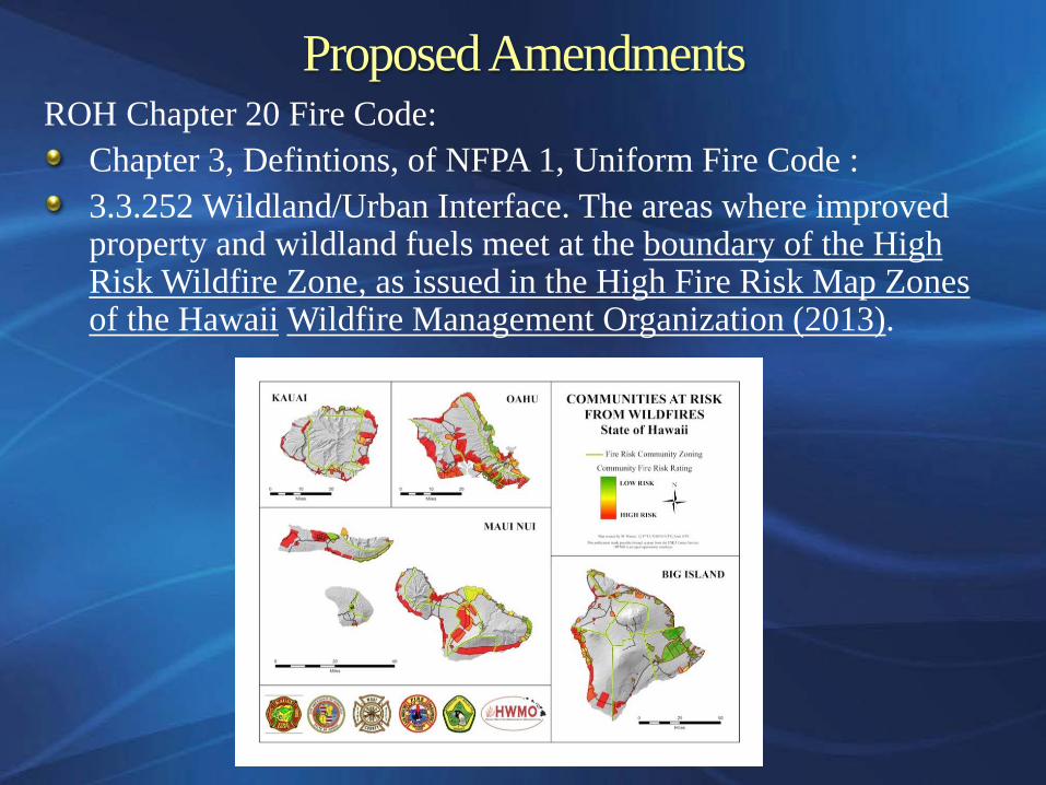
Proposed AmendmentsROH Chapter 20 Fire Code:
Chapter 3, Defintions, of NFPA 1, Uniform Fire Code :3.3.252 Wildland/Urban Interface. The areas where improved property and wildland fuels meet at the boundary of the High Risk Wildfire Zone, as issued in the High Fire Risk Map Zones of the Hawaii Wildfire Management Organization (2013).

Draft List of Proposed AmendmentsROH Chapter 23 – Article 1, Section 23-1.4 Shoreline setback line:
(d) Adjustment of Shoreline Setback Line Related to the Construction of a New Building or Structure, or an Addition to an Existing Building or Structure.
The shoreline setback line shall be established 25 feet inland from the certified shoreline plus a distance of 50 times the historical annual erosion hazard rate from the shoreline established by county maps.Where the lot has average depth of less than 160 feet, the shoreline setback need not exceed 40 feet.Accretion rates shall not be considered.

Proposed AmendmentsROH Chapter 25 SMA –Sec. 25-1.3 Definitions.
“Coastal Construction Control Zone” is the map area within the coastal inundation limit of the 500-year flood developed including the effects of expected climate change by the year 2100 and including a sea level rise of 2 feet above the year 2000 mean high water.

Proposed AmendmentsROH Chapter 25 SMA –Article 3, Section 25-3.2, Review guidelines, subsection (a) and subsection (b) are amended to add the following guidelines (5) and (4), respectively:
All development in the special management area shall be subject to reasonable terms and conditions set by the council to ensure that:
(5) for developments exceeding $10 million, provisions are for made to accommodate or mitigate effects of flooding within the Coastal Construction Control Zone.
No development shall be approved unless the council has first found that:
(4) for developments exceeding $10 million, the adverse effects of climate change and sea level rise as defined by the Coastal Construction Control Zone have been minimized to the extent practicable and clearly outweighed by public health and safety, or compelling public interest. …

Proposed AmendmentsHRS 205A Certified Shoreline: for planning purposes, also include an Expected Shoreline map taking into account shoreline erosion and relative sea level rise over the next 50 years.§205A-1 Definitions.
" Expected Future Shoreline" means the future expected upper reaches of the wash of the waves, other than storm and seismic waves, at high tide during the season of the year in which the highest wash of the waves occurs, estimated including the effects of 1 feet of sea level rise and shoreline erosion projected forward to the year 2060. The expected future shoreline is shown on [new maps required].
§205A-26 Special management area guidelines.(1) All development in the special management area shall be subject to reasonable terms and conditions set by the authority in order to ensure:(E) to accommodate the future retreat of the shoreline as indicated by the maps of the Expected Future Shoreline.

Proposed AmendmentsROH Chapter 32 Building Energy Conservation Code: Adopt American Society of Heating, Refrigerating, and Air-Conditioning Engineers Standard 169, Weather Data for Building Design Standards for use in the application of ANSI/ASHRAE/IESNA Standard 90.1-2004, Energy Standard for Buildings Except Low-Rise Residential Buildings

Requires the seller to disclose material facts that would affect the value of the residential real estate. Add the following:
where the site includes any extent of the Expected Future Shoreline, as defined in HRS §205A-1;Within the Coastal Construction Control Zone, defined by Chapter 21A as the 500-year coastal flood inundation limit including the effects of 2 feet of sea level rise.within lava inundation hazard zone 1, 2, or 3 per USGS (1992)within a high risk wildfire zone designated

Required information subdivision sales relating to exposure to natural hazards; e.g., earthquakes, floods, tidal waves, volcano, forest fires, slides, etc. [HAR § 16-104-25] , add:Within the anticipated inundation areas designated on the department of defense's emergency management extreme tsunami inundation maps;where the site includes any extent of the Expected Future Shoreline, as defined in HRS §205A-1;Within the Coastal Construction Control Zone, defined by Chapter 21A as the 500-year coastal flood inundation limit including the effects of 2 feet of sea level risewithin lava inundation hazard zone 1, 2, or 3 per USGS (1992)within a high risk wildfire zone

Public Utilities Commission 2007 adoption of the 2002 National Electrical Safety Code
In 2007, the PUC rescinded General Order 6 and adopted the 2002 National Electrical Safety Code that uses a 105 mph basic wind speed. •The 2002 National Electrical Safety Code uses a design load methodology that references the ASCE 7-05 wind load provisions for windspeed. The PUC should adopt the windspeed maps of the 2010 Hawaii State Building Code, to replace the NEC 2012 Figure 250-2. Otherwise, the wind design standard for power transmission and distribution systems is deficient with respect to actual wind speeds that would occur during tropical storms and hurricanes.

Public Utilities Commission 2007 adoption of the 2002 National Electrical Safety Code
Section 6-73-21 Modifications to the National Electrical Safety CodeRule 250:Page 161, the definition of V is replaced with the following:
V Basic Wind Speed, 3 s gust wind speed in mph at 33 ft. above ground, that shall be taken lue given in Figure 250-2 for the effective ultimate wind speed, multiplied by the factor √0.625.
Page 163, the first paragraph is replaced to state,“The wind pressure parameters (kz
, V, and GRF
) are based on Exposure C per ASCE 7-16,which is the basis for the NESC extreme wind criteria.”

Questions/Discussion?
Note that the aforementioned draft code amendments are subject to further revision.