BRUNSWICK STRUCTURE PLAN - City of Moreland · a strong history of activism supporting and opposing...
34
VOLUME 1 VOLUME 2 - PART 1 SYDNEY ROAD / UPFIELD CORRIDOR READ VOLUME 1 PLUS YOUR LOCAL AREA VOLUME 2 - PART 2 LYGON STREET VOLUME 2 - PART 3 NICHOLSON STREET BRUNSWICK STRUCTURE PLAN STRATEGIC FRAMEWORK Adopted by Council 11 August 2010 FINAL VERSION
-
Upload
phungthuan -
Category
Documents
-
view
213 -
download
0
Transcript of BRUNSWICK STRUCTURE PLAN - City of Moreland · a strong history of activism supporting and opposing...

VOLUME 1
VOLUME 2 - PART 1
SYDNEY ROAD /
UPFIELD CORRIDOR
READ VOLUME 1
PLUS YOUR LOCAL AREA
VOLUME 2 - PART 2
LYGON STREET
VOLUME 2 - PART 3
NICHOLSON STREET
BRUNSWICK STRUCTURE PLANSTRATEGIC FRAMEWORK
Adopted by Council 11 August 2010FINAL VERSION
Moreland City Council acknowledges the traditional owners of
the land, the Kulin Nation, of which the local indigenous people
are the Wurrundjeri. Council is committed to building a trusting,
collaborative and supportive relationship with indigenous
groups, and to respecting identified Aboriginal sacred sites
and special places.
Disclaimer
This Structure Plan establishes Council’s policy in relation to the development of the Brunswick Activity Centre. It may be of assistance to you, but Moreland City Council and its employees do not guarantee that the publication is without flaw of any kind or is wholly appropriate for your particular purposes, and therefore expressly disclaims any liability for any loss or damage, whether direct or consequential, suffered by any person as the result of or arising from reliance on anything contained in this publication. Council recommends that any person relying on this policy conduct their own investigations and/or seek their own independent advice in relation to the matters contained in it.
This project has received funding through the Department of Planning and Community Development’s Expert Assistance Program. The State of Victoria and its employees do not guarantee that the publication is without flaw of any kind or is wholly appropriate for your particular purposes and therefore disclaims all liability for any error, loss or other consequence which may inform you relying on any information in this publication.
© All applicable copyrights reserved for Moreland City Council. Except for any uses permitted under the Copyright Act 1968 (Cth), no part of this Structure Plan may be reproduced in any manner or in any medium (whether electronic or otherwise) without the express permission of Moreland City Council.

VOLUME 1 : STRATEGIC FRAMEWORK
BRUNSWICK STRUCTURE PLAN — 1
Historically, Brunswick was and still is, a diverse suburb shaped by numerous waves of migration. There is a lively entertainment area with quirky cafés and live music venues. Brunswick once supported a curious blend of industries including clay pits, quarrying, brickworks, footwear, foundries, textiles and creative services. Brunswick also has a strong history of activism supporting and opposing a wide spectrum of opinion and politics. Famous names in Australia’s political history grew up on or lived in Brunswick. This small area of Melbourne was home to a Prime Minister, John Curtin; to intellectuals; to good hard working migrants; and Australians and even an occasional villain.
Though we desire to preserve everything we love about Brunswick, we must plan for the inevitable changes happening around us.
Our suburb is evolving from its former industrial roots and is now home to a growing professional community. Inner Melbourne is growing and changing so rapidly, that many are confused and disturbed by these significant transitions. It is therefore important not only to our present citizens, but to their children and yet unborn grand-children to protect and conserve Brunswick’s diverse heritage. The art studios, the eclectic boutiques mixed together with traditional wedding gown shops and Mediterranean grocery wholesalers, struggle against the imposts of clearways, rising land prices, and rapid change.
This Structure Plan is a map for Brunswick’s development over the next fifteen years. Even as we go to press, the demands for additional housing, denser living and new developments, force house and land prices to record levels.
Fortunately, Brunswick is well prepared to tackle these many challenges; because we have a plan. The suburb has access to good public transport, bike paths, walking paths, substantial and growing social services, open spaces and even areas available for potential developments.
Good and careful management of Brunswick’s potential strengths can generate an increased and controlled housing density, a sustainable population growth of about 10,000–20,000 people, while at the same time reducing the general reliance on cars. The Structure Plan provides the map for renewal and focuses on important amenity issues, such as streetscapes, building heights and heritage.
This Structure Plan envisages a compact and diverse Brunswick, a pleasant environment where residents are not car dependent and where local trips are encouraged on foot or bicycle. This document identifies activity hubs meeting local demands, where real job opportunities exist matching the skills of Brunswick’s evolving workforce and residents.
This plan is visionary. It perceives the challenge; to revitalise Brunswick for tomorrow’s demands.
I believe that of all the Councils throughout Australia, Moreland’s plans for Brunswick are exciting, long sighted and will deliver sound social and economic outcomes for our children and their children’s children.
Cr Stella Kariofyllidis Mayor of Moreland
MAYOR'S INTRODUCTION

2 — BRUNSWICK STRUCTURE PLAN
VOLUME 1 : STRATEGIC FRAMEWORK

VOLUME 1 : STRATEGIC FRAMEWORK
BRUNSWICK STRUCTURE PLAN — 3
1 INTRODUCTION AND CONTEXT . . . . . . . . . . . . . . . . . . . . 4
1.1 Brunswick Activity Centre . . . . . . . . . . . . . . . . . . . . . . . . . . . . . . . . . . . . . . . . . .5
1.2 How the plan is organised . . . . . . . . . . . . . . . . . . . . . . . . . . . . . . . . . . . . . . . . . .6
1.3 The legislative status of the plan . . . . . . . . . . . . . . . . . . . . . . . . . . . . . . . .8
1.4 Policy context . . . . . . . . . . . . . . . . . . . . . . . . . . . . . . . . . . . . . . . . . . . . . . . . . . . . . . . . . . . . .8
2 BRUNSWICK TODAY . . . . . . . . . . . . . . . . . . . . . . . . . . . . . . . . . . . . . . . 10
2.1 Demographic profile . . . . . . . . . . . . . . . . . . . . . . . . . . . . . . . . . . . . . . . . . . . . . . . . .10
2.2 Economic profile . . . . . . . . . . . . . . . . . . . . . . . . . . . . . . . . . . . . . . . . . . . . . . . . . . . . . . .12
2.3 Issues . . . . . . . . . . . . . . . . . . . . . . . . . . . . . . . . . . . . . . . . . . . . . . . . . . . . . . . . . . . . . . . . . . . . . . .12
2.3.1 Planning and land use . . . . . . . . . . . . . . . . . . . . . . . . . . . . . . . . . . . .12
2.3.2 Housing . . . . . . . . . . . . . . . . . . . . . . . . . . . . . . . . . . . . . . . . . . . . . . . . . . . . . . . . . .13
2.3.3 Transport and movement . . . . . . . . . . . . . . . . . . . . . . . . . . . . . . .14
2.3.4 Public realm . . . . . . . . . . . . . . . . . . . . . . . . . . . . . . . . . . . . . . . . . . . . . . . . . . .15
2.3.5 Built form . . . . . . . . . . . . . . . . . . . . . . . . . . . . . . . . . . . . . . . . . . . . . . . . . . . . . . .15
2.3.6 Local character and identity . . . . . . . . . . . . . . . . . . . . . . . . . . .16
2.3.7 Social, cultural and leisure services and facilities . . . . . . . . . . . . . . . . . . . . . . . . . . . . . . . . . . . . .17
3 VISION . . . . . . . . . . . . . . . . . . . . . . . . . . . . . . . . . . . . . . . . . . . . . . . . . . . . . . . . . . . . . . 18
4 STRATEGIC FRAMEWORK . . . . . . . . . . . . . . . . . . . . . . . . . . . . . 22
4.1 Planning and land use Objectives, strategies and guidelines . . . . . . . . . . . . . . . . . . . . . . .22
4.2 Housing Objectives, strategies and guidelines . . . . . . . . . . . . . . . . . . . . . . .26
4.3 Transport and movement Objectives, strategies and guidelines . . . . . . . . . . . . . . . . . . . . . . .30
4.4 Public realm Objectives, strategies and guidelines . . . . . . . . . . . . . . . . . . . . . . .38
4.5 Built form Objectives, strategies and guidelines . . . . . . . . . . . . . . . . . . . . . . .44
4.6 Character and identity Objectives, strategies and guidelines . . . . . . . . . . . . . . . . . . . . . . .50
4.7 Social, cultural and leisure services and facilities Objectives, strategies and guidelines . . . . . . . . . . . . . . . . . . . . . . .56
4.8 Strategic framework plan . . . . . . . . . . . . . . . . . . . . . . . . . . . . . . . . . . . . . . . . .60
5 IMPLEMENTATION FRAMEWORK . . . . . . . . . . . . . . . . 62
6 GLOSSARY . . . . . . . . . . . . . . . . . . . . . . . . . . . . . . . . . . . . . . . . . . . . . . . . . . . . . . . 64
7 ACKNOWLEDGEMENTS . . . . . . . . . . . . . . . . . . . . . . . . . . . . . . . . 66
CONTENTS
4 — BRUNSWICK STRUCTURE PLAN
VOLUME 1 : STRATEGIC FRAMEWORK
1 INTRODUCTION AND CONTEXT
This Strategic Framework (Volume 1) applies to the whole area of
Brunswick Activity Centre, and informs the Structure Plans for the
three local areas defined within it: Sydney Road/Upfield Corridor,
Lygon Street and Nicholson Street. For objectives, strategies and
guidelines relevant to a local area or precinct refer to the local
area structure plans (Volume 2).
The Brunswick Structure Plan will guide development in the Brunswick Activity Centre through to 2025, and gives effect to the State Government’s policies Melbourne 2030: Planning for Sustainable Growth and Melbourne @ 5 million.
The Structure Plan articulates a vision for the suburb’s future, and defines a framework to guide decisions made by Council, the community and other stakeholders in relation to activities in the public and private realms.
It will be used to guide decision making on applications for land use and development, as well as amendments to the Moreland Planning Scheme. It provides guidance for the development of infrastructure, amenities and services. The Structure Plan also establishes the basis for funding applications to external bodies, including the State Government, for projects identified in the plan such as community services and capital works.
The features of Brunswick that make it an interesting place to live and work, derive from its history as an industrial hub located close to the centre of Melbourne, and from the way that successive waves of migration and economic restructuring have shaped the area. It has a history of strong community activism and support for progressive social policies such as multiculturalism, environmental sustainability, social equity and the retention of built heritage.
This Structure Plan articulates the community and Council’s ambitions regarding the retention, perpetuation and celebration of these features and values, and defines a framework in which to manage issues into the future.
The Moreland Council Plan contains a commitment to four strategic focus areas that represent Council’s core objectives for delivering a sustainable future for the municipality.
The four Strategic Focus Areas are:
This Structure Plan has been written to support this commitment – all objectives and strategies have been developed following consideration of their social, economic, environmental, and governance consequences.
Scientific evidence linking climate change to the increasing carbon concentration in the atmosphere arising from human activity is now overwhelming, and urgent precautionary measures should be taken to reduce carbon emissions. Forward planning combined with strong leadership and commitment are needed to transition to a low-carbon economy. Declining oil reserves will fundamentally alter the way communities function. This scenario should be viewed ‘rather than a problem, [as] a unique opportunity to set humanity on a new course, built on sustainable principles'.1
Council is committed to the achievement of environmentally sustainable development (ESD), and will set high development standards so that Brunswick continues to be a good model of a sustainable Melbourne suburb. The Structure Plan strives to:
in the Brunswick Major Activity Centre (BMAC).
living, working and recreational environments.
benefits of all new development.
The Structure Plan will capitalise on opportunities for a larger population to live within a relatively small carbon footprint made possible by Brunswick’s abundance of public transport, good walking access and established service and social infrastructure. It will build on existing initiatives such as Council's Climate Action Plan 2007-2012 and Zero Carbon Moreland to address issues of sustainability including the emerging challenges of climate change and peak oil by planning for the provision of equitable and accessible transport networks, enhancing social services, improving passive and active recreation spaces, and creating local jobs that match the skills of local people.
1 Dunlop
VOLUME 1 : STRATEGIC FRAMEWORK
BRUNSWICK STRUCTURE PLAN — 5
Melbourne Central Activity District
City of MorelandMajor Road
Railway
Major open space/park
Airport
Principal Activity
South Eastern Suburbs
Yarra Valley andEastern Suburbs
To Sydney
To Bendigo
To Adelaide
To GeelongPort Philip Bay
Hum
e
Highw
ay
Centre
Brunswick Major Activity Centre
Major Activity Centre
Bell Street
Melbourne Central Activity District
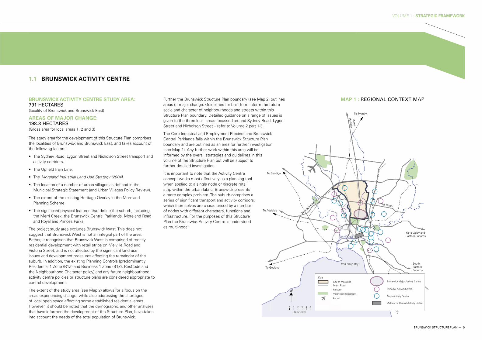
BRUNSWICK ACTIVITY CENTRE STUDY AREA: 791 HECTARES (locality of Brunswick and Brunswick East)
AREAS OF MAJOR CHANGE: 198.3 HECTARES (Gross area for local areas 1, 2 and 3)
The study area for the development of this Structure Plan comprises the localities of Brunswick and Brunswick East, and takes account of the following factors:
activity corridors.
Moreland Industrial Land Use Strategy (2004).
urban villages as defined in the Municipal Strategic Statement (and Urban Villages Policy Review).
Planning Scheme.
the Merri Creek, the Brunswick Central Parklands, Moreland Road and Royal and Princes Parks.
The project study area excludes Brunswick West. This does not suggest that Brunswick West is not an integral part of the area. Rather, it recognises that Brunswick West is comprised of mostly residential development with retail strips on Melville Road and Victoria Street, and is not affected by the significant land use issues and development pressures affecting the remainder of the suburb. In addition, the existing Planning Controls (predominantly Residential 1 Zone (R1Z) and Business 1 Zone (B1Z), ResCode and the Neighbourhood Character policy) and any future neighbourhood activity centre policies or structure plans are considered appropriate to control development.
The extent of the study area (see Map 2) allows for a focus on the areas experiencing change, while also addressing the shortages of local open space affecting some established residential areas. However, it should be noted that the demographic and other analyses that have informed the development of the Structure Plan, have taken into account the needs of the total population of Brunswick.
Further the Brunswick Structure Plan boundary (see Map 2) outlines areas of major change. Guidelines for built form inform the future scale and character of neighbourhoods and streets within this Structure Plan boundary. Detailed guidance on a range of issues is given to the three local areas focussed around Sydney Road, Lygon Street and Nicholson Street – refer to Volume 2 part 1-3.
The Core Industrial and Employment Precinct and Brunswick Central Parklands falls within the Brunswick Structure Plan boundary and are outlined as an area for further investigation (see Map 2). Any further work within this area will be informed by the overall strategies and guidelines in this volume of the Structure Plan but will be subject to further detailed investigation.
It is important to note that the Activity Centre concept works most effectively as a planning tool when applied to a single node or discrete retail strip within the urban fabric. Brunswick presents a more complex problem. The suburb comprises a series of significant transport and activity corridors, which themselves are characterised by a number of nodes with different characters, functions and infrastructure. For the purposes of this Structure Plan the Brunswick Activity Centre is understood as multi-nodal.
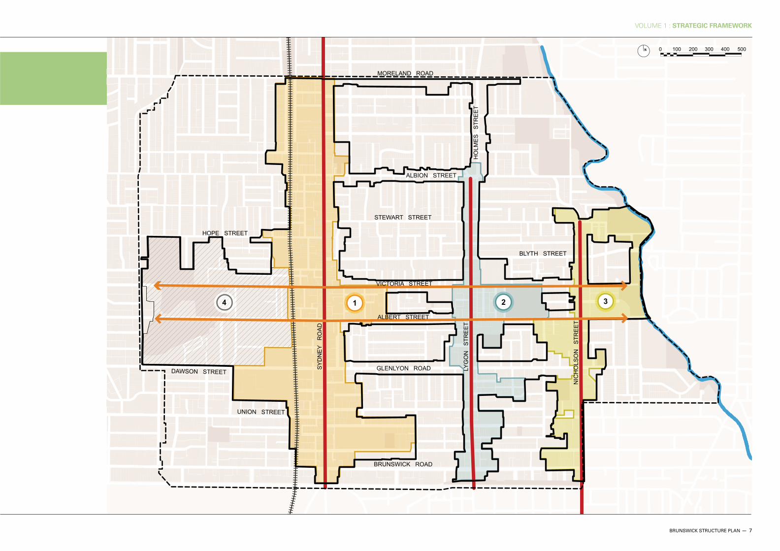
1.1 BRUNSWICK ACTIVITY CENTRE
MAP 1 : REGIONAL CONTEXT MAP
6 — BRUNSWICK STRUCTURE PLAN
VOLUME 1 : STRATEGIC FRAMEWORK
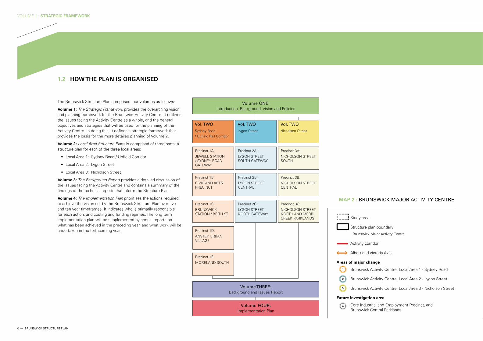
The Brunswick Structure Plan comprises four volumes as follows:
Volume 1: The Strategic Framework provides the overarching vision and planning framework for the Brunswick Activity Centre. It outlines the issues facing the Activity Centre as a whole, and the general objectives and strategies that will be used for the planning of the Activity Centre. In doing this, it defines a strategic framework that provides the basis for the more detailed planning of Volume 2.
Volume 2: Local Area Structure Plans is comprised of three parts: a structure plan for each of the three local areas:
Volume 3: The Background Report provides a detailed discussion of the issues facing the Activity Centre and contains a summary of the findings of the technical reports that inform the Structure Plan.
Volume 4: The Implementation Plan prioritises the actions required to achieve the vision set by the Brunswick Structure Plan over five and ten year timeframes. It indicates who is primarily responsible for each action, and costing and funding regimes. The long term implementation plan will be supplemented by annual reports on what has been achieved in the preceding year, and what work will be undertaken in the forthcoming year.
1.2 HOW THE PLAN IS ORGANISED
MAP 2 : BRUNSWICK MAJOR ACTIVITY CENTRE
Volume ONE: Introduction, Background, Vision and Policies
Volume THREE: Background and Issues Report
Volume FOUR: Implementation Plan
Vol. TWO
Sydney Road / Upfield Rail Corridor
Vol. TWO
Lygon Street
Vol. TWO
Nicholson Street
Precinct 1D:
ANSTEY URBAN VILLAGE
Precinct 1E:
MORELAND SOUTH
Precinct 1C:
BRUNSWICK STATION / BEITH ST
Precinct 2C:
LYGON STREET NORTH GATEWAY
Precinct 3C:
NICHOLSON STREET NORTH AND MERRI CREEK PARKLANDS
Precinct 1A:
JEWELL STATION / SYDNEY ROAD GATEWAY
Precinct 2A:
LYGON STREET SOUTH GATEWAY
Precinct 3A:
NICHOLSON STREET SOUTH
Precinct 1B:
CIVIC AND ARTS PRECINCT
Precinct 2B:
LYGON STREET CENTRAL
Precinct 3B:
NICHOLSON STREET CENTRAL
Study area
Structure plan boundary
Brunswick Major Activity Centre
Activity corridor
Albert and Victoria Axis
Areas of major change
Brunswick Activity Centre, Local Area 1 - Sydney Road
Brunswick Activity Centre, Local Area 2 - Lygon Street
Brunswick Activity Centre, Local Area 3 - Nicholson Street
Future investigation area
Core Industrial and Employment Precinct, and Brunswick Central Parklands
VOLUME 1 : STRATEGIC FRAMEWORK
BRUNSWICK STRUCTURE PLAN — 7
NIC
HO
LSO
N
STR
EE
T
LYG
ON
S
TRE
ET
SY
DN
EY
RO
AD
DAWSON STREET
UNION STREET
BRUNSWICK ROAD
GLENLYON ROAD
ALBERT STREET
VICTORIA STREET
STEWART STREET
ALBION STREET
BLYTH STREET
HO
LME
S
STR
EE
T
HOPE STREET
MORELAND ROAD
0 100 200 300 400 500
8 — BRUNSWICK STRUCTURE PLAN
VOLUME 1 : STRATEGIC FRAMEWORK
The Brunswick Structure Plan provides a framework to guide the development and use of land within the Brunswick Activity Centre. The Structure Plan sits within a State and Local Government policy context, which means it builds upon existing government policies but provides variations that are particular to the planning and development needs of the City of Moreland.
The Structure Plan will inform a number of policies to be formally adopted and used to govern broad operations of the Council.
Council will assimilate the key objectives and strategies of the Structure Plan into the Moreland Planning Scheme. This would be done through a series of amendments to the planning scheme and is likely to be in the form of new local planning policies, zones and overlays. This is a formal process within the statutory framework of the Planning and Environment Act 1987.
A range of State Government and Moreland City Council policies have informed the development of the Brunswick Structure Plan. In turn, the Structure Plan will act as a tool to implement some elements of these policies.
Two key policies are the State Government’s Melbourne 2030: Planning for Sustainable Growth (Melbourne 2030) and Council’s Municipal Strategic Statement (MSS). Details about these and other State Government and Council policy documents are available in Volume 3: The Background Report or by contacting Council or the State Government.
1.3 THE LEGISLATIVE STATUS OF THE PLAN 1.4 POLICY CONTEXT

VOLUME 1 : STRATEGIC FRAMEWORK
BRUNSWICK STRUCTURE PLAN — 9
Melbourne 2030: Planning for Sustainable Growth
Melbourne 2030 is the State Government’s strategy for the future development of metropolitan Melbourne to the year 2030. The central elements of Melbourne 2030 seek to achieve:
and the revitalisation of activity centres.
planning, including an urban growth boundary that sets clear limits to Melbourne’s outward development.
zones for certain uses, freight and logistics nodes and infrastructure provision.
enhancement of the natural environment.
infrastructure.
A key focus of the Melbourne 2030 strategy is the development of activity centres as focal points for high-quality development, activity and living across Melbourne.
Activity centres are places where people can shop, work, meet, relax and live. Well served by public transport, they provide a focus for services, employment and social interaction. They range in size and intensity of use and include strip shopping centres, major education and employment hubs and centres focused on regional malls.
Brunswick is identified as a major activity centre in the hierarchy of Melbourne’s activity centres. Major activity centres are identified as having the potential for significant development and infill building to accommodate a range of housing forms, densities and high-quality urban design.
The Activity Centre and its future role must be considered in the context of other activity centres in the region.
Municipal Strategic Statement
The Moreland Municipal Strategic Statement (MSS) forms part of the Moreland Planning Scheme and is a statement of the key strategic planning, land use and development objectives for the municipality.
The MSS outlines the influences and critical issues that are affecting Moreland. These include: changing population profiles and decreasing household sizes that affect the demand for housing and community services; changing employment patterns due to the loss of traditional manufacturing – this affects the availability of local jobs and travel patterns; and the impact of current lifestyles and design standards on greenhouse gas emissions and environmental resources.
The MSS seeks to tackle these challenges and has identified a number of focus areas. The following are relevant to Brunswick in terms of its role as a major activity centre:
activity centres as one of the primary opportunities to implement Council’s vision to create an environmentally sustainable and liveable city, where people can shop, work and socialise locally.
Moreland’s principal retail centres including Brunswick.
operation and protection from competing residential activities.
trams, trains, buses, bicycles and footpaths.
increase in traffic on the arterial roads system.
functions.
Brunswick Town Hall.

10 — BRUNSWICK STRUCTURE PLAN
VOLUME 1 : STRATEGIC FRAMEWORK
2 BRUNSWICK TODAY
The following section provides a snapshot of today's Brunswick - the existing conditions and key trends present in the Activity Centre.
2.1 DEMOGRAPHIC PROFILE
According to the Australian Bureau of Statistics, around 41,200 people were living in the Brunswick SLA in 2006, an increase of 4 per cent since the 2001 census. The population grew more than in the previous census period (previously +1 per cent), with growth in Brunswick East particularly strong at 8 per cent. Further increases are expected with the population estimated to grow to 44,800 by 20212. However, the current growth rate is significantly higher than forecast, and this suggests that these estimates may be conservative.
The area has social and demographic characteristics more in common with inner Melbourne suburbs than with Moreland as a whole. The population is characterised by a significantly younger age structure than both Moreland and Melbourne. Notably, the Brunswick SLA has a relatively high ratio of young adults (27.3 per cent of residents aged 25 - 34 years) and comparatively low proportions of children, middle aged and elderly people.
There are however notable differences between the SLA’s three suburbs, with Brunswick West and East both experiencing an increase in families with young children, and an increase in birth rates. The proportion of older residents is also increasing in line with ageing population trends, but at a slower rate than for the Moreland and Melbourne areas.
Brunswick has traditionally been a culturally diverse area, with migrants from the UK, Italy and Greece settling in the post-war years. While the proportion of overseas-born residents remains higher than Melbourne’s average, it has decreased in recent years (34.7 per cent in 2001 down to 32.2 per cent in 2006). The top five birth countries of overseas-born residents have been relatively stable, with Italy, Greece, UK and China remaining the top four countries, and NZ replacing Lebanon at number five.
Household numbers in Brunswick grew at a faster rate than the population (5.9 per cent compared to a 3.3 per cent population increase). The average household size is decreasing, and at 2.2 people per household, it is significantly smaller than the Melbourne average of 2.6, and the Moreland average of 2.4 people. This is largely due to the high percentage of residents who live alone (30 per cent in 2006), and a decline in family households consisting of couples with children (21 per cent in 2001 down to 19 per cent in 2006).
As noted above, this trend is not consistent across Brunswick, with Brunswick East and West experiencing increased birth rates and family numbers.
The 2006 Census indicated that Brunswick‘s income distribution was more affluent than metropolitan Melbourne’s and even higher relative to Moreland as a whole. Moreland’s high-income households (gross weekly income of $2500+) are concentrated in the Brunswick, but there are wide variations within smaller areas, reflecting pockets of relative disadvantage in the area.
MAP 3 : EXISTING CONDITIONS
Existing land uses
Health services precinct
School, church and other public use
Industry in transition to other use
Police garage
Education focus
Existing retail focus
Shopping centre / supermarket
Core industry and employment precinct
Other industry and employment precinct
Open space
Key built form elements
Gateway
Church
Iconic building
Corner hotel
Primary access and movement network
Bus route
Tram line
Rail line
Train station
Study area
2 Population forecasts prepared by id consulting

VOLUME 1 : STRATEGIC FRAMEWORK
BRUNSWICK STRUCTURE PLAN — 11
Jewell
Brunswick
Anstey
Moreland
NorthcoteGolf Links
AllardPark
JonesPark
RobertsReserve
CERES
FlemingPark
Merri Park
Merri CreekReserve
SumnerPark
BalfePark
MethvenPark
Barkly StPark
TemplePark
GilpinPark
Clifton Park
A G GillonOval
WarrPark
KirkdalePark
PhillipsReserve
Merri Creek
M
erri Creek
NIC
HO
LSO
N
STR
EE
T
LYG
ON
S
TRE
ET
SY
DN
EY
RO
AD
DAWSON STREET
UNION STREET
BRUNSWICK ROAD
GLENLYON ROAD
ALBERT STREET
VICTORIA STREET
STEWART STREET
ALBION STREET
BLYTH STREET
HO
LME
S
STR
EE
T
HOPE STREET
MORELAND ROAD
0 100 200 300 400 500

12 — BRUNSWICK STRUCTURE PLAN
VOLUME 1 : STRATEGIC FRAMEWORK
Brunswick plays many roles within the metropolitan economy. It hosts shopping services for the northern suburbs and beyond. It is still the location of significant manufacturing and wholesaling activity despite a considerable contraction in key industries. It is a dormitory providing relatively cheap housing for students in the nearby universities, and young workers with jobs in the inner city.
Brunswick’s residents are now less likely to work in manufacturing industries. They are increasingly university educated and work in professional occupations, often travelling away from Brunswick to their jobs. Conversely, many of those working in Brunswick’s industries are travelling from homes outside the Activity Centre. The area’s occupation profile is changing, with increasing numbers of residents employed in professional occupations.
Overall, there is a mismatch between local jobs and the skills of local residents. Brunswick has net exports of workers in all the capital city services – communications, government, finance, property, business services, accommodation, cafés and restaurants – as well as education and health services. However, the area has strong net imports of employees in manufacturing and wholesale trades.
The unemployment rate for Brunswick was 3.8 per cent in December 2007, as compared with the metropolitan Melbourne unemployment rate of 4.5 per cent. The rate of unemployment in this area has declined (10.7 per cent in December 2001) and this decline is reflective of broader trends across the municipality and the North Western Melbourne region.
2.3.1 PLANNING AND LAND USE
Brunswick Activity Centre encompasses a broad range of land uses including conventional housing areas, higher densities housing development, strip shopping centres, and a range of commercial and industrial uses. The main shopping strips (Sydney Road and Lygon Street) are of great significance to the area and provide a mix of local convenience shopping and regional functions. The Barkly Square Shopping Centre is a sub-regional centre incorporating a discount department store, two supermarkets and specialty shops. Other freestanding supermarkets also service the area. Nicholson Street and its surrounds host a variety of manufacturing and wholesale activities as well as local business and resident services.
Brunswick has a significant area of industrial land that is experiencing pressure for change. The Structure Plan therefore provides particular guidance for the redevelopment of industrial land, and prefigures a master plan for the Brunswick Central Parklands and the adjacent Core Industry and Employment Precinct. These areas have detailed requirements for revitalisation and redevelopment that build on the conclusions and recommendations of the Moreland Industrial Land Use Strategy (2004).
Issues
A summary of the planning and land use issues facing the Activity Centre includes:
Brunswick Activity Centre.
area also weigh against further manufacturing investment.
Policy
as such.
garage, RMIT Fashion and Textiles campus and the Brunswick Secondary College.
Economic development
the jobs available in the local area.
industrial buildings) will come under pressure for redevelopment into more intensive uses as land prices rise.
wholesale activities will be made, many shops (particularly fabric and clothing, building supplies, food and office equipment) will likely continue wholesaling activities.
Activity Centre must compete with enclosed regional shopping centres that are able to control the retail mix, fit-out and positioning to generate maximum efficiency.
ownership and poor commercial connections between retail nodes, the Activity Centre does not function as a single retail centre but as a series of separate, sometimes overlapping smaller centres with different functions and specialties.
lack of investment in presentation and building fabric and many retail dead spots.
continue to decline through the process of industrialisation.
than are currently provided for in the Activity Centre.
presence, but mainly as retail services to residents and the business community (legal, accounting and computing services).
potential for growth in export-oriented business services.
add to overall activity levels and turnover have not been encouraged to set up or relocate in this area.
2.2 ECONOMIC PROFILE 2.3 ISSUES

VOLUME 1 : STRATEGIC FRAMEWORK
BRUNSWICK STRUCTURE PLAN — 13
2.3.2 HOUSING
Brunswick has a relatively broad range of house types, including the ornate mansions of successful early entrepreneurs, small workers cottages, dwelling spaces above and behind commercial buildings, and an increasing number of medium density apartments and townhouses.
The most common tenure in Brunswick is rental accommodation, with 42 per cent of households renting compared to 24.5 per cent across metropolitan Melbourne, which is typical of inner city suburbs. Conversely, the proportion of fully owned houses and purchasers is relatively low. Public housing represents about 3 per cent of the existing housing stock, which is comparable to Moreland (2.6 per cent) and metropolitan Melbourne (2.7 per cent).
Property in Brunswick is relatively expensive compared to property prices in Moreland and the metropolitan area, as illustrated in Graph 1. Median property price increases in the three suburbs were higher in percentage terms than the average for metropolitan Melbourne. With the exception of Brunswick West, the percentage change in median house prices between the December 07 and March 08 quarters also exceeded metropolitan Melbourne trends.
Issues
A summary of the housing issues facing the Activity Centre includes:
number of dwellings in response to Metropolitan-wide population growth.
the local community.
urban renewal areas within the Brunswick Activity Centre.
Housing affordability
housing.
housing stress are often tenants who are also susceptible to marginalisation in other aspects of their lives.
enter into mortgage agreements.
Assistance.
Brunswick Road is slowly changing due to gentrification, higher operational costs and regulatory expectations.
public or private sectors.
Appropriate and accessible housing
appropriate housing for particular socio-economic groups.
cultural groups.
GRAPH 1 : Median House Prices
Median House Prices
0
100,000
200,000
300,000
400,000
500,000
600,000
700,000
800,000
MetropolitanMelbourne
Brunswick Brunswick East Brunswick West
Mar-07 Dec-07 Mar-08
(Sou
rce:
RE
IV)
14 — BRUNSWICK STRUCTURE PLAN
VOLUME 1 : STRATEGIC FRAMEWORK
2.3.3 TRANSPORT AND MOVEMENT
Brunswick has good public transport infrastructure, mostly with a linear north–south focus along the tram routes of Sydney Road, Lygon Street and Nicholson Street as well as the Upfield Train Line radiating from the Melbourne CBD. Bus routes generally run east to west.
An inconsistent street pattern exists in Brunswick, with the east-west street pattern being more permeable than north-south. Increasing walking and cycling as modes of transport are important to achieving objectives in terms of reducing car use. To achieve this, improvements are needed to create pedestrian and cycling networks that are safe, attractive and convenient, providing continuous links to key destinations.
The road network in the study area is not free flowing and is unsuitable for large freight vehicles, and access to many of the industrial areas with the Activity Centre is difficult. While Moreland Road and Brunswick Road provide connections to CityLink, access is limited. This restricted access to industrial and retail areas is a potential issue for the future of these areas and their potential for redevelopment.
Car parking in the area is becoming more of an issue, with increasing demand for a limited number of parking spaces. However, this demand needs to be balanced against the need to investigate ways to manage parking to help reduce car use. Greater understanding of the long-term environmental, social and economic costs of parking needs to be gained by all stakeholders.
Issues
A summary of the transport and movement issues facing the Activity Centre includes:
corridors as the suburb’s principal social and economic spaces are undermined by car traffic.
no coordinated approach for interchange between east-west bus routes and tram and train routes.
congestion, increase travel times for buses and trams.
Blue Orbital Smartbus was omitted from the 2008 Victorian Transport Plan while the Moreland Integrated Transport Strategy (MITS) advocates for the reinstatement of the bus route.
Blue Orbital Smartbus route along Glenlyon Road /Dawson Street and an interchange to Jewell or Brunswick Train Stations needs more consideration.
east of Melbourne to the city fringe areas of Brunswick, despite its proximity to CityLink.
pedestrian walking as preferred mode of transport for shorter trips.
Upfield Shared Path and Sydney Road are partly at capacity and are relatively unsafe.
VOLUME 1 : STRATEGIC FRAMEWORK
BRUNSWICK STRUCTURE PLAN — 15
2.3.4 PUBLIC REALM
The public realm is the shared meeting and living spaces within the community, and includes road reserves, public places, parks and even semi-public spaces such as public facilities and shopping malls. These spaces serve an important social function and also add to the character and sense of place of the Activity Centre. As Brunswick grows, and accommodates higher density development, the importance of defining high-quality, well located public spaces will grow. The Structure Plan seeks to enhance the quality and provision of public spaces, creating a network of unique and relevant places within the Activity Centre.
Brunswick currently has a healthy variety of open spaces from well-designed small parks to Heritage Parks that meet both passive and active recreation needs. However, not all residents have good access to appropriate open spaces and the Structure Plan seeks to provide quality accessible open space within safe walking distance of all residents. Open space, parks as well as public places and social gathering spaces, will be enhanced to better match the opportunities of a growing and diversifying population.
There are numerous parklands in the Brunswick Activity Centre that provide space for passive and active recreation and add to the amenity of the area, however the provision of open space is mixed and unevenly distributed within the centre. The Merri Creek corridor and surrounds contain a large percentage of Brunswick’s open space, and the creek environs provide a rich variety of recreational activities. There is great potential to further improve this area; however, the greatest benefit for the community would be improvement of east-west pedestrian and cycle routes to maximise access to this open space. The two district parks, Brunswick Central Parklands to the west and Kirkdale/Sumner/Merri Parks to the east, are on the periphery of the centre.
East of Lygon Street, there is a good distribution of local parks. Between Sydney Road and Lygon Street the parks are small and far apart. West of Sydney Road and past the Upfield railway line there are not many parks and this area is dominated by industrial land and run down housing stock.
There are only a small number of public places (plazas) within the centre and they are generally situated along Sydney Road.
Given the restrictions of acquiring land for open space and taking into account areas of future urban renewal there is generally the need for:
in particular Methven Park and Balfe Park.
new development.
Issues
A summary of the public realm issues facing the Activity Centre includes:
are limited public places to provide for the increasing public space needs.
rundown industrial sites.
youth space where young people can hang out safely, preferably close to public transport and activity to support Brunswick as a major youth destination.
areas is limited.
pocket parks in the study area need improvements to provide a richer program of passive recreational activities.
the fringe of the Brunswick Activity Centre. This includes Brunswick Central Parklands to the west and open space along Merri Creek to the east. Both these areas can be better presented and are relatively underutilised given their potential.
particularly poor.
2.3.5 BUILT FORM
The Brunswick Activity Centre consists of a rich mix of built form fabric. The prominent Sydney Road streetscape is well defined by predominantly two storey heritage buildings. In contrast Lygon Street has an irregular streetscape with a mix of buildings from one to five storeys. Lygon Street has a larger spread of building styles and building infill has happened over a period of time.
The neighbourhoods of Brunswick are generally characterised by a mix of older industrial buildings, detached housing, town houses and some apartment buildings. The neighbourhoods are changing fast due to urban renewal and the future character will be affected by the conversion of many industrial sites to mixed use development.
Issues
A summary of the built form issues facing the Activity Centre includes:
Brunswick and the sense of character can be lost without coordinated guidelines of future character.
including issues associated with blank walls, inappropriate vehicular access and lack of ground floor activity.
daylight, outlook and natural ventilation to dwellings.
make inefficient use of energy water and materials.
and make more efficient use of energy, water and materials.

16 — BRUNSWICK STRUCTURE PLAN
VOLUME 1 : STRATEGIC FRAMEWORK
Upfield Train Line.
2.3.6 LOCAL CHARACTER AND IDENTITY
The diversity and the relatively youthful profile of its residents make Brunswick one of Melbourne’s cultural frontiers, with a thriving arts and music scene. The lively urban culture of Brunswick, and its proximity to Melbourne’s centre, is attracting new residents and increasing the demand for housing. An eclectic mix of new occupants is settling into former industrial buildings, with a growing number of professional and cultural services firms locating among existing small-scale manufacturing and wholesaling.
There are a myriad of creative enterprises located in the localities of Brunswick and East Brunswick. These small businesses support local designers and artisans by providing retail outlets. The growing number of niche outlets adds to the cultural fabric and vibrancy of the area.
Heritage streetscapes and buildings are a major contributor to the character and feel of Brunswick. Brunswick’s heritage assets range from Aboriginal archaeological sites to buildings of State significance, such as Hoffman’s Brickworks and the former Hooper Building at 463–475 Sydney Road, and from substantial Victorian hotels such as the Lomond and the East Brunswick, to humble workers cottages. They also include historic parklands, such as Warr Park and Methven Park.
Brunswick’s nineteenth and early twentieth century industrial and commercial legacy is today reflected in conversions of buildings that supported earlier industries (brickwork, textiles, clothing, footwear, cordage and rope works, and confectionery), and public places of entertainment such as cinemas.
Issues
A summary of the character and identity issues facing the Activity Centre includes:
and recommended for heritage overlay are not yet protected.
intangible and social values that do not necessarily reside in the physical fabric of a place, but in the memories of and/or ongoing use of a place.
the arts and entertainment sector under pressure, and undermine the Activity Centre as a metropolitan cultural hub.

VOLUME 1 : STRATEGIC FRAMEWORK
BRUNSWICK STRUCTURE PLAN — 17
2.3.7 SOCIAL, CULTURAL AND LEISURE SERVICES AND FACILITIES
There are numerous social, cultural and leisure services dispersed across the Brunswick Activity Centre, including iconic and important buildings such as the Brunswick Town Hall and the Brunswick City Baths. Facilities such as the Counihan Gallery, Mechanics Institute Performing Arts Centre, and Brunswick Library add cultural vitality to the area, and the many sports and recreation reserves and facilities such as the Bill and Les Barnes Sports Hall and the Clifton Park stage provide a focus for both sporting events and other community activities.
Issues
A summary of the social, cultural and leisure services and facilities facing the Activity Centre includes:
needs and the level of demand.
are problematic for low-income residents and their service providers.
and around the Activity Centre are experiencing declines in client numbers or are operating from buildings that are poorly located or are not fit for purpose.
redevelop facilities.
significant land holdings, but not always enough income to adequately maintain buildings and services.
housing and non-commercial entertainment.
demand is difficult to gauge due to current decentralised registration arrangements.
senior citizens club social activities and facilities in the future, and more demand for alternatives that appeal to the different age cohorts of older people.
lonely and desolate.
competition and existing turf sports fields suffer from over-use for practice and competition.
recreation opportunities at existing facilities.
function space, kitchens, kiosks, toilets) varies greatly.

18 — BRUNSWICK STRUCTURE PLAN
VOLUME 1 : STRATEGIC FRAMEWORK
3 VISION
The following Vision for the future of Brunswick has been developed from the extensive background research, analysis and community and stakeholder consultation that has been undertaken in the early phases of the Structure Plan project:
We value Brunswick for its varied people, places, buildings and streets, for its creeks and open spaces and for the variety of experiences and opportunities that it offers.
Our aim in planning Brunswick’s future is to preserve what we love, while providing for growth that respects and enhances these characteristics. This means neighbourhoods that will continue to welcome newcomers; neighbourhoods that will continue to provide a range of opportunities and choices for a diverse and prosperous community; neighbourhoods where a car and a high income are not necessary to enjoy all that Brunswick has to offer.
The following sections provide detail to support key aspects of the Vision.
A celebration of our shared heritage
The heritage street network, laneways and buildings will continue to be recognised as major contributors to the character and feel of Brunswick. These elements will provide the foundation for a well-grounded, socially inclusive future Brunswick.
The desired outcomes of the Structure Plan are:
elements of Brunswick’s physical fabric.
with all its irregularities – to create a convenient and engaging movement network.
and layered stories and mixed built form of Brunswick.
such as those based around gardening, craft, cooking, festivals and other events.
of Sydney Road.
characterised by the broad cross section of nineteenth and early twentieth-century industrial, commercial and residential buildings.
heritage is understood in the broad sense, and includes, for example, twentieth century industrial buildings.
post European Settlement.
Local action for global issues
Environmental, social and democratic values will continue to be an important focus of everyday life in Brunswick.
The desired outcomes of the Structure Plan are:
respond to challenges such as climate change and peak oil.
created through innovation and design excellence.
and the Moreland Energy Foundation continue to provide support and inspiration on environmental and social issues to the Brunswick community and beyond.
indigenous vegetation or land with no recreational facilities to create habitat for native flora and fauna conservation.
A community linked by healthy transport options
Brunswick features high-quality, well-integrated transport and movement networks.
The desired outcomes of the Structure Plan are:
people to arrive and move around Brunswick on foot, by bike or by using public transport.
majority of people to arrive and move around Brunswick on foot, by bike or by using public transport.
a cycling street.
greater proportion of short trips are done on foot.
advocating for the Blue Orbital Smartbus route along Glenlyon Rd and Dawson St.
activities.
services.
enhanced tram stops.
priority access around the Brunswick Activity Centre.

VOLUME 1 : STRATEGIC FRAMEWORK
BRUNSWICK STRUCTURE PLAN — 19
movement around Brunswick for locals and visitors alike.
improved access for those who are reliant on cars, and for delivery vehicles.
Albert and Victoria Streets link Brunswick’s regional open spaces.
footpaths in Brunswick.
A rich network of streets, places and spaces
A public realm in Brunswick consisting of a range of high-quality places and spaces that support positive interaction between people will be progressively developed.
The desired outcomes of the Structure Plan are:
and improved public spaces, civic places and streetscapes.
accessible public spaces.
pattern to make high-quality, accessible public spaces.
of Brunswick as a place and as a community (using heritage interpretation themes).
Moreland Open Space Strategy (2004) (MOSS) is resolved. These deficiencies are located in the central north-south spine between Sydney Road and Lygon Street, and west of the Upfield Train Line clustered around Albion Street.
integrated, multi-faceted community hub.
interface between public and private spaces and feels safe.
bike racks, shade and drinking water fountains) enhance the environment for all the community.
Local jobs and services in a robust economy
Businesses will choose to come to Brunswick and remain due to the support and encouragement given to existing business services, and to a new wave of creative service activities.
The desired outcomes of the Structure Plan are:
the areas of food and groceries, clothing and soft goods, continues to grow.
proximity to the Melbourne CAD, and has become a major employer of local professionals.
economic, social and cultural activities.
arts, textiles and fashion, animation, film-making, architecture and design, will develop and thrive.
cutting-edge fashion design.
Stimulating arts, cultural and recreational activities
Brunswick will continue to be a creative hub for fashion, arts and music. The range of formal and informal sporting and recreation facilities will be enhanced to cater for all the community.
The desired outcomes of the Structure Plan are:
cultural expression.
activities and access open space.
community, including a better balance for women and children.
youth space that allows young people to hang out safely in Brunswick (as identified in the Moreland Open Space Strategy).
gardens and festivals.
spaces for the whole community.
community, arts and cultural activities, including space for working artists.
Sydney Road Arts Precinct Feasibility Study, December 1997, is reviewed and integrated into the Brunswick Structure Plan.
Access, services, facilities and accommodation for all
People of all abilities, incomes and cultures will have access to public facilities, services and housing within Brunswick.
The desired outcomes of the Structure Plan are:
the changing needs of the Brunswick community, including people from non-English speaking backgrounds, older people, families and people with disabilities.
aged and people with complex health needs.
needs of people at various life stages.
mobility.
relative to needs and budgets.
accessible to people of all abilities.
appropriate meeting places that reflect the needs and expectations of the community.

20 — BRUNSWICK STRUCTURE PLAN
VOLUME 1 : STRATEGIC FRAMEWORK
13
7
3
2
ILLUSTRATION 1 : Network of activity nodes - Vision
1
614
15
13
4
3
2
8
7
12
11
10
9
15
16

VOLUME 1 : STRATEGIC FRAMEWORK
BRUNSWICK STRUCTURE PLAN — 21
11
9
4
10
5
6
14
15
8
1
Wilson Avenue – Civic space andpedestrian priority street will integrateincreased business activity at Jewell Station with activity at Barkly Squareshopping centre.
2
Dawson Street – Pedestrian friendly environment including small pockets of civic space will create a prominent setting for existing and new public institutions and facilities.
3
Brunswick Central – Urban renewal will provide a better physical presentation of Brunswick Station with new station forecourt and will improve pedestrian amenity and safety at this transport interchange.
4 Brunswick Hill – A new node in the pedestrian network between Sydney Road and Anstey Station will connect new civic space and urban park creating attractive space forinformal activity, café seating and fresh produce market.
5 Lygon Street Gateway South – The wide streetscape will provide a sought after setting for restaurants and cafésas footpaths have been extended for outdoor dinning and new buildings empasise this unique outdoor space.
6 Maternal and Child Health Centre
– A focal point for urban renewal will be created by providing for a new civic space and a community hubintegrated with enhanced tram stop.
7
Lygon Street Gateway North – Anew civic space and landmark building will strengthen this gateway to the activity corridor and will be integrated with a transport interchange.
8
Nicholson Central – Urban renewal and increased commercial activity on Nicholson street will be focussed around transport interchange atGlenlyon Road.
9 East Brunswick Village Centre – This node at the Nicholson/Blyth Streetintersection will be strengthened asa local community hub by improvingpedestrian environment around shops.
10
CERES Gateway – Stewart Street,between Nicholson Street and thenew CERES visitor centre, will bestrengthened as a pedestrian friendlylink.
11
Kirkdale Park – The park will bestrengthened as a natural junctionpoint in the open space network byimproving pedestrian links and visualconnectivity and by providing activeinterface.
12
Fleming Park – A pedestrian priorityenvironment along Cross Street willbe the focus for a community hubat Fleming Park and urban renewaladdressing the park.
13
Beith Street – This street will becomea pedestrian priority street in largeurban renewal area linking residents toRandazzo Park.
14
Gardiner Street – (Future investigationarea) Connections between the healthservices precinct and the parklandsand interfaces between parks andadjacent land uses will be improved.
15
Brunswick Central Parklands –(Future investigation area) Accessto the parklands will be improvedand pedestrian connection betweenparklands will be strengthened.
Moreland Interchange –Urban renewal will enhance the settingaround the transport interchange andwill improve pedestrian amenity.
16

22 — BRUNSWICK STRUCTURE PLAN
VOLUME 1 : STRATEGIC FRAMEWORK
4 STRATEGIC FRAMEWORK
This chapter describes a strategic framework which is comprised of the strategies Council will use to achieve the objectives for the centre. These strategies are organised around seven themes, and when combined, form a spatial plan for achieving the vision for the centre.
The seven themes are:
Theme 1 : Planning and land use
Theme 2 : Housing
Theme 3 : Transport and movement
Theme 4 : Public realm
Theme 5 : Built form
Theme 6 : Character and identity
Theme 7 : Social, cultural and leisure services and facilities
The vision for Brunswick is one of continued economic and social diversity and improved sustainability; for an area in which globally connected, knowledge-intensive industries exist alongside local and metropolitan services.
Planning for the growth and development of Brunswick will mainly focus on three local areas: the Sydney Road / Upfield Corridor, Lygon Street and Nicholson Street. More detailed structure plans for each of the three local areas, focused around tram corridors and the Upfield Railway line, have been prepared to provide for a more detailed level of local planning (refer to Volume 2). In general terms, growth will be concentrated at key activity nodes close to public transport services, and along the east-west spines of Albert and Victoria Streets.
The land within the Brunswick Activity Centre between the three local areas is expected to remain relatively unchanged. These in-between areas are zoned for residential use and as such, will be protected by the planning scheme provision that relate to residential zoned land including policies relating to neighborhood character, heritage and tall development.
To ensure that Brunswick continues to prosper into the future, a diverse and outward looking local economy will be the key to future economic sustainability. A range of employment opportunities will attract a wide variety of people able to support a strong local service sector. Local jobs that match local skills will enable more residents to work locally, with improved social, economic and environmental outcomes.
Brunswick already has attributes that are attractive to certain knowledge-intensive industries – particularly cultural and design industries. These include a vibrant street-scene, multi-ethnic population, a complex and interesting urban environment, many cafés and restaurants, music venues and art galleries and potential properties to occupy or redevelop for enterprises and housing. The Brunswick Structure Plan will strengthen and build on these attractions through appropriate zoning, urban design and infrastructure provision to attract knowledge-intensive industries and their workers.
4.1 PLANNING AND LAND USE
OBJECTIVE 1
To develop a more dense activity centre that encourages
investment, maximises existing infrastructure, improves the
built environment and ensures efficient development of land
that is well integrated with its context.
STRATEGY 1.1
Promote urban consolidation and intensification in strategic locations, including transport oriented development around train stations, tram stops and identified activity nodes.
STRATEGY 1.2
Continue developing the unique nature of activity corridors through future retail growth opportunities, the future metropolitan traffic role, overall streetscape character and existing building characteristics.
STRATEGY 1.3
Develop the Albert and Victoria Axis along Albert and Victoria Streets as a high profile sustainable inner city urban renewal area.
STRATEGY 1.4
Develop precincts aligned with the train stations to achieve:
commercial uses.
STRATEGY 1.5
Improve the use of public land by developing community hubs including multi-use facilities with complementary services and facilities.
STRATEGY 1.6
Improve links across Brunswick, in particular from east to west.

VOLUME 1 : STRATEGIC FRAMEWORK
BRUNSWICK STRUCTURE PLAN — 23
OBJECTIVE 2
To ensure an adequate policy framework that supports local
planning and land use objectives.
STRATEGY 2.1
Prepare an amendment or amendments to the Moreland Planning Scheme to implement the Brunswick Structure Plan.
OBJECTIVE 3
To minimise conflicts between competing land uses.
STRATEGY 3.1
Endorse the reverse sensitivity principle, which identifies the vulnerability of existing permitted activities (retail, commercial and entertainment) to encroachment from incompatible permitted activities (sensitive uses such as residential).
STRATEGY 3.2
Develop a policy that balances the needs of music venues and new residents in the precinct.
POLICY
OBJECTIVE 4
To outline a planning framework to guide future development
and growth and manage the impacts of change.
STRATEGY 4.1
Ensure zoning accurately reflects land use.
STRATEGY 4.2
Develop land use provisions that relate to the intensification of uses and to employment generation.
ECONOMIC DEVELOPMENT
OBJECTIVE 5
To strengthen the economic role of the Activity Centre to
ensure a robust, diverse and competitive economy that
supports local community needs and is relevant in today's
economic climate.
STRATEGY 5.1
Build on the strengths of the Brunswick retail offer and improve the range and variety of retail opportunities within the centre.
STRATEGY 5.2
Promote a diversity of employment opportunities to better match local jobs with the skills of residents.
STRATEGY 5.3
Identify areas for priority of employment uses over residential.
STRATEGY 5.4
Identify appropriate sites for office development.
STRATEGY 5.5
Encourage the development of significant additional office activity.
STRATEGY 5.6
Encourage the provision of employment uses in redevelopment areas, including multi-use buildings and loose-fit buildings that can accommodate either housing or employment uses.
STRATEGY 5.7
Reduce commercial vacancies and ensure that commercial properties generate adequate income to fund their maintenance and renewal.
STRATEGY 5.8
Strengthen the individual identity and economic activity of distinct retail precincts on Sydney Road, Lygon Street and Nicholson Street.
Albert Street.

24 — BRUNSWICK STRUCTURE PLAN
VOLUME 1 : STRATEGIC FRAMEWORK
Proposed future land uses
Retail focus to be strengthened
Large format retail, showroom or office at ground level focus
Mixed use development
Health services precinct
Core industry and employment precinct
Other industry and employment precinct
Education focus
Police garage site redevelopment
Future investigation area
Key planning elements
Albert and Victoria Axis
Neighbourhood activity centre
Proposed community hub
Existing conditions
Tram line
Rail line
Train station
Study area
Waterways
Open space
MAP 4 : PLANNING AND LAND USE
OBJECTIVE 6
To support the transition from traditional manufacturing and
industrial uses to new economic activities such as business
services sector and export-oriented business services.
STRATEGY 6.1
Develop strategies for replacing declining economic activities with a new wave of business services.
STRATEGY 6.2
Investigate the provision of magnet infrastructure for export-oriented business and cultural services.
STRATEGY 6.3
Support the establishment of a wider range of employment-related uses on former industrial sites close to existing commercial areas.
STRATEGY 6.4
Permit additional convenience retailing to respond to demand for a wider range of retailing options and reduce car use.
STRATEGY 6.5
Attract and retain knowledge-intensive industries and their workers, particularly in the cultural and design industries.
STRATEGY 5.9
Maintain and develop niche business opportunities.
STRATEGY 5.10
Develop precincts of showrooms and large format retailing that focus on homewares and renovation supplies in appropriate locations.
STRATEGY 5.11
Build on the attributes of existing creative industries to become part of the international knowledge economy.
STRATEGY 5.12
Develop local partnerships to strengthen Brunswick's social diversity and creative industries.
STRATEGY 5.13
Enhance the presence of higher value activities in the local textile and clothing industry, (e.g. design and marketing) in conjunction with the RMIT Fashion and Textiles campus.
STRATEGY 5.14
Identify potential buildings for interim and permanent use as arts studios.
STRATEGY 5.15
Support the development of an evening economy to stimulate new economic growth in the centre.
STRATEGY 5.16
Generate cross-attraction between retail/ lifestyle outlets and business/ professional premises.

VOLUME 1 : STRATEGIC FRAMEWORK
BRUNSWICK STRUCTURE PLAN — 25
Jewell
Brunswick
Anstey
Moreland
NorthcoteGolf Links
AllardPark
JonesPark
RobertsReserve
CERES
FlemingPark
Merri Park
Merri CreekReserve
SumnerPark
BalfePark
MethvenPark
Barkly StPark
TemplePark
GilpinPark
Clifton Park
A G GillonOval
WarrPark
KirkdalePark
PhillipsReserve
Merri Creek
M
erri Creek
NIC
HO
LSO
N
STR
EE
T
LYG
ON
S
TRE
ET
SY
DN
EY
RO
AD
DAWSON STREET
UNION STREET
BRUNSWICK ROAD
GLENLYON ROAD
ALBERT STREET
VICTORIA STREET
STEWART STREET
ALBION STREET
BLYTH STREET
HO
LME
S
STR
EE
T
HOPE STREET
MORELAND ROAD
0 100 200 300 400 500

26 — BRUNSWICK STRUCTURE PLAN
VOLUME 1 : STRATEGIC FRAMEWORK
Melbourne 2030 has identified activity centres like Brunswick as key locations for the new housing necessary to meet Melbourne’s projected population growth. Based on current trends and planning applications, much new housing in Brunswick will occur through infill and medium-density redevelopment of strategic sites.
The provision of strategic locations for new forms of residential development is an important measure to contain urban sprawl. It also provides a degree of certainty for the community, landowners, Council and developers about the location of proposed higher density development.
Encouraging redevelopment to occur on sites that are well serviced by public transport and community infrastructure will also enable Council to surpass the target of 4,500 new households between 2001-20313
Traditionally an affordable suburb, Brunswick is now experiencing increasingly high land and property values. This lack of affordability is a major social problem across Brunswick, particularly as those most likely to experience housing stress are often tenants who are also susceptible to marginalisation in other aspects of their lives. As a result many households cannot afford to enter into the housing market, and a larger proportion of household income is being consumed by housing costs.
The provision of housing in Brunswick must also respond to people with special needs including (but not limited to): children, older people, Aboriginal and Torres Strait Islanders, culturally and linguistically diverse groups, people on low incomes and those with physical or mental disability. These people often require more accessible housing both in terms of building design, to ensure that particular mobility needs are met, and location, to allow them to be in close proximity to a variety of services and facilities including social and health services and public transport. Achieving this will allow these people to stay in the Brunswick community and maintain the diversity that makes it such a special place.
4.2 HOUSING
Heritage buildings on
Sydney Road.
OBJECTIVE 1
To accommodate a significant number of new dwellings.
STRATEGY 1.1
Achieve significant population increases through the redevelopment of under-utilised industrial land.
STRATEGY 1.2
Explore air rights development over car parking for future residential accommodation.
STRATEGY 1.3
Encourage mixed use and residential development in neighbourhood activity centres on the periphery of Brunswick Activity Centre.
OBJECTIVE 2
To ensure that higher density multi-use and residential
development is appropriately located and contributes to
environmental sustainability goals.
STRATEGY 2.1
Encourage residential intensification in tramway corridors.
STRATEGY 2.2
Provide good access to district parks to the east and to the west to complement types of open spaces on offer to new residential development.
3 Housing Potential identified in the Northern Regional Housing Statement 2006
VOLUME 1 : STRATEGIC FRAMEWORK
BRUNSWICK STRUCTURE PLAN — 27
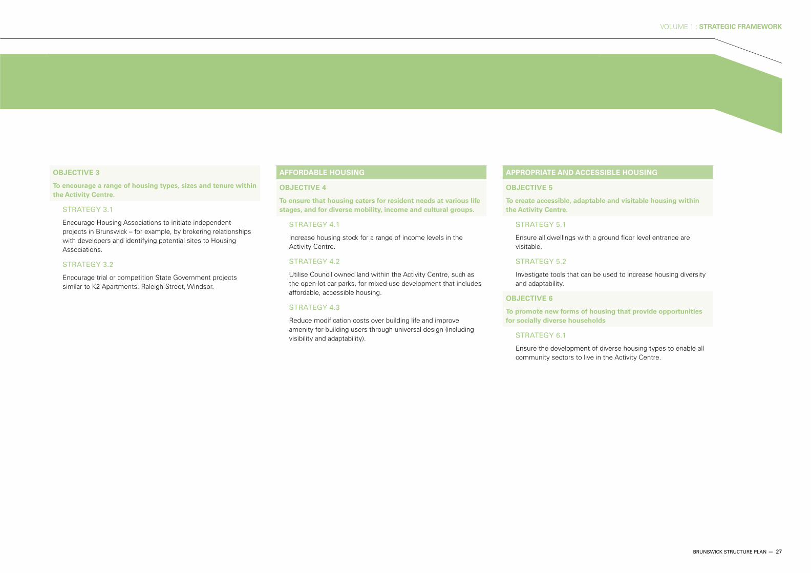
OBJECTIVE 3
To encourage a range of housing types, sizes and tenure within
the Activity Centre.
STRATEGY 3.1
Encourage Housing Associations to initiate independent projects in Brunswick – for example, by brokering relationships with developers and identifying potential sites to Housing Associations.
STRATEGY 3.2
Encourage trial or competition State Government projects similar to K2 Apartments, Raleigh Street, Windsor.
AFFORDABLE HOUSING
OBJECTIVE 4
To ensure that housing caters for resident needs at various life
stages, and for diverse mobility, income and cultural groups.
STRATEGY 4.1
Increase housing stock for a range of income levels in the Activity Centre.
STRATEGY 4.2
Utilise Council owned land within the Activity Centre, such as the open-lot car parks, for mixed-use development that includes affordable, accessible housing.
STRATEGY 4.3
Reduce modification costs over building life and improve amenity for building users through universal design (including visibility and adaptability).
APPROPRIATE AND ACCESSIBLE HOUSING
OBJECTIVE 5
To create accessible, adaptable and visitable housing within
the Activity Centre.
STRATEGY 5.1
Ensure all dwellings with a ground floor level entrance are visitable.
STRATEGY 5.2
Investigate tools that can be used to increase housing diversity and adaptability.
OBJECTIVE 6
To promote new forms of housing that provide opportunities
for socially diverse households
STRATEGY 6.1
Ensure the development of diverse housing types to enable all community sectors to live in the Activity Centre.

28 — BRUNSWICK STRUCTURE PLAN
VOLUME 1 : STRATEGIC FRAMEWORK
Housing development and open space access
Mixed use redevelopment
Albert and Victoria Axis
Primary east - west pedestrian link along urban renewal.
Activity corridor
Increase shop-top housing.
Adjacent neighbourhood activity centres
District park - improve access
Brunswick Central Parklands.
District park - improve access
Kirkdale Park, Sumner Park and Merri Creek Park.
Residential areas with poor access to public space
Indicative based on residences more than 300m from local park.
Future investigation area
Existing conditions
Tram line
Rail line
Train station
Study area
Waterways
Open space
MAP 5 : HOUSING
GUIDELINES : HOUSING DEVELOPMENT Refer to glossary for definitions of affordable, adaptable accessible housing.
Affordable housing At least 20 per cent of housing within private development and on Council owned-land should be affordable.
Adaptable housing 100 per cent of high density dwellings should be adaptable based on best practice – high density in this context being developments over 4 storeys or more than 15 dwellings.
The ground floor of all dwellings with no lift, within Local Area 1, 2 and 3, should be adaptable based on best practice.
Accessible housing 10 per cent of dwellings in development of six or more dwellings should be accessible.
RMIT University School of
Fashion and Textiles.

VOLUME 1 : STRATEGIC FRAMEWORK
BRUNSWICK STRUCTURE PLAN — 29
Jewell
Brunswick
Anstey
Moreland
NorthcoteGolf Links
AllardPark
JonesPark
RobertsReserve
CERES
FlemingPark
Merri Park
Merri CreekReserve
SumnerPark
BalfePark
MethvenPark
Barkly StPark
TemplePark
GilpinPark
Clifton Park
A G GillonOval
WarrPark
KirkdalePark
PhillipsReserve
Merri Creek
M
erri Creek
NIC
HO
LSO
N
STR
EE
T
LYG
ON
S
TRE
ET
SY
DN
EY
RO
AD
DAWSON STREET
UNION STREET
BRUNSWICK ROAD
GLENLYON ROAD
ALBERT STREET
VICTORIA STREET
STEWART STREET
ALBION STREET
BLYTH STREET
HO
LME
S
STR
EE
T
HOPE STREET
MORELAND ROAD
0 100 200 300 400 500

30 — BRUNSWICK STRUCTURE PLAN
VOLUME 1 : STRATEGIC FRAMEWORK
Designing for sustainable modes of transport and management of traffic and parking are critical issues for the Brunswick Activity Centre. Brunswick already has good public transport services with numerous tram and bus routes serving the area, and the Upfield rail corridor providing rail service. The key direction for transport and movement outlined in the Structure Plan is to see the majority of people arrive and move around the Activity Centre on foot, by bike or by using public transport.
The dominance of traffic within the centre will be reduced, with the objective of increasing the use of sustainable modes of transport. Streets will be enhanced as accessible, high-quality open space. Traffic will be managed to reduce congestion and parking will be located in appropriate places whilst not detracting from the area.
The east-west linkages within the Activity Centre will be strengthened to help balance the north-south nature of transport in the Activity Centre. In particular, improved walking and cycling links will be developed to form a network of interconnected pathways. This will improve transport and movement within the Activity Centre, and allow residents to better meet their transport needs.
4.3 TRANSPORT AND MOVEMENT

VOLUME 1 : STRATEGIC FRAMEWORK
BRUNSWICK STRUCTURE PLAN — 31
OBJECTIVE 1
To integrate development with land use and the public realm,
ensuring a range of transport alternatives that enable easy
access to the Activity Centre by residents, workers and visitors.
STRATEGY 1.1
Maintain a mix of land uses so that the Activity Centre serves a range of needs within walking and cycling distance, minimises the need for car trips, and encourages the combining of trips.
STRATEGY 1.2
Provide infrastructure and pedestrian priority as larger urban renewal areas are planned and redeveloped.
OBJECTIVE 2
To ensure that transport and movement networks in
Brunswick are integrated, equitable, efficient and sustainable.
STRATEGY 2.1
Establish links and circuits between and through open spaces as a network for walking and cycling, within and beyond the municipality.
STRATEGY 2.2
Promote the development of a fine-grained active movement network including well connected activity nodes in accordance with Map 7.
STRATEGY 2.3
Improve Brunswick’s movement system through new links and better pedestrian amenity.
OBJECTIVE 3
To develop good connections to adjoining suburbs for all
modes of alternative transport.
STRATEGY 3.1
Improve access to, from and within the centre for all active modes of transport, with a focus on alternatives to the car.
PEDESTRIANS
OBJECTIVE 4
To encourage local trips by foot or bicycle by providing safe
and convenient access between activity nodes.
STRATEGY 4.1
Develop strong pedestrian-oriented neighbourhoods in key urban renewal areas, including identified pedestrian-priority streets in accordance with Map 7.
STRATEGY 4.2
Improve the urban environment and street network to ensure safe, comfortable and efficient pedestrian routes.
STRATEGY 4.3
Provide high-quality pedestrian footpaths, seating, shade, shelter, water drinking fountains and street lighting on key walking routes, particularly those between public transport and major activity nodes.
STRATEGY 4.4
Ensure that good connections with multiple walking routes are provided to, from and within the centre and its activity nodes in accordance with Map 7.

32 — BRUNSWICK STRUCTURE PLAN
VOLUME 1 : STRATEGIC FRAMEWORK
PUBLIC TRANSPORT
OBJECTIVE 6
To reduce local car trips by providing a reliable public transport
system that is well-connected to local neighbourhoods and
pedestrian and cycling networks.
STRATEGY 6.1
Develop a fine-grained public transport network focusing on east-west movement including a possible minibus / shuttle bus service between activity nodes to discourage short vehicle trips.
STRATEGY 6.2
Develop transport interchanges adjacent to the four railway stations that will integrate trains, trams, buses, taxis, pedestrians and cyclists. Refer to Map 8.
STRATEGY 6.3
Advocate for Blue Orbital Smartbus route in line with the Moreland Integrated Transport Strategy.
STRATEGY 6.4
Provide and enhance bus and tram stops that are well located, safe and accessible.
STRATEGY 6.5
Ensure priority for tram and pedestrian amenity along the three main activity corridors.
CYCLING
OBJECTIVE 5
To ensure a safe, accessible and efficient cycling network
linking facilities within and outside of the Activity Centre.
STRATEGY 5.1
Ensure important routes are accessible and well marked for people with limited mobility.
STRATEGY 5.2
Ensure cycle paths are well-connected, visible, safe, accessible and well signed.
STRATEGY 5.3
Enhance existing pedestrian and cycling connections and provide new connections to public transport stops.
STRATEGY 5.4
Provide bicycle parking amenities in appropriate locations, including in the activity nodes and within new mixed use and office developments.
STRATEGY 5.5
Improve cycle path crossings at major roads to enhance the connections with cycling routes surrounding the Activity Centre.
STRATEGY 5.6
Upgrade the Upfield Shared Path as part of upgrading the transport interchanges.