Brownfield Land Registers Data Standard
40
Brownfield Land Registers Data Standard Vers 2 August 2017 Paul Davidson, CIO Sedgemoor District Council Director of Standards for iStandUK
Transcript of Brownfield Land Registers Data Standard

Brownfield Land Registers Data Standard
Vers 2
August 2017
Paul Davidson, CIO Sedgemoor District Council
Director of Standards for iStandUK

• Operating since 2006
– Formerly known as LeGSB
– All personnel are employees of local authorities, and central government departments.
– Board representatives from DCLG, DWP, LGA, SOCITM, NHS Digital, Government Digital Service, Various Councils.
• Funded by Central Government Departments – currently
– Department for Communities and Local Government (DCLG)
– Department for Work and Pensions (DWP)
– Projects with LGA
• Mission
– To promote Standards for Efficiency, Transformation, and Transparency of Local Services
– Bridging the Information Gap
• http://www.iStandUK.org
Introduction to iStandUK

Brownfield Land Register Data Standard
3
• Data Standard and Guidance published by DCLG – https://www.gov.uk/government/publications/brownfield-land-registers-data-
standard – Each ‘site’ in the register, is a row.
– All rows are ‘Part 1’ of the register, some rows are also ‘Part 2’.
– Each row has the same 28 columns
– Each column has a precise definition
– File name convention
– Licencing
• ‘How To’ guides produced by iStandUk
– How to find your URI
– How to check that your file is valid
– How to register the locations of your files
– … more?

… as defined in the regs …
• http://www.legislation.gov.uk/uksi/2017/403/schedule/2/made
4

Part 1 and Part 2
• Part1
- Part 1 of a brownfield land register will comprise all brownfield sites that a local planning
authority has assessed as appropriate for residential development, having carried out
any procedures such as consultation, which they consider appropriate. This will include
sites with extant full planning permission, outline planning permission and permission in
principle as well as sites without planning permission.
• Part2
- Part 2 is a subset of Part 1. Part 2 will comprise only those sites in Part 1 that the local
planning authority has decided that the land would be suitable for a grant of permission
in principle for residential development.
- Part 2 of the register will consist of further information entered in the columns:
• Part2
• NetDwellingsRangeFrom
• NetDwellingsRangeTo
… and where necessary: - NonHousingDevelopment - HazardousSubstances
5

Example of how a column is defined
6
Column Number 14
Column Name PermissionType
Field Type encoded list
Cardinality 1
Mandatory /
Optional?
Optional
A value must be given where the
‘PlanningStatus’ field contains the
value ‘permissioned’.
Definition The latest type of permission that has been granted on the site.
Validation One of:
•full planning permission
•outline planning permission
•reserved matters approval
•permission in principle
•technical details consent
•planning permission granted under an order
•other
Notes These terms are defined in paragraph 5 of Schedule 2 to the 2017 Regulations.
Where more than one permission exists for the site, identify the latest permission granted and any other permissions, including the date that such
permission was granted or deemed to have been granted, in the ’Notes’ column.
‘planning permission granted under an order’ means planning permission granted under a local development order, a mayoral development order or a
neighbourhood development order.

Building on existing standards for
open data
• Government Digital Service – open standards – Persistent Identifiers
– Dates
– Point Locations
• Local Government Association – open data schemas – Coordinate Reference Systems
– URIs
• Open Data Institute – Good CSV
7
SiteReference
8
Column Number 3
Column Name SiteReference
Field Type string
Cardinality 1
Mandatory /
Optional?
Mandatory
Definition A reference applied by the local authority to identify a site.
Validation Up to 50 characters.
Notes Unique to the local authority, but not necessarily nationally. This reference should be used consistently to identify the same site whilst it remains on future
versions of a register.
The reference may be reused from existing listings of sites such as the Strategic Housing Land Availability Assessment (SHLAA).
If a site is known by more than one reference, perhaps across different systems, these alternative references could be listed in an additional column. The
extra column could have a column heading of ‘AlternativeReferences’. It may be useful to prefix a reference with some initials to identify the local source
system e.g pa:1234.

PreviouslyPartOf
9
Column Number 4
Column Name PreviouslyPartOf
Field Type string
Cardinality 1
Mandatory /
Optional?
Optional
Definition The SiteReference that this site was previously a part of when reported on an earlier register.
Validation Up to 50 characters.
Notes This field will typically be blank.
Where an entry of land on the register is only partly permissioned, and where in the opinion of the local planning authority the remaining land should
have a separate entry in the register, this field may be used to link back to the original entry.
Using this field will promote the availability of the remaining part of the land.

SiteNameAddress
10
Column Number 5
Column Name SiteNameAddress
Field Type string
Cardinality 1
Mandatory /
Optional?
Mandatory
Definition The name and address of a site, which should be sufficient to describe its location.
Validation Up to 255 characters.
Notes This is a single line of text, which is not intended to be strictly structured. i.e. no need to put street name or town in a particular part.
Parts of the address may be separated using commas, in which case this field should be surrounded by double-quotes.

SiteplanURL
11
Column Number 6
Column Name SiteplanURL
Field Type URL
Cardinality 1
Mandatory /
Optional?
Mandatory
Definition A URL to a web page giving a site plan for the site.
Validation Web links will start with http:// or https://
Notes A good approach to this field will be a link to a GIS style web page showing the extent of the selected site, overlaid on a map. That page might also show
other related information and other geographic layers such as constraints.
It is also valid for the field to link to a static web page or document containing an image of the extent of the select site.
It is also acceptable, but less desirable, for the field to link to a common landing page for a GIS service, where the user would then have to enter more
information, such as the SiteReference, to then bring up the selected site.

CoordinateReferenceSystem
12
Column Number 7
Column Name CoordinateReferenceSystem
Field Type encoded list
Cardinality 1
Mandatory /
Optional?
Mandatory
Definition The Coordinate Reference System that is used for the fields ‘GeoX’ and ‘GeoY’.
Validation One of:
•WGS84
•OSGB36
•ETRS89
Notes The field must contain one of the following values:
•WGS84 (see http://en.wikipedia.org/wiki/WGS84) – version of latitude and longitude.
•OSGB36 (see http://en.wikipedia.org/wiki/Ordnance_Survey_National_Grid) – version of northing and easting.
•ETRS89 (see https://en.wikipedia.org/wiki/European_Terrestrial_Reference_System_1989) – version of longitude and latitude. This is the coordinate
reference system that is required for use with INSPIRE.
The Cabinet Office Open Standards Board have adopted a standard for expressing point locations in open data at
https://www.gov.uk/government/publications/open-standards-for-government/exchange-of-location-point
The adopted standard requires that points are expressed using the ETRS89 system, with an option to use the WGS84 system where a reduced level of
precision is acceptable. Therefore, although this field has three options, local authorities should use the ETRS89 system.
The Ordnance Survery provide a web facility to transform a batch of coordinates in OSGB36, to ETRS89, at
https://www.ordnancesurvey.co.uk/gps/transformation/batch
If a publisher wishes to also publish OSGB36 coordinates, extra columns can be added for
•Easting
•Northing

GeoX
13
Column Number 8
Column Name GeoX
Field Type number
Cardinality 1
Mandatory /
Optional?
Mandatory
Definition Longitude or east grid reference for the visual centroid of the site boundary.
Validation A decimal number.
Notes A Longitude will typically be stated to 6 decimal places of a degree.
An Easting will typically be a whole number, or with up to 2 decimal places.

GeoY
14
Column Number 9
Column Name GeoY
Field Type number
Cardinality 1
Mandatory /
Optional?
Mandatory
Definition Latitude or north grid reference for visual of application boundary.
Validation A decimal number.
Notes A Latitude will typically be stated to 6 decimal places of a degree.
A Northing will typically be a whole number, or with up to 2 decimal places.

Hectares
15
Column Number 10
Column Name Hectares
Field Type number
Cardinality 1
Mandatory /
Optional?
Mandatory
Definition The size of the land in hectares.
Validation A decimal number with up to 2 decimal places.
Notes

OwnershipStatus
16
Column Number 11
Column Name OwnershipStatus
Field Type encoded list
Cardinality 1
Mandatory /
Optional?
Mandatory
Definition The ownership status of the land.
Validation One of:
•owned by a public authority
•not owned by a public authority
•mixed ownership
•unknown ownership
Notes These terms are defined in paragraph 5 of Schedule 2 to the 2017 Regulations.

Deliverable
17
Column Number 12
Column Name Deliverable
Field Type encoded list
Cardinality 1
Mandatory / Optional? Optional
Must be completed where
relevant
Definition To indicate if the land is 'Deliverable'.
Validation One of:
•yes
Notes Where the land is ‘deliverable’ the value ‘yes’ must be selected.
‘Deliverable’ is defined in paragraph 5 to Schedule 2 of the 2017 Regulations as, “there is a reasonable prospect that residential development will
take place on the land within 5 years beginning with the entry date”.

PlanningStatus
18
Column Number 13
Column Name PlanningStatus
Field Type encoded list
Cardinality 1
Mandatory /
Optional?
Mandatory
Definition To indicate the stage, if any, that has been reached in the planning process for the site.
Validation One of:
•permissioned
•not permissioned
•pending decision
Notes This field is helpful to monitor the progress of individual sites as they appear on successive versions of a register, and to derive statistics.
These terms are defined in paragraph 5 of Schedule 2 of the 2017 Regulations.
Where part of a site is permissioned, it should be recorded as ‘permissioned’ here, and the Notes field used to explain why it is only partly
permissioned.

PermissionType
19
Column Number 14
Column Name PermissionType
Field Type encoded list
Cardinality 1
Mandatory /
Optional?
Optional
A value must be given where the
‘PlanningStatus’ field contains the
value ‘permissioned’.
Definition The latest type of permission that has been granted on the site.
Validation One of:
•full planning permission
•outline planning permission
•reserved matters approval
•permission in principle
•technical details consent
•planning permission granted under an order
•other
Notes These terms are defined in paragraph 5 of Schedule 2 to the 2017 Regulations.
Where more than one permission exists for the site, identify the latest permission granted and any other permissions, including the date that such
permission was granted or deemed to have been granted, in the ’Notes’ column.
‘planning permission granted under an order’ means planning permission granted under a local development order, a mayoral development order or a
neighbourhood development order.

PermissionDate
20
Column Number 15
Column Name PermissionDate
Field Type date
Cardinality 1
Mandatory /
Optional?
Optional
A value must be given where the
‘PlanningStatus’ field contains the
value ‘permissioned’.
Definition The date permission was granted for the permission set out in the field ‘PermissionType’.
Validation A valid date in the form yyyy-mm-dd.
Notes

PlanningHistory
21
Column Number 16
Column Name PlanningHistory
Field Type URL
Cardinality many
Mandatory /
Optional?
Optional
Definition Links to webpages giving information about the planning history of the site.
Validation Web links will start with http:// or https://. If more than one link is given, they should be separated by the pipe character (|).
Notes Avoid links to history which is not relevant to the site in its brownfield state.

ProposedForPIP
22
Column Number 17
Column Name ProposedForPIP
Field Type encoded list
Cardinality 1
Mandatory /
Optional?
Optional
Must be completed where
relevant.
Definition To indicate if the site has been proposed for residential development (permission in principle).
Validation One of:
•yes
Notes ‘yes’ means that the land is proposed for residential development (permission in principle).
This field must be completed within 7 days of the local authority displaying a site notice under regulation 6(1) of the 2017 Regulations where -
(a) land has been entered in Part 1; and,
(b) first publication of Part 1, (in accordance with paragraph (2) of regulation 3 of the 2017 Regulations), has taken place.
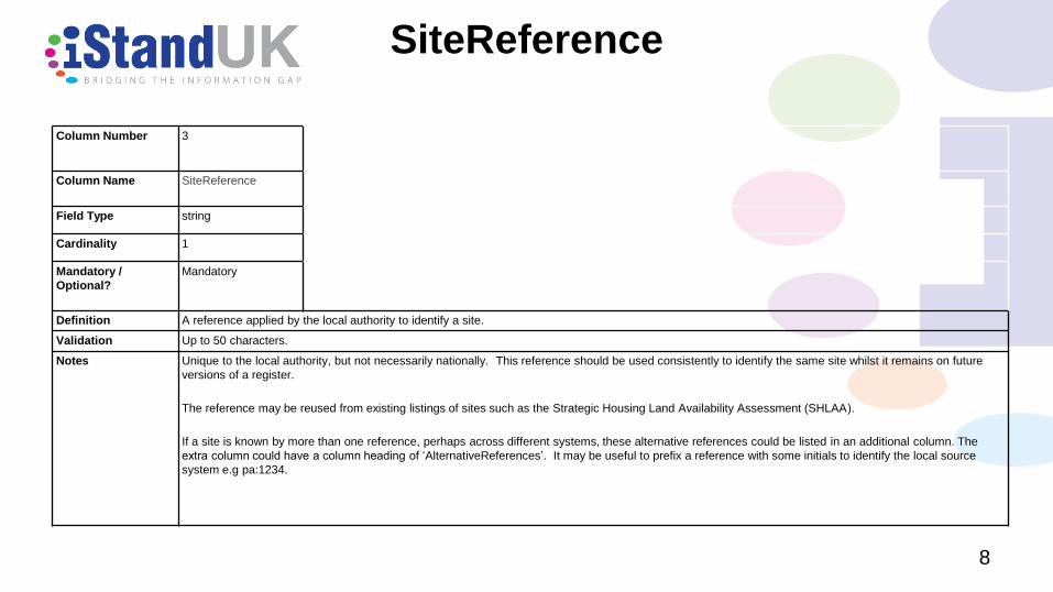
MinNetDwellings
23
Column Number 18
Column Name MinNetDwellings
Field Type number
Cardinality 1
Mandatory /
Optional?
Mandatory
Definition The minimum net number of dwellings that the local authority estimates the site should support.
Validation
Notes This could be:
•the number of homes planning permission has been granted for.
•the minimum number of the range expressed in NetDwellingsRangeFrom
•an estimate based on a density calculation undertaken by the authority.
The ‘minimum net number of dwellings’ is defined in regulation 2 of the 2017 Regulations.

DevelopmentDescription
24
Column Number 19
Column Name DevelopmentDescription
Field Type text
Cardinality 1
Mandatory /
Optional?
Optional
Must be completed where relevant.
Definition A description of any proposed housing development.
Validation Up to 4000 characters.
Notes A description of any proposed housing development will need to be given here for all sites in Part 1 of the register where there are no values in the
NetDwellingsRangeFrom and NetDwellingRangeTo fields. This will include sites that have planning permission for a prescribed amount of housing
development. This does not include sites with a grant of Permission in principle through their inclusion on (Part 2 of the register)

NonHousingDevelopment
25
Column Number 20
Column Name NonHousingDevelopment
Field Type text
Cardinality 1
Mandatory /
Optional?
Optional.
Must be completed where relevant.
Definition A description of any proposed non-housing development
Validation Up to 4000 characters.
Notes Must be completed for all relevant sites in Part 1 where the development includes non-housing development, and provide a description of the
type, including an indication of the use of the buildings or land, and the scale of any such development.
For the purposes of section 59 of the Town and Country Planning Act 1990, to allocate land for residential development in a brownfield land
register, the register must contain a value in this field, in relation to each entry of land in Part 2 where the development includes non-housing
development, and provide a description of the type, including an indication of the use of the buildings or land, and the scale of any such
development.

Part2
26
Column Number 21
Column Name Part2
Field Type encoded list
Cardinality 1
Mandatory /
Optional?
Optional
Must be completed where
relevant.
Definition To indicate that a site is in Part 2 of the register.
Validation One of:
•yes
Notes ‘yes’ is to mean that the site has been allocated for residential development for the purposes of section 59A of the Town and Country Planning Act 1990
(permission in principle).
Where land is entered in Part 2 of the register, where there is a ‘yes’ value in the ProposedForPiP field, this must be removed. That means, if this field is
set to ‘yes’, the ProposedForPIP field must be blank.

NetDwellingsRangeFrom
27
Column Number 22
Column Name NetDwellingsRangeFrom
Field Type number
Cardinality 1
Mandatory /
Optional?
Optional
Must be completed where relevant.
Definition The minimum net number of dwellings which, in the authority’s opinion, the land is capable of supporting.
Validation
Notes This field must be completed for all entries in Part 1 of the register where the DevelopmentDescription field has not been completed.
For the purposes of section 59 of the Town and Country Planning Act 1990, to allocate land for residential development in a brownfield land
register, the register must contain a value in this field, in relation to each entry of land in Part 2
The ‘minimum net number of dwellings’ is defined in regulation 2 of the 2017 Regulations.
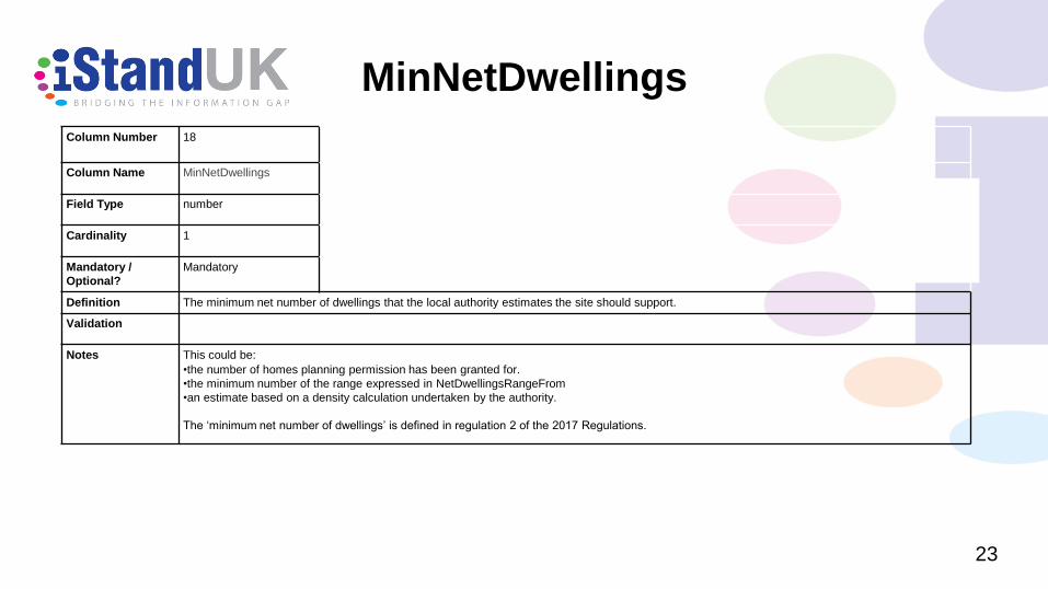
NetDwellingsRangeTo
28
Column Number 23
Column Name NetDwellingsRangeTo
Field Type number
Cardinality 1
Mandatory /
Optional?
Optional.
Must be completed where
relevant.
Definition The maximum net number of dwellings which, in the authority’s opinion, the land is capable of supporting.
Validation
Notes This field must be completed for all entries in Part 1 of the register where the DevelopmentDescription field has not been completed.
For the purposes of section 59 of the Town and Country Planning Act 1990, to allocate land for residential development in a brownfield land register,
the register must contain a value in this field, in relation to each entry of land in Part 2
The ‘maximum net number of dwellings’ is defined in regulation 2 of the 2017 Regulations.

HazardousSubstances
29
Column Number 24
Column Name HazardousSubstances
Field Type encoded list
Cardinality 1
Mandatory /
Optional?
Optional
Must be completed where relevant.
Definition To indicate the presence of certain characteristics of the site.
Validation One of:
•yes
Notes This field is to indicate, as set out in paragraph 3 of Schedule 2 to the 2017 Regulations, the information required by regulation 26(3) of the
Planning (Hazardous Substances) Regulations 2015 SI 2015/627 for sites in Part 2 of the register, that the:
• development of that land would, in the opinion of the local planning authority, be a relevant project for the purpose of regulation 26 of the Planning
(Hazardous Substances) Regulations 2015; … and
•the local planning authority is the competent authority for the purpose of that regulation.
Where this field has a value, use the SiteInformation field to record one or more links to the associated information.

SiteInformation
30
Column Number 25
Column Name SiteInformation
Field Type URL
Cardinality many
Mandatory /
Optional?
Optional.
Must be completed where
relevant.
Definition Links to webpages giving further information about the site.
Validation Web links will start with http:// or https://. If more than one link is given, they should be separated by the pipe character (|).
Notes Where the Indicators field includes ‘hazardous substances’, this field must contain one or more links to the information required by paragraph
(3) of regulation 26 of the Planning (Hazardous Substances) Regulations 2015.

Notes
31
Column Number 26
Column Name Notes
Field Type text
Cardinality 1
Mandatory /
Optional?
Optional
Definition General information about a site and its entry on the register.
Validation Up to 4000 characters.
Notes Information that developers might find useful, such as:
•Where permission in principle has been granted, aspects of the technical details consent application that the local planning authority would expect to
see can be provided
•Details of planning permissions, including the date that such permission was granted or deemed to have been granted, where more than one exists for
a site
•Where part of a site is permissioned,and has been recorded as ‘permissioned’ in the ‘PlanningStatus’ field, an explanation of why it is only partly
permissioned can be recorded here
•Any other information relevant to the development of the site

FirstAddedDate
32
Column Number 27
Column Name FirstAddedDate
Field Type date
Cardinality 1
Mandatory /
Optional?
Mandatory
Definition The date that the site was first added to the register.
Validation A valid date in the form yyyy-mm-dd.
Notes

LastUpdatedDate
33
Column Number 28
Column Name LastUpdatedDate
Field Type date
Cardinality 1
Mandatory /
Optional?
Mandatory
Definition The date that information about the site was last updated.
Validation A valid date in the form yyyy-mm-dd.
Notes If information about the site has not been updated since first being added to the register, this should repeat the ‘FirstAddedDate’ field.

OrganisationLabel
34
Column Number 2
Column Name OrganisationLabel
Field Type string
Cardinality 1
Mandatory /
Optional?
Mandatory
Definition The name of the local authority that is identified using the OrganisationURI.
Validation Up to 100 characters.
Notes This should be laid out as per the authority’s preference, for example
Sedgemoor District Council.
This field will be repeated for every row in a register that refers to the same local authority.

OrganisationURI
35
Column Number 1
Column Name OrganisationURI
Field Type URL
Cardinality 1
Mandatory /
Optional?
Mandatory
Definition To identify the Local Authority within whose area the parcel of land lies.
Validation These URIs all start with ‘http://opendatacommunities.org/id/’. For example, the URI for Sedgemoor District Council is
http://opendatacommunities.org/id/district-council/sedgemoor
Notes The OrganisationURI must be selected from a list of existing URIs, provided by DCLG.
iStandUK provide some guidance about how to find the right URI.
The Local Government Association provide a simple tool to find the right URI for a local authority at http://uris.opendata.esd.org.uk/.
This field will be repeated for every row in a register that refers to the same local authority.
Some files may be compiled for a partnership of councils, in which case there will be more than one OrganisationURI throughout the file.
These URIs are useful as they can be looked up to give more structured information about a local authority, including for example, the coordinates of its
boundary. Using URIs in this way can give valuable information that app developers can use to provide a rich linked view of information, which is otherwise not
contained in the register.
Where land is spread across local authority boundaries, each local planning authority must enter into the register that part of land within its own boundaries, taking
into account the criteria in the 2017 Regulations.

Example – Part 1
36
Header row column name Data row example data Points to note.
OrganisationURI http://opendatacommunities.org/id/district-council/examplecouncil
OrganisationLabel Example District Council
SiteReference B123
PreviouslyPartOf
SiteNameAddress “Land at rear of High Street, Test Town” As this contains a comma, the field is surrounded by double-
quotes.
SiteplanURL http://www.example.gov.uk/siteview.html?siteref=B123 Illustrating how a deep link might be given to present a
brownfield site map in a GIS style web page.
CoordinateReferenceSystem ETRS89
GeoX 7.300345
GeoY 49.958888
Hectares 5.25
OwnershipStatus public ownership Must use one of the permitted values for this field.
Deliverable yes Must use one of the permitted values for this field.
PlanningStatus permissioned Must use one of the permitted values for this field.
PermissionType outline planning permission This field must have a value when ‘PlanningStatus’ is set to
‘permissioned’.
Must use one of the permitted values for this field.
PermissionDate 2017-12-01 This field must have a value when ‘PlanningStatus’ is set to
‘permissioned’.
Must be in the form yyyy-mm-dd.
PlanningHistory http://www.example.gov.uk/planning/applications?appref=abc123

Example – Part 1 ( continued)
37
ProposedforPIP
MinNetDwellings 50
DevelopmentDescription “Erection of 25, two-storey two bedroom semi-detached houses.
1 block containing 25 x one bedroom flats.
Change of class from Sui generis to C3”
As this information contains a new line, it is surrounded by
double-quotes.
NonHousingDevelopment
Part2
NetDwellingsRangeFrom
NetDwellingsRangeTo
HazardousSubstances
SiteInformation
Notes “Former scrap yard use, assessment of land contamination completed.
A site allocation in accordance with the “xxx development plan.””
As this information contains a new line, a comma, and double-
quotes, it is surrounded by double-quotes.
The double-quotes in the text then need to be repeated.
FirstAddedDate 2017-11-10 Note the format of date.
LastUpdatedDate 2017-11-10 The information has not been amended since it first appeared on
the register.

Example – Part 2
38
Header row column name Data row example data Points to note.
OrganisationURI http://opendatacommunities.org/id/county-council/examplecouncil
OrganisationLabel Example County Council
SiteReference C123
PreviouslyPartOf
SiteNameAddress “Land next to Example Lane, Test Village” As this contains a comma, the field is surrounded by double-
quotes.
SiteplanURL http://www.example.gov.uk/siteview.html?siteref=C123 Illustrating how a deep link might be given to present a brownfield
site map in a GIS style web page.
CoordinateReferenceSystem ETRS89
GeoX 1.009012
GeoY 70.123665
Hectares 2.25
OwnershipStatus mixed ownership Must use one of the permitted values for this field.
Deliverable yes Must use one of the permitted values for this field.
PlanningStatus permissioned Must use one of the permitted values for this field.
PermissionType permission in principle This field must have a value when ‘PlanningStatus’ is set to
‘permissioned’.
For Part 2 entries the value must be ‘permission in principle’.
PermissionDate 2017-08-10 This field must have a value when ‘PlanningStatus’ is set to
‘permissioned’.
Must be in the form yyyy-mm-dd.
PlanningHistory http://www.example.gov.uk/planning/applications?appref=C123

Example – Part 2 (continued)
39
ProposedforPIP
If previously proposed for permission in principle, this field must be
changed to blank for Part 2 entries.
MinNetDwellings 10
DevelopmentDescription
NonHousingDevelopment “Class D2 - Outdoor recreational space 1002
m.”
Part2 yes
NetDwellingsRangeFrom 10
NetDwellingsRangeTo 20
HazardousSubstances hazardous substances
SiteInformation http://www.example.gov.uk/planning/applications?appref=C123
Notes “Where permission in principle is granted, aspects of the technical details
consent application that the local planning authority would expect to see can
be provided.
Any other information relevant to the development of the site.”
As this information contains a new line, a comma, and double-
quotes, it is surrounded by double-quotes.
The double-quotes in the text then need to be repeated.
FirstAddedDate 2017-07-01 Note the format of date.
LastUpdatedDate 2017-08-17 The information has been amended since it first appeared on the
register.

Thank you
40
Paul Davidson
- Director of Standards for iStandUK
- http://www.iStandUK.org