Brief State of the Art - Semantic Web technologies for geospatial data - Modelling and...
35
Presentation Ana ROXIN
-
Upload
ana-roxin -
Category
Presentations & Public Speaking
-
view
75 -
download
1
Transcript of Brief State of the Art - Semantic Web technologies for geospatial data - Modelling and...

PresentationAna ROXIN
/ 352
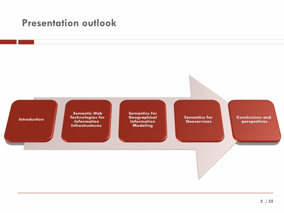
Presentation outlook
/37
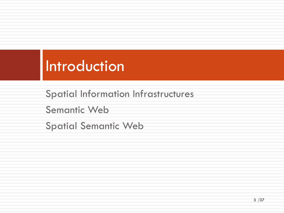
Spatial Information Infrastructures
Semantic Web
Spatial Semantic Web
Introduction
3

/ 35
Introduction – Spatial Information Infrastructures
4
Goals
• Discover resources (data and services)
• Access data (for both vector and coverage data)
• Use data
• Visualize data according to given rules
• Harmonize and integrate data
• Orchestration
Challenges
• Inconsistent data
• Naming conflicts
• Scale conflicts
• Precision or resolution conflicts
• Constraint conflicts
• Data value conflicts
• Multilinguality
• Multiple representations
• Reference systems and units of measure
• Etc.

/ 355
Introduction – The Semantic Web

/ 356
Introduction – The Spatial Semantic Web
Spatial data community
• Ontologies for describing spatial data
• Formally defined and shared semantics
• Handling of heterogeneous spatial features
Semantic Web community
• Spatial information as a context provider
• Data validity
• Temporal information

/377

/ 358
Semantic Web Technologies for Information
Infrastructures

/ 359
A growing demand for interoperability
< 1970s
• Mainframe computing
• Centralized perspective
1980s
• First revolution: advent of personal computer
• Data interoperability becomes an issue
1990s
• Second revolution: advent of Internet
• Need for more principled mechanisms to ensure interoperability
/ 3510
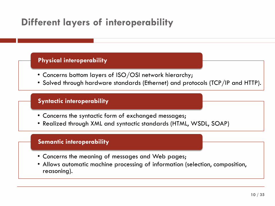
Different layers of interoperability
• Concerns bottom layers of ISO/OSI network hierarchy;
• Solved through hardware standards (Ethernet) and protocols (TCP/IP and HTTP).
Physical interoperability
• Concerns the syntactic form of exchanged messages;
• Realized through XML and syntactic standards (HTML, WSDL, SOAP)
Syntactic interoperability
• Concerns the meaning of messages and Web pages;
• Allows automatic machine processing of information (selection, composition, reasoning).
Semantic interoperability
/ 3511
Ontologies as building bricks for the Semantic Web
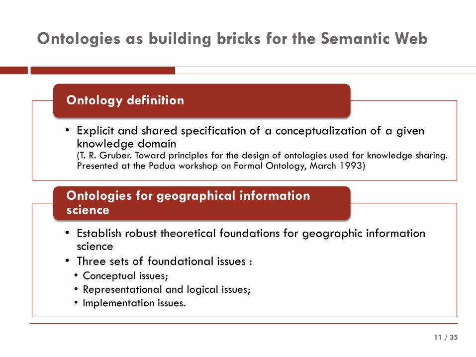
• Explicit and shared specification of a conceptualization of a given knowledge domain (T. R. Gruber. Toward principles for the design of ontologies used for knowledge sharing. Presented at the Padua workshop on Formal Ontology, March 1993)
Ontology definition
• Establish robust theoretical foundations for geographic information science
• Three sets of foundational issues :• Conceptual issues;
• Representational and logical issues;
• Implementation issues.
Ontologies for geographical information science
/ 3512
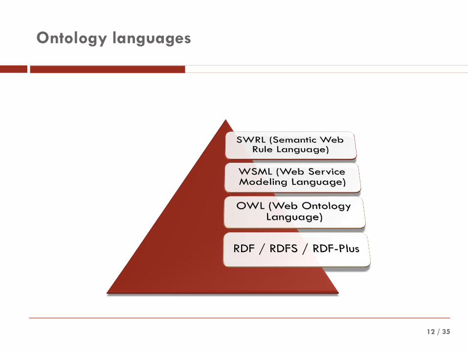
Ontology languages
/ 3513
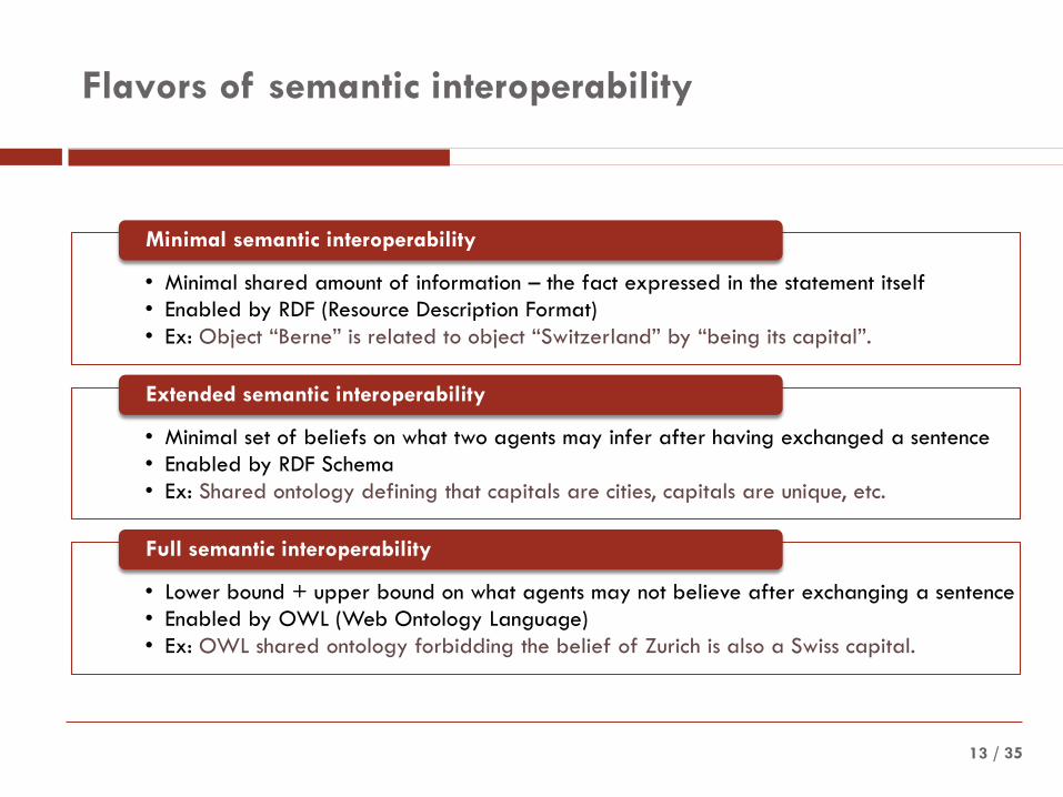
Flavors of semantic interoperability
• Minimal shared amount of information – the fact expressed in the statement itself
• Enabled by RDF (Resource Description Format)
• Ex: Object “Berne” is related to object “Switzerland” by “being its capital”.
Minimal semantic interoperability
• Minimal set of beliefs on what two agents may infer after having exchanged a sentence
• Enabled by RDF Schema
• Ex: Shared ontology defining that capitals are cities, capitals are unique, etc.
Extended semantic interoperability
• Lower bound + upper bound on what agents may not believe after exchanging a sentence
• Enabled by OWL (Web Ontology Language)
• Ex: OWL shared ontology forbidding the belief of Zurich is also a Swiss capital.
Full semantic interoperability

/ 3514
Building bricks of the Semantic Web architecture
/ 3515
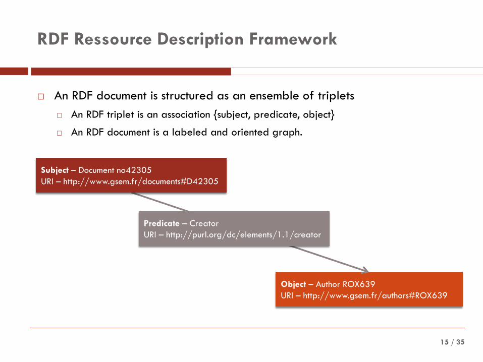
RDF Ressource Description Framework
An RDF document is structured as an ensemble of triplets
An RDF triplet is an association {subject, predicate, object}
An RDF document is a labeled and oriented graph.
Object – Author ROX639
URI – http://www.gsem.fr/authors#ROX639
Predicate – Creator
URI – http://purl.org/dc/elements/1.1/creator
Subject – Document no42305
URI – http://www.gsem.fr/documents#D42305
/ 3516
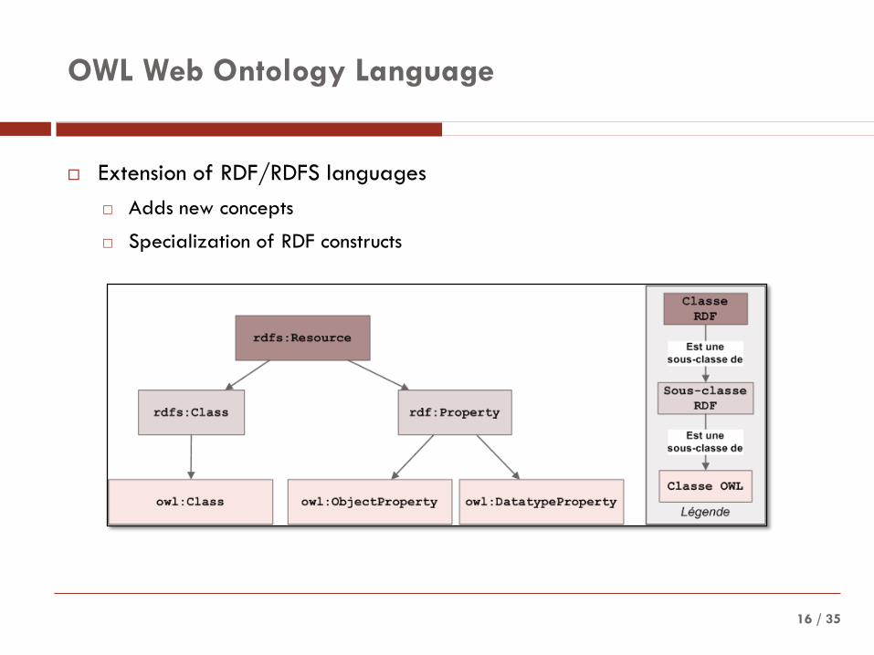
OWL Web Ontology Language
Extension of RDF/RDFS languages
Adds new concepts
Specialization of RDF constructs

/ 3517
Example – DBpedia Relation Finder
http://relfinder.dbpedia.org/relfinder.html
/3718
/ 3519
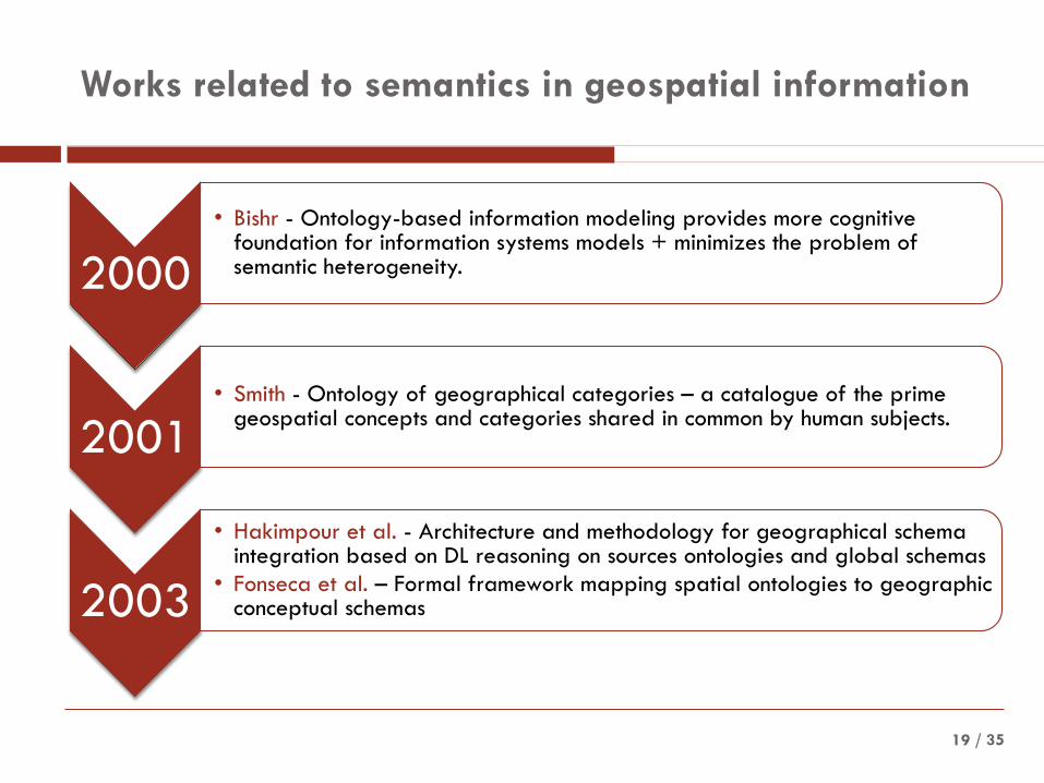
Works related to semantics in geospatial information
2000
• Bishr - Ontology-based information modeling provides more cognitive foundation for information systems models + minimizes the problem of semantic heterogeneity.
2001• Smith - Ontology of geographical categories – a catalogue of the prime
geospatial concepts and categories shared in common by human subjects.
2003
• Hakimpour et al. - Architecture and methodology for geographical schema integration based on DL reasoning on sources ontologies and global schemas
• Fonseca et al. – Formal framework mapping spatial ontologies to geographic conceptual schemas

/ 3520
Works related to semantics in geospatial information
2004
• Hess and Iochpe – Methodology for semantic integration of geographic conceptual schemas;
• Rodriguez and Egenhofer – Technique for calculating semantic similarity among spatial entities (Matching Distance Similarity Measure).
2005
• Schwering and Raubal – Query method based on spatial relations for integration of information sources (shared vocabulary mapped to ontologies);
• Sotnykova et al. – Methodology for integration of spatio-temporal schemas, based on the MADS-compliant source ontology (translated into OWL DL).
2006
• Stoimenov et al. – Implementation of semantic mediators acting access points for several independent geoinformation sources;
• Aerts et al. – Methodology for topographic databases integration based on OWL ontologies.
/ 3521
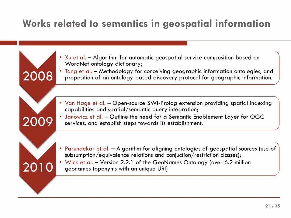
Works related to semantics in geospatial information
2008
• Xu et al. – Algorithm for automatic geospatial service composition based on WordNet ontology dictionary;
• Tang et al. – Methodology for conceiving geographic information ontologies, and proposition of an ontology-based discovery protocol for geographic information.
2009
• Van Hage et al. – Open-source SWI-Prolog extension providing spatial indexing capabilities and spatial/semantic query integration;
• Janowicz et al. – Outline the need for a Semantic Enablement Layer for OGC services, and establish steps towards its establishment.
2010
• Parundekar et al. – Algorithm for aligning ontologies of geospatial sources (use of subsumption/equivalence relations and conjuction/restriction classes);
• Wick et al. – Version 2.2.1 of the GeoNames Ontology (over 6.2 million geonames toponyms with an unique URI)
/ 35
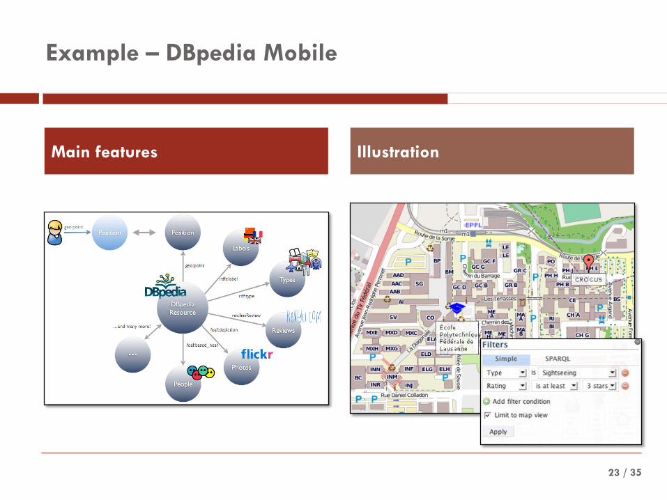
Example – DBpedia Mobile
23
Main features Illustration

/3724
/ 3525
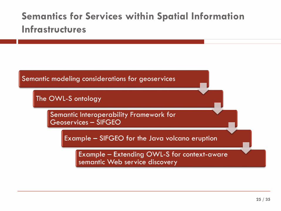
Semantics for Services within Spatial Information
Infrastructures

/ 3526
Semantic modeling considerations for geoservices
• Common ground of ontological concepts to which semantic descriptions of services should refer.
Semantic interoperability frameworks
• Geoservices perform geo-operations on various representations of features (spatial, temporal and thematic dimensions)
Geoservices
• Ontology-based :• Classification of geo-operation functionality;
• Description of operation input and output parameter types;
• Description of geodata that are tightly coupled to the service;
• Description of the control flow in (virtual) composite operations.
Semantic description of geoservices

/ 3527
The OWL-S ontology
Discovery
InteractionExecution
/ 35
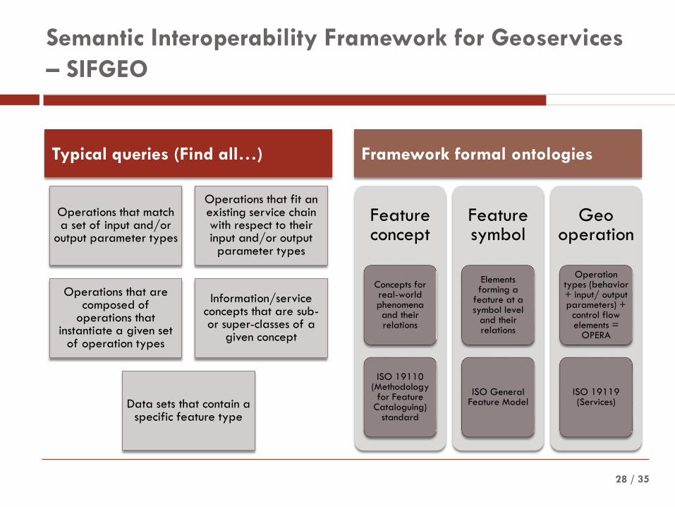
Semantic Interoperability Framework for Geoservices
– SIFGEO
Operations that match a set of input and/or
output parameter types
Operations that fit an existing service chain with respect to their input and/or output
parameter types
Operations that are composed of
operations that instantiate a given set
of operation types
Information/service concepts that are sub-or super-classes of a
given concept
Data sets that contain a specific feature type
Feature concept
Concepts for real-world phenomena and their relations
ISO 19110 (Methodology
for Feature Cataloguing)
standard
Feature symbol
Elements forming a
feature at a symbol level
and their relations
ISO General Feature Model
Geooperation
Operation types (behavior + input/ output parameters) +
control flow elements =
OPERA
ISO 19119 (Services)
28
Typical queries (Find all…) Framework formal ontologies

/ 3529
Example – SIFGEO for the Java volcano eruption – 1
Scope: create a service chain to identify the extent of mud eruption
Input: 3 SPOT images from the volcano eruption
Step 1: Creating the services
SPOT image 1 SPOT image 2 SPOT image 3
Band rationing service
= distinguish land-mud
boundaries
Slicing service
= land-mud pixels’
classification
Cross service
= combining land-mud
coverages into one
Impact service
= impact area calculus
for 2 eruption periods
/ 3530
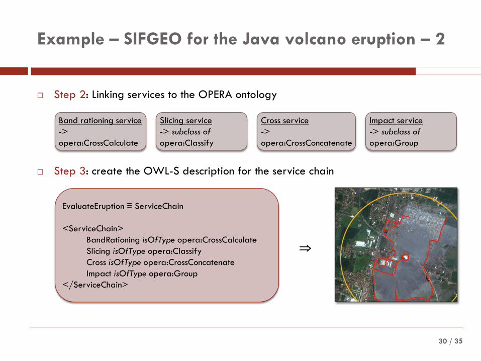
Example – SIFGEO for the Java volcano eruption – 2
Step 2: Linking services to the OPERA ontology
Step 3: create the OWL-S description for the service chain
Band rationing service
->
opera:CrossCalculate
Slicing service
-> subclass of
opera:Classify
Cross service
->
opera:CrossConcatenate
Impact service
-> subclass of
opera:Group
EvaluateEruption ≡ ServiceChain
<ServiceChain>
BandRationing isOfType opera:CrossCalculate
Slicing isOfType opera:Classify
Cross isOfType opera:CrossConcatenate
Impact isOfType opera:Group
</ServiceChain>

/ 35
Example – Extending OWL-S for context-aware
semantic Web service discovery – 1
31
Service
ServiceProfile
ServiceModel
ServiceGrounding
ServiceContext
ECommerceService
xsd:float
InformationService
PersonalService
EmergencyService
xsd:boolean
hasValue*

/ 3532
Example – Extending OWL-S for context-aware
semantic Web service discovery – 2
/3733

/ 35
Geographic information
• Development of SII
• Risk of condemning the GI community to a specialist backwater.
• Semantic Web technologies
• Useful, interesting
• Difficult to integrate
• Geosemantic interoperability relies on standards
Geosemantics
• Geo ontology
• Feature ontology
• Feature type ontology
• Spatial relationship ontology
• Toponym ontology
• Coordinate reference/spatial index ontology
• Geodata set/metadata ontology
• Spatial services ontology
Standardization
• Critical for SII
• SII must support the evolution of geosemantics
• Geosemantic standards are not completely “hopeless without,” but they are at least quite urgently “nice to have.”
34
Conclusion and perspectives