Annual Report of the Municipal Officers of Bridgewater For ...
Upload
duongthuanCategory
view
218download
4
BRIDGEWATER
MUNICIPAL PLAN
2008
Adopted January 22, 2008
This Plan was developed by the Bridgewater Planning Commission with assistance from
Two Rivers - Ottauquechee Regional Commission, Woodstock, Vermont, partially funded by a Municipal Planning Grant from
the Vermont Agency of Commerce and Community Development

Bridgewater Municipal Plan 2008 Adopted January 22, 2008
TABLE OF CONTENTS
INTRODUCTION ........................................................................................................................................... 1 THE TOWN SETTING ...................................................................................................................................... 1 TOWN HISTORY ............................................................................................................................................. 2 RECENT DEVELOPMENTS............................................................................................................................... 5
MUNICIPAL PLANS IN VERMONT .......................................................................................................... 9 THE BRIDGEWATER MUNICIPAL PLAN........................................................................................................... 9
MUNICIPAL BYLAWS ............................................................................................................................... 11
TOWN SERVICES AND FACILITIES...................................................................................................... 12 SEWAGE FACILITIES .................................................................................................................................... 12 SOLID WASTE DISPOSAL ............................................................................................................................. 12 EMERGENCY SERVICES................................................................................................................................ 14 FIRE PROTECTION........................................................................................................................................ 15 RECREATION................................................................................................................................................ 15 SNOWMOBILE TRAILS AND TRAVEL............................................................................................................. 15 APPALACHIAN TRAIL CORRIDOR .................................................................................................................. 16 EDUCATION ................................................................................................................................................. 16 CHILD CARE ................................................................................................................................................ 18 ECONOMY.................................................................................................................................................... 18 RICHARD SOUTHGATE HOUSE/TOWN OFFICES ............................................................................................ 18
HOUSING ...................................................................................................................................................... 20 BACKGROUND ............................................................................................................................................. 20 HOUSING AFFORDABILITY........................................................................................................................... 20
THE USE OF LAND IN BRIDGEWATER................................................................................................ 25 SETTLEMENT AND LAND USE PATTERNS ..................................................................................................... 25 PROPOSED LAND USE IN BRIDGEWATER...................................................................................................... 25 PROPOSED LAND USE MAP.......................................................................................................................... 26 GENERAL VILLAGE AND HAMLET SETTLEMENT PATTERNS......................................................................... 27 BRIDGEWATER VILLAGE.............................................................................................................................. 27 THE HAMLETS ............................................................................................................................................. 28 BRIDGEWATER CORNERS............................................................................................................................. 29 BRIDGEWATER CENTER ............................................................................................................................... 29 WEST BRIDGEWATER .................................................................................................................................. 29 RURAL AREAS ............................................................................................................................................. 30 CHATEAUGUAY – DAILEY HOLLOW CONSERVATION AREA ........................................................................ 32 PLANNED RESIDENTIAL DEVELOPMENT ...................................................................................................... 36
CRITICAL AREAS....................................................................................................................................... 37 STEEP SLOPES.............................................................................................................................................. 37 HIGH ELEVATIONS....................................................................................................................................... 37 SHALLOW AND WET SOILS .......................................................................................................................... 38 FLOOD-PRONE AREAS ................................................................................................................................. 39 SURFACE WATERS....................................................................................................................................... 39 WETLANDS .................................................................................................................................................. 41 CRITICAL WILDLIFE HABITAT ..................................................................................................................... 41
Bridgewater Municipal Plan 2008 Adopted January 22, 2008
AGRICULTURAL AND FORESTRY RESOURCES............................................................................... 43 EARTH RESOURCES EXTRACTION ................................................................................................................ 43
TRANSPORTATION PLAN........................................................................................................................ 45 EXISTING HIGHWAY AND ROADS................................................................................................................. 45 FUNCTIONAL CLASSIFICATION OF TOWN ROADS......................................................................................... 46 TOWN HIGHWAYS........................................................................................................................................ 46 U.S. ROUTE 4 .............................................................................................................................................. 47 PUBLIC TRANSPORTATION........................................................................................................................... 49 ROAD AND CULVERT MANAGEMENT........................................................................................................... 50 SAFETY PLANNING AND ENFORCEMENT ...................................................................................................... 50
ENERGY PLANNING AND CONSERVATION....................................................................................... 52 BACKGROUND ............................................................................................................................................. 52
PLANNING FOR TELECOMMUNICATIONS FACILITIES................................................................ 55 BACKGROUND ............................................................................................................................................. 55
AESTHETICS AND OUTDOOR LIGHTING........................................................................................... 58 ISSUES AND OPPORTUNITIES ....................................................................................................................... 58
BRIDGEWATER'S PLANNING AND ITS RELATIONSHIP TO OTHER PLANNING ACTIVITIES61 KEEPING THE PLAN REALISTIC AND RELEVANT........................................................................................... 61 NEIGHBORING TOWN PLANNING ACTIVITIES............................................................................................... 61 REGIONAL PLANNING ACTIVITIES ............................................................................................................... 62
PLAN IMPLEMENTATION ....................................................................................................................... 63 REGULATORY METHODS ............................................................................................................................. 63 NON-REGULATORY METHODS..................................................................................................................... 64
TOWN PLAN MAPS .................................................................................................................................... 67
LIST OF FIGURES AND TABLES FIGURE 1: BRIDGEWATER POPULATION GROWTH.............................................................................................. 3 FIGURE 2: RECENT POPULATION GROWTH IN SELECTED TOWNS....................................................................... 5 FIGURE 3: POPULATION GROWTH IN PERCENTS................................................................................................. 5 FIGURE 4: POPULATION DISTRIBUTION BY AGE 2000........................................................................................ 6 FIGURE 5: REAL ESTATE OWNERSHIP - 2006 ..................................................................................................... 7 FIGURE 6: TAX RETURNS BY INCOME CATEGORY.............................................................................................. 7 FIGURE 7: TAX BASE COMPONENTS FOR BRIDGEWATER – 1994, 2001, AND 2006 ............................................ 8 FIGURE 8: CROSS SECTION OF APPALACHIAN TRAIL CORRIDOR FROM WOODSTOCK TO BARNARD................. 16 FIGURE 9: EFFECTIVE TAX RATES – 2006........................................................................................................ 21 FIGURE 10: AVERAGE RESIDENTIAL TAX BURDEN - 1999 ............................................................................... 21 FIGURE 11: HOUSING UNIT GROWTH............................................................................................................... 22 FIGURE 12: HOUSING UNIT CHANGE 1990-2000 ............................................................................................. 22 FIGURE 13: COMMUTERS TO BRIDGEWATER.................................................................................................... 48 FIGURE 14: COMMUTERS FROM BRIDGEWATER............................................................................................... 49 FIGURE 15: TRAVEL TIME TO WORK ............................................................................................................... 49
Bridgewater Municipal Plan 2008 Adopted January 22, 2008
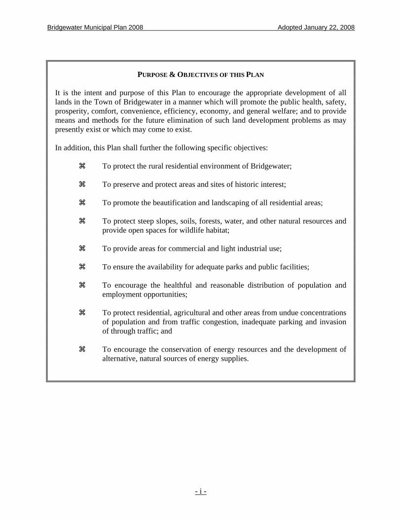
PURPOSE & OBJECTIVES OF THIS PLAN It is the intent and purpose of this Plan to encourage the appropriate development of all lands in the Town of Bridgewater in a manner which will promote the public health, safety, prosperity, comfort, convenience, efficiency, economy, and general welfare; and to provide means and methods for the future elimination of such land development problems as may presently exist or which may come to exist. In addition, this Plan shall further the following specific objectives: To protect the rural residential environment of Bridgewater; To preserve and protect areas and sites of historic interest; To promote the beautification and landscaping of all residential areas; To protect steep slopes, soils, forests, water, and other natural resources and
provide open spaces for wildlife habitat; To provide areas for commercial and light industrial use; To ensure the availability for adequate parks and public facilities; To encourage the healthful and reasonable distribution of population and
employment opportunities; To protect residential, agricultural and other areas from undue concentrations
of population and from traffic congestion, inadequate parking and invasion of through traffic; and
To encourage the conservation of energy resources and the development of
alternative, natural sources of energy supplies.
- i -

Bridgewater Municipal Plan 2008 Adopted January 22, 2008
INTRODUCTION
THE TOWN SETTING The Town of Bridgewater is situated in the central portion of Windsor County, Vermont. It comprises an area of approximately 28,657 acres or 44.8 square miles. Bridgewater is bounded by seven towns: Barnard and Pomfret to the north; Woodstock to the east; Reading and Plymouth to the south; and, Killington and Stockbridge to the west. Bridgewater is located within two physiographic areas. The major portion of the Town is between the Northern New England Uplands, which rise out of the Connecticut River Valley, and the Green Mountains that rise to the west of Town. This area is known as the Intermountain/Valleys and Foothills Area and is characterized by mountainous terrain, narrow valleys, and a few peaks with elevations over 2,500 feet. A small part of the Town, to the east of the ridge formed by Pinnacle, Montague, and Ohio Hills, is within the Uplands Area and is characterized by a more subdued terrain, where the valleys are less narrow, and the slopes less steep. In the northern part of the Town, north of Bridgewater Center, is a large area of very little development. Houses there are more likely to be camps than permanent homes, and the forest dominates the scene. There are a few open fields left from the days when this was an active farming area, but now this section is an unusually natural scenic place where the activities of people seldom intrude into the wildness that has taken over from the 19th century farms. Through this section of the Town, the Appalachian Trail crosses from Killington through Bridgewater to Barnard and Pomfret. This area is highly valued by local people as a special place for outdoor activities such as hunting, fishing, hiking, cross-country skiing, and snowmobiling. Geologic maps show most of the Town to be covered with glacial till, while there are more than ample places where bedrock appears at the surface. Along the river valleys are fertile soils and in these places, the thriving farms of Bridgewater's past were located. Along Route 4 near Bridgewater Corners, along the North Branch from Route 4 to Bridgewater Center, and along Route 100A south from Bridgewater Corners, one can still find excellent examples of agriculturally valuable soils and fields. Near the southern edge of the Town flows the Ottauquechee River, from west to east. It rises several miles away in Killington, and flows through Bridgewater, Woodstock, Hartford, and Hartland on its way through the famous Quechee Gorge and into the Connecticut River. Almost all of Bridgewater, except for the northeastern section, is drained by this river and the streams that run into it.
Page - 1 -

Bridgewater Municipal Plan 2008 Adopted January 22, 2008
TOWN HISTORY Prior to the King granting the lands that would become Vermont to both New Hampshire and New York, the Green Mountains were inhabited by Native Americans for at least 10,000 years. While there have been no archaeological sites found in Bridgewater, it is clear that the Ottauquechee River served as a route between the Connecticut River and the mountain pass north of Killington (now used by Route 4). The major Native American communities in Vermont were along the Upper Connecticut River and along the shores of Lake Champlain. However, the hills and valleys of what is now Bridgewater were used as part of the hunting grounds of the Algonkian speaking peoples and it is likely that there were several hunting camps here, probably along the Ottauquechee. During the Seven Years War - also called the French and Indian War - Vermont served as a minor battlefield at several times during the struggle to determine whether most of North America would be French or British. The Lake Champlain - Lake George - Hudson River route was heavily fought over as the French tried to isolate the New England colonies from the rest of the British colonies to the south. The Connecticut River was used as a warpath by the French and their Indian allies in raids against Massachusetts throughout this war, and some of the warring parties traveled into the interior of Vermont - but not into Bridgewater as far as we know. Until the 1763 peace treaty following this war, settlement in Vermont was too fraught with danger to allow permanent settlement, and ownership of the land was clearly not practical nor was it contested. Following the war, however, soldiers returning to southern New England told their neighbors about the lands to be found west of the Upper Connecticut River. The Governor of New Hampshire, Benning Wentworth, was able to start selling off the lands he had been given by the King. Bridgewater received its Royal Charter from Governor Wentworth on July 10, 1761, along with Hartland and Woodstock. Sixty-seven Proprietors' Shares were issued to Seth Field and his associates at that time. Actual settlement of the new town did not begin actively until nine years later in 1770. Because of its original land grant, Bridgewater was one of the few towns in this part of Vermont that was not disputed and claimed by the (then) Colony of New York. In 1779, Deacon Asa Jones of Woodstock began the first survey in town in the area now known as the Mendall District north of the present Village. With his family, he soon settled there. Another settler, Amos Mendall, married one of the Deacon's daughters and their child, Lucy, became the firstborn in Bridgewater. Settlement in general continued slowly. Seventeen eighty three saw Isaiah Shaw and Cephas Sheldon settle with their families. A year later, Richard Southgate settled in the area that would become Bridgewater Village. In 1785, there were finally enough residents to organize and to hold their first Town Meeting. Deacon Jones was the first Moderator and Mr. Southgate the first Selectman.
Page - 2 -
Bridgewater Municipal Plan 2008 Adopted January 22, 2008
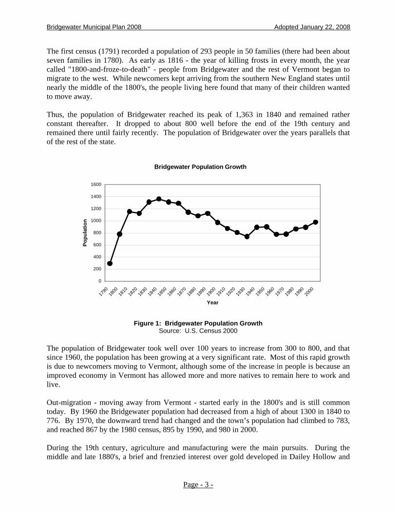
The first census (1791) recorded a population of 293 people in 50 families (there had been about seven families in 1780). As early as 1816 - the year of killing frosts in every month, the year called "1800-and-froze-to-death" - people from Bridgewater and the rest of Vermont began to migrate to the west. While newcomers kept arriving from the southern New England states until nearly the middle of the 1800's, the people living here found that many of their children wanted to move away. Thus, the population of Bridgewater reached its peak of 1,363 in 1840 and remained rather constant thereafter. It dropped to about 800 well before the end of the 19th century and remained there until fairly recently. The population of Bridgewater over the years parallels that of the rest of the state.
Bridgewater Population Growth
0
200
400
600
800
1000
1200
1400
1600
1790
1800
1810
1820
1830
1840
1850
1860
1870
1880
1890
1900
1910
1920
1930
1940
1950
1960
1970
1980
1990
2000
Year
Popu
latio
n
Figure 1: Bridgewater Population Growth Source: U.S. Census 2000
The population of Bridgewater took well over 100 years to increase from 300 to 800, and that since 1960, the population has been growing at a very significant rate. Most of this rapid growth is due to newcomers moving to Vermont, although some of the increase in people is because an improved economy in Vermont has allowed more and more natives to remain here to work and live. Out-migration - moving away from Vermont - started early in the 1800's and is still common today. By 1960 the Bridgewater population had decreased from a high of about 1300 in 1840 to 776. By 1970, the downward trend had changed and the town’s population had climbed to 783, and reached 867 by the 1980 census, 895 by 1990, and 980 in 2000. During the 19th century, agriculture and manufacturing were the main pursuits. During the middle and late 1880's, a brief and frenzied interest over gold developed in Dailey Hollow and
Page - 3 -

Bridgewater Municipal Plan 2008 Adopted January 22, 2008
Chateauguay. Extensive mining of the precious metal took place for a few years, although no great fortune was made by any of the gold-seekers. Local manufacturing was based on wool and lumber, two readily available commodities in 19th century Bridgewater. The Bridgewater Woolen Company - owner of the large mill building in the Village - operated throughout most of the history of the Town until the 1973 flood, combined with competition from southern mills and a changed national market, caused it to cease operations. It has been recently renovated into many retail shops and is called “The Marketplace at Bridgewater Mill.” It features arts and crafts shops and a ski retail shop. Other businesses include a bookstore, furniture builder, and an antique center, as well as many other retail shops. The post office for the village is located here. It continues to be the major employer in Town and the Town has loaned its owners funds received for this purpose from the federal government. Most of the people in Town, from its beginning until well into the 20th century, lived and worked on farms as was the case in the rest of the state. They lived off the land, producing most of what they needed, and sold a few of their surplus crops to get the things they could not coax from the local hillsides and shallow soils. During the first three quarters of the 1800's, sheep were the major livestock, but they were slowly replaced by dairy cows after the Civil War. With the coming of trains to the lower Ottauquechee in the 1870's, farm produce, and especially milk, butter and cheese, could be shipped to the urban markets of Boston, Southern New England and New York. As automobiles replaced horses in the early 20th century, people moved away from the old hill farms and moved closer to the hamlets and villages. Agriculture remained a common activity until recently - but now seems to be seriously threatened as an economically viable occupation. There are only a few dairy farms left, and some hillside fields are growing back into young forests throughout the Town. Throughout the 19th and 20th centuries, the people of Bridgewater enjoyed an active social life, especially in the village and hamlets. Amateur theatricals were given at Union and Josselyn Halls. There was a splendid Coronet Band, and the Bridgewater Baseball Team was one of the finest in the county. Religious life exerted a strong influence then, as it does now. A Congregational Church is located in the village, a Mennonite Church located at the Corners, and a Christian Community Church is located in Bridgewater Center. The restoration of the historic Capt. Richard Southgate House (1797) by the Town in the 1970's, the creation of a splendid recreation field, and the rehabilitation of the old Village School Building into a community recreation and meeting center in the 1980's, have brought new life and a new sense of community into the Town.
Page - 4 -
Bridgewater Municipal Plan 2008 Adopted January 22, 2008
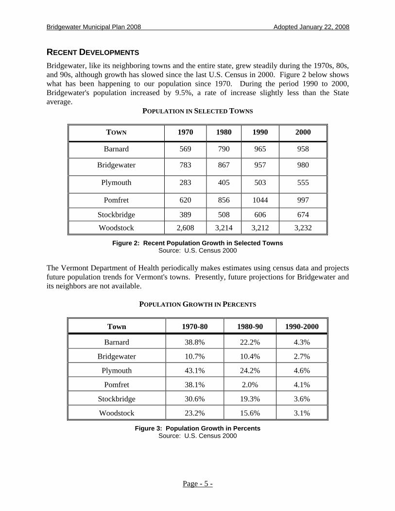
RECENT DEVELOPMENTS Bridgewater, like its neighboring towns and the entire state, grew steadily during the 1970s, 80s, and 90s, although growth has slowed since the last U.S. Census in 2000. Figure 2 below shows what has been happening to our population since 1970. During the period 1990 to 2000, Bridgewater's population increased by 9.5%, a rate of increase slightly less than the State average.
POPULATION IN SELECTED TOWNS
TOWN 1970 1980 1990 2000
Barnard 569 790 965 958
Bridgewater 783 867 957 980
Plymouth 283 405 503 555
Pomfret 620 856 1044 997
Stockbridge 389 508 606 674
Woodstock 2,608 3,214 3,212 3,232
Figure 2: Recent Population Growth in Selected Towns Source: U.S. Census 2000
The Vermont Department of Health periodically makes estimates using census data and projects future population trends for Vermont's towns. Presently, future projections for Bridgewater and its neighbors are not available.
POPULATION GROWTH IN PERCENTS
Town 1970-80 1980-90 1990-2000
Barnard 38.8% 22.2% 4.3%
Bridgewater 10.7% 10.4% 2.7%
Plymouth 43.1% 24.2% 4.6%
Pomfret 38.1% 2.0% 4.1%
Stockbridge 30.6% 19.3% 3.6%
Woodstock 23.2% 15.6% 3.1%
Figure 3: Population Growth in Percents Source: U.S. Census 2000
Page - 5 -
Bridgewater Municipal Plan 2008 Adopted January 22, 2008
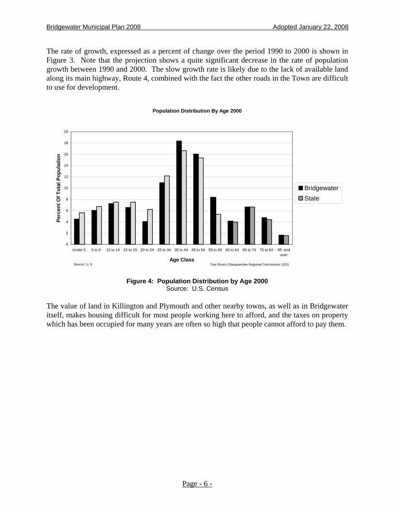
The rate of growth, expressed as a percent of change over the period 1990 to 2000 is shown in Figure 3. Note that the projection shows a quite significant decrease in the rate of population growth between 1990 and 2000. The slow growth rate is likely due to the lack of available land along its main highway, Route 4, combined with the fact the other roads in the Town are difficult to use for development.
Population Distribution By Age 2000
0
2
4
6
8
10
12
14
16
18
20
Under 5 5 to 9 10 to 14 15 to 19 20 to 24 25 to 34 35 to 44 45 to 54 55 to 59 60 to 64 65 to 74 75 to 84 85 andover
Age Class
Perc
ent O
f Tot
al P
opul
atio
n
BridgewaterState
Source: U. S Two Rivers Ottauquechee Regional Commission 12/01
Figure 4: Population Distribution by Age 2000
Source: U.S. Census The value of land in Killington and Plymouth and other nearby towns, as well as in Bridgewater itself, makes housing difficult for most people working here to afford, and the taxes on property which has been occupied for many years are often so high that people cannot afford to pay them.
Page - 6 -

Bridgewater Municipal Plan 2008 Adopted January 22, 2008
PERCENT OF REAL ESTATE OWNED BY RESIDENTS - 2006
TOWN PERCENTAGE Killington 16.3% Plymouth 19.3%
Bridgewater 47.9% Barnard 49.5%
Woodstock 49.8% Stockbridge 49.9%
Reading 51.0% Pomfret 84.3%
Figure 5: Real Estate Ownership - 2006 Source: Vermont Dept. of Taxes – Annual Report – Div. of Property Valuation and Review
PERCENT OF TAX RETURNS BY INCOME CATEGORY - 2005
REPORTED INCOME VERMONT BRIDGEWATER # RETURNS
$0 - $9.9K 18.9% 22.8% 113
$10K - $19.9K 15.9% 15.7% 78
$20K - $29.9K 14.3% 15.3% 76
$30K - $39.9 11.0% 9.5% 47
$40K - More 39.8% 36.7% 182
Total 100.0% 100.0% 496
Figure 6: Tax Returns by Income Category Source: Vermont Dept. of Taxes – Vermont Tax Statistics/Summary of 2005
Page - 7 -
Bridgewater Municipal Plan 2008 Adopted January 22, 2008
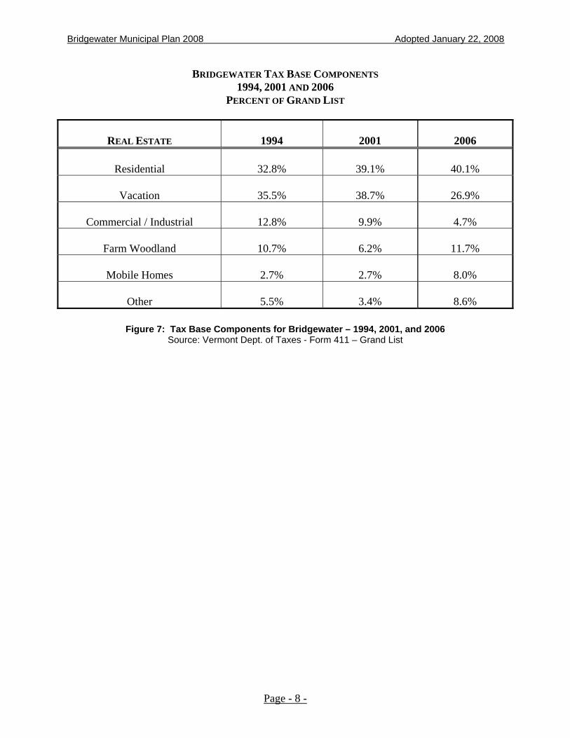
BRIDGEWATER TAX BASE COMPONENTS 1994, 2001 AND 2006
PERCENT OF GRAND LIST
REAL ESTATE 1994 2001
2006
Residential 32.8% 39.1%
40.1%
Vacation 35.5% 38.7%
26.9%
Commercial / Industrial 12.8% 9.9%
4.7%
Farm Woodland 10.7% 6.2%
11.7%
Mobile Homes 2.7% 2.7%
8.0%
Other 5.5% 3.4%
8.6%
Figure 7: Tax Base Components for Bridgewater – 1994, 2001, and 2006 Source: Vermont Dept. of Taxes - Form 411 – Grand List
Page - 8 -
Bridgewater Municipal Plan 2008 Adopted January 22, 2008
MUNICIPAL PLANS IN VERMONT According to Title 24, Chapter 117 of the Vermont Statutes, the Vermont Planning and Development Act, towns are enabled to have Municipal Plans. These Plans are used most frequently in Act 250 proceedings - projects approved under Act 250 must be found to conform to duly adopted municipal and regional plans. Municipal Plans are also used as a legal framework for zoning and subdivision bylaws, should they be adopted by the town. Plans, unlike Bylaws, are adopted by the town's Board of Selectmen. The voters are not asked to vote on them. The adoption process for a new Plan, or for amending an existing Plan, is this: The Planning Commission prepares a Plan and conducts at least one public hearing. Following the hearing, the Planning Commission may make changes, and then passes the Plan along to the Selectboard. The Selectboard may make changes, and then holds a public hearing. The Selectboard may again make changes and hold additional hearings. After the final hearing, the Plan is adopted by the Selectboard.
THE BRIDGEWATER MUNICIPAL PLAN Preparation of the original Bridgewater Municipal Plan was completed by the Bridgewater Planning Commission in 1972, with the assistance of the Ottauquechee Regional Planning Commission, now the Two Rivers - Ottauquechee Regional Commission. Extensive studies and analysis were undertaken before the formulation of that Plan. Natural processes and formations, which included climate, geology, hydrology, topography, soils, floodplain, etc., were identified and mapped. Socio-economic data was gathered pertaining to population, housing employment, and land use. An analysis of this information was presented in a 1972 report entitled: "Bridgewater: The Background for Town Planning.” A Plan for the Town was then formulated. A land use map was prepared identifying steep slopes, shallow and wet soils, flood prone areas, wetlands, agricultural lands, surface waters, and rural lands suitable for high, medium and low density settlement. The original Plan was adopted on July 25, 1972. In the spring of 1977, the Bridgewater Municipal Plan was reviewed for re-adoption according to the requirements of Section 4387 of the Vermont Municipal and Regional Planning and Development Act that stipulates that a plan shall expire five years from the date of its adoption. At that time, minor changes were made in the Plan's form and content. Where available, updated data on housing, land use, and population characteristics were included. The second Bridgewater Municipal Plan was adopted on July 19, 1977. On July 19, 1982, the Bridgewater Municipal Plan expired. A second Plan was prepared with the assistance of the Two Rivers-Ottauquechee Regional Commission. Again, information was updated, and new material and changes to the format were included. For the most part, these changes were intended to broaden the Plan's scope and to explain in more detail, the rational for making certain recommendations and policy statements. The third Plan was adopted by the
Page - 9 -

Bridgewater Municipal Plan 2008 Adopted January 22, 2008
Selectboard in December, 1984 and expired in December 1989. A fourth Plan was adopted in January, 1990 and expired in January 1995. In July 2001 and again in January 2003, the Plan was readopted. This Plan, updated in 2008 to incorporate changes to the State Planning and Development Law and other new information, will remain in effect for a period of five years, but may be amended from time to time as necessary.
Page - 10 -
Bridgewater Municipal Plan 2008 Adopted January 22, 2008
MUNICIPAL BYLAWS In 1972, proposed Zoning Regulations were prepared and presented for a vote of the Town in order to implement the policies presented in the original Plan. These Regulations were rejected by Australian Ballot in 1972 and 1975 by a small margin. In 1986, a revised Zoning Regulation was rejected again by the voters. Currently, Bridgewater has no local land use regulations in effect. In 1975, Interim Flood Hazard Zoning Regulations were prepared and adopted by the Town to protect flood hazard areas as designated and prepared by the National Flood Insurance Administration. In 1980, permanent Flood Hazard Zoning Regulations were passed by a vote of the Town and adopted. These regulations were updated and readopted by the Town in November 2006. Since 1975, the Town has had in effect Health Regulations for Bridgewater relating to individual sewage disposal systems. This Regulation requires that a permit be obtained from the Selectboard before any sewage system is constructed or replaced. Beginning July 1, 2007, however, this regulation was superseded by a new State regulation under which every parcel of land, wastewater facility, private drinking water supply, and water treatment facility in the state will need a state permit for repairs, upgrades, and new construction. In July 1975, the Town of Bridgewater adopted a Road Ordinance that establishes procedures and standards for highways to be assumed by the Town as part of its road system. This Ordinance was amended in 2002 to address new policies. In 1979, Bridgewater passed a Sewer Use Ordinance that requires that all sewage from properties within the service area of the Bridgewater Sewage System be connected to the municipal system.
Page - 11 -

Bridgewater Municipal Plan 2008 Adopted January 22, 2008
TOWN SERVICES AND FACILITIES
SEWAGE FACILITIES In 1978, the Bridgewater Municipal Sewage Treatment Facility began operation on less than one (1) acre of land located just over the town line, in Woodstock. This “Rotating Biological Disc” secondary treatment facility has a design capacity of 43,000 gallons per day, and serves the village area of Bridgewater and the Bridgewater Mill Mall. As of December 2007, the system was operating at slightly more than twenty-two percent of its design capacity, processing approximately 9,500 gallons per day, from the 145 units of domestic and commercial service. Use of the sewage treatment facility decreased when the brewery moved out of the Mill Mall. From 1989 to 1995, one of the tenants of the Bridgewater Mill Mall had discharged an increasing larger organic loading to the facility. This had caused the facility to treat a much higher level of organic waste so that organic loading had been sometimes exceeded with an average of 95 percent of its design capacity of 73 lbs/day. This had created severe operational problems including process upset, additional sludge removal and disposal costs, and troublesome odors in and around the facility. With the relocation of this tenant out of the Mill Mall, the problems no longer exist. Even with this condition, development requiring wastewater treatment should be encouraged to locate within the service area of the system, as there is land available within the Town of Woodstock near Bridgewater Village and this land could make use of the hydraulic capacity of the Bridgewater Treatment Plant. In 1993, Woodstock constructed an 8-inch sewer extension to service the first house in Woodstock. This sewer has the design condition to allow future extension to service the four additional existing houses. It is the policy of the Town to coordinate with Woodstock in the future development of this area.
SOLID WASTE DISPOSAL In 1987 the Vermont legislature passed a new solid waste law that resulted in dramatic changes in the way Vermonters view their garbage and how they will chose to manage and dispose of it. The law brought Vermont communities into the modern era of refuse management in accordance with the new U.S. Environmental Protection Agency requirements. This law prohibited unlined landfills from being constructed. New landfills must have expensive synthetic liners and leachate collection and treatment systems. The law also stated that existing landfills, including Bridgewater's, needed to be closed by July 1, 1991. The Bridgewater landfill stopped accepting waste in October 1992, and closure was complete in July 1993. The law identified the need for regional solid waste planning as the means for managing solid waste. Bridgewater, along with 15 other towns, joined the Joint Municipal Survey Committee (JMSC) in July 1988; the JMSC determined that a solid waste district in this region was necessary for financing future solid waste disposal alternatives. The Greater Upper Valley Solid
Page - 12 -

Bridgewater Municipal Plan 2008 Adopted January 22, 2008
Waste Management District was formed in 1990. Bridgewater remains a member of this District, along with nine other towns. The Greater Upper Valley Solid Waste District adopted its first Solid Waste Implementation Plan (SWIP) in the early 1990’s with subsequent amendments following its initial approval. Its most recent Plan was approved by the Vermont Agency of Natural Resources in August 1999. This Plan was prepared in anticipation of the State Plan, currently undergoing revision by the Agency. Upon completion of the new State Plan, the District will again review its SWIP to check it for consistency with the State Plan and amend it, if necessary. Projects to be undertaken by the District over the next couple of years include:
• Create a waste diversion plan to address collections of electronics and plastics;
• Review unit pricing plans haulers within the District, particularly for the construction and demolition process facility;
• Address illegal disposal and backyard burning while working with member towns and the Agency;
• Work to amend all necessary permits or to address permit conditions for the landfill site in North Hartland, including new access from Route 5;
• Review the SWIP to address increased pressure to handle additional volumes of trash from member towns which could mean demands for new facilities sooner than anticipated;
• Bolster outreach efforts for the general public as well as stakeholders in program planning through a variety of ways including a possible community survey; and
• Work more closely with member towns and the regional commissions to ensure that the updated SWIP goals and policies match well with Chapter 117 town and regional plans addressing solid waste.
Bridgewater intends to remain an active participant in the governance of the District to ensure that the goals and policies for the management of solid waste are both economically and environmentally sound.
Specific principles that the Town will follow in addressing waste management will include:
• Continue to work to reduce the amount to solid waste generated;
• Support to reuse and recycling of materials taken from the waste stream;
• Maintain a program to process waste or reduce volumes before disposal;
• Ensure that remaining waste is disposed in lined landfill that is an environmentally sound manner;
• Support the concept that waste generators bear the full cost of proper waste disposal; and
Page - 13 -

Bridgewater Municipal Plan 2008 Adopted January 22, 2008
• Recognize that the private sector serves as the primary vendor for waste management services while recognizing that local governments and the District bear the responsibility to provide such services when it is in the public interest to do so.
Presently, the Lebanon City Landfill provides lined disposal capacity for mixed solid waste for all towns in the District. The District is allowed access to this facility as a “tenant at will” and, accordingly, has no guarantee for long-term access to this site. Because of this uncertainty, the District has identified the North Hartland site as a contingency plan in the event that Lebanon landfill becomes unavailable or unaffordable. The District site received certification from the Vermont Department of Environmental Conservation several years ago. This site is estimated to provide capacity for disposal of District waste for at least 50 years. However, long-term access to the proposed site is dependent on implementing a traffic access plan to reroute trucks away from downtown White River and area neighborhoods. To this end the District, Twin State Sand and Gravel Company, the Town of Hartford, and affected landowners have been working on new plans for an access road from Route 5. Construction and demolition (C&D) materials are currently disposed at the Hartford C&D landfill through an agreement by the District with the Town of Hartford. The District has no plans to develop or operate its own C&D facility or contract with another operator unless its agreement with Hartford expires. Detailed information about the organization and operation of the District can be obtained from District Offices in North Hartland or by calling 296-3688.
EMERGENCY SERVICES Ambulance services are provided in cooperation with the Woodstock Ambulance Association. In 1996, E911 telephone service was placed in effect. In 2001, federal funds were used to acquire emergency generators to service public buildings or shelters. In 2000, a Rapid Response Plan was developed in cooperation with the Vermont Department of Emergency Management. The Bridgewater Fast Squad provides emergency medical services. The Squad consists of nine volunteers and is available to respond to accidents and medical emergencies as needed. Town of Bridgewater volunteers should be encouraged to continue building a cohesive town wide emergency service team. With US Route 4 as a major thoroughfare in town and the Town’s location between two major medical centers in Rutland and Hanover, Bridgewater lacks medical care that would provide service to the surrounding area. A small wellness clinic in town would address preventative care instead of using up resources that would be better suited for emergency care at the major medical centers. Another option is to discuss with the Visiting Nurse Association and Hospice of Vermont and New Hampshire ways to improve the visiting nurse services already existing in community. The Town has seen a dramatic decline in the number of accidents on Route 4 since the County Sheriff has become active patrolling this route. This is a huge improvement in safety for people traveling on Route 4, which pays for itself through speeding ticket revenues.
Page - 14 -

Bridgewater Municipal Plan 2008 Adopted January 22, 2008
FIRE PROTECTION The Town of Bridgewater is serviced by the Bridgewater Volunteer Fire Department that is a member of the Connecticut River Valley Fire Mutual Aid Association, where towns provide assistance to one another in the case of a serious fire. With 20 active volunteer members, two pumper trucks and two 4-wheel drive tanker trucks, the Department is doing a commendable job for its size. Funding is provided through fund raising activities plus annual support from the Town. All future development within the Town should be in accord with the capabilities of this Department to service the development. Anyone planning to build a new pond or to upgrade an old pond should consider consulting the fire department about the installation of a dry hydrant.
RECREATION A 1979 study revealed that recreation was a high priority need within the Town of Bridgewater. In January 1981, the Selectboard created within the body of the town government, the Bridgewater Recreation Committee. Since that time, the Committee has successfully raised private and public funds to construct the Bridgewater recreation park, to renovate the 'old brick school' and convert it into a community center. Groundbreaking for the park began in July 1982 on the 4.5 acres of land generously donated to the Committee by a Bridgewater resident. The park now includes a baseball (softball) diamond, tennis court, basketball court, shuffleboard court, horseshoe pits, picnic area, volleyball court, and playground area. A full basketball court has also been constructed behind the elementary school. If a Recreation Committee is created, it could establish a baseball program as well as winter programs such as swimming, skating, bowling, roller skating, and skiing. This is a needed and most welcomed development within the town that should meet the recreation needs of Bridgewater citizens for the duration of this Plan. Reuse of the Old School House that is owned by the Town in the center of Bridgewater is a wonderful opportunity to create a community center.
SNOWMOBILE TRAILS AND TRAVEL The Town of Bridgewater recognizes the importance of snowmobiles to our local and state economy. Not only does this sport bring thousands of visitors to the state every year to ride our 4,700 miles of trails, but many business serve and support snowmobile users including lodging, gas, food, restaurants, machine dealers and repair shops, and real estate agencies. According to the Vermont Association of Snow Travelers (VAST), snowmobiling contributes an estimated $550 million dollars a year to the economy of Vermont.
Page - 15 -

Bridgewater Municipal Plan 2008 Adopted January 22, 2008
Eighty percent of Vermont's snowmobile trail system is on private land. Because landowner permission is required to ride on private land, snowmobiling is a privilege permitted only through their generosity. VAST is a non-profit, private group responsible for the organization of the sport, maintaining and grooming trails. VAST trails are for winter use only and any other use (by ATVs, four-wheelers, motor or mountain bikes, or hiking) unless specifically authorized is considered trespassing. Recommended Action
1. To support maintenance of snowmobile trails on private lands in Bridgewater and to encourage development of businesses that serve and support snowmobile users.
APPALACHIAN TRAIL CORRIDOR The Appalachian Trail is a 250,000 acre greenway spanning 2,175 miles from Maine to Georgia. Close to the town line toward Barnard is roughly a half-mile swath of the Appalachian Trial Corridor that crosses into North Bridgewater for about four miles, providing a wildlife corridor for large mammals. Views at Lookout Point are exceptional, and there is a town-wide desire that this area remain undeveloped.
Figure 8: Cross section of Appalachian Trail Corridor from Woodstock to Barnard
Source: Green Mountain Club – Ottauquechee Section, 2007
EDUCATION The Bridgewater School System consists of the one elementary school located in the village area, which serves grades pre-K-6. In the 2005-2006 school year, there were 71 students enrolled at the Bridgewater Village School, though at present there are only 58 students enrolled.
Page - 16 -
Bridgewater Municipal Plan 2008 Adopted January 22, 2008
The capacity of the seven classroom school is 90. The 2005-2006 staff consisted of 7.0 FTE teachers and one teaching principal, plus support staff and special education personnel. In 2007, there were 5.0 FTE teachers. Students in grades 7-12 attend the Woodstock Union Middle School and High School. Bridgewater is a member district of the Windsor Central Supervisory Union. School appropriations comprise a considerable portion of the Town budget although the student population is very low and continues to decrease. Since the Town currently pays more into the state education fund than what it receives from the State, improving the town’s educational facilities is not a practical option. These issues should be carefully addressed in the light of its burden on the Town’s ability to provide education and the local tax burden. In late 2001, voters defeated a proposal to bond for a two-room addition and renovations to the School. This effort to improve school facilities was to address life/safety concerns. Later at the March 2002 Town Meeting, voters approved a scaled down version of the initial renovation proposal, allowing the building to meet plumbing and safety codes. Construction began in 2002, with the State of Vermont contributing 30% to the total construction budget. TECHNICAL AND VOCATIONAL OPPORTUNITIES The Town encourages alternative education programs for adults and students in Bridgewater. The Town hopes to develop and offer community based workshops, technical and vocational programs, and agricultural education with partnerships between schools and local businesses. A major contributor would be local businesses in offering internship opportunities such as construction, EMS/paramedic careers, shadowing local artisans, and working on local farms or farm stands.
Goals
1. To provide the opportunity for Bridgewater students to have access to high quality and affordable education.
2. To encourage the use of the Town’s school for adult education and other community activities.
Recommended Actions
1. The Planning Commission should meet with the School Board to discuss ways to address the impact of the low elementary school enrollment on education in Bridgewater as well as the adequacy of school facilities in Town.
2. Identify a local coordinator to develop technical/vocational training opportunities with local businesses and facilitate connections with students.
3. Provide community based workshops and vocational programs in Bridgewater schools for the community and potential start-up businesses.
Page - 17 -

Bridgewater Municipal Plan 2008 Adopted January 22, 2008
CHILD CARE In 2003, the Vermont Legislature added a thirteenth goal to Chapter 117. “To ensure the availability of safe and affordable child care and to integrate child care issues into the planning process, including child care financing, infrastructure, business assistance for child care providers, and child care work force development.” Currently, there are no registered in-home providers of child care in the Town of Bridgewater or any licensed child care programs, however there are many programs and providers in the surrounding towns. Bridgewater supports the private development of additional facilities to meet the needs of its residents.
ECONOMY
Historically, a great deal of the economic activity in Bridgewater has been related to agriculture and forestry, providing jobs for many residents. In recent years, U.S. Census figures show that Bridgewater’s workers have shifted to service industries (22%), sales and office occupations (23%), and professional and management occupations (29%).
The Town of Bridgewater should plan for economic growth and expansion in a manner that creates a range of employment opportunities, encourages rising incomes, and raises citizens’ living standards while considering the impact of such growth on the Town. New businesses can be encouraged to locate in Town through mention of the related regulatory climate, thereby providing local jobs for residents and eliminating transportation concerns.
Policies
1. To encourage the development of local businesses, professional services and agriculture-related activity in a manner that conforms to overall goals of keeping Bridgewater rural and residential and which will not require Town expenditures on infrastructure.
2. To reduce the demand for commuter transportation and energy, and encourage the development of energy efficient home occupations and small-scale home business.
3. To encourage business growth that will expand the primarily residential tax base and enhance the rural character that Bridgewater’s residents so strongly value.
Recommended Actions
1. Create a forum for local businesses or some type of local association, with information available at the town offices.
2. Piggyback on the work and results of the local job bank in Woodstock.
3. Seek grant funding to create a town website and/or newsletter.
RICHARD SOUTHGATE HOUSE/TOWN OFFICES In 1971, the Bridgewater Town Offices moved into the renovated Richard Southgate House. This historic structure also houses the Bridgewater Public Library and has an additional 1,800 sq. ft. of professional office space for rent. Work should be done to preserve this facility as necessary.
Page - 18 -

Bridgewater Municipal Plan 2008 Adopted January 22, 2008
The Bridgewater Public Library was organized in 1972 in the renovated Richard Southgate House. In March 1996, a Town vote discontinued the Library as a Public Library and it now serves as the school library. It presently houses over 5,000 books. Within the library is a small conference room, which is available for meetings relating to Town business. Recommended Action
1. Seek grant funding to conduct necessary historic preservation work on the Town Office building.
Page - 19 -
Bridgewater Municipal Plan 2008 Adopted January 22, 2008
HOUSING
BACKGROUND As populations in the Upper Valley area expands, people who work here oftentimes cannot find affordable land for housing. This prompts them to look to the towns further from the interstate highways. These people are now looking to Bridgewater for affordable land. There is a general tendency for growth in housing and population within a town to push the cost of land upwards, and as a result both the cost of housing and property taxes increase, usually faster than the average income increases. The Town of Bridgewater has seen an increase in population and new homes being built in the last several decades. Since 1970, the Town’s population has grown by 25% and the number of housing units has grown by a remarkable 63%. Change of this nature is difficult to manage, at best. This is particularly true since the Town does not have zoning regulations, nor would zoning be likely to pass. However, a simple Building Notification Ordinance requiring builders to provide basic project information concerning health and safety standards and avoiding nuisances would be helpful to the Town. Building notification would help ensure that buildings are not placed in nuisance areas, to confirm that builders are referred to the state for septic permits, and to ensure driveway access onto town roads is controlled by the Town and therefore is safe for emergency vehicles. Additionally, priority conservation areas would be better protected from development, and people who build in the flood zone would know they need to get a local flood permit before they begin their project.
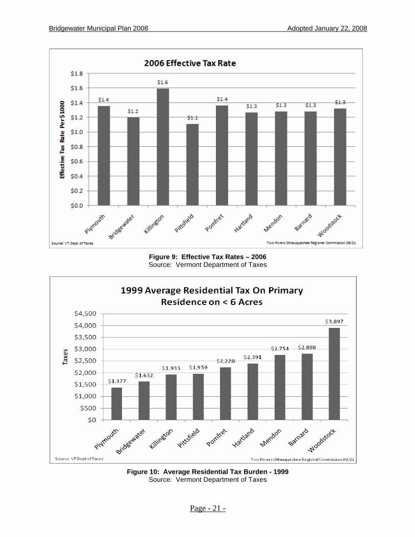
HOUSING AFFORDABILITY Affordable housing is very difficult to find in Bridgewater and all of the other nearby towns. The Town's steep hills and rugged topography, along with the remoteness of the northern half of the Town, tend to make land suitable for building upon hard to find. The remaining lands are expensive, and the average wage earned by Bridgewater people is not extravagant. The following two Figures illustrate the differences between Bridgewater and surrounding towns in 2006 tax rates and actual tax bills for 1999. In the past decade, Bridgewater has shifted from having one of the highest tax rates in its region, to the middle when compared to surrounding towns. This may be, in part, due to Act 60, which seeks to equalize tax rates between towns.
Page - 20 -
Bridgewater Municipal Plan 2008 Adopted January 22, 2008
Figure 9: Effective Tax Rates – 2006 Source: Vermont Department of Taxes
Figure 10: Average Residential Tax Burden - 1999
Source: Vermont Department of Taxes
Page - 21 -

Bridgewater Municipal Plan 2008 Adopted January 22, 2008
The number of housing units within Bridgewater has increased in recent years. Figures 10 and 11 indicate relative housing unit changes in Bridgewater and surrounding towns.
HOUSING UNIT GROWTH
Town 1980 1990 2000
Bridgewater 486 571 582
Barnard 555 607 629
Plymouth 495 736 773
Pomfret 404 490 544
Stockbridge 413 488 528
Woodstock 1,548 1,755 1,775
Figure 11: Housing Unit Growth Source: U.S. Census
Figure 12: Housing Unit Change 1990-2000
Source: U.S. Census
Page - 22 -

Bridgewater Municipal Plan 2008 Adopted January 22, 2008
A Bridgewater Planning Survey, conducted in 1995, clearly indicated that residents felt affordable housing in Town was necessary and desirable. Housing is considered affordable when households pay no more than 30% of their gross income on housing costs. Housing costs for homeowners include principal, interest, taxes, and insurance. For renters, housing costs include rent and utilities. At the time this Plan was written, the stock of senior housing and low to moderate income housing is viewed as sufficient to meet current needs. However, private development of additional housing stock to meet future needs is anticipated. New housing affordable to working families should be tied to public transportation systems to enable commuting. Additionally, this housing should be located near child care resources and should be served by other commercial services (e.g., Laundromats) and local health care services that meet the needs of these residents. Goals
1. To provide the opportunity for Bridgewater residents to have access to decent and affordable housing.
2. To encourage retention of existing housing and construction of new housing that meets the anticipated population growth.
3. To encourage the preservation of historic structures in ways that appropriately serve the need for housing.
Policies
1. It is the policy of the Town to ensure that the timing and rate of new housing construction or rehabilitation does not exceed the community’s ability to provide adequate public facilities (e.g. schools and municipal services).
2. It is the policy of the Town to accommodate housing that is permanently affordable for households having moderate, low, and very low incomes.
3. It is the policy of the Town to keep housing affordable by planning for:
• appropriately sized lots;
• accessory apartments; and
• clustered developments.
4. It is the policy of the Town to work with businesses and non-profit housing corporations to help Bridgewater meet the demands for affordable housing.
5. It is the policy of the Town to encourage the provision of housing for special needs population, such as the elderly and physically handicapped.
6. It is the policy of the Town that the location of primary and vacation housing, related amenities and land uses should be planned with due regard to the physical limitations of the site and location of current or planned public and private services such as roads and commercial/service centers.
Page - 23 -

Bridgewater Municipal Plan 2008 Adopted January 22, 2008
Recommended Actions
1. The Town should develop a building notification ordinance to ensure all weather access management for emergency vehicles to new homes and to refer builders to state and local safety, health and flood hazard requirements.
2. The Planning Commission should work with the Selectboard to:
a) Suggest ways to encourage the creation of additional rental properties throughout town, provided that they do not put an undue burden on Town services and facilities.
b) Seek information from the Two Rivers-Ottauquechee Regional Commission to understand better housing needs of Bridgewater residents and options for addressing these needs.
3. The Town should encourage private development of senior housing and low to moderate income housing for working families.
Page - 24 -

Bridgewater Municipal Plan 2008 Adopted January 22, 2008
THE USE OF LAND IN BRIDGEWATER
SETTLEMENT AND LAND USE PATTERNS Settlement in Bridgewater has occurred in a distinct pattern of small settlements of relatively high density of mixed areas surrounded by sparsely settled rural agricultural and forest lands. The areas of concentrated development are Bridgewater Village, Bridgewater Corners, and West Bridgewater, all of which are located along U.S. Route 4, a highway that runs on an east/west axis through Town. In addition, located approximately 2.5 miles north of Bridgewater Corners at the end of a State-Aid Highway is Bridgewater Center. Of these village settlement areas, Bridgewater Village is the largest. Land use for crop, tillage, hay and pasture stretches along the roadways in the Town, especially south from Bridgewater Corners, along Route 100A, north to Bridgewater Center from Route 4 and In North Bridgewater. Residential uses in the Town, if not located in the villages and hamlets or along the major roads leading to these village/hamlet areas, are located along the road system extending north of Bridgewater Village, north of Bridgewater Center or along several other roads lying north of Route 4. Recent development of houses, some of them permanent residences, along the Dailey Hollow and other remote roads, has been requiring additional services from the highway department.
PROPOSED LAND USE IN BRIDGEWATER It can be seen from the foregoing sections that the Town of Bridgewater has a distinct pattern of settlement, which has emerged over time in response to cultural and social attitudes, as well as to natural environmental considerations. This pattern is one of small localized centers of village and hamlet settlement composed of high densities of residential and commercial uses, surrounded by very sparsely settled rural agricultural and forest lands. Over the years this pattern of settlement has demonstrated itself to be of sociological, psychological and aesthetic benefit to the Town, while simultaneously providing a system that is both efficient and economical for the conduct of business and the provision of social and community services. Even though maintaining the existing settlement pattern of the Town is a fundamental goal of this Plan, development pressure within the Town is a reality. More and more homes are being built in rural areas, particularly in close proximity to maintained town roads far outside of the existing community centers. Maintaining a sense of community and environmental quality that makes Bridgewater a pleasant place to live and work is becoming more difficult due these recent land use trends. Nevertheless, because the existing pattern of settlement has served the public interest for well over 200 years, it is the purpose of this Plan to maintain and to enhance this pattern wherever possible. Overall Land Use Goals
Page - 25 -

Bridgewater Municipal Plan 2008 Adopted January 22, 2008
1. Locate higher density mixed use development in the village and hamlets, or designated expansion areas surrounding the village and hamlets.
2. Provide for both residential and non-residential development only in areas where adequate public services are available or planned.
3. Protect and conserve rural areas and their natural resources by avoiding scattered development and discouraging incompatible land uses.
4. Conserve forest lands, wildlife habitats, outdoor recreation, and scenic resources and local history of the Chateauguay area by promoting conservation and sustainable resource management.
5. Retain the quality and wise use of the natural environment by wise use of natural resources.
PROPOSED LAND USE MAP A proposed or future Land Use Map has been produced and is part of this Plan to illustrate land use categories in Bridgewater. Input on the creation of this map included past planning documents, current Plan policies and responses from residents of Bridgewater through the 1995 Planning Survey. The pattern of development on this map maintains established compact village and hamlet areas with medium density growth areas adjacent to them generally within the 2,000 feet prescribed in the Municipal Plan. Commercial and light industrial development is planned for existing Village and hamlet areas only with no planned pattern of “strip development” along roadsides outside these Village and hamlet areas. Rural, low density development are located in areas not having physical constraints listed as conservation or critical areas in the Municipal Plan, while avoiding existing agricultural lands. The largest, contiguous agricultural areas are not planned for future development, while some small patches of current agricultural areas may be suitable for low density development. The rural, low density developments follow the existing roadways so no new roads need to be built at taxpayer expense. The rural, essentially undeveloped areas such as the Chateauguay, ridges south of Route 4 and ridges between town highways are maintained in their undeveloped state hosting only small camps and no permanent housing or commerce. Areas of new low density rural housing development are concentrated essentially to the:
• existing highway system in the northeast of Bridgewater where homes and access from Woodstock highways are already established, and;
• the southwest area of Bridgewater north of Route 4 where land appears suitable for such development without major public investment in roads.
The remaining terrain in Bridgewater is not conducive to development because it is steep, not suited for septic systems, has very limited highway access and is thus planned for conservation
Page - 26 -
Bridgewater Municipal Plan 2008 Adopted January 22, 2008
of forest, recreation, and watershed resources. Bridgewater is highly regarded as a town with excellent tracts of undeveloped forest land frequently enjoyed by hunters, off-road vehicle enthusiasts, hikers, and snowmobile enthusiasts. The neighboring towns of Killington, Barnard, Stockbridge, and Plymouth all have similar forested areas contiguous to Bridgewater, making this one of the best multi-town recreational assets in this Region. This future land use map does not plan for development of the large tracts of forest into residential, commercial, or industrial uses. Conversely, such tracts are intended to remain predominately as undeveloped or limited development areas for the purposes of conserving existing resource values.
This map is for general planning purposes only and should be reviewed with site visits to verify its suitability in meeting the goals and policies of the Bridgewater Municipal Plan. This map is intended to be a general guide for development in Bridgewater recognizing specific sites not shown on this map may indeed be suitable for certain densities of development.
GENERAL VILLAGE AND HAMLET SETTLEMENT PATTERNS The areas of highly concentrated settlement in the Town are Bridgewater Village, Bridgewater Corners, Bridgewater Center, and West Bridgewater. By analyzing the existing pattern of settlement, it can be seen that these areas are the focal points of the Town, providing a sense of place or identity, a center for community interaction and a contrast to the surrounding rural countryside. As the Town develops, the village and hamlets should continue to fulfill these important functions.
BRIDGEWATER VILLAGE Bridgewater Village is the location of the major retail commercial activities of the Town, the elementary school, recreation facilities, town offices and other major cultural and civic functions. It is also the only section of the Town with a public sewer system, which allows for considerably more concentrated development than those areas where room for septic systems with leach field is required. Therefore, the following Planning Policies are established for Bridgewater Village. Planning Policies for the Village
1. Any new intensive and concentrated, commercial, or multi-unit development requiring public sewage facilities should be located within Bridgewater Village.
2. Residential development within the Village should allow a variety of housing types at high densities and should be coordinated with the sewer system and its ability to accommodate additional sewage.
3. All new development, or modification of existing buildings in the Village should seek to establish a flow of traffic for automobiles and pedestrians that is safe and convenient for local residents as well as through traffic.
4. Because of past problems caused by the parking of large trucks along the side of Route 4, it is the policy of this Plan to discourage the creation of any commercial development that does not have adequate space for off-street parking and safe ingress and egress sight lines for its customers.
Page - 27 -

Bridgewater Municipal Plan 2008 Adopted January 22, 2008
5. Commercial and industrial development should be encouraged within the Village so as to maintain a balanced relationship between population growth, the provision of job opportunities and the generation of tax income for the town. Notwithstanding the above, it is not the policy of this Plan to encourage any commercial or industrial development within the Village that will markedly change the character of the community as a prime residential area. Proposed development that creates excessive noise, odors, visual clutter, or other nuisances is not in concert with this Plan.
6. New development of any type should seek to enhance and protect the scenic features and aesthetic quality of the Village area. Where possible, the architectural style of new or modified buildings should reflect existing architectural styles and details. Architectural styles that vary significantly from the existing predominate mix of building types are inconsistent with this Plan. Maintenance of open spaces within the Village is encouraged to assure adequate off-street parking and scenic amenities.
7. Preservation of historically significant buildings is important in the Village as well as in all parts of the Town. It is the policy of this Plan that buildings with architectural and historic value should not be destroyed, modified, or altered without due consideration to these values and where changes in the exterior of such buildings are to be made, the changes shall attempt to duplicate and maintain the style of the building prior to its modification.
8. No development should be permitted if it will cause a loss of environmental quality within the Village or a degradation of the environmental quality of adjacent properties.
9. Because there is a need for affordable housing in the Town, and because the presence of a public sewer system in the Village suggests a higher density of housing can be located there, this Plan advocates that when a developer proposes a multi-unit residential project of ten or more housing units that at least ten percent of the units be affordable.
10. It is the policy of this Plan to encourage developers who are proposing affordable housing projects to work closely with the Planning Commission in determining the economic impact of the proposed development on the Town's tax structure. If the proposal were to significantly affect the carrying and financial capacity of the Town of reasonably accommodate increased growth, such housing may be considered incompatible with this policy.
THE HAMLETS 1. Bridgewater Corners, Bridgewater Center, and West Bridgewater are identified as
hamlets, with concentrated development, and feature a variety of small scale residential, commercial, and public land uses. The boundaries of these hamlet areas are shown on the maps accompanying this Plan.
2. The three hamlets within the Town of Bridgewater are presently primarily clusters of residential buildings with associated businesses that serve the townspeople and people traveling through the area.
3. While it is desired that small businesses flourish within the Town, and that they be primarily located within the designated hamlet areas, it is not the intent of this Plan that
Page - 28 -
Bridgewater Municipal Plan 2008 Adopted January 22, 2008
the quality of life, the semi-rural character of hamlet living, and the convenience of the local residents be usurped by development contrary to that which has already been created.
4. The hamlet designation does not indicate a desire for "strip" or "sprawl" development and their associated problems such as traffic congestion and hazards caused by unlimited highway access; extensive signage, and on-site advertising; any development which lends to or which impedes pedestrian traffic is contrary to this Plan.
5. Future development within the hamlet areas must be accomplished so as to retain the present hamlet qualities and amenities. These include: community integrity and identification; maintenance of a center for community interaction; internal vehicular and pedestrian circulation which provides for easy and safe access to any part of the hamlet; harmony of building and property utilization features within each hamlet, and appropriate aesthetic design considerations.
BRIDGEWATER CORNERS Bridgewater Corners is located at the junction of Routes 4, 100A, and the State-Aid Highway leading from Bridgewater Center. The Corners is also located at the confluence of the Ottauquechee River with the North Branch, and further downstream, with Broad Brook. At the Corners there are presently several businesses including a restaurant and inn, a U.S. Post Office, Well Drilling Co., the Cutting Edge, Brewery, business offices, and a general store with gasoline pumps serving local and tourist needs. The Corners is also the location of the Town Garage, Mennonite Church, and Grange.
BRIDGEWATER CENTER Bridgewater Center is located at the end of the State-Aid Highway that runs 2.46 miles north from Route 4. Bridgewater Center is also the site of the Oak Chapel Community Christian Church. There are several small businesses located here. Major planning concerns for future development of the Center include the suitability of the soils for on-site sewage systems, the need for recreational facilities, vehicular and pedestrian safety, and floodplain boundaries.
WEST BRIDGEWATER The hamlet of West Bridgewater is located at the junction of the town lines of Killington, Bridgewater, and Plymouth; Routes 100 and 4; and the Ottauquechee River and Reservoir Brook. There are several businesses in West Bridgewater, including a motel, general store, restaurant, gas stations, ski lodge, snowmobile tour facility, and other retail shops. Planning Policies for the Hamlets
Page - 29 -

Bridgewater Municipal Plan 2008 Adopted January 22, 2008
1. New development within the hamlets must be sited to minimize conflicts in traffic flow and vehicular movement while maintaining safe pedestrian movement. Development that requires on-street parking should not be permitted.
2. New development near or adjacent to the Ottauquechee or its tributaries must maintain and enhance the scenic and recreational amenities of these waters. Waterways throughout the Town should be protected from development activities which could impair these amenities
3. It is not within the financial capabilities of the Town of Bridgewater at this time to finance or construct wastewater treatment or water system facilities within any of the Hamlet areas.
4. Whereas none of the hamlet areas are currently served by a municipal treatment facility, new development must be sited and designed so as to insure the safe, healthful, and environmentally sound disposal or treatment of sewage in such a way as it does not endanger water sources of adjacent properties.
5. Future development within the hamlets should be composed of predominately single-family and two-family dwellings and small commercial establishments of a type that will serve the local community.
6. Any development adjacent to the hamlets should be related to them as logical extensions of the build-up area rather than be so located as to constitute strip development or urban sprawl characteristics. Since one of the major goals of this Plan is to keep the hamlets separated from each other and to have rural and or residential land uses in between them, development of a sprawl nature along town roads is not desired.
7. All new development along Route 4 should be sited so as to minimize conflicts in traffic flow and vehicular movements and seek to maintain the scenic qualities and recreational amenities of the Ottauquechee River and its tributaries.
RURAL AREAS Surrounding the village and hamlets is rural land. Settlement in these outlying areas has been historically associated with farming and other agricultural uses, and generally homes have been located in areas that are suitable for building and where the subsurface disposal of sewage effluent is appropriate. However, most future development in rural areas will not be related to farming, but rather to the construction of single-family homes as permanent residences or vacation homes. Access to public sewer facilities is not available in rural areas, nor in the hamlets, and for economic reasons will not be in the near future. Therefore, new households will probably continue to be serviced by individual septic tank and leach field systems or other suitable individual systems to treat and recycle sewage effluent. Since the majority of homes constructed in rural areas will utilize ground water as their drinking supply, it is especially important that septic systems are designed and maintained that drinking water sources are not polluted. The proper installation and functioning of subsurface sewage disposal systems is dependent on the physical composition of the land. This includes soil type, steepness of slope, depth to
Page - 30 -

Bridgewater Municipal Plan 2008 Adopted January 22, 2008
bedrock or other impervious material, high ground water table and flooding hazard. The first phase in preparing the Municipal Plan several years ago included an identification of the physical processes and formations within Bridgewater. These processes and formations were analyzed to identify the degree to which they affect the proper installation and functioning of subsurface disposal systems. Based on this analysis, a map was prepared showing the range or degree of suitability of the land in Bridgewater for these systems. This Plan is based on that map, but because there is a need for individual on-site analysis to determine the exact suitability of a specific lot for subsurface disposal systems. Given the continuing demand for new housing, particularly vacation homes, a strong private capital investment market for second homes and innovative technologies for waste water system design, the location of development in future years will not be confined to those areas traditionally considered suitable for home sites. Given adequate financial resources and high quality environmental engineering design, land once considered as undevelopable, due to both economic and physical constraints, will be developed. New development, such as the Hawk Mountain Corporation projects in Plymouth and Pittsfield, and numerous other mountain-side projects in Killington, serve as examples of this new era of development that will extend to Bridgewater, particularly in the western portions of the Town. Planning Policies for the Rural Areas
1. In rural areas, the lot size, density and rate of development should be determined by the following factors:
• the suitability of the land to provide for waste water disposal;
• the slope of the land, and the likelihood of soil erosion;
• the availability of water to accommodate existing and planned uses within an area; and
• the overall effect on town highways and other costs to the Town.
2. Because of the economic, cultural, and scenic value of agricultural lands, it is the policy of this Plan to limit new development on current and recently used agricultural land. Within the rural areas, it is the Plan's intent to preserve scenic open space as well as the potential for future agricultural and forestry uses of our land. The Plan recommends Medium Density uses on non-agricultural land within 2,000 feet of the boundaries of the village and hamlets, and High Density development only within the village and hamlets.
3. In consideration of the varying land formation and the resulting natural physical limitations of the land within the rural areas for development, the varying ability of the Town to provide a high level of service at a reasonable cost to these areas and the overall objective of the Plan, development within rural settlement areas of Bridgewater is recommended at three different densities.
High Density Areas - these areas where overall suitability of the soil reveals excellent-to-good potential for concentrated development, those areas where slope is typically slight to moderate, where depth to bedrock is not shallow, where permeability rates are
Page - 31 -
Bridgewater Municipal Plan 2008 Adopted January 22, 2008
moderately rapid, where water tables are not seasonably high or excessive well-drained, where availability of water for domestic use is excellent and in close proximity to those areas adjacent to Bridgewater's existing highway systems. Density in this area is recommended to be one residential unit per .5 to 1 acre.
Medium Density Areas - those areas where overall suitability of the soil reveals good to fair potential for development, those areas where the slope range is typically moderate to steep (10-15%) where soils generally have moderate limitations for development of roads and where water tables are not seasonably high or wet. Density in this area is recommended to be one residential unit per 2 to 3 acres.
Low Density Areas - those areas where overall suitability of the soil reveals poor potential for development, particularly on-site waste water disposal systems. Areas of low density development are characterized by one or more of the following factors: slopes greater than 15%, shallow depths to bedrock or water table. Density in this area is recommended to be one residential unit per 3 to 5 acres.
CHATEAUGUAY – DAILEY HOLLOW CONSERVATION AREA A predominant land use for much of Bridgewater is remote forestland, particularly in the Chateauguay - Dailey Hollow area of town. The Chateauguay-Dailey Hollow Area has historically been very rural or in a wilderness state, except for a period during the mid-1800’s when development flourished for a brief period due to gold mining speculation. Today human settlement in the Area is very sparse, year round public access is practically non-existent for most of areas, and public services (electric or telephone) are very limited. For the few habitants living here, most are dependent on providing their own power and lighting, and maintaining and plowing their own roads. Roads are relatively narrow and steep and are not designed to sustain heavy vehicles or higher volumes of traffic. For those public roads leading into the Area, none are open or passable as through roads to the abutting towns of Barnard, Stockbridge, or Killington. With limited exception, land parcels are very large, ranging upwards to several thousand acres in size. Much of this land is owned by timber companies or families interested in using the land for wood production. While there have been numerous land title transfers in recent years the number of land subdivisions has remained relatively low. Much of this land is enrolled in Vermont’s Land Use Value Appraisal Program. Under this program, qualified landowners, owning at least 25 contiguous acres, have elected to keep their forest land in production and to pay local property taxes based on its 'use' value rather than 'development' value. This Program has had the effect of slowing down development of these lands. Multiple use recreational activities are highly prevalent in this Area. Numerous seasonal hunting camps are situated in the Area. Valuable wildlife habitats exist here, including black bear, moose, and deer. Hikers seeking a rugged wilderness experience, frequent the Area at all times of the year, using old town roads and trails, and the Appalachian Trail that passes through a section of the Area. Access to the Trail is relatively easy and the number of trail users continues to increase. Snowmobiling remains a very popular sport, attracting both locals and outsiders to the Area. The Vermont Association of Snow Travelers (VAST) retains an extensive system of snowmobile trails in the Area that serve as connector routes to other trails in Windsor and
Page - 32 -
Bridgewater Municipal Plan 2008 Adopted January 22, 2008
Rutland Counties. Local snowmobile groups have been active in maintaining these trails and working with landowners to ensure continued use of the trails on effected properties. The entire Area has been identified by the Vermont Department of Fish and Wildlife as a bear production habitat or an area supporting high densities of cub-producing females. These production areas are contiguous to or within remote roadless forest lands. The Chateauguay No Town area of the Towns of Bridgewater, Barnard, Killington, and Stockbridge serves as a critical link between the production areas south and north of Route 4. The long-term stability of black bear depends on the retention of this Area in a predominately undeveloped state. Excepting busy Route 4, which acts an unwanted crossing barrier, this Area provides a critical link for bears to move freely between the north and the south habitat areas. In late 1997, the Chateauguay No Town Conservation Project was launched by the four towns of Bridgewater, Barnard, Killington, and Stockbridge. A locally directed project, its goals are “to foster, through locally sponsored conservation activities, the long term commitment to stewardship of exceptional forest, wildlife, and recreational lands” in the upland areas where these four towns meet. Consisting of approximately 55,000 acres, work in the Area will take years to complete. Since 1997, a locally appointed Town Committee, in cooperation with the Vermont Land Trust, The Conservation Fund, Two Rivers-Ottauquechee Regional Commission, Appalachian Trail Conference, and the Vermont Agency of Natural Resources, has been evaluating ways to conserve this Area, to protect critical habitats, to promote sustainable forestry, and to ensure recreational opportunities. To date, Project activities have included working with landowners on long-term planning and conservation of their property. Several landowners have agreed to work with the Vermont Land Trust, and other land trusts on specific plans to conserve the Area. In some cases, landowners have donated easements, relinquishing their right to develop their property and others have agreed to sell rights to the Trust. The hope of this Project is that if enough people are inspired by the prospect of conserving the Area, land will be permanently protected from development. This will enable current use of the Area to be permanently retained in the future. In December 2001, Meadowsend Timber Inc., headquartered in New London, New Hampshire, and a large landowner with a strong conservation ethic, sold development rights to its land to the Vermont Land Trust, permanently protecting approximately 2,100 acres of land in the Project area. Most of this land is in Bridgewater. To assist the Project partners in the implementation of the Project, both a local and a regional conservation fund has been established to provide financial resources to assist landowners interested in conservation of their property. Goals for the Chateauguay-Dailey Hollow Conservation Area
1. To promote and endorse voluntary efforts between landowners and conservation trusts to conserve property that has exceptional aesthetic, historic, recreational, and natural resource values.
2. To maintain or enhance use of land for forestry which provides wildlife habitat as well as recreational opportunities.
3. To support local, regional, and State efforts to foster conservation of the Area through planning, land acquisition, conservation easements, and tax incentives.
Page - 33 -

Bridgewater Municipal Plan 2008 Adopted January 22, 2008
4. To limit public investments by the Town of Bridgewater, abutting municipalities, the State of Vermont, and other governmental agencies when these investments unnecessarily or unreasonably endanger the long-term use of the Area for forestry, wildlife, and recreational purposes.
5. To discourage public or private development of major access roads or through roads connecting with public highways in neighboring towns.
6. To advocate against public utility upgrades or extensions unless the public is clearly benefited thereby and where it is determined not to compromise the land use goals and policies for this Area.
7. To ensure the protection and management of upland watersheds comprising the Area and that they remain in their pristine or natural state.
8. To promote land and wildlife conservation on privately owned land. Conservation is possible only through the support of private landowners and with the respect of the community.
Planning Policies for the Chateauguay-Dailey Hollow Conservation Area
1. Given the combination of factors that make conservation of this Area a high public priority, large development projects, including major residential subdivisions and tract development, in the Area are inconsistent with this Plan. Accordingly, they are discouraged. Development of non-commercial seasonal camps serving hunters, snowmobilers, and other outdoor recreational users are appropriate uses and are encouraged. Construction of conventional homes intended for permanent or seasonal occupancy with all modern amenities is not the intended use for the Area. In situations where developments of this type are being proposed, they should only be at extremely low densities. Where a landowner is proposing to undertake such a development, permanent conservation of the remaining land is encouraged as a means to ensure that future residential development will be limited on this tract. Such use should not be endorsed by the Town Selectboard or Planning Commission unless it is demonstrated that the environmental and economic benefits to the public are not unduly compromised.
2. Timber production should be the primary or dominant use in this Area. Logging operations are encouraged provided that they are in accordance with acceptable management practices. Accordingly, woodlots should be managed and harvested in ways to keep soil erosion and sedimentation of streams to a minimum.
3. Insofar as is reasonable, all future development should be planned and sited to promote the continued use of forest land for its intended purposes. To minimize conflicts between forestry, wildlife habitats, and recreational uses, projects should be designed with the following principles in mind:
• be relatively small in scale, not be the dominate land use on the parcel or in the immediate area.
• include or reserve a major portion of the land base for conservation or open space;
Page - 34 -
Bridgewater Municipal Plan 2008 Adopted January 22, 2008
• avoid improvements or development in areas exhibiting highly scenic or sensitive landscapes and design structures to minimize disruption of the natural condition of the Area.
4. Ensuring continued public access into the Area for snowmobilers, hunters, hikers, and others is critical to the future use and enjoyment of this Area for sporting and recreational purposes. Town roads, legal trails, and some private roads open to the public serve as primary access routes into the Area. Loggers, sportsmen, hikers, and snowmobilers, benefit from this as they are able to access woodlots and trails readily. Public policy decisions or actions need to reflect these values.
5. Retention of snowmobile trails, many that go over private land and are part of the statewide VAST trail network, is a priority. Where private lands are involved owners should be encouraged to keep their land open for these purposes. Local sports groups and snowmobile clubs should continue to have the support and cooperation of the Town in these efforts. Conservation plans developed for landowners in this Area should reflect, where practicable, the desire to retain this network of trails and not close or cut-off important trail routes.
6. This policy is specific to town roads and trails in the Area. Town highways and legal trails are the primary means of public access to land in the Area. Principal users of these roads are local residents, seasonal camp owners, hikers, hunters, snowmobilers, and loggers. These roads accommodate relatively few vehicles ranging from light ATVs and snowmobiles to heavy logging trucks. The Selectboard retains jurisdiction over these roads, including maintenance, upgrading, reclassification, and discontinuance. Roads are classified by the Town either Class 3 or Class 4 Highways or legal trails. Class 3 roads are intended to be open year around and be negotiable by a regular automobile. Class 4 roads are not regularly maintained and are only improved to the extent required by the necessity of the Town in the judgment of the Selectboard. Legal trails are not considered highways in a legal sense, and the Town is not responsible for maintenance, including culverts and bridges (19 V.S.A. Sections 302 and 310). ATVs and snowmobiles are not permitted on Class 3 or 4 roads in town. Present and future programs and actions for town roads and trails for this area needs to be compatible and complement the long-term land use goals and policies of this Plan. Public investment decisions that have the potential effect of altering the stated land use goals of the Area are discouraged. In considering whether to reclassify or improve a Class 4 highway or to lay out or accept a new highway in the Area, the Selectboard shall give due consideration as to the extent of development likely to result from the action and whether or not such public investment is in accordance with this Plan. Notwithstanding, maintaining or improving bridges and culverts in the Area should be undertaken when needed to accommodate log trucks and related equipment provided that it is economically feasible to the Town. Upgrading roads and trails will stimulate year round residential development within an area intended primarily for conservation. Over time the cumulative impact of new development in the area could erode the fundamental land use goals for the Area. It is in the interest of the Town to evaluate the effects of its decisions on the scenic, historic, and recreational values, on homestead rights, and public safety. The mere loss of a particular right or benefit to improved access to property should not be the single factor to be considered in reclassifying or upgrading roads and trails within the Area.
Page - 35 -
Bridgewater Municipal Plan 2008 Adopted January 22, 2008
7. Vermont law (24 V.S.A. Section 1111) grants authority to the Selectboard to control driveway entrances, power and telephone lines, and similar private investments within the right-of-way of Town roads. It is unlawful to construct a driveway accessing a town highway or to extend a power line within the right-of-way without first obtaining the approval of the Selectboard. In determining whether to grant approval the Town may consider, in addition to other criteria, the likely impact on the stated goals and policies of this land use Area. The existing public road and trail system within the Area functions primarily to provide access for timber harvesting, seasonal camps, and recreational uses. Access for residential uses is a secondary and subordinate function. Evaluation of requests for improvements within the right-of-way shall consider if is compatible or consistent with the goals and policies of this Plan, and this Area, in particular.
PLANNED RESIDENTIAL DEVELOPMENT This Municipal Plan recognizes that a prime characteristic of rural areas is the landscape pattern. Small clusters of farm buildings surrounded by open fields and woodlands add greatly to the attractiveness of Bridgewater. This pattern is greatly valued by the people of the Town. As development occurs in the rural settlement areas, it must not only respect the physical limitations imposed by topography and soil characteristics, but must also be in harmony with the existing landscape. Bridgewater can maintain the feeling of openness in its countryside while permitting development by providing for Planned Residential Development in certain areas. These rural residential groupings of buildings at relatively high densities are also called cluster housing. Such groupings of houses respect the overall rural densities recommended elsewhere in this Plan but permit placing the houses on lots smaller than otherwise is normally required. To offset this high concentration of homes, a reservation of open space is required for the remainder of the property so developed to be secured against future development by a grant of easement, covenant to the municipality, or other legal instrument. The purpose of this kind of development in rural areas, as stated in the Vermont Planning and Development Act, is "to encourage flexibility of design and development of land in such a manner so as to promote the most appropriate use of land, to facilitate the adequate and economical provision of streets and utilities, and to preserve the natural and scenic qualities of the open lands and forests in the town".
Page - 36 -

Bridgewater Municipal Plan 2008 Adopted January 22, 2008
CRITICAL AREAS An analysis of the natural features, processes and formations that comprise Bridgewater was an important part of developing the Town Plan. This analysis included the identification of certain critical areas which, because of their fragile nature, are irreplaceable and which function in the maintenance of the environmental health and quality of the Town. These areas and features require special conservation and protective measures. The nature and importance of these critical areas is described below with recommendations which constitutes an environmental conservation policy for the Town.
STEEP SLOPES The steepness, or slope, of the land is an important physical factor directly affecting the natural processes of water runoff and erosion. This in turn influences other natural processes such as the formation of soils, as well as those related to human occupation and use of the land. Generally, as the slope increases, the suitability of the land for development decreases. Steep slopes are more susceptible to erosion caused by high rates of runoff and when vegetation is removed for the construction of roads and buildings severe environmental damage can take place. The proper installation and functioning of subsurface wastewater disposal systems is severely limited on steep slopes. In addition, development on steep slopes can be costly to the Town in the maintenance of roads, construction of potential utilities such as sewer and water systems or when erosion causes increased sedimentation of surface water bodies. Planning Policy for Steep Slopes
1. Slopes greater than 25% in steepness should remain predominantly in forest cover. Development on these areas should be permitted only if it can be demonstrated that development will not be detrimental to the environment. Where the average gradient of the land is 25% or more, the density of settlement should be limited to a minimum of twenty-five (25) acres per dwelling unit.
HIGH ELEVATIONS Because Bridgewater is located among the foothills of the Green Mountains, the tops of Bridgewater's hills tend to be relatively high. Several peaks rise above the environmentally critical height of 2,500 feet. Above these elevations there are severe limitations on the kinds of disturbances that can be tolerated without creating extensive environmental damage. On these higher elevations the rainfall is greater, air and soil temperatures are lower, soils are more shallow, poorly drained and low in nutrients, slopes are usually quite steep, and there are fewer plant species. Increased rainfall on steep slopes, shallow soils, and disturbed ground cover create the potential for serious erosion problems. Once erosion has begun it is hard to stop because the few existing natural species of plants grow quite slowly and cannot establish themselves quickly enough on steep slopes where erosion forces are greatly accelerated. In the shallow ledgy mountain soils, road and building construction are especially detrimental to natural water drainage as well as disposal of sewage effluent associated with that type of development.
Page - 37 -
Bridgewater Municipal Plan 2008 Adopted January 22, 2008
The most appropriate use of mountain lands above 2,500 feet is as a source of abundant clean water that supplies streams, rivers and lakes. Mountain soils absorb large quantities of water that come from the high rainfall and fog moisture collections from forest trees. The water filters through the thin soil and adds to stream flows, springs and eventually ground water supplies in the valleys. An abundant supply of clean potable water is one of the most vital natural resources. Planning Policy for High Elevations
1. Mountain lands with elevations of 2,500 feet and above should be protected from ANY development which would be detrimental to their ecosystems or which would disturb their soils or which would interfere with their function as a continuing source of clean water for both surface and ground water supplies.
SHALLOW AND WET SOILS The soils that cover the bedrock of Vermont are those soils which were created over a period of about 10,000 years and which have not yet been eroded and washed away to the sea. Soils come in many various types and degrees of quality. Good soils are alive with micro-organisms and provide food and minerals for the vegetation that grows in them. Top soil especially is of value to humans because without it we cannot grow food for our animals and ourselves. The soils covering the ground in Bridgewater are the results of many things that have occurred over many years. These include the nature of bedrock, past glacial action, climate, terrain, vegetation, and animal life. These factors have produced soils with particular characteristics as to depth, composition, texture, and stratification that in turn determine the permeability and absorption rate for water, the water-holding capacity, and load-bearing capacity of each particular type of soil. The depth of the soil over bedrock and its degree of wetness are two of the most important characteristics affecting development. Areas where the soil is less than four feet deep are not suitable for the use of leach fields and septic systems, for these systems depend upon the soil serving as a filtering medium to purify wastewater. If soils of too little depth were to be flooded with wastewater, they do not have the ability to cleanse the water sufficiently and downhill and downstream water pollution is likely to occur. When shallow soils and steep slopes are combined there is a very high degree of likelihood that ground water recharge and storage areas will be polluted. Shallow soils are also very susceptible to erosion, and once bedrock is exposed, the regeneration ability of soils and plants is greatly reduced. Soils that are excessively wet, or where the seasonal high ground water table is within four feet of the surface, also have severe limitations for development. If subsurface disposal systems are constructed in these areas, pollution of ground water supplies is almost guaranteed. These wet soils, because of their low load-bearing capacity, often do not provide adequate strength for the construction of buildings.
Page - 38 -
Bridgewater Municipal Plan 2008 Adopted January 22, 2008
Planning Policy for Shallow and Wet Soils
1. In areas where shallow or wet soils exist, development using subsurface disposal of sewage effluent should be prohibited or, where it can be shown that development will have no deleterious effects, the density of any such development should be limited to a minimum of twenty-five (25) acres per dwelling unit.
FLOOD-PRONE AREAS In Bridgewater there are lands adjacent to the Ottauquechee River, its North Branch, Broad Brook, and Reservoir Brook that are subject to occasional flooding. These flood-prone areas are natural extensions of these water bodies. They retain excessive amounts of water occurring as runoff during heavy rains and spring thaws, and impede the velocity of water flow during floods. Flood-prone areas are unsuitable for development for many reasons: There is a potential for danger to life and property, it may cause harmful effects on channel capacity, and subsurface sewage disposal systems do not function properly when influenced by high water. In addition, flood-prone areas are usually locations of good agricultural land and contain most of the areas of flat land suitable for future use as agricultural areas. These areas can be used for human activities that do not pose safety or health problems for the community or for property-owners and their down-stream neighbors. Planning Policy for Flood-Prone Areas
1. The Town has flood hazard regulations that are compliant with the National Flood Insurance Program for the management and protection of flood-prone areas for a 100-year flood (a flood that has a probability of occurrence of one percent for any given year). Under these regulations, only certain non-structural land uses can be permitted in the floodway portion of these areas. The current regulations specify where, under what conditions, and in what manner any development can be undertaken in these hazardous areas within the Town. Development in the floodplain outside of floodways should be very limited, must take place in a manner that does not lead to increased flooding elsewhere, and is safe from the damages of floods. It is the policy of this Plan that development in flood-prone areas follow the dictates of these federally-approved regulations.
SURFACE WATERS The brooks, streams, and rivers that comprise Bridgewater’s surface water resources are perhaps the most important of its resources. These water bodies not only provide an important amenity for recreation and scenic value but also are potential sources of future municipal water supplies. The continued use of surface water is directly related to its quality. The state has passed a Water Pollution Control act regulating the quality of waters in the state. This Act forbids the discharge into the waters of the state of any waste that reduces the quality of the receiving waters below the classification established for them except by special permits. Many of the Town's water bodies were found to be below the required criteria for classification.
Page - 39 -

Bridgewater Municipal Plan 2008 Adopted January 22, 2008
Since the 1970's when extensive efforts were made to clean up the waters of the Ottauquechee and its tributaries, and when the Village Sewage Treatment Plant was installed, the formerly horrid waters of the Town have been reclaimed to a quite satisfactory degree in most areas. The major threat to surface water quality now seems to be the failure of wastewater treatment systems, and especially from the older private septic systems. Other forms of pollution exist, and non-point pollution such as storm water run-off from farm fields that have been fertilized or otherwise treated with chemicals is a potential problem, but seems to pose no significant threat to public health at this time. In Bridgewater, the threats to Ottauquechee's water quality include: 1) sedimentation due to land development, stream bank de-stabilization, and road runoff and 2) pathogens from poor or possibly failing septic systems. Upstream in Killington these same sources of non-point pollution plus thermal modification from riparian vegetation removal are not just threats but are having impacts on the water quality and aquatic life. The simplest, most straightforward, and a very effective means of preventing sedimentation impacts to rivers and streams is to have buffer strips of native vegetation between any land disturbing activity and the top of the stream or river bank. The roots of the trees, shrubs, and herbaceous species will hold soil in place and help keep the banks stable. Woody vegetation will also help shade the rivers and streams. All the vegetation in addition to the un-compacted soil and uneven topography of an undisturbed vegetation community will slow runoff reducing its erosive force; allowing sediments to settle out; and filtering out nutrients and other pollutants. Planning Policy for Protection of Surface Waters
1. The use and development of lands adjacent to streams should not significantly detract from the scenic resources of the stream corridor. Accordingly, it is appropriate public policy to impose conditions on development, including buffer strips, to control unreasonable or unnecessary adverse affects on the scenic resource of the town's surface waters.
For the purpose of maintaining water quality, land within fifty (50) feet of stream banks should not be used for the installation of subsurface wastewater disposal systems. Any development within fifty (50) feet of any permanent surface water should be very limited and not permitted unless it can be shown that there are no harmful effects upon the town's surface waters. Recommended uses adjacent to surface waters are farming, forest cover, and open spaces for recreation and the maintenance of scenic values.
It is in the public interest of Bridgewater that the waters of the Ottauquechee River and its tributaries be protected, managed, and utilized in a manner to meet or exceed the water quality standards for Class B waters as set forth under the Vermont Water Quality Standards.
Where water quality currently exceeds the standards of Class B waters, it is not in the public interest of Bridgewater to degrade knowingly the quality of such waters. All new or increased discharge of wastewater into the Ottauquechee River and its tributaries must be fully compatible with this standard and utilize the highest practical degree of treatment currently available.
Page - 40 -

Bridgewater Municipal Plan 2008 Adopted January 22, 2008
Where the natural flow of the Ottauquechee River and its tributaries are to be artificially limited, as would be the case where a dam was proposed, it is necessary to maintain certain critical minimum flow rates, and to insure that excessive erosion, turbidity and discoloration of the water does not take place.
The Town of Bridgewater recognizes and seeks to maintain the Ottauquechee River and its tributaries as a water resource for the protection and management of fish and aquatic life for the use and benefit of the public for recreation. Land uses and development that interfere with this principle are not to be allowed.
Where new development proposals will result in the creation of treated or untreated domestic, commercial or industrial wastes, discharges into the Ottauquechee River and its tributaries shall be eliminated by utilizing off-stream disposal techniques.
WETLANDS The occurrence of wetland areas in Bridgewater is not extensive, but those that do exist are very important. They provide needed wildlife habitat through serving as feeding or breeding grounds for a select group of species. Water-associated mammals such as muskrat, beaver and raccoon, as well as certain bird species, are associated with wetland areas. Wetland areas also provide a direct benefit as flood protection areas. In having a high organic composition, a large amount of water occurring as runoff can be absorbed and retained by these areas, thus reducing flood peaks and providing a more constant supply of water. Wetlands, because they are naturally associated with the ground water table, need protection from pollution of various kinds. Whatever is allowed to flow into wetlands will flow into the ground water. They serve also to purify ground water and thus are natural cleansers of this resource. Planning Policy for Wetlands
1. Wetland areas should be retained in their natural state for provision of wildlife habitats and as retention areas for runoff. Development on or near wetlands, and filling or disturbing wetland areas is not consistent with this Plan. Establishment of buffer strips need to be used near wetlands.
CRITICAL WILDLIFE HABITAT The Bridgewater area is host to some critical wildlife habitat areas and deer wintering areas. Most of these areas are located in the more undeveloped sections of Town. Natural Heritage Sites (rare and endangered species or habitats) and deer wintering areas are mapped by State of Vermont officials and have been excluded from the Future Land Use Map as areas appropriate for development. Planning Policy for Critical Wildlife Habitats
Page - 41 -

Bridgewater Municipal Plan 2008 Adopted January 22, 2008
1. These areas have been identified by state wildlife officials as the most important or threatened habitats. New development, especially intensive, is not allowed in these areas without state wildlife officials’ concurrence.
Page - 42 -

Bridgewater Municipal Plan 2008 Adopted January 22, 2008
AGRICULTURAL AND FORESTRY RESOURCES Agriculture and forestry are important components of the economy of Bridgewater. Until recently, they were the major factor in the Town's economy. Collectively they represent a large employer in Town. Because of the passive nature of farming and timbering, it is sometimes unnoticed as an industry serving as a part-time or full-time occupation for many Bridgewater families. Because these occupations are heavily dependent on land as a basis of their operation, the use of land with a high potential for productive agriculture and forestry is of public concern. The conversion of agricultural land to non-agricultural land uses, such as for housing and commercial development, is probably irreversible. Such conversion, if allowed to occur in sufficient quantity, would undermine Bridgewater's economic base, decrease the availability of locally grown foodstuffs for future generations, eliminate much of the natural beauty of open and undeveloped land and destroy the sense of physical separation between the developed communities within the town. In many ways, it is the appearance of the rural life that is important to the residents of Bridgewater. Whether for appearance sake, or for the sake of growing food and wood products, the farm and forest lands of the town are important considerations and should not be carelessly diminished. The Planning Commission, with the advice and assistance of property owners and as a part of the planning process, should consider the development of an Agricultural and Forestry Protection Plan to identify those areas in Bridgewater which rank highest as an agricultural or forestry resource, based upon soil quality, current and prospective productivity levels, parcel size, shape, location, and other relevant criteria. Based upon the findings of this Plan, the Planning Commission, following a public hearing, should consider refinement of the Municipal Plan to assure that such areas are provided with equitable and workable methods of protection. Special incentives within these areas should be made available to the landowner/farmer for the continuance of these lands as agricultural and forestry resources. The Town of Bridgewater should encourage raising awareness of community supported agriculture (CSA) programs to reflect the importance of the agriculture profession. Establishing a town farmer’s market would help highlight the agriculture industry.
The Town should also promote agritourism to promote the viability of agriculture in Bridgewater, provided that it does not negatively influence the health, welfare or safety of nearby residents. Agritourism, as defined by the Vermont Farms Association, is the practice of keeping a farm open to the public to allow visitors. Agritourism allows farms to remain financially viable by diversifying their operations.
EARTH RESOURCES EXTRACTION The use of local sand and gravel significantly reduces the cost of road maintenance within the Town, helping the local economy. When proper erosion control and reclamation techniques are used, extraction of gravel and other minerals can have minimal impact on the environment. The
Page - 43 -
Bridgewater Municipal Plan 2008 Adopted January 22, 2008
land can later be returned to other productive uses. Currently, there are no operating sand or gravel pits in Bridgewater.
Policies
Note the policy regarding agricultural land preservation in the section on Rural Area Development.
1. The Town of Bridgewater encourages investigation of and participation in public and private programs that provide for equitable means of keeping the agricultural and forestry land in continuous production.
2. The construction or expansion of public facilities should not significantly reduce the resource value of primary agricultural or forest property and soils, particularly those currently in production, unless no feasible or prudent alternative exists and any such activities are planned to minimize its effect on adjoining lands of similar character.
3. When non-agricultural or non-forestry development is proposed on land currently used for these purposes, the development should be planned to minimize the reduction of the agricultural or forestry potential by cluster design which reduces the costs of roads, utilities, and land usage, and planned so as to not unreasonably or significantly interfere with agricultural or forestry uses of adjoining lands.
4. The Town should promote agritourism to increase the viability of agriculture in Bridgewater, provided that it does not negatively influence the health, welfare or safety of nearby residents.
5. The Town discourages the unsustainable extraction of earth resources, including sand and gravel, as well as timber.
6. The extraction of earth resources, logging and forestry activities are to be limited to operations that do not conflict with the other goals, policies, or objectives of this plan.
Recommended Actions 1. The Town of Bridgewater should establish a regular town farmer’s market to help
highlight the agriculture industry in Town, particularly for value added agriculture and forest products. Participation in this market should be relatively easy and open. The Town should seek grant funding to hire a local coordinator for this program.
2. Potential sand and gravel reserves should be identified and set aside for future use.
Page - 44 -
Bridgewater Municipal Plan 2008 Adopted January 22, 2008
TRANSPORTATION PLAN The Town’s Transportation Plan is critical, not only to maintain this important capital asset, but also for the safety and economy of the surrounding towns and the region. The purpose of this Transportation Plan is to promote transportation as a complete system that addresses the diverse mobility needs for all people in Bridgewater. Decisions about transportation resources should be made enhance the safety of the Town’s residents, community livability, economic development, and the preservation of the environment. This Transportation Plan encourages the preservation and maintenance of the Town’s current transportation assets that include roads as well as bridges and culverts.
The Town has invested more money in transportation than any other town asset. Town highways are the second highest annual budget item, beyond schools, in our municipal budget. Our network of back roads is also an integral element of the scenic, rural countryside. These byways are both visually and economically important to the town. Improvement of the town highway system should support development that is consistent with other elements of the Town Plan. Due to our population’s increased demand for mobility, an effective transportation system is an integral part of the community's future growth and economic well-being. While there are many elements that comprise a total transportation system, the Transportation Plan for Bridgewater is limited to its network of highways and roads. This network should form a system that provides for the efficient and safe movement of through traffic, as well as ease of access to, and egress from, individual properties. The Town Transportation Plan consists of three parts: a discussion of the highway and road network as it now exists; a description of the highways and roads and their classification by function within the transportation network; and a discussion of Bridgewater’s most important facility, U.S. Route 4.
EXISTING HIGHWAY AND ROADS There is a total of 70 miles of highways and roads in the Town of Bridgewater. This total is from State and State Aid Highways and local town roads. State highways in the Town are U.S. Route 4, Vermont 100, and Vermont 100A. Route 4 extends for 7.5 miles through the town, generally following the Ottauquechee River. It is one of the major east-west highways serving the State, and within the Town, it connects Bridgewater Village, Bridgewater Corners, and West Bridgewater. Vermont 100 extends south from West Bridgewater one mile into the Town of Plymouth. In 1972, this section of highway was reconstructed and paved, thus upgrading its efficiency for vehicular movement. Vermont 100A also extends south from its junction with Route 4 in Bridgewater Corners, where it winds 2 miles into the Town of Plymouth. There is one State-Aid Highway in Bridgewater at this time, running from Route 4 in Bridgewater Corners, north to Bridgewater Center. This is a distance of 3 miles of paved road. The major portion of miles comprising the Town's transportation network is local town roads. There are a total of 56 miles in this category. They serve as access to individual properties and their condition ranges from hard surfaced road to untraveled rights-of-way.
Page - 45 -

Bridgewater Municipal Plan 2008 Adopted January 22, 2008
Map 3 illustrates Bridgewater’s local transportation network. The overall network has a unique circulation pattern where the main destinations are located along Route 4 in the southern portion of Town, and there is no central destination, unlike other Towns in the region. It is important for emergency planning purposes, especially for areas that are fed by only one road and provide all access in and out of the area. Road failures in these areas are a concern (e.g., the Chateauguay No Town area). Access management policy in Bridgewater should reflect the need to preserve mobility on and safety of the major collector roads.
FUNCTIONAL CLASSIFICATION OF TOWN ROADS Using the inventory and analysis of the existing transportation network and the land use plan as a basis, a classification expressing the function of each highway and road was developed. The following classification types are recommended to guide the Town toward a transportation network that is efficient, economical, and provides for orderly and controlled development. Arterial Highways - (U.S. Route 4, Vermont 100, Vermont 100A) - These are inter-regional or regional highways that connect larger population areas outside the Town. The primary function of this highway type is to serve as an arterial for the movement of through-traffic. Access to individual properties is secondary. Strip development or other land uses that might create traffic congestion and reduce the function of an arterial highway should be prohibited.
Collector Roads - (State Highway No. 1) - This is the most important town road in terms of vehicular movement. It forms a connecting link in the transportation pattern by joining local town roads to the arterial highway network. While collector roads service abutting properties their major function is to serve as local connections between villages and hamlets. Regardless of their classifications, the North Bridgewater and Bridgewater Center/Chateauguay roads operate as major collectors.
Local Town Roads - These are the town roads and rights-of-way that comprise the final element of the transportation network. Access to abutting properties is their primary function and movement of through-traffic is secondary. The Town has adopted a Road Ordinance that controls the design and construction of town roads. This includes standards as to grade, width of right-of-way, and other construction specifications.
TOWN HIGHWAYS In accordance with Vermont law, all town highways are classified into four principal categories according to their level of use and condition. These classifications are used as a basis for determining the level of State assistance given to the Town each year for the maintenance of these highways. Bridgewater has three classes of local town roads, Class 2, 3, and 4. Class 2 highways in Bridgewater include only the paved road running to Bridgewater Center from Bridgewater Corners. Class 3 highways comprise the largest segment of town highways (46 miles) but are generally less frequently traveled than Class 2 highways. Class 3 highways usually connect to a Class 2 or State highway. Class 3 highways by law must be capable of being passable by standard pleasure cars most times of the year. Class 4 town highways are the lowest order of
Page - 46 -

Bridgewater Municipal Plan 2008 Adopted January 22, 2008
Page - 47 -
town roads and are generally not plowed during the winter months. They are generally not of a high standard as compared to Class 3 highways. Vermont law does not require maintenance of Class 4 roads, nor is the Town eligible to receive assistance from the State for maintenance of these roads. Outlined below is a breakdown of both State and Town Highway mileage:
HIGHWAY MILEAGE
Class 1 Town Highways 0.0 Class 2 Town Highways 2.9 Class 3 Town Highways 42.4 Class 4 Town Highways 10.3
Total Town Highways 55.6
Route 4 7.5 Route 100 0.9 Route 100A 2.2
Total State Highways 10.6 Total All Highways 66.2
Road mileage, especially Class 3 and Class 4 Town Roads, are subject to changes as new developments necessitate or as old highways are discontinued. It is recommended that the Town of Bridgewater consider reclassifying some Class 3 highways to Class 2 highways as Class 2 highways receive greater priority and greater state funding. Due to limited municipal taxes for funding major improvements, the Town of Bridgewater anticipates no major upgrading of Class 4 highways over the duration of this Plan.
U.S. ROUTE 4 U.S. Route 4 is a principal arterial highway, one moving large amounts of traffic and goods between regions of Vermont. It also has been designated as a National Highway of Significance (NHS) where improvements and dollars will be focused. A secondary purpose of a principal arterial is connecting other town highways to it. The Bridgewater survey of residents found little support for a bypass of the Village on Route 4. This feeling is significant because residents acknowledge at the same time, the vehicular/pedestrian conflicts that exist in the Village.

Bridgewater Municipal Plan 2008 Adopted January 22, 2008
Sidewalks are a critical part of any Route 4 improvements within the Village as is a flashing warning light at the school crossing. Any Route 4 improvement project should include space for pedestrian movement between Bridgewater Village and Bridgewater Corners. The Town does support some limited improvements to Route 4 outside of village areas within Town boundaries. The Towns of Bridgewater and Woodstock, in consultation with the Vermont Agency of Transportation, during the period 2000 - 2002 completed and accepted a conceptual plan for the construction of sidewalks in the village area and related improvements. The objective of this project is to enhance village character, provide traffic calming measures, and to improve safety for pedestrians, including school children. Presently, steps are being taken to advance this project to the final design stage. From West Bridgewater to Bridgewater Corners, U.S. Route 4 adequately fulfills the needs of existing traffic movement, but from Bridgewater Corners east through Bridgewater Village, Route 4 is a narrow winding highway in need of some improvement to provide better safety and convenience. As one would expect, Route 4 serves as a major commuting facility for residents leaving town for their jobs and those working in Bridgewater living elsewhere. Places of Work The 2000 Census Transportation Planning Package (CTPP) established Geographic Reference Files (GRF) containing additional information on origin and destination patterns of residents and workers. This information is also available for other Vermont communities and States. Through analysis of this data, a determination can be made regarding a worker’s place of work and place of residence. This information reveals some interesting characteristics for Bridgewater. In the year 2000, 122 workers 16 years or older commuted to jobs within Bridgewater or 44% of Bridgewater’s workers. As might be expected, a large number of commuters were from area towns in close proximity to Bridgewater. Outlined below is a breakdown of key places that commuters come to work in Bridgewater.
COMMUTERS TO BRIDGEWATER
Woodstock 48 Barnard 7 Hartford 26 Killington 7
Springfield 9 Sharon 5 Ferrisburg 9 Ludlow 5 Plymouth 8 Reading 4
Figure 13: Commuters to Bridgewater Source: 2000 U.S. Census - CTPP
Workers from these communities represented 56% of the total commuting work forces for workers employed in Bridgewater, but not living here Where do the residents of Bridgewater work? Of the 470 workers reported in Bridgewater who did not work at home, as reported above, 122 work within their own hometown. As expected,
Page - 48 -
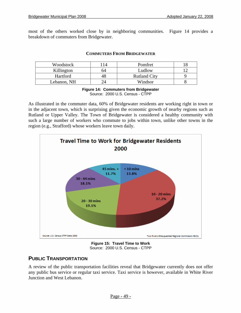
Bridgewater Municipal Plan 2008 Adopted January 22, 2008
most of the others worked close by in neighboring communities. Figure 14 provides a breakdown of commuters from Bridgewater.
COMMUTERS FROM BRIDGEWATER
Woodstock 114 Pomfret 18 Killington 64 Ludlow 12 Hartford 48 Rutland City 9
Lebanon, NH 24 Windsor 8 Figure 14: Commuters from Bridgewater
Source: 2000 U.S. Census - CTPP
As illustrated in the commuter data, 60% of Bridgewater residents are working right in town or in the adjacent town, which is surprising given the economic growth of nearby regions such as Rutland or Upper Valley. The Town of Bridgewater is considered a healthy community with such a large number of workers who commute to jobs within town, unlike other towns in the region (e.g., Strafford) whose workers leave town daily.
Figure 15: Travel Time to Work
Source: 2000 U.S. Census - CTPP
PUBLIC TRANSPORTATION A review of the public transportation facilities reveal that Bridgewater currently does not offer any public bus service or regular taxi service. Taxi service is however, available in White River Junction and West Lebanon.
Page - 49 -
Bridgewater Municipal Plan 2008 Adopted January 22, 2008
Air travel services are available in the nearby airport in West Lebanon, New Hampshire.
Currently, the lack of public transportation services has led to a dependency on private automobiles to commute to work. The development of carpooling or vanpooling, either by private arrangements or through Vermont Rideshare, would have the benefit of decreasing dependence on private autos. The current Stagecoach strategic plan calls for developing a US Route 4 Bridgewater-Woodstock-Hartford-Upper Valley fixed route system. The logical stop for such a service would be a US Route 4 Bridgewater East park and ride. This park and ride facility is a most welcomed and would facilitate carpooling and vanpooling, particularly to major employment centers in the area such as Dartmouth Hitchcock Medical Center. Park and Ride facilities are being established in other small Vermont towns and are eligible for full state funding.
The Thompson Senior Center offers limited van service to participants for travel from home to the center as well as for trips to shopping and banking facilities. Bridgewater and the surrounding towns contribute through taxes to this service that is also federally supported. Vermont has the greatest population of elderly people in the union, and as demonstrated by the population distribution in Figure 4, Bridgewater has a higher than average population of elderly residents. Non-fixed route services such as elderly and disabled transportation through Stagecoach or Thompson Senior Center will be a growing need. This is consistent with resident’s desire to ‘age in place’, and so the community should better support public transportation in the future.
ROAD AND CULVERT MANAGEMENT The town of Bridgewater has inventoried and assessed every road mile and culvert. The Road Surface Management System (RSMS) and culvert inventory gives the town a better local match rate on state grants and helps town officials manage their system. These are important assets of the local transportation system.
SAFETY PLANNING AND ENFORCEMENT National and state data statistics show that speeding is one of the greatest contributors to crashes and that speed is one of the highest contributing factors to fatal crashes. There are two approaches to improve safety, which are preventing crashes and mitigating those effects. As previously mentioned, the number of accidents on US Route 4 has reduced dramatically in the town due to the presence of a County Sheriff and with vigilant speeding enforcement through speeding tickets. Policies
1. To ensure safe and dependable transportation for the residents of Bridgewater, and other users of the roads, at a cost within the Town's budget, it is recommended that all existing
Page - 50 -

Bridgewater Municipal Plan 2008 Adopted January 22, 2008
roads be maintained and upgraded according to the functional classification designated herein.
2. Where new developments are proposed with access to town highways, and where such developments necessitate improvements to certain town highways, it is recommended that the developer pay for the major share of the costs of making such improvements to the town roads. Prior to the issuance of any required permits, an agreement should be reached between the Selectboard and the party’s proposed new development as to what a fair share for both the Town and the developers would be.
3. Any new roads constructed by developers of land within Bridgewater should be constructed to the standards of the town's road system, and only after consultation with the Selectboard and obtaining their approval for such construction.
4. Any Route 4 improvements must balance the need versus the environmental, social, cultural, and historical costs. Extensive changes to Route 4 are contrary to this Plan.
5. As an alternative to complete discontinuance of Class 4 Town Highways, the Town should retain them for recreational use or down grade them to legal trail status that preserves public access. Legal trails can be gated with the approval of the Selectboard but cannot be locked.
6. The development of bike lanes and pedestrian pathways or sidewalks along or parallel to Route 4 are supported and would support bike tours and the associated business opportunities. The Town is encouraged to support these projects.
Recommended Actions
1. Seek state funding to create a Park and Ride facility in Bridgewater. Identify local businesses to donate parking space for this effort.
2. Establish a local ride share bulletin board and create the same service on a new town website.
3. Investigate local bus companies that could expand service into Bridgewater. Seek grant funding to establish a local bus stop on existing routes.
4. Maintain current management on road and culvert inventory to keep opportunities for state grants available.
5. Continue with speed enforcement or introduce traffic calming options to maintain a safer environment for pedestrians and drivers.
Page - 51 -
Bridgewater Municipal Plan 2008 Adopted January 22, 2008
ENERGY PLANNING AND CONSERVATION
BACKGROUND Vermont planning law provides that municipal plans include an energy program for the community. Such a program is intended to promote efficient and economic utilization of energy. Pragmatic energy planning and implementation results in positive environmental and economic returns to the community and energy providers. Conservation of energy lessens the demand for expensive new sources. Utilities are able to postpone capital investments necessary to provide for additional capacity. Such a practice has benefits to residents, businesses, and ratepayers. While it is recognized that energy supply and demand are directed largely by economic forces at the state, federal, and international levels, the manner in which the Town plans for future growth can have an impact on energy. For example, a highly dispersed and unplanned pattern of land use can waste both land and energy resources. By planning the location of jobs, public services and housing in close proximity to growth centers, the consumption of fuel and the need for additional roads can be reduced. The siting and design of buildings and the selection of energy systems can influence the efficiency and conservation of energy. Historically, energy has been taken largely for granted because it is relatively abundant and cheap. Society becomes “energy conscious” only when supplies are threatened and prices are up. The Town must not be paralyzed by the belief that many of the energy related issues are beyond its control and can only be solved at the national and international levels. Local governments and individuals are in key positions to influence energy policies and use. Energy Demands - According to the Vermont Comprehensive Energy Plan (1991), the major fuels consumed in Vermont are oil (65%), electric (17%), wood (8%), LPG and gas (6%), and other (4%). Per capita energy consumption for residential and transportation purposes is about the same as in the Northeast. About 76% of all energy used is for these purposes. Almost 80% of residential energy is dedicated to space heating and domestic hot water. State energy officials estimate that simple conservation measures incorporated in new housing can result in a 20% to 30% reduction of energy usage. About half of all energy used in Vermont (hence, most likely in Bridgewater) is for transportation. Over 50% of this is used for residential users who use private cars. Public transportation in Bridgewater is nearly non-existent and as a result, there are few alternatives, if any, to the automobile. Renewable Energy - Approximately 40% of Vermont households use wood as a fuel source for heating. About 23% use wood as their primary source of heat and 17% use wood as a supplemental heat source. The Department of Public Service estimates that the average household uses between three and four cords of wood each year during the heating season. Given the total number of housing units in Bridgewater (571 in 1990), it is estimated that between 1,713 and 2,284 cords of wood are consumed annually.
Page - 52 -
Bridgewater Municipal Plan 2008 Adopted January 22, 2008
Increased reliance on wood as a heating source can offset some demand for expensive alternative sources. Recently, prices of fuel oil have dropped causing many homeowners to shift from wood to oil. Bridgewater has thousands of acres of timberland that are underutilized and its own forests could supply all of its homes and other buildings without difficulty for heating. There is a potential side effect to this, however, as significant use of wood could contribute to increased air pollution, particularly in valley areas. Goals
1. To encourage a pattern of settlement and land use that uses energy efficiently.
2. To promote the design and construction of buildings and structures that are energy efficient and postpone the need for costly sources of energy.
3. To encourage the development of local renewable energy sources and to reduce dependence on outside foreign energy sources.
4. To increase public awareness and use of energy conservation practices through educational efforts.
Policies
1. Planning which reduces the dependency and demand for new sources of energy are matters of public good. Likewise, conservation of energy usage is encouraged. To meet this policy, the following practices are recommended:
a. development of existing and current transportation routes and highways need to reflect design and location principles that complement the recommended land use and settlement patterns set forth in this Plan. Major public investments, such as schools, public recreational areas, and municipal facilities need to be situated within or in close proximity to the village of Bridgewater;
b. the rehabilitation or the development of new buildings and equipment should be encouraged where use of proven design principles and practices demonstrates the lowest life cycle costs;
c. where land development or subdivisions are proposed, design plans should work towards the goal of locating structures and buildings on the site that reflect sound energy conservation principles, such as solar and slope orientation and protective wind barriers. Use of the cluster planning concept, where buildings are concentrated in one area of a site with a complementing off-set of open space, is an approach that encourages energy conservation and efficiency; and
d. given that electrical generation, transmission, and distribution facilities are significant visual contributors of the landscape, it is the policy of the Town to encourage efforts to monitor the negative effects of these facilities on the landscape and adjacent uses. Accordingly, where such facilities are proposed, design plans should uphold recognized standards and practices to minimize any adverse visual impacts.
2. Where generation, transmission, and distribution facilities or service areas are proposed, such facilities or areas should be encouraged only when they complement the recommended land use patterns set forth in this Plan.
Page - 53 -
Bridgewater Municipal Plan 2008 Adopted January 22, 2008
3. As alternatives to the automobile, the acquisition of land or rights to land by the Town or other qualified entities for the future development of bikeways and footpaths is encouraged in the village areas or other areas of concentrated settlement.
4. To reduce the demand for commuter transportation facilities and energy, the development of energy efficient home occupations and small-scale home business is encouraged.
5. To ensure a sustainable source of fuel wood production and improvement of Bridgewater’s forests at a reasonable rate of return, such lands should be taxed at use value and not at development value.
6. To promote energy efficient commuting, the community supports state and regional transportation programs serving Bridgewater.
Recommended Actions
1. The Town, if undertaking development of land use regulations, should consider enacting provisions that encourage innovation of energy conservation and concentrate development in the best locations (e.g., grant density bonuses to projects that employ advanced energy design and efficiency).
Page - 54 -

Bridgewater Municipal Plan 2008 Adopted January 22, 2008
PLANNING FOR TELECOMMUNICATIONS FACILITIES
BACKGROUND Telecommunications have become increasingly, important to the security, and economic needs of residents and businesses in the Upper Valley. This trend will continue. It will play a key role in the Upper Valley's economic future, creating new opportunities for the relocation and growth of decentralized business operations and reducing demands for travel by conventional modes. With an improved telecommunications infrastructure, large amounts of information can be conveniently moved over long distances at competitive rates. The field of telecommunications is undergoing rapid change. Advancements in this technology have and will continue to impact growth in Bridgewater. The implications for land use are significant, as this technology has enabled people to move into rural areas of the Town and to "telecommute" to other remote or central offices more readily. Under present standards, transmission towers are the dominant telecommunications facilities. As land uses, these towers have emerged as planning concerns. Towers may emit electromagnetic radiation that affect human health, can conflict with other forms of development, and raise issues of aesthetic impact. To ensure adequate transmission of signals in mountainous areas, towers and related facilities often times need to be confined to hilltops or high elevation points. Thus, due to their higher visibility from multiple vantage points, conflict with scenic landscapes has become to be an issue. The Federal Communications Commission (FCC) retains jurisdiction over public airwaves and the telecommunications industry in general. Additionally, the Federal Aviation Administration (FAA) exercises control over the location and height of towers and similar structures to prevent interference with airport operations. Under Vermont law (24 V.S.A. Chapter 117), municipalities may require that certain standards be met prior to the erection of telecommunication facilities. Local bylaws may regulate the use, dimension, location, and density of towers; however, FCC rules are preemptive of local and state law where conflicts exist. In 1997, Act 250 jurisdiction was conferred by the State requiring a permit prior to the construction of a communications tower or similar structure over 20 feet in height. Goals
1. To preserve the rural character and appearance of the Town of Bridgewater.
2. To protect the scenic, historic, environmental, and natural resources of the Town of Bridgewater.
3. To provide standards and requirements for the operation, siting, design, appearance, construction, monitoring, modification, and removal of telecommunication facilities and towers.
4. To minimize tower and antenna proliferation by requiring sharing of existing communications facilities, towers and sites, where possible and appropriate.
Page - 55 -

Bridgewater Municipal Plan 2008 Adopted January 22, 2008
5. To facilitate the provision of telecommunication services to the residences and businesses of the Town of Bridgewater
6. To minimize the adverse visual affects of towers and related facilities through careful design and siting standards.
7. To encourage the location of towers and antennas in non-residential areas and away from visually sensitive areas, prominent scenic areas, historic areas, and the White River.
Policies
1. In order to minimize tower proliferation, it is the policy of the Town that applicants exhaust all reasonable options for sharing space on existing towers prior to proposing new towers and related facilities. The principle of co-location is the favored alternative. In making such a determination on the feasibility of co-location, prospective developers should conduct a due diligence effort to evaluate space available on existing towers, the tower owner's ability to lease space, geographic service area requirements, mechanical or electrical incompatibilities, the comparative costs of co-location and new construction, and regulatory limitations.
2. It is the policy of the Town that existing wireless service providers be required to allow other providers to co-locate on existing facilities, subject to reasonable terms and conditions.
3. One of the Town's principal scenic qualities is its ridgelines and mountainsides. These areas are significant contributors to the maintenance and enjoyment of rural character. These ridges are predominately undeveloped and provide an unbroken skyline viewed from the valley floor. It is the policy of the Town that use of ridges for telecommunication towers and related facilities needs to be undertaken in a manner that will not detract or adversely affect these scenic values. Accordingly, protection of these areas from insensitive developments are matters of public good. To minimize conflict with scenic values, facility design and construction should employ the following principles:
a. be sited in areas minimally visible to the traveling public, particularly for users of Routes 4, 100, and 100A, from residential areas, historic buildings or sites, public use areas, shorelines or lands immediately adjunct to the Ottauquechee River, and public outdoor recreation areas such as hiking trails, including the Appalachian Trail;
b. be located in forested areas or be sufficiently landscaped to screen the lower sections of towers and related ground fixtures from public vantage points, such as trails, roads, or water bodies;
c. utilize materials, architectural styles, color schemes, mass, and other design elements to promote aesthetic compatibility with surrounding uses and to avoid adverse visual impacts;
d. where prominent views of a site exist, be located downgrade of the ridge so as not to exceed the elevation of the immediate ridge;
e. where construction of access roads are involved to minimize visibility, be situated to follow the contour of the land and to avoid open fields or meadows; and
Page - 56 -
Bridgewater Municipal Plan 2008 Adopted January 22, 2008
f. avoid peaks and ridges that are locally significant or regional focal points.
4. It is the policy of the Town that towers not be illuminated by artificial means and not display strobe lights.
5. It is the policy of the Town that the height for towers, antennae, and tower-related fixtures not exceed 30 feet above the average height of the tree line within the immediate vicinity of a wireless communication facility.
6. It is the policy of the Town that in planning for telecommunication facilities, due consideration be given to the environmental limitations of any given site. Impacts of the use on wildlife habitats, soil erosion, forestry and agricultural lands, and similar resources should be carefully addressed. Projects that materially influence these resources are discouraged.
7. It is the policy of the Town that telecommunication projects situated on lands owned by the State, design plans that are compatible with current Management Plans for Public Lands adopted by the Agency of Natural Resources.
8. It is the policy of the Town that towers, antennae, and related fixtures that fall into disuse, or are discontinued be removed to retain the values set forth above. Local and state land use permits should incorporate removal of inactive fixtures as a condition of approval.
9. It is the policy of the Town that the policies of this section serve as a clear written community standard intended to preserve the aesthetics or scenic beauty of the Town of Bridgewater. Accordingly, it is the intent that this section be utilized by the District Environmental Commission or the Vermont Environmental Board as part of an aesthetics analysis for all wireless communications facilities. These policies shall be used, however, not exclusively, to determine whether or not a project fits the context in which it will be located, is highly visible, and results in an adverse impact on scenic resources.
Page - 57 -
Bridgewater Municipal Plan 2008 Adopted January 22, 2008
AESTHETICS AND OUTDOOR LIGHTING
ISSUES AND OPPORTUNITIES Increased development in the Town in recent decades has brought about a corresponding increase in the use of outdoor lighting. These include new parking lots, brighter street lighting, floodlights on commercial and industrial complexes, and lighted gas station canopies at our interchanges and along our major roads. While increased lighting can be seen as an inevitable result of growth, there is a concern that excessive and unplanned lighting results is unwise and uneconomic energy use, contributes to "light pollution", affects our ability to view the night landscape as well as creating an adverse impact on the character of our historic village. With the advent and increased use of new lighting technologies since the 1950's, commercial enterprises, industry, public utilities, and others now have new tools to shape the nighttime environment. Many of these new lighting installations are well designed, provide good night vision at reasonable levels, and fit well into their immediate surroundings. Others do not. Problems of glare, over-lighting light escalation, skyglow, and energy waste have become more common. This section is intended to provide guidance and standards to assist policymakers in evaluating lighting issues, opportunities, and costs. It is also intended to provide clear policy statements to developers and enable them to evaluate new lighting installations located on public and private property. By selecting a lighting design that enhances the nighttime comfort, our historic village, other areas planned for concentrated mixed use, and rural areas will be better served. The purpose of an outdoor lighting installation should be to enhance the visibility necessary to provide lighting for a given task or need. Using a large quantity of light does not guarantee good visibility, however. Over lighting can cause glare and other problems that hinder good vision. Lighting problems arise when competing properties are illuminated at very different levels. For example, a brightly lit auto sales parking lot situated next to an adequately lit restaurant can make it look dark by comparison. Studies have shown that this leads to "competitive" lighting; more light is added to reduce the risk of not being seen. This results in more lighting equipment expense, higher electric bills for businesses, and the loss of character in an area. Excessive light levels can vary according to the use. Conventional parking lots generally need higher light levels than passive recreational parks. Using the minimal amount of light necessary to allow adequate visibility for a site decreases skyglow and avoids escalation of light levels. Glare is another lighting issue facing growing communities in the Upper Valley, including Bridgewater. Excessive brightness makes it difficult to see. Good visibility can be accomplished with less light. Misdirected fixtures or unshielded lamp sources cause glare. Light that is not directed toward the ground or towards the intended surface can shine into the viewer's eyes, impairing vision and causing potential safety problems. Skyglow or reflected light front surfaces is visible in the night sky over villages or large commercial/industrial complexes. Sky glow is a form of "light pollution.” Sky glow contributes
Page - 58 -

Bridgewater Municipal Plan 2008 Adopted January 22, 2008
to a loss of our ability to see stars and other celestial elements of our galaxy. Reducing skyglow is a desirable objective for the Town. Techniques to reduce the amount of illumination shining directly into the sky can reduce skyglow and the overall level of lighting to be used. Goals
1. To preserve the nighttime ambiance and aesthetic qualities of the village and other places by illuminating them for safety and convenience in ways that enhance the best qualities of streets, architecture, and public spaces.
2. To enable outdoor lighting systems that conserve energy and minimize life cycle costs.
3. To encourage lighting design that is creative and functional consistent with these lighting goals and policies.
Policies
1. It is the policy of the Town that in developing lighting plans, observance of good design light levels and distribution be appropriate for the proposed use of the site and compatible with the character of the neighborhood. New lighting installations should be designed to minimize glare, to not directly light beyond the boundaries of the area to be illuminated or onto adjacent properties, and to not result in excessive lighting levels.
2. It is the policy of the Town that for large projects, lighting professionals follow lighting design guidelines and other technical information established by the Illuminating Engineering Society of North America (IESAA). Such information will be useful in evaluating and developing lighting schemes for particular uses and settings, but not necessarily in all situations. Additionally, it is the policy of the Town that project planners give due consideration to the guidelines set forth in the "Outdoor Lighting Manual for Vermont Municipalities,” published by the Chittenden County Regional Planning Commission (1996). Design plans that exceed IESNA or the Manual recommendations for outdoor lighting should be evaluated for conformity with this Plan, particularly as they may relate to the effects on the character of the area and aesthetics.
3. It is the policy of the Town that project designers utilize fixtures to reduce glare. Where a light source is particularly bright compared to its background, use of cut-off or shielded fixtures to direct light downward or a reduction on the amount of light being generated is encouraged. Such a practice should utilize lighting more efficiently, minimize the amount of wasted light, and reduce energy costs.
4. It is the policy of the Town that excessively high lighting levels for uses in rural or very low density residential areas are inappropriate. Where neighborhoods are characterized by heavy traffic, larger facilities (i.e. schools, and industrial plants), or high parking turnover rates, higher lighting levels may be appropriate. Where high ambient or background lighting levels are adjacent to planned uses, such levels should be considered when evaluating light levels for new installations.
5. Lighting at gasoline stations and convenience stores, and some types of commercial establishments (i.e. Sharon Industrial Park) have or may become lighting issues. Such facilities are typically far more brightly illuminated than neighboring properties to attract attention to the business. Glare hinders visibility for pedestrians and drivers on major
Page - 59 -

Bridgewater Municipal Plan 2008 Adopted January 22, 2008
highways. It is the policy of the Town that lighting levels for these uses and similar uses only, be sufficient to facilitate the activities taking place in such locations. Lighting schemes that serve as advertising or to attract attention to these uses are discouraged. Signs or other forms of advertising should be used for these purposes. Excessive pole height and bright lighting fixtures are inconsistent with this Plan.
6. Illuminated signs that are excessively bright, causing glare and illuminating surrounding areas are inappropriate. It is the policy of the Town that large illuminated signs are disruptive to rural areas or Bridgewater's historic village and that they should be discouraged.
7. Lighting designs should address the negative effects of skyglow. Project designers should advocate for lighting plans that minimize light pollution without unduly compromising safety, security, or utility. Methods to be used for minimizing skyglow are:
• directing luminaries downward toward the ground;
• using low pressure sodium lamps;
• turning lights off after hours;
• reducing illumination levels; and
• prohibiting rays of light from being emitted above 90 degrees from Luminaries.
8. It is the policy of the Town that outdoor lighting schemes employ generally available mitigating steps to improve harmony with its surroundings taking into consideration, among other things, the type and density of land use presently in existence, the type of topography, and whether the area has scenic value.
Page - 60 -

Bridgewater Municipal Plan 2008 Adopted January 22, 2008
BRIDGEWATER'S PLANNING AND ITS RELATIONSHIP TO OTHER PLANNING ACTIVITIES
KEEPING THE PLAN REALISTIC AND RELEVANT The statements, goals, and policies set forth in this Plan to guide growth extend from the desires and needs expressed by the people of Bridgewater. It is intent on articulating a clear vision for the future. Successful implementation of Plan goals depends on the public’s commitment to it. The Planning Commission and Selectboard cannot alone bear the responsibility for planning. Citizens must ensure that the Plan is dynamic and remains realistic. They must remain informed and involved. While local control is recognized and to an extent desirable, neither the Town nor its citizens have total control over the focus that will affect growth in Bridgewater. There are numerous social and economic factors driven by national and international events or conditions beyond our control. In spite of this, the community needs to relate this to those planning activities and programs set forth in this Plan.
NEIGHBORING TOWN PLANNING ACTIVITIES This Plan is consistent with the goals set forth in 24 V.S.A., Section 4302 and is compatible with the plans or planning activities of adjacent towns, the Two Rivers - Ottauquechee Region and various state agencies. In the development of this Plan, all of the goals set forth in Section 4302 have been incorporated and addressed. Where necessary or appropriate, the Planning Commission has adapted them to fit Bridgewater. This Plan is based, in part, on the inter-relationship among Bridgewater, adjacent towns and the rest of the region, and past development trends in those areas. Analysis of these inter-relationships has reaffirmed the realization that these goals cannot be achieved without the cooperation of neighboring towns and the State. Likewise, they need Bridgewater’s commitment to help them achieve their goals. The Town is open and available to working with these towns and the State. The Towns of Woodstock, Plymouth, Reading, Barnard, Pomfret, Stockbridge, and Killington abut Bridgewater. All of these communities have adopted municipal plans prepared under 24 V.S.A., Chapter 117. To ensure that municipal plans are reasonably compatible with one another and that potential conflicts in land use development are identified and possibly addressed, it is recommended that the Planning Commission’s of these communities jointly meet from time to time.
Page - 61 -

Bridgewater Municipal Plan 2008 Adopted January 22, 2008
REGIONAL PLANNING ACTIVITIES Bridgewater is within the Two Rivers - Ottauquechee Regional Commission. It is one of thirty (30) municipalities that comprise the Region. The Region covers northern Windsor County, most of Orange County, the Town of Pittsfield in Rutland County, and the Towns of Hancock and Granville in Addison County. The Commission was chartered in 1970 by the acts of its constituent towns. All towns are members of the Commission, and town representatives govern its affairs. One of the Regional Commission’s primary purposes is to provide technical services to town officials and to undertake a regional planning program. As is the case in many areas of the State, the extent of local planning throughout the region is varied. Some municipalities are more active than others are. Thus, the level of services to each of the towns changes with time.
The Regional Commission adopted its Regional Plan in May 2007. It will remain in effect for a period of five years. This Plan was developed to reflect the general planning goals and policies expressed in the local plans. It is an official policy statement on growth and development of the Region. The Regional Plan contains several hundred policies to guide future public and private development in the Region. Policies for land use settlement are identified. These areas are: Town Centers, Village Settlement Areas, Hamlet Areas, Rural Area, and Conservation and Resource Areas. Although delineation of each land use area is not precisely mapped or charted, policies for management of new development within these areas are substantially similar to those set forth in detail in the Bridgewater Municipal Plan. Accordingly, it is reasonable to conclude that the Bridgewater Municipal Plan and the Regional Plan are compatible, complementary to one another and the goals of the Planning and Development Act (24 V.S.A. Chapter 117).
Page - 62 -
Bridgewater Municipal Plan 2008 Adopted January 22, 2008
PLAN IMPLEMENTATION This Municipal Plan outlines numerous recommendations and policies for accomplishing its many stated purposes and objectives. It is a duly adopted public policy statement made by and for the citizens of the Town. In Vermont, municipalities are given numerous ways in which to implement their municipal plans. The following paragraphs explain generally the methods that may be utilized to implement the Bridgewater Town Plan.
REGULATORY METHODS Land development and subdivision of land may be regulated by laws adopted by vote of the Town. The parameters by which municipalities can create and enforce these bylaw provisions are set forth inconsiderable detail under the Vermont Planning and Development Act (24 VSA, Chapter 117). Essentially, there are zoning regulations, subdivision regulations, and official maps. In addition, the Town may exercise control over new developments by adoption of health regulations and highway ordinances. Zoning Bylaws (Bridgewater does not have) - Zoning bylaws typically establish general land use districts throughout the Town. Within these districts, prior to the erection of a building or change in use of a present building, an application for a permit would have to be submitted to the town. In granting the permit, the Town would have to find that the project, as proposed, would meet area and use criteria established for the district.
Subdivision Regulations (Bridgewater does not have) - Adoption of a subdivision regulation would give authorization to the Planning Commission to approve, modify, or disapprove the division of all land into two or more lots. In rendering approval for the subdivision of land, the Planning Commission would have find such land division, as planned, would meet standards for the design and layout of streets and roads, water, sewage, public utilities, and drainage facilities. Prior to any action by the Planning Commission, a public hearing would be required with notice to all affected property owners.
Official Map (Bridgewater does not have) - Although little used in Vermont, municipalities may adopt an official map showing the location and widths of existing and proposed rights-of-way of all streets or drainage ways and the location of all existing and proposed public facilities. Within the bounds, as outlined and described on such a map, building development or improvements could be prohibited or limited so as to not adversely affect such existing facilities or those planned by the Town of Bridgewater.
Health Regulations - Municipalities may adopt health regulations relating to the installation and maintenance of sewage disposal systems. Such a regulation typically would require that, prior to the construction or replacement of an on-site waste water disposal system, a permit be obtained from the Town Board of Health. In granting permits for these systems, the Board would have to find that the systems, as designed and proposed for construction, complied with accepted standards related to system design and operation. The Town of Bridgewater has had in effect a health ordinance regulating the installation of a sewage disposal system since September, 1981.
Highway Ordinance - Towns can adopt and administer an ordinance for the purpose of establishing a municipal policy and practice for the maintenance and upgrading of existing town roads and to set forth standards by which new roads may be added to the town highway system.
Page - 63 -
Bridgewater Municipal Plan 2008 Adopted January 22, 2008
Through such an ordinance, the municipality can prevent or control highway improvements that would cause unreasonable congestion or unsafe conditions or significantly affect the financial capacity of the Town to provide for such improvements.
NON-REGULATORY METHODS Although the primary implementation tools for a Municipal Plan are generally considered to be regulatory in nature, there are a number of non-regulatory means that can be used to supplement local land use regulations. The use of non-regulatory methods has gained in popularity in Vermont in recent years. To a large extent, this can be attributed to voluntary cooperation between property owners, citizen interest groups, and town government; and the degree of flexibility that can be utilized to meet the objectives of both the public and private sectors. Outlined below is a brief description of the non- regulatory methods that may be employed by Bridgewater to implement its Municipal Plan. Vermont Land Trust - The Vermont Land Trust, headquartered in Montpelier, is a non-profit charitable corporation whose principal goals are to protect and encourage the productive use of farm and forest land, create opportunities for farmers or foresters to acquire land and to assist in directing development on to suitable lands.
The Trust achieves these goals by negotiating agreements with private landowners. This task frequently requires reconciling the owner's financial needs with conservation needs. The Trust assists in tax planning for the property owner and has in past projects worked out plans that would allow for limited development of the property. Every agreement that is achieved assures permanent protection of the land resources.
Examples of conservation options available include conservation easements, gifts of land, leasing, and purchase.
Public Sector Conservation by acquisition of Land - Under Vermont law, municipalities have the power to acquire land or interests in land for the purpose of maintaining farm, forest and other open land, recreation and service areas. Acquisition of whole or partial interest in land consistent with the above purposes can serve to implement the recommendations of the Bridgewater Town Plan.
Conservation Commissions - Although few towns in Vermont have established Conservation Commissions, they have been very effective in other New England States. Conservation Commissions, whose members are appointed by the Selectboard, may undertake a number of conservation activities designed to encourage the maintenance of open space, improved forestry markets, and practices, and the protection of rare and unique natural areas.
Further information about this program can be obtained from the Two Rivers-Ottauquechee Regional Commission.
Current Use Value Appraisal Techniques - By far the majority of the land in Bridgewater is timber or forest land. In Vermont, municipalities may appraise and tax certain forest land according to its use value rather than market value at the request of the property owner. In so
Page - 64 -

Bridgewater Municipal Plan 2008 Adopted January 22, 2008
doing, the taxes on such property is reduced, however, the landowner who is benefited from the reduction must be willing to make a long-term commitment to keep his land in forestry production. The use value or tax is based upon the productivity value the higher the use value. The State has, since the commencement of the program, reimbursed the Town for the difference in lost property tax revenues. To remain eligible for the tax break, the landowner must agree to manage his timberland in accordance with an approved forest management plan, approved by the Town Listers.
More information about this program can be obtained from the Bridgewater Town Listers or the Two Rivers-Ottauquechee Regional Commission.
Page - 65 -
Bridgewater Municipal Plan 2008 Adopted January 22, 2008
CONSIDERATIONS ABOUT
DEVELOPMENT IN BRIDGEWATER What follows are thoughts about development that we hope will help facilitate what we, the people of Bridgewater, look towards as a cooperative and valuable relationship between potential developers and the community. Bridgewater residents hold dearly to the values of small town life, of community involvement in various activities and social functions that knit the people of a small town together. The people of Bridgewater value highly the visual beauty of their farms and open spaces, their forests and mountain tops and scenic ridgelines, their churches, old homes and stores centrally located in Bridgewater Village, Bridgewater Corners, Bridgewater Center, and West Bridgewater. These values represented by these things are what make up the standard of the quality of life that is why we choose to live here. We believe that it is our duty to see that the beauty of hamlet and village, of field and forest, is handed down not only to our children and grandchildren but also to the residents and children who will live here a hundred and two hundred years from now. We believe that these values outweigh any immediate monetary gain. Further we believe that development just for development's own gains and profits, without concern for the standards of the town, is not to be considered to be in the town's best interest. This kind of growth only adds to the required services that the Town must provide, at taxpayer expense, and to the visual and scenic destruction of this very beautiful Vermont town. The following things are important to the Town and should be considered in planning any development in Bridgewater: Preservation of open land Establishment of low-income housing Betterment of town services, facilities and equipment Maintenance of the quality of life which is to be had here. Peter Bramhall, for the Planning Commission January 1990
Page - 66 -

Bridgewater Municipal Plan 2008 Adopted January 22, 2008
Page - 67 -
TOWN PLAN MAPS MAP 1 – CURRENT LAND USE MAP 2 – FUTURE LAND USE MAP 3 - TRANSPORTATION MAP 4 – UTILITIES, FACILITIES & EDUCATION