Branston Locks, Burton upon Trent - East Staffordshire … Applicatio… · · 2012-11-30Branston...
19
Technical Appendix Branston Locks, Burton upon Trent Tree Survey Report 14 November 2012 Nurton Developments (Quintus) Ltd 6801/R02/Rev2
Transcript of Branston Locks, Burton upon Trent - East Staffordshire … Applicatio… · · 2012-11-30Branston...

Technical Appendix
Branston Locks, Burton upon Trent
Tree Survey Report
14 November 2012
Nurton Developments (Quintus) Ltd
6801/R02/Rev2
lisa.roberts
Text Box
P/2012/01467 Received 15/11/12

14 November 2012 │ Nurton Developments (Quintus) Ltd │ 6801/R02/Rev2
Contents
1 Introduction 1
1.1 Terms of Reference 1
1.2 Site Description 1
2 Methodology 3
3 Survey Results 4
3.1 Terms Used in Appendix 1 4
3.1.1 Age Class 4
3.1.2 Physiological Condition 4
3.1.3 Structural Condition 4
3.1.4 Retention Grade 4
3.1.5 Comments 5
3.2 Summary of Survey Findings 5
4 Recommendations 7
4.1 Tree Protection Measures 7
5 Summary 8
Appendix 1 : Tree Survey Schedule 9
Figure : Tree Survey Plan
Rosebery House,
9 Haymarket
Terrace,
Edinburgh,
EH12 5EZ
Moray House,
16-18 Bank Street,
Inverness,
IV1 1QY
Durham Dales
Centre,
Castle Gardens,
Stanhope,
County Durham,
DL13 2FJ
Mynydd Awel,
Mold Business Park,
Maes Gwern,
Mold,
CH7 1XN
Keystone
Innovation Centre
Croxton Road
Thetford
Norfolk
IP24 1JD
Document Prepared For
R.J. Young
Nurton Developments (Quintus) Ltd
2nd Floor, 11 Waterloo Street
Birmingham
B2 5TB
Document Prepared By Document Approved By
C. Lake, MIEEM
Senior Consultant
M.J. Boardman, MSc MICFor
Arboriculturist
Karen Atkins
Technical Director
Version Date Reason
6801/R02/Rev1 09th November 2012 Draft issued for client team comment
6801/R02/Rev2 14th November 2012 Final report
Copyright © 2012 Atmos Consulting Ltd
14 November 2012 │ Nurton Developments (Quintus) Ltd │ 6801/R02/Rev2 1
1 Introduction
1.1 Terms of Reference
In April 2009 Atmos Consulting Ltd was commissioned by Nurton Developments
(Quintus) Ltd to provide a Tree Survey Report in connection with the proposed mixed
use development of employment and residential land and associated infrastructure on
a site referred to in this report as ‘Branston Locks’, located on land off Branston Road,
Burton upon Trent.
The tree survey was undertaken by a qualified Arboriculturist, who recorded details of
all trees/tree groups on site within the layout of the proposed development in
accordance with the then-current British Standard BS 5837: 2005 Trees in relation to
construction: Recommendations. The assessment of tree retention values was
undertaken on the day of survey without reference to the development layout plan.
This report therefore provides the baseline information on the trees present within the
Branston Locks site, independent from the development proposals. The potential effects
of the development footprint on the trees present are described in the Environmental
Statement.
It should be noted that this report is not a Tree Risk Management Report or a Hazard
Analysis Report, and should not under any circumstances be used as such.
The results of the survey were re-verified on 30th August 2012. Due to the changing
nature of trees and other site circumstances, this report and any recommendations
made are limited to a 12 month period. Any alteration to the application site or any
development proposals could change the current circumstances and may invalidate
this report and any recommendations made. Should this be the case this report will
require revision to reflect the development proposals.
1.2 Site Description
The Branston Locks site is approximately 136.19ha in size and is situated to the north west
of Burton upon Trent, adjacent to the A38 trunk road, which forms the eastern
boundary. It is a generally linear site which is at its widest in the south west where it is
bounded by Branston Road, and tapers to the north east where it ends at Shobnall
Road.
The site supports large flat arable fields which are surrounded by mostly intact hedges
with standard trees, and occasional ditches. It is bisected by the Trent and Mersey
Canal and the private access road Anglesey Street, which leads to Lawns Farm, the
main farmstead on the site, and adjacent ‘The Bungalows’.
The open fields rise in the west up as the Needwood Scarp to Battlestead Ridge, which
is a steep-sided spine of wooded land running adjacent to and parallel with the site
boundary. The highest point on the ridge, known as Battlestead Hill supports a small
area of mature secondary sycamore Acer pseudoplatanus woodland on an Ancient
Woodland site. To the north of this woodland the ridge supports dense plantations of
mainly deciduous tree species, which were planted in 1996 under a Woodland Grant
Scheme as part of the National Forest initiative, known as the Bass Millennium Wood;
and further north is a mixture of self-sown scrub and secondary woodland known as The

14 November 2012 │ Nurton Developments (Quintus) Ltd │ 6801/R02/Rev2 2
Thorns and The Rough. Pockets of grassland, bramble scrub and tall ruderals are also
present, as well as three ponds, situated on the top of ridge.
14 November 2012 │ Nurton Developments (Quintus) Ltd │ 6801/R02/Rev2 3
2 Methodology At the commencement of work, Nurton Developments (Quintus) Ltd team provided a
topographical map, in electronic format. The tree surveyor used this plan to locate the
centres of individual trees within the application site having a trunk diameter of 300mm
or more at 1.5m above adjacent ground level. As there were large numbers of
standard trees along the field boundaries of the site, the majority have been recorded
as individuals, with a further six areas on the site and one off-site recorded as
woodland/tree groups.
The trees were visited on 8th April 2009 by a suitably experienced team, comprising an
arboriculturist (M.J. Boardman, MSc MICFor) and bat ecologists (Mr A. Nyul, MIEEM and
Dr W Sims, MIEEM) who completed the tree survey through the following actions:
assigning each tree (or group) a number;
identifying each tree’s species;
measuring the girth of each tree;
measuring the branch spread in metres to approximate spatial crown coverage;
estimating tree height;
assigning each tree to an age class;
recording noteworthy aspects of physiological and structural condition;
recording Perceived Safe Useful Life Expectancy (PSULE) in years;
assigning a grade to each tree, A – C, or R, relating to its pre-development retention
value.
The trees were not climbed, with inspections made from the ground, so there is
potential for hidden defects to be present and to have gone undetected in this survey.
This is an inevitable risk associated with any relatively rapid, ground-based survey
technique, but is considered to be an acceptable limitation, given the purpose of this
Tree Survey Report.
It should be noted that, with the issue of the most recent version of the relevant British
Standard (BS 5837: 2012) the reference to trees being within the category ‘R’ would
now be denoted instead as ‘U’, based on their being unsuitable for retention. However,
the criteria applied in both cases is essentially the same. The other aspects of tree
survey that have been amended in the 2012 edition of the British Standard would not
be considered material for a survey undertaken in the current context and of this scale.
In addition to recording the characteristics above for each individual tree/group, notes
were taken by the ecologists on the potential for roosting bats to be present, with
features such as rot holes or cracked branches being of particular interest and
checked with binoculars for signs of bat occupancy, e.g. staining of bark with fur oils,
urine or bat droppings.
14 November 2012 │ Nurton Developments (Quintus) Ltd │ 6801/R02/Rev2 4
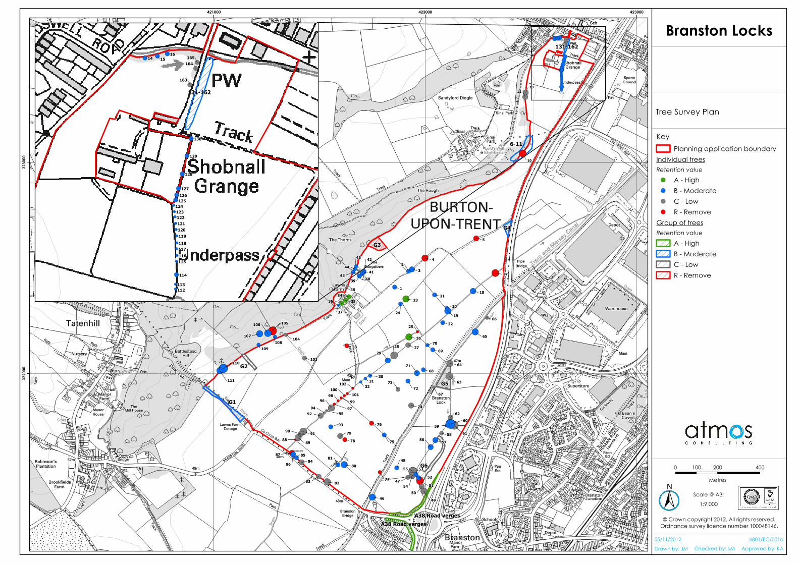
3 Survey Results The survey data are provided in the Tree Survey Schedule at Appendix 1.
The tree numbers and their current retention value grade are plotted on an electronic
plan of the site (see Figure), with coloured spots/shading indicating the grade assigned
in the Tree Survey Schedule. Where trees are assessed as groups, one overall canopy
extent is shown for the group.
3.1 Terms Used in Appendix 1
3.1.1 Age Class
Trees may be assigned to the following age classes:
Young (approximately first third of life)
Early mature (approximately second third of life expectancy)
Mature (approximately final third of life expectancy)
Over-mature (final third of life and showing signs of decline)
Veteran
Dead
3.1.2 Physiological Condition
Under BS 5738: 2005 trees were categorised as to whether they were in excellent,
acceptable, unacceptable or dead/dying/dangerous condition.
3.1.3 Structural Condition
Trees are dynamic structures that can never be fully guaranteed safe: even those in
good condition can suffer damage or decay under average conditions. As the trees
were surveyed from the ground the potential for there to be hidden defects cannot be
entirely ruled out. Structural features that were noted in the schedule at Appendix 1 are
those where the presence of significant decay or damage was evident at the time of
survey.
3.1.4 Retention Grade
The retention grade indicated in the Schedule refers to the advantages of retaining
trees in the context of the current land use, taking into consideration a range of factors
including life expectancy, cultural value and contributions to wildlife, landscape and
amenity. The grades are defined as follows:
A – High value – most desirable to retain in pre-development context
B – Moderate value - desirable to retain in pre-development context
C – Low value – could be retained in pre-development context
R (U) – Remove – unsuitable for retention in pre-development context, including
where recommended for removal for the benefit of adjacent trees.
14 November 2012 │ Nurton Developments (Quintus) Ltd │ 6801/R02/Rev2 5
3.1.5 Comments
This section has been used to denote whether or not the tree or group has been
assessed as having potential to support roosting bats, on the basis of it having a high,
medium or low potential; or no risk, of bats being present.
3.2 Summary of Survey Findings
The trees on site consist of predominantly mature and early mature oak Quercus robur
and ash Fraxinus excelsior in association with hedgerows and field boundaries across
the application site. Pockets of mature white and crack willow Salix alba and S. fragilis
were found characteristically in association with the Trent and Mersey Canal or
networks of ditches, and landscaping belts of Lombardy poplar Populus nigra var.
Italica and Leyland cypress Cupressus x leylandii near houses and farmsteads.
In total 15 species are recorded in the tree survey, as follows:
Oak
Ash
Sycamore
Field maple Acer campestre
Silver birch Betula pendula
Alder Alnus glutinosa
Horse chestnut Aesculus hippocastanum
Poplar
Crack willow
White willow
Hawthorn Crataegus monogyna
Leyland cypress
Scot’s pine Pinus sylvestris
Sitka spruce Picea sitchensis
Larch Larix x intermedia
Trees are numbered from 001 to 165, with tree groups within the site numbered G1 – G6
and the off-site roadside planting along the verges of the A38 trunk road. Most of the
trees – 161 – are within the application site; the exceptions being T46 (in a private
garden); and T105 – 107 inclusive (mature trees, one of which is dead) incorporated
into the Bass Millennium Wood.
The majority of the trees surveyed, 106 (including four off-site trees) and two groups – G1
and G4, are classed as having moderate retention value, i.e. are grade B, shown in
blue on the Tree Survey Plan and Schedule. These incorporate individuals of all tree
species listed above which are in acceptable physiological condition and considered
to be desirable to retain within development proposals where possible due to their
landscape/amenity value and/or form. Also included in this grade are most of the
veteran ash trees along the southern foot of Needwood Scarp known as The Rough.
There are five trees categorised as being of high retention value on the site as these
were of excellent form and/or of amenity significance in their current context. These

14 November 2012 │ Nurton Developments (Quintus) Ltd │ 6801/R02/Rev2 6
grade A trees are all within the application site and are shown in green on the Tree
Survey Plan and Schedule. Two are mature oak trees (T23 and T26), situated along a
field boundary (T23) and the main ditch (T26) respectively; and three Scot’s pine (T34 –
36) are in a row forming the setting to the farmhouse at Lawn’s Farm. Additionally, the
trees outside the application site but on the verges of the A38 trunk road are also
assessed as justifying an ‘A’ retention grade as the majority of the trees are in their early
mature stage, acceptable condition and the group as a whole plays an important role
in screening the road from users on surrounding land.
19 trees are recommended for removal. These are largely over-mature with limited
longevity and include an oak (T4) and ash (T5) along the central road; one veteran ash
tree at the foot of The Rough (T10); two ash trees (T17 and T25) along the main ditch; an
oak beside the dry pond in the centre of the site (T33); a white willow (T51) to the east
of the canal, three oak trees (Ts 76 – 78) to the west of the canal; a row of crack willow
along the main ditch (Ts 87 – 88; 97 – 102) and a dead tree (T105) at the foot of the
Needwood Scarp in the Bass Millennium Wood.
The remaining 35 trees are considered to be of low retention value (C1-3, shown in grey
on the Tree Survey Plan), where they are neither of landscape value nor in good form,
but could be retained as they do not present a hazard or indicate signs of disease that
may lead to a short lifespan.
14 November 2012 │ Nurton Developments (Quintus) Ltd │ 6801/R02/Rev2 7
4 Recommendations The Branston Locks site supports at least 161 individual trees, most of which being
mature broadleaved species which are worthy of retention.
A Root Protection Area (RPA) is defined in BS5837: 2012 as the area on the ground
surrounding the tree that contains sufficient rooting volume to ensure its survival. This
RPA takes into consideration factors which may influence the tree’s rooting
environment, such as species, age, proximity to other trees, topography and drainage.
It is the minimum area in m2 which should be left undisturbed around each retained
tree. The RPA has not been calculated for the trees on the Branston Locks site at this
stage, but it is recommended that as each stage of the development is brought
forward for Reserved Matters applications the findings of this Tree Survey are revisited
and RPAs calculated for all trees that are in proximity to proposed future development
plots.
4.1 Tree Protection Measures
Trees to be retained should be protected throughout the construction activities by the
installation of protective fencing. The area enclosed within the fencing should include
the root systems of the vegetation affected. Fencing should be fit for purpose (‘Netlon’
or similar is not generally considered suitable) and be clearly visible to the driver(s) of
the large construction vehicle(s). ‘Heras’ type temporary fencing would be suitable in
cases where works are proposed close to retained trees. No human access, materials
storage or fires should be permitted within the fenced areas. The fences should be
checked and maintained to ensure their continued function throughout the
construction stage, but should be removed from site on completion of the works.

14 November 2012 │ Nurton Developments (Quintus) Ltd │ 6801/R02/Rev2 8
5 Summary The Branston Locks site is comprised of large open arable fields bounded by hedgerows
with trees. Standard trees are also present within the fields, particularly in the south of
the site. Patches of hawthorn and willow scrub are recorded along the Trent and
Mersey Canal, whilst landscaping belts are present around the properties within the site
– Lawns Farm, the Bungalows and Shobnall Grange.
All the individual trees on the site with a trunk diameter of 300mm or more at 1.5m
above adjacent ground level have been surveyed in accordance with British Standard
BS 5837: 2005 “Trees in relation to construction: Recommendations”, by a suitably
experienced arboriculturist. This assigned the trees grades according to their retention
value, with ‘A’ being of high retention value, ‘B’ of moderate value, ‘C’ of low value
and ‘R’ (U) recommended for removal due to poor form or condition.
Most of the trees present are broadleaves, with small numbers of conifers. In total, 15
tree species are recorded – oak, ash, sycamore, field maple, silver birch, white willow,
crack willow, hawthorn, alder, horse chestnut, Lombardy poplar, Leyland cypress, larch,
Sitka spruce and Scot’s pine, which are classed as being young, early mature, mature
or over-mature. A small number of veteran ash trees are also present along the
boundary between the application site and The Rough.
The most abundant classification assigned to the trees is ‘B’, where 106 of the trees are
considered to be of moderate value for retention. These are typically trees in good
health which form part of the landscape and biodiversity of the site. A small number of
trees (five) are classed to be of high value (A). These are in the centre of the site and
comprise three Scot’s pine and two mature oak trees which are in excellent form and a
significant landscape feature on the site. The remaining trees are classed either as low
value or recommended for removal because they are unsuitable for retention: mainly
over-mature specimens which have a limited lifespan.
It is recommended that the trees of A and B value are retained on the site as far as
possible, whilst those recommended for removal should be removed if they present a
risk to the public or the health of adjacent trees.

14 November 2012 │ Nurton Developments (Quintus) Ltd │ 6801/R02/Rev2 9
Appendix 1 : Tree Survey Schedule
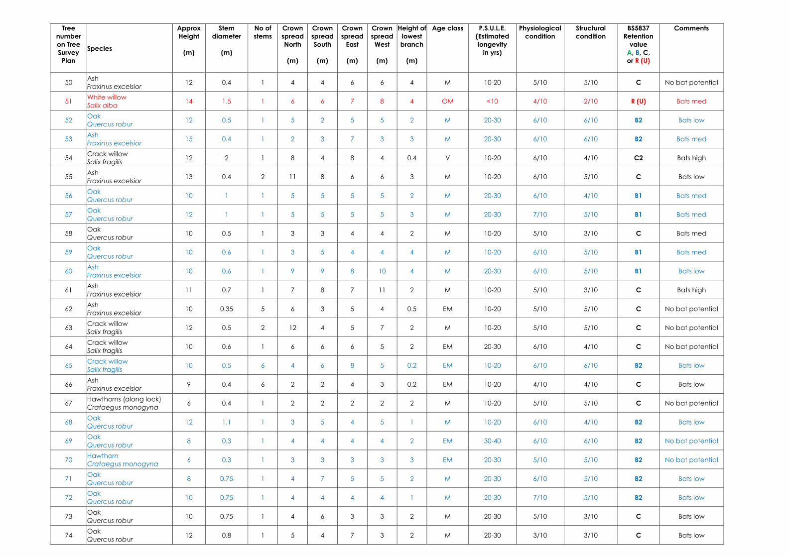
TREE SURVEY SCHEDULE
Tree
number
on Tree
Survey
Plan
Species
Approx
Height
(m)
Stem
diameter
(m)
No of
stems
Crown
spread
North
(m)
Crown
spread
South
(m)
Crown
spread
East
(m)
Crown
spread
West
(m)
Height of
lowest
branch
(m)
Age class P.S.U.L.E.
(Estimated
longevity
in yrs)
Physiological
condition
Structural
condition
BS5837
Retention
value
A, B, C,
or R (U)
Comments
1 Oak
Quercus robur 12 1.1 1 2 6 3 4 2 M 20-30 6/10 7/10 B3 Bats low
2 Field maple
Acer campestre 8 0.6 1 3 4 4 4 2 M 20-30 7/10 7/10 B3 No bat potential
3 Oak
Quercus robur 10 1 1 5 5 5 5 3 M 20-30 6/10 5/10 B3 Bats low
4 Oak
Quercus robur 9 1.1 1 3 6 9 6 2 OM <10 3/10 1/10 R (U) Bats med
5 Ash
Fraxinus excelsior 12 1.1 1 5 5 7 3 2 OM <10 3/10 1/10 R (U) Bats med
6 Ash
Fraxinus excelsior 16 0.8, 0.9 2 7 10 10 10 2.5 V <20 3/10 2/10 B2 High ecology value
7 Ash
Fraxinus excelsior 14 0.7 1 4 5 5 5 2 V <20 3/10 3/10 B2 High ecology value
8 Ash
Fraxinus excelsior 16 1.1 1 6 15 12 6 5 V <20 3/10 3/10 B2 High ecology value
9 Ash
Fraxinus excelsior 18 1.5 1 10 15 15 10 4 V <20 3/10 3/10 B2 High ecology value
10 Ash
Fraxinus excelsior 18 1 1 2 2 10 2 Ground V <10 2/10 1/10 R (U) Unsafe – bats high
11 Ash
Fraxinus excelsior 18 1.2 1 8 10 10 10 5 V <20 3/10 3/10 B2 High ecology value
12 Silver birch
Betula pendula 10 0.3 1 3 3 3 3 1.5 EM 40+ 7/10 7/10 C No bat potential
13 Ash
Fraxinus excelsior 10 0.5 1 3 3 3 3 1.5 M 20-30 6/10 4/10 C No bat potential
14 Ash
Fraxinus excelsior 12 0.5 2 5 5 5 5 2 EM 40+ 6/10 6/10 B2 No bat potential
15 Ash
Fraxinus excelsior 10 0.4 1 4 4 4 4 2 EM 40+ 6/10 6/10 B2 No bat potential
16 Ash
Fraxinus excelsior 10 0.4 1 4 4 4 4 2 EM 40+ 6/10 6/10 B2 No bat potential
17 Ash
Fraxinus excelsior 16 1.2 1 10 5 5 7 5 OM 10-20 5/10 1/10 R (U) Bats high
18 Oak
Quercus robur 12 1.3 1 5 5 5 7 2 M 20-30 5/10 6/10 B2 Bats med
19 Oak
Quercus robur 12 1.2 1 7 7 5 6 2.5 M 20-30 6/10 4/10 B1 Bats low
20 White willow
Salix alba 5 0.3 5 7 2 4 1 1 EM 20-30 6/10 6/10 B1 No bat potential
21 Oak
Quercus robur 12 0.6 1 5 5 2 5 4 EM 30-40 6/10 6/10 B1 Bats low
22 Oak
Quercus robur 10 0.6 1 3 4 4 4 1 M 20-30 7/10 7/10 B3 Bats low
23 Oak
Quercus robur 12 1.2 1 5 5 5 10 1 M 20-30 7/10 7/10 A1 Bats low
24 Hawthorn
Crataegus monogyna 5 0.5 5 2 2 5 5 1.5 M 10-20 7/10 7/10 B1 No bat potential
Tree
number
on Tree
Survey
Plan
Species
Approx
Height
(m)
Stem
diameter
(m)
No of
stems
Crown
spread
North
(m)
Crown
spread
South
(m)
Crown
spread
East
(m)
Crown
spread
West
(m)
Height of
lowest
branch
(m)
Age class P.S.U.L.E.
(Estimated
longevity
in yrs)
Physiological
condition
Structural
condition
BS5837
Retention
value
A, B, C,
or R (U)
Comments
25 Ash
Fraxinus excelsior 4 0.3 1 3 2 1 2 4 OM <5 1/10 1/10 R (U) Bats med
26 Oak
Quercus robur 8 0.5 1 6 5 8 6 1.5 M 20-30 6/10 6/10 A1 No bat potential
27 Oak
Quercus robur 10 0.8 1 3 5 7 3 3 EM 10-20 6/10 5/10 C1 Bats med
28 Ash
Fraxinus excelsior 12 1.5 1 4 4 10 10 1.5 M <10 6/10 4/10 C Bats med
29 Oak
Quercus robur 10 0.5 1 5 5 5 5 2 M 20-30 6/10 5/10 B2 Bats med
30 Field maple
Acer campestre 8 0.4 1 2 3 3 3 0.5 EM 20-30 6/10 6/10 B2 No bat potential
31 Hawthorn
Crataegus monogyna 6 0.3 1 2 2 3 3 0.3 EM 20-30 5/10 5/10 B2 No bat potential
32 Hawthorn
Crataegus monogyna 6 0.3 1 1 2 3 3 2 EM 20-30 5/10 5/10 B2 No bat potential
33 Oak
Quercus robur 8 1 1 4 3 6 4 3 OM <5 2/10 1/10 R (U) Bats med
34 Scots pine
Pinus sylvestris 12 0.5 1 5 5 3 3 5 EM 20-30 8/10 8/10 A2 No bat potential
35 Scots pine
Pinus sylvestris 12 0.4 1 5 5 2 3 5 EM 20-30 8/10 8/10 A2 No bat potential
36 Scots pine
Pinus sylvestris 12 0.4 1 3 3 2 3 4 EM 20-30 8/10 8/10 A2 No bat potential
37 Leyland cypress
Cupressus x leylandii 14 0.6 1 2 2 2 2 0.3 M 10-20 7/10 7/10 B2 No bat potential
38 Sycamore
Acer pseudoplatanus 7 0.3 1 4 4 4 4 1.5 EM 10-20 5/10 5/10 C Bats low
39 Sycamore
Acer pseudoplatanus 12 0.3 – 0.4 5 4 5 4 4 1 EM 30-40 7/10 7/10 B2 No bat potential
40 Ash
Fraxinus excelsior 12 0.3 2 5 3 2 6 0.5 EM 30-40 6/10 6/10 B2 No bat potential
41 Ashes 10 0.15 – 0.4 4 3 3 3 3 1 Y 40+ 6/10 6/10 B2 No bat potential
42 White willow
Salix alba 8 0.75 1 3 3 5 3 0.5 EM 20-30 5/10 5/10 B2 No bat potential
43 Leyland cypress
Cupressus x leylandii 10 0.6 1 3 3 3 3 0.5 M <15 7/10 7/10 B2 No bat potential
44 Leyland cypress
Cupressus x leylandii 8 0.4 1 3 3 3 3 0.5 M <15 7/10 7/10 B2 No bat potential
45 Leyland cypress
Cupressus x leylandii 6 0.4 1 3 3 3 3 0.5 M <15 7/10 7/10 B2 No bat potential
46 Oak (in private garden)
Quercus robur 8 0.4 1 6 7 6 6 1.6 M 20-30 7/10 7/10 B2 Bats low
47 Ash
Fraxinus excelsior 8 0.3 1 4 3 4 4 0.15 M 10 5/10 5/10 C Bats med
48 Oak
Quercus robur 10 1 1 4 4 4 4 2 M 20-30 6/10 6/10 B2 Bats low
49 Ash
Fraxinus excelsior 15 0.6 1 7 6 6 6 1 M 15-20 7/10 5/10 C Bats low
Tree
number
on Tree
Survey
Plan
Species
Approx
Height
(m)
Stem
diameter
(m)
No of
stems
Crown
spread
North
(m)
Crown
spread
South
(m)
Crown
spread
East
(m)
Crown
spread
West
(m)
Height of
lowest
branch
(m)
Age class P.S.U.L.E.
(Estimated
longevity
in yrs)
Physiological
condition
Structural
condition
BS5837
Retention
value
A, B, C,
or R (U)
Comments
50 Ash
Fraxinus excelsior 12 0.4 1 4 4 6 6 4 M 10-20 5/10 5/10 C No bat potential
51 White willow
Salix alba 14 1.5 1 6 6 7 8 4 OM <10 4/10 2/10 R (U) Bats med
52 Oak
Quercus robur 12 0.5 1 5 2 5 5 2 M 20-30 6/10 6/10 B2 Bats low
53 Ash
Fraxinus excelsior 15 0.4 1 2 3 7 3 3 M 20-30 6/10 6/10 B2 Bats med
54 Crack willow
Salix fragilis 12 2 1 8 4 8 4 0.4 V 10-20 6/10 4/10 C2 Bats high
55 Ash
Fraxinus excelsior 13 0.4 2 11 8 6 6 3 M 10-20 6/10 5/10 C Bats low
56 Oak
Quercus robur 10 1 1 5 5 5 5 2 M 20-30 6/10 4/10 B1 Bats med
57 Oak
Quercus robur 12 1 1 5 5 5 5 3 M 20-30 7/10 5/10 B1 Bats med
58 Oak
Quercus robur 10 0.5 1 3 3 4 4 2 M 10-20 5/10 3/10 C Bats med
59 Oak
Quercus robur 10 0.6 1 3 5 4 4 4 M 10-20 6/10 5/10 B1 Bats med
60 Ash
Fraxinus excelsior 10 0.6 1 9 9 8 10 4 M 20-30 6/10 5/10 B1 Bats low
61 Ash
Fraxinus excelsior 11 0.7 1 7 8 7 11 2 M 10-20 5/10 3/10 C Bats high
62 Ash
Fraxinus excelsior 10 0.35 5 6 3 5 4 0.5 EM 10-20 5/10 5/10 C No bat potential
63 Crack willow
Salix fragilis 12 0.5 2 12 4 5 7 2 M 10-20 5/10 5/10 C No bat potential
64 Crack willow
Salix fragilis 10 0.6 1 6 6 6 5 2 EM 20-30 6/10 4/10 C No bat potential
65 Crack willow
Salix fragilis 10 0.5 6 4 6 8 5 0.2 EM 10-20 6/10 6/10 B2 Bats low
66 Ash
Fraxinus excelsior 9 0.4 6 2 2 4 3 0.2 EM 10-20 4/10 4/10 C Bats low
67 Hawthorns (along lock)
Crataegus monogyna 6 0.4 1 2 2 2 2 2 M 10-20 5/10 5/10 C No bat potential
68 Oak
Quercus robur 12 1.1 1 3 5 4 5 1 M 10-20 6/10 4/10 B2 Bats low
69 Oak
Quercus robur 8 0.3 1 4 4 4 4 2 EM 30-40 6/10 6/10 B2 No bat potential
70 Hawthorn
Crataegus monogyna 6 0.3 1 3 3 3 3 3 EM 20-30 5/10 5/10 B2 No bat potential
71 Oak
Quercus robur 8 0.75 1 4 7 5 5 2 M 20-30 6/10 5/10 B2 Bats low
72 Oak
Quercus robur 10 0.75 1 4 4 4 4 1 M 20-30 7/10 5/10 B2 Bats low
73 Oak
Quercus robur 10 0.75 1 4 6 3 3 2 M 20-30 5/10 3/10 C Bats low
74 Oak
Quercus robur 12 0.8 1 5 4 7 3 2 M 20-30 3/10 3/10 C Bats low

Tree
number
on Tree
Survey
Plan
Species
Approx
Height
(m)
Stem
diameter
(m)
No of
stems
Crown
spread
North
(m)
Crown
spread
South
(m)
Crown
spread
East
(m)
Crown
spread
West
(m)
Height of
lowest
branch
(m)
Age class P.S.U.L.E.
(Estimated
longevity
in yrs)
Physiological
condition
Structural
condition
BS5837
Retention
value
A, B, C,
or R (U)
Comments
75 Oak
Quercus robur 8 0.4 1 4 4 4 4 2 M 20-30 5/10 5/10 B2 Bats low
76 Oak
Quercus robur 8 0.4 1 3 3 5 5 2 M 10-20 2/10 3/10 R (U) Bats low
77 Oak
Quercus robur 8 0.4 1 3 3 3 3 2 M <10 2/10 3/10 R (U) Bats med
78 Oak
Quercus robur 8 0.6 1 4 4 4 4 2 M 10-15 4/10 2/10 R (U) Bats low
79 Oak
Quercus robur 10 0.7 1 5 5 5 5 2 M 20-30 5/10 3/10 C Bats low
80 Oak
Quercus robur 12 0.9 1 6 9 4 4 2 M 20-30 5/10 5/10 B2 No bat potential
81 Alder
Alnus glutinosa 6 0.4 1 4 4 4 3 1.5 EM 20-30 6/10 6/10 B2 Bats low
82 Oak
Quercus robur 10 0.9 1 5 7 8 5 2.5 EM 10-20 5/10 3/10 C Bats low
83 Oak
Quercus robur 8 0.6 1 5 6 5 2 2 M 10-20 5/10 3/10 C Bats low
84 Oak
Quercus robur 8 0.7 1 4 4 7 5 3 M 10-20 5/10 3/10 C Bats low
85 Oak
Quercus robur 7 0.4 1 4 4 4 4 2 EM 20-30 5/10 5/10 B2 Bats low
86 Crack willow
Salix fragilis 10 1 8 3 4 8 4 1 EM 20-30 5/10 5/10 B2 Bats low
87 Crack willow
Salix fragilis 10 1.5 1 3 4 8 4 2 M >10 3/10 1/10 R (U) Bats med
88 Crack willow group x 5
Salix fragilis 10 <1 average n/a n/a n/a n/a n/a n/a M >10 3/10 2/10 R (U) No bat potential
89 Crack willow
Salix fragilis 13 0.4 10 6 6 8 4 1 M 20-30 4/10 4/10 C No bat potential
90 Crack willow
Salix fragilis 10 0.4 6 5 6 5 5 1.5 M 20-30 4/10 4/10 C No bat potential
91 Crack willow
Salix fragilis 10 0.4 9 6 6 7 7 0.5 M 20-30 4/10 4/10 C No bat potential
92 Crack willow
Salix fragilis 10 0.5 1 5 5 5 5 2.5 M 20-30 6/10 4/10 C No bat potential
93 Oak
Quercus robur 7 0.6 1 4 4 4 4 1 M 20-30 5/10 5/10 B2 Bats low
94 Crack willow
Salix fragilis 10 0.7 1 3 3 3 3 1 EM 30-40 5/10 5/10 C Bats low
95 Crack willow
Salix fragilis 10 0.7 1 2 2 2 2 1 EM 30-40 5/10 5/10 C No bat potential
96 Crack willow
Salix fragilis 10 1.2 1 6 6 6 6 Ground EM 30-40 6/10 4/10 C Bats low
97 Crack willow
Salix fragilis 10 1.5 1 3 4 3 3 1 M 10-20 3/10 3/10 R (U) No bat potential
98 Crack willow
Salix fragilis 10 1 1 3 3 3 3 1 M 10-20 5/10 5/10 R (U) No bat potential
99 Crack willow
Salix fragilis 10 1 1 3 3 3 3 1 M 10-20 5/10 5/10 R (U) No bat potential
Tree
number
on Tree
Survey
Plan
Species
Approx
Height
(m)
Stem
diameter
(m)
No of
stems
Crown
spread
North
(m)
Crown
spread
South
(m)
Crown
spread
East
(m)
Crown
spread
West
(m)
Height of
lowest
branch
(m)
Age class P.S.U.L.E.
(Estimated
longevity
in yrs)
Physiological
condition
Structural
condition
BS5837
Retention
value
A, B, C,
or R (U)
Comments
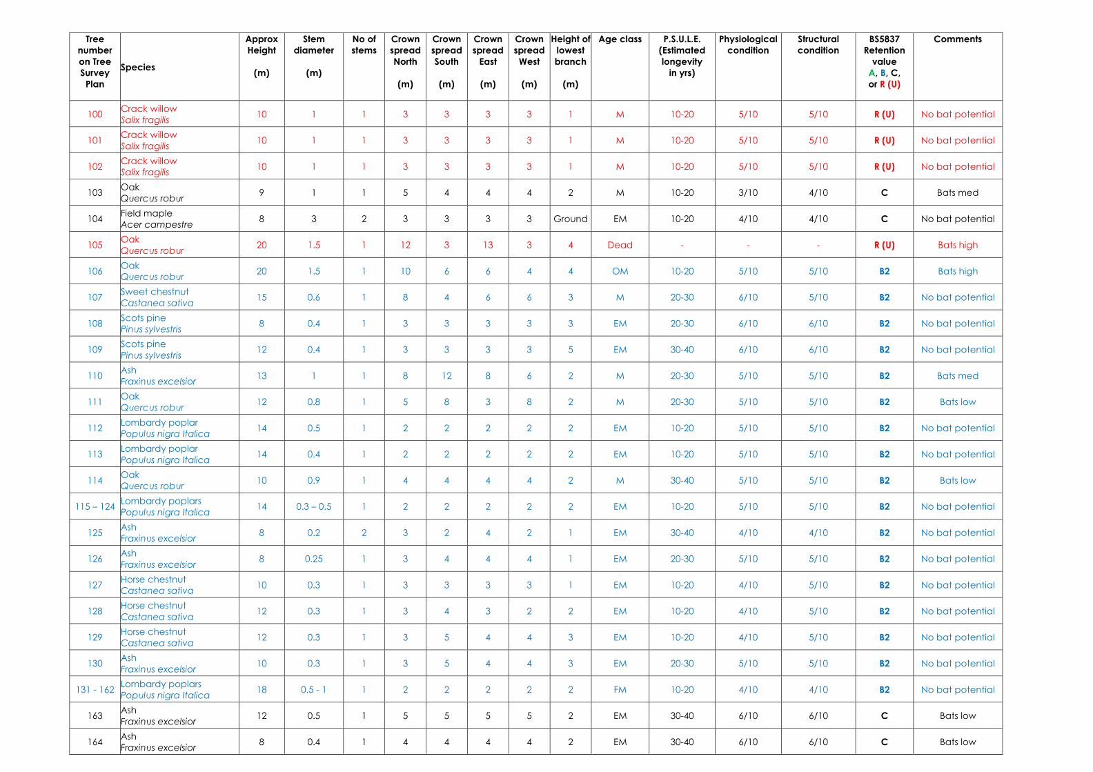
100 Crack willow
Salix fragilis 10 1 1 3 3 3 3 1 M 10-20 5/10 5/10 R (U) No bat potential
101 Crack willow
Salix fragilis 10 1 1 3 3 3 3 1 M 10-20 5/10 5/10 R (U) No bat potential
102 Crack willow
Salix fragilis 10 1 1 3 3 3 3 1 M 10-20 5/10 5/10 R (U) No bat potential
103 Oak
Quercus robur 9 1 1 5 4 4 4 2 M 10-20 3/10 4/10 C Bats med
104 Field maple
Acer campestre 8 3 2 3 3 3 3 Ground EM 10-20 4/10 4/10 C No bat potential
105 Oak
Quercus robur 20 1.5 1 12 3 13 3 4 Dead - - - R (U) Bats high
106 Oak
Quercus robur 20 1.5 1 10 6 6 4 4 OM 10-20 5/10 5/10 B2 Bats high
107 Sweet chestnut
Castanea sativa 15 0.6 1 8 4 6 6 3 M 20-30 6/10 5/10 B2 No bat potential
108 Scots pine
Pinus sylvestris 8 0.4 1 3 3 3 3 3 EM 20-30 6/10 6/10 B2 No bat potential
109 Scots pine
Pinus sylvestris 12 0.4 1 3 3 3 3 5 EM 30-40 6/10 6/10 B2 No bat potential
110 Ash
Fraxinus excelsior 13 1 1 8 12 8 6 2 M 20-30 5/10 5/10 B2 Bats med
111 Oak
Quercus robur 12 0.8 1 5 8 3 8 2 M 20-30 5/10 5/10 B2 Bats low
112 Lombardy poplar
Populus nigra Italica 14 0.5 1 2 2 2 2 2 EM 10-20 5/10 5/10 B2 No bat potential
113 Lombardy poplar
Populus nigra Italica 14 0.4 1 2 2 2 2 2 EM 10-20 5/10 5/10 B2 No bat potential
114 Oak
Quercus robur 10 0.9 1 4 4 4 4 2 M 30-40 5/10 5/10 B2 Bats low
115 – 124 Lombardy poplars
Populus nigra Italica 14 0.3 – 0.5 1 2 2 2 2 2 EM 10-20 5/10 5/10 B2 No bat potential
125 Ash
Fraxinus excelsior 8 0.2 2 3 2 4 2 1 EM 30-40 4/10 4/10 B2 No bat potential
126 Ash
Fraxinus excelsior 8 0.25 1 3 4 4 4 1 EM 20-30 5/10 5/10 B2 No bat potential
127 Horse chestnut
Castanea sativa 10 0.3 1 3 3 3 3 1 EM 10-20 4/10 5/10 B2 No bat potential
128 Horse chestnut
Castanea sativa 12 0.3 1 3 4 3 2 2 EM 10-20 4/10 5/10 B2 No bat potential
129 Horse chestnut
Castanea sativa 12 0.3 1 3 5 4 4 3 EM 10-20 4/10 5/10 B2 No bat potential
130 Ash
Fraxinus excelsior 10 0.3 1 3 5 4 4 3 EM 20-30 5/10 5/10 B2 No bat potential
131 - 162 Lombardy poplars
Populus nigra Italica 18 0.5 - 1 1 2 2 2 2 2 FM 10-20 4/10 4/10 B2 No bat potential
163 Ash
Fraxinus excelsior 12 0.5 1 5 5 5 5 2 EM 30-40 6/10 6/10 C Bats low
164 Ash
Fraxinus excelsior 8 0.4 1 4 4 4 4 2 EM 30-40 6/10 6/10 C Bats low
Tree
number
on Tree
Survey
Plan
Species
Approx
Height
(m)
Stem
diameter
(m)
No of
stems
Crown
spread
North
(m)
Crown
spread
South
(m)
Crown
spread
East
(m)
Crown
spread
West
(m)
Height of
lowest
branch
(m)
Age class P.S.U.L.E.
(Estimated
longevity
in yrs)
Physiological
condition
Structural
condition
BS5837
Retention
value
A, B, C,
or R (U)
Comments
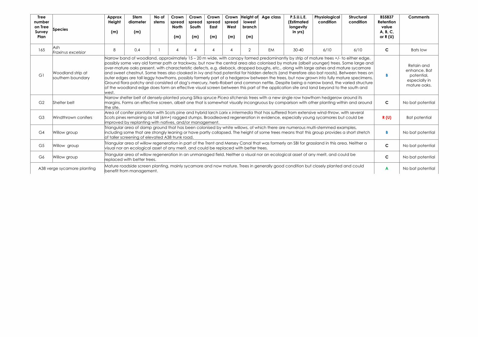
165 Ash
Fraxinus excelsior 8 0.4 1 4 4 4 4 2 EM 30-40 6/10 6/10 C Bats low
G1 Woodland strip at
southern boundary
Narrow band of woodland, approximately 15 – 20 m wide, with canopy formed predominantly by strip of mature trees +/- to either edge,
possibly some very old former path or trackway, but now the central area also colonised by mature (albeit younger) trees. Some large and
over-mature oaks present, with characteristic defects, e.g. dieback, dropped boughs, etc., along with large ashes and mature sycamore
and sweet chestnut. Some trees also cloaked in ivy and had potential for hidden defects (and therefore also bat roosts). Between trees on
outer edges are tall leggy hawthorns, possibly formerly part of a hedgerow between the trees, but now grown into fully mature specimens.
Ground flora patchy and consisted of dog’s-mercury, herb-Robert and common nettle. Despite being a narrow band, the varied structure
of the woodland edge does form an effective visual screen between this part of the application site and land beyond to the south and
west.
B
Retain and
enhance. Bat
potential,
especially in
mature oaks.
G2 Shelter belt
Narrow shelter belt of densely-planted young Sitka spruce Picea sitchensis trees with a new single row hawthorn hedgerow around its
margins. Forms an effective screen, albeit one that is somewhat visually incongruous by comparison with other planting within and around
the site.
C No bat potential
G3 Windthrown conifers
Area of conifer plantation with Scots pine and hybrid larch Larix x intermedia that has suffered from extensive wind-throw, with several
Scots pines remaining as tall (6m+) ragged stumps. Broadleaved regeneration in evidence, especially young sycamores but could be
improved by replanting with natives, and/or management.
R (U) Bat potential
G4 Willow group
Triangular area of damp ground that has been colonised by white willows, of which there are numerous multi-stemmed examples,
including some that are strongly leaning or have partly collapsed. The height of some trees means that this group provides a short stretch
of taller screening of elevated A38 trunk road.
B No bat potential
G5 Willow group Triangular area of willow regeneration in part of the Trent and Mersey Canal that was formerly an SBI for grassland in this area. Neither a
visual nor an ecological asset of any merit, and could be replaced with better trees. C No bat potential
G6 Willow group Triangular area of willow regeneration in an unmanaged field. Neither a visual nor an ecological asset of any merit, and could be
replaced with better trees. C No bat potential
A38 verge sycamore planting Mature roadside screen planting, mainly sycamore and now mature. Trees in generally good condition but closely planted and could
benefit from management. A No bat potential
!
!
!
!
!
!
!
!
!!!!!
!
!
!
!
!
!
(
(
(
(
(
(
(
(
(((((
(
(
(
(
(
(
!!
!!
!
!
!
!
!!
!
!
!
!
!
!
!!!!
!!
!!!!
!
!!
!
!!!
!
!!
((
((
(
(
(
(
((
(
(
(
(
(
(
((((
((
((((
(
((
(
(((
(
((
!!
!
!!!!
!
!!
!
!!
!!
!!!!
!
!!!!!!!!
!
!
!
!
!
!!
! !
!
!!
!
!
!!
!
!
!
!!
!
!
!!
!!
!
!!
!
!
!
!!!
!!!!!
((
(
((((
(
((
(
((
((
((((
(
((((((((
(
(
(
(
(
((
( (
(
((
(
(
((
(
(
(
((
(
(
((
((
(
((
(
(
(
(((
(((((
!!
!!
!
((
((
(
5
1
4
32
67
68
48
4443
33
56 57
60
61
62
55
54
46
7782
8081
91 7993
9997
92
76
75
74
70
71
7273
32
2928 27
2566
65
22
23
24
21
17
3618
90
89
86 84
83
64
63
5049
42
40
103
111
110
106 105
109
102
104
45
5859
53
47
78
9896
9594
69
3130
26
3534
88
87 85
5251
413938
3720
19
108
101100
107
10
1312
G5
G3
G6
G1
6-11
G4
G2
A38 Road vergesA38 Road verges
131-162
421000 422000 423000
3220
0032
3000
Branston Locks
0 200 400100
Metres
1:9,000
Drawn by: JM
05/11/2012
KeyPlanning application boundary
Individual treesRetention value!( A - High!( B - Moderate!( C - Low!( R - Remove
Group of treesRetention value
A - HighB - ModerateC - LowR - Remove
© Crown copyright 2012. All rights reserved.Ordnance survey licence number 100048146.
Scale @ A3:
Tree Survey Plan
±Checked by: SM Approved by: KA
6801/EC/001a
!
!!
(
((
!
!
!
!
!
!
!
!
!
!
!
!
!
!
!!!
!
!
!
!!
(
(
(
(
(
(
(
(
(
(
(
(
(
(
(((
(
(
(
((
14 1516
126125
128
129
130
165164
163
127
123122121120119118117116
124
115
114113112
131-162