BRA PlON - Peel Region · BRA PlON brompton.co Flower City June 29, 2012 Ms. Carol Reid, Clerk...
21
BRA PlON brompton.co Flower City June 29, 2012 Ms. Carol Reid, Clerk Regional Municipality of Peel 10 Peel Centre Drive, Suite "A", 5 th Floor BramptQn, ON L6T 4B9 Mr. Jeffrey A. Abrams, City Clerk City of Vaughan 2141 Major Mackenzie Drive Vaughan, ON L6A 1 T1 Toronto & Region Conservation Authority 5 Shoreham Drive Downsview, ON M3N 1S4 Ms. Karen T own of Caledon P.O. Box 1000, 6300 Old Church Road Caledon, ON L7C 1J6 Mr. Denis Kelly, Regional Clerk Region of York 17250 Yonge Street, 4th Floor Newmarket, ON L3Y 621 Ministry of Transportation Central Region - Bldg. "D" 3 rd Floor Planning and Environmental Office 1201 Wilson Avenue, Downsview, ON M3M 1J8 Re: Brampton Response to the Provincial Growth Plan - Additional Draft Growth Plan Official Plan Amendment and Direction to Hold a Statutory Open House and Public Meeting (File G65). The following recommendation of the Planning, Design and Development Committee Meeting of June 11 . 2012 was approved by Council on June 20, 2012: PDD119-2012 1. That the report from D. Waters, Manager, Land Use Policy, and M. Majeed, Policy Planner, dated April 16, 2012, re: Proposed Land Use Plan for Public Consultation - REFERRAL TO ___ -======-""""""" ..... Highway 427 Industrial Secondary Plan (Area 47) RECOMMENDED (File P26 S47) be received; and, DIRECTION REQUIRED_-::----= RECEIPT RECOMMENDED£' 2:, That staff present the Citis Proposed Land Use Plan at an open house that will also include public consultation required as part of the Municipal CIl:iss EA process for the Transportation Master Plan being undertaken for Secondary Plan Area 47; and, 3. JUL 06 2012 REGION OF PEEL CLERKS DEPT. That the City Clerk be directed to provide a copy of this staff report and Council resolution to the Regions of Peel and York, Town of Caledon, City of Vaughan, Toronto & Region Conservation Authority and the Ministry of Transportation (Planning and Environmental Office) for their information. cont. .. ./ The Corporation of The City of Brampton 2 Wellington Street West, Brampton, ON L6Y 4R2 T: 905.874.2000 TTY: 905.874.2130
-
Upload
duongkhanh -
Category
Documents
-
view
216 -
download
0
Transcript of BRA PlON - Peel Region · BRA PlON brompton.co Flower City June 29, 2012 Ms. Carol Reid, Clerk...
BRA PlON brompton.co Flower City June 29, 2012
Ms. Carol Reid, Clerk Regional Municipality of Peel 10 Peel Centre Drive, Suite "A", 5th Floor BramptQn, ON L6T 4B9
Mr. Jeffrey A. Abrams, City Clerk City of Vaughan 2141 Major Mackenzie Drive Vaughan, ON L6A 1 T1
Toronto & Region Conservation Authority 5 Shoreham Drive Downsview, ON M3N 1S4
Ms. Karen Larfrfi~~!T'k------'-"----...L..I T own of Caledon P.O. Box 1000, 6300 Old Church Road Caledon, ON L7C 1J6
Mr. Denis Kelly, Regional Clerk Region of York 17250 Yonge Street, 4th Floor Newmarket, ON L3Y 621
Ministry of Transportation Central Region - Bldg. "D" 3rd Floor Planning and Environmental Office 1201 Wilson Avenue, Downsview, ON M3M 1J8
Re: Brampton Response to the Provincial Growth Plan - Additional Draft Growth Plan Official Plan Amendment and Direction to Hold a Statutory Open House and Public Meeting (File G65).
The following recommendation of the Planning, Design and Development Committee Meeting of June 11 . 2012 was approved by Council on June 20, 2012:
PDD119-2012 1 . That the report from D. Waters, Manager, Land Use Policy, and M. Majeed, Policy Planner, dated April 16, 2012, re: Proposed Land Use Plan for Public Consultation -
REFERRAL TO ___ -======-""""""" ..... Highway 427 Industrial Secondary Plan (Area 47) RECOMMENDED (File P26 S47) be received; and, DIRECTION REQUIRED_-::----= RECEIPT RECOMMENDED£' 2:, That staff present the Citis Proposed Land Use Plan at an
open house that will also include public consultation required as part of the Municipal CIl:iss EA process for the Transportation Master Plan being undertaken for Secondary Plan Area 47; and,
p@~ilWm;~ 3.
JUL 06 2012
REGION OF PEEL CLERKS DEPT.
That the City Clerk be directed to provide a copy of this staff report and Council resolution to the Regions of Peel and York, Town of Caledon, City of Vaughan, Toronto & Region Conservation Authority and the Ministry of Transportation (Planning and Environmental Office) for their information.
cont. .. ./
The Corporation of The City of Brampton 2 Wellington Street West, Brampton, ON L6Y 4R2 T: 905.874.2000 TTY: 905.874.2130
60938
Rectangle
Yours truly,
(!j~()~,~ Chandra Urquhart Legislative Coordinator City Clerk's Office Tel: 905-874-2116 Fax: 905-874-2119 e-mail: [email protected]
(PDD/G1)
cc: J. Corbett, Commissioner, Planning, Design and Development H. Zbogar, Acting Director, Planning Policy and Growth Management D. Waters, Manager, Land Use Policy, Planning Policy and Growth Management M. Majeed, Policy Planner, Planning, Design and Development
60938
Rectangle
BRA PT N Flower City
Report Planning, Design and
Development Committee Committee of the Council of
The Corporation of the City of Brampton Date: April 16, 2012
File:
Subject:
Contact:
Overview:
P26 S47
RECOMMENDATION REPORT
PLANNING, DESIGN & DEVELOPMENT COMMITTEE
DATe::J~ \\, ~'k
PROPOSED LAND USE PLAN FOR PUBLIC CONSULTATION Highway 427 Industrial Secondary Plan (Area 47) Ward 10
David Waters, Manager, Land Use Policy (905) 874-2074
11/ Staff held an open house in June 2011 to present the City's Preliminary Land Use Concept for Area 47.
.. Based on public feedback and the current findings of the component studies, a Proposed Land Use Plan is ready for public consultation.
.. This plan provides more detail with respect to a land use structure, including schools, parks, commercial sites, stormwater management ponds and a collector road network.
.. Public comments from the June 2011 open house indicated concern about the proposed redesignation for employment uses, on the east side of Clarkway Drive between the TransCanada Pipeline and Countryside Drive. In response, staff is proposing a Special Policy Area that maintains the "Residential" designation for a major portion of the area and that designates a band of "Mixed Commercial/Industrial" for the area abutting the Area 47 employment lands.
11/ The Proposed Land Use Plan now recognizes the Province's Preliminary Route Planning Study Area for the future GTA West Transportation Corridor, to allow for the identification and evaluation of alternative route alignments and interchange options.
60938
Rectangle
60938
Rectangle
60938
Rectangle
60938
Rectangle
60938
Rectangle
60938
Rectangle
Recommendations:
1. THAT the staff report from David Waters, Manager, Land Use Policy, Planning, Design & Development, dated April 16, 2012 to the Planning, Design and De.velopment Committee meeting of June 11, 2012 re: Recommendation Report - Proposed Land Use Plan for Public Consultation - Highway 427 Industrial Secondary Plan (Area 47) - Ward 10 (File: P26 547) - be received;
2. THAT staff present the City's Proposed Land Use Plan at an open house that will also include public consultation required as part of the Municipal Class EA process for the Transportation Master Plan being undertaken for Secondary Plan Area 47; and,
3. THAT the City Clerk be directed to provide a copy of this staff report and Council resolution to the Regions of Peel and York, Town of Caledon, City of Vaughan, Toronto & Region Conservation Authority and the Ministry of Transportation (Planning and Environmental Office) for their information.
Background:
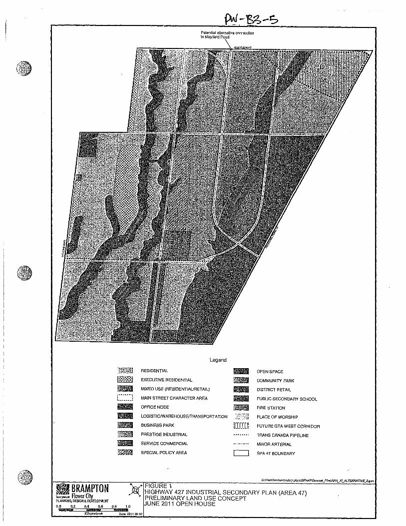
In accordance with Council direction, City staff presented the City's Preliminary Land Use Concept at an open house in June 2011 in order to obtain public feedback (see Figure 1).
In the Preliminary Land Use Concept, lands west of Clarkway Drive are generally designated "Residential". An "Executive Residential" designation abutting The Gore Road Tributary and The Gore Road is proposed to deliver 600 executive housing units in Area 47 in accordance with the Official Plan and to provide a transition from the existing Toronto Gore Estate Residential Community (see Figure 1).
The Preliminary Land Use Concept designates lands east of Clarkway Drive generally for employment uses including "Prestige Industrial", "Business Park" and "Logistics/WarehousefTransportation" based on the findings of the draft Employment Maximization Study (see Figure 1 ). It also identifies about 50 net hectares (123 acres) of additional employment lands within a Special Policy Area designation east of Clarkway Drive and north of the TransCanada Pipeline that are currently designated "Residential" in the Official Plan.
The network of arterials identified on the Preliminary Land Use Concept builds upon the City's Transportation and Transit Master Plan (TTMP) and the joint municipal PeelHighway 427 Extension Area Transportation Master Plan Study and is generally
2
60938
Rectangle
60938
Rectangle
60938
Rectangle
60938
Rectangle
C \.
~BRAMPTON ~'mpbUI Aower Olv PLANNING, DESIGN & oemOPMOO
0.0 0.2 0.4 0.6
KTt:':'es O.B
Polentlal alternative connection 10 Mayfield
Legend
~~.~ai~~ RESIDENTIAL .. OPEN SPACE
~ EXECUTIVE RESIDENTIAL ~ COMMUNITY PARK
~ MIXED USE (RESIDENTIAURETAIL) .. DISTRICT RETAIL r ...... -_ ...... _ .. J MAIN STREET CHARACTER AREA RII PUBLIC SECONDARY SCHOOL - OFFICE NODE ~ FIRE STATION .. LOGISTICIW AREHOUSEITRANSPORTATION PLACE OF WORSHIP
filii BUSINESS PARK ~JIm FUTURE GTA WEST CORRIDOR
E~ PRESTIGE INDUSTRIAL TRANS CANADA PIPELINE
liB SERVICE COMMERCIAL MINOR ARTERIAL
W~ SPECIAL POLICY AREA c=J SPA 47 BOUNDARY
... .. FIGURE 1 . .-®' HIGHWAY 427 INDUSTRIAL SECONDARY PLAN (AREA 47)
• PRELIMINARY LAND USE CONCEPT JUNE 2011 OPEN HOUSE 1.0
Dato: 2011 05 30
60938
Rectangle
60938
Rectangle
60938
Rectangle
60938
Rectangle
60938
Rectangle

consistent with the arterial road network proposed in the Growth Plan Amendment OP2006-43.
The Preliminary Land Use Concept identifies a preferred location for the Community Park proposed within Area 47.
Component studies being undertaken as part of secondary planning for Area 47 are at various stages of completion. These include a Community Design and Open Space Study, Transportation Study, Master Environmental Servicing Plan, Employment Maximization Strategy, Retail and Institutional Land Use Study, Cultural Heritage Study and an Infrastructure Servicing Study. A table summarizing the status of each component study is provided in Appendix f>:..
Public comments received at the June 2011 open house with respect to the Preliminary Land Use Concept focused mainly on the proposed redesignation to employment uses of lands designated "Residential" within the Clarkway Special Policy Area on the east side of Clarkway Drive, between Countryside Drive and the TransCanada Pipeline.
Some residents commented that the proposed location for the major part of the "Executive Residential" area abutting The Gore Road Tributary was inappropriate and suggested that lands abutting the existing Toronto Gore Estate Residential Area to the west are more suitable areas for "Executive Residential" development.
With respect to the proposed employment designations, some of the comments noted that the "Prestige Industrial" designation is not appropriate on lands on the east side of Clarkway Drive north of Countryside Drive, based on the proximity of these lands to existing estate residences on the west side of Clarkway Drive. A few comments also noted that employment designations should be confined to lands abutting Highway 50 and Mayfield Road and that the balance of the employment lands should be redeSignated "Residential".
The proposed location for the Community Park was generally well received by the public and, as such, staff will not be looking to relocate the use as secondary planning progresses.
A summary of the public comments received at the June 2011 open house and following the event, is provided in Appendix B.
3
60938
Rectangle
60938
Rectangle
60938
Rectangle
60938
Rectangle
60938
Rectangle
Clarkway Drive Special Policy Area
At the June 2011 open house, area residents expressed concern regarding the Preliminary Land US,e Concept showing about 50 ha of new employment lands east of Clarkway Drive between Countryside Drive and the TransCanada Pipeline that are currently deSignated Residential in the Official Plan. Residents noted that the proposed redesignation will negatively impact the eXisting character of the area and result in additional traffic on Clarkway Drive, which cannot be widened since a majority of the right-of- way is in the floodplain.
Current Situation:
Proposed Land Use Plan
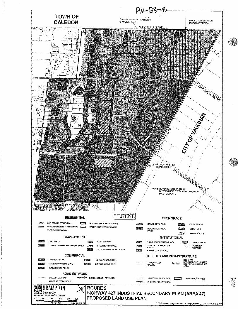
The Proposed Land Use Plan that staff is proposing to present at the open house is a refinement of the Preliminary Land Use Concept and addresses the findings of the component studies and the feedback received at, and following, the June 2011 open house. This plan is more representative of a secondary plan land use schedule and includes additional detail showing the general locations of schools, parks, commercial centres, stormwater management ponds and a collector road network (see Figure 2).
Residential
The residential lands portion of the proposed plan now includes a breakdown of densities including "Executive Residential", "Low Density" and "Low/Medium Density".
In addressing the comments with respect to the proposed "Executive Residential" area, staff advises that the proposed location for a major portion of the "Executive Residential" area as identified in the Preliminary Land Use Concept is necessary in order to create a sufficient mass to support a clearly identifiable and complete executive housing community, which will include parks, schools and exposure to natural features. The band of "Executive Residential" designated opposite the existing "Estate Residential" community is intended to provide a gradual transition to the new residential area in Area 47.
Lands adjoining the "Executive Residential" designation and north of the TransCanada Pipeline are proposed for "Low Density Residential" with a maximum net density of 20 units per net residential hectare (8 units per net residential acre). Lands south of the TransCanada Pipeline are proposed for "Low/Medium Residential" use with a maximum net density of 35 units per net residential hectare (14 units per net residential acre). Together the residential and mixed use designations proposed within Area 47 are
4
60938
Rectangle
60938
Rectangle
60938
Rectangle
60938
Rectangle
TOWN OF CAlEDON
RESIDENTIAL
,,·t·,'M lOW DENSITY RESIDENTIAL ~ MIXED USE (RESIDENTIAURET AIL)
&l1li lOWIMEDIUM DENSITY RESlllENTlAL , •••• : MAIN STREET CHARACTER AREA
EXECUTIVE RESIDEHTIAL
EMPLOYMENT _ OFFICE NODE ~ BUSINESS PARK
_ LOGISTICfV{AREHOUSEITAANSPORTATKlN :::~r.~ PRESTIGE INDUSTRIAL
lllim9I MIXED COMMERClAlJINDUSTRIAl
COMMERCIAL _ DISTRICT RETAIL _ HIGHWAY COMMERCIAL
_ NEIGHBOURHOOD RETAIL _ SERVICE COMMERCIAL
_ CONVENIENCE RETAIL
ROAD NElWORK COLLECTOR ROAD
MINOR ARTERIAL ROAD
~ i':OAO ACCESS ( POTENTIAL)
FIGURE 2
iml"!l!l Im!l!Ii Ilm'II
[J[J
r2.:.:..:;J
. /
PROPOSED SIMPSON ROAD EXTENSION
NOTE: ROAD NETWORK TO BE DETERMINED BY TRANSPORTATION MASTER PLAN.
OPEN SPACE
COMMUNITY PARK
NEIGHBOURHOOD PARK
. ... ".
!SWM!
OPEN SPACE
CEMETERY
SWM FACILITY
INSTITUTIONAL PUBLIC SECONDARY SCHOOL ~ FIRE STATION CATHOLlCL ELEMENT MY ' .. :.j PLACE OF SCHOOL WORSHIP ELEMENTARY SCHOOL
UTILITIES AND INFRASTRUCTURE GTAWEST
TRANS CANADA :em: CORRIDOR·PRELIMINARY ROUTE PLANNING STUDY PIPELINE AREA
HERITAGE RESOURCE c::J SPA 47 BOUNDARY
SPECIAL POLICY AREA
~BRA~PTON t.amp;m... Flower Ciw PLANNING, DESIGN & iiVaOPMENT 0.0 0.2 0.4 0.6 O.B
i§i 1.0
HIGHWAY 427 INDUSTRIAL SECONDARY PLAN (AREA 47) PROPOSED LAND USE PLAN
Kilometres Data: 2012 05 24
./
" .
60938
Rectangle
60938
Rectangle
60938
Rectangle

expected to yield about 5,700 units, which includes a required minimum of 600 executive residential units.
Employment Lands
The Proposed Land Use Plan designates lands east of Clarkway Drive generally for employment uses including "Prestige Industrial", "Business Park" and "Logistics/Warehouse/Transportation", based on the recommendations of the Employment Maximization Study and generally consistent with the employment designations in the Preliminary Land Use Concept (see Figure 2).
The Proposed Land Use Plan now proposes a band of 9 hectares (22 acres) of new employment lands (designated "Mixed Commercial/Industrial") at the eastern edge of the Clarkway Drive Special Policy Area (Special Policy Area 1) abutting the proposed north-south collector road.
With respect to the above-noted public comments, that lands on the east side of Clarkway Drive, north of Countryside Drive that are designated "Residential" in the Official Plan should remain designated "Residential", staff notes that the "Prestige Industrial" deSignation proposed on these lands is based on Council direction, as part of OP2006-43, to maximize the City's future employment opportunities within lands east of Clarkway Drive. A significant portion of these lands are identified as part of the GT A West Corridor Study Area and, as such, are more suitable for employment uses that will ultimately benefit from this transportation facility.
Population and Employment Forecast
The City's Proposed Land Use Plan is estimated to yield about 22,300 people and 20,700 jobs (including employment land jobs and population-related jobs) which results in a density target of approximately 41 people and jobs per hectare. The employment forecast considered a 200 metre wide GTA West Corridor and Hydro Corridor located close to the northeast corner of Area 47. The forecast will be refined once the boundaries of the natural heritage system are finalized as part of the Area 47 MESP, and the GTA West Preliminary Route Planning Study Area is finalized as part of the ongoing Individual EA.
The vacant employment lands within Area 47 together with the 9 hectares of new employment lands proposed as part of Special policy Area 1 would yield in the order of 17,000 employment land jobs based mainly on densities of 45 jobs per net hectare for "Prestige Industrial", 38 jobs per net hectare for "Business Park", 28 jobs per net hectare for "Logistics, Warehouse and Transportation" and 100 jobs per net hectare for
5
60938
Rectangle
60938
Rectangle
60938
Rectangle

the "Mixed Commercial/Industrial" designation identified within Special Policy Area 1 in the Proposed Land Use Plan.
Clarkway Drive Special Policy Area (Special Policy Area 1)
As noted previously, concerns were raised by the public at the June 2011 open house regarding the proposal for employment lands within the Clarkway Drive Special Policy Area. In order to address public concerns, staff has refined the Preliminary Concept to now designate a major portion of the SPA for residential use on the east side of Clarkway Drive. The SPA proposes gradually increasing densities from large lots fronting the east side of Clarkway Drive to Low/Medium Density further east. "Mixed Commercial/Industrial" uses within a compatible built form are proposed for the lands at the eastern edge of the Special Policy Area, abutting the proposed north-south collector road (see Figure 2).
Policies for Special Policy Area 1 will include specific provisions with respect to densities and lot widths to protect the character of the existing estate residences along Clarkway Drive. The policies will also address setbacks and landscaping to create compatibility between new residential development and the "Mixed Commercialll ndustrial" designation.
Commercial and Institutional
Commercial/Retail Uses
The Commercial and Institutional Land Use Study undertaken by urbanMetrics has recommended that one "District Retail", two "Neighborhood Retail", three "Convenience Retail" and one "Highway Commercial" designation be included as part of the retail hierarchy to service the residents within Area 47 as well as the surrounding lands.
Adjustments to the proposed retail designations within Area 47 will be undertaken through the refinement of the population and employment forecast, public consultation and the finalization of the Commercial and Institutional Land Use Study.
Schools
Based on the student yield that are estimated within Area 47, the Peel District School Board has noted that one Public Secondary School and five Elementary Schools will be required in the general locations shown on the Proposed Land Use Plan. The Dufferin Peel Catholic District School Board has identified the need for one elementary school in (~~:~~
6
60938
Rectangle
60938
Rectangle
60938
Rectangle

r.( the general area west of The Gore Road between Countryside Drive and the \ TransCanada Pipeline.
The Proposed Land Use Plan designates a Secondary School site on the south side of Countryside Drive and east of The Gore Road, representing a slight shift from the location fronting The Gore Road that was identified in the Preliminary Concept. This change was undertaken to avoid impacting the existing residences on the east side of The Gore Road (see Figures 1 and 2).
The school designations included in the Proposed Land Use Plan will be further refined based on student yield from the final proposed residential types and densities.
Places of Worship
The Preliminary Land Use Concept designated two "Places of Worship" in the southwest quadrant of Mayfield Road and Clarkway Drive and 10307 Clarkway Drive on the east side of Clarkway Drive (see Figure 1).
OP2006-44 designated a Special Study Area overlay on two properties, including 10307 Clarkway Drive on the east side of Clarkway Drive and 5253 Countryside Drive on the south side of Countryside Drive, east of Clarkway Drive (see Figure 3). OP2006-44 notes that the subject properties will be studied as part of secondary planning to determine if a Place of Worship can be developed in a manner that is complementary and supportive of the planning objectives for Area 47.
Considering the relatively large size (about 55 acres) of the property at 10307 Clarkway Drive, the Proposed Land Use Plan includes a Special Policy Area 3 designation that proposes to further evaluate the feasibility of a Place of Worship at this location. In this regard, the City has requested the property owner to provide a concept plan including the scale and range of proposed uses to fully evaluate the proposed development of the area.
With respect to the feasibility of a Place of Worship on the property at 5253 Countryside Drive, staff notes that the lands adjacent to the intersection of Countryside Drive and the Major Mackenzie Drive extension are more suited for employment uses, and that a Place of Worship is feasible south of this intersection in the general area identified as Special Policy Area 2 in the Proposed Land Use Plan. As a result of the relatively narrow width of the property at 5253 CountrySide Drive, some land assembly will be required for a Place of Worship development in this general area.
7
60938
Rectangle
60938
Rectangle
60938
Rectangle

BRAMPTON ~~ bromplon.co Flower City "" ~ PLANNING, DESIGN & DEVELOPMENT
Drawn By: TDlAd Date: 2012 0515
PW-iS'3-12
TOWN OF CALEDON
. : ..
.. '; .. ,:."
.... ·.5253.: ... COUNTRYSIDE
. DRIVE:· ...
:. ',' : ..
CITY OF VAUGHAN
Legend
SPA 47 PLANNING AREA
SPECIAL STUDY AREA (OP2006-44)
G~TechServlsecondary plansISPA47\Concept]lanllocation MapISPA_ 47 _LOC.gws
FIGURE 3 - LOCATION MAP SPECIAL STUDY AREAS (OP2006-44)
SECONDARY PLAN AREA 47
Heritage Resources
The Built Heritage and Cultural Landscape Assessment undertaken by Archaeological Services Inc., as part of the Cultural Heritage Study for Area 47, has identified a total of twenty two cultural heritage resources that require heritage impact assessment, based generally on their historical value, design value and contextual value. These resources include residential structures, agricultural related buildings, landscape features, building remnants, farm complexes and barns.
The City's Heritage Coordinator has identified two additional heritage resources that are being recommended for listing in the City's Register of Cultural Heritage Resources. Accordingly, a total of twenty four cultural heritage resources have been identified in the Proposed Land Use Plan.
Community Park
The preferred location for the Community Park of approximately 40 acres was generally identified in the Preliminary Land Use Concept at the northeast quadrant of Clarkway Drive and the TransCanada Pipeline. The Community Park is expected to provide a range of outdoor recreational activities. No indoor (e.g. recreation centre) components are envisaged for this site. The size and shape of the Community Park will be refined through the preparation of a facility fit that would be undertaken as part of the Block Plan development process. As such, the ultimate role and function of this facility will be determined through further work.
Through the open house, the public commented that the proposed Community Park should be smaller and located central to the planned residential area. Staff notes that the Community Park is of a larger scale (40 acres) and intended to service a broader catchment area. The proposed location of the Community Park at the intersection of arterial roads anchors the northern edge of the Main Street Special Character Area, and provides a community focus. Further, the location of the Community Park provides a spatial separation from the proposed Community Park and Community Centre being developed on the Fitzpatrick lands at the northwest corner of The Gore Road and Castlemore Road. Furthermore, its location on the edge of the proposed residential, flanking the employment uses, allows greater flexibility in terms of programming -including the potential for lighting, which can be a disturbance to adjacent residents when located in the centre of residential communities.
8
60938
Rectangle
60938
Rectangle
60938
Rectangle
QvV -Bs- 14
Neighbourhood Parks
Based on preliminary analysis undertaken by the City's Community Design Parks Planning and Development Section, seventeen Neighbourhood Parks have been identified within the planned residential areas on the plan. Each park would have an approximate service area of about 400 metres. The general locations for the parks have been shown on the Proposed Land Use Plan. The final total, size and type of Neighbourhood Parks required will be determined through the Block Plan review process having regard for final population estimates, land uses, road network, natural heritage features, land ownership etc.
Stormwater Management Ponds
Based on stormwater modeling undertaken to date, the consultant to the Master Environmental Servicing Plan for Area 47 with input from the consultant to the Infrastructure Servicing Study has proposed SWM ponds in the general locations shown in the Proposed Land Use Plan. The modeling generally addressed topography, existing drainage patterns, proposed land uses and the arterial road network. Preliminary environmental constraints, including floodplains and environmental features that were identified and staked as part of the 2011 field investigations, were also considered in determining proposed SWM pond locations. The number of SWM ponds required and the location, type and size of each SWM pond, including . recommended sustainable best management practices, will be refined based on the final recommendations of the MESP and the Infrastructure Servicing Study.
GTA West Corridor
The GTA West Transportation Corridor study area that was depicted in the Preliminary Concept has been expanded in the Proposed Land Use Plan in order to match the current Study Area identified by MTO. This change follows a meeting with MTO, the Transportation Study consultant and City staff, where it was confirmed that the boundaries of MTO's Preliminary Route Planning Study Area within SP47 is necessary to allow for the identification and evaluation of alternative road alignments and interchange options as part of the GT A West Transportation Corridor Environmental Assessment now under way (see Figure 2).
In drafting the official plan amendment for Area 47, staff will propose policies that would enable the early release of lands within MTO's Preliminary Route Planning Study Area that are no longer required for corridor protection, as determined through forthcoming EA tasks and subject to meeting certain tests. (il
9
60938
Rectangle
60938
Rectangle
60938
Rectangle
60938
Rectangle
60938
Rectangle
~W-b>-(S
Transportation Network
The network of arterials indentified on the Proposed Land Use Plan builds upon the City's Transportation and Transit Master Plan (TTMP) and the joint municipal PeelHighway 427 Extension Area Transportation Master Plan Study and is generally consistent with the arterial network set out in OP2006-43. The proposed arterials within Area 47 include an east-west connector facility, referred to as "Arterial A2", linking Major Mackenzie Drive to Mayfield Road, and an east-west arterial in proximity to the TransCanada Pipeline that connects The Gore Road with a realigned Coleraine Drive. In recognition of the floodplain constraint to widening Clarkway Drive abutting Special Policy Area 1, the Transportation Master Plan will consider a 6 lane "Arterial A2" as part of a sensitivity analysis of the network alternatives.
The proposed Land Use Plan also identifies a preliminary network of new collector roads based on analysis undertaken to date by the Transportation Study consultant together with input from the other component studies. The transportation network included in the Proposed Land Use Plan will be refined based on the recommendations of the Transportation Master Plan for Area 47 which is expected to be fi.nalized by the end of the year.
New arterial and collector roads being proposed within Area 47 are subject to the Municipal Class EA process for roads and finalized through that process. Phases 1 and 2 of the Class EA, including public consultation, are being completed as part of the Area 47 Transportation Master Plan. Phases 3 and 4 for specific road projects identified in the Master Plan will be completed through future EA studies, or as an integrated process through block planning.
Next Steps:
Staff proposes that the public consultation required as part of Phases 1 and 2 of the EA for the Transportation Master Plan be held jOintly with the open house for the Proposed Land Use Plan.
Following the open house in June 2012, the Proposed Land Use Plan will be further refined through feedback from the public and the finalization of the component studies. Staff will then begin to draft the implementing official plan amendment and expect to present a draft amendment at a statutory public meeting in late 2012 or early 2013.
10
60938
Rectangle
60938
Rectangle
60938
Rectangle
60938
Rectangle
(MJ-B-s-rb
Conclusion:
The City's Proposed Land Use Plan represents a refinement of the Preliminary Land Use Concept based on current findings of the component studies and public input. The Proposed Land Use Plan will be further refined through the finalization of the component studies and public and stakeholder feedback received at the next open house.
Henri bogar, MCIP, RPP Acting Director, Policy Planning & Growth Management
Authored by: Malik Majeed
Attachments: Appendix A - Status of Area 47 Component Studies Appendix B - Summary of Public Comments
11
{(,H:~~ \1'
60938
Rectangle
60938
Rectangle
60938
Rectangle
Appendix A - Status of Area 47 Component Studies
Study I Study Purpose Status Consultant Community Design Focuses on the physical design of the community, including Prepared Preliminary Land Use Concept and related and Open Space I its structure and neighbourhoods, principles for street and demonstration plans in order to test key issues including MBTW block patterns, streetscapes, and built form and the the feasibility of achieving a minimum of 600 upscale
creation of an open space network that includes the cultural executive housing units, the interface of residential and heritage landscape, topography and natural features such employment areas on the east side of Clarkway Drive and as valleys and woodlands, storm water ponds, parks, the 'Main Street' concept along Clarkway Drive north of schools, and other uses. Castlemore Road (see Figure 2 of the staff report).
Further work on this study will resume shortly to refine the Proposed Land Use Plan and complete the Community Design Study.
Transportation Master This study assesses and recommends the transportation HDR has completed the following tasks: Plan / HDRiTrans infrastructure required to support the full development of
Area 47. Part I of the study addresses background - Prepared Background Conditions Report. conditions with respect to traffic and transportation. Part II Comments from the steering committee with of the study includes the preparation of the community respect to the Phase I Report are being addressed transportation plan. by HDR through discussions with staff and the
Landowners Group representatives and through This study builds upon the City's Transportation and Transit further work on this Study. Master Plan (TTMP) and incorporates the results of the' - Revised land use scenarios based on input joint municipal Peel-Highway 427 Extension Area recently provided by the City, Peel and York Transportation Master Plan Study. Regions;
- Completed auto and transit network coding to the The Transportation Study is being coordinated, as far as City's travel demand forecasting model; possible, with the GTA West EA study. The GTA West - Developed reporting procedures and EMME Corridor identified in the Preliminary Concept has been output reports; increased in the Proposed Land Use Plan in order to match - Finalized arterial network alternatives for 2031 and the current Study Area identified by MTO. This change proposed preliminary collector road network with follows a meeting with MTO, the Transportation Study input from other study consultants; consultant and City staff, where it was determined that a corridor represented by MTO's Study Area is necessary to To do: allow for the identification and evaluation of alternative road - Develop 2031 demand forecasts; alignments and interchange options for the GTA West . - Evaluate the results, identify the preliminary Corridor. preferred alternative and summarize the results;
- Prepare community transportation plan. ---_ ................. _- ._ ........... __ .- ~
12
! \fo , :J
60938
Rectangle
60938
Rectangle
60938
Rectangle
60938
Rectangle

Master Environmental Servicing I Aquafor Beech
Employment Maximization Strategy IMKI
Retail and Institutional Land Use I urban Metrics
Cultural Heritage / ASI
~~}
Phases 1 and 2 of the Class Environmental Assessment process for the proposed arterial and collector road network are being undertaken as part of this Transportation Study. Phases 3 and 4 will be completed as part of block planning through a separate EA. Phase I of the MESP addresses existing conditions with respect to natural environment, groundwater, surface water and geomorphic conditions as well as opportunities and constraints. Phase II work includes analysis and preparation of proposed natural heritage system and proposed storm water management plan and will provide recommendations with respect to a management and implementation strategy.
The overall strategic objective is to identify mechanisms and strategies to maximize employment yield within SPA 47. The study will also evaluate the viability of the lands currently designated Residential east of Clarkway Drive to be redesignated Industrial. Identifies the total amount of the major types of retail space that should be included in Area 47 and the distribution of retail space by retail hierarchy.
Identifies the need for institutional uses, such as schools and places of worShip, required to serve the community and surrounding area and identifies appropriate locations for such uses.
Undertake a Stage 1 Archaeological Assessment and a Built Heritage and Cultural Landscape Analysis and provide recommendations regarding the conservation and sensitive integration of Significant cultural heritage resources into any land use development plan.
13
A draft Transportation Master Plan is expected to be ready by September 2012.
Draft Phase I Report, addressing existing conditions, has been reviewed by staff. The consultant completed site investigations last summer in order to stake top-of- bank. Further field work is under way to refine some of the findings with respect to existing natural heritage.
A draft Headwater Drainage Feature evaluation summary report is being prepared for review. Proposed SWM pond locations were presented to the City and TRCA earlier this year. Geotechnical investigations at the proposed ponds and to investigate slope stability at the locations noted in the top-of-bank surveys are expected to be undertaken this summer.
A draft report of the MESP is expected to be submitted later this year. A final draft report was provided in April this year. Staff are reviewing the draft and will finalize this study shortly.
A draft report has been reviewed by staff. The population and unit yields within Area 47 have been revised subsequent to the submission of this draft and, as such, urban Metrics will be requested to address this change and present a final draft report.
The Stage 1 Archaeological Assessment was completed, and a Stage 2 Archaeological Assessment is required. The Cultural Heritage Study has been completed.
.1 \f --(j::J
60938
Rectangle
60938
Rectangle
60938
Rectangle
60938
Rectangle
Infrastructure A high level study addressing stormwater management and Servicing / Candevcon water and wastewater servicing that is intended to confirm
that Area 47 can be serviced through the logical extension of existing and planned infrastructure.
14
Analysed trunk sanitary servicing requirements and coordinated with the Region of Peel with respect to design of proposed sanitary trunk sewers on The Gore Road (Castlemore Road to Countryside Drive) and Regional Road 50 (Castiemore Road to Coleraine Drive).
Coordinated with the Region of Peel with respect to construction of trunk watermain servicing (400mm diameter main on Castlemore Road and 750mm diameter main on Countryside Drive).
Completed preliminary analysis of the grading/servicing associated with the proposed SWM ponds.
A draft Report will be prepared in tandem with the MESP. I Anticipated completion is later this year.
.'
r ~ ~
~
60938
Rectangle
60938
Rectangle
60938
Rectangle
60938
Rectangle
Appendix B - Summary of Public Comments
Clarkway Special Policy Area
- Many of the comments expressed concern about the proposal to redesignate about 50 net ha of additional employment lands on east side of Clarkway Dr, between Countryside Dr & the TransCanada Pipeline, that are currently designated Residential in the OP. The comments generally noted that the proposal will have significant traffic impact considering the constraint for widening section of Clarkway Dr that lies in the floodplain and will impact property values as well as the attractive character of the existing rural residential area.
- It was also noted that the City should plan for a 100-150 metre residential buffer between existing residential area on the east side of Clarkway Dr and the employment lands, including a parallel road to Clarkway Dr.
Proposed Redesignation to Employment Use of Lands North of Countryside Dr on East Side of Clarkway Dr
- Lands north of Countryside Dr on east side of Clarkway Dr that are designated Residential in the OP should remain designated Residential considering that abutting lands to the west are designated Residential and that the Clarkway Tributary would serve as a buffer between residential and employment uses.
Proposed Residential DeSignations
- Lands designated Estate Residential in the OP on the west side of The Gore Rd Tributary north of Countryside Dr should remain designated Estate Residential.
Proposed Executive Residential Area
- The major portion of the proposed Executive Residential area should be located north of Countryside Dr or within the northeast quadrant of The Gore Rd and Castlemore Rd, abutting Estate Residential lands, rather than abutting The Gore Road Tributary as shown in the Proposed Land Use Plan.
Commercial/Retail Proposal
- Proposes commerciaVretaii designation to permit Power Centre type uses on the employment lands north of the GTA West Corridor that may become surplus to Provincial needs for the right-ot-way.
Proposed Public Secondary School
- Proposed location of Public Secondary School on the east side of The Gore Rd and south of Countryside Dr. as shown in the Preliminary Land use Concept. should be reconsidered as it impacts the new house on resident's property.
Transportation Network
- The existing direct access to Hwy 50 for the property at 10410 Coleranie Dr. should be recognized in the Secondary Plan. ".' - Supports the potential alternative connection to Mayfield Rd as shown in the Proposed Land Use Concept. - Provide flexibility with respect to the internal road network within employment areas to allow for efficient goods movement and to .maximize
i retention of large em~I0:iment land ~arcels.
15 .... ~-.....
~jli:~ ,.::' ~ ,
~
f ~ ~
60938
Rectangle
60938
Rectangle
60938
Rectangle

,..~~~
GTA West Corridor
- The lands identified as part of the GTA West Corridor overlay is excessive when compared to the approved geometry of Hwy 407. - Lands subject to the GTA West Corridor overlay should include a sunset policy reQarding the protection of the lands.
Employment Lands
- Designate Industrial use adjacent to major roads. Designate lands north of Countryside Dr for industrial use. - Industrial/Commercial uses should be located on lands fronting Hwy 50 so that our home (fronting Coleraine Dr ~outh of Countryside Dr) and
the countryside lifestyle are not destroyed. - Generally opposed to the Industrial designation on a large portion of Area 47. - Property at 10671 Clarkway Dr that is designated Residential and Industrial in the OP should be entirely designated Residential. The OP
designations that divide the property will result in dependence on infrastructure development within other areas designated Industrial, require significant buffer area between the uses and reduce the viability of the area designated Residential within the property. Rainbow Creek should be the appropriate boundary between future Residential and Industrial areas.
- Logistics/Warehouse/Transportation should be limited to lands that can be accessed and serviced from Hwy 50. -s::> - Plan for logistics/warehousing/transportation uses to be permitted near existing and planned transportation corridors. <:. - Permitted uses within the employment designations should be clearly identified. i - Not appropriate to prescribe minimum employment densities in the Secondary Plan as this may preclude certain types of employment uses. sg - Secondary Plan policies should not include prescriptive performance standards. These should rather be addressed in a zoning by-law.
Policies should be flexible and not include minimum office space requirements with respect to logistics/warehouse uses. ~ - The Employment Maximization Study will need to be adjusted in the future to reconcile the return of a significant area of employment lands that _
are now subject to the GTA West Corridor overlay. Place of Worship
- Property at 5253 CountrySide Dr, which is deSignated Special Study Area as part of the Place of Worship OP2006-44 should be designated Place of Worship in the Proposed Land Use Plan.
- Property at 10307 Clarkway Dr. should be deSignated Place of Worship and future roads being planned should not traverse this property. - One of the public comments did not support a Place of Worship designation generally at 10307 Clarkway Dr, as shown in the Preliminary Land
Use Concept. Community Park
- Community Park should be located central to the planned residential community. - Proposed location is too far from Mayfield Rd. - The location identified for the Community Park should be designated Residential or Commercial. - Community Park should be smaller and better planned with bike paths abuttinq valley corridors. Natural Heritage System
The Open Space designation with respect to Rainbow Creek on the Preliminary Land Use Concept should be narrower in order to reflect its true width on the ground.
16
60938
Rectangle
60938
Rectangle
60938
Rectangle
60938
Rectangle