Bowdens Exploration Activities – EL 5920(1)
132
ABN: 88 138 395 141 Bowdens Exploration Activities – EL 5920(1) Review of Environmental Factors December 2011 Prepared by: R.W. CORKERY & CO. PTY. LIMITED
Transcript of Bowdens Exploration Activities – EL 5920(1)
ABN: 88 138 395 141
Bowdens Exploration Activities – EL 5920(1)
Review of
Environmental Factors
December 2011
Prepared by:
R.W. CORKERY & CO. PTY. LIMITED

This page has intentionally been left blank
R. W. CORKERY & CO. PTY. LIMITED
ABN: 88 138 395 141
Bowdens Exploration Activities – EL 5920(1)
Review of
Environmental Factors Prepared for: Kingsgate Consolidated Limited ABN: 88 138 395 141 Suite 801, Level 8 14 Martin Place SYDNEY NSW 2000
Telephone: (02) 8256 4800 Facsimile: (02) 8256 4810 Email: [email protected]
Prepared by:
R.W. Corkery & Co. Pty. Limited Geological & Environmental Consultants ABN: 31 002 033 712
Brooklyn Office: 1st Floor, 12 Dangar Road PO Box 239 BROOKLYN NSW 2083 Telephone: (02) 9985 8511 Facsimile: (02) 9985 8208 Email: [email protected]
Orange Office: 62 Hill Street ORANGE NSW 2800 Telephone: (02) 6362 5411 Facsimile: (02) 6361 3622 Email: [email protected]
Brisbane Office: Level 19, 1 Eagle Street BRISBANE QLD 4000 Telephone: (07) 3360 0217 Facsimile: (07) 3360 0222 Email: [email protected]
Ref No. 429/09P
December 2011

KINGSGATE CONSOLIDATED LIMITED REVIEW OF ENVIRONMENTAL FACTORS Bowdens Exploration Activities – EL 5920(1) Report No. 429/09P
ii R. W. CORKERY & CO. PTY. LIMITED
This Copyright is included for the protection of this document
COPYRIGHT
© R.W. Corkery & Co. Pty Limited 2011 and
© Kingsgate Consolidated Limited 2011
All intellectual property and copyright reserved.
Apart from any fair dealing for the purpose of private study, research, criticism or review, as permitted under the Copyright Act, 1968, no part of this report may be reproduced, transmitted, stored in a retrieval system or adapted in any form or by any means (electronic, mechanical, photocopying, recording or otherwise) without written permission. Enquiries should be addressed to R.W. Corkery & Co. Pty Limited.

REVIEW OF ENVIRONMENTAL FACTORS KINGSGATE CONSOLIDATED LIMITED Report No. 429/09P Bowdens Exploration Activities – EL 5920(1)
R. W. CORKERY & CO. PTY. LIMITED
iii
CONTACT INFORMATION AND DECLARATION Applicant: Mr Brendan Bradley
Kingsgate Consolidated Limited Suite 801, 14 Martin Place SYDNEY NSW 2001
Tel: (02) 8256 4800 Email: [email protected]
Signature: _____________________ Date:_22/12/2011___
REF Prepared by: Mr Robert William Corkery, Mrs Christy Hill and Mr Chris Dickson R.W. Corkery & Co. Pty Limited Level 1, 12 Dangar Road BROOKLYN NSW 2083
Tel: (02) 9985 8511 Email: [email protected] Signature:_ ____________________ Date: _22/12/2011___ Signature:___ __________________ Date:_22/12/2011___ Signature_____________________ Date:_22/12/2011___
Land Address for Application:
Maloneys (Bara) Road, via Lue, NSW 2850 Land Titles comprise the following Lots and DPs: 143/755435, 140/755435, 1/814633, 2/814633, 86/755435, 132/1050074, 26/755435, 25/755435, 161/755435, 149/755435, 2/766856, 2/572701, 119/755435, 3/572701, 4/572701, 7007/1029353
Titleholder Declaration:
I, Brendan Bradley, as Exploration Manager of Kingsgate Consolidated Limited and titleholder of EL 5920(1), declare that the information contained in this Review of Environmental Factors is neither false nor misleading.
Signature: _____________________ Date:_22/12/2011___

KINGSGATE CONSOLIDATED LIMITED REVIEW OF ENVIRONMENTAL FACTORS Bowdens Exploration Activities – EL 5920(1) Report No. 429/09P
iv R. W. CORKERY & CO. PTY. LIMITED
Frequently Used Acronyms
AHD – Australian Height Datum DC – Diamond Core DRE – Division of Resources and Energy EL – Exploration Licence KCN – Kingsgate Consolidated Limited LEP – Local Environmental Plan LGA – Local Government Area RC – Reverse Circulation REF – Review of Environmental Factors SEPP – State Environmental Planning Policies

REVIEW OF ENVIRONMENTAL FACTORS KINGSGATE CONSOLIDATED LIMITED Report No. 429/09P Bowdens Exploration Activities – EL 5920(1)
CONTENTS Page
R. W. CORKERY & CO. PTY. LIMITED
v
1. INTRODUCTION .............................................................................................................................. 1
1.1 SCOPE ................................................................................................................................... 1
1.2 DOCUMENT FORMAT .......................................................................................................... 1
1.3 THE LICENSEE ..................................................................................................................... 3
1.4 EXPLORATION LICENCES .................................................................................................. 3
1.5 EXPLORATION AREA ........................................................................................................... 3
1.6 PREVIOUS ACTIVITIES WITHIN THE EXPLORATION AREA ............................................ 6
1.7 STAKEHOLDER CONSULTATION ....................................................................................... 6
1.8 MANAGEMENT OF EXPLORATION ACTIVITIES ................................................................ 8
1.9 MANAGEMENT OF INVESTIGATIONS ................................................................................ 9
2. DESCRIPTION OF EXPLORATION ACTIVITIES ........................................................................... 9
2.1 INTRODUCTION ................................................................................................................... 9
2.2 GEOLOGICAL SETTING ....................................................................................................... 9
2.2.1 Regional Geology ...................................................................................................... 9
2.2.2 Exploration Area Geology ....................................................................................... 11
2.2.3 Bowdens Mineralisation .......................................................................................... 11
2.3 PROPOSED EXPLORATION ACTIVITIES ......................................................................... 11
2.3.1 Introduction ............................................................................................................. 11
2.3.2 Exploration Equipment ............................................................................................ 13
2.3.3 Drilling Program Design .......................................................................................... 14
2.3.4 Access Tracks ......................................................................................................... 14
2.3.5 Vegetation Clearing ................................................................................................. 18
2.3.6 Description of Drilling Operations ........................................................................... 18
2.3.7 Waste Management ................................................................................................ 23
2.3.8 Traffic ...................................................................................................................... 24
2.3.9 Hours of Operation and Timeline ............................................................................ 24
2.3.10 Employment ............................................................................................................ 24
2.4 REHABILITATION AND ONGOING MONITORING/MAINTENANCE ................................ 25
2.5 DOCUMENTATION AND RECORD MAINTENANCE ........................................................ 26
2.6 LICENCES AND APPROVALS REQUIRED ....................................................................... 26
3. ENVIRONMENTAL SETTING ....................................................................................................... 28
3.1 INTRODUCTION ................................................................................................................. 28
3.2 LAND USE AND PLANNING CONSIDERATIONS ............................................................. 29
3.2.1 Land Use ................................................................................................................. 29
3.2.2 Planning Considerations ......................................................................................... 29
3.3 TOPOGRAPHY AND DRAINAGE ....................................................................................... 29
3.3.1 Regional and Local Topography and Drainage ...................................................... 29
3.3.2 Exploration Area Topography and Drainage .......................................................... 36
3.4 LAND OWNERSHIP AND RESIDENCES ........................................................................... 36
3.5 SERVICES ........................................................................................................................... 39
KINGSGATE CONSOLIDATED LIMITED REVIEW OF ENVIRONMENTAL FACTORS Bowdens Exploration Activities Report No. 429/09P
CONTENTS Page
vi R. W. CORKERY & CO. PTY. LIMITED
3.6 CLIMATE .............................................................................................................................. 39
3.6.1 Introduction .............................................................................................................. 39
3.6.2 Temperature ............................................................................................................ 41
3.6.3 Rainfall..................................................................................................................... 41
3.6.4 Wind Speed and Direction....................................................................................... 42
4. ENVIRONMENTAL IMPACTS AND MANAGEMENT ................................................................... 43
4.1 INTRODUCTION .................................................................................................................. 43
4.2 AIR QUALITY ....................................................................................................................... 43
4.2.1 Existing Environment ............................................................................................... 43
4.2.2 Potential Dust Sources ............................................................................................ 45
4.2.3 Mitigation Measures ................................................................................................ 45
4.2.4 Assessment of Impacts ........................................................................................... 45
4.3 SURFACE WATER .............................................................................................................. 45
4.3.1 Existing Environment ............................................................................................... 45
4.3.2 Mitigation Measures ................................................................................................ 46
4.3.3 Assessed Impacts ................................................................................................... 47
4.4 GROUNDWATER ................................................................................................................ 47
4.4.1 Existing Environment ............................................................................................... 47
4.4.2 Mitigation Measures ................................................................................................ 48
4.4.3 Assessed Impacts ................................................................................................... 48
4.5 VISUAL AMENITY ............................................................................................................... 50
4.5.1 Existing Environment ............................................................................................... 50
4.5.2 Mitigation Measures ................................................................................................ 51
4.5.3 Assessed Impacts ................................................................................................... 51
4.6 NOISE AND VIBRATION ..................................................................................................... 51
4.6.1 Existing Environment ............................................................................................... 51
4.6.2 Identified Noise Sources ......................................................................................... 51
4.6.3 Mitigation Measures ................................................................................................ 52
4.7 HERITAGE ........................................................................................................................... 55
4.7.1 Existing Environment ............................................................................................... 55
4.7.2 Mitigation Measures ................................................................................................ 58
4.7.3 Assessed Impacts ................................................................................................... 58
4.8 FLORA AND FAUNA ........................................................................................................... 59
4.8.1 Existing Environment - Flora ................................................................................... 59
4.8.2 Assessment of Likelihood of the Presence of Endangered Ecological Communities in the Exploration Area ...................................................................... 61
4.8.3 Existing Environment - Fauna ................................................................................. 63
4.8.4 Assessed Impacts ................................................................................................... 64
4.8.5 Mitigation Measures ................................................................................................ 64
4.9 SOILS AND LAND CAPABILITY.......................................................................................... 65
4.9.1 Existing Environment ............................................................................................... 65
4.9.2 Mitigation Measures ................................................................................................ 66
4.9.3 Assessed Impacts ................................................................................................... 66

REVIEW OF ENVIRONMENTAL FACTORS KINGSGATE CONSOLIDATED LIMITED Report No. 429/09P Bowdens Exploration Activities – EL 5920(1)
CONTENTS Page
R. W. CORKERY & CO. PTY. LIMITED
vii
4.10 NATURAL RESOURCE USE .............................................................................................. 67
4.10.1 Introduction ............................................................................................................. 67
4.10.2 Mitigation Measures ................................................................................................ 67
4.10.3 Assessed Impacts ................................................................................................... 67
4.11 CONTAMINATED LAND ...................................................................................................... 67
4.11.1 Existing Environment .............................................................................................. 67
4.11.2 Mitigation Measures ................................................................................................ 67
4.11.3 Assessed Impacts ................................................................................................... 68
4.12 CHEMICAL AND HAZARDOUS SUBSTANCE MANAGEMENT ........................................ 68
4.13 IMPACT ON THE COMMUNITY.......................................................................................... 68
4.14 CUMULATIVE ENVIRONMENTAL IMPACTS ..................................................................... 69
4.15 SUMMARY OF SAFEGUARDS AND MITIGATION MEASURES ....................................... 69
4.16 SUMMARY OF IMPACTS AND CONCLUSIONS ............................................................... 72
5. ACTIVITY JUSTIFICATION ........................................................................................................... 73
5.1 SUMMARY OF RESIDUAL ENVIRONMENTAL IMPACTS ................................................ 73
5.2 JUSTIFICATION OF THE PROPOSED ACTIVITY ............................................................. 73
5.3 EVALUATION OF ALTERNATIVES .................................................................................... 73
6. ECOLOGICALLY SUSTAINABLE DEVELOPMENT ................................................................... 73
7. CONCLUSIONS ............................................................................................................................. 74
8. REFERENCES ............................................................................................................................... 75 APPENDICES
Appendix 1 Coverage of Exploration Licence 5920(1) Conditions ......................................................A1-1
Appendix 2 DPI – Content Requirements for a Review of Environmental Factors .............................A2-1
Appendix 3 DECCW – Content Requirements for a Review of Environmental Factors ......................A3-1
Appendix 4 Drill Hole Locations ...........................................................................................................A4-1 FIGURES
Figure 1.1 Locality Plan ........................................................................................................................... 2
Figure 1.2 Exploration Area Land Titles .................................................................................................. 4
Figure 1.3 Previous Drilling and Indicative Mineralisation ...................................................................... 7
Figure 2.1 Regional Geology ................................................................................................................ 10
Figure 2.2 Geology of the Mineralisation Area ...................................................................................... 12
Figure 2.3 Exploration Areas ................................................................................................................. 15
Figure 2.4 Proposed Access Tracks ..................................................................................................... 16
Figure 2.5 Access Track Construction ................................................................................................. 17
Figure 2.6 Schematic Drill Pad Layouts ............................................................................................... 19

KINGSGATE CONSOLIDATED LIMITED REVIEW OF ENVIRONMENTAL FACTORS Bowdens Exploration Activities Report No. 429/09P
CONTENTS Page
viii R. W. CORKERY & CO. PTY. LIMITED
Figure 2.7 Southern Exploration Area Drilling ....................................................................................... 20
Figure 2.8 Northern Exploration Area Drilling ....................................................................................... 21
Figure 2.9 Central Exploration Area Drilling .......................................................................................... 22
Figure 3.1 Mid-Western LGA ................................................................................................................. 28
Figure 3.2 Land Use .............................................................................................................................. 30
Figure 3.3 LEP Zoning ........................................................................................................................... 31
Figure 3.4 Local Topography and Drainage .......................................................................................... 32
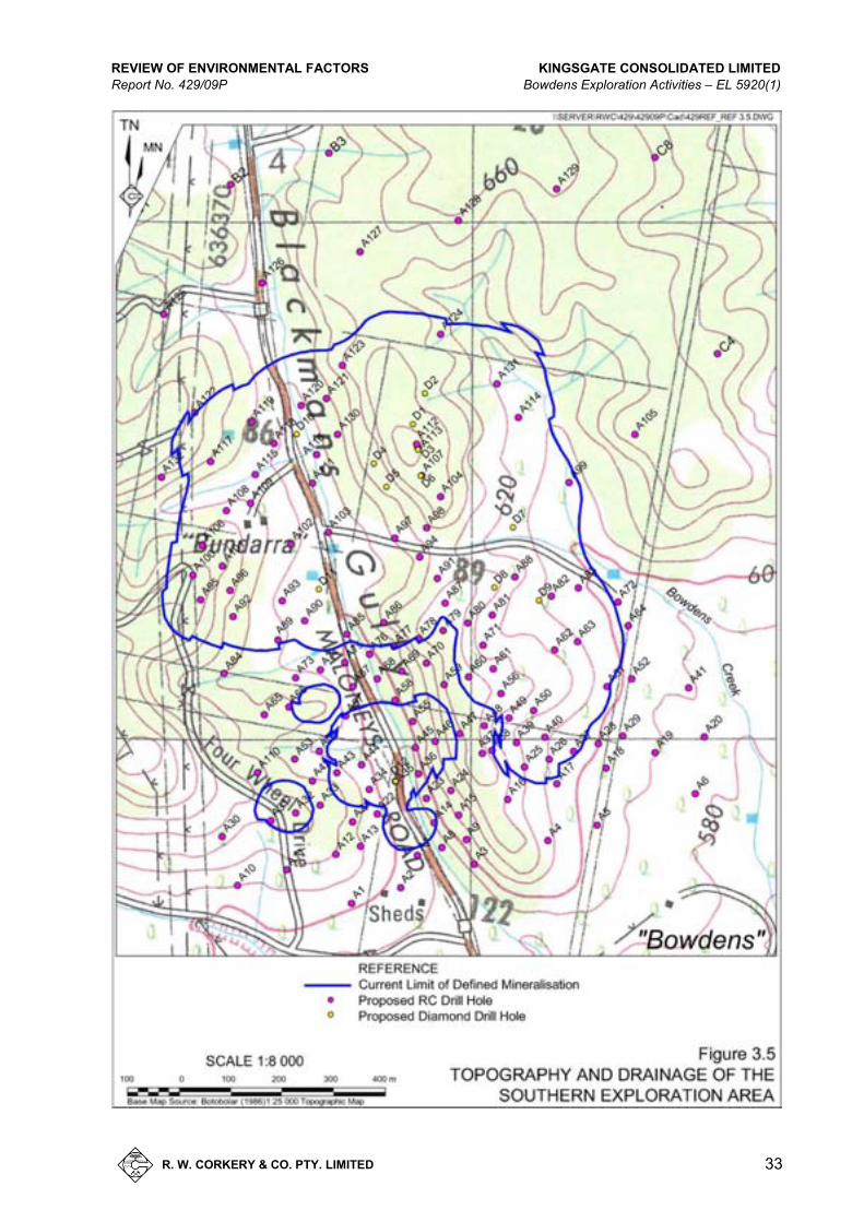
Figure 3.5 Topography and Drainage of the Southern Exploration Area .............................................. 33
Figure 3.6 Topography and Drainage of the Northern Exploration Area .............................................. 34
Figure 3.7 Topography and Drainage of the Central Exploration Area ................................................. 35
Figure 3.8 Land Ownership and Surrounding Residences ................................................................... 37
Figure 3.9 Services ................................................................................................................................ 40
Figure 3.10 Temperature Statisticsfor Mudgee ...................................................................................... 41
Figure 3.11 Bowdens Annual Wind Rose ................................................................................................ 42
Figure 4.1 Baseline Environmental Monitoring...................................................................................... 44
Figure 4.2 Groundwater Bores .............................................................................................................. 49
Figure 4.3 AHIMS Search Results ........................................................................................................ 56 TABLES
Table 1.1 Land Titles and Landowners within the Exploration Area ..................................................... 5
Table 2.1 Exploration Personnel ......................................................................................................... 25
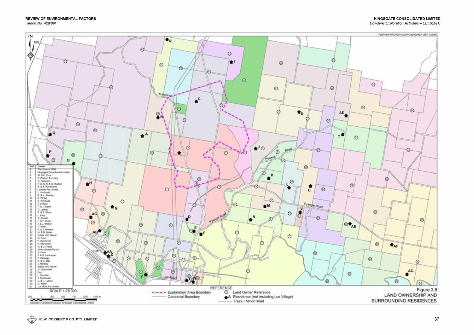
Table 3.1 Proximity of Residences to Exploration Area ...................................................................... 39
Table 3.2 Monthly Rainfall – Mudgee/Lue area .................................................................................. 42
Table 4.1 Proximity of Residences to Exploration Area ...................................................................... 52
Table 4.2 Estimated Sound Pressure Levels at Residences – RC Drilling Operations ..................... 54
Table 4.3 Sound Pressure Levels at Residences – Diamond Drilling Operations .............................. 54
Table 4.4 Sound Pressure Levels at Residences – RC Drilling & Komatsu Dozer Operations.......... 55
Table 4.5 Sound Pressure Levels at Residences – Diamond Drilling & Komatsu Dozer Operations........................................................................................................................... 55
Table 4.6 Overview of Safeguards and Mitigation Measures ............................................................. 69
Table 4.7 Overview of Expected Impacts for Each Environmental Aspect ......................................... 72
Table 6.1 Overview of Expected Impacts for Each Environmental Aspect ......................................... 74

REVIEW OF ENVIRONMENTAL FACTORS KINGSGATE CONSOLIDATED LIMITED Report No. 429/09P Bowdens Exploration Activities – EL 5920(1)
R. W. CORKERY & CO. PTY. LIMITED
1
1. I N T RO D U C TI ON
1.1 SCOPE
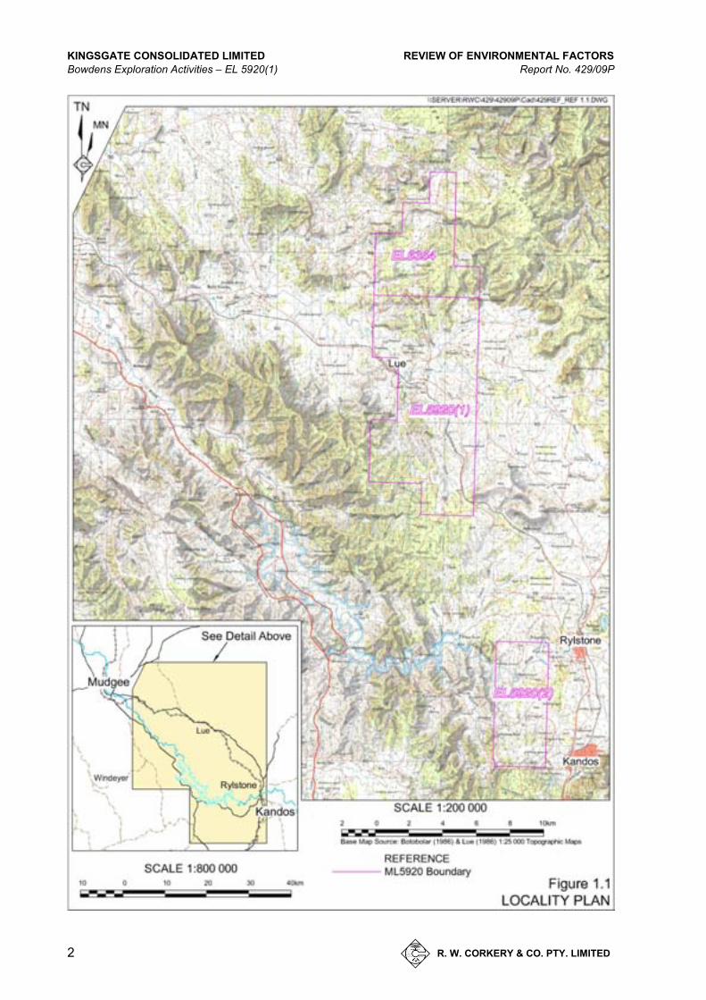
This Review of Environmental Factors (REF) has been prepared by R.W. Corkery & Co. Pty Limited on behalf of Kingsgate Consolidated Limited (Kingsgate) to assess the possible environmental impacts of proposed mineral exploration activities for the Bowdens Silver Project within a 288ha area within EL 5920(1) (the Exploration Area) near Lue, approximately 26km east of Mudgee (Figure 1.1).
The Bowdens Silver Project has reached the stage of evaluation that requires further information to enable Kingsgate to:
upgrade the status of the current knowledge of ore reserve/resource;
obtain sufficient ore samples to assist with metallurgical testing; and
provide data confirming the suitability of key areas for future mine infrastructure.
The information is provided to enable the Department of Trade and Investment, Regional Infrastructure and Services – Division of Resources & Energy (DTIRIS-DRE) to assess the proposed mineral exploration activities in accordance with Part 5 of the Environmental Planning and Assessment Act 1979 (EP&A Act).
1.2 DOCUMENT FORMAT
This document has been prepared in accordance with the Guidelines for Review of Environmental Factors (ESB18) published by the former Industry & Investment NSW in June 2006. The document comprises five sections as follows.
Section 1: introduces the proposed exploration activities, and provides relevant background information about the previous exploration, stakeholder consultation and management of the exploration activities.
Section 2: outlines details of the proposed mineral exploration and rehabilitation-related activities describes the licences and approvals required.
Section 3: describes the environmental setting in the vicinity of the Exploration Area, including the topography, geology, climate, land ownership, land use and zoning.
Section 4 describes and assesses the likely environmental impacts of the proposed activities on the air quality, surface water, groundwater, visual amenity, noise and vibration, heritage, flora and fauna, waste minimisation and management, soils and land capability, natural resource use, contaminated land, chemical and hazardous substance management, impacts on the surrounding community and cumulative environmental impacts. Also included in this section is a summary of the mitigation measures that will be implemented by Kingsgate to minimise and manage environmental impacts associated with the proposed exploration activities.
Section 5: concludes this document with a summary of residual environmental impacts and a justification of the proposed activities.
KINGSGATE CONSOLIDATED LIMITED REVIEW OF ENVIRONMENTAL FACTORS Bowdens Exploration Activities – EL 5920(1) Report No. 429/09P
2 R. W. CORKERY & CO. PTY. LIMITED
Figure 1.1 Locality Plan
A4 /
REVIEW OF ENVIRONMENTAL FACTORS KINGSGATE CONSOLIDATED LIMITED Report No. 429/09P Bowdens Exploration Activities – EL 5920(1)
R. W. CORKERY & CO. PTY. LIMITED
3
1.3 THE LICENSEE
The licensee, Kingsgate Bowdens Pty Ltd, is a fully owned subsidiary of Kingsgate Consolidated Limited (“Kingsgate”), a gold mining, development and exploration company, traded on the Australian Stock Exchange (KCN:ASX). In line with the company’s strategy and vision to explore, develop and operate high quality gold projects and become a significant mid-tier gold producer, and their willingness to develop new mineral projects leveraged off a proven record demonstrating world’s best practice in sustainability together with the company’s commitment to local development and training.
Kingsgate purchased the Bowdens Silver Project when it acquired Silver Standard Australia Pty Ltd (Silver Standard) on 23 September 2011. The Company is operated by a board and a management team. The board includes Ross Smyth-Kirk and Gavin Thomas.
Kingsgate's management team has a comprehensive range of skills and experience including mine development and operations, exploration, finance and administration. They are supported by highly qualified specialists, whose backgrounds cover the full scope of mining resources activities.
1.4 EXPLORATION LICENCES
Kingsgate Bowdens Pty Ltd is the holder of two Exploration Licences (ELs) in three tenements located in Lue/Rylstone area in the central western NSW (see Figure 1.1). EL 5920 is divided into two separate areas with the exploration activities covered in this document to wholly occur within EL 5920(1), at the Bowdens site. The residual area of EL 5920 referred as EL 5920(2) is located west of the townships of Rylstone and Kandos and is not the subject of any exploration addressed in this REF.
EL 6354 shares the northern border of EL 5920(1) and is not the subject of any drilling program to be undertaken by Kingsgate for the purpose of this REF. It should be noted that Kingsgate is currently pursuing the renewal of EL 6354 for future exploration.
1.5 EXPLORATION AREA
For the purposes of this REF, the area in which the proposed exploration activities will be conducted is referred to as the “Exploration Area”.
Figure 1.2 displays the location of the Exploration Area and the land titles within the Exploration Area. Table 1.1 lists the landowners of each of the lots on which the exploration activities are proposed. The Exploration Area covers an area of 288ha.

KINGSGATE CONSOLIDATED LIMITED REVIEW OF ENVIRONMENTAL FACTORS Bowdens Exploration Activities – EL 5920(1) Report No. 429/09P
4 R. W. CORKERY & CO. PTY. LIMITED
Figure 1.2 Exploration Area Land Titles
A4 /

REVIEW OF ENVIRONMENTAL FACTORS KINGSGATE CONSOLIDATED LIMITED Report No. 429/09P Bowdens Exploration Activities – EL 5920(1)
R. W. CORKERY & CO. PTY. LIMITED
5
Table 1.1
Land Titles and Landowners within the Exploration Area
Lot/DP Number Landowner 143/755435 F. & J. Bryant 140/755435 F. & J. Bryant 1/814633 Kingsgate Consolidated Limited 2/814633 Kingsgate Consolidated Limited 86/755435 Kingsgate Consolidated Limited 132/1050074 Kingsgate Consolidated Limited 26/755435 P. & S. Wood 25/755435 P. & S. Wood 161/755435 P. & S. Wood 149/755435 The State of NSW 2/766856 W. & C. Price 2/572701 F. & T. Green 119/755435 L. King 3/572701 P. & S. Wood 4/572701 P. & S. Wood 122/755435 B. Winter 7007/1029353 The State of NSW
Kingsgate has written access agreements in place with the landowners identified in Table 1.1 to allow exploration to be undertaken on their properties. The key common commitments that Kingsgate has made to the respective landowners are as follows.
Kingsgate will compensate all affected land owners for exploration disturbances carried out on their properties as stipulated in the signed access agreements.
Kingsgate will repair, reinstate, rehabilitate, make good or pay compensation in respect of any damage to fences, gates, buildings, crops, stock, dams, and other improvements, arising from its exploration activities.
Kingsgate will consult with the landowner prior to implementing any drilling program so as to minimise any interference with the landowner’s farming activities.
Kingsgate will notify the owner within 14 (fourteen) days of completion of each identifiable phase of work. Compensation is payable within 14 (fourteen) days of the landowner issuing Kingsgate a Tax Invoice.
Kingsgate will ensure adequate public liability cover is maintained by itself or its subcontractors to satisfy all eventualities including drilling areas, workings and sumps.
KINGSGATE CONSOLIDATED LIMITED REVIEW OF ENVIRONMENTAL FACTORS Bowdens Exploration Activities – EL 5920(1) Report No. 429/09P
6 R. W. CORKERY & CO. PTY. LIMITED
1.6 PREVIOUS ACTIVITIES WITHIN THE EXPLORATION AREA
Multiple drilling programs have previously been undertaken within the Exploration Area with the following summary showing the relevant company and dates when activities were undertaken.
CRA Exploration (1989 – 1994)
Golden Shamrock Mines (1994 – 1997)
Silver Standard (1997 – August 2011)
Kingsgate (August 2011 – present)
Silver Standard undertook two drilling programs in 1998 and 2002 in which REFs were lodged with the then Department of Mineral Resources and subsequently approved.
In total, approximately 485 exploration drill holes have been previously been drilled within and surrounding the Exploration Area. The locations of all previous drill holes are displayed on Figure 1.3. Programs of both geophysical and geochemical exploration have also been undertaken.
1.7 STAKEHOLDER CONSULTATION
The following provides an overview of consultation undertaken with various stakeholders.
Surrounding Landowners - All landowners within a 2km radius of the Exploration Area have been contacted primarily to introduce Kingsgate as the new project owners, and to give a brief rundown on project development and planned exploration activities. It is planned to re-contact all landowners either personally or through a newsletter to notify them about the planned commencement of drilling activities. Follow up contact with individual landowners would occur typically two weeks prior to commencement of activities within 2km of their residence.
Wider Community - In addition to comments above, a meeting was held with the Bingman Landcare Group plus invited local landowners to answer questions about development of the project. Kingsgate has commenced engagement with Lue residents including the School Principal, Local Fire Brigade, etc.

REVIEW OF ENVIRONMENTAL FACTORS KINGSGATE CONSOLIDATED LIMITED Report No. 429/09P Bowdens Exploration Activities – EL 5920(1)
R. W. CORKERY & CO. PTY. LIMITED
7
Figure 1.3 Previous Drilling and Indicative Mineralisation
A4 Colour
KINGSGATE CONSOLIDATED LIMITED REVIEW OF ENVIRONMENTAL FACTORS Bowdens Exploration Activities – EL 5920(1) Report No. 429/09P
8 R. W. CORKERY & CO. PTY. LIMITED
Local Aboriginal Communities - Contact with Aboriginal stakeholders is occurring through the Archaeologist managing the Aboriginal Cultural Heritage assessment for the EIS for the Bowdens Silver Project.
Local Council - Two meetings have been held with the Mid-Western Regional Council including a presentation on the project to the full Council. This outlined expected project timelines and an initial assessment of factors likely to impact on the Council including workforce, accommodation, traffic etc. Brief reference was made to ongoing exploration activities.
Other Government Agencies - Ongoing discussions are occurring with Transgrid regarding the twin 500kV power line. No other agencies have been contacted at this stage.
Other Groups - Bingman Landcare Group as discussed under Wider Community.
1.8 MANAGEMENT OF EXPLORATION ACTIVITIES
The key Kingsgate personnel involved in the management of the exploration activities and a description of their respective roles is as follows.
Dr Simon McDonald
Dr McDonald is Kingsgate’s Manager of New Projects and will be the key contact person for all Bowdens Silver Project matters. He has overall responsibility for all activities conducted throughout the duration of the forthcoming exploration program. Any government or public requests or actions need to be directed through Dr McDonald.
Mr Ron James
Mr James is Kingsgate’s General Manager of Exploration and has overall responsibility for all exploration personnel working on Kingsgate projects in Australia, Thailand and South America. Mr James reports directly to Kingsgate’s Managing Director and Chief Executive Officer.
Mr Brendan Bradley
Mr Bradley is Kingsgate’s Regional Exploration Manager and reports directly to Mr James. Mr Bradley will be involved in the Bowdens Project from a geological, logistical and staffing perspective.
Mr Graham Kubale
Mr Kubale is Kingsgate’s Senior Exploration Geologist and will be responsible for the day to day execution and management of all field-related exploration activities. In Mr Kubale’s absence, Mr John Elliot will assume Graham’s responsibilities on site.
Mr John Elliot
Mr Elliot is a consulting geologist to Kingsgate and former Silver Standard employee. Mr Elliot will assume site-based management responsibilities whilst Mr Kubale is absent from site.
REVIEW OF ENVIRONMENTAL FACTORS KINGSGATE CONSOLIDATED LIMITED Report No. 429/09P Bowdens Exploration Activities – EL 5920(1)
R. W. CORKERY & CO. PTY. LIMITED
9
Mr Paul Beer
Mr Beer is Kingsgate’s Logistics Officer and Occupational Health and Safety Officer for the Exploration Division. Mr Beer is responsible for supervision of field staff and the site implementation of the company’s Occupation Health and Safety Procedures.
1.9 MANAGEMENT OF INVESTIGATIONS
This REF has been prepared by Mr Rob Corkery (M.Appl.Sc, B.Sc (Hons)), Principal of R.W Corkery and Co Pty Ltd, with the assistance of Mrs Christy Hill, (B.Env Man), Senior Environmental Consultant and Mr Chris Dickson (B.Sc Phys Geog), Environmental Consultant (Graduate), both with R.W Corkery and Co Pty Ltd. The bulk of the assessment (excluding flora, fauna and soils) has been based on a desktop assessment of publicly available literature with information provided to R.W Corkery and Co Pty Ltd by Kingsgate personnel as described in Section 1.8.
The flora and fauna assessment of the proposed exploration program has been respectively undertaken by Mr Geoff Cunningham of Geoff Cunningham Natural Resource Consultants Pty Ltd and Mr Martin Denny of Biodiversity Monitoring Services. The soils information has also been assembled by Mr Cunningham.
2. D E S C RI P T I O N OF E XP LO R AT I O N AC T I V I T I E S
2.1 INTRODUCTION
This section describes in detail the proposed exploration activities throughout the 2011-2012 exploration program for the Bowdens Silver Project. The section incorporates information on:
the proposed drilling activities;
rehabilitation and ongoing maintenance;
documentation and record maintenance; and
licences and approvals required.
2.2 GEOLOGICAL SETTING
2.2.1 Regional Geology
The Bowdens Silver Project is situated on the northeastern margin of the Lachlan Fold Belt, one of the main components of the Tasman Fold Belt System in southeastern Australia. In Victoria, the system is approximately 700km wide and its total strike length, including the New South Wales and Tasmanian portions, is approximately 1 200km. There is a general consensus that the system formed by protracted accretion of mainly oceanic crust against the Australian Craton from the Late Ordovician to the Carboniferous.
Figure 2.1 displays the regional geology in the Lue area, drawn from the Mudgee 1:100 000 Geological Map Sheet (Colqhoun G.P., et.al. 2000).

KINGSGATE CONSOLIDATED LIMITED REVIEW OF ENVIRONMENTAL FACTORS Bowdens Exploration Activities – EL 5920(1) Report No. 429/09P
10 R. W. CORKERY & CO. PTY. LIMITED
Figure 2.1 Regional Geology
A4 - Colour
REVIEW OF ENVIRONMENTAL FACTORS KINGSGATE CONSOLIDATED LIMITED Report No. 429/09P Bowdens Exploration Activities – EL 5920(1)
R. W. CORKERY & CO. PTY. LIMITED
11
2.2.2 Exploration Area Geology
Figure 2.2 displays the detailed mapped geology of the mineralisation area already defined.
The Bowdens silver deposit is hosted by flat-lying Early Permian Rylstone Volcanics that unconformably overlie the Ordovician Lue Beds, a fine-grained basic volcanogenic sequence. The Rylstone Volcanics are partially overlain by a sequence of marine sandstones, conglomerates and shales of the Permo-Triassic Sydney Basin Shoalhaven Group. The Rylstone Volcanics range in thickness from 10m to 200m and are dominated by dacitic and rhyolitic pyroclastics and epiclastics (including ignimbrites and crystal-rich epiclastics, e.g. tuffs) and minor intrusions and flows.
The silver mineralization occurs as flat-lying to moderately dipping zones of disseminations and silicic fracture-filling within the Rylstone Volcanics and is closely associated with sulphides of iron, arsenic, lead and zinc. High grade silver mineralization is also hosted in steeply-dipping fracture zones which host banded sulphide veins.
2.2.3 Bowdens Mineralisation
Silver mineralization within the Bowdens Resource is associated wi th minor lead and zinc sulphides within air-fall breccias, ignimbrites and crystal tuffs of rhyolitic composition. The ignimbrites, and to a lesser degree the tuffs, are frequently welded and have been brecciated in place to form crackle, mosaic and rotational types of breccias. Base and precious metal mineralization are fracture controlled in ignimbrite units, fracture and locally disseminated in crystal tuff units, and mainly disseminated in the matrix of coarse grained tuff breccia units.
The mineralization event began as fluidized brecciation followed by wallrock replacement and open space filling dominated by quartz/adularia, then sulphides, then carbonates and finally clay minerals. Base metal mineralization began late in the quartz event and extended into the carbonate and rarely the clay event. Silver mineralization began in the sulphide event and extends through to the clay event (Leach, 2003).
The first stage of mineralization was the deposition of fine-grained disseminated mineralization both within the matrix and the siliceous fill cementing the breccias. The crystal tuffs, however, display less brecciation and locally within them the mineralization may be finely disseminated within the matrix. A later stage of mineralization is represented by crustiform veining, up to 100mm in width, often within sub-vertical shear or fault zones, and comprising quartz-carbonate-sulphide assemblages.
The bulk of the Bowdens mineralization occurs as a thick zone extending from surface, and near surface, to vertical depths of about 200m. The deposit is poorly constrained below 200m.
2.3 PROPOSED EXPLORATION ACTIVITIES
2.3.1 Introduction
The principal exploration activities proposed within the Exploration Area during 2011-2012 will involve defining the extent and grade of the mineralisation to a greater detail than previous studies, as well as providing samples for metallurgical testing. A total of 171 drill holes will be drilled throughout the exploration program with specific details of each drilling activity to be discussed further in Section 2.4.4. One or two further RC holes would be drilled in close proximity to drill holes C1 and C2 to serve as piezometers for establishing groundwater levels. The exact location of these holes has not yet been finalised.

KINGSGATE CONSOLIDATED LIMITED REVIEW OF ENVIRONMENTAL FACTORS Bowdens Exploration Activities – EL 5920(1) Report No. 429/09P
12 R. W. CORKERY & CO. PTY. LIMITED
Figure 2.2 Geology of the Mineralisation Area
A4 - Colour

REVIEW OF ENVIRONMENTAL FACTORS KINGSGATE CONSOLIDATED LIMITED Report No. 429/09P Bowdens Exploration Activities – EL 5920(1)
R. W. CORKERY & CO. PTY. LIMITED
13
To date, the general locations of all drill holes have been identified through pegging and definition by GPS (see Appendix 4). Exploration activities will involve the following.
1. Confirmation of specific drill hole locations, and pegging.
2. Access preparation, potentially involving track preparation.
3. Drill pad preparation including sump excavation, if required.
4. Drilling and sample collection.
5. Demobilisation of all equipment and temporary stabilisation.
6. Rehabilitation of the drill pad and access tracks.
The process for identifying each drill hole location will take into consideration the following to ensure that each drill hole has a minimal impact on the surrounding environment.
Areas of disturbance associated with all drill hole locations will avoid as far as possible threatened flora, fauna and ecological communities, farm dams, and mature, established vegetation areas.
In steep terrain, drill pads are to be shaped through earthmoving works to provide a near horizontal slope.
Identification and avoidance of the underground service cables and overhead power lines.
The orientation of the drill rig and ancillary equipment, where possible, to minimise noise impacts upon surrounding residents.
In general, the exploration activities would be undertaken, with reference to, NSW Minerals Council – Mineral Exploration Handbook: Towards Environmental Excellence dated September 2010.
2.3.2 Exploration Equipment
The proposed exploration activities will involve the use of the following equipment/vehicles, either continuously or sporadically, throughout the entire exploration process.
Drill Rig
1 x UDR650 drill rig
Drill Support Equipment/Vehicles
2 x Toyota Landcruiser diesel traybacks 1 x 8x8 man truck 1 x 4x4 Mercedes truck with 10 000L
water tank 1 x 4x4 Mercedes support truck (incl.
booster, auxiliary and fuel)
Transport Vehicles
2 x Toyota Landcruiser diesel traybacks
1 x Great wall petrol single cab utility
1 rental 4x4 diesel vehicle (Occasional)
KINGSGATE CONSOLIDATED LIMITED REVIEW OF ENVIRONMENTAL FACTORS Bowdens Exploration Activities – EL 5920(1) Report No. 429/09P
14 R. W. CORKERY & CO. PTY. LIMITED
Earthmoving Equipment
1 x 2007 Kolbelco SK2008 Excavator 1 x 2002 Komatsu D65E6/12 1 x 1995 Komatsu WA420 loader 1 x 1990 Ford LTL 9000 tip truck 1 x 1980 120g Caterpillar grader
(Occasional use)
2.3.3 Drilling Program Design
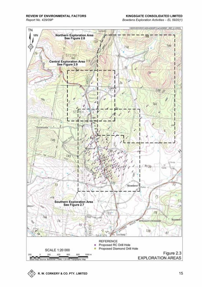
Two types of drilling techniques have been planned for the 2011-2012 exploration drilling with unique objectives for each. These are summarised below.
1. Reverse Circulation Drilling – to increase the understanding of resource extent of the deposit within and outside the current defined limit of mineralisation (see Figure 1.3). This will involve drilling approximately 159 RC holes to varying depths.
2. Diamond Drilling – to ensure adequate diamond core is sent for metallurgical test work. This test work is necessary in establishing recovery grades, grind optimisation and deposit mineralogy. The drilling will involve 12 HQ Diamond holes to varying depths.
Figure 2.3 displays the locations of all drill holes planned for the 2011-2012 program.
2.3.4 Access Tracks
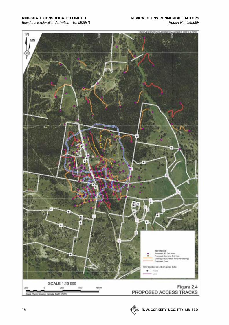
The drilling program requires access tracks to be constructed and/or upgraded to provide access for the drill rig to the specified drill hole locations shown in Figure 2.3. The access tracks have been designed to provide the best access to the drill sites with minimised impacts to the environment as possible. Figure 2.4 shows the proposed access tracks which have been interpreted from aerial photography and topographical maps to allow best access from the existing road/track network. Track clearing will avoid mature, established trees where possible, and with no clearing within open, topographically flat paddocks. While Kingsgate will endeavour to confine its access to the proposed access tracks, some tracks will need to be modified pending unforeseen field practicalities and safety issues.
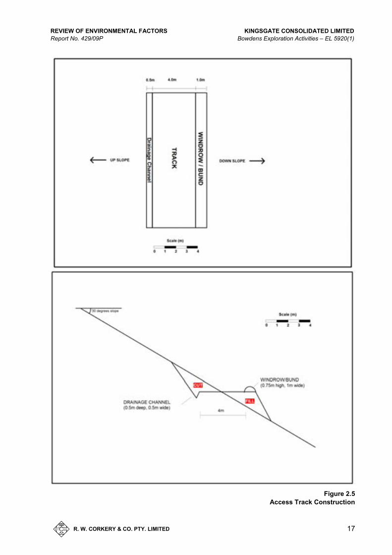
The construction of both existing and new tracks will incorporate drainage channels as well as windrows if topography becomes a safety issue. If any additional fill material is required for track construction or windrows, material will be sourced/quarried from either of the existing borrow pits (see Figures 2.3 and 2.7) within the resource area. Sediment traps are to be incorporated into the design of all tracks where erosional runoff is likely to occur and will either involve rocky material being placed in the drainage channels at regular intervals or by the construction of silt-stop fencing as dictated by the track’s length and slope. Sumps will be excavated at the base of hillside tracks to catch excess runoff water. A cross-sectional view and plan view of the proposed tracks to be constructed are shown in Figure 2.5.
REVIEW OF ENVIRONMENTAL FACTORS KINGSGATE CONSOLIDATED LIMITED Report No. 429/09P Bowdens Exploration Activities – EL 5920(1)
R. W. CORKERY & CO. PTY. LIMITED
15
Figure 2.3 Exploration Areas
A4 /
KINGSGATE CONSOLIDATED LIMITED REVIEW OF ENVIRONMENTAL FACTORS Bowdens Exploration Activities – EL 5920(1) Report No. 429/09P
16 R. W. CORKERY & CO. PTY. LIMITED
Figure 2.4 Proposed Access Tracks
A4 /
REVIEW OF ENVIRONMENTAL FACTORS KINGSGATE CONSOLIDATED LIMITED Report No. 429/09P Bowdens Exploration Activities – EL 5920(1)
R. W. CORKERY & CO. PTY. LIMITED
17
Figure 2.5
Access Track Construction

KINGSGATE CONSOLIDATED LIMITED REVIEW OF ENVIRONMENTAL FACTORS Bowdens Exploration Activities – EL 5920(1) Report No. 429/09P
18 R. W. CORKERY & CO. PTY. LIMITED
2.3.5 Vegetation Clearing
Vegetation clearing for access tracks and other activities would be kept to a minimum but will be unavoidable particularly within the resources area where placement of holes in a grid pattern is essential to achieve the best statistical assessment of the ore body.
All vegetation would preferably be cut/removed just above ground level to enable re-shooting at a later date. All vegetation removed would be stockpiled immediately adjacent to where it is cleared.
2.3.6 Description of Drilling Operations
2.3.6.1 Introduction
Two methods of drilling will be used throughout the 2011-2012 exploration program, namely:
Reverse Circulation (RC) Drilling; and
Diamond Core (DC) Drilling.
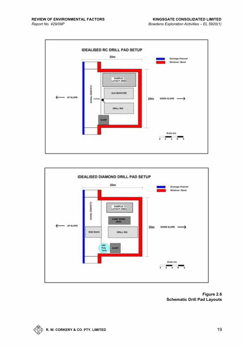
Both RC and DC drilling will require the construction of a drill pad typically 20m x 20m (approximately). Figure 2.6 displays the typical layouts of the drill pads for both drilling operations.
2.3.6.2 Drilling Program
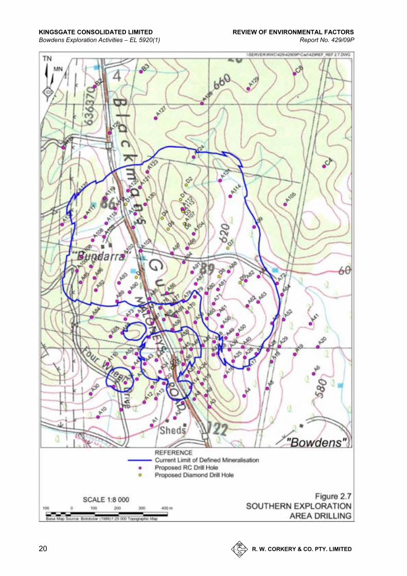
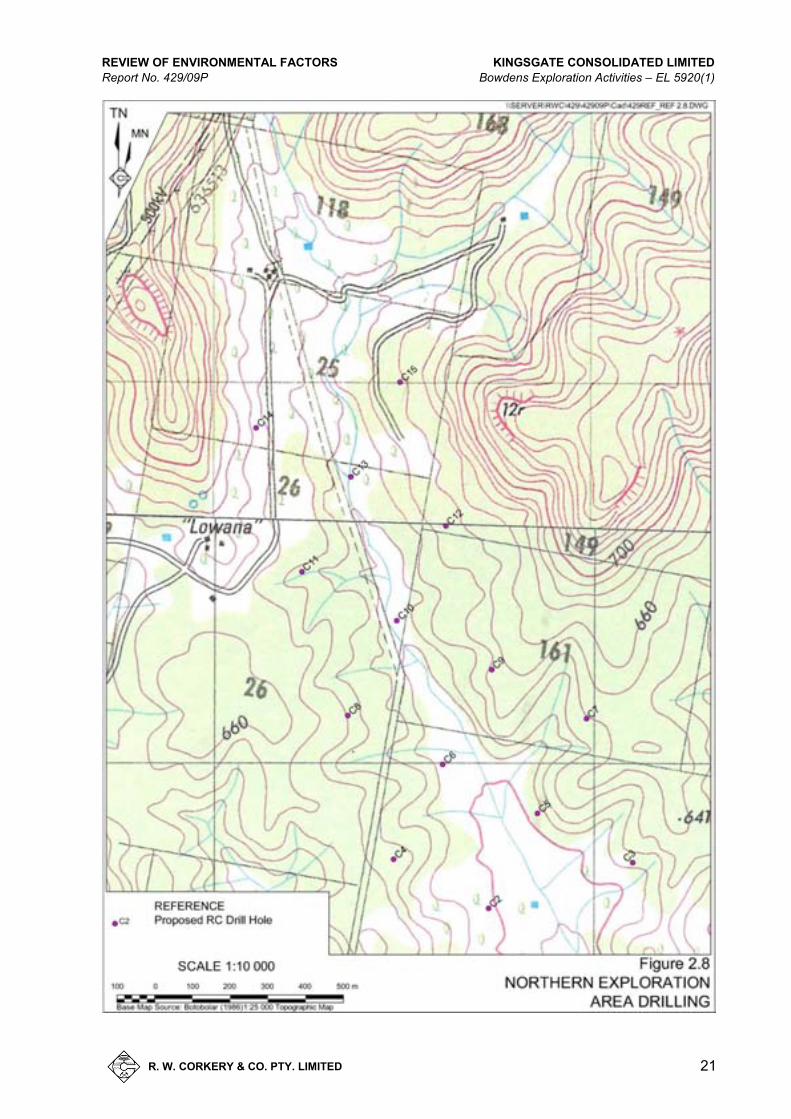
The drilling operations will utilise both RC and DC drilling methods with each drill hole shown in Figure 2.7, 2.8 and 2.9.
RC drilling involves the use of compressed air to drive a slowly rotating percussion drill bit, which operates in a similar manner to a jack hammer. The percussion drill bit is typically fitted with numerous, hardened protrusions that crush the rock at the bottom of the hole. The crushed material is brought to the surface with the returning air through the centre of the drill rods. This drilling method is relatively fast compared with diamond drilling methods. Typically, this drilling method requires multiple trucks, including a rig truck, compressor truck and support truck, as well as one or more light vehicles.
Diamond core drilling involves the use of a rapidly rotating, diamond impregnated drill bit and water with drilling additives to cool and lubricate the drill bit. As the drill rods and drill bit spin, the diamonds grind away the face of the hole leaving a cylinder of rock in the centre of the drill barrel. The cutting face of the drill bit is lubricated using the water and additives mix. As the drill rods advance, the cylinder of remaining rock gradually becomes enveloped by the drill rods. The drill rods are stopped at regular intervals, commonly 1.5m, 3m or 6m intervals, and the resulting drill core is bought to the surface. Ground-up rock material is transported to the surface by the returning drilling fluids and is separated from the fluids, typically in drill sumps. This drilling method is capable of drilling holes to many kilometres depth. Typically this drilling method requires a truck or track mounted drill rig, a support truck and a number of light vehicles. Depending on the duration of the drilling program, additional equipment such as portable shelters, storage containers and portable lighting plants may be required.
Figure 2.6 presents a typical drill site layout for RC and Diamond Core drilling.
REVIEW OF ENVIRONMENTAL FACTORS KINGSGATE CONSOLIDATED LIMITED Report No. 429/09P Bowdens Exploration Activities – EL 5920(1)
R. W. CORKERY & CO. PTY. LIMITED
19
Figure 2.6
Schematic Drill Pad Layouts
KINGSGATE CONSOLIDATED LIMITED REVIEW OF ENVIRONMENTAL FACTORS Bowdens Exploration Activities – EL 5920(1) Report No. 429/09P
20 R. W. CORKERY & CO. PTY. LIMITED
Figure 2.7 Southern Exploration Area Drilling
A4 /
REVIEW OF ENVIRONMENTAL FACTORS KINGSGATE CONSOLIDATED LIMITED Report No. 429/09P Bowdens Exploration Activities – EL 5920(1)
R. W. CORKERY & CO. PTY. LIMITED
21
Figure 2.8 Northern Exploration Area Drilling
A4 /

KINGSGATE CONSOLIDATED LIMITED REVIEW OF ENVIRONMENTAL FACTORS Bowdens Exploration Activities – EL 5920(1) Report No. 429/09P
22 R. W. CORKERY & CO. PTY. LIMITED
Figure 2.9 Central Exploration Area Drilling
A4 /
REVIEW OF ENVIRONMENTAL FACTORS KINGSGATE CONSOLIDATED LIMITED Report No. 429/09P Bowdens Exploration Activities – EL 5920(1)
R. W. CORKERY & CO. PTY. LIMITED
23
2.3.6.3 Sample Management and Processing
A proportion of the drilled materials (‘drill cuttings’) from each drill hole to be sent for assay will be directly placed into calico bags, sealed in green plastic bags and transported in heavy duty “Bulka Bags”. The samples will be despatched approximately weekly from site via an enclosed truck and transported to the contracted laboratory(ies).
The drilled material that is not used for the initial assay (estimated 75% to 94% of the drilled material) will be kept on the drill pad, in their calico or green bags, until it’s no longer required. At that time, the materials would be disposed on site (see Section 2.3.7).
The diamond drill core will be stored in core trays and selected section of core will be split longitudinally to provide core for assay and reference material retained.
The core saw used to cut diamond core will be positioned on the southern end of the sample storage shed adjacent to the “Bowden” residence. Hay bales will be positioned around the saw to muffle the sound generated by the cutting operations. There will also be a roof above the saw to shelter the operator and further contain the sound. All cuttings and fluids will be captured by a primary drum and excess water drained to a small lined sump and allowed to evaporate. All cuttings will be stored in drums for disposal, and is discussed in Section 2.4.7.
2.3.7 Waste Management
Waste will be produced through different mechanisms of the drilling program. A summary of the waste produced from the drilling operations is as follows.
Reverse Circulation Drilling Waste Products
All retention bags (green plastics) and duplicate split samples (calicos) will be stored on the drill pad adjacent to the drill hole until all analytical testing is complete. All residue samples will be removed from the bags and placed into sumps. All retention green plastic and calico bags will then be taken to the local waste facility and disposed of at the appropriate location.
All water and drill sediments will be captured by on-site sumps (4m x 4m x 2m). The water will eventually evaporate and/or naturally drain leaving the residual drill sludge in the bottom of the sumps.
Hydro-carbon spill mats will be used by the drilling contractor as a precaution to hydrocarbon spills. Spill kits will be present on all active drill sites. Any spills will be cleaned up promptly and taken to the local waste facility and disposed of at the appropriate location.
Diamond Core Drilling Waste Products
All diamond cores will be removed daily from the rig site to the designated core cutting/processing facility adjacent to the “Bowden” residence. All water used in cutting core will be re-circulated and captured in an above ground poly tank. The small proportion of waste rock cuttings/sludge residue will be buried within one or more of the drill sumps once they are no longer required.

KINGSGATE CONSOLIDATED LIMITED REVIEW OF ENVIRONMENTAL FACTORS Bowdens Exploration Activities – EL 5920(1) Report No. 429/09P
24 R. W. CORKERY & CO. PTY. LIMITED
All residual drill sludge captured in the base of poly tanks at the drill sites will be transferred from the tank(s) and buried within a site sump no longer required.
Hydrocarbon spill mats will be used by the drilling contractor as a precaution to hydrocarbon spills. Spill kits will be present on all active drill sites. Any spills will be cleaned up promptly and stored until removed from site.
Non Drilling Related Waste Products
All other waste, chiefly domestic household, will be placed in plastic bags and drums and disposed of at the local waste facility. All drill contractor waste material (including plastic drums, PVC, etc.) will also be taken to the local waste facility and disposed of at the appropriate location.
Whilst the above waste management procedures are typical of most drilling campaigns.
2.3.8 Traffic
The exploration program will generate approximately up to 14 vehicle movements per day for up to 7 days per week within the Exploration Area through the use of two to three light vehicles for personnel transport and the use of associated drilling equipment.
2.3.9 Hours of Operation and Timeline
Drilling and related activities will only be undertaken between the hours of 7:00am and 7:00pm Monday to Sunday. It is Kingsgate’s intention to finish all drilling activities before 6:00 pm on Monday to Saturday with the provision of an hour to conclude any activity that may only slightly exceed 6:00 pm. Furthermore, it is proposed that, when required, maintenance is undertaken during Saturday afternoons and Sundays, whenever possible. These days will invariably be rostered days off for the drill crew. It will also serve to minimise noise impacts at surrounding residences throughout the weekend.
It is envisaged that one or two shallow RC drill holes (<150m) will be completed each day. When diamond drilling, an estimated 20m will be completed each day. Deeper RC holes will require operations over periods of up to 2 or 3 days.
When diamond drilling, an estimated 20m will be completed each day which will involve activities between 2 and 10 days at each hole.
Drilling is programmed to start by approximately mid-January 2012. The timing of RC versus DC drilling will be dependent on the requirements of Kingsgate at the time of drilling.
2.3.10 Employment
Table 2.1 details both the drill crew and Kingsgate employees that will be on site at any given time throughout the exploration programs. In total, there would typically be 7 full-time personnel and 5 part-time personnel on site.

REVIEW OF ENVIRONMENTAL FACTORS KINGSGATE CONSOLIDATED LIMITED Report No. 429/09P Bowdens Exploration Activities – EL 5920(1)
R. W. CORKERY & CO. PTY. LIMITED
25
Table 2.1
Exploration Personnel
Personnel Full Time Part Time Caretaker 1 - Field assistant 2 - Field geologist 1 - Senior geologist - 1 Field supervisor - 1 Driller 1 - Drill offsider 2 - Drilling supervisor - 1 Plant operator - 2 Total 7 5 Source: Kingsgate Consolidated Limited
2.4 REHABILITATION AND ONGOING MONITORING/MAINTENANCE
Rehabilitation of areas disturbed during the drilling programs will be undertaken in three stages.
1. Following Construction Works
Following construction works for each hole, all embankments created adjacent to tracks or drill ponds would be seeded with a pasture mix. Silt-stop fencing will be positioned downslope from all embankments until they are adequately stabilised by the vegetation. Appropriate drainage controls, if required, will be constructed to protect disturbed areas.
2. Following Completion of Drilling
Once all drilling activities are completed on each drill pad, and the access track to them, the need for temporary rehabilitation would be reviewed. The key factor influencing the decision whether some temporary rehabilitation is undertaken will centre around the likelihood of natural revegetation or excess sediment loss until the drill pad or pad(s) are either permanently rehabilitated or incorporated within an approved mine. For those drill pads and access tracks where excess sediment loss is likely, those areas will be lightly scarified and seeded with a pasture mix.
3. Long Term Rehabilitation
In the event that the proposed silver mine does not receive approval or within a period of 2 years of the exploration period (whichever occurs later), Kingsgate will undertake a program of final rehabilitation to provide for a stable long term landform in those areas disturbed by exploration. The exact timing of the need for long term rehabilitation would be discussed, if required, with the DRE.
Long term rehabilitation will involve the following component activities.
i) Re-shaping the drill pads to remove their geometric shape and creating slopes comparable with those natural slopes around the pads.
ii) Re-placing topsoil set aside during pad construction onto the final landform.

KINGSGATE CONSOLIDATED LIMITED REVIEW OF ENVIRONMENTAL FACTORS Bowdens Exploration Activities – EL 5920(1) Report No. 429/09P
26 R. W. CORKERY & CO. PTY. LIMITED
iii) Installation of any required surface water management structures to protect the disturbed area, including silt-stop fencing.
iv) Revegetation of the entire disturbed area with a pasture weed mix.
All revegetated areas will be inspected at least every 6 months for a period of up to 2 years or following any substantial storm events to identify whether there is a need for any maintenance activities.
All PVC drill collars will be retained as long as the holes are required to be open and available for further tests or groundwater monitoring. In the unlikely event the mine does not proceed and the exploration licence is relinquished, the drill collars would be cut to a level approximately 1m below the ground surface and a metal plate positioned on the hole before the hole is backfilled to ground level.
All sumps will be rehabilitated within 6 months of the drilling program. This will include the pumping of any remaining water and subsequent disposal at an appropriate off-site facility. Once the sumps are removed of excess water, the sumps are to be suitably filled in with available material and covered with previously removed vegetation.
2.5 DOCUMENTATION AND RECORD MAINTENANCE
Kingsgate will manage the exploration programs with a consolidated set of documentation comprising:
1. a register for all drill holes and their locations, results, rehabilitation progress, etc. and individual folders for each drill hole;
2. procedures reflecting all operational aspects of the program, including aspects influencing environmental issues;
3. procedures to check or monitor the activities are being undertaken in accordance with EL conditions and any other relevant approvals;
4. induction and training programs; and
5. procedures for informing surrounding residents and responding to any issues/complaints (see Section 1.7).
2.6 LICENCES AND APPROVALS REQUIRED
Exploration for minerals in NSW requires an exploration licence or mining lease issued in accordance with the Mining Act 1992. Silver Standard is the holder of ELs 5920(1), 5920(2) and 6354. The exploration works will occur wholly within EL 5920(1).
The conditions of an exploration licence list three categories of activities and their requirements of notification and approvals. The activities proposed in this REF are classed as Category 3, requiring a REF be prepared to accompany a surface disturbance notice. Category 3 activities include:
a) Operations under Category 2 (c) to (g) within or adjacent to Sensitive Areas.

REVIEW OF ENVIRONMENTAL FACTORS KINGSGATE CONSOLIDATED LIMITED Report No. 429/09P Bowdens Exploration Activities – EL 5920(1)
R. W. CORKERY & CO. PTY. LIMITED
27
b) Operations under Category 2 (c) to (g) of a concentrated or cumulative nature.
c) Excavations or bulk sampling in excess of 60 cubic metres.
d) Shaft sinking or tunnelling
e) Drilling holes in excess of 400 millimetre diameter.
f) Intensive drilling, such as for resource definition purposes.
g) Access tracks involving formed construction.
It is activities f) and g) that qualify the proposed exploration program as Category 3. The Company notes that no land within the licence area is classified as sensitive land.
A Part 5 Water Licence under the Water Act 1912 will also be required for the installation of piezometers and ongoing monitoring of selected drill holes as they potentially will intercept groundwater. An activity is considered to interfere with an aquifer if it does any of the following.
Penetrates an aquifer.
Interferes with water in an aquifer.
Obstructs the flow of water in an aquifer.
Takes water from an aquifer in the course of carrying out mining, or any other activity prescribed by the regulations.
Disposes of water taken from an aquifer in the course of carrying out mining, or any other activity prescribed by the regulations.
It is the recovery of water for monitoring purposes that qualifies the proposed exploration program as requiring a Part 5 Water Licence.
It is recognised that whilst some holes have been positioned within 40m of a watercourse (see Figures 2.7, 2.8 and 2.9), correspondence with the NSW Office of Water (NOW) - Dubbo Office, has determined that a Controlled Activity Approval is not required for any exploration activities that occur within the Exploration Area.
For the proposed activities, as no contaminated waters will be discharged from site, no items of Aboriginal-heritage significance will be disturbed and no threatened species or endangered ecological communities will be adversely impacted by the proposed activities, no further approvals other than that required under the Mining Act 1992 are required.

KINGSGATE CONSOLIDATED LIMITED REVIEW OF ENVIRONMENTAL FACTORS Bowdens Exploration Activities – EL 5920(1) Report No. 429/09P
28 R. W. CORKERY & CO. PTY. LIMITED
3. E N VI RO NM E NTAL S E T TI NG
3.1 INTRODUCTION
The Bowdens Silver Project Exploration Area is located within the Mid-Western Local Government Area (LGA) (see Figure 3.1) The Exploration Area is located within EL 5920(1) which and is bounded by Hawkins Creek to the south and unnamed western spurs of the Great Dividing Range to the north.
Figure 3.1 Mid-Western LGA
A5 /
This section describes the environmental setting within and surrounding the Exploration Area, including land use and planning considerations, topography and drainage, land ownership, services and climate. Other components of the existing environment are described in Section 4 together with the controls Kingsgate intends to adopt to ensure acceptable impacts occur throughout the exploration program.

REVIEW OF ENVIRONMENTAL FACTORS KINGSGATE CONSOLIDATED LIMITED Report No. 429/09P Bowdens Exploration Activities – EL 5920(1)
R. W. CORKERY & CO. PTY. LIMITED
29
3.2 LAND USE AND PLANNING CONSIDERATIONS
3.2.1 Land Use
Land use throughout the Exploration Area comprises primarily rural activities such as grazing and some cropping with interspersed hobby farming (see Figure 3.2). Land parcels range from grazing properties of up to 200ha to hobby farms/lifestyle blocks of <50ha. The township of Lue is included within EL 5920 (1) but is not within the Exploration Area to covered by this REF.
3.2.2 Planning Considerations
3.2.2.1 State Planning Instruments
No State Environmental Planning Policies (SEPPs) are relevant to the proposed exploration activities. It is noteworthy that the, with the exception of, as discussed in Section 2.7, (SEPP (Mining, Petroleum Production and Extractive Industries)) 2007 states that mineral exploration activities described in Section 2, does not require development consent under the Environmental Planning and Assessment Act 1979. Rather, the activities are approved by the DRE as part of the exploration licence activities.
3.2.2.2 Local Planning Instruments
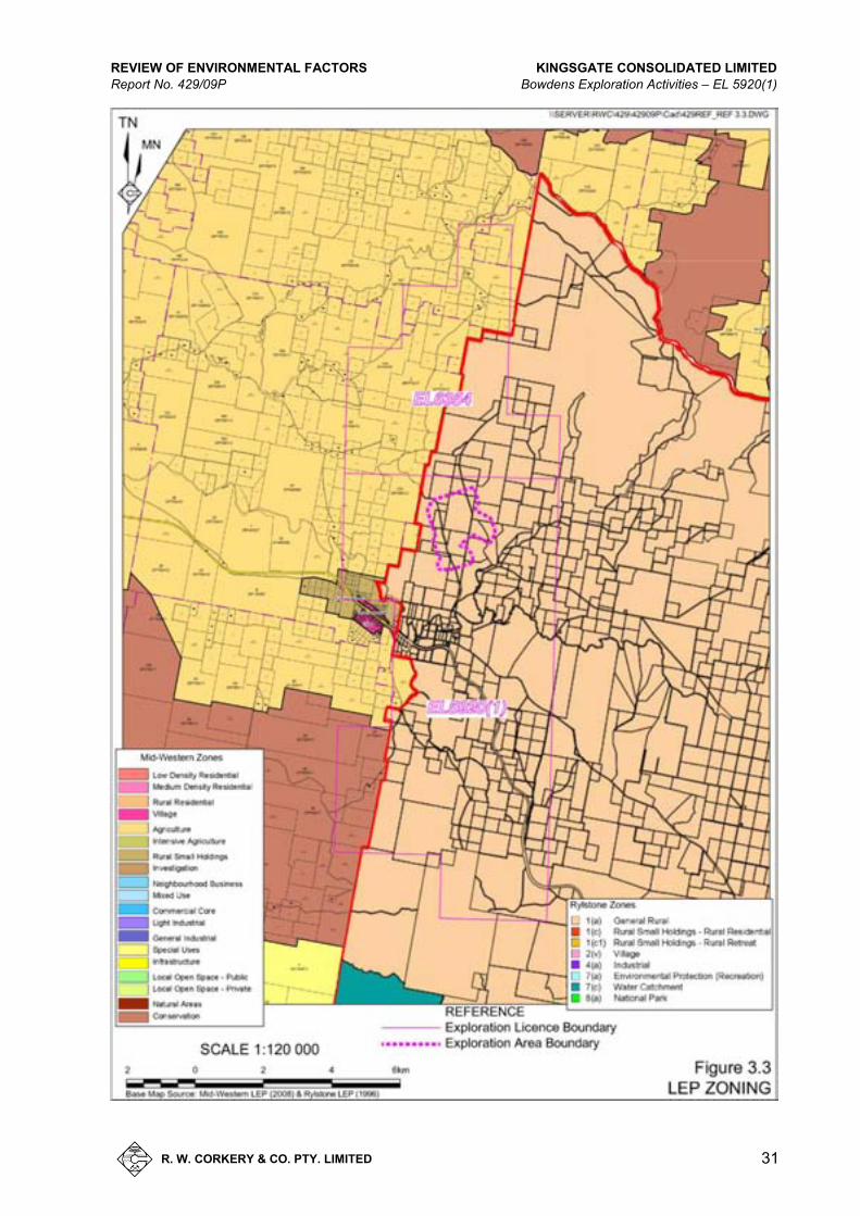
The Exploration Area is located entirely within an area covered by the Rylstone LEP 1996 as shown in Figure 3.3. The Exploration Area is zoned as 1(a) – General Rural within Rylstone LEP 1996. Mining is permissible within this zone. The zones in the area to the west of the Exploration Area are also displayed on Figure 3.3, i.e. within the area covered by the Mid-Western Regional Interim Local Environmental Plan (LEP) 2008.
It should be noted that the amalgamation of Mudgee and Rylstone Councils on 28 May 2004 resulted in the creation of the Mid-Western Regional Council. A Draft LEP for the new LGA is currently on public exhibition. That instrument provides for a Rural Zone 1 (RU1 – Primary Production) across the Exploration Area which, as previously, nominated that mining is permissible in this zone. As the LEP is in its draft version and has not been finalised, the REF will subjected to the aforementioned Mid-Western Regional Interim LEP and the Rylstone LEP.
3.3 TOPOGRAPHY AND DRAINAGE
3.3.1 Regional and Local Topography and Drainage
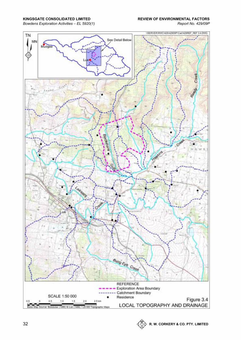
The Exploration Area is located on the western flanks of the Great Dividing Range. Throughout the region, the topography is dominated by rocky ridges with broad, flat valleys intersecting the ridges. General topography of the regional area ranges from <800m AHD within the western flanks Great Dividing Range to <500m AHD to the west of the Exploration Area within the broad, flat valleys. Figures 3.4 to 3.7 display the topography within the Exploration Area.

KINGSGATE CONSOLIDATED LIMITED REVIEW OF ENVIRONMENTAL FACTORS Bowdens Exploration Activities – EL 5920(1) Report No. 429/09P
30 R. W. CORKERY & CO. PTY. LIMITED
Figure 3.2 Land Use
A4 /
REVIEW OF ENVIRONMENTAL FACTORS KINGSGATE CONSOLIDATED LIMITED Report No. 429/09P Bowdens Exploration Activities – EL 5920(1)
R. W. CORKERY & CO. PTY. LIMITED
31
Figure 3.3 LEP Zoning
A4 /
KINGSGATE CONSOLIDATED LIMITED REVIEW OF ENVIRONMENTAL FACTORS Bowdens Exploration Activities – EL 5920(1) Report No. 429/09P
32 R. W. CORKERY & CO. PTY. LIMITED
Figure 3.4 Local Topography and Drainage
A4 /
REVIEW OF ENVIRONMENTAL FACTORS KINGSGATE CONSOLIDATED LIMITED Report No. 429/09P Bowdens Exploration Activities – EL 5920(1)
R. W. CORKERY & CO. PTY. LIMITED
33
Figure 3.5 Topography and Drainage of the Southern Exploration Area
A4 /

KINGSGATE CONSOLIDATED LIMITED REVIEW OF ENVIRONMENTAL FACTORS Bowdens Exploration Activities – EL 5920(1) Report No. 429/09P
34 R. W. CORKERY & CO. PTY. LIMITED
Figure 3.6 Topography and Drainage of the Northern Exploration Area
A4 /

REVIEW OF ENVIRONMENTAL FACTORS KINGSGATE CONSOLIDATED LIMITED Report No. 429/09P Bowdens Exploration Activities – EL 5920(1)
R. W. CORKERY & CO. PTY. LIMITED
35
Figure 3.7 Topography and Drainage of the Central Exploration Area
A4 /

KINGSGATE CONSOLIDATED LIMITED REVIEW OF ENVIRONMENTAL FACTORS Bowdens Exploration Activities – EL 5920(1) Report No. 429/09P
36 R. W. CORKERY & CO. PTY. LIMITED
The drainage associated with the regional topography is generally towards the west where the water throughout the western flanks of the Great Dividing Range flow until they reach local creeks and join with the Cudgegong River. The most prominent local creek to the Exploration Area within the region is Lawsons Creek. All rainfall that falls within the regional area flows into either Lawsons Creek or Bara Creek catchments before joining the Cudgegong River, just east of Mudgee.
3.3.2 Exploration Area Topography and Drainage
The Exploration Area comprises of two valleys intersected with a north-south trending, rocky ridge. Within the localised area surrounding the Exploration Area, the highest point is 782m AHD located northwest of the Exploration Area with the lowest point in the area located south of the Exploration Area near the intersection of Hawkins Creek and Lawsons Creek at an elevation of approximately 560m AHD.
The topography of the Exploration Area creates two drainage lines, Blackmans Gully and Price Creek with both drainage lines flowing southwards into Hawkins Creek. Hawkins Creek has its headwaters to the east of the Exploration Area and flows westerly towards Lawsons Creek where it joins approximately 1.5km south of the Exploration Area. Both the drainage lines are ephemeral with flowing water experienced only during and after heavy rainfall events.
Drainage on local land not associated with the Exploration Area is typically the same as ephemeral drainage associated the Exploration Area but is regularly intercepted by stock dams.
3.4 LAND OWNERSHIP AND RESIDENCES
The Exploration Area encompasses nine separate properties and includes two residences (one of which is owned by the Company) as shown in Figure 3.8. All cadastral data and land title information was sourced from the NSW Land and Property Management Authority (now known as NSW Lands and Property Information (LPI)).
Kingsgate has negotiated access agreements for all landholders on whose properties drilling will be conducted.
Figure 3.8 also displays the locations of residences on surrounding properties. Table 3.1 lists the distance of the surrounding residences from the Exploration Area.
REVIEW OF ENVIRONMENTAL FACTORS KINGSGATE CONSOLIDATED LIMITED Report No. 429/09P Bowdens Exploration Activities – EL 5920(1)
R. W. CORKERY & CO. PTY. LIMITED
37
Figure 3.8 Land Ownership and Surrounding Residences
A3 /

This page has intentionally been left blank
This page has intentionally been left blank
REVIEW OF ENVIRONMENTAL FACTORS KINGSGATE CONSOLIDATED LIMITED Report No. 429/09P Bowdens Exploration Activities – EL 5920(1)
R. W. CORKERY & CO. PTY. LIMITED
39
Table 3.1
Proximity of Residences to Exploration Area
Residences Distance (m) to Closest
Drill Hole Locations
A 640 B 190 C 240 D 760 E 1040 F 1130 I 550 J 290 K 890 L 1380 M 1280 N 1240 S 1330 U 1770 V 1950
3.5 SERVICES
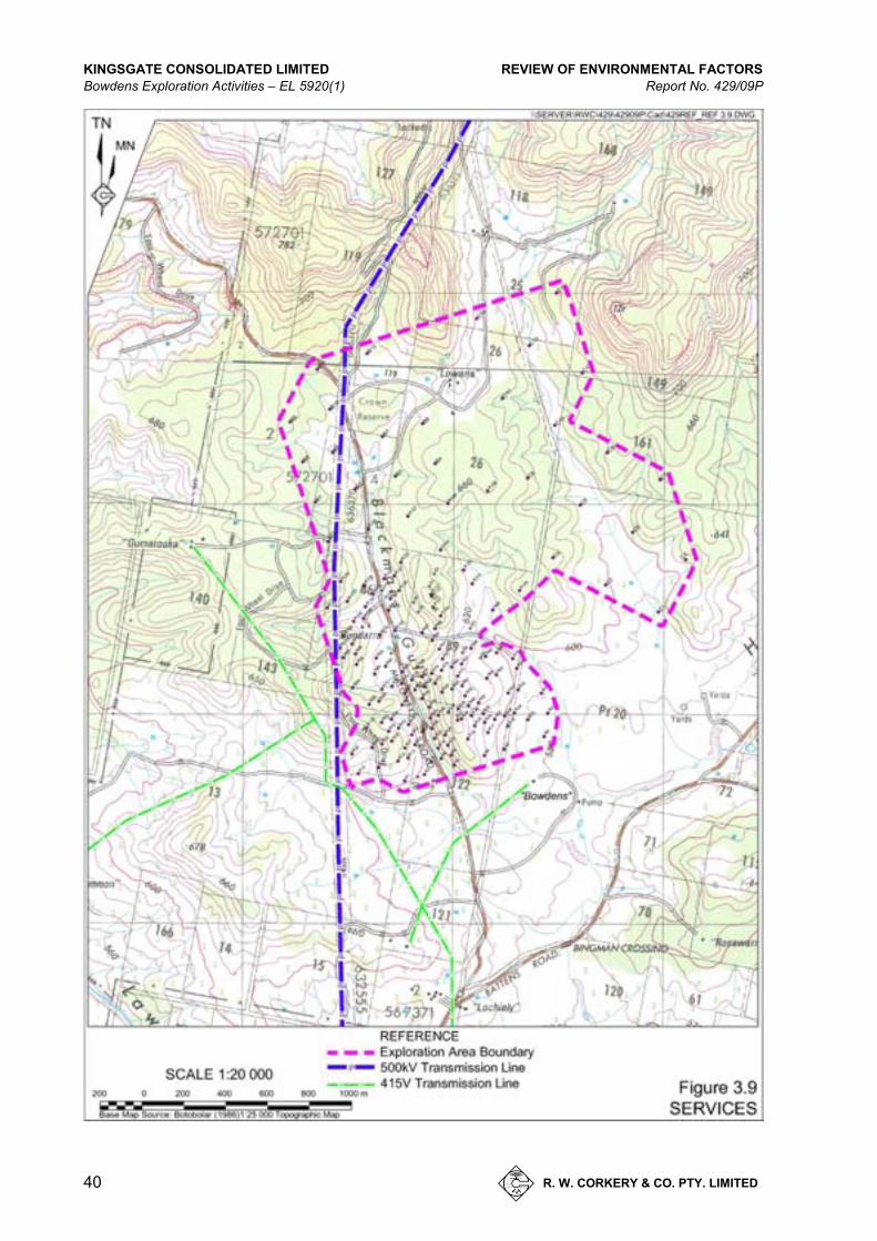
Figure 3.9 displays the services known to occur within the Exploration Area. The key services are:
1. A 500kV power transmission line oriented generally north-south through the Exploration Area.
2. A 415V power transmission line oriented generally east-west.
3. Various buried telecommunications cables principally to the residences and located largely within the local road reserves.
3.6 CLIMATE
3.6.1 Introduction
The climate in the vicinity of Lue is warm temperate, i.e. warm to hot summers and mild to cool winters with the rainfall pattern having a summer maximum.
Temperature data was sourced from the meteorological stations at Mudgee Airport and George St, Mudgee (approximately 26km northwest from the Exploration Area) whilst data on wind speed and direction has been drawn from a weather station on the “Bowden” property.
KINGSGATE CONSOLIDATED LIMITED REVIEW OF ENVIRONMENTAL FACTORS Bowdens Exploration Activities – EL 5920(1) Report No. 429/09P
40 R. W. CORKERY & CO. PTY. LIMITED
Figure 3.9 Services
A4 /
REVIEW OF ENVIRONMENTAL FACTORS KINGSGATE CONSOLIDATED LIMITED Report No. 429/09P Bowdens Exploration Activities – EL 5920(1)
R. W. CORKERY & CO. PTY. LIMITED
41
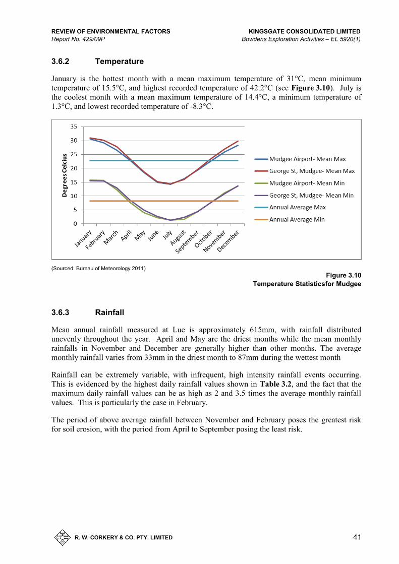
3.6.2 Temperature
January is the hottest month with a mean maximum temperature of 31°C, mean minimum temperature of 15.5°C, and highest recorded temperature of 42.2°C (see Figure 3.10). July is the coolest month with a mean maximum temperature of 14.4°C, a minimum temperature of 1.3°C, and lowest recorded temperature of -8.3°C.
(Sourced: Bureau of Meteorology 2011)
Figure 3.10
Temperature Statisticsfor Mudgee
3.6.3 Rainfall
Mean annual rainfall measured at Lue is approximately 615mm, with rainfall distributed unevenly throughout the year. April and May are the driest months while the mean monthly rainfalls in November and December are generally higher than other months. The average monthly rainfall varies from 33mm in the driest month to 87mm during the wettest month
Rainfall can be extremely variable, with infrequent, high intensity rainfall events occurring. This is evidenced by the highest daily rainfall values shown in Table 3.2, and the fact that the maximum daily rainfall values can be as high as 2 and 3.5 times the average monthly rainfall values. This is particularly the case in February.
The period of above average rainfall between November and February poses the greatest risk for soil erosion, with the period from April to September posing the least risk.
KINGSGATE CONSOLIDATED LIMITED REVIEW OF ENVIRONMENTAL FACTORS Bowdens Exploration Activities – EL 5920(1) Report No. 429/09P
42 R. W. CORKERY & CO. PTY. LIMITED
Table 3.2
Monthly Rainfall – Mudgee/Lue area
Rainfall Jan Feb Mar Apr May Jun Jul Aug Sep Oct Nov Dec Annual Mean Monthly (mm) Mudgee Airport 67 71 47 34 38 39 43 39 51 57 81 87 653 George St, Mudgee 68 64 51 44 49 55 53 53 52 60 62 65 676 Lue 57 47 49 39 33 56 52 51 47 50 66 62 615 Max Monthly (mm) Mudgee Airport 196 233 187 108 124 127 144 112 114 136 163 242 1152 George St, Mudgee 225 263 303 237 158 201 178 171 188 212 237 268 1443 Lue 143 127 229 123 135 145 152 132 127 160 227 156 1047 Max Daily (mm) Mudgee Airport 65 174 53 46 39 37 48 51 45 51 57 101 - George St, Mudgee 95 169 104 87 74 57 71 68 71 68 103 119 - Lue 52 165 88 60 58 42 50 41 54 50 85 71 - Sourced: BOM 2011
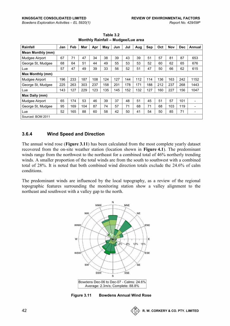
3.6.4 Wind Speed and Direction
The annual wind rose (Figure 3.11) has been calculated from the most complete yearly dataset recovered from the on-site weather station (location shown in Figure 4.1). The predominant winds range from the northwest to the northeast for a combined total of 46% northerly trending winds. A smaller proportion of the total winds are from the south to southwest with a combined total of 28%. It is noted that both combined wind direction totals exclude the 24.6% of calm conditions.
The predominant winds are influenced by the local topography, as a review of the regional topographic features surrounding the monitoring station show a valley alignment to the northeast and southwest with a valley gap to the north.
Figure 3.11 Bowdens Annual Wind Rose

REVIEW OF ENVIRONMENTAL FACTORS KINGSGATE CONSOLIDATED LIMITED Report No. 429/09P Bowdens Exploration Activities – EL 5920(1)
R. W. CORKERY & CO. PTY. LIMITED
43
4. E N VI RO NM E NTAL I M PAC T S AN D M AN AG EM E N T
4.1 INTRODUCTION
This section provides further description of the existing environment within and surrounding the Exploration Area and an outline of the potential impacts of the proposed exploration activities and where relevant, measures are proposed to minimise, manage and monitor impacts for each potential impact. The following environmental attributes are discussed in throughout this section.
Air Quality
Surface Water
Groundwater
Visual Amenity
Noise and Vibration
Heritage
Flora and Fauna
Soils and Land Capability
Natural Resource Use
Contaminated Land
Chemical and Hazardous Substance Management
Impact of the Community
Cumulative Environmental Impacts
With the exception of the flora and fauna studies and noise assessment, information gathered in the absence of specialist consultant assessments has been sourced by R.W. Corkery and Co. Pty Limited from publicly available sources to assess the potential environmental impacts of the exploration activities.
4.2 AIR QUALITY
4.2.1 Existing Environment
The air quality of the Exploration Area and surrounds is typical of a rural environment with the principal air-quality related environmental issue being deposited dust. Mean measured deposited dust levels were recorded at “Bundarra”, Bowden”, “Bingman” and the Price holiday cottage (see Figure 4.1) in 2000 and returned levels ranging from 0.4g/m2/month to 2.1g/m2/month. These levels are consistent with natural rural levels.
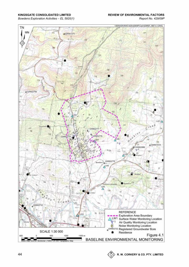
KINGSGATE CONSOLIDATED LIMITED REVIEW OF ENVIRONMENTAL FACTORS Bowdens Exploration Activities – EL 5920(1) Report No. 429/09P
44 R. W. CORKERY & CO. PTY. LIMITED
Figure 4.1 Baseline Environmental Monitoring
A4 /

REVIEW OF ENVIRONMENTAL FACTORS KINGSGATE CONSOLIDATED LIMITED Report No. 429/09P Bowdens Exploration Activities – EL 5920(1)
R. W. CORKERY & CO. PTY. LIMITED
45
4.2.2 Potential Dust Sources
The primary source of dust arising from the proposed exploration program is from vehicle movements on the unsealed Bara and Powells Roads with other minor dust sources from wind and agricultural activities. The drilling programs have the potential to generate airborne dust during the proposed activities with the following dust sources.
RC drilling.
Access track and drill pad construction.
Vehicle movements associated with the drilling program on unsealed roads, anticipated up to 14 movements per day (7 return trips per day).
4.2.3 Mitigation Measures
Kingsgate will implement the following mitigation measures to reduce potential dust emissions related to the proposed drilling activities.
Minimise surface disturbance.
Use of cyclone dust extraction system on RC drill rigs.
Removal of drilling residues once dried.
Restrict, in consultation with the respective landowner, the speed limit which all Kingsgate contractors will need to follow on all unsealed roads on each property in order to minimise dust lift-off.
4.2.4 Assessment of Impacts
All drilling will be carried out on land for which access agreements have been negotiated with the landowners and, given background levels and the general rural nature of the Exploration Area, it is assessed that the proposed activities will readily satisfy the allowable incremental increase of 2g/m2/month, and a maximum of 4g/m2/month of deposited dust.
4.3 SURFACE WATER
4.3.1 Existing Environment
As discussed in Section 3.3, there are no permanent watercourses within or immediately adjacent to the proposed Exploration Area. All existing watercourses are predominantly Order 1 and 2 streams and recognised to be intermittent and intercepted by stock dams before progressing to Hawkins Creek and hence to Lawsons Creek.
KINGSGATE CONSOLIDATED LIMITED REVIEW OF ENVIRONMENTAL FACTORS Bowdens Exploration Activities – EL 5920(1) Report No. 429/09P
46 R. W. CORKERY & CO. PTY. LIMITED
Based upon previous drilling results, a number of drill holes will intercept the groundwater table and bring the water to the surface where it will flow from the drill rig down slope into a purpose built sump. Testwork on the water samples contained in the sumps will be performed at regular intervals throughout the drill program to ensure water quality is of an appropriate standard. If the water quality results show elevated levels of any relevant analytes, all remaining hole sumps will be plastic lined and the water will be disposed of via evaporation or delivered to a facility licensed to receive the liquids.
Testing of the surface water quality in 2004 at locations shown on Figure 4.1, displayed the water quality to be variable but generally good and is summarised as follows.
pH: 6.9 – 8.9
EC: 139 – 3 210μS/cm
Cl: 7 – 514mg/L
SO4: 7 – 452mg/L
Ca: 5 – 84mg/L
Mg: 4 – 104mg/L
K: <20mg/L
TSS: 6 – 106mg/L
As: <0.01mg/L
Cu: <0.01mg/L
Pb: <0.05mg/L
Zn: <0.05mg/L
Mn: 0.1 – 2.7mg/L
Cd: <0.001mg/L
Fe: 0.5 – 8.4
It should be noted that all monitoring results were taken at locations in very minor to no flow conditions.
As previously determined in Section 2.6, a Controlled Activity Approval from NOW is not required for exploration activities within the Exploration Area.
4.3.2 Mitigation Measures
Mitigation measures to manage the impact(s) on surface water will include the following.
Drill residues from the RC drilling will be collected in a sump excavated within the drill pad, dried and then buried within the sump. If the water contains elements that exceed safe levels, then all future sumps will be lined.
The sumps of all diamond drill holes will be lined to contain all drilling fluids. Sumps in conjunction with above ground tanks will be used.
Storage of drilling chemicals on bunded trays on the support vehicles.
Undertaking refuelling carefully, for example, using funnels. Any spillages will be cleaned up and contaminated soil removed.
Any excess water /drilling fluids encountered would be contained in the sump.
If the water quality from the residues is suitable (satisfying the above criteria), most of the water will be left to drain or allowed to evaporate leaving only silt within the sump.

REVIEW OF ENVIRONMENTAL FACTORS KINGSGATE CONSOLIDATED LIMITED Report No. 429/09P Bowdens Exploration Activities – EL 5920(1)
R. W. CORKERY & CO. PTY. LIMITED
47
Additional site specific mitigation measures may be necessary for any drill holes located within 40m of a watercourse. These measures would be detailed in an application for a controlled activity approval sought for those holes.
4.3.3 Assessed Impacts
The proposed methods of water management will protect the water quality in the watercourses and dams within and immediately surrounding the Exploration Area. The discharge of minor quantities of groundwater to the land surface or its replacement in completed holes will not have any measurable impact on surface or groundwater. Due to the limited flow conditions and low order streams within the vicinity of the drilling program, there are to be negligible impacts on the catchment and ephemeral waterways.
4.4 GROUNDWATER
4.4.1 Existing Environment
A review of groundwater information in the local area within and surrounding the Exploration Area by C.M. Jewell and Associates in September 2003, identified two types of aquifers in the Exploration Area and surrounding region, namely, alluvial / colluvial aquifers and fractured rock aquifers.
4.4.1.1 Alluvial / Colluvial Aquifers
The Quaternary aquifers are not extensive in the Exploration Area and there is no significant delineation of Quaternary alluvial sediments apart from that associated with Lawsons Creek approximately 5km to the west of Lue.
Throughout the local area, minor alluvium / colluvium is present within and adjacent to watercourses in varying thicknesses as a result of continuing erosion.
4.4.1.2 Fractured Rock Aquifers
Groundwater occurrences within the Exploration Area principally occur within Rylstone Volcanics and the underlying Ordovician basement rocks of the Adaminaby Group. Groundwater is controlled primarily by the presence of secondary permeability due to faulting and fracturing. Groundwater storage and flow characteristics are therefore likely to be highly variable and generally controlled by local geological structural features.
4.4.1.3 Surrounding Groundwater Bores
Figure 4.2 displays the locations of the groundwater bores surrounding the Exploration Area. A total of three existing registered groundwater bores are located within 1.5km of the boundary of the Exploration Area.

KINGSGATE CONSOLIDATED LIMITED REVIEW OF ENVIRONMENTAL FACTORS Bowdens Exploration Activities – EL 5920(1) Report No. 429/09P
48 R. W. CORKERY & CO. PTY. LIMITED
4.4.2 Mitigation Measures
Borehole construction methods will be in accordance with the Minimum Construction Requirements for Water Bores in Australia (Edition 3) with boreholes appropriately grouted on completion. However, in order to confirm that no impacts have occurred, it is proposed that monitoring of private groundwater bores within a 2km radius (with landholder permission) will be undertaken before drilling commences, to more clearly establish baseline conditions, and then monitoring will be continued on a regular basis throughout the duration of all drilling activities to identify changes in the parameters being monitored. It is proposed that monitoring will include water level and water quality (electrical conductivity) observations.
In order to manage/prevent the risk of any seepage of drilling fluids into shallow groundwater the following mitigation measures are proposed.
The drilling sumps for the diamond drill holes will be lined with plastic.
Should artesian conditions be encountered, which is considered unlikely, drilling will cease and the holes grouted.
In the event of unmanageable volumes of water are encountered, drilling will cease until either the sump capacity is increased or stored water is removed to a containment area.
Cuttings from the diamond drill hole will be removed to a safe containment area in the event mining does not proceed.
Cuttings from RC drilling will be bagged and despatched to a laboratory and stored on the edge of the drill pad.
Following the completion all exploration drilling activities, each exploration drill hole casing will be securely capped in the short term as further testing may need to be undertaken.
The management of the risks associated with chemicals, hydrocarbons and any other hazardous substances are addressed in Section 4.12.
4.4.3 Assessed Impacts
Water from the targeted drilling horizons is not anticipated to be lifted to the surface during diamond (DC) drilling, whereas RC drilling may produce water if fractures with some storage capacity are intersected.

REVIEW OF ENVIRONMENTAL FACTORS KINGSGATE CONSOLIDATED LIMITED Report No. 429/09P Bowdens Exploration Activities – EL 5920(1)
R. W. CORKERY & CO. PTY. LIMITED
49
Figure 4.2 Groundwater Bores
A4 – Colour
KINGSGATE CONSOLIDATED LIMITED REVIEW OF ENVIRONMENTAL FACTORS Bowdens Exploration Activities – EL 5920(1) Report No. 429/09P
50 R. W. CORKERY & CO. PTY. LIMITED
The potential impacts of RC drilling relate to the following.
The possibility of cross contamination of aquifers (e.g. brackish or saline water being introduced to a fresh water aquifer via the drilling process).
The possibility of contamination of the aquifers by drilling muds / fluids.
Groundwater discharging to the surface, this may cause flooding or impact on surface water quality depending on the discharge and receiving water qualities.
Seepage of drilling mud, drilling additives and/or hydrocarbons (oils / lubricants, etc.) to shallow groundwater beneath the rig at exploration sites.
With regard to the first three possible impacts, the proposed drilling construction and abandonment methodologies eliminate the risks.
During the drilling of diamond exploration holes, the circulating drilling mud will establish a wall cake (low permeability “skin” around the wall of the hole) and also maintain a positive head (pressure) on the various aquifers intercepted. This will prevent both the ingress of groundwater to the hole (and any possible mixing or discharge to the surface) and also limit the ingress of drilling mud into the aquifers to the immediate vicinity of the exploration holes. Furthermore, there are no artesian pressures anticipated in the area and therefore the potential for pressurised groundwater reaching the surface is considered negligible.
During the drilling of RC exploration holes, the volume of water produced from drill holes will be dependent on the nature of structures intersected. There is potential for significant short term flows with historical drilling records indicating that 5L/s are not uncommon, although predominantly previous exploration holes resulted in negligible to no water. Drill cuttings from RC drilling will be bagged for removal.
Following the completion of the drill holes, each hole will be securely capped which will allow the possibility of further studies to be undertaken.
The long term solution for exploration drill holes, if the Bowdens Silver Project does not proceed, will involve the cutting of the drill hole casing approximately 1m below ground, plugging the bore hole with 1m of concrete and placing backfill over the drill hole into a slight mound.
4.5 VISUAL AMENITY
4.5.1 Existing Environment
As discussed in Section 3.2.1, the area within and surrounding the Exploration Area is rural in nature, and has been substantially cleared for agricultural purposes. The proposed Exploration Area is partially visible from Bara and Powells Roads and from up to five adjacent residences, albeit at distances of 0.5km to 4km. The Exploration Area is not visible from the township of Lue.

REVIEW OF ENVIRONMENTAL FACTORS KINGSGATE CONSOLIDATED LIMITED Report No. 429/09P Bowdens Exploration Activities – EL 5920(1)
R. W. CORKERY & CO. PTY. LIMITED
51
4.5.2 Mitigation Measures
Mitigation measures to manage visual impacts will include:
minimising surface disturbance;
routine utilisation of dust collation equipment;
maintaining the operational area in a neat and tidy condition at all times; and
all consumables, including plastic, is removed as soon as practicable.
4.5.3 Assessed Impacts
Some motorists will periodically observe the drilling activities when travelling along sections of Bara Road. It is also likely for some residences to periodically observe drilling activities but as the activities will invariably be short-lived, as well as well-established vegetation communities blocking much of the drilling activities, the impacts will likely be minimal.
Therefore, given the relatively short duration of the exploration activities, no line-of-sight from either the township of Lue or Lue Road and established vegetation communities preventing sight of the activities, minimal impacts will be associated by the proposed drilling activities.
4.6 NOISE AND VIBRATION
4.6.1 Existing Environment
The existing noise environment is typical of rural areas with principal noise sources including birds, stock, wind in trees and agricultural activity. The assumed LA90 noise level is therefore 30dB(A).
4.6.2 Identified Noise Sources
Potential noise sources will include the following plant and corresponding LAeq sound power level (SWL):
Site preparatory works, e.g. the use of a small bulldozer – 113dB(A).
Drilling activities – two types of drilling rigs will be utilised:
– reverse circulation – 114dB(A).
– diamond core –102dB(A).
Table 4.1 shows the proximity of the residences to the closest bore hole locations from each of the drilling areas.
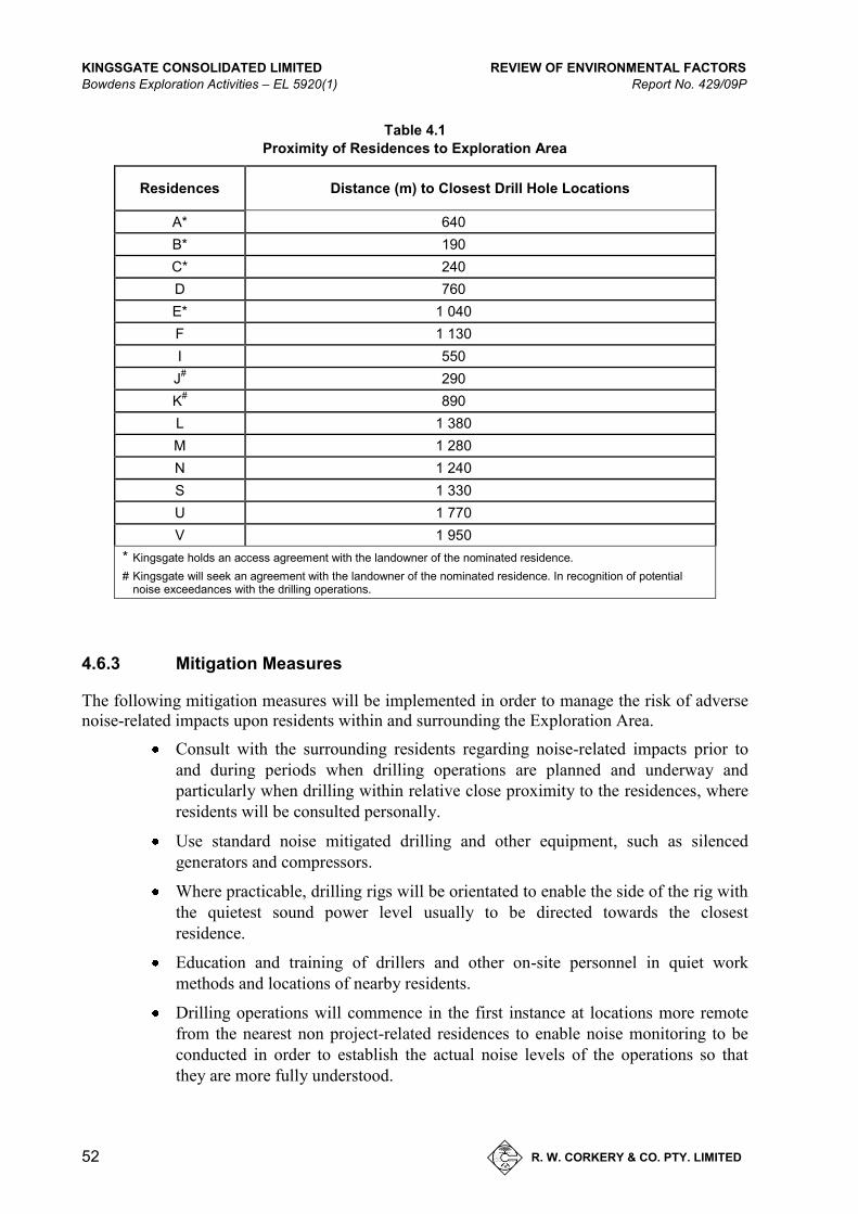
KINGSGATE CONSOLIDATED LIMITED REVIEW OF ENVIRONMENTAL FACTORS Bowdens Exploration Activities – EL 5920(1) Report No. 429/09P
52 R. W. CORKERY & CO. PTY. LIMITED
Table 4.1
Proximity of Residences to Exploration Area
Residences Distance (m) to Closest Drill Hole Locations
A* 640 B* 190 C* 240 D 760 E* 1 040 F 1 130 I 550
J# 290 K# 890 L 1 380 M 1 280 N 1 240 S 1 330 U 1 770 V 1 950
* Kingsgate holds an access agreement with the landowner of the nominated residence. # Kingsgate will seek an agreement with the landowner of the nominated residence. In recognition of potential
noise exceedances with the drilling operations.
4.6.3 Mitigation Measures
The following mitigation measures will be implemented in order to manage the risk of adverse noise-related impacts upon residents within and surrounding the Exploration Area.
Consult with the surrounding residents regarding noise-related impacts prior to and during periods when drilling operations are planned and underway and particularly when drilling within relative close proximity to the residences, where residents will be consulted personally.
Use standard noise mitigated drilling and other equipment, such as silenced generators and compressors.
Where practicable, drilling rigs will be orientated to enable the side of the rig with the quietest sound power level usually to be directed towards the closest residence.
Education and training of drillers and other on-site personnel in quiet work methods and locations of nearby residents.
Drilling operations will commence in the first instance at locations more remote from the nearest non project-related residences to enable noise monitoring to be conducted in order to establish the actual noise levels of the operations so that they are more fully understood.
REVIEW OF ENVIRONMENTAL FACTORS KINGSGATE CONSOLIDATED LIMITED Report No. 429/09P Bowdens Exploration Activities – EL 5920(1)
R. W. CORKERY & CO. PTY. LIMITED
53
Conduct hand-held noise monitoring at the initial borehole locations for both RC and DC drilling in order to monitor the noise levels and re-assess the actual noise impacts.
Limit the hours of operation to daytime only.
In the event an exceedance of the noise criteria is predicted (see Section 4.6.4), Kingsgate would negotiate an agreement with the respective landowner for the short period of exceedance or investigate the opportunity to stagger/carefully plan the exploration program in order to work in with local residents’ requirements.
The opportunity also exists for Kingsgate to plan its exploration activities with a knowledge of local wind patterns. Such an approach would allow drilling activities to occur when gentle winds are not blowing towards a surrounding residence.
In the event neither an agreement or arrangement can be negotiated, Kingsgate will adopt additional noise controls to reduce the noise level to the noise criteria. The most effective and practical additional control would be the use of straw bales positioned strategically around the key noise sources.
Staggering and careful planning of the exploration program in order to work with local residents requirements.
Promptly responding to any complaint in relation to noise.
Use of noise reduction barriers, e.g. hay bales.
4.6.3.1 Assessment of Impacts
The assessment of noise impacts has been assessed an as construction activity given the comparatively short duration of the drilling programs – in accordance with the ‘Interim Construction Noise Guidelines’. The guideline nominates the impacts of short term noise can be assessed either quantitatively or qualitatively. Qualitative assessments invariably relate to those activities that are experienced by a resident for less than 3 weeks in total.
Given the duration of the drilling activities will extend beyond 3 weeks, it is considered appropriate to assess the noise impacts quantitatively at the surrounding residences. For the quantitative assessment of noise impacts, the criterion drawn from the Interim Construction Noise Guidelines would be 40dB(A). A preliminary evaluation of the potential noise from the reverse circulation and diamond core drilling operation has been undertaken by SLR Consulting under calm and adverse weather conditions.
Attenuation from topography has been estimated and included in predictions although it is considered the predictions remain conservative. Table 4.2 to Table 4.5 show the sound pressure levels expected at the residences for different operations and weather conditions for the following scenarios.
Table 4.2 Reverse circulation drilling operations only.
Table 4.3 Diamond Drilling operations only.
Table 4.4 Reverse Circulation drilling operations and bulldozer.
Table 4.5 Diamond Drilling operations and bulldozer.
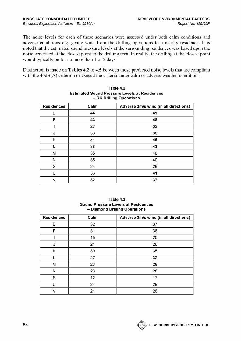
KINGSGATE CONSOLIDATED LIMITED REVIEW OF ENVIRONMENTAL FACTORS Bowdens Exploration Activities – EL 5920(1) Report No. 429/09P
54 R. W. CORKERY & CO. PTY. LIMITED
The noise levels for each of these scenarios were assessed under both calm conditions and adverse conditions e.g. gentle wind from the drilling operations to a nearby residence. It is noted that the estimated sound pressure levels at the surrounding residences was based upon the noise generated at the closest point to the drilling area. In reality, the drilling at the closest point would typically be for no more than 1 or 2 days.
Distinction is made on Tables 4.2 to 4.5 between those predicted noise levels that are compliant with the 40dB(A) criterion or exceed the criteria under calm or adverse weather conditions.
Table 4.2
Estimated Sound Pressure Levels at Residences – RC Drilling Operations
Residences Calm Adverse 3m/s wind (in all directions) D 44 49 F 43 48 I 27 32 J 33 38 K 41 46 L 38 43 M 35 40 N 35 40 S 24 29 U 36 41 V 32 37
Table 4.3
Sound Pressure Levels at Residences – Diamond Drilling Operations
Residences Calm Adverse 3m/s wind (in all directions) D 32 37 F 31 36 I 15 20 J 21 26 K 30 35 L 27 32 M 23 28 N 23 28 S 12 17 U 24 29 V 21 26

REVIEW OF ENVIRONMENTAL FACTORS KINGSGATE CONSOLIDATED LIMITED Report No. 429/09P Bowdens Exploration Activities – EL 5920(1)
R. W. CORKERY & CO. PTY. LIMITED
55
Table 4.4
Sound Pressure Levels at Residences – RC Drilling & Komatsu Dozer Operations
Residences Calm Adverse 3 m/s wind (in all directions) D 47 52 F 45 50 I 30 35 J 35 40 K 44 49 L 41 46 M 37 42 N 37 42 S 27 32 U 39 44 V 35 40
Table 4.5
Sound Pressure Levels at Residences – Diamond Drilling & Komatsu Dozer Operations
Residences Calm Adverse 3 m/s wind (in all directions) D 44 49 F 42 47 I 27 32 J 32 37 K 41 46 L 38 43 M 34 39 N 34 39 S 24 29 U 36 41 V 32 37
Based upon the above qualitative and quantitative assessments, it is assessed that the noise impacts from the proposed drilling operations would be acceptable. Surrounding residents would be aware of the noise from the drilling operations from time to time. However, Kingsgate will regularly inform surrounding residents about its plans and sequence drilling operations, wherever practicable, to reduce noise impacts for surrounding residents.
4.7 HERITAGE
4.7.1 Existing Environment
A search of the AHIMS database identified multiple registered archaeological deposits in a 30km radius of the Exploration Area (see Figure 4.3) with three registered archaeological sites identified in close proximity to the Exploration Area (see Figure 4.4).
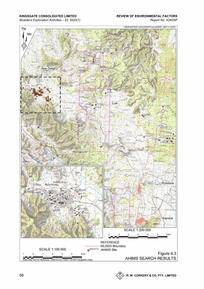
KINGSGATE CONSOLIDATED LIMITED REVIEW OF ENVIRONMENTAL FACTORS Bowdens Exploration Activities – EL 5920(1) Report No. 429/09P
56 R. W. CORKERY & CO. PTY. LIMITED
Figure 4.3 AHIMS Search Results
A4 – Colour

REVIEW OF ENVIRONMENTAL FACTORS KINGSGATE CONSOLIDATED LIMITED Report No. 429/09P Bowdens Exploration Activities – EL 5920(1)
R. W. CORKERY & CO. PTY. LIMITED
57
KINGSGATE CONSOLIDATED LIMITED REVIEW OF ENVIRONMENTAL FACTORS Bowdens Exploration Activities – EL 5920(1) Report No. 429/09P
58 R. W. CORKERY & CO. PTY. LIMITED
An archaeological survey of a portion of the Exploration Area was undertaken by consultant archaeologist, J. Appleton of Archaeological Surveys and Reports Pty Ltd in 1996 with 10 archaeological sites identified comprising of five open scatters and five isolated artefacts. In 1998, D. Maynard of Murong Gialinga ATSIC inspected a broader section of the Exploration Area and identified a total of 42 sites comprising:
22 open camp sites;
14 isolated finds that were found in areas closely associated with the open camp site areas;
five shelters, three with artefact deposits; and
a stone quarry site.
Both Appleton and Maynard recorded sites and their survey areas are shown in Figure 4.4. None of these sites have been placed on the AHIMS register.
Given the limited scope of the exploration works proposed, the Exploration Area’s previous drilling operations and an official AHIMS search revealing no registered archaeological deposits within the Exploration Area, it is considered that the proposed drilling activities in the 2011-2012 program will have a minimal impact on the archaeological setting.
In recognition of the sites identified by Appleton and Maynard in 1996 and 1998 respectively, the drilling program has been designed to avoid disturbance to these sites.
4.7.2 Mitigation Measures
The Company would implement the following mitigation measures to manage the potential risks to items of Aboriginal or European significance.
Utilise previously disturbed areas whenever practicable.
Surface disturbance will be minimised as far as practicable.
Should any ‘objects’ or other Aboriginal sites (such as burials) be uncovered during the course of the activities, work in that area will cease and the OEH and the relevant registered aboriginal stakeholders contacted to discuss how to proceed.
4.7.3 Assessed Impacts
There will be minimal impact expected on Aboriginal or European heritage.
REVIEW OF ENVIRONMENTAL FACTORS KINGSGATE CONSOLIDATED LIMITED Report No. 429/09P Bowdens Exploration Activities – EL 5920(1)
R. W. CORKERY & CO. PTY. LIMITED
59
4.8 FLORA AND FAUNA
4.8.1 Existing Environment - Flora
4.8.1.1 Introduction
Site surveys were undertaken by Geoff Cunningham Natural Resources Consultants in October and November 2011. These surveys examined species and communities across the bulk of the Exploration Area with the exception of an area including, the Winter property. The Winter property was not surveyed as access could not be arranged at the time of the surveys. It is not expected that the communities occurring in areas not surveyed will differ greatly from those already examined.
No threatened species have been identified in the surveys undertaken; however, there is one species of Pomaderris collected that has yet to be identified at the National Herbarium.
No easily identifiable endangered ecological communities were recorded within the Exploration Area. However, there may be a potential for the White Box – Yellow Box – Blakely’s Red Gum Woodland (NSW Threatened Species Conservation Act 1995) and the White Box – Yellow Box – Blakely’s Red Gum Grassy Woodland and Derived Native Grasslands (Commonwealth Environment Protection and Biodiversity Conservation Act 1999). Each community is Endangered/Critically Endangered (respectively) Ecological Communities (the EEC) to occur in the region in which the Bowdens Silver Project is located.
It should be noted that an assessment of significance of the likely impact of the proposed exploration activity on any possible occurrences of the EEC would be undertaken if the potential EECs were not under the threshold for an assessment of significance under the and TSC and EPBC Acts. Section 4.8.2 justifies why an assessment of significance is not applicable to the vegetation communities within the Exploration Area.
Two communities were identified within the Exploration Area (see Figure 4.5), a summary of these communities is present in Section 4.8.1.2 and 4.8.1.3. Note an * denotes an introduced species.
4.8.1.2 Open Cleared Land with Scattered Trees
This community occurs over the lands with gentle slopes within the Exploration Area including some of the valley floors between the more hilly areas. The dominant species is Rough-barked Apple [Angophora floribunda] which occurs as scattered single paddock trees and clumps. Also present are individual Blakely’s Red Gums [Eucalyptus blakelyi] as scattered trees or, at times, in clumps.
While a shrub layer is not prominent in this community, a number of shrub species were recorded. These include Acacia filicifolia, Hopbush [Dodonaea sp.], Hibbertia sp., Native Peas [Pultenaea spp.] and Cassinia sp. The introduced weedy shrubs, Blackberry* [Rubus sp.] and Briar Rose* [Rosa rubiginosa] are also present.
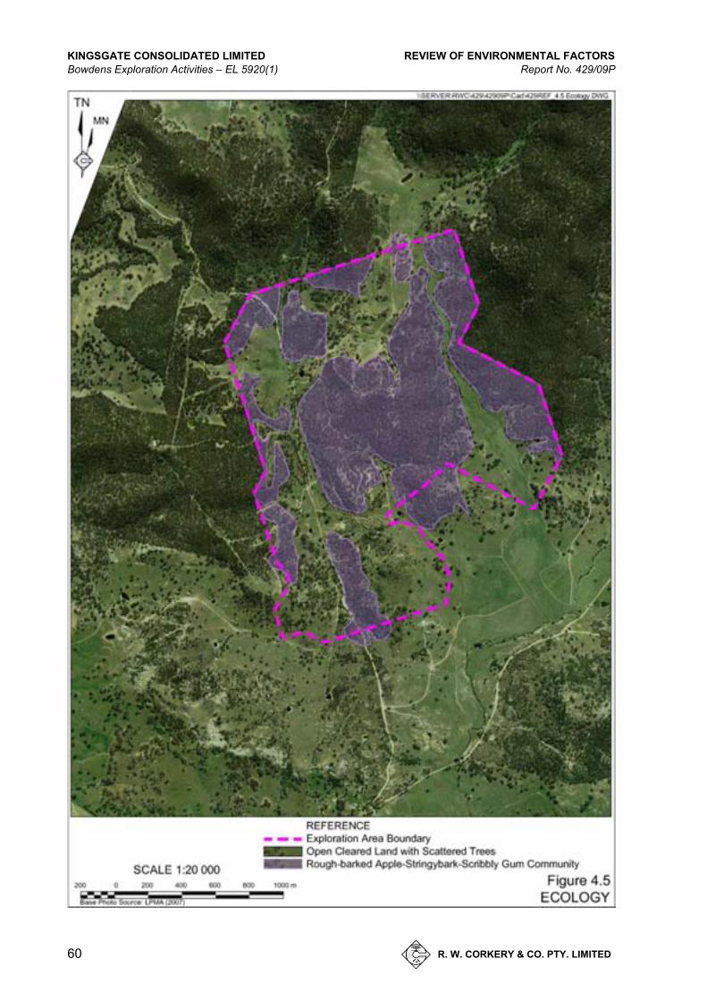
KINGSGATE CONSOLIDATED LIMITED REVIEW OF ENVIRONMENTAL FACTORS Bowdens Exploration Activities – EL 5920(1) Report No. 429/09P
60 R. W. CORKERY & CO. PTY. LIMITED
Figure 4.4 Ecology
A4 – Colour

REVIEW OF ENVIRONMENTAL FACTORS KINGSGATE CONSOLIDATED LIMITED Report No. 429/09P Bowdens Exploration Activities – EL 5920(1)
R. W. CORKERY & CO. PTY. LIMITED
61
4.8.1.3 Rough-barked Apple – Stringybark – Scribbly Gum Community
This community is very variable and difficult to map. There are some discrete areas of Stringybark and Scribbly Gum and similar areas of Rough-barked Apple but these quickly merge into a community comprising all three types. For this reason, the community has been described as one. Rough-barked Apple [Angophora floribunda] is very common throughout and particularly on the lower slopes but is also found on the ridge tops.
A number of Stringybark species were recorded at the site, including Red Stringybark [Eucalyptus macrorhyncha], Narrow-leaf Stringybark [Eucalyptus sparsifolia] and Blue-leaved Stringybark [Eucalyptus agglomerata]. These species are usually confined to the ridge tops and upper slopes.
Scribbly Gum [Eucalyptus rossii] was recorded primarily from the ridge tops and upper slopes but also occurred in drainage lines on lower slopes.
Other eucalypts recorded in the community include Red Box [Eucalyptus polyanthemos], Yellow Box [Eucalyptus melliodora], Bundy [Eucalyptus goniocalyx] and Apple Box [Eucalytus bridgesiana]. Black Cypress Pine [Callitris endlicheri] is common in patches that appear on the aerial photos but is also distributed through the community, particularly on the more elevated areas.
A shrub layer is prominent in this community with Chinese Shrub [Cassinia arcuata], Acacia filicifolia and Acacia caesiella common. A range of groundcover species was recorded and in general introduced species were uncommon in this community although where the community borders the Open Cleared Land with Scattered Trees community there is a greater degree of invasion for some distance from the boundary.
4.8.2 Assessment of Likelihood of the Presence of Endangered Ecological Communities in the Exploration Area
No threatened or endangered flora species or readily recognisable endangered ecological communities are present within the Exploration Area.
However, there may be a potential for the White Box – Yellow Box – Blakely’s Red Gum Woodland (NSW Threatened Species Conservation Act 1995) and the White Box – Yellow Box – Blakely’s Red Gum Grassy Woodland and Derived Native Grasslands (Commonwealth Environment Protection and Biodiversity Conservation Act 1999). Each community is Endangered/Critically Endangered (respectively) Ecological Communities (the EEC) to occur in the region in which the Bowdens Silver Project is located.
Occurrences of two of the three defining species of this endangered ecological community have been recorded during the field survey. These species are Yellow Box and Blakely’s Red Gum.
Yellow Box
Four occurrences of this species were noted in the field. All comprised single trees or small groups of trees occupying a very small area ranging from <100m2 to 200m2.
In the Commonwealth Department of Environment and Heritage publication titled ‘White Box – Yellow Box – Blakely’s Red Gum Grassy Woodlands and Derived Native Grasslands’, it is
KINGSGATE CONSOLIDATED LIMITED REVIEW OF ENVIRONMENTAL FACTORS Bowdens Exploration Activities – EL 5920(1) Report No. 429/09P
62 R. W. CORKERY & CO. PTY. LIMITED
noted (page 5) that if at least one of the defining species is present in a field situation, the site is not regarded as being a remnant of the EEC under the EPBC Act if it is less than 1000 m2 in area.
There is no minimum area stipulation in the case of the NSW TSC Act.
However, all four of the recorded occurrences of Yellow Box were below the minimum area required to qualify as a remnant under the EPBC Act. With regard to the TSC Act, all four occurrences were single trees or small groups of trees within a community dominated by such species as Eucalyptus rossii, Eucalyptus macrochyncha, Eucalyptus sparsifolia and Angophora floribunda and were unmappable.
Rather than forming a remnant of the EEC, these trees appear to be isolated occurrences within an otherwise dissimilar community.
Blakely’s Red Gum
A number of occurrences of Blakely’s Red Gum were recorded in the field within the Exploration Area. Again, as with the Yellow Box, these occurrences were small in size and often associated with species such as Eucalyptus rossii, Eucalyptus macrorhyncha and Angophora floribunda in a community that would be regarded on the basis of general appearance, location in the toposequence and general floristics as a Scribbly Gum – Stringybark community
The occurrences were usually accompanied by a relatively dense understorey of shrubs and hence do not fit within the definition of the EEC under either Act.
The occurrences were less than 100m2 to approximately 300m2 in area and so do not qualify as the EEC under the Commonwealth EPBC Act even if they are deemed to be true remnants which is extremely doubtful.
With regard to the TSC Act definition, the NSW Department of Environment and Conservation [DEC] publication titled ‘Reconstructed and Extant Distribution of Native Vegetation in the Central West Catchment’ [Department of Environment and Conservation, Information and Assessment Section, North-West Branch, Dubbo, 2006] describes a community from the Mudgee to Coonabarabran area that is styled BVT 17 – Blakely’s Red Gum – Rough-barked Apple Woodland on Flats and Alluvial Terraces.
The accompanying text notes that ‘it could be part of the White Box – Yellow Box – Blakely’s Red Gum Endangered Ecological Community’. This community has Blakely’s Red Gum, Rough-barked Apple, White Box, White Cypress Pine, River Red Gum and River Red Gum / Dirty Gum intergrades and River Oak as principal components.
Such a community is very different in composition and location in the toposequence to the occurrences within the Exploration Area and it is concluded that the community within the Exploration Area is not equivalent to the community identified by DEC.
In addition, it should be noted that when the Scientific Committee’s Final Listing Determination is consulted, Rough-barked Apple is not listed as a component species of the EEC – let alone a principal component.
REVIEW OF ENVIRONMENTAL FACTORS KINGSGATE CONSOLIDATED LIMITED Report No. 429/09P Bowdens Exploration Activities – EL 5920(1)
R. W. CORKERY & CO. PTY. LIMITED
63
Most of the Blakely’s Red Gum occurrences, in addition to being small, have a relatively dense shrub layer or a highly invaded groundcover where shrubs are absent or few, which means that they do not fit the TSC Act definition of the EEC.
4.8.3 Existing Environment - Fauna
A preliminary desktop fauna assessment was undertaken by Biodiversity Monitoring Services in October 2011 where searches of the NSW Office of Environment and Heritage Wildlife Atlas, and the CSIRO and Australian Government’s Atlas of Living Australia web site were undertaken to identify the known presence of any fauna species within a 20km radius of the Exploration Site. A summary of observed species during a recent site inspection (September 2011) are as follows.
Mammals – Protected (National Parks and Wildlife Act, 1974) 11 – Vulnerable (Threatened Species Conservation Act, 1995) 2 – Unprotected 7
Birds – Protected (National Parks and Wildlife Act, 1974) 88 – Vulnerable (Threatened Species Conservation Act, 1995) 12 – Unprotected 2 – Endangered (Threatened Species Conservation Act, 1995) 1
Reptiles – Protected (National Parks and Wildlife Act, 1974) 5
Amphibians – Protected (National Parks and Wildlife Act, 1974) 1
A search of threatened species within 50km of the Exploration Area identified:
Mammals – Vulnerable (Threatened Species Conservation Act, 1995): 13
Birds – Vulnerable (Threatened Species Conservation Act, 1995): 22 – Endangered (Threatened Species Conservation Act, 1995): 2
Reptiles – Vulnerable (Threatened Species Conservation Act, 1995): 1 – Endangered (Threatened Species Conservation Act, 1995): 1
Amphibians – Vulnerable (Threatened Species Conservation Act, 1995): 3
KINGSGATE CONSOLIDATED LIMITED REVIEW OF ENVIRONMENTAL FACTORS Bowdens Exploration Activities – EL 5920(1) Report No. 429/09P
64 R. W. CORKERY & CO. PTY. LIMITED
A total of 42 threatened species have been recorded from an area of 50km surrounding the Exploration Area. Few of these species have been recorded from within 20km of the project area as the wider area captures a number of National Parks and other conservation areas. While it is possible these threatened species could occur in the Exploration Area, the number is likely to be less than that from a far larger area.
4.8.4 Assessed Impacts
A development or activity undertaken under the Environmental Planning and Assessment Act 1979 (EP&A Act) requires an Assessment of Significance to be provided to the appropriate determining authority. Under the Threatened Species Conservation Amendment Act 2002, several factors are required to be considered when determining whether an action, development or activity is likely to significantly affect threatened species, populations or ecological communities, or their habitats. The factors are collectively known as the 7-part test.
The Assessment of Significance for the proposed exploration program has been undertaken for three ‘woodland’ birds that may occur within the area (Brown Treecreeper - eastern subspecies (Climacteris picumnus victoriae), Grey-crowned Babbler - southeastern sub-species (Pomatostomus temporalis) and the Scarlet Robin (Petroica boodang). Appendix 5 displays the complete results of the detailed 7-part tests which have resulted that in the case of the drilling program proposed for EL 5920, the extent of any impacts will be low, provided a number of conservation and mitigation measures are undertaken. Such measures are part of ‘standard’ procedures undertaken during exploratory drilling.
Provided the mitigation measures listed in Section 4.8.5 and the rehabilitation strategies described in Section 2.4 are undertaken, the extent of loss of vegetation during drilling programs is relatively low and it is unlikely that there would be any significant impacts upon threatened species that may occur within EL 5920.
4.8.5 Mitigation Measures
Mitigation measures for the management of flora and fauna impacts will include the following.
Selection of access tracks to avoid areas of natural vegetation, particularly woodland.
Use of existing tracks where possible.
Keep clearing at drill sites to a minimum.
Avoid removing any mature trees, where possible.
If a mature tree is removed, then an inspection of any hollows will be undertaken by a qualified animal rescue person.
Clearing will utilize the salvage and re-use of felled tree hollows, fallen timber, hollow logs and boulders.
Felled timber will be re-used to cover the access track when drilling is completed.
Soil erosion and run-off prevention procedures will be undertaken.
REVIEW OF ENVIRONMENTAL FACTORS KINGSGATE CONSOLIDATED LIMITED Report No. 429/09P Bowdens Exploration Activities – EL 5920(1)
R. W. CORKERY & CO. PTY. LIMITED
65
4.9 SOILS AND LAND CAPABILITY
4.9.1 Existing Environment
A preliminary desktop assessment was undertaken by (Geoff Cunningham Natural Resource Consultants Pty Ltd) in October 2011, to identify the soil landscapes within the Exploration Area. A review of the Dubbo 1:250 000 Soil Landscapes map and the Mudgee 1:100 000 Geological Map assists to identify six soil landscapes with the Exploration Area.
Details of the major soils within each of these six soil landscapes are set out below.
Barigan Creek
– Topography - undulating low rises and flats; relief 40-80m, slopes 3-8%.
– Geological Units - Illawarra Coal Measures; Shoalhaven Group - shale, sandstone, siltstone, conglomerate, chert.
– Soils – Commonly Yellow Podsolics on lower slopes and along drainage lines; Red podsolic soils on higher colluvial slopes, benches and rises.
Bald Hill
– Topography – low hillocks and small basalt caps with moderate to steep slopes; relief 60-120m, slopes 10-35%.
– Geological Units – Tertiary Basalt – olivine basalt, dolerite, teschenite.
– Soils – Euchrozems on crests; Euchrozems / Chocolate Soils on mid-slopes with basalt outcrop and floaters; Shallow Stony Soils on steeper slopes near crests; Brown Clays with linear gilgais on lower slopes.
Lees Pinch
– Topography – rolling hills and low hills with steep rocky slopes and valley sides; relief to 240m, slopes 15-40%.
– Geological Units – Narrabeen Group, Illawarra Coal Measures – sandstone, shale, conglomerate, mudstone, chert, coal seams, torbanite seams.
– Soils - shallow sandy soils with extensive rock outcrop, boulder debris slopes and sandstone cliffs; Grey or Yellow Podsolics on lower slopes, shallow acid loams on coal bearing strata and Oodzols on lower slopes.
Murrumbo
– Topography – ancient river gravels and levee bank; relief to 20m, slopes 1-3%.
– Geological Units - undifferentiated river gravels; derived from various rocks within the catchment.
– Soils – Gravelly Red Earths on crests and benches.
KINGSGATE CONSOLIDATED LIMITED REVIEW OF ENVIRONMENTAL FACTORS Bowdens Exploration Activities – EL 5920(1) Report No. 429/09P
66 R. W. CORKERY & CO. PTY. LIMITED
Rylstone
– Topography – undulating low hills and hills; relief 40-60m, slopes 5-15%; outcrop common on upper slopes and crests.
– Geological Units - Rylstone tuff.
– Soils – mainly shallow siliceous sands and bleached sands; Red Podsolic Soils with floaters between the outcrops; shallow Yellow Podsolic soils / Soloths in drainage lines.
Ulan
– Topography – low undulating rises and flats; relief 10-40m, slopes 2-10%.
– Geological Units – Undifferentiated material; Illawarra Coal Measures; shale, sandstones, conglomerate, chert, coal, torbanite.
– Soils – Yellow Podsolics on lower slopes and drainage lines with patches of Solodic Soils / Solonetz Soils on salt scalds on footslopes, Earthy Sands on low rises.
Land Capability
Land within and surrounding the Exploration Area is classed as follows.
Class VII land on ridges and steep vegetated slopes.
Class II/III land in cleared valleys.
4.9.2 Mitigation Measures
The following mitigation measures will be adopted to protect the soil resources disturbed throughout the exploration program.
Minimise surface disturbance as far as practicable.
Define clear tracks and avoid deviation from these.
Separate topsoil and subsoil from areas disturbed.
Undertake rehabilitation of disturbed areas.
4.9.3 Assessed Impacts
The impacts on soils are assessed as negligible given the adoption of the above mitigation measures.
There will be no adverse impacts on medium to long term land use or land capability.
REVIEW OF ENVIRONMENTAL FACTORS KINGSGATE CONSOLIDATED LIMITED Report No. 429/09P Bowdens Exploration Activities – EL 5920(1)
R. W. CORKERY & CO. PTY. LIMITED
67
4.10 NATURAL RESOURCE USE
4.10.1 Introduction
The main natural resources to be used during the exploration activities comprise of fuels such as diesel that are designated for vehicles, drilling activities and ancillary equipment. Water resources are likely to be used for drilling personnel as well as for use in the DC drilling activities (See Section 2.2.4) Potable water for consumption will be brought to site in appropriate bottles and containers.
4.10.2 Mitigation Measures
The primary mitigation measures to be employed in the Exploration Area relates to the extractions and storage of waste water produced from drilling activities. As mentioned in Sections 2.2.4 and 4.3, the waste water produced from drilling activities will be collected by purpose built sumps that are located in a down slope position of the drill rig.
In relation to natural resource uses from vehicles, all vehicles will be used in an efficient manner where engines are turned off when not in use.
4.10.3 Assessed Impacts
Based on the appropriate mitigation measures that will be implemented throughout the exploration program, it is assessed that the proposed activities will have no significant impact on the local environment in relation to natural resource use.
4.11 CONTAMINATED LAND
4.11.1 Existing Environment
Due to the agricultural land within the Exploration Area, it is anticipated that contaminated land is unlikely to be encountered throughout the exploration drilling program and associated activities. There is the possibility of groundwater being brought to the surface through drilling activities that contain elevated levels of naturally occurring lead associated with drilling and defining the ore body.
4.11.2 Mitigation Measures
If the groundwater and subsequent surface water associated with drilling activities is found by water quality testing to contain elevated levels of lead and zinc, all extracted water is to be contained in a plastic lined, excavated sump as to not contaminate the soil. When drilling has ceased and there are is no further groundwater brought to the surface, the sumps will be left to evaporate for a period of up to 6 months. After the 6 month period and if the water has not fully evaporated, Kingsgate will then remove the water from site to a licensed facility, if the quality is inappropriate for irrigation on site.
KINGSGATE CONSOLIDATED LIMITED REVIEW OF ENVIRONMENTAL FACTORS Bowdens Exploration Activities – EL 5920(1) Report No. 429/09P
68 R. W. CORKERY & CO. PTY. LIMITED
Furthermore, Kingsgate will ensure that all refuelling of plant and equipment is done with the correct gear (e.g. funnels), in appropriate areas such as flat areas away from any drainage lines and within close proximity of a hydrocarbon spill kit.
4.11.3 Assessed Impacts
It is expected that the proposed mitigation measures will prevent any contamination of lands associated with the exploration drilling program.
4.12 CHEMICAL AND HAZARDOUS SUBSTANCE MANAGEMENT
Throughout the drilling program within the Exploration Area, various chemicals and hazardous substances are to be used to fuel the machinery, for use when drilling is being undertaken and for various other activities. A consolidated list of chemicals and hazardous substances are listed below with all associated MSDSs held by Kingsgate and the associated drilling contractors.
Cement
Diesel/Petrol
ZN50 (Used for Lubrication)
Rod Grease
Sunscreen
Talcor Blue, Talcor Blue (2), Talcor Blue (3)
Tuff CRP (Flocculation agent)
Tuff DET (Dispersion Agent)
Tuff Drill 320 w-moly (Drilling Oil)
Tuff Foam Ultra (Foaming Agent)
Tuff Gel Extra (Used in oil well drilling fluids; cement slurries for oil well casings)
Tuff Pac R (Used in the well drilling industry)
Tuff Plug A (Isocyanate component used to make polyurethane)
Tuff Plug B (Polyurethane foam polyol blend)
Tuff Pol (Drilling fluid additive)
Tuff Set (High strength gypsum cement, formulated to set as a strong plug in various set times)
Type N Solvent Cement (For bonding PVC-U pipes and fittings in non-pressure applications)
UPVC Priming Fluid (Cleaning and priming PVC-U pipes and fittings)
WD-40 Aerosol (Lubricates, corrosion inhibitor, displaces moisture, penetrant, cleans (spray).
4.13 IMPACT ON THE COMMUNITY
Impacts on the community are expected to be minimal and limited in length of duration although the increased level of activity would be noticeable. Impacts will be limited to visual and noise impacts, however these will last only as long as the duration of the exploration activities. Mitigation measures have been proposed in Sections 4.5 and 4.6 respectively.

REVIEW OF ENVIRONMENTAL FACTORS KINGSGATE CONSOLIDATED LIMITED Report No. 429/09P Bowdens Exploration Activities – EL 5920(1)
R. W. CORKERY & CO. PTY. LIMITED
69
4.14 CUMULATIVE ENVIRONMENTAL IMPACTS
It is proposed that there are to be no cumulative environmental impacts associated with the Bowdens Exploration Activities for the following reasons.
The relatively small-scale exploration activities are located on land that has been mostly cleared and used for grazing purposes as well as being exposed to other previous drilling activities with no cumulative impacts.
Assessments of environmental issues noted in Section 4 have shown that none to negligible impacts are to be associated with the Bowdens Exploration Activities.
4.15 SUMMARY OF SAFEGUARDS AND MITIGATION MEASURES
An overview of the proposed safeguards and mitigation measures associated with the proposed activities is provided Table 4.6.
Table 4.6
Overview of Safeguards and Mitigation Measures Page 1 of 3
Aspect Safeguards and Mitigation Measures Drill hole placement
Areas of disturbance associated with all drill hole locations will avoid as far as possible threatened flora, fauna and ecological communities, farm dams, and mature, established vegetation areas.
In steep terrain, drill pads are to be shaped through earthmoving works to provide a near horizontal slope.
Identification and avoidance of the underground service cables and overhead power lines.
The orientation of the drill rig and ancillary equipment, where possible, to minimise noise impacts upon surrounding residents.
Track placement
Track clearing will avoid mature, established trees where possible, and with no clearing within open, topographically flat paddocks.
The construction of both existing and new tracks will incorporate drainage channels as well as windrows if topography becomes a safety issue.
Sediment traps are to be incorporated into the design of all tracks where erosional runoff is likely to occur and will either involve rocky material being placed in the drainage channels at regular intervals or by the construction of silt-stop fencing as dictated by the track’s length and slope.
Sumps will be excavated at the base of hillside tracks to catch excess runoff water. Waste Hydro-carbon spill mats will be used by the drilling contractor as a precaution to
hydrocarbon spills. Spill kits will be present on all active drill sites. Any spills will be cleaned up promptly and taken to the local waste facility and
disposed of at the appropriate location. All other waste, chiefly domestic household, will be placed in plastic bags and drums
and disposed of at the local waste facility. All drill contractor waste material (including plastic drums, PVC, etc.) will be taken to
the local waste facility and disposed of at the appropriate location.

KINGSGATE CONSOLIDATED LIMITED REVIEW OF ENVIRONMENTAL FACTORS Bowdens Exploration Activities – EL 5920(1) Report No. 429/09P
70 R. W. CORKERY & CO. PTY. LIMITED
Table 4.6 (Cont’d)
Overview of Safeguards and Mitigation Measures Page 2 of 3
Aspect Safeguards and Mitigation Measures Air Quality Surface disturbance will be minimised.
Cyclone dust extraction systems on RC drill rigs will be used. Drilling residues will be removed once dried. In consultation with the respective landowner, the speed limit which all Kingsgate
contractors will need to follow on all unsealed roads on each property will be restricted.
Surface Water
Drill residues from the RC drilling will be collected in a sump excavated within the drill pad, dried and then buried within the sump. If the water contains elements that exceed safe levels, then all future sumps will be lined.
The sumps of all diamond drill holes will be lined to contain all drilling fluids. Sumps in conjunction with above ground tanks will be used.
Drilling chemicals will be stored on bunded trays on the support vehicles. Refuelling will be undertaken carefully, for example, using funnels. Any spillages will
be cleaned up and contaminated soil removed. Any excess water /drilling fluids encountered will be contained in the sump. If the water quality from the residues is suitable, most of the water will be left to drain
or allowed to evaporate leaving only silt within the sump. Groundwater Borehole construction methods will be in accordance with the Minimum Construction
Requirements for Water Bores in Australia (Edition 3) with boreholes appropriately grouted on completion.
The drilling sumps for the diamond drill holes will be lined with plastic. Should artesian conditions be encountered drilling will cease and the holes grouted. In the event of unmanageable volumes of water are encountered, drilling will cease
until either the sump capacity is increased or stored water is removed to a containment area.
Cuttings from the diamond drill hole will be removed to a safe containment area in the event mining does not proceed.
Cuttings from RC drilling will be bagged and despatched to a laboratory and stored on the edge of the drill pad.
Following the completion all exploration drilling activities, each exploration drill hole casing will be securely capped in the short term as further testing may need to be undertaken.
Visual Impact Surface disturbance will be minimised. Dust collation equipment will be routinely utilised. The operational area will be maintained in a neat and tidy condition at all times. All consumables, including plastic, will be removed as soon as practicable.
Noise Standard noise mitigated drilling and other equipment, such as silenced generators and compressors, will be used.
Where practicable, drilling rigs will be orientated to enable the side of the rig with the quietest sound power level usually to be directed towards the closest residence.
Education and training of drillers and other on-site personnel regarding quiet work methods and locations of nearby residents will be undertaken.
Drilling operations will commence in the first instance at locations more remote from the nearest non project-related residences to enable noise monitoring to be conducted. This will enable the actual noise levels of the operations to be established.
REVIEW OF ENVIRONMENTAL FACTORS KINGSGATE CONSOLIDATED LIMITED Report No. 429/09P Bowdens Exploration Activities – EL 5920(1)
R. W. CORKERY & CO. PTY. LIMITED
71
Table 4.6 (Cont’d)
Overview of Safeguards and Mitigation Measures Page 3 of 3
Aspect Safeguards and Mitigation Measures Noise (Cont’d)
Hand-held noise monitoring will be conducted at the initial borehole locations for both reverse circulation and diamond core drilling in order to monitor the noise levels and re-assess the actual noise impacts.
Hours of operation will be limited to daytime only. Heritage Previously disturbed areas will be utilised whenever practicable.
Surface disturbance will be minimised as far as practicable. Should any ‘objects’ or other Aboriginal sites (such as burials) be uncovered during
the course of the activities, work in that area will cease and the OEH and the relevant registered aboriginal stakeholders contacted to discuss how to proceed.
Flora and Fauna
Access tracks will be selected to avoid areas of natural vegetation, particularly woodland.
Existing tracks will be used where possible. Clearing at drill sites will be kept to a minimum. Where possible mature trees will be avoided. If a mature tree is removed, then an inspection of any hollows will be undertaken by a
qualified animal rescue person. Clearing will utilize the salvage and re-use of felled tree hollows, fallen timber, hollow
logs and boulders. Felled timber will be re-used to cover the access track when drilling is completed. Soil erosion and run-off prevention procedures will be undertaken.
Soil Surface disturbance will be minimised as far as practicable. Clear tracks will be defined and deviation avoided. Topsoil and subsoil from areas disturbed will be separated. Disturbed areas will be rehabilitated.
Natural Resources
All vehicles will be used in an efficient manner where engines are turned off when not in use.
Contaminated Land
If the groundwater and subsequent surface water associated with drilling activities is found by water quality testing to contain elevated levels of lead and zinc, all extracted water will be contained in a plastic lined, excavated sump as to not contaminate the soil. When drilling has ceased and there are is no further groundwater brought to the surface, the sumps will be left to evaporate for a period of up to 2 years. Where the water has not fully evaporated, Kingsgate will then remove the water from site to a licensed facility, if the quality is inappropriate for irrigation on site.
All refuelling of plant and equipment will be done with the correct gear (e.g. funnels) in appropriate areas such as flat areas away from any drainage lines and within close proximity of a hydrocarbon spill kit.
Bushfire All mobile equipment will be maintained in good working order with appropriate exhaust and fire suppression and extinguishing systems.
Mobile equipment working in areas that are not cleared will not be left unattended with the engine running. If mobile equipment must be left unattended within these areas they will first be inspected and made fire safe through removal of low vegetation and grasses.
All work areas will be equipped with suitable fire extinguishers and their locations indicated by appropriate signage.

KINGSGATE CONSOLIDATED LIMITED REVIEW OF ENVIRONMENTAL FACTORS Bowdens Exploration Activities – EL 5920(1) Report No. 429/09P
72 R. W. CORKERY & CO. PTY. LIMITED
4.16 SUMMARY OF IMPACTS AND CONCLUSIONS
Expected impacts associated with the proposed activities are limited in extent and in duration. The following provides an overview of the expected impacts (with the mitigation measures detailed in this report implemented) for each environmental aspect with the section they have been addressed in.
Table 4.7
Overview of Expected Impacts for Each Environmental Aspect
Aspect Expect Impacts (with Mitigation Measures Implemented) REF Section
Air Quality Given background levels and the general rural nature of the Exploration Area, it is assessed that the proposed activities will readily satisfy the air quality criteria.
4.2
Surface Water The proposed management methods will protect the water quality within and immediately surrounding the Exploration Area.
4.3
Groundwater Potential impacts of aquifer, groundwater and surface water contamination have been minimised through drilling technics and management methods. Partial rehabilitation of groundwater bores will occur following construction and again following drilling activities if required. They will remain installed until the proposed silver mine does not receive approval or within a period of 2 years of the exploration period (whichever occurs later). At that time Kingsgate will cap the bores and will undertake a program of final rehabilitation to provide for a stable long term landform in those areas disturbed by exploration.
4.4
Visual Amenity Given the relatively short duration of the exploration activities, no line-of-sight from either the township of Lue or Lue Road and established vegetation communities preventing sight of the activities, minimal impacts will be associated by the proposed drilling activities.
4.5
Noise and Vibration
It is assessed that the noise impacts from the proposed drilling operations would be acceptable. Surrounding residents would be aware of the noise from the drilling operations from time to time. However, Kingsgate will regularly inform surrounding residents about its plans and sequence drilling operations, wherever practicable, to reduce noise impacts for surrounding residents.
4.6
Heritage There will be minimal impact expected on Aboriginal or European heritage. 4.7 Flora and Fauna Minimal short-term impacts are expected due to the clearing of small
sections of vegetation; however given the mitigation measures and rehabilitation (Section 2.4) proposed, impacts are predicted to be limited in extent and temporary in nature. There will be no impact on endangered ecological communities, and impacts on threatened species are unlikely and would be temporary in nature.
4.8
Soils and Land Capability
The impacts on soils are assessed as negligible given the adoption of the mitigation measures. There will be no adverse impacts on medium to long term land use or land capability.
4.9
Natural Resource Utilisation
The proposed activities will have no significant impact on the local environment in relation to natural resource use.
4.10
Contaminated Land
It is expected that the proposed mitigation measures will prevent any contamination of lands associated with the exploration drilling program.
4.11
Impact on the Community
Impacts on the community are expected to be minimal and limited in length of duration. Impacts will be limited to visual and noise impacts; however these will last only as long as the duration of the Exploration activities.
4.13
Cumulative Impacts
It is proposed that there are to be no cumulative environmental impacts associated with the Bowdens Exploration Activities.
4.14
REVIEW OF ENVIRONMENTAL FACTORS KINGSGATE CONSOLIDATED LIMITED Report No. 429/09P Bowdens Exploration Activities – EL 5920(1)
R. W. CORKERY & CO. PTY. LIMITED
73
Given the mitigation measures proposed throughout this section, it is assessed that the proposed exploration activities will have no long-term residual impacts on the environment within or surrounding the Bowdens Exploration Area.
5. AC T I V I T Y J U ST I F I C AT I O N
5.1 SUMMARY OF RESIDUAL ENVIRONMENTAL IMPACTS
Given the mitigation measures proposed throughout this document, it is anticipated that the proposed exploration activities will have no long-term residual impacts on the environment within and surrounding the Exploration Area.
Minimal short-term residual impacts are anticipated, however they will be limited in extent and temporary in nature. These could include noise during drilling activities and clearing of small sections of vegetation, however this will be avoided as much as practicable.
5.2 JUSTIFICATION OF THE PROPOSED ACTIVITY
The proposed exploration activities are essential to further understand the resource within the Exploration Area and provide the information upon which to plan for the development of a new mine in the area. Given that the anticipated residual environmental impacts will be limited to minor short-term impacts and that no long-term impacts are anticipated, the Company contends that the proposed activities are justified.
5.3 EVALUATION OF ALTERNATIVES
Given the need to positively locate the resource, the Company contends that there are no feasible alternatives to the proposed exploration program to enable a full and robust assessment of the resource. The program will effectively be undertaken with a range of practices consistent with industry best practice. Therefore, consideration of alternatives with lesser environmental benefits was considered un-necessary.
6. E C O LO GI C AL LY S US TAI N AB L E D EV E LO PM E N T
Section 6(2)(1-d) of the Protection of the Environment Administration Act 1991 states that ecologically sustainable development (ESD) requires the effective integration of economic and environmental considerations in decision-making processes. It then outlines principles and guidelines by which ESD can be achieved. Table 6.1 outlines the principles and details how the proposed exploration activities comply.

KINGSGATE CONSOLIDATED LIMITED REVIEW OF ENVIRONMENTAL FACTORS Bowdens Exploration Activities – EL 5920(1) Report No. 429/09P
74 R. W. CORKERY & CO. PTY. LIMITED
Table 6.1
Overview of Expected Impacts for Each Environmental Aspect
Principle Compliance Precautionary principle
The REF is the culmination of a development process which has examined options for the Activity against environmental criteria, and where impact is unavoidable, provides for suitable mitigation measures. The drilling of the exploration drill holes would not irreversibly degrade the health, diversity or productivity of the environment.
Inter-generational equity
The drilling of the exploration drill holes would not irreversibly degrade the health, diversity or productivity of the environment for future generations. If the outcomes of the drilling activities are favourable and the mine proceeded, the project could deliver jobs for the region for over a minimum ten years.
Conservation of biological diversity and ecological integrity
The drill hole locations and access track have been designed to minimise impacts upon biological diversity and ecological integrity as far as practicable. Mitigation measures have been designed following the general principle of avoid, minimise, mitigate to reduce impacts as far as practicably possible.
Improved valuation, pricing and incentive mechanisms
The Company has provided a security to the Division of Resources and Energy (DRE) such that if the Company defaults with its rehabilitation obligations, funds would be available for the rehabilitation of the areas disturbed by exploration. In the event the Company satisfactorily rehabilitates areas disturbed during exploration activities, the DRE would refund the security.
7. C O N C L U SI O NS
Given the mitigation measures proposed throughout this document, it is assessed that the proposed exploration activities will have no long-term residual impacts on the environment within or surrounding the Bowdens Exploration Area.
Minimal short-term residual impacts associated with areas of disturbance may occur. However, these are anticipated to be limited in extent and temporary. Seeding and appropriate drainage controls will be implemented following construction works, with further requirements for rehabilitation assessed on a hole by hole basis following exploration drilling. In the event that the proposed silver mine does not receive approval or within a period of 2 years of the exploration period (whichever occurs later), Kingsgate will undertake a program of final rehabilitation to provide for a stable long term landform in those areas disturbed by exploration.
The proposed exploration activities are essential to further delineate the potential economic resource and to provide data confirming the suitability of key areas for future mine infrastructure. Given that the assessed residual environmental impacts will be limited to minor short-term impacts and that no long-term impacts are anticipated, Kingsgate contend that the proposed activities are justified.

REVIEW OF ENVIRONMENTAL FACTORS KINGSGATE CONSOLIDATED LIMITED Report No. 429/09P Bowdens Exploration Activities – EL 5920(1)
R. W. CORKERY & CO. PTY. LIMITED
75
8. R E F E RE N C ES
Colqhoun G.P., Meakin N.S., Henderson G.A.M., Krynen J.P., Jagodzinski E.A., Watkins J.J. and Yoo E.K., 2000, Mudgee 1:100 000 Geological Sheet 8832, 1st edition. Geological Survey of New South Wales, Sydney & Geoscience Australia, Canberra.
Leach 2003, Petrological Evaluation of the Alteration and Mineralisation at The Bowdens Silver Prospect, Central New South Wales, Prepared for Silver Standard Australia.
Pincock Allen & Holt 2001, Bowdens Property, Australia Technical Report- Prepared for Silver Standard Resources Inc.

KINGSGATE CONSOLIDATED LIMITED REVIEW OF ENVIRONMENTAL FACTORS Bowdens Exploration Activities – EL 5920(1) Report No. 429/09P
76 R. W. CORKERY & CO. PTY. LIMITED
This page has intentionally been left blank

REVIEW OF ENVIRONMENTAL FACTORS KINGSGATE CONSOLIDATED LIMITED
Report No. 429/09P Bowdens Exploration Activities
R. W. CORKERY & CO. PTY. LIMITED
Appendices
(Total No. of pages including blank pages = 34)
Appendix 1 Coverage of Exploration Licence 5920(1) Conditions
Appendix 2 DPI – Content Requirements for a Review of Environmental Factors
Appendix 3 DECCW – Content Requirements for a Review of Environmental Factors
Appendix 4 Drill Hole Locations
Appendix 5 Assessment of Significance – 7 Part Test Fauna

KINGSGATE CONSOLIDATED LIMITED REVIEW OF ENVIRONMENTAL FACTORS
Bowdens Exploration Activities Report No. 429/09P
R. W. CORKERY & CO. PTY. LIMITED
This page has intentionally been left blank

REVIEW OF ENVIRONMENTAL FACTORS KINGSGATE CONSOLIDATED LIMITED
Report No. 429/09P Bowdens Exploration Activities
R. W. CORKERY & CO. PTY. LIMITED
A1-1
Appendix 1
Coverage of Exploration Licence 5920(1)
Conditions
(Total No. of pages including blank pages = 6)

KINGSGATE CONSOLIDATED LIMITED REVIEW OF ENVIRONMENTAL FACTORS
Bowdens Exploration Activities Report No. 429/09P
A1-2
R. W. CORKERY & CO. PTY. LIMITED
This page has intentionally been left blank
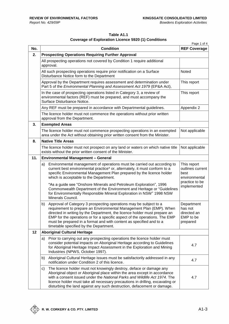
REVIEW OF ENVIRONMENTAL FACTORS KINGSGATE CONSOLIDATED LIMITED
Report No. 429/09P Bowdens Exploration Activities
R. W. CORKERY & CO. PTY. LIMITED
A1-3
Table A1.1
Coverage of Exploration Licence 5920 (1) Conditions Page 1 of 4
No. Condition REF Coverage
2. Prospecting Operations Requiring Further Approval
All prospecting operations not covered by Condition 1 require additional approval.
All such prospecting operations require prior notification on a Surface Disturbance Notice form to the Department
Noted
Approval by the Department requires assessment and determination under Part 5 of the Environmental Planning and Assessment Act 1979 (EP&A Act),
This report
In the case of prospecting operations listed in Category 3, a review of environmental factors (REF) must be prepared, and must accompany the Surface Disturbance Notice.
This report
Any REF must be prepared in accordance with Departmental guidelines. Appendix 2
The licence holder must not commence the operations without prior written approval from the Department.
3. Exempted Areas
The licence holder must not commence prospecting operations in an exempted area under the Act without obtaining prior written consent from the Minister.
Not applicable
8. Native Title Areas
The licence holder must not prospect on any land or waters on which native title exists without the prior written consent of the Minister.
Not applicable
11. Environmental Management – General
a) Environmental management of operations must be carried out according to current best environmental practice* or, alternately, it must conform to a specific Environmental Management Plan prepared by the licence holder which is acceptable to the Department.
*As a guide see “Onshore Minerals and Petroleum Exploration”, 1996 Commonwealth Department of the Environment and Heritage or “Guidelines for Environmentally Responsible Mineral Exploration in NSW” 1998 NSW Minerals Council.
This report outlines current best environmental practice to be implemented
b) Approval of Category 3 prospecting operations may be subject to a requirement to prepare an Environmental Management Plan (EMP). When directed in writing by the Department, the licence holder must prepare an EMP for the operations or for a specific aspect of the operations. The EMP must be prepared in a format and with content as specified and to a timetable specified by the Department.
Department has not directed an EMP to be prepared
12 Aboriginal Cultural Heritage
a) Prior to carrying out any prospecting operations the licence holder must consider potential impacts on Aboriginal Heritage according to Guidelines for Aboriginal Heritage Impact Assessment in the Exploration and Mining Industries (NPWS, October 1997).
4.7
b) Aboriginal Cultural Heritage issues must be satisfactorily addressed in any notification under Condition 2 of this licence.
4.7
c) The licence holder must not knowingly destroy, deface or damage any Aboriginal object or Aboriginal place within the area except in accordance with a consent issued under the National Parks and Wildlife Act 1974. The licence holder must take all necessary precautions in drilling, excavating or disturbing the land against any such destruction, defacement or damage.
4.7
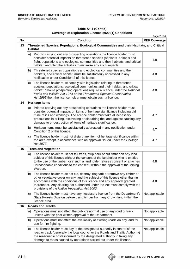
KINGSGATE CONSOLIDATED LIMITED REVIEW OF ENVIRONMENTAL FACTORS
Bowdens Exploration Activities Report No. 429/09P
A1-4
R. W. CORKERY & CO. PTY. LIMITED
Table A1.1 (Cont’d)
Coverage of Exploration Licence 5920 (1) Conditions Page 2 of 4
No. Condition REF Coverage
13 Threatened Species, Populations, Ecological Communities and their Habitats, and Critical Habitat
a) Prior to carrying out any prospecting operations the licence holder must consider potential impacts on threatened species (of plants. animals and fish). populations and ecological communities and their habitats, and critical habitat, and plan the activities to minimise any such impacts.
4.8
b) Threatened species populations and ecological communities and their habitats, and critical habitat, must be satisfactorily addressed in any notification under Condition 2 of this licence.
4.8
c) The licence holder must comply with legislation relating to threatened species, populations, ecological communities and their habitat, and critical habitat. Should prospecting operations require a licence under the National Parks and Wildlife Act 1974 or the Threatened Species Conservation Act 1995 then the licence holder must obtain such a licence.
4.8
14 Heritage Items
a) Prior to carrying out any prospecting operations the licence holder must consider potential impacts on items of heritage significance including old mine relics and workings. The licence holder must take all necessary precautions in drilling, excavating or disturbing the land against causing any damage to or destruction of items of heritage significance.
4.7
b) Heritage items must be satisfactorily addressed in any notification under Condition 2 of this licence.
4.7
c) The licence holder must not disturb any item of heritage significance within the area except in accordance with an approval issued under the Heritage Act 1977.
4.7
15 Trees and Vegetation
a) The licence holder must not fell trees, strip bark or cut timber on any land subject of this licence without the consent of the landholder who is entitled to the use of the timber, or if such a landholder refuses consent or attaches unreasonable conditions to the consent, without the approval of the Mining Warden.
4.8
b) The licence holder must not cut, destroy, ringbark or remove any timber or other vegetative cover on any land the subject of this licence other than in accordance with the conditions of this licence and any approval granted thereunder. Any clearing not authorised under the Act must comply with the provisions of the Native Vegetation Act 2003.
4.8
c) The licence holder must have any necessary licence from the Department’s State Forests Division before using timber from any Crown land within the licence area.
Not applicable
16 Roads and Tracks
a) Operations must not affect the public’s normal use of any road or track unless with the prior written approval of the Department.
Not applicable
b) Operations must not affect the availability of existing roads on any land for use for fire fighting.
Not applicable
c) The licence holder must pay to the designated authority in control of the road or track (generally the local council or the Roads and Traffic Authority) the reasonable costs incurred by the designated authority in fixing any damage to roads caused by operations carried out under the licence.
Not applicable
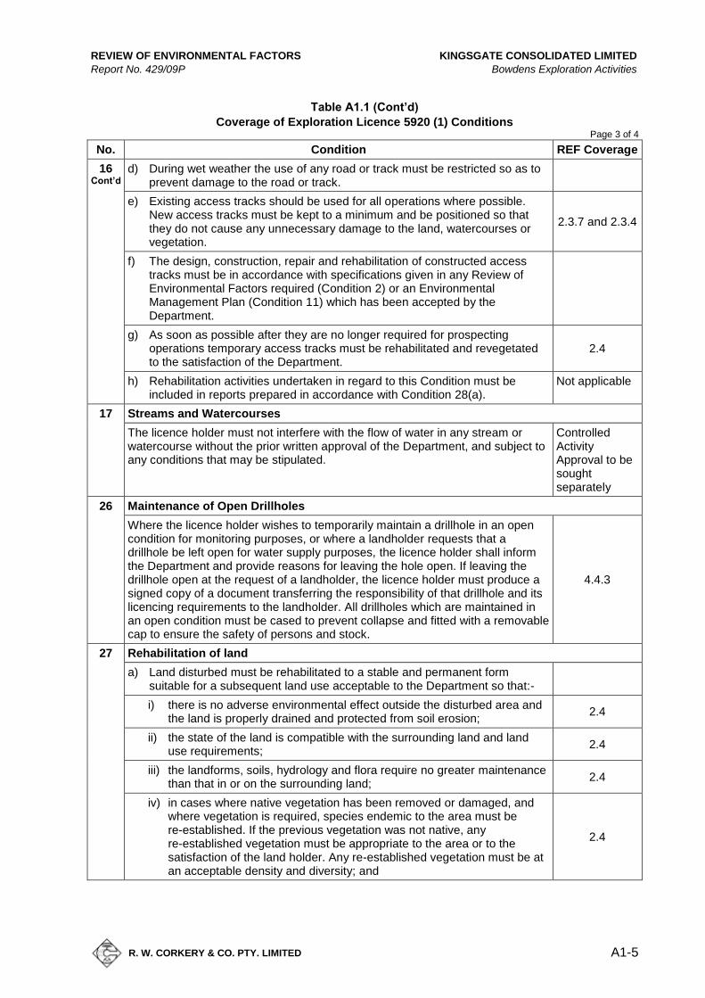
REVIEW OF ENVIRONMENTAL FACTORS KINGSGATE CONSOLIDATED LIMITED
Report No. 429/09P Bowdens Exploration Activities
R. W. CORKERY & CO. PTY. LIMITED
A1-5
Table A1.1 (Cont’d)
Coverage of Exploration Licence 5920 (1) Conditions Page 3 of 4
No. Condition REF Coverage
16 Cont’d
d) During wet weather the use of any road or track must be restricted so as to prevent damage to the road or track.
e) Existing access tracks should be used for all operations where possible. New access tracks must be kept to a minimum and be positioned so that they do not cause any unnecessary damage to the land, watercourses or vegetation.
2.3.7 and 2.3.4
f) The design, construction, repair and rehabilitation of constructed access tracks must be in accordance with specifications given in any Review of Environmental Factors required (Condition 2) or an Environmental Management Plan (Condition 11) which has been accepted by the Department.
g) As soon as possible after they are no longer required for prospecting operations temporary access tracks must be rehabilitated and revegetated to the satisfaction of the Department.
2.4
h) Rehabilitation activities undertaken in regard to this Condition must be included in reports prepared in accordance with Condition 28(a).
Not applicable
17 Streams and Watercourses
The licence holder must not interfere with the flow of water in any stream or watercourse without the prior written approval of the Department, and subject to any conditions that may be stipulated.
Controlled Activity Approval to be sought separately
26 Maintenance of Open Drillholes
Where the licence holder wishes to temporarily maintain a drillhole in an open condition for monitoring purposes, or where a landholder requests that a drillhole be left open for water supply purposes, the licence holder shall inform the Department and provide reasons for leaving the hole open. If leaving the drillhole open at the request of a landholder, the licence holder must produce a signed copy of a document transferring the responsibility of that drillhole and its licencing requirements to the landholder. All drillholes which are maintained in an open condition must be cased to prevent collapse and fitted with a removable cap to ensure the safety of persons and stock.
4.4.3
27 Rehabilitation of land
a) Land disturbed must be rehabilitated to a stable and permanent form suitable for a subsequent land use acceptable to the Department so that:-
i) there is no adverse environmental effect outside the disturbed area and the land is properly drained and protected from soil erosion;
2.4
ii) the state of the land is compatible with the surrounding land and land use requirements;
2.4
iii) the landforms, soils, hydrology and flora require no greater maintenance than that in or on the surrounding land;
2.4
iv) in cases where native vegetation has been removed or damaged, and where vegetation is required, species endemic to the area must be re-established. If the previous vegetation was not native, any re-established vegetation must be appropriate to the area or to the satisfaction of the land holder. Any re-established vegetation must be at an acceptable density and diversity; and
2.4
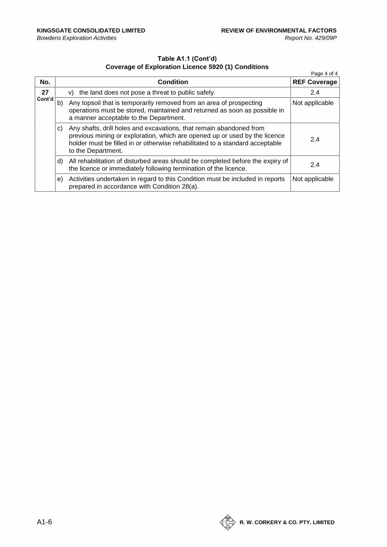
KINGSGATE CONSOLIDATED LIMITED REVIEW OF ENVIRONMENTAL FACTORS
Bowdens Exploration Activities Report No. 429/09P
A1-6
R. W. CORKERY & CO. PTY. LIMITED
Table A1.1 (Cont’d)
Coverage of Exploration Licence 5920 (1) Conditions Page 4 of 4
No. Condition REF Coverage
27 Cont’d
v) the land does not pose a threat to public safely. 2.4
b) Any topsoil that is temporarily removed from an area of prospecting operations must be stored, maintained and returned as soon as possible in a manner acceptable to the Department.
Not applicable
c) Any shafts, drill holes and excavations, that remain abandoned from previous mining or exploration, which are opened up or used by the licence holder must be filled in or otherwise rehabilitated to a standard acceptable to the Department.
2.4
d) All rehabilitation of disturbed areas should be completed before the expiry of the licence or immediately following termination of the licence.
2.4
e) Activities undertaken in regard to this Condition must be included in reports prepared in accordance with Condition 28(a).
Not applicable
REVIEW OF ENVIRONMENTAL FACTORS KINGSGATE CONSOLIDATED LIMITED
Report No. 429/09P Bowdens Exploration Activities
R. W. CORKERY & CO. PTY. LIMITED
A2-1
Appendix 2
DPI Content Requirements for a
Review of Environmental Factors
(Total No. of pages including blank pages = 10)

KINGSGATE CONSOLIDATED LIMITED REVIEW OF ENVIRONMENTAL FACTORS
Bowdens Exploration Activities Report No. 429/09P
A2-2
R. W. CORKERY & CO. PTY. LIMITED
This page has intentionally been left blank
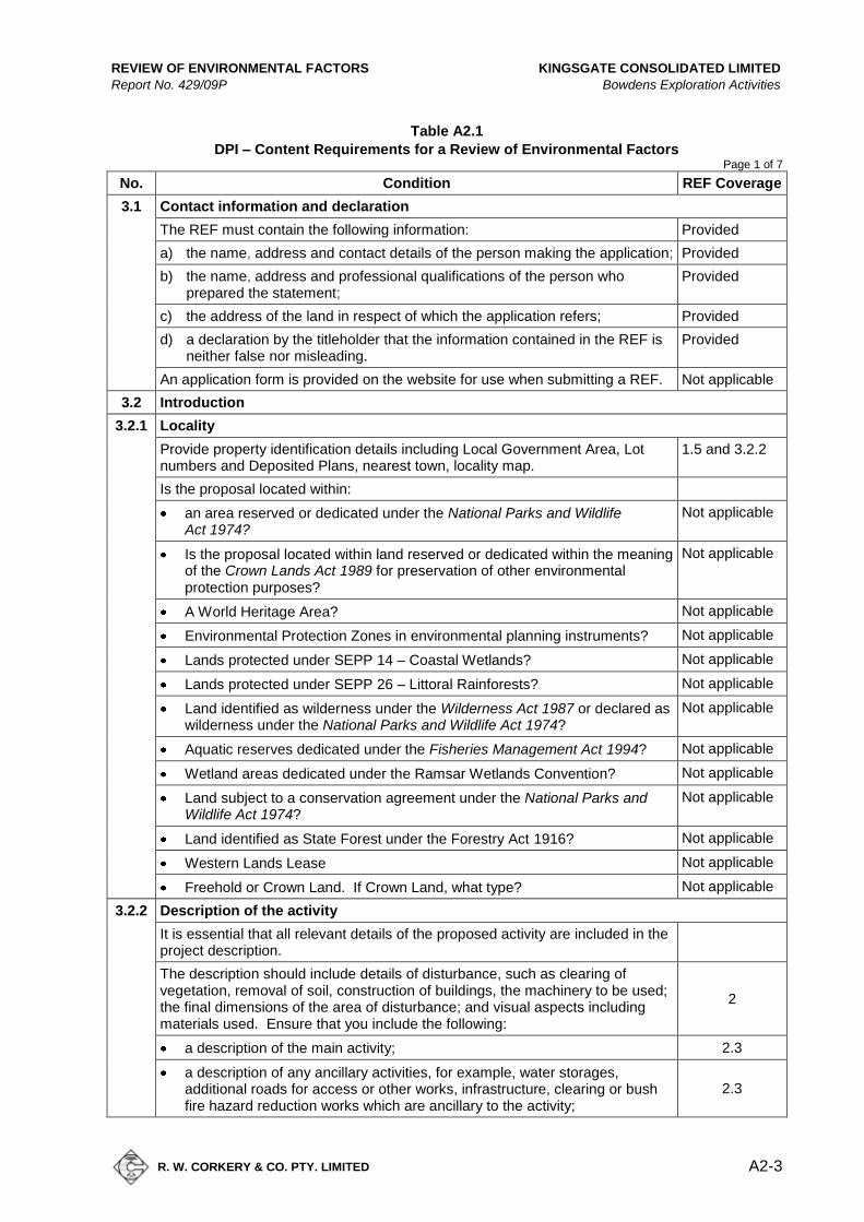
REVIEW OF ENVIRONMENTAL FACTORS KINGSGATE CONSOLIDATED LIMITED
Report No. 429/09P Bowdens Exploration Activities
R. W. CORKERY & CO. PTY. LIMITED
A2-3
Table A2.1
DPI – Content Requirements for a Review of Environmental Factors Page 1 of 7
No. Condition REF Coverage
3.1 Contact information and declaration
The REF must contain the following information: Provided
a) the name, address and contact details of the person making the application; Provided
b) the name, address and professional qualifications of the person who prepared the statement;
Provided
c) the address of the land in respect of which the application refers; Provided
d) a declaration by the titleholder that the information contained in the REF is neither false nor misleading.
Provided
An application form is provided on the website for use when submitting a REF. Not applicable
3.2 Introduction
3.2.1 Locality
Provide property identification details including Local Government Area, Lot numbers and Deposited Plans, nearest town, locality map.
1.5 and 3.2.2
Is the proposal located within:
an area reserved or dedicated under the National Parks and Wildlife Act 1974?
Not applicable
Is the proposal located within land reserved or dedicated within the meaning of the Crown Lands Act 1989 for preservation of other environmental protection purposes?
Not applicable
A World Heritage Area? Not applicable
Environmental Protection Zones in environmental planning instruments? Not applicable
Lands protected under SEPP 14 – Coastal Wetlands? Not applicable
Lands protected under SEPP 26 – Littoral Rainforests? Not applicable
Land identified as wilderness under the Wilderness Act 1987 or declared as wilderness under the National Parks and Wildlife Act 1974?
Not applicable
Aquatic reserves dedicated under the Fisheries Management Act 1994? Not applicable
Wetland areas dedicated under the Ramsar Wetlands Convention? Not applicable
Land subject to a conservation agreement under the National Parks and Wildlife Act 1974?
Not applicable
Land identified as State Forest under the Forestry Act 1916? Not applicable
Western Lands Lease Not applicable
Freehold or Crown Land. If Crown Land, what type? Not applicable
3.2.2 Description of the activity
It is essential that all relevant details of the proposed activity are included in the project description.
The description should include details of disturbance, such as clearing of vegetation, removal of soil, construction of buildings, the machinery to be used; the final dimensions of the area of disturbance; and visual aspects including materials used. Ensure that you include the following:
2
a description of the main activity; 2.3
a description of any ancillary activities, for example, water storages, additional roads for access or other works, infrastructure, clearing or bush fire hazard reduction works which are ancillary to the activity;
2.3
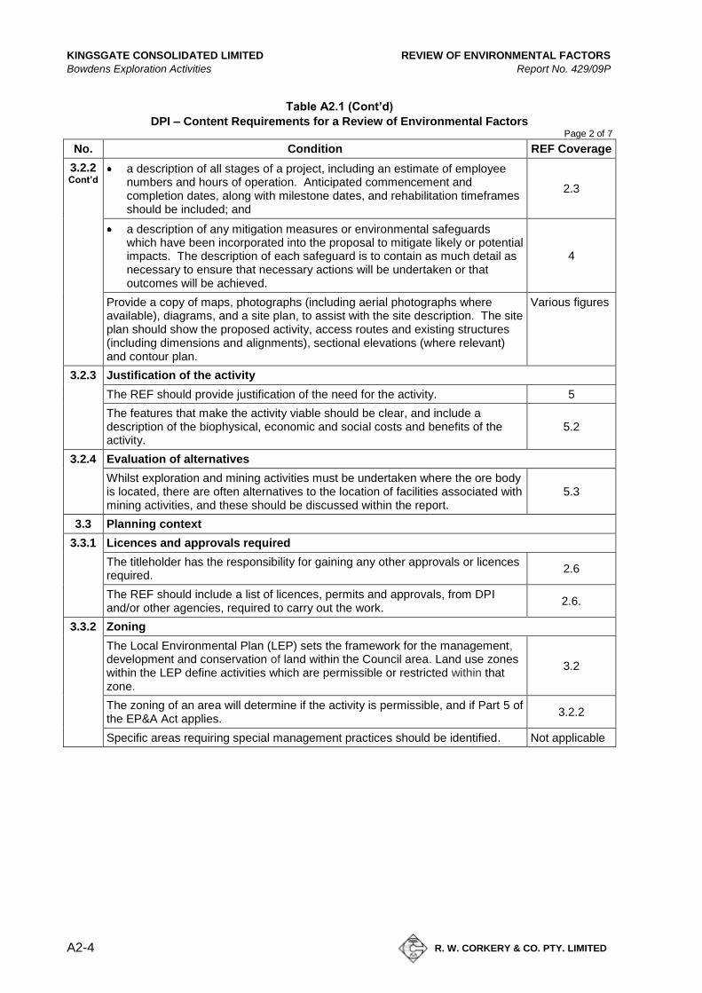
KINGSGATE CONSOLIDATED LIMITED REVIEW OF ENVIRONMENTAL FACTORS
Bowdens Exploration Activities Report No. 429/09P
A2-4
R. W. CORKERY & CO. PTY. LIMITED
Table A2.1 (Cont’d)
DPI – Content Requirements for a Review of Environmental Factors Page 2 of 7
No. Condition REF Coverage
3.2.2 Cont’d
a description of all stages of a project, including an estimate of employee numbers and hours of operation. Anticipated commencement and completion dates, along with milestone dates, and rehabilitation timeframes should be included; and
2.3
a description of any mitigation measures or environmental safeguards which have been incorporated into the proposal to mitigate likely or potential impacts. The description of each safeguard is to contain as much detail as necessary to ensure that necessary actions will be undertaken or that outcomes will be achieved.
4
Provide a copy of maps, photographs (including aerial photographs where available), diagrams, and a site plan, to assist with the site description. The site plan should show the proposed activity, access routes and existing structures (including dimensions and alignments), sectional elevations (where relevant) and contour plan.
Various figures
3.2.3 Justification of the activity
The REF should provide justification of the need for the activity. 5
The features that make the activity viable should be clear, and include a description of the biophysical, economic and social costs and benefits of the activity.
5.2
3.2.4 Evaluation of alternatives
Whilst exploration and mining activities must be undertaken where the ore body is located, there are often alternatives to the location of facilities associated with mining activities, and these should be discussed within the report.
5.3
3.3 Planning context
3.3.1 Licences and approvals required
The titleholder has the responsibility for gaining any other approvals or licences required.
2.6
The REF should include a list of licences, permits and approvals, from DPI and/or other agencies, required to carry out the work.
2.6.
3.3.2 Zoning
The Local Environmental Plan (LEP) sets the framework for the management, development and conservation of land within the Council area. Land use zones within the LEP define activities which are permissible or restricted within that zone.
3.2
The zoning of an area will determine if the activity is permissible, and if Part 5 of the EP&A Act applies.
3.2.2
Specific areas requiring special management practices should be identified. Not applicable
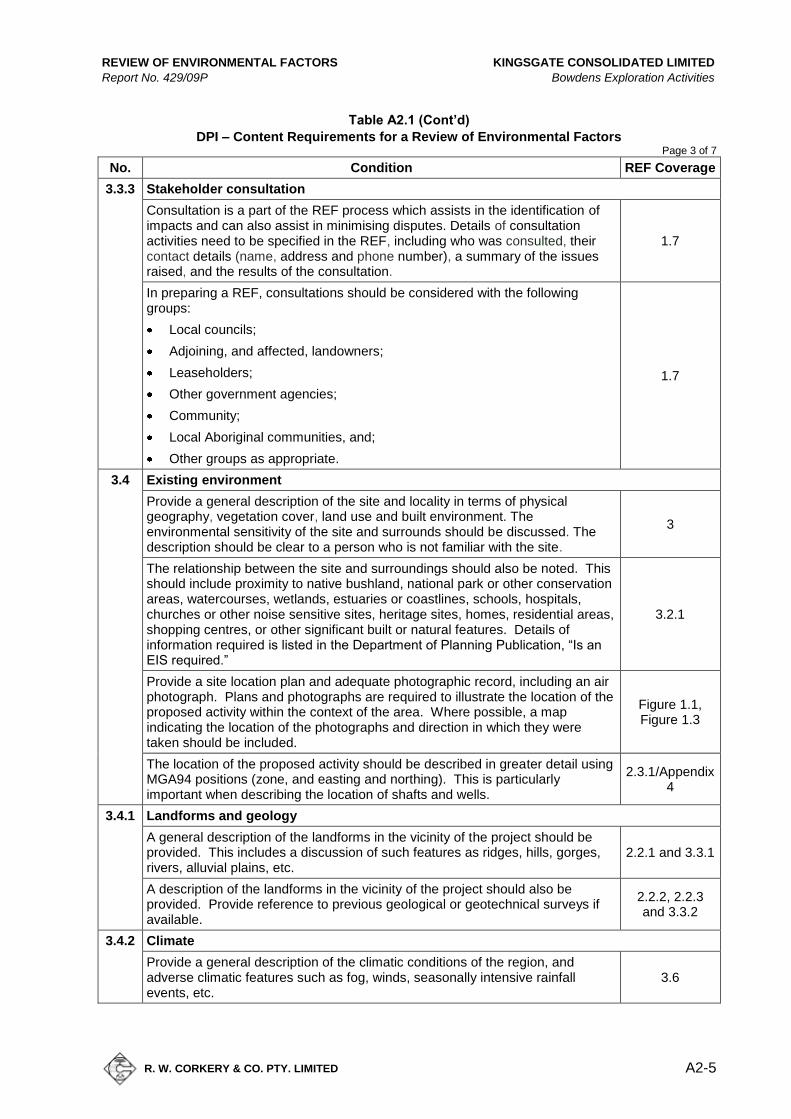
REVIEW OF ENVIRONMENTAL FACTORS KINGSGATE CONSOLIDATED LIMITED
Report No. 429/09P Bowdens Exploration Activities
R. W. CORKERY & CO. PTY. LIMITED
A2-5
Table A2.1 (Cont’d)
DPI – Content Requirements for a Review of Environmental Factors Page 3 of 7
No. Condition REF Coverage
3.3.3 Stakeholder consultation
Consultation is a part of the REF process which assists in the identification of impacts and can also assist in minimising disputes. Details of consultation activities need to be specified in the REF, including who was consulted, their contact details (name, address and phone number), a summary of the issues raised, and the results of the consultation.
1.7
In preparing a REF, consultations should be considered with the following groups:
Local councils;
Adjoining, and affected, landowners;
Leaseholders;
Other government agencies;
Community;
Local Aboriginal communities, and;
Other groups as appropriate.
1.7
3.4 Existing environment
Provide a general description of the site and locality in terms of physical geography, vegetation cover, land use and built environment. The environmental sensitivity of the site and surrounds should be discussed. The description should be clear to a person who is not familiar with the site.
3
The relationship between the site and surroundings should also be noted. This should include proximity to native bushland, national park or other conservation areas, watercourses, wetlands, estuaries or coastlines, schools, hospitals, churches or other noise sensitive sites, heritage sites, homes, residential areas, shopping centres, or other significant built or natural features. Details of information required is listed in the Department of Planning Publication, “Is an EIS required.”
3.2.1
Provide a site location plan and adequate photographic record, including an air photograph. Plans and photographs are required to illustrate the location of the proposed activity within the context of the area. Where possible, a map indicating the location of the photographs and direction in which they were taken should be included.
Figure 1.1, Figure 1.3
The location of the proposed activity should be described in greater detail using MGA94 positions (zone, and easting and northing). This is particularly important when describing the location of shafts and wells.
2.3.1/Appendix 4
3.4.1 Landforms and geology
A general description of the landforms in the vicinity of the project should be provided. This includes a discussion of such features as ridges, hills, gorges, rivers, alluvial plains, etc.
2.2.1 and 3.3.1
A description of the landforms in the vicinity of the project should also be provided. Provide reference to previous geological or geotechnical surveys if available.
2.2.2, 2.2.3 and 3.3.2
3.4.2 Climate
Provide a general description of the climatic conditions of the region, and adverse climatic features such as fog, winds, seasonally intensive rainfall events, etc.
3.6

KINGSGATE CONSOLIDATED LIMITED REVIEW OF ENVIRONMENTAL FACTORS
Bowdens Exploration Activities Report No. 429/09P
A2-6
R. W. CORKERY & CO. PTY. LIMITED
Table A2.1 (Cont’d)
DPI – Content Requirements for a Review of Environmental Factors Page 4 of 7
No. Condition REF Coverage
4. Environmental impacts and management
4.1 Air
Local and regional air quality can be affected by the activity, e.g. dust and vehicle movement, use of equipment, flaring of methane, etc. In most situations, a qualitative, rather than quantitative, discussion of impacts will be sufficient.
4.2.2
Consideration should be given to climatic factors affecting local air quality such as seasonal weather conditions, including prevailing winds and temperature inversions.
Noted
Methods to mitigate impacts should be identified. 4.2.3
Refer to the Department of Environment and Conservation for guidelines and advice on air quality.
Noted
4.2 Water
Describe the natural and built drainage systems within and surrounding the boundaries of the proposed activity. Potential impacts on both surface and groundwater, including quality and quantity, should be considered, including the potential for acid rock drainage.
3.3, 4.3.1 and 4.4.1
There are legislative requirements for works which potentially affect water quality and quantity. The Department of Natural Resources can provide advice on such matters. There may also be specific requirements under the Fisheries Management Act 1994 or other acts.
Noted
A summary of the results of consultations with other agencies should be included in the document.
1.7
Methods to mitigate impacts should be identified. 4.3.2 and 4.4.2
Refer to the Department of Environment and Conservation for guidelines and advice on water quality.
Noted
4.3 Soils
The report should identify soil type and discuss erosion hazard through analysis of type and texture.
4.9.1
The potential for salinization, acidification, contamination, or loss of structural integrity should be discussed. Special consideration of soil management may be required where such impacts are identified.
Not applicable
The potential for mass movement, subsidence or slips should also be discussed.
Not applicable
Land Capability Class (as used by the Department of Natural Resources) should be identified.
4.9.1
Methods to mitigate impacts should be identified. 4.9.2
4.4 Noise and vibration
Noise and vibration impacts should be discussed in terms of impacts on neighbours or sensitive land uses.
4.6.2
Methods to mitigate impacts should be identified. 4.6.3
Refer to the Department of Environment and Conservation for guidelines and advice on noise and vibration.
Noted

REVIEW OF ENVIRONMENTAL FACTORS KINGSGATE CONSOLIDATED LIMITED
Report No. 429/09P Bowdens Exploration Activities
R. W. CORKERY & CO. PTY. LIMITED
A2-7
Table A2.1 (Cont’d)
DPI – Content Requirements for a Review of Environmental Factors Page 5 of 7
No. Condition REF Coverage
4.5 Flora and fauna
A discussion of the potential impacts on all flora and fauna species (including fish and aquatic vegetation) should be provided, and impacts should be assessed in terms of section 5(A) of the Environmental Planning and Assessment Act 1979. Impacts may include clearing native vegetation (including trees, shrubs, grasses, herbs or aquatic species), displacing flora and fauna or creating a barrier to their movement, or introducing noxious weeds, vermin or feral species.
4.8.1
If the assessment indicates a significant impact(s) then a Species Impact Statement (SIS) will be required. (Refer Appendix A). Refer to the Department of Environment and Conservation for guidelines and advice on the preparation of an SIS.
4.8.3
The proposed should consider seasonal factors including the potential impacts on migratory birds, particularly those species listed under international agreements including Japan-Australia Migratory Birds Agreement (JAMBA) and China-Australia Migratory Birds Agreement (CAMBA).
Note: Additional studies may be required if listed threatened species are identified and potential impacts have not been adequately considered.
4.8.1
Refer to the Department of Environment and Conservation (National Parks and Wildlife Service) or Department of Primary Industries (Fisheries) for advice on threatened species.
Noted
The titleholder should note that requirements may also exist under the Commonwealth Environment Protection and Biodiversity Conservation Act 1999.
Noted
Methods to mitigate impacts should be identified. 4.8.2
4.6 Chemical and hazardous substance management
Describe activities which use, store or transport hazardous substances or use other chemicals which may build up residues in the environment, for example oils, greases, fuels, drilling fluids, fertilisers, pesticides, or herbicides. Describe the potential impacts of the use of these materials and the methods for minimising any impact.
4.12, 2.3.7
Methods to mitigate impacts should be identified. 2.3.7
Refer to the Department of Environment and Conservation for guidelines and advice.
Noted
4.7 Contaminated land
The proposal may cause contamination or may be located on contaminated land. A baseline study to identify the nature and extent of contamination should be considered prior to undertaking the project. Responsibility for remediation of the contaminated areas should be identified.
4.11.1
Methods to mitigate impacts should be identified. 4.11.2
Refer to the Department of Environment and Conservation for guidelines and advice on contaminated land.
Noted
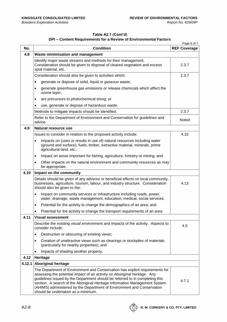
KINGSGATE CONSOLIDATED LIMITED REVIEW OF ENVIRONMENTAL FACTORS
Bowdens Exploration Activities Report No. 429/09P
A2-8
R. W. CORKERY & CO. PTY. LIMITED
Table A2.1 (Cont’d)
DPI – Content Requirements for a Review of Environmental Factors Page 6 of 7
No. Condition REF Coverage
4.8 Waste minimisation and management
Identify major waste streams and methods for their management. Consideration should be given to disposal of cleared vegetation and excess spoil material, etc.
2.3.7
Consideration should also be given to activities which: 2.3.7
generate or dispose of solid, liquid or gaseous waste;
generate greenhouse gas emissions or release chemicals which affect the ozone layer;
are precursors to photochemical smog; or
use, generate or dispose of hazardous waste.
Methods to mitigate impacts should be identified. 2.3.7
Refer to the Department of Environment and Conservation for guidelines and advice.
Noted
4.9 Natural resource use
Issues to consider in relation to the proposed activity include: 4.10
Impacts on (uses or results in use of) natural resources including water (ground and surface), fuels, timber, extractive material, minerals, prime agricultural land, etc.;
Impact on areas important for fishing, agriculture, forestry or mining; and
Other impacts on the natural environment and community resources as may be appropriate.
4.10 Impact on the community
Details should be given of any adverse or beneficial effects on local community, businesses, agriculture, tourism, labour, and industry structure. Consideration should also be given to the:
4.13
Impact on community services or infrastructure including roads, power, water, drainage, waste management, education, medical, social services;
Potential for the activity to change the demographics of an area; and
Potential for the activity to change the transport requirements of an area.
4.11 Visual assessment
Describe the existing visual environment and impacts of the activity. Aspects to consider include:
4.5
Destruction or obscuring of existing views;
Creation of unattractive views such as clearings or stockpiles of materials (particularly for nearby properties); and
Impacts of shading another property.
4.12 Heritage
4.12.1 Aboriginal heritage
The Department of Environment and Conservation has explicit requirements for assessing the potential impact of an activity on Aboriginal heritage. Any guidelines issued by the Department should be referred to in completing this section. A search of the Aboriginal Heritage Information Management System (AHIMS) administered by the Department of Environment and Conservation should be undertaken as a minimum.
4.7.1

REVIEW OF ENVIRONMENTAL FACTORS KINGSGATE CONSOLIDATED LIMITED
Report No. 429/09P Bowdens Exploration Activities
R. W. CORKERY & CO. PTY. LIMITED
A2-9
Table A2.1 (Cont’d)
DPI – Content Requirements for a Review of Environmental Factors Page 7 of 7
No. Condition REF Coverage
4.12.2 Other cultural heritage
The NSW Heritage Office has explicit requirements for assessing the potential impact of an activity on items of heritage significance. Any guidelines issued by this Department should be referred to in completing this section.
Noted
4.13 Land use
Describe the nature and extent of the activity and likely changes as a result of the proposed work. Adverse or beneficial short, medium or long-term impacts on individuals and the local community should be discussed.
3.2.1 and 4.16
4.14 Cumulative environmental impacts
The cumulative environmental impacts of a proposal are those impacts which are likely to combine with each other or with impacts of other activities to produce a beneficial or adverse effect.
4.14
Impacts should be considered in terms of:
The relationship of the activity to other proposals or developments in the area;
Not applicable
Synergistic effects of individual project impacts when considered in combination; and
Not applicable
Any known environmental stresses in the affected area and the likely contribution of the proposed activity to increasing or decreasing those stresses.
Not applicable
4.15 Summary of mitigation measures
Sections of the REF should describe in detail the safeguards and mitigation measures to be implemented during the project. A summary of these measures should be provided here.
4.15
4.16 Rehabilitation works
Describe the rehabilitation works proposed to return disturbed areas to an appropriate state at the completion of the project. Any ongoing maintenance requirements should also be noted.
2.4
4.17 Summary of impacts and conclusions
List the major outcomes that would result from implementation of the proposed activity, and provide a justification, within the following contexts:
4.16 Biophysical effects;
Social/Community effects; and
Economic effects.

KINGSGATE CONSOLIDATED LIMITED REVIEW OF ENVIRONMENTAL FACTORS
Bowdens Exploration Activities Report No. 429/09P
A2-10
R. W. CORKERY & CO. PTY. LIMITED
This page has intentionally been left blank
REVIEW OF ENVIRONMENTAL FACTORS KINGSGATE CONSOLIDATED LIMITED
Report No. 429/09P Bowdens Exploration Activities
R. W. CORKERY & CO. PTY. LIMITED
A3-1
Appendix 3
DECCW Content Requirements for a
Review of Environmental Factors
(Total No. of pages including blank pages = 10)

KINGSGATE CONSOLIDATED LIMITED REVIEW OF ENVIRONMENTAL FACTORS
Bowdens Exploration Activities Report No. 429/09P
A3-2
R. W. CORKERY & CO. PTY. LIMITED
This page has intentionally been left blank
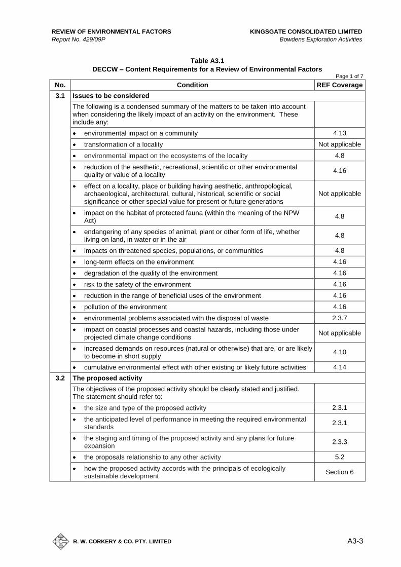
REVIEW OF ENVIRONMENTAL FACTORS KINGSGATE CONSOLIDATED LIMITED
Report No. 429/09P Bowdens Exploration Activities
R. W. CORKERY & CO. PTY. LIMITED
A3-3
Table A3.1
DECCW – Content Requirements for a Review of Environmental Factors Page 1 of 7
No. Condition REF Coverage
3.1 Issues to be considered
The following is a condensed summary of the matters to be taken into account when considering the likely impact of an activity on the environment. These include any:
environmental impact on a community 4.13
transformation of a locality Not applicable
environmental impact on the ecosystems of the locality 4.8
reduction of the aesthetic, recreational, scientific or other environmental quality or value of a locality
4.16
effect on a locality, place or building having aesthetic, anthropological, archaeological, architectural, cultural, historical, scientific or social significance or other special value for present or future generations
Not applicable
impact on the habitat of protected fauna (within the meaning of the NPW Act)
4.8
endangering of any species of animal, plant or other form of life, whether living on land, in water or in the air
4.8
impacts on threatened species, populations, or communities 4.8
long-term effects on the environment 4.16
degradation of the quality of the environment 4.16
risk to the safety of the environment 4.16
reduction in the range of beneficial uses of the environment 4.16
pollution of the environment 4.16
environmental problems associated with the disposal of waste 2.3.7
impact on coastal processes and coastal hazards, including those under projected climate change conditions
Not applicable
increased demands on resources (natural or otherwise) that are, or are likely to become in short supply
4.10
cumulative environmental effect with other existing or likely future activities 4.14
3.2 The proposed activity
The objectives of the proposed activity should be clearly stated and justified. The statement should refer to:
the size and type of the proposed activity 2.3.1
the anticipated level of performance in meeting the required environmental standards
2.3.1
the staging and timing of the proposed activity and any plans for future expansion
2.3.3
the proposals relationship to any other activity 5.2
how the proposed activity accords with the principals of ecologically sustainable development
Section 6
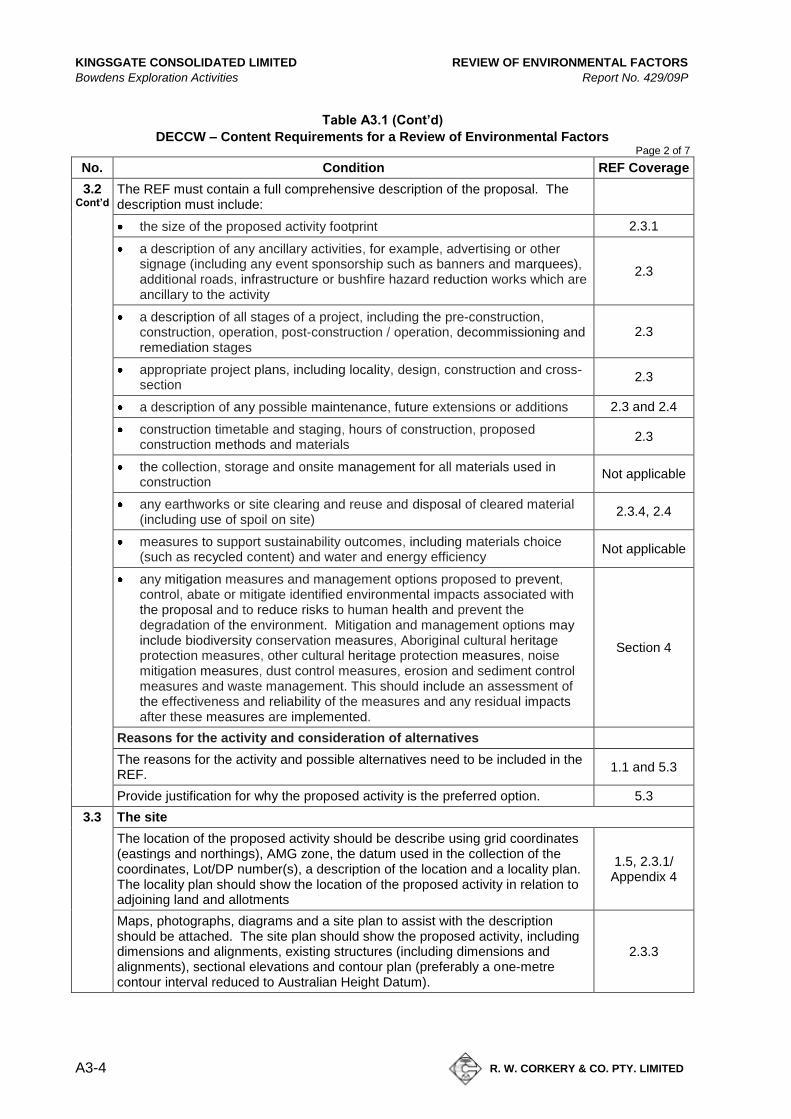
KINGSGATE CONSOLIDATED LIMITED REVIEW OF ENVIRONMENTAL FACTORS
Bowdens Exploration Activities Report No. 429/09P
A3-4
R. W. CORKERY & CO. PTY. LIMITED
Table A3.1 (Cont’d)
DECCW – Content Requirements for a Review of Environmental Factors Page 2 of 7
No. Condition REF Coverage
3.2 Cont’d
The REF must contain a full comprehensive description of the proposal. The description must include:
the size of the proposed activity footprint 2.3.1
a description of any ancillary activities, for example, advertising or other signage (including any event sponsorship such as banners and marquees), additional roads, infrastructure or bushfire hazard reduction works which are ancillary to the activity
2.3
a description of all stages of a project, including the pre-construction, construction, operation, post-construction / operation, decommissioning and remediation stages
2.3
appropriate project plans, including locality, design, construction and cross-section
2.3
a description of any possible maintenance, future extensions or additions 2.3 and 2.4
construction timetable and staging, hours of construction, proposed construction methods and materials
2.3
the collection, storage and onsite management for all materials used in construction
Not applicable
any earthworks or site clearing and reuse and disposal of cleared material (including use of spoil on site)
2.3.4, 2.4
measures to support sustainability outcomes, including materials choice (such as recycled content) and water and energy efficiency
Not applicable
any mitigation measures and management options proposed to prevent, control, abate or mitigate identified environmental impacts associated with the proposal and to reduce risks to human health and prevent the degradation of the environment. Mitigation and management options may include biodiversity conservation measures, Aboriginal cultural heritage protection measures, other cultural heritage protection measures, noise mitigation measures, dust control measures, erosion and sediment control measures and waste management. This should include an assessment of the effectiveness and reliability of the measures and any residual impacts after these measures are implemented.
Section 4
Reasons for the activity and consideration of alternatives
The reasons for the activity and possible alternatives need to be included in the REF.
1.1 and 5.3
Provide justification for why the proposed activity is the preferred option. 5.3
3.3 The site
The location of the proposed activity should be describe using grid coordinates (eastings and northings), AMG zone, the datum used in the collection of the coordinates, Lot/DP number(s), a description of the location and a locality plan. The locality plan should show the location of the proposed activity in relation to adjoining land and allotments
1.5, 2.3.1/ Appendix 4
Maps, photographs, diagrams and a site plan to assist with the description should be attached. The site plan should show the proposed activity, including dimensions and alignments, existing structures (including dimensions and alignments), sectional elevations and contour plan (preferably a one-metre contour interval reduced to Australian Height Datum).
2.3.3

REVIEW OF ENVIRONMENTAL FACTORS KINGSGATE CONSOLIDATED LIMITED
Report No. 429/09P Bowdens Exploration Activities
R. W. CORKERY & CO. PTY. LIMITED
A3-5
Table A3.1 (Cont’d)
DECCW – Content Requirements for a Review of Environmental Factors Page 3 of 7
No. Condition REF Coverage
3.4 The existing environment
The REF must include a comprehensive description of the existing environment and surrounds that would be affected by the proposed activity. This includes the site on which the activity is proposed to occur and its surrounding environment.
Section 3
The description of the existing environment must provide enough detail to place the proposal in its local and regional environmental context including:
meteorological data (e.g. rainfall, temperature and evaporation, wind speed and direction)
3.6
topography (Iandform element, slope type, gradient and length) 3.3
surrounding land-uses (potential synergies and conflicts) 3.2
geomorphology (rates of landform change and current erosion and deposition processes)
3.3 and 4.9
soil types and properties (including erodibility, engineering and structural properties, dispersibility, permeability, presence of acid sulfate soils and potential acid sulfate soils)
4.9
ecological information (water system habitat, vegetation , fauna) 3.3, 4.3 and 4.8
existence or likely existence of Aboriginal cultural heritage (see 3.6 for more information)
4.7
availability of services 3.5
3.5 Threatened species, populations and ecological communities
All REFs must include a statement as to whether or not threatened species, populations and ecological communities are likely to occur in the proposed subject site and study area.
4.8.1
If it is found that threatened species, populations and/or ecological communities occur or are likely to occur in the subject site and/or study area then an Assessment of Significance must be included with your REF.
4.8.3
3.6 Aboriginal cultural heritage
It is DECCW policy that all REFs must state whether or not the proposed activity is likely to have an impact on Aboriginal cultural heritage and must include information on how this assessment was made.
4.7.3
If it is considered through the REF process that an activity is likely to impact on Aboriginal objects or Aboriginal places then the proponent will need to redesign the proposal to avoid impacts as the first priority. If impacts are unavoidable, the proponent will need to apply for an Aboriginal Heritage Impact Permit (AHIP) under s.90 of the NPW Act. The AHIP application must be accompanied by an impact assessment.
Not applicable
An online search of AHIMS can be undertaken to discover if an Aboriginal object has been recorded, or an Aboriginal place declared, on a parcel of land.
4.7.1
If you are aware of any other sources of information, these need to be used to identify if Aboriginal objects are likely to be present in the area.
4.7.1
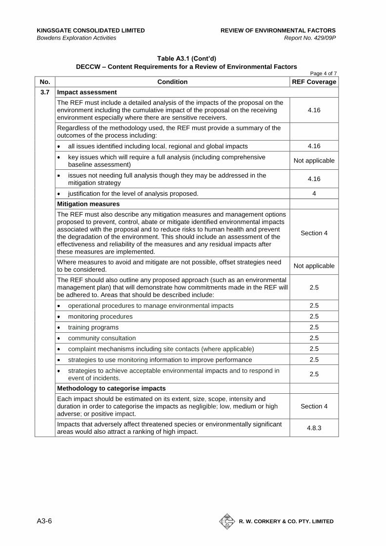
KINGSGATE CONSOLIDATED LIMITED REVIEW OF ENVIRONMENTAL FACTORS
Bowdens Exploration Activities Report No. 429/09P
A3-6
R. W. CORKERY & CO. PTY. LIMITED
Table A3.1 (Cont’d)
DECCW – Content Requirements for a Review of Environmental Factors Page 4 of 7
No. Condition REF Coverage
3.7 Impact assessment
The REF must include a detailed analysis of the impacts of the proposal on the environment including the cumulative impact of the proposal on the receiving environment especially where there are sensitive receivers.
4.16
Regardless of the methodology used, the REF must provide a summary of the outcomes of the process including:
all issues identified including local, regional and global impacts 4.16
key issues which will require a full analysis (including comprehensive baseline assessment)
Not applicable
issues not needing full analysis though they may be addressed in the mitigation strategy
4.16
justification for the level of analysis proposed. 4
Mitigation measures
The REF must also describe any mitigation measures and management options proposed to prevent, control, abate or mitigate identified environmental impacts associated with the proposal and to reduce risks to human health and prevent the degradation of the environment. This should include an assessment of the effectiveness and reliability of the measures and any residual impacts after these measures are implemented.
Section 4
Where measures to avoid and mitigate are not possible, offset strategies need to be considered.
Not applicable
The REF should also outline any proposed approach (such as an environmental management plan) that will demonstrate how commitments made in the REF will be adhered to. Areas that should be described include:
2.5
operational procedures to manage environmental impacts 2.5
monitoring procedures 2.5
training programs 2.5
community consultation 2.5
complaint mechanisms including site contacts (where applicable) 2.5
strategies to use monitoring information to improve performance 2.5
strategies to achieve acceptable environmental impacts and to respond in event of incidents.
2.5
Methodology to categorise impacts
Each impact should be estimated on its extent, size, scope, intensity and duration in order to categorise the impacts as negligible; low, medium or high adverse; or positive impact.
Section 4
Impacts that adversely affect threatened species or environmentally significant areas would also attract a ranking of high impact.
4.8.3
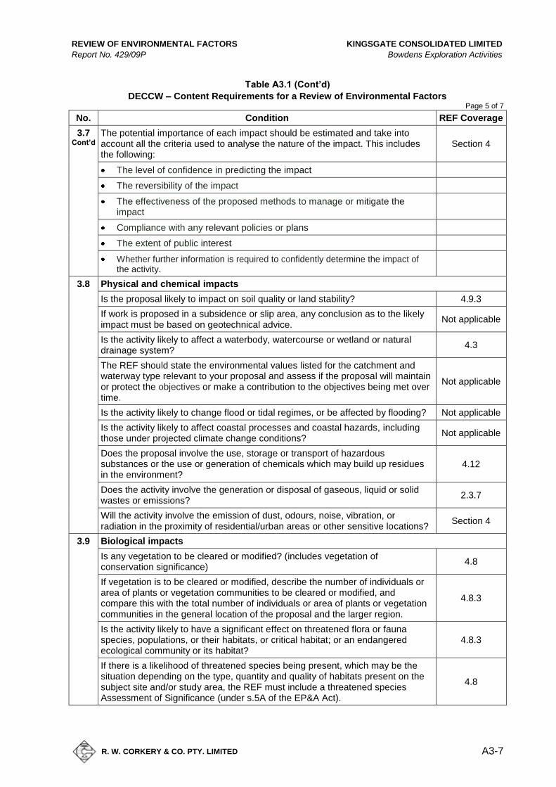
REVIEW OF ENVIRONMENTAL FACTORS KINGSGATE CONSOLIDATED LIMITED
Report No. 429/09P Bowdens Exploration Activities
R. W. CORKERY & CO. PTY. LIMITED
A3-7
Table A3.1 (Cont’d)
DECCW – Content Requirements for a Review of Environmental Factors Page 5 of 7
No. Condition REF Coverage
3.7 Cont’d
The potential importance of each impact should be estimated and take into account all the criteria used to analyse the nature of the impact. This includes the following:
Section 4
The level of confidence in predicting the impact
The reversibility of the impact
The effectiveness of the proposed methods to manage or mitigate the impact
Compliance with any relevant policies or plans
The extent of public interest
Whether further information is required to confidently determine the impact of the activity.
3.8 Physical and chemical impacts
Is the proposal likely to impact on soil quality or land stability? 4.9.3
If work is proposed in a subsidence or slip area, any conclusion as to the likely impact must be based on geotechnical advice.
Not applicable
Is the activity likely to affect a waterbody, watercourse or wetland or natural drainage system?
4.3
The REF should state the environmental values listed for the catchment and waterway type relevant to your proposal and assess if the proposal will maintain or protect the objectives or make a contribution to the objectives being met over time.
Not applicable
Is the activity likely to change flood or tidal regimes, or be affected by flooding? Not applicable
Is the activity likely to affect coastal processes and coastal hazards, including those under projected climate change conditions?
Not applicable
Does the proposal involve the use, storage or transport of hazardous substances or the use or generation of chemicals which may build up residues in the environment?
4.12
Does the activity involve the generation or disposal of gaseous, liquid or solid wastes or emissions?
2.3.7
Will the activity involve the emission of dust, odours, noise, vibration, or radiation in the proximity of residential/urban areas or other sensitive locations?
Section 4
3.9 Biological impacts
Is any vegetation to be cleared or modified? (includes vegetation of conservation significance)
4.8
If vegetation is to be cleared or modified, describe the number of individuals or area of plants or vegetation communities to be cleared or modified, and compare this with the total number of individuals or area of plants or vegetation communities in the general location of the proposal and the larger region.
4.8.3
Is the activity likely to have a significant effect on threatened flora or fauna species, populations, or their habitats, or critical habitat; or an endangered ecological community or its habitat?
4.8.3
If there is a likelihood of threatened species being present, which may be the situation depending on the type, quantity and quality of habitats present on the subject site and/or study area, the REF must include a threatened species Assessment of Significance (under s.5A of the EP&A Act).
4.8

KINGSGATE CONSOLIDATED LIMITED REVIEW OF ENVIRONMENTAL FACTORS
Bowdens Exploration Activities Report No. 429/09P
A3-8
R. W. CORKERY & CO. PTY. LIMITED
Table A3.1 (Cont’d)
DECCW – Content Requirements for a Review of Environmental Factors Page 6 of 7
No. Condition REF Coverage
3.9 Cont’d
Does the activity have the potential to endanger, displace or disturb fauna (including fauna of conservation significance) or create a barrier to their movement?
4.8
Is the activity likely to impact on an ecological community of conservation significance?
4.8
Is the activity likely to cause a threat to the biological diversity or ecological integrity of an ecological community?
4.8
Is the activity likely to introduce noxious weeds, vermin, feral species or genetically modified organisms into an area?
Not applicable
3.10 Community impacts
Is the activity likely to affect existing community services or infrastructure? 4.13
Does the activity affect sites of importance to the local or broader community for their recreational or other values or access to these sites?
Not applicable
Is the activity likely to affect economic factors? 4.13
Is the activity likely to have an impact on the safety of the community? 4.13
Is the activity likely to cause a bushfire risk? 4.15
Is the activity likely to cause impacts on the visual or scenic landscape? 4.5
3.11 Natural resource impacts
Is the activity likely to result in the degradation of the park or any other area reserved for conservation purposes?
Not applicable
Is the activity likely to affect the use of, or the community's ability to use, natural resources?
Not applicable
Is the activity likely to involve the use, wastage, destruction or depletion of natural resources including water, fuels, timber or extractive materials?
4.10
Does the activity provide for the sustainable and efficient use of water and energy?
Not applicable
3.12 Aboriginal cultural heritage impacts
Will the activity disturb the ground surface or any culturally modified trees (e.g. a scar tree)?
4.7.1
Does the activity affect known Aboriginal objects or Aboriginal places? 4.7.1
Is the activity located in areas where landscape features indicate the presence of Aboriginal objects?
4.7.1
Can harm to objects or disturbance of landscape features be avoided? 4.7.2
Does the activity affect wild resources or access to these resources, which are used or valued by the Aboriginal community?
4.7
Does the proposal affect areas subject to native title claims, indigenous land use agreements or joint management?
4.7.1
3.13 Historic cultural heritage impacts
What is the impact on places, buildings, landscapes or moveable historic heritage items?
Not applicable
Is any vegetation of cultural landscape value likely to be affected (e.g. gardens and settings, introduced exotic species, or evidence of broader remnant land uses)?
Not applicable

REVIEW OF ENVIRONMENTAL FACTORS KINGSGATE CONSOLIDATED LIMITED
Report No. 429/09P Bowdens Exploration Activities
R. W. CORKERY & CO. PTY. LIMITED
A3-9
Table A3.1 (Cont’d)
DECCW – Content Requirements for a Review of Environmental Factors Page 7 of 7
No. Condition REF Coverage
3.14 EPBC Act matters
Is the proposal likely to impact on matters of national environmental significance under the EPBC Act?
4.7
3.15 Summary of impacts and conclusions
Conclusions
To conclude an REF, you will decide whether:
there is likely to be a significant effect on the environment (if so, an EIS is required)
4.16
there is likely to be a significant effect on threatened species, populations, ecological communities or their habitats (if so, an SIS is required)
4.16
the activity is in respect of land that is, or is part of, critical habitat (if so, an SIS is required)
4.16
When deciding whether there is likely to be a significant effect on the environment, it must be determined whether the activity as a whole has a significant effect on the environment. Reasons should be given for the decision.
4.16
The conclusion of the REF also requires proponents to identify whether the activity will require certification to meet the requirements of the Building Code of Australia or relevant Australian Standards.
Not applicable

KINGSGATE CONSOLIDATED LIMITED REVIEW OF ENVIRONMENTAL FACTORS
Bowdens Exploration Activities Report No. 429/09P
A3-10
R. W. CORKERY & CO. PTY. LIMITED
This page has intentionally been left blank

REVIEW OF ENVIRONMENTAL FACTORS KINGSGATE CONSOLIDATED LIMITED
Report No. 429/09P Bowdens Exploration Activities
R. W. CORKERY & CO. PTY. LIMITED
A4-1
Appendix 4
Drill Hole Locations
(Total No. of pages including blank pages = 6)

KINGSGATE CONSOLIDATED LIMITED REVIEW OF ENVIRONMENTAL FACTORS
Bowdens Exploration Activities Report No. 429/09P
A4-2
R. W. CORKERY & CO. PTY. LIMITED
This page has intentionally been left blank
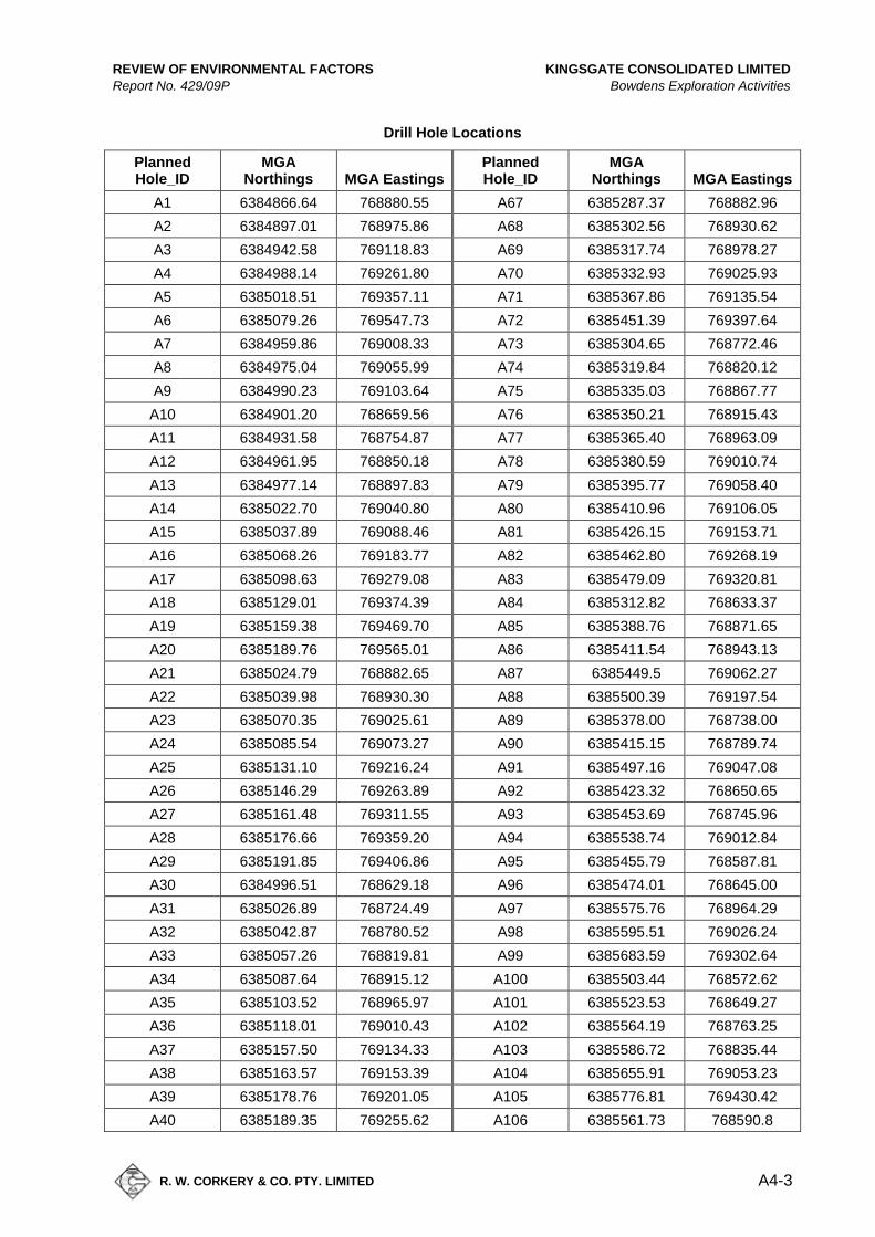
REVIEW OF ENVIRONMENTAL FACTORS KINGSGATE CONSOLIDATED LIMITED
Report No. 429/09P Bowdens Exploration Activities
R. W. CORKERY & CO. PTY. LIMITED
A4-3
Drill Hole Locations
Planned Hole_ID
MGA Northings MGA Eastings
Planned Hole_ID
MGA Northings MGA Eastings
A1 6384866.64 768880.55 A67 6385287.37 768882.96
A2 6384897.01 768975.86 A68 6385302.56 768930.62
A3 6384942.58 769118.83 A69 6385317.74 768978.27
A4 6384988.14 769261.80 A70 6385332.93 769025.93
A5 6385018.51 769357.11 A71 6385367.86 769135.54
A6 6385079.26 769547.73 A72 6385451.39 769397.64
A7 6384959.86 769008.33 A73 6385304.65 768772.46
A8 6384975.04 769055.99 A74 6385319.84 768820.12
A9 6384990.23 769103.64 A75 6385335.03 768867.77
A10 6384901.20 768659.56 A76 6385350.21 768915.43
A11 6384931.58 768754.87 A77 6385365.40 768963.09
A12 6384961.95 768850.18 A78 6385380.59 769010.74
A13 6384977.14 768897.83 A79 6385395.77 769058.40
A14 6385022.70 769040.80 A80 6385410.96 769106.05
A15 6385037.89 769088.46 A81 6385426.15 769153.71
A16 6385068.26 769183.77 A82 6385462.80 769268.19
A17 6385098.63 769279.08 A83 6385479.09 769320.81
A18 6385129.01 769374.39 A84 6385312.82 768633.37
A19 6385159.38 769469.70 A85 6385388.76 768871.65
A20 6385189.76 769565.01 A86 6385411.54 768943.13
A21 6385024.79 768882.65 A87 6385449.5 769062.27
A22 6385039.98 768930.30 A88 6385500.39 769197.54
A23 6385070.35 769025.61 A89 6385378.00 768738.00
A24 6385085.54 769073.27 A90 6385415.15 768789.74
A25 6385131.10 769216.24 A91 6385497.16 769047.08
A26 6385146.29 769263.89 A92 6385423.32 768650.65
A27 6385161.48 769311.55 A93 6385453.69 768745.96
A28 6385176.66 769359.20 A94 6385538.74 769012.84
A29 6385191.85 769406.86 A95 6385455.79 768587.81
A30 6384996.51 768629.18 A96 6385474.01 768645.00
A31 6385026.89 768724.49 A97 6385575.76 768964.29
A32 6385042.87 768780.52 A98 6385595.51 769026.24
A33 6385057.26 768819.81 A99 6385683.59 769302.64
A34 6385087.64 768915.12 A100 6385503.44 768572.62
A35 6385103.52 768965.97 A101 6385523.53 768649.27
A36 6385118.01 769010.43 A102 6385564.19 768763.25
A37 6385157.50 769134.33 A103 6385586.72 768835.44
A38 6385163.57 769153.39 A104 6385655.91 769053.23
A39 6385178.76 769201.05 A105 6385776.81 769430.42
A40 6385189.35 769255.62 A106 6385561.73 768590.8
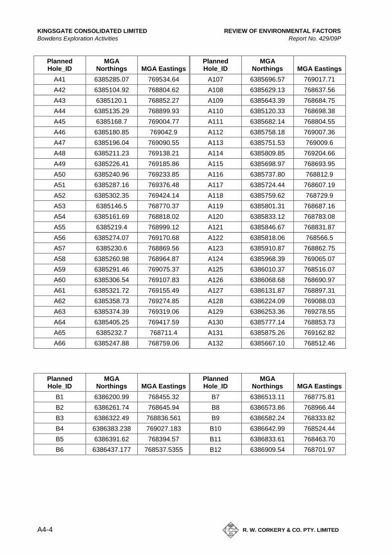
KINGSGATE CONSOLIDATED LIMITED REVIEW OF ENVIRONMENTAL FACTORS
Bowdens Exploration Activities Report No. 429/09P
A4-4
R. W. CORKERY & CO. PTY. LIMITED
Planned Hole_ID
MGA Northings MGA Eastings
Planned Hole_ID
MGA Northings MGA Eastings
A41 6385285.07 769534.64 A107 6385696.57 769017.71
A42 6385104.92 768804.62 A108 6385629.13 768637.56
A43 6385120.1 768852.27 A109 6385643.39 768684.75
A44 6385135.29 768899.93 A110 6385120.33 768698.38
A45 6385168.7 769004.77 A111 6385682.14 768804.55
A46 6385180.85 769042.9 A112 6385758.18 769007.36
A47 6385196.04 769090.55 A113 6385751.53 769009.6
A48 6385211.23 769138.21 A114 6385809.85 769204.66
A49 6385226.41 769185.86 A115 6385698.97 768693.95
A50 6385240.96 769233.85 A116 6385737.80 768812.9
A51 6385287.16 769376.48 A117 6385724.44 768607.19
A52 6385302.35 769424.14 A118 6385759.62 768729.9
A53 6385146.5 768770.37 A119 6385801.31 768687.16
A54 6385161.69 768818.02 A120 6385833.12 768783.08
A55 6385219.4 768999.12 A121 6385846.67 768831.87
A56 6385274.07 769170.68 A122 6385818.06 768566.5
A57 6385230.6 768869.56 A123 6385910.87 768862.75
A58 6385260.98 768964.87 A124 6385968.39 769065.07
A59 6385291.46 769075.37 A125 6386010.37 768516.07
A60 6385306.54 769107.83 A126 6386068.68 768690.97
A61 6385321.72 769155.49 A127 6386131.87 768897.31
A62 6385358.73 769274.85 A128 6386224.09 769088.03
A63 6385374.39 769319.06 A129 6386253.36 769278.55
A64 6385405.25 769417.59 A130 6385777.14 768853.73
A65 6385232.7 768711.4 A131 6385875.26 769162.82
A66 6385247.88 768759.06 A132 6385667.10 768512.46
Planned Hole_ID
MGA Northings MGA Eastings
Planned Hole_ID
MGA Northings MGA Eastings
B1 6386200.99 768455.32 B7 6386513.11 768775.81
B2 6386261.74 768645.94 B8 6386573.86 768966.44
B3 6386322.49 768836.561 B9 6386582.24 768333.82
B4 6386383.238 769027.183 B10 6386642.99 768524.44
B5 6386391.62 768394.57 B11 6386833.61 768463.70
B6 6386437.177 768537.5355 B12 6386909.54 768701.97
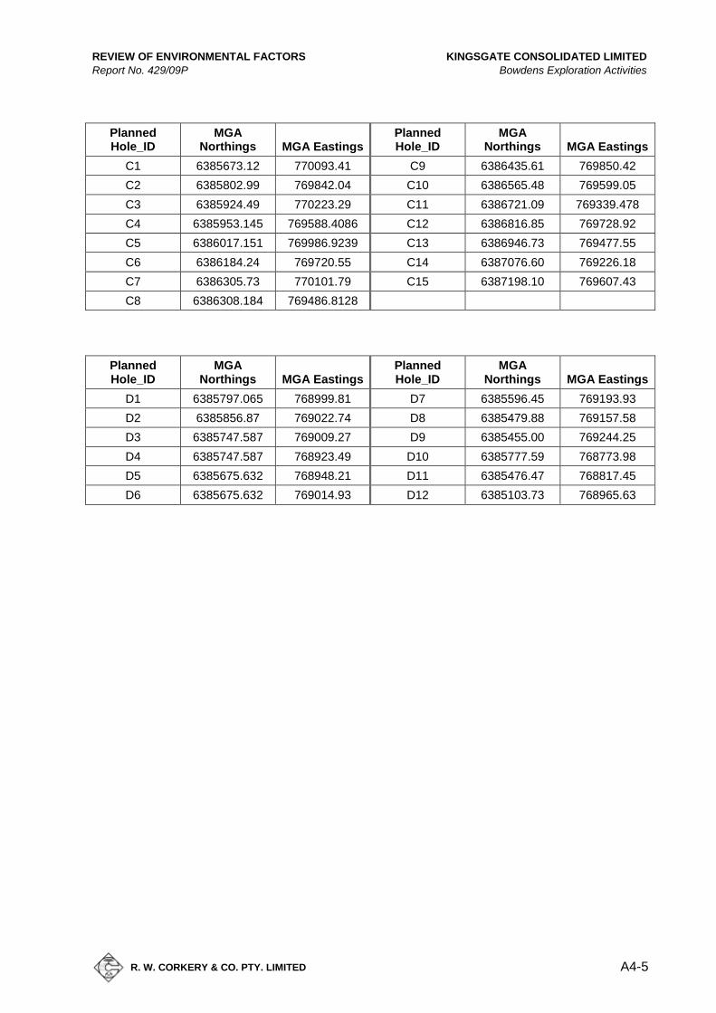
REVIEW OF ENVIRONMENTAL FACTORS KINGSGATE CONSOLIDATED LIMITED
Report No. 429/09P Bowdens Exploration Activities
R. W. CORKERY & CO. PTY. LIMITED
A4-5
Planned Hole_ID
MGA Northings MGA Eastings
Planned Hole_ID
MGA Northings MGA Eastings
C1 6385673.12 770093.41 C9 6386435.61 769850.42
C2 6385802.99 769842.04 C10 6386565.48 769599.05
C3 6385924.49 770223.29 C11 6386721.09 769339.478
C4 6385953.145 769588.4086 C12 6386816.85 769728.92
C5 6386017.151 769986.9239 C13 6386946.73 769477.55
C6 6386184.24 769720.55 C14 6387076.60 769226.18
C7 6386305.73 770101.79 C15 6387198.10 769607.43
C8 6386308.184 769486.8128
Planned Hole_ID
MGA Northings MGA Eastings
Planned Hole_ID
MGA Northings MGA Eastings
D1 6385797.065 768999.81 D7 6385596.45 769193.93
D2 6385856.87 769022.74 D8 6385479.88 769157.58
D3 6385747.587 769009.27 D9 6385455.00 769244.25
D4 6385747.587 768923.49 D10 6385777.59 768773.98
D5 6385675.632 768948.21 D11 6385476.47 768817.45
D6 6385675.632 769014.93 D12 6385103.73 768965.63

KINGSGATE CONSOLIDATED LIMITED REVIEW OF ENVIRONMENTAL FACTORS
Bowdens Exploration Activities Report No. 429/09P
A4-6
R. W. CORKERY & CO. PTY. LIMITED
This page has intentionally been left blank
REVIEW OF ENVIRONMENTAL FACTORS KINGSGATE CONSOLIDATED LIMITED
Report No. 429/09P Bowdens Exploration Activities
R. W. CORKERY & CO. PTY. LIMITED
A4-1
Appendix 5
Assessment of Significance 7 Part Test
Fauna
(Total No. of pages including blank pages = 12)

KINGSGATE CONSOLIDATED LIMITED REVIEW OF ENVIRONMENTAL FACTORS
Bowdens Exploration Activities Report No. 429/09P
A4-2
R. W. CORKERY & CO. PTY. LIMITED
This page has intentionally been left blank

REVIEW OF ENVIRONMENTAL FACTORS KINGSGATE CONSOLIDATED LIMITED
Report No. 429/09P Bowdens Exploration Activities
R. W. CORKERY & CO. PTY. LIMITED
A4-3
Application of an Assessment of Significance (“7-Part Test”) to
Threatened Species Known or Expected to Occur within the Bowden’s
Silver Mine Project Area
5.1 LEGISLATIVE REQUIREMENTS
A development or activity undertaken under the EP&A Act requires an Assessment of
Significance to be provided to the appropriate determining authority. Under the Threatened
Species Conservation Amendment Act 2002, the factors to be considered when determining
whether an action, development or activity is likely to significantly affect threatened species,
populations or ecological communities, or their habitats (known previously as the “8-part
test”), have been revised. This affects s5A EP&A Act, s94 Threatened Species Conservation Act
1995 (TSC Act) and s220ZZ Fisheries Management Act 1994 (FM Act).
The revised factors (now called “7-part test”) maintain the same intent but focus
consideration of likely impacts in the context of the local rather than the regional environment
as the long-term loss of biodiversity at all levels arises primarily from the accumulation of
losses and depletions of populations at a local level. A description of each factor follows,
together with short notes on their application. These notes have been taken from “Guidelines
for undertaking the Assessment of Significance (Section 5A EP&A Act)” (Department of
Environment and Conservation, 2005).
5.1.1 The factors of assessment are:
(a) in the case of a threatened species, whether the action proposed is likely to
have an adverse effect on the life cycle of the species such that a viable local
population of the species is likely to be placed at risk of extinction,
This factor refers only to those species listed on Part 1 and Part 4 of Schedule 1 and Part 1 of Schedule 1A of the TSC Act,
and Part 1 and Part 4 of Schedule 4 of the FM Act.
KINGSGATE CONSOLIDATED LIMITED REVIEW OF ENVIRONMENTAL FACTORS
Bowdens Exploration Activities Report No. 429/09P
A4-4
R. W. CORKERY & CO. PTY. LIMITED
(b) in the case of an endangered population, whether the action proposed is likely
to have an adverse effect on the life cycle of the species that constitutes the
endangered population such that a viable local population of the species is
likely to be placed at risk of extinction,
This factor is essentially identical to factor (a) except that it refers only to endangered
populations listed on Part 2 of Schedule 1 of the TSC Act and Part 2 of Schedule 4 of the FM
Act, whereas factor (a) refers to species.
(c) in the case of an endangered ecological community or critically endangered
ecological community, whether the action proposed:
(i) is likely to have an adverse effect on the extent of the ecological
community such that its local occurrence is likely to be placed at risk of
extinction, or
(ii) is likely to substantially and adversely modify the composition of the
ecological community such that its local occurrence is likely to be placed
at risk of extinction,
This factor applies to endangered ecological communities listed under Part 3 of Schedule 1 of
the TSC Act and Part 3 of Schedule 4 of the FM Act, and critically endangered ecological
communities listed under Part 2 of Schedule 1A of the TSC Act and Part 2 of Schedule 4A of
the FM Act.
(d) in relation to the habitat of a threatened species, population or ecological
community:
(i) the extent to which habitat is likely to be removed or modified as a
result of the action proposed, and
(ii) whether an area of habitat is likely to become fragmented or isolated
from other areas of habitat as a result of the proposed action, and
(iii) the importance of the habitat to be removed, modified, fragmented or
isolated to the long-term survival of the species, population or ecological
community in the locality,

REVIEW OF ENVIRONMENTAL FACTORS KINGSGATE CONSOLIDATED LIMITED
Report No. 429/09P Bowdens Exploration Activities
R. W. CORKERY & CO. PTY. LIMITED
A4-5
When applying this factor, consideration must be given to all short-term and long-term
impacts (direct and indirect) on habitat that is likely to support threatened biota regardless of
whether the habitat occurs on the subject site. This is equally true for occupied and
unoccupied habitat as the recovery of threatened species, populations and ecological
communities relies on having access to suitable habitat to move into as numbers increase.
(e) whether the action proposed is likely to have an adverse effect on critical
habitat (either directly or indirectly),
This factor is aimed at assessing whether the proposal is likely to affect (directly or indirectly)
areas of critical habitat present in the study area. Critical habitat refers only to those areas of
land listed in the Register of Critical Habitat kept by the Director General of DECC and the
Register of Critical Habitat kept by the Director General of Department of Primary Industries
(DPI).
(f) whether the action proposed is consistent with the objectives or actions of a
recovery plan or threat abatement plan,
When deciding whether the action proposed is consistent with the objectives or actions of a
recovery plan or threat abatement plan, consideration must be given to relevant approved
recovery plans and threat abatement plans.
(g) whether the action proposed constitutes or is part of a key threatening process
or is likely to result in the operation of, or increase the impact of, a key
threatening process.
This factor refers only to those key threatening processes (KTP) listed on Schedule 3 of the
TSC Act and Schedule 6 of the FM Act. In addition to deciding whether the action/activity
constitutes a KTP, consideration must also be given to whether the proposal is likely to
exacerbate a KTP.

KINGSGATE CONSOLIDATED LIMITED REVIEW OF ENVIRONMENTAL FACTORS
Bowdens Exploration Activities Report No. 429/09P
A4-6
R. W. CORKERY & CO. PTY. LIMITED
5.1.2 Assessment of Significance for Threatened Species Likely to Occur in
Bowden’s Silver Mine Project Area
a. Brown Treecreeper (eastern subspecies) Climacteris picumnus victoriae
A medium-sized insectivorous bird that nests in tree hollows within permanent territories. They forage on tree trunks and
on the ground amongst leaf litter.
Distribution:
General The eastern subspecies of the Brown Treecreeper is distributed through south-
eastern Queensland, eastern NSW and south-eastern Victoria (Schodde and Mason, 1999). In
NSW, they are mainly found on the western slopes of the Great Dividing Range, and are
sparsely scattered to the east of the Divide in drier areas, such as western parts of
Cumberland Plain (NPWS, 2002c).
Locality There are several records of the Brown Treecreeper in the locality of the
Project Area, one within two kilometres of Lue.
Preferred Habitat:
This medium-sized insectivorous bird occupies eucalypt woodlands, mainly with grassy
understorey, but is also found in paddocks and grasslands where there are sufficient logs and
dead trees nearby (Environment ACT, 1997). It is sedentary and nests in tree hollows within
permanent territories. Studies have shown that Brown Treecreepers are unable to disperse
to isolated woodland patches and that remnant connectivity influences dispersal success
(Cooper, 2000; Cooper et al, 2002). All the woodland communities would represent the
preferred habitats of this species.
Occurrence of Habitat within Project Area:
All preferred habitats are widely distributed throughout the Project Area.

REVIEW OF ENVIRONMENTAL FACTORS KINGSGATE CONSOLIDATED LIMITED
Report No. 429/09P Bowdens Exploration Activities
R. W. CORKERY & CO. PTY. LIMITED
A4-7
Occurrence within Conservation Reserves:
Known from New England, Blue Mountains, Wollemi and Kanangra-Boyd National Parks, and
Longneck Lagoon and Munghorn Gap Nature Reserves.
APPLICATION OF 7-PART TEST:
a) In the case of a threatened species, whether the action proposed is likely to have an adverse
effect on the life cycle of the species such that a viable local population of the species is likely to be
placed at risk of extinction,
The Brown Treecreeper is known to occur near the Project Area but it is unlikely that the life
cycle of this species would be disrupted by the development due to the low loss of preferred
habitat (woodland) as a result of the drilling activities and any mitigation measures.
b) In the case of an endangered population, whether the action proposed is likely to have an
adverse effect on the life cycle of the species that constitutes the endangered population such that a
viable local population of the species is likely to be placed at risk of extinction,
No endangered population occurs in the Project Area.
c) In the case of an endangered ecological community or critically endangered ecological
community, whether the action proposed:
i) is likely to have an adverse effect on the extent of the ecological community such that its local
occurrence is likely to be placed at risk of extinction, or
ii) is likely to substantially and adversely modify the composition of the ecological community such that
its local occurrence is likely to be placed at risk of extinction,
No endangered ecological community occurs within the Project Area.
d) In relation to the habitat of a threatened species, population or ecological community:
i) the extent to which habitat is likely to be removed or modified as a result of the action
proposed,
Limited preferred habitat would be removed or modified within the Project Area.
ii) whether an area of habitat is likely to become fragmented or isolated from other areas of
habitat as a result of the proposed action,
No area of preferred habitat is likely to become fragmented or isolated as a result of the
proposed action.
iii) the importance of the habitat to be removed, modified, fragmented or isolated to the long-
term survival of the species, population or ecological community in the locality,
The habitat removed from the Project Area could be used by the Brown Treecreeper but the
extent of removal should not influence the long-term survival of this species.
KINGSGATE CONSOLIDATED LIMITED REVIEW OF ENVIRONMENTAL FACTORS
Bowdens Exploration Activities Report No. 429/09P
A4-8
R. W. CORKERY & CO. PTY. LIMITED
e) Whether the action proposed is likely to have an adverse effect on critical habitat (either
directly or indirectly),
No critical habitat is listed for the Project Area.
f) Whether the action proposed is consistent with the objectives or actions of a recovery plan or
threat abatement plan,
There is no recovery plan for the Brown Treecreeper but the species profile includes the
following priority actions:
Modify grazing management practices that will maintain or improve habitat values and still allow some grazing to occur at strategic times of the year.
Do not allow further loss of dead standing or fallen timber from firewood collection or
on-farm practices such as 'tidying up'; do not allow removal of hollow-bearing dead or
living trees and stumps on private and public lands.
Protection of the surface land is part of the actions proposed.
g) Whether the action proposed constitutes or is part of a key threatening process or is likely to
result in the operation of, or increase the impact of, a key threatening process.
Clearing of native vegetation was listed as a key threatening process on Schedule 3 of the
Threatened Species Conservation Act 1995. Clearing, as defined by the determination, refers to
the destruction of a sufficient proportion of one or more strata (layers) within a stand or
stands of native vegetation. The relatively small amount of vegetation loss would not
constitute a ‘sufficient proportion’.
From the above test, it is concluded that the Brown Treecreeper would not be significantly
affected by the development.
b. Grey-crowned Babbler (south-eastern sub-species) Pomatostomus
temporalis temporalis
The Grey-crowned Babbler is the largest of the four Australian babblers that lives in large family groups.
Distribution:
General The Grey-crowned Babbler is found throughout large parts of northern Australia and in south-
eastern Australia. In NSW, the eastern sub-species occurs on the western slopes of the Great Dividing Range, and on
the western plains reaching as far as Louth and Hay.
Locality There three records of this bird within 10 km of the Project Area.
Preferred Habitat:
Inhabits open Box-Gum Woodlands on the slopes, and Box-Cypress-pine and open Box
Woodlands on alluvial plains.

REVIEW OF ENVIRONMENTAL FACTORS KINGSGATE CONSOLIDATED LIMITED
Report No. 429/09P Bowdens Exploration Activities
R. W. CORKERY & CO. PTY. LIMITED
A4-9
Occurrence of Habitat within the Project Area:
All preferred habitats are found within the Project Area.
Occurrence within Conservation Reserves:
Found in a number of conservation reserves and State Forests in the Central West.
APPLICATION OF 7-PART TEST:
a) In the case of a threatened species, whether the action proposed is likely to have an adverse
effect on the life cycle of the species such that a viable local population of the species is likely to be
placed at risk of extinction,
The Grey-crowned Babbler is known to occur near the Project Area but it is unlikely that the
life cycle of this species would be disrupted by the development due to the low loss of
preferred habitat (woodland) as a result of the drilling activities and any mitigation measures.
.
b) In the case of an endangered population, whether the action proposed is likely to have an
adverse effect on the life cycle of the species that constitutes the endangered population such that a
viable local population of the species is likely to be placed at risk of extinction,
No endangered population occurs in the area.
c) In the case of an endangered ecological community or critically endangered ecological
community, whether the action proposed:
i) is likely to have an adverse effect on the extent of the ecological community such that its local
occurrence is likely to be placed at risk of extinction, or
ii) is likely to substantially and adversely modify the composition of the ecological community such that
its local occurrence is likely to be placed at risk of extinction,
No endangered ecological community occurs within the Project Area.
d) In relation to the habitat of a threatened species, population or ecological community:
i) the extent to which habitat is likely to be removed or modified as a result of the action
proposed,
Limited preferred habitat would be removed or modified within the Project Area.
ii) whether an area of habitat is likely to become fragmented or isolated from other areas of
habitat as a result of the proposed action,
No area of preferred habitat is likely to become fragmented or isolated as a result of the
proposed action.
iii) the importance of the habitat to be removed, modified, fragmented or isolated to the long-
term survival of the species, population or ecological community in the locality,

KINGSGATE CONSOLIDATED LIMITED REVIEW OF ENVIRONMENTAL FACTORS
Bowdens Exploration Activities Report No. 429/09P
A4-10
R. W. CORKERY & CO. PTY. LIMITED
No preferred habitat will be removed, modified, fragmented or isolated within the Project
Area.
e) Whether the action proposed is likely to have an adverse effect on critical habitat (either
directly or indirectly),
No critical habitat is listed for the Project Area.
f) Whether the action proposed is consistent with the objectives or actions of a recovery plan or
threat abatement plan,
There is no recovery plan for the Grey-crowned Babbler but the species profile includes the
following priority actions:
Retain existing woodland vegetation.
Retain dead timber on the ground in open woodland areas.
Encourage regeneration of habitat by fencing remnant stands.
Increase the size of existing remnants, planting trees and establishing buffer zones of unimproved uncultivated pasture around woodland remnants.
Protection of the surface land is part of the actions proposed.
g) Whether the action proposed constitutes or is part of a key threatening process or is likely to
result in the operation of, or increase the impact of, a key threatening process.
Clearing of native vegetation was listed as a key threatening process on Schedule 3 of the
Threatened Species Conservation Act 1995. Clearing, as defined by the determination, refers to
the destruction of a sufficient proportion of one or more strata (layers) within a stand or
stands of native vegetation. The relatively small amount of vegetation loss would not
constitute a ‘sufficient proportion’.
From the above test, it is concluded that the Grey-crowned Babbler would not be significantly
affected by the development.
c. Petroica boodang Scarlet Robin
The Scarlet Robin is a small Australian robin, the male having a bright scarlet-red chest, black
head and a white belly.
Distribution:
General The Scarlet Robin is found from SE Queensland to SE South Australia and also in
Tasmania and SW Western Australia. In NSW, it occurs from the coast to the inland slopes.
Locality There are numerous records of this bird within 20 km of the Project Area, including one record at the mine
site.
REVIEW OF ENVIRONMENTAL FACTORS KINGSGATE CONSOLIDATED LIMITED
Report No. 429/09P Bowdens Exploration Activities
R. W. CORKERY & CO. PTY. LIMITED
A4-11
Preferred Habitat:
The Scarlet Robin lives in dry eucalypt forests and woodlands. The understorey is usually open and grassy with few scattered shrubs.
Occurrence of Habitat within the Project Area:
All preferred habitats are found within the Project Area.
Occurrence within Conservation Reserves:
Found in a number of conservation reserves and State Forests in the Central West.
APPLICATION OF 7-PART TEST:
a) In the case of a threatened species, whether the action proposed is likely to have an adverse
effect on the life cycle of the species such that a viable local population of the species is likely to be
placed at risk of extinction,
The Scarlet Robin is known to occur in the Project Area but it is unlikely that the life cycle of
this species would be disrupted by the development due to the low loss of preferred habitat
(woodland) as a result of the drilling activities and any mitigation measures.
.
b) In the case of an endangered population, whether the action proposed is likely to have an
adverse effect on the life cycle of the species that constitutes the endangered population such that a
viable local population of the species is likely to be placed at risk of extinction,
No endangered population occurs in the Project Area.
c) In the case of an endangered ecological community or critically endangered ecological
community, whether the action proposed:
i) is likely to have an adverse effect on the extent of the ecological community such that its local
occurrence is likely to be placed at risk of extinction, or
ii) is likely to substantially and adversely modify the composition of the ecological community such that
its local occurrence is likely to be placed at risk of extinction,
No endangered ecological community occurs within the Project Area.
d) In relation to the habitat of a threatened species, population or ecological community:
i) the extent to which habitat is likely to be removed or modified as a result of the action
proposed,
Limited preferred habitat would be removed or modified within the Project Area.
ii) whether an area of habitat is likely to become fragmented or isolated from other areas of
habitat as a result of the proposed action,
No area of preferred habitat is likely to become fragmented or isolated as a result of the proposed action.

KINGSGATE CONSOLIDATED LIMITED REVIEW OF ENVIRONMENTAL FACTORS
Bowdens Exploration Activities Report No. 429/09P
A4-12
R. W. CORKERY & CO. PTY. LIMITED
iii) the importance of the habitat to be removed, modified, fragmented or isolated to the long-
term survival of the species, population or ecological community in the locality,
No preferred habitat will be removed, modified, fragmented or isolated within the Project
Area.
e) Whether the action proposed is likely to have an adverse effect on critical habitat (either
directly or indirectly),
No critical habitat is listed for the Project Area.
f) Whether the action proposed is consistent with the objectives or actions of a recovery plan or
threat abatement plan,
There is no recovery plan for the Scarlet Robin but the species profile includes the following
priority actions:
Retain existing forest, woodland and remnant grassland vegetation, including paddock trees.
Retain dead timber on the ground in open forest and woodland areas.
Enhance potential habitat through regeneration by reducing the intensity and duration
of grazing.
Fence remnants to protect from long-term, intense grazing.
Increase the size of existing remnants, by planting trees and establishing buffer zones of un-modified, uncultivated pasture around woodland remnants.
Keep domestic cats indoors at night; desex domestic cats; assess the appropriateness
of cat ownership in new subdivisions adjacent to Scarlet Robin habitat.
Avoid the use of exotic berry-producing shrubs in landscape and garden plantings in
areas adjacent to Scarlet Robin habitats.
g) Whether the action proposed constitutes or is part of a key threatening process or is likely to
result in the operation of, or increase the impact of, a key threatening process.
Clearing of native vegetation was listed as a key threatening process on Schedule 3 of the
Threatened Species Conservation Act 1995. Clearing, as defined by the determination, refers to
the destruction of a sufficient proportion of one or more strata (layers) within a stand or
stands of native vegetation. The relatively small amount of vegetation loss would not
constitute a ‘sufficient proportion’.
From the above test, it is concluded that the Scarlet Robin would not be significantly affected
by the development.