Boca Dam Safety of Dams Modification Project - EA/IS
147
April 2018 Boca Dam Safety of Dams Modification Project Environmental Assessment/Initial Study Environmental Assessment No. 15-03-MP Nevada County, California U.S. Department of the Interior California Regional Water Quality Control Board Bureau of Reclamation Lahontan Region Mid-Pacific Region Office Region 6 – South Lake Tahoe Office Sacramento, California South Lake Tahoe, California
Transcript of Boca Dam Safety of Dams Modification Project - EA/IS

April 2018
Boca Dam Safety of Dams Modification Project Environmental Assessment/Initial Study Environmental Assessment No. 15-03-MP Nevada County, California
U.S. Department of the Interior California Regional Water Quality Control Board Bureau of Reclamation Lahontan Region Mid-Pacific Region Office Region 6 – South Lake Tahoe Office Sacramento, California South Lake Tahoe, California

[This page intentionally left blank]

1
Table of Contents SECTION 1 INTRODUCTION ..................................................................................................... 6 1.1 Background ................................................................................................................ 6 1.2 Need for Proposed Action/Proposed Project ............................................................ 7 1.3 Document Structure ................................................................................................... 8 1.4 Environmental Setting ................................................................................................ 8 1.4.1 Topography and Geology .............................................................................................................. 8 1.4.2 Weather.......................................................................................................................................... 9 1.4.3 Hydrology and Water Supply ....................................................................................................... 11 1.4.4 Water Quality ............................................................................................................................... 14 1.4.5 Air Quality .................................................................................................................................... 15 1.4.6 Biological Resources ................................................................................................................... 18 1.4.7 Recreational Activities .................................................................................................................. 21 1.4.8 Visual Resources ......................................................................................................................... 22 1.4.9 Traffic and Circulation .................................................................................................................. 22 1.4.10 Fire Danger .................................................................................................................................. 23 1.4.11 Cultural Resources ...................................................................................................................... 23 1.4.12 Waters of the U.S./Waters of the State ........................................................................................ 24 1.4.13 Noise ............................................................................................................................................ 24 SECTION 2 ALTERNATIVES ................................................................................................... 25 2.1 No Action Alternative ................................................................................................ 25 2.2 Proposed Action Alternative – Shear Key and Stability Berm .................................. 26 2.2.1 Schedule ...................................................................................................................................... 26 2.2.2 Reservoir Operations During Construction .................................................................................. 27 2.2.3 Spillway Modifications .................................................................................................................. 29 2.2.4 Site Preparation ........................................................................................................................... 29 2.2.5 Cutoff Wall, Shear Key, Stability Berm, and Embankment Overlay Construction ....................... 31 2.2.6 Road Use and Public Access....................................................................................................... 35 2.2.7 Haul Routes ................................................................................................................................. 39 2.2.8 In-Reservoir Borrow Area (IRBA)................................................................................................. 40 2.2.9 Staging and Stockpiling Areas ..................................................................................................... 41 2.2.10 Mitigation Measures for the Proposed Action Alternative ............................................................ 41 2.2.11 Obtaining Permits and Other Approvals ...................................................................................... 54 2.3 Reservoir Restriction Alternative .............................................................................. 55 2.3.1 Mitigation Measures for the Reservoir Restriction Alternative ..................................................... 57 2.4 Dam Breach Alternative ........................................................................................... 57 SECTION 3 EVALUATION OF ENVIRONMENTAL IMPACTS ................................................ 58 3.1 Resources Analyzed ................................................................................................ 59 3.1.1 Aesthetics .................................................................................................................................... 59 3.1.2 Agriculture and Forestry Resources ............................................................................................ 61 3.1.3 Air Quality .................................................................................................................................... 63 3.1.4 Biological Resources ................................................................................................................... 66 3.1.5 Cultural Resources ...................................................................................................................... 86 3.1.6 Geology and Soils ........................................................................................................................ 88 3.1.7 Greenhouse Gas Emissions ........................................................................................................ 90 3.1.8 Hazards and Hazardous Materials .............................................................................................. 91 3.1.9 Hydrology and Water Quality ....................................................................................................... 94 3.1.10 Land Use and Planning .............................................................................................................. 115 3.1.11 Mineral Resources ..................................................................................................................... 116

2
3.1.12 Noise .......................................................................................................................................... 116 3.1.13 Population and Housing ............................................................................................................. 121 3.1.14 Public Services .......................................................................................................................... 121 3.1.15 Recreation .................................................................................................................................. 123 3.1.16 Transportation/Traffic ................................................................................................................. 127 3.1.17 Utilities and Service Systems..................................................................................................... 130 3.1.18 Tribal Cultural Resources .......................................................................................................... 131 3.1.19 Mandatory Findings of Significance ........................................................................................... 132 SECTION 4 OTHER FEDERAL ENVIRONMENTAL COMPLIANCE REQUIREMENTS....... 137 4.1 Indian Sacred Sites ................................................................................................ 137 4.2 Indian Trust Assets ................................................................................................ 137 4.3 Environmental Justice ............................................................................................ 139 4.4 Consultation and Coordination ............................................................................... 140 SECTION 6 REFERENCES .................................................................................................... 141

3
Figures Page Figure 1 Location of Boca Dam 6 Figure 2 Features of Boca Dam 7 Figure 3 Profile of modeled dam deformation during
an earthquake 9
Figure 4 Drought areas in the western United States 10 Figure 5 Little Truckee River Watershed within the
Lower Truckee River Watershed 11
Figure 6 Hydrograph of Boca Reservoir since 2009 14 Figure 7 Air basin location 16 Figure 8 Attainment status for the NSAQMD 18 Figure 9 Concept Level Construction Schedule 27 Figure 10 Hypothetical Boca Reservoir Operation at
Full Pool during Temporary Reservoir Drawdown
29
Figure 11 Proposed Action Alternative in-reservoir borrow area (indicated in orange)
30
Figure 12 Proposed Action Alternative shear key excavation conceptual plan view
32
Figure 13 Proposed Action Alternative stability berm conceptual plan view
33
Figure 14 Turbidity Curtain Concept 34 Figure 15 Traffic detour to Boca Campground 36 Figure 16 IRBA Construction and Access Points 37 Figure 17 Proposed haul roads and use areas 38 Figure 18 Example: shoreline conditions at Boca
Reservoir at a water level elevation of 5,574 feet (NAVD88) (May 2014)
56
Figure 19 Example: shoreline conditions at Martis Creek Reservoir (May 2014)
57
Figure 20 Dam Breach Alternative conceptual plan view
59
Figure 21 Impacts to Waters of the U.S. from the Proposed Action Alternative – IRBA
79
Figure 22 Impacts to Waters of the U.S. from the Proposed Action Alternative – dam site, stockpile, and staging areas
80
Figure 23 Ivesia sericoleuca avoidance area and Sagebrush habitat impacts from the Proposed Action Alternative
83
Figure 24 Truckee River Flow at Reno Exceedance Probabilities during Initial Drawdown and Reservoir Drawdown Period (Maintenance is the reservoir drawdown)
100
4
Figure 25a Boca Reservoir Fall Outflow Exceedance Probabilities (Maintenance is the reservoir drawdown)
101
Figure 25b Reduced Peak Truckee River Flows During Large Fall Flood Event – Flood of Record (Maintenance is the reservoir drawdown)
101
Figure 26 Daily exceedance plot comparison of total Pyramid Lake Paiute Tribe storage between baseline and reservoir drawdown (Maintenance is with the temporary reservoir drawdown)
105
Figure 27 FEMA 100-year floodplain – IRBA 106 Figure 28 FEMA 100-year floodplain – dam site,
stockpile, and staging areas 107
Figure 29 Reservoir Restriction Alternative’s maximum potential reductions in deliveries for downstream water right holders (Floriston Rate Water; WY2058-WY2060) - Boca 1=Baseline; Boca 2=Reservoir Restriction Alternative
112
Figure 30 Reservoir Restriction Alternative’s maximum potential increases in all deliveries for the Pyramid Lake Paiute Tribe (WY2055-WY2058) - Boca 1=Baseline; Boca 2=Reservoir Restriction Alternative
114
Figure 31 Roadway Construction Noise Model Results 118
Tables Page Table 1 Floriston Rates Schedule 12 Table 2 Special status plants and wildlife
near Boca Reservoir further analyzed
18
Table 3 Normal Boca Reservoir Storage, Elevations, and Storage Restrictions
28
Table 4 Water quality best management practices for the Proposed Action Alternative
44
Table 5 Permits and approvals required to implement the Proposed Action Alternative
55
Table 6 Estimated air pollutant emissions from the Proposed Action Alternative
64

5
Table 7 Closest LCT Stocking Events to Boca Dam
75
Table 8 Impacts to waters of the U.S./waters of the State from the Proposed Action Alternative
81
Table 9 Estimated maximum effects based on values and baseline percentage, and the associated frequency, of Reservoir Restriction Alternative on monthly deliveries for downstream water right holders
112
Table 10 Decibel addition approximation 118 Table 11 Truckee Municipal Code Noise
Standards by Receiving Land Use 120
Appendices Appendix A Boca Maintenance Analysis
Technical Report Appendix B Boca Reservoir Potential
Reservoir Restriction Analysis Technical Report
Appendix C CalEEMod air quality model report
Appendix D Indian Trust Assets coordination

6
Section 1 Introduction
1.1 Background In accordance with the National Environmental Policy Act (NEPA) and California Environmental Quality Act (CEQA), this Environmental Assessment/Initial Study (EA/IS) was prepared by the Bureau of Reclamation (Reclamation) to examine the potential direct, indirect, and cumulative impacts to the affected environment associated with Reclamation implementing the Boca Dam Safety of Dams Modification Project (Project). Additionally, Reclamation prepared this joint document for use by the California Regional Water Quality Control Board, Lahontan Region (Lahontan Water Board) for their use in considering Clean Water Act section 401 water quality certification for the project. Boca Dam and Boca Reservoir are located on the Little Truckee River, east of the Town of Truckee and north of Interstate 80 in Nevada County, California (Figure 1).
Boca Reservoir is used to regulate the Truckee and Little Truckee Rivers and provide water for irrigation, municipal and industrial (M&I) uses, recreation, fish and wildlife benefits and power generation as required by the Orr Ditch Decree and Truckee River Operating Agreement (TROA). Boca Dam was constructed in accordance with the Truckee River Agreement; since 1939 it has been operated and maintained by the Washoe County Water Conservation District (WCWCD) under contract with Reclamation. Boca Dam and Reservoir are components of the Truckee Storage Project. The dam is a zoned earthfill embankment dam with a structural height of 116 feet, a crest length of 1,629 feet, and an active storage capacity of 40,900 acre-feet. The normal reservoir water surface, and top of the spillway gates, elevation is at 5,609 feet (all elevations
referenced in this document are in NAVD88, unless otherwise noted as NGVD29 for modeling purposes), and the spillway crest elevation is at 5,593 feet (Reclamation 2009). Boca Dike is located left of the spillway crest structure. Boca Dam has a gated, concrete-lined open channel chute spillway, and an outlet works through the right abutment. The spillway is located through the left abutment of the main embankment, in a knoll between the dam and the dike. The spillway consists of a concrete-lined inlet channel and
Figure 1. Location of Boca Dam

7
transition section, a crest structure housing two 19-foot-wide by 16-foot-high radial gates, a concrete-lined chute, a stilling basin, and a discharge channel. The outlet works consists of a trash-racked intake structure, a 12-foot-diameter, 400-foot-long, concrete-lined tunnel through the right abutment, a gate chamber housing two high-pressure slide gates, a 10-foot 6-inch by 14-foot horseshoe tunnel containing two 50-inch-diameter steel discharge pipes, a valve house containing two 48-inch jet-flow gates, a stilling basin, and an outlet channel.
A majority of the lands in the vicinity of Boca Reservoir, part of Tahoe National Forest, are managed by the U.S. Forest Service (Forest Service) or WCWCD. The study area includes those lands that are owned and managed by the Forest Service and lands owned by Reclamation (and managed by WCWCD) that are within an area that Reclamation and the Forest Service have deemed the “Reclamation Zone”. A Reclamation Zone is land set aside exclusively for the operation and maintenance of the dam. For Boca Dam, the Reclamation
Zone includes the dam, dike, and areas immediately east, west, and south of the dam site (see Figure 2 for features).
1.2 Need for Proposed Action/Proposed Project 1 In 2004, Reclamation began analyzing Boca Dam for possible deficiencies that may lead to uncontrolled reservoir release under the Safety of Dams Program. The Safety of Dams Program requires that Reclamation evaluate all of the high and significant hazard potential dam facilities to determine if they may pose an unacceptable risk of seismic (earthquake), hydrologic (flooding), or static potential failure modes. As a part of the analysis, Reclamation analyzed the full range of loading conditions and the ability of the dam to resist those conditions. Safety of Dams modification projects are undertaken when Reclamation concludes that there is an unacceptable level of risk to downstream communities from a potential dam failure due to one or more potential failure modes. The Project will not increase storage, affect water rights nor provide any additional benefits for the Truckee Storage Project. Boca Dam is at risk from structural failure under certain conditions due to the presence of liquefiable alluvium (i.e., loose sand and gravel) within the dam’s foundation. During a significant earthquake event, the alluvium may lose its shear strength (seismically induced liquefaction) and lead to excessive embankment deformation and cracking or immediate
1 The term “Proposed Action” is a NEPA term and “Proposed Project” is a CEQA term. Since this is a joint document, these terms are used interchangeably.

8
overtopping of the dam. In order to reduce the risk in case of such an event happening, Reclamation has undertaken the Project to protect the public. Corrective actions may include a structural alternative (referred to as the Proposed Action Alternative in this document), a reservoir restriction, or a dam breach.
1.3 Document Structure To consider environmental impacts of the Proposed Action pursuant to both NEPA and CEQA, Section 3 includes the analysis of possible effects to resources using an initial study checklist adapted from the CEQA Guidelines, Appendix G. Discussion of potential impacts for the No Action Alternative and Proposed Action are addressed in more detail following each checklist section. The CEQA Checklist does not incorporate all resource areas required by NEPA; Section 4 includes NEPA-specific components.
1.4 Environmental Setting
1.4.1 Topography and Geology Boca Reservoir is in the Little Truckee River valley that slopes south towards the Truckee River. The west side of the reservoir is bordered by hills while the area east is characterized by a gradual incline towards Verdi, Nevada. Elevations of the Project site range between 5,500 and 5,700 feet (NAVD88) and slopes range from two percent to 30 percent. The dam crest is located at an elevation of 5,615 feet. Boca Dam and Reservoir are within the Sierra Nevada Ecoregion, just west of the Central Basin and Range Ecoregion. An international ecoregion system developed by the Commission on Environmental Cooperation places Boca Dam and Boca Reservoir in the Sierra Nevada section of the Northwestern Forested Mountains Ecoregion (CEC, 2014). The Sierra Nevada is a mountain range that rises sharply from the arid zone of the Central Basin and Range, gently toward the Central California Valley (USFWS, 2014). Boca Dam and Boca Reservoir are located in an area influenced by the Sierra Nevada fault system. The Sierra Nevada fault system forms a topographic and structural break of the eastern side of the Sierra Nevada. Boca Dam and Boca Reservoir are in an area called the Neogene Boca Basin, which is located northeast of Truckee. The basin slopes to the southwest. Geologic studies in the area indicate that there has been a southwest flowing drainage for at least the last 4.4 million years in the basin. Deposits from this drainage are overlain by a 4.38 million year old basalt flow associated with volcanic activity from Boca Hill, southwest of the reservoir. The westward tilting of the basin started at around 2.7 million years ago prior to the eruption of the larger Boca Ridge Formation, east of the reservoir (Mass, 2009). The Boca basin is near several local fault zones capable of producing large earthquakes. These include the Mohawk Valley fault zone and Dog Valley fault zone (Oldow, 2014) which contribute to the seismic hazard for Boca Dam. A 1986 study by Reclamation concluded that the Mohawk Valley Fault could result in a maximum credible earthquake (MCE) of 7.0 on the

9
Richter scale. The same study concluded that the Dog Valley Fault would have an MCE of 6.7 (Town of Truckee, 2005). In another study done by the California Department of Transportation, the Mohawk Valley Fault was determined to have an MCE of 6.5 (Caltrans, 1996). The Boca Dike and spillway are founded mainly on a sequence of flat-lying, glacial outwash deposits. The top most layer in the vicinity of Boca Dike is quaternary Tahoe outwash. The potentially liquefiable basal sand layer is sandwiched between the top most layer of Tahoe outwash and another layer of Tahoe outwash under the dike (Figure 3). Progressing deeper in to the geologic profile, the next two layers consist of quaternary Donner outwash and tertiary Truckee formation, respectively. Figure 3. Profile of modeled dam deformation during an earthquake
The quaternary Tahoe outwash unit, classifies mostly as poorly to well-graded gravel with silt, sand and cobbles, with a trace of boulders to 18-inch maximum diameter. The quaternary Tahoe outwash unit is pervious and functions as an aquifer that conveys groundwater from hill slopes. This is the geologic condition that has caused seeps to form east of the dike to the left spillway on the cut slope. Shallow groundwater downstream of the dam is most likely infiltration of rainfall and snowmelt that moves west in the basin toward the Little Truckee River canyon. The lack of response of groundwater levels to reservoir fluctuations conducted by Reclamation suggests that the reservoir is a relatively minor contributor to groundwater downstream of the dam and dike. A positive cutoff into impermeable quaternary Tahoe outwash would explain the relative absence of reservoir seepage (Reclamation, 2013).
1.4.2 Weather High temperatures range from 40 degrees to 82 degrees Fahrenheit during the day with a range of low temperatures at night between 9 degrees and 38 degrees Fahrenheit. On average, there are only three months of the year where the temperatures at night exceed freezing (WRCCa). The average precipitation per year is approximately 22 inches, making the area drier than western

10
parts of Nevada County and Truckee which average eight inches more in precipitation annually (WRCCb). The last five years, 2012 through 2016 have been considered drought years until Water Year 2017, when a very wet winter and spring brought an end to the drought. Precipitation during the drought (2012 to 2016) was well below average, with the exception of an El Niño winter in Water Year 2016. Average precipitation for the 2012 to 2015 water years was 16.43 inches, while precipitation for the 2016 water year was 27.63 inches (CNRFC, 2017). As of September 30, 2017, precipitation for Water Year 2017 at Boca Reservoir was 53.77 inches (average 240% to date) (CNRFC, 2017). Boca Reservoir is no longer within a zone with drought conditions (Figure 4). Figure 4. Drought areas in the western United States
11
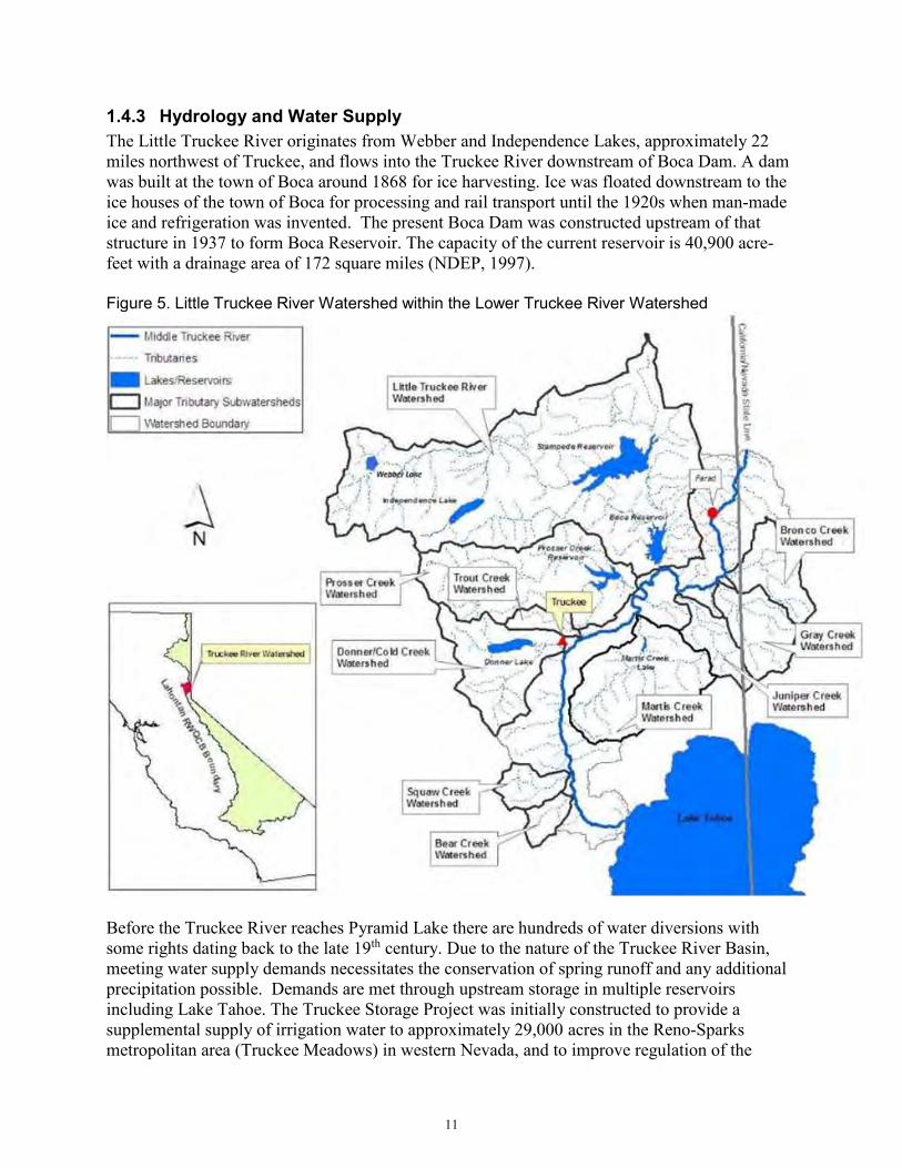
1.4.3 Hydrology and Water Supply The Little Truckee River originates from Webber and Independence Lakes, approximately 22 miles northwest of Truckee, and flows into the Truckee River downstream of Boca Dam. A dam was built at the town of Boca around 1868 for ice harvesting. Ice was floated downstream to the ice houses of the town of Boca for processing and rail transport until the 1920s when man-made ice and refrigeration was invented. The present Boca Dam was constructed upstream of that structure in 1937 to form Boca Reservoir. The capacity of the current reservoir is 40,900 acre-feet with a drainage area of 172 square miles (NDEP, 1997). Figure 5. Little Truckee River Watershed within the Lower Truckee River Watershed
Before the Truckee River reaches Pyramid Lake there are hundreds of water diversions with some rights dating back to the late 19th century. Due to the nature of the Truckee River Basin, meeting water supply demands necessitates the conservation of spring runoff and any additional precipitation possible. Demands are met through upstream storage in multiple reservoirs including Lake Tahoe. The Truckee Storage Project was initially constructed to provide a supplemental supply of irrigation water to approximately 29,000 acres in the Reno-Sparks metropolitan area (Truckee Meadows) in western Nevada, and to improve regulation of the

12
Truckee River through releases to satisfy the Floriston Rate flow regime, in accordance with the Truckee River Agreement entered in 1935. WCWCD holds License 3723 issued by the State of California, which authorizes the storage of water in Boca Reservoir. Boca Reservoir is operated by the TROA Administrator in accordance with TROA, and in conjunction with Lake Tahoe water to maintain Floriston Rates2 (NDEP, 1997), to satisfy water rights recognized by the Orr Ditch Decree. Water may only be stored in Lake Tahoe and Boca Reservoir when the Floriston Rates are met (NDWP, 1999). Outside of mandated annual winter releases for flood control, the water stored in Boca Reservoir is released to meet Floriston Rates, which include municipal, industrial, agricultural, instream flows, and hydroelectric power generation. Floriston Rates are met from natural flow, Lake Tahoe storage releases, storage releases from Boca Reservoir under License 3723, and releases of Tahoe Exchange Water from Prosser Creek Reservoir under License 10180 pursuant to the Tahoe-Prosser Exchange Agreement. Floriston Rates and Reduced Floriston Rates range from 300 cfs to 500 cfs, depending on the time of year and the corresponding elevation of Lake Tahoe. The Truckee River General Electric Decree required that flow in the Truckee River be maintained at a rate of 500 cfs from March 1 through September 30 of each year. From October 1 through the last day in February, the flow requirement was reduced to 400 cfs. The Reduced Floriston Rates from November 1 through end of February are 350 cfs whenever the surface water elevation of Lake Tahoe is between 6,225.25 feet and 6,226 feet, and 300 cfs whenever the elevation is below 6,225.25 feet (see Table 1). Table 1. Floriston Rates Schedules
Normal Floriston Rates - Truckee River Flow at Farad (cfs) Lake Tahoe Elevation (ft) October November-February March-September
6,226.00 400 400 500
Reduced Floriston Rates - Truckee River Flow at Farad (cfs) October November-March April-September
6,225.25< El. <6,226.00 400 350 500 El. <6,225.25 400 300 500
Floriston Rate water is released from Boca Reservoir and Lake Tahoe, as available, when unregulated flow in the basin is insufficient to maintain Floriston Rates as measured at the Farad Gauge. Floriston Rate Water is stored and delivered as follows: From October 31 through March 31, all Boca Reservoir storage water which had been
diverted to storage prior to October 1, and which remains in Boca Reservoir or any other Truckee River Reservoir on October 31, shall be released for the purpose of maintaining Floriston rates or reduced Floriston rates, subject to the provisions below.
2 Floriston is a town located on the Truckee River downstream of the confluence with the Little Truckee River. There is a gage located in Floriston where water flows are measured. The Truckee River General Electric and Orr Ditch decrees require prescribed flows ranging from 300 to 500 cubic feet per second (cfs), known as Floriston Rates in the Truckee River at the gage. Floriston Rate Water is a minimum prescribed flow in the river required by these decrees (Reclamation, 2008).

13
Water stored in Boca from October 1 through March 31 shall not be released during that period, except at the option of the WCWCD.
April through October, while Lake Tahoe is above 6,225.5 feet, Boca Reservoir would be the primary source of stored water for maintaining Floriston Rates, at which time releases from Lake Tahoe would be reduced to achieve only minimum stream flows to the extent Floriston Rate water can be stored in Prosser Creek Reservoir.
April through October, when Lake Tahoe elevation is equal to or below 6,225.5 feet Lake Tahoe would be the primary source to support Floriston Rates.
April through September, if Floriston Rates cannot be achieved for the entire period, the Truckee River basin Committee could, by unanimous agreement, reduce Floriston Rates in order to extend the otherwise shortened water delivery season. Diversion of available water would be administered according to decreed priorities.
At all times, a required minimum flow of 30 cfs is maintained in the Little Truckee River between Stampede Reservoir and Boca Reservoir.
After nearly three decades of litigation and negotiations, a new operating agreement for the operation of the Truckee River reservoirs (Truckee River Operating Agreement or TROA) was signed in 2008. As of August 2016, the TROA has been fully implemented. Boca Reservoir plays a pivotal role in the effective implementation and application of the storage and credit water aspects of TROA. TROA promotes the efficient and flexible use of Truckee River Reservoirs through greater cooperation between stakeholders, by allowing building of “credit water,” according to prescribed priorities or exchange of credit water with water stored in other Truckee River reservoirs under prescribed conditions. The U.S. Army Corps of Engineers (USACE) oversees flood control operations for the Truckee Basin. Flood control operations are governed by the Water Control Manual (WCM) for Truckee River Basin Reservoirs. Flood control space on the Little Truckee River is provided by Boca and Stampede Reservoirs, with total required flood control space of 30,000 acre-feet (AF) each season. Boca Reservoir provides 8,000 AF, with Stampede Reservoir drawdown providing the remaining 22,000 AF. Flood control space requirements for the two reservoirs begin on October 1, and the full required space must be evacuated by November 1. The current flood control operations for combined Boca and Stampede reservoirs are as follows:
i. From October 1 to November 1, uniform increase of flood control space from 0 to 30,000 AF.
ii. From November 1 to April 10, constant 30,000 AF of flood control space. iii. From April 10 to July 5, varying flood control space based on forecasted snowmelt
runoff. Water levels in Boca Reservoir fluctuate over the course of a water year with valleys (low storage) in the late fall and winter months and peaks (high storage) during the summer months. Over the past six full water years, Boca Reservoir water levels have fluctuated with a low at approximately elevation 5,545 feet (NGVD29) in water year 2015 with a peak elevation of over 5,605 feet in water year 2011 and 2017 (Figure 6; elevations are in NGVD29, which is 3.88123 feet lower than NAVD88).

14
Figure 6. Hydrograph of Boca Reservoir since 2009
Reclamation conducted simulations of the entire Truckee River system to identify the potential impacts of the temporary reservoir drawdown during construction on flood control. Reclamation also conducted simulations using the RiverWare Operations model for Truckee-Carson River basins to analyze how the drawdown could affect water supply allocated for water users’ demands during the temporary reservoir drawdown. Modeling analyses on how the temporary reservoir drawdown associated with the Proposed Action Alternative could affect flood control and water supply are discussed in a detailed technical report, Boca Maintenance Analysis, attached as Appendix A. Additionally, Reclamation conducted simulations using the RiverWare Planning model for Truckee-Carson River basins to see how the Reservoir Restriction Alternative’s drawdown could affect water supply allocated for water users’ demands on a long-term basis, presented in a technical report, Boca Reservoir Potential Reservoir Restriction Analysis, attached as Appendix B. Potential effects to flood control and water supply are discussed in Section 3.1.9 Hydrology and Water Quality, below.
1.4.4 Water Quality The Lahontan Water Board has established the following designated and potential beneficial uses for water quality standards for the Little Truckee River: agricultural supply; municipal and domestic supply; groundwater recharge; freshwater replenishment; hydropower generation; contact and noncontact water recreation; commercial and sport fishing; cold freshwater habitat (aquatic habitats, vegetation, fish and wildlife, including invertebrates); wildlife habitat; rare, threatened or endangered species (e.g., Lahontan cutthroat trout and cui-ui); migration of aquatic organisms; and spawning, reproduction, and development. Boca Reservoir provides the same beneficial uses as the Little Truckee River, with the exception of freshwater replenishment, hydropower generation, and migration of aquatic organisms. Boca Reservoir also provides the

15
beneficial use of navigation (Lahontan Water Board 2017). The Little Truckee River between Boca and Stampede reservoirs and below Boca Dam is not listed as impaired by any pollutant pursuant to CWA section 303(d), and quality is generally considered suitable to serve all beneficial uses.. Section 303(d) of the CWA requires States and tribes to identify water bodies that do not meet water quality standards and to publish a list of these impaired waters every 2 years. For lakes, rivers and streams identified on this list, States must develop water quality improvement plans referred to as total maximum daily loads (TMDLs). These TMDLs establish the amount of a pollutant a water body can carry and still meet water quality standards. The Truckee River was placed on the 303(d) list for suspended sediments in 2007. The Little Truckee River is a stream that flows into a river that is on the 303(d) list (Middle Truckee River). In September 2008, the Lahontan Water Board approved a TMDL for Sediment for the Middle Truckee River Watershed. This TMDL is an amendment to the Water Quality Control Plan for the Lahontan Region (Basin Plan) (Lahontan Water Board, 2017). Sources of suspended sediment in the Truckee River sub-watershed are calculated (source assessment) for nine creeks as well as the Little Truckee River. The Little Truckee River contributes sediment at a rate of 1,026 tons/year to the total watershed loading rate of 10,345 tons/year. Other sources of suspended sediment in the Truckee River include intervening zones/unmeasured inputs; load measured at Farad and event-based loading. Continuous turbidity monitoring in the river shows that sediment loading ―pulses attributed to thunderstorms, snowmelt periods and dam releases may account for up to half the loading. These flow events can produce turbidity spikes that exceed the water quality objective of 3 Nephelometric turbidity units (based on a mean of monthly means); however, other region-wide water quality objectives that allow 10% increase above background levels may not be exceeded. Such event-based loading contributes 24,064 tons of sediment to the Truckee River, which, along with intervening zones/unmeasured inputs (15,973 tons/year) and the load measured at the Farad gage (26,318 tons/year), adds up to a grand total of 50,382 tons/year total watershed loading. This is 90 percent of the total with 10 percent (5,066 tons/year) contributed by urban areas. The TMDL established a waste load allocation for the Little Truckee River of 800 tons/year of sediment. Waste load allocations for the Middle Truckee River are based on a 50 percent load reduction and a best management practice efficiency of 50 percent. The Lahontan Water Board has regulatory authority to require implementation of this TMDL under both the CWA and the Water Code, including, but not limited to, adopting or waiving waste discharge requirements, and issuing storm water and construction permits to control sediment discharges (Lahontan Water Board 2008).
1.4.5 Air Quality Boca Dam and Boca Reservoir are within the boundaries of the Mountain Counties Air Basin (Figure 7). More specifically, the project location is within the jurisdiction of the Northern Sierra Air Quality Management District (NSAQMD), which oversees the counties of Nevada, Sierra, and Plumas.

16
The Federal Clean Air Act Amendments (Federal CAA) of 1970 established National Ambient Air Quality Standards (NAAQS) for six “criteria pollutants”: photochemical ozone (O3), carbon monoxide (CO), sulfur dioxide (SO2), nitrogen dioxide (NO2), inhalable particulate matter (PM) up to 2.5 microns in diameter (PM2.5) and from 2.5 to 10 microns in diameter (PM10), and lead (Pb). The California CAA of 1977 created California Ambient Air Quality Standards (CAAQS) for the six criteria pollutants pertaining to the State. The CAAQS also set standards for sulfates, hydrogen sulfide, and visibility. Thresholds established for the NAAQS and CAAQS represent maximum acceptable concentrations of a criteria pollutant to ensure that the air is considered healthy to breathe. When an area exceeds these standards, it is designated as “non-attainment” by the California Air Resources Board (CARB) for CAAQS and by the U.S. Environmental Protection Agency (EPA) for NAAQS. Section 176 (C) of the Federal CAA (42 U.S.C. 7506 (C)) requires any entity of the Federal Government that engages in, supports, or in any way provides financial support for, licenses or permits, or approves any activity to demonstrate that the action conforms to the applicable State

17
Implementation Plan3 (SIP) required under Section 110(a) of the Federal CAA (42 U.S.C. 7401 (a)) before the action is otherwise approved. In this context, conformity means that such Federal actions must be consistent with the SIP’s purpose of eliminating or reducing the severity and number of violations of the NAAQS and achieving expeditious attainment of those standards. Each Federal agency must determine any action that is proposed by the agency and that is subject to the regulations implementing the conformity requirements would, in fact conform to the applicable SIP before the action is taken. On November 30, 1993, the U.S. EPA promulgated final general conformity regulations (40 CFR 93 Subpart B) for all Federal activities except those covered under transportation conformity. The general conformity regulations apply to a proposed Federal action in a non-attainment or maintenance area if the total of direct and indirect emissions of the relevant criteria pollutants and precursor pollutant caused by the project equal or exceed certain de minimis thresholds, thus requiring the Federal agency to make a determination of general conformity (Federal general conformity). If the Federal agency determines that the general conformity regulations do not apply to the project (meaning the project emissions do not exceed the de minimis thresholds and are not regionally significant4), then a Federal general conformity analysis report is not required. The overall air quality within the vicinity of Boca Reservoir is considered good as noted in the NSAQMD’s most recent Annual Air Monitoring Report. The NSAQMD can experience overwhelming O3 transport from upwind areas, primarily from the Broader Sacramento Area and to a lesser degree the San Francisco Bay Area (NSAQMD, 2005). The NSAQMD has reached Federal and State attainment or unclassified status for CO, NO2, SO2, and Pb (Figure 8). Federal and State attainment or unclassified status for PM2.5 have been reached in most areas of the NSAQMD except for the Portola Valley in Plumas County, which exceeds the State standard. The NSAQMD is in non-attainment status PM10 for State. State O3 status is in non-attainment for Nevada County. Federal O3 status is attainment or unclassified in all three counties within the NSAQMD, except for the western portion of Nevada County, which is in non-attainment. The pollutants of greatest concern for the NSAQMD are PM10 (CAAQS) and O3 (including ozone precursors such as reactive organic gases (ROG)) and nitrogen oxides (NOx) (CAAQS and NAAQS).
3 The SIP is the State’s plan to attain the NAAQS for nonattainment pollutants. 4 Regardless of the project's emissions relative to the de minimis amounts, if the action’s total emissions of a given pollutant represents 10 percent or more of the area's total emissions of that pollutant, the action is considered regionally significant and the Federal agency must make a determination of general conformity.

18
Figure 8. Federal and State Attainment status for the NSAQMD
1.4.6 Biological Resources This section describes the different special status wildlife, plant and fungi species that could be present and have habitat within the Project area. Species with habitat present in the Project area are analyzed. Table 2 summarizes special status species that were further analyzed and are protected under the California Endangered Species Act, federal Endangered Species Act, the Bald and Golden Eagle Protection Act, Migratory Bird Protection Act, and species considered sensitive by the Forest Service. Table 2. Special status plants and wildlife near Boca Reservoir further analyzed
Species Species Status
Present in Project Area: Habitat and/or Detections
Western bumblebee (Bombus occidentalis) Forest Service R5 Sensitive (TNF) Suitable habitat is present and
individuals may be present.
Bald eagle (Haliaeetus leucocephalus)
Forest Service R5 Sensitive (TNF), protected under the BGEPA
Nesting pair located over 2,000 feet from the project area in mature pine
habitat.
Sierra Nevada yellow-legged frog (Rana sierrae)
Forest Service R5 Sensitive (TNF), ESA endangered; CESA
threatened
Known populations upstream of Stampede Reservoir, but not in Boca
Reservoir vicinity. Predatory fish present. Surveys conducted in 2015 concluded that no suitable habitat is
present in the study area. Lahontan Lake tui chub (Gila
bicolor pectinifer) Forest Service R5 Sensitive (TNF) Populations occur in Boca Reservoir and the Little Truckee River.
Lahontan Cutthroat Trout (Oncorhynchus clarkii
henshawi) ESA threatened
Populations stocked in Boca Reservoir and the Truckee River, but
won’t be present during Project. Species will not be in the Little
Truckee River below Boca Dam. Great Basin ramshorn snail
(Helisoma newberryi) Forest Service R5 Sensitive (TNF) Known populations in Little Truckee River below Lake Tahoe. Individuals

19
may be present in Boca Reservoir. Suitable habitat is present.
Cliff swallows (Hirundo pyrrhonota)
Migratory bird protected under the Migratory Bird Treaty Act
Active nests were observed by Reclamation staff on June 10, 2015, under the spillway control structure.
Plumas ivesia (Ivesia sericoleuca) Forest Service R5 Sensitive (TNF)
May affect up to 17.2 acres of potentially suitable habitat. A small occurrence of this species has been documented in a small ephemeral drainage in the east portion of the
East Stockpile Area during a survey in 2017. The ephemeral drainage
where the occurrence was observed will be avoided by maintaining a 10-foot buffer around this feature with
construction fencing. Lemmon’s milkvetch
(Astragalus lemmonii) Forest Service R5 Sensitive (TNF) May affect up to 15.8 acres of potentially suitable habitat
Modoc Plateau milk-vetch (Astragalus pulsiferae var.
coronensis) Forest Service R5 Sensitive (TNF) May affect up to 19.4 acres of
potentially suitable habitat
Upswept moonwort (Botrychium ascendens) Forest Service R5 Sensitive (TNF) May affect up to 6.5 acres of
potentially suitable habitat Scalloped moonwort
(Botrychium crenulatum) Forest Service R5 Sensitive (TNF) May affect up to 6.5 acres of
potentially suitable habitat Slender moonwort
(Botrychium lunaria) Forest Service R5 Sensitive (TNF) May affect up to 6.5 acres of
potentially suitable habitat Mingan moonwort
(Botrychium minganense) Forest Service R5 Sensitive (TNF) May affect up to 6.5 acres of
potentially suitable habitat western goblin (Botrychium
montanum) Forest Service R5 Sensitive (TNF) May affect up to 6.5 acres of
potentially suitable habitat Bolander’s candle moss
(Bruchia bolanderi) Forest Service R5 Sensitive (TNF) May affect up to 6.5 acres of
potentially suitable habitat Blandow’s bog-moss (Helodium blandowii)
Forest Service R5 Sensitive (TNF) May affect up to 6.5 acres of potentially suitable habitat
Sierra Valley Ivesia (Ivesia aperta var. aperta)
Forest Service R5 Sensitive (TNF) May affect up to 17.2 acres of potentially suitable habitat
Dog Valley Ivesia (Ivesia aperta var. canina)
Forest Service R5 Sensitive (TNF) May affect up to 17.2 acres of potentially suitable habitat
Santa Lucia dwarf rush (Juncus luciensis)
Forest Service R5 Sensitive (TNF) May affect up to 6.5 acres of potentially suitable habitat
Sticky Pyrrocoma (Pyrrocoma lucida)
Forest Service R5 Sensitive (TNF) May affect up to 6.5 acres of potentially suitable habitat
1.4.6.1 Wildlife
Several species of woodpeckers and sapsuckers are known to be in the vicinity of Boca Reservoir including a rich diversity of birds with over 30 species documented in Audubon’s eBird website for Boca Dam and Reservoir. Various ducks, geese, swans, and cormorants are present as well as owls (long-eared owl [Asio otus] and Northern pygmy owl [Glaucidium gnoma]), and many common song birds such as vireos, flycatchers, finches, blackbirds, tanagers, and sparrows. Cliff swallows (Hirundo rustica) were observed nesting under the spillway control structure in June 2015. Several bald eagle (Haliaeetus leucocephalus) territories with recent nesting activity are located near Boca Reservoir. One is located near Stampede Dam, another is located at the Sagehen Arm

20
of the reservoir outside the project area, and the closest is located northwest of the in-reservoir borrow area (IRBA) near the Boca Rest Campground. Concentrations of bald eagles can occur on the Little Truckee River during kokanee spawning which occurs around mid-October. However, known bald eagle nests are 2,000 feet north from the IRBA, which is far beyond the USFWS buffer requirement. Mammals that could be encountered around Boca Reservoir include mule deer (Odocoileus hemionus), black bear (Ursus americanus), raccoon (Procyon lotor), bobcat (Lynx rufus), snowshoe hare (Lepus americanus), mountain lion (Puma concolor), American beaver (Castor canadensis), mountain beaver (Aplodontia rufa), golden mantled ground squirrel (Callospermophilus lateralis), mountane vole (Microtus montanus), and bushy-tailed woodrat (Neotoma cinerea). Common reptiles that could be in the vicinity of Boca Reservoir include western fence lizard (Sceloporus occidentalis), sagebrush lizard (Sceloporus graciosus), western garter snake (Thamnophis elegans), gopher snake (Pituophis cantenifer), rattlesnake (Crotalus oregansus), and northern rubber boa (Charina bottae). Amphibians that could be in the vicinity of Boca Reservoir include western toad (Anaxyrus boreas), Sierran treefrog (Pseudacris sierra), Sierra Nevada yellow-legged frog (Rana sierrae), long-toed salamander (Ambystoma macrodactylum), and Sierra newt (Tariacha sierrae) (California Academy of Sciences, 2015). Surveys completed in May and June of 2015 by the USFWS and Reclamation concluded that there is no suitable habitat for the federally-listed as endangered mountain yellow-legged frogs in the study area. The results of an electrofishing survey in the Little Truckee River immediately upstream of Boca Reservoir conducted by the California Department of Fish and Wildlife (CDFW) in 2009, showed the following fish to be present: brown trout (Salmo trutta), coastal rainbow trout (Oncorhynchus mykiss irideus), and Paiute sculpin (Cottus beldingi) (CDFW, 2009). The results of a fish stranding and relocation effort in the Little Truckee River immediately downstream of Boca Dam conducted by CDFW in 2014, showed the same fish to be present as well as mountain whitefish (Prosopium williamsoni), Lahontan red-side (Richardsonius egregius), and tui chub (Gila bicolor). Other fish species known to occur presently or historically in Boca Reservoir include brook trout (Salvelinus fontinalis), Lahontan cutthroat trout (Oncorhynchus clarki henshawi) (LCT), lake trout (Salvelinus namaycush), Lahontan stream tui chub (Siphatales bicolor obesus), mountain whitefish (Prosopium williamsoni), smallmouth bass (Micropterus dolomieu), and Tahoe sucker (Catostomus tahoensis) (UC Davis, 2014). Potential presence of LCT in the Project site is further discussed in Section 3.1.4 – Biological Resources, below. Table 2 summarizes plant and wildlife Tahoe National Forest special status species that were further analyzed and are protected under the California Endangered Species Act, federal Endangered Species Act (ESA), the Bald and Golden Eagle Protection Act, Migratory Bird Protection Act, and by the Forest Service under the Sierra Nevada Forest Plan Amendment.
1.4.6.2 Plants and Fungi
Upland areas around Boca Dam and Boca Reservoir are primarily sagebrush scrub habitat that includes silver sagebrush (Artemisia cana), mountain sagebrush (Artemisia tridentata subsp.

21
vaseyana), rubber rabbitbrush (Ericameria nauseosa), and bitter brush (Purshia tridentata var. tridentata). Herb species in the sagebrush scrub community around the reservoir include Tahoe lupine (Lupinus meionanthus), meadow penstemon (Penstemon rydbergii), blue-eyed Mary (Collinsia torreyi), mules ear (Wyethia mollis), cheatgrass (Bromus tectorum), common yarrow (Achillea millefolium), Wheeler’s bluegrass (Poa wheeleri), mountain dandelion (Agroseris heterophylla), common dandelion, slender birds beak (Cordylanthus tenius), Indian paintbrush (Castilleja applegatei), and wooly mullein (Verbascum thaspus). Pine tree communities are present but sparse along the east side of Boca Reservoir and primarily occur east of Stampede Meadows Road. Some pines are present along the bank of the reservoir consisting mainly of Jeffrey pines (Pinus jeffreyi). Aspen trees (Populus tremuloides) are present east of Stampede Meadows Road along a roadside ditch. Vegetation in and near the seasonal wetland, perennial seep wetlands, and reservoir rim communities include Geyer’s willow (Salix geyeriana), arctic rush (Juncus arcticus), Sierra gooseberry (Ribes roezlii), Wheeler’s bluegrass (Poa wheeleri), dwarf waterleaf (Hydrophyllum capitatum), Brewer’s bishop cap (Mitella brewerii), Hartweg’s iris (Iris hartwegii), mountain chickweed (Stellaria longipes), western buttercup (Ranunculus occidentalis), American brooklime (Veronica americana), seep monkeyflower (Mimulus guttatus), watercress (Nasturium officinale), Douglas’ knotweed (Polygonum douglasii), and swollen duckweed (Lemna gibba). One occurrence of Plumas ivesia (Ivesia sericoleuca), Forest Service sensitive, was observed during a survey in 2017 in a small ephemeral drainage in the eastern portion of the East Stockpile Area. This occurrence was mapped by the Forest Service, and will be avoided by installing construction fencing as a 10-foot buffer around this occurrence during construction (mitigation measure BIOL-15). No other sensitive plant species protected by the California Endangered Species Act, federal ESA, or species of concern in the Tahoe National Forest, were detected within the limits of the delineated Project area during the course of two field surveys in June 2014 and August 2014 by a qualified Reclamation botanist. Reclamation’s Technical Service Center out of Denver, Colorado developed a Boca Dam Safety of Dams Modification Supplemental Biological Evaluation: Sensitive Plants and Fungi in 2016 (O’Meara 2016), in which this survey data was analyzed. Habitats within the Project areas were deemed not suitable for the majority of the listed sensitive species.
1.4.7 Recreational Activities Boca Reservoir provides a variety of recreational activities for local to international visitors. There are two campgrounds with a total of 59 campsites adjacent to the reservoir. Recreation, other than camping at the Forest Service campgrounds, is allowed year round at the lake and includes fishing, ice fishing, shooting, boating, hunting, picnicking, and water sports. Sport fish species in the reservoir include kokanee salmon, rainbow trout, brook trout, and brown trout (Recreation.gov, 2015). Area outfitters and fishing guides host state, out-of-state, and foreign travelers on fishing trips that include fishing and ice fishing along Boca Reservoir and upstream and downstream of the reservoir on the Little Truckee River. Boca Reservoir is used extensively by small watercraft, including kayaks, sailboats, canoes, floatplanes, and motorized boats. There is a designated boat launch facility on the west shore of

22
the reservoir maintained by the Forest Service (Division of Boating and Waterways, 2013). A whitewater recreation company launches rafts from an area below Boca Dam, using the turnaround near the dam tender’s house for staging (pers. comm. Recreation and Lands Staff Officer, Forest Service, June 10, 2015). The open season for water recreation is from April/May to October/November depending on snow conditions. Cyclists frequently ride over Boca Dam making loops around Stampede Reservoir and along the Truckee River, staging at the overlook parking lot at Boca Dam (Hauserman, 2015). Nevada County permits a series of bicycle races over the dam every year during the summer (pers. comm. Steve Castleberry, Nevada County, June 10, 2015). Security bollards currently exist at each abutment of the dam, which restrict vehicular access across the dam during high reservoir levels.
1.4.8 Visual Resources Boca Dam, Dike, and Reservoir are visible from locations along nearby Stampede Meadows Road. The portion of the upstream face of Boca Dam and Dike visible from the reservoir and its shoreline is dependent on reservoir elevation. The downstream face of the Dam and Dike are visible from areas of the Little Truckee River corridor immediately below. The road across the top of the dam and dike, Boca Dam Reservoir Road, provides upstream and downstream views of the surrounding area including the sagebrush scrub and pine dominated upland habitats, the riverine habitat of the Little Truckee River, the reservoir, the historic ice dam, dam tender’s house, control house at the base of the dam, the Union Pacific Railroad line, the historic Boca Townsite, Interstate 80, and parts of the Boca-Loyalton Railroad berm. The Forest Service has installed a kiosk at an overlook near the dam with information on the history of Boca Reservoir and the nearby Boca Townsite. This area is not officially designated as a scenic vista, but the parking area and associated pathway down to the reservoir are likely considered scenic. Boca Dam is an earthen dam and there are no existing sources of light from the dam or from any structures nearby that are visible at night by residents or travelers.
1.4.9 Traffic and Circulation Site construction vehicle traffic will use Interstate 80, Hirschdale Road, Boca Dam Reservoir Road, and Stampede Meadows Road as access roads. There will be up to two existing earthen roads improved to provide access to the IRBA for construction use. These existing roads will be widened to accommodate equipment access. Further description of road improvements is explained in Section 2.2.6 below. Recreational users and residents in this area commonly use Hirschdale Road, Boca Dam Reservoir Road, and Interstate 80 (via Hirschdale Road/Stampede Meadows Road) as the three main crossings of the Little Truckee River. Reclamation monitored traffic over Boca Dam in 2014 using a traffic counter during the peak recreational season starting on Memorial Day weekend and ending on Labor Day weekend. Nights and weekdays had the lowest number of crossings per hour with some nighttime hours having no vehicle crossings. Normal commute hours on the weekdays averaged 5 to 15 crossings per hour with the exception of Friday afternoons which jump to an average of 20 or more crossings per hour. The most active time outside of a holiday weekend appears to be the

23
weekends between 9 am and 7 pm with 20 to 50 crossings per hour. A peak occurred on Memorial Day weekend on Sunday, May 25, 2014, between noon and 1 pm when there were 67 crossings. A peak occurred on the Fourth of July weekend on Friday, July 4, 2014, between noon and 1 pm when there were 73 crossings. The peaks observed are likely direct reflections of recreational traffic which tend to increase on weekends and holidays. Reclamation will modify construction days and times to avoid high traffic as much as feasible, such as avoiding construction during Memorial Day, Fourth of July, and Labor Day weekends and providing detours and traffic controls.
1.4.10 Fire Danger The combination of the region experiencing five years of drought (2011-2016) and an increase in bark beetle presence has increased the fire danger. The Forest Service has restricted open fires, lanterns, portable stoves, and smoking and has prohibited off-trail motorized vehicle use. In August 2014, approximately 84 acres around the Boca Townsite burned (KOLO ABC News, Nov 2014). The Forest Service will review the Fire Prevention Plan for the Project to ensure public safety.
1.4.11 Cultural Resources The Washoe people have a long tenure in their known area of historic use. They are part of an ancient Hokan-speaking population, which has been subsequently surrounded by Numic-speaking incomers, such as the Northern Paiute. At the time of “Contact” (ca. 1840s) with the onset of Euro-American migration, the project area was frequented by the northern Washoe or Welmelti. These northerners occupied the northern Lake Tahoe Basin, Donner-Truckee basins, Sierra Valley, and the eastern Sierran front north of Carson Valley, through Washoe Valley and north to Truckee Meadows (Reno) (Waechter et al.,2015) which included the project area. A cultural resource inventory of the Proposed Action Alternative area of potential effects (APE) by Waechter, et al. (2015) identified four previously identified prehistoric sites that lay (partially) within the APE – FS #05-17-57-240, -57-883, -57-886, and newly recorded site BB1. These sites consist of shallow and deeply buried artifact scatters. Historic-era resources in the vicinity of Boca Dam and Reservoir reflect the transportation, industrial, commercial, municipal and recreational developments associated with the establishment, growth and decline of the town of Boca, California, into the middle decades of the twentieth century. Established in 1868 as a section station on the first transcontinental railroad, over the course of the following decades the town became a major producer of wood products, a center of the natural ice harvesting and packing industry, and the site of the largest brewery on the Pacific Coast. By the late 1920s, however, the town had virtually ceased to exist, save its hotel and a few residences. In addition to the Boca town site itself, water resources conservation and development in the broader Tahoe-Truckee Basins are important regional themes that have a notable association with the immediate project area. During the Great Depression of the 1930s, Congress authorized the Truckee Storage Project, the main feature of which was a 40,000-acre foot storage reservoir formed by construction of Boca Dam. The Truckee Storage Project was designed to be operated for the purposes of supplementing water to meet the Floriston Rates. Floriston Rates are met from natural flows, Lake Tahoe storage releases and Boca storage releases, to benefit the Orr Ditch Decree water rights holders. As stated in Section 1.4.3 above, Floriston Rates help meet the hydroelectric power generation and the municipal, industrial,

24
agricultural, and instream flows needs, including irrigation of nearly 30,000 acres in Truckee Meadows (modern-day Reno) in western Nevada. Boca Reservoir helped reduce the demand for irrigation water withdrawals from Lake Tahoe. Since its completion in 1939, Boca Reservoir has become a popular recreational area for camping, boating, and fishing (Waechter et al. 2015). Historic-era archaeological sites identified within the Proposed Action Alternative APE include P-29-662 (Boca town site), FS #05-17-57-179 (Civilian Conservation Corps [CCC] Camp Boca), and portions of the Boca & Loyalton Railroad (BLRR) system (FS #05-17-57-896). The portion of the Boca town site within the project APE includes foundations and support features of the Sierra Lakes Ice Company, historic artifact scatters, and a remnant railroad grade for the BLRR. The features identified for the CCC Camp include the dirt pads for a garage/repair shop, bathhouse, drain features and concrete slabs associated with the kitchen/mess hall, two cesspools, camp office, and a 1930s-era refuse disposal area. The larger more extensive archaeological features identified for the ice industry include remnant foundations for two of the ice houses, ice flumes, and hoist pads. The remnant railroad grade for the BLRR includes an abandoned section of the East Boca Grade and is currently represented by a highly eroded grade below the high water line of Boca Reservoir. Identified architectural resources within the Proposed Action Alternative APE include the Boca Dam, government buildings, a few CCC works, hydroelectric plant, ice ponds, water supply system, CCC Camp road, Hobart Mills Road, Boca Springs Road, and West Hinton Road. Boca Dam consists of the embankment, spillway, gatehouse, and Needle Valve House. The government buildings were constructed by Reclamation in the late 1930’s in support of Boca Dam construction. The CCC structures consist of the riprap of the Boca Dam spillway channel, the rock parapet wall on the upstream side of the Boca Dam crest, and a rock drainage feature. The low head hydroelectric power plant was built in 1909 to serve the community of Boca and its industries. It was the third known power plant built at Boca to serve the ice industry. The ice pond dam remnants in the APE is the fourth known ice dam at Boca. The water elements include a reservoir, valve box, two wheel valves, and a section of pipeline. The CCC Camp road provided access to CCC camp site near Boca Dam. The Hobart Mills Road was identified at four locations from its intersection with Stampede Meadows Road to west of the ice pond dam bridge. The Boca Springs Road was identified at three locations below the high water line of Boca Reservoir. The West Hinton Road was identified at three locations between Stampede Meadows Road and Hinton Road.
1.4.12 Waters of the U.S./Waters of the State On May 29, 2015, the Sacramento District USACE, verified the extent of the following waters of the U.S. in the 665.49-acre study area: 392.26 acres of open water (Boca Reservoir), 7.96 acres of perennial drainages/riverine habitat (Little Truckee River), 1.69 acres of ephemeral drainages, 9.21 acres of seasonal wetlands, 4.82 acres of perennial wetlands, and 1.77 acres of perennial seep wetland.
1.4.13 Noise Beyond the concepts of pitch and loudness, there are several noise measurement scales which are used to describe noise in a particular location. Noise is generally measured in decibels (dB), a unit measurement of amplitude of sound on a logarithmic scale so that each increase in 10 dB

25
equals a doubling of loudness. The letter “A” is added to the abbreviation (dbA) to indicate an “A-weighted” scale, which filters out very low and very high frequencies that cannot be heard by the human ear (Design, Community & Environment 2006: 8-3). Since sensitivity to noise increases during the evening and at night because excessive noise interferes with the ability to sleep, 24-hour descriptors have been developed that incorporate artificial noise penalties added to quiet-time noise events (Design, Community & Environment 2006: 8-3). Two unit measurements are used to represent the average noise levels occurring over a 24-hour period, during which individual noise levels might be louder or quieter than average: Community Noise Equivalent Level (CNEL); and the Day/Night Average Sound Level (Ldn). CNEL is a measure of the cumulative noise exposure in a community with a 5 dB penalty added to evening (7:00 PM - 10:00 PM) and a 10 dB penalty added to nocturnal (10:00 PM - 7:00 AM) noise levels. The Ldn is similar to CNEL, but only includes the 10 dB penalty for the 10:00 PM to 7:00 AM period (Design, Community & Environment 2006: 8-3). The Proposed Action area is located in Nevada County, characterized by heavily wooded foothills and rural communities scattered along Interstate 80, with the Town of Truckee as the nearest residential and commercial area. Primary noise sources include traffic and fixed noise sources. Interstate 80 is the major transportation corridor in the Town of Truckee planning area and the loudest source of noise affecting the Town of Truckee. Interstate 80 affects the noise environment in the community over a distance of several thousand feet from the roadway. The Town of Truckee conducted a comprehensive noise monitoring survey to document noise generated by the predominant transportation noise sources that affect the Town of Truckee (Design, Community & Environment 2006: 8-5). The noise monitoring survey included a combination of long-term (24-hour durations) and short-term (15-minute durations) noise measurements throughout the Town of Truckee limits. A long-term noise measurement (LT-10 as indicated in Table 4.9-5 of the Town of Truckee 2025 General Plan Environmental Impact Report (2006)) was taken 300 feet from the centerline of Interstate 80 near Hirschdale Road, which is near the closest residential area to the Project area. LT-10 has an Ldn daytime value of 60-68, Ldn nighttime value of 61-66, and CNEL value of 71.
Section 2 Alternatives
2.1 No Action Alternative This alternative involves no action, no risk reduction, and assumes continued operation of Boca Dam with no changes. A risk analysis by Reclamation indicates that continued operation of the dam without structural modifications or operational restrictions would place the ability to maintain structural integrity during a seismic event, and place downstream populations at a level of risk significantly higher than current Reclamation Interim Public Protection Guidelines. The No Action alternative is required by NEPA and Council on Environmental Quality implementing regulations, and serves as the baseline for comparison of alternatives.

26
2.2 Proposed Action Alternative – Shear Key and Stability Berm Reclamation’s Proposed Action Alternative at Boca Dam to protect against overtopping or cracking failure during a seismic event is construction of a shear key and a stability berm, and modifying the spillway crest structure. A shear key will be excavated through the liquefiable alluvium and basal sand layer, and a stability berm will be constructed on the downstream side of the main embankment and dike. The construction would include a pervious zone of coarser material known as a “chimney filter” and new toe drain to collect internal seepage. A portion of the stability berm width will be extended to the top of the dam increasing the crest width. This alternative would reduce the seismic risks and meet Reclamation’s Interim Public Protection Guidelines.
2.2.1 Schedule Construction of the Proposed Action Alternative would occur from May of the year the Project is funded and awarded to the end of October of the following year. Reclamation intends to start the Project in the spring of 2019; although, project planning-related circumstances could delay the anticipated schedule. Figure 9 below shows how the Project schedule is anticipated to occur, which would be similar regardless of what year the project started and be dependent on the chosen contractor’s means and methods for executing the work. Also, the construction contract will contain contractual milestones such as when the In-Reservoir Borrow Area (IRBA) is available (refer to Section 2.2.8), spillway modification timeframes (refer to Section 2.2.3) and Project completion. During the first season of work there will be a temporary reservoir drawdown, which will allow the spillway to be modified and will expose the IRBA, in accordance with Section 1.F.2(a) of the TROA. The proposed reservoir operation during construction is described below in Section 2.2.2, and will only occur from June 15 to November 15, with a drawdown period starting as early as April 10. No reservoir drawdown is planned for the second construction season. Excavation and hauling materials obtained from half of the IRBA will start after August 1, and continue in the full extent of the IRBA after Labor Day until the winter shutdown period. The IRBA will only be available during the first construction season, concurrent with the temporary reservoir drawdown. Due to the limited availability of the IRBA, as described in Section 2.2.8, it will be necessary for construction crews to have the ability to work extended hours to perform the required work during the first construction season. Therefore, during the first construction season, allowable work hours would be 24 hours a day, Monday through Saturday, with no work proposed on Sundays. Although work is only anticipated to occur during daylight hours, the flexibility of extended work hours could be necessary to finish work required to be completed in the first construction season. The IRBA will be restored prior to the end of the first construction year and open to the public thereafter. The spillway modifications will occur and be completed by October 1 of the first construction year. The dam and dike modification will be constructed to an elevation above the normal reservoir surface level and winterized by the end of the first construction year, and remaining work and restoration would be completed the following year.

27
Figure 9. Concept Level Construction Schedule
2.2.2 Reservoir Operations During Construction Note, all elevations in this document are reported in the NAVD88 datum, unless otherwise stated. Reclamation will temporarily drawdown and restrict the maximum water level at Boca Reservoir to elevation 5,581 (28 feet lower than the maximum capacity elevation) from June 15 to November 15 of the first construction year in order to allow the spillway modifications to occur and expose the IRBA. Reclamation will coordinate with the Water Master’s office and downstream water right holders on the water supply of the first year of construction, any anticipated reduction in releases, and proposed strategies to minimize impacts to downstream water right holders prior to drawing the reservoir down. In coordination with the Water Master’s office, drawdown will begin as early as April 10, when winter flood space requirements are normally lifted, to reach elevation 5,581 by June 15. Water will either be released from Boca Reservoir through outlet works releases for the temporary reservoir drawdown, or will be moved to other reservoirs by the Water Master to the extent allowed under the Orr Ditch Decree and TROA, to avoid impacting downstream water right holders to the greatest extent possible. The Water Master would move water to other reservoirs in order to avoid or reduce the need to release water, as well as the other Floriston Rate maintenance strategies prepared with the Water Master (Appendix A: 46 – 47). Additionally, Reclamation will ensure that releases from Boca Reservoir during the potential drawdown period of April, May and June will not exceed the 6,000 cubic feet per second threshold for the Truckee River going through Reno. Under a scenario when the peak runoff occurs later in the spring than usual, the drawdown period would be shifted a couple weeks later, which will be accommodated in the Project schedule. Boca releases under the temporary reservoir drawdown will be within the range of normal operations, and still conform to the TROA. Downstream water right holders will be able to track water right

28
entitlements and deliveries with the existing accounting system used by the Water Master for TROA. The proposed schedule requires the spillway modification to be complete and functional by October 1. During the spillway modification from June 15 up to October 1, the outlet works would be used to maintain the restricted reservoir elevation. Through analysis and modeling, it has been determined that the probability of any flood event that could not be stored in Stampede Reservoir and would also exceed the Boca outlet works capacity is negligible during the proposed temporary reservoir drawdown period. After October 1 the spillway will be functional, and the temporary reservoir drawdown will be held up to November 15 in order to finish the excavation and hauling of IRBA materials. The flood storage space of 8,000 AF will not be impacted by the drawdown. Normal operations and flood control space distribution will resume November 16. Boca reservoir is operated at a lower elevation of 5,600 feet from late fall to early spring to provide a flood control pool, then allowed to raise up to full capacity of 5,609 feet the rest of the year, which corresponds to the top of the spillway gate elevation. Refer to Table 3 below. The normal flood control schedule is outlined towards the end of Section 1.4.3 Hydrology and Water Supply. Table 3. Normal Boca Reservoir Storage, Elevations, and Storage Restrictions
Time Period Water Elevation (feet) (NAVD88)
Storage (acre feet)
Restricted Storage (acre feet)
Spring, Summer, Fall (April to September)
5,609 40,900 N/A
Late Fall, Winter, Early Spring (October to March**)
5,600 32,900 8,000
Temporary Drawdown (mid-June to November)
5,581 18,000 22,900
** Exact timeframes dependent on water year Figure 10 is a hypothetical graph illustrating how the reservoir would be operated for the temporary reservoir drawdown if Boca Reservoir had a full pool of water. The exact operations will be dependent upon the water year. Reclamation will continue to work with the Water Master’s Office to implement the proposed temporary reservoir drawdown. Additionally, through coordination with the USACE, it has been determined no deviation to the WCM is required. The WCM guides dam operators on how to manage water releases under various scenarios, including operational rules for dam safety and flood risk management. A technical report that discusses 1) modeled hydrology scenarios and the temporary reservoir drawdown’s effect on flood control, and 2) temporary reservoir drawdown effects on water supply was prepared on December 22, 2016. The analysis was done using a different time frame of July 1 to December 31 for the proposed drawdown, with the spillway unavailable for that duration so potential effects are conservative. This Boca Maintenance Analysis technical report is included as Appendix A. Since the date of that analysis, the timeframe of the temporary reservoir drawdown has been refined to June 15 to November 15, 2018.

29
Figure 10. Hypothetical Boca Reservoir Operation at Full Pool during Temporary Reservoir Drawdown
2.2.3 Spillway Modifications The existing spillway structure will be exposed by excavating the surrounding earthen material. Excavated materials will be stockpiled in the areas identified in Figure 17 for later use. Once exposed, the structure will be retrofitted to accommodate larger seismic loads. This modification will include removing and reinstalling the existing gates, excavating soil and exposing the existing structure, which extends approximately 25 feet below the crest road elevation, installing reinforced concrete seismic panels along the outside of the existing spillway walls and installing new metal struts within the structure between the existing walls. This work will occur during the first construction year facilitated by the temporary reservoir drawdown described in Section 2.2.1. The spillway will be complete and functional by October 1 of that year. A few inches of water may be ponded within the spillway discharge channel between the temporary earthen access crossing areas. If this occurs, the water will be removed and discharged to the turbidity curtain in Boca Reservoir in accordance with a Dewatering and Discharge Plan. See Section 2.2.5 for a description of the dewatering and discharge system.
2.2.4 Site Preparation The Proposed Action Alternative will result in site disturbance to a total area of up to 71 acres, approximately 50 acres of which is an unvegetated IRBA (Figure 11 and Figure 16). Reclamation does not anticipate the entire 50 acres of IRBA to be needed and it will be at Reclamation’s contractor’s discretion what available use areas would be advantageous to use to facilitate construction. Approximately 17 acres of temporary use areas will be cleared of vegetation. These available use areas include: access routes to the IRBA, earthen access crossings of the spillway channel and Little Truckee River, contractor use areas west of the dam, contractor use areas east of the dam, stockpile areas south of the dike and stockpile areas east of Stampede Meadows Road.

30
Figure 11. Proposed Action Alternative in-reservoir borrow area
Clearing of trees and shrubs in all staging, stockpiling and haul route areas may be necessary prior to construction activities. Cliff swallow nests, from previous years, located under the spillway will be removed prior to April 1 when the nesting season starts, and the spillway will be protected from nesting activities using a PollyNet or similar product that can safely exclude small birds. Areas cleared for construction purposes will have stumps and brush removed and disposed of appropriately. Vegetation clearing will be accomplished with typical ground clearing construction equipment like dozers. Topsoil removed from permanently impacted areas will be stripped and stockpiled for later use in revegetation efforts. Topsoil which has been in stockpile in excess of 12 months will be amended with organic compost to reestablish beneficial microorganisms before use in revegetation efforts. The power lines leading to the spillway crest structure and outlet works will be cut flush to the ground and removed. One or two generators would be used to maintain operation of both the outlet works and spillway gate hoist motor during construction. The generators will be used for seven months during the construction period and then left in place permanently as backup generators. Reclamation may construct a cofferdam on the upstream side of the existing spillway crest structure in order to protect the spillway and serve as an access road. This would only occur if access was needed around the spillway or the reservoir level unexpectedly needs to rise above the temporary drawdown. The alignment of the cofferdam would be within the concrete spillway

31
inlet and the reservoir-side of the cofferdam would be lined with a geomembrane to prevent erosion of sediment into the reservoir. Water used for fugitive dust abatement and other construction activities will be pumped from Boca Reservoir, up to 10 AF, as permitted by the Truckee Meadows Water Authority (pers. comm. Senior Hydrologist, Truckee Meadows Water Authority, August 18, 2016)). Water will not be imported for this Project.
2.2.5 Cutoff Wall, Shear Key, Stability Berm, and Embankment Overlay Construction
Reclamation proposes to trench and construct a concrete cutoff wall near the downstream most portion of the shear key to reduce seepage from the Little Truckee River into the shear key excavation. Reclamation will install silt fencing and other sediment control devices between the river and construction area prior to work. The trench will be approximately 200 feet long by three feet wide by up to 15 feet deep. The excavated spoils will be temporarily placed on the east side of the trench, away from the river. The entire length of the trench would be refilled with low-strength concrete to half of the depth, and the rest backfilled with the excavated spoils. The remaining spoils will be regraded in the immediate vicinity. This work would occur during the spring of the first construction year. The toe drain outlet near the cutoff wall will also be modified over a one week period. No detectable flow will be moving through the toe drain outlet ditch, but backwater will be present in the ditch from the Little Truckee River. Temporary sediment control during the replacement will be achieved by using sandbags in the ditch to create a small berm to keep backwater out, and pumping the minor amount of ponded water onto upland areas for infiltration. A silt fence would also be installed in the ditch near the replacement activities to catch any sediments, which would then be removed prior to operation of the outlet. The existing rock fill mantling the downstream slope of the dam and dike will be removed and stockpiled on site for reuse. Following removal of the rock fill, the shear key located at the downstream toe of the dam and dike will be excavated approximately 15 feet below the existing ground surface to the bedrock surface or appropriate foundation material (Figure 12). The excavated materials will be stockpiled on site for later reuse. Excavation of the shear key will remove a portion of the liquefiable foundation alluvium that could lead to excessive dam deformation.

32
Figure 12. Proposed Action Alternative shear key and dike excavation conceptual plan view

33
Figure 13. Proposed Action Alternative stability berm conceptual plan view
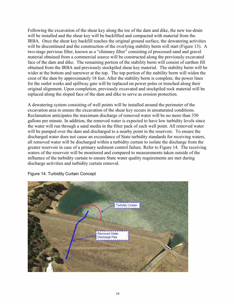
34
Following the excavation of the shear key along the toe of the dam and dike, the new toe-drain will be installed and the shear key will be backfilled and compacted with material from the IRBA. Once the shear key backfill reaches the original ground surface, the dewatering activities will be discontinued and the construction of the overlying stability berm will start (Figure 13). A two-stage pervious filter, known as a “chimney filter” consisting of processed sand and gravel material obtained from a commercial source will be constructed along the previously excavated face of the dam and dike. The remaining portion of the stability berm will consist of earthen fill obtained from the IRBA and previously stockpiled shear key material. The stability berm will be wider at the bottom and narrower at the top. The top portion of the stability berm will widen the crest of the dam by approximately 18 feet. After the stability berm is complete, the power lines for the outlet works and spillway gate will be replaced on power poles or trenched along their original alignment. Upon completion, previously excavated and stockpiled rock material will be replaced along the sloped face of the dam and dike to serve as erosion protection. A dewatering system consisting of well points will be installed around the perimeter of the excavation area to ensure the excavation of the shear key occurs in unsaturated conditions. Reclamation anticipates the maximum discharge of removed water will be no more than 350 gallons per minute. In addition, the removed water is expected to have low turbidity levels since the water will run through a sand media in the filter pack of each well point. All removed water will be pumped over the dam and discharged to a nearby point in the reservoir. To ensure the discharged water does not cause an exceedance of State turbidity standards for receiving waters, all removed water will be discharged within a turbidity curtain to isolate the discharge from the greater reservoir in case of a primary sediment control failure. Refer to Figure 14. The receiving waters of the reservoir will be monitored and compared to measurements taken outside of the influence of the turbidity curtain to ensure State water quality requirements are met during discharge activities and turbidity curtain removal. Figure 14. Turbidity Curtain Concept

35
2.2.6 Road Use and Public Access 2.2.6.1 Boca Dam Reservoir Road
Vehicle access across Boca Dam Reservoir Road that crosses the dam will be closed to the public for the entirety of the proposed construction period. Prior to reopening the road to the public, a new concrete roadway surface for Boca Dam Reservoir Road will be constructed on top of the dam crest. The new roadway across the dam will be constructed immediately downstream of the existing roadway on the widened crest. Concrete Jersey barriers will be utilized to confine the traffic to the roadway. The portion of the roadway across the dike will receive new asphalt paving. The existing bollards, commonly referred to as pop-up barriers, located at each abutment will be removed and replaced with steel gates. The steel gates will only be closed for unforeseen security reasons. After the Project is complete, the road over the dam will no longer need to be closed due to high reservoir levels as currently operated.
2.2.6.1.1 Emergency Vehicle Access during construction During construction, the road across the dam and dike will be closed to the public but there will be established guidelines on providing access to emergency vehicles on an as-needed basis. Reclamation’s contractor will submit an emergency access plan to be approved by Reclamation and the Forest Service. Reclamation will coordinate with local emergency services to make them aware of the access situation.
2.2.6.1.2 Detour route to Boca Campground and the west side of Boca Reservoir Due to the closure of the road over the dam and dike during construction, a detour route for traffic wanting to reach the Boca Campground on the west side of Boca Reservoir has been identified. The detoured traffic will be routed to Prosser Dam Road off of Highway 89. From Prosser Dam Road, traffic will be routed along Forest Service Road 73/Boca Road. This detour would be eight miles long and take approximately 25 minutes to travel, refer to Figure 15. To ensure the detour will be suitably passable, Reclamation’s contractor will be required to maintain access along the road as well as performing dust abatement as necessary during the season when the campground is normally open. In addition, Reclamation will provide detour signs to clearly inform the public of the alternate route.

36
Figure 15. Traffic detour to Boca Campground
2.2.6.2 Traffic control for excavating and hauling IRBA material
Stampede Meadows Road will be used to haul the excavated material from the IRBA to the project site. This excavation will occur after August 1 until the winter shut down period. Stampede Meadows Road will be open during this work and the contractor will be required to provide traffic control that would allow public vehicles and cyclists safe passage along this stretch of road.
To prevent new environmental impacts and disturbance, the IRBA will be accessed from Stampede Meadows Road using one or both of the two existing volunteer access points created by recreationists driving their vehicles off Stampede Meadows Road to the reservoir (refer to Figure 16). These existing access roads will need to be widened to allow two-way traffic. This will be achieved with grading onsite materials and placing gravel surfacing. In addition, some

37
trees will need to be either trimmed or removed that are adjacent to the existing road. There is expected to be fewer than 50 trees removed, most of which are 10-inches or smaller diameter trunks. Once excavation and hauling from the IRBA has been completed, the existing access roads will be re-contoured, and undeveloped areas outside of the IRBA area will be revegetated by the Forest Service in accordance with their approved site-access revegetation plan. This will result in these access points being permanently closed to public traffic, in accordance with the Forest Service Recreation Plan. In addition, Reclamation’s contractor will re-contour and stabilize the disturbed area of the IRBA according to plans developed in coordination with the Forest Service. Figure 16. IRBA Construction and Access Points
2.2.6.3 Traffic control for other work
During the construction of the shear key and stability berm, the contractor will have the option to use a variety of different haul roads as they determine necessary, as shown on Figure 17. Any crossing of Stampede Meadows Road with construction equipment would require a detailed traffic control plan that will be reviewed in coordination with the Forest Service and Nevada County. Emergency responders (Highway Patrol, ambulance, etc.) will be made aware of all

38
traffic control plans well in advance of implementation. In addition, all temporary haul roads and other disturbed use areas or stock pile areas will be restored and revegetated in accordance with the revegetation plan.
2.2.6.4 Public access near historic ice dam
Reclamation will maintain public access to the small parking area on the east side of the historic ice dam, which is currently used as a parking area for recreational activities such as rafting. Reclamation’s contractor may also use the access road to this area, but will maintain safe access and a parking area for the public. To ensure public safety, the contractor will have the option to widen the existing road down to the lower parking lot. The road would be widened from the existing southwest edge up to 20 feet. After construction, the road would be restored to pre-project conditions according to plans developed in coordination with the Forest Service. Figure 17. Proposed haul roads and use areas
2.2.6.5 Rehabilitation of Stampede Meadows Road
The contractor will use Stampede Meadows Road for hauling material from the IRBA to the project area. Based on feedback from Nevada County, after construction is complete, Reclamation will rehabilitate the section of Stampede Meadows Road from the IRBA access points to Boca Dam by milling and overlaying the existing asphalt. Reclamation will obtain an encroachment permit for this work with Nevada County.

39
2.2.6.6 Recreational access to the reservoir
While material is being removed from the IRBA, access to the reservoir will be restricted along the eastern shoreline of Boca Reservoir. Reclamation’s contractor will partition off the work area within the IRBA for safety and security reasons. After material extraction, recreation access along the east side of the reservoir will be re-established following re-contouring and stabilization, in coordination with the Forest Service. During construction the overlook parking lot and access at the east side of the dam will be temporarily closed to the public out of safety concerns due to close proximity to the work areas.
2.2.6.7 Construction of new gravel parking lot
Within Reclamation’s property, a gravel parking area will be constructed on the west side of Stampede Meadows Road in the area shown on Figure 17. This parking area will be approximately 50,000 square feet in size and will be used as the construction administration area during the Project. The new parking lot will be left after construction to serve as a permanent feature to increase the available parking for recreationists in the Boca Dam area. At the end of the Project, large boulders will be installed around the perimeter of the parking lot. To control storm water, the gravel surfaced parking lot will be designed using typical low-impact development best practices such as directing the water through existing vegetation, and installing permanent storm water control measures.
2.2.7 Haul Routes The contractor will have the option to use any combination of haul routes in shown in Figure 17 in order to facilitate their chosen construction methods to accomplish the work. Reclamation is anticipating the need for a contractor to cross the spillway chute and spillway discharge channel to the Little Truckee River, and therefore, has included these earthen access crossings and measures to minimize their effects to aquatic resources and fish. The upper spillway crossing option would be located in the flat portion of Reclamation’s concrete lined spillway chute and would either consist of an earthen plug within the concrete spillway chute or a temporary bridge. If an earthen plug is used, the downstream slope will be lined with impermeable material to prevent erosion and sediment entering the river. The Little Truckee River crossing would be located approximately 500 feet downstream of the end of the spillway crossing. The Little Truckee River crossing proposed would be a compacted earthen plug and the downstream slope would be lined with impermeable material to prevent erosion and sediment entering the river. In addition, appropriate erosion and turbidity control devices will be installed around the spillway and Little Truckee River as needed to further prevent the discharge of turbid water into the Little Truckee River. Other crossing alternatives were evaluated, such as a temporary bridge, but were not chosen due to schedule and logistics problems. If the above described earthen crossing is used, a fish rescue operation would be conducted by fish biologists prior to installing the earthen plug to remove any fish that could be in the 500 foot section of river upstream of the earthen plug. Specifically, a block net will be walked through

40
the spillway channel by biologists to relocate any fish species. A small pump will then be placed behind this crossing to continually pump as much standing water as feasible within the 500 foot stretch of river upstream of the earthen plug. This removed water would be discharged out to the same dewatering discharge point for water removed from excavations, within the turbidity curtain in the reservoir. This pumping would occur for a period of less than three months in the late spring, early summer and not significantly affect the ground water in this area. It is not anticipated that vegetation will be affected along this reach, but if monitoring of the riparian or wetland vegetation on the banks indicates die-back from the temporary reduction in surface water, the bank areas will be revegetated in like manner, within 30 days of crossing removal. If used, both crossings described above would be removed prior to October 31 of the first year of construction. If needed, the crossings would be re-established in April, at the start of the second year of construction. The vegetated banks of the spillway discharge channel would be revegetated in accordance with a revegetation plan, and could include methods such as hydroseeding, willow stakes, or willow mattressing.
2.2.8 In-Reservoir Borrow Area (IRBA) The IRBA is a 50-acre area located within the Tahoe National Forest, approximately one mile north of the dam site on the east shore within Boca Reservoir (see Figures 11 and 16). Approximately 125,000 cubic-yards of earthen fill will be excavated from this borrow area for this Project. During the time period the IRBA is being used in the first year of construction, there will be a temporary reservoir drawdown so that the reservoir elevation is below the IRBA. Refer to Sections 2.2.1 and 2.2.2. To ensure sediment from the IRBA does not reach the reservoir, sediment controls will be installed around the entire perimeter. Additionally, there will be stabilized rock entrances at each access point to Stampede Meadows road to limit sediment track out with the use of street sweeping, if needed. To minimize impacts to the recreating public, the Project will sequence work within the IRBA to account for peak recreation periods. Specifically, the Project will begin using half of the IRBA starting after August 1, then will use the entire area after Labor Day. Once each section is being used, the area will be fenced off for safety and security reasons. This sequencing will be coordinated with the Forest Service. Since the IRBA will only be available the first construction season (Refer to Section 2.2.1 and Figure 9), it is critical that the Project obtains the necessary quantity of material during that time period. From August to the end of October, the material will be directly hauled to the dam site. If there is still material that needs to be hauled from the IRBA after October 31, material will be hauled directly to the East Stockpile Area, east of Stampede Meadows Road up to November 15 for use the following year. As of October 31, the Project area at the dam and dike will be fully winterized to stabilize the site from erosion until snow melts and the site becomes accessible the following year. During this time period, hauling would only occur on non-rain/non-snow days and any remaining material would be obtained from higher elevations of the IRBA. No hauling would occur if saturated ground conditions would cause excessive rutting and excessive
41
sediment track out onto Stampede Meadows Road that typical engineering controls could not maintain, such as stabilized entrances, tire washing and street sweeping. In addition, no snow plowing is proposed for this work. Snow would be allowed to melt prior to resuming work. Lower portions of the IRBA would be restored prior to October 31, and the remaining upper portions of the IRBA will be restored as the rest of the material is hauled out. The upper approximately two feet of the IRBA soils (surficial soil) will be stripped and stockpiled then used to re-contour and stabilize the IRBA at the completion of excavation activities. IRBA restoration activities will consist of replacing the previously stripped surficial materials and regarding the area with gradual slopes and compacting the area with a smooth drum roller creating a surface that is similar to the existing condition. Post-restoration, the borrow area will look similar to the pre-construction condition of the area. Reclamation will coordinate the re-contouring terms with the Forest Service in order to leave the IRBA in a manner that would better facilitate public safety and recreational use, such as launching boats, compared to the existing pre-project condition. Within the IRBA there will be a designated construction staging area located at least 300 feet away from the water surface, where off-highway construction equipment will be parked when not in use (Refer to Figure 16). No fuel storage tanks will be located in the IRBA or waters of the U.S., although tracked earthmoving equipment will be fueled by mobile sources and serviced in this area under a Spill Prevention Control and Countermeasure Plan (SPCCP). Per the approved SPCCP, typical BMPs will be used for addressing leaking equipment, such as prompt repair and using drip pans. Additionally, the fueling and equipment parking area will be covered with an impervious liner. No fueling of, or non-emergency maintenance activity on, haul trucks will occur in the IRBA.
2.2.9 Staging and Stockpiling Areas Up to 20 acres of upland areas may be used during construction as temporary contractor staging and stockpiling areas. As shown on Figure 17, the East Stockpile Area is located east of Stampede Meadows Road near the left abutment of the dike partially outside the Reclamation Zone on Forest Service lands. The South Stockpile Area is located west of Stampede Meadows Road, downstream of the dike within the Reclamation Zone. Sagebrush and bitterbrush vegetation communities may need to be removed in these areas to provide workspace for construction operations. No trees are located in these areas. The IRBA may also be used for temporary staging and stockpiling (Figure 16). Additional contractor staging and use areas could be located at the intersection of the outlet works access road and Boca Dam Reservoir Road, by the ice dam pedestrian bridge and within the stockpile areas. Trees will be avoided to the extent feasible and marked with high-visibility fencing around the dripline to provide protection during construction activities. Refer to Section 2.2.8 regarding staging and stockpiling within the IRBA.
2.2.10 Mitigation Measures for the Proposed Action Alternative 2.2.10.4 Erosion and sediment control (EROS)
42
Used cumulatively, sediment control devices will substantially eliminate project generated sediment from reaching receiving waters in the area. Table 4 provides a matrix describing the sediment control devices that would be deployed for the various elements of the Proposed Action Alternative. EROS-1 – Storm water and construction runoff releases from the construction site will be
controlled and monitored to ensure that discharges of storm water and authorized non-storm water discharges do not cause surface waters of the Little Truckee Hydrologic Unit to exceed the threshold of ten percent above the baseline water quality conditions unaffected by the Project, and meet other requirements in accordance with the obtained Construction General Permit.
EROS-2 – In accordance with the Project’s storm water pollution prevention plan (SWPPP), inactive stockpiles and inactive portions of stockpiles that are over-wintered will be stabilized with any combination of geomembrane materials, soil coverings and straw wattles. To eliminate the chance of sediment from leaving the stockpile sites, keyed-in silt fencing or water bars will be installed around the perimeter of the stockpile area based on the slope and height of the stockpiles. Erosion and sediment control devices will be visually monitored throughout the construction period by a Qualified SWPPP Practitioner.
EROS-3 – Where trucks enter onto paved roadways from unpaved work areas, crushed rock will be used to stabilize the entrance and exit points and reduce track out.
EROS-4 – Roadways near entrances and exits used for construction and stockpiling will be swept, as needed, to minimize fugitive dust and sediments entering waterways from storm water.
EROS-5 – Storm water runoff originating on upslope areas will be diverted away from disturbed areas. Runoff on bare ground will be dispersed to reduce concentrated flows that might deliver fine sediment to water sources.
EROS-6 – Existing vegetation will be preserved where feasible. Preserved vegetation can intercept rainfall, filter storm water, and prevent sediments and other pollutants from leaving the site.
EROS-7 – Wastewater from general construction activities will be prevented from entering flowing or dry watercourses with the use of approved sediment control methods, such as silt fences and straw wattles.
EROS-8 – The Little Truckee River crossing and reservoir-side spillway cofferdam, if utilized, will be covered with an impermeable geomembrane, on the waterside of the feature, to prevent erosion of sediment into the reservoir and Little Truckee River.
EROS-9 – Any water removed from the dewatering systems will be filtered through sand media and discharged to Boca Reservoir within a turbidity curtain. Receiving waters will be monitored and compared to measurements taken outside of the influence of the turbidity curtain (for background levels) to ensure turbidity levels do not reach or exceed 10% of background turbidity, together with other discharge monitoring required in the Construction General Permit. A minor amount of water will be removed from the toe drain ditch. This water will either be pumped into the above described turbidity curtain or in upland areas in accordance with the SWPPP.
EROS-10 – Topsoil will be removed, stockpiled, and replaced as a medium for revegetation. Topsoil stockpiled for more than 12 months will be amended with organic compost to reestablish beneficial microorganisms.

43
EROS-11 – By October 31, the Project area at the dam, dike, and lower elevation portion of the IRBA will be fully winterized. Disturbed areas will either be regraded or reseeded for revegetation, or BMPs such as silt fences and soil covers, will be installed and maintained prior to the winter shut-down period as temporary stabilization from erosion, pending final restoration or revegetation efforts. If hauling is required during the month of November, it will only occur on non-rain/non-snow days and the remaining material to be hauled will be obtained from higher elevations of the IRBA. Refer to Section 2.2.8 for further discussion on hauling during the month of November. The upper IRBA elevations will be restored (backfilled, compacted, and graded) concurrently with final hauling activities up until November 15. Refer to Section 2.2.8 for description of restoration activities in the IRBA. No snow plowing is proposed.
EROS-12 – The design of the new parking lot will direct storm water through existing vegetation and include low-impact best practices to control storm water.
EROS-13 – Temporarily disturbed areas such as staging and stockpile areas and haul roads will be re-contoured and scarified to pre-project conditions so that surfaces blend with natural terrain and are in a condition to facilitate revegetation, provide proper drainage, and prevent erosion. They will also be re-vegetated with native plant communities, including trees, according to a Revegetation Plan developed in coordination with the Forest Service. Post-construction monitoring, coordination with the Forest Service, and adaptive management as identified in the Revegetation Plan will be used to identify changing needs and meet the desired future conditions of establishing ground cover to minimize soil erosion and re-establishing native plant communities. Following soil preparation and seeding in disturbed areas, at least 70 percent of the pre-project vegetative cover for the area will be expected to be provided, relative to pre-project and post-project monitoring photos or vegetation-plot monitoring to provide stability from erosion. Monitoring will occur over a period of three years to evaluate success in establishment, species composition, and percentage of plant cover.
EROS-14 – After construction, the dam and dike will be permanently stabilized by rock slope protection along the sloped areas, thereby reducing expected erosion.
EROS-15 – No detectable flow will be moving through the toe drain outlet ditch, but backwater will be present. Replacement of the toe drain outlet will take approximately one week, and temporary sediment control during the replacement will be achieved by using sandbags to create a small berm in the ditch to keep backwater out, and pumping the ponded water out and onto upland areas for infiltration. A silt fence would also be installed in the ditch near the replacement activities to catch any sediment, which would then be removed prior to operation of the outlet. Once in operation, erosion at the outfall of the toe drain will be controlled with the installation of an energy dissipating structure such as riprap with an underlying filter fabric.
EROS-16 – Surficial materials in the IRBA will be removed and temporarily stockpiled during excavation. In coordination with the Forest Service, this material will be reused to grade the area back to desired contours and to resemble natural contours.
EROS-17 - To ensure sediment from the IRBA does not reach the reservoir, sediment control devices will be placed around the entire perimeter with a silt fence between the IRBA and the water.

44
2.2.10.5 Equipment emissions and fugitive dust (EMIS)
EMIS-1 – Apply water or dust palliatives as necessary to prevent nuisance of fugitive dust from unpaved roads and disturbed areas.
EMIS-2 – It is not expected that dust will be problematic during the hauling operations as the material will either be moist when excavated or moistened prior to hauling to accommodate compaction requirements. If dust is problematic during hauling activities, haul trucks will be required to be covered.
EMIS-3 – Limit vehicle speeds on unpaved roadways.
Table 4. Water quality best management practices for the Proposed Action Alternative
Proposed Action Alternative Element Sc
hedu
ling
wor
k to
m
inim
ize
the
amou
nt o
f op
en g
roun
d R
e-co
ntou
r
Roc
k re
vetm
ent
Pres
erve
Veg
etat
ion
Mul
ch
Hyd
rom
ulch
Oth
er R
eveg
etat
ion
– C
hapa
rral
B
road
cast
see
ding
Silt
fenc
e
Fibe
r rol
ls/s
traw
wat
tles
Wat
erba
rs o
r san
dbag
s
Trac
k w
alk
surf
ace
Roc
k ch
eck
dam
s
Jute
Stoc
kpili
ng a
way
from
w
ater
s of
the
U.S
./wat
ers
of th
e St
ate
“Str
eet s
wee
p” p
aved
ro
ads
to k
eep
sedi
men
ts
out o
f run
off
Cov
er s
tock
pile
s
Stab
ilize
con
stru
ctio
n en
tran
ce
Geo
mem
bran
e
Lim
it re
crea
tiona
l off-
road
ac
cess
(e.g
. phy
sica
l ba
rrie
rs)
Site Preparation X X X X X X X X X In Reservoir Borrow Area excavation and hauling
X X X X X X X
In Reservoir Borrow Area and haul route restoration
X X X X X X X
Spillway and Little Truckee River temporary access crossings
X X X X X X X X
Spillway construction X X X X Staging and stockpile areas grading, use and restoration
X X X X X X X X X X X
Dam and dike shear key and stability berm construction
X X X X X X X X X
Replace toe drain pipe X X X X Permanent gravel parking lot X X X X X Stabilizing surface of the dam and dike after construction
X X X X X X X
45
EMIS-4 – Sweep trackout on paved roadways EMIS-5 – Covering stockpiles as needed. EMIS-6 – Use of at least tier 2 equipment types. EMIS-7 – Where trucks enter onto paved roadways from unpaved work areas, crushed
rock will be used to stabilize the entrance and exit points and reduce track out. EMIS-8 – Equipment idling will be minimized, and on-road and off-road material
hauling vehicles will shut off engines while queuing for loading and unloading for time periods longer than five minutes.
2.2.10.6 100-year floodplain (FLDP)
FLDP-1 – This project is a Safety of Dams project necessary for the public’s safety, and Reclamation will request an exemption to the Basin Plan’s waste discharge prohibitions applicable to the 100-year floodplain in the Little Truckee Hydrologic Unit from the Lahontan Water Board, together with the CWA Section 401, Water Quality Certification application.
FLDP-2 – Erosion and surface runoff controls, such as straw wattles, silt fences, water bars, jute matting, hydromulching, and more will be implemented to avoid and minimize erosion and surface runoff within waters of the U.S./State and the 100-year floodplain.
FLDP-3 – All temporary fills within the 100-year floodplain, such as the spillway cofferdam, turbidity curtain and discharge water pumps, and the spillway and Little Truckee River access crossings, will be removed by October 31, before the winter shutdown period. If these construction activities are needed again in the second construction season, they will be re-established and then removed upon activity completion, and affected areas will be restored to pre-project grade and condition. The Basin Plan requires that the project to repair the dam will not adversely affect the 100-year floodplain functions that “. . . includes the conveyance of floodwaters along with other hydrologic, geomorphic, biological and ecological processes such as groundwater recharge, floodwater filtration, sediment transport, spawning gravel replenishment, seed dispersal, and riparian vegetation maintenance” (Lahontan Water Board 2017: 4.9-16). The short-term, temporary impacts to the 100-year floodplain in these areas will be offset by the removal of material from the IRBA that will nominally increase reservoir floodwater retention.
2.2.10.7 Waters of the U.S./waters of the State (WOUS)
WOUS-1 – Access into and out of the IRBA will be limited to two locations along existing dirt roads that connect to Stampede Meadows Road, minimizing interference with wetlands and waters of the U.S./State. Use of these routes will be at the discretion of the contractor.
WOUS-2 – Post construction re-contouring and restoration efforts in the IRBA will be done within 30 days of IRBA activity completion, and coordinated with the Forest Service. Reclamation and the Forest Service are expected to leave the area in a safe state that would better accommodate recreationist use compared to the existing pre-construction condition.
WOUS-3 – Temporary construction access will be needed to get to the shear key and stability berm over the spillway channel and Little Truckee River to keep equipment from

46
moving directly within the channels. Temporary crossings will be placed within the spillway channel, depending on if Reclamation’s contractor chooses to utilize them. These crossings will be removed by October 31, before the winter shutdown period, and re-established the second construction year if needed. One of the available crossings for dam site access has been located over the concrete spillway channel so that it minimizes the disturbance to willow scrub and riverine habitat in the spillway channel. The second downstream Little Truckee River crossing runs through a portion of a perennial wetland. Temporary impacts in this area will be restored within 30 days of activity completion, and will be monitored for three years according to the Revegetation Plan for restoration success. Within 30 days of the crossing being removed, the vegetated banks of the spillway discharge channel will be revegetated in accordance with a Revegetation Plan, and could include methods such as hydroseeding, willow stakes, or willow mattressing.
WOUS-4 – A temporary upstream cofferdam may be installed on the reservoir-side of the spillway gates. This cofferdam will be covered with an impermeable geomembrane to prevent sediment from falling into the reservoir.
WOUS-5 – All temporarily affected waters of the U.S. and State, will be restored to pre-project contour and condition within 30 days of completing the impacting activity.
2.2.10.8 Noxious weeds (NOX)
NOX-1 – Project areas will be surveyed for non-native, invasive, noxious weeds to determine risk of spread from project activities, and how to avoid or minimize potential for spread.
NOX-2 – Monitoring for noxious weeds will continue during construction activities and if small infestations of noxious weeds are identified during project implementation, the contractor will evaluate if the weeds should be hand treated or flagged and avoided according to the species present and project constraints.
NOX-3 – All earth-moving equipment and imported fill materials will be noxious weed-free.
NOX-4 – Earth moving equipment will be cleaned prior to leaving the project site to prevent transport of noxious weed seeds to other areas.
NOX-5 – Only weed-free seed stocks and products to control sediments and reduce erosion will be used for erosion control and revegetation.
NOX-6 – Reclamation will conduct post-construction monitoring and treatment of noxious or invasive weeds on impacted National Forest System lands in coordination with the Forest Service, and on Reclamation-owned lands or facilities in accordance with Reclamation’s policy on integrated pest management, and in accordance with laws and labeling of the State of California concerning pesticides usage.
NOX-7 – The contractor will follow the guidance in the following documents to reduce the spread of noxious weeds:
o Preventing the Spread of Invasive Plants: Best Management Practices for Land Managers, 3rd Edition (California Invasive Plants Council) – 2012; and
o Technical Memorandum No. 86-68220-07-05, Inspection and Cleaning Manual for Equipment and Vehicles to Prevent the Spread of Invasive Species (Reclamation) – 2012.

47
Such measures to be implemented include washing equipment during construction and applying herbicides in accordance to the manufacturer’s label in areas after construction where weed growth is a concern. Herbicides will not be used in or near surface waters or groundwater, and the contractor will consult with the Lahontan Water Board on herbicide application.
2.2.10.9 Hazardous materials (HAZ)
HAZ-1 – Reclamation will implement a Spill Pollution Control and Countermeasure Plan (SPCCP) in accordance with Federal requirements (CWA Section 311(j)(1)(c), as amended by the Oil Pollution Act of 1990). If a spill occurs anywhere in the work area, the SPCCP will be implemented. If a spill occurs where it can be carried via a stormwater or construction runoff discharge to a water of the U.S. or State, Reclamation will sample for the visible and non-visible hazardous pollutant constituents and any potential breakdown products and report any violation to the Lahontan Water Board. If a spill occurs in the IRBA, the spill will be cleaned up with absorbent materials to be determined in the SPCCP and the Water Board will be contacted immediately since the IRBA is in a water of the U.S. Several spill kits will be maintained onsite. The SPCCP will include the following measures:
o Covered storage of hazardous materials, chemicals, fuels, and oils will not take place within one hundred (100) feet of any drainage, wetland, Boca Reservoir, or the Little Truckee River. Stored liquid hazardous materials will also be stored within secondary containment capable of storing 110% of liquid material volume;
o Materials will be stored in appropriate containers and contents labeled; o Material volume will be restricted to the volume that can be addressed by
available spill kits and supplies; o Used containers will be disposed of at an appropriate landfill or other legal
disposal or recycling facility; o Bulk storage tanks will have secondary containment systems at least 110% of
storage tank capacity; o Spill cleanup will occur immediately and notification will be given to the
California Department of Fish and Wildlife, USFWS, Forest Service, Reclamation, Lahontan Water Board, and California Office of Emergency Services;
o Cement and concrete delivery and transfer equipment will be washed in contained areas protected from direct runoff until material sets or is removed for proper disposal;
o Workers will be trained to properly handle hazardous materials, cleanup spills, and report spills. Construction workers will be trained to identify indicators of contaminated soils such as soil discoloration, odors, differences in soil properties, and buried debris. Construction workers will be trained to be aware of proper handling techniques and appropriate responses and actions to be taken if hazardous materials are accidentally released, with special emphasis on those hazardous materials with the greatest potential to occur at the Project site;
o Soils contaminated with fuels or chemicals will be disposed of in a suitable location in coordination with the County of Nevada to prevent discharge to surface waters and in further accordance with the rules and regulations of the U.S.

48
Department of Transportation, the U.S. Environmental Protection Agency, the Lahontan Water Board, and other agencies of the California Environmental Protection Agency, as applicable;
o Excess or unused quantities of hazardous materials will be removed upon project completion. Although hazardous waste generation is not anticipated, any such wastes produced during construction will be properly containerized, labeled, and transported to an approved hazardous waste disposal facility; and
o All nonhazardous waste materials including construction refuse, garbage, and sanitary waste, will be disposed of by removal from the work area to an approved disposal facility. They will also be covered when not in use, at the end of each shift, and before a storm event.
HAZ-2 – Reclamation will implement a waste handling plan to certify that any hazardous or non-hazardous wastes are disposed of in accordance with Federal, State, and local regulations.
HAZ-3 – A fueling plan will be prepared separately or as a part of the SPCCP. The fueling plan will include the following measures:
o Vehicles will be monitored for fluid leaks and will be maintained regularly to reduce the chance of leakage. If any leaks are detected, the vehicle will be taken to a special paved area designated for vehicle repair and equipped with management controls for leaked materials, or a replacement will be obtained;
o In accordance with the SPCCP, vehicle refueling will only occur on flat or relatively level ground where there is little chance of a spilled substance reaching a stream or waterway, over an impermeable surface;
o Refueling and vehicle maintenance will be performed at least 100 feet from receiving waters and outside of 100-year floodplain areas, with the exception of servicing tracked earthmoving equipment within the impervious-lined area located in the upper portion of the IRBA;
o All fueling materials will be properly labeled and stored outside of waterways; and
o Oil, antifreeze, solvents, and other materials related to equipment maintenance will be disposed of or recycled appropriately offsite. If these materials have to be stored before disposal/recycling, they will be stored in covered areas with berms to contain any spills. Covered containment areas will have 110% capacity of stored containers and also be lined with impermeable material. The impermeable material will be maintained free of holes that would permit leaks.
2.2.10.10 Traffic and circulation (TRAF)
TRAF-1 – Emergency responders will be provided access across Boca Dam and on Stampede Meadows Road at all times. Reclamation will notify emergency responders at least 30 days in advance of any potential road closures so arrangements to service the area can be implemented.
TRAF-2 – The contractor will be required to prepare a traffic control plan and temporary traffic signage plan for all work areas including signage to inform the public of alternate routes to Boca Reservoir, and provide the traffic control plan to the Nevada County Sherriff’s office. The contractor will be required to maintain access during construction
49
to the boat ramp, campgrounds, and other recreational amenities associated with Boca Reservoir during the summer recreation season. The contractor’s traffic control plan will:
o Follow the Caltrans Standard Specifications; o Follow the Federal Highway Administration Manual on Uniform Traffic Control
Devices; o Be approved by the County of Nevada; o Be approved by the Forest Service; and o Include plans:
For work areas and haul routes. To provide flaggers, guards, or signaling equipment as required to prevent
accidents and damage or injury to passing traffic. To maintain traffic flow and conduct construction operations to minimize
obstruction and inconvenience to public traffic. To protect roads closed to traffic with effective barricades and warning
signs and illuminate barricades and obstructions from sunset to sunrise. TRAF-3 – The Contractor will be required to coordinate with Caltrans, the Town of
Truckee, and the County of Nevada for temporary traffic signage plans. The Contractor's temporary traffic signage plans must:
o Be approved by the County of Nevada; o Include temporary traffic signage plans for Interstate Highway 80, State
Highway 89, and county roads regarding public access and detours; and o Include but not be limited to:
Modification of existing signage on Interstate 80 indicating the detour route to Prosser Creek Reservoir during construction;
Installation of signs on State Highway 89, county, and local roads indicating the detour route to Prosser Creek Reservoir;
Road closure signs indicating the segment of Boca Dam Reservoir Road and Stampede Meadows Road to be closed during construction; and
Remove required signage when no longer needed.
2.2.10.11 Special status plants and wildlife (BIOL)
BIOL-1 – All native vegetation removed for temporary construction activities, including trees and riparian vegetation, will be done under the Construction General Permit, and replaced with the same vegetation community and monitored according to a Revegetation Plan prepared by Reclamation, in coordination with the Forest Service. See mitigation measure EROS-13.
BIOL-2 – The Proposed Action Alternative falls under Category B (large scale construction, greater than one-half acre, mining and related activities) in the National Bald Eagle Management Guidelines (USFWS, 2007). For Category B projects, the guideline is to implement a 330 foot setback between the project activities and an active nest if the nest is not visible from the site.
BIOL-3 – As a precautionary measure recommended by the Forest Service, Reclamation will conduct preconstruction surveys for active nests and monitor courtship, mating, and nesting behaviors of bald eagles if work in the IRBA extends past the start of the nesting season (January 1), in accordance with the Bald Eagle Monitoring Plan.

50
BIOL-4 – The bald eagle nest will be monitored by a qualified biologist daily for one week of IRBA activities to determine if any significant changes to nesting bald eagles occur due directly to project activities.
BIOL-5 – Reclamation will contact the USFWS and work with the Forest Service on ways to minimize disturbance effects to nesting eagles if they are observed.
BIOL-6 – Biweekly monitoring will continue until the eaglets leave the nest which may extend into mid-August. Monitoring of the nest would only occur during the first year of construction so long as there are no observable effects to the nesting behavior of the adults or eaglets. Due to the distance from the existing nest, subsequent years would not require monitoring if there are no observable effects.
BIOL-7 – If Project activities will occur during two nesting seasons, Reclamation will coordinate with USFS to determine if the resident pair of bald eagles nests in the location. If the eagles are not nesting in the same location, but within 660 feet of Project activities, Reclamation will coordinate with the USFS or USFWS to determine what level of monitoring, if any, will be performed.
BIOL-8 – All necessary tree and shrub removal that occurs during the migratory bird nesting season will be preceded by six preconstruction surveys two weeks prior to vegetation removal for active nests.
BIOL-9 – If active nests are observed, a minimum buffer of 200 feet, depending on the bird species, will be established around the nest until nestlings have fledged. A biological monitor will also be onsite to monitor if Project activities disturb the nesting birds until fledged, and provide further minimization measures as necessary.
BIOL-10 – Cliff swallow nest removal from the spillway and exclusion netting setup will occur in the winter when cliff swallows are not nesting. The exclusion apparatus will be approved by the biologist, and some monitoring on a small scale will be implemented during the period when the swallows begin arriving back in the area during the spring to ensure that the system is working as intended.
BIOL-11 – To avoid direct effects to the Boca Reservoir fish population, Reclamation will remove the borrow material from the IRBA when the water in the reservoir is at or below elevation 5,581 feet (NAVD88).
BIOL-12 – In order to avoid direct effects to fish in the Little Truckee River, CDFW will walk a block net through the spillway channel and install it downstream before the crossings are constructed. Once the spillway access crossings are installed, CDFW fish biologists will perform a fish rescue and relocation effort as necessary.
BIOL-13 –The water intake pump used to obtain up to 10 AF of construction water from the reservoir, as permitted by Truckee Meadows Water Authority, will be completely screened, with screen slots not exceeding 1/4-inch. The pump velocity will not exceed 6.5 cfs, and the pump will be placed at a depth to minimize interaction with small fish and debris. A velocity reducing device, such as a perforated drum may be installed over the pump intake. These measures will prevent debris, fish, amphibians and other aquatic wildlife from getting into the water intake pump system. Access to the water body will be limited to the extent necessary to deploy and retract the water intake pump.
BIOL-14 – Reclamation and the Forest Service will identify site specific planting expectations for those areas having higher aesthetics requirements and include them in the revegetation plan. Reclamation will work cooperatively with the Forest Service to address long-term revegetation of bitterbrush and tree re-establishment following

51
construction. Long-term stabilization of disturbed areas will be verified by the Lahontan Water Board.
BIOL-15 – A minimum 10-foot buffer established with construction fencing around the Plumas ivesia (Ivesia sericoleuca) plant occurrence in the east portion of the East Stockpile Area will be maintained during the project.
BIOL-16 – Trees will be avoided to the extent feasible and marked with high-visibility fencing around the dripline to provide protection during construction activities
2.2.10.12 Fire control (FIRE)
FIRE-1 – A fire prevention and suppression plan will be developed by the Reclamation contractor and approved by the Forest Service. The plan will outline the responsibilities for prevention and suppression of fires during construction, provide local contacts in the event of a fire event, and methods to prevent and suppress small fires. The plan will cover fire hazards related to equipment movement over dry brush, welding, and other worker activities that may spark a fire. In the event of a fire, work will stop until appropriate control and notification measures can be implemented, according to the fire prevention and suppression plan. The following preventative measures will be included as required by Reclamation:
o Create a fire break around and adjacent to offices, shops, and other work areas by clearing away all flammable vegetation or combustible growth;
o Maintain any tree adjacent to or overhanging any building, trailer, shop, or work area, free of dead or dying wood;
o Maintain roof of any structures including temporary offices or shops free of leaves, needles, or other dead vegetative growth;
o Permanent and Temporary Access and Haul Roads: Remove grass, brush, and combustible materials from roadway and
roadway shoulders to the slope break along fill sections of the road; Place gravel to a depth necessary to prohibit regrowth of grass and brush,
or treat with herbicide to prevent regrowth of grass and brush, in the area between the edge of the road travel-way and slope break along fill sections of the road. The Lahontan Water Board will be consulted prior to herbicide use to avoid discharge of herbicides to surface or ground waters;
In cut sections of the road remove grass and brush from road shoulders and up to a distance of five feet;
Place gravel to a depth necessary to prohibit regrowth of grass and brush, or treat with herbicide to prevent regrowth of grass and brush on road shoulders and up to a distance of five feet; and
Trees in this area may be left in place after being pruned eight feet up tree from ground.
o Fire tools and preventative actions will be required at shops, staging areas, and other stationary work areas where equipment machinery or tools that can cause sparks are used. Reclamation will require the contractor to:
Maintain one serviceable round-point shovel overall length not less than 46 inches;

52
Maintain a five gallon minimum back pack pump water-type fire extinguisher or one five gallon minimum pressurized water fire extinguisher;
Fire tools required in areas where portable tools powered by internal combustion engines are used within 25 feet of any flammable material;
Maintain one serviceable round point shovel, minimum overall length 46 inches, and one three-gallon-minimum pressurized fire extinguisher or five gallon back pump;
Keep required fire tools within 25 feet of operating equipment powered by internal combustion engine.
o Reclamation will require the contractor to maintain the following passenger vehicle and construction machinery requirements to prevent fire:
Passenger vehicles, cars, pickups, light trucks, shall be equipped with one water fire extinguisher or back pack pump with three-gallon-minimum capacity; and
Any internal combustion engine operated on or near forest, brush, grass covered land shall be equipped with a spark arrester or the engine shall be constructed, equipped and maintained for prevention of fire.
o The contractor will be required to provide a water truck equipped with 500 feet of 1.5 inch single jacket hose, nozzle and pressure pump. A truck with 300 gallon (minimum) water capacity must be on site with a trained operator during normal work hours and at any other at any time site work is being conducted. Up to 10 AF of water obtained from the reservoir by agreement with the Truckee Meadows Water Authority will be pumped from within the reservoir near the dam. Such water truck may be used for other on-site watering work but 300 gallons or more of water must be immediately available for fire suppression duty.
2.2.10.13 Cultural resources (CUL)
CUL-1 – Reclamation will avoid the fourth archaeological site that is adjacent to a proposed haul road. If this haul road is chosen for use, Reclamation will provide an archaeological monitor during activities to improve the road to access the IRBA.
CUL-2 – In the event that human remains, associated funerary objects, or sacred objects (43 CFR 10.2) are inadvertently discovered during the course of the proposed action, all activities will be stopped and a Reclamation Archaeologist will be consulted on how to proceed. If the human remains, funerary objects, or sacred objects are on Forest Service lands, the Forest Service will be notified immediately in accordance with procedures at 43 CFR § 10.4. All work in the vicinity of the discovery will be halted and Reclamation’s Regional Archaeologist will be notified immediately, followed by a written report within 48 hours. Implementation of the Proposed Action Alternative in the vicinity of the discovery will not resume until Reclamation or the Forest Service complies with the 43 CFR Part 10 regulations and provides notification to proceed. The responsible Federal agency official (43 CFR 10.2(2) will be Reclamation and the Forest Service, within their respective areas.
CUL-3 – Because the west haul route goes through the CEC camp area, no widening of this haul route will be permitted.

53
2.2.10.14 Recreation (REC)
REC-1 – Reclamation will notify Nevada County and the Reno Wheelmen regarding effects to the Twilight Road Series Boca Road Race bike race series that typically starts on Stampede Meadows Road near Boca Dam. This event typically occurs multiple times between May and September.
REC-2 – Reclamation will work with the whitewater outfitter to provide controlled access to an area where the buses and trailers can be offloaded in the turnaround area downstream of the dam.
REC-3 – Reclamation will coordinate with the Forest Service on possible mitigation for potential noise and light impacts to campground recreationists caused by the Proposed Action Alternative.
REC-4 – Qualified biologists will walk a seine net through the 500 feet length of the spillway discharge channel behind the earthen Little Truckee River crossing, prior to its construction. This is to clear the area of fish species, including recreational species such as German brown trout and rainbow trout. If any fish remain behind the crossing, qualified biologists will relocate them to the Little Truckee River, prior to pumping out the majority of ponded water in that area. The ponded water in this portion of the Little Truckee River would be pumped out, treated as necessary, and discharged behind a turbidity curtain in Boca Reservoir for the duration of the crossing being in place, from July through October the first construction year, and possibly April to July of the second construction year. The earthen crossings will be removed at the end of the first year of construction, before the winter shutdown period of November 16 to March 31, and may be re-established in the second construction year; in which the same fish relocation activities will occur.
REC-5 – In the first construction year, half of the IRBA will be open for excavation starting August 1, with the entire IRBA opening as well the day after Labor Day to avoid interference with recreationists during peak periods on Boca Reservoir. Fencing will be placed around the IRBA for public safety.
2.2.10.15 Noise (NOISE)
NOISE-1 - Equip all internal combustion engine driven equipment with intake and exhaust mufflers that are in good condition and appropriate for the equipment.
NOISE-2 – Locate stationary noise generating equipment as far as possible from sensitive receptors when sensitive receptors adjoin or are near a construction project area.
NOISE-3 – Utilize “quiet” air compressors and other stationary noise generating equipment where appropriate technology exists.
NOISE-4 – The contractor will designate a “disturbance coordinator” who would be responsible for responding to any local complaints about construction noise. The disturbance coordinator will determine the cause of the noise complaint (e.g., starting too early, bad muffler, etc.) and will require that reasonable measures warranted to correct the problem be implemented. A telephone number for the disturbance coordinator will be posted at the construction administration area to allow for reporting of excessive noise. Additionally, Reclamation will maintain a project website and email list where project updates will be provided and public inquiries and questions will be answered.

54
NOISE-5 – No demolition activities or other excessively loud work will be allowed between 11pm and 7am, if night time work occurs.
2.2.10.16 Solid Waste Disposal (DISP)
DISP-1 – Dumpsters will be placed in staging areas to collect solid waste generated from construction and administrative activities. Waste containers will be covered at the end of every business day and during rain events.
DISP-2 – Wastes can include, but may not be limited to, construction debris and administrative solid waste and will be removed from the Project site and disposed of at a landfill selected by the Contracting Officer’s representative.
2.2.10.14 Visual Impacts (VIS)
VIS-1 – The contractor will be required to direct stationary floodlights to shine downward at an angle less than horizontal, and shield floodlights so they will not be a nuisance to surrounding areas
VIS-2 – Direct lighting so that residential and highway areas are not in direct beam of light
VIS-3 – Correct lighting control problems when they occur.
2.2.11 Obtaining Permits and Other Approvals Reclamation’s contractor will obtain an encroachment permit from the Forest Service for impacts to Boca Dam Reservoir Road across Boca Dam, and from the State of California, Town of Truckee, and County of Nevada (the latter for impacts to sections of Prosser Dam Road, sections of Boca Road, and Stampede Meadows Road). Permitted activities also include installation of temporary detour and construction signage. An encroachment permit allows the authority having jurisdiction to review and approve traffic control measures including road closures, detours, and road restoration plans, prior to project implementation. Reclamation will assist the Lahontan Water Board, the designated California state lead agency, in the preparation of CEQA compliance for its action of issuing a Clean Water Act, Section 401 Water Quality Certification for the Project. Reclamation or its contractor will also be responsible for developing a SWPPP and reporting to the State Water Resources Control Board and Lahontan Water Board. Reclamation will coordinate with the Water Master’s office and the downstream water right holders on the drawdown period and water supply status of the first construction year, prior to drawing down Boca Reservoir. Downstream water right holders will be able to track water right entitlements and deliveries with the existing accounting system used by the Water Master for TROA. All anticipated permits that will be obtained for the Project are listed in Table 5.
Table 5. Permits and approvals required to implement the Proposed Action Alternative
Resource Statute, regulation, or process
Administering agency Action needed
Hydrology and Water Quality
CWA Sect. 404 USACE Letter of permission or standard permit CWA Sect. 401 Water Board Water quality certification CWA Sect. 402 State Water Resources
Control Board Construction General Permit (CGP)
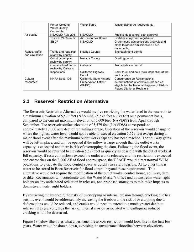
55
Porter-Cologne Water Quality Control Act
Water Board Waste discharge requirements
Air quality NSAQMD Rule 226 NSAQMD Fugitive dust control plan approval 13 CCR 2450-2465 Air Resources Board Portable equipment registration SB 97 NSAQMD Greenhouse gas emissions analysis and
plans to reduce emissions in CEQA documents
Roads, traffic, and circulation
Traffic and road plan review by county
Nevada County Encroachment permit
Construction plan review by county
Nevada County Grading permit
Oversize load permit review by Caltrans
Caltrans Transportation permit
Inspections California Highway Patrol
Semi-truck and haul truck inspection at the truck scales
Cultural resources
NHPA Sect. 106 California State Historic Preservation Officer (SHPO)
Concurrence on Reclamation’s determinations of effects on properties eligible for the National Register of Historic Places (National Register)
2.3 Reservoir Restriction Alternative The Reservoir Restriction Alternative would involve restricting the water level in the reservoir to a maximum elevation of 5,579 feet (NAVD88) (5,575 feet NGVD29) on a permanent basis, compared to the current maximum elevation of 5,609 feet (NAVD88) from April through September. The reservoir surface elevation of 5,579 feet (NAVD88) corresponds to approximately 17,000 acre-feet of remaining storage. Operation of the reservoir would change to where the highest water level would not be able to exceed elevation 5,579 feet except during a major flood event after the maximum outlet works capacity has been reached. The spillway gates will be left in place, and will be opened if the inflow is large enough that the outlet works capacity is exceeded and there is risk of overtopping the dam. Following the flood event, the reservoir would be returned to elevation 5,579 feet as quickly as possible with the outlet works at full capacity. If reservoir inflows exceed the outlet works releases, and the restriction is exceeded and encroaches on the 8,000 AF of flood control space, the USACE would direct normal WCM operations to evacuate the flood control space as quickly as safely feasible. At no other time is water to be stored in Boca Reservoir for flood control beyond these requirements. This alternative would not require the modification of the outlet works, control house, spillway, dam, or dike. Reclamation will coordinate with the Water Master’s office and downstream water right holders on any anticipated reduction in releases, and proposed strategies to minimize impacts to downstream water right holders. By restricting the reservoir, the risks of overtopping or internal erosion through cracking due to a seismic event would be addressed. By increasing the freeboard, the risk of overtopping due to deformations would be reduced, and cracks would need to extend to a much greater depth to intersect the reservoir, thus the risk of internal erosion associated with earthquake induced cracking would be decreased. Figure 18 below illustrates what a permanent reservoir restriction would look like in the first few years. Water would be drawn down, exposing the unvegetated shoreline between elevations

56
5,579 feet and 5,605 feet (NAVD88), permanently. The shoreline could revegetate naturally, similar to Martis Creek Reservoir, where the water surface has been restricted by the USACE over the past eight years during Dam Safety Modification studies. As can be seen in Figure 19, the sagebrush community and pines have begun to re-establish independently of any action by USACE at Martis Creek Reservoir, which is located southeast of the Town of Truckee. A permanent reservoir restriction5 would also result in a reduction of water storage in Boca, which could impact meeting the Floriston Rates, and therefore, the downstream water right holders relying on Floriston Rate Water, including the different water demand categories under TROA. The flexibility of TROA allows participants to move storage to other reservoirs as Credit/Exchange Water would partially make up for the storage lost in Boca Reservoir. Reclamation anticipates operational adjustments can be made to manage for higher flows in many years to minimize the potential impact of any increased “spills” of Credit/Exchange Water. However, not all downstream water right holders that could be impacted by reduced Boca storage are able to establish or accumulate Credit/Exchange Water; therefore, these water right holders could experience adverse effects to their water supply. WCWCD holds a water right for storing water in Boca Reservoir. Stored Boca Reservoir water is operated in conjunction with Lake Tahoe water to maintain Floriston Rates, which were described above in Section 1.4.3 Hydrology and Water Supply (NDEP, 1997). Reclamation believes this water right, and other water rights allowing the TROA Credit/Exchange Water process and Orr Ditch Decree water rights could be impacted. Figure 18. Example: shoreline conditions at Boca Reservoir at a water level elevation of 5,574 feet (NAVD88) (May 2014)
5 The Reservoir Restriction Alternative drawdown and any associated impacts to water users’ demands on a long-term basis are presented in a technical report, Boca Reservoir Potential Reservoir Restriction Analysis, attached as Appendix B.

57
Figure 19. Example: shoreline conditions at Martis Creek Reservoir (May 2014)
2.3.1 Mitigation Measures for the Reservoir Restriction Alternative 2.3.1.1 Noxious Weeds (NOX)
NOX-1 – A permanent reservoir restriction would result in exposing bare ground year round that could be colonized by non-native noxious weeds. Reclamation would work with the Forest Service to develop a weed control program if needed.
2.3.2.2 Waters of the U.S./waters of the State
WOUS-1 – If a weed control program is needed Reclamation will obtain all required permits and coordinate with the Lahontan Water Board if herbicides are proposed to be applied to waters, or lands within the 100-year floodplain of waters of the U.S./State, where waste discharges, including from herbicides, are generally prohibited.
2.4 Dam Breach Alternative This alternative would involve breaching Boca Dam main embankment and completely draining the reservoir. After the breach is complete, a new river channel through the dam site would be constructed. This alternative includes: excavating a trapezoid shaped breach channel in the main embankment, the width and elevation at the bottom of breach channel would be close to the original streambed configuration, placing upstream riprap material in the breach channel for erosion control, abandoning the spillway and outlet works intake structures, and seeding grasses for erosion control purposes in areas disturbed by the breach and channel contouring activities. This alternative also would involve rerouting of the public roadway currently across the crest of the dam which includes earthwork, roadway surfacing, and bridge construction (Figure 20).

58
Due to the sheer volume and excavation and material that would need to be handled and hauled offsite, this alternative would be more expensive than the Proposed Action or Reservoir Restriction alternatives. The Dam Breach Alternative would also result in complete loss of all benefits provided by Boca Reservoir, including loss of storage for Floriston Rates as required under the Truckee River Agreement, loss of storage for water accounts under the TROA, loss of Truckee River water management flexibility under TROA, and loss of flood control benefits. Negative environmental impacts would also likely ensue from efforts to replace the water storage capacity lost. For these reasons, the Dam Breach Alternative is not considered a reasonable alternative and is excluded from further analysis. Figure 20. Dam Breach Alternative conceptual plan view
Section 3 Evaluation of Environmental Impacts To satisfy the need to consider environmental impacts of the Action Alternatives pursuant to both NEPA and CEQA, possible effects to resources were analyzed using an initial study

59
checklist adapted from the CEQA Guidelines Appendix G. The factors that were determined to be particularly relevant to the Proposed Action are addressed in more detail following each listed resource; resources that would not be affected are briefly discussed. Unless more specifically defined in a resource section, the general Project Area analyzed is within the Project activity footprint, including water bodies affected such as wetlands, Boca Reservoir, and the Little Truckee River, and 200 feet beyond in which noise and fugitive dust may occur. The No Action Alternative reflects future conditions without the Proposed Action and serves as a basis of comparison for determining potential effects to the human environment. For purposes of analysis, the No Action Alternative is the same as status quo.
3.1 Resources Analyzed
3.1.1 Aesthetics
Potentially Significant
Impact
Less Than Significant with
Mitigation Incorporated
Less Than Significant
Impact No
Impact
I. AESTHETICS. Would the project: a) Have a substantial adverse effect on a scenic vista?
b) Substantially damage scenic resources, including, but not limited to, trees, rock outcroppings, and historic buildings within a state scenic highway?
c) Substantially degrade the existing visual character or quality of the site and its surroundings?
d) Create a new source of substantial light or glare which would adversely affect day or nighttime views in the area?
Proposed Action Alternative – Shear Key and Stability Berm a) No Impact. None of the work areas are located in or designated as a scenic vista or within view of a state scenic highway. b) Less Than Significant with Mitigation Incorporated. The 1990 Land and Resource Management Plan for the Tahoe National Forest, the most current Plan, prescribes management of the Forest and displays short- and long-term management intent, goals, and objectives for the Tahoe National Forest (USFS, 1990). Visual quality objectives (VQOs) for protecting and managing visual resources, the scenic values, are identified. Visual resource direction is specified for each management area. Boca Dam and Reservoir are located in Management Area 032 Stampede-Boca. The VQO for the management area is partial retention wherein management activities remain visually subordinate to the characteristic landscape. Reclamation will construct a shear key, stability berm, and replace the spillway crest structure, having minimal impact on the visual character of the water control structures at Boca Dam and Reservoir. A new gravel parking lot would also be constructed south of the dike and west off of Stampede Meadows Road. These modifications would fall within the VQO for the management area. The shear key and stability berm will be constructed on the downstream side of Boca Dam

60
and Dike and include a chimney filter and new toe drain. A portion of the stability berm will extend to the top of the dam increasing the crest width. All areas used during construction including temporary staging and stockpile areas, borrow areas, and haul roads will be restored and a Revegetation Plan implemented with guidance from the Forest Service to assure the VQO is maintained (mitigation measure BIOL-14 in Section 2.2.10.8). Following restoration and revegetation, the modifications will not be apparent to those viewing the dam and its surrounding areas from the downstream Little Truckee River corridor, Stampede Meadows Road, the reservoir or its shoreline. The upstream and downstream views from Boca Dam Reservoir Road will be temporarily affected during construction, but would be less than significant with mitigation incorporated. c) No Impact. The completed modification will not substantially change the visual quality of the Project area and its surroundings as it will blend in with the existing dam and dike. Temporarily impacted areas will be re-contoured and revegetated to pre-project conditions. The visual quality for the foreground and middle ground of Boca Dam and Boca Reservoir will be maintained from Stampede Meadows Road. d) Less Than Significant with Mitigation Incorporated. The proposed Project involves lighting for nighttime work during IRBA excavation and hauling (24 hours a day Monday through Saturday) in the first season of construction. The contractor will be required to direct stationary floodlights to shine downward at an angle less than horizontal; shield floodlights so that floodlights will not be a nuisance to surrounding areas; direct lighting so that residential and highway areas are not in direct beam of light; and correct lighting control problems when they occur (mitigation measures VIS-1 through -3 in Section 2.2.10.14). The proposed Project will not create a new source of glare affecting day or nighttime views in the area as no permanent exterior lighting or reflective surfaces are proposed. There would be a less than significant impact with mitigation incorporated. Reservoir Restriction Alternative a, c) Less Than Significant Impact. A reservoir restriction would result in minor changes to the year-round look of the reservoir. The maximum elevation of the reservoir would be limited to elevation 5,579 feet (NAVD88) (except possibly during a major flood event), the water level typically seen during the winter months. The exposed lakebed areas around the reservoir would become a permanent feature of the landscape. Over time, the exposed reservoir bed would revegetate naturally with a sagebrush/bitterbrush community. If non-native noxious plants dominate the revegetation, Reclamation will coordinate with the Forest Service on a weed control program (mitigation measure NOX-1 under Section 2.3.1.1), and with the Lahontan Water Board if herbicides are proposed to be applied to waters, or lands within the 100-year floodplain of the reservoir, where waste discharges, including from pesticides, are generally prohibited. The Reservoir Restriction Alternative would have a less than significant impact. b) No Impact. The project area of the Reservoir Restriction Alternative is not located in or designated as a scenic vista or within view of a state scenic highway. The Reservoir Restriction Alternative would have no impact.

61
d) Less Than Significant Impact. Vehicle traffic and roadway lighting along the I-80 corridor, scattered residential and commercial development, and reflective surfaces such as boats are among the primary sources of light and glare in the project area. The Reservoir Restriction Alternative does not involve any structural modifications or construction and therefore would not create new light or glare sources. As a reservoir, water levels fluctuate in response to climatic conditions and operational requirements. Typical operational scenarios involve drawing the reservoir down during the demand period (May through October) and storing runoff during the winter/spring period. By its nature, the amount of shoreline exposed below the full pool level elevation fluctuates daily. Considering that the reservoir restriction would keep the water level year-round at a lower water level typically seen during the winter months under current conditions, there would be an increased area of exposed lakebed year-round. Exposed bare mineral soils, which characterize the “bathtub ring” around the perimeter of the lake during periods of drawdown, are a potential source of glare. The chroma of these soils is generally light, and the contrast of the bathtub ring with upslope vegetation and downslope water is readily apparent from various distances, which could increase the amount of daytime glare. However, over time, the exposed reservoir bed would revegetate naturally with a sagebrush/bitterbrush community. The Reservoir Restriction Alternative would have a less than significant impact.
3.1.2 Agriculture and Forestry Resources
Potentially Significant
Impact
Less Than Significant with
Mitigation Incorporated
Less Than Significant
Impact No
Impact
II. AGRICULTURE AND FORESTRY RESOURCES. In determining whether impacts to agricultural resources are significant environmental effects, lead agencies may refer to the California Agricultural Land Evaluation and Site Assessment Model (1997) prepared by the California Dept. of Conservation as an optional model to use in assessing impacts on agriculture and farmland. In determining whether impacts to forest resources, including timberland, are significant environmental effects, lead agencies may refer to information compiled by the California Department of Forestry and Fire Protection regarding the state’s inventory of forest land, including the Forest and Range Assessment Project and the Forest Legacy Assessment project; and forest carbon measurement methodology provided in Forest Protocols adopted by the California Air Resources Board. Would the project:
a) Convert Prime Farmland, Unique Farmland, or Farmland of Statewide Importance (Farmland), as shown on the maps prepared pursuant to the Farmland Mapping and Monitoring Program of the California Resources Agency, to non-agricultural use?
b) Conflict with existing zoning for agricultural use, or a Williamson Act contract?
62
c) Conflict with existing zoning for, or cause rezoning of, forest land (as defined in Public Resources Code section 12220(g)), timberland (as defined by Public Resources Code section 4526), or timberland zoned Timberland Production (as defined by Government Code section 51104(g))?
d) Result in the loss of forest land or conversion of forest land to non-forest use?
e) Involve other changes in the existing environment which, due to their location or nature, could result in conversion of Farmland, to non-agricultural use or conversion of forest land to non-forest use?
Proposed Action Alternative – Shear Key and Stability Berm a, b, c, d) No Impact. No farmland or agricultural areas or activities occur in the Project area. Therefore, the Proposed Action Alternative would neither convert Prime Farmland, Unique Farmland, or Farmland of Statewide Importance to non-agricultural use nor conflict with existing zoning for agricultural use or a Williamson Act contract. The Proposed Action Alternative also does not involve impacts to forest land, therefore forest land would not be lost or converted to non-forest use. There would be no impact. e) Less Than Significant Impact. Project activities will be restricted to proposed haul and access roads and contractor use areas, which would not conflict with existing zoning or cause rezoning of forest land, or timberland. The Project also does not involve loss or conversion of forest land to non-forest use. There would be no impact. The simulation results showed maximum probable shifts in water deliveries to each downstream water right holder to be by negligible amounts, by less than 2% of baseline averages (Appendix A – Section 3.3). Considering all maximum probable impacts to water deliveries would be by less than 2%, the most probable impact represents the greatest potential impact to water deliveries for all downstream water right holders, including the Newlands Project. The most probable shift in deliveries (37% probability) was estimated to occur for Pyramid Lake inflows (Truckee River flows at the Nixon gage). Therefore, potential shifts in water deliveries to all other downstream water right holders, all of which would be by less than 2% of baseline averages, would have an even lower probability of occurring. The model results for potential impacts to timing in water deliveries to the Newlands Project are in Table 11 of Appendix A. The temporary reservoir drawdown is not anticipated to result in the conversion of farmland to non-agricultural use. Reservoir Restriction Alternative a, b, c, d) No Impact. The same analysis applies to the Reservoir Restriction Alternative as for the Proposed Action Alternative – Shear Key and Stability Berm. There would be no impact. e) Less Than Significant Impact. The simulation results show that approximately 98% of the time the Reservoir Restriction would not affect deliveries for Truckee Meadows Agriculture (Appendix B – Figure 18). The frequency of any effect on deliveries for Truckee Meadows Agriculture is approximately 2% of months over a 50-year period, and the frequency of reductions by greater magnitude, such as by 100% of deliveries (1,448 AF), is approximately 1%
63
of months over a 50-year period (Table 9). Results of the simulation show a similar trend for the Newlands Project, with only a few years showing relatively higher or relatively lower water availability compared to without the restriction (Appendix B – Figure 11). The simulation shows a maximum potential increase of deliveries to the Newlands Project, through the Truckee Canal, by approximately 773%, an increase by 3,832 AF for that month. Increases of this magnitude occurred less than 1% of months over a 50-year period. On the other hand, during the simulated drought year WY2056, the reduction in Truckee Canal deliveries to the Newlands Project under the Reservoir Restriction Alternative was 10,134 AF for the year, which corresponds to an approximate 21% reduction per month for that year. This reduction in Truckee Canal deliveries to the Newlands Project also corresponds to a reduction in Floriston Rate Water, and the available water being delivered first to the higher priority water right holders. Reductions of this magnitude also occurred less than 1% of months over a 50-year period. These potential reductions under the Reservoir Restriction Alternative have a very low chance of occurring and are not anticipated to result in the conversion of farmland to non-agricultural use.
3.1.3 Air Quality
Proposed Action Alternative – Shear Key and Stability Berm a, b) Less Than Significant with Mitigation Incorporated. The proposed Project is located in the Mountain Counties Air Basin, in Nevada County which is regulated by the NSAQMD. The proposed Project would result in the temporary emissions of dust and vehicle combustion pollutants during construction activities, including earthmoving, material processing, engine emissions and fugitive dust. The pollutants of greatest concern in the NSAQMD are PM10, and ozone, including ozone precursors such as ROG and NOx. The California Emissions Estimator Model (CalEEMod version 13.2.7) was initially run for a 12-month construction schedule from 2018 to 2019 (see Appendix C for model report), but having construction occur 2019 and 2020 instead would have insignificant changes in potential
Potentially Significant
Impact
Less Than Significant with
Mitigation Incorporated
Less Than Significant
Impact No
Impact
III. AIR QUALITY. Where available, the significance criteria established by the applicable air quality management or air pollution control district may be relied upon to make the following determinations. Would the project:
a) Conflict with or obstruct implementation of the applicable air quality plan?
b) Violate any air quality standard or contribute substantially to an existing or projected air quality violation?
c) Result in a cumulatively considerable net increase of any criteria pollutant for which the project region is non-attainment under an applicable federal or state ambient air quality standard (including releasing emissions which exceed quantitative thresholds for ozone precursors)?
d) Expose sensitive receptors to substantial pollutant concentrations?
e) Create objectionable odors affecting a substantial number of people?

64
emissions. Table 6 shows the Federal de minimis general conformity thresholds, local thresholds of significance for the NSAQMD, and total unmitigated and mitigated emissions for the Proposed Action Alternative. In 2009, the NSAQMD developed local thresholds for NOx, ROG, and PM10 pursuant to Section 15382 and Appendix G of CEQA guidelines. In addition to the local thresholds, guidance on land use impacts on air quality within the district can be found within the NSAQMD’s draft, Guidelines for Assessing and Mitigating Air Quality Impacts of Land Use Projects (NSAQMD 2009). Table 6. Estimated air pollutant emissions from the Proposed Action Alternative
Pollutant 2019 Unmitigated
Emissions (tpy)
2019 Mitigated Emissions
(tpy)
2020 Unmitigated
Emissions (tpy)
2020 Mitigated Emissions
(tpy)
NSAQMD significance thresholdsa
Federal de minimis General
conformity threshold (tpy)
ROG 1.77 (9.72 lb/day)
1.77 (9.72 lb/day)
0.48 (2.63 lb/day)
0.48 (2.63 lb/day) 136 lbs/day 50
NOx 17.01 (93.02 lb/day)
17.01 (93.02 lb/day)
4.73 (25.92 lb/day)
4.73 (25.92 lb/day)
136 lbs/day 50
PM10 17.12 (93.81 lb/day)
1.80 (9.86 lb/day)
5.66 (31.01 lb/day)
0.56 (3.07 lb/day) 136 lbs/day 100
PM2.5 4.07 0.95 1.31 0.28 NA 100 SOx 0.02 0.02 0.01 0.01 NA 100
CO2 1,777.77 metric tpy
1,777.77 metric tpy
500.33 metric tpy
500.33 metric tpy NA 100
a Source: The NSAQMD’s Thresholds of Significance are currently in draft form, and were developed pursuant to Section 15382 and Appendix G of the CEQA Guidelines.
Daily construction emissions of NOx, ROG, PM10, and PM2.5, with or without mitigation measures, will be temporary, and will neither exceed the significance thresholds set by the NSAQMD nor the Federal de minimis general conformity thresholds. A diesel generator (41.2 horsepower) would also be installed at the outlet works to maintain operation during construction. This generator will become a permanent stationary source, along with another generator installed at the modified spillway structure for emergency backup power in case electrical power shuts off during a seismic event. Since these generators are less than 50 horsepower, an air pollution permit is not required from the NSAQMD. As backup generators, they would be run for testing up to two weeks a year, emitting: 0.02 tpy of ROG, 0.10 tpy of NOx, 0.005 tpy of PM10, 0.005 tpy of PM2.5, 0.0006 tpy of SOx, and 11.74 metric tpy of CO2. Emissions from operating the generators for up to two weeks a year would be far below the Federal general conformity and local thresholds. The Proposed Action Alternative would not conflict with nor obstruct the California State Implementation Plan, and a Federal general conformity analysis report is not required. Reclamation estimates that the number of vehicles diverted onto Prosser Dam Road and Boca Road from Highway 89, portions of which are unpaved, to reach the reservoir from the west would be minimal. This would be due to most of the recreation opportunities being on the east side of Boca Reservoir during the first year of construction because the temporary reservoir drawdown during the first year of construction will drop the reservoir below the elevation at

65
which the west boat ramp is usable. All project emissions are estimated to fall within the State and Federal thresholds for ROG, NOx, and PM10 during any given construction year. Reclamation will also implement mitigation measures EMIS-1 through -8 in Section 2.2.10.2, including those listed in the NSAQMD’s District Rule 226: Dust Control as required for compliance with NSAQMD rules and state regulations. Although Project emissions without mitigation would not exceed thresholds, with the implementation of these specified measures, impacts to air quality during construction are even more so expected to be minor to moderate. The Proposed Action Alternative would have a less than significant impact with mitigation incorporated. c) Less Than Significant with Mitigation Incorporated. The Boca Quarry Expansion Project is a project proposed for Nevada County approval to expand mining operations at the existing Boca Quarry. Boca Quarry is located southeast of Boca Dam, 2.5 miles down West Hinton Road off of Stampede Meadows Road. This project involves increasing the existing extraction area of 40 acres to 158 acres, and the continued use of West Hinton Road to Stampede Meadows Road to Interstate-80 for equipment access and aggregate transport. Frequency of aggregate transport and equipment mobilization on West Hinton Road and Stampede Meadows Road would depend on demand. This project is described in more detail under XIX.(b) under Section 3.1.19 Mandatory Findings of Significance, and in the Nevada County Community Development Agency’s 2012 Boca Quarry Expansion Project Draft Environmental Impact Report. This project could start as early as September 2018 and overlap with the Proposed Action Alternative from June through October 2019 and May through October 2020. The proposed emissions of NOx and PM10 by the Boca Quarry Expansion Project were already estimated to exceed the NSAQMD 136 lbs/day threshold for these pollutants (Nevada County Community Development Agency 2012). Six mitigation measures proposed for that project include installation of an on-site air quality monitoring station and implementation of various controls for NOx, particulate matter, and fugitive dust emissions. Nevada County determined that with implementation of these mitigation measures, the estimated NOx emissions of 964.28 lbs/day and PM10 emissions of 202.52 lbs/day could not be mitigated to below the daily NSAQMD thresholds of 136 lbs/day. Therefore, impacts to air quality from the Boca Quarry Expansion Project are significant and unavoidable. The unmitigated Proposed Action Alternative emissions of 93.02 lbs/day of NOx (2019), 93.81 lbs/day of PM10 (2019), 25.92 lbs/day of NOx (2020), and 31.01 lbs/day of PM10 (2020) are below the NSAQMD thresholds, and would be further reduced with implementation of mitigation measures EMIS-1 through -8 (Table5), most of which are also consistent with measures listed in Rule 223 – Fugitive Dust of the Mountain Counties Air Basin SIP. Considering the unmitigated Proposed Action Alternative emissions are very small compared to those from the Boca Quarry Expansion Project, mitigation measures will be implemented to further reduce NOx and PM10 emissions, and the Project will conform to the SIP, the Proposed Action Alternative’s incremental contribution to a significant cumulative effect will be rendered less than cumulatively considerable, and thus, not significant. d) Less Than Significant Impact. The proposed Project area is located approximately 1,000 yards from the nearest sensitive receptors, which are users of the Boca Campground site, which may be temporarily closed to the public during construction, and a Recreational Vehicle park south of Interstate-80. The proposed diesel engines would not be located within one-quarter mile of these

66
receptors. Emissions are likely to disperse away from receptors in the prevailing southwest winds in the area. Therefore, there would be a less than significant. e) Less Than Significant Impact. Given the distance of the proposed Project from residences the only likely odor effect would be to recreational users, hikers and fishermen, using the areas immediately adjacent to the proposed Project site. Emissions from equipment do contain an odor objectionable to some people. Considering that people would not have access to the Project site, the Project site is an open area subject to air flow that discourages odor concentration, construction emissions would be temporary and minor, and odors from operation of equipment would affect a minor number of hikers, boaters, and fishermen, there would be a less than significant impact. Reservoir Restriction Alternative a, b, c) Less Than Significant Impact. The Reservoir Restriction Alternative may result in an increase in fugitive dust (PM2.5 and PM10) emissions from additional lakebed now exposed year-round. This increase is expected to be minor since the exposed soil of the reservoir bed is sand-silt with low erodibility, and is expected to be colonized with vegetation over time. There would be a less than significant impact. d, e) No Impact. The Reservoir Restriction Alternative does not involve construction, ground disturbance, or the use of diesel-powered equipment and would not release any pollutant concentrations or odors that are objectionable to a substantial number of people or sensitive receptors. There would be no impact.
3.1.4 Biological Resources
Potentially Significant
Impact
Less Than Significant
with Mitigation
Incorporated
Less Than Significant
Impact No
Impact
IV. BIOLOGICAL RESOURCES: Would the project:
a) Have a substantial adverse effect, either directly or through habitat modifications, on any species identified as a candidate, sensitive, or special status species in local or regional plans, policies, or regulations, or by the California Department of Fish and Wildlife or U.S. Fish and Wildlife Service?
b) Have a substantial adverse effect on any riparian habitat or other sensitive natural community identified in local or regional plans, policies, regulations or by the California Department of Fish and Wildlife or US Fish and Wildlife Service?
c) Have a substantial adverse effect on federally protected wetlands as defined by Section 404 of the Clean Water Act (including, but not limited to, marsh, vernal pool, coastal, etc.) through direct removal, filling, hydrological interruption, or other means?
d) Interfere substantially with the movement of any native resident or migratory fish or wildlife species or with established native resident or migratory wildlife

67
corridors, or impede the use of native wildlife nursery sites?
e) Conflict with any local policies or ordinances protecting biological resources, such as a tree preservation policy or ordinance?
f) Conflict with the provisions of an adopted Habitat Conservation Plan, Natural Community Conservation Plan, or other approved local, regional, or state habitat conservation plan?
Proposed Action Alternative – Shear Key and Stability Berm a) Less Than Significant with Mitigation Incorporated. Table 2 in Section 1.4.7 Biological Resources summarizes plant and wildlife Tahoe National Forest special status species that were further analyzed and are protected under the California Endangered Species Act, federal ESA, the Bald and Golden Eagle Protection Act, Migratory Bird Protection Act, and by the U.S. Forest Service under the Sierra Nevada Forest Plan Amendment. This list was developed from the a query of the California Diversity Database, an official species list updated on October 31, 2017 from the USFWS Information for Planning and Consultation website, and environmental documents for local projects. The following species were considered but eliminated from further analysis. These species and their habitat do not occur in the Project area and would not be affected by the proposed Project.
1. The California spotted owl (Strix occidentalis occidentalis). The project area consists of eastside pure pine stands which is not considered to be suitable for this species. However eastside pine forests that are both well stocked and has a white fir understory may provide structural components that make it marginally suitable. As there is no white fir understory in the pine forest in the project area, and the area is near human disturbances, there is no suitable habitat for California spotted owl.
2. The great gray owl (Strix nebulosa) is associated with mature and late seral conifer forest adjacent to meadows. This habitat type does not occur in the project area.
3. Northern goshawk (Accipter gentilis) are associated with habitat that has; (1) one to two tree canopy layers, (2) trees in the dominant and co-dominant crown classes averaging at least 24 inches dbh, (3) at least 70 percent tree canopy cover (including hardwoods), (4) a number of very large (greater than 45 inches dbh) old trees, and (5) higher than average levels of snags and down woody material. The project area does not contain suitable habitat for the northern goshawk and is not in or near a northern goshawk Protected Activity Center.
4. Willow flycatcher (Empidonax trailii) utilize wet meadows with stands of willows. The nearest documented willow flycatcher occurrences include the Little Truckee River immediately below Stampede Reservoir and Boynton Mill Campground on the Little Truckee River (USDA Forest Service 2004). Other documented locations exist upstream of Stampede Reservoir in Sagehen Creek, Perazzo Meadow and others (USDA Forest Service 2004). The Boynton Mill area is approximately 1.5 miles upstream of the proposed project area boundary. Willow habitat within the project area is unsuitable as it consists of thin sparse strips along the east shore of Boca Reservoir above the high water level, as well as small isolated clumps of willows that occur in springs and wetlands such as the seep above the spillway channel; on the hillside above the left abutment of the dam

68
and thin strips of young willows along the edge of the Little Truckee River and spillway channel. Willow flycatchers have not been documented using these areas in the Boca Reservoir vicinity. These areas are likely to be too sparse or isolated to be suitable willow flycatcher habitat. Flycatchers were not observed in these areas during the June 2014 and August 2014 surveys.
5. Greater sandhill crane (Grus canadensis tabida) occur in wet meadow, shallow lacustrine and fresh emergent wetland habitat. The only known breeding area for this species is at Kyburz Flat and Carman Valley on the Sierraville RD as well as on private land in the Sardine Valley. This habitat type does not occur on the project area.
6. Fisher (Martes pennanti) occur on old forest habitat with mature and late seral closed canopy. Fishers are not known to occur on the Tahoe National Forest. There are standards and guidelines in effect to protect suitable fisher denning habitat should that species once again recolonize the TNF. Old forest habitat does not occur on the project area thus no suitable habitat is present.
7. American marten (Martes americana) occurs in old forest habitat consisting of mature and late seral closed canopy coniferous forest. The TNF occurs with an identified distribution gap for this species. No suitable habitat exists for this species in the project area. Areas surrounding marten den sites have; (1) at least two conifers per acre greater than 24 inches dbh with suitable denning cavities, (2) canopy closure exceeding 60 percent, (3) more than 10 tons per acre of coarse woody debris in decay classes 1 and 2, and (4) an average of 6 snags per acre on the westside and 3 per acres on the eastside. A 6-year study using 136 baited camera stations (over 3,808 survey days) were operated by the Sierraville Ranger District personnel. Of the 47 stations with martens observed, 5 occurred in the transition zone where eastside pine mixes with white fir and none were observed in pure eastside pine type habitats. This habitat type does not occur on the project area.
8. North American wolverine (Gulo luscus) occurs in alpine fir, alpine fir-spruce and alpine fir-lodgepole pine cover as well as Douglas-fir and whitebark pine. The presence of persistent spring snow cover through the denning period (mid-April to mid-May), generally associated with alpine vegetation and alpine climate, is considered essential for wolverines. The project area is in the Jeffrey pine/sagebrush zone and does not provide suitable habitat for this species. Persistent observations of a lone individual are located on Pacific Industries land in the vicinity of Fordyce Lake, French Lake, Jackson Meadows Reservoir, Webber Lake, Independence Lake, and Castle Peak. . Given the absence of suitable habitat and low elevations of the project area in comparison to the nearby known range of the wolverine, it is unlikely this species would utilize or travel through the proposed project area.
9. The pallid bat (Antrozous pallidus) has been shown to have an affinity for oak and mixed hardwood, with roost sites in buildings, mines, caves and live oak trees and oak snags. This habitat does not occur in the project area. No suitable roosting habitat
10. The Townsend’s big-eared bat (Corynorhinus townsendii) is strongly correlated with the availability of caves and cave analogs for roosting. Habitat of this type does not occur on this site.
11. The fringed myotis (Myotis thysanodes) roost in mature growth douglas fir forests. Few mature trees exist in the project area and most are Jeffrey pines.

69
12. California red-legged frog (Rana draytonii) ranges at elevations lower than that of the project area so is not expected to be present.
13. Foothill yellow-legged frog (Rana boylii) ranges at elevations lower than the project area so is not expected to be present.
14. Western pond turtle (Actinmys marmorata) most often occur below 5,000 feet in elevation, but there have been some document occurrences up to 6,700 feet.
15. California floater (Anodonta californiensis) is a mussel known to occur in the area but the study area does not provide the mud or sand substrate the mussel uses and impacts to host fish species for the mussel by the impoundment of the Little Truckee River into Boca Reservoir.
16. Black juga (Juga nigrina). As presently understood taxonomically, the black juga is restricted to the Upper Sacramento system in California and would therefore not be in the study area.
17. Hardhead (Mylopharodon conocephalus). The hardhead fish is not present in the study area because the study area is outside of the species’ range.
18. Sierra Nevada red fox (Vulpes vulpes necator). Would not be present in the study area. It is only found above 6,000 feet in elevation.
19. Gray wolf (Canis lupis): The wolf historically ranged throughout the Sierra Nevada but is not known to currently migrate through the area.
Table 2 under Section 1.4.6 Biological Resources lists the special status species further analyzed for potential effects from the Proposed Action Alternative, which include: western bumblebee, bald eagle, Sierra Nevada yellow-legged frog, Lahontan Lake tui chub, cui-ui, Lahontan cutthroat trout, Great Basin ramshorn snail, and cliff swallows. The analysis on presence and potential effects on the plant and fungi species of concern in Reclamation’s 2016 Boca Dam Safety of Dams Modification Supplemental Biological Evaluation: Sensitive Plants and Fungi, and listed in Table 2, are hereby incorporated by reference. Potential habitat effects were analyzed for the following plant species: Plumas ivesia, Lemmon’s milkvetch, Modoc Plateau milkvetch, upswept moonwort, scalloped moonwort, slender moonwort, Mingan moonwort, western goblin, Bolander’s candle moss, Blandow’s bog-moss, Sierra Valley ivesia, Santa Lucia dwarf rush, and sticky pyrrocoma. Effects to these individual plant species are not anticipated as they either will be avoided or have not been observed in the Project site, but the Project will affect suitable habitat for these species. The contractor will restore temporarily impacted Project areas, such as haul roads and staging and stockpile areas, to pre-project conditions and revegetate according to a Revegetation Plan, developed by Reclamation in coordination with the Forest Service. Western Bumblebee (USFS R5 Sensitive) Site prep of the south staging/stockpile area would temporarily remove 16.56 acres of a mixed stand of sagebrush/bitterbrush and forbs including a number of flowering native plant species such as lupine that may serve as foraging habitat for the western bumble bee. This may slightly reduce foraging opportunities temporarily. Other proposed construction activities such as construction of the shear key below the dam, construction of various access roads and smaller equipment and staging areas may also reduce potential foraging habitat. All temporarily disturbed areas will be revegetated to pre-project condition with native plant species; however,

70
2.05 acres of sagebrush habitat would be permanently impacted and not revegetated. The implementation of the Proposed Action may affect individual bees, but is not likely to result in a trend toward Federal listing or loss of viability within the planning area. Bald Eagle and Migratory Birds The National Bald Eagle Management Guidelines (USFWS, 2007) provide guidance for large construction projects. For projects with nests not visible from the project area, a buffer of at least 330 feet between the project activities and the nest (both active and alternate) must be maintained. The most recent confirmed active nest for this pair of eagles was in 2015 (the same nest as was used in 2013 and 2014), and the nest was located near the top of a Jeffrey pine (George, 2016). The closest proposed Project feature to the nest at Boca Reservoir is the IRBA, 2,000 feet away. This is far beyond the minimum of 330 feet prescribed by the Bald Eagle Management Guidelines; therefore, Reclamation is not required to obtain a take permit for effects to the nest or birds. However, it is possible that nesting eagles may respond to the visual disturbances and noise from equipment working in the IRBA that could disrupt critical courtship, egg laying, and incubation behaviors. Nest building and court activities range from early January to early April and egg laying/incubation activities range from early February through late May (USFWS, 2007). Adverse effects to the eagles would result in agitated calling, flying out of the nest, altering foraging areas and frequency of foraging. However, to address potential impacts to nesting eagles during construction in the IRBA, Reclamation will implement a Bald Eagle Monitoring Plan, as described in mitigation measures BIOL-2 through -7 under Section 2.2.10.8. The strategy of this bald eagle monitoring plan is to monitor the nesting pair one week prior to, and the first week of IRBA construction activity to 1) determine the pair’s nest site location, and 2) determine if Project activities result in any detectable change in eagle behavior. If such changes are noted during hauling or construction activities, Reclamation would coordinate with the USFWS and Forest Service on actions that could be implemented to reduce truck noise and visual disturbances in the area. Regarding birds protected under the Migratory Bird Treaty Act, if vegetation removal activities cannot avoid the nesting season of March 1 through August 30, these activities will be preceded by six preconstruction surveys 2 weeks prior to vegetation removal for active nests (mitigation measure BIOL-8 in Section 2.2.10.8). If active nests are observed, a buffer will be established around the nest until nestlings have fledged, and a biological monitor will also be onsite to monitor if Project activities disturb the nesting birds and provide further minimization measures as necessary (mitigation measure BIOL-9). The long-eared owl and Northern pygmy owl have been observed within the general Project area, but are not anticipated to nest within areas of proposed, minimal tree removal, which could occur along the existing “volunteer” access roads from Stampede Meadows Road to the IRBA, created and frequented by the public. No adverse impacts would occur to the fish and waterfowl populations present in Boca Reservoir and the Little Truckee River, so the forage base for bald eagles would not be affected. No long-term impacts to the eagles from lower reservoir water elevations would occur since the reservoir drawdown would only be in place temporarily, for up to eight months.

71
Sierra Nevada Yellow-Legged Frog (USFS R5 Sensitive, USFWS Endangered) At the base of the dam in the project area the Little Truckee River and the spillway channel could potentially provide suitable habitat for the Sierra Nevada yellow-legged frog. However, the Little Truckee River has robust populations of fish which can readily prey on adults and larvae. The spillway channel opens into the Little Truckee River providing unobstructed fish access to the channel. There is a spring below the dam that flows into the river that could provide suitable habitat, but it is open to fish access from the Little Truckee River. However, the spring feature is not deep enough for breeding or overwintering. Adjacent to the spillway channel is a flowing spring-wetland complex that could potentially provide suitable habitat, but no frogs have been observed there. This feature is also not deep enough for breeding or overwintering. Three surveys were conducted in spring 2015 by Natural Resources Specialists from Reclamation’s Lahontan Basin Area Office, and a biologist with the U.S. Fish and Wildlife Service, to determine if Sierra Nevada yellow-legged frog was present in the spring features and areas near the Little Truckee River. Those surveys came back negative. No frogs, larvae, or egg masses were found. In addition, the large number of predatory trout observed in the river precluded finding frogs there. Although there are spring and wetland features downstream of Boca Dam that could provide habitat for Sierra Nevada yellow-legged frog, the presence of predatory trout in the Little Truckee River with open access to these features make them unsuitable habitat. Neither suitable habitat nor Sierra Nevada yellow-legged frog individuals are present in the project area; therefore Reclamation has determined that the proposed Project will have no effect on this frog species. Lahontan Lake Tui Chub (USFS R5 Sensitive)
Lahontan Lake tui chub may occur in Boca Reservoir. It is possible that some water quality impacts could occur from IRBA activities, which will occur below the ordinary high water mark of Boca reservoir. However, the reservoir would be restricted to elevation 5,581 feet so that the spillway and IRBA are exposed during construction. The potential upstream spillway cofferdam would be constructed above the restricted elevation and would be covered with a geomembrane to avoid erosion and sedimentation. The only activities that would occur below the reservoir water surface are temporary installation of a water intake pump to pump up to 10 AF of water from the reservoir for dust abatement and construction uses, and discharging pumped ponded and dewatered water from the dam worksite to within a turbidity curtain. Silt fencing, straw wattles, and hydromulching will be used around stockpiles to prevent erosion and sequester sediments before they enter the reservoir. Mitigation measures EROS-1 through -5, -7, -9, and -11 in Section 2.2.10.1, and BIOL-11 and -12 in Section 2.2.10.8 will be implemented in the reservoir to prevent erosion and sedimentation from storm water and discharge of dewatered water. The cofferdam and earthen access crossings will be covered with an impermeable geomembrane liner to prevent soil from entering bodies of water. The water intake will be screened with mesh slots no larger than ¼-inch, and may be covered with a perforated drum to prevent fish and aquatic wildlife from entering the intake system. The pump velocity would also be limited to 6.5 cfs, which reduces the chance of sucking debris and aquatic life into the system. Receiving waters will be monitored and compared to measurements taken outside of the influence of the turbidity

72
curtain (for background levels) to ensure turbidity levels do not reach 10% of background turbidity, together with other discharge monitoring required in the Construction General Permit. Implementation of the Proposed Action Alternative may affect individuals by temporary loss of lake habitat from the drawdown, but is not likely to result in a trend toward Federal listing or loss of viability for the Lahontan Lake tui chub within the planning area of the Tahoe National Forest. Overall, there would be a less than significant impact with mitigation incorporated to special status species. Cui-ui (USFWS Endangered) Cui-ui is a sucker fish that is endemic to Pyramid Lake (extirpated from Lake Winnemucca), and was listed as endangered in 1967 by the U.S. Fish and Wildlife Service (USFWS) under the Endangered Species Preservation Act of 1966 which was later superseded by the Endangered Species Act of 1973. The 1987 USFWS Pyramid Lake Inflow Required for Cui-ui and Lahontan Cutthroat Trout states that the cui-ui spawning run occurs in the lower Truckee River from late April to early May when instream incubation flows are sufficient. Cui-ui are broadcast spawners, and eggs hatch within one to two weeks, most by early June, and larvae are swept downstream to Pyramid Lake upon emergence where they rear in shallow waters. The upper limit of water temperature for incubation is 17.2ºC. The USFWS and Pyramid Lake Paiute Tribe established six Fish Flow Regime targets (documented in the TROA), which are monthly minimum flow targets for the lower Truckee River as measured at the Nixon gage. Flow Regimes 1 (800 cfs), 2 (600 cfs), and 3 (500 cfs) are designed specifically to provide minimum flows and water temperature for successful cui-ui and LCT spawning and egg incubation in the month of June in above average, average, and below average water years, respectively. Construction Considerations for Cui-ui
Cui-ui are located in the lower Truckee River and Pyramid Lake, more than 80 river miles downstream of Boca Dam. There would be no construction-related effects on cui-ui. Flow Operation Considerations for Cui-ui
The temporary alteration in Truckee River flows from the temporary reservoir drawdown could affect adult spawning cui-ui, incubating eggs, and emerged larvae. Potential effects to water supply caused by the Proposed Action Alternative are discussed in further detail in Section 3.1.9 Hydrology and Water Quality. Prior to construction, temporary changes in Boca Reservoir operation could potentially cause higher releases from Boca Dam, within normal operations, to occur as early as April 10 in order to draw the reservoir elevation down to 5,581 feet (NAVD88) by June 15. If the reservoir elevation is already at or below elevation 5,581 feet by June 15, then additional releases will not be necessary. The Pyramid Lake Paiute Tribe senior water rights from the Truckee River are usually met within the Floriston Rate (Orr Ditch Decree), and the Pyramid Lake Paiute Tribe currently uses a portion of their water rights as instream flow needs, which benefit LCT, Lahontan Lake tui chub, and cui-ui. Stampede Reservoir and Prosser Creek Reservoir under the TROA are operated

73
primarily to maintain the Pyramid Lake fishery. Boca releases under the temporary reservoir drawdown will still conform to the TROA and attempt to meet the applicable Fish Flow Regimes. Section 3.1.9, Hydrology and Water Quality, includes an analysis of proposed operation during the construction period, and associated potential water supply impacts on several parameters. For planning reservoir operations in any given year, usually the 50% Exceedance Probability is used, along with the upper (95%) and lower (5%) bounds of probabilities. Results of the simulation presented as the 50% Exceedance Probability, as shown in Figure 24, also represent the most conservative potential effect to Truckee River flows as measured at Reno, and is used to analyze potential effects on the resource areas considered in this document. Figure 24 shows potential changes to Truckee River flows would be negligible with the 50% Exceedance Probability, or dryer conditions (upper bound of potential hydrology; 95% Exceedance Probability), and would increase by up to approximately 600 cfs between June to mid-July in wetter conditions (lower bound of potential hydrology; 5% Exceedance Probability). According to the 50% Exceedance Probability, the flow operations proposed during construction of the Proposed Project would cause Truckee River flows to slightly exceed the minimum June Fish Flow Regime targets, compared to normal conditions. If an early drawdown is necessary to reach 5,581 feet by June 15, Boca Dam would gradually release higher flows, increasing maximum June flows from approximately 800 cfs (baseline conditions) to 950 cfs (Figure 24; 50% probability). This would presumably help keep the water cooler through the lower Truckee River during the cui-ui spawning and egg incubation period, contributing to the purpose of Fish Flow Regimes to provide minimum flows and water temperature for successful cui-ui and LCT spawning and egg incubation. Water will still be released from Stampede Reservoir, as needed, to meet the Fish Flow Regimes. The potential slight increase in Truckee River flows in June, as shown in Figure 24, appear to be well within the channel capacity. The potential flow rate increase of up to 150 cfs (18.8%) during the reservoir drawdown would be gradual and is not anticipated to cause embryo or pre-swim-up larvae mortality. It is rather preferred to have flows higher than 950 cfs for fish production or migration. Also, the majority of cui-ui larvae are expected to have emerged and started moving downstream by early June, before flows could increase by 150 cfs. Therefore, water temperatures and flows for incubating eggs, or fry/larvae emergence and migration in the lower Truckee River will not be adversely affected. Considering that maximum Truckee River flows could temporarily increase by up to 150 cfs in June of the first year of construction and would exceed the minimum Fish Flow Regime target, that higher flows would be released gradually in June, that the increase would occur after the majority of cui-ui larvae have emerged and moved downstream, and that water will be released from Stampede Reservoir according to the Fish Flow Regimes, the Project is not anticipated to adversely affect spawning habitat, spawning success, or behavior of cui-ui in the lower Truckee River or Pyramid Lake. Lahontan Cutthroat Trout (USFWS Threatened) The LCT was listed as threatened in 1975 by the USFWS, under the Endangered Species Act of 1973. No critical habitat has been designated for LCT. The LCT historically inhabited most cold waters of the Lahontan Basin of northern Nevada, eastern California, and southern Oregon,

74
including the Humboldt, Truckee, Carson, Walker, Susan, Summit Lake/Black Rock Desert, Quinn and Coyote Lake watersheds. LCT populations have been extirpated from most of historically occupied waterbodies, due to manmade physical obstructions, habitat loss, and competition and predation by introduced trout and salmonid species. Brook trout, brown trout, and rainbow trout are resident in Boca Reservoir, and the Truckee and Little Truckee rivers. These species often outcompete and predate on LCT, making it unlikely for them to survive in these water bodies. Six elements of the Proposed Action that have the potential to affect adult migrating/spawning LCT and incubating eggs include: (1) excavation activities in Boca Reservoir in the IRBA to remove and process borrow material to construct the stability berm below the dam; (2) construction of a temporary cofferdam on the reservoir-side of Boca Dam; (3) replacement of the toe drain pipe; (4) construction of two temporary access crossings in the spillway and in the Little Truckee River, downstream of the spillway channel; (5) discharge of pumped groundwater to a turbidity curtain in Boca Reservoir, and (6) temporarily altering flows in the Little Truckee and Truckee rivers from the reservoir drawdown. Construction Considerations for LCT
According to the 2009 LCT 5-Year Review and communication with USFWS, Pole Creek and Summit and Independence lakes are the only bodies of water in the Truckee watershed that contain self-sustaining populations of LCT. In February of 2016, Reclamation asked USFWS if there was any new information available regarding the occurrences of LCT populations. USFWS notified Reclamation that there was no new information available although they are in the process of developing another 5-Year Review. The USFWS, Nevada Department of Wildlife, and California Department of Fish and Wildlife (CDFW) have been stocking LCT throughout the Truckee watershed through recreational and recovery programs. Table 7 shows the closest LCT stocking events, performed by CDFW, in proximity to Boca Dam since 2001. Table 7. Closest LCT Stocking Events to Boca Dam
Waterbody Stocking Year(s) River Miles from Project Truckee River, near Pole Creek 2001, 2003, 2006 >5
Prosser Reservoir 2016 <5 Boca Reservoir 2013, 2016 0 Stampede Reservoir 2013, 2016 <5 Little Truckee River, Perazzo Meadows 2012, 2013 >5
Coldstream Creek 2005 >5 Coldstream Creek Pond 2002, 2005-2008, 2010-2013 >5 Martis Creek Reservoir 2002-2008, 2010, 2012-2013 5
Source: Pers. comm. Biologist, North Central Region, CDFW, 2017. The CDFW and USFWS’s 2010 Hatchery and Stocking Program Environmental Impact Report/Environmental Impact Statement research states that the average home-range for stocked LCT is 850 meters, or approximately half a mile, in stream environments.

75
In “Fitness of hatchery-reared salmonids in the wild” by Hitoshi Araki et. Al (2008) a study on the fitness of hatchery-reared salmonids in the wild found that compared to the relative fitness of wild fish, hatchery rearing decreases relative fitness. CDFW’s hatchery and stocking program also showed that one year after stocking catchable-sized rainbow trout in a lightly fished lake, only 9.1-percent survived. In addition to catchable-sized rainbow trout, CDFW has been stocking fingerling and subcatchable LCT. The 2012 Alexiades study on “Movement Patterns, Habitat Use, and Survival of Lahontan Cutthroat Trout in the Truckee River” states that smaller juveniles are even more susceptible to high levels of predation and competition. Considering that hatchery reared fish have decreased relative fitness, other trout species are known to outcompete LCT, Boca Reservoir is frequented by anglers, and stocked fingerling or subcatchable hatchery trout are more susceptible to these factors, the annual survival rate of 9.1% is far better than a best case scenario for LCT. In 2016, CDFW stocked 2,801 subcatchable hatchery LCT in Boca Reservoir, and 5,000 fingerlings in Stampede Reservoir as a recreational population, not expected to reproduce (Pers. comm. Biologist, North Central Region, CDFW, 2017). CDFW agreed to not stock LCT in Boca Reservoir in 2017, 2018 and during the Project in 2019 and 2020. Considering the best case scenario annual survival rate of less than 9.1% after one year of stocking catchable sized trout in a lightly fished lake, and that CDFW will have not stocked LCT in Boca Reservoir for two years prior to Project initiation, it is highly improbable any LCT would remain due to predator competition and anglers. Also, the Boca outlet works have a fish screen, but the spillway has activated since the 2016 stocking event. The likelihood of fingerling, hatchery-raised LCT making it down the spillway and surviving the Little Truckee River is very improbable considering overall decreased relative fitness of hatchery fish and the presence of nonnative predatory fish. The Little Truckee River in Perazzo Meadows and Coldstream Creek were last stocked with hatchery LCT in 2013 and 2005 respectively, and are both located upstream of Boca and Stampede dams. If these stocked LCT have survived, it is very improbable that they would have been able to make it through Stampede and Boca dams, and into the Little Truckee River below. CDFW performed a fish stranding and relocation effort with dip nets and electro-fishing in the segment of the Little Truckee River downstream of Boca Dam in 2014; no LCT individuals were observed. USFWS also performs annual LCT sampling at set transects in the mainstem Truckee River. The transect site nearest to Boca Dam is approximately 2.5 river miles downstream of project activities between Hirschdale Bridge and the Town of Hirschdale, California. No LCT were observed in the Truckee River during sampling in 2016 (pers. comm. Project Leader, Lahontan National Fish Hatchery Complex, USFWS, 2017). Coldstream Creek Pond is located off the Truckee River upstream of Stampede Dam, and Martis Creek Reservoir and Prosser Creek Reservoir are located further upstream of the Little Truckee River confluence with the Truckee River. The closest LCT stocking events connected to the Truckee River, aside from Boca Reservoir and upstream, occurred in the Truckee River near Pole Creek (2006), Martis Creek Reservoir (2013), Coldstream Creek Pond (2013), and in Prosser Creek Reservoir (2016). Prosser Creek Reservoir is approximately 4 river miles upstream from Boca Dam, but it is unlikely that fingerling or sub-catchable sized LCT stocked in Prosser Creek Reservoir have made it through the Prosser Creek Dam outlet works or spillway
76
and into the Truckee River downstream, and survived despite a large presence of nonnative predatory fish. Pole Creek, Martis Creek Reservoir and Coldstream Creek Pond are also at least 5 river miles upstream the Truckee River, from Boca Dam. These most recent LCT stocking events and locations are far above the average home-range of half a mile for stocked hatchery LCT. It is not likely that LCT would escape these reservoirs through the outlet works and spillways, and then navigate 4 to 5 river miles to Boca Dam. Considering the low relative fitness of stocked LCT, recreational fishing activities, presence of nonnative predator fish, low reservoir levels in Boca Reservoir and that LCT has not been stocked in Boca since 2016 and will not be stocked in Boca during the Project, distance of water bodies most recently stocked with LCT, absence of LCT within the vicinity of Boca Dam during 2014 and 2016 surveys, it is improbable that LCT would be present in the Little Truckee River at the Project site. Also, erosion and sedimentation controls will be used for discharge water so turbidity of receiving waters is not anticipated to surpass 10% background levels. Temporary, minor increases in Truckee River flows in June due to the reservoir drawdown would not change habitat or behavior of LCT. For these reasons, Reclamation has determined that the Proposed Action Alternative would have no effect on LCT. Flow Operation Considerations for LCT
As previously discussed, LCT are managed by the Pyramid Lake Paiute Tribe in Pyramid Lake. LCT enter the lower Truckee River from Pyramid Lake to spawn. The LCT spawning migration period occurs from February through May, with egg incubation occurring in the following months. This species does not require large attraction flows as long as minimal inflows provide enough water depth (200 cfs) for fish to respond to water they are imprinted on. Suitable water temperature is the most important factor for successful LCT spawning. The 1987 USFWS Pyramid Lake Inflow Required for Cui-ui and Lahontan Cutthroat Trout states that the upper temperature limit gravid LCT tolerate during upstream migration (through May), and incubating eggs is 13.3ºC. The upper limit for fry is 21.1ºC. As previously mentioned, Fish Flow Regimes 1 – 3 are designed to provide minimum flows and water temperature for successful cui-ui and LCT spawning and egg incubation in June, which is when the Proposed Action Alternative could alter Truckee River flows (50% probability or less). The minimum Fish Flow Regime target in June for the Truckee River is 500 cfs (Regime 3, below average water years). Water will still be released from Stampede Reservoir according to the Fish Flow Regimes, and Figure 24 indicates that the Project would potentially cause an overall temporary increase in Truckee River flows in June, and presumably would help keep water cooler through the lower Truckee River during the LCT egg incubation period. Figure 24 shows that for the 50% Exceedance Probability, Truckee River flows could slightly exceed the Fish Flow Regimes for June for the Proposed Project (950 cfs) compared to the baseline (800 cfs). The Truckee River flow rate increase by up to 150 cfs (18.8% increase) during the potential reservoir drawdown will be gradual and is not anticipated to cause redd disturbance or affect embryo development. This gradual, temporary increase in Truckee River flows in June is not anticipated to change LCT egg incubation conditions. Considering that the June Truckee River Target flows could temporarily increase by up to 150 cfs, that higher flows would be provided gradually and would not affect redds, and that releases will be in accordance with the TROA Fish Flow Regimes, the potential

77
temporary changes in Boca Reservoir operations are not anticipated to change spawning habitat or behavior of LCT in the lower Truckee River or Pyramid Lake. Great Basin Ramshorn Snail (USFS R5 Sensitive) The Great Basin ramshorn snail is a freshwater species. Suitable habitat for the snail consists of large lakes and slow, low gradient rivers where the snail can burrow into soft mud (Taylor 1981). The IRBA substrate is a non-erodible, surficial soil made of sand and silt that does not have the fine particle characteristics that a muddy substrate would have. The substrate in the Little Truckee River below Boca Dam is primarily sand and cobbles. However, the backwatering from the river into the spillway channel has caused fine sediments to deposit, creating a mud substrate along the approximately 500-foot long segment of the Little Truckee River connecting to the spillway channel. Suitable habitat for the Great Basin ramshorn snail may exist in this segment of the spillway channel. Reclamation plans to build an earthen access road crossing the 500-foot long segment of the Little Truckee River connecting to the spillway channel, to allow for equipment passage. This earthen crossing will be covered with a geomembrane liner to prevent erosion. This crossing itself would affect 0.077 acres of riverine habitat with suitable substrate for the ramshorn snail. This activity would smother any snails that are present in that area. Any snails in that 0.75-acre area of river channel where water is removed may be entrained in the dewatering system, or desiccate. However, a screen and perforated drum will be placed over the intake pump to prevent debris and aquatic organisms from entering the system (mitigation measure BIOL-13), and the sediment is not anticipated to completely dry out. After construction, the crossing fill material would be removed and the channel banks revegetated, which includes suitable habitat for the snail. Considering there is potential suitable habitat in other areas throughout the Truckee River Watershed, effects to potential habitat would be temporary, and mitigation measures will be implemented, the Proposed Action Alternative’s effect to the Great Basin Ramshorn snail is considered as short-term and minor in areal extent and is not likely to result in a trend toward Federal listing or loss of viability. b) Less Than Significant with Mitigation Incorporated. Less than 0.10 acre of willow scrub habitat associated with the perennial wetlands and riverine habitats in the study area would be temporarily affected by the Proposed Action Alternative. However, as indicated in mitigation measures BIOL-1 and -16, under Section 2.2.10.8, temporarily affected areas would be replanted with native vegetation post-construction according to a Revegetation Plan, and trees will be avoided as much as feasible. The introduction or spread of invasive and noxious weed species during implementation of the proposed Project will be minimized by surveying for non-native, invasive weeds, and implementing mitigation measures NOX-1 through -7 under Section 2.2.10.5, such as using weed-free seed stocks and weed-free products to contain sediments and reduce erosion, and washing vehicles that transit through areas where there are known populations of invasive plants. Known weeds in the Project area will be avoided and treated according to guidance provided by the Forest Service and Reclamation’s policy on integrated pest management. There would be a less than significant impact with mitigation incorporated.

78
c) Less Than Significant with Mitigation Incorporated. The Proposed Action Alternative would result in the temporary fill in waters of the U.S./State, including Boca Reservoir, the Little Truckee River, perennial seep wetlands, perennial wetlands, and seasonal wetlands (Table 8, Figure 21 and Figure 22). There will be no permanent losses to waters of the U.S. and waters of the State. All potential impacts would be temporary, occurring for less than five months at a time. Reclamation will obtain a nationwide permit from USACE for the discharges of fill in waters of the U.S. Reclamation will also obtain a Water Quality Certification (WQC) from the Lahontan Water Board for discharges in waters of the U.S. and waters of the State. The Proposed Action Alternative would have a total of 52.78 acres of temporary impacts to waters of the U.S./State, 51.87 acres of which are within Boca Reservoir from IRBA activities, the spillway cofferdam, and dewatered water discharging activities. All other temporary impacts to wetlands and the Little Truckee River are due to IRBA access road improvements, widening the road to the Ice Dam, the Little Truckee River earthen crossing, toe drain pipe replacement, and removing ponded water behind the Little Truckee River crossing and in the toe drain outlet ditch. See Table 8 for explanation of each activity impacting what type of water of the U.S./State, the amount of impact, and type of fill material used, if any. Project activities were adjusted to avoid impacts to water of the U.S./State as much as feasible (mitigation measures WOUS-1, -3, -4 in Section 2.2.10.4), including implementation of mitigation measures to further avoid and minimize erosion and sedimentation impacts (EROS-1, -9, -12, -14, -15 in Section 2.2.10.1). Within 30 days of completion of the impacting activity, Reclamation will re-contour and revegetate temporarily impacted areas to pre-Project conditions, according to a Revegetation Plan, to offset the temporary losses to waters of the U.S./waters of the State (mitigation measures EROS-10, -11, -13, -16; WOUS-2 and -5). There would be a less than significant impact with mitigation incorporated.

79
Figure 21. Impacts to Waters of the U.S. from the Proposed Action Alternative – IRBA

80
Figure 22. Impacts to Waters of the U.S. from the Proposed Action Alternative – damsite, stockpile, and staging areas

81
Table 8. Impacts to waters of the U.S./waters of the State from the Proposed Action Alternative
Proposed Action Alternative feature
Wetland/waters type
Temporary or permanent
Fill or Excavation
Size of impact (acres)
Linear feet of feature impacted
Source of fill material
IRBA Open water (Boca Reservoir)
Temporary Excavation 50 4,600 On-site reservoir substrate
Haul route to the IRBA – North
Open water (Boca Reservoir)
Temporary Fill 0.026 NA (captured in IRBA impact)
Commercial aggregate base material (ABM)
Haul route to the IRBA – North
Open water (Boca Reservoir)
Temporary Fill 0.013 NA (captured in IRBA impact)
Commercial aggregate base material (ABM)
Haul route to the IRBA – North
Perennial seep wetland
Temporary Fill 0.005 NA Commercial ABM
Haul route to the IRBA – North
Perennial wetland
Temporary Fill 0.0008 NA Commercial ABM
Haul route to the IRBA – North
Perennial wetland
Temporary Fill 0.006 NA Commercial ABM
Haul route to the IRBA – North
Perennial wetland
Temporary Fill 0.002 NA Commercial ABM
Haul route to the IRBA – North
Perennial wetland
Temporary Fill 0.001 NA Commercial ABM
Haul route to the IRBA – North
Seasonal wetland
Temporary Fill 0.042 NA Commercial ABM
Haul route to the IRBA – South
Open water (Boca Reservoir)
Temporary Fill 0.025 NA (captured in IRBA impact)
Commercial ABM
Haul route to worksite below dam – Little Truckee River
Perennial wetland
Temporary Fill 0.028 NA Commercial gravel and material from the IRBA
Haul route to worksite below dam – Little Truckee River
Riverine Temporary Fill 0.067 31 Commercial gravel and material from the IRBA
Remove water ponded behind Little Truckee River crossing
Riverine Temporary “Fill” 0.751 328 No fill other than an 8 square-foot (.0002 acre) area for water intake pump (1 cy). Entire 0.751 acre of impacted area would be dewatered.
Widen road to Ice Dam Bridge
Ephemeral drainage
Temporary Fill 0.002 16 Graded native soil, commercial gravel, or IRBA material (5 cy)
Potential reservoir-side spillway cofferdam
Open water (Boca Reservoir)
Temporary Fill 1.791 550 Commercial gravel and material from the IRBA (51,000 cy).

82
Reservoir turbidity curtain and discharge pipe
Open water (Boca Reservoir)
Temporary “Fill” 0.021 203 Synthetic fabric curtain with floatation material and ballast; metal water discharge pipe (10 cy).
Toe drain outlet ditch
Riverine Temporary Fill 0.0003 3 Sand bag berm and silt fence
Remove water ponded behind sand bag berm in toe drain ditch
Riverine Temporary “Fill” 0.002 15 1 cy of sand bags, and an 8 square-foot (0.0002 acre) area for water intake pump (1 cy).
Total Temporary Impacts 52.78 acres (0.907 acre wetlands/river; 51.87 acres reservoir); 5,746 feet (377 feet riverine; 5,353 feet reservoir; 16 feet drainage)
d) Less Than Significant with Mitigation Incorporated. Resident and migratory birds may nest in the riparian and sagebrush vegetation in the Project area and nearby. Approximately 40 acres of upland areas, including existing paved and unpaved roadways, would be occupied by the Proposed Action Alternative’s work areas, staging areas, stockpiling areas, and haul routes (Figure 23). There would be a total of 18.61 acres of sagebrush habitat affected, 16.56 acres of which would be temporary from stockpile and staging areas, and haul routes, and 2.05 acres of which would be permanent. The permanently impacted areas of sagebrush habitat would be from construction of the new gravel parking lot, and the shear key and stability berm construction on the downstream face of the dam and dike. Vegetation on the dam face will be removed, then covered with rock slope protection post-construction. These areas would not be revegetated, as vegetation on the dam face could cause structural issues. Temporarily impacted sagebrush areas would be mitigated by revegetating these areas with native species post-construction, according to a Revegetation Plan developed in coordination with the Forest Service (mitigation measure EROS-10 in Section 2.2.10.1, and BIOL-1 and -14 in Section 2.2.10.8).

83
Figure 23. Ivesia sericoleuca avoidance area and Sagebrush habitat impacts from the Proposed Action Alternative
Sagebrush and bitterbrush plant communities that are temporarily cleared during construction activities would be reseeded and replanted with native shrub, forb and grass species. The mix of native plants would be determined in consultation with the Forest Service and would use the Seeding Guidelines for the Tahoe National Forest. Adapted erosion control grass species as approved by the Forest Service would be used to quickly establish ground cover to reduce potential erosion. Adjacent undisturbed sites would also provide seed sources for recolonizing the disturbed areas and natural recruitment would supplement these revegetation efforts. Over time, these upland areas would be revegetated to the degree that site conditions allow. Post-construction monitoring, coordination with the Forest Service, and adaptive management would be used to identify changing needs and meet the desired future conditions of re-establishing native plant communities and to reduce the spread of noxious weeds. Loss of sagebrush habitat where vegetation is removed to accommodate temporary construction activities, including the staging and stockpiling areas and haul roads would occur for approximately one year. However, as indicated in mitigation measures BIOL-1 and -14 under Section 2.2.10.8, these areas would be replanted with native trees, shrubs, forbs and approved erosion control grass species post-construction according to a Revegetation Plan. Reclamation will produce a Revegetation Plan in coordination with the Forest Service that will document the details and implementation schedule for revegetation activities during and post-construction.

84
Due to the presence of snow in the Project area through April, all necessary vegetation removal to reduce nest losses will be completed by mid-May, which does overlap with the migratory bird nesting season (April 1 – August 31). Mitigation measures BIOL-8 and -9 under Section 2.2.10.8 will be implemented to avoid and minimize impacts to nesting birds. Key areas such as large mature pines along the reservoir shoreline would be avoided. Cliff swallow nests under the spillway control structure will be removed and exclusion netting installed prior to April 1 to prevent the swallows from nesting prior to construction (Mitigation measure BIOL-10). Both small and large mammals would be temporarily displaced from parts of the Project area during the two year construction period. Mule deer may have difficulty moving around the dam during construction. Increased vehicle traffic in the area may increase the risk of mortality and injury from vehicle collisions with wildlife. This risk would be minimized by limiting construction equipment vehicle speed as much as feasible on Stampede Meadows Road. All temporarily disturbed areas in the staging and stockpile areas and temporary haul roads would be replanted with native or adapted species. Wildlife species that were displaced temporarily would be able to utilize the restored habitats upon Project completion. Potential effects of the Proposed Action Alternative to cui-ui and LCT are analyzed above in IV.(a). Long-term operations of the reservoir would remain unchanged from current operations under the Proposed Action Alternative, thus no long term effects would occur to nesting and foraging birds, and fish species. Overall, there would be a less than significant impact on the movement of native resident or migratory with mitigation incorporated. e) No Impact. The Proposed Action Alternative does not conflict with the Timber Resources or Plants and Wildlife elements of the Sierra County General Plan. The proposed Project area is not within a Timber Protection Zone. There would be no impact. f) No Impact. Reclamation has coordinated with the Forest Service regarding areas of disturbance, construction activities, and restoration of the proposed Project site after construction and has not identified any conflicts with the Forest Service’s Sierra Nevada Forest Plan. No other relevant plans were identified. There would be no impact. Reservoir Restriction Alternative a, b) Less than Significant with Mitigation Incorporated. The simulation results (Appendix B – Figure 5) show that the Reservoir Restriction Alternative would in general not affect Truckee River flows at the Nixon gage on an annual basis. As discussed below and in IX.(c, d, f) Section 3.1.9 Hydrology and Water Quality, the greatest potential reduction in Truckee River flows at the Nixon gage, when looked at as a monthly value could be by up to 10%, and potential increases could be by up to 20% (Appendix B – Table 13). The greatest potential increase in monthly Truckee River flows at the Nixon gage could be by 4,456 AF (approximate 413% increase; happened in the month of December during a drought year, WY2056), which would improve the ability to meet minimum Fish Flow Regime targets for LCT and cui-ui during drought years. The initial slight increase in flows is anticipated to occur gradually, and the

85
impact to wildlife and sensitive habitat from a permanent reservoir restriction that is within current operating parameters would be negligible. Non-native invasive weeds may begin to colonize around the newly exposed shoreline along with the sagebrush community species, such as with Martis Creek Reservoir (see Figure 19). The increase in invasive weeds from disturbance from the reservoir restriction would be minor to moderate. Reclamation will work with the Forest Service to develop a weed control program (mitigation measure NOX-1, Section 2.3.1.1). There would be a less than significant impact with mitigation incorporated. c) Less Than Significant Impact. Operation of the reservoir at a lower maximum elevation of 5,579 feet (reduction by 30 feet) would change the location of the OHWM. A reservoir restriction would reduce the extent of waters of the U.S. and waters of the State by reducing the open water habitat created by the reservoir. However, the lowered reservoir level is not expected to reduce the extent of wetlands and drainages near the reservoir. d) Less Than Significant Impact. The Reservoir Restriction Alternative would not affect the previously listed special status species under the Proposed Action Alternative analysis, with the possible exception of Lahontan lake tui chub, cui-ui and LCT. A maximum reservoir elevation of 5,579 feet (NAVD88) would reduce the current maximum elevation of 5,609 feet by 30 feet, and would reduce the lake habitat of Boca Reservoir correspondingly. However, this reduction is not likely to result in a trend toward Federal listing or loss of viability for the Lahontan Lake tui chub within the planning area of the Tahoe National Forest. Also, CDFW would also likely adjust the amount of LCT stocked in Boca Reservoir as part of a recovery and recreation program to avoid overcrowding and stock in other suitable locations within the Truckee River watershed. Stampede Reservoir and Prosser Creek Reservoir under TROA are operated primarily to maintain the Pyramid Lake fishery of LCT, tui chub, and cui-ui, which are managed by the Pyramid Lake Paiute Tribe. As discussed in IX.(c, d, f) under Section 3.1.9 Hydrology and Water Quality, restricting the Boca Reservoir levels to elevation 5,579 feet can also cause storage in Stampede Reservoir to increase or decrease. The simulation results (Appendix B – Figure 14) show that the Reservoir Restriction Alternative would in general not affect the Stampede Reservoir storage on an annual basis, except for a few years. It was observed in simulations that, on a monthly basis over drought years, storage in Stampede Reservoir could increase significantly (by up to approximately 40%) and decrease slightly (between 4% and 18%) under the Reservoir Restriction Alternative. On average, Stampede Reservoir storage tends to be nominally lower (0.6%; Appendix B – Figure 14), but the somewhat large difference in storage in a few months of the simulated drought years may affect the average as flows are usually lower in these months. Although the Reservoir Restriction Alternative could affect the Truckee River flows at Nixon gage (considered for Fish Flow Regimes) 73% of the time on a monthly basis, they would most likely be either reductions by up to 10% or increases by up to 20%. Table 9 shows the maximum potential effect on Truckee River flows at the Nixon gage in any given month could be an increase by 17,023 AF (approximate 34% increase; Figure 30), or a decrease by up to 20,010 AF (approximate 44% decrease). An effect of this magnitude occurred in less than 1% of months over a 50-month period, during drought years, which could help meet Fish

86
Flow Regime targets more often than compared to baseline. The Reservoir Restriction Alternative would have a less than significant impact on cui-ui and LCT. e) No Impact. The reservoir restriction would not impact trees, and the project area is not within a Timber Protection Zone. f) No Impact. The reservoir restriction would not conflict with the Forest Service’s Sierra Nevada Forest Plan. No other plans were identified.
3.1.5 Cultural Resources
Potentially Significant
Impact
Less Than Significant with
Mitigation Incorporated
Less Than Significant
Impact No
Impact
V. CULTURAL RESOURCES. Would the project: a) Cause a substantial adverse change in the significance of a historical resource as defined in § 15064.5?
b) Cause a substantial adverse change in the significance of an archaeological resource pursuant to § 15064.5?
c) Directly or indirectly destroy a unique paleontological resource or site or unique geologic feature?
d) Disturb any human remains, including those interred outside of formal cemeteries?
Proposed Action Alternative – Shear Key and Stability Berm a, c, d) Less Than Significant Impact with Mitigation Incorporated. Cultural resources is a term used to describe both ‘archaeological sites’ depicting evidence of past human use of the landscape through material culture and the ‘built environment’ which is represented in structures (such as dams and roadways) and buildings. Cultural resources also include traditional cultural properties, sites of religious or cultural significance, and sacred sites. The National Historic Preservation Act (NHPA) of 1966 (now Title 54 USC § 306108) is the primary Federal legislation which outlines the Federal Government’s responsibility to consider historic preservation. Other applicable cultural resources laws that could apply include, but are not limited to, the Native American Graves Protection and Repatriation Act (NAGPRA), and the Archaeological Resources Protection Act (ARPA). Section 106 of the NHPA requires the Federal government to take into consideration the effects of their actions on historic properties, defined as cultural resources that are listed or eligible for inclusion in the National Register of Historic Places (National Register) and to allow the Advisory Council on Historic Preservation an opportunity to comment. The Section 106 process, outlined in the Federal regulations at 36 CFR Part 800, is a consultative process involving consultations with the State Historic Preservation Officer, Indian tribes, and other interested parties. Although the Section 106 and NEPA process are independent statutes Reclamation uses the Section 106 process as its primary effort to identify cultural resources and to evaluate potential impacts as they apply to NEPA. A cultural resource inventory for archaeological and architectural resources has been completed within the project APE and final reporting completed. Archaeological and architectural resources have been identified within the

87
project APE, and will be avoided. For example, the existing west haul road goes through an archaeological site, and no widening of this road will be permitted. Another archaeological site is adjacent to a proposed haul road to the IRBA, and if this route is chosen, Reclamation will provide an archaeological monitor during activities to improve the road to access the IRBA. These are listed as mitigation measures CUL-1 and -3 in Section 2.2.10.10 above. Reclamation consulted with the SHPO on the APE and a no adverse effect to historic properties determination on the undertaking. The SHPO concurred on April 8, 2016. There would be a less than significant impact with mitigation incorporated. It is not anticipated that human remains will be discovered during implementation of the Proposed Action Alternative, but in the event that human remains, associated funerary objects, or sacred objects (43 CFR 10.2) are inadvertently discovered during the course of the proposed action, all activities will be stopped and a Reclamation Archaeologist will be consulted on how to proceed. If the human remains, funerary objects, or sacred objects are on Forest Service lands, the Forest Service will be notified immediately in accordance with procedures at 43 CFR § 10.4. All work in the vicinity of the discovery will be halted and Reclamation’s Regional Archaeologist will be notified immediately. The responsible Federal agency official (43 CFR 10.2(2) will be Reclamation and the Forest Service, within their respective areas (mitigation measure CUL-2). b) Less Than Significant with Mitigation Incorporated. Through Native American consultation, multiple prehistoric sites within the preliminary Proposed Action Alternative APE were reviewed by Reclamation, the Forest Service, and the Washoe Tribe, on June 9, 2015. The Washoe Tribe requested that Reclamation avoid and protect four prehistoric archaeological sites, they consider sensitive. Two of the sites were avoidable by eliminating an option that would allow the construction of an in-reservoir haul route. The third and fourth archaeological sites will be avoided, with an archaeological monitor at the fourth site, as indicated in mitigation measures CUL-1 and -3 under Section 2.2.10.10. Reservoir Restriction Alternative a, b, c, d) Potentially Significant Impact. The Reservoir Restriction Alternative has the potential to expose historic properties not previously identified, permanently increasing potential access and potential for adverse effect. In addition, a permanent reservoir restriction may change the zone of the highest fluctuation and wave action to a lower point in the reservoir, which has the potential to increase erosion of unidentified historic properties. Cultural resource identification, evaluation to the National Register, determination of effect, and consultation was only completed for the Proposed Action Alternative. If the Reservoir Restriction Alternative is adopted as the Proposed Action Alternative, Reclamation will take steps to comply with and consult under Title 54 USC § 306108, commonly known as Section 106 of the NHPA, and its implementing regulations found at 36 CFR Part 800, as well as Executive Order 13007 in regards to Sacred Sites.
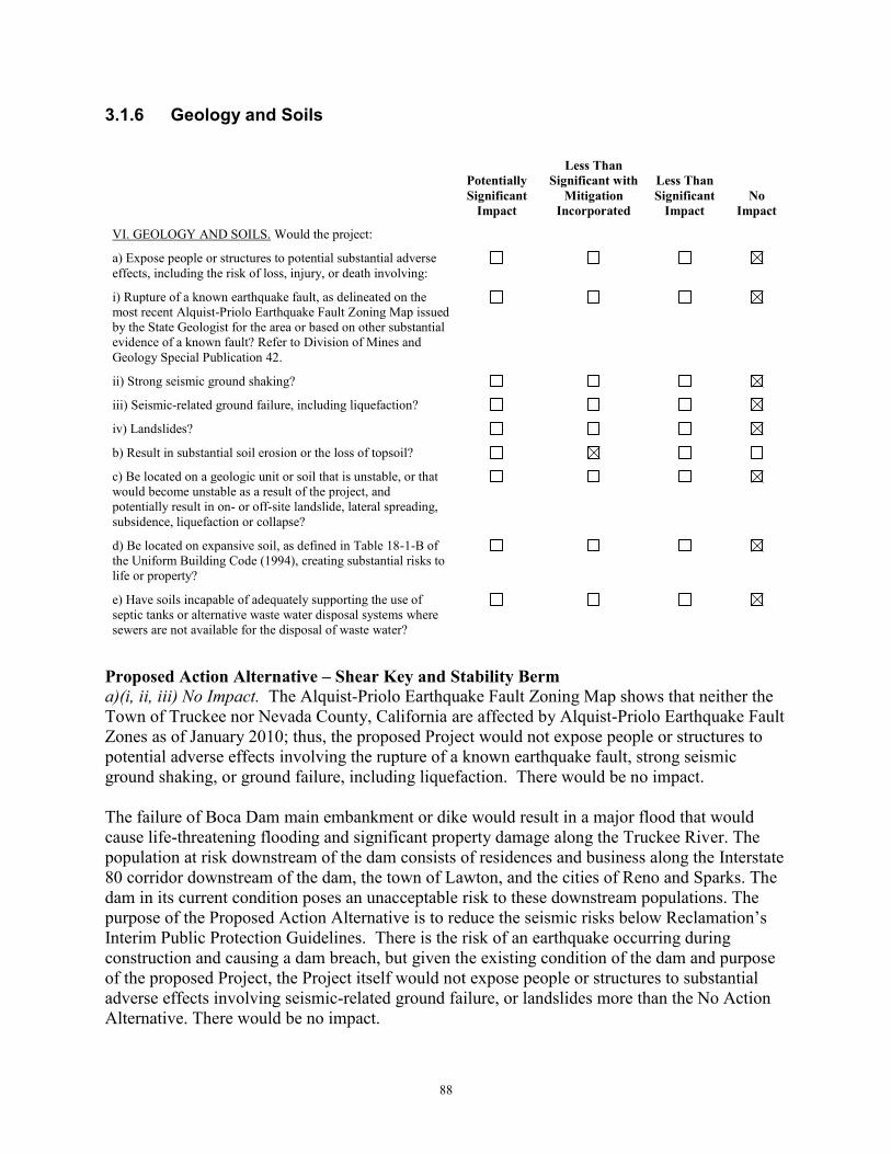
88
3.1.6 Geology and Soils
Proposed Action Alternative – Shear Key and Stability Berm a)(i, ii, iii) No Impact. The Alquist-Priolo Earthquake Fault Zoning Map shows that neither the Town of Truckee nor Nevada County, California are affected by Alquist-Priolo Earthquake Fault Zones as of January 2010; thus, the proposed Project would not expose people or structures to potential adverse effects involving the rupture of a known earthquake fault, strong seismic ground shaking, or ground failure, including liquefaction. There would be no impact. The failure of Boca Dam main embankment or dike would result in a major flood that would cause life-threatening flooding and significant property damage along the Truckee River. The population at risk downstream of the dam consists of residences and business along the Interstate 80 corridor downstream of the dam, the town of Lawton, and the cities of Reno and Sparks. The dam in its current condition poses an unacceptable risk to these downstream populations. The purpose of the Proposed Action Alternative is to reduce the seismic risks below Reclamation’s Interim Public Protection Guidelines. There is the risk of an earthquake occurring during construction and causing a dam breach, but given the existing condition of the dam and purpose of the proposed Project, the Project itself would not expose people or structures to substantial adverse effects involving seismic-related ground failure, or landslides more than the No Action Alternative. There would be no impact.
Potentially Significant
Impact
Less Than Significant with
Mitigation Incorporated
Less Than Significant
Impact No
Impact
VI. GEOLOGY AND SOILS. Would the project: a) Expose people or structures to potential substantial adverse effects, including the risk of loss, injury, or death involving:
i) Rupture of a known earthquake fault, as delineated on the most recent Alquist-Priolo Earthquake Fault Zoning Map issued by the State Geologist for the area or based on other substantial evidence of a known fault? Refer to Division of Mines and Geology Special Publication 42.
ii) Strong seismic ground shaking?
iii) Seismic-related ground failure, including liquefaction?
iv) Landslides?
b) Result in substantial soil erosion or the loss of topsoil?
c) Be located on a geologic unit or soil that is unstable, or that would become unstable as a result of the project, and potentially result in on- or off-site landslide, lateral spreading, subsidence, liquefaction or collapse?
d) Be located on expansive soil, as defined in Table 18-1-B of the Uniform Building Code (1994), creating substantial risks to life or property?
e) Have soils incapable of adequately supporting the use of septic tanks or alternative waste water disposal systems where sewers are not available for the disposal of waste water?

89
a)(iv) No Impact. Foundation materials were examined as a part of the Safety of Dams evaluation process. No issues with failure due to seismic activity or liquefaction post-construction were found. There would be no impact. b) Less Than Significant with Mitigation Incorporated. The Proposed Action Alternative involves disturbing approximately 50 acres of Boca Reservoir lakebed from excavation of the IRBA material used in construction of the shear key or stability berm at Boca Dam. IRBA topsoil will be stockpiled and reused for restoration activities post-construction (mitigation measure EROS-10). Approximately 26 acres of ground disturbance would also occur from the shear key and stability berm work at the dam and dike, and at the stage and stockpile areas. These ground disturbing activities and use of earthen roads will temporarily generate loose soil. Phasing work and preserving vegetation will be considered first to eliminate or control sediment from entering waters in the Little Truckee River watershed as a result of construction activity. A combination of sediment control devices, installed as part of the SWPPP will occur to avoid and minimize erosion during and post-construction. During construction, sediment control devices such as silt fencing, fiber rolls, and erosion control methods like mulching and hydroseeding will be used to stabilize disturbed areas and stockpiles. Permanent stabilization measures such as the placement of rock revetments and revegetation will be implemented after construction. An overview of the erosion control measures that will be implemented to avoid and minimize erosion are listed as mitigation measures EROS-2 to -8, -11 to -14, and -16 in Section 2.2.10.1. The Proposed Action Alternative would have a less than significant impact with mitigation incorporated. c) No Impact. See response to VI.(a)(iv) above. There would be no impact. d) No Impact. Boca Dam is not located on expansive soils. There would be no impact. e) No Impact. Construction site sewage will be managed with vault or portable toilet facilities that will not discharge liquid or solid wastes to the environment. Soil suitability need not be considered. There would be no impact. Reservoir Restriction Alternative a)(i) No Impact. The Reservoir Restriction Alternative would have the same impacts as the Proposed Action Alternative. The purpose of the Project is to reduce risk of dam failure during a significant earthquake event. By restricting the reservoir to an elevation of 5,579 feet (NAVD88), the risks of overtopping or internal erosion through cracking due to a seismic event would be addressed. By increasing the freeboard, the risk of overtopping due to deformations would be reduced. Similarly, by reducing the reservoir water surface elevation, the gradient across the transverse cracking would be reduced, thus the risk of internal erosion associated with earthquake induced cracking would be decreased. There would be no impact. a)(iv) No Impact. Foundation materials were examined as a part of the Safety of Dams evaluation process. No issues with failure due to seismic activity or liquefaction post-construction were found.

90
b) No Impact. The amount of permanently exposed lake bed would increase with the reservoir restriction. However, the topmost layer of substrate material in the reservoir is surficial soil made of sand and silt. This material has a low erodibility. During a permanent reservoir restriction, erosion control measures will not be required. There would be no impact. c) No Impact. See response to VI.(a)(iv) above. There would be no impact. d) No Impact. Boca Dam is not located on expansive soils. There would be no impact. e) No Impact. There is no construction involved with the Reservoir Restriction Alternative; therefore, there would be no additional waste water disposal or sewage needs on-site. There would be no impact.
3.1.7 Greenhouse Gas Emissions
Potentially Significant
Impact
Less Than Significant with
Mitigation Incorporated
Less Than Significant
Impact No
Impact
VII. GREENHOUSE GAS EMISSIONS. Would the project: a) Generate greenhouse gas emissions, either directly or indirectly, that may have a significant impact on the environment?
b) Conflict with an applicable plan, policy or regulation adopted for the purpose of reducing the emissions of greenhouse gases?
Proposed Action Alternative – Shear Key and Stability Berm a, b) Less Than Significant with Mitigation Incorporated. Burning of fossil fuels is considered a major contributor to perceived global climate change. Carbon dioxide (CO2), which is produced when fossil fuels are burned, is a greenhouse gas (GHG) that effectively traps heat in the lower atmosphere. Some CO2 is liberated naturally, but this may be augmented greatly through human activities. Increases in air temperature may lead to changes in precipitation patterns, runoff timing and volume, sea level rise, and changes in the amount of irrigation water needed due to modified evapotranspiration rates. These changes may lead to impacts to Nevada and California’s water resources and project operations. As shown in Table 6, the estimated GHG emissions due to temporary Proposed Action construction activities with mitigation measures implemented is 1,777.8 metric tons/year in 2018, and 500.3 metric tons/year in 2019. Mitigation measures that would be implemented to avoid and minimize emissions include using off-road equipment that are rated at least tier 2, as well as mitigation measures EMIS-1 through -8 in Section 2.2.10.2. The only potential on-going operational emissions from the Project would be test runs of the backup diesel generators for the spillway and outlet works, which would occur for up to two weeks a year. Reclamation ran CalEEMod for potential emissions from operating two 42 horsepower diesel generators for two weeks and estimated 11.74 metric tons/year of CO2. In considering when to disclose projected quantitative GHG emissions, the Council on Environmental Quality has provided a reference point of 25,000 metric tons of carbon dioxide equivalent emissions on an annual basis below which a GHG emissions quantitative analysis is

91
not warranted unless quantification below that reference point is easily accomplished (CEQ 2014). In California, Assembly Bill 32 established 25,000 metric tons/year as the threshold for mandatory emissions reporting for stationary sources. The estimated 11.74 metric tons/year of CO2 from testing the backup generators falls far below the threshold for mandatory emissions reporting for stationary sources; therefore, contribution of GHG is negligible. California did not establish a threshold for cumulative emissions from temporary mobile sources such as construction equipment, which would be lower than permanent stationary sources. Since the estimated emissions of carbon dioxide equivalent per year anticipated to be emitted from construction of the Proposed Action Alternative is well below 25,000 metric tons/year, the contribution of GHG is negligible. Reservoir Restriction Alternative a, b) No Impact. A reservoir restriction would not cause any increase in emissions from construction equipment, generators, or existing operational sources. This alternative would not have a substantial contribution of GHG emissions or in other ways contribute to climate change regionally or globally.
3.1.8 Hazards and Hazardous Materials
Potentially Significant
Impact
Less Than Significant with
Mitigation Incorporated
Less Than Significant
Impact No
Impact
VIII. HAZARDS AND HAZARDOUS MATERIALS. Would the project:
a) Create a significant hazard to the public or the environment through the routine transport, use, or disposal of hazardous materials?
b) Create a significant hazard to the public or the environment through reasonably foreseeable upset and accident conditions involving the release of hazardous materials into the environment?
c) Emit hazardous emissions or handle hazardous or acutely hazardous materials, substances, or waste within one-quarter mile of an existing or proposed school?
d) Be located on a site which is included on a list of hazardous materials sites compiled pursuant to Government Code Section 65962.5 and, as a result, would it create a significant hazard to the public or the environment?
e) For a project located within an airport land use plan or, where such a plan has not been adopted, within two miles of a public airport or public use airport, would the project result in a safety hazard for people residing or working in the project area?
f) For a project within the vicinity of a private airstrip, would the project result in a safety hazard for people residing or working in the project area?
g) Impair implementation of or physically interfere with an adopted emergency response plan or emergency evacuation plan?
h) Expose people or structures to a significant risk of loss, injury or death involving wildland fires, including where

92
wildlands are adjacent to urbanized areas or where residences are intermixed with wildlands?
Proposed Action Alternative – Shear Key and Stability Berm a) Less than Significant with Mitigation Incorporated. Implementation of the Proposed Action Alternative would involve a hazard associated with the use of diesel- or gasoline-powered construction equipment (e.g., dozer, compactor, dump trucks, etc.) and lubricants such as oil. There is potential for public or environmental exposure to such a hazard; although, it would be temporary and is mitigatable since equipment would be routinely maintained and inspected to avoid leaks. Reclamation’s contractor will be required to prepare a Spill Pollution Control and Countermeasure Plan (SPCCP) pursuant to Section 311 of the Clean Water Act. This SPCCP will identify petroleum and other hazardous products (such as herbicides used for invasive, noxious plant management) used in construction and address secondary containment of the products, prevention of spills, spill containment and cleanup procedures, and materials on hand to accomplish the containment and cleanup. The identified procedures will minimize the risk of harm to animals or humans from hazardous and toxic materials due to soil or water contamination at the construction sites. The SPCCP will include requirements that the contractor prepares for working in areas where (1) accidental spillage could reasonably be expected to enter into or upon navigable waters of the United States or adjoining shorelines and (2) aggregate storage of oil at a site is over 1,320 gallons or a single container has a capacity in excess of 660 gallons. The SPCCP will be developed in consultation with the Lahontan Water Board and approved by Nevada County before beginning construction or storing hazardous materials on the Project site. The SPCCP will also be certified by a registered professional engineer. Remaining details of what will be required under the SPCCP are listed in mitigation measure HAZ-1 in Section 2.2.10.6. By implementing a SPCCP containing these measures, the chances of spills will be greatly reduced and thus potential adverse effects would be reduced to a less than significant level. b) Less than Significant with Mitigation Incorporated. Refueling and storage of equipment working in the IRBA will occur within an area designated within the upper elevation of the IRBA, covered with an impervious liner. Only tracked off-road vehicles will be serviced in this area. Hazardous materials will not be stored or used in amounts required to be reported by law in the IRBA or on the construction sites. Per the Project specifications, the contractor will be required to use maintained vehicles to prevent oil spills, gasoline spills, and diesel fuel spills. See response to VIII.(a), above, and mitigation measures HAZ -2 and -3 in Section 2.2.10.6 for commitments to waste handling and fueling plans. By implementing a SPCCP containing avoidance, minimization, and response measures, the chances of spills will be greatly reduced and thus potential adverse effects will be reduced to a less than significant level. c) No Impact. Construction equipment would emit combustion-engine emissions, but the proposed Project area is not located within one-quarter mile of an existing or proposed school. There would be no impact.

93
d) No Impact. The proposed Project area is not located on a site which is included on a list of hazardous materials sites compiled pursuant to Government Code Section 65962.5; therefore, it would not create a hazard to the public or the environment. There would be no impact. e) No Impact. The proposed Project area is neither located within an airport land use plan nor, where such a plan has not been adopted, within two miles of a public airport or public use airport and therefore not result in a safety hazard for people residing or working in the Project area. There would be no impact. f) No Impact. The proposed Project area is not located within the vicinity of a private airstrip. There would be no impact. g) Less Than Significant with Mitigation Incorporated. Reclamation will prepare a Construction Emergency Action Plan that provides information on who is contacted when an initiating (emergency) event occurs. The Lahontan Water Board is also apprised of the Washoe County (Nevada) Office of Emergency Management’s 2010 Evacuation, Sheltering and Mass Care Plan. There is no basis to conclude that the proposed Project would impair or physically interfere with implementation of that plan, or any other local agency plans that may be developed for evacuation of areas subject to inundation in the event of a major failure of Boca Dam (e.g., due to overtopping at flood). The Lahontan Water Board is not aware of any element of the proposed Project that would increase the risk of a dam failure from existing conditions, including from or during construction. However, the closure of Boca Dam Reservoir Road across the dam during construction would physically interfere with emergency response plans of local law enforcement and emergency responders, and may affect emergency response times to incidents such as fires and accidents at the campgrounds, day use areas, and on the reservoir. However, there will be established guidelines on providing access to emergency vehicles. Reclamation’s contractor will submit an emergency access plan to be approved by Reclamation and the Forest Service. Reclamation will notify emergency responders 30 days in advance of any potential road closures that may affect their response times or routes so their alternate arrangements to service the area can be implemented. The contractor will be required to prepare a traffic control plan and temporary traffic signage plan for all work areas including signage to inform the public of alternate routes to Boca Reservoir. As noted above, the contractor will be required to maintain access during construction to the boat ramp, campgrounds, and other recreational amenities associated with Boca Reservoir during the summer recreation season. The required details of the contractor’s traffic control plan and other traffic control or coordination measures are listed in mitigation measures TRAF-1 through -3 in Section 2.2.10.7, which would reduce potential impacts to less than significant. h) Less than Significant with Mitigation Incorporated. Although the six-year drought ended in early 2017, trees in the Sierra Nevada Mountains have weakened and become more vulnerable to bark beetle infestation, which has increased the risk of fire danger in the region. Reclamation and the Project contractor will comply with any fire restriction orders issued by the Forest Service to protect public safety and natural resources. The proposed Project will not involve blasting or use of explosives, but will require welding and saw cutting which is considered “hot work”. However, vegetation will be removed from Project work areas, reducing the risk of fire.

94
The closure during construction of Boca Dam Reservoir Road across the dam would physically interfere with emergency response plans of local law enforcement and emergency responders and may affect emergency response times to incidents such as fires at the campgrounds, day use areas, and on the reservoir. See discussion in VIII.(g) above regarding emergency responder access through the Project site, which would be maintained despite the road across Boca Dam being closed to the public. A fire prevention and suppression plan will be developed by the Reclamation contractor and approved by the Forest Service. The plan will outline the responsibilities for prevention and suppression of fires during construction, provide local contacts in the event of a fire event, and methods to prevent and suppress small fires. The plan will cover fire hazards related to equipment movement over dry brush, welding, and other worker activities that may spark a fire. In the event of a fire, work will stop until appropriate control and notification measures can be implemented. The preventative measures in the fire plan are further detailed in mitigation measure FIRE-1 in Section 2.2.10.9. There would be a less than significant impact with mitigation incorporated. Reservoir Restriction Alternative a, b, c) No Impact. The Reservoir Restriction Alternative does not involve transport, use, or disposal of hazardous materials. d) No Impact. The Project is not located within or near a Hazardous Waste and Substances site. e, f) No Impact. The Project is not within an airport land use plan or near an airport or airstrip. g) No Impact. A reservoir restriction does not involve construction and would not impair implementation of or physically interfere with an adopted emergency response plan or emergency evacuation plan. h) No Impact. A change in operations due to the reservoir restriction would not expose people or structures to a significant risk of loss, injury or death involving wildland fires.
3.1.9 Hydrology and Water Quality
Potentially Significant
Impact
Less Than Significant with
Mitigation Incorporated
Less Than Significant
Impact No
Impact
IX. HYDROLOGY AND WATER QUALITY. Would the project:
a) Violate any water quality standards or waste discharge requirements?
b) Substantially deplete groundwater supplies or interfere substantially with groundwater recharge such that there would be a net deficit in aquifer volume or a lowering of the local groundwater table level (e.g., the production rate of pre-existing nearby wells would drop to a level which would not support

95
existing land uses or planned uses for which permits have been granted)?
c) Substantially alter the existing drainage pattern of the site or area, including through the alteration of the course of a stream or river, in a manner which would result in substantial erosion or siltation on- or off-site?
d) Substantially alter the existing drainage pattern of the site or area, including through the alteration of the course of a stream or river, or substantially increase the rate or amount of surface runoff in a manner which would result in flooding on- or off-site?
e) Create or contribute runoff water which would exceed the capacity of existing or planned stormwater drainage systems or provide substantial additional sources of polluted runoff?
f) Otherwise substantially degrade water quality?
g) Place housing within a 100-year flood hazard area as mapped on a federal Flood Hazard Boundary or Flood Insurance Rate Map or other flood hazard delineation map?
h) Place within a 100-year flood hazard area structures which would impede or redirect flood flows?
i) Expose people or structures to a significant risk of loss, injury or death involving flooding, including flooding as a result of the failure of a levee or dam?
j) Inundation by seiche, tsunami, or mudflow?
Proposed Action Alternative – Shear Key and Stability Berm a, f) Less Than Significant Impact with Mitigation Incorporated – waste discharge requirements and water quality. The Truckee River was placed on the CWA 303(d) list of impaired waterways for suspended sediments on September 16, 2009. The Little Truckee River is a tributary to the Truckee River. The Little Truckee River has an 800 ton per year suspended sediment load allocation (40% of which reflects controllable non-urban loads) within the Truckee River watershed (Lahontan Water Board 2008). Removal of the rockfill, excavation and installation of the shear key, stability berm, coffer dam, and toe drain modification could have short-term impacts on water quality. Exposed soil could potentially erode as a result of significant runoff events, causing increased turbidity in local waterways. Approximately 17 acres of sagebrush vegetation would be temporarily removed for construction work, and staging and stockpiling areas; however, these areas will be restored and revegetated to pre-project conditions once the Project is complete. In order to protect water

96
resources and maintain existing water quality conditions, a CWA 401 Water Quality Certification, and a National Pollutant Discharge Elimination System Construction General Permit (CGP) will be obtained from the Lahontan Water Board and State Water Board, respectively. The CGP pertains to the prevention of increased turbidity of adjacent waterways as resulting from site erosion and sedimentation, as well as debris, soil, fuel, and oil spill prevention. The contractor would be required to design and implement a SWPPP prior to initiating construction activities, and to implement the associated standard measures (mitigation measure EROS-2). Mitigation measures EROS-5 through -7, -10, and -11 in Section 2.2.10.1 will also be implemented to avoid and minimize erosion and sedimentation during construction. Any removed topsoil will be stockpiled and reused for restoration. Approximately two acres of sagebrush vegetation would be permanently removed due to work on the dam and dike, and construction of the new gravel parking lot downstream of the dike, along the west edge of Stampede Meadows Road. The dam and dike areas will not be revegetated because it is best to keep the dam face free of vegetation for structural integrity. These areas, as well as the new parking lot, will not be revegetated and could increase the amount of runoff due to more barren ground. However, Reclamation will implement erosion and runoff treatment and control measures (mitigation measures EROS-12 through -14 in Section 2.2.10.1), such as placing rock slope protection on the downstream face of Boca Dam and Dike, and designing the new gravel parking lot to direct storm water runoff through existing vegetation to avoid and minimize generating sediments that could enter Boca Reservoir or the Little Truckee River post-construction. As discussed in Section 2.2.5, removed water from work areas will be discharged to a turbidity curtain within Boca Reservoir. The pump will be placed in the reservoir, on top of sand bags to minimize erosion and sedimentation during discharge. Mitigation measures EROS-1 and -9, in Section 2.2.10.1, will be implemented to avoid and minimize erosion and turbidity from discharges. In addition, debris and inadvertent spills of fuels, or oils from construction equipment, work areas, staging areas, could be a source of contamination in adjacent waterways. Potential effects from equipment working in the Project area and proposed mitigation measures to avoid and minimize effects are analyzed in Section 3.1.8 Hazards and Hazardous Materials above. Two crossings will be constructed in the spillway channel and immediately downstream in the Little Truckee River to act as contractor crossings as well as to isolate the spillway modification actions from waters. The earthen crossings (described in detail in Section 2.2.7 Haul Routes) will be covered with an impermeable geomembrane to prevent erosion into the Little Truckee River (mitigation measure EROS-8 in Section 2.2.10.1 Erosion and sediment control). The crossings will be removed by October 31 of the first construction year and temporarily re-established the next year if needed. The crossing sites will be winterized with erosion control devices such as soil coverings and straw wattles. Once the crossings are completely removed and no longer needed, vegetation will be restored. During removal of the crossing, turbidity in the Little Truckee River may temporarily increase upon the restoration of the backwater area to the spillway channel. However, removal will be done slowly to minimize sediment suspension. Approximately 125,000 cubic yards of material would be removed from the IRBA. The Proposed Action Alternative involves disturbing approximately 50 acres of Boca Reservoir

97
lakebed from excavation of the IRBA material used in construction of the shear key or stability berm at Boca Dam. Excavating the substrate material in the IRBA will generate loose soil that may mobilize when the reservoir levels increase after the drawdown is lifted, or be carried in to the reservoir by runoff. In order to keep the IRBA exposed, Boca Reservoir will be temporarily drawn down and restricted to elevation 5,581 feet (NAVD88) from June 15 through November 15. Also, IRBA surficial soil will be stockpiled in a higher elevation portion of the IRBA and reused to restore the IRBA prior to the winter shutdown date of November 16. Prior to and during construction, the IRBA will be stabilized using storm water runoff and erosion controls, including creating an earthen berm around the perimeter of the IRBA and installing a silt fence on the reservoir side, above the 5,581 feet reservoir drawdown (EROS-2 to -8, -11, -13, -16, -17, in Section 2.2.10.1). Mitigation measure EROS-11 requires that all work areas be winterized by October 31 of the first construction year, with the exception of upper elevations of the IRBA. This area will remain active until November 15, site and weather conditions permitting. During this period, any remaining material removed from the IRBA will be hauled to the East Stockpile Area, and the IRBA will be graded and the stockpile area winterized as previously described. If hauling is required during the month of November, it will only occur on non-rain/non-snow days or when ground conditions do not result excessive rutting and sediment track-out on Stampede Meadows Road. No snow plowing is proposed. During excavation of material from the IRBA there is potential for sediments to mobilize if a significant storm event or events causes the reservoir to exceed the drawdown elevation and inundate unrestored portions of the IRBA. The largest winter floods that have historically occurred in this region have been caused by heavy precipitation from atmospheric rivers. A recent analysis of cool-season (November to April) atmospheric rivers indicates atmospheric rivers occur most frequently during December across the Sierra Nevada, with a general decline in atmospheric river frequency after December, through April (Rutz et al 2014). From this analysis and discussion with the Water Master about the past 50 years of hydraulic data in this region, it is unlikely that a large winter flood would occur and cause the reservoir drawdown to be exceeded. Reclamation will also make all efforts to maintain the restricted elevation, including increasing releases through the outlet works up to the maximum capacity, as long as the downstream safe channel capacity for the Truckee River through Reno is not exceeded. As described in Section 2.2.8 In-Reservoir Borrow Area, in Section 2.2.10.1, the spillway will be functional and in operation by October 1, and at least the lower portions of the IRBA will be compacted and restored prior to the winterization date of October 31. As any remaining material is hauled from the IRBA in November, the rest of the IRBA will simultaneously be restored (EROS-11), therefore, reducing the potential for unrestored areas to be inundated. Sediments may also mobilize in the IRBA if a flood event occurs during construction prior to re-contouring and closure of the borrow area. Post construction re-contouring and restoration efforts in the IRBA will be coordinated with the Forest Service and are expected to leave the area in a state that would better accommodate recreational use compared to the existing pre-construction condition. A significant storm event raising the reservoir elevation and inundating non-restored portions of the IRBA is not anticipated to occur. By the implementation of the erosion and sedimentation control mitigation measures EROS-1 through -17 in Section 2.2.10.1, water quality standards and waste discharge requirements

98
associated with earth moving activities would be met; therefore, water quality would not be substantially degraded and impacts would be less than significant with mitigation incorporated. b) No Impact – groundwater. No wells exist within the Proposed Action area. However, the Truckee Meadows Water Authority has groundwater permits, which could be used to compensate for a potential reduction in surface water deliveries. Model results on the Project’s potential effect on water supply (as discussed below in IX.(d)) show that no water delivery shortages to Truckee Meadows Water Authority would occur. Due to the current status of Truckee Meadows Water Authority’s drought storage, it is very unlikely to experience a water delivery shortage through 2019. Therefore, the Truckee Meadows Water Authority is not anticipated to increase groundwater pumping as a result of the temporary reservoir drawdown. There would be no impact. c) Less Than Significant Impact – effect of drainage pattern on erosion and siltation. Construction Activity Considerations on Drainage Patterns and Erosion and Siltation
As discussed in IX.(a, f) above, a total of approximately 17 acres of sagebrush vegetation would be temporarily removed from activity areas. An ephemeral drainage perpendicular to the road leading to the Ice Dam will be maintained with a culvert as the west edge of the road is temporarily expanded. The Proposed Action Alternative does not involve storm water drainage diversions with the exception of temporary sediment control devices, such as water bars or straw wattles, to divert storm water runoff originating on upslope areas away from stockpiles and disturbed areas. Runoff on bare ground will be dispersed with sediment control devices around construction and stockpiling areas to reduce concentrated flows that might deliver fine sediment to water sources. Installation of rock slope protection and straw wattles, and revegetation would also occur to stabilize the 2.05 acres of permanently disturbed upland areas from construction on the dam and dike and of the new gravel parking lot. These storm water controls would be in place temporarily and are intended to avoid and minimize erosion and siltation effect. The majority of construction would occur during summer months when chances of large storm events are lower. Between construction seasons, the dam worksite and lower portions of the IRBA will be fully winterized by October 31. Any remaining IRBA material that needs to be hauled to the East Stockpile Area will be done, and the remaining IRBA restored and stockpile area winterized, by November 15, which will include installing a combination of sediment and erosion controls that will remain effective through the winter shutdown period. Mitigation measure EROS-11 will be implemented to further avoid and minimize erosion within the IRBA and along earthen roads if hauling is needed in November, when storm events could occur. Winterization of the East Stockpile Area will conclude by November 15. The winter shutdown period of November 16 through March 31 will be observed, and activities during the second construction season will conclude by September. There would be a less than significant impact of construction activities affecting drainage patterns that cause erosion or siltation, with mitigation incorporated.

99
Temporary Reservoir Drawdown Considerations on Drainage Patterns and Erosion and Siltation
The temporary reservoir drawdown to elevation 5,581 feet from June 15 to November 15 could temporarily modify water flow in the Little Truckee and Truckee rivers. The reservoir drawdown is intended to expose the IRBA during the first year of construction, and is expected to be able to be maintained through outlet works releases. Reclamation conducted simulations to analyze how the Truckee River system would respond to a reservoir drawdown and major flood events, such as a Flood of Record6; see Figures 24, 25a and 25b. Boca Reservoir usually undergoes drawdown in the spring/summer time based on how much of the stored water is needed to maintain the Floriston Rate. Depending on how full Boca Reservoir is at the beginning of April, increased releases from Boca Dam would occur gradually as early as April 10 to reach elevation 5,581 feet by June 15.
Simulation results showed that Boca Reservoir outflows could increase by between 200 and 500 cfs in wetter years during the drawdown period, which is normally when spring runoff is being stored and Boca releases are smaller (Precision Water Resources Engineering 20167). Figure 24 shows how there is a 20% chance that an increase in Boca releases could also increase overall flows in the Truckee River at Reno during the drawdown period by up to approximately 500 cfs. The potential temporary increase in flows would not exceed the Boca outlet works maximum capacity nor the safe downstream capacity of the Truckee River through Reno (6,000 cfs). Potential increases appear to be well within the Truckee River channel’s normal operating range, except for major flood events when it could increase erosion and siltation in the Little Truckee and Truckee Rivers; however, even without the reservoir drawdown a major flood event could increase erosion and siltation. The simulations also showed that the chance of major flood events occurring is extremely low at 1.7% (Reclamation 2016b: 29). Releases would be within the normal range of operations and would not alter drainage patterns and cause substantial erosion or siltation.
6 Further probabilistic analysis was conducted for 2-year back to back extreme hydrology. Flood of Record is a sequence from 1952 and 1997 that represents the highest April-July volume on record followed by the highest flood on record, the January 1997 flood. This is a robust test of the altered Truckee River system’s resilience to an extreme flood occurring during construction (Page 10 of Appendix A – Boca Maintenance Analysis Technical Report). 7 Consultant to Reclamation’s Lahontan Basin Area Office.

100
Figure 24. Truckee River Flow at Reno Exceedance Probabilities during Drawdown and Drawdown Period - (Maintenance is the reservoir drawdown) 8
Over the course of the reservoir drawdown period, there would be no notable impacts to Prosser and Martis Creek Reservoirs regarding flood operations (Reclamation 2016b: 27). The reservoir drawdown may lead to generally reduced Boca outflows at the beginning of October, by up to approximately 250 cfs (20% chance) (Figure 25a). This could temporarily reduce the amount of erosion and siltation in the Little Truckee River in October, and the magnitude of the potential change due to the Proposed Action appears to be well within the normal variation. During extreme fall flood events, such as Flood of Record hydrology, changes in flows on the Truckee
River would be negligible. Also, peak flows of the Truckee River at Reno would either very
likely be reduced, by up to approximately 5,000 cfs, or be unaffected due to the reservoir
drawdown and resulting increase in flood storage space; see Figure 25b (Reclamation 2016b:
15). The temporary reservoir drawdown associated with the Proposed Action Alternative would
have a less than significant impact on drainage patterns and associated siltation and erosion on
the Little Truckee and Truckee Rivers.
8 This Figure is based on a more conservative restriction period of July 1 through December 31.

101
Figure 25a. Boca Reservoir Fall Outflow Exceedance Probabilities (Maintenance is the reservoir drawdown) 9
Figure 25b. Reduced Peak Truckee River Flows During Large Fall Flood Event – Flood of Record (Maintenance is the reservoir drawdown)
9 This Figure is based on a more conservative restriction period of July 1 through December 31.

102
d, i) Less Than Significant Impact – effect of drainage patterns and surface runoff on flooding. Construction Activity Considerations on Drainage Patterns and Flooding
As described in IX.(a, f) above, a total of 18.61 acres of sagebrush vegetation would be cleared or disturbed, including 16.56 acres of sagebrush vegetation temporarily removed for haul roads, staging, and stockpiling, and approximately 2 acres of vegetated areas would be permanently impacted and not revegetated. Storm water runoff and erosion control devices will be installed at all disturbed areas, with the temporarily disturbed sites restored and revegetated to minimize the length of bare ground exposure and associated risk of surface runoff. When final grading is complete, the permanently impacted areas of the dam and dike will be covered with rip rap, and the gravel parking lot surrounded with gravel (mitigation measures EROS-12 and -14), which will protect against erosion and prevent increased runoff. The dam and dike work areas will be fully winterized and at least the lower portion of the IRBA will be restored by October 31, with the upper portion of IRBA restored by November 15. Also, the probability of a significant or extended storm event occurring during the majority of construction, summer months, is very low. The drainage patterns from these areas are not anticipated to substantially increase the rate or amount of runoff in a manner which would result in flooding on- or off-site. Groundwater and removed water discharging activities may affect runoff quantities on-site as well. Removed water will be filtered through a sand filter, piped over Boca Dam and discharged to an area within a turbidity curtain in Boca Reservoir. Smaller-scale removed water activities, such as for the toe drain ditch, will pump water behind the sandbag berm and spray it to upland areas at a low rate to encourage infiltration and avoid runoff (mitigation measure EROS-9). The amount of water temporarily discharged to uplands will be minor and is also not anticipated to be enough to cause flooding. Construction-related activities would not substantially increase the rate or amount of surface runoff in a manner which would result in flooding on- or off-site. Temporary Reservoir Drawdown Considerations for Drainage Patterns and Flooding
The normal flood control schedule is outlined towards the end of Section 1.4.3 Hydrology and Water Supply. As discussed in IX.(c) above, the temporary reservoir drawdown would not alter the course of the Little Truckee or Truckee Rivers, but could affect flows. Flows on the Little Truckee and Truckee Rivers could temporarily increase by anywhere between 200 and 500 cfs during the drawdown period (April 10 to June 15); however, the drawdown will be gradual over up to 36 days and would not cause flooding downstream, as the magnitude of the potential change due to the Proposed Action appears to be well within the normal variation. Truckee River flows over the course of the reservoir drawdown would also see negligible changes, with the exception of reduced flows in October and largely reduced peak flow at the Reno gage. Therefore, the risk of flooding offsite would be reduced with the reservoir drawdown in place. The reservoir drawdown will be maintained through Boca outlet works releases, through which maximum releases could be made if necessary, but will not cause the safe downstream channel capacity of the Truckee River going through Reno (6,000 cfs) to be exceeded. The Water Master would move water to other reservoirs, to the extent allowed under the Orr Ditch Decree, and TROA, in order to avoid or reduce the need to release water. Also as discussed in IX.(c) above, simulation results showed the chances of a major flood event occurring during the drawdown period of June 15 through November 15 are very low, estimated at 1.7%. If a large storm event

103
were to occur after September, the spillway will be operational by October 1, and the temporary reservoir drawdown at 5,581 feet would actually create an additional 14,900 AF to 22,900 AF of flood control space compared to normal operations during that period. The temporary reservoir drawdown would not substantially alter the existing drainage pattern, course, or rate or amount of flows on the Little Truckee and Truckee Rivers, even during flood events. The Proposed Action Alternative also would not expose people or structures to a significant risk of loss, injury, or death involving flooding, including flooding as a result of the failure of a levee or dam. There would be a less than significant impact. Temporary Reservoir Drawdown Considerations for Water Supply
Reclamation also conducted simulations using TROA RiverWare Operations model for Truckee-Carson River basins to see how the temporary reservoir drawdown could affect water supply allocated for the downstream water right holders’ demands (see Appendix A for full technical report). A wide range of possible historical hydrology sequences that is representative of potential hydrologic scenarios that could occur from 2017 through 2019 was utilized for the simulations to determine potential effects in water supply from the temporary reservoir drawdown on the following downstream water right holders: the Floriston Rates Water (required in-stream flows to provide downstream supply water for irrigation, municipal, and hydropower purposes), Pyramid Lake Paiute Tribe, Truckee Meadows Water Authority, Truckee Meadows for Agriculture, and Truckee Canal for the Newlands Project (Carson Division and Truckee Division). As discussed in Appendix A, the Boca Maintenance Analysis technical report, the model attempts to meet Floriston Rate targets as measured at the Farad gage, specified by TROA to meet demands of many downstream users. Releases of previously stored water from Boca and Tahoe Reservoirs supplement natural inflow to the basin in years when the natural inflow is inadequate to meet the Floriston Rates. The model also attempts to meet Fish Flow Regime targets as measured at the Nixon gage, which are monthly flow targets for the lower Truckee River, determined by the March 1 hydrology forecast for Stampede Reservoir inflow and storage. The Pyramid Lake Paiute Tribe operates the Fish Flow Regime water that is stored under licenses or permits held by Reclamation in Stampede Reservoir, and has the ability to credit storage water in certain circumstances. In years when the naturally available Truckee River inflow at the Nixon gage is inadequate to meet the relevant Fish Flow Regime, water is released from Stampede to aide in meeting the Regime. Implementation of the temporary reservoir drawdown would not affect the total amount of water available in the Truckee River system, but have the potential to cause minor effects to the amount of water stored, and therefore, the timing of water deliveries. This would be a result of the temporary reservoir drawdown reducing the amount of water stored in Boca. Releases would potentially occur during the initial Boca Reservoir drawdown period as early as April 10. Therefore, downstream water right holders could see increased deliveries around late spring/early summer and potentially decreased deliveries from fall to early spring, and potential decreased storage for Floriston Rate water in the first year. Downstream water right holders will be able to track water right entitlements and deliveries with the existing accounting system used by the Water Master for TROA. As stated earlier, the downstream water right holders would not

104
experience a reduction in total water deliveries; the only change could be to the timing of when flows are delivered in the months leading up to and during the reservoir drawdown period. This would be a result of the reservoir drawdown reducing the amount of water stored in Boca Reservoir. The greatest potential shift in the timing of deliveries could be to release 8,600 AF (1.1% of baseline average) in the spring rather than the fall. The probability of this occurring is about 5% in any given year (Appendix A; Reclamation 2016b: 49). Conversely, there could also be a beneficial effect, such as no change in timing and an increased delivery of 17,100 AF (2.2% of baseline average) to Pyramid Lake (Truckee River flow at Nixon gage) (Appendix A; Reclamation 2016b: 49). Depending on the actual hydrologic condition during construction, if the total amount of water that would be shifted in delivery timing decreases, the probability of any shift in water delivery timing increases. The maximum probable adverse impact in delivery timing would be for up to 8,600 AF, which is a negligible amount (1.1%) compared to average baseline deliveries; this shift in timing has a very low chance of occurring, and this potential effect is considered less than significant. Potential impacts to water delivery timing for all other downstream water right holders have an even lower probability of occurring, and would affect less than 2% of average baseline deliveries (further details on these impacts are in the tables of Appendix A). Therefore, impacts to water delivery timing for all other downstream water right holders would also be less than significant. The temporary reservoir drawdown could reduce the amount of water that can be stored in Boca Reservoir during construction. The greatest potential reduction in end of water year 2019 storage could be up to 21,900 AF, which has a 5% probability of occurring in any given year, and would occur if water year 2019 is very wet (Appendix A; Reclamation 2016b: 50). If this reduction occurs due to the temporary reservoir drawdown, the reduction could occur over approximately one year (June 2018 through June 2019), after which storage levels would recover to baseline conditions (Reclamation 2016b: 51); any amount of water that would not be stored in Boca or Stampede Reservoirs to maintain the temporary reservoir drawdown would be flowing to the lower Truckee River and still be available to downstream water right holders. Within a few months of resuming normal reservoir operations (November 16 of the first construction year), baseline storage levels would recover to pre-Project levels (see Figure 26). Given this effect could happen if the first year of construction is a wet year, and storage would return to normal in the following year, this effect is less than significant. The reservoir drawdown could also cause positive effects to stored water and meeting flow targets, such as increasing the amount of water able to be stored at the end of the water year, and the number of days the Fish Flow Regime target is met. For example, the simulation results showed that there is a 64% probability of increasing the amount of stored water for the California DWR and a 46% probability of increasing storage for Floriston Rates by the end of water year 2019. This would be due to the additional storage space available once the reservoir drawdown ends. Considering the low probability of occurrence of stored water potentially reduced, that the amount of water delivered to downstream water right holders would not be affected, and that the potential change in delivery timing would be temporary, effects to water stored and delivered to downstream water users would be temporary and minor.

105
Figure 26. Daily exceedance plot comparison of total Pyramid Lake Paiute Tribe storage between baseline and reservoir drawdown (Maintenance is with the temporary drawdown)
e) Less Than Significant with Mitigation Incorporated. As discussed above in IX.(c), storm water runoff over disturbed areas will be avoided and minimized through restoration and revegetation of temporarily impacted areas to pre-project condition, covering permanently disturbed areas with riprap or gravel, and installing erosion control devices. Sediment controls such as straw wattles or silt fences will be installed around contractor use areas to primarily reduce erosion and sedimentation (mitigation measures EROS-1 through -17 in Section 2.2.10.1) but also serve to slow down surface water runoff and allow infiltration. The additional amount of runoff water potentially produced by the Proposed Action is not anticipated to exceed the capacity of existing or planned storm water drainage systems. The potential minor and temporary increase in post-Project land erosion could constitute an additional source of polluted runoff to occur. However, a SWPPP (mitigation measure EROS-2) and pollution control measures deployed as needed in the SPCCP (mitigation measures HAZ-1 through -3 in Section 2.2.10.6) will greatly reduce the likelihood of construction activities generating substantial additional sources of polluted runoff. There would be a less than significant impact with mitigation incorporated. g) No Impact. The Proposed Action does not involve housing development; therefore, there would be no impact. h) Less Than Significant Impact with Mitigation Incorporated. The delineated ordinary high water mark (OHWM) of Boca Reservoir closely coincides with the Federal Emergency Management Agency (FEMA) 100-year flood zone. This is due to the

106
reservoir filling up regularly and reaching the same elevation as the 100-year floodplain. The maximum reservoir elevation is correlated with the spillway crest elevation, so the flood stage elevations do not exceed that of the spillway crest. Therefore, the potential reservoir-side spillway cofferdam, IRBA activities, turbidity curtain and discharge system, and impacts from the haul routes servicing the IRBA were considered to be in waters of the U.S. and not in the 100-year floodplain (Figure 27). Figure 27. FEMA 100-year floodplain – IRBA

107
Figure 28. FEMA 100-year floodplain – dam site, stockpile, and staging areas
Figure 28 shows the location of the FEMA 100-year floodplain at the dam site, which appears to be inaccurate and crude considering it shows the east portion of the existing downstream face of the dam and areas outside the spillway channel to be located within the 100-year floodplain. However, the actual topography of the site and function of the dam precludes the 100-year floodplain from overlapping these areas. Therefore, the east portion of the stability berm and road over the spillway crest marked as “Inaccurate Floodplain Overlap” on Figure 28 is not considered within the 100-year floodplain. There would be no permanent impacts to the 100-year floodplain. Temporary fill within the 100-year floodplain would occur from the two access crossings in the spillway discharge channel and Little Truckee River (0.11 acres in floodplain); however, this fill will be temporary and removed upon activity completion (mitigation measures FLDP-2 and -3 in Section 2.2.10.3). The discharge or threatened discharge, attributable to human activities, of solid

108
or liquid waste materials including soil, silt, clay, sand, and other organic and earthen materials to lands within the 100-year floodplain of the Little Truckee River or any tributary to the Little Truckee River is prohibited (Lahontan Water Board, 2017). Reclamation will seek a 100-year floodplain waste discharge prohibition exemption from the Water Board for discharges and structures in the affected drainages in the Little Truckee River Hydrologic Unit (mitigation measure FLDP-1). The Proposed Action Alternative satisfies the exemption criterion of being a repair project necessary to protect public safety. Short-term and temporary adverse effects to existing floodplain functions will be offset and mitigated by removal of material from the IRBA that will nominally increase reservoir floodwater retention (FLDP-3). Restoration of functions in these areas is also required, with demonstration that all applicable and practicable erosion controls and mitigation measures are incorporated (FLDP-2 and -3). Temporary fill from the spillway channel and Little Truckee River earthen crossings, and from portions of the West Stockpile Area that fall within the 100-year floodplain boundary cannot be located in other areas, but will be temporary and restored to pre-project grade and condition. Earthen crossings are the most reasonable option as bridges are much more expensive and would take more time and effort for the contractor to construct and remove. The spillway modification will be done by October 1, and the earthen crossings and spillway cofferdam removed and dam worksite fully winterized by October 31. On-site erosion, storm water, floodplain, and hazardous material avoidance and minimization controls (mitigation measures EROS-1 through -17, FLDP-2 through -3, and HAZ-1 through -3 in Section 2.2.10), will be implemented during and post-construction to ensure that any erosion, surface runoff, and potential hazardous material spills are mitigated to levels of insignificance. These temporary controls may redirect or slow surface runoff to minimize erosion, but would not impede or redirect flood flows. There would be a less than significant impact with mitigation incorporated. j) No Impact. The Project area is not in a coastal area and is not susceptible to tsunami. Mudflows are created by fast wasting of earth material upstream, generally following a volcanic event, large forest fire, or human disturbance over a large area. The risk of mudflows affecting the Proposed Action Alternative is very low considering the majority of construction would occur on the downstream face of Boca Dam, which is covered with rip rap. Seiches are standing waves in an enclosed body of water caused by strong winds, changes in atmospheric pressure, and sometimes strong earthquakes causing part of the reservoir to slump. The proposed Project does involve Boca Reservoir, which is an enclosed body of water susceptible to experiencing a seiche from a significant earthquake. However, the purpose of the Project is to address the risk of dam failure in the event the dam slumped and overtopped during an earthquake. Reservoir Restriction Alternative a) Less Than Significant with Mitigation Incorporated. The permanent reservoir restriction does not involve construction and is not anticipated to violate water quality standards or waste discharge requirements. If the permanently exposed banks of Boca Reservoir become occupied with non-native noxious weeds, Reclamation will coordinate with the Forest Service on a weed control program, and with the Lahontan Water Board if herbicides are a proposed control method as potential discharge of herbicides within waterways and the 100-year floodplain are prohibited

109
in the Basin Plan (mitigation measure WOUS-1 in Section 2.3.1.2). There would be a less than significant impact with mitigation incorporated. b) Less Than Significant Impact. No wells exist within the Project area. However, the Reservoir Restriction Alternative would reduce the amount of water able to be stored in Boca Reservoir. The amount of water available in the Truckee River system will remain the same, but water users will have less control over the timing of deliveries. In order to maintain control over when the Truckee Meadows Water Authority receives needed supply, it may need to pump groundwater as available and permitted by the Nevada State Engineer, which could lower the local groundwater table. Reclamation also conducted simulations using the RiverWare Planning model for Truckee-Carson River basins to see how the permanent Reservoir Restriction could affect the long-term water supply allocated for downstream water right holders’ demands (Appendix B). This is further explained below in IX.(c, d, f) for the Reservoir Restriction Alternative. The results show that 94% of the time (565 months out of 603 months) deliveries to the Truckee Meadows Water Authority would not be affected, and the maximum potential effect the Reservoir Restriction Alternative could have on deliveries to the Truckee Meadows Water Authority could be a reduction by as much as 357 AF in a particular month (approximate 9% reduction for that month) (Table 9). However, reductions in Truckee Meadows Water Authority deliveries by this magnitude occurred less than 1% of months over a 50-year simulation period. Also, as a downstream water right holder, Truckee Meadows Water Authority is authorized to move storage to other reservoirs as Credit or Exchange Water in accordance with the priority set forth in TROA. Truckee Meadows Water Authority has access to groundwater, as well; therefore, the party could compensate for or supplement water supply by moving storage to other reservoirs (particularly the firm supply) or by increasing groundwater pumping. Moving storage to other reservoirs, as allowed in TROA, is likely to be prioritized before increasing groundwater pumping. Potential increases in groundwater pumping are not anticipated to occur at a rate that could affect groundwater recharge such that there would be a net deficit in aquifer volume or a lowering of the local groundwater table level beyond what was incorporated in the issuance of the groundwater permits; therefore, there would be a less than significant impact. c, d, f) Less Than Significant Impact. The Reservoir Restriction Alternative would permanently lower the maximum reservoir water surface level to elevation 5,579 feet (NAVD88), reducing Boca Reservoir’s storage capacity by 58% from 40,900 AF to 17,000 AF. The lowered reservoir restriction would also increase the amount of flood control space in Boca Reservoir by 23,900 AF, but only during major flood events if releases from the outlet works (that do not exceed the downstream safe channel capacity) cannot maintain the restriction. Following these events, water surface elevations in the reservoir will be lowered to the restriction as quickly as safely feasible. Reservoir Restriction Alternative Considerations for Water Quality
If the reservoir is above elevation 5,579 feet when the restriction is first implemented, releases would initially need to be increased to draw the reservoir down. The temporary increase in sedimentation that could occur during the drawdown could temporarily degrade water quality in these rivers. As previously discussed in Section 1.4.4 Water Quality, the Middle Truckee River is a CWA 303(d) impaired water and has a TMDL for sedimentation/siltation. Sediment loading from pulses attributed to thunderstorms, snowmelt periods and dam releases may account for up to half the loading in the Truckee River. These flow events produce turbidity spikes that exceed

110
the water quality objective, and the TMDL waste load allocation established for the Little Truckee and Truckee Rivers is 800 tons/year of sediment. However, the initial releases during drawdown would occur gradually in order to minimize erosion or siltation in the Little Truckee and Truckee Rivers downstream, and avoid downstream flooding, and would occur within the normal range of operations. The TMDL of 800 tons/year of sediment is not anticipated to be exceeded during the initial drawdown of Boca Reservoir. The Reservoir Restriction would have a less than significant impact on erosion or siltation, flooding, and overall water quality of the Little Truckee and Truckee Rivers.
Reservoir Restriction Alternative Considerations for Water Supply
Effects to Storage Appendix B presents several graphs that depict the likely status of reservoir storage under both the baseline condition and the Reservoir Restriction Alternative. Restricting Boca Reservoir levels to elevation 5,579 feet can cause storage changes in the upstream reservoirs. Implementation of the Reservoir Restriction Alternative may require a change in TROA; for this analysis it was assumed TROA is unchanged and the same set of operating criteria were applied for all three alternatives. Figures 1-2 and Figures 13-17 in Appendix B present the annual storage values, and Appendix B – Table 13 presents a few statistics based on monthly values. It was observed in simulations over drought years that on a monthly basis the storage in Stampede Reservoir could increase by up to approximately 40% (approximately 25,800 AF, Appendix B – Table 13) under the Reservoir Restriction Alternative, but is most often slightly lower by between 4% and 18% (approximately 23,100 AF, Appendix B – Table 13). On average, Stampede Reservoir storage tends to be nominally lower (0.6%), and the relatively large percentages of changes in storage result from having a low storage value in those particular months, when any change in the storage value would tend to present a relatively large percentage change. The restriction could also cause a reduction in water stored in Lake Tahoe by up to 5% on average over drought years for more than a month, and a reduction in overall Lake Tahoe storage by over 20%, between 8,400 and 56,700 AF on a monthly basis (Appendix B – Table 13). The reduction in Boca Reservoir storage due to the restriction could shift the timing of delivery, and the amount of water needed to meet the Floriston Rates for the different downstream water right holders. Some of the downstream water right holders, such as entities which are parties to TROA, may be able to partially compensate for potential reduction in Boca storage by increasing storage in other TROA reservoirs as Credit or Exchange Water, in accordance with TROA. Others might benefit from increased flows in some months as water is spilled due to Boca’s storage being limited under the Reservoir Restriction Alternative. The Truckee Meadows Water Authority could also minimize any potential reduction in storage with groundwater, as available and permitted by the Nevada State Engineer. Impacts to storage and the full implementation of TROA for certain water right holders may be adverse. If Reclamation selects the Reservoir Restriction Alternative for the proposed action, further modeling of potential impacts to water supply and the operations of TROA, and analysis in an Environmental Impact Statement/Environmental Impact Report may be necessary. Effects to Deliveries to Downstream Water Right Holders Floriston Rate Water is natural instream Truckee River flow supplemented as needed, and as available, by Floriston Rate Water stored in Boca Reservoir and Lake Tahoe to meet the rates. Floriston Rate Water is typically delivered year-round unless there is not enough supply to meet

111
the rates, which also affects the timing and amount of deliveries to other downstream water right holders. Available Floriston Rate Water is released from Boca Reservoir and Lake Tahoe during times of inadequate natural flows to meet the Rates until it runs out. The irrigation season for the Newlands Project is typically from March 15 into November. Irrigation water for users along the Truckee River is supplied by maintaining Floriston Rates (average daily flows of 500 cfs from March 1 through September 30, and 400 cfs from October 1 through the last day of February). When Floriston Rates are not met, water is first delivered to higher priority water right holders. The greatest potential effect the Reservoir Restriction Alternative could have on deliveries to downstream water right holders is shown by the percentage difference between baseline deliveries and deliveries under the Reservoir Restriction Alternative. Simulations indicate that restricting the Boca Reservoir elevation could cause the average flow in the Truckee River to fall below Floriston Rates sooner in the season, potentially up to a month earlier (in years when there is an effect, approximately 20% of all years) than without the restriction. The greatest potential effect the Reservoir Restriction Alternative could have on deliveries to downstream water right holders would be to Floriston Rate Water deliveries. Approximately 82% of the time (493 months out of 603 months, Appendix B – Table 13) Floriston Rate Water deliveries would not be affected by the Reservoir Restriction Alternative. In extreme cases, such as multiple year droughts10, the reduction in total volume of Floriston Rate Water delivered in a given month under the Reservoir Restriction Alternative could be by 5,412 to 17,189 AF (more than 50% reduction), which occurred in less than 1% of months over the total simulation period. Modeling performed for the reservoir restriction indicated that the maximum potential impact in any given month to downstream water right holders is to Floriston Rate Water recipients in the 6th year of a drought (17,189 AF reduction; see Figure 29 for an illustration). A reduction of this magnitude occurred less than 1% of months over a 50-year period.
10 In TROA, a drought condition is defined to exist when either: 1) there will not be sufficient Floriston Rate Water to maintain Floriston Rates through October 31 (determined on April 15), or 2) the Lake Tahoe water surface elevation is projected to be below 6223.5’ (Lake Tahoe Datum: NGVD29 plus 1.14 feet) on November 15th of that year (including Lake Tahoe Floriston Rate Water in other Truckee River reservoirs as if it were in Lake Tahoe).

112
Figure 29. Reservoir Restriction Alternative’s maximum potential reductions in deliveries for downstream water right holders (Floriston Rate Water; WY2058-WY2060) - Boca 1=Baseline; Boca 2=Reservoir Restriction Alternative
Reductions in Floriston Rate Water supply affects deliveries for all other downstream water right holders, delivering to higher priority water right holders first, and causing reduced deliveries to water right holders with lower priority water rights11. Such reductions in Floriston Rate Water supplies could impact deliveries to Truckee Meadows Agriculture and the Newlands Project, among all the Floriston Rates Water recipients. Simulations indicate the reduced storage limit in Boca Reservoir in general could result in an increase in Truckee River Flows at Nixon (Appendix B – Figure 5) (Table 9).
11 Truckee Meadows Water Authority has first priority for up to 40 cfs of water during drought periods, per Articles V and VII of the Truckee River Agreement, as provided in Section 5.A.6 of the TROA.
0
5000
10000
15000
20000
25000
30000
35000
Oct-57 Oct-58 Oct-59 Oct-60
AF/
mo
nth
Month-Water Year
Boca 1 FR Deliveries : Total AF Boca 2 FR Deliveries

113
Table 9. Estimated maximum effects based on values and baseline percentage, and the associated frequency, of Reservoir Restriction Alternative on monthly deliveries for downstream water right holders
Water User Maximum Impact to Deliveries (AF in any given month)a
Maximum Impact to Deliveriesa
Average Impact to Deliveries (AF /year)a
Frequency of Average Impacta
Floriston Rate -10,657 -17,189
-61% -58% -3,387 -1.1%
Truckee River flows @ Nixon (Pyramid Lake inflow)
17,023 -20,010
34% -44% 2,571 0.5%
Truckee Meadows Water Authority -357 -9% -31 0.03%
Newlands Project (Carson and Truckee divisions via Truckee Canal)
3,832 -11,720
773% -67% -1,081 -0.9%
Diversion to Truckee Meadows Agriculture
-1,448 -1,774
-100% -87% -232 -1.8%
a Negative numbers indicate a reduction whereas positive numbers indicate an increase. Although 73% of the time (439 months out of 603 months) Pyramid Lake inflows (Truckee River flows at Nixon) could be affected, Table 9 shows the maximum potential effect in any given month could be an increase by 17,023 AF (approximate 34% increase; Figure 30), or a decrease by up to 20,010 AF (approximate 44% decrease). Although 43% of the months simulated over a 50-year period showed Truckee Canal deliveries would not be affected, the maximum potential effect on deliveries to the Newlands Project through the Truckee Canal could be an increase by as much as 3,832 AF in any given month (approximate 773% increase). Increases of this magnitude occurred less than 1% of months over a 50-year period. On the other hand, the maximum potential reduction in Truckee Canal deliveries would be by approximately 11,720 AF (67%), in any month during drought years when Floriston Rate Water supplies run out. For the drought year WY2056, the total reduction in Truckee Canal deliveries over the year was by 10,134 AF when averaged over the 12 months. This reduction in Truckee Canal deliveries also corresponds to a reduction in Floriston Rate Water. Reductions over 4,200 AF in any given month occurred less than 1% of months over a 50-year period.

114
Figure 30. Reservoir Restriction Alternative’s maximum potential increases in all inflows to Pyramid Lake (Truckee River @ Nixon) (WY2055-WY2058) - Boca 1=Baseline; Boca 2=Reservoir Restriction Alternative
The simulation results show that the reduced Boca storage capacity from the Reservoir Restriction Alternative increases Truckee River flows at Nixon during higher water years. Boca outlet works maximum release rates are 1,200 to 1,500 cfs, and Stampede outlet works maximum release rate is 2,500 to 3,000 cfs. The increased releases to accommodate the permanent Boca reservoir restriction can be managed easily in most years. This becomes more difficult in high water years; however, additional operational adjustments may need to be incorporated to manage for higher flows and avoid effects to timing of water deliveries. Although there would be an overall reduction in Boca Reservoir storage, and hence in the total upstream storage, on average this reduction appears to not reduce deliveries to downstream water right holders the majority of the time. Given simulations also indicate that when the greatest potential effects occurred, effects of that magnitude for each water right holder occurred in approximately 1% of the months over a 50-month period (Floriston Rates in Table 8), the Reservoir Restriction Alternative’s potential effect on water supply for downstream water right holders is considered less than significant. As previously stated, if Reclamation selects the Reservoir Restriction Alternative for the proposed action, further modeling and detailed analysis of potential impacts to water supply and the operations of TROA may be necessary.

115
e) No Impact. A reservoir restriction action would neither create nor contribute runoff water which would exceed the capacity of existing or planned storm water drainage systems, or provide additional sources of polluted runoff. g) No Impact. A permanent reservoir restriction would not involve placing any new structures that would impede or redirect the flow of water. h) No Impact. Existing conditions expose people downstream to significant risk of loss, injury or death involving flooding, including flooding as a result of the failure of the dam. The purpose of the Project is to address dam safety concerns regarding potential dam failure and the consequential risks to public safety during a seismic event. If a seismic event were to occur and the dam to fail, a reservoir restriction would reduce volume of stored water, and therefore, the chance and intensity of flooding downstream. i) No Impact. A reservoir restriction would reduce the chances of inundation, including debris flow, downstream by reducing the chances of dam failure.
3.1.10 Land Use and Planning
Potentially Significant
Impact
Less Than Significant with
Mitigation Incorporated
Less Than Significant
Impact No
Impact
X. LAND USE AND PLANNING. Would the project: a) Physically divide an established community?
b) Conflict with any applicable land use plan, policy, or regulation of an agency with jurisdiction over the project (including, but not limited to the general plan, specific plan, local coastal program, or zoning ordinance) adopted for the purpose of avoiding or mitigating an environmental effect?
c) Conflict with any applicable habitat conservation plan or natural community conservation plan?
Proposed Action Alternative – Shear Key and Stability Berm a, b) No Impact. The Proposed Action Alternative does not conflict with the Nevada County General Plan. No individual residences or communities will be affected by the project. c) No Impact. The area is not covered by a habitat conservation plan or natural community conservation plan. Noxious weed species of special concern in the Tahoe National Forest include tall white top, thistle, and cheatgrass. Mitigation measures NOX-1 through -7 under Section 2.2.10.5 will be implemented to avoid and minimize the spread of noxious weeds. Reservoir Restriction Alternative a, b, c) Less Than Significant with Mitigation Incorporated. The Reservoir Restriction Alternative would have the same impact assessments as for the Proposed Action Alternative, and

116
mitigation measure NOX-1 under Section 2.3.1.1 would be implemented to prevent colonization of the newly exposed lakebed by noxious weeds. There would be a less than significant impact with mitigation incorporated.
3.1.11 Mineral Resources
Potentially Significant
Impact
Less Than Significant with
Mitigation Incorporated
Less Than Significant
Impact No
Impact
XI. MINERAL RESOURCES. Would the project: a) Result in the loss of availability of a known mineral resource that would be of value to the region and the residents of the state?
b) Result in the loss of availability of a locally-important mineral resource recovery site delineated on a local general plan, specific plan or other land use plan?
Proposed Action Alternative – Shear Key and Stability Berm a, b) Less Than Significant Impact. The proposed Project involves construction of a shear key at the dam toe, removing alluvium, and constructing a stability berm out of the gravel material from the IRBA. The Project will utilize mineral resources from the IRBA to construct the Project, thereby reducing their availability for other uses. This loss is not considered significant due to other mineral sources in the area. The Project will not otherwise meaningfully affect mineral resources availability that is of value to the region and residents of the state. There are no mineral resources in or near the Project area that are identified in the Nevada County General Plan. There would be a less than significant impact. Reservoir Restriction Alternative a, b) No Impact. The reservoir restriction would not affect mineral resources availability that is of value to the region and residents of the state. There are no mineral resources in or near the Project area that are identified in the Nevada County General Plan.
3.1.12 Noise
Potentially Significant
Impact
Less Than Significant with
Mitigation Incorporated
Less Than Significant
Impact No
Impact
XII. NOISE -- Would the project result in: a) Exposure of persons to or generation of noise levels in excess of standards established in the local general plan or noise ordinance, or applicable standards of other agencies?
b) Exposure of persons to or generation of excessive groundborne vibration or groundborne noise levels?

117
c) A substantial permanent increase in ambient noise levels in the project vicinity above levels existing without the project?
d) A substantial temporary or periodic increase in ambient noise levels in the project vicinity above levels existing without the project?
e) For a project located within an airport land use plan or, where such a plan has not been adopted, within two miles of a public airport or public use airport, would the project expose people residing or working in the project area to excessive noise levels?
f) For a project within the vicinity of a private airstrip, would the project expose people residing or working in the project area to excessive noise levels?
Proposed Action Alternative – Shear Key and Stability Berm a, d) Less Than Significant with Mitigation Incorporated. From August 1 to November 15 of the first construction year, IRBA excavation and hauling to the dam worksite or East Stockpile Are could occur 24 hours a day, Monday through Saturday, excluding Labor Day weekend. All other construction activities could occur into the nocturnal hours; therefore, the Ldn value will be used for analysis considering potential effects on nearby residences’ ability to sleep. As explained in Section 1.4.15 Noise, the Town of Truckee conducted a noise monitoring survey, which provided Ldn nighttime values from the portion of Interstate 80 nearest to the proposed Project of 61-66 dBA, and Ldn daytime values of 60-68 dBA. The Federal Highway Administration Roadway Construction Noise Model was used to estimate the amount of noise generated by the proposed Project that would be experienced by the closest receptor. The closest receptor is a residence 3,500 feet from the proposed Project area, south of Interstate 80 and Hirschdale Road. The model input and output data are in Figure 31, which show that the maximum Ldn (Lmax) is 48.1 dBA.

118
Figure 31. Roadway Construction Noise Model Results
Table 10, cited from the Federal Highway Administration Noise Barrier Design Handbook, is used to determine the additive noise at the nearest residence, which is the total amount of noise produced by the project combined with existing noise from Interstate 80 experienced at the receptor. Table 10. Decibel addition approximation (Fleming, et. al 2011) When two decibel values differ by (dB) Add to higher value (db) Example
0 to 1 3 50 + 51 = 54 2 to 3 2 62 +65 = 67 4 to 9 1 65 +71 = 72 10 or more 0 55 +65 = 65

119
Considering the minimum Interstate 80 Ldn nighttime value of 61 dBA (CNEL value of 71), and the estimated proposed Project Ldn value of 48.1 dBA, the difference between the two dBA is more than 10 dBA; therefore, no additional decibels are added. This indicates that the proposed Project would not contribute additional noise as measured at the receptor. The Town of Truckee 2025 General Plan Environmental Impact Report based significance thresholds for noise on several factors, such as:
Cause a substantial temporary or periodic increase in ambient noise levels in the project vicinity above levels existing without the project. Construction activities that would cause noise levels to exceed an hourly average of 60 dBA Leq, exceed existing ambient noise levels by 5 dBA or more at a sensitive receiver, and would last more than one construction season, would be considered to cause a substantial temporary or periodic increase in ambient noise.
Cause the CNEL at noise-sensitive uses12 to increase by 3 dBA or more and exceed the “normally acceptable” level.
The Proposed Action Alternative would cause a temporary increase in noise from construction, but no additional dBA would be experienced at the nearest sensitive receptor. Mitigation measures NOISE-1 through -5 in Section 2.2.10.12 would also be implemented and include standard measures as required by the Town of Truckee General Plan to minimize construction noise impacts (Design, Community & Environment 2006: 8-23). In addition, Table 11 shows the Truckee Municipal Code Noise Standards, with the most stringent noise level standard for residential uses at 55 dBA from 7:00 AM to 10:00 PM, and 50 dBA from 10:00 PM to 7:00 AM. The estimated cumulative noise output with the proposed Project of 48.1 dBA is still below these standards. The Proposed Action Alternative would not generate noise levels in excess of standards established in the local general plan or noise ordinance, and any noise generated would be temporary. Mitigation measures to minimize noise effects on sensitive receptors will be implemented (mitigation measures NOISE-1 through -5 in Section 2.2.10.12). The contractor will designate a “disturbance coordinator” who would be responsible for responding to any local complaints about construction noise. The disturbance coordinator will determine the cause of the noise complaint (e.g., starting too early, bad muffler, etc.) and will require that reasonable measures needed to correct the problem be implemented if warranted. There would be a less than significant impact, with mitigation incorporated.
12 For Residential, Mobile Homes as the Land Use Category, “normally acceptable” is 50-60 dBA. “conditionally acceptable” is 61-65 dBA.

120
Table 11. Truckee Municipal Code Noise Standards by Receiving Land Use (Table 4.9-4 in Town of Truckee 2025 General Plan)
b) Less Than Significant Impact. Noise-sensitive receptors near the dam and reservoir include people using the National Forest and campgrounds for recreational purposes and persons working from the dam tender’s house. However, vibration levels from all construction zone activities will have attenuated to acceptable levels at the distance of the nearest campgrounds, and effects will be temporary and vary in duration as each project phase is carrieut. c) No Impact. The proposed Project will not result in any new, permanent operations or long-term increases in ambient noise levels in the Project vicinity. e, f) No Impact. The Proposed Action Alternative is neither located within two miles of an airport land use plan, public airport, or public use airport, nor a private airstrip. There would be no impact. Reservoir Restriction Alternative a, b, c, d) No Impact. The Reservoir Restriction Alternative does not involve any construction; therefore, there would be no noise production.

121
3.1.13 Population and Housing
Potentially Significant
Impact
Less Than Significant with
Mitigation Incorporated
Less Than Significant
Impact No
Impact
XIII. POPULATION AND HOUSING. Would the project: a) Induce substantial population growth in an area, either directly (for example, by proposing new homes and businesses) or indirectly (for example, through extension of roads or other infrastructure)?
b) Displace substantial numbers of existing housing, necessitating the construction of replacement housing elsewhere?
c) Displace substantial numbers of people, necessitating the construction of replacement housing elsewhere?
Proposed Action Alternative – Shear Key and Stability Berm a) No Impact. The proposed Project does not involve the construction of new homes or provide substantial improvements to roadways or other infrastructure. A new gravel parking lot may be constructed for the Forest Service, but this is to support recreationists and not housing or businesses. Therefore, there will be no impact to population and housing. b) No Impact. There are no residences that are in the proposed Project area that will be displaced or affected. There would be no impact. c) No Impact. See response to XIII.(b) above. Reservoir Restriction Alternative a, b, c) No Impact. The Reservoir Restriction Alternative does not involve construction or ground disturbance. This alternative would neither induce population growth in the area nor impact nearby residences.
3.1.14 Public Services
Potentially Significant
Impact
Less Than Significant with
Mitigation Incorporated
Less Than Significant
Impact No
Impact
XIV. PUBLIC SERVICES. a) Would the project result in substantial adverse physical impacts associated with the provision of new or physically altered governmental facilities, need for new or physically altered governmental facilities, the construction of which could cause significant environmental impacts, in order to maintain acceptable service ratios, response times or other performance objectives for any of the public services:
i) Fire protection?
ii) Police protection?
iii) Schools?

122
Proposed Action Alternative – Shear Key and Stability Berm a)(i, ii) Less than Significant with Mitigation Incorporated. Although public access across the dam will be blocked off during construction, access by emergency vehicles will be maintained. Reclamation will notify emergency responders 30 days in advance of the actual road closure so their alternate arrangements to service the area can be implemented. See response to VIII.g) under Section 3.1.8 for analysis of effects to emergency responders and proposed mitigation measures. Detours will also be routed to Prosser Dam Road off of Highway 89. From Prosser Dam Road, traffic will be routed along Forest Service Road 73/Boca Road. This detour would be eight miles long and take approximately 25 minutes to travel. a)(iii, iv) No Impact. There are neither schools nor parks in the Project area that could be affected by the Proposed Action. There would be no impact. a)(v) Less than Significant Impact. Access to the Boca campground facilities and nearby boat launch will remain open during construction. Detours for recreation traffic will be clearly marked starting on traffic coming in from Interstate 80 (see Figure 15). While material is being removed from the IRBA, access to the reservoir will be restricted along the eastern shoreline of Boca Reservoir. Reclamation’s contractor will partition off the work area within the IRBA for safety and security reasons. After material extraction, recreation access along the east side of the reservoir will be re-established following re-contouring and stabilization. Open access points to the reservoir that have been created voluntarily by the public will be permanently closed to the public post-construction, in accordance with the Forest Service Traffic Plan. This is to encourage the public to use official access points to Boca Reservoir and avoid areas that may be protected. During construction the overlook parking lot and access at the east side of the dam will be closed to the public out of safety concerns due to close proximity to the work areas. Reclamation will maintain public access to the small parking area on the east side of the historic ice dam near the footbridge, which is currently used as a parking area for recreational activities such as rafting. Reclamation’s contractor will also use the access road to this area, but will maintain safe access and a parking area for the public by temporarily expanding the access road by 20 feet. Prior to reopening the road across Boca Dam to the public, a reinforced roadway surface will be constructed. The new roadway across the dam will be constructed immediately downstream of the existing roadway on the widened crest. Concrete Jersey barriers will be utilized to confine the traffic to the reinforced concrete roadway. The portion of the roadway across the dike will receive new asphalt paving. The existing bollards, commonly referred to as pop-up barriers, located at each abutment will be replaced with steel gates to limit access when necessary for security concerns, which is not anticipated to be a routine practice. The new operation of steel gates will increase access across the dam for recreationists and emergency services compared to how the pop-up barriers are currently operated. In coordination with the Forest Service, the contractor will construct a new, permanent, gravel parking lot within the temporary stage and stockpile area west of Stampede Meadows Road
iv) Parks?
v) Other

123
south of the dike (Figure 17). This new parking lot will supplement existing parking for recreationists at Boca Reservoir and the Little Truckee River. Considering the temporary closures of certain access roads and points to the reservoir, roads would be restored, and that a new parking lot may be constructed for recreationists, there would be a less than significant impact. Reservoir Restriction Alternative a)(i, ii, iii, iv) No Impact. The Reservoir Restriction Alternative would not involve the provision of or physical alteration of government facilities that could impact maintenance of acceptable service ratios, response times or other performance objectives for fire and police protection. Access across Boca Dam would be improved considering pop up barriers to block public crossing of the dam would only be necessary during a large flood that raises the water level. The Reservoir Restriction Alternative would increase flood control space, which reduces the need for pop up barriers.
3.1.15 Recreation
Potentially Significant
Impact
Less Than Significant with
Mitigation Incorporated
Less Than Significant
Impact No
Impact
XV. RECREATION. a) Would the project increase the use of existing neighborhood and regional parks or other recreational facilities such that substantial physical deterioration of the facility would occur or be accelerated?
b) Does the project include recreational facilities or require the construction or expansion of recreational facilities which might have an adverse physical effect on the environment?
Proposed Action Alternative – Shear Key and Stability Berm a) Less than Significant with Mitigation Incorporated. The proposed Project would not increase the use of recreation facilities at Boca Reservoir, but may do so at nearby lakes/reservoirs due to the temporary traffic detours and reservoir drawdown during construction. The increase in distance and time it takes to reach the Boca Campground caused by the detour, as well as the temporarily lowered reservoir elevation could discourage the public from using the campgrounds and go to an alternative destination. This could also result in decreased fishing activities in the proposed Project area. The east reservoir boat ramp will not be usable if the reservoir level is below elevation 5,591 feet (NAVD88), and fishermen would not be allowed to fish in the spillway discharge outlet portion of the Little Truckee River immediately below Boca Dam during construction. Fishing activities in the full length of the Little Truckee River downstream of Boca Dam will be able to resume after construction is complete. Prior to construction of the spillway access crossings, fish biologists will walk a seine net through the spillway channel to encourage any fish out, and any left behind will be relocated (mitigation measure REC-4, Section 2.2.10.11). Navigation by boaters in Boca Reservoir will not be affected by the IRBA and cofferdam construction activities due to these activities occurring above the surface water. Boaters will

124
have the option to use the designated, paved boat launch facility on the west side of the reservoir. Half of the IRBA will be opened for excavation and hauling activities starting August 1, with the entire IRBA opened starting the day after Labor Day to minimize interference with recreationists (see Figure 16; mitigation measure REC-5). The IRBA and haul roads will be fenced off to keep the public out of work areas, while maintaining public access to that area of Boca Reservoir for recreationists to launch their boats. Since IRBA excavation and hauling will occur 24 hours a day Monday through Saturday, campers across the reservoir at the Boca Campground may be affected by night noise and light. However, Boca Campground is more than 4,500 feet away from the IRBA, night lights will be shielded and pointed away from the Boca Campground, mufflers will be used on heavy equipment, and would only occur for approximately 3.5 months (August up to mid-November) of the first construction year. Campers could be discouraged from camping at Boca Campground at this time, and could camp elsewhere; however, this would only occur in one recreation season and is not anticipated to accelerate physical deterioration at other nearby camping sites. Cycles, cars, trucks, and RVs will be unable to cross at Boca Dam during construction. Traffic control will allow cyclists to ride along Stampede Meadows Road when material is being hauled out of the IRBA during the fall and winter. The contractor will be required to submit an extensive traffic control plan to accommodate other users along Stampede Meadows Road. In addition, the Twilight Road Series Boca Road Race bike race series that typically takes place along Stampede Meadows Road in the late spring/early summer months may be affected. Reclamation will notify Nevada County of the potential interference ahead of time (mitigation measure REC-1). Due to these temporary impacts from construction, recreationists may decide to recreate at an alternative reservoir or lake. Other regional reservoirs and lakes that may see increased activity as a result include Stampede Reservoir, Donner Lake, and Prosser Creek Reservoir. However, this selection of alternative recreational sites would be temporary, and further avoidance and minimization measures are listed as REC-1 through -4 in Section 2.2.10.11. Part of the turnaround area downstream of the dam is used by the whitewater outfitter to offload buses and trailers. The area below the dam will be used for construction access for the Project, and rafters may experience a slight delay in the time it takes to get in the river; however, access by the whitewater outfitter and rafters will be maintained. Mitigation measures TRAF-2 and -3 under Section 2.2.10.7, and REC-1 and -2 under Section 2.2.10.11 will be implemented to ensure there is minimal effect to recreating bicyclists and whitewater rafters. There would be a less than significant impact with mitigation incorporated.
b) Less than Significant with Mitigation Incorporated. There would not be an expansion of recreational facilities, but the proposed Project may involve construction of a new gravel parking lot. The new parking lot would supplement existing parking for recreationists, such as fishermen, boaters, and rafters. The location of the new gravel parking lot is immediately west of the temporary East Stockpile Area, along Stampede Meadows Road. The parking lot would affect 0.076 acres of sagebrush habitat. As discussed in Section 3.1.9 Hydrology and Water Quality, under IV.c), storm water runoff and erosion caused by the new parking lot
125
will be avoided and minimized by directing runoff through vegetation, covering the lot with gravel instead of solid asphalt, and implementing other low-impact best practices (mitigation measure EROS-12, Section 2.2.10.1); therefore, impacts would be mitigated to less than significant.
Reservoir Restriction Alternative a) Less Than Significant Impact. A permanent reservoir restriction would not create additional recreational activities at Boca Reservoir; however, it could cause an increase in activity at other existing recreational facilities, which may accelerate their physical deterioration. Potential effects of the Reservoir Restriction Alternative on recreation opportunities were also analyzed in Reclamation's 2016 Boca Dam Safety of Dams Modification Project Economic Benefit Analysis and Damage Assessment. However, this analysis was based off of a reservoir restriction at elevation 5,583 feet (NAVD88), thus the potential impacts of a restriction at elevation 5,579 feet would be slightly greater than what is analyzed here. The outcome of this analysis shows that during an average year, the Reservoir Restriction Alternative is expected to have a less than significant impact on recreation at Boca Reservoir and flow-dependent recreation on the Little Truckee and Truckee Rivers. Visitation estimates in the Recreation Model used were calibrated to reflect 2013 recreation visitation levels.13 The Recreation Model evaluates the effects of changes in reservoir levels and Truckee River flows on water-based recreation using the following indicators:
1. Reservoir-based Recreation: a. Seasonal recreation visitation (as measured by overnight and day use visitors
correlated to reservoir elevation and reservoir surface area); and b. Boat ramp usability.
2. River-based Recreation: a. Suitability of flows for stream fishing during the recreation season (fly fishing and
lure/bait fishing) as measured by the number of months that desired flows occur. b. Suitability of flows for rafting during the recreation season; and c. Suitability of flows for kayaking during the recreation season.
In general, the Recreation Model results show that as reservoir elevation declines the number of visitors also decline, regardless of activity. For flow-dependent river recreation, the Recreation Model predicts that as river flows increase or decrease visitation will increase for some activities and decrease for others (e.g., kayaking visitation tends to increase as river flows increase, and fishing tends to decrease as river flows decrease). The Recreation Model estimated the baseline Boca Reservoir area visitation to average approximately 40,000 visitor days per year (Reclamation 2016a: 25). In this study, based on the survey conducted for the Recreation Model employed in the 2008 TROA, it was assumed that approximately 20% of estimated lost visits to Boca Reservoir due to the Reservoir Restriction Alternative would not be substituted with alternate recreation opportunities or sites. This estimate does not include the potential additional impacts of drought conditions and the residual effects (e.g., the loss of fish stocks due to the draining of the Reservoir). The remaining 80% of estimated visits lost would be substituted with alternate recreation opportunities or sites. The 13 2013 visitation data was obtained from California Land Management Services 2013 Occupancy Report.

126
Recreation Model in conjunction with the opportunity/site substitution assumption forecasts that, on average, annual recreation visitation in the Truckee River watershed would be reduced by approximately 2,381 visitor-days under the Reservoir Restriction Alternative. This is a reduction by approximately 6% of recreationists at Boca Reservoir, and a potential corresponding increase in recreationists at other reservoirs. For Truckee River recreation opportunities, only flow dependent activities, such as fishing, kayaking, and rafting, are analyzed as a storage reduction would have a direct effect on flows. The Truckee River is heavily stocked with hatchery trout by both the Nevada Department of Wildlife and the California Department of Fish and Wildlife. The wild fish and trophy section of the Truckee River from Truckee, California, to Verdi, Nevada, is managed for trophy trout. The Truckee River is the only white water river in Nevada and a popular recreation resource in the area for kayaking and rafting. Several commercial unguided river rafting enterprises operate along the Truckee River from Tahoe City to the State line. These enterprises only operate when stream flows in the river are adequate for that purpose. Average monthly flows of the Truckee River would be affected by the reduction in releases from the reservoir restriction. With the exception of during the initial drawdown period, this alternative could potentially result in decreased recreation visits for kayaking, rafting, and fishing due to the reduction in releases in the recreation season (late spring to early fall). In this study, based on the survey completed for the Recreation Model and the number, proximity, and estimated carrying capacity of alternative recreation sites, it is assumed that approximately 20% of estimated lost visits due to the reservoir restriction would not substitute their desired recreation with another site or activity. This estimate also does not include the potential additional impacts of drought conditions and the residual effects (e.g., the loss of fish stocks due to warmer water temperatures and drop in river flows). The Recreation Model in conjunction with the site substitution assumption forecasts that, on average, annual river-based recreation visitation in the watershed would be reduced by approximately 140 total visitor-days under the Reservoir Restriction Alternative. This is a reduction by approximately 0.04% of recreationists on the Truckee River below Boca Dam, and a potential corresponding increase in recreationists at other rivers and streams. The Reservoir Restriction could cause a total reduction in visitor-days to Boca Reservoir, Little Truckee River, and Truckee River by approximately 6.04%. The corresponding increase in recreationists at nearby reservoirs, rivers, and streams is fairly low and is not likely to cause substantial physical deterioration or be accelerated at these other recreational facilities. There would be a less than significant impact. b) No Impact. The reservoir restriction would not require construction or expansion of recreational facilities. There would be no impact.

127
3.1.16 Transportation/Traffic
Potentially Significant
Impact
Less Than Significant with
Mitigation Incorporated
Less Than Significant
Impact No
Impact
XVI. TRANSPORTATION/TRAFFIC. Would the project: a) Conflict with an applicable plan, ordinance or policy establishing measures of effectiveness for the performance of the circulation system, taking into account all modes of transportation including mass transit and non-motorized travel and relevant components of the circulation system, including but not limited to intersections, streets, highways and freeways, pedestrian and bicycle paths, and mass transit?
b) Conflict with an applicable congestion management program, including, but not limited to level of service standards and travel demand measures, or other standards established by the county congestion management agency for designated roads or highways?
c) Result in a change in air traffic patterns, including either an increase in traffic levels or a change in location that results in substantial safety risks?
d) Substantially increase hazards due to a design feature (e.g., sharp curves or dangerous intersections) or incompatible uses (e.g., farm equipment)?
e) Result in inadequate emergency access?
f) Conflict with adopted policies, plans, or programs regarding public transit, bicycle, or pedestrian facilities, or otherwise decrease the performance or safety of such facilities?
Proposed Action Alternative – Shear Key and Stability Berm a) Less than Significant with Mitigation Incorporated. As previously discussed in XV.(a) under Section 3.1.16 Recreation, traffic going to Boca Reservoir will be detoured to Prosser Creek Dam Road from Interstate 80 and a Traffic Control Plan will be implemented; see Figure 15 and mitigation measures TRAF-1 through -3 in Section 2.2.10.7 for plan requirements. The main route for importing commercially purchased materials to the site will be Interstate 80 to Hirschdale Road, and the main public road used for hauling IRBA materials is Stampede Meadows Road. Stampede Meadows Road will be used to haul IRBA materials from the IRBA to the work areas. The Project is not expected to generate a load capacity greater than the road can handle. As a result of the construction, some congestion may be experienced along Stampede Meadows Road adjacent to Boca Reservoir. Traffic control measures, as specified in the Traffic Control Plan that will be prepared, will be in place to ensure safe passage of public, and minimize potential conflicts with public traffic. The following information describes the amount of local and long-distance haul trips anticipated for construction. Major localized hauling activities for the Proposed Action Alternative will include the following:

128
1. Hauling material from the IRBA to the Project Area: A total of up to 10,000 truck trips will be required. This loop will be approximately four miles using Stampede Meadows Road, see Figure 15.
2. Hauling excavated shear key material to stockpile: A total of up to 6,750 truck trips will be required. This material could be stockpiled at either of the two main available stockpile areas, which are both within a mile of the Project Area.
3. Hauling the previously stockpiled material to Project Area: Depending on how much of the material is directly hauled to the new construction areas rather than stockpiled, anywhere from 2,000 to 11,000 truck trips will be required. This material would be hauled from either of the two main available stockpile areas, which are both within a mile of the Project Area.
Major long-distance hauling activities for the Proposed Action Alternative will include the following:
1. The filter sand, drain rock, and concrete are expected to be imported from within a 70-mile range. Approximately 50,000 tons of filter sand and 35,000 tons of drain rock will be imported using typical on-highway haul trucks with a 24-ton capacity. Approximately 1,465 cubic yards (cy) of concrete will be imported via 9-cy capacity concrete mixers. The concrete mixers are anticipated to make 135 70-mile trips.
2. Smaller loads of SWPPP supplies and metalwork materials are anticipated to generate 25 70-mile semi-truck trips and 15 200-mile semi-truck trips.
3. Additional security modifications to the dam will require the import of concrete for a reinforced roadway and asphalt overlay. Approximately 3,300 tons of asphalt will be imported via 24-ton capacity haul trucks. The asphalt trucks are anticipated to make 138 70-mile trips.
Personnel traveling to and from the site are expected to make trips from Truckee, Reno and Sacramento. On average, it is expected that there would be anywhere from 10 to 30 employees working on this Project at one time. As previously discussed, a Traffic Control Plan will be implemented, including flaggers, signage, speed limits for construction traffic, and road closure devices. All roadway activities and roadway designs would be coordinated with Nevada County. Due to the rural location of the dam and the low vehicle count on the highway, congestion from the increase in construction traffic is expected to be minimal. There would be no long-term impacts to traffic associated with the Proposed Action Alternative. Public notices will be provided about the construction project, temporary closures, open facilities, and alternate access routes before construction began with updates throughout construction process. The earthen road leading to the Boca Ice Dam will be temporarily widened by 20 feet to more safely accommodate movement of equipment and the public who enter the Little Truckee River downstream of the ice dam for rafting. With the implementation of these measures, effects on traffic and circulation will be less than significant. b) Less than Significant Impact. There is no level of service designated for Boca Dam Reservoir Road. Traffic counts show that less than 800 vehicles per week travel across Boca Dam during

129
the peak recreation season (Memorial Day weekend to Labor Day weekend) on Boca Dam Reservoir Road. Reclamation estimates that the number of vehicles diverted onto Prosser Dam Road from Highway 89 to reach the reservoir from the west would be less than 800 per week during the peak recreation season due to most of the recreation opportunities being on the east side of Boca Reservoir during the first year of construction. Recreation traffic along the detour route to the west side of Boca Reservoir would be reduced because the temporary reservoir drawdown during the first year of construction will drop the reservoir below the elevation at which the west boat ramp is usable. There would be a less than significant effect. c) No Impact. The Proposed Action Alternative will neither involve nor affect air traffic patterns. d) Less than Significant Impact. Boca Dam Reservoir Road currently includes a sharp bend on the crest of the dam. The Proposed Action Alternative will increase the radius of this bend and improve traffic safety on the dam crest following construction. These modifications will not increase hazards or incompatible uses. Current traffic volumes and patterns will resume following completion of construction. e) Less than Significant with Mitigation Incorporated. Emergency vehicles will be allowed to cross the dam as needed. Reclamation will notify emergency responders 30 days in advance of any road closures that may affect their response times or routes so their alternate arrangements to service the area can be implemented. Mitigation measure TRAF-1 in Section 2.2.10.7 will be implemented to avoid and minimize effects on emergency responders needing access across Boca Dam Reservoir Road. There would be a less than significant impact with mitigation incorporated. f) No Impact. The proposed Project would not conflict with adopted policies, plans or programs supporting alternative transportation. The turnaround area downstream of the dam, near the Little Truckee River where buses drop off white water rafters will be maintained. Reservoir Restriction Alternative a, b, c, d, e, f) No Impact. The Reservoir Restriction Alternative does not involve any construction or ground-disturbing activities. To maintain a restricted reservoir water surface level, operations will be controlled by the U.S. Watermaster who oversees implementation of TROA. This alternative would have no effect on traffic and circulation, parking, emergency responder access, and alternative transportation plans or policies.

130
3.1.17 Utilities and Service Systems
Potentially Significant
Impact
Less Than Significant with
Mitigation Incorporated
Less Than Significant
Impact No
Impact
XVII. UTILITIES AND SERVICE SYSTEMS. Would the project:
a) Exceed wastewater treatment requirements of the applicable Regional Water Quality Control Board?
b) Require or result in the construction of new water or wastewater treatment facilities or expansion of existing facilities, the construction of which could cause significant environmental effects?
c) Require or result in the construction of new storm water drainage facilities or expansion of existing facilities, the construction of which could cause significant environmental effects?
d) Have sufficient water supplies available to serve the project from existing entitlements and resources, or are new or expanded entitlements needed?
e) Result in a determination by the wastewater treatment provider which serves or may serve the project that it has adequate capacity to serve the project’s projected demand in addition to the provider’s existing commitments?
f) Be served by a landfill with sufficient permitted capacity to accommodate the project’s solid waste disposal needs?
g) Comply with federal, state, and local statutes and regulations related to solid waste?
Proposed Action Alternative – Shear Key and Stability Berm a) No Impact. The Proposed Action Alternative does not involve of wastewater treatment facilities. Dewatering and discharge activities will occur during construction, which are discussed above under IX.(a, f) in Section 3.1.9 Hydrology and Water Quality. b) No Impact. No new permanent water or wastewater treatment facilities will be created or expanded. The Proposed Action Alternative would have no impact. c) Less than Significant Impact. The existing Boca Dam toe drain would be replaced, but no new or expanded storm water drainage facilities would be constructed by the Proposed Action Alternative. There would be a less than significant impact. d) Less than Significant Impact. The spillway channel would be temporarily out of service during modifications, from July through September. However, the outlet works will maintain in operation and continue releases to the Little Truckee River. The minimum required release of 30 cfs to the Little Truckee River between Stampede and Boca dams will be maintained, but releases are anticipated to be far higher than the minimum to maintain the reservoir drawdown. In addition, as permitted by TMWA, Reclamation would obtain up to 10 AF of water for fugitive dust and construction uses from Boca Reservoir (Hauck 2016). Reclamation will use a flow

131
meter at the truck fill site and send weekly or monthly reports to the TMWA. This amount of water over a two-year construction project is less than the amount of natural evaporation that occurs from Boca Reservoir in a year. There would be a less than significant impact. e) Less than Significant Impact. Portable restrooms will be used at construction staging areas to minimize the use of Forest Service toilet facilities. Portable restrooms will be serviced (i.e., pumped waste removal) and cleaned weekly by the contractor or a subcontractor. The Proposed Action Alternative would not cause an increase in demand for the wastewater treatment provider that serves the Project area. f, g) Less than Significant Impact with Mitigation Incorporated. The contractor has the discretion to use one or more regional landfill facilities. Waste volumes generated by the Proposed Action Alternative are not large enough to generate concerns about disposal capacity at regional landfills. The majority of the 125,000 cy of material excavated from the IRBA will be repurposed in the stability berm. The Project contractor will be required to comply with federal, state, and local laws and regulations pertaining to solid waste collection and disposal. The contractor will also be required to comply with the Reclamation Safety and Health Standards. Mitigation measures DISP-1 and -2 in Section 2.2.10.13 will be implemented to further reduce potential impacts from solid waste disposal to less than significant. Reservoir Restriction Alternative a, b, c, d, e, f, g) No Impact. The reservoir restriction would not involve any construction or ground disturbance, a water supply for activities, wastewater production, expansion of storm water drainage facilities, or solid waste production. There would be no impact.
3.1.18 Tribal Cultural Resources
Potentially Significant
Impact
Less Than Significant with
Mitigation Incorporated
Less Than Significant
Impact No
Impact
XVIII. TRIBAL CULTURAL RESOURCES. a) Would the project cause a substantial adverse change in the significance of a tribal cultural resource, defined in Public Resources Code section 21074 as either a site, feature, place, cultural landscape that is geographically defined in terms of the size and scope of the landscape, sacred place, or object with cultural value to a California Native American tribe, and that is:
i) Listed or eligible for listing in the California Register of Historical Resources, or in a local register of historical resources as defined in Public Resources Code section 5020.1(k), or
ii) A resource determined by the lead agency, in its discretion and supported by substantial evidence, to be significant pursuant to criteria set forth in subdivision (c) of Public Resources Code Section 5024.1. In applying the criteria set forth in subdivision (c) of Public Resource Code Section 5024.1, the lead agency shall consider the significance of the resource to a California Native American tribe.

132
Proposed Action Alternative – Shear Key and Stability Berm a) Less Than Significant with Mitigation Incorporated. Reclamation consulted with the Washoe Tribe of Nevada and California and the Forest Service on multiple prehistoric sites within the preliminary Proposed Action Alternative APE on June 9, 2015. Reclamation agreed to commitments requested by the Washoe Tribe to avoid and protect four prehistoric archaeological sites (mitigation measures CUL-1 and -3 in Section 2.2.10.10). The Lahontan Water Board sent a tribal notification letter to the United Auburn Indian Community on August 11, 2017 and provided the United Auburn Indian Community an opportunity to engage in formal consultation concerning cultural resources that may be affected by this Project prior to issuing this joint EA/IS. The United Auburn Indian Community did not reply with interest in the Proposed Action Alternative; therefore, no other resources of significance to a California Native American tribe were determined to be present. Reservoir Restriction Alternative a) No Impact. The Reservoir Restriction Alternative does not involve construction activities; therefore, no direct effects to tribal cultural resources listed or eligible for listing in the California Register of Historical Resources, or in a local register of historical resources as defined in Public Resources Code section 5020.1(k), or determined to be significance to a California Native tribe.
3.1.19 Mandatory Findings of Significance
Potentially Significant
Impact
Less Than Significant with
Mitigation Incorporated
Less Than Significant
Impact No
Impact
XIX. MANDATORY FINDINGS OF SIGNIFICANCE. a) Does the project have the potential to degrade the quality of the environment, substantially reduce the habitat of a fish or wildlife species, cause a fish or wildlife population to drop below self-sustaining levels, threaten to eliminate a plant or animal community, reduce the number or restrict the range of a rare or endangered plant or animal or eliminate important examples of the major periods of California history or prehistory?
b) Does the project have impacts that are individually limited, but cumulatively considerable? ("Cumulatively considerable" means that the incremental effects of a project are considerable when viewed in connection with the effects of past projects, the effects of other current projects, and the effects of probable future projects)?
c) Does the project have environmental effects which will cause substantial adverse effects on human beings, either directly or indirectly?
Proposed Action Alternative – Shear Key and Stability Berm a) Less than Significant with Mitigation Incorporated. See responses to IV.(a), (b), and (d) under Section 3.1.4 Biological Resources, and responses to V.(a) – (d) under Section 3.1.5 Cultural Resources. With mitigation measures implemented for the Proposed Action Alternative, there would be a less than significant impact on special status fish and wildlife, plant populations and habitat, and cultural resources. The Proposed Action Alternative would not substantially degrade the quality of the environment by reducing the habitat of a fish or wildlife species, reducing a

133
fish or wildlife population to drop below self-sustaining levels or risk of elimination, reducing the number or restricting the range of a rare or endangered plant or animal, or by eliminating important examples of the major periods of California history or prehistory. b) Less than Significant with Mitigation Incorporated. According to the Council on Environmental Quality regulations for implementing the procedural provisions of NEPA, a cumulative impact is defined as the impact on the environment which results from the incremental impact of the action when added to other past, present, and reasonably foreseeable future actions regardless of what agency (Federal or non-Federal) or person undertakes such other actions. Cumulative impacts can result from individually minor but collectively significant actions taking place over a period of time. Cumulative effects can result from individually minor but collectively significant actions taking place over a period of time (40 CFR 1508.7). Under CEQA regulations cumulative impacts are defined as two or more individual effects which, when considered together, are considerable or which compound or increase other environmental impacts.
(a) The individual effects may be changes resulting from a single project or a number of separate projects. (b) The cumulative impact from several projects is the change in the environment which results from the incremental impact of the project when added to other closely related past, present, and reasonably foreseeable probable future projects. Cumulative impacts can result from individually minor but collectively significant projects taking place over a period of time” (California Code of Regulations, Title 14, Section 15355).
Projects analyzed for potential cumulatively considerable impacts with the Project include the Boca Quarry Expansion Project and the Pyramid Lake Paiute Tribe Hydroelectric Project. The Boca Quarry Expansion Project is anticipated to overlap with construction of the Project. The Pyramid Lake Paiute Tribe Hydroelectric Project will occur after the proposed Project. Concurrent Project
The Boca Quarry Expansion Project is a project proposed for Nevada County approval to expand mining operations at the existing Boca Quarry. Boca Quarry is located 2.5 miles southeast of Boca Dam on West Hinton Road off of Stampede Meadows Road. This project involves increasing the existing extraction area of 40 acres to 158 acres, and the continued use of West Hinton Road to Stampede Meadows Road to Interstate-80 for equipment access and aggregate transport. Frequency of aggregate transport and equipment mobilization on West Hinton Road and Stampede Meadows Road depends on demand. The quarry has been idle since 2008 due to reduced aggregate demand. The estimated maximum number of trips for aggregate transport per day is 560; or 15,120 trucks per month. The plant would operate from May 1 until October 31, six days per week, and expansion could start as early as September 2018. There is a potential overlap in project activities from June through October 2019, and May through October 2020. During the anticipated overlap in 2019, work will be concluding for the spillway and shear key excavation, construction of the stability berm will begin, and material will be hauled from the IRBA either to the East Stockpile Area or directly to the dam worksite for the Proposed Action Alternative. During the potential overlap of May through October 2020, activities for the Boca Quarry Expansion Project are likely to involve excavation, processing, and transport.

134
Concurrent Project Cumulative Effects
Individual effects from the Proposed Action Alternative and the previously described projects that are anticipated to occur concurrently on transportation and traffic and air quality are described below to determine if they are cumulatively significant: Transportation and Traffic:
The overlap in aggregate transport activities from the Boca Quarry Expansion Project with hauling activities from the Proposed Action could increase traffic congestion on West Hinton Road and Stampede Meadows Road. However, a Traffic Control Plan will be implemented for the duration of the Proposed Action Alternative, including flaggers, signage, speed limits for construction traffic, and road closure devices. Re-paving Stampede Meadows Road in September 2020, and hauling material between the IRBA, East Stockpile Area, and the dam worksite from August to November 2019, and April and May 2020. Considering the transport activities would only occur May through October, the Proposed Action Alternative hauling activities may cause slowing of aggregate transport from the quarry on West Hinton Road and Stampede Meadows Road for up to a total of four months and would not cause a meaningful delay considering the low traffic count. Interaction of equipment on West Hinton Road and Stampede Meadows Road would also decrease as hauling activities conclude towards the beginning of the second year of construction for the Proposed Action Alternative. Considering the low vehicle count on roads and the highway in this area, congestion from a minor increase in construction traffic from both projects is not anticipated to cause a cumulatively considerable impact on transportation and traffic. Air Quality:
See previous discussion in Section 3.1.3 Air Quality, under III.(c). Emissions of criteria air pollutants NOx, ROG and PM10 from the Proposed Action Alternative would not cause cumulatively considerable impacts to air quality, but still involve mitigation measures to avoid and minimize potential emissions. Water Quality:
The surface water in the Boca Quarry Expansion Project site and immediate vicinity consists predominantly of ephemeral flows from storm events, which lead to a pit, containing all incidental storm water with no outflows. The exception to this would be ephemeral flows through the roadside drainage along the mine access road, West Hinton Road. This project involves a lot of ground disturbance and stockpiling; however, little runoff related to storm water has been observed due to extremely high infiltration rates of the soils onsite, and any flow would be captured in artificial channels and conveyed to zero-discharge detention basins to infiltrate (Nevada County Community Development Agency). Erosion and sedimentation control measures associated with a SWPPP and WQC will be implemented as part of the project and would cause a less than significant impact on water quality in the Truckee River. Provided the minor overlap and type of construction activities and that erosion and sediment control BMPs will be used for each of these projects, there would be a less than significant cumulative impact on water quality with mitigation incorporated.
135
Future Project
The Pyramid Lake Paiute Tribe currently proposes to implement the Boca Hydroelectric Project to create a renewable source of energy via hydroelectric power generation at Boca Dam. This project would not start until after the Boca Dam Safety of Dams Modification Project is complete. The hydroelectric project includes activities on the downstream side of Boca Dam with new bifurcations on both of the existing low-level outlet pipes, a new penstock, and a new powerhouse containing a Kaplan generating unit with a total rated capacity of 1.6 megawatts, along with ancillary electrical and mechanical equipment, power transmission, and parking facilities. The hydroelectric project would operate by kinetic energy of flows that are currently released from Boca Dam under the terms of TROA, and generate energy. Power generation will not alter the timing or the amount of releases from Boca Reservoir and will not affect existing water rights of downstream users. The following resources may be affected by actions from this project, which were preliminarily analyzed in the Pyramid Lake Paiute Tribe Boca Hydroelectric Project FERC Project No. 14728 Pre-Application Document (2016): Water Quality:
The Boca Hydroelectric Project has the potential to cause erosion and sedimentation in the Little Truckee River during construction, but long-term effects above and beyond existing operation and maintenance of Boca Dam are not anticipated. Water quality is not anticipated to be appreciably impacted by the changes in the outlet configuration below the dam. Potential turbidity in the Little Truckee River during construction of the hydroelectric project would likely occur as early as 2021, which is approximately one year after the Proposed Action Alternative would be complete. Considering that potential turbidity in the Little Truckee River caused by the Project would dissipate well before construction of the hydroelectric project, and that surface water turbidity levels in the Project area will not be allowed to exceed 10% of background, there would not be a cumulatively considerable effect on water quality. Biological Resources:
The hydroelectric project would not result in a change in the operation of the existing Boca Dam and the Little Truckee River, would not alter the amount or timing of water releases, and would therefore not create any impacts to existing fish and aquatic species that are known to occur in the Project Area. The powerhouse would be constructed downstream of the dam, where the vegetation would have been previously disturbed from staging with the Proposed Action Alternative. Reclamation plans to revegetate that area post-construction of the Proposed Action Alternative; however, the hydroelectric project powerhouse would be located in this area and permanently remove 0.05-acre of the revegetated area. This could mean 0.05-acre less habitat for Western bumblebee, migratory birds, and deer. In combination with the 2.05 acres of permanently removed vegetation habitat by the Boca SOD Project, the total of 2.10 acres of lost habitat is insignificant considering the hundreds of acres of sagebrush community habitat surrounding Boca Dam. There would not be a cumulatively significant effect on biological resources.

136
Air Quality:
Construction of the Boca Hydroelectric Project is not expected to start until 2021, which is one year after the Boca SOD Project is proposed to be complete. Considering that approximately a year would pass between the two projects, emissions from the Proposed Action Alternative, which would not exceed NAAQS nor CAAQS and would dissipate before the start of the hydroelectric project; therefore, there would not be a cumulatively considerable effect on air quality. Considering the other proposed and futures projects, the Proposed Action Alternative’s incremental contribution to cumulative impacts would not be considerable. c) Less than Significant with Mitigation Incorporated. The Proposed Action Alternative has the potential to have adverse impacts on recreation, traffic, water quality and hydrology, air quality, cultural resources, wildlife, wetlands, and noise. However, mitigation measures EROS, EMIS, FLDP, WOUS, NOX, HAZ, TRAF, BIOL, FIRE, CUL, REC, NOISE, DISP, and VIS listed under Section 2.2.10 will be implemented before, during, or after construction to prevent and reduce the impacts of the Proposed Action Alternative to below the level of significance. Reservoir Restriction Alternative a) Potentially Significant Impact. See responses to IV.(a), (b), and (d) under Section 3.1.4, and responses to V.(a) – (d) under Section 3.1.5 for the Reservoir Restriction Alternative. The Reservoir Restriction Alternative would have a less than significant impact on special status fish and wildlife, and plant populations and habitat. There is potential for adverse effect to historic properties that were not previously identified and that may be exposed, and by permanently increasing potential access. If Reclamation determines that the Reservoir Restriction Alternative will be implemented, Reclamation will reopen Section 106 to address potential effects of the Reservoir Restriction Alternative and enter into a programmatic agreement (PA), pursuant to 36 CFR § 800.14(b)(1). A PA is recommended for this alternative because the effects on historic properties cannot be fully determined prior to approval of the undertaking, and the specifics regarding the possible occurrence of a major flood event warrants departure from the normal Section 106 process. The Reservoir Restriction Alternative would not substantially degrade the quality of the environment by reducing the habitat of a fish or wildlife species, reducing a fish or wildlife population to drop below self-sustaining levels or risk of elimination, or by reducing the number or restricting the range of a rare or endangered plant or animal. However, there may be potentially significant impacts to unidentified historic properties by eliminating important examples of the major periods of California history or prehistory. b) No Impact. The Reservoir Restriction Alternative would not have air quality or water quality effects; therefore, in consideration of the Stampede Dam SOD Project and Pyramid Lake Paiute Tribe Boca Hydroelectric Project there is no potential for cumulatively considerable impacts to air quality and water quality. The Reservoir Restriction Alternative also would not adversely affect biological resources such as special status fish, wildlife, and plants; therefore, this alternative would not cause cumulatively considerable impacts to biological resources. c) No Impact. The Reservoir Restriction Alternative would not have environmental effects which will cause substantial adverse effects on human beings. There would be no impact.

137
Section 4 Other Federal Environmental Compliance Requirements
4.1 Indian Sacred Sites Executive Order 13007 (May 24, 1996) requires that federal agencies accommodate access to and ceremonial use of Indian sacred sites by Indian religious practitioners, and avoid adversely affecting the physical integrity of such sacred sites. Proposed Action Alternative – Shear Key and Stability Berm No Indian Sacred Sites under the definition of Executive Order 13007 were identified. Sensitive archaeological sites were identified under the NHPA Section 106 process, but are not the same. Avoidance of these sites were sufficiently addressed under Section 3.1.5 Cultural Resources. The Proposed Action Alternative will not affect access to or use of Indian sacred sites. Reservoir Restriction Alternative The Reservoir Restriction Alternative may expose some cultural resources, permanently increasing potential access and potential for effect. Comments or concerns regarding sacred sites on Federal land or access to sacred sites on Federal land under Executive Order 13007 was only done for the Proposed Action Alternative. If the Reservoir Restriction Alternative is adopted, Reclamation will consult with the appropriate Tribe to identify concerns in regards to sacred sites. In addition, Reclamation will fulfill obligations to Title 54 USC § 306108, commonly known as Section 106 of the NHPA, and its implementing regulations found at 36 CFR Part 800.
4.2 Indian Trust Assets Indian Trust Assets (ITAs) are legal interests in assets that are held in trust by the U.S. Government for Federally recognized Indian tribes or individuals. The Truckee River Pyramid Lake fishery is an important aspect of the Pyramid Lake Paiute Tribe’s cultural heritage. The Pyramid Lake Paiute Tribe is a signatory to the TROA. TROA contains requirements on how water is stored and what it is used for in area reservoirs, four of which are Reclamation facilities in the local area: Boca Reservoir, Stampede Reservoir, Lake Tahoe, and Prosser Creek Reservoir. Stampede Reservoir and Prosser Creek Reservoir under TROA are operated primarily to maintain the Pyramid Lake fishery of LCT, tui chub, and cui-ui; therefore, water delivered to the Pyramid Lake Paiute Tribe for the Pyramid Lake fishery is an ITA. Boca Reservoir and Lake Tahoe are operated to meet Floriston Rates which include municipal, industrial, agricultural, instream flows, and hydroelectric power generation. TROA also allows other parties to store water as credit waters in both Stampede and Boca Reservoirs, which under certain circumstances may be converted to benefit the fisheries in the lower Truckee River (Fish Credits).

138
Proposed Action Alternative – Shear Key and Stability Berm On October 2, 2017, an inquiry on ITAs was made to the Native American Affairs Program Manager regarding the Proposed Action Alternative. The closest ITA to the Project is a parcel of Native American lands called the Reno-Sparks Colony of the Reno-Sparks Indian Colony, Nevada, located approximately 18.2 miles to the northeast of the Project site. It was determined that due to the nature of the planned construction work, it does not appear to be in an area that will impact Indian hunting or fishing resources or water rights, nor on actual Indian lands. See Appendix D. However, if water year 2019 is a very wet year, the temporary reservoir drawdown could affect the releases from Boca Reservoir, and therefore the timing of water delivered to the Pyramid Lake for the Pyramid Lake Paiute Tribe. As previously analyzed in Section 3.1.9 Hydrology and Water Quality, the greatest potential shift in the timing of deliveries (inflows) for the Pyramid Lake would be to release 8,600 AF (1.1% of baseline) in the spring rather than the fall. The probability of this occurring is about 5% in any given year (Appendix A; Reclamation 2016b: 49). Given the maximum probable impact on delivery timing would be for up to 8,600 AF, which is a negligible amount compared to average baseline deliveries, and this shift in timing has a very low chance of occurring, this effect is considered less than significant. There could also be a beneficial effect, such as no change in timing and an increased release of 17,100 AF (2.2% of baseline average) for the Pyramid Lake (Appendix A; Reclamation 2016b: 49). The temporary reservoir drawdown would reduce the amount of water that can be stored in Boca Reservoir during construction. The greatest potential reduction in end of water year 2019 storage would be up to 21,900 AF (15.2% baseline) for the Pyramid Lake, which has a 5% probability of occurring in any given year, and would occur if water year 2019 is very wet (Appendix A; Reclamation 2016b: 50). If this reduction occurs due to the temporary reservoir drawdown, the reduction could occur over approximately one year (June 2018 through June 2019), after which storage levels would recover to baseline conditions (Reclamation 2016b: 51); any amount of water that would not be stored in Boca or Stampede Reservoirs to maintain the temporary reservoir drawdown would be flowing to the lower Truckee River and still be available to downstream water right holders. There is also the potential for an increase in end of water year 2019 storage for the Pyramid Lake, by up to 2,300 AF (1.6% increase). Within a few months of resuming normal reservoir operations (November 16 of the first construction year), baseline storage levels would recover to pre-Project levels (see Figure 26). Given this effect would be in a wet year, and storage would return to normal in the following year, this effect is less than significant. Pyramid Lake Paiute Tribe storage in Little Truckee reservoirs is used primarily to (1) benefit the cui-ui and LCT in the lower Truckee River, (2) supplement flow rates in the lower river near the Nixon gage, and (3) improve the lake levels in Pyramid Lake. Therefore, any water that could have been stored but is spilled due to the temporary reservoir drawdown can still reach Pyramid Lake to serve as a beneficial use to the fishes. This potentially spilled water would likely be delivered around late spring and early summer during the initial reservoir drawdown rather than in late fall and winter months. The Pyramid Lake Paiute Tribe would still receive its full allocation from the Truckee River for the senior priority water rights under Claims 1 and 2. Further discussion of the Proposed Action Alternative’s potential effect on the Pyramid Lake fishery of LCT and cu-ui are located in IV.(d), under Section 3.1.4 Biological Resources. The

139
Proposed Action Alternative is not anticipated to change the habitat or behavior of LCT and cui-ui. Reservoir Restriction Alternative Similar to the temporary reservoir restriction of the Proposed Action Alternative, a permanent reservoir restriction at Boca Reservoir would not result in changes to the total amount of water in the Truckee River that feeds into Pyramid Lake, but to the timing at which deliveries occur. Any water that could have been stored in Lake Tahoe, and Boca, Stampede, or Prosser Creek reservoirs under the Pyramid Lake Paiute Tribe’s water rights for Stampede and Prosser Creek reservoirs, but is spilled due to the reservoir restriction would still reach Pyramid Lake to serve as a beneficial use to the fishes. During drought years when Floriston Rate Water supplies run out, senior water right holders, such as the Pyramid Lake Paiute Tribe, receive deliveries first over junior water right holders. Although 73% of the time, the Reservoir Restriction Alternative could affect deliveries to the Pyramid Lake as measured at the Truckee River Nixon gage, they would most likely be either reductions by up to 10% or increases by up to 20%. Table 9 and Figure 30 in Section 3.1.9 Hydrology and Water Quality shows the maximum potential effect to Pyramid Lake inflows in any given month could be an increase by 17,023 AF in a given month (approximate 34% increase) during drought years, or a decrease by up to 20,010 AF (approximate 44% decrease), with both of these impacts occurring in less than 1% of months over a 50-month period. Average impacts to Pyramid Lake inflows (Truckee Riverflows at the Nixon gage), could be an increase by 2,571 AF in any given month (approximate 0.5% increase), which could help meet Fish Flow Regime targets more often during drought years than compared to baseline. This would have a positive effect on the Pyramid Lake fishery. The average effect the Reservoir Restriction Alternative could have would be an overall beneficial effect on tribal water interests.
4.3 Environmental Justice Executive Order 12898 requires each Federal agency to identify and address disproportionately high and adverse human health or environmental effects, including social and economic effects of its program, policies, and activities on minority populations and low-income populations. Boca Dam and Boca Reservoir are within Census Tract 0009.0 in Nevada County, California. This census tract has a population of 3,078 (Office of Statewide Health Planning and Development 2015). The area surrounding Boca Dam and Reservoir and downstream communities to Reno, Nevada, do not constitute low-income or minority communities, with less than 50% of the community members being minority or considered in poverty. Since the community in Census Tract 0009.0, which covers Boca Dam and Boca Reservoir, and the downstream communities of Verdi, Reno and Sparks, Nevada, do not meet the definition of a low-income or minority community, neither the Proposed Action Alternative nor Reservoir Restriction Alternative would have a disproportionate effect on low-income or minority communities.

140
4.4 Consultation and Coordination Reclamation coordinated with the Lahontan Water Board, State Water Resources Control Board, the Washoe County Water Conservation District, USFWS Reno Office, the CDFW Rancho Cordova Office, the Forest Service, County of Nevada, the U.S. Army Corps of Engineers, Sacramento District, Washoe Tribe of Nevada and California, Greenville Rancheria of Maidu Indians, United Auburn Indian Community of the Auburn Rancheria, the Pyramid Lake Paiute Tribe, Ms. Lorena Gorbet with Maidu Cultural and Development Group, and the California SHPO in the preparation of this EA/IS. The EA/IS was provided for public review from January 3, 2018 to February 1, 2018. Comment letters were received during the public review period from members of the general public, County of Nevada, California Department of Transportation, Truckee Meadows Water Authority, and Truckee-Carson Irrigation District. Reclamation consulted with the Washoe Tribe of Nevada and California and the Forest Service on multiple prehistoric sites within the preliminary Proposed Action Alternative APE on June 9, 2015. Reclamation agreed to commitments requested by the Washoe Tribe to avoid and protect four prehistoric archaeological sites. The Lahontan Water Board sent a tribal notification letter to the United Auburn Indian Community on August 11, 2017. The United Auburn Indian Community did not reply with interest. Reclamation, the Forest Service, and USACE consulted with the SHPO on the APE and finding of no adverse effects for the Proposed Action Alternative, receiving concurrence on April 8, 2016. Upon receiving concurrence from SHPO, Title 54 USC § 306108, commonly known as Section 106 of the NHPA was closed. If the Reservoir Restriction Alternative is selected, Reclamation proposes to reopen Section 106 to address potential effects of the Reservoir Restriction Alternative and enter into a programmatic agreement (PA), pursuant to 36 CFR § 800.14(b)(1). A PA is recommended for this alternative because the effects on historic properties cannot be fully determined prior to approval of the undertaking, and the specifics regarding the possible occurrence of a major flood event warrants departure from the normal Section 106 process. The Forest Service will participate as a signatory agency and the Washoe Tribe will be invited to concur. Consultations will continue to identify any additional signatory parties. The PA will be finalized prior to signing of a Finding of No Significant Impact. Reclamation coordinated with the USFWS and CDFW on the Proposed Action Alternative and came to a no effect determination for federally-listed species (i.e., cui-ui, LCT, and Sierra Nevada yellow-legged frog). Reclamation provided the USFWS 45 days to review and provide FWCA recommendations on a preliminary version of the administrative draft environmental document starting on May 6, 2015. The USFWS was provided a second opportunity to provide recommendations related to the FWCA when the draft joint Environmental Assessment/Initial Study was published for public
141
comment on January 3, 2018. The USFWS did not have further FWCA recommendations (pers. comm. Biologist, USFWS Reno Office, February 1, 2018). Reclamation has coordinated with the Forest Service to determine if the Proposed Action Alternative would conflict with or be consistent with the Tahoe National Forest Land and Resource Management Plan by providing the Forest Service the opportunity to review the description of the Proposed Action Alternative in a preliminary version of the administrative draft environmental document concurrently with the USFWS review. The Forest Service provided verbal and written comments on a preliminary version of the administrative draft environmental document and their feedback was incorporated in this document. Additional avoidance and minimization measures were added to the description of the Proposed Action Alternative and list of environmental commitments as a result of these discussions with the Forest Service. The Forest Service contributed feedback related to invasive plant species control, impacts to recreation, impacts to emergency responders, traffic impacts, and impacts to wildlife. The Forest Service provided comments on biological evaluation documents prepared by Staff from Reclamation’s Technical Service Center in Denver, Colorado also performed surveys for special status plant species, including Forest Service sensitive species, in 2014 in the Project study area. Biological Evaluation reports were prepared by Reclamation, analyzing potential effects the Proposed Action Alternative could have on Forest Service sensitive plant and wildlife species. The Forest Service was given 20 days to review these documents starting on May 13, 2016. Written comments were provided, and their feedback was incorporated in the Biological Evaluation documents and this EA/IS. Reclamation coordinated with Nevada County. Nevada County was given the opportunity to comment on a preliminary version of the administrative draft environmental document. Reclamation incorporated the county’s verbal and written comments in this document. Additional impacts and analysis needs were identified as a result of these discussions with the county including the quantification of truck trips and materials hauled, wear on Stampede Meadows Road, recreation impacts, and traffic concerns.
Section 6 References California Academy of Sciences. 2015. iNaturalist: Tahoe National Forest Checklist. Retrieved April 20, 2015, from: https://www.inaturalist.org/places/tahoe-national-forest. CDFW. 2009. Little Truckee River 2009 Summary Report. Retrieved April 20, 2015, from: http://www.dfg.ca.gov/fish/Resources/WildTrout/SurveySummaryRpts.html. CDFW. 2017. Electronic mail communication between CDFW biologist and Alexandra Woodward, Bureau of Reclamation. 23 February 2017.

142
Caltrans. 1996. A Technical Report to Accompany the Caltrans Seismic Hazard Map. Retrieved April 28, 2015, from: http://www.dot.ca.gov/hq/esc/earthquake_engineering/seismology/MapReport.pdf. Council on Environmental Quality. 2014. Revised Draft Guidance for Federal Departments and Agencies on Consideration of Greenhouse Gas Emissions and the Effects of Climate Change in NEPA Reviews. Federal Register /Vol. 79, No. 247 /Wednesday, December 24, 2014. CNRFC. 2017. Monthly Precipitation Summary Water Year 2016. Retrieved October 31, 2017, from: http://www.cnrfc.noaa.gov/monthly_precip.php Design, Community & Environment. 2006. Town of Truckee 2025 General Plan. Retrieved January 22, 2016, from: http://laserfiche.townoftruckee.com/Weblink/DocView.aspx?id=59041998. Division of Boating and Waterways. 2013. Facility Search: Boca Reservoir. Retrieved on September 11, 2013, from http://www.dbw.ca.gov/maps/facilityinfo.asp?facilityID=674. Fleming, G.G., H.S. Knauer, C.S.Y. Lee, S. Pederson. 2011. Noise Barrier Design Handbook. Department of Transportation. Retrieved February 4, 2016, from: http://www.fhwa.dot.gov/environment/noise/noise_barriers/design_construction/design/design00.cfm Forest Service. 1990. Tahoe National Forest Land and Resource Management Plan. Pacific Southwest Region, Nevada City, California. George, Jon. 2016. U.S. Forest Service. Email communication with Alexandra Aviles, Bureau of Reclamation. 29 June 2016. Castleberry, S. 2015. Nevada County. In-person communication with Andrea Meier, Bureau of Reclamation. 10 June 2015. Hauck, B. 2016. Truckee Meadows Water Authority. Email communication with Scott Schoenfeld, Bureau of Reclamation. 18 August 2016. Hauserman, T. 2015. Tahoe Road Rides. California Adventure Sports Journal. Retrieved April 21, 2015, from: http://adventuresportsjournal.com/biking/tahoe-road-rides/. KOLO ABC News Now. 2014. Boca Fire Near Hirschdale Fully Contained at 84 Acres. August 18. Retrieved August 01, 2016, from: http://www.kolotv.com/home/headlines/Vegetation-Fire-271753041.html.

143
[Lahontan Water Board] State of California Regional Water Quality Control Board, Lahontan Region. 2008. Staff Report, Total Maximum Daily Load for Sediment, Middle Truckee River Watershed, Placer, Nevada, and Sierra Counties. State of California Regional Water Quality Control Board, Lahontan Region, 6 May 2008. Retrieved 20 Sept. 2017, from www.waterboards.ca.gov/lahontan/water_issues/programs/tmdl/truckee/docs/adopted_staffreport.pdf. Lahontan Water Board. 2017. “Basin Plan Program.” State Water Resources Control Board, 20 June 2017. Retrieved 20 Sept. 2017, from www.waterboards.ca.gov/lahontan/water_issues/programs/basin_plan/index.shtml. Accessed 20 Sept. 2017. Mass, K.B., Cashman, P.H., & Trexler, J.H. 2009. Stratigraphy and structure of the Neogene Boca basin, northeastern California: Implications for late Cenozoic tectonic evolution of the northern Sierra Nevada. Geological Society of America Special Papers, Vol. 447, p. 147-170. Nevada County Community Development Agency. 2012. Boca Quarry Expansion Project Draft Environmental Impact Report. Prepared by HELIX Environmental Planning, Inc. for Nevada County Community Development Agency. Nevada County Department of Public Works. 2017. Soda Springs Bridge over South Yuba River Replacement Project Initial Study with Mitigated Negative Declaration. Prepared by Dokken Engineering for the Nevada County Department of Public Works. NSAQMD. 2005. Northern Sierra Air Quality Management District Annual Air Monitoring Report 2005. Retrieved April 20, 2015, from: http://www.myairdistrict.com/ air-monitoring/2005-report. NDEP. 1997. Truckee River Chronology: A Chronological History of Lake Tahoe and the Truckee River and Related Water Issues. Retrieved April 10, 2015, from: http://images.water.nv.gov/images/publications/River%20Chronologies/Truckee%20River %20Chronology.pdf. NDWP. 1999. Nevada State Water Plan: Glossary on Selected Water-Related Decrees, Agreements and Operating Criteria. Retrieved April 10, 2015, from: http://water.nv.gov/programs/planning/stateplan/summary/. O’Meara, S. 2016. Boca Dam Safety of Dams Modification Biological Evaluation – Sensitive Plants and Fungi. Technical Service Center, Bureau of Reclamation: Denver, Colorado. Oldow, J.S. & Cashman, P.H. 2009. Late Cenozoic Structure and Evolution of the Great Basin-Sierra Nevada. Geological Society of America Special Papers, Vol. 447, p. v-viii.

144
OSHPD. 2015. Health Atlas: Census Tract – Details Tract 0009.00 in Nevada County & MSSA #114. Retrieved April 21, 2015, from http://gis.oshpd.ca.gov/atlas/places/tract/06057000900. Precision Water Resources Engineering. 2016. Email communication with Alexandra Woodward, Bureau of Reclamation. 21 December 2016. Pyramid Lake Paiute Tribe. 2016. Pyramid Lake Paiute Tribe Boca Hydroelectric Project FERC Project No. 14728 Pre-Application Document. HDR: Sacramento, California. Reclamation. 2009. Boca Dam. Bureau of Reclamation. Retrieved August 1, 2016, from: http://www.usbr.gov/projects/Facility.jsp?fac_Name=Boca+Dam&groupName=Dimensions. Reclamation. 2013. 2012 Geologic Field Investigations, Safety of Dams Corrective Action Study, Boca Dam. Reclamation. 2016a. Boca Dam Safety of Dams Modification Project Economic Benefit Analysis and Damage Assessment. U.S. Department of the Interior, Bureau of Reclamation, Technical Service Center, Denver, Colorado. Reclamation. 2016b. Boca Maintenance Analysis. U.S. Department of the Interior, Mid-Pacific Region, Carson City, Nevada. Recreation.gov. 2015. Boca Reservoir, CA. Retrieved April 21, 2015, from: http://www.recreation.gov/recreationalAreaDetails.do?contractCode=NRSO&recAreaId=30. Rhoades, Amanda. “Bark beetle infestation continues to threaten Tahoe-Truckee forests.” Sierra Sun, 24 June 2017, www.sierrasun.com/news/environment/bark-beetle-infestation-continues-to-threaten-tahoe-truckees-forests/. Accessed 8 Sept. 2017. Rutz, J.J., W.J. Steenburgh, and F.M. Ralph 2014: Climatological characteristics of atmospheric rivers and their inland penetration over the western United States. Mon. Wea Rev., 142, 905-921 Taylor, D.W. 1981. Freshwater mollusks of California: a distributional checklist. California Fish and Game 67(3):140-163. Town of Truckee. 2005. Town of Truckee 2025 General Plan EIR. p. 4.5-5. Retrieved April 20, 2015, from: http://www.townoftruckee.com/departments/planning-division/plans-and-regulations/2025-general-plan. UC Davis. 2014. California Fish Website: Fish Species by Location - 'Boca Reservoir-Little Truckee River.' Retrieved April 20, 2015, from: http://calfish.ucdavis.edu/.

145
USCBa. 2015. 2011-2015 American Community Survey 5-Year Estimates: Selected Economic Characteristics. Retrieved January 19, 2017, from: https://factfinder.census.gov/faces/nav/jsf/pages/community_facts.xhtml USCBb. 2015. QuickFacts: Nevada County, California. Retrieved January 17, 2017, from: http://www.census.gov/quickfacts/. USDA Forest Service. 2004. Sierra Nevada Forest Plan Amendment: Final Supplemental Environmental Impact Statement, vols 1-2 and Record of Decision. U.S. Department of Agriculture, Forest Service, Pacific Southwest Region, Vallejo, California. USFWS. 1987. Pyramid Lake Inflow Required for Cui-ui and Lahontan Cutthroat Trout. Retrieved July 24, 2015, from: http://www.nativefishlab.net/library/textpdf/13863.pdf. USFWS. 2007. National Bald Eagle Management Guidelines. Retrieved July 16, 2015, from: http://www.fws.gov/southdakotafieldoffice/NationalBaldEagleManagementGuidelines.pdf. USFWS. 2014. Nevada’s Ecoregions. Retrieved April 20, 2015, from: http://www.fws.gov/nevada/habitats/ecoregions_html.htm. USFWS. 2018. Electronic mail communication between USFWS biologist and Alexandra Woodward, Bureau of Reclamation. 01 February 2018. Waechter, S.A., Wee, S., Norby, H., Steve and Melvin. 2015. Volume 1: Report. Historical Context, Research Design, and work Plan for Cultural Resources Studies, Boca Safety of Dams Modification Project, Nevada County, California. Tracking Number: 11-MRPO-265. WRCCa. Truckee Ranger Stn., California (049043), Period of Record, Monthly Climate Survey. Retrieved August 8, 2013, from: http://www.wrcc.dri.edu/cgi-bin/cliMAIN.pl?ca9043. WRCCb. Boca, California (040931), Period of Record Monthly Climate Survey. Retrieved August 8, 2013, from: http://www.wrcc.dri.edu/cgi-bin/cliMAIN.pl?caboca+nca.