1.12.2011 south devon suffolk coast - adaptation action plans
14
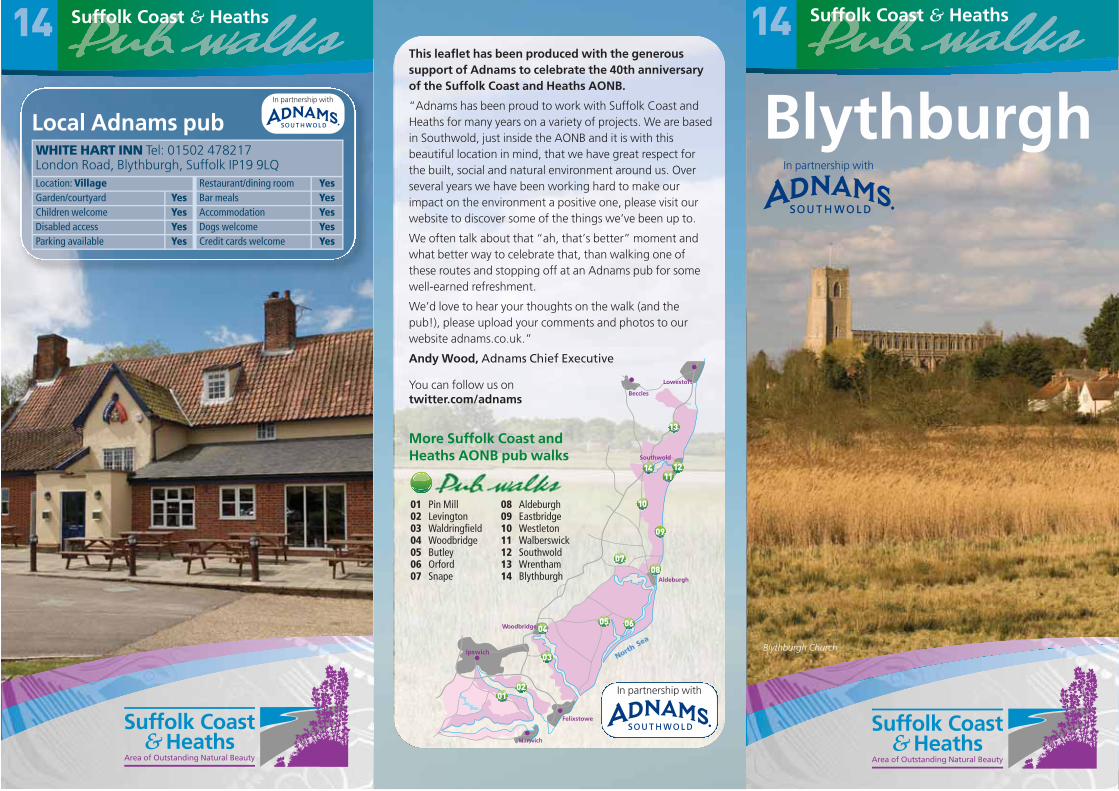
Blythburgh In partnership with
Blythburgh Church
14
Local Adnams pubIn partnership with
WHITE HART INN Tel: 01502 478217London Road, Blythburgh, Suffolk IP19 9LQLocation: Village Restaurant/dining room YesGarden/courtyard Yes Bar meals YesChildren welcome Yes Accommodation YesDisabled access Yes Dogs welcome YesParking available Yes Credit cards welcome Yes
Felixstowe
Ipswich
oodbridge
Harwich
Aldeburgh
Southwold
Lowestoft
Beccles
NorthSea
W
01 Pin Mill02 Levington03 Waldringfield04 Woodbridge 05 Butley06 Orford07 Snape
08 Aldeburgh09 Eastbridge10 Westleton11 Walberswick12 Southwold 13 Wrentham14 Blythburgh
In partnership with
This leaflet has been produced with the generoussupport of Adnams to celebrate the 40th anniversaryof the Suffolk Coast and Heaths AONB.
“Adnams has been proud to work with Suffolk Coast andHeaths for many years on a variety of projects. We are basedin Southwold, just inside the AONB and it is with thisbeautiful location in mind, that we have great respect forthe built, social and natural environment around us. Overseveral years we have been working hard to make ourimpact on the environment a positive one, please visit ourwebsite to discover some of the things we’ve been up to.
We often talk about that “ah, that’s better” moment andwhat better way to celebrate that, than walking one ofthese routes and stopping off at an Adnams pub for somewell-earned refreshment.
We’d love to hear your thoughts on the walk (and thepub!), please upload your comments and photos to ourwebsite adnams.co.uk.”
Andy Wood, Adnams Chief Executive
You can follow us on twitter.com/adnams
More Suffolk Coast andHeaths AONB pub walks

BlythburghMain walk – 2.5 miles/3.8 km
From the White Hart Inn , turn righttowards the bridge then right again down the
lane to left of pub. At gateway to house, turn right(signed “Walberswick”) and enter the WalberswickNational Nature Reserve. Alternatively, start bygoing to the bottom of the pub garden, throughthe gate onto the river wall and turn right.
Blythburgh’s location at the first practical crossing point ofthe River Blyth, and at the navigable head of the tidal rivermeant that it was once a much more important settlementthan it is today. There has been a bridge here since the 12thcentury, and it was a significant site for the Anglo-Saxons.
The White Hart Inn was the court house for the port ofBlythburgh in medieval times, while the house opposite wasa customs house. Its red brick ‘Dutch’ gable end was afashionable addition, added in the seventeenth century to abuilding that has been changed considerably over the years– much as the village has. Today there are few signs thatBlythburgh was once a thriving minor port and market
A
A
B
AA
BLYTHBURGH
A12
B1125
B1387
Dunwich Rd
Lodge LaneDeadman’s
Covert
WaterTower
Priory
Bulcamp Marshes
River Blyth
AAAAAAAAA
0 0.5km 1km
Blythburgh This scenic 2.5 mile walk follows the River Blyth downstreamtowards Walberswick, following the river wall, before returning viaBlythburgh village. There is an optional diversion to take inBlythburgh Church, and an alternative start, enabling you to visitthe pub half way round the route. The path along the river wall maybe muddy in wet weather, but the route is otherwise flat andundemanding. The diversion to Blythburgh Church involves crossingthe busy A12 road – please be careful.
There is parking at the pub but please check with the landlordbefore leaving your car there, especially if you plan to walk first, andvisit the pub on your return.
14
Dogs will enjoy both walks, but please do not allow them to disturbthe estuary birds, for whom these marshes are a scarce and much-prized habitat.
Long WalkOptional loop
Public House
Points ofinterest 1Car Park/Layby
Place ofworship
Path, track orother roadFootpath/bridleway
A/B/C Roads
Woods
Suffolk Coast and Heaths AONBTel: 01394 384948 www.suffolkcoastandheaths.org
East of England Tourismwww.visiteastofengland.com
Public transport: www.suffolkonboard.com, 0845 606 6171
Further information
43
2
5THE
WHITEHART
Crown copyright. All rights reserved.© Suffolk County Council. Licence LA100023395
1

The Suffolk Coast and Heaths Area of OutstandingNatural Beauty (AONB) is one of Britain’s finestlandscapes. Located on the coast of East Anglia andcovering 403 square kilometres, the AONB extendsfrom the Stour estuary in the south to the easternfringe of Ipswich and to Kessingland in the north.
www.suffolkcoastandheaths.org
town, larger and more important than nearby Lowestoft,Halesworth or Southwold. Its decline began following thearrival of the Black Death in 1349, although the portcontinued to trade in coal, timber and stone until thebeginning of the 20th century.
In 1759, work began on the Blyth Navigation, a series oflocks and other works built to enable boat traffic to reachas far as Halesworth, although little survives today. Later,the narrow gauge Southwold Railway line operatedbetween Halesworth and Southwold, via Blythburgh, from1879 to 1929.
The path follows the track of the SouthwoldRailway. After approx 1km, a path leads left,
into reedbeds, to a public bird hide .
Compared to the rest of the Suffolk coast, landreclamation in the Blyth valley occurred comparatively late,taking place mainly during the 18th century. Many of thewalls in this part of the river have since been abandoned, ordamaged beyond economic repair, allowing the river tospread once more across the valley floor. The walls wereconstructed by driving wooden stakes into the river, whichwere then covered with clay to build up a protective bank.You can still see the remains of some of these walls today,and the Ordnance Survey still record them as Rights of Way– though it would be unwise to venture along them!
1
Alternative starting point. There is a small carpark on the Walberswick Road B1387, allowing
the option to start from there and make the visit toBlythbugh the half way point on the walk. From thecar park , take the wide ride to the left and walkgently downhill through the heathland forapproximately 500m until you reach point .
Lodge Lane keeps to the higher ground on the edge of theSandlings, a low, narrow plateau of sandy, acidic soils thatrun, almost unbroken, from Ipswich to Southwold. Unlikethe river valleys, where cattle were frequently grazed, theSandlings were better suited to sheep. Huge flocks onceroamed this country, giving rise to the distinctive heathlandlandscape that can, in places, still be seen today.
Stay on this unpaved track (Lodge Lane) until it reaches the Dunwich Road . For a
quick route back to the pub from here, turn rightalong road.
3
2
B
At low tide the bird lifeof the river can beenjoyed, and Redshank,Dunlin and Lapwing areamong the species likelyto be seen. There hasbeen a great increase inthe number of over-wintering wading birdshere since EnglishNature obtained most ofthe shooting rights in1989. The river, coastalmarshes and heathland between Blythburgh, Dunwich andWalberswick collectively form Walberswick National NatureReserve, one of the outstanding wildlife sites for which theSuffolk coast is famous.
At cross tracks, where a path comes in fromthe right (and continues onto the old river
wall), go straight across, leaving an area of fencedwoodland known as Deadman’s Covert to yourright. At the end of this section of the wood youwill reach a sign marking an area of Open Accessahead, but turn right here, curving round the endof Deadman’s Covert, and soon at a T-junctionwith a larger track, turn right and to return alongthe southern side of the Covert , and keepingright through gateposts.
2
Redshank (FLPA)
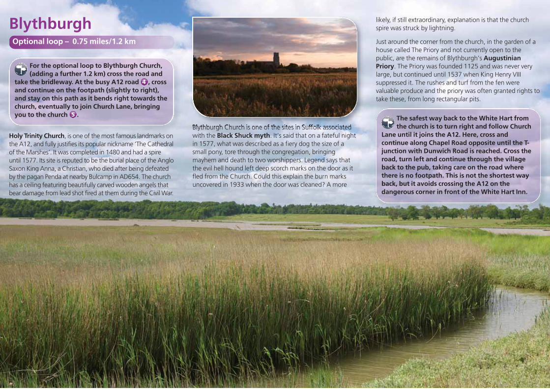
For the optional loop to Blythburgh Church,(adding a further 1.2 km) cross the road and
take the bridleway. At the busy A12 road , crossand continue on the footpath (slightly to right),and stay on this path as it bends right towards thechurch, eventually to join Church Lane, bringingyou to the church .
Holy Trinity Church, is one of the most famous landmarks onthe A12, and fully justifies its popular nickname ‘The Cathedralof the Marshes’. It was completed in 1480 and had a spireuntil 1577. Its site is reputed to be the burial place of the AngloSaxon King Anna, a Christian, who died after being defeatedby the pagan Penda at nearby Bulcamp in AD654. The churchhas a ceiling featuring beautifully carved wooden angels thatbear damage from lead shot fired at them during the Civil War.
4
5
Blythburgh Church is one of the sites in Suffolk associatedwith the Black Shuck myth. It’s said that on a fateful nightin 1577, what was described as a fiery dog the size of asmall pony, tore through the congregation, bringingmayhem and death to two worshippers. Legend says thatthe evil hell hound left deep scorch marks on the door as itfled from the Church. Could this explain the burn marksuncovered in 1933 when the door was cleaned? A more
likely, if still extraordinary, explanation is that the churchspire was struck by lightning.
Just around the corner from the church, in the garden of ahouse called The Priory and not currently open to thepublic, are the remains of Blythburgh’s AugustinianPriory. The Priory was founded 1125 and was never verylarge, but continued until 1537 when King Henry VIIIsuppressed it. The rushes and turf from the fen werevaluable produce and the priory was often granted rights totake these, from long rectangular pits.
The safest way back to the White Hart fromthe church is to turn right and follow Church
Lane until it joins the A12. Here, cross andcontinue along Chapel Road opposite until the T-junction with Dunwich Road is reached. Cross theroad, turn left and continue through the villageback to the pub, taking care on the road wherethere is no footpath. This is not the shortest wayback, but it avoids crossing the A12 on thedangerous corner in front of the White Hart Inn.
Blythburgh Optional loop – 0.75 miles/1.2 km