Blueprint for EUROSCAPE 2020
48
Blueprint for EUROSCAPE 2020 REFRAMING THE FUTURE OF THE EUROPEAN LANDSCAPE - POLICY VISIONS AND RESEARCH SUPPORT - Dirk Wascher & Bas Pedroli May 2008
Transcript of Blueprint for EUROSCAPE 2020

Blueprint for EUROSCAPE 2020
REFRAMING THE FUTURE OF THE EUROPEAN LANDSCAPE- Policy Visions and ReseaRch suPPoRt -
Dirk Wascher & Bas Pedroli
May 2008
REFRAMING THE FUTURE OF THE EUROPEAN LANDSCAPE
1B
lue
PR
int f
oR e
uR
osc
aP
e 2
02
0

Policy Visions and ReseaRch suPPoRt �
1 LANDSCAPES: WHERE EU TERRITORIAL POLICIES MEET 4
2 CHALLENGES IN EUROPEAN RURAL DEVELOPMENT 8
2.1 LANDSCAPE: THE HUMAN DIMENSION 8
2.2 THE END-EFFECT OF SO MANY POLICIES: LANDSCAPE CHANGE 12
2.� PLANNING SUSTAINABLE REGIONS 2�
� THREE CRUCIAL PRINCIPLES: ASSESSMENT, GOVERNANCE AND SPATIAL VISION 24
�.1 LANDSCAPE CHARACTER ASSESSMENT 25
�.2 NEW FORMS OF GOVERNANCE AT THE LANDSCAPE LEVEL 27
�.� SPATIAL VISION: POLYCENTRIC REGIONS, VITAL BRIDGES AND RURAL RETREAT �2
4 TOWARDS EUROSCAPE2020: RECOMMENDATIONS 40
4.1 GETTING STARTED 40
4.2 LANDSCAPE AGENDA FOR EUROSCAPE2020 42
References 45
contents
Blu
eP
Rin
t f
oR e
uR
osc
aP
e 2
02
0
REFRAMING THE FUTURE OF THE EUROPEAN LANDSCAPE4
landscaPes: wheRe eu teRRitoRial Policies meet1• An emerging policy domain
Since the launch of the European Landscape
Convention1 in 2000 was backed by a successful
ratification process, the awareness and political
willingness of European countries to develop
national strategies and plans in support of land-
scapes has clearly increased. National agencies
such as Natural England, Federal Agency of
Nature Conservation in Germany, the Belgium
Research Institute for Nature and Forest, Cema-
gref in France and many others are currently
in the process of reviewing their national land-
scape policies. In most cases, efforts are being
directed towards the strengthening of existing
legal instruments, integrating landscape ob-
jectives into other sectors and increasing the
overall awareness among decision makers and
stakeholders. In doing so, national agencies
encounter a striking congruence between the
need to sustain their characteristic landscapes
and the European Union’s shift towards the
second pillar of the Common Agricultural Policy
rural development.
• Rural development, a crucial asset
With over 60 % of the population in the 27
Member States of the European Union (EU)
living in rural areas, which comprise 90 % of
the territory, rural development has evolved to
one of the most vitally important policy areas.
Spatial policy instruments such as Natura 2000,
the Water Framework Directive, or the plans of
the Trans- European Transport Network have
Policy Visions and ReseaRch suPPoRt 5
Blu
eP
Rin
t foR e
uR
osc
aP
e 20
20
already been established to set a direction to-
wards sustainable environmental management.
The European Commission, supported by the
European Environment Agency and by ESPON,
has established comprehensive indicator frame-
works (e.g. IRENA2), is developing policy-orien-
ted sustainability impact assessment tools (e.g.
SENSOR�) and is in the process of strengthening
its reporting mechanisms to monitor and guide
policy implementation.
• Ambitions and reality
However, it is already clear that European
landscapes will not be able to support the
EU’s ambitious Biodiversity Targets 2010, will
face a further divide between economically
prosperous and under-privileged regions, and

Blu
eP
Rin
t f
oR e
uR
osc
aP
e 2
02
0
REFRAMING THE FUTURE OF THE EUROPEAN LANDSCAPE
1
6
will be exposed to unprecedented land use
changes driven by the global market economy
– see the recent debate on bio-energy crops and
the world-wide shortage of agricultural pro-
ducts. The EU’s spatial policies lack region-spe-
cific feed-back mechanisms addressing the large
variety of rural and urban structures, expressed
in the socio-economic and demographic profile
as well as in landscape character. This in return,
will require new forms of governance, namely
more transparent and integrated decision
pathways that link local, regional, national and
European institution, new forms of inter-agency
communications in the form of spatial and
contextual reference systems (e.g. regional
typologies) and new methods for participatory
processes that involve stakeholders and citizens
alike at different levels. In essence, the EU’s am-
bitious territorial policies are likely to conflict
with its social cohesion, regional identity and
quality of life targets if not rooted in effective
regionalised bottom-up procedures.
Policy Visions and ReseaRch suPPoRt 7
Blu
eP
Rin
t foR e
uR
osc
aP
e 20
20
Aim: A new approach in policy implementation
This Blueprint for EUROSCAPE 2020 proposes to undertake a radically new strategic operational approach for the European Union when defining targets for its territorial policies. The key princi-ples are: (1) to establish a policy monitoring for rural deve-
lopment on the basis of a landscape functions; (2) introduce new spatial planning instruments to
support Polycentric Regions and Vital Bridges; and
(3) develop new forms of governance involving local and regional authorities, people and decision-makers.
Before describing these, the main challenges in rural development are identified, based on an analysis of landscape changes in the past 50 years, and a prospective analysis of trends in land use change into the future.

Blu
eP
Rin
t f
oR e
uR
osc
aP
e 2
02
0
REFRAMING THE FUTURE OF THE EUROPEAN LANDSCAPE8
challenges in euRoPean RuRal deVeloPment 2
2.1 Landscape: the human dimension
• Drivers for the quality of life
Recent scientific literature on sustainability
impact assessment� suggests that the adequacy
and scope of rural development measures are
assessed on the basis of the multiple landscape
functions associated with certain landscape
types. Several EU projects4 have proposed to
develop the landscape function approach based
on the framework of ecosystem goods and
services as addressed in the Millennium Assess-
ment5. The underlying assumption is that both
policy and economy affect the social/cultural
and the natural/cultivated capital of a society
(Figure 1) and so have decisive impacts on
people’s well being. Conceptually, landscapes
provide transmission functions between the
mechanics of land-use management and change
on the one hand, and basic goods and services
offered by ecosystem on the other hand.
• The weak position of ecosystem
services in cultural landscapes
Classical ecological theory considers ecosys-
tem goods and services as direct drivers of
human well being. In Europe – where cultivated
systems dominate and where landscapes are
being managed according to traditions and de-
mands put forward by recreation and tourism,
such a view does not only come across as a
natural science interpretation, but also seems at
odds with both policy and basic economic
Policy Visions and ReseaRch suPPoRt 9
Blu
eP
Rin
t foR e
uR
osc
aP
e 20
20
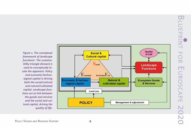
Figure 1. The conceptual framework of landscape functions6. The sustaina-bility triangle (brown) is used to conceptually lo-
cate the approach. Policy and economic/techno-
logical capital is driving both the social/cultural and natural/cultivated
capital. Landscape func-tions act as link between
the goods and services and the social and cul-
tural capital, driving the quality of life.
Land use
Management & adjustment
Social
Economic EnvironmEnt
Economic & techno-logical capital
Social &Cultural capital
Natural &cultivated capital
Ecosystem Goods& Services
LandscapeFunctions
Qualityof Life
POLICY

Blu
eP
Rin
t f
oR e
uR
osc
aP
e 2
02
0
REFRAMING THE FUTURE OF THE EUROPEAN LANDSCAPE
1
10
theory7. Over the centuries, European land-
scapes have been gradually but nevertheless
radically transformed from natural systems
to cultural essentially artificially maintained
environments. Since only relatively small relics
of the original natural ecosystem components
remain – in often remote locations and/or
dependent on massive human interventions in
terms of management and protection measures
– the net economic value of this fragmented
natural capital is probably rather limited7. Key
ecosystem goods and services affecting the
quality of life are certainly regulating functions
affecting climate, flooding or water purification
and retention. On the other hand, when addres-
sing production functions such as agriculture
and forestry or biodiversity values such as rare
species, a spatially complex and wide network
of landscape functions related to perception,
identity and recreation remains unaddressed.
This means that there is an over-emphasis of
ecological and economic goods and services
on the expense of the human dimension of the
landscape.
• Transmission functions bridging the gap
In order to strengthen the social-cultural com-
ponents that are less driven by environmental
factors but rather by human interaction and
perception, it is proposed to consider landscape
functions transmitting between “ecosystem
goods and services” and “quality of life”. The
reasons for this proposition are twofold. First

Policy Visions and ReseaRch suPPoRt 11
Blu
eP
Rin
t foR e
uR
osc
aP
e 20
20
landscape is a holistic expression of the physi-
cal, biological and human properties of a given
parcel of land and acts at a higher spatial aggre-
gation level than simple land-use or land cover.
Second, “single land use can involve numerous
functions”8. Different land uses can result in
different functions, but not all functions can
be expressed as land uses. Agriculturally used
land has, for example, economic, aesthetic and
recreational functions, but only one land use,
namely, agriculture.
Furthermore, the ecosystem dimension of
these services are strongly – almost entirely
– demand-driven: without human resource
needs and aesthetic preferences, such goods
and services would not exist9. The introduc-
tion of landscape functions will not only fill
a major gap in current land use policy design
and implementation, it will also strengthen the
participatory and integrative dimension at the
regional level.
• Landscape functions at regional level
The recent reforms of the Common Agricultural
Policy are a first expression of this situation:
because there are periodic fluctuations in the
needs for agricultural products (goods) and
an increasing demand for agricultural services
(quality of life), the European Commission is
shifting its financial support away from produc-
tion towards rural development. The recrea-
tional and aesthetic functions of agricultural
landscapes are very much related to the results
Blu
eP
Rin
t f
oR e
uR
osc
aP
e 2
02
0
REFRAMING THE FUTURE OF THE EUROPEAN LANDSCAPE
1
12
of certain – often traditional – forms of land use
management, policies, patterns and structures.
These result from historic developments and
enhance the perception of an identified land-
scape character. But such factors derive from
outside the pure natural science context and
are difficult to match with classical ecosystem
theory10. It hence does not come as a surprise
that state-of-the-art valuation methods are – in
the majority – focusing on identifying issues
such as ‘readiness to pay’ and related prefe-
rence systems. In most cases, it is difficult to
establish clearly defined linkages between such
preferences and ecosystem goods and services.
A much more transparent and direct way of
measurement would be the identification of
landscape functions with respect to preferences
at the regional level.
2.2 The end-effect of so many policies: landscape change
• Land abandonment, a temporary feature?
Given the influence of global market fluctuati-
ons on all economic sectors, land use change
is already a defining feature of the European
landscape. Periods with land abandonment in
the past are e.g. those affected by the McSharry
regulations, characterised by the abandonment
of marginal lands in mountain areas, and the
abandonment of non-economic lands in some
of the new Member States. Such periods alter-
nate with periods of increasing land pressure,
in the past especially in the larger conurbations,
but also in areas with formerly completely

Policy Visions and ReseaRch suPPoRt 1�
Blu
eP
Rin
t foR e
uR
osc
aP
e 20
20
unproductive soils. Recently the increasing at-
tention to biomass-fuel crops is leading to con-
siderably differing points of view in the debate
about the value of the rural area for cropping11.
Also, the revision of the Common Agricultural
Policy will have large consequences for land use
and landscape.
• EU enlargement challenging sustaina-ble landscapes
The accession of the southern countries to
the EU in the 80s (Greece in 1981, Spain and
Portugal in 1986) more than doubled the size
of the population working in agriculture and
increased the number of agricultural enterpri-
ses in Europe by more than two-thirds. “Thus
enlargement must inevitably reduce both the
Community’s average holding size and, by im-
plication, the average level of farm incomes – a
retrograde shift vis-à-vis the objectives of the
CAP”12. This had substantial consequences e.g.
for the montados in Portugal (first case below).
Such processes will be evident in the recently
accessed countries as well, e.g. in the currently
small scale pattern of agricultural land use in
Poland (second case below). In the upper Po
valley in Italy (third case below) consolidation
of landscape development might be expected,
but also here large dynamics remain present.

Blu
eP
Rin
t f
oR e
uR
osc
aP
e 2
02
0
REFRAMING THE FUTURE OF THE EUROPEAN LANDSCAPE14
Intensification and extensification of the traditional
system in the last decades has led to degradation
of the montado, the Portuguese traditional mixed
farming system of scattered (often cork) oak trees
and grazing meadows1�. With the opening of
international markets and the fall in crop prices,
market-oriented cultivation of cereals on the
infertile montado soils has progressively declined.
This led to extensification of land-use, and in some
areas even to abandonment. Moreover, the system
of extensive Iberian pig-raising under the trees
disappeared in the sixties, mainly due to the spread
of African swine fever. Other production strategies
followed, based on alternative livestock, intensifi-
cation of cultivation in the most fertile soils, incre-
ased cork production and abandonment of agricul-
ture in many areas, resulting in a degradation of
the traditional system and in the distortion of the
human-maintained equilibrium that has preserved
not only economic and biological productivity, but
also the stability of unique cultural landscapes.
Land use changes characteristic of extensification
are: fewer cultivated fields, more shrub patches,
larger areas of natural pastures, and also abandon-
ment of some patches, followed by the develop-
ment of stratified bush communities14. The result
is a new landscape mosaic, more heterogeneous
than the landscape created under the regular ma-
nagement of the montado. If crop cultivation is the
main objective of intensification (this is normally
the case on the best soils), the tree density is often
reduced, and the cultivation depends on mechani-
sation and deep ploughing. The choice of the crop
The Montado case
Policy Visions and ReseaRch suPPoRt 15
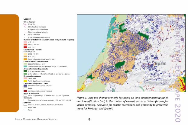
Figure 2. Land use change scenario focussing on land abandonment (purple) and intensification (red) in the context of current tourist activities (brown for inland camping, turquoise for coastal recreation) and proximity to protected areas for Portugal and Spain15.
Blu
eP
Rin
t foR e
uR
osc
aP
e 20
20
Blu
eP
Rin
t f
oR e
uR
osc
aP
e 2
02
0
REFRAMING THE FUTURE OF THE EUROPEAN LANDSCAPE
1
16
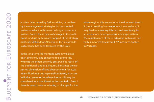
is often determined by CAP subsidies, more than
by the management strategies for the montado
system — which in this case no longer works as a
system. Even if these types of change in the tradi-
tional land use systems are not part of the strategy
politically defined for Alentejo, in the last decade
such change has been favoured by the CAP.
In the long term the montado system will disap-
pear, since only one component is promoted,
whereas the others are only preserved as relicts of
the traditional land use. Figure 2 illustrates the ex-
pected dimension of land abandonment for 20�0.
Intensification is not a generalised trend, it occurs
in limited areas — but where it occurs it may be
considered as a true threat to the montado. Even if
there is no accurate monitoring of changes for the
whole region, this seems to be the dominant trend.
It is not resulting in abandonment everywhere; it
may lead to a new equilibrium and eventually to
an even more heterogeneous landscape pattern.
The maintenance of these extensive systems is par-
tially supported by current CAP measures applied
in Portugal.

Policy Visions and ReseaRch suPPoRt 17
Poland is among the largest agrarian economies
of Central and Eastern Europe. Its agricultural land
resources of 15.9 million hectares account for 60%
of the country’s total land area and the number of
people engaged in agricultural activities is nearly
17% of the economically active population17. Polish
rural landscapes have thus far remained relatively
unaffected in terms of biodiversity and cultural
heritage. Therefore the significance of rural land-
scapes of the country is recognised at the highest
policy level in the European Union.
In view of the expected economic development
within the European Union the large diversity of
Polish landscapes is, however, subject to future
change . Environmentally valuable agricultu-
ral landscapes recognised as high nature value
farmlands in Poland comprise about 10.6% of
utilised agricultural area, representing almost one
fourth of the area of semi-natural grasslands in
Central and Eastern Europe19. In this respect the
role of support measures for less intensive farming
methods to help in maintaining biodiversity should
be enhanced.
Implementation of the CAP will cause certain
adjustments in rural development strategy and
agricultural management practices, which will
affect rural landscapes substantially. The declining
role of agriculture will be accompanied by on-farm
diversification. A decrease in numbers of smaller
farms using traditional methods can be expected.
Instead, the number of more commercially viable
farms will grow, which means an increased inten-
The Polish case Blu
eP
Rin
t foR e
uR
osc
aP
e 20
20

Blu
eP
Rin
t f
oR e
uR
osc
aP
e 2
02
0
REFRAMING THE FUTURE OF THE EUROPEAN LANDSCAPE
1
18
sity of use of most productive landscapes, while
the less economically viable become marginalised.
Considerable enlargement of individual farm
ownerships can be predicted, as the average farm
size at present accounts only 6 ha against e.g. 4�
ha in Germany17.
Figure 3. Expected changes of the share of agricultural production
at overall GDP in the context of current tourist activities (light green for
coastal recreation) and proximity to protected
areas for Poland15.
Policy Visions and ReseaRch suPPoRt 19
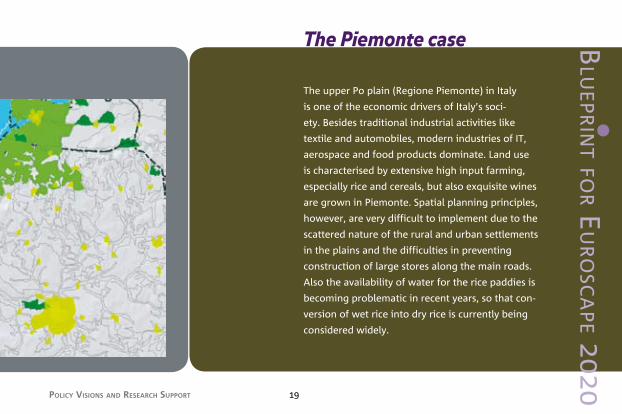
The upper Po plain (Regione Piemonte) in Italy
is one of the economic drivers of Italy’s soci-
ety. Besides traditional industrial activities like
textile and automobiles, modern industries of IT,
aerospace and food products dominate. Land use
is characterised by extensive high input farming,
especially rice and cereals, but also exquisite wines
are grown in Piemonte. Spatial planning principles,
however, are very difficult to implement due to the
scattered nature of the rural and urban settlements
in the plains and the difficulties in preventing
construction of large stores along the main roads.
Also the availability of water for the rice paddies is
becoming problematic in recent years, so that con-
version of wet rice into dry rice is currently being
considered widely.
The Piemonte case Blu
eP
Rin
t foR e
uR
osc
aP
e 20
20

Blu
eP
Rin
t f
oR e
uR
osc
aP
e 2
02
0
REFRAMING THE FUTURE OF THE EUROPEAN LANDSCAPE
1
20
The expected changes in land use (see Figure
4) have significant consequences for landscape
character. The regional spatial planning philosophy
is based on due consideration of landscape values,
especially in areas of outstanding beauty20, but
also the areas of mainly residential and agricultural
function are taken into consideration. The Biella
Project (an initiative of the Province and the town
of Biella, supported by the Regione Piemonte,
implementing the European Landscape Conven-
tion21) provides an example of this. An example
of new alliances forged for the sake of landscape
conservation and sustainable rural development
is the cooperation between farmers and the ad-
ministration of a Regional Park along the Po river,
rehabilitating land use in the marginal areas in the
hills, and promoting tourist functions on farms22.

Policy Visions and ReseaRch suPPoRt 21
Figure 4. Land use change scenario focussing on land abandonment (purple) and intensification (red) in the con-text of current tourist activities (brown for inland camping, tur-quoise for coastal recreation) and proximity to protected areas in northern Italy15.
Blu
eP
Rin
t foR e
uR
osc
aP
e 20
20

Blu
eP
Rin
t f
oR e
uR
osc
aP
e 2
02
0
REFRAMING THE FUTURE OF THE EUROPEAN LANDSCAPE
1
22
Figure 5. Changes in semi-natural land per Harm region as a consequence of the continental market scenario. Left: 2007, centre: 2030, right: difference between them. Source: EURURALIS23.

Policy Visions and ReseaRch suPPoRt 2�
Blu
eP
Rin
t foR e
uR
osc
aP
e 20
20
2.3 Planning sustainable regions
Recent projections24 show a trend towards the
richer European regions getting richer and
the poorer regions falling ever further behind.
Overexploitation of the landscape in the eco-
nomic zones, and underexploitation and land
abandonment are the unsustainable but logical
consequences of this rather autonomous deve-
lopment. Under a continental market scenario
(EURURALIS2�), within the axis of economic
development (London – Frankfurt – Milano), the
expansion of semi-natural lands will decrease
only slightly or even increase, whereas in the
periphery the decrease in semi-natural lands is
almost catastrophic, mainly due to increase of
agricultural land use intensity (Iberian penin-
sula, Denmark, Lithuania, Greece and as an
exception also Paris: Figure 5). These processes
are associated with a loss of landscape charac-
ter and identity in those places where no special
protection status applies. Europe as a whole is
thus getting poorer in landscape values.

Blu
eP
Rin
t f
oR e
uR
osc
aP
e 2
02
0
REFRAMING THE FUTURE OF THE EUROPEAN LANDSCAPE24
thRee cRucial PRinciPles: • assessment, • governance and • spatial vision
�
Landscape scientific research, which is mainly
expanding from pure landscape ecological
perspectives towards broader socio-cultural
domains25, has stressed the interdependencies
that exist between landscape character and the
socio-economic context26 when assessing sustai-
nability, sensitivity and multi-functionality of the
landscape. EU research projects such as SENSOR
and FARO27 on sustainability impact assessment
and land use scenarios have demonstrated
the use of the European landscape typology
LANMAP228 for the development of a spatial re-
gional reference for policy evaluation. A spatial
reference framework that is accepted by both
the European Union and the Member States
must be considered as an important prerequi-
site for a transparent implementation of rural
development policies at the regional level.

Policy Visions and ReseaRch suPPoRt 25
Blu
eP
Rin
t foR e
uR
osc
aP
e 20
20
3.1 Landscape Character Assessment
• Sharing a passion for landscape
The example of England shows that the ambi-
tions of a governmental agency in the field of
landscape character assessment – in this case
the former Countryside Commission – can have
a tremendous impact on the national status
and perception of landscape29. It must be as-
sumed that several aspects have contributed
to this development, one of which is certainly
the existence of a cultural affinity towards the
topic of landscape, a ‘passion for landscape’.
This passion has probably been shared between
larger parts of the population and the agen-
cies involved. However, it is also clear that this
impact has ‘been staged’ by the political forces,
e.g. by launching the ‘landscape character area
map’ as one of the key national references for
regional identity in the countryside. Another
likely element of the success-formula was the
early and broad participation of many different
stakeholders when establishing each landscape
character area unit, and it is significant that a
technological approach did not play a dominant
role!

Blu
eP
Rin
t f
oR e
uR
osc
aP
e 2
02
0
REFRAMING THE FUTURE OF THE EUROPEAN LANDSCAPE
1
26
Figure 6. The first CQC assessment, covering the period 1990-19989.
• About �6% (56) of JCAs were stable or showed changes that were consistent with either maintaining or streng-thening their character.
• In about 64% (100) they were diverging, in the sense that they showed marked pat-terns of change that were transforming or eroding the elements that made them distinctive.
Maintained
Neglected
Enchanging
Diverging

Policy Visions and ReseaRch suPPoRt 27
Blu
eP
Rin
t foR e
uR
osc
aP
e 20
20
• Monitoring landscape change is possible
In England, the aim was to develop a national
framework of geographical areas that described
what the landscape was, how it had evolved
and how to use this knowledge better to guide
and inform its protection, conservation, enhan-
cement and restoration�0. Landscape Character
Assessment in fact also allowed the monitoring
of landscape change through the Countryside
Quality Counting method (Figure 6).
Landscape Character Assessment techniques
as developed in England and Scotland have be-
come a point of reference for recent European
approaches, manifested in the development of
a European Landscape Typology LANMAP228
and a review of classifications25. European pro-
grammes such as Corine land cover, the agri-en-
vironmental indicator programme IRENA (EEA),
the area sampling process LUCAS (Eurostat),
and the European Landscape Mapping initiative
LANMAP must be considered as the cornersto-
nes for the systematic development of a land-
scape monitoring and reporting programme.
3.2 New forms of governance at the landscape level
• Linkage between governance and nature
It is interesting that from the viewpoint of the
social sciences, the landscape concept is being

Blu
eP
Rin
t f
oR e
uR
osc
aP
e 2
02
0
REFRAMING THE FUTURE OF THE EUROPEAN LANDSCAPE28
interpreted as follows: “as a link between
governance processes in multi-level-politics and
natural-spatial conditions is precisely its hybrid
character, that is, that societal and “natural”
factors are intrinsically linked to one another”�1.
The identification of a ‘linkage’ between
governance and nature echoes in an intriguing
way the earlier acknowledged role of landscape
functions between land use and ecosystem
goods and services. Both conceptual placements
of landscapes evoke associations with the
chemo-physical sciences, namely attributes such
as catalyst, converter or transmitter.
In many countries, nature conservation and
landscape protection instruments are addressed
in one and the same legal framework. Because
of their complementary character and the tra-
ditionally common roots of both concepts such
a dual approach is not surprising. Interestingly,
spatial and regional planning is frequently very
closely associated with landscape planning�2.
Figure 7 serves as a reference for placing new
forms of governance into the existing frame-
work of policy implementation.
• Landscape governance, a new concept
Although top-down regulations and policy
structures tend to be inherently conservative
and to counteract creative participation from
the bottom-up��, landscape governance should
be able to compensate for this inherent pro-
blem in modern landscape management.
According to Görg�1, landscape governance as a
component of environmental governance

Policy Visions and ReseaRch suPPoRt 29
stakeholders and decision-makers involved in
EU policy implementation. In the case of the
“Cross Compliance” scheme as part of the CAP
reform, the introduction of the Single Payment
Scheme (single farm payment for EU farmers,
independent from production, with the option
of limited coupled elements) in 2005, pay-
ments to farmers are linked to the respect of
environmental, food safety, animal and plant
health and animal welfare standards, as well as
the requirement to keep all farmland in good
agricultural and environmental condition. In the
current situation farmers follow European-wide
generic requirements, rather than context-speci-
fic, stakeholder determined solutions.
should follow these principles:
• Social shaping of landscapes must be the
starting point for analysis;
• The plurality of landscape-comprehensions
and interests related to a landscape in context
should be recognised;
• The aesthetic dimension is not itself a norma-
tive starting point for landscape governance;
• Cultural dimensions must be supported by the
insights of natural-science.
• Single payment as a chance
Landscape governance can be seen as a way
of offering a pragmatic up- and downscaling
mechanism based on the view of a variety of
Blu
eP
Rin
t foR e
uR
osc
aP
e 20
20

Blu
eP
Rin
t f
oR e
uR
osc
aP
e 2
02
0
REFRAMING THE FUTURE OF THE EUROPEAN LANDSCAPE�0
Nature Conversation
Landscape ProtectionBiodiversity& Landscape
Spatial & RegionalPlanning
SectoralPolicies
Multi-sectoral Instruments Methods
Agriculture
Landscape Planning
Energy
Water
Figure 7. Context of landscape governance between sec-toral policies, multi-sectoral instruments and methods32.

Policy Visions and ReseaRch suPPoRt �1
Blu
eP
Rin
t foR e
uR
osc
aP
e 20
20
• Establishing landscape development plans
According to a recent evaluation�4, a general
conclusion can be reached that these obliga-
tions are mostly appropriate and likely to contri-
bute to the intended effects (assuming farmers
comply with them). Some Member States have
made particular effort to design and target
obligations to achieve real environmental bene-
fit. However, in other cases, some obligations
are considered to be so general that they are
unlikely to achieve any real benefit. A landscape
governance type of approach could require the
establishment of landscape development plans
in which landscape functions and the respective
indicators for monitoring policy implementa-
tion constitute a first step for making farmers
of such a region eligible for farm payments.
Member States and regional authorities would
need to ensure that such landscape develop-
ment plans are based on landscape character
assessments and are available in digital, geo-
referenced formats for European-wide inte-
gration. If national or regional authorities are
not able or willing to provide such services in
support of their farmers, land owners can also
apply for interim payments provided they com-
mission private landscape planners to produce
the required plans on behalf of the municipali-
ties or regions. The specifications put forward
in such landscape developments plans would
replace the generic requirements followed thus
far (Figure 7).

Blu
eP
Rin
t f
oR e
uR
osc
aP
e 2
02
0
REFRAMING THE FUTURE OF THE EUROPEAN LANDSCAPE�2
3.3 Spatial vision: polycentric regions, vital bridges and rural retreat
• Polycentric regions as anchor points
A continuous and increasingly dynamic change in time and over space calls for strong anchor points of more stable land use�5. It will certainly be a challenge for land use and landscape management to define which places have such a strong and unique character that they deserve to be managed as polycentric regions�6. This may be from the point of view of the visually attractive and ecologically resilient landscape as much as from the point of view of intrinsic values like historical meanings of a particular landscape (e.g. battlefields, landscapes with a particular reclamation history, etc.).Though the debate and research on multi-func-
tional land use must be welcomed as a great contribution in response to the largely underva-lued aspects of the land such as habitat, cultural amenity and information functions, the focus on land use only is lacking a spatially coherent vision and regional focus. The concept of Euro-pean Polycentric Regions is an answer to that as a meta-scale regional planning instrument for integrating multi-functional land use into a spa-tial framework based on landscape functions. Polycentric Regions can be characterised by:
• designation of region-specific resilience cen-tres that provide essential compensation and buffer functions for adjacent high agglome-ration and that can support structurally weak zones;
• �spatial distribution of landscape services that reflects the bio-physical structure as well as socio-economic necessities at various levels of

Policy Visions and ReseaRch suPPoRt ��
Blu
eP
Rin
t foR e
uR
osc
aP
e 20
20
sustainable forms of resource management and
environmental risk management programmes.
• Safeguarding Vital Bridges
The degree of connectivity between regions
depends on the scale of required support servi-
ces (international, national, regional and local)
taking into account a wide range of parameters.
E.g. centres of high manure and urban organic
waste production will need to be linked to
alternative energy production plants; recreatio-
nal areas need to accommodate for expected
growth trends in urban areas; key biodiversity
centres need to be supported by corridors for
current and future migration needs. A Euro-
pean Green Structure in support of the Natura
2000 network, linking habitats across national
borders and large distances has become a Eu-
scale from the local to the supranational with special emphasis on trans-boundary situati-ons;
• governance structures that build upon bottom-up civil society initiatives within a generally accepted framework of European policies, stimulated by incentives from public administration;
• awareness of the importance of linking regio-nal identity with global sustainable develop-ment objectives, implying careful reference to landscape impacts in all relevant policy sectors.
The envisioned system of Polycentric Regi-
ons – essentially a spatial concentration of
vital landscape services at the regional level
– will have to be embedded into a network of
European Vital Bridges providing easy access,

Blu
eP
Rin
t f
oR e
uR
osc
aP
e 2
02
0
REFRAMING THE FUTURE OF THE EUROPEAN LANDSCAPE�4
ropean strategic consideration. River networks
can be considered as key bio-physical structu-
res, among other things with reference to flood
risk. Trend reports have prompted European
countries to re-consider the role of spatial plan-
ning in the light of risk management. Identify-
ing landscape services that can provide buffer
and compensation against life threatening
risks must be considered as a primary step of
Euroscape 2020.
Vital bridges imply landscape concepts and
design solutions linking polycentric regions
with each other where appropriate, providing
natural and cultural corridors, closing the gap
between the rural and urban and offering spa-
tial solutions for risk management
Policy Visions and ReseaRch suPPoRt �5
Blu
eP
Rin
t foR e
uR
osc
aP
e 20
20
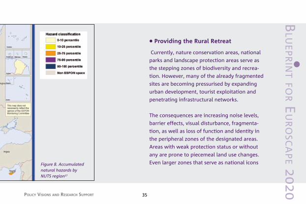
Figure 8. Accumulated natural hazards by NUTS region37
• Providing the Rural Retreat
Currently, nature conservation areas, national
parks and landscape protection areas serve as
the stepping zones of biodiversity and recrea-
tion. However, many of the already fragmented
sites are becoming pressurised by expanding
urban development, tourist exploitation and
penetrating infrastructural networks.
The consequences are increasing noise levels,
barrier effects, visual disturbance, fragmenta-
tion, as well as loss of function and identity in
the peripheral zones of the designated areas.
Areas with weak protection status or without
any are prone to piecemeal land use changes.
Even larger zones that serve as national icons

Blu
eP
Rin
t f
oR e
uR
osc
aP
e 2
02
0
REFRAMING THE FUTURE OF THE EUROPEAN LANDSCAPE�6
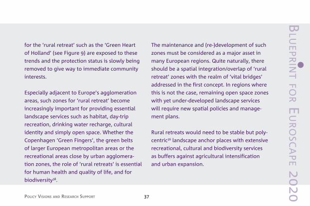
Figure 9. The Green Heart in the Netherlands – a long-term spatial planning asset as an example for classical rural retreat15.
Policy Visions and ReseaRch suPPoRt �7
Blu
eP
Rin
t foR e
uR
osc
aP
e 20
20
for the ‘rural retreat’ such as the ‘Green Heart
of Holland’ (see Figure 9) are exposed to these
trends and the protection status is slowly being
removed to give way to immediate community
interests.
Especially adjacent to Europe’s agglomeration
areas, such zones for ‘rural retreat’ become
increasingly important for providing essential
landscape services such as habitat, day-trip
recreation, drinking water recharge, cultural
identity and simply open space. Whether the
Copenhagen ‘Green Fingers’, the green belts
of larger European metropolitan areas or the
recreational areas close by urban agglomera-
tion zones, the role of ‘rural retreats’ is essential
for human health and quality of life, and for
biodiversity�8.
The maintenance and (re-)development of such
zones must be considered as a major asset in
many European regions. Quite naturally, there
should be a spatial integration/overlap of ‘rural
retreat’ zones with the realm of ‘vital bridges’
addressed in the first concept. In regions where
this is not the case, remaining open space zones
with yet under-developed landscape services
will require new spatial policies and manage-
ment plans.
Rural retreats would need to be stable but poly-
centric�6 landscape anchor places with extensive
recreational, cultural and biodiversity services
as buffers against agricultural intensification
and urban expansion.

Blu
eP
Rin
t f
oR e
uR
osc
aP
e 2
02
0
REFRAMING THE FUTURE OF THE EUROPEAN LANDSCAPE
1
�8
• Energising Remote Regions
Rural development is an increasingly impor-
tant policy area. Farming and forestry remain
crucial for land use and the management of
natural resources in the EU’s rural areas, and as
a platform for economic diversification in rural
communities. The strengthening of EU rural
development policy has, therefore, become an
overall EU priority.
The EU Rural Development Strategy 2007-201�
provides a key references for EUROSCAPE 2020,
especially the requirement to identify the areas
where the use of EU support for rural develop-
ment creates the most value added at EU level.
In remote European regions regional identity
and economic viability might be introduced
or revitalised through innovative land use
based production systems. For instance, special
initiatives for regenerating the socio-economic
perspectives of these areas require a third set
of strategic policy plans. In remote European
regions thus regional identity and economic
viability should be introduced or re-vitalised
through innovative land use based production
systems.
Current trends show that the proportion of
peripheral areas is increasing. According to
ESPON scenarios (Figure 10), these trends will
continue, raising the question how ‘quality of
life’ objectives can be met in the future for both
local population and tourists�7.

Policy Visions and ReseaRch suPPoRt �9
Blu
eP
Rin
t foR e
uR
osc
aP
e 20
20
Figure 10. Integrated spatial scenarios on European economic core regions. The two scenarios are developed under two different policy assumptions: a cohesion approach (left) resulting in a wider coverage, and a competition-oriented approach (right)37.

Blu
eP
Rin
t f
oR e
uR
osc
aP
e 2
02
0
REFRAMING THE FUTURE OF THE EUROPEAN LANDSCAPE40
towaRds euRoscaPe 2020: Recommendations4
4.1 Getting started
Until today, most of the manifold impacts of
European policies on the ‘everyday’ landscape
as addressed in the European Landscape
Convention are not captured by the state-of-the-
art international assessment and monitoring
programmes. Apart from the paradoxical lack
in direct competence of the EU in the area of
landscape, the reasons are as follows:
1 limitations with regard to data-driven indica-
tor frameworks which fall short of adequa-
tely addressing the large variety of cultural
characteristics;
2 the focus on singular, often protected sites of
special interest; and
� the lack of bottom-up mechanisms to provide
regionally adequate interpretations of the
existing international assessment results.
These shortcomings can be overcome by enga-
ging in new forms of institutional cooperation
and by establishing new structures of gover-
nance. The implementation of European land
use policies – especially those related to the
objectives for Rural Development and instru-
ments such as the agri-environmental measures
and compliance programme – require more
integrated, region- and problem-specific imple-
mentation procedures.
The example of the Landscape Character Assess-
ment as performed in the United Kingdom can
serve as a stimulus for developing a European-
wide approach in which local and regional

Policy Visions and ReseaRch suPPoRt 41
Blu
eP
Rin
t foR e
uR
osc
aP
e 20
20
sessment and monitoring cannot be expected
to start as an immediate, Europe-wide and
top-down organised programme. It will require
incentives, examples for good and best practice
and the identification of priority regions. Ho-
wever, existing European land use change and
sustainability impact assessments as performed
by the European Environment Agency, the
Joint Research Centre and many EU projects
are very capable of identifying critical regions
where social or environmental problems can be
expected to aggravate over the next deca-
des. Therefore it is important to demonstrate
that spatial planning tools can offer adequate
ways of tackling concrete spatial issues related
to sustainable development at the regional
level, e.g. reconstructing agricultural land use,
authorities are as much involved as national
government agencies and the institutions of the
European Union. By means of readily availa-
ble, digital and/or internet-based information
access, the observed information and inter-
pretation gaps can be filled without the need
to engage in costly and time-consuming data
gathering exercises. Other than being conside-
red an isolated, research-driven exercise, a regi-
onally based approach to landscape assessment
will strengthen the policy-science interface in
exactly those places where it is the most rele-
vant: close to the stakeholders, decision-makers
and public.
Obviously, a wider and more integrated
approach towards policy implementation, as-

Blu
eP
Rin
t f
oR e
uR
osc
aP
e 2
02
0
REFRAMING THE FUTURE OF THE EUROPEAN LANDSCAPE42
introducing landscape-level urban development
schemes and working towards cultural identity
objectives. The above mentioned region-based
assessment programmes and new forms of
governance will allow to guide policy imple-
mentation in the identified ‘high-priority’ areas
by introducing a new dimension of spatially
integrated planning concepts. This means, that
the EU’s current financial schemes such as struc-
tural funds and less favoured area will need to
be complemented by more sophisticated spatial
development programmes backed by local and
regional authorities.
The following elements should at least be re-
cognisable in an innovative policy and research
agenda for sustainable landscape development
in the European Union, enhancing a real para-
digm shift.
4.2. landscape agenda for eUroscape 2020
Assessment
• A close linkage between EU policy implementation (e.g. rural development) and a landscape-functional approach is required: regions need to demonstrate that they fulfil minimum standards regarding the description and target setting for landscapes.
• A sector-oriented landscape monitoring and repor-ting process should provide the basis for integrative measures. Sectors to start with are tourism, agricul-ture, forestry, energy, nature conservation.
• A European Landscape Character Assessment should initiate bottom-up mechanisms involving authorities, stakeholders and researchers to arrive at clearly defined European Landscape Assets.
• A strong ERA-Net initiative should coordinate the land-scape research efforts of all European countries.

Policy Visions and ReseaRch suPPoRt 4�
4.2. landscape agenda for eUroscape 2020
Governance
• Integration of landscape concerns into current and future legislation at all governance levels should strongly be promoted.
• The implication of the European Landscape Conven-tion should be considered in order to engage in a pro-active process of institutional support for landscape development.
• Successive introduction of the bottom-up definition of landscape character, polycentric regions and anchor points should complement the top-down scenario approach.
• Establishment of a European Landscape Observatory should play a key role in the development of Euro-pean-wide regional planning schemes.
Spatial vision
• A clear spatial vision for Europe should be devloped, focussing on vital bridges, possibilities for rural retreat, and energising remote regions.
• Priority regions should be identified for launching spatial regional development plans with clear refe-rences to landscape visions in which European and regional/national objectives are integrated.
• An appropriate Rural Development Strategy 2013 – 2020 should be designed, including landscape quality aims.
Blu
eP
Rin
t foR e
uR
osc
aP
e 20
20

Blu
eP
Rin
t f
oR e
uR
osc
aP
e 2
02
0
REFRAMING THE FUTURE OF THE EUROPEAN LANDSCAPE44

Policy Visions and ReseaRch suPPoRt 45
Blu
eP
Rin
t foR e
uR
osc
aP
e 20
20
1 Council of Europe (2000). European Landscape Convention. Council of Europe publishing, Strasbourg.
2 EEA (2004). Agriculture and environment in the EU-15: the IRENA indicator report. European Environmental Agency, Copenhagen.
� Helming K, Tabbush P & Perez-Soba M (eds. 2007). Sustainabi-lity Impact Assessment of Land Use Changes. Springer Verlag Berlin. 507 p.
4 The EU projects are: SENSOR (see Helming et al. 2007 under note �),
ELCAI: Perez-Soba M & Wascher DM (eds. 2005). Landscape Character Areas. Places for building a sustainable Europe. Policy Brochure as deliverable from the EU’s Accompanying Measure project European Landscape Character Assessment Initiative (ELCAI), funded under the 5th Framework Program-me on Energy, Environment and Sustainable Development (4.2.2). �� p. [see also note 25]
EnRisk: Delbaere B (Ed. 200�). Environmental risk assessment for European agriculture: interim report. – Tilburg, European Centre for Nature Conservation. ELISA: Wascher DM (Ed. 2000), Tilburg: Agri-Environmental Indicators for Sustainable Agriculture in Europe. European Centre for Nature Conservation, Tilburg. 240 p5 Hassan R, Scholes R & Ash N (eds. 2005). Ecosystems and hu-
man well-being: current state and trends. The millennium eco-system assessment series Volume 1, Island Press, New York.
6 Adapted by the authors after the “Conceptual framework of landscape functions” of Kienast F, Bollinger M, De Groot D, Potschin M & Haines-Young R (2008). Landscape function
assessment at the European level (SENSOR publication in prep.)7 Prevailing concepts for indicator assessments of land use
policy such as the Driving Forces – Pressure – State – Impact – Response mechanism (EEA, OECD) associate demographic, climatic and land use change with principle driving forces, and policy development to guide or counteract such trends as both a driving force and a response. Ecosystems, by contrast, are considered as places where driving forces can impact as pres-sures on their state. With regard to the underlying economic aspects of these cause-effect relations it appears that the in average marginal proportion of agricultural production at the national GNP and the minor role of natural ecosystems in relation to the total national land cover, does not lend itself for an accounting system that is entirely based on ecosystem goods and services.
8 Brandt J, Tress B, Tress G (2000). Multifunctional Landscapes: Interdisciplinary Approaches to Landscape Research and Management. In: Conference material for the international conference on “Multifunctional Landscapes: Interdisciplinary Approaches to Landscape Research and Management”, Centre for Landscape Research, University of Roskilde, Denmark, October 18–21, 2000. pp. 185-186.
9 A recent example is described by Haines-Young R & Potschin M (2008). England’s Terrestrial Ecosystem Services and the Rationale for an Ecosystem Approach. Overview Report (Defra Project Code NR0107). �0 p.
10 Cuddington K & Beisner BE (2005). Ecological Paradigms Lost. Routes of Theory Change. Academic Press. 4�5 p.
11 Fresco L (2006). Biomass for Food or Fuel: Is There a Di-lemma? The Duisenberg Lecture. Singapore, September 17,
references

Blu
eP
Rin
t f
oR e
uR
osc
aP
e 2
02
0
REFRAMING THE FUTURE OF THE EUROPEAN LANDSCAPE46
2006. University of Amsterdam / Rabobank. �5 p.; Fresco L, Dijk D & De Ridder W (2007). Biomass, food and sustainability: is there a dilemma? Updated version, Univer- sity of Amsterdam / Rabobank. 51 p. 12 Ingersent KA & Rayner AJ (1999). Agricultural policy in
Western Europe and United States, Edward Elgar, Chelten-ham, UK/Northampton, USA.
1� Pinto-Correia T (2000). Future development in Portuguese ru-ral areas: how to manage agricultural support for landscape conservation? Landscape Urban Plan. 50: 95-106.
14 Pinto-Correia T & Mascarenhas JM (1999). Contribution to the extensification/intensification debate: new trends in the Portuguese Montado. Landscape Urban Plann. 46: 125–1�1.
15 Wascher DM, Schuiling R & Hazendonk N (2008). Landscape Functions and Recreation – Tourist Values at the European Level: The Leisurescape Project (Report Alterra Wageningen UR, in press).
16 ELCAI project: see note 4. 17 Data for 2005. European Commission (2007). Statistical data
(EC: Eurostat, DG Agri; FAO and UNSO).18 Hajduk E (2004). Joining the EU – an opportunity or threat for
Polish farmers? Pesticides News No. 64: 8-9.19 European Environmental Agency (2004). High nature value
farmland. EEA Report 1/2004, Copenhagen.20 Regione Piemonte (2004). L’agenda della pianificazione ter-
ritoriale in Piemonte: la pianificazione paesistica. Direzione Pianificazione e Gestione Urbanistica Settore Pianificazione Paesistica.
21 Conti ML, Manovani E, Penna R, Gallà D, Pidello G, Polidori
A, Corbellaro F & Rossi L (2008). Progetto Paesaggio Biellese. Un’attuazione della Convenzione Europea del Paesaggio proposta dalla Provincia e dal Commune di Biella in collabo-razione con la Regione Piemonte e la RECEP. Linea Guida, Gennaio 2008, Biella.
22 Deambrogio F, Paves B & Cristaldi L (2004). Progetto collet-tivo: interazione tra Parco e agricoltori. In: Atti Convegno In-ternazionale, Il sistema rurale, Una sfida per la progettazione tra salvaguardia, sostenibilità e governo delle trasformazioni, Milano, 1� – 14 ottobre 2004. Politecnico di Milano.
2� EURURALIS. see www.eururalis.eu 24 See note 4 25 Naveh Z & Lieberman AS (1994). Landscape Ecology – Theory
and Application, Springer-Verlag, Berlin; Wascher DM (ed. 2005). European Landscape Character Areas – Typologies, Cartography and Indicators for the Assessment of Sustainable Landscapes. Final Project Report as deliverable from the EU’s Accompanying Measure project European Landscape Character Assessment Initiative (ELCAI), funded under the 5th Framework Programme on Energy, Environment and Sustainable Development (4.2.2), Alterra Report No. 1254. 150 p.26 Hollaus M & Suppan F (2004). Landbedeckungsdatensatz aus
der Kulturlandschaftsforschung (SINUS). In: R. Grillmayer and W. Schneider, Editors, Geodaten zur Landbedeckung in Österreich, Shaker, Aachen. pp. ��–44;
Peterseil J, Wrbka T, Plutzar C, Schmitzberger I, Kiss A, Szerencsits E, Reiter K, Schneider W, Suppan F & Beissmann H (2004). Evaluating the ecological sustainability of Austrian
Policy Visions and ReseaRch suPPoRt 47
agricultural landscapes: the SINUS approach, Land Use Policy 21: �07–�20; Wrbka T, Erb K-H, Schulz NB, Peterseil J, Hahn C & Haberl H (2004). Linking pattern and processes in cultural landscapes. An empirical study based on spatially explicit indicators, Land Use Policy 21: �89–406.27 Perez-Soba M et al. (2007). Forsight Analysis of Rurul Areas
of Europe. FARO-EU (Foresight Analysis of Rural areas Of Europe) is a EU FP6 Specific Targeted Research Project, with a two year duration (Jan 2007-Dec 2008). http://www.faro-eu.org/
28 Mücher CA, Wascher DM, Klijn JA, Koomen AJM & Jongman RHG (2006). A new European Landscape Map as an inte-grative framework for landscape character assessments. In: Bunce RGH & Jongman RHG (Eds), Proceedings of the Euro-pean IALE Conference 29 March -2 April 2005, Faro, Portugal. IALE Publication �, Wageningen. pp 2��-24�.
29 Somper C (2000). Coutryside character and natural areas – combining landscape and biodiversity. In: Wascher D (ed.) Landscapes and Sustainability. Proceedings of the European Workshop on landscape assessment as as policy tool; 25th-26th March 1999 Strasbourg, organised by the European Centre for Nature Conservation and the Countryside Agency of England, United Kingdom, Tilburg. pp 45-50.
�0 Haines-Young R, Langanke T & Potschin M (2007). landscape Character as a Framework for The Assessment of Environ-mental Change. In: Petrosillo I, Muller F, Jones KB, Zurlini G, Krauze K, Victorov S, Li B-L & Kepner WG (eds.). Use of Landscape Sciences for the Assessment of Environmental
Security. Springer. pp. 165-174.�1 Görg C (2007). Landscape Governance - The “politics of
scale” and the “natural” conditions of places. Geoforum �8, 5: 954-966.
�2 Wascher DM, Pedroli B & Schröder R (2008). Benchmarking of Landscape Policy in North-West Europe. Manuscript for Landscape and Urban Planning.
�� Buizer M (2008). Worlds Apart. Interactions between local initiatives and established policy. Alterra Scientific Contributi-ons 22. Alterra Wageningen UR. 241 p.
�4 IEEP (2007). Alliance Environnement: Evaluation of the ap-plication of cross compliance as foreseen under Regulation 1782/200�; Part I: Descriptive Report - 26/07/2007. Deliverable prepared for DG Agriculture. Institute for European Environ-mental Policy, London. 198 p.
�5 Anchor points for landscape planning on the basis of tradi-tional landscapes were first introduced by Antrop, M (1997). The concept of traditional landscapes as a base for landscape evaluation and planning. The example of Flanders Region. Landscape Urban Plan. �8, 1-2: 105-117.
�6 “…. Even more markedly, the processes of re-territorialisation and re-clustering are far more important than those of glo-balisation and fragmentation because it is precisely through them that a new urban will arise (note: civitas, not urbs, e.g., not the new urbanism of Calthorpe). This is equally true on the economic, socio-cultural and political fronts and it is exactly this that will need to be the focus of more detailed and targeted research.” Boelens L (2006). Beyond the Plan; Towards a New Kind of Planning. disP 167 (4): 25-40.
Blu
eP
Rin
t foR e
uR
osc
aP
e 20
20

Blu
eP
Rin
t f
oR e
uR
osc
aP
e 2
02
0
REFRAMING THE FUTURE OF THE EUROPEAN LANDSCAPE48
�7 ESPON (2006). Mapping the Structure of the European Community. ESPON Project �.1 – ESPON Atlas. Edited by the Bundesamt für Bauwesen und Raumordnung, Germany. Luxembourg. 92 p.
�8 Pedroli B, Van Doorn A, De Blust G, Paracchini ML, Wascher D & Bunce F (Eds. 2007). Europe’s living landscapes. Essays exploring our identity in the countryside. LANDSCAPE EU-ROPE, Wageningen / KNNV Publishing, Zeist. 4�2 p.


![Welcome to your Project Blueprint … · Web viewProject Blueprint 2020 - L2TREC [add your name] for example, if your name is Jolinda Jollibee, Project Blueprint 2020 - L2TREC Jolinda](https://static.fdocuments.us/doc/165x107/5fc78040cae654426d382569/welcome-to-your-project-blueprint-web-view-project-blueprint-2020-l2trec-add.jpg)