BLUEBIRD HERITAGE TRAIL - DoverBluebirdTrail
13
B L U E B I R D H E R I T A G E T R A I L BLUEBIRD HERITAGE TRAIL
Transcript of BLUEBIRD HERITAGE TRAIL - DoverBluebirdTrail

BLUEBIRDH
ER
ITAGE TRAIL
BLUEBIRD HERITAGE TRAIL

Welcome to the Bluebird Heritage Trail which takes in Dover’s historic buildings, sites and monuments from 3500 years ago to recent times.It’s easy to find your way – just follow the directions in this guide. There are also pavement waymarkers bearing the bluebird image to help you with arrows to indicate direction. There is also the map on the centre pages to help you.
The route starts at the War Memorial by the Town Hall and ends on the Admiralty Pier, although you may start and leave at any point or even work backwards. The whole walk is about two miles long and takes up to three hours to complete. The trail is entirely on level surfaces making it easily accessible in a wheelchair or with a pushchair except for the pedestrian access to Admiralty Pier where there are steps. While we have made every effort to ensure the trail is accessible to all users as far as possible, some of the pavements and surfaces may be uneven or narrow in places.
For more information and to download our free App go to our website at:www. doverbluebirdtrail.org.uk
WHY BLUEBIRD TRAIL?
The song ‘ There’ll be Bluebirds over the White Cliffs of Dover’ was made famous by ‘forces favourite’ Vera Lynn during the Second World War
and was adopted by our soldiers dreaming of seeing the White Cliffs, representing home, as they returned from years of combat.
It was composed in 1941 by Walter Kent with lyrics by Nat Burton to lift the spirits of the Allies at a time when Nazi Germany had conquered much of Europe and was bombing Britain following the dark days of the Battle of Britain the previous year when British and German aircraft had fought in the air over the cliffs of Dover. The words also looked towards a time when the
war would be over and peace would rule over the iconic Dover cliffs.
There will probably never be bluebirds over the White Cliffs of Dover as the species is not indigenous to Europe and does not migrate.
BLUEBIRD
H
ERITAGE TRAIL
WELCOME

Unveiled in 1924, the Dover War Memorial was designed by Richard Goulden, a Dovorian and veteran of the Great War. It symbolises gratitude to the fallen and sympathy for the bereaved. In the War Memorial garden, mounted on a concrete block, is a grappling iron used in the heroic raid by the Dover Patrol to prevent German submarines leaving their base by blocking the Port of Zeebrugge on St. George’s Day, 23rd April 1918. The attack was successful but cost 176 lives, 412 wounded and 49 missing and had only a temporary effect on U-boat activities.
Set back behind the town’s war memorial is Maison Dieu House (Grade II*) built in 1665 as the office of the Agent Victualler of the Navy and now the Town Council Offices. The impressive staircase inside, with turned balusters, is contemporary with the building.
Walk a few steps to the left.
The tower to the right and the hall at the top of the steps of the Town Hall (Grade II*) are among the remnants of the ancient Maison Dieu. Note the tops of the arches visible on the tower, just above the pavement, which show how the street level has risen. To the left of the building the remains of a 13th century church gave way in 1867 to a four storey prison. This was demolished to make way for the present building faced with knapped flints, designed by William Burges in gothic revival style. It was opened in 1883 by the Duke and Duchess
of Connaught who also opened Connaught Park on the slopes below the castle. Hanging on the façade under a wooden canopy is the Zeebrugge Bell which is rung on 23rd April at noon. A plaque beneath it tells its history. Originally the site was a hospice (hostel) for pilgrims (en route to Thomas Becket’s shrine at Canterbury) and needy travellers probably founded in 1203 by Hubert de Burgh, Earl of Kent and Constable of Dover Castle. Their wants were catered for by a Master and Augustinian Brethren until its suppression by Henry VIII in the 16th century.
Later it became a Victualling Office (store depot) for the navy. It was purchased by the Town Council in 1834 for use as a town hall and court. The Victorian restoration of the late 13th century hall, designed by architects Ambrose Poynter and William Burges, is lit by six great windows, which are filled with painted glass designed by Edward J Poynter, later Director of the National Gallery and President of the Royal Academy. These windows, installed by 1873, depict six scenes from Dover’s history from the 1216 siege of Dover Castle by the French to the 1660 landing of the restored King Charles II.
There are portraits of Queen Elizabeth the Queen Mother, Sir Winston Churchill, other Lords Warden of the Cinque Ports, Mayors as well as regimental colours (flags) and displays of arms. Burges’s 1883 Connaught Hall retains medieval arches, remnants of the 13th century church.The Mayor’s Parlour still contains some of Burges’s original decoration and furniture. The council chamber, built in 1868, is impressive with a rare sunburner gas light and a Cinque Ports’ fleet banner dating from 1632. The chapel, consecrated in 1227, was converted into the town’s Petty Sessional Court in 1836 and used until 1987.
Cross the High Street using the pedestrian crossing, turn left and then right into Effingham Crescent.
BLUEBIRD
H
ERITAGE TRAIL
1 DOVER WAR MEMORIAL
2 MAISON DIEU HOUSE
3 MAISON DIEU

From the entrance to Dover College formerly St. Martin’s Priory (Grade II*) parts of the ancient priory are visible, including the gatehouse and strangers’ house, incorporated into Dover College when it was founded in 1871.
Dedicated to the Virgin Mary and St. Martin, it was also known as St. Martin Newark (New Work), and was begun in 1130 by Archbishop Corbeil. The small Benedictine community, with its superb library, was suppressed by Henry VIII in 1535. Some of the buildings were then plundered for their stone and for many years what remained was a farm. The boundary wall is built of flint and medieval masonry rescued from the ruins. The former refectory, now the college hall, is a most impressive example of Norman architecture, 100 ft long, it is built of flint faced with bands of stone from Caen in Normandy.
From 1845-7, when the Priory Estate was being laid out, the foundations of the great Priory Church, some 300 ft long, were recorded. The transepts almost followed the line of Effingham Road and the chancel extended nearly halfway down the present Saxon Street. The tower over the crossing stood almost at the junction of the two streets. Note the Dover Society plaque by the college entrance commemorating composer Thomas Tallis who was organist at the Priory in the 1530s.
Walk along the right hand side of Effingham Street and turn left onto the right hand side of Norman Street. At the far end cross Priory Road using the crossing and turn left.
St Edmund’s Chapel (Grade II*) is probably the smallest church in England in regular use. Built as a cemetery chapel for the Maison Dieu, it was dedicated to St. Edmund of Abingdon, Archbishop of Canterbury 1234-40 and consecrated by St. Richard of Chichester who died a few days later in the Maison Dieu in 1253. It is the only religious building consecrated by one English saint in honour of another English saint. After its suppression it was put to various uses until 1965 when, threatened with demolition, it was purchased privately and beautifully restored by 1968. At least 75% of the building is original. Walk along the narrow St. Edmund’s Walk alongside the Chapel into Biggin Street and turn right.
On the left is Pencester Road where the River Dour flows through Pencester Gardens and from where there are excellent views of Dover Castle. The road is named after Stephen de Pencester, Constable of Dover Castle 1265-1298, and Warden of the Cinque Ports 1276-1298. The river, only seven miles long, supported several industries in the days of water power including flour, paper, oil seed and saw mills. Today, there is a waymarked route along this chalk stream with its brown trout.
Turn right into New Street (opposite St. Mary’s Church) and walk to the far end.
BLUEBIRD
H
ERITAGE TRAIL
4 DOVER COLLEGE 5 ST EDMUNDS CHAPEL
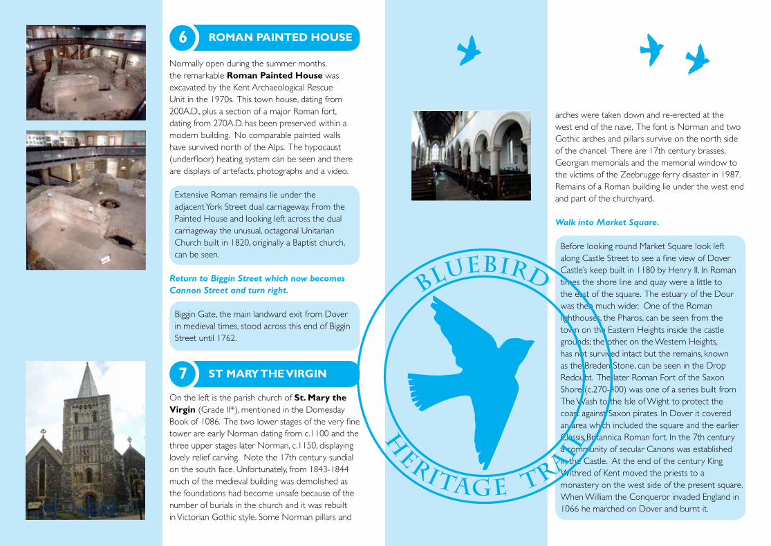
Normally open during the summer months, the remarkable Roman Painted House was excavated by the Kent Archaeological Rescue Unit in the 1970s. This town house, dating from 200A.D., plus a section of a major Roman fort, dating from 270A.D. has been preserved within a modern building. No comparable painted walls have survived north of the Alps. The hypocaust (underfloor) heating system can be seen and there are displays of artefacts, photographs and a video.
Extensive Roman remains lie under the adjacent York Street dual carriageway. From the Painted House and looking left across the dual carriageway the unusual, octagonal Unitarian Church built in 1820, originally a Baptist church, can be seen.
Return to Biggin Street which now becomes Cannon Street and turn right.
Biggin Gate, the main landward exit from Dover in medieval times, stood across this end of Biggin Street until 1762.
On the left is the parish church of St. Mary the Virgin (Grade II*), mentioned in the Domesday Book of 1086. The two lower stages of the very fine tower are early Norman dating from c.1100 and the three upper stages later Norman, c.1150, displaying lovely relief carving. Note the 17th century sundial on the south face. Unfortunately, from 1843-1844 much of the medieval building was demolished as the foundations had become unsafe because of the number of burials in the church and it was rebuilt in Victorian Gothic style. Some Norman pillars and
arches were taken down and re-erected at the west end of the nave. The font is Norman and two Gothic arches and pillars survive on the north side of the chancel. There are 17th century brasses, Georgian memorials and the memorial window to the victims of the Zeebrugge ferry disaster in 1987. Remains of a Roman building lie under the west end and part of the churchyard.
Walk into Market Square.
Before looking round Market Square look left along Castle Street to see a fine view of Dover Castle’s keep built in 1180 by Henry II. In Roman times the shore line and quay were a little to the east of the square. The estuary of the Dour was then much wider. One of the Roman lighthouses, the Pharos, can be seen from the town on the Eastern Heights inside the castle grounds; the other, on the Western Heights, has not survived intact but the remains, known as the Breden Stone, can be seen in the Drop Redoubt. The later Roman Fort of the Saxon Shore (c.270-400) was one of a series built from The Wash to the Isle of Wight to protect the coast against Saxon pirates. In Dover it covered an area which included the square and the earlier Classis Britannica Roman fort. In the 7th century a community of secular Canons was established in the Castle. At the end of the century King Withred of Kent moved the priests to a monastery on the west side of the present square. When William the Conqueror invaded England in 1066 he marched on Dover and burnt it.
BLUEBIRD
H
ERITAGE TRAIL
6 ROMAN PAINTED HOUSE
7 ST MARY THE VIRGIN

The Normans rebuilt the monastery and the splendid church of St Martin Le Grand replaced the Saxon building. The church, cruciform in plan, had three apsidal chapels at the east end. In 1131 the Canons were turned out, probably on a pretext, and St. Martin Le Grand became the church of three parishes. Its destruction began at the Reformation. More was pulled down in 1881 and even more when the National Provincial Bank, now the National Westminster Bank, was built. Behind the bank the remains, excavated in the 1970s, can be seen if you walk between the Museum and Barclays Bank and up the steps or ramp.
On the south side is the attractive façade of the former Market Hall (Grade II), designed by Edmund Woodthorpe in 1846. Dover Museum, transferred from the old Guildhall, occupied the upper storey until it was damaged by enemy action in the Second World War. It returned to this site in 1991 and has now been joined by the Visitor Information Centre.
Above the door of Dickens’ Corner coffee shop on the corner with Church Street is a plaque which records that in Dickens’ novel, David Copperfield, David rested here. Looking south into King Street you can see on the left an attractive reddish building with heraldic beasts, which was purpose built as the Head Post Office in 1893.
At the end of Bench Street, a continuation of King Street, at the entrance to the A20 underpass, is a plaque commemorating the spot where the world’s oldest seagoing boat, the Dover Bronze Age Boat was found in1992 some 20 feet below street level, superbly crafted in oak with yew withies to tie the planks and caulked with sphagnum and other mosses. Eight metres were successfully removed and this wonderful find is now on display in Dover Museum in a purpose-built Bronze Age Boat Gallery.
After looking round Market Square walk down the right hand side of Castle Street and continue up Castle Hill Road using the crossing.
Castle Street dates from the 1830s. Before 1829 the land was several feet lower and marshy. The terraced houses form a harmonious and attractive group. Between Stembrook and Dolphin Passage there was a ford over the Dour. The river was later arched over and now runs under the street.
By the triangular green turn right into St. James’s Street.
On the right hand side is Castle Hill House (Grade II*), a large Georgian residence built in 1760 by the Stringer family and set in parkland, including the present Victoria Park. It was the home of several Dover mayors and was also home to Dover MP (1922-1945) Major John Jacob Astor. On the left the White Horse Inn (Grade II) is now the oldest surviving public house in Dover and the ‘local’ for Channel swimmers.
Cross the road to the White Horse pub.
BLUEBIRD
HERITAGE TRAIL
8 ST MARTIN LE GRAND
9 MARKET HALL
10 BRONZE AGE BOAT
11 CASTLE HILL HOUSE
Admiralty Pier
DOVERCASTLE
1 2345
67
810 9
11
13
12
1415161718
19202122
23
24
25
26
27
29
30
31
28
Dover map is correct at time of printing. For latest please go to our website.
1. Dover War Memorial
2. Maison Dieu House
3. Town Hall
4. Dover College/St Martin’s Priory
5. St Edmund’s Chapel
6. Roman Painted House
7. St Mary the Virgin Church
8. St Martin Le Grand
9. Market Hall / Museum
10. Bronze Age Boat Gallery
11. Castle Hill House
12. Old St James’s Church
13. Mote’s Bulwark
14. Captain Matthew Webb
15. Operation Fuller
16. Merchant Navy Memorial
17. Charles Rolls
18. Rifles’ Monument
19. Dover Harbour
20. Dunkirk Memorial
21. Frontline Britain
22. Lindemann Monument
23. Waterloo Crescent
24. Charles II Pavilion
25. Prince of Wales Pier
26. Fairbairn Crane
27. Grand Shaft
28. Lord Warden House / Hotel
29. Admiralty Pier
30. Marine Station
31. Admiralty Pier Gun Turret
BLUEBIRD TRAIL

Old St. James’ Church (Grade II), originally Norman, was heavily restored in 1869. Badly damaged by German shelling from the French coast during the Second World War it is now preserved as a ‘tidy ruin’. The main doorway is Victorian in the Norman style, but on the north side, in Hubert Passage, is a damaged medieval doorway with barley-sugar columns filled with attractive pieces of carved stone.
Turn left onto the left hand side of Woolcomber Street and continue to the Townwall Street (A20) junction.
The name of this street recalls an 18th century cottage industry. On the left and right hand sides pre World War II there was a maze of old, narrow streets, but with extensive wartime damage the area was cleared and remained largely derelict until recent redevelopment. Dover was known as Hell Fire Corner with 464 bombs and 2226 shells falling on the town causing great destruction, especially near the seafront. Nearly 1000 premises were destroyed and many more damaged. There were air raid shelters in caves in the cliffs which held 12,000 people.
Cross the A20 using the pedestrian crossing, turn left and then right into Douro Place. Cross Marine Parade to the seafront promenade. Before walking west you may wish to walk east to the jetty by the toilets and look left to the cliffs to see Mote’s Bulwark
Near the base of Castle Cliff Henry VIII’s Mote’s Bulwark was built in about 1540 to protect the harbour. In the cliffside you can see casemate openings dating from Napoleonic times which were greatly extended during World War II to act
as an underground command centre and from which the Dunkirk evacuation was masterminded in 1940. From the balcony Churchill looked towards occupied France.
The pleasing East Cliff terrace was built c.1830-40. At the eastern end of the promenade are the Eastern Docks, the busiest passenger and vehicle ferry terminal in Britain. A good view of dock activity, the Channel and the coast of France can be obtained by walking up the cliff path at the end of Athol Terrace to Langdon Cliffs, part of the world famous White Cliffs, where there is a National Trust visitor centre. The Coastguard Station is also on the cliffs on the site of Langdon Battery used in both world wars. Inland, between Langdon Cliffs and the castle, is the Bleriot Memorial, commemorating the first successful Channel crossing by an aeroplane in July 1909 when Louis Bleriot landed in Northfall Meadow where the memorial in the shape of his aircraft is now sited.
Now walk westwards along the promenade.
The seafront is dominated by The Gateway flats, completed in 1958 to replace the war-damaged 19th century terraces, gardens and bathing establishments which lined Marine Parade.
There are a number of interesting memorials. The first is a bust of Captain Matthew Webb who, in 1875, was the first man to swim the Channel unaided. Webb gave up his job as a ship’s captain to train for the ordeal. His first attempt, on 12 August, failed when a storm blew up but on 24 August he succeeded, taking 21 hours 45 minutes and actually swimming 64 kilometres rather than the 34km straight line distance. Webb died attempting to swim across the Whirlpool Rapids below Niagara Falls in 1883.
BLUEBIRD
HERITAGE TRAIL
12 OLD ST JAMES’ CHURCH
13 MOTE’S BULWARK
14 CAPTAIN MATTHEW WEB
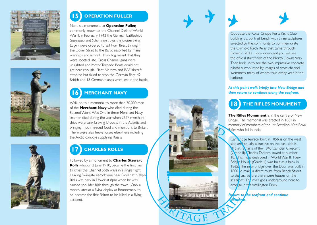
Next is a monument to Operation Fuller, commonly known as the Channel Dash of World War II. In February 1942 the German battleships Gneisenau and Scharnhorst plus the cruiser Prinz Eugen were ordered to sail from Brest through the Dover Strait to the Baltic escorted by many warships and aircraft. Thick fog meant that they were spotted late. Cross Channel guns were unsighted and Motor Torpedo Boats could not get near enough. Fleet Air Arm and RAF aircraft attacked but failed to stop the German fleet. 42 British and 18 German planes were lost in the battle.
Walk on to a memorial to more than 30,000 men of the Merchant Navy who died during the Second World War. One in three Merchant Navy seamen died during the war when 2627 merchant ships were sunk braving U-boats in the Atlantic and bringing much needed food and munitions to Britain. There were also heavy losses elsewhere including the Arctic convoys supplying Russia.
Followed by a monument to Charles Stewart Rolls who, on 2 June 1910, became the first man to cross the Channel both ways in a single flight. Leaving Swingate aerodrome near Dover at 6.30pm, Rolls was back in Dover at 8pm when he was carried shoulder high through the town. Only a month later, at a flying display at Bournemeouth, he became the first Briton to be killed in a flying accident.
Opposite the Royal Cinque Ports Yacht Club building is a portrait bench with three sculptures selected by the community to commemorate the Olympic Torch Relay that came through Dover in 2012. Look down and you will see the official start/finish of the North Downs Way. Then look up to see the two impressive concrete plinths surmounted by images of cross channel swimmers, many of whom train every year in the harbour.
At this point walk briefly into New Bridge and then return to continue along the seafront.
The Rifles Monument is in the centre of New Bridge. The memorial was erected in 1861 in memory of members of the 1st Battalion 60th Royal Rifles who fell in India.
Cambridge Terrace, built in 1856, is on the west side and equally attractive on the east side is all that remains of the 1840 Camden Crescent (Grade II). Charles Dickens stayed at number 10, which was destroyed in World War II. New Bridge House (Grade II) was built as a bank in 1865. The ‘new bridge’ over the Dour was built in 1800 to make a direct route from Bench Street to the sea, before there were houses on the sea front. The river goes underground here to emerge in the Wellington Dock.
Return to the seafront and continue westwards.
BLUEBIRD
H
ERITAGE TRAIL
15 OPERATION FULLER
16 MERCHANT NAVY
17 CHARLES ROLLS
18 THE RIFLES MONUMENT

Looking seawards, the expanse of Dover Harbour is impressive. The construction of a National Harbour of Refuge was first discussed in the early 19th century. For hundreds of years the shingle which blocked successive harbours was a problem. It was not really solved until the Admiralty Pier, begun in 1847 and completed in 1871, was built into deep water. In 1897 work commenced on the Eastern Arm, the Southern Breakwater and the extension to the Admiralty Pier, which was finished in 1909. This huge outer harbour was intended solely for Royal Navy use. The Dover Patrol was based here during World War I, but it was never used for the whole fleet. The Admiralty handed over the harbour to the Harbour Board in 1922 for commercial use and since the Second World War the port has developed enormously. In 2014 13 million passengers, 2.5 million tourist vehicles, 90,000 coaches, 2.4 million freight lorries and 120 cruise ships used the port.
Continue westwards along the seafront where there are more memorials.
The Dunkirk Memorial pays tribute to the events of 26th May to 4th June 1940 when 338,226 British and Allied troops were evacuated from the beaches of Dunkirk to Kentish ports in an assortment of craft which included destroyers, paddle-steamers, trawlers, dredgers and cockle boats. 180,982 men landed in Dover but 68,111 were killed or captured by the enemy during the retreat.
The Frontline Britain memorial commemorates all those in East Kent who died during WWII.
Next is the very unusual Lindemann Monument, containing a section of the armour-plating from one of the German long-range 406mm guns, called ‘Caesar’, sited at Batterie Lindemann near Sangatte in the Pas de Calais. The gun was silenced by Canadian troops who captured it in September 1944. The plating is inscribed ‘Es flogen gegen Engeland’ ‘They flew against England’, and a tally of rounds fired is recorded.
These memorials are set against the handsome background of Waterloo Crescent (Grade II), built between 1834 and 1838. At its western end is Harbour House, the headquarters of Dover Harbour Board. In 1606, at the instigation of James I, Dover Corporation agreed to transfer control of the harbour to ‘eleven discreet men’, including the Lord Warden of the Cinque Ports.
The small pavilion at the end of the sea front marks the Restoration of the Monarchy when Charles II landed at Dover in 1660 en route for London where he was crowned King.
BLUEBIRD
H
ERITAGE TRAIL
20 DUNKIRK MEMORIAL
21 FRONT LINE BRITAIN
22 LINDEMANN MONUMENT
19 DOVER HARBOUR
23 WATERLOO CRESCENT
24 RESTORATION

In front of you now is the half mile long Prince of Wales Pier (Grade II), constructed between 1893 and 1902, but subjected to many amendments since. In 1977 a hoverport was built on the west side and operated a regular service to Calais until 2005. A 19th century clock tower and former lifeboat station are by the original pier entrance. The pier will be largely incorporated in the Western Docks Cargo Terminal.
Look behind you and enjoy the glorious view of Dover Castle (Grade I). The castle site has thousands of years of history: an iron-age hill fort, a surviving Roman lighthouse (Grade I), a Saxon church (Grade I), and an impressive medieval stone fortress dating from 1180, adapted over the centuries to counter several threats of invasion.
The trail continues for another mile, but you may wish to stop at this point to enjoy the beach and facilities or return to the town centre.
If you wish to continue: Leave the seafront and turn right into Union Street using the right hand side.
On the right hand side of the road is the Wellington Dock, now a marina and formerly the Great Pent, into which the River Dour flows. An unusual feature of the dock is the Fairbairn hand crank crane (Grade II) dating from 1868 and known locally as the ‘gooseneck’ for obvious reasons.
At the end of Union Street look at the towering Western Heights.
The Western Heights may be reached via the Grand Shaft, when it is open, or via York Street and Military Road. Using the latter route you will pass the ruined foundations of what is thought to be a Knights Templar church with its circular nave and short chancel. Excellent views of the town, harbour, Eastern Heights and, on clear days, the French coast may be obtained. Fortification began in 1779 when England was at war with America and feared attack from America’s allies, France, Spain and the Netherlands. The Drop Redoubt, a detached fort, may be visited on Open Days. Connected to the Redoubt by brick-lined, dry moats is The Citadel, a much larger fort, now used as a prison and not open to the public. Barracks located near the top of the Grand Shaft were demolished in the 1960s. Snargate Street at the foot of the Heights was, before World War I, the main shopping area of Dover.
The Grand Shaft (Grade II) entrance can be seen at the base of the cliff opposite. It was built between 1804 and 1807 as a short-cut for soldiers stationed in the barracks and forts of the Western Heights. It consists of a unique triple spiral staircase through the chalk cliff. Each staircase has 140 steps within the cliff and another 59 into the former Grand Shaft Barracks’ yard. Notices placed at the top of each staircase changed slightly over the years. One version is: 1 For Officers and their ladies, 2 For Sergeants and their wives, 3 For Soldiers and their women. The original purpose, however, was for speed rather than class distinction. In the event of the invasion threatened by Napoleon Bonaparte, troops could be quickly assembled at sea level.
Turn left onto left hand side of Limekiln Street (A20).
BLUEBIRD
H
ERITAGE TRAIL
26 HAND CRANK CRANE
25 PRINCE OF WALES PIER
27 THE GRAND SHAFT

The chalk cliffs conceal many extensive man made cave systems that were used as air raid shelters during both world wars.
At the next roundabout turn left and walk over The Viaduct.
On your left the long, narrow brick building with its clock tower is the former Harbour Station opened by the London, Chatham and Dover Railway in 1861 as an extension to the Western Docks of its line from London to Dover Priory Station. This required a 684 yard (626m) tunnel from Dover Priory and the demolition of a considerable number of properties in the Pier District.
Lord Warden House (Grade II) is the impressive building at the end of The Viaduct. Built as the Lord Warden Hotel, it was opened in 1853 to cater for cross Channel passengers arriving and departing by rail at the adjacent Town Station (now demolished). Distinguished guests included Napoleon III and Charles Dickens.
Cross the access road to the Cruise Terminal, walk in front of Lord Warden House, turn left and use the impressive pedestrian entrance to Admiralty Pier.
Admiralty Pier was begun in 1847 as one arm of a proposed naval harbour, which eventually enclosed Dover Bay.
The imposing listed structure on the left is Cruise Terminal1, but was formerly Dover Marine Station (Grade II), completed in 1914 and used extensively during World War I to move troops and the wounded. It closed in 1994 as a consequence of the opening of the Channel Tunnel. Inside is an impressive memorial to the railwaymen who gave their lives in both World Wars.
Look right to see the distinctive Shakespeare Cliff, named from an incident in King Lear.
Between the present Cruise Terminals 1 and 2 is the Admiralty Pier Gun Turret, a coastal artillery battery completed in the 1880s but never fired in anger. When built it was at the seaward end of the pier prior to a later pier extension. The hidden gems here are its original armaments: two Armstrong 16 inch Rifled Muzzle Loading guns each weighing 81 tons within a circular cast-iron turret. The guns, about 8 metres in length could fire a 1700 pound (771kg) shell nearly seven miles. They were the second largest Armstrong guns ever made and the only steam powered guns ever possessed by the coastal artillery in Britain.
You have now completed the Bluebird Heritage Trail.
BLUEBIRD
H
ERITAGE TRAIL
29 ADMIRALTY PIER
30 DOVER MARINE STATION
31 GUN TURRET
28 LORD WARDEN HOUSE

Having enjoyed a glimpse of the wealth of Dover’s history and attractions, you may wish to discover more. If so, return to the Visitor Information Centre in Market Square where you can get more information or visit the listed websites:
www.doversociety.orgwww.doverhistorian.comwww.dovermuseum.co.ukwww.dovertransportmuseum.org.ukwww.doverwesternheights.orgwww.doverwarmemorialproject.org.ukwww.theromanpaintedhouse.co.ukwww.stedmundschapel.co.ukwww.english-heritage.org.uk/visit/places/dovercastlewww.nationaltrust.org.uk/the-white-cliffs-of-doverwww.kearsneyparks.co.uk/The Parks/RiverDour/Walk-the-Dour.aspxwww.whitecliffscountry.org.ukFacebook: dover(kent)history
Acknowledgements:The Dover Society wishes to acknowledge the financial and other support given by the Heritage Lottery Fund, Dover District Council, Dover Town Council and the Port of Dover.
Compiled by Derek Leach and designed by Clare Limbrey, Design Studio, Dover District Council. Photographs courtesy of Dover Museum and Derek Leach.Printed by A.R.Adams & Sons (Printers) Ltd. Dover