
Blue Primitive Area Trailsc001af38d1d46a976912-b99970780ce78ebdd694d83e551ef810.r48.cf1... · Blue...
8
GRAND CANYON COUNCIL, BSA ARIZONA TRAILS BOOK Page 39 Blue Primitive Area Trails The Blue Range Primitive Area lies in east-central Arizona between State Highway 666 and the New Mexico border. It is named for the Blue River that flows north to south through the center of the area. It is rugged terrain similar to the White Mountain area to the west of the highway and is also a three season hiking area. BE SURE TO BE IN TOUCH WITH THE APPROPRIATE U. S. FOREST SERVICE DISTRICT OFFICE BEFORE HIKING THESE TRAILS! The topographical maps covering each hike will be named with each description, but USFS trail numbers are not given on these maps. They should be used in conjunction with the USFS Apache-Sitgreaves National Forests Map available through forest service offices and retail outlets. HORSE RIDGE: Backpack or use vehicular support for this two day hike from the Coronado Trail (State 666) to the Blue River and back. The Horse Ridge trailhead is located on State 666 one half mile southwest of its junction with Forest Road 567 by Beaverhead Lodge. From the trailhead hike down Trail # 38 to #76 to #5 to Blue Crossing Campground. For the return, backtrack on #5 to #56 and follow this trail northwest to Forest Road 567. Contact: Alpine Ranger District Apache National Forest P.O. Box 469 Alpine, AZ 85920 Telephone: (928) 339-4384 This 22 mile hike covers 8000' to 6200'. (Topos: Hannagan Meadow [15'] and Blue [15] Quads) BEAR MOUNTAIN: Bear Mountain stands in the heart of the Blue Range Primitive Area and provides a sweeping view of mountain upon mountain in every direction. Three or four days are needed to complete this moderately difficult backpacking trek. Start at Trailhead #38 (see previous hike) and follow Trail #38 to #76. On #76 hike to Blue Camp on the Blue River and pick up #51 (Largo Creek Trail) and proceed past Dutch Oven Spring to #54 (WS Lake Trail) which takes you to the top of Bear Mountain. Descend by Trail #39 (Sawmill Canyon Trail) down Telephone Ridge to the Blue River. Three quarters of a mile downstream pick up Forest Road 281 and Trail # 75 up Grant Creek to the highway. Continue northeast about three quarters of a mile where there is a turnout at which a vehicle can be safely loaded. Elevation ranges between 8000' and 6100' on this 30 mile hike. Contact Alpine Ranger District. (Topos: Hannagan Meadow [15"] and Blue [15] Quads)
Transcript of Blue Primitive Area Trailsc001af38d1d46a976912-b99970780ce78ebdd694d83e551ef810.r48.cf1... · Blue...

GRAND CANYON COUNCIL, BSA ARIZONA TRAILS BOOK
Page 39
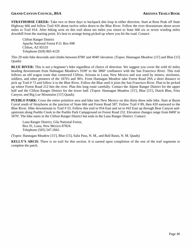
Blue Primitive Area Trails The Blue Range Primitive Area lies in east-central Arizona between State Highway 666 and the New Mexico border. It is named for the Blue River that flows north to south through the center of the area. It is rugged terrain similar to the White Mountain area to the west of the highway and is also a three season hiking area. BE SURE TO BE IN TOUCH WITH THE APPROPRIATE U. S. FOREST SERVICE DISTRICT OFFICE BEFORE HIKING THESE TRAILS!
The topographical maps covering each hike will be named with each description, but USFS trail numbers are not given on these maps. They should be used in conjunction with the USFS Apache-Sitgreaves National Forests Map available through forest service offices and retail outlets.
HORSE RIDGE: Backpack or use vehicular support for this two day hike from the Coronado Trail (State 666) to the Blue River and back. The Horse Ridge trailhead is located on State 666 one half mile southwest of its junction with Forest Road 567 by Beaverhead Lodge. From the trailhead hike down Trail # 38 to #76 to #5 to Blue Crossing Campground. For the return, backtrack on #5 to #56 and follow this trail northwest to Forest Road 567. Contact:
Alpine Ranger District Apache National Forest P.O. Box 469 Alpine, AZ 85920 Telephone: (928) 339-4384
This 22 mile hike covers 8000' to 6200'. (Topos: Hannagan Meadow [15'] and Blue [15] Quads)
BEAR MOUNTAIN: Bear Mountain stands in the heart of the Blue Range Primitive Area and provides a sweeping view of mountain upon mountain in every direction. Three or four days are needed to complete this moderately difficult backpacking trek. Start at Trailhead #38 (see previous hike) and follow Trail #38 to #76. On #76 hike to Blue Camp on the Blue River and pick up #51 (Largo Creek Trail) and proceed past Dutch Oven Spring to #54 (WS Lake Trail) which takes you to the top of Bear Mountain. Descend by Trail #39 (Sawmill Canyon Trail) down Telephone Ridge to the Blue River. Three quarters of a mile downstream pick up Forest Road 281 and Trail # 75 up Grant Creek to the highway. Continue northeast about three quarters of a mile where there is a turnout at which a vehicle can be safely loaded. Elevation ranges between 8000' and 6100' on this 30 mile hike. Contact Alpine Ranger District. (Topos: Hannagan Meadow [15"] and Blue [15] Quads)
GRAND CANYON COUNCIL, BSA ARIZONA TRAILS BOOK
Page 40
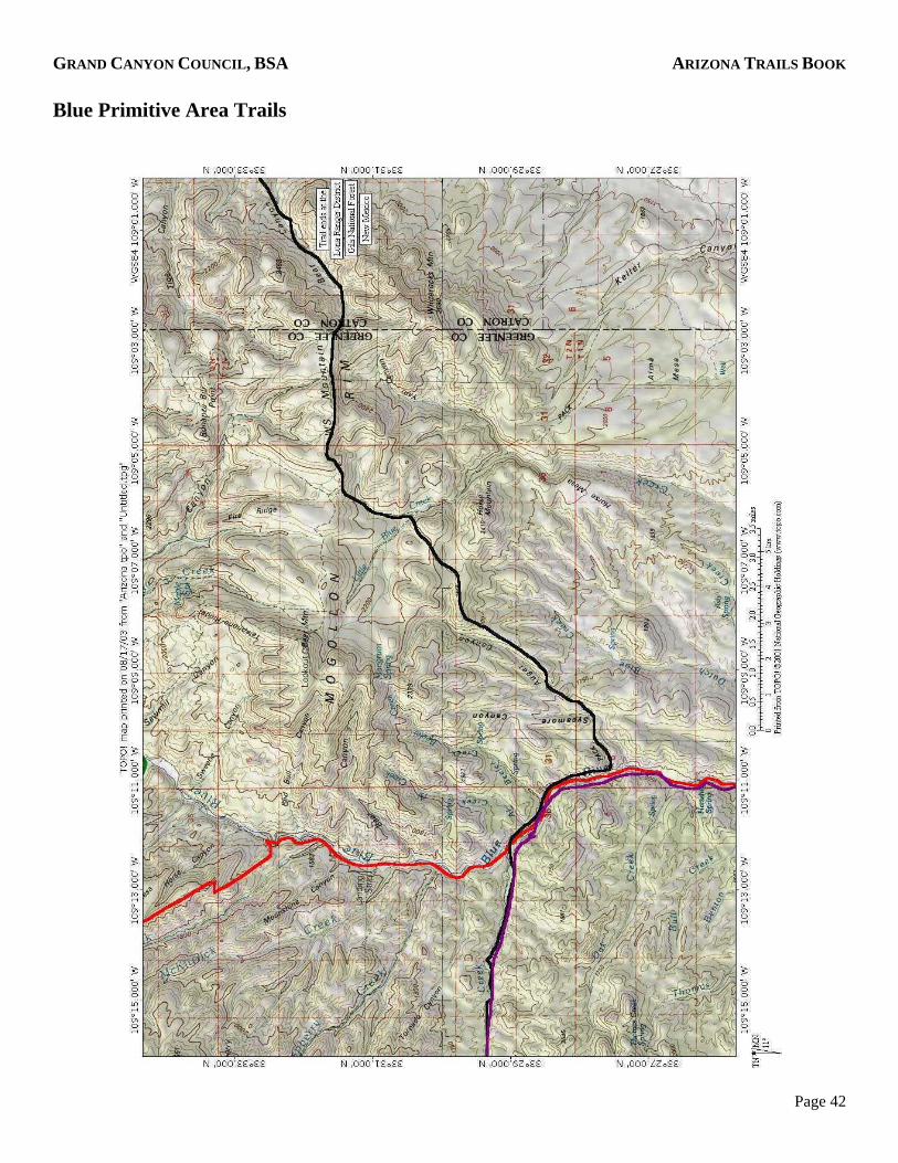
STRAYHORSE CREEK: Take two or three days to backpack this loop in either direction. Start at Rose Peak off State Highway 666 and follow Trail #20 about twelve miles down to the Blue River. Follow the river downstream about seven miles to Trail #14. After hiking west on this trail about ten miles you return to State 666 six or seven winding miles downhill from the starting point. It's best to arrange being picked up where you hit the road. Contact:
Clifton Ranger District Apache National Forest P.O. Box 698 Clifton, AZ 85533 Telephone (928) 865-4129
This 29 mile hike descends and climbs between 8780' and 4940' elevation. (Topos: Hannagan Meadow [15'] and Blue [15] Quads)
BLUE RIVER: This is not a beginner’s hike regardless of choice of direction. We suggest you cover the wild 42 miles heading downstream from Hahnagan Meadow's 9100' to the 3860' confluence with the San Francisco River. This trail follows an old wagon route that connected Clifton, Arizona to Luna, New Mexico and was used by miners, stockmen, soldiers, and other pioneers of the 1870's and '80's. From Hannagan Meadow take Forest Road 29A a short distance to pick up Trail # 73 and follow it to the Blue River. Follow the Blue until it joins the San Francisco River. Plan to be picked up where Forest Road 212 hits the river. Plan this long route carefully. Contact the Alpine Ranger District for the upper half and the Clifton Ranger District for the lower half. (Topos: Hannagan Meadow [15'], Blue [15'], Dutch Blue, Fritz Canyon, and Big Lue Mountains [15'] Quads)
PUEBLO PARK: Cross the entire primitive area and hike into New Mexico on this thirty-three mile hike. Start at Burnt Corral south of Strayhorse at the junction of State 666 and Forest Road 587. Follow Trail # 89, then #20 eastward to the Blue River. Hike downstream to Trail # 55. Follow this trail to #54 East and on to #43 East up through Bear Canyon and- upstream along Pueblo Creek to the Pueblo Park Campground on Forest Road 232. Elevation changes range from 8400' to 5070'. The hike starts in the Clifton Ranger District but ends in the Luna Ranger District. Contact:
Luna Ranger District, Gila National Forest, Box 91, Luna, New Mexico 87824. Telephone (505) 547-2661.
(Topos: Hannagan Meadow [15'], Blue [15], Saliz Pass, N. M., and Bull Basin, N. M. Quads)
KELLY’S ARCH: There is no trail for this section. It is earned upon completion of the rest of the trail segments to complete the patch.

GRAND CANYON COUNCIL, BSA ARIZONA TRAILS BOOK
Page 41
Blue Primitive Area Trails
GRAND CANYON COUNCIL, BSA ARIZONA TRAILS BOOK
Page 42
Blue Primitive Area Trails

GRAND CANYON COUNCIL, BSA ARIZONA TRAILS BOOK
Page 43
Blue Primitive Area Trails
GRAND CANYON COUNCIL, BSA ARIZONA TRAILS BOOK
Page 44
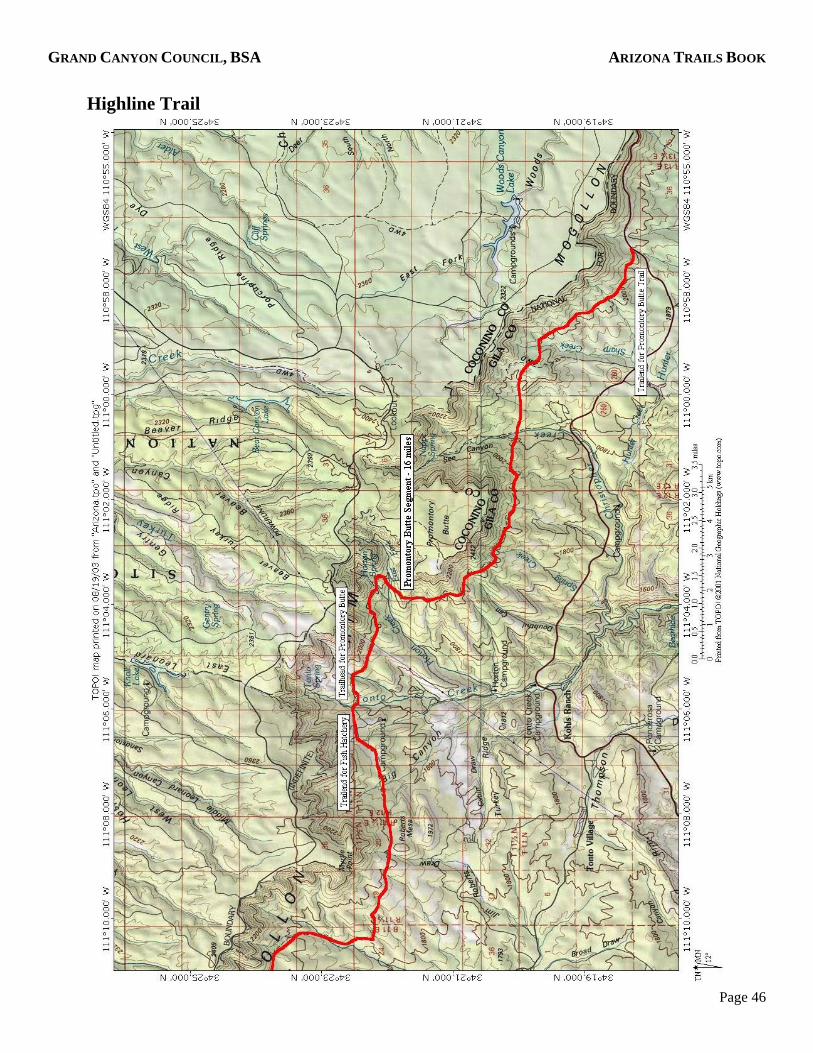
Highline Trail For a great hiking adventure, the Highline Trail is hard to beat with its breathtaking scenic beauty, varying flora and fauna, spectacular geologic formations and historical background.
The Volunteers of Outdoor Arizona, (VOAZ) worked on rerouting a portion of the trail East of Camp Geronimo on October 12-14, 2003 to conform to National Forest Specifications. They plan on having the Arizona Trail/Highline Trail to NF Standards by 2015.
The name "Highline" comes from its location along the highest contour line below the majestic Mogollon Rim for which a trail is possible. It was built by the rangers of the Tonto National Forest to access remote and rugged areas with fire fighters and equipment. Portions of the trail were used even earlier as routes of communication between early ranchers.
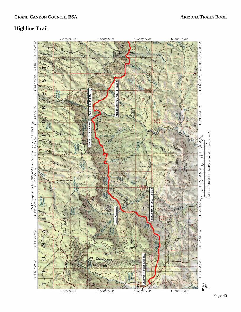
The trail begins just south of Pine, Arizona and winds its way eastward 51 miles at an elevation of 5700'. It parallels the famous General Crook Trail atop the rim as it winds through dense stands of Ponderosa Pine and one of the states best groves of Smooth bark Cypress along Milk Ranch Point. The trail passes just south of Camp Geronimo and continues to Washington Park, Tonto Creek, See Canyon and ends near Arizona 260. The trail has been divided into three sections of about equal length. Each segment can be hiked in one day if there are no mistakes or injuries. Two days per segment would be a lot more enjoyable and a week for the entire trail would be ideal. The trail is identified as Forest Trail 31.
BAKER BUTTE SEGMENT: One mile south of Pine on Highway 87 a sign reading "Pine Trailhead" leads the way to a staging area for hikers and horsemen. This 18 mile segment skirts Milk Ranch Point through smooth-bark cypress and heads eastward past Camp Geronimo and on to Washington Park. Camping is available at several trailside sites including Camp Geronimo with prior reservations. (Topos: Buckhead Mesa and Kehl Ridge Quads)
FISH HATCHERY SEGMENT: This section begins at Washington Park and heads east past the site of Zane Grey's Cabin ending at Tonto Creek below the trout hatchery. This section traverses the area of the Dude Fire. The trail is about 17 miles long with numerous campsites along the way with water usually available. Camping at Tonto Creek affords an opportunity to visit the state hatchery and a chance to watch American Dippers forage on the bottom of the creek. (Topos: Kehl Ridge, Dane Canyon, Promontory Butte, and Knoll Lake Quads)
PROMONTORY BUTTE SEGMENT: This segment begins at Tonto Creek, wraps around Promontory Butte, and ends at Highway 260 between Christopher Creek and the top of the Rim. This segment is about 16 miles and no matter which direction you go you must climb into and out of See Canyon. (Topos: Promontory Butte and Woods Canyon (15] Quads)
GRAND CANYON COUNCIL, BSA ARIZONA TRAILS BOOK
Page 45
Highline Trail
GRAND CANYON COUNCIL, BSA ARIZONA TRAILS BOOK
Page 46
Highline Trail