P11017 Tactile Navigation Interface for the Visually-Impaired (VI) and Blind

Citation
Giudice N A amp Legge G E (2008) Blind navigation and the role of
technology In A Helal M Mokhtari amp B Abdulrazak (Eds) Engineering
handbook of smart technology for aging disability and independence (pp 479-
500) John Wiley amp Sons
download from wwwvemilaborg
Leave comments on this article using the recommender system at
wwwvemilaborgnode31
Original content adapted for web distribution
25 Blind Navigation and the
Role of Technology Nicholas A Giudice
University of California Santa Barbara
Gordon E Legge
University of Minnesota
251 INTRODUCTION
The ability to navigate from place to place is an integral part of daily life Most people would acknowledge that vision plays a critical role but would have great difficulty in identifying the visual information they use or when they use it Although it is easy to imagine getting around without vision in well-known environments such as walking from the bedroom to the bathroom in the middle of the night few people have experienced navigating large-scale unfamiliar environments nonvisually Imagine for example being blindfolded and finding your train in New Yorkrsquos Grand Central Station Yet blind people travel independently on a daily basis To facilitate safe and efficient navigation blind individuals must acquire travel skills and use sources of nonvisual environmental information that are rarely considered by their sighted peers How do you avoid running into the low-hanging branch over the sidewalk or falling into the open manhole When you are walking down the street how do you know when you have reached the post office the bakery or your friendrsquos house
The purpose of this chapter is to highlight some of the navigational technologies available to blind individuals to support independent travel Our focus here is on blind navigation in large-scale unfamiliar environments but the technology discussed can also be used in well-known spaces and may be useful to those with low vision
The Engineering Handbook of Smart Technology for Aging Disability and Independence Edited by A Helal M Mokhtari and B Abdulrazak Copyright 2008 John Wiley amp Sons Inc
479
480 BLIND NAVIGATION AND THE ROLE OF TECHNOLOGY
In Section 252 we look at some perceptual and cognitive aspects of navigating with and without vision that help explain why most people cannot imagine getting around in its absence Section 253 presents four often ignored factors from engineering blunders to aesthetic bloopers which should be considered when developing and assessing the functional utility of navigational technologies In Section 254 we summarize several of these technologies ranging from sonar glasses to talking lights giving the strengths and limitations of each Section 255 concludes the chapter by reviewing key features of these products and highlighting the best trajectory for continued development of future technology
252 FACTORS INFLUENCING BLIND NAVIGATION
Two of the biggest challenges to independence for blind individuals are difficulties in accessing printed material [1] and the stressors associated with safe and efficient navigashytion [2] Access to printed documents has been greatly improved by the development and proliferation of adaptive technologies such as screen-reading programs optical character recognition software text-to-speech engines and electronic Braille displays By conshytrast difficulty accessing room numbers street signs store names bus numbers maps and other printed information related to navigation remains a major challenge for blind travel Imagine trying to find room n257 in a large university building without being able to read the room numbers or access the ldquoyou are hererdquo map at the buildingrsquos entrance Braille signage certainly helps in identifying a room but it is difficult for blind people to find Braille signs In addition only a modest fraction of the more than 3 million visually impaired people in the United States read Braille Estimates put the number of Braille readers between 15000 and 85000 [3]
Braille signs indicating room numbers are installed by law in all newly constructed or renovated commercial buildings [4] However many older buildings do not have accessible signage and even if they do room numbers represent only a small portion of useful printed information in the environment For instance a blind navigator walking into a mall is unable to access the directory of stores or in an airport the electronic displays of departure and arrival times When traveling without vision in an unfamiliar outdoor setting accessing the names of the shops being passed the name of the street being crossed or the state of the traffic signal at a busy intersection can also be challenging Although speech-enabled GPS-based systems can be used to obtain access to street names and nearby stores and audible traffic signals can provide cues about when it is safe to cross the street these technologies are not widely available to blind navigators Where an environment can be made accessible for somebody in a wheelchair by removing physical barriers such as installing a ramp there is no simple solution for providing access to environmental information for a blind traveler [5] As our interest is in blind navigation and environmental access most of the navigational technologies discussed in this chapter collect and display environmental information rather than require structural modifications For a review of the benefits of some physical modifications that can aid blind navigation such as the installation of accessible pedestrian signals see the article by Barlow and Franck [6]
Compared to the advances in accessing printed material in documents there has been far less development and penetration of technologies to access print-based information in the environment or to aid navigation The reason for this limited adoption inevitably
FACTORS INFLUENCING BLIND NAVIGATION 481
stems from several factors Most navigational technologies cost hundreds or thousands of dollars This makes it prohibitively expensive for most blind people to buy these devices on their own budgets Rehabilitation agencies for the blind will often assist in the purchase of adaptive technology for print access but rarely provide their clients with technologies for navigation In addition to cost constraints broad adoption of navigational technologies will likely not occur until greater emphasis is given to perceptual factors and end-user needs In other words there needs to be more research investigating whether these devices are providing a solution to something that is in fact a significant problem for blind navigators (see Sections 253 and 255 for more detail) Until then safe and efficient travel will continue to be a stressful endeavor for many blind wayfinders
Another factor to be addressed is the population of potential users of navigational techshynologies The vast majority of impaired vision is aged-related with late onset [7] such as from macular degeneration glaucoma or diabetic retinopathy Those with age-related vision loss may have more difficulty than younger people in learning to use high-tech devices Compounding the problem older people often have coexisting physical or cogshynitive deficits that could render the adoption of some technology impractical Given these concerns more research is needed to address how to best develop devices to aid navigation for people with late-onset vision loss
While the goal of navigating with or without vision is the same that is safely locomotshying from an origin to a destination the environmental information available to sighted and blind people is quite different Understanding the challenges to blind navigation requires appreciation of the amount of spatial information available from vision Think of walking from your front door to the mailbox at the end of your driveway If you are sighted your movement is guided entirely by visual perception You simultaneously observe the distant mailbox and intervening environment from your door and navigate a route that gets you there as directly as possible while circumventing the bicycle on the front path and the car in the driveway You likely pay little attention to what you hear from the environment as you avoid the obstacles along the way With vision it is trivial to see the spatial configuration of objects in the environment around you and how the relation between yourself and these objects changes as you move This example represents what is called position-based navigation or piloting Piloting involves use of external information to specify the navigatorrsquos position and orientation in the environment [8] Although vision is typically used to estimate distance and direction to landmarks and guide onersquos trajectory a navigator can also use tactile auditory or olfactory information as well as signals from electronic aids such as GPS-based devices for piloting [9] Navigation can also be done without reference to fixed landmarks such as through velocity-based techniques that use instantaneous speed and direction of travel determined through optic or acoustic flow to keep track of translational and rotational displacements Inertial techniques may also be used that utilize internal acceleration cues from the vestibular system to update these displacements (see Refs 8 and 10 for general discussions of these navigational techniques)
Since both position- and velocity-based navigation are best served by visual cues navigation using other sensory modalities is typically less accurate For instance auditory olfactory or tactile input conveys much less information than vision about self-motion layout geometry and distance or direction cues about landmark locations [1112] Given that this information is important for efficient spatial learning and navigation lack of access puts blind people at a disadvantage compared to their sighted peers As we will see in Section 254 navigational technologies attempt to close this gap by providing blind
482 BLIND NAVIGATION AND THE ROLE OF TECHNOLOGY
wayfinders access to the same critical environmental information available to sighted navigators
Another major difference in navigating without vision is the added demand of learnshying to interpret nonvisual sensory signals Blind navigators need to learn how to safely traverse their environment They must learn how to detect obstructions to their path of travel find curbs and stairs interpret traffic patterns so as to know when the light is red or green not veer when crossing the street find the bus stop and myriad other navigashytional tasks They must also keep track of where they are in the environment and how their current position and orientation relates to where they want to go These tasks are cognitively demanding and often require conscious moment-to-moment problem solving By comparison sighted people solve these problems visually in a more automatic less cognitively demanding way In other words vision-based navigation is more of a pershyceptual process whereas blind navigation is more of an effortful endeavor requiring the use of cognitive and attentional resources [13ndash15] Vision also affords access to many orienting cues in the environment For instance use of local landmarks such as street signs or colorful murals and global landmarks such as tall buildings or mountain ranges can aid spatial updating and determination of location Since access to this type of envishyronmental information is difficult from nonvisual modalities blind wayfinders must rely on other cues for orientation which are often ambiguous and unreliable (see Ref 12 for a review) Most sighted people have never considered how they avoid obstacles walk a straight line or recognize landmarks It is not something they consciously learned itrsquos just something they do By contrast the majority of blind people who are competent independent travelers have had specific training to acquire these skills This is called orientation and mobility (OampM) training
The navigational components of orientation and mobility are sometimes ambiguously defined in the literature but in general orientation refers to the process of keeping track of position and heading in the environment when navigating from point A to point B and mobility involves detecting and avoiding obstacles or drop-offs in the path of travel Thus good mobility relates to efficient locomotion and orientation to accurate wayfinding behavior Effective navigation involves both mobility and orientation skills As we will see the aids that are available to augment blind navigation generally provide information that falls within one of these categories
253 TECHNOLOGY TO AUGMENT BLIND NAVIGATION
Many navigational technologies have been developed throughout the years but few are still in existence Part of the reason may be due to a disconnect between engineering factors and a devicersquos perceptual and functional utility that is a device may work well in theory but be too difficult or cumbersome in practice to be adopted by the intended user Four important factors should be considered when discussing the design and implementation of technology for blind navigation
2531 Sensory Translation Rules
Most of the navigational technology discussed in this chapter conveys information about a visually rich world through auditory or tactile displays These channels have a much lower bandwidth than does vision and are sensitive to different stimulus properties For
TECHNOLOGY TO AUGMENT BLIND NAVIGATION 483
instance where cues about linear perspective are salient to vision this information is not well specified through touch By contrast thermal cues are salient to touch but not vision Thus any mapping between the input and output modality especially if it is cross-modal (eg visual input and auditory output) must be well specified Rather than assuming that any arbitrary mapping will work we need more insight from perception (auditory and tactile) and a clearer understanding of the cognitive demands associated with interpreting this information to guide the design principles of more effective mappings The ideal device would employ a mapping that is intuitive and requires little or no training How much training will be required and the ultimate performance level that can be obtained are empirical issues As these prerequisite issues are often ignored improved performance measures for evaluating such mappings are necessary
It is tempting but probably misleading to assume that people can easily interpret arbishytrary mappings of two-dimensional (2D) image data such as video images into auditory or tactile codes The history of print-to-sound technology is instructive in this regard The first efforts to build reading machines for the blind involved mapping the black-and-white patterns of print on a page to arbitrary auditory codes based on frequency and intensity These efforts were largely unsuccessful the resulting reading machines required too many hours of training and reading speeds were very slow [16] Print-to-sound succeeded only when two things happened (1) optical character recognition algorithms became robust and (2) synthetic speech became available In other words arbitrary mappings from print to sound did not work but the specific mapping from print to synthetic speech has been very effective A related point is that the translation from print to synthetic speech requires more than analog transformation of optical input to acoustic output There is an intervening stage of image interpretation in the form of optical character recognition It is likely that the future of successful high-tech navigation devices will rely more and more on computer-based interpretation of image data prior to auditory or tactile display to the blind user
2532 Selection of Information
To be effective the product must focus on conveying specific environmental informashytion To facilitate training with any navigational technology it is important to understand exactly what information it provides The complexity of the display is directly proporshytional to the amount of information that the developer wishes to present It may be tempting to design a device that strives to convey as much information as possible actshying as a true visual substitute However more is not always better For instance the best tactile maps are simple uncluttered displays that do not try to reproduce all that exists on a visual map [17] An inventor should be cognizant of the basic research addressing such perceptual issues and carry out empirical studies to ensure that the display is interpretable and usable to the target population Most of the technology discussed employs auditory or tactile output (see Ref 18 for a review of echo location and auditory perception in the blind and Refs 19 and 20 for excellent reviews of touch and haptic perception)
2533 Device Operation
The optimal operating conditions depend largely on the characteristics of the sensor used by the device For instance sonar-based devices can operate in the dark rain and snow This versatility provides a functional advantage of these devices for outdoor usage
484 BLIND NAVIGATION AND THE ROLE OF TECHNOLOGY
However they are not ideal for use in crowded or confined places as the sonar echoes become distorted rendering the information received by the user unreliable By contrast camera-based technology can work well under a wide range of operating conditions both inside and outside but these systems may have difficulty with image stabilization when used by moving pedestrians and wide variations in ambient luminance within and between scenes GPS-based devices are fairly accurate across a range of atmospheric conditions but the signal is line of sight and can thus be disrupted or completely occluded when under dense foliage or traveling among tall buildings Also GPS does not work indoors The bottom line is that each technology has its own strengths and weaknesses and successful navigation over a wide range of environmental conditions will probably require the integration of multiple technologies
2534 Form and Function
Another often neglected consideration is the aesthetic impact on the user that is a device should be minimally intrusive A survey carried out by Golledge and colleagues found wide variability in the ldquocosmetic acceptabilityrdquo of navigational technology [21] The finding that some people felt strongly enough to rate this issue as more important than having a device that improved navigation shows that aesthetic impact cannot be ignored
254 REVIEW OF SELECTED NAVIGATIONAL TECHNOLOGIES
Tools used in blind navigation are often called mobility aids or electronic travel aids (ETAs) While they generally provide information useful for mobility or orientation they can be further divided into two categories depending on the information displayed The most common devices are used as a mobility aid and serve as obstacle detectors Such aids are generally limited to providing low-resolution information about the nearby environment (see Ref 22 for a review) Another class of devices attempts to convey more detailed environmental information over a wider range of distances These ETAs are called environmental imagers as they serve as vision substitution devices (see Ref 23 for a review of vision substitution) The following discussion highlights some key technologies from these categories and provides some strengths and weaknesses of each This review is not meant as an exhaustive list but focuses instead on providing a brief historical context of each technology while emphasizing those devices that are commershycially available or part of an active research program For a more thorough discussion of blind navigation and some of the technologies discussed below see the classic book on orientation and mobility by Blasch and Welsh [24]
The long cane and guide dog are the most common tools for mobility The cane is a simple mechanical device that is traditionally used for detecting and identifying obstacles finding steps or drop-offs in the path of travel or as a symbolic indicator to others that a person is blind Although direct contact with the cane is limited to proximal space its effective range for detecting large obstacles is increased with the use of echo location cues created as a result of tapping [25]
The guide dog performs many of the same functions as the cane although navigation is often more efficient because the dog can help take direct routes between objects instead of following edges or shorelining which is a standard technique with a cane
REVIEW OF SELECTED NAVIGATIONAL TECHNOLOGIES 485
The dog also helps reduce veering which is often a challenge when crossing streets or traversing large open places The cane and guide dog have similar limitations They are most effective for detection of proximal cues are limited in detecting overhanging or non-ground-level obstructions and do not provide much in the way of orientation information about the userrsquos position and heading in the environment
It is important to note that most of the electronic travel aids discussed here are meant to complement not replace use of the long cane or guide dog
An ETA can be regarded in terms of its sensor the component receiving information about the environment and the display where the information is conveyed to the user Some devices such as GPS-based navigation systems also incorporate a user interface where specific information can be entered or queried from the system In the following discussion the navigational technologies are classified according to their sensor charactershyistics sonar-based (using sonic sensors) vision-based (using cameras or lasers) infrared (IR) or GPS devices All of these technologies provide auditory andor tactile output to the user (devices based on visual enhancement or magnification are not included in the following discussion)
2541 Sonar-Based Devices
The first sonar-based mobility aid was the handheld sonic torch using a special ultrasonic sensor developed by Leslie Kay in the early 1960s Kayrsquos company Bay Advanced Technologies (BAT) has developed many sonar-based devices since then the latest is the BAT lsquoKrsquo Sonar-Cane This cell-phone-sized device costs around $700 and can be affixed to the handle of a long cane increasing its effective range to detection of a 40 mm diameter object out to 5 m [26] With the BAT lsquoKrsquo Sonar-Cane a user is able to hear echoes from multiple sources facilitating simultaneous tracking of more than one object in the environment The auditory output delivered threw earphones modulates pitch proportionally to distance Low-pitched sounds are heard for close objects and high-pitched sounds relate to far objects This is Kayrsquos latest product and no empirical studies have yet been carried out with the device It employs a simpler display than do several other of his devices (see text below) indicating that the complexity of the earlier ETAs may have limited their acceptance by blind users
Kayrsquos sonic glasses (or Sonicguide) and Trisensor (also called KASPA) were designed to provide a sonic image albeit coarse of the environment The Sonicguide was a head-mounted binaural device commercially available through the mid-1990s utilizing ultrasonic echo location KASPA which became commercially available in 1994 costing around $2500 used a triad of high-resolution ultrasonic spatial sensors on a head-mounted device The three sensors covered a 50 forward field of view and the auditory ldquoimagerdquo was heard through stereo headphones The auditory information provided by the three sensors one centrally mounted and two peripherally was meant to model the visual information that would be available from the central and peripheral visual field of view KASPA afforded access to detection and location of multiple objects in 3D stereo space up to 5 m ahead of the user The frequency of the tones provided information about distance direction was indicated through delivery of the sounds in the binaural headphones and the timbre from the multiple reflections provided information about the objectrsquos unique surface properties By learning the invariant sound signatures reflected from different objects navigators could in theory learn to recognize specific objects and build up a 3D representation of the space they are navigating Much work has gone into merging the
486 BLIND NAVIGATION AND THE ROLE OF TECHNOLOGY
technology with our understanding of the perceptual aspects of visual and auditory proshycessing and the associated neural correlates of 3D auditory perception [2728] The results from behavioral studies carried out using these more complex ETAs are mixed (see Ref 29 and Kayrsquos Website [26] for several theses and technical reports)
In contrast to Kayrsquos high-resolution sensors several sonar-based mobility aids have been developed that use a relatively simple display These ETAs provide extended inforshymation about object detection but do not attempt to convey complex sound signatures about multiple objects in the environment The Sonic PathFinder developed by Tony Heyes and his company Perceptual Alternatives is an outdoor device meant to comshyplement other obstacle avoidance techniques such as the long cane or guide dog [30] The Sonic PathFinder costs around $1600 and is a head-mounted system employing five ultrasonic transducers that are controlled by a microcomputer The system uses the notes of a musical scale to give a navigator advanced warning of obstructions to their path of travel As the person approaches an object the musical scale descends with each note representing a distance of sim03 m Objects picked up from the left or right of the user are heard in the left and right ears respectively Those straight ahead are heard in both ears simultaneously Rather than adopting a fixed distance the range of the device is determined by the walking speed of the user Thus information is provided about objects that would be encountered during the next 2 s of travel Behavioral studies with the device yielded mixed results demonstrating that it did not improve travel time but did reduce contact of the cane with obstacles in the environment [3132]
Two other devices using ultrasonic echo location are the Miniguide and UltraCane The Miniguide is a handheld device produced by GDP Research and costing approximately $600 [33] In addition to auditory output the Miniguide uses vibration to indicate object distance The faster the rate of vibration the closer the object It is used to detect single objects at a range of 05ndash8 m (with the optimal size accuracy tradeoff for object detection at 4 ms) Since this device cannot detect drop-offs it must be used in conjunction with a cane or guide dog
The UltraCane developed by Sound Foresight and costing approximately $800 works in a similar fashion out to 4 m but has front- and upward-facing ultrasonic sensors that are part of the long canersquos handle This design makes it possible to easily detect drop-offs via the cane and overhangs via the sensors Detection of overhangs by this and other devices is particularly useful as canes and guide dogs provide poor access to this information In addition to indicating distance through vibration the arrangement of the UltraCanersquos vibrators provide coarse spatial information about where the object is located for instance a head-level obstruction is felt on the forward vibrator and ground-to-chest-level obstacles are indicated by the rear vibrator [34]
The final sonar-based device discussed here is the GuideCane developed in the Advanced Technologies Lab at the University of Michigan Although research and development of this product have been discontinued it is included here because of its interesting approach to information presentation
The focus of the GuideCane was to apply mobile robotic technology to create a product that reduced conscious effort from the person by acting autonomously in obstacle avoidance decisions As accurate mobility can be cognitively taxing the philosophy of the GuideCane was to reduce the effort associated with determining a safe path of travel The device resembled an upright vacuum cleaner on wheels and employed 10 ultrasonic sensors to detect obstacles in a 120 forward field of view To operate the user pushed the GuideCane and when the ultrasonic sensors detected an obstacle an embedded computer
REVIEW OF SELECTED NAVIGATIONAL TECHNOLOGIES 487
determined a suitable direction of motion to avoid the obstruction The GuideCane then steered the user via force feedback in the handle around the obstacle and returned to the original path of travel The system determined and maintained position information by combining odometry compass and gyroscope data as it moved (For technical details on the system and how it dealt with accumulated error from the sensors and determination of the best path of travel see Ref 35)
In an attempt to reduce complexity the GuideCane analyzes the environment comshyputes the optimal direction of travel and initiates the action automatically This transshyparent automaticity while lauded as a benefit by the developers is also a limitation as the user is simply FOLLOWING the device The reduction of information to this single FOLLOW action by a fully autonomous device during navigation is potentially dangershyous as it removes all navigational decisions from the operatorrsquos control Although the problems of detection and avoidance of obstacles are often tedious to a blind person being actively engaged in this process is important for spatial learning For instance contacting an object with the long cane allows the user to know that it is there and encode this location in memory Simply being led around the object does not allow one to know what is in onersquos surrounds Even with the guide dog the first tenant of the handler is that they are always supposed to be in control While you let the dog alert you to obstructions or suggest a path of travel you must always be the one to make the final decision and give the commands
Several clear benefits to the various sonar devices are discussed in this section Both the mobility aids and more complex vision substitution systems extend the perceptual reach of a blind navigator from single to multiple meters Not only do they alert userrsquos to obstacles in the immediate path of travel most devices also provide access to off-course objects or head-height obstructions elements that are difficult to find using the long cane or guide dog The availability of this information may benefit safe and efficient travel as well as the opportunity for blind individuals to learn about their surroundings Finally regarding expense since all necessary hardware is carried by the user no installation or maintenance costs are incurred by third parties This provides an up-front benefit to mass penetration of sonar devices as there is no need for retrofitting of the environment in order for the device to work
Sonar-based devices have limitations They are not very effective in crowded environments because the signal is prone to reflection errors The technology is also expensive as the ultrasonic sensors are not built on off-the-shelf hardware and software such as commercially available sonar range-finding devices With the exception of the vibrating interfaces these devices provide a continuous stream of audio information Since blind people rely heavily on listening to their environment the presence of auditory output could be distracting or could interfere with other ambient cues from the environment Given the importance of acoustic cues such as hearing traffic the reflected echoes from cane tapping or distinctive auditory landmarks masking this information could have deleterious effects on safe and efficient navigation
Another major limitation is the time and effort needed to become proficient using these devices The learning curve will be especially steep for ETAs like KASPA or the Sonicguide which afford access to a much higher-resolution display than the basic obstacle detection devices In addition while the cane-mounted devices are integrated into the aid that they are designed to augment the head-mounted systems are less aesthetically discreet which may be undesirable to some people
488 BLIND NAVIGATION AND THE ROLE OF TECHNOLOGY
2542 Optical Technologies (Camera or Laser-Based Devices)
The first incarnation of a laser-based navigational technology was the Nurion laser cane developed in the late 1970s and now updated and commercially available for around $3000 This device is similar to the cane-mounted sonar ETAs but uses diode lasers rather than ultrasonic sensors Three laser transmitters and receivers directed up ahead and down provide the user with three levels of extended obstacle detection including drop-offs and overhead obstructions out to 4 m [36] The output is signaled by the rate of auditory tones or vibration felt in the canersquos handle
The talking laser cane is another cane-mounted ETA using a laser sensor This device developed by Sten Lofving of Sweden is no longer being produced because of to funding limitations but is discussed here because of its novel design In addition to providing auditory feedback about the presence of objects in the forward path of travel with a 20 spread angle the receiver could also be used to pick up reflections from special retroReflective signs out to 10 m Each sign consisted of a different barcode (thick or thin strips of retroreflective tape) When the laser detected a sign a distinctive beep was sounded and a microprocessor in the unit tried to identify the bar codes If recognized the navigator heard a spoken message from a small built-in loudspeaker Personal comshymunication with the developer clarified that sign recognition occurred significantly closer (le3 m) than its original detection but empirical tests have not been conducted Each sign conveyed 4 bits of information allowing 16 specific labels to be predefined with a verbal message The 16 spoken messages consisted of the numerals 0ndash9 and words like door elevator or bathroom The device worked both indoors and outside and the signs could be attached to any landmark that might help facilitate navigation Thus this device served as both a mobility aid and an orientation tool as it could be used to detect obstructions and also provide position and direction information about specific landmarks in the environment For ongoing research using recognition of passive signs to provide orientation information see the DSS project discussed in Section 2545
As with the sonar devices laser-based ETAs require a line-of-sight (LOS) measureshyment and the reflections can be easily blocked or distorted such as by a person walking in the hall or from a door being opened
Another approach to optical sensing uses cameras to capture environmental inforshymation The vOICe Learning Edition video sonification software developed by Dutch physicist Peter Meijer is designed to render video images into auditory soundscapes This is called ldquoseeing with soundrdquo It is the most advanced image to sound product available and according to the developerrsquos listserv is actively being used by blind people on a daily basis For a detailed explanation of the software and demos hints on training user experiences and preliminary neuroscientific research using vOICe see the developerrsquos expansive Website [37] The vOICe software works by converting images captured by a PC or cell phone camera through a computer into corresponding sounds heard from a 3D auditory display The output called a soundscape is heard via stereo headphones This is a vision substitution device that uses a basic set of image-to-sound translation rules for mapping visual input to auditory output For instance the horizontal axis of an image is represented by time for example the user hears the image scan from left to right at a default rate of one image snapshot per second The vertical axis is represented by pitch with higher pitch indicating higher elevation in the visual image Finally brightness is represented by loudness Something heard to be louder is brighter black is silent and white is heard as loudest For instance a straight white line running from the top left to
REVIEW OF SELECTED NAVIGATIONAL TECHNOLOGIES 489
the bottom right on a black background would be heard as a tone steadily decreasing in pitch over time The complexity of each soundscape is dependent on the amount of information conveyed in the image being sonified (for details see Ref 38)
The vOICe software also allows the user to reverse the polarity of the image slow down or speed up the scan and manipulate many other parameters of how the image is heard The power of this experimental software is that it can be used from a desktop computer to learn about graphs and pictures or used in a mobile context In this latter capacity the software is loaded on a laptop wearable computer or PDA-based cell phone coupled with a head-mounted camera and used to sonify the environment during navigation The continuous stream of soundscapes heard by the user represents the images picked up by the camera as they move in real time
In theory the system could enhance mobility by detecting potential obstacles and orientation as the information provided could be used to locate and recognize distal landmarks in the environment As of yet there is no performance data with the vOICe software demonstrating that it can support these spatial operations In deed beyond individual case studies [39] it is not clear whether people can easily learn the mapping of visual images to soundscapes If the information can be used in a meaningful way it will require a steep learning curve In addition processing of the continuous complex signals inevitably imposes stiff cognitive demands something that could negatively impact safe navigation by blind wayfinders which also requires significant cognitive effort
An advantage of the vOICe experimental software over other devices that we have discussed is that it is free of charge and runs on all modern Windows-based computshyers works with off-the-shelf cameras and headphones and requires no installation of specialized equipment in the environment These factors make the vOICe accessible to a broad base of people However to be adopted more behavioral research is needed demonstrating that the vision-to-sound mappings are interpretable and that the utility of the information provided is commensurate with the learning curve required to achieve competence
Finally another camera-based device that may be used for object detection and navshyigation is the tactile tongue display This technology converts images from a camera into patterns of vibrations delivered through an array of vibrotactile stimulators on the tongue Stemming from the pioneering work in the early 1970s by Paul Bach-y-Rita the original research demonstrated that vibrotactile displays on the back or abdomen can be used as a vision substitution device [40] Although the empirical studies with the system focused on detecting or recognizing simple objects it was hoped that it could also work as a navigational technology The modern incarnation of the system uses vibrotactile stimulators on the tongue which has a much higher receptor density than does the back or stomach In theory this could sufficiently improve resolution such that the camera images could convey information about the distance or direction of objects which could then be represented as a 2D image via the tongue display The efficacy of this system as a navigational technology has not been shown but research with the device by Bach-y-Rita and his colleagues is ongoing [41]
2543 Infrared Signage
The most notable remote infrared audible signage (RIAS) is a system called ldquoTalking Signsrdquo This technology pioneered and developed at the Smith-Kettlewell Eye Research Institute in San Francisco consists of infrared transmitters and a handheld IR receiver
490 BLIND NAVIGATION AND THE ROLE OF TECHNOLOGY
[42] The cost of the receiver is approximately $250 and the transmitter and its installation total $2000 The Talking Signs system works by installing the transmitters in strategic locations in the environment Each sign sends short audio messages via a constantly emitted IR beam which can be decoded and spoken when picked up by the receiver A person carrying the Talking Signs receiver uses hand scanning to search the environment for a signal The signal can be picked up from up to 20 m away and when detected the navigator hears a message from the onboard speaker (or attached headphone) indicating that heshe is in the proximity of a particular location For example when scanning one might hear ldquoinformation deskrdquo ldquoentrance to main lobbyrdquo or ldquostairs to the second floorrdquo Users can navigate to the landmark by following the IR beam such as walking in the direction of the message they are receiving If they go off course they will lose the signal and will need to rescan until they once again hear the message The signals sent out by the transmitter are directional and for maximum flexibility parameters such as beamwidth and throw distance are adjustable Talking Signs work effectively in both interior and exterior environments and can be used anywhere landmark identification and wayfinding assistance are needed In contrast to most of the technology previously disshycussed Talking signs are an orientation device as they convey positional and directional information If more than one transmitter is installed (eg multiple signs to indicate the location of several doors in a transit station) a person may detect several messages from a single location This can aid in learning the spatial relations between multiple landshymarks [43] As transmission of the infrared messages are frequency-modulated there is no cross-interference between nearby transmitters only information from the strongest signal detected is spoken at a time [44] Several studies have shown that Talking Signs can be used to identify bus stops and information about approaching buses [45] to describe orientation information as a navigator reaches an intersection [42] and to improve effishycient route navigation of large environments such as San Francisco transit stations (see Refs 44 and 46 for discussions) These studies also demonstrated that access to Talking Signs increased user confidence and reduced navigation-related anxiety
The main limitation of Talking Signs is that they require access to a permanent source of electrical power which can require expensive retrofitting of a building or city At $2000 per sign an installation base of sufficient density to cover the major landmarks or decision points in a city or every room number in a building would cost many millions of dollars Thus the more practical solution is to have Talking Signs provide information about only key landmarks in the environment but this means that many potentially important features remain inaccessible to the blind navigator It should be noted that while the up-front cost of installing the signs is significant they have little subsequent costs By contrast other orientation technologies such as GPS-based devices may have a minimal initial cost but incur significant back-end expense in order to stay up to date with changing maps and other databases of location-based information
In contrast to IR technology radiofrequency (RF)-based signage systems are omnidishyrectional Thus messages are accessible from all directions and can be received without the need for environmental scanning In addition RF signals are not LOS and so are not blocked by transient obstructions However because of their omnidirectionality RF signals generally have a smaller range and provide no information about the direction of a landmark with respect to the user A study comparing navigational performance using Talking Signs Versus Verbal Landmarks a RF-based audible signage system found that access to Talking Signs resulted in significantly better performance than the RF alternative
REVIEW OF SELECTED NAVIGATIONAL TECHNOLOGIES 491
[47] This result demonstrates the importance of providing directional information to aid orientation in navigational technology
2544 GPS-Based Devices
The global positioning system (GPS) is a network of 24 satellites maintained by the US military forces that provides information about a personrsquos location almost anywhere in the world when navigating outdoors GPS-based navigation systems are a true orientation aid as the satellites provide constantly updated position information whether or not the pedestrian is moving When in motion the software uses the sequence of GPS signals to also provide heading information Because of the relatively low precision of the GPS signal providing positional information on the order of one to 10 m accuracy these devices are meant to be used in conjunction with a mobility aid such as a white cane or a guide dog
The first accessible GPS-based navigation system developed by Jack Loomis and his colleagues at the University of California Santa Barbara was initially envisaged in 1985 and became operational by 1993 [48] This personal guidance system (PGS) employs GPS tracking and a GIS database and has been investigated using several output modalities including a haptic interface using a handheld vibratory device synthetic speech descriptions using spatial language and a virtual acoustic display using spatialized sound (see the PGS Website for more information [49]) The use of spatialized sound is especially novel as it allows a user to hear the distance and direction of object locations in 3D space Thus the names of objects are heard as if coming from their physical location in the environment Use of this system has proved effective in guiding people along routes and finding landmarks in campus and neighborhood environments [50ndash52]
Although there are many commercially available GPS-based devices employing visual displays (and some that even provide coarse speech output for in-car route navigation) these are not fully accessible to blind navigators The first commercially available accesshysible GPS-based system was GPS-Talk developed by Mike May and Sendero Group in 2000 This system ran on a laptop computer and incorporated a GPS receiver and a GIS database that included maps of most US addresses and street names It was designed with a talking user interface that constantly updated the wayfinderrsquos position and gave real-time verbal descriptions of the streets landmarks or route information at their curshyrent location A strength of this system was that it was highly customizable for instance verbal directions could be presented in terms of right left front back clock face compass or 360 headings A person could get information about the length of each block the heading and distance to a defined waypoint or destination predefined and programmable points of interest or a description of each intersection There was also a route-planning facility that allowed creation of routes from a current position to any other known posishytion on the map Another advantage of this system was that it could be used in virtual mode such as using the keyboard to simulate navigation of the digital map This allowed a person to learn and explore an environment prior to physically going there Research on a similar European GPS initiative MoBIC demonstrated the benefits of this pre-journey planning for blind wayfinders [53]
Senderorsquos most current version the BrailleNote GPS works on the popular BrailleNote accessible PDA and is now one of three commercially available GPS-based navigation systems for the blind (see Ref 54 for a review) Many of the core features between the three systems are similar but while Senderorsquos BrailleNote GPS and Freedom Scientificrsquos
492 BLIND NAVIGATION AND THE ROLE OF TECHNOLOGY
PAC Mate GPS work on specialized hardware Trekker distributed by Humanware runs on a modified mass-market PDA Trekker is a Braille input and speech output device where the other two systems have configurations for Braille or QWERTY keyboard input and speech or Braille output
Whether this GPS technology is used as a pre-journey tool to explore a route or durshying physical navigation the information provided is expected to greatly improve blind orientation performance and increase user confidence in promoting safe and indepenshydent travel No other technology can provide the range of orientation information that GPS-based systems make available As we discussed in Section 252 effective orientation can be particularly difficult for blind navigators Thus these devices have great potential to resolve the orientation problem that has been largely unmet by other navigational technologies
There are several notable limitations to GPS-based navigation systems First although the accessible software may not be very expensive the underlying adaptive hardware on which it runs can be quite costly (eg up to $6000) The user must also periodically buy new maps and databases of commercial points of interest as these change with some regularity
In addition GPS accuracy is not currently sufficient for precise localization unless the user has additional differential correction hardware which is expensive and bulky GPS technology is also unable to tell a user about the presence of drop-offs obstacles or moving objects in the environment such as cars or other pedestrians Thus these systems are not a substitute for good mobility training The base maps are also often incorrect such that a street name may be wrong or the system may try to route the navigator down a nonexistent road or even worse along a freeway or thoroughfare that is dangerous to pedestrian travel As GPS signals are LOS the signals are often disrupted when the user is navigating under dense foliage or between tall buildings and indoor usage is not possible As orientation information is as important inside as it is out this lack of coverage can be a significant challenge to blind wayfinders (see text below)
2545 Technology for Indoor Navigation
While the advent of GPS technology has driven tremendous innovation in the develshyopment of accessible navigation systems for use in outdoor environments much less is known about methods for tracking position and orientation indoors Besides Talking Signs which have a small installation base and provide information about specific landshymarks only there are no commercially available products to aid indoor wayfinding This can pose a problem as it is often challenging for blind or visually impaired people to find their way in unfamiliar complex indoor spaces such as schools or office buildings
While several technologies may share in solving the problem of indoor wayfinding without vision they all have a major limitation namely they are restricted to providing fixed messages about the immediate local environment Braille infrared or RF-based signage ldquoTalking Lightsrdquo fluorescent lights that are temporally modulated to encode a message [55] and use of wi-fi (wireless-fidelity) signals from known 80211 wireless access points to locate a pedestrian within a building [56] are all based on static inforshymation A more flexible system would couple an inexpensive method for determining a pedestrianrsquos location and heading indoors with readily accessible information about the building environment This system should be capable of guiding pedestrians along routes supporting free exploration and describing points of interest to the pedestrian
CONCLUSIONS 493
The authors of this chapter are currently part of a team addressing the indoor navigation problem through research on a digital sign system (DSS) (see Ref 57 for a preliminary report) The DSS consists of a handheld device that emits an infrared beam The user pans the beam until a reflection is returned from a retroreflective barcoded sign The image of the sign is ldquoreadrdquo by computer software and its identification code is fed to a building database This database is part of a software application called ldquoBuilding Navigatorrdquo that provides information to users via synthetic speech about the content of the sign the layout of nearby points of interest and routing information to goal locations in the building The codevelopment of indoor positioning technology and relevant indoor navigation software sets this project apart from most other methods of location determination which are unable to provide context-sensitive and user-queriable information about the surrounding environment
Critical to the success of this project is a clear method of describing the environment being navigated To this end several studies were conducted that investigated the efficacy of a verbal interface to support accurate spatial learning and wayfinding These studies employed dynamically updated verbal descriptions messages that are contingent on the userrsquos position and orientation in the environment as the basis of accessing layout inforshymation during navigation The results from these studies demonstrated that both blind and sighted people could effectively use context-sensitive verbal information to freely explore real and virtual environments and find hidden target locations [5859] These findings provide strong initial support for the success of an integrated indoor navigation system incorporating the Building Navigator and DSS
255 CONCLUSIONS
Many factors are involved in developing an electronic travel aid but there is little conshysensus about the information that should be provided On the one hand we have vision substitution devices that attempt to convey a rich image of the environment such as Leslie Kayrsquos KASPA or Peter Meijerrsquos vOICe Although the resolution of these devices varies they represent a school of thought predicated on the view that navigational technologies should provide blind people with as much information about the world as is possible On the other hand there is the notion that the most useful technology is based on a simple display such as Tony Heyesrsquos Sonic PathFinder or GDP Researchrsquos Miniguide From this perspective conveying detailed surface property information about multiple objects in the environment leads to undue complexity Rather a device should focus on providing only the most critical information for safe and efficient navigation such as detection of objects in the immediate path of travel These divergent perspectives bring up two important issues
1 More impartial behavioral studies are needed to demonstrate the efficacy of ETArsquos Most of the limited research in this area has been based on extremely small sample sizes or was carried out by the developer of the device Given the extant literature it is not possible to determine whether high-resolution displays are indeed providing useful information or if they are overloading the user with an uninterpretable barrage of tones buzzes and vibrations In addition to perceptual issues the functional utility of the device must also be considered Ideas on the ldquoproblem to be solvedrdquo and best feature set of a device may differ between an OampM (orientationndashmobility) instructor and the
494 BLIND NAVIGATION AND THE ROLE OF TECHNOLOGY
engineer developing the product The disconnect between what a product does and what the user wishes it would do is compounded as there is often inadequate communication between engineers and rehabilitation professionals or potential blind users This lack of communication about user needs coupled with the dearth of empirical research and limited funding opportunities for purchasing ETAs are major reasons why navigational technologies have not gained broader acceptance in the blind community
2 In addition where the long cane and guide dog are tried and true mobility aids it is not clear whether blind navigators want (or require) additional electronic devices that provide extended access to mobility information in the environment This is not to say that such ETAs canrsquot serve as effective mobility aids it simply raises the question whether people find the costndashbenefit tradeoff of learning and using the device worth the information provided It is possible that the success of accessible GPS-based devices demonstrated by the more recent emergence of three commercially available systems and the results of rigorous scientific studies stems from the fact that this technology provides information that does not overlap with what is provided by the cane or guide dog Since GPS-based navigation systems convey updated orientation information incorporate huge commercial databases about the locations of streets and addresses and often allow for route planning and virtual exploration of an environment they provide access to a wide range of information that is otherwise difficult for a blind navigator to acquire Given that no other technology directly supports wayfinding behavior the growing success of GPS-based devices makes sense from the standpoint of addressing an unmet need for blind navigators
Table 251 provides an overview of some of the navigational technologies discussed in Section 254
As can be seen in the table there are multiple approaches for conveying environmental information to a blind navigator We believe that the future of navigational technology depends on consolidating some of these approaches into an integrated easy-to-use device Since there is no single universal technology that aids in providing both orientation and mobility information in all environments an integrated system will necessarily incorshyporate several technologies The goal of such a system is to complement the existing capabilities of the user by providing important information about herhis surroundings in the simplest most direct manner possible The notion of an integrated platform for supporting blind navigation is not new Work by a European consortium on a project called MoBIC represented the first attempt at such a system [53] Although now defunct the MoBIC initiative incorporated talking and tactile maps for pre-journey route planning audible signage and GPS tracking for outdoor navigation Another sysshytem being developed in Japan uses GPS tracking RFID (radiofrequency identification) tags and transmission of camera images to a central server via cell phone for proshycessing of unknown environmental features [60] An integrated Talking SignsndashGPS receiver has also been shown to facilitate route guidance and on-course information about landmarks [52] Finally a consortium of five US institutions and Sendero Group LLC have been working on a integrated hardware and software platform to provide a blind user with accessible wayfinding information during indoor and outdoor navigashytion This project brings together several of the technologies discussed in this chapter but is still in the RampD stage (see Ref 61 for more information about the Wayfinding Group)
TA
BLE
25
1 O
verv
iew
of
Nav
igat
iona
l Tec
hno
log
y
Req
uire
s In
put
O
utp
ut
Info
rmat
ion
Mod
e of
S
pec
ial I
nfra
-O
per
atin
g A
pp
roxi
mat
eD
evic
e Tr
ansd
ucer
D
isp
lay
Con
veye
d
Op
erat
ion
Str
uctu
re
Env
ironm
ent
Cos
t D
evel
oper
BA
T lsquoK
rsquoS
onar
A
cous
tic
Pre
senc
e of
Can
e-m
ount
ed
No
Ind
oors
or
$700
B
ay A
dva
nced
Son
arm
ultip
leou
tdoo
rs
Tech
nolo
gies
C
ane
targ
ets
out
to
http
w
ww
5
m d
ista
nce
bat
forb
lind
in
clud
ing
con
z d
rop
-offs
and
over
-han
gs
Kas
pa
Son
ar
Aco
ustic
A
cous
tic im
age
Hea
d-m
ount
ed
No
Mai
nly
outd
oors
$2
500
B
ay A
dva
nced
ster
eoof
mul
tiple
Tech
nolo
gies
so
und
ob
ject
s in
3-D
http
w
ww
sp
ace
(out
to
bat
forb
lind
5
m)
incl
udin
gco
nz
over
-han
gs
Son
icS
onar
A
cous
tic
obje
cts
Hea
d-m
ount
ed
No
Mai
nly
outd
oors
$1
600
P
erce
ptu
alP
ath-
find
er
ster
eoco
ntac
ted
by
Alte
rnat
ives
so
und
a
ped
estr
ian
http
w
ww
in
the
nex
t 2
soni
cpat
hfind
er
seco
nds
org
(incl
udin
gov
er-h
angs
) M
ini-
guid
e S
onar
A
cous
tic a
ndO
bje
ct d
ista
nce
Han
d-h
eld
N
o M
ainl
y ou
tdoo
rs
$600
G
DP
Res
earc
hvi
bro
-tac
tile
(05
to
8 m
)ht
tp
ww
w
incl
udin
ggd
p-r
esea
rch
over
-han
gs
com
au
Ultr
aCan
e S
onar
A
cous
tic a
ndO
bje
ct d
ista
nce
Can
e-m
ount
ed
No
Ind
oors
or
$800
S
ound
For
esig
ht
vib
ro-t
actil
e (1
to
4 m
)ou
tdoo
rs
http
w
ww
in
clud
ing
soun
dfo
resi
ght
dro
p-o
ffs a
ndco
uk
over
-han
gs
495
TA
BLE
25
1
(Con
tin
ued
)
Req
uire
s In
put
O
utp
ut
Info
rmat
ion
Mod
e of
S
pec
ial I
nfra
-O
per
atin
g A
pp
roxi
mat
eD
evic
e Tr
ansd
ucer
D
isp
lay
Con
veye
d
Op
erat
ion
Str
uctu
re
Env
ironm
ent
Cos
t D
evel
oper
Nur
ion
Lase
rLa
ser
Aco
ustic
and
O
bje
ct d
ista
nce
(out
Can
e-m
ount
ed
No
Ind
oors
or
$30
00
Nur
ion-
Ray
cal
http
w
ww
ca
ne
vib
ro-t
actil
e
to 4
m) i
nclu
din
gou
tdoo
rs
nurio
nne
tLC
htm
ld
rop
-offs
and
ov
er-h
angs
vO
ICe
Cam
era
Aud
itory
Son
ic im
age
ofH
ead
-mou
nted
No
Ind
oors
or
Free
P
eter
Mei
jer
htt
p
ww
w
Lear
ning
soun
d-
mul
tiple
ob
ject
sor
han
d-h
eld
ou
tdoo
rs
seei
ngw
ithso
und
com
E
diti
on
scap
es
in 3
-D s
pac
e B
raill
e-N
ote
Glo
bal
Sp
eech
and
D
irect
ion
and
GP
S r
ecei
ver
Pre
senc
e of
Out
doo
rs
$21
99S
end
eroG
roup
htt
p
ww
w
GP
S
Pos
ition
ing
Bra
ille
dis
tanc
e to
loca
lan
dG
PS
sig
nal
(incl
udin
gse
nder
ogro
upc
om
Sys
tem
poi
nts
of in
tere
st
acce
ss-i
ble
soft
war
e
Rec
eive
r ro
ute
pla
nnin
gP
DA
wor
nG
PS
ac
tive
and
virt
ual
over
sho
uld
er
rece
iver
navi
gatio
n m
odes
an
d a
ll U
S
map
s)
Per
sona
lG
lob
alS
pat
ializ
edD
irect
ion
and
GP
S r
ecei
ver
Pre
senc
e of
Out
doo
rs
Not
UC
SB
Per
sona
l Gui
dan
ceG
uid
ance
Pos
ition
ing
soun
d
dis
tanc
e to
ob
ject
com
pas
s a
ndG
PS
sig
nal
com
erci
ally
Sys
tem
htt
p
ww
wg
eog
Sys
tem
Sys
tem
hap
ticlo
catio
ns in
3-D
lap
top
wor
n in
avai
lab
le
ucsb
ed
up
gsm
ain
htm
(PG
S)
Rec
eive
r in
terf
ace
spac
e r
oute
bac
kpac
k na
viga
tion
Ta
lkin
g S
igns
Inf
rare
d
Sp
eech
M
essa
ge a
bou
tH
and
-hel
d
Talk
ing
sign
Ind
oors
or
$200
0 p
erTa
lkin
g si
gns
dire
ctio
n an
dtr
ansm
itter
outd
oors
si
gn
http
w
ww
tal
king
sign
slo
catio
n of
(req
uire
sco
mt
ksin
fos
htm
lla
ndm
arks
inp
ower
) lo
cal e
nviro
nmen
t D
igita
l Sig
nIn
frar
ed
Aco
ustic
and
Ind
oor
loca
tion
and
Han
d-h
eld
P
assi
veIn
doo
rs
Not
Tjan
et
al (
2005
) [57
] S
yste
msp
eech
ne
arb
y p
oint
s of
bar
-cod
edco
mer
cial
ly(D
SS
) in
tere
st
sign
s av
aila
ble
496
CONCLUSIONS 497
FIGURE 251 A blind pedestrian is using a guide dog and five technologies for navigation This figure illustrates the need for an integrated navigational system The guide dog aids with mobility and obstacle avoidance The compass provides the user with heading information when stationary The GPS receiver integrates with a GIS database (digital map) to provide position and heading information during outdoor navigation The talking signs receiver gives orientation cues by identifying the direction and location of important landmarks in the environment The digital sign system (DSS) receiver picks up barcodes from signs and sends them to a database to facilitate indoor navigation The BrailleNote accessible computer represents the lsquolsquobrainrsquorsquo of the system allowing Braille input and speech and Braille output In theory this device could serve as the hub to which all other technologies interface
As of yet there is no commercial product that seamlessly integrates multiple techshynologies into a single system but one can readily imagine such a product Figure 251 shows components from several technologies a Talking Signs receiver a DSS receiver a GPS receiver a compass an accessible PDA and a guide dog
Now imagine that the electronics for the compass Talking Signs DSS and GPS receivers are merged into one housing The maps needed for outdoor environments and indoor databases are consolidated onto one large compact flash storage card and the accessible PDA serves as a common inputoutput device providing speech and Braille access for all subsystems With this configuration a blind navigator receives traditional mobility information from the guide dog and uses the integrated PDA for all other orientation information in both indoor and outdoor environments This system would be minimally intrusive utilize a clear and customizable user interface work under a wide range of environmental conditions and guarantee compatibility and interoperability between the various technologies Although training would inevitably be a critical factor in effective use of such a system a major advantage is that all environmental sensors would utilize a common output modality People would need to learn only one set of rules and could choose the information from the sensors that most benefited their needs
498 BLIND NAVIGATION AND THE ROLE OF TECHNOLOGY
If an ETA could be designed that could provide much of the information that many of the above mentioned devices did in a package that seamlessly integrated mobility and orientation information both indoors and out it would probably experience a much higher level of acceptance than many of the existing technologies in isolation
ACKNOWLEDGMENTS
Preparation of this chapter was supported by NRSA grant 1F32EY01596301 and NIDRR grant H133A011903
REFERENCES
1 National Research Council Visual Impairments Determining Eligibility for Social Security Benefits National Academy Press 2002
2 Golledge RG Geography and the disabled A survey with special reference to vision impaired and blind populations Trans Inst Br Geographers 1863ndash85 (1993)
3 Legge GE Madison C Mansfield JS Measuring Braille reading speed with the MNREAD test Visual Impair Res 1131ndash145 (1999)
4 Americans with Disabilities Act (ADA) 2006 (httpwwwadagov)
5 Arditi A Brabyn J Signage and wayfinding in Silverstone B Lange MA Rosenthal B Faye E eds The Lighthouse Handbook on Vision Impairment and Rehabilitation Oxford Univ Press New York 2000 Vol 1 pp 637ndash650
6 Barlow JM Franck L Crossroads Modern interactive intersections and accessible pedestrian signals J Visual Impair Blindness 99(10)599ndash610 (2005)
7 Lighthouse International The Lighthouse Handbook on Vision Impairment and Vision Rehabilshyitation Oxford Univ Press New York 2000
8 Loomis JM Klatzky RL Golledge RG Cincinelli JG Pellegrino JW Fry PA Nonvisual navshyigation by blind and sighted Assessment of path integration ability J Exper Psychol General 122(1)73ndash91 (1993)
9 Loomis JM Golledge RG Klatzky RL Speigle JM Tietz J Personal guidance system for the visually impaired Proc 1st Annual ACMSIGGAPH Conf Assistive Technologies Marina Del Rey CA 1994
10 Gallistel CR Insect navigation Brains as symbol-processors in Conceptual and Methodologshyical Foundations MIT Press Cambridge MA 1990 Vol 4
11 Strelow ER What is needed for a theory of mobility Direct perception and cognitive mapsmdashlessons from the blind Psychol Rev 97(2)226ndash248 (1985)
12 Thinus-Blanc C Gaunet F Representation of space in blind persons Vision as a spatial sense Psychol Bull 121(1)20ndash42 (1997)
13 Rieser JJ Guth DA Hill EW Mental processes mediating independent travel Implications for orientation and mobility Visual Impair Blindness 76213ndash218 (June 1982)
14 Rieser JJ Guth DA Hill EW Sensitivity to perspective structure while walking without vision Perception 15173ndash188 (1986)
15 Bigelow A Spatial mapping of familiar locations in blind children J Visual Impair Blindness 85113ndash117 (March 1991)
16 Cooper F Gaitenby J Nye P Evolution of reading machines for the blind Haskins Laborashytoriesrsquo research as a case history J Rehab Res Devel 2151ndash87 (1984)
REFERENCES 499
17 Golledge RG Tactual strip maps as navigational aids J Visual Impair Blind 85(7)296ndash301 (1991)
18 Kish D Echolocation How humans can ldquoseerdquo without sight 2006 (httpwww worldaccessfortheblindorgecholocationreviewrtf)
19 Loomis JM Lederman SJ Tactual perception in Boff K Kaufman L Thomas J eds Handbook of Perception and Human Performance Wiley New York 1986 Vol 2 Chapter 31
20 Klatzky R Lederman S Touch in Weiner IB Healy AF Proctor R eds Experimental Psychology and Comprehensive Handbook of Psychology Wiley New York 2002 Vol 4 Chapter 6
21 Golledge RG Marston JR Loomis JM Klatzky RL Stated preferences for components of a personal guidance system for non-visual navigation J Visual Impair Blind 98(3)135ndash147 (2004)
22 Brabyn J A Review of Mobility Aids and Means of Assessment Martinus Nijhoff Boston 1985
23 Loomis JM Sensory replacement and sensory substitution Overview and prospects for the future in Roco MC Bainbridge WS eds Converging Technologies for Improving Human Performance Nanotechnology Biotechnology Information Technology and Cognitive Science Kluwer Academic Publishers Boston 2003
24 Blasch BB Welsh RL Wiener WR Foundations of Orientation and Mobility 2nd ed AFB Press 1997
25 Schenkman BN Jansson G The detection and localization of objects by the blind with the aid of long-cane tapping sounds Human Factors 28(5)607ndash618 (1986)
26 Bay Advanced Technologies Ltd (httpwwwbatforblindconz accessed 2006)
27 Kay L Auditory perception of objects by blind persons using bioacoustic high resolution air sonar J Acoust Soc Am 107(6)3266ndash3275 (2000)
28 Kay L Bioacoustic spatial perception by humans A controlled laboratory measurement of spatial resolution without distal cues J Acoust Soc Am 109(2)803ndash808 (2001)
29 Farmer LW Mobility devices in Welsh LW Blasch BB eds Foundations of Orientation and Mobility American Foundation for the Blind New York 1980
30 Perceptual alternatives 2006 (httpwwwsonicpathfinderorg)
31 Dodds AG Clark-Carter Dd Howarth CI The Sonic PathFinder An evaluation J Visual Impair Blind 78(5)306ndash310 (1984)
32 LaGrow S The use of the Sonic PathFinder as a secondary mobility aid for travel in business environments A single-subject design J Rehab Res Devel 36(4) (1999)
33 GDP Research 2006 (httpwwwgdp-researchcomau)
34 Sound Foresight 2006 (httpwwwsoundforesightcouk)
35 Borenstein J Ulrich I The GuideCane A computerized travel aid for the active guidance of blind pedestrians Proc IEEE Int Conf Robotics and Automation Albuquerque NM 1997
36 Nurion-Raycal 2006 (httpwwwnurionnetLChtml)
37 vOICe Learning Edition 2006 (httpwwwseeingwithsoundcom)
38 Meijer PB An experimental system for auditory image representations IEEE Trans Biomed Eng 39(2)112ndash121 (1992)
39 Fletcher JE Seeing with sound A journey into sight Tucson 2002 Conf ldquoToward a Science of Consciousness rdquo Tucson AZ 2002
40 Bach-Y-Rita P Brain Mechanisms in Sensory Substitutions Academic Press New York 1972
41 Bach-y-Rita P Tyler ME Kaczmarek KA Seeing with the brain Int J Human-Comput INTERshyACTION 15(2)285ndash295 (2003)
500 BLIND NAVIGATION AND THE ROLE OF TECHNOLOGY
42 Crandall W Brabyn J Bentzen BL Myers L Remote infrared signage evaluation for transit stations and intersections J Rehab Res Devel 36(4)341ndash355 (1999)
43 Marston J Spatial knowledge acquisition and the blind The effect of environmental auditory cues on spatial awareness Conf Workshop on Assistive Technologies for Vision and Hearing Impairment Granada Spain 2004
44 Crandall W Bentzen BL Myers L Brabyn J New orientation and accessibility option for pershysons with visual impairments Transportation applications for remote infrared audible signage Clin Exper Optometry 84(3)120ndash131 (2001)
45 Golledge RG Marston JR Towards an Accessible City Removing Functional Barriers to Indeshypendent Travel for Blind and Vision Impaired Residents and Visitors California PATH Program Inst Transportation Studies Univ California Berkeley 1999 (UCB-ITS-PPR-99-33 for PATH project MOU 343)
46 Marston JR Towards an Accessible City Empirical Measurement and Modeling of Access to Urban Opportunities for those with Vision Impairments Using Remote Infrared Audible Signage unpublished doctoral dissertation Dept Geography Univ California Santa Barbara 2002
47 Bentzen BL Mitchell PA Audible signage as a wayfinding aid Comparison of ldquoVerbal land-Marksrdquo with ldquoTalking Signsrdquo Rehab Res Devel 36(4) (1999)
48 Loomis JM Golledge RG Klatzky RL Personal guidance system for the visually impaired using GPS GIS and VR technologies Conf Virtual Reality and Persons with Disabilities Millbrae CA 1993
49 UCSB Personal Guidance System 2006 (httpwwwgeogucsbedupgsmainhtm)
50 Loomis JM Golledge RG Klatzky RL Navigation system for the blind Auditory display modes and guidance Presence Teleoperators Virtual Environ 7193ndash203 (1998)
51 Loomis JM Marston JR Golledge RG Klatzky RL Personal guidance system for people with visual impairment A comparison of spatial displays for route guidance J Visual Impair Blind 99219ndash232 (2005)
52 Marston JR Loomis JM Klatzky RL Golledge RG Smith EL Evaluation of spatial displays for navigation without sight ACM Trans Appl Percep 3(2)110ndash124 (2006)
53 Petrie H Johnson V Strothotte T Raab A Fritz S Michel R MoBIC Designing a travel aid for blind and elderly people J Nav 4945ndash52 (1996)
54 NFB Access Technology Staff GPS technology for the blind a product evaluation Braille Monitor 49101ndash108 (2006)
55 Talking Lights LLC 2006 (httpwwwtalking-lightscom)
56 Commercial software EPE 21 available from Ekahau 2006 (httpwwwekahaucom)
57 Tjan BS Beckmann Pj Roy R Giudice NA Legge GE Digital sign system for indoor wayfindshying for the visually impaired Proc 1st IEEE Workshop on Computer Vision Applications for the Visually Impaired in conjunction with CVPR 2005 San Diego 2005
58 Giudice NA Navigating Novel Environments A Comparison Of Verbal and Visual Learning dissertation Dept Psychology Univ-Minnesota Twin Cities 2004
59 Giudice NA Bakdash JZ Legge GE Wayfinding with words Spatial learning and navigation using dynamically-updated verbal descriptions Psychol Res 71(3)347ndash358 (2007)
60 Ohkugo H Kamakura K Kitakaze S Fujishima Y Watanabe N Kamata M Integrated wayfindingguidance system using GPSIRRFRFID with mobile device 20th Annual CSUN Int Conf Technology and Persons with Disabilities Los Angeles 2005
61 The wayfinding group 2006 (httpwwwwayfindingorg)
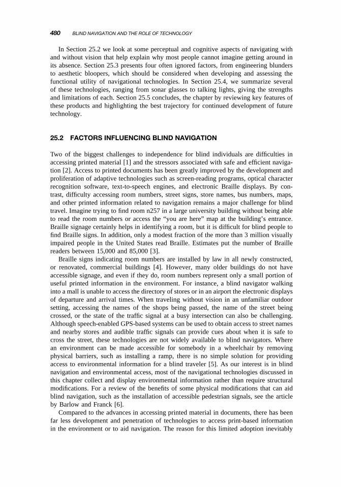
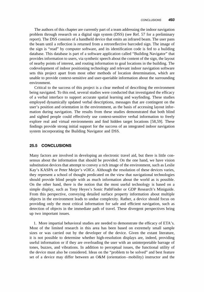
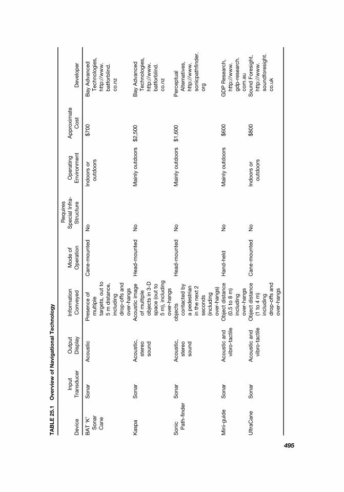
TA
BLE
25
1 O
verv
iew
of
Nav
igat
iona
l Tec
hno
log
y
Req
uire
s In
put
O
utp
ut
Info
rmat
ion
Mod
e of
S
pec
ial I
nfra
-O
per
atin
g A
pp
roxi
mat
eD
evic
e Tr
ansd
ucer
D
isp
lay
Con
veye
d
Op
erat
ion
Str
uctu
re
Env
ironm
ent
Cos
t D
evel
oper
BA
T lsquoK
rsquoS
onar
A
cous
tic
Pre
senc
e of
Can
e-m
ount
ed
No
Ind
oors
or
$700
B
ay A
dva
nced
Son
arm
ultip
leou
tdoo
rs
Tech
nolo
gies
C
ane
targ
ets
out
to
http
w
ww
5
m d
ista
nce
bat
forb
lind
in
clud
ing
con
z d
rop
-offs
and
over
-han
gs
Kas
pa
Son
ar
Aco
ustic
A
cous
tic im
age
Hea
d-m
ount
ed
No
Mai
nly
outd
oors
$2
500
B
ay A
dva
nced
ster
eoof
mul
tiple
Tech
nolo
gies
so
und
ob
ject
s in
3-D
http
w
ww
sp
ace
(out
to
bat
forb
lind
5
m)
incl
udin
gco
nz
over
-han
gs
Son
icS
onar
A
cous
tic
obje
cts
Hea
d-m
ount
ed
No
Mai
nly
outd
oors
$1
600
P
erce
ptu
alP
ath-
find
er
ster
eoco
ntac
ted
by
Alte
rnat
ives
so
und
a
ped
estr
ian
http
w
ww
in
the
nex
t 2
soni
cpat
hfind
er
seco
nds
org
(incl
udin
gov
er-h
angs
) M
ini-
guid
e S
onar
A
cous
tic a
ndO
bje
ct d
ista
nce
Han
d-h
eld
N
o M
ainl
y ou
tdoo
rs
$600
G
DP
Res
earc
hvi
bro
-tac
tile
(05
to
8 m
)ht
tp
ww
w
incl
udin
ggd
p-r
esea
rch
over
-han
gs
com
au
Ultr
aCan
e S
onar
A
cous
tic a
ndO
bje
ct d
ista
nce
Can
e-m
ount
ed
No
Ind
oors
or
$800
S
ound
For
esig
ht
vib
ro-t
actil
e (1
to
4 m
)ou
tdoo
rs
http
w
ww
in
clud
ing
soun
dfo
resi
ght
dro
p-o
ffs a
ndco
uk
over
-han
gs
495
TA
BLE
25
1
(Con
tin
ued
)
Req
uire
s In
put
O
utp
ut
Info
rmat
ion
Mod
e of
S
pec
ial I
nfra
-O
per
atin
g A
pp
roxi
mat
eD
evic
e Tr
ansd
ucer
D
isp
lay
Con
veye
d
Op
erat
ion
Str
uctu
re
Env
ironm
ent
Cos
t D
evel
oper
Nur
ion
Lase
rLa
ser
Aco
ustic
and
O
bje
ct d
ista
nce
(out
Can
e-m
ount
ed
No
Ind
oors
or
$30
00
Nur
ion-
Ray
cal
http
w
ww
ca
ne
vib
ro-t
actil
e
to 4
m) i
nclu
din
gou
tdoo
rs
nurio
nne
tLC
htm
ld
rop
-offs
and
ov
er-h
angs
vO
ICe
Cam
era
Aud
itory
Son
ic im
age
ofH
ead
-mou
nted
No
Ind
oors
or
Free
P
eter
Mei
jer
htt
p
ww
w
Lear
ning
soun
d-
mul
tiple
ob
ject
sor
han
d-h
eld
ou
tdoo
rs
seei
ngw
ithso
und
com
E
diti
on
scap
es
in 3
-D s
pac
e B
raill
e-N
ote
Glo
bal
Sp
eech
and
D
irect
ion
and
GP
S r
ecei
ver
Pre
senc
e of
Out
doo
rs
$21
99S
end
eroG
roup
htt
p
ww
w
GP
S
Pos
ition
ing
Bra
ille
dis
tanc
e to
loca
lan
dG
PS
sig
nal
(incl
udin
gse
nder
ogro
upc
om
Sys
tem
poi
nts
of in
tere
st
acce
ss-i
ble
soft
war
e
Rec
eive
r ro
ute
pla
nnin
gP
DA
wor
nG
PS
ac
tive
and
virt
ual
over
sho
uld
er
rece
iver
navi
gatio
n m
odes
an
d a
ll U
S
map
s)
Per
sona
lG
lob
alS
pat
ializ
edD
irect
ion
and
GP
S r
ecei
ver
Pre
senc
e of
Out
doo
rs
Not
UC
SB
Per
sona
l Gui
dan
ceG
uid
ance
Pos
ition
ing
soun
d
dis
tanc
e to
ob
ject
com
pas
s a
ndG
PS
sig
nal
com
erci
ally
Sys
tem
htt
p
ww
wg
eog
Sys
tem
Sys
tem
hap
ticlo
catio
ns in
3-D
lap
top
wor
n in
avai
lab
le
ucsb
ed
up
gsm
ain
htm
(PG
S)
Rec
eive
r in
terf
ace
spac
e r
oute
bac
kpac
k na
viga
tion
Ta
lkin
g S
igns
Inf
rare
d
Sp
eech
M
essa
ge a
bou
tH
and
-hel
d
Talk
ing
sign
Ind
oors
or
$200
0 p
erTa
lkin
g si
gns
dire
ctio
n an
dtr
ansm
itter
outd
oors
si
gn
http
w
ww
tal
king
sign
slo
catio
n of
(req
uire
sco
mt
ksin
fos
htm
lla
ndm
arks
inp
ower
) lo
cal e
nviro
nmen
t D
igita
l Sig
nIn
frar
ed
Aco
ustic
and
Ind
oor
loca
tion
and
Han
d-h
eld
P
assi
veIn
doo
rs
Not
Tjan
et
al (
2005
) [57
] S
yste
msp
eech
ne
arb
y p
oint
s of
bar
-cod
edco
mer
cial
ly(D
SS
) in
tere
st
sign
s av
aila
ble
496
CONCLUSIONS 497
FIGURE 251 A blind pedestrian is using a guide dog and five technologies for navigation This figure illustrates the need for an integrated navigational system The guide dog aids with mobility and obstacle avoidance The compass provides the user with heading information when stationary The GPS receiver integrates with a GIS database (digital map) to provide position and heading information during outdoor navigation The talking signs receiver gives orientation cues by identifying the direction and location of important landmarks in the environment The digital sign system (DSS) receiver picks up barcodes from signs and sends them to a database to facilitate indoor navigation The BrailleNote accessible computer represents the lsquolsquobrainrsquorsquo of the system allowing Braille input and speech and Braille output In theory this device could serve as the hub to which all other technologies interface
As of yet there is no commercial product that seamlessly integrates multiple techshynologies into a single system but one can readily imagine such a product Figure 251 shows components from several technologies a Talking Signs receiver a DSS receiver a GPS receiver a compass an accessible PDA and a guide dog
Now imagine that the electronics for the compass Talking Signs DSS and GPS receivers are merged into one housing The maps needed for outdoor environments and indoor databases are consolidated onto one large compact flash storage card and the accessible PDA serves as a common inputoutput device providing speech and Braille access for all subsystems With this configuration a blind navigator receives traditional mobility information from the guide dog and uses the integrated PDA for all other orientation information in both indoor and outdoor environments This system would be minimally intrusive utilize a clear and customizable user interface work under a wide range of environmental conditions and guarantee compatibility and interoperability between the various technologies Although training would inevitably be a critical factor in effective use of such a system a major advantage is that all environmental sensors would utilize a common output modality People would need to learn only one set of rules and could choose the information from the sensors that most benefited their needs
498 BLIND NAVIGATION AND THE ROLE OF TECHNOLOGY
If an ETA could be designed that could provide much of the information that many of the above mentioned devices did in a package that seamlessly integrated mobility and orientation information both indoors and out it would probably experience a much higher level of acceptance than many of the existing technologies in isolation
ACKNOWLEDGMENTS
Preparation of this chapter was supported by NRSA grant 1F32EY01596301 and NIDRR grant H133A011903
REFERENCES
1 National Research Council Visual Impairments Determining Eligibility for Social Security Benefits National Academy Press 2002
2 Golledge RG Geography and the disabled A survey with special reference to vision impaired and blind populations Trans Inst Br Geographers 1863ndash85 (1993)
3 Legge GE Madison C Mansfield JS Measuring Braille reading speed with the MNREAD test Visual Impair Res 1131ndash145 (1999)
4 Americans with Disabilities Act (ADA) 2006 (httpwwwadagov)
5 Arditi A Brabyn J Signage and wayfinding in Silverstone B Lange MA Rosenthal B Faye E eds The Lighthouse Handbook on Vision Impairment and Rehabilitation Oxford Univ Press New York 2000 Vol 1 pp 637ndash650
6 Barlow JM Franck L Crossroads Modern interactive intersections and accessible pedestrian signals J Visual Impair Blindness 99(10)599ndash610 (2005)
7 Lighthouse International The Lighthouse Handbook on Vision Impairment and Vision Rehabilshyitation Oxford Univ Press New York 2000
8 Loomis JM Klatzky RL Golledge RG Cincinelli JG Pellegrino JW Fry PA Nonvisual navshyigation by blind and sighted Assessment of path integration ability J Exper Psychol General 122(1)73ndash91 (1993)
9 Loomis JM Golledge RG Klatzky RL Speigle JM Tietz J Personal guidance system for the visually impaired Proc 1st Annual ACMSIGGAPH Conf Assistive Technologies Marina Del Rey CA 1994
10 Gallistel CR Insect navigation Brains as symbol-processors in Conceptual and Methodologshyical Foundations MIT Press Cambridge MA 1990 Vol 4
11 Strelow ER What is needed for a theory of mobility Direct perception and cognitive mapsmdashlessons from the blind Psychol Rev 97(2)226ndash248 (1985)
12 Thinus-Blanc C Gaunet F Representation of space in blind persons Vision as a spatial sense Psychol Bull 121(1)20ndash42 (1997)
13 Rieser JJ Guth DA Hill EW Mental processes mediating independent travel Implications for orientation and mobility Visual Impair Blindness 76213ndash218 (June 1982)
14 Rieser JJ Guth DA Hill EW Sensitivity to perspective structure while walking without vision Perception 15173ndash188 (1986)
15 Bigelow A Spatial mapping of familiar locations in blind children J Visual Impair Blindness 85113ndash117 (March 1991)
16 Cooper F Gaitenby J Nye P Evolution of reading machines for the blind Haskins Laborashytoriesrsquo research as a case history J Rehab Res Devel 2151ndash87 (1984)
REFERENCES 499
17 Golledge RG Tactual strip maps as navigational aids J Visual Impair Blind 85(7)296ndash301 (1991)
18 Kish D Echolocation How humans can ldquoseerdquo without sight 2006 (httpwww worldaccessfortheblindorgecholocationreviewrtf)
19 Loomis JM Lederman SJ Tactual perception in Boff K Kaufman L Thomas J eds Handbook of Perception and Human Performance Wiley New York 1986 Vol 2 Chapter 31
20 Klatzky R Lederman S Touch in Weiner IB Healy AF Proctor R eds Experimental Psychology and Comprehensive Handbook of Psychology Wiley New York 2002 Vol 4 Chapter 6
21 Golledge RG Marston JR Loomis JM Klatzky RL Stated preferences for components of a personal guidance system for non-visual navigation J Visual Impair Blind 98(3)135ndash147 (2004)
22 Brabyn J A Review of Mobility Aids and Means of Assessment Martinus Nijhoff Boston 1985
23 Loomis JM Sensory replacement and sensory substitution Overview and prospects for the future in Roco MC Bainbridge WS eds Converging Technologies for Improving Human Performance Nanotechnology Biotechnology Information Technology and Cognitive Science Kluwer Academic Publishers Boston 2003
24 Blasch BB Welsh RL Wiener WR Foundations of Orientation and Mobility 2nd ed AFB Press 1997
25 Schenkman BN Jansson G The detection and localization of objects by the blind with the aid of long-cane tapping sounds Human Factors 28(5)607ndash618 (1986)
26 Bay Advanced Technologies Ltd (httpwwwbatforblindconz accessed 2006)
27 Kay L Auditory perception of objects by blind persons using bioacoustic high resolution air sonar J Acoust Soc Am 107(6)3266ndash3275 (2000)
28 Kay L Bioacoustic spatial perception by humans A controlled laboratory measurement of spatial resolution without distal cues J Acoust Soc Am 109(2)803ndash808 (2001)
29 Farmer LW Mobility devices in Welsh LW Blasch BB eds Foundations of Orientation and Mobility American Foundation for the Blind New York 1980
30 Perceptual alternatives 2006 (httpwwwsonicpathfinderorg)
31 Dodds AG Clark-Carter Dd Howarth CI The Sonic PathFinder An evaluation J Visual Impair Blind 78(5)306ndash310 (1984)
32 LaGrow S The use of the Sonic PathFinder as a secondary mobility aid for travel in business environments A single-subject design J Rehab Res Devel 36(4) (1999)
33 GDP Research 2006 (httpwwwgdp-researchcomau)
34 Sound Foresight 2006 (httpwwwsoundforesightcouk)
35 Borenstein J Ulrich I The GuideCane A computerized travel aid for the active guidance of blind pedestrians Proc IEEE Int Conf Robotics and Automation Albuquerque NM 1997
36 Nurion-Raycal 2006 (httpwwwnurionnetLChtml)
37 vOICe Learning Edition 2006 (httpwwwseeingwithsoundcom)
38 Meijer PB An experimental system for auditory image representations IEEE Trans Biomed Eng 39(2)112ndash121 (1992)
39 Fletcher JE Seeing with sound A journey into sight Tucson 2002 Conf ldquoToward a Science of Consciousness rdquo Tucson AZ 2002
40 Bach-Y-Rita P Brain Mechanisms in Sensory Substitutions Academic Press New York 1972
41 Bach-y-Rita P Tyler ME Kaczmarek KA Seeing with the brain Int J Human-Comput INTERshyACTION 15(2)285ndash295 (2003)
500 BLIND NAVIGATION AND THE ROLE OF TECHNOLOGY
42 Crandall W Brabyn J Bentzen BL Myers L Remote infrared signage evaluation for transit stations and intersections J Rehab Res Devel 36(4)341ndash355 (1999)
43 Marston J Spatial knowledge acquisition and the blind The effect of environmental auditory cues on spatial awareness Conf Workshop on Assistive Technologies for Vision and Hearing Impairment Granada Spain 2004
44 Crandall W Bentzen BL Myers L Brabyn J New orientation and accessibility option for pershysons with visual impairments Transportation applications for remote infrared audible signage Clin Exper Optometry 84(3)120ndash131 (2001)
45 Golledge RG Marston JR Towards an Accessible City Removing Functional Barriers to Indeshypendent Travel for Blind and Vision Impaired Residents and Visitors California PATH Program Inst Transportation Studies Univ California Berkeley 1999 (UCB-ITS-PPR-99-33 for PATH project MOU 343)
46 Marston JR Towards an Accessible City Empirical Measurement and Modeling of Access to Urban Opportunities for those with Vision Impairments Using Remote Infrared Audible Signage unpublished doctoral dissertation Dept Geography Univ California Santa Barbara 2002
47 Bentzen BL Mitchell PA Audible signage as a wayfinding aid Comparison of ldquoVerbal land-Marksrdquo with ldquoTalking Signsrdquo Rehab Res Devel 36(4) (1999)
48 Loomis JM Golledge RG Klatzky RL Personal guidance system for the visually impaired using GPS GIS and VR technologies Conf Virtual Reality and Persons with Disabilities Millbrae CA 1993
49 UCSB Personal Guidance System 2006 (httpwwwgeogucsbedupgsmainhtm)
50 Loomis JM Golledge RG Klatzky RL Navigation system for the blind Auditory display modes and guidance Presence Teleoperators Virtual Environ 7193ndash203 (1998)
51 Loomis JM Marston JR Golledge RG Klatzky RL Personal guidance system for people with visual impairment A comparison of spatial displays for route guidance J Visual Impair Blind 99219ndash232 (2005)
52 Marston JR Loomis JM Klatzky RL Golledge RG Smith EL Evaluation of spatial displays for navigation without sight ACM Trans Appl Percep 3(2)110ndash124 (2006)
53 Petrie H Johnson V Strothotte T Raab A Fritz S Michel R MoBIC Designing a travel aid for blind and elderly people J Nav 4945ndash52 (1996)
54 NFB Access Technology Staff GPS technology for the blind a product evaluation Braille Monitor 49101ndash108 (2006)
55 Talking Lights LLC 2006 (httpwwwtalking-lightscom)
56 Commercial software EPE 21 available from Ekahau 2006 (httpwwwekahaucom)
57 Tjan BS Beckmann Pj Roy R Giudice NA Legge GE Digital sign system for indoor wayfindshying for the visually impaired Proc 1st IEEE Workshop on Computer Vision Applications for the Visually Impaired in conjunction with CVPR 2005 San Diego 2005
58 Giudice NA Navigating Novel Environments A Comparison Of Verbal and Visual Learning dissertation Dept Psychology Univ-Minnesota Twin Cities 2004
59 Giudice NA Bakdash JZ Legge GE Wayfinding with words Spatial learning and navigation using dynamically-updated verbal descriptions Psychol Res 71(3)347ndash358 (2007)
60 Ohkugo H Kamakura K Kitakaze S Fujishima Y Watanabe N Kamata M Integrated wayfindingguidance system using GPSIRRFRFID with mobile device 20th Annual CSUN Int Conf Technology and Persons with Disabilities Los Angeles 2005
61 The wayfinding group 2006 (httpwwwwayfindingorg)
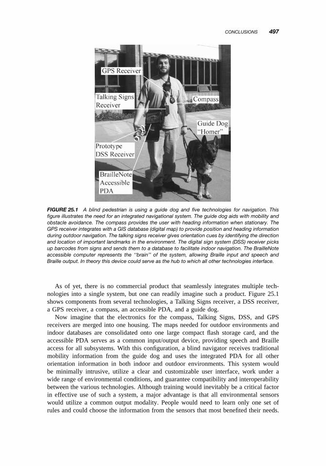