
Blackmore, Kara Shelter and Relocation (Summary Document ...

BLACKMORE LOCAL STRUCTURE PLAN No. 97
PART TWO
EXPLANATORY REPORT

CONTENTS PART 2: EXPLANATORY REPORT 4 1.0 Planning Background 4
1.1 Introduction and Purpose 4 1.2 Land Description 4 1.2.1 Location 4
1.2.2 Area and Land Use 5 1.2.3 Legal Description and Ownership 5
1.3 Planning Framework 5 1.3.1 Zoning and Reservations 5
1.3.2 Regional and Sub-Regional Structure Plan 5 1.3.3 Planning Strategies 5
1.3.4 Policies 5 2.0 Site Conditions and Constraints 8
2.1 Biodiversity and Natural Area Assets 8 2.2 Landform and Soils 8 2.3 Groundwater and Surface Water 10 2.4 Bushfire Hazard 10 2.5 Heritage 10 2.6 Context 11 2.6.1 Context Analysis 11 2.6.2 Objectives 15
3.0 Land Use And Subdivision Requirements 15 3.1 Land Use 15 3.2 Open Space 18 3.3 Residential 20 3.4 Movement Network 23 3.5 Water Management 26 3.6 Servicing and infrastructure 26 3.7 Sustainable Design 26 3.8 Demonstration Lot 27 3.9 Technical Reports 28
4.0 Conclusion 29

FIGURES
1. Location Plan 2. Cadastral Plan 3. Aerial 4. Context Plan 5. Blackmore Structure Plan No. 97. 6. Existing Public Open Space within a 10 minute Walk (800m) 7. Development Concept 8. Pedestrian Movement Network
TABLES 1. Public Open Space Provision 2. Yield Estimates
TECHNICAL APPENDICES
1. Servicing Report 2. Geotechnical Investigation 3. Transport Assessment 4. Tree Survey 5. Local Water Management Strategy

PART 2 – EXPLANATORY REPORT
1.0 PLANNING BACKGROUND
1.1 Introduction and Purpose
The Local Structure Plan No97 has been prepared to facilitate the redevelopment of the original Blackmore Primary School site at 64 Allinson Drive in Girrawheen.
Historically the subject land was the site of the Blackmore Primary School until this facility was determined as excess to requirements. It has been subsequently cleared of all buildings and was rezoned by Amendment No.112 to the City of Wanneroo District Scheme No.2 (DPS2) on the 8th of March 2011 from “Public Use (Primary School)” Reserve to “Urban Development“ zone. Under clause 3.4.4.1 of DPS 2, no subdivision or other development can be carried out in an Urban Development zone until an Agreed Structure Plan has been prepared and adopted under the provisions of Part 9 of the District Planning Scheme. The subject land is a highly visible and strategic site offering significant redevelopment possibilities with the potential to make a positive contribution to the locality. The opportunity to achieve innovative and sustainable development providing affordable housing product via creative design approaches in lot size and shape, the wider subdivision layout and built form, is inherent within the site. This includes acknowledging the objectives of the City of Wanneroo Local Planning Policy 3.1: Local Housing Strategy Implementation for the locality, while enabling compatible and acceptable development and design solutions for the existing surrounding community.
Land Description
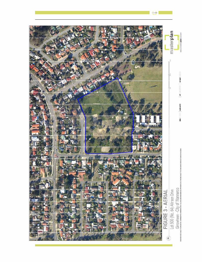
1.2.1 Location The subject site is situated at the intersection of Allinson Drive and Innes Place in Girrawheen. It directly abutts Blackmore Reserve which is located to its south east.

1.2.2 Area and Land Use The subject land has an area of 4.106ha and is currently vacant.
1.2.3 Legal Description and Ownership The subject land is described as lot 500 on Deposited Plan 75395, Certificate of Title Volume 2786, Folio 84.
1.3 Planning Framework
1.3.1 Zoning and Reservations The subject site is zoned “Urban Development” under the City of Wanneroo District Structure Plan No. 2. It is zoned “Urban” in the Metropolitan Region Scheme. No reservations apply to the site and it is not the subject of any existing improvement plans.
1.3.2 Regional and Sub-Regional Structure Plan
The site is not the subject of any Regional or Sub-Regional Structure Plan.
1.3.3 Planning Strategies The subject site is within the framework of the “Directions 2031 and Beyond” Regional Planning Strategy and provides an opportunity to deliver on the objectives of that strategy by delivering medium density urban infill housing.
It also reflects residential density proposals promoted for the locality in the City of Wanneroo Local Planning Policy 3.1: Local Housing Strategy Implementation.
1.3.4 Policies The proposed Local Structure Plan has been prepared cognisant of all relevant government policies and reflects the requirements objectives and intent of such policies including State Planning Policies, Development Policies and Guidelines including the Residential Design Codes and Liveable Neighbourhoods.


2.0 SITE CONDITIONS AND CONSTRAINTS
2.1 Biodiversity and Natural Area Assets The historic use of the land as a school means that the majority of the subject site has been cleared, although a number of individual trees, either in isolation or in small groups, remain distributed across the site. A specialist Arborist Report paragraph 1 and 2 has been prepared based upon detailed investigations of each tree on site. This has indentified the health and type of each tree and given a retention value to each one. The majority of trees are not identified as of priority value, although a number of trees across the site have been identified in this category. The Local Structure Plan where possible, provides for the retention of priority classified trees. The Arborist report is appended.
2.2 Landform and Soils
The subject site while essentially level in topography comprises two levels. The south-east corner of the site contains a significant ridge which drops approximately three metres to a lower flat terrace area abutting Blackmore reserve. This area in turn is approximately one metre above the adjoining Blackmore POS area.
An expert contamination assessment of the subject land has also been completed. This concluded while there was some peripheral evidence of possible contaminants related primarily to historic building materials, these were not considered a constraint to development and any scattered elements remaining on the subject land could be appropriately addressed as part of site work associated with the future development.
Geology comprises sand-pale and olive yellow, medium to coarse grained, sub-angular to well-rounded quartz, trace of feldspar, moderately sorted of residual origin. Field studies indicated the topsoil consisting of fine to medium grained, grey sand with silt to a depth of approximately 0.2m. Medium grained sand underlies the topsoil and extends to at least 2.5m depth. The relative density of the sand is dense in the eastern half and medium dense in the remaining area.

In accordance with AS 2870 – 2011 the site is Class ‘A’ (Mostly sand and rock sites with little or no ground movement from moisture changes). The permeability of the subject site varies between 1x10sqm/s and 1x10sqm/s without any compaction indicating good drainage condition as per the field test.
The site is not identified in any relevant data bases as affected by Acid Sulphate Soils (ASS). Given its location, characteristics and the nature of the soils present any ASS classification is anticipated to be nil to low at most.
2.3 Groundwater and Surface Water The subject land does not contain any wetlands or natural waterways.
The historical maximum groundwater level is 24m below the surface at the north east corner rising to 22m at the south east corner.
The subject land falls under the Perth Groundwater Area and Whitfords groundwater subarea. The aquifer is the Perth-Superficial Swan. One bore is registered within the subject area with license number 155312. The Water allocation is 11099070 KL/annum which is sufficient for irrigating approximately 160 ha as per Department of Water target use of 7500 KL/ha/year for POS area. This bore is managed by the City of Wanneroo and used to irrigate the surrounding ovals. A Local Water Management Strategy is appended.
2.4 Bushfire Hazard
The subject site is not within a Bushfire risk area and is generally cleared. As such no Bushfire hazard is identified.
2.5 Heritage There are no heritage items, either Aboriginal or historic, applicable to the subject site.

2.6 Context 2.6.1 Context Analysis
The Historic Blackmore Primary School site is surrounded on three of its four boundaries by existing single residential development. Its eastern boundary abuts the rear boundary of single residences fronting Blackmore Avenue. On the north eastern corner it abuts the Blackmore Kindergarten facility and along the remainder of the northern boundary a row of single residences overlooks the subject site from the northern side of Innes Place. Historic car parking within the road reserve directly abuts the boundary of the subject site with Innes Place. The western side of Allinson Drive is also characterised by single residential housing on larger lots opposite the subject land. Seaton Place terminates at the southern boundary of Lot 500. This boundary is separated from the existing single residential premises between Allinson Drive and Seaton Place, and a medium density Department of Housing (DHW) apartment complex on the eastern side of Seaton Place, by pedestrian access ways which link Allinson Drive to Blackmore Reserve and hence the subject site. Blackmore Reserve itself directly abuts the remaining southern boundary of the subject land between the DHW housing complex and Blackmore Avenue.
With the exception of the DHW apartment complex in Seaton Place, surrounding residential form is predominantly single residential. This housing stock generally dates to the original development of the locality (1970’s-1980) and in the main comprises brick and tile single storey construction with low pitched roofs. The apartment complex also dates to the origins of the locality although appears to have been subject to refurbishment in recent years. Blackmore Reserve is an attractive and well maintained public open space area providing active and passive recreational facilities and includes some areas of remnant native bush.

A context analysis of the subject site has been undertaken to identify the key opportunities and any potential constraints presented by the context of the site within its existing surrounding locality. The subject land provides a unique opportunity within the Girrawheen locality with the following features noted:
• It is a large redevelopment site. • It is generally level. • It has frontage to existing roads. • It has direct access to adjoining established Public Open Space. • It is within close proximity of public transport routes with five individual bus stops
identified within a five minute walk of the subject land on Beach Road, Blackmore Avenue or Wanneroo Road.
• It is located within a five minute walk of a Neighbourhood Centre • It is within 1.5km of a District Centre. • It is within 1.5km of a Senior High School. • It is 10 minutes’ walk from the nearest Primary School.
This combination of factors confirms that the subject site is ideally located to accommodate redevelopment for residential purposes which will benefit from these locational assets. Given its proximity to a Neighbourhood Centre, Public Transport and Public Open Space and the potential under the City of Wanneroo Local Planning Policy 3.1: Local Housing Strategy Implementation promoting medium density residential, the subject land is ideally suited to deliver medium density development which can capitalise on its context. Careful consideration has, however, been undertaken to ensure the redevelopment will be provided in a manner compatible with the adjoining predominately single residential context. Historic connectivity across the site should also be reflected in future redevelopment. This includes east-west connectivity from Allinson Drive and areas further west, across the site to Blackmore Reserve, and north-south connectivity, either from Blackmore Reserve and the existing Seaton Place pedestrian access ways in the south to further north along Innes Place and the existing pedestrian link to Blackmore Avenue to the north.


In summary the outcomes of Site Context and Site Analysis assessments include:
• Policy Context. City of Wanneroo Local Planning Policy 3.1: Local Housing Strategy Implementation promotes medium density residential development.
• Locational Context
The subject site is a strategic large redevelopment site in the context of the locality. It has direct access to abutting Public Open Space, is in close proximity to public transport with 5 individual bus stops within a 5 minute walk, is within a 5-10 minute walk of a neighbourhood centre, adjoins a Kindergarten, is within a 10 minute walk of a Primary School and is within 1.5km of a District Centre.
• Accessibility
There is direct road frontage to the western boundary abutting Allinson Drive, and the majority of the northern boundary abutting Innes Place. End of road access is available on the southern boundary to Seaton Place.
• Interfaces
The eastern boundary interfaces with the rear boundary of existing single residential housing. Approximately 50% of the southern boundary directly abuts the adjoining Blackmore Reserve with the remaining boundary adjoining a DHW apartment complex, in Seaton Place and the side boundaries of two single residential properties. A PAW runs parallel to the boundary connecting Blackmore Reserve to Allinson Drive and between the residential use to the south and the subject land.
Single residential housing overlooks the site from the western side of Allinson Drive with the exception of a POS link from areas further to the west. Likewise single residential housing overlooks the site from the northern side of Innes place for most of its length with the exception of a Kindergarten facility at the northeast comer which is separated from the subject land by a PAW connecting the end of Innes Place to Blackmore Avenue further to the east.
• Site Detail o 4.106 ha in area o Generally flat but comprises two terraces with the majority of the site at the Allinson
Drive level and a portion in the south-west corner abutting Blackmore Reserve, also flat, but approximately 2-2.5m lower than the remainder of site.
o Historic verge parking along Allinson Drive and Innes Place remains o Portion of subject site enjoys elevated views over Blackmore Reserve o Historically part of an interconnected pedestrian network via adjoining PAW and POS
links o Services are existing or in close proximity

o Generally cleared but with remnant trees of varying quality – some trees/stands of trees identified as priority for retention.
These assessments suggest a range of opportunities available with no major constraints identified related to potential design or physical development issues. 2.6.2. Objectives Given the outcome of the site context and analysis assessment, a series of key objectives have been identified as part of Local Structure Planning as follows;
• To achieve sustainable and environmentally appropriate subdivision and built form • Retention of existing landform where possible • Retention of Priority 1 identified trees where possible • Maintenance of existing external pedestrian linkages and creation of good internal
pedestrian linkages • Diversity in lot/built form housing product • Delivery of affordable lots/built form • Sensitive design interfaces to existing abutting surrounding residential uses.
In order to achieve these objectives the following elements are proposed to be included;
• A predominately north-south, east-west oriented road network to establish opportunity for creation of lots that maximise solar orientation.
• Maximum retention of Priority 1 identified trees as part of the Structure Planning process. • Implementation of pedestrian connectivity links within the site and into the wider
pedestrian network external to the site. • Approaches to minimise earthworks and maximise use of existing landform. • Strategies to enable delivery of affordable housing compatible to the locality.
3.0 LAND USE AND SUBDIVISION REQUIREMENTS
3.1 Land Use
The Structure Plan will facilitate development of the subject site for residential purposes. Surrounding land comprises historic single residential housing and the structure plan will facilitate creation of larger residential lots at the interface with existing surrounding development while promoting smaller medium density residential product within the subject area.


As noted in 3.1 above, that portion of the subject site directly opposite existing single residential development in Allinson Drive is identified within the Structure Plan for future subdivision into larger single residential lots to be more compatible with existing development on the western side of Allinson Drive.
Development of the subject land adjoining Innes Place will result in primarily three side boundaries of future lots fronting Innes Place. As part of future development, appropriate fencing treatment is recommended to ensure a high standard of presentation.
A Grouped Housing demonstration lot is also proposed which will have a boundary to Innes Place and also to a future proposed internal subdivision road. It is intended that development of this grouped housing lot will be effected in such a manner so that dwelling will front both Innes Place and the future internal subdivision road. Further development controls to guide development of this site in the form of a Local Development Plan may be appropriate.
Seaton Place terminates at the existing southern boundary of the subject site. It is not proposed to extend Seaton Place into the subject land, however, a substantial grouped housing site is proposed between Seaton Place and the future main subdivisional road. This is consistent with the existing adjoining development within Seaton Place. Access to this grouped housing site from Seaton Place is anticipated and again further detailed design requirements via a Local Development Plan may be appropriate.
The eastern boundary of the subject site abuts the rear boundaries of existing single residential development. It is proposed to create a row of single residential lots along this boundary which back onto the existing development.
Maximum accessibility from the subject site to Blackmore Reserve will be established via the creation of a small subdivisional road along the boundary with Blackmore Reserve.

3.2 Open Space
A centralised area of Public Open Space (POS) is proposed. The 10% requirement based on the area of the subject site would generate a Public Open Space provision of 4106m2. The substantial provision of existing open space in the locality, in particular the major Blackmore Reserve directly abutting the subject site confirms the limited necessity for physical provision of extensive open space. A more appropriate approach on this basis is provision of Cash- in- Lieu which could be used to enhance the existing adjoining facilities at Blackmore Reserve. Nevertheless, the existence of a number of stands of trees which have been identified as a priority for preservation within the site, results in allocation of an area of 2765m2 centrally located within the subject site for Public Open Space. The majority of this area is set aside to enable retention of the main stands of priority one trees with the balance incorporated into the design, in turn, providing opportunity for an Urban Water Management function.
It is anticipated this Public Open Space area will not be formally landscaped but rather comprise low maintenance native vegetation consistent with the retention of the existing trees. The remaining POS requirement as noted is proposed to be provided as Cash- in -Lieu. While this will result in a physical provision of just under 7% rather than the full 10%, the payment of Cash-in-Lieu is considered acceptable given the extent of open space already provided in the locality. Figure 7 shows the extent of existing POS within a 10 minute (800m) walk of the subject site. Of the total area within this radius 17.61% is allocated for POS purposes. As such POS within useable proximity of the subject land already exceeds requirements.

–

The proposed POS approach is summarised following:
Site Area 4.106ha
Less 0.0ha Deductions 0.0ha Gross Subdividable Area 41060m²
Public Open Space @ 10 per cent 4106m²
Public Open Space contribution May comprise: minimum 80 per cent unrestricted public open space minimum 20 per cent restricted use public open space
3284m²
821m²
4106 m²
Unrestricted public open space sites Local Park A 2304 m²
Local Park B 1341 m²
Public Open Space provision 4106 m² 10%
Table 1: Public Open Space Provision 3.3 Residential
The City of Wanneroo Local Planning Policy 3.1: Local Housing Strategy Implementation promotes medium density residential development and identifies a preferred density of R40 for the majority of the site, but with the possibility of some R60 for the subject site. On this basis it is proposed that the majority of the site be coded R40 in the Structure plan although a strategically located area of R60 is also proposed. The need to achieve an appropriate interface with existing surrounding development is acknowledged, as is a desire to promote a diverse range of housing alternatives to maximise the opportunity to provide affordable housing options in this locality.
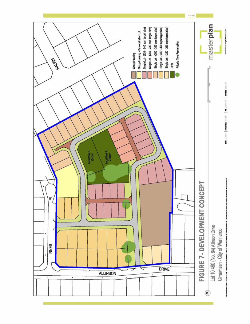

On this basis a variety of housing product will be offered within the R40 coding with the Structure Plan identifying preferred subdivision and development outcomes. The diverse range of housing products includes rear loaded laneway lots generally from 220m2 to 240m2 and a range of front loaded lots generally from 260m2 up to 460m2 in area. A few bigger single residential lots may eventuate.
In addition, two Grouped Dwelling lots are proposed. A smaller lot approximately 1430m2 in area is proposed as an R40 ‘”Demonstration” lot and is discussed in Section 3.8 following. A larger site in the order of 4300m2 is identified abutting the existing Department of Housing apartment development in Seaton Place south of the subject site. It is proposed to allocate a density coding of R60 to this site under the LSP. While it is acknowledged Local Planning Policy 3.1: Local Housing Strategy Implementation proposes the whole of the subject land as R40, the various locational characteristics described above support consideration of carefully placed density options to maximise the opportunity inherent in the location to respond to Strategic Policy imperatives such as Directions 2031 and promote affordable housing opportunities. The ultimate yield will be determined at the time of subdivision dependent upon the final mix of housing product identified. It will, however, be based upon the allocation and range of lot and dwelling options identified in the Structure Plan.
LandCorp, as development proponents, have entered into a partnership arrangement with BGC Residential to develop built product aimed at delivering sustainable and affordable housing product appropriate to the market and the final mix of lot sizes and ultimate yield will result from this process. As a consequence a specific dwelling yield is difficult to confirm, however, based upon the approach proposed an estimated ultimate dwelling yield range can be identified. A breakdown of the potential yield range is described following:

YIELD ESTIMATE
DWELLINGS
GROUPED HOUSING SINGLE LOTS (220-240) SINGLE LOTS (260-280)) SINGLE LOTS (280-350) SINGLE LOTS (350-420)) SINGLE LOTS (220-350)
29 21-23 8-9 15-17 17-20 3-5
TOTAL 93-103
Table 2: Yield Estimates 3.4 Movement Network Porter Engineers has investigated traffic and transport implications arising from the LSP
proposal. This has confirmed that the proposal will not generate significant or unmanageable traffic movements or volumes that the existing road network cannot sustain.
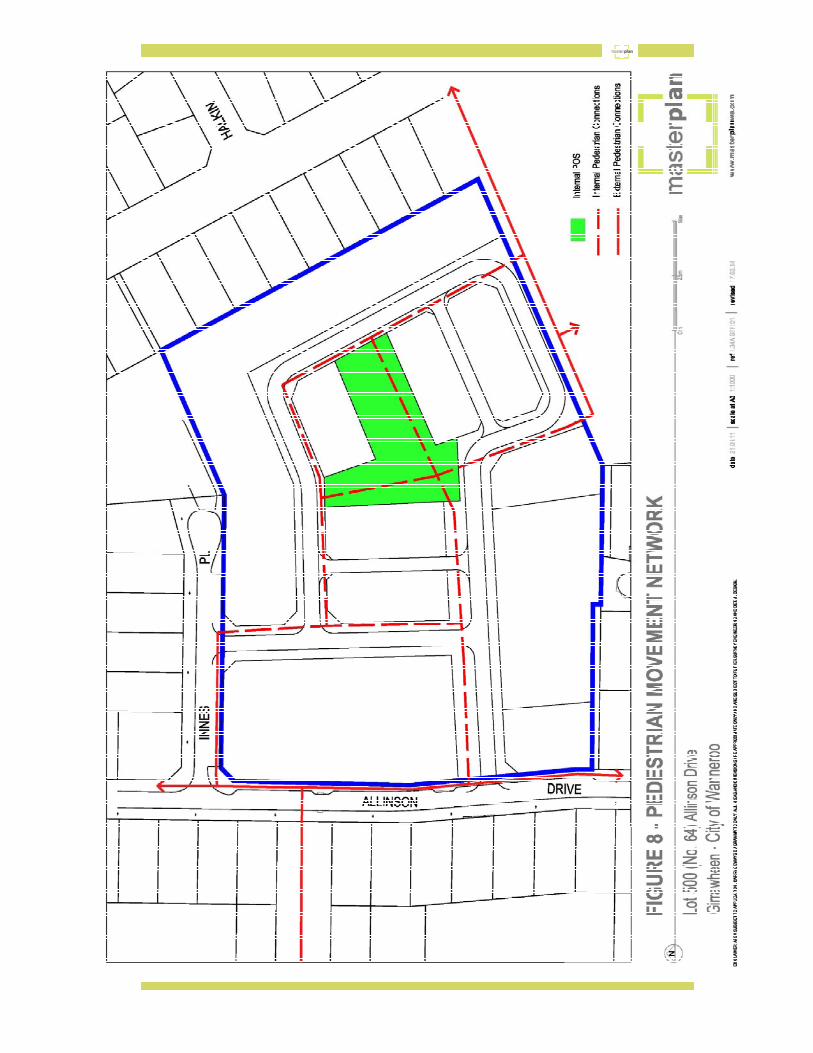
The indicative road pattern proposed reflects both the slightly unusual shape of the subject land and the desire to establish, where possible, east/west and north/south orientated roads to promote the best solar orientation for future lots. The road system is intended to be as permeable as possible, not only for vehicular traffic, but to facilitate pedestrian movement through the subject site and, in particular maintaining the link through the site from Allinson Drive to Blackmore Reserve. Accessibility has been further enhanced via the inclusion of two small laneways as well as via a central area of open space. New road links are established onto Allinson Drive and Innes place with the main road link being parallel to Innes place accessing from Allinson Drive. This access point has been designed not only to facilitate connectivity within the subject site but also to assist in preservation of priority trees identified on site. As such a portion of the

new internal road reflects a Liveable Neighbourhoods Access Street A Classification, enabling provision of appropriate services and road carriageway and incorporation of preservation of priority one trees within a wider road verge. This road verge will also provide further opportunities to incorporate best practice Urban Water Management. The rest of the local road network will comprise a mixture of lower access street types as per the provision of Liveable Neighbourhoods. Applicable road widths will be within the context of the subdivision application. Two small laneways of approximately 65 metres each in length are also proposed. Historic pedestrian movements have connected the original school site via pedestrian links which exist along both the northern and southern site boundaries. The northern link connects Innes Place to Blackmore Avenue. The southern link connects Allinson Drive via Seaton Place to Blackmore Reserve and then Blackmore Avenue. The main north-south link was via Blackmore Avenue from the south. The original school site was a destination as part of the existing pedestrian movement network. With the closure of the school use, the site is no longer a destination itself, however, redevelopment of this subject land should still provide an opportunity to maintain links to and as part of the existing pedestrian movement network. The indicative layout arising from the Structure Plan enables permeable access across the site to link with the existing external network described above. North south links across the site are facilitated by linking Blackmore Reserve in the south to Innes place in the north. Figure 8: Movement Network shows this network.

3.5 Water Management
Liaison has been undertaken with the City to confirm appropriate approaches to Urban Water Management on the subject land. Wider verges and the utilisation of the POS have been proposed to address the required levels of water and drainage management.
This incorporates use of parts of both the proposed new POS area within the structure plan area, and the existing Blackmore Reserve as part of the water management response.
All measures are appropriately detailed in an Urban Water Management Plan prepared for the site by Porter Consulting Engineers and TME Consultants.
3.6 Servicing and Infrastructure Porter Consulting Engineers have undertaken an examination of relevant servicing and infrastructure matters. This has confirmed that all relevant services are located adjacent to the site and that the subject land can be appropriately serviced.
3.7 Sustainable Design Ensuring sustainable design has been given a priority as a central focus of preparation of the Structure Plan. A range of sustainable design considerations were identified against which alternative structure plan approaches have been tested.
These sustainable design criteria included:
• Solar Orientation: The number of potential lots with an optimal east-west orientated long boundary.
• Priority Tree Preservation: The number of trees to be retained from those previously identified as of priority one significance.
• Permeability: Ability for new roads and access ways to connect with the existing road and movement network.
• Adaptability: The ability of sites to be adapted from one lot type or size to another.

• Legibility: The legibility of open spaces, streets and connectivity at a pedestrian and vehicular context.
• Lot Diversity: The diversity of lot types and sizes.
• Utilisation of existing Landform
The proposed LSP performs well against all criteria confirming that the Structure Plan establishes a sustainable design foundation that can be built upon through subsequent more detailed levels of planning and design.
For example almost 72% of the future lots likely to be created using the indicative layout based on the Structure Plan, will be based on an optimal east/west oriented long boundary, Priority One trees are preserved within increased width road reservations or POS, connections to the existing external road and pedestrian network have been carefully designed and a wide range of potential lot types/sizes and dwelling options can be provided.
Careful attention has been given to working with the landform to try and minimise earth working as much as possible. This has included designing the laneway parallel to the boundary with Blackmore Park as much as possible along the ridge, allowing innovative design approaches to be considered in response to this change in topography. Further detailed design for this part of the site will be developed as part of a future Local Development Plan.
3.8 Demonstration Lot
Landcorp as proponent for the future development of the subject site is keen to investigate opportunities for developing sustainable affordable building and development models. As part of this process a Grouped Housing site with potential for 6 grouped dwellings has been identified as a “Demonstration lot”.
It is intended that Landcorp, in collaboration with its builder partner, BGC Residential will utilise this lot to demonstrate approaches to achieving affordable and sustainable housing product. It is anticipated this approach will be refined via the identification of standards in the partnership described and which again then could be confirmed via a Detailed Area Plan process.
3.9 Technical Reports
As a part of preparation of the Local Structure Plan a range of supporting investigations have been completed and are appended. These include:
• Contamination Report • Engineering and Servicing Report • Transport Report • Urban Water Management Report • Arborist Report

4.0 CONCLUSION The subject land offers a unique opportunity within the context of its locality. It is well serviced in close proximity to local facilities and public transport and directly abuts a substantial public open space resource. This has been recognised in the City of Wanneroo Local Planning Policy 3.1: Local Housing Strategy Implementation which has identified the site for medium density residential development. The site itself is relatively unconstrained. A number of remnant trees have been identified as a priority for retention and while the site is generally level, it does contain essentially two plateaus separated by a ridgeline some 2.5 to 3.0 metres in height. While these elements potentially provide a design challenge they also offer opportunities to contribute to a design response which will maximise both the connection to the historic use of the site and the inherent features within it. Careful consideration has been undertaken to design for the redevelopment of the site in a manner that acknowledges its history and features as well as its interface with the surrounding community. The Structure Plan is also designed to provide a focus upon sustainable development approaches and to facilitate development of a diverse range of housing options that will achieve affordable housing objectives. This proposed Local Structure Plan represents a logical and positive response to the various imperatives affecting the subject site and will provide the necessary context to enable redevelopment to be progressed in a manner which will achieve a positive outcome for all stakeholders.