Black and Ottauquechee Rivers -...
163
DRAFT Black and Ottauquechee Rivers and adjacent Connecticut River Tactical Basin Plan Page 1 Vermont Agency of Natural Resources Watershed Management Division Black and Ottauquechee Rivers and adjacent Connecticut River & tributaries Spencer, Blood, Mill, Mill and Lulls Brooks DRAFT 2017 TACTICAL BASIN PLAN
Transcript of Black and Ottauquechee Rivers -...

DRAFT Black and Ottauquechee Rivers and adjacent Connecticut River Tactical Basin Plan Page 1
Vermont Agency of Natural Resources
Watershed Management Division
Black and Ottauquechee Rivers and adjacent
Connecticut River & tributaries Spencer, Blood, Mill, Mill and Lulls Brooks
DRAFT 2017 TACTICAL BASIN PLAN

DRAFT Black and Ottauquechee Rivers and adjacent Connecticut River Tactical Basin Plan Page 2
Approved:
Emily Boedecker, Commissioner Date:
Department of Environmental Conservation
Julie Moore, Secretary Date:
Agency of Natural Resources
Cover Photo: Comtu Falls, Black River, Springfield
By Marie Levesque Caduto
The Vermont Agency of Natural Resources is an equal opportunity agency and offers all persons the
benefits of participating in each of its programs and competing in all areas of employment regardless
of race, color, religion, sex, national origin, age, disability, sexual preference, or other non-merit
factors.
This document is available in alternative formats upon request.
Call 802-828-1535 for assistance.

DRAFT Black and Ottauquechee Rivers and adjacent Connecticut River Tactical Basin Plan Page 3
All Towns Within Basin 10
Andover
Baltimore
Barnard
Bridgewater
Cavendish
Chester
Hartford
Hartland
Killington
Ludlow
Mendon*
Mt. Holly
Plymouth
Pomfret
Reading
Shrewsbury
Springfield
Stockbridge*
Weathersfield
West Windsor
Windsor
Woodstock
Black River
Andover*
Baltimore
Cavendish
Chester
Ludlow
Mount Holly
Plymouth
Reading
Shrewsbury
Springfield
Weathersfield
West Windsor
Ottauquechee River
Barnard
Bridgewater
Hartford
Hartland
Killington
Mendon*
Plymouth
Pomfret
Reading
Shrewsbury
Stockbridge*
Woodstock
Connecticut River & Tributary Brooks
Hartford
Hartland
Reading
Springfield
Weathersfield
West Windsor
Windsor
* Towns with < 3 sq. mi. in Basin 10

DRAFT Black and Ottauquechee Rivers and adjacent Connecticut River Tactical Basin Plan
Page 4
Basin 10

DRAFT Black and Ottauquechee Rivers and adjacent Connecticut River Tactical Basin Plan
Page 5
Contents Executive Summary ....................................................................................................................... 11
Summary of Protection Opportunities ...................................................................................... 14
Chapter 1 – Tactical Basin Planning Process & Watershed Description ....................................... 17
Tactical Basin Planning Process ................................................................................................. 17
Plan Implementation ................................................................................................................. 17
Vermont Water Quality Standards and Clean Water Act ......................................................... 19
Regional Conformance .............................................................................................................. 20
Basin Description ....................................................................................................................... 20
Chapter 2 – Water Quality in the Basin ........................................................................................ 23
Overview of Water Resources and Stressors ............................................................................ 23
Summary of Surface Water Assessments ................................................................................. 25
Condition of Specific Sub-watersheds....................................................................................... 28
................................................................................................................................................... 29
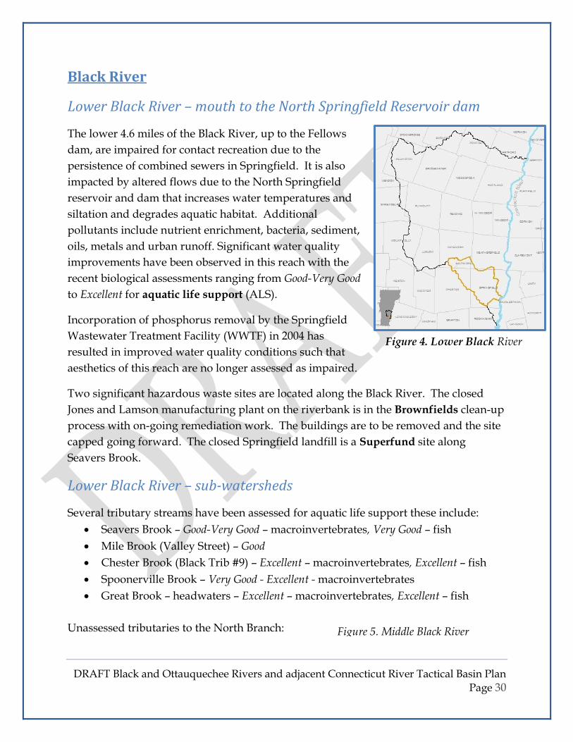
Black River ................................................................................................................................. 30
Lower Black River – mouth to the North Springfield Reservoir dam ........................................ 30
Lower Black River – sub-watersheds ......................................................................................... 30
Middle Black River – North Springfield dam to Cavendish dam ............................................... 31
Middle Black River –Cavendish dam to Branch Brook .............................................................. 31
Black River Headwaters – Branch Brook to headwaters........................................................... 33
Ottauquechee River .................................................................................................................. 34
Lower Ottauquechee River – mouth to Kedron Brook ............................................................. 34
Middle Ottauquechee River – Kedron Brook to Broad Brook .................................................. 36
Upper Ottauquechee River - Broad Brook to headwaters ........................................................ 39
Connecticut River and tributary streams .................................................................................. 42
Connecticut River – White River Junction to Springfield .......................................................... 42
Tributaries to the Connecticut River – – (listed from north to south) ...................................... 42

DRAFT Black and Ottauquechee Rivers and adjacent Connecticut River Tactical Basin Plan
Page 6
Lakes and Ponds ........................................................................................................................ 43
Wetlands ................................................................................................................................... 51
Fisheries Description ................................................................................................................. 52
Special Values and Features ...................................................................................................... 53
Rare, Threatened and Endangered Species and Natural Communities.................................... 57
Water Quality Monitoring and Assessment Needs ................................................................... 57
Chapter 3 – Addressing Stressors, Impaired Waters and TMDLs ................................................. 59
Major Stressors ......................................................................................................................... 59
Priority Waters .......................................................................................................................... 59
Impaired, Stressed and Altered Waters Watershed Summary of Segments with Impacts ...... 60
Total Maximum Daily Loads ...................................................................................................... 69
TMDL Implementation Update ................................................................................................. 72
Known Contaminants & Direct Discharges ............................................................................... 72
Flood Resiliency ......................................................................................................................... 79
Chapter 4 – Management Goals for Protecting Surface Waters .................................................. 85
Reclassification Priorities .......................................................................................................... 89
Outstanding Resource Waters .................................................................................................. 91
Class I Wetland Designation ...................................................................................................... 92
Existing Uses .............................................................................................................................. 93
Chapter 5 – Project Implementation: Protection and Remediation Actions ............................... 95
Projects Completed ................................................................................................................... 95
Table 18. Summary of Implementation Projects ...................................................................... 98
References ............................................................................................................................... 103
Acronyms & Abbreviations...................................................................................................... 104
Glossary ................................................................................................................................... 107
Appendices .................................................................................................................................. 110
APPENDIX A. – Basin Planning meetings ................................................................................. 111
APPENDIX B. – Fisheries Assessments .................................................................................... 113

DRAFT Black and Ottauquechee Rivers and adjacent Connecticut River Tactical Basin Plan
Page 7
APPENDIX C. – Existing Uses in Basin 10 Waters .................................................................... 129
APPENDIX D. – Municipal Planning and Water Resources Review ......................................... 138
APPENDIX E. – Dams in Basin 10 ............................................................................................. 146
APPENDIX F. – USACE / VT ANR / USFWS Agreement & ANR Factsheet ................................ 151
APPENDIX G. – Draft Plan Public Comment Responsiveness Summary ................................. 159
APPENDIX H. – Potential funding sources ............................................................................... 160
APPENDIX I. – Regulatory and Non-Regulatory Programs Related To Protecting and Restoring
Waters ..................................................................................................................................... 161
Acronyms................................................................................................................................ 162

DRAFT Black and Ottauquechee Rivers and adjacent Connecticut River Tactical Basin Plan
Page 8
List of Figures
Figure 1. Basin 10 Watersheds
Figure 2. Stream Geomorphic Assessments
Figure 3. Biomonitoring Sites
Figure 4. Lower Black River
Figure 5a. Middle Black River
Figure 5b. Middle Black River
Figure 6. Okemo Biomonitoring Sites
Figure 7. Black River Headwater Figure 8. North Branch Black Rivers
Figure 9 Sherman Brook Biomonitoring Sites
Figure 10. Lower Ottauquechee River
Figure 11. Barnard Brook
Figure 12. Kedron Brook
Figure 13. Middle Ottauquechee River
Figure 14. North Branch Ottauquechee River & Conserved Lands
Figure 15. Chateauguay-No Town Conservation Project Figure 16. Upper Ottauquechee River
Figure 17. Roaring Brook Biomonitoring Sites
Figure 18. Hartland-Windsor Direct Figure 19. Mill Brook
Figure 20. Impaired, Stressed and Altered Waters
Figure 21. Known Contaminant Sites – Ottauquechee River
Figure 22. Known Contaminant Sites – Black River
Figure 23. Known Contaminant Sites – Connecticut River region
Figure 24. Emergency Relief and Assistance Fund Cost Share List of Tables Table 1. Completed Assessments Table 2. Ottauquechee River Group Monitoring Sites Table 3. ORG 6-Year Summary Table 4. Lake Score Card Table 5. Known Invasive Plant Populations Table 6. Waterbodies with Use Restrictions Table 7. Boating Accesses in the Basin Table 8. Monitoring and Assessment Needs Table 9. Watershed Summary of Segments with Impacts Table 10. Summary of Permit Requirements for Wastewater Treatment Facilities Table 11. Class A(2) - Public Water Sources Table 12. Criteria for Water Classes

DRAFT Black and Ottauquechee Rivers and adjacent Connecticut River Tactical Basin Plan
Page 9
Table 13. Reservoirs Proposed for Reclassification Table 14. Waters Proposed for Reclassification to A(1) Table 15. Waters Proposed for Reclassification to B(1) Table 16. Waters Proposed for designation as Outstanding Resource Water Table 17. Prospective Candidates for Wetland Reclassification Table 18. Summary of Implementation Projects

DRAFT Black and Ottauquechee Rivers and adjacent Connecticut River Tactical Basin Plan
Page 10

DRAFT Black and Ottauquechee Rivers and adjacent Connecticut River Tactical Basin Plan
Page 11
Executive Summary The Black and Ottauquechee River Tactical Basin Plan (referred herein to as the Basin 10
Plan) provides an overall view of the health of the regions waters and defines on-going
and future actions to address high-priority stressors. This Plan includes targeted actions
to achieve the State’s water quality goals laid out in the Vermont Clean Water Act, the
Vermont Surface Water Management Strategy and the Long Island Sound Total
Maximum Daily Load. The actions are described in the Summary Implementation
Table in Chapter 5 and in the online Watershed Projects Database.
The two major watersheds in the Basin - the Ottauquechee River watershed and the
Black River watershed cover 425 square miles of southeastern Vermont from Killington
Peak down to Springfield. The mainstem of the Connecticut River from Hartford to
Bellows Falls, along with the tributaries within this region are also included in the plan.
In looking at the broader water quality concerns in the Basin excessive sediment, high
water temperatures, excessive levels of nutrients and E. coli bacteria, physical alterations
of stream channels, water level and flow alterations, and habitat alterations are the most
pervasive. Impairments of water quality impact 11 miles of rivers and streams with
many more being Altered1 or Stressed by one or more these factors. The impaired
waters are being addressed through the implementation of Total Maximum Daily Load
plans and watershed restoration projects identified through this and other regional and
local planning processes.
The protection or improvement of water quality and water-related uses is being
promoted by establishing specific management goals for individual bodies or stretches
of water. The management goals describe the values and uses of the surface water that
are to be protected or achieved through appropriate management. Select waters
including rivers, streams, lakes and wetlands are proposed for reclassification to
increase protection from future degradation.
Since the previous Basin Plan was completed in 2012 over $1,000,000 have been invested
by the Vermont Department of Environmental Conservation to improve water quality
and habitat conditions in this Basin. Geomorphic assessments have been completed on
the Black and Ottauquechee Rivers and several of their tributaires and on Mill Brook in
Windsor. These have provided a multitude of potential remediation projects that will
1 Words in BOLD are defined in the Glossary

DRAFT Black and Ottauquechee Rivers and adjacent Connecticut River Tactical Basin Plan
Page 12
be reviewed by Vermont Department of Environmental Conservation (VDEC) and our
partners to prioritize the most important ones to pursue over the next few years.
The overarching strategies indentified are laid out in the Summary of Implementation
Projects Table 17 in Chapter 5. These are intended to address issues and corresponding
actions such as:
• Agriculture: Implement Best Management Practices
• Flow Alteration: Restore natural flows
• Forest Management: Abate soil erosion
• Hazard Mitigation & Flood Resiliency: Decrease threats to human safety and
property damage
• Impaired & Stressed Waters: Improve water quality and habitat restoration
• River Corridor: Reach stream equilibrium and flood resilience
• Shorelands: Protect and restore
• Stormwater: Reduce pollutants and volume
• Surface Water Protection: Restore and reclassify
• Wetlands: Protect and restore
With the help of our major planning partners in the Tactical Basin Planning process,
including the Southern Windsor County Regional Planning Commission, the Two-
Rivers Ottauquechee Regional Commission and the Ottauquechee Natural Resources
Conservation District and numerous committed partner organizations, municipalities
and individual landowners, we will continue working together to implement Plan
priorities for the restoration, remediation and protection of water quality and habitat
conditions throughout the Basin.

DRAFT Black and Ottauquechee Rivers and adjacent Connecticut River Tactical Basin Plan
Page 13
Top Objectives and Strategies
Protect river corridors to allow rivers to reach equilibrium and increase flood
resilience through protection of river corridors with conservation easements; active and
passive stream channel, floodplain and wetland restoration; resizing of bridges and
culverts; and municipal adoption of appropriate ordinances, focusing on the upper
Black River and its North Branch, mid-Ottauquechee River and Mill Brook.
Protect riparian areas from encroachment and degradation through buffer plantings,
invasive plant control, conservation easements, and municipal adoption of appropriate
ordinances for streambank buffers and setbacks.
Mitigate sources of stormwater runoff causing water quality impairments through
the development and implementation of stormwater master plans, focusing on
Roaring and East Roaring Brooks, Okemo and Trailside Brooks, and the lower Black
River.
Implement agricultural Best Management Practices (BMPs) in areas that are a
significant source of nutrients and where BMPs are best suited to conditions with a
focus on the watersheds of Kedron Brook, lower Ottauquechee River, lower Black River,
North Branch Black River, Twentymile Stream and the Connecticut River.
Protect very high-quality surface waters throughout the Basin through re-classification
and designation of significant natural resource assets such as biological integrity,
recreation, water quality protection, and fisheries, with a focus on locations listed in
Tables 12 - 15.
Prioritize and implement wetland and floodplain restoration projects on agricultural
lands for nutrient retention and sediment attenuation with a focus on the watersheds of
the North Branch Black River, Twentymile Stream and Mill Brook.
Inventory and prioritize municipal road erosion that affects surface water and
implement high priority projects that are identified in municipal road erosion
inventories.
Promote and implement shoreland protection and restoration through direct outreach
with landowners to encourage participation in the Lake Wise Program, which promotes
implementation of lakeshore BMPs.

DRAFT Black and Ottauquechee Rivers and adjacent Connecticut River Tactical Basin Plan
Page 14
Mitigate flow alterations by working with dam operators to lessen flow variations and
work toward run-of-river management.
Summary of Protection Opportunities
Waters recommended for further assessment for reclassification from
Class B to Class A(1) for Aquatic Biota & Habitat:
Surface Water: Town(s):
• North Branch Ottauquechee River Bridgewater, Killington - All
• Great Brook Cavendish - Above Cavendish town line
• Black River Trib #9 Springfield - Above Rt. 11
• Tiny Pond Stream Ludlow, Mount Holly
• Kilburn Brook Trib #1 Hartford
• Barnard Brook Trib 6 Pomfret
Waters recommended for reclassification from Class A(2) to Class A(1) or B(1):
These waters are no longer used or reserved for use as A2 - public water supply
Surface Water: Town:
• Spring and unnamed trib to the Ottauquechee River North Hartland
• Carlton Hill Reservoirs Woodstock
• Wright, Upper and Lower Hurricane Reservoirs Hartford
• Springfield Reservoir and tributaries Weathersfield
• Unnamed tributary to Mill Brook Ascutney
Waters recommended for further assessment to verify conditions for reclassification
from Class B(2) to Class B(1) for Aquatic Biota & Habitat:
Surface Water: Town(s):
• Ottauquechee River Bridgewater - above Bridgewater Hill Rd
• Lulls Brook Hartland, West Windsor - above fire station
• Great Roaring Brook Plymouth
Waters recommended for further assessment to verify conditions for reclassification from Class B(2) to Class B(1) for Fishery:
Surface Water: Town:
• Jewell Brook Ludlow

DRAFT Black and Ottauquechee Rivers and adjacent Connecticut River Tactical Basin Plan
Page 15
• Grant Brook Ludlow
• Sanders Brook Ludlow
• Twenty Mile Stream Cavendish • North Branch Black Cavendish – Upstream of Ascutney Basin Road
• Kent Brook Killington - Above Kent Pond
• Falls Brook Killington
• Ottauquechee River Above Roaring Brook confluence
• Roaring Brook Killington
• Reservoir Brook West Bridgewater
• Madden Brook West Bridgewater
• Dailey Hollow Brook Bridgewater Center
• Pinney Hollow Brook Plymouth
• Curtis Hollow Brook Bridgewater
• Beaver Brook West Woodstock
• Kedron Brook South Woodstock
• Barnard Brook South Pomfret
• Cloudland Brook South Pomfret
• Babcock Brook Taftsville
• Whitman Brook Hartford
• Fulling/Harlow Brook North Hartland
Waters recommended for Outstanding Resource Waters designation:
Surface Water: Town:
• North Branch Ottauquechee River Bridgewater, Killington - All • Buttermilk Falls, Branch Brook Ludlow
• Cavendish Gorge, Black River Cavendish
• Comtu Falls, Black River Springfield
Wetlands to be assessed for potential reclassification to Class 1 or 2
Surface Water: Town:
• Black Pond Plymouth
• Beaver Pond Weathersfield
• Killington Flats Killington
• Lake Ninevah (contiguous) Mount Holly
• Eshqua Bog Hartland

DRAFT Black and Ottauquechee Rivers and adjacent Connecticut River Tactical Basin Plan
Page 16

DRAFT Black and Ottauquechee Rivers and adjacent Connecticut River Tactical Basin Plan
Page 17
Chapter 1 – Tactical Basin Planning Process & Watershed
Description
Tactical Basin Planning Process
The Vermont Department of Environmental Conservation’s (VDEC) tactical planning
process is designed to identify and prioritize state and local water quality issues and
lead to implementation of on-the-ground watershed protection and restoration projects.
Plans are designed to meet the goals and objectives of the Vermont Surface Water
Management Strategy (VSWMS) to protect, maintain and restore the biological,
chemical, and physical integrity, and public use and enjoyment of Vermont’s water
resources, and to protect public health and safety. The VDEC collaborates with state,
federal, regional and municipal organizations, local conservation groups, businesses,
and a variety of landowners and interested citizens to develop the water quality
management plan for waters in these Basins.
Plan Implementation
This Tactical Basin Plan (TBP) includes targeted actions to achieve the State’s water
quality goals laid out in the Vermont Clean Water Act, the Vermont Surface Water
Management Strategy and the Long Island Sound Total Maximum Daily Load. The
actions are described in the Summary Implementation Table 17 in Chapter 5 and in the
online Watershed Projects Database which is continuously updated as projects are
implemented, as new projects come to light from newly emerging information and
unanticipated events, as priorities change and as new requirements arise. Actions are
reviewed and prioritized for implementation by regional Clean Water Advisory
Committees which consist of municipal and non-profit representation. Successes and
challenges in implementing actions will be reviewed in biannual meetings with
watershed partners.
In order to implement high priority actions, watershed partners apply for funding,
coordinate projects and track the progress of measurable indicators of outcomes. The
Clean Water Fund has been established, and paired with other funds available for water
quality improvements. Funds are dedicated towards the highest priority water quality
remediation actions.

DRAFT Black and Ottauquechee Rivers and adjacent Connecticut River Tactical Basin Plan
Page 18
For more information about the Vermont Clean Water Act, readers should review the
content of the Vermont Clean Water Initiative website at:
http://dec.vermont.gov/watershed/cwi.
The life of this Plan is envisioned to be five years. It is expected that the Agency and its
partners will develop adaptive management techniques as new natural events such as
major storms, and human-caused changes, alter conditions over time.
Many partners are integral to the planning process, these include:
• Black River Action Team
• Connecticut River Joint Commissions and
o Mount Ascutney Local River Subcommittee
• Connecticut River Conservancy
• Great River Hydro formerly TransCanada Hydro Northeast Inc.
• Lake Ninevah Community & Foundation
• Lake Rescue Association
• Municipalities throughout the Basin
• Ottauquechee Natural Resources Conservation District
• Ottauquechee River Group
• Southern Windsor County Regional Planning Commission & Clean Water Advisory
Committee
• Trout Unlimited, Greater Upper Valley Chapter
• Two Rivers-Ottauquechee Regional Commission & Clean Water Advisory
Committee
• US Army Corps of Engineers
• USDA
o Forest Service and
o Natural Resources Conservation Service
• VT Agency of Agriculture, Food and Markets
o Water Quality Division
• VT Agency of Natural Resources Departments of
o Environmental Conservation
o Fish and Wildlife
o Forests, Parks and Recreation
• VT Agency of Transportation

DRAFT Black and Ottauquechee Rivers and adjacent Connecticut River Tactical Basin Plan
Page 19
Vermont Water Quality Standards and Clean Water Act
The Vermont Water Quality Standards (VWQS) are rules specific to Vermont that
protect the waters of the state. These rules expand upon the 1972 Federal Clean Water
Act, which requires states "to restore and maintain the chemical, physical and biological
integrity of the nation’s waters.” The VWQS define biological integrity as the ability of
an aquatic ecosystem to support and maintain a community of organisms that is
balanced, fully functional (integrated), resilient to change or impact (adaptive), and has
the expected species composition, diversity, and functional organization for its type of
ecosystem. The health of a biological community reflects the level of combined human-
induced stresses acting upon it. Aquatic communities that are most impaired suffer
from an accumulation of multiple stressors.
The implementation actions identified in this Tactical Basin Plan are meant to fulfill all
the geographically-specific planning requirements in the VWQS, while the statewide
planning requirements, including state-scale strategies, are addressed in the statewide
Surface Water Management Strategy.
In 2015 the Vermont Legislature passed Act 64, the Vermont Clean Water Act, which
creates new statutory authorities and strengthens multiple statutes related to water
quality in the State. The Act addresses agricultural water quality through Required
Agricultural Practices, establishes water quality requirements for stormwater
discharges from new and existing development, industrial and municipal stormwater
discharges, and runoff from municipal roads. It also addresses water quality runoff
from forest silvicultural activities and supports wetland restoration efforts.
Act 64 establishes the requirement that all water quality improvement actions
undertaken by the State be integrated by means of Tactical Basin Plans, and establishes
partnerships with Regional Planning Commissions, Conservation Districts, and other
organizations to support this work.
To meet requirements for attaining these new standards the Clean Water Fund has been
established, permit fees have been increased, and new supportive positions have been
created within the Agency of Natural Resources (ANR) and the Agency of Agriculture,
Food and Markets (AAFM).
Act 64 is being gradually implemented as procedures are drafted and legislative rule-
making progresses. The resulting policies and procedures will take several years to be

DRAFT Black and Ottauquechee Rivers and adjacent Connecticut River Tactical Basin Plan
Page 20
fully implemented, and will ensure improved water quality throughout the state. For
more information, readers should review the content of the Vermont Clean Water
Initiative website at: http://dec.vermont.gov/watershed/cwi.
Regional Conformance
Regarding work with the Regional Planning Commissions, the Agency of Natural
Resources (VANR) will work with the applicable regional planning commissions to
develop an analysis and formal recommendation on conformance with the goals and
objectives of applicable regional plans, see 10 V.S.A 1253(d)(2)(G). The overall role of
the TBPs is not to determine where development should happen. This Tactical Basin
Plan encourages communities to take protective measures that will restore, maintain
and enhance water quality in all areas that in turn protect human health, ecological
integrity, and water-based recreational uses. The TBP does not preclude any
development that is consistent with municipal zoning, regional and municipal plans
and with applicable State and federal regulations.
Basin Description
A watershed, or basin, is a distinct land area that drains into a specific waterbody either
through stream flow or surface runoff. Mountain peaks and hillsides define the Basin 10
watersheds. Killington Peak is the northernmost edge, Ludlow Mountain or Okemo
borders the south basin boundary and Mount Ascutney defines the basin to the east.
The twenty-three towns encompassed in the Basin are a diverse array of landscapes
from wilderness to urban, from Chateauguay-No Town in Bridgewater to downtown
Springfield. The local concerns for water quality, flood resiliency, and watershed
protection are as diverse as the landscape.
Basin 10 consists of two major watersheds in southeastern Vermont - the Ottauquechee
River watershed and the Black River watershed. Both rivers flow from the Green
Mountain range near Killington peak down to the Connecticut River, the Black meeting
it at Hoyt’s Landing in Springfield and the Ottauquechee reaching it in North Hartland
east of the flood control dam. Almost 80% of the Basin is in forect cover, 10% in
agriculture or parture/grass and 6.7% is developed.

DRAFT Black and Ottauquechee Rivers and adjacent Connecticut River Tactical Basin Plan
Page 21
The Ottauquechee River has a mainstem length of 38 miles and drains an area of 223
square miles. From Killington Peak the river drops 3900 feet in elevation down to the
Connecticut River in Hartland.
The Black River, has a mainstem length of 40 miles and drains an area of 202 square
miles. It is formed at the outlet of Black Pond in the town of Plymouth and drops 3040
feet in elevation from the top of Ludlow Mountian (Okemo) to Hoyts Landing in
Springfield.
Basin 10 also includes the streams that flow directly into the Connecticut River between
the mouths of these two larger rivers. Among these are the two Mill Brooks that run on
the north and south sides of Ascutney Mountain and Spencer, Blood and Lulls Brooks.
These direct tributaries flow through the Towns of Hartland, Reading, West Windsor,
Windsor, Springfield and Weathersfield.
There are 19 lakes and ponds in the Basin that are 20 acres or larger covering
approximately 1,610 acres. The North Springfield Reservoir, North Hartland Reservoir,
Echo Lake, Lake Rescue, Lake Ninevah and Woodward Reservoir are the largest bodies
of water in Basin 10, each being at least 100 acres in size.
Knapp Brook, Knapp Brook Wildlife Management Area Cavendish

DRAFT Black and Ottauquechee Rivers and adjacent Connecticut River Tactical Basin Plan Page 22
Figure 1. Basin 10 Watersheds

DRAFT Black and Ottauquechee Rivers and adjacent Connecticut River Tactical Basin Plan Page 23
Chapter 2 – Water Quality in the Basin
Overview of Water Resources and Stressors
In developing the SWMS, the WSMD recognized that individual pollutants (often more
than one) can be simultaneously mitigated by managing surface water stressors. The
Division has identified a list of 10 major stressors with specific causes and sources, and
sometimes overlapping effects, which result in the surface water impacts documented
in Vermont. By identifying stressors and approaches to their management, the Strategy
sets the stage for the WSMD’s approach to multi-agency planning and implementation
that will meet the WSMD goals.2
A stressor is defined as an observable influence with quantifiable damaging effects on
surface waters resulting from the delivery of pollutants to a waterbody, or an increased
threat to public health and safety. For the most part, stressors result from human
activity on the landscape; however, when landscape activities are appropriately
managed, stressors are reduced or eliminated.
Rivers
In the Ottauquechee River watershed the major pollutants include sediment,
temperature, nutrients, and E. coli, as well as the impacts from physical alteration, flow
alteration, and habitat alteration. Impairments are caused by stormwater runoff and
2 SWMS, Chapter 1

DRAFT Black and Ottauquechee Rivers and adjacent Connecticut River Tactical Basin Plan
Page 24
iron seepage. The North Branch Ottauquechee maintains a high level of water quality
and is an excellent fishery.
Pollutants impacting the Black River also include sediment, nutrients, E. coli and flow
alteration dues to the flood control dams in North Springfield.
The Connecticut River tributaries are impacted by sediment and habitat alteration,
while flow alteration impacts the entire Connecticut River mainstem.
Lakes and Ponds
Lakes and ponds in the region are impacted by low pH from acid rain and several have
invasive species populations that impact lake uses and ecology. Encroachment of
development along the lakeshore however is the most prevalent stressor with
sedimentation and land erosion also impacting water quality.
Wetlands
Wetlands constitute only 1.8% of the Basin’s land use. Extensive wetlands occur along
the upper Ottauquechee and in association with the US Army Corps of Engineers flood
control dams in both watersheds. While most are small to moderate in size there is a
good diversity of wetland types in the Basin. As with lakes, encroachment and sediment
from road runoff and erosion are major stressors to the regions wetlands.
Climate Change: increasing pollutant loads and impacts to
waterbodies
Climate change predictions for Vermont are expected to intensify stresses on our
watersheds, leading to increased pollutant loads from the landscape as well as loss of
native species. Predictions include increased intensity and frequency of storms with
resulting increases in stormwater flows which scour stream beds, impacting fish,
macroinvertebrates and algal populations. In response, improved management of
landscape activities will need to more effectively address the impacts of the additional
flows and the resulting increases in channel and land erosion, nutrient loading and
thermal stress.
Increased temperatures are also predicted, which will place further thermal stress on
waterbodies and aquatic communities. Warmer temperatures will allow some invasive

DRAFT Black and Ottauquechee Rivers and adjacent Connecticut River Tactical Basin Plan
Page 25
species to gain a competitive edge, requiring changes in management strategies to
better protect native species.
Summary of Surface Water Assessments
VANR and its partners conduct on-going monitoring and assessment throughout the
Basin. Water quality, biological and physical assessments have been completed on
many of the rivers, streams and lakes. VDEC uses monitoring and assessment data to
assess individual surface waters in relation to Vermont Water Quality Standards as
outlined in the 2016 VDEC Assessment and Listing Methodology.
Other types of assessments include stream geomorphic assessments (SGA), stormwater
inventory and illicit discharge and detection studies and Total Maximum Daily Load
(TMDL) plans. These efforts, as well as those planned for execution during the
implementation of this Plan are detailed in Table 1.
Table 1. Completed Assessments
Sub-watershed Date Coverage
Stream Geomorphic Assessments
Black River Corridor Plan 2009 Phase 1, 2 & Corridor Plan
Patch & Buffalo Brooks Corridor Plan 2010 Phase 1, 2 & Corridor Plan
Ottauquechee River Corridor Plan 2013 Phase 1, 2 & Corridor Plan
Roaring Brook Phase 1 and 2 SGA 2006 Phase 1, 2 Only
Mill Brook River Corridor Plan 2015 Phase 1, 2 & Corridor Plan
Hubbard Brook Phase 1 SGA 2008 Phase 1 Only
Water Quality and Aquatic Habitat Assessments
Black River Watershed 2016
Ottauquechee River Watershed including Mill Brook and Lulls Brook
2016
Stormwater Assessments
Town Stormwater Mapping and Stormwater Master Planning Reports
various
Barnard, Bridgewater,
Cavendish, Chester, Hartford,
Hartland, Killington, Ludlow,
Plymouth, Reading, Springfield,
Weathersfield, West Windsor,
Windsor, Woodstock

DRAFT Black and Ottauquechee Rivers and adjacent Connecticut River Tactical Basin Plan
Page 26
Town of Springfield Illicit Discharge Detection and Elimination Study
2013
Black River from St Mary's Cemetery to Seavers Brook & Chester Brook to Bellows Rd, Valley St to Litchfield Rd. & No. Springfield
TMDLs
Black River - Phosphorus 2001 Below Ludlow WWTF for approx. 0.5 mi
Black River - Bacteria 2011 Springfield CSO3
Vermont - Mercury 2007 Statewide
Long Island Sound 2000 Multi-state
Water Quality Remediation Plan* 2011 Roaring Brook & East Branch of Roaring Brook
* Pursuant to 40 C.F.R. §130.7(b), the State may use a Water Quality Remediation Plan (WQRP) in lieu of a TMDL for an impaired water when the State determines that the pollution control requirements of the WQRP are stringent enough to meet State Water Quality Standards within a reasonable period of time.
3 These waters are impaired for E.coli due to the influence of wastewater treatment facilities and combined sewer overflows. These waters are not covered under this TMDL but specifics regarding their location and management status is included in this document for informational purposes only.

DRAFT Black and Ottauquechee Rivers and adjacent Connecticut River Tactical Basin Plan
Page 27
Stream geomorphic assessments
(SGA) study the physical conditions
of rivers and the interralationships of
flowing water and sediment within
varying landscapes. SGAs
incorporate watershed-wide
information from maps, aerial
photographs, existing studies, and
field data into a detailed
characterization of riparian and in-
stream habitat, erosion, and flood
hazards for use in watershed
planning. Table 1 and Figure 2 show
the locations and links for those
completed in the Basin.
The Ambient Biomonitoring Program
of the Watershed Management
Division (WSMD) samples
macroinvertebrate and fish
communities in order to evaluate the
biological health, or biological
integrity, of rivers and streams and to identify high quality waters as candidates for
reclassification. These surveys are used for detecting aquatic life impairments and
assessing their relative severity. Biomonitoring assessments indicate the overall
ecological integrity of the river system and provide a method of evaluating waters in
comparison to their “reference condition” without human impacts. This program also
collects water quality data that are used to assess compliance with Water Quality
Standards. The biological and water quality results are used to rank the condition of
waters as Excellent, Very Good, Good, Fair or Poor, using the Department’s Procedures for
Ambient Biomonitoring and Assessment.
The Lake Assessment Program of the WSMD performs similar functions for lakes and
ponds, and numerous lakes and ponds have been assessed in this Basin. Figure 3 shows
monitoring locations for both programs, and provides an assessment of current
Figure 2. Stream Geomorphic Assessments

DRAFT Black and Ottauquechee Rivers and adjacent Connecticut River Tactical Basin Plan
Page 28
biological integrity for streams. The condition of lakes is described separately in this
Chapter.
A comprehensive summary of available assessment information from these and other
processes is compiled into individual reports for each major watershed which details
the conditions on a sub-watershed and reach level for the major watersheds in the
Basin. These can be found at: http://dec.vermont.gov/watershed/map/basin-
planning/basin10.
The Agency of Agriculture, Food and Markets assesses the need for Required
Agricultural Practices (RAP) and Best Management Practices (BMPs) on agricultural
sites through its farm inspection program. The level of assessment varies based on
intensity of agriculture in the area. Initial assessments in Basin 10 are underway.
Condition of Specific Sub-watersheds
The Basin 10 planning unit includes the Ottauquechee and Black River watersheds, and
the mainstem of the Connecticut River from the mouth of the White River in Hartford
down to the mouth of the Williams River in Rockingham. All the smaller tributaries
that drain directly into the Connecticut, such as the Mill Brooks in Windsor and
Weathersfield, Lulls Brook in Hartland, Spencer Brook in Springfield and Blood Brook
in Weathersfield are also now included in Basin 10.
The Watershed Management Division monitors river and steams on a five-year rotating
schedule. The rankings below are based on the resulting biological, chemical and
physical assessments. These rankings indicate compliance with Vermont Water Quality
Standards (VWQS). Other forms of monitoring are conducted but compliance is based
on the biological condition as evidenced through macroinvertebrate and fish
community assessment data. Most of this data can be accessed through the Vermont
Integrated Watershed Information System (IWIS), online data portal.

DRAFT Black and Ottauquechee Rivers and adjacent Connecticut River Tactical Basin Plan
Page 29
Figure 3. Biomonitoring Sites
DRAFT Black and Ottauquechee Rivers and adjacent Connecticut River Tactical Basin Plan
Page 30
Black River
Lower Black River – mouth to the North Springfield Reservoir dam
The lower 4.6 miles of the Black River, up to the Fellows
dam, are impaired for contact recreation due to the
persistence of combined sewers in Springfield. It is also
impacted by altered flows due to the North Springfield
reservoir and dam that increases water temperatures and
siltation and degrades aquatic habitat. Additional
pollutants include nutrient enrichment, bacteria, sediment,
oils, metals and urban runoff. Significant water quality
improvements have been observed in this reach with the
recent biological assessments ranging from Good-Very Good
to Excellent for aquatic life support (ALS).
Incorporation of phosphorus removal by the Springfield
Wastewater Treatment Facility (WWTF) in 2004 has
resulted in improved water quality conditions such that
aesthetics of this reach are no longer assessed as impaired.
Two significant hazardous waste sites are located along the Black River. The closed
Jones and Lamson manufacturing plant on the riverbank is in the Brownfields clean-up
process with on-going remediation work. The buildings are to be removed and the site
capped going forward. The closed Springfield landfill is a Superfund site along
Seavers Brook.
Lower Black River – sub-watersheds
Several tributary streams have been assessed for aquatic life support these include:
• Seavers Brook – Good-Very Good – macroinvertebrates, Very Good – fish
• Mile Brook (Valley Street) – Good
• Chester Brook (Black Trib #9) – Excellent – macroinvertebrates, Excellent – fish
• Spoonerville Brook – Very Good - Excellent - macroinvertebrates
• Great Brook – headwaters – Excellent – macroinvertebrates, Excellent – fish
Unassessed tributaries to the North Branch: Figure 5. Middle Black River
Figure 4. Lower Black River

DRAFT Black and Ottauquechee Rivers and adjacent Connecticut River Tactical Basin Plan
Page 31
• Knapp Brook – Cavendish
• Alder Meadow Brook
• Darby Brook
Middle Black River – North Springfield dam to
Cavendish dam
Recent monitoring of this reach reveals a community
assessesed as Very Good to Excellent. The hydroelectric dam
in Cavendish is operated as a run-of-river facility. This
mode of operation maintains minimum flows levels and
decreases the impacts on water temperture. The
Cavendish WWTF discharges to the Black River in this
reach.
The tributary stream assessed in the reach is:
• Tarbell Hill Brook – Very Good - macroinvertebrates
Middle Black River –Cavendish dam to Branch
Brook
The Ludlow WWTF discharges to the Black River in this
reach. Monitoring above the dam/below WWTF rate the
reach as Very Good to Excellent for macroinvertebrates. The
WWTF does seasonal phosphorus removal to remove
excess nutrients during the growing season.
Tributary streams assessed for macroinvertebrates in the
reach include:
• Serpentine Brook (below quarry above North Star
Hill Road) – Poor
• Coleman Brook – Good
• Jewell Brook – last monitored in 2007 at two
locations when it was reported to be Excellent and
Very Good.
• Okemo Brook – Fair-Good Figure 5b. Middle Black
Figure 5a. Middle Black

DRAFT Black and Ottauquechee Rivers and adjacent Connecticut River Tactical Basin Plan
Page 32
• Sanders Brook – the lower brook is rated as Very Good-Excellent, while the upper
brook degraded from Good-Very Good in 2014 down to Fair in 2015. The cause of
this change is not yet clear but may be due to altered streambed conditions.
• Soapstone Brook - Excellent
• Trailside Brook – ranges from Good to Poor along its length. Trailside Brook runs
through Reservoir Number 3
• Branch Brook – Poor (2011) down from several years of Excellent ratings.
Sampling was done shortly after Tropical Storm Irene, which likely scoured the
stream bed, causing reduced numbers and diversity of macroinvertebrates
resulting in a temporary asssessment of Poor. The stream has most likely
recovered in the years since.
Several of these brooks are located within the Okemo Resort development as noted in
Figure 6.
Figure 6. Okemo Biomonitoring Sites

DRAFT Black and Ottauquechee Rivers and adjacent Connecticut River Tactical Basin Plan
Page 33
Black River Headwaters – Branch Brook to headwaters
Black River – Very Good for macroinvertebrates above
Amherst Lake. This site is the most upstream monitoring
site on the Black River mainstem and is also below the
confluence of Money Brook. Fish sampling done in 2012
suggests some degradation in the overall community.
North Branch Black River - Very Good – Excellent for
macroinvertebrates, Fair for
fish. This site is the most
upstream monitoring site on
the North Branch.
Tributary streams assessed in
the reach include:
• Great Roaring Brook -
Very Good for macroinverte-
brates, Excellent for fish
• Patch Brook - Very Good for macroinvertebrates
• Tarbell Hill Brook - Very Good for
macroinvertebrates
Buffalo Brook was removed from the threatened category
due to the new legislation in effect that discourages gold
dredging.
Figure 8. North Branch
Black River
Figure 7. Black River
Headwaters

DRAFT Black and Ottauquechee Rivers and adjacent Connecticut River Tactical Basin Plan
Page 34
Sherman Brook – tributary to the North
Branch – In the fall of 2013 a road project
caused a discharge of Styrene into
Sherman Brook in Weathersfield. Follow
up monitoring revealed that the pollutant
levels in the water were extremely high.
The communities were severely
impacted. As shown in Figure 4. above
the site the macroinvertebrate community
was Good, just below the site it was
reduced to Poor. Fifty meters
downstream this community recovered
to Very Good condition. Fish sampling
above the impact site counted 33 Brook
trout while below the site no trout were
found. Clean-up efforts were put in place
to capture and remove as much of the
chemical as possible. A 2016 fish survey
shows fish populations had recovered.
Ottauquechee River
Lower Ottauquechee River – mouth to Kedron Brook
The lower Ottauquechee River system is dominated by six dams. Beginning at the river
mouth is the White Current dam in Hartland. Farther upriver are the USACE flood
control dam in North Hartland and the Deweys Mill dam in Quechee, all three of these
dams provide hydroelectric generation. Deweys Pond and Quechee Mills dams and the
off-river Lake Pinneo dam provide recreational opportunities. The uppermost
Taftsville dam is also power producing.
Figure 9. Sherman Brook Biomonitoring Sites

DRAFT Black and Ottauquechee Rivers and adjacent Connecticut River Tactical Basin Plan
Page 35
The flow alterations caused by the dams impact aquatic
life, recreation and aesthetics of the reach which is listed
as Altered from the upper end of the North Hartland
reservoir to the Connecticut River. The remainder of the
reach is listed as Stressed for these uses due to nutrients,
organic enricment, temperature, sediment and E. coli.
The reach is stressed from Woodstock village to the
reservoir for secondary contact recreation, aquatic
biota/habitat and aesthetics due to nutrients, organic
enrichment, temperture, sediment, and E. coli, from golf
course, road, and developed land runoff, septic systems
and fertilized turf.
From Bridgewater Corners to Woodstock village it is
stressed for sediment, physical alteration, temperature
from road encroachments and runoff, and an over-wide
channel.
Permitted wastewater discharges to the reach include the Quechee, Sherburne,
Taftsville and Woodstock wastewate treatment facilities
(WWTF) and the disposal field for the Sunrise Village
development in Killington.
Tributary streams assessed for macroinvertebrates in the
reach include:
• Barnard Brook – Stressed for sediment and
temperature from unknown sources – Good-Very Good
o Gulf Stream – Stressed for sediment from gravel road
maintenance
• Harlow Brook – Good
Figure 10. Lower Ottauquechee
River
Figure 11. Barnard Brook

DRAFT Black and Ottauquechee Rivers and adjacent Connecticut River Tactical Basin Plan
Page 36
• Kedron Brook – Stressed for sediment, nutrients and
bacteria caused by horse recreation activity; pasture; road
runoff; loss of riparian vegetation; and a golf course
o Very Good at its mouth
o Very Good-Excellent below the golf course
o Good above the So. Woodstock WWTF
o Good below the So. Woodstock WWTF
Middle Ottauquechee River – Kedron Brook to Broad Brook
This reach while assessed for macroinvertebrates at
Excellent and Very Good along its course, is stressed from
Woodstock to Bridgewater Corners vicinity for aquatic
habitat, aesthetics, and secondary contact recreation. The
stressed conditon results from physical alteration of the
channel and the lack of riparian vegetation creating a wide
and shallow channel with high water temperatures.
A small unnamed tributary draining the closed
Bridgewater landfill enters this reach and is listed as
impaired for leaching metals into the river.
Over 350 acres of wetlands along Route 4 help protect the
water quality of the river and provide wildlife habitat and
flood prevention.
North Branch Ottauquechee River – Very Good-Excellent for
macroinvertebrates
Figure 12. Kedron Brook
Figure 13. Middle
Ottauquechee River

DRAFT Black and Ottauquechee Rivers and adjacent Connecticut River Tactical Basin Plan
Page 37
The North Branch of the Ottauquechee River is being put forth in this plan for
designation as an Outstanding Resource Water and reclassification to Class A(1) or B(1)
for its fishery and aquatic biota and habitat. More data needs to be gathered for full
documentation but the current data show the biota to be of very high quality and the
habitat in excellent condition. The land in the watershed is almost completely forested
and the majority of the land is protected by either public ownership (6,700 acres),
private conservation (6,890 acres) or is under restrictions through the Use Value
Appraisal or Current Use program.
The Chateauguay No Town Conservation Project is a four town conservation
partnership to protect the 60,000+ acre Chateauguay No Town (CNT) Area. The multi-
town partnership in Barnard, Stockbridge, Bridgewater, and Killington features
collaboration between town officials, non-profit organizations, and private landowners
to protect the critical natural resources of CNT and to maintain its relatively
undeveloped landscape. The maintenance of CNT assists and encourages private
landowners in voluntary conservation mechanisms; promotes sustainable forestry;
preserves the ecological integrity of the area’s natural resources; conserves critical
Figure 14. North Branch
Ottauquechee River and Conserved
Lands

DRAFT Black and Ottauquechee Rivers and adjacent Connecticut River Tactical Basin Plan
Page 38
wildlife habitat areas for bear, moose,
and plant communities; and protects
the upland watersheds of the
Ottauquechee and White Rivers.
Tributary streams assessed for macroinvertebrates in the reach include:
• Broad Brook – Stressed for sediment and physical alterations caused by streambank erosion, channelization, and past gold dredging
• Beaver Brook – Excellent
• Falls Brook – Stressed for sediment caused by land development; erosion; and streambank destabilization
• Bridgewater landfill tributary – Impaired for heavy metals from landfill leachate in a wetland draining to small stream to the Ottauquechee River
Figure 15. Chateauguay-No
Town Conservation Project

DRAFT Black and Ottauquechee Rivers and adjacent Connecticut River Tactical Basin Plan
Page 39
Upper Ottauquechee River - Broad Brook to headwaters
Geomorphic assessment of the mainstem river shows it to
be stressed for sediment, physical alteration and
temperature due to pre- and post-Irene channelization,
road encroachment and runoff, causing the channel to be
over-wide. However, biomonitoring sites through the
reach rank the river as Very Good to Excellent. This region
also benefits from extensive wetlands that run adjacent to
Route 4 from the Bridgewater/Killington town line up to
the headwaters.
Tributary streams assessed for macroinvertebrates in the
reach include:
• Madden Brook - Good
• Roaring Brook – Impaired for stormwater from
runoff, land development and erosion.
▪ Near base lodge – Stressed – Good ▪ Near junction of E. Mountain Rd – Poor
o East Branch Roaring Brook – Impaired for stormwater and iron caused by stormwater runoff, land development, and erosion – Fair-Good
o West Branch Roaring Brook – Impaired for sediment from land development; erosion and road runoff – above Killington Rd – Good
o Upper Roaring Brook and West Branch (Approx. 1.2 Miles) – Stressed for sediment from land development; erosion; and road runoff.
Figures 17. shows the conditions in the impaired Roaring Brook branches.
Figure 16. Upper
Ottauquechee River

DRAFT Black and Ottauquechee Rivers and adjacent Connecticut River Tactical Basin Plan
Page 40
Supporting data on the water quality of the river is also provided by the Ottauquechee
River Group (ORG). ORG has been monitoring the watershed since 2010 for bacteria,
nitrogen, phosphorus, turbidity and chloride. Sampling locations are listed below in
Table 2. Included in their 2016 summary report covering six years of monitoring is
Table 3 which shows sites of concern for each parameter tested. This reveals that
phosphorus levels throughout the river are of concern, as are chloride in the upper
river.
Figure 17. Roaring Brook Biomonitoring Sites

DRAFT Black and Ottauquechee Rivers and adjacent Connecticut River Tactical Basin Plan
Page 41
Table 2. Ottauquechee River Group Monitoring Sites
Ottauquechee River Group Monitoring Sites
Ottauquechee River: Tributaries:
Site Name Site
Number Site Name
Site
Number
Hartland covered bridge swim area OtR006 Kedron Brook below Horse Stables KeB032
Below Quechee WWTF OtR070 Kedron Bk below WWTF KeB045
Below Taftsville WWTF OtR132 Kedron Bk above WWTF KeB046
Above Taftsville Dam OtR133 Kedron Brook above GMHA KeB057
Below Woodstock WWTF OtR157 North Branch/Otto Confluence NBO001
Above Woodstock WWTF OtR163 Falls Bk/Otto Confluence FaB002
Behind Woodstock Union HS OtR185 Roaring Bk above Roaring/Otto
Confluence (just u/s Route 4 bridge) RoB002
Below Bridgewater WWTF OtR245 Roaring Bk/Mtn View Rd. crossing RoB010
Route 100A Bridge OtR254 Roaring Brook above WWTF (just u/s of
Ravine Road bridge) RoB028
Rabeck Road Bridge OtR384
Table 3. ORG 6-Year Summary
Each X indicates the average
of one season of data that
exceeded expected levels for
that parameter
TP – total phosphorus TN – total nitrogen Cl – Chloride E. coli – bacteria TURB - turbidity

DRAFT Black and Ottauquechee Rivers and adjacent Connecticut River Tactical Basin Plan
Page 42
Connecticut River and tributary streams
Connecticut River – White River Junction to Springfield
The reach of the Connecticut River mainstem covered in the Plan is impaired due to the
flow alterations created by the operation of the hydroelectric dams at Wilder and
Bellows Falls. The altered hydrology impacts aquatic life support. Vermont conducts
very limited assessment of the Connecticut River and depends on monitoring by New
Hampshire Department of Environmental Services. New Hampshire lists this reach as
impaired for Aquatic Life due to low pH.
One site near Johnson Island in Hartford is assessed as Fair for macroinvertebrates.
Tributaries to the Connecticut River – – (listed from north to south)
Tributary streams assessed for macroinvertebrates in the
reach include:
Kilburn Brook – in 2009 – Good and in 2015 - Excellent
Neal Brook – Hartford - drains the closed Hartford landfill
site – Impaired for metals
• 2015 – Fair above the tributary draining the landfill
and below I-91
• 2015 – Poor below the landfill tributary, decreased
from Fair in 2009
• 2015 – Fair another 1500 feet downstream
Lulls Brook – Stressed for sedimentation from gravel road
runoff & other sources; needs additional
assessment. Upstream from below Weed
Road to downstream at Bishoff Lane the
stream goes from Excellent to Good.
Hubbard Brook – 2003 - Good
Mill Brook – Windsor
• 2008 – Excellent at Rt 44 in Windsor
• 2014 – Fair at Rt 44 in West Windsor below old talc mine
Figure 18. Hartland-
Windsor Direct

DRAFT Black and Ottauquechee Rivers and adjacent Connecticut River Tactical Basin Plan
Page 43
• Mill Brook is listed as Stressed from the Mill Pond
dam to the Connecticut River for sedimentation
from dam work and stormwater from development.
• It is also listed as Stressed from Willow Brook down
to Mill Pond for sediment and habitat alteration
due to streambank erosion and road runoff.
• The Mill Pond (Windsor Upper) dam at the outlet
of Mill Pond was inspected in 2016 and is rated in
Poor condition. This is a High Hazard Dam
meaning that a dam failure “may cause serious
damage to homes, as well as extensive damage to
the agricultural, industrial and commercial
facilities, important public utilities, main highways
or railroads. The potential economic loss is
extensive and there is a high potential for loss of
life.” The Town of Windsor continues to work on securing the structure.
• A River Corridor Plan was completed in 2015 providing over 60 potential
restoration projects along the brook. The priority projects are listed in the
Implementation Table in Chapter 4.
Blood Brook – Good/Very Good for macroinvertebrates, Excellent for fish
Lakes and Ponds
There are a total of 43 lakes and ponds of 10 acres or larger in the Basin totaling
approximately 2,172 acres. North Springfield Reservoir, North Hartland
Reservoir, Lake Rescue, Lake Ninevah, Woodward Reservoir and Echo Lake are
the largest, each being at least 100 acres in area. Others of note include Amherst
Lake, Stoughton Pond, Deweys Mill Pond*, Lake Pinneo*4, the Knapp Brook
ponds, Colby Pond, Black Pond, Lakota Lake and the Pogue.
Several deserve mention for their special features.
Black Pond, Plymouth: This 20-acre private pond constitutes the headwaters of
the Black River. Despite being relatively close to VT Route 100, it has a secluded
4 * - these are constructed ponds
Figure 19. Mill Brook

DRAFT Black and Ottauquechee Rivers and adjacent Connecticut River Tactical Basin Plan
Page 44
feeling, and the majority of the shoreline is forested. There exists an unusual
cluster of boulders on the shoreline which provide for scenery of statewide
significance.
Echo Lake, Plymouth: This 104-acre lake has supported two rare native species
of watermilfoil: Myriophyllum alterniflorum, which was last observed in 1985, and
M. farwelli, which was last seen in 1990.
Kent Pond, Killington: At one time, 99 acre Kent Pond was characterized by poor
water quality, with excess algae growth throughout the pond. However, recent
assessments show improved water quality conditions and decreased spring
phosphorus levels. It does however host a Eurasian watermilfoil population.
Woodward Reservoir, Plymouth: This impounded 106-acre lake has an adjacent
palustrine wetland characterized by a floating bog mat. This is a significant
feature, and is rare in the Black and Ottauquechee River Basin. It also provides
rare Dwarf Shrub Bog habitat.
Lake Ninevah, Mount Holly: This 171-acre, high elevation lake is significant for
a variety of reasons. While the lake is developed along approximately one third
of its northern shoreline, the remainder is undeveloped and protected forested
land. The watershed of the lake is also completely forested. The southern portion
of the lake is bordered by a 56-acre wetland which has significant habitat value
for both wildlife and other aquatic biota. The lake is a long-term loon (Gavia
immer) nesting site and hosts a number of rare species including Farwell's Water-
milfoil (Myriophyllum farwellii), Slender Naiad (Najas gracillima) and the rare
pondweeds Bluntleaf Pondweed (Potamogeton obtusifolius) and Tuckerman's
Pondweed (P. confervoides). 115 species of birds have been observed here as well.
Over 60 acres of wetlands are contiguous to the lake hosting Sweet Gale
Shoreline Swamp, Poor Fen and Intermediate Fen natural communities.
Eurasian watermilfoil is monitored and controlled through hand-pulling by
divers. Lake landowners are working to re-establish the Lay Monitoring
Program and conduct invasive plant surveys.

DRAFT Black and Ottauquechee Rivers and adjacent Connecticut River Tactical Basin Plan
Page 45
The Pogue, Woodstock: This small 11-acre pond has become part of the Marsh-
Billings-Rockefeller National Historic Site, and as such is now under the
protection and stewardship of the National Park Service.
Deweys Mills Pond, Quechee: This impoundment was originally created by
construction of a dam on the Ottauquechee River in the early 1900s. In the 1970s,
a dike was built to separate the impoundment from the river. The current 56-acre
impoundment is managed specifically to support waterfowl and wildlife uses.
The pond is characterized by dense macrophyte cover, with significant shallow
areas. Eurasian watermilfoil has become a problem in the pond which has led to
chemical treatment and hand-pulling efforts.
Mill Pond or Kennedy Pond, Windsor: At 77 acres, Mill Pond is the largest pond
in the Connecticut River tributary watersheds. It is listed as Altered due to the
presence of Eurasian watermilfoil and is impacted by Phragmites and Purple
loosestrife all of which are invasive. The pond hosts the town beach and large
recreation area with trails along the 45 acres of contiguous wetlands. Several
uncommon species are present in the pond and wetlands including:
• Guadalupe naiad (Najas guadalupensis), S2
• Slender Naiad (Najas flexilis), S2
• Slender Paspalum (Paspalum setaceum var. muhlenbergii), S2
• Bald Eagles (Haliaeetus leucocepahlus) are also a common sight and nest
nearby.
• 72 species of birds have been documented including Great Egret (Ardea
alba)
Lake Runnemede or Evarts Pond, Windsor covers 62 acres. While classified as
Class B, the lake is part of the town’s Wellhead Protection area and recreational
uses are limited to protect the water quality. About 60 acres of wetlands,
including those in Paradise Park, are contiguous to the lake. The S1 species
Ogden's Pondweed (Potamogeton x ogdenii), is present as is Marsh Horsetail
(Equisetum palustre), S2. The 200 species of birds documented here include
American Pipit, Marsh Wren, Bobolink, Cliff Swallow, Common Loon,
Bonaparte's Gull, Horned Lark, Nelson's Sparrow, Red-throated Loon, and
Orchard Oriole.

DRAFT Black and Ottauquechee Rivers and adjacent Connecticut River Tactical Basin Plan
Page 46
Muckross Pond, Springfield: while only 15 acres in size Muckross Pond is one of
the newest waterbodies under State ownership. As of 2017, the pond and the
surrounding 204 acres have become Muckross State Park. Preliminary
investigations by the Black River Action Team have discovered fresh water
sponge, bryozoans and a new-to-Vermont species of dragonfly.
The North Hartland and North Springfield Reservoirs and Stoughton Pond are listed as
Altered by flow regulation due to their flood control dams. The latter two have no
biologically based conservation flow requirements in their permit conditions. Lack of
flow alters aquatic habitat. The North Hartland dam is also used for hydropower
production. Invasive Water chestnut was found in North Springfield Reservoir a few
years ago, and has been managed by hand-pulling efforts ever since. Dense Eurasian
watermilfoil populations were found in North Springfield Reservoir and Stoughton
Pond in 2017.
Lake and pond water quality and habitat conditions are monitored through numerous WSMD programs including the Spring Phosphorus and Lake Assessment, Long Term Monitoring of Acid Lakes, and by the Lay Monitoring Program among others. While many lakes and ponds fully support the requirements of the VWQS, many others are impacted by acidification, and several exhibit high levels of mercury in fish. Both issues result from atmospheric deposition of pollutants from sources outside of Vermont.
Acid deposition is rain, snow, fog or dust that is polluted by acid in the atmosphere and
damages aquatic and terrestrial systems. Two common air pollutants acidify the water
or dust particles: sulfur dioxide (SO2) and nitrogen oxide (NOX). When these substances
are released into the atmosphere, they can be carried over long distances by prevailing
winds before returning to earth as acidic precipitation. When the environment cannot
neutralize the acid being deposited, damage occurs. Lakes and ponds are especially
vulnerable to this damage. Due to weather patterns and topography two-thirds of the
acid impaired lakes are in southern Vermont.
Lake-specific information is compiled in the Vermont Lake Score Card, which has been
developed to convey a large amount of data on four key aspects of lake health:
nutrients, aquatic invasive species, shoreland condition and lake habitat. The 2017
Scorecard also includes mercury pollution and a Watershed Disturbance Index which is
a measure of human-induced alterations to the biological, chemical and physical

DRAFT Black and Ottauquechee Rivers and adjacent Connecticut River Tactical Basin Plan
Page 47
processes of a watershed’s lands that impact the lake. Table 4 provides an assessment of
individual lakes from the Vermont Lakes Scorecard.

DRAFT Black and Ottauquechee Rivers and adjacent Connecticut River Tactical Basin Plan Page 48
Table 4. Lake Score Card
Lake ID Lake
Area(acres) Town WQ
Trend WQ
Status AIS
2015 2015
Mercury 2015
Shoreland Watershed
(LDI)
AMHERST LAKE 81 Plymouth Blue Blue Blue Yellow Yellow 1.31
BLACK POND 20 Plymouth Blue Blue Blue Yellow Yellow 1.6
CARLTON RESERVOIR 4 Woodstock White White White Yellow White
COLBY POND 20 Plymouth Blue pH Blue Yellow Yellow 2.25
COOK POND 3 Ludlow White White White Yellow White
COX RESERVOIR 2 Woodstock White White White Yellow White
CRYSTAL POND 2 Hartland White White White Yellow White
DEWEYS MILL POND 56 Hartford White Blue Red Yellow Red 2.18
ECHO LAKE 104 Plymouth Blue Blue Blue Yellow Yellow 1.3
GOULDS; MUCKROSS POND
6 Springfield White White White Yellow White
GRAHAMVILLE; (Golf course)
8 Ludlow White White White Yellow White 3.08
GRASS POND 3 Plymouth White White White Yellow White
JEWELL BK #1; 14 Ludlow White pH White Yellow Yellow 1.71
JEWELL BK #2; 17 Ludlow White Blue White Yellow Yellow 1.22
JEWELL BK #3; 18 Ludlow White White White Yellow White 1.87
KENT POND 99 Killington Blue Blue Red Yellow Yellow 1.42
KNAPP BROOK #1 25 Cavendish Blue pH Blue Yellow Yellow 1.16
KNAPP BROOK #2 35 Cavendish Blue pH Blue Yellow Blue 1.17
LAKOTA LAKE 20 Barnard White pH Blue Yellow Blue 1
LINE POND 10 Barnard White White Blue Yellow Yellow 1.29
LOWER MOORE POND 5 Plymouth White Blue White Yellow White 1.02
MECAWEE POND 11 Reading White pH White Yellow Yellow 1.06
NINEVAH, LAKE 171 Mount Holly Blue pH Blue Yellow Yellow 1.18

DRAFT Black and Ottauquechee Rivers and adjacent Connecticut River Tactical Basin Plan Page 49
Connecticut River
Lake ID Lake
Area(acres) Town WQ
Trend WQ
Status AIS
2015 2015
Mercury 2015
Shoreland Watershed
(LDI)
BEAVER POND 49 Weathersfield White Blue White Yellow Blue 1.39
COOKS POND 10 Weathersfield White White White Yellow Blue 1.73
MILL POND 77 Windsor Blue Blue Red Yellow Yellow 1.73
RUNNEMEDE, LAKE 62 Windsor Red Blue Blue Yellow Red 2.36
Lake
Area(acres) Town
WQ
Trend
WQ
Status
AIS
2015
2015
Mercury
2015
Shoreland
Watershed
(LDI)
215 Hartland White Flow alterationn Red Yellow White 1.57
290 Springfield White Flow alterationn Red Yellow Yellow 1.57
12 Killington White pH White Yellow Blue 1.09
50 Hartford Blue Blue Red Yellow Red 4.33
22 Reading White pH Blue Yellow White 1
184 Ludlow Yellow Blue Red Yellow Yellow 1.3
32 Ludlow White Blue White Yellow Yellow 1.32
2 Reading White Blue White Yellow White 1
12 Reading White White White Yellow White 1.46
8 Chester White White White Yellow White 1.64
10 Weathersfield White White White Yellow Blue 1.84
56 Weathersfield Blue Flow alterationn White Yellow Yellow 1.46
11 Woodstock White Blue White Yellow Yellow 1.54
29 Ludlow White Blue Blue Yellow White 1.15
3 Plymouth White Blue White Yellow White
4 Woodstock White White White Yellow White
10 Woodstock White Blue White Yellow Blue 1.15
106 Plymouth Blue Blue Red Yellow Yellow 1.29
Lake ID
NORTH HARTLAND
RESERVOIR
NORTH SPRINGFIELD
RESERVOIR
PICO POND
PINNEO, LAKE
READING POND
RESCUE LAKE
RESERVOIR POND / LAKE
PAULINE
SOUTH MECAWEE POND
SOUTH READING;
UPPER MOORE
VIEW POND
VONDELL
WOODWARD RESERVOIR
SPOONERVILLE POND
SPRINGFIELD
STOUGHTON POND
THE POGUE
TINY POND

DRAFT Black and Ottauquechee Rivers and adjacent Connecticut River Tactical Basin Plan
Page 50
Table 5. Known Invasive Plant Populations
Lake Town Control Methods Invasive
DEWEYS MILL POND Hartford Diver-operated suction harvesting; Hand pulling
Eurasian watermilfoil
KENT POND Killington None Eurasian watermilfoil
LAKE NINEVAH Mount Holly Controlled since 2011 Eurasian watermilfoil
LAKE PINNEO Hartford Herbicide permit Eurasian watermilfoil
LAKE RESCUE Ludlow Diver-operated suction harvesting; Hand pulling
Eurasian watermilfoil
LINE POND Barnard None Eurasian watermilfoil
MILL/KENNEDY POND Windsor None Eurasian watermilfoil
NORTH HARTLAND RESERVOIR Hartland Hand pulling Eurasian watermilfoil
NORTH SPRINGFIELD RESERVOIR Springfield Hand pulling Water chestnut
Rivers
BLACK RIVER (lower) Springfield None Rusty crayfish
HOYTS LANDING (Black River) Springfield None Eurasian watermilfoil, Curly-leaf pondweed
CONNECTICUT RIVER Many None
Eurasian watermilfoil, Curly leaf pondweed, Purple loosestrife, Japanese knotweed
OTTAUQUECHEE RIVER (lower) Hartland None Purple loosestrife, Japanese knotweed

DRAFT Black and Ottauquechee Rivers and adjacent Connecticut River Tactical Basin Plan
Page 51
The Vermont Legislature passed the Shoreland Protection Act for lakes and ponds,
effective July 1, 2014, that regulates activities within 250 feet of the mean water level of
lakes greater than 10 acres in size. The intent of the Shoreland Protection Act is to allow
reasonable development along shorelands of lakes and ponds while protecting aquatic
habitat, water quality, and maintaining the natural stability of shorelines. Standards for
the creation of impervious surfaces (such as buildings and driveways) and cleared areas
within the shoreland area are intended to preserve functioning lake ecosystems, protect
water quality, bank stability, conserve aquatic and wildlife habitat, and further the
economic benefits of lakes and their shorelands. Guidance on implementing the
requirements of the Act is provided in A Handbook for Shoreland Development.
Wetlands
Eshqua Bog (Hartland) is 8 acres within a 41 parcel. Though not mapped as a wetland it
is technically a Rich Fen, containing Showy lady's slipper (Cypripedium reginae), Yellow
lady's slipper (Cypripedium pubscens), Northern Bog orchid (Plantanthera huronensis) and
Green orchid (Platanthera hyperborean), as well as numerous dragonfly species and 69
documented bird species. The unique wetland is co-owned and managed by The
Nature Conservancy of Vermont and the New England Wild Flower Society. A
boardwalk and trails provides visitor access for viewing a variety of plants and animals.
Killington Flats (Killington) Stretching almost 8 miles, over 400 acres of contiguous
wetlands provide vital floodwater storage and wildlife habitat through the Route 4
valley below Killington Mountain. 99 species of birds have been documented including
Swamp sparrow (Meliospiza georgiana), Hermit thrush (Catharus guttatus), American
bittern (Botaurus lentiginosus), Black duck (Anas rubripes), Lincoln’s sparrow (Melospiza
lincolnii), Wilson’s snipe (Gallinago delicata), and Virginia rail (Rallus ilimicola).
Three wetlands have also been identified as potential restoration sites due to the habitat
alterations and invasive plant populations. Two are former wetlands converted to
agriculture, one adjacent to the Connecticut River on River Road in Springfield and one
by the North Branch of the Black River along Route 106 in Weathersfield. The third
called Upper Meadows is also on the Connecticut River along Route 5 north of Bellows
Falls.

DRAFT Black and Ottauquechee Rivers and adjacent Connecticut River Tactical Basin Plan
Page 52
Fisheries Description
Fisheries, as used here, are those activities related to recreational fishing. Fish
community assessments as they relate to aquatic life support are included in the river
biological assessments.
The Black River basin supports a wide variety of both warm and cold-water fisheries.
The mouth of the Black River and its lower reach contains many warm-water fish
species as are commonly seen in the Connecticut River. The lower portion of the Black
River and its lower tributaries also serve as spawning areas for wild rainbow trout
populations residing in the Connecticut River and native anadromous sea lamprey,
which migrate up the Connecticut River from the Atlantic Ocean. Species of greatest
conservation need (SGCN) including redbreast sunfish and anadromous American shad
also utilize the lower Black River downstream of the Lovejoy Dam, although the
number of American shad that have passed above the Bellows Falls fish ladder has only
begun to increase in recent years.
Upstream portions of the Black River mainstem and its tributaries above the Cavendish
Dam, are managed for wild brook trout (a SGCN), and brown trout populations.
However, portions of the Black River mainstem downstream of the dam are managed
as a “put and take” fishery due to high water temperatures throughout the summer
months which prevent the establishment of wild trout populations or the long-term
survival of stocked trout. Average water temperatures measured on the Black River
mainstem in Weathersfield by the Vermont Department of Fish and Wildlife in 2015 at
622-feet in elevation above sea level generally exceeded 70°F throughout the summer,
and maximum seven-day mean water temperatures commonly reached nearly 83°F
(Will 2016; Figures 1, 4). Temperatures above 70°F are unsuitable for brook trout. Brown
trout can tolerate warmer temperatures up to 80°F, but only for short periods of time.
A variety of fish species exist within the Ottauquechee River basin, many of which
support a popular recreational fishery. Naturally reproducing (wild) native brook trout
are common in colder, higher elevation tributaries and within the mainstem above West
Bridgewater. Wild non-native populations of brown trout and rainbow trout are less
common, but present within individual tributaries and mainstem reaches. The
mainstem below West Bridgewater supports low wild trout populations, likely due to
temperature limitations and poor habitat quality. In 2016, VDFW (Vermont Department

DRAFT Black and Ottauquechee Rivers and adjacent Connecticut River Tactical Basin Plan
Page 53
of Fish and Wildlife) observed mainstem water temperatures exceeding 80°F at seven
locations between Bridgewater and Hartford and maximum temperatures exceeded
85°F above Dewey’s Mill Pond (upper end of Highland Golf Course). In 2005,
maximum water temperature at the same location exceeded 88°F and reached 80°F or
above on 29 days. Hatchery-reared trout are stocked annually by VDFW within the
Ottauquechee River from Bridgewater Corners (Junction of Rt.4 & 100) to the Taftsville
Dam and provide angling opportunity in areas with limited wild trout populations.
Tributary streams are not stocked and managed as wild trout waters.
Mill Brook is considered a cold-water fishery and supports native populations of brook
trout and non-native brown trout. Population estimates from two annual sampling sites
on Mill Brook in recent years indicate trout populations are generally stable, but low
relative to more productive waters in the state. Brook trout are currently stocked
annually through an approximately 1.2 mile stretch of Mill Brook along the West
Windsor and Reading town line. Other fish species present in Mill Brook include
northern redbelly dace, fathead minnow, blacknose dace, longnose dace, white sucker,
longnose sucker, creek chub, and slimy sculpin.
Mill Brook and the Ottauquechee River have impassable dams cutting off fish passage
from the Connecticut River within one mile of the confluence. The first dam on the
Black River is four miles up from the mouth. These obstructions prevent native Brook
trout and anadromous sea lamprey and shad from reaching spawning areas and
accessing cooler water when Connecticut River temperature rises.
Excessively high summer water temperature is the biggest problem for fisheries in the
Basin. Lack of riparian vegetation that should provide shade and extensive
impoundments exposed to the sun behind the numerous dams in the region create
challenging conditions for fish populations to thrive. Climate change will continue to
add additional thermal stress to these waters.
Full fisheries assessments are available in Appendix B.
Special Values and Features
Waterfalls & Cascades
The Waterfalls, Cascades and Gorges of Vermont (Jenkins & Zika, 1985) highlights seven
notable sites in the Basin and numerous others should be highlighted. In the Black River

DRAFT Black and Ottauquechee Rivers and adjacent Connecticut River Tactical Basin Plan
Page 54
watershed, Buttermilk Falls on Branch Brook and Cavendish Gorge on the Black River
are the best known. Additionally, the recent acquisition of Muckross State Park in
Springfield adds Muckross Falls there to those under public ownership. Also in
Springfield is Comtu Falls in downtown consisting of a series of falls and cascades over
1,000 feet long. In Reading, Little Niagara Falls and Upper Little Niagara Falls are found
on the North Branch of the Black River.
In the Ottauquechee watershed, Quechee Gorge is the largest gorge in Vermont, North
Hartland, Quechee Village Falls and Thundering Falls in Killington are all notable.
Two sets of falls are within Ascutney Mountain State Park, Crystal Cascade on
Weathersfield’s Mill Brook is one of the highest falls in the state and Gerry’s Falls is on a
tributary to Windsor’s Mill Brook, both are accessible from park hiking trails.
Sumner Falls in Hartland on the Connecticut River consist of a set of ledges spanning
most of the width of the river. Rapids and low falls of 3-4 feet create whitewater that is
popular with advanced paddlers and offers anglers and swimmers access just below the
falls. Numerous rare, threatened and endangered plants and animals can be found at
the site.
Recreation
Outdoor water-based recreation, swimming, boating and fishing, are important
components of living in the region. Recreational resources include public and
privately-owned swimming holes and beaches, boat launches on rivers and lakes, and
fishing access points and parking. State agencies, municipal departments and local
groups are all involved in creating and maintaining these resources.
Swimming holes
Swimming holes are numerous throughout the Basin and well used. Although many
areas are used by local residents some sites are distinguished by their long history of
use and by their popularity throughout the region.
The Black River hosts Twenty-Foot Hole on the North Branch in Reading, and
Buttermilk Falls in Ludlow, on Branch Brook. Also on the Black are Tolles Hill Dam, a
USACE recreational area in Perkinsville, and Flat Rock on the Black River opposite Mill
Road just north of the Route 106 river crossing in Perkinsville.

DRAFT Black and Ottauquechee Rivers and adjacent Connecticut River Tactical Basin Plan
Page 55
The Ottauquechee has popular spots at the Quechee Covered Bridge in Quechee village,
the base of the Quechee Gorge, Woodstocker’s swimming hole along River Road in
Taftsville which has a rope swing and at the Elm Street bridge access downtown.
Hartland residents use the sandy beach below the Martins Mill Covered Bridge and
Harlow Brook at the Harlow Brook Trailhead culvert crossing under Clay Hill Road.
Along the Connecticut River Wilgus State Park in Ascutney and Sumner Falls, in
Hartland, are the best known.
Boating
Kayaks, canoes, powerboats and paddle boards all have their places in Basin 10.
Whitewater and flatwater can be enjoyed on rivers, streams, lakes, and ponds. The
Connecticut River offers powerboating in the reservoirs behind the hydropower dams
which cover most of the river in the region. Sumner Falls is a major whitewater rapid
area that is frequently used by kayakers.
Boating regulations on certain waterbodies restrict use or limit the types of crafts that
can be used. The Use of Public Waters Rules details these waterbodies and restrictions
summarized in Table 6.
Table 6. Waterbodies with Use Restrictions
Waterbody Town Rules
Amherst Lake Plymouth a.
Beaver Pond Weathersfield a, b, c, d
Black Pond Plymouth a, b, c, d
Colby Pond Plymouth a, c, d
Dewey’s Mill Pond Hartford a, b, c, d
Echo Lake Plymouth a
Lake Runnemede/Evart’s Pond Windsor a, b, c, d
Mill Pond /Kennedy’s Pond Windsor a, b, d, e
Kent Pond Killington a, b
Knapp Brook Ponds #1 & #2 Reading, Cavendish a, b, d
Lakota Lake Barnard a, b, c, d
Lake Ninevah Mount Holly a, b, d, f
North Hartland Reservoir Hartland, Hartford a
North Springfield Reservoir Weathersfield, Springfield a, b, d
Lake Pauline/Reservoir Pond Ludlow a, b, d
Lake Pinneo Hartford a, b, c, d

DRAFT Black and Ottauquechee Rivers and adjacent Connecticut River Tactical Basin Plan
Page 56
Reading Pond Reading, Plymouth a, b, c, d
Rescue Lake Ludlow a
Stoughton Pond Weathersfield a, b, d
Tiny Pond Ludlow, Mt. Holly a, b, d
Woodward Reservoir Plymouth a, b, d a. Use of personal watercraft is prohibited
b. Vessels powered by motor shall not exceed 5 mph
c. Use of internal combustion motors is prohibited
d. Use of aircraft is prohibited May 1 - November 30, except where authorized under 5
e. The operation of vessels and vehicles powered by an internal combustion motor except
snowmobiles on a designated trail is prohibited
f. Except in an emergency situation or as authorized by the Vermont Transportation Board in
accordance with 5 V.S.A. Chapter 9, aircraft are prohibited from landing or taking off
Boating information is available through numerous organizations and web sites
including the Connecticut River Paddlers Trail, American Whitewater and the Vermont
Outdoor Guide Association.
Table 7. Boating Accesses in the Basin
Waterbody Town Amenities Connecticut River
• Hoyts Landing Springfield Dock, Ramp, Shorefishing Platform
• Sumner Falls Hartland Unimproved, car-top, Portage
• Lyman Point Park White River Junction
Unimproved, car-top
• Blood's Brook Lebanon, NH Unimproved, car-top
• Cornish Boat Landing Cornish, NH Gravel Ramp
• Wilgus State Park Ascutney Unimproved, car-top
• Ashley Ferry State Park Claremont, NH Gravel Ramp
• Patch Park Charleston, NH Gravel Ramp
• Charlestown Lower Landing
Charleston, NH Temp. closed for repairs
• Herrick's Cove Rockingham Dock, Ramp
Amherst Lake Plymouth Ramp
Colby Pond Plymouth Gravel Ramp
Echo Lake Plymouth Ramp
Kent Pond Killington Ramp, Shorefishing Platform
Knapp Ponds #1 Reading, Cavendish
Ramp, Shorefishing Platform

DRAFT Black and Ottauquechee Rivers and adjacent Connecticut River Tactical Basin Plan
Page 57
Knapp Ponds #2 Reading, Cavendish
Ramp
Lake Ninevah Mount Holly Gravel Ramp
Lake Rescue Ludlow Ramp
Woodward Reservoir Plymouth Ramp, Shorefishing Platform
Ottauquechee Launch North Hartland Unimproved, car-top
Fishing
As mentioned in the Fisheries description on p. 47, fish stocking supplements existing
populations on appropriate waters and access points are available throughout the
Basin.
Rare, Threatened and Endangered Species and Natural
Communities
There are five federally endangered species residing in the Basin. The Dwarf
wedgemussel (Alasmidonta heterodon) is known to be in the Connecticut River and in the
lower reaches of some of the tributaries. The Northeastern or Barbed-bristle Bulrush
(Scirpus ancistrochaetus), lives in wetlands and beaver ponds. Jesup's Milk-vetch
(Astragalus robbinsii var. jesupii) clings to steep rocky river outcrops of the Connecticut
River. Finally, the Northern Long-eared Bat (Myotis septentrionalis) and the Indiana Bat
(Myotis sodalist) hold out in several mines and caves in the Basin. The Puritan Tiger
Beetle (Cicindela puritan) is presumed extinct as it has not been seen in over 50 years.
Two other rare species of the Connecticut River are the Cobblestone Tiger Beetle
(Cicindela marginipennis) and the Alewife Floater (Anodonta implicate). Grasshopper
Sparrows (Ammodramus savannarum), Bald Eagles (Haliaeetus leucocephalus) and Rusty
Blackbirds (Euphagus carolinus) are all known to breed here.
Water Quality Monitoring and Assessment Needs
Water quality monitoring needs to be conducted on the waters listed in Table 8 because
they have little or no data. Pertinent data includes macroinvertebrates, fish and water
chemistry.

DRAFT Black and Ottauquechee Rivers and adjacent Connecticut River Tactical Basin Plan
Page 58
Table 8. Monitoring and Assessment Needs
Black River watershed:
• Knapp Brook – Cavendish
• Alder Meadow Brook – Reading
• Darby Brook – Reading
• Twentymile Stream – Reading, Cavendish
o Whitney Brook – Cavendish, Ludlow
Ottauquechee River watershed:
• North Branch of the Ottauquechee River – upstream sites needed
• Gulf Stream – Woodstock, Pomfret, Barnard
• Tinker Brook – Plymouth, Shrewsbury
• Broad Brook – Bridgewater, Plymouth
o Pinney Hollow Brook – Plymouth
Connecticut River watershed:
• Shepard Brook – Hartland
• McArthur Brook – Hartland
• Bashan Brook – Windsor
• Hubbard Brook – Windsor
o Kimball Brook – Windsor
• Mill Brook - Windsor
• Mill Brook – Weathersfield
• Barkmill Brook – Weathersfield
• Spencer Brook – Springfield
• Gravel Brook – Springfield
Lake assessments are needed on the following lakes for potential reclassification:
• Lakota Lake – Barnard
• Mecawee Pond – Reading
• Woodward Reservoir – Plymouth
• Black Pond – Plymouth
• Tiny Pond – Ludlow, Mount Holly
Wetland assessments are needed conducted on these wetlands for potential
reclassification:
• Beaver Pond – Weathersfield
• Killington Flats – Killington, Route 4
• Reading Pond wetlands
• Lake Ninevah wetlands
• Upper Meadows – Rockingham

DRAFT Black and Ottauquechee Rivers and adjacent Connecticut River Tactical Basin Plan
Page 59
Chapter 3 – Addressing Stressors, Impaired Waters and TMDLs
Major Stressors
Of the ten major stressors and resulting pollutants that can negatively affect the
designated uses of Vermont surface waters, four are having the greatest impact across
Basin 10. These are channel and land erosion contributing excess sediment and
nutrients, encroachments from all forms of development and thermal stress from
stormwater runoff and impoundments.
The sub-watersheds of greatest concern due to the cumulative impacts of these stressors
are listed as the priority waters for the focused implementation remediation and
enhancement projects.
Priority Waters
The following lists those waters which are deemed a priority for remediation. The
cause of the pollution is identified after each waterbody.
• Lower Black River – stormwater runoff
• North Branch Black River – erosion, sediment, nutrients, bacteria, lack of buffers
• Lower Ottauquechee River – erosion, sediment, nutrients, bacteria, temperature,
development runoff, road issues
• Roaring Brook – stormwater runoff, erosion, sediment
• Kedron Brook –erosion, sediment, nutrients, bacteria, agricultural runoff
• Mill Brook – erosion, sediment, road issues, habitat alteration

DRAFT Black and Ottauquechee Rivers and adjacent Connecticut River Tactical Basin Plan
Page 60
Impaired, Stressed and Altered Waters Watershed Summary of
Segments with Impacts
Four categories are used in Vermont’s surface water assessment data to evaluate
individual surface waters in relation to Vermont Water Quality Standards. These are
Full Support, Stressed, Altered and Impaired. Fully supporting and stressed waters
are those that meet the goals of the water quality standards, although stressed waters
show some degree of impact from land use activities. Impaired waters do not meet
goals of the water quality standards because of one or more particular pollutants.
Altered waters do not meet water quality standards because of non-pollutant impacts
(e.g., alteration of flow to generate electricity).
Waters deemed to be Impaired, Altered or Stressed are often referred to as “Listed
Waters” for their inclusion in the US EPA 303(d) List. Listed waters in the Basin are
mapped in Figure 10. Table 9 presents the impacts and stresses on these waterbodies.

DRAFT Black and Ottauquechee Rivers and adjacent Connecticut River Tactical Basin Plan
Page 61
Figure 20. Impaired, Stressed and Altered Waters

DRAFT Black and Ottauquechee Rivers and adjacent Connecticut River Tactical Basin Plan Page 62
Table 9. Watershed Summary of Segments with Impacts
Waterbody Miles & Status
Pollutant(s) Primary Stressor
Use Affected
Problem / Source Proposed Actions
BLACK RIVER
Black River - from mouth to Fellows Dam
~4.6 Miles Impaired
E. coli
CR Combined Sewer Overflows
Support continued municipal CSO separation projects; continue implementation of bacteria TMDL for CSO/WWTF-related Bacteria-Impaired Waterbodies
No. Branch Black River
9.3 Miles Above
Stoughton Pond
Stressed
Sediment, Nutrients,
E. coli
AES, ALS, CR
Source(s) Need Further Assessment; Notable Erosion
Complete agricultural assessment; implement RAPs; scope, prioritize and implement projects identified in the River Corridor Plan; identify and implement buffer and wetland restoration on high priority sites identified by VDEC
Coleman Brook ~4.6 Mi Stressed
Developed Land Runoff,
Changed Hydrology
ALS, AES Ski Area Development Develop & Implement a Water Quality Remediation Plan
Okemo Brook 0.1 Miles Stressed
Sand/sediment, chlorides
ALS Elevated Chloride; Chloride Assessment Recommended
Conduct Cl assessment, Develop & Implement a Water Quality Remediation Plan
AES - aesthetics CR - contact recreation RM - river mile
ALS - aquatic life support 2 CR - secondary contact recreation

DRAFT Black and Ottauquechee Rivers and adjacent Connecticut River Tactical Basin Plan Page 63
Waterbody Miles & Status
Pollutant(s) Primary Stressor
Use Affected
Problem / Source Proposed Actions
Trailside Brook Mouth to
RM 1.8 Stressed
Undefined
ALS
Bugs fail to meet ALS at RM 1.7 (2015 & 2016), and are indeterminate (Fair/Good) at RM 1.8
Develop & Implement a Water Quality Remediation Plan
North Springfield Reservoir
290 acres Altered
ALS
Water Level Fluctuation Alters Aquatic Habitat; USACOE Dam; No Conservation Flow based on any Biological/WQ Criteria
Pursue conservation flows through appropriate state regulatory processes
Stoughton Pond 56 acres Altered
ALS
Water Level Fluctuation Alters Aquatic Habitat; USACOE Dam; No Conservation Flow Based on Any Biological/WQ Criteria
Pursue conservation flows through appropriate state regulatory processes
OTTAUQUECHEE RIVER
Small Stream to Ottauquechee River (Bridgewater)
~4.6 Mi Impaired
Metals (iron)
ALS, AES Closed Bridgewater Landfill; Leachate Entering Surface Water
Implement leachate control and remediate wetland impacts
Roaring Brook RM 3.5 To
RM 4.2 Impaired
Stormwater
AES, ALS
Stormwater Runoff, Land Development; Erosion
Implement 2011 Water Quality Remediation Plan
East Branch Roaring Brook
RM 0.1 To RM 0.6
Impaired
Stormwater, Iron
AES, ALS Stormwater Runoff, Land Development, Erosion
Remediate iron impairment by implementing 2011 Water Quality Remediation Plan

DRAFT Black and Ottauquechee Rivers and adjacent Connecticut River Tactical Basin Plan Page 64
Waterbody Miles & Status Pollutant(s) Primary Stressor
Use Affected
Problem / Source Proposed Actions
Lower Ottauquechee River, Below North Hartland Dam
0.9 Mile Altered
AES, ALS, 2CR
Artificial Flow Regulation & Condition; Flow Regulation Largely Controlled by Hydro Facility. FERC License Expires In 2021
Pursue conservation flows through appropriate state regulatory processes
Lower Ottauquechee River, Below Woolen Mill Dam
0.1 Mile Altered
AES Artificial Flow Condition, Dewatering of Falls By Hydro
Pursue conservation flows through appropriate state regulatory processes
North Hartland Reservoir
215 acres Altered
ALS, 2CR
Annual Water Level Fluctuations Alter Aquatic Habitat; Dam Now Used for Hydropower; Operated Under FERC License Expiring In 2021
Pursue conservation flows through appropriate state regulatory processes
Ottauquechee River
9.5 Miles Kedron Brook down to
No. Hartland Res Stressed
Nutrients, Organic
Enrichment, Temperature, Sediment,
E. Coli
ALS, CR, 2CR, AES
Golf Course, Road, Developed Land Runoff, Septic Systems, Fertilized Turf, Bugs Borderline.
Scope and implement priority projects identified in the River Corridor Plan
Ottauquechee River
10.0 Miles Bridgewater
Corners down to Woodstock
Stressed
Sediment, Physical
Alteration, Temperatur
e
ALS, AES, 2CR
Channelization (Pre- and Post-Irene), Road Encroachment and Runoff, Wide Channel
Scope and implement priority projects identified in the River Corridor Plan

DRAFT Black and Ottauquechee Rivers and adjacent Connecticut River Tactical Basin Plan Page 65
Waterbody Miles & Status Pollutant(s) Primary
Stressor
Use
Affected Problem / Source Proposed Actions
Falls Brook Tributary #4 0.4 Miles
Stressed Sediment
ALS
Land Development;
Erosion; Streambank
Destabilization
Develop & implement a Water
Quality Remediation Plan
Upper Roaring Brook
and West Branch
Approx. 1.2
Miles
Stressed
Sediment
AES, ALS Land Development;
Erosion; Road Runoff
Develop & implement a Water
Quality Remediation Plan
Kedron Brook -
Woodstock
6.0 Miles
Stressed
Sediment,
Nutrients, E.
coli
AES, ALS,
CR
Horse Recreation
Activity; Pasture; Road
Runoff; Loss of Riparian
Vegetation; Golf Course
Complete agricultural assessment;
implement RAPs; scope, prioritize
and implement projects identified
in the River Corridor Plan; identify
and implement buffer and wetland
restoration on high priority sites
identified by VDEC
Broad Brook 1.5 Miles
Stressed
Sediment,
Physical
Alterations
ALS, AES
Streambank Erosion,
Channelization, Gold
Dredging (In Past At
Least)
Identify target areas for river
corridor protection and restoration
and work with landowners to
secure easements
Barnard Brook 2.0 Miles
Stressed
Sediment,
Temperature
ALS Source(s) Need Further
Assessment
Identify target areas for river
corridor protection and restoration
and work with landowners to
secure easements

DRAFT Black and Ottauquechee Rivers and adjacent Connecticut River Tactical Basin Plan Page 66
Gulf Stream Brook 4.2 Miles
Stressed Sediment
2CR Gravel Road
Maintenance
Complete Road Erosion Inventory
and implement priority projects

DRAFT Black and Ottauquechee Rivers and adjacent Connecticut River Tactical Basin Plan Page 67
Waterbody Mileage &
Status Pollutant(s)
Primary Stressor
Use Affected
Problem / Source Proposed Actions
CONNECTICUT RIVER
Neal Brook Mouth to
RM 0.4 Impaired
Metals
ALS Macroinvertebrates Impacted by Landfill Drainage
Implement leachate control and remediate stream impacts
Commissary Brook Tributary
Mouth to RM 0.2
Impaired Sediment
AES, ALS Bank Failure and Erosion Due to Past Clay Mining
Address mass failure
Mill Pond (Kennedys Pond) (Windsor)
14 acres Altered
AES, ALS, CR,
2CR
Locally abundant Eurasian Watermilfoil growth
Develop and implement an invasive species management plan
Connecticut River
Hoyts Landing &
Wilder Dam TransCanada
Launches Altered
AES, ALS, CR,
2CR
Locally abundant Eurasian Watermilfoil growth
Develop and implement an invasive species management plan
Connecticut River
20.5 Miles Wilder Dam to Ascutney
Village Altered
ALS
Artificial Flow Condition, Fluctuating Flows Associated with Hydropower Production; FERC License Expires In 2018
Currently under review for FERC re-licensing; pursue conservation flows through appropriate state regulatory processes

DRAFT Black and Ottauquechee Rivers and adjacent Connecticut River Tactical Basin Plan Page 68
Waterbody Miles & Status
Pollutant(s) Primary Stressor
Use Affected
Problem / Source Proposed Actions
Connecticut River
21.5 Miles Above
Bellows Falls Dam
Altered
ALS
Water Level Fluctuation at Dam; Dewatered Shorelines/Wetlands; FERC License Expires In 2018
Currently under review for FERC re-licensing; pursue conservation flows through appropriate state regulatory processes
Connecticut River
Above Bellows Falls
Dam to Springfield
Altered
AES, ALS
Reservoir Water Level Fluctuation at Dam; Destabilized Eroding Streambanks; Observed Impacts to Skitchewaug Archeological Site; Site Rip-Rapped; FERC License Expires In 2018
Currently under review for FERC re-licensing; pursue conservation flows through appropriate state regulatory processes
Lulls Brook 8.0 Miles Stressed
Sediment
AES, ALS
Sedimentation from Gravel Road Runoff & Other Sources; Needs Additional Assessment
Complete Road Erosion Inventory and implement priority projects
Mill Brook
1.0 Miles Mill Pond
Dam to Conn Rv
Stressed
Sedimentation, Stormwater
ALS, AES Impoundment De-Silting, Developed Land Runoff
Scope and implement priority projects identified in the River Corridor Plan
Mill Brook
8.6 Miles Willow Brook
confluence to Mill Pond
Stressed
Sediment, Habitat
Alteration
ALS
Streambank Erosion, Road Maintenance & Runoff; Biological community not meeting expectations.
Scope and implement priority projects identified in the River Corridor Plan; complete Road Erosion Inventory and implement priority projects

DRAFT Black and Ottauquechee Rivers and adjacent Connecticut River Tactical Basin Plan Page 69
Total Maximum Daily Loads
A TMDL or Total Maximum Daily Load is the calculated maximum amount of a pollutant that
a waterbody can receive and still meet Vermont Water Quality Standards. In a broader sense, a
TMDL is a plan that identifies the pollutant reductions a waterbody needs to meet Vermont's
Water Quality Standards and develops a means to implement those reductions. TMDLs can be
calculated for reducing water pollution from specific point source discharges or for an entire
watershed to determine the location and amount of needed pollution reductions.
Under Section 303(d) of the Federal Clean Water Act, all states are required to develop lists of
impaired waters. The list includes impaired lakes, ponds, rivers and streams that do not meet
Water Quality Standards. For Vermont, impairment is substantiated by chemical, physical or
biological data collected through monitoring and these waters are noted on the state's 303(d)
list of Impaired Waters. The Federal Clean Water Act requires TMDLs to be developed for
waters on the list; the list provides a schedule indicative of TMDL completion priority.
Waters with a completed TMDL or a TMDL equivalent are listed in 2016 Priority Listing of
Vermont Waters
TMDLs for Basins 10 include:
• Black River - Ludlow - phosphorus
• Vermont Statewide Total Maximum Daily Load (TMDL) for Bacteria-Impaired Waters
o Appendix 19- CSO & WWTF Related (Springfield)5
• Long Island Sound (LIS) Dissolved Oxygen TMDL
• Northeast Regional Mercury Total Maximum Daily Load
The Long Island Sound Dissolved Oxygen TMDL released in 2000 is designed to address low
dissolved oxygen or hypoxia in Long Island Sound bottom waters. It is often referred to as the
Connecticut River Nitrogen TMDL because it is linked to an overabundance of nitrogen
discharging into the Sound from the Connecticut River and other tributaries. While nitrogen is
essential to a productive ecosystem, too much nitrogen fuels the excessive growth of algae.
When the algae die, they sink to the bottom, where they are consumed by bacteria. The
microbial decay of algae and the respiration of oxygen-breathing organisms use up the
5 These waters are impaired for E.coli due to the influence of wastewater treatment facilities and combined sewer overflows. These waters are not covered under this TMDL but specifics regarding their location and management status is included in this document for informational purposes only.

DRAFT Black and Ottauquechee Rivers and adjacent Connecticut River Tactical Basin Plan Page 70
available oxygen in the lower water column and in the bottom sediments, gradually reducing
the dissolved oxygen concentration to unhealthy levels.6
In 2013 a Vermont-specific section was added to the LIS-TMDL to address four goals. First, to
identify the Vermont sources of nitrogen as they are currently understood, across broad land
use sectors, such as developed, agricultural and forested;
Second, to identify the current status and trends of important drivers of nitrogen export such
as the intensity of agricultural and development activities and investigate how these might
have changed since the TMDL baseline time period of 1990;
Third, to identify the management programs that address these drivers of nitrogen loading
that have a significant effect on reducing or preventing nitrogen export. A part of this is to
identify a timeline as to when programs were initiated or enhanced; and
Fourth, using a weight-of-evidence approach, to assess the combined management
programs/projects to develop a qualitative evaluation as to whether management efforts are
sufficient to meet the original 2000 TMDL of a 10% NPS nitrogen reduction and if these actions
are sufficient to maintain that control into the future. 7
Vermont nitrogen export to LIS is estimated to be about 4% of the total load to the Sound.
Modeling estimates the breakdown of nitrogen sources in Vermont. Approximately 21% of
Vermont’s nitrogen export originates from agricultural areas and approximately 4% originates
from developed areas. Of note is that approximately 65% of the nitrogen exported from
Vermont originates as atmospheric deposition.8
In 2017, EPA embarked on its Nitrogen Reduction Strategy to investigate and better define
control actions to reduce nitrogen in the Long Island Sound. A summary from EPA’s Long
Island Sound Study website is given below:
EPA is implementing a strategy to aggressively continue progress on nitrogen
reductions, in parallel with the States’ continued implementation of the 2000 Total
Maximum Daily Load (TMDL), and achieve water quality standards throughout Long
6 A Total Maximum Daily Load Analysis to Achieve Water Quality Standards for Dissolved Oxygen in Long Island Sound 7 Vermont Enhanced Implementation Plan for the Long Island Sound TMDL 8 Ibid

DRAFT Black and Ottauquechee Rivers and adjacent Connecticut River Tactical Basin Plan Page 71
Island Sound and its embayments and near shore coastal waters. The strategy
recognizes that more work must be done to reduce nitrogen levels, further improve
dissolved oxygen (DO) conditions, and address other nutrient-related impacts in Long
Island Sound. The nitrogen reduction strategy complements the 2000 TMDL in
important ways. Foremost, while the 2000 TMDL is premised on achieving water
quality standards for DO in the open waters of LIS, the EPA strategy expands the focus
to include other nutrient-related adverse impacts to water quality, such as loss of
eelgrass, that affect many of LIS’s embayments and near shore coastal waters.
The sources of nitrogen to be addressed in Vermont include wastewater discharges,
agricultural lands, developed lands and forest practices. Overarching strategies include:
• Continue implementation of nitrogen reductions from wastewater treatment plants
(WWTPs), including capping WWTP nitrogen loads, monitoring nitrogen discharged
from WWTPs, and the completion of nitrogen removal optimization studies at WWTFs
in the VT portion of the LIS watershed.
• Control non-point source discharges from agricultural lands through implementation of
RAPs and BMPs to decrease sediment and nutrient runoff.
• Continue implementation of state stormwater permits covering construction, roads,
direct and indirect discharges.
• Decrease discharges from forestry practices through continued implementation of
AMPs, outreach and the use of portable skidder bridges.
The Long Island Sound Watershed Regional Conservation Partnership Program (LISW-RCPP)
was created in 2015 across six states to coordinate the development and implementation of a
comprehensive working lands program with foci on: 1) nutrient management and soil health,
2) protection of non-industrial forest habitat, biodiversity, and drinking water sources, and 3)
stem erosion and improve resiliency on working lands through riparian restoration.
In partnership with the Vermont Association of Conservation Districts (VACD), UVM
Extension, the Connecticut River Conservancy, The Nature Conservancy and federal, state and
local organizations in NH, MA, CT, NY and RI ten million dollars is being invested in the
adoption of best management practices on private working lands, providing both technical
and financial assistance.9
9 LISW-RCPP website at: http://www.lisw-rcpp.com/home.html

DRAFT Black and Ottauquechee Rivers and adjacent Connecticut River Tactical Basin Plan Page 72
TMDL Implementation Update
As waters are remediated, they are removed from the TMDL list. As new impairments occur or are documented, new TMDL’s are drafted. Work is ongoing on several sites to remediate the impairments that the TMDLs regulate. Both Springfield and Ludlow have implemented projects to address the pollutants from their respective wastewater discharges. Black River, from mouth to 2.5 mi. upstream - Springfield Springfield WWTF Combined Sewer Overflows Progress Toward CSO Elimination: Originally there were approximately 25 combined sewer overflows in the Springfield WWTF collection system. Upon completion of the work currently underway in 2017, all CSOs will be disconnected from the stormwater system. Waters Removed from 303(d) List As waters are improved by positive work in the watershed and they come back into compliance with the VWQS they are removed from the impaired waters list. There has been one recent successful de-listing of an impaired stream in Basin 10. Black River, below Ludlow WWTF for approx. 0.5 Miles – Ludlow Improvements at the Ludlow Wastewater Treatment plant have resulted in a decrease in phosphorus discharge into the river. Phosphorus loads are now within acceptable limits and this reach of the river is no longer listed as impaired.
Known Contaminants & Direct Discharges
The Sites Management Section (SMS) of VDEC provides State oversight of the investigation
and cleanup of properties where a release of a hazardous material has contaminated the
environment, including soils, groundwater and surface water. The Vermont Hazardous Waste
Management Program (HWMP) regulates the generation, transportation, storage, treatment,
recycling and disposal of hazardous waste, used oil, and universal hazardous waste. All
known permitted and unpermitted hazardous waste sites and generator facilities are tracked.
Locations of these sites along rivers and streams make them vulnerable to erosion which could
lead to contamination of adjacent waters. These sites should be carefully tracked and
monitored for soil erosion and bank stability. Site locations of these sites are shown in Figures
10 – 12.
Of particular concern are the brownfields sites indicted on Figures 11 and 12.

DRAFT Black and Ottauquechee Rivers and adjacent Connecticut River Tactical Basin Plan Page 73
Figure 21.

DRAFT Black and Ottauquechee Rivers and adjacent Connecticut River Tactical Basin Plan Page 74
Figure 22.

DRAFT Black and Ottauquechee Rivers and adjacent Connecticut River Tactical Basin Plan Page 75
Figure 23.
Known Contaminated Sites in the Connecticut River Tributaries

DRAFT Black and Ottauquechee Rivers and adjacent Connecticut River Tactical Basin Plan Page 76
Direct Discharges
The Wastewater Management Program provides regulatory oversight for and technical
assistance to Vermont's wastewater treatment facilities in cooperation with State, regional and
national organizations. All municipal, industrial and commercial facilities that discharge
wastewater directly from a point source (such as a pipe, ditch or channel) into a receiving
waterbody (lake, river, or ocean) are required to have a National Pollutant Discharge
Elimination System (NPDES) permit issued by the State of Vermont.
Facilities that discharge to a wastewater treatment facility, which in turn discharges into the
receiving waterbody, are not subject to NPDES permits; rather they are controlled by the
national pretreatment program. The State of Vermont has been given authority by the NPDES
program from the federal government to issues permits through the Wastewater Management
Program.
Of the 18 NPDES permits in the Basin, twelve cover discharges from wastewater treatment
facilities (WWTF). Four are mine-related, one medical and one hydropower.
Controlling Phosphorus from Wastewater Treatment Facilities and Other
Industrial Discharges
An overarching consideration for the issuance of permits in the Ottauquechee/Black planning
basin is the Long Island Sound TMDL for nitrogen. This multi-state TMDL has been
promulgated with interim wasteload and nonpoint source nitrogen load allocations. As of the
issuance of this Plan, all facilities are operating under permits developed under a nitrogen
permitting strategy whereby all Vermont WWTFs ultimately discharging to the Connecticut
River must, collectively, discharge no more than 1,727 lbs of Total Nitrogen (TN)/day. Each
individual facility has a unique TN loading limit. In addition to the nitrogen loading limit,
WWTFs are required to develop optimization plans for maximizing nitrogen removal and
regularly monitor for nitrogen compounds.
The municipal wastewater discharge permits in place in the Basin are shown in Table 10. As
part of a necessary refinement of the facility-specific nitrogen limits, the WSMD, with
assistance from certain municipalities, is conducting an extensive sampling effort. This effort
will document the current loading conditions and determine the “reasonable potential” that
WWTFs have to cause or contribute to downstream water quality impairment.

DRAFT Black and Ottauquechee Rivers and adjacent Connecticut River Tactical Basin Plan Page 77
Table 10. Summary of Permit Requirements for Wastewater Treatment Facilities
Facility (permit ID)
Permit expiration
date
Design flow MGD
IWC* 7Q10 /LMM
Current Percent of
Design Flow
(YEAR)
Treatment type
Number of non-
compliant CSOs
Receiving water
Bellows Falls (3-1297)
9/30/2021 1.400 0.002/ 0.001
27% 4/16 – 4/17
Rotating Biological Contactors
0 Connecticut River
Bridgewater (3-1156)
9/30/2021 0.043 0.007/ 0.002
17% (4/16-4/17)
Rotating Biological Contactors
0 Ottauquechee River
Cavendish (3-1205)
9/30/2019 0.150 0.020/ 0.007
43% (6/16-6/17)
Aerated lagoons
0 Black River
Hartford – Quechee (3-1185)
3/31/2019 0.475 0.016/ 0.006
44% (4/16-4/17)
Sequential Batch Reactors
0 Ottauquechee River
Ludlow (3-1208)
12/31/2019 1.050 0.155/ 0.058
34% (4/16-4/17)
Extended aeration
0 Black River
Sherburne FD#1 (3-1243)
3/31/2020 0.300 0.141/ 0.043
25.3% (7/16 – 6/17
Rotating Biological Contactors
0 Ottauquechee River
Springfield (3-1154)
9/30/2020 2.200 0.149/ 0.059
39% (2/16-2/17)
Activated Sludge
13 (will be 2 at end of current abatement project)
Black River
Windsor - Main (3-1253)
9/30/2021 1.130 0.002/ 0.001
22% (4/16-4/17)
Rotating Biological Contactors
0 Connecticut River
Windsor Weston Heights (3-1168)
12/31/2021 0.015 <0.001/ <0.001
35% (6/16-6/17)
Extended aeration
0 Connecticut River
Woodstock – Main (3-1228)
3/31/2020 0.450 0.032/ 0.011
48% (6/16-6/17)
Extended aeration
0 Ottauquechee River
Woodstock – South (3-1178)
9/30/2021 0.050 0.099/ 0.029
17% (4/16-4/17)
Extended aeration
0 Kedron Brook
Woodstock – Taftsville (3-1179)
12/31/18 0.010 0.001/ <0.001
27% (4/16-4/17)
Activated Sludge
0 Ottauquechee River
* Instream Waste Concentration – or the proportion of river flow at lowest base (7Q10) and low median
monthly (LMM) flow attributable to discharge, for the facility design flow. Note that the IWC is specific to the
flow of receiving water.
MGD – million gallons per day

DRAFT Black and Ottauquechee Rivers and adjacent Connecticut River Tactical Basin Plan Page 78
Facility-specific information
Bridgewater
The Town of Bridgewater operates a Rotating Biological Contactor (RBC) facility which was
constructed in 1978. Raw wastewater enters equalization tanks for primary settling before
entering an RBC unit, followed by secondary clarification and chlorine disinfection and
dichlorination. The clarifier returns the sludge to a sludge holding tank.
Cavendish
The Town of Cavendish operates a secondary treatment facility consisting of three aerated
lagoons for treatment and chlorine disinfection and dichlorination.
Hartford-Quechee
The Town of Hartford operates a Sequencing Batch Reactors (SBR) facility (upgraded from a
lagoon system in 2010) for secondary treatment with Ultra Violet disinfection which precludes
the use of chlorine.
Ludlow
The treatment system is an oxidation ditch followed by clarification and alum addition for
phosphorus removal. Disinfection is achieved by chlorination followed by dechlorination prior
to discharge to the Black River.
Sherburne FD#1
This wastewater treatment facility consists of RBCs with chlorination/dechlorination for
disinfection. Several components were replaced or upgraded in 2012 including influent pump,
clarifier troughs, the RBC outlet and chlorine tank. The population serviced by this facility
fluctuates seasonally with highest flows occurring in the winter.
Springfield
The Town of Springfield operates this facility which is an activated sludge treatment system.
The facility was upgraded in 2005, and consists of two primary clarifiers, four biological
reactors and two secondary clarifiers. The flow from the secondary clarifiers is disinfected
with UV and discharged to the Black River, a tributary of the Connecticut River. It’s
anticipated that the permitted flow will increase to 2.4 MGD when an ongoing CSO abatement
project is completed, potentially in Fall 2017.
Windsor-Main
The Town of Windsor owns and operates the Windsor Main Wastewater Treatment Facility.
The facility consists of two primary clarifiers, twelve RBCs, two secondary clarifiers, and a

DRAFT Black and Ottauquechee Rivers and adjacent Connecticut River Tactical Basin Plan Page 79
chlorine contact tank for disinfection and dichlorination. A centrifuge is used to dewater the
sludge.
The Ascutney Mountain Sewer System consists of two pump stations and a force main that
pumps sewage from the resort and surrounding area to the Town of Windsor collection
system. The Ascutney System property transferred ownership in February 2014; Pump Station
#1 is located in and owned by the Town of West Windsor and Pump Station #2 is located in
and owned by the Town of Windsor.
Windsor Weston Heights
The Weston Heights development owns and operates the Weston Heights Wastewater
Treatment Facility which is an extended aeration “package plant”. The facility was constructed
in 1972 and began operation in January 1973. Several upgrades were made in the early 2000’s
following recommendations in a 1998 engineering evaluation. These included improvements
to the influent pump station, construction of a new control building, new RAS/WAS pumps,
and the installation of a second final clarifier. The facility discharges secondary treated and
chlorinated/dechlorinated wastewater to the Connecticut River.
Woodstock-Main
The Town of Woodstock operates this facility which consists of two aeration basins and two
secondary clarifiers followed by chlorine disinfection and dichlorination. The Town has
actively pursued elimination of CSOs – two of the original three have been plugged and the
third’s unauthorized discharge has been eliminated due to control of infiltration and inflow.
Woodstock-South
The Town of Woodstock owns and operates the South Woodstock Wastewater Treatment
Facility, a small extended aeration package plant with chlorination for disinfection and
dichlorination before being discharged to Kedron Brook. The facility was constructed in 1966.
Woodstock-Taftsville
The Town of Woodstock operates this facility which is an extended aeration activated sludge
secondary “package plant”. Chlorination/ dichlorination is used for disinfection.
Flood Resiliency
Precipitation trend analysis indicates that the state of Vermont and the Basin 10 watersheds
will receive increased rainfall in the future, primarily in the form of intense, local storms that
drop high volumes of rainfall in short durations. Due to the surrounding terrain, the
mainstems of the Ottauquechee and Black Rivers are especially vulnerable to flooding, which

DRAFT Black and Ottauquechee Rivers and adjacent Connecticut River Tactical Basin Plan Page 80
occurs when the rivers receive more water from precipitation and/or snowmelt than they
typically experience. As a result, waters fill the channels of rivers, overflow their banks, and
inundate floodplain areas that normally do not have water. Fluvial erosion also occurs during
flooding events, as well as during natural hydrologic function, as water that passes through
stream channels and exerts energy upon its streambanks.
The topography of Basin 10, consisting of steep slopes and narrow river valleys, make it
especially vulnerable to flooding and erosion. Much of the watershed consists of steep slopes
and narrow valleys, and features many small, mountainous streams that parallel
transportation infrastructure. These smaller streams are flashier in nature, and are vulnerable
to flooding and severe erosion that can occur during storm events.
Tropical Storm Irene, which cascaded across the region in late August of 2011, caused
widespread and severe damage to the Towns that compose Basin 10. Altogether, these
communities experienced $24,637,766 in damages. The Towns in the Ottauquechee River
watershed experienced $12,686,382 in damages and the Towns in the Black River watershed
experienced $12,535,826 in damages.
Efforts to increase the resiliency of the watershed and its communities to future flooding
events are ongoing. Communities and individuals worked extremely hard in the months and
years following Tropical Storm Irene to strengthen areas of vulnerability and to implement
projects to mitigate future damage to health and property as a result of flooding. However,
much work remains in order to protect communities as future flooding and intense rain events
continue will likely persist.
In 2011, Act 110 established a river corridor management program and a shoreland
management program. Act 138 followed in 2012 expanding the state’s regulatory and technical
assistance programs with respect to the management of rivers, river corridors, and floodplains.
Financial incentives for municipalities have been established in accordance with to the
requirements of 10 V.S.A. §§ 1425 and 1427 for the adoption and implementation of municipal
zoning bylaws that protect and preserve river corridors, shorelands and buffers.
Communities become eligible for financial incentives for river corridor and floodplain
protection based on a rating system that considers a suite of mitigation activities, including
implementation of Standard River Management Practices. Emergency Relief and Assistance
(ERAF) rules now recognize towns that have increased river corridor and floodplain
protection and provide an increased state cost share for emergency relief funding.

DRAFT Black and Ottauquechee Rivers and adjacent Connecticut River Tactical Basin Plan Page 81
Four towns in Basin 10 have completed this process and will receive the maximum 17.5% State
match for future damages these are Baltimore, Barnard, Plymouth and Shrewsbury. Twelve
towns have reached the 12.5% match rate and six towns remain at the 7.5% rate. An updated
list can be found at ERAF Summary Sheet10.
The Vermont Legislature passed Act 16, which took effect in July 2014. The Act requires
municipal and regional plans to incorporate a “flood resilience” component into all future
plans. Working towards resiliency means both proactively reducing vulnerabilities to flooding
and flood damage, and improving response and recovery efforts when flood events do occur,
so that communities bounce back quickly and minimize long term economic, social, and
natural resource impacts. The effort has led to the creation of maps11 to identify local flood
hazard areas, identifying specific areas that should be protected for their values of slowing
down or attenuating floodwaters (including floodplains, river corridors, forests and wetlands)
and recommending specific strategies and policies that will help protect these areas and
reduce the risks facing existing development. ANR is providing resources and assistance to
make flood resiliency an integral part of town planning including river corridor maps and
model language for town plans. Numerous Tactical Basin Plan actions will assist communities
in becoming more flood resilient.
The Emergency Relief and Assistance Fund provides State funding to match Federal Public
Assistance after federally-declared disasters12. Eligible public costs are reimbursed by federal
taxpayers at 75%. For disasters after 2014, the State of Vermont will contribute an additional
7.5% toward the costs leaving the municipal share of 17.5%. For communities that take specific
steps to reduce flood damage the State’s contribution will increase to 12.5% or 17.5% of the
total cost.
The four mitigation measures towns must have in place to receive 12.5%:
1. National Flood Insurance Program (participate in or have applied to);
2. Town Road and Bridge Standards – (annually certify adopted standards that meet or
exceed the standards in the most current: VTrans Orange Book: Handbook for Local
Officials);
3. Local Emergency Operations Plan (adopted annually after town meeting);
10 http://floodready.vermont.gov/assessment/community_reports 11 tinyurl.com/floodreadyatlas 12 https://www.fema.gov/disasters/grid/state-tribal-government/35?field_disaster_type_term_tid_1=All

DRAFT Black and Ottauquechee Rivers and adjacent Connecticut River Tactical Basin Plan Page 82
4. Local Hazard Mitigation Plan - adopt a FEMA- approved local plan (valid for five
years).
To receive 17.5% - eligible communities also must:
5. Protect River Corridors from new encroachment; or, protect their flood hazard areas
from new encroachments and participate in the FEMA Community Rating System.
After a declared disaster, the damage to public infrastructure including roads and
culverts can exceed a million dollars. Adoption of these resiliency measures can
mean significant savings for municipal taxpayers. As Figure 14. demonstrates, in the event of
$1,000,000 in damages to infrastructure, the municipal share of recovery costs will decrease by
up to $100,000 when ERAF protections are in place.
Figure 24. Emergency Relief and Assistance Fund Cost Share
From: http://floodready.vermont.gov/find_funding/emergency_relief_assistance
Another resiliency effort undertaken is the Vermont Economic Resiliency Initiative (VERI).
With funding from the US Economic Development Administration (EDA), the Vermont
Department of Housing and Community Development, working with the Agencies of Natural
Resources and Transportation and the Regional Planning Commissions, VERI was launched to
help ensure Vermont remains open for business when disaster strikes.
VERI assisted the state and local communities by evaluating local flood risk to business and
infrastructure, and identify the steps communities and the state can take to minimize
rebuilding and recovery costs and ensure businesses stay open -- saving jobs and maintaining
our economy. The Town of Woodstock was selected for a more detailed analysis of the local

DRAFT Black and Ottauquechee Rivers and adjacent Connecticut River Tactical Basin Plan Page 83
flood risks to the community and businesses. This Community Report13 provides the
foundation for the team to develop community-tailored action plans to reduce the loss of jobs,
inventory, revenue, as well as the cost to repair roads, bridges and other key infrastructure.
13 http://accd.vermont.gov/sites/accdnew/files/documents/CD/CPR/CPR-VERI-Woodstock-CommunityReport.pdf

DRAFT Black and Ottauquechee Rivers and adjacent Connecticut River Tactical Basin Plan Page 84

DRAFT Black and Ottauquechee Rivers and adjacent Connecticut River Tactical Basin Plan Page 85
Chapter 4 – Management Goals for Protecting Surface Waters
The protection or improvement of water quality and water-related uses can be promoted by establishing specific management goals for individual bodies or stretches of water. The management goals describe the values and uses of the surface water that are to be protected or achieved through appropriate management. In Chapter 2 of this plan, a number of waters were identified as being of notable high quality, and these, as well as other unique areas, may be candidates for establishing alternate management goals or augmented protections through one of the processes that are further described below.
• Identification of existing uses
• Designation of Outstanding Resource Waters
• Reclassification of waters
• Reclassification of wetlands
• Designation of waters as warm-water or cold-water fisheries The Agency of Natural Resources is responsible for determining the presence of existing uses on a case by case basis or through basin planning, and is also responsible for classification or other designations. Once the Agency establishes a management goal, the Agency manages state lands and issues permits to achieve all management goals established for the associated surface water. Before the Agency recommends management goals through a classification or designation action, input from the public on any proposal is required and considered. The public may present a proposal for establishing management goals for Agency consideration at any time. When the public advances proposals regarding management goals, the increased community awareness can lead to protection of uses and values by municipalities and individuals. Public involvement is an essential component to restoring and protecting river and lake
ecology. The Vermont Water Quality Standards state “Public participation shall be sought to
identify and inventory problems, solutions, high quality waters, existing uses and significant
resources of high public interest.” Emphasis on the identification of values and expectations
for future water quality conditions can only be achieved through public contributions to the
planning process.
Changes in the 2017 Vermont Water Quality Standards created a new class for waters. The
previous classes were A(1), A(2) and B. The new classification includes A(1), A(2) and B(1)
and B(2). The new class of B(1) and B(2) allow for increased protection of waters that meet
very high water quality standards but do not rise to Class A status. Water classification is now
based on the separate and specific uses of the waterbody which include aquatic biota and

DRAFT Black and Ottauquechee Rivers and adjacent Connecticut River Tactical Basin Plan Page 86
wildlife, aquatic habitat, aesthetics, fishing, boating, swimming, irrigation and public water
supply. Class A(2) is reserved for active public water supply waters.
A water may be classified with a mix of designations based on its uses. For example a river
that is heavily used for fishing but has dams that block boating access may be B(1) for fishing
and B(2) for boating. The level of protection offered by the classification is based on the State’s
Antidegradation Policy which states “Existing uses of waters and the level of water quality
necessary to protect those existing uses shall be maintained and protected regardless of the
water’s classification.” And “… waters shall be managed to maintain and protect the higher
water quality and minimize risk to existing and designated uses. In all cases, the level of water
quality necessary to maintain and protect all existing uses as well as applicable water quality
criteria shall be maintained.” 14
Public Drinking Supplies
The following are currently listed as waters that are managed for the purpose of public water
supplies and designated as Class A(2) Public Water Supplies (note – the watershed delineation
of Class A(2) waters can be viewed via the ANR Natural Resource Atlas from this link:
http://anrmaps.vermont.gov/websites/anra5/).
Grant Brook in Ludlow is the only waterbody currently classified as A(2) that is being used for
water supply. Cox and Vondell Reservoirs in Woodstock serve as emergency back-up sources
only.
All others have been abandoned as water supply sources.
14 VWQS

DRAFT Black and Ottauquechee Rivers and adjacent Connecticut River Tactical Basin Plan Page 87
Table 11. Class A(2) - Public Water Sources
Ottauquechee River Approx.
Miles/Acres
Spring and unnamed tributary to the Ottauquechee River. Abandoned - Village of North Hartland water source. A spring and unnamed tributary to the Ottauquechee River and all waters within its watershed upstream of the water intake. The spring and brook are located approximately 1 mile north-northwest of North Hartland Village.
0.3 mile
Cox, Vondell, and Carlton Hill Reservoirs. Cox and Vondell – Emergency; Carlton Hill – Abandoned - Village of Woodstock (WSID 5342) water sources. Cox, Vondell, and Carlton Hill Reservoirs in the Town of Woodstock and all waters within their watersheds.
2.5 miles (Stream only)
Wright, Upper Hurricane, and Lower Hurricane Reservoirs. Abandoned - Hartford Town (WSID 5319) water sources. Wright, Upper Hurricane, and Lower Hurricane Reservoirs and all waters within their watersheds in the Town of Hartford.
10.4 acres
Black River
Springfield Reservoir Brook. Abandoned - Village of Springfield water source. Springfield Reservoir Brook and tributaries and all waters in its watershed upstream of Springfield Reservoir.
1.8 miles
Springfield Reservoir and tributaries. Abandoned - Village of Springfield water source. Springfield Reservoir all waters within its watershed.
9.8 acres
Unnamed tributary to Mill Brook. Abandoned - Village of Ascutney water source. Unnamed tributary to Mill Brook and all waters in its watershed above the water intake. The unnamed tributary is the first tributary to Mill Brook in the Town of Weathersfield.
1.7 miles
Waters that have been abandoned as water supply sources are recommended for
reclassification to either A(1) or B(1) to more appropriately reflect the actual uses of the
waterbody.

DRAFT Black and Ottauquechee Rivers and adjacent Connecticut River Tactical Basin Plan Page 88
Table 12. Criteria for Water Classes
Use A1 B1 B2
Aquatic Biota Excellent - Natural
Condition Very Good - minor
change Good - moderate change
Aquatic Habitat Natural Condition Very Good - minor
change Good - moderate change
Aesthetics Natural Condition Very Good Good
Boating Excellent - maximum
extent without degradation
Very Good - maximum extent with no more than
minor degradation
Good - meets hydrological criteria
Fishing Salmonid population in
Natural Condition Salmonid population in
Very Good Condition Salmonid population in
Good Condition
Public Water Supply
(A2) Uniformly excellent character, highly suitable
--- Suitable with treatment
Swimming Excellent --- Good
Presently in all basins across Vermont, waters above 2,500 feet in elevation are classified A(1)
by Vermont statute. A(1) may also be designated by petition or based on the water meeting
biological and chemical criteria. In Basin 10 Grant Brook in Ludlow has recently been
reclassified from A(2) to A(1). While it is no longer used as a direct water supply source, the
brook feeds the town well field and the town petitioned to maintain a high level of protection.
Table 13 and 14 present the following waters proposed for reclassification consideration:

DRAFT Black and Ottauquechee Rivers and adjacent Connecticut River Tactical Basin Plan Page 89
Reclassification Priorities
Table 13. Reservoirs Proposed for Reclassification
Waterbody Location
A(2) to A(1) or B(1) These waters are no longer used or reserved for use as public water supply
Spring and unnamed tributary to the Ottauquechee River North Hartland
Carlton Hill Reservoirs Woodstock
Wright, Upper and Lower Hurricane Reservoirs Hartford
Springfield Reservoir and tributaries Weathersfield
Unnamed tributary to Mill Brook Ascutney
Table 14. Waters Proposed for Reclassification to A(1)
Waterbody Location Comments: Supporting DataMonitoring
Needs:
B to A(1)
North Branch
Ottauquechee RiverBridgewater, Killington - All
intact landscape throughout,
extensive conserved lands,
UVA or forest cover
RM 0.2 2014 – Very Good-
Excellent M1 yr M, 2 yrs F
Great BrookCavendish - Above Cavendish
town linedata
RM 6.9 2014 Excellent M,
Excellent F1 yr M; 1 yr F
Black River Trib #9 Springfield - Above Rt. 11 data
RM 0.2 2014 & 2015 Excellent
M; 2014 Excellent F; Entirely in
UVA
1 yr F
Tiny Pond stream Ludlow, Mount Holly
intact landscape thru state
lands and VLT conserved
land in UVA
Kilburn Brook Trib #1 Hartford dataRM 0.2 2011 Excellent M,
Excellent F; 2014 Excellent F1 yr M
RM 0.6 2004 & 2008 Excellent F 2 yr M
Barnard Brook Trib 6 Pomfret dataRM 0.4 2014 Very Good M;
Excellent F1 yr M; 1 yr F
M - marcoinvertebrates, F - fish, RM - river mile
A(1) - Aquatic Biota & Habitat These waters provide important aquatic organism life support and habitat

DRAFT Black and Ottauquechee Rivers and adjacent Connecticut River Tactical Basin Plan Page 90
Waterbody Location Comments: Supporting DataMonitoring
Needs:
B to B(1)
Ottauquechee RiverBridgewater - above
Bridgewater Hill Rddata
RM 27.5 1992 & 2007 –
Excellent M; 2007 – Very Good -
F
current data - 1 yr
M; 1 yr F
Lulls BrookHartland, West Windsor - above
fire stationdata
RM 5.9 2008 - Very Good-
Excellent M & Very Good F
current data -
resample M & F
RM 6.6 2005 - Very Good-
Excellent M
RM 6.8 2005 - Excellent M
Great Roaring Brook Plymouth
intact landscape thru state
forest and UVA, Round Top
at bottom
RM 0.1 2014 Very Good M,
Excellent F1 yr M; 1 yr F
Jewell Brook Ludlow
Grant Brook Ludlow
Sanders Brook Ludlow
Twenty Mile Stream Cavendish
North Branch Black
Cavendish – Upstream of
intersection with Ascutney Basin
Road
Kent Brook Killington - Above Kent Pond
Falls Brook Killington
Ottauquechee RiverAbove Roaring Brook
confluence
North Branch
Ottauquechee RiverBridgewater, Killington
Roaring Brook Killington
Reservoir Brook West Bridgewater
Considered major spawning
tributary especially for
brown trout
Madden Brook West Bridgewater
Dailey Hollow Brook Bridgewater Center
Pinney Hollow Brook Plymouth
Highly impacted by river
channel manipulation
following TS Irene. In 2016,
temperature data collected
by VDFW between June and
October showed 0 days
reaching 68°F at a site near
Coolidge State Park and 60
days reaching 68°F or above
just upstream of the mouth.
**Pinney Hollow
Brook is a good
candidate for
habitat
restoration**
Curtis Hollow Brook Bridgewater
Beaver Brook West Woodstock
Kedron Brook South Woodstock
Barnard Brook South Pomfret
Cloudland Brook South Pomfret
Babcock Brook Taftsville
Whitman Brook Hartford
Considered a spawning
tributary for rainbow trout.
In 2016, dry conditions
limited flow stranding trout
in pools at lower reaches.
Potential sources of water
withdrawal contributing to
this issue should be
investigated.
Fulling/Harlow Brook North Hartland
These waters provide important aquatic organism life support and habitat
These waters provide important fish spawning and nursery habitatB(1) - Fishery
B(1) - Aquatic Biota & Habitat
Table 15. Waters Proposed for Reclassification to B(1)

DRAFT Black and Ottauquechee Rivers and adjacent Connecticut River Tactical Basin Plan Page 91
Outstanding Resource Waters
In 1987, the Vermont Legislature passed Act 67, “An Act Relating to Establishing a Comprehensive State Rivers Policy.” A part of Act 67 provides protection to rivers and streams that have “exceptional natural, cultural, recreational or scenic values” through the designation of Outstanding Resource Waters (ORW). Depending on the values for which designation is sought, ORW designation may protect exceptional waters through the permits for stream alteration, dams, wastewater discharges, aquatic nuisance controls, solid waste disposal, Act 250 projects and other activities. ORWs are waters which can be designated by the Agency of Natural Resources through a petition process. ORWs display outstanding qualities that are determined to deserve a higher level of protection. ORW designation may be based on any one or more of the following features:
1. existing water quality and current water quality classification;
2. the presence of aquifer protection areas;
3. the waters' value in providing temporary water storage for flood water and storm runoff;
4. the waters' value as fish habitat;
5. the waters' value in providing or maintaining habitat for threatened or endangered plants or animals;
6. the waters' value in providing habitat for wildlife, including stopover habitat for migratory birds;
7. the presence of gorges, rapids, waterfalls, or other significant geologic features;
8. the presence of scenic areas and sites;
9. the presence of rare and irreplaceable natural areas;
10. the presence of known archeological sites;
11. the presence of historic resources, including those designated as historic districts or structures;
12. existing usage and accessibility of the waters for recreational, educational, and research purposes and for other public uses;
13. studies, inventories and plans prepared by local, regional, statewide, national, or international groups or agencies, that indicate the waters in question merit protection as outstanding resource waters; and
14. existing alterations, diversions or impoundments by permit holders under state or federal law.
There are currently no ORW waters in Basin 10. Several surface waters have been identified as
prospective candidates for ORW, which are presented in Table 15. As part of the
implementation of this tactical basin plan, the Department will evaluate the features and

DRAFT Black and Ottauquechee Rivers and adjacent Connecticut River Tactical Basin Plan Page 92
values of these surface waters for consistency with identified in prior ORW criteria. Surface
waters that satisfy criteria for designation as ORW will be proposed for such designation
through public hearings and legislative rulemaking.
Table 16. Waters Proposed for designation as Outstanding Resource Water
Waterbody Location Comments:
ORW These waters display outstanding qualities based on one or more of 14 features
ORW Feature
North Branch Ottauquechee River
Bridgewater, Killington - All Fish habitat and fishery recreation 1, 4, 12
Buttermilk Falls, Branch Brook
Ludlow 7, 8, 12
Cavendish Gorge, Black River
Cavendish 7, 8, 12
Comtu Falls, Black River Springfield 7, 8
Class I Wetland Designation
It is policy of the State of Vermont to identify and protect significant wetlands and the values
and functions they serve in such a manner that the goal of no net loss of such wetlands and
their functions is achieved. Based on an evaluation of the extent to which a wetland provides
functions and values it is classified at one of three levels:
Class I: Exceptional or irreplaceable in its contribution to Vermont's natural heritage
and therefore, merits the highest level of protection
Class II: Merits protection, either taken alone or in conjunction with other wetlands
Class III: Neither a Class I or Class II wetland
As part of the development of this tactical basin plan, several surface waters have been
identified as prospective candidates for Class I. These wetlands have passed a cursory review
by the Vermont Wetlands Program Ecologists. Three wetlands warrant study for Class I
potential, others for Class II. These wetlands are presented in Table 17. As part of the
implementation of this tactical basin plan, the Department will develop and implement
procedures and documents to enable submission, evaluation, and implementation of petitions
to classify wetlands as Class I.

DRAFT Black and Ottauquechee Rivers and adjacent Connecticut River Tactical Basin Plan Page 93
Those wetlands that satisfy criteria for designation may be proposed for such designation
through Departmental rulemaking authority, and as consistent with the Vermont Wetland
Rules.
Table 17. Prospective Candidates for Wetland Reclassification
Waterbody Location Comments:
Wetlands These waters should be assessed for potential reclassification to Class 1 or 2
Black Pond Plymouth
Beaver Pond Weathersfield
Killington Flats Killington
Extensive wetlands with many strong wetland functions due to the stream (e.g., erosion control, flood storage, fish habitat, wildlife habitat) and a strong aesthetic value due to their visibility from a public road
Lake Ninevah contiguous
Mount Holly
Eshqua Bog Hartland
High recreational and educational value, Showy Lady-slipper, Yellow Lady-slipper, northern bog orchid, green orchid, Labrador tea, cotton grass, pitcher plants, showy lady's slippers, larches, buckbean
Existing Uses
All surface waters in Vermont are managed to support designated uses valued by the public at
a level of Class B(2) or higher. These uses include swimming, boating, fishing, aquatic biota,
habitat, aesthetics, drinking water supply and irrigation.
The degree of protection afforded to these uses is based on the water’s class as described in
above. In addition, under the anti-degradation policy of the Vermont Water Quality
Standards, if the Agency of Natural Resources identifies in a waterbody, a use, the existing
condition of which exceeds its classification criteria, then that use shall be protected to
maintain that higher level of quality. The Agency may identify existing conditions, known as
existing uses, of particular waters during the tactical basin planning process or on a case-by-
case basis during application reviews for State or Federal permits. Consistent with the Federal
Clean Water Act, the Vermont Water Quality Standards have always stipulated that existing
uses may be documented in any surface water location where that use has occurred since
November 28, 1975. Pursuant to the definition of the new Class B(1) in Act 79, the Agency will

DRAFT Black and Ottauquechee Rivers and adjacent Connecticut River Tactical Basin Plan Page 94
identify an existing use at Class B(1) or A(1) levels when that use is demonstrably and
consistently attained.
It is the Agency’s long-standing stipulation that all lakes and ponds in the basin have existing
uses of swimming, boating and fishing. Likewise, the Agency recognizes that fishing activities
in streams and rivers are widespread throughout the state and are too numerous to document.
Also recognized is that while some streams may be too small to support significant angling
activity, they provide important spawning and nursery areas, which contributes to fish stocks
downstream where larger streams and rivers support a higher level of fishing activity. As
such, these small tributaries are considered supporting the use of fishing and are protected at a
level commensurate with downstream areas.
Based on the above paragraph, the existing uses identified by DEC for the Basin to date should
therefore be viewed as only a partial accounting of known existing uses based upon limited
criteria. The list does not change protection under the Clean Water Act or Vermont Water
Quality Standards for waters not listed. Appendix C. presents the current list of Existing Uses
determined for the Basin, while Table 8 identifies those surface waters where additional data
will be obtained to demonstrate the consistent attainment of Class B(1) criteria for aquatic life
and wildlife.

DRAFT Black and Ottauquechee Rivers and adjacent Connecticut River Tactical Basin Plan Page 95
Chapter 5 – Project Implementation: Protection and Remediation
Actions
The tactical plan’s implementation table identifies specific actions to address impairments,
altered or stressed waters (Table 9) and waters included as priority areas at the beginning of
Chapter 3. Prioritized assessment and monitoring needs are included in Table 8. Many action
items reflect the primary goals and objectives identified in the Statewide Surface Water
Management Strategy with the purpose of remediating or protecting waters. Others reflect
regional and local concerns for water quality and habitat improvements.
This tactical plan implementation table is intended to be a working document and will be
continuously updated with input from watershed partners.
The Summary of Implementation Projects presented in Table 18. addresses a broad set of
actions addressing the overarching issues facing wide areas of the Basin. Specific sub-
watersheds where projects are proposed are identified in some cases. Individual project
details and locations can be found in the on-line Watershed Projects Database.
Projects Completed
Project implementation is on-going in the Basin. Since the previous plan was completed in
2012, 37 clean water projects have been implemented by watershed partners investing over
$1,000,000 in state, municipal and private funding.
Some examples of these projects include:
Stormwater system mapping, illicit discharge detection studies and town stormwater reports
are completed or underway by VDEC for 15 towns.
In the Town of Springfield this has resulted in
• expanding the sewer system to unserved residences and businesses
• purchasing of a Vactor truck to remove sediment from stormwater catch basins
• design of a stormwater detention & treatment basin for the Springfield Transfer Station
• an assesssment of Mile Brook along Valley Street to determine causes for erosion and streambank failure
• installing a raingarden for stormwater treatment by the Black River Action Team.

DRAFT Black and Ottauquechee Rivers and adjacent Connecticut River Tactical Basin Plan Page 96
River corridor easements are now in place in along the Black River in Cavendish and
Plymouth to protect floodplains from development.
Sediment control projects have been completed in Plymouth, Ludlow and Woodstock. And
riparian buffer plantings are growing in Bridgewater, Hartford, Hartland and Woodstock.
Assessments and river corridor planning have been completed on ten rivers and streams.
Leading to
• instream culverts being removed (Woodstock)
• a pond being removed to create floodplain (Reading)
• creation of a floodplain park (Woodstock)
• a floodplain restoration designed and ready to be established (Plymouth)
• a dam removed and another designed and planned for removal West Windsor).
Harrington Road dam constriction removal:
BEFORE AFTER
Volunteers from the Black River Action Team and the Ottauquechee River Group are testing
water quality on:
• Black River and its tributaries
o North Branch
o Mile Brook
o Spoonerville Brook
o Great Brook
• Ottauquechee River and its tributaries
o Falls Brook

DRAFT Black and Ottauquechee Rivers and adjacent Connecticut River Tactical Basin Plan Page 97
o North Branch
o Roaring Brook
o Kedron Brook
o Kent Brook
Between 2014 and 2017 nineteen basin towns have received over $650,000 from the Better
Roads program to address road erosion projects. Another $420,000 in projects is planned and
funded for 2018.

DRAFT Black and Ottauquechee Rivers and adjacent Connecticut River Tactical Basin Plan Page 98
Table 18. Summary of Implementation Projects
Strategies Priority Subbasin or Town
Stressor(s) addressed
Potential Partners
AGRICULTURE: Implement BMPs Increase outreach and technical assistance through workshops and trainings for farmers, ag contractors and technical service providers
Basin-wide Land erosion, nutrients, pathogens
UVM Ext., NRCDs, AAFM, NRCS
Implement livestock exclusion practices Kedron Brook Land erosion, nutrients, pathogens
NRCDs, AAFM, NRCS
Increase farm buffer establishment along surface waterways and upland wetlands
Kedron Brook, No. Branch Black, Twentymile Stream
Land erosion, nutrients, pathogens, temperature
NRCDs, AAFM, NRCS
Establish long-term funding for projects like ‘Trees for Streams’ Basin-wide Land erosion, nutrients, pathogens, temperature
VDEC, NRCDs, AAFM, NRCS
Expand small farm NMP development courses and workshops, trainings for farmers, manure applicators and technical service providers
Basin-wide Nutrients, pathogens UVM Ext., NRCDs, AAFM, NRCS
Increase the use of cover crops Basin-wide Land erosion, nutrients, pathogens
UVM Ext., NRCDs, AAFM, NRCS
Identify areas in need of AEM assessment and additional BMP practices
Kedron Brook, No. Branch Black, Twentymile Stream
Land erosion, nutrients, pathogens
NRCDs, AAFM, NRCS
Provide technical assistance to the equine community to increase participation in nonpoint source pollution prevention
Kedron Brook, Mill Brook Land erosion, nutrients, pathogens, temperature
UVM Ext., NRCDs, AAFM, NRCS
Continue outreach to farmers on the RAPs. Basin-wide Land erosion, nutrients, pathogens, temperature
NRCDs, AAFM

DRAFT Black and Ottauquechee Rivers and adjacent Connecticut River Tactical Basin Plan Page 99
Strategies Priority Subbasin or Town
Stressor(s) addressed
Potential Partners
Acquire RCE on farmland located on alluvial fans
Kedron Brook/Ottauquechee confluence, Hubbard Brook, No. Branch Black, Twentymile Stream, Mill Brook
Flood resiliency VLT, VRC, UVLT
FLOW ALTERATION: Restore natural flows Work with dam operators to mitigate flow variations and work toward run-of-river management
Connecticut River, Ottauquechee River, Black River
Flow Alteration USACE, Great River Hydro
Pursue conservation flows through appropriate state regulatory processes
Connecticut River, Ottauquechee River, Black River
Flow Alteration VDEC, USACE, Great River Hydro
FOREST MANAGEMENT: Abate soil erosion
Protect headwater streams and sensitive upland surface waters North Branch Ottauquechee Land erosion, Nutrient loading
DFPR, VLT, UVLT
Better manage forest road runoff through adherence to AMPs Basin-wide Land erosion, Nutrient loading
DFPR, ???
Continue and expand the Portable Skidder Bridge Program Basin-wide Land erosion, Nutrient loading
NRCDs
HAZARD MITIGATION & FLOOD RESILIENCY: Decrease threats to human safety and property damage Enhance the Flood Resiliency with funding for technical assistance and incentives for municipalities
Basin-wide Flood resiliency VEM, VDEC-Rivers
Remove sewer lines from hazardous locations including streambeds
Woodstock, Windsor Flood resiliency Municipalities, VDEC - FED
Buy-out properties that are highly vulnerable to flooding from willing sellers
Cavendish, Ludlow, Plymouth, Springfield, West Windsor, Windsor
Flood resiliency VEM, FEMA. RPCs
Assess dams for structural integrity: prioritize High and Significant Hazard dams for removal or repair
Basin-wide Flood resiliency VDEC - FED

DRAFT Black and Ottauquechee Rivers and adjacent Connecticut River Tactical Basin Plan Page 100
Implement Emergency Action Plans for all High and Significant Hazard dams
Basin-wide Flood resiliency RPCs, VDEC - FED
Strategies Priority Subbasin or Town
Stressor(s) addressed
Potential Partners
IMPAIRED & STRESSED WATERS: Improve water quality and habitat restoration
See Proposed Actions in Table 9. Ludlow, Hartford, Killington, Springfield
stormwater runoff landowners, municipalities
RIVER CORRIDOR: Reach stream equilibrium and flood resilience
Increase the number of river and floodplain restoration projects to re-establish connections to floodplains
Black River, No. Branch Black, Patch Brook, Mill Brook
Land erosion, nutrients, pathogens, temperature, flood resiliency
VNRCDs, RPCs
Increase River Conservation Easements: support projects which incorporate channel management, riparian buffer provisions and flood resiliency
Basin-wide
Land erosion, nutrients, pathogens, temperature, flood resiliency
VRC, VLT, UVLT
Replace geomorphologically incompatible culvert and bridges: RPCs work with towns to identify, add to capital budget, seek additional funding sources
Basin-wide Land erosion, nutrients, flood resiliency
VTrans, municipalities
Remove dams, esp. High Hazard dams Basin-wide Flow alteration, temperature, flood resiliency
CRC, RPCs, dam owners
Increase buffer plantings Ottauquechee River, Kedron Brook, No. Branch Black, Twentymile Stream
Land erosion, nutrients, pathogens, temperature, flood resiliency
NRCDs, watershed assoc's

DRAFT Black and Ottauquechee Rivers and adjacent Connecticut River Tactical Basin Plan Page 101
Strategies Priority Subbasin or Town
Stressor(s) addressed Potential Partners
SHORELANDS: Protect and restore
Promote & implement the Lake Wise Program to encourage lake-friendly shoreline property maintenance
Echo Lake, others????
Land erosion, nutrients, temperature, flood resiliency
lakeshore owners, lake assoc's
Raise awareness about lake-friendly living and shoreland protection
All lakes and ponds Land erosion, nutrients, temperature, toxics
Zoning administrators, realtors, lakeshore owners, DEC permit specialist
Establish Lay Lake Monitoring on appropriate lakes and ponds
Amherst, Echo, Kent, Knapp 1 & 2, Lakota, Mecawee, Mill (Windsor), Ninevah, Rescue, Woodward
lakeshore owners, lake assoc's
Work to control riparian and aquatic invasive plants
Hoyts Landing (Black River), Kent Pond, Mill (Windsor), Ninevah, North Hartland Reservoir, North Springfield Reservoir, Rescue
Invasives lakeshore owners, lake assoc's
STORMWATER: Reduce pollutants and volume
Develop stormwater master planning to identify and prioritize actions
Roaring Brook, East Roaring Brook (Killington), Okemo Brook, Trailside Brook (Ludlow) also: Hartford, Windsor, Woodstock
RPCs, NRCDs, municipalities
Implement the above plans
Land erosion, channel erosion, nutrients, pathogens, temperature, flood resiliency
RPCs, NRCDs, municipalities

DRAFT Black and Ottauquechee Rivers and adjacent Connecticut River Tactical Basin Plan Page 102
Strategies Priority Subbasin or Town
Stressor(s) addressed Potential Partners
Assist municipalities to control runoff from gravel and paved roads: implement road assessment protocol to assist with prioritization; provide technical and financial resources to assist with implementation; implement Municipal Roads General Permit
Basin-wide
Land erosion, channel erosion, nutrients, temperature, flood resiliency
RPCs, NRCDs, municipalities
Address gully erosion from stormwater runoff Ottauquechee River, Roaring Brook, Mill Brook
Land erosion, channel erosion, nutrients
RPCs, NRCDs, municipalities
SURFACE WATER PROTECTION: Restore and reclassify Monitor and assess waters with no or outdated data see Table 8 VDEC
With partners, submit applications for reclassification see Table 12, 13, 14, 15 RPCs, NRCDs, municipalities
Evaluate waters for ORW designation see Table 16 VDEC
WETLANDS: Protect and restore
Restore degraded wetlands for habitat and water quality improvement
No. Branch Black, Twentymile Stream, Mill Brook
Land erosion, nutrients, temperature, flood resiliency
RPCs, NRCDs, watershed assoc’s
Assess wetlands for potential reclassification see Table 17 VDEC - Wetlands
Map unmapped wetlands Basin-wide VDEC - Wetlands, RPCs

103
References
J. Jenkins & P. Zika, 1985, The Waterfalls, Cascades and Gorges of Vermont, VT Agency of
Natural Resources, Waterbury, VT
Ottauquechee River Group: 6 Year Data Summary, 2017, Chris Yurek
Pingree, Rodrick, Rodrick’s Guide to Vermont Waterfalls, Cascades & Gorges, personal
publication
A Total Maximum Daily Load Analysis to Achieve Water Quality Standards for Dissolved
Oxygen in Long Island Sound, 2000, Prepared by New York State Department of
Environmental Conservation & Connecticut Department of Environmental Protection
Vermont Enhanced Implementation Plan for the Long Island Sound TMDL, 2013, LIS TMDL
Workgroup
Vermont Surface Water Assessment and Listing Methodology, 2016, VT DEC, Watershed
Management Division
Vermont’s DRAFT Wildlife Action Plan, 2015 Draft, Vermont Fish & Wildlife Department

104
Acronyms & Abbreviations
319 Federal section 319 grants for NPS pollution abatement 604b Federal section 604b pass through funds AAFM Vermont Agency of Agriculture Food and Markets ACCD Agency of Commerce and Community Development ALS Aquatic Life Support ANR Vermont Agency of Natural Resources ANS Aquatic Nuisance Species Program AOP Aquatic Organism Passage AR American Rivers BASS Biological Assessment Studies Section BFE Base Flood Elevation BR Better Roads Program (VTrans) BMP Best Management Practices CDBG Community Development Block Grant CREP Conservation Reserve Enhancement Program CRJC Connecticut River Joint Commissions CRWC Connecticut River Watershed Council CSO Combined Sewer Overflow CWIP Clean Water Initiative Program CWSRF Clean Water State Revolving Fund E Endangered: in immediate danger of becoming extirpated in the state EBTJV Eastern Brook Trout Joint Venture EPA Environmental Protection Agency ERAF Emergency Relief Assistance Fund EQIP Environmental Quality Incentives Program FEH Fluvial Erosion Hazard FEMA Federal Emergency Management Agency FERC Federal Energy Regulatory Commission GMNF Green Mountain National Forest GSI Green Stormwater Infrastructure HMGP Hazard Mitigation Grant Program IBA Important Bird Area IDDE Illicit Discharge Detection and Elimination LaRosa LaRosa Analytical Partnership Program LE Listed Endangered – Federal Status LID Low Impact Development LIS-RCPP Long Island Sound - Regional Conservation Partnership Program LMM Low Median Monthly LT Listed Threatened – Federal Status MAPP Monitoring, Assessment and Planning Program MGD million gallons per day

105
MPG Municipal Planning Grants NECRR New England Central Railroad NFIP National Flood Insurance Program NOAA National Oceanographic and Atmospheric Administration NC Natural Community NHDES New Hampshire Department of Environmental Services NPDES National Pollution Discharge Elimination System NPS Nonpoint Source Pollution NRCD Natural Resources Conservation District NRCS Natural Resource Conservation Service ONRCD Ottauquechee Natural Resource Conservation District ORW Outstanding Resource Water PFW Partners for Fish and Wildlife Program RAP Required Agricultural Practices RAS/WAS Return Activated Sludge/ Waste Activated Sludge RBC Rotating Biological Contactor RM River Mile RMP River Management Program (Agency of Natural Resources) RPC Regional Planning Commission RTE Rare, Threatened and Endangered species S1 Very rare, vulnerable to extirpation from the state S2 Rare, vulnerable to extirpation in the state SBR Sequencing Batch Reactors SGA Stream Geomorphic Assessment SGCN/SC Species of Greatest Conservation Need/Special Concern SPA Source Protection Area for drinking water supply SWCRPC Southern Windsor County Regional Planning Commission SWG State Wildlife Grants T Threatened: with high possibility of becoming endangered in the near future TBP Tactical Basin Plan TFS Trees for Streams TMDL Total Maximum Daily Load TN Total Nitrogen TNC The Nature Conservancy TU Trout Unlimited USFWS United States Fish and Wildlife Service USFS United States Forest Service USGS United States Geological Survey UVM Ext University of Vermont Extension UV Ultraviolet light UVLT Upper Valley Land Trust VAPDA Vermont Association of Planning and Development Agencies VDEC Vermont Department of Environmental Conservation

106
VDFPR Vermont Department of Forest Parks and Recreation VDFW Vermont Department of Fish and Wildlife VDOH Vermont Department of Health VHCB Vermont Housing and Conservation Board VIP Vermont Invasive Patrollers VLCT Vermont League of Cities and Towns VLT Vermont Land Trust VRC Vermont River Conservancy VTC Vermont Technical College VTrans Vermont Agency of Transportation VTWAP Vermont Wildlife Action Plan VWQS Vermont Water Quality Standards VYCC Vermont Youth Conservation Corps WMA Wildlife Management Area WQRP Water Quality Remediation Plan WSMD Watershed Management Division WWTF Wastewater Treatment Facility

107
Glossary
A full glossary is available in the Vermont Surface Water Management Strategy Glossary. Terms not listed there are included below. Altered –Waters where a lack of flow, water level or flow fluctuations, modified hydrology, physical channel alterations, documented channel degradation or stream type change is occurring and arises from some human activity, OR where the occurrence of exotic species has had negative impacts on designated uses. The aquatic communities are altered from the expected ecological state. Anoxic – an aquatic system totally depleted of dissolved oxygen. Acceptable Management Practices (AMP) - measures for loggers, foresters, and landowners to utilize, before, during, and after logging operations to comply with the Vermont Water Quality Standards and minimize the potential for a discharge of pollutants from logging operations. Aquatic Life Support (ALS) - the ability of an aquatic community or communities to meet a certain level of biological integrity that complies with Class Standards in state Water Quality Standards. Biocriteria – is Biological Integrity – the ability of an aquatic ecosystem to support and maintain a community of organisms that is balanced, fully functional (integrated), resilient to change or impact (adaptive), and has the expected species composition, diversity, and functional organization for its type of ecosystem. Best Management Practices (BMP) – site specific on-farm remedies implemented either voluntarily or as required in order to address water quality problems and in order to achieve compliance with state water quality standards. Brownfields – is real property, the expansion, redevelopment, or reuse of which may be complicated by the presence or potential presence of a hazardous substance, pollutant, or contaminant. Equilibrium or Dynamic equilibrium or Equilibrium condition – the width, depth, meander pattern, and longitudinal slope of a stream channel that occurs when water flow, sediment, and woody debris are transported by the stream in such a manner that it generally maintains dimensions, pattern, and slope without unnaturally aggrading or degrading the channel bed elevation.

108
Full Support – surface waters of high quality that meet all use support standards for the water’s classification and water management type. Head Cut (stream geomorphology) - an erosional feature of some intermittent streams and perennial streams where an abrupt vertical drop, also known as a knickpoint in the stream bed occurs. The knickpoint, where a head cut begins, can be as small as an overly-steep riffle zone or as a large as a waterfall. When not flowing, the head cut will resemble a very short cliff or bluff. A small plunge pool may be present at the base of the head cut due to the high energy of falling water. As erosion of the knickpoint and the streambed continues, the head cut will migrate upstream. (http://en.wikipedia.org) Impaired - surface waters where chemical, physical and/or biological data collected from quality assured and reliable monitoring efforts reveal 1) an ongoing violation of one or more of the criteria in the Water Quality Standards and 2) a pollutant of human origin is the most probable cause of the violation. Outstanding Resource Water – waters of the State designated by the Secretary as having exceptional natural, recreational, cultural, or scenic values. Reach – a segment of river displaying similar characteristics throughout. Required Agricultural Practices (RAP) - practices and management strategies to which all types of farms must be managed to reduce the impact of agricultural activities to water quality. River Corridor - the land area adjacent to a river that is required to accommodate the dimensions, slope, planform, and buffer of the naturally stable channel and that is necessary for the natural maintenance of natural restoration of a dynamic equilibrium condition and for minimization of fluvial erosion hazards, as delineated by the Agency of Natural resources in accordance with river corridor protection procedures. Run-of-the-river mode of dam operation where instantaneous flows below the tailrace
shall equal instantaneous inflow to the impoundment at all times.
Superfund site – any land in the United States that has been contaminated by hazardous
waste and identified by the EPA as a candidate for cleanup because it poses a risk to
human health and/or the environment.
Species of Greatest Conservation Need (SGCN) - According to federal legislation and
guidance from the USFWS on the development of Comprehensive Wildlife Conservation
Strategies, "each State will determine these species in the context of developing its
[Wildlife Conservation Strategy]. These species must be fauna, and not flora, and may

109
include aquatic species and invertebrates. A State's list of "species of the greatest
conservation need" may include currently listed Federal and State wildlife species and
other species of concern. We anticipate that the composition of this list will change over
time as the status and conservation need of species changes within the State." The term
Species of Greatest Conservation Need is not a statutory designation similar to the terms
"endangered" or "threatened" codified by federal and state Endangered Species Acts.
Stressed - surface waters that support the uses for the classification but the water quality
and/or aquatic biota/habitat have been disturbed and these may be at risk of not
supporting uses in the future.
Stressor - an observable influence with quantifiable damaging effects on surface waters
resulting from the delivery of pollutants to a waterbody, or an increased threat to public
health and safety.
Total Maximum Daily Load (TMDL) – is the calculation of the maximum amount of
pollution a body of water can receive and still meet state water quality standards.
Water Quality Remediation Plan (WQRP) - a TMDL alternative in which pollutant
sources stressing a waterbody (normally non-point sources) are identified and
remediation actions believed sufficient to alleviate the problem are rapidly installed.
Actions are usually tied to a completion timeline as well as follow-up monitoring to track
improvement and success. WQRPs have been instituted as part of Act 250 permit
requirements and 1272 Orders and are usually sufficient to preclude the development of
a TMDL according to EPA regulations (i.e. 4b alternative). Oftentimes WQRPs are
preferable to TMDLs because much of the modeling and loading estimate work, which
can be complex and time consuming, is skipped to enable rapid assessment and
deployment of BMPs.

110
Appendices
Appendices .................................................................................................................................. 110
APPENDIX A. – Basin Planning meetings ................................................................................. 111
APPENDIX B. – Fisheries Assessments .................................................................................... 113
APPENDIX C. – Existing Uses in Basin 10 Waters .................................................................... 129
APPENDIX D. – Municipal Planning and Water Resources Review ......................................... 138
APPENDIX E. – Dams in Basin 10 ............................................................................................. 146
APPENDIX F. – USACE / VT ANR / USFWS Agreement & ANR Factsheet ................................ 151
APPENDIX G. – Draft Plan Public Comment Responsiveness Summary ................................. 159
APPENDIX H. – Potential funding sources ............................................................................... 160
APPENDIX I. – Regulatory and Non-Regulatory Programs Related To Protecting and Restoring
Waters ..................................................................................................................................... 161
Acronyms ................................................................................................................................. 162

111
APPENDIX A. – Basin Planning meetings
2015
September
• Weathersfield Conservation Commission - present information about water quality, introduce the
TBP process and recruit their involvement in the upcoming new plan development
2016
February
• Mill Brook High Meadows Project meeting
• TRORC and SWCRPC staff to review and discuss RPC MOU and work on B10 TBP
• SWCRPC training for municipal officials on Act 64, presented on TBP
May
• Meeting with Cavendish Conservation Committee July
• SWCRPC Clean Water Conversations meeting
• Reading Road tour & meeting September
• SWCRPC projects planning meeting November
• Kedron Brook project planning meeting
• SWCRPC: o Clean Water Advisory Committee meeting o Board meeting - presented on TBP for Basin 10
o Meeting with staff on project planning and project database
o Weathersfield planning meeting
o CRJC Ascutney LRS Board - presented on TBP for Basin 10
2017 January
• SWCRPC Clean Water Advisory Committee meeting March
• Weathersfield projects planning meeting
• TRORC: o planning meeting for High Meadows project on the Ottauquechee River o Leahy Conference for High Meadows project on the Ottauquechee River o Clean Water Advisory Committee meeting
• Connecticut River Watershed Farmers Alliance meeting
• Meeting with NRCS, AAFM & ONRCD to discuss B10 TBP, focus areas and projects

112
• Met with Lakers and Pond to discuss B10 TBP, monitoring and projects April
• SWCRPC Clean Water Advisory Committee meeting
• Connecticut River Watershed Farmers Alliance meeting
• ONRCD Local Workgroup to set TBP priorities in NRCS program applications • Town of Weathersfield meeting with town manager, town planner and WCC chair on developing
potential Black River projects in Perkinsville to enhance aquatic habitat conditions and river access
May
• Attended meeting
• Meet with staff on potential ERP projects for grant round
• Kedron Brook water quality meeting
July
• TRORPC/NRCD outreach meeting on Required Agricultural Practices and Municipal Jurisdiction • Connecticut River Conservancy - River Recreation forum
August
• Ninevah lake visit and meeting
September
• TRORC Clean Water Advisory meeting - discuss the B10 plan progress, reclassification implications, WPD and funding opportunities
• SWCRPC Clean Water Advisory Committee meeting
October
• SWCRPC Clean Water Advisory Committee meeting
• Connecticut River Joint Commissions - Connecticut River Agriculture Clean Water Initiatives November
• Upper Valley Land Trust project coordination meeting
•
December
• Ottauquechee High Meadows Project meeting
113
APPENDIX B. – Fisheries Assessments
State of Vermont Agency of Natural Resources Fish & Wildlife Department 100 Mineral Street, Suite 302 [cell] 802-622-4017 Springfield, VT 05156-3168 [fax] 802-885-8890 www.vtfishandwildlife.com [email] [email protected]
Memorandum
TO: Marie Caduto; Watershed Coordinator
FROM: Lee Simard, Fisheries Biologist
DATE: June 19, 2017
SUBJECT: Black River and Mill Brook Watershed Fisheries Assessment
Black River Fisheries
The Black River basin supports a wide variety of both warm and cold-water fisheries. The mouth of the
Black River and its lower reach contains many warm-water fish species as are commonly seen in the
Connecticut River. The lower portion of the Black River and its lower tributaries also serve as spawning
areas for wild rainbow trout populations residing in the Connecticut River and native anadromous sea
lamprey, a species of greatest conservation need (SGCN) which migrate up the Connecticut River from the
Atlantic Ocean. Other SGCN including redbreast sunfish and anadromous American shad also utilize the
lower Black River downstream of the Lovejoy Dam, although the number of American shad that have
passed above the Bellows Falls fish ladder has only begun to increase in recent years.
Upstream portions of the Black River mainstem and its tributaries above the Cavendish Dam, are managed
for wild brook trout (a SGCN), and brown trout populations. However, portions of the Black River
mainstem downstream of the dam are managed as a “put and take” fishery due to high water temperatures
throughout the summer months which prevent the establishment of wild trout populations or the long-term
survival of stocked trout. Average water temperatures measured on the Black River mainstem in
Weathersfield by the Vermont Department of Fish and Wildlife in 2015 at 622-feet in elevation above sea
level generally exceeded 70°F throughout the summer, and maximum seven-day mean water temperatures
commonly reached nearly 83°F (Will 2016; Figures 1, 4). Temperatures above 70 F are unsuitable for brook
trout. Brown trout can tolerate warmer temperatures up to 80 F, but only for short periods of time.
Several lakes exist along the mainstem of the Black including North Springfield Reservoir (96 acres),
Rescue Lake (224 acres), Echo Lake (100 acres), Amherst Lake (83 acres), and Black Pond (20 acres).
These lakes and ponds provide fishing opportunities. Lake Rescue, Echo Lake, and Amherst Lake located
along the mainstem of the Black River are stocked annually. Each lake receives rainbow trout, lake trout are
added to Echo Lake and Lake Rescue, and brown trout are added to Lake Rescue. These lakes also support
other fish species including yellow perch, chain pickerel, rock bass, largemouth bass, smallmouth bass,

114
brown bullhead, black crappie, and rainbow smelt. Boat access is provided at all three lakes via access areas
maintained by the Vermont Fish and Wildlife Department.
Colby Pond (21 acres), located in Plymouth along the headwaters of Twenty Mile Stream, is stocked
annually with rainbow and brown trout. Rock bass and golden shiners are also present. A Vermont Fish and
Wildlife Department boat access ramp is located at Colby Pond.
Knapp Pond #1 (30 acres), Knapp Pond #2 (42 acres), and Stoughton Pond (560 acres), located on the
North Branch of the Black River, are also stocked annually; Stoughton Pond and Knapp Pond Number 1 are
stocked with rainbow trout while Knapp Pond Number 2 is stocked with brook trout. Stoughton Pond is a
popular largemouth bass fishery. High turbidity levels in the pond following Tropical Storm Irene led to
heavy sedimentation that reduced aquatic vegetation and smothered other important habitat, potentially
negatively impacting the bass population in subsequent years (Cox 2012, Cox 2014).
Other species including yellow perch, golden shiner, white sucker, and pumpkinseed are also present in
Stoughton Pond. Fathead minnow, a popular bait species, was discovered in both Knapp Ponds in 2007,
likely following an illegal introduction; the use of baitfish for fishing, either alive or dead, was prohibited at
the Knapp Ponds until 2011. Vermont Fish and Wildlife boat access ramps are provided at both Knapp
Ponds. A boat ramp maintained by the US Army Corps of Engineers is located at Stoughton Pond.
Black River Characteristics:
The mainstem of the Black River is highly impounded. Thirteen total dams (Table 1) are located along the
mainstem of the Black River. Many additional dams are located on tributaries to the Black River, including
four flood control and storm water management dams along Jewell Brook and its tributaries, all highly
productive trout streams.
There are five hydroelectric facilities currently operating along the Black River, with the majority occurring
in the downtown Springfield area (Table 1). These facilities have the potential to entrain and impinge fish,
which can cause mortality of riverine species. At least one of these facilities (Slack Dam) regularly
interrupts flows which can draw down water levels and impact aquatic biota. Historically, a surface level
downstream passage pipe was required under the Atlantic salmon Restoration Program to convey Atlantic
salmon smolts through the system. The Agency has been requiring their continued use during the spring and
fall for resident species pursuant to the LIHI certification. However, their effectiveness has not yet been
tested.
There is also one flood control facility operated by the Army Corps of Engineers (North Springfield
Reservoir), which regulates flows on the Black River. Reduced peak discharges and generally stable flows
produced by regulated water releases from reservoirs inevitably impact natural stream processes including
channel morphology and substrate composition.
The impacts of dams and their associated impoundments on the physical, chemical, and biological
processes within and downstream of the waters that they impound are well documented. These dams and
their associated impoundments alter the natural hydrology and sediment transport of the system and can
impact water quality, especially water temperature. These structures also either limit or prevent passage of
fish and other aquatic organisms. Maintaining a connected system allows fish to seek the best available
habitat for
reproductive needs, food resources, thermal refuge and cover. Aquatic connectivity also allows for the
recolonization of upstream habitats after catastrophic events, such as floods or toxic discharges.
Furthermore, free movement within a river system helps to maintain genetic diversity of aquatic
populations. During periods of stressful environmental conditions, fish will often migrate to cold-water

115
refuges such as the mouths of tributary streams or to areas of groundwater inflow during warm periods.
Similarly, trout may migrate in the fall to areas providing suitable overwintering or spawning habitat. Local
fish populations may be impacted by these barriers if the populations are unable to access these areas.
Other structures, such as poorly designed culverts, can also act as barriers to aquatic organism passage and
degrade aquatic ecosystems. Of the 418 culverts that have currently been assessed in the Black River
watershed, only 6.2% are fully passable by aquatic organisms. The failure potential and flood risk
associated with culverts should also be evaluated in addition to evaluating aquatic organism passage.
Factors including bankfull width, the level of sediment continuity, slope of the structure relative to the
surrounding stream, approach angle of the stream, and the amount of erosion and armoring can all affect the
performance and failure potential of a culvert during high flow events.
Mill Brook Fisheries
Mill Brook is considered a cold-water fishery and supports native populations of brook and brown trout.
Population estimates from two annual sampling sites on Mill Brook in recent years indicate trout
populations are generally stable, but low relative to more productive waters in the state with an average of
only 120 and 71 catchable (>6 inches) trout per mile between 2013 and 2016 at the Mill Brook sites located
at elevations 810 and 1048 feet above sea level located in the towns of West Windsor and Reading,
respectively. Brook trout are currently stocked annually through an approximately 1.2 mile stretch of Mill
Brook along the West Windsor and Reading town line. Other fish species present in Mill Brook include
northern redbelly dace, fathead minnow, blacknose dace, longnose dace, white sucker, longnose sucker,
creek chub, and slimy sculpin.
Windsor Upper Dam is located approximately 1 mile upstream of the Connecticut River along Mill Brook
in the town of Windsor. The impoundment, Mill Pond, is a popular recreational area for swimming, boating,
and fishing. Mill Pond is stocked annually with rainbow trout and brown trout. The pond also contains
white sucker, longnose sucker, brown bullhead, golden shiner, common shiner, creek chub, yellow perch,
bluegill, and fallfish.
Many of the stream crossings along the mainstem of Mill Brook are bridges or arches and provide full
aquatic organism passage. However, of the 19 culverts that have currently been evaluated within the Mill
Brook watershed, none are fully passable. The failure potential and flood risk associated with culverts
should also be evaluated in addition to evaluating aquatic organism passage. Factors including bankfull
width, the level of sediment continuity, slope of the structure relative to the surrounding stream, approach
angle of the stream, and the amount of erosion and armoring can all affect the performance and failure
potential of a culvert during high flow events.
Water temperatures in Mill Brook are generally conducive to trout populations. In 2015, water temperatures
briefly reached 70°F at both sampling sites in Mill Brook, but only had maximum 7-day means around 68°F
(Will 2016; Figures 2, 3).
Management Opportunities
1. Work to improve riparian corridors and thermal conditions: Elevated water temperatures (Figures 1,
4) can be moderated through instream and riparian cover. Much of the mainstem of the Black River,
especially from the confluence of the Connecticut River upstream through Springfield, is highly developed
and has little to no vegetated riparian corridor. Improving or providing riparian corridors along the main
stem of the Black River and its tributaries, especially in highly developed areas, would help shade the
stream and maintain cooler water temperatures needed for trout. Advocating for dam removal, where

116
appropriate, would also improve water temperatures as impoundments created by dams increase water
surface area enhancing exposure to solar radiation.
2. Work to improve aquatic habitat connectivity: Providing aquatic connectivity by evaluating and
replacing culverts which impede access to the cooler tributaries would benefit native species that have the
propensity to seek thermal refuge in the warm summer months. Advocating for dam removal, where
appropriate, would also improve aquatic connectivity through the system. To maintain or improve aquatic
connectivity, downstream passage for resident fish species should continue to be provided at all
hydroelectric facilities within the watershed. Continuing to maintain or improve these passage facilities
would greatly benefit other species.
3. Work to improve instream habitat complexity and diversity: Post-Tropical Storm Irene impacts,
including berming, instream channelization, and removal of instream cover including boulders and wood
inevitably impacted aquatic biota. Windshield surveys following Irene identified nearly 12,500 feet of
major impacts and over 2,500 feet of minor impacts along the mainstem and North Branch of the Black
River and over 3,000 feet of major impacts along the mainstem of Mill Brook and Bailey Brook, a
headwater tributary. Other tributaries within the basins were not evaluated. Complex and diverse habitat is
essential to healthy ecosystems. Restoring instream complexity and access to floodplains would improve
the overall quality of the system leading to positive impacts on fish populations (Kirn 2012). Additionally,
addressing areas with sediment runoff and erosion will help benefit streams and riparian ecosystems.
4. Work to improve flows: Maintaining or improving flow management at hydroelectric and existing flood
control facilities would benefit downstream species. Rapid fluctuations in flows can strand fish or displace
them downstream. Fluctuations may also expose or destroy spawning areas containing eggs or newly
hatched fish, including those of native spawning sea lamprey. Hydro-electric facilities should continue to be
operated in run-of river mode. Efforts should be made to require continuous flow at hydro-electric facilities
that are known to cause interruptions.
5. Work to stop the spread of exotic species and pathogens: A variety of non-native fish species and
harmful pathogens are present in Vermont or surrounding states. Preventing future introductions of these
exotic species and pathogens will allow healthy fisheries to continue.
6. Work to identify and designate B1 High Quality Fishing – Wild Salmonid Streams
The VDFW assesses wild trout populations and important spawning and nursery areas to document reaches
which support very high quality recreational fisheries, which are typically found in surface waters that
exhibit cool water temperatures and complex habitat conditions. Abundant wild trout populations are
defined as supporting multiple age classes of one or more species of wild trout (brook, brown, rainbow
trout) at levels generally equal to or greater than 1,000 fish/mile and/or 20 pounds/acre. It should be
recognized that wild trout populations vary widely from year to year and therefore an individual population
may sometimes go below or greatly exceed these values in a given year. Other waters that have not been
surveyed may also support similar wild trout densities and should be identified in the future. Certain
streams also support important spawning and nursery habitat. Based upon fish population surveys
conducted by VDFW these fisheries exist in the following waters:
• • Jewell Brook - Ludlow
• • Grant Brook - Ludlow
• • Sanders Brook – Ludlow
• • Twenty Mile Stream - Cavendish
• • North Branch Black – Upstream of intersection with Ascutney Basin Road
Literature Cited

117
Cox, K. 2012. District I black bass survey summary – Stoughton Pond, Vermont Fish and Wildlife
Department Federal Aid in Fish Restoration Annual Report, F-36-R-14.
Cox, K. 2014. District I – Stoughton Pond, Vermont Fish and Wildlife Department Federal Aid in Fish
Restoration Annual Report, F-36-R-16.
Kirn, R. 2012. Impacts to stream habitat and wild trout populations in Vermont following Tropical Storm
Irene. Vermont Fish and Wildlife Department Federal Aid in Fish Restoration, F-36-R-14.
Montpelier.
Will, L. 2016. District I stream temperature monitoring. Vermont Fish and Wildlife Department Federal
Aid in Fish Restoration Annual Report, F-36-R-18.

118
Tables and Figures
Table 1:
Artificial dams
located along
the mainstem
of the Black
River, Windsor
County
Dam Name Town Hazard Potential Purpose
Lovejoy Springfield Low Hydroelectric
Slack Springfield Low Hydroelectric
Comtu Falls Springfield Low Hydroelectric
Gilman Springfield Low Hydroelectric
Fellows Springfield Low Hydroelectric
North Springfield Springfield High Flood Control
Soapstone Weathersfield Low Hydroelectric
Cavendish Cavendish Low Hydroelectric
Okemo Snow Pond
Diversion Structure
Ludlow Low Snow Withdrawal
Reservoir Pond Ludlow Low Recreation
Lake Rescue Ludlow Low Recreation
Amherst Lake Plymouth Significant Recreation
Black Pond Plymouth Low Recreation
Figure 1: Daily mean, minimum,
and maximum water temperatures
recorded from May 7 to November
4, 2015 along the Black River
trophy trout section in Cavendish,
Vermont located at 622-feet in
elevation above sea level.

119
Figure 3: Daily mean, minimum,
and maximum water temperatures
recorded from May 7 to November
4, 2015 in Mill Brook in West
Windsor, Vermont located at 810-
feet in elevation above sea level.
Figure 2: Daily mean, minimum,
and maximum water temperatures
recorded from May 7 to November
4, 2015 on Mill Brook just
downstream of the confluence with
Bailey Brook in Reading, Vermont
located at 1048-feet in elevation
above sea level.

120
cc. Rich Kirn, Fisheries Program Manager
Lael Will, Fisheries Biologist
Figure 4: Comparison of daily
maximum water temperatures
recorded from May 7 to November
4, 2015 for the Black River trophy
trout section in Cavendish, Vermont
at 622-feet in elevation, Mill Brook
just downstream of the confluence
with Bailey Brook in Reading,
Vermont at 1048-feet in elevation,
and Mill Brook in West Windsor,
Vermont at 810-feet in elevation.

121
State of Vermont Agency of Natural Resources Fish & Wildlife Department 100 Mineral Street, Suite 302 [cell] 802-777-0827 Springfield, VT 05156-3168 [fax] 802-885-8890 www.vtfishandwildlife.com [email] [email protected]
TO: Marie Caduto; Watershed Coordinator
FROM: Bret Ladago; Fisheries Biologist
DATE: January 3, 2017
SUBJECT: Ottauquechee Watershed Fisheries Assessment
Ottauquechee Fisheries:
A variety of fish species exist within the Ottauquechee River basin, many of which support a popular
recreational fishery. Naturally reproducing (wild) native brook trout are common in colder, higher elevation
tributaries and within the mainstem above West Bridgewater. Wild populations of brown trout and rainbow
trout are less common, but present within individual tributaries and mainstem reaches. The mainstem below
West Bridgewater supports low wild trout populations, likely due to temperature limitations and poor
habitat quality. In 2016, VDFW (Vermont Department of Fish and Wildlife) observed mainstem water
temperatures exceeding 80°F at 7 locations between Bridgewater and Hartford (Table 1) and maxim
temperatures exceeded 85°F above Dewey’s Mill Pond (upper end of Highland Golf Course). In 2005,
maximum water temperature at the same location exceeded 88°F and reached 80°F or above on 29 days
(Table 1). Hatchery-reared trout are stocked annually by VDFW within the Ottauquechee River from
Bridgewater Corners (Junction of Rt.4 & 100) to the Taftsville Dam and provide angling opportunity in
areas with limited wild trout populations. Tributary streams are not stocked and managed as wild trout
waters.
Several unnatural barriers exist within the mainstem of the Ottauquechee that limit fish migration, impact
water quality and alter sediment transport and natural hydrology. During times of stressful environmental
conditions, trout may seek tributary streams as refuge. For example, trout often migrate to cold-water
refuges such as the mouths of tributary streams or to areas of groundwater inflow during warm periods.
Similarly, trout may migrate in the fall to areas providing suitable overwintering or spawning habitat. Large
barriers prevent these migrations and may impact local populations.
Impassable artificial barriers within the mainstem of the Ottauquechee River include:

122
Taftsville Dam – Taftsvillle
Downers Mills (Simon Pearce) – Woodstock
Deweys Mills – Woodstock
North Hartland Dam – North Hartland
White Current Dam – North Hartland
In addition to large structures, small dams and poorly designed culverts can prevent ecological connectivity
and degrade aquatic ecosystems. VDFW assessed 211 culverts within the Ottaquechee drainage and found
that only 7% were fully passable to fish. Furthermore, only 1.4% of culverts assessed were measured equal
to or wider than bank full width, which could indicate increased flood risk and structure failure potential.
The Ottauquechee River below the North Hartland Dam to its confluence with the Connecticut River is
designated warm water fish habitat. The fish community includes largemouth bass, smallmouth bass,
pumpkinseed, rock bass, tessellated darter, longnose dace, bluntnose minnow, lake chub, common shiner,
and fathead minnow. Abrupt flow fluctuations within this reach due to peaking operations of the North
Hartland Hydroelectric project likely impact fish populations and other aquatic biota (Figure 1). The FERC
license for this facility will expire in 2024. VFWD is currently involved in the relicensing process and is
working with VDEC and facility owners (Concord Hydro Associates) to improve conditions.
Lake and Pond habitat within the Ottauquechee basin is primarily composed of man-made waterbodies.
Only one natural pond (View Pond) exists within the basin and three others (Woodward Reservoir, Lakota
Lake, and the Pogue) are naturally occurring with artificial controls. Of these natural waterbodies, only
Woodward Reservoir offers public access (VDFW owned access area). Woodward Reservoir provides
fishing opportunities for largemouth bass, smallmouth bass fisheries, brown trout (stocked), rainbow trout
(stocked), brown bullhead, chain pickerel, northern pike, rainbow smelt, white sucker, rock bass, and
yellow perch. Woodward reservoir also serves as a water supply for snowmaking operations at Killington.
Man-made ponds within the Ottauquechee basin that provide public access and recreational fishing
opportunity include:
Kent Pond - (VDFW owned dam and access area) - Fishery includes largemouth bass, pumpkinseed, brook
trout (stocked), rainbow trout (stocked), brown bullhead, white sucker, and yellow perch.
Vondell Reservoir - Stocked annually with rainbow trout; rudd are also present.
Deweys Mill Pond - (Recreational access provided by the Army Corps of Engineers) Fish community
includes largemouth bass, northern pike, brown bullhead, pumpkinseed, bluegill, rock bass, white sucker,
bluntnose minnow, fall fish, golden shiner, creek chub and rudd. One black crappie was found by F&W
personnel in 2014 during an electrofishing survey.
North Hartland Reservoir - (Recreational access provided by the Army Corps of Engineers) – Fish
community includes northern pike, brown bullhead, largemouth bass, pumpkinseed, rock bass, white
sucker, yellow perch, and rudd. Rainbow trout were stocked annually until 2012. In 2016 maximum water
temperatures exceeded 80ºF and temperatures reached 75ºF or above on 90 or 55 days between June and
October depending on the depth within the reservoir (Table 1).

123
To maintain quality fisheries, the continued protection and enhancement of aquatic habitat is required
including:
• Naturally vegetated riparian areas – Undisturbed riparian areas provide a host of essential
functions and values including filtering pollutants, maintaining cool water temperatures, recruiting
natural wood and other organic materials, preventing erosion, and providing food and shelter for
fish and other aquatic organisms. These benefits are realized not only within the protected stream
reach, but also in the downstream receiving waters.
• Habitat connectivity – The movement of fish and other aquatic populations to critical feeding,
spawning, and refuge habitats is hindered by dams and poorly designed culverts. Removing dams
and replacing impassible culvers is vital to improve connectivity
• Sedimentation – Preventing sediment runoff and erosion help the benefit stream and riparian
ecosystems.
• Natural hydrologic regimes – Regulated stream flows from hydroelectric facilities and water
withdrawals can reduce habitat availability and quality in reservoirs and downstream reaches. Lake
elevation fluctuations often negatively affect littoral zone habitats and can impact fish and other
aquatic populations.
• Preventing the introduction of exotic species and pathogens – A variety of non-native invasive
aquatic species and harmful pathogens are present in Vermont or surrounding states. Limiting the
spread of these detrimental species will help maintain healthy fisheries.
• Habitat complexity – Complex and diverse habitat is essential to healthy ecosystems. The removal
of woody habitat and alteration of stream channels following tropical storm Irene lead to over
48,500 feet of stream habitat degradation primarily within the North Branch and Broad Brook
drainages of the Ottauquechee basin.
VDFW assesses wild trout populations and important nursery areas to document very high quality
recreational fisheries, which are typically found in surface waters that exhibit clean and cool conditions.
Abundant wild trout populations are defined as supporting multiple age classes of one or more species of
wild trout (brook, brown, rainbow trout) at levels generally equal to or greater than 1,000 fish/mile and/or
20 pounds/acre. It should be recognized that wild trout populations vary widely from year to year and
therefore an individual population may sometimes go below or greatly exceed these values in a given year.
Other waters that have not been surveyed may also support similar wild trout densities and may be
identified in the future. Certain noteworthy streams are also important to support spawning and nursery
habitat. Based upon fish population surveys conducted by VDFW these fisheries exist in the following
waters:
• Kent Brook - Above Kent Pond (Killington)
• Falls Brook (Killington)
• Ottauquechee River (Above Roaring Brook confluence)
• Roaring Brook (Killington)
• Reservoir Brook (West Bridgewater) - Considered major spawning tributary especially for
brown trout
• Madden Brook (West Bridgewater)
• Dailey Hollow Brook (Bridgewater Center)
• Pinney Hollow Brook (Plymouth) – Highly impacted by river channel manipulation following
tropical storm Irene. In 2016, temperature data collected by VDFW between June and October
showed 0 days reaching 68°F at a site near Coolidge State Park and 60 days reaching 68°F or
above just upstream of the mouth.

124
**Pinney Hollow Brook is a good candidate for habitat restoration**
• Curtis Hollow Brook (Bridgewater)
• Beaver Brook (West Woodstock)
• Kedron Brook (South Woodstock)
• Barnard Brook (South Pomfret)
• Cloudland Brook (South Pomfret)
• Babcock Brook (Taftsville)
• Whitman Brook (Hartford) - Considered a spawning tributary for rainbow trout. In 2016, dry
conditions limited flow stranding trout in pools at lower reaches. Potential sources of water
withdrawal contributing to this issue should be investigated.
• Fulling/Harlow Brook (North Hartland)
Table 1. Water temperature metrics (°F) measured between June and October for multiple locations along the
Ottaquechee River and within North Hartland Reservoir.
Town
Location
Description
Elevation
(feet
MSL) Year
Days
>65F
Days
>68
Days
>72
Days
>75
Days
>80
Max
Temp
Sherburne
Sherburne
Center 1170 2016 89 70 20 2 0 76.1
Bridgewater
West
Bridgewater 1060 2016 93 56 13 1 0 75.7
Bridgewater
Abv North
Branch 860 2016 93 70 31 5 0 76.6
Bridgewater
Blw Broad
Brook 830 2016 105 93 66 41 6 81.6
Woodstock
Abv Taftsville
dam 640 2016 109 101 84 59 16 84.4
Woodstock
Blw Taftsville
dam 610 2016 108 96 75 43 3 80.3
Hartford
Abv Deweys
Mill Pond 570 2016 110 104 92 67 29 85.6
Hartford
Abv Deweys
Mill Pond 570 2005 107 97 79 62 29 88.4
Hartford
Quechee
Gorge 460 2016 110 104 88 63 13 82.4

125
Hartford
In N.
Hartland Res
- 5ft Deep 420 2016 115 109 100 90 32 84.0
Hartford
In N.
Hartland Res
- 10ft Deep 410 2016 109 105 82 55 2 80.4
Figure 1 – Pool elevations of North Hartland Reservoir and hourly discharge measurements from the
Ottauquechee River upstream in West Bridgewater and downstream below the North Hartland Dam
between October 20, 2016 and November 11, 2016.
cc. Rich Kirn, VDFW

126
State of Vermont Agency of Natural
Resources
Fish & Wildlife Department 100 Mineral Street, Suite 302 [cell] 802-777-0827 Springfield, VT 05156-3168 [fax] 802-885-8890 www.vtfishandwildlife.com [email] [email protected]
Memorandum
TO: Marie Caduto, Watershed Coordinator
FROM: Lael Will, Fisheries Biologist
DATE: 2/23/2017
SUBJECT: Black River
Management Strategy
The mainstem of the Black River in Weathersfield and Cavendish is managed as a "Put and Take"
fishery because while spring flows are ideal, and access is excellent, summer water temperatures
are some of the highest in our District. For example, out of the 20 streams we monitor for stream
temperatures, this portion of the Black is the warmest, with maximum temperatures reaching 87
degrees (Figure 1). Recent angler survey data conducted at this site indicate that the fishery is
functioning as intended (a popular short-term fishery with little impact to wild trout populations).
Recent creel surveys indicate that the current management strategy provides high catch
rates, high levels of fish “recycling” increasing the value of each trout stocked, while
allowing anglers to harvest their daily limit of two fish. Furthermore, environmental
conditions in this portion of the Black River would not allow anglers to realize the benefits
of delayed harvest or no kill regulations.
Habitat conditions: This portion of the Black experiences temperatures in which duration,
frequency and magnitude are not suitable for trout. For example, the Black River is heavily
impounded and includes the North Springfield Reservoir (96 acres), Rescue Lake (224
acres), Echo Lake (100 acres), Amherst Lake (83 acres), and Black Pond (20 acres).
Although the upper Black River mainstem and tributaries support wild brook and brown
trout populations, the lower river is too thermally impaired to neither support wild trout
populations nor provide for the long-term survival of stocked trout.

127
Habitat Improvements: Efforts should be made to improve the thermal conditions of the
Black River. This could be accomplished by advocating for dam removal (where
appropriate), and improving riparian corridors. Providing aquatic connectivity by
evaluating and replacing culverts which impede access to the cooler tributaries would
benefit native species that have the propensity to seek thermal refuge in the warm summer
months. Lastly, post-Irene channelization should be analyzed to identify stream reaches
that may benefit from instream habitat improvements (e.g. boulder placement). A channel
that mimics natural conditions (pre-Irene) and provides instream channel roughness will
improve the physical habitat conditions. However, without adequate stream temperatures
this strategy is likely going to have negligible benefits to cold-waters species such as trout.
If you require more clarification or have any questions regarding these recommendations, please do not
hesitate to contact me.
Lael Will, Fisheries Biologist [cell] 802-777-0827 [fax] 802-885-8890 [email] [email protected] [website] www.vtfishandwildlife.com Fish & Wildlife Department 100 Mineral Street, Suite 302 Springfield, VT 05156-3168

128
Figure 3. Daily maximum, minimum and mean water temperatures in the Black River,
Weathersfield VT 2013
50
55
60
65
70
75
80
85
90
Tem
per
atu
re F
Max of Temp
Min of Temp
Average of Temp
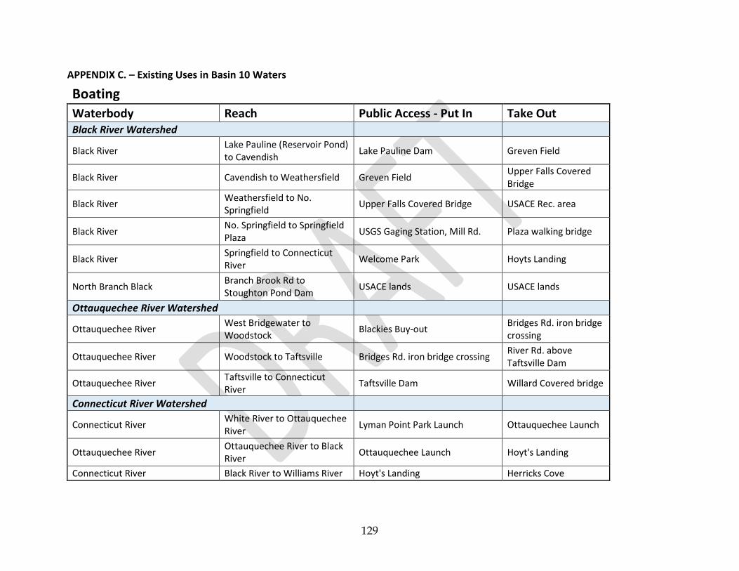
129
APPENDIX C. – Existing Uses in Basin 10 Waters
Boating
Waterbody Reach Public Access - Put In Take Out Black River Watershed
Black River Lake Pauline (Reservoir Pond) to Cavendish
Lake Pauline Dam Greven Field
Black River Cavendish to Weathersfield Greven Field Upper Falls Covered Bridge
Black River Weathersfield to No. Springfield
Upper Falls Covered Bridge USACE Rec. area
Black River No. Springfield to Springfield Plaza
USGS Gaging Station, Mill Rd. Plaza walking bridge
Black River Springfield to Connecticut River
Welcome Park Hoyts Landing
North Branch Black Branch Brook Rd to Stoughton Pond Dam
USACE lands USACE lands
Ottauquechee River Watershed
Ottauquechee River West Bridgewater to Woodstock
Blackies Buy-out Bridges Rd. iron bridge crossing
Ottauquechee River Woodstock to Taftsville Bridges Rd. iron bridge crossing River Rd. above Taftsville Dam
Ottauquechee River Taftsville to Connecticut River
Taftsville Dam Willard Covered bridge
Connecticut River Watershed
Connecticut River White River to Ottauquechee River
Lyman Point Park Launch Ottauquechee Launch
Ottauquechee River Ottauquechee River to Black River
Ottauquechee Launch Hoyt's Landing
Connecticut River Black River to Williams River Hoyt's Landing Herricks Cove

130
Contact Recreation
Waterbody Site Location of Use Town Ownership Black River Watershed
Black River RR Bridge RR bridge crossing Cavendish village, ~350 below RR bridge
Cavendish RR ROW
Black River Cavendish Gorge ~300' below CVPS Cavendish dam
Cavendish CVPS
Black River Carlton Rd Crossing ~100' north D/S of Carlton Rd bridge
Cavendish unknown (ROW)
Black River Power Plant Rd ~500' below the end of Power Plant Rd
Cavendish CVPS
Black River Tolles Hill Dam Area USACE No. Springfield Recreation Area
Weathersfield USACE
North Branch Black River
Bartley Field Rec Area Bartley Field Reading Town of Reading
North Branch Black River
Twenty-Foot Hole Tyson Rd. access Reading VDFPR / VRC
North Branch Black River
Branch Brook Rd. Branch Brook Rd. end Weathersfield USACE
Branch Brook Buttermilk Falls Buttermilk Falls Ludlow VDFPR / VRC
Ottauquechee River Watershed Ottauquechee River Bridgewater Rec Park Park riverfront Bridgewater Town of Bridgewater
Ottauquechee River River Road --- Woodstocker’s Rope Swing
River Rd. ~500' east of Otis Hill Rd.
Hartford Town of Hartford
Ottauquechee River Quechee Gorge Bottom end of gorge, ~2250' below Rte 4 bridge
Hartford USDOD/VDFPR
Ottauquechee River Quechee Covered Bridge
Below Covered Bridge Hartford Town of Hartford ROW
Ottauquechee River Elm St. Bridge Below Elm St. bridge crossing
Woodstock Town of Woodstock
Harlow Brook Clay Hill Rd. Hole Clay Hill Rd. crossing Hartland USACE

131
Contact Recreation
Connecticut River Watershed Connecticut River Wilgus State Park Park riverfront Weathersfield VDFPR
Connecticut River Sumners Fall Town access Hartland Town of Hartland

132
Fishing
Rivers & Streams
Rivers and Streams Town County Table Ice
Fishing Table
Map Stream Section
# ANS*
(Including tributaries, bays, and setback to first highway bridge)
All Applicable Towns All Applicable Counties 4 4, 7, 8, 11, 13,
15 E
Ottauquechee River
Connecticut River main channel to first highway bridge crossing, Hartland.
Hartland Windsor 4 11 62
First highway bridge crossing, Hartland, to Headwaters.
All Applicable Towns All Applicable Counties 1 11
Black River
Black River along Route 131 in Weathersfield and Cavendish, from Downers covered bridge upstream (approximately 4 miles) to the next bridge across the river, the Howard Hill bridge.
Weathersfield/Cavendish Weathersfield/Cavendish 1 13 7
Brook, Brown, and Rainbow Trout: length limit, none; daily limit, 2 trout aggregate
From Nov. 1 to Friday before the second Saturday in April, open ONLY TO TROUT FISHING (Catch and Release) using artificial flies and lures
Howard Hill bridge to headwaters All Applicable Towns All Applicable Counties 1 13
Connecticut River
main channel to I-91 bridge, Hartland. Hartland Windsor 4 13 45
I-91 bridge, Hartland, to Headwaters. Hartland Windsor 1 13

133
Fishing
Lakes and Ponds
Lakes and Ponds Town County Table Ice
Fishing Table
Map Lake Area
(acres)
Access 1
Aquatic Nuisance Species2
Internal Combustion
Boat Motors
Allowed3
Other Boating Restrictions
Amherst Lake Plymouth Windsor 2 8 13 81 St Y
Black Pond Plymouth Windsor 2 8 13 20 N 5mph
Colby Pond
Plymouth Windsor 5 6 13 20 St Y 5mph
Only open to fishing from second Saturday in April to Oct. 31 (see table for regulations on specific species)
Deweys Mill Pond Hartford Windsor 2 8 11 56 E N 5mph
Echo Lake
Plymouth Windsor 2 10 13 104 St Y
Open to fishing year-round (see below and table for regulations on specific species)
Brook, Brown, Rainbow, and Lake Trout, Landlocked Salmon, and Largemouth and Smallmouth Bass: Ice Fishing Open Season: third Saturday in Jan. to March 15
Kent Pond
Killington Rutland 2 8 10 99 St E Y 5mph
Largemouth Bass: length limit, no minimum length. 10” to 12” protected slot (all bass 10” to 12” must be released); daily limit, 10 bass, only 1 greater than 12”
Knapp Brook Cavendish/Reading Windsor 5 6 13 25 St Y 5mph
Pond No. 1 Only open to fishing from second Saturday in April to Oct. 31 (see table for regulations on specific species)
Knapp Brook Cavendish/Reading Windsor 5 6 13 35 St Y 5mph
Pond No. 2 Only open to fishing from second Saturday in April to Oct. 31 (see table for regulations on specific species)

134
Fishing
Lakes and Ponds
Mill Pond Windsor Windsor 2 8 13 77 Mt E N 5mph
(Kennedys Pond)
North Hartland Hartland Windsor 2 8 11 215 Gt E Y
Reservoir
North Springfield Reservoir
Springfield Windsor 2 8 13 290 Gt E Y 5mph
Pinneo Lake Hartford Windsor 2 8 11 50 N 5mph
Reading Pond Reading Windsor 2 8 13 22 N 5mph
Rescue Lake
Ludlow Windsor 2 10 13 180 St Y
Open to fishing year-round (see below and table for regulations on specific species)
Brook, Brown, Rainbow, and Lake Trout, Landlocked Salmon, and Largemouth and Smallmouth Bass: ice fishing open season, third Saturday in Jan. to March 15
Reservoir Pond Ludlow Windsor 2 8 13 32 Y 5mph
(Lake Pauline)
Runnemede Lake
No Boating or
(Evarts Pond) Swimming
Stoughton Pond Weathersfield Windsor 5 6 13 56 Gt Y 5mph
Only open to fishing from second Saturday in April to Oct. 31 (see table for regulations on specific species)
Tiny Pond Ludlow Windsor 2 8 13 29 Y 5mph
Woodward Reservoir Plymouth Windsor 2 8 13 106 St Y 5mph 1 S=State; M=Municipal; G=Federal; U=Utility; P=Private; f=foot or
Aquatic nuisance species (ANS) spread-prevention practices should always be employed when visiting ANY waterbody, regardless of
whether a known infestation is present. Invasive species and/or fish diseases could be present but not yet detected. Please follow the
recommendations to help stop the spread of ANS.
carry in; ud=undeveloped; t=boats on trailer; c=cartop; r=regulated. 2 E=Eurasian Watermilfoil; Z=Zebra Mussel; W=Water Chestnut;
V=Variable-leaf watermilfoil; LBV=Largemouth Bass Virus; A=Alewife. 3 The rule prohibits the use of internal combustion motors to power vessels.

135
Water Supply
FROM: Vermont Water Quality Standards, Environmental Protection Rule Chapter 29A

136

137

138
APPENDIX D. – Municipal Planning and Water Resources Review
Town Flood
Regulations Floodway Conditions Special Flood Hazard Area Conditions
Flood Regulations
Last Updated NFIP
Flood Resiliency Element
River Corridor Protection
Road and Bridge
Standards
Local Hazard Mitigation
Plan
LHMP Expiration
Date LEOP
ERAF Rate (%)
Baltimore Flood Hazard
Area Regulations
No FEMA identified Special Flood Hazard Area within
town.
No FEMA identified Special Flood Hazard Area within town. Locally designated areas.
2009 Yes Yes Interim Yes Yes 10/12/2017 Yes 17.5
Barnard
Unified Zoning and
Subdivision: Flood Hazard
Overlay District
Encroachments and development prohibited
New development, new fill, and storage prohibited. Non-substantial improvements allowed.
2012 Yes Yes Interim Yes In Progress 5 years from
FEMA approval
Yes 7.5
Bridgewater Flood Hazard
Area Regulations
Development prohibited, and only minor improvements
allowed
New development and substantial improvements must elevate lowest floor 1 ft above BFE. All development shall be reasonably safe from flooding: designed and anchored to prevent flotation, collapse, release, and movement of the structure; constructed with materials resistant to flood damage; construction methods that minimize flood damage; and service facilities located in areas to prevent water from entering.
2006 Yes No No Yes Yes 8/4/2020 Yes 12.5
Cavendish Flood Hazard
Area Regulations
Encroachments and development prohibited.
Improvements within existing footprint allowed.
Functionally dependent buildings allowed.
New construction and substantial improvement 1' above BFE.
2007 Yes Yes No Yes Yes 10/12/2017 Yes 12.5

139
Town Steep Slope/Ridgeline Development Stormwater/LID Requirements
Baltimore No adverse impact under Conditional Use Review. Subdivisions standards say…"shall not ordinarily be subdivided."
Section 7.7 enables the PC to require stormwater management plans, sediment/erosion control plans. Section 7.9 requires that subdivisions be designed to minimize grading, cut and fill, to retain, insofar as possible, the natural contours, limit stormwater runoff, and conserve the natural cover and soil
Barnard
Town Plan includes an objective to "protect steep slopes and ridgelines from inappropriately sited development," a goal to "ensure slopes greater than 25 degrees should remain predominantly in forest cover," "development in these areas should be permitted only if it can be demonstrated that it will have safe access and not be detrimental to the environment," and a recommendation that "future revisions to the Zoning Bylaw should consider using elevation in restricting development." The Zoning Bylaw prohibits digging or creating pits on steep slopes, it says that "disturbance of steep slopes greater than 25% shall be minimized," and it requires subdivisions on slopes greater than 25% to require a licensed professional engineer to certify that they do not pose a landslide or erosion risk.
Subdivisions standards state that stormwater shall be handled by an erosion control plan prepared by a licensed professional engineer for control of erosion, sediment, and runoff during and following development. Conditional use development standards require stormwater and erosion control and state that drainage must control stormwater runoff, prevent erosion, and protect neighboring land and roads from undue impacts. No increase is allowed in off-site stormwater runoff in terms of volume or peak discharge.
Bridgewater
One of the Town Plan objectives is "to protect steep slopes, soils, forests, water, and other natural resources and provide open spaces for wildlife and habitat." Steep slopes are considered a Critical Natural Area of the Town, and policies in the Plan state that steep slopes should remain predominantly in forest cover, that development of steep slopes should be considered carefully in order that it not be detrimental to the environment, and land above 2,500 feet should be maintained predominantly in a natural wilderness state. As a portion of the Rural Area land use section, the plan includes slopes greater than 15% as lowdensity areas.
None
Cavendish No zoning No zoning

140
Town Flood
Regulations Floodway Conditions Special Flood Hazard Area Conditions
Flood Regulations
Last Updated NFIP
Flood Resiliency Element
River Corridor Protection
Road and Bridge
Standards
Local Hazard Mitigation
Plan
LHMP Expiration
Date LEOP
ERAF Rate (%)
Chester
Unified Bylaws - Article 6 -
Flood Damage Prevention Standards
Development and encroachments in Floodway
are prohibited unless demonstrated by an
engineer that no increase in flood levels will occur.
New construction and substantial improvement 1' above BFE.
2014 Yes Flood Hazard
Section No Yes Yes 5/6/2021 Yes 12.5
Hartford Flood Hazard
Area Regulations
Development prohibited.
New development and substantial improvements must elevate lowest floor 1 ft above BFE. All development shall be reasonably safe from flooding: designed and anchored to prevent flotation, collapse, and movement of the structure; constructed with materials resistant to flood damage; construction methods that minimize flood damage; and service facilities located in areas to prevent water from entering.
2007 Yes Yes No Yes Yes 7/23/2019 Yes 12.5
Hartland Flood Hazard
Area Regulations
No fill, storage areas, and new development prohibited
New development and substantial improvements must elevate lowest floor 1 ft above BFE. All development shall be reasonably safe from flooding: designed, operated, and anchored to prevent flotation, collapse, release, and movement of structure, chemicals, or hazardous materials; constructed with materials resistant to flood damage; construction methods that minimize flood damage; service facilities located in areas to prevent water from entering; and located so as to minimize conflict with floodwaters and natural channel movement.
2007 Yes Yes No Yes Yes 8/4/2020 Yes 12.5
Ludlow
Flood Hazard Area
Regulations (includes Local Flood Hazard
Areas)
New Development is prohibited in the Floodway. Substantial improvements
require conditional use review.
New structures and substantial improvements require conditional use review. 1' of BFE. Establishes small stream setbacks for named streams.
2014 Yes Yes No Yes Yes 10/12/2017 Yes 12.5

141
Town Steep Slope/Ridgeline Development Stormwater/LID Requirements
Chester Development on slopes >25% requires conditional use review. Section 3.7 requires erosion prevention and sedimentation control during construction.
Hartford
Hartford's Zoning Ordinance contains the Rural Lands, Agricultural Lands, and Wildlife Connector Overlay District which state that development should be located down-slope of ridgelines and prominent hills in areas where ridgelines and hillsides are easily visible from existing roadways, and development shall be considered relative to the availability of less visible locations on-site.
Hartford's Zoning Regulations require a conditional use permit which will be issued given that a proposed project disturbs the least possible riparian vegetation, erosion and sediment control methods are followed, and development manages and treats stormwater runoff to filter pollutants. Specific applications for development must include a description of the practices that will be used to protect water quality of stormwater runoff and an erosion control plan. Hartford's subdivision regulations require: a project provide an adequate stormwater drainage system with culverts and drainage areas that accommodate runoff from the development's upstream drainage area or a 25 year storm event (a 4% chance of occurring annually); a project expose the smallest possible area possible at any one time during development; land should not be left exposed during winter months; temporary vegetation or mulching and structural measures may be required to protect exposed areas; sediment basins shall be installed and maintained to remove sediment from entering runoff; 4 inches of topsoil shall be provided to cover all finished slopes; and embankments are to be planted with stabilizing ground cover and seeded with grass to prevent erosion.
Hartland
Hartland's Town Plan includes a policy to prohibit development on slopes steeper than 25% unless development will not be harmful to the environment or health of the community. A second policy states that development on slopes from 15-25% require special provisions to make sure they do not result in erosion or sedimentation
Hartland's Town Plan includes recommendations that development proposals should be designed to minimize the amount of impermeable surfaces and provide for on-site stormwater treatment to enable groundwater recharge, and that the Town of Hartland will continue to participate in Act 250 and other State permit application reviews to ensure that approvals are conditioned on proper water quality protection safeguards. This will include locating activities and structures at least a 50-foot buffer from surface waters, with a larger setback distance in areas of steep slope or highly erodible soils; requirements for a detailed erosion and sedimentation control plan demonstrating proper controls during and after construction; a detailed stormwater management plan with appropriate stormwater treatment; and other recommended land use management practices.
Ludlow Section 490 Ridgeline Protection Overlay District Stormwater management/erosion control plans may be required for projects subject to the ridgeline overlay provisions

142
Town Flood
Regulations Floodway Conditions Special Flood Hazard Area Conditions
Flood Regulations
Last Updated NFIP
Flood Resiliency Element
River Corridor Protection
Road and Bridge
Standards
Local Hazard Mitigation
Plan
LHMP Expiration
Date LEOP
ERAF Rate (%)
Plymouth
Zoning Ordinance:
Flood Hazard Protection
Overlay
Development prohibited, and only improvements to
existing structures allowed.
Includes the River Corridor: new principal structures and new net fill are prohibited.
2013 Yes No Interim Yes Yes 8/4/2020 Yes 17.5
Pomfret Flood Hazard
Area Regulations
Development prohibited, and only minor improvements
allowed
New development and substantial improvements must elevate lowest floor 1 ft above BFE. All development shall be reasonably safe from flooding: designed and anchored to prevent flotation, collapse and movement of the structure; constructed with materials resistant to flood damage; construction methods that minimize flood damage; and service facilities located in areas to prevent water from entering.
2007 Yes No No Yes In Progress 5 years from
FEMA approval
Yes 7.5
Reading Flood Hazard
Area Regulations
Development in the floodway is prohibited unless
demonstrated by an engineer that no increase in
flood levels will occur.
Residential - at or above BFE. Non-Residential - at or above 1' above BFE.
2007 Yes Yes Currently
Considering Yes Yes 10/12/2017 Yes 12.5
Springfield Flood Hazard
Review
Development in the floodway is prohibited unless
demonstrated by an engineer that no increase in
flood levels will occur.
New construction and substantial improvement 1' above BFE.
2014 Yes
Currently in adoption
process (as of 8/18/16)
Currently Considering
Yes Yes 10/12/2017 Yes 12.5
Weathersfield Flood Hazard
Area Regulations
Development in the floodway is prohibited unless
demonstrated by an engineer that no increase in
flood levels will occur.
New construction and substantial improvement 1' above BFE.
2013 Yes No No Yes Yes 10/12/2017 Yes 12.5

143
Town Steep Slope/Ridgeline Development Stormwater/LID Requirements
Plymouth
Plymouth's Town Plan identifies areas of high elevation above 2,500 feet and steep slopes greater than 15% as Significant Natural and Fragile Areas. It contains a policy to "protect steep slopes and ridgelines from inappropriately sited development" and a recommendation that steep slopes shall remain predominantly forest cover and development will be allowed only if it can be demonstrated that it will not be detrimental to the environment. The Town Plan also states that residential development in the Village, Vacation-Resort, Mountain-Recreational, and Rural Residential zoning districts/land areas shall avoid steep slopes and high elevations. It also states that development on ridgelines shall not break the silhouette of the hill. Plymouth's zoning ordinance says that subdivisions shall exclude from development land that has steep slopes greater than 25%.
Commercial and Industrial conditional use standards in the Zoning Ordinance require that parking lots shall be bordered with a buffer area landscaped in a manner that integrates the parking area with an overall landscaping plan for the site, and that the removal of existing trees shall be minimized to integrate the site with the surrounding landscape and to enhance environmental quality.
Pomfret
Pomfret's Zoning Ordinance consists of a Ridgeline and Hillside Conservation Area, which includes all land within 750 feet from primary ridges. The Ordinance identifies the importance of ridges and hillsides to the scenic quality of Pomfret, the rural and pastoral character and personality of the Town, and to the current and future well-being of Pomfret's residents. It states that the preservation and conservation of Pomfret's ridges and hillsides are essential to maintaining Pomfret's rural and pastoral character, and that the protection of this natural beauty in Pomfret's landscape is a matter of public use. Development and use of these areas should be in a manner which will not detract from nor adversely affect the scenic qualities of the Town, and development should take place in a manner compatible with important natural environmental assets of the Town.
None
Reading None - But there is a Ridgeline Protection Overlay District Stormwater provisions apply to mineral extraction operations under Section 4.5.
Springfield Slopes over 20% require erosion control and stormwater management plans. Grading and drainage plan is required part of application for site plan, current use and flood hazard review. Erosion control and stormwater management provisions apply to many types of development, including mobile home parks, filling of low areas, steep slopes (20%+), and modifying the buffer standards.
Weathersfield Development shall cause minimal disturbance to the natural landscape in areas of slopes over 25%
Adequate provisions shall be made for the management of erosion, sedimentation and storm water runoff. For all projects undergoing Site Plan Review, except one- or two-family dwellings, appropriate storm water management measures shall be incorporated into the final site design. The Zoning Board of Adjustment may require a storm water management and erosion control plan.

144
Town Flood
Regulations Floodway Conditions Special Flood Hazard Area Conditions
Flood
Regulations Last
Updated
NFIP
Flood
Resiliency
Element
River Corridor
Protection
Road and
Bridge
Standards
Local Hazard
Mitigation
Plan
LHMP
Expiration
Date
LEOP ERAF
Rate (%)
West Windsor
Flood Hazard
Area
Regulations
Development in the floodway
is prohibited unless
demonstrated by an engineer
that no increase in flood levels
will occur.
New construction and substantial improvement 1'
above BFE.
2012 (but
currently
working to
update)
Yes Yes No Yes Yes 10/12/2017 Yes 12.5
Woodstock Town
Zoning
Regulations:
Flood Hazard
District
Development prohibited.
New development and substantial improvements
must elevate lowest floor 1 ft above BFE. All
development shall be reasonably safe from
flooding: designed and anchored to prevent
flotation, collapse, and movement of the
structure; constructed with materials resistant to
flood damage; construction methods that
minimize flood damage; adequately drained to
reduce exposure to flood hazards; and located so
as to minimize conflict with floodwaters and
natural channel movement.
2010 Yes Yes No Yes Yes 8/21/2020 Yes 12.5
Woodstock Village
Zoning
Regulations:
Flood Hazard
District
Development prohibited.
New development and substantial improvements
must elevate lowest floor 1 ft above BFE. All
development shall be reasonably safe from
flooding: designed and anchored to prevent
flotation, collapse, and movement of the
structure; constructed with materials resistant to
flood damage; construction methods that
minimize flood damage; and service facilities
located in areas to prevent water from entering.
2012 Yes Yes No Yes Yes 8/21/2020 Yes 12.5

145
Town Steep Slope/Ridgeline Development Stormwater/LID Requirements
West Windsor Development on slopes >25% requires DRB review and an erosion and sedimentation control plan under Section 3.5.
See Section 3.5.
Woodstock Town
The Zoning Regulations include a Steep Slopes and Fragile Soils portion of the Conservation District. General standards for planned development state that proposed development shall provide for the preservation of steep slopes; that buildings should not be located in sensitive areas such as steep slopes; that development shall not result in adverse impact on fragile environments (which includes steep slopes); and that steep slopes are priority areas where clearing should be avoided to protect wildlife habitat, prevent erosion, and prevent sedimentation resulting from stormwater runoff. Development on slopes greater than 15% require conditional use review, and development, regrading, and clearing of vegetation is prohibited on slopes with a grade greater than 25%. Development on slopes greater than 15% shall be sited, constructed, and slopes stabilized to minimize risks to surface waters; house sites, sewage, and parking shall be located on the flattest portion of the land; and development of roads and driveways should minimize crossing steep slopes and should follow topographic contours to minimize soil and vegetation disturbance.
Article VI in Zoning Regulations: Stormwater-Low Impact Development requires permit applications to include a condition site assessment, an erosion & sediment control plan, and a stormwater management plan. Low impact development design is preferred. Development must minimize land disturbance; preserve natural areas; and manage water, prevent erosion, and control sediment during construction according to pre-development and construction site standards. Development is also subject to stormwater management standards that include vegetative and landscaping controls that naturally manage surface runoff, standards for building on steep slopes, strategies to reduce impervious surfaces, and low impact integrated management practices.
Woodstock Village
The Conservation District in the Zoning Regulations includes Steep Slopes over 25%. Lots with steep slope characteristics as identified in the overlay zone shall be reviewed for suitable sewage disposal, access for emergency vehicles, drainage, and erosion control. New development that adds more than 10,000 sq. ft. of impervious area - roofs, decks, patios and driveways - shall be reviewed to ensure on-site retention of stormwater.
Applications for development shall include the location of facilities for the control and disposal of stormwater. Zoning Regulations include a Conservation District that aims to reduce the impact of stormwater runoff and prevent soil erosion.

146
APPENDIX E. – Dams in Basin 10
Dams of the Black River Watershed
Dam Name Stream Town Dam
Status State ID
Hazard Class
Powerhouse Black River Springfield Breached 194.13 N/A
Vermont Snath Black River Springfield Breached 194.14 N/A
Lovejoy Black River Springfield In Service
194.06 Low
Slack (Lower) Black River Springfield In Service
194.05 Low
Comtu Falls Black River Springfield In Service
194.04 Low
Gilman Black River Springfield In Service
194.03 Low
Fellows Black River Springfield Not in use
194.02 Low
Muckross Black River tributary Springfield In Service
194.08 Low
Springfield-11 Black River tributary Springfield ---- 194.11 Low
Springfield-10 Black River tributary Springfield ---- 194.1 Low
Springfield-9 Black River tributary Springfield ---- 194.09 N/A
Carey Black River tributary Significant
North Springfield Black River Springfield In Service
194.01 High
Springfield Reservoir Black River tributary Weathersfield In Service
229.02 Significant
Perkinsville Black River Weathersfield Breached 229.04 ???Low
Soapstone Black River Weathersfield ---- 229.03 Low
Atherton Black River Cavendish Breached 44.07 N/A
Cavendish 11 Twenty Mile Stream Cavendish Breached 44.11 N/A
Colby Pond Twenty Mile Stream Plymouth In Service
156.06 Low
Cavendish Black River Cavendish In Service
44.01 Low
Parker Brothers Black River Cavendish Breached 44.09 N/A
Murdoch Black River Cavendish Breached 44.02 N/A
Black Bear Woolen Co Black River Cavendish Breached 44.1 N/A
Smithville Black River Ludlow ---- 117.11 ???N/A
Jewell Brook Site No. 3 Jewell Brook tributary Ludlow In Service
117.04 High
Jewell Brook Site No. 3 Dike Jewell Brook tributary Ludlow In Service
117.12 Low
Jewell Brook Site No. 5 Sanders Brook Ludlow In Service
117.05 High
Jewell Brook Site No. 2 Grant Brook Ludlow In Service
117.06 High
Jewell Brook Site No. 1 Jewell Brook Ludlow In Service
117.07 High

147
Okemo Snow Pond Diversion Structure
Black River Ludlow In Service
117.15 Low
Okemo Snow Pond Black River – off stream (OS)
Ludlow In Service
117.13 High
Branch Brook Branch Brook tributary Mount Holly In Service
135.03 Low
Reservoir Pond Black River Ludlow In Service
117.02 Low
Lake Rescue Black River Ludlow In Service
117.01 Low
Lacoss Patch Brook tributary Plymouth In Service
156.12 Low
Lake Ninevah Patch Brook Mount Holly In Service
135.01 Significant
Plymouth-8 Patch Brook tributaryy Plymouth In Service
156.08 Low
Reading Pond Reading Pond Brook Reading Breached 163.02 N/A
Amherst Lake Echo lake tributary Plymouth In Service
156.05 Significant
Duck Pond Black river tributary Plymouth Breached (partial)
156.11 N/A
Plymouth Notch Snowmaking Pond
Black River – OS Plymouth In Service
156.1 Significant
Black Pond Black River Plymouth In Service
156.02 Low
Stoughton Pond North Branch Black River
Weathersfield In Service
229.01 Significant
Widow Hill North Branch Black River tributary
Cavendish In Service
44.06 Low
Knapp Brook Site #1 Knapp Brook Cavendish In Service
44.04 Significant
Knapp Brook Site #2 Knapp Brook Cavendish In Service
44.05 Significant
Mile Brook Mile Brook Springfield ---- Unmapped Unknown

148
Dams of the Ottauquechee River Watershed
Dam Name Stream Town Dam Status
State ID Hazard Class
White Current Ottauquechee River Hartland In Service
95.05 Low
Hartland-6 Ottauquechee River Hartland ---- 95.06 N/A
North Hartland Ottauquechee River Hartland In Service
95.01 High
Quechee Mills Ottauquechee River Hartford In Service
94.01 Low
Deweys Mills Ottauquechee River Hartford In Service
94.02 Low
Taftsville Ottauquechee River Woodstock In Service
254.05 Low
Deweys Pond Ottauquechee River TR
Hartford In Service
94.07 Low
Sunny Acres Ottauquechee River TR
Hartland In Service
95.04 Low
Lake Pinneo Ottauquechee River TR
Hartford In Service
94.08 Low
Crystal Pond Happy Valley Brook TR Hartland In Service
95.06 Low
Cox Reservoir Ottauquechee River TR
Woodstock In Service
254.03 Significant
Vondell Reservoir Vondell Brook Woodstock In Service
254.02 Significant
Carlton Reservoir Ottauquechee River TR
Woodstock In Service
254.04 Significant
Sherburne 14 Reservoir Brook TR Killington In Service
188.14 Low
Woodward Reservoir Reservoir Brook Plymouth In Service
156.01 High
Rockefeller Woodward Reservoir TR
Plymouth In Service
156.07 Significant
Johnson Ottauquechee River TR
Killington In Service
188.08 Low
Sunrise Village Lagoon Falls Brook TR Killington In Service
188.15 Low
Bear Pond Falls Brook TR Killington In Service
188.16 Low
Mirror Lake Roaring Brook TR OS Killington In Service
188.06 Low
Snowshed Pond Roaring Brook TR OS Killington In Service
188.07 Significant
Thundering Falls Kent Brook Killington In Service
188.2 Low
Sherburne 5 Kent Pond TR Killington In Service
188.05 ???
Kent Pond Kent Brook Killington In Service
188.09 Significant
Pico Pond Kent Pond TR Killington Deleted 188.17 N/A
Connors Pond Kedron Brook TR Woodstock In Service
254.09 Significant

149
Mecawee Pond Broad Brook TR Reading In Service
163.01 Significant
Pinney Hollow Pinney Hollow Brook Plymouth Removed 156.09 N/A
Lower Moore Pond Pinney Hollow Brook Plymouth In Service
156.03 Significant
Upper Moore Pond Pinney Hollow Brook Plymouth In Service
156.04 Significant
Billings Pond Barnard Brook Woodstock In Service
254.01 Low
The Pogue Barnard Brook TR Woodstock In Service
254.08 Low
Lakota Lake Richmond Brook Barnard In Service
11.05 Significant
Martin Cloudland Brook TR Pomfret In Service
157.02 Significant
Breakneck Hill ---- Pomfret ---- 157.06 N/A
Gray Camp Pond Barnard Brook TR Barnard In Service
11.01 Low
Line Pond Barnard Brook TR Barnard Deleted1 11.06 N/A
Kellogg Pond Barnard Brook TR Barnard In Service
11.03 Significant
Sonnenburg Ski Area Barnard Brook TR Barnard In Service
11.04 Low
Noble Pond Gulf Stream TR Bridgewater In Service
28.03 Significant

150
Dams of the Connecticut River watershed
Dam Name Stream Town Status State ID Hazard Class
Hurricane Lower Reservoir Kilburn Brook Hartford
Breached (Partial)
94.04 Significant
Wright Reservoir Connecticut River-TR Hartford Drained 94.05 Significant
Hurricane Upper Reservoir Kilburn Brook-TR Hartford Breached (Partial)
94.03 Low
Simonds Reservoir Kilburn Brook-TR Hartford In Service
94.06 Low
Stokien Weed Brook Hartland In Service
95.02 Low
Martinsville Lulls Brook Hartland In Service
95.03 Low
Bronson Lulls Brook-TR West Windsor
In Service
239.04 Significant
Rawson Lulls Brook-TR West Windsor
In Service
239.02 Significant
Prison Pond Hubbard Brook-TR Windsor In Service
248.07 Significant
Lake Runnemede Dike Connecticut River-TR Windsor In Service
248.08 Low
Lake Runnemede Connecticut River-TR Windsor In Service
248.01 Significant
Windsor (Lower) Mill Brook Windsor Breached
248.03 N/A
Windsor Upper Mill Brook Windsor In Service
248.02 High
Mount Ascutney Effluent Pond Mill Brook-OS West Windsor
In Service
239.07 Low
Mount Ascutney Snow Pond Mill Brook-OS West Windsor
In Service
239.08 Low
Howland Mill Brook-TR West Windsor
In Service
239.01 Significant
Hammondsville Mine Reading Hill Brook - OS
Reading In Service
163.08 Low
Windsor Minerals Pond #9 Mill Brook-TR West Windsor
In Service
239.05 Low
Windsor Minerals Pond #10 Mill Brook-TR West Windsor
In Service
239.06 Low
Cooks Pond Blood Brook Weathersfield
In Service
229.08 Low
Firehouse Mill Brook West Windsor
In Service
Unmapped Unknown
Harrington Mill Brook West Windsor
Breached
Unmapped Unknown

151
APPENDIX F. – USACE / VT ANR / USFWS Agreement & ANR Factsheet
U.S Army Corps of Engineers & Vermont Agency of Natural Resources
Coordination Plan for Operating Federal Flood Control Dams in Vermont
Background In recent years, a number of concerns have been raised pertaining to the operation and maintenance of Federal flood control dams in Vermont and across the New England District. To address these concerns, the Vermont Agency of Natural Resources (VANR), U.S. Fish and Wildlife Service (USFWS), and U.S. Army Corps of Engineers (Corps) have engaged in collaborative discussions since 1999 to identify ways to improve operations at the five Corps’ flood control projects in Vermont: Union Village, North Hartland, North Springfield, Ball Mountain and Townshend. As a result of these discussions, operational improvements have been enacted, including implementation of conservation flows and ramping standards. To build on the work performed to date, the three agencies are implementing a three-year adaptive management process (AMP) to use as a framework for identifying and resolving issues of concern. The goal of the process is to evaluate current operational and maintenance practices and identify ways to maintain and restore the integrity of the downstream and upstream aquatic and terrestrial ecosystems while maintaining the projects’ primary purpose of flood control and recognizing other recreation and natural resource management objectives. The Adaptive Management Process A basic tenet of adaptive management involves continued monitoring and evaluation leading to revised strategies that will achieve the desired results (see figure). This approach allows the participants to address problems and areas of uncertainty over time. In this case, issues related to the operation, maintenance and modification of the flood control projects will be addressed. Each of the three participating agencies will designate representatives to a working group that will implement this plan. Other participants will be called in as needed to provide their expertise on specific issues. A key part of the process is the annual interagency coordination meeting, to be held in January of each year. This meeting will provide the agencies with an opportunity to review the previous years’ operations, revise operational and monitoring procedures, and raise new issues. Other meetings or site visits will be held as needed. A number of issues identified and discussed in this plan require resolution or effectiveness monitoring. Adaptive management relies upon the collection of data that can be used to make appropriate adjustments. Assessment
The Adaptive Management Model
Establish Objectives
Implement Strategies
Monitor Effectiveness
Evaluate Results
Revise Strategies

152
plans (for monitoring/assessment/evaluation) will be developed for each pending issue so that participating agencies have the information needed to move forward at each annual meeting. Responsibility for administering the adaptive management process will rotate among the three agencies on an annual basis. The U.S. Fish and Wildlife Service will take the lead in the first year, followed by the Vermont Agency of Natural Resources, and then the U.S. Army Corps of Engineers. Administrative duties include organizing meetings (scheduling, preparing agendas, preparing meeting notes) and site visits. Each agency will be responsible for suggesting meeting agenda topics and preparing any necessary background material. Any modifications or operational changes agreed to by the parties will be incorporated into the operating and maintenance policies and practices of each project. The Adaptive Management Plan Regulation of flood control dams involves both flood control and non-flood control operations. In general, flood control operations involve the coordinated regulation of dams located on tributaries to reduce flood damages downstream of the dam and to reduce flood damages collectively on the Connecticut River. Flood control operations are authorized by Congress and implemented by the reservoir regulation manual for projects in the Upper Connecticut River Basin. Non-flood control operations describe the scheduled or recurring regulation of the dams for other purposes. Flood control projects in Vermont are authorized to perform natural resources management activities and provide public recreational opportunities. A hydropower facility was added to North Hartland Dam at a later date.
Objectives:
• Maintain the dams’ flood control function while mitigating the ecological impacts of flood control operations.
• During non-flood control periods, maintain downstream flows as close to instantaneous run-of-river as feasible, with outflow equal to inflow.
The following sections discuss a number of issues related to dam operation and identify those that will be addressed in the adaptive management process.
Flood Control Operations: The Corps has maintained that it is necessary to maintain maximum operational flexibility during flood control periods. However, VANR and USFWS have expressed concerns about the ecological impacts of flood control operations. While the Corps has implemented ramping and conservation flow standards, the VANR and USFWS do not consider those standards protective of downstream resources and have advocated that more information be provided on how more protective standards would affect flood control capabilities. Both ANR and USFWS have expressed an interest in learning when the projects are in flood control operations. The Corps will provide background information on how these decisions are made. Rather than try to define theoretically what may constitute flood operations at the dams, the Corps prefers to find a reliable way to contact and notify ANR and USFWS and incorporate this into the Communication Procedures.

153
Conservation flow, ramping, and reservoir release/refill standards for flood control operations will be addressed during the adaptive management period.
Routine Operations: The Corps, ANR, and USFWS have agreed to the concept of routinely operating the dams in instantaneous run-of-river mode (outflow equal to inflow) outside of flood control periods. Differences remain on how closely releases from the dams should equal inflow. These differences are most evident at North Hartland and Ball Mountain, where pools are maintained year-round and outflow is controlled by the gate openings. It is also an issue, to a lesser extent, at Union Village, which has a pool in the winter only. VANR has identified problematic flow fluctuations and instances where flows fall below ABF during routine operations at these projects. Over a 3-year period, the Corps will increase flow monitoring and gate adjustment frequency to twice a day during the work week and on the weekends if necessary, at Union Village (winter only), North Hartland, and Ball Mountain. Further, the parties will review the procedures used to monitor and adjust gate settings and develop procedures to improve routine daily flow management. The objective of this exercise is to develop procedures that will maintain outflow equal to inflow to the greatest extent feasible.
Non-Flood Control Operations: While the general goal is run-of-river operation, the parties have identified circumstances, outside of flood control operations, when flow or reservoir stage manipulation is necessary or appropriate. Those circumstances are listed below and described in more detail in subsequent sections.
1. Whitewater boating releases 2. Periodic inspections 3. Beach maintenance 4. Major maintenance and rehabilitation 5. Emergency operations
As noted in the detailed descriptions, there is not consensus among the parties regarding when flow or stage manipulation is necessary. During such periods, the Corps will employ conservation flow, ramping, and reservoir refill standards that serve to protect the ecological integrity of the downstream reach. With respect to conservation flows, the Corps has implemented the USFWS Aquatic Base Flow (ABF) standard for non-flood control operations at all projects. The ABF standard is based on the drainage area at the dam and is expressed in cfs/mile or csm. The rates vary seasonally:
October – March: 1.0 csm (or inflow) April – May: 4.0 csm (or inflow) June – September: 0.5 csm (or inflow)
The Corps has agreed to maintain the seasonal ABF flow at all times when flows are being manipulated (i.e., non run-of-river) outside of flood control operations, provided inflows are equal or greater than ABF.
154
Similarly, ramping rates have been adopted at all projects for use during all operations (including routine) outside of flood control periods. The ramping rates are 0.5 csm/hr for flows up to 4.0 csm, and 1.0 csm/hr for flows greater than 4.0 csm. Reservoir water level management is the final water management issue. Reservoir refill standards have been implemented by the Corps. When refilling the reservoir or raising the reservoir to an increased target level during non-flood periods, the seasonal ABF will be maintained at all times except when flows are below ABF. If inflows are less than ABF, then a 70/30 rule will be implemented whereby the dam will pass at least 70 percent of inflow while storing no more than 30 percent. The Agency of Natural Resources contends that the 70/30 rule does not provide adequate protection for downstream resources, and has proposed a 90/10 rule, with 90 percent of inflow being released downstream. Resolution of this issue will be a priority of the adaptive management process. During the AMP, a clear statement of seasonal reservoir target elevations will be developed. Other issues related to reservoir water level management will be identified by the parties within the first year of the adaptive management process and addressed.
Whitewater boating releases The Corps has provided releases to accommodate scheduled recreational boating events at many of its dams for over forty years. At present there are two whitewater release events scheduled at Ball Mountain Dam and Townshend Lake. These releases, which are timed to coincide with planned seasonal regulations of the conservation pool, are scheduled for the last weekend in April and again in late September. In recent years, the resource agencies have raised concerns about the ecological impacts of these releases. In response, beginning in 2003, the Corps adopted the minimum conservation flows and ramping rates recommended by the U.S. Fish and Wildlife Service for each project. For the spring release on the West River, the Corps will follow the ANR/USFWS ramping and refill rates agreed to by the parties. In addition, an overnight flow of 4.0 csm will be maintained. The target pool elevation at the start of this release will be approximately 75 feet with a target pool elevation of 25 feet at the end. Releases beyond the last weekend in April will not be considered due to the need to pass salmon smolts downstream in the spring. For the fall release on the West River, the Corps will follow the ANR/USFWS ramping and refill rates agreed to by the parties. Beginning in 2003, the Corps has released water to support a one-day event. A full two-day event may be possible under conditions when where there is sufficient inflow to support a second day while employing ramping and 4.0 csm flows overnight. The target pool elevation at the start of this release will be 65 feet with a target pool elevation of 35 feet at the end.
Periodic inspections To assure the integrity and ability of a flood control dam to perform its authorized purposes, inspection of the entire dam and related structures is performed every five years. Periodic inspection is required for the continued operation of the dam. In the future, the Corps will perform conduit and outlet works and gate inspections without restricting outflows from the control structures if and when possible. During these inspections, the flood control gates must be operated for structural, mechanical and electrical performance.

155
Minor fluctuations to the outflow could be encountered during periodic inspection; however, testing of flood control gates will generally not occur during low-flow periods. The preferred time to conduct conduit inspections will be during low-flow periods when this can be completed without interrupting river flows. The Corps will attempt to perform conduit inspections both prior to and during the scheduled fiscal year of the periodic inspection. If this is not feasible, some reduction of river flows may still be required in order to conduct a satisfactory inspection. Periodic inspections of dams in Vermont are scheduled as follows: 2002 – North Springfield Lake, Townshend Lake 2003 – None 2004 – Ball Mountain Dam, North Hartland Lake, Union Village Dam 2005 – None 2006 – None 2007 – North Springfield Lake, Townshend Lake The following monitoring and operational procedures will be performed to minimize impacts during the inspection event: If the outlet works and conduit can be safely inspected without disruption of flow during low- flow periods, the periodic inspection, and/or the inspection of the conduit/flood control gates, will be conducted at that time. To increase the probability of being able to perform conduit inspections during low-flow periods, the Corps will conduct inspections, if possible, whenever these naturally occur. If reductions of flow are necessary to perform conduit inspections, outflow will be reduced only to the extent needed to safely inspect the conduit (historically < 1 hour). Under extenuating circumstances, the inspections may take longer to complete. Prior to and during each conduit/flood control gate inspection, the Corps will have biologists evaluate the impact of any planned gate operation on the upstream and downstream communities and habitat. During any shutdown, biologists will be stationed downstream of the conduit to monitor river conditions and rescue stranded fauna. These monitoring activities and protocols will be coordinated with the VANR and USFWS. In 2002, monitoring protocols for performing conduit inspections were developed and implemented at North Springfield Lake. Further refinement of periodic inspection and monitoring procedures are a high-priority for the AMP.
Beach Maintenance The Corps maintains public swimming beaches in Vermont at North Hartland Lake, Townshend Lake and at Stoughton Pond at North Springfield Lake. These beaches are maintained annually to inspect the public swimming area and to remove debris and sedimentation that collects on the beach over the winter and when flood storage events inundate the beach and swimming area. The Corps will attempt to perform maintenance of the public swimming beaches without drawing down the conservation pool. As part of this AMP, the parties will develop a process to determine if a satisfactory and safe facility can be maintained without water level manipulation. The Corps has prepared a draft beach maintenance SOP that addresses issues surrounding the timing and mechanics of performing beach maintenance to minimize impacts to both downstream and reservoir aquatic habitats and species. VANR and USFWS will review the SOP and provide suggestions and alternatives for

156
maintenance activities. Upon review and finalization, the beach maintenance SOP will be submitted to the agency representatives for their review and concurrence.
Major Maintenance and Rehabilitation: Major maintenance and rehabilitation of the dams and appurtenant structures are necessary for their continued operation. These are large-scale projects, so they will be planned and coordinated separately from other routine or recurring activities. Close coordination with VANR and USFWS will begin early in the planning process and continue through project completion.
Emergency Operations: Occasionally, the Corps will need to operate the dams in response to unplanned emergencies. These emergencies include acts of God, casualties, disasters, national defense or homeland security emergencies. At these times it may become necessary to take immediate steps to contain, limit, or alleviate an emergency in order to protect human health, safety, and welfare prior to initiating any form of coordination or consultation with other agencies or individuals. In these instances, the Corps will contact VANR and USFWS, among others, as soon as practicable, if emergency modification or interruption of flows has occurred.
Fish Migration and Passage: Ball Mountain Dam and Townshend Lake have been modified to allow for passage of Atlantic salmon. The facilities at Ball Mountain Dam consist of one automated gate and at Townshend Dam a modified weir to allow for outmigration of salmon smolts. A trap-and-truck facility was constructed at Townshend Lake in 1993 to allow migrating adults to be trapped from the West River below Townshend Dam and transported above Townshend Lake and Ball Mountain Dam to locations identified by Vermont Fish and Wildlife. In 2002, the trap-and-truck facility at Townshend Lake was upgraded to a variable array electric barrier that was designed, constructed and operated in a manner that has significantly reduced gate operations and minimizes impacts to the downstream aquatic habitat. North Springfield Lake also has a modified outlet pool to protect salmon smolts.
Project Modifications: The Corps recognizes a need to study the performance of the outlet works at Union Village Dam, North Hartland Lake and Ball Mountain Dam. At these projects, the Corps ability to maintain permanent or seasonal conservation pools, as well as maintaining run-of-river conditions, without a weir or static flow control structure is difficult. Another related issue is the repair or modification of the outlet gates at Townshend Lake. In 1995, the Corps prepared a sedimentation study for Ball Mountain Dam that identifies and evaluates structural alternatives to the project. The study addressed the prevention of unplanned silt discharges into the West River resulting from faulty gate operations or failure of the automated gate operators. The Corps recognizes the need for further study to identify and implement structural changes to the Vermont flood control dams to alleviate flow regulation problems and enhance the aquatic habitat. Any future study to modify these dams would need to be conducted under existing authorities. If current authorities are not workable, the agency representatives will pursue other funding or authorities. As part of the adaptive management process, the Corps will investigate water temperature problems at North Springfield and Townshend Lakes to address potential warm water invasion created by shallow conservation pools and top-

157
spilling weirs. The Corps Water Quality Team is available to prepare study parameters and provide an alternative analysis of possible solutions. The agencies have prioritized their respective needs. The agencies will jointly prioritize the respective priorities and propose a plan to implement studies or improvements. ❖ Vermont Agency of Natural Resources priorities:
➢ Flow regulation improvement at Ball Mountain ➢ Flow regulation improvement at North Hartland ➢ Winter flow regulation improvement at Union Village ➢ Downstream temperature impacts at Townshend ➢ Downstream temperature impacts at North Springfield
❖ U. S. Fish and Wildlife Service priorities:
➢ Feasibility studies of weirs at all gate-operated projects ➢ Feasibility studies of converting projects with conservation pools to dry bed systems
❖ Corps of Engineers priorities:
➢ Feasibility of weirs at Ball Mountain and N. Hartland Lake ➢ Instream flow study on West River downstream of Ball Mountain Dam ➢ Instream flow study on Black River downstream of N. Springfield Dam ➢ Instream flow study on Ompompanoosuc River downstream of Union Village Dam
Coordination: The following agency representatives should continue to serve in the capacity of moderators for meetings and dispute resolution. This Adaptive Management Plan and attachments will prevail unless amended and agreed to by all agencies. All parties involved in the preparation, implementation and evaluation of this plan agree to present their recommendations to these representatives for resolution or implementation prior to elevating their concerns to other persons, offices or agencies. ____________________________ ____________________ Supervisor, New England Field Office Date U.S. Fish and Wildlife Service ____________________________ ____________________ Acting Director, Water Quality Division Date Department of Environmental Conservation Vermont Agency of Natural Resources ____________________________ ____________________ Chief, Construction/Operations Division Date New England District U.S. Army Corps of Engineers

158

159
APPENDIX G. – Draft Plan Public Comment Responsiveness Summary Basin 10 Water Quality Management Plan Public Comments Responsiveness Summary

160
APPENDIX H. – Potential funding sources
Lists of potential funding source are maintained by numerous state agencies and are continuously being
updated. Many of these can be found at:
Agency of Natural Resources
• Department of Environmental Conservation
o http://dec.vermont.gov/watershed/funding
• Vermont Fish and Wildlife Department
o http://www.vtfishandwildlife.com/cms/one.aspx?portalid=73163&pageid=85025
• Department of Forests, Parks and Recreation
o http://fpr.vermont.gov/about_us/grants
Agency of Agriculture Food & Markets Grants & Programs http://agriculture.vermont.gov/producer_partner_resources/funding_opportunities/vaafm_funding
Farmer Assistance
• Ag-Clean Water Initiative Program (Ag-CWIP)
• Best Management Practices (BMPS)
• Conservation Reserve Enhancement Program (CREP)/Grassed Waterways
• Farm Agronomic Practices (FAPs)
• Nutrient Management Planning & Land Treatment Planning
• Capital Equipment Assistance Program (CEAP) Agency of Commerce and Community Development http://accd.vermont.gov/search/node/grants Agency of Transportation
• Better Roads
• Municipal Highway and Stormwater Mitigation Program
• Transportation Alternatives Federal Emergency Management Administration (FEMA)
• https://www.fema.gov/grants

161
APPENDIX I. – Regulatory and Non-Regulatory Programs Related To Protecting and Restoring Waters
The Vermont Surface Water Management Strategy maintains a roster of regulatory and non-regulatory technical assistance programs. Regulatory programs may be accessed at:
http://dec.vermont.gov/sites/dec/files/documents/wsmd_swms_Appendix_A_Vermont_Regulations_Pertaining_to_Water_Quality.pdf Non-regulatory programs may be accessed at:
http://dec.vermont.gov/sites/dec/files/documents/wsmd_swms_Appendix_D_Toolbox.pdf

162
Acronyms
ACEP – ALE – Agricultural Conservation Easement Program/Ag land easement ACEP – WRE – Wetlands Restoration Easements
BFE – Base flood elevation BMP – Best management practices EQIP – Environmental Quality Incentives Program - Field practices, barnyard improvement, waste management FA – financial assistance – payments directly to farmers for projects FAP – Farm Agronomic Practices NMP – Nutrient Management Plans NRCS – Natural Resources Conservation Service RCPP – Regional Conservation Partnership Program TA – technical assistance – people to help design, implement projects for farmers VACD – VT Association of Conservation District
163
Agency of Natural Resources Department of Environmental Conservation
Water Quality Division Waterbury, VT 05671-0408