Super-Connected and Super-Smart - Birmingham's Digital Agenda
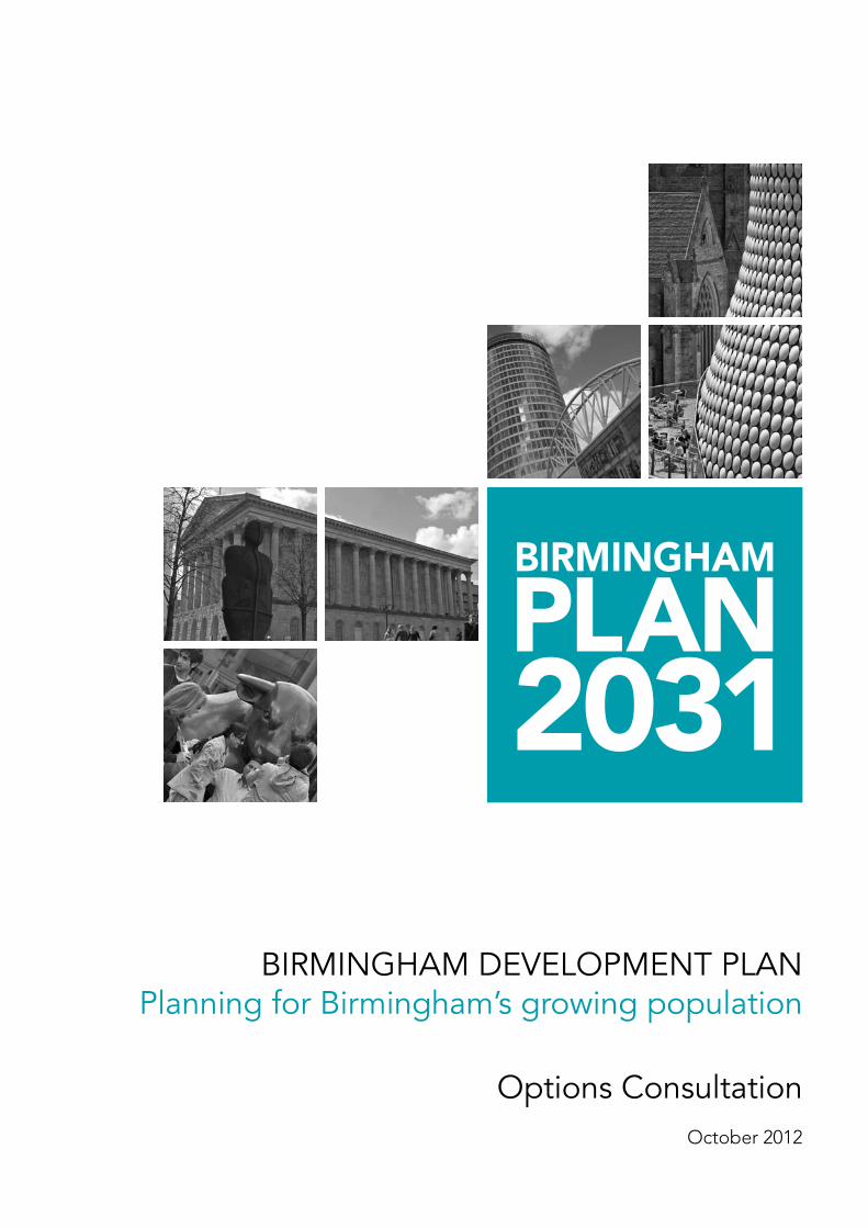
BIRMINGHAM DEVELOPMENT PLANPlanning for Birmingham’s growing population
Options ConsultationOctober 2012

Contact
Development DirectorateBirmingham City Council
Click:E-mail:[email protected]
Call:Telephone:(0121) 303 4041
Visit:Office:1 Lancaster CircusBirminghamB4 7DJ
Post:PO Box 28BirminghamB1 1TU
You can ask for a copy of this document in large print, another format or another language. We aim to supply what you need within ten working days.
Call (0121) 303 4041
If you have hearing difficulties please call us via Typetalk 18001 0121 303 4041 or e-mail us at the address above.
Plans contained within this document are based upon Ordnance Survey material with the permission of Ordnance Survey on behalf of the Controller of Her Majesty’s Stationery Office.
© Crown Copyright. Unauthorised reproduction infringes Crown Copyright and may lead to prosecution or civil proceedings.Birmingham City Council. Licence number 100021326, 2012.
contents / birmingham development plan
Contents
Introduction 2
The plan 4
Planning for Birmingham’s growing population 14
birmingham development plan / introduction
2
The Birmingham Development Plan will be central to this approach setting out the statutory planning framework that will guide decisions on development and regeneration over the period to 2031. It will set out how and where the homes, jobs, services and infrastructure will be delivered and the type of places and environments we want to create.
Purpose of this documentThis consultation document has been produced to seek your views on our proposed approach to how the City can plan positively for the homes and jobs. We are also asking for any alternatives to our approach that you feel could help plan positively for the challenges the City faces.
To help set the scene we have provided details of the scale of the challenge the City faces and why we have had to re-assess the approach we have taken to date.
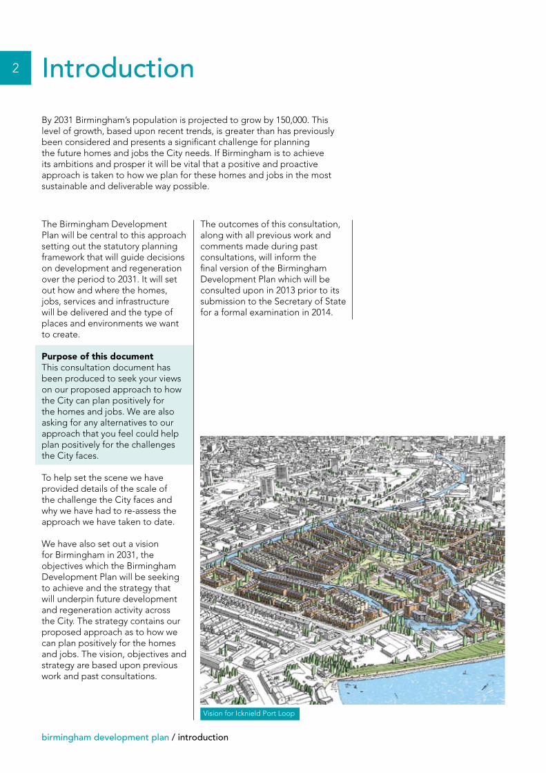
We have also set out a vision for Birmingham in 2031, the objectives which the Birmingham Development Plan will be seeking to achieve and the strategy that will underpin future development and regeneration activity across the City. The strategy contains our proposed approach as to how we can plan positively for the homes and jobs. The vision, objectives and strategy are based upon previous work and past consultations.
By 2031 Birmingham’s population is projected to grow by 150,000. This level of growth, based upon recent trends, is greater than has previously been considered and presents a significant challenge for planning the future homes and jobs the City needs. If Birmingham is to achieve its ambitions and prosper it will be vital that a positive and proactive approach is taken to how we plan for these homes and jobs in the most sustainable and deliverable way possible.
Introduction
The outcomes of this consultation, along with all previous work and comments made during past consultations, will inform the final version of the Birmingham Development Plan which will be consulted upon in 2013 prior to its submission to the Secretary of State for a formal examination in 2014.
Vision for Icknield Port Loop
introduction / birmingham development plan
The scale of the challenge
The preparation of the Birmingham Development Plan started in 2007 with a period of public consultation, held in autumn 2008, on a strategy and range of options for delivering between 50,000 and 65,000 new homes. Following this consultation further background work was carried out and in December 2010 we consulted on a document titled the Birmingham Core Strategy Consultation Draft. The focus was on how the City could deliver up to 50,600 new homes.
Since we presented the Birmingham Core Strategy Consultation Draft a number of changes have occurred which mean we need to revisit aspects of our approach relating to housing and jobs. The changes include:
• The publication of the National Planning Policy Framework (NPPF) in March 2012 introduced a national agenda for the planning system to deliver sustainable growth and support economic recovery. The emphasis in the NPPF is for each local authority to produce an up-to-date Development Plan that meets the needs of their area. This agenda has been accompanied by a move away from regionally determined targets for growth to an emphasis on the assessment of objectively assessed needs driven from the local authority level.
• The publication of the Office of National Statistics revised population projections showing that Birmingham’s population will grow by up to 150,000 between 2011 and 2031. On the basis of these latest population and household projections Birmingham’s Strategic Housing Market Assessment concludes that the number of households in the City will increase by around 80,000 over the period to 2031. This level of need goes beyond that which was proposed and planned for by the Birmingham Core Strategy Consultation Draft.
• The results of the 2011 Census indicate that Birmingham’s population grew by 88,000 or 9% over the period 2001 to 2011. Coupled with the future projections for the City’s population there is a pressing need to address issues of overcrowding and the provision of jobs.
As a result of these changes we now need to explore how we can plan positively for an increasing population and deliver the homes and jobs the City needs.
We have also changed the period which the Birmingham Development Plan covers so that we are now planning for the period to 2031. You will also notice that there has been a change in name from Core Strategy to Birmingham Development Plan which reflects the guidance in the NPPF.
3
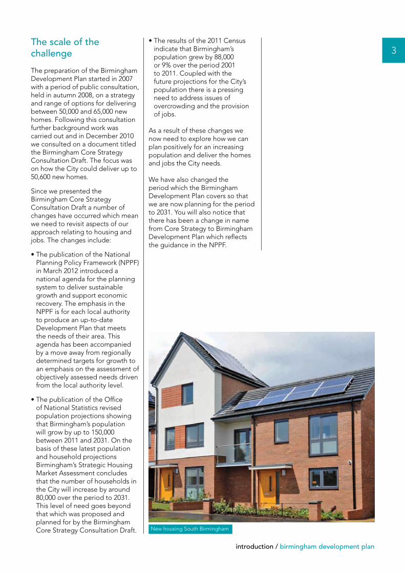
New housing South Birmingham
4
birmingham development plan / the plan
Birmingham’s residents will be experiencing a high quality of life, living within attractive and well designed sustainable neighbourhoods. The choice and affordability of housing will be meeting the needs of all and local jobs and services will be accessible through a range of sustainable transport choices.
The City’s economy will be strong and prosperous built around a diverse base of economic activities and supported by a skilled workforce. The City Centre will have expanded accommodating major
new prime office developments and a series of exciting destinations boosting the cultural, leisure and retail offer. The network of thriving local centres will reflect the diversity of the City and the needs of local people.
The historic environment and sense of place of localities throughout the city will have been enhanced. The City will have achieved high sustainability credentials with resilient, adaptive environments and all new developments built to the best standards of design.
ObjectivesTo deliver the vision and ensure that future development meets the aspirations for the City the objectives of the plan will be:
• To develop Birmingham as a city of sustainable neighbourhoods that are safe, diverse and inclusive with a locally distinctive character.
• To make provision for a significant increase in the City’s population.
• To create a prosperous, successful and enterprising economy with benefits felt by all.
• To promote Birmingham’s national and international role.
• To provide high quality connections throughout the City and with other places and encourage the increased use of public transport, walking and cycling.
• To create a more sustainable city that minimises its carbon footprint and waste while allowing the City to grow.
• To strengthen Birmingham as a learning City with quality institutions.
• To encourage better health and wellbeing through the provision of new and existing recreation and leisure facilities linked to good quality public open space.
• To protect and enhance the City’s heritage and historic environments.
• To conserve Birmingham’s natural environments, allowing biodiversity and wildlife to flourish.
The plan
Birmingham in 2031By 2031 Birmingham will be renowned as an enterprising, innovative and green city that has delivered sustainable growth meeting the needs of its population and strengthened its position on the international stage.
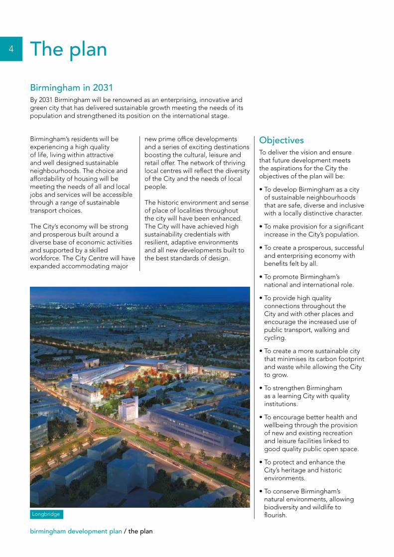
Longbridge
the plan / birmingham development plan
The strategyTo meet Birmingham’s future needs and achieve the vision of an enterprising, innovative, prosperous and green city we will need to provide for significant new growth in the most sustainable way, ensuring that the development of new homes is matched by the provision of opportunities for new employment, accessible local services and a high quality environment. Developing Birmingham’s international role will be central to its economic success, attracting investment and visitors and supporting the delivery of our growth agenda.
The City’s growth will be pursued in the most sustainable way practicable reducing the City’s carbon footprint. New development will need to be built to the highest sustainability standards, helping to generate wider benefits in terms of the quality of the environment and carbon reduction, be energy efficient, using renewable resources, and minimising the production of waste. The built environment will need to be resilient to the potential impact of climate change with flood plains protected from inappropriate development and the sustainable management of the City’s watercourses promoted.
All future development will need to be supported by suitable social infrastructure and set within environments that reflect the character and history of the City. Across the City all development must be well-designed, accessible and safe. Schools, health care
facilities, shops and other services need to be available in accessible locations along with parks, sports facilities and well-maintained local open space, forming part of a wider ‘green infrastructure network’ threading through the City and linking to the open countryside beyond. The canal network will continue to be promoted as a vital asset for the City supporting movement, environmental and biodiversity quality and as the setting for development.
The historic environment will be central to shaping the City’s future. Historic assets in all their forms
will be promoted and enhanced in supporting the delivery of distinctive places. Equally the biodiversity and geodiversity will be critical components in delivering a high quality of life and contribute to the quality of the environment and future green credentials. Birmingham’s wide variety of natural environments will be protected and enhanced and new opportunities for wildlife and biodiversity encouraged.
5
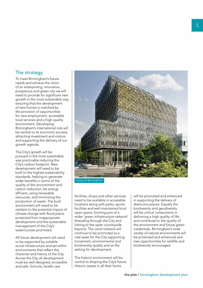
Library of Birmingham
6
birmingham development plan / the plan
Our proposed strategy for delivering new housing between 2011 and 2031 in response to higher projected population growth
Our approach is to provide for as much of the City’s growing population within the urban area as far as possible. The focus will be on brownfield or other available sites within the existing built-up area including major developments such as Greater Icknield, The Southern Gateway and Longbridge.
In order to ensure that best use of land is made a minimum density of 40 dwellings per hectare will be expected in the suburbs with higher densities in the City Centre, other centres and along transport corridors. There will continue to be an emphasis on improving existing housing which is of poor quality, replacing that which is beyond repair or improvement and bringing vacant dwellings back into use. Within the urban area there is capacity for some 43,000 dwellings with the potential for an additional 2,000 to 3,000 on other land currently in the urban area that no longer performs its original function including some open space.
This is a lower capacity than was identified in the Birmingham Core Strategy Consultation Draft which covered the period 2006-2026. This is because over 9,000 new homes were built in Birmingham between 2006 and 2011 and because some of the high density apartment schemes are less likely to happen in the short term.
The urban area therefore has limits on the amount of available space and as a result there is likely to be a shortfall of land to accommodate in the region of 30,000 dwellings in order to meet future needs. Options beyond the urban area need to be explored if we are to plan positively for the future.
Providing new homes
At the heart of the City’s growth agenda will be the promotion of sustainable neighbourhoods, supporting the City’s increasing and diverse population in the most sustainable way possible. For sustainable neighbourhoods to flourish they will be supported by high quality local infrastructure and services, including a thriving network of local centres which will reduce the need to travel and enable these areas to provide for the local population.
High standards of design in new residential areas will be expected with a strong sense of place, environmental sustainability and climate proofing, attractive, safe and multi-functional public spaces and effective long-term management provided. There will be an expectation that new housing will complement the character and environment of the surrounding area, in order to create high quality living environments which promote good health and well-being.
In delivering the principles of sustainable neighbourhoods we will seek to ensure that a wide choice of housing sizes, types and tenures is provided to meet community needs including homes for families, for the elderly and appropriate levels of affordable housing. The contribution that ‘mature suburbs’ make to the quality and choice within the City’s housing stock will continue to be recognised and these areas protected.
This means that it is necessary to explore the release of land from the Green Belt for housing development. The proposed approach to providing additional land for housing including the release of land from the Green Belt and the options available are set out on pages 14-17.
In addition to considering options within Birmingham we are also working proactively with neighbouring authorities through the Duty to Cooperate to share some of the housing requirements, as has been the case in the past. The Duty to Co-operate is a statutory requirement of the National Planning Policy Framework for local authorities to work together to address planning issues which go beyond individual authority boundaries. The fact that our current population projections are based upon recent demographic patterns, which have involved adjoining authorities accommodating a proportion of the City’s growth on the basis of travel to work patterns and wider economic benefits, will play an important consideration in how and where all of Birmingham’s future housing needs are delivered.
the plan / birmingham development plan
7
BirminghamAirport
NationalExhibition
Centre
M6
M6
M6 (Toll)
M42
M5
KEY
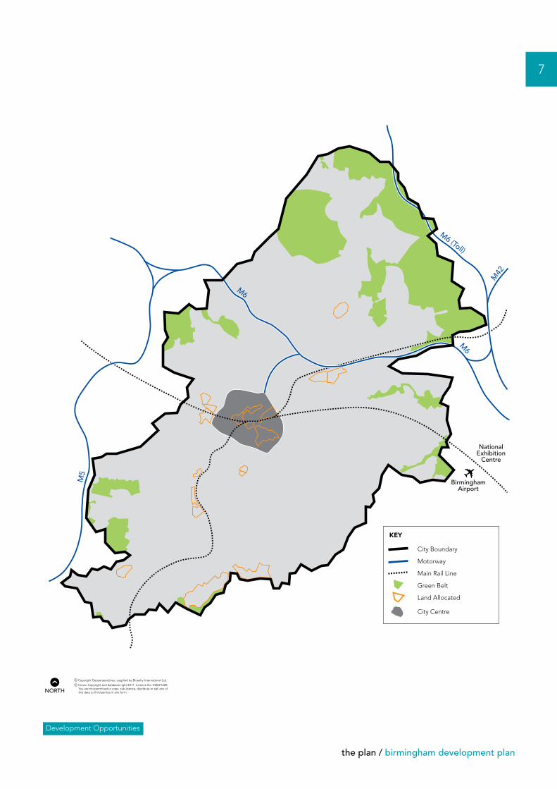
City Boundary Motorway Main Rail Line Green Belt Land Allocated City Centre
Development Opportunities
nNORTH
8
birmingham development plan / the plan
Our proposed strategy to provide sufficient land to meet the needs of businesses now and in the future
The current approach towards employment land supply has been based around the provision of a portfolio of employment sites. This strategy has been focused on brownfield regeneration which has involved the recycling or churn of existing industrial sites to provide more modern accommodation. There are however very few opportunities in the City to create new employment land and in particular provide sites of a size capable to accommodate economic development from a small number of major occupiers.
While the City will continue to promote the re-use and retention of land in employment use to provide for a range of businesses and investors the availability of land, beyond the existing pool of sites within the urban area to accommodate major investment, is limited. Options beyond the urban area therefore need to be explored if we are to plan positively for the future economic development of the City.
This means that it is necessary to explore the release of land from the Green Belt to provide land capable of accommodating a large strategic site for employment use.
The proposed approach to providing additional land for economic development including the release of land from the Green Belt and the options available are set out on pages 18-19.
Creating a prosperous economy
The continued revitalisation and modernisation of the City’s economy will be central to the growth agenda ensuring that jobs and prosperity are generated for current and future residents.
A continuous supply of land and full range of premises will be made available for all forms of employment development, including for the growth and modernisation of existing companies, the establishment of new businesses and to attract inward investment from both within the UK and globally.
Particular emphasis will be placed on ensuring that sites are available to support the economic sectors important to the City’s economic growth, these include business and professional services, creative and digital media, life sciences, food and drink, ITEC, logistics and advanced manufacturing.
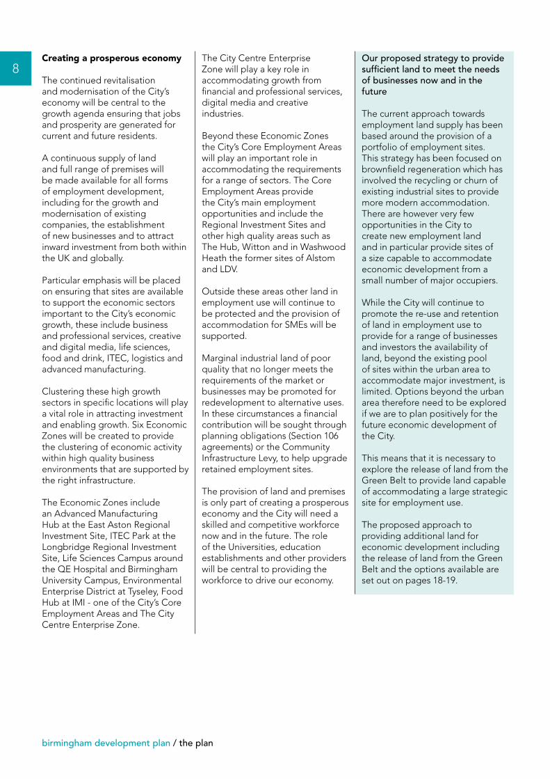
Clustering these high growth sectors in specific locations will play a vital role in attracting investment and enabling growth. Six Economic Zones will be created to provide the clustering of economic activity within high quality business environments that are supported by the right infrastructure.
The Economic Zones include an Advanced Manufacturing Hub at the East Aston Regional Investment Site, ITEC Park at the Longbridge Regional Investment Site, Life Sciences Campus around the QE Hospital and Birmingham University Campus, Environmental Enterprise District at Tyseley, Food Hub at IMI - one of the City’s Core Employment Areas and The City Centre Enterprise Zone.
The City Centre Enterprise Zone will play a key role in accommodating growth from financial and professional services, digital media and creative industries.
Beyond these Economic Zones the City’s Core Employment Areas will play an important role in accommodating the requirements for a range of sectors. The Core Employment Areas provide the City’s main employment opportunities and include the Regional Investment Sites and other high quality areas such as The Hub, Witton and in Washwood Heath the former sites of Alstom and LDV.
Outside these areas other land in employment use will continue to be protected and the provision of accommodation for SMEs will be supported.
Marginal industrial land of poor quality that no longer meets the requirements of the market or businesses may be promoted for redevelopment to alternative uses. In these circumstances a financial contribution will be sought through planning obligations (Section 106 agreements) or the Community Infrastructure Levy, to help upgrade retained employment sites.
The provision of land and premises is only part of creating a prosperous economy and the City will need a skilled and competitive workforce now and in the future. The role of the Universities, education establishments and other providers will be central to providing the workforce to drive our economy.
the plan / birmingham development plan
9
BirminghamAirport
NationalExhibition
Centre
M6
M6
M6 (Toll)
M42
M5
KEY
City Boundary Motorway Main Rail Line Economic Zones
Core Employment Areas Green Belt Regional Investment Sites City Centre
The Food Hub
Life SciencesCampus
Tyseley EnvironmentalEnterprise District
LongbridgeITEC Park
Advanced Manufacturing Hub
City CentreEnterprise Zone
Employment Sites
nNORTH
10
birmingham development plan / the plan
A network of centres
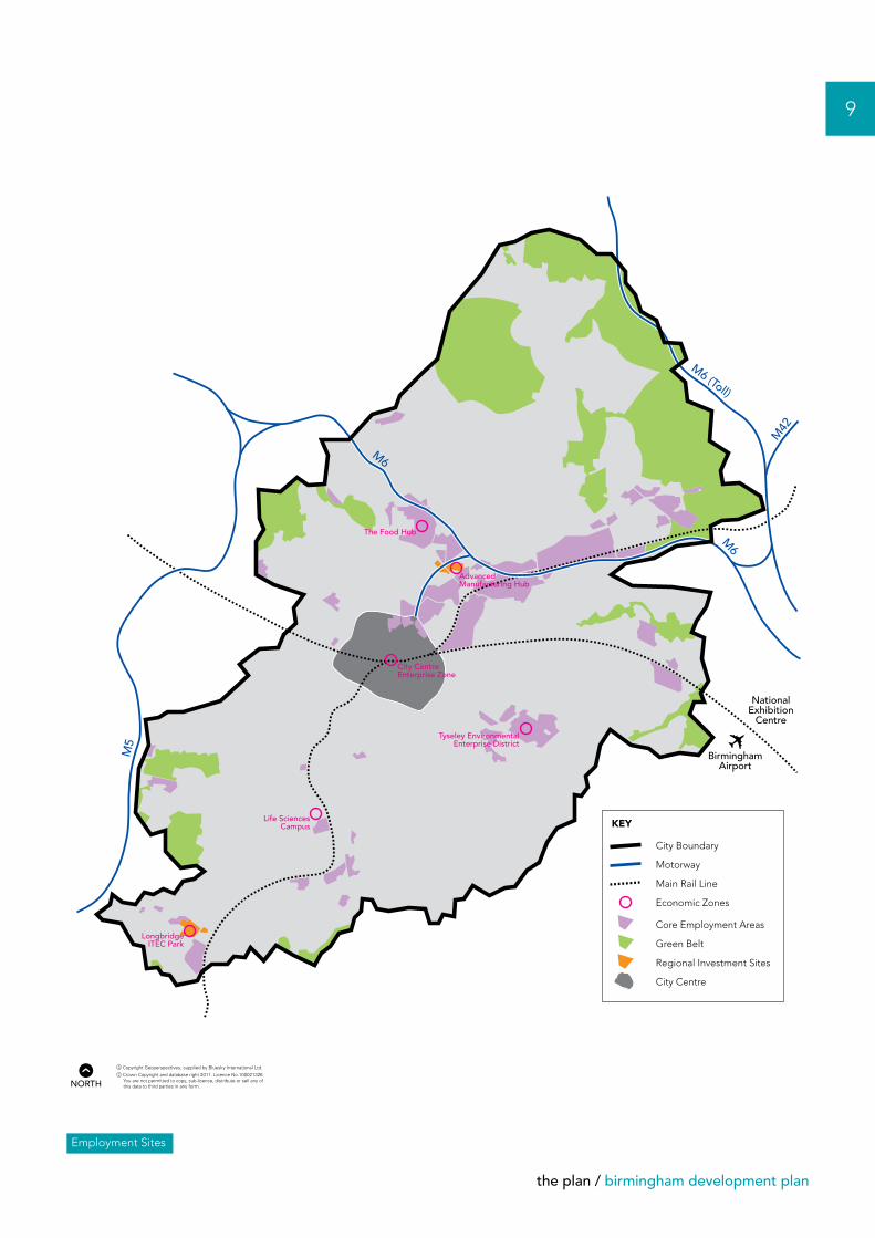
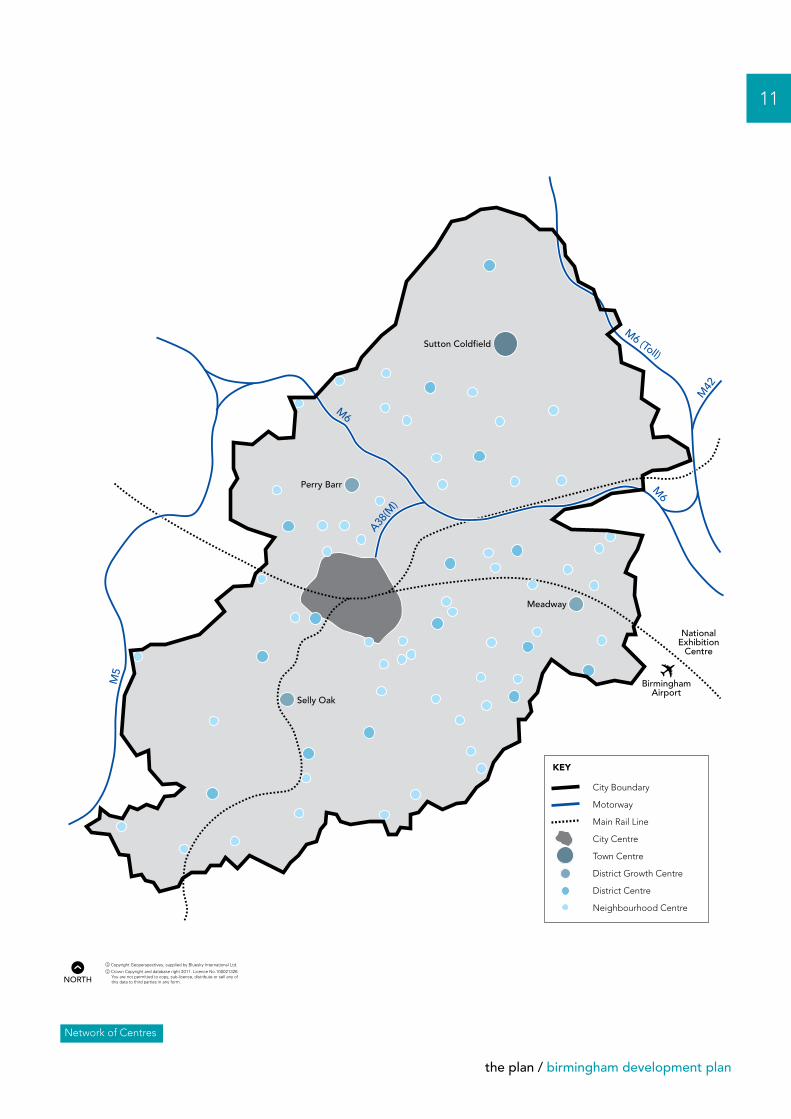
A thriving network of centres will be a significant driver for growth and central to delivering new office and retail development and other services to support communities.The priority will be to promote retail and office development within the defined centres and resist development that would undermine the strength of the network.
This network comprises of:
• The City Centre which will continue to be strengthened as a centre for finance and business services, and as a destination for shopping, business tourism and major cultural events with world-class conference facilities and other venues. Five areas of transformation will deliver new development, investing in new high quality buildings and public spaces, and creating new vibrant destinations. The success of the City Centre will be central in promoting the international profile of the City and attracting investment, visitors and wealth.
• Sutton Coldfield Town Centre as a sub-regional centre is capable of accommodating significant additional comparison retail floorspace and some office space.
• Perry Barr, Selly Oak and Meadway as district growth centres accommodating both retail and office uses but at a lower level of growth to the City Centre and Sub-Regional Centre.
• A network of some 70 other district and neighbourhood centres accommodating more limited levels of growth supporting local needs.
Brindleyplace
the plan / birmingham development plan
11
BirminghamAirport
NationalExhibition
Centre
M6
M6
M6 (Toll)
M42
M5
A38(M
)
Sutton Coldfield
Selly Oak
Meadway
Perry Barr
KEY
City Boundary Motorway Main Rail Line City Centre Town Centre District Growth Centre District Centre Neighbourhood Centre
Network of Centres
nNORTH
12
birmingham development plan / the plan
Improving connectivity
If Birmingham is to deliver its growth agenda and attract and retain investment and economic activity, it must be able to provide the necessary infrastructure. This will include in particular, high quality transport links to the rest of the country and beyond and easy movement within the City.
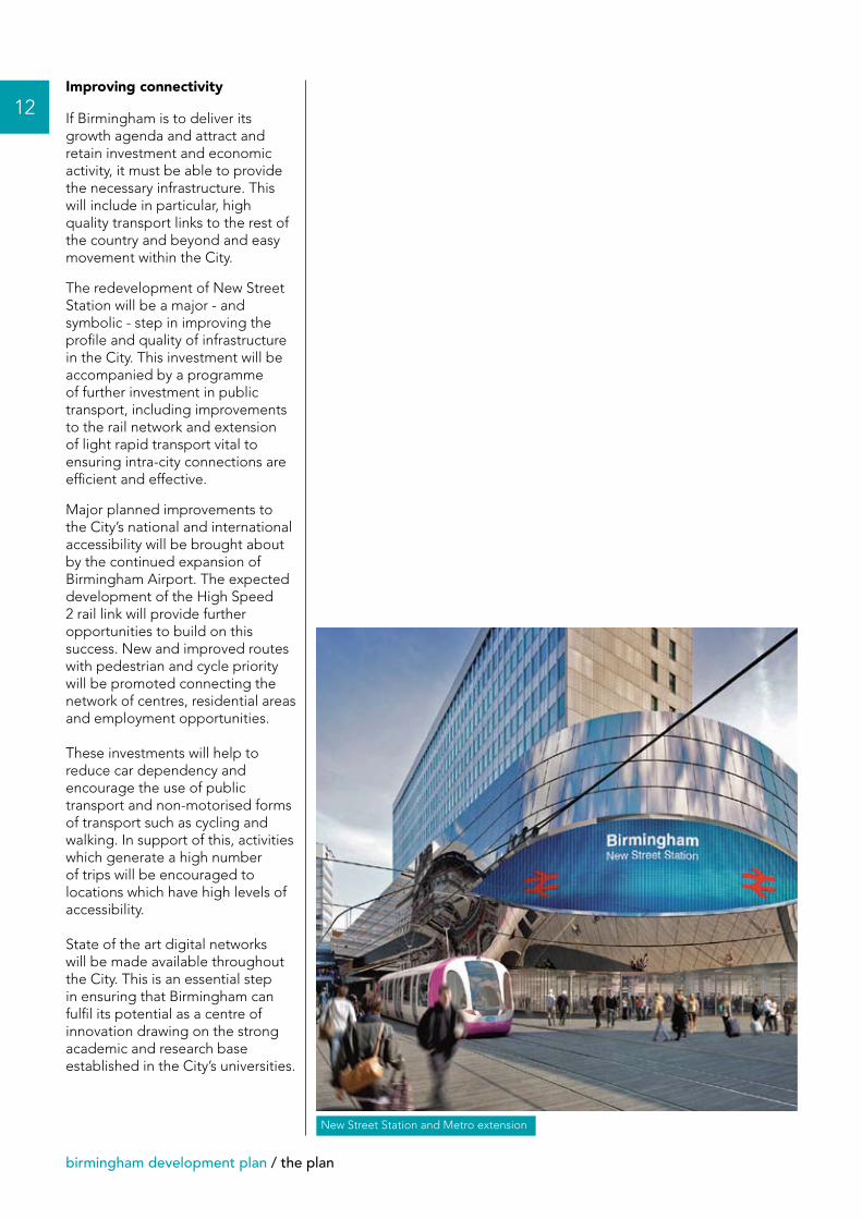
The redevelopment of New Street Station will be a major - and symbolic - step in improving the profile and quality of infrastructure in the City. This investment will be accompanied by a programme of further investment in public transport, including improvements to the rail network and extension of light rapid transport vital to ensuring intra-city connections are efficient and effective.
Major planned improvements to the City’s national and international accessibility will be brought about by the continued expansion of Birmingham Airport. The expected development of the High Speed 2 rail link will provide further opportunities to build on this success. New and improved routes with pedestrian and cycle priority will be promoted connecting the network of centres, residential areas and employment opportunities.
These investments will help to reduce car dependency and encourage the use of public transport and non-motorised forms of transport such as cycling and walking. In support of this, activities which generate a high number of trips will be encouraged to locations which have high levels of accessibility.
State of the art digital networks will be made available throughout the City. This is an essential step in ensuring that Birmingham can fulfil its potential as a centre of innovation drawing on the strong academic and research base established in the City’s universities.
New Street Station and Metro extension
the plan / birmingham development plan
13
A4040
A453
A4040
A34
A47
A47
A4040
A452
A452A5127
A5127
A453
A38
A38
A38
A38
A38B4096
A441
A435
A34
A41
A45
A45
A456
A457
A441
A4040
A4040
A4040
A4040
A41
BirminghamAirport
NationalExhibition
Centre
To Manchester
To Warwick
Snow Hill
Moor Street
To Worcester
To Derby
To London
To Stratford
To Redditch
To Lichfield
Birmingham Metro
To Walsall
New Street
M6
M6
M6 (Toll)
M42
M5
KEY
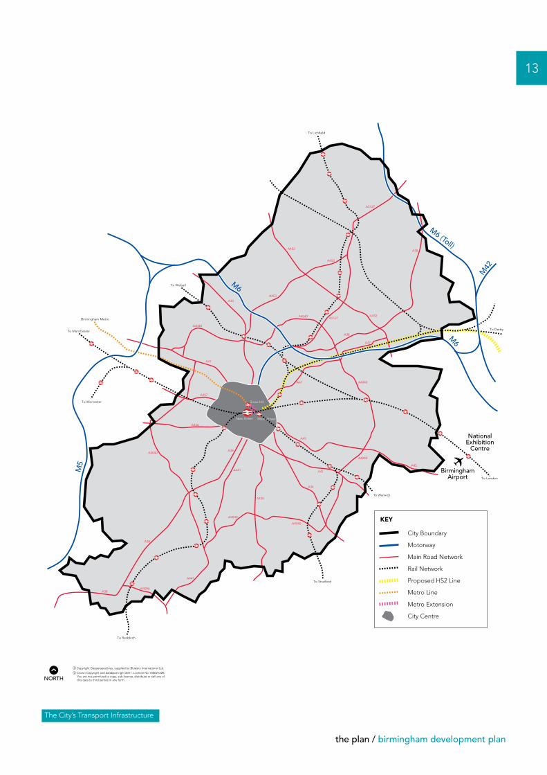
City Boundary Motorway Main Road Network Rail Network Proposed HS2 Line Metro Line Metro Extension City Centre
The City’s Transport Infrastructure
nNORTH
14
birmingham development plan / planning for birmingham’s growing population
Providing a supply of land to meet housing needsOn the basis of the projected increase in Birmingham’s population there is a need to plan for around 80,000 new homes in the period between 2011 and 2031.
This assumes that international migration continues at past rates. If international migration reduces in the future, as envisaged by Central Government, the growth in households would reduce by about 10,000.
Our strategy to deliver the housing to support the City’s growing population will be based upon the principles of creating sustainable neighbourhoods through new residential developments or improving existing areas of housing. In delivering the principle of sustainable neighbourhoods we will seek to ensure developments provide:
• A wide choice of housing sizes, types and tenures including affordable homes.
• Access to facilities such as shops, leisure and work opportunities.
• Convenient options to travel by public transport, foot or bicycle.
• A strong sense of place with high quality design.
• Environmental sustainability and climate proofing.
• Attractive, safe and multi-functional public spaces.
• Effective long-term management.
As described on page 6 the strategy will continue to prioritise brownfield sites for housing development but the evidence indicates that insufficient brownfield land is available to meet the requirements for new homes.
With Birmingham’s population projected to grow by up to 150,000 over the period to 2031 there will be increased demand for new housing, jobs, infrastructure and services. Through the Birmingham Development Plan we will need to plan for this future growth in a way that is both sustainable and deliverable. We have explored a number of ways in which we can plan positively for our growing population in order to deliver our strategy for the City.
Planning for Birmingham’s growing population
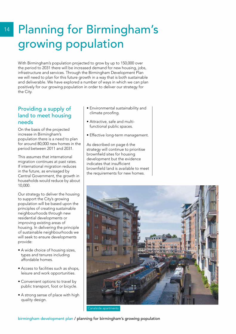
Canalside apartments
planning for birmingham’s growing population / birmingham development plan
Current assessment of available land
Through the Strategic Housing Land Availability Assessment we have identified land within the urban area to accommodate 43,000 dwellings focused predominately on brownfield sites. This housing will be delivered in a number of ways including through new neighbourhoods, redevelopment of land, infill, conversions and bringing properties back into use, all driven by the principles of sustainable neighbourhoods.
Other opportunities
In response to the projected population growth we have explored the opportunity to utilise other sources of land that we have traditionally not considered, including open space and that in employment use.
Open space is an important asset and forms a central part of our strategy to create sustainable neighbourhoods. We have explored the potential to utilise land defined as open space where it is of limited value, underused or no longer serves its designated purpose.
As the City’s population grows the demand for open space will also increase and there will be both a need to provide more in some areas and improve what already exists across the City. In many parts of the City there is already a shortage of good quality open space, so opportunities to utilise open space for housing are limited.
However there are some opportunities to utilise land currently defined as open space through selective redevelopment which could also provide the opportunity for improvements to the quality of remaining areas of open space. The North Worcestershire Golf Club is an example where additional housing alongside improving the quality and accessibility of the open space could be delivered.
On this basis we estimate that there is the potential to accommodate a further 2,000 to 3,000 dwellings within the urban area.
The other opportunity is to accommodate housing on land currently in employment use. Similar to open space, land for employment is important in delivering our overall strategy, particularly to generate more jobs for both the City’s current and future projected population. It is therefore essential that vacant employment land which has reasonable prospects of being redeveloped for employment is retained for that purpose. Where employment redevelopment is unlikely, these sites have already been identified in the Strategic Housing Land Availability Assessment. There is therefore little further potential to secure more land for housing from this source.
We have also explored opportunities to make better use of the land within the urban area by applying higher densities. The densities we have applied are in line with current policy to maximise
the number of dwellings built while balancing the needs to deliver a range of dwelling type, size and tenure alongside creating attractive and durable environments. Over the last 10 years around 50% of the City’s housing has been built in the City Centre in the form of one or two bedroom apartments at high densities. Looking to the future the City will need to provide more dwellings for families. The need for such homes will put pressure on the ability to achieve high densities, with limited potential to increase housing supply in this way.
Having explored the capacity within the urban area it is clear that it will be impossible to provide sufficient new housing to meet the City’s growing population with a shortfall in the region of 30,000 dwellings. In producing our Development Plan we need to explore all the reasonable options to provide land to accommodate the housing for Birmingham’s growing population. This means that we must also consider the potential for development on the edge of the City - which means on land currently in the Green Belt.
15
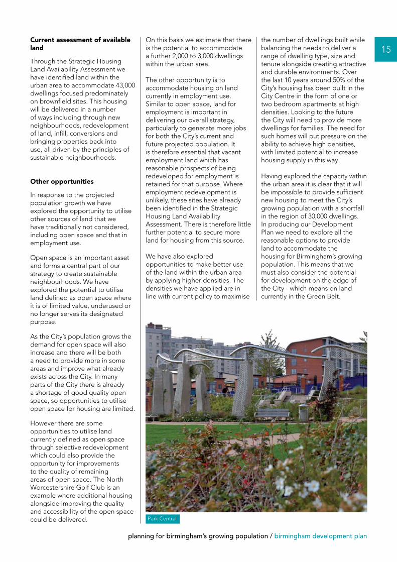
Park Central
16
birmingham development plan / planning for birmingham’s growing population
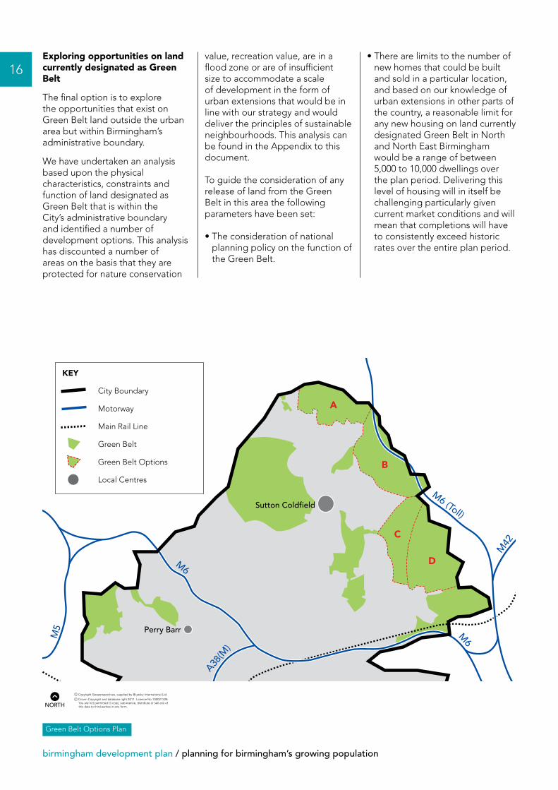
Exploring opportunities on land currently designated as Green Belt
The final option is to explore the opportunities that exist on Green Belt land outside the urban area but within Birmingham’s administrative boundary.
We have undertaken an analysis based upon the physical characteristics, constraints and function of land designated as Green Belt that is within the City’s administrative boundary and identified a number of development options. This analysis has discounted a number of areas on the basis that they are protected for nature conservation
value, recreation value, are in a flood zone or are of insufficient size to accommodate a scale of development in the form of urban extensions that would be in line with our strategy and would deliver the principles of sustainable neighbourhoods. This analysis can be found in the Appendix to this document.
To guide the consideration of any release of land from the Green Belt in this area the following parameters have been set:
• The consideration of national planning policy on the function of the Green Belt.
• There are limits to the number of new homes that could be built and sold in a particular location, and based on our knowledge of urban extensions in other parts of the country, a reasonable limit for any new housing on land currently designated Green Belt in North and North East Birmingham would be a range of between 5,000 to 10,000 dwellings over the plan period. Delivering this level of housing will in itself be challenging particularly given current market conditions and will mean that completions will have to consistently exceed historic rates over the entire plan period.
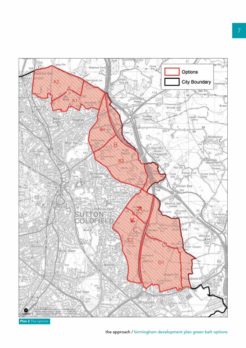
Green Belt Options Plan
A
B
C
DM6
M6
M6 (Toll)
M5
BirminghamAirport
NationalExhibition
Centre
A38(M
)
Sutton Coldfield
Selly Oak
Meadway
Perry Barr
M42
KEY
City Boundary
Motorway
Main Rail Line
Green Belt
Green Belt Options
Local Centres
nNORTH
planning for birmingham’s growing population / birmingham development plan
• The need to avoid undermining our strategy for prioritising brownfield development and urban regeneration.
• The environmental impact.
• The extent to which proposed urban extensions would deliver upon the principles of creating sustainable neighbourhoods.
QuestionsPlease refer to the Consultation Response Form for the questions and details on the methods for responding.
17
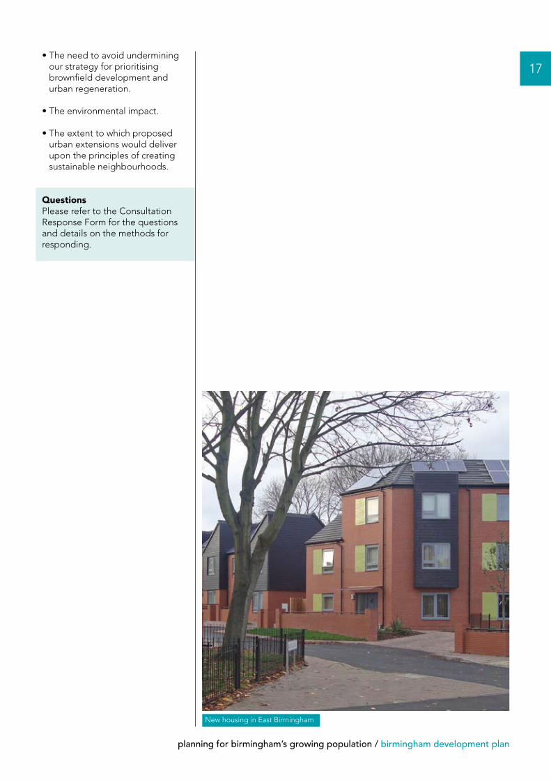
New housing in East Birmingham
18
birmingham development plan / planning for birmingham’s growing population
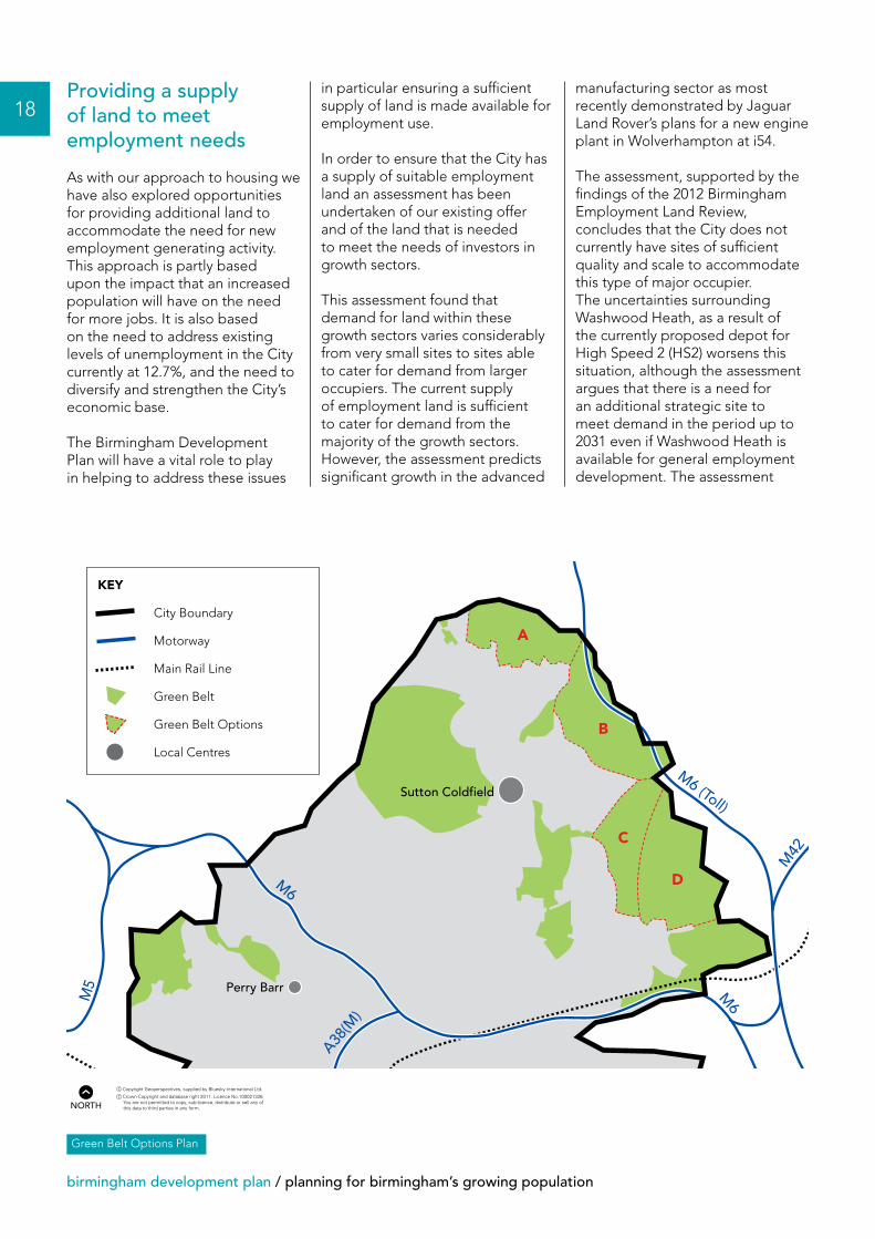
Providing a supply of land to meet employment needs
As with our approach to housing we have also explored opportunities for providing additional land to accommodate the need for new employment generating activity. This approach is partly based upon the impact that an increased population will have on the need for more jobs. It is also based on the need to address existing levels of unemployment in the City currently at 12.7%, and the need to diversify and strengthen the City’s economic base.
The Birmingham Development Plan will have a vital role to play in helping to address these issues
in particular ensuring a sufficient supply of land is made available for employment use.
In order to ensure that the City has a supply of suitable employment land an assessment has been undertaken of our existing offer and of the land that is needed to meet the needs of investors in growth sectors.
This assessment found that demand for land within these growth sectors varies considerably from very small sites to sites able to cater for demand from larger occupiers. The current supply of employment land is sufficient to cater for demand from the majority of the growth sectors. However, the assessment predicts significant growth in the advanced
manufacturing sector as most recently demonstrated by Jaguar Land Rover’s plans for a new engine plant in Wolverhampton at i54.
The assessment, supported by the findings of the 2012 Birmingham Employment Land Review, concludes that the City does not currently have sites of sufficient quality and scale to accommodate this type of major occupier. The uncertainties surrounding Washwood Heath, as a result of the currently proposed depot for High Speed 2 (HS2) worsens this situation, although the assessment argues that there is a need for an additional strategic site to meet demand in the period up to 2031 even if Washwood Heath is available for general employment development. The assessment
A
B
C
DM6
M6
M6 (Toll)
M5
BirminghamAirport
NationalExhibition
Centre
A38(M
)
Sutton Coldfield
Selly Oak
Meadway
Perry Barr
M42
KEY
City Boundary
Motorway
Main Rail Line
Green Belt
Green Belt Options
Local Centres
Green Belt Options Plan
nNORTH

planning for birmingham’s growing population / birmingham development plan
recommends that a large strategic site of at least 50 hectares should be identified within the City with the potential to accommodate economic development from a small number of major occupiers particularly in the advanced manufacturing sector.
However if the Washwood Heath site is lost to the HS2 Depot there will be a need for further additional land.
Current assessment of available land
We have explored how we could identify a site of this scale on existing brownfield land within the urban area but there are no further sites of this size currently or likely to become available.
Other opportunities
We have also explored utilising land which is designated as open space. The value of open space and the opportunities for development have been set out in the ‘options for housing’ section. Due to the size of the sites needed to meet business needs and the location of much of the open space this is not considered as a viable option to provide land for employment use.
Exploring opportunities on land currently designated as Green Belt
Taking into account all the options explored above and the need for the City to identify a site to meet the needs for a major employment use there is still a requirement for additional land. Land designated as Green Belt that is within the City’s administrative boundary is the only remaining option if the City is to deliver its strategy.
As in the case of the housing options we have undertaken an analysis of the City’s Green Belt in order to inform this consultation. The options capable
of accommodating a site of at least 50 hectares are set out in the Appendix.
To guide the consideration of any release of land from the Green Belt in this area the following parameters have been set:
• The consideration of national planning policy on the function of the Green Belt.
• The ability of the site to provide for the access arrangements to meet the needs of major occupiers.
• The use of the site to support the requirements for a small number of major occupiers particularly in the advanced manufacturing sector.
QuestionsPlease refer to the Consultation Response Form for the questions and details on the methods for responding.
19
Jaguar at Castle Bromwich

P&R/
11/?
??/A
/???
/02/
11
BIRMINGHAM DEVELOPMENT PLANPlanning for Birmingham’s growing population
Green Belt Options AppendixOctober 2012

Contact
Development DirectorateBirmingham City Council
Click:E-mail:[email protected]
Call:Telephone:(0121) 303 4041
Visit:Office:1 Lancaster CircusBirminghamB4 7DJ
Post:PO Box 28BirminghamB1 1TU
You can ask for a copy of this document in large print, another format or another language. We aim to supply what you need within ten working days.
Call (0121) 303 4041
If you have hearing difficulties please call us via Typetalk 18001 0121 303 4041 or e-mail us at the address above.
Plans contained within this document are based upon Ordnance Survey material with the permission of Ordnance Survey on behalf of the Controller of Her Majesty’s Stationery Office.
© Crown Copyright. Unauthorised reproduction infringes Crown Copyright and may lead to prosecution or civil proceedings.Birmingham City Council. Licence number 100021326, 2012.
contents / birmingham development plan green belt options
Contents
Context 2
Birmingham’s Green Belt 2
National Planning Policy Framework 3
The approach 4
The options 8
2
birmingham development plan green belt options / context • birmingham’s green belt
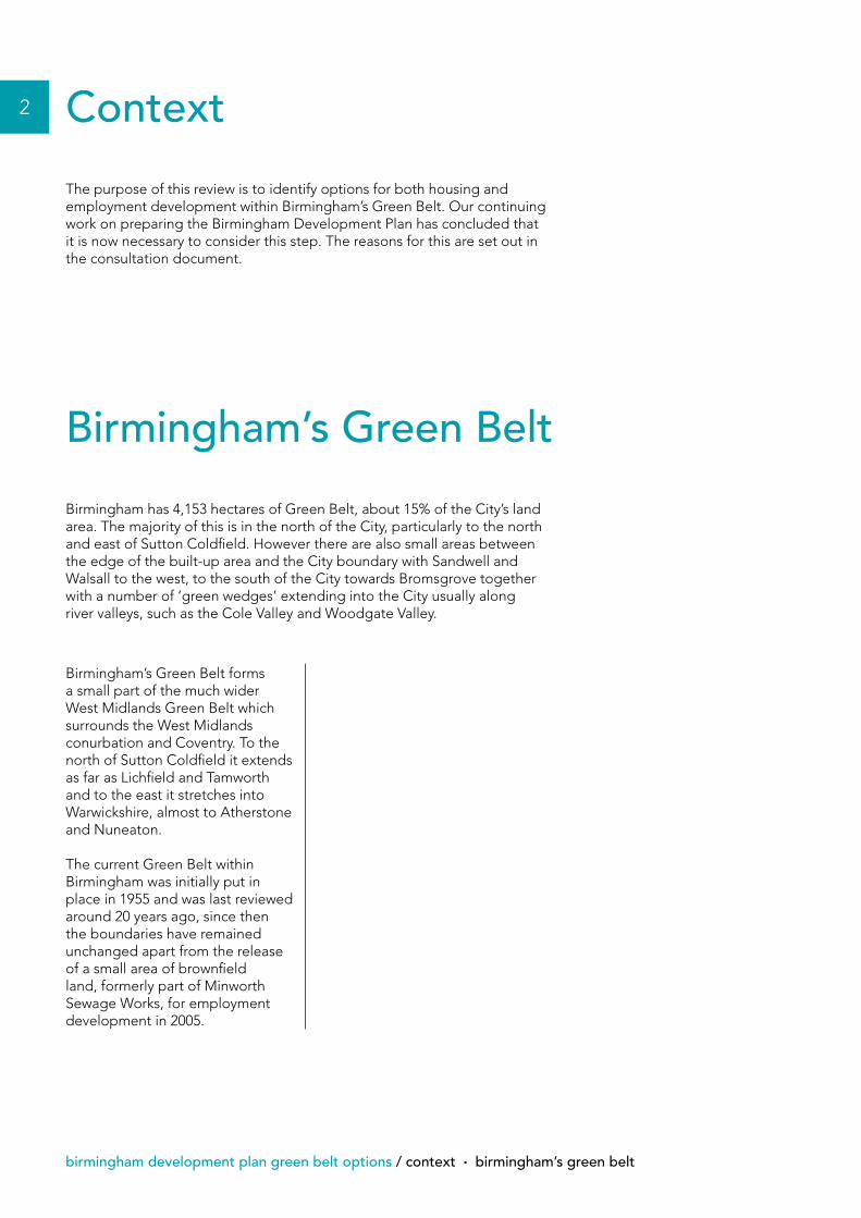
Context
The purpose of this review is to identify options for both housing and employment development within Birmingham’s Green Belt. Our continuing work on preparing the Birmingham Development Plan has concluded that it is now necessary to consider this step. The reasons for this are set out in the consultation document.
Birmingham’s Green Belt forms a small part of the much wider West Midlands Green Belt which surrounds the West Midlands conurbation and Coventry. To the north of Sutton Coldfield it extends as far as Lichfield and Tamworth and to the east it stretches into Warwickshire, almost to Atherstone and Nuneaton.
The current Green Belt within Birmingham was initially put in place in 1955 and was last reviewed around 20 years ago, since then the boundaries have remained unchanged apart from the release of a small area of brownfield land, formerly part of Minworth Sewage Works, for employment development in 2005.
Birmingham’s Green Belt
Birmingham has 4,153 hectares of Green Belt, about 15% of the City’s land area. The majority of this is in the north of the City, particularly to the north and east of Sutton Coldfield. However there are also small areas between the edge of the built-up area and the City boundary with Sandwell and Walsall to the west, to the south of the City towards Bromsgrove together with a number of ‘green wedges’ extending into the City usually along river valleys, such as the Cole Valley and Woodgate Valley.
national planning policy framework / birmingham development plan green belt options
3
Paragraph 80 of the NPPF sets out the five purposes of Green Belt which are:
• To check the unrestricted sprawl of large built-up areas.
• To prevent neighbouring towns merging into one another.
• To assist in safeguarding the countryside from encroachment.
• To preserve the setting and special character of historic towns.
• To assist in urban regeneration, by encouraging the recycling of derelict and other urban land.
It goes on to say in paragraph 83 that “Local Planning Authorities with Green Belts in their area should establish Green Belt boundaries in their Local Plans which set the framework for Green Belt and settlement policy. Once established, Green Belt boundaries should only be altered in exceptional circumstances, through the preparation or review of the Local Plan. At that time, authorities should consider the Green Belt boundaries having regard to their intended permanence in the long term, so that they should be capable of enduring beyond the plan period”.
It also provides advice on the definition of Green Belt boundaries in paragraph 85, which requires the following to be taken into account:
• Ensure consistency with the Local Plan strategy for meeting identified requirements for sustainable development.
• Not include land which it is unnecessary to keep permanently open.
• Where necessary, Local Authorities identify in their plans areas of ‘safeguarded land’ between the urban area and the Green Belt, in order to meet longer-term development needs stretching well beyond the plan period.
• Make clear that the safeguarded land is not allocated for development at the present time. Planning permission for the permanent development of safeguarded land should only be granted following a Local Plan review which proposes the development.
• Satisfy themselves that Green Belt boundaries will not need to be altered at the end of the development plan period.
• Define boundaries clearly, using physical features that are readily recognisable and likely to be permanent.
This review has been undertaken within the context of this advice.
National Planning PolicyFramework (NPPF)
National policy towards Green Belts is currently set out in the National Planning Policy Framework (NPPF).
4
birmingham development plan green belt options / the approach
The approach
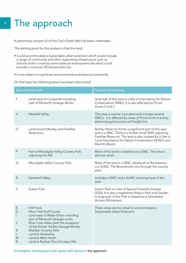
A preliminary analysis of all the City’s Green Belt has been undertaken.
The starting point for this analysis is that the land:
• Could accommodate a sustainable urban extension which would include a range of community and other supporting infrastructure such as schools and/or could accommodate an employment site which could provide a minimum 50 hectare plot size.
• Is not subject to significant environmental and physical constraints.
On this basis the following areas have been discounted:
F - Land west of Curdworth including part of Minworth Sewage Works.
H - Newhall Valley.
O - Land around Bartley and Frankley Reservoirs.
P - Part of Woodgate Valley Country Park adjoining the M5.
Q - Woodgate Valley Country Park.
R - Sandwell Valley.
S - Sutton Park.
E - Hill Hook.G - Moor Hall Golf Course.I - Land west of Water Orton including
part of Minworth Sewage works.J - River Cole Valley (with the exception
of the former Yardley Sewage Works).K - Sheldon Country Park.L - Land at Hawkesley.M - Land at West Heath.N - Land at Rednal; Part of Lickey Hills.
Over half of this area is a Site of Importance for Nature Conservatiom (SINC). It is also affected by Flood Zones 2 and 3.
This area is narrow, truncated and includes several SINC’s. It is affected by areas of Flood Zone 3 and by electricity pylons and a rail freight line.
Bartley Reservoir forms a significant part of this area and is a SINC. There is a further small SINC adjoining Frankley Reservoir. The area is also crossed by a Site of Local Importance for Nature Conservation (SLINC) and Merritt’s Brook.
Most of this land is classified as a SINC. The area is also too small.
Most of the land is a SINC. Nearly all of the balance is a SLINC. The Bournbrook runs through the country park.
Includes a SINC and a SLINC covering most of the area.
Sutton Park is a Site of Special Scientific Interest (SSSI). It is also a registered Historic Park and Garden. A large part of the Park is classed as a Scheduled Ancient Monument.
These areas are too small to accommodate a Sustainable Urban Extension.
Area of Green Belt Reasons for omitting
the approach / birmingham development plan green belt options
5
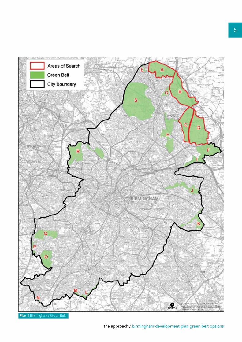
Plan 1 Birmingham’s Green Belt
nNORTH
6
birmingham development plan green belt options / the approach
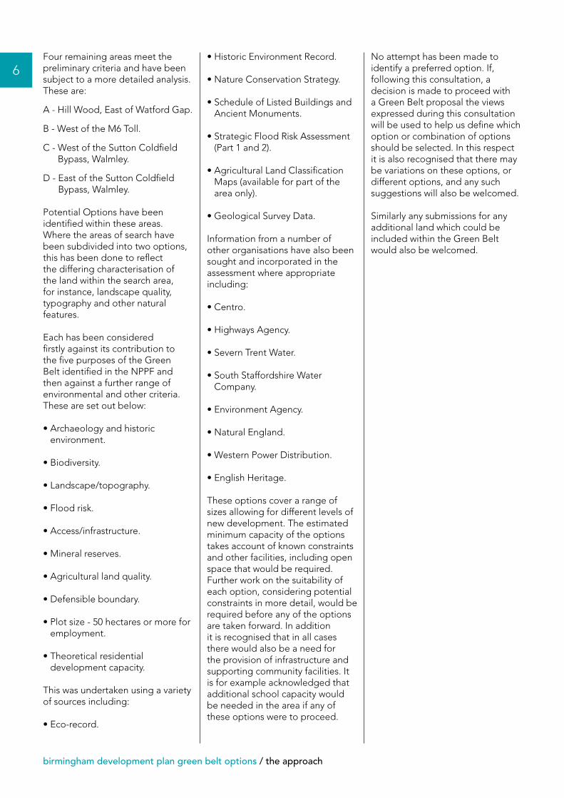
Four remaining areas meet the preliminary criteria and have been subject to a more detailed analysis. These are:
A - Hill Wood, East of Watford Gap.
B - West of the M6 Toll.
C - West of the Sutton Coldfield Bypass, Walmley.
D - East of the Sutton Coldfield Bypass, Walmley.
Potential Options have been identified within these areas. Where the areas of search have been subdivided into two options, this has been done to reflect the differing characterisation of the land within the search area, for instance, landscape quality, typography and other natural features.
Each has been considered firstly against its contribution to the five purposes of the Green Belt identified in the NPPF and then against a further range of environmental and other criteria. These are set out below:
• Archaeology and historic environment.
• Biodiversity.
• Landscape/topography.
• Flood risk.
• Access/infrastructure.
• Mineral reserves.
• Agricultural land quality.
• Defensible boundary.
• Plot size - 50 hectares or more for employment.
• Theoretical residential development capacity.
This was undertaken using a variety of sources including:
• Eco-record.
• Historic Environment Record.
• Nature Conservation Strategy.
• Schedule of Listed Buildings and Ancient Monuments.
• Strategic Flood Risk Assessment (Part 1 and 2).
• Agricultural Land Classification Maps (available for part of the area only).
• Geological Survey Data.
Information from a number of other organisations have also been sought and incorporated in the assessment where appropriate including:
• Centro.
• Highways Agency.
• Severn Trent Water.
• South Staffordshire Water Company.
• Environment Agency.
• Natural England.
• Western Power Distribution.
• English Heritage.
These options cover a range of sizes allowing for different levels of new development. The estimated minimum capacity of the options takes account of known constraints and other facilities, including open space that would be required. Further work on the suitability of each option, considering potential constraints in more detail, would be required before any of the options are taken forward. In addition it is recognised that in all cases there would also be a need for the provision of infrastructure and supporting community facilities. It is for example acknowledged that additional school capacity would be needed in the area if any of these options were to proceed.
No attempt has been made to identify a preferred option. If, following this consultation, a decision is made to proceed with a Green Belt proposal the views expressed during this consultation will be used to help us define which option or combination of options should be selected. In this respect it is also recognised that there may be variations on these options, or different options, and any such suggestions will also be welcomed.
Similarly any submissions for any additional land which could be included within the Green Belt would also be welcomed.
the approach / birmingham development plan green belt options
7
Plan 2 The options
nNORTH
8
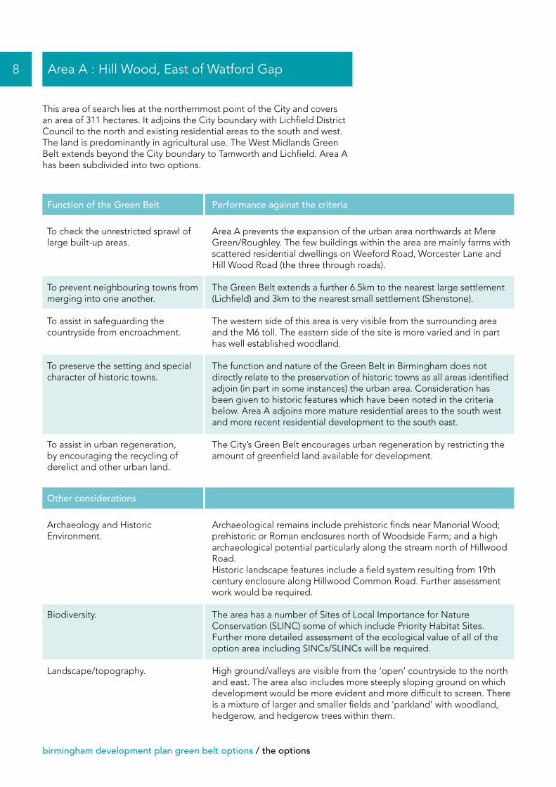
birmingham development plan green belt options / the options
This area of search lies at the northernmost point of the City and covers an area of 311 hectares. It adjoins the City boundary with Lichfield District Council to the north and existing residential areas to the south and west. The land is predominantly in agricultural use. The West Midlands Green Belt extends beyond the City boundary to Tamworth and Lichfield. Area A has been subdivided into two options.
Area A : Hill Wood, East of Watford Gap
To check the unrestricted sprawl of large built-up areas.
To prevent neighbouring towns from merging into one another.
To assist in safeguarding the countryside from encroachment.
To preserve the setting and special character of historic towns.
To assist in urban regeneration, by encouraging the recycling of derelict and other urban land.
Area A prevents the expansion of the urban area northwards at Mere Green/Roughley. The few buildings within the area are mainly farms with scattered residential dwellings on Weeford Road, Worcester Lane and Hill Wood Road (the three through roads).
The Green Belt extends a further 6.5km to the nearest large settlement (Lichfield) and 3km to the nearest small settlement (Shenstone).
The western side of this area is very visible from the surrounding area and the M6 toll. The eastern side of the site is more varied and in part has well established woodland.
The function and nature of the Green Belt in Birmingham does not directly relate to the preservation of historic towns as all areas identified adjoin (in part in some instances) the urban area. Consideration has been given to historic features which have been noted in the criteria below. Area A adjoins more mature residential areas to the south west and more recent residential development to the south east.
The City’s Green Belt encourages urban regeneration by restricting the amount of greenfield land available for development.
Function of the Green Belt Performance against the criteria
Archaeology and Historic Environment.
Biodiversity.
Landscape/topography.
Archaeological remains include prehistoric finds near Manorial Wood; prehistoric or Roman enclosures north of Woodside Farm; and a high archaeological potential particularly along the stream north of Hillwood Road. Historic landscape features include a field system resulting from 19th century enclosure along Hillwood Common Road. Further assessment work would be required.
The area has a number of Sites of Local Importance for Nature Conservation (SLINC) some of which include Priority Habitat Sites. Further more detailed assessment of the ecological value of all of the option area including SINCs/SLINCs will be required.
High ground/valleys are visible from the ‘open’ countryside to the north and east. The area also includes more steeply sloping ground on which development would be more evident and more difficult to screen. There is a mixture of larger and smaller fields and ‘parkland’ with woodland, hedgerow, and hedgerow trees within them.
Other considerations
the options / birmingham development plan green belt options
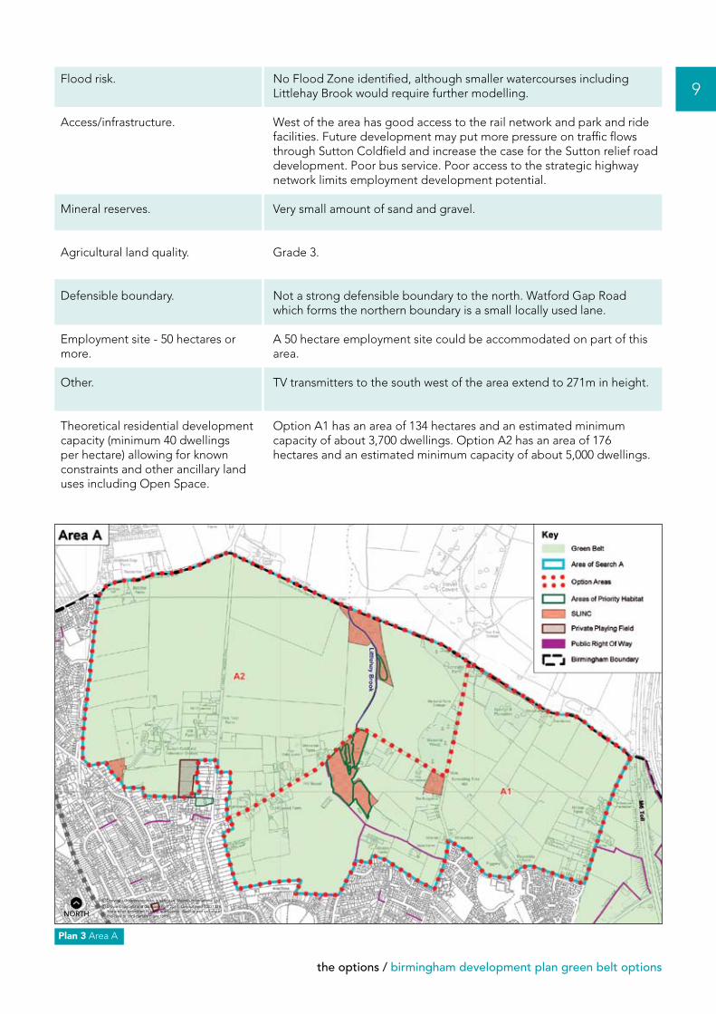
9Flood risk.
Access/infrastructure.
Mineral reserves.
Agricultural land quality.
Defensible boundary.
Employment site - 50 hectares or more.
Other.
Theoretical residential development capacity (minimum 40 dwellings per hectare) allowing for known constraints and other ancillary land uses including Open Space.
No Flood Zone identified, although smaller watercourses including Littlehay Brook would require further modelling.
West of the area has good access to the rail network and park and ride facilities. Future development may put more pressure on traffic flows through Sutton Coldfield and increase the case for the Sutton relief road development. Poor bus service. Poor access to the strategic highway network limits employment development potential.
Very small amount of sand and gravel.
Grade 3.
Not a strong defensible boundary to the north. Watford Gap Road which forms the northern boundary is a small locally used lane.
A 50 hectare employment site could be accommodated on part of this area.
TV transmitters to the south west of the area extend to 271m in height.
Option A1 has an area of 134 hectares and an estimated minimum capacity of about 3,700 dwellings. Option A2 has an area of 176 hectares and an estimated minimum capacity of about 5,000 dwellings.
Plan 3 Area A
nNORTH

10
birmingham development plan green belt options / the options
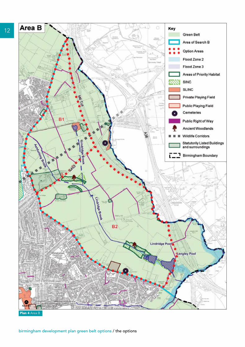
This area of search lies to the north east of the City and covers an area of 353 hectares. It is mainly in agricultural use with New Hall cemetery at the southern end. It adjoins the existing, predominantly residential, urban area to the west and the M6 Toll road to the east. The West Midlands Green Belt extends beyond the M6 Toll to Tamworth. Area B has been subdivided into two options.
Area B : West of the M6 Toll
To check the unrestricted sprawl of large built-up areas.
To prevent neighbouring towns from merging into one another.
To assist in safeguarding the countryside from encroachment.
To preserve the setting and special character of historic towns.
To assist in urban regeneration by encouraging the recycling of derelict and other urban land.
Area B prevents the expansion of the urban area eastwards at Roughley/Whitehouse Common.
The Green Belt extends 8km from the City’s urban area to Tamworth (6.5km from Area B’s outer boundary). 5km of Green Belt lies between Area B and the nearest small settlement (Kingsbury).
There are a number of ancient woodlands, SINCs and SLINCS and Flood Zones 2 and 3 within this area. The area has high landscape quality and is very open and visible to the wider countryside. The M6 Toll to the east forms a defensible boundary.
The function and nature of the Green Belt in Birmingham does not directly relate to the preservation of historic towns as all areas identified adjoin (in part in some instances) the urban area. Consideration has been given to historic features which have been noted in the criteria below.
The City’s Green Belt encourages urban regeneration by restricting the amount of greenfield land available for development.
Function of the Green Belt Performance against the criteria
Archaeology and Historic Environment.
Biodiversity.
Landscape/topography.
Archaeological features include prehistoric burnt mound near Withy Hill Lane; and a high potential for archaeological remains throughout the area which adjoins extensive prehistoric and Roman remains excavated around Langley Mill Farm and Langley Brook as part of M6 Toll construction. There are a number of historic buildings in prominent locations: Fox Hill House, Wheatmoor Farm, Ashfurlong Hall, High Heath Cottage and Beehive pottery kiln. Further assessment work would be required.
The area has a number of SINCs and SLINCs. Ancient Woodlands can also be found at two of these locations and a Wildlife Corridor runs through this area. Further more detailed assessment of the ecological value of all of the option area including SINCs/SLINCs will be required.
Ridges/high ground visible from the ‘open’ countryside to the east. More steeply sloping ground on which development would be more evident and more difficult to screen. Mixture of larger and smaller fields with woodland, hedgerow, and trees.
Other considerations
the options / birmingham development plan green belt options
11
Flood risk.
Access/infrastructure.
Mineral reserves.
Agricultural land quality.
Defensible boundary.
Employment site - 50 hectares or more.
Theoretical residential development capacity (minimum 40 dwellings per hectare) allowing for known constraints and other ancillary land uses including Open Space.
Flood Zone 2 and 3 identified but further modelling work required at Ashfurlong Brook and Lindridge Brook. Careful consideration is needed of the potential effects on Langley and Lindridge Pool as additional flows to Lindridge Brook would have an effect on these Pools.
Future development may put more pressure on traffic flows through Sutton Coldfield and increase the case for the Sutton relief road. Has access to the strategic road network at Bassetts Pole island. Poor bus service.
Large areas of sand and gravel and small areas of clay and silt.
Grade 3.
The M6 toll forms most of the defensible boundary for this area on the east of the site and the urban area to the west.
Both options could potentially provide a 50 hectare or more employment site, although constraints make this difficult.
Option B1 has an area of 112 hectares and an estimated minimum capacity of about 3,200 dwellings. Option B2 has an area of 230 hectares and an estimated minimum capacity of about 6,300 dwellings.
12
birmingham development plan green belt options / the options
Plan 4 Area B
nNORTH
the options / birmingham development plan green belt options
13
This area of search lies to the north east of the City and covers an area of 273 hectares. It adjoins the existing urban area to the west and the Sutton Coldfield bypass to the east. The land is predominantly in agricultural use. The Green Belt extends beyond the bypass along the whole length of the search area into Warwickshire. Area C has been subdivided into two options, one of which covers the entire area of search and the other excludes the northern part.
Area C : West of Sutton Coldfield Bypass, Walmley
To check the unrestricted sprawl of large built-up areas.
To prevent neighbouring towns from merging into one another.
To assist in safeguarding the countryside from encroachment.
To preserve the setting and special character of historic towns.
To assist in urban regeneration, by encouraging the recycling of derelict and other urban land.
Area C prevents the expansion of the urban area eastwards from Walmley, Thimble End and Falcon Lodge.
The nearest large settlements are Atherstone which is around 18km from the City’s urban area, and Tamworth which is 8km to the north west. The closest small settlement is Curdworth some 2.5km beyond Area C’s outer (eastern) boundary. The Green Belt extends into North Warwickshire, the boundary being around 1km to the west of Atherstone. Area C does not extend to the City boundary. A further area of Green Belt of between 1.2km and 2km in width lies between its outer boundary (A38) and the City boundary with North Warwickshire District. This forms Area D.
Some parts of the area have limited landscape value, and only a small number of constraints, it also has a defensible boundary to the east in the form of the A38.
The function and nature of the Green Belt in Birmingham does not directly relate to the preservation of historic towns as all areas identified adjoin (in part in some instances) the urban area. Consideration has been given to historic features which have been noted in the criteria below.
The City’s Green Belt encourages urban regeneration by restricting the amount of greenfield land available for development.
Function of the Green Belt Performance against the criteria
Archaeology and historic environment.
Biodiversity.
Archaeological remains include Prehistoric and Roman finds around Brockhurst Farm and Fox Hollies. Springfield Farm- probable medieval farm site in an enclosure. There are a number of historic buildings and structures within the area including, Pool dam and mill site near Brockhurst Farm, Old Langley Hall and associated features including the moat and fishponds, the setting of Springfield Farm, Langley Gorse Farm, Langley Heath Farm and Fox Hollies. Historic landscape features include parkland south of Fox Hollies. Further assessment work would be required.
A small Priority Habitat site and several SLINCs are located in the area. Further more detailed assessment of the ecological value of all of the option area including SINCs/SLINCs will be required.
Other considerations
14
birmingham development plan green belt options / the options
Landscape/topography.
Flood risk.
Access/infrastructure.
Mineral reserves.
Agricultural land quality.
Defensible boundary.
Employment site - 50 hectares or more.
Theoretical residential development capacity (minimum 40 dwellings per hectare) allowing for known constraints and other ancillary land uses including Open Space.
The north west of the area consists of large, open fields, with little or no hedgerows/field pattern within them. Located in a dip with raised ground to the east. Raised motorway junction signage, sewage works to the south east and woodland to the north east. Area C2 lies in a shallow basin/valley with raised ground to the north of Area C1. The north east of the area contains higher ground/valleys visible from the ‘open’ countryside to the north and east. A mixture of larger and smaller fields with woodland, hedgerow, and trees within them. The south of the site again comprises large, open fields, with little or no hedgerows/field pattern within them.
Flood Zone 2 and 3 identified but further modelling work required at Langley Brook.
Good access to the A38 and M6 Toll. Potential to increase capacity on Chester Road and other major routes. Bus services poor to the north of the area but more frequent services to Minworth to the south. No current rail access but potential to create a new rail station at Walmley and possible Park and Ride.
Elements of sand and gravel but also small areas of sand and clay.
Grade 3 (a) and 3.
This area has a defensible boundary. On the west it abuts the urban area and to the east the A38.
An employment site of 50 hectares or more could be accommodated on this area.
Option C1 has an area of 273 hectares and an estimated minimum capacity of about 7,900 dwellings. Option C2 consists of part of option C1 and has an area of 193 hectares and an estimated minimum capacity of about 5,500 dwellings.

the options / birmingham development plan green belt options
15
Plan 5 Area C
nNORTH
16
birmingham development plan green belt options / the options
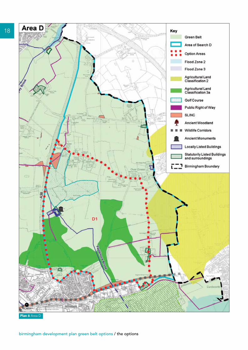
This area of search lies to the north east of the City and covers an area of 473 hectares. The search area is bounded by the Sutton Coldfield bypass to the west, the City boundary with North Warwickshire District Council to the east and Minworth sewage works to the south. The land use is predominantly agriculture but also includes a golf course. One option has been identified for this area.
Area D : East of Sutton Coldfield Bypass, Walmley
To check the unrestricted sprawl of large built-up areas.
To prevent neighbouring towns from merging into one another.
To assist in safeguarding the countryside from encroachment.
To preserve the setting and special character of historic towns.
To assist in urban regeneration, by encouraging the recycling of derelict and other urban land.
Area D lies between the City boundary and the A38. Its western (inner) boundary is 0.5km and 1km from the City’s urban area. The Area is surrounded by Green Belt other than at the south west corner where it adjoins the urban area at Minworth. This area prevents the further expansion (beyond Area C) of the urban area eastwards from Walmley, Thimble End and Falcon Lodge. It contains the small settlement of Over Green, a small number of farm buildings, and some residential dwellings.
The closest large settlements to the City’s urban area are Tamworth (8 km to the north west) and Atherstone (15km to the east). The Green Belt extends beyond Tamworth and stops just short of Atherstone. The closest small settlement is Curdworth some 0.5km beyond the outer (western) boundary of the area of search. To the west a further area of Green Belt (Area C) of between 1km and 1.75km width lies between this area and the City’s urban area.
Some parts of the area have limited landscape quality and limited constraints, although these include a scheduled ancient monument. This area lies in a shallow basin/valley but apart from this there is no obvious physical boundary.
The function and nature of the Green Belt in Birmingham does not directly relate to the preservation of historic towns as all areas identified adjoin (in part in some instances) the urban area. Consideration has been given to historic features which have been noted in the criteria below.
The City’s Green Belt encourages urban regeneration by restricting the amount of greenfield land available for development.
Function of the Green Belt Performance against the criteria
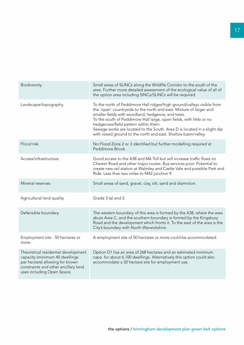
Archaeology and historic environment.
Many archaeological remains including burnt mound near Hurst Green Farm, prehistoric and Roman finds, former stream channels providing information on past environmental conditions, possible prehistoric ditches, boundary ditches of medieval fields. The setting of Peddimore Hall Scheduled Ancient Monument - in a basin and isolated - retains its original medieval setting. Settings of Grove End and Over Green and Wiggins Hill (groups of listed buildings, medieval and probably Roman settlements) are also notable. Historic landscape features include a field system between Ox Leys Road and Bulls Lane. Further assessment work would be required.
Other considerations
the options / birmingham development plan green belt options
17
Biodiversity.
Landscape/topography.
Flood risk.
Access/infrastructure.
Mineral reserves.
Agricultural land quality.
Defensible boundary.
Employment site - 50 hectares or more.
Theoretical residential development capacity (minimum 40 dwellings per hectare) allowing for known constraints and other ancillary land uses including Open Space.
Small areas of SLINCs along the Wildlife Corridor to the south of the area. Further more detailed assessment of the ecological value of all of the option area including SINCs/SLINCs will be required.
To the north of Peddimore Hall ridges/high ground/valleys visible from the ‘open’ countryside to the north and east. Mixture of larger and smaller fields with woodland, hedgerow, and trees.To the south of Peddimore Hall large, open fields, with little or no hedgerows/field pattern within them. Sewage works are located to the South. Area D is located in a slight dip with raised ground to the north and east. Shallow basin/valley.
No Flood Zone 2 or 3 identified but further modelling required at Peddimore Brook.
Good access to the A38 and M6 Toll but will increase traffic flows on Chester Road and other major routes. Bus services poor. Potential to create new rail station at Walmley and Castle Vale and possible Park and Ride. Less than two miles to M42 junction 9.
Small areas of sand, gravel, clay, silt, sand and diamicton.
Grade 3 (a) and 3.
The western boundary of this area is formed by the A38, where the area abuts Area C, and the southern boundary is formed by the Kingsbury Road and the development which fronts it. To the east of the area is the City’s boundary with North Warwickshire.
A employment site of 50 hectares or more could be accommodated.
Option D1 has an area of 268 hectares and an estimated minimum capa for about 6,100 dwellings. Alternatively this option could also accommodate a 50 hectare site for employment use.
18
birmingham development plan green belt options / the options
Plan 6 Area D
nNORTH
19


P&R/
11/?
??/A
/???
/02/
11