Biophysical variability and pastoral resource rights revisited Leif V. Brottem, Ph.D Department of...
12
Biophysical variability and pastoral resource rights revisited Leif V. Brottem, Ph.D Department of Political Science Global Development Studies Program Grinnell College World Bank Conference on Land and Poverty March 24, 2014
-
Upload
chad-booker -
Category
Documents
-
view
214 -
download
0
Transcript of Biophysical variability and pastoral resource rights revisited Leif V. Brottem, Ph.D Department of...

Biophysical variability and pastoral resource rights revisited
Leif V. Brottem, Ph.DDepartment of Political Science Global Development Studies Program
Grinnell College
World Bank Conference on Land and Poverty
March 24, 2014

0 25 5012.5 Kilometers
±
Historicgrazingarea for
Sahelian herds
The Fuladougouagro-pastoral zone in western Mali
Livestock mobility and resource access will be essential to climate resilient development in rural West Africa
Seasonal well dug in a dry stream bed
Brottem, March 24, 2014

Agricultural expansion in historically‘vacant’ areas used for grazing
Land cleared for agriculturebetween 2000 and 2010.
1. The ‘pastoral paradox’: herds in drylands need flexibility and mobility but also protection from agricultural encroachment(Fernandez-Gimenez 2002).
• Not just in West Africa butall over the continent
2. Policymakers tended to emphasize the variability of resource patches in such environments but this has not necessarily done herders much good.
Pastoral resources at risk
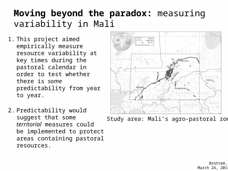
Moving beyond the paradox: measuring variability in Mali
1. This project aimed empirically measure resource variability at key times during the pastoral calendar in order to test whether there is some predictability from year to year.
2. Predictability would suggest that some territorial measures could be implemented to protect areas containing pastoral resources.
Study area: Mali’s agro-pastoral zone
Brottem, March 24, 2014

Critical periods in the West African agro-pastoral calendar: vegetation green up and brown down (senescence)
1. A previous stage in the project had calculated temporal change in seasonal vegetation patterns based on MODIS image-derived normalized difference vegetation index (NDVI) values.
2. For this stage, we needed to add spatial changes in vegetation during the most critical periods of the pastoral calendar: green up and brown down (senescence).
From: Butt, B., M. D. Turner, A. Singh, and L. Brottem. 2011. "Use of MODIS NDVI to evaluate changing latitudinal gradients of rangeland phenology in Sudano-Sahelian West Africa." Remote Sensing of Environment no. 115 (12): 3367-3376

To create a measurement of spatio-temporal change in vegetation, we used a landscape metric for land cover patch arrangement:
1. Mean proximity index (MPI, McGarigal and Marks 1995) measures the level of fragmentation of discrete land covers (e.g. ‘greened up’ areas)
2. We used MPI to measure green up and brown down changes in 4 important agro-pastoral zonesof Mali
June 9th 2005June 14th 2005June 19th 2005June 24th 2005
Pastoral zone green up over5-day intervals

155 160 165 170 175 180 185 1900
1000
2000
3000
4000
5000
6000
7000
Example: Mopti green up period: increase in MPI reflects less fragmentation of ‘green’
patches
Mopti green up period: change in mean proximity index
Calendar Julian Date (June 4th to July 9th)
Mea
n Pr
oxim
ity In
dex
By calculating changes in MPI for pixels that had ‘greened up’ or ‘browned down’ at the beginning and end of a given rainy season, respectively, we established a viable measure of spatio-temporal change in vegetation.
Brottem, March 24, 2014
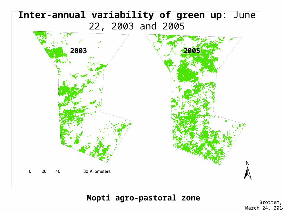
Inter-annual variability of green up: June 22, 2003 and 2005
Mopti agro-pastoral zone
2003 2005
Brottem, March 24, 2014

Key question: Despite some inter-annual variability, do some areas display longer-term predictability of green up and brown down patterns?
• Calculating longer-term (2000-2010) green up and brown down periods for each of the four zones, we found that certain places green up earlier and senesce later than average.
• We defined these places as ‘key pastoral resources areas’.
Brottem, March 24, 2014
Cattle drinking in an seasonal water sourceat the end of the rainy season.

Results: Each of thefour agro-pastoralzones had placesof early green up and late brown down.
Two of the sheds—Mopti and Gourma—are shown on the right.Early green up (top)and brown down (bottom) areas are darkened.

This is a serious matter!
1. Despite efforts to protect livestock mobility through measures such as livestock corridors, pastoral resource areas are often left out due to highly contentious land tenure issues.
2. Mali’s pastoral code calls on local governments to identify and protect such areas but the country’s land tenure law makes this difficult by codifying the customary rights of farmers.
3. Empirical evidence of pastoral resources will lend weight to efforts to provide them with stronger territorial protection.
Malian citizens deliberating over livestock corridors in their area
Thank you!
This project was made possible by the generous support of the USAID Mali Livestock and Pastoral Initiative (Grant #688-A-00-10-00131-00).
Two publications are thus far available from this research:
1. Brottem, Leif, Matthew D Turner, Bilal Butt, and Aditya Singh. 2014. "Biophysical Variability and Pastoral Rights to Resources: West African Transhumance Revisited." Human Ecology: 1-15.
2. Butt, B., M. D. Turner, A. Singh, and L. Brottem. 2011. "Use of MODIS NDVI to evaluate changing latitudinal gradients of rangeland phenology in Sudano-Sahelian West Africa." Remote Sensing of Environment no. 115 (12): 3367-3376.
Other cited works:
• Fernandez-Gimenez, M. E. 2002. "Spatial and Social Boundaries and the Paradox of Pastoral Land Tenure: a Case Study from Postsocialist Mongolia." Human Ecology no. 30 (1):49-78.
• McGarigal, K., and B. J. Marks. 1995. FRAGSTATS: Spatial pattern analysis program for quantifying landscape structure. In USDA Forest Service General Technical Report.