![V P V U R gq ^ ý u;Vóÿ d u;S:Wßÿ ^ WS S:Wß0]0nÿ ) N …...N N N N N N N N N N N N N N N N N N N N N N N N N N N N N N N N N P N1 N1 N1 N1 N1 N1 N1 N1 N1 N1 N1 N1 P P P N1 N1](https://static.fdocuments.us/doc/165x107/5fbf575d848b0b7e9575f4b2/v-p-v-u-r-gq-uv-d-usw-ws-sw00n-n-n-n-n-n-n-n-n-n.jpg)
Biondic n zrnovnica
20
Vulnerability mapping of the Novljanska Žrnovnica karstic spring catchment area in Croatia assoc.prof.dr.sc. Ranko Biondić assist.prof.dr.sc. Hrvoje Meaški prof. emeritus Božidar Biondić dr.sc. Jelena Loborec University of Zagreb, Croatia Faculty of Geotechnical Engineering
-
Upload
groundwatercop -
Category
Education
-
view
168 -
download
0
Transcript of Biondic n zrnovnica

Vulnerability mapping of the Novljanska Žrnovnica karstic spring catchment area in Croatia
assoc.prof.dr.sc. Ranko Biondićassist.prof.dr.sc. Hrvoje Meaškiprof. emeritus Božidar Biondić
dr.sc. Jelena Loborec
University of Zagreb, CroatiaFaculty of Geotechnical Engineering
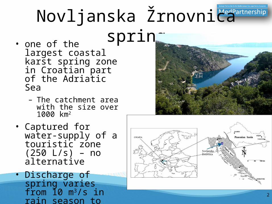
Novljanska Žrnovnica spring• one of the largest coastal
karst spring zone in Croatian part of the Adriatic Sea– The catchment area with
the size over 1000 km2
• Captured for water-supply of a touristic zone (250 L/s) – no alternative
• Discharge of spring varies from 10 m3/s in rain season to about 500 l/s in the dry season
2

• main aquifer is built of well permeable carbonate rocks
• very well researched area – lots of tracing tests, geological & hydrogeological maps
• typical catchment for the Dinaric karst region– surface flow – Gacka & Lika rivers– ponors groundwater flow– groundwater depth up to few hundreds
meters– discharging on coastal springs– coastal springs permanently or temporary
with problem of salinization– touristic zone – raising demands for the
water-supply• lots of springs in rain season, but in
dry season discharge decreasing and only Novljanska Žrnovnica remains for usage in water-supply
ponor of Gacka River
3

Contents of the project• Vulnerability mapping of the Novljanska Žrnovnica karstic spring
catchment area by the well-known methods:– the PI method (Goldscheider, 2002; Goldscheider et al., 2002)– the COP method (Vias et al., 2002)– the SINTACS method (Civita & De Maio, 2000)– the COST 620 project methodology (ed. Zwahlen, 2004)
• Using the experiences collected through the work with those four methods, the new method appropriate for the Dinaric karst terrains is developed – KAVA method– Karst Aquifer Vulnerability Assessment method
4

The PI method• two main factors:
– Protective cover (P)• factor R (recharge)• factor T (topsoil)• factor S (subsoil)• factor B (bedrock)
– factor L (lithology)– factor F (fracturing)– B=L*F
• factor A (Artesian pressure)• factor M (thickness of each stratum)
– Infiltration condition (I)• factor I’ (depth to low permeability layer;
slope)• SCM (surface catchment map – a, b, c, d, e
types)
5

the PI map – some conclusions after the usage in the Dinaric karst aquifer
• many subfactors of factor P (cover soils) – need for very detail researches• maximum recharge in tables is > 400 mm/year in Dinaric karst > 3500 mm/year ??• subfactor F (fracturing) - epikarst zones with F=0 totally eliminates the protective role of
unsaturated zone• flow conditions in the covering layers – very complex parameters scheme
6

The COP method
• factor C (Flow concentration)– distance to the sinking zone (db)– distance to the streams that sink (ds)– slope & vegetation conditions (sv)– surface karst features (sf)
• factor O (Overlaying layers)– soils (Os)– lithology (Ol)
• factor P (Precipitation)– precipitation quantity (Pq)– precipitation intensity (Pi)
7
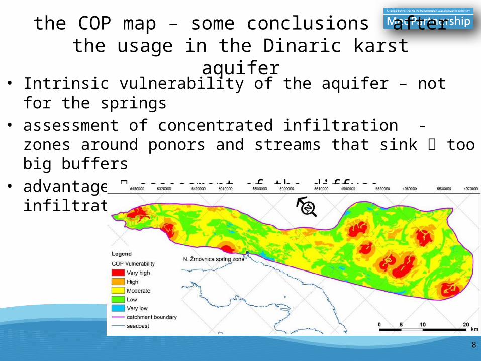
the COP map – some conclusions after the usage in the Dinaric karst aquifer
• Intrinsic vulnerability of the aquifer – not for the springs• assessment of concentrated infiltration - zones around ponors and
streams that sink too big buffers• advantage assessment of the diffuse infiltration of surface waters
8

The SINTACS method
• S1 – depth to groundwater• I – effective infiltration• N – unsaturated zone attenuation capacity• T – soil/overburden attenuating capacity• A – hydrogeological characterization of the aquifer• C – hydraulic characterization of the aquifer• S2 – hydrological role of the topographic slope
• due to the SINTACTS R5 weighted strings the catchment is in the scenario #4 – karst – deep karstified terrain
9

the SINTACS map – some conclusions after the usage in the Dinaric karst aquifer
• Aquifer intrinsic vulnerability – could be used for the vulnerability of springs with minor modifications
• At the first sight seems very complex, but it is obvious how each parameter is strictly defined and described in details no need to define additional parameters
10

COST 620 - some conclusions after the usage in the Dinaric karst aquifer
• Resource and source vulnerability map– Resource – the same as the COP map– Source – additional factor K – karst network development
• the European approach doesn’t offer some specific guidance for different subfactors, already recommends determination of different parameters
11
SOURCE VULNERABILITY MAP

The KAVA method
• Karst Aquifers Vulnerability Assessment (KAVA)
• based on four basic factors:– Overlay protection (O
factor)– Precipitation influence
(P factor)– Infiltration conditions (I
factor)– Aquifer conditions (A
factor)
12

Overlay protection(O factor)
• subfactor Os (soils)– protective role of covering soil– proposed by COP method; in KAVA method slightly simplified because
the Dinaric karst catchments are mostly without cover deposits• subfactor Okf (karst features)
– defines impacts of epikarst zones– number of doline per km2
13

Precipitation influence(P factor)
• subfactor Pe (effective precipitation)– can be obtained from previous researches, meteorological
maps, many empirical formulas (Keller, Srebrenović, Žugaj)• subfactor Pi (Precipitation intensity)
– from data about mean annual rainfall and the total number of rainy days in the catchment area
14

Surface Catchment Areas (SCA)
15

Infiltration conditions(I factor)
• Isv subfactor (slope & vegetation)– slope parameter from the DEM– vegetation from the Corine Land Cover map– SCA1 – area of the greatest vulnerability– SCA2 & SCA3 – according to the table
• Igwd subfactor (depth to groundwater)
16

Aquifer condition(A factor)
• Ahg subfactor (hydrogeological function of the rocks and deposits)
• Att subfactor (tracing tests)– only the tracing test performed during the rain period
17

Source and Resource Vulnerability Maps
• SV index – refers to the assessment of the intrinsic vulnerability of karst springs– applied subfactor with
tracing tests
• RSV index - refers to the assessment of the intrinsic vulnerability of karst aquifer
18
ExtremeVery HighHighModerateLowVery low
ExtremeVery HighHighModerateLowVery low

Conclusion
• all methods, including the KAVA method, were tested on the example of the karst catchment area of the Novljanska Žrnovnica spring, wich was selected as a typical catchment of the Dinaric karst region
• That’s the good base for renewing of delineation of the protection zones of the Novljanska Žrnovnica catchment area
• The KAVA method is developed with goal to in more realistic way present the intrinsic vulnerability of karst aquifers such as Dinaric karst aquifers, and we believe that the KAVA method will find its application in similar karst areas in the Mediterranean region
19

Thank you for your attention
Merci pour votre attention
النتباهكم شكرًا