BIOLOGICAL RESOURCES MANAGEMENT PLAN … Library...LA-UR-07-2595 April 2007 Approved for public...
60
BIOLOGICAL RESOURCES MANAGEMENT PLAN FOR LOS ALAMOS NATIONAL LABORATORY Purpose This management plan formalizes the biological resources management program for Los Alamos National Laboratory (LANL). It describes goals, objectives, and strategies for managing biological resources at LANL, and incorporates regulatory and statutory requirements for biological resources protection. It also fulfills a 1999 Site-wide Environmental Impact Statement Mitigation Action Plan commitment to include a biological resources management plan as part of integrated natural resources management. ADESHQ is the institutional point of contact for this plan. Signatures Approved by: Signature on file __________________________________________________ Richard S. Watkins, LANL Associate Director for ESH&Q Date: 21 September 2007
Transcript of BIOLOGICAL RESOURCES MANAGEMENT PLAN … Library...LA-UR-07-2595 April 2007 Approved for public...

BIOLOGICAL RESOURCES MANAGEMENT PLAN FOR LOS ALAMOS NATIONAL LABORATORY
Purpose This management plan formalizes the biological resources management program for Los Alamos National Laboratory (LANL). It describes goals, objectives, and strategies for managing biological resources at LANL, and incorporates regulatory and statutory requirements for biological resources protection. It also fulfills a 1999 Site-wide Environmental Impact Statement Mitigation Action Plan commitment to include a biological resources management plan as part of integrated natural resources management. ADESHQ is the institutional point of contact for this plan.
Signatures Approved by:
Signature on file __________________________________________________
Richard S. Watkins, LANL Associate Director for ESH&Q
Date:
21 September 2007

LA-UR-07-2595 April 2007 Approved for public release; distribution is unlimited.
Title: Biological Resources Management Plan for Los Alamos National Laboratory
Author(s): Leslie Hansen, Carey Bare, Gil Gonzales, John Isaacson, Sam Loftin, and Kathy Bennett

Los Alamos National Laboratory, an affirmative action/equal opportunity employer, is operated by the Los Alamos National Security, LLC for the National Nuclear Security Administration of the U.S. Department of Energy under contract DE-AC52-06NA25396. By acceptance of this article, the publisher recognizes that the U.S. Government retains a nonexclusive, royalty-free license to publish or reproduce the published form of this contribution, or to allow others to do so, for U.S. Government purposes. Los Alamos National Laboratory requests that the publisher identify this article as work performed under the auspices of the U.S. Department of Energy. Los Alamos National Laboratory strongly supports academic freedom and a researcher’s right to publish; as an institution, however, the Laboratory does not endorse the viewpoint of a publication or guarantee its technical correctness.
Edited by: Hector Hinojosa, Group IRM-CAS
Cover photo: Pajarito Mountain.
An Affirmative Action/Equal Opportunity Employer

Biological Resources Management Plan iii
CONTENTS List of Acronyms .......................................................................................................................vi Executive Summary .................................................................................................................vii 1.0 Introduction .........................................................................................................................1
1.1. Purpose and Need.................................................................................................................................. 1 1.2. Applicability ........................................................................................................................................... 1 1.3. Plan Organization and Use .................................................................................................................. 2 1.4. Roles and Responsibilities.................................................................................................................... 2
2.0 Description of Biological Resources.....................................................................................4 2.1. Soils, Landforms, and Topography.................................................................................................... 4 2.2. Climate .................................................................................................................................................... 6 2.3. Prehistoric and Historic Human Influences ..................................................................................... 7 2.4. Plant Communities and Fire ............................................................................................................. 10 2.5. Biota ...................................................................................................................................................... 10 2.6. Rare and Sensitive Habitats .............................................................................................................. 14 2.7. Contaminants in Biological Resources and Ecological Risk ........................................................ 19
3.0 Biological Resources Management at Los Alamos National Laboratory ...........................22 3.1. Legal Requirements ............................................................................................................................ 22 3.2. Institutional Policy .............................................................................................................................. 24 3.3. Summary of Objectives and Strategies............................................................................................ 25
4.0 Site Planning......................................................................................................................27 4.1. Los Alamos National Laboratory Site Land Uses.......................................................................... 27 4.2. Biological Resources Management Site Planning Principles ....................................................... 29 4.3. Objectives and Strategies ................................................................................................................... 30 4.4. Criteria for Evaluating Biological Value......................................................................................... 30 4.5. Planning Recommendations .............................................................................................................. 33 4.6. Potential Areas of Conflict................................................................................................................. 33
5.0 Landscape Management.....................................................................................................36 5.1. Objectives and Strategies ................................................................................................................... 36 5.2. Related Plans: LANL Wildland Fire Management Plan .............................................................. 38 5.3. Status of Fuels Management Activities............................................................................................ 38
6.0 Species Management..........................................................................................................40

Biological Resources Management Plan iv
6.1. Objectives and Strategies ................................................................................................................... 40 7.0 Ecological Risk Management.............................................................................................41
7.1. Objectives and Strategies ................................................................................................................... 41 8.0 Biological Resources Data Management............................................................................43
8.1. Design and Software ........................................................................................................................... 44 8.2. Maintenance......................................................................................................................................... 44
References................................................................................................................................45 List of Tables Table 1. Federally Listed Threatened and Endangered Species Potentially Occurring at
LANL..........................................................................................................................16
Table 2. Sensitive Species Occurring or Potentially Occurring at LANL. ..................................16 Table 3. Birds of Concern Potentially Occurring at LANL. .......................................................17
Table 4. Potentially Occurring Imperiled or Vulnerable Ecological Associations at LANL........18 Table 5. Canyon Systems and Number of Springs. ....................................................................19
Table 6. Objectives and Strategies for LANL’s Biological Resources Management Plan...........26 Table 7. Criteria to Develop Proof of Concept Data Layer. .......................................................31
List of Figures Figure 1. Relationship of organizations within LANL relative to implementation of
the BRMP. ...................................................................................................................3 Figure 2. Location and physical setting of LANL........................................................................5
Figure 3. Regional map and generalized geology surrounding LANL..........................................6 Figure 4. Aerial photograph of Los Alamos town site area taken in 1935 showing the
extensive land areas used for dry-land farming. ............................................................8 Figure 5. Fire occurrence by decade, from the WALTER (Wildfire Alternatives) Project
website.......................................................................................................................11 Figure 6. Quarter-hectare land cover map from 2001 satellite imagery. .....................................12
Figure 7. Site-wide area development plan from LANL’s Comprehensive Site Plan (LANL 2001). ............................................................................................................28
Figure 8. Proof of concept map showing biological values for LANL property..........................32 Figure 9. Zones for future development possibilities. ................................................................34

Biological Resources Management Plan v
Figure 10. A) Mexican spotted owl core habitat and a large-game migration corridor with a constriction point crossing Pajarito Road in the Pajarito West Corridor. B) A large-game migration corridor with a constriction point crossing Pajarito Road at TA-51. C) A large-game migration corridor and constriction point crossing Pajarito Road at TA-54. D) Mexican spotted owl core habitat near the Research Park and TA-62. .......35
Figure 11. Location of thinning activities conducted following the Cerro Grande Fire, 2001–2004. ................................................................................................................39
Figure 12. Diagram of GIS use in the BRMP. ...........................................................................43

Biological Resources Management Plan vi
List of Acronyms AOC area of concern BRMP Biological Resources Management Plan CAP Corrective Actions Project CERCLA Comprehensive Environmental Response, Compensation, and Liability Act DOE US Department of Energy EMS Environmental Management System ENV Environmental Protection (Division) ENV-EAQ Ecology and Air Quality Group EPA US Environmental Protection Agency GIS geographic information system HSWA Hazardous and Solid Waste Amendment IWD Integrated Work Document JHA Job Hazard Analysis LANL Los Alamos National Laboratory LANS Los Alamos National Security, LLC LANSCE Los Alamos Neutron Science Center LPR Laboratory Performance Requirement NEPA National Environmental Policy Act NFA No Further Action NMED New Mexico Environment Department NNSA National Nuclear Security Administration PR-ID permits and requirements identification RCRA Resource Conservation and Recovery Act SWMU solid waste management unit TA Technical Area

Biological Resources Management Plan vii
Executive Summary Activities at Los Alamos National Laboratory (LANL) must comply with federal and state regulations that govern the protection of biological resources. In addition, the National Nuclear Security Administration/US Department of Energy and Los Alamos National Security, LLC recognize their obligation to act as responsible stewards of the LANL site. The Biological Resources Management Plan (BRMP) addresses LANL’s commitment to conduct site operations using processes that minimize risk to both mission implementation and biological resources. The BRMP describes objectives, strategies, and actions that fulfill the following goals:
1. Mission Support: Ensure and facilitate compliance with biological resource laws and regulations
2. Site Stewardship: Identify and mitigate adverse impacts on biological resources
3. Regional Commitment: Meet responsibilities as a good neighbor and trustee of natural resources
Preliminary analysis of relative biological value of LANL: dark brown indicates development is not recommended, tan indicates development should be mitigated, and green indicates development can proceed without mitigation. These BRMP goals (mission support, site stewardship, and regional commitment) will be met by focusing on the following objectives:
• Improve tools for planning, decision analysis, and project review
• Protect special classes of species (federally listed species, state-listed species, migratory birds)
• Protect sensitive habitats (wetlands, floodplains, riparian areas)
• Minimize and mitigate environmental risks to biota from contaminants
• Maintain ability of large-game animals to migrate across LANL property
• Continue educational, outreach, and collaborative efforts
Sections 1–3 of the BRMP are introductory. They discuss the need for the plan, describe
Mexican spotted owl chicks at LANL

Biological Resources Management Plan viii
LANL’s biological resources, and identify the applicable policy and regulatory drivers for objectives, strategies, and actions. Section 4 (Site Planning) describes the methodology and initial products for evaluating overall biological resources value of site locations. Products show the relative biological value of different areas at LANL and a map of zones of relative adverse impacts of development (see map, previous page or Fig. 9). These analyses are useful for
• planning future development to minimize environmental impacts,
• quantifying biological resources impacts for compliance documentation, and
• improving LANL’s project review processes with respect to biological resources compliance.
These analyses would be updated as more detailed information becomes available through implementation of the BRMP strategies. Section 5 (Landscape Management) describes approaches for management of landscape-scale biological resources (i.e., wetlands and floodplains protection, maintenance of large-animal migration corridors, habitat management). Recommendations from this section include
• continuing to update and implement the Threatened and Endangered Species Habitat Management Plan for federally listed species,
• identifying locations of large-game migration corridors and developing management strategies to protect them, and
• continuing to participate in regional collaboration efforts such as the East Jemez Resources Council.
Section 6 (Species Management) describes approaches for managing localized issues or
populations of protected species (sensitive species, migratory birds) and other species of special interest. Recommendations from this section include
• developing sensitive species best management practices,
• implementing migratory bird best management practices, and
• providing guidelines to minimize animal-vehicle collisions.
Section 7 (Ecological Risk Management) considers the special case of mitigating and managing the risks to LANL’s biological resources of contaminants produced by legacy and current operations. Recommendations from this section include
• developing a long-term biota contaminant monitoring plan,
• continuing or initiating monitoring of certain sensitive classes of biota, and
• continuing support of environmental remediation actions through ecological risk assessment.
Section 8 (Biological Resources Data Management) describes the database and geographic information system used by LANL to store, manage, and use data. The Laboratory has legal and stewardship responsibilities to manage biological resources. This BRMP provides LANL with a consistent approach to protect biological resources and monitor, assess, and mitigate impacts to them from site development and environmental restoration activities. It also provides strategies for reducing costs and time delays to projects by streamlining and improving planning and project review.

Biological Resources Management Plan 1
1.0 Introduction Los Alamos National Laboratory (LANL) is a nuclear weapons laboratory operated by the National Nuclear Security Administration (NNSA) of the US Department of Energy (DOE) and currently managed under contract by Los Alamos National Security, LLC (LANS). The primary mission of LANL is to
• ensure the safety and reliability of the US nuclear deterrent,
• reduce the global threat of weapons of mass destruction, and
• solve national problems in energy, environment, infrastructure, and health security.
All activities at LANL must comply with federal and state regulations that govern the protection of biological resources. NNSA/DOE and LANS have established internal policies designed to ensure compliance with these regulations. In addition, NNSA/DOE and LANS recognize their obligation to act as stewards of biological resources at LANL by pursuing strategies that consider the biological resources as part of a larger regional context that includes the public; Native American tribes; county, state, and federal land managers; and other stakeholders. Implementing mission activities in a compliant, cost effective, and sustainable manner is a critical component of successfully managing daily and long-term operations. 1.1. Purpose and Need The Biological Resources Management Plan (BRMP) addresses a DOE/NNSA and LANS commitment to enhance site operations with a process that minimizes risk to both mission implementation and the biological resources within and around LANL. The BRMP is an overarching
document that identifies priorities for biological resources management at LANL and gaps in current processes and programs and provides a roadmap for improving LANL’s biological resources management. The BRMP includes goals, objectives, strategies, and actions that are inclusive of compliance and stewardship drivers for
• mission support, • site stewardship, and • a regional approach to
implementation.
Implementation of the BRMP will provide better tools to identify compliance requirements and evaluate the relative impacts of different planning alternatives on biological resources. The BRMP also takes a proactive approach in identifying and implementing options for biological resources protection that support site stewardship beyond compliance requirements and that anticipate future regulatory trends to minimize potential future disruptions to mission-related activities. LANL projects and activities must be planned and implemented in a manner that minimizes risk to both institutional activities and the surrounding environs. The BRMP was developed based on legal requirements that direct an ecosystem management approach toward resource management.
1.2. Applicability The BRMP is guidance that applies to LANL organizations unless there is a management decision not to apply it. This plan will not have a retroactive effect. The BRMP does not create any right, benefit, or trust responsibility, substantive or procedural, enforceable against LANL, its employees, or any person.

Biological Resources Management Plan 2
1.3. Plan Organization and Use The BRMP is designed to assist site program and project managers and resource professionals in prioritizing and implementing biological resources protection activities. Goals, Objectives, and Strategies—The overall goals, objectives, strategies, and recommended major implementation actions for LANL’s BRMP are summarized in Section 3. Site Planning—Section 4 contains the methodology and initial products for evaluating overall biological resources value of site locations and for providing planners with information on where development will have the least adverse impacts. Products include a map showing the relative biological value of different areas of LANL and a map of zones of relative adverse impacts of development. These maps are designed for use in planning future development to minimize environmental impacts and in quantifying biological resources impacts for compliance documentation, such as preparation of National Environmental Policy Act (NEPA) documents. Landscape Management—Section 5 describes approaches for management of landscape-scale biological resources (i.e., federally listed threatened and endangered species habitat management, wetlands and floodplains protection, maintenance of large-animal migration corridors). Species Management—Section 6 describes approaches for management of protected species (i.e., sensitive species, migratory birds) and other species of special interest.
Ecological Risk Management—Section 7 considers the special case of mitigating and managing the risks to LANL’s ecological systems from contaminants resulting from legacy and current operations. Biological Resources Data Management—Section 8 describes the database and geographic information system (GIS) used by LANL to store, manage, and use data. 1.4. Roles and Responsibilities Effective implementation of the BRMP requires that roles and responsibilities be well defined within LANL. Figure 1 depicts the broad overall relationships of positions and organizations within LANL related to BRMP implementation. Under current LANL structure, roles and responsibilities are listed below. Laboratory Director: The Director has the authority for decisions on LANL policy regarding management of biological resources.
Environmental Protection (ENV) Division: ENV Division staff serve as subject matter experts (with coordination of Infrastructure Planning subject matter experts where appropriate).
• Prepare, maintain, update, and implement the BRMP.
• Conduct project reviews (excavation permits and permits and requirements identifications [PR-IDs]).
• Develop and maintain databases and GIS tools; conduct GIS analyses (with support from GIS specialists in other Divisions, as needed).
• Identify best management practices for projects and activities to reduce risks to biological resources and comply with regulatory guidelines.

Biological Resources Management Plan 3
Program or Project Managers • Incorporate best management
practices for protection of biological resources into project planning and implementation.
• Ensure funding will support requirements, as appropriate.
• Coordinate with subcontractors to ensure best management practices are followed and requirements are met.
• Fund and support plan actions, as appropriate.
Integrated Work Document (IWD) Preparers
• Contact Ecology and Air Quality Group (ENV-EAQ) subject matter experts when directed to do so by the Job Hazard Analysis (JHA) Tool.
• Ensure best management practices identified in the JHA Tool or by subject matter experts are incorporated into the job activities.
Environmental Management System (EMS) Specialists
• Ensure impacts to biological resources are considered when identifying environmental aspects and impacts of work activities and incorporate best management practices into procedures.
• Incorporate targets that improve protection of biological resources into annual EMS action plans.
Workers • Follow procedures and best
management practices as defined in work documents.
• Assist, as desired, in voluntary monitoring and reporting activities.
Figure 1. Relationship of organizations within LANL relative to implementation of the BRMP.
Laboratory Director
-
Prepare IWDs
Guidance, Oversight, and Support
Resource monitoring -
Guidance
Programmatic Work and Operations
Oversight and Support
Establishes policies for BRMP Applicable to all programs and operations
Implementation Responsibilities All Divisions
Ensure PR IDs prepared for all projects Implementation of mitigation action plans
Responsibilities ENV Division, Site Planning,
EMS Specialist PR ID review
Mitigation planning
Fulfill identified requirements
Contractor Projects

Biological Resources Management Plan 4
2.0 Description of Biological Resources
LANL and the associated town sites of Los Alamos and White Rock are located on the Pajarito Plateau at the eastern edge of the Jemez Mountains in north-central New Mexico, approximately 60 miles north-northeast of Albuquerque and 25 miles northwest of Santa Fe (Figure 2). Surrounding land is largely undeveloped, and land north, west, and south of LANL is administered by the Santa Fe National Forest, Bureau of Land Management, Bandelier National Monument, General Services Administration, and Los Alamos County. The Pueblo of San Ildefonso borders LANL to the east. 2.1. Soils, Landforms, and Topography The current Jemez Mountains were formed approximately 1.1 to 1.6 million years ago by series of volcanic eruptions that released nearly 75 cubic miles of glowing ash (Pettitt 1990). The ash cooled and consolidated, forming volcanic tuff plateaus west and south of the eruption. During the volcanic eruptions, subsidence formed a caldera approximately 12 miles across in the heart of the Jemez Mountains. This caldera is now known as the Valles Caldera (Figure 3) and contains five large, high-elevation grassland valleys and numerous forested peaks. The rim of the caldera forms a string of mountain peaks directly west of the Pajarito Plateau, known as the Sierra de los Valles. The Pajarito Plateau is an approximately 900-foot layer of solidified volcanic ash, or tuff, at the eastern base of the Jemez Mountains (Powers 2005). Within its roughly 220-square-mile expanse, the plateau ranges from 5,500 feet to approximately 8,000 feet in elevation. The
Rio Grande has incised a deep gorge, White Rock Canyon, along the eastern edge of the Plateau. A dozen deep canyons trending west to east cut the Plateau into long, sloping mesas. Two of these canyons, Frijoles and Santa Clara, contain permanent streams. The volcanically derived soils on the Pajarito Plateau vary greatly in geochemical characteristics (Longmire et al. 1996). Of the 10 recognized soil orders, only five exist in the Los Alamos area: Alfisols, Aridisols, Entisols, Inceptisols, and Mollisols, with about 80% of the county soils in the Alfisol and Entisol soil orders (Nyhan et al. 1978). Alfisols are well-developed, moderately leached forest soils with relatively high native fertility, containing a subsurface horizon in which clays have accumulated. Entisols are relatively undeveloped soils of recent origin, frequently found in steep, rocky settings. About 20% of Los Alamos County consists of rock outcrop mapping units, and 38% of the county contains soil complexes with rock outcrop (Nyhan et al. 2001). Several distinct soils have developed in and around LANL. Soils that formed on mesa tops include the Carjo, Frijoles, Hackroy, Nyjack, Pogna, Prieta, Seaby, and Tocal soil series. All of these soils are well drained and range from very shallow (0 to 10 inches) to moderately deep (20 to 40 inches), with the greatest depth to the underlying Bandelier Tuff being about 40 inches. Approximately 6.6% of LANL acreage is bare soil. Soil erosion rates vary considerably on mesa tops at LANL, with highest rates occurring in drainage channels and areas of steep slopes and lowest rates occurring on gently sloping portions of the mesa tops away from channels.

Biological Resources Management Plan 5
Figure 2. Location and physical setting of LANL.

Biological Resources Management Plan 6
Figure 3. Regional map and generalized geology surrounding LANL (SWEIS Project Office 1997). 2.2. Climate Los Alamos has a temperate, semiarid mountain climate. However, its climate is strongly influenced by elevation, and large temperature and precipitation differences are observed in the area because of topography. Los Alamos has four distinct seasons. Winters are generally mild, but occasionally winter storms produce large amounts of snow and below-freezing temperatures. Spring is the windiest season of the year. Summer is the rainy season in Los Alamos,
when afternoon thunderstorms and associated hail and lightning are common. Fall marks the end of the rainy season and a return to drier, cooler, and calmer weather. Climate statistics discussed below summarize analyses given in Bowen (1990 and 1992). The sloping nature of the Pajarito Plateau causes cold-air drainage, making the coolest air settle in the valley. The Sangre de Cristo Mountains to the east act as a barrier to arctic air masses affecting the central and

Biological Resources Management Plan 7
eastern US. The temperature does occasionally drop well below freezing, however. Another factor affecting the temperature in Los Alamos is the lack of moisture in the atmosphere. With less moisture, there is less cloud cover, which allows a significant amount of solar heating during the daytime and radiative cooling during the nighttime. This heating and cooling often causes a wide range of daily temperatures. Winter temperatures range from 30°F to 50°F (-1°C to 10°C) during the daytime to 15°F to 25°F (-9°C to -4°C) during the nighttime. The record low temperature (LANL 2005) recorded in Los Alamos is -18°F (-28°C). Winter is usually not particularly windy, so extreme wind chills are uncommon at Los Alamos. Summer temperatures range from 70°F to 88°F (21°C to 31°C) during the daytime to 50°F to 59°F (10°C to 15°C) during the nighttime. Temperatures occasionally will break 90°F (32°C). The highest temperature (LANL 2005) recorded in Los Alamos is 95°F (35°C). The average annual precipitation in Los Alamos from 1971 to 2000 was 18.95 inches. The average snowfall for a year is 58.2 inches. The snow is usually a dry, fluffy powder with an average equivalent water-to-snowfall ratio of 1:20. The summer rainy season accounts for 48% of the annual precipitation. 2.3. Prehistoric and Historic Human
Influences The Pajarito Plateau has been used by humans for at least 10,000 years. The following information has been summarized from Foxx et al. (1997) and other cited sources. Around the late 1100s, Pueblo Indians settled in the area and began agriculture on the mesas and canyon bottoms (Powers 2005). Large pueblo settlements were in place in the late 1300s,
but were abandoned about 1500 AD, possibly due to drought and soil depletion (Powers 2005). Domestic livestock were introduced to the region by the Spanish beginning in 1598. Between the late 1500s and the mid-1800s, there was probably low-intensity agricultural and grazing use of the Pajarito Plateau both by Pueblo Indians and by settlers of European descent (Foxx and Tierney 1999). Beginning in the mid-1800s, larger commercial operations involving sheep, goats, and cattle were introduced onto the Plateau (Sydoriak et al. 2000). Sheep were the major domestic livestock until the late 1800s, when cattle became more profitable. For example, from approximately 1885 through 1887, the Ramon Vigil Grant (which included some property currently controlled by LANL) was rented to a Texas cattleman, W. C. Bishop, who ran 3,000 head of cattle on 32,000 acres. After the Homestead Act of 1862, the Plateau west and north of the Ramon Vigil Grant became homesteads for summer grazing areas and subsistence agriculture (Figure 4). The Act granted quarter-sections of land to any settler who occupied a site for five years. Sections of mesa top and canyon bottom were cleared for such crops as beans, wheat, corn, alfalfa, and oats. In addition to cash crops, settlers usually had small vegetable gardens and fruit orchards near their cabins. Settlers also kept small herds of goats, horses, cattle, and sheep. By 1937, 35 homesteads occupied about 6 square miles of the Pajarito Plateau. In 1897, H. S. Buckman bought logging and timber rights to the Ramon Vigil Grant. A newspaper article of December 1903 speculated that Buckman cut 36,000,000 board feet on the 32,000-acre grant. Areas adjacent to the Grant were also logged when the land was sold to the Ramon Land and Lumber Company in 1906. The logging industry continued clear-cutting areas into the 1940s.

Biological Resources Management Plan 8
Figure 4. Aerial photograph of Los Alamos town site area taken in 1935 showing the extensive land areas used for dry-land farming (National Archives and Record Service, Washington, DC, Rio Grande Series No. 1477). Scale is 1:4680.
Ashley Pond

Biological Resources Management Plan 9
Bandelier National Monument was established in 1916, but livestock grazing was allowed on the Monument until 1932 (Sydoriak et al. 2000). Much of the Ramon Vigil Grant along with properties of homesteaders and the Los Alamos Boys Ranch were acquired by the Federal Government in 1943 for the Manhattan Project. Los Alamos County was established by state statute in 1948 from Santa Fe and Sandoval counties. The communities of Los Alamos and White Rock developed as a result of the Manhattan Project and establishment of LANL (Foxx et al. 1997). Currently, LANL is divided into technical areas that are used for office space,
experimental areas, waste disposal locations, and other mission-related uses. However, these uses account for only a small part of the total land area. Development is limited by steep slopes, by the need for security and safety buffers, and because of the work being performed. Over one-half of the total acreage has slopes with grades over 20%, making development very difficult. In addition, much of the area that could be developed is needed for security and safety buffers. NNSA/DOE has the option to completely restrict public access to LANL. However, the public is currently allowed limited recreational access to certain areas. Neither Bandelier National Monument nor LANL allow hunting, farming, or grazing on
Drought at the Beginning of the 21st Century: There is no standard quantitative or legal definition of “drought.” The term refers to an extended period of below-normal precipitation, generally long enough to have pronounced effects on plants, rivers, or reservoirs. Parts of New Mexico are currently in a long-term meteorological drought caused by a multi-year precipitation deficit that has built up since the late 1990s (Gutzler 2003). North-central New Mexico, including Los Alamos County, has been one of the most drought-stricken areas in the state. Los Alamos averaged 77% of normal precipitation from 1999 through 2002, which is in the lowest 2 percentile, or equivalent to a 75- to 100-year drought (similar to the way a 75- to 100-year flood event would be described). During 2003, Los Alamos had 55% of normal precipitation (National Weather Service 2004). Drought made pinõn and other trees susceptible to invasion by bark beetles. Mortality of pinõn trees in New Mexico was first noted in and around Los Alamos, Española, and Taos in 2001 and spread to other areas in the state in 2002 (Santa Fe Pinõn Initiative 2004). Conditions are much better now (2007) than they were during the worst year (2003) but no one can predict when the drought will be over.

Biological Resources Management Plan 10
their properties. Timber harvest is limited to forest fuel management activities. 2.4. Plant Communities and Fire By 1999, two dominant forest types occupied the majority of the undeveloped portions of LANL: piñon-juniper woodlands (46.2%) and ponderosa pine forest (29.3%). Other vegetative cover types at LANL include mixed conifer forests on the north-facing slopes of canyons and juniper woodlands at lower elevations near the Rio Grande. Areas at LANL previously affected by the La Mesa Fire or cleared for agriculture contained grasslands or oak shrublands. Each of the two dominant forest types had its own characteristics; however, they showed effects of fire suppression and grazing practices over the last 100 years. The most obvious effects of fire suppression have been an increase in overall tree stand densities and continuity with a concomitant decrease in understory cover. These conditions have resulted in an increase in the occurrence of severe wildfires. Since the 1970s, almost the entire eastern slope of the Jemez has been affected by forest fires (Figure 5). Recent extreme drought and the Cerro Grande Fire in 2000 changed the extent and condition of much of the forest, range, and soils of the LANL site. Bark beetle outbreaks have killed more than 90% of the piñon trees greater than 10 feet tall, as well as many mature trees in ponderosa pine and mixed conifer forest types (R. Balice, pers. comm.). Site soils have become more vulnerable to erosion because of loss of vegetation and increased flooding potential resulting from the fire. Thinning efforts in the ponderosa pine forest types since 2000 have reduced tree densities on large areas of
LANL property. Vegetative communities at LANL are currently in a dramatic state of flux and it is not certain what future boundaries will be for vegetation cover types in the landscape. Analysis of 2001 satellite imagery (Figure 6, taken after the Cerro Grande Fire, but before most thinning and bark-beetle-induced tree mortality) documented the following five most abundant cover types on LANL property: piñon-juniper, 39.4%; ponderosa pine, 18.8%; urban-sparse-bare rock, 13.0%; shrublands, 11.2%; and grasslands, 10.0% (McKown et al. 2003). 2.5. Biota Although the Jemez Mountains are technically a secondary range of the San Juan Mountains, they are characterized by a marked degree of topographic isolation (Cook et al. 2000). The Jemez Mountains form part of the southern boundary of the Rocky Mountain Biotic Province (Cook et al. 2000). An analysis of the native vertebrate and butterfly faunas of the Jemez, San Juan, and Sangre de Cristo mountain ranges in New Mexico found that for birds and mammals, the fauna of the Jemez Mountains is very similar to the fauna found in the Sangre de Cristo and San Juan mountain ranges, but with some species missing from the Jemez. On the other hand, butterflies, reptiles, and terrestrial amphibian species appear to be highly differentiated among the mountain ranges and may have unique occurrences in the Jemez. For example, species of butterflies differed substantially between the Jemez and San Juan mountain ranges, and one species (the silver-bordered fritillary, Boloria selene) was reported only from the Jemez.

Biological Resources Management Plan 11
Figure 5. Fire occurrence by decade, from the WALTER (Wildfire Alternatives) Project website, http://walter.arizona.edu/overview/study_areas/jemez_ fire_history.asp (last accessed 9/6/05).

Biological Resources Management Plan 12
Figure 6. Quarter-hectare land cover map from 2001 satellite imagery (McKown et al. 2003).
White Rock

Biological Resources Management Plan 13
The Cerro Grande Fire: On May 4, 2000, Bandelier National Monument employees began the Cerro Grande prescribed burn. Three days later, pushed by strong winds, the fire spread outside the project area. It ultimately spread into the town of Los Alamos, New Mexico, destroying 239 residential structures, and also spread onto lands administered or owned by the Santa Fe National Forest, LANL, and San Ildefonso and Santa Clara Pueblos. More than 18,000 residents of the towns of Los Alamos and White Rock were evacuated, and 429 families lost their homes in the fire. The Cerro Grande Fire remains the most costly federal fire disaster, with nearly $570 million in disaster expenses and claims paid to individuals, businesses, communities, and tribes. About 7,678 acres of LANL lands burned and 112 LANL structures were lost. However, all major structures at LANL were secured and no releases of radiation occurred. The Cerro Grande Fire is estimated to have covered a total of 42,870 acres. Forty percent of the Cerro Grande Fire area was burned at high fire intensity, with greater than 70% mortality of trees, while 33.1% burned at moderate to low intensity, with 10% to 40% mortality of trees. The most frequently burned cover types over the entire Cerro Grande Fire were ponderosa pine forest and mixed conifer forest. Portions of the fire that burned on LANL property were predominantly in ponderosa pine forests, whereas the Cerro Grande Fire burned primarily in mixed conifer forests on lands managed by other agencies (Balice et al. 2004).
Pueblo Canyon west of Los Alamos town site following Cerro Grande Fire.

Biological Resources Management Plan 14
Jemez Mountains salamander
One terrestrial salamander is endemic to the Jemez Mountains (the Jemez Mountains salamander, Plethodon neomexicanus). Cook et al. (2000) concluded that most differences in vertebrate faunal composition among the three mountain ranges are influenced by the past local extinction of isolated populations in the Jemez. However, the occurrence of butterfly populations found in the Jemez and not found in the other Rocky Mountain ranges in New Mexico could be influenced by differences in habitat availability or the protection provided by relatively undisturbed habitats at LANL and Bandelier National Monument. Federally listed species, sensitive species, and birds of conservation concern occurring or potentially occurring on LANL property are given in Tables 1, 2, and 3. Movements and distribution of large ungulates and carnivores are of special interest to some LANL stakeholders, particularly the governments, agencies, and tribes owning or controlling adjacent properties. Mountain lion, black bear, Rocky Mountain elk, and mule deer are all game species that may undergo seasonal migrations or periodic movements across LANL property, as well as being resident on LANL. LANL activities have potential to affect availability of these species to tribal
residents hunting on San Ildefonso lands as well as natural movement patterns of these species onto and off of property managed by
the US Forest Service and the National Park Service. Bandelier National Monument has identified concerns for negative impacts of high elk numbers on plant communities, soil erosion, and protection of archeological sites (Allen 1996).
2.6. Rare and Sensitive Habitats
Most vegetation types that occur in the Jemez Mountains and on the Pajarito Plateau also occur in the other Southern Rocky Mountain ranges in New Mexico (Cook et al. 2000). A search of the NatureServe web database (http://www.natureserve.org/explorer/index.htm, accessed 8/10/05) identified 10 globally imperiled or vulnerable ecological associations that potentially occur on LANL (Table 4). Most of these ecological associations consist of riparian-associated vegetation types or dry grasslands. Since small ecological associations are not all well defined, and have not been specifically identified on LANL property, this list is not comprehensive or necessarily accurate, but it does serve to identify the types of habitats that may deserve further consideration and protection.

Biological Resources Management Plan 15
Wildlife-Vehicle Accidents in Los Alamos County: Biggs et al. (2004) collected information on wildlife-vehicle accidents in Los Alamos County during 1990–1999. There was an average of 23.2 accidents reported per year involving deer or elk on 68 kilometers of primary roads. The majority of accidents with elk occurred on LANL interior primary roads. Average annual costs in property damage alone from these accidents were estimated to be $45,100. In general, only 50% or less of accidents involving wildlife are reported (Conover et al. 1995, Romin and Bissonette 1996), therefore, the authors extrapolated that at least 46 wildlife-vehicle accidents occur per year in Los Alamos County. Approximately 10% of reported accidents resulted in human injuries.
Animal-vehicle accident “hot-spots” at LANL, 1990–1999 (Biggs et al. 2004).

Biological Resources Management Plan 16
Table 1. Federally Listed Threatened and Endangered Species Potentially Occurring at LANL
Scientific Name
Common Name
Status1 Habitat Potential to Occur2
Mustela nigripes
Black-footed ferret
FE Prairie dog towns greater than 80 acres. Low
Haliaeetus leucocephalus
Bald eagle FT Permanent rivers, lakes, and large streams, nests in cliffs or large trees.
High
Empidonax trailii extimus
Southwestern willow flycatcher
FE Riparian areas with stands of willow, buttonbush, or tamarisk.
Moderate
Strix occidentalis lucida
Mexican spotted owl
FT Forested mountains and canyons. Generally uneven aged, multistoried forest with closed canopy.
High
1Codes for Legal Status: FE = Federally Endangered, FT = Federally Threatened 2Potential to Occur: High = Species is known to occur in the area; Moderate = The area has some species habitat components; Low = The area does not have species habitat components.
Table 2. Sensitive Species Occurring or Potentially Occurring at LANL
Scientific Name Common Name Protected Status1 Potential to Occur2 Gila pandora Rio Grande chub NMS Moderate Plethodon neomexicanus Jemez Mountains salamander NME, FSOC High Falco peregrinus anatum American peregrine falcon NMT, FSOC High Falco peregrinus tundrius Arctic peregrine falcon NMT, FSOC Moderate Cynanthus latirostris magicus
Broad-billed hummingbird S1, NMT Low
Accipiter gentiles Northern goshawk NMS, FSOC High Coccyzus americanus Yellow-billed cuckoo C High Lanius ludovicianus Loggerhead shrike NMS High Vireo vicinior Gray vireo NMT Moderate Plegadis chihi White-faced ibis S1 Moderate Myotis ciliolabrum melanorhinus
Western small-footed myotis bat
NMS High
Myotis thysanodes thysanodes
Fringed bat NMS High
Myotis yumanensis yumanensis
Yuma bat NMS High
Myotis volans interior Long-legged bat NMS High Myotis evotis evotis Long-eared bat NMS High Euderma maculatum Spotted bat NMT High Plecotus townsendii pallescens
Townsend’s pale big-eared bat NMS, FSOC High
Nyctinomops macrotis Big free-tailed bat NMS High Bassariscus astutus Ringtail NMS High Vulpes vulpes Red fox NMS Moderate

Biological Resources Management Plan 17
Table 2. (cont.) Scientific Name Common Name Protected Status1 Potential to Occur2
Ochotona princeps nigrescens
Goat Peak pika NMS, FSOC Low
Zapus hudsonius luteus New Mexico meadow jumping mouse
NME, FSOC Moderate
Lilium philadelphicum var. andinum
Wood lily NME High
Cypripedium calceolus var. pubescens
Greater yellow lady’s slipper NME Moderate
Erigeron rhizomatus Rhizome fleabane NME Moderate Speyeria nokomis nitocris New Mexico silverspot
butterfly FSOC Moderate
1 C = Federal Candidate Species; NMS = New Mexico Sensitive Taxa (informal); S1 = Heritage New Mexico: Critically Imperiled in New Mexico; NMT = New Mexico Threatened; NME = New Mexico Endangered; FSOC = Federal Species of Concern. 2 Low = No known habitat exists on LANL; Moderate = Habitat exists, though the species has not been recorded recently; High = Habitat exists and the species is recorded to occur at LANL.
Table 3. Birds of Concern Potentially Occurring at LANL Scientific Name Common Name Protected Status1 Potential to
Occur2
Falco peregrinus anatum American peregrine falcon
BOCC, NMT, FSOC High
Falco peregrinus tundrius Arctic peregrine falcon BOCC, FSOC Low Accipiter gentiles Northern goshawk BOCC, NMS, FSOC High Aquila chrysaetos canadensis Golden eagle BOCC Moderate Buteo regalis Ferruginous hawk BOCC Low Circus cyaneus hudsonius Northern harrier BOCC Low Falco mexicanus Prairie falcon BOCC Moderate Coccyzus americanus Yellow-billed cuckoo BOCC, C Moderate Lanius ludovicianus Loggerhead shrike BOCC, NMS Low Vireo vicinior Gray vireo BOCC, NMT Low Otus flammeolus Flammulated owl BOCC High Melanerpes lewis Lewis’s woodpecker BOCC High Sphyrapicus thyroideus Williamson’s sapsucker BOCC High Gymnorhinus cyanocephalus Piñon jay BOCC High Toxostoma bendirei Bendire’s thrasher BOCC Low Toxostoma crissale Crissal thrasher BOCC Moderate Vermivora virginiae Virginia’s warbler BOCC High Dendroica nigrescens Black-throated gray
warbler BOCC High

Biological Resources Management Plan 18
Table 3. (cont.) Scientific Name Common Name Protected Status1 Potential to
Occur2
Dendroica graciae Grace’s warbler BOCC High
Amphispiza belli Sage sparrow BOCC High
Cyanthus latirostris magicus Broad-billed hummingbird
BOCC, NMT Low
1 BOCC = Bird of Conservation Concern; C = Federal Candidate Species; NMS = New Mexico Sensitive Taxa (Informal); NMT = New Mexico Threatened; FSOC = Federal Species of Concern 2
Low = Never or only transients recorded from LANL region, habitat marginal; Moderate = Habitat exists, the species is recorded occasionally, has not been recorded breeding on LANL; High = Habitat exists and the species is recorded to occur or breed at LANL. Table 4. Potentially Occurring Imperiled or Vulnerable Ecological Associations at LANL Ecological Association Common Name Status1
Pinus ponderosa/Schizachyrium scoparium Woodland
Ponderosa pine/Little bluestem Woodland
G3/G4
Acer negundo/Salix exigua Woodland
Boxelder/Coyote willow Woodland G3?
Populus angustifolia/Forestiera pubescens var. pubescens Woodland
Narrowleaf cottonwood/Wild privet Woodland
G3?
Populus angustifolia/Prunus virginiana Woodland
Narrowleaf cottonwood/ Chokecherry Woodland
G2Q
Salix exigua/Equisetum arrense Shrubland
Coyote willow/horsetail Shrubland G3
Bouteloua eriopoda–Bouteloua curtipendula Herbaceous Vegetation
Black grama–Sideoats grama Grassland
G2
Bouteloua eriopoda–Boutelous gracilis Herbaceous Vegetation
Black grama–Blue grama Grassland G2
Bouteloua eriopoda Semi-desert Herbaceous Vegetation
Black grama Semi-desert Grassland G2Q
Festuca arizonica–Muhlenbergia montana Herbaceous Vegetation
Arizona fescue–Mountain muhly Grassland
G3
1 Conservation Status. G2 = Imperiled (at high risk of extinction), G3 = Vulnerable (at moderate risk of extinction), G4 = Apparently Secure (uncommon but not rare), ? = inexact numeric rank, Q = questionable taxonomy. Water is as precious a resource on the Pajarito Plateau as it is elsewhere in New Mexico. Vegetative communities associated with wetlands or riparian areas provide important resources for biota living in the region and contribute disproportionately to biodiversity. There are no perennial streams
crossing LANL property. The following stream reaches have been identified as perennial reaches by the New Mexico Environment Department (NMED; K. Buckley, pers. comm., 2005): Cañon de Valle from LANL stream gage E256 upstream to Burning Ground Spring, Sandia

Biological Resources Management Plan 19
Canyon from Sigma Canyon upstream to LANL Outfall 001, Pajarito Canyon from Arroyo de La Delfe upstream into Starmer’s Gulch to Starmer’s Spring, and Water Canyon from Area A Canyon upstream to State Route 501. In general, canyons on LANL contain water flow intermittently for varying lengths of time and distances each year depending on snowmelt, storm runoff, and inputs from outfalls from Laboratory operations. Perennial springs are located on the flanks of the Jemez Mountains and in White Rock Canyon (DOE 1999). Springs located at higher elevations supply base flow into the upper reaches of some canyons (Table 5). There are 45 identified springs in canyons at LANL and several identified wetlands, which may provide perennial or intermittent water sources depending on overall regional drought and aquifer conditions. Riparian areas exist at LANL, but have not been inventoried. The current status of springs and their associated vegetative communities has not been inventoried.
2.7. Contaminants in Biological Resources and Ecological Risk
Contaminants in plants and animals may adversely affect the health and viability of natural resources and provide a route of transport and exposure to other resources in the food web or to humans. Public perceptions of a potential or actual contaminant issue affect site operations. These concerns can affect how biological resources are managed. Roughly less than 3% of LANL’s mesa-top areas contain low levels of contaminants resulting from past LANL operations. These contaminants fall into three classes: organic chemicals (e.g., polychlorinated biphenyls, pesticides, etc.), inorganic chemicals (e.g., barium, beryllium, etc.), and radionuclides. Contaminants occur in small areas known as solid waste management units (SWMUs; formerly known as potential release sites or areas of concern [AOCs]). Some SWMUs are located outside of current LANL boundaries. Most contamination is in soil and sediments. In many places, contaminants entered canyon systems at LANL through waste disposal practices
Table 5. Canyon Systems and Number of Springs Canyon System Number of Springs Ancho Canyon 1 Bulldog Gulch 2 Cañon de Valle 6* Chaquehui Canyon 2 DP Canyon 1 Los Alamos Canyon 3 Mortandad Canyon 1 Pajarito Canyon 1 Pueblo Canyon 1 White Rock Canyon 9 Starmer’s Gulch 7 Three-mile Canyon 2 Two-mile Canyon 5 Water Canyon 4* Total 45
*One spring in the canyon system is located in a smaller tributary canyon rather than the named canyon.

Biological Resources Management Plan 20
or erosion, and contaminated sediments have been transported downstream. These canyon systems comprise a large percentage of LANL and are considered AOCs. SWMU and AOC investigations and cleanup activities over the past several years have reduced the spatial area requiring further assessment. The Environmental Remediation and Surveillance Program originally identified 2,124 SWMUs and AOCs; 1,099 of these were listed in the hazardous waste facility permit and subject to Hazardous and Solid Waste Amendment (HSWA) corrective action requirements (originally under the authority of the US Environmental Protection Agency [EPA] and later the NMED). In March 2005 the NMED, DOE, and University of California entered into a Compliance Order on Consent (hereafter
referred to as the Consent Order) that replaces the HSWA module and regulates all sites being addressed by the Corrective Actions Project (CAP). Through the end of calendar year 2005, 774 sites were approved for No Further Action (NFA), including 146 sites that have been removed from LANL’s Hazardous Waste Facility Permit. Based on prior NFA approvals and consolidation of geographically proximate sites, a total of 829 sites remain within the CAP. During 2005, LANL requested NMED to remove three sites from the Hazardous Waste Facility Permit and received certificates of completion (which will replace the former NFA determinations) for eight sites. The potential exposure of plants and animals to these environmental contaminants and potential effects constitute ecological risk.
Wetlands and Contaminants: Wetlands are protected because of their unique contribution to ecosystem diversity and support of diverse species. Hydrological transport of contaminants can result from storm water runoff and permitted discharges. Data on contaminant levels in indicator species are needed to periodically assess the health of these special systems. Amphibians are well known sensitive indicators of wetland health. Considerations will be made on whether their occurrence and abundance at LANL or other factors warrant inventorying and monitoring.
The chorus frog (Pseudacris triseriata) inhabits wetland habitats.

Biological Resources Management Plan
21
Section 7 identifies some of the known gaps in knowledge on this subject—monitoring of contaminants in protected habitats (e.g., wetlands) and food chains of protected species (e.g., Mexican spotted owl),
monitoring in sensitive indicator species (e.g., amphibians)—and outlines the objectives, strategies, and actions that need to be satisfied to contribute to effective biological resources management.
(Left) Field crew installing traps for the many-lined skink as part of a contaminant study; (below) Adult and juvenile many-lined skinks captured at LANL.

Biological Resources Management Plan 22
3.0 Biological Resources Management at Los Alamos National Laboratory
The BRMP has three major goals:
1. Mission Support—Facilitate and
improve Laboratory planning and operations to ensure compliance with biological resources protection requirements through comprehensive biological resources management.
This is the primary goal of the BRMP. By implementing institutional strategies for identifying and protecting resources of high biological value, as required by law, regulation, and good business practices, and incorporating this information into Laboratory planning processes and standards such as the Engineering Standards, Architectural Standards, Ten-year Comprehensive Site Plan, Siting Process, and subcontractor requirements, briefing, and bids, we can minimize costs and disruptions to projects while meeting quality goals for compliance and biological resources protection.
2. Site Stewardship—Restore, sustain, and
enhance biological quality and ecosystem integrity at LANL within the regional context of the Pajarito Plateau and east Jemez Mountains ecosystem.
This goal represents the stewardship or sustainability component of resource management—that as “owners” of these 40 square miles, we have an obligation to manage the resources for future generations.
3. Regional Commitment—Support the
Laboratory’s societal obligations as a
good neighbor and trustee of natural resources.
This goal recognizes that natural resources management must be conducted on a regional scale to be effective. It also acknowledges that the Laboratory must cooperate with our neighboring agencies and governments if we all are to achieve resource management goals.
3.1. Legal Requirements
• Endangered Species Act [16 U.S.C. 460
et seq. (1973)] requires federal agencies to carry out programs to conserve threatened and endangered species, improve species’ habitats, and ensure that no action will jeopardize the continued existence of any threatened or endangered species.
LANL’s Governing Environmental Policy:
“It is the policy of Los Alamos National Laboratory that we will be responsible stewards of our environment. It is our policy to manage and operate our site in compliance with environmental laws and standards and in harmony with the natural and human environment; meet our environmental permit requirements; use continuous improvement processes to recognize, monitor, and minimize the consequences to the environment stemming from our past, present, and future operations; prevent pollution; foster sustainable use of natural resources; and work to increase the body of knowledge regarding our environment.”

Biological Resources Management Plan 23
• NEPA [42 U.S.C. 4321 et seq. (1970)] requires federal agencies to integrate environmental values into their decision-making process by considering the environmental impacts of their proposed actions and reasonable alternatives to those actions.
• Executive Order 11988, Floodplains Management, directs federal agencies to avoid to the extent possible the long- and short-term adverse impacts associated with the occupancy and modification of floodplains and to avoid direct or indirect support of floodplain development wherever there is a practicable alternative.
• Executive Order 11990, Protection of Wetlands, directs federal agencies to avoid to the extent possible the long- and short-term adverse impacts associated with the destruction or modification of wetlands and to avoid direct or indirect support of new construction in wetlands wherever there is a practicable alternative.
• 10 CFR 1022, DOE Floodplain/Wetlands Environmental Review Requirements, are implementing regulations for Executive Orders 11988 and 11990.
• The Comprehensive Environmental Response, Compensation, and Liability Act (CERCLA) allows that damages are recoverable at sites where injuries to natural resources have occurred as a result of releases of hazardous substances or oil or as a result of natural resource injury related to implementation of a response action. CERCLA defines "natural resources" broadly to include "land, fish, wildlife, biota, air, water, ground water, drinking water supplies, and other such resources . . . ." The measure of damages is the cost of restoring injured resources to their baseline condition, compensation
for the interim loss of injured resources pending recovery, and the reasonable cost of a damage assessment.
• The Resource Conservation and Recovery Act (RCRA) [42 U.S.C. Section 6901 et seq.] as amended by the HSWA of 1984, established a comprehensive program to regulate hazardous wastes from generation to ultimate disposal. The EPA has authorized the State of New Mexico to implement the requirements of the program, which it does through the New Mexico Hazardous Waste Act and state regulations of New Mexico Administrative Code Title 20, Chapter 4, Part 1, as revised October 1, 2003 (20.4.1 NMAC). Federal and state laws regulate management of hazardous wastes based on a combination of the facility’s status; large- or small-quantity generation; and the types of treatment, storage, and disposal conducted by the facility. Certain operations may require an operating permit, called a hazardous waste facility permit or a RCRA permit.
• Compliance Order on Consent (Consent Order) for Corrective Action; March 1, 2005. The Consent Order contains requirements for investigation and cleanup of SWMUs and AOCs at the Laboratory. The Consent Order includes major activities of investigation of canyon watersheds, investigation of material disposal areas, completion of ongoing investigations and cleanups begun under Module VIII of LANL’s hazardous waste facility permit, and investigation of watershed aggregate areas comprising SWMUs and AOCs.
• DOE Order 5400.5, “Radiation Protection of the Public and the Environment,” establishes standards and requirements for operations of the DOE and DOE contractors with respect to protection of members of the public and

Biological Resources Management Plan 24
the environment against undue risk from radiation. With DOE Order 450.1, DOE Order 5400.5 mandates the monitoring of biota for the protection of ecosystems.
• DOE Order 450.1 requires DOE sites to consider (1) protection of natural resources, including biota and (2) protection of site resources from wildland and operational fires in the site EMS. This Order also requires the protection of natural resources, including biological resources, from potential adverse environmental impacts associated with DOE operations, including, as appropriate, preoperational characterization and assessment and surveillance monitoring.
• Migratory Bird Treaty Act [16 U.S.C. 703 et seq. (1918)] makes it unlawful to “pursue, hunt, shoot, wound, kill, trap, capture, or collect” any migratory bird or any part, nest, or egg of any migratory bird covered by the Act, or to attempt those activities.
• Executive Order 13186, Responsibilities of Federal Agencies to Protect Migratory Birds, directs federal agencies to avoid or minimize negative impacts on migratory birds and take active steps to protect migratory birds and their habitats.
• Memorandum of Understanding Between the United States Department of Energy and the United States Fish and Wildlife Service Regarding Implementation of Executive Order 13186, "Responsibilities of Federal Agencies to Protect Migratory Birds," effective 8/1/06.
• Bald and Golden Eagle Protection Act [16 U.S.C. 668a-d (1940)] makes it unlawful to take, possess, or conduct commerce in bald and golden eagles.
• New Mexico Wildlife Conservation Act [NMSA 1978 § 17-2-37 (1974)] makes it
unlawful to kill or possess any state-listed endangered animal species.
• New Mexico Endangered Plant Species Act [NMSA 1978 § 75-6-1 (1985)] makes it unlawful to take any state-listed endangered plant species.
• 1999 Site-Wide Environmental Impact Statement Mitigation Action Plan [DOE/EIS-0238 (1999)] directs LANL to manage natural resources by using a comprehensive process for guiding land- and facility-use decisions. The Mitigation Action Plan directs LANL to develop and implement an overall Natural Resources Management Plan and a Wildfire Program.
• Executive Order 11514, Protection and Enhancement of Environmental Quality, directs, in furtherance of the purpose and policy of NEPA, federal agencies to monitor, evaluate, and control on a continuing basis their activities to protect and enhance the quality of the environment.
• Executive Order 12088, Federal Compliance with Pollution Control Standards, requires all federal agencies to control and monitor environmental pollution at their facilities.
3.2. Institutional Policy • The Laboratory Performance
Requirement (LPR), Environmental Protection (LPR 404-00-00.2), states current LANL performance requirements for environmental protection, including ecological and cultural resources. Performance criteria for ecological resources in this LPR are (1) ecological resources are managed to protect the environment, workers, and the public in accordance with Work Smart Standards and (2) ecological resource requirements are established to ensure compliance with the Work Smart
Biological Resources Management Plan 25
Standards. Work Smart Standards for ecological resources are the Endangered Species Act and NEPA. This LPR is in the process of being replaced with LANL Implementation Policies.
• LANL’s Environmental Protection Institutional Policy and Implementation Procedure (IPP 400) identifies roles and responsibilities for environmental compliance, the process for project reviews, and compliance requirements, including LANL’s EMS. An EMS is a systematic method for assessing mission activities, determining the environmental impacts of those activities, prioritizing improvements, and measuring results.
• Tiered under IPP 400 will be three Implementation Policies that will relate to biological resources management: IMP 404, Environmental Resources Management, IMP 405, NEPA-Biological-Cultural Resources, and IMP 406, Forestry Management. These are currently in draft.
• An important component of the EMS will be ensuring compliance with applicable laws and regulations. As indicated in LPR 404, LANL has implemented processes for reviewing new or modified activities to ensure they comply with applicable laws, regulations, and DOE and LANL policies. Project review is one of the primary tools LANL uses to protect biological resources from impacts of current and future Laboratory operations and to comply with EMS commitments. New or modified Laboratory projects are screened for impacts to federally listed threatened or endangered species, floodplains, and wetlands.
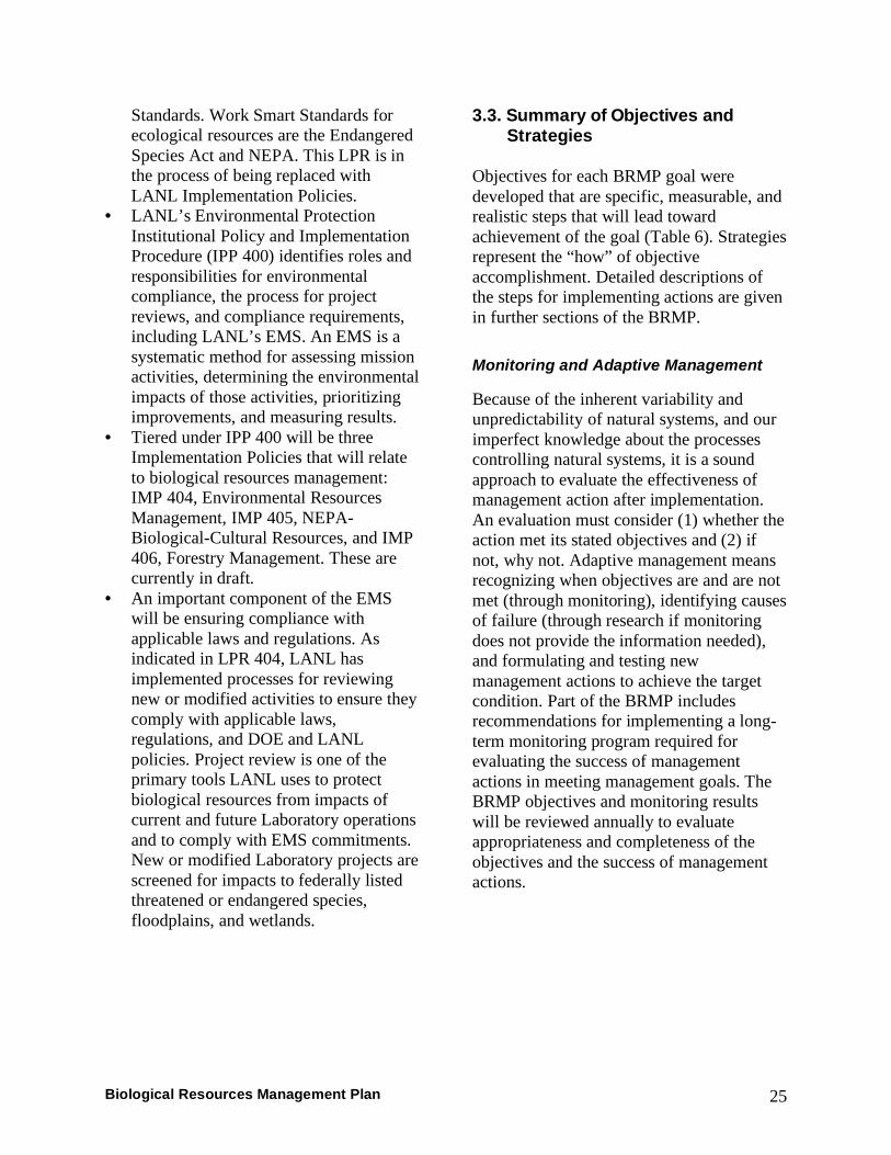
3.3. Summary of Objectives and Strategies
Objectives for each BRMP goal were developed that are specific, measurable, and realistic steps that will lead toward achievement of the goal (Table 6). Strategies represent the “how” of objective accomplishment. Detailed descriptions of the steps for implementing actions are given in further sections of the BRMP. Monitoring and Adaptive Management
Because of the inherent variability and unpredictability of natural systems, and our imperfect knowledge about the processes controlling natural systems, it is a sound approach to evaluate the effectiveness of management action after implementation. An evaluation must consider (1) whether the action met its stated objectives and (2) if not, why not. Adaptive management means recognizing when objectives are and are not met (through monitoring), identifying causes of failure (through research if monitoring does not provide the information needed), and formulating and testing new management actions to achieve the target condition. Part of the BRMP includes recommendations for implementing a long-term monitoring program required for evaluating the success of management actions in meeting management goals. The BRMP objectives and monitoring results will be reviewed annually to evaluate appropriateness and completeness of the objectives and the success of management actions.

Biological Resources Management Plan 26
Table 6. Objectives and Strategies for LANL’s Biological Resources Management Plan
OBJECTIVES STRATEGIES 1 Improve planning, decision
analysis, and project review • Develop and maintain integrated GIS-based application and
data for biological review of proposed projects, operations, and facilities.
• Develop GIS-based maps of “relative biological value” of different areas of LANL based on resource protection goals and objectives for use in planning and assessment.
• Incorporate biological resource protection requirements and best management practices into LANL standards, planning documents, and management plans.
2 Protect special classes of species (federally listed species, state-listed species, migratory birds)
• Develop and implement management plans or best management practices for protected species: o Threatened and Endangered Species Habitat
Management Plan (completed and in use) o Migratory Bird Best Management Practices (in draft) o Sensitive Species Best Management Practices (in
process) 3 Protect sensitive habitats
(wetlands, floodplains, riparian areas)
• Develop and implement Wetlands/Floodplain Management Plan.
4 Minimize and mitigate environmental risks to biota from contaminants
• Develop and implement an integrated program for monitoring contaminants in biota.
• Integrate strategies to minimize ecological risks from contaminants into land management actions.
• Continue to support planning, remediation, and closure decisions with biota data collection and management and ecological risk evaluations.
5 Maintain ability of large-game animals to migrate across LANL property
• Develop and implement a migratory corridor management plan.
6 Continue, as needed, educational, outreach, and collaborative efforts
• Actively participate in regional management councils and planning groups.
• Provide classes, publications, and presentations on biological resources issues.
• Coordinate activities with other LANL Divisions and Groups conducting actions that affect biological resources.

Biological Resources Management Plan 27
4.0 Site Planning One strategy of LANL’s BRMP is to provide planners, managers, and workers with information on the relative biological value of different areas of LANL based on a specified set of criteria. This information will allow better evaluation of relative impacts of siting projects in different locations during the planning process, as well as improving LANL’s ability to conduct NEPA analyses of the environmental impacts of proposed projects. This chapter discusses site land uses, site planning principles, and a process for developing a map of relative biological value for LANL. 4.1. Los Alamos National Laboratory
Site Land Uses Land uses at LANL include regular office space, theoretical/computational facilities, laboratory space, and technical structures supporting experimental science; waste management facilities; areas devoted to high explosives research, development, and testing; and reserve areas that serve as safety and security buffers for hazardous activities. In addition, the White Rock Canyon Reserve was established in 1999 to be managed for ecological and cultural resources. For planning purposes, the Laboratory has been divided into several land use planning areas. These planning areas (Figure 7) describe current uses and planned future uses as identified in LANL’s Comprehensive Site Plan (LANL 2000, 2001). Core Area: These two square miles of LANL contain the Laboratory’s administrative center, as well as biological sciences and theoretical/computational
sciences. The Core Area contains the majority of the Laboratory’s population, buildings, and infrastructure. Pajarito Corridor West: Activities in Pajarito Corridor West are heavily focused on nuclear material research and development. Other work includes liquid waste management and treatment. Pajarito Corridor East: LANL is in the process of ceasing nuclear activities at Technical Area (TA) 18 in this planning area. However, TA-54 represents the Laboratory’s major facility for managing and storing solid wastes, including hazardous and radioactive materials. Los Alamos Neutron Science Center (LANSCE): This small planning area is dedicated to technical activities associated with stockpile stewardship and management. Anchor Ranch: Activities in the Anchor Ranch planning area include experimental engineering with high explosives and tritium facilities. Much of the eastern part of the planning area represents a safety and security buffer for these activities. Water Canyon: The Water Canyon planning area is devoted to high explosives testing and includes large areas of safety and security buffers for these activities. Sigma Mesa: In the past, Sigma Mesa has been a reserve area. Future planning calls for LANL support facilities to be relocated to this area, with the potential for considerable development.

Biological Resources Management Plan 28
Figure 7. Site-wide area development plan from LANL’s Comprehensive Site Plan (LANL 2001). Much of the planning area labeled as Land Transfer has been transferred out of NNSA/DOE control.

Biological Resources Management Plan 29
Omega West: A large portion of the Omega West planning area consists of Los Alamos Canyon. Some facilities were removed from the bottom of the canyon following the Cerro Grande Fire to mitigate flooding risks, and this area is considered to be primarily a reserve area. Rio Grande Corridor: The Rio Grande Corridor contains several major utility corridors. It also contains the White Rock Canyon Reserve. The Reserve was established by DOE in 1999 as a nearly 1,000-acre area to be managed for ecological and cultural resources and research potential. The eastern boundary of the reserve fronts along the west bank of the Rio Grande and rises sharply nearly 1,000 feet in elevation to the upper rim of White Rock Canyon. A management plan for the reserve is being prepared by National Park Service personnel from Bandelier National Monument. 4.2. Biological Resources Management Site Planning Principles Many of the following site planning principles have been adapted from Environmental Law Institute’s, “Conservation Thresholds for Land Use Planners” (Kennedy et al. 2003), which was developed to provide planners with quantitative recommendations to address guideline #5 in the sidebar entitled “Committee Recommendations.” 1. As a long-term goal, the Laboratory
should strive to conserve 60% of its natural habitat to sustain populations of area-sensitive species and rare species. As an absolute minimum, 20% should be maintained. Note: Of the 40 square miles controlled by NNSA/DOE, approximately 15% is currently developed. Over 50% of the site has
slopes with grades >20%, making development of these areas very difficult and thus makes achievement of this goal reasonable.
2. Land use planning that allows for the
persistence of species such as rare and endangered, keystone, or umbrella species can help direct land conservation strategies that benefit a broad number of other species. The Laboratory’s Threatened and Endangered Species Habitat Management Plan is an example of this and it serves as a foundation for the BRMP.
3. The Laboratory should protect and
maintain habitat patches larger than 140 acres. To avoid negative effects of “edges” on these unfragmented and
Committee Recommendations: The Ecological Society of America’s Land Use Committee recommends that land use planners consider the following guidelines in evaluating the impacts of decisions on natural systems:
1. Examine the impacts of local decisions
in a regional context. 2. Plan for long-term change and
unexpected events. 3. Preserve rare landscape elements and
associated species. 4. Avoid land uses that deplete natural
resources over a broad area. 5. Retain large contiguous or connected
areas that contain critical habitats. 6. Minimize the introduction and spread
of non-native species. 7. Avoid or compensate for effects of
development on ecological processes. 8. Implement land use and land
management practices that are compatible with the natural potential of the area.

Biological Resources Management Plan 30
undeveloped patches, buffer areas should be provided where roads, trails, and other development should be restricted.
4. Riparian areas and wetlands should be buffered by at least 100 meters. To perform adequately, all major sources of disturbance and contamination should be excluded, including dams, channelization, water diversion and extraction, heavy construction, impervious surfaces, logging roads, clear cutting, mining, septic tank drain fields, waste disposal sites, and application of pesticides and fertilizers. Ideally, these buffers should extend along all perennial, intermittent, and ephemeral streams.
4.3. Objectives and Strategies Objective: Improve planning, decision analysis, and project review. Strategy: Develop GIS-based map of relative biological value at LANL based on resource protection goals and objectives for use in planning and assessment. • STATUS: Currently there is not a formal
process to incorporate biological resources values into site planning, although data are available as GIS coverages and are sometimes informally used in developing alternatives. The Laboratory’s siting process does not consider biological resources protection. Projects frequently do not have information on biological resources requirements or potential impacts until they get to the stage of submitting a PR-ID or excavation permit.
• ACTIONS: (1) Finalize a map as a GIS coverage of relative biological value for LANL. (2) Use the map as a tool in site planning, siting, and environmental assessments of projects.
4.4. Criteria for Evaluating Biological Value
A preliminary list of criteria of interest was developed to quantify the biological value of areas in an ecosystem management framework. This list included the following: • ecological risk from biocontaminants • threatened and endangered species
habitats • White Rock Canyon Reserve • elk winter range • migratory corridors • developed areas • planned development • wetlands • floodplains • canyons • exotic/invasive plant species • social values • economic values • stakeholder concerns and interests • traditional cultural properties/resource
collection zones • sensitive species • rare or valuable habitats • soil productivity • fragmentation
Based on expert opinion and data currently available, seven criteria (Table 7) were selected to develop a “proof of concept” GIS-based data layer of biological value. The map presented as Figure 8 is not intended to be the final analysis of biological value of property at LANL, but is intended to show how this process can work. We do not have data on some important criteria, and that data would need to be collected and incorporated into the analysis before a final biological values data layer can be produced. To develop the map, levels of each criteria were scored with values between 1 and 5, with 1 having the least amount of biological
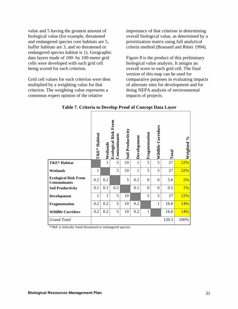
Biological Resources Management Plan 31
value and 5 having the greatest amount of biological value (for example, threatened and endangered species core habitats are 5, buffer habitats are 3, and no threatened or endangered species habitat is 1). Geographic data layers made of 100- by 100-meter grid cells were developed with each grid cell being scored for each criterion. Grid cell values for each criterion were then multiplied by a weighting value for that criterion. The weighting value represents a consensus expert opinion of the relative
importance of that criterion in determining overall biological value, as determined by a prioritization matrix using full analytical criteria method (Brassard and Ritter 1994). Figure 8 is the product of this preliminary biological value analysis. It assigns an overall score to each grid cell. The final version of this map can be used for comparative purposes in evaluating impacts of alternate sites for development and for doing NEPA analysis of environmental impacts of projects.
Table 7. Criteria to Develop Proof of Concept Data Layer
T&
E*
Hab
itat
Wet
land
s E
colo
gica
l Ris
k Fr
om
Con
tam
inan
ts
Soil
Prod
uctiv
ity
Dev
elop
men
t
Frag
men
tatio
n
Wild
life
Cor
rido
rs
Tot
al
Wei
ghte
d %
T&E* Habitat 1 5 10 1 5 5 27 22%
Wetlands 1 5 10 1 5 5 27 22%
Ecological Risk From Contaminants 0.2 0.2 5 0.2 0 0 5.6 5%
Soil Productivity 0.1 0.1 0.2 0.1 0 0 0.5 1%
Development 1 1 5 10 5 5 27 22%
Fragmentation 0.2 0.2 5 10 0.2 1 16.6 14%
Wildlife Corridors 0.2 0.2 5 10 0.2 1 16.6 14%
Grand Total 120.3 100%
*T&E is federally listed threatened or endangered species.

Biological Resources Management Plan 32
Figure 8. Proof of concept map showing biological values for LANL property.

Biological Resources Management Plan 33
4.5. Planning Recommendations The following zones along with their level of impact on biological resources were developed to assist with planning and impact evaluation as another proof of concept. The zone map (Figure 9) can be overlaid with planned future development for LANL to estimate the potential impact of this development on biological resources at LANL. Zone 1: High adverse impact to biological resources; development not recommended. Zone 1 includes core habitat for federally listed threatened or endangered species, wetlands, high-quality riparian areas, and constriction points in large-game migration routes across LANL. Zone 2: Moderate adverse impact to biological resources; development should include mitigation to protect biological resources. Zone 2 includes buffer habitat for federally listed threatened or endangered species; core habitat for sensitive species; large-game migration routes across LANL that are not constricted; large, currently unfragmented, natural areas (>140 acres); and other areas that may not be appropriate for development (such as lands adjacent to Bandelier National Monument). Zone 3: Low adverse impact to biological resources; development not restricted. Zone 3 contains all remaining areas at LANL that are not included in Zones 1 or 2. Zone 3 currently includes areas that are classified as safety and security buffers for high explosives testing. If the use of these land areas were to change, zoning of these areas should be reanalyzed.
4.6. Potential Areas of Conflict As a demonstration of potential uses of this map, proposed Zone 1 areas were overlaid with areas identified as having high potential for future development to determine where there might be areas of potential conflict (Figure 10):
• TA-35, TA-50, TA-66, TA-52, TA-60, and TA-61: Areas of future development in these technical areas overlap both Mexican spotted owl core habitat—a bridge over Mortandad Canyon—and a constriction point for large-game movement onto San Ildefonso property—the Chemistry and Metallurgy Research Building Replacement and a commuter parking lot (Figure 10A). Detailed planning in this area is highly advisable since this area contains occupied Mexican spotted owl habitat. This area is part of the Pajarito Corridor West Planning Area, which houses mission-critical activities related to plutonium (LANL 2001), and the Sigma Mesa Planning Area, which has been proposed for considerable development growth (LANL 2001).
• TA-51 and TA-54: Areas planned for future development in these technical areas overlap constriction points for large-game movement onto San Ildefonso property—one constriction point crossing Pajarito Road at TA-51 (Figure 10B) and another crossing Pajarito Road near the east end of TA-54 (Figure 10C).
• TA-62: East of West Road (Figure 10D), areas proposed for future development, such as the Science Complex, are located within Mexican spotted owl core habitat.

Biological Resources Management Plan 34
Development of the Research Park Area was approved by the US Fish and Wildlife Service under a Biological Assessment, but if this
area were to become occupied habitat, consultation with the US Fish and Wildlife Service would have to be reinitiated.
Figure 9. Zones for future development possibilities.

Fi
gure
10.
A) M
exic
an s
potte
d ow
l cor
e ha
bita
t and
a la
rge-
gam
e m
igra
tion
corr
idor
with
a c
onst
rictio
n po
int
cros
sing
Paj
arito
Roa
d in
the
Paja
rito
Wes
t Cor
ridor
. B) A
larg
e-ga
me
mig
ratio
n co
rrid
or w
ith a
con
stric
tion
poin
t cr
ossi
ng P
ajar
ito R
oad
at T
A-5
1. C
) A la
rge-
gam
e m
igra
tion
corr
idor
and
con
stric
tion
poin
t cro
ssin
g Pa
jarit
o R
oad
at T
A-5
4. D
) Mex
ican
spo
tted
owl c
ore
habi
tat n
ear t
he R
esea
rch
Park
and
TA
-62.
Biological Resources Management Plan 35

Biological Resources Management Plan 36
5.0 Landscape Management Landscape management includes management activities and plans that impact vegetation, soil, and abiotic aspects of the environment over a relatively large area. Examples of landscape management include forest management and planning of future development. This chapter discusses objectives, strategies, and proposed actions for biological resources management specifically related to landscape management. 5.1. Objectives and Strategies These are the objectives and strategies introduced in Section 3 that relate to landscape management.
Objective: Protect special classes of species (federally listed species). Strategy: Implement Threatened and Endangered Species Habitat Management Plan (for federally listed species). • STATUS: This plan, first implemented
in 1999, identifies the location of habitat for all federally listed threatened or endangered species at LANL and provides guidelines describing what kind of work can occur in these habitats without consultation with the US Fish and Wildlife Service. The Threatened and Endangered Species Habitat Management Plan has proven to be an extremely important planning and project review tool. This plan is listed under landscape management because large acreages are protected under the plan as threatened or endangered species’ habitat.
• ACTIONS: (1) Maintain and update, as needed, data identifying locations of threatened or endangered species’ habitats. (2) Continue annual
presence/absence surveys for federally listed species.
Objective: Protect sensitive habitats (wetlands, floodplains, riparian areas). Strategy: Develop and implement Wetlands/Floodplains Management Plan. • STATUS: This plan is proposed to
locate, inventory, and identify best management practices and restrictions for the protection of these sensitive habitats. Post-Cerro Grande Fire 100-year floodplains were modeled in 2002. Wetlands at LANL were inventoried in 2005. A riparian area inventory is scheduled to begin in 2007. Best management practices for floodplains and wetlands are provided in project reviews, but are not LANL-specific and are not enforced.
• ACTIONS: (1) Complete riparian area inventory. (2) Create GIS layers with locations of sensitive habitats. (3) Develop procedures for updating this information, as needed. (4) Develop and implement LANL-specific best management practices and plans for protection and retention of wetlands, floodplains, and riparian areas, including consideration of outfall and storm water management.
Objective: Maintain ability of large-game animals to migrate across LANL property. Strategy: Develop and implement a Migratory Corridor Management Plan. • STATUS: Data from radio- and
geographic-positioning-system-collared Rocky Mountain elk and mule deer in the late 1990s and early 2000s have been used to identify and model the corridors these animals can use to cross LANL property to San Ildefonso Pueblo, Santa

Biological Resources Management Plan 37
Fe National Forest, and Bandelier National Monument properties (Bennett 2006). Bennett (2006) also identifies “pinch points,” areas where animal migrations could be blocked or diverted through additional development or disturbance.
• ACTIONS: (1) Using data from Bennett (2006), develop guidelines and requirements to avoid actions that would block migratory routes onto San Ildefonso properties. (2) Develop road construction and maintenance recommendations to minimize animal-vehicle collisions.
Objective: Improve planning, decision analysis, and project review. Strategy: Develop integrated GIS-based application for biological review of proposed projects, operations, and facilities. • STATUS: GIS-based ArcIMS tools,
including biological resources, are currently developed and deployed for excavation permit reviews, PR-IDs, JHAs, and as a stand-alone planning tool.
• ACTIONS: (1) Maintain and update, as needed, the data layers supporting the GIS tools. (2) Educate employees about existence and uses of the tools. (3) Improve tools (continuous improvement). (4) Evaluate effectiveness of tool in JHA and improve use and process.
Strategy: Incorporate biological resource protection requirements and best management practices into LANL standards, planning documents, and management plans. • STATUS: Currently, biological
resources protection requirements and measures are not identified in LANL’s engineering or architectural standards or
in bid information provided to contractors. Some biological resources information has been included in LANL’s Wildland Fire Management Plan and Infrastructure Planning Documents.
• ACTIONS: (1) Get wording for biological resources protection restrictions and guidelines into contract language and LANL standards where appropriate. (2) Coordinate biological resources goals and objectives with Infrastructure Planning. (3) Coordinate biological resources goals and objectives with annual forest fuels management activities.
Objective: Continue, as needed, educational, outreach, and collaborative efforts. Strategy: Actively participate in regional management councils and planning groups. • STATUS: LANL currently has
representatives on the East Jemez Resources Council and the Interagency Wildfire Management Team and runs the Interagency LANL Trails Working Group.
• ACTIONS: (1) Continue current practices.
Strategy: Coordinate activities with other LANL Divisions and Groups conducting actions that affect biological resources. • STATUS: The Biological Resources
Compliance Team interacts with other LANL organizations through the excavation permit and PR-ID processes, representation on Integrated Project Teams, and reviews of Directorate Environmental Action Plans as part of the EMS.
• ACTIONS: (1) Continue current practices. (2) Work on including biological resources protection criteria in

Biological Resources Management Plan 38
the project siting and land-use planning processes.
5.2. Related Plans: LANL Wildland Fire Management Plan LANL’s Wildland Fire Management Plan (Draft)—This plan is a strategic plan that describes a program to manage risk associated with wildland fires. The overall goals of the wildland fire management program at LANL are to minimize the risks to public and worker safety, facilities and operations, and natural and cultural resources from destructive crown fires. The strategy of the program is organized around a set of core activities: planning and preparedness, fire suppression, fuels mitigation through use of prescribed fire, fuels mitigation through activities other than prescribed fire (e.g., thinning, mowing, herbicides), rehabilitation, and monitoring. Since forest management activities such as fuels management discussed in the Wildland Fire Management Plan potentially have a large impact on biological resources considered in the BRMP, LANL’s Wildland Fire Management Plan and the BRMP need to be well integrated. 5.3. Status of Fuels Management Activities LANL began thinning of ponderosa pine forests near roads and facilities and taking other measures such as fire road improvement on a limited scale in 1996 (following the Dome Fire) as a wildland fire risk-reduction measure. Following the Cerro Grande Fire in 2000, the US Congress
Mechanical thinning in piñon-juniper
woodland. provided LANL with a special allocation to conduct forest thinning and fuels reduction. Thinning activities started in January 2001 and some carryover funds allowed the program to operate through the end of fiscal year 2004. To date, approximately 5,100 acres of piñon-juniper and 3,900 acres of ponderosa pine on LANL have been treated (Figure 11). This includes defensible space around facilities, firebreaks around roads and firing sites, utility corridor thinning, and forest health thinning. Currently, LANL has no long-term institutional funding source for implementing a wildland fire management program and no long-term institutional operational plan for wildfire risk reduction. A final draft of the Wildland Fire Management Plan has been completed; it needs to receive institutional management approval, backing, and funding to be adopted as Laboratory policy and be implemented as a program.

Biological Resources Management Plan 39
Figure 11. Location of thinning activities conducted following the Cerro Grande Fire, 2001–2004.

Biological Resources Management Plan 40
6.0 Species Management
Species management includes management of localized issues or protected populations. This chapter discusses objectives, strategies, and proposed actions for biological resources management specifically related to management of state-listed species, migratory birds, and other protected species or species of interest where management actions are not applied to habitat at a landscape scale. 6.1. Objectives and Strategies
Objective: Protect special classes of species (state-listed species, migratory birds). Strategy: Develop and implement migratory birds best management practices and sensitive species best management practices. • STATUS: A draft version of migratory
birds best management practices for LANL has been completed. This document provides guidelines on avoiding disturbance to nestlings and bird-friendly designs for power lines and communication towers. ENV-EAQ and Maintenance and Site Services-Utilities and Infrastructure recently agreed to retrofit power line locations where two or more bird mortalities or injuries were recorded. Sensitive species best management practices (including state-listed species and other protected species) are currently being developed.
• ACTIONS: (1) Finalize and publish migratory bird best management practices. (2) Work to include bird-friendly power line designs in LANL Engineering Standards. (3) Work to include migratory bird best management practices in project reviews. (4) Complete sensitive species best management practices.
Objective: Continue, as needed, educational, outreach, and collaborative efforts . Strategy: Provide classes, publications, and presentations on biological resources issues. • STATUS: Information on wildlife safety
is presented to LANL employees through classes at the White Rock Training Center, public outreach presentations and handouts, LANL notices, Daily NewsBulletin articles, and other venues.
• ACTIONS: (1) Continue current practices.

Biological Resources Management Plan 41
Ecological Risk and Threatened or Endangered Species: Nesting pairs of Mexican spotted owls and their fledglings inhabit LANL. The Endangered Species Act of 1972 requires the protection of federally listed species such as these from contaminants. Even after assessments of potential impacts are completed, periodic monitoring is necessary because species and habitats are dynamic. A long-term contaminant monitoring plan will balance location-specific monitoring needs with site-wide monitoring needs as well as integrating the activities of different organizations that have monitoring requirements.
7.0 Ecological Risk Management Potential adverse effects on plants and animals from exposure to contaminants may influence how biological resources are managed. Monitoring contaminant levels in biological organisms and habitats, especially protected species and habitats, is an important component of biological resources management. These activities help to demonstrate that LANL is complying with environmental laws, regulations, and other requirements and that LANL operations, both past and present, are not resulting in any adverse cumulative impacts to biological resources on the Pajarito Plateau and lands bordering LANL. This chapter discusses objectives, strategies, and proposed actions to minimize and mitigate environmental risks to biota from contaminants. 7.1. Objectives and Strategies Objective: Minimize and mitigate environmental risks to biota from contaminants. Strategy: Develop and implement an integrated program for monitoring contaminants in biota. • STATUS: The Environmental
Surveillance Program and the CAP in the Environmental Programs Directorate collect data on contaminants in biota, but generally not in an integrated fashion or with the primary goal of understanding overall ecological risk to biota. The Environmental Surveillance Program monitors contaminant levels in soils, human foodstuffs, and vegetation collected within and around the Laboratory. The CAP investigates hazardous chemicals and radioactive wastes resulting from past LANL
operations and remediates contaminated areas, as necessary, to protect human health and the environment. In addition, some facilities with ongoing operations potentially releasing contaminants conduct periodic site-specific monitoring of biota.
• ACTIONS: (1) Continue the avian nest-box monitoring program begun in 1997. (2) Develop and implement an integrated

Biological Resources Management Plan 42
long-term biota contaminant monitoring plan addressing environmental stewardship objectives and regulatory requirement including RCRA and potential natural resource damage assessment issues. The following areas will be considered for monitoring: (1) contaminants in threatened or endangered species, (2) contaminants in protected habitat such as wetlands, (3) contaminants in amphibians, and (4) measures of ecological health.
Strategy: Integrate strategies to minimize ecological risk from contaminants into land management actions. • STATUS: Disturbance of potential
release sites is very carefully managed for construction and excavation projects through the PR-ID and excavation permit processes. There currently is no formal process to ensure consideration
of ways to incorporate actions to stabilize or (hopefully) diminish possibilities for contaminant transport or uptake as a result of land management actions such as fuels mitigation.
• ACTIONS: (1) Work with LANL foresters to incorporate objectives to reduce contaminant transport and uptake as part of fuels management actions.
Strategy: Continue supporting planning, remediation, and closure decisions with biota data and ecological risk evaluations. • STATUS: Currently, collection of biota
contaminant level data and modeling of ecological risk is conducted on an on-demand, project-specific basis.
• ACTIONS: (1) Continue supporting projects, as needed. (2) Maintain comprehensive database of contaminant levels in biota. (3) Integrate location-specific data into site-wide assessments.
LANL’s Avian Nest Box Monitoring Network: The avian nest box monitoring network started in 1997. Nest boxes are co-located with contaminated areas and can be used to evaluate potential adverse effects of exposure of song birds to environmental contaminants. The distribution of boxes allows for the assessment of site-wide risk from contaminants to population health.
Ash-throated flycatcher (Myiarchus cinerascens cinerascens) and a nest box used in the LANL avian monitoring network.

Biological Resources Management Plan 43
8.0 Biological Resources Data Management
A GIS is a computer application that stores, retrieves, manipulates, analyzes, and displays geographically referenced data. Application of GIS provides managers and researchers with an invaluable tool to address fundamental scientific, management, and operational questions concerning LANL’s biological resources. GIS brings both data analysis and visualization together. In many instances, the data analysis occurs on the actual spatial component and its relationship to other spatial components, but a GIS is not limited to spatial analysis. GIS manages two basic kinds of data: geospatial data (spatial data) that define the location of a feature and attribute data that describe characteristics of this feature. Analysis can occur on each type
of data separately or jointly. The attribute data of a GIS are stored in a relational database and the geospatial data are usually stored in what are commonly called map coverages, layers, or themes. A GIS is composed of many individual themes, all geographically referenced to one another. A GIS is being used for data collected for or used in the BRMP. The GIS will be used as a tool to manage spatial and attribute data, provide data analysis, model development, and integrate data from many different sources, including data generated from other analysis or modeling software. The GIS will also be used to assist resource managers in development of management strategies and to track the effectiveness of these strategies (Figure 12).
Figure 12. Diagram of GIS use in the BRMP.
GIS
Data
Analysis/Models Strategy Development
Strategy Implementation
Adaptive Management and Monitoring

44 Biological Resources Management Plan
8.1. Design and Software Design work on the BRMP database began in 2001. Software requirements and software packages were evaluated as well as data storage location and data backup protocols. Before a draft database design was developed, a user needs assessment was conducted to match user needs and expectations to GIS functions. Portions of datasets were obtained to test database design. Both geospatial layers and attribute tables were created. Portions of the database design are still being tested and evaluated. Storage of vector themes is a combination of shapefiles and coverages. Attribute data are stored in the Microsoft product Access. The BRMP GIS resides on a server maintained by ENV Division. 8.2. Maintenance The maintenance cycle of GIS includes keeping data up to date, training in the use of software/BRMP GIS, software or system upgrades, and adding new functions that might be required as the BRMP progresses. In order to keep the BRMP GIS current, newly collected data will need to be incorporated into the GIS on a regular and routine basis. The process for incorporating data into the GIS will follow a formal procedure. The data owner is responsible for the technical accuracy of the data collected and must perform a quality check on the data prior to submitting for inclusion into the BRMP GIS.
For the BRMP GIS to be an effective tool, people (GIS Analysts and users) must know how to access it and perform necessary functions. Training will be required for both the GIS Analyst (GIS personnel that work daily with the database, perform data conversions, modeling, and advanced analysis) and the GIS user (personnel that use the database to display, query, and perform simple analysis). As the BRMP GIS is used, revisions will be made to keep up with changing conditions and requirements. New requirements may result in the need for new types of analysis or data. In addition, customized applications may also be needed to allow users to easily obtain information from complex analysis in a real-time fashion. The BRMP GIS will not be static but changing/enhancing over time to meet the needs of the BRMP. Over the last several years, many technical advances in GIS have occurred. These advances have resulted in a GIS that is more user friendly, more powerful, faster, and more reliable with greater analysis capabilities. These advances were the result of new software and hardware development. In order to take advantage of new technical advancements or growing needs of the BRMP, software and hardware upgrades may be required. Software upgrades generally occur annually and hardware upgrades are usually dependent on performance issues or software requirements.

Biological Resources Management Plan 45
References Allen, Craig D. 1996. Elk population response to the La Mesa Fire and current status in the Jemez Mountains. Pages 179–195 in Craig D. Allen, ed., Fire Effects in Southwestern Forests: Proceeding of the Second La Mesa Fire Symposium. US Department of Agriculture Forest Service, Rocky Mountain Forest and Range Experiment Station General Technical Report RM-GTR-286, Fort Collins, CO. Balice, Randy G., Kathryn D. Bennett, and Marjorie A. Wright. 2004. Burn severities, fire intensities, and impacts to major vegetation types from the Cerro Grande Fire. Los Alamos National Laboratory report LA-14159, Los Alamos, NM.
Bennett, Kathryn D. 2006. Development and evaluation of movement corridors used by Rocky Mountain elk within the vicinity of Los Alamos National Laboratory, Los Alamos, New Mexico. M. S. Thesis, Northwest Missouri State University, Maryville, MI.
Biggs, J., S. Sherwood, S. Michalak, L. Hansen, and C. Bare. 2004. Animal-related accidents at the Los Alamos National Laboratory, New Mexico. The Southwest Naturalist 49(3):384–394.
Bowen, Brent M. 1990. Los Alamos climatology. Los Alamos National Laboratory report LA-11735-MS, Los Alamos, NM.
Bowen, Brent M. 1992. Los Alamos climatology summary. Los Alamos National Laboratory report LA-12232-MS, Los Alamos, NM.
Brassard, Michael, and Diane Ritter. 1994. The Memory Jogger II. GOAL/QPC, Salem, NH.
Conover, M. R., W. C. Pitt, K. K. Kessler, T. J. DuBow, and W. A. Sanborn. 1995. Review of human injuries, illnesses, and economic losses caused by wildlife in the United States. Wildlife Society Bulletin 23:407–414.
Cook, Rosamonde R., Curtis H. Flather, and Kenneth R. Wilson. 2000. Faunal characteristics of the southern Rocky Mountains of New Mexico: Implications for biodiversity analysis and assessment. US Department of Agriculture Forest Service, Rocky Mountain Research Station, General Technical Report RMRS-GTR-58, Fort Collins, CO.
DOE (US Department of Energy). 1999. Site-wide environmental impact statement for the continued operation of Los Alamos National Laboratory. US Department of Energy report DOE/EIS-0238, Albuquerque, NM.
Foxx, Teralene S., and Gail D. Tierney. 1999. Historical botany of the Romero Cabin: A family homestead on the Pajarito Plateau. Los Alamos National Laboratory report LA-13644-H, Los Alamos, NM.
Foxx, Teralene S., Gail D. Tierney, Mary A. Mullen, and Mary E. Salisbury. 1997. Old-field plant succession on the Pajarito Plateau. Los Alamos National Laboratory report LA-13350, Los Alamos, NM.

46 Biological Resources Management Plan
Gutzler, David. 2003. Drought in New Mexico: History, causes, and future prospects. Pages 101–105 in Water Resources of the Lower Pecos Region, New Mexico: Science, Policy, and a Look to the Future. Peggy S. Johnson, Lewis A. Land, L. Greer Price, and Frank Titus, eds. New Mexico Decision Makers Field Guide no. 3, New Mexico Bureau of Geology and Mineral Resources, Santa Fe, NM.
Kennedy, C., J. Wilkinson, and J. Balch. 2003. Conservation thresholds for land use planners. Environmental Law Institute, Washington, DC.
Los Alamos National Laboratory. 2000. Comprehensive site plan 2000. Los Alamos National Laboratory report LA-UR-99-6704, Los Alamos, NM.
Los Alamos National Laboratory. 2001. Comprehensive site plan 2001. Los Alamos National Laboratory report LA-UR-01-1838, Los Alamos, NM.
Los Alamos National Laboratory. 2005. The weather machine: Los Alamos National Laboratory. Website accessed 6/05: http://weather.lanl.gov/.
Longmire, Patrick A., Steven L. Reneau, Paula M. Watt, Leslie D. McFadden, Jamie N. Gardner, Clarence J. Duffy, and Randall T. Ryti. 1996. Natural background geochemistry, geomorphology, and pedogenesis of selected soil profiles and Bandelier Tuff Los Alamos, New Mexico. Los Alamos National Laboratory report LA-12913-MS, Los Alamos, NM.
McKown, Brad, Steven W. Koch, Randy G. Balice, and P. Neville. 2003. Land cover classification map for the Eastern Jemez Region. Los Alamos National Laboratory report LA-14029, Los Alamos, NM. National Weather Service. 2004. 2003 Weather Highlights for Albuquerque and New Mexico. Report located at http:/www.srh.noaa.gov/abq/climate/Monthlyreports/Annual/2003weatherhighlights.htm, last accessed 9/2/2005. Nyhan, John W., L. W. Hacker, T. E. Calhoun, and D. L. Young. 1978. Soil survey of Los Alamos County, New Mexico. Los Alamos Scientific Laboratory report LA-6779-MS, Los Alamos, NM.
Nyhan, John W., Steven W. Koch, Randy G. Balice, and Samuel R. Loftin. 2001. Estimation of soil erosion in burnt forest areas of the Cerro Grande Fire in Los Alamos, New Mexico. Los Alamos National Laboratory report LA-UR-01-4658, Los Alamos, NM.
Pettitt, Roland A. 1990. Exploring the Jemez Country, 2nd ed. Los Alamos Historical Society, Los Alamos, NM.
Powers, Robert P. 2005. A grand and isolated place. Pages 1–10 in The Peopling of Bandelier: New Insights from the Archeology of the Pajarito Plateau. Robert P. Powers, ed. School of American Research Press, Santa Fe, NM.

Biological Resources Management Plan 47
Romin, L., and J. Bissonette. 1996. Deer-vehicle collisions: Status of state monitoring activities and mitigation efforts. Wildlife Society Bulletin 24:276–283.
Santa Fe Piñon Initiative. 2004. Living with drought, fire, and bark beetle: Understanding natural landscape changes in Santa Fe County. Located at http://www.emnrd.state.nm.us/forestry/santafetrees/pdf/beetlepublication.pdf (last accessed 9/14/05).
Site-Wide Environmental Impact Statement Project Office. 1997. Overview of Los Alamos National Laboratory–1997. Los Alamos National Laboratory report LA-UR-97-4765, Los Alamos, NM.
Sydoriak, Charisse A., Craig D. Allen, and Brian F. Jacobs. 2000. Would ecological landscape restoration make the Bandelier Wilderness more or less of a wilderness? Pages 209–215 in David N. Cole, Stephen F. McCool, William T. Borrie, and Jennifer O'Loughlin, eds. Proceedings for Wilderness Science in a Time of Change Conference-Volume 5: Wilderness Ecosystems, Threats, and Management. 1999 May 23–27; Missoula, MT. US Department of Agriculture, Forest Service, Rocky Mountain Research Station publication RMRS-P-15-VOL-5, Ogden, UT.

48 Biological Resources Management Plan


Los Alamos, New Mexico 87545