Biological Assessment for Threatened, Endangered… · Biological Assessment . for Threatened,...
173
Biological Assessment for Threatened, Endangered, and Proposed Species Forest Plan Amendments—Incorporating habitat management direction for the NCDE grizzly bear population into the Helena, Lewis and Clark, Kootenai, and Lolo National Forest Plans /s/ Nancy Warren_______________________________ __10/31/17____ Prepared by Nancy Warren, Wildlife Biologist (contractor) Date /s/ Reed Kuennen_______________________________ __10/31/17____ Accepted by Reed Kuennen, Wildlife Biologist Date /s/ Pat Van Eimeren__________________________________ __10/31/17____ Prepared by Pat Van Eimeren, Fisheries Biologist Date /s/ Heidi Trechsel_________________________________ __10/31/17____ Prepared by Heidi Trechsel, Silviculturist Date Note: The draft biological assessment submitted to the USFWS on March 13, 2017 was updated and resubmitted on October 4, 2017, with a final version submitted on October 31, 2017 that reflects the changes previously documented in the errata, incorporates wording changes to NCDE-STD-GRZ-02 and NCDE-HNF Zone 1&2-DC-02 that were discussed with USFWS, and includes editorial corrections.
Transcript of Biological Assessment for Threatened, Endangered… · Biological Assessment . for Threatened,...
Biological Assessment for Threatened, Endangered, and Proposed Species
Forest Plan Amendments—Incorporating habitat management direction for the NCDE grizzly bear
population into the Helena, Lewis and Clark, Kootenai, and Lolo National Forest Plans
/s/ Nancy Warren_______________________________ __10/31/17____ Prepared by Nancy Warren, Wildlife Biologist (contractor) Date
/s/ Reed Kuennen_______________________________ __10/31/17____ Accepted by Reed Kuennen, Wildlife Biologist Date
/s/ Pat Van Eimeren__________________________________ __10/31/17____ Prepared by Pat Van Eimeren, Fisheries Biologist Date
/s/ Heidi Trechsel_________________________________ __10/31/17____ Prepared by Heidi Trechsel, Silviculturist Date
Note: The draft biological assessment submitted to the USFWS on March 13, 2017 was updated and resubmitted on October 4, 2017, with a final version submitted on October 31, 2017 that reflects the changes previously documented in the errata, incorporates wording changes to NCDE-STD-GRZ-02 and NCDE-HNF Zone 1&2-DC-02 that were discussed with USFWS, and includes editorial corrections.
NCDE Grizzly Bear Forest Plan Amendments Biological Assessment
page i
Table of Contents Summary of Findings ............................................................................................................................................. 1
Introduction ........................................................................................................................................................... 2
Purpose and need for the proposed action ............................................................................................................... 2
Programmatic decision.............................................................................................................................................. 3
Consultation history .................................................................................................................................................. 3
Action Area ................................................................................................................................................................ 4
Description of the proposed forest plan amendments .............................................................................................. 5
Listed species and designated critical habitat ........................................................................................................... 6
Terrestrial Wildlife Species .................................................................................................................................... 7
Grizzly bear ................................................................................................................................................................ 7 Background—Recovery Plan and Conservation Strategy ..................................................................................... 7 Ongoing grizzly bear conservation actions by the Forest Service ......................................................................... 8 Existing conditions .............................................................................................................................................. 10 Effects of the proposed amendments ................................................................................................................ 22 Cumulative effects .............................................................................................................................................. 56 Determination of effects and rationale .............................................................................................................. 63
Canada lynx ............................................................................................................................................................. 64 Existing conditions .............................................................................................................................................. 64 Effects of the proposed amendments ................................................................................................................ 67 Cumulative effects .............................................................................................................................................. 69 Determination of effect and rationale ................................................................................................................ 69
Canada lynx critical habitat ..................................................................................................................................... 70 Existing conditions .............................................................................................................................................. 70 Effects of the proposed amendments ................................................................................................................ 71 Cumulative effects .............................................................................................................................................. 72 Determination of effect and rationale ................................................................................................................ 72
North American Wolverine ...................................................................................................................................... 72 Existing conditions .............................................................................................................................................. 72 Effects of the proposed amendments ................................................................................................................ 75 Determination of effect and rationale ................................................................................................................ 76
Yellow-billed cuckoo, western distinct population segment ................................................................................... 76 Existing conditions .............................................................................................................................................. 76 Effects of the proposed amendments ................................................................................................................ 77 Determination of effect and rationale ................................................................................................................ 77
Aquatic Species .................................................................................................................................................... 77
Species descriptions and habitat requirements ....................................................................................................... 77 White sturgeon—Kootenai National Forest ....................................................................................................... 77 Determination of effect and rationale ................................................................................................................ 78 Bull trout—threatened species ........................................................................................................................... 78 Effects of the proposed amendments ................................................................................................................ 96 Cumulative effects .............................................................................................................................................. 98
NCDE Grizzly Bear Forest Plan Amendments Biological Assessment
page ii
Determination of effect and rationale ................................................................................................................ 98
Plant Species ........................................................................................................................................................ 98
Spalding’s campion (Silene spaldingii) .................................................................................................................... 98 Existing conditions .............................................................................................................................................. 98 Effects of the proposed amendments ................................................................................................................ 99 Determination of effect and rationale ................................................................................................................ 99
Water howellia ........................................................................................................................................................ 99 Existing conditions .............................................................................................................................................. 99 Effects of the proposed amendments .............................................................................................................. 100 Determination of effect and rationale .............................................................................................................. 100
Appendix 1: Maps .................................................................................................................................................. 1
Appendix 2: Text of Grizzly Bear Amendments ...................................................................................................... 1
Wildlife (WL) .............................................................................................................................................................. 1 Desired Conditions ................................................................................................................................................ 1 Standards .............................................................................................................................................................. 1 Guidelines ............................................................................................................................................................. 1
Access and Recreation (AR) ....................................................................................................................................... 2 Desired Conditions ................................................................................................................................................ 2 Standards .............................................................................................................................................................. 2 Guidelines ............................................................................................................................................................. 4
Terrestrial Ecosystems Vegetation (VEG) .................................................................................................................. 5 Desired Conditions ................................................................................................................................................ 5 Guidelines ............................................................................................................................................................. 5
Grazing (GRZ) ............................................................................................................................................................ 6 Desired Condition ................................................................................................................................................. 6 Standards .............................................................................................................................................................. 6 Guidelines ............................................................................................................................................................. 7
Special Forest Products (SFP)..................................................................................................................................... 7 Desired Condition ................................................................................................................................................. 7 Standard ................................................................................................................................................................ 7
Renewable/Non-Renewable Energy and Mineral Resources (MIN) .......................................................................... 7 Desired Condition ................................................................................................................................................. 7 Standards .............................................................................................................................................................. 7 Guidelines ............................................................................................................................................................. 9
Helena National Forest—Zone 1, Zone 2 ................................................................................................................. 10 Desired Conditions .............................................................................................................................................. 10 Standards ............................................................................................................................................................ 10
Kootenai National Forest—Zone 1 .......................................................................................................................... 11 Desired Conditions .............................................................................................................................................. 11 Standards ............................................................................................................................................................ 11
Lolo National Forest—Zone 1 .................................................................................................................................. 11 Desired Conditions .............................................................................................................................................. 11 Standards ............................................................................................................................................................ 12
How changes in route density and secure core would be implemented ................................................................. 12
NCDE Grizzly Bear Forest Plan Amendments Biological Assessment
page iii
Hypothetical example ......................................................................................................................................... 13
Monitoring (MON) ................................................................................................................................................... 14
Glossary ................................................................................................................................................................... 15
Appendix 3: Existing forest plan direction and how they would be changed under the proposed NCDE amendments ......................................................................................................................................................... 1
Introduction ............................................................................................................................................................... 1
Helena National Forest .............................................................................................................................................. 2 Current forest plan component and changes under the proposed amendment ................................................. 2
Kootenai National Forest ........................................................................................................................................... 8 Current forest plan components and changes under the proposed amendment ................................................ 8
Lewis and Clark National Forest .............................................................................................................................. 13 Current forest plan components and changes under the proposed amendment .............................................. 13
Lolo National Forest ................................................................................................................................................ 20 Current forest plan components and changes under the proposed amendment .............................................. 20
References ............................................................................................................................................................. 1
List of Tables Table 1. Summary of the determinations of effect of the proposed forest plan amendments on each of the
federally listed species .................................................................................................................................. 1 Table 2. Acres and percentage of NFS land included within the NCDE recovery zone/primary conservation area
(PCA), zone 1 within and outside of the demographic connectivity areas (DCA), zone 2 and zone 3. ............. 5 Table 3. Listed species and species proposed for listing that may be present on the Helena-Lewis and Clark,
Kootenai, and Lolo National Forests .............................................................................................................. 6 Table 4. Current food/wildlife attractant storage orders on NFS lands in the NCDE. .............................................. 8 Table 5. Threshold values for road density in Alberta and how they were interpreted and used in the NCDE ..... 16 Table 6. Baseline levels for open and total motorized route density and secure core by bear management
subunit on the Helena National Forest. ....................................................................................................... 24 Table 7. Linear density of motorized routes (roads and trails) open to the public on NFS lands by bear
management zone. ...................................................................................................................................... 26 Table 8. Comparing secure core calculated with and without nonmotorized high intensity use trails (data from
2015 moving window analysis (Ake, 2015a)) ............................................................................................... 28 Table 9. Beaverhead-Deerlodge forest plan objectives and existing conditions for open motorized route density
in selected landscapes. ................................................................................................................................ 32 Table 10. Baseline levels for motorized route density and secure core by bear management subunits on the
Lewis and Clark National Forest under the proposed amendment. ............................................................. 34 Table 11. Comparing secure core calculated with and without nonmotorized high intensity use trails................ 36 Table 12. Baseline levels of motorized route density and secure core by bear management subunits on the
Kootenai National Forest. ............................................................................................................................ 41 Table 13. Baseline levels for motorized route density and secure core by bear management subunits on the Lolo
National Forest. ........................................................................................................................................... 49 Table 14. Comparing secure core calculated with and without nonmotorized high intensity use trails................ 52 Table 15. Acres that were anticipated to be treated under the exceptions to NRLMD vegetation standards in the
first decade (2008-2017), and the total acres actually implemented by decisions 2007-2014 ...................... 68 Table 16. Canada lynx critical habitat primary constituent element in relation to lynx management direction in
the forest plans. .......................................................................................................................................... 71 Table 17. Streams, lakes, and rivers designated as critical habitat within the amendment analysis area, excluding
the Flathead National Forest ....................................................................................................................... 79
NCDE Grizzly Bear Forest Plan Amendments Biological Assessment
page iv
Table 18. North Fork Blackfoot River local population summary ......................................................................... 83 Table 19. Monture Creek local population summary ........................................................................................... 84 Table 20. Cottonwood Creek local population summary ...................................................................................... 85 Table 21. Gold Creek local population summary .................................................................................................. 85 Table 22. Nevada Creek headwaters population summary .................................................................................. 86 Table 23. Group of streams that contribute to Blackfoot core population summary ............................................ 86 Table 24. Landers Fork local population summary ............................................................................................... 87 Table 25. Poorman Creek local population summary ........................................................................................... 88 Table 26. East Fork Clearwater River local population summary .......................................................................... 89 Table 27. West Fork Clearwater River local population summary ........................................................................ 89 Table 28. Morrell Creek local population summary.............................................................................................. 90 Table 29. Placid Creek local population summary ................................................................................................ 91 Table 30. Rattlesnake Creek local population summary ....................................................................................... 92 Table 31. Grant Creek local population summary ................................................................................................ 92 Table 32. Albert Creek local population summary................................................................................................ 93 Table 33. Petty Creek local population summary ................................................................................................. 93 Table 34. Fish Creek local population summary ................................................................................................... 93 Table 35. Trout Creek local population summary ................................................................................................. 93 Table 36. Cedar Creek local population summary ................................................................................................ 94 Table 37. St. Regis River local population summary ............................................................................................. 94 Table 38. Little Blackfoot River population summary ........................................................................................... 95 Table 2-1. Values in a bear management subunit for OMRD, TMRD, and secure core for project in years 11
through 14 ................................................................................................................................................... 13 Table 2-2. Using data from table 2-1 to show the 10-year running averages for OMRD, TMRD, and secure core
before, during, and after project completion .............................................................................................. 13 Table 3-1. Helena National Forest (HNF) comparison of existing forest plan components and changes under the
proposed amendment ................................................................................................................................... 2 Table 3-2. Kootenai National Forest (KNF) comparison of existing forest plan components and proposed
amendment ................................................................................................................................................... 8 Table 3-3. Lewis and Clark (L&C) National Forest existing forest plan components and proposed amendment ... 13 Table 3-4. Lolo National Forest (LNF) existing forest plan components and proposed amendment ..................... 20
List of Figures The figures are located in appendix 1: Maps.
Figure 1-1. The Northern Continental Divide Ecosystem vicinity map, with inset showing NCDE and Greater Yellowstone Ecosystem population distributions. ......................................................................................... 2
Figure 1-2. Current grizzly bear distribution on the Helena National Forest with the Blackfoot and Divide landscapes delineated. .................................................................................................................................. 3
Figure 1-3. Distribution of grizzly bears (2004 to 2014) in the NCDE (Costello et al., 2016) .................................... 4 Figure 1-4. Distribution of trails modeled as “high use” trails in the NCDE, the majority of which are located in
Glacier National Park ..................................................................................................................................... 5 Figure 1-5. NCDE Grizzly Bear Conservation Strategy management zones and Kootenai National Forest Bears
Outside the Recovery Zone (BORZ) area. ....................................................................................................... 6 Figure 1-6. Designated critical habitat unit 3 for Canada lynx (from the September 12, 2014 final rule). ............... 7 Figure 1-7. Distribution of secure core in relation to wilderness areas and inventoried roadless areas on the
Helena National Forest. ................................................................................................................................. 8 Figure 1-8. Distribution of secure core in relation to wilderness areas and inventoried roadless areas on the
Lewis and Clark National Forest. ................................................................................................................... 9 Figure 1-9. Distribution of secure core in relation to wilderness study areas, inventoried roadless areas and
special areas on the Kootenai National Forest. ............................................................................................ 10
NCDE Grizzly Bear Forest Plan Amendments Biological Assessment
page v
Figure 1-10. Distribution of secure core in relation to wilderness areas and inventoried roadless areas on the Lolo National Forest. ................................................................................................................................... 11
NCDE Grizzly Bear Forest Plan Amendments Biological Assessment
page vi
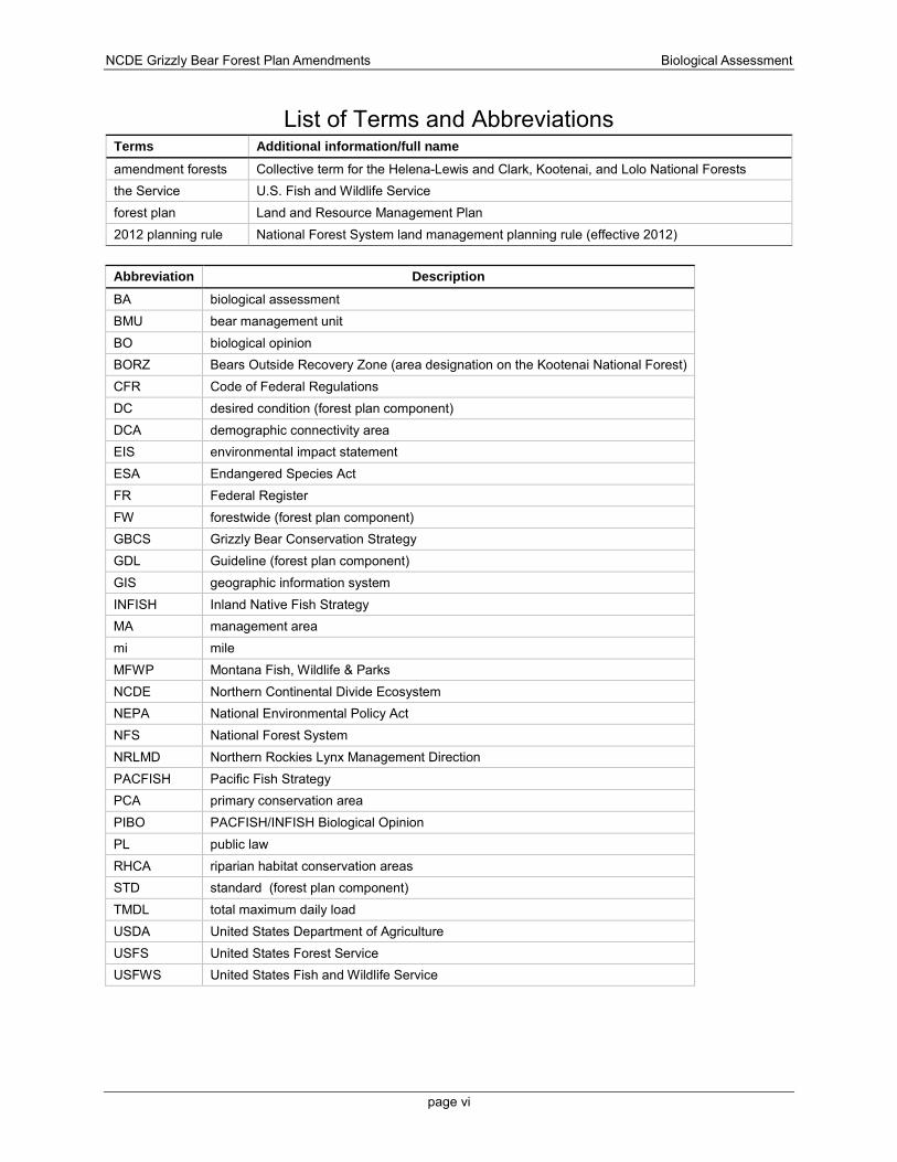
List of Terms and Abbreviations Terms Additional information/full name amendment forests Collective term for the Helena-Lewis and Clark, Kootenai, and Lolo National Forests the Service U.S. Fish and Wildlife Service forest plan Land and Resource Management Plan 2012 planning rule National Forest System land management planning rule (effective 2012)
Abbreviation Description BA biological assessment BMU bear management unit BO biological opinion BORZ Bears Outside Recovery Zone (area designation on the Kootenai National Forest) CFR Code of Federal Regulations DC desired condition (forest plan component) DCA demographic connectivity area EIS environmental impact statement ESA Endangered Species Act FR Federal Register FW forestwide (forest plan component) GBCS Grizzly Bear Conservation Strategy GDL Guideline (forest plan component) GIS geographic information system INFISH Inland Native Fish Strategy MA management area mi mile MFWP Montana Fish, Wildlife & Parks NCDE Northern Continental Divide Ecosystem NEPA National Environmental Policy Act NFS National Forest System NRLMD Northern Rockies Lynx Management Direction PACFISH Pacific Fish Strategy PCA primary conservation area PIBO PACFISH/INFISH Biological Opinion PL public law RHCA riparian habitat conservation areas STD standard (forest plan component) TMDL total maximum daily load USDA United States Department of Agriculture USFS United States Forest Service USFWS United States Fish and Wildlife Service
NCDE Grizzly Bear Forest Plan Amendments Biological Assessment
1
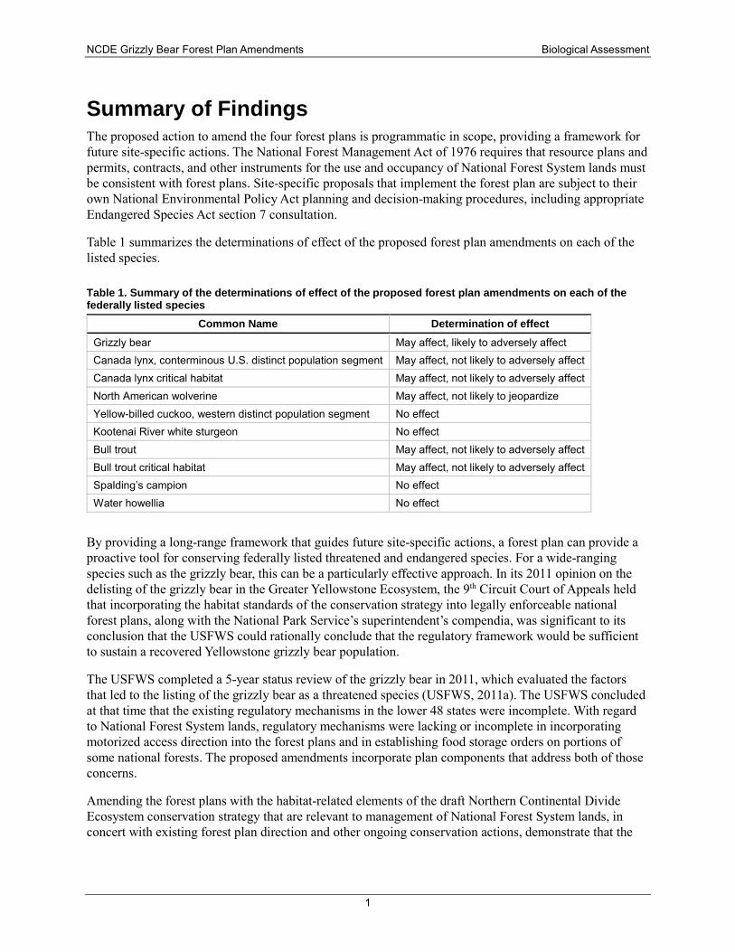
Summary of Findings The proposed action to amend the four forest plans is programmatic in scope, providing a framework for future site-specific actions. The National Forest Management Act of 1976 requires that resource plans and permits, contracts, and other instruments for the use and occupancy of National Forest System lands must be consistent with forest plans. Site-specific proposals that implement the forest plan are subject to their own National Environmental Policy Act planning and decision-making procedures, including appropriate Endangered Species Act section 7 consultation.
Table 1 summarizes the determinations of effect of the proposed forest plan amendments on each of the listed species.
Table 1. Summary of the determinations of effect of the proposed forest plan amendments on each of the federally listed species
Common Name Determination of effect Grizzly bear May affect, likely to adversely affect Canada lynx, conterminous U.S. distinct population segment May affect, not likely to adversely affect Canada lynx critical habitat May affect, not likely to adversely affect North American wolverine May affect, not likely to jeopardize Yellow-billed cuckoo, western distinct population segment No effect Kootenai River white sturgeon No effect Bull trout May affect, not likely to adversely affect Bull trout critical habitat May affect, not likely to adversely affect Spalding’s campion No effect Water howellia No effect
By providing a long-range framework that guides future site-specific actions, a forest plan can provide a proactive tool for conserving federally listed threatened and endangered species. For a wide-ranging species such as the grizzly bear, this can be a particularly effective approach. In its 2011 opinion on the delisting of the grizzly bear in the Greater Yellowstone Ecosystem, the 9th Circuit Court of Appeals held that incorporating the habitat standards of the conservation strategy into legally enforceable national forest plans, along with the National Park Service’s superintendent’s compendia, was significant to its conclusion that the USFWS could rationally conclude that the regulatory framework would be sufficient to sustain a recovered Yellowstone grizzly bear population.
The USFWS completed a 5-year status review of the grizzly bear in 2011, which evaluated the factors that led to the listing of the grizzly bear as a threatened species (USFWS, 2011a). The USFWS concluded at that time that the existing regulatory mechanisms in the lower 48 states were incomplete. With regard to National Forest System lands, regulatory mechanisms were lacking or incomplete in incorporating motorized access direction into the forest plans and in establishing food storage orders on portions of some national forests. The proposed amendments incorporate plan components that address both of those concerns.
Amending the forest plans with the habitat-related elements of the draft Northern Continental Divide Ecosystem conservation strategy that are relevant to management of National Forest System lands, in concert with existing forest plan direction and other ongoing conservation actions, demonstrate that the
NCDE Grizzly Bear Forest Plan Amendments Biological Assessment
2
agency is fulfilling its Endangered Species Act section 7(a)(1) responsibilities to conserve the threatened grizzly bear.
Introduction This biological assessment (BA) addresses the effects of amending the forest plans for the Helena-Lewis and Clark, Kootenai, and Lolo National Forests to incorporate the habitat-related provisions of the draft Northern Continental Divide Ecosystem (NCDE) Grizzly Bear Conservation Strategy (USFWS, 2013e). All threatened, endangered, and proposed species and designated critical habitat that are known or suspected to occur on the affected national forests are addressed. The proposed forest plan amendments are being prepared in conjunction with the revision of the Flathead National Forest’s forest plan. Separate BAs are being prepared for the Flathead’s revised forest plan and for the proposed amendments because the scope of the revision is much broader than that of the amendments.
Threatened, endangered, and proposed species are managed by the Forest Service under the authority of the federal Endangered Species Act of 1973 (PL 93-205, as amended) and the National Forest Management Act of 1976 (PL 94-588). Section 7(a)(1) of the Endangered Species Act (ESA) directs all federal agencies to carry out programs for the conservation of endangered species and threatened species. Section 7(a)(2) of the ESA requires federal agencies to ensure that any actions authorized, funded, or carried out by the agency are not likely to jeopardize the continued existence of any threatened, endangered, or proposed species or to adversely modify critical habitat.
A consultation agreement between the Forest Service and the U.S. Fish and Wildlife Service (USFWS) was established on August 2, 2016, to coordinate the section 7 consultation process and help guide development of the BAs.
Purpose and need for the proposed action In 2013, the USFWS announced the availability of a draft Northern Continental Divide Ecosystem (NCDE) Grizzly Bear Conservation Strategy for public review and comment. When finalized, the grizzly bear conservation strategy will become the post-delisting management strategy for the NCDE grizzly bears and their habitat. The NCDE grizzly bear conservation strategy contains habitat-related management direction that pertains to the portions of the Flathead, Helena-Lewis and Clark, Kootenai, and Lolo National Forests that are located within the NCDE. Note that the Helena National Forest and Lewis and Clark National Forest have recently been administratively combined but still have separate forest plans in place, each of which are being amended.
Habitat conditions and management on the Flathead, Helena-Lewis and Clark, Kootenai, and Lolo National Forests have contributed importantly to the increased population size and improved status of the grizzly bear across the NCDE. Supporting a healthy grizzly bear population in the NCDE will depend on continued, effective management of the grizzly bear’s habitat. By incorporating consistent direction for management of grizzly bear habitat into the forest plans, the Forest Service will be able to demonstrate to the USFWS that adequate regulatory mechanisms are in place to support potential future delisting of the NCDE grizzly bear population.
The purpose of the proposed action evaluated in this BA is to amend four forest plans—the Helena, Lewis and Clark, Kootenai, and Lolo National Forest plans—to incorporate the desired conditions, standards, guidelines, and monitoring items that are relevant to management of NFS lands and that will support the recovery of the NCDE population of grizzly bears.
NCDE Grizzly Bear Forest Plan Amendments Biological Assessment
3
Programmatic decision The proposed action to amend the four forest plans is programmatic in scope. A forest plan identifies general land use purposes or suitability, future conditions that are desirable, goals and objectives for resource conditions on specific lands, and standards and guidelines that establish a management framework for all activities conducted and allowed on National Forest System (NFS) lands. In accordance with the National Forest Management Act of 1976, resource plans and permits, contracts, and other instruments for the use and occupancy of NFS lands must be consistent with the forest plans. Thus, the effects of a forest plan are indirect, by providing long-range guidance for future site-specific actions. Site-specific proposals that implement the forest plan are subject to their own National Environmental Policy Act (NEPA) planning and decision-making procedures, including appropriate ESA section 7 consultation.
The management direction contained in the proposed amendments will go into effect once the final records of decision are signed by the three Forest Supervisors. Project-level environmental analysis will still need to be completed for proposals that would implement the direction in the forest plan.
Consultation history The following is a synopsis of ESA section 7 consultations completed on the current forest plans. Note that in December 2015, the Helena and the Lewis and Clark National Forests were administratively consolidated into one forest, the Helena-Lewis and Clark National Forest. The combined forest still has two separate forest plans that differ from one another and completed their own ESA section 7 consultations. The effects analyses for the Helena forest plan and the Lewis and Clark forest plan are therefore presented separately in this BA.
The Helena National Forest plan (USDA, 1986a), approved in 1986, received a biological opinion (BO) from USFWS in 1985, which concluded that the forest plan was not likely to jeopardize the grizzly bear. The consultation for the grizzly bear covered the area within the NCDE recovery zone on the Lincoln Ranger District. On August 5, 2005, the Helena Forest Supervisor submitted a BA to USFWS requesting reinitiation of consultation on the effects of continued implementation of the forest plan on the grizzly bear in the NCDE and in the grizzly bear distribution zone, which encompassed all of the Lincoln Ranger District and that portion of the Helena Ranger District that is north of Mullan Pass. A BO issued on July 8, 2006, administratively amended the 1985 BO. On December 3, 2013, the Helena Forest Supervisor again requested reinitiation of consultation to encompass areas where grizzly bears may be present, both within and outside the recovery zone, which included the Lincoln Ranger District and that portion of the Helena Ranger District that is west of I-15, referred to as the Divide landscape. The BO issued on Feb. 19, 2014, administratively amended the 1985 BO and superseded portions of the 2006 BO (USFWS, 2014c). The remainder of the 2006 BO was superseded by the August 3, 2016 BO on the Blackfoot non-winter travel plan. Additional section 7 consultations on broad-scale travel management plans have been completed for the winter travel plan and the Divide travel plan.
The Lewis and Clark National Forest Plan was approved in 1986 (USDA, 1986b). A biological opinion dated Aug. 22, 1985, concluded that the selected alternative is not likely to jeopardize the continued existence of grizzly bear and gray wolf and should not adversely affect peregrine falcon and bald eagle. Informal section 7 consultations on broad-scale travel management plans have been completed for the Birch Creek South travel plan (letter of concurrence dated Sept. 18, 2006) and the Badger-Two Medicine travel plan (letter of concurrence dated Dec. 15, 2008).
The Kootenai National Forest’s revised forest plan was approved in 2015 (USDA, 2015b). ESA section 7 consultation on the revised forest plan was completed with issuance of a BO in 2013 (USFWS, 2013b). The grizzly bear consultation covered Kootenai National Forest lands within the Cabinet-Yaak recovery
NCDE Grizzly Bear Forest Plan Amendments Biological Assessment
4
zone, the NCDE recovery zone, and areas outside of the recovery zones that receive recurring use by grizzly bears (BORZ). The Kootenai forest plan explicitly incorporated the Forest Plan Amendments for Motorized Access Management within the Selkirk and Cabinet-Yaak Grizzly Bear Recovery Zones on the Kootenai, Idaho Panhandle, and Lolo National Forests.
The Lolo National Forest Plan was approved in 1986 (USDA, 1986c) after receiving a 1982 BO that concluded that implementation of the forest plan would not be likely to jeopardize the continued existence of threatened and endangered species, including the Cabinet-Yaak and NCDE grizzly bear populations. During the early 1990s, the Forest developed a more detailed grizzly bear recovery strategy that included definitions, standards, and guidelines for bear management analysis areas, road density standards, activity scheduling, and displacement areas. In May 1996, USFWS administratively amended the 1982 BO on the Lolo Forest Plan with an incidental take statement regarding access management and grizzly bears. On August 30, 2004, USFWS issued a BO and incidental take statement regarding the effects of the Lolo’s forest plan on grizzly bears occurring outside of the recovery zone, as well as the effects of forest plan direction related to food and attractant storage and livestock grazing on grizzly bears occurring on the Forest within the recovery zone. On June 14, 2012, USFWS issued a revised incidental take statement for grizzly bears based on updated information on the environmental baseline provided by the Lolo National Forest (USFWS, 2012). An access management strategy was developed specifically for the Swan bear management unit (BMU) subunit, and consultation was reinitiated on the 1996 BO and incidental take statement with a final BO for the Swan subunit issued on Oct. 19, 2011 (USFWS, 2011b).
The Helena, Kootenai, and Lolo forest plans were amended to incorporate the Inland Native Fish Strategy (INFISH) in 1995. INFISH standards and guidelines apply to all riparian habitat conservation areas (RHCAs) and to activities outside RHCAs that would degrade habitat conditions within RHCAs. The standards and guidelines address ten issues: timber management, roads management, grazing management, recreation management, minerals management, fire and fuels management, lands, general riparian area management, watershed and habitat restoration, and fisheries and wildlife restoration. Originally proposed as interim direction, INFISH has remained in place and has been found to have been effective in protecting aquatic resources (Meredith et al., 2012). When the Kootenai forest plan was revised, the INFISH direction was carried forward, with the addition of an active aquatic restoration component.
The Helena, Lewis and Clark, Kootenai, and Lolo forest plans all were amended by the Northern Rockies Lynx Management Direction on March 23, 2007. That decision incorporated management direction that conserves and promotes recovery of Canada lynx by reducing or eliminating adverse effects from land management activities. The BO and incidental take statement addressing effects to the contiguous U.S. distinct population segment of Canada lynx was issued by USFWS on March 19, 2007. The level of incidental take was quantified based on the percentage of occupied lynx habitat that coincides with the wildland urban interface (6 percent) and estimates of the amount of thinning allowed under the exceptions to VEG S5 that likely would be undertaken during the first 10 years of implementation. The BO stated there was no effect on lynx critical habitat since none had been designated on NFS lands at that time. When the Kootenai forest plan was revised, the Norther Rockies Lynx Management Direction was retained.
Action Area The NCDE grizzly bear recovery zone encompasses about 5.7 million acres. Each of the five proclaimed national forests in the NCDE (Flathead, Kootenai, Helena, Lewis and Clark, and Lolo) is managed in accordance with its own forest plan, which includes direction for management of grizzly bear habitat.
NCDE Grizzly Bear Forest Plan Amendments Biological Assessment
5
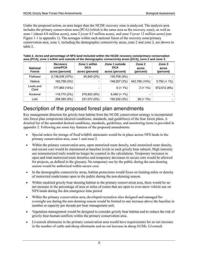
Under the proposed action, an area larger than the NCDE recovery zone is analyzed. The analysis area includes the primary conservation area (PCA) (which is the same area as the recovery zone), as well as zone 1 (about 4.8 million acres), zone 2 (over 4.5 million acres), and zone 3 (over 12 million acres) (see Figure 1-1 in appendix 1). The acreages within each national forest of the recovery zone/primary conservation area, zone 1, including the demographic connectivity areas, zone 2 and zone 3, are shown in table 2.
Table 2. Acres and percentage of NFS land included within the NCDE recovery zone/primary conservation area (PCA), zone 1 within and outside of the demographic connectivity areas (DCA), zone 2 and zone 3.
National Forest
Recovery zone/PCA
acres (percent)
Zone 1 within DCA
acres (percent)
Zone 1 outside DCA
acres (percent)
Zone 2 acres
(percent)
Zone 3 acres
(percent)
Flathead 2,136,536 (37%) 95,840 (2%) 135,708 (3%) - - Helena 183,758 (3%) - 149,207 (3%) 642,786 (14%) 5,792 (< 1%)
Lewis and Clark 777,963 (14%) - 6 (< 1%) 2 (< 1%) 972,612 (8%)
Kootenai 118,770 (2%) 276,822 (6%) 6,480 (< 1%) - - Lolo 268,390 (5%) 231,072 (5%) 155,202 (3%) 38 (< 1%) -
Description of the proposed forest plan amendments Key management direction for grizzly bear habitat from the NCDE conservation strategy is incorporated into forest plan components (desired conditions, standards, and guidelines) of the four forest plans. A detailed list of the amended desired conditions, standards, guidelines, and monitoring items is provided in appendix 2. Following are some key features of the proposed amendments:
• Special orders for storage of food/wildlife attractants would be in place across NFS lands in the primary conservation area, zone 1 and zone 2.
• Within the primary conservation area, open motorized route density, total motorized route density, and secure core would be maintained at baseline levels in each grizzly bear subunit. High intensity use nonmotorized trails would no longer be counted in the calculations. Temporary increases in open and total motorized route densities and temporary decreases in secure core would be allowed for projects, as defined in the glossary. No temporary use by the public during the non-denning season would be authorized within secure core.
• In the demographic connectivity areas, habitat protections would focus on limiting miles or density of motorized roads/routes open to the public during the non-denning season.
• Within modeled grizzly bear denning habitat in the primary conservation area, there would be no net increase in the percentage of area or miles of routes that are open to over-snow vehicle use on NFS lands during the den emergence time period
• Within the primary conservation area, developed recreation sites designed and managed for overnight use during the non-denning season would be limited to one increase above the baseline in number or capacity per decade per bear management unit.
• Vegetation management would be designed to consider grizzly bear habitat and to reduce the risk of grizzly bear-human conflicts within the primary conservation area.
• Livestock allotments in the primary conservation area would have requirements for no net increase in the number of cattle and sheep allotments and no net increase in sheep AUMs. Livestock
NCDE Grizzly Bear Forest Plan Amendments Biological Assessment
6
allotments would be managed to limit the risk of grizzly bear-human conflicts in the primary conservation area and zone 1.
• Minerals and energy development would be managed with consideration of grizzly bear habitat and to reduce the risk of grizzly bear-human conflicts in the primary conservation area and zone 1. New leases for fluid minerals (e.g., oil and gas) in the primary conservation area would be required to have a no surface occupancy stipulation.
• Forest plan monitoring items would be added.
The proposed forest plan amendments are not reconsidering any goals, objectives, land allocations, standards, or guidelines that are unrelated to grizzly bear habitat management.
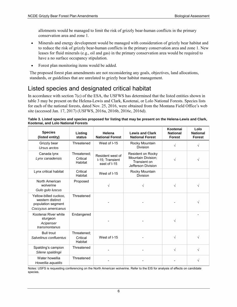
Listed species and designated critical habitat In accordance with section 7(c) of the ESA, the USFWS has determined that the listed entities shown in table 3 may be present on the Helena-Lewis and Clark, Kootenai, or Lolo National Forests. Species lists for each of the national forests, dated Nov. 25, 2016, were obtained from the Montana Field Office’s web site (accessed Jan. 17, 2017) (USFWS, 2016a, 2016b, 2016c, 2016d).
Table 3. Listed species and species proposed for listing that may be present on the Helena-Lewis and Clark, Kootenai, and Lolo National Forests
Species (listed entity)
Listing status
Helena National Forest
Lewis and Clark National Forest
Kootenai National Forest
Lolo National Forest
Grizzly bear Ursus arctos
Threatened West of I-15 Rocky Mountain Division √ √
Canada lynx Lynx canadensis
Threatened; Critical Habitat
Resident west of I-15; Transient
east of I-15
Resident on Rocky Mountain Division;
Transient on Jefferson Division
√ √
Lynx critical habitat Critical Habitat West of I-15 Rocky Mountain
Division
North American wolverine
Gulo gulo luscus
Proposed √ √ √ √
Yellow-billed cuckoo, western distinct
population segment Coccyzus americanus
Threatened
- - - √
Kootenai River white sturgeon Acipenser
transmontanus
Endangered
- - √
-
Bull trout Salvelinus confluentus
Threatened; Critical Habitat
West of I-15 - √ √
Spalding’s campion Silene spaldingii
Threatened - - √ √
Water howellia Howellia aquatilis
Threatened - - - √
Notes: USFS is requesting conferencing on the North American wolverine. Refer to the EIS for analysis of effects on candidate species.
NCDE Grizzly Bear Forest Plan Amendments Biological Assessment
7
Terrestrial Wildlife Species Grizzly bear
Background—Recovery Plan and Conservation Strategy Since its listing as a threatened species in 1975, federal agencies have been working towards recovery of the grizzly bear. Land management plans and practices have been informed by the 1986 Interagency Grizzly Bear Guidelines (IGBC, 1986) and the 1993 grizzly bear recovery plan (USFWS, 1993).
One of the requirements for delisting the grizzly bear is the development and completion of an interagency conservation strategy that will ensure that adequate regulatory mechanisms will continue to be present after delisting (USFWS, 1993). Five federal agencies—the Forest Service, USFWS, National Park Service, U.S. Bureau of Land Management, and U.S. Geological Survey—participated in development of the NCDE grizzly bear conservation strategy, published in draft in 2013, and will be signatories to an agreement to implement the conservation strategy. The expectation is that the signatories will incorporate the set of habitat standards and guidelines relevant to their jurisdiction into their respective management plans.
The NCDE recovery zone/primary conservation area includes about 5.7 million acres of land. About 60 percent of the primary conservation area is on NFS lands. Glacier National Park lands represent about 19 percent of the primary conservation area. The U.S. Bureau of Land Management, USFWS, and U.S. Bureau of Reclamation collectively manage a very small fraction (0.4 percent) of the primary conservation area. Acreage in each management zone for each national forest in the NCDE is displayed in table 2 (above).
Under the draft NCDE conservation strategy, all federal agencies would manage lands within the primary conservation area so that (1) there would be no net decrease in secure core from the baseline and no net increase in open and total motorized route densities; (2) the number and capacity of developed recreation sites would be limited; (3) there would be no net increase in the number of livestock allotments and no net increase in the number of sheep animal unit months from the baseline; (4) vegetation management would be conducted in a way that is compatible with grizzly bear habitat needs; and (5) mineral and energy development would be designed to avoid, minimize, or mitigate adverse impact to grizzly bears.
In the lawsuit Fund for Animals v. Babbitt, 967 F. Supp. 6 (D.D.C. 1997), the Court ruled that the USFWS needed to “establish a threshold of minimal habitat values to be maintained within each Cumulative Effects Analysis Unit in order to ensure that sufficient habitat is available to support a viable population.” For the Greater Yellowstone recovery area, USFWS held a public workshop to identify habitat-based recovery criteria. Three objective and measurable criteria, which had already been incorporated into the conservation strategy for the Greater Yellowstone recovery area, were identified: a secure habitat standard, a developed site standard, and a livestock allotment standard. These habitat-based recovery criteria were appended to the Greater Yellowstone Ecosystem chapter of the Grizzly Bear Recovery Plan (USFWS, 2013d).
USFWS is currently evaluating habitat-based recovery criteria for the NCDE. On May 11, 2016, a notice was published in the Federal Register informing scientists and other interested parties that they would have the opportunity to submit oral or written comments on habitat-based recovery criteria for the NCDE grizzly bear population. On July 7, 2016, the Service conducted a workshop to hear oral presentations and also accepted written comments during July 2016. The USFWS is now reviewing and responding to the
NCDE Grizzly Bear Forest Plan Amendments Biological Assessment
8
comments. If it is determined that habitat-based recovery criteria are needed for the NCDE population, such criteria may be appended to the grizzly bear recovery plan.
The draft NCDE conservation strategy includes measurable criteria for motorized access and secure habitat, developed recreation sites, and livestock allotments and also for minerals management and vegetation management. The conservation strategy also addresses measures to maintain or enhance connectivity between grizzly bear ecosystems and to require proper storage of food and attractants. The proposed amendments incorporate these elements.
Ongoing grizzly bear conservation actions by the Forest Service Over the years, the Forest Service has undertaken substantial actions both inside and outside the NCDE recovery zone to maintain or improve grizzly bear habitat and to reduce grizzly bear-human conflicts on the national forests. These actions will continue. Following are some examples.
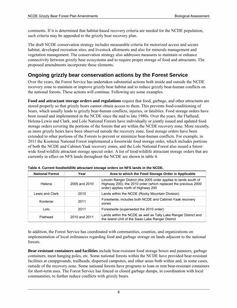
Food and attractant storage orders and regulations require that food, garbage, and other attractants are stored properly so that grizzly bears cannot obtain access to them. This prevents food-conditioning of bears, which usually leads to grizzly bear-human conflicts, injuries, or fatalities. Food storage orders have been issued and implemented in the NCDE since the mid to late 1980s. Over the years, the Flathead, Helena-Lewis and Clark, and Lolo National Forests have individually or jointly issued and updated food storage orders covering the portions of the forests that are within the NCDE recovery zone. More recently, as more grizzly bears have been observed outside the recovery zone, food storage orders have been extended to other portions of the Forests to prevent or minimize bear-human conflicts. For example, in 2011 the Kootenai National Forest implemented a forestwide food storage order, which includes portions of both the NCDE and Cabinet-Yaak recovery zones, and the Lolo National Forest also issued a forest-wide food/wildlife attractant storage special order. A list of food/wildlife attractant storage orders that are currently in effect on NFS lands throughout the NCDE are shown in table 4.
Table 4. Current food/wildlife attractant storage orders on NFS lands in the NCDE. National Forest Year Area to which the Food Storage Order is Applicable
Helena 2005 and 2010 Lincoln Ranger District (the 2005 order applies to lands south of Highway 200); the 2010 order (which replaced the previous 2000 order) applies north of Highway 200
Lewis and Clark 2010 Lands within the NCDE (Rocky Mountain Division)
Kootenai 2011 Forestwide, includes both NCDE and Cabinet-Yaak recovery zones
Lolo 2011 Forestwide (superseded the 2010 order)
Flathead 2010 and 2011 Lands within the NCDE as well as Tally Lake Ranger District and the Island Unit of the Swan Lake Ranger District
In addition, the Forest Service has coordinated with communities, counties, and organizations on implementation of local ordinances regarding food and garbage storage on lands adjacent to the national forests.
Bear-resistant containers and facilities include bear-resistant food storage boxes and panniers, garbage containers, meat hanging poles, etc. Some national forests within the NCDE have provided bear-resistant facilities at campgrounds, trailheads, dispersed campsites, and other areas both within and, in some cases, outside of the recovery zone. Some national forests have programs to loan or rent bear-resistant containers for short-term uses. The Forest Service has fenced or closed garbage dumps, in coordination with local communities, to further reduce conflicts with grizzly bears.
NCDE Grizzly Bear Forest Plan Amendments Biological Assessment
9
Information and education A variety of information and education materials (e.g., pamphlets, brochures, signs, videos, etc.) and programs are provided to the public at Forest Service offices. Signs and brochures about proper behavior and safety procedures in bear country are placed at campgrounds, trailheads, dispersed recreation sites, picnic areas, etc. The Forest Service has cooperated with Montana Fish, Wildlife & Parks (MFWP) and other cooperating institutions and individuals in giving presentations and offering workshops that address bear identification; safe camping, hiking, hunting, and working procedures to use in bear habitat; the use of electric fencing to reduce conflicts between bears and livestock (e.g., chickens, pigs, beehives, sheep, cattle); and the proper use of bear-deterrent pepper spray. Wilderness rangers and other backcountry patrols have been used to inform and educate the public on food storage orders and to check on compliance with these orders. Field patrols have been used during hunting seasons to reduce hunter-caused conflicts and grizzly bear mortalities.
Special grizzly bear requirements in contracts and permits Many contracts and special-use permits in the NCDE contain provisions requiring protection of the grizzly bear and its habitat, as well as proper storage of food and attractants. Some contract and permit provisions require temporary or permanent cessation of permitted activities to resolve grizzly bear-human conflicts. Timber sale prescriptions and contracts incorporate provisions to protect grizzly bear habitat. For example, silvicultural prescriptions are designed to maintain or enhance food sources, timing provisions are aimed at reducing the potential for grizzly bear-human conflicts, and specific contract provisions require proper food storage and temporary or permanent cessation of permitted activities to resolve grizzly bear-human conflicts.
Livestock grazing permits may include special provisions such as proper storage of food and attractants as well as carcass removal. Annual monitoring of livestock allotments is performed to check on compliance and assess any conflicts. Disposal of animal carcasses has been emphasized to reduce conflicts with grizzly bears.
Land adjustments Important grizzly bear habitat has been acquired through land exchanges and acquisitions on the NCDE national forests. The cooperative Legacy Project acquisition of Plum Creek Timber Company lands by the Nature Conservancy, Flathead National Forest, and Lolo National Forest is a landmark example, to name just one.
Motorized route management and monitoring During recent decades, motorized routes have been restricted in some areas in order to provide security for grizzly bears and other wildlife. Annual monitoring is performed to evaluate compliance with access restrictions and to provide information and education to the public. Monitoring also helps to identify when repairs are needed to keep road closures effective.
Highway and railroad mortality For many years, the Forest Service has coordinated with transportation agencies and railroad companies to seek to reduce the risk of collisions with grizzly bears. For example, in 1991, the Great Northern Environmental Stewardship Area (GNESA) was formed through an agreement with the Burlington Northern Santa Fe Railroad and multiple state, federal and tribal partners for the rail line that traverses the Middle Fork Flathead River Corridor. The GNESA agreement established a conservation trust fund and identified several railroad operation and maintenance procedures that would be followed to minimize train-bear incidents and ensure a rapid response and removal of attractants from the railroad right-of-way. The Forest Service maintains the Wildlife Crossings Toolkit website (https://www.fs.fed.us/wildlifecrossings/index.php) which was developed in partnership with the National Park Service, Federal Highway Administration and the American Association of State Highway and Transportation Officials. This website provides state-of-the-art information for biologists, engineers, and transportation professionals to assist in reducing wildlife mortalities and maintaining or restoring habitat connectivity across transportation infrastructure on public lands.
NCDE Grizzly Bear Forest Plan Amendments Biological Assessment
10
Existing conditions
Grizzly bear population size and trend in the NCDE The Grizzly Bear Recovery Plan established demographic recovery goals for each grizzly bear recovery zone. For the NCDE, the demographic recovery subgoals are:
• At least 10 females with cubs inside Glacier National Park and 12 females with cubs outside the Park over a running 6-year average within the recovery zone and a 10-mile buffer area, excluding Canada;
• Occupancy by females with young of 21 of 23 BMUs from a running 6-year sum of verified sightings and evidence, with no two adjacent BMUs unoccupied; and
• Known human-caused mortality does not exceed 4 percent of population estimate based on the most recent 3-year sum of females with cubs, and no more than 30 percent of the 4 percent shall be females, and the mortality limits cannot be exceeded during any 2 consecutive years (USFWS, 1993, pp. 26, as amended).
• Additionally, the Mission Mountains portion of the recovery zone must be occupied.
However, as described in the five-year status review of the grizzly bear (USFWS 2011 p. 16), sightability of females with young has always been a challenge in this heavily forested ecosystem. In addition, there was a lack of consistency in data collection and survey effort (Costello et al. 2016). For these reasons, USFWS discontinued recording the number of females with cubs and their distribution in the NCDE as of 2004. Instead, USFWS has relied on new science and techniques developed through an extensive DNA-based population estimate (Kendall et al. 2009) and a study of radiocollared bears sampled proportionately to relative population density, enabling calculation of reproductive rates, survival rates, and population trend (Mace et al. 2012). Subsequent work by Costello et al. (2016) has further refined the methods used for monitoring and reporting population distribution, vital rates including an estimate of unreported mortalities, and population trend. The following summarizes the findings of these and related studies of population size, distribution and trend in the NCDE.
In 2004, a DNA-based mark-recapture study was conducted in a 7.8-million-acre area of occupied grizzly bear range in and around the NCDE recovery zone. Extrapolating from the 563 individuals detected, the overall grizzly bear population in the NCDE was calculated to be 765 grizzly bears, including all sex and age classes (Kendall et al., 2009). Between 2004 and 2009, Mace and others radio-collared and monitored 83 different female grizzly bears in the NCDE and calculated that the population was increasing at a rate of 3.06 percent per year (95 percent confidence interval = 0.928-1.102) (R. D. Mace et al., 2012). Coupled with concurrent studies of population size, Mace and others (2012) estimated that more than 1,000 grizzly bears resided in and adjacent to the NCDE recovery zone in 2012.
Using data from 2004-2014 and some differences in methods, a slightly lower rate of population increase of 2.3 percent was calculated by Costello et al. (2016). The authors stated: “we do not believe the observed difference in the two estimates is a result of actual population change. Our current models included a covariate for trend, and no negative trend was observed in any of the vital rates. Rather, we believe that the differences between Mace et al. (2012) and this report can be attributed to: (1) an increase in sample sizes for estimation of all vital rates; (2) better representation of conflict females in the estimation of vital rates; and (3) subtle but significant differences in methods of analysis.”
Grizzly bears are well distributed throughout the NCDE recovery area. In 2004, at least one female bear was detected in each of the 23 bear management units and an additional 12 were detected outside the recovery zone (Kendall et al., 2009). Costello and others (2016) evaluated occupancy of the 23 bear management units in the NCDE by females with offspring during 2004–2014. Using the 6-year running
NCDE Grizzly Bear Forest Plan Amendments Biological Assessment
11
average as set forth in the recovery plan (USFWS, 1993), Costello and others (2016) evaluated occupancy of the 23 bear management units in the NCDE by females with offspring during 2004–2014 documented full occupancy of the recovery zone by females with young starting in 2009 and continuing through 2014.
Using genetic analysis, six subpopulations were identified within the NCDE (Kendall et al., 2009). However, the genetic differentiation values between these subpopulations were generally low, suggesting that few barriers to genetic exchange have existed within the NCDE. The NCDE grizzly bear population also appears to be well connected to populations in Canada (Proctor et al., 2012).
Based on verified grizzly bear locations, Costello et al. (2016) estimated that the NCDE grizzly bear population has expanded to occupy an area of about 13.6 million acres, more than double the size of the recovery zone. Genetic analysis by Mikle and others (2016) also supports population expansion, following a range contraction that probably had its low point in the 1920s or 1930s. The highest density of bears and the highest genetic diversity is found in Glacier National Park and surrounding lands, with lower densities and lower heterozygosity on lands farther south (Mikle et al., 2016). However as the population expands, genetic diversity has been increasing in the peripheral areas.
Human-caused mortality is the most significant factor influencing grizzly bear survival in the NCDE. Of 337 grizzly bear mortalities documented between 1998 and 2011, 290 (86 percent) were human-caused (R. D. Mace et al., 2012). Of the human-caused mortalities, the major causes were management removals (removed from the population due to conflicts with humans or property, 31 percent), illegal kills (21 percent), defense of life (15 percent), collisions with trains (11 percent), and collisions with automobiles (10 percent).
During 2015, there were 22 known and probable grizzly bear mortalities in the NCDE (Costello et al., 2016). Nineteen of these occurred within the primary conservation area and zone 1, while two occurred in zone 3. Causes of death for independent bears (11 males and 3 females) were: agency removal (4), poaching/malicious kill (4), automobile collisions (2), defense of life (1), mistaken identification (1), and undetermined (2). The causes of death for the eight dependent bears were automobile collisions (4), agency removal (2), capture mortality (1) and undetermined (1).
Legal hunting of grizzly bears has not occurred in Montana since 1991 (Pac & Dood, 1998), but grizzly bears are mistakenly killed during the black bear hunting season, killed by poachers, or killed in self-defense (Costello et al., 2016). Recognizing that management removals were documented with 100 percent accuracy, whereas other deaths often go unreported, Costello et al. (2016) further analyzed the 2015 data to provide a corrected estimate of unreported mortalities. This revealed that poaching/malicious kills likely accounted for the highest proportion of total independent bear mortality (27 percent), followed by management removals (16 percent), illegal defense of property (11 percent), and natural causes (9 percent).
The majority of management removals result from conflicts at sites on private lands associated with frequent or permanent human presence (USFWS, 1993). Unsecured attractants on private lands such as chicken coops, garbage, human foods, pet/livestock foods, bird food, livestock carcasses, wildlife carcasses, barbeque grills, compost piles, orchard fruits, or vegetable gardens are usually the source of these conflicts. As described in the previous section, the Forest Service has issued food/attractant storage orders across the NCDE and has established or cooperated in various other efforts to reduce grizzly bear mortality risk on NFS lands.
Despite the various sources of human-caused mortalities, the survival rate for adult females (the most important group affecting population trend) is high at 0.947, with a 95 percent confidence interval of 0.919-0.972 (Costello et al., 2016).
NCDE Grizzly Bear Forest Plan Amendments Biological Assessment
12
In summary, available information documents increases in grizzly bear distribution, population size, and genetic diversity. The estimated population size was 765 bears in 2004 (Kendall et al. 2009), nearly double the target of 391 bears based on sightings of females with cubs (USFWS 1993). Occupancy of bear management units by females with young has been documented (Costello et al. 2016). Mortality has been at an acceptable level based on ongoing research and monitoring showing that the NCDE grizzly bear population has been stable to increasing and expanding its distribution (Costello et al. 2016).
Many factors have led to the increased numbers and distribution of grizzly bears. For example, MFWP has instituted a mandatory black bear hunter testing and certification program to help educate hunters in distinguishing species and reducing grizzly bear mortalities due to mistaken identity and employs bear management specialists to help prevent and resolve grizzly bear-human conflicts. Habitat management on NFS lands, including motorized travel restrictions, improvements in securing food and other attractants, carefully designed habitat restoration, and use of prescribed and managed use fire, also has contributed to the improved status of the grizzly bear population.
NCDE population distribution in relation to other recovery zones The NCDE recovery zone includes about 5.7 million acres of land. Using verified grizzly bear locations to create a current distribution map for the NCDE, Costello et al. (2016) estimated that bears occupy an area of about 13.6 million acres, more than double the size of the recovery zone.
The current distribution of grizzly bears encompasses the entire NCDE recovery zone, nearly all of zone 1, including 100 percent of the Salish demographic connectivity area and 63 percent of the Ninemile demographic connectivity area, and part of zones 2 and 3 (Costello et al., 2016). Both males and females are becoming increasingly common along streams and in shrubby draws to the east of the recovery zone boundary along the Rocky Mountain Front. Three female grizzly bear dens have been documented in short-grass prairie habitat along the eastern front of the Rocky Mountains (R. D. Mace & Roberts, 2014).
Based on its large population size, increasing trend, and genetic diversity, the NCDE appears to be capable of serving as a source population for other grizzly bear populations in the contiguous United States (USFWS, 2013e). Demographic connectivity may be especially important to support the small grizzly bear population in the Cabinet-Yaak ecosystem, which might not otherwise be viable over the long term. The NCDE population also has the potential to be a source population for recolonization of the Bitterroot potential recovery zone.
The Greater Yellowstone Ecosystem has a robust bear population, but there is a concern that its geographical isolation from other populations may lead to a loss of genetic diversity. To address that concern, the recovery plan (p. 56) suggested introducing one male bear into the Greater Yellowstone from another recovery area about every 10 years to limit the loss of genetic diversity (USFWS, 1993). DNA analysis by Miller and Waits (2003) on museum specimens did show that there was a decline in allelic richness and expected heterozygosity during the early half of the 20th century. However, Kamath et al. (2015) recently reported that genetic diversity of the Greater Yellowstone Ecosystem population has stabilized, with a very low (0.2 percent) rate of inbreeding during the 1985-2010 period. The current genetic diversity of the Greater Yellowstone population is moderately low as compared to other North American and European brown bear populations, due to its isolation (Kamath et al., 2015). The restoration of gene flow is still important, although it appears to be less urgently needed than previously hypothesized.
The current distribution of grizzly bears in the NCDE has been reported by Costello and others (2016) for the NCDE and by Bjornlie and others (2014) for the Greater Yellowstone Ecosystem. Male bears from the NCDE have been documented as far south as Butte, Montana (R. D. Mace & Roberts, 2012). Available
NCDE Grizzly Bear Forest Plan Amendments Biological Assessment
13
information indicates that the bears are moving south from the NCDE through the west side of the Helena National Forest rather than through the Big Belt or Little Belt Mountains to the east (see Figure 1-1 in appendix 1). The area that includes a portion of the Blackfoot landscape south of Highway 200 and all of the Continental Divide landscape thus appears to have the most potential for establishing genetic connectivity through NFS lands from the NCDE to the Greater Yellowstone Ecosystem.
Habitat in the NCDE The search for energy-rich food appears to be a driving force in grizzly bear behavior and habitat selection. Grizzly bears are large animals that have high metabolic demands during the non-denning season. Adequate nutritional quality and quantity are important factors for successful reproduction. Bears are dependent upon learned food locations within their home ranges and can switch food habits according to which foods are available (K. Aune & Kasworm, 1989; Kendall, 1986; R. D. Mace & Jonkel, 1986; Servheen, 1981). Mattson et al. (1991) hypothesized that grizzly bears are always sampling new foods in small quantities so that they have alternative options in years when preferred foods are scarce.
Grizzly bears use a wide variety of habitats, including open to forested and temperate through alpine habitats. The varying climate, topography, and vegetative conditions throughout the NCDE provide for a variety of habitats and foods for bears to consume during different seasons. During spring and early summer, grizzly bears in the NCDE eat primarily roots, corms, bulbs, and other vegetation (K. E. Aune, 1994; Bruce N. McLellan & Hovey, 1995). Later in the summer, grizzlies consume a wide variety of berries once they become available (Bruce N. McLellan & Hovey, 1995). Summer foods also include concentrations of lady bird beetles and army cutworm moths on rocky talus slopes (K. Aune & Kasworm, 1989; Mattson et al., 1991; Servheen, 1983). During late summer to fall, grizzly bears in the NCDE continue to eat berries but also consume more meat, herbaceous vegetation, and roots (K. Aune & Kasworm, 1989; R. D. Mace, Minta, Manley, & Aune, 1994; Bruce N. McLellan & Hovey, 1995).
In the past, grizzlies were known to feed extensively on whitebark pine nuts in the late summer to fall, particularly in the Whitefish Range and on the Rocky Mountain Front (K. Aune & Kasworm, 1989; Kendall & Arno, 1990). However, high infection rates and mortality of whitebark pine caused by white pine blister rust (Kendall & Keane, 2001) have dramatically reduced or eliminated this food source. The bear population has continued to increase despite the loss of this food source, indicating that ample alternate food sources have been available to bears in the NCDE.
Teisberg and others (2015) studied grizzly bear population health and body condition, finding that adult females throughout the NCDE entered their dens with average fat levels above those thought to be critical for cub production. Bears on the southwestern, southern, and eastern periphery of the NCDE consumed a significantly higher proportion of meat in their diets than those in the interior or northwestern periphery. However, there was no evidence to indicate that the widely varying food resources across the NCDE are inadequate to meet the needs of reproductively active adult females. As truly opportunistic omnivores, grizzly bears in all regions of the NCDE exploit diverse combinations of food items to arrive at productive body conditions (Teisberg et al., 2015).
As described in the recovery plan, grizzly bears are an omnivorous and opportunistic species, with available food sources varying annually, seasonally, and even day to day (USFWS, 1993). The abundance and distribution of food resources, availability of habitat components such as cover and denning sites, the levels and types of human activities, grizzly bear social dynamics, learned behavior of individual grizzly bears, and annual weather are important variables influencing the accessibility of foods for bears. Because of the complexity and interactions of these variables, there is no known way to deductively calculate the carrying capacity for grizzly bears across a landscape (USFWS, 1993). Grizzly bears in the NCDE occupy numerous different habitat types, but generally prefer to forage in areas with some type of hiding
NCDE Grizzly Bear Forest Plan Amendments Biological Assessment
14
cover nearby, particularly in daylight hours (K. Aune & Kasworm, 1989; John S. Waller & Mace, 1997). A mosaic of vegetation providing forage and cover is desirable, but the complexity described above makes it difficult to quantify a desired landscape composition.
Graves and others (2011) studied variables affecting grizzly bear abundance in a study area centered over Glacier National Park that spanned the NCDE. Grizzly bear abundance was based upon DNA detection using rub trees and hair traps. For female bears, the authors used a grid representing the median female home range size of 10.36 x10.3 km placed over the study area. For male bears, the authors used a grid representing the median male home range size of 19.76 x 19.7 km cells. Graves and others (2012) found that the amount of mesic habitat (moist cover types and riparian areas that contain bear foods, derived from a remotely sense LANDFIRE cover type classification), bear management level (defined by experts who assigned a value to ownership categories based on efforts to protect bears including attractant storage management, enforcement of food storage regulations, and road density/use management), and historical presence of bears were most closely associated with both female and male grizzly bear abundance. In addition, the amount of meadow and shrub habitat was closely associated with female grizzly bear abundance (see table 3 in Graves et al., 2012).
Grizzly bear populations persisted historically in areas with large expanses of habitat without permanent human presence and where the frequency of contact with humans was low (Mattson & Merrill, 2002). Maintaining large blocks of secure habitat is important to the survival and reproductive success of grizzly bears, especially females (R. D. Mace, Waller, Manley, Ake, & Wittinger, 1999; C. C. Schwartz, Haroldson, & White, 2010). Providing secure core distributed across the primary conservation area is a major goal identified in the draft NCDE grizzly bear conservation strategy.
The NCDE contains large acreages of congressionally designated wilderness, totaling about 1.7 million acres within the recovery zone/primary conservation area. The Wilderness Act of 1964 precludes road construction, motorized and mechanized uses, permanent human habitation, new livestock allotments, new mining claims, new oil and gas leases, or other developments that would impair the wilderness character of wilderness areas, except for those specifically allowed by the enabling legislation (e.g., Schafer airstrip). Wilderness areas provide a high degree of security for grizzly bears.
The NCDE also contains substantial acreage of inventoried roadless areas. These roadless areas, as well as certain other lands that have little or no permanent human presence or road development, are well distributed throughout the NCDE. Inventoried roadless areas contribute to secure habitat for grizzly bears.
The Nature Conservancy mapped landscape permeability for the Pacific Northwest (McRae et al., 2016) including western Montana, by classifying areas as having high, moderate or low landscape permeability. Resistance to movement was modeled by considering features such as land use, roads and rail lines, energy infrastructure, and housing development. Overall, the network of federal lands in northwestern Montana were shown to provide a moderate to high degree of landscape permeability for wildlife. The Forest Service has been cooperating for many years with federal and state agencies and private organizations to improve habitat connectivity and mitigate the impacts of highways, train tracks, and other developments that impede movement by wildlife, including specific efforts for grizzly bears.
Grizzly bears hibernate in dens during the winter months. On the west side of the NCDE, 52 separate females monitored during 1987–88 to 2012–13 entered their dens between the first week of October and the fourth week of November, with most occurring the fourth week of October; 72 females emerged in the spring between the third week of March and the fourth week of May, with most occurring during the second week of April (R. D. Mace & Roberts, 2014). On the east side (Rocky Mountain Front), grizzlies (both male and female) entered dens between October 10 and December 5, with a median date of November 7; they emerged in the spring between March 10 and May 13, with a median date of April 7
NCDE Grizzly Bear Forest Plan Amendments Biological Assessment
15
(K. E. Aune, 1994; R. D. Mace et al., 1994). Males typically enter dens later in the fall and emerge earlier in the spring than do females.
Both males and females have a tendency to use the same general area to hibernate year after year, but the same den is rarely reused by an individual (Linnell, Swenson, Andersen, & Barnes, 2000). Most grizzly bear dens in the NCDE are located at elevations above 6,400 feet (R. D. Mace & Waller, 1997a), with the average elevation somewhat higher on the Rocky Mountain Front (K. E. Aune, 1994; R. D. Mace et al., 1994). The average elevation of 252 grizzly bear dens in the NCDE ranged from 6,427 to 6,906 feet (R. Mace, 2014). An estimated 47 percent (1,647,863 acres) of NFS land in the primary conservation area provides potential denning habitat (Ake, 2015f). The availability of denning habitat is not likely to be a limiting factor for grizzly bears in this area (USFWS, 2013e).
Grizzly bear response to human activities
Motorized routes Research has clearly demonstrated that the presence of roads and associated human activities impacts grizzly bears by displacing them from important habitats and lowering their survival rates during the non-denning season (Boulanger & Stenhouse, 2014; R. D. Mace & Waller, 1996; Mattson, Knight, & Blanchard, 1987; B. N. McLellan & Shackleton, 1989; John S. Waller & Mace, 1997). Mace and Manley (1993) also showed that grizzly bears adjusted their habitat use patterns to both total road densities and open road densities, as well as the traffic levels on roads.
Research findings from the Swan Mountain Range of the Flathead National Forest have been used to evaluate the effects of motorized route density on grizzly bears in the NCDE since 1995. Mace et al. (1996) converted a linear road map to a total road density map using a 1 km2 (0.39 mi2) moving window analysis and reported the following relationships to road density:
• Road density was lower within the composite of the multiannual home ranges of 14 adult and subadult female grizzly bears (0.6 km/km2 or 0.95 mi/mi2) than was road density outside the composite home range (1.1 km/km2 or 1.7 mi/mi2);
• As total road density increased, probability of selection by grizzly bears declined;
• 56 percent of the composite female home range was unroaded compared to 30 percent outside the composite home range;
• Within seasonal ranges, grizzly bears were more likely to use areas with higher road densities during spring than during other seasons;
• Selection for habitats within a 0.3 mi buffer around roads decreased as traffic volume increased.
Based on these and related findings, Amendment 19 to the Flathead National Forest plan (USDA, 1995a) established limits for total motorized route density (no more than 19 percent with density exceeding 2 mi/mi2), open motorized route density (no more than 19 percent with density exceeding 1 mi/mi2), and secure core (at least 68 percent) within each bear management subunit that has more than 75 percent NFS lands. In bear management subunits with less than 75 percent NFS lands, no net increase in total motorized route density (the percent of area with more than 2 mi/mi2) or open motorized route density (the percent of area with more than 1 mi/mi2) would be allowed, and no net decrease in the percentage of secure core in a subunit would be allowed.
The Interagency Grizzly Bear Committee appointed an Access Task Force to develop guidelines for the management of motorized routes in grizzly bear habitat. The guidelines, originally published in 1994, were updated in 1998 to incorporate new information and clarify differences among ecosystems. The
NCDE Grizzly Bear Forest Plan Amendments Biological Assessment
16
access task force endorsed the basic premise of managing open and total route densities and secure core during the non-denning season as an effective strategy to support recovery of the species, although they noted that other strategies may also be effective (IGBC, 1998).
The moving window analysis method has been used to analyze the effects of open motorized route density and total motorized route density in the NCDE recovery zone since 1995. Under the proposed Flathead National Forest plan revision and the amendments of the Helena, Kootenai, Lewis and Clark, and Lolo National Forest plans, the moving window analysis method would continue to be used to calculate open and total motorized route density and secure core in the primary conservation area. This would facilitate comparison of past, present, and foreseeable future effects of motorized routes on grizzly bears in the primary conservation area.
It should be noted that nonmotorized, high intensity use trails were originally included in the methods used to identify secure core. This was done to be conservative in identifying this important feature of habitat for adult female grizzly bears. Because of the difficulty of distinguishing “high intensity use” nonmotorized trails, the resulting lack of lack of consistency, and the lack of published research demonstrating effects on grizzly bears (see further discussion below), the NCDE conservation strategy team decided that high intensity use nonmotorized trails should no longer be part of the process for calculating secure core. The existing percentage of secure core has been calculated both with and without nonmotorized, high intensity use trails.
Outside the primary conservation area, within zone 1 and the demographic connectivity areas, the draft conservation strategy established a goal to maintain grizzly bear occupancy that will likely be at a lower density than in the primary conservation area. In recognition of the differing grizzly bear management objectives for zone 1 and the demographic connectivity areas, and that bear management subunits are delineated only within the primary conservation area, different methods for calculating and evaluating the effects of motorized use were considered.
Rather than using the moving window method, the average density of linear miles of motorized routes/roads was selected for zone 1 and the demographic connectivity areas. Average motorized route densities could be compared with recent work by Boulanger and Stenhouse (2014), who studied 142 grizzly bears monitored in Alberta from 1999-2012. This research constitutes the best available science on the effects of roads on grizzly bears of different sex and age classes (C. Servheen, USFWS, pers. comm. to R. Kuennen 2015).
Boulanger and Stenhouse (2014) found strong spatial gradients in grizzly bear population trend based upon road density. The roads in the Alberta study area were almost entirely (96.5%) gravel secondary roads associated with settlements and industrial resource extraction activities. In Alberta, for the most part, resource roads are all weather gravel roads that are open for public use year round (Gordon Stenhouse, researcher, personal communication with Mark Ruby, Flathead NF biologist, 3/4/2016). Therefore we assumed that all of the roads in the Alberta study area were open. There were no motorized trails in the Alberta study area. Boulanger and Stenhouse identified threshold values for road density to refine targets for population recovery of grizzly bears in Alberta. A summary of the threshold values, and how they were used in the NCDE, is shown in table 5.
Table 5. Threshold values for road density in Alberta and how they were interpreted and used in the NCDE
Objective described in the Alberta study
Reported density km/km2
Converted to English units
Where applied as a standard in the NCDE grizzly bear amendment
Grizzly bear presence – Distribution of collared bears shows most bears
1.5 km/km2
2.4 mi/mi2 Used to evaluate the ability to provide for bear movement on the Helena NF (zone
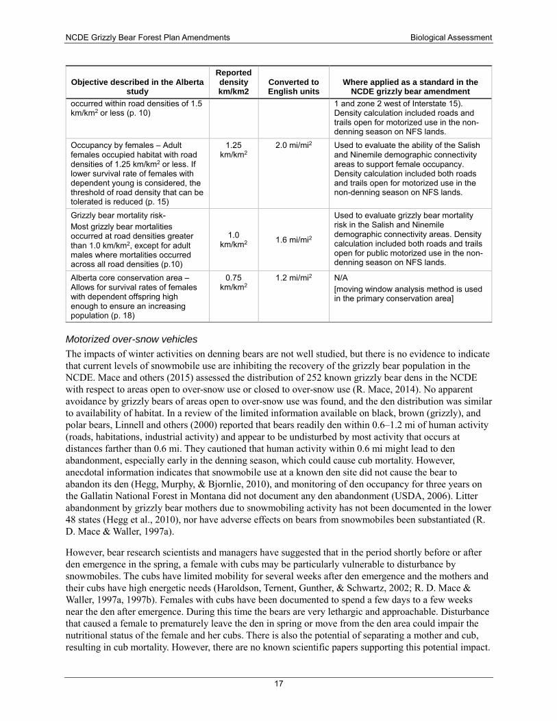
NCDE Grizzly Bear Forest Plan Amendments Biological Assessment
17
Objective described in the Alberta study
Reported density km/km2
Converted to English units
Where applied as a standard in the NCDE grizzly bear amendment
occurred within road densities of 1.5 km/km2 or less (p. 10)
1 and zone 2 west of Interstate 15). Density calculation included roads and trails open for motorized use in the non-denning season on NFS lands.
Occupancy by females – Adult females occupied habitat with road densities of 1.25 km/km2 or less. If lower survival rate of females with dependent young is considered, the threshold of road density that can be tolerated is reduced (p. 15)
1.25 km/km2
2.0 mi/mi2 Used to evaluate the ability of the Salish and Ninemile demographic connectivity areas to support female occupancy. Density calculation included both roads and trails open for motorized use in the non-denning season on NFS lands.
Grizzly bear mortality risk- Most grizzly bear mortalities occurred at road densities greater than 1.0 km/km2, except for adult males where mortalities occurred across all road densities (p.10)
1.0 km/km2 1.6 mi/mi2
Used to evaluate grizzly bear mortality risk in the Salish and Ninemile demographic connectivity areas. Density calculation included both roads and trails open for public motorized use in the non-denning season on NFS lands.
Alberta core conservation area – Allows for survival rates of females with dependent offspring high enough to ensure an increasing population (p. 18)
0.75 km/km2
1.2 mi/mi2 N/A [moving window analysis method is used in the primary conservation area]
Motorized over-snow vehicles The impacts of winter activities on denning bears are not well studied, but there is no evidence to indicate that current levels of snowmobile use are inhibiting the recovery of the grizzly bear population in the NCDE. Mace and others (2015) assessed the distribution of 252 known grizzly bear dens in the NCDE with respect to areas open to over-snow use or closed to over-snow use (R. Mace, 2014). No apparent avoidance by grizzly bears of areas open to over-snow use was found, and the den distribution was similar to availability of habitat. In a review of the limited information available on black, brown (grizzly), and polar bears, Linnell and others (2000) reported that bears readily den within 0.6–1.2 mi of human activity (roads, habitations, industrial activity) and appear to be undisturbed by most activity that occurs at distances farther than 0.6 mi. They cautioned that human activity within 0.6 mi might lead to den abandonment, especially early in the denning season, which could cause cub mortality. However, anecdotal information indicates that snowmobile use at a known den site did not cause the bear to abandon its den (Hegg, Murphy, & Bjornlie, 2010), and monitoring of den occupancy for three years on the Gallatin National Forest in Montana did not document any den abandonment (USDA, 2006). Litter abandonment by grizzly bear mothers due to snowmobiling activity has not been documented in the lower 48 states (Hegg et al., 2010), nor have adverse effects on bears from snowmobiles been substantiated (R. D. Mace & Waller, 1997a).
However, bear research scientists and managers have suggested that in the period shortly before or after den emergence in the spring, a female with cubs may be particularly vulnerable to disturbance by snowmobiles. The cubs have limited mobility for several weeks after den emergence and the mothers and their cubs have high energetic needs (Haroldson, Ternent, Gunther, & Schwartz, 2002; R. D. Mace & Waller, 1997a, 1997b). Females with cubs have been documented to spend a few days to a few weeks near the den after emergence. During this time the bears are very lethargic and approachable. Disturbance that caused a female to prematurely leave the den in spring or move from the den area could impair the nutritional status of the female and her cubs. There is also the potential of separating a mother and cub, resulting in cub mortality. However, there are no known scientific papers supporting this potential impact.
NCDE Grizzly Bear Forest Plan Amendments Biological Assessment
18
As described previously, Mace and Roberts (2014) reported that 72 females on the west side of the Continental Divide emerged in the spring between the third week of March and the fourth week of May, with most occurring during the second week of April. In three earlier grizzly bear denning studies conducted in the NCDE, the den emergence period was similar. The median date of exit on the east side of the Continental Divide was April 7 (K. Aune & Kasworm, 1989); the median date was Apri1 14 in the Swan Mountains (R. D. Mace & Waller, 1997a) and early April in the Mission and Rattlesnake Mountains (Servheen & Klaver, 1983). Among the different age and sex classes, females with cubs entered their dens earlier and emerged later. After leaving the den site, grizzlies usually moved to lower-elevation habitats such as riparian areas and avalanche chutes to forage during the spring (R. D. Mace & Waller, 1997a).
Nonmotorized high intensity use trails Several studies have investigated the behavioral response of bears to nonmotorized trails (Jope, 1985; Wayne F. Kasworm & Manley, 1990; R. D. Mace & Waller, 1996; B. N. McLellan & Shackleton, 1989; White, Kendall, & Picton, 1999). These studies vary considerably in study design, trail use levels, grizzly bear sample sizes and conclusions as to the impacts of nonmotorized trails on bears.
In Glacier National Park, bears more than 500 feet away from trails generally did not respond to hikers by fleeing (Jope, 1985, p. 34), and in 45 percent of all cases bears showed no movement in response to hikers. Hiker group size did not significantly affect initial bear behavior, and the relationship between group size and subsequent behavior was similarly weak (Jope, 1985). The higher presence of bear bells among larger groups may have influenced bear response.
McLellan and Shackleton (1989) reported that bears showed a stronger response to people on foot than in motor vehicles in “low human-use” areas. However, less than half of bears showed any response (walked or ran away) to stimulus greater than 250 feet away. McLellan and Shackleton (1989) also reported that grizzlies fled further in response to unexpected off-trail foot travel than to motorized use (p. 274).Similarly, Mace and Waller (1996) reported that bear response to off-trail hikers was greater than that observed for other types of disturbances.
White and others (1999) documented grizzly bear displacement from feeding sites in Glacier National Park in response to hikers. Kasworm and Manley (1990) reported that grizzly bears used habitats within 100 meters (328 feet) of trails less than expected but used habitats 100-1,000 m (3,281 feet) from trails in proportion to their availability.
Grizzly bear response to human disturbance may differ between seasons or habitats. Jope (1985) noted that grizzly bears were more likely to respond to hikers through flight or charges in spring and early summer than later in the year, possibly due to habituation once human use became more common during the summer season. Kasworm and Manley (1990) found that bears used habitat within 400 feet of trails less than expected in spring and fall. Conversely, Mace and Waller (1996) found that distance to trails and/or lakes with campsites was a significant variable only in summer and autumn.
Nonmotorized recreation uses (hiking, horse-back riding, mountain biking) also affect the risk of grizzly-bear human conflicts. These conflicts can pose risks to human safety as well as to grizzly bears.
Herrero (1985) was one of the first researchers to report on the causes of bear attacks and how to avoid them. Based upon his study of bear attacks in Canadian national parks, Herrero reported that 68 out of 135 grizzly bear incidents in which the party’s activity prior to the bear attack was known, hiking was the most common activity. Herrero reported that 75% of encounters he classified as “sudden” were known to involve bear mothers, with females and cubs of the year being most dangerous. Sudden encounters are the most likely situation to result in a grizzly bear-inflicted injury (S. Herrero, 1989). Attacks by bears on humans in North America are disproportionately more frequent in national parks, most being the result of
NCDE Grizzly Bear Forest Plan Amendments Biological Assessment
19
sudden encounters between hikers and grizzly bears that react defensively to protect young or a food source (MacHutchon, 2014). Fortin and others (2016) reported that most defensive attacks result from surprise encounters involving humans hiking off-trail, in the backcountry, and in areas of natural food abundance for grizzly bears.
Various studies have analyzed the contribution of human behavior in bear attacks and concluded that activities where people may be moving quickly and/or quietly enough to surprise a bear before the bear detects them is an important factor. This can include activities such as mountain biking (if cyclists are travelling quietly at high speed) or hiking while hunting (if an individual is moving quietly through the forest or is in close proximity to an animal carcass).
Quinn and Chernoff (2010) conducted a literature review of the ecological effects of mountain bikes. A database of 33 grizzly bear-bicyclist encounters or confrontations within western North America revealed that in 95% (20 of 21) of encounters where the distance apart was estimated, the bear was 165 feet or less away. Schmor (1999) interviewed 41 mountain bikers in the Calgary region who cycled in the Rocky Mountains and concluded that the speed and relative silence of mountain bikes, especially when combined with environmental factors (e.g., dense vegetation, hilly terrain, running water), likely contributed to mountain bikers approaching bears closer than 50 meters (164 feet) before being detected by the bear. These factors make it less likely that an encounter can be avoided. MacHutchon (2014) stated that an alert mountain biker making sufficient noise and traveling at slow speed (e.g., uphill) would be no more likely to have a sudden encounter with a bear than would a hiker.
In Glacier National Park, conflicts and grizzly bear mortalities are rare and are related almost exclusively to campgrounds and other developed human-use areas (White et al., 1999). In the Swan Mountains, Mace and Waller (1996) reported there were no historic or recent records of grizzly bear-human conflict in their study area. The authors suggested that avoidance by bears of heavily used human trails may increase grizzly bear survival (R. D. Mace & Waller, 1996).
In 1994 and 1998, the Interagency Grizzly Bear Committee chartered a task force to create standard definitions and procedures for managing motorized access in grizzly bear recovery zones. At that time, the task force recommended that the impacts of “high intensity use” non-motorized trails be considered in calculations of “core” habitat in the grizzly bear recovery area (IGBC, 1998). Because there were no data or literature available to determine what the threshold number of parties was that defined a “high intensity use” trail or how high-use trails may relate to grizzly bear population parameters, the threshold value to be used to for a trail’s influence on security core was determined by a panel of experts. The panel recommended that trails receiving > 20 parties per week for at least one month during the non-denning season be considered “high intensity use” and that an influence zone would be used that was the same as motorized routes, for the purpose of deducting from the effectiveness of security core habitat. Figure 1-4 shows the distribution of trails modeled as “high use” trails in the NCDE, the majority of which are located in Glacier National Park.
Because of the subjective method of establishing the threshold value of 20 parties per week, and the lack of available objective data to quantify nonmotorized use levels, and the lack of published research demonstrating increased grizzly bear mortality risk or population-level impacts associated with nonmotorized trails, the NCDE conservation strategy team recommended removing consideration of high intensity use nonmotorized trails to define core habitat (USFWS, 2013c).
Strategies recommended to reduce the risk of sudden encounters include visitor education regarding safe practices in bear country and proper use of bear deterrent spray, managing recreation to occur predictably in space and time, and designing and locating recreation trails to avoid habitats with concentrated bear food resources (Fortin et al., 2016; J. Herrero & Herrero, 2000; Quinn & Chernoff, 2010).
NCDE Grizzly Bear Forest Plan Amendments Biological Assessment
20
Although a variety of methods can be used to reduce the risk of grizzly bear-human conflicts due to nonmotorized uses, Herrero and Herrero (2000) emphasized that none of them can entirely remove the risk of hiking or mountain biking in grizzly bear habitat. When grizzly bear-human conflicts do occur in the NCDE (whether associated with nonmotorized trail use, off-trail backcountry use, in developed recreation sites, or on private or other agency lands), MFWP, in cooperation with land management agencies and the USFWS, monitors the conflict situation and determines the appropriate conflict response based on established Interagency Grizzly Bear Guidelines. Educating people about proper use of bear deterrent spray in the event of an encounter is also key to protecting both people and bears.
Developed recreation sites Developed recreation sites are sites or facilities on federal lands with features that are intended to accommodate public use and recreation. Examples include campgrounds, trailheads, rental cabins, fire lookouts, summer homes, and visitor centers. Developed recreation sites can impact bears through temporary or permanent habitat loss and displacement, but the primary concern is grizzly bear-human conflicts caused by unsecured bear attractants, habituation, and food conditioning, which could lead to grizzly bear mortality or removal from the ecosystem (Knight, Blanchard, & Eberhardt, 1988). Developed recreation sites that support overnight public use are thought to have a higher potential to increase both the levels of bear attractants and grizzly bear mortality risk (USFWS, 2013e, p. 59). Grizzly bear-human conflicts have occurred at developed recreation sites on NFS lands, although efforts such as food storage orders, bear-resistant containers, and public education have been implemented to help reduce the risk of conflicts. Most of the grizzly bears killed or removed by management agencies in the NCDE in the past had been involved in conflicts related to unsecured attractants such as garbage, bird feeders, pet/livestock feed, and human foods. Although the majority of these mortalities occurred on private lands, developed recreation sites on public lands in the primary conservation area remain of concern.
Livestock management When the grizzly bear was listed in 1975, the USFWS identified “livestock use of surrounding national forests” as detrimental to grizzly bears “unless management measures favoring the species are enacted” (40 FR, p. 31734). Impacts to grizzly bears from livestock operations potentially include competition for preferred forage, displacement of bears due to livestock-related activity, and direct mortality due to control actions resulting from livestock depredation or learned use of bear attractants such as livestock carcasses and feed.
Although grizzly bears frequently coexist with large livestock such as adult cattle without preying on them, when grizzly bears encounter smaller animals such as domestic sheep, domestic goats, calves, or chickens, they will often attack and kill them (Anderson, Ternent, & Moody, 2002; Knight & Judd, 1983). If repeated depredations occur, managers may relocate bears or remove them from the population. Thus, areas with small domestic livestock have the potential to become population sinks (Knight et al., 1988). Because of the increased risk to grizzly bears posed by actions taken to protect sheep and other small livestock, the 1986 Interagency Grizzly Bear Guidelines emphasized the desirability of phasing out these types of allotments.
Approximately 7 percent of all human-caused grizzly bear mortalities in the NCDE between 1998 and 2011 were due to management removal actions associated with livestock depredations. In the NCDE, most livestock depredations by grizzly bears occur on sheep but also on young cattle. Most livestock-related grizzly bear mortalities occur east of the Continental Divide, either on private lands or on the Blackfeet Indian Reservation along the Rocky Mountain Front.
There are permitted grazing operations on NFS land for horses and mules in the NCDE, primarily associated with outfitter and guide operations or Forest Service administrative use. There is no evidence
NCDE Grizzly Bear Forest Plan Amendments Biological Assessment
21
of conflicts with bears due to depredation, attractants, or forage competition related to horse and mule grazing permits. Honeybees, classified as livestock in Montana (MCA 15-24-921), can be attractants to some grizzly bears. Tools such as electric fencing have been and are being used effectively to reduce potential conflicts with beekeeping.
Vegetation management Vegetation management may alter the amount and arrangement of cover and forage and can locally increase bear foods through improved growth of grasses, forbs, and berry-producing shrubs (Zager, Jonkel, & Habeck, 1983). However, the roads and human activity associated with timber harvest can negatively affect grizzly bears by disturbing or displacing bears from habitat during logging activities and increasing mortality risk (Zager et al., 1983). Grizzly bears in the NCDE occupy numerous different habitat types but generally prefer to forage in areas with some type of hiding cover nearby, particularly in daylight hours (K. Aune & Kasworm, 1989; R. D. Mace & Waller, 1997a). Waller (1992) reported that grizzly bears avoided lower-elevation, more accessible harvested stands as well as stands less than 30–40 years old where the vegetation had not recovered enough to provide security cover.
Nielson and others (2004) reported that clearcuts provided a diverse array of food resources for grizzly bears in south-central Alberta, particularly roots and tubers, herbaceous materials, and ants. Average fruit production for six fruit-bearing species used by grizzly bears was similar between clearcuts and uncut forests in their study area. They suggested that forest design and silviculture consider strategies such as increasing the perimeter-to-area ratio and using low-impact site preparation methods to maximize grizzly bear food abundance, while minimizing human access (S. E. Nielsen et al., 2004).
Mineral and energy management Mineral and oil and gas development may potentially increase grizzly bear mortality risk from associated motorized use, habituation, and/or increased grizzly bear-human encounters and conflicts. Permanent habitat loss, habitat fragmentation, and displacement from habitat may also occur.
Mineral development refers to surface and underground hardrock mining and coal production, which is regulated by permits on NFS lands. Currently there are no plans of operation or notices of intent to explore or operate any commercial mines inside the primary conservation area on NFS or Bureau of Land Management lands except for the Cotter Mine on the Helena National Forest. The production of oil and natural gas is conducted through a leasing process. As of 2012, there were 247 oil and gas leases inside the primary conservation area. At that time, nine leaseholders had submitted applications for permit to drill to the Bureau of Land Management, one of which was located on private lands. Within zone 1, there have been eleven applications for permit to drill submitted, only three of which are on NFS lands. The applications for permit to drill include surface use plans of operation, which will require evaluation and analysis in compliance with NEPA. In 2016, 15 leases in the Badger-Two Medicine area of the Lewis and Clark National Forest were cancelled by the Secretary of the Interior, and the remaining two leases in the Badger-Two Medicine were cancelled in 2017.
Food and attractant storage Improperly stored food, garbage, livestock feed and carcasses, and pet foods pose a significant risk of habituating grizzly bears to human presence and/or conditioning grizzly bears to seek out human foods and attractants. Food-conditioned grizzly bears can learn to enter unsecured garbage receptacles, sheds, and other buildings in search of a food reward. The accessibility of attractants often leads to the mortality of a food-conditioned grizzly bear by management removal or by people defending their life or property. Bears are particularly susceptible to anthropogenic foods and attractants during years of poor natural food production such as a berry crop failure. Measures that make attractants such as food, garbage, and
NCDE Grizzly Bear Forest Plan Amendments Biological Assessment
22
livestock carcasses inaccessible through proper storage or disposal are very effective in reducing grizzly bear-human conflicts and the potential for injuries or mortalities.
More than 17 percent of the NCDE is private land. In the Swan Mountains, the majority of grizzly bear-human conflicts and bear deaths were reported to have occurred on private lands in rural roaded areas (R. D. Mace et al., 1996). These conflicts often involved bears that were food-conditioned or habituated to human presence. Nearly 60 percent of management removals resulted from conflicts caused by unsecured food, garbage, pet and livestock foods, carcasses, orchard fruits, vegetable gardens, etc., that attracted bears into the proximity of humans.
Efforts by the Forest Service to keep human food, garbage, and other attractants unavailable to bears are ongoing. A food storage order was first issued for the Bob Marshall Wilderness Complex in 1998. Food storage orders have been supplemented or updated since then, including extending food storage orders as the grizzly bear population has expanded outside the recovery zone, to prevent or minimize grizzly bear–human conflicts. A forestwide food/wildlife attractant storage special order was issued by the Lolo National Forest in 2011 (planning record exhibit 00142 and 00143). The Kootenai National Forest also implemented a forestwide food storage and sanitation special order in 2011 that covered lands within both the NCDE and Cabinet-Yaak recovery zones (USDA, 2011b). The Helena-Lewis and Clark National Forest most recently issued food/attractant storage orders in 2005 and 2010 (planning record exhibits 00137 and 00141). Special orders in effect on the Flathead National Forest were issued in 2010 and 2011 (USDA, 2010, 2011a). The adjoining national forest to the south of the NCDE, the Beaverhead-Deerlodge National Forest, updated its food storage order in 2014 (planning record exhibit 00457).
Other federal agencies also use their authorities to provide for proper storage of food and attractants. Within Glacier National Park, food storage regulations (pursuant to 36 CFR 2.10 (d)) prohibit anyone from leaving food unattended or stored improperly where it could attract or otherwise be available to wildlife. The USFWS administers the National Bison Range complex. These refuges are day-use only, with no overnight camping allowed. Users are expected to pack out their trash; there are no garbage receptacles available anywhere on the refuges. On BLM lands within the NCDE recovery zone, food storage guidelines are incorporated into their contracts (see planning record exhibit 00458). Food storage guidelines are also incorporated into BLM contracts in areas that are outside the recovery zone but in areas known to be occupied by grizzly bears.
Effects of the proposed amendments The draft NCDE grizzly bear conservation strategy (USFWS, 2013e) proposed a management framework that identifies different levels of emphasis by management zone. Six key habitat features and human activities with the greatest potential to impact grizzly bears were identified. These are (1) the amount and distribution of secure core, (2) motorized route densities, (3) developed recreation sites, (4) livestock allotments, (5) vegetation management, and (6) mineral and energy development. The analysis of effects of the proposed amendments in relation to the existing forest plan direction is focused on these six aspects of grizzly bear habitat in the NCDE. The analysis is presented for each forest plan in turn.
Helena National Forest Plan The Helena National Forest has a relatively small proportion of land area within the NCDE recovery zone, comprising 183,758 acres (table 2). Three subunits within the Monture Landers Fork BMU occur on the Helena National Forest on the Lincoln Ranger District (figure 1-1). The Helena National Forest contains land within the primary conservation area (about 3 percent of the total), zone 1 (about 3 percent of the total), zone 2 (about 14 percent of the total), and zone 3 (less than 1 percent of the total).
NCDE Grizzly Bear Forest Plan Amendments Biological Assessment
23
Food storage orders are in place on the Lincoln Ranger District, both for the northern portion that is within the NCDE recovery zone and for the portion of the Blackfoot landscape that is in zone 1 (see figure 1-2). There is no food storage order yet in place for zone 2. The Forest intends to issue a special order for zone 2 and begin phasing in implementation during 2017. Efforts to educate users about proper storage of food and attractants are ongoing.
Under the existing Helena forest plan (USDA, 1986a), forest-wide standard 2 references guidelines in appendix D that are applied to management situations 1 and 2 within the NCDE recovery zone. About 63 percent of the acres within the recovery zone on the Helena National Forest are management situation 1, which gives the most stringent protection to grizzly bear habitat, and about 37 percent are management situation 2 (USDA, 1986a, p. appendix D). Management of grizzly bears outside the recovery zone is addressed in appendix E to the forest plan. The appendix provides guidance for identifying grizzly bear habitat that is not currently inventoried and also provides guidance for management in areas of known grizzly bear activity (defined as observations in 6 out of the last 10 years, including observations of females with cubs or yearlings in at least 5 of the 10 years).
The amendment would remove specific reference to the management situations from the forest plan. However, much of the existing forest plan management direction for grizzly bears would be retained as shown in appendix 3. Additional desired conditions, standards and guidelines, and monitoring items would be added, with the following effects.
Motorized route density and secure core inside the primary conservation area The existing Helena National Forest plan does not establish required levels for open motorized route density, total motorized route density, or secure core on NFS lands in the NCDE recovery area. In 2006, ESA section 7 consultation was reinitiated to evaluate the effects of continued implementation of the forest plan, including motorized access density within the recovery zone. The Blackfoot non-winter travel plan (USDA, 2017) updated the access management direction for this portion of the forest. The 2016 BO for the Blackfoot non-winter travel plan (see pages 135-143 of the ROD) superseded the portion of the 2006 BO on grizzly bears related to motorized access within the recovery zone (the Lincoln Ranger District). A 2014 BO superseded the remainder of the 2006 BO.
There are three bear management subunits located on the Helena National Forest: Alice Creek, Arrastra Mountain and Red Mountain. Levels of open motorized route density (percent of area > 1 mi/mi2), total motorized route density (percent of area > 2 mi/mi2) and percent secure core (existing or after implementation of the Blackfoot non-winter travel plan decision) are shown in table 6.
The Alice Creek subunit is composed of less than 75 percent NFS lands. The Alice Creek subunit baseline has been updated to reflect the acquisition in 2006 and 2011 of 6,240 acres from the Nature Conservancy that were previously owned by Plum Creek Timber Company. The Alice Creek bear management subunit fully meets recommended levels for open motorized route density (less than 19 percent), total motorized route density (less than 19 percent) and secure core (at least 68 percent).
The existing condition in the Arrastra Mountain subunit currently exceeds the recommended level for total motorized route density at 21 percent, but will fully meet the recommended level after implementation of the Blackfoot travel plan.
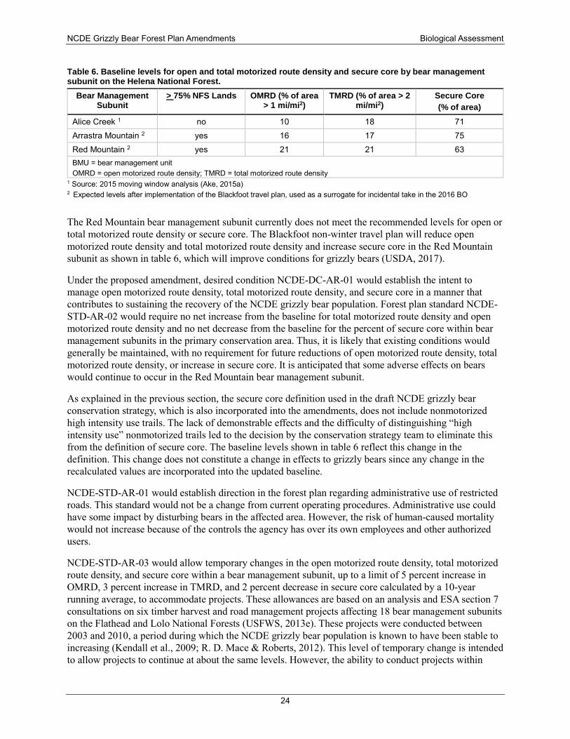
NCDE Grizzly Bear Forest Plan Amendments Biological Assessment
24
Table 6. Baseline levels for open and total motorized route density and secure core by bear management subunit on the Helena National Forest.
Bear Management Subunit
> 75% NFS Lands OMRD (% of area > 1 mi/mi2)
TMRD (% of area > 2 mi/mi2)
Secure Core (% of area)
Alice Creek 1 no 10 18 71 Arrastra Mountain 2 yes 16 17 75 Red Mountain 2 yes 21 21 63 BMU = bear management unit OMRD = open motorized route density; TMRD = total motorized route density
1 Source: 2015 moving window analysis (Ake, 2015a) 2 Expected levels after implementation of the Blackfoot travel plan, used as a surrogate for incidental take in the 2016 BO
The Red Mountain bear management subunit currently does not meet the recommended levels for open or total motorized route density or secure core. The Blackfoot non-winter travel plan will reduce open motorized route density and total motorized route density and increase secure core in the Red Mountain subunit as shown in table 6, which will improve conditions for grizzly bears (USDA, 2017).
Under the proposed amendment, desired condition NCDE-DC-AR-01 would establish the intent to manage open motorized route density, total motorized route density, and secure core in a manner that contributes to sustaining the recovery of the NCDE grizzly bear population. Forest plan standard NCDE-STD-AR-02 would require no net increase from the baseline for total motorized route density and open motorized route density and no net decrease from the baseline for the percent of secure core within bear management subunits in the primary conservation area. Thus, it is likely that existing conditions would generally be maintained, with no requirement for future reductions of open motorized route density, total motorized route density, or increase in secure core. It is anticipated that some adverse effects on bears would continue to occur in the Red Mountain bear management subunit.
As explained in the previous section, the secure core definition used in the draft NCDE grizzly bear conservation strategy, which is also incorporated into the amendments, does not include nonmotorized high intensity use trails. The lack of demonstrable effects and the difficulty of distinguishing “high intensity use” nonmotorized trails led to the decision by the conservation strategy team to eliminate this from the definition of secure core. The baseline levels shown in table 6 reflect this change in the definition. This change does not constitute a change in effects to grizzly bears since any change in the recalculated values are incorporated into the updated baseline.
NCDE-STD-AR-01 would establish direction in the forest plan regarding administrative use of restricted roads. This standard would not be a change from current operating procedures. Administrative use could have some impact by disturbing bears in the affected area. However, the risk of human-caused mortality would not increase because of the controls the agency has over its own employees and other authorized users.
NCDE-STD-AR-03 would allow temporary changes in the open motorized route density, total motorized route density, and secure core within a bear management subunit, up to a limit of 5 percent increase in OMRD, 3 percent increase in TMRD, and 2 percent decrease in secure core calculated by a 10-year running average, to accommodate projects. These allowances are based on an analysis and ESA section 7 consultations on six timber harvest and road management projects affecting 18 bear management subunits on the Flathead and Lolo National Forests (USFWS, 2013e). These projects were conducted between 2003 and 2010, a period during which the NCDE grizzly bear population is known to have been stable to increasing (Kendall et al., 2009; R. D. Mace & Roberts, 2012). This level of temporary change is intended to allow projects to continue at about the same levels. However, the ability to conduct projects within
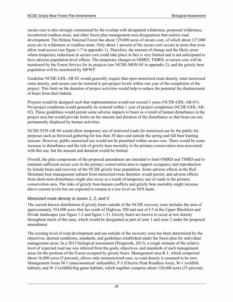
NCDE Grizzly Bear Forest Plan Amendments Biological Assessment
25
secure core is also strongly constrained by the overlap with designated wilderness, proposed wilderness, inventoried roadless areas, and other forest plan management area designations that restrict road development. The Helena National Forest has about 129,000 acres of secure core, of which about 127,000 acres are in wilderness or roadless areas. Only about 1 percent of the secure core occurs in areas that even allow road access (see figure 1-7 in appendix 1). Therefore, the amount of change and the likely areas where temporary reductions in secure core could take place in fact is very limited and is not anticipated to have adverse population-level effects. The temporary changes to OMRD, TMRD, or secure core will be monitored by the Forest Service for its projects (see NCDE-MON-05 in appendix 2), and the grizzly bear population will be monitored by MFWP.
Guideline NCDE-GDL-AR-02 would generally require that open motorized route density, total motorized route density, and secure core be restored to pre-project levels within one year of the completion of the project. This limit on the duration of project activities would help to reduce the potential for displacement of bears from their habitat.
Projects would be designed such that implementation would not exceed 5 years (NCDE-GDL-AR-01). Pre-project conditions would generally be restored within 1 year of project completion (NCDE-GDL-AR-02). These guidelines would permit some adverse impacts to bears as a result of human disturbance in the project area but would provide limits on the amount and duration of the disturbance so that bears are not permanently displaced by human activities.
NCDE-STD-AR-04 would allow temporary use of restricted roads for motorized use by the public for purposes such as firewood gathering for less than 30 days and outside the spring and fall bear hunting seasons. However, public motorized use would not be permitted within secure core. There would be some increase in disturbance and the risk of grizzly bear mortality in the primary conservation area associated with this use, but the amount and duration would be limited.
Overall, the plan components of the proposed amendment are intended to limit OMRD and TMRD and to maintain sufficient secure core in the primary conservation area to support occupancy and reproduction by female bears and recovery of the NCDE grizzly bear population. Some adverse effects in the Red Mountain bear management subunit from motorized route densities would persist, and adverse effects from short-term disturbance might also occur as a result of temporary use of roads in the primary conservation area. The risks of grizzly bear-human conflicts and grizzly bear mortality might increase above current levels but are expected to remain at a low level on NFS lands.
Motorized route density in zones 1, 2, and 3 The current known distribution of grizzly bears outside of the NCDE recovery zone includes the area of approximately 354,600 acres that lies south of Highway 200 and east of I-5 in the Upper Blackfoot and Divide landscapes (see figure 1-2 and figure 1-3). Grizzly bears are known to occur at low density throughout much of this area, which would be designated as part of zone 1 and zone 2 under the proposed amendment.
The existing level of road development and use outside of the recovery zone has been determined by the objectives, desired conditions, standards, and guidelines established under the forest plan for individual management areas. In a 2013 biological assessment (Pengeroth, 2013), a rough estimate of the relative level of expected road use was inferred from the goals, objectives, and standards of each management areas for the portions of the Forest occupied by grizzly bears. Management area R-1, which comprised about 16,000 acres (5 percent), allows only nonmotorized uses, so road density is assumed to be zero. Management Areas M-1 (uneconomical/ unfeasible), P-3 (Electric Peak Roadless Area), W-1 (wildlife habitat), and W-2 (wildlife/big game habitat), which together comprise about 120,600 acres (35 percent),
NCDE Grizzly Bear Forest Plan Amendments Biological Assessment
26
are expected to have low road densities currently and little or no road development planned. Moderate road densities are expected in management areas H-1 and H-2 (Tenmile municipal watershed) as well as L-1 (livestock grazing) and L-2 (livestock grazing and elk habitat), which altogether comprised about 42,500 acres (12 percent). Relatively high road densities are expected in the 166,500 acres (48 percent) that are within management areas T-1, T-3, T-4, and T-5 (productive timberlands).
The current linear densities of all motorized routes (roads and trails) by management zone on the Helena NF are shown in the table 7 below. A comparison to the threshold values identified in Alberta by Boulanger and Stenhouse (2014) would suggest that existing road densities on NFS lands in zone 1 and zone 2 are compatible with supporting occupancy by grizzly bears (2.4 mi/mi2), and also are below the Alberta thresholds for presence of adult females (<2 mi/mi2) and minimizing mortality (<1.6 mi/mi2).
Table 7. Linear density of motorized routes (roads and trails) open to the public on NFS lands by bear management zone.
Zone Density of all motorized routes Density of NFS routes only Zone 1 (233 mi2) 1.5 mi/mi2 1.3 mi/mi2
Zone 2 (1,004 mi2) 0.9 mi/mi2 0.8 mi/mi2 Zone 3 (9 mi2) 0.1 mi/mi2 0 mi/mi2
Source: Data report by K. Ake Sept. 23, 2015 (planning record exhibit 00174)
In zone 1 on the Helena National Forest (see figure 1-1), standard NCDE-HNF Zone 1-STD-01 would be added. This standard would require no net increase above the baseline in the density of roads open to public motorized use during the non-denning season on NFS lands. This would maintain the conditions that have been compatible with a stable to increasing grizzly bear population that has been expanding into this area south of highway 200.
Existing Helena forest plan management direction applicable to zones 2 and 3 would continue to govern the development and management of motorized routes in those portions of the national forest.
Under the 2016 decision on the Divide Travel Plan, the function of a number of existing roads in this area will shift (closing some, converting others to motor trails), but no construction of any new permanent roads will be authorized. Overall, the motorized trail system on NFS lands in the Divide Travel Plan area will increase from 19 miles to 52 miles. Roads open to full-sized vehicles will decrease from 415 miles to 271 miles (USDA, 2016). The result will be a net decrease of 111 miles in motor routes open to vehicle use during the grizzly bear non-denning period. This complies with the terms and conditions of the 2014 incidental take statement.
Motorized over-snow vehicle use during the den emergence period The Blackfoot-North Divide winter travel plan, completed in 2013, analyzed a large geographic area of approximately 372,000 acres. Of this, about 185,000 acres are located within the NCDE recovery zone, which provides 63,322 acres of modeled denning habitat (Shanley, 2009). A total of about 89 percent of the modeled denning habitat is within the Scapegoat Wilderness and other areas that do not allow motorized over-snow vehicle use. In the areas where motorized over-snow vehicle use is allowed, the season-ending date is March 31, except in the Copper Bowls extended use area where the ending date is May 31 (USDA, 2013a). By implementing a March 31 closure date with the exception of the Copper Bowls area, there is very little potential for motorized over-snow vehicle use to overlap with den emergence of grizzly bears. In the Copper Bowls play area, the amount of modeled denning habitat (3,233 acres) as well as foraging habitat is limited by the rock slopes at the head of the drainage. There is a
NCDE Grizzly Bear Forest Plan Amendments Biological Assessment
27
potential for adverse impacts to female grizzly bears in the primary conservation area during the den emergence period, although the area affected is relatively small.
Under the forest plan amendments, NCDE-STD-AR-08 requires no net increase in the percentage of area or miles of routes that are designated for motorized over-snow vehicle use on NFS lands in the primary conservation area during the den emergence time period. The standard would provide additional assurance that potential impacts to bears, particularly females with cubs, would not increase over time.
Grizzly bears continue to expand their range south of the primary conservation area. During the winter of 2008/2009, a female grizzly fitted with a radio collar by MFWP denned south of Highway 200. This was the first time that a grizzly bear den had been documented on the Helena National Forest outside of the NCDE recovery zone. There are relatively few verified occurrences of grizzly bears south of Highway 12 in zone 2, although there are five reports since 1991of a female with cubs in that area.
Under the Blackfoot-North Divide winter travel plan decision (USDA, 2013a), about 70,610 acres of the acres south of Highway 200 (outside the primary conservation area) are open for motorized over-snow vehicle use from Dec. 2 to April 15 annually, and about 77,520 acres are closed to that use. However, motorized over-snow vehicle use generally is minimal south of Highway 200 by April due to poor snow conditions and limited access on lower-elevation lands. Therefore, there is a potential for adverse impacts on bears due to late-season over-snow vehicle use in this area, although the likelihood of this occurring is not high.
Nonmotorized trails in the primary conservation area Grizzly bears may avoid nonmotorized trails or have conflicts with people on nonmotorized trails. Several different variables, such as season, habitats and food sources, recreationist group size and behavior, and the predictability of the activity may influence the degree of disturbance and the risk of grizzly bear-human encounters and conflicts. Sudden encounters between bears and recreationists, particularly activities where the person is moving quickly and/or quietly, have the greatest risk of resulting in injuries or mortalities.
Strategies recommended to reduce the risk of sudden encounters include visitor education regarding safe practices in bear country and proper use of bear deterrent spray, managing recreation to occur predictably in space and time, and designing and locating recreation trails to avoid habitats with concentrated bear food resources (Fortin et al., 2016; J. Herrero & Herrero, 2000; Quinn & Chernoff, 2010). Under the proposed amendment, several forest plan components have been included that incorporate these strategies. For example, desired condition NCDE-DC-WL-03 is intended to help reduce the risk of bear-human conflicts by providing information, education, and design features or criteria for management activities. Under guideline NCDE-GDL-AR-03, if the number or capacity of day use or overnight developed recreation sites within the NCDE primary conservation area is increased, the project should include measures to reduce the risk of grizzly-bear human conflicts in that BMU (e.g., with additional public information and education).
Although a variety of methods can be used to reduce the risk of grizzly bear-human conflicts due to nonmotorized uses, Herrero and Herrero (2000) emphasized that none of them can entirely remove the risk of hiking or mountain biking in grizzly bear habitat. When grizzly bear-human conflicts do occur in the NCDE (whether associated with nonmotorized trail use, off-trail backcountry use, in developed recreation sites, or on private or other agency lands), MFWP, in cooperation with land management agencies and the USFWS, monitors the conflict situation and determines appropriate conflict response based on the established Interagency Grizzly Bear Guidelines. No population-level effects of nonmotorized trails have been demonstrated.
NCDE Grizzly Bear Forest Plan Amendments Biological Assessment
28
As discussed previously, nonmotorized high intensity use trails are no longer included in defining secure core. This does not make a substantial change in the amount of secure core. Within the primary conservation area on the Helena National Forest, there is a total of 126,782 acres of secure core (69 percent) when calculated with nonmotorized high intensity use trails and a total of 129,039 acres of secure core (70 percent) when calculated without nonmotorized high intensity use trails. There is a high intensity use trail in the wilderness portion of the Red Mountain bear management subunit (table 8).
In the future, nonmotorized high intensity use trails will not be constrained in the primary conservation area by the standard for percent secure core. However, the effects of such trails would be considered and analyzed during site-specific planning.
Table 8. Comparing secure core calculated with and without nonmotorized high intensity use trails (data from 2015 moving window analysis (Ake, 2015a))
Bear Management Subunit Percent secure core with high
intensity use nonmotorized trails Percent secure core without high intensity use nonmotorized trails
Alice Creek 70 71 Arrastra Mountain 74 74
Red Mountain 58 61 Source: 2015 update (Ake, 2015a)
Developed recreation sites Developed recreation sites are of concern because frequent or prolonged human occupancy may result in increased bear attractants, increasing the risk of habituation, food conditioning, and grizzly bear-human conflicts or mortalities. Under the existing Helena forest plan, a forest-wide standard states that new campgrounds and other developed recreation facilities, such as boat ramps or picnic areas, will generally not be constructed. Existing developed recreation sites will be maintained, but emphasis instead is given to providing dispersed recreation opportunities.
Within the Monture Landers Fork BMU on the Helena National Forest, three campgrounds provide a total of 35 campsites; there are no cabins or lodges. There are eight day-use recreation sites and 17 trailheads on NFS lands in this BMU. There is no history of grizzly bear mortalities associated with developed recreation sites on the Helena National Forest.
Under the proposed amendment, several plan components address developed recreation sites designed and managed for overnight use. Within the primary conservation area, the number, capacity, and improvements of developed recreation sites will provide for user comfort and safety while minimizing the risk of grizzly bear–human conflicts on NFS lands (NCDE-DC-AR-02). Increases in the number and capacity of developed recreation sites on NFS lands that are designed and managed for overnight use during the non-denning season will be at levels that contribute to sustaining the recovery of the grizzly bear population in the NCDE (NCDE-DC-AR-03). In addition, guideline NCDE-GDL-AR-03 states that if the number or capacity of day use or overnight developed recreation sites is increased within the NCDE primary conservation area, the project should include measures to reduce the risk of grizzly-bear human conflicts in that BMU (e.g., with additional public information and education; by providing backcountry food-hanging poles or bear-resistant food or garbage storage devices; by increasing law enforcement and patrols). Standard NCDE-STD-AR-05 would set a limit of one increase in the number or the overnight capacity of developed recreation sites designed and managed for overnight use per BMU per decade on NFS lands in the primary conservation area. Standard NCDE-STD-AR-07 would require that new or reauthorized ski area permits include mitigation measures to reduce the risk of grizzly bear-human conflicts.
NCDE Grizzly Bear Forest Plan Amendments Biological Assessment
29
This set of plan components is consistent with what has occurred on the Flathead National Forest through ESA section 7 consultation during the time period when the grizzly bear population was stable to increasing and expanding its distribution. Although there may be an increased risk of grizzly bear-human conflicts as a result of some increase in developed recreation sites with overnight use in the future, the risk of mortality for grizzly bears would be limited under the proposed action. Implementation and monitoring of the food storage orders, public education, and increases in the availability of bear-resistant food storage devices have all helped to reduce the number of grizzly bear-human conflicts on the Forest in recent decades, and these would continue. In addition, concerted efforts by MFWP to respond to grizzly bear-human conflicts, both on and off NFS lands, have substantially reduced the risks to both bears and people.
In light of the relatively small number and size of developed recreation sites in the primary conservation area on the Helena National Forest, the existing forest plan direction that new developments generally will not be constructed, the addition of the new plan components, and the lack of history of conflicts in this area, the risk of mortality for grizzly bears as related to developed recreation sites would remain low under the proposed amendment.
Livestock allotments Within the primary conservation area on the Helena National Forest, there are two active cattle allotments and one active sheep allotment. The sheep are closely managed on this allotment (e.g., the sheep are never bedded down on NFS lands but return to private lands at night). No grizzly bear mortalities have occurred on the Forest as a result of sheep or cattle grazing on the Helena National Forest. However, four mortalities and one bear relocation have occurred as a result of livestock depredations that occurred on private land in the Lincoln area.
In the area south of Highway 200 and west of Interstate highway 15 where grizzly bears are present, there are two active sheep allotments and 30 cattle allotments (9 in the Upper Blackfoot and 21 in the Divide landscape). There have been no reported bear mortalities or management actions towards grizzly bears associated with livestock on NFS lands. Off of the national forest, grizzly bear mortality associated with livestock depredation has occurred in both zone 1 and zone 2.
The existing forest plan direction includes use of the Interagency Grizzly Bear Guidelines within the recovery zone to reduce livestock impacts to important grizzly bear habitats and protect food production areas (wet alpine and subalpine meadows, stream bottoms, aspen groves, and other riparian areas) and to manage grizzly bear-livestock conflict situations. In addition, provisions in grazing permits provide for the cancellation, suspension, or temporary cessation of activities if needed to resolve a grizzly bear conflict situation. The food and attractant special order requires bear-resistant storage of all livestock food and the reporting of all livestock carcasses within 24 hours of discovery.
In addition, the 2014 BO and incidental take statement included the following mandatory terms and conditions to reduce the potential for mortality and displacement of grizzly bears on the forest, both inside and outside the NCDE recovery zone (p. 63):
• Allow no new sheep allotments on the Forest within the NCDE recovery zone.
• Include a provision in all grazing permits that occur within the recovery zone and distribution area requiring the permittee to notify the Forest of any grizzly bear depredation on livestock or conflicts between grizzly bears and livestock, even if the conflict did not result in the loss of livestock within 24 hours of discovery. The Forest shall work with MFWP and Wildlife Control personnel to determine the appropriate action.
NCDE Grizzly Bear Forest Plan Amendments Biological Assessment
30
• Include a provision in all grazing permits that occur within the recovery zone and distribution area requiring the permittee to notify the Forest Service of any livestock losses, regardless of the cause, within 24 hours of discovery. Agency personnel and the permittee would then jointly determine how to properly treat or dispose of livestock carcasses so as to eliminate any potential attractant for bears.
Under the proposed amendment, existing forest plan standards and guidelines would be retained and new plan components would be added (appendices 3 and 4). New standards would require that new or reauthorized grazing permits (NCDE-STD-GRZ-01) and temporary grazing permits for small livestock used for purposes such as controlling invasive exotic weeds or reducing fire risk, or for trailing of livestock across NFS lands (NCDE-STD-GRZ-06) in the primary conservation area and zone 1 incorporate measures to reduce the risk of grizzly bear-human conflicts. No increase in the number of cattle allotments (NCDE-STD-GRZ-05) or in the number of sheep allotments or permitted sheep animal unit months (NCDE-STD-GRZ-02 and NCDE-STD-GRZ-04) would be allowed in the primary conservation area. Guideline NCDE-GDL-GRZ-01 encourages reducing the number of open or active sheep grazing allotments on NFS lands within the primary conservation area if an opportunity exists with a willing permittee in order to reduce the risk of conflicts with grizzly bears. Livestock carcasses in the primary conservation area and zone 1 must be reported within 24 hours (NCDE-STD-GRZ-03). Within the NCDE primary conservation area, an allotment management plan and plan of operation should specify any needed measures to protect key grizzly bear food production areas (e.g., wet meadows, stream bottoms, aspen groves, and other riparian wildlife habitats) from conflicting and competing use by livestock (NCDE-GDL-GRZ-02).
The existing livestock grazing allotments have been compatible with an increasing grizzly bear population. Based on the lack of history of conflicts, the mortality risk associated with livestock grazing on the Helena National Forest appears to be moderate to low. The additional standards and guidelines would further reduce the potential for conflicts on NFS lands in the primary conservation area and zone 1.
Vegetation management Existing forest plan standards and guidelines for vegetation management in the primary conservation area would be retained (see appendix 3). Under the proposed amendment, additional desired conditions and guidelines applicable to the primary conservation area would be added. The added direction is very similar to the Interagency Grizzly Bear Guidelines (IGBC, 1986) in encouraging a mosaic of successional stages; restricting logging activities in time and space as needed; designing projects to maintain or improve grizzly bear habitat quality or quantity where it would not increase the risk of grizzly bear-human conflicts; and retaining cover as needed along grass/forb/shrub openings, riparian wildlife habitat, or wetlands.
Standard NCDE-AR-STD-03 specifically allows for temporary increases in open and total motorized route density and temporary decreases in secure core under to allow for project activities. This differs from the existing forest plan and programmatic BO. However, this type of limited temporary change has been evaluated and allowed through project-level section 7 consultations elsewhere in the NCDE in order to accommodate post-fire salvage, timber harvest, and road management projects. The conservation strategy (p. 51) describes six projects affecting 18 subunits and the temporary changes that were allowed that provided the basis for NCDE-AR-STD-03. There have been very few instances on the Helena National Forest when temporary changes have been necessary. No measurable difference in effects are expected as a result of incorporating this standard into the forest plan.
The vegetation management guidelines would provide for diverse cover and forage conditions and would reduce the potential for grizzly bear displacement through the timing of timber sale activities. There may
NCDE Grizzly Bear Forest Plan Amendments Biological Assessment
31
be short-term adverse effects to individual bears from vegetation management activities and associated road use, but these are not expected to have a negative or long-term adverse impact on the population.
Mineral and energy development The only commercial mining rights within the primary conservation area on lands managed by the Forest Service or Bureau of Land Management are for the Cotter Mine on the Helena National Forest. There is no activity occurring at the site currently.
All NFS lands are available for the staking of claims for locatable minerals under the general mining law unless withdrawn from mineral entry by an act of Congress or through the withdrawal process under the Federal Lands Policy and Management Act. As part of the Rocky Mountain Front Mineral Withdrawal, the Secretary of the Interior withdrew acres open to the staking of claims for locatable minerals, including a withdrawal area on the Lincoln Ranger District known as Alice Creek/Indian Meadows, totaling 26,589 acres (see forest plan amendment 19). These lands were withdrawn for 20 years, and the withdrawal could be extended for another 20 years. Under this alternative, the withdrawal would continue to protect grizzly bear habitat values and minimize the potential for grizzly bear disturbance/displacement in the withdrawal area over the life of the plan.
The existing forest plan requires that oil and gas leases must have a stipulation requiring no surface occupancy in management situation 1 grizzly bear habitat. No surface occupancy also applies to overlapping occupied denning and summer habitat in management situation 2. Timing restrictions may be applied in management situation 2 to denning areas, spring habitat, or summer areas, as described in Helena forest plan amendment 13. With a no surface occupancy stipulation, access to oil and gas deposits would require horizontal drilling from outside the boundaries of the no surface occupancy areas. This prevents the loss of grizzly bear habitat and limits the potential for habituation, disturbance, or displacement of bears.
Under the proposed amendment, a no surface occupancy stipulation would be required across the primary conservation area. This would make it unlikely that exploration and development of leasable minerals would negatively affect grizzly bear habitat or result in disturbance or displacement of bears.
Genetic interchange with the Greater Yellowstone Ecosystem The current Helena forest plan does not provide specific management direction aimed at supporting genetic interchange with the Greater Yellowstone Ecosystem. Available information indicates that grizzly bears are moving south from the NCDE mostly through the west side of the Helena National Forest, rather than through the Big Belt or Little Belt Mountains to the east (see Figure 1-1 in appendix 1). There has been an increasing number of credible grizzly bear reports in the Blackfoot landscape south of Highway 200 and all of the Divide landscape (R. D. Mace & Roberts, 2012). This area appears to have the most potential for establishing genetic connectivity through NFS lands from the NCDE to the Greater Yellowstone Ecosystem.
The Montana Highway 200 corridor through the Lincoln Ranger District, including private lands adjacent to Montana Highway 200, represents an area of potential fragmentation that could affect grizzly bear movement.
Farther south in the Divide landscape, rural residences, open roads, motor trails, developed recreation facilities, livestock grazing, mining operations, and other human activities are identified in the BA for grizzly bears on the west side of the Helena National Forest (Pengeroth, 2013), although ample portions of the Divide landscape are unroaded or lightly roaded. For the purpose of analyzing road density, the 317 mi2 Divide landscape was split into 13 management areas, all of which had road densities averaging less
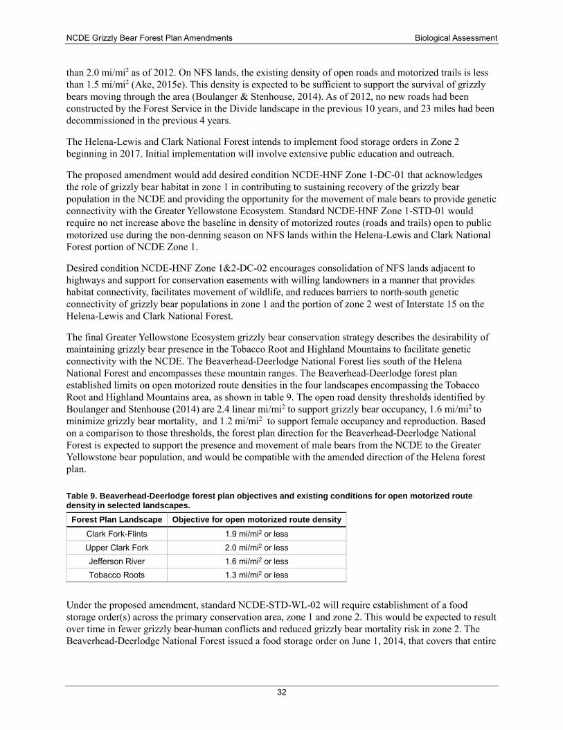
NCDE Grizzly Bear Forest Plan Amendments Biological Assessment
32
than 2.0 mi/mi2 as of 2012. On NFS lands, the existing density of open roads and motorized trails is less than 1.5 mi/mi2 (Ake, 2015e). This density is expected to be sufficient to support the survival of grizzly bears moving through the area (Boulanger & Stenhouse, 2014). As of 2012, no new roads had been constructed by the Forest Service in the Divide landscape in the previous 10 years, and 23 miles had been decommissioned in the previous 4 years.
The Helena-Lewis and Clark National Forest intends to implement food storage orders in Zone 2 beginning in 2017. Initial implementation will involve extensive public education and outreach.
The proposed amendment would add desired condition NCDE-HNF Zone 1-DC-01 that acknowledges the role of grizzly bear habitat in zone 1 in contributing to sustaining recovery of the grizzly bear population in the NCDE and providing the opportunity for the movement of male bears to provide genetic connectivity with the Greater Yellowstone Ecosystem. Standard NCDE-HNF Zone 1-STD-01 would require no net increase above the baseline in density of motorized routes (roads and trails) open to public motorized use during the non-denning season on NFS lands within the Helena-Lewis and Clark National Forest portion of NCDE Zone 1.
Desired condition NCDE-HNF Zone 1&2-DC-02 encourages consolidation of NFS lands adjacent to highways and support for conservation easements with willing landowners in a manner that provides habitat connectivity, facilitates movement of wildlife, and reduces barriers to north-south genetic connectivity of grizzly bear populations in zone 1 and the portion of zone 2 west of Interstate 15 on the Helena-Lewis and Clark National Forest.
The final Greater Yellowstone Ecosystem grizzly bear conservation strategy describes the desirability of maintaining grizzly bear presence in the Tobacco Root and Highland Mountains to facilitate genetic connectivity with the NCDE. The Beaverhead-Deerlodge National Forest lies south of the Helena National Forest and encompasses these mountain ranges. The Beaverhead-Deerlodge forest plan established limits on open motorized route densities in the four landscapes encompassing the Tobacco Root and Highland Mountains area, as shown in table 9. The open road density thresholds identified by Boulanger and Stenhouse (2014) are 2.4 linear mi/mi2 to support grizzly bear occupancy, 1.6 mi/mi2 to minimize grizzly bear mortality, and 1.2 mi/mi2 to support female occupancy and reproduction. Based on a comparison to those thresholds, the forest plan direction for the Beaverhead-Deerlodge National Forest is expected to support the presence and movement of male bears from the NCDE to the Greater Yellowstone bear population, and would be compatible with the amended direction of the Helena forest plan.
Table 9. Beaverhead-Deerlodge forest plan objectives and existing conditions for open motorized route density in selected landscapes.
Forest Plan Landscape Objective for open motorized route density Clark Fork-Flints 1.9 mi/mi2 or less Upper Clark Fork 2.0 mi/mi2 or less Jefferson River 1.6 mi/mi2 or less Tobacco Roots 1.3 mi/mi2 or less
Under the proposed amendment, standard NCDE-STD-WL-02 will require establishment of a food storage order(s) across the primary conservation area, zone 1 and zone 2. This would be expected to result over time in fewer grizzly bear-human conflicts and reduced grizzly bear mortality risk in zone 2. The Beaverhead-Deerlodge National Forest issued a food storage order on June 1, 2014, that covers that entire
NCDE Grizzly Bear Forest Plan Amendments Biological Assessment
33
national forest and all of the Anaconda-Pintler Wilderness Area, which also will help to protect dispersing male bears.
The Beaverhead-Deerlodge National Forest has an active bear education program in cooperation with the Southwest Grizzly Bear Education Group. The Forest has also been working to “harden” some developed campsites with bear-resistant containers, and all of the national forests in the Greater Yellowstone Ecosystem are pursuing expanding food storage facilities (e.g., food poles) in dispersed sites. The Bureau of Land Management’s Western Montana District has also developed a food storage order that will be applied by the Butte, Missoula, and Dillon Field Offices to provide consistent requirements on adjoining Forest Service and BLM lands. These efforts further help to support genetic exchange between the NCDE and Greater Yellowstone Ecosystem.
Implementation of the proposed amendment is likely to provide habitat conditions that would support movement of dispersing bears, particularly male bears, to the adjoining Beaverhead-Deerlodge National Forest and would promote genetic interchange with the Greater Yellowstone Ecosystem.
Lewis and Clark National Forest Plan The Lewis and Clark National Forest contains land within the primary conservation area (777,963 acres, or 14 percent of the total) and zone 3 (967,047 acres, or 8 percent of the total), with negligible amounts in zone 1 (6 acres) and zone 2 (2 acres) (table 2). There are six BMUs on the Lewis and Clark National Forest, divided into 13 bear management subunits (figure 1-1). Two of the bear management subunits are completely within designated wilderness.
Under the existing Lewis and Clark forest plan (USDA, 1986b), about 763,740 acres of the land within the recovery zone on the Forest were designated as management situation 1, none were designated as management situation 2, and 14,159 acres were designed as management situation 3. Specific reference to the 1986 Interagency Grizzly Bear Guidelines, including the delineation of management situations, would be removed from the forest plan. However, much of the management direction that is based on the Interagency Grizzly Bear Guidelines would be retained in the form of new standards and guidelines.
Motorized route densities and secure core in the primary conservation area The Lewis and Clark forest plan does not contain a road density standard for grizzly bears in the recovery zone/primary conservation area. The Rocky Mountain Front Heritage Act of 2014 (PL 13–291) generally does not allow the construction of new or temporary roads within the Conservation Management Area, which covers approximately 195,073 acres of NFS lands and 13,087 acres of adjoining lands managed by the Bureau of Land Management. The law permits the use of motorized vehicles only on existing roads, trails, and areas designated for such use at the time the law was passed.
The Interagency Grizzly Bear Access Task Force (IGBC, 1998) recommended that the percentage of area with open motorized route density of more than 1 mi/mi2, the percentage of area with total motorized route density more than 2 mi.mi2, and the percentage of secure core be evaluated using a moving window analysis method. The Lewis and Clark National Forest has not adopted specific limits on motorized access densities but has conducted moving window analyses for travel management planning.
Most of the 13 bear management subunits on the Lewis and Clark National Forest contain less than 75 percent NFS lands (see table 10). Two of the bear management unit subunits are located wholly within wilderness. The eleven other subunits have been evaluated through two travel plans completed for the Rocky Mountain Division: Birch Creek South and Badger-Two Medicine. Both travel plan decisions substantially reduced motorized access. The biological assessments concluded that these travel plan decisions are not likely to adversely affect the grizzly bear (planning record exhibits 00126 and 00127)
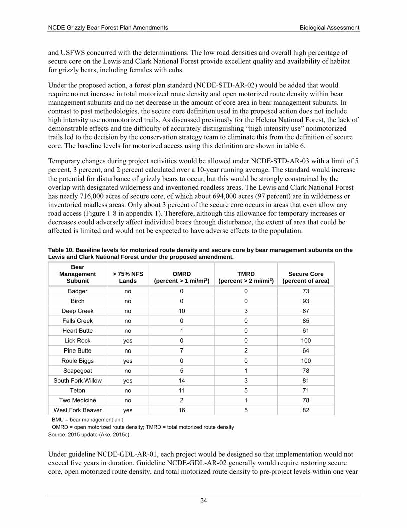
NCDE Grizzly Bear Forest Plan Amendments Biological Assessment
34
and USFWS concurred with the determinations. The low road densities and overall high percentage of secure core on the Lewis and Clark National Forest provide excellent quality and availability of habitat for grizzly bears, including females with cubs.
Under the proposed action, a forest plan standard (NCDE-STD-AR-02) would be added that would require no net increase in total motorized route density and open motorized route density within bear management subunits and no net decrease in the amount of core area in bear management subunits. In contrast to past methodologies, the secure core definition used in the proposed action does not include high intensity use nonmotorized trails. As discussed previously for the Helena National Forest, the lack of demonstrable effects and the difficulty of accurately distinguishing “high intensity use” nonmotorized trails led to the decision by the conservation strategy team to eliminate this from the definition of secure core. The baseline levels for motorized access using this definition are shown in table 6.
Temporary changes during project activities would be allowed under NCDE-STD-AR-03 with a limit of 5 percent, 3 percent, and 2 percent calculated over a 10-year running average. The standard would increase the potential for disturbance of grizzly bears to occur, but this would be strongly constrained by the overlap with designated wilderness and inventoried roadless areas. The Lewis and Clark National Forest has nearly 716,000 acres of secure core, of which about 694,000 acres (97 percent) are in wilderness or inventoried roadless areas. Only about 3 percent of the secure core occurs in areas that even allow any road access (Figure 1-8 in appendix 1). Therefore, although this allowance for temporary increases or decreases could adversely affect individual bears through disturbance, the extent of area that could be affected is limited and would not be expected to have adverse effects to the population.
Table 10. Baseline levels for motorized route density and secure core by bear management subunits on the Lewis and Clark National Forest under the proposed amendment.
Bear Management
Subunit > 75% NFS
Lands OMRD
(percent > 1 mi/mi2) TMRD
(percent > 2 mi/mi2) Secure Core
(percent of area) Badger no 0 0 73 Birch no 0 0 93
Deep Creek no 10 3 67 Falls Creek no 0 0 85 Heart Butte no 1 0 61 Lick Rock yes 0 0 100 Pine Butte no 7 2 64
Roule Biggs yes 0 0 100 Scapegoat no 5 1 78
South Fork Willow yes 14 3 81 Teton no 11 5 71
Two Medicine no 2 1 78 West Fork Beaver yes 16 5 82
BMU = bear management unit OMRD = open motorized route density; TMRD = total motorized route density
Source: 2015 update (Ake, 2015c).
Under guideline NCDE-GDL-AR-01, each project would be designed so that implementation would not exceed five years in duration. Guideline NCDE-GDL-AR-02 generally would require restoring secure core, open motorized route density, and total motorized route density to pre-project levels within one year
NCDE Grizzly Bear Forest Plan Amendments Biological Assessment
35
of completion of the project. This would help to reduce the potential for disturbance or displacement as a result of project activities.
Other standards would establish consistent definitions and procedures for managing administrative use (NCDE-STD-AR-01) and short-term public use (NCDE-STD-AR-04). This would not constitute a change in how the forest plan is currently being implemented. However, the amendment would establish a set of standards and guidelines that is consistent across the NCDE and would provide the needed regulatory mechanisms to support delisting of the grizzly bear from protections of the ESA.
Motorized route density in zone 3 It is important to note that the portion of the Forest in zone 3 is comprised of disjunct mountain ranges. The lands in these isolated mountain ranges are more than 60 air miles away from the recovery zone, separated by land that is almost entirely in private ownership. To date, no grizzly bears have been documented on the Lewis and Clark National Forest outside of the recovery zone.
The Lewis and Clark forest plan does not require management for grizzly bears or their habitat outside of the recovery zone. Nevertheless, the forest plan contains direction that could provide some benefits to grizzly bears should they occur in the areas outside the recovery zone. In particular, the forest plan contains standards that control the type and intensity of activities, including road management, in order to conserve other wildlife species, such as elk. To coordinate management with the needs and objectives for elk, forest plan appendix F provides the Elk-Logging Study (Lyon et al., 1985), which is focused on maintaining elk summer range habitat effectiveness. The Lewis and Clark forest plan appendix G provides the Montana Fish and Game Commission Road Management Policy, which specifically addresses road density in conjunction with percent hiding cover during the elk hunting season.
The proposed amendment does not include standards and guidelines related to motorized route density that would be applicable in zone 3. Occupancy by grizzly bears is not an objective of zone 3. Grizzly bears are not currently known to occur in zone 3 on the Lewis and Clark National Forest and are not expected to inhabit zone 3 on a regular basis. The forest plan’s elk management guidelines would help to reduce the mortality risk for any bears that occasionally use these areas.
Motorized over-snow vehicle use during the den emergence period No snowmobiling is allowed on the Rocky Mountain Ranger District as of April 1 each year except on three main access roads, where it is allowed as long as snow conditions permit. Snowmobiles are not allowed to leave these roads after March 31.
Under the existing forest plan, Developed Recreation Forest-wide Management Standard A-2 requires that the management guidelines developed under the Interagency Rocky Mountain Front Wildlife Monitoring/Evaluation Program be used to avoid or mitigate conflicts between developed recreation and threatened and endangered species. One of the management guidelines is to avoid human activities in grizzly bear habitat components that provide important food sources during spring and early summer, April 1 to July 15.
Under the proposed amendment, standard NCDE-STD-AR-08 would not allow any increase above the baseline in the acreage of areas and miles of routes designated for motorized over-snow vehicle use in the primary conservation area during the den emergence (i.e., late spring) time period. This would be no change from the current situation but would help to ensure that impacts, particularly to females with cubs during this sensitive period, would not increase in the future.
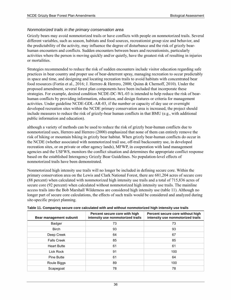
NCDE Grizzly Bear Forest Plan Amendments Biological Assessment
36
Nonmotorized trails in the primary conservation area Grizzly bears may avoid nonmotorized trails or have conflicts with people on nonmotorized trails. Several different variables, such as season, habitats and food sources, recreationist group size and behavior, and the predictability of the activity, may influence the degree of disturbance and the risk of grizzly bear-human encounters and conflicts. Sudden encounters between bears and recreationists, particularly activities where the person is moving quickly and/or quietly, have the greatest risk of resulting in injuries or mortalities.
Strategies recommended to reduce the risk of sudden encounters include visitor education regarding safe practices in bear country and proper use of bear-deterrent spray, managing recreation to occur predictably in space and time, and designing and locating recreation trails to avoid habitats with concentrated bear food resources (Fortin et al., 2016; J. Herrero & Herrero, 2000; Quinn & Chernoff, 2010). Under the proposed amendment, several forest plan components have been included that incorporate these strategies. For example, desired condition NCDE-DC-WL-03 is intended to help reduce the risk of bear-human conflicts by providing information, education, and design features or criteria for management activities. Under guideline NCDE-GDL-AR-03, if the number or capacity of day use or overnight developed recreation sites within the NCDE primary conservation area is increased, the project should include measures to reduce the risk of grizzly-bear human conflicts in that BMU (e.g., with additional public information and education).
although a variety of methods can be used to reduce the risk of grizzly bear-human conflicts due to nonmotorized uses, Herrero and Herrero (2000) emphasized that none of them can entirely remove the risk of hiking or mountain biking in grizzly bear habitat. When grizzly bear-human conflicts do occur in the NCDE (whether associated with nonmotorized trail use, off-trail backcountry use, in developed recreation sites, or on private or other agency lands), MFWP, in cooperation with land management agencies and the USFWS, monitors the conflict situation and determines the appropriate conflict response based on the established Interagency Grizzly Bear Guidelines. No population-level effects of nonmotorized trails have been demonstrated.
Nonmotorized high intensity use trails will no longer be included in defining secure core. Within the primary conservation area on the Lewis and Clark National Forest, there are 681,204 acres of secure core (88 percent) when calculated with nonmotorized high intensity use trails and a total of 715,836 acres of secure core (92 percent) when calculated without nonmotorized high intensity use trails. The mainline access trails into the Bob Marshall Wilderness are considered high intensity use (table 11). Although no longer part of secure core calculations, the effects of such trails would be considered and analyzed during site-specific project planning.
Table 11. Comparing secure core calculated with and without nonmotorized high intensity use trails
Bear management subunit Percent secure core with high
intensity use nonmotorized trails Percent secure core without high intensity use nonmotorized trails
Badger 73 73 Birch 93 93
Deep Creek 64 67 Falls Creek 85 85 Heart Butte 61 61 Lick Rock 91 100 Pine Butte 61 64
Roule Biggs 89 100 Scapegoat 78 78
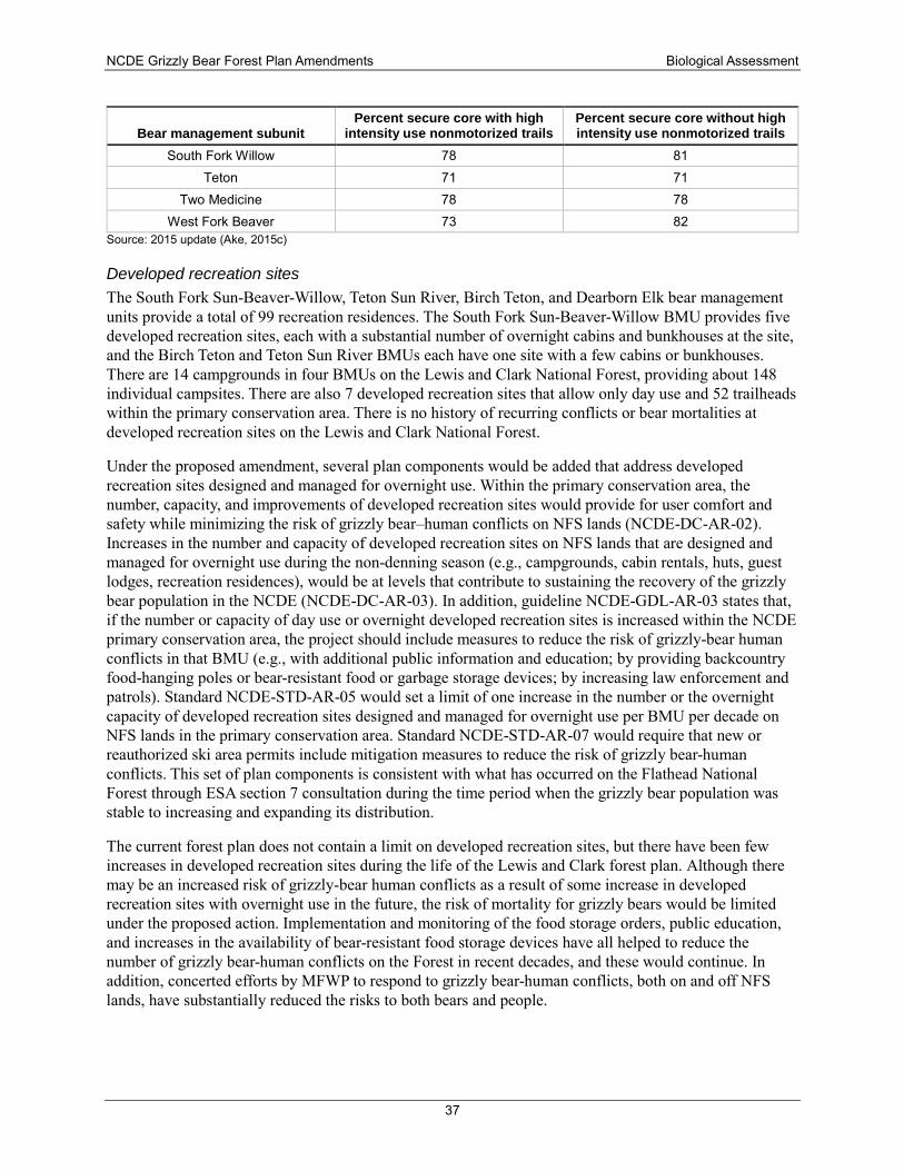
NCDE Grizzly Bear Forest Plan Amendments Biological Assessment
37
Bear management subunit Percent secure core with high
intensity use nonmotorized trails Percent secure core without high intensity use nonmotorized trails
South Fork Willow 78 81 Teton 71 71
Two Medicine 78 78 West Fork Beaver 73 82
Source: 2015 update (Ake, 2015c)
Developed recreation sites The South Fork Sun-Beaver-Willow, Teton Sun River, Birch Teton, and Dearborn Elk bear management units provide a total of 99 recreation residences. The South Fork Sun-Beaver-Willow BMU provides five developed recreation sites, each with a substantial number of overnight cabins and bunkhouses at the site, and the Birch Teton and Teton Sun River BMUs each have one site with a few cabins or bunkhouses. There are 14 campgrounds in four BMUs on the Lewis and Clark National Forest, providing about 148 individual campsites. There are also 7 developed recreation sites that allow only day use and 52 trailheads within the primary conservation area. There is no history of recurring conflicts or bear mortalities at developed recreation sites on the Lewis and Clark National Forest.
Under the proposed amendment, several plan components would be added that address developed recreation sites designed and managed for overnight use. Within the primary conservation area, the number, capacity, and improvements of developed recreation sites would provide for user comfort and safety while minimizing the risk of grizzly bear–human conflicts on NFS lands (NCDE-DC-AR-02). Increases in the number and capacity of developed recreation sites on NFS lands that are designed and managed for overnight use during the non-denning season (e.g., campgrounds, cabin rentals, huts, guest lodges, recreation residences), would be at levels that contribute to sustaining the recovery of the grizzly bear population in the NCDE (NCDE-DC-AR-03). In addition, guideline NCDE-GDL-AR-03 states that, if the number or capacity of day use or overnight developed recreation sites is increased within the NCDE primary conservation area, the project should include measures to reduce the risk of grizzly-bear human conflicts in that BMU (e.g., with additional public information and education; by providing backcountry food-hanging poles or bear-resistant food or garbage storage devices; by increasing law enforcement and patrols). Standard NCDE-STD-AR-05 would set a limit of one increase in the number or the overnight capacity of developed recreation sites designed and managed for overnight use per BMU per decade on NFS lands in the primary conservation area. Standard NCDE-STD-AR-07 would require that new or reauthorized ski area permits include mitigation measures to reduce the risk of grizzly bear-human conflicts. This set of plan components is consistent with what has occurred on the Flathead National Forest through ESA section 7 consultation during the time period when the grizzly bear population was stable to increasing and expanding its distribution.
The current forest plan does not contain a limit on developed recreation sites, but there have been few increases in developed recreation sites during the life of the Lewis and Clark forest plan. Although there may be an increased risk of grizzly-bear human conflicts as a result of some increase in developed recreation sites with overnight use in the future, the risk of mortality for grizzly bears would be limited under the proposed action. Implementation and monitoring of the food storage orders, public education, and increases in the availability of bear-resistant food storage devices have all helped to reduce the number of grizzly bear-human conflicts on the Forest in recent decades, and these would continue. In addition, concerted efforts by MFWP to respond to grizzly bear-human conflicts, both on and off NFS lands, have substantially reduced the risks to both bears and people.
NCDE Grizzly Bear Forest Plan Amendments Biological Assessment
38
Livestock allotments There are 21 cattle grazing allotments but no sheep grazing allotments within the primary conservation area on the Lewis and Clark National Forest.
An existing forest plan standard requires that livestock grazing that affects grizzly bears and/or their habitat will be made compatible with grizzly needs or such uses will be disallowed or eliminated. In addition, the Interagency Wildlife Management Guidelines (forest plan appendix I) provides guide1ines that are specifically oriented toward minimizing the potential for conflicts between grizzly bears and 1ivestock:
• Livestock grazing on important spring habitat for grizzly bears should be deferred until after July 1.
• Boneyards and livestock dumps are prevalent along the East Front and are frequented by grizzly bears. Ranchers and landowners should be encouraged to place carcasses of dead livestock and garbage on remote areas of their land. Dead cows and calves should be hauled a considerable distance from calving grounds to discourage bears from feeding on carrion and newborn calves.
• Sheep grazing allotments in management situation 1, as defined in the Yellowstone Guidelines, on lands administered by government agencies should be eliminated.
• In riparian habitats that receive high amounts of bear use, fencing to exclude livestock grazing and trampling may be necessary where livestock turn-out dates-prior to July 1 are allowed.
Approximately 7 percent (21 of 290) of all human-caused grizzly bear mortalities in the NCDE between 1998 and 2011 were due to management removal actions associated with livestock depredations. These livestock-related grizzly bear mortalities all occurred on private lands or on the Blackfeet Indian Reservation along the Rocky Mountain Front, east of the Continental Divide.
Existing forest plan direction to reduce livestock impacts and to minimize grizzly bear-livestock conflicts on NFS lands in the primary conservation area would be retained. Additional standards and guidelines that would be added are listed in appendix 2. New permits would have to incorporate measures to reduce the risk of grizzly bear-human conflicts. Livestock carcasses would have to be reported within 24 hours (which is already a requirement of the food storage order). No increase in the number of cattle allotments, or in the number of sheep allotments or permitted sheep animal unit months would be allowed. To reduce the potential risk of grizzly bear-human conflicts, sheep grazing permits in non-use status should be phased out and sheep allotments closed if an opportunity arises with a willing permittee.
Livestock grazing is not be anticipated to displace grizzly bears or negatively impact important bear food production areas. Based on the lack of sheep allotments, no recent history of conflicts, and no known mortalities associated with livestock grazing on NFS lands, the mortality risk associated with livestock grazing on the Lewis and Clark National Forest is very low.
Vegetation management Existing forest plan direction on the Lewis and Clark National Forest is to follow the Interagency Grizzly Bear Guidelines for vegetation management in management situation 1 and 2 grizzly bear habitat. These guidelines specify that measures that maintain and/or improve grizzly bear habitat and populations will be specified in project design. The Interagency Grizzly Bear Guidelines for timber and fire management include the following guidelines:
• All proposed logging and burning activities will be evaluated for their effects on grizzlies and their habitat.
NCDE Grizzly Bear Forest Plan Amendments Biological Assessment
39
♦ Logging and burning activities will occur at a time or season when the area is of little or no biological importance to the bear.
♦ Grizzly bear habitat will be improved through vegetation manipulation.
• Habitat management in forested cover should provide a balance of all successional stages.
• Roads used for timber sale purposes will be single-purpose roads only and will be closed to public use not associated with timber sale operation and administration.
• Desirable clearcut features include (1) one or more leave or cover patches in cuts over 10 acres, (2) minimum soil scarification where soil disturbance impedes the reestablishment of grizzly foods, (3) slash disposal by spring broadcast burning, and (4) protection of hydric stream bottoms, wet meadows, marshes, and bogs from soil disturbance and security cover removal.
• Prescribed burning in habitat types that are not managed for timber production could be used to approximate a natural fire frequency in order to promote berry-producing shrubs.
Under this alternative, existing forest plan standards and guidelines for vegetation management would be updated with desired conditions and guidelines applicable to the primary conservation area as shown in appendix 2. The added direction is very similar to the Interagency Grizzly Bear Guidelines in encouraging a mosaic of successional stages (NCDE-DC-VEG-02); reducing the risk of disturbance of bears during project activities (NCDE-GDL-VEG-01); designing projects to maintain or improve grizzly bear habitat quality or quantity where it would not increase the risk of grizzly bear-human conflicts (NCDE-GDL-VEG-02); and retaining cover as needed along grass/forb/shrub openings, riparian wildlife habitat, or wetlands (NCDE-GDL-VEG-03).
The vegetation management guidelines would provide for diverse cover and forage conditions and would reduce the potential for grizzly bear displacement through the timing of timber sale activities. Timber management activities and associated road use may result in some short-term adverse impacts to individual bears.
Mineral and oil and gas development In 2006, lands outside of designated wilderness areas on the Rocky Mountain Ranger District, some areas of the Flathead National Forest, and Bureau of Land Management lands along the Rocky Mountain Front were withdrawn permanently from any future mineral, oil, natural gas, or geothermal leasing and all forms of location, entry and patent under mining laws, by the Tax Relief and Health Care Act of 2006 (PL109-432). It was not necessary to withdraw lands inside designated wilderness areas from future leasing because new leases are already prohibited by the Wilderness Act in these areas.
Although PL 109-432 prohibited the establishment of new leases, it did not eliminate leases that existed in 2006, at the time the law was passed. Many leases on federal lands that existed at the time PL 109-432 was passed have been voluntarily retired. As of 2012, there were 247 oil and gas leases in the recovery zone, most of which are on the Flathead National Forest. Of these, 235 were suspended, pending forestwide leasing analyses. In 2016 and 2017, the remaining 17 leases in the Badger-Two Medicine area of the Lewis and Clark National Forest were cancelled.
An existing forestwide standard (G-2) for oil and gas leasing, exploration, drilling, field development, and production requires that activities be restricted, delayed, or modified to prevent adverse effects on threatened and endangered species and their habitat. Additional measures are included in forest plan appendix I, Interagency Wildlife Management Guidelines, to coordinate oil and gas exploration and development within grizzly bear habitat, including the following:
NCDE Grizzly Bear Forest Plan Amendments Biological Assessment
40
• Establish flight patterns in advance when activities require the use of he1icopters. Flight patterns should be located to avoid seasonally important grizzly bear habitat constituent elements and habitat components during the designated seasonal use periods.
• Seismic or exploratory drilling activities should not be conducted within a minimum of one mile of den sites during the October 15 to April 15 period.
• Seismic permits should include a provision providing for cancellation or temporary cessation of activities, if necessary, to prevent grizzly bear-human conflicts.
• Scheduling of well drilling on adjacent sites, within important grizzly bear use areas, should be staggered to provide a disturbance free area for displaced bears.
• Pipeline construction required for the development of a gas or oil field should be condensed into the shortest time frame possible and subject to seasonal restrictions when conducted in important grizzly bear habitat.
• Field operation centers associated with seismic or oil/gas exploration activities should be placed carefully to avoid seasonally important habitat components or constituent elements. Such placement of sites is necessary in order to avoid direct potential conflicts between humans and grizzly bears.
Additional desired conditions, standards, and guidelines applicable to the primary conservation area would be added as shown in appendix 3. The additional standards and guidelines would apply to new or reauthorized permits, leases, or plans of operation and would provide guidance for mitigation of mineral development impacts, proper storage and handling of wildlife attractants, timing restrictions for ground-disturbing activities in spring habitat and seismic activity in denning habitat, management of motorized traffic and helicopter use, noise reduction, and worker safety when living near and working in grizzly bear habitat. A stipulation for no surface occupancy would be required for any new or reauthorized leases in the primary conservation area. Continued implementation of the food storage order in the primary conservation area would minimize the potential for grizzly bear-human conflicts and bear mortality.
The likelihood of development of leasable or locatable minerals occurring within the primary conservation area on the Lewis and Clark National Forest is low. Forest plan components will help to ensure that any future mineral and energy development will be done in a manner that minimizes habitat loss and the disturbance or displacement of grizzly bears.
Kootenai National Forest Plan Portions of two grizzly bear recovery areas, the Cabinet-Yaak and the NCDE, overlap with the Kootenai National Forest. About 118,770 acres of the Kootenai National Forest are within the NCDE primary conservation area (about 2 percent of the total primary conservation area), within the Murphy Lake BMU and a small portion of the Stillwater River BMU. There are also about 283,300 acres of zone 1 (about 6 percent of the total), most of which (276,822 acres) is within the Salish demographic connectivity area (table 2).
Under the existing Kootenai forest plan (USDA, 2015c), a desired condition is that a forestwide system of large remote areas is available to accommodate species such as grizzly bears that require large home ranges and low levels of disturbances (FW-DC-WL-02). A long-term desired condition of the forest plan is recovery of threatened and endangered species (FW-DC-WL-03), and recovery of the grizzly bear is promoted by motorized access management (FW-DC-WL-05). Desired condition FW-DC-WL-04 states that all grizzly BMUs have low levels of disturbance to facilitate denning activities and spring use, limit displacement, and limit grizzly bear-human conflicts and potential bear mortality. All of these desired conditions would be retained in the forest plan.
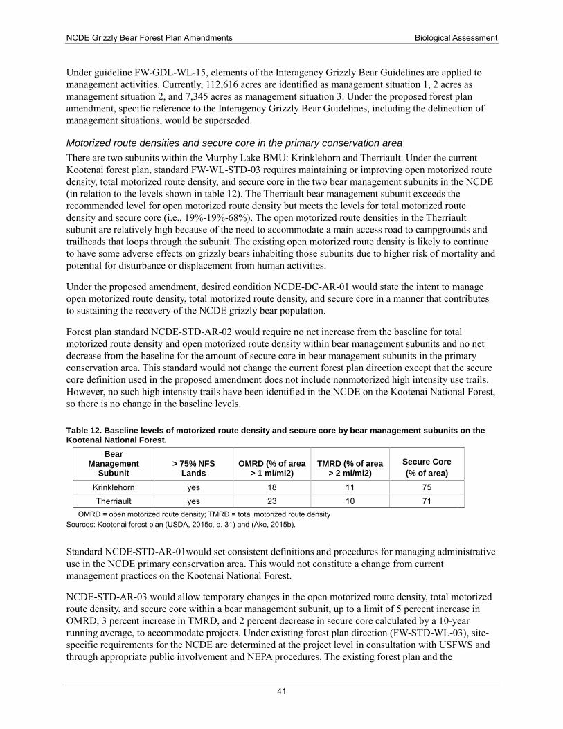
NCDE Grizzly Bear Forest Plan Amendments Biological Assessment
41
Under guideline FW-GDL-WL-15, elements of the Interagency Grizzly Bear Guidelines are applied to management activities. Currently, 112,616 acres are identified as management situation 1, 2 acres as management situation 2, and 7,345 acres as management situation 3. Under the proposed forest plan amendment, specific reference to the Interagency Grizzly Bear Guidelines, including the delineation of management situations, would be superseded.
Motorized route densities and secure core in the primary conservation area There are two subunits within the Murphy Lake BMU: Krinklehorn and Therriault. Under the current Kootenai forest plan, standard FW-WL-STD-03 requires maintaining or improving open motorized route density, total motorized route density, and secure core in the two bear management subunits in the NCDE (in relation to the levels shown in table 12). The Therriault bear management subunit exceeds the recommended level for open motorized route density but meets the levels for total motorized route density and secure core (i.e., 19%-19%-68%). The open motorized route densities in the Therriault subunit are relatively high because of the need to accommodate a main access road to campgrounds and trailheads that loops through the subunit. The existing open motorized route density is likely to continue to have some adverse effects on grizzly bears inhabiting those subunits due to higher risk of mortality and potential for disturbance or displacement from human activities.
Under the proposed amendment, desired condition NCDE-DC-AR-01 would state the intent to manage open motorized route density, total motorized route density, and secure core in a manner that contributes to sustaining the recovery of the NCDE grizzly bear population.
Forest plan standard NCDE-STD-AR-02 would require no net increase from the baseline for total motorized route density and open motorized route density within bear management subunits and no net decrease from the baseline for the amount of secure core in bear management subunits in the primary conservation area. This standard would not change the current forest plan direction except that the secure core definition used in the proposed amendment does not include nonmotorized high intensity use trails. However, no such high intensity trails have been identified in the NCDE on the Kootenai National Forest, so there is no change in the baseline levels.
Table 12. Baseline levels of motorized route density and secure core by bear management subunits on the Kootenai National Forest.
Bear Management
Subunit > 75% NFS
Lands OMRD (% of area
> 1 mi/mi2) TMRD (% of area
> 2 mi/mi2) Secure Core (% of area)
Krinklehorn yes 18 11 75 Therriault yes 23 10 71
OMRD = open motorized route density; TMRD = total motorized route density Sources: Kootenai forest plan (USDA, 2015c, p. 31) and (Ake, 2015b).
Standard NCDE-STD-AR-01would set consistent definitions and procedures for managing administrative use in the NCDE primary conservation area. This would not constitute a change from current management practices on the Kootenai National Forest.
NCDE-STD-AR-03 would allow temporary changes in the open motorized route density, total motorized route density, and secure core within a bear management subunit, up to a limit of 5 percent increase in OMRD, 3 percent increase in TMRD, and 2 percent decrease in secure core calculated by a 10-year running average, to accommodate projects. Under existing forest plan direction (FW-STD-WL-03), site-specific requirements for the NCDE are determined at the project level in consultation with USFWS and through appropriate public involvement and NEPA procedures. The existing forest plan and the
NCDE Grizzly Bear Forest Plan Amendments Biological Assessment
42
programmatic BO did not specifically provide for temporary decreases in secure core and/or temporary increases in total and open motorized route density in the primary conservation area. However, through project-level section 7 consultations elsewhere in the NCDE, temporary changes have been allowed to accommodate projects such as post-fire salvage, timber harvest, and road management projects. The conservation strategy (p. 51) describes six projects affecting 18 subunits on the Flathead and Lolo National Forests, and the temporary changes that were allowed, which provided the basis for standard NCDE-AR-STD-03. This standard would provide specific direction and require monitoring of temporary use of restricted roads. In the past, there have been very few instances of temporary use of restricted roads, and that would likely continue to be the case on the Kootenai National Forest. The secure core has a significant overlap with a wilderness study area, recommended wilderness, inventoried roadless areas, and other forest plan management area designations that restrict road development. The Kootenai National Forest has about 82,400 acres of secure core, of which almost 74,000 acres (90 percent) is in a wilderness study area, recommended wilderness, or inventoried roadless areas. Only about 10 percent of the secure core in the Kootenai National Forest occurs in areas where road access could possibly occur (see Figure 1-9 in appendix 1). However, by explicitly providing more latitude for disturbance from temporary use, there is a potential for adverse impacts on individual grizzly bears to occur. The potential is greater than under the existing forest plan direction but would be limited in duration and extent.
Under standard NCDE-STD-AR-04, short-term public use of restricted roads could also be allowed in certain circumstances in the primary conservation area but not within secure core. This would not be a change from current management practices on the Kootenai National Forest.
Under guideline NCDE-GDL-AR-01, each project would be designed so that it would not exceed five years in duration. Guideline NCDE-GDL-AR-02 generally would require restoring secure core, open motorized route density, and total motorized route density to pre-project levels within one year of completion of the project. This would help to limit the potential for disturbance or displacement as a result of project activities.
Motorized route density in zone 1 and the Salish demographic connectivity area The Kootenai National Forest contains roughly 277,000 acres within the Salish demographic connectivity area and about 6,500 acres of zone 1 outside the Salish demographic connectivity area. The motorized access amendment, which is incorporated into the Kootenai forest plan, refers to the areas outside of a recovery zone where there is recurring use by grizzly bears as a “bears outside the recovery zones” (BORZ) area. The Tobacco BORZ largely overlaps with NCDE zone 1 and the Salish demographic connectivity area, although the boundaries do not perfectly align (figure 1-5). A number of observations of grizzly bears, including females with cubs, have been documented in the Tobacco BORZ area. At least one female bear with cubs is known to have denned in the Tobacco BORZ area.
Forest plan components that apply to all of zone 1, including the Salish demographic connectivity area, include several forestwide desired conditions: FW-DC-WL-02 (a forestwide system of large remote areas is available to accommodate species requiring large home ranges and low disturbances, such as the grizzly bear), FW-DC-WL-03 (recovery of threatened and endangered species is the long-term desired condition), and FW-DC-AR-07 (the transportation system and its use have minimal impacts on resources, including threatened and endangered species).
A desired condition for the Tobacco geographic area (GA-DC-WL-TOB-01) is low levels of human disturbance to allow for denning activities of wide-ranging carnivores that are sensitive to human disturbance (e.g., grizzly bears). Within the Tobacco BORZ area, no increases in permanent linear miles of open or total miles of road are allowed within the BORZ area, with listed exceptions and an allowance
NCDE Grizzly Bear Forest Plan Amendments Biological Assessment
43
for temporary increases under specified conditions. Under the proposed amendment, the standard would be carried forward for the BORZ area (NCDE-KNF Zone 1-STD-01).
The small portion of zone 1 and the Salish demographic connectivity area that is outside the BORZ area on the Kootenai National Forest would be managed according to existing forest plan direction (NCDE-KNF Zone 1-STD-02). Management areas within NCDE zone 1 but outside the BORZ area include management area 3 (special areas), management area 6 (general forest), and management area 7 (primary recreation area). Under management area 3, road construction is not allowed in botanical, historical, or zoological areas (MA3-STD-AR-01), but road construction and motor vehicle use are allowed in geological, recreational, and scenic areas (MA3-GDL-AR-02). In management area 6, motorized use of roads and trails is allowed and roads can be constructed and reconstructed (MA6-GDL-AR-01, MA6-GDL-AR-02, MA6-GDL-AR-03, MA6-GDL-AR-04). In management area 7, road construction, road reconstruction, and motorized use are allowed (MA7-GDL-AR-01, MA7-GDL-AR-03, MA7-GDL-AR-04).
The current density of open roads and motorized trails on Kootenai National Forest lands within the Salish demographic connectivity area is 2.0 mi/mi2. In comparison to the thresholds identified by Boulanger and Stenhouse (2014) for grizzly bears in Alberta, the motorized route densities in the Salish demographic connectivity area are below the 2.4 mi/mi2 threshold for grizzly bear occupancy, and are at the 2.0 mi/mi2 threshold for female occupancy. The survival rates of females with cubs of the year or yearlings may be negatively affected because the motorized route density exceeds the 1.6 mi/mi2 threshold for reduced mortality.
On zone 1 lands outside the Salish demographic connectivity area on the Kootenai National Forest (about 6,500 acres), the open road and motorized trail density is 3.5 mi/mi2. This linear route density would be expected to have adverse effects on grizzly bears, but the impact is likely small due to the limited acreage involved. Standard NCDE-KNF Zone 1-STD-AR-01 is more restrictive than the comparable standards on the Flathead and Lolo National Forests since it limits total (not just open) road miles. This wording will maintain consistency across the several BORZ areas on the Kootenai National Forest, and this standard may be helpful over time in encouraging female occupancy in this area.
Motorized over-snow vehicle use during the den emergence period The biological assessment for the 2015 Kootenai forest plan reported there are 7 miles of groomed routes and 4 miles of ungroomed routes within the primary conservation area on the Kootenai National Forest. Off-route use occurs on approximately 7,905 acres or 18 percent of the 44,724 acres of modeled denning habitat on the Kootenai National Forest. Existing forestwide standard FW-STD-WL-05 prohibits grooming of snowmobile routes in grizzly bear core habitat in the spring after April 1 of each year. Furthermore, FW-GDL-WL-01 states that management activities should avoid or minimize disturbance in areas of predicted denning habitat during spring emergence (April 1 through May 1).
Under the proposed amendment, NCDE-STD-AR-08 would require no net increase in the percentage of area or miles of routes that are designated for motorized over-snow vehicle use within modeled grizzly bear denning habitat in the primary conservation area on NFS lands during the den emergence (i.e., late spring) time period. The primary concern during the den emergence period is that disturbance from snowmobiles may negatively affect the survival of cubs. Adding this standard would curb increases in the extent of late-season snowmobiling and the potential impacts on bears in the primary conservation area. The potential for adverse effects on a female grizzly bear with cubs due to the existing late-season snowmobiling remains, but the impact is likely to be small due to the small proportion (about 18%) of denning habitat affected.
NCDE Grizzly Bear Forest Plan Amendments Biological Assessment
44
Nonmotorized trails in the primary conservation area Grizzly bears may avoid nonmotorized trails or have conflicts with people on nonmotorized trails. Several different variables, such as season, habitats and food sources, recreationist group size and behavior, and the predictability of the activity, may influence the degree of disturbance and the risk of grizzly bear-human encounters and conflicts. Sudden encounters between bears and recreationists, particularly activities where the person is moving quickly and/or quietly, have the greatest risk of resulting in injuries or mortalities.
Under the proposed amendment, several forest plan components have been included that incorporate strategies to reduce the risk of sudden encounters. For example, desired condition NCDE-DC-WL-03 is intended to help reduce the risk of grizzly bear-human conflicts by providing information, education, and design features or criteria for management activities. Under guideline NCDE-GDL-AR-03, if the number or capacity of day use or overnight developed recreation sites within the NCDE primary conservation area is increased, the project should include measures to reduce the risk of grizzly bear-human conflicts in that BMU (e.g., with additional public information and education).
Although a variety of methods can be used to reduce the risk of grizzly bear-human conflicts due to nonmotorized uses, Herrero and Herrero (2000) emphasized that none of them can entirely remove the risk of hiking or mountain biking in grizzly bear habitat. When grizzly bear-human conflicts do occur in the NCDE (whether associated with nonmotorized trail use, off-trail backcountry use, in developed recreation sites, or on private or other agency lands), MFWP, in cooperation with land management agencies and the USFWS, monitors the conflict situation and determines appropriate conflict response based on established Interagency Grizzly Bear Guidelines. No population-level effects of nonmotorized trails has been demonstrated. There are no “high intensity use” trails within the primary conservation area on the Kootenai National Forest.
As discussed previously, nonmotorized high intensity use trails are no longer included in defining secure core. On the Kootenai National Forest, there are 82,438 acres of secure core in the NCDE primary conservation area. Since no high intensity use trails have been identified in the NCDE on the Kootenai National Forest, the baseline is the same.
Developed recreation sites The Murphy Lake and Stillwater River BMUs currently provide 5 cabins, 19 campgrounds, 20 day-use sites, and 40 trailheads for public recreation use. There is no history of grizzly bear-human conflicts or mortalities at developed recreation sites on the Kootenai National Forest.
Existing forest plan standard FW-STD-WL-04 requires that permits and operating plans specify measures to reduce grizzly bear-human conflicts and grizzly bear mortality by making wildlife attractants (e.g., food and garbage) inaccessible through proper storage or disposal. A forestwide food storage and sanitation special order is in place for the Kootenai National Forest (USDA, 2011b).
Under the proposed amendment, several plan components would be added that address developed recreation sites designed and managed for overnight use. Standard NCDE-STD-AR-05 would allow no more than one increase in the number or capacity of developed recreation sites that are designed and managed for overnight use (e.g., campgrounds, cabin rentals, huts, guest lodges, recreation residences) during the non-denning season per BMU per decade. This would limit the potential for future bear-human conflicts associated with habituation or food conditioning to develop at such sites. In addition, guideline NCDE-GDL-AR-03 states that, if the number or capacity of day use or overnight developed recreation sites is increased within the NCDE primary conservation area, the project should include measures to reduce the risk of grizzly-bear human conflicts in that BMU (e.g., with additional public information and
NCDE Grizzly Bear Forest Plan Amendments Biological Assessment
45
education; by providing backcountry food-hanging poles or bear-resistant food or garbage storage devices; by increasing law enforcement and patrols). In addition, standard NCDE-STD-AR-07 would require that new or reauthorized ski area permits include mitigation measures to reduce the risk of grizzly bear-human conflicts. This set of plan components is consistent with what has regularly occurred through consultation during the time period when the NCDE grizzly bear population was stable to increasing.
By allowing future increases in the number or capacity of developed recreation sites with overnight use, there is a potential for adverse effects on individual bears, in particular an increased risk of mortality. However, the above-described direction reduces the likelihood of habituation or food-conditioning of bears at developed recreation sites. Implementation and monitoring of the food storage orders, public education, and increases in the availability of bear-resistant food storage devices have all helped to reduce the number of grizzly bear-human conflicts on the Forest in recent decades. In addition, concerted efforts by MFWP to respond to grizzly-human conflicts, both on and off NFS lands, have greatly reduced the risks to both bears and people.
Livestock allotments There is one cattle grazing allotment on the 4,880 acres of the Kootenai National Forest that are within the primary conservation area. Eleven allotments overlap the area outside the primary conservation area in the BORZ. There is no history of grizzly bear-human conflicts or management actions against bears related to grazing in the Kootenai National Forest.
Existing forest plan direction to reduce livestock impacts and to minimize grizzly bear-livestock conflicts on NFS lands in the primary conservation area would be retained. FW-DC-GRZ-01 states that grazing occurs at sustainable levels in suitable locations while protecting resources. Standard FW-STD-WL-04 requires that permits and operating plans specify sanitation measures and adhere to the forestwide food/attractant storage order. Guideline FW-WL-GDL-15 references the Interagency Grizzly Bear Guidelines or a conservation strategy to guide management.
Existing allotments are not expected to increase, and few acres are subject to livestock grazing in the primary conservation area. The food storage order in effect on the Kootenai National Forest helps to minimize the potential for attractant-related human-caused grizzly bear mortality.
Under the proposed amendment, additional standards and guidelines would be added (appendix 3). These include a requirement that new or reauthorized grazing permits (NCDE-STD-GRZ-01) and temporary grazing permits for small livestock used for purposes such as controlling invasive exotic weeds or reducing fire risk or for trailing of livestock across National Forest System lands (NCDE-STD-GRZ-06) in the primary conservation area and zone 1 incorporate measures to reduce the risk of grizzly bear-human conflicts. No increase in the number of cattle allotments (NCDE-STD-GRZ-05) or in the number of sheep allotments or permitted sheep animal unit months (NCDE-STD-GRZ-02 and NCDE-STD-GRZ-04) would be allowed in the primary conservation area. Livestock carcasses in the primary conservation area and zone 1 must be reported within 24 hours (NCDE-STD-GRZ-03). Within the NCDE primary conservation area, an allotment management plan and plan of operation should specify any needed measures to protect key grizzly bear food production areas (e.g., wet meadows, stream bottoms, aspen groves, and other riparian wildlife habitats) from conflicting and competing use by livestock (NCDE-GDL-GRZ-02).
Based on the few acres subject to livestock grazing in the primary conservation area and the lack of history of grizzly bear-livestock conflicts, the mortality risk associated with livestock grazing on the Kootenai National Forest appears to be low. The additional standards and guidelines would further reduce
NCDE Grizzly Bear Forest Plan Amendments Biological Assessment
46
the potential for conflicts on NFS lands in the primary conservation area. Livestock grazing on the Kootenai National Forest is not likely to adversely affect the grizzly bear.
Vegetation management Under the Kootenai forest plan, there are about 218,212 acres suitable for timber production within bear management units (16 percent of the bear management units in both the Cabinet-Yaak and NCDE recovery zones) and 333,925 acres suitable for timber production in areas outside the recovery zones where grizzly bears now occur (59 percent of the area). However, within management area 6 (general forest), none of the acres of grizzly bear secure core habitat are identified as suitable for timber production. Vegetation management activities could only be done in secure core to meet resource needs such as insect and disease mitigation, salvage harvest, wildlife habitat diversity, and fuels management.
Vegetation management (i.e., timber harvest, salvage harvest, planting, thinning, fuels treatment, prescribed fires) may impact grizzly bears by affecting food resource availability, proximity to escape cover, human disturbance and potential for conflicts, or temporarily shifting grizzly bears into less secure areas. Timber harvest units, which remove cover, at times may be placed along open roads to meet objectives other than optimizing grizzly bear habitat. This is allowed under the existing forest plan. However, this is not expected to have a negative effect on grizzly bears since most bears avoid the area adjacent to open roads (R. D. Mace et al., 1996).
In the area outside of recovery zones where there is recurring use by grizzly bears (BORZ), there would be a higher degree of disturbance to bears from vegetation management activities than in the primary conservation area. However, the forest plan does not allow any increase in linear permanent miles of total and open roads, and any timber harvest activities occurring within multiple watersheds must be scheduled in a manner to minimize disturbance of grizzly bears.
Under the proposed amendment, existing forest plan standards and guidelines for vegetation management would be retained and additional desired conditions and guidelines applicable to the primary conservation area would be added as shown in appendix 3. The added direction is very similar to the Interagency Grizzly Bear Guidelines (IGBC, 1986) in encouraging a mosaic of successional stages (NCDE-DC-VEG-02); restricting logging activities in time and space as needed (NCDE-GDL-VEG-01); designing projects to maintain or improve grizzly bear habitat quality or quantity where it would not increase the risk of grizzly bear-human conflicts (NCDE-GDL-VEG-02, NCDE-GDL-VEG-05); and retaining cover as needed along grass, forb and shrub openings, riparian wildlife habitat, or wetlands (NCDE-GDL-VEG-03).
The forest plan components for vegetation management would provide for diverse cover and forage conditions and would reduce the potential for grizzly bear displacement through the timing of timber sale activities. There may be short-term impacts to individual bears from timber management activities and associated road use, but the plan components would limit disturbance or displacement of bears and maintain or improve habitat quality and quantity where appropriate. Implementation of the vegetation management direction is not likely to adversely affect grizzly bears.
Mineral and energy development Under the forest plan, the majority of Kootenai National Forest lands, with the exception of management areas 1a and 1c (wilderness and wilderness study areas), would be available for mineral leasing (e.g., oil, gas, coal, geothermal resources, potassium, sodium, phosphates, oil shale, and sulfur). The Ten Lakes wilderness study area (MA 1c) is located within the NCDE portion of the Kootenai National Forest. The majority of the Forest is also available for locatable minerals, with the exception of 150,100 acres that are withdrawn from mineral entry under the revised plan.
NCDE Grizzly Bear Forest Plan Amendments Biological Assessment
47
The effects of future mining activities on grizzly bears are expected to be similar to those that occurred at past mining sites (e.g., Troy Mine). Such effects may include loss of habitat within the footprint of the mine, disturbance to grizzly bears from road use and mining activities, displacement from habitat from road use or mine development, or impacts to habitat connectivity.
The extent of these effects would be limited by elements of the revised forest plan. Any mining proposal on the Forest would be considered in terms of forestwide desired conditions that trend toward providing remote areas for species with large home ranges, recovering federally listed species, facilitating denning and habitat use through low levels of disturbance, and managing motorized access to promote recovery (FW-DC-WL-01 through 05). At the project level, forestwide guidelines and standards would address potential effects of mining proposals on connectivity and linkage areas (FW-GDL-WL-12 through 14), food storage and attractants (FW-STD-WL-04, Food Storage Order), disturbance of grizzly bears (FW-GDL-WL-01), and access management (FW-STD-WL-02 and 03). Any mining proposals would be subject to additional site-specific analysis and planning.
Under the proposed amendment, new or reauthorized permits, leases, or plans of operation in the primary conservation area and zone 1 would include a provision for modification or temporary cessation of activities, if needed, to resolve a grizzly bear-human conflict situation (NCDE-STD-MIN-02); would include measures for mitigation of mineral development impacts (NCDE-STD-MIN-03); would provide for proper storage and handling of wildlife attractants (NCDE-STD-MIN-04); would require mitigation measures or stipulations such as timing restrictions for ground-disturbing activities in spring habitat and seismic activity in denning habitat if needed (NCDE-STD-MIN-05); would require mitigation measures if needed regarding motorized access, such as management of motorized traffic, helicopter use, noise reduction (NCDE-STD-MIN-06); and would require worker safety training for employees living near and working in grizzly bear habitat (NCDE-STD-MIN-07). NCDE-STD-MIN-08 would require that new leases for leasable minerals in the NCDE primary conservation area include a no surface occupancy stipulation. Guidelines NCDE-GDL-MIN-01 through 06 provide further direction to reduce grizzly bear disturbance or displacement and potential for grizzly bear-human conflicts.
These measures will help to ensure that mineral and energy development will be done in a manner that minimizes habitat loss and the disturbance or displacement of grizzly bears. There is a potential for adverse impacts from mineral and energy development on grizzly bears, but forest plan direction will help to minimize the impacts. The location and extent of future development is not known at this time but would be subject to site-specific analysis and planning.
Demographic connectivity Occupancy and movement by female bears into the area outside the recovery zone (BORZ) has been documented. In 2006, a radio-collared female grizzly bear with a cub spent most of the summer in the Salish Mountains of Montana less than 2 miles east of the edge of the Cabinet-Yaak recovery zone while denning within the boundaries of the NCDE recovery zone (Wayne F Kasworm, Carriles, Radandt, Proctor, & Servheen, 2011).
The open motorized route density within the Tobacco BORZ is about 2 mi/mi2, which should allow for occupancy by bears but has elevated risk of mortality (Boulanger & Stenhouse, 2014). In addition, demographic connectivity between the Cabinet-Yaak and the NCDE recovery zones could be hindered by higher levels of mortality along Highways 2 and 93 (Servheen, Waller, & Sandstrom, 2001).
The forestwide food storage order would continue to minimize the risk of grizzly bear-human conflicts, particularly in the lower elevations, which often have higher concentrations of human development. This
NCDE Grizzly Bear Forest Plan Amendments Biological Assessment
48
contributes to conditions on NFS lands that are likely to foster movement of grizzly bears, including, over time, occupancy by females with cubs needed for demographic connectivity.
In their 2013 biological opinion for grizzly bears for the Kootenai forest plan (USFWS, 2013b), USFWS concluded that the areas outside the recovery zones will likely continue to support grizzly bear movement and linkage, although some adverse effects on individual bears are anticipated from open road miles and from site-specific projects in those areas. The proposed amendment would maintain or improve the ability of the Salish demographic connectivity area to support connectivity between the NCDE and Cabinet-Yaak populations.
Lolo National Forest Plan The Lolo National Forest has roughly 268,000 acres within the NCDE recovery zone (5 percent of the total). There are three BMUs (Rattlesnake, Upper South Fork Flathead, and Monture/Landers Fork), which are divided into seven subunits within the Forest.
Under the existing Lolo forest plan (USDA, 1986c), the Interagency Grizzly Bear Guidelines (IGBC, 1986) are applied on the portion of the Lolo National Forest located within the NCDE recovery zone. The Interagency Grizzly Bear Guidelines were designed to address maintaining and improving habitat, minimizing grizzly bear-human conflict potential, and resolving grizzly bear-human conflicts, in coordination with various resource management programs. On the Lolo National Forest, 222,290 acres were designated as management situation 1 and 25,430 acres were designated as management situation 2, in accordance with the Interagency Grizzly Bear Guidelines.
The Lolo forest plan does not itself address the management of grizzly bears outside the recovery zone. Subsequent ESA section 7 consultations have provided analysis and guidance for habitat management in areas outside the recovery zone.
Motorized route densities and secure core in the primary conservation area The Lolo forest plan (USDA, 1986c) contains several standards that guide the coordination and management of forest roads. For example, standard 49 (p. II-17) limits roads to the minimum number and design standard to meet resource needs. Standard 52 (pp. II-18 and II-19) directs the management of forest roads to provide for resource protection, wildlife needs, commodity removal, and a wide range of recreation opportunities. Part (e) specifically addresses grizzly bear habitats, providing for seasonal road closures if necessary to reduce the risk of human-caused bear mortality; closure of all non-arterial systems April 15 to June 15 within designated essential habitat spring range; and closure of roads that bisect identified critical habitat components July 15 thru October 15.
The Lolo forest plan does not contain specific requirements regarding motorized route density or secure core in grizzly bear habitat in the NCDE. During the early 1990s, the Lolo National Forest developed a grizzly bear recovery strategy that included definitions, standards, and guidelines related to road density, activity scheduling, and displacement areas that would be applied to portions of the Forest within the recovery zone. In 1996, USFWS administratively amended the 1982 biological opinion on the Lolo forest plan and also provided an incidental take statement regarding access management and grizzly bears. New research information regarding the impacts of roads on grizzly bears, recommendations in the Interagency Grizzly Bear Committee’s Access Taskforce Report (1998), and the access management goals of the Lolo National Forest’s grizzly bear recovery strategy were considered in formulating the incidental take statement. Terms and conditions included, in part, requiring that no more than 19 percent of a bear management subunit exceed 1 mi/mi2 of open motorized route density, no more than 19 percent of a bear management subunit exceed 2 mi/mi2 of total motorized route density, and minimum secure core of 68 percent or greater be maintained in each BMU subunit, all to be achieved within 5 years.
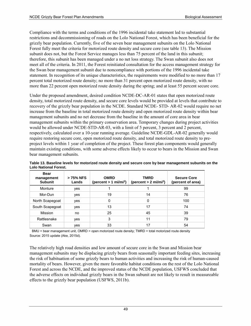
NCDE Grizzly Bear Forest Plan Amendments Biological Assessment
49
Compliance with the terms and conditions of the 1996 incidental take statement led to substantial restrictions and decommissioning of roads on the Lolo National Forest, which has been beneficial for the grizzly bear population. Currently, five of the seven bear management subunits on the Lolo National Forest fully meet the criteria for motorized route density and secure core (see table 13). The Mission subunit does not, but the Forest Service manages less than 75 percent of the land in this subunit; therefore, this subunit has been managed under a no net loss strategy. The Swan subunit also does not meet all of the criteria. In 2011, the Forest reinitiated consultation for the access management strategy for the Swan bear management subunit due to noncompliance with portions of the 1996 incidental take statement. In recognition of its unique characteristics, the requirements were modified to no more than 17 percent total motorized route density; no more than 31 percent open motorized route density, with no more than 22 percent open motorized route density during the spring; and at least 55 percent secure core.
Under the proposed amendment, desired condition NCDE-DC-AR-01 states that open motorized route density, total motorized route density, and secure core levels would be provided at levels that contribute to recovery of the grizzly bear population in the NCDE. Standard NCDE- STD- AR-02 would require no net increase from the baseline in total motorized route density and open motorized route density within bear management subunits and no net decrease from the baseline in the amount of core area in bear management subunits within the primary conservation area. Temporary changes during project activities would be allowed under NCDE-STD-AR-03, with a limit of 5 percent, 3 percent and 2 percent, respectively, calculated over a 10-year running average. Guideline NCDE-GDL-AR-02 generally would require restoring secure core, open motorized route density, and total motorized route density to pre-project levels within 1 year of completion of the project. These forest plan components would generally maintain existing conditions, with some adverse effects likely to occur to bears in the Mission and Swan bear management subunits.
Table 13. Baseline levels for motorized route density and secure core by bear management subunits on the Lolo National Forest.
Bear management
Subunit > 75% NFS
Lands OMRD
(percent > 1 mi/mi2) TMRD
(percent > 2 mi/mi2) Secure Core
(percent of area) Monture yes 1 1 99 Mor-Dun yes 19 14 76
North Scapegoat yes 0 0 100 South Scapegoat yes 13 17 74
Mission no 25 45 39 Rattlesnake yes 3 11 79
Swan yes 33 17 54 BMU = bear management unit, OMRD = open motorized route density; TMRD = total motorized route density
Source: 2015 update (Ake, 2015d).
The relatively high road densities and low amount of secure core in the Swan and Mission bear management subunits may be displacing grizzly bears from seasonally important feeding sites, increasing the risk of habituation of some grizzly bears to human activities and increasing the risk of human-caused mortality of bears. However, given the more favorable habitat conditions on the rest of the Lolo National Forest and across the NCDE, and the improved status of the NCDE population, USFWS concluded that the adverse effects on individual grizzly bears in the Swan subunit are not likely to result in measureable effects to the grizzly bear population (USFWS, 2011b).
NCDE Grizzly Bear Forest Plan Amendments Biological Assessment
50
The allowance for temporary increases in open and total motorized route densities and temporary decreases in secure core under standard NCDE-STD-AR-03 could result in a higher potential for disturbance of grizzly bears. Under guideline NCDE-GDL-AR-01, each project would be designed so that it will not exceed five years in duration. In addition, the amount of secure core that could be affected is strongly constrained by the overlap with designated wilderness, inventoried roadless areas, and other forest plan management area designations that restrict road development. The Lolo National Forest has about 221,000 acres of secure core, of which about 211,000 acres are in wilderness and inventoried roadless areas. Only about 4 percent of the secure core occurs in areas where road access would be possible (Figure 1-10 in appendix 1). Therefore, although this standard could allow adverse impacts on individual bears to occur, the extent of the area where this could occur is limited, and adverse effects to the population would not be expected.
Other standards would establish consistent definitions and procedures for managing administrative use (NCDE-STD-AR-01) and short-term public use (NCDE-STD-AR-04) in the primary conservation area. This would not constitute a change in how the forest plan is currently being implemented; however, a consistent set of standards and guidelines would be formalized in the forest plan rather than being requirements of a biological opinion and incidental take statement. Thus, the direction would remain in place and provide the needed regulatory mechanisms at such time that the grizzly bear is delisted from the ESA.
Motorized route density in zone 1 and the Ninemile demographic connectivity area The current Lolo Forest Plan does not require management for grizzly bears or their habitat outside of the recovery zone. The forest plan restricts open road densities to 1.1 mi/mi2 in highly productive big game summer range and, as described above, requires that management of roads be coordinated with other resource objectives, including grizzly bear habitat.
In 2004, the Lolo National Forest analyzed the effects of its forest plan direction on grizzly bears occurring both inside and outside the recovery zone. USFWS issued a biological opinion and incidental take statement on August 30, 2004, focusing on access management, livestock grazing, and storage of food and attractants. The biological opinion required the Lolo National Forest to contact the USFWS if a net increase in permanent system roads exceeds 2 linear miles in the grizzly bear distribution area outside the recovery zone during the subsequent 4-year period. Since 2004, no new permanent roads have been constructed in the grizzly bear distribution area outside of the NCDE recovery zone, and 5.14 miles have been decommissioned in the distribution area. The 2004 BO and incidental take statement was extended by USFWS in 2012 (USFWS, 2012). The term and condition was administratively amended as follows: The Forest will contact the USFWS if more than 2 miles of new permanent road over the 2004 baseline, or 7.14 miles total, will be constructed over the next 10 years in the distribution area outside of the NCDE recovery zone.
Within the Ninemile demographic connectivity area, there are currently 754 miles of Forest Service roads and 36 miles of Forest Service trails that are open to public motorized use on about 399 mi2 of NFS land, for an existing motorized route density of 2.0 mi/mi2 (Ake, 2017). In light of the Alberta thresholds identified by Boulanger and Stenhouse (2014), this existing motorized route density is expected to be compatible with occupancy by female grizzly bears. The survival rates of females with cubs of the year or yearlings may be negatively affected because the motorized route density exceeds the 1.6 mi/mi2 threshold for reduced mortality.
Currently, in zone 1 outside the Ninemile DCA, there are about 315 miles of Forest Service roads that are open to public motorized use on about 244 mi2 of NFS land, for an existing open road density of about 1.3 mi/mi2 ((Ake, 2017). There are only about 2 miles of motorized trail in this area. This existing linear
NCDE Grizzly Bear Forest Plan Amendments Biological Assessment
51
density of motorized routes is below the threshold values identified in Alberta by Boulanger and Stenhouse (2014) for bear occupancy, occupancy by females, and bear mortality.
Under the proposed amendment, two desired conditions would be added to the forest plan. NCDE-LNF Zone 1-DC-01 states that roads located within the Lolo National Forest portion of NCDE zone 1 (including the Ninemile demographic connectivity area) will provide for public and administrative access to NFS lands while contributing to sustaining the grizzly bear population in the NCDE and acknowledges that the Ninemile demographic connectivity area will provide habitat that can be used by female grizzly bears and allow for bear movement between grizzly bear ecosystems. NCDE-LNF Zone 1-DC-02 encourages consolidation of NFS lands and conservation easements with willing landowners in the areas between the primary conservation area and the Ninemile demographic connectivity area to provide habitat connectivity and facilitate movement of wildlife.
NCDE-LNF Zone 1-STD-01 addresses the density of roads/motorized routes open to public motorized use. Within the Lolo National Forest portion of NCDE zone 1 (outside the Ninemile demographic connectivity area), there shall be no net increase above the baseline in the density of roads open to public motorized use during the non-denning season on NFS lands. Within the Ninemile demographic connectivity area, there shall be no net increase above the baseline in the density of roads and trails open to public motorized use during the non-denning season on NFS lands.
This standard would limit the disturbance, displacement, and mortality risk associated with open roads in zone 1 and with motorized routes (roads and trails) in the Ninemile demographic connectivity area. The baseline road density of 1 mi/mi2 in zone 1 and the motorized route density of 1.5 mi/mi2 in the Ninemile demographic connectivity area are below (i.e., better than) the threshold value reported by Boulanger and Stenhouse (2014) to sustain grizzly bear presence (2.4 linear mi/mi2) and to reduce mortality (1.6 linear mi/mi2). Implementation of the plan components is expected to be effective in sustaining female grizzly bear occupancy and encouraging demographic connectivity with the Bitterroot recovery zone.
Motorized over-snow vehicle use in the den emergence period On the Lolo National Forest, Seeley Lake within the NCDE is a major snowmobile destination area. Groomed snowmobile routes and snowmobile play areas are concentrated outside the primary conservation area except for the large block of former Plum Creek Timber Company land in the Mission Subunit and on NFS lands in the lower elevation areas in the Swan Subunit and in the Dun Creek drainage in the Mor-Dun Subunit. The Monture, North Scapegoat, South Scapegoat, and Rattlesnake Subunits are dominated by wilderness and roadless areas where snowmobile use is restricted by area closures or topography. Spring road closures are in place around Morrell Falls, Richmond Peak, and Clearwater Lake to specifically protect grizzly bear from snowmobile and other motorized disturbance during the non-denning period from April 1-June 30. There are two groomed snowmobile routes totaling 94 miles on the edge of secure core habitat. All 315 mi2 of secure core habitat are closed year-round to snowmobile use. There are 78 mi2 outside secure core habitat within the primary conservation area that are open to snowmobile use.
The existing Lolo forest plan does not restrict over-snow vehicle use during the den emergence period. Under the proposed amendment, NCDE-STD-AR-08 would be added to limit the impact of this activity during this period when female bears with cubs are vulnerable to disturbance. The standard would allow no net increase in the percentage of area or miles of routes that are designated for motorized over-snow vehicle use within modeled grizzly bear denning habitat in the primary conservation area on NFS lands during the den emergence time period. This standard would prevent future increases in impacts to female bears during this period.
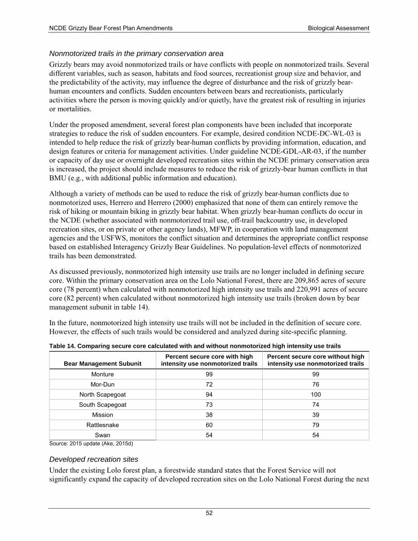
NCDE Grizzly Bear Forest Plan Amendments Biological Assessment
52
Nonmotorized trails in the primary conservation area Grizzly bears may avoid nonmotorized trails or have conflicts with people on nonmotorized trails. Several different variables, such as season, habitats and food sources, recreationist group size and behavior, and the predictability of the activity, may influence the degree of disturbance and the risk of grizzly bear-human encounters and conflicts. Sudden encounters between bears and recreationists, particularly activities where the person is moving quickly and/or quietly, have the greatest risk of resulting in injuries or mortalities.
Under the proposed amendment, several forest plan components have been included that incorporate strategies to reduce the risk of sudden encounters. For example, desired condition NCDE-DC-WL-03 is intended to help reduce the risk of grizzly bear-human conflicts by providing information, education, and design features or criteria for management activities. Under guideline NCDE-GDL-AR-03, if the number or capacity of day use or overnight developed recreation sites within the NCDE primary conservation area is increased, the project should include measures to reduce the risk of grizzly-bear human conflicts in that BMU (e.g., with additional public information and education).
Although a variety of methods can be used to reduce the risk of grizzly bear-human conflicts due to nonmotorized uses, Herrero and Herrero (2000) emphasized that none of them can entirely remove the risk of hiking or mountain biking in grizzly bear habitat. When grizzly bear-human conflicts do occur in the NCDE (whether associated with nonmotorized trail use, off-trail backcountry use, in developed recreation sites, or on private or other agency lands), MFWP, in cooperation with land management agencies and the USFWS, monitors the conflict situation and determines the appropriate conflict response based on established Interagency Grizzly Bear Guidelines. No population-level effects of nonmotorized trails has been demonstrated.
As discussed previously, nonmotorized high intensity use trails are no longer included in defining secure core. Within the primary conservation area on the Lolo National Forest, there are 209,865 acres of secure core (78 percent) when calculated with nonmotorized high intensity use trails and 220,991 acres of secure core (82 percent) when calculated without nonmotorized high intensity use trails (broken down by bear management subunit in table 14).
In the future, nonmotorized high intensity use trails will not be included in the definition of secure core. However, the effects of such trails would be considered and analyzed during site-specific planning.
Table 14. Comparing secure core calculated with and without nonmotorized high intensity use trails
Bear Management Subunit Percent secure core with high
intensity use nonmotorized trails Percent secure core without high intensity use nonmotorized trails
Monture 99 99 Mor-Dun 72 76
North Scapegoat 94 100 South Scapegoat 73 74
Mission 38 39 Rattlesnake 60 79
Swan 54 54 Source: 2015 update (Ake, 2015d)
Developed recreation sites Under the existing Lolo forest plan, a forestwide standard states that the Forest Service will not significantly expand the capacity of developed recreation sites on the Lolo National Forest during the next
NCDE Grizzly Bear Forest Plan Amendments Biological Assessment
53
10-year period. (This standard does not include trailheads in the definition of developed recreation sites.) Emphasis will be placed on increasing the use of existing sites by making them usable by a wide segment of society, including the elderly and handicapped. Those existing sites receiving low levels of public use or that are not cost effective to operate will be considered for temporary or permanent closure. It is acknowledged that the Forest has had to respond to increasing use in some areas by hardening dispersed sites and installing facilities to provide for sanitation and public safety.
Each of the three bear management units (Monture Landers Fork, Rattlesnake, and Upper South Fork Flathead) has one site with one cabin for overnight use, The Monture Landers Fork BMU has three campgrounds providing a total of 12 individual campsites, and the Rattlesnake BMU has one campground with three campsites.
There are seven day-use developed recreation sites, five in the Monture Landers Fork BMU and two in the Upper South Fork BMU, and 24 trailheads (14 in Monture Landers Fork and five each in Rattlesnake and Upper South Fork Flathead).
There are ski resorts on the Lolo National Forest, but none are located within the primary conservation area. Under the proposed amendment, NCDE-STD-AR-07 would require that new or reauthorized ski area permits include mitigation measures to reduce the risk of future grizzly bear-human conflicts in the PCA.
From 2000 through 2010, four known grizzly bear mortalities occurred inside the Lolo National Forest boundary, and 14 mortalities occurred off the Forest but in the occupied distribution area south of the Forest boundary (R. D. Mace & Roberts, 2011). Causes of death included collisions with cars, mistaken identity, illegal shooting, and defense of life. None of the mortalities on the Lolo National Forest were known or suspected to be associated with food conditioning or unsecured attractants at developed recreation sites.
Under the proposed amendment, several plan components would be added that address developed recreation sites designed and managed for overnight use. Within the primary conservation area, the number, capacity, and improvements of developed recreation sites would provide for user comfort and safety while minimizing the risk of grizzly bear-human conflicts on NFS lands (NCDE-DC-AR-02). Increases in the number and capacity of developed recreation sites on NFS lands that are designed and managed for overnight use during the non-denning season (e.g., campgrounds, cabin rentals, huts, guest lodges, recreation residences) will be at levels that contribute to sustaining the recovery of the grizzly bear population in the NCDE (NCDE-DC-AR-03). Guideline NCDE-GDL-AR-03 states that if the number or capacity of day use or overnight developed recreation sites is increased within the NCDE primary conservation area, the project should include measures to reduce the risk of grizzly-bear human conflicts in that BMU (e.g., with additional public information and education; by providing backcountry food-hanging poles or bear-resistant food or garbage storage devices; by increasing law enforcement and patrols). Standard NCDE-STD-AR-05 would set a limit of one increase in the number or the overnight capacity of developed recreation sites designed and managed for overnight use per BMU per decade on NFS lands in the primary conservation area. In addition, standard NCDE-STD-AR-07 would require that new or reauthorized ski area permits include mitigation measures to reduce the risk of grizzly bear-human conflicts. This set of plan components is consistent with what has occurred on the Flathead National Forest through consultation during the time period when the grizzly bear population was stable to increasing and expanding its distribution.
Although there is a potential for some future increase in developed recreation sites with overnight use to affect bears through habituation or food conditioning, the risk of mortality for grizzly bears would be limited under the proposed action. There is no history of recurring conflicts at developed recreation sites
NCDE Grizzly Bear Forest Plan Amendments Biological Assessment
54
on the Lolo National Forest. Implementation and monitoring of the food storage orders, public education, and increases in the availability of bear-resistant food storage devices have all helped to reduce the potential for grizzly bear-human conflicts in recent decades. In addition, concerted efforts by MFWP to respond to grizzly bear-human conflicts, both on and off NFS lands, have greatly reduced the risks to both bears and people.
Livestock Allotments There is only one cattle grazing allotment within the primary conservation area, located on the Seeley Lake Ranger District, and there are no sheep grazing allotments. Within the primary conservation area, the forest plan directs that grazing be managed to reduce the number of grizzly bear-human conflicts and reduce or eliminate the need for removal of grizzly bears from the population.
In the grizzly bear distribution area outside of the recovery zone, there are three cattle allotments. One is located on the Ninemile Ranger District, but it has not been grazed since 1994. The second cattle allotment is the 4Mile allotment, which is an active allotment on the Superior Ranger District. It is located near St. Regis and is within the Salish demographic connectivity area. The third is the O’Keefe allotment, located within zone 1 on the Missoula Ranger District. No known incidents of grizzly bear mortality or grizzly bear-human conflict have occurred on the Lolo National Forest from livestock grazing-related management control actions since the grizzly bear was listed in 1975 (USFWS, 2012).
Existing forest plan direction to reduce livestock impacts and to minimize grizzly bear-livestock conflicts on NFS lands in the primary conservation area would be retained. Additional standards and guidelines applicable to the primary conservation area would be added. New permits would need to incorporate measures to reduce the risk of grizzly bear-human conflicts. Livestock carcasses would need to be reported within 24 hours. No increase in the number of cattle allotments, or in the number of sheep allotments or permitted sheep animal unit months would be allowed. To reduce the potential risk of grizzly bear-human conflicts, sheep grazing permits in non-use status should be phased out and sheep allotments closed as the opportunity arises with a willing permittee.
As discussed for the no-action alternative, the two existing livestock grazing allotments have been compatible with recovery of the NCDE grizzly bear population. The mortality risk associated with livestock grazing on the Lolo National Forest has been very low. The additional standards and guidelines would maintain a low potential for conflicts on NFS lands in the primary conservation area.
Vegetation Management The Forest would continue to follow the Interagency Grizzly Bear Guidelines for vegetation management in management situation 1 and 2 grizzly bear habitat. These guidelines specify that measures that maintain and/or improve grizzly bear habitat and populations will be specified in project design. A summary of the Interagency Grizzly Bear Guidelines for timber and fire management (IGBC, 1986) include:
• All proposed logging and burning activities will be evaluated for their effects on grizzly bears and their habitat.
♦ Logging and burning activities will occur at a time or season when the area is of little or no biological importance to the bear.
♦ Grizzly bear habitat will be improved through vegetation manipulation.
• Habitat management in forested cover should provide a balance of all successional stages.
NCDE Grizzly Bear Forest Plan Amendments Biological Assessment
55
• Roads used for timber sale purposes will be single-purpose roads only and will be closed to public use not associated with timber sale operation and administration.
• Desirable clearcut features include (1) one or more leave or cover patches in cuts over 10 acres; (2) minimum soil scarification where soil disturbance impedes the reestablishment of grizzly foods; (3) slash disposal by spring broadcast burning; and (4) protection of hydric stream bottoms, wet meadows, marshes, and bogs from soil disturbance and security cover removal.
• Prescribed burning in habitat types that are not managed for timber production could be used to approximate a natural fire frequency in order to promote berry-producing shrubs.
The vegetation management guidelines would provide for diverse cover and forage conditions and would reduce the potential for grizzly bear displacement through the timing of timber sale activities. Although there may be short-term impacts to individual bears from timber management activities and associated road use, these impacts have been and would continue to be managed acceptably using the Interagency Grizzly Bear Guidelines.
Under this alternative, existing forest plan standards and guidelines for vegetation management would be retained. Additional desired conditions and guidelines applicable to the primary conservation area would be added. The added direction is very similar to the Interagency Grizzly Bear Guidelines in encouraging a mosaic of successional stages; restricting logging activities in time and space as needed; designing projects to maintain or improve grizzly bear habitat quality or quantity where it would not increase the risk of grizzly bear-human conflicts; and retaining cover as needed along grass, forb, and shrub openings, riparian wildlife habitat, or wetlands. No additional measures would be applied to zone 1 or the Ninemile demographic connectivity area.
The vegetation management guidelines for the primary conservation area would provide for diverse cover and forage conditions and would reduce the potential for grizzly bear displacement through the timing of timber sale activities. Although there may be short-term impacts to individual bears from timber management activities and associated road use, these impacts have been and would continue to be managed acceptably.
Mineral and Energy Development Lolo forest plan standard 41 requires that “Before oil and gas lease stipulation recommendations are made, site specific analysis of environmental effects will be made. Stipulations which are displayed in Appendix F and based upon the Environmental Analysis for Oil and Gas of Nonwilderness Lands on the Lolo National Forest, 9/20/82, will be recommended in accordance with management area direction in Chapter III. In some instances, the stipulations will include a provision for ‘no surface occupancy.’ The lessee or designated operator has the right to explore for and extract oil/gas from his/her lease in accordance with the stipulations attached to the lease.”
The magnitude of effects from leasable or locatable minerals exploration and development thus would be limited by provisions of the forest plan. Any such proposals would be subject to additional site-specific analysis. Project development and mitigation plans would be designed to avoid, minimize, or compensate for any adverse effects associated with the mining proposal.
Existing forest plan standards pertaining to mineral and energy development would be retained. Additional desired conditions, standards, and guidelines applicable to the primary conservation area and zone 1 would be added. The additional standards and guidelines would apply to new or reauthorized permits, leases, or plans of operation and would provide guidance for mitigation of mineral development impacts, proper storage and handling of wildlife attractants, timing restrictions for ground-disturbing
NCDE Grizzly Bear Forest Plan Amendments Biological Assessment
56
activities in spring habitat and seismic activity in denning habitat, management of motorized traffic and helicopter use, noise reduction, and worker safety when living near and working in grizzly bear habitat.
With these measures in place, grizzly bears would likely continue to use areas where development occurs with minimal habitat loss and slight temporary disruptions to habitat use patterns. Any future developments would also be subject to site-specific analysis and design.
Demographic connectivity The existing forest plan does not have specific provisions that encourage demographic connectivity to the Cabinet-Yaak and Bitterroot Ecosystems. However, forest plan standard 27 directs that management practices be compatible with habitat needs of threatened and endangered species, consistent with the goal of recovery.
The proposed amendments would establish additional management direction requiring no net increase in motorized use of roads open to the public during the non-denning season in zone 1 and no net increase in motorized routes (roads and trails) in the Ninemile demographic connectivity area. Existing open road density in zone 1 outside the demographic connectivity area is about 1.5 mi/mi2; existing open motorized route density in the Ninemile demographic connectivity area is about 1 mi/mi2. Implementation of this direction would provide the conditions needed to support occupancy by grizzly bears, including female bears, and to facilitate connectivity with the Cabinet-Yaak and Bitterroot Ecosystems.
Cumulative effects The analysis of cumulative effects provides a larger context in which to evaluate the effects of the forest plan direction by considering conditions across all land ownerships within the NCDE. Both the grizzly bear recovery plan and the draft NCDE conservation strategy emphasized the need to coordinate management across multiple land ownerships and jurisdictions to sustain the NCDE grizzly bear population through time. This section considers the cumulative impacts of (1) past, present, and future management of grizzly bear habitat on state, tribal, and private lands and in Canada, including the effects on connectivity between the NCDE and other grizzly bear recovery zones; (2) grizzly bear-human conflicts on private lands in the NCDE conservation strategy area; and (3) future climate change.
Effects of management on grizzly bear habitat State lands Montana Department of Natural Resources and Conservation lands comprise about 3.6 percent of the primary conservation area and 6.2 percent of zone 1. In 2011, the Montana Department of Natural Resources and Conservation in conjunction with USFWS completed a habitat conservation plan, which has a 50-year term. This is a comprehensive program to conserve federally listed species and minimize incidental take during ongoing forest management activities in western Montana. Within the area delineated as the primary conservation area, zone 1 and zone 2, the Montana Department of Natural Resources and Conservation manages about 574,000 acres of state trust lands. Of this, approximately 204,000 acres are located within the primary conservation area.
The Swan River State Forest has been a party to the Swan Valley Grizzly Bear Conservation Agreement (PC-MDNRC-FNF-USFWS, 1997), along with Plum Creek Timber Company, the Flathead National Forest, and USFWS, since 1995. This agreement has coordinated timber harvest activities and associated road management across the multiple land ownerships in the Swan Valley in a manner that contributes to the recovery of the grizzly bear population. Under this agreement, 3 years of rest (during which low-intensity administrative activities may occur but public access is restricted) must be provided after three years of management activities; areas with open road density > 1 mi/mi2 must not exceed 33 percent of
NCDE Grizzly Bear Forest Plan Amendments Biological Assessment
57
each bear management subunit; road closure devices are maintained; and seasonal road closures are implemented.
Recently, a land transfer known as the Legacy Project has been completed in the Swan Valley. The Nature Conservancy and the Trust for Public Land agreed to purchase lands from Plum Creek Timber Company and then sell or donate these lands to federal, state, and private owners. The vast majority of these lands have become federal (USFS) or state (Montana Department of Natural Resources and Conservation) owned, and any lands that were sold to private owners have safeguards (e.g., conservation agreements) attached to them so that the integrity of wildlife habitat is maintained. The “fiber agreement” that was part of the Legacy Project and necessitated coordination of timber harvest on Legacy lands has now ended. In the foreseeable future, Montana Department of Natural Resources and Conservation may be managing their lands in the Swan Valley using their habitat conservation plan (MTDNRC, 2011) rather than the conservation agreement.
On all lands under the habitat conservation plan, the Montana Department of Natural Resources and Conservation is committed to minimizing construction of new open roads in riparian area wetlands and avalanche chutes. Motorized activities are suspended within 0.6 mile of a known active grizzly bear den. Visual cover is retained in riparian and wetland areas. Information is provided to all contractors and training is provided to employees about living and working in bear habitat.
Within the primary conservation area and zone 1 (zone 1 is called “non-recovery occupied habitat” in the habitat conservation plan), Montana Department of Natural Resources and Conservation agreed to minimize the construction of new open roads; prohibit commercial forest management activities, pre-commercial thinning, and heavy equipment slash treatments during April 1-June 15 in spring bear habitat; minimize helicopter operations requiring flights lower than 500 meters in seasonally important grizzly bear habitat; limit the number of active gravel pits; and discourage new domestic sheep grazing allotments. Spring habitat restrictions are implemented on about 48,600 acres in the Stillwater and Coal Creek State Forests and 31,700 acres in the Swan River State Forest. Currently, the Montana Department of Natural Resources and Conservation has very few grazing licenses on very limited ownership in the NCDE. Fewer than 9,000 acres within the primary conservation area and about 30,700 acres in the non-recovery occupied habitat are grazed by livestock. Information and education programs and other measures are being taken to avoid and minimize the risk of grizzly bear-human conflicts. Prompt removal of livestock carcasses also minimizes risk of bear-livestock conflicts.
Additional protective measures apply to the primary conservation area, including capping the miles of open and restricted roads in the Stillwater Block and Swan River State Forest. The Stillwater Block will maintain 22,007 acres of security zones where management and administrative uses are prohibited during the non-denning season. The Swan habitat conservation plan strategy is that 4 years of activity must be followed by 8-year rest periods across five management subzones. The impacts to important grizzly bear habitats are minimized; all primary road closure devices are examined and repaired annually; and no new grazing licenses for sheep and other small livestock will be authorized. The transportation plan for the Stillwater and Coal Creek State Forests capped road construction at 19.3 more miles of permanent road and reduced the miles of road open year-round by 15 percent.
The transportation plan for the Swan River State Forest under the habitat conservation plan capped new permanent roads at 70 miles (none open to the public), allowed a minimal net increase in linear open road miles, and called for an additional 41 miles of road to restrict commercial forest activities during the spring season. The Montana Department of Natural Resources has no commitments to manage secure core habitat for grizzly bears on the Swan River State Forest.
NCDE Grizzly Bear Forest Plan Amendments Biological Assessment
58
Although there could be some short-term adverse effects on a few individual bears, implementation of the habitat conservation plan is not likely to cause cumulative adverse effects on the NCDE grizzly bear population.
Montana Department of Fish, Wildlife and Parks A very small proportion of the land within the primary conservation area (0.6 percent) and zone 1 (1.2 percent) are managed by MFWP. Montana’s wildlife management areas are managed with wildlife and wildlife habitat conservation as the primary concern, along with the concern of providing for enjoyment by the public. Some wildlife management areas are open for hunting or camping and others are not. Several are closed to the public during the winter and spring periods. MFWP is very active in providing public information and education about conserving grizzly bears and their habitat.
Given the agency’s mission to conserve wildlife and its small holdings with the primary conservation area and zone 1, no adverse cumulative effects on the NCDE grizzly bear population are anticipated due to management actions of MFWP.
Tribal lands The Blackfeet Indian Reservation represents about 4.5 percent of the primary conservation area and about 5.6 percent of zone 1. The Blackfeet Indian Reservation has about 175,000 forested acres. These are managed under the Blackfeet Nation Forest Management Plan, which is expected to be in effect until 2030. Nearly all of the acres under the forest management plan occur within the primary conservation area or zone 1. Under the forest management plan, no net increase in overall road density levels is allowed.
The Blackfeet Nation with the Bureau of Indian Affairs are currently soliciting interest in the Land Buy-Back Program. Purchase offers have been generated for nearly 7,000 landowners with fractional interests at the Blackfeet Indian Reservation through the Land Buy-Back Program for Tribal Nations (formerly called the Cobell Land Consolidation Program). The Land Buy-Back Program is part of the Indian Trust Settlement resulting from the Cobell v. Salazar class action lawsuit, in which $1.9 billion was earmarked to address the growing problem of fractionated ownership. Land ownership becomes fractionated when the original owner leaves a tract to multiple descendants, and eventually the land becomes so divided that the ability of an owner to manage the land is compromised. If successfully completed, the purchases could transfer a substantial amount land from private to tribal ownership.
Lands managed by the Confederated Salish and Kootenai Tribes comprise about 2.5 percent of the primary conservation area and nearly 11 percent of zone 1. Of the acreage that is within the primary conservation area, 91 percent of reservation lands are in the Mission Mountains Tribal Wilderness Area or the South Fork Jocko Primitive Area. No commercial forest activities occur in these areas. There will be no permanent increase in open or total road densities and no permanent decreases in secure core within the wilderness area. In the South Fork Jocko Primitive Area, there will be no net increase in open roads. The forest management plan (CSKT, 2000) provides the following guidance for motorized access management on the remaining lands: open road densities shall not exceed 4 mi/mi2; total road miles shall remain at or below what existed in 1999; total road densities will be reduced over the life of the plan by removing 15 percent of road spurs; and roads in timber sale areas shall be closed after timber harvest is completed. Vegetation management direction in the primary conservation area restricts the locations and methods of harvest in some areas; hiding cover is retained along major highways near identified crossing areas; and during the duration of a timber sale and for two years afterward, adjacent drainages must remain undisturbed. On the Flathead Indian Reservation, there is no livestock grazing within the primary conservation area. Under the conservation agreement, the standards for management of livestock grazing would be the same as for the federal agencies.
NCDE Grizzly Bear Forest Plan Amendments Biological Assessment
59
Existing management direction on tribal lands has been in place during the period when the NCDE grizzly bear population was stable to increasing. There may be some adverse effects on individual grizzly bears due, for example, to high road densities outside of tribal wilderness areas. However the overall suite of management direction along with efforts of tribal bear management specialists will minimize adverse effects. Cumulative adverse effects to the NCDE population are not expected as a result of management actions on tribal lands.
Canadian lands Grizzly bear populations in the lower 48 states are not separated biologically from grizzly bears in Canada. However, there are distinct differences in population status, habitat management, and regulatory mechanisms between the two countries. Overall, Canada supports approximately 27,000 grizzly bears in relatively contiguous populations (Ross, 2002). Grizzly bears are listed as a species of “special concern” under the Canadian Species at Risk Act, but this designation is given to any species that is sensitive to human activities and does not indicate an extinction risk (USFWS, 2011a).
In contrast to the United States, there is no national land management agency to establish and implement habitat management programs across Canada. The national parks and provincial parks have uniform habitat protections in place for grizzly bears. Provincial management plans have been developed for grizzly bears in British Columbia and Alberta. In Canada immediately north of the NCDE, the main human activities that have impacted grizzly bears and their habitat are timber harvesting, oil and gas exploration and development, coal mining, and the proliferation of roads and other human developments related to these industries. On February 18, 2010, the premier of British Columbia announced that mining, oil, gas, and coal development were no longer permissible land uses in the Canadian portion of the North Fork Flathead River basin, removing a substantial threat to the NCDE population.
There is no evidence to suggest that adverse cumulative impacts are now or will occur due to land management activities in Canada.
Private lands Privately owned lands comprise about 10 percent of the 5.7-million-acre primary conservation area, nearly 48 percent of zone 1. Privately owned lands occur within and adjacent to NFS lands throughout the NCDE.
The human population in northwest Montana has grown at a relatively high rate during the past few decades, and growth is expected to continue. Increasing residential development and demand for recreational opportunities can result in habitat loss, habitat fragmentation, and increases in grizzly bear-human conflicts. These impacts are likely to intensify, although appropriate residential planning, outreach about how to minimize adverse effects, and assistance in resolving conflicts can help mitigate these impacts.
Increasing development on private lands has the potential to have cumulative adverse effects on the NCDE grizzly bear population. Monitoring of population status will provide a mechanism to identify areas of concern so that appropriate preventive or corrective actions can be taken.
Grizzly bear-human conflicts Between 1999 and 2008, 201 human-caused mortalities of grizzly bears were recorded in the NCDE. The top three sources of mortality were management removals (27 percent), illegal kills (25 percent), and trains (12 percent) (USFWS, 2011a). The majority (67 percent) of the management removals were related to unsecured attractants.
State lands Food and attractant storage programs for Montana Department of Natural Resources and Conservation staff and contractors reduce the risk of bear-human conflicts. On Department lands within the NCDE recovery zone and on scattered school trust lands within the NCDE and Cabinet-Yaak recovery
NCDE Grizzly Bear Forest Plan Amendments Biological Assessment
60
zones, contract language requires the removal of garbage from work sites daily. Outside the NCDE and Cabinet-Yaak recovery zones but in known occupied grizzly bear habitat, timber sale contract language requires the removal of garbage from work sites daily. For Department lands outside the recovery zones and outside known occupied grizzly bear habitat, precautions are taken on a case-by-case basis only if known bear activity occurs. Recreationists are expected to pack out their trash. As a partner in the Blackfoot Challenge, Montana Department of Natural Resources and Conservation has placed bear-resistant dumpsters at state land locations where bear-attractant conflicts have been known to occur. The Department provides all of its cabin lessees with the brochure “Living with Bears” that explains measures that should be taken to minimize bear-human conflicts. No Montana Department of Natural Resources and Conservation employees or contractors have been involved in a grizzly bear-human conflict that resulted in a management action or death of a grizzly bear.
Montana Department of Fish, Wildlife and Parks MFWP completed a grizzly bear management plan for western Montana in 2006 (Dood, Atkinson, & Boccadori, 2006) and a grizzly bear management plan for southwestern Montana in 2013 (MFWP, 2013). These documents establish goals and strategies to manage and enhance grizzly bear populations and to minimize the potential for grizzly bear-human conflicts. The Department also employs several bear management specialists to work with landowners and educate the public in an effort to avoid or resolve grizzly bear-human conflicts and to reduce grizzly bear mortalities. Food storage guidelines are in place in some state parks and wildlife management areas, and bear-resistant dumpsters are in place in most state parks.
The State of Montana allows regulated hunting for black bears and other wildlife species. There is a potential for grizzly bear mortality by hunters to occur as a result of mistaken bear identification or self-defense, especially in proximity to the carcasses of harvested animals. MFWP provides a variety of public information and education programs, including a mandatory black bear hunter testing and certification program to help educate hunters in distinguishing the two species, aimed at reducing human-caused mortalities. Black bear hunting seasons have also been shortened in recent years, reducing the potential for mistaken identity. These efforts have helped to decrease legal and illegal shooting mortalities.
Hunting of grizzly bears has not been allowed in Montana since 1991. In a recovered, delisted population of grizzly bears, the Department would assume management responsibility for the grizzly bear population. Management could include regulated hunting in the future, when and where appropriate, which potentially could increase tolerance of or support for grizzly bear presence among some segments of the public. The Department would monitor the level of mortality due to hunting and its effects on the NCDE grizzly bear population.
Tribal lands The Blackfeet Indian Reservation has a food storage order in in place under the Blackfeet Fish and Wildlife Code of Regulations (chapter 3, section 17) that applies to all lands within the exterior boundaries of the reservation that are designated as normally being occupied by bears. The regulations govern food storage and sanitation in camping and nonresidential situations and also govern the removal of livestock carcasses that may attract bears into conflict situations. In addition, beekeepers in bear country are encouraged to install electric fencing around beehives
All lands within the primary conservation area on the Blackfeet Indian Reservation are currently allotted for livestock grazing. A bear management specialist(s) works with livestock producers to minimize and manage bear-livestock conflicts. Existing sheep allotments will be monitored, evaluated, and phased out if the opportunity arises with willing permittees.
On the Flathead Indian Reservation, there is a food storage order for backcountry areas in the primary conservation area. As warranted, residents are notified of bear activity and precautionary measures that
NCDE Grizzly Bear Forest Plan Amendments Biological Assessment
61
should be taken to reduce bear-human conflict. Tribal biologists provide assistance in mitigating situations where food and attractant storage is an issue.
Although there has been a history of grizzly bear mortalities related to livestock on the Blackfeet Indian Reservation, the rate of increase of the grizzly bear population indicates that the level of mortality has been sustainable. The Blackfeet Nation and the Confederated Salish and Kootenai Tribes have taken actions, such as hiring bear management specialists and providing information and education, to reduce grizzly bear-human conflicts. Therefore, no adverse cumulative impacts are anticipated due to grizzly bear-human conflicts on tribal lands.
Private lands Private lands continue to account for a disproportionate number of conflicts and grizzly bear mortalities in the NCDE. These impacts are likely to intensify, although appropriate residential planning, outreach and information about how to avoid conflicts, tools such as bear-resistant containers and electric fencing, and assistance in resolving conflicts can help mitigate these impacts. Walters and Holling (1990) stated that managing human-caused mortality, monitoring both population and habitat parameters, and responding when necessary with adaptive management are the best ways to ensure a healthy grizzly population. The USFS does not have authority to manage grizzly bear-human conflicts or human-caused mortality on private lands. Population monitoring and management of grizzly bear-human conflicts is under the authority of MFWP.
MFWP, the Confederated Salish and Kootenai Tribes, and the Blackfeet Nation employ bear specialists who work with landowners in an effort to reduce risks to grizzly bears and humans on private, public, or tribal lands. Bear specialists provide information and assistance to landowners on appropriate ways to secure food and attractants from grizzly bears and respond to reports of conflicts with nuisance black and grizzly bears. These programs have been successful in informing the public, reducing the availability of attractants to grizzly bears on private and public lands, and reducing human-caused mortalities of grizzly bears. These programs and their positive results are expected to continue for the foreseeable future.
Increasing development on private lands and the accompanying risk of grizzly bear-human conflicts has the potential to have cumulative adverse effects on the NCDE grizzly bear population. Monitoring of population status and grizzly bear-human conflicts will provide a mechanism to identify areas of concern so that appropriate preventive or corrective actions can be taken.
Effects of management and development on connectivity with adjacent ecosystems State lands Under the habitat conservation plan, maintenance of eight security zones comprising 22,007 acres in the Stillwater Block and adherence to seasonal restrictions in that transportation plan would facilitate important linkage between the Whitefish and Salish Mountain Ranges. The Swan Valley Grizzly Bear Conservation Agreement also provides a framework for cooperative management, and it would continue to facilitate effective linkage across the valley. The Montana Department of Natural Resources and Conservation’s habitat conservation plan also has provisions that help to maintain the integrity of linkages in the Swan valley to provide for movement between suitable habitats and recovery zones, if it were to go into effect in this area. Thus, under either strategy into the future, effective linkage is likely to be maintained on state trust lands.
The sale or other disposal of some state lands is allowed. However, under the habitat conservation plan, removal of lands is capped at 5 percent of the baseline acreage of certain areas, including the grizzly bear NCDE recovery zone.
The Department’s management direction contributes to maintaining or improving connectivity, and adverse cumulative effects are not anticipated.
NCDE Grizzly Bear Forest Plan Amendments Biological Assessment
62
Montana Department of Fish, Wildlife and Parks Grizzly bear management plans establish goals and strategies to manage and enhance grizzly bear populations and to minimize the potential for grizzly bear-human conflicts. A long-term goal is to allow the populations in western and southwestern Montana to reconnect through the intervening, currently unoccupied habitats. No adverse cumulative impacts on connectivity are anticipated.
Tribal lands On the Flathead Indian Reservation lands within the Ninemile demographic connectivity area, the above-mentioned requirements under the forest management plan also apply. There is a tribally designated wilderness, Sleeping Woman, and tribally designated roadless areas, Burgess and the Ravalli Valley complex, that help to facilitate grizzly bear occupancy and movements within the demographic connectivity area. In a 54-mile stretch of Highway 93 between Evaro and Polson, more than 50 wildlife crossing structures have been constructed. Hiding cover is retained on the reservation adjacent to highway 93 at Evaro and in the Ravalli Corridor to provide conditions that facilitate movement of wildlife. No adverse cumulative impacts on connectivity are anticipated as a result of tribal actions.
Future climate change The USFWS examined climate change and potential future effects on the grizzly bear in its 5-year status review (USFWS, 2011a). The most likely ways in which climate change may potentially affect grizzly bear habitat are reduction in snowpack levels, shifts in the denning season, shifts in the abundance and distribution of some natural food sources, and changes in fire regimes due to summer drought.
Reduced snowpack or a shorter winter season could improve over-winter survival of bears, assuming that sufficient bear foods are available later in the fall and earlier in the spring. However, a shorter denning period could increase the potential for spring and fall encounters between grizzly bears and hunters and/or recreationists, which in turn would increase the risk of mortality to grizzly bears.
With respect to shifts in the denning season, the draft NCDE grizzly bear conservation strategy defined denning season dates and recommended that dates be adjusted if the 10-year average den emergence data for females or females with offspring shows a shift of at least a week. Denning in the NCDE continues to be monitored. The analysis of effects of the amendments on denning habitat used modeled denning habitat provided by Rick Mace (R. Mace, 2014), which is the best available scientific information.
The extent and rate to which individual plant species or plant communities will be impacted by climate change is not possible to foresee with any level of confidence (Fagre, Peterson, & Hessl, 2003; Walther et al., 2002). However, there is general consensus that grizzly bears are flexible enough in their diet that they will not be impacted directly by plant community changes in response to climate change (Servheen & Cross, 2010).
The draft grizzly bear conservation strategy states: “Most grizzly bear biologists in the U.S. and Canada do not expect habitat changes predicted under climate change scenarios to directly threaten grizzly bears (Servheen and Cross 2010). These changes may even make habitat more suitable and food sources more abundant. However, these ecological changes may also affect the timing and frequency of grizzly bear/human interactions and conflicts (Servheen and Cross 2010).”
Fire frequency and severity are predicted to increase in the western United States as a result of climate change. Large, severe wildfires that convert mature forest to early successional condition alter the availability of grizzly bear foods and cover, potentially changing how bears use the landscape. Decreases in forest cover could benefit grizzly bears by increasing the production of shrubs, berries and root crops in the years following large fires (Blanchard & Knight, 1996).
NCDE Grizzly Bear Forest Plan Amendments Biological Assessment
63
The potential positive and negative effects of climate change would likely be variable across the ecosystem and are difficult to predict. Grizzly bears are habitat generalists and opportunistic omnivores, which may make them less susceptible to changes in plant communities than some other species of wildlife. The high degree of uncertainty emphasizes the importance of long-term monitoring of the grizzly bear population so that any necessary adjustments can be made.
Determination of effects and rationale The forest plan amendments would add components (desired conditions, standards, guidelines, and monitoring items) aimed at maintaining conditions that contribute to supporting recovery of the NCDE grizzly bear population and providing connectivity with other grizzly bear recovery zones. The proposed amendments may affect, and are likely to adversely affect the grizzly bear, in consideration of the following:
Motorized access in the primary conservation area: Almost all of the 25 bear management subunits on the amendment forests currently meet the research thresholds for open motorized route density (< 19 percent with > 1 mi/mi2), total motorized route density (< 19 percent with > 2 mi/mi2) and secure core (> 68 percent), providing excellent quality and availability of habitat for grizzly bears, including females with cubs. Three subunits that have > 75 percent Forest Service ownership—Red Mountain, Thierrault, and Swan—do not meet one or more of the research thresholds; the Mission subunit that has < 75 percent Forest Service ownership also does not. The amendments would incorporate direction to maintain baseline levels, which would allow adverse effects to individual bears to continue in those four subunits. The amendments would establish consistent definitions and direction in the forest plans relative to temporary use of roads for projects, administrative use, temporary use by the public outside of secure core, and limits on project duration. Implementation of these standards may also result in short-term adverse effects to individual bears.
Linear miles or density of roads/routes in zone 1 and the Salish and Ninemile demographic connectivity areas: The existing Kootenai forest plan allows no increases in permanent linear miles of open roads, total roads, or motorized trails within the bears outside recovery zone (BORZ) polygons, of which the Tobacco BORZ coincides with zone 1 and the Salish demographic connectivity area. This restriction will remain in place and will help to limit mortality risk and to support female occupancy in the Salish demographic connectivity area and support connectivity with the Cabinet-Yaak recovery area. For both the Kootenai and Lolo forest plans, a desired condition would be added to encourage consolidation of NFS lands support conservation easements with willing landowners in the areas between the primary conservation area and the demographic connectivity areas, to provide habitat connectivity and facilitate movement of wildlife. On the Lolo National Forest, the amendment would add a standard requiring no net increase from the baseline in roads open to public motorized use on NFS lands in zone , and no net increase from the baseline in motorized routes (roads and trails) open to public motorized use in the Ninemile demographic connectivity area. These forest plan components would help to limit mortality risk in zone 1, support occupancy by female bears in the Ninemile demographic connectivity area, and encourage movement to the Bitterroot recovery area.
Zone 1 and the portion of zone 2 west of Interstate 15 on the Helena NF: The amendment would add a desired condition for zone 1 and the portion of zone 2 west of Interstate 15 that would encourage consolidation of NFS lands adjacent to highways and would support conservation easements with willing landowners to provide habitat connectivity and reduce barriers to genetic connectivity between the NCDE and GYE bear populations. In zone 1, a standard would require no net increase above the baseline in the density of motorized routes (roads and trails) open to public use during the non-denning season on NFS lands.
NCDE Grizzly Bear Forest Plan Amendments Biological Assessment
64
Developed recreation sites: The frequent or prolonged human occupancy that occurs at developed recreation sites increases the risk of habituation, food conditioning, and grizzly bear-human conflicts. In the past, conflicts have occurred, but there is no history of recurring conflicts or bear mortalities on NFS lands in the NCDE. Implementation and monitoring of the food storage orders, public education, and increases in the availability of bear-resistant food storage devices have all helped to reduce the number of grizzly bear-human conflicts on the national forests in recent decades and would continue. The proposed amendments would add forest plan components that would limit future increases in the number or the overnight capacity of developed recreation sites designed and managed for overnight use during the non-denning season on NFS lands in the primary conservation area. In light of past efforts, lack of history of mortalities, and the addition of the new plan components, the risk of mortality for grizzly bears related to developed recreation sites would remain low under the proposed amendment.
Vegetation management: Existing forest plan standards and guidelines for vegetation management in the primary conservation area would be retained (see appendix 3). Under the proposed amendment, additional desired conditions and guidelines applicable to the primary conservation area would be added that would provide for diverse cover and forage conditions and would reduce the potential for grizzly bear displacement through timing of timber sale activities. There may be short-term adverse effects to individual bears from vegetation management activities and associated road use, but these are not expected to have a negative or long-term adverse impact on the population.
Livestock grazing: Currently, the mortality risk associated with livestock grazing on the Kootenai, Lewis and Clark, and Lolo National Forests is low, and it is moderate to low on the Helena National Forest. The additional forest plan components would further reduce the potential for conflicts on NFS lands in the primary conservation area.
Minerals and energy development: The amendment would add plan components to guide new or reauthorized leases for oil, gas, and other leasable minerals in the primary conservation area, as well as several plan components that would help to coordinate activities and reduce impacts of mineral and energy exploration and development activities. This would reduce the potential for permanent habitat loss, habitat fragmentation, and disturbance or displacement of bears from habitat, as well as reduce the risk of grizzly bear habituation and/or increased grizzly bear-human encounters and conflicts.
Food and attractant storage: Standard NCDE-STD-WL-02 would result in extending the food storage order, which over time would help to limit mortality risk in zone 2.
Canada lynx
Existing conditions
Population status and distribution The range of Canada lynx extends from Alaska across much of Canada (except for the coastal forests), with southern extensions into parts of the western United States, the Great Lakes states, and New England. Lynx distribution is closely aligned with the distribution of snowshoe hares and boreal forests (McKelvey, Aubry, & Ortega, 1999).
In Montana, lynx are primarily restricted to the northwestern portion of Montana from the Purcell Mountains east to Glacier National Park and then south through the Bob Marshall Wilderness Complex to Highway 200, based on 81,523 telemetry points obtained from resident lynx during 1998–2007 (John R. Squires et al., 2013). Lynx are known to occur on the Helena-Lewis and Clark, Kootenai, and Lolo National Forests (USDA, 2007).
NCDE Grizzly Bear Forest Plan Amendments Biological Assessment
65
To gain a better understanding of the status of the contiguous U.S. distinct population segment of Canada lynx, USWFS convened an expert workshop in October, 2015 (Bell et al., 2016). The results of the species status assessment workshop will be used by USFWS to inform recovery planning, classification decisions, and other determinations required by the ESA. For the species status assessment unit that encompasses northwestern Montana/northeastern Idaho, experts concluded there would be an initially high and subsequently decreasing probability of Canada lynx persistence in this unit, with increasing uncertainty over time, but a higher probability of persistence in all time frames compared to the other units occupied by lynx. For the species status assessment unit encompassing northwestern Montana/northeastern Idaho, all experts predicted near-term (year 2025) persistence probability greater than or equal to 95 percent and mid-century persistence at 70 percent to 100 percent (median = 90 percent).
Habitat Snowshoe hares are the primary winter prey of lynx in Montana (John R. Squires & Ruggiero, 2007), as is true throughout the range of lynx (Aubry, Koehler, & Squires, 1999). Lynx have special adaptations as a predator of snowshoe hares, including a lightweight body frame and proportionately large paws that enable them to travel on top of deep snow. Dense horizontal cover, persistent snow, and moderate-to-high snowshoe hare densities (greater than 0.2 hares/acre) are common attributes of lynx habitat (ILBT, 2013).
In studies conducted in northwestern Montana, lynx typically were found in boreal and subalpine coniferous forests in areas of gentle topography (John R. Squires et al., 2013). Lynx primarily selected mature multistory stands during winter, composed mostly of mature Engelmann spruce and subalpine fir trees. Conifer boughs touching the snow and the young trees in the understory provided the dense horizontal cover that supported higher-density snowshoe hare populations at varying snow depths throughout the winter. Lynx were more restricted to stands with high density of horizontal cover in winter than in summer (John R. Squires, Decesare, Kolbe, & Ruggiero, 2010). Lynx used mid- to high-elevation forests (4,134–7,726 feet) during winter and slightly higher elevations during summer in Montana. Lynx made more use of regenerating forests with abundant small diameter (1–3 in.) and pole-sized (3–7 in. diameter at breast height) trees, dense shrubs, and high horizontal cover during the summer months (John R. Squires et al., 2010).
The lynx recovery outline (USFWS, 2005) stratified lynx habitat into three categories: core, secondary, and peripheral. Core areas are places where long-term persistence of lynx and recent evidence of reproduction have been documented and where the quality and quantity of habitat is available to support both lynx and snowshoe hare life needs. Six core areas were identified in the recovery outline, one of which is in northwestern Montana/northeastern Idaho. The recovery outline stated that lynx conservation efforts should be focused on core areas to ensure the continued persistence of lynx in the contiguous United States.
Secondary and peripheral areas have fewer and more sporadic current, and historical records of lynx and reproduction has not been documented in these areas. Habitat may be patchier, drier, and/or more maritime. In secondary/peripheral areas, the focus of management is on providing a mosaic of forest structure that supports snowshoe hare prey resources for individual lynx that infrequently may move through or reside temporarily in the area. Landscape connectivity should be maintained to allow for lynx movement and dispersal.
For analysis and management purposes, lynx habitat is delineated into lynx analysis units. Lynx analysis units do not depict actual lynx home ranges but approximate the size of a female’s home range and contain year-round habitat components. A lynx analysis unit must contain at least 10 mi2 of primary vegetation (e.g., spruce/fir) to be capable of supporting lynx (ILBT, 2013). It is not necessary to delineate
NCDE Grizzly Bear Forest Plan Amendments Biological Assessment
66
lynx analysis areas in secondary and peripheral areas, although that may have been done in accordance with prior recommendations.
Thirty lynx analysis units have been delineated on lands administered by the Helena National Forest: 17 in the Blackfoot landscape (all in lynx core/designated critical habitat), six in the Divide landscape (two within lynx core and designated critical habitat and four in secondary), three in the Elkhorns landscape (a lynx secondary area), and four in the Big Belts landscape (a lynx secondary area). The best lynx habitat and the most robust population are in the Blackfoot landscape of the Lincoln Ranger District. The Divide landscape supports a small but apparently persistent population of lynx. Tracking surveys backed by 39 DNA samples identified an adult male lynx that was present for at least 3 years and an adult female lynx that was present for at least 1 full year, as well as evidence of the presence of one or more additional lynx (Gehman & Jakes, 2007; Gehman, Robinson, & Porco, 2010) in this area. Habitat in the Divide landscape connects to the Blackfoot landscape and the adjoining Garnet Range, which has the southernmost lynx population in Montana. The Big Belts and Elkhorns landscapes are not considered to be occupied by resident lynx, although transient animals have been documented in the Big Belt Mountains.
On the Lewis and Clark National Forest, there are 57 lynx analysis units, 27 of which are on the Rocky Mountain Ranger District. Large patches of boreal forest on the Rocky Mountain Ranger District are well connected to large areas of lynx habitat on the Flathead and Lolo National Forests to the west and Glacier National Park to the north. The Castle, Crazy, and Little Belt mountain ranges are considered lynx secondary areas and may occasionally host transient dispersing lynx but are not considered occupied by resident lynx. The Highwood Mountains and Little Snowy Ranges are small, isolated mountain ranges that are separated from each other and from other lynx habitat by significant stretches of low elevation, are often agricultural landscapes that do not support lynx or their primary prey species, and are lynx peripheral areas. The 27 lynx analysis units on the Rocky Mountain Ranger District overlap with the NCDE grizzly bear recovery zone/primary conservation area.
On the Kootenai National Forest, 47 lynx analysis units have been delineated, all within lynx core area. This encompasses about 67 percent of the Kootenai National Forest (roughly 1,492,600 out of 2,219,100 acres). A large portion of the acreage in lynx analysis units (62 percent) overlaps with the Cabinet-Yaak and NCDE recovery zones for grizzly bear on the Forest. If both bear management units and the bears outside of recovery zone polygons are included, there is 87 percent overlap with the total lynx analysis unit acreage.
There are a total of 54 lynx analysis units on the Lolo National Forest, 17 of which are within the amendment action area. Four of the lynx analysis units are wholly within the primary conservation area (Big Slide, Scapegoat, Lake, and Monture). Nine lynx analysis units are in both the primary conservation area and zone 1 (Cottonwood Dunham, Morrell, Rice, Clearwater, Marshall Deer, Placid, Boles, Gold, and Rattlesnake). Four lynx analysis units are within the Ninemile demographic connectivity area (Frenchtown, McCormick, Upper Ninemile Siegel, and Ninemile Divide). Lynx are known to be resident on the Lolo National Forest in all lynx analysis units that lie north of Interstate 90 and east of Montana Highway 93, based on extensive surveys and research conducted since 1998. As part of a multi-species carnivore monitoring program, lynx have been surveyed on the Lolo National Forest since 2007 using methods developed by Squires et al. (2004). In 2010 and 2011, this method (snow tracking and DNA collection) was implemented forestwide. Since 2012, surveys have been concentrated in the Southwestern Crown of the Continent analysis area; over a 4-year period, 198 lynx detections were recorded inside lynx core/critical habitat, and one lynx was detected outside of but adjacent to critical habitat. Portions of the Forest to the west do not support resident lynx and are considered lynx secondary areas.
NCDE Grizzly Bear Forest Plan Amendments Biological Assessment
67
Effects of the proposed amendments In the Lynx Conservation Strategy and Assessment (ILBT, 2013), anthropogenic influences are placed in either the “upper tier” or the “lower tier.” The upper tier includes anthropogenic influences that are of greatest concern to the conservation of the lynx: climate change, vegetation management, wildland fire management, and fragmentation of habitat. Recreation (including snowmobiling), minerals and energy development, forest/backcountry roads and trails, and grazing by domestic livestock, which are the factors of most concern in the grizzly bear conservation strategy, were placed in the “lower tier” of anthropogenic influences on lynx. It is thought that these activities could affect individual lynx but are not likely to have a substantial effect on lynx populations and lynx habitat; they are of less concern for conservation of the species. The analysis of effects of the proposed amendments is focused on these anthropogenic influences, with emphasis on the upper tier.
The Helena, Lewis and Clark, Kootenai, and Lolo National Forests contain a suite of forest plan components aimed at providing for the conservation and recovery of the Canada lynx (USDA, 2007). Current forest plan direction specific to lynx, which addresses vegetation management, livestock grazing, human uses, and linkage areas, will not be changed by the proposed amendment. The following summarizes the existing forest plan management direction that addresses the first tier of anthropogenic influences:
• Climate change. No direction specific to climate change was established by the Northern Rockies Lynx Management Direction since this is outside the control of the Forest Service.
• Vegetation management. Objectives VEG O1, VEG O2, and VEG O4 encourage managing vegetation to mimic or approximate natural succession and disturbance processes while maintaining lynx habitat components; providing a mosaic of habitat conditions through time that support dense horizontal cover and high densities of snowshoe hare; and focusing vegetation management in areas that have the potential to improve winter snowshoe hare habitat but presently have poorly developed understories that lack dense horizontal cover. Standard ALL S1 requires that vegetation management projects maintain habitat connectivity in a lynx analysis unit and/or linkage area. Standard VEG S1 allows no additional regeneration harvest if more than 30 percent of the lynx habitat in a lynx analysis unit is currently in a stand initiation structural stage that does not yet provide winter snowshoe hare habitat. VEG S2 does not allow timber management projects to regenerate more than 15 percent of lynx habitat on NFS lands within a lynx analysis unit in a 10-year period. VEG S5 generally precludes pre-commercial thinning projects that reduce snowshoe hare habitat from the stand initiation structural stage until the stand no longer provides winter snowshoe hare habitat. Standard VEG S6 protects snowshoe hare habitat in multistory mature or late successional forests. Guideline G1 encourages projects that are designed to recruit a high density of conifers, hardwoods, and shrubs where such habitat is scarce or not available. Guideline VEG G5 is to provide habitat for alternative prey species, particularly red squirrel, in each lynx analysis unit. Guideline VEG G11 is to provide denning habitat distributed in each lynx analysis unit. The VEG standards allow certain exceptions and exemptions. For the consultation on the Northern Rockies Lynx Management Direction, an estimate was provided of the number of acres that were anticipated to be treated under each of the exceptions in the first decade. Table 15 provides this estimate and an updated estimate for the next decade (2017-2026) for each national forest.
• Wildland Fire Management. Objective VEG O3 encourages fire use activities that restore ecological processes and maintain or improve lynx habitat. Under guideline VEG G4, prescribed fire activities should not create permanent travel routes that facilitate snow compaction and permanent firebreaks should not be constructed on ridges or saddles. Guideline VEG G10 is to
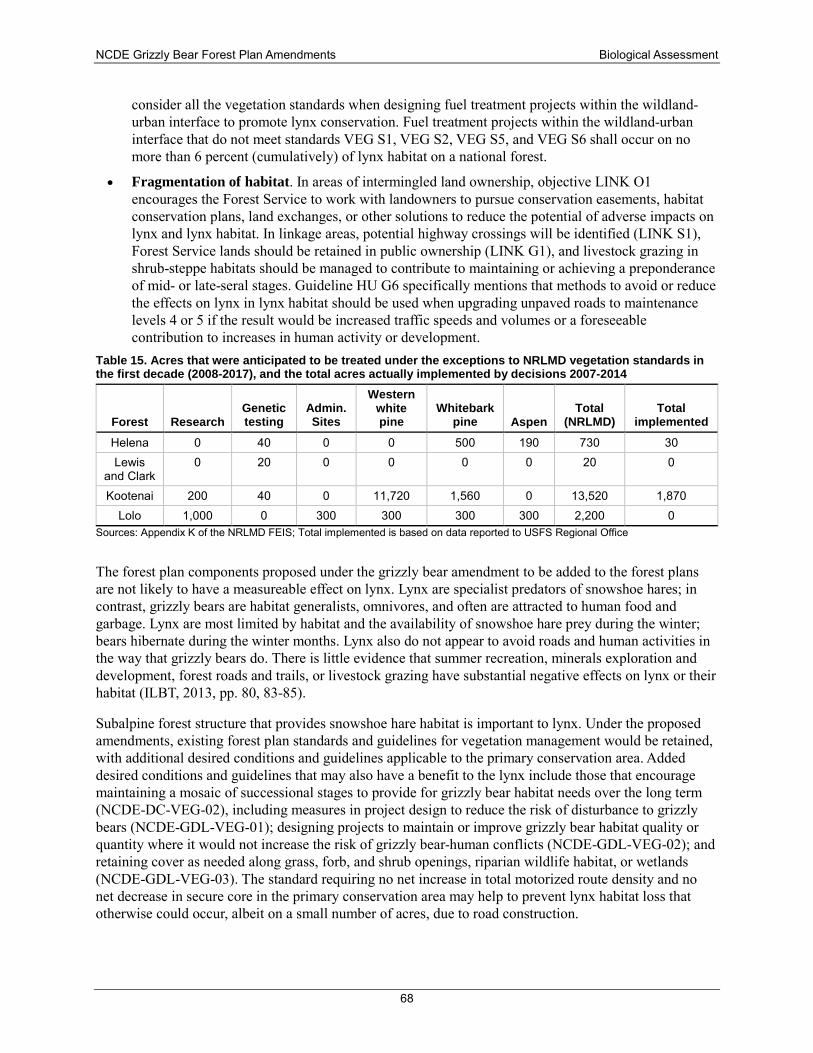
NCDE Grizzly Bear Forest Plan Amendments Biological Assessment
68
consider all the vegetation standards when designing fuel treatment projects within the wildland-urban interface to promote lynx conservation. Fuel treatment projects within the wildland-urban interface that do not meet standards VEG S1, VEG S2, VEG S5, and VEG S6 shall occur on no more than 6 percent (cumulatively) of lynx habitat on a national forest.
• Fragmentation of habitat. In areas of intermingled land ownership, objective LINK O1 encourages the Forest Service to work with landowners to pursue conservation easements, habitat conservation plans, land exchanges, or other solutions to reduce the potential of adverse impacts on lynx and lynx habitat. In linkage areas, potential highway crossings will be identified (LINK S1), Forest Service lands should be retained in public ownership (LINK G1), and livestock grazing in shrub-steppe habitats should be managed to contribute to maintaining or achieving a preponderance of mid- or late-seral stages. Guideline HU G6 specifically mentions that methods to avoid or reduce the effects on lynx in lynx habitat should be used when upgrading unpaved roads to maintenance levels 4 or 5 if the result would be increased traffic speeds and volumes or a foreseeable contribution to increases in human activity or development.
Table 15. Acres that were anticipated to be treated under the exceptions to NRLMD vegetation standards in the first decade (2008-2017), and the total acres actually implemented by decisions 2007-2014
Forest Research Genetic testing
Admin. Sites
Western white pine
Whitebark pine Aspen
Total (NRLMD)
Total implemented
Helena 0 40 0 0 500 190 730 30 Lewis
and Clark 0 20 0 0 0 0 20 0
Kootenai 200 40 0 11,720 1,560 0 13,520 1,870 Lolo 1,000 0 300 300 300 300 2,200 0
Sources: Appendix K of the NRLMD FEIS; Total implemented is based on data reported to USFS Regional Office
The forest plan components proposed under the grizzly bear amendment to be added to the forest plans are not likely to have a measureable effect on lynx. Lynx are specialist predators of snowshoe hares; in contrast, grizzly bears are habitat generalists, omnivores, and often are attracted to human food and garbage. Lynx are most limited by habitat and the availability of snowshoe hare prey during the winter; bears hibernate during the winter months. Lynx also do not appear to avoid roads and human activities in the way that grizzly bears do. There is little evidence that summer recreation, minerals exploration and development, forest roads and trails, or livestock grazing have substantial negative effects on lynx or their habitat (ILBT, 2013, pp. 80, 83-85).
Subalpine forest structure that provides snowshoe hare habitat is important to lynx. Under the proposed amendments, existing forest plan standards and guidelines for vegetation management would be retained, with additional desired conditions and guidelines applicable to the primary conservation area. Added desired conditions and guidelines that may also have a benefit to the lynx include those that encourage maintaining a mosaic of successional stages to provide for grizzly bear habitat needs over the long term (NCDE-DC-VEG-02), including measures in project design to reduce the risk of disturbance to grizzly bears (NCDE-GDL-VEG-01); designing projects to maintain or improve grizzly bear habitat quality or quantity where it would not increase the risk of grizzly bear-human conflicts (NCDE-GDL-VEG-02); and retaining cover as needed along grass, forb, and shrub openings, riparian wildlife habitat, or wetlands (NCDE-GDL-VEG-03). The standard requiring no net increase in total motorized route density and no net decrease in secure core in the primary conservation area may help to prevent lynx habitat loss that otherwise could occur, albeit on a small number of acres, due to road construction.
NCDE Grizzly Bear Forest Plan Amendments Biological Assessment
69
The requirement under NCDE-STD-MIN-08 for no surface occupancy on mineral leases (e.g., oil and gas) and the limit on expansion of developed recreation sites (NCDE-STD-AR-05) under the proposed amendment could contribute to maintaining connectivity within and between areas of lynx habitat that are within the primary conservation area.
NCDE-STD-AR-08 would not allow any increase above the baseline in the acreage of areas and miles of routes designated for motorized over-snow vehicle use in the den emergence time period (i.e., late spring) on NFS lands within modeled denning habitat in the primary conservation area. However, snowmobiles have not been shown to disturb or displace lynx, and late spring snow naturally becomes compacted, so this standard likely would have little or no effect on lynx.
Cumulative effects Future climate change is expected to impact lynx habitat by further reducing the cold climatic conditions that create and maintain boreal forests as lynx habitat. Reduced snowpack and earlier snow melt may also reduce the lynx’s competitive edge as a predator of snowshoe hares in deep, fluffy snow. Warmer temperatures may lead to a reduction in available habitat for lynx as subalpine forests recede to even higher elevations. Forest Service actions will have little or no influence on snowpack and snowmelt.
Continuing development of private lands to support increased human populations will likely increase habitat fragmentation and may reduce or sever habitat connectivity between blocks of public lands. However, the amendments will add a desired condition (NCDE-DC-WL-02) for the NCDE primary conservation area and zone 1 that NFS lands contribute to sustaining recovery of the grizzly bear population and contribute to connectivity with neighboring recovery zones. Standards NCDE-KNF Zone 1-DC-02 and NCDE-Lolo Zone 1-DC-02 further state that, in areas between the primary conservation area and the Salish or Ninemile demographic connectivity areas, NFS lands will be consolidated and conservation easements with willing landowners will be supported in a manner that provides habitat connectivity and facilitates movement of wildlife.
Canada has a legal trapping season for lynx. Some lynx home ranges overlap the international border, making those lynx susceptible to harvest. The State of Montana prohibits trapping of lynx; however, legal trapping of other species occurs in Montana and lynx could be unintentionally injured or killed. Poaching may occur, but the magnitude of this form of mortality, although unknown, is probably small.
Determination of effect and rationale The proposed amendments may affect but are not likely to adversely affect the lynx, in consideration of the following.
In its 2007 BO on the Northern Rockies Lynx Management Direction, USFWS concluded that the objectives, standards, and guidelines would provide comprehensive conservation direction adequate to reduce adverse effects to lynx from forest management on NFS lands and would not result in jeopardy to the lynx distinct population segment. Implementation of the amended forest plans would likely result in some adverse effects to individual lynx, primarily due to impacts of vegetation and fuels management on lynx foraging habitat. The existing forest plan direction for lynx would not be changed by the grizzly bear amendments. Vegetation management, including the fuels exemption and exceptions under VEG S5 and VEG S6, are anticipated to continue at about the same level as in the previous decade. The actual acres treated using the exceptions has been substantially less than originally estimated.
The proposed amendment’s desired conditions, standards, and guidelines for grizzly bears are compatible with the existing forest plan direction for lynx. Under the amendments, forest plan components that would limit new road construction, limit increases in the number or capacity of developed recreation sites, and
NCDE Grizzly Bear Forest Plan Amendments Biological Assessment
70
require a no surface occupancy stipulation for fluid mineral leases may be of some benefit to lynx by limiting impacts to lynx habitat where it overlaps with the primary conservation area.
Canada lynx critical habitat
Existing conditions On September 12, 2014, USFWS issued a final rule revising the critical habitat designation and the distinct population boundary for the contiguous United States distinct population segment of the Canada lynx (USFWS, 2014a). Under the Endangered Species Act, specific areas within the geographical area occupied by the species at the time it was listed are included in a critical habitat designation if they contain physical or biological features that (1) are essential to the conservation of the species and (2) may require special management considerations or protection. Areas outside the geographical area occupied by the species at the time it is listed could also be designated as critical habitat if a designation limited to its current range would be inadequate to ensure the conservation of the species. USFWS designated five units of critical habitat in the states of Idaho, Maine, Minnesota, Montana, Washington, and Wyoming. For the lynx, only areas that were within the range of the species at the time of listing were designated as critical habitat.
The designation of critical habitat does not prohibit development or forest management activities, but federal agency actions must not result in destruction or adverse modification of critical habitat. A federal action must be separately evaluated for effects on the species and on its critical habitat. To determine if the proposed amendment would result in destruction or adverse modification of critical habitat, this analysis focuses on the primary constituent elements. The primary constituent elements for lynx critical habitat, which are unchanged from the previous rule issued in 2009, are:
Boreal forest landscapes supporting a mosaic of differing successional forest stages and containing:
a) Presence of snowshoe hares and their preferred habitat conditions, which include dense understories of young trees, shrubs or overhanging boughs that protrude above the snow, and mature multistoried stands with conifer boughs touching the snow surface;
b) Winter snow conditions that are generally deep and fluffy for extended periods of time;
c) Sites for denning that have abundant coarse woody debris, such as downed trees and root wads; and
d) Matrix habitat (e.g., hardwood forest, dry forest, non-forest, or other habitat types that do not support snowshoe hares) that occurs between patches of boreal forest in close juxtaposition (at the scale of a lynx home range) such that lynx are likely to travel through such habitat while accessing patches of boreal forest within a home range.
Lynx critical habitat unit 3 consists of 9,783 mi2 in the northern Rocky Mountains of northwest Montana and northeast Idaho (figure 1-6). Lynx are known to be widely distributed throughout this unit, and breeding has been documented in multiple locations. Lynx critical habitat unit 3 coincides with the lynx core area in northwestern Montana/northeastern Idaho. Lynx critical habitat unit 3 overlaps to a large extent the NCDE recovery zone for the grizzly bear.
On the Kootenai National Forest, 32 of the 49 lynx analysis units (65 percent), comprising approximately 909,816 acres, are located within critical habitat unit 3. The western portions (Rocky Mountains) of the Lewis and Clark National Forest and the northern portion of the Divide landscape on the Helena National
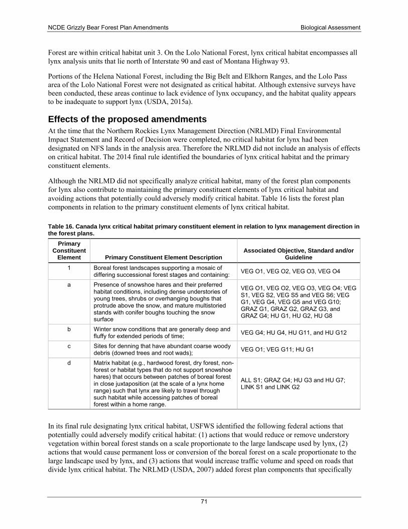
NCDE Grizzly Bear Forest Plan Amendments Biological Assessment
71
Forest are within critical habitat unit 3. On the Lolo National Forest, lynx critical habitat encompasses all lynx analysis units that lie north of Interstate 90 and east of Montana Highway 93.
Portions of the Helena National Forest, including the Big Belt and Elkhorn Ranges, and the Lolo Pass area of the Lolo National Forest were not designated as critical habitat. Although extensive surveys have been conducted, these areas continue to lack evidence of lynx occupancy, and the habitat quality appears to be inadequate to support lynx (USDA, 2015a).
Effects of the proposed amendments At the time that the Northern Rockies Lynx Management Direction (NRLMD) Final Environmental Impact Statement and Record of Decision were completed, no critical habitat for lynx had been designated on NFS lands in the analysis area. Therefore the NRLMD did not include an analysis of effects on critical habitat. The 2014 final rule identified the boundaries of lynx critical habitat and the primary constituent elements.
Although the NRLMD did not specifically analyze critical habitat, many of the forest plan components for lynx also contribute to maintaining the primary constituent elements of lynx critical habitat and avoiding actions that potentially could adversely modify critical habitat. Table 16 lists the forest plan components in relation to the primary constituent elements of lynx critical habitat.
Table 16. Canada lynx critical habitat primary constituent element in relation to lynx management direction in the forest plans.
Primary Constituent
Element Primary Constituent Element Description Associated Objective, Standard and/or
Guideline 1 Boreal forest landscapes supporting a mosaic of
differing successional forest stages and containing: VEG O1, VEG O2, VEG O3, VEG O4
a Presence of snowshoe hares and their preferred habitat conditions, including dense understories of young trees, shrubs or overhanging boughs that protrude above the snow, and mature multistoried stands with conifer boughs touching the snow surface
VEG O1, VEG O2, VEG O3, VEG O4; VEG S1, VEG S2, VEG S5 and VEG S6; VEG G1, VEG G4, VEG G5 and VEG G10; GRAZ G1, GRAZ G2, GRAZ G3, and GRAZ G4; HU G1, HU G2, HU G8
b Winter snow conditions that are generally deep and fluffy for extended periods of time; VEG G4; HU G4, HU G11, and HU G12
c Sites for denning that have abundant coarse woody debris (downed trees and root wads); VEG O1; VEG G11; HU G1
d Matrix habitat (e.g., hardwood forest, dry forest, non-forest or habitat types that do not support snowshoe hares) that occurs between patches of boreal forest in close juxtaposition (at the scale of a lynx home range) such that lynx are likely to travel through such habitat while accessing patches of boreal forest within a home range.
ALL S1; GRAZ G4; HU G3 and HU G7; LINK S1 and LINK G2
In its final rule designating lynx critical habitat, USFWS identified the following federal actions that potentially could adversely modify critical habitat: (1) actions that would reduce or remove understory vegetation within boreal forest stands on a scale proportionate to the large landscape used by lynx, (2) actions that would cause permanent loss or conversion of the boreal forest on a scale proportionate to the large landscape used by lynx, and (3) actions that would increase traffic volume and speed on roads that divide lynx critical habitat. The NRLMD (USDA, 2007) added forest plan components that specifically
NCDE Grizzly Bear Forest Plan Amendments Biological Assessment
72
address these three categories of actions that could potentially adversely modify lynx critical habitat. Objectives VEG O2 and VEG O4, standards VEG S1, VEG S2, VEG S5 and VEG S6, and guidelines VEG G1 and VEG G10 are aimed at maintaining understory vegetation that will support snowshoe hares and lynx across lynx analysis units. These same plan components along with objective ALL O1 preclude permanent loss or conversion of boreal forest at a large landscape scale. Objective HU O6, guideline HU G6 and guideline ALL G1 are designed to avoid or reduce effects to lynx from highways and when upgrading gravel roads and constructing or reconstructing highways on federal lands.
The proposed amendments would not change the existing forest plan direction that protects lynx habitat and linkage areas. The requirement for a no surface occupancy stipulation for new oil and gas leases in the primary conservation area (NCDE-STD-MIN-08) and the limits placed on developed recreation sites with overnight use in the primary conservation area (NCDE-STD-AR-05) could contribute to maintaining connectivity of matrix habitat.
Cumulative effects Future climate change is expected to impact lynx habitat by further reducing the cold climatic conditions that create and maintain boreal forests and deep persistent snow. Reduced snowpack and earlier snow melt may reduce the lynx’s competitive edge as a predator of snowshoe hares in deep, fluffy snow. Warmer temperatures may lead to a reduction in available habitat for lynx as subalpine forests recede to even higher elevations. Although there is a potential for future changes in climate to contribute to adverse cumulative effects, the magnitude and imminence of the impacts are uncertain.
Development of private lands to support increased human populations will likely continue and may reduce or sever habitat connectivity across valleys that are located between blocks of lynx habitat on public lands.
Determination of effect and rationale The proposed amendments of the forest plans may affect but are not likely to adversely affect lynx critical habitat based on the following.
The amendments will not alter existing forest plan direction that addresses conservation of lynx habitat. The amendments would add a desired condition, NCDE-DC-VEG-02, to provide a mosaic of successional stages. Existing forest plan direction allows some project activities to occur that would temporarily reduce snowshoe hare habitat in certain situations but does not allow actions that would reduce or remove substantial amounts of understory vegetation on a scale proportionate to the large landscape used by lynx. Neither the existing direction not the amendments would be expected to cause permanent loss or conversion of boreal forest or to increase traffic volume and speed on roads that divide lynx habitat.
North American Wolverine
Existing conditions
Population status and distribution USFWS proposed to list the wolverine as a threatened distinct population segment in the contiguous United States on Feb. 4, 2013 (USFWS, 2013a). On August 13, 2014, USFWS withdrew that proposal, concluding that the factors affecting the distinct population segment, including stressors such as land management, recreation, infrastructure development, and transportation corridors, were not as significant as believed at the time of the proposed rule’s publication (p. 47539). Furthermore, there was a lack of
NCDE Grizzly Bear Forest Plan Amendments Biological Assessment
73
sufficient information to make a reliable prediction about how wolverines are likely to respond to impacts to habitat that may result from climate change and whether such habitat changes will pose a threat in the future (USFWS, 2014b). However, on April 14, 2016, the U.S. District Court, District of Montana, vacated the withdrawal of the proposal to list and remanded the matter to USFWS by for further consideration consistent with order CV 14-246-M-DLC (Consolidated with Case Nos.14-247-M-DLC and 14-250-M-DLC). This had the effect of restoring the wolverine’s status as a proposed threatened or endangered species, pending completion of a status review. A new status review was initiated on Oct. 18, 2016, along with the re-opening of a public comment period. The decision is now pending.
The wolverine occurs throughout the arctic regions and also in subarctic areas and boreal forests of Eurasia and North America. The southern portion of the species’ range extends into mountainous portions of Washington, California, Idaho, Montana, Wyoming, and Colorado. They occur at low densities, are difficult to detect, range widely, and inhabit remote and rugged landscapes away from human populations Wolverine population growth and expansion has been documented in the North Cascades Range in Washington and the Northern Rockies of Montana, Idaho, and Wyoming (USFWS, 2014b). Populations once existed but were extirpated from the Sierra Nevada of California and the southern Rocky Mountains of Colorado, Wyoming, and New Mexico. Recently, wolverine have been detected in Colorado, California, Wyoming, and Utah.
Wolverines are believed to occur on all of the national forests in the NCDE, although surveys are incomplete and detection of wolverines can be difficult. On the Helena National Forest, wolverines were detected through genetic sampling in each of the years from 2012-2014 throughout the Lincoln Ranger District (SWCC, 2014). On the Lewis and Clark National Forest, wolverines have been documented to occur in all geographic areas except the Highwood, Snowy, and Castle mountain ranges, with a single trapping record from the Crazies from over 40 years ago (USDA, 2015a). On the Lolo National Forest, genetic sampling conducted from 2012 to 2014 verified three individual wolverines on the Seeley Lake Ranger District (SWCC, 2014). On the Kootenai National Forest, based on the map of persistent spring snow by Copeland et al. (2010), the areas that are thought most likely to support wolverines are the Cabinets, West Cabinets, Northwest Peak, and Ten Lakes areas (USDA, 2013b).
Habitat Wolverines are found in a wide variety of habitats, including alpine and arctic tundra and coniferous forests. In Montana, year-round habitat is found in high-elevation rocky alpine areas, glacial cirque basins, and avalanche chutes that provide food sources such as marmots, voles, and carrion (Copeland et al., 2010; Hornocker & Hash, 1981; Inman et al., 2007; Magoun & Copeland, 1998). Wolverines disperse through areas where snow persists through mid-May but minimize travel through low-elevation habitats (McKelvey et al., 2011).
Deep, persistent, and reliable spring snow cover (April 15 to May 14) appears to be the best overall predictor of wolverine occurrence in the contiguous United States (Aubry, McKelvey, & Copeland, 2007; Copeland et al., 2010; Inman et al., 2013; Magoun & Copeland, 1998). This appears to be due to the strong correlation of den sites with deep snow. In the boreal forest region of northern Alberta, Webb and others (2016) found that wolverines were not as closely associated with persistent spring snow as wolverines in the Rocky Mountains.
Wolverines are constantly on the move and their home range sizes are large, disproportionately so for a mammal of its size. The availability and distribution of food is likely the primary factor determining wolverine movements and home range size (Hornocker & Hash, 1981). Wolverines, particularly the males, frequently travel long distances over rough terrain and deep snow (Copeland & Yates, 2006; Hornocker & Hash, 1981; Inman et al., 2009). In Glacier National Park, adult female home ranges
NCDE Grizzly Bear Forest Plan Amendments Biological Assessment
74
averaged 55 mi2, and adult males ranged over an even larger area, including lands outside the Park, with home ranges that averaged 193 mi2 (Copeland & Yates, 2006).
Female wolverines use natal (birthing) dens that are excavated in snow. Persistent, stable snow greater than 5 feet deep appears to be a requirement for natal dens because it provides security for offspring and buffers cold winter temperatures (Copeland et al., 2010). Wolverines appear to choose areas of high structural diversity for dens, including components such as logs or boulders (Magoun & Copeland, 1998).
Female wolverines forage close to maternal den sites in early summer, progressively ranging further from dens as kits become more independent. Females in Glacier National Park typically used two or three different dens prior to weaning of kits at 6-7 months of age (Copeland & Yates, 2006). Kits were found to gather at rendezvous sites that were located primarily in boulder, talus, and cliff areas (Copeland et al., 2010).
The wolverine is primarily a scavenger of carrion, but also preys on small animals and birds, and eats fruits, berries, and insects when available (Hornocker & Hash, 1981). Wolverines have an excellent sense of smell that enables them to find food, even beneath deep snow. Inman and others (2013) found a link between persistent snow and wolverine foraging strategy, since wolverines may rely on the cold and snow to cache carrion (Inman, Magoun, Persson, & Mattisson, 2012).
In the NCDE, the majority of wolverine habitat is located in higher-elevation areas that are largely wilderness, inventoried roadless areas, or lands otherwise relatively unavailable for development. Wolverines do not appear to avoid infrastructure such as buildings, houses, oil and gas wells, and ski areas, and have been known to scavenge food at dumps in and adjacent to human developments. In Idaho, wolverines frequently used un-maintained roads for traveling during the winter, and did not avoid trails used infrequently by people or active campgrounds during the summer (Copeland et al., 2007).
They are capable of moving long distances including across transportation corridors (Inman et al., 2009). Populations in the northern Rocky Mountains appear to be connected to each other via dispersal at the present time (M. K. Schwartz et al., 2009).
Timber harvest, livestock grazing and prescribed fire appear to have little impact on wolverines since they are not dependent on specific vegetation or habitat features that might be manipulated by land management activities. In British Columbia, wolverines used recently logged areas in the summer and moose winter ranges for foraging in the winter, and males did not appear to be influenced strongly by the presence of roadless areas (Krebs, Lofroth, & Parfitt, 2007). In Idaho, wolverines used recently burned areas despite the loss of canopy cover (Copeland, 1996).
Human disturbance at den sites Some scientists have expressed concern about the effects of human activities on female wolverines with young kits during the mid-February to mid-May time period, when food resources are scarce for foraging females. Until they are at least 10 weeks old, the kits cannot travel with their mother. If a female needs to move kits to a new location or to another maternal den, she must carry them in her mouth. If the female needs to move the kits very far, the probability of kits dying increases. Reproductive females and kits are most at risk of predation (Magoun & Copeland, 1998), and females have high energetic demands due to lactation (Krebs et al., 2007). The threshold for the amount of human activity that could cause disturbance or displacement of wolverines is unknown.
Backcountry winter recreation, including snowshoeing, snowboarding, skiing, snowcat or trackster-assisted skiing/snowboarding, snow bikes, and snowmobiling, is the predominant human activity that may occur in portions of wolverine habitat during the mid-February to mid-May time period. Heinemeyer and
NCDE Grizzly Bear Forest Plan Amendments Biological Assessment
75
Squires (2015) are investigating the responses of wolverines to winter recreation use in central Idaho and the Yellowstone region of Idaho, Montana, and Wyoming. They reported that wolverines appear to tolerate many types of winter recreation in their home ranges, including developed alpine ski areas and areas with motorized over-snow vehicle use (Heinemeyer, 2012; Heinemeyer & Squires, 2013). However, Heinemeyer and Squires (2014) indicated there may be increasing avoidance of winter recreation areas as the proportion of an individual wolverine’s home range affected increases. They also noted that reproductive females had higher movement rates when in a high recreation zone. Although suggestive, the data are still being analyzed and results are not yet known.
In the Columbia Mountains of southern British Columbia, where winter recreation is widespread, both female and male wolverines have been negatively associated with helicopters and backcountry skiing. As Krebs and others (2007) stated, “We expected predation risk to be an important factor during winter denning season when reproductive females must provision and protect developing neonates from predation (e.g., Burkholder 1962, Magoun and Copeland 1998, Persson et al. 2003). Our results support this hypothesis. Females were negatively associated with broad landscapes of winter range where wolves concentrated (Allison 1998, Kunkel and Pletscher 2001) and positively associated with rugged terrain where security habitat is presumably more abundant” (p. 2188).
Climate change Climate change has been discussed as the greatest potential impact to wolverine numbers and distribution because of their apparent requirement for deep, persistent snow for females to den and reproduce successfully. Wolverines’ need for relatively cold average temperatures and for persistent snow explains their occurrence largely in the upper elevations of mountains in the contiguous United States. It appears that low elevation and valley bottom habitats are used only for dispersal and not for foraging or reproduction in Montana and elsewhere in the northern Rockies (Inman et al., 2009). If climate change affects montane habitats, particularly the timing, depth, or duration of snowpack, it might impact wolverine numbers and distribution. However, there is a high degree of uncertainty regarding the impacts of climate change, and in particular if and when a decrease in deep, persistent spring snow will limit the availability of den sites, therefore causing a wolverine population decline in the future. USFWS concluded that available information does not yet indicate if and when that may occur (USFWS, 2014b).
Effects of the proposed amendments The key indicator for determining effects to wolverines is persistent spring snow for denning habitat. The proposed amendments would not have an impact on the extent of persistent spring snow nor would the amendments alter the effects of climate change on wolverine habitat.
The majority of wolverine habitat in the NCDE is located in higher-elevation areas that are largely wilderness, inventoried roadless areas, or lands that are relatively unavailable for development. Forest plan direction for activities such as timber harvest, livestock grazing, motorized use of forest roads and trails are not expected to negatively affect wolverines or their habitat.
Over-snow vehicle use is prohibited in designated wilderness and certain other portions of the forests but existing motorized use would continue where it is allowed. With very few exceptions, over snow vehicle use is not permitted after March 31on the amendment forests.
There is a potential for existing over-snow vehicle use to negatively impact wolverines in their natal and maternal dens. Under the proposed amendments, standard NCDE-STD-AR-08 would allow no net increase in the percentage of area or miles of routes within modeled grizzly bear denning habitat in the NCDE primary conservation area that are designated for motorized over-snow vehicle use on NFS lands
NCDE Grizzly Bear Forest Plan Amendments Biological Assessment
76
during the den emergence time period. This could have a small benefit to wolverines by preventing an increase in possible impacts during the portion of the season when females are using maternal dens.
Determination of effect and rationale The proposed amendments will not alter the extent of persistent spring snow or future climate change. There is a potential for existing over snow vehicle use to have adverse effects on denning wolverines. The proposed amendments would add standard NCDE-STD-AR-08 which would require no net increase in the percentage of area or miles of routes that are designated for motorized over snow vehicle use in modeled grizzly bear denning habitat in the primary conservation are during the late spring period. The proposed amendments may affect but are not likely to jeopardize the wolverine.
Yellow-billed cuckoo, western distinct population segment
Existing conditions
Population status and distribution The yellow-billed cuckoo is a medium-sized bird, about 12 inches in length. The western subspecies generally is larger than the eastern subspecies and differs in the timing of its migration and breeding (Franzreb & Laymon, 1993).
On October 3, 2014, the USFWS published the final rule to list the yellow-billed cuckoo as a threatened distinct population segment in the western portion of its range in the United States, Canada, and Mexico (79 FR pp. 59992–60038). The western distinct population segment of the yellow-billed cuckoo is located west of the crest of the Rocky Mountains. This population was found to be threatened by two factors:
• First, habitat destruction, modification, and degradation from dam construction and operations, water diversions, river flow management; stream channelization and stabilization; conversion to agricultural uses, such as crops and livestock grazing; urban and transportation infrastructure; and increased incidence of wildfire threaten the yellow-billed cuckoo western distinct population segment. These factors also contribute to fragmentation and promote conversion to non-native plant species, particularly tamarisk. The majority of the habitat for the cuckoo is on private lands and continues to be lost or significantly altered.
• Second, rarity and small and isolated population sizes cause the remaining western yellow-billed cuckoo populations to be increasingly susceptible to further declines through lack of immigration, reduced populations of prey species (i.e., food items), pesticides, and collisions with tall vertical structures during migration. The serious and ongoing threat of small overall population size, which is the result of other threats in combination, leads to an increased chance of local extirpations.
There are very few occurrences of the yellow-billed cuckoo recorded west of the Continental Divide in Montana. A few records indicate that yellow-billed cuckoos occur in the Flathead River area, but no information exists to confirm breeding in that area. USFWS indicates that the species “may be present” on the Lolo National Forest.
Habitat Western yellow-billed cuckoos breed in riparian habitats, particularly woodlands with cottonwoods (Populus fremontii) and willows (Salix sp.) in the western United States (Laymon & Halterman, 1987). The amount of cottonwood-willow-dominated vegetation cover in the landscape and the width of riparian habitat have been found to influence cuckoo distribution and abundance in Arizona (Johnson, Magill, & vanRiper III, 2010).
NCDE Grizzly Bear Forest Plan Amendments Biological Assessment
77
Effects of the proposed amendments The western subspecies of yellow-billed cuckoo has not been documented to occur within the NCDE recovery zone or the primary conservation area, demographic connectivity areas, or zones 1, 2, or 3. However, riparian woodlands on the Lolo National Forest west of the Continental Divide may provide habitat for the yellow-billed cuckoo. The amendment would not alter the management of riparian deciduous forests along rivers. Therefore, no direct, indirect, or cumulative effects to this species or its habitat are anticipated as a result of the proposed forest plan amendments.
Determination of effect and rationale The species has not been documented to occur on NFS lands in the NCDE, and the amendments would not alter the management of its riparian deciduous habitat. Therefore, the determination is that there would be no effect to the yellow-billed cuckoo.
Aquatic Species Species descriptions and habitat requirements This analysis only considers bull trout (Salvelinus confluentus) and Kootenai River white sturgeon (Acipenser transmontanus). These are the aquatic species in the NCDE action area that are listed under the ESA. Other native species known to be present in the project area are westslope cutthroat trout (Oncorhynchus clarki lewisi), mountain whitefish (Prosopium williamsoni), and sculpin (Cottus sp.). Tailed frogs (Ascaphus truei) and western pearlshell mussel (Margaritifera falcate) are also present in some watersheds. Non-native brook trout (S. fontinalis), rainbow trout (O.mykiss), grayling, (Thymallus arcticus), and brown trout (Salmo trutta) are present within the project, primarily within the Rocky Mountain Front streams and some Blackfoot River drainages.
White sturgeon—Kootenai National Forest The white sturgeon inhabits large rivers, lakes, and marine environments from southern California to Alaska’s Cook Inlet. It is a migratory species that can reach lengths of nearly 20 feet, weights of 1,970 pounds, and ages of 100 years or more.
The white sturgeon native to the Kootenai River drainage of Montana, Idaho, and British Columbia has been geographically isolated from the lower Columbia River stocks by Bonnington Falls (Corra Linn Dam) near Nelson, British Columbia. White sturgeon migrate freely throughout the Kootenai River (Andrusak, 1980) but are uncommon upstream of Bonners Ferry, Idaho (Apperson, 1992; Graham, 1981). There are no published reports of sturgeon using lateral tributaries in Idaho or Montana (Partridge, 1983). The Kootenai River white sturgeon exhibits both riverine and adfluvial life histories. Most adult fish reside in Kootenay Lake and make extended (> 60 mi) migrations to spawn in a stretch below Bonners Ferry, Idaho.
The Kootenai River white sturgeon was listed as an endangered species in 1994 (USFWS). The recovery plan for the Kootenai River population of the white sturgeon was completed in 1999 (Duke et al., 1999). Critical habitat has been designated for Kootenai River white sturgeon, but none has been designated on the Kootenai National Forest.
In the Kootenai River, white sturgeon have not successfully spawned in recent years due to changes in river flow dynamics resulting from operation of the Libby Dam. Past land management activities
NCDE Grizzly Bear Forest Plan Amendments Biological Assessment
78
conducted by the Forest Service, such as road construction and timber harvest, are considered a secondary impact to populations of this species (Lee, Sedell, Rieman, Thurow, & Williams, 1997).
White sturgeon spawn during spring peak flows when velocities are high and turbidity is elevated. The fertilized eggs sink to the bottom and then hatch within a few weeks. The newly hatched sac fry briefly drift with the current before retreating into the substrate for up to a month. The juveniles eventually emerge from the substrate and begin a free-roaming life. Juvenile fish use a wide range of depths and water velocities as habitat.
Older fish are relatively sedentary in the deepest locations of the Kootenai River drainage, often selecting low-velocity waters greater than 20 feet deep and with sand substrates. There are very few areas within the lower Kootenai River that contain substrates greater in size than sand. White sturgeon are opportunistic feeders and subsist on insects, clams, snails, plant material, and fish.
Determination of effect and rationale There will be no effect on Kootenai River white sturgeon since they do not occur within the analysis area, although they do occur on the Kootenai National Forest below Libby dam.
Bull trout—threatened species The final rule to list bull trout as threatened in the Columbia River basin was published on June 10, 1998. The USFWS listed all populations of bull trout within the coterminous United States as a threatened species, combining bull trout in the Coastal-Puget Sound populations (Olympic Peninsula and Puget Sound regions) and Saint Mary-Belly River populations (east of the Continental Divide in Montana) with previous listings of three separate distinct population segments of bull trout in the Columbia River, Klamath River, and Jarbidge River basins (63 FR 31647, June 10, 1998; 64 FR 17110, April 8, 1999). USFWS designated critical habitat for bull trout throughout the U.S. range on September 30, 2010. Critical habitat encompasses about 18,795 miles of streams and 488,252 acres of lakes and reservoirs in Idaho, Oregon, Washington, Montana, and Nevada. The recovery plan for the coterminous United States population of bull trout was finalized in 2015 (USFWS, 2015). In its most recent status review for bull trout, USFWS (2008) identified historical habitat loss and fragmentation, interaction with non-native species, and fish passage issues as the most significant primary threat factors affecting bull trout. These threats are addressed in the recovery plan for each of the six recovery units. The Kootenai, Flathead, and Lolo National Forests are within the Columbia Headwaters recovery unit.
Two basic life history forms of bull trout are known to occur: resident and migratory. Resident bull trout spend their entire lives in their natal streams, whereas migratory bull trout travel downstream as juveniles to rear in larger rivers (fluvial types) or lakes (adfluvial types). Bull trout in the NCDE are an adfluvial migratory group, with juveniles moving downstream to rivers or lakes at age 2-3 and then returning around age 6 to spawn. Bull trout spawning occurs in the fall, and the eggs incubate in the stream gravel until hatching in January (Fraley & Shepard, 1989). The alevins remain in the gravel for several more months and emerge as fry in early spring. Unlike many anadromous salmonids, which spawn once and die, bull trout are capable of multiyear spawning (Fraley & Shepard, 1989). The historic range of bull trout stretched from California, where the species is now extinct, to the Yukon Territory of Canada (Haas & McPhail, 1991).
Several factors have contributed to the decline of bull trout. Habitat degradation, interaction with exotic species, over-harvesting, and fragmentation of habitat by dams and diversions are all factors contributing to the decline (B. E. Rieman & McIntyre, 1995). A change in the species composition of Flathead Lake is perhaps the most important factor in the decline of the upper Flathead bull trout subpopulation (McIntyre, 1998). Between 1968 and 1975, opossum shrimp (Mysis relicta) were stocked in three lakes with
NCDE Grizzly Bear Forest Plan Amendments Biological Assessment
79
tributaries feeding into Flathead Lake; the shrimp were then able to migrate downstream and became established in Flathead Lake. The shrimp were documented in Flathead Lake in 1981, and populations peaked in 1986. Two non-native species, lake trout (Salvelinus namaycush) and lake whitefish (Coregonus clupeaformis), expanded as juvenile fish benefited from the addition of shrimp to the prey base.
It is believed that the expansion of the lake trout and lake whitefish contributed to the decline of bull trout (McIntyre, 1998). The mechanisms of the decline are not well understood, but it is assumed that the loss of kokanee as a food source for bull trout and competition/predation with lake trout was a major contributor to the decline in bull trout. Bull trout populations remain healthy in Swan Lake and Hungry Horse Reservoir. Lake trout are absent from Hungry Horse but have recently been documented in Swan Lake, which has raised concern among land and fishery managers, and efforts are underway to reduce lake trout.
Critical habitat was designated in 2010 with the aim of providing sufficient habitat to allow for genetic and life history diversity, ensuring that bull trout are well distributed across representative habitats, and ensuring sufficient connectivity among populations. USFWS designated 32 critical habitat units within six recovery units as critical habitat for bull trout (see table 17). Two critical habitat units, the Kootenai River Basin and the Clark Fork River Basin, overlap with the amendment analysis area.
Table 17. Streams, lakes, and rivers designated as critical habitat within the amendment analysis area, excluding the Flathead National Forest
E. Fork Clearwater R Clearwater Lake Rainy Lake Lodgepole Cr Poorman Cr W. Fork Clearwater R Placid Lake Clark Fork R. Dunham Cr Rattlesnake Cr Morrell Cr Seeley Lake Blackfoot R. Monture Cr Grant Cr Placid Cr Salmon Lake Gold Cr N.F. Blackfoot R Albert Cr Boles Cr Inez Lake Belmont Cr Copper Cr Petty Cr Marshall Cr Alva Lake Cottonwood Cr Landers Fork Cache Cr N. F. Fish Cr Trout Cr N. F. Little Joe Twelve mile Cr Clarence Cr S. F. Fish Cr Cedar Cr S. F. Little Joe Tobacco R. Blue Sky Cr W. F. Fish Cr Lost Cr Ward Cr Grave Cr Wigwam R St Regis R
The primary constituent elements are those habitat components that are essential for the primary biological needs of foraging, reproducing, rearing of young, dispersal, genetic exchange, or sheltering. They are:
• Springs, seeps, groundwater sources, and subsurface water connectivity (hyporheic flows) to contribute to water quality and quantity and provide thermal refugia.
• Migration habitats with minimal physical, biological, or water quality impediments between spawning, rearing, overwintering, and freshwater and marine foraging habitats, including but not limited to permanent, partial, intermittent, or seasonal barriers.
• An abundant food base, including terrestrial organisms of riparian origin, aquatic macroinvertebrates, and forage fish.
• Complex river, stream, lake, reservoir, and marine shoreline aquatic environments, and processes that establish and maintain these aquatic environments, with features such as large wood, side
NCDE Grizzly Bear Forest Plan Amendments Biological Assessment
80
channels, pools, undercut banks and unembedded substrates, to provide a variety of depths, gradients, velocities, and structure.
• Water temperatures ranging from 2 to 15 °C (36 to 59 °F), with adequate thermal refugia available for temperatures that exceed the upper end of this range. Specific temperatures within this range will depend on bull trout life-history stage and form; geography; elevation; diurnal and seasonal variation; shading, such as that provided by riparian habitat; streamflow; and local groundwater influence.
• In spawning and rearing areas, substrate of sufficient amount, size, and composition to ensure success of egg and embryo overwinter survival, fry emergence, and young-of-the-year and juvenile survival. A minimal amount of fine sediment, generally ranging in size from silt to coarse sand, embedded in larger substrates, is characteristic of these conditions. The size and amounts of fine sediment suitable to bull trout will likely vary from system to system.
• A natural hydrograph, including peak, high, low, and base flows within historic and seasonal ranges or, if flows are controlled, minimal flow departure from a natural hydrograph.
• Sufficient water quality and quantity such that normal reproduction, growth, and survival are not inhibited.
• Sufficiently low levels of occurrence of non-native predatory (e.g., lake trout, walleye, northern pike, smallmouth bass); interbreeding (e.g., brook trout); or competing (e.g., brown trout) species that, if present, are adequately temporally and spatially isolated from bull trout.
Bull trout and westslope cutthroat trout status by watershed
South Fork of the Flathead River The South Fork pf the Flathead River originates at the confluence of Danaher and Youngs Creeks in the Bob Marshall Wilderness Area and flows north 57 miles into Hungry Horse Reservoir. It drains a 1,663-square-mile area with an average annual discharge of 3,522 cubic feet per second. Bull trout are native to the South Fork of the Flathead River drainage and are distributed throughout the Flathead River Basin. Prior to human intervention, migratory bull trout that spawned and reared in the South Fork occupied Flathead Lake as adults. Construction of Hungry Horse Dam in 1952-53 blocked access to the entire South Fork drainage. About 38 percent of the spawning and rearing area once available to the Flathead bull trout population was cut off (Zubik & Fraley, 1987).
The construction of Hungry Horse Dam in 1952 isolated the South Fork population of bull trout from the rest of the Flathead River system. The Montana Bull Trout Scientific Group (1995b) reported that the South Fork of the Flathead drainage upstream from Hungry Horse Dam is the “most intact native fish ecosystem remaining in western Montana.” Currently, subadult bull trout upstream of the dam in Hungry Horse Reservoir or in the South Fork mainstem above the reservoir reside for several years prior to maturity and migration into tributaries to spawn. The majority of the spawning and rearing habitats for the South Fork bull trout population are located in the backcountry, most of which is in the Bob Marshall Wilderness. Juvenile bull trout rear from 1 to 4 years before moving downstream to the mainstem or to the reservoir.
The Montana Bull Trout Scientific Group (1995b) reported that the South Fork bull trout population trend is stable based on available data. However, they cautioned that data are limited and more long-term information is needed for a full assessment. This is significantly different than the rest of the Flathead River Basin subpopulations. The current status of Flathead River subpopulations of migratory bull trout in the Middle Fork and North Fork of the Flathead River are depressed, and the trend is declining.
NCDE Grizzly Bear Forest Plan Amendments Biological Assessment
81
Two known disjunct populations of bull trout occur in the South Fork of the Flathead River drainage. Big Salmon Lake supports a migratory bull trout population that uses 5.5 miles of Big Salmon Creek upstream from the lake to a barrier falls for spawning and rearing. Doctor Lake also supports a bull trout population. Little is known about this population, but it is suspected to spawn and rear in a short reach of Doctor Creek upstream of the lake (MBTSG, 1995b).
Core areas are drainages that currently contain the strongest remaining populations of bull trout and that must be given highest priority for protection as they will be the primary source of fish for recolonization (B. Rieman & McIntyre, 1993). They are usually relatively undisturbed and have been identified as needing the highest level of protection (MBTSG, 1995b). Core areas in the South Fork include the entire drainages of Wounded Buck, Wheeler, and Sullivan Creeks. Also included as core areas are tributaries to the river upstream of the reservoir (Spotted Bear River, Bunker Creek, Little Salmon Creek, White River, Gordon Creek, Youngs Creek, and Danaher Creek) and the South Fork itself above Gordon Creek.
Nodal habitats are waters that provide migratory corridors, overwintering areas, or other areas that are otherwise essential to bull trout at some point in their life history (MBTSG, 1995b). Nodal habitat for the South Fork population is provided by the mainstem South Fork of the Flathead River downstream from Gordon Creek, including Hungry Horse Reservoir (MBTSG, 1995b).
The Bull Trout Recovery Plan (USFWS, 2015) has suggested that an appropriate conservation goal is to maintain the status quo. It is believed that by protecting and maintaining the existing native species complex through natural production, maintaining the current genetic structure and diversity, and ensuring that Hungry Horse Dam does not exceed the desired minimum pool level, the conservation goal to meet bull trout life history requirements in the South Fork of the Flathead River will be met.
Westslope cutthroat populations in the South Fork of the Flathead River drainage are arguably the strongest within their range, given that there are no non-native fish and the area is primarily wilderness.
Middle and North Fork Flathead River The Flathead River drainage supports one of the highest migratory bull trout populations in the United States. Historically, prior to the construction of Hungry Horse Dam and Reservoir, Flathead Lake bull trout had access to all three forks of the Flathead River (North, South, and Middle Forks) and bull trout were widely distributed throughout the drainage. The Middle and North Fork populations are considered one meta-population since these fish depend on Flathead Lake for a major part of their life cycle. Juvenile fish rear in the tributaries of the Middle and North Fork for 1 to 3 years before migrating back to Flathead Lake (Fraley & Shepard, 1989).
The Middle Fork of the Flathead River originates in the Great Bear Wilderness at the confluence of Bowl and Strawberry Creeks. It flows for 47 miles to Bear Creek along Highway 2, where it forms the southern boundary of Glacier National Park. It then flows for 54 miles to its confluence with the North Fork. There are 19 streams in the Middle Fork subbasin that are known to support bull trout, including five in Glacier National Park.
At present, the predominant life history form of bull trout in the North and Middle Fork system is the lacustrine-adfluvial. No resident populations are known to exist, and there are no indications that fluvial populations are present. Adfluvial fish reach sexual maturity in Flathead Lake at about age 6 and migrate upriver beginning in April. They reach the North and Middle Forks in June and July and enter tributaries in August, with spawning commencing in late September and October when water temperatures drop to 9-10 °C (48.2 to 50 °F) (Fraley & Shepard, 1989). Incubation of eggs to emergence of swim-up fry lasts about 200 days, with emergence occurring in April. Juvenile bull trout rear for 2 to 3 years in the streams until they migrate downstream to Flathead Lake.
NCDE Grizzly Bear Forest Plan Amendments Biological Assessment
82
Unlike the South Fork bull trout population, recent monitoring data (MFWP, 2015) indicate declining numbers of spawning bull trout in the Middle Fork and North Fork River systems. The mechanisms for the decline in the Flathead Lake migratory population are not completely understood but include the introduction and subsequent population increase in mysis shrimp in Flathead Lake, which changed the composition of the fish community in Flathead Lake. Lake trout (Salvelinus namaycush) and lake whitefish (Coregonus clupeaformis) now dominate the fish community and may be responsible for the decline in bull trout as well as other species. These changes in the Flathead Lake and River system are considered the primary threat to bull trout in the entire drainage system. Lake trout and bull trout competition has been documented elsewhere. Donald and Alger (1993) looked at 34 lakes in the distributional overlap of the species and found that in 28 cases, only one species was present. In the lakes where they were sympatric, lake trout were the dominant species, and three case histories were documented where lake trout completely displaced bull trout. A secondary threat is the high incidental catch of bull trout and the strong fisheries management emphasis on introduced species (MBTSG, 1995a). Forestry issues are also considered important in the managed portions of the Middle and North subbasins.
Core areas are drainages that currently contain the strongest remaining populations of bull trout and that must be given highest priority for protection as they will be the primary source of fish for recolonization (B. Rieman & McIntyre, 1993). Core areas in the Middle Fork include Nyack, Park, Ole, Bear, Long, Granite, Morrison, Schafer, Clack, Strawberry, and Bowl Creek drainages. Core areas in the North Fork include Trail, Whale, Red Meadow, Coal, and Big Creek drainages.
Nodal habitat for this population is provided by the mainstem rivers. Nodal habitats are waters that provide migratory corridors, overwintering areas, or other areas that are otherwise essential to bull trout at some point in their life history (MBTSG, 1995a). The restoration goal for the migratory population of bull trout in the Flathead River drainage is to maintain or restore self-sustaining populations in the core areas, protect the integrity of the population’s genetic structure, and enhance the migratory component of the population (MBTSG, 1995a). The specific goal is to increase bull trout spawners to the level recorded in the 1980s and to maintain this level for three generations. The average 1980 redd count in the Middle Fork index streams was 151 (MBTSG, 1995a). In 2013, 137 redds were counted in the index streams.
Westslope cutthroat trout that are migratory have also been affected by lake trout predation in Flathead Lake, but resident populations remain strong.
Swan River At present, the Swan River drainage provides habitat for one of the strongest collections of local migratory bull trout populations remaining in the State of Montana (MBTSG, 1996). At least 23 tributaries support some level of juvenile bull trout rearing (Leathe & Enk, 1985). Bull trout spawning occurs in at least 10 tributary drainages. Major spawning and rearing areas in the Swan River drainage are highly groundwater influenced, which reduces the risk of impact from drought conditions. Bull trout are thought to be primarily adfluvial fish, and they mature in Swan Lake, located at the northern end of the Swan Valley. The recent invasion of lake trout into Swan Lake may threaten the long-term viability of this population. Lake trout have been suppressed by gillnetting since 2010, with about 5,000-7,000 lake trout removed annually. Core areas include Elk Creek, Cold Creek, Jim Creek, Piper Creek, Lion Creek, Goat Creek, Woodward Creek, Soup Creek, and Lost Creek, as well as Swan Lake, Holland Lake, and Lindbergh Lake.
Westslope cutthroat trout populations remain strong in some tributary streams but have been replaced by brook trout and have hybridized with rainbow trout in other streams.
NCDE Grizzly Bear Forest Plan Amendments Biological Assessment
83
Blackfoot River Core Area There are two bull trout local populations within the Blackfoot River core area on the Helena National Forest—Landers Fork and Poorman Creek—identified by the Conservation Strategy for Bull Trout on NFS lands in western Montana. There are five local populations within the core area on the Lolo National Forest. The Lolo National Forest ownership only has meaningful contributions to four of these populations: North Fork Blackfoot, Monture, Cottonwood, and Gold Creek. Belmont Creek is predominantly owned and managed by Plum Creek Timber Company.
Historically, bull trout populations were well distributed throughout the core area and were likely in much higher densities than they are today. It is thought that up to 1,000 bull trout redds may have been historically present in the Blackfoot River core area. As with most bull trout populations, overall numbers were likely highly variable from year to year, based on natural climatic and disturbance patterns. These redd numbers were generated from estimating the potential in each of the 16 major spawning tributaries to the Blackfoot River (Union, Gold, Belmont, Cottonwood, Monture, Chamberlain, North Fork Blackfoot, Nevada, Arrastra, Beaver, Willow, Poorman, Upper Willow, Landers, Alice, and the upper Blackfoot).
Bull trout populations in the Blackfoot River were likely first exposed to mining-caused impacts in the late 1800s in the form of small-scale mining. This mining was focused mainly south of the Blackfoot River in the Lincoln area (eastern Nevada Creek tributaries to Anaconda Creek) and in the northern Garnet Mountain range (Ashby to Chamberlain Creek). The mining method was often an instream “placer” type operation that directly disrupted fish habitat and stream functions. Once disturbed in this fashion, streams rarely have the ability to naturally recover to their predisturbance level.
Of primary concern is the fact that there are only six index reaches or tributaries within the Blackfoot core area that have bull trout populations high enough to warrant counting, followed by concern that the populations in three of the six index reaches are declining. Bull trout populations in Gold Creek and Belmont Creeks are both in steep decline and appear to be in imminent threat of extirpation. The three stronger populations are clustered in the northern and eastern portion of the Blackfoot River watershed. These populations that are remaining stronger are in unroaded or minimally managed watersheds and have less anthropogenic impacts. However they are in landscapes that are inherently stochastic and sensitive to drought conditions and dry years. Thus, in order to conserve long-term bull trout populations within the Blackfoot River, restoration and conservation efforts need to secure populations that are distributed across the core area.
North Fork Blackfoot subpopulation of bull trout Habitat in the lower reaches of the North Fork Blackfoot is affected by diversions and water withdrawal, but this is being addressed through the efforts of Big Blackfoot Chapter Trout Unlimited, MFWP, and landowners. Habitat in the middle and upper reaches is pristine. Incidental mortality (and probably some poaching) may affect this population. Fishing pressure is high, and some targeting of bull trout is suspected. Changes in MFWP fishing regulations that closed the system to fishing with bait should help to improve this situation.
Table 18. North Fork Blackfoot River local population summary
# Spawning Adults
Short-Term (5-year) Pop Trend
Life History, Connectivity
# Known Spawn
Reaches Non-native Species,
Threat
50-250 migratory, 250-500 resident. Upward. Fluvial, connected. 1
Moderate. Rainbows and brown trout present in the lower North Fork. Angling
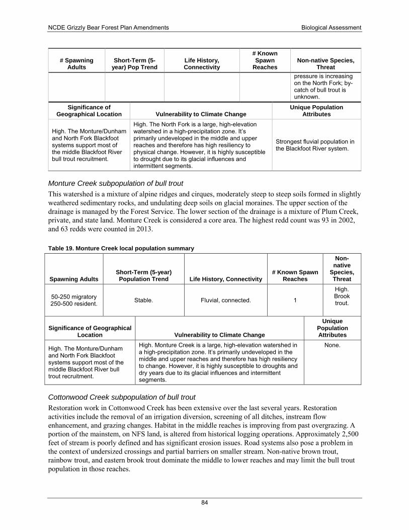
NCDE Grizzly Bear Forest Plan Amendments Biological Assessment
84
# Spawning Adults
Short-Term (5-year) Pop Trend
Life History, Connectivity
# Known Spawn
Reaches Non-native Species,
Threat pressure is increasing on the North Fork; by-catch of bull trout is unknown.
Significance of Geographical Location Vulnerability to Climate Change
Unique Population Attributes
High. The Monture/Dunham and North Fork Blackfoot systems support most of the middle Blackfoot River bull trout recruitment.
High. The North Fork is a large, high-elevation watershed in a high-precipitation zone. It’s primarily undeveloped in the middle and upper reaches and therefore has high resiliency to physical change. However, it is highly susceptible to drought due to its glacial influences and intermittent segments.
Strongest fluvial population in the Blackfoot River system.
Monture Creek subpopulation of bull trout This watershed is a mixture of alpine ridges and cirques, moderately steep to steep soils formed in slightly weathered sedimentary rocks, and undulating deep soils on glacial moraines. The upper section of the drainage is managed by the Forest Service. The lower section of the drainage is a mixture of Plum Creek, private, and state land. Monture Creek is considered a core area. The highest redd count was 93 in 2002, and 63 redds were counted in 2013.
Table 19. Monture Creek local population summary
Spawning Adults Short-Term (5-year) Population Trend Life History, Connectivity
# Known Spawn Reaches
Non-native
Species, Threat
50-250 migratory 250-500 resident. Stable. Fluvial, connected. 1
High. Brook trout.
Significance of Geographical Location Vulnerability to Climate Change
Unique Population Attributes
High. The Monture/Dunham and North Fork Blackfoot systems support most of the middle Blackfoot River bull trout recruitment.
High. Monture Creek is a large, high-elevation watershed in a high-precipitation zone. It’s primarily undeveloped in the middle and upper reaches and therefore has high resiliency to change. However, it is highly susceptible to droughts and dry years due to its glacial influences and intermittent segments.
None.
Cottonwood Creek subpopulation of bull trout Restoration work in Cottonwood Creek has been extensive over the last several years. Restoration activities include the removal of an irrigation diversion, screening of all ditches, instream flow enhancement, and grazing changes. Habitat in the middle reaches is improving from past overgrazing. A portion of the mainstem, on NFS land, is altered from historical logging operations. Approximately 2,500 feet of stream is poorly defined and has significant erosion issues. Road systems also pose a problem in the context of undersized crossings and partial barriers on smaller stream. Non-native brown trout, rainbow trout, and eastern brook trout dominate the middle to lower reaches and may limit the bull trout population in those reaches.
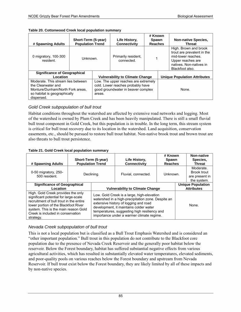
NCDE Grizzly Bear Forest Plan Amendments Biological Assessment
85
Table 20. Cottonwood Creek local population summary
# Spawning Adults Short-Term (5-year) Population Trend
Life History, Connectivity
# Known Spawn
Reaches Non-native Species,
Threat
0 migratory, 100-300 resident. Unknown. Primarily resident,
connected. 1
High. Brown and brook trout are prevalent in the mid-lower reaches. Upper reaches are natives. Non-natives in Blackfoot also.
Significance of Geographical Location Vulnerability to Climate Change Unique Population Attributes
Moderate. This stream lies between the Clearwater and Monture/Dunham/North Fork areas, so habitat is geographically dispersed.
Low. The upper reaches are extremely cold. Lower reaches probably have good groundwater in beaver complex areas.
None.
Gold Creek subpopulation of bull trout Habitat conditions throughout the watershed are affected by extensive road networks and logging. Most of the watershed is owned by Plum Creek and has been heavily manipulated. There is still a small fluvial bull trout component in Gold Creek, but this population is in trouble. In the long term, this stream system is critical for bull trout recovery due to its location in the watershed. Land acquisition, conservation easements, etc., should be pursued to restore bull trout habitat. Non-native brook trout and brown trout are also threats to bull trout persistence.
Table 21. Gold Creek local population summary
# Spawning Adults Short-Term (5-year) Population Trend
Life History, Connectivity
# Known Spawn
Reaches
Non-native Species, Threat
0-50 migratory, 250-500 resident. Declining. Fluvial, connected. Unknown.
Moderate. Brook trout
are present in the system.
Significance of Geographical Location Vulnerability to Climate Change
Unique Population Attributes
High. Gold Creek provides the only significant potential for large-scale recruitment of bull trout in the entire lower portion of the Blackfoot River system. This is the main reason Gold Creek is included in conservation strategy.
Low. Gold Creek is a large, high-elevation watershed in a high-precipitation zone. Despite an extensive history of logging and road development, it maintains colder water temperatures, suggesting high resiliency and importance under a warmer climate regime.
None.
Nevada Creek subpopulation of bull trout This is not a local population but is classified as a Bull Trout Emphasis Watershed and is considered an “other important population.” Bull trout in this population do not contribute to the Blackfoot core population due to the presence of Nevada Creek Reservoir and the generally poor habitat below the reservoir. Below the Forest boundary, habitat has suffered substantial negative effects from various agricultural activities, which has resulted in substantially elevated water temperatures, elevated sediments, and poor-quality pools on various reaches below the Forest boundary and upstream from Nevada Reservoir. If bull trout exist below the Forest boundary, they are likely limited by all of these impacts and by non-native species.
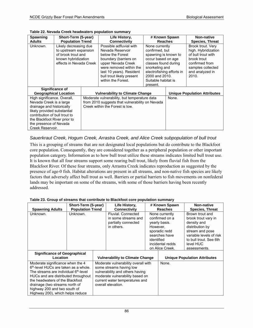
NCDE Grizzly Bear Forest Plan Amendments Biological Assessment
86
Table 22. Nevada Creek headwaters population summary Spawning Adults
Short-Term (5-year) Population Trend
Life History, Connectivity
# Known Spawn Reaches
Non-native Species, Threat
Unknown. Likely decreasing due to upstream expansion of brook trout and known hybridization effects in Nevada Creek
Possible adfluvial with Nevada Reservoir below the Forest boundary (barriers on upper Nevada Creek were removed within the last 10 years). Resident bull trout likely present within the Forest.
None currently confirmed, but spawning is known to occur based on age classes found during snorkeling and electrofishing efforts in 2000 and 2010. Suitable habitat is present.
Brook trout. Very high. Hybridization of bull trout with brook trout confirmed from samples collected and analyzed in 2010.
Significance of Geographical Location Vulnerability to Climate Change Unique Population Attributes
High significance. Overall, Nevada Creek is a large drainage and historically likely provided substantial contribution of bull trout to the Blackfoot River prior to the presence of Nevada Creek Reservoir.
Moderate vulnerability, but temperature data from 2010 suggests that vulnerability on Nevada Creek within the Forest is low.
None.
Sauerkraut Creek, Hogum Creek, Arrastra Creek, and Alice Creek subpopulation of bull trout This is a grouping of streams that are not designated local populations but do contribute to the Blackfoot core population. Consequently, they are considered together as a peripheral population or other important population category. Information as to how bull trout utilize these streams indicates limited bull trout use. It is known that all four streams support some rearing bull trout, likely from fluvial fish from the Blackfoot River. Of these four streams, only Arrastra Creek indicates reproduction as suggested by the presence of age-0 fish. Habitat alterations are present in all streams, and non-native fish species are likely factors that adversely affect bull trout as well. Barriers or partial barriers to fish movements on nonfederal lands may be important on some of the streams, with some of those barriers having been recently addressed.
Table 23. Group of streams that contribute to Blackfoot core population summary
Spawning Adults Short-Term (5-year) Population Trend
Life History, Connectivity
# Known Spawn Reaches
Non-native Species, Threat
Unknown. Unknown. Fluvial. Connected in some streams and partially connected in others.
None currently confirmed on a yearly basis. However, sporadic redd searches have identified incidental redds on Alice Creek.
Brown trout and brook trout vary in density and distribution by stream and pose variable levels of risk to bull trout. See 6th level HUC assessments.
Significance of Geographical Location Vulnerability to Climate Change Unique Population Attributes
Moderate significance when the 4 6th-level HUCs are taken as a whole. The streams are individual 6th-level HUCs and are distributed throughout the headwaters of the Blackfoot drainage (two streams north of highway 200 and two south of Highway 200), which helps reduce
Moderate vulnerability overall with some streams having low vulnerability and others having moderate vulnerability based on current water temperatures and overall elevation.
None.
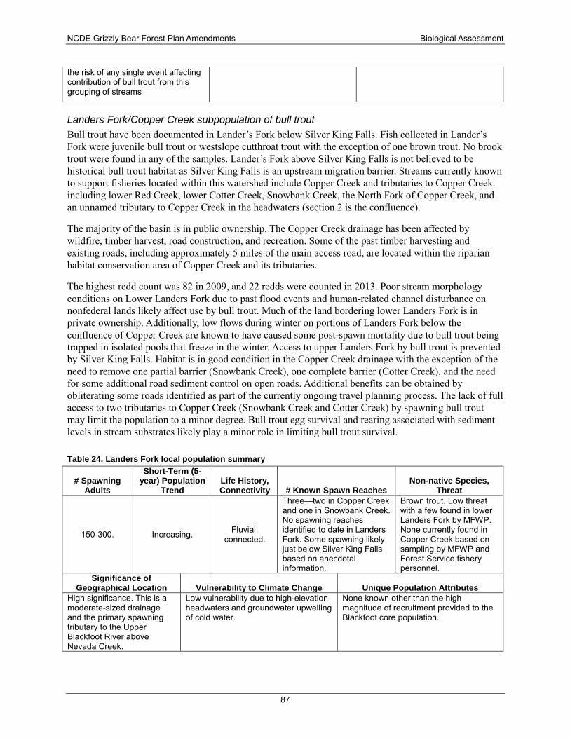
NCDE Grizzly Bear Forest Plan Amendments Biological Assessment
87
the risk of any single event affecting contribution of bull trout from this grouping of streams
Landers Fork/Copper Creek subpopulation of bull trout Bull trout have been documented in Lander’s Fork below Silver King Falls. Fish collected in Lander’s Fork were juvenile bull trout or westslope cutthroat trout with the exception of one brown trout. No brook trout were found in any of the samples. Lander’s Fork above Silver King Falls is not believed to be historical bull trout habitat as Silver King Falls is an upstream migration barrier. Streams currently known to support fisheries located within this watershed include Copper Creek and tributaries to Copper Creek. including lower Red Creek, lower Cotter Creek, Snowbank Creek, the North Fork of Copper Creek, and an unnamed tributary to Copper Creek in the headwaters (section 2 is the confluence).
The majority of the basin is in public ownership. The Copper Creek drainage has been affected by wildfire, timber harvest, road construction, and recreation. Some of the past timber harvesting and existing roads, including approximately 5 miles of the main access road, are located within the riparian habitat conservation area of Copper Creek and its tributaries.
The highest redd count was 82 in 2009, and 22 redds were counted in 2013. Poor stream morphology conditions on Lower Landers Fork due to past flood events and human-related channel disturbance on nonfederal lands likely affect use by bull trout. Much of the land bordering lower Landers Fork is in private ownership. Additionally, low flows during winter on portions of Landers Fork below the confluence of Copper Creek are known to have caused some post-spawn mortality due to bull trout being trapped in isolated pools that freeze in the winter. Access to upper Landers Fork by bull trout is prevented by Silver King Falls. Habitat is in good condition in the Copper Creek drainage with the exception of the need to remove one partial barrier (Snowbank Creek), one complete barrier (Cotter Creek), and the need for some additional road sediment control on open roads. Additional benefits can be obtained by obliterating some roads identified as part of the currently ongoing travel planning process. The lack of full access to two tributaries to Copper Creek (Snowbank Creek and Cotter Creek) by spawning bull trout may limit the population to a minor degree. Bull trout egg survival and rearing associated with sediment levels in stream substrates likely play a minor role in limiting bull trout survival.
Table 24. Landers Fork local population summary
# Spawning Adults
Short-Term (5-year) Population
Trend Life History, Connectivity # Known Spawn Reaches
Non-native Species, Threat
150-300. Increasing. Fluvial, connected.
Three—two in Copper Creek and one in Snowbank Creek. No spawning reaches identified to date in Landers Fork. Some spawning likely just below Silver King Falls based on anecdotal information.
Brown trout. Low threat with a few found in lower Landers Fork by MFWP. None currently found in Copper Creek based on sampling by MFWP and Forest Service fishery personnel.
Significance of Geographical Location Vulnerability to Climate Change Unique Population Attributes
High significance. This is a moderate-sized drainage and the primary spawning tributary to the Upper Blackfoot River above Nevada Creek.
Low vulnerability due to high-elevation headwaters and groundwater upwelling of cold water.
None known other than the high magnitude of recruitment provided to the Blackfoot core population.
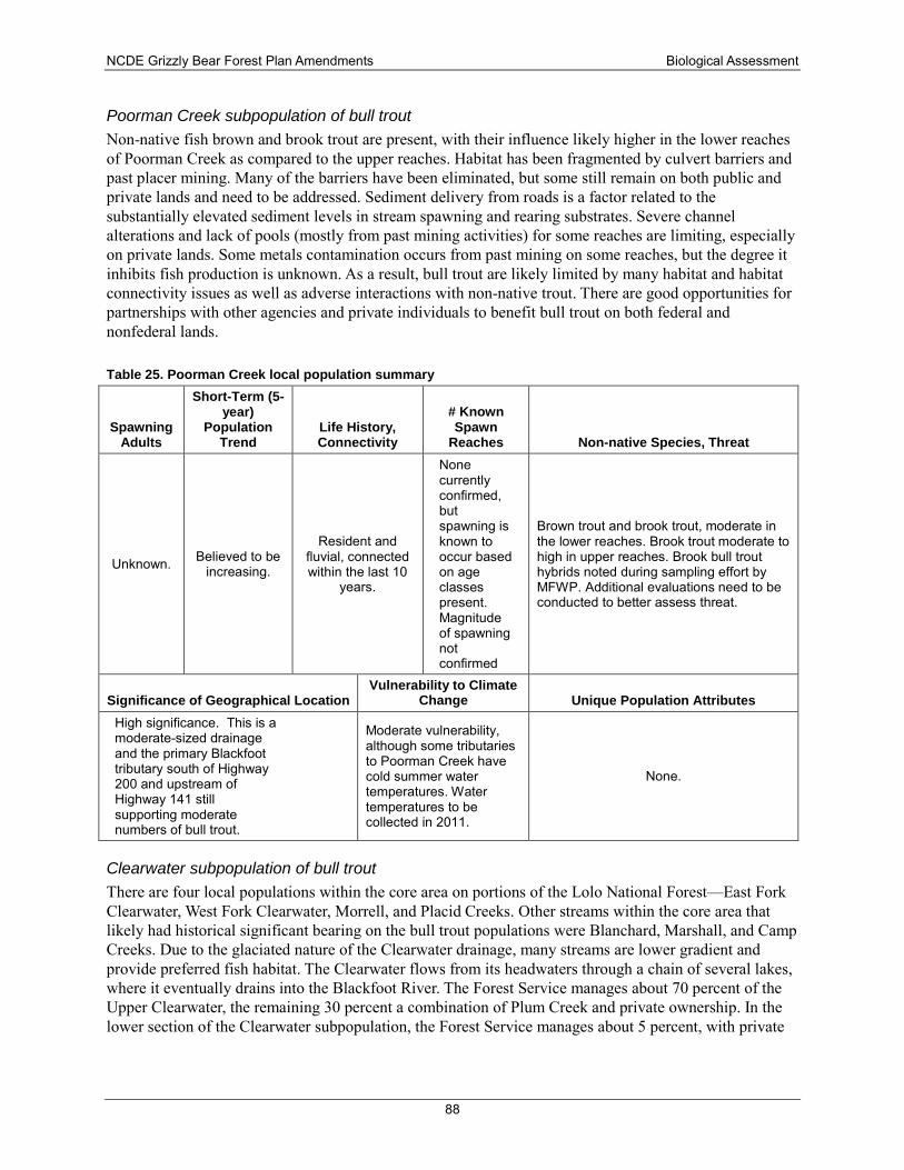
NCDE Grizzly Bear Forest Plan Amendments Biological Assessment
88
Poorman Creek subpopulation of bull trout Non-native fish brown and brook trout are present, with their influence likely higher in the lower reaches of Poorman Creek as compared to the upper reaches. Habitat has been fragmented by culvert barriers and past placer mining. Many of the barriers have been eliminated, but some still remain on both public and private lands and need to be addressed. Sediment delivery from roads is a factor related to the substantially elevated sediment levels in stream spawning and rearing substrates. Severe channel alterations and lack of pools (mostly from past mining activities) for some reaches are limiting, especially on private lands. Some metals contamination occurs from past mining on some reaches, but the degree it inhibits fish production is unknown. As a result, bull trout are likely limited by many habitat and habitat connectivity issues as well as adverse interactions with non-native trout. There are good opportunities for partnerships with other agencies and private individuals to benefit bull trout on both federal and nonfederal lands.
Table 25. Poorman Creek local population summary
Spawning Adults
Short-Term (5-year)
Population Trend
Life History, Connectivity
# Known Spawn
Reaches Non-native Species, Threat
Unknown. Believed to be increasing.
Resident and fluvial, connected within the last 10
years.
None currently confirmed, but spawning is known to occur based on age classes present. Magnitude of spawning not confirmed
Brown trout and brook trout, moderate in the lower reaches. Brook trout moderate to high in upper reaches. Brook bull trout hybrids noted during sampling effort by MFWP. Additional evaluations need to be conducted to better assess threat.
Significance of Geographical Location Vulnerability to Climate
Change Unique Population Attributes High significance. This is a moderate-sized drainage and the primary Blackfoot tributary south of Highway 200 and upstream of Highway 141 still supporting moderate numbers of bull trout.
Moderate vulnerability, although some tributaries to Poorman Creek have cold summer water temperatures. Water temperatures to be collected in 2011.
None.
Clearwater subpopulation of bull trout There are four local populations within the core area on portions of the Lolo National Forest—East Fork Clearwater, West Fork Clearwater, Morrell, and Placid Creeks. Other streams within the core area that likely had historical significant bearing on the bull trout populations were Blanchard, Marshall, and Camp Creeks. Due to the glaciated nature of the Clearwater drainage, many streams are lower gradient and provide preferred fish habitat. The Clearwater flows from its headwaters through a chain of several lakes, where it eventually drains into the Blackfoot River. The Forest Service manages about 70 percent of the Upper Clearwater, the remaining 30 percent a combination of Plum Creek and private ownership. In the lower section of the Clearwater subpopulation, the Forest Service manages about 5 percent, with private
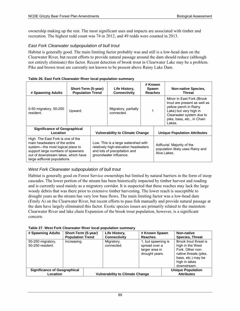
NCDE Grizzly Bear Forest Plan Amendments Biological Assessment
89
ownership making up the rest. The most significant uses and impacts are associated with timber and recreation. The highest redd count was 74 in 2012, and 49 redds were counted in 2013.
East Fork Clearwater subpopulation of bull trout Habitat is generally good. The main limiting factor probably was and still is a low-head dam on the Clearwater River, but recent efforts to provide natural passage around the dam should reduce (although not entirely eliminate) this factor. Recent detection of brook trout in Clearwater Lake may be a problem. Pike and brown trout are currently not known to be present above Rainy Lake Dam.
Table 26. East Fork Clearwater River local population summary
# Spawning Adults Short-Term (5-year) Population Trend
Life History, Connectivity
# Known Spawn
Reaches Non-native Species,
Threat
0-50 migratory, 50-250 resident. Upward. Migratory, partially
connected. 1
Minor in East Fork (Brook trout are present as well as yellow perch in Rainy Lake) but very high in Clearwater system due to pike, bass, etc., in Chain Lakes.
Significance of Geographical Location Vulnerability to Climate Change Unique Population Attributes
High. The East Fork is one of the main headwaters of the entire system—the most logical place to support large numbers of spawners out of downstream lakes, which have large adfluvial populations.
Low. This is a large watershed with relatively high-elevation headwaters and lots of precipitation and groundwater influence.
Adfluvial. Majority of the population likely uses Rainy and Alva Lakes.
West Fork Clearwater subpopulation of bull trout Habitat is generally good on Forest Service ownerships but limited by natural barriers in the form of steep cascades. The lower portion of the stream has been historically impacted by timber harvest and roading and is currently used mainly as a migratory corridor. It is suspected that these reaches may lack the large woody debris that was there prior to extensive timber harvesting. The lower reach is susceptible to drought years as the stream has very low base flows. The main limiting factor was a low-head dam (Emily A) on the Clearwater River, but recent efforts to pass fish manually and provide natural passage at the dam have largely eliminated this factor. Exotic species issues are primarily related to the mainstem Clearwater River and lake chain Expansion of the brook trout population, however, is a significant concern.
Table 27. West Fork Clearwater River local population summary # Spawning Adults Short-Term (5-year)
Population Trend Life History, Connectivity
# Known Spawn Reaches
Non-native Species, Threat
50-250 migratory, 50-250 resident.
Increasing. Migratory, connected.
1, but spawning is spread over a larger area in drought years.
Brook trout threat is high in the West Fork. Other non-native threats (pike, bass, etc.) may be high in lakes downstream.
Significance of Geographical Location Vulnerability to Climate Change
Unique Population Attributes
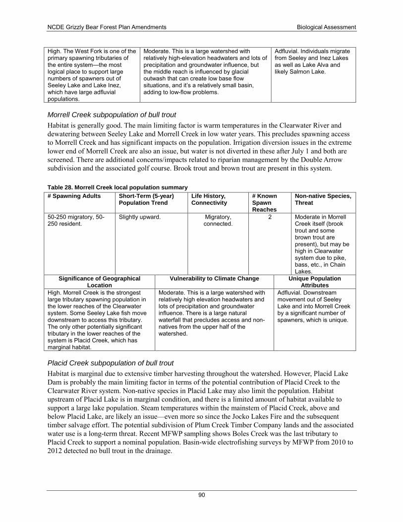
NCDE Grizzly Bear Forest Plan Amendments Biological Assessment
90
High. The West Fork is one of the primary spawning tributaries of the entire system—the most logical place to support large numbers of spawners out of Seeley Lake and Lake Inez, which have large adfluvial populations.
Moderate. This is a large watershed with relatively high-elevation headwaters and lots of precipitation and groundwater influence, but the middle reach is influenced by glacial outwash that can create low base flow situations, and it’s a relatively small basin, adding to low-flow problems.
Adfluvial. Individuals migrate from Seeley and Inez Lakes as well as Lake Alva and likely Salmon Lake.
Morrell Creek subpopulation of bull trout Habitat is generally good. The main limiting factor is warm temperatures in the Clearwater River and dewatering between Seeley Lake and Morrell Creek in low water years. This precludes spawning access to Morrell Creek and has significant impacts on the population. Irrigation diversion issues in the extreme lower end of Morrell Creek are also an issue, but water is not diverted in these after July 1 and both are screened. There are additional concerns/impacts related to riparian management by the Double Arrow subdivision and the associated golf course. Brook trout and brown trout are present in this system.
Table 28. Morrell Creek local population summary # Spawning Adults Short-Term (5-year)
Population Trend Life History, Connectivity
# Known Spawn Reaches
Non-native Species, Threat
50-250 migratory, 50-250 resident.
Slightly upward. Migratory, connected.
2 Moderate in Morrell Creek itself (brook trout and some brown trout are present), but may be high in Clearwater system due to pike, bass, etc., in Chain Lakes.
Significance of Geographical Location
Vulnerability to Climate Change Unique Population Attributes
High. Morrell Creek is the strongest large tributary spawning population in the lower reaches of the Clearwater system. Some Seeley Lake fish move downstream to access this tributary. The only other potentially significant tributary in the lower reaches of the system is Placid Creek, which has marginal habitat.
Moderate. This is a large watershed with relatively high elevation headwaters and lots of precipitation and groundwater influence. There is a large natural waterfall that precludes access and non-natives from the upper half of the watershed.
Adfluvial. Downstream movement out of Seeley Lake and into Morrell Creek by a significant number of spawners, which is unique.
Placid Creek subpopulation of bull trout Habitat is marginal due to extensive timber harvesting throughout the watershed. However, Placid Lake Dam is probably the main limiting factor in terms of the potential contribution of Placid Creek to the Clearwater River system. Non-native species in Placid Lake may also limit the population. Habitat upstream of Placid Lake is in marginal condition, and there is a limited amount of habitat available to support a large lake population. Steam temperatures within the mainstem of Placid Creek, above and below Placid Lake, are likely an issue—even more so since the Jocko Lakes Fire and the subsequent timber salvage effort. The potential subdivision of Plum Creek Timber Company lands and the associated water use is a long-term threat. Recent MFWP sampling shows Boles Creek was the last tributary to Placid Creek to support a nominal population. Basin-wide electrofishing surveys by MFWP from 2010 to 2012 detected no bull trout in the drainage.
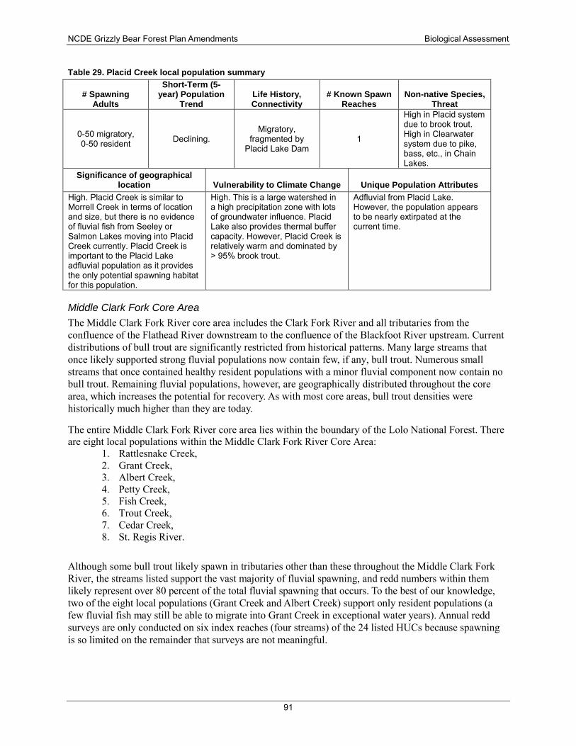
NCDE Grizzly Bear Forest Plan Amendments Biological Assessment
91
Table 29. Placid Creek local population summary
# Spawning Adults
Short-Term (5-year) Population
Trend Life History, Connectivity
# Known Spawn Reaches
Non-native Species, Threat
0-50 migratory, 0-50 resident Declining.
Migratory, fragmented by
Placid Lake Dam 1
High in Placid system due to brook trout. High in Clearwater system due to pike, bass, etc., in Chain Lakes.
Significance of geographical location Vulnerability to Climate Change Unique Population Attributes
High. Placid Creek is similar to Morrell Creek in terms of location and size, but there is no evidence of fluvial fish from Seeley or Salmon Lakes moving into Placid Creek currently. Placid Creek is important to the Placid Lake adfluvial population as it provides the only potential spawning habitat for this population.
High. This is a large watershed in a high precipitation zone with lots of groundwater influence. Placid Lake also provides thermal buffer capacity. However, Placid Creek is relatively warm and dominated by > 95% brook trout.
Adfluvial from Placid Lake. However, the population appears to be nearly extirpated at the current time.
Middle Clark Fork Core Area The Middle Clark Fork River core area includes the Clark Fork River and all tributaries from the confluence of the Flathead River downstream to the confluence of the Blackfoot River upstream. Current distributions of bull trout are significantly restricted from historical patterns. Many large streams that once likely supported strong fluvial populations now contain few, if any, bull trout. Numerous small streams that once contained healthy resident populations with a minor fluvial component now contain no bull trout. Remaining fluvial populations, however, are geographically distributed throughout the core area, which increases the potential for recovery. As with most core areas, bull trout densities were historically much higher than they are today.
The entire Middle Clark Fork River core area lies within the boundary of the Lolo National Forest. There are eight local populations within the Middle Clark Fork River Core Area:
1. Rattlesnake Creek, 2. Grant Creek, 3. Albert Creek, 4. Petty Creek, 5. Fish Creek, 6. Trout Creek, 7. Cedar Creek, 8. St. Regis River.
Although some bull trout likely spawn in tributaries other than these throughout the Middle Clark Fork River, the streams listed support the vast majority of fluvial spawning, and redd numbers within them likely represent over 80 percent of the total fluvial spawning that occurs. To the best of our knowledge, two of the eight local populations (Grant Creek and Albert Creek) support only resident populations (a few fluvial fish may still be able to migrate into Grant Creek in exceptional water years). Annual redd surveys are only conducted on six index reaches (four streams) of the 24 listed HUCs because spawning is so limited on the remainder that surveys are not meaningful.
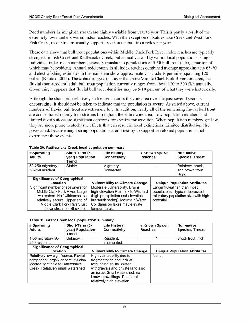
NCDE Grizzly Bear Forest Plan Amendments Biological Assessment
92
Redd numbers in any given stream are highly variable from year to year. This is partly a result of the extremely low numbers within index reaches. With the exception of Rattlesnake Creek and West Fork Fish Creek, most streams usually support less than ten bull trout redds per year.
These data show that bull trout populations within Middle Clark Fork River index reaches are typically strongest in Fish Creek and Rattlesnake Creek, but annual variability within local populations is high. Individual index reach numbers generally translate to populations of 5-50 bull trout (a large portion of which may be resident). Annual redd counts in all index reaches combined average approximately 65-70, and electrofishing estimates in the mainstem show approximately 1-2 adults per mile (spanning 120 miles) (Knotek, 2011). These data suggest that over the entire Middle Clark Fork River core area, the fluvial (non-resident) adult bull trout population currently ranges from about 120 to 300 fish annually. Given this, it appears that fluvial bull trout densities may be 5-10 percent of what they were historically.
Although the short-term relatively stable trend across the core area over the past several years is encouraging, it should not be taken to indicate that the population is secure. As stated above, current numbers of fluvial bull trout are extremely low. In addition, nearly all of the remaining fluvial bull trout are concentrated in only four streams throughout the entire core area. Low population numbers and limited distributions are significant concerns for species conservation. When population numbers get low, they are more prone to stochastic effects that can result in local extinctions. Limited distribution also poses a risk because neighboring populations aren’t nearby to support or refound populations that experience these events.
Table 30. Rattlesnake Creek local population summary # Spawning Adults
Short-Term (5-year) Population Trend
Life History, Connectivity
# Known Spawn Reaches
Non-native Species, Threat
50-250 migratory, 50-250 resident.
Stable. Migratory, Connected.
1 Rainbow, brook, and brown trout. High.
Significance of Geographical Location Vulnerability to Climate Change Unique Population Attributes
Significant number of spawners for Middle Clark Fork River. Large watershed. Half wildeness, so
relatively secure. Upper end of Middle Clark Fork River, just
downstream of Blackfoot.
Moderate vulnerability. Drains high-elevation Point Six to Wishard (high precipitation and elevation but south facing). Mountain Water Co. dams on lakes may elevate temperatures.
Larger fluvial fish than most populations—typical depressed migratory population size with high potential.
Table 31. Grant Creek local population summary # Spawning Adults
Short-Term (5-year) Population Trend
Life History, Connectivity
# Known Spawn Reaches
Non-native Species, Threat
1-50 migratory 50-250 resident.
Unknown. Resident, fragmented.
1 Brook trout, high.
Significance of Geographical Location Vulnerability to Climate Change Unique Population Attributes
Relatively low significance. Fluvial component largely absent. It’s also located right next to Rattlesnake Creek. Relatively small watershed.
High vulnerability due to fragmentation and lack of refounding ability. Water withdrawals and private land also an issue. Small watershed, no known upwellings. Does drain relatively high elevation.
None.
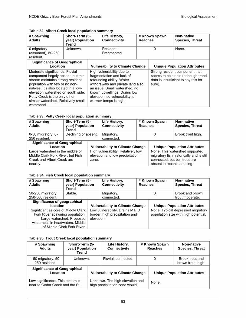
NCDE Grizzly Bear Forest Plan Amendments Biological Assessment
93
Table 32. Albert Creek local population summary # Spawning Adults
Short-Term (5-year) Population Trend
Life History, Connectivity
# Known Spawn Reaches
Non-native Species, Threat
0 migratory (assumed), 50-250 resident.
Unknown. Resident, Fragmented.
0 None.
Significance of Geographical Location Vulnerability to Climate Change Unique Population Attributes
Moderate significance. Fluvial component largely absent, but this stream maintains strong resident population with few or no non-natives. It’s also located in a low-elevation watershed on south side; Petty Creek is the only other similar watershed. Relatively small watershed.
High vulnerability due to fragmentation and lack of refounding ability. Water withdrawals and private land also an issue. Small watershed, no known upwellings. Drains low elevation, so vulnerability to warmer temps is high.
Strong resident component that seems to be stable (although trend data is insufficient to say this for sure).
Table 33. Petty Creek local population summary # Spawning Adults
Short-Term (5-year) Population Trend
Life History, Connectivity
# Known Spawn Reaches
Non-native Species, Threat
0-50 migratory, 0-250 resident.
Declining or absent. Migratory, connected.
0 Brook trout high.
Significance of Geographical Location Vulnerability to Climate Change Unique Population Attributes
Large watershed in the middle of Middle Clark Fork River, but Fish Creek and Albert Creek are nearby.
High vulnerability. Relatively low elevation and low precipitation zone.
None. This watershed supported migratory fish historically and is still connected, but bull trout are absent in recent sampling.
Table 34. Fish Creek local population summary # Spawning Adults
Short-Term (5-year) Population Trend
Life History, Connectivity
# Known Spawn Reaches
Non-native Species, Threat
50-250 migratory, 250-500 resident.
Stable. Migratory, connected.
3 Brook and brown trout moderate.
Significance of geographical location Vulnerability to Climate Change Unique Population Attributes
Significant as core of Middle Clark Fork River spawning population.
Large watershed. Proposed wilderness in headwaters. Middle
of Middle Clark Fork River.
Low vulnerability. Drains MT/ID border; high precipitation and elevation.
None. Typical depressed migratory population size with high potential.
Table 35. Trout Creek local population summary # Spawning
Adults Short-Term (5-
year) Population Trend
Life History, Connectivity
# Known Spawn Reaches
Non-native Species, Threat
1-50 migratory, 50-250 resident.
Unknown. Fluvial, connected. 0 Brook trout and brown trout, high.
Significance of Geographical Location Vulnerability to Climate Change Unique Population Attributes
Low significance. This stream is near to Cedar Creek and the St.
Unknown. The high elevation and high precipitation zone would
None.
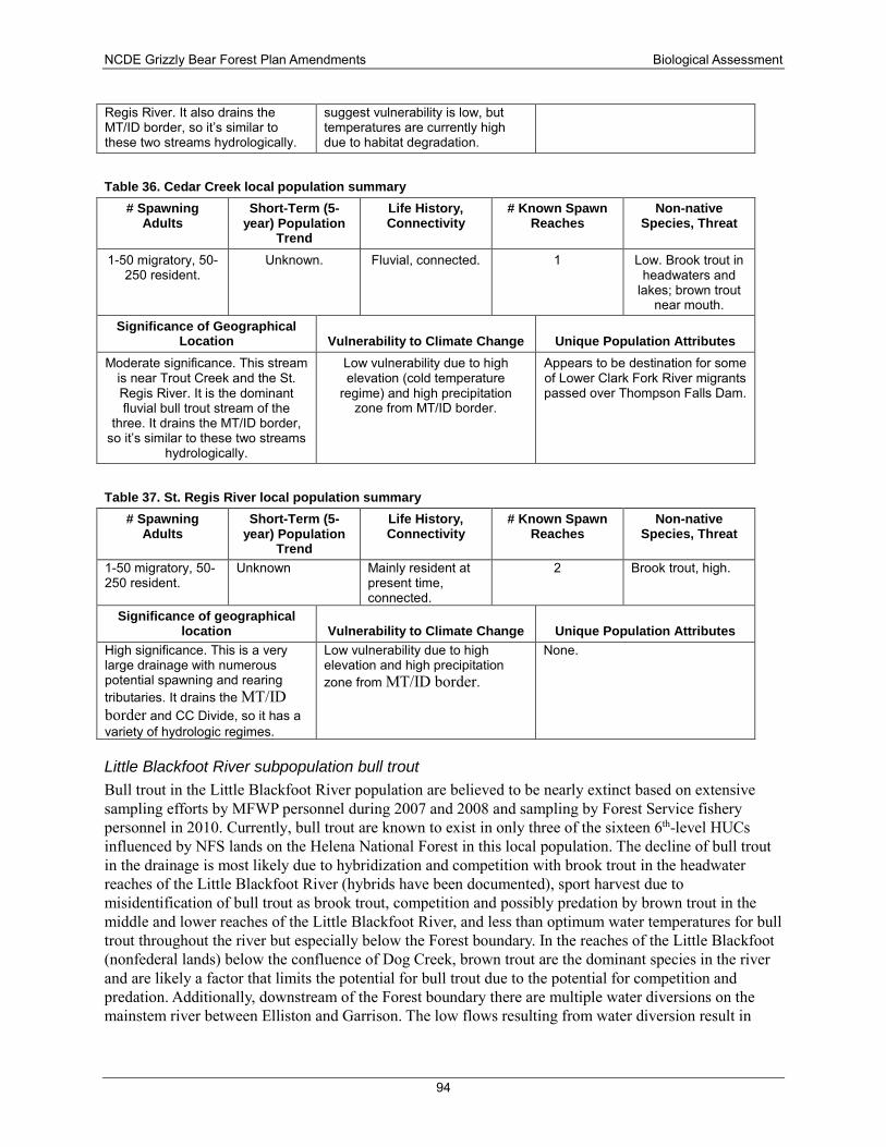
NCDE Grizzly Bear Forest Plan Amendments Biological Assessment
94
Regis River. It also drains the MT/ID border, so it’s similar to these two streams hydrologically.
suggest vulnerability is low, but temperatures are currently high due to habitat degradation.
Table 36. Cedar Creek local population summary # Spawning
Adults Short-Term (5-
year) Population Trend
Life History, Connectivity
# Known Spawn Reaches
Non-native Species, Threat
1-50 migratory, 50-250 resident.
Unknown. Fluvial, connected. 1 Low. Brook trout in headwaters and
lakes; brown trout near mouth.
Significance of Geographical Location Vulnerability to Climate Change Unique Population Attributes
Moderate significance. This stream is near Trout Creek and the St. Regis River. It is the dominant fluvial bull trout stream of the
three. It drains the MT/ID border, so it’s similar to these two streams
hydrologically.
Low vulnerability due to high elevation (cold temperature
regime) and high precipitation zone from MT/ID border.
Appears to be destination for some of Lower Clark Fork River migrants passed over Thompson Falls Dam.
Table 37. St. Regis River local population summary # Spawning
Adults Short-Term (5-
year) Population Trend
Life History, Connectivity
# Known Spawn Reaches
Non-native Species, Threat
1-50 migratory, 50-250 resident.
Unknown Mainly resident at present time, connected.
2 Brook trout, high.
Significance of geographical location Vulnerability to Climate Change Unique Population Attributes
High significance. This is a very large drainage with numerous potential spawning and rearing tributaries. It drains the MT/ID border and CC Divide, so it has a variety of hydrologic regimes.
Low vulnerability due to high elevation and high precipitation zone from MT/ID border.
None.
Little Blackfoot River subpopulation bull trout Bull trout in the Little Blackfoot River population are believed to be nearly extinct based on extensive sampling efforts by MFWP personnel during 2007 and 2008 and sampling by Forest Service fishery personnel in 2010. Currently, bull trout are known to exist in only three of the sixteen 6th-level HUCs influenced by NFS lands on the Helena National Forest in this local population. The decline of bull trout in the drainage is most likely due to hybridization and competition with brook trout in the headwater reaches of the Little Blackfoot River (hybrids have been documented), sport harvest due to misidentification of bull trout as brook trout, competition and possibly predation by brown trout in the middle and lower reaches of the Little Blackfoot River, and less than optimum water temperatures for bull trout throughout the river but especially below the Forest boundary. In the reaches of the Little Blackfoot (nonfederal lands) below the confluence of Dog Creek, brown trout are the dominant species in the river and are likely a factor that limits the potential for bull trout due to the potential for competition and predation. Additionally, downstream of the Forest boundary there are multiple water diversions on the mainstem river between Elliston and Garrison. The low flows resulting from water diversion result in
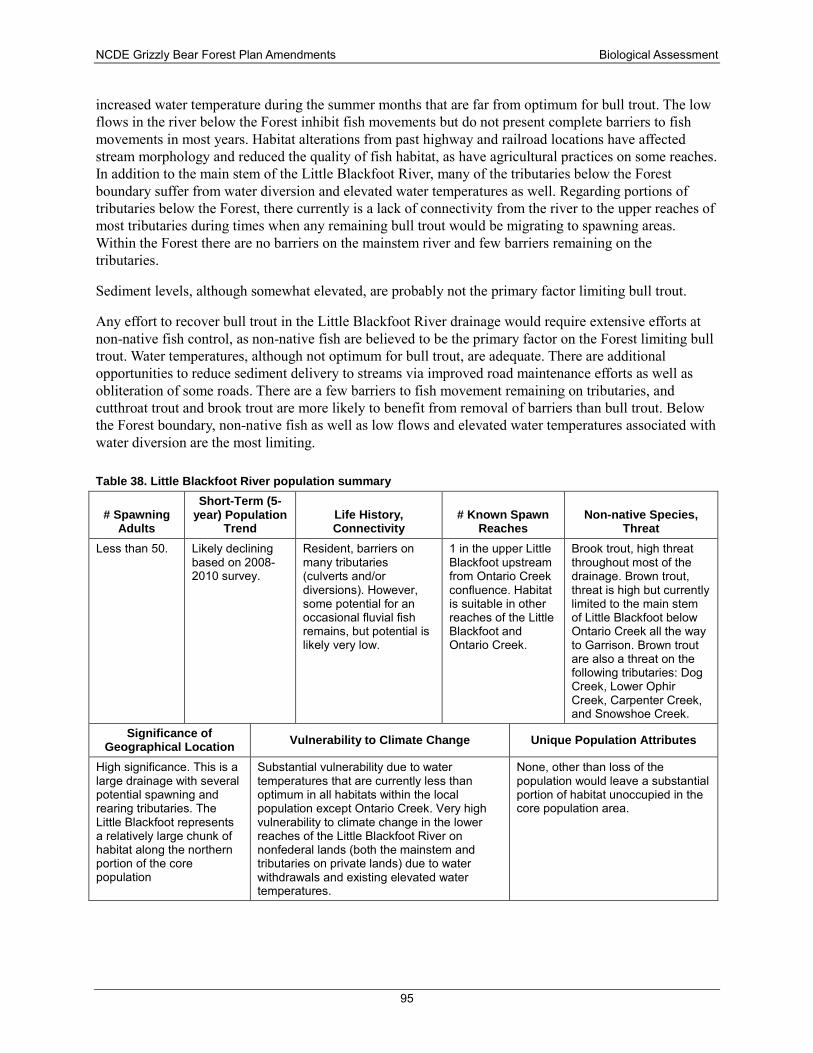
NCDE Grizzly Bear Forest Plan Amendments Biological Assessment
95
increased water temperature during the summer months that are far from optimum for bull trout. The low flows in the river below the Forest inhibit fish movements but do not present complete barriers to fish movements in most years. Habitat alterations from past highway and railroad locations have affected stream morphology and reduced the quality of fish habitat, as have agricultural practices on some reaches. In addition to the main stem of the Little Blackfoot River, many of the tributaries below the Forest boundary suffer from water diversion and elevated water temperatures as well. Regarding portions of tributaries below the Forest, there currently is a lack of connectivity from the river to the upper reaches of most tributaries during times when any remaining bull trout would be migrating to spawning areas. Within the Forest there are no barriers on the mainstem river and few barriers remaining on the tributaries.
Sediment levels, although somewhat elevated, are probably not the primary factor limiting bull trout.
Any effort to recover bull trout in the Little Blackfoot River drainage would require extensive efforts at non-native fish control, as non-native fish are believed to be the primary factor on the Forest limiting bull trout. Water temperatures, although not optimum for bull trout, are adequate. There are additional opportunities to reduce sediment delivery to streams via improved road maintenance efforts as well as obliteration of some roads. There are a few barriers to fish movement remaining on tributaries, and cutthroat trout and brook trout are more likely to benefit from removal of barriers than bull trout. Below the Forest boundary, non-native fish as well as low flows and elevated water temperatures associated with water diversion are the most limiting.
Table 38. Little Blackfoot River population summary
# Spawning Adults
Short-Term (5-year) Population
Trend Life History, Connectivity
# Known Spawn Reaches
Non-native Species, Threat
Less than 50. Likely declining based on 2008-2010 survey.
Resident, barriers on many tributaries (culverts and/or diversions). However, some potential for an occasional fluvial fish remains, but potential is likely very low.
1 in the upper Little Blackfoot upstream from Ontario Creek confluence. Habitat is suitable in other reaches of the Little Blackfoot and Ontario Creek.
Brook trout, high threat throughout most of the drainage. Brown trout, threat is high but currently limited to the main stem of Little Blackfoot below Ontario Creek all the way to Garrison. Brown trout are also a threat on the following tributaries: Dog Creek, Lower Ophir Creek, Carpenter Creek, and Snowshoe Creek.
Significance of Geographical Location Vulnerability to Climate Change Unique Population Attributes
High significance. This is a large drainage with several potential spawning and rearing tributaries. The Little Blackfoot represents a relatively large chunk of habitat along the northern portion of the core population
Substantial vulnerability due to water temperatures that are currently less than optimum in all habitats within the local population except Ontario Creek. Very high vulnerability to climate change in the lower reaches of the Little Blackfoot River on nonfederal lands (both the mainstem and tributaries on private lands) due to water withdrawals and existing elevated water temperatures.
None, other than loss of the population would leave a substantial portion of habitat unoccupied in the core population area.
NCDE Grizzly Bear Forest Plan Amendments Biological Assessment
96
Kootenai River The Wigwam River drainage in the United States is a 30,792-acre watershed that flows north into British Columbia, Canada. The major lakes in the drainage include Big and Little Therriault Lakes, Paradise Lake, and Wolverine Lake. Bull trout and westslope cutthroat trout are codominant species, with some mountain whitefish (Prosopium williamsoni) and largescale suckers (Catostomus macrocheilus) also represented. Due to partial fish passage barriers, the whitefish and suckers rarely occur in the U.S. portion of the Wigwam. The Wigwam River is a bull trout core area (a population stronghold). The Kootenai National Forest Plan lists the Wigwam River as a priority bull trout watershed.
Grave Creek is considered one of the major fisheries streams on the Fortine Ranger District. This drainage produces both resident and migratory populations of bull trout and cutthroat trout and a moderate run of rainbow trout. Grave Creek is considered the major spawning stream south of the Canadian border for Lake Koocanusa’s bull trout population and is a priority bull trout watershed. The Tobacco/Grave bull trout subpopulation (stock) is a part of the larger upper Kootenai River meta-population. The Tobacco/Grave population consists of both migratory and resident forms. Bull trout are known to inhabit or reproduce in Grave Creek and the following tributaries: Lewis, Blue Sky, Clarence, Stahl, and Williams Creeks. The upper reaches of Stahl and Williams Creeks support instream falls that are fish barriers. Only Williams Creek is known to have an isolated population of resident bull trout above the falls.
Sun, Teton, Two Medicine, Badger, Deep, and Dearborn rivers Bull trout are not present in these drainages. The most widespread impact to aquatic habitats in these drainages is the stocking of non-native fish. This has eliminated westslope cutthroat trout of conservation-level purity from most of the historically populated stream reaches. The few isolated populations that still persist represent unique genetic diversity from the range east of the continental divide (Allendorf & Leary, 1988; Leary, Allendorf, & Knudsen, 1988). Survey work jointly conducted by the USFS and MFWP recently led to the discovery of a previously unknown remnant population. This is the last known genetically pure population in the entire Sun River drainage. Historically, fish were unable to colonize the Sun River above the falls at Diversion Dam, located approximately 1.5 miles downstream from Gibson Dam. Although fish are not native to this portion of the Sun River drainage, this area has been stocked with both native and non-native fish species and is dominated by non-native trout.
Several other river and large stream networks occur within this area. These include headwater portions of the Two Medicine River, Badger Creek, the Teton River, Deep Creek, and the Dearborn River. Thirty-four conservation populations of westslope cutthroat trout are known to occur in this geographic area. Headwater tributaries of Badger Creek contain five of the eight tested populations with 100 percent genetic purity. There are not any genetically pure populations known in Dearborn River drainages. There is one in each of the Two Medicine River and Teton River systems. Preliminary testing indicates that Deep Creek contains genetically pure fish from west of the Continental Divide. These are likely the result of an unauthorized transplant from west of the Continental Divide to an area above a waterfall that is a natural fish barrier.
Effects of the proposed amendments In the past two decades, there has been a net reduction of roads across all Forests. These tended to be roads that were in excess of what was needed for management or recreational activities, were difficult or expensive to maintain, or both. Roads were also decommissioned to benefit wildlife and fish and improve water quality. In the past, roads have been a primary cause of the reduction of water quality due to sedimentation from roads that had stream crossings. Decommissioning has disconnected many of these roads as a sediment source; roads constructed in the last decade meet standards for water conservation
NCDE Grizzly Bear Forest Plan Amendments Biological Assessment
97
practices. Much of the road decommissioning has taken place inside the primary conservation area, with little accompanying road construction.
The effects on soil and water resources from grizzly bear habitat conservation are in direct proportion to the amount of activity that is allowed. In general, there would be no adverse effects as what is good for grizzly bears is also beneficial for bull trout and other aquatic species. There are additional opportunities for road decommissioning within and outside the primary conservation area as Forests address excess roads from past logging and heavily roaded NFS lands recently acquired through land exchanges such as in the Swan Valley. Some additional road construction may be needed to address access needs for timber management and fuel hazard reduction, especially within 1½ miles of structures.
Activities that would cause disturbance such as road building would remain at the 2011 baseline. Levels of open motorized road density, total motorized route density, and secure core were set by previous BO terms and conditions. The secure habitat standard and the developed site standard in the amendments would limit these activities. There would be a limit on overnight-use developed recreation sites, allowing an increase of one developed site in each bear management unit/decade under the preferred alternative that, depending on the location, would result in soil disturbance and potential impacts on aquatics if constructed within riparian areas. The one site may or may not be within a bull trout watershed and would be decided by interdisciplinary teams when and if the need arises.
The Lolo and Kootenai and the Blackfoot River drainage on the Helena National Forest plans were amended in 1995 by the Inland Native Fish Strategy (USDA, 1995b), which will continue to provide standards and guidelines to limit management actions that may impact aquatic species. The Inland Native Fish Strategy did not apply to the Lewis and Clark National Forest. INFISH will remain in effect on these forests to continue to provide habitat protection for bull trout.
The preferred alternative proposes several standards and guidelines that will be beneficial to aquatic species because they limit the amount of road construction, grazing, recreational development, or mining surface occupancy that may adversely impact aquatic species. The greatest benefits will be derived for aquatic species in the primary conservation area, followed by the demographic connectivity area, zone1, and zone 2, in that order. The following are a synopsis of beneficial standards and guidelines (there are no standard and guidelines that provide adverse effects to fish):
NCDE-STD-AR-01—This standard will limit the amount of vehicle traffic in the primary conservation area, which will allow for some vegetation to become established on the road surface and limit sediment production. Gated roads also benefit native fish by making fishing access more remote and reducing access for potential poachers.
NCDE-STD-AR-02—This standard will limit road construction in the primary conservation area, which will reduce sediment production.
NCDE-STD-AR-04—This standard opens some roads for firewood cutting. There is a requirement on firewood permits that does not allow cutting within 300 feet of streams.
NCDE-STD-AR-05—This will limit the number of recreation sites in the primary conservation area which, if they are proposed near streams, will provide benefits in the long term since there can be no more than one in a bear management unit.
NCDE-GDL-AR-02—Restoring temporary roads in the primary conservation area within 1 year will reduce potential sediment inputs following management activities.
NCDE Grizzly Bear Forest Plan Amendments Biological Assessment
98
NCDE-STD-GRZ-04—Capping sheep allotments and animal unit months in the primary conservation area and demographic connectivity area/zone 1 may reduce impacts to aquatic species, depending on the location of the allotment.
NCDE-STD-GRZ-05—Capping the number of cattle allotments in the primary conservation area and demographic connectivity area/zone 1 may reduce impacts to aquatic species, depending on the location of the allotment.
NCDE-GDL-GRZ-02—Protecting riparian areas for grizzly bears will also provide protection for aquatic species and habitat.
NCDE-STD-MIN-05—Measures provide for riparian habitat conservation area restoration and maintenance for operating plans.
NCDE-STD-MIN-08—Within the NCDE primary conservation area and zone 1 (including the Salish and Ninemile demographic connectivity areas), new oil and gas leases shall include a no surface occupancy stipulation under alternative 3 that will benefit aquatic species by limiting surface disturbance depending on the location of the proposal.
Bull trout critical habitat is present within the primary conservation area and zone 1. Any standard or guideline that limits roads or ground disturbance may provide beneficial effects to the sediment primary constituent element. There are no potential adverse effects to critical habitat from any of the action alternatives.
Cumulative effects There are no adverse direct or indirect effects to aquatic species; therefore, there are no cumulative effects from the action alternatives.
Determination of effect and rationale Based on the analysis of interrelated and interconnected activities, and the cumulative effects of other federal and non-federal activities within the planning area, it has been determined that the implementation of the preferred alternative “may affect but is not likely to adversely affect” bull trout and “may affect but is not likely to adversely affect” designated bull trout critical habitat. Bull trout should benefit by less road construction and less recreational development. Temporary roads and developed recreation sites depending on location may still have some level of impact.
There will be no effect on Kootenai River white sturgeon since they do not occur within the analysis area, although they do occur on the Kootenai National Forest below Libby Dam.
Plant Species Spalding’s campion (Silene spaldingii)
Existing conditions Spalding’s campion (also known as Spalding’s catchfly) is an herbaceous perennial plant in the pink family (Caryophyllaceae). It was listed as a threatened species under the ESA on October 10, 2001.
Spalding’s campion is a regional endemic found predominantly in bunchgrass grasslands and sagebrush-steppe and occasionally in open pine communities in eastern Washington, northeastern Oregon, west-
NCDE Grizzly Bear Forest Plan Amendments Biological Assessment
99
central Idaho, western Montana, and the southern edge of British Columbia, Canada. As of 2007, there were 99 known populations of Spalding’s campion (USFWS, 2007). According to a five-year review completed in 2009, 10 additional populations had been found, none in Montana, and all were located within the known distribution (USFWS, 2009). Occupied habitat occurs in five physiographic regions: the Palouse Grasslands in west-central Idaho and southeastern Washington; the Channeled Scablands in eastern Washington; the Blue Mountain Basins in northeastern Oregon; the Canyon Grasslands of the Snake River and its tributaries in Idaho, Oregon, and Washington; and the Intermontane Valleys of northwestern Montana.
Spalding’s campion is described as “suspected” to occur within NCDE grizzly bear recovery zone 1 on the Lolo National Forest and zone 1 of the Salish demographic connectivity area on the Kootenai National Forest. Surveys to date have not confirmed the presence of this plant, although suitable habitat is thought to exist on the national forests. Populations are known to occur on the Lost Trail Wildlife Refuge and on private lands near these national forests. The recovery plan identified potential key conservation areas that overlap with the Flathead and Kootenai National Forests.
No known or suspected populations of Spalding’s campion occur on the Helena-Lewis and Clark National Forest.
Effects of the proposed amendments The recovery plan for Spalding’s campion identified habitat loss due to human development, habitat degradation associated with excessive grazing, and invasions of aggressive non-native plants as threats. In addition, the loss of genetic variability and adverse effects of inbreeding are a problem for many small, fragmented populations where genetic exchange is limited. Other potential threats include changes in fire frequency and seasonality, off-road vehicle use, and herbicide spraying and drift.
This species is suspected but has not been confirmed to occur on the Kootenai and Lolo National Forests. The prairie habitats used by this species would not be affected by the changes proposed in management direction pertaining to the grizzly bear.
Determination of effect and rationale Because the species is not known to occur on NFS lands and because the management direction pertaining to the grizzly bear would not affect the prairie habitats of this plant species, the determination is that the amendments would have no effect on Spalding’s campion.
Water howellia
Existing conditions Water howellia (Howellia aquatilis) is an aquatic plant that occurs in shallow ponds and oxbows. Water howellia reproduces only by seed, which germinates when ponds dry during the fall. Population size varies year to year, influenced primarily by annual fluctuations in precipitation and pond drying. Reduced population sizes often occur in years following cooler, wetter summers that inhibit fall seed germination (Lesica, 1990). Water howellia was listed as threatened by USFWS on July 14, 1994 (USFWS, 1994a). A recovery plan for the species was drafted in 1996 but has not been finalized. Therefore, no recovery goals have been officially identified for the species.
Water howellia is historically and currently known to occur in California, Oregon, Washington, Idaho, and Montana. The distribution in Montana is restricted to the Swan Valley (Lake and Missoula Counties). The species has not been found on the Lolo National Forest despite numerous surveys conducted over many
NCDE Grizzly Bear Forest Plan Amendments Biological Assessment
100
years in apparently suitable habitat, such as in the Clearwater River drainage. However, USFWS identifies it as a species that may be present on the Lolo National Forest because potential suitable habitat does exist.
No known or suspected populations of water howellia occur on the Helena-Lewis and Clark National Forest or on the Kootenai National Forest.
The five-year review of water howellia (USFWS, 2013f) reported that almost 200 additional populations have been documented rangewide since the time of listing, including sites previously believed to be extirpated in Oregon and California. USFWS also concluded that federal listing and other regulatory mechanisms have provided protection from human-caused habitat destruction for the majority of occurrences (86 percent on federal, state, and some private lands). Reed canarygrass likely occurs as both native and introduced populations in the Pacific Northwest (Merigliano & Lesica, 1998). Aggressive, potentially introduced reed canarygrass populations threatening some ponds with water howellia have been successfully treated in some states, but it does not seem to be invading other habitat as was previously anticipated. Given the improved population status and redundancy, reduction or elimination of threats present at the time of listing, and increased habitat protections, the USFWS is recommending delisting water howellia but maintaining current conservation measures (USFWS, 2013f).
Effects of the proposed amendments Threats identified at the time of listing included destruction or modification by timber harvesting practices, livestock use in pond habitats, human-related development, altered hydrology, and invasive species (reed canarygrass).
This species is suspected but has not been confirmed to occur on the Lolo National Forest. The pond habitats used by this species would not be affected by the changes proposed in management direction pertaining to the grizzly bear.
Determination of effect and rationale Because the species is not known to occur on NFS lands and because the management direction pertaining to the grizzly bear would not affect the pond habitats of this plant species, the proposed amendments would have no effect on water howellia.
NCDE Grizzly Bear Amendments Appendix 1: Maps
1-1
Appendix 1: Maps
Figure 1-1. The Northern Continental Divide Ecosystem vicinity map, with inset showing NCDE and Greater Yellowstone Ecosystem grizzly bear distributions. ......................................................................................... 2
Figure 1-2. Current grizzly bear distribution on the Helena National Forest with the Blackfoot and Divide landscapes delineated. .................................................................................................................................. 3
Figure 1-3. Distribution of grizzly bears (2004 to 2014) in the NCDE (Costello et al., 2016) .................................... 4 Figure 1-4. Distribution of trails modeled as “high use” trails in the NCDE, the majority of which are located in
Glacier National Park ..................................................................................................................................... 5 Figure 1-5. NCDE Grizzly Bear Conservation Strategy management zones and Kootenai National Forest Bears
Outside the Recovery Zone (BORZ) area. ....................................................................................................... 6 Figure 1-6. Designated critical habitat unit 3 for Canada lynx (from the September 12, 2014 final rule). ............... 7 Figure 1-7. Distribution of secure core in relation to wilderness areas and inventoried roadless areas on the
Helena National Forest. ................................................................................................................................. 8 Figure 1-8. Distribution of secure core in relation to wilderness areas and inventoried roadless areas on the
Lewis and Clark National Forest. ................................................................................................................... 9 Figure 1-9. Distribution of secure core in relation to wilderness study areas, inventoried roadless areas and
special areas on the Kootenai National Forest. ............................................................................................ 10 Figure 1-10. Distribution of secure core in relation to wilderness areas and inventoried roadless areas on the
Lolo National Forest. ................................................................................................................................... 11
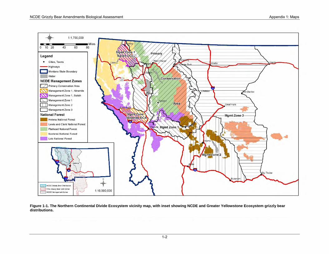
NCDE Grizzly Bear Amendments Biological Assessment Appendix 1: Maps
1-2
Figure 1-1. The Northern Continental Divide Ecosystem vicinity map, with inset showing NCDE and Greater Yellowstone Ecosystem grizzly bear distributions.
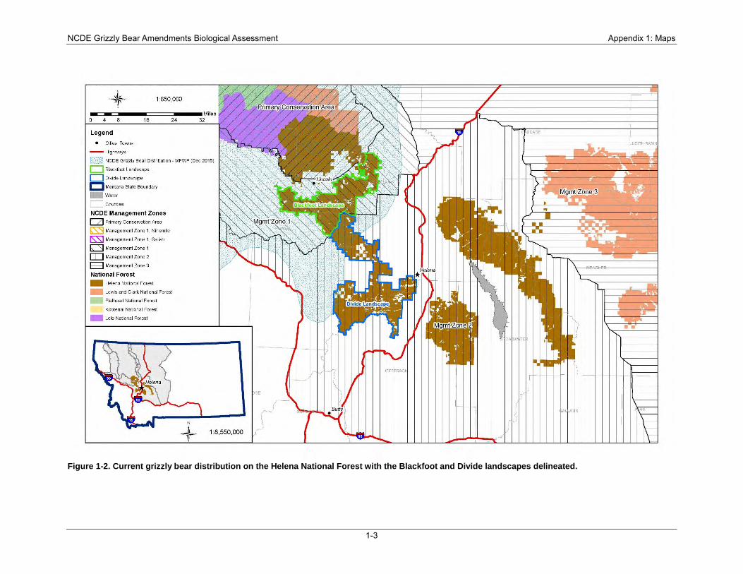
NCDE Grizzly Bear Amendments Biological Assessment Appendix 1: Maps
1-3
Figure 1-2. Current grizzly bear distribution on the Helena National Forest with the Blackfoot and Divide landscapes delineated.
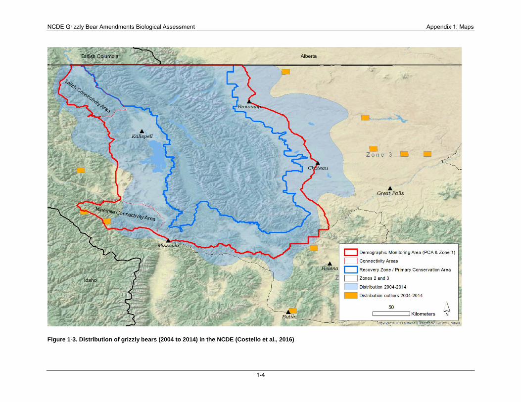
NCDE Grizzly Bear Amendments Biological Assessment Appendix 1: Maps
1-4
Figure 1-3. Distribution of grizzly bears (2004 to 2014) in the NCDE (Costello et al., 2016)
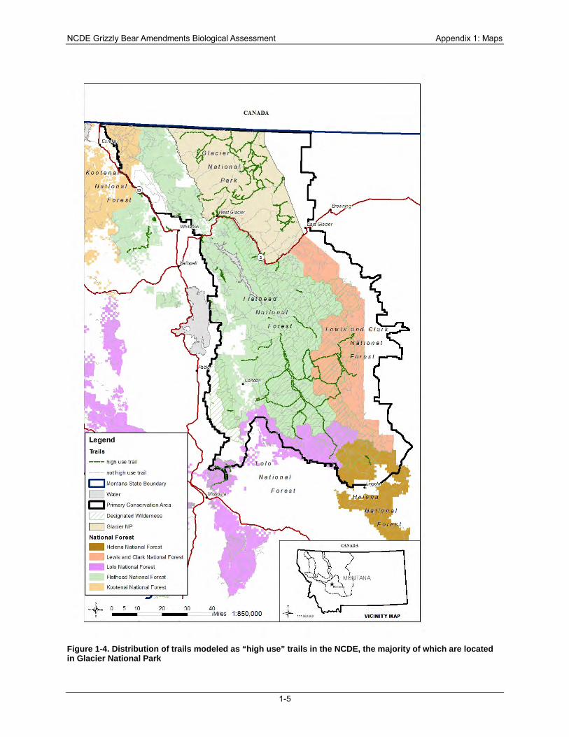
NCDE Grizzly Bear Amendments Biological Assessment Appendix 1: Maps
1-5
Figure 1-4. Distribution of trails modeled as “high use” trails in the NCDE, the majority of which are located in Glacier National Park
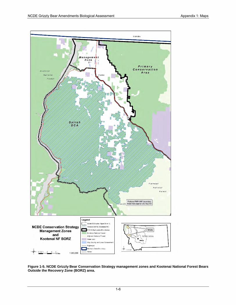
NCDE Grizzly Bear Amendments Biological Assessment Appendix 1: Maps
1-6
Figure 1-5. NCDE Grizzly Bear Conservation Strategy management zones and Kootenai National Forest Bears Outside the Recovery Zone (BORZ) area.
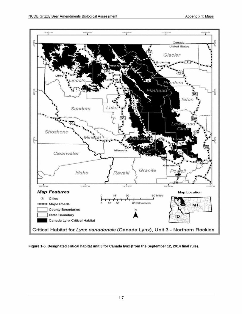
NCDE Grizzly Bear Amendments Biological Assessment Appendix 1: Maps
1-7
Figure 1-6. Designated critical habitat unit 3 for Canada lynx (from the September 12, 2014 final rule).
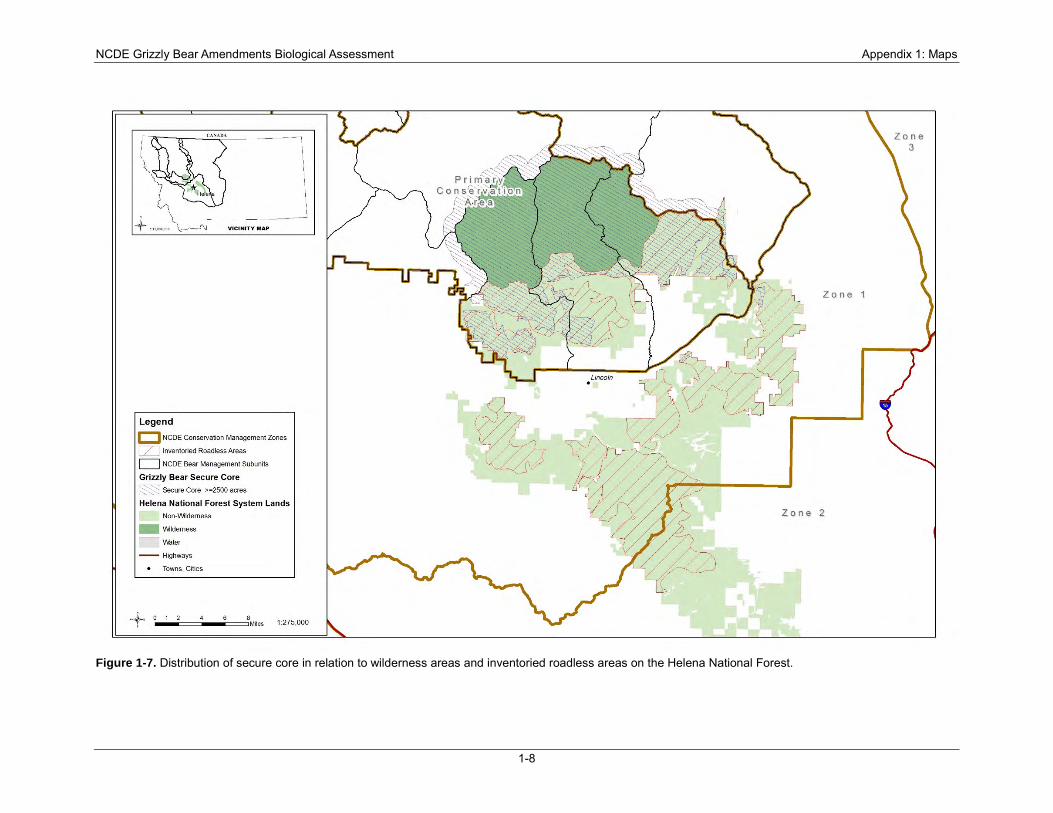
NCDE Grizzly Bear Amendments Biological Assessment Appendix 1: Maps
1-8
Figure 1-7. Distribution of secure core in relation to wilderness areas and inventoried roadless areas on the Helena National Forest.
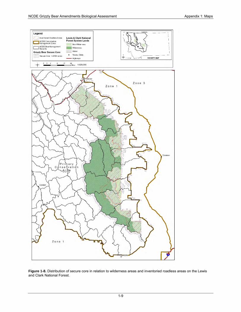
NCDE Grizzly Bear Amendments Biological Assessment Appendix 1: Maps
1-9
Figure 1-8. Distribution of secure core in relation to wilderness areas and inventoried roadless areas on the Lewis and Clark National Forest.
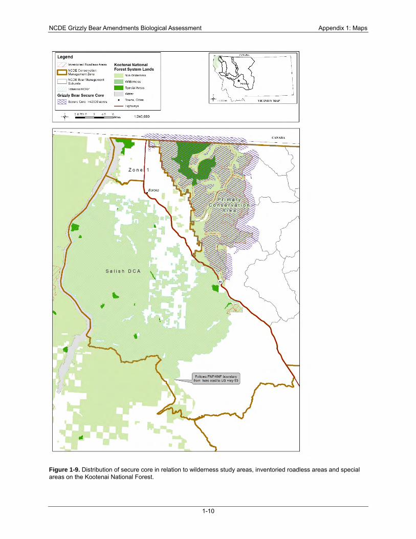
NCDE Grizzly Bear Amendments Biological Assessment Appendix 1: Maps
1-10
Figure 1-9. Distribution of secure core in relation to wilderness study areas, inventoried roadless areas and special areas on the Kootenai National Forest.
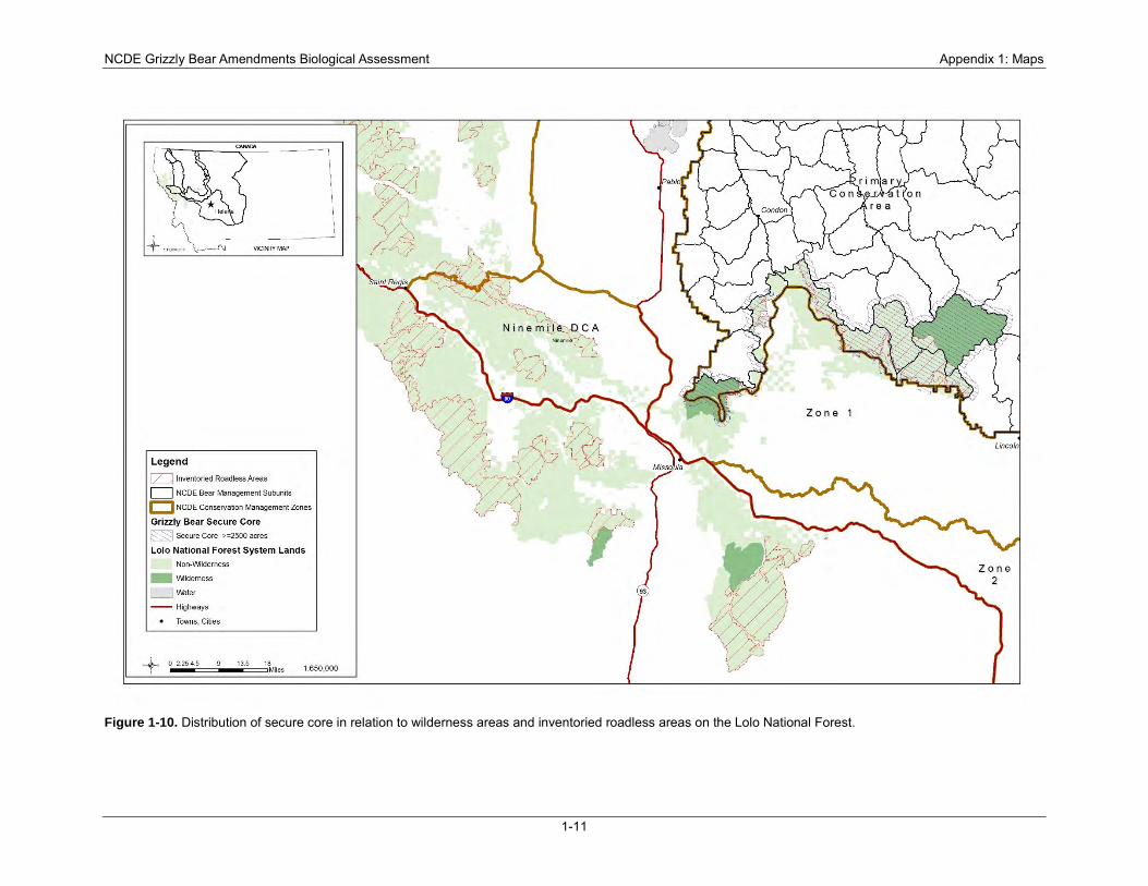
NCDE Grizzly Bear Amendments Biological Assessment Appendix 1: Maps
1-11
Figure 1-10. Distribution of secure core in relation to wilderness areas and inventoried roadless areas on the Lolo National Forest.
NCDE Grizzly Bear Amendments Biological Assessment Appendix 2: Text of Grizzly Bear Amendments
page 2-1
Appendix 2: Text of Grizzly Bear Amendments
The following is the preferred alternative for purposes of initiating ESA section 7 consultation. These plan components that would support continued recovery of the NCDE grizzly bear population would be incorporated into the Helena, Lewis and Clark, Kootenai, and Lolo forest plans.
Wildlife (WL)
Desired Conditions NCDE-DC-WL-01. Within the NCDE primary conservation area, zone 1 (including the Salish and Ninemile Demographic Connectivity Areas) and zone 2, bear attractants on National Forest System lands are stored in a manner that reduces the risk of grizzly bear–human conflicts in the NCDE. NCDE-DC-WL-02. Within the NCDE primary conservation area and zone 1 (including the Salish and the Ninemile demographic connectivity area), grizzly bear habitat on National Forest System lands contributes to sustaining the recovery of the grizzly bear population in the NCDE and contributes to connectivity with neighboring grizzly bear recovery zones. NCDE-DC-WL-03. The risk of grizzly bear-human conflicts is reduced by information, education, and design features or criteria for management activities.
Standards NCDE-STD-WL-01. Grizzly bear habitat on National Forest System lands in the NCDE shall be delineated and managed as the Primary Conservation Area, zone 1 (including the Salish and Ninemile demographic connectivity areas), zone 2 or zone 3 (see figure 1 and figure 2 or subsequent USFWS updates is applicable). NCDE-STD-WL-02. Within the NCDE primary conservation area, zone 1 (including the Salish and Ninemile demographic connectivity areas) and zone 2, Food/Wildlife Attractant Storage Special Order(s) shall apply to National Forest System lands. NCDE-STD-WL-03. In each bear management subunit within the NCDE primary conservation area, temporary changes in the open motorized route density, total motorized route density, and secure core shall be calculated for roads used for projects (as defined by “project (in grizzly bear habitat in the NCDE)” during the non-denning season (see glossary). Calculations will include estimated changes for each year of the anticipated duration of the project and shall be incorporated into the 10-year running average required by standard NCDE-STD-AR-03.
Guidelines NCDE-GDL-WL 01. Within the NCDE primary conservation area, zone 1 (including the Salish and Ninemile demographic connectivity areas) and zone 2, contractors, permittees, lessees, operators, and their employees should be informed of Food/Wildlife Attractant Storage Special Order(s) and procedures for safely working and recreating in grizzly bear country, prior to turn-out of livestock or beginning work and annually thereafter, in order to reduce the risk of grizzly bear–human conflicts. NCDE-GDL-WL-02. Within the NCDE primary conservation area, zone 1 (including the Salish and Ninemile demographic connectivity areas) and zone 2, if a contractor, permittee, lessee, operator or their employees elect to camp on National Forest System lands other than in a developed recreation site, a site evaluation should be prepared by a wildlife biologist and written authorization (i.e., a campsite agreement that includes the Food/Attractant Storage Special Order) should be provided before the campsite is established. The purpose is to reduce the risk of grizzly bear-human conflicts.
NCDE Grizzly Bear Amendments Biological Assessment Appendix 2: Text of Grizzly Bear Amendments
page 2-2
NCDE-GDL-WL-03. Within the NCDE primary conservation area and zone 1 (including the Salish and Ninemile Demographic Connectivity Areas), clover should not be used in seed mixes on National Forest System lands. Native seed mixes or those that are less palatable to grizzly bears should be used so that seeded areas do not become an attractant.
Access and Recreation (AR)
Desired Conditions NCDE-DC-AR-01. Within the NCDE primary conservation area, motorized access provides for multiple uses (such as harvesting of timber and non-timber forest products; hunting, fishing, and recreation opportunities) on National Forest System lands while providing open motorized route density (OMRD), total motorized route density (TMRD) and secure core levels that contribute to sustaining recovery of the grizzly bear population in the NCDE. NCDE-DC-AR-02. Within the NCDE Primary Conservation Area, the number, capacity, and improvements of developed recreation sites provide for user comfort and safety while minimizing the risk of grizzly bear–human conflicts on National Forest System lands. NCDE-DC-AR-03. Within each bear management unit in the primary conservation area, increases in the number and capacity of developed recreation sites on National Forest System lands that are designed and managed for overnight use during the non-denning season, are at levels that contribute to sustaining the recovery of the grizzly bear population in the NCDE.
Standards NCDE-STD-AR-01. Within the NCDE primary conservation area, motorized use of roads with public restrictions shall be permitted for administrative use (see glossary), as long as it does not exceed either 6 trips (3 round trips) per week OR one 30-day unlimited use period during the non-denning season (see glossary). The exception to this standard is:
• Emergency situations as defined by 36 CFR 218.21. Note: Administrative use is not included in baseline calculations and is not included in calculations of net increases or decreases. If the level of administrative use exceeds this standard, the use is counted as a project (see “project (in grizzly bear habitat in the NCDE)” in the glossary). NCDE-STD-AR-02. In each bear management subunit within the NCDE primary conservation area, there shall be no net decrease to the baseline (see glossary) for secure core and no net increase to the baseline for open motorized route density or total motorized route density on National Forest System lands during the non-denning season (see glossary). The following conditions are not considered a net increase/decrease from the baseline:
• administrative use (see glossary);
• temporary use of a motorized route for a project (see “project (in grizzly bear habitat in the NCDE)” that meets the conditions stipulated in NCDE-STD-AR-03);
• mining activities (as authorized under the Mining Law of 1872) and oil and gas activities (as authorized under the Federal Onshore Oil and Gas Leasing Reform Act of 1987) conducted in accordance with valid existing rights and applicable standards and guidelines listed under NCDE-MIN;
• updated/improved data on a motorized route without an actual change on the ground;
• changes in technology or projections resulting in changed open motorized route density, total motorized route density, or secure core values without actual change on the ground (e.g., a switch in
NCDE Grizzly Bear Amendments Biological Assessment Appendix 2: Text of Grizzly Bear Amendments
page 2-3
geodetic reference system from the North American Datum of 1927 to the North American Datum of 1983);
• a road closure location is moved a short distance to a better location (e.g., to the nearest intersection or turnout) to allow a turn-around providing for public safety, to reduce vandalism, or to improve enforcement of the closure;
• the agency exchanges, acquires, buys or sells lands with motorized routes;
• a change in a motorized route is necessary to comply with Federal laws;
• a change in a motorized route is necessary to address grizzly bear–human conflicts, human safety concerns, or resource damage/concerns (e.g., a road paralleling a stream may be decommissioned and replaced by a new upslope road to reduce water quality impacts);
• a change is made by an adjacent non-federal landowner that decreases the percentage of secure core or increases OMRD or TMRD values on adjacent national forest;
• use of a motorized route for emergency situations as defined by 36 CFR 218.21;
• temporary roads (see glossary).
NCDE-STD-AR-03. In each bear management subunit within the NCDE primary conservation area, temporary changes in the open motorized route density, total motorized route density, and secure core shall be allowed for projects (as defined by “project (in grizzly bear habitat in the NCDE)” in the glossary). The 10-year running average for open motorized route density, total motorized route density, and secure core shall not exceed the following limits during the non-denning season (see glossary):
• 5% temporary increase in open motorized route density in each bear management subunit (i.e., OMRD baseline plus 5%);
• 3% temporary increase in total motorized route density in each bear management subunit (i.e., TMRD baseline plus 3%);
• 2% temporary decrease in secure core in each bear management subunit (i.e., secure core baseline minus 2%).
Exceptions to this standard include:
• Temporary changes for emergency situations as defined by 36 CFR 218.21;
• Temporary changes for actions where valid existing rights preclude or constrain agency discretion (e.g., certain contracts, permits, leases, etc.).
Refer to appendix 1 for examples of how to calculate and apply the 10-year running average and temporary increase/decrease. NCDE-STD-AR-04. Within the NCDE primary conservation area, a restricted road may be temporarily opened for public motorized use to allow authorized uses (such as firewood gathering), provided the period of use does not exceed 30 consecutive days during one non-denning season and occurs outside of spring and fall bear hunting seasons. However, temporary public use of a restricted road shall not be authorized in secure core (see glossary). NCDE-STD-AR-05. Within the NCDE primary conservation area, the number and capacity of developed recreation sites on National Forest System lands that are designed and managed for overnight use by the public during the non-denning season (e.g., campgrounds, cabin rentals, huts, guest lodges, recreation residences) shall be limited to one increase above the baseline (see glossary) in the number or capacity per decade per bear management unit (BMU). The following conditions are not considered an increase from the baseline:
NCDE Grizzly Bear Amendments Biological Assessment Appendix 2: Text of Grizzly Bear Amendments
page 2-4
• the agency obtains better information or updated information in its database(s); • the agency acquires land which contains developed recreation sites; • the agency increases the number or capacity of a developed recreation site in order to comply with
Federal laws; • the agency maintains or modifies an existing overnight developed or dispersed recreation site in such
a way that does not increase the number or capacity of the site (e.g., installing a pit toilet to avoid damage to water resources or installing a bear-resistant food storage structure to reduce grizzly bear-human conflicts);
• the agency modifies an existing developed recreation site to enhance human safety (e.g., enlarging a road pull-out to allow trailers to safely turn around) ;
• the agency operates a developed recreation site to allow overnight use only during the denning season (see glossary);
• the agency makes a corresponding reduction in the number or capacity of overnight developed recreation sites in the same BMU through any of the following means: (1) equal reduction in capacity at another site; (2) closure of a developed site(s); or (3) consolidation and/or elimination of dispersed camping, when and where it can be enforced effectively and it is reasonably assured that new dispersed sites will not develop nearby. Note: If these measures are used to offset an increase in number or capacity, they must be in place before the initiation of the increase. If the agency reduces the number or capacity of developed sites below baseline levels, these reductions may be used at a future date to mitigate equivalent impacts of an increase, expansion, or change of use in developed sites within that BMU. Note: This standard does not apply to dispersed recreations sites or to developed recreation sites managed for day-use only (e.g., outfitter camps, roadside trail crossings or interpretive pull-outs; trailheads, picnic areas, or boat launches that are closed at night; ski areas that do not have overnight lodging).
NCDE-STD-AR-06. Within the NCDE primary conservation area, new or re-authorized recreation permits shall include a clause providing for modification, cancellation, suspension, or temporary cessation of activities if needed to resolve a grizzly bear–human conflict situation. NCDE-STD-AR-07. Within the NCDE primary conservation area, new or re-authorized permits for ski areas on National Forest System lands that operate during the non-denning season shall include requirements to limit the risk of grizzly bear-human conflicts (e.g., to store garbage in a bear-resistant manner). NCDE-STD-AR-08. Within modeled grizzly bear denning habitat in the NCDE primary conservation area, there shall be no net increase in the percentage of area or miles of routes designated for motorized over-snow vehicle use on National Forest System lands during the den emergence time period (see glossary).
Guidelines NCDE-GDL-AR-01. In each bear management subunit within the NCDE primary conservation area, each project (as defined by “project (in grizzly bear habitat in the NCDE)” in the glossary) should be designed so that on-the-ground implementation does not exceed 5 years, to reduce the potential duration of grizzly bear disturbance or displacement due to project-related activities. Exceptions may be made where necessary, for example to accommodate:
actions where valid existing rights preclude or constrain agency discretion (e.g., certain contracts, permits, leases);
prescribed burning (including slash disposal), best management practices to protect water quality, or required reforestation activities; or
NCDE Grizzly Bear Amendments Biological Assessment Appendix 2: Text of Grizzly Bear Amendments
page 2-5
emergency situations as defined by 36 CFR 218.21. If an extension to the 5-year time limitation is required (e.g., to meet contractual obligations or to complete on-the-ground treatments), the reasons should be documented in writing prior to authorization of the extension. NCDE-GDL-AR-02. Within the NCDE primary conservation area, secure core, open motorized route density and total motorized route density should be restored to pre-project levels (as defined by “project (in grizzly bear habitat in the NCDE)” in the glossary) within 1 year after completion of the project, to reduce the potential duration of grizzly bear disturbance due to project-related activities. Exceptions may be made where necessary, for example to accommodate: actions where valid existing rights preclude or constrain agency discretion (e.g., certain contracts,
permits, leases); prescribed burning (including slash disposal), best management practices to protect water quality, or
required reforestation activities; or emergency situations as defined by 36 CFR 218.21.
If an extension to the 1-year time limitation is made (e.g., to meet contractual obligations or to complete on-the-ground treatments), the reasons should be documented in writing prior to authorization of the extension. NCDE-GDL-AR-03. Within the NCDE primary conservation area, if the number or capacity of day use or overnight developed recreation sites is increased, the project should include one or more measures to reduce the risk of grizzly-bear human conflicts in that BMU. These measures can include but are not limited to additional public information and education; providing backcountry food-hanging poles or bear-resistant food or garbage storage devices; including design criteria that would limit capacity increases to those needed for public health and safety; and increasing law enforcement and patrols.
Terrestrial Ecosystems Vegetation (VEG)
Desired Conditions NCDE-DC-VEG-01. Within the NCDE primary conservation area, the amount, type and distribution of vegetation provides for the ecological, social and economic sustainability of National Forest System lands, while providing habitat components that contribute to sustaining the recovery of the grizzly bear population in the NCDE. NCDE-DC-VEG-02. Within the NCDE primary conservation area, there is a mosaic of successional stages to provide for grizzly bear habitat needs over the long term.
Guidelines NCDE-GDL-VEG-01. Within the NCDE primary conservation area, measures to reduce the risk of disturbance to the grizzly bear population should be incorporated into vegetation and fuels project design criteria, which vary on a site-specific basis (e.g., some activities should be restricted in spring habitat during the spring; areas with low levels of human activity should be provided adjacent to areas with high levels of disturbance). Note: Management activities such as pre-commercial thinning, burning, weed spraying, and implementation of road best management practices may need to be completed during the spring time period in order to meet resource objectives (especially if needed to prevent resource damage), in which case other measures should be used to reduce the risk of disturbance (e.g., limiting the duration of the activity or limiting use of closed roads). NCDE-GDL-VEG-02. Within the NCDE primary conservation area, vegetation management activities should be designed to avoid detrimental effects on the grizzly bear population and to include one or more measures to protect, maintain, increase and/or improve grizzly habitat quantity or quality (e.g., promoting
NCDE Grizzly Bear Amendments Biological Assessment Appendix 2: Text of Grizzly Bear Amendments
page 2-6
growth of berry-producing shrubs, forbs, or grasses known to be bear foods) in areas where it would not increase the risk of grizzly bear–human conflicts. NCDE-GDL-VEG-03. Within the NCDE primary conservation area, measures to retain cover (where present) along a portion of grass/forb/shrub openings, riparian wildlife habitat, or wetlands should be incorporated in project design criteria (this varies on a site-specific basis). NCDE-GDL-VEG-04. Within the NCDE primary conservation area, vegetation management projects (including timber sales and other non-commercial vegetation management contracts) should include a clause providing for modification, cancellation, suspension, or temporary cessation of activities, if needed, to resolve a grizzly bear-human conflict situation. NCDE-GDL-VEG-05. To reduce the risk of grizzly-bear human conflicts within the NCDE primary conservation area, vegetation management activities designed to enhance grizzly habitat (e.g., increase huckleberry production) should not occur in or next to campgrounds, administrative facilities or other developed recreation sites that operate during the non-denning season.
Grazing (GRZ)
Desired Condition NCDE-DC-GRZ-01.Within the NCDE primary conservation area, the number of, capacity of, and improvements on cattle and sheep grazing allotments support ecologically sustainable grazing, and temporary grazing permits are used for effective management of noxious weeds, while minimizing the risk of bear-human conflicts on National Forest System lands.
Standards NCDE-STD-GRZ-01. Within the NCDE primary conservation area and zone 1 (including the Salish and Ninemile demographic connectivity areas), new or re-authorized grazing permits and annual operating plans shall incorporate requirements to reduce the risk of grizzly bear–human conflicts (e.g., food/wildlife attractant storage special order). New or re-authorized permits shall include a clause providing for modification, cancellation, suspension, or temporary cessation of activities, if needed, to resolve a grizzly bear–human conflict situation. NCDE-STD-GRZ-02. Within the NCDE primary conservation area, a sheep grazing permit in non-use status shall not be allowed to increase allowable animal unit months beyond what was previously permitted prior to being in non-use when it is returned to use. NCDE-STD-GRZ-03. Within the NCDE primary conservation area and zone 1 (including the Salish and Ninemile demographic connectivity areas), permits for livestock grazing shall include a provision that requires reporting livestock carcasses within 24 hours of discovery, which shall be followed by proper disposal of the carcass. Bone yards shall not be established on National Forest System lands. NCDE-STD-GRZ-04. Within the NCDE primary conservation area and zone 1 (including the Salish and Ninemile demographic connectivity areas), there shall be no net increase in the number of active sheep allotments or in permitted sheep animal unit months above the baseline (see glossary) on National Forest System lands. Allowable animal unit months shall not be increased for inactive allotments. Note: Existing allotments may be combined or divided as long doing so does not result in grazing allotments in currently un-allotted lands or an increase in animal unit months . NCDE-STD-GRZ-05. Within the NCDE Primary Conservation Area, there shall be no net increase in the number of active cattle grazing allotments above the baseline (see glossary) on National Forest System lands. Note: Existing allotments may be combined or divided as long as doing so does not result in grazing allotments in currently un-allotted lands.
NCDE Grizzly Bear Amendments Biological Assessment Appendix 2: Text of Grizzly Bear Amendments
page 2-7
NCDE-STD-GRZ-06. Within the NCDE primary conservation area and zone 1 (including the Salish and Ninemile demographic connectivity areas), temporary permits for grazing by small livestock for purposes such as controlling invasive exotic weeds or reducing fire risk, or for trailing of small livestock across National Forest System lands, shall not result in an increase in bear/small livestock conflicts.
Guidelines NCDE-GDL-GRZ-01. Within the NCDE primary conservation area, the number of open or active sheep grazing allotments on NFS lands should be reduced if an opportunity exists with willing permittee, to reduce the risk of conflicts with grizzly bears. NCDE-GDL-GRZ-02. Within the NCDE primary conservation area, an allotment management plan and plan of operation should specify any needed measures to protect key grizzly bear food production areas (e.g., wet meadows, stream bottoms, aspen groves, and other riparian wildlife habitats) from conflicting and competing use by livestock (this varies on a site-specific basis).
Special Forest Products (SFP)
Desired Condition NCDE-DC-SFP-01. National Forest System lands provide a variety of public services and special forest products (such as mushrooms, huckleberries, firewood) while minimizing the risk of grizzly bear–human conflicts on National Forest System lands in the NCDE. See also NCDE-DC-WL-01 and NCDE-DC-WL-02.
Standard NCDE-STD-SFP-01. Special use permits for apiaries (beehives) located on National Forest System lands shall incorporate measures including electric fencing to reduce the risk of grizzly bear–human conflicts, as specified in the food/wildlife attractant storage special order.
Renewable/Non-Renewable Energy and Mineral Resources (MIN)
Desired Condition NCDE-DC-MIN-01. Mineral materials are available based upon public interest, in-service needs, material availability, and valid existing rights, where consistent with desired conditions for other resources.
Standards NCDE-STD-MIN-01. Within the NCDE primary conservation area and zone 1 (including the Salish and Ninemile demographic connectivity areas), mining activities (as authorized under the Mining Law of 1872) and oil and gas activities (as authorized under the Federal Onshore Oil and Gas Leasing Reform Act of 1987) occurring on National Forest System lands, where feasible shall avoid, minimize and/or mitigate environmental impacts to grizzly bears or their habitat, subject to valid existing rights. Stipulations or mitigation measures already included in existing leases, permits, or plans of operation on National Forest System lands shall not be changed, nor will additional stipulations or mitigation measures be added, without the lease, permit, or plan of operation holder’s agreement. NCDE-STD-MIN-02. Within the NCDE primary conservation area and zone 1 (including the Salish and Ninemile demographic connectivity areas), new or re-authorized permits, leases, and/or plans of operation shall include a provision for modification or temporary cessation of activities if needed to resolve a grizzly bear–human conflict situation.
NCDE Grizzly Bear Amendments Biological Assessment Appendix 2: Text of Grizzly Bear Amendments
page 2-8
NCDE-STD-MIN-03. Within the NCDE Primary Conservation Area and zone 1 (including the Salish and Ninemile demographic connectivity areas), new plans of operation, permits, and/or leases for mineral activities shall include measures to reasonably mitigate potential impacts of mineral development for the following: land surface and vegetation disturbance; water table alterations that affect bear foods on the surface; and construction, operation, and reclamation of mine-related facilities such as impoundments, rights of
way, motorized routes, pipelines, canals, transmission lines or other structures. NCDE-STD-MIN-04. Within the NCDE primary conservation area and zone 1 (including the Salish and Ninemile demographic connectivity areas), in addition to measures included in the food/wildlife attractant storage special order(s), new plans of operation, permits, and/or leases for mineral activities shall include the following measures regarding grizzly bear attractants: bear resistant food storage and garbage containers shall be used at development sites and at any
campgrounds or dispersed sites where exploration or production-related human occupancy is anticipated; garbage shall be removed in a timely manner; road kills shall be removed daily during active operating periods to a designated location determined
in close coordination with Montana Fish, Wildlife and Parks; feeding of wildlife shall not be allowed; and locations of work camps shall be approved in advance of operations. Food storage requirements shall
be strictly adhered to in any work camps. NCDE-STD-MIN-05. Within the NCDE primary conservation area and zone 1 (including the Salish and Ninemile demographic connectivity areas), if minerals activities have the potential to adversely affect grizzly bears or their habitat as determined by a site-specific analysis, new plans of operation, permits, and/or leases for mineral activities shall include the following mitigation measures, stipulations, or surface use criteria regarding grizzly bear habitat: Ground-disturbing activities in identified grizzly bear spring habitat (as identified in a site specific
biological evaluation or other environmental document) shall be avoided between April 1 and June 30. If timing restrictions are not practicable, other measures shall be taken to reasonably mitigate negative impacts of mineral activity to grizzly bears; Seismic activity in identified grizzly bear denning habitat (as identified in a site specific biological
evaluation or other environmental document) shall be avoided during the denning season (see glossary). If timing restrictions are not practicable, other measures shall be taken to reasonably mitigate negative impacts of mineral activity to grizzly bears; Cumulative impacts of multiple, concurrent seismic and/or drilling operations shall be limited by
timing restrictions. If timing restrictions are not practicable, reasonable and appropriate measures shall be taken to mitigate negative impacts to the grizzly bear; Reasonable and appropriate measures regarding the maintenance, rehabilitation, restoration or
mitigation of functioning aquatic systems and riparian habitat conservation areas shall identify how reclamation will occur, plant species to be used in reclamation, a timeframe of when reclamation will be completed, and monitoring criteria; and
Reclamation and revegetation of motorized routes, drilling pads, and other areas disturbed from mineral activities shall be completed as soon as practicable by the operator.
NCDE-STD-MIN-06. Within the NCDE primary conservation area and zone 1 (including the Salish and Ninemile demographic connectivity areas), if mineral activities have the potential to adversely affect
NCDE Grizzly Bear Amendments Biological Assessment Appendix 2: Text of Grizzly Bear Amendments
page 2-9
grizzly bears or their habitat as determined by a site-specific analysis, new plans of operation, permits, and/or leases shall include the following mitigation measures regarding motorized access: Public motorized use that is not associated with minerals activities shall be prohibited on motorized
routes constructed for exploration and/or development; A traffic management plan shall be developed as part of the proposed activity to identify when and
how motorized routes will be used, maintained, and monitored (if required), and how motorized route standards and guidelines will be implemented after activities have ended; Helicopter use associated with seismic activity, exploration, drilling or development must follow an
approved plan or permit; Speed limits shall be adopted on motorized routes if needed to prevent or reduce collisions with
grizzly bears. NCDE-STD-MIN-07. Within the NCDE primary conservation area and zone 1 (including the Salish and Ninemile demographic connectivity areas), minerals contractors and lessees shall require employees to attend training related to safely living near and working in grizzly bear habitat prior to starting work, and on an annual basis thereafter. NCDE-STD-MIN-08. Within the NCDE primary conservation area, new leases for leasable minerals shall include a no surface occupancy stipulation (see glossary).
Guidelines NCDE-GDL-MIN-01. Within the NCDE primary conservation area and zone 1 (including the Salish and Ninemile demographic connectivity areas), in addition to forest-wide guidelines, the following guidelines apply to new leasable minerals activities including leases, surface use plans for proposed wells or operations, or permits to conduct seismic exploration or drilling. To reduce potential grizzly bear disturbance or displacement, helicopter use plans should: Avoid establishing recurring helicopter use (see glossary), especially in spring habitats or other known
important grizzly bear habitats or use areas; and Avoid establishing landing zones, especially in spring habitats or other known important grizzly bear
habitats or use areas. If a landing zone is deemed necessary for safe implementation of the seismic or surface use plan or permit to drill, the landing zone should be constructed only in an area that has had site-specific analysis and approval.
NCDE-GDL-MIN-02. Within the NCDE primary conservation area and zone 1 (including the Salish and Ninemile demographic connectivity areas), leasable energy activities should use the best available noise-reduction technology on equipment and motorized vehicles to reduce potential disturbance or displacement of grizzly bears, whenever possible. NCDE-GDL-MIN-03. Within the NCDE primary conservation area and zone 1 (including the Salish and Ninemile demographic connectivity areas), along motorized routes, seismic corridors, and pipelines constructed for leasable energy activities, wildlife cover should be maintained at regular intervals where present (this varies on a site specific basis), in order to provide habitat connectivity for grizzly bears. NCDE-GDL-MIN-04. Within the NCDE primary conservation area and zone 1 (including the Salish and Ninemile demographic connectivity areas), for locatable and non-energy leasable minerals activities with the potential to adversely affect the grizzly bear or its habitat (this varies on a site-specific basis), the following tiered measures should be considered to mitigate impacts to grizzly bear habitat. Beginning at Step 1, any subsequent steps would be implemented only if the prior steps are not possible or achievable.
Step 1: The operator should reclaim the affected area back to suitable bear habitat that has similar or improved characteristics and qualities as the original habitat (such as the same native vegetation).
NCDE Grizzly Bear Amendments Biological Assessment Appendix 2: Text of Grizzly Bear Amendments
page 2-10
Step 2: If Step 1 is not attainable, operators should either acquire a perpetual conservation easement (or easements) or purchase comparable or better replacement grizzly bear habitat within the primary conservation area. Acquisition of habitat within connectivity corridors could also be considered for mitigation, when appropriate. Habitat acquired for mitigation may require a purchase rate of >1:1 on an acreage basis, depending on the quality of habitat degraded and habitat available for acquisition.
Step 3: If Steps 1 and 2 are not achievable, the next option is to offset negative effects to bears and grizzly bear habitat with other appropriate types of actions.
NCDE-GDL-MIN-05. Within the NCDE primary conservation area and zone 1 (including the Salish and Ninemile demographic connectivity areas), carrying of bear deterrent spray should be recommended to mineral permittees, lessees and operators to reduce the risk of grizzly bear-human conflicts. NCDE-GDL-MIN-06. Within the NCDE primary conservation area and zone 1(including the Salish and Ninemile demographic connectivity areas), available resources at existing gravel pits should be used before constructing new pits to reduce the risk of grizzly bear disturbance or displacement associated with blasting of rock or crushing of gravel.
Helena National Forest—Zone 1, Zone 2
Desired Conditions NCDE-HNF Zone 1-DC-01. Within zone 1 on the Helena-Lewis and Clark National Forest, roads and trails provide for public and administrative access to National Forest System lands. Grizzly bear habitat in zone 1 contributes to sustaining recovery of the grizzly bear population in the NCDE and providing the opportunity for movement of male bears to provide genetic connectivity with the Greater Yellowstone Ecosystem. NCDE-HNF Zone 1&2-DC-02. On the Helena-Lewis and Clark National Forest within zone 1 and the portion of zone 2 west of Interstate 15, National Forest System lands adjacent to highways are consolidated and other efforts to reduce barriers to genetic connectivity of grizzly bear populations are supported.
Standards NCDE-HNF Zone 1-STD-01. Within zone 1 on the Helena-Lewis and Clark National Forest (figure 1-1), there shall be no net increase above the baseline in density of motorized routes (roads and trails) open to public motorized use during the non-denning season on NFS lands. Open motorized route density is calculated by dividing the total miles of open motorized routes on NFS lands in zone 1 by the total square miles of NFS land area in that same area (figure 1-1). This standard does not apply to the following:
motorized use by agency personnel or others authorized by the appropriate agency personnel;
temporarily opening a motorized route for a short period of time to allow for public firewood gathering and other authorized use;
updated or improved data without an actual change on the ground;
changes in technology or projections result in changed calculations without actual change on the ground (e.g., a switch in geodetic systems from North American Datum of 1927 to the North American Datum of 1983);
a road closure location is moved a short distance to a better location (e.g., to the nearest intersection or turnout ) to allow turn-arounds providing for public safety, to reduce vandalism, or to improve enforcement of the closure;
NCDE Grizzly Bear Amendments Biological Assessment Appendix 2: Text of Grizzly Bear Amendments
page 2-11
the agency exchanges, acquires, buys or sells lands with motorized routes; a change in a motorized route is necessary to comply with Federal laws; motorized use for mining activities (as authorized under the Mining Law of 1872) and oil
and gas activities (as authorized under the Federal Onshore Oil and Gas Leasing Reform Act of 1987) conducted in accordance with valid existing rights and applicable standards and guidelines;
a change in a motorized route is necessary to address grizzly bear-human conflicts, resource damage, or human safety concerns;
use of motorized routes in emergency situations as defined by 36 CFR 218.21; temporary roads (see glossary).
Kootenai National Forest—Zone 1
Desired Conditions NCDE-KNF Zone 1-DC-01. Within zone 1 (including the Salish demographic connectivity area), roads provide for public and administrative access to National Forest System lands while contributing to sustaining the grizzly bear population in the NCDE. The demographic connectivity area provides habitat that can be used by female grizzly bears and allows for bear movement between grizzly bear ecosystems. NCDE-KNF Zone 1-DC-02. In areas between the primary conservation area and the Salish demographic connectivity area, National Forest System lands are consolidated and conservation easements with willing landowners are supported in a manner that provides habitat connectivity and facilitates movement of wildlife. See also FW-DC-WL-17, FW-GDL-WL-14 and GA-DC-WL-TOB-02.
Standards NCDE- KNF Zone 1-STD-01. Within zone 1 (including the Salish demographic connectivity area) on the Kootenai National Forest, there shall be no increases in permanent linear miles of open roads, total roads, or motorized trails within the bears outside recovery zone polygons, with listed exceptions (Kootenai forest plan, appendix B). A temporary increase in open and total miles of road is allowed under specified conditions (Kootenai forest plan, appendix B p. 150). NCDE-KNF Zone 1-STD-02. Within zone 1 (including the Salish demographic connectivity area) on the Kootenai National Forest, National Forest System lands which lie outside the area covered by the Tobacco bears outside the recovery zone polygons (Kootenai forest plan, appendix B page 150-151) shall be managed according to Kootenai National Forest Plan direction.
Lolo National Forest—Zone 1
Desired Conditions NCDE-LNF Zone 1-DC-01. Within the Lolo National Forest portion of NCDE zone 1 (including the Ninemile demographic connectivity area), roads provide for public and administrative access to National Forest System lands while contributing to sustaining the grizzly bear population in the NCDE. The Ninemile demographic connectivity area provides habitat that can be used by female grizzly bears and allows for bear movement between grizzly bear ecosystems. NCDE-LNF Zone 1-DC-02. In areas between the primary conservation area and the Ninemile demographic connectivity area, National Forest System lands are consolidated and conservation easements with willing landowners are supported in a manner that provides habitat connectivity and facilitates movement of wildlife.
NCDE Grizzly Bear Amendments Biological Assessment Appendix 2: Text of Grizzly Bear Amendments
page 2-12
Standards NCDE-LNF Zone 1-STD-01. Within zone 1 (outside the Ninemile demographic connectivity area) on the Lolo National Forest, there shall be no net increase above the baseline (see glossary) in the density of roads open to public motorized use during the non-denning season on National Forest System lands. Inside the Ninemile demographic connectivity area, there shall be no net increase above the baseline (see glossary) in the density of roads and trails open to public motorized use during the non-denning season on National Forest System lands. Density is calculated by dividing the total miles open to public motorized use on NFS lands during the non-denning season, by the total square miles of NFS lands in that same area. This standard does not apply to the following:
• motorized use by agency personnel or others authorized by the appropriate agency personnel;
• temporarily opening a road for a short periods of time to allow for public firewood gathering and other authorized use;
• updated/improved data on a motorized route without an actual change on the ground;
• changes in technology or projections result in changed calculations without actual change on the ground (e.g., a switch in geodetic systems from North American Datum of 1927 to the North American Datum of 1983);
• a road closure location is moved a short distance (e.g., to the nearest intersection or turnout) to a better location to allow turn-arounds providing for public safety, to reduce vandalism, or to improve enforcement of the closure;
• the agency exchanges, acquires, buys or sells lands with motorized routes;
• a change in an open road is necessary to comply with Federal laws;
• motorized use for mining activities (as authorized under the Mining Law of 1872) and oil and gas activities (as authorized under the Federal Onshore Oil and Gas Leasing Reform Act of 1987) conducted in accordance with valid existing rights and applicable standards and guidelines;
• a change in motorized route is necessary to address grizzly bear–human conflicts, human safety concerns or resource damage/concerns (e.g., a road paralleling a stream may be decommissioned and replaced by a new upslope road to reduce water quality impacts);
• motorized use for emergency situations as defined by 36 CFR 218.21; or
• temporary roads (see glossary).
How changes in route density and secure core would be implemented As stated in NCDE-STD-AR-03, in each bear management subunit within the NCDE primary conservation area, temporary changes in the open motorized route density, total motorized route density and secure core shall be calculated for projects (as defined by “project (in grizzly bear habitat in the NCDE)” in the glossary).
The 10-year running average for open motorized route density, total motorized route density, and secure core numeric parameters shall not exceed the following limits per bear management subunit:
• 5% temporary increase in open motorized route density in each subunit (i.e., open motorized route density baseline plus 5%);
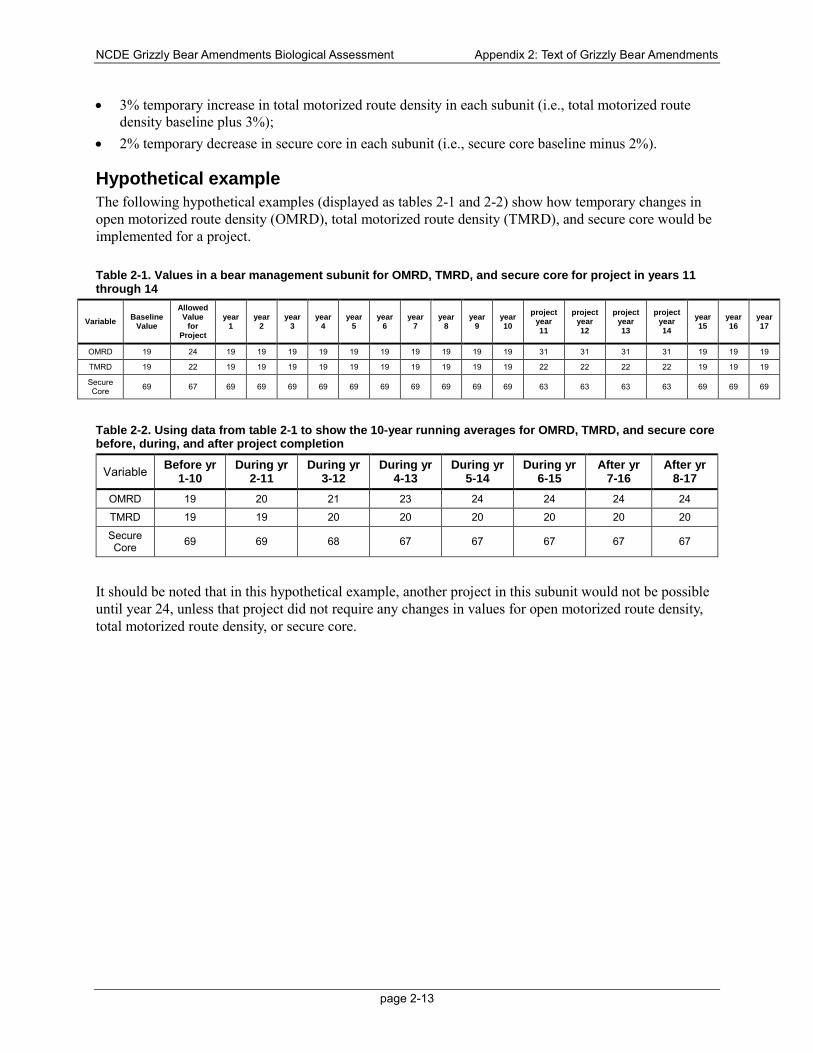
NCDE Grizzly Bear Amendments Biological Assessment Appendix 2: Text of Grizzly Bear Amendments
page 2-13
• 3% temporary increase in total motorized route density in each subunit (i.e., total motorized route density baseline plus 3%);
• 2% temporary decrease in secure core in each subunit (i.e., secure core baseline minus 2%).
Hypothetical example The following hypothetical examples (displayed as tables 2-1 and 2-2) show how temporary changes in open motorized route density (OMRD), total motorized route density (TMRD), and secure core would be implemented for a project.
Table 2-1. Values in a bear management subunit for OMRD, TMRD, and secure core for project in years 11 through 14
Variable Baseline Value
Allowed Value
for Project
year 1
year 2
year 3
year 4
year 5
year 6
year 7
year 8
year 9
year 10
project year 11
project year 12
project year 13
project year 14
year 15
year 16
year 17
OMRD 19 24 19 19 19 19 19 19 19 19 19 19 31 31 31 31 19 19 19
TMRD 19 22 19 19 19 19 19 19 19 19 19 19 22 22 22 22 19 19 19
Secure Core 69 67 69 69 69 69 69 69 69 69 69 69 63 63 63 63 69 69 69
Table 2-2. Using data from table 2-1 to show the 10-year running averages for OMRD, TMRD, and secure core before, during, and after project completion
Variable Before yr 1-10
During yr 2-11
During yr 3-12
During yr 4-13
During yr 5-14
During yr 6-15
After yr 7-16
After yr 8-17
OMRD 19 20 21 23 24 24 24 24
TMRD 19 19 20 20 20 20 20 20
Secure Core 69 69 68 67 67 67 67 67
It should be noted that in this hypothetical example, another project in this subunit would not be possible until year 24, unless that project did not require any changes in values for open motorized route density, total motorized route density, or secure core.
NCDE Grizzly Bear Amendments Biological Assessment Appendix 2: Text of Grizzly Bear Amendments
3-14
Monitoring (MON) NCDE-MON-01. Within the NCDE primary conservation area, the levels of secure core, open motorized route density (> 1 mi/mi2) and total motorized route density (> 2 mi/mi2) within each bear management unit (BMU) subunit during the non-denning season, will be monitored and compared to the baseline.
NCDE-MON-02. Within the NCDE primary conservation area, the number and overnight capacity of developed recreation sites designed and managed for overnight use on National Forest System lands within each BMU will be monitored and compared to the baseline. The number of day use recreation sites and trailheads in each BMU in the NCDE primary conservation area and administrative sites (see glossary) will also be monitored.
NCDE-MON-03. Within the NCDE primary conservation area, the numbers of commercial livestock grazing allotments and the numbers of sheep animal unit months on National Forest system lands will be monitored and compared to the baseline. In the NCDE primary conservation area and zone 1, the number of grizzly bear-livestock conflicts occurring annually on National Forest System lands will be monitored.
NCDE-MON-04. Within the NCDE primary conservation area and zone 1 (including the Salish and the Ninemile demographic connectivity areas), where it is determined there is potential for adverse effects to the grizzly bear population or its habitat resulting from leasable or locatable mineral activities, a monitoring plan will be developed for the life of the mineral activity. The monitoring plan will outline how changes in habitat and/or disturbance to bears will be monitored and mitigations (e.g., monitoring of mining reclamation measures) will be identified and funded.
NCDE-MON-05. Within the NCDE primary conservation area, the 10-year running average of open motorized route density, total motorized route density and secure core will be monitored by forest staff and documented for each project (see NCDE STD-AR-03 and the definition of “project (in grizzly bear habitat in the NCDE)” in the glossary).
NCDE-MON-06. Within the NCDE primary conservation area, the duration of projects will be monitored by forest staff (see NCDE-GDL-AR-01 and the definition of “project (in grizzly bear habitat in the NCDE)” in the glossary).
NCDE-MON-07. In NCDE zone 1 on the Helena National Forest, the density of motorized routes open for public use during the non-denning season on National Forest System lands will be monitored and compared with the baseline.
NCDE-MON-08. In NCDE zone 1 on the Kootenai National Forest, the permanent linear miles of open roads, total roads and motorized trails on National Forest System lands within the bears outside recovery zone (BORZ) polygons will be monitored.
NCDE-MON-09. In NCDE zone 1 outside of the Ninemile demographic connectivity area on the Lolo National Forest, the density of roads open for public motorized use during the non-denning season on National Forest System lands will be monitored and compared with the baseline. Inside the Ninemile demographic connectivity area, the density of roads and trails open to public motorized use on National Forest System lands will be monitored and compared with the baseline.
NCDE-MON-10. NCDE-MON-10. In the NCDE primary conservation area, the percentage of modeled grizzly bear denning habitat (as updated by MFWP) where public motorized over-snow vehicle use is allowed during the den emergence time period will be monitored and compared to the baseline.
NCDE Grizzly Bear Amendments Biological Assessment Appendix 2: Text of Grizzly Bear Amendments
3-15
Glossary The following terms, and definitions, are to be used only where they apply within the Northern Continental Divide Ecosystem (NCDE) for grizzly bears, see amendment standard NCDE-STD-WL-01.
administrative site a location or facility constructed for use primarily by government employees to facilitate the administration and management of public lands. Examples on National Forest Service lands include, but are not limited to, ranger stations, warehouses, and guard stations.
administrative use a generic term for authorized agency activity. Specifically, in the portion of the NCDE for grizzly bears mapped as the primary conservation area, motorized use of roads closed to the public is permitted for Federal agency personnel or personnel authorized to perform duties by appropriate agency officials, as long as it does not exceed either 6 trips (3 round trips) per week OR one 30-day unlimited use period during the non-denning season (see non-denning season).
baseline the baseline for the NCDE is defined as conditions as of December 31, 2011, as modified by changes in numbers that were evaluated and found to be acceptable through the Endangered Species Act Section 7 consultation with USFWS while the grizzly bear was listed as Threatened. The baseline will be updated to reflect changes allowed under the standards and guidelines.
bear management subunit an area of a bear management unit, in the portion of the NCDE for grizzly bears mapped as the primary conservation area, representing the approximate size of an average annual female grizzly bear home range (e.g., 31-68 mi2 (R. D. Mace & Roberts, 2012)).
bear management unit an area about 400 m2, in the portion of the NCDE for grizzly bears mapped as the primary conservation area that meets yearlong habitat needs of both male and female grizzly bears.
boneyard an established site that is used by a grazing permittee for disposing of entire animal carcasses.
capacity (of developed recreation sites within the NCDE primary conservation area) the number of sites available for overnight use (e.g. the number of sites in a campground; the number of rooms available for lodging (as a commercial rental); or the number of cabins, bunkhouses or recreation residences managed under a special use permit).
consultation a process required by Section 7 of the Endangered Species Act whereby federal agencies proposing activities that may affect a listed species or critical habitat confer with the U.S. Fish and Wildlife Service about the impacts of the activity on the species (50 CFR 402).
cover the elements of the environment used by an animal for hiding. Cover varies depending upon the species or the time of year and may include a variety of vegetation types as well as topography. The amount and quality of cover needed depends on the animal’s size, mobility, and reluctance or willingness to venture into relatively open areas.
demographic connectivity area an area intended to allow female grizzly bear occupancy and potential dispersal beyond the NCDE to other recovery areas.
den emergence time period the spring-time period when a grizzly bear emerges from its den and remains in the vicinity before moving to lower elevations. The den emergence time period occurs at the beginning of the non-denning season. Females with cubs usually emerge later and spend more time (a few days to a few weeks) near the den after emergence, than do male bears.
NCDE Grizzly Bear Amendments Biological Assessment Appendix 2: Text of Grizzly Bear Amendments
3-16
denning season the typical time period, within the NCDE, during which most grizzly bears are hibernating in dens. There are no restrictions on motorized use related to grizzly bears during the denning season, which occurs:
• west side of the Continental Divide: from 1 December through 31 March.
• east of the Continental Divide: from 1 December through 15 April.
developed recreation site capacity within the NCDE primary conservation area for purposes of implementing standard NCDE-STD-AR-05, developed recreation site capacity on NFS lands that are designed and managed for overnight use includes:
• the number of camp sites available in a campground
• the number of rooms available for lodging at a ski area or guest lodge
• the maximum sleeping capacity of a cabin rental or bunkhouse that is available for overnight use by the public
• the maximum parking capacity at picnic areas, trailheads, or boat launches that are not closed to overnight use [NCDE]
developed recreation site within the NCDE primary conservation area for purposes of implementing standard NCDE-STD-AR-05, developed recreation sites on NFS lands that are designed and managed for overnight use includes campgrounds, lodging at ski areas, cabin rentals, huts, guest lodges, recreation residences. This standard does not apply to dispersed recreations sites nor to developed recreation sites managed for day-use only (e.g., outfitter camps, roadside trail crossings or interpretive pull-outs; trailheads, picnic areas, or boat launches that are closed at night; ski areas that do not have overnight lodging). [NCDE]
dispersed recreation An area in a national forest or national grassland with limited or no amenities provided for recreational users 36 CFR § 261.2.
emergency situation a circumstance on National Forest System lands for which immediate implementation of all or part of a decision is necessary for relief from hazards threatening human health and safety or natural resources on those National Forest System or adjacent lands; or that would result in substantial loss of economic value to the Federal Government if implementation of the decision were delayed. (36 CFR 218.21)
grazing allotment a designated area of land that is available for livestock grazing and is represented on a map. A grazing allotment can include National Forest Service (NFS) and non-NFS lands. Permits are issued for the use of allotments or portions of allotments. Allotments may be:
• active: Livestock grazing allotments that are in use, including pack and saddle stock allotments.
• closed: Areas having suitable livestock range that have been closed to livestock grazing by administrative decision or action.
• combined: An allotment that has been combined into another allotment and therefore, no longer exists as an independent allotment.
• vacant: An allotment that does not have a current grazing permit issued. (Forest Service Manual 2205)
NCDE Grizzly Bear Amendments Biological Assessment Appendix 2: Text of Grizzly Bear Amendments
3-17
grazing permit in non-use status a term that applies to livestock numbers. Non-use of a term grazing permit, in whole or in part, must be approved by a Forest Supervisor and is allowed for permittee convenience, resource protection or development, or range research (Forest Service Manual 2231.7).
grazing permit in inactive status all permitted uses have expired, been cancelled, or been waived.
grizzly bear–human conflict an interaction between a grizzly bear and human in which bears either do, or attempt to, injure people, damage property, kill or injure livestock, damage beehives, obtain anthropogenic foods or attractants or agricultural crops.
livestock a type of domestic animal raised for commercial production purposes, e.g., cattle. Small livestock includes animals smaller than a cow, such as sheep, goats, and llamas.
mitigate to avoid, minimize, rectify, reduce, or compensate the adverse environmental impacts associated with an action.
motorized route a National Forest System road or trail that is designated for motorized use on a motor vehicle use map pursuant to 36 CFR 212.51.
motorized use the designation of roads, trails, and areas that are open to motor vehicle use as specified in Federal Register / Vol. 70, No. 216 / Wednesday, November 9, 2005 /36 CFR Parts 212, 251, 261, Travel Management; Designated Routes and Areas for Motor Vehicle Use; Final Rule.
moving window analysis a geographic information system procedure that quantifies the density of roads and trails by incrementally moving a template across a digital map.
net change the difference in a measurement (such as road density) after on-the-ground changes are accounted for pre- and post-project; allows for temporary changes during a project.
no surface occupancy (NSO) a fluid mineral leasing stipulation that prohibits use or occupancy of the land surface in order to protect identified resource values. Lessees may develop the oil and gas or geothermal resources under the area restricted by this stipulation through use of directional drilling from sites outside the no surface occupancy area.
Northern Continental Divide Ecosystem a region identified in the Grizzly Bear Conservation Strategy encompassing about 27.3 million acres of land in western and central Montana that is one of five areas in the lower 48 states where grizzly bear populations occur.
Northern Continental Divide Ecosystem (NCDE) Coordinating Committee an interagency group that evaluates implementation of the NCDE grizzly bear conservation strategy, promotes the exchange of data and information about the NCDE grizzly bear population among agencies and the public, and makes recommendations to the management agencies regarding implementation of the NCDE grizzly bear conservation strategy. Members of the interagency group may include Montana Fish, Wildlife and Parks; U.S. Fish and Wildlife Service; U.S. Park Service; U.S. Forest Service; APHIS-Wildlife Services; U.S. Geological Survey; U.S. Bureau of Land Management; Blackfeet Tribe, and the Confederated Salish and Kootenai Tribes.
non-denning season the time period when grizzly bears typically are not hibernating:
• west side of the Continental Divide: from 1 April through 30 November. • east side of the Continental Divide: from 16 April through 30 November.
NCDE Grizzly Bear Amendments Biological Assessment Appendix 2: Text of Grizzly Bear Amendments
3-18
open motorized route density a moving window analysis calculation that applies to the primary conservation area portion of the NCDE and includes Federal, State, and Tribal roads and motorized trails that are open to wheeled motor vehicle use by the public for any part of the non-denning season. Note: Motorized routes closed only by sign or order are considered to be open for purposes of this calculation. See also moving window analysis.
primary conservation area an area identified in the NCDE Grizzly Bear Conservation Strategy to be managed as a source area for the grizzly bear population, where continuous occupancy by grizzly bears would be maintained. Habitat within the primary conservation area would receive the most stringent protection. The primary conservation area is the same area as the NCDE grizzly bear recovery zone identified in the Recovery Plan (http://www.fws.gov/mountain-prairie/species/mammals/grizzly/ [U.S. Fish and Wildlife Service 1993]).
project an organized effort to achieve an outcome on National Forest System lands identified by location, tasks, outputs, effects, times, and responsibilities for execution (36 CFR 219.19).
project (in grizzly bear habitat in the NCDE) a project in grizzly bear habitat in the NCDE, for purposes of the motorized access standards and guidelines in the primary conservation area of the NCDE, refers to any temporary activity requiring construction of new roads, temporary roads, reconstruction or opening of restricted roads during the non-denning season, if such use exceeds administrative use levels (see administrative use). Activities involving recurring helicopter use (see recurring helicopter use) are also considered to be a project.
recurring helicopter use a type of helicopter flight that involves multiple trips/passes each day consisting of low-altitude (< 500 m above-ground-level) flights that continues for a duration longer than 48 consecutive hours.
road a motor vehicle route more than 50 inches wide, unless identified and managed as a trail. (36 CFR 212.1, FSM 7705):
1. decommissioned: The stabilization and restoration of an unneeded road to a more natural state (36 CFR 212.1). Decommissioned roads do not count towards Total Motorized Route Density as long as they meet the definition of impassable.
2. forest road or trail: A route wholly or partly within or adjacent to and serving the National Forest Service (NFS) that is necessary for the protection, administration, and utilization of the NFS and the use and development of its resources (36 CFR 212.1 – Definitions)
3. impassable: A road that has been treated in such a manner that the road is blocked and there is little resource risk if road maintenance is not performed on a regular basis (self-maintaining).These roads are not counted in the total motorized route density as long as the road (generally the first 50 to 300 feet) has been treated to make it inaccessible to wheeled motorized vehicles during the non-denning season. Roads may become impassable as a result of a variety of means, including but not limited to one or more of the following: natural vegetation growth, road entrance obliteration, scarified ground, fallen trees, boulders, culvert or bridge removal, etc. Impassable roads may remain on the inventoried road system if use of the road is anticipated at some point in the future. Some, but not all, roads placed in intermittent stored service may be impassable. [GBCS]
4. intermittent stored service/intermittent service road, closed to traffic: The road is in a condition that there is little resource risk if maintenance is not performed.
NCDE Grizzly Bear Amendments Biological Assessment Appendix 2: Text of Grizzly Bear Amendments
3-19
5. maintenance level: A term for the level of service provided by, and maintenance required for, a specific road, consistent with road management objectives and maintenance criteria (Forest Service Handbook 7709.59, 62.32)
Level 1: These are roads that have been placed in storage between intermittent uses. The period of storage must exceed 1 year. Basic custodial maintenance is performed to prevent damage to adjacent resources and to perpetuate the road for future resource management needs. Emphasis is normally given to maintaining drainage facilities and runoff patterns.
Level 2: Assigned to roads open for use by high clearance vehicles. Passenger car traffic, user comfort, and user convenience are not considerations.
Level 3: Assigned to roads open and maintained for travel by a prudent driver in a standard passenger car. User comfort and convenience are not considered priorities
Level 4: Assigned to roads that provide a moderate degree of user comfort and convenience at moderate travel speeds
Level 5: Assigned to roads that provide a high degree of user comfort and convenience.
6. National Forest System: A forest road other than a road which has been authorized by a legally documented right-of-way held by a State, county, or other local public road authority (36 CFR 212.1)
7. temporary: A road necessary for emergency operations or authorized by contract, permit, lease, or other written authorization that is not a forest road and that is not included in a forest transportation atlas (36 CFR 212.1). In the NCDE primary conservation area, temporary roads will meet the definition of impassable when no longer needed. [GBCS]
running average a method for computing the average of a stream of numbers for a specified period. A 10-year running average computes the mean for the values in the current year plus the previous 9 years. A running average is commonly used with time series data to smooth out short-term fluctuations and highlight longer-term trends or cycles.
secure core (grizzly bear) an area of the NCDE primary conservation area 500 meters or more from (1) a route open to public wheeled motorized use during the grizzly bear non-denning season, (2) a gated route, or (3) a route closed only with a sign, that is greater than or equal to 2,500 acres in size. Roads restricted with physical barriers (not gates), decommissioned roads, impassable roads, temporary roads, over-the-snow motorized routes/areas, and non-motorized trails are allowed within secure core, unless otherwise restricted (e.g., by other national forest plan direction).
total motorized route density a moving window analysis calculation that applies to the primary conservation area portion of the NCDE and includes Federal, State, and Tribal roads and motorized trails that do not meet the definition of an impassable road. See also moving window analysis.
zone 1 an area surrounding the grizzly bear primary conservation area in the NCDE, where the intent is to maintain occupancy by grizzly bears, but at expected lower densities than inside the primary conservation area. Zone 1 also includes two demographic connectivity areas.
zone 2 an area adjacent to the grizzly bear zone 1 and/or zone 3 in the NCDE, where grizzly bears, particularly males, would have the opportunity to move between the NCDE and adjacent ecosystems. The intent of the zone 2 area is to allow for resource management and recreational opportunities while responding to grizzly bear-human conflicts with appropriate management actions.
NCDE Grizzly Bear Amendments Biological Assessment Appendix 2: Text of Grizzly Bear Amendments
3-20
zone 3 the area that primarily consists of areas where grizzly bears do not have enough suitable habitat to support population growth. The intent is that grizzly bear occupancy is not actively discouraged in zone 3 and the management emphasis is on conflict response.
NCDE Grizzly Bear Amendments Biological Assessment Appendix 3: Existing Forest Plan Direction
3-1
Appendix 3: Existing forest plan direction and how they would be changed under the proposed NCDE amendments Introduction This document contains detailed information for the purposed of ESA Section 7 consultation showing current forest plan management direction for the amendment forests, and the changes that would be made under the proposed amendment. Forest plan components include desired conditions, standards, guidelines, and monitoring items.
The full text of the forest plan language and a glossary of terms that would be incorporated into the revised Flathead Forest Plan and in the amended Helena, Kootenai, Lewis and Clark, and Lolo Forest Plans under the proposed action modified alternative is found in appendix 3.
The draft NCDE grizzly bear conservation strategy identified a subset of resource management activities that need to be coordinated with grizzly bear habitat needs to support recovery of the grizzly bear population. These are: motorized access and secure core, developed recreation sites, livestock grazing, vegetation management, and minerals and energy development. Only the management direction applicable to this subset of resource management programs is included in this comparison.
For each national forest in turn, the current forest plan language that specifically pertains to grizzly bear habitat management is presented. The column identified as alternative 1 directly quotes from the existing forest plan. The second column states whether the existing direction would be retained, added to, or would be replaced. If it would be added to or replaced, a specific reference to the forest plan component (e.g., NCDE-DC-WL-01) is given.
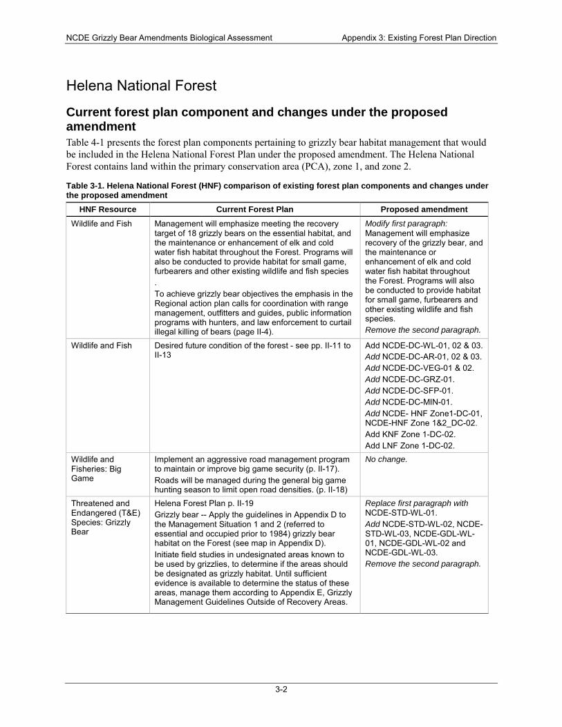
NCDE Grizzly Bear Amendments Biological Assessment Appendix 3: Existing Forest Plan Direction
3-2
Helena National Forest
Current forest plan component and changes under the proposed amendment Table 4-1 presents the forest plan components pertaining to grizzly bear habitat management that would be included in the Helena National Forest Plan under the proposed amendment. The Helena National Forest contains land within the primary conservation area (PCA), zone 1, and zone 2.
Table 3-1. Helena National Forest (HNF) comparison of existing forest plan components and changes under the proposed amendment
HNF Resource Current Forest Plan Proposed amendment Wildlife and Fish Management will emphasize meeting the recovery
target of 18 grizzly bears on the essential habitat, and the maintenance or enhancement of elk and cold water fish habitat throughout the Forest. Programs will also be conducted to provide habitat for small game, furbearers and other existing wildlife and fish species . To achieve grizzly bear objectives the emphasis in the Regional action plan calls for coordination with range management, outfitters and guides, public information programs with hunters, and law enforcement to curtail illegal killing of bears (page II-4).
Modify first paragraph: Management will emphasize recovery of the grizzly bear, and the maintenance or enhancement of elk and cold water fish habitat throughout the Forest. Programs will also be conducted to provide habitat for small game, furbearers and other existing wildlife and fish species. Remove the second paragraph.
Wildlife and Fish Desired future condition of the forest - see pp. II-11 to II-13
Add NCDE-DC-WL-01, 02 & 03. Add NCDE-DC-AR-01, 02 & 03. Add NCDE-DC-VEG-01 & 02. Add NCDE-DC-GRZ-01. Add NCDE-DC-SFP-01. Add NCDE-DC-MIN-01. Add NCDE- HNF Zone1-DC-01, NCDE-HNF Zone 1&2_DC-02. Add KNF Zone 1-DC-02. Add LNF Zone 1-DC-02.
Wildlife and Fisheries: Big Game
Implement an aggressive road management program to maintain or improve big game security (p. II-17). Roads will be managed during the general big game hunting season to limit open road densities. (p. II-18)
No change.
Threatened and Endangered (T&E) Species: Grizzly Bear
Helena Forest Plan p. II-19 Grizzly bear -- Apply the guidelines in Appendix D to the Management Situation 1 and 2 (referred to essential and occupied prior to 1984) grizzly bear habitat on the Forest (see map in Appendix D). Initiate field studies in undesignated areas known to be used by grizzlies, to determine if the areas should be designated as grizzly habitat. Until sufficient evidence is available to determine the status of these areas, manage them according to Appendix E, Grizzly Management Guidelines Outside of Recovery Areas.
Replace first paragraph with NCDE-STD-WL-01. Add NCDE-STD-WL-02, NCDE-STD-WL-03, NCDE-GDL-WL-01, NCDE-GDL-WL-02 and NCDE-GDL-WL-03. Remove the second paragraph.
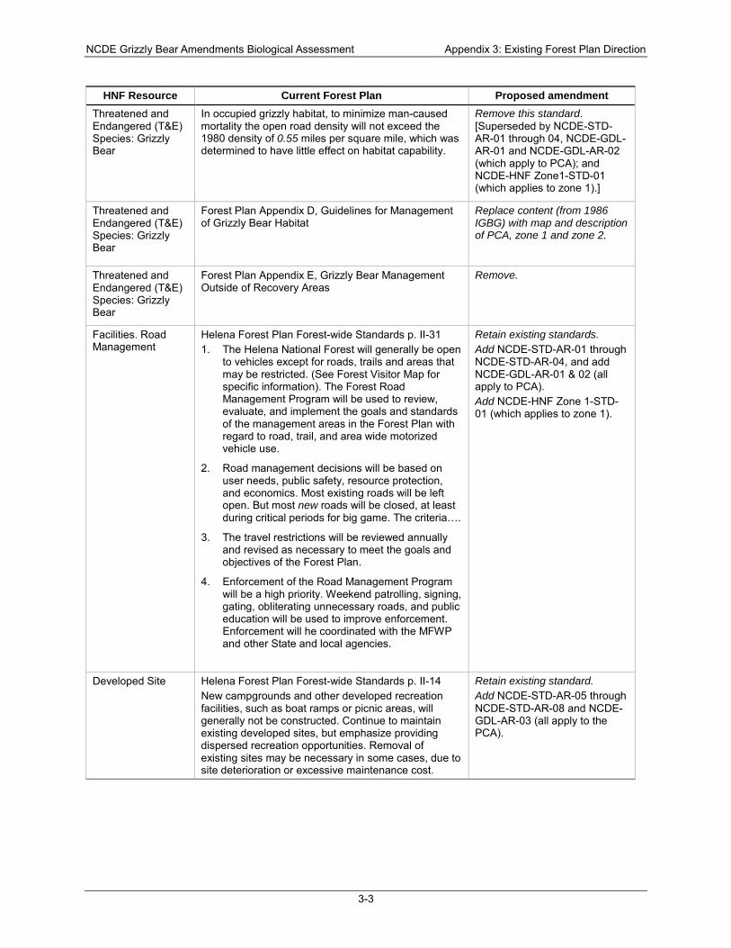
NCDE Grizzly Bear Amendments Biological Assessment Appendix 3: Existing Forest Plan Direction
3-3
HNF Resource Current Forest Plan Proposed amendment Threatened and Endangered (T&E) Species: Grizzly Bear
In occupied grizzly habitat, to minimize man-caused mortality the open road density will not exceed the 1980 density of 0.55 miles per square mile, which was determined to have little effect on habitat capability.
Remove this standard. [Superseded by NCDE-STD-AR-01 through 04, NCDE-GDL-AR-01 and NCDE-GDL-AR-02 (which apply to PCA); and NCDE-HNF Zone1-STD-01 (which applies to zone 1).]
Threatened and Endangered (T&E) Species: Grizzly Bear
Forest Plan Appendix D, Guidelines for Management of Grizzly Bear Habitat
Replace content (from 1986 IGBG) with map and description of PCA, zone 1 and zone 2.
Threatened and Endangered (T&E) Species: Grizzly Bear
Forest Plan Appendix E, Grizzly Bear Management Outside of Recovery Areas
Remove.
Facilities. Road Management
Helena Forest Plan Forest-wide Standards p. II-31 1. The Helena National Forest will generally be open
to vehicles except for roads, trails and areas that may be restricted. (See Forest Visitor Map for specific information). The Forest Road Management Program will be used to review, evaluate, and implement the goals and standards of the management areas in the Forest Plan with regard to road, trail, and area wide motorized vehicle use.
2. Road management decisions will be based on user needs, public safety, resource protection, and economics. Most existing roads will be left open. But most new roads will be closed, at least during critical periods for big game. The criteria….
3. The travel restrictions will be reviewed annually and revised as necessary to meet the goals and objectives of the Forest Plan.
4. Enforcement of the Road Management Program will be a high priority. Weekend patrolling, signing, gating, obliterating unnecessary roads, and public education will be used to improve enforcement. Enforcement will he coordinated with the MFWP and other State and local agencies.
Retain existing standards. Add NCDE-STD-AR-01 through NCDE-STD-AR-04, and add NCDE-GDL-AR-01 & 02 (all apply to PCA). Add NCDE-HNF Zone 1-STD-01 (which applies to zone 1).
Developed Site Helena Forest Plan Forest-wide Standards p. II-14 New campgrounds and other developed recreation facilities, such as boat ramps or picnic areas, will generally not be constructed. Continue to maintain existing developed sites, but emphasize providing dispersed recreation opportunities. Removal of existing sites may be necessary in some cases, due to site deterioration or excessive maintenance cost.
Retain existing standard. Add NCDE-STD-AR-05 through NCDE-STD-AR-08 and NCDE-GDL-AR-03 (all apply to the PCA).
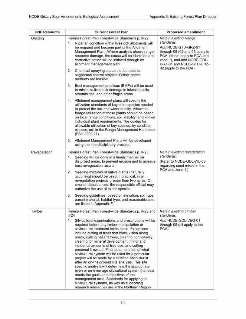
NCDE Grizzly Bear Amendments Biological Assessment Appendix 3: Existing Forest Plan Direction
3-4
HNF Resource Current Forest Plan Proposed amendment Grazing Helena Forest Plan Forest-wide Standards p. II-22
1. Riparian condition within livestock allotments will be mapped and become part of the Allotment Management Plan. Where analysis shows range resource damage, the cause will be identified and corrective action will be initiated through an allotment management plan.
2. Chemical spraying should not be used on sagebrush control projects if other control methods are feasible.
3. Best management practices (BMPs) will be used to minimize livestock damage to lakeside soils, streamsides, and other fragile areas.
4. Allotment management plans will specify the utilization standards of key plant species needed to protect the soil and water quality. Allowable forage utilization of these plants should be based on local range conditions, soil stability, and known individual plant requirements. The guides for allowable utilization of key species, by condition classes, are in the Range Management Handbook (FSH 2209.21).
5. Allotment Management Plans will be developed using the interdisciplinary process.
Retain existing Range standards. Add NCDE-STD-GRZ-01 through 06 (02 and 05 apply to PCA, others apply to PCA and zone 1), and add NCDE-GDL-GRZ-01 and NCDE-STD-GRZ-02 (apply to the PCA).
Revegetation Helena Forest Plan Forest-wide Standards p. II-23 1. Seeding will be done in a timely manner on
disturbed areas, to prevent erosion and to achieve best revegetation results.
2. Seeding mixtures of native plants (naturally occurring) should be used, if practical, in all revegetation projects greater than two acres. On smaller disturbances, the responsible official may authorize the use of exotic species.
3. Seeding guidelines, based on elevation, soil type, parent material, habitat type, and reasonable cost, are listed in Appendix F.
Retain existing revegetation standards. [Refer to NCDE-GDL-WL-03 regarding seed mixes in the PCA and zone 1.]
Timber Helena Forest Plan Forest-wide Standards p. II-23 and II-24 1. Silvicultural examinations and prescriptions will be
required before any timber manipulation or silvicultural treatment takes place. Exceptions include cutting of trees that block vision along roads, cutting hazard trees, clearing right-of-way, clearing for mineral development, minor and incidental amounts of free use, and cutting personal firewood. Final determination of what silvicultural system will be used for a particular project will be made by a certified silviculturist after an on-the-ground site analysis. This site specific analysis will determine the appropriate even or un-even age silvicultural system that best meets the goals and objectives of the management area. Standards for applying all silvicultural systems, as well as supporting research references are in the Northern Region
Retain existing Timber standards. Add NCDE-GDL-VEG-01 through 05 (all apply to the PCA).
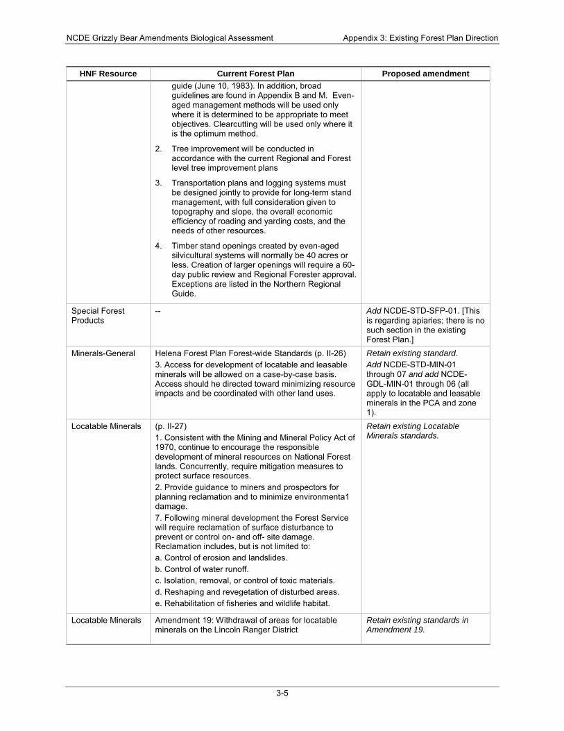
NCDE Grizzly Bear Amendments Biological Assessment Appendix 3: Existing Forest Plan Direction
3-5
HNF Resource Current Forest Plan Proposed amendment guide (June 10, 1983). In addition, broad guidelines are found in Appendix B and M. Even-aged management methods will be used only where it is determined to be appropriate to meet objectives. Clearcutting will be used only where it is the optimum method.
2. Tree improvement will be conducted in accordance with the current Regional and Forest level tree improvement plans
3. Transportation plans and logging systems must be designed jointly to provide for long-term stand management, with full consideration given to topography and slope, the overall economic efficiency of roading and yarding costs, and the needs of other resources.
4. Timber stand openings created by even-aged silvicultural systems will normally be 40 acres or less. Creation of larger openings will require a 60-day public review and Regional Forester approval. Exceptions are listed in the Northern Regional Guide.
Special Forest Products
-- Add NCDE-STD-SFP-01. [This is regarding apiaries; there is no such section in the existing Forest Plan.]
Minerals-General Helena Forest Plan Forest-wide Standards (p. II-26) 3. Access for development of locatable and leasable minerals will be allowed on a case-by-case basis. Access should he directed toward minimizing resource impacts and be coordinated with other land uses.
Retain existing standard. Add NCDE-STD-MIN-01 through 07 and add NCDE-GDL-MIN-01 through 06 (all apply to locatable and leasable minerals in the PCA and zone 1).
Locatable Minerals (p. II-27) 1. Consistent with the Mining and Mineral Policy Act of 1970, continue to encourage the responsible development of mineral resources on National Forest lands. Concurrently, require mitigation measures to protect surface resources. 2. Provide guidance to miners and prospectors for planning reclamation and to minimize environmenta1 damage. 7. Following mineral development the Forest Service will require reclamation of surface disturbance to prevent or control on- and off- site damage. Reclamation includes, but is not limited to: a. Control of erosion and landslides. b. Control of water runoff. c. Isolation, removal, or control of toxic materials. d. Reshaping and revegetation of disturbed areas. e. Rehabilitation of fisheries and wildlife habitat.
Retain existing Locatable Minerals standards.
Locatable Minerals Amendment 19: Withdrawal of areas for locatable minerals on the Lincoln Ranger District
Retain existing standards in Amendment 19.
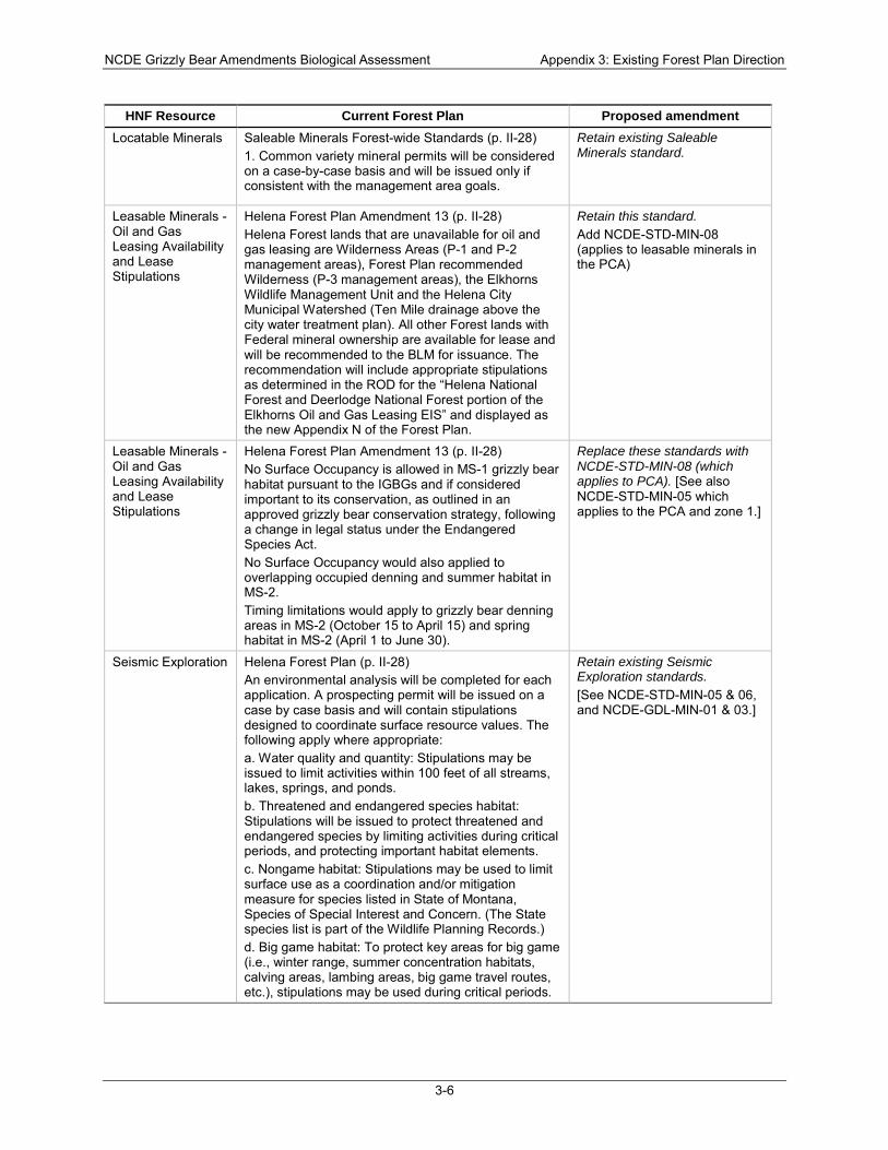
NCDE Grizzly Bear Amendments Biological Assessment Appendix 3: Existing Forest Plan Direction
3-6
HNF Resource Current Forest Plan Proposed amendment Locatable Minerals Saleable Minerals Forest-wide Standards (p. II-28)
1. Common variety mineral permits will be considered on a case-by-case basis and will be issued only if consistent with the management area goals.
Retain existing Saleable Minerals standard.
Leasable Minerals - Oil and Gas Leasing Availability and Lease Stipulations
Helena Forest Plan Amendment 13 (p. II-28) Helena Forest lands that are unavailable for oil and gas leasing are Wilderness Areas (P-1 and P-2 management areas), Forest Plan recommended Wilderness (P-3 management areas), the Elkhorns Wildlife Management Unit and the Helena City Municipal Watershed (Ten Mile drainage above the city water treatment plan). All other Forest lands with Federal mineral ownership are available for lease and will be recommended to the BLM for issuance. The recommendation will include appropriate stipulations as determined in the ROD for the “Helena National Forest and Deerlodge National Forest portion of the Elkhorns Oil and Gas Leasing EIS” and displayed as the new Appendix N of the Forest Plan.
Retain this standard. Add NCDE-STD-MIN-08 (applies to leasable minerals in the PCA)
Leasable Minerals - Oil and Gas Leasing Availability and Lease Stipulations
Helena Forest Plan Amendment 13 (p. II-28) No Surface Occupancy is allowed in MS-1 grizzly bear habitat pursuant to the IGBGs and if considered important to its conservation, as outlined in an approved grizzly bear conservation strategy, following a change in legal status under the Endangered Species Act. No Surface Occupancy would also applied to overlapping occupied denning and summer habitat in MS-2. Timing limitations would apply to grizzly bear denning areas in MS-2 (October 15 to April 15) and spring habitat in MS-2 (April 1 to June 30).
Replace these standards with NCDE-STD-MIN-08 (which applies to PCA). [See also NCDE-STD-MIN-05 which applies to the PCA and zone 1.]
Seismic Exploration Helena Forest Plan (p. II-28) An environmental analysis will be completed for each application. A prospecting permit will be issued on a case by case basis and will contain stipulations designed to coordinate surface resource values. The following apply where appropriate: a. Water quality and quantity: Stipulations may be issued to limit activities within 100 feet of all streams, lakes, springs, and ponds. b. Threatened and endangered species habitat: Stipulations will be issued to protect threatened and endangered species by limiting activities during critical periods, and protecting important habitat elements. c. Nongame habitat: Stipulations may be used to limit surface use as a coordination and/or mitigation measure for species listed in State of Montana, Species of Special Interest and Concern. (The State species list is part of the Wildlife Planning Records.) d. Big game habitat: To protect key areas for big game (i.e., winter range, summer concentration habitats, calving areas, lambing areas, big game travel routes, etc.), stipulations may be used during critical periods.
Retain existing Seismic Exploration standards. [See NCDE-STD-MIN-05 & 06, and NCDE-GDL-MIN-01 & 03.]
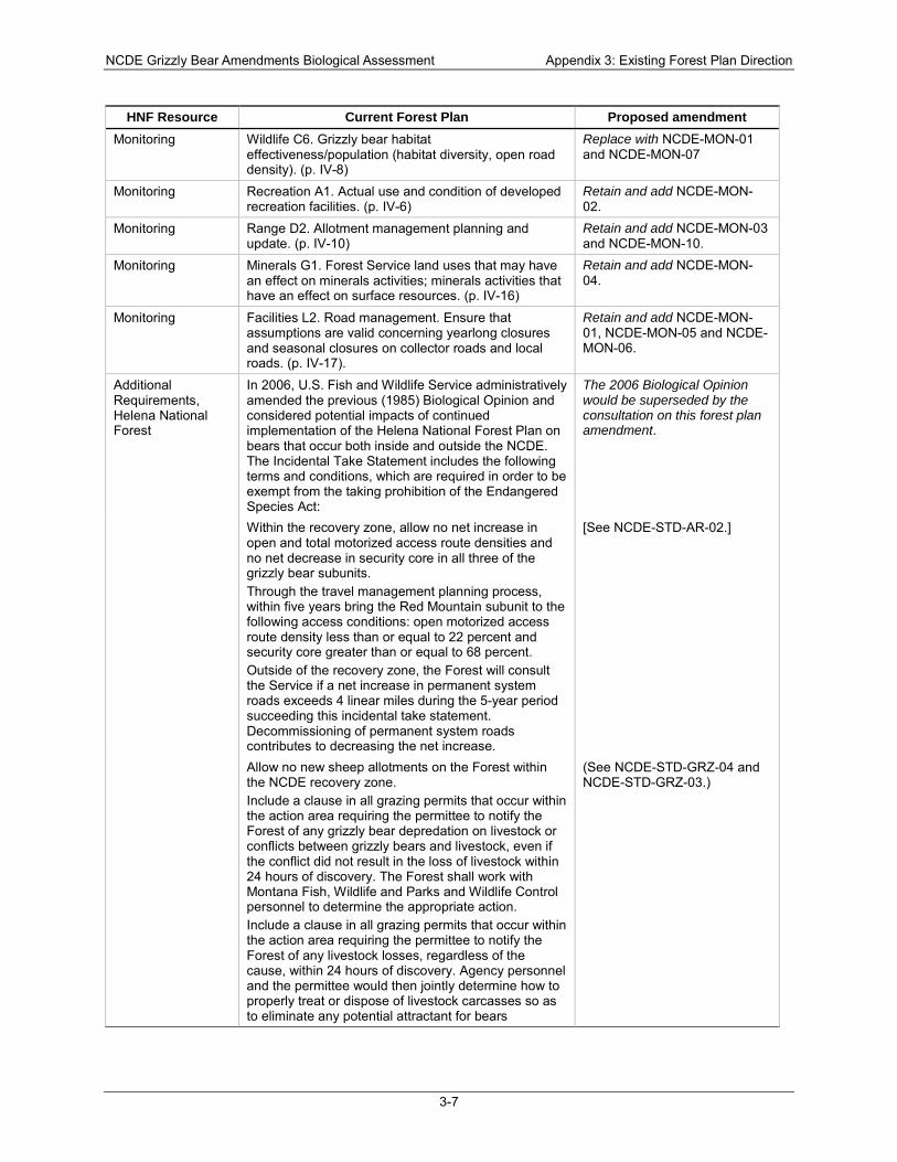
NCDE Grizzly Bear Amendments Biological Assessment Appendix 3: Existing Forest Plan Direction
3-7
HNF Resource Current Forest Plan Proposed amendment Monitoring Wildlife C6. Grizzly bear habitat
effectiveness/population (habitat diversity, open road density). (p. IV-8)
Replace with NCDE-MON-01 and NCDE-MON-07
Monitoring Recreation A1. Actual use and condition of developed recreation facilities. (p. IV-6)
Retain and add NCDE-MON-02.
Monitoring Range D2. Allotment management planning and update. (p. IV-10)
Retain and add NCDE-MON-03 and NCDE-MON-10.
Monitoring Minerals G1. Forest Service land uses that may have an effect on minerals activities; minerals activities that have an effect on surface resources. (p. IV-16)
Retain and add NCDE-MON-04.
Monitoring Facilities L2. Road management. Ensure that assumptions are valid concerning yearlong closures and seasonal closures on collector roads and local roads. (p. IV-17).
Retain and add NCDE-MON-01, NCDE-MON-05 and NCDE-MON-06.
Additional Requirements, Helena National Forest
In 2006, U.S. Fish and Wildlife Service administratively amended the previous (1985) Biological Opinion and considered potential impacts of continued implementation of the Helena National Forest Plan on bears that occur both inside and outside the NCDE. The Incidental Take Statement includes the following terms and conditions, which are required in order to be exempt from the taking prohibition of the Endangered Species Act:
The 2006 Biological Opinion would be superseded by the consultation on this forest plan amendment.
Within the recovery zone, allow no net increase in open and total motorized access route densities and no net decrease in security core in all three of the grizzly bear subunits. Through the travel management planning process, within five years bring the Red Mountain subunit to the following access conditions: open motorized access route density less than or equal to 22 percent and security core greater than or equal to 68 percent. Outside of the recovery zone, the Forest will consult the Service if a net increase in permanent system roads exceeds 4 linear miles during the 5-year period succeeding this incidental take statement. Decommissioning of permanent system roads contributes to decreasing the net increase.
[See NCDE-STD-AR-02.]
Allow no new sheep allotments on the Forest within the NCDE recovery zone. Include a clause in all grazing permits that occur within the action area requiring the permittee to notify the Forest of any grizzly bear depredation on livestock or conflicts between grizzly bears and livestock, even if the conflict did not result in the loss of livestock within 24 hours of discovery. The Forest shall work with Montana Fish, Wildlife and Parks and Wildlife Control personnel to determine the appropriate action. Include a clause in all grazing permits that occur within the action area requiring the permittee to notify the Forest of any livestock losses, regardless of the cause, within 24 hours of discovery. Agency personnel and the permittee would then jointly determine how to properly treat or dispose of livestock carcasses so as to eliminate any potential attractant for bears
(See NCDE-STD-GRZ-04 and NCDE-STD-GRZ-03.)
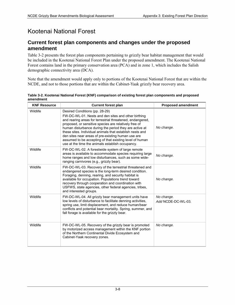
NCDE Grizzly Bear Amendments Biological Assessment Appendix 3: Existing Forest Plan Direction
3-8
Kootenai National Forest
Current forest plan components and changes under the proposed amendment Table 3-2 presents the forest plan components pertaining to grizzly bear habitat management that would be included in the Kootenai National Forest Plan under the proposed amendment. The Kootenai National Forest contains land in the primary conservation area (PCA) and in zone 1, which includes the Salish demographic connectivity area (DCA).
Note that the amendment would apply only to portions of the Kootenai National Forest that are within the NCDE, and not to those portions that are within the Cabinet-Yaak grizzly bear recovery area.
Table 3-2. Kootenai National Forest (KNF) comparison of existing forest plan components and proposed amendment
KNF Resource Current forest plan Proposed amendment Wildlife Desired Conditions (pp. 28-29)
FW-DC-WL-01. Nests and den sites and other birthing and rearing areas for terrestrial threatened, endangered, proposed, or sensitive species are relatively free of human disturbance during the period they are active at these sites. Individual animals that establish nests and den sites near areas of pre-existing human use are assumed to be accepting of that existing level of human use at the time the animals establish occupancy.
No change.
Wildlife FW-DC-WL-02. A forestwide system of large remote areas is available to accommodate species requiring large home ranges and low disturbances, such as some wide-ranging carnivores (e.g., grizzly bear).
No change.
Wildlife FW-DC-WL-03. Recovery of the terrestrial threatened and endangered species is the long-term desired condition. Foraging, denning, rearing, and security habitat is available for occupation. Populations trend toward recovery through cooperation and coordination with USFWS, state agencies, other federal agencies, tribes, and interested groups.
No change.
Wildlife FW-DC-WL-04. All grizzly bear management units have low levels of disturbance to facilitate denning activities, spring use, limit displacement, and reduce human/bear conflicts and potential bear mortality. Spring, summer, and fall forage is available for the grizzly bear.
No change. Add NCDE-DC-WL-03.
Wildlife FW-DC-WL-05. Recovery of the grizzly bear is promoted by motorized access management within the KNF portion of the Northern Continental Divide Ecosystem and Cabinet-Yaak recovery zones.
No change.
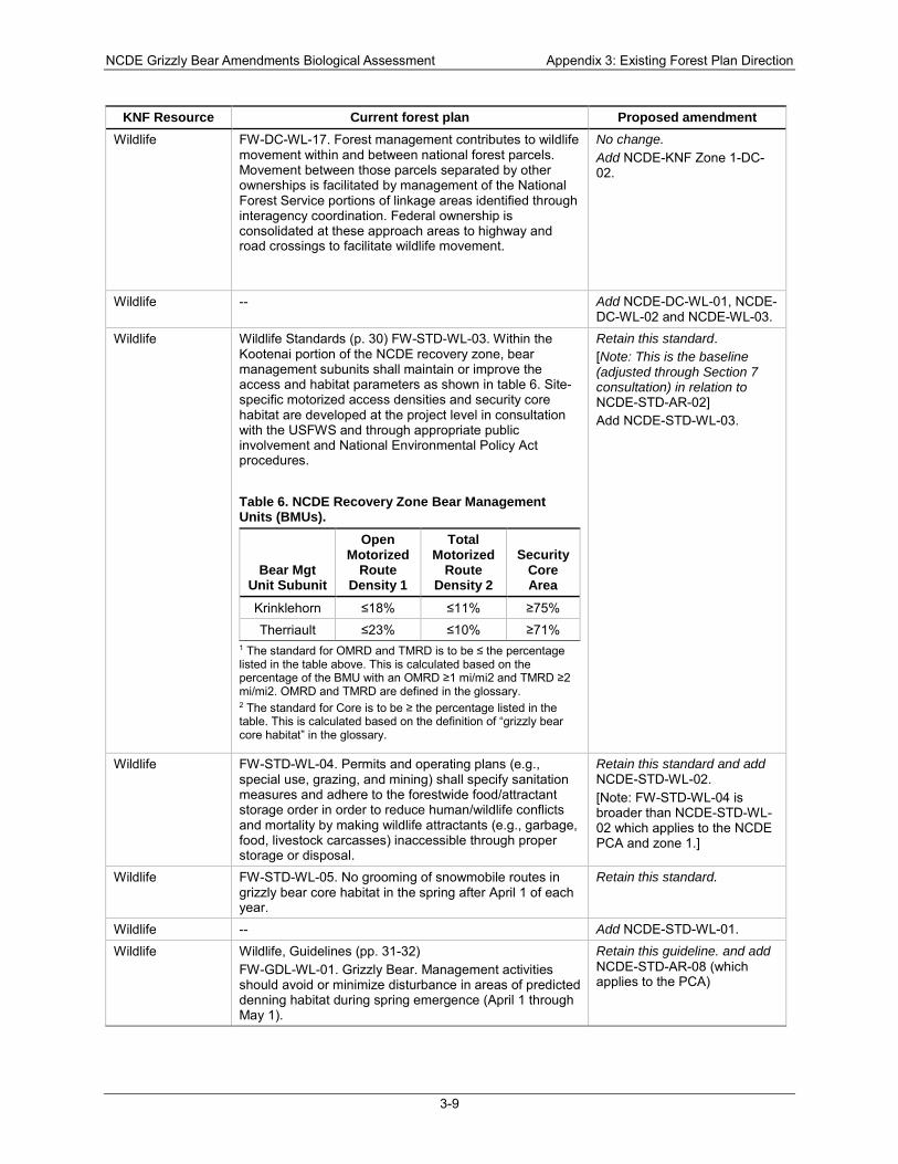
NCDE Grizzly Bear Amendments Biological Assessment Appendix 3: Existing Forest Plan Direction
3-9
KNF Resource Current forest plan Proposed amendment Wildlife FW-DC-WL-17. Forest management contributes to wildlife
movement within and between national forest parcels. Movement between those parcels separated by other ownerships is facilitated by management of the National Forest Service portions of linkage areas identified through interagency coordination. Federal ownership is consolidated at these approach areas to highway and road crossings to facilitate wildlife movement.
No change. Add NCDE-KNF Zone 1-DC-02.
Wildlife -- Add NCDE-DC-WL-01, NCDE-DC-WL-02 and NCDE-WL-03.
Wildlife Wildlife Standards (p. 30) FW-STD-WL-03. Within the Kootenai portion of the NCDE recovery zone, bear management subunits shall maintain or improve the access and habitat parameters as shown in table 6. Site-specific motorized access densities and security core habitat are developed at the project level in consultation with the USFWS and through appropriate public involvement and National Environmental Policy Act procedures.
Table 6. NCDE Recovery Zone Bear Management Units (BMUs).
Bear Mgt Unit Subunit
Open Motorized
Route Density 1
Total Motorized
Route Density 2
Security Core Area
Krinklehorn ≤18% ≤11% ≥75% Therriault ≤23% ≤10% ≥71%
1 The standard for OMRD and TMRD is to be ≤ the percentage listed in the table above. This is calculated based on the percentage of the BMU with an OMRD ≥1 mi/mi2 and TMRD ≥2 mi/mi2. OMRD and TMRD are defined in the glossary. 2 The standard for Core is to be ≥ the percentage listed in the table. This is calculated based on the definition of “grizzly bear core habitat” in the glossary.
Retain this standard. [Note: This is the baseline (adjusted through Section 7 consultation) in relation to NCDE-STD-AR-02] Add NCDE-STD-WL-03.
Wildlife FW-STD-WL-04. Permits and operating plans (e.g., special use, grazing, and mining) shall specify sanitation measures and adhere to the forestwide food/attractant storage order in order to reduce human/wildlife conflicts and mortality by making wildlife attractants (e.g., garbage, food, livestock carcasses) inaccessible through proper storage or disposal.
Retain this standard and add NCDE-STD-WL-02. [Note: FW-STD-WL-04 is broader than NCDE-STD-WL-02 which applies to the NCDE PCA and zone 1.]
Wildlife FW-STD-WL-05. No grooming of snowmobile routes in grizzly bear core habitat in the spring after April 1 of each year.
Retain this standard.
Wildlife -- Add NCDE-STD-WL-01.
Wildlife Wildlife, Guidelines (pp. 31-32) FW-GDL-WL-01. Grizzly Bear. Management activities should avoid or minimize disturbance in areas of predicted denning habitat during spring emergence (April 1 through May 1).
Retain this guideline. and add NCDE-STD-AR-08 (which applies to the PCA)

NCDE Grizzly Bear Amendments Biological Assessment Appendix 3: Existing Forest Plan Direction
3-10
KNF Resource Current forest plan Proposed amendment Wildlife FW-GDL-WL-15. Grizzly bear. Elements contained in the
most recent “Interagency Grizzly Bear Guidelines,” or a conservation strategy once a grizzly bear population is delisted, would be applied to management activities.
Revise as shown in bold: Elements contained in the most recent “Interagency Grizzly Bear Guidelines,” or a conservation strategy incorporated into the Forest Plan, would be applied to management activities.
Wildlife -- Add NCDE-GDL-WL-01 through 03.
Access and Recreation
Access and Recreation (pp. 33-35) FW-DC-AR-01. Quality, well-maintained recreation facilities exist at key locations to accommodate concentrations of use, enhance the visitor’s experience, and protect the natural resources of the area. Day use access is available for relaxation, viewing scenery and wildlife, and for water and snow-based play. Recreation rental cabins and lookouts provide safe, comfortable, overnight facilities that allow visitors to experience and learn about the rich history of the area. Dispersed camping resource concerns, activity conflicts, or over-use. Food and garbage storage do not contribute to conflicts between recreation users and wildlife.
Retain this desired condition and add NCDE-DC-AR-02 which applies to the PCA.
Access and Recreation
FW-DC-AR-07. A transportation system is in place that provides safe and efficient public and administrative access to the Forest for recreation, special uses, forest resource management, and fire management activities. It is efficiently maintained, environmentally compatible, and responsive to public needs and desires. The transportation system and its use have minimal impacts on resources including threatened and endangered species, sensitive species, heritage and cultural sites, watersheds, and aquatic species. Newly constructed or reconstructed roads do not encroach into streams and riparian areas in ways that impact channel function, geometry or sediment delivery. Roads in intermittent stored service pose minimal risks to water quality and aquatic ecosystems. Drainage structures have a minimal risk of failure, and provide adequate drainage that prevents accelerated runoff, erosion, and sediment delivery to streams. In addition, stream crossings provide for passage of aquatic organisms. Unauthorized roads and trails are no longer created.
Retain this desired condition and add NCDE-DC-AR-01 (which applies to the PCA).
Access and Recreation
-- Add NCDE-STD-AR-01 through 04 and add NCDE-GDL-AR-01 through 04 (all apply to the PCA).
Access and Recreation
-- Add NCDE-STD-AR-07 (which applies to ski areas within the PCA)
-- -- Add NCDE-KNF Zone1-DC-01 and NCDE-KNF Zone 1-DC-02 and add NCDE-KNF Zone1-STD-01 & NCDE-KNF Zone 1-STD-02 (apply to zone 1 and the Salish DCA).
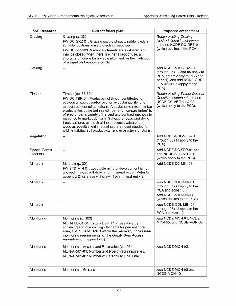
NCDE Grizzly Bear Amendments Biological Assessment Appendix 3: Existing Forest Plan Direction
3-11
KNF Resource Current forest plan Proposed amendment Grazing Grazing (p. 38)
FW-DC-GRZ-01. Grazing occurs at sustainable levels in suitable locations while protecting resources. FW-DC-GRZ-03. Vacant allotments are evaluated and may be closed when there is either a lack of use, a shortage of forage for a viable allotment, or the likelihood of a significant resource conflict.
Retain existing Grazing Desired Condition statements, and add NCDE-DC-GRZ-01 (which applies in the PCA).
Grazing -- Add NCDE-STD-GRZ-01 through 06 (02 and 05 apply to PCA, others apply to PCA and zone 1), and add NCDE-GDL-GRZ-01 & 02 (apply to the PCA).
Timber Timber (pp. 38-39) FW-DC-TBR-01. Production of timber contributes to ecological, social, and/or economic sustainability, and associated desired conditions. A sustainable mix of timber products (including both sawtimber and non-sawtimber) is offered under a variety of harvest and contract methods in response to market demand. Salvage of dead and dying trees captures as much of the economic value of the wood as possible while retaining the amount needed for wildlife habitat, soil productivity, and ecosystem functions.
Retain existing Timber Desired Condition statement and add NCDE-DC-VEG-01 & 02 (which apply to the PCA).
Vegetation -- Add NCDE-GDL-VEG-01 through 05 (all apply to the PCA).
Special Forest Products
-- Add NCDE-DC-SFP-01 and add NCDE-STD-SFP-01 (which apply to the PCA).
Minerals Minerals (p. 39) FW-STD-MIN-01. Locatable mineral development is not allowed in areas withdrawn from mineral entry. (Refer to appendix D for areas withdrawn from mineral entry.)
Add NCDE-DC-MIN-01.
Minerals -- Add NCDE-STD-MIN-01 through 07 (all apply to the PCA and zone 1). Add NCDE-STD-MIN-08 (which applies to the PCA).
Minerals -- Add NCDE-GDL-MIN-01 through 06 (all apply to the PCA and zone 1).
Monitoring Monitoring (p. 100) MON-FLS-01-01: Grizzly Bear: Progress towards achieving and maintaining standards for percent core area, OMRD, and TMRD within the Recovery Zones (see monitoring requirements for the Grizzly Bear Access Amendment in appendix B).
Add NCDE-MON-01, NCDE-MON-05, and NCDE-MON-08.
Monitoring Monitoring – Access and Recreation (p. 102) MON-AR-01-01: Number and type of recreation sites. MON-AR-01-02: Number of Persons at One Time
Add NCDE-MON-02.
Monitoring Monitoring – Grazing Add NCDE-MON-03 and NCDE-MON-10.
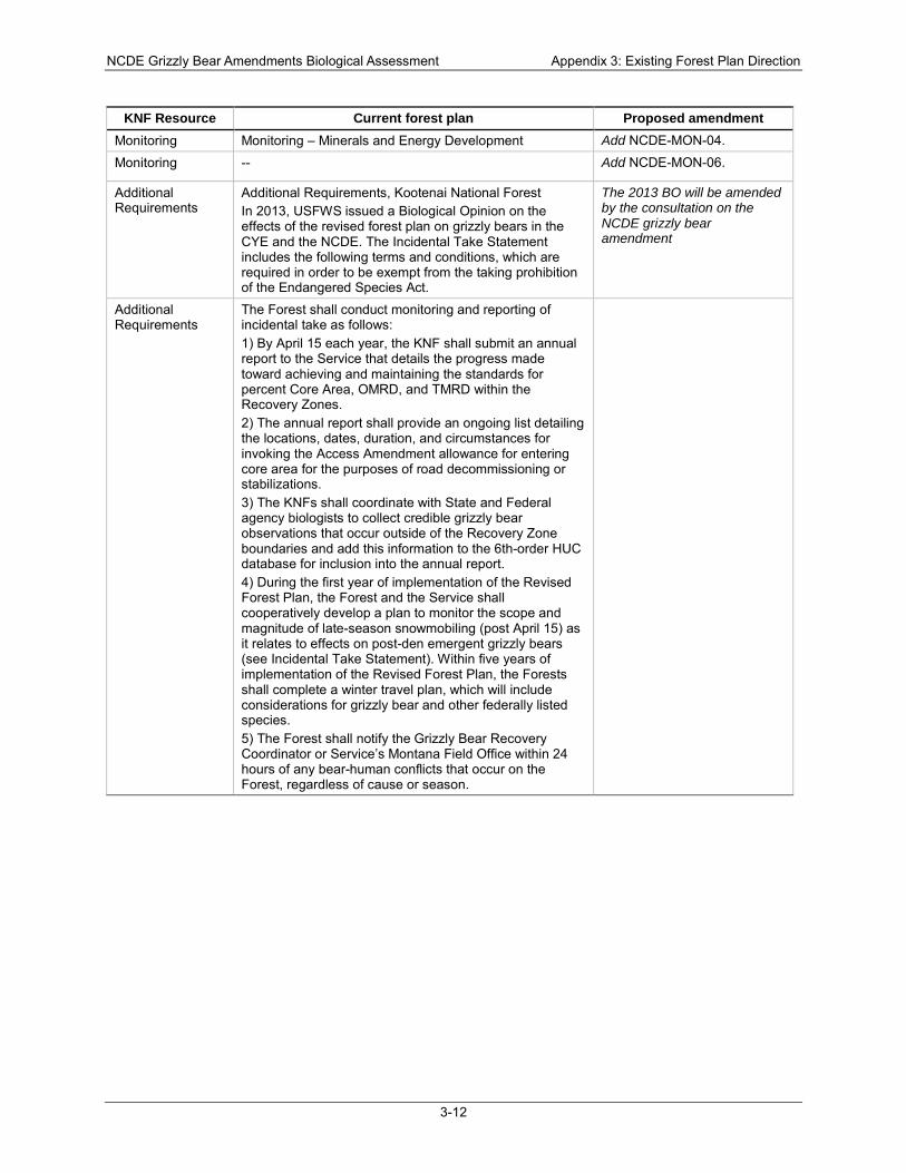
NCDE Grizzly Bear Amendments Biological Assessment Appendix 3: Existing Forest Plan Direction
3-12
KNF Resource Current forest plan Proposed amendment Monitoring Monitoring – Minerals and Energy Development Add NCDE-MON-04.
Monitoring -- Add NCDE-MON-06.
Additional Requirements
Additional Requirements, Kootenai National Forest In 2013, USFWS issued a Biological Opinion on the effects of the revised forest plan on grizzly bears in the CYE and the NCDE. The Incidental Take Statement includes the following terms and conditions, which are required in order to be exempt from the taking prohibition of the Endangered Species Act.
The 2013 BO will be amended by the consultation on the NCDE grizzly bear amendment
Additional Requirements
The Forest shall conduct monitoring and reporting of incidental take as follows: 1) By April 15 each year, the KNF shall submit an annual report to the Service that details the progress made toward achieving and maintaining the standards for percent Core Area, OMRD, and TMRD within the Recovery Zones. 2) The annual report shall provide an ongoing list detailing the locations, dates, duration, and circumstances for invoking the Access Amendment allowance for entering core area for the purposes of road decommissioning or stabilizations. 3) The KNFs shall coordinate with State and Federal agency biologists to collect credible grizzly bear observations that occur outside of the Recovery Zone boundaries and add this information to the 6th-order HUC database for inclusion into the annual report. 4) During the first year of implementation of the Revised Forest Plan, the Forest and the Service shall cooperatively develop a plan to monitor the scope and magnitude of late-season snowmobiling (post April 15) as it relates to effects on post-den emergent grizzly bears (see Incidental Take Statement). Within five years of implementation of the Revised Forest Plan, the Forests shall complete a winter travel plan, which will include considerations for grizzly bear and other federally listed species. 5) The Forest shall notify the Grizzly Bear Recovery Coordinator or Service’s Montana Field Office within 24 hours of any bear-human conflicts that occur on the Forest, regardless of cause or season.
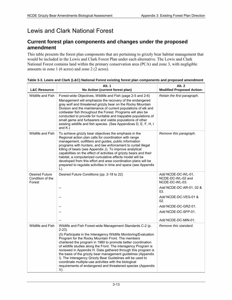
NCDE Grizzly Bear Amendments Biological Assessment Appendix 3: Existing Forest Plan Direction
3-13
Lewis and Clark National Forest
Current forest plan components and changes under the proposed amendment This table presents the forest plan components that are pertaining to grizzly bear habitat management that would be included in the Lewis and Clark Forest Plan under each alternative. The Lewis and Clark National Forest contains land within the primary conservation area (PCA) and zone 3, with negligible amounts in zone 1 (6 acres) and zone 2 (2 acres).
Table 3-3. Lewis and Clark (L&C) National Forest existing forest plan components and proposed amendment
L&C Resource Alt. 1
No Action (current forest plan) Alt. 2
Modified Proposed Action- Wildlife and Fish Forest-wide Objectives, Wildlife and Fish (page 2-5 and 2-6)
Management will emphasize the recovery of the endangered gray wolf and threatened grizzly bear on the Rocky Mountain Division and the maintenance of current populations of elk and coldwater fish throughout the Forest. Programs will also be conducted to provide for huntable and trappable populations of small game and furbearers and viable populations of other existing wildlife and fish species. (See Appendices D, E, F, H, I and K.)
Retain the first paragraph.
Wildlife and Fish To achieve grizzly bear objectives the emphasis in the Regional action plan calls for coordination with range management, outfitters and guides, public information programs with hunters, and law enforcement to curtail illegal killing of bears (see Appendix J). To improve analytical capabilities on the effect of activities of grizzly bears and their habitat, a computerized cumulative effects model will be developed from this effort and area coordination plans will be prepared to regulate activities in time and space (see Appendix L).
Remove this paragraph.
Desired Future Condition of the Forest
Desired Future Conditions (pp. 2-18 to 22) Add NCDE-DC-WL-01, NCDE-DC-WL-02 and NCDE-DC-WL-03.
-- Add NCDE-DC-AR-01, 02 & 03.
-- Add NCDE-DC-VEG-01 & 02.
-- Add NCDE-DC-GRZ-01. -- Add NCDE-DC-SFP-01.
-- Add NCDE-DC-MIN-01. Wildlife and Fish Wildlife and Fish Forest-wide Management Standards C-2 (p.
2-23) (5) Participate in the Interagency Wildlife Monitoring/Evaluation Program for the Rocky Mountain Front. The members chartered the program in 1980 to promote better coordination of wildlife studies along the Front. The interagency Program is reviewed in Appendix H. Data gathered through this program is the basis of the grizzly bear management guidelines (Appendix I). The Interagency Grizzly Bear Guidelines will be used to coordinate multiple-use activities with the biological requirements of endangered and threatened species (Appendix V).
Remove this standard.
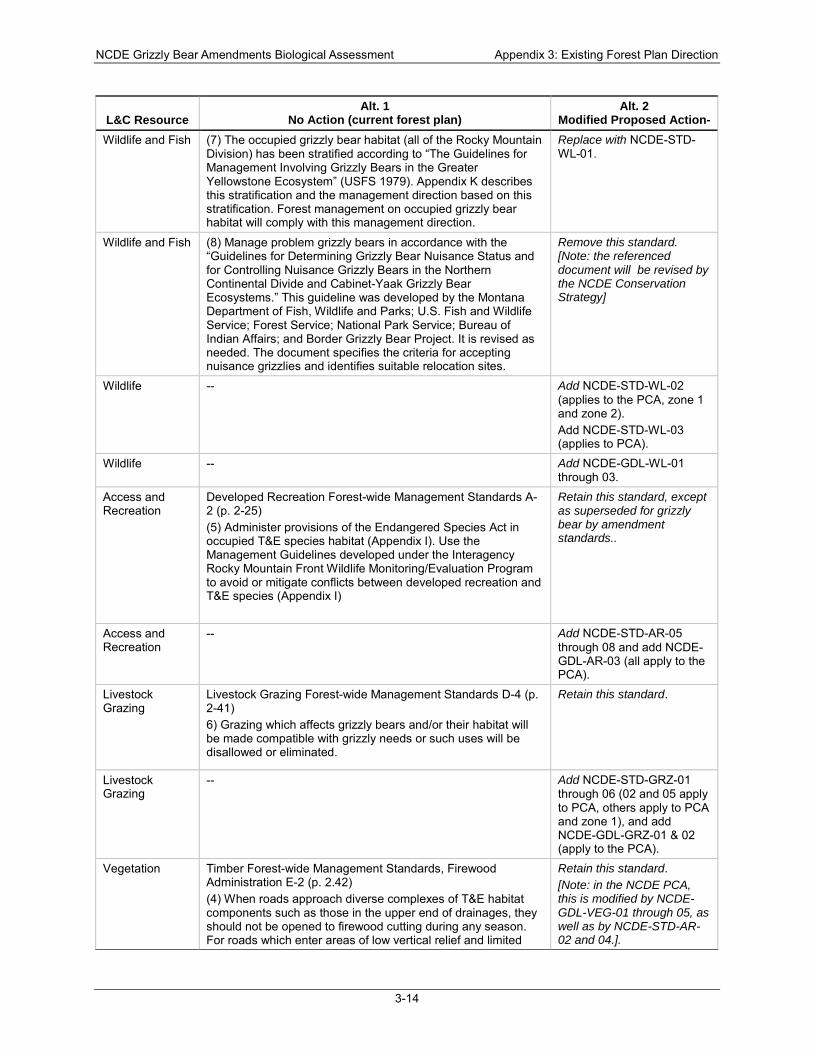
NCDE Grizzly Bear Amendments Biological Assessment Appendix 3: Existing Forest Plan Direction
3-14
L&C Resource Alt. 1
No Action (current forest plan) Alt. 2
Modified Proposed Action- Wildlife and Fish (7) The occupied grizzly bear habitat (all of the Rocky Mountain
Division) has been stratified according to “The Guidelines for Management Involving Grizzly Bears in the Greater Yellowstone Ecosystem” (USFS 1979). Appendix K describes this stratification and the management direction based on this stratification. Forest management on occupied grizzly bear habitat will comply with this management direction.
Replace with NCDE-STD-WL-01.
Wildlife and Fish (8) Manage problem grizzly bears in accordance with the “Guidelines for Determining Grizzly Bear Nuisance Status and for Controlling Nuisance Grizzly Bears in the Northern Continental Divide and Cabinet-Yaak Grizzly Bear Ecosystems.” This guideline was developed by the Montana Department of Fish, Wildlife and Parks; U.S. Fish and Wildlife Service; Forest Service; National Park Service; Bureau of Indian Affairs; and Border Grizzly Bear Project. It is revised as needed. The document specifies the criteria for accepting nuisance grizzlies and identifies suitable relocation sites.
Remove this standard. [Note: the referenced document will be revised by the NCDE Conservation Strategy]
Wildlife -- Add NCDE-STD-WL-02 (applies to the PCA, zone 1 and zone 2). Add NCDE-STD-WL-03 (applies to PCA).
Wildlife -- Add NCDE-GDL-WL-01 through 03.
Access and Recreation
Developed Recreation Forest-wide Management Standards A-2 (p. 2-25) (5) Administer provisions of the Endangered Species Act in occupied T&E species habitat (Appendix I). Use the Management Guidelines developed under the Interagency Rocky Mountain Front Wildlife Monitoring/Evaluation Program to avoid or mitigate conflicts between developed recreation and T&E species (Appendix I)
Retain this standard, except as superseded for grizzly bear by amendment standards..
Access and Recreation
-- Add NCDE-STD-AR-05 through 08 and add NCDE-GDL-AR-03 (all apply to the PCA).
Livestock Grazing
Livestock Grazing Forest-wide Management Standards D-4 (p. 2-41) 6) Grazing which affects grizzly bears and/or their habitat will be made compatible with grizzly needs or such uses will be disallowed or eliminated.
Retain this standard.
Livestock Grazing
-- Add NCDE-STD-GRZ-01 through 06 (02 and 05 apply to PCA, others apply to PCA and zone 1), and add NCDE-GDL-GRZ-01 & 02 (apply to the PCA).
Vegetation Timber Forest-wide Management Standards, Firewood Administration E-2 (p. 2.42) (4) When roads approach diverse complexes of T&E habitat components such as those in the upper end of drainages, they should not be opened to firewood cutting during any season. For roads which enter areas of low vertical relief and limited
Retain this standard. [Note: in the NCDE PCA, this is modified by NCDE-GDL-VEG-01 through 05, as well as by NCDE-STD-AR-02 and 04.].
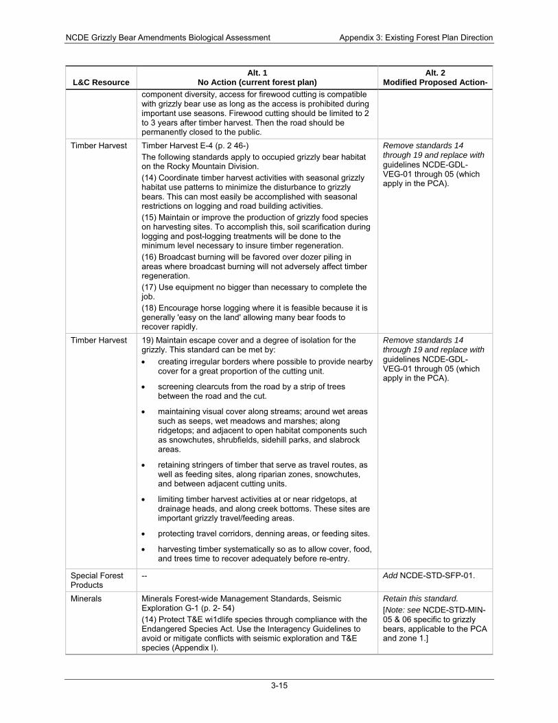
NCDE Grizzly Bear Amendments Biological Assessment Appendix 3: Existing Forest Plan Direction
3-15
L&C Resource Alt. 1
No Action (current forest plan) Alt. 2
Modified Proposed Action- component diversity, access for firewood cutting is compatible with grizzly bear use as long as the access is prohibited during important use seasons. Firewood cutting should be limited to 2 to 3 years after timber harvest. Then the road should be permanently closed to the public.
Timber Harvest Timber Harvest E-4 (p. 2 46-) The following standards apply to occupied grizzly bear habitat on the Rocky Mountain Division. (14) Coordinate timber harvest activities with seasonal grizzly habitat use patterns to minimize the disturbance to grizzly bears. This can most easily be accomplished with seasonal restrictions on logging and road building activities. (15) Maintain or improve the production of grizzly food species on harvesting sites. To accomplish this, soil scarification during logging and post-logging treatments will be done to the minimum level necessary to insure timber regeneration. (16) Broadcast burning will be favored over dozer piling in areas where broadcast burning will not adversely affect timber regeneration. (17) Use equipment no bigger than necessary to complete the job. (18) Encourage horse logging where it is feasible because it is generally 'easy on the land' allowing many bear foods to recover rapidly.
Remove standards 14 through 19 and replace with guidelines NCDE-GDL-VEG-01 through 05 (which apply in the PCA).
Timber Harvest 19) Maintain escape cover and a degree of isolation for the grizzly. This standard can be met by: • creating irregular borders where possible to provide nearby
cover for a great proportion of the cutting unit.
• screening clearcuts from the road by a strip of trees between the road and the cut.
• maintaining visual cover along streams; around wet areas such as seeps, wet meadows and marshes; along ridgetops; and adjacent to open habitat components such as snowchutes, shrubfields, sidehill parks, and slabrock areas.
• retaining stringers of timber that serve as travel routes, as well as feeding sites, along riparian zones, snowchutes, and between adjacent cutting units.
• limiting timber harvest activities at or near ridgetops, at drainage heads, and along creek bottoms. These sites are important grizzly travel/feeding areas.
• protecting travel corridors, denning areas, or feeding sites.
• harvesting timber systematically so as to allow cover, food, and trees time to recover adequately before re-entry.
Remove standards 14 through 19 and replace with guidelines NCDE-GDL-VEG-01 through 05 (which apply in the PCA).
Special Forest Products
-- Add NCDE-STD-SFP-01.
Minerals Minerals Forest-wide Management Standards, Seismic Exploration G-1 (p. 2- 54) (14) Protect T&E wi1dlife species through compliance with the Endangered Species Act. Use the Interagency Guidelines to avoid or mitigate conflicts with seismic exploration and T&E species (Appendix I).
Retain this standard. [Note: see NCDE-STD-MIN-05 & 06 specific to grizzly bears, applicable to the PCA and zone 1.]
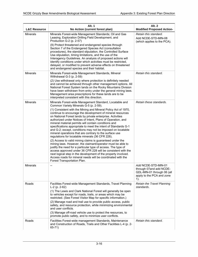
NCDE Grizzly Bear Amendments Biological Assessment Appendix 3: Existing Forest Plan Direction
3-16
L&C Resource Alt. 1
No Action (current forest plan) Alt. 2
Modified Proposed Action- Minerals Minerals Forest-wide Management Standards; Oil and Gas
Leasing, Exploration Drilling Field Development, and Production G-2 (p. 2-57) (9) Protect threatened and endangered species through Section 7 of the Endangered Species Act (consultation procedures), the standard stipulation, the Controlled Surface Use stipulation, timing limitations, and the use of the Interagency Guidelines. An analysis of proposed actions will identify conditions under which activities must be restricted, delayed, or modified to prevent adverse effects on threatened and endangered species and their habitat.
Retain this standard. Add NCDE-STD-MIN-08 (which applies to the PCA).
Minerals Minerals Forest-wide Management Standards, Mineral Withdrawal G-3 (p. 2-59) (2) Use withdrawal only where protection is definitely needed and cannot be achieved through other management options. All National Forest System lands on the Rocky Mountains Division have been withdrawn from entry under the general mining laws. Management area prescriptions for these lands are to be interpreted consistent with this direction.
Retain this standard.
Minerals Minerals Forest-wide Management Standard, Locatable and Common Variety Minerals G-5 (p. 2-59). (1) Consistent with the Mining and Mineral Policy Act of 1970, continue to encourage the development of mineral resources on National Forest lands by private enterprise. Activities authorized under Notices of Intent, Plans of Operation, and mineral material permits will contain conditions and specifications appropriate to meet the intent of Standards G-1 and G-2; except, conditions may not be imposed on locatable mineral operations that are contrary to the surface use regulations for locatable minerals (36 CFR 228). (2) Access to valid mining claims is guaranteed under the mining laws. However, the claimant/operator must be able to justify the need for a particular type of access. The type of access approved under 36 CFR 228 will be consistent with the next logical step in the development of the property involved. Access roads for mineral needs will be coordinated with the Forest Transportation Plan.
Retain these standards.
Minerals -- Add NCDE-STD-MIN-01 through 07and add NCDE-GDL-MIN-01 through 06 (all apply to the PCA and zone 1).
Roads Facilities Forest-wide Management Standards, Travel Planning L-2 (p. 2-62) (1) The Lewis and Clark National Forest will generally be open to vehicles except for roads, trails, or areas which may be restricted. (See Forest Visitor Map for specific information.) (2) Manage road and trail use to provide public access, public safety, and resource protection, while minimizing environmental and user conflicts. (3) Manage off-road vehicle use to protect the resources, to promote public safety, and to minimize user conflicts.
Retain the Travel Planning standards.
Roads Facilities Forest-wide management Standards, Maintenance and Construction of Roads, Trails and Other Facilities L-4 (p. 2-65-71)
Retain this standard.
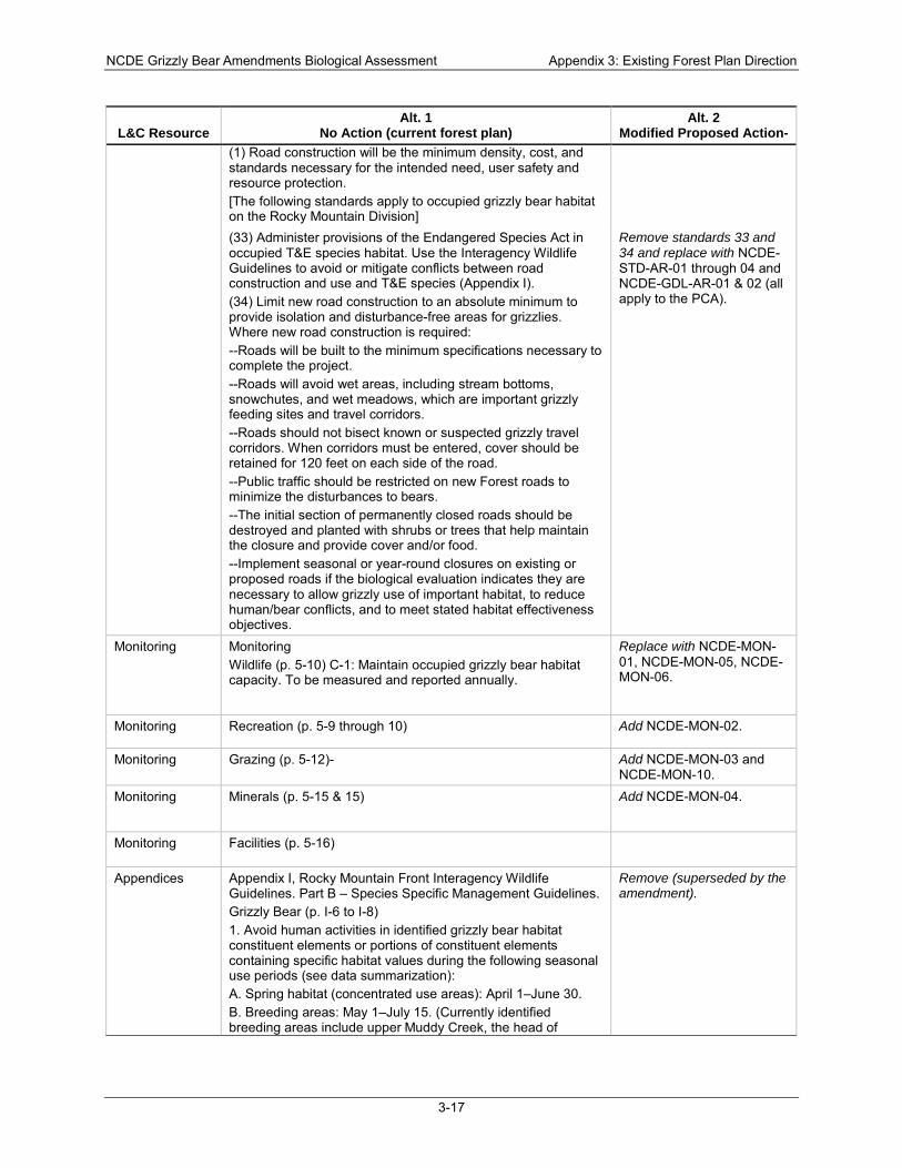
NCDE Grizzly Bear Amendments Biological Assessment Appendix 3: Existing Forest Plan Direction
3-17
L&C Resource Alt. 1
No Action (current forest plan) Alt. 2
Modified Proposed Action- (1) Road construction will be the minimum density, cost, and standards necessary for the intended need, user safety and resource protection. [The following standards apply to occupied grizzly bear habitat on the Rocky Mountain Division]
(33) Administer provisions of the Endangered Species Act in occupied T&E species habitat. Use the Interagency Wildlife Guidelines to avoid or mitigate conflicts between road construction and use and T&E species (Appendix I). (34) Limit new road construction to an absolute minimum to provide isolation and disturbance-free areas for grizzlies. Where new road construction is required: --Roads will be built to the minimum specifications necessary to complete the project. --Roads will avoid wet areas, including stream bottoms, snowchutes, and wet meadows, which are important grizzly feeding sites and travel corridors. --Roads should not bisect known or suspected grizzly travel corridors. When corridors must be entered, cover should be retained for 120 feet on each side of the road. --Public traffic should be restricted on new Forest roads to minimize the disturbances to bears. --The initial section of permanently closed roads should be destroyed and planted with shrubs or trees that help maintain the closure and provide cover and/or food. --Implement seasonal or year-round closures on existing or proposed roads if the biological evaluation indicates they are necessary to allow grizzly use of important habitat, to reduce human/bear conflicts, and to meet stated habitat effectiveness objectives.
Remove standards 33 and 34 and replace with NCDE-STD-AR-01 through 04 and NCDE-GDL-AR-01 & 02 (all apply to the PCA).
Monitoring Monitoring Wildlife (p. 5-10) C-1: Maintain occupied grizzly bear habitat capacity. To be measured and reported annually.
Replace with NCDE-MON-01, NCDE-MON-05, NCDE-MON-06.
Monitoring Recreation (p. 5-9 through 10) Add NCDE-MON-02.
Monitoring Grazing (p. 5-12)- Add NCDE-MON-03 and NCDE-MON-10.
Monitoring Minerals (p. 5-15 & 15) Add NCDE-MON-04.
Monitoring Facilities (p. 5-16)
Appendices Appendix I, Rocky Mountain Front Interagency Wildlife Guidelines. Part B – Species Specific Management Guidelines. Grizzly Bear (p. I-6 to I-8) 1. Avoid human activities in identified grizzly bear habitat constituent elements or portions of constituent elements containing specific habitat values during the following seasonal use periods (see data summarization): A. Spring habitat (concentrated use areas): April 1–June 30. B. Breeding areas: May 1–July 15. (Currently identified breeding areas include upper Muddy Creek, the head of
Remove (superseded by the amendment).
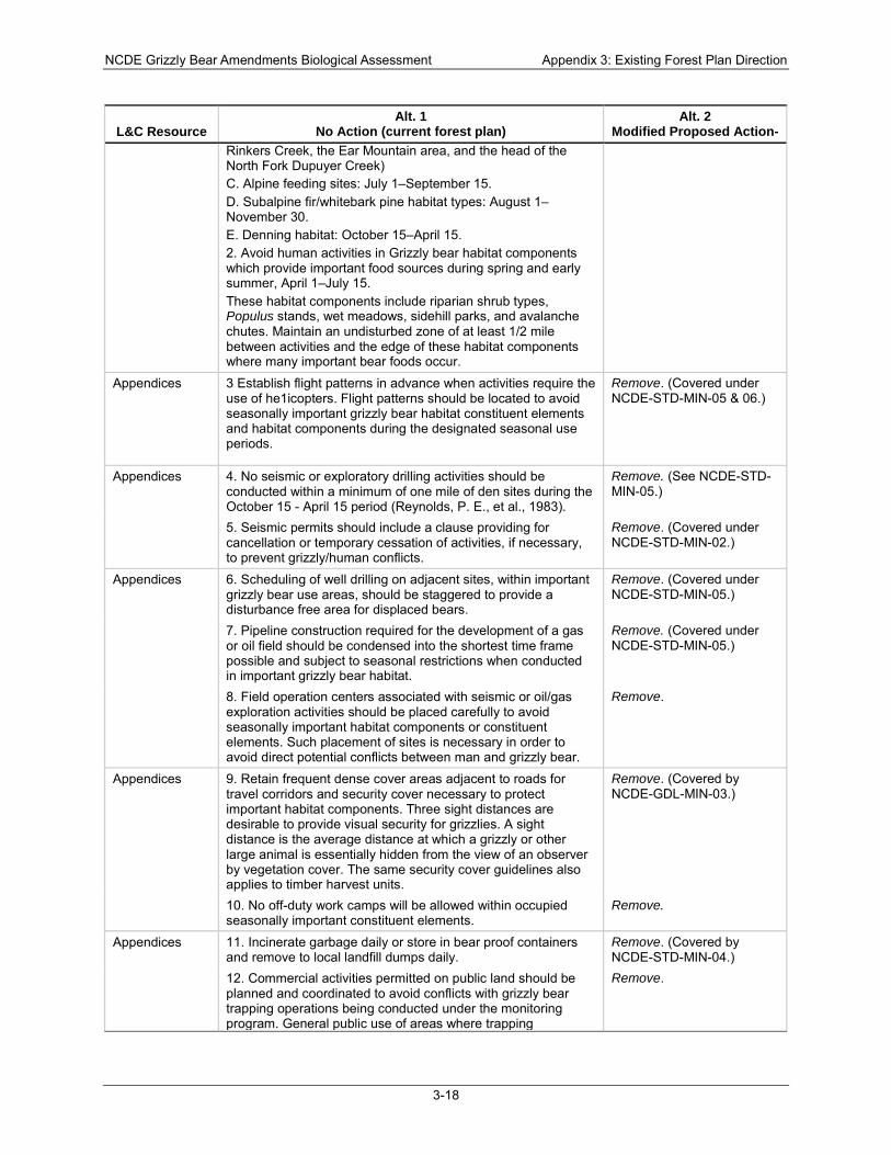
NCDE Grizzly Bear Amendments Biological Assessment Appendix 3: Existing Forest Plan Direction
3-18
L&C Resource Alt. 1
No Action (current forest plan) Alt. 2
Modified Proposed Action- Rinkers Creek, the Ear Mountain area, and the head of the North Fork Dupuyer Creek) C. Alpine feeding sites: July 1–September 15. D. Subalpine fir/whitebark pine habitat types: August 1–November 30. E. Denning habitat: October 15–April 15. 2. Avoid human activities in Grizzly bear habitat components which provide important food sources during spring and early summer, April 1–July 15. These habitat components include riparian shrub types, Populus stands, wet meadows, sidehill parks, and avalanche chutes. Maintain an undisturbed zone of at least 1/2 mile between activities and the edge of these habitat components where many important bear foods occur.
Appendices 3 Establish flight patterns in advance when activities require the use of he1icopters. Flight patterns should be located to avoid seasonally important grizzly bear habitat constituent elements and habitat components during the designated seasonal use periods.
Remove. (Covered under NCDE-STD-MIN-05 & 06.)
Appendices 4. No seismic or exploratory drilling activities should be conducted within a minimum of one mile of den sites during the October 15 - April 15 period (Reynolds, P. E., et al., 1983).
Remove. (See NCDE-STD-MIN-05.)
5. Seismic permits should include a clause providing for cancellation or temporary cessation of activities, if necessary, to prevent grizzly/human conflicts.
Remove. (Covered under NCDE-STD-MIN-02.)
Appendices 6. Scheduling of well drilling on adjacent sites, within important grizzly bear use areas, should be staggered to provide a disturbance free area for displaced bears.
Remove. (Covered under NCDE-STD-MIN-05.)
7. Pipeline construction required for the development of a gas or oil field should be condensed into the shortest time frame possible and subject to seasonal restrictions when conducted in important grizzly bear habitat.
Remove. (Covered under NCDE-STD-MIN-05.)
8. Field operation centers associated with seismic or oil/gas exploration activities should be placed carefully to avoid seasonally important habitat components or constituent elements. Such placement of sites is necessary in order to avoid direct potential conflicts between man and grizzly bear.
Remove.
Appendices 9. Retain frequent dense cover areas adjacent to roads for travel corridors and security cover necessary to protect important habitat components. Three sight distances are desirable to provide visual security for grizzlies. A sight distance is the average distance at which a grizzly or other large animal is essentially hidden from the view of an observer by vegetation cover. The same security cover guidelines also applies to timber harvest units.
Remove. (Covered by NCDE-GDL-MIN-03.)
10. No off-duty work camps will be allowed within occupied seasonally important constituent elements.
Remove.
Appendices 11. Incinerate garbage daily or store in bear proof containers and remove to local landfill dumps daily.
Remove. (Covered by NCDE-STD-MIN-04.)
12. Commercial activities permitted on public land should be planned and coordinated to avoid conflicts with grizzly bear trapping operations being conducted under the monitoring program. General public use of areas where trapping
Remove.
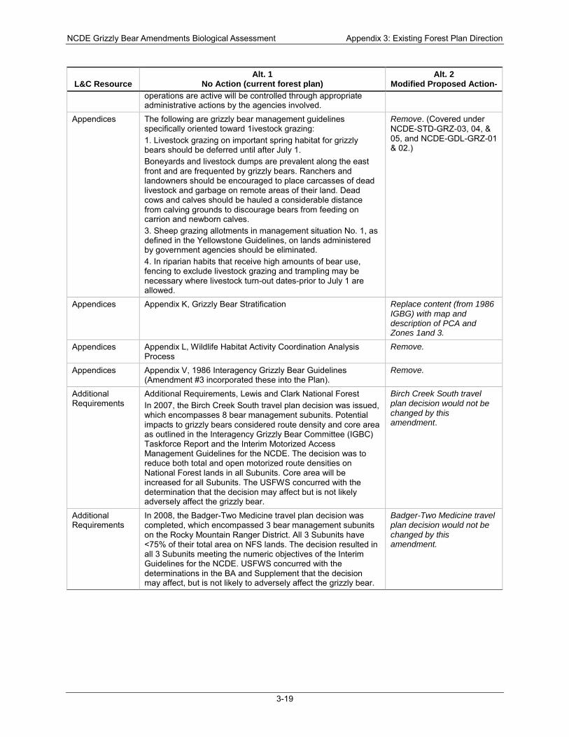
NCDE Grizzly Bear Amendments Biological Assessment Appendix 3: Existing Forest Plan Direction
3-19
L&C Resource Alt. 1
No Action (current forest plan) Alt. 2
Modified Proposed Action- operations are active will be controlled through appropriate administrative actions by the agencies involved.
Appendices The following are grizzly bear management guidelines specifically oriented toward 1ivestock grazing: 1. Livestock grazing on important spring habitat for grizzly bears should be deferred until after July 1. Boneyards and livestock dumps are prevalent along the east front and are frequented by grizzly bears. Ranchers and landowners should be encouraged to place carcasses of dead livestock and garbage on remote areas of their land. Dead cows and calves should be hauled a considerable distance from calving grounds to discourage bears from feeding on carrion and newborn calves. 3. Sheep grazing allotments in management situation No. 1, as defined in the Yellowstone Guidelines, on lands administered by government agencies should be eliminated. 4. In riparian habits that receive high amounts of bear use, fencing to exclude livestock grazing and trampling may be necessary where livestock turn-out dates-prior to July 1 are allowed.
Remove. (Covered under NCDE-STD-GRZ-03, 04, & 05, and NCDE-GDL-GRZ-01 & 02.)
Appendices Appendix K, Grizzly Bear Stratification Replace content (from 1986 IGBG) with map and description of PCA and Zones 1and 3.
Appendices Appendix L, Wildlife Habitat Activity Coordination Analysis Process
Remove.
Appendices Appendix V, 1986 Interagency Grizzly Bear Guidelines (Amendment #3 incorporated these into the Plan).
Remove.
Additional Requirements
Additional Requirements, Lewis and Clark National Forest In 2007, the Birch Creek South travel plan decision was issued, which encompasses 8 bear management subunits. Potential impacts to grizzly bears considered route density and core area as outlined in the Interagency Grizzly Bear Committee (IGBC) Taskforce Report and the Interim Motorized Access Management Guidelines for the NCDE. The decision was to reduce both total and open motorized route densities on National Forest lands in all Subunits. Core area will be increased for all Subunits. The USFWS concurred with the determination that the decision may affect but is not likely adversely affect the grizzly bear.
Birch Creek South travel plan decision would not be changed by this amendment.
Additional Requirements
In 2008, the Badger-Two Medicine travel plan decision was completed, which encompassed 3 bear management subunits on the Rocky Mountain Ranger District. All 3 Subunits have <75% of their total area on NFS lands. The decision resulted in all 3 Subunits meeting the numeric objectives of the Interim Guidelines for the NCDE. USFWS concurred with the determinations in the BA and Supplement that the decision may affect, but is not likely to adversely affect the grizzly bear.
Badger-Two Medicine travel plan decision would not be changed by this amendment.
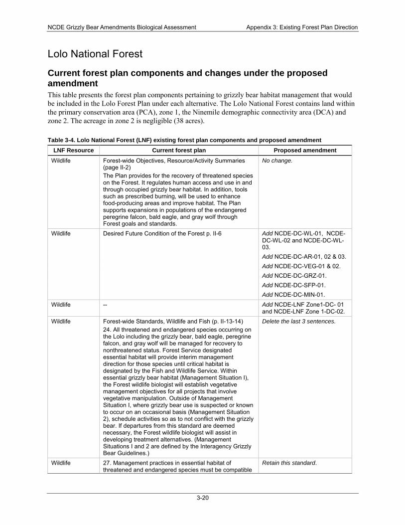
NCDE Grizzly Bear Amendments Biological Assessment Appendix 3: Existing Forest Plan Direction
3-20
Lolo National Forest
Current forest plan components and changes under the proposed amendment This table presents the forest plan components pertaining to grizzly bear habitat management that would be included in the Lolo Forest Plan under each alternative. The Lolo National Forest contains land within the primary conservation area (PCA), zone 1, the Ninemile demographic connectivity area (DCA) and zone 2. The acreage in zone 2 is negligible (38 acres).
Table 3-4. Lolo National Forest (LNF) existing forest plan components and proposed amendment LNF Resource Current forest plan Proposed amendment
Wildlife Forest-wide Objectives, Resource/Activity Summaries (page II-2) The Plan provides for the recovery of threatened species on the Forest. It regulates human access and use in and through occupied grizzly bear habitat. In addition, tools such as prescribed burning, will be used to enhance food-producing areas and improve habitat. The Plan supports expansions in populations of the endangered peregrine falcon, bald eagle, and gray wolf through Forest goals and standards.
No change.
Wildlife Desired Future Condition of the Forest p. II-6 Add NCDE-DC-WL-01, NCDE-DC-WL-02 and NCDE-DC-WL-03.
Add NCDE-DC-AR-01, 02 & 03. Add NCDE-DC-VEG-01 & 02. Add NCDE-DC-GRZ-01. Add NCDE-DC-SFP-01. Add NCDE-DC-MIN-01.
Wildlife -- Add NCDE-LNF Zone1-DC- 01 and NCDE-LNF Zone 1-DC-02.
Wildlife Forest-wide Standards, Wildlife and Fish (p. II-13-14) 24. All threatened and endangered species occurring on the Lolo including the grizzly bear, bald eagle, peregrine falcon, and gray wolf will be managed for recovery to nonthreatened status. Forest Service designated essential habitat will provide interim management direction for those species until critical habitat is designated by the Fish and Wildlife Service. Within essential grizzly bear habitat (Management Situation I), the Forest wildlife biologist will establish vegetative management objectives for all projects that involve vegetative manipulation. Outside of Management Situation I, where grizzly bear use is suspected or known to occur on an occasional basis (Management Situation 2), schedule activities so as to not conflict with the grizzly bear. If departures from this standard are deemed necessary, the Forest wildlife biologist will assist in developing treatment alternatives. (Management Situations I and 2 are defined by the Interagency Grizzly Bear Guidelines.)
Delete the last 3 sentences.
Wildlife 27. Management practices in essential habitat of threatened and endangered species must be compatible
Retain this standard.
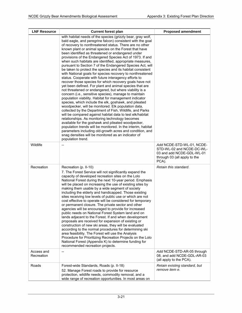
NCDE Grizzly Bear Amendments Biological Assessment Appendix 3: Existing Forest Plan Direction
3-21
LNF Resource Current forest plan Proposed amendment with habitat needs of the species (grizzly bear, gray wolf, bald eagle, and peregrine falcon) consistent with the goal of recovery to nonthreatened status. There are no other known plant or animal species on the Forest that have been identified as threatened or endangered under provisions of the Endangered Species Act of 1973. If and when such habitats are identified, appropriate measures, pursuant to Section 7 of the Endangered Species Act, will be taken to protect the species and its habitat consistent with National goals for species recovery to nonthreatened status. Cooperate with future interagency efforts to recover those species for which recovery goals have not yet been defined. For plant and animal species that are not threatened or endangered, but where viability is a concern (i.e., sensitive species), manage to maintain population viability. Habitat for management indicator species, which include the elk, goshawk, and pileated woodpecker, will be monitored. Elk population data, collected by the Department of Fish, Wildlife, and Parks will be compared against habitat data to test elk/habitat relationships. As monitoring technology becomes available for the goshawk and pileated woodpecker, population trends will be monitored. In the interim, habitat parameters including old-growth acres and condition, and snag densities will be monitored as an indicator of population trend.
Wildlife -- Add NCDE-STD-WL-01, NCDE-STD-WL-02 and NCDE-DC-WL-03 and add NCDE-GDL-WL-01 through 03 (all apply to the PCA).
Recreation Recreation (p. II-10) 7. The Forest Service will not significantly expand the capacity of developed recreation sites on the Lolo National Forest during the next 10-year period. Emphasis will be placed on increasing the use of existing sites by making them usable by a wide segment of society including the elderly and handicapped. Those existing sites receiving low levels of public use or which are not cost effective to operate will be considered for temporary or permanent closure. The private sector and other agencies will be encouraged to provide for increased public needs on National Forest System land and on lands adjacent to the Forest. If and when development proposals are received for expansion of existing or construction of new ski areas, they will be evaluated according to the normal procedures for determining ski area feasibility. The Forest will use the Analysis Procedure for Prioritizing Recreation Projects on the Lolo National Forest (Appendix K) to determine funding for recommended recreation projects.
Retain this standard.
Access and Recreation
-- Add NCDE-STD-AR-05 through 08, and add NCDE-GDL-AR-03 (all apply to the PCA).
Roads Forest-wide Standards, Roads (p. II-18) 52. Manage Forest roads to provide for resource protection, wildlife needs, commodity removal, and a wide range of recreation opportunities. In most areas on
Retain existing standard, but remove item e.

NCDE Grizzly Bear Amendments Biological Assessment Appendix 3: Existing Forest Plan Direction
3-22
LNF Resource Current forest plan Proposed amendment the Forest, this will involve leaving some roads open, closing some roads seasonally, and closing other roads on a permanent basis. Generally, arterial and major collector roads will be left open, whereas local roads will generally be closed. Decisions for road management will be based upon public involvement through the Travel Plan revision process. Primary benefits to be considered are: optimizing big-game production, providing a variety of hunting recreation experiences, protecting critical grizzly bear habitat, reducing sediment in streams, reducing road maintenance costs, and providing for firewood and commodity removal. The criteria to be used to analyze the need for road use restrictions are from the 1984 edition of the Forest Travel Plan and are detailed as follow: e. Roads within grizzly bear habitat may be closed seasonally if it is determined that an open road may be increasing the risk of human-caused bear mortality. Within designated Essential Habitat spring range, all nonarterial systems will be closed April 15 to June 15. On summer range, roads that bisect identified critical habitat components will be closed July 15 thru October 15.
Access and Recreation
-- Add NCDE-STD-AR-01 through 04 and add NCDE-GDL-AR-01 & 02 (all apply to the PCA).
Access and Recreation
-- Add NCDE-LNF Zone1-STD-01 (applies to zone 1 and the Ninemile DCA).
Grazing Forest-wide Standards, Range (p. II-9) 4. Conflicts between livestock and big game will be resolved so big game are allocated the forage required to meet their needs. Domestic livestock will be allowed to utilize any forage surplus not conflicting with the planned expansion of big-game populations. Reductions in livestock numbers will be avoided if possible, but will be acceptable to meet management goals. 5. Allotments with no AUM’s shown for the Proposed Action in Appendix B will be phased out unless the permittee is willing to make necessary investments in livestock management and structural improvement to maintain range conditions at an acceptable level.
Retain these Range standards.
Grazing -- Add NCDE-STD-GRZ-01 through 06 (02 and 05 apply to PCA, others apply to PCA and zone 1), and add NCDE-GDL-GRZ-01 & 02 (apply to the PCA).
Timber Harvest Forest-wide Standards, Timber (p. II-11-12) 10. Regional standards will be followed for tree utilization, management intensity, measurement, growth suitability for timber production, tree openings, and silvicultural systems.
Retain this standard.
Vegetation -- Add NCDE-GDL-VEG-01 through 05 (all apply to the PCA).
Special Forest Products
Special Forest Products Add NCDE-STD-SFP-01 (applies to the PCA).
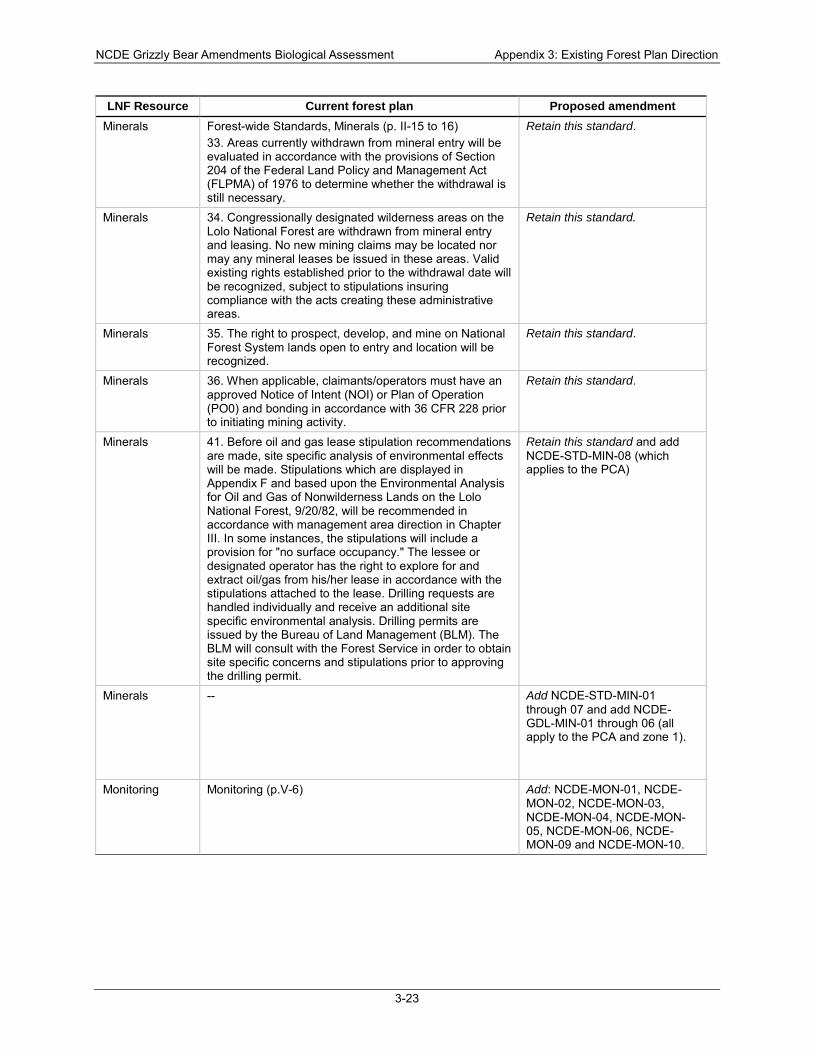
NCDE Grizzly Bear Amendments Biological Assessment Appendix 3: Existing Forest Plan Direction
3-23
LNF Resource Current forest plan Proposed amendment Minerals Forest-wide Standards, Minerals (p. II-15 to 16)
33. Areas currently withdrawn from mineral entry will be evaluated in accordance with the provisions of Section 204 of the Federal Land Policy and Management Act (FLPMA) of 1976 to determine whether the withdrawal is still necessary.
Retain this standard.
Minerals 34. Congressionally designated wilderness areas on the Lolo National Forest are withdrawn from mineral entry and leasing. No new mining claims may be located nor may any mineral leases be issued in these areas. Valid existing rights established prior to the withdrawal date will be recognized, subject to stipulations insuring compliance with the acts creating these administrative areas.
Retain this standard.
Minerals 35. The right to prospect, develop, and mine on National Forest System lands open to entry and location will be recognized.
Retain this standard.
Minerals 36. When applicable, claimants/operators must have an approved Notice of Intent (NOI) or Plan of Operation (PO0) and bonding in accordance with 36 CFR 228 prior to initiating mining activity.
Retain this standard.
Minerals 41. Before oil and gas lease stipulation recommendations are made, site specific analysis of environmental effects will be made. Stipulations which are displayed in Appendix F and based upon the Environmental Analysis for Oil and Gas of Nonwilderness Lands on the Lolo National Forest, 9/20/82, will be recommended in accordance with management area direction in Chapter III. In some instances, the stipulations will include a provision for "no surface occupancy." The lessee or designated operator has the right to explore for and extract oil/gas from his/her lease in accordance with the stipulations attached to the lease. Drilling requests are handled individually and receive an additional site specific environmental analysis. Drilling permits are issued by the Bureau of Land Management (BLM). The BLM will consult with the Forest Service in order to obtain site specific concerns and stipulations prior to approving the drilling permit.
Retain this standard and add NCDE-STD-MIN-08 (which applies to the PCA)
Minerals -- Add NCDE-STD-MIN-01 through 07 and add NCDE-GDL-MIN-01 through 06 (all apply to the PCA and zone 1).
Monitoring Monitoring (p.V-6) Add: NCDE-MON-01, NCDE-MON-02, NCDE-MON-03, NCDE-MON-04, NCDE-MON-05, NCDE-MON-06, NCDE-MON-09 and NCDE-MON-10.
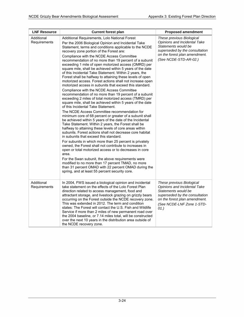
NCDE Grizzly Bear Amendments Biological Assessment Appendix 3: Existing Forest Plan Direction
3-24
LNF Resource Current forest plan Proposed amendment Additional Requirements
Additional Requirements, Lolo National Forest Per the 2006 Biological Opinion and Incidental Take Statement, terms and conditions applicable to the NCDE recovery zone portion of the Forest are: Compliance with the NCDE Access Committee recommendation of no more than 19 percent of a subunit exceeding 1 mile of open motorized access (OMRD) per square mile, shall be achieved within 5 years of the date of this Incidental Take Statement. Within 2 years, the Forest shall be halfway to attaining these levels of open motorized access. Forest actions shall not increase open motorized access in subunits that exceed this standard. Compliance with the NCDE Access Committee recommendation of no more than 19 percent of a subunit exceeding 2 miles of total motorized access (TMRD) per square mile, shall be achieved within 5 years of the date of this Incidental Take Statement. The NCDE Access Committee recommendation for minimum core of 68 percent or greater of a subunit shall be achieved within 5 years of the date of the Incidental Take Statement. Within 2 years, the Forest shall be halfway to attaining these levels of core areas within subunits. Forest actions shall not decrease core habitat in subunits that exceed this standard. For subunits in which more than 25 percent is privately owned, the Forest shall not contribute to increases in open or total motorized access or to decreases in core area. For the Swan subunit, the above requirements were modified to no more than 17 percent TMAD, no more than 31 percent OMAD with 22 percent OMAD during the spring, and at least 55 percent security core.
These previous Biological Opinions and Incidental Take Statements would be superseded by the consultation on the forest plan amendment. (See NCDE-STD-AR-02.)
Additional Requirements
In 2004, FWS issued a biological opinion and incidental take statement on the effects of the Lolo Forest Plan direction related to access management, food and attractant storage, and livestock grazing on grizzly bears occurring on the Forest outside the NCDE recovery zone. This was extended in 2012. The term and condition states: The Forest will contact the U.S. Fish and Wildlife Service if more than 2 miles of new permanent road over the 2004 baseline, or 7.14 miles total, will be constructed over the next 10 years in the distribution area outside of the NCDE recovery zone.
These previous Biological Opinions and Incidental Take Statements would be superseded by the consultation on the forest plan amendment. (See NCDE-LNF Zone 1-STD-01.)
NCDE Grizzly Bear Amendments Biological Assessment References
References page 1
References Planning record exhibits, indicated by a unique number (e.g., 00XXX), are located at the Flathead National Forest Supervisor’s Office.
Ake, K. (2015a). Helena National Forest motorized access analysis. Retrieved from Kalispell, MT: Ake, K. (2015b). Kootenai National Forest motorized access analysis. Retrieved from Kalispell, MT: Ake, K. (2015c). Lewis and Clark National Forest motorized access analysis. 00461. Ake, K. (2015d). Lolo National Forest motorized access analysis. 00462. Ake, K. (2015e). Summary of miles of open roads and motorized trails on the Helena and Lewis and
Clark National Forests. 00174. Ake, K. (2015f). Summary of Rick Mace's 2014 grizzly bear denning grids. Retrieved from Kalispell, MT: Ake, K. (2017). Zone 1 linear road and trail density tracking: Amendment forests, 2011, 2013, and 2015
summaries. Retrieved from Kalispell, MT: Allendorf, F. W., & Leary, R. F. (1988). Conservation and distribution of genetic variation in a polytypic
species, the cutthroat trout. Conservation Biology, 2(2), 170-184. Anderson, C. R., Ternent, M. A., & Moody, D. S. (2002). Grizzly bear-cattle interactions on two grazing
allotments in northwest Wyoming. Ursus, 13, 247-256. Andrusak, H. (1980). Kootenay River white sturgeon. Retrieved from Nelson, BC: Apperson, K. A. (1992). Kootenai River white sturgeon investigations and experimental culture: Annual
progress report FY 1991. (Contract DE-A179-88BP93497). Idaho Department of Fish and Game and Bonneville Power Administration.
Aubry, K. B., Koehler, G. M., & Squires, J. R. (1999). Ecology of Canada lynx in southern boreal forests. In L. F. Ruggiero, K. B. Aubry, S. W. Buskirk, G. M. Koehler, C. J. Krebs, K. S. McKelvey, & J. R. Squires (Eds.), Ecology and Conservation of Lynx in the United States, General Technical Report RMRS-GTR-30WWW (pp. 373-396): USDA, Forest Service, Rocky Mountain Research Station.
Aubry, K. B., McKelvey, K. S., & Copeland, J. P. (2007). Distribution and broadscale habitat relations of the wolverine in the contiguous United States. Journal of Wildlife Management, 71(7), 2147-2158. doi:http://dx.doi.org/10.2193/2006-548
Aune, K., & Kasworm, W. (1989). Final report: East Front grizzly studies. Retrieved from Helena, MT: Aune, K. E. (1994). Comparative ecology of black and grizzly bears on the Rocky Mountain Front. In
International Association for Bear Research and Management (Ed.), Bears: Their biology and management: Vol. 9, part 1: A selection of papers from the Ninth International Conference on Bear Research and Management, Missoula, Montana, February 23-28, 1992 (Vol. Vol. 9, Part 1, pp. 365-374).
Bell, H., Broderdorp, K., Cummings, J., Holt, B., McCollough, M., Parkin, M., . . . Zelenak, J. (2016). Canada lynx expert elicitation workshop. Retrieved from Bloomington, MN: https://www.fws.gov/mountain-prairie/es/species/mammals/lynx/SSA2016/Appendices/2016%2004%2018%20FINAL%20Lynx%20SSA%20EE%20Workshop%20Report%202%20jzeds.pdf
Bjornlie, D. D., Thompson, D. J., Haroldson, M. A., Schwartz, C. C., Gunther, K. A., Cain, S. L., . . . Aber, B. C. (2014). Methods to estimate distribution and range extent of grizzly bears in the Greater Yellowstone Ecosystem. Wildlife Society Bulletin, 38(1), 182-187. doi:10.1002/wsb.368
Blanchard, B. M., & Knight, R. R. (1996). Effects of wildfire on grizzly bear movements and foraging strategies. Retrieved from Fairfield, WA:
Boulanger, J., & Stenhouse, G. B. (2014). The impact of roads on the demography of grizzly bears in Alberta. PLoS ONE, 9(12), 22. doi:10.1371/journal.pone.0115535
Copeland, J. P. (1996). Biology of the wolverine in central Idaho. University of Idaho, Moscow, ID. Retrieved from
NCDE Grizzly Bear Amendments Biological Assessment References
References page 2
https://www.researchgate.net/profile/Jeffrey_Copeland/publication/34538098_Biology_of_the_wolverine_in_Central_Idaho/links/00463529a13d401802000000.pdf
Copeland, J. P., McKelvey, K. S., Aubry, K. B., Landa, A., Persson, J., Inman, R. M., . . . May, R. (2010). The bioclimatic envelope of the wolverine (Gulo gulo): Do climatic constraints limit its geographic distribution? Canadian Journal of Zoology, 88(3), 233-246. doi:10.1139/Z09-136
Copeland, J. P., Peek, J. M., Groves, C. R., Melquist, N. E., Mckelvey, K. S., Mcdaniel, G. W., . . . Harris, C. E. (2007). Seasonal habitat associations of the wolverine in central Idaho. Journal of Wildlife Management, 71(7), 2201-2212. doi:10.2193/2006-559
Copeland, J. P., & Yates, R. E. (2006). Wolverine population assessment in Glacier National Park. Retrieved from Missoula, MT:
Costello, C. M., Mace, R. D., & Roberts, L. L. (2016). Grizzly bear demographics in the Northern Continental Divide Ecosystem, Montana: Research results (2004–2014) and suggested techniques for management of mortality (in review). Retrieved from Helena, MT: http://www.google.com/url?sa=t&rct=j&q=&esrc=s&source=web&cd=2&ved=0ahUKEwiy_cb7oO7NAhUQ5GMKHXE4B-cQFggiMAE&url=http%3A%2F%2Ffwp.mt.gov%2FfwpDoc.html%3Fid%3D75547&usg=AFQjCNFdVMLXWJsfWn6RksuSEgnNZ9VdBw&bvm=bv.126130881,d.cGc
CSKT. (2000). Flathead Indian Reservation forest management plan: An ecosystem approach to tribal forest management: Confederated Salish and Kootenai tribes. Retrieved from Pablo, MT:
Donald, D. B., & Alger, D. J. (1993). Geographic-distribution, species displacement, and niche overlap for lake trout and bull trout in mountain lakes. Canadian Journal of Zoology, 71(2), 238-247. doi:10.1139/Z93-034
Dood, A. R., Atkinson, S. J., & Boccadori, V. J. (2006). Grizzly bear management plan for western Montana: Final programmatic environmental impact statement 2006-2016. Retrieved from Helena, MT: http://fwp.mt.gov/fishAndWildlife/management/grizzlyBear/managementPlan.html
Duke, S., Anders, P., Ennis, G., Hallock, R., Hammond, J., Ireland, S., . . . Westerhof, R. (1999). Recovery plan for Kootenai River white sturgeon (Acipenser transmontanus). Journal of Applied Ichthyology, 15(4-5), 157-163. doi:10.1111/j.1439-0426.1999.tb00226.x
Fagre, D. B., Peterson, D. L., & Hessl, A. E. (2003). Taking the pulse of mountains: Ecosystem responses to climatic variability. Climatic Change, 59(1-2), 263-282. doi:10.1023/A:1024427803359
Fortin, J. K., Rode, K. D., Hilderbrand, G. V., Wilder, J., Farley, S., Jorgensen, C., & Marcot, B. G. (2016). Impacts of human recreation on brown bears (Ursus arctos): A review and new management tool. PLoS ONE, 11(1). doi:10.1371/journal.pone.0141983
Fraley, J. J., & Shepard, B. B. (1989). Life-history, ecology and population status of migratory bull trout (Salvelinus confluentus) in the Flathead Lake and River system, Montana. Northwest Science, 63(4), 133-143.
Franzreb, K. E., & Laymon, S. A. (1993). A reassessment of the taxonomic status of the yellow-billed cuckoo. Western Field Ornithologists, 24(1), 28.
Gehman, S., & Jakes, A. (2007). Winter wildlife tracking surveys in the MacDonald Pass area. Retrieved from Bozeman, MT:
Gehman, S., Robinson, B., & Porco, M. (2010). Snow-tracking surveys on the Helena National Forest, December 2009–March 2010. Unpublished report. Wild Things Unlimited. Bozeman, MT.
Graham, P. (1981). Status of white sturgeon in the Kootenai River. Helena, MT: Montana Department of Fish, Wildlife, and Parks.
Graves, T. A., Kendall, K. C., Royle, J. A., Stetz, J. B., & Macleod, A. C. (2011). Linking landscape characteristics to local grizzly bear abundance using multiple detection methods in a hierarchical model. Animal Conservation, 14(6), 652-664. doi:10.1111/j.1469-1795.2011.00471.x
Graves, T. A., Royle, J. A., Kendall, K. C., Beier, P., Stetz, J. B., & Macleod, A. C. (2012). Balancing precision and risk: Should multiple detection methods be analyzed separately in N-mixture models? PLoS ONE, 7(12). doi:10.1371/journal.pone.0049410
NCDE Grizzly Bear Amendments Biological Assessment References
References page 3
Haas, G. R., & McPhail, J. D. (1991). Systematics and distributions of dolly varden (Salvelinus malma) and bull trout (Salvelinus confluentus) in North America. Canadian Journal of Fisheries and Aquatic Sciences, 48(11), 2191-2211.
Haroldson, M. A., Ternent, M. A., Gunther, K. A., & Schwartz, C. C. (2002). Grizzly bear denning chronology and movements in the Greater Yellowstone Ecosystem. Ursus, 13, 29-37.
Hegg, S. J., Murphy, K., & Bjornlie, D. (2010). Grizzly bears and snowmobile use: A summary of monitoring a grizzly bear den on Togwotee Pass. Yellowstone Science, 18(2), 23-28.
Heinemeyer, K. (2012). Central Idaho wolverine and winter recreation research study, February, 2012, project update. Retrieved from Salt Lake City, UT:
Heinemeyer, K., & Squires, J. (2015). Wolverine-winter recreation research project: Investigating the interactions between wolverines and winter recreation: 2015 progress report. Retrieved from Salt Lake City, UT: http://wolverinefoundation.org/resources/research-reports
Heinemeyer, K., & Squires, J. R. (2013). Wolverine-winter recreation research project: Investigating the interactions between wolverines and winter recreation, 2013 progress report. Retrieved from Salt Lake City, UT: http://wolverinefoundation.org/wp-content/uploads/2014/03/Final-Idaho-Wolverine-Winter-Recreation-Project-2013-Progress-Report-16Nov13.pdf
Heinemeyer, K., & Squires, J. R. (2014). Wolverine-winter recreation research project: Investigating the interactions between wolverines and winter recreation, 2014 progress report. Retrieved from Salt Lake City, UT: http://wolverinefoundation.org/wp-content/uploads/2015/01/Wolverine-Winter-Recreation-Project-2014-Progress-Report-Final.pdf
Herrero, J., & Herrero, S. (2000). Management options for the Moraine Lake Highline Trail: Grizzly bears and cyclists. Retrieved from Banff, AB:
Herrero, S. (1985). Bear attacks: Their causes and avoidance. New York, NY: Nick Lyons Books/Winchester Press.
Herrero, S. (1989). The role of learning in some fatal grizzly bear attacks on people. In M. Bromley (Ed.), Bear-people conflicts: Proceedings of a symposium on management strategies (pp. 9-14). Yellowknife, NWT: Northwest Territories Department of Renewable Resources.
Hornocker, M. G., & Hash, H. S. (1981). Ecology of the wolverine in northwestern Montana. Canadian Journal of Zoology, 59(7), 1286-1301. doi:10.1139/z81-181
IGBC. (1986). Interagency grizzly bear guidelines. Retrieved from https://www.nps.gov/yell/learn/nature/upload/IGB_Guidelines.pdf
IGBC. (1998). Interagency Grizzly Bear Committee taskforce report (revised from 1994). Retrieved from http://www.igbconline.org/index.php/historical-documents, http://www.igbconline.org/index.php/who-we-are/about-the-igbc
ILBT. (2013). Canada lynx conservation assessment and strategy (3rd ed.) Retrieved from Missoula, MT: https://www.fs.fed.us/biology/resources/pubs/wildlife/index.html
Inman, R. M., Brock, B. L., Inman, K. H., Sartorius, S. S., Aber, B. C., Giddings, B., . . . Chapron, G. (2013). Developing priorities for metapopulation conservation at the landscape scale: Wolverines in the western United States. Biological Conservation, 166, 276-286. doi:10.1016/j.biocon.2013.07.010
Inman, R. M., Magoun, A. J., Persson, J., & Mattisson, J. (2012). The wolverine's niche: Linking reproductive chronology, caching, competition, and climate. Journal of Mammology, 93(3), 634-644.
Inman, R. M., Magoun, A. J., Persson, J., Pedersen, D., Mattisson, J., & Bell, J. K. (2007). Wolverine reproductive chronology In Wildlife Conservation Society (Ed.), Greater Yellowstone Wolverine Study: Cumulative report, May 2007 (pp. 55-64). Ennis, MT: Wildlife Conservation Society, North America Program.
Inman, R. M., Packila, M. L., Inman, K. H., Aber, B., Spence, R., & McCauley, D. (2009). Greater Yellowstone Wolverine Program: Progress report, August 2009. Retrieved from Ennis, MT: http://www.wcsnorthamerica.org/AboutUs/Publications/tabid/3437/Default.aspx, http://www.wcsnorthamerica.org/About-Us/Publications.aspx
NCDE Grizzly Bear Amendments Biological Assessment References
References page 4
Johnson, M. J., Magill, R. T., & vanRiper III, C. (2010). Western yellow-billed cuckoo in Arizona: 1998 and 1999. In I. vanRiper, Charles, B. W. Wakeling, & T. K. Sisk (Eds.), The Colorado Plateau IV: Integrating research and resources management for effective conservation (pp. 197-212). Tucson, AZ: University of Arizona Press.
Jope, K. L. (1985). Implications of grizzly bear habituation to hikers. Wildlife Society Bulletin, 13(1), 32-37.
Kamath, P. L., Haroldson, M. A., Luikart, G., Paetkau, D., Whitman, C., & Van Manen, F. T. (2015). Multiple estimates of effective population size for monitoring a long-lived vertebrate: An application to Yellowstone grizzly bears. Molecular Ecology, 24(22), 5507-5521. doi:10.1111/mec.13398
Kasworm, W. F., Carriles, H., Radandt, T. G., Proctor, M. F., & Servheen, C. (2011). Cabinet–Yaak grizzly bear recovery area 2010 research and monitoring progress report. Retrieved from Missoula, MT:
Kasworm, W. F., & Manley, T. L. (1990). Road and trail influences on grizzly bears and black bears in northwest Montana. Bears: Their Biology and Management, 8, 79-84. doi:10.2307/3872905
Kendall, K. C. (1986). Grizzly and black bear feeding ecology in Glacier National Park, Montana. Retrieved from West Glacier, MT: http://ecoshare.info/uploads/ccamp/synthesis_paper_tools/huckleberry/Kendall_1986.pdf
Kendall, K. C., & Arno, S. F. (1990). Whitebark pine--An important but endangered wildlife resource. In W. C. a. K. J. M. Schmidt (Ed.), Proceedings: Symposium on whitebark pine ecosystems: Eecology and management of a high-mountain resource, Bozeman, MT, March 29-31, 1989. Odgen, UT: USDA Forest Service Intermountain Research Station.
Kendall, K. C., & Keane, R. E. (2001). Whitebark pine decline: Infection, mortality, and population trends. In D. F. Tomback, S. F. Arno, & R. E. Keane (Eds.), Whitebark pine communities: ecology and restoration (pp. 221-242). Washington, DC: Island Press.
Kendall, K. C., Stetz, J. B., Boulanger, J., Macleod, A. C., Paetkau, D., & White, G. C. (2009). Demography and genetic structure of a recovering grizzly bear population. Journal of Wildlife Management, 73(1), 3-17. doi:10.2193/2008-330
Knight, R. R., Blanchard, B. M., & Eberhardt, L. L. (1988). Mortality patterns and population sinks for Yellowstone grizzly bears, 1973-1985. Wildlife Society Bulletin, 16(2), 121-125.
Knight, R. R., & Judd, S. L. (1983). Grizzly bears that kill livestock. Bears: Their Biology and Management, 5, 186-190. doi:10.2307/3872537
Knotek, W. L. (2011). Statewide fisheries management, Middle Clark Fork River. Krebs, J., Lofroth, E. C., & Parfitt, I. (2007). Multiscale habitat use by wolverines in British Columbia,
Canada. Journal of Wildlife Management, 71(7), 2180-2192. doi:10.2193/2007-099 Laymon, S. A., & Halterman, M. D. (1987). Can the western subspecies of the yellow-billed cuckoo be
saved from extinction? Western Birds, 19-26. Leary, R. F., Allendorf, F. W., & Knudsen, K. L. (1988). Changes in the genetic composition of the Lake
Koocanusa trout fishery. Retrieved from Missoula, MT: Leathe, S. A., & Enk, M. D. (1985). Cumulative effects of micro-hydro development on the fisheries of the
Swan River drainage, Montana. Retrieved from Kalispell, MT: https://pisces.bpa.gov/release/documents/documentviewer.aspx?doc=36717-1
Lee, D. C., Sedell, J. R., Rieman, B. F., Thurow, R. F., & Williams, J. E. (1997). Broadscale assessment of aquatic species and habitats. In T. M. Quigley & S. J. Arbelbide (Eds.), An assessment of ecosystem components in the interior Columbia Basin and portions of the Klamath and Great Basins (Vol. 1, pp. 1058-1496). Portland, OR: USDA Forest Service, Pacific Northwest Research Station.
Lesica, P. (1990). Habitat requirements, germination behavior and seed bank dynamics of Howellia aquatilis in the Swan Valley, Montana. Retrieved from Kalispell, MT:
Linnell, J. D. C., Swenson, J. E., Andersen, R., & Barnes, B. (2000). How vulnerable are denning bears to disturbance? Wildlife Society Bulletin, 28(2), 400-413.
NCDE Grizzly Bear Amendments Biological Assessment References
References page 5
Lyon, L. J., Lonner, T. N., Weigand, J. P., Marcum, C. L., Edge, W. D., Jones, J. D., . . . Hicks, L. L. (1985). Coordinating elk and timber management: Final report of the Montana Cooperative Elk-Logging Study, 1970-1985. Retrieved from
Mace, R. (2014). [E-mail from R. Mace to R. Kuennen and K. Ake, May 13, 2014, re: grizzly bear den attributes].
Mace, R. D., Carney, D. W., Chilton-Radandt, T., Courville, S. A., Haroldson, M. A., Harris, R. B., . . . Wenum, E. (2012). Grizzly bear population vital rates and trend in the Northern Continental Divide Ecosystem, Montana. The Journal of Wildlife Management, 76(1), 119-128. doi:10.1002/jwmg.250
Mace, R. D., & Jonkel, C. J. (1986). Local food habits of the grizzly bear in Montana. Ursus, 6, 105-110. Mace, R. D., & Manley, T. L. (1993). South Fork Flathead River Grizzly Bear Project: Progress report
for 1992. Retrieved from Helena, MT: Mace, R. D., Minta, S. C., Manley, T. L., & Aune, K. E. (1994). Estimating grizzly bear population-size
using camera sightings. Wildlife Society Bulletin, 22(1), 74-83. Mace, R. D., & Roberts, L. L. (2011). Northern Continental Divide Ecosystem grizzly bear monitoring
team annual report, 2009-2010. Retrieved from Kalispell, MT: http://fwp.mt.gov/fishAndWildlife/management/grizzlyBear/monitoring.html
Mace, R. D., & Roberts, L. L. (2012). Northern Continental Divide Ecosystem grizzly bear monitoring team annual report, 2012. Retrieved from Kalispell, MT: http://fwp.mt.gov/fishAndWildlife/management/grizzlyBear/monitoring.html
Mace, R. D., & Roberts, L. L. (2014). Northern Continental Divide Ecosystem grizzly bear monitoring team annual report, 2014. Retrieved from Kalispell, MT: <Go to WoS>://WOS:000174607800036, http://www.nature.com/nature/journal/v416/n6879/full/416389a.html
Mace, R. D., & Waller, J. S. (1996). Grizzly bear distribution and human conflicts in Jewel Basin Hiking Area, Swan Mountains, Montana. Wildlife Society Bulletin, 24(3), 461-467.
Mace, R. D., & Waller, J. S. (1997a). Final report: Grizzly bear ecology in the Swan Mountains, Montana. Retrieved from Helena, MT: http://fwp.mt.gov/fwpDoc.html?id=52073, http://fwp.mt.gov/fishAndWildlife/management/grizzlyBear/monitoring.html
Mace, R. D., & Waller, J. S. (1997b). Spatial and temporal interaction of male and female grizzly bears in northwestern Montana. Journal of Wildlife Management, 61(1), 39-52. doi:10.2307/3802412
Mace, R. D., Waller, J. S., Manley, T. L., Ake, K., & Wittinger, W. T. (1999). Landscape evaluation of grizzly bear habitat in western Montana. Conservation Biology, 13(2), 367-377. doi:10.1046/j.1523-1739.1999.013002367.x
Mace, R. D., Waller, J. S., Manley, T. L., Lyon, L. J., & Zuuring, H. (1996). Relationships among grizzly bears, roads and habitat in the Swan Mountains, Montana. Journal of Applied Ecology, 33(6), 1395-1404. doi:10.2307/2404779
MacHutchon, A. G. (2014). Human-bear interaction risk assessment for the July 2014 Moose-Wilson Corridon Management Plan alternatives. Retrieved from Moose, WY:
Magoun, A. J., & Copeland, J. P. (1998). Characteristics of wolverine reproductive den sites. Journal of Wildlife Management, 62(4), 1313-1320. doi:10.2307/3801996
Mattson, D. J., Gillin, C. M., Benson, S. A., & Knight, R. R. (1991). Bear feeding activity at alpine insect aggregation sites in the Yellowstone ecosystem. Canadian Journal of Zoology, 69(9), 2430-2435. doi:10.1139/z91-341
Mattson, D. J., Knight, R. R., & Blanchard, B. M. (1987). The effects of developments and primary roads on grizzly bear habitat use in Yellowstone National Park, Wyoming. International Association for Bear Research and Management, 7, 259-273. doi:10.2307/3872633
Mattson, D. J., & Merrill, T. (2002). Extirpations of grizzly bears in the contiguous United States, 1850-2000. Conservation Biology, 16(4), 1123-1136. doi:10.1046/j.1523-1739.2002.00414.x
NCDE Grizzly Bear Amendments Biological Assessment References
References page 6
MBTSG. (1995a). Flathead River drainage bull trout status report (including Flathead Lake, the North and Middle Forks of the Flathead River, and the Stillwater and Whitefish Rivers). Retrieved from Helena, MT:
MBTSG. (1995b). South Fork Flathead River drainage bull trout status report (upstream of Hungry Horse Dam). Retrieved from Helena, MT:
MBTSG. (1996). Swan River drainage bull trout status report (including Swan Lake). Retrieved from Helena, MT:
McIntyre, J. D. (1998). An assessment of bull trout and lake trout interactions in Flathead Lake, Montana. Retrieved from Helena, MT:
McKelvey, K. S., Aubry, K. B., & Ortega, Y. K. (1999). History and distribution of lynx in the contiguous United States. In L. F. Ruggiero, K. B. Aubry, S. W. Buskirk, G. M. Koehler, C. J. Krebs, K. S. McKelvey, & J. R. Squires (Eds.), Ecology and conservation of lynx in the United States (pp. 207-264). Fort Collins, CO: USDA Forest Service, Rocky Mountain Research Station.
McKelvey, K. S., Copeland, J. P., Schwartz, M. K., Littell, J. S., Aubry, K. B., Squires, J. R., . . . Mauger, G. S. (2011). Climate change predicted to shift wolverine distributions, connectivity, and dispersal corridors. Ecological Applications, 21(8), 2882-2897. doi:10.1890/10-2206.1
McLellan, B. N., & Hovey, F. W. (1995). The diet of grizzly bears in the Flathead River drainage of southeastern British Columbia. Canadian Journal of Zoology, 73(4), 704-712. doi:10.1139/z95-082
McLellan, B. N., & Shackleton, D. M. (1989). Grizzly bears and resource-extraction industries: Habitat displacement in response to seismic exploration, timber harvesting and road maintenance. Journal of Applied Ecology, 26, 371-380. doi:10.2307/2404067
McRae, B., Popper, K., Jones, A., Schindel, M., Buttrick, S., Hall, K., . . . Platt, J. (2016). Conserving nature's stage: Mapping omnidirectional connectivity for resilient terrestrial landscapes in the Pacific Northwest. Retrieved from Porltand, OR: http://nature.org/resilienceNW
Meredith, C., Archer, E. K., Scully, R., Van Wagenen, A., Ojala, J. V., Lokteff, R., & Roper, B. B. (2012). PIBO effectiveness monitoring program for streams and riparian areas: 2012 annual summary report. USDA Forest Service, USDI BLM, EPA Retrieved from https://www.fs.fed.us/biology/resources/pubs/feu/pibo/2012_PIBOEM_AnnualReport9_12_2013update.pdf.
Merigliano, M. F., & Lesica, P. (1998). The native status of reed canary grass (Phalaris arundinacea L.) in the inland Northwest, USA. Natural Areas Journal, 18(3), 223-230.
MFWP. (2013). Grizzly bear management plan for southwestern Montana 2013: Final programmatic environmental impact statement. Retrieved from Helena, MT: http://fwp.mt.gov/fishAndWildlife/management/grizzlyBear/
MFWP. (2015). Bull trout redd counts for waters across northwest Montana completed for 2015 [Press release]
Mikle, N., Graves, T. A., Kovach, R., Kendall, K. C., & Macleod, A. C. (2016). Demographic mechanisms underpinning genetic assimilation of remnant groups of a large carnivore. Proceedings of the Royal Society B-Biological Sciences, 283(1839). doi:10.1098/rspb.2016.1467
Miller, C. R., & Waits, L. P. (2003). The history of effective population size and genetic diversity in the Yellowstone grizzly (Ursus arctos): Implications for conservation. Proceedings of the National Academy of Sciences of the United States of America, 100(7), 4334-4339. doi:10.1073/pnas.0735531100
MTDNRC. (2011). Record of decision, forested state trust lands final habitat conservation plan and environmental impact statement. Retrieved from Helena, MT: http://dnrc.mt.gov/divisions/trust/docs/forest-management/hcp
Nielsen, S. E., Munro, R. H. M., Bainbridge, E. L., Stenhouse, G. B., & Boyce, M. S. (2004). Grizzly bears and forestry: II. Distribution of grizzly bear foods in clearcuts of west-central Alberta, Canada. Forest Ecology and Management, 199(1), 67-82.
NCDE Grizzly Bear Amendments Biological Assessment References
References page 7
Pac, H. I., & Dood, A. R. (1998). Five year update of the programmatic environmental impact statement: The grizzly bear in northwestern Montana 1991-1995. Retrieved from Helena, MT:
Partridge, F. (1983). Kootenai river fisheries investigations in Idaho. Retrieved from PC-MDNRC-FNF-USFWS. (1997). Amended and restated conservation agreement among Plum Creek
Timber company, L.P., and Montana Department of Natural Resources and Conservation and U.S.D.A. Forest Service, Flathead National Forest and United States Fish and Wildlife Service [Swan Valley conservation agreement]. Retrieved from
Pengeroth, D. (2013). Biological assessment for grizzly bears on the westside of the Helena National Forest. Retrieved from Helena, MT: http://data.ecosystem-management.org/nepaweb/nepa_project_exp.php?project=41571, http://a123.g.akamai.net/7/123/11558/abc123/forestservic.download.akamai.com/11558/, www/nepa/94938_FSPLT3_1637896.pdf
Proctor, M. F., Paetkau, D., Mclellan, B. N., Stenhouse, G. B., Kendall, K. C., Mace, R. D., . . . Strobeck, C. (2012). Population fragmentation and inter-ecosystem movements of grizzly bears in western Canada and the northern United States. Wildlife Monographs(180), 1-46. doi:10.1002/wmon.6
Quinn, M., & Chernoff, G. (2010). Mountain biking: A review of the ecological effects; A literature review for Parks Canada--National office (Visitor Experience Branch). Retrieved from Gatineau, QC:
Rieman, B., & McIntyre, J. D. (1993). Demographic and habitat requirements for conservation of bull trout. Retrieved from Ogden, UT: https://www.fs.fed.us/rm/pubs_int/int_gtr302.html
Rieman, B. E., & McIntyre, J. D. (1995). Occurrence of bull trout in naturally fragmented habitat patches of varied size. Transactions of the American Fisheries Society, 124(3), 285-296. doi:10.1577/1548-8659(1995)124<0285:Oobtin>2.3.Co;2
Ross, P. I. (2002). COSEWIC assessment and update status report on the grizzly bear, Ursus arctos, in Canada: Prairie population, northwestern population. Retrieved from Ottawa, ON: https://www.registrelep-sararegistry.gc.ca/document/default_e.cfm?documentID=220
Schmor, M. R. (1999). An exploration into bear deterrents, as related to mountain biking, and the design of an ultrasonic bear warning device. University of Calgary,
Schwartz, C. C., Haroldson, M. A., & White, G. C. (2010). Hazards affecting grizzly bear survival in the Greater Yellowstone Ecosystem. Journal of Wildlife Management, 74(4), 654-667. doi:10.2193/2009-206
Schwartz, M. K., Copeland, J. P., Anderson, N. J., Squires, J. R., Inman, R. M., McKelvey, K. S., . . . Cushman, S. A. (2009). Wolverine gene flow across a narrow climatic niche. Ecology, 90(11), 3222-3232. doi:10.1890/08-1287.1
Servheen, C. (1981). Grizzly bear ecology and management in the Mission Mountains, Montana. (PhD dissertation), University of Montana, Missoula, MT.
Servheen, C. (1983). Grizzly bear food-habits, movements, and habitat selection in the Mission Mountains, Montana. Journal of Wildlife Management, 47(4), 1026-1035. doi:10.2307/3808161
Servheen, C., & Cross, M. (2010). Climate change impacts on grizzly bears and wolverines in the Northern U.S. and transboundary Rockies: Strategies for conservation. Retrieved from Missoula, MT: http://www.igbconline.org/index.php/y-reports/228-climate-change-grizzlies-and-wolverines-transboundary-workshop-report
Servheen, C., & Klaver, R. (1983). Grizzly bear dens and denning activity in the Mission and Rattlesnake Mountains, Montana. In International Association for Bear Research and Management (Ed.), Bears: Their biology and management: Volume 5, a selection of papers from the Fifth International Conference on Bear Research and Management, Madison, Wisconsin, USA, February 1980 (pp. 201-207).
Servheen, C., Waller, J. S., & Sandstrom, P. (2001). Identification and management of linkage zones for grizzly bears between the large blocks of public land in the northern Rocky Mountains. In C. L. Irwin, P. Garrett, & K. P. McDermott (Eds.), Proceedings of the 2001 International Conference
NCDE Grizzly Bear Amendments Biological Assessment References
References page 8
on Ecology and Transportation (pp. 161-179). Raleigh: North Carolina State University, Center for Transportation and the Environment.
Shanley, P. (2009). Supplement to the biological assessment for terrestrial wildlife species: Blackfoot-North Divide Winter Travel, Lincoln Ranger District, Helena National Forest. Retrieved from
Squires, J. R., Decesare, N. J., Kolbe, J. A., & Ruggiero, L. F. (2010). Seasonal resource selection of Canada lynx in managed forests of the northern Rocky Mountains. Journal of Wildlife Management, 74(8), 1648-1660. doi:10.2193/2009-184
Squires, J. R., DeCesare, N. J., Olson, L. E., Kolbe, J. A., Hebblewhite, M., & Parks, S. A. (2013). Combining resource selection and movement behavior to predict corridors for Canada lynx at their southern range periphery. Biological Conservation, 157, 187-195. doi:10.1016/j.biocon.2012.07.018
Squires, J. R., McKelvey, K. S., & Ruggiero, L. F. (2004). A snow-tracking protocol used to delineate local lynx, Lynx canadensis, distributions. Canadian Field-Naturalist, 118(4), 583-589.
Squires, J. R., & Ruggiero, L. F. (2007). Winter prey selection of Canada lynx in northwestern Montana. The Journal of Wildlife Management, 71(2), 310-315. doi:10.2193/2005-445
SWCC. (2014). Forest carnivore monitoring in the Southwestern Crown of the Continent: Progress report 2012-2014. Retrieved from http://www.swcrown.org/monitoring/wildlife-monitoring/
Teisberg, J. E., Madel, M. J., Mace, R. D., Servheen, C. W., & Robbins, C. T. (2015). Diet composition and body condition of Northern Continental Divide grizzly bears: Final report, March 2015. Retrieved from
USDA. (1986a). Helena National Forest plan. Retrieved from Helena, MT: https://www.fs.usda.gov/main/helena/landmanagement/planning, https://www.fs.usda.gov/Internet/FSE_DOCUMENTS/stelprdb5352772.pdf
USDA. (1986b). Lewis and Clark National Forest plan. Retrieved from https://www.fs.usda.gov/detail/lcnf/landmanagement/?cid=stelprdb5409100
USDA. (1986c). The Lolo National Forest plan. Retrieved from Missoula, MT: https://www.fs.usda.gov/Internet/FSE_DOCUMENTS/fseprd477025.pdf
USDA. (1995a). Decision notice: Amendment to the Flathead National Forest land and resource management plan, Flathead National Forest, Montana: Amendment no. 19, allowable sale quantity and objectives and standards for grizzly bear habitat management. Retrieved from Kalispell, MT:
USDA. (1995b). Inland native fish strategy: Environmental assessment--Decision notice and finding of no significant impact. Retrieved from https://www.fs.usda.gov/Internet/FSE_DOCUMENTS/fsbdev3_033158.pdf
USDA. (2006). Gallatin National Forest travel management plan, final environmental impact statement, and record of decision. Retrieved from Bozeman, MT: https://www.fs.usda.gov/main/custergallatin/landmanagement/planning, http://www.fs.usda.gov/detail/custergallatin/landmanagement/planning/?cid=stelprdb5130474, https://www.fs.usda.gov/Internet/FSE_DOCUMENTS/stelprdb5133419.pdf, https://www.fs.usda.gov/Internet/FSE_DOCUMENTS/stelprdb5133660.pdf
USDA. (2007). Northern Rockies lynx management direction record of decision, national forests in Montana, and parts of Idaho, Wyoming, and Utah. Retrieved from Missoula, MT: http://www.snowmobileinfo.org/snowmobile-access-docs/Northern-Rockies-Lynx-Management-Direction-ROD_2007.pdf, http://www.fs.fed.us/r1/planning/lynx.html.
USDA. (2010). Food storage special order LC 10 D1 01: Occupancy and use restrictions, Northern Continental Divide Ecosystem, Flathead, Lolo, Helena and Lewis and Clark, National Forests, Region One, USDA, Forest Service. Retrieved from Missoula, MT:
USDA. (2011a). Food/wildlife attractant storage special order: Flathead National Forest, order number F10-076-L-11. Retrieved from Kalispell, MT:
USDA. (2011b). Occupancy and use restrictions: Food storage and sanitation special order, Kootenai National Forest. USDA Forest Service, Kootenai National Forest.
NCDE Grizzly Bear Amendments Biological Assessment References
References page 9
USDA. (2013a). Decision notice and finding of no significant impact: Blackfoot-North Divide winter travel plan, Helena National Forest. Retrieved from
USDA. (2013b). Final environmental impact statement for the revised land management plan, Kootenai National Forest. Retrieved from Libby, MT: https://www.fs.usda.gov/main/kootenai/landmanagement/planning, https://www.fs.usda.gov/Internet/FSE_DOCUMENTS/stelprdb5436479.pdf
USDA. (2015a). Assessment of the Helena and Lewis & Clark National Forests. Retrieved from Helena, MT: https://www.fs.usda.gov/detailfull/helena/home/?cid=stelprd3798801&width=full, https://www.fs.usda.gov/detailfull/helena/home/?cid=stelprd3832458&width=full
USDA. (2015b). Final record of decision for the final environmental impact statement and Kootenai National Forest land management plan, Lincoln, Sanders, and Flathead Counties, Montana and Bonner and Boundary Counties, Idaho. Retrieved from Missoula, MT: https://www.fs.usda.gov/Internet/FSE_DOCUMENTS/stelprd3826661.pdf, https://www.fs.usda.gov/main/kootenai/landmanagement/planning
USDA. (2015c). Land management plan, 2015 revision, Kootenai National Forest. Retrieved from Libby, MT: https://www.fs.usda.gov/main/kootenai/landmanagement/planning, https://www.fs.usda.gov/Internet/FSE_DOCUMENTS/stelprd3826663.pdf
USDA. (2016). Record of decision: Divide travel plan, Helena Ranger District, Helena-Lewis & Clark National Forest. Retrieved from Helena, MT:
USDA. (2017). Record of decision: Blackfoot travel plan and programmatic forest plan amendment #33 for management area N1. Retrieved from Helena, MT:
USFWS. (1993). Grizzly bear recovery plan. Retrieved from Missoula, MT: https://www.fws.gov/mountain-prairie/es/species/mammals/grizzly/Grizzly_bear_recovery_plan.pdf, http://www.fws.gov/mountain-prairie/species/mammals/grizzly/
USFWS. (1994a). 50 CFR Part 17, Endangered and Threatened Wildlife and Plants; The Plant, Water Howellia (Howellia Aquatilis), Determined To Be a Threatened Species, Final Rule. Federal Register Vol. 59, No. 134 (Thursday, July 14, 1994), [FR DOC #94-17134]. Washington, DC: U.S. Fish and Wildlife Service Retrieved from http://www.gpo.gov/fdsys/pkg/FR-1994-07-14/html/94-17134.htm, http://www.gpo.gov/fdsys/browse/collection.action?collectionCode=FR, https://www.federalregister.gov/articles/1994/07/14/94-17134/endangered-and-threatened-wildlife-and-plants-the-plant-water-howellia-howellia-aquatilis-determined.
USFWS. (1994b). 50 CFR Part 17; Endangered and Threatened Wildlife and Plants; Determination of Endangered Status for the Kootenai River Population of the White Sturgeon. Washington, DC: U.S. Fish and Wildlife Service Retrieved from https://www.gpo.gov/fdsys/pkg/FR-1994-09-06/html/94-21864.htm.
USFWS. (2005). Recovery outline, contiguous United States distinct population segment of the Canada lynx. Retrieved from Helena, MT:
USFWS. (2007). Recovery plan for Silene spaldingii (Spalding’s catchfly). Retrieved from Portland, OR: http://www.fws.gov/endangered/species/recovery-plans.html, http://ecos.fws.gov/docs/recovery_plan/071012.pdf
USFWS. (2008). Bull trout (Salvelinus confluentus) 5-year review: Summary and evaluation. Retrieved from Portland, OR: http://www.fws.gov/pacific/bulltrout/5yrreview.html
USFWS. (2009). Spalding’s catchfly (Silene spaldingii) 5-year review: Short form summary. Boise, ID: U.S. Fish and Wildlife Service Retrieved from http://ecos.fws.gov/docs/five_year_review/doc2612.pdf.
USFWS. (2011a). Grizzly bear (Ursus arctos horribilis) 5-year review: Summary and evaluation. Retrieved from Missoula, MT: https://ecos.fws.gov/docs/five_year_review/doc3847.pdf
USFWS. (2011b). Revised biological opinion on the effects of the final access management strategy for the Swan grizzly bear subunit on grizzly bears, Lolo National Forest. Retrieved from Helena, MT:
NCDE Grizzly Bear Amendments Biological Assessment References
References page 10
USFWS. (2012). Review of updated baseline for the 2004 biological assessment for grizzly bears within the Lolo National Forest outside the Northern Continental Divide Ecosystem recovery zone. Retrieved from Helena, MT:
USFWS. (2013a). 50 CFR Part 17, Endangered and Threatened Wildlife and Plants; Threatened Status for the Distinct Population Segment of the North American Wolverine Occurring in the Contiguous United States. Federal Register / Vol. 78, No. 23 / Monday, February 4, 2013 / Proposed Rules/ Pages 7864-7890. U.S. Fish and Wildlife Service Retrieved from http://www.regulations.gov/, http://www.fws.gov/mountain-prairie/species/mammals/wolverine/, http://www.archives.gov/federal-register/cfr/about.html.
USFWS. (2013b). Biological opinion on the revised forest plan for the Kootenai National Forest. Retrieved from Helena, MT: https://www.fs.usda.gov/detail/kootenai/landmanagement/planning/?cid=stelprdb5345946
USFWS. (2013c). Endangered and threatened wildlife and plants; Draft conservation strategy for the Northern Continental Divide Ecosystem grizzly bear. Federal Register / Vol. 78, No. 86 / Friday, May 3, 2013 / Notices/ Page 26064. U.S. Fish and Wildlife Service Retrieved from http://www.fws.gov/endangered/species/recovery-plans.html.
USFWS. (2013d). Grizzly bear recovery plan, draft revised supplement: Revised demographic recovery criteria for the Yellowstone Ecosystem (approved February 19, 2013). Retrieved from Missoula, MT: http://www.fws.gov/mountain-prairie/species/mammals/grizzly/Grizzly_Bear_Recovery_Plan_March2013.pdf, http://www.nps.gov/noca/upload/Grizzly_bear_recovery_plan.pdf
USFWS. (2013e). Northern Continental Divide Ecosystem grizzly bear conservation strategy draft. Retrieved from http://www.fws.gov/mountain-prairie/species/mammals/grizzly/continentalindex.html, http://www.fws.gov/mountain-prairie/species/mammals/grizzly/NCDE_Draft_CS_Apr2013_Final_Version_corrected_headers.pdf
USFWS. (2013f). Water howellia (Howellia aquatilis) 5-year review: Summary and evaluation. Retrieved from Helena, MT: http://ecos.fws.gov/docs/five_year_review/doc4271.pdf
USFWS. (2014a). 50 CFR Part 17 Endangered and threatened wildlife and plants; Revised designation of critical habitat for the contiguous United States distinct population segment of the Canada Lynx and revised distinct population segment boundary; Final rule. Federal Register Vol. 79 (No. 177), September 12, 2014. Washington, DC: U.S. Fish and Wildlife Service Retrieved from https://www.fws.gov/mountain-prairie/species/mammals/lynx/CHFinalRule2014/20140912_Lynx_CH_Final_Rule_Fed_Reg.pdf.
USFWS. (2014b). 50 CFR Part 17, Threatened Status for the Distinct Population Segment of the North American Wolverine occurring in the Contiguous United States. U.S. Department of the Interior, Fish and Wildlife Service. Proposed rules; withdrawal. Federal Register / Vol. 79, No. 156 / Wednesday, August 13, 2014 / Proposed Rules, 47522-47545. Retrieved from http://www.regulations.gov/, http://www.archives.gov/federal-register/cfr/about.html.
USFWS. (2014c). Biological opinion on the effects of the Helena National Forest plan on grizzly bears. Retrieved from Helena, MT:
USFWS. (2015). Recovery plan for the coterminous United States population of bull trout (Salvelinus confluentus). Retrieved from Portland, OR: http://www.fws.gov/pacific/bulltrout/Planning.html, http://www.fws.gov/pacific/bulltrout/pdf/Final_Bull_Trout_Recovery_Plan_092915.pdf
USFWS. (2016a). Threatened, endangered and candidate species for the Helena National Forest, 11/25/2016. Helena, MT: U.S. Fish and Wildlife Service, Ecological Services.
USFWS. (2016b). Threatened, endangered and candidate species for the Kootenai National Forest, 11/25/2016. Helena, MT: U.S. Fish and Wildlife Service, Ecological Services.
USFWS. (2016c). Threatened, endangered and candidate species for the Lewis and Clark National Forest, 11/25/2016. Helena, MT: U.S. Fish and Wildlife Service, Ecological Services.
http://www.fws.gov/mountain-prairie/species/mammals/grizzly/Grizzly_Bear_Recovery_Plan_March2013.pdf
NCDE Grizzly Bear Amendments Biological Assessment References
References page 11
USFWS. (2016d). Threatened, endangered and candidate species for the Lolo National Forest, 11/25/2016. Helena, MT: U.S. Fish and Wildlife Service, Ecological Services.
Waller, J. S. (1992). Grizzly bear use of habitats modified by timber management. (Master of Science), Montana State University, Bozeman, MT. Retrieved from http://scholarworks.montana.edu/xmlui/bitstream/handle/1/7106/31762101749107.pdf?sequence=1
Waller, J. S., & Mace, R. D. (1997). Grizzly bear habitat selection in the Swan Mountains, Montana. Journal of Wildlife Management, 61(4), 1032-1039. doi:10.2307/3802100
Walters, C. J., & Holling, C. S. (1990). Large-scale management experiments and learning by doing. Ecology, 71(6), 2060-2068. doi:10.2307/1938620
Walther, G.-R., Post, E., Convey, P., Menzel, A., Parmesan, C., Beebee, T. J. C., . . . Bairlein, F. (2002). Ecological responses to recent climate change. Nature, 416(6879), 389-395. doi:10.1038/416389a
Webb, S. M., Anderson, R. B., Manzer, D. L., Abercrombie, B., Bildson, B., Scrafford, M. A., & Boyce, M. S. (2016). Distribution of female wolverines relative to snow cover, Alberta, Canada. Journal of Wildlife Management, 80(8), 1461-1470.
White, D., Kendall, K. C., & Picton, H. D. (1999). Potential energetic effects of mountain climbers on foraging grizzly bears. Wildlife Society Bulletin, 27(1), 146-151.
Zager, P., Jonkel, C., & Habeck, J. (1983). Logging and wildfire influence on grizzly bear habitat in northwestern Montana. Bears: Their Biology and Management, 5, 124-132. doi:10.2307/3872529
Zubik, R. J., & Fraley, J. J. (1987). Determination of fishery losses in the Flathead system resulting from the construction of Hungry Horse Dam: Final completion report 1986. Portland, OR: Montana Department of Fish, Wildlife and Parks.