Biodiversity Monitoring in Brazil: Accomplishments and ... · Presidential Decree no. 4.339, of...
56
Biodiversity Monitoring in Brazil: Accomplishments and Challenges Braulio Ferreira de Souza Dias Secretary for Biodiversity and Forests Ministry of the Environment - MMA International Conference Getting Post 2010 Biodiversity Targets Right Bragança Paulista, December 2010
Transcript of Biodiversity Monitoring in Brazil: Accomplishments and ... · Presidential Decree no. 4.339, of...

Biodiversity Monitoring in Brazil: Accomplishments and Challenges
Braulio Ferreira de Souza DiasSecretary for Biodiversity and Forests
Ministry of the Environment - MMA
International Conference Getting Post 2010 Biodiversity Targets Right
Bragança Paulista, December 2010

Brazil: Some Metrics
•Land Area: 8,514,877 km2
•Sea Area: 4,500,000 km2
•Natural Forests: 4,617,915 km2 (54.2%)
•Natural Savannas: 1,185,807 km2 (13,9%)
•Water Resources: >18% of the world
•Species Richness: >15% of the world
•Human Population:191,500,000 people
•Economy: US 1,75 trillion

The biogeographic complexity of Brazil (Biomes and Ecoregions)

The political complexity of Brazil (regions, states and municipalities)
•Brazil is a federal state
•26 States & the Federal District
•5,564 Municipalities
•Environment is a shared responsibility of the Union, States & Municipalities, but states and municipalities are bound to federal laws
•States have their own constitutions and laws
•States have their own environmental councils and agencies
•Most Municipalities have their own environmental councils and agencies

Biodiversity Policy Framework
The Brazilian Federal Constitution – Art. 225:
•“All [citzens] have the right for an ecologically balanced environment, which is a common good of the people and essential for a healthy quality of life; and the public power [governments] and the society have the duty to protect it and to preserve it for the current and future generations.”
•“To ensure the effectiveness of this right, the government has to:
•I –preserve and restore essential ecological processes and promote the ecological management of species and ecosystems;
•II – preserve the diversity and integrity of the country’s genetic patrimony and fiscalize the entities dedicated to research and handling of genetic materials;
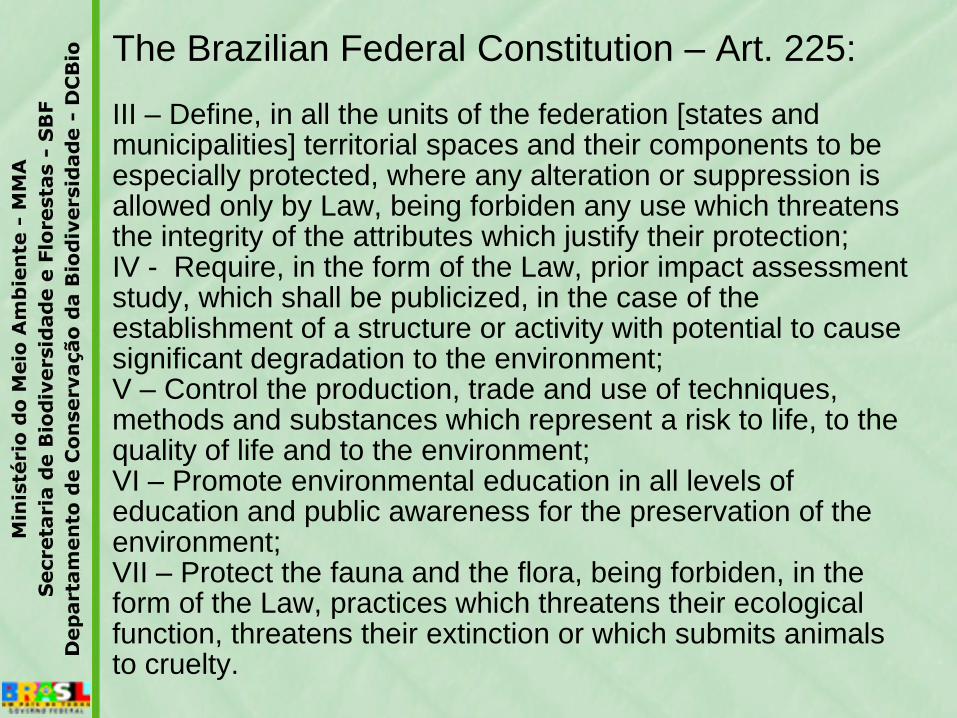
The Brazilian Federal Constitution – Art. 225:
III – Define, in all the units of the federation [states and municipalities] territorial spaces and their components to be especially protected, where any alteration or suppression is allowed only by Law, being forbiden any use which threatens the integrity of the attributes which justify their protection;IV - Require, in the form of the Law, prior impact assessment study, which shall be publicized, in the case of the establishment of a structure or activity with potential to cause significant degradation to the environment;V – Control the production, trade and use of techniques, methods and substances which represent a risk to life, to the quality of life and to the environment;VI – Promote environmental education in all levels of education and public awareness for the preservation of the environment;VII – Protect the fauna and the flora, being forbiden, in the form of the Law, practices which threatens their ecological function, threatens their extinction or which submits animals to cruelty.

The National Biodiversity Policy:
•Principles, Guidelines and Priorities defined in the Presidential Decree no. 4.339, of August 22, 2002;
•National Biodiversity Targets for 2010 defined by CONABIO Resolution no. 3, of December 21, 2006;
•Revised National Priority Areas for Biodiversity Conservation, Sustainable Use and Benefit Sharing defined by MMA Instruction no. 9, of January 23, 2007;
•National Biodiversity Action Plan, adopted by CONABIO Decision no. 40, of February 7, 2006;
•Revised National Biodiversity Program (PRONABIO) and National Biodiversity Committee (CONABIO) established by Presidential Decree no. 4.703, of May 21, 2003;
•National Strategic Plan for Protected Areas (PNAP) established by Presidential Decree no. 5.758, of April 13, 2006 (Protected Areas Network Law No 9.985, of 2000
•;

Ministry of the EnvironmentBrazil
•Created in 1992 (earlier version: 1985-89)
•6 Secretariats:
•Biodiversity & Forests (SBF);
•Water Resources & Urban Environment (SRHU);
•Extractivism & Sustainable Rural Development SEDR);
•Climate Change & Environmental Quality (SMCQ);
•Institutional Articulation & Environmental Citzenship (SAIC);
•Executive Secretariat (SECEX).

Ministry of the Environment of Brazil
•5 Executive Institutes/Agencies:
•IBAMA – Brazilian Institute for the Environment and Renewable Natural Resources (since 1989 – precursors from 1962, 1967 and 1973);
•SFB – Brazilian Forest Service (since 2006 –precursors since 1926);
•ICMBIO – Chico Mendes Institute for Biodiversity Conservation (since 2007);
•JBRJ - Rio de Janeiro Botanical Garden Research Institute (since 1808);
•ANA – National Water Agency (since 2000).

Chico Mendes Institute for Biodiversity Conservation – ICMBio
National Centers for Research and Conservation:
•Center for Continental Fishes – CEPTA (Pirassununga, SP)
•Center for Marine Turtles – TAMAR
(Camaçari, BA)
•Center for Reptiles & Amphibians – RAN (Goiânia, GO)
•Center for Aquatic Mammals – CMA
(Itamaracá, PE)
•Center for Wild Birds – CEMAVE
(Cabedelo, PB)

Chico Mendes Institute for Biodiversity Conservation – ICMBio
National Centers for Research and Conservation:
•Center for Brazilian Primates – CPB
(João Pessoa, PB)
•Center for Carnivore Mammals – CENAP
(Atibaia, SP)
•Center for Caves – CECAV (Brasília, DF)
•Center for Cerrado & Caatinga Biodiversity –CECAT (Brasília, DF)
•Center for Amazonian Biodiversity – CEPAM (Manaus, AM)
•Center for Socio-Biodiversity of Traditional Peoples and Communities – CNPT (São Luís, MA)

The National Institute of Geography and Statistics - IBGE
•Established in 1933 (precursors since 1825)
•Statistical Anuary (since 1937)
•Human population surveys
•Economic surveys
•Land Use surveys (every ten years)
•Vegetation & Natural Resources mapping
•Fisheries & Plant Resources Statistics
•Economic & Ecological Zoning
•Sustainable Development Index
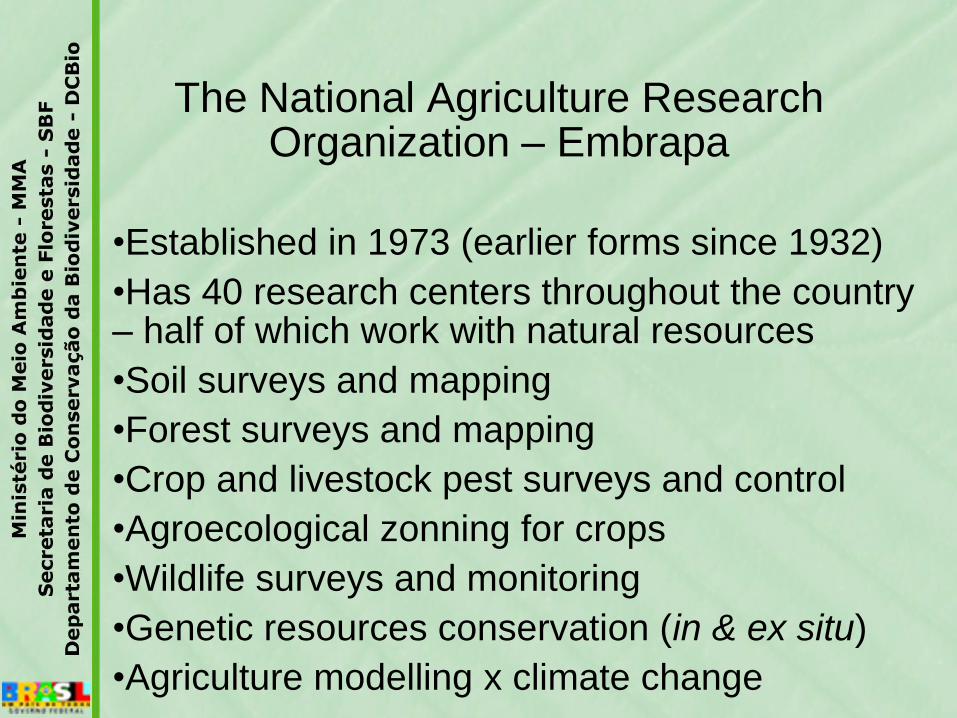
The National Agriculture Research Organization – Embrapa
•Established in 1973 (earlier forms since 1932)
•Has 40 research centers throughout the country – half of which work with natural resources
•Soil surveys and mapping
•Forest surveys and mapping
•Crop and livestock pest surveys and control
•Agroecological zonning for crops
•Wildlife surveys and monitoring
•Genetic resources conservation (in & ex situ)
•Agriculture modelling x climate change

The National Meteorological Institute (INMET) & The Center for Climate
Forecast (CPTEC/INPE)
•National Meteorological Institute (since 1909) (precursors since 1851 [National Observatory] and 1862 (Navy])
•Currently INMET runs a network of 527 meteorological stations throughout the country (manual since 1920s, automatic since 2000s)
•The Center for Weather Forecast and Climate Research (CPTEC), a branch of the National Space Research Institute (INPE), was established in 1994
•Currently CPTEC monitors by Satellite (SCD-1 & SCD-2) data from 1011 stations (since 1996)

Deforestation and Ecosystem Conversion Monitoring
•Amazon Forest Deforestation Monitoring (PRODES) by INPE since 1989 (annually)
•Amazon Forest Deforestation Alert (DETER) by INPE since May 2004 (monthly)
•Amazon Forest Degradation Monitoring (DEGRAD) by INPE since 2007 (annually)
•Atlantic Forest Deforestation Monitoring (SOS Mata Atlântica) by INPE since 1985 (every 5 years)
•Brazilian Biomes Deforestation Monitoring (PMDBB) by IBAMA since 2002 (Caatinga, Cerrado, Pantanal, Mata Atlântica & Pampa) (annually)
•Other Deforestation Monitoring programs at # biomes or states by state agencies and NGOs (eg: Amazonia by IMAZON, Cerrado by LAPIG/UFG & São Paulo State by IF-SP)

Fires & Burnings Monitoring(INPE)
•Fires & Burnings Monitoring by INPE since 1986 (daily) for all of South America (with AVHRR images of the polar satellites NOAA-12, NOAA-15, NOAA-16, NOAA-17 & NOAA-18, the MODIS images of the polar satellites NASA TERRA & AQUA, and images of the geostacionary satellites GOES-10, GOES-12 & MSG-2)

Fisheries Statistics and Monitoring
•National Fisheries Statistics (fish landing; marine and inland waters) annually by IBGE from 1946 to 1989 & by IBAMA since 1990
•Demersal Fish Resources Statistics for the Northeast of Brazil Marine Zone (annually) by SUDEPE (1967-1988), IBAMA (1989-2000) & REVIZEE (1997-2003)
•Fisheries Statistics for the Pantanal (Paraguai Basin) (annually) by INAMB/MS from 1979 to 1984 and by SCPESCA/MS since 1994
•Fisheries Statistics for the Amazon Valley (annually) by INPA & MPEG in the 1970s, by Projects Iara & Mamirauá in the 1990s, by PROVARZEA Project since 2001
•Living Resources Assessments of the Exclusive Marine Zone by the REVIZEE Project from 1995 to 2006
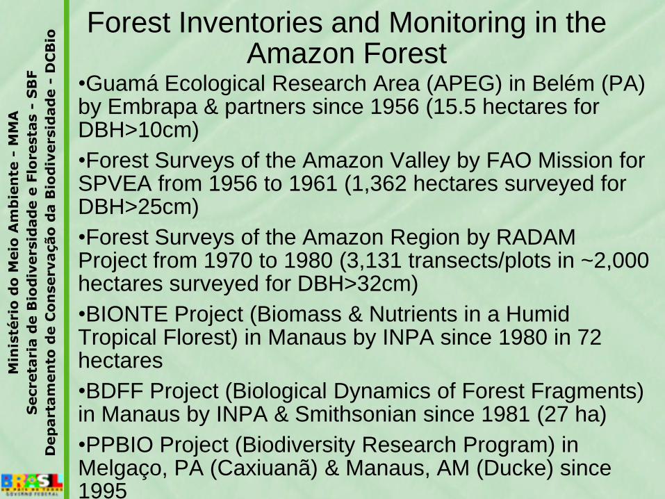
Forest Inventories and Monitoring in the Amazon Forest
•Guamá Ecological Research Area (APEG) in Belém (PA) by Embrapa & partners since 1956 (15.5 hectares for DBH>10cm)
•Forest Surveys of the Amazon Valley by FAO Mission for SPVEA from 1956 to 1961 (1,362 hectares surveyed for DBH>25cm)
•Forest Surveys of the Amazon Region by RADAM Project from 1970 to 1980 (3,131 transects/plots in ~2,000 hectares surveyed for DBH>32cm)
•BIONTE Project (Biomass & Nutrients in a Humid Tropical Florest) in Manaus by INPA since 1980 in 72 hectares
•BDFF Project (Biological Dynamics of Forest Fragments) in Manaus by INPA & Smithsonian since 1981 (27 ha)
•PPBIO Project (Biodiversity Research Program) in Melgaço, PA (Caxiuanã) & Manaus, AM (Ducke) since 1995

Threatened Animal Species (ICMBIO)
•Freshwater Amazonian Turtles Project: 6 species monitored & protected since 1979 in 115 reproduction areas, with 15 field stations]
•Marine Turtles [Tamar Project: 5 species monitored yearly since 1980 along 1,100 km of beaches, with 23 field stations]
•National Bird Ringing Project: >550,000 birds from >1,000 species (including many migratory species) have been ringed since 1977
•Albatross & Petrels Project: 9 species of sea birds monitored since 1991
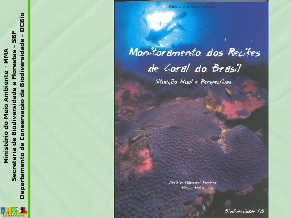
•Coral Reefs Monitoring Project: since 2003, indicator species monitored along 1,000km

Threatened Animal Species (ICMBIO)
•Manattees Projects: West Indian Manatee [since 1980] & Amazonian Manatee [since 1993]
•Whales Projects: Right Whale [since 1982] & Humpback Whale [since 1987]
•Dolfins Projects: Spinner Dolfin [since 1992], Amazon River Dolfin [since 1993] & La Plata Dolfin [since 1990s]
•Carnivores Project: Jaguar (since 1995) and Manned Wolf [since 2000s]
•Marmosets Projects: 4 Lion Marmosets [monitored since 1980s]
•Monkeys Projects: Woolly Spider Monkeys [since 1980s]
•Blue Macaws Projects: Lear’s Macaw and HyacinthMacaw [since 1990s]

Inventory & Monitoring Networks
•MONITORE
•SIMBIO
•PPBIO (Amazon, Caatinga, Atlantic Forest)
•RAINFOR
•ProBUC (Protected Areas in State of Amazonas)
•BIOTA FAPESP
•COM-CERRADO

National Environmental & Biodiversity Indicators
•Sustainable Development Index – IBGE (since 2002)
•National Report on the Millenium Development Goals – IPEA (since 2004)
•National Report on Latin American Sustainable Development Initiative (ILAC) – MMA (since 2007)
•National Environmental Indicators – MMA (since 2009)
•National Report to the CBD/2010 Biodiversity Target – MMA (since 1998)
•National Biodiversity Targets for 2010 – MMA (since 2002)

Priority Areas for Biodiversity in Brazil
O processo de atualização dasÁreas Prioritárias para aConservação, Uso Sustentável eRepartição de Benefícios daBiodiversidade Brasileira, tevecomo resultados o mapa e bancode dados com 2.684 áreasprioritárias indicadas ereferendadas pela sociedade.
Os biomas Mata Atlântica eAmazônia, agregaram 63% dototal das áreas prioritárias, com880 e 824 áreas respectivamente;o Cerrado com 431 áreas, aCaatinga com 292, o Pampa com105, Zona Marinha com 102 e oPantanal com 50, completam onovo mapa atualizado.
Secretaria de Biodiversidade
e Florestas

Bioma (área
total km2)
Área
desmata-
da no
período
(km2)
% desmata-
mento
sobre a
área total
bioma
Desmatamento
anual médio
(km2/ano)
Taxa anual média
de desmatamento
(%)
Cerrado
(2.047.146)85.074 4,17 14.200 0,69
Pantanal
(151.313)4.279 2,82 713 0,47
Amazônia
(4.196.943)(*) 106.215 2,53 17.702 0,42
Caatinga
(826.411)16.576 2,01 2.763 0,33
Pampa
(177.767)2.197 1,23 363 0,20
Mata
Atlântica
(1.103.961)
2.742 0,25 457 0,04
Deforestation rates of the Brazilian biomes
(2002-2008)
(*) Dados do PRODES. No período de 2004-2008, a evolução do desmatamento foi decrescente naAmazônia (média de – 17.000 km2/ano), passando de 27.423 km2 no período 2003-2004 para 12.911 km2 no período 2007-2008.

Até 10%
10 - 20%
20 – 30%
30 – 40%
40 – 50%
50 – 60%
60 – 70%
70 – 80%
80 – 90%
90 – 100%
Deforestation in Amazonia (PRODES 2008)
O INPE analisou 85 imagens, que cobrem área em que foram verificados 94% do total da área desmatada no ano anterior (2006-2007)
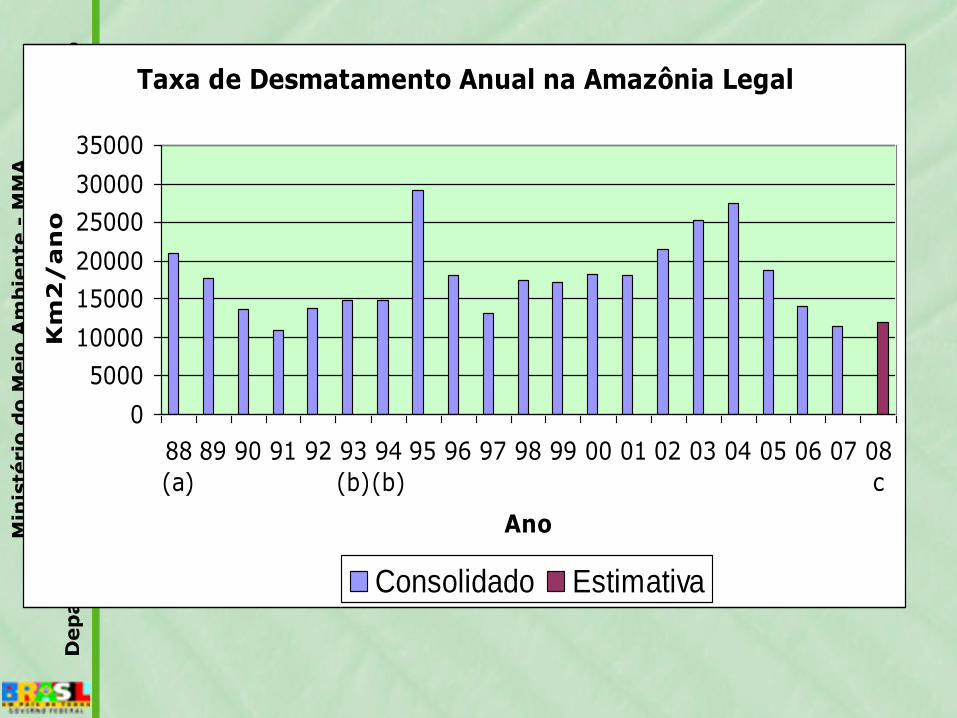
Taxa de Desmatamento Anual na Amazônia Legal
0
5000
10000
15000
20000
25000
30000
35000
88
(a)
89 90 91 92 93
(b)
94
(b)
95 96 97 98 99 00 01 02 03 04 05 06 07 08
c
Ano
Km
2/an
o
Consolidado Estimativa

Deforestation in the Pantanal
2002-2008

Deforestation in the Cerrado biome
up to 2008

Deforestation in the Caatinga biome2002-2008
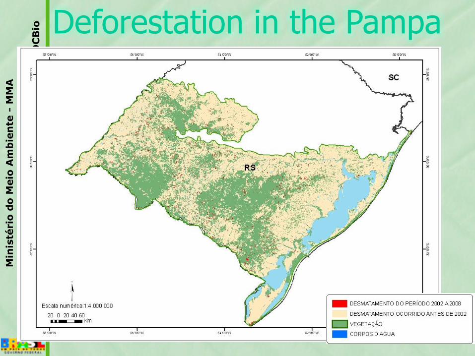
Deforestation in the Pampa

Deforestation in the Atlantic
Forest biome 2002-2008
ÁREA DESMATADA:2.742 km2 (2002-2008)
TAXA DE DESMATAMENTO:457 km2/ano
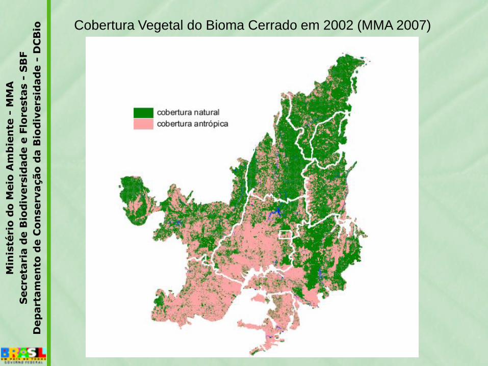
Cobertura Vegetal do Bioma Cerrado em 2002 (MMA 2007)
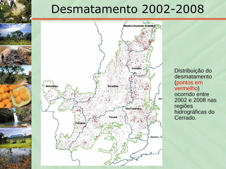
Desmatamento 2002-2008
Distribuição do desmatamento (pontos em vermelho) ocorrido entre 2002 e 2008 nas regiões hidrográficas do Cerrado.

Municípios que mais desmataram no período 2002-2008:
18% do total de 85.075 km²
1. Formosa do Rio Preto (BA)2. São Desidério (BA)3. Correntina (BA)4. Paranatinga (BA)5. Barra do Corda (MA)6. Balsas (MA)7. Brasnorte (MT)8. Nova Ubiratã (MT)9. Jaborandi (BA)10.Sapezal (MT)11.Baixa Grande do Ribeirão
(PI)12.Nova Mutum (MT)13.São José do Rio Claro (MT)14. Barreiras (BA) 15.Grajaú (MA)16.Uruçuí (PI)17.Riachão das Neves (BA)18.Santa Rita do Trivelato
(MT)19.Crixás (GO)20.João Pinheiro (MG)
Áreas remanescentes sob intensa pressão de desmatamento
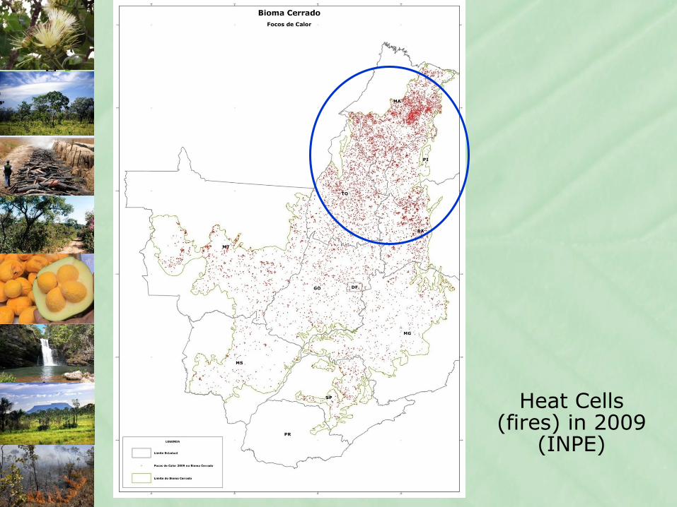
Heat Cells (fires) in 2009
(INPE)

Protected Areas under different categories and
responsibility
• 304 federal PAs (ICMBIO)
• 797 state PAs
• 689 Municipal PAs (in 2002)
• 805 Private PAs (RPPNs)
• 517 Indigenous Territories
• ??? Marrons Territories


Futuro dos Biomas Brasileiros?
fonte: Oyama & Nobre, 2003
Savanização da Amazônia: um estado de equilíbrio na relação bioma-clima?
floresta savana caatinga campos deserto
2000 2100

DCBIO/GCB – Projeto GEF Polinizadores
O Projeto GEF Polinizadores “Conservação e Manejo de Polinizadores para umaAgricultura Sustentável, através de uma Abordagem Ecossistêmica”
Objetivo: Monitorar o declínio dos polinizadores, sua causa e seu impacto sobre os serviços depolinizadores; Destacar a falta de informação taxonômica sobre polinizadores; Avaliar o valoreconômico da polinização e do impacto do declínio dos serviços de polinização; e Promover aconservação, a restauração e o uso sustentável da diversidade de polinizadores naagricultura e nos ecossistemas relacionados.
Duração: 5 anos.
Recursos: US$ 4,5 milhões (GEF para o Brasil, não internalizados no Orçamento da União -FAO) e contrapartida nacional de US$ US$ 6 milhões.
Coordenação Nacional: DCBIO e Iniciativa Brasileira de Polinizadores.
Estrutura e Principais Resultados:
Componente 1: Desenvolvimento de uma base de conhecimento
Componente 2: Extensão e promoção das melhores práticas de manejo para o uso dos
polinizadores.
Componente 3: Capacitação e aumento de conscientização
Componente 4: Troca de experiências e disseminação de informação
Parceiros do MMA na Implementação do Projeto: MAPA, ICHICO, EMBRAPA, MDA, FBOMS,
CNA, CBA, MCT
Situação Atual: Projeto Full sized aprovado pelo Conselho do GEF em junho de 2007 , endosso eassinatura prevista para 2007, implementação a partir de 2008.
Abrangência: Global (Brasil, África do Sul, Gana, Quênia, Índia, Nepal, Paquistão)
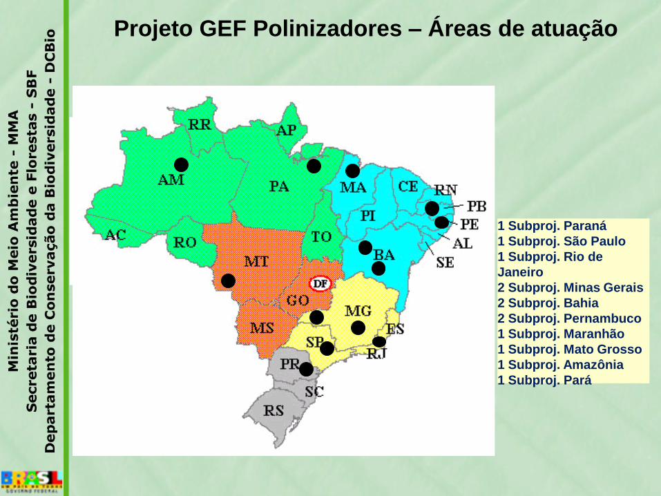
1 Subproj. Paraná
1 Subproj. São Paulo
1 Subproj. Rio de
Janeiro
2 Subproj. Minas Gerais
2 Subproj. Bahia
2 Subproj. Pernambuco
1 Subproj. Maranhão
1 Subproj. Mato Grosso
1 Subproj. Amazônia
1 Subproj. Pará
Projeto GEF Polinizadores – Áreas de atuação

- 1.300 colaboradores
(moradores locais)
- 160 técnicos
- 200 estagiários e trainees
TAMAR
- 22 bases de proteção
- 1.100 km monitorados

Áreas de Desova – desde 1980 Banco de Dados padrão organizado desde
1984~ 210.000 registros
(até a campanha reprodutiva 2008/2009)
Registros não reprodutivos – desde 1990Atividades aquáticas, captura incidental e
encalhesBanco de dados padrão organizado desde
199045.000 registros
(até agosto de 2009)


Monitoramento de recifes de coral
Histórico
1997- Implantação da Rede Global de Monitoramento deRecifes de Coral (GCRMN); perante a preocupação decientistas - impactos antropogênicos atingindo níveisalarmantes e a informação disponível era insuficiente paraformar um retrato da situação mundial
-No Brasil: inicio do Programa Nacional com PROBIO-programa piloto em 2002- tese de protocolo base (ReefCheck) e adaptações
--2005-2009: convenio MMA/UFPE/IRCOS paraimplementação do programa, coleta de dados etreinamento.
--2010- ? ICMBIO/PARCEIROS

O monitoramento é um meio de acompanhar ascondições dos ecossistemas recifais ao longo dotempo, relacionando essas condições com asações de manejo tomadas.
Foto
: L
eo
Fra
ncin
i

Posicionamento das trenas
Foto Zaira Matheus
Foto Zaira Matheus
Foto Ivonildo

Indicadores
Brasil:
- inclusão e adaptação de 20 indicadores
- identificação por espécie


Pontos monitorados
2002-2009:
203 saídas
• 812 transectos
• 4 IES
• 4 agências ambientais
• 5 ONG’s
• 3 operadoras
• +90mergulhadores voluntários

Pesquisa de Informações Georreferenciadas

Treinamentos Reef Check Brasil para equipes locais
Pernambuco – Tamandaré, Porto de Galinhas, São José da Coroa Grande e Fernando de Noronha
Alagoas - Maragogi
PE/AL – MMA / UFPE / IRCOS / ICMBIO / CEPENE / APA Costa dos Corais / Projeto Recifes Costeiros /APA de Guadalupe / Atlantis Divers / PARNAMAR Fernando de Noronha / AVINA

Brazilian Reef Check: Fishes x PAs

THANK YOU!