Bincar-Bonom: The Basis of Spatial Arrangements of ...
16
ISVS e-journal, Vol. 3, no. 2, December 1, 2014 Journal of the International Society for the Study of Vernacular Settlements 1 Bincar-Bonom: The Basis of Spatial Arrangements of Singengu Village, Indonesia. Cut Nuraini, Achmad Djunaedi, Sudaryono & T.Yoyok W. Subroto Department of Architecture and Planning Faculty of Engineering, Gadjah Mada University Indonesia Abstract Singengu village is the first tapian (land at the banks of the river) inhabited by the ancient Indonesians when they came down from the mountain ranges. Places in the village show some remarkable spatial arrangements of articulated oppositions. Places for women's activities are in the direction of what is called bincar (sunrise), while places for men’s activities are in the direction of bonom (sunset). The locations of the tomb also shows similar oppositions. The ancestral grave is in the direction of bonom whereas ancestral descent tomb is in the direction of bincar. This paper presents a study of the Singengu village in Mandailing Julu, north Sumatera which is a mountainous riverside settlement. Its dual reality of oppositions is a unique phenomenon. The study employed a phenomenological approach; an appropriate paradigm to explore the meanings behind the two realities. It begins with a grand-tour to explore the phenomenon and continue with a mini-tour to deepen the understanding and derive deep insights. It then employs an inductive analysis to reveal the truth obtained through transcendental reduction. The results show that the Bincar-Bonom direction is the base of spatial settlement as a form of obedience to the Datu (the Creator/God) because Datu is believed always to give a life by the movement of the sun. Bincar directions is a symbol of the future, direction for the young, junior and something new; while the Bonom direction is a symbol of the past, directions for the elderly, seniors and something old. There are three essential concepts which supported and formed Bincar-Bonom as the basis of spatial arrangement of Singengu Village Settlement, ie. (1) the Mangulaki Pangkal (back to the origin) concept, (2) the Banua (the world) concept, and (3) the Parkouman (fraternity) concept. The paper concludes that Bincar-Bonom is a concept that has guided the mountainous riverside settlements with the socio-symbolic-spiritual spatial relations, which is unique to Indonesian Vernacular Settlements. Keywords: Bincar-Bonom, Mangulaki Pangkal, Banua, Parkouman, Socio-symbolic-spiritual spatial, Singengu Village Settlement Introduction Most vernacular settlements have their own character, uniqueness and differences arising from traditions and ways of life of people’s beliefs and geo-spatial settings. Settlements built on mountains and valleys in fact are very unique. Research on
Transcript of Bincar-Bonom: The Basis of Spatial Arrangements of ...

ISVS e-journal, Vol. 3, no. 2,
December 1, 2014
Journal of the International Society for the Study of Vernacular Settlements 1
Bincar-Bonom:
The Basis of Spatial Arrangements of
Singengu Village, Indonesia.
Cut Nuraini, Achmad Djunaedi, Sudaryono & T.Yoyok W. Subroto Department of Architecture and Planning
Faculty of Engineering, Gadjah Mada University
Indonesia
Abstract
Singengu village is the first tapian (land at the banks of the river) inhabited by the ancient Indonesians when they came down from the
mountain ranges. Places in the village show some remarkable spatial
arrangements of articulated oppositions. Places for women's activities are in the direction of what is called bincar (sunrise), while places for men’s
activities are in the direction of bonom (sunset). The locations of the tomb
also shows similar oppositions. The ancestral grave is in the direction of bonom whereas ancestral descent tomb is in the direction of bincar.
This paper presents a study of the Singengu village in Mandailing Julu, north Sumatera which is a mountainous riverside settlement. Its dual
reality of oppositions is a unique phenomenon. The study employed a
phenomenological approach; an appropriate paradigm to explore the meanings behind the two realities. It begins with a grand-tour to explore
the phenomenon and continue with a mini-tour to deepen the
understanding and derive deep insights. It then employs an inductive
analysis to reveal the truth obtained through transcendental reduction.
The results show that the Bincar-Bonom direction is the base of spatial settlement as a form of obedience to the Datu (the Creator/God)
because Datu is believed always to give a life by the movement of the sun.
Bincar directions is a symbol of the future, direction for the young, junior
and something new; while the Bonom direction is a symbol of the past, directions for the elderly, seniors and something old. There are three
essential concepts which supported and formed Bincar-Bonom as the basis
of spatial arrangement of Singengu Village Settlement, ie. (1) the Mangulaki Pangkal (back to the origin) concept, (2) the Banua (the world)
concept, and (3) the Parkouman (fraternity) concept. The paper concludes
that Bincar-Bonom is a concept that has guided the mountainous riverside
settlements with the socio-symbolic-spiritual spatial relations, which is unique to Indonesian Vernacular Settlements.
Keywords: Bincar-Bonom, Mangulaki Pangkal, Banua, Parkouman,
Socio-symbolic-spiritual spatial, Singengu Village Settlement
Introduction
Most vernacular settlements have their own character, uniqueness and differences arising from traditions and ways of life of people’s beliefs and geo-spatial
settings. Settlements built on mountains and valleys in fact are very unique. Research on

ISVS e-journal, Vol. 3, no. 2,
December 1, 2014
Journal of the International Society for the Study of Vernacular Settlements 2
settlements in mountains can divulge such specificity and richness of local values and approaches to making them. They can provide deep understanding of these settlements so
that others can appreciate their uniqueness and character as well as contribute to their
well-being. In fact, many lessons can be learnt from them to prepare planned
interventions if and when necessary.
There are serious difficulties in understanding the mountain settlements employing general theories of vernacular settlements. For example, in the absence of
specific meanings and values of the communities, analysis and findings can become
superficial. The essence of a settlement cannot be discovered by ad-hoc alien approaches.
Exploring the uniqueness and richness of mountain settlements require an understanding of the contexts morefully and can offer new theories of vernacular with reference to the
contextual forces of their existence.
Mountainous settlements with diverse backgrounds have often been studied based
on kinship systems, social and cultural systems, cosmology, beliefs, and also natural
elements such as mountains, seas and rivers (Nuraini,2012). They indicate that mountainous settlements are unique and the essence of a settlement must be revealed in
order to find the local theory. Other studies on mountain settlements focus on spatial
formations (Parimin, 1986) based on sacred-profane dualities and spatial systems (Runa, 2004) as related to the social systems and cultures of societies. Research on mountain
settlements are also conducted with a focus on tribal governance and spatial planning
(Purbadi, 2010) and the punden-based settlements system as a symbol of pangayoman
(Rezeki, 2012) which has four characteristics of papan (place). Another focus often found
is on settlement spatial plan structures (Han, 1991) those permanent and those that
change However,most researchers have not specifically observed the spatial
arrangements of settlements primarily at spatial scales.
In Indonesia, there are many such mountain settlements, which can offer greater insights into the ways in which they have been formed, although not many exist. Some
observations and research on Singengu village in Mandailaing Julu has shown that there
is an interesting phenomenon that has guided its making. Reference here is to two concepts, often presented as a dual term; bincar-bonom. Simply put, these two terms refer
to sunrise and sunset. It has been noted that in the Singengu village, the spatial
arrangement has been related to bincar-bonom at three different scales, namely the
regional scale, village-environmental scale and house scale.
The research presented in this paper examined the concepts of bincar-bonom and how it has become the basis of settlements. It raised the following question: What is the
nature/meaning behind bincar-bonom direction (sunrise-sunset) in forming Singengu
village settlement spatial plan? The study aimed to find a theoretical articulation of the
Singengu village settlement spatial plan in Mandailaing Julu. Its benefit is to contribute to enhance the present settlement theories, and to increase the understanding of Mandailaing
tribes’ living culture. It is expected to serve as guidelines for settlement development
actions that may be needed to conserve these settlements and the Nature that surrounds them while respecting the unique values of local culture in Indonesia.
Singengu village
Singengu is a village with a status of huta induk (mother village) that has some huta anak (small village). It is located in Kotanopan sub-district, Mandailing Julu area,
North Sumatera Province. In fact, Singengu has developed huta anak to east dan west,
with Singengu as axis point. The landscapes of Mandailing Julu also shows the same
pattern. There are two mountains, ‘Tor Sihite’ in the West and ‘Tor Kulabu’ in the East with Singengu as the axis point. Singengu village is situated between two hills, Tawar
ISVS e-journal, Vol. 3, no. 2,
December 1, 2014
Journal of the International Society for the Study of Vernacular Settlements 3
hills in the North and Parkutahan hills in South. Singengu village is also crossed by Aek Batang Gadis river flowing from upstream to downstream from the East to the West. The
eastern part of the village is bordered by Aek Singengu river flowing from South to North
and empties into Aek Batang Gadis. Aek Singangir river from the North also empties into
Aek Batang Gadis river. Administratively, Singengu village area does not have clear boundaries because they still use the customary land system. The overall width of
Singengu village land is 1092.95 Ha, with the following usage; paddy land area occupies
10 hectares, dry land area is of 716.5 ha, buildings / yard area is of 3.5 ha and the rest are
forest and agriculture. Most of the Singengu people are farmers. (Goverment of
Mandailing Natal Regency, 2010)
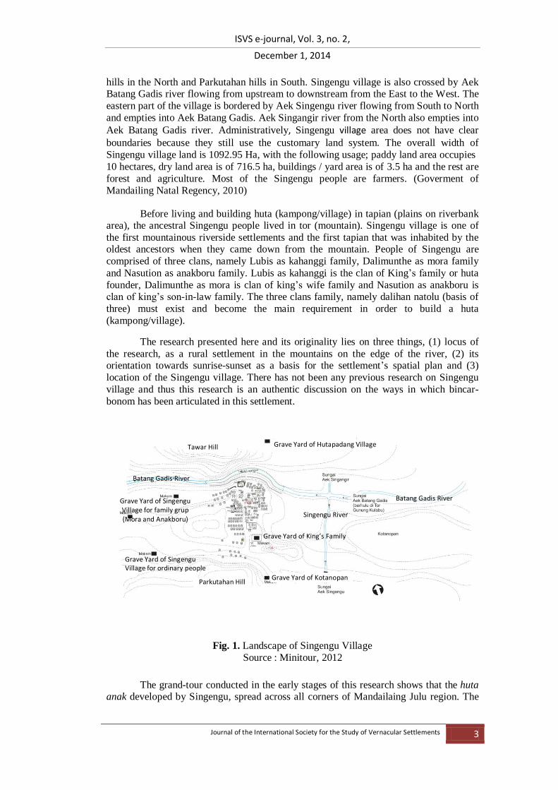
Before living and building huta (kampong/village) in tapian (plains on riverbank area), the ancestral Singengu people lived in tor (mountain). Singengu village is one of
the first mountainous riverside settlements and the first tapian that was inhabited by the oldest ancestors when they came down from the mountain. People of Singengu are
comprised of three clans, namely Lubis as kahanggi family, Dalimunthe as mora family
and Nasution as anakboru family. Lubis as kahanggi is the clan of King’s family or huta
founder, Dalimunthe as mora is clan of king’s wife family and Nasution as anakboru is clan of king’s son-in-law family. The three clans family, namely dalihan natolu (basis of
three) must exist and become the main requirement in order to build a huta
(kampong/village).
The research presented here and its originality lies on three things, (1) locus of
the research, as a rural settlement in the mountains on the edge of the river, (2) its orientation towards sunrise-sunset as a basis for the settlement’s spatial plan and (3)
location of the Singengu village. There has not been any previous research on Singengu
village and thus this research is an authentic discussion on the ways in which bincar-
bonom has been articulated in this settlement.
Fig. 1. Landscape of Singengu Village
Source : Minitour, 2012
The grand-tour conducted in the early stages of this research shows that the huta anak developed by Singengu, spread across all corners of Mandailaing Julu region. The
Tawar Hill
Parkutahan Hill Grave Yard of Kotanopan
Grave Yard of Singengu Village for family grup (Mora and Anakboru)
Grave Yard of Hutapadang Village
Grave Yard of Singengu Village for ordinary people
Grave Yard of King’s Family
Batang Gadis River
Batang Gadis River
Singengu River

ISVS e-journal, Vol. 3, no. 2,
December 1, 2014
Journal of the International Society for the Study of Vernacular Settlements 4
interesting fact is that the youngest huta anak is located on the most eastern part of Mandailaing Julu (people of Singengu called it as "the direction of bincar/ sunrise"),
while the oldest huta anak is in the most western region ("in direction of bonom
/sunset"). The decision of Singengu ancestors in the past in choosing the location of
Singengu as a place for living, in the landscape that is flanked by two large mountains; in the East (Tor Kulabu) and in the western Mandailaing Julu (Tor Sihite) also shows an
awareness of spatial concepts of their settlements.
A Theoretical Orientation
A vernacular settlement is an environment that becomes a space for human life; a
living space. Haryadi and Setiawan (1995) point out that the phenomenon of living space should be seen as ‘environmental architecture’ instead of building architecture. In other
words, it is the spaces and environments created by the buildings that matter rather than
the buildings themselves. Unfortunately, in most studies of the vernacular settlements, the focus is on the buildings, their character, style, forms and shapes. In this research, the
technologies of the material structures have been studied with some observations of
space.
The essence of architecture according to Zevi (1957) is space. Zevi proposes that
spatial point of view is the most appropriate way to understand the phenomenon of architecture; thus settlements. According to Zevi, architecture rises up to the fourth
dimension, i.e. the dimension of time and does not stop at the third dimension.
Architecture that is conceived as space is always associated with and is integrated to
people. It means to understand architecture is to understand humanity at the same time. The meaning of ‘a spatial plan’ according to Rapoport (1969) is defined as a physical
environment in which the organizational relationships between various kinds of objects
and people exist that are separated in certain spaces. Rapoport (1969) also reveals that ‘spatial’ conceptually emphasizes the interdependence between three important processes,
namely (1) the process of activity occuring in an area according to the functional
relationship, (2) the providing process of physical facilities that answer the need for space for activities such as form of work place, shelter, transportation and communication, and
(3) the process of providing and merging of various parts of the spatial plan as an
integrated area.
Hillier (1984) furthers this argument and asserts that space is always associated
with people’s reality and their lives, which have two structures, namely superficial structure and deep structure. Space as a thing that materializes (tangible) is superficial in
nature while the one that does not appear is the deep structure; aspects as its spatial
dimension. Architecture according to Hillier (1984) is full of human content in the study
of spatial artifacts and evolves towards the concept of spatial culture. People organize the spatial milieu in order to generate a construction called spatial culture. Spatial culture is a
way or a particular space setup that reveals the artifact’s relation order based on principle
of social order. According to this analysis, there is a very close reciprocal relationship between spatial artifacts as spatial culture to the governance or social relations in
communities that inhabits or uses artifacts in their life space. At a certain moment, spatial
is influenced by the social order and at another moment, social order is influenced by
spatial-physical order. Thus, Hillier says that settlements’ architecture is a socio-spatial artifact that is very rich in dimension and values.
This shows that the elements forming the physical settlements have physical and
non-physical, natural and manufacturing as well as real (visible) characters. Some cultural
elements are expressed spatially in the settlement neighborhoods, including beliefs
(religious), economic (livelihood), knowledge (formal and informal), kinship systems and

ISVS e-journal, Vol. 3, no. 2,
December 1, 2014
Journal of the International Society for the Study of Vernacular Settlements 5
social relations, the system of inheritance / distribution of wealth to the offspring, various arts, engineering (including spatial plan) Nature and natural conditions.
A settlement is always manifested in two forms, i.e. as a container and content. A container refers to the container of social activities, while a content is actualization of
spirit (mental thing or mental spirit). Mental space in the form of values, symbols,
spirit/soul will realize space as something intangible. In a religious person’s mind, a space or place is not homogeneous yet different, thus it forms a space or place that is sacred and
profane. Sacred is the conception of a reality considered different from the reality of
Nature due to the perception or views regarding the presence of a force. These forces
might be derived from Nature, spirit and the Creator. A space or place is profane in nature because they are considered to be homogeneous, neutral and contain no difference in
quality. The grant of sacred nature gives rise to the so-called universal pillar (axis mundi)
which connects three types of the world, namely upward (upper world/world-purified/heavenly), center of the world (middle world, the world is, the real world of
human/cosmos/earth) and downward (underworld/death world/other world) (Eliade,
1959).
The concept of the sacred-profane is conceived as the relationship of space and
time that is subjective in Nature ("upper world" and the "underworld") and objective (middle world) through the world of traditional social experiences (Tuan, 2008). Time
can serve as a measure of distance quality so it is known as a spatio temporal world that
may have time world character (the objective world) and subjective world that is not
measured by distance and time, or as called by Tuan (2008) as timelessness.
Sacred or profane manifests in the conception of circular space (Geertz, 1983). Central figure (center point of the power) is in central / middle area and fizzles out
towards the periphery. This can be seen in places or areas in which palace, temple, and
shrine and activity center are surrounded by secondary and tertiary activities. On such
spot or space, different forces will affect the formation of space hierarchy and social status stratification socially, culturally and politically.
A settlement as a physical phenomenon provides an opportunity to become
diverse, as a result of public response with various physical environments, social, cultural
and economic background. The influence of setting or the hue of environment both
physical and non-physical (socio-cultural) directly influences the activity patterns and the processes of gathering. The social system in the form of clan-based kinship (group
identity) on a society with other social systems with the same inhabiting cultural
backgrounds (eg in-mountains inhabiting culture) will generate different spatial concepts. Moreover, if a different social and cultural system exists, it will certainly produce a
different spatial plan of settlement. The social and cultural system of a community group
will form a different and unique spatial plan of settlement in accordance with the
understanding of each group on a settlement (Rapoport, 1969).
The mountainous natural conditions that are different from lowland area cause differences in people's creativity in having certain attitude to their settlement
environment. Hefner (1999, in Rejeki, 2012) revealed that the mountain community always considers natural potential, spiritual attitude towards the mountain and kinship in
shaping their neighborhoods. Sumardjo (2002) described the basic ideology of the
mountains community as two-division or three-division ideologies. The two-division ideology is the presence of micro-cosmos and macro cosmos elements, while the three-
division ideology reveals self position to the environment. Mountains are considered as
part of the macro-cosmos while human as micro-cosmos elements have to address the
macro-cosmos well. This understanding leads to particular views for the community who live in the mountains; that is they are not familiar with levels or strata in kinship.
Mountainous community always keeps their relationship to the mountain in the form of

ISVS e-journal, Vol. 3, no. 2,
December 1, 2014
Journal of the International Society for the Study of Vernacular Settlements 6
traditions, rituals and beliefs to the legends associated with the mountain, including in the form of spatial settlement.
Mountainous settlements that exist in some places in Indonesia emphasize the ideology or primitive classification known as division of the world associated with the
concept of Hindu cosmology (Koencaranigrat, 2004). Hindu cosmology emphasizes the natural function/world as macro-cosmos (the great globe) and personal/home as a micro-
cosmos (little globe). Macro-cosmos relationship between God and human is expressed in
spatial form of settlement, as seen in the pattern of settlement in Java or settlement system in Bali due to the influence of Majapahit, it is also found in mountainous
settlements in Lombok, Nusa Tenggara Barat (Mulyadi, 2001).
Research Methodology
The focus of the research presented here is on the spatial arrangement of the Singengu village settlement in Mandailing Julu. In conjunction with bincar-bonom
(sunrise-sunset) and with its cultural background, it is believed to have the ‘real’ reality (tangible) to the transcendent (ideas and values). Hence, the most appropriate research
approach for this study comes from the phenomenological paradigm with inductive-
qualitative methods that can holistically examine the issue of spatial organisation of the Singengu rural settlement in depth.
Phenomenology according to Husserl (Smith, 2007; Crowell, 2001) is an attempt to understand the consciousness as experienced from the first-person perspective. The
essence of Husserl’s phenomenology according to Smith (2007) is the awareness that is
directed or intentionality (consciousness directivity). Intentionality has a deep meaning, i.e. act directivity that aims to an object to know the true essence of a phenomenon. The
effort to reach the essence of things is through a process of phenomenon filtering, or the
so-called reduction (Husserl, 1970). Reduction according to Husserl (1970) consists of
three stages: (1) phenomenology reduction, i.e. filtering some experiences to get the phenomenon in the pure form (real phenomenon), or uncover what is visible, (2) eidetic
reduction, i.e. reduction to uncover eidos (truth/essence) or the essence of the
phenomenon, and (3) transcendental reduction, i.e.reduction done to get at the meaning or ultimate truth.
The study is conducted through several stages. First, the exploration of theories relevant to the research is done through a literature survey that serves as knowledge
background to help the researcher see and interpret the phenomenon. Furthermore,a
‘grand-tour’ is conducted to see the initial phenomena that can be experienced and followed with a mini-tour to deepen the observations on objects or information that often
reveals and keeps repeating, especially the one related to the direction of sunrise-sunset.
All information obtained during the grand-tour and mini-tour is collected and compiled in a logbook and then a categorization is made.
The categorization of information units obtained during the grand-tour and the mini-tour is then reduced through phenomenology reduction to obtain appropriate data for
the actual situation at the field. The next stage is to reveal the essence of the phenomenon
through eidetic level reduction. The eidetic level reduction in this study consists of three phases. The first phase reduction is conducted on 34 groups of information units and
produces 13 sub-themes, while the second stage reduction is done on the 13 sub-themes
forming seven empirical themes. For the needs of data validity, triangulation is done
continuously, until the stage of data saturation. Furthermore, the third stage reduction is done by analyzing the seven empirical themes so it generates the main concepts
underlying the formation of Singengu village settlement.

ISVS e-journal, Vol. 3, no. 2,
December 1, 2014
Journal of the International Society for the Study of Vernacular Settlements 7
Once the eidetic essence of the phenomena is formed, the next stage is to perform the transcendental reduction of the final concepts to get at the
ultimate truth. The result of the transcendental reduction generates the essence/meaning
of all phenomena as a finding of a new theory. The abstraction that leads to the finding of
bincar-bonom actually has been seen since the first stage of the eidetic reduction level is done and produces empirical sub-themes, which consist of places. After an in-depth
examination, it is found that spatial direction in the settlement can be seen in every place.
This fact further emphasizes the indication that the direction of sunrise-sunset is the basis for the formation of the spatial plan of the Singengu village.
The Research Outcome: The Deeper Meanings of Singengu Village
Singengu village Settlement is the result of ‘architecture work’ (meaning conceptualising space and building) of Mandailing tribal people planned with full
awareness and purpose, based on the depth of thought insight and owned since the earlier times until the present. The agreement on bincar-bonom awareness set in motion by the
ancestors act as a sacred guide for every next generation. Bincar (which means sunrise)
and bonom (which means sunset) are not merely terms to indicate the direction of sunrise
and sunset, but have become principal guidelines in arranging living spaces in the residential areas. Bincar is identical with youth, junior and new, while bonom is identical
to the aged, senior and old, as llustrated in Figure 2. Bincar-Bonom as the direction of
sunrise sunset becomes the base of forming Singengu rural settlement spatial plan which is empirically translated in the form of placement, setting or location of physical elements
of settlements in the three spatial scales in such a way, so it is always on the bincar
bonom axis with an emphasis on three important relations, i.e. the relation between people, present day people to the ancestors, and all people to the Creator.
Fig. 2. The local theory of Bincar-Bonom (Source : Analysis, 2014)
What is most commonly found at village scale is the tendency of the direction of sunrise and sunset in forming the Singengu village settlement. Three of them, namely (a)
clear separation between sites for men’s activities in the direction of bonom and women’s
in bincar direction, (b) the inheritance of the parents is always among elder children’s
homes (bonom direction) and the young children’s (the direction of bincar), and (c) the tomb as a corpse place is in the direction of bonom while poken (market) as the central
gathering place of people who are still alive is in the direction of bincar.
At house scale, some interesting facts indicated by the orientation of the house
have a tendency to relate to the same orientation, that is marsiadopan (facing) with a
north-south orientation. There is no east-west-oriented house. Doors and stairs as the access to houses are always placed in the direction of bincar. Spaces in the houses are
also always developed to bincar direction, so former spaces are always in bonom
direction. Reflective space sketch of each house has put the old space remains on position

ISVS e-journal, Vol. 3, no. 2,
December 1, 2014
Journal of the International Society for the Study of Vernacular Settlements 8
in bonom direction (such as parent’s bedrooms) while the bincar direction always becomes a place for developing new spaces (such as the heir child's bedroom who has
been married).
The Bincar-Bonom local theory as the basis of Singengu rural settlement spatial
plan refers to the empirical reality of 13 places as sub-themes, as follows.
(1) the place of worship (8) the earlier time place,
(2) the place of direction of motion (9) the place of units of relatives,
(3) the place of Huta founder (10) the place for a living,
(4) the place of assembly (11) the present place,
(5) the place for women (12) the place of huta induk -huta anak*
(6) the place for men (13) the place of divider.
(7) the prohibition place, * main village-small village
The 13 sub-themes form three concepts, namely (1) the concept of parkouman (brotherhood), (2) the concept banua (world: Huta and Huta ruar) and the concept
Mangulaki pangkal (return to home).
1. Parkouman Concept
A settlement in Mandailaing, can only be built if there are three clan family
groups (Dalihan Natolu / the three base) that are mutually marsambar bulung (give and accept each other in marriage mutually) and form a parkouman (brotherhood).
Parkouman in the form of three clan family groups arranges its place in the settlement
based on the Bonom Bincar-axis. Group of Kahanggi as a forerunner of the leader (king) and is the senior (the oldest), is placed in the direction of bonom. Group of anakboru
family as the group of son or daughter in law family and is a junior (the youngest) is
placed in the direction of bincar, while mora as a group of most respected families
(because of his position as king’s "besan") and act as advisors are in tonga (middle), between kahanggi and anakboru family. The illustrations can be seen in Figure 3.
Fig. 3. The spasial arrangement of Kahanggi, mora and anakboru that according to the
Bincar-Bonom principles
(Source : Analysis, 2014)
Schematic map The Existing
Anakboru (the youngest family groups/ King’s son-in-law)
Mora (the advisor family groups/ family who have relationship between King because her daughter married with King son’s)
Kahanggi (the oldest family group/King’s Family)
King Place Sun
Sun

ISVS e-journal, Vol. 3, no. 2,
December 1, 2014
Journal of the International Society for the Study of Vernacular Settlements 9
Parkouman on the environment scale also shows a trend in the same direction in translating bincar-bonom. Parents’ house is always at the direction of bonom, while
children’s houses are at the direction of bincar. If there are several children, then the
youngest child’s house is placed at the direction of bincar, while the elder children’s
houses are at the direction of bonom. The youngest child as the heir remains to live in parents’ heirloom house, see figure 4.
Fig. 4. House spatial arrangement for young-elder according to Bonom Bincar principles
(Source : Analysis, 2014)
At the house scale, spaces for the young and the old are also set in accordance to bonom-bincar axis. The parents’ bedroom is at the direction of bonom while the child's
bedroom is at the direction bincar. Houses that are built with the concept of marsiadopan
(facing towards) are also representing forms of bincar-bonom axis consciousness that
always place the parents’ bedroom at the direction of bonom, as seen in figure 5.
Fig. 5. Bedroom arrangement for parents and son according to Bonom Bincar principles (Source : Analysis, 2014)
A settlement which has been formed by parkouman of three clan groups is
considered to have custom completeness. The settlements will continue to develop. To expand the area of power and to grow offspring, the king will send three groups of clan
family from the settlements of origin to open new settlements. This process of
BINCAR BONOM BP elder young
Parent
1
2
3
4
7 6
5
Parent House
Sun
Bonom Bincar
Bincar-Bonom at housing scale
sun
Bincar-Bonom at house scale
Pantar tonga
Pantar bilik Anak
Pantar bilik Orang Tua
Pantar tonga Pantar bilik Orang Tua
Pantar bilik Anak (belum menikah)
Pantar tonga Pantar bilik Orang Tua
Pantar tonga
Pantar bilik Anak
Pantar bilik Orang Tua
Bincar Bonom Children badroom
Children badroom
Parent
badroom
Parent
badroom Living room
Living room

ISVS e-journal, Vol. 3, no. 2,
December 1, 2014
Journal of the International Society for the Study of Vernacular Settlements 10
development of new settlements then forms the parent Huta (hometown/parent village) and child Huta (hometown/child village). Huta means that the village is interpreted as
banua (world). Banua means that the world consists of two places, namely Huta as the
village of birthplace and huta ruar as the village to live after getting married. Thus,
parkouman as the first concept which forms Singengu rural settlement at the next stage will form banua (world).
2. Banua (world) Concept
Banua means the world and for recent generations, banua consists of two forms, Huta (village) and Huta ruar (outside village). Huta is tano inganan sorang (land of
birth) while huta ruar is a place to live after getting married. Singengi as parent Huta has some Huta ruar which are developed to the direction of bincar-bonom. Huta ruar
development by young child is made toward bincar direction, while the older children
develop huta ruar to bonom direction, as illustrated in Figure 6.
Fig. 6. Spatial arrangement of Huta scattered according to Bincar-Bonom principles
(Source : Analysis, 2014)
The analysis that has been carried out on the concept of banua demonstrates that Huta and Huta ruar as two forms of banua in tapian at the macro scale, is developed to
direction of bincar (sunrise) and direction of bonom (sunset). At huta/village meso scale,
the Singengu village’s spatial plan also follows bincar-bonom principle. At the micro scale, bagas (the house) as the smallest form of banua also always develops new spaces
towards bincar direction (sunrise) so new spaces at bonom direction are never found.
This forms a conclusion that concept of banua as the second concept (after parkouman) underlying the formation of Singengu rural settlement also uses the principle of bincar-
bonom.
Huta that is developed at bincar (sunrise) and bonom (sunset) direction always
leads to places of tor (mountain). It is done because of the understanding of tor
(mountain) as the place of origin. The place of origin always becomes a place of "return" as the place of origin is always identical with the source of life, namely water. Hence, in
order to survive in banua (world) then Huta and Huta ruar should always refer to the
where the tor (mountain) is. This is called mangulaki pangkal (back to the origin) as the third concept that forms Singengu rural settlements. Huta always mangulaki pangkal, ie
back to the places where the tor (mountain) is. The explanation of mangulaki pangkal
concept is outlined in the following description.
Bincar Bonom
Sun
Bincar-bonom at region scale
Singengu Village (Huta Induk/Main Village)
Huta Anak developed by young sons
Huta Anak developed by elder sons
Map of Kotanopan District

ISVS e-journal, Vol. 3, no. 2,
December 1, 2014
Journal of the International Society for the Study of Vernacular Settlements 11
3. The concept of Mangulaki Pangkal (back to the origin)
Mangulaki pangkal in the true sense is an effort to strengthen the bonding of kinship therefore it will not be broken up. Mangulaki pangkal is basically one of the
traditional principles used as a tool to continue the clans, so the lineage of the clan will not be broken. Mangulaki Pangkal as a tool to continue the clan also is a tool to establish
a continuous relationship with the ancestors through the development of Hutas to the
direction of places of tor (mountain) and dolok (hills) as the ancestral’s place of origin. At
the time the ancestors come down the mountain and live in tapian, the ancestors have chosen Singengu village as a place that is right in the middle Mandailing Julu landscape.
The position is characterized by the presence of two hills that flank Singengu, those are
Parkutahan hills in the south and Tawar hills in the north and also two large mountains that flank in two directions. They are mountains tor Sihite in the northwest and mountain
tor Kulabu in the southeast (Figure 7).
Fig. 7. Huta Anak/Ruar (small villages) always mangulaki pangkal to Tor (Mountain) and Datu (The Creator) through bincar-bonom axis
(Source : Analysis, 2014)
The concept of mangulaki pangkal on regional scale can be described as follows:
a. The bodies of mangulaki pangkal (back to the origin) ancestors, i.e. to the place of origin, a first stop over on the way down the mountain and the origin /
first place of staying in tapian. Senior ancestors are buried in Tor Sihite, at the
direction of bonom while junior ancestors are buried in Tor Tatinggi, at the direction of bincar.
b. Huta ruar (outside village as smallest) is always mangulaki pangkal (back to the origin), to the origin/first place the ancestor inhabited, ie tor (mountain).
Huta ruar develops to the direction of tor (mountains) since tor is considered
as the place of origin and the place to return. Huta ruar by the younger children is developed toward the tor at the direction of bincar, while Huta
ruar by older children is expanded toward the tor at the direction of bonom.
The youngest son as the heir remains to live in the Huta (village of origin).
The concept of mangulaki pangkal at the environment/village scale can be explained that people of Singengu do mangulaki pangkal to Kotanopan in bincar (as the
initial/first place of the ancestor settled after coming down the mountain) by placing
Kotanopan as poken (traditional market) center of Mandailing Julu villages. Poken in bincar becomes a gathering place for all Mandailing people in the tradition of mardomu
Datu
BINCAR(terbit)
BONOM(terbenam)
Matahari : Sumber kekuatan Datu
Mangulaki Pangkal ke Datu
Tor (gunung) sebagai tempat
asal
Banua Tapian(Huta dan Huta ruar)
Tor (gunung) sebagai tempat
asal
Tor as place of anchestor (the origin)
Sun : Source of Datu Power
(God/The Creator)
(back to the origin)
(back to the origin)
Huta Induk
Huta Anak/Ruar
Huta Anak/Ruar Huta Anak/Ruar

ISVS e-journal, Vol. 3, no. 2,
December 1, 2014
Journal of the International Society for the Study of Vernacular Settlements 12
daro (meet with blood relatives) on every Saturday. An area at bonom direction is the place for the bodies of those who have died that is pakkuburan (tomb).
The concept of mangulaki pangkal at the building scale can be seen that the new spaces in bagas (house) is mangulaki pangkal (back to the origin) towards the
beginning/origin of life that is bincar (sunrise), so the development is always at the
direction of bincar (sunrise). The old spaces remain in bonom. The parents’ bedroom is always at the direction of bonom, while the children's bedroom is at the direction of
bincar.
Fig. 8. Three concepts of Singengu village settlements
(Source : Analisis, 2013)
Parkouman Banua
Mangulaki Pangkal
Mangulaki pangkal to anchestor
with develop huta ruar towards Tor
(mountain)
Sun
BANUA
DnT : Dalihan Natolu (basis of three) K : Kahanggi
M : Mora Ab : Anakboru
Mangulaki pangkal to the Datu
(Creator) toward Bincar-Bonom
Kulabu Mountain Sihite Mountain

ISVS e-journal, Vol. 3, no. 2,
December 1, 2014
Journal of the International Society for the Study of Vernacular Settlements 13
Bincar-bonom sets the hierarchical relationship at all spatial scales. At the macro spatial scale of village and region, bincar-bonom organizes the hierarchical relationship
between the parent Huta and the child Huta by placing Singengu village in the middle as
the bonom-bincar axis point. Singengu as a parent develops child huta toward bincar
direction done by the younger child while the older child develops huta towards bonom direction. A child huta may progress to be a parent huta. To become a parent huta, a child
huta must develop new other Hutas. In the process of mamungka huta (open village) of a
new huta, bincar-bonom formation is re-done. That is a new huta at the bonom direction that is developed by older children while younger children develop huta at bincar
direction. The process has been kept being done since the ancestors of the Mandailing
people who first established a settlement, as illustrated in Figure 8.
Singengu rural settlement basically has hierarchically and transcendent inter-
human relations that continues all the time. The relationship contains ideas about the structure of the three dimensional spaces that are transcendent in nature. Bincar-bonom
which at first is as if merely sets the hierarchical and transcendent relationships among
humans, the clan group and huta later turns into a basic foundation or way of thinking
that is always used in everyday life of Singengu village people. The local idea containing substance of bincar-bonom axis turns into indigenous knowledge that is stored in
community cognitions thus affect the mind continuously and is materialized in the form
of behavior that always creates bonom-bincar spatial plan.
The purpose of life for the Singengu village people is to retain a continuous
relationship with the ancestors and the Creator for tondi (zest, soul, spirit) that is in every human being to be maintained. The effort to establish a continuous relationship with the
Creator is carried out through an attitude of constructing a spatial plan that always refers
to bincar-bonom axis as the direction of sunrise-sunset, due to the thought of the sun as the source of Datu’s strength. Datu as the owner of tondi gives life to human beings
through the direction of sunrise-sunset. So by always referring to the direction of sunrise-
and sunset, human beings may continue to live.
Tondi existing in every human being must always be protected, preserved and
maintained continuously in order to live a life in the world by achieving meaningful glory (hamoraon) in spiritual wealth. Hamoraon before the Creator (Datu / God) can be
achieved if the spiritual wealth is maintained continuously by complying with all patik,
uhum dohot ugari. Patik is ethical behavior while uhum is binding norms, rules, regulations that are used as a guide to behave. Uhum has forced power, meaning that, if it
is broken then there will be a penalty. Ugari is a rule that has been set by the ancestors
that must be respected, obeyed and executed from the past to now, which always refers to
the direction of bincar-bonom in all respects.
Theoretical Diologue
Theories related to the concept of settlements have asserted that space is always related to the reality of human being and their lives. A settlement as a work of architecture always places human beings as the main aspect called human content and creates relationships with artifacts which in the long run lead to socio culture (Hillier, 1984). The
environmental design or settlement architecture is a socio-spatial artefact. Thus, the core
of Hillier’s (1984) theory lies in the relation between "people" to "people".
Waterson’s (1990) concept on the social and symbolic space also states that space becomes a determinant of human behavior that will specifically show the social relations of its inhabitants. The emphasis of Waterson (1990) also lies in the element of people
therefore a settlement on the basis of social-symbolic space is established. Han (1991)
also emphasizes the human aspects through cognition to understand a settlement that is categorized into two fundamental relationships, namely the global space and elements
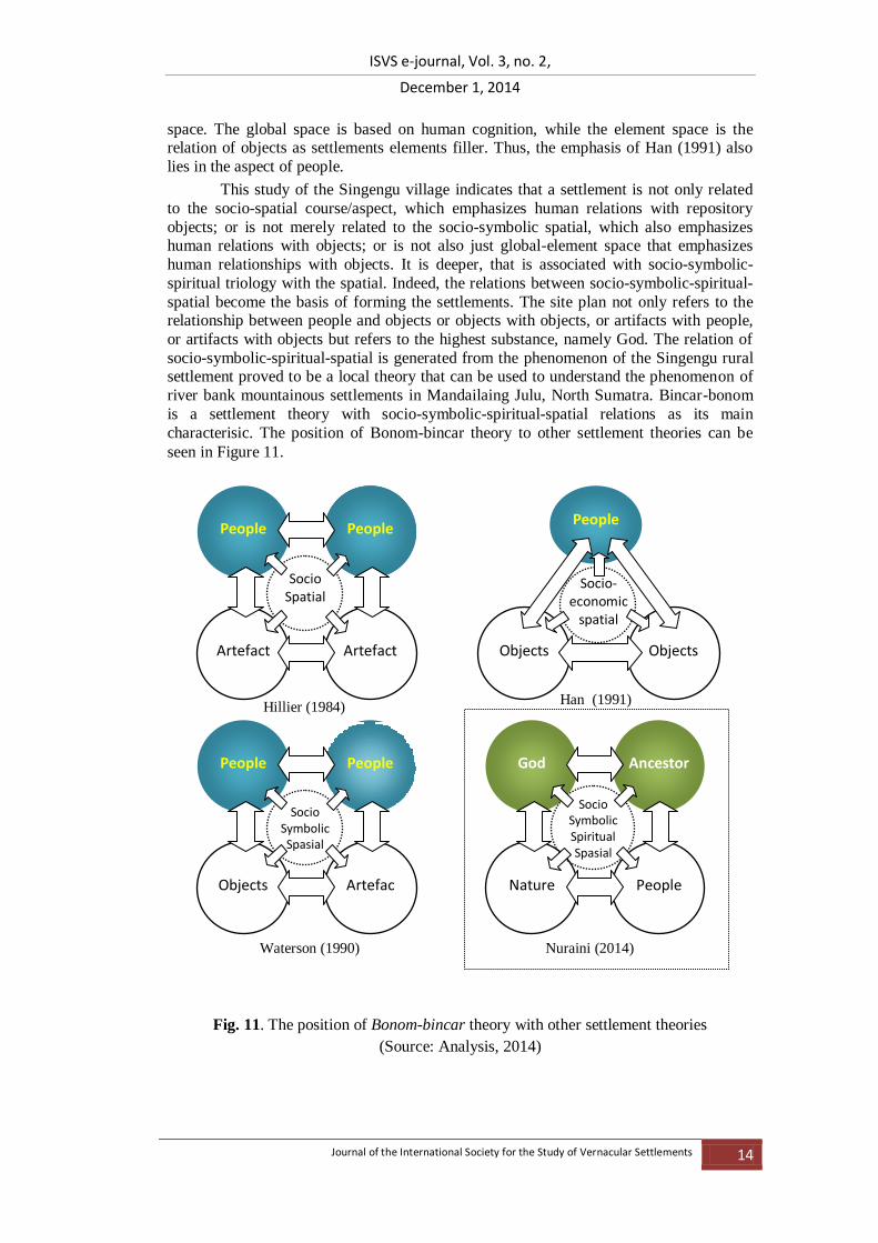
ISVS e-journal, Vol. 3, no. 2,
December 1, 2014
Journal of the International Society for the Study of Vernacular Settlements 14
space. The global space is based on human cognition, while the element space is the relation of objects as settlements elements filler. Thus, the emphasis of Han (1991) also
lies in the aspect of people.
This study of the Singengu village indicates that a settlement is not only related
to the socio-spatial course/aspect, which emphasizes human relations with repository
objects; or is not merely related to the socio-symbolic spatial, which also emphasizes human relations with objects; or is not also just global-element space that emphasizes
human relationships with objects. It is deeper, that is associated with socio-symbolic-
spiritual triology with the spatial. Indeed, the relations between socio-symbolic-spiritual-
spatial become the basis of forming the settlements. The site plan not only refers to the relationship between people and objects or objects with objects, or artifacts with people,
or artifacts with objects but refers to the highest substance, namely God. The relation of
socio-symbolic-spiritual-spatial is generated from the phenomenon of the Singengu rural settlement proved to be a local theory that can be used to understand the phenomenon of
river bank mountainous settlements in Mandailaing Julu, North Sumatra. Bincar-bonom
is a settlement theory with socio-symbolic-spiritual-spatial relations as its main
characterisic. The position of Bonom-bincar theory to other settlement theories can be
seen in Figure 11.
Fig. 11. The position of Bonom-bincar theory with other settlement theories
(Source: Analysis, 2014)
Waterson (1990)
People People
Objects Artefac
Socio Symbolic Spasial
Nuraini (2014)
God Ancestor
Nature People
Socio Symbolic Spiritual Spasial
Han (1991)
Objects Objects
Socio-economic
spatial
People
Hillier (1984)
People People
Artefact Artefact
Socio Spatial

ISVS e-journal, Vol. 3, no. 2,
December 1, 2014
Journal of the International Society for the Study of Vernacular Settlements 15
Conclusion
This reserach revealed that the Bincar-Bonom as the basis of Singengu rural
settlement spatial plan has been translated into all scales of space with the highest philosophical foundations that refer to the existence of Datu (the Creator). The people of Mandailing in Singengu village believe that every place and every human being was
awarded tondi (zest, soul, spirit) by the Creator, so that in carrying out life, people must
always keep tondi in order to reach hamoraon (glory) of life. An effort that should
continuosly be made to maintain tondi is through a continuous rapport with the Creator through the philosophy of Bincar-Bonom axis. Making uninterrupted relationships with
Datu as the Creator also means that there are efforts among the Singengu people to live in
timelessness, just like the cycle of sunrise-sunset that always happens and is ‘timeless’, since after the sunset, it always rises again.
The nature of the existence of Singengu village spatially is formed by the
symbolic pattern of Bincar-bonom axis that regulates the relationship between the older
and the younger, the seniors and juniors, the old and the new. This symbolic pattern has been a guide and at the same time has been a guide to the development of Singengu
village up until now. Thus the existence of Singengu village from the past to present
shows a ‘woven-continuity’ and binding at the same time among "transcendental
existence consciousness", "intentional existing consciousness" and "existential existence
consciousness". The essence of Singengu village existence is maintained since the village
existence core is consciously preserved. The core existence of Singengu village is an
extending space landscape from the direction of Bonom to the direction of Bincar and it is
flanked by two hills and exceeded by rivers. The core existence of Mandailing Julu
settlements is an extending space landscape from Tor Kulabu in the direction of Bincar to
Tor Sihite in direction of Bonom with Singengu village positioned as the axis point.
The results of this theoretical dialogue shows that Singengu village as a central point for the formation of ‘spots’ is arranged and marked by objective spaces in the form
of Huta ruar and parginjang-partoru subjective spaces that is arranged with a
transcendental consciousness of its inhabitants, so it is always on bincar-bonom axis.
Bincar-bonom has uncovered all the layers of architecture "blanket" of Singengu rural settlement and finds the essence or meaning of Singengu rural settlement spatial plan.
Singengu rural settlement spatial plan that is built by a transcendental consciousness of its
occupants puts Datu (Creator) by means of the relations between the human beings and the Creator. It is not simply a socio-symbolic spatial relation but also a socio-symbolic-
spiritual-spatial relation which is articulated by the bincar-bonom as the basis.
References
Crowell S Galt (2001) Husserl, Heidegger and the Space of Meaning: Paths toward
Transcendental Phenomenology, Norhwestern University Press, USA.
Eliade, Mircea (1959) Image and Symbols, Sheed Andrews and McMeel Inc, Kansas city.
Geertz, Clifford (1983) Centers, Symbols and Hierarchies : Essay on The Classical States of Southeast Asia, Yale University, Southeast Asia Studies.
Goverment of Mandailing Natal Regency (2010) Data Monografi Kecamatan, Pemerintah
Kabupaten Daerah Tingkat II Mandailing Natal, Sumatera Utara. Han, Pilwon (1991) The Spatial Structure of the Traditional Settlement, a Study of Clan
Village in Korean Rural Area, Ph.D Dissertation, Publised at Journal of
Architectural Institute of Korea, Vol. 9, No. 7 (July, 1993), Korea: Seoul National
University.
ISVS e-journal, Vol. 3, no. 2,
December 1, 2014
Journal of the International Society for the Study of Vernacular Settlements 16
Haryadi & Setiawan, Bhakti (1995) Arsitektur Lingkungan dan Perilaku (Architecture, Environment and Behaviour), Direktorat Jenderal Pendidikan Tinggi dan
Kebudayaan, Jakarta.
Hillier, Bill & Hanson, Jhon (1984), The Social Logic of Space, Cambridge University
Press, Cambridge. Husserl, Edmund (1970) The Crisis of European Science and Transcendental
Phenomenology : An Introductions to Phenomenological Philosophy, Translated
from Germany Ed. by Carr D, Northwestern University Press, Evanston. Howell, Kerry (2013) An Introduction to The Philosophy of Methodology, Sage
Publication Ltd., London.
Koencaraningrat (2004) Kebudayaan, Mentalisme dan Pembangunan, cetakan ke-21, PT. Gramedia Pustaka Utama, Jakarta.
Mulyadi, Lalu (2001) Verifikasi Spasial Permukiman Hindu di Cakranegara Lombok,
Nusa Tenggara Barat, Tesis, Program Studi Arsitektur Jurusan Ilmu-ilmu Teknik
Universitas Gadjah Mada, Yogyakarta. Nuraini, Cut (2004) Permukiman Suku Batak Mandailing (Batak Mandailing
Settlements), Gadjah Mada University Press, Yogyakarta.
Nuraini, Cut (2012) Permukiman Tepian Sungai di Asia Tenggara, (Tugas Mata kuliah S3 Matakuliah Studi Mandiri/Tidak dipublikasikan), Jurusan Teknik Arsitektur
dan Perencanaan, Universitas Gadjah Mada, Yogyakarta.
Parimin, Ardi P (1986) Fundamental Study on Spatial Formation of Island Village :
Environmental Hierarchy of Sacred-Profane Concepts in Bali, Unpublised Doctorate Dissertation, Osaka University, Japan.
Purbadi, Y Djarot (2010) Tata Suku dan Tata Spasial Permukiman Tradisional Desa
Kaenbaun di Pulau Timor, Disertasi, Universitas Gadjah Mada, Yogyakarta. Rapoport, Amost (1969) House Form and Culture, New Jersey: Printice Hall.
Rejeki, VG Sri (2012) Tata Permukiman berbasis Punden desa Kapencar, Lereng Gunung
Sindoro, Kabupaten Wonosobo, Disertasi, Universitas Gadjah Mada, Yogyakarta. Runa, I Wayan (2004) Sistem Spasial desa Pegunungan di Bali dalam Perspektif Sosial-
Budaya, Disertasi, Universitas Gadjah Mada, Yogyakarta.
Schatzki, R Theodore (2010) The Timespace of Human Activity, University Press of
America: Lexington Books, USA. Smith, W David (2007) Husserl London and New York: Routledge,
Sumardjo, J., 2002, Arkeologi Budaya Indonesia : Pelacakan Hermeneutis-Historis
terhadap Artefak-artefak kebudayaan, CV Qalam, Yogyakarta Tuan, Yi-fu (2008) Space and Place; The Perspective of Experience, Minneapolis:
University of Minnesota Press
Waterson, Roxana (1990), The Living House and Anthropology of Arc in South-east
Asia, New York: Oxford University Press?/ Oxford University Press Zevi, Bruno (1957) Architecture as Space: How to Look at Architecture, New York:
Horizon Press.
Cut Nuraini, is a PhD candidate at the Department of Architecture and Planning,
Faculty of Engineering, Gadjah Mada University, Indonesia. She can be contacted at