BIG SIOUX RIVER WATERSHED PROJECT -...
31
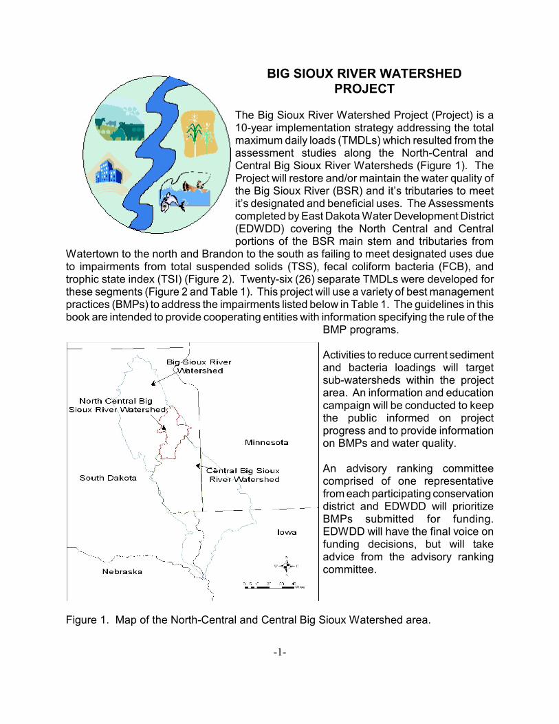
-1- BIG SIOUX RIVER WATERSHED PROJECT The Big Sioux River Watershed Project (Project) is a 10-year implementation strategy addressing the total maximum daily loads (TMDLs) which resulted from the assessment studies along the North-Central and Central Big Sioux River Watersheds (Figure 1). The Project will restore and/or maintain the water quality of the Big Sioux River (BSR) and it’s tributaries to meet it’s designated and beneficial uses. The Assessments completed by East Dakota Water Development District (EDWDD) covering the North Central and Central portions of the BSR main stem and tributaries from Watertown to the north and Brandon to the south as failing to meet designated uses due to impairments from total suspended solids (TSS), fecal coliform bacteria (FCB), and trophic state index (TSI) (Figure 2). Twenty-six (26) separate TMDLs were developed for these segments (Figure 2 and Table 1). This project will use a variety of best management practices (BMPs) to address the impairments listed below in Table 1. The guidelines in this book are intended to provide cooperating entities with information specifying the rule of the BMP programs. Activities to reduce current sediment and bacteria loadings will target sub-watersheds within the project area. An information and education campaign will be conducted to keep the public informed on project progress and to provide information on BMPs and water quality. An advisory ranking committee comprised of one representative from each participating conservation district and EDWDD will prioritize BMPs submitted for funding. EDWDD will have the final voice on funding decisions, but will take advice from the advisory ranking committee. Figure 1. Map of the North-Central and Central Big Sioux Watershed area.
Transcript of BIG SIOUX RIVER WATERSHED PROJECT -...
-1-
BIG SIOUX RIVER WATERSHEDPROJECT
The Big Sioux River Watershed Project (Project) is a10-year implementation strategy addressing the totalmaximum daily loads (TMDLs) which resulted from theassessment studies along the North-Central andCentral Big Sioux River Watersheds (Figure 1). TheProject will restore and/or maintain the water quality ofthe Big Sioux River (BSR) and it’s tributaries to meetit’s designated and beneficial uses. The Assessmentscompleted by East Dakota Water Development District(EDWDD) covering the North Central and Centralportions of the BSR main stem and tributaries from
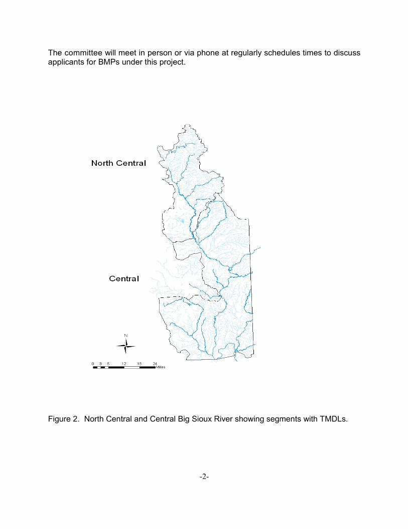
Watertown to the north and Brandon to the south as failing to meet designated uses dueto impairments from total suspended solids (TSS), fecal coliform bacteria (FCB), andtrophic state index (TSI) (Figure 2). Twenty-six (26) separate TMDLs were developed forthese segments (Figure 2 and Table 1). This project will use a variety of best managementpractices (BMPs) to address the impairments listed below in Table 1. The guidelines in thisbook are intended to provide cooperating entities with information specifying the rule of the
BMP programs.
Activities to reduce current sedimentand bacteria loadings will targetsub-watersheds within the projectarea. An information and educationcampaign will be conducted to keepthe public informed on projectprogress and to provide informationon BMPs and water quality.
An advisory ranking committeecomprised of one representativefrom each participating conservationdistrict and EDWDD will prioritizeBMPs submitted for funding.EDWDD will have the final voice onfunding decisions, but will takeadvice from the advisory rankingcommittee.
Figure 1. Map of the North-Central and Central Big Sioux Watershed area.
-2-
The committee will meet in person or via phone at regularly schedules times to discussapplicants for BMPs under this project.
Figure 2. North Central and Central Big Sioux River showing segments with TMDLs.
-3-
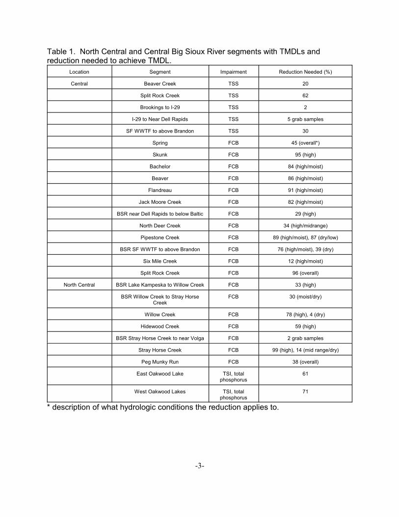
Table 1. North Central and Central Big Sioux River segments with TMDLs andreduction needed to achieve TMDL.
Location Segment Impairment Reduction Needed (%)
Central Beaver Creek TSS 20
Split Rock Creek TSS 62
Brookings to I-29 TSS 2
I-29 to Near Dell Rapids TSS 5 grab samples
SF WWTF to above Brandon TSS 30
Spring FCB 45 (overall*)
Skunk FCB 95 (high)
Bachelor FCB 84 (high/moist)
Beaver FCB 86 (high/moist)
Flandreau FCB 91 (high/moist)
Jack Moore Creek FCB 82 (high/moist)
BSR near Dell Rapids to below Baltic FCB 29 (high)
North Deer Creek FCB 34 (high/midrange)
Pipestone Creek FCB 89 (high/moist), 87 (dry/low)
BSR SF WWTF to above Brandon FCB 76 (high/moist), 39 (dry)
Six Mile Creek FCB 12 (high/moist)
Split Rock Creek FCB 96 (overall)
North Central BSR Lake Kampeska to Willow Creek FCB 33 (high)
BSR Willow Creek to Stray HorseCreek
FCB 30 (moist/dry)
Willow Creek FCB 78 (high), 4 (dry)
Hidewood Creek FCB 59 (high)
BSR Stray Horse Creek to near Volga FCB 2 grab samples
Stray Horse Creek FCB 99 (high), 14 (mid range/dry)
Peg Munky Run FCB 38 (overall)
East Oakwood Lake TSI, totalphosphorus
61
West Oakwood Lakes TSI, totalphosphorus
71
* description of what hydrologic conditions the reduction applies to.
-4-
ANIMAL WASTE MANAGEMENT SYSTEMS PROGRAM
The Animal Waste Management Systems (AWMS) Program is designed to reduce FCBloadings entering the BSR and it’s tributaries from animal feeding operations (AFOs) in theProject area. This will be accomplished by upgrading or relocating existing AFOs.
Program Criteria
1. All operators interested in the AWMS program must provide adequateinformation so that an application form can be completed. This application formwill be used to rank all applicants to make funding decisions.
1.1 The application form described above is located near the end of thisdocument. When filling out the application form, please read allinformation, including the guide sheet associated with the applicationform.
1.2 These application forms must be turned into EDWDD by April 30 forconsideration. The date of April 30 is for the first year of funding andsubsequent funding years may have a different due date. All entities willbe notified of deadlines in subsequent years. Once all applications arereceived, a decision will be made within 30 days.
2. To be considered for funding, the AFO must not currently hold the South Dakotaconfined animal feeding operation (CAFO) General Permit. The State CAFOGeneral Permit is required by facilities classified as CAFOs or by those facilitiesforced to acquire the permit as a result of legal action.
2.1 AFOs not currently possessing the State CAFO General Permit will beallowed to make an application for the permit during the upgrading process.
3. Animal feeding operations must be existing facilities.
3.1 Funding will cover partial or full upgrades to the existing facilities or movingexpenses to move the feeding operation to a less environmentally sensitivelocation.
3.1.1 For facilities currently operating in an environmentally sensitive area(creek bottom, over an aquifer, etc), a portion of the cost share willcover restoration of the original site. Restoration activities will includebut are not limited to seeding and/or reshaping of stream/creek banksas is applicable.
-5-
3.1.2 For facilities moving from an environmentally sensitive area, if currentoperations have buildings, this program will provide reimbursement forthe foundation, floor, drainage system, or building structure (walls,roof, etc.) of the previous facility and/or will provide funds for therelocation of the barn. An option may be to pay the operator for thevalue of the existing barn if moving it is not an option.
4. Animal feeding operations must be located in close proximity to river and/or streamsegments identified as impaired in the BSR Watershed (Figure 2 and Table 1).
4.1 Animal feeding operations located directly on a river and/or stream segment(within a mile) identified as impaired in the BSR Watershed will receive ahigher priority than those located greater than one mile from a river and/orstream segment identified as impaired.
4.2 Animal feeding operations located on a segment with the designated use ofimmersion recreation will receive the highest priority. These segmentsinclude the BSR near Dell Rapids to below Baltic and from the Sioux FallsWaste Water Treatment Facility (SF WWTF) to above Brandon and thetributaries of Split Rock and Pipestone Creek within the Central BSRWatershed .
5. Under the AWMS program, engineering designs and upgrades will be cost sharedwith operators.
5.1 For the engineering designs, the operator will be responsible for 25%, EastDakota Water Development District (EDWDD) will be responsible for 10%,and the 319 grant will cover 65% of the total cost.
5.1.1 EDWDD will be under contract with Eisenbraun and Associates for allinitial engineering designs. In the future, EDWDD may use the SouthDakota Association of Conservation Districts (SDACD) NutrientManagement Team for engineering designs as they becomeavailable.
5.1.2 The operator will be required to provide 25% of the anticipated coststo EDWDD for the engineering designs before any engineering workwill begin on their property. An estimated total cost of the engineeringdesigns will be provided to the landowner. If the actual cost variesfrom the estimate, EDWDD and the landowner will come to anagreement regarding the final costs of the engineering designs.
5.1.3 Engineering designs can be either conventional or alternative,depending upon operator interests.
-6-
5.1.4 EDWDD and/or an SDACD representative and/or the local soilconservation district representative will work with the landowner andthe engineering firm to develop engineering designs that thelandowner will be happy with and will meet the goals of the Project.
5.2 For construction upgrades, the operator will be responsible for 25% and the319 grant will cover 75% of the total cost, not to exceed $90,000. The 319grant will not cover more than $90,000 for any one upgraded facility and theoperator will assume greater than 25% of the total cost if their facilityupgrade requires a total cost of greater than $112,500.
5.2.1 A mixture of conventional and alternative upgrades have beenproposed, depending upon the operator interests.
5.2.2 In initial phases of this Project, Eisenbraun and Associates will beused to oversee all construction upgrades. They will be undercontract with EDWDD and will handle the bidding of the constructionupgrades and if possible the upgrades will be bid upon in bundles of2 or more. As the SDACD Nutrient Management Team is able towork on this Project, they may be used to oversee constructionupgrades also.
5.2.3 Upgrades which will qualify for reimbursement include, but are notlimited to waste storage facilities, roof runoff structure (rain gutters),clean water diversions, sediment ponds, waste treatment lagoons,wastewater treatment strips (filter strip), and vegetated treatmentareas (VTAs). This project can pay for the same items that the USDAEQIP program can pay for. Waste storage facilities will be requiredto hold 270 days of manure. See attachment A for further details.
5.2.4 If a facility is moving because of a poor environmental location that itis currently in, the operator may be compensated for existingstructures at the abandoned lot. The reimbursement will only coverthe replacement of existing features and if existing features can bemoved, they are to be moved rather than replaced. (Attachment A)
5.2.5 If an operator is moving and expanding, for example from 250 headto 500 head, the items which will qualify for reimbursement for movingwill include those items which are capable of handling the original 250head. Items which will accommodate the expansion will not becovered. (Attachment A)
6. If an animal feeding operation is planning to relocate, all applicable permits must beobtained by the landowner. The County Zoning Commission must approve themove of the animal feeding operation.
-7-
7. If the animal feeding operation is planning to relocate, the operator will have toformally agree, in writing, that the previous facility will be abandoned and a deed,covenant, or restriction will be placed on the property to ensure that a feeding facilitydoes not return to the location.
7.1 The operator will agree to reseed all abandoned feed lots and perform anyother reclamation activities the operator and EDWDD agree upon whenabandoning an old site.
8. The operator will be required to sign a contract with EDWDD stating that he/she willcomplete all construction activities the two parties agree upon.
8.1 The operator will be required to pay 50% of their portion (25% of total cost)up front to EDWDD before any construction activities will begin. Theremaining balance owed to EDWDD by the operator will be collected asexpenses are incurred by EDWDD. The initial 50% fronted by the operatorwill equate to 1/8 of the total cost of the construction upgrade. Once thatmoney has been matched by the Project funds, the operator will be expectedto make regular payments to EDWDD on the construction upgrades until allwork is completed. EDWDD will provide the operator with a detailedstatement identifying their portion of the funds needed to complete thisproject.
8.2 The operator will be given 30 days to make payments once an invoice hasbeen sent out. The invoice will detail the operators portion of the paymentexpected. If the operator has any questions regarding the invoice, he/shewill be expected to notify EDWDD immediately.
8.3 If the operator decides to abandon the construction upgrade, he/she will berequired to repay EDWDD all monies previously paid by the district.
9. The operator will be required to follow a nutrient management plan which will beprovided by EDWDD or the firm overseeing the construction upgrades.
9.1 EDWDD will contract with a third party to provide nutrient management plansfor the animal waste management system upgrades if needed.
10. A representative of SDACD, the local conservation district, and/or EDWDD will meetregularly with the operator receiving funds to ensure that the construction upgradprocess stays on tract.
11. EDWDD reserves the right to perform an inspection of the constructed upgradeupon adequate notice to the operator. The operator will be expected to maintain thefacility and follow the nutrient management plan provided by EDWDD for the lifeexpectancy of the upgrade. If the operator decides to apply for a State CAFO
-8-
General Permit, SD DENR will be responsible for ensuring that the operator followshis/her nutrient management plan.
RESPONSIBILITIES OF THE SOUTH DAKOTA ASSOCIATION OF CONSERVATIONDISTRICTS (SDACD)
1. SDACD will be responsible for promoting the Animal Waste Management Systems(AWMS) Program. They will act as the lead contact for operators requestinginformation on this program.
1.1 SDACD will be responsible for ensuring that the operators understand theprogram criteria stated in the above section regarding the AWMS program.
2. SDACD will be responsible for obtaining information from the operator to completean AWMS Program ranking sheet. SDACD will provide the ranking sheets toEDWDD for evaluation. The advisory ranking committee, composed on onerepresentative from each conservation district and EDWDD, will meet on a regularbasis to prioritize applications.
3. SDACD will be responsible for providing technical assistance to the operatorsregarding upgrades to existing animal waste management systems.
RESPONSIBILITIES OF EDWDD
1. EDWDD will be responsible for compiling all Animal Waste Management Systemsranking sheets provided to them by the SDACD.
1.1 All applications will be ranked based on distance to nearest TMDL segment,distance from nearest receiving surface water, length of current filter strip,feedlot watershed area, depth to a useable aquifer, total animal units, andavailability of funding by operator. Other criteria used by EDWDD to makedecisions regarding funding include the targeted reduction defined for theTMDL of the nearest segment in the Assessment report (Table 1).
2. The advisory ranking committee will meet when needed to prioritize the applicantsfor the AWMS program. Once prioritized, EDWDD will make the final decisionregarding the funding of applicants for this program.
3. EDWDD will be under contract with the engineering firm overseeing the engineeringand construction upgrades for this program. EDWDD will also hold a contract withthe operator for engineering and construction upgrades. This is discusses furtherin the above section entitled Program Criteria under the AWMS program.
-9-
4. EDWDD will be responsible for tracking the progress of the Animal WasteManagement Systems Program and all reporting to the South Dakota Departmentof Environment and Natural Resources (DENR).
5. EDWDD reserves the right to monitor the upgraded facility for its expected life span.EDWDD will provide adequate notice to the operator before an inspection. If theoperator applies for and obtains a State CAFO General Permit, the SD DENR willbe responsible for inspecting the records of the operator to be sure he/she isfollowing the nutrient management plan.
THE RIPARIAN AREA MANAGEMENT PROGRAM
The Riparian Area Management (RAM) Program is designed to reduce TSS and FCBloadings within the Project area by ensuring that tracts of land not eligible for a USDA CRPprogram become protected as riparian buffer areas.
Program Criteria
1. If the land under application is eligible for a USDA CRP program, the landowner isencouraged to seek funding from the USDA. This program is only for land whichis not eligible for a USDA CRP program.
2. The land under application must be located on or in close proximity to an impairedriver or stream segment (Figure 2 and Table 1).
2.1 Impaired segments which will have a greater priority will be SF WWTF toabove Brandon BSR segment, Flandreau Creek, Jack Moore Creek,Bachelor Creek, Split Rock Creek, Beaver Creek, Pipestone Creek, andSkunk Creek. These TMDL segments require significantly large reductionsin fecal coliform and/or TSS to meet the standards for designated uses.
3. The rental rate as established by the county USDA FSA office for the CRP programwill be used for payment under the RAM Program.
3.1 Current rental rates are as follows: Brookings County - $60/acre, Moody -$66/acre, and Minnehaha - $66/acre for acreage along permanent streams.
4. There are two ways that land can be enrolled in the RAM Program.
4.1 If a landowner has applied for a USDA CRP Program and a small portion ofland does not qualify, the landowner may apply for the RAM Program.
-10-
4.1.1 Land not eligible for USDA CRP programs may be covered by thisprogram as long as less than 35% of the total amount of land enrolledin both programs is under application for the RAM Program. Seebelow for a further explanation.
4.1.1.1 The amount of land under application for the RAMProgram must be adjoining land which is currentlyunder application for a USDA CRP program and mustnot be more than 35 percent of the total amount of landunder application for a USDA CRP program and theRAM Program.
4.1.1.2 The length of time for a RAM contract under thisscenario will follow the length of time for the USDA CRPcontract.
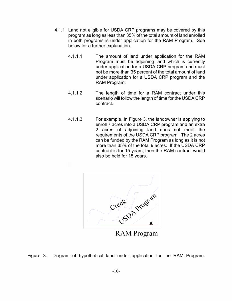
4.1.1.3 For example, in Figure 3, the landowner is applying toenroll 7 acres into a USDA CRP program and an extra2 acres of adjoining land does not meet therequirements of the USDA CRP program. The 2 acrescan be funded by the RAM Program as long as it is notmore than 35% of the total 9 acres. If the USDA CRPcontract is for 15 years, then the RAM contract wouldalso be held for 15 years.
Figure 3. Diagram of hypothetical land under application for the RAM Program.
-11-
4.2 Land which does not qualify for a USDA CRP program because of currentconditions of the land may be enrolled in the RAM Program.
4.2.1 For example, if a tract of land is not eligible for a conservation practicebecause of the amount of tree canopy, this land can apply for theRAM Program.
4.2.2 The length of the contract time for lands enrolled under thesecircumstances will be 15 years.
4.2.3 Payment rates for land under this circumstance will follow the localCounty USDA rates, as noted above in Section 3.1 under RiparianArea Management program criteria.
5. The landowner will be required to follow a conservation plan for the tract of landenrolled in the RAM Program. This will be provided to the landowner by theconservation districts.
6. The landowner will be assessed penalties by the holder of the RAM contracts if thelandowner is found to be not following the conservation plan for the land undercontract.
7. Lands which are currently grazed or cropped up to the river or stream bank will bea high priority. Lands which are currently maintained as a riparian area will be alower priority.
RESPONSIBILITIES OF THE CONSERVATION DISTRICTS
1. The conservation districts will be responsible for promoting the RAM Program. Theywill act as the lead contact for landowners requesting information about thisprogram.
1.1 The conservation districts will be responsible for ensuring that thelandowners are aware of the program criteria for the RAM Program which arestated in the section above.
2. The conservation districts will be responsible for obtaining information from thelandowner to complete a RAM Program ranking sheet.
2.1 Please read all information relating to the ranking sheet for the RAMprogram, including the guide sheet associated with the ranking sheet.
3. The conservation districts will appoint a member of the advisory ranking committeeto discuss application for the RAM program. This advisory ranking committee will
-12-
meet on a regular basis as needed to discuss applications. After this meeting, theconservation districts will turn in all ranking sheets to EDWDD.
4. The conservation districts will hold RAM Program contracts and disburse annualrental rates to the landowner in their district.
5. The conservation districts will provide the landowner with a conservation plan for theland enrolled in the RAM Program. This conservation plan will be similar or thesame as the conservation plan for the land enrolled in the adjoining USDA CRPprogram (if applicable).
6. The conservation districts will be responsible for annual inspection of the landenrolled in the RAM Program. If the conservation districts find that the land owneris not following the conservation plan, they will take appropriate actions.
7. The conservation districts will be responsible for submitting a request for paymentfor the RAM Program and reimbursement of staff dollars to EDWDD. EDWDD willprocess payment request once monthly.
RESPONSIBILITIES OF EDWDD
1. EDWDD will be responsible for compiling all RAM Program ranking sheetssubmitted by the conservation districts. Applications will be ranked based ondistance to nearest impaired segment, amount of land to be enrolled, and amountof time land will be enrolled. The reduction needed to meet the TMDL as describedin the Assessment Report will also be used in the decision making process (Figure2 and Table 1).
2. EDWDD will be responsible for making decisions regarding the awarding of fundsto RAM Program applicants. A decision will be made within thirty (30) days oncethe advisory ranking committee has met to prioritize the applications.
3. EDWDD will be responsible for tracking all RAM Program progress and reportingto DENR.
4. EDWDD will be responsible for reimbursing funds to the conservation districts oncemonthly as request for reimbursements are made.
THE BIG SIOUX RIVER CONSERVATION EASEMENT PROGRAM
The Big Sioux River Conservation Easement Program is designed to reduce TSS and FCBloadings in the Project area. Conservation easements will be used to restrict or exclude
-13-
livestock grazing and other farming practices in the riparian area along the BSR and it’snamed tributaries.
Program Criteria
1. Conservation easements will be sought along the mainstem of the Big Sioux Riverand named tributaries which are currently impaired.
2. Conservation easements will be held by Northern Prairies Land Trust (NPLT).
3. The land under application must be adjacent to or in close proximity to an impairedsegment of the Big Sioux River or named tributaries (Figure 2 and Table 1).
3.1 Segments which require significantly large reductions in fecal coliform and/orTSS to meet the standards for designated uses will have a greater priorityand include: from the SF WWTF to above Brandon BSR, Flandreau Creek,Jack Moore Creek, Bachelor Creek, Split Rock Creek, Beaver Creek,Pipestone Creek, and Skunk Creek.
4. The land offered must currently be used as grazing land for livestock or mustcurrently be cropped up to the stream bank. Land which is currently maintained asa riparian area will be considered a lower priority.
5. Easements will be held for a minimum of thirty (30) years or perpetually(permanent).
6. Easements can be placed on lands currently under a USDA CRP contract.
7. Riparian buffers developed by the easement will be a minimum of seventy-five (75)and a maximum of one hundred-fifty (150) feet from the river or stream bank.
7.1 The width of the buffer to be enrolled will be used to calculate the acreageenrolled. The total acreage enrolled (calculated as described above) willthen be used to square off the riparian buffer. When squaring off, theriparian buffer may be less than seventy-five (75) feet and may be greaterthan one hundred-fifty (150) feet in some locations..
8. The landowners will be required to follow a conservation plan which will beprovided by NPLT.
8.1 Under the conservation plan, management of the land under theconservation easement will be outlined. Some type of maintenance onthe vegetation will be required.
-14-
9. The payment schedule for land enrolled in the conservation easement ispresented in Table 2.
9.1 Briefly, payment will be a percentage of the Adjusted AssessedLand Value (AALV). An assessed value of the property will beobtained and corrected with a multiplier unique to each county. This multiplier is developed by the US Fish and Wildlife Service foruse in their easements. The percentage of AALV listed in Table 2corresponds to amount of time the land is enrolled in theConservation Easement Program. The easement will restrict someproperty uses, as outlined above. Any other uses will be retainedby the property owner.
Table 2. Payment schedule for conservation easements
Duration Time left on USDA contract (if applicable) Percentage of AALV
30 year 80
30 year < 5 years 75
30 year 6-9 years 70
30 year > 10 years 65
perpetual 95
perpetual < 5 years 90
perpetual 6-9 years 85
perpetual > 10 years 80
RESPONSIBILITIES OF THE CONSERVATION DISTRICTS
1. The conservation districts will assist in promoting the BSR ConservationEasement Program. The district staff will act as a primary contact forlandowners requesting information. The conservation districts will forwardinformation about interested landowners to NPLT.
RESPONSIBILITIES OF NORTHERN PRAIRIES LAND TRUST
1. NPLT will be responsible for contacting and providing information to landownersregarding conservation easements.
-15-
2. NPLT will be responsible for providing an Application for Conservation Easementto landowners.
3. NPLT will be responsible for conducting an initial property visit, recordingproperty information, and providing a Preliminary Project Report (PPR) toEDWDD.
4. NPLT will provide a preliminary valuation per acre, the approximate number ofacres, and a preliminary determination of NPLT Primary and Long-Term CostCalculations to EDWDD.
5. NPLT will provide a draft conservation work plan to EDWDD if the PPR isapproved.
5.1 The draft conservation work plan will outline the measures to becompleted by the property owner(s).
6. NPLT will provide the property owner(s) with an outline of the requirements ofthe work plan and information on potential funding/cost sharing programs. NPLTwill also provide a model conservation easement to the property owner(s).
7. NPLT will be responsible for developing the work plan the property owner(s)must follow prior to finalizing the easement and preparing the final conservationeasement.
8. NPLT will be responsible for all negotiations with the land owners pertaining tothe specific conditions of the conservation easement.
9. NPLT will provide a final copy of the conservation easement to EDWDD forapproval.
10. NPLT will hold the conservation easements and will be responsible for annualmonitoring and enforcement.
11. NPLT will be responsible for requesting funds for the conservation easementprogram to be made available on the closing date.
11.1 NPLT will be responsible for submitting payment request to EDWDD atleast fifteen (15) working days in advance. EDWDD will process paymentrequests on the fifteenth and last day of each month.
12. Payments made to the landowner for the conservation easement can be made inone lump sum on the date of closing or may be made in two payments.
-16-
12.1 If the two payment option is chosen by the landowner, one payment willbe made available on the date of closing and the second payment will bemade the following year once the first annual inspection has occurred. Once NPLT has determined that the conservation plan has been followed,the second payment will be made.
RESPONSIBILITIES OF EDWDD
1. EDWDD will be responsible for filling out a ranking sheet for all applicants. EDWDDwill use the ranking sheet to make decisions regarding funding of applicants.
2 EDWDD will be responsible for reviewing applications. EDWDD will make arecommendation to purchase or not purchase a conservation easement basedupon the application, PPR provided by NPLT, and location of the proposedeasement.
3. EDWDD will make decisions to purchase conservation easements within thirty (30)days once the PPR has been obtained by EDWDD and the ranking sheet has beencompleted by EDWDD. EDWDD will notify NPLT of its decision within five (5) days.
4. EDWDD will review the final conservation plan for each conservation easement andgive NPLT approval/disapproval.
4.1 If EDWDD does not approve of the final conservation plan, NPLT, EDWDD,and the landowner will negotiate revisions to the final conservation plan.
5. EDWDD will be responsible for tracking the Big Sioux River Conservation EasementProgram progress and reporting to DENR.
6. EDWDD will process requests for funding on the fifteenth and last day of eachmonth.
FENCING AND ALTERNATE WATER SOURCES
To help landowners establish fencing and alternate watering sources for areas of landunder either of the riparian buffer programs mentioned above, EDWDD and theconservation districts are offering partial funding for landowners enrolling in the BSRConservation Easement Program or Riparian Area Management Program.
Program Criteria
-17-
1. Fencing and alternate water source funding will be offered to landowners enrollingriparian buffers in the Big Sioux River Conservation Easement Program or RAMProgram.
2. The costs of installing fencing or water sources will be shared by EDWDD (25%),the conservation districts (50%), and the landowner (25%).
2.1 The US Fish and Wildlife Service has offered fencing material to landownersinterested for free of charge. The requirements of the free fencing materialswill need to be obtained from the US Fish and Wildlife Service.
3. The landowner will be responsible for submitting receipts for materials forreimbursement to the conservation districts. These receipts must be official receiptsfrom vendors.
4. Information regarding landowners interests in the fencing and alternate watersource program must be given to EDWDD before any BMPs can be installed.
RESPONSIBILITIES OF THE CONSERVATION DISTRICTS
1. The conservation districts will be responsible for promoting the program and act asthe lead landowner contact.
2. The conservation district will be responsible for providing technical assistance tolandowners.
3. The conservation districts will be responsible for providing applicant information toEDWDD for potential funding.
3.1 This information must be provided to EDWDD before any work is to beimplemented on the landowner’s property.
4. The conservation districts will be responsible for reimbursing landowners forapplicable expenses related to materials for fencing or water source installation.
4.1 Conservation district staff will be responsible for submitting a request forreimbursement for the fencing and alternate water source program and staffdollars to the Moody County Conservation District (MoCCD). The MoCCDwill be the conservation district holding the Conservation Commission Grantwhich will support the efforts of the Project. The MoCCD will be responsiblefor submitting a request for payment to EDWDD for EDWDDs portion of theapproved materials and/or reimbursement of conservation district staff time.EDWDD will process the request once monthly. The MoCCD will be
-18-
responsible for tracking all conservation district funds related to theConservation Commission Grant.
5. The conservation districts will be responsible for monitoring the practices installedannually for the life of the practice. If the landowner is found not maintaining thepractice properly, the conservation district will take appropriate action.
RESPONSIBILITIES OF EDWDD
1. EDWDD will be responsible for making decisions regarding awarding funds (withinthirty (30) days of notice to EDWDD) to applicants applying for the Fencing andAlternate Water Source Program.
2. EDWDD will be responsible for tracking the Fencing and Alternate Water SourceProgram progress and reporting DENR.
3. EDWDD will be responsible for reimbursing funds to the conservation districts whenrequests are made. EDWDD will process reimbursement request once monthly.
-19-
ATTACHMENT A
EPA Region VIII -NONPOINT SOURCE SECTION 319(h)
POLICY PAPER # 2
July 20, 1994
ISSUE: 319(h) NPS Funding for Animal Feedingand Waste Systems
BACKGROUND
EPA Region VIII has developed guidelines to assist State water quality agencies and nonpoint sourceproject sponsors in the planning, design, and implementation of confined animal feeding and waste.management systems. The follow information applies to dairies as well asfeedlots.
The first portion of this guideline applies to the improvement of existing animal feeding facilitiesas well as the relocation of a feeding operation to a more acceptable site. The last portion of thisguidance applies only to relocation of the animal facilities.
COST SHARE
Due to the high costs associated with reducing the pollution potential from confined animal feedingfacilities, Region VIII encourages the State water quality agencies and project sponsors to be prudent in planning, designing, installing and cost sharing the proposed facilities.
Cost share should be limited to the minimum required in order to protect water quality and meet thebest management practice (BMP) specifications.
All components listed as authorized in the USDA -Stabilization and Conservation Service (ASCS)nat.iona1 1-ACP Guidance, WP4 Agricultural Waste Control Facilities (attached) or future revisions are eligible for Section 319 NPS funding. State ASCS Office revisions to 1-ACPWP4 can also be used to determine funding eligibility under Section 319. The State ACP WP4 document should be reviewed to determine how the State has defined paragraph G and anysubsequent sections of the National guidance.
-20-
Any expenses that are incurred to improve livestock handling, to increase production, or otherimprovements not related to achieving water quality objectives will be assumed by the producer and not used as matching funds following the regulations outlined in WP4.
Cost sharing for buildings will be limited to the foundation, floor and drainage components wherethey are necessary for pollution control. In special situations, additional cost sharing may benegotiated, as outlined below. The balance of the building expenses will be the responsibility of theproducer.
Additional eligibility and/or waivers to the WP4 requirements can be granted by the lead State NPSagency or if needed, the EPA project Office in conjunction with the State NPS Coordinator, on a site by site basis. A written justification as to the rationale or need for the waiverwill be required.
ON-SITE IMPROVEMENTS VERSUS RELOCATION
It is important to establish priorities for funding the improvement or relocation of animal feedingoperations. Section B1 in Chapter 2 of the "Guidance Specifying Management Measures for,Sources of Nonpoint Pollution in Coastal Watersn, EPA, January 1993 may be useful forestablishing prioritization criteria (Attached). The document also provides animal unit equivalentsfor different kinds of livestock.
Relocation
Relocation of a confined feeding operation may be a preferred alternative or a more cost effectivealternative over the installation of necessary best management practices in an area currently beingused. Section 319(h) NPS funding may be used for "Relocationn if the following guidelines areobserved:
1. Materials and installation costs for all necessary structures and equipment can be reimbursed inaccordance with WP4 and the approved project implementation plan. When feasible/ practicalexisting equipment and buildings should also be relocated to the new location. 2. The relocation sitemust be approved by the project sponsors and state water quality agency. Potential impacts on ground and surface water and related environmental concerns at the new site need to bereviewed/assessed. particular care should be taken to avoid adverse impacts to wetlands and othersensitive environmental areas. 3. Section 319(h) funds can not be used to expand the new
-21-
facility to handle more animals beyond the capacity'of the original location. The new operation maybe expanded; but, the costs of such expansion will be assumed by the producer and can not beused.as match. 4. A legal document prohibiting the future use of the abandoned site for any confinedfeeding operation is required, unless an agreement specifies that all the best management practicesrequired by the state water quality agency will be installed and maintained properly at the previouslyabandoned site. This may require a deed restriction or similar use-limiting document. 5. Thepreviously used site must be reclaimed to protect water quality. 6. All required permits for therelocation must have been secured before any EPA funds are paid to the producer.
WASTE MANAGENENT
The Region encourages proper land application of animal waste as a part of a nutrient managementplan. EPA funds can be used on a demonstration basis to lease or rent equipment for pond drainageand animal waste application. No EPA funds will be used for the private acquisition of equipmentto drain animal waste facilities or for land application.
For watershed projects, it is appropriate for the project sponsor to purchase this equipment or serviceor other assure it is available to the project participants. Section 319 funds are available to cost share equipment for use by multiple producers.
Animal waste nutrient testing and field soil testing are eligible for Section 319 cost sharing on ademonstra,tion basis or over a restricted time period.
ELIGIBILITY RESTRICTIONS
Facilities having greater than 1,000 animal units are required to be permitted under Section 402National Pollution Discharge Elimination System (NPDES) . Facilities which are qualified for orunder a NPDES permit are not eligible for funding under Section 319(h). In addition, facilities under1,000 animal units and have been issued a discharge permit by the appropriate State agency or if anotice of violation (NOV) has been issued by EPA or the State, are not eligible for funding underSection 319 (h) .
-22-
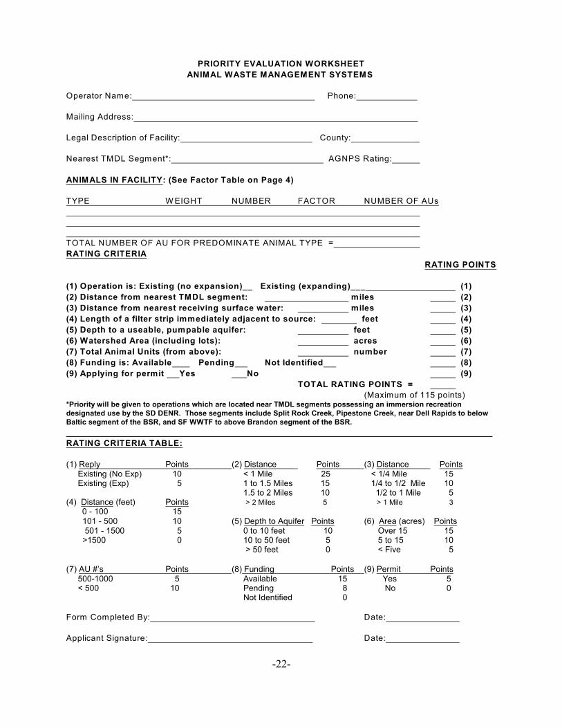
PRIORITY EVALUATION WORKSHEET
ANIMAL WASTE MANAGEMENT SYSTEMS
Operator Name: Phone:
Mailing Address:
Legal Description of Facility: County:
Nearest TMDL Segment*: AGNPS Rating:
ANIMALS IN FACILITY: (See Factor Table on Page 4)
TYPE W EIGHT NUMBER FACTOR NUMBER OF AUs
TOTAL NUMBER OF AU FOR PREDOMINATE ANIMAL TYPE =
RATING CRITERIA
RATING POINTS
(1) Operation is: Existing (no expansion)__ Existing (expanding)___ (1)
(2) Distance from nearest TMDL segment: miles (2)
(3) Distance from nearest receiving surface water: miles (3)
(4) Length of a filter strip immediately adjacent to source: feet (4)
(5) Depth to a useable, pumpable aquifer: feet (5)
(6) Watershed Area (including lots): acres (6)
(7) Total Animal Units (from above): number (7)
(8) Funding is: Available Pending Not Identified (8)
(9) Applying for permit Yes No (9)
TOTAL RATING POINTS =
(Maximum of 115 points)*Priority will be given to operations which are located near TMDL segments possessing an immersion recreationdesignated use by the SD DENR. Those segments include Split Rock Creek, Pipestone Creek, near Dell Rapids to belowBaltic segment of the BSR, and SF WWTF to above Brandon segment of the BSR.
RATING CRITERIA TABLE:
(1) Reply Points (2) Distance Points (3) Distance Points Existing (No Exp) 10 < 1 Mile 25 < 1/4 Mile 15 Existing (Exp) 5 1 to 1.5 Miles 15 1/4 to 1/2 Mile 10
1.5 to 2 Miles 10 1/2 to 1 Mile 5(4) Distance (feet) Points > 2 Miles 5 > 1 Mile 3
0 - 100 15 101 - 500 10 (5) Depth to Aquifer Points (6) Area (acres) Points 501 - 1500 5 0 to 10 feet 10 Over 15 15 >1500 0 10 to 50 feet 5 5 to 15 10 > 50 feet 0 < Five 5 (7) AU #’s Points (8) Funding Points (9) Permit Points 500-1000 5 Available 15 Yes 5 < 500 10 Pending 8 No 0
Not Identified 0
Form Completed By: Date:
Applicant Signature: Date:
-23-
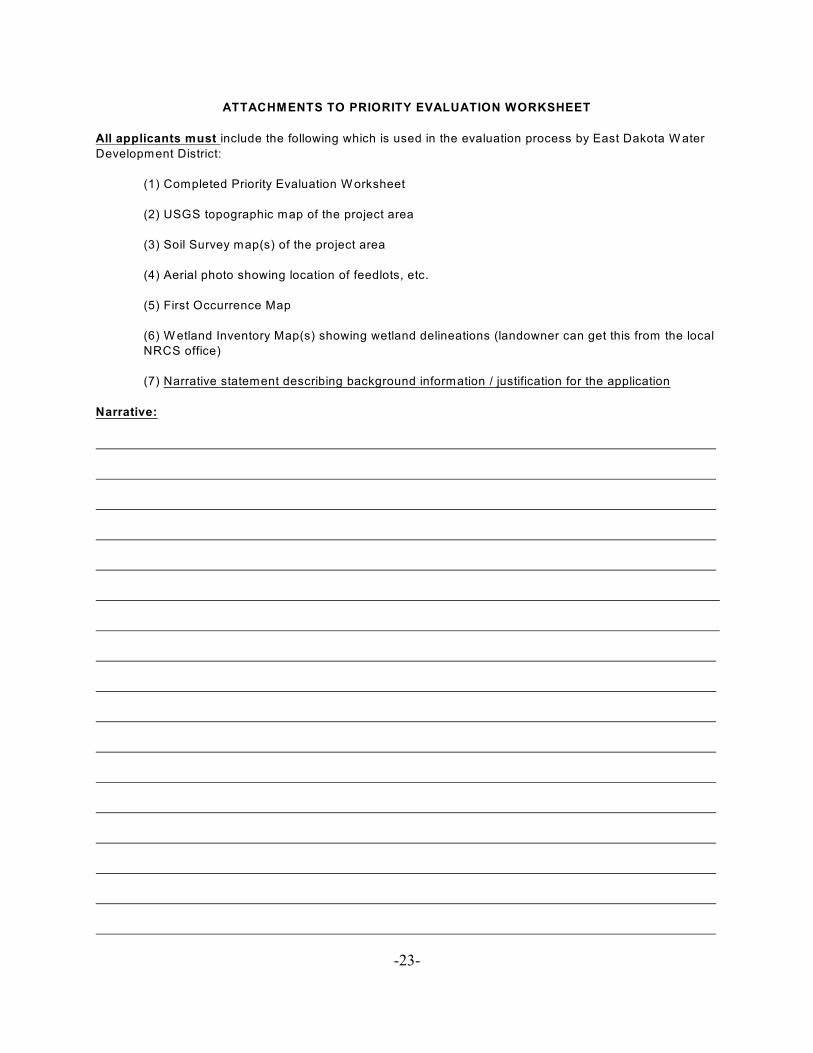
ATTACHMENTS TO PRIORITY EVALUATION WORKSHEET
All applicants must include the following which is used in the evaluation process by East Dakota W ater
Development District:
(1) Completed Priority Evaluation W orksheet
(2) USGS topographic map of the project area
(3) Soil Survey map(s) of the project area
(4) Aerial photo showing location of feedlots, etc.
(5) First Occurrence Map
(6) W etland Inventory Map(s) showing wetland delineations (landowner can get this from the local
NRCS office)
(7) Narrative statement describing background information / justification for the application
Narrative:
-24-
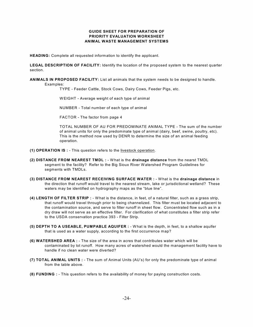
GUIDE SHEET FOR PREPARATION OF
PRIORITY EVALUATION WORKSHEET
ANIMAL WASTE MANAGEMENT SYSTEMS
HEADING: Complete all requested information to identify the applicant.
LEGAL DESCRIPTION OF FACILITY: Identify the location of the proposed system to the nearest quarter
section.
ANIMALS IN PROPOSED FACILITY: List all animals that the system needs to be designed to handle.
Examples:
TYPE - Feeder Cattle, Stock Cows, Dairy Cows, Feeder Pigs, etc.
W EIGHT - Average weight of each type of animal
NUMBER - Total number of each type of animal
FACTOR - The factor from page 4
TOTAL NUMBER OF AU FOR PREDOMINATE ANIMAL TYPE - The sum of the number
of animal units for only the predominate type of animal (dairy, beef, swine, poultry, etc).
This is the method now used by DENR to determine the size of an animal feeding
operation.
(1) OPERATION IS : - This question refers to the livestock operation.
(2) DISTANCE FROM NEAREST TMDL : - W hat is the drainage distance from the nearst TMDL
segment to the facility? Refer to the Big Sioux River W atershed Program Guidelines for
segments with TMDLs.
(3) DISTANCE FROM NEAREST RECEIVING SURFACE WATER : - W hat is the drainage distance in
the direction that runoff would travel to the nearest stream, lake or jurisdictional wetland? These
waters may be identified on hydrography maps as the “blue line”.
(4) LENGTH OF FILTER STRIP : - W hat is the distance, in feet, of a natural filter, such as a grass strip,
that runoff would travel through prior to being channelized. This filter must be located adjacent to
the contamination source, and serve to filter runoff in sheet flow. Concentrated flow such as in a
dry draw will not serve as an effective filter. For clarification of what constitutes a filter strip refer
to the USDA conservation practice 393 - Filter Strip.
(5) DEPTH TO A USEABLE, PUMPABLE AQUIFER : - W hat is the depth, in feet, to a shallow aquifer
that is used as a water supply, according to the first occurrence map?
(6) WATERSHED AREA : - The size of the area in acres that contributes water which will be
contaminated by lot runoff. How many acres of watershed would the management facility have to
handle if no clean water were diverted?
(7) TOTAL ANIMAL UNITS : - The sum of Animal Units (AU’s) for only the predominate type of animal
from the table above.
(8) FUNDING : - This question refers to the availability of money for paying construction costs.
-25-
GUIDE SHEET FOR PREPARATION OF
PRIORITY EVALUATION WORKSHEET
ANIMAL WASTE MANAGEMENT SYSTEMS Cont’d
(9) PERMIT : -This question refers to the operators intentions for a permit. If he plans to apply or is in the
process of obtaining a permit, award 5 points. If he has no intentions of obtaining a permit, award zero
points. Remember, permitted CAFOs will not be allowed to receive assistance.
NOTE: Assign rating points using the rating criteria table on page 22.
ANIMAL UNIT FACTORS FOR
PRIORITY EVALUATION WORKSHEET
ANIMAL WASTE MANAGEMENT SYSTEMS
Animal Unit Factor Table
Livestock Type Factor
Horses 2.0
Mature Dairy Cows 1.43
Beef Cow/Calf Pair 1.0
Mature Beef Cows 1.0
Beef or Dairy Bulls 1.0
Beef or Dairy Steers 1.0
Replacement Heifers 1.0
Cattle in Feedlot 1.0
Veal Calves 1.0
Sheep or Lambs 0.1
Swine (Under 55 lbs) 0.1
Swine (Over 55 lbs) 0.4
Turkeys 0.0182
Laying Hens or Broilers 0.03331
Chickens 0.0082
Laying Hens 0.1222
Ducks 0.21
Ducks 0.03332
Geese 0.0333
W ith liquid manure system1
W ith waste handling system other than liquid2
-26-
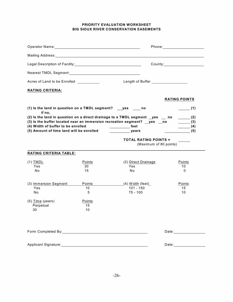
PRIORITY EVALUATION WORKSHEET
BIG SIOUX RIVER CONSERVATION EASEMENTS
Operator Name: Phone:
Mailing Address:
Legal Description of Facility: County:
Nearest TMDL Segment:
Acres of Land to be Enrolled Length of Buffer
RATING CRITERIA:
RATING POINTS
(1) Is the land in question on a TMDL segment? yes no (1)
if no,
(2) Is the land in question on a direct drainage to a TMDL segment yes no (2)
(3) Is the buffer located near an immersion recreation segment? yes no (3)
(4) Width of buffer to be enrolled feet (4)
(5) Amount of time land will be enrolled years (5)
TOTAL RATING POINTS =
(Maximum of 80 points)
RATING CRITERIA TABLE:
(1) TMDL Points (2) Direct Drainage Points
Yes 30 Yes 10
No 15 No 0
(3) Immersion Segment Points (4) W idth (feet) Points
Yes 10 101 - 150 15
No 5 75 - 100 10
(5) Time (years) Points
Perpetual 15
30 10
Form Completed By: Date:
Applicant Signature: Date:

-27-
ATTACHMENTS TO PRIORITY EVALUATION WORKSHEET
All applicants must include the following which is used in the evaluation process by East Dakota W ater
Development District:
(1) Completed Priority Evaluation W orksheet
(2) USGS topographic map of the project area
(3) Soil Survey map(s) of the project area
(4) Aerial photo of the area
(5) Narrative statement describing background information / justification for the application
Narrative:
-28-
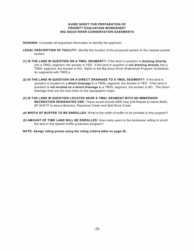
GUIDE SHEET FOR PREPARATION OF
PRIORITY EVALUATION WORKSHEET
BIG SIOUX RIVER CONSERVATION EASEMENTS
HEADING: Complete all requested information to identify the applicant.
LEGAL DESCRIPTION OF FACILITY: Identify the location of the proposed system to the nearest quarter
section.
(1) IS THE LAND IN QUESTION ON A TMDL SEGMENT?: If the land in question in draining directly
into a TMDL segment, the answer is YES. If the land in question is not draining directly into a
TMDL segment, the answer is NO. Refer to the Big Sioux River W atershed Program Guidelines
for segments with TMDLs.
(2) IS THE LAND IN QUESTION ON A DIRECT DRAINAGE TO A TMDL SEGMENT?: If the land in
question is located on a direct drainage to a TMDL segment, the answer is YES. If the land in
question is not located on a direct drainage to a TMDL segment, the answer is NO. The direct
drainage lines are the blue lines on the topographic maps.
(3) IS THE LAND IN QUESTION LOCATED NEAR A TMDL SEGMENT WITH AN IMMERSION
RECREATION DESIGNATED USE: These would include BSR near Dell Rapids to below Baltic,
SF W W TF to above Brandon, Pipestone Creek and Split Rock Creek
(4) WIDTH OF BUFFER TO BE ENROLLED: W hat is the width of buffer to be enrolled in this program?
(5) AMOUNT OF TIME LAND WILL BE ENROLLED: How many years is the landowner willing to enroll
the land in the riparian buffer protection program?
NOTE: Assign rating points using the rating criteria table on page 26.
-29-
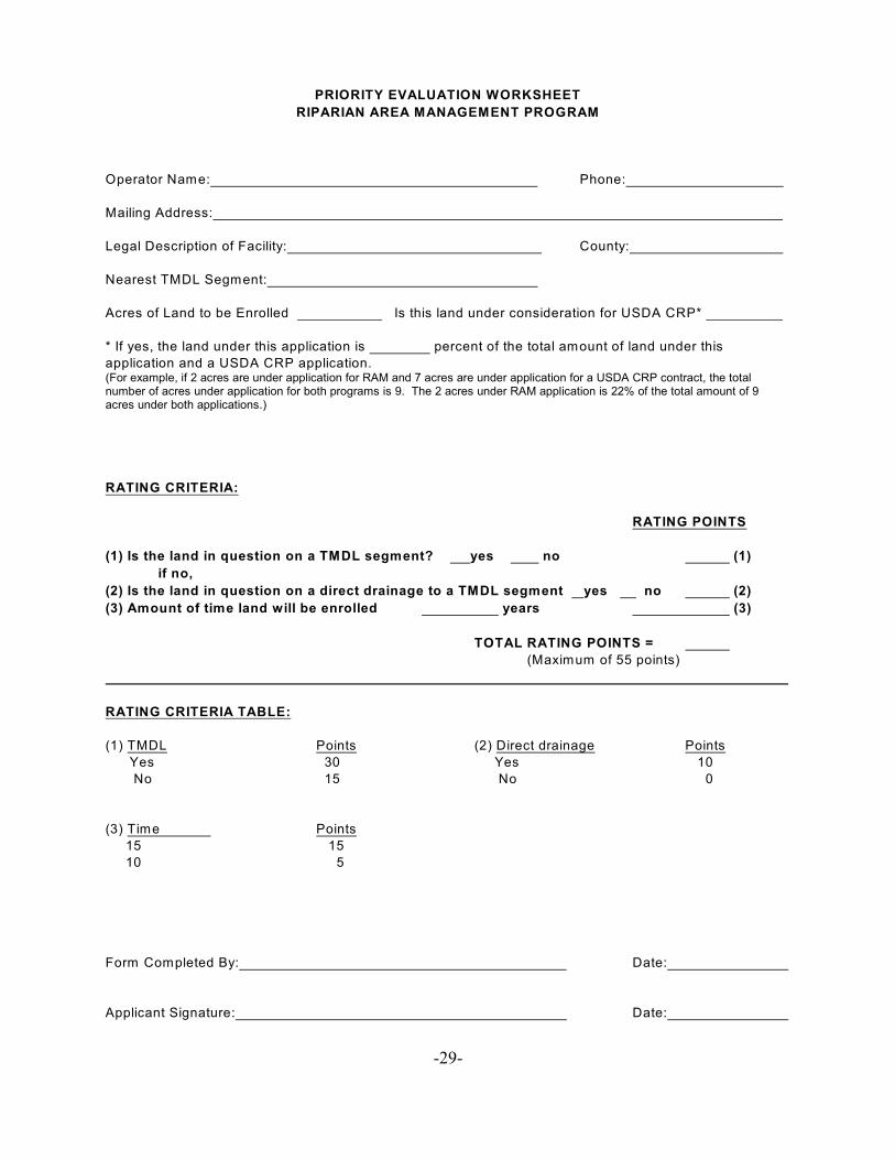
PRIORITY EVALUATION WORKSHEET
RIPARIAN AREA MANAGEMENT PROGRAM
Operator Name: Phone:
Mailing Address:
Legal Description of Facility: County:
Nearest TMDL Segment:
Acres of Land to be Enrolled Is this land under consideration for USDA CRP*
* If yes, the land under this application is percent of the total amount of land under this
application and a USDA CRP application.(For example, if 2 acres are under application for RAM and 7 acres are under application for a USDA CRP contract, the totalnumber of acres under application for both programs is 9. The 2 acres under RAM application is 22% of the total amount of 9acres under both applications.)
RATING CRITERIA:
RATING POINTS
(1) Is the land in question on a TMDL segment? yes no (1)
if no,
(2) Is the land in question on a direct drainage to a TMDL segment yes no (2)
(3) Amount of time land will be enrolled years (3)
TOTAL RATING POINTS =
(Maximum of 55 points)
RATING CRITERIA TABLE:
(1) TMDL Points (2) Direct drainage Points
Yes 30 Yes 10
No 15 No 0
(3) Time Points
15 15
10 5
Form Completed By: Date:
Applicant Signature: Date:
-30-
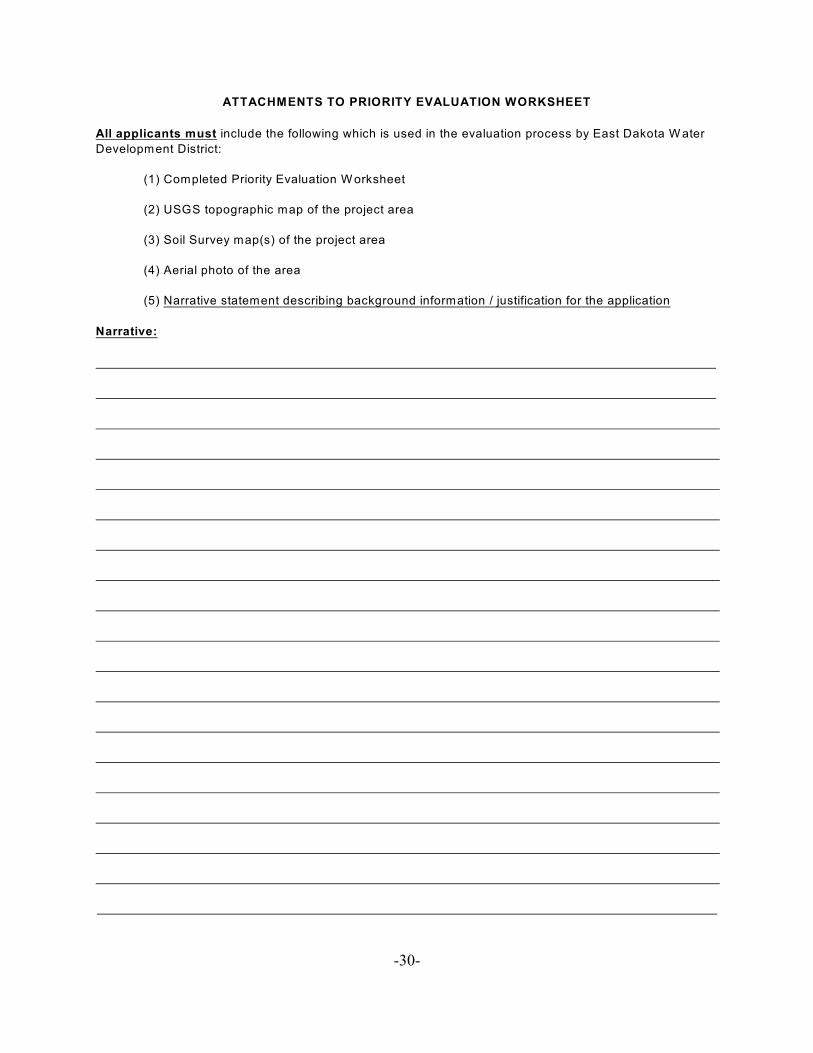
ATTACHMENTS TO PRIORITY EVALUATION WORKSHEET
All applicants must include the following which is used in the evaluation process by East Dakota W ater
Development District:
(1) Completed Priority Evaluation W orksheet
(2) USGS topographic map of the project area
(3) Soil Survey map(s) of the project area
(4) Aerial photo of the area
(5) Narrative statement describing background information / justification for the application
Narrative:
-31-
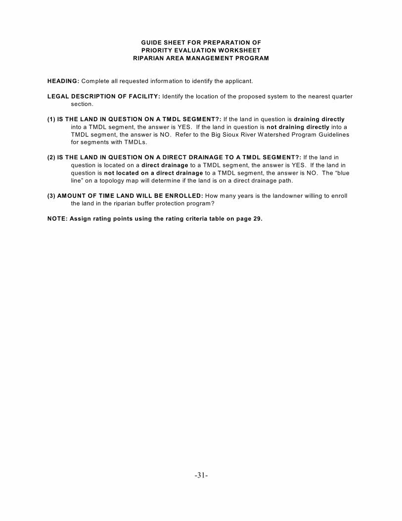
GUIDE SHEET FOR PREPARATION OF
PRIORITY EVALUATION WORKSHEET
RIPARIAN AREA MANAGEMENT PROGRAM
HEADING: Complete all requested information to identify the applicant.
LEGAL DESCRIPTION OF FACILITY: Identify the location of the proposed system to the nearest quarter
section.
(1) IS THE LAND IN QUESTION ON A TMDL SEGMENT?: If the land in question is draining directly
into a TMDL segment, the answer is YES. If the land in question is not draining directly into a
TMDL segment, the answer is NO. Refer to the Big Sioux River W atershed Program Guidelines
for segments with TMDLs.
(2) IS THE LAND IN QUESTION ON A DIRECT DRAINAGE TO A TMDL SEGMENT?: If the land in
question is located on a direct drainage to a TMDL segment, the answer is YES. If the land in
question is not located on a direct drainage to a TMDL segment, the answer is NO. The “blue
line” on a topology map will determine if the land is on a direct drainage path.
(3) AMOUNT OF TIME LAND WILL BE ENROLLED: How many years is the landowner willing to enroll
the land in the riparian buffer protection program?
NOTE: Assign rating points using the rating criteria table on page 29.