INDIAN OIL CORPORATION LIMITED HINDUSTAN PETROLEUM CORPORATION LIMITED
Bharat Petroleum Corporation Limited Tender for Survey for LPG Import Facility at Haldia
E&P (Pipeline Projects) – Noida Page 1 of 57
Bharat Petroleum Corporation Limited (A Govt. of India Enterprise)
BIDDING DOCUMENT NO.: CRFQ 1000225704
TENDER
For SURVEY FOR LPG IMPORT FACILITY AT
HALDIA
Bharat Petroleum Corporation Limited Tender for Survey for LPG Import Facility at Haldia
E&P (Pipeline Projects) – Noida Page 2 of 57
Request for Quotation

Bharat Petroleum Corporation Limited Tender for Survey for LPG Import Facility at Haldia
E&P (Pipeline Projects) – Noida Page 3 of 57
REQUEST FOR QUOTATION
Electronic digitally signed & sealed (encrypted) e-tenders / e-bids are invited under two bid system from Bidders as per details given below: TENDER NO.: CRFQ 1000225704 dated 04.02.2015
S. No.
Description Location
1 Detailed Route Survey Pipeline from Jetty No. 3 to LPG Terminal
2 Soil Investigation & Corrosion Survey Pipeline from Jetty No. 3 to LPG Terminal
3 Cadastral Survey Pipeline from Jetty No. 3 to LPG Terminal
4 Geo-Technical Survey LPG Import Facility at Haldia
5 Topographical Survey LPG Import Facility at Haldia
E-bids are required to be submitted only through BPCL’s e-proc website https://bpcl.eproc.in/, on or before the bid submission date and time. Important:
Bid Submission due date & time 25.02.2015 (2.00 p.m.)
Unpriced Bid Opening 25.02.2015 (4.00 p.m.)
Earnest Money Deposit (EMD) ` 1,00,000/-

Bharat Petroleum Corporation Limited Tender for Survey for LPG Import Facility at Haldia
E&P (Pipeline Projects) – Noida Page 4 of 57
Instructions to Bidders
Bharat Petroleum Corporation Limited Tender for Survey for LPG Import Facility at Haldia
E&P (Pipeline Projects) – Noida Page 5 of 57
INSTRUCTIONS TO BIDDERS
Bidder shall study the tender document carefully and understand the conditions etc. before quoting. If there are any doubts, he shall obtain clarification from OWNER. Bidders’ non-understanding of the tender document / ignorance shall not be entertained nor shall be treated as basis for legal argument prior to award or at a later date of award. Should Bidder find discrepancies or if the intent and meaning of any of the tender documents appears unclear or ambiguous, Bidder should refer the matter to OWNER for clarification. BID CLARIFICATIONS & ADDENDA Addressee All questions and requests for clarifications or interpretations related to tender documents shall be addressed in writing to: Mr. H. R. Dash Sr. Manager, LPG Submarine (Pipeline Projects) Bharat Petroleum Corporation Limited 1st Floor, Engg. & Projects Deptt. A – 5 & 6, Sector – 1, Udyog Marg Noida, U.P. – 201 301 Phone No. – 0120 247 4145 Email – [email protected] Time Limit for Tender Offer against this tender enquiry must be submitted on or before due date / time of receipt of tender at specified address. Request for time extension shall not be entertained. Addenda Addenda to the tender enquiry may be issued at any time prior to the closing date fixed for receiving Bids, to vary either the Bid period or any part of the tender documents. Integral Part of Tender All addenda are to be considered as an integral part of the tender enquiry. Bidder to Confirm Bidder is required to take account in its Bid of all addenda received during the Bid period and confirm in its Bid.

Bharat Petroleum Corporation Limited Tender for Survey for LPG Import Facility at Haldia
E&P (Pipeline Projects) – Noida Page 6 of 57
CONDITIONS OF BID a) Language The Bid and all supporting documentation shall be in the English language. b) Incomplete / Late Bids
Incomplete Bids / late bids may not be considered and are liable to be rejected.
Validity of offer would be 6 months from the date of opening of un-priced bid. OWNER reserves the right to reject any or all offers in total or part without assigning any reason whatsoever. SUBMISSION OF BIDS Bids are to be submitted online only at site https://bpcl.eproc.in/. Bids received in any other form shall not be accepted. For viewing details including EMD, Specs, on-line bidding please visit our web site https://bpcl.eproc.in/. BPCL reserves the right to extend price / purchase preference as per prevailing guidelines of Government of India. Each bidder shall submit only one bid. A bidder who submits more than one bid will be rejected. Alternative bids will not be accepted. The quote shall be expressed both in figures and words. Where any discrepancy exists between the two, the rates expressed in words shall prevail. Quoted prices should be inclusive of all taxes and duties. However, the service tax will be payable extra, if mentioned by the tenderer. Failure to Submit Bid Any bidder who does not or is unable to submit a Bid in accordance with these Instructions to bidders shall notify M/s BPCL accordingly. EARNEST MONEY DEPOSIT (EMD) Scanned copy of the Bid Security / EMD in form of DD / irrevocable Bank Guarantee in the prescribed format should be submitted on e-procurement portal https://bpcl.eproc.in/ of BPCL. However, the original hard copy of Bid Security / EMD, which shall exactly be the same as uploaded on e-procurement portal https://bpcl.eproc.in/ of BPCL, shall reach BPCL Noida office within SEVEN (7) days from date of opening the bid, otherwise the offer will be rejected / not considered for further evaluation.

Bharat Petroleum Corporation Limited Tender for Survey for LPG Import Facility at Haldia
E&P (Pipeline Projects) – Noida Page 7 of 57
SCOPE OF WORK
Bharat Petroleum Corporation Limited Tender for Survey for LPG Import Facility at Haldia
E&P (Pipeline Projects) – Noida Page 8 of 57
PROJECT DETAILS INTRODUCTION BPCL in a bid to meet the growing demand of LPG in the Eastern India proposes to develop a Refrigerated LPG Import Facility at Haldia, West Bengal. In order to proceed further on the proposal, BPCL desires to carry out the following surveys: 1. Detailed Route Survey for Twin Pipelines from Haldia Oil Jetty (HOJ – 3) to
Proposed LPG Import Facility at Haldia 2. Soil Investigation and Corrosion Survey for Twin Pipelines from Haldia Oil Jetty
(HOJ – 3) to Proposed LPG Import Facility at Haldia 3. Cadastral Survey for Twin Pipelines from Haldia Oil Jetty (HOJ – 3) to Proposed
LPG Import Facility at Haldia 4. Geotech Survey of the Proposed LPG Import Facility at Haldia 5. Topographical Survey of the Proposed LPG Import Facility at Haldia PROJECT DESCRIPTION We propose to import 1.0 million metric tons of Propane and Butane through Haldia port and transfer it through pipe lines to two nos. of refrigerated storage tanks constructed at a distance of around 9 km from Haldia Oil Jetty. The site selected for construction of storage tanks is in industrial area at Haldia in the district of East Midnapur and is behind Hindustan Petrochemicals Ltd. Pipelines have to be laid for carrying refrigerated propane and butane from Haldia Oil Jetty (HOJ – 3) to the storage tanks. At storage site, Propane & Butane will be heated, mixed with Ethyl Mercaptan and then sent through tank Lorries to different bottling plants and also to industries. A sixteen bay tank lorry filling gantry will be needed at the site for filling the Tank Lorries. Moreover, a Bottling Plant for filling LPG in cylinders with provision for loading them into trucks for transportation is also proposed at the site. PROPOSED PROJECT LOCATION AND DETAILS The proposed storage facilities will be set up in industrial area at Haldia in the district of East Midnapur near Hindustan Petrochemicals Complex. Pipeline will be laid from HOJ – 3 to proposed storage tanks. The length of pipelines will be around 9 km. Particulars of 3rd Oil Jetty (HOJ – 3) The location of 3rd oil jetty is on River Hooghly downstream of lock gate behind Jawahar Tower.
Bharat Petroleum Corporation Limited Tender for Survey for LPG Import Facility at Haldia
E&P (Pipeline Projects) – Noida Page 9 of 57
SITE AND SURROUNDINGS FOR THE INSTALLATION
I. The plot of land is a vacant land. The plot earmarked for the project is on either side of the HPL link road. The northern side of the HPL link road is for parking of road tankers (area around 15 Acres) and the southern side is for proposed storage, handling of imported products and a LPG Bottling Plant (area around 30 acres).
II. Railway track is passing about 1 Km at the southern side of the proposed plot and at the western side national highway is passing at a distance of about 800 meters while HPL boundary is located at a distance of 700 meters at south eastern side. The area within these distances is covered by vacant land. North and eastern side is also covered by vacant land. SITE ACTIVITIES All the site activities shall be coordinated by: Mr. M. K. Taneja Project Facilitator (Engineering & Projects) Bharat Petroleum Corporation Limited Bharat Bhavan, Plot No. 31 Prince Gulam MD Shah Road Golf Green, Kolkata
West Bengal – 700 095 Phone No. – 033 2429 3242 Email – [email protected]
Bharat Petroleum Corporation Limited Tender for Survey for LPG Import Facility at Haldia
E&P (Pipeline Projects) – Noida Page 10 of 57
DETAILED ROUTE SURVEY

Bharat Petroleum Corporation Limited Tender for Survey for LPG Import Facility at Haldia
E&P (Pipeline Projects) – Noida Page 11 of 57
DETAILED ROUTE SURVEY FOR HOJ – HALDIA TWIN PIPELINES
GENERAL It is proposed to lay twin pipelines from HOJ – 3 to Haldia (approx. 9 km each). It is, proposed to carry out the following for the above pipelines for propane and butane:
Reconnaissance Survey for selecting the Final / Best Route for the pipeline alignment for the pipelines from HOJ – 3 to Haldia and comparing minimum three alternate routes.
Detailed Route Survey of the selected pipeline route and suggesting the best
possible route for the pipeline.
Party has to depute sufficient teams fully equipped to do the item-wise activity independently. At any point of time when BPCL feel that the team in the field is not sufficient to achieve the schedule as indicated in the tender, party has to deploy additional team accordingly, as per instructions of BPCL Officer in-charge. Topo sheets (of 2,50,000 / 1,40,000 or of any other scale) required may be collected by the Survey Contractor.
RECONNAISSANCE SURVEY: Party shall carry out reconnaissance survey with alternative routes as per the criteria mentioned in the enclosed specification. However the contractor’s responsibility includes identification / confirmation that the route selected is the most optimum / suitable route, in terms of minimum length, minimum elevations passing through the minimum length of forest areas, no sanctuaries / reserve area by Govt. of India & State Deptt., min. Mining area, avoiding thickly populated areas / Historical monuments / National Park / dismantling of permanent Structures / uprooting of minimum numbers of trees, avoiding sharp bends & turnings etc. All Topo-sheets required to find out the alternative routes are to be procured by the Contractor. Any documents if required from BPCL for procuring the topo-sheets shall be provided. Scope This specification covers the Selecting the Final Route by Reconnaissance Survey by proposing 3 best optimistic pipe line route to identify the pipeline Corridor, Investigation and generation of Field data of Proposed Twin Pipelines from HOJ – 3 to Haldia of approximate length of 9 km each. Requirements All survey works shall be performed under the supervision of a qualified and

Bharat Petroleum Corporation Limited Tender for Survey for LPG Import Facility at Haldia
E&P (Pipeline Projects) – Noida Page 12 of 57
experience land surveyor. The surveyor should have experience of pipeline survey work. All measurements shall be in metric units. The readings and noting shall be neat, legible and scorings and overwriting shall be duly initiated by the Surveyor. Reconnaissance Survey The Surveyor is expected to make himself aware of the general conditions of the terrain. The Reconnaissance Survey shall be done for pipeline from HOJ – 3 to Haldia. Office Work Based on the preliminary route survey report and finalization thereof the detailed route, survey is to be carried out as per the scope below. Detailed Summary of the Route passing through individual Topo-Sheet for minimum three Routes. Collecting the Future Development Plan / Drawings from different Authorities such as development plan of Town and Country Planning, Development Authorities, Road, Rail, Irrigation, Defense Authority before finalizing the route with their names and telephone nos. Necessary request letters / documents shall be provided by BPCL. Marking of Alignment on the Topo-Sheets in 1:50,000 scale for all the three Routes. Details of all roads, Railways, Rivers, Streams, (major and minor), with crossing length, depth of water bodies, optical fiber laid etc. for all the three routes. Details of High tension line crossings within the area of 200 Meter from proposed ROU. Compensation for land, plantations, built up area, crossings, parallel railway lines, and ROW of Roads and railways. Compensation to be calculated for the Crops (on the basis of standing crops / 3 year khasra record – the calculation of the crop will be on the basis of Mandi rate on the basis of per hect. yield from relevant authority), the cost of land per hectare for all the three Routes (the Govt. approved rate / market rate). The Length of Pipeline passing Through Protected Forest, Reserved Forest, Community Forest, Social forest, Revenue Forest, National sanctuaries etc. and fee payable for acquiring the land for construction purpose. Mining area en-route to be clearly marked. Special conditions and relevant deposit amount for obtaining NOC for ROU acquisition in this area to be clearly brought out. And its approximate compensation for the entire Route marked on the Topo-Sheets.

Bharat Petroleum Corporation Limited Tender for Survey for LPG Import Facility at Haldia
E&P (Pipeline Projects) – Noida Page 13 of 57
Field Work Carry out the Reconnaissance Survey for the minimum three routes. Carry out Detailed Reconnaissance Survey to finalize the Best / Economical pipeline alignment. The scope also includes determining Population density along the pipeline route. The population density identification should be done as per relevant codes and standard practices and indicating on which class of density the pipeline is falling. A preliminary survey for locating the centre-line of pipeline alignment on the ground shall be carried out as follows: Mark Flag Control Points as close as possible. Physical Verification of Routes along the Proposed main Line at Sites with paint marking at closer interval, at turning point & major land mark record shall be maintained for easy identification of route Collecting the field data supported by Photograph at important flag control points, railway, roads and water crossings, rain data, flood data for at least last 25 years are also to be included. The depth of water crossing to be calculated based on HFL. Pipeline length to be accurately measured with the help of topo-sheets. Carry-out levelling along the Center line of the alignment by Fly Levelling / from Topo-Sheets as required. Hill section / Undulating portion to be calculated only by levelling. Check for terrain gradient by using hand Clinometer. The boundaries of the different type of crops, vegetation, cultivation limit, barren land, Govt. land, different types of forests etc. to be marked separately with Legend. Soil Classification by Visual Inspection of surface features and by obtaining the data from the relevant authorities. Identification of Special Areas requiring blasting. Marking of any Future Development / Road Plan / proposed dam on the river or any other major developmental activity of Land which is not marked on Topo-sheets by collecting this data from appropriate authorities from the concerned departments. Anticipated problems in acquisition of ROU / Pipeline laying activities to be clearly spelled. Collecting current forest map with compartment number from Range office and marking them on Topo sheets, If the proposed pipeline is crossing the railway track, then also provide the traction power supply detail, feeding sub-station and their distance from the alignment. To collect the approximate cost of land at different places for pipeline route, existing Depots, collect the data for the growth of crops per year / no. of crops per year (last 5 year record) / cost of each crops per MT, cost of trees, garden and any other

Bharat Petroleum Corporation Limited Tender for Survey for LPG Import Facility at Haldia
E&P (Pipeline Projects) – Noida Page 14 of 57
objects from the appropriate statutory authorities like Revenue Dept. / Mandi / Market rates. Turning Points shall be located by Surveyor in consultation with BPCL Engineer / agency deputed by BPCL. Ensure proper angle of crossing by keeping as nearly right angle (to road / rail / water Bodies etc.) as possible and avoiding turning points on the crossing. To check from construction point of view avoid utilities like power, telephone and telegraph poles, wells, tube wells or such other structures falling on the trench alignment. Also structures like boundary walls, houses etc. should be at a sufficient distance so as not to get damaged during construction. It is to be also seen that the route should go approximately 2-3 km away from the residential area boundary and there should not be any future plan by the State to develop industry / residential area. Any Topo-sheets required by the Contractor are to be collected by them. Documents / letter required from BPCL for procuring the topo-sheets shall be provided. The report to be submitted in six copies along with all original Topo-sheets, Reproducible, Level books, Original Copies of the Field Work, CDs within the stipulated time frame. The payment will be made only on the basis of the length of Best / Economical alignment of the Pipeline Route, not on the basis of the Reconnaissance Survey carried out for all the Alternatives alignment of the pipeline route.
DETAILED ROUTE SURVEY Carrying out Detailed Route Survey as per enclosed specifications, including procuring topo-sheets required for the survey including procuring and supplying two sets to BPCL. The final alignment along the Right of Use of pipeline along the flow direction (5 meters on the left side and 13 meters on the right side) fixed by the contractor after Reconnaissance survey and approved by BPCL shall be marked by the Contractor on the topo-sheet for carrying out detailed route survey. The alignment of the pipeline route during detailed route survey shall be fixed taking into account all existing planned / proposed future developments en-route. All the development plans of Town and Country Planning, Development Authorities, Road, Rail, Irrigation, Defense Authorities should be collected before finalizing the route. The detailed route survey work shall include but not limited to: a) Location of all buried objects, pipelines and metals along the center line of the
pipeline route at a minimum distance of 50 m on either side of the pipeline route corridor (18 m). However, the contractor shall obtain the details of buried facilities and any proposed facility coming in future from the statutory agencies and superimpose the same on the pipeline alignment drawings.

Bharat Petroleum Corporation Limited Tender for Survey for LPG Import Facility at Haldia
E&P (Pipeline Projects) – Noida Page 15 of 57
b) Providing a list of all crossings (with chainage starting from HOJ – 3) i.e., Rail / River / Roads / Canals / Stream / Nala / High Tension Lines (HT line details shall be provided for the HT line coming 200 meter on either side of ROU) / Foreign Pipelines / Optical Fiber cable route etc. serially from HOJ – 3 to Haldia giving details of chainage, type of crossing, length, depth, Supervising / Approving Agency with their address and the concerned person with their contact numbers, under whose jurisdiction the crossing falls. Basic requirements for obtaining NOC shall also be furnished. Separate list should be prepared for each type of crossings with their details. The details shall contain all relevant data which may be required from ROU acquisition / Pipeline laying angle.
c) Providing 25 year future development plan from the concerned Town & country Planning Deptt. / PWD / National Highway / Defense Deptt. etc. for complete ROU.
d) Preparation and submission of Alignment sheets for the entire Pipeline Route. Contractor’s Responsibilities 1 Contractor to note that detailed route survey work for the pipeline shall
commence after completion of center-line survey and after obtaining Company’s approval on the pipeline route proposed after center-line survey.
2 Providing all qualified / unskilled personnel to carry out the entire job, all survey and other equipment tools tackles including pipe / cable locator (Metrotech or equivalent) and all other necessary materials and facilities required to complete the job to the entire satisfaction of the Company Representative in accordance with the requirements of the tender document. Deploying Skilled / unskilled personnel conversant to communicate in local language.
3 Contractor shall provide and maintain adequate transport facilities with drivers for Company’s personnel / representatives. Such transport facilities shall be at the disposal of the Company’s personnel / representative as and when required. Contractor to provide at least 2 nos. good conditioned AC vehicle to BPCL staff for day to day supervision of field as well as desktop work.
4 Arranging, acquiring all data access, permissions and other activities / services required for and / or incidental to performing the work tendered.
5 Settling all compensation and disputes arising out of any damages caused by Contractor or Contractors workmen during the execution of the work
6 Survey of India Bench-marks and determination of their values including tieing-in of proposed pipeline profile to the same shall also be Contractor’s responsibility
7 Collection of all information and proposed development plans etc. from the concerned department of Government of India, Government of Tamil Nadu and

Bharat Petroleum Corporation Limited Tender for Survey for LPG Import Facility at Haldia
E&P (Pipeline Projects) – Noida Page 16 of 57
private / public institutions / Companies etc. within 500m of either side of the proposed pipeline alignment.
8 SOl maps in scale of 1:25,000 and 1:50 000 pertaining to pipeline route shall also be arranged / procured by Contractor shall transfer the identified route on to the maps for carrying out detailed route survey work.
9 Contractor shall establish pipeline starting & termination point with co-ordinate system on SOl map.
10 All maps procured by the Contractor under this contract shall be property of the Company and shall be handed over to the Company on completion of the work.
Scope This specification covers the minimum requirements of Detailed Route survey along the Pipeline Route approved by BPCL / Agency deputed by BPCL including locating the center-line of pipeline alignment on the ground, marking the Center line by grouting the pillars, field measurements, providing Bench Marks for planimetry and profiles and preparation of drawings, reports and documents. The Detailed Route survey will be done for Proposed Pipeline from HOJ – 3 to Haldia.
Equipments Only the Modern reliable equipment to be used for carrying out the Survey e.g. Total Stations, Modern Gadgets, Optical Theodolite, GPS, DGPS, Most Sophisticated Level Instruments etc.
Requirements All survey works shall be performed by or under the supervision of a qualified & experienced land surveyor & surveyor should have experience of pipeline survey. All measurements shall be in metric units. The readings and noting shall be neat, legible and scorings & overwriting shall be duly initiated by the Surveyor.
Alignment & Location Surveys
Surveyor is expected to make him aware of the general conditions of the terrain before starting Detailed Route Survey by visiting in advance at least certain length of the pipeline route to avoid the duplication / confusion. Surveyor shall locate and identify the existing features or obstructions along the route that are not shown in available drawings. Where it becomes apparent during Detailed Route Survey that a better route could be followed, built-up areas, sanctuaries etc. shall be avoided. The Surveyor shall consult the BPCL Engineer / agency deputed by BPCL for authorization to make any changes.
Turning Points shall be located by Surveyor in consultation with BPCL Engineer / Engineer deputed by BPCL considering the following:
Bharat Petroleum Corporation Limited Tender for Survey for LPG Import Facility at Haldia
E&P (Pipeline Projects) – Noida Page 17 of 57
Check for terrain gradient by using hand clinometers. Ensure proper angle of crossing by keeping as nearly right angle to road / rail / water bodies etc. as possible. To check from construction point of view, utilities like power, telephone and telegraph poles, walls, houses etc. should be at a sufficient distance so as not to get damaged during construction. The distances are to be maintained from these structures as per the standards. Clarification / approval shall be provided by the BPCL. Staking of Pipeline Route The pipeline alignment defining trench center line shall be staked by placing suitably painted marker stakes at Turning Points (TPs) and at intermediate points (IPs) between consecutive TPs. All Turning Points and intermediate points are referred as Intersection Points. The pipeline center line shall be staked on the ground as follows: The Turning Points (TPs) and Intermediate Points (IPs) shall be staked simultaneously and the distance between two TPs, two IPs, IP and TP should not be more than 500 m. Staking should be made on either side of any crossing.
The IPs and TPs shall be serially numbered from the starting point. The serial number of each Intersection Point shall be boldly inscribed on the marker stake. In addition, the Turning Point (TP) marker stake shall identify the Turning Point reference number from the starting point. For intermediate points (IPs) letter "P" shall precede the serial number of the Intersection Point marker. For Turning Points, the letters "TP" Shall precede the Turning Point reference number. The marker stakes at Turning Points (TPs) shall be referred with three reference stakes around the T.P. The reference stakes shall carry the Turning Point reference number and their respective distance from the TP marker stake. Change in direction of line shall be marked on the TP marker stakes. In addition, direction markers near TPs and other locations shall be placed wherever necessary. Marker shall be placed on daily basis as soon as detailed survey is over. Adequate care should be taken while placing the marker that it should not fall on the crop land.
Stakes And Markers
All marker stakes shall be Stone Blocks having dimensions 150 x 200 x 800 mm, and shall be buried to a depth of 500 mm. The exposed surface of the blocks shall have a plain finish and shall be painted with 'Post Office Red' paint. All letters and figures shall be paint marked on the sides of the pillar surface of the blocks in white. On the top surface of the stone blocks, a cross inside a circle shall be engraved at the center to indicate the exact position of the Intersection Point. The circle shall be of approximately 50 mm diameter. On the side of the Pillars the Chainage Marking and

Bharat Petroleum Corporation Limited Tender for Survey for LPG Import Facility at Haldia
E&P (Pipeline Projects) – Noida Page 18 of 57
name of the Pipeline Project to be marked with white paint.
Benchmarks Permanent bench marks (BM) approx. every 5 km on permanent structures off the Right of Use shall be established and described. Additional permanent bench marks shall be established near the major pipeline crossing sites, both sides of the crossings. Location of benchmarks shall be established in the field by using Stone Blocks similar to pipeline marker stakes described specified earlier. Exact position of BM shall be marked by a cross inside a circle on the top surface of the Stone block. The reduced level of the BM shall be paint marked on the side of the stone block. Letters "BM" shall precede the reduced level of benchmark recorded to the second place of decimal. Accuracy of the reduced levels of the Benchmarks shall be verified wherever possible by checking levels with the nearest permanent Bench Mark established by Survey of India. Marker shall be placed on daily basis as soon as survey is over CROSSINGS
General
As far as possible, crossings shall be made at right angles. The Surveyor shall record the angles of crossing for all fences, property lines, utilities, roads, railways, canals, streams, etc. that are crossed. In addition, the true bearings of the center-line and the chainage of the road, railway, canal, etc. as well as that of the pipe center-line shall be recorded.
The deflection angle should not be more than 45 degrees, any deviation from this shall be finalized in consultation with BPCL Engineer / Engineer deputed by BPCL.
Railway Crossings
The angles for all railway crossings shall be as close to 90 degrees as possible, but in no case less than 85 degrees to the center-line of the railway. Any other requirement as furnished by the Railway Authority should also be taken into consideration. Any deviation from the above shall be finalized in consultation with BPCL Engineer / Agency deputed by BPCL. It is better to select the railway crossing at the berm area to facilitate the horizontal drilling method while crossing the pipeline Primary Road Crossings
Primary roads are the National & State Highways, all-weather roads (paved/unpaved) and roads providing access to major Cities / Towns etc. The angle of crossings shall be as close to 90 degrees as possible, but in no case less than 85 degrees to the center line of the road. Any deviation from the above shall be finalized in consultation with BPCL Engineer / Agency deputed by BPCL. The names and sizes of all primary road crossings shall be included in the survey notes. It is better to select the road crossing at the berm area to facilitate the horizontal drilling method while crossing

Bharat Petroleum Corporation Limited Tender for Survey for LPG Import Facility at Haldia
E&P (Pipeline Projects) – Noida Page 19 of 57
the pipeline. Secondary Road Crossings
The angles of crossing for secondary roads shall be as close to 90 degrees as possible, but in no case less than 60 degrees to the center-line of the roads. All seasonal roads, unpaved village roads, cart-tracks, etc. come under this category. The angle of crossing should be decided at site and finalized in consultation with BPCL Engineer / Engineer deputed by BPCL. The names and sizes of all secondary road crossings shall be included in the survey notes. River / Stream / Major Nalla Crossings:
These crossings shall be established as close as possible to the locations shown on the route map. Any deviation from the above shall be finalized in consultation with BPCL Engineer / Engineer deputed by BPCL. Crossings shall be located in a comparatively straight reach of the river where the banks are stable / no erosion of banks and beds are marked and there is sufficient area for construction. Angle of crossing shall be as close to 90 degrees as possible but in no case less than 85 degrees. The names and sizes of all rivers / streams / nallas crossings shall be included in the survey notes. All details of HFL/ water level in different seasons shall be collected atleast for the last 25 years. Authenticated HFL levels must be obtained by the contractor. Canal / Drainage / Nalla / Ditch Crossings
The angle of crossing shall be as close to 90 degrees as possible but in no case less than 60 degrees to the center-line of the canal/drainage ditch. Crossings shall be located where there is no evidence of slumping or erosion of banks, or bed. The Major Canal crossings should be as close as 90 degree but in no case less than 60 degrees. The names and sizes of all canal / drainage / Nalla / ditch crossings shall be included in the survey notes.
Utility Crossings
Utilities crossed shall be located at their center-lines with stakes containing station numbers in the survey. The angle of crossings shall be measured and locations established relative to their above-ground facilities. The names and sizes of all utility lines shall be included in the survey notes. In the cases of overhead power and telephone lines, the distance to the poles and towers on each side of the survey line shall be measured, and the numbers of poles or towers noted. Line voltage shall also be recorded. Where possible, the survey shall be established so that there is a minimum distance of 50 meters from the survey line to the nearest High Tension pole or tower.
Underground utilities shall be located as far as possible and staked for a minimum distance of 50 meters on each side of the survey line. Contractor is also advised to maintain the following:

Bharat Petroleum Corporation Limited Tender for Survey for LPG Import Facility at Haldia
E&P (Pipeline Projects) – Noida Page 20 of 57
EHV line voltage more than 66 KV : 200 meter. House / Hut : 50 m. Well : 25 meter. Religious place / School : 100 m. Avoid water logging areas.
Accuracies in Measurement Surveyor shall incorporate corrections to the linear ground measurement due to standard errors, variations from standard temperature and pull. The error for angular closure for the work shall not exceed one minute per station and for linear measurements it shall be read to the nearest 0.005m. The ‘Error on Closure’ for measurements on vertical distance to establish bench marks shall not be more than V24K millimetres (where 'K' is the linear distance in Km.). The observations for measurement of vertical distances on bench marks shall be read to accuracy to the nearest 5 mm and for Intersections Points and other points along the pipeline route and at crossings to the nearest 10 mm. The error of disclosure in vertical distance shall be distributed linearly. Azimuth checks shall be made by observations of the sun or Polaris at intervals of 15 - 20 km. These observations of bearings together with deflection angles shall be recorded in survey notes. Azimuth disclosure based on bearings with observed angles at Turning Points shall be equally distributed over the number of stations observed in between. Accuracy of azimuth observations shall be acceptable if the three deductions agree within one minute. The Azimuth carried out should be checked by the BPCL Engineer / Engineer deputed by BPCL.
Chainage Distance should be measured with the help of Total Station / Distomate. However, in case of abrupt slope change the tape / chain may be used. Distance between Intersection Points staked along the pipeline route shall be measured and recorded. In addition, distance between level points shall also be measured and recorded.
Chaining will be continuous in the direction of survey (Flow of the pipeline).The true bearing of all straight portions shall be observed and recorded.
Data on nature of terrain, viz. sandy, stony, vegetation, etc. and type of ground will also be recorded along with changes of change points. Check on distance measurements will be by stadia method at the time of levelling. Standard chain survey format will be used for record keeping.
Bharat Petroleum Corporation Limited Tender for Survey for LPG Import Facility at Haldia
E&P (Pipeline Projects) – Noida Page 21 of 57
Measurement of Horizontal Angles
Horizontal angles are measured to indicate the change in direction of alignment and specify the horizontal bend at the Turning Points. The odolite, reading direct to 10 seconds or better, shall preferably be used. Angles shall be measured clockwise from back station to fore-station. Mean of two readings-one on face left and other on face right shall be taken as the horizontal angle. The line at both ends shall be tied to the grid control system being used for end facilities. True bearing at the beginning, end and every 15 - 20 km. shall be observed to keep a check on errors in angular measurements.
Profiles
The continuous profile of the proposed pipeline route shall be established from the reduced levels taken: 1. At the starting point 2. At the Turning Points (TPs) 3. At all intermediate points staked on the ground 4. At all points on the pipeline route where there is a change in slope.
When the terrain is flat, reduced level shall be additionally recorded along the pipeline route which is not to be more than 100 m interval along the center line of the pipeline route and 10 meters across the center line.
When the terrain is undulating observation of reduced level shall be made at a sufficient number of points so as to give an accurate plotting of the ground profile along the route. For road and railway crossings, the reduced levels shall be recorded at all points along the pipeline alignment wherever there is a change in slope within the entire width of the Right-of-way of the road / railway. CONTRACTOR shall prepare a detailed drawing for the crossing in scale 1:100 (in both horizontal and vertical directions) which shall be truly representative of the crossing profile. For river / stream / nalla / crossings, levels shall be taken at intervals of 5m upto 30m beyond the highest banks on both sides. Levels shall be taken at closer intervals, if there is a change in slope. CONTRACTOR shall prepare a detailed drawing for the crossing in scale 1:100 (in both Horizontal and Vertical directions) for the rivers / stream / nalla / crossings of smaller width and 1:1000 for the rivers of bigger width which shall be truly representative of the crossing profile.
For congested areas, closer distance may be adopted, however, location shall be approved by the BPCL Engineer / Agency deputed by BPCL. Parallel Alignment
The pipeline alignment wherever runs parallel to an existing or planned under / over ground facility will be treated as parallel alignment. For underground facilities,

Bharat Petroleum Corporation Limited Tender for Survey for LPG Import Facility at Haldia
E&P (Pipeline Projects) – Noida Page 22 of 57
surveyor shall identify and locate them with suitable special ground laths. The following clearances shall be observed in case of parallel alignment defined above.
Between existing / planned electrical power cables / lines and the proposed line – 50.0 Meters. (LT lines), 150 – 200 m for HT lines
Between existing / planned communication cables / line and the proposed line – 7.0 Meters.
Parallel Encroachment
Unless otherwise stated, when the pipeline alignment runs generally parallel to a road or railway it shall be kept sufficiently clear of the Right of Way limits of the facility and any other requirement of the concerned authority may be clearly mentioned.
Azimuth Observations
Azimuth control shall be maintained by observation of azimuth at every twenty kilo meters by closing the traverse on existing control points. Azimuth may be obtained by making observations to sun or star depending upon the location of the area and direction control. In case of azimuth from sun, the computed values must be within one minute. In case of stars the computed values should agree within 10 to 15 sec. Horizontal disclosure between two azimuth stations shall be equally distributed among TPs in between. Survey Notes, Observations & Computations The procedures followed both for field and office calculations shall be such that the results obtained shall be readily understood and retraceable. All up-to-date notes and observations related to the basis for determination of boundary lines and corners shall be maintained by surveyor.
Survey records must contain schematic diagrams of all horizontal controls pertinent to the project showing all existing and established control points, bench marks, any triangulation station and boundary lines.
Maps & Drawings
Surveyor shall perform mapping and drawing work so as to contain all relevant data consistent with the survey notes and observation. The drawings shall also contain details of roads, streets, highways, structures, all types of crossings, terrain surface vegetation and all other details which all maps, drawings and Pipeline Alignment sheets shall be made on standard format and the same shall be required for the purpose of engineering design. All maps / drawings shall be made available in six copies along with Reproducible and CDs.

Bharat Petroleum Corporation Limited Tender for Survey for LPG Import Facility at Haldia
E&P (Pipeline Projects) – Noida Page 23 of 57
Following types of detailed survey drawing shall be made available: Right of use Planimetry : 1:2500 along the line. 1:2500 across the line.
Ground Profile : 1:2500 Horizontal 1:250 Vertical
Crossing Details : 1:100 Horizontal (Road / Railway / River / : 1:100 Vertical
Stream / Nalla / Any other object / Pipeline with their name & other details)
(For Bigger width of the Crossing, drawings should be to the Scale of 1:1000)
Index Maps : 1:2,50,000 (showing entire pipeline route).
Detailed Route Map : 1:50,000
Additional Route Map : 1:15,000 for Hilly, Ghat and Ravenous regions in line with village map having khasra nos.
Cross Section for : 1:100 Horizontal
(Sloping Right-of-way) 1:100 Vertical
TP / IP reference Drawings
Pipeline Alignment Sheets
Presentation of Field Survey Data
Survey drawings shall contain the following data as a minimum requirement.
Pipeline Route Map
Pipeline route map shall show all features including, but not limited to roads and railroads, canals, streams, lakes, rivers, villages, towns and cities, Monuments, Sanctuaries, Latest development plans, Mining area and also considering future development plan etc which are located within a distance of 5 km from the pipeline center line on either side of it. This should not only include the correction on Topo-Sheet of Survey of India, but also fresh drawing to be prepared after collecting the data. For the entire region, contours shall be plotted on the route map at 10m contour interval. Additional information like cultivated areas (different crops), Gardens, Govt. land, barren land, areas prone to flooding, rocky areas and forests (Reserved / Protected / Community) Tribal land or land with special conditions attached shall also be shown on the route maps. The distance to be measured with

Bharat Petroleum Corporation Limited Tender for Survey for LPG Import Facility at Haldia
E&P (Pipeline Projects) – Noida Page 24 of 57
the Total Station but Ground Profile distance also to be indicated in the Planimetry Drawing.
The above information is to be superimposed on the village maps and relevant revenue data to be updated accordingly for the final route in the final report.
Additionally for areas which are undulating such as hilly areas, Ghat regions, ravines and other areas, pipeline route map to a scale 1:15,000 shall be drawn over a distance of 1.0 Km from the pipeline center-line on either side of it. For such areas contours shall be plotted at 5m contour interval.
Right of way Planimetry drawings shall show all objects within 30 meters on either side of the Pipeline in Plan. But details are to be indicated with marking within 5 meters on left side and 13 meters on the right side of the pipeline along the flow from the main line on the either side.
In case of all rail, road, river, stream, canal and utility crossings, the angle of crossing shall be mentioned. The km Chainage of the Pipeline as well as the chainage of the Roads / Railways / Canal / Streams etc. are to be indicated. The Name and the Address of the Approving Authority under whose Jurisdiction the approval to be obtained for Crossing to be indicated in the Drawing. In case of rail, road, river, stream and canal crossings wider than 10 m, the distances at the start and at the end of the crossing from the nearest TP / IP shall also be mentioned. For crossings less than 10 m, the distance of the center-line of crossing from the nearest TP / IP shall be given.
For all river, stream and Nalla crossings, the level of water at the time of survey and the approximate surface velocity of the flowing stream shall be observed and recorded and reported in the survey drawings. Also, the general nature of the surface soil (soft / hard, normal soil or rock / boulders) at the bed and banks of the river / stream / nalla shall be observed and mentioned in the drawings. The Authenticated High Flood Level shall be mentioned with the 25 year and the maximum velocity also to be mentioned. Seasonal high levels also to be recorded.
A separate list of the above crossing should be prepared giving details of Jurisdiction under which they are falling along with their requirement of obtaining NOC.
Formats of all the Standard Documents / Drawings / Reports are to be approved by BPCL Engineer / Agency Deputed by BPCL well in advance to avoid any dispute while submitting the draft documents / drawings / reports to BPCL for approval.
Party to collect all desired data about Forest Land involved for the Pipeline route. Party to obtain necessary Certificate from the desired forest departments if no forest land is involved for the pipeline route. The job also includes obtaining consent / certification of District Forest Authorities on the SOI maps / state / district Maps about involvement of forest land for the entire pipeline route. Obtaining NOC from Forest Department, in case no forest land is involved in the entire pipeline route is a part of Detailed Route Survey.

Bharat Petroleum Corporation Limited Tender for Survey for LPG Import Facility at Haldia
E&P (Pipeline Projects) – Noida Page 25 of 57
DETERMINATION OF BROAD POPULATION DENSITY INDEX & CLASS LOCATION: While carrying route survey of proposed High Vapor Pressure (HVP) pipelines, zone location based on Canadian Standards Association (CSA) Z183, M1982 for oil pipe line transportation system shall also be carried out broadly.
A Zone, 200 m wide on either side of the pipeline shall be considered. Then the entire route of the pipeline shall be divided into lengths of 1 km stretch such that the individual lands included maximum number of dwellings intended for human occupancy. The total number of dwellings shall be countered and reported and zones are classified as below: a) Class-I Location
A Class-I Location is any 1000 m section that has 5 or fewer dwellings intended for human occupancy.
b) Class- II Location
A class-II Location is any 1000 m section that has >5 but less 46 dwellings intended for human occupancy.
The various class locations observed in various sections shall be represented in the form of Annexures. While classifying areas, all possibilities of increase in concentration of population along the route of the pipelines shall be considered as this may cause a change in the location class.
Bharat Petroleum Corporation Limited Tender for Survey for LPG Import Facility at Haldia
E&P (Pipeline Projects) – Noida Page 26 of 57
SOIL INVESTIGATION &
CORROSION SURVEY

Bharat Petroleum Corporation Limited Tender for Survey for LPG Import Facility at Haldia
E&P (Pipeline Projects) – Noida Page 27 of 57
SOIL INVESTIGATION & CORROSION SURVEY FROM HOJ – HALDIA TWIN PIPELINES
SOIL INVESTIGATION – SCOPE OF WORK
1. Introduction This specification covers the requirement of Soil Investigation for the proposed HOJ – Haldia Twin Pipelines of BPCL. The investigation shall be carried out at various TP points for generating design ground water table and preparing comprehensive Soil Investigation Report. The bidder shall visit the site (before submitting the bid) in order to become fully acquainted with the existing site conditions.
2. Scope
2.1 This specification covers the requirement for Soil Investigation for the proposed facilities of the project. Contractor shall submit the interim Soil Investigation Report after completion of field work based on field data. Contractor shall submit the field bore logs incorporating observation of ground water table, co-ordinates & RL of boreholes to Engineer-in-Charge immediately after completion of borehole. The work shall comprise of in general, but not limited to the following: Boring through all kinds of soil : 20 m deep boreholes at each TP point
2.2 Standard Penetration tests and collection of disturbed, undisturbed soil samples from
boreholes.
2.3 Establishing reduced levels and co-ordinates of the test locations with respect to permanent bench mark / reference point.
2.4 Recording water table in the boreholes.
2.5 Laboratory tests on soil and water samples collected from boreholes.
2.6 Preparation and submission of soil reports (3 no.s draft copies and 6 no.s hardbound final reports with 2 no.s soft copies in CD ROM).
3. Requirements
3.1 The contractor shall engage qualified and experienced Geotechnical Engineer for supervision in the field & laboratory works. The Soil Investigation Report shall be prepared by a post graduate Geotechnical Engineer having minimum experience of 10 years. He should visit the site during investigation and shall associate with site and laboratory testing.

Bharat Petroleum Corporation Limited Tender for Survey for LPG Import Facility at Haldia
E&P (Pipeline Projects) – Noida Page 28 of 57
3.2 All test equipments and tools to be mobilized for this job shall confirm to latest relevant IS code.
3.3 Field bore logs and other test results shall be furnished to the Engineer-in-Charge for his review as soon as it is completed.
4. Boring
4.1 Boring Boring shall be carried out in accordance with the provision of IS: 1892. Minimum diameter of boring shall be 150 mm. Auger boring shall be resorted to above the water table, whereas below the water table the boreholes shall be advanced by rotary drilling with mud circulation through all kinds of soil. While boring above water table, no water shall be introduced in the boreholes. Casing shall be used to support the sides of boreholes in soft to firm soils. Any other proposed method of boring other than the specified rotary drilling method may be acceptable in case found suitable for the type of soils encountered at site. The depth of ground water table shall be measured in all the boreholes. Before taking the water table readings, the water table in the borehole shall be allowed to stabilize after depressing the water level adequately by bailing. The water table reading shall be recorded after 24 hours of completion of borehole. The boreholes shall be backfilled with sand and compact properly by pouring water after completion of boring / samples collection and observation of Ground Water Table.
4.2 Standard Penetration Tests (SPT) The test shall be conducted in boreholes at interval of 1.5 m or at change of strata starting the first SPT at 0.5 m depth below EGL (Existing Ground Level). The last SPT shall be conducted at the termination depth of borehole.
4.3 Disturbed Samples Disturbed soil samples shall be collected from boreholes at every 1.5 m intervals or at every change of strata. Identification labels indicating depth, borehole no. and visual soil classification shall be affixed on the containers.
4.4 Undisturbed Samples Undisturbed samples (100 mm dia.) shall be collected in clayey strata from boreholes at intervals of 3 m in depth or at every change of stratum starting first UDS at 2.5 m depth.
Bharat Petroleum Corporation Limited Tender for Survey for LPG Import Facility at Haldia
E&P (Pipeline Projects) – Noida Page 29 of 57
For stiff clays, area ratio of the sampling tubes shall not exceed 20%. In soft deposits piston sampler shall be used to collect UDS. Quoted rates shall include transport of samples to the laboratory. Care shall be taken to minimize sample disturbance during collection of samples. Samples shall be collected by pushing the sampler. Driving by hammer above ground level (like SPT) is not acceptable. However, for stiff / hard soil a sliding hammer can be used for driving the sampler at sampler head.
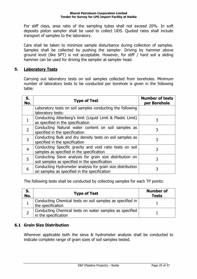
5. Laboratory Tests Carrying out laboratory tests on soil samples collected from boreholes. Minimum number of laboratory tests to be conducted per borehole is given in the following table:
S. No.
Type of Test Number of tests
per Borehole
Laboratory tests on soil samples conducting the following laboratory tests:
1 Conducting Atterberg’s limit (Liquid Limit & Plastic Limit) as specified in the specification
3
2 Conducting Natural water content on soil samples as specified in the specification
3
3 Conducting Bulk and dry density tests on soil samples as specified in the specification
3
4 Conducting Specific gravity and void ratio tests on soil samples as specified in the specification
3
5 Conducting Sieve analysis for grain size distribution on soil samples as specified in the specification
3
6 Conducting Hydrometer analysis for grain size distribution on samples as specified in the specification
3
The following tests shall be conducted by collecting samples for each TP points:
S. No.
Type of Test Number of
Tests
1 Conducting Chemical tests on soil samples as specified in the specification
1
2 Conducting Chemical tests on water samples as specified in the specification
1
6.1 Grain Size Distribution
Wherever applicable both the sieve & hydrometer analysis shall be conducted to
indicate complete range of grain sizes of soil samples tested.

Bharat Petroleum Corporation Limited Tender for Survey for LPG Import Facility at Haldia
E&P (Pipeline Projects) – Noida Page 30 of 57
6.2 Atterberg Limits Wherever applicable, these tests shall be carried out by the skilled personnel. The test result should include liquid limit, plastic limit and shrinkage limit of the soil samples tested. These tests should be conducted as per IS-2720, Part V & VI.
6.3 Chemical Tests Chemical tests shall be conducted on soil and water samples as per relevant BIS (latest revision) to report the following: a) pH b) Chlorides in ppm & percentage c) Sulphates in ppm, percentage & expressed as SO3 & SO4.
7. Report
7.1 The report shall be prepared with due regard to above given requirements. Draft
geotechnical reports shall be furnished upon completion of investigation for Owner’s review / comments. Comments, if any, on these reports shall be duly incorporated in the final report.
7.2 The final report shall include but not limited to the following:
a) A plot plan showing all test locations with respect to reference bench mark. The co-ordinates and RLs of test locations shall be given in a tabular form in the report.
b) General geographical information of the site.
c) Character and genesis of soil.
d) Procedure of investigation and method of various testing adopted.
e) Detailed bore logs indicating co-ordinates, reduced level, ground water table etc., subsoil profiles along various sections indicating boreholes no.s, depth wise in-situ test results like SPT and other lab test results etc.
f) All field and laboratory test results shall be plotted against depth in bore log and also in tabular form.
g) Summary of results obtained from various tests and their interpretation to evaluate various soil parameters along with all literature backup.
h) Recommendations regarding ground water table fluctuation and design ground water table to be considered for design of foundations.
Bharat Petroleum Corporation Limited Tender for Survey for LPG Import Facility at Haldia
E&P (Pipeline Projects) – Noida Page 31 of 57
i) Assessment of seismic hazard and liquefaction potential shall be carried out and furnished in the report.
j) Comments on chemical nature of ground water and soil with due regard to potential deleterious effect on concrete and steel and firm recommendations on protective measures. Also remedial measures for any sulphate attack or detrimental acidic conditions shall be dealt in detail giving clear practical recommendations.
k) All calculations, recommended design parameters and measurements shall be reported in SI units.
l) All recommendations furnished in the report shall be supported by detailed back-up calculations. Extract of relevant parts of the references / literature used in firming up the recommendations shall be appended in the geotechnical report.
The following soil parameters are required for the seismic analysis (wave propagation and fault movement analysis) of the pipeline: a) Angle of Internal Friction b) Undrained Shear Strength c) Total Unit Weight / effective unit weight of soil d) Shear wave propagation velocity e) Liquefaction Assessment ERT AND TRIAL PIT – SCOPE OF WORK Trial Pit: The depth of pit shall be 3.0 m or up to level of ground water whichever is less. The size of pit shall be 2.50 m × 2.50 m for depth up to 2.0 m from ground level. Size of pit shall be reduced to 1.0 m × 1.0 m below 2.0 m and it continues up to termination depth. Bulk samples shall be collected within depth 1.5 m to 2.0 m (one sample) and from bottom of the pit (one sample) for visual inspection. All necessary precautions shall be observed in order to avoid the collapse of pits. Logging of pit shall be made as per relevant IS codes. Trial pits shall be hand excavated and shall avoid any underground utilities at the proposed locations. Trial pits shall be backfilled in layers not exceeding 300 mm and thoroughly compacted to in-situ ground condition before excavation on completion of the investigations. Trial pits shall be fenced off until it has been backfilled and reinstated.

Bharat Petroleum Corporation Limited Tender for Survey for LPG Import Facility at Haldia
E&P (Pipeline Projects) – Noida Page 32 of 57
ERT: Electrical Resistivity Test (ERT) shall be carried out to have the resistivity value of sub soil profile up to a depth of at least 8.0 m in each direction. ERT tests shall be conducted in the field at specified locations as per IS 3043 (latest edition).

Bharat Petroleum Corporation Limited Tender for Survey for LPG Import Facility at Haldia
E&P (Pipeline Projects) – Noida Page 33 of 57
CORROSION SURVEY – SCOPE OF WORK
1. Scope The specification covers the corrosion survey including measurement of soil resistivity and other cathodic protection related data collection along Right of Use of the pipelines.
2. Codes and Standards Equipment and measurement techniques shall unless otherwise specified conform to the requirement of following latest applicable standards:
BIS specifications and codes of practice The work shall be carried out in compliance with all applicable local laws and
regulations.
3. General
This specification defines the basic guidelines for carrying out the corrosion survey. Contractor shall be responsible for providing necessary data interpretation based on corrosion survey measurements which is intended to form a basis for design of cathodic protection system for the pipeline to be buried along ROU.
4. Soil Resistivity Survey Unless otherwise specified the soil resistivity measurements shall be carried out at intervals of 250 m (approx.) along the center line of pipeline route.
To carry out the soil resistivity measurement, Wenner's 4 pin method or approved Equivalent most modern / sophisticated reliable method shall be used. The depth of resistivity measurement shall be 3 meters from NGL approximately and the resistivity readings should be taken at every meter level. At locations where two layer soil is expected and / or locations specifically advised by the BPCL Engineer / agency deputed by BPCL, resistivity measurements at additional depth shall be taken. In general the resistivity of soil which shall be surrounding the pipe shall be measured. Hence the depth of measurement / electrode spacing may vary depending on topography and strata at the area. Electrode spacing shall be approximately equal to the depth of measurement.
The readings for the Corrosion survey to be taken along the center line and the right angle to the center line of the proposed pipeline route
The observations shall be made enclosing the soil immediately surrounding the pipeline route alignment.
All measurements shall be taken at right angles to the Right of Use unless otherwise asked by the BPCL Engineer / Engineer deputed by BPCL at site. At places in Right of

Bharat Petroleum Corporation Limited Tender for Survey for LPG Import Facility at Haldia
E&P (Pipeline Projects) – Noida Page 34 of 57
Use where other pipe lines are already existing care shall be taken to precisely locate such pipe line and take such precautions that observations are not adversely affected by presence of such pipe lines.
Care shall also be taken that the observations are not influenced by presence of other earth currents in the area especially in the vicinity of HT lines and plants using earth return in their source of power etc. (This data also to be collected for these types of objects falling within 200 m from the pipeline route).
Wherever possible / advised by the BPCL Engineer / agency deputed by BPCL depth of water table shall be determined by resistivity observations. All measurements shall be made and recorded in metric units. While recording the data wherever possible, reference to the nearest intersecting point shall be made. To provide visual representation of variations in the resistivity along Right of Use, values shall be plotted on Semillon graph sheets. The resistivity graph shall also indicate the resistivity at additional depths measured at various locations and depth of water table.
5. Additional Data Collection
The following data shall be collected with a view to generate design data for evaluation of cathodic protection interaction possibilities due to presence of other services in Right of Use and its vicinity:
Route and types of foreign pipeline in and around or crossing the Right of Use. Diameter, wall thickness, pressure, soil cover etc. of the foreign pipelines. Voltage rating, phases and sheathing details of parallel running or crossing
cables.
Foreign pipeline coating details.
Details of existing cathodic protection systems protecting the services including rating and location of ground bed, test station locations and connection schemes etc. Where pipeline is likely to pass close to any existing ground bed, necessary anode -bed potential gradient survey shall be carried out.
Interference remedial measures existing on foreign pipelines.
Graphical representation of existing structure / pipe to soil potential records, T/R unit / CP Power source voltage / current readings.
Possibilities of integration / isolation of the pipe line CP system with foreign
pipeline / structure CP system which may involve negotiations with owner's of foreign services.

Bharat Petroleum Corporation Limited Tender for Survey for LPG Import Facility at Haldia
E&P (Pipeline Projects) – Noida Page 35 of 57
Information on existing and proposed DC / AC power sources and system in the vicinity of the entire Right of Use.
Crossing and parallel running of electrified and non – electrified railway tracks. Crossing or parallel running of any H.T. AC / DC overhead line. Any other relevant information that may be needed in designing and
implementing of proper cathodic protection scheme for the proposed pipeline. No extra payment shall be made on this account.
6. Report
On completion of all field and laboratory work, a report incorporating all the results generated from various surveys, data collected and tests carried out shall be furnished. The report shall include reproducible and 6 prints each of various drawings and graphs prepared by the contractor in connection with the work. The report shall be submitted in six copies including the original field records, CDs etc. The Graph showing the Soil Resistivity and Soil Investigation comparison is to be produced. The drawings should be clearly marked with the legend for representing the soil strata with respect to the Resistivity Value.
7. Information Required with Bid
Bidder shall provide following information along with the bid without which the bids are liable for rejection:
Instruments that will be used for carrying out Soil Resistivity Survey.
Procedure to be adopted for avoiding foreign pipe lines / HT lines etc. affecting the soil resistivity observation (Also considering any object falling within the area of 200 m from the route).
Measurement location and identification procedure.
Formats for presentation of results.
Bharat Petroleum Corporation Limited Tender for Survey for LPG Import Facility at Haldia
E&P (Pipeline Projects) – Noida Page 36 of 57
CADASTRAL SURVEY

Bharat Petroleum Corporation Limited Tender for Survey for LPG Import Facility at Haldia
E&P (Pipeline Projects) – Noida Page 37 of 57
CADASTRAL SURVEY FROM HOJ – HALDIA TWIN PIPELINES SPECIFICATION FOR CADASTRAL SURVEY
CONTENTS
SCOPE
PROCEDURE ADDITIONAL DATA COLLECTION PREPARATION OF MAP / REPORT

Bharat Petroleum Corporation Limited Tender for Survey for LPG Import Facility at Haldia
E&P (Pipeline Projects) – Noida Page 38 of 57
SCOPE The Contractor's scope of work shall include, but not limited to the following:
Procurement of all Latest Revenue / Village maps, 7/12 Records, Khasra / Khatauni from revenue department required for carrying out Cadastral Survey work for entire length of pipeline route.
PROCEDURE
Carrying out Cadastral survey for ROU in land acquisition including detailed Survey for the individual Survey numbers with the help of Total Station for the area 5 meters on left side and 13 meters on the right side of the pipeline along the flow from the main line of the proposed pipeline alignment.
Identification of survey number of individual owners & plotting on village maps as per revenue records.
The cadastral maps are to match with village maps. Contractor should draw the ROU on the village map available from revenue department of the area.
These land acquisition plan drawing shall show the proposed pipeline alignment with TP / IP No.s showing the Khasra details etc.
Preparation of land acquisition statement Taluka wise / chainage wise for ROU in land acquisition for the area 5 meters on left side and 13 meters on the right side of the pipeline along the flow from the center line of the proposed pipeline alignment. This statement shall include but not limited to the following: Survey. No. / Gat No. / Plot No. / Sub-division No. etc. Particulars of land to be acquired giving details of type of land. Area to be
acquired in Hectare / Acre, total area of the particular Survey no. / Gat no. / Plot no. / Sub-division and assessment rate of the land. Name of the owners of individual Survey no. / Plot no. / Sub-divisions as on date Programming to be made for list of survey no.s with its area for preparation of Sec – 3(1) / Sec – 6(1) documents as per Petroleum and Mineral Pipeline Act.
Details of super structure / trees / wells / any other utilities / facilities within the Survey no. / Gat no. / Plot no. / Sub-division no falls in the ROU.
Details of status of land e.g. Non – Agriculture Diversions etc.
Any other details required for ROU in land acquisition as per Petroleum and Mineral Pipeline Act.
This statement shall also give the reference of corresponding land acquisition plan drawing.
Bharat Petroleum Corporation Limited Tender for Survey for LPG Import Facility at Haldia
E&P (Pipeline Projects) – Noida Page 39 of 57
List to be prepared for the number of trees fell at the time of laying the pipeline within the ROU survey number wise/ owner wise/ village wise / district wise / Taluka wise for obtaining the permission from the appropriate authority in the prescribed format as suggested by different authorities. The same to be collected by the Contractor and arrangement to be made for inspection / approval by the Patwari / Revenue Inspector / Tehsildar etc.
ADDITIONAL DATA COLLECTION
For land other than private land, the following additional drawings / data / records are required which shall form a part of cadastral Survey work. No extra payment shall be made for these works.
Identification and preparation of a list of Government / State Authorities with full address and contact numbers in whose land the pipeline route is passing through.
Find and tabulate the area of the Individual Government / State Authorities land.
Preparing of proposal including drawings for submission to Government/ State authorities as per their requirements for obtaining permissions for routing the pipeline through their land meeting the different stage of NOC procedure as per the instruction of the BPCL Engineer / agency deputed by BPCL.
Submit the Proposal to BPCL for obtaining the Permissions. Assist BPCL Engineer for obtaining the Permission for laying the pipeline.
Tribal Land / any other land with special protection by law may be identified and details marked. Assistance is to be provided by to BPCL for getting permissions etc. The required data / drawings are to be provided by the survey party. Permissions are to be obtained by BPCL.
PREPARATION OF MAP / REPORT
Submit the following in six sets along with tracings, CDs.
The Village Drawing in the Scale 1:5000 marking the Survey no. / Plot No. / Gat no. / Sub-division No. 50 m on either side.
The Land Acquisition Drawing in the Scale of 1:2500 with all details of Survey No. / Plot No. / Gat No. / Sub-Division No.
The Report containing the area of each Survey no. / Plot no. / Gat no. / Sub-
division no., Name of the Owner of Individual Survey no / Gat no / plot no. / Sub-division no., duly verified by the latest revenue record 7/12 record / khasra / khatauni, Type of land, Type of crop grown with total quantity of crops grows in the Individual Survey no. / Gat no. / Plot no. / Sub-division no., Cost of Crops as per latest market rate / Mandi rate, Cost of land as per the Market Price / Govt. guide line price, Cost of well, cost of trees, cost of any other facilities. Copies of

Bharat Petroleum Corporation Limited Tender for Survey for LPG Import Facility at Haldia
E&P (Pipeline Projects) – Noida Page 40 of 57
all relevant approved guidelines and rate lists for arriving at land / crop prices should also be provided along-with the above details.
The full village map traced on cloth / tracing cloth / thick tracing paper / 75 micron polyester film of all the villages through which the pipeline is passing.

Bharat Petroleum Corporation Limited Tender for Survey for LPG Import Facility at Haldia
E&P (Pipeline Projects) – Noida Page 41 of 57
SPECIFICATION OF FOREST SURVEY CONTENTS
SCOPE
PROCEDURE
ADDITIONAL DATA COLLECTION
PREPARATION OF MAP / REPORT
Bharat Petroleum Corporation Limited Tender for Survey for LPG Import Facility at Haldia
E&P (Pipeline Projects) – Noida Page 42 of 57
SCOPE
The contractor’s scope of work shall include, but limited to the following:
Procurement of the latest Forest Map with compartment numbers from Range offices & also collecting maps from DCF office. Identification of the Reserved Forest / Protected Forest / Community Forest / Acquired Forest Social forest, Revenue forest (Under the control of revenue department), National sanctuary.
PROCEDURE
Carrying out the Forest Survey along with the Forest Authority for the reduced ROU OF 10/7 meters width (5 meters on both side of the center line or 3 meters on left side and 4 meters on the right side of the pipeline along the flow as the case may be). Finalize the alignment and mark the Pipeline Alignment on the Forest Map collected from the Forest Authority. Carry out the Forest Enumeration along with the Forest Officials / to be approved by the concerned DFO for no of trees, type of trees, size of trees with its girth, estimated timber , fuel etc for the 10/7 meters width of pipeline ROU passing through the forest.
ADDITIONAL DATA COLLECTION
Any other data required to be collected by the contractor for carrying out the Forest Survey and Preparation of the Forest Proposal. No extra payments on this account shall be made.
PREPARATION OF REPORTS
All the drawings / data, information related to the Forest proposals are to be provided by the survey party. Proforma for making forest proposals is to be collected from the Forest Authority. All formalities in preparation of forest proposal to submit to division office shall be carried out by the contractor. The division forest proposal to be prepared in twelve sets for submitting to the Forest Authority. In case there is no forest crossing in any tehsil / range observed, then NOC shall be obtained from Range office to confirm the same.

Bharat Petroleum Corporation Limited Tender for Survey for LPG Import Facility at Haldia
E&P (Pipeline Projects) – Noida Page 43 of 57
GEOTECH SURVEY
Bharat Petroleum Corporation Limited Tender for Survey for LPG Import Facility at Haldia
E&P (Pipeline Projects) – Noida Page 44 of 57
GEOTECH SURVEY FOR LPG IMPORT FACILITY AT HALDIA The scope of the work shall include:
a) Mobilization, transportation, loading / unloading of all necessary rigs,
equipments, tools & tackles etc. and required manpower for carrying out the field investigation works a specified.
b) Conducting borehole investigations as specified.
c) Conducting standard penetration tests and collecting disturbed and undisturbed
soil samples from boreholes as specified.
d) Conducting chemical tests on soil and ground water samples collected from boreholes as specified.
e) Recording water table in the boreholes
f) Carrying out laboratory tests on soil samples collected from boreholes as specified. Laboratory tests to be conducted per borehole is given in the table below:
Sr. No.
Type of test No. of test
1 Grain size analysis 6 / borehole
2 Hydrometer analysis wherever applicable 4 / borehole
3 Atterberg’s Limits (LL, PL & Shrinkage Limit) 6 / borehole
4 Natural Moisture Content 6 / borehole
5 Bulk & Dry Density 5 / borehole
6 Unconfined compression tests on soil samples (in clayey strata)
4 / borehole
7 Unconsolidated Undrained tests (in clayey strata) 5 / borehole
8 Consolidation tests (in clayey strata) 3 / borehole
9 Box shear Test (for sandy soil samples) 4 / borehole
10 Laboratory CBR test on soil samples collected from proposed borrow area per station
3
11 Chemical tests on soil samples per station 4
12 Free swell and swelling pressure test (if soil is expansive in nature) per station
4
g) Preparation and submission of report in six hard copy and 2 soft copies.
h) Demobilization / removal of equipments from site on completion of work.

Bharat Petroleum Corporation Limited Tender for Survey for LPG Import Facility at Haldia
E&P (Pipeline Projects) – Noida Page 45 of 57
Requirements The contractor shall confirm their schedule of field / lab investigations well in advance for the purpose of witness of tests by OWNER. The contractor shall mobilize a qualified geotechnical engineer for supervision of field works. Also an experienced geotechnical Engineer with postgraduate qualification should be engaged for preparation of the report and he should visit site to familiarize with the site conditions and to assess various field and laboratory tests to arrive at design parameters. All test equipments and tools shall confirm to relevant IS code of practice. Boring Boring shall be carried out in accordance with the provision of IS: 1892. Minimum diameter of boring shall be 150 mm. Auger boring shall be resorted to above the water table, whereas below the water table the boreholes shall be advanced by rotary drilling with mud circulation through all kinds of soil other than rock. While boring above water table, no water shall be introduced in the boreholes. Casing shall be used to support the sides of boreholes in soft to firm soils. Use of chisel, percussion, and drilling with NX size may be permitted exclusively in strata having SPT-N greater than 100 blows per 30 cm penetration and as per direction of Engineer-in-charge. The depth of ground water table shall be measured. The water table in the borehole shall be allowed to stabilize after depressing the water level adequately by bailing. Coring Coring shall be done with NX size diamond drill bit. Double tube core barrel shall be used for coring. The termination criteria of borehole shall be as follows (whichever occurs earlier): a) Depth of borehole = 30 m b) After observing consecutive minimum 5 Nos. of SPT N-value more than 50 at
spacing in each of boreholes at the stations where rock is not encountered. In case rock strata is encountered then bore hole shall be terminated after coring 5m in soft rock (core recovery up to 50%) or 2m in hard rock having core recovery more than 50%.
Standard Penetration Tests (SPT) These shall be conducted in boreholes at interval of 1.5 m or at change of strata starting first test at 0.5 m depth. Last SPT shall be conducted at the termination depth of borehole. The disturbed representative samples shall be visually classified, labelled for identification, and properly preserved for laboratory testing. SPT shall be

Bharat Petroleum Corporation Limited Tender for Survey for LPG Import Facility at Haldia
E&P (Pipeline Projects) – Noida Page 46 of 57
terminated at any depth when the number of blows exceeds 100 for a penetration of 30 cm or less. All test equipments and tools shall confirm to relevant IS code of practice. Undisturbed Samples Undisturbed samples of 100 mm dia shall be taken from all boreholes and from representative strata at intervals of 3.0 m or change of strata whichever occurs earlier starting first UDS at 2.5 m depth. For stiff clays, area ratio of the sampling tubes shall not exceed 20%. In soft deposits piston sampler shall be used to collect UDS. Quoted rates shall include transport of samples to the laboratory. Care shall be taken to minimize sample disturbance during collection of samples. Samples shall be collected by pushing the sampler. Driving by hammer above ground level (like SPT) is not acceptable. However, for stiff / hard soil a sliding hammer can be used for driving the sampler at sampler head. Disturbed Samples Disturbed soil / wash samples shall be collected at every 0.5 m intervals and at every change of strata from boreholes. Identification labels indicating depth, borehole no. and visual soil classification shall be affixed on the containers. Laboratory Tests After collecting disturbed and undisturbed samples from different boreholes at different depths a laboratory test schedule shall be prepared and submitted to BPCL for review. Adequate number of the following tests shall be conducted to clearly determine the mechanical strength and compressibility characteristics of each strata of soil encountered. Minimum requirement of the various laboratory tests envisaged are specified in clause 1 above All tests on rock and soil samples shall conform to relevant IS codes. The laboratory tests shall essentially comprise of but not limited to the followings:
1. Grain Size Distribution Wherever applicable both the sieve & hydrometer analysis shall be conducted to indicate complete range of grain sizes of soil samples tested.
2. Atterberg Limits Wherever applicable, these tests shall be carried out by the skilled personnel. The test result should include liquid limit, plastic limit and shrinkage limit of the soil samples tested. These tests should be conducted as per IS-2720, Part V & VI.
3. Consolidation Tests
Bharat Petroleum Corporation Limited Tender for Survey for LPG Import Facility at Haldia
E&P (Pipeline Projects) – Noida Page 47 of 57
The following loading stages shall be employed: 0.10, 0.25, 0.50, 1.0, 2.0, 4.0, 8.0 kg cm-2. From e Vs log p curves, pre consolidation pressure shall be determined to establish whether the soil is normally consolidated or over-consolidated. The point (e, p) showing initial condition of the soil under test must be specifically marked on the consolidation curves. Settlement predictions based on the field virgin compression curve shall only be acceptable. The procedure adopted in respect of obtaining compression indices from the field curve & that for computing settlements for the type of clay under consideration shall be clearly illustrated in the report. It is to be noted that deviations from the standard procedure of performing consolidation tests given in IS-2720 Part XV are permissible in order to enable computation of settlements based on the above procedure i.e. cycle(s) of loading, unloading & reloading shall be employed wherever required. The following curves shall be included in the report: a) e Vs log P b) e Vs p
c) Compression Vs log (t) or compression Vs t The choice of relationship depends upon the shape of the plot which enables, clear determination of CV, the coefficient of consolidation. The time period required for 50% & 90% primary consolidation shall be given in the report. Computation of secondary settlements, if significant, shall also be made and included in the report.
4. Unconfined Compressive Strength These tests shall be done as per IS-2720 (Part- X) on selected soil sample.
5. Triaxial Tests These tests shall be done on specimens saturated by the applicable of back pressure. Only if the water table is at sufficient depth so that chances of it’s rising to the base of the footing are meager or nil, the tri axial tests shall be performed on specimens at natural moisture content. The magnitude of the back pressure applied shall be indicated in the report. All the stress strain diagrams as well as Mohr circle envelopes shall be included in the report. Density and water content of the sample tested and modulus of elasticity along with shear strength parameters shall be reported.

Bharat Petroleum Corporation Limited Tender for Survey for LPG Import Facility at Haldia
E&P (Pipeline Projects) – Noida Page 48 of 57
In case the soils are predominantly sandy in nature and sampling is not possible for tri-axial shear tests, box shear tests shall be carried out as per the relevant IS code.
6. Modulus of Elasticity E-value shall be determined from the tri axial tests. Relative corrections applied to the computed 'E' shall be clearly illustrated in the report.
7. Chemical Tests Chemical tests shall be conducted on soil and water samples as per relevant BIS (latest revision) to report the following: d) pH e) Chlorides in ppm & percentage f) Sulphates in ppm, percentage & expressed as SO3 & SO4.
8. Free Swell Index & Swelling Pressure Test
Wherever applicable, these tests shall be conducted on the selected soil samples collected from boreholes / trial pits from different depths, as per relevant IS codes (latest edition).
9. CBR Test Laboratory CBR tests shall be carried out under both soaked and unsoaked conditions on soil samples (to be collected by the contractor from borrow pit area or as per instruction of Engineer-in-charge) compacted to OMC (Optimum moisture Content). This test shall be carried out as per IS 2720 Part XIV. The Soil samples for the test shall be compacted to the maximum density at optimum moisture content determined in accordance with 2720 Part VIII. Report Detailed report(s) shall be prepared and submitted to BPCL as soon as the field and laboratory works are completed. The report shall include but not limited to following: A location plan showing all the test locations with respect to reference chainage
and spot levels / contour details of the proposed area. General geological information of the site. Character and genesis of soil. Procedure of investigation and method of various testing adopted.

Bharat Petroleum Corporation Limited Tender for Survey for LPG Import Facility at Haldia
E&P (Pipeline Projects) – Noida Page 49 of 57
Detailed bore logs indicating co-ordinates, reduced level, ground water table etc., subsoil section along various profiles indicating boreholes nos. depth wise in situ tests like SPT.
All field and laboratory test results shall be plotted against depth and also in tabular form.
Summary of results obtained from various tests and their interpretation to evaluate various soil parameters.
Ultimate and safe bearing capacity from shear as well as from settlement criteria
(i.e. for 25 mm & 40 mm) for the shallow footings of size ranging from 1 m to 4 m and for rafts of size greater 6.0 m placed at different depths from 1 to 3 meters. The recommendation shall also contain provision of basement raft and its construction aspects. The recommended bearing capacities shall be worked out based on various field and laboratory tests.
Recommendations of CBR value etc regarding design and construction of roads
and other paved structures and also suitability of soil for back filling in foundations.
All recommendations shall be supported by back up calculations.

Bharat Petroleum Corporation Limited Tender for Survey for LPG Import Facility at Haldia
E&P (Pipeline Projects) – Noida Page 50 of 57
TOPOGRAPHICAL SURVEY

Bharat Petroleum Corporation Limited Tender for Survey for LPG Import Facility at Haldia
E&P (Pipeline Projects) – Noida Page 51 of 57
TOPOGRAPHICAL SURVEY FOR LPG IMPORT FACILITY AT HALDIA
The detailed scope of work shall be as below but not limited to the following:
1. Identification of True / Magnetic North and marking in the survey maps.
2. The base line shall be established at site and the grid system shall be parallel and perpendicular to this base line
3. Establishing reliable HFL and its source for Station Sites.
4. Location of suggestive storm water disposal point along with levels including making the same in topographical survey drawings
5. Construction of Permanent Pillars – 02 Nos. for each site. Size 300 *300 * 1000 mm
6. Topography survey shall be extended to 30m beyond the station boundary limits at all sides as specified in the specifications and marking all natural and manmade features.
7. The contour survey shall be carried out with reference to the existing nearest PBM and the contractor shall transfer the same to site and BM shall be established at site.
8. The grid shall be of 10 m (max) for Stations. The grid for taking spot levels for the access road corridor shall be 5 m (max).
9. Establishing and constructing boundary Conner pillars as directed by BPCL engineer of size 200 x 200 x 800 mm.
Bharat Petroleum Corporation Limited Tender for Survey for LPG Import Facility at Haldia
E&P (Pipeline Projects) – Noida Page 52 of 57
DELIVERY SCHEDULE
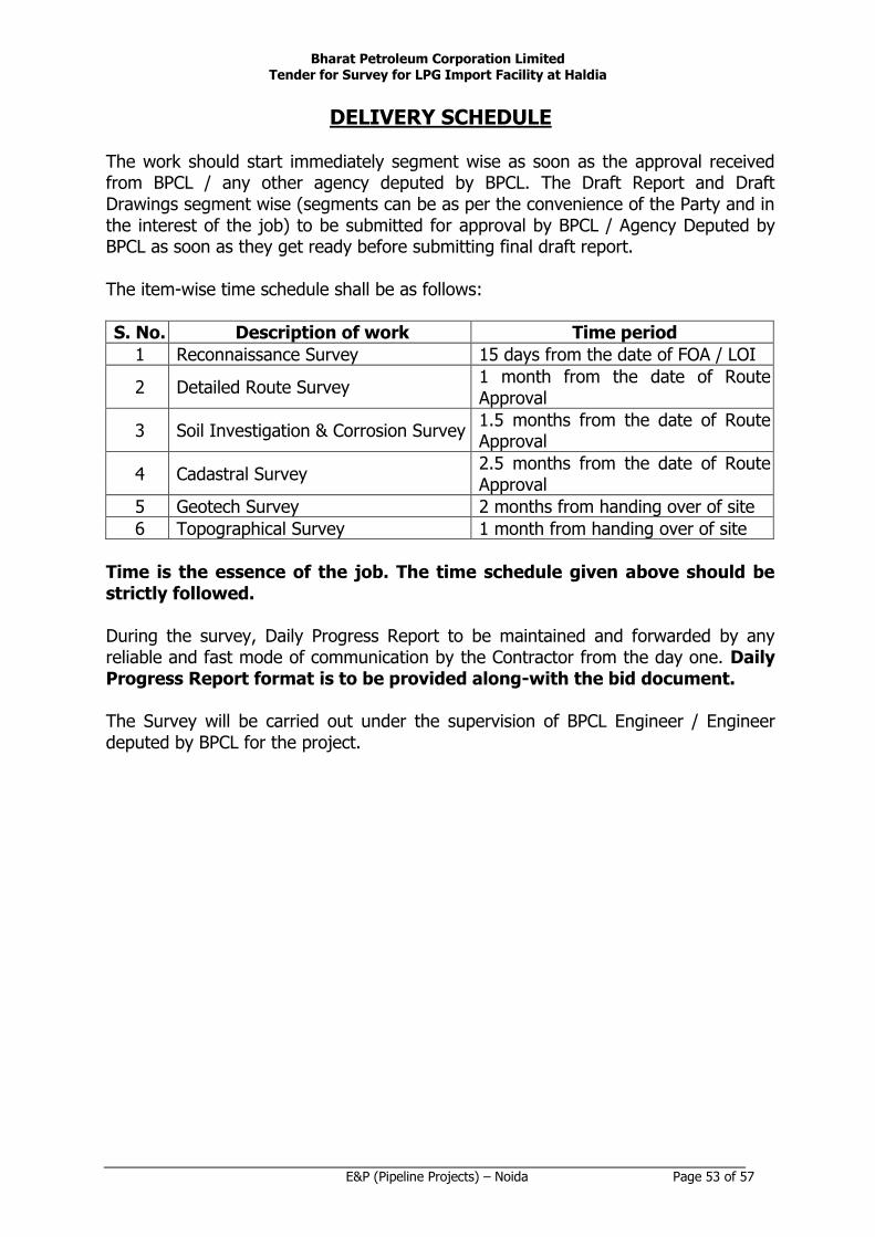
Bharat Petroleum Corporation Limited Tender for Survey for LPG Import Facility at Haldia
E&P (Pipeline Projects) – Noida Page 53 of 57
DELIVERY SCHEDULE The work should start immediately segment wise as soon as the approval received from BPCL / any other agency deputed by BPCL. The Draft Report and Draft Drawings segment wise (segments can be as per the convenience of the Party and in the interest of the job) to be submitted for approval by BPCL / Agency Deputed by BPCL as soon as they get ready before submitting final draft report.
The item-wise time schedule shall be as follows:
S. No. Description of work Time period
1 Reconnaissance Survey 15 days from the date of FOA / LOI
2 Detailed Route Survey 1 month from the date of Route Approval
3 Soil Investigation & Corrosion Survey 1.5 months from the date of Route Approval
4 Cadastral Survey 2.5 months from the date of Route Approval
5 Geotech Survey 2 months from handing over of site
6 Topographical Survey 1 month from handing over of site
Time is the essence of the job. The time schedule given above should be strictly followed. During the survey, Daily Progress Report to be maintained and forwarded by any reliable and fast mode of communication by the Contractor from the day one. Daily Progress Report format is to be provided along-with the bid document.
The Survey will be carried out under the supervision of BPCL Engineer / Engineer deputed by BPCL for the project.

Bharat Petroleum Corporation Limited Tender for Survey for LPG Import Facility at Haldia
E&P (Pipeline Projects) – Noida Page 54 of 57
PAYMENT TERMS
Bharat Petroleum Corporation Limited Tender for Survey for LPG Import Facility at Haldia
E&P (Pipeline Projects) – Noida Page 55 of 57
PAYMENT TERMS DETAILED ROUTE SURVEY
The payment terms against each item shall be as follows and made progressively in running bills:
50% Payment against the Completion of Field Work.
20% Payment against the submission of the Draft Report / Draft Drawings for the Approval from BPCL Engineer / Engineer Deputed by BPCL.
30% Payment against the Submission of the Final Report and Final Drawings.

Bharat Petroleum Corporation Limited Tender for Survey for LPG Import Facility at Haldia
E&P (Pipeline Projects) – Noida Page 56 of 57
Schedule of Quantities
Bharat Petroleum Corporation Limited Tender for Survey for LPG Import Facility at Haldia
E&P (Pipeline Projects) – Noida Page 57 of 57
SCHEDULE OF QUANTITIES
S.
No. Description Unit Qty
Rate
(`)
Amount
(`)
1
Carrying out the Reconnaissance Survey for
selecting the best / economical route as per
specifications to be made for all the three different
routes (GPS / DGPS to be used for the
Reconnaissance Survey)
Meter 9,000
2
Carrying out Detailed Route Survey for the
Pipeline Route of ROU 18 meters along NH / SH /
MDR etc. with all the tracings / field documents in
original, disks etc. in accordance with the
specifications, along with identification of high
consequence zones with population density
Meter 9,000
3
Soil Investigation: The samples to be collected for
every meter depth upto 10 m depth, in consultation
with BPCL Engineers / Authorized representatives of
BPCL as per detailed specification attached.
AND
Carrying out Corrosion Survey work by Measuring
Soil Resistivity at 250 meters intervals as per
enclosed specification for corrosion survey as per the
points on the centreline of the pipeline where the
readings are taken
No. 36
4 Cadastral Survey Meter 9,000
5 Geotech Survey for Cryogenic Import Facility at
Haldia for borehole depth upto 20 m No. 20
6 Geotech Survey for Cryogenic Import Facility at
Haldia for borehole depth from 20 m upto 30 m No. 20
7 Topographical Survey for Cryogenic Import
Facility at Haldia SQM 1,82,000
TOTAL
Service Tax @ ________ %
GRAND TOTAL