BEYOND TRAFFIC - US Department of Transportation · BEYOND TRAFFIC: The Smart City Challenge ......
82
SUBMITTED BY: May 24, 2016 | Solicitation No. DTFH6116RA00002 Volume 1: Technical Application BEYOND TRAFFIC: The Smart City Challenge PHASE 2
Transcript of BEYOND TRAFFIC - US Department of Transportation · BEYOND TRAFFIC: The Smart City Challenge ......

SUBMITTED BY:
May 24, 2016 | Solicitation No. DTFH6116RA00002
Volume 1: Technical Application
BEYOND TRAFFIC:The Smart City Challenge
PHASE 2

Solicitation No.: DTFH6116RA00002
Volume 1: Technical Application
BEYOND TRAFFIC: The Smart City Challenge
Phase 2
May 24, 2016

TECHNICAL APPROACH | May 24, 2016 | Solicitation No.: DTFH6116RA00002 i
TABLE OF CONTENTS Page
Acronym List ................................................................................................................................................. iv
Executive Summary ...................................................................................................................................... 1 The Smart Columbus Vision ............................................................................................................ 1 The Columbus Way.......................................................................................................................... 1 Leadership and Expertise ................................................................................................................ 1 State-of-the-Art Facilities and Networks .......................................................................................... 2 Challenges: A Tale of Two Cities ..................................................................................................... 3 Smart Columbus Goals .................................................................................................................... 3 A District Approach .......................................................................................................................... 3 Deploying Smart Technology Solutions ........................................................................................... 3 Outcomes: A Safer, More Mobile and Accessible City .................................................................... 4 Smart Columbus Sustainability ........................................................................................................ 4 Conclusion ....................................................................................................................................... 4
A Technical Approach .............................................................................................................................. 6 A.1 Implementing and Operating the Demonstration Project ......................................................... 6
A.1.1 Implementing Smart Columbus .............................................................................. 6 A.1.2 Operating Smart Columbus ................................................................................. 27 A.1.3 Alignment of Approach with USDOT Vision Elements ......................................... 29
A.2 Approach to Interacting and Engaging with Partners ............................................................ 30 A.2.1 USDOT Partners .................................................................................................. 30 A.2.2 Public/Private Partnership .................................................................................... 32
A.3 Testing and Demonstrating Highly Automated Vehicles ....................................................... 34 A.3.1 Approach .............................................................................................................. 34 A.3.2 Identification of Regulatory Issues and Plans for Overcoming
Impediments ......................................................................................................... 35 A.4 Deploying Electric Vehicles .................................................................................................... 35
A.4.1 Ability and Commitment to Electric Vehicles, Grid Decarbonizing, and Fleet Transition .................................................................................................... 35
A.4.2 Current and Planned Electric Vehicle Deployment and Decarbonization Activities ............................................................................................................... 36
A.5 Setting and Monitoring Measurable Goals and Objectives .................................................... 38 A.6 Using Existing Standards, Architectures, and Certifications Processes ................................ 38 A.7 Following a Systems Engineering Approach ......................................................................... 44
A.7.1 Applying Lessons Learned from Other Federal Programs .................................. 44 A.7.2 Other Systems Engineering Documents .............................................................. 44 A.7.3 System Management and Operations ................................................................. 45
A.8 Ensuring Safety of all Travelers ............................................................................................. 45 A.9 Communications and Outreach ............................................................................................. 46
B Data Management Approach .............................................................................................................. 52 B.1 Data Management ................................................................................................................. 52
B.1.1 Types of Data to be Produced ............................................................................. 52 B.1.2 Policies for Data Access and Sharing .................................................................. 52 B.1.3 Policies for Data Re-use, Redistribution, and Production of Derivatives ............. 53 B.1.4 Archiving Data and Preserving Access ................................................................ 53

TECHNICAL APPROACH | May 24, 2016 | Solicitation No.: DTFH6116RA00002 ii
B.2 Data City Currently Collects ................................................................................................... 53 B.2.1 Using Current and Newly Collected Data to Address City Challenges ................ 54 B.2.2 Integrating Transportation Data with Other Functions or Services to
Improve City Management and Operations ......................................................... 55 B.2.3 Integrating Data from Other Sectors with Transportation Data to Improve
Transportation Operations ................................................................................... 55 B.2.4 Applicable Policies ............................................................................................... 56 B.2.5 Using and Sharing Data from Other Partners ...................................................... 56 B.2.6 Sustainability ........................................................................................................ 56
B.3 Support for Independent Evaluation ...................................................................................... 57
C Management Approach ....................................................................................................................... 58 C.1 Project Leadership ................................................................................................................. 58 C.2 Team Members and Partners ................................................................................................ 58 C.3 Key Implementation Partners ................................................................................................ 60 C.4 Governance Processes .......................................................................................................... 60 C.5 Partnership Management ....................................................................................................... 61 C.6 Community Support ............................................................................................................... 62 C.7 Start-up and Small Business Involvement ............................................................................. 64 C.8 Roles, Responsibilities, and Lines of Communication ........................................................... 64 C.9 Leveraging Federal Resources .............................................................................................. 65 C.10 Approach to Ensuring Quality, Timeliness, Cost Control, and Managing Risk ...................... 65
D Staffing Approach ................................................................................................................................ 66 D.1 Organizational Staffing Chart ................................................................................................. 66 D.2 Position Descriptions and Level of Effort ............................................................................... 66 D.3 Key Staff Experience on Related ITS and Transportation Projects ....................................... 68 D.4 Staff Contingency Plan .......................................................................................................... 69 D.5 Key Personnel Resumes ....................................................................................................... 69
E Capacity and Capability ...................................................................................................................... 70 E.1 Capacity and Capability to Conduct Project .......................................................................... 70 E.2 Sustainability Plan .................................................................................................................. 73
List of Tables
Table A-1. CTSS fiber strand count allocation. ............................................................................................. 8 Table A-2. CCTN infrastructure deployments. .............................................................................................. 9 Table A-3. CCTN data sources and sensors. ............................................................................................... 9 Table A-4. Risks associated with deployment of EAVs. ............................................................................. 21 Table A-5. Technology solution alignment with USDOT vision elements. .................................................. 29 Table A-6. Smart Columbus has numerous partners supporting the deployment effort. ........................... 33 Table A-7. Smart Columbus goals. ............................................................................................................. 39 Table A-8. Illustration of potential safety risks and mitigation measures. ................................................... 46
Table C-1. Smart Columbus has numerous partners supporting the deployment effort. ........................... 58 Table C-2. Smart Columbus Board of Trustees .......................................................................................... 61
Table D-1. Smart Columbus staffing plan. .................................................................................................. 67 Table D-2. The application team provided expertise to develop the Smart Columbus application. ........... 69
Table E-1. Smart Columbus Acceleration Fund.......................................................................................... 74

TECHNICAL APPROACH | May 24, 2016 | Solicitation No.: DTFH6116RA00002 iii
List of Figures
Figure ES-1. Smart Columbus will demonstrate our technology solutions in four distinct districts .............. 5
Figure A-1. The four core enabling systems support the Smart Columbus Vision and lay the foundation for deployment and repeatable implementation of smart solutions. .................................. 7
Figure A-2. The Smart Columbus Integrated Data Exchange consists of three primary components. ........................................................................................................................................ 10
Figure A-3. Columbus looks to partner with Moovel to provide comprehensive traffic data information and a customized multi-modal trip planning application to enhance human services. .............................................................................................................................................. 12
Figure A-4. Columbus looks to partner with the local financial sources industry, Alliance Data Services, COTA, and others to create a common payment system for transit as well as goods and services for cash-based households. ................................................................................ 13
Figure A-5. The City of Columbus looks to partner with Mass Factory to deploy a customized application developed in Barcelona to assist persons with disabilities to utilize public transportation in Columbus. ................................................................................................................ 13
Figure A-6. The core components of the Residential District will address challenges in the Linden neighborhood. ..................................................................................................................................... 16
Figure A-7. The Commercial District includes EAVs in a mixed-use environment. .................................... 20 Figure A-8. The Downtown District solution leverages multiple technologies to address a range of
challenges. .......................................................................................................................................... 22 Figure A-9. The Columbus Region Serves as a Gateway to the North American Market .......................... 25 Figure A-10. The City of Columbus may partner with Peloton to deploy two-truck platoons along
Alum Creek Drive to reduce congestion and increase capacity. ........................................................ 26 Figure A-11. The proposed schedule leverages the experience of ITS experts. ........................................ 28 Figure A-12. Flow from Sidewalk Labs will help the City of Columbus improve public health and
infant mortality by connecting health service providers and travelers and providing an analytic engine and reports to focus additional intervention activities. ............................................... 32
Figure A-13. Smart Columbus will develop an architecture to document concepts and applications and ensure interoperability, using the System Engineering Tool for Intelligent Transportation with the Connected Vehicle Reference Implementation Architecture. ................................................ 43
Figure A-14. The City of Columbus may partner with the proposed SPARC development to perform vehicle installation and safety checkouts of all vehicle technologies deployed. ................... 45
Figure A-15. The proposed rewards strategy is designed to engage and incentivize residents to download the mobile transit service application. ................................................................................ 48
Figure A-16. The Moonwall mural, located near Cooke Road, demonstrates investment in neighborhood art. ................................................................................................................................ 50
Figure B-1. The City of Columbus and our proposed partners already capture data from more than 1,000 traffic cameras and sensors. ............................................................................................. 54
Figure B-2. The City of Columbus and our proposed partners already capture a wealth of data such as calls for service requests or assistance to the City’s Customer Service Hotline. .................. 55
Figure C-1. The Ohio congressional delegation has expressed strong support for Smart Columbus. ........................................................................................................................................... 62
Figure C-2. The Smart Columbus Program Office provides the Smart Columbus Program with a centralized management and advisory team. ..................................................................................... 64
Figure D-1. The Program Office provides Smart Columbus with a centralized management and advisory team. ..................................................................................................................................... 66

TECHNICAL APPROACH | May 24, 2016 | Solicitation No.: DTFH6116RA00002 iv
ACRONYM LIST AASHTO American Association of State Highway and Transportation Officials ACC Adaptive Cruise Control ADA Americans with Disabilities Act AEP American Electric Power AEV Alternative Energy Vehicle AEZ Alternative Energy Zone API Application Programming Interface APP Software Application ASD After-market Safety Device ATCMTD Advanced Transportation and Congestion Management Technologies Deployment ATIS Advanced Traveler Information System ATM Automated Teller Machine AV Autonomous Vehicle AWS Amazon Web Services
BRT Bus Rapid Transit BSM Basic Safety Message
CAMP Crash Avoidance Metrics Partnership CAV Connected/Automated Vehicles CCDI Columbus Area Committee on Disability Issues CCTN Columbus Connected Transportation Network CCTV Closed Circuit Television CDDC Columbus Downtown Development Corporation CEO Chief Executive Officer CFO Clean Fuels Ohio CMAQ Congestion Mitigation and Air Quality CMAX Central Ohio Transit Authority Bus Rapid Transit Project Brand CNG Compressed Natural Gas ConOps Concept of Operations COTA Central Ohio Transit Authority CRLC Columbus Region Logistics Council CSCC Columbus State Community College CTSS Columbus Traffic Signal System CV Connected Vehicle CVRIA Connected Vehicle Reference Implementation Architecture
DATP Driver Assistive Truck Platooning DBE Disadvantaged Business Enterprise DMA Dynamic Mobility Application DoT Department of Technology DOT Department of Transportation DRS Deployment Readiness Summary DSRC Dedicated Short Range Communications DWDM Dense Wave Division Multiplexing

TECHNICAL APPROACH | May 24, 2016 | Solicitation No.: DTFH6116RA00002 v
EAM Enterprise Asset Management EAV Electric Autonomous Vehicle EHS Enhanced Human Services ESCO Energy Services Company ESID Energy Special Improvement District EV Electric Vehicle EVSE Electric Vehicle Supply Equipment
FAST Act Fixing America’s Surface Transportation Act FHWA Federal Highway Administration FMLM First Mile/Last Mile FMS Freeway Management System FSP Freight Signal Prioritization FTA Federal Transit Administration FTZ Foreign Trade Zone
GCAC Greater Columbus Arts Council GCD GridCommand Distribution™ GhG Greenhouse Gasses Ghz Gigahertz GIS Geographic Information System GM General Motors GMP Gross Metropolitan Product GPS Global Positioning System GTFS General Transit Feed Specification
IAM Identity and Access Management ICT Information and Communication Technology IDE Integrated Data Exchange IEEE Institute of Electrical & Electronic Engineering IRB Institutional Review Board ISO International Organization of Standardization ITS Intelligent Transportation Systems
JSON Java Script Object Notation
LED Light-Emitting Diode LOE Level of Effort
MDOT Michigan Department of Transportation MMITSS Multi-Modal Intelligent Traffic Signal System MORPC Mid-Ohio Regional Planning Commission MOU Memorandum of Understanding MPO Metropolitan Planning Organization
NHTSA National Highway Traffic Safety Administration NOC Network Operations Center NTP Notice to Proceed NSF National Science Foundation

TECHNICAL APPROACH | May 24, 2016 | Solicitation No.: DTFH6116RA00002 vi
OARS Olentangy-Scioto-Interceptor Augmentation Relief Sewer ODOT Ohio Department of Transportation ODW Ohio Distribution Warehouse OEM Original Equipment Manufacturer OSU The Ohio State University OSU CAR The Ohio State University Center for Automotive Research
PACE Property Assessed Clean Energy PMBOK Project Management Body of Knowledge PMP Program Management Plan POS Point of Service PSP Platoon Signal Priority PUCO Public Utilities Commission of Ohio
QA Quality Assurance QC Quality Control
RDAC Regional Data Advisory Committee RDE Research Data Exchange REC Renewable Energy Credits RFID Radio Frequency Identification RFP Request for Proposal ROI Return on Investment RSU Roadside Unit RTCM Radio Technical Commission for Maritime Services
SCC Smart City Challenge SCMS Security Credential Management System SDD System Design Document SDK Software Development Kit SEMP Systems Engineering Management Plan SID Downtown Columbus Special Improvement District SIT Special Income Tax SME Subject Matter Expert SPARC Sports Pavilion and Automotive Research Complex SPaT Signal Phasing & Timing SPR Statewide Planning & Research STEM Science, Technology, Engineering, and Math
THEA Tampa Hillsborough Expressway Authority TIGER Transportation Investment Generating Economic Recovery TIP/STIP Transportation Improvement Plan/State Transportation Improvement Plan TMC Traffic Management Center TMDD Traffic Management Data Dictionary TNC Transportation Networking Company TOC Time of Charge TOU Time of Use TPIMS Truck Parking Information and Management System TRC Transportation Research Center

TECHNICAL APPROACH | May 24, 2016 | Solicitation No.: DTFH6116RA00002 vii
TSP Transit Signal Priority TSPS Truck Smart Parking Services, Inc. TSPW Transit Bus Stop Pedestrian Warning
UHF Ultra-High Frequency UPS United Parcel Service US United States USDOE United States Department of Energy USDOT United States Department of Transportation UTC University Transportation Center
V2G Vehicle to Grid VRU Vulnerable Road Users
WBS Work Breakdown Structure WIC Women, Infants, and Children
EXECUTIVE SUMMARY | May 24, 2016 | Solicitation No.: DTFH6116RA00002 1
EXECUTIVE SUMMARY The City of Columbus has aligned around a unified vision to lead the way in moving our country forward with the deployment of Smart City technologies. With the leadership of our public and private sectors, our community will leverage the investment of the US Department of Transportation (USDOT) and Vulcan into a total investment of $140 million. This financial investment, coupled with industry leading expertise, will ensure effective deployment that can be shared with the world.
THE SMART COLUMBUS VISION Columbus strives to be the nation’s epicenter for Intelligent Transportation Systems (ITS) research, development and implementation. Our investment in ITS will create opportunities for economic development and job creation and provide ladders of opportunity for residents to better access jobs, fresh food, services, education, healthcare, and recreation.
Smart Columbus projects are universally accessible and sustainable. Our proposed approach is revolutionary in unprecedented data integration, autonomous and connected vehicle deployment, and implementing advanced sensors and cameras through smart intersections. With guidance from a diverse group of civic organizations, non-profits, business leaders, and senior technical advisors, our demonstration will be designed, developed, and implemented to provide optimal accessibility to youth, seniors, New Americans, and the Americans with Disabilities Act (ADA) community. We will also make significant investments, implement programs, and create incentives for transportation electrification and greenhouse gas reduction that will be environmentally and financially sustainable.
Columbus is the ideal testing ground to demonstrate the application of ITS. What works in Columbus—a model mid-sized American city—can be transferred to cities around the country. Columbus has a proven record of using transportation infrastructure to reconnect neighborhoods and unlock economic opportunity, with previous projects like the Long Street Bridge and Cultural Wall that have become a national template.
THE COLUMBUS WAY In Columbus, we have built an unprecedented culture of collaboration. By knocking down silos and building partnerships, Columbus has quickly become one of the fastest growing cities in the country, leading the Midwest in job and wage growth.
Through collaboration, Columbus has delivered complex projects like the $35.5 million Scioto Greenways downtown riverfront restoration and the $387 million Olentangy-Scioto-Interceptor Augmentation Relief Sewer (OARS) Deep Sewer Tunnel. Notably, our Public Private Partnership Program has managed 102 projects, representing $284.5 million in public investment while leveraging $2.58 billion in private investment.
This history of collaboration enables our commitment: Columbus will make Smart Columbus the most coveted model for every other city.
LEADERSHIP AND EXPERTISE The leadership of Mayor Andrew J. Ginther and the community, social services, advocates, industry leaders, and experts that comprise the Smart Columbus Team position Columbus to lead the country in adopting Smart City technology. We will leverage the resources, capabilities, and expertise of the private sector through the deep engagement of the Columbus Partnership, a non-profit corporate CEO group
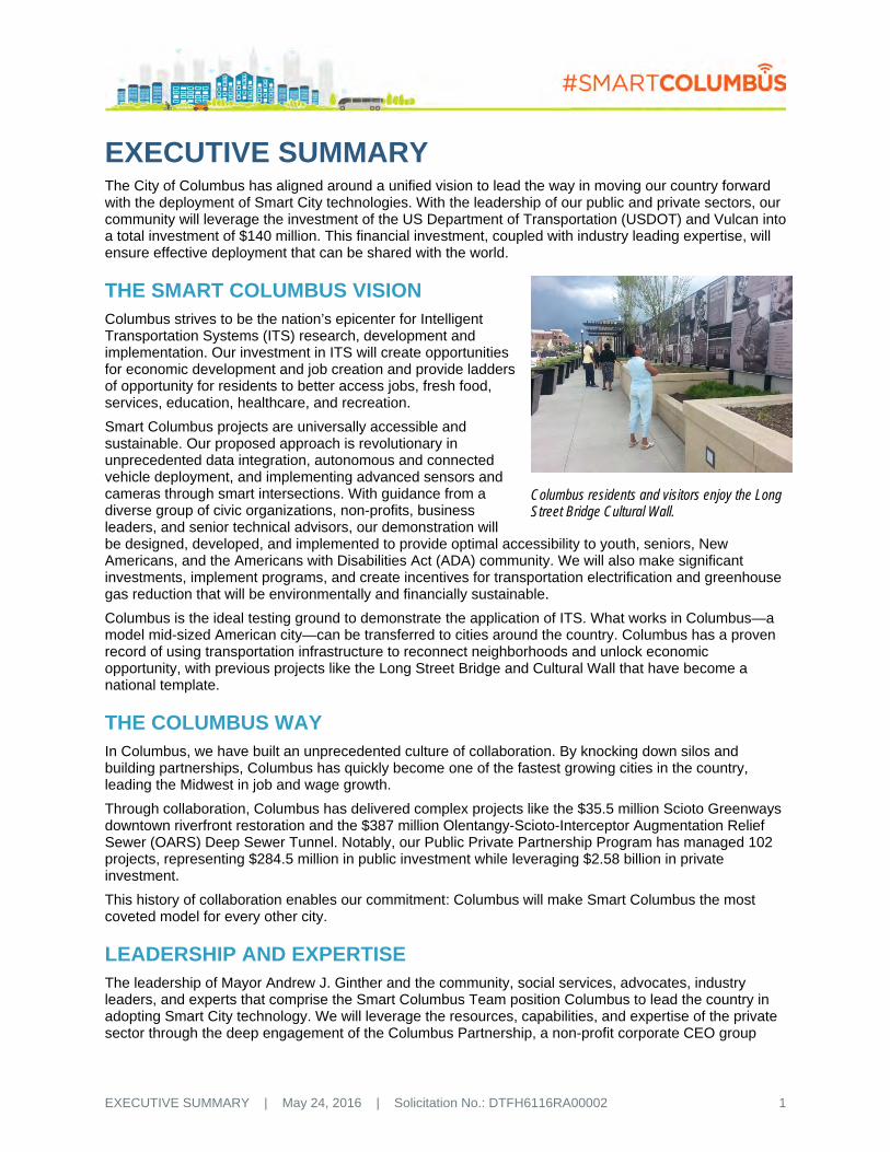
Columbus residents and visitors enjoy the Long Street Bridge Cultural Wall.

EXECUTIVE SUMMARY | May 24, 2016 | Solicitation No.: DTFH6116RA00002 2
representing more than 50 of our region’s largest employers and most significant institutions. The Smart Columbus Program Office will provide program management, acceleration and deployment of advanced transportation technologies, and collection of project data and its dissemination at our annual Mid-Sized City Forum. The Program Office will leverage the resources, capabilities, and expertise of the following in-market partners:
The Ohio State University – One of the largest public research universities in the country with renowned expertise in ITS research and development, and the City’s largest employer with one of the largest student populations in the United States, the university maintains its own transportation infrastructure and electric grid, maximizing our opportunities for scalability.
Battelle – The world’s largest non-profit research and development organization serves as a portal to six national laboratories leveraging world-class facilities and expertise in vehicle electrification and autonomy, and smart grid research.
American Electric Power – America’s largest public utility company is a catalytic force in moving electric vehicle and smart-grid technologies forward.
Honda of America, Mfg. – As the hub of Honda of America’s Manufacturing and Research and Development operations, Honda offers expertise in advanced electric vehicles and commitment to our comprehensive, connected vehicle (CV) deployment.
IBM – Global center to IBM’s advanced data analytics operation, Columbus gains access to the best of IBM - the power of Watson, Weather Channel, IBM Cloud Platform, Smart Cities global network, and IBM proprietary Design Thinking framework.
Nationwide Insurance – One of the largest insurance and financial services companies in the world located in the heart of Downtown presents a corporate campus test bed for smart technology and transit adoption.
Alliance Data Systems (ADS) – The engine behind loyalty and marketing campaigns for more than 1,000 consumer-facing companies worldwide offers relevant support for mobile fare payment and transit pass adoption.
L Brands – Fashion retail parent company of global brands Victoria’s Secret and Bath and Body Works, L Brands maintains full service logistics operations and significant employment centers that will engage in the autonomous vehicle demonstration.
Cardinal Health – The leading healthcare logistics company provides access to a national network of distribution centers, transportation logistics, and regulatory experience.
STATE-OF-THE-ART FACILITIES AND NETWORKS The City of Columbus recently completed construction of an advanced Traffic Management Center (TMC), and construction is presently underway with a multi-year, $76 million investment in the Columbus Traffic Signal System (CTSS). The CTSS, TMC, and Ohio Department of Transportation (ODOT) TMC will provide advanced and integrated traffic management coordination between Columbus, ODOT, and regional communities.
The Transportation Research Center (TRC) is a world-leading provider of vehicular testing services, providing research and development (R&D), compliance, and certification testing for vehicles and components for crash-, emissions-, dynamic- and durability-testing. The TRC will contribute its wealth of expertise in advanced automotive research to the Smart Columbus Demonstration.
The Central Ohio Transit Authority (COTA) Cleveland Avenue Bus Rapid Transit (CMAX BRT) will connect more than 200,000 residents and 170,000 jobs between Downtown and major residential, retail, and employment centers along the City’s second busiest transit route, including three of our most challenged neighborhoods. COTA and Smart Columbus will expand the CMAX project to bring a smart payment system to cash-based households, integrated trip planning for first mile/last mile connections, and Wi-Fi along the route.

EXECUTIVE SUMMARY | May 24, 2016 | Solicitation No.: DTFH6116RA00002 3
CHALLENGES: A TALE OF TWO CITIES While Columbus is a city of great opportunity, we have our challenges as well. Like many cities, we wrestle with aging infrastructure while striving to satisfy growing demands for improved quality of life. Every family in every neighborhood should be able to share in the Columbus success story, but they do not. We must begin by providing our youngest residents the opportunity to celebrate their first birthdays. Infant mortality rate is widely viewed as the global standard for measuring the health of a community. Absence of reliable access to prenatal care and challenging social and economic conditions are key contributors. Our goal is to reduce infant mortality in Franklin County by 40 percent and cut the racial health disparity gap in half by 2020. Through the smart corridors and smart payment projects to improve mobility, Smart Columbus will improve access to pre-natal care and provide ladders of opportunity for residents to address these challenging social and economic conditions. In addition, the City and CelebrateOne are collaborating with COTA for the USDOT Rides to Wellness grants. These additional funds enhance our efforts to increase healthcare access for mothers and lower rates of infant mortality.
SMART COLUMBUS GOALS After engaging residents, leaders, experts and others, five major goals emerged to provide ladders of opportunity for all:
Improve access to jobs through expanded mobility options in major job centers
Enhance visitor experience by better connecting our visitors to transportation options
Stimulate regional economic prosperity and compete globally through smart logistics
Better connect Columbus residents to safe, reliable transportation that can be accessed by all
Support the efficient movement of people and goods through environmentally sustainable practices.
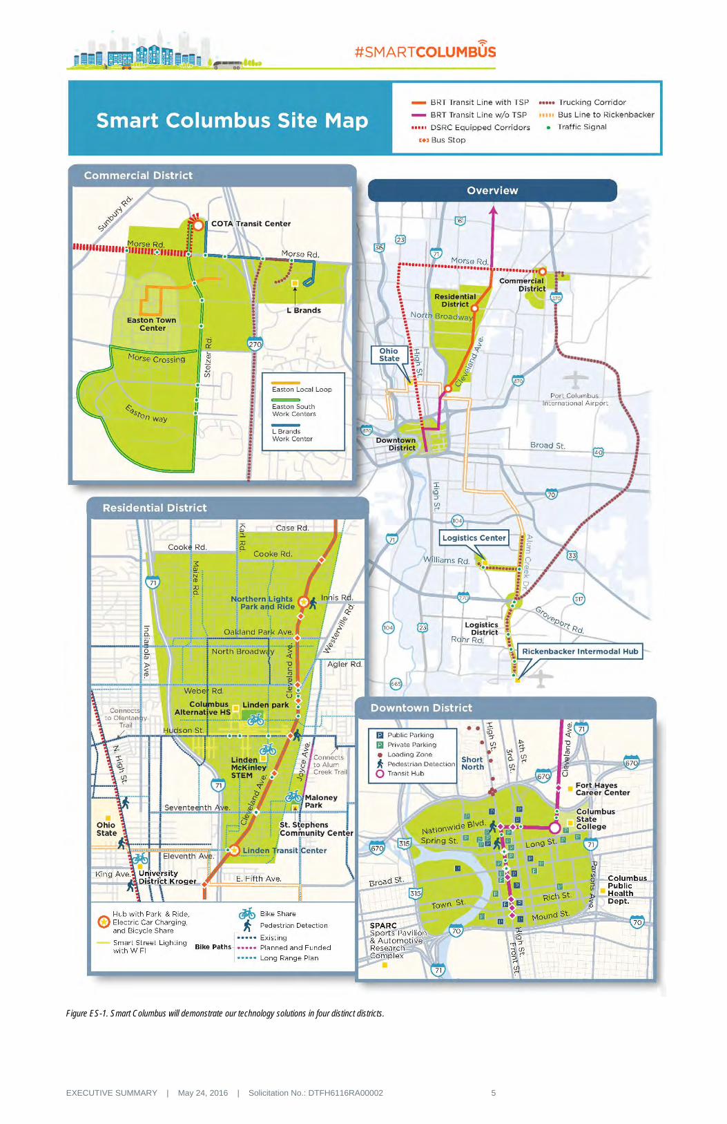
A DISTRICT APPROACH The Smart Columbus Program will pilot projects in four distinct types of districts (residential, commercial, downtown, and logistics), as illustrated in Figure ES-1. Each district has challenges unique to its type, yet universal to similar commercial, residential, downtown, and logistics districts across Columbus and the Nation. Our challenges, solutions, results, and performance measures are scalable to other neighborhoods and transferable to other mid-sized cities through our Mid-Sized City Forum.
DEPLOYING SMART TECHNOLOGY SOLUTIONS To tackle the challenges faced by our community, the Smart Columbus Program creates a menu of smart solutions built upon four core-enabling technologies:
The Connected Columbus Transportation Network (CCTN) will include traffic signals equipped with traffic detection and sensors, dedicated short range communications (DSRC), and pedestrian detection; truck loading zones with machine vision detection of zone availability; multi-function kiosks with transit service information, first/last mile and bike/vehicle sharing information, parking availability, and Wi-Fi hot spots.
SUSTAINABLE TRANSPORTATION
CONNECTED RESIDENTS
CONNECTED VISITORSSMART LOGISTICSVISION ACCESS TO JOBS

EXECUTIVE SUMMARY | May 24, 2016 | Solicitation No.: DTFH6116RA00002 4
The Integrated Data Exchange (IDE) open data environment will contain data from many different sources consistent with the USDOT’s Research Data Exchange (RDE) concept. IDE will generate performance metrics for program monitoring and evaluation; transparently serve the needs of public agencies, researchers, and entrepreneurs; provide practical guidance and lessons learned to other potential deployment sites; and assist health and human service organizations to provide more effective services to their clients
A suite of applications and processes will deliver Enhanced Human Services (EHS) to residents and visitors. These applications include a multi-modal trip planning application, a common payment system for all transportation modes, a smartphone application for assistance to persons with disabilities, and integration of travel options at key locations for visitors.
Smart Columbus will expand the Smart Grid program and increase Electric Vehicle (EV) Infrastructure. We will install vehicle-to-grid capability for charging stations to manage grid resources, provide assistance and analysis to fleet operators to encourage EV adoption, increase investment in EV charging, create customer education programs such as ride-and-drive events with local dealers, and create an EV cooperative buying program.
OUTCOMES: A SAFER, MORE MOBILE AND ACCESSIBLE CITY The Smart Columbus Program will reorient our city to deliver more diversified and nimble transportation options by using data and a connected, complete network that supports healthy activity and a more attractive and sustainable urban form.
We will use data to measure our progress toward improved safety, enhanced mobility, and enhanced ladders of opportunity, and address climate change so we can make adjustments and replicate our success. Benchmarking data regarding infant mortality, poverty, and unemployment rates will be used to monitor behavioral change, so we can move our more challenged neighborhoods into prosperity.
SMART COLUMBUS SUSTAINABILITY To accelerate and sustain Smart Columbus, the City has established a non-profit composed of some of the world’s most talented individuals, companies, and organizations. Managed by the Smart Columbus Board of Trustees, the non-profit will provide the resources and guidance needed to implement Smart Columbus initiatives, including an Acceleration Fund, which will nearly triple the $50 million in USDOT and Vulcan funding.
CONCLUSION Smart Columbus leverages existing Columbus strengths while acknowledging there is much more work to be done. Just as we will provide a single mom with tools to connect with a better job and improve her health and that of her children, we will provide companies easier access to available parking and efficient delivery of their goods. We will make it easier for visitors to take advantage of Columbus’ many popular attractions.
In all cases, we are committed to providing sustainable transportation services that reduce our carbon footprint and preserve our planet. We will implement our vision that encourages walkable, bikable, and transit-friendly communities that lift up all residents – whether a senior desiring to age in place, a Somalian immigrant or single dad wanting to earn a decent wage, or Asa Burke, a scholar-athlete at East High School, who maintains a 4.3 GPA despite the daily struggle of having no dependable means of transportation.
EXECUTIVE SUMMARY | May 24, 2016 | Solicitation No.: DTFH6116RA00002 5
Figure ES-1. Smart Columbus will demonstrate our technology solutions in four distinct districts.

TECHNICAL APPROACH | May 24, 2016 | Solicitation No.: DTFH6116RA00002 6
A TECHNICAL APPROACH
A.1 IMPLEMENTING AND OPERATING THE DEMONSTRATION PROJECT
Columbus, like many cities across the United States, faces challenges resulting from rapid population growth and the resulting strain placed on aging infrastructure to meet growing demands for health, mobility, safety, security, prosperity, environmental sustainability, and access to opportunities. Facing limited resources, smart cities must seek innovative solutions to address these challenges, make wise investment decisions, and empower residents to help create a new, smarter, and sustainable urban environment.
This proposal describes how the City of Columbus plans to overcome the challenges of the future to create a healthy, prosperous, and attractive city by:
Addressing the mobility needs of underserved communities by providing safe, reliable, and affordable transportation alternatives, while also investing in those communities to provide ladders of opportunity.
Implementing innovative technology-based solutions to connect all residents to information and opportunities, and breaking down digital barriers.
Using technology to manage traffic congestion and improve safety with demonstrable results.
Providing a robust data management approach that supports efficient data collection, storage, aggregation, and analysis; data-driven decision-making; performance measurement and monitoring; evaluation; and an open, entrepreneurial environment for app developers and researchers.
Supporting smart grid applications, vehicle electrification, and technological solutions to reduce greenhouse gases.
We offer an integrated, holistic approach that will be a model for other aspiring smart cities throughout the world. More than a demonstration of technologies, Smart Columbus offers a sustainable deployment and an operational environment that will yield continuing benefits in the four desired outcome areas – improving safety, enhancing mobility, creating ladders of opportunity, and addressing climate change.
Smart Columbus is both scalable and replicable. The City of Columbus plans to leap-frog fixed rail through enhanced connections to transit and First Mile/Last Mile (FMLM) services. The City and its partners consider their bus-based mass transit system to be an opportunity to demonstrate emerging mobility solutions at a lower cost and with greater flexibility than a fixed-rail infrastructure. Many mid-sized cities cannot afford light rail, or the feasibility of deploying such a system is limited. The Smart Corridor solution will be a model for similarly situated cities throughout the United States. Bus Rapid Transit (BRT) deployments and technological breakthroughs involving vehicle connectivity and automation have the ability to maximize existing infrastructure.
Smart Columbus is innovative, but also implementable. Smart Columbus offers a robust and proven technical approach, based on application team experience of the Tampa and New York City Connected Vehicle (CV) Pilots, the Safety Pilot Model Deployment, the Ann Arbor Connected Vehicle Test Environment, the Florida Department of Transportation Automated Vehicle Support Program, and myriad other highly complex and innovative programs. Lessons learned and innovations developed under those programs will be leveraged for Smart Columbus.
Our Vision and Technical Approach are described below.
A.1.1 Implementing Smart Columbus
The Smart Columbus enabling technologies will build the foundational elements of a smart city – a connected transportation network, an integrated data exchange (IDE) network, systems to support enhanced human services (EHS), and infrastructure elements to support smart grid and vehicle electrification solutions. These foundational elements will be applied to meet urban challenges that are

TECHNICAL APPROACH | May 24, 2016 | Solicitation No.: DTFH6116RA00002 7
faced by most cities, defined by neighborhoods and districts – residential, commercial, downtown, and logistics – to deliver the outcomes desired by the United States Department of Transportation (USDOT).
Figure A-1 depicts how the Smart Columbus vision elements remain guideposts to the Smart Columbus program.
Deployment District Approach
Smart Columbus is taking a district-oriented approach to best demonstrate effective implementation of a comprehensive portfolio of connected technologies that solve focused, relatable city issues and enhance mobility across the region. Four deployment districts have strategically identified based on the unique problem-solving proving ground they offer creating a foundation of nationwide scalability: Residential (Linden) – high opportunity and economic need neighborhood; Commercial (Easton) – high traffic retail destination and jobs center; Downtown – regional economic anchor and growing urban core; and Logistics (Rickenbacker) – 10th most active logistics hub in the heart of America.
A.1.1.1 Enabling Technologies
The City of Columbus is approaching the implementation of our Smart Columbus Program by evaluating the needs of our community; documenting the challenges and needs faced by our residents, businesses,
Figure A-1. The four core enabling systems support the Smart Columbus Vision and lay the foundation for deployment and repeatable implementation of smart solutions.

TECHNICAL APPROACH | May 24, 2016 | Solicitation No.: DTFH6116RA00002 8
and visitors; and creating a menu of solutions and a suite of applications that can be developed and deployed to meet those needs. This menu of solutions is built upon four core-enabling systems:
Data Collection – Deployment of the (1) Connected Columbus Transportation Network (CCTN)
Data Storage and Analysis – Creation of an (2) Integrated Data Exchange (IDE), an open environment for data capture, management, warehousing, analysis, decision support, distribution, research, and application development
Data Usage for Smart Choices – Implementation of a suite of technologies to (3) enhance human services and (4) establishment of smart grid solutions and vehicle electrification capabilities.
These four enabling technologies serve as the building blocks for the district deployments described later in this section.
A.1.1.1.1 Connected Columbus Transportation Network (CCTN)
An effective transportation system connects people, goods, and services using a variety of modes and technologies. In addition to quality physical infrastructure, optimal performance of transportation networks is increasingly reliant upon the quick and accurate collection and dissemination of large amounts of data.
The foundation for development and implementation of the CCTN is based on the Columbus Traffic Signal System (CTSS) program, currently underway, which will interconnect the Central Ohio Region’s 1,250 traffic signals and provide capability for uniform signal coordination throughout the system. The CTSS communications network comprises 565 miles of single mode 144 strand fiber optic trunk cables along arterial routes and 288 strand fiber optic backbone cables along freeway infrastructure (Table A-1). Network access and redundancy is enhanced by connections to additional fiber optic networks of various regional agencies and wireless Ethernet equipment is extensively used for “last mile” applications.
While the CTSS signal operations network supports GigE connectivity between sites, the overall network is capable of moving vast amounts of data throughout the region. Fiber use was thoughtfully engineered in order to maximize the potential data throughput and the accessibility within the City and to regional agencies. Using dense wave division multiplexing (DWDM) technology, the City’s Department of Technology (DoT) can achieve data transfer rates of up to 100 Gbps using a single pair of fibers. The network layout was designed to be readily accessible for future expansion opportunities for new equipment and technologies.
Construction of the CTSS network is 60 percent complete and the entire CTSS network is anticipated to be operational by 2020. The long-term vision of the CCTN is to leverage the CTSS network investments made by the region and deploy dedicated short-range communications (DSRC) at every signalized intersection along key corridors in the City that connects people, goods, and services. The initial deployment consists of 175 traffic signalized intersections (sites) covering approximately more than 50 miles of roadways, including new roadway fiber or wireless backhaul along two roadways serving Rickenbacker Inland Port. Alum Creek Drive from Performance Parkway south to Rickenbacker Freight Intermodal Facility and Williams Road from Groveport Road to Alum Creek Drive will be added to enable our proposed logistics solutions. All other deployments using fiber connectivity are covered by the City’s ongoing CTSS project. Refer to Figure ES-1 displaying the proposed locations of the DSRC deployments. Using citywide fiber to connect people, vehicles, and infrastructure the CTSS provides:
Enhanced emergency vehicle preemption passage through intersections
Transit vehicle priority to improve transit operations
Real-time changes for signal timing based on data
Pedestrian detection and red light safety applications for improved intersection safety
Table A-1. CTSS fiber strand count allocation.
Backbone Trunk
CTSS 24 24 Central Ohio Transit Authority (COTA) Operations
12 12
ODOT Freeway Management System (FMS)
12 12
ODOT Division of Information Technology 12
Other Agencies 24 Columbus Department of Technology 144 72 Available Fibers for Future Use 60 24 Total 288 144

TECHNICAL APPROACH | May 24, 2016 | Solicitation No.: DTFH6116RA00002 9
Increased school zone visibility to CVs
Transit and travel options for increased resident connectivity
Increased student access to education tools.
Smart Columbus Traffic Signal Corridor Deployments
The City of Columbus will deploy a number of technologies and components throughout the City in the districts and along major routes connecting those districts. These deployments will include a consistent set of components as presented in Table A-2.
Table A-2. CCTN infrastructure deployments.
Deployment Component
Traffic Signal Traffic detection and sensors, DSRC radio, I-SIG DMA suite (including MMITSS, Transit Signal Priority (TSP), Freight Signal Prioritization (FSP) and PREEMPT), Global Positioning System (GPS) correction, pedestrian detection (pedestrians in the roadway and pedestrians awaiting transit service)
Truck Loading Zone Machine vision detection of loading zone availability Multi-Modal Service Hubs
DSRC radios, security features (CCTV and emergency call boxes), multi-function kiosks (transit service information, FMLM and vehicle sharing request and information, bike sharing information, parking availability information), automated shuttle service request in Easton hubs, Wi-Fi hot spots, pedestrian detection (collision avoidance and demand detection), traveler information, and payment kiosks
Street Lights Wi-Fi with traveler information “splash” or welcome page in the Hudson Street Corridor smart street lights demonstration
School Zones Reduced speed via DSRC
Other Data Sources and Sensors
The CCTN also includes sensor data (Table A-3) being generated by different network nodes for application use and analysis within the IDE. These sources will provide a large data stream into the IDE to improve safety, mobility, and operations in the City of Columbus.
Table A-3. CCTN data sources and sensors.
Data Source Data
DSRC Basic safety message, vehicle situation data, transit, freight, emergency vehicle priority call history. Equipped vehicles, including 350 COTA buses, 400 City vehicles, 50 trucks, 100 school buses, and 2,100 vehicles from volunteers
MobileEye Shield+ Collision avoidance warning data and pavement marking, signing, and pothole roadway condition data from 350 COTA buses
Peloton Platoon frequency and truck travel times Parking Operators Parking lot occupancy and availability; parking space occupancy and availability at on-street and off-
street parking facilities Traffic Signals Traffic signal state (SPaT broadcast capture and Econolite developed Centracs module), traffic
detector data and signal system operations data Partner Agencies (ODOT, COTA, etc.)
Operations data (speeds, volume, occupancy) and transit-specific data (vehicle location, bus occupancy)
All in-vehicle DSRC devices will utilize the Security Credential Management System (SCMS) developed by the USDOT and the Crash Avoidance Metrics Partnership (CAMP). This use of the SCMS will ensure authenticity of all data exchanges. All devices will be procured from vendors who have been certified through the USDOT process for these devices, which will help to ensure that the devices meet the standards developed for the CV program. The data collected from the roadside units will be transmitted over the CCTN network to the City of Columbus IDE.

TECHNICAL APPROACH | May 24, 2016 | Solicitation No.: DTFH6116RA00002 10
A.1.1.1.2 Integrated Data Exchange
At the center of Smart Columbus is the Integrated Data Exchange (IDE), a new dynamic platform that integrates data from deployed smart technologies and community partners offering an open-source information portal intended to facilitate better decision-making and problem solving for all users. The collaborative culture and data analytics landscape in Columbus makes us uniquely capable of building a cutting-edge data exchange that will set the standard of excellence for cities to emulate around the country.
As a public entity, we recognize the importance of maintaining data integrity and protecting the public’s interest, as well as providing a critical resource to measuring and understanding the benefits, costs, issues, and potential resolutions for replication of the success of Smart Columbus elsewhere. Within the Columbus Region, our Mid-Ohio Regional Planning Commission (MORPC), in collaboration with several public and private sector partners, has provided leadership in data fusion and has initiated developing a Regional Data Laboratory for Central Ohio. Smart Columbus will build upon this framework and expand this concept to an even wider range of data sources and integration opportunities. While leveraging the Elastic Cloud Services of Amazon Web Services (AWS), the Smart Columbus IDE will consist of three primary components as illustrated in Figure A-2.
As efforts by the Regional Data Laboratory for Central Ohio have begun similar architectural considerations for managing such a data resource, this approach incorporates additional policies and methods to respond to the incredible data volume and velocity, as well as provide standards and templates for future smart city initiatives.
IDE Architecture Framework
The IDE is an approach to data that includes policies, governance, and security. It consists of a set of data repositories that will be created to support data discovery, analytics, ad hoc investigations, and reporting. The IDE contains data from many different sources while being consistent with the USDOT’s Research Data Exchange (RDE) concept—authorized stakeholders are free to add data to the data exchange and access any updates as necessary.
The IDE has capabilities that ensure the data is properly documented, cataloged, and protected so subject matter experts (SMEs) have access to the data they need for their work. This design point is critical because SMEs play a crucial role in ensuring that analytics provide worthwhile and valuable insights at appropriate points in the organization’s operation.
The IDE will classify data as it enters the IDE to support both privacy principles and user needs. For example, when data is classified as highly sensitive, the IDE can enforce dynamic security of the data on
Figure A-2. The Smart Columbus Integrated Data Exchange consists of three primary components.

TECHNICAL APPROACH | May 24, 2016 | Solicitation No.: DTFH6116RA00002 11
ingestion into the IDE. Less sensitive data may be stored in secured repositories in the IDE, so it can be used for production analytics. However, when it is copied into sandboxes for analytical discovery, it will be masked to prevent data scientists from seeing the values, without losing the referential integrity of the data. Behind the scenes, the IDE is auditing access to data to detect if users are accessing more data than is reasonable for their role. The IDE opens access to the defined user community of the system and the associated approved partners and developers, but only for legitimate and approved purposes.
Cloud Hosting Platform (Amazon Web Services)
Deploying a smart city generates a significant amount of data and requires application hosting and content delivery infrastructure. AWS is a comprehensive cloud-computing platform designed to address these needs while being as scalable and elastic as possible. Where applicable and economically responsible, AWS will be used to provide the storage and content delivery infrastructure necessary to support the Columbus IDE, as well as application hosting services, management identification, and integration services to connect disparate data sources (non-traditional transportation data) with real-time information and analytics. Over the years, the City has been extremely successful in scaling cloud resources both on premise and off to maintain budget and availability for over 550 servers and 1.8 petabytes of data. To sustain the program beyond the demonstration, the City will evaluate long-term solutions, ownership, and management that will be informed through the deployment.
Urban Analytics
The IDE provides an open analytics platform that will allow the City to collaborate with other stakeholder organizations and capture and integrate all current and future forms of structured and unstructured data to achieve network-wide visibility. To support advanced urban analytics, the IDE will leverage standards-based integration of traffic and road information capture systems from various technologies and other ITS detection devices; provide built-in capabilities for using weather, social media, and other Internet information; and support the Traffic Management Data Dictionary (TMDD) data format as a standards-based data exchange. Finally, the IDE will provide a Service Oriented Architecture-based platform for any involved stakeholder to engage in big data analytical efforts on both real-time and archived data, to investigate system performance and the impacts to the community and region. The urban analytics services will also support many non-transportation-specific applications as discussed in the integrated solutions.
Smart Columbus Developer Network
A Developer Network will be created that promotes extensive use of the IDE by both the public and private sectors. The City will encourage third-party developer participation from the wider technology community to create innovative applications and services that leverage the data generated through the Smart Columbus Program. The City will launch a developer platform on http://developer.columbus.gov and continue to expand the City’s existing Open Data Portal http://data.columbus.opendata.arcgis.com/. The developer network will include tools and resources including software development kits (SDK), interfaces, sample code, and full documentation to support the developer community. In addition, a number of community events, specifically hackathons, will be hosted to bring innovations to the Smart Columbus Program. The Developer Network and companion outreach efforts are critical to ensuring data availability to entrepreneurs, residents, evaluators, and researchers, along with the local and regional agencies involved.
A.1.1.1.3 Enhanced Human Services
Successful communities are dense, active, and, most importantly, connected. Dense communities bring together enough residents to support neighborhood retail, viable community institutions, and relationships among neighbors. Activity brings people out of their homes into common spaces and onto the streets.
MORPC, working with Columbus and other regional private and public partners, is hosting a Regional Data Laboratory. The Data Laboratory’s multidisciplinary oversight committee, the Regional Data Advisory Committee (RDAC), comprises representatives from multiple data providers. The RDAC can provide governance in developing and maintaining the IDE. Through its regional partner MORPC, the IDE will be used to generate metrics on achieving data-driven Smart City Challenge goals, as well as goals related to sustainability and quality of life initiatives. The regional team will use data to measure success, identify weaknesses, and predict trends to prevent failure.

TECHNICAL APPROACH | May 24, 2016 | Solicitation No.: DTFH6116RA00002 12
Block parties, cookouts, attendance at school events, and other gatherings build a sense of community and connection to one another. Activity requires density and safety. Beyond these interpersonal connections, being physically and electronically connected is necessary for the economic sustainability of a neighborhood. Without access to jobs, food, and modern technology, existing residents with options will leave and the neighborhood will become a residence of last resort, rather than a neighborhood of choice.
The suite of enabling technologies, processes, and implementations within the EHS group are based on information and research conducted by USDOT as well as our own experiences with the objective of promoting a dense, active, and connected community for residents and visitors in the City of Columbus. EHS requires coordination and collaboration across entities to successfully overcome the many inherent challenges and barriers to implementation. However, if successful, EHS transportation programs can have a noticeable impact on the mobility of persons with and without disabilities, as the overall transportation experience, from trip planning through trip conclusion can be streamlined, integrated, and require less effort by the traveler. In terms of technologies, these are the “building blocks” for applications and systems.
The City of Columbus is proposing four technology and process components that collectively will serve to provide EHS to residents and visitors. These components include: (1) a multi-modal, comprehensive trip planning application; (2) an integrated and common payment system throughout all transportation systems in the City; and (3) adoption of a smartphone application from our International City Partner in Barcelona to provide assistance in travel to persons with disabilities.
Multi-Modal Trip Planning Application
Leveraging a potential partnership with Moovel and the City’s rich geographical information system (GIS) datasets, we are proposing to adapt and adopt their existing multi-modal trip planning application for the City as illustrated in Figure A-3. Currently, this application provides turn-by-turn voice guidance for driving with real-time traffic; incidents and road closures; routing and guidance for transit, pedestrian, and ride-share; and works in an offline mode to enable underserved communities access to travel guidance without a cellular data plan. Users can compare travel options across modes and plan their travel based upon current traffic conditions and availability of services. In Columbus, we will enhance this existing application by adding multi-lingual information on parking availability, ridesharing options, and car/bicycle sharing options. One key enhancement to the application will be the addition of information that will allow for the coordination of travel across these modes (i.e., availability of services across the entire trip), and will use “Connection Protection” type features to ensure that those services remain available and accessible once a trip has been selected.
Integrated Common Payment System
One of the most significant barriers to transportation has nothing to do with infrastructure. Our cash-based families face a hardship beyond proximity to mobility options. Their hardship is availability of payment transactions options. Without a debit or credit card, our cash-based families are at a severe disadvantage. Transportation providers like car2go, Uber, Lyft, and others require card-based accounts. In addition to limited choices, those residents living on cash become targets for muggings and other theft crimes. New Americans and our undocumented residents and many residents in neighborhoods like Linden, which is a banking desert, need a solution. Our integrated common payment system will allow travelers to use one card for all of their transportation options. The City will partner with Alliance Data Systems, Central Ohio Transit Authority (COTA), and our regional banks to create an integrated payment system based upon the use of a dual chip, customized prepaid card. These cards will have the ability to
Figure A-3. City of Columbus looks to partner with Moovel to provide comprehensive traffic data information and a customized multi-modal trip planning application to enhance human services.

TECHNICAL APPROACH | May 24, 2016 | Solicitation No.: DTFH6116RA00002 13
have cash encumbered on them at those banks, their Automated Teller Machines (ATMs) throughout the City (Figure A-4). Part of the City’s request of our banking partners will be to infuse ATMs and a branch office into specific neighborhoods, and Linden is our first target. This will assist our cash-based households to have access to the tools they need to access our new transportation model, just like anyone else in Columbus.
The efficiency of this program is not solely focused on our residents and families in need of card payment options, it will be available to our residents who now use their smartphones to submit payment. COTA has agreed to upgrade their fareboxes across their entire fleet to accept additional forms of payments, including magnetic stripes, contactless payment, and mobile applications. For the first time in Columbus, residents will be able to plan, book, and pay for all aspects of their travel with a common payment system, regardless of their financial status. The data generated from usage statistics of these cards as well as pay for services and goods using the same card will provide our city with additional information we will be integrate into our outreach and informational campaigns.
Quite simply, for transportation to provide a catalyst for climbing the ladder-of-opportunity, we must look beyond transporting residents from Point A to Point B. What is needed is to tie the transportation system, and its use thereof, to the ultimate purpose of the trip and the resulting goods and services that are provided to the traveler when they arrive at their destination. Our vision is to grow the common payment platform and the trip planning software to ultimately include the ability to pay for non-transportation goods and services at their destination as well. This will provide the City a cross-section of data that can be used by social services or healthcare providers to enhance their services provided to their clients.
In an effort to create this impactful data, the City has partnered with Sidewalk Labs, and will utilize their Flow platform to allow private service providers, such as doctor’s offices, to assist their patients in planning and paying for travel to their office as well as providing automated notification if publically assisted transportation trips are missed or not taken so that follow-up with those patients can be made. This will be a critical component and feature that will be used to reduce infant mortality, which is four times the national average in our challenged residential neighborhoods, particularly as a result of lack of access to consistent prenatal care. This enables truly “connecting” the residents in disadvantaged to service and better health through the transportation system.
To amplify the ladders of opportunity objectives of the Smart Columbus application, the business community has committed to deploy a set of focused strategies that connect Linden residents with job opportunities in the Smart Columbus deployment zones.
Inclusive Mobility
In an approach to enhance the mobility of all residents, Smart Columbus will pilot the deployment of a new mobile device application that enables those with cognitive disabilities. Barcelona, one of Columbus’ international smart city partners, connected us to Mass Factory Urban Accessible Mobility, a high-tech company spin-off of Autonomous University of Barcelona. Their flagship mobile application ‘App&Town’ (Figure A-5) is a free Android mobile application that allows users to plan and navigate their transit routes. The application includes a proprietary turn-by-turn navigator so accurate and intuitive that groups with reduced mobility including elderly, cognitively impaired, and even visually impaired can use it.
The application uses the latest technology available on mobile devices, such as Global Positioning System (GPS),
Figure A-4. City of Columbus looks to partner with the local financial sources industry, Alliance Data Services, COTA, and others to create a common payment system for transit as well as goods and services for cash-based households.
Figure A-5. The City of Columbus looks to partner with Mass Factory to deploy a customized application developed in Barcelona to assist persons with disabilities to utilize public transportation in Columbus.

TECHNICAL APPROACH | May 24, 2016 | Solicitation No.: DTFH6116RA00002 14
compass and accelerometer, speech recognition or generation, and mobile cell or Wi-Fi connection to provide a guidance system of maps. This application will be deployed initially as a pilot installation to ensure that the concepts are compatible with US systems and processes. Following a successful pilot deployment, the intention is to launch a full deployment across all public transit services in the City including those operated by COTA, The Ohio State University (OSU), and others to be determined.
A.1.1.1.4 Electric Vehicle Infrastructure
As explained in the Vulcan application and in other sections of this proposal, the City of Columbus, OSU, and the private sector under the leadership of the Columbus Partnership are fully committed to leading a community-wide transition to being an electric vehicle (EV)-centric city. Currently, Columbus is deficient in EV infrastructure and as a result has a low rate of user adoption. With the Vulcan and USDOT investment, Smart Columbus will spur the conversion of public fleets, private fleets, and personal vehicles to electric and double-down on charging station installation.
The City of Columbus, OSU, and others have made the commitment to begin the conversion of vehicles in their fleet, causing a direct and immediate effect on the local production of greenhouse gases. The Columbus Partnership will launch ‘Lead Electric,’ a first of its kind effort to catalyze broad adoption of EVs by enlisting top executives to convert their personal vehicles, gain commitment by workplaces to build sustainability strategy around adoptive EV by installing charging stations, providing individual EV education, and converting their private fleet as appropriate. The consumer adoption and institutional commitment to building a more robust EV mobility culture will be captured in a data feedback loop through the IDE. Furthermore, research capacity and assets of OSU will be dedicated to Smart Columbus in this area.
A.1.1.2 Deployment Districts
Like most mid-sized cities in the United States, the City of Columbus is divided into several neighborhoods, commercial districts, and other geographic zones that are connected by highways, rail, transit, people, and culture. Some of these communities, such as Milo-Grogan, are defined geographically by transportation infrastructure, such as rail lines on all four boundaries. Regardless of the reason, these neighborhoods or communities can be classified into one of four districts based upon the predominant type of land-use. This classification scheme is well-known among the transportation planning community and virtually every city in the United States can identify regions within their city that can be similarly classified. Although some of our deployments will occur within a specific neighborhood or geographic region, we use this district schema to reinforce the concept that the proposed technology solutions can and should be readily adopted and deployed in other cities with these same types of districts.
In the following sections, we discuss the specific challenges, technology solutions, and potential for sustainability within each of these four districts. We believe that the challenges and technology solutions can be transferred from one neighborhood or geographic location to another within the same district classification. Importantly, however, is the connectivity and linkages between these districts that the enabling technologies facilitate.
A.1.1.2.1 Residential District
A.1.1.2.1.1 Challenges The Residential District identified by Smart Columbus is Linden, an underserved neighborhood situated northeast of the Downtown District. Underserved communities throughout the United States unfortunately share many of the same challenges. By deploying smart technology solutions in Linden, Smart Columbus will demonstrate how next generation transportation technology can reconnect neighborhoods previously divided by transportation infrastructure. Decades ago the construction of Interstate 71 along the West border of the neighborhood caused Linden to essentially be cut off from nearby amenities, services, and centers of employment.
The Linden Neighborhood of Columbus was chosen as the first neighborhood district for its numerous socio-economic challenges, including low household income, a lack of major employers, and poor access to recreational amenities. These problems are compounded by the lack of access to transportation options. Despite the neighborhood’s proximity to the central core of the Columbus Region, basic services such as healthcare, grocery stores, and banking are scarce within the neighborhood boundaries. Many

TECHNICAL APPROACH | May 24, 2016 | Solicitation No.: DTFH6116RA00002 15
residents are transit-reliant; yet planning and completing a trip to access employment and services can be challenging, particularly for parents with young children, seniors, and travelers with disabilities.
Transit service is available in Linden along the Cleveland Avenue Corridor; however, facilities at bus stops are lacking, with extremely few shelters along existing bus routes. Intersections in the area are frequently ranked as unsafe, with three of the top 25 highest crash intersections in the Columbus Region located in Linden. Neighborhood residents report that existing shelters are often poorly lit and lack amenities. There are also many FMLM challenges along the corridor: sidewalks are missing from many streets and the existing network is in poor condition; street lighting is often dim or missing; and, Americans with Disabilities Act (ADA)-compliant facilities for travelers with disabilities are often inadequate or non-existent.
Due to the lack of major employers in Linden, residents must travel to other neighborhoods to seek employment. Yet commuting can be a challenge, particularly for carless households. Currently, planning and completing a trip to work is difficult when multiple modes or systems are involved. Departure, arrival, and overall travel times can be unpredictable if congestion is present in the system; this unpredictability can place stress on residents who work shift-based schedules.
Numerous public health issues exist in Linden, where residents often lack access to basic healthcare facilities as well as health insurance. One clear manifestation of this problem is infant mortality – for every 1,000 babies born in the United States, about 6 die before they turn the age of 1. In South Linden, this number is nearly four times higher. Infant mortality is especially acute for black babies, who, in Franklin County, are two and a half times as likely to die before their first birthday as white babies. Currently, there are no obstetrics/gynecology offices in Linden to combat this problem. Seventy-five percent of WIC recipients are in need of transportation to and from their appointments. The neighborhood is also a food desert without easy access to a major grocery store with fresh produce. Many residents report that their main sources of food are convenience stores. In addition, exercise and recreation are possible at nearby parks and trails, but accessing these facilities can be difficult.
A.1.1.2.1.2 Technology Solution The Smart Columbus deployment proposes to address the transportation challenges of Linden using a multi-faceted, scalable, high-technology approach that includes the following core components (see Figure A-6):
Smart Corridor will leverage the new COTA CMAX BRT line by installing DSRC-equipped intersections along Cleveland Avenue and neighboring streets including Hudson Street, High Street, and Morse Road.
New Mobility and Safety Applications will be enabled through the Smart Corridor infrastructure and demonstration deployment of 3,000 CVs throughout the City. Applications will be provided via a combination of in-vehicle signage, mobile apps, and on-street kiosks.
Neighborhood Hubs (serving the Smart Corridor) will provide a variety of transportation options to facilitate FMLM connections, as well as access to the jobs and amenities that were cut off by the construction of Interstate 71.
Smart Lighting and Wi-Fi Infrastructure will be deployed in part of the neighborhood to provide FMLM safety and to make the neighborhood more walkable.
Smart Corridor
As part of the CCTN network, the City of Columbus will deploy a Smart Corridor along Cleveland Avenue, which will leverage the new COTA CMAX BRT service by equipping the entire COTA fleet with DSRC technology. The BRT line currently under construction will include upgraded transit stops, more frequent bus service, and faster travel times. The Smart Columbus Program will enhance this service through a range of CV technologies. Intersections will include prioritization for CMAX buses and emergency vehicles. Buses, transit stops, and crosswalks will be equipped with pedestrian detection technology. The physical infrastructure of this component will also allow transit users access to the traveler information and mobility applications discussed below. Riding the bus will be an attractive option – users of the CMAX service will consist of both transit-dependent residents as well as new choice transit riders.

TECHNICAL APPROACH | May 24, 2016 | Solicitation No.: DTFH6116RA00002 16
The upgraded traffic signals allow for signal prioritization and support intersection safety applications for pedestrians and personal vehicles as well. Smart Columbus aims to deploy 3,000 vehicles with aftermarket retrofit DSRC and in-vehicle signage citywide. However, Linden will be a key focus of this initiative due to the prevalence of high-crash intersections throughout the neighborhood.
The City of Columbus is committed to ensuring the success of the Smart Corridor concept by encouraging use of each deployed component. COTA will launch CMAX initially as a free service in Linden to incentivize new transit riders who live in the neighborhood and encourage the use of park-and-ride lots along the corridor. This free service will alleviate the increasingly challenging market for downtown parking, which is currently inhibiting the ability to fill vacant office space. Additionally, the City may utilize a gamified approach to incentivizing use of the apps developed in the Smart Columbus Deployment. Under this concept and with private funding, a $5 incentive would be given to download and use the Smart Columbus app (while incentives last) and users will be given the opportunity to receive a wearable FitBit device. Smart Columbus would review analytics from the use of the app to measure effectiveness of this component. Engagement with the app would also earn users rewards from local retailers and grocers, as well as national partners.
Mobility and Safety Applications
To capitalize on the physical infrastructure, the City of Columbus will promote and deploy numerous traveler information and mobility applications. Capabilities of the proposed application suite include the following:
Dynamic Transit Operations will link multi-modal transportation options with travelers through dynamic transit vehicle scheduling, dispatching, and routing capabilities, allowing travelers to request and view multiple trip itineraries in real-time.
Connection Protection will provide coordination between transportation providers, increasing the likelihood of making successful inter-modal, intra-modal transit transfers (e.g., from COTA to the OSU Campus Area Bus Service) and non-transit (e.g., shared ride) modes.
Dynamic Ridesharing will provide an automated ride matching system for carpool travelers and allow users to offer or request rides in real-time, minutes prior to departure, or make scheduled one-way appointments.
Figure A-6. The core components of the Residential District will address challenges in the Linden neighborhood.

TECHNICAL APPROACH | May 24, 2016 | Solicitation No.: DTFH6116RA00002 17
Integrated Multi-Modal Electronic Payment will facilitate payments for a variety of modes.
Enhanced Human Services will deliver real-time, multi-modal trip and services planning via multi-lingual decision support applications that assist travelers, including those with disabilities, in finding and choosing accessible transportation solutions.
The fiber and traffic signal infrastructure deployed along the Smart Corridor will also support numerous safety applications. New applications available to transit drivers and riders will include the following:
Transit Signal Priority will provide travelers using CMAX with increased travel time reliability and shorter overall trip durations.
Transit Stop Pedestrian Warnings will alert bus drivers and waiting passengers when a pedestrian may be at risk of strike via warnings inside transit vehicles and on transit stop signage.
Pedestrian in Signalized Crosswalk Warnings will alert bus drivers when pedestrians in a crosswalk may be at risk of strike via an in-vehicle display.
Vehicle Turning Right in Front of Bus Warnings will alert bus drivers when a vehicle passes a stopped transit vehicle and then begins to make a right turn in front of the bus.
Finally, the prevalence of connected personal vehicles in Linden will allow for a range of safety, mobility, and environmental applications. The following capabilities will be deployed as part Smart Columbus:
Forward Collision Warning will alert drivers of an impending rear-end collision with another vehicle.
Emergency Brake Light Warning will enable CVs to broadcast a self-generated message to other vehicles when an emergency braking event occurs.
Signal Phase and Timing will allow for a two-way exchange of information between vehicles and intersections in order to provide alerts to optimize signal timing and provide alerts to drivers.
Eco-Approach and Departure at Signalized Intersections will provide drivers with speed recommendations to pass a signal on green or decelerate to a stop in the most eco-friendly manner.
Neighborhood Hubs
The City of Columbus will employ smart Neighborhood Hubs along the Cleveland Avenue Corridor in order to facilitate access to the COTA CMAX BRT, as well as transitions to other modes. Hubs in Linden will be located at the Northern Lights Shopping Center and the Linden Transit Center. Additional Hubs will be located outside the neighborhood to provide access to Easton Town Center, Columbus State Community College (CSCC), and Downtown Columbus. As part of the CMAX BRT project, transit stops throughout the Smart Corridor will also be equipped with additional amenities beyond typical offerings.
Neighborhood Hubs would utilize a range of technologies to support enhanced access to jobs, services, and recreational amenities, and consist of a kiosk that provides trip planning applications, as well as the ability to accept payment for trips made via the common payment system, a critical need in Linden where many households are cash-based. Prior to the Smart City Challenge, the City of Columbus had been in discussion with potential vendors about deploying information kiosks in the City, primarily in the Downtown area. The Smart City Challenge affords the City the opportunity to expand this initiative to the Linden neighborhood, leveraging its plans for Downtown. While procurement has not been conducted, the City is in discussions with alternative vendors in addition to the kiosk system offered by Sidewalk Labs. The City intends to partner with COTA and one or more kiosk vendors to monetize its downtown kiosk installations to support a more robust kiosk installation in the Linden neighborhood and in support of the new COTA CMAX BRT project. The City would work with its procured vendor or vendors to install numerous kiosks Downtown, and approximately 10 kiosks at key locations in Linden and along the COTA CMAX BRT Corridor to facilitate access to public transit, as well as transitions to other modes. We would call these Linden kiosks “Neighborhood Hubs.” Additional Hubs would be located at key locations outside the neighborhood to provide information access and trip planning to Easton Town Center, CSCC, and Downtown Columbus. The deployment would work with COTA to augment the CMAX BRT transit stops throughout the Smart Corridor with this additional data access.
Hubs would also be coordinated with the COTA CMAX BRT to provide transit information with real-time arrival and departure times, and for Hubs at CMAX stops, may provide a warning to alert waiting passengers who are standing within or close to the roadway to move back.

TECHNICAL APPROACH | May 24, 2016 | Solicitation No.: DTFH6116RA00002 18
Additionally, Neighborhood Hubs would be used to facilitate first- and last-mile travel by supporting a range of modal options. Upon award, we will seek to expand the City’s CoGo bike share service in Linden. Bike share stations would potentially be present at neighborhood schools or parks, select locations along the Alum Creek Trail, and select amenities west of Interstate 71, in order to facilitate stronger east-west connections in Linden. The bike share vendor would be required to accept payment via the common payment platform in order to allow cash-based households to participate. Similarly, we will seek a car share partner based on the same requirements. Finally, parking facilities at Hubs like the Northern Lights Shopping Center will enable car owners to transition to the CMAX line, and avoid downtown parking and congestion, and will include electric charging stations (estimated at two charging stations per transit center) to encourage EV use.
Smart Lighting and Wi-Fi
A Smart Lighting and Wi-Fi infrastructure will be deployed as a demonstration in Linden that would include motion-responsive LED street lights in order to create a better sense of safety and make the neighborhood more walkable. The system would also reduce electricity usage. Upgrades will be conducted based on existing street lighting circuits. As part of Smart Columbus, this infrastructure will be deployed along the Hudson Street Corridor between Interstate 71 and Cleveland Avenue (refer to site map in Volume 2), which includes Columbus Alternative High School, Linden Park, and private residences. Hudson Street also serves as an east-west cycling connection between two major north-south bike trails, the Alum Creek Trail, and the Olentangy River Trail. Enhanced lighting will increase cyclist safety and facilitate use of the bike share service.
Neighborhood residents report slow Internet speeds in Linden, as the underlying coaxial infrastructure is outdated and Internet service providers have demonstrated interest in making upgrades. To combat this problem, the new smart lighting installation will also include Wi-Fi Internet. A widespread network of street lighting will enable free, wireless Internet access along the Hudson Street Corridor of Linden, which is the proposed location for the smart street lighting deployment. This free service will help enable online educational and career development resources for neighborhood residents, thereby providing an additional ladder of opportunity.
A.1.1.2.1.3 Potential for Sustainability The challenges faced in Linden are present in underserved communities throughout the United States. The City of Columbus proposes a comprehensive and proactive program of transportation upgrades in Linden that will respond to each of these challenges, providing residents with the ladders of opportunity to be prosperous, healthy, and happy. All of the project components contained within the Residential District concept are designed to be scalable to other neighborhoods within the City, as well as other cities throughout the United States. While these proposals complement each other and are intended to function as an integrated solution, cities and neighborhoods could deploy a combination of components that meets their individual needs.
Columbus plans to leap-frog fixed rail through enhanced connections to transit and FMLM services. The City of Columbus and its partners consider their bus-based mass transit system to be an opportunity to demonstrate emerging mobility solutions at a lower cost and with greater flexibility than a fixed-rail infrastructure. Many mid-sized cities cannot afford light rail, or the feasibility of deploying such a system is limited. The Smart Corridor solution will be a model for similarly situated cities throughout the United States. BRT deployments and technological breakthroughs involving vehicle connectivity and automation have the ability to maximize existing infrastructure.
As the population within the Columbus Region continues to grow at a rapid pace, creating opportunities for mode diversions will be increasingly important to avoid congestion and combat the associated climate impacts. To hasten the development of new solutions, all applications developed in support of the Residential District concept will be made available as open source on the IDE to allow public and private sector entities the ability to develop a customized system to meet their needs.
A.1.1.2.2 Commercial District
A.1.1.2.2.1 Challenges Located in the northeast part of Columbus, the Easton area is a mixed-use environment consisting of retail space, dining, commercial office space, warehousing, and residential units accessed primarily by

TECHNICAL APPROACH | May 24, 2016 | Solicitation No.: DTFH6116RA00002 19
light-duty vehicles with regular scheduled bus service along the fringes of the area. The central retail area is built in the model of a mid-20th century urban town center, including through streets designed for vehicular traffic and on-street parking. With the exception of an enclosed mall structure comprising a small portion of this retail space, the majority of stores and restaurants have direct off-street access, resulting in a high percentage of pedestrians along outdoor sidewalks interacting with vehicular traffic. Surrounding this central region are several strip malls, big-box retailers, and standalone dining areas. To the south are large office and apartment/condominium complexes. This mix of properties has resulted in an extremely dense population of both people and vehicles. There is 2.9m SF of office space and 1.7m SF of retail space in the area. At its daily peak, as many as 32,000 people and 400,000 vehicles/week might be located in the region, and the number of jobs in the area exceeds 30,000.
The area serves as a major employment center, with numerous jobs in the retail, food services, and warehouse industries. These jobs are typically low paying and have a high-rate of turnover. Further, research has demonstrated that a major contributor to the instability in these types of jobs is the lack of reliable transportation. Compounding this challenge is a high number of professional service industries, such as legal, finance, and insurance, including regional or national headquarters, that are also located in the region.
Adding to the reliable transportation concerns are those of FMLM safety and mobility. While the area is served by both public transit services and numerous parking facilities, the proximity of these stops and/or facilities to the final destination of travelers, combined with the density of both pedestrian and vehicle traffic, creates both safety and mobility concerns. After departing transit, there remain points within this region that literally approach the mile distance from the current stops, presenting a FMLM challenge and potentially discouraging transit use in the region, both for employees and for patrons. Those who travel using their personal vehicle also find similar FMLM challenges due to quickly filled parking lots. The latter also add to the congestion of the region by using their personal vehicle.
Finally, building on this previous discussion, is the need to reduce harmful emissions and the sources of those emissions. Current traffic volumes in the area, particularly during peak times, have necessitated consideration of capacity improvements as costly and expansive as adding an additional freeway exit to support the present volume. Future development plans include additional retail and office space, furthering the current congestion challenges and demand on the transportation system.
A.1.1.2.2.2 Technology Solution Addressing the challenges of the Commercial District require both investment in technology solutions and investments in techniques to create societal change. We are proposing a highly transformative, environmentally friendly, economically viable, and scalable approach to deploy AVs that are both electrified and connected. These connected Electric Autonomous Vehicles (EAVs) will be deployed in a live mixed-used traffic environment, interacting with other vehicles, bicyclists, pedestrians, and other forms of transportation, and operating in an environment that includes both signalized and non-signalized intersections. Our approach intends to bring a safe, efficient, accessible, environmentally friendly and easily expandable FMLM transportation solution to the region by deploying a fleet of multi-passenger EAVs that leverage the enhanced connectivity provided by the CCTN and leverages the citywide travel planning and payment solutions. The implementation of this innovative FMLM solution in this region also extends the access to jobs benefit by expanding the reach of the new CMAX BRT system immediately to the west of this location, and the deployment of smart connected intersections throughout the region, allowing for more efficient traffic flow to, from, and within the region.
Following are specifics of the major components of the vision for this region.
Electric Autonomous Vehicle
As Figure A-7 illustrates, current plans include three fixed routes, with EAV deployment dependent on the time of day and the day of the week. These routes will serve the retail, commercial, and warehouse centers in the region, and create a connection to the recently opened, high-volume transit center located in in the Easton area, as well as to the numerous parking areas in the region.
The envisioned EAV fleet would utilize existing public roadways that will be “upgraded” to ensure necessary lane-keeping and safe traversing of intersections. The fleet would also use inductive charging stations to allow for fully autonomous operations, only requiring human interaction for regular safety and

TECHNICAL APPROACH | May 24, 2016 | Solicitation No.: DTFH6116RA00002 20
maintenance inspections, as well as if the moderately low risk of a system error occurs. Finally, the “station” that will house this fleet during off hours and when recharging will be fully equipped with photovoltaic (solar) panels, and will be integrated with an expanded Smart Grid to allow for optimal charging cycles to be considered as part of the fleet’s operations.
The proposed EAV will incorporate the latest electrified AV technologies available, but would include up to a 12-passenger vehicle, wheelchair capable, fully autonomous, electric vehicle capable of speeds of up to 25 mph. The vehicle must also be capable of operating for nearly 14 hours on a single charge. Additional capabilities that will be added to support the operational and safety needs of this deployment include both an ability to manually control (locally and remotely), and the presence of DSRC technology to support USDOT V2V and V2I applications such as Forward Collison Warning and Stopped Vehicle Ahead. The EAV will also include a camera for both occupant counts, as well as to be used in cases of emergency or security situations. Occupancy will be limited to vehicle maximum weight capacity and onboard sensors will be used to determine the weight. All vehicles will also be outfitted with seat belts, an emergency call box, internal visual and audible indicators, and as appropriate, a farebox to support the common payment system.
Operationally we intend to deploy a total of six EAVs in the district. Two proposed work center shuttle routes will be synchronized with the schedules of the local employers and the COTA fleet, and will start and end at the COTA Transit Center. The retail shuttle will operate within the confines of the retail area, serving the largest parking facilities and retail areas. Connection Protection, a feature of the Integrated Dynamic Transit Operations Dynamic Mobility Applications bundle, will be implemented to ensure successful transfers are made between COTA and the EAVs. Additionally, the EAV will be equipped with robust health and status monitoring capabilities, a sophisticated obstacle bypass algorithm, and for worse-case scenarios, will have the ability to be operated locally and remotely. Transit Signal Priority (TSP) to ensure safe passage through intersections and signal phase and timing information will also be available to the EAV to further improve its safe operation. On-demand service will be explored during the off-peak hours and for emergencies, as well as for any passenger who currently qualifies for COTA’s paratransit service. While the goal is to maximize operational efficiency by operating at capacity, we will provide access for all. Further, there will be a back-office monitoring service performed by COTA. This monitoring system will serve to provide emergency monitoring and assist with any remote operation, as needed. This back office will also serve to collect and forward all applicable data associated with operation of the EAV fleet.
There are significant inherent risks, but our approach for a phased development and testing, along with securing experts in this area, serves to reduce those risks. Further, we have the commitment of the Easton community and COTA to see this initiative through to success. Table A-4 provides a set of identified risks and the corresponding remediation.
Figure A-7. The Commercial District includes EAVs in a mixed-use environment.

TECHNICAL APPROACH | May 24, 2016 | Solicitation No.: DTFH6116RA00002 21
Table A-4. Risks associated with deployment of EAVs.
Risk Likelihood Impact Remediation Environmental conditions (fog, rain, snow, ice) impact operation of EAV
Medium High Procedures and technologies will be developed to ensure EAVs will only be operated when it is certain that the safety of occupants can be assured. Local policy will also be developed to publish the conditions and criteria upon which to base this decision.
Equipment failure Low High Daily pre-operation test will be performed, as will recurring health and status monitoring while operational. Further, emergency call capability will be standard equipment.
Communications failures with DSRC, modems, or sensors, or other devices
Low Medium Major communication outages affecting ability of vehicle to perform safety will result in it automatically disengaging. Redundant or backup systems, including manual control (local or remote) will be available to complete route or return vehicle to maintenance.
Battery levels reach critical condition
Medium Medium Monitor and record battery levels continuously. Vehicles exhibiting critical levels can be manually overridden and moved to a safe place if return to charging station is not available.
Fixed-obstacles in pre-planned route
Medium Medium Manual control, whether local or remote, will be used if local algorithm is unable or incapable of re-routing around obstacle automatically.
Inductive Charging Station
As the EAV is intended to be fully autonomous, requiring minimal human intervention, the proposed solution uses a contactless inductive charging system to recharge the EAV’s Li-ion batteries. These charging stations will be located in a dedicated, off-route location that also serves as a secure, indoor storage facility used to house the EAV during periods of non-use. The facility will be located near the COTA Transit Hub. We propose to construct a 3,600 square foot facility that can house up to 12 vehicles and similar charging stations. Initially there will be three charging stations, allowing the fleet to rotate through as necessary to perform optimal charging. The facility will include sufficient room for maintenance and vehicle cleaning.
Enhanced Human Service
The Transit Service Information capability will be made available via both the smartphone application as well as from strategically deployed kiosks. The Easton EAV will take advantage of the proposed common payment platform. Connection Protection also will be enabled in conjunction with this application.
CCTN Build Out
The CCTN build out will include the region immediately surrounding the Easton Town Center, primarily to support the deployment of the EAV in that region, but to also offer the advanced safety features afforded by CV technology in an area with a high rate of adoption of new technologies. Each intersection in the region would broadcast Signal Phasing & Timing (SPaT), MAP, and Radio Technical Commission for Maritime Services (RTCM), and would have the ability to support EVP, Transit Signal Priority (TSP), and Freight Signal Prioritization (FSP), along with collecting anonymous Basic Safety Messages (BSMs) to help traffic engineers better understand the vehicle movements and patterns in the region and to optimize signal timing and related parameters.
Specific to the EAV, both SPaT information and TSP will be used to relay/adjust signal timing to ensure safe passage through the intersection by the EAV. Select intersections with high pedestrian volumes will also be equipped with pedestrian detection equipment that will not only aid the EAV, but will also provide warnings to all CV-equipped vehicles that include a pedestrian warning application – includes all COTA buses that will be operated in the region.
Finally, FSP will be implemented on select intersections to allow for the unencumbered passage of a proposed freight truck platooning (discussed later in section A.1.1.2.4.2) into the warehouse area adjacent to Easton. This same warehouse region also will be serviced by the EAV, allowing for both modes to effect signal timing, and to demonstrate arbitration between the two modes.

TECHNICAL APPROACH | May 24, 2016 | Solicitation No.: DTFH6116RA00002 22
A.1.1.2.2.3 Potential for Sustainability A major benefit of a fully autonomous vehicle is the reduction in cost achieved by eliminating the operator and all onboard equipment necessary for human operation (steering wheel, pedals, gauges, and others). Further, by incorporating an electric AV, the complexity of the vehicle propulsion system is further simplified, potentially reducing maintenance costs. During the demonstration period, the vendor will be expected to perform all regular and unplanned maintenance actions on the EAV. If deemed successful, potential approaches for longer term sustainability include sponsorship/naming rights, MORPC funding, COTA funding, Federal Transit Administration (FTA) or other USDOT grants, or consideration of other fare options, with the future owner/operator likely to either perform the ongoing maintenance, or to contract it out to a qualified vendor.
A.1.1.2.3 Downtown District
A.1.1.2.3.1 Challenges Columbus’ vibrant and fast-growing economy is anchored by the region’s Downtown District, depicted in Figure A-8. As the region’s central business district and center of government for the State, County, and City, the district’s workforce is just over 83,000. Its largest employers include the State of Ohio, Nationwide, Huntington Bancshares, and American Electric Power. Moreover, 32,000 college students attend one of the five higher education institutions located in the urban core.
In recent years, Downtown has become an emerging neighborhood attracting millennials and boomers alike. With a current occupancy rate of 96 percent, the district experienced an 8 percent increase in residents in 2015 and anticipates an increased pace of growth over the next several years. Contributing to the density of activity and draw of visitors, located in the Downtown District are 14 hotels, four performing arts theaters, two major sporting event venues, and several vibrant entertainment and event venues.
The greatest challenge to continued growth and development of downtown is the lack of parking availability. The commercial office vacancy rate for all classes of space is 12 percent. Commercial real estate brokers report that they cannot lease office space because prospective tenants cannot find parking for employees. Hotels and other service industries report high staff turnover because of the cost of parking. Major employers report an inability to add jobs downtown. Visitors for events and guests of everyday business activity report regular frustration with finding parking. Additionally, increased congestion and roadway blockages result from delivery or service vehicles double-parking or continuously circling a block because of a shortage of delivery parking spaces to service the many restaurants, shops, and hotels in the Downtown District. We will address these challenges through technologies that connect visitors to parking as well as other travel options, provide real-time parking availability service for freight delivery, increase the efficiency of parking management through radio frequency identification (RFID) – based window stickers; and shift the commuter culture through employer-driven transit benefit programs deployed through the Smart Pass program.
Utilizing Technologies to Enhance the Connectedness of Visitors During Large Events. In addition to sporting events and conventions, the
Figure A-8. The Downtown District solution leverages multiple technologies to address a range of challenges.

TECHNICAL APPROACH | May 24, 2016 | Solicitation No.: DTFH6116RA00002 23
City of Columbus is host to many significant events throughout the year that range in size from 35,000 attendees to more than 450,000 visitors into the Downtown District as part of the “Red, White, and Boom” Independence Day celebration. With more than 26,000 downtown hotel rooms, the City is a thriving and growing destination for tourists and residents. Experience Columbus, together with their associated agencies such as the Columbus Convention Center, and CampusParc, Buckeye Parking Garage, LAZ Parking Realty Investors, and Franklin County Convention Facility, who collectively manage more than 42,000 parking spaces in Downtown Columbus and actively track, monitor, and collect information from visitors and residents regarding their downtown experiences. Over the past three years, Experience Columbus has collected more than 25,000 survey responses from visitors to the City regarding their experiences and satisfaction during their visit. One consistent and common theme found to be pervasive throughout these responses was the lack of information and satisfaction with parking, particularly parking availability. During this same time, the City engaged in a variety of outreach and communication activities to explore options for parking and congestion in the downtown districts.
Reducing Congestion and Greenhouse Gas Emissions from Inefficient Use of Loading Zones Use. Contributing to and expanding upon challenges associated with the lack of a centralized information source on parking availability, congestion, and additional greenhouse gas emissions are caused by the shortage and demand for delivery parking spaces to service the many restaurants, shops, and hotels in the Downtown District. In the City of Columbus, as in many city centers and business districts, parking spaces for delivery or service vehicles are extremely limited. This issue frequently manifests in increased congestion or roadway blockages as these trucks double-park or continuously circle a block waiting for a parking space. Safety of pedestrians is also at risk as trucks extend into sidewalks and roadways because they are stopping in undersized loading areas.
Between 2013 and 2015, the City of Columbus commissioned a comprehensive parking study of the Short North neighborhood to specifically examine parking technologies, demand, availability, and to solicit feedback from the pubic, small and large businesses, and delivery truck drivers1. In addition to stakeholder outreach and a detailed analysis of parking capacity, utilization, and availability, the City also identified a host of Best Practices for parking that were used in the United States and Internationally. One outcome of this parking study was the identification of the need for more information on parking availability to be made available, validating the visitor responses obtained by Experience Columbus through their visitor satisfaction survey. However, this survey was also extended to specifically include and address parking of delivery vehicles in the Short North, which compete with passenger vehicles for on-street parking, particularly during major events at the Columbus Convention Center when both passenger and delivery vehicle parking is in peak demand and the corresponding roadways are highly congested with circling traffic seeking a parking space.
Facilitating More Efficient Permit Parking through Active Parking Management. The City of Columbus recognizes that public on-street parking as well as private parking for individual businesses is limited in many commercial, residential, historic, and mixed-use neighborhoods. To preserve the vitality for residents, and to balance it with the needs of businesses in areas of limited parking, it was necessary to establish residential district permit parking in neighborhoods in these mixed-use neighborhoods, including the Downtown District. Our current system is largely a manual process for the issuance of parking permits as well as performing parking compliance checks. This results in periods, particularly during events or during periods where parking demand is significantly increased with a significant lack of parking for residents as spaces are consumed by visitors and other non-residents.
A.1.1.2.3.2 Technology Solution These proposed technology solutions leverage the enabling technologies, particularly the EHS multi-modal trip planning application, the CCTN expansion to include video monitoring of loading zones in the Downtown District, and the IDE. The following provides additional information on the specific deployment for each challenge.
1 “Columbus, OH Short North Parking Final Report,” June 25, 2015. Available at: https://www.columbus.gov/uploadedFiles/Columbus/Departments/Public_Service/Mobility_Options/Community_Mobility_Planning/CIP_Short_North_Parking_Study/Columbus%20Short%20North%20Final%20Report%20COMBINED%20w%20Appendix%20%2006215.pdf

TECHNICAL APPROACH | May 24, 2016 | Solicitation No.: DTFH6116RA00002 24
Event Parking Management. The City of Columbus has partnered with Experience Columbus and their associated agencies who collectively manage more than 42,000 parking spaces in Downtown Columbus. Together with the City’s roughly 4,200 managed metered parking spaces, these providers encompass virtually all publically available parking in the Downtown District and the Short North neighborhood. Each of these parking providers already utilizes a variety of different technologies and tools to determine the availability of parking in their facilities. For example, the City’s parking meters are all connected via a cellular backhaul and can provide information on their payment status in real-time. In partnership with the City, these operators have agreed to provide real-time availability of public parking in their facilities to the City as an electronic input stream to the IDE for the duration of the Smart Columbus Program and beyond. This information will then be utilized by the City’s potential partnership with HERE for a multi-lingual, multi-modal trip planning application that will provide this information to the traveling public in real-time. Linkages to the reservation pages of the respective parking providers will be included allowing travelers to both plan and “reserve and book” a parking space during large events. Direct routing of travelers during large events is expected to reduce the overall congestion during those events. In addition to other forms of payment, each of these providers would accept the Smart Columbus payment card at their facility/meter for their parking.
Loading Zone Parking Management. As discussed in the build out of the CCTN, we will include video equipment that will be capable of monitoring loading zones in the Downtown District and programmatically determine availability using objective detection and visual data processing algorithms. The City has partnered with Truck Smart Parking Services, Inc. (TSPS) and HERE, Inc. to install and operate a real-time parking availability service for freight delivery. We will identify 10 loading zones at locations in collaboration with special improvement districts and property owners and businesses within the Downtown District during the first year, install a reservation service during the second year, and operate this reservation service for the remaining years.
Managing Permit-Only Parking Spaces. The City of Columbus annually issues 6,300 color-coded parking permits annually. We will pilot and evaluate augmenting the usefulness of these simple windshield stickers with a customized RFID-based window sticker provided by partners NXP and Neology. Through the inclusion of RFID technology in these window stickers, the City could almost immediately create a large pool of technology-enhanced vehicles where the technology includes relevant information such as Vehicle Identification. The large number of stickers offered by Neology could allow the City to potentially extend the demonstration to other permit parking zones in the City. Coupled with Ultra-High Frequency (UHF) RFID Readers placed at strategic points such as at surface lots and at the borders of permit parking zones, these RFID stickers will enable the City to have information on the number of permitted vehicles within each permit-only parking zone as well as automating enforcement through the use of a mobile mounted UHF RFID readers.
Transit Benefit Program. A scalable user-oriented transit benefit that aims to cause a shift in the commuter culture of our workforce increasing the ridership of public transportation, car sharing, and as a result decreasing the demand for parking infrastructure and output of carbon emissions. The program will be deployed through an early adopter network of ten private-sector employers, property owners, civic organizations, and the City of Columbus. The deployment of this pass program within our member companies and partner organizations will invite integration of transit education within HR operations and would open up information sharing funnels to input commuter behavior and transit usage from this program into the IDE.
A.1.1.2.3.3 Potential for Sustainability The City of Columbus is highly leveraging the Public-Private Partnership with Experience Columbus and parking providers to demonstrate smart parking technologies such as RFID, camera-based monitoring, ticket counters, and magnetic vehicle sensors. On the City’s part, the recent upgrade of the Downtown parking meters and subsequent integration of their availability into the IDE through a wireless backhaul is a sustainable business model that requires virtually no additional investment to maintain. Once the initial set of applications have been developed, we fully expect that upgrades and enhancements will be needed in the future as new systems come online and new partners engage. At the same time, we are expecting that these upgrades will become commercialized through third-party software development providers who utilize the information provided by the IDE as a key source of parking availability information to enhance their own offerings. For this reason, we are specifically proposing a Developer

TECHNICAL APPROACH | May 24, 2016 | Solicitation No.: DTFH6116RA00002 25
Portal so that by the end of the Smart Columbus Program period, the transition from public sponsored applications to third-party applications will be well underway, if not completed.
A.1.1.2.4 Logistics District
A.1.1.2.4.1 Challenges Freight is a critical component of transportation and economic development. The Columbus Region ranks first among inland and coastal ports in population concentration within a one-day drive. The region is crossed by eight major Interstate highways. The City of Columbus itself is within a 10-hour drive of 47 percent of the country, and serves as a hub for long-haul trucks (Figure A-9). In addition to highway- borne freight, the City is served by both the Norfolk Southern Heartland Corridor and CSX Gateway that link the Columbus Region to multiple deep water and East Coast ports.
Located 10 miles south of Downtown, Rickenbacker International Airport is a cargo-dedicated, high-speed, international, multi-modal logistics hub and includes Foreign Trade Zone #138, the 10th most active in the nation. As one of the world’s only cargo-dedicated airports, Rickenbacker International Airport offers an uncongested option to move air cargo to, from, and within the United States.
Recognizing the role that freight has as a dominant factor of employment and economic development, the Columbus Chamber of Commerce sponsors and coordinates the Columbus Region Logistics Council
(CRLC). CRLC was formed in 2008 of industry leaders in shipping/manufacturers, carriers, warehouse and distribution centers, and service providers to the logistics industry to serve as the regional catalyst for the growth of the region’s logistics capability. CRLC provides a significant resource for accessing and mobilizing the freight community to deploy leading-edge technologies.
Columbus experiences three significant freight-induced transportation challenges that will be addressed: (1) freight-induced congestion and queuing; (2) major incidents at bridges and over-passes from trucks exceeding weight and height restrictions; and (3) accommodating long-distance freight haulers to achieve hours-of-service requirements.
Freight-induced Congestion and Queuing is a significant challenge at the south end of the City where distribution centers have been established in proximity to Rickenbacker Airport. In particular, one significant access road where truck volume and freight-induced congestion routinely occurs is along Alum Creek Drive on the south side of the City and associated branch on Williams Road connecting to Groveport Road. This local access road connects Rickenbacker Airport with the outer loop of the City (Interstate-270). This low-speed road has several major warehouse and distribution centers including; UPS Distribution Center, CEVA Logistics, Walmart Distribution Center, and Eddie Bauer’s Fulfillment Service Center.
Major Incidents Involving Heavy-Duty Vehicles at Bridges and Overpasses occur relatively infrequently, but when they do occur, it results in significant costs. Truck routing is not a trivial activity as the truck charcteristics and materials being transported have a significant impact on whether a specific truck can use a route or not. The ability to cross-reference route planning and vehicle characteristics in advance can provide drivers the advanced warning needed to avoid collisions.
Major Logistics Employers in the Columbus Region
Abercrombie & Fitch Co. Big Lots, Inc. Cardinal Health, Inc. DSW, Inc. Eddie Bauer Exel, Inc. Express, Inc. Zulily, Inc.
FedEx Corporation L Brands, Inc. Restoration Hardware Target Brands, Inc. United Parcel Service,
Inc. Wal-Mart Stores, Inc. Amazon
Figure A-9. The Columbus Region Serves as a Gateway to the North American Market Source: Columbus 2020

TECHNICAL APPROACH | May 24, 2016 | Solicitation No.: DTFH6116RA00002 26
Accommodating Long-distance Freight Haulers to Achieve their Hours-of-Service Requirements without increasing congestion or wear-and-tear on local roads is another significant challenge facing the City. A significant number of truck trips that originate from the City as well as travel through the City to destinations within Ohio and throughout the Midwest. Long-haul trucks have been observed queuing on access and local roads as they wait for parking availability. In some cases, they depart their distribution center without a clear plan for where and when they will fulfill their hours-of-service rest requirements and are relying upon experiences to identify suitable parking locations. We believe that if these long-distance haulers had better information on parking availability throughout Ohio as well as neighboring states, they would be less likely to depart from their distribution center until they had secured the appropriate parking or would be less likely to travel on local roads seeking parking options.
A.1.1.2.4.2 Technology Solutions Freight-induced congestion and queuing will be addressed through Truck Platooning and FSP. Major incidents at overpasses and narrow streets will be avoided through a comprehensive bridge and street inventory and routing application. Long distance truck parking will be addressed through data integration and information dissemination using a web-enabled device.
Driver Assistive Truck Platooning (DATP) is the wireless coupling of longitudinal (brake and throttle) control of two trucks to maintain a safe, aerodynamic following distance between the trucks. DATP is an evolution of Adaptive Cruise Control (ACC) (on the market in the truck and automobile industries for over a decade) which relies on radar sensing to control throttle and brakes based on awareness of traffic ahead. DATP adds DSRC-based vehicle-to-vehicle communications to synchronize operation of brakes and throttle in both trucks, enabling shorter following distances. The City of Columbus has partnered with Peloton and fleet partners to deploy an innovative ITS platooning technology for heavy vehicles that features V2X (vehicle-to-vehicle/infrastructure/cloud) communications, radar-based active safety systems, vehicle control algorithms, and a cloud-based Network Operations Center (NOC) to link heavy trucks traveling along this freight corridor (Figure A-10). As a key element of the future smart city, this deployment will be a stepping stone toward full deployment of systems, which can save fuel, reduce emissions, and enhance quality of life in the City.
On Alum Creek Drive, equipped tractor-trailers will platoon two-at-a-time. Their movements will be monitored and coordinated by the Peloton NOC that will also take into account dynamic conditions such as traffic, workzones, and weather, using information feeds from the IDE to adjust gap sizes and other operating parameters for optimal safety and traffic flow. In approaching intersections equipped with Platoon Signal Priority (PSP) and DSRC I2V to broadcast signal phase and timing data, the trucks will adjust their speed to align with signal timing. In parallel, the signal controller will become aware of the approaching platoon via standard DSRC V2I communications and will seek to provide the trucks priority if conditions allow. The anticipated benefit for this deployment is that trucks will take up less precious space on arterial streets, the intersection becomes more efficient, and truck drivers save time and fuel. PSP and FSP will be implemented along Alum Creek Drive and Williams Road using DSRC equipment on the trucks and installed at the signalized intersections.
Minimizing Incidents Due to Low Bridges or Narrow Roads will be completed through conducting a comprehensive inventory of all road overpasses within the City and making this information available to the public via the IDE. The City of Columbus has partnered with TSPS to implement an intelligent truck warning and routing application.
Figure A-10. The City of Columbus may partner with Peloton to deploy two-truck platoons along Alum Creek Drive to reduce congestion and increase capacity.

TECHNICAL APPROACH | May 24, 2016 | Solicitation No.: DTFH6116RA00002 27
Regional Truck Parking Information and Management System would leverage the $25M Secretary Foxx awarded in 2015 for the development of such a system across eight states, including Kansas, Indiana, Iowa, Kentucky, Michigan, Minnesota, Ohio, and Wisconsin. As part of this grant, all rest areas along highways in these eight states will be instrumented with ITS equipment to determine the real-time availability of parking spaces. Michigan has aggressively implemented, through this grant, an Interstate 94 Truck Parking Information and Management System (TPIMS), a system that assesses truck parking availability along the Interstate 94 Corridor in Southwest Michigan and delivers real-time parking availability information to truck drivers through a mobile application. Similarly, the other states have begun to implement systems. With the availability of the IDE as part of the Smart Columbus Program, we are proposing to leverage these existing systems and create a “one-stop-shop” for all truck operators in the eight-state region, leveraging Michigan’s expertise and existing mobile application. In particular, we will consolidate the information streams from each state and make this information available in real-time for truck operators originating, destinating, or moving through the eight-state region. Within the Columbus Region, users will be routed to auxilliary parking spaces, both public and private, to eliminate unsafe parking and unnecessary driving on arterials and local roads. Traditional and non-traditional parking providers within the Columbus Region, such as a distribution centers or truck stop can register within the IDE and provide real-time availability on their parking. Truck operators will be presented with available parking options based upon criteria such as distance, availability, and distance from highway.
A.1.1.2.4.3 Potential for Sustainability The technology solutions proposed for the Logistics District are already on the verge of commercial viability and sustainability. Interest in truck platooning is growing rapidly with shortages in truck drivers and increase in demand for moving goods via the highway. The United States Department of Energy (USDOE) research has clearly identified emissions and fuel saving benefits of truck platooning that would be sufficient to pay for the systems. The Smart Columbus Program provides a catalyst for adoption in the United States to launch this growth and adoption. Truck parking is similarly also beginning to be commercialized and simply needs a location with high visibility where procedural challenges can be identified and resolved. With the eventual ability to include private parking providers within the system, this system can quickly utilize a fee-based subscription service to become self-sustaining.
A.1.2 Operating Smart Columbus
The Smart Columbus Program Management approach offers a structure for optimizing the expected outcomes – improving safety, enhancing mobility, creating ladders of opportunity, and addressing climate change. The structure is encompassed within the Smart Columbus Program Office as the governance body for planning, design, implementation, and sustainable operations of our program components. It is also incorporated in our processes for managing the planning, design, deployment, testing, and operation of Smart Columbus.
The key to the success of Smart Columbus is having a detailed Program Management Plan (PMP) and skilled program leadership to execute the plan. The Smart Columbus Program Office will ensure successful execution of the PMP, including ongoing operations. Smart Columbus leadership will base the PMP on proven Project Management Body of Knowledge (PMBOK) principles. Components of the PMP are described below.
A.1.2.1 Scope Management
The Smart Columbus Team will prepare a scope management plan that presents a clear approach to managing risks associated with scope changes. Managing changing requirements will be a challenge over the life of the program. The Smart Columbus Team will employ change management as a key component of scope management to ensure a process is in place to manage changing requirements over time. The technologies and standards involved in this program are in their infancy. Thus, the technical concept described in this proposal may be impacted due to technological advances, enhancements of standards, regulatory changes, or functional obsolescence. The Smart Columbus Team will develop subcontract scopes that are precise, clear, and measurable to ensure ambiguities do not result in scope changes, schedule slips, or added costs. The City has well-established procurement processes geared to handle the various professional and construction services and equipment to be acquired during the

TECHNICAL APPROACH | May 24, 2016 | Solicitation No.: DTFH6116RA00002 28
demonstration, which allow for various forms of procurement from closed bid to sole source. The City’s Vendor Services is an eGov initiative that provides a one-stop, 24-hour portal for vendor services and contract information. It allows vendors to express interest in doing business with the City and effectively self-manage registration, compliance, and bid information, and provides open access for vendors to compete for the public's business.
A.1.2.2 Work Breakdown Structure
Each task in the Work Breakdown Structure (WBS) will be associated with a task in the program schedule and a deliverable or element of a deliverable. A preliminary WBS for this project has already been developed as the basis for the project work scope, task descriptions, and the project schedule. An updated version of this WBS will be presented at the kick-off meeting to obtain feedback from the USDOT on the structure of the program and to discuss task priorities.
A.1.2.3 Schedule
The Smart Columbus baseline schedule is our roadmap to success. The Smart Columbus application writing team has prepared a baseline schedule using Microsoft Project. Figure A-11 shows a summary version, which will be expanded and refined for the kick-off meeting. Our team used our experience from the Safety Pilot Model Deployment and the Tampa Connected Vehicle Pilot projects to provide a realistic schedule that considers risk areas.
We will flag and develop a risk management plan for items that present a schedule risk, such as agency procurement, partnering or contracting issues, or intellectual property disclosures during concept development. When tasks are not keeping pace with the baseline schedule, mitigation efforts will be undertaken to bring the task back in line.
A.1.2.4 Risk Management Plan
The Smart Columbus Team will maintain a risk register, derived from the risk register used on the Safety Pilot and the Tampa CV Pilot. Possible risks will be identified and presented at the kick-off meeting with USDOT. This identification of risks will offer an early opportunity to discuss collaborative ways to mitigate such risks. A plan will then be defined to develop mitigation actions based on the potential impact.
A.1.2.5 Communications Management
Clear lines of communication are necessary between single points of contact on the Smart Columbus Team and at the USDOT for important decision-making. In many cases, however, it is not necessary that communications be funneled through program leadership, unless decisions are required that affect overall program scope, schedule, or costs. Routine communications can be peer-to-peer to establish and strengthen such relationships as the program moves into deployment and operations.
A.1.2.6 Milestones and Deliverables
The Smart Columbus Team anticipates a start date as early as July 1, 2016. Anticipating this date, the City of Columbus will seek to begin procurement activities in June 2016 with the intent to have the technical deployment team in contract in July 2016. Following completion of procurement of the
Figure A-11. The proposed schedule leverages the experience of ITS experts.
Q3 Q4 Q1 Q2 Q3 Q4 Q1 Q2 Q3 Q4 Q1 Q2 Q3 Q4 Q1 Q2 Q3 Q4
2016
Program Management
Communications Outreach
Planning Documentation
ConOps SDD Deploy & Test Operate & Maintain
SEMP SyRS Design SmartCols-11
2017 2018 2019 2020

TECHNICAL APPROACH | May 24, 2016 | Solicitation No.: DTFH6116RA00002 29
deployment team, the team will commence immediately upon notice to proceed (NTP) with development of the PMP and refinement of the project schedule.
A.1.2.7 Systems Engineering and Planning (SEMP)
Our high-level schedule calls for the Systems Engineering and Planning (SEMP) to be completed within two months of NTP. In the meantime, the Smart Columbus Team will begin development of the Concept of Operations (ConOps), which is expected to be completed within the first four months of the contract. When user needs are understood, high-level requirements will be defined and the Systems Requirements Specification process will be completed in early 2017, followed by the System Design Document (SDD). It is anticipated that all systems engineering documents will be completed within 12 months of NTP.
Other plans, including the Performance Measurement Plan, Data Privacy Plan, Data Management Plan, Safety Management Plan, and Communications and Outreach Plan, will be completed in that same timeframe.
A.1.2.8 Design, Deployment, Testing, Operations, and Evaluation Support
Upon USDOT approval of the systems engineering documents and plans, the Smart Columbus Team will commence design and deployment activities for the projects. The SDD, Site Plan, and Installation Schedule will be our guide for the design and deployment activities.
The four enabling systems – the CCTN, IDE, EHS System, and the EV infrastructure solutions – will be the first group of projects to be deployed. These projects represent the foundation of the program. Design and development of the enabling systems will occur beginning in mid 2017 with completion expected within 12 months. Four separate teams – one for each district – will work on these systems concurrently to expedite delivery of the system designs to the deployment team.
As these foundational elements are developed, they can be rolled out to the various districts, where solutions will be deployed in conjunction with the Smart Columbus partners. Deployment is expected to take 18-24 months, with completion of the system deployment by June of 2019. This time frame will allow a 12-month operations and data collection period for evaluation, with final completion in July 2020.
A.1.3 Alignment of Approach with USDOT Vision Elements
As the previous discussions indicate, the proposed Smart Columbus approach embraces and addresses the USDOT vision elements. Table A-5 summarizes this alignment. More importantly, the City has defined an approach that builds on these elements and enables us to achieve the vision we have framed for Columbus: use innovative technology solutions to improve access to jobs, connect visitors to transportation options, use smart logistics to stimulate economic prosperity, connect our residents to safe reliable transportation, and efficiently move people and goods through environmentally sustainable practices.
Table A-5. Technology solution alignment with USDOT vision elements.
USDOT Vision Element
Smart Columbus Program Elements
CCTN IDE EHS EV Infra-structure
Residential District
Commercial District
Downtown District
Logistics District
Urban Automation X X X X X X
Connected Vehicles X X X X X X X
Intelligent Infrastructure X X X X X X X
Urban Analytics X X X X X X X User-Focused Mobility Choices
X X X X X X
Urban Logistics X X X X X

TECHNICAL APPROACH | May 24, 2016 | Solicitation No.: DTFH6116RA00002 30
Table A-5. Technology solution alignment with USDOT vision elements.
USDOT Vision Element
Smart Columbus Program Elements
CCTN IDE EHS EV Infra-structure
Residential District
Commercial District
Downtown District
Logistics District
Electrification & Smart Grid
X X X X
Connected Citizens
X X X X X X X
Partnering & Strategic Business Models
X X X X X X X X
Architecture & Standards
X X X X X X X X
Communications Technology
X X X X X X X X
Smart Land Use X X X X X X
A.2 APPROACH TO INTERACTING AND ENGAGING WITH PARTNERS
A.2.1 USDOT Partners
A.2.1.1 Paul Allen’s Vulcan
Vulcan will provide up to $10 million in funding in addition to the USDOT grant. The partnership with Vulcan will be a client relationship, much like the USDOT relationship. Vulcan will be our client with progress and reporting requirements. In cooperation with Vulcan and the Electrification Coalition, we will work to change how Columbus powers and moves people to reduce greenhouse gas emissions.
A.2.1.2 Mobileye
Mobileye has committed to providing 300 units of their Shield + collision avoidance systems to help prevent collisions between vehicles and vulnerable road users (VRUs).
COTA has a fleet of 350 buses, 302 of which run during peak hours. COTA leadership is committed to equipping their entire fleet with Mobileye’s Shield + to take advantage of the safety benefits. Because drivers handle different vehicles, COTA wants to ensure that all vehicles are equipped with the Mobileye Shield; therefore, the purchase of an additional 50 shield units is included. These Shields will eliminate driver confusion that could occur if drivers use different buses. Rosco has been responsible for North American installation of Shield + to date and will work with COTA to determine the best way to train COTA’s technicians and equip their fleet.
The Mobileye units will also be used to collect data on the condition of pavement markings. Currently, the City of Houston, Texas is deploying the lane-marking assessment technology. Columbus would like to incorporate collection of these roadway data, as well as the signing condition and pothole presence data into the deployment, and leverage it as part of their planned asset management system. In the winter, the early detection of potholes will be especially useful.
A.2.1.3 Autodesk
Our Smart Columbus Team is working hard to share with our community the opportunity presented by this challenge. Therefore, we are challenged with how best to help various user groups, stakeholders, and anyone affected by the deployment of our smart city initiatives to understand what this challenge means for them. Already, we are hearing that early and effective education will be critical to adoption of any new technology in the Residential District of Linden.

TECHNICAL APPROACH | May 24, 2016 | Solicitation No.: DTFH6116RA00002 31
As we progress toward detailed planning and design, we will engage City area commissions, the Urban League, and Columbus Area Committee on Disability Issues for design and deployment suggestions. Autodesk Infraworks 360, with its ability to quickly absorb and render numerous data formats, is assisting us with these challenges by conveying what a smart city is and obtaining meaningful feedback through the 3D models and videos.
A.2.1.4 Amazon Web Services
The City of Columbus will control access to data and resources through Amazon Identity and Access Management (IAM), allowing information and resources to be shared securely with partner agencies, consultants, and contractors. This approach will enable the City to retain control of shared information, while facilitating rapid distribution of data for development purposes, as well as facilitate the ability to monitor data usage and performance for reporting and measuring success with stakeholders.
Resource and action-based permissions will allow the City to attach policies to large datasets in addition to users, groups, and roles to specify what actions can be performed. The City will assign permissions to application developers, providing them permission to specific categories of data from the Smart Columbus Program within the Smart Columbus IDE. These permissions can be assigned to a template through AWS CloudFront, and assigned to other partners as needed.
The City of Columbus will also implement operational and administrative controls through AWS to automate access management and share information securely. A Governance Plan will be created to assist in managing the increased complexity inherent in this smart city deployment. The Governance Plan will define the policies and permissions for levels of access, as well as managing security, audit information, and compliance. A Data Governance plan will be used to plan for the increased complexity inherent in a smart city.
A.2.1.5 NXP
Partnering with NXP will be a strategic asset in connecting the City of Columbus, whether it be vehicle to infrastructure or people to people via technology. NXP has generously agreed to provide the following:
From the automotive business unit:
75 DSRC roadside units (RSUs) with the full WAVE software stack
250+ on-board After-market Safety Devices (ASDs)
10 Software Development Kit (SDKs)
2 development licenses
Training and support in deploying NXP automotive products
From the security and connectivity business unit:
50,000 RFID stickers tags. These tags will replace the parking tags currently distributed by the City at the rate of approximately 6,250 per year. We will work to double the distribution to 12,500 per year. This number equates to 50,000 over the course of 4 years. Our Smart Columbus Team is working with NXP to design a Smart Columbus/NXP-branded RFID sticker for wide distribution.
60 POS readers
10 RFID readers
Development of a software application (1 media issuer and 3-4 application providers)
Development of a software authentication solution
Training (up to 8 sessions) and support in deploying NXP security and connectivity products.
Our team is most excited about having access to NXP’s training staff and their IoT Truck on a regular basis during the four-year grant period. The truck is a hands-on technology showcase and demonstration platform and provides learning opportunities for Columbus youth and emerging scientists. We plan to deploy it, in partnership with local Science, Technology, Engineering, and Math (STEM) programs, community centers, and schools throughout the City.

TECHNICAL APPROACH | May 24, 2016 | Solicitation No.: DTFH6116RA00002 32
A.2.1.6 Alphabet’s Sidewalk Labs
Alphabet’s Sidewalk Labs Flow platform provides the City of Columbus with an opportunity to address a common challenge within our city and cities throughout the United States.
The Flow platform provides a mechanism for the City to build and integrate trip planning and routing across multiple providers and modes. With the availability of Google’s Urban Mobility data, as well as data from Experience Columbus and our regional parking providers, the Flow Platform will provide a back office integration and algorithm assignment that will be used to drive our integrated, multi-modal travel application. A significant benefit of the Flow Platform is its adaptability, and Sidewalk Labs’ willingness to customize the platform to solve one of Columbus’ key challenges, linking health providers and residents and facilitating their transportation options. Through the Flow platform, the City of Columbus will implement a back office system that health service providers can use to arrange for transportation on behalf of their patients (Figure A-12). This system can encourage health visits to be made through transportation subsidies and the linking of the trip to a “Smart Columbus” payment card/mobile application. Following the initial project deployment, Sidewalk Labs can register new providers and offer this service in a per-transaction service model.
A.2.1.7 US Department of Energy
The City will partner with USDOE and one of their in-resident electrification SMEs from one of its national laboratories. This SME will be located in Columbus and will serve various deployments. We will engage this resource early to ensure we incorporate their ideas early and have the maximum amount of time to mitigate any new risks that are noted.
A.2.2 Public/Private Partnerships
In addition to the USDOT Partners and team members who will actively participate, Smart Columbus proposes to engage a number of other partners and stakeholders, subject to the City’s procurement regulations, who would collaborate, primarily with in-kind services, to make the demonstration project a success. Table A-6 summarizes the partners and their areas of contribution.
Figure A-12. Flow from Sidewalk Labs will help the City of Columbus improve public health and infant mortality by connecting health service providers and travelers and providing an analytic engine and reports to focus additional intervention activities.
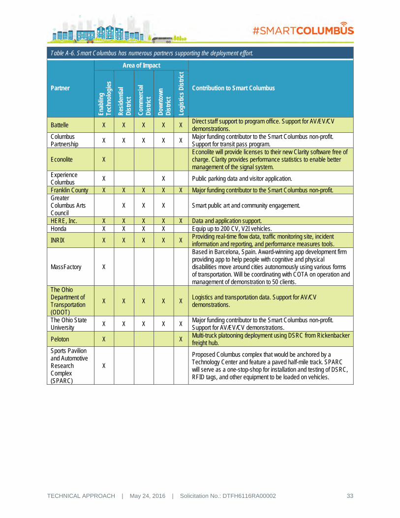
TECHNICAL APPROACH | May 24, 2016 | Solicitation No.: DTFH6116RA00002 33
Table A-6. Smart Columbus has numerous partners supporting the deployment effort.
Partner
Area of Impact
Contribution to Smart Columbus
Enab
ling
Tech
nolo
gies
Res
iden
tial
Dis
tric
t
Com
mer
cial
D
istr
ict
Dow
ntow
n D
istr
ict
Logi
stic
s D
istr
ict
Battelle X X X X X Direct staff support to program office. Support for AV/EV/CV demonstrations.
Columbus Partnership X X X X X
Major funding contributor to the Smart Columbus non-profit. Support for transit pass program.
Econolite X Econolite will provide licenses to their new Clarity software free of charge. Clarity provides performance statistics to enable better management of the signal system.
Experience Columbus
X X Public parking data and visitor application.
Franklin County X X X X X Major funding contributor to the Smart Columbus non-profit. Greater Columbus Arts Council
X X X Smart public art and community engagement.
HERE, Inc. X X X X X Data and application support. Honda X X X X Equip up to 200 CV, V2I vehicles.
INRIX X X X X X Providing real-time flow data, traffic monitoring site, incident information and reporting, and performance measures tools.
MassFactory X
Based in Barcelona, Spain. Award-winning app development firm providing app to help people with cognitive and physical disabilities move around cities autonomously using various forms of transportation. Will be coordinating with COTA on operation and management of demonstration to 50 clients.
The Ohio Department of Transportation (ODOT)
X X X X X Logistics and transportation data. Support for AV/CV demonstrations.
The Ohio State University X X X X X
Major funding contributor to the Smart Columbus non-profit. Support for AV/EV/CV demonstrations.
Peloton X X Multi-truck platooning deployment using DSRC from Rickenbacker freight hub.
Sports Pavilion and Automotive Research Complex (SPARC)
X
Proposed Columbus complex that would be anchored by a Technology Center and feature a paved half-mile track. SPARC will serve as a one-stop-shop for installation and testing of DSRC, RFID tags, and other equipment to be loaded on vehicles.
TECHNICAL APPROACH | May 24, 2016 | Solicitation No.: DTFH6116RA00002 34
A.3 TESTING AND DEMONSTRATING HIGHLY AUTOMATED VEHICLES
A.3.1 Approach
Our proposal for FMLM solutions in our commercial district includes the deployment of multiple EAVs on public roadways. Further, our freight solution includes heavy tractor platooning using an AV for the trailing vehicle. In both cases, for purposes of testing and initial demonstration, the Smart Columbus Team has the distinct advantage of having multiple resources fully capable of supporting the safety and operational testing necessary to deploy autonomous vehicle technology:
The proposed Sports Pavilion and Automotive Research Complex (SPARC) facility, located less than 1 mile west of Columbus’ central business district will serve as the primary test site, offering an ability to conduct both urban environment and high-speed AV testing in a controlled environment. CV infrastructure, including test intersections, will be available to support the full suite of necessary testing. SPARC is also expected to be the site for testing of all CV-enabled vehicles associated with our proposal, ensuring interoperability in that environment. Details of SPARC’s capabilities are listed in the Safety section of this proposal.
The National Highway Traffic Safety Administration (NHTSA)-owned and OSU-operated Transportation Research Center (TRC) is located roughly 20 miles northwest of Columbus’ outerbelt and has a seven-mile long, high-speed track that is the perfect environment to test and demonstrate the truck platooning feature. Further, the TRC has the facilities to conduct a majority of the testing associated with the EAV, able to replicate the size extent of the Easton area within TRC’s property. Finally, after-hours testing at the proposed Easton site will be conducted as final demonstration of the concept.
OSU’s CAR West site will be equipped with the necessary charging station and signal systems, identical to that to be deployed in the Easton area, so that the initial component and integration testing can be conducted.
Test procedure development will be led by the OSU research team in cooperation with the vehicle manufacturers and the test facility operators. Currently, the Automated Driving Lab at the Center for Automotive Research of OSU is working with industry partners on several EAV projects. One in particular focuses on reducing energy consumption by 20 percent of connected and automated driving technologies. The energy consumption reduction is expected to be achieved by using CV technology to communicate with the traffic lights to slow down or start vehicle motion optimally at red and green lights, respectively. The results of this collaboration are expected to result in even greener on-demand vehicles that can be deployed in the Columbus EAV deployment sites, including the Easton Town Center. Test procedures and lessons learned from both efforts are expected to be shared in order to advance both projects.
In addition to traditional functional testing, the City will perform an independent safety assessment of the proposed EAVs. All procedures will be reviewed by an independent safety evaluator and our Institutional Review Board (IRB). Professional drivers will be employed as necessary to complete the initial testing phases.
The City’s long-term vision includes the continued operation of both the EAVs and the truck platooning tractors, however, if for any reason it was decided to discontinue their use, or if equipment failure resulted in their no longer being suitable for their intended purpose, the following actions would be taken:
Operational but no longer deployed EAV’s will be transferred to OSU’s CAR for further research purposes, or at the request of USDOT, provided to another interested UTC.
All batteries or other power sources utilized in the electrified AVs will be recycled in accordance with State regulations.
The AV tractor used for truck platooning will remain in the carrier’s fleet, operated as a normal driver-controlled vehicle and disposed of following the carrier’s normal practices.

TECHNICAL APPROACH | May 24, 2016 | Solicitation No.: DTFH6116RA00002 35
A.3.2 Identification of Regulatory Issues and Plans for Overcoming Impediments
Licensing of 5.9 Ghz DSRC spectrum. The City of Columbus will apply for and would be expected to receive the necessary operating license for the 5.9 GHz spectrum associated with the DSRC. The City will be responsible for all licenses deployed in the region even if the radio is deployed on County or ODOT facilities.
Regulations for driverless vehicles in the State of Ohio. Smart Columbus Team members are actively engaging state legislators to enact regulations to allow for use of Connected/Automated Vehicles (CAVs) on public roads. These regulations include the necessary regulations to allow fully autonomous “driverless” vehicles to operate on public roads, as well as to allow the necessary close-proximity following that is part of the proposed truck platoon vehicles. Specifically, ODOT is developing an action plan and a cross-functional leadership team with its transportation partners to prepare for CAVs. ODOT has assembled an executive management team to guide the Department’s activities. The cross-functional team will include key state agencies like the Departments of Public Safety, Commerce, and Administrative Services, as well as regional and local entities including MORPC, COTA, and the City of Columbus.
A.4 DEPLOYING ELECTRIC VEHICLES
A.4.1 Ability and Commitment to Electric Vehicles, Grid Decarbonizing, and Fleet Transition
A.4.1.1 Procurement Challenges and Opportunities
There are three types of buyers for electric vehicles: Public Fleets, Private Fleets, and Consumers. There are challenges and strategies that face each group:
Public Fleets: Government fleets must competitively bid vehicle purchases from a “bid list” developed by a local or state government procurement department. Currently in Ohio, no EVs are included on this list. Fortunately, the City of Columbus Fleet Services Division and Procurement Office are highly receptive to EV acquisition and interested in developing specifications and a competitive bid process for EV acquisitions. We anticipate EVs being available for government purchase by the end of 2016.
Private Fleets: Higher initial costs are a barrier for adoption, but financing to leverage total cost of ownership is helpful. Ensuring proper operational range is also critical; sometimes supplemental EV charging is needed. For these fleets, proper planning and consideration can help yield insight for the role EVs can play.
Consumers: Overcoming higher upfront vehicle costs is a hurdle, especially when gas prices are lower. By creating new financial structures and leasing arrangements, individuals can overcome this challenge.
A.4.1.2 Fleet Conversion
Fleets are often dedicated to a specific make or model of vehicle, in the interest of streamlining maintenance through more parts commonality. With EVs however, maintenance requirements and costs overall are reduced. Integration of EVs will require training for fleet technicians and analysis to help fleets choose EVs that best fits with operations.
A.4.1.3 Electric Vehicle Car Share
The City of Columbus already carries a number of transportation sharing platforms, including car2go. Currently, this car sharing service does not include EVs. Installation of charging facilities will facilitate adoption of EVs by car sharing services.2 Fortunately, there are a number of car2go-dedicated parking spaces in off-street lots throughout the City. Importantly, these need to be “smart” charging facilities to
2 EV Carsharing Services: Car2Go San Diego: http://bit.ly/OFegN7 and BlueIndy: http://bit.ly/1iz4ony

TECHNICAL APPROACH | May 24, 2016 | Solicitation No.: DTFH6116RA00002 36
enable car sharing EVs to be used in the future to provide grid resources such as peak shaving and vehicle to grid (V2G).
A.4.1.4 Decarbonization of City Electricity Supply
EV adoption, paired with smart charging, is critical to decarbonize transportation and also the electric grid in the medium to longer-term time frame. Because Ohio is a deregulated electricity market, governments, businesses, and individuals can choose 100 percent renewable electricity plans to help reduce the carbon footprint of their electricity consumption. Charging most EVs at night will enable greater utilization of wind energy. Solar installed on rooftops and parking lots, particularly at workplaces, provides an opportunity for continued decarbonization. Continuation of net metering will be essential.
Enabling benefits from grid-connected solar EVs paired with renewable energy also will require significant investment in smart metering. The City of Columbus and partners support bringing cases to fund investments over time to our utility regulators while obtaining policy support from the Ohio General Assembly. While the City of Columbus has been recognized as #13 in the Environmental Protection Agency’s (EPA’s) rankings of Greenest Local Governments, these steps would further advance efforts to reduce carbon emissions.3
A.4.1.5 Consumer Adoption of Electric Vehicles
Barriers to consumer adoption of EVs include higher initial purchase costs, lack of charging, especially at multi-unit residences and workplaces, and lack of education about the cars and their capabilities. One encouraging model that addresses the up-front cost and educational barrier simultaneously is group cooperative purchasing of EVs. The City of Columbus provided a letter of support to Clean Fuels Ohio (CFO), the local Clean Cities coalition, as part of a seven-state application to the USDOE for consumer education funding. The program will feature educational partnerships with dealers, workplaces, large-scale educational events, and other efforts.
Electrification Infrastructure
Information on the availability of charging stations within the City of Columbus will be captured, monitored, and disseminated using a version of the Electric Charging Stations Management Connected Vehicle application. Access to this information will be made available through an Application Programming Interface (API) and a base mobile phone or web-application to disseminate this information to the public will be developed and deployed.
A.4.1.6 Lessons Learned and Best Practices
Group purchasing and “ride and drives” are the best way to encourage adoption of EVs by consumers. Many fleets in the Central Ohio area have analyzed fleet operations and economics of alternative fuel choices using a total cost model. Similar analyses can be conducted regarding prospects for incorporating EVs.
A.4.2 Current and Planned Electric Vehicle Deployment and Decarbonization Activities
A.4.2.1 Local Utilities Programs
Local utilities in the Columbus area offer various incentives that encourage the decarbonization of electricity production and electric vehicle adoption. There are also significant opportunity for expansion of these programs, such as current policies:
Local utility AEP offers a Net Energy Metering Service tariff for customers with renewable energy installations, including solar and wind.4 Customers receive credit for supplying excess energy from
3 City of Columbus Recognized as Top 30 Greenest Local Government, US EPA: http://bit.ly/1rt9pT8 4 AEP Net Metering Eligibility: http://bit.ly/1raR3pr

TECHNICAL APPROACH | May 24, 2016 | Solicitation No.: DTFH6116RA00002 37
their installation back to the grid, saving them money and providing the grid with support during peak hours.
AEP also offers customers the option to match their electric usage with Renewable Energy Credits (RECs), ensuring that they are purchasing 100 percent renewable energy.5
The City of Columbus and our proposed partners are supportive of efforts to encourage community outreach and policy adoption through Ohio utility regulators and the Ohio General Assembly to enable EVs to provide grid resources and facilitate greater development of renewable energy.
A.4.2.2 Sustainability Plans
The City of Columbus, OSU, and other community entities have sustainability plans and initiatives that address decarbonization of the electricity grid and adoption of electric vehicles. Current plans include the following:
The City of Columbus has five-year environmental sustainability guidelines.
OSU’s Sustainability Plan includes reducing the carbon footprint of the university fleet by 25 percent, and includes EV adoption.6 The university also plans to achieve carbon neutrality by 2050.
Many large employers and national companies within the Columbus Area have extensive sustainability plans, of which EV adoption is factored in. Further participation in programs such as the Workplace Charging Challenge will help these entities reach their sustainability goals, attract top talent, and provide opportunities for recognition and publicity.7
A.4.2.3 Local Incentives
Current initiatives for EV adoption and energy decarbonization include:
Ohio Green Fleets Program (CFO – Clean Cities coalition serving Columbus and statewide) – Assistance and recognition to fleets who look to achieve fuel usage and reduce emissions through the adoption of various alternative fuels and efficiency technologies, including EVs.
The City of Columbus GreenSpot program8 – Recognizes households, businesses, and community groups for environmental initiatives, including EV use, charging, and fleet initiatives. Nearly 14,000 members are enrolled, including nearly all major employers and community groups.
Planned and potential future policies include:
County or State Excise Tax Exemption on EV purchases.
Allocation of Congestion Mitigation and Air Quality (CMAQ) funding for Columbus to provide matching funding for charging station installations at public locations, workplaces, and multi-use dwellings.
Modify local parking codes to incentivize developers to install EV charging or to be “EV charging ready” to reduce installation costs later on.
A.4.2.5 Electric Vehicle Infrastructure
Impacts of seasonal weather variation can be addressed by offering EV charging at sheltered and/or in parking garages. This means of charging reduces any perceived or actual issues with range in cold weather. Increased EV infrastructure through public stations and workplace charging also reduces any weather-related range anxiety.
A.4.2.6 Availability of Electric Vehicles
Currently, a variety of EVs of various ranges and prices are offered by Original Equipment Manufacturer (OEMs) in the Columbus area, including offerings from Tesla, BMW, Nissan, GM, and Ford with Kia and 5 AEP 100% Retail Electricity Plan: http://bit.ly/1raR3pr 6 Ohio State University Sustainability Plan: http://bit.ly/1pwipFa 7 Workplace Charging Challenge: http://1.usa.gov/1zYWPOv 8 Columbus GreenSpot: http://bit.ly/1QwaXjq

TECHNICAL APPROACH | May 24, 2016 | Solicitation No.: DTFH6116RA00002 38
Honda set to enter the Ohio market later in 2017. The number of total EV sales has increased annually since 2013. Some models are not yet available in Ohio but this is expected to change over the next few years. Growth of the EV market in Central Ohio and partnerships with OEMs will accelerate this process. Finally, Honda of America is a partner with significant manufacturing based in Central Ohio. Honda is committing to sell the Fit-EV in Ohio. Honda will bring new plug-in models to market by 2017 and will offer these in the Columbus area.
A.5 SETTING AND MONITORING MEASURABLE GOALS AND OBJECTIVES
Smart Columbus has developed five major goals to achieve its vision. They revolve around connecting all our residents to safe and reliable transportation, access to jobs, connecting visitors, smart logistics, and environmentally sustainable practices. Smart Columbus has identified specific transportation challenges associated with accomplishing these goals that impact the long-term viability and livability for the City. It is this team’s mission to overcome these challenges through a comprehensive and integrated approach that accomplishes the goals, objectives, and performance measures described in this section.
Each of the five Smart Columbus goals is highlighted in Table A-7. Below each goal are the USDOT Goals and Vision Elements that are addressed with our technology solutions. Each goal has specific objectives to be accomplished and the rationale explained for why these are important. Precise performance measures have been developed to quantify the exact outcome we are trying to achieve with our technology solutions, along with existing or proposed measurements.
A.6 USING EXISTING STANDARDS, ARCHITECTURES, AND CERTIFICATIONS PROCESSES
A successful Smart Columbus will employ an “open” platform approach, leveraging existing and emerging standards, and embodying both an open-architecture for integrating and exchanging data among various partners systems. It will leverage and contribute to the body of available open-source tools and products. Finally, a Smart Columbus will utilize components that meet requisite USDOT and industry certifications, such as J2735 DSRC message set, IEEE 1609.x, IEEE 802.11p, and the various Society of Automotive Engineers Standards. Our team truly understands the importance of these concepts and is committed to their use, both during this initial program and beyond.
Evidence of our commitment to this philosophy can be readily found in both our existing government/public-sector partnerships, and the outcomes they have produced. As an example, MORPC has followed guidance prescribed in the National ITS Architecture, as well as the recommendations provided by the Federal Highway Administration (FHWA). This architecture provided a framework for the integration and interoperability of ITS systems in the region and continues to be refined as new ITS strategies are implemented. Historically, the City, MORPC, and COTA had convened quarterly ITS committee meetings to coordinate current and future ITS capital projects to be integrated into the Regional ITS Architecture plan.

TE
CH
NIC
AL A
PP
RO
AC
H
| M
ay 2
4, 2016
| S
olicitation No.: D
TF
H6116
RA
0000
2
39
Table A-7. Smart Columbus goals.
GOAL: Improve access to jobs through expanded mobility options in major job centers that currently are autocentric. Applicable USDOT Goals: Improve Safety, Enhance Mobility, Enhance Ladders of Opportunity, Address Climate Change Applicable USDOT Vision Elements: 1,2,3,4,5,7,8,9,10,11,12 OBJECTIVE: Provide options for first and last mile connections throughout Columbus' largest job centers Rationale Technology Solution Performance Measure Baseline Measurement Data Source Improve accessibility options to areas that are not easily reached by urban transit services and other means, so residents will have more employment and travel options for more economic opportunities and higher transit ridership.
Electric Autonomous Vehicle Pilot Project at Easton
The number of commuters using electric autonomous vehicles for job commute
Ridership Survey to be conducted before EAV deployment
EAV and COTA Ridership Survey, COWIC, US Together, Urban League
GOAL: Impact the Columbus visitor experience by better connecting our visitors to transportation options. Applicable USDOT Goals: Enhance Mobility, Address Climate Change Applicable USDOT Vision Elements: 3,4,5,7,11
OBJECTIVE: Improve perception that Columbus lacks transportation options and parking availability for visitors of special events within the City Rationale Technology Solution Performance Measure Baseline Measurement Data Source Experience Columbus has collected more than 25,000 perpetual survey responses, indicating a lack of information and satisfaction with parking availability. Through our Columbus visitor application, we will change those perceptions by making the information more readily available.
Event Parking Decrease number of survey results where lack of information and satisfaction with parking.
Established Experience Columbus Visitor Survey
Reduction in Congestion Index preceding and clearance time following event
Established Department of Public Service, Analytics from Apps
GOAL: Stimulate additional economic prosperity as a region and compete globally through smart logistics Applicable USDOT Goals: Improve Safety, Enhance Mobility, Enhance Ladders of Opportunity, Address Climate Change Applicable USDOT Vision Elements: 1,2,3,4,6,7,10,11
OBJECTIVE: Minimize the amount of extra (buffer) travel time necessary when planning expected trip travel time Rationale Technology Solution Performance Measure Baseline Measurement Data Source Freight carriers, commuters, and businesses need reliable and consistent travel times to ensure the on-time delivery of goods and most efficiently use their time. Consistency will give the Columbus Region a competitive edge and lead to economic prosperity.
Loading Zone Reduction in travel time to loading zone following entry into Downtown District (Short North Neighborhood)
Logistics Survey to be conducted before deployment
RFID Data and Analytics from Apps to be Developed
Long Haul Truck Parking Optimization
Utilization of developed application to obtain parking availability
Logistics Survey to be conducted before deployment
ODOT and Analytics from Applications

TE
CH
NIC
AL A
PP
RO
AC
H
| M
ay 2
4, 2016
| S
olicitation No.: D
TF
H6116
RA
0000
2
40
Table A-7. Smart Columbus goals.
OBJECTIVE: Improve air quality through the reduction of truck congestion Rationale Technology Solution Performance Measure Baseline Measurement Data Source By more efficiently routing trucks throughout the region, while improving truck congestion, air quality improvements will occur.
Platooning The rate at which the goods pass through the Logistics District (Alum Creek Drive and Williams Drive)
Established ODOT, DSRC, Department of Public Service
OBJECTIVE: Reduce truck accidents related to roadway limitations Rationale Technology Solution Performance Measure Baseline Measurement Data Source By appropriately routing trucks through the region, we can reduce truck accidents, leading to safer roadways, less accident induced congestion, and high costs of repairing roadway infrastructure.
Asset Inventory and Truck Routing
Reduction in number of truck accidents due to truck height, weight, width, roadway limitation
Established ODOT and City of Columbus Department of Public Service
GOAL: Better connect Columbus residents to safe, reliable transportation that can be accessed by all. Applicable USDOT Goals: Improve Safety, Enhance Mobility, Enhance Ladders of Opportunity, Address Climate Change Applicable USDOT Vision Elements: 1,2,3,4,5,7,8,9,10,11,12
OBJECTIVE: Improve the ladders of opportunity for residents in our most underserved neighborhoods Rationale Technology Solution Performance Measure Baseline Measurement Data Source Improving the ladders of opportunities in our most needy neighborhoods. One major technology solution is to provide improved Wi-Fi accessibility to residents throughout Linden. This improved accessibility will connect residents to healthcare, education, and employment options.
Enhanced Human Services; Wi-Fi Smart Street Lights Project; Kiosks, Smart Payment; Data Exchange; Smart Corridor
Number of missed prenatal and pediatric visits scheduled with the Enhanced Human Services Module
User Survey to be conducted before deployment
Enhanced Human Services Module, CelebrateOne
Amount of food received per family per targeted Residential District (Linden) through the Mid-Ohio Foodbank
Established Mid-Ohio Foodbank
Job turnover in targeted Residential District (Linden) due to lack of travel options
Established Columbus Chamber of Commerce
Internet Accessibility and Availability in targeted Residential District (Linden)
Resident Survey to be conducted before deployment
Residential Survey, Analytics from Smart Street Lights and Neighborhood Hubs

TE
CH
NIC
AL A
PP
RO
AC
H
| M
ay 2
4, 2016
| S
olicitation No.: D
TF
H6116
RA
0000
2
41
Table A-7. Smart Columbus goals.
OBJECTIVE: Increase mobility options throughout Columbus Rationale Technology Solution Performance Measure Baseline Measurement Data Source Smart Columbus aims to increase transportation options, not for some, but for all its residents (including the cash-based households) through multiple ways including a smart payment option that does not currently exist today but will work with both COTA and other non-transit providers while paying for it all in one application.
Smart Corridor; Multi-Modal Trip Planning; Smart Payment; Transit Service Information; Integrated Data Exchange; and Enhanced Human Services
Significant reduction in average commute time to work (Linden to Rickenbacker) (Linden to Easton)
Established Mid-Ohio Regional Planning Commission
Improvement in travel time reliability (Linden to Rickenbacker) (Linden to Easton)
Established Mid-Ohio Regional Planning Commission
Percentage of Smart Payment users that make purchases on multiple types of transactions
Not Applicable (new program)
Smart Payment App Analytics
The percentage of residents that are aware of the multi-modal transit options
Not Applicable (new program)
Onboard Transit Survey, Transit Columbus
OBJECTIVE: Leverage Columbus' Connected Traffic Signal System upgrades to safely and optimally connect people, goods, and services Rationale Technology Solution Performance Measure Baseline Measurement Data Source At its core, transportation is all about connecting people, goods, and services to other people, goods and services. Our CCTN will leverage planned improvements to build a safe and optimal demonstration of the system.
Connected Columbus Transportation Network (CCTN)
Number of Connected Vehicles Not Applicable (new program)
MORPC
Number of Connected Infrastructure Components
Not Applicable (new program)
Smart Columbus Deployment
OBJECTIVE: Capitalize on the vast amount of data to enhance Columbus' transportation connections Rationale Technology Solution Performance Measure Baseline Measurement Data Source In the Smart Columbus program, data is the bond that links the infrastructure to the residents and visitors to the city; data is the core of Smart Columbus; a vast array of data has been identified from traditional and non-traditional transportation sources.
Integrated Data Exchange
Number of incoming streams of data from traditional and non-traditional transportation sources.
Established MORPC, Department of Technology
Number of third-party application developers utilizing the Integrated Data Exchange
Not Applicable (new program)
MORPC, City of Columbus Department of Technology

TE
CH
NIC
AL A
PP
RO
AC
H
| M
ay 2
4, 2016
| S
olicitation No.: D
TF
H6116
RA
0000
2
42
Table A-7. Smart Columbus goals.
OBJECTIVE: Effectively balance the need for City issued permit-only parking spaces and general public parking in mixed-use neighborhoods Rationale Technology Solution Performance Measure Baseline Measurement Data Source In several mixed-use neighborhoods surrounding downtown, there is a constant struggle between how much permit-only parking to offer neighborhood residents versus the neighborhood business patrons. By tracking the permitted vehicles with RFID-based stickers, the real need can be correctly established.
Permit-Only Parking Space Management
The number of residential complaints registered in the City's 311 Call Center
Established City of Columbus 311 Customer Service Center
GOAL: Through environmentally sustainable practices, support the efficient movement of people and goods. Applicable USDOT Goal: Address Climate Change Applicable USDOT Vision Elements: 7,8
Objective: Increase the number of electric vehicle charging stations positioned throughout Columbus Rationale Technology Solution Performance Measure Baseline Measurement Data Source With less than 50 current charging stations throughout the Central Ohio Region, the quantity is insufficient to support any large-scale shift toward electric vehicles.
Electric Vehicle Charging Stations
The number of charging stations Established Clean Fuels Ohio
Utilization of charging stations Not Applicable (new program)
Smart Columbus
OBJECTIVE: Expand the Smart Grid Program to Include vehicle-to-grid capability for charging stations Rationale Technology Solution Performance Measure Baseline Measurement Data Source Growth of the Smart Grid Program will support electric vehicle infrastructure expansion, and manage grid resources for charging.
Smart Grid The number of smart meters installed
Not Applicable (new program)
City of Columbus Department of Public Utilities, and AEP

TECHNICAL APPROACH | May 24, 2016 | Solicitation No.: DTFH6116RA00002 43
With the addition of CV/AV technologies to the region, this current regional ITS architecture will be expanded to ensure that the guidance and processes captured in the Connected Vehicle Reference Implementation Architecture (CVRIA) are also documented and adopted. Coinciding with this, the review committee will expand to encompass a broader set of regional stakeholders to ensure the necessary interoperability is achieved. Figure A-13 is an example of how the architecture might look as expanded to document the concepts and application of a CV-enabled TSP system as discussed earlier in this proposal. Similar outputs will be produced and vetted for all applications proposed.
Interim and final versions of this architecture will be made available to USDOT for review. Further, the City will participate in USDOT-led discussions related to CVRIA, sharing the documentation, successes, and lessons learned.
In addition to the expanded ITS and CVRIA architectures, the City also will employ and publish information related to the open-architecture upon which the IDE is based. Details of the IDE are described elsewhere in this proposal, but akin to the process currently used for the regional ITS architecture, the IDE will be brought under the purview of a stakeholder group similarly charged to coordinate current and future data-related projects and update the architecture accordingly.
In supporting these architectures, the City will also draw from the growing list of supporting standards, a list of which will be included in the deliverable Standards Plan. These standards include the core CV standards, such as SAE J2735 & J2945, IEEE 1609.x, etc., and also consider both emerging standards, such as those under development for wireless inductive vehicle charging (SAE J2954), as well as data management standards such as the International Organization of Standardization (ISO) 9075 series. To the extent available, the City will also commit to select equipment or systems that adhere to these standards or related specifications. Opportunities for future standardization will also be captured by the City and its partners, identifying any gaps during the design and implementation phase, and reporting these to the respective standards development organizations. Collectively, as an advocate of these
Figure A-13. Smart Columbus will develop an architecture to document concepts and applications and ensure interoperability, using the System Engineering Tool for Intelligent Transportation with the Connected Vehicle Reference Implementation Architecture.

TECHNICAL APPROACH | May 24, 2016 | Solicitation No.: DTFH6116RA00002 44
deployment approaches, Smart Columbus will continue to follow USDOT guidance for the use of Standards, Architectures, and the Certification Processes as an integral part of our successful approach.
A.7 FOLLOWING A SYSTEMS ENGINEERING APPROACH Smart Columbus interweaves cross-cutting enabling technologies with innovative solution sets to present a holistic approach to meeting the desired outcomes for the USDOT and the City of Columbus. Our program addresses all 12 USDOT vision elements for a smart city. Because of the complex interplay of these elements with the Smart Columbus Program, strict adherence to the systems engineering process is required to minimize risk and to ensure that user needs are met and performance goals are realized.
A.7.1 Applying Lessons Learned from Other Federal Programs
The Smart Columbus Team will adapt lessons learned from other Federal programs, such as the Safety Pilot Connected Vehicle Model Deployment, the Tampa and NYC Connected Vehicle Pilots, the Ann Arbor Connected Vehicle Test Environment, the Connected Vehicle Transit Research Project, and the V2I Reference Architecture, to complete the documentation for the Smart Columbus Program and to lay the foundation for requirements definition, design, deployment, and continuing operations. Our experience on these other programs has demonstrated the importance of developing a robust SEMP that is integrated with the overall PMP to produce timely deliverables and to capture early benefits.
The systems engineering process begins with this document. This document is our plan for demonstrating what our smart city will be and what it will become in future as the solutions scale on a citywide basis.
Elements of our approach include:
Concept of Operations (ConOps) – The Smart Columbus approach is focused on the users of the system and their needs. This principle is core for Smart Columbus. Thus, the ConOps will be user-focused.
System Requirements – The system requirements will focus on five key system attributes – functions, interfaces, data, performance (including reliability), and security, specifically for the four core enabling systems.
Architecture – One of the goals of Smart Columbus is to provide a scalable, interoperable, and replicable deployment. This goal is necessary to support national deployment objectives of connected, electric, and automated vehicle technologies. Consequently, the Smart Columbus Team will leverage federal investments in existing ITS standards, architectures, and certification processes for ITS and connected vehicle based technologies to the maximum extent possible. These processes includes the CVRIA and SET-IT tools.
System Design Document – The system design documentation will provide the level of detail needed to implement the system and to document its configuration with drawings and photos for future operation and maintenance.
Test Plans and Documentation – For each requirement, the Smart Columbus Team will identify and describe a test procedure and criteria to describe how the test verifies that the requirement has been met. The test plan will be a compilation of these test procedures. They will be mapped back to the system requirements.
Operations and Maintenance Plans – The Operations and Maintenance Plans will be based on the ConOps and will be documented in MOUs among partner organizations. The Smart Columbus Program Office will continue to be the governing body for ongoing O&M of the system, but also for execution of the policies and procedures established for long-term sustainability of the system.
A.7.2 Other Systems Engineering Documents
A Comprehensive Deployment Plan will be completed for this program utilizing experience gained on Safety Pilot and the Tampa CV Pilot. The schedule, cost estimates, and scope for the Smart Columbus Program will be presented in the document, which will lay the ground work for the successful design,

TECHNICAL APPROACH | May 24, 2016 | Solicitation No.: DTFH6116RA00002 45
deployment, integration, operation and maintenance of the program, as well as demonstrate a comprehensive and integrated approach.
In addition to the Comprehensive Deployment Plan, we will also prepare a Deployment Readiness Summary (DRS) to ensure that we have satisfied all of the required elements of the program, and that we are in a position to design, build, test, and operate the proposed systems.
A.7.3 System Management and Operations
The Smart Columbus Program Office will be responsible for ongoing system management and operations. The team will employ a Systems Manager Approach for execution of the SEMP and longer-term operation and maintenance of the Smart Columbus Program. This approach, used by the Smart Columbus Team members for other complex projects, provides continuing systems engineering rigor for future upgrades and replacement cycles, while offering flexibility in procurement techniques.
A.8 ENSURING SAFETY OF ALL TRAVELERS Safety is a critical component to any technology deployment, and the City has taken measures to mitigate safety concerns to protect the traveling public. In some instances, we will require the installation of duplicative technologies or backup systems to guarantee as safe a deployment as possible. For example, we will equip our autonomous vehicle fleet with DSRC radios that we will monitor via DSRC Roadside Unit (RSU) in and around the Easton deployment site. Further, 350 cameras in the Easton area will allow new ubiquitous coverage. This coverage enables a human operator to intervene and stop the vehicle if needed or to identify a vehicle that is behaving erratically and pull the vehicle out of service. In our Truck Platooning deployment, we will require a similar redundant system as well as having an operator in the second vehicle as an additional backup.
We will develop a detailed safety plan as part of the project design process as well as a comprehensive IRB package. For this project, OSU’s IRB will serve as the IRB of record. OSU will review the safety plan and ensure that the team has undertaken the appropriate protective measures during the planning process, and during deployment through quarterly review meetings.
One key safety aspect with a technology deployment is to ensure that we install the equipment and technology components consistently and that they do not impede driving or other requirements of the operator. For this project, the proposed SPARC development would potentially provide, as a cost-share to the project, access to their facility and staff located in a HUB zone in downtown Columbus (Figure A-14). SPARC will be instrumented with two DSRC RSUs and all vehicles instrumented for the project will be equipped at this facility and run through a ¼-mile road course to ensure that the operator and equipment are functioning correctly and that there are no safety issues that need to be addressed (e.g., visibility impairments, etc.). Similar capabilities are available both at
Figure A-14. The City of Columbus may partner with the proposed SPARC development to perform vehicle installation and safety checkouts of all vehicle technologies deployed.
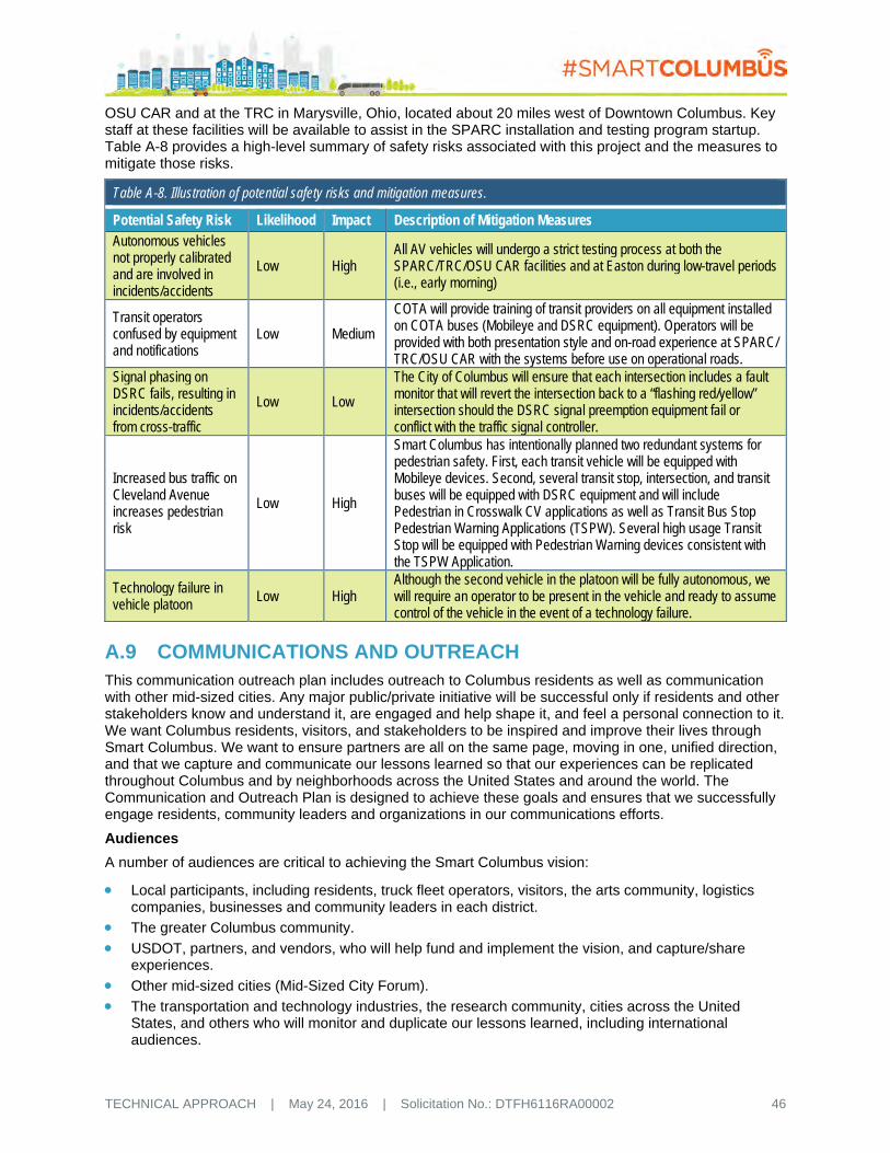
TECHNICAL APPROACH | May 24, 2016 | Solicitation No.: DTFH6116RA00002 46
OSU CAR and at the TRC in Marysville, Ohio, located about 20 miles west of Downtown Columbus. Key staff at these facilities will be available to assist in the SPARC installation and testing program startup. Table A-8 provides a high-level summary of safety risks associated with this project and the measures to mitigate those risks.
Table A-8. Illustration of potential safety risks and mitigation measures.
Potential Safety Risk Likelihood Impact Description of Mitigation Measures Autonomous vehicles not properly calibrated and are involved in incidents/accidents
Low High All AV vehicles will undergo a strict testing process at both the SPARC/TRC/OSU CAR facilities and at Easton during low-travel periods (i.e., early morning)
Transit operators confused by equipment and notifications
Low Medium
COTA will provide training of transit providers on all equipment installed on COTA buses (Mobileye and DSRC equipment). Operators will be provided with both presentation style and on-road experience at SPARC/ TRC/OSU CAR with the systems before use on operational roads.
Signal phasing on DSRC fails, resulting in incidents/accidents from cross-traffic
Low Low
The City of Columbus will ensure that each intersection includes a fault monitor that will revert the intersection back to a “flashing red/yellow” intersection should the DSRC signal preemption equipment fail or conflict with the traffic signal controller.
Increased bus traffic on Cleveland Avenue increases pedestrian risk
Low High
Smart Columbus has intentionally planned two redundant systems for pedestrian safety. First, each transit vehicle will be equipped with Mobileye devices. Second, several transit stop, intersection, and transit buses will be equipped with DSRC equipment and will include Pedestrian in Crosswalk CV applications as well as Transit Bus Stop Pedestrian Warning Applications (TSPW). Several high usage Transit Stop will be equipped with Pedestrian Warning devices consistent with the TSPW Application.
Technology failure in vehicle platoon Low High
Although the second vehicle in the platoon will be fully autonomous, we will require an operator to be present in the vehicle and ready to assume control of the vehicle in the event of a technology failure.
A.9 COMMUNICATIONS AND OUTREACH This communication outreach plan includes outreach to Columbus residents as well as communication with other mid-sized cities. Any major public/private initiative will be successful only if residents and other stakeholders know and understand it, are engaged and help shape it, and feel a personal connection to it. We want Columbus residents, visitors, and stakeholders to be inspired and improve their lives through Smart Columbus. We want to ensure partners are all on the same page, moving in one, unified direction, and that we capture and communicate our lessons learned so that our experiences can be replicated throughout Columbus and by neighborhoods across the United States and around the world. The Communication and Outreach Plan is designed to achieve these goals and ensures that we successfully engage residents, community leaders and organizations in our communications efforts.
Audiences
A number of audiences are critical to achieving the Smart Columbus vision:
Local participants, including residents, truck fleet operators, visitors, the arts community, logistics companies, businesses and community leaders in each district.
The greater Columbus community.
USDOT, partners, and vendors, who will help fund and implement the vision, and capture/share experiences.
Other mid-sized cities (Mid-Sized City Forum).
The transportation and technology industries, the research community, cities across the United States, and others who will monitor and duplicate our lessons learned, including international audiences.

TECHNICAL APPROACH | May 24, 2016 | Solicitation No.: DTFH6116RA00002 47
The media, including print, digital, and broadcast – with local, state, national, and international audiences.
Policymakers, including elected officials at the federal, state and local levels.
Communications and Outreach Plan
Upon project award, the Smart Columbus Team will further refine and expand upon this Communication and Outreach Plan, vet it with local partners and USDOT, finalize the schedule, and proceed with implementation. We will document all outreach activities and provide interim reports.
Brand, Message, Website, and Communication Toolkit
Working through community partners we have thus far engaged, the Smart Columbus Program Office has established a compelling brand in Smart Columbus that will work in conjunction with the Smart Cities brand. The name, logo, and color palette will be incorporated into all communication materials. Next, we will develop a concise message so the community understands and can rally around the Smart Cities mission. This foundational message, along with sub-messages for each target audience, will serve as the overarching talking points and basis for all communication tools moving forward, from a website and presentations to news releases, frequently asked questions, fact cards, social media, and advertising. These outreach measures ensure the public hears one consistent message, which builds understanding over time.
The toolkit will include a promotional video about the Smart City Program that will be updated at least twice. We will also produce short video clips that can be posted regularly on the website and easily shared on social media with the Smart Columbus message.
The City of Columbus Smart Columbus website www.columbus.gov/smartcity will provide demonstration updates and the communication toolkit, but will also relay progress through a regular blog and dash board that reports numbers of participants, community engagement opportunities, and data/transportation metrics. Interim reports and other knowledge transfer will be gathered here. The blog, which will spotlight various aspects of Smart Columbus, along with photographs and other web content will become the basis for our social media campaign. The City of Columbus and its partners have already established a region-wide social media and public information officer network. This network has agreed to drive social media updates to audiences throughout the region and, with USDOT and national vendor assistance, throughout the nation.
District Outreach Strategy
We will employ a number of outreach strategies to engage the community and promote the demonstration in each district.
All Districts
Several strategies will be incorporated in all districts. We will also:
Appoint a team liaison to each district to ensure the community is informed, engaged, and has one point of contact. The liaison will provide regular updates to the Area Commission; conduct monthly “Walk Abouts” in District businesses and neighborhoods to answer questions and distribute information; make presentations at District-based meetings and events; and also, with other team members, engage the public in local events such as the Columbus Arts Festival and Neighborhood Pride events. The liaisons also will participate in presentations throughout Columbus so other neighborhoods can learn how the pilot programs are working and what they can do to prepare for eventual roll-out in their neighborhoods.
Run a paid print, electronic, and social media public awareness and incentive campaign to recruit participants. Participants will have the option to sign up through the website, mail or by phone to ensure equal access. Information will be provided in a multi-lingual format. Additionally, Smart Columbus will work with the Columbus Area Committee on Disability Issues (CCDI) to ensure distribution to residents with cognitive and other disabilities.
Print and distribute fact cards and/or door hangers to each district household and businesses with step-by-step instructions on how to access Smart Columbus mobility options.
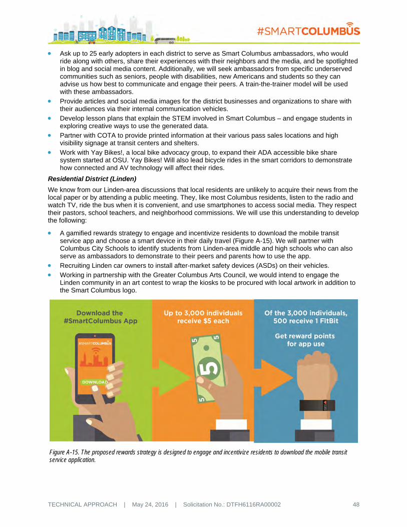
TECHNICAL APPROACH | May 24, 2016 | Solicitation No.: DTFH6116RA00002 48
Ask up to 25 early adopters in each district to serve as Smart Columbus ambassadors, who would ride along with others, share their experiences with their neighbors and the media, and be spotlighted in blog and social media content. Additionally, we will seek ambassadors from specific underserved communities such as seniors, people with disabilities, new Americans and students so they can advise us how best to communicate and engage their peers. A train-the-trainer model will be used with these ambassadors.
Provide articles and social media images for the district businesses and organizations to share with their audiences via their internal communication vehicles.
Develop lesson plans that explain the STEM involved in Smart Columbus – and engage students in exploring creative ways to use the generated data.
Partner with COTA to provide printed information at their various pass sales locations and high visibility signage at transit centers and shelters.
Work with Yay Bikes!, a local bike advocacy group, to expand their ADA accessible bike share system started at OSU. Yay Bikes! Will also lead bicycle rides in the smart corridors to demonstrate how connected and AV technology will affect their rides.
Residential District (Linden)
We know from our Linden-area discussions that local residents are unlikely to acquire their news from the local paper or by attending a public meeting. They, like most Columbus residents, listen to the radio and watch TV, ride the bus when it is convenient, and use smartphones to access social media. They respect their pastors, school teachers, and neighborhood commissions. We will use this understanding to develop the following:
A gamified rewards strategy to engage and incentivize residents to download the mobile transit service app and choose a smart device in their daily travel (Figure A-15). We will partner with Columbus City Schools to identify students from Linden-area middle and high schools who can also serve as ambassadors to demonstrate to their peers and parents how to use the app.
Recruiting Linden car owners to install after-market safety devices (ASDs) on their vehicles.
Working in partnership with the Greater Columbus Arts Council, we would intend to engage the Linden community in an art contest to wrap the kiosks to be procured with local artwork in addition to the Smart Columbus logo.
Figure A-15. The proposed rewards strategy is designed to engage and incentivize residents to download the mobile transit service application.

TECHNICAL APPROACH | May 24, 2016 | Solicitation No.: DTFH6116RA00002 49
Commercial District (Easton)
The Easton area has more than 235 retail stores and 40,000 employees. We will coordinate with those businesses and use the following to build awareness and usage of Smart Columbus and electric autonomous vehicles (EAVs):
Working with Easton Town Center, hold a Smart Columbus launch rally to share details about the services and distribute “how to” fact cards to attendees and local establishments.
Collaborate with local businesses to use their existing communication vehicles (e.g., e-news, social media, cafeteria posters) to promote the app to their employees.
In anticipation of expanding the system to other locations within the City, a series of “Smart Columbus AV days” will be held to deploy the AVs in other locations throughout Columbus to provide demonstration rides to local business owners and patrons.
Downtown District
We will coordinate with the Downtown Residents Association, Downtown Columbus Special Improvement District (SID), Columbus Downtown Development Corporation (CDDC), Columbus Chamber and Experience Columbus, Short North Business Association, and others to communicate the following, in addition to those outlined above:
NXP has agreed to provide up to 50,000 RFID window stickers for parking. We will promote these via the paid advertising outlined above, news releases, employer transportation fairs, e-newsletter articles and social media.
MORPC and the Urban Land Institute has established an insight2050 Academy to convene major stakeholders to share information and learn how to plan for emerging trends. They have agreed to use these forums to discuss how Smart Columbus and the advent of AV technology will impact development with regard to parking demand and location, site access, market potential for increased development density, and overall infrastructure needs. Developer Arshot Investment Corp. has offered to customize its new 25-story Downtown building, to open in 2018, with parking spots that accommodate AVs.
Experience Columbus already has an ambassador program to help visitors experience the best of Columbus; we will train them so they can also showcase the Smart Columbus story. We will also provide Experience Columbus links to our website and related promotional materials so visitors can also download the Smart Columbus app.
Logistics District (Rickenbacker Airport)
We will coordinate with the Rickenbacker Global Logistics Park, Columbus Region Logistics Council, Columbus Regional Airport Authority, and other business and community organizations in the Rickenbacker area to communicate in the following ways in addition to those outlined above:
Ambassadors and interns will partner with the District Liaison and brief Rickenbacker-area employers on how Smart Columbus works. “How to” fact cards will be provided.
The City will work with the Greater Linden Development Corporation to build upon the Linden Logistics Pilot Program. The Columbus Region has a high need for logistics employees and has trouble filling these positions; meanwhile Linden suffers from high unemployment rates. The first phase of this program will involve a four-week “Customer Service and Logistics Career Exploration Boot Camp,” follow-up training will be provided through a number of community partners such as the CSCC Supply Chain Management program. The City will work with GLDC to increase the size and frequency of this program in order to train more students from throughout Columbus and the region.
Partnership with Greater Columbus Arts Council
Integration of the arts into Smart Columbus is meant to inspire, create a sense of pride, and make people feel more connected to their neighborhoods and public spaces, such as the mural in Figure A-16 that is located under a railroad bridge and highlights Ohio’s history. The Greater Columbus Arts Council has committed $1 million to partner with us to:

TECHNICAL APPROACH | May 24, 2016 | Solicitation No.: DTFH6116RA00002 50
Commission local artists to design imagery for AVs, kiosks, crosswalks, utility boxes, and trash cans for neighborhoods and along key points in Linden and the other Districts as appropriate.
Provide pop-up music and poetry-reading performances on CMAX buses and at transit centers and other unexpected places.
Integrate Columbus ArtWalks into Smart Columbus communications/marketing to neighborhoods.
Establish a Culture Trail, selecting key points within and along the Smart Columbus Districts and corridors to highlight cultural venues, public art and concentrations of neighborhood stores and businesses.
Install screens in taxis, buses and/or Transit Centers that could share a variety of videos such as Art Makes Columbus artist profiles and WOSU Broad & High segments and excerpts from WOSU’s Neighborhood series.
Community Awareness
In addition to the strategies outlined above, we will expand our reach beyond the four districts to the community at large through the following:
NXP has graciously agreed to partner with Smart Columbus to increase local STEM education by bringing its Smart World Tour Internet of Things Bus to Columbus for 12 months. We will take this mobile lab to each of the districts, schools, and also feature it at Columbus-wide community events like the Red, White & Boom parade held on the 4th of July, which attracts a half million people. The trucks is a hands-on technology showcase and demonstration platform, so we can provide learning opportunities for Columbus youth and emerging scientists.
Partner with 200+ organizations to link websites and share information via social media and e-news articles. We will provide content and ask them to personalize/share.
Provide regular briefings to local, state, and Congressional elected officials. We will steer these officials to the web-based dashboard that reports metrics and lessons learned, so they understand our progress and how these results can be replicated elsewhere.
Develop a presentation and trade show booth, then aggressively pursue opportunities to present to conferences and organizations such as Columbus Metropolitan Club, Kiwanis, MORPC, and Chamber events.
Staff and promote a telephone hotline, e-mail address, website, and social media so residents and the public can access information in ways most convenient to them. All phone/email interactions will be tracked so they can be summarized in a lessons learned report.
Mid-Sized City Forum
Smart Columbus will organize and host an annual Mid-Sized City Forum with USDOT. The purpose of the forum is to share our Smart Columbus program plans, results and lessons learned.
National/International Collaboration and Media Strategy
The Smart Columbus Team will solicit and accommodate site visits from the media, researchers, and others who want to learn from our experiences. We will work with the USDOT to pitch success stories to the national media, and also pitch stories to industry media, inviting them to interview local ambassadors and participants. This marketing strategy will include placing at least three articles per year in trade journals, and leveraging existing transportation conferences and demonstrations as opportunities for additional news coverage. As part of our media relations effort, we will provide media and speaker training to the Smart Columbus Team, liaisons, ambassadors and interns, and ask them to participate in at least two local press conferences each year as well as regularly scheduled webinars with USDOT.
Figure A-16. The Moonwall mural, located near Cooke Road, demonstrates investment in neighborhood art.

TECHNICAL APPROACH | May 24, 2016 | Solicitation No.: DTFH6116RA00002 51
We will ensure knowledge transfer on a number of fronts. ODOT is currently developing an action plan and strengthening key relationships with its transportation partners to prepare for CV and AV. This action plan will be closely coordinated with Smart Columbus, and tentatively includes hosting a CAV conference in Columbus within the next two years. The purpose of this national conference will be to engage CAV stakeholders in the national dialogue and discuss the progress made in Ohio, and particularly in Columbus. ODOT will also include sessions on Smart Columbus at its bi-annual statewide Planning Conference to be held this summer, and will highlight Smart Columbus/Smart Cities at an upcoming Ohio Transportation Engineering Conference that it convenes annually in partnership with OSU.
MORPC hosts an annual Sustainability Summit each fall, and has agreed to feature Smart Columbus/Smart Cities during the four-year pilot. We will ask other community partners to incorporate a Smart Cities module in their annual conferences and outreach to other cities. We will work with USDOT to display a trade show booth at the Transportation Research Board’s annual conference, and make team members available to present findings there and at other conferences. We would also be eager to partner with USDOT to host annual Smart Cities gatherings in Columbus to report our interim findings in additional to the webinars.
Crisis Communications Plan
We will prepare a Crisis Communications Plan and emergency response protocol to include the following:
Develop a chain of command and staff designated to respond to emergencies.
Develop communications approaches/draft messages to respond to various emergency scenarios.
Develop actions to be taken to mitigate the crisis.
Develop procedures for notifying USDOT, the public, and others who are impacted.
Develop a process for identifying corrective procedures to be put in place as a result of the crisis.
Conduct crisis communication training to ensure all Crisis Team members understand the protocols and participate in practice drills.
Distribute laminated cards with contact information for each team member, and provide printed and online instructions on the various aspects of crisis response.
Review and update the plan annually.

TECHNICAL APPROACH | May 24, 2016 | Solicitation No.: DTFH6116RA00002 52
B DATA MANAGEMENT APPROACH The City of Columbus has many different sources of data that have been developed, managed, and maintained by many of our partners. For example, Mid-Ohio Regional Planning Commission (MORPC) provides detailed information on peer-to-peer ridesharing as well as information on transit providers, and freight information. Central Ohio Transit Authority (COTA), the Ohio State University (OSU), and other transit providers maintain data and web-portals that contain the computer-aided dispatch and location information for their transit fleets. Other partners, such as the Mid-Ohio Food Bank, track usage of their services by location. The Columbus Chamber maintains a database associated with their Workforce Program that tracks employment history of users and can be used to demonstrate steps on the ladder-of-success. Our local United Way maintains databases on usage and service provided by geographic area. Hands-on Ohio maintains a database of Human Service providers throughout the state and tracks utilization of these services by geographic neighborhoods. In short, Columbus has a wealth of information and data that is captured, analyzed, and maintained. However, at the same time, a critical aspect of this data that has not been widely adopted or formulated in Columbus, and many other cities of our size, is the consolidation and synthesis of data from these disparate sources into a single, comprehensive location. This disparity creates opportunities for advanced analytics and the development and targeting of new services, products, and mobilization of resources to address issues that previously have been undetected.
B.1 DATA MANAGEMENT As a public entity, we recognize the importance of maintaining data integrity and protecting the public’s interest as well as providing a critical resource to measuring and understanding the benefits, costs, issues, and potential resolutions for replication of the success of Smart Columbus elsewhere. Within the Columbus Region, our Metropolitan Planning Organization (MPO), MORPC, in collaboration with several public and private sector partners, has provided leadership in data collaboration and has initiated developing a Regional Data Lab for Central Ohio. The Smart Columbus Program will build upon this framework and expand this concept to an even wider range of data sources and integration opportunities utilizing the Smart Columbus Integrated Data Exchange (IDE).
B.1.1 Types of Data to be Produced
The City of Columbus, and our proposed partnering agencies already collect a significant amount of information as illustrated in Figure A-2 in Section A.1.1.1.2. We are envisioning an information exchange where information from disparate sources will be combined with data from traditional transportation data using data fusion techniques that can key upon common characteristics such as geography. As part of the Smart Columbus Program, all data generated through the project will be ported into this IDE and processed using a variety of cloud-based analytical tools. Application Programming Interfaces (APIs) and Software Development Kits (SDKs) will be developed and made available so that private, public, and corporate software developers, service providers, and others can access and build additional apps and conduct analytics using the data. The Smart Columbus IDE will provide a mechanism for the collection and synthesis of data from many disparate sources. These data will be made available through APIs, SDKs, standardized performance dashboards and reports, and through managed Amazon Web Services (AWS) mechanisms.
B.1.2 Policies for Data Access and Sharing
It is our intention that, to the extent that is possible under privacy laws, all data captured and included in the IDE be made available to the public. To foster this information exchange, we will provide the requisite software tools for developers to utilize to extract and access the data directly using their preferred platform. Data made available through the IDE to the public will follow an open data format following technical formats that meet the State of Ohio and Project Open Data Metadata Schema v1.1 standards and support of two-way APIs. The RDAC is chaired by a representative from OCLC, a global library cooperative that developed the globally recognized metadata standards that will be followed for open data format in the IDE.

TECHNICAL APPROACH | May 24, 2016 | Solicitation No.: DTFH6116RA00002 53
At the same time, we will leverage the work conducted by the United States Department of Energy (USDOE) National Laboratories, particularly Oak Ridge National Laboratory’s National Transportation Research Center, who have created online data access and analysis tools to datasets such as the National Household Travel Survey, Freight Analysis Framework, and others. Additionally, we anticipate that data will be made available and disseminated through our partner organizations as appropriate. For example, MORPC will continue to provide extracts and excerpts of these data as reports and online datasets.
Access to the raw data will be restricted to protect privacy and confidentiality and the integrity of the data. Industry standard credentialing and multi-level authentication will be utilized. Only processed, post-processed data will be made available for analysis and extraction by public entities. Access by private entities to the raw data will be made available in accordance with the City’s privacy policy as managed by the Department of Technology.
The Smart Columbus IDE will be designed using an overall data governance model that will be driven through automation using AWS IIM services. This level of automation will allow overall control by the City of Columbus of the IDE platform, while minimizing manual information technology service actions. This automated governance model will be critical to making proprietary datasets available and accessible to necessary parties while assigning appropriate staff and providing documentation.
B.1.3 Policies for Data Re-use, Redistribution, and Production of Derivatives
One of the City of Columbus’ objectives is to provide data for unrestricted public re-use and distribution. Data and metadata made available through the IDE APIs will be non-restricted for public and private use. As well, built into the governance model will be the methods for all stakeholders to interact with the IDE using data interfaces or templates that allow authorized use and/or publishing of different datasets. Throughout implementation, the Smart Columbus IDE data agreements will be maintained and will include applicable elements necessary for the City to comply with the Freedom of Information Act.
B.1.4 Archiving Data and Preserving Access
The data governance model will also drive automated archival rules and processes. The Smart Columbus IDE will leverage AWS web services capabilities for archival and flexible retrieval policies. Specifically, historic non-time sensitive data will be stored in the extremely affordable Amazon Glacier platform and more recently archived data will be stored using Amazon Simple Storage Service (S3) for faster retrieval. As the demonstration deployment progresses, the City will evaluate alternatives for long-term sustainment of the data management and hosting, maintenance, hardware, support, app management and ownership of the various components of the system.
The use of these AWS services will allow for long-term data retention and disposition with extremely low cost and minimal labor necessary to retrieve and use any data assets that have been archived.
B.2 DATA CITY CURRENTLY COLLECTS The City of Columbus and our proposed partnering agencies already collect a significant amount of information that includes both traditional transportation information such as traffic counts, transit ridership, information on work zones, incidents/accidents, and ridesharing metrics as illustrated in Figure B-1. For example, in cooperation with the Ohio Department of Transportation (ODOT) and neighboring municipalities, data from more than 50 traffic cameras, that can be recorded, analyzed, and used to create “heat maps” of traffic congestion and incidents, origin/destination data, estimates of emissions, and other transportation planning and performance metrics.
However, our current data collection activities go far beyond those traditional data sources and metrics. Our partner agencies collect a significant amount of information that can be used to assess the overall impact that transportation technology has on the community and the health and well-being of its inhabitants.
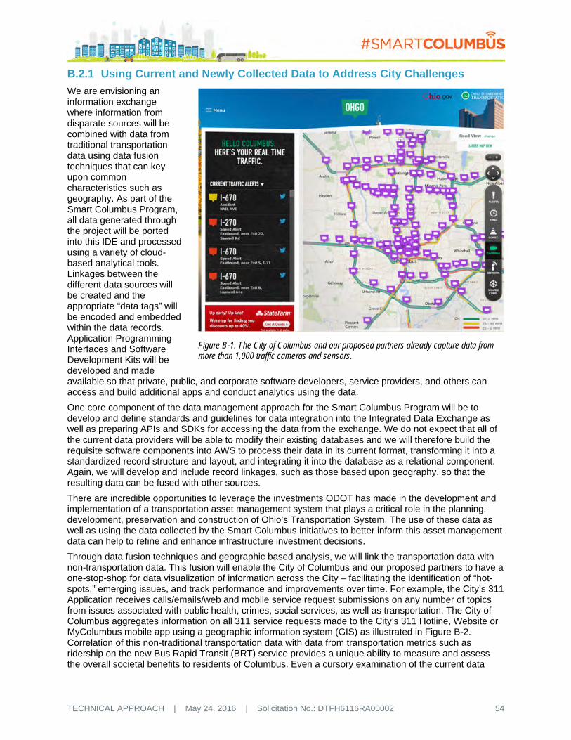
TECHNICAL APPROACH | May 24, 2016 | Solicitation No.: DTFH6116RA00002 54
B.2.1 Using Current and Newly Collected Data to Address City Challenges
We are envisioning an information exchange where information from disparate sources will be combined with data from traditional transportation data using data fusion techniques that can key upon common characteristics such as geography. As part of the Smart Columbus Program, all data generated through the project will be ported into this IDE and processed using a variety of cloud-based analytical tools. Linkages between the different data sources will be created and the appropriate “data tags” will be encoded and embedded within the data records. Application Programming Interfaces and Software Development Kits will be developed and made available so that private, public, and corporate software developers, service providers, and others can access and build additional apps and conduct analytics using the data.
One core component of the data management approach for the Smart Columbus Program will be to develop and define standards and guidelines for data integration into the Integrated Data Exchange as well as preparing APIs and SDKs for accessing the data from the exchange. We do not expect that all of the current data providers will be able to modify their existing databases and we will therefore build the requisite software components into AWS to process their data in its current format, transforming it into a standardized record structure and layout, and integrating it into the database as a relational component. Again, we will develop and include record linkages, such as those based upon geography, so that the resulting data can be fused with other sources.
There are incredible opportunities to leverage the investments ODOT has made in the development and implementation of a transportation asset management system that plays a critical role in the planning, development, preservation and construction of Ohio’s Transportation System. The use of these data as well as using the data collected by the Smart Columbus initiatives to better inform this asset management data can help to refine and enhance infrastructure investment decisions.
Through data fusion techniques and geographic based analysis, we will link the transportation data with non-transportation data. This fusion will enable the City of Columbus and our proposed partners to have a one-stop-shop for data visualization of information across the City – facilitating the identification of “hot-spots,” emerging issues, and track performance and improvements over time. For example, the City’s 311 Application receives calls/emails/web and mobile service request submissions on any number of topics from issues associated with public health, crimes, social services, as well as transportation. The City of Columbus aggregates information on all 311 service requests made to the City’s 311 Hotline, Website or MyColumbus mobile app using a geographic information system (GIS) as illustrated in Figure B-2. Correlation of this non-traditional transportation data with data from transportation metrics such as ridership on the new Bus Rapid Transit (BRT) service provides a unique ability to measure and assess the overall societal benefits to residents of Columbus. Even a cursory examination of the current data
Figure B-1. The City of Columbus and our proposed partners already capture data from more than 1,000 traffic cameras and sensors.

TECHNICAL APPROACH | May 24, 2016 | Solicitation No.: DTFH6116RA00002 55
captured by the 311 system reveals distinct concentrations of service requests in neighborhoods that the Smart Columbus Program will be targeting and enhancing with technology.
Figure B-2. The City of Columbus and our proposed partners already capture a wealth of data such as calls for service requests or assistance to the City’s Customer Service Hotline.
B.2.2 Integrating Transportation Data with Other Functions or Services to Improve City Management and Operations
The Smart Columbus IDE will enable both public and private providers to visualize and coordinate services ranging from transportation to health services. Data made available through the IDE open APIs can be consumed by other entities and applications to enhance their use by using tools and methods posted in public resources such as http://developer.columbus.gov and http://data.columbus.opendata.arcgis.com.
Through an urban analytics approach, the IDE will enable easy correlations of the transportation data with non-transportation data. One particular source of data that will provide information that can be used to assess performance of the overall transportation system includes data from INRIX, some of which is currently being purchased by ODOT and made available to the City of Columbus. These data, along with ridership data from COTA and data from the instrumented Smart Corridor will facilitate an independent evaluation of the impact of the technology in reducing congestion at a corridor-wide level similar to the national evaluation framework used to evaluate the impacts of the Integrated Corridor Management deployments.
B.2.3 Integrating Data from Other Sectors with Transportation Data to Improve Transportation Operations
By building out the Smart Columbus IDE and applying analytics, we envision many applications for improvement such as:
Cities will be able to evaluate all the factors affecting road congestion in real-time, and advisories will be issued before congestion develops to reroute traffic or shift commuters to alternate modes of transportation.

TECHNICAL APPROACH | May 24, 2016 | Solicitation No.: DTFH6116RA00002 56
Bus, airports, and cities will use analytics to better predict demand and optimize their capacity, schedules, pricing models, and staff plans.
Travelers are now able to state their departure and arrival locations and their desired time of travel in their own words. A cognitive system will recommend door-to-door travel options spanning all modes of transport and price options.
Schedules will be optimized based on actual demand in real-time, while vehicles and routes will be managed to minimize congestion, fuel use and carbon emissions.
Coordinated communications across channels will provide an integrated and unified data source.
Integrated intelligence from all related business areas, such as operations, cities and other agencies, will be used to intelligently maximize each users touch points.
Detect operational inefficiencies, theft, and fraud.
Forecast transport demand to construct price and schedule structures.
Congestion will be reduced and major risks will be avoided through performing what-if analyses and policy change scenarios.
B.2.4 Applicable Policies
Bringing data together makes it easier to enforce standards, but having data in one place creates a higher risk of loss or misuse of information if the security of the system is compromised. The IDE addresses this dilemma with its information governance and security capabilities.
Data Policy is a key to the success of the IDE and the overall Smart Columbus effort:
Federal, State, and local governments recognizing data is a strategic asset.
Policies support open-sharing, machine-readable data with public, service providers, and other agencies.
Policies support developing and maintaining systems and connections to share these data.
Open government data policies are often best when developed iteratively, adapting to help strengthen and grow fledgling efforts and to identify where continued revision is needed. By being open (or even requiring) future review and iteration, open data policies will be able to keep current with best practices, technological advances, and feedback from existing policy oversight. Through the outreach efforts throughout this initiative, the City will work to continually evaluate the open data policies and practices in order to encourage the highest and best use of the incredible data asset of Smart Columbus.
The IDE’s governance model will engage a plan for both automated and manual data checks using AWS health check dashboard when verifying data quality and perform regular diagnostic checks to ensure equipment accuracy and health.
B.2.5 Using and Sharing Data from Other Partners
The IDE, supported by the Regional Data Advisory Committee (RDAC), has capabilities that ensure the data is properly cataloged and protected so subject matter experts (SMEs) have access to the data they need for their work. This design point is critical because SMEs play a crucial role in ensuring that analytics provides worthwhile and valuable insights at appropriate points in the organization’s operation. With access to the Smart Columbus IDE, line-of-business teams can take advantage of the data in the IDE to make decisions with confidence.
B.2.6 Sustainability
During the third year of this grant, the Smart Columbus Team will work with partners to re-visit and develop in detail the long-term sustainability plan. This plan will include role definition, responsibilities, long-term adjustments to architecture, and ties to necessary resources to lay out a sustainable approach for hosting and other data management elements beyond the grant proposal.

TECHNICAL APPROACH | May 24, 2016 | Solicitation No.: DTFH6116RA00002 57
B.3 SUPPORT FOR INDEPENDENT EVALUATION The Smart Columbus Program Office will prepare an Evaluation Support Plan with details of our support for the independent evaluation of the demonstration. We will work with the independent evaluator to provide access to specific sites and staff as needed during the evaluation.
Through data fusion techniques and geographic tagging of records, we intend to link the transportation data with non-transportation data. One particular source of data that will provide information that can be used to assess performance of the overall transportation system includes data from both INRIX and HERE. These data, along with ridership data from COTA and data from the instrumented Smart Corridor, will facilitate an independent evaluation of the impact of the technology in reducing congestion at a corridor-wide level similar to the national evaluation framework used by Battelle and others to evaluate the impacts of the Integrated Corridor Management deployments.
Data quality measures needed to support independent evaluation will be initiated by controlling the data at the source, or early in the process, through data model design and well-defined business rules the Smart Columbus IDE.
Data can be scheduled to pass to the Independent Evaluator’s location via a web service in a standardized encrypted format, such as an encrypted Java Script Object Notation (JSON) response as the target output schema. Included in this response would be digital certificate properties, such as X.509 certificate authentication or another as defined by the Independent Evaluator, where only the Recipient and Independent Evaluator have the key needed to decrypt this securely transmitted data.
The data governance model will also provide full access and privileges of the Smart Columbus IDE platform to the Independent Evaluator. The primary focus though will be to drive specific performance measure data through an API and web services designed specific to the Evaluator’s needs.
TECHNICAL APPROACH | May 24, 2016 | Solicitation No.: DTFH6116RA00002 58
C MANAGEMENT APPROACH The City of Columbus has a bold vision to become a world-class smart city and a mission to share its experiences with other mid-sized cities in the United States through our Mid-Sized City Forum. To achieve this vision and mission, the Smart Columbus Team is proposing to manage this large and diverse transportation technology deployment and data project in a way that ensures successful implementation and builds a sustainable program.
C.1 PROJECT LEADERSHIP Sound and stable leadership is a hallmark of Columbus. Mayor Andrew J. Ginther assumed office on January 1 of this year after serving nine years on the City Council and five years as its president. Mayor Ginther will provide continuous leadership over the period of the entire Smart City Challenge grant, and serve as the champion of the Smart Columbus Program. Mayor Ginther places a high priority on Smart Columbus, as it creates the opportunity both to meet the goals of the United States Department of Transportation (USDOT) for improving safety, enhancing mobility, enhancing ladders of opportunity, and addressing climate change, and to advance administration priorities, such as reducing infant mortality, lifting up disadvantaged neighborhoods, reducing the City’s carbon footprint, and ensuring that the City is prepared for an expected increase in population of up to 50 percent over the next three decades.
C.2 TEAM MEMBERS AND PARTNERS The City of Columbus is proposing a team of key personnel from the City’s Department of Public Service to manage the activities of the Smart Columbus Program Office. The Program Office will be assisted by USDOT partners, City departments, regional implementation partners, communications professionals, and technical ITS consultants to assist with funding, design, deployment, operation, and sustainment of the demonstration. The following City departments will have significant roles in the demonstration program:
Technology: Smart payment app, Integrated Data Exchange (IDE), kiosks, and mobile transit app
Public Utilities: Smart street lights and smart utility metering for water and city electric
Finance and Management: Fleet electrification, auditing, and vendor procurement.
Table C-1 presents the assistance and coordination our strategic implementation partners will provide.
Table C-1. Smart Columbus has numerous partners supporting the deployment effort.
Partner
Area of Impact
Contribution to Smart Columbus
Enab
ling
Tech
nolo
gies
Res
iden
tial
Dis
tric
t
Com
mer
cial
D
istr
ict
Dow
ntow
n D
istr
ict
Logi
stic
s D
istr
ict
Battelle X X X X X Battelle scientists and engineers will provide in-kind technical expertise in Dedicated Short Range Communications (DSRC) connected vehicle and deployment.
Central Ohio Transit Authority (COTA)
X X X X X
COTA serves 1.2 million residents and provides more than 19 million passenger trips annually. COTA’s support is key to the Bus Rapid Transit (BRT) line, Mobileye Shield +, park and ride EV charging installations, Mass Factory app for users with cognitive disabilities, monitoring/operating the AV Easton shuttle demonstration, and adding bus service from the residential district to Rickenbacker.
Clean Fuels Ohio (CFO) X
Columbus-based not-for-profit serves as USDOE Clean Cities program center for Ohio, and will assist with EV/EVSE analytics, education and awareness, and technical support and legislative assistance.
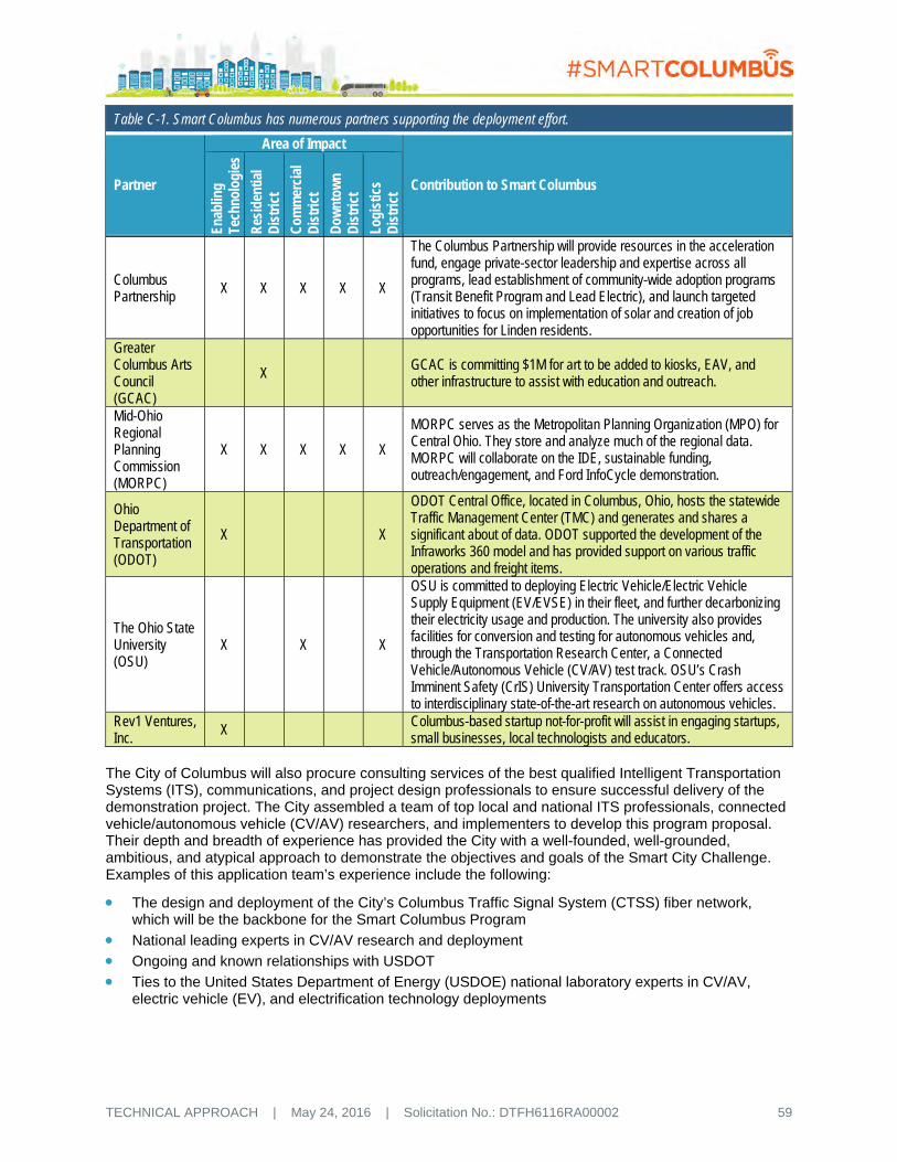
TECHNICAL APPROACH | May 24, 2016 | Solicitation No.: DTFH6116RA00002 59
Table C-1. Smart Columbus has numerous partners supporting the deployment effort.
Partner
Area of Impact
Contribution to Smart Columbus
Enab
ling
Tech
nolo
gies
Res
iden
tial
Dis
tric
t
Com
mer
cial
D
istr
ict
Dow
ntow
n D
istr
ict
Logi
stic
s D
istr
ict
Columbus Partnership
X X X X X
The Columbus Partnership will provide resources in the acceleration fund, engage private-sector leadership and expertise across all programs, lead establishment of community-wide adoption programs (Transit Benefit Program and Lead Electric), and launch targeted initiatives to focus on implementation of solar and creation of job opportunities for Linden residents.
Greater Columbus Arts Council (GCAC)
X GCAC is committing $1M for art to be added to kiosks, EAV, and other infrastructure to assist with education and outreach.
Mid-Ohio Regional Planning Commission (MORPC)
X X X X X
MORPC serves as the Metropolitan Planning Organization (MPO) for Central Ohio. They store and analyze much of the regional data. MORPC will collaborate on the IDE, sustainable funding, outreach/engagement, and Ford InfoCycle demonstration.
Ohio Department of Transportation (ODOT)
X X
ODOT Central Office, located in Columbus, Ohio, hosts the statewide Traffic Management Center (TMC) and generates and shares a significant about of data. ODOT supported the development of the Infraworks 360 model and has provided support on various traffic operations and freight items.
The Ohio State University (OSU)
X X X
OSU is committed to deploying Electric Vehicle/Electric Vehicle Supply Equipment (EV/EVSE) in their fleet, and further decarbonizing their electricity usage and production. The university also provides facilities for conversion and testing for autonomous vehicles and, through the Transportation Research Center, a Connected Vehicle/Autonomous Vehicle (CV/AV) test track. OSU’s Crash Imminent Safety (CrIS) University Transportation Center offers access to interdisciplinary state-of-the-art research on autonomous vehicles.
Rev1 Ventures, Inc.
X Columbus-based startup not-for-profit will assist in engaging startups, small businesses, local technologists and educators.
The City of Columbus will also procure consulting services of the best qualified Intelligent Transportation Systems (ITS), communications, and project design professionals to ensure successful delivery of the demonstration project. The City assembled a team of top local and national ITS professionals, connected vehicle/autonomous vehicle (CV/AV) researchers, and implementers to develop this program proposal. Their depth and breadth of experience has provided the City with a well-founded, well-grounded, ambitious, and atypical approach to demonstrate the objectives and goals of the Smart City Challenge. Examples of this application team’s experience include the following:
The design and deployment of the City’s Columbus Traffic Signal System (CTSS) fiber network, which will be the backbone for the Smart Columbus Program
National leading experts in CV/AV research and deployment
Ongoing and known relationships with USDOT
Ties to the United States Department of Energy (USDOE) national laboratory experts in CV/AV, electric vehicle (EV), and electrification technology deployments

TECHNICAL APPROACH | May 24, 2016 | Solicitation No.: DTFH6116RA00002 60
Ties to ongoing AV/CV research and deployment with Detroit automakers
Ongoing USDOT CV demonstration projects in Tampa and New York City, which will help accelerate practical and low-risk deployments in the City.
C.3 KEY IMPLEMENTATION PARTNERS The Smart Columbus Program Office, located within the Department of Public Service, will coordinate with key stakeholders to achieve the goals of the Smart Columbus Program. Business and public entities in the region, including Columbus Partnership, Columbus 2020, Rev1 Ventures, Inc., Mid-Ohio Regional Planning Commission (MORPC), Experience Columbus, Central Ohio Transit Authority (COTA), the Ohio Department of Transportation (ODOT), Ohio State University (OSU), and Clean Fuels Ohio (CFO) have strategic implementation roles in areas such as policy/regulatory, program sustainment, and economic development:
The Columbus Partnership is the non-profit, membership-based Chief Executive Officer (CEO) organization representing more than 50 of Columbus’ leading businesses and institutions, and is the proxy for the key private sector engagement on implementation of the Smart Columbus Program.
Columbus 2020 is the regional economic development engine and the key stakeholder to building existing assets, attracting new investment, and creating sustainable new business opportunities as an outgrowth from the Smart Columbus Program.
Rev1 Ventures, Inc. is a venture development organization with the expertise and connections to fuel startup success. Rev1 will be key to engaging startups to assist in sustaining the Smart Columbus Program.
MORPC is the local Metropolitan Planning Organization (MPO) for the Central Ohio region. MORPC is a sustaining funding partner that will help expand the Smart Columbus deployments beyond the demonstration. MORPC is also a key stakeholder to the data management, electrification/decarbonization and mobility components of the Smart Columbus Program.
Experience Columbus supports more than 1,000 members who invest in the efforts to help make the City of Columbus an appealing destination to visitors, meeting planners, convention delegates, and residents. Experience Columbus is key to assembling downtown parking operators and venue organizers to assist in the visitor-centric mobility app.
COTA is the regional public transit provider for Greater Columbus and Central Ohio.
ODOT is key to coordinating data management and availability, managing transportation policy development stemming from the Smart Columbus demonstration, and assisting in transferability and portability of the Smart Columbus Program to other Ohio cities.
OSU provides invaluable research and organizational support to the Smart Columbus Program, particularly through the Transportation Research Center, the Center for Automotive Research, the University Transportation Center, and the Center for Urban and Regional Analysis.
CFO is a non-profit organization that is the largest among the USDOT’s nearly 100 Clean Cities coalitions. CFO is a key stakeholder, providing fleet consultation and certification services and educating Ohio cities, fleet organizations, fuel marketers, and the public on the electrification/decarbonization components of the Smart Columbus Program.
C.4 GOVERNANCE PROCESSES The Department of Public Service, through the Smart Columbus Program Office, will be responsible for directing and coordinating all activities related to the planning, procurement, execution, monitoring, sharing, close-out, and sustainment of the Smart Columbus Program, including funds from USDOT, Vulcan, Inc., and Smart Columbus not-for-profit (Refer to Section E). To ensure the sustainment of the program beyond the demonstration period, the Program Office will train, organize, and assist city departments in changing procedures, policies, and standards to meet the goals and objectives of the Smart Columbus Program. This approach is taken from lessons learned by the City over the past 16 years as it has incorporated accessibility and complete streets concepts into its projects and programs. For instance, a concentrated group first focused on a major policy shift and made changes to current

TECHNICAL APPROACH | May 24, 2016 | Solicitation No.: DTFH6116RA00002 61
departmental policies and procedures. Then, the policy and processes were broadened to the rest of the city departments, thus promoting sustainment to the changes. We would propose to follow this successful algorithm and apply it to our Smart Columbus approach – first incubate smart city policies and procedures in the Program Office, and use our partnerships with city departments to accelerate learning and debugging policy and process change, so that at the end of the demonstration, the City organization will be infused with the smart city approach.
C.5 PARTNERSHIP MANAGEMENT The Smart Columbus Program Office will be supported by a Smart Columbus Board of Trustees, chaired by Mayor Andrew J. Ginther. The Board will meet at regular intervals and provide the following support to the Program Office:
Provide resources and guidance needed to implement the projects and initiatives in the Smart Columbus application for the Smart City Challenge.
Identify resources (capital, grants, research, and expertise) needed to fund and implement Smart Columbus through a privately financed Smart Columbus Acceleration Fund.
Assist in determining how funds are allocated from the Smart Columbus Acceleration Fund.
Fund completion of the Columbus Connected Transportation Network (CCTN).
Build and market Smart Columbus as a global leader in ITS and innovation.
Share Smart Columbus success with the world.
Retain, support, and attract innovative companies and organizations in the City of Columbus.
Use innovation to address social challenges and support ladders of opportunity for our residents.
Encourage individuals, companies, governments, and organizations to invest in electrification or other alternative fuels for transportation.
Encourage individuals, companies, governments, and organizations to invest in sustainable energy upgrades to private infrastructure, facilities, buildings, and homes.
Table C-2 presents the organization and members of the Smart Columbus Board of Trustees.
Table C-2. Smart Columbus Board of Trustees
Name Title Organization Andrew J. Ginther, Chair Mayor City of Columbus Alex Fischer, Vice Chair President & CEO Columbus Partnership Dr. Michael Drake, MD President The Ohio State University Nicholas K. Akins Chairman, President, CEO American Electric Power Dr. Jeffrey Wadsworth President & CEO Battelle Memorial Institute Nancy Kramer Founder & Chairman Resource/Ammirati: an IBM Company Stephanie Hightower President & CEO Columbus Urban League W. Curtis Stitt President & CEO Central Ohio Transit Authority John O'Grady Commissioner Franklin County William Murdock Executive Director Mid-Ohio Regional Planning Commission Shannon Granville Hardin Council Member City of Columbus Steven S. Rasmussen CEO Nationwide Dr. David Harrison President Columbus State Community College Steve Lipster Director Electrical Trades Center Jennifer Adair Area Commissioner North Linden Area Commission Tom Walker President & CEO Rev1 Ventures, Inc. Yaromir Steiner Founder & CEO Steiner & Associates Elissa Schneider Chair, Board of Trustees Transit Columbus Stu Hampton Area Commissioner South Linden Area Commission

TECHNICAL APPROACH | May 24, 2016 | Solicitation No.: DTFH6116RA00002 62
C.6 COMMUNITY SUPPORT The Smart Columbus Proposal is supported by a wide coalition of local, state, and congressional elected officials; government leaders; education, business, and labor leaders; non-profit, community, workforce development and advocacy groups; international partners; and logistics, transportation, and technology businesses. Over 120 of these regional partners have voiced their support – they realize the advantages to the Columbus Region‘s residents and economic vitality by pursuing the Smart Columbus vision.
Elected Officials
As a major swing state, Ohio's political winds change with every election cycle. A constant in this cycle is the never-ending, bi-partisan support of our delegation to move Ohio forward, as demonstrated by their letter of support in Figure C-1. In addition, the following state and county elected officials have expressed their support: State Senators Kevin Bacon (R-OH 3rd District); Jim Hughes (R-OH 16th District); and Charleta B. Tavares (D-OH 15th District); and State Representatives Robert D. Hackett (R-OH 74th District); Kristin Boggs (D-OH 18th District); Kevin L. Boyce (D-OH 25th District); Leland (D-OH 22nd District); and Hearcel F. Craig (D-OH 26th District). The Ohio General Assembly issued a resolution stating their support.
Local Officials
Columbus City Council; Cities of Grandview, Dublin, Gahanna, Grove City, Hilliard, New Albany, Reynoldsburg, Upper Arlington, Whitehall, Worthington; Plain Township; Franklin, Delaware, and Union County Commissions; Franklin County Engineer
Government Leaders
Drug and Mental Health Board of Franklin County; Central Ohio Transit Authority; Franklin County Convention Center Authority; Central Ohio Area Agency on Aging; Columbus Zoo and Aquarium;
Figure C-1. The Ohio congressional delegation has expressed strong support for Smart Columbus.

TECHNICAL APPROACH | May 24, 2016 | Solicitation No.: DTFH6116RA00002 63
Columbus Regional Airport Authority; Greater Columbus Sports Commission; Mid-Ohio Regional Planning Commission; Ohio Turnpike and Infrastructure Commission; Workforce Development Board of Central Ohio; OhioMeansJobs Columbus-Franklin County; Union County Economic Development Partnership; Columbus Metropolitan Housing Authority
Education Leaders
The Ohio State University; Columbus State Community College; Columbus City Schools; Educational Service Center of Central Ohio
Business Leaders
Columbus Partnership; Columbus 2020; Columbus Chamber of Commerce; Columbus Downtown Development Corporation; American Electric Power; Battelle Memorial Institute; Cardinal Health; IBM; Nationwide Children’s Hospital; OhioHealth; JobsOhio; Nationwide; Rev1 Ventures; Easton Town Center; Alliance Data Systems; 1776
Labor Leaders
Columbus/Central Ohio Building & Construction Trades Council; American Federation State County Municipal Employees Locals 1632 and 2191; Communication Workers of America Local 4502; Columbus Firefighter Union Local #67; Fraternal Order of Police Capital City Lodge No. 9
Non-Profit and Community Groups
Clean Fuels Ohio; The Center for Disability Empowerment; The Columbus Foundation; Community Refugee & Immigration Services; Create Columbus Commission; Experience Columbus; Forge Columbus; Forge Ahead, Forge Columbus; Godman Guild; Greater Columbus Arts Council; Transit Columbus; United Way of Central Ohio; Urban Land Institute, Columbus District Council; US Together; World Relief Columbus; Northland Community Council; South Linden Area Commission; North Linden Area Commission; Milo-Grogan Area Commission; Downtown Resident Area Commission; US Together; Transit Columbus; Columbus Advisory Committee on Disability Issues; Greater Columbus Arts Council; Maryhaven; South Side Settlement House; Southeast, Inc.; Primary 1; Mount Carmel Community Outreach
Workforce Development Groups
Alvis House; Central Ohio Workforce Investment Corporation; Jewish Family Services; Per Scholas; United Way; Urban League
Advocacy Groups
Yay Bikes!; Ohio Association of Regional Councils; North American Bikeshare Association; Society of Automotive Engineers
International Partners
City of Barcelona; IDIADA Automotive Technology S.A.; ACCIA Catalonia; InnoCiteMTL; Mass Factory
Logistics Business Leaders
Columbus Region Logistics Council; Abercrombie & Fitch; Acquisition Logistics Engineering; Benesch Friedlander Coplan & Aronoff, LLP; D+S Distribution Inc.; Dismas Distribution Services; Gwynnie Bee; ODW Logistics, Inc.; ProLogistix; Roadmaster Drivers School of Ohio, Inc.; TTS, LLC
Technology and Transportation Business Leaders
Sports Pavilion & Automotive Research Complex (SPARC); Transportation Research Center, Inc.; General Motors; Ford; Nissan; Honda R&D Americas, Inc.; Innova EV & Innova EV Car Share; Navistar, Inc.; Peloton; EasyMile; car2go; CoGo Bikeshare; Uber Columbus; Buckeye Parking Garage; CampusParc; LAZ Parking; Pizzuti; General Electric; Ricardo, Inc.; Siemens ITS; AT&T; Ericsson; Persistent Systems, Inc.; Moovel; INRIX; Live Traffic Data; Orange Barrel Media; LQD; Moovel; HERE, Inc.

TECHNICAL APPROACH | May 24, 2016 | Solicitation No.: DTFH6116RA00002 64
C.7 START-UP AND SMALL BUSINESS INVOLVEMENT Smart Columbus has partnered with Rev1 Ventures, Inc., Columbus’ technology incubator, who hosted the Smart City Challenge proposal development team and partner meetings in their facility. Through discussions with leaders at Rev1, the Smart Columbus Team has developed the following plan to capitalize on the start-up and small business environment Rev1 fosters:
Two hackathons are planned for the second and third quarter after the USDOT award is made. Four topics will be identified that need further development, such as the comment payment system or how to transfer cash to a smartphone without a bank account. Prior to the hackathons, the four topics of interest will be tested via national surveys to gauge interest in development and use of the various applications being considered.
Rev1 will reach out and assemble a combination of professional programmers that are entrepreneurs or from large Central Ohio companies, such as Nationwide Insurance and Cardinal Health, which frequently assist them with start-up activities. Rev1 will also enlist OSU and other college faculty and students.
The City of Columbus, though not explicitly setting Disadvantaged Business Enterprise (DBE) and small business goals in their requests for proposals, is committed to their involvement. Mayor Ginther appointed the City’s first-ever Chief Diversity Officer to lead the City’s efforts to expand the depth and breadth of the Small, Minority, and Female business community through creative support services and business growth opportunities. In the City’s recent experience with public projects, including those for communications network and fiber design projects, consulting contracts utilized over 20 percent DBEs, and even more was paid to small businesses. With the unique nature of many of the Smart Columbus Program advanced technology deployments, we may see a DBE participation of 15-20 percent on the Smart Columbus Program. However, we are confident that the skills developed by these and other firms in the Columbus area on other ITS project and the communications and outreach activities will provide opportunities for local DBE firms to display their various skillsets.
C.8 ROLES, RESPONSIBILITIES, AND LINES OF COMMUNICATION Well-defined roles and clear lines of communication are critical to the effectiveness and efficiency of organizations. The roles and lines of communication for the Smart Columbus Program Office are summarized in Figure C-2. The Program Manager, Deputy Program Manager, and Project Managers are critical to implementation and long-term sustainability of the Smart Columbus Program, and for maintaining regular interaction with the USDOT Smart City Challenge leadership. Key elements of this organization are highlighted below:
Smart Columbus Board of Trustees includes the City’s top government and industry representatives and provides access to other government entities and major employers.
Program Management within the Smart Columbus Program Office includes the City’s designated Program Manager and Deputy Program Manager.
Project Management within the Smart Columbus Program Office includes the City’s designated Project Managers.
Senior Technical Advisors provide access to experts and professionals from ODOT, OSU, MORPC, COTA, and CFO to identify issues and lower risk.
Figure C-2. The Smart Columbus Program Office provides the Smart Columbus Program with a centralized management and advisory team.
SmartCols-10
Smart Columbus
Program OfficeBoard of Trustees
USDOT
Technical Advisors
City Departments
Implementation Partners
International and National Outreach and Engagement
Program ManagementCommunications
Project ManagementQA/QC
ReportingProcurement Management
Startup EngagementCoordination and
Engagement with U.S. and International Cities (Montreal & Barcelona)

TECHNICAL APPROACH | May 24, 2016 | Solicitation No.: DTFH6116RA00002 65
Please refer to Section D.2 for detailed position descriptions for the Program Manager, Deputy Program Manager, and Project Managers.
C.9 LEVERAGING FEDERAL RESOURCES The City of Columbus will leverage long-standing public and private cooperation efforts, such as the Columbus Partnership, to successfully accomplish our vision. Recent examples of cooperation, cost-sharing, and blended funding include Columbus 2020’s Columbus Regional Logistics Council (CRLC), which provided private donations to the Rickenbacker Parkway Intersection. This project was an Ohio Stimulus project, which included cost-sharing between public and private sectors. To support the Heartland Corridor Double-Stack Clearance Project, Columbus, Licking County, and Franklin County with the Columbus Regional Airport Authority received a 2012 Transportation Investment Generating Economic Recovery (TIGER) grant, which included local public and private sector matches, including cash cost share and land donated by Norfolk Southern Railroad.
To implement the deployments proposed under the Smart Columbus Program, and to ensure a sustainable approach to the program beyond the deployment demonstration, the Smart Columbus Program will initially leverage federal funding, including the COTA Bus Rapid Transit Project Brand (CMAX BRT) Cleveland Avenue project, currently in the Federal Transit Administration (FTA) Major Capital Investment grants program pipeline and OSU’s SMOOTH ITS Project, which was funded in part through a National Science Foundation (NSF) grant. In addition, Smart Columbus will work with MORPC to update the MPO’s Metropolitan Transportation Plan during the deployment demonstration so that future phases of the Smart Columbus deployment will be eligible for MPO-attributable funding (e.g., Congestion Mitigation and Air Quality (CMAQ) program funding for additional CV-enabled corridors).
Once USDOT awards the demonstration to Smart Columbus, the City will work with MORPC and ODOT to have the Demonstration amended into the MPO TIP/STIP and ODOT SPR Work Programs.
The City of Columbus supports and seeks to leverage grant funding by its implementation partners. For example, the City supports pending requests for USDOT funding by our partners, including OSU’s University Transportation Center (UTC) grants, COTA’s Enhanced Mobility of Seniors & Individuals with Disabilities/Rides to Wellness Demonstration & Innovative Coordinated Access & Mobility grants, as well as the Advanced Transportation and Congestion Management Technologies Deployment (ATCMTD) Initiative, which is a partnership between ODOT and the Indiana DOT.
C.10 APPROACH TO ENSURING QUALITY, TIMELINESS, COST CONTROL, AND MANAGING RISK
Successful risk management on advanced technology programs, such as this Smart Columbus Program, begins with a detailed Program Management Plan (PMP) and skilled program leadership. The Smart Columbus Program Office will ensure successful execution of the PMP, including ongoing operations. In addition, the Program Office will be informed by a Board of Directors and a team of internal and external Senior Technical Advisors with skills and experience to support the activities and components of the Smart Columbus Program. Furthermore, the Program Office will be supported by an audit and quality assurance/quality control (QA/QC) team member to ensure fiscal accountability, document control, and quality assurance. Finally, the Program Office will utilize and maintain a Schedule Management Plan with USDOT with frequent reviews to ensure timely delivery of projects and to facilitate schedule recovery.

TECHNICAL APPROACH | May 24, 2016 | Solicitation No.: DTFH6116RA00002 66
D STAFFING APPROACH The City of Columbus is organizing the Smart Columbus Program Office within the City’s Department of Public Service. The Program Office will be staffed by technically qualified leaders serving as Program Manager, Deputy Program Manager, and Project Managers. This Smart Columbus Team will direct, manage, and coordinate the Smart Columbus Program. The Program Office will leverage the existing and well-established Department of Public Service organizational structure to procure highly qualified Intelligent Transportation Systems (ITS) consulting professionals, communications support, construction and installation services, and equipment. The Program Office will also coordinate with other city departments and key stakeholders.
Public Service has an organizational infrastructure that is geared toward implementing the Smart Columbus Program with its highly qualified staff and well-established procedures designed to handle bidding and procurement of over $150 million annually for professional services, construction contracts, and other procurements for a variety of agencies, including public-private partnerships. The Department has a successful track record in managing complex projects and programs with a variety of funding schemes, including multiple Federal and State programs and private sector partnerships.
The Program Office will also coordinate procurement, contracting, project management, deployment, and operation of the Demonstration with City Departments of Technology, Public Utilities, and Finance and Management, both to ensure a successful Demonstration project and to ensure a sustainable program following the Demonstration.
D.1 ORGANIZATIONAL STAFFING CHART The Smart Columbus Program Office is organized to manage, direct, and coordinate all aspects of the demonstration deployment while leveraging existing and well-established city organizational structure. Figure D-1 illustrates the Smart Columbus Program Office organization.
D.2 POSITION DESCRIPTIONS AND LEVEL OF EFFORT Table D-1 provides position descriptions and level of effort for the Smart Columbus Key Personnel. The level of effort for the Smart Columbus Program is expected to be 100 percent to ensure a deployment that meets The United States Department of Transportation (USDOT) goals.
Figure D-1. The Program Office provides Smart Columbus with a centralized management and advisory team.
SmartCols-12
Smart ColumbusProgram Office
USDOT
Communications Lead
QA/QC Lead
Procurement LeadDeputy Program ManagerSenior Technical Advisors
Project Managers
Vulcan/Electrification Lead
Data Management and Analysis Lead
System Development and Integration Lead
Implementation Lead

TECHNICAL APPROACH | May 24, 2016 | Solicitation No.: DTFH6116RA00002 67
Table D-1. Smart Columbus staffing plan.
Title and Position Responsibilities Proposed LOE (%)
Allocation of Time (Hours/Year)
Summary Hours
Y1 Y2 Y3 Y4 Program Manager Responsible for overall program delivery Primary point of contact for the USDOT Primary point of contact for Smart Columbus Board of
Trustees Manages all stages of the project Manages and directs procurement, reporting, and auditing Responsible for communication plan and its execution Responsible for the stakeholder plan and its execution
100% 2080 2080 2080 2080 8320
Deputy Program Manager Manages the technical activities and deliverables, City
department support, and Implementation Partner support Primary point of contact for Senior Technical Advisors Leads component reviews by the Senior Technical Advisors
(every 6 months), as well as the periodic reviews for safety and quality assurance/quality control (QA/QC)
100% 2080 2080 2080 2080 8320
Project Manager (2) Acts as engineer-in-charge of deployments Reviews and interprets plans and specifications and reviews
designs for conformance to plans; contract specifications; Federal, State, and City regulations; and codes and sound engineering principles
Prepares technical reports and maintains engineering files Reviews reports, studies, recommendations, and surveys Prepares preliminary plans/proposals and specifications and
cost estimates for engineering projects
100% each 4160 4160 4160 4160 16640
Vulcan and Electrification Lead Responsible for the deployment components for
electrification, decarbonization, and liaison to Vulcan 100% 2080 2080 2080 2080 8320
Data Management and Analytics Lead Responsible for data collection, management, integration,
and dissemination plan, which covers the City’s approach to meeting requirements for publicly available open, machine-readable data that understands privacy and security needs
100% 2080 2080 2080 2080 8320
System Development & Integration Lead Responsible for integrating the component applications Manages concept development, design, deployment, testing
O&M, and evaluation Leads the application of the systems engineering process
100% 2080 2080 2080 2080 8320
Implementation Lead Responsible for the project approach, component
implementation, and objectives for the entire project Leads team agreements, performance measures, and
implementation best practices
100% 2080 2080 2080 2080 8320
Senior Technical Advisors Small group of regional senior staff responsible for
periodically reviewing the approach and progress of each of the components
~10% each
240 240 240 240 760
TECHNICAL APPROACH | May 24, 2016 | Solicitation No.: DTFH6116RA00002 70
E CAPACITY AND CAPABILITY Columbus is Ohio’s State Capital, the largest Ohio city, and the fifteenth largest city in the United States. We are the fastest growing metro in the Midwest, the top metro for job growth in the Midwest, and the top metro for wage growth in the United States. In 2015, we were designated the Most Intelligent Community in the World by Intelligent Communities Forum. We are an international economic powerhouse with a gross metropolitan product (GMP) of $118 billion—an economy larger than 142 countries and 17 states. The Columbus Region is home to 15 Fortune 1000 companies and 4 Fortune 500 companies, including Cardinal Health, American Electric Power, L. Brands, Inc., and Nationwide Mutual Insurance Company. Other companies with a major presence in the region are JP Morgan Chase & Co., Honda of America Mfg., Inc., Alliance Data Systems, Emerson Network Power, and IBM.
E.1 CAPACITY AND CAPABILITY TO CONDUCT PROJECT The City of Columbus has more than 8,000 employees, an operating budget of over $820 million, and a capital budget of more than $1 billion. Columbus is the only city of its size in the United States to have a AAA bond rating—the highest possible credit rating from Moody's Investors Service, Standard & Poors, and Fitch Ratings. It has held a AAA rating since 1995. Columbus is located in three counties—Franklin, Delaware, and Licking—and both Franklin and Delaware have AAA Bond Ratings as well and are among only 80 out of 3,143 counties nationwide that have AAA bond rating. Our bond rating allows the City to borrow at lower interest rates, saving the City millions of dollars in borrowing costs.
The core of the City’s financial stability is the Special Income Tax Fund (SIT). A quarter of every dollar the City receives in income tax goes to the SIT to pay the debt service on its capital investments such as park and roadway improvements, fire stations, and safety equipment. The City income tax rate is 2.5 percent and was raised 0.5 percent in 2009. The permanent income tax increase was approved by 52 percent of Columbus voters because of their faith in the effectiveness of their city government, despite being in the depth of the Great Recession. This tax increase allowed the City to maintain its critical services and make significant infrastructure investments, while cities across the country were forced to make deep cuts. Consequently, the City regained its jobs much quicker than its peers during the recession.
Managing Complex Projects
The City of Columbus has a long history of managing large, complex projects with multiple partners and Federal, State, local, private, and grant funding. A few examples include:
Scioto Greenways Project. Completed in 2015, the $35.5 million project transformed the Scioto Riverfront by removing a low head dam, restoring the natural flow of the river, improving the ecological systems and river habitat, and adding 33 acres of new greenway and 1.5 miles of bike trails. In addition to the City, Mid-Ohio Regional Planning Commission (MORPC), Ohio Department of Environmental Protection, Columbus Downtown Development Corporation, The Columbus Foundation, and Battelle contributed funding.
Olentangy-Scioto-Interceptor Augmentation Relief Sewer (OARS) Deep Sewer Tunnel. The 200-foot deep, 20-foot in diameter, 4.5-mile tunnel will intercept wet weather overflows that currently empty into the Scioto River and carry the flows instead to the City’s Jackson Pike and Southerly wastewater treatment plants. Design began in 2008 and construction is set to complete in the summer of 2017. The $387 million project is the largest capital improvement project in Columbus history.
Public Private Partnership (3P) Program. The City has a robust 3P Program to build infrastructure, funded by a multitude of public and private funding sources, to support economic development projects. Since 2012, the 3P Program has managed 102 (60 active) projects, representing $284.5 million in public investment while leveraging $2.58 billion in private investment.
The City of Columbus has an experienced procurement office with defined procedures for managing large capital and technology projects, as well as unique projects that may not fit the usual capital project

TECHNICAL APPROACH | May 24, 2016 | Solicitation No.: DTFH6116RA00002 71
definition. The City also has efficient contracting process and performance measures. The Department of Public Service selects consultants within nine days of Request for Proposal (RFP) submittal and contracts within 55 days of selection. Invoices are paid in an average of 32 days.
Executive Commitment
Sound and stable leadership is a hallmark of Columbus. Mayor Andrew J. Ginther assumed office on January 1 this year after serving nine years on the City Council and five years as its president. Mayor Ginther will provide continuous leadership over the entire Smart City Challenge grant. He continues the steady leadership the City has enjoyed over the past 16 years under former Mayor Michael Coleman, the longest serving mayor in City history. Mayor Ginther has made Smart Columbus one of his highest priorities and has engaged our leading business, political, and community leaders in the effort. He assembled broad bi-partisan support of the community with more than 100 letters of support from local, State, and Federal elected officials, regional governments, business leaders, and non-profits.
Columbus has a long tradition of partnerships and collaboration between business, non-profits, and government. The Mayor and City Council have a great working relationship. The City Council is also made of up seven At-Large Members, which lessens conflicts between different areas of the City that have paralyzed other cities. The City and County regularly partner on major initiatives like CelebrateOne to address infant mortality in our community.
The Mid-Ohio Regional Planning Commission (MORPC), a voluntary association of more than 60 Columbus Region governments, has served as the metropolitan planning organization (MPO) for the region since 1943. The Columbus Chamber of Commerce has been helping Columbus Region businesses succeed since 1884. The Chamber also helps to administer the Columbus Region Logistics Council (CRLC), to promote Columbus as global logistics hub. The Columbus Partnership is a membership-based organization comprised of over 50 CEOs from the City’s leading businesses and institutions and also supports Columbus 2020, the leading economic development organization for the Columbus Region.
Workforce Capacity
The Columbus Region has the workforce to sustain the Smart Columbus Plan well into the future. The Columbus Region is a center of learning and higher education with more than 138,000 students attending 63 college and university campuses, including The Ohio State University (OSU).
The Smart Columbus Team comprises some of the world’s most talented individuals, companies, and organizations. OSU is in the top 20 of all universities in higher education research and development expenditures, and a national leader in Intelligent Transportation Systems (ITS) research and development. Headquartered and founded in Columbus, Battelle Memorial Institute is the world’s largest non-profit research and development organization with 22,000 employees at more than 60 locations globally. Battelle and each of the six national laboratories it manages bring excellent facilities and expertise into the electrification of vehicles, autonomous vehicles, and smart grid. IBM’s Client Center for Advanced Analytics, based in Columbus, is advancing research, development, client services, and skills training in the areas of analytics, big data, and cognitive computing. The Columbus Region is home to Honda of America Mfg., Inc., Honda R&D Americas, Inc., and the Honda North America corporate headquarters. All partners are providing significant resources and expertise to the Smart Columbus Team.
Smart Columbus will build on a foundation of transformative Columbus projects like the Long Street Bridge and Cultural Wall that have become a national template for how transportation can reconnect neighborhoods. The US Department of Transportation’s 2017 budget proposal cover featured the Long Street Bridge, which restored the connection between the King-Lincoln District and downtown as part of the Columbus Crossroads I-70/I-71 improvements.
King-Lincoln is a historically African-American neighborhood that was cut off in the 1960s by the construction of I-71 interstate highway from the City’s center and economic opportunity. In his budget message, Secretary Foxx said, “This effort to reconnect and revitalize a community divided by past transportation policies is a compelling example of how transportation can create or eliminate opportunity gaps in our Nation.”

TECHNICAL APPROACH | May 24, 2016 | Solicitation No.: DTFH6116RA00002 72
The Smart Columbus application writing team includes four organizations with significant local ITS talent and national expertise with ITS and Connected Vehicle/Autonomous Vehicle (CV/AV) projects. For example, HNTB is leading the Tampa Hillsborough Expressway Authority (THEA) Connected Vehicle (CV) Pilot Deployment, which will demonstrate multi-modal applications of CV technology in a real-world urban environment. Parsons Brinckerhoff’s ITS experience includes the United States Department of Transportation (USDOT) Safety Pilot Model Deployment, Ann Arbor Connected Vehicle Test Environment, and the Michigan Department of Transportation (MDOT) Connected Vehicle Deployment. Battelle’s extensive ITS experience includes its current role in the NYC Connected Vehicle Pilot, and CDM Smith is supporting the Illinois Tollway Smart Corridor. CDM Smith and HNTB has AV project experience with Florida DOT.
To foster the next generation of entrepreneurs and innovators, the OSU Center for Innovation and Entrepreneurship facilitates entrepreneurial and innovation-based learning and experiences that will impact the global economy by assisting in new company formation and the development of new products and services within existing businesses. The City’s business catalyst, Rev1 Ventures, Inc., has been recognized for offering startup acceleration, business mentoring, seed funding, and capital attraction. In 2014, Rev1 Ventures provided 169 companies with funding or business services and invested in 18 companies, making it one of the most active feed funds in the Midwest. In November, Rev1 Ventures launched VentureNEXT, an annual event that gathers the region’s top entrepreneurs, investors, economic developers, and community leaders. And Rev1 Labs, a small business incubator, was ranked the #3 incubator in the world by UBI Global in 2014.
Degree of Infrastructure Readiness
Columbus has state-of-the-art facilities and networks. Columbus has completed construction of a new advanced Traffic Management Center (TMC), and construction is presently underway with the City’s multi-year, $76 million investment in the Columbus Traffic Signal System (CTSS) project. When completed in 2018, 565 miles of fiber will link the Columbus TMC to all 1,250 signalized Columbus intersections and utilize new weather-tracking software and sensors to relay pavement conditions while a global positioning system (GPS) system provides real-time information about where snowplows are operating. The CTSS is the backbone of the Smart Columbus Plan’s Columbus Connected Transportation Network (CCTN). Most importantly, the CTSS project and the new Columbus TMC will provide traffic management coordination between Columbus, 12 regional communities, Franklin County, OSU, and the Ohio Department of Transportation (ODOT). The Columbus TMC consolidates traffic signal, special event traffic, and snow removal operation command into a centralized location for the Columbus Region. Columbus is also home to ODOT TMC, which monitors traffic conditions in each of the major metropolitan areas of the state and is linked to city infrastructure through a robust network of sensors, cameras, and communication technologies.
The Central Ohio Transit Authority’s (COTA) CMAX Cleveland Avenue Bus Rapid Transit (BRT) project will connect the City’s second busiest transit route from the northern boundary of Columbus to downtown. The 15.6-mile project is estimated to begin construction in 2016 and begin service in January 2018. The over $48 million project was made possible through more than $37 million in New Starts program funding from the Federal Transit Administration (FTA).
The City of Columbus was among the first to establish a formal Bikeway Advisory Committee (1993) and was an early leader in Safe Routes to School with our Walk Smart School Program (1998). Columbus also just hosted the 2016 Safe Routes to School National Conference. The city has continued to advance mobility, adopting a robust complete street policy and fully embracing the sharing economy. CoGo, Columbus’ bikesharing system, launched July 30, 2013 with 30 stations and has grown to its present 410 bicycles and 41 stations across the City serving over 120,000 trips and counting. In the same year, Car2Go launched in Columbus with 300 point-to-point shared cars – one of only nine US cities to enjoy the service – which complements the rent-and-return car share service Zipcar. Newly passed statewide legislation governing ride-sharing operations has been praised by Uber and other Transportation Networking Companies (TNCs) for providing a fair, consistent, predictable and welcoming foundation.

TECHNICAL APPROACH | May 24, 2016 | Solicitation No.: DTFH6116RA00002 73
Data and Performance Management Capabilities
The City of Columbus maintains information and communication technology (ICT) data from across the City made available to the public in the MyColumbus app. Winner of the 2014 Consumerization of IT in the Enterprise (CITE) Award for Best Customer App and the 2013 ComputerWorld Honors Laureate Award, the app puts the City at residents’ fingertips, providing enhanced access to city and community resources including COTA bus schedules, Columbus capital project information, 311 service request submission, viewing, and more. The hybrid app promotes personal and environmental health by providing information about parks, local sporting events, and pointers for environmentally sustainable behavior.
Combining walking and art, the app includes an Art Walk feature that provides various walking routes, which highlight city artwork, monuments, and historical sites along the way with visual, text, and audio descriptions. The MyColumbus app, in addition to “pushing” a large variety of information to users via a data bus, “pulls” information as well through an interactive feedback loop. With over 25,000 downloads, the MyColumbus app offers push notifications to remind residents of trash/recycling/yard waste collection days, which due to the vast size of the collection area rolls to a different day each time there’s a holiday.
The app offers live streaming of the CTV Columbus Television station keeping residents up to date on city activities. Additionally, users can view live traffic camera feeds and construction information.
To make data accessible and user-friendly to the public, Columbus maintains a robust data visualization program called MyNeighborhood, which aggregates the data from a variety of city agencies and public sources (roughly 50 in total) into a user-friendly format, synched with the MyColumbus app via common APIs. The app is tightly integrated with the City’s website, www.columbus.gov, and its content management system allowing the content entered to be reused across multiple forums, like MyColumbus. For example, News and Alerts are entered via the content management system and displayed on the departmental home page, the City home page, and the MyColumbus app eliminating any duplicate entry and increasing the opportunities to filter the message out to constituents.
Further, the City’s comprehensive and award-winning global information systems (GIS) datasets and applications are also available to city departments and residents from City’s GIS Portal, as well as the Open Data Portal.
In addition, MORPC maintains a publically available online data center, with access to zoning, aerials, traffic counts, GIS layers, and population estimates. DataSource 2.0 is a regional data visualization tool developed by MORPC, which allows users to create maps, charts, and other visualizations free of charge using a variety of data and geographic areas from the Columbus region. MORPC is creating a web-based Regional Data Lab to create a branded, single point of entry to access credible data about the Columbus Region for empowering business decisions, completing grant applications, conducting research, promoting entrepreneurship, and marketing the Columbus Region.
COTA maintains a public website at www.cota.com/data with General Transit Feed Specification (GTFS) and GIS files available to the public for download. The agency launched real-time bus arrival through a mobile application in May 2016. Finally, for over 20 years Columbus, ODOT, MORPC, and the Federal Highway Administration (FHWA) have collaborated on Paving the Way, the Columbus region’s one-stop source for road construction and roadway safety information.
E.2 SUSTAINABILITY PLAN We are committed to fund the Smart Columbus Program well beyond the period of performance of the USDOT application. The Smart Columbus Program Office is only a subset of the wider Smart City vision. The Smart Columbus Team will establish a Smart Columbus non-profit to support the City’s vision:
To be the nation’s epicenter for ITS (CV and AV) research, development, and implementation.
To be synonymous for ITS in the same way Silicon Valley is synonymous for information technology.
To create opportunities for economic development and job creation and to provide ladders of opportunity for our residents to better access jobs, fresh food, services, education, and recreation.
To show the world a practical path to implementing ITS and reducing greenhouse gas emissions.
To address major community challenges such as the CelebrateOne effort to address infant mortality.

TECHNICAL APPROACH | May 24, 2016 | Solicitation No.: DTFH6116RA00002 74
Much like the Smart Columbus Program Office, the Smart Columbus Board of Trustees (The Board) is composed of some of the world’s most talented individuals, companies, and organizations. The Board will provide the Program Office the resources and guidance needed to implement the projects and initiatives in the Smart Columbus Plan for the Smart City Challenge.
Smart Columbus $140 Million Program
The Board will create an Acceleration Fund that will nearly triple the USDOT and Vulcan grant funding for a Program total of $140 million. We will use this funding to accelerate specific projects as well as sustain the Smart Columbus Program Office and its smart city technology deployment, scale-up activities within the Columbus region, and transfer of our project results with other mid-sized cities via our Mid-Sized City Forum. Table E-1 summarizes the make-up of the Acceleration Fund. The Acceleration Fund has three components: program funds, cash, and research funds. We will use the program (in-kind) funds to implement specific projects in the Smart Columbus Program pertaining to those organizations, as highlighted for USDOT projects. We will use the matching cash to support Smart Columbus projects or capitalize on new opportunities for investment. However, the Columbus Partnership fund ($10M) will be used for sustaining the program beyond the grant’s period of performance. The matching research funds will fund specific projects in the Smart Columbus Program or future areas of innovation research. Throughout the period of performance and in the years beyond, the City and its partners will invest additional capital funds, identify grants, and raise additional private funding to support the Smart Columbus Program Office and the Board.
Table E-1. Smart Columbus Acceleration Fund.
Organization Grants Acceleration Fund
Program1 Cash Research1 US Department of Transportation $40,000,000 Vulcan Foundation $10,000,000 City of Columbus $2,500,000 $8,000,000 Franklin County, Ohio $3,000,000 $1,000,000 American Electric Power $22,100,000 $700,000 The Ohio State University $5,000,000 $2,000,000 $8,000,000 Columbus Partnership $7,500,000 $10,000,000 $5,000,000 Ohio Department of Transportation $7,000,000 Battelle $1,000,000 Greater Columbus Arts Council $1,000,000 Experience Columbus $100,000 Mid-Ohio Regional Planning Commission
$600,000
Honda of America $2,600,000 Vendors $3,644,0002
Total $50,000,000 $54,344,000 $22,700,000 $13,700,000 Total Acceleration Fund: $90,744,000
Notes Total Program Fund $140,744,000 USDOT Vulcan Sustainment
1In-kind cost estimate supporting specific projects in USDOT and Vulcan plans. 2In-kind vendor support for USDOT-specific projects: HERE $1,000,000, Peloton $165,000, SPARC $400,000, Mass Factory $40,000, INRIX $1,424,000, and Econolite $280,000. In-kind vendor support for Vulcan-specific projects: FleetCarma $300,000.
The Board and Acceleration Fund are critical factors in proposing a real solution for sustaining the Smart Columbus Plan and vision.

TECHNICAL APPROACH | May 24, 2016 | Solicitation No.: DTFH6116RA00002 75
The Board is also committed to the following functions:
Complete the Columbus Connected Transportation Network (CCTN).
Build and market Smart Columbus as a global leader in ITS and innovation.
Share the Smart Columbus Plan success with the world.
Retain, support, and attract innovative companies and organizations in Columbus.
Use innovation to address social challenges and support ladders of opportunity for our residents.
Encourage individuals, companies, governments, and organizations to invest in electrification or other alternative fuels for transportation.
Encourage individuals, companies, governments, and organizations to invest in sustainable energy upgrades to private infrastructure, facilities, buildings, and homes.
Complete Columbus Connected Transportation Network (CCTN). The USDOT application will partially fund the CCTN. The City of Columbus and MORPC, with other government partners, will complete the CCTN over the next 6-8 years. This completed CCTN project will be the first connected vehicle network for an entire region in the United States. Having a completed connected vehicle network will be valuable for future deployment and understanding of the full potential for the connected vehicle technologies.
Build and Market Smart Columbus as a Global Leader in ITS and Innovation. The Board will invest resources for marketing, advertising, building relationships, and travel for key conferences/events for Smart Columbus Team members to present the Smart Columbus Vision.
Share Smart Columbus Success with the World. Through our Mid-Sized City Sized Forum, the Smart Columbus Team will be sharing its successes and challenges. The Smart Columbus Team will also leverage its existing relationships with Barcelona, Montreal, and the existing Sister Cities Relationships the City has with Curtiba, Brazil; Accra, Ghana; Seville, Spain; Genoa, Italy; Odense, Denmark; Ahmedabad, India; Tainan City, Republic of China; and Hefei, People’s Republic of China, to spread its vision around the globe. The Smart Columbus Team will invest the resources to develop new partnerships across the globe.
Retain, Support, and Attract Innovative Companies and Organizations in Columbus. The Smart Columbus Team will work with JobsOhio, Columbus 2020, Rev1 Ventures, Inc., and others to connect to innovative companies build relationships to support economic development and job creation.
Use Innovation to Address Social Challenges and Support Ladders of Opportunity for Our Residents. The Smart Columbus Team will incorporate the plan used in the Residential District of Linden to improve mobility and ladders of opportunity and scale it to other challenged neighborhoods in Columbus. The Smart Columbus Team will also research how other cities are using innovation to address social challenges.
Encourage Individuals, Companies, Governments, and Organizations to Invest in Sustainable Energy Upgrades to Private Infrastructure, Facilities, Buildings, and Homes. The Smart Columbus Team will work with MORPC and others to use new innovative tools like the Energy Special Improvement District (ESID), a Property-Assessed Clean Energy (PACE) program that is a non-contiguous geographical area made up of only those properties that have chosen to use PACE financing. The voluntary program helps to finance energy efficiency upgrades for existing commercial and industrial buildings.