BetterUrbanWater Management - Department of Planning ...€¦ · email:[email protected]...
59
Better Urban Water Management October 2008
Transcript of BetterUrbanWater Management - Department of Planning ...€¦ · email:[email protected]...

Better UrbanWaterManagementOctober 2008
BUWMdoc:Layout 1 21/10/08 2:47 PM Page i
© State of Western Australia
Published by theWestern Australian Planning CommissionAlbert Facey House469 Wellington StreetPerth Western Australia 6000
Published October 2008
ISBN O 7309 9974 2
internet: http://www.wapc.wa.gov.auemail: [email protected]
tel: 08 9264 7777fax: 08 9264 7566TTY: 08 9264 7535infoline:1800 626 477
Western Australian Planning Commission owns all photography in this document unlessotherwise stated.
Copies of this document are available in alternative formats on application to the disabilityservices coordinator.
BUWMdoc:Layout 1 21/10/08 2:47 PM Page ii

Albert Facey House469 Wellington StreetPerth Western Australia 6000
Better UrbanWaterManagementOctober 2008
BUWMdoc:Layout 1 21/10/08 2:47 PM Page iii

Better Urban Water Management iv
Endorsement
Partners
BUWMdoc:Layout 1 21/10/08 2:47 PM Page iv
Better Urban Water Management
This document has been formulated as part ofthe strategy for implementing water sensitiveurban design on the Swan Coastal Plain, withparticular regard for the Swan-Canning andVasse-Geographe catchments. The strategy is asub-program of the Coastal CatchmentsInitiative (CCI) for the Swan-Canning and Vasse-Geographe catchments. The development of thedocument is a partnership between theDepartments for Planning and Infrastructure andWater, the Western Australian LocalGovernment Association and the AustralianGovernment Department of the Environment,Water, Heritage and the Arts.
The document has been prepared by astakeholder reference group which comprisesrepresentatives from the following organisations.
• Department for Planning and Infrastructure(DPI)
• Department of Water (DoW)
• Western Australian Local GovernmentAssociation
• Water Corporation (WC)
• Department of Environment andConservation (DEC)
• Swan River Trust
• Swan Catchment Council
• GeoCatch
• Shire of Busselton
• Shire of Capel
• City of Armadale
• City of Bayswater
• City of Swan
• Urban Development Institute of Australia
• Planning Institute of Australia
• Institution of Engineers Australia, Societyfor Sustainability and EnvironmentalEngineering
• Institute of Public Works Engineers
This document is based on the outcomes of twokey water sensitive urban design demonstrationprojects – in Southern River and the Peel-Harvey coastal catchment. Both projects aresignificant partnerships with all stakeholdersdedicated to improving the achievement of watersensitive urban design on the ground.
Agencies that have contributed significantly tothe development of this strategy prior to the CCIprogram, include the Australian GovernmentDepartment of the Environment, Water, Heritageand the Arts, DPI, DoW, Department ofAgriculture and Food, WC, Peel DevelopmentCommission, City of Gosnells, City of Armadale,Peel-Harvey Catchment Council, EssentialEnvironmental Services, APP, ParsonsBrinckerhoff and GHD.
Thank you to all individuals for continuallyproviding constructive comments.
v
Acknowledgement
BUWMdoc:Layout 1 21/10/08 2:47 PM Page v

Better Urban Water Management vi
BUWMdoc:Layout 1 21/10/08 2:47 PM Page vi

Better Urban Water Management
This document provides guidance on theimplementation of State Planning Policy 2.9Water Resources (Government of WA, 2006),which is a requirement of the State WaterStrategy for Western Australia (Government ofWA, 2003).
It is designed to facilitate better managementand use of our urban water resources byensuring an appropriatelevel of consideration isgiven to the total watercycle at each stage of theplanning system. Thedocument intends to assistregional, district and localland use planning, as wellas subdivision anddevelopment phases of theplanning process. It shouldbe applied to both newgreenfield and urbanrenewal projects whereresidential, commercial,industrial and ruralresidential uses anddevelopment are proposed,including in rural townsiteareas. It is not intended toapply in brownfield or infillcircumstances or to smallscale subdivision ordevelopment proposalsunless significant watermanagement issues1 arepresent.
This document provides a framework for howwater resources should be considered at eachplanning stage by identifying the various actionsand investigations required to support theparticular planning decision being made. It alsoidentifies the agencies responsible for provisionof water resource information. Informationderived at each planning stage can then becarried through to inform the subsequentplanning stage(s). This will enable holisticplanning decisions that are underpinned byinformed consideration of the total water cycle.
Application of the recommended approach willensure consideration of issues which arerelevant to the site at a level of detail which is
appropriate to the planning decision being madeand the degree of risk associated with theproposal, in terms of ecological and communityimpacts.
The planning process outlined in this documentis the ideal process. In some cases, the planningactions undertaken for a proposed developmentmay not follow the ideal process and the
requirements for waterplanning should adjustaccordingly.
This documentrecognises the need fora flexible approach toits implementation,particularly in areas ofland use pressurewhere regional anddistrict level informationis not available, andwhere urban zoningexists. It identifies waterquantity and qualitydesign objectives thatcan be implemented insuch cases.
If the planning processis conducted asrecommended, theplans prepared will beconsistent with theState Water Plan(2007), the State WaterStrategy (2003), the
State Planning Strategy (1997), LiveableNeighbourhoods (2007), and State PlanningPolicy 2.9 Water Resources (2006).
The proposed process and accountability forstages of the process is summarised in Table 1.
vii
Executive Summary
(courtesy of Swan River Trust)
1 see glossary in section 1.5
BUWMdoc:Layout 1 21/10/08 2:47 PM Page vii

Better Urban Water Management viii
Land Water Summary ofplanning resources actions requiredtool report at each stage
Planning Responsibilitystage/scale for action
1. Regionalandsub-regional
Greater thanone localgovernmentarea
Table 1: Summary of the planning process for achieving integrated water cycle managementand the accountability for each stage.
DoW
DoW(NRM groups)
DoW, DEC(wetlands)
DEC, DoW
DPI
DoW, DEC
DoW/WC
DoW
DPI
Chapter inregional/sub-regionalstructure planor strategysupported by aregional watermanagementstrategy (as atechnicalappendix).
• Definition of regionalobjectives for total watercycle management.
• Regional/sub-regionalsurface and groundwaterinvestigations.
• Mapping of water resources,watercourse catchments,water dependent ecosystemsand existing drainagenetworks.
• Identify significant waterdependent environments tobe protected.
• Desktop historical land useassessment.
• Assessment of proposedland use changes.
• Water source planning andidentification of options for re-use based on regional waterbalance.
• Preparation of regional watermanagement strategy(including strategic drainageplan). The regional waterplan should be used as afoundation where available.
• Preparation of regionalstrategic plan, havingconsideration of regional/sub-regional water resourceinformation and strategy.
Regional/sub-regionalstrategy, regionscheme orregional/sub-regionalstructure plan.
Thesedocuments areendorsed bythe WesternAustralianPlanningCommission(WAPC).
BUWMdoc:Layout 1 21/10/08 2:47 PM Page viii

Better Urban Water Managementix
Land Water Summary ofplanning resources actions requiredtool report at each stage
Planning Responsibilitystage/scale for action
2. District
Generallygreater than300 ha (butmay not be ininnermetropolitanareas), may begreater thanone localgovernmentarea
DoW
DPI
DoW
DoW/local government
DoW/DEC
DoW/WC
DoW/localgovernment/WC
WC/DoW/local government
DoW/local government
District watermanagementstrategy –separatedocument thataccompaniesthe districtstructure plan,local planningstrategy orregion schemeamendmentreport.
• Define catchment objectivesand design objectives forwater quality, quantity andconservation for localplanning and subdivision.
• Define best planningpractice.
• Determine potential impact ofproposed land use changeon catchment hydrology.
• More detailed ecological,surface and groundwaterinvestigations and modelling,focusing on potential risk,including acid sulfate soils.
• Where required, moredetailed mapping ofcatchments.
• Identify appropriate sourcesfor drinking water and otheruses, including options for re-use based on district scalewater balance. Considerapprovals required.
• Refine arterial drainage plan.
• Define ongoing managementarrangements andresponsibilities for urbanwater management.
• Preparation of district watermanagement strategy whichprovides input into localplanning strategy or districtstructure plan or regionscheme amendment report.Include a chapter on waterresource management.
Districtstructure plan,local planningstrategy, regionschemeamendment.
Thesedocuments areendorsed byWAPC.
BUWMdoc:Layout 1 21/10/08 2:47 PM Page ix
Better Urban Water Management x
Land Water Summary ofplanning resources actions requiredtool report at each stage
Planning Responsibilitystage/scale for action
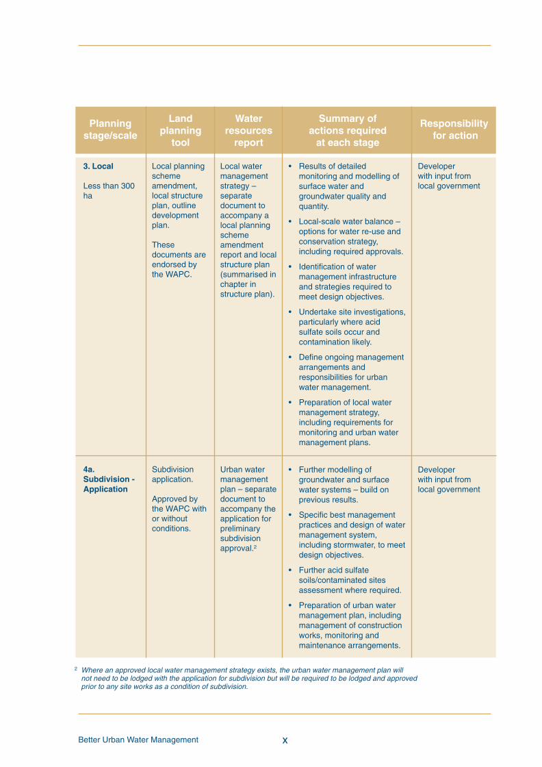
3. Local
Less than 300ha
4a.Subdivision -Application
Developerwith input fromlocal government
Developerwith input fromlocal government
Local watermanagementstrategy –separatedocument toaccompany alocal planningschemeamendmentreport and localstructure plan(summarised inchapter instructure plan).
Urban watermanagementplan – separatedocument toaccompany theapplication forpreliminarysubdivisionapproval.2
• Results of detailedmonitoring and modelling ofsurface water andgroundwater quality andquantity.
• Local-scale water balance –options for water re-use andconservation strategy,including required approvals.
• Identification of watermanagement infrastructureand strategies required tomeet design objectives.
• Undertake site investigations,particularly where acidsulfate soils occur andcontamination likely.
• Define ongoing managementarrangements andresponsibilities for urbanwater management.
• Preparation of local watermanagement strategy,including requirements formonitoring and urban watermanagement plans.
• Further modelling ofgroundwater and surfacewater systems – build onprevious results.
• Specific best managementpractices and design of watermanagement system,including stormwater, to meetdesign objectives.
• Further acid sulfatesoils/contaminated sitesassessment where required.
• Preparation of urban watermanagement plan, includingmanagement of constructionworks, monitoring andmaintenance arrangements.
Local planningschemeamendment,local structureplan, outlinedevelopmentplan.
Thesedocuments areendorsed bythe WAPC.
Subdivisionapplication.
Approved bythe WAPC withor withoutconditions.
2 Where an approved local water management strategy exists, the urban water management plan willnot need to be lodged with the application for subdivision but will be required to be lodged and approvedprior to any site works as a condition of subdivision.
BUWMdoc:Layout 1 21/10/08 2:47 PM Page x
Better Urban Water Managementxi
Land Water Summary ofplanning resources actions requiredtool report at each stage
Planning Responsibilitystage/scale for action
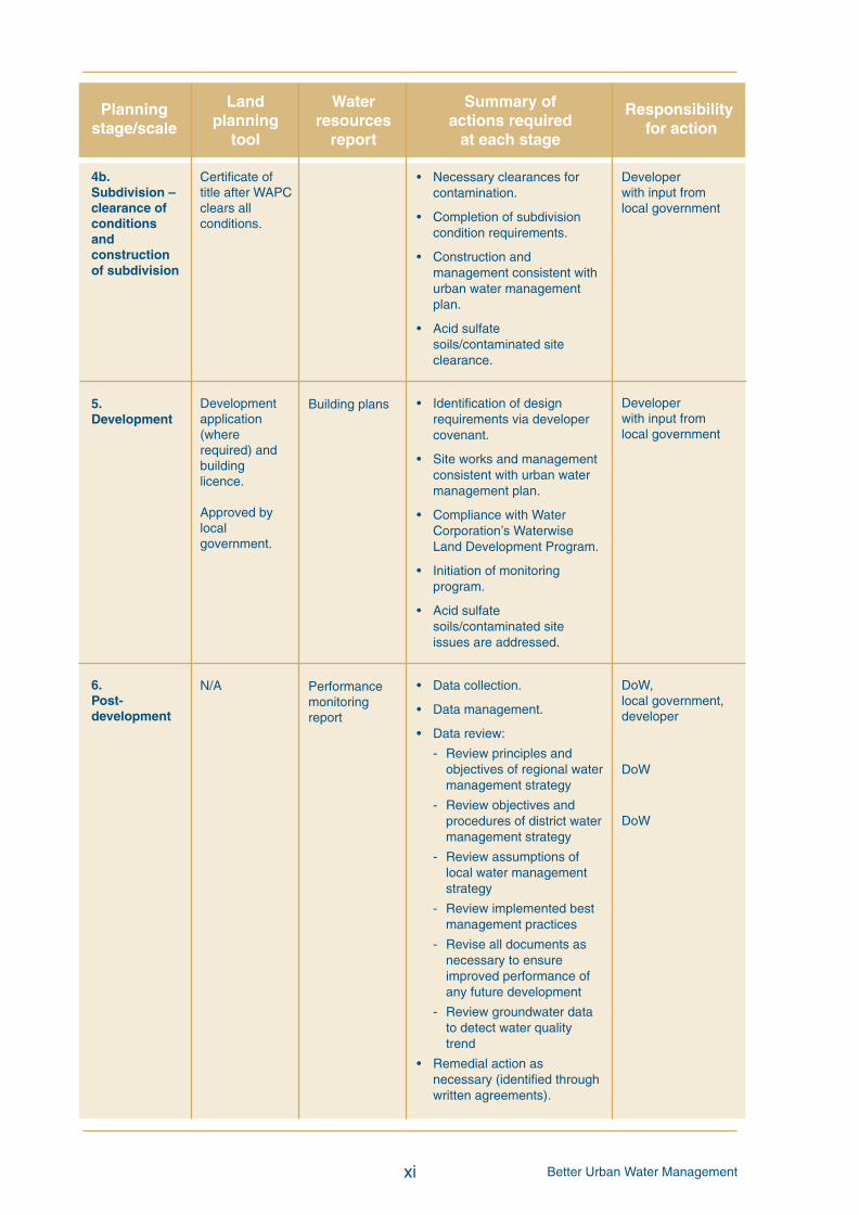
4b.Subdivision –clearance ofconditionsandconstructionof subdivision
5.Development
6.Post-development
Developerwith input fromlocal government
Developerwith input fromlocal government
DoW,local government,developer
DoW
DoW
Building plans
Performancemonitoringreport
• Necessary clearances forcontamination.
• Completion of subdivisioncondition requirements.
• Construction andmanagement consistent withurban water managementplan.
• Acid sulfatesoils/contaminated siteclearance.
• Identification of designrequirements via developercovenant.
• Site works and managementconsistent with urban watermanagement plan.
• Compliance with WaterCorporation’s WaterwiseLand Development Program.
• Initiation of monitoringprogram.
• Acid sulfatesoils/contaminated siteissues are addressed.
• Data collection.
• Data management.
• Data review:
- Review principles andobjectives of regional watermanagement strategy
- Review objectives andprocedures of district watermanagement strategy
- Review assumptions oflocal water managementstrategy
- Review implemented bestmanagement practices
- Revise all documents asnecessary to ensureimproved performance ofany future development
- Review groundwater datato detect water qualitytrend
• Remedial action asnecessary (identified throughwritten agreements).
Certificate oftitle after WAPCclears allconditions.
Developmentapplication(whererequired) andbuildinglicence.
Approved bylocalgovernment.
N/A
BUWMdoc:Layout 1 21/10/08 2:47 PM Page xi

Better Urban Water Management xii
BUWMdoc:Layout 1 21/10/08 2:47 PM Page xii
Better Urban Water Managementxiii
Contents
Acknowledgement v
Executive summary vii
1 Introduction 1
1.1 Integrated water cycle management 1
1.2 Policy basis 2
1.3 Design objectives for water sensitive urban design 3
1.4 Planning and integrated water cycle management 4
1.5 Glossary 6
2 TheWA land use planning system 7
2.1 Planning tools 7
2.2 Planning process 7
3 Applying the approach 11
3.1 Linking land and water planning 13
3.2 Founding principles 15
4 Process to integrate water management into the planning system 17
4.1 Stage 1: Regional and sub-regional land and water planning 17
4.2 Stage 2: District planning 20
4.3 Stage 2: Local planning strategy 23
4.4 Stage 3: Local planning – local planning scheme amendment 25
4.5 Stage 3: Local planning – local structure plan 27
4.6 Stage 4a: Application for subdivision 31
4.7 Stage 4b: Construction of subdivision 34
4.8 Stage 5: Development 35
5 References 37
BUWMdoc:Layout 1 21/10/08 2:47 PM Page xiii

Better Urban Water Management
Figures and tables
Figure 1: Managing water resources in an urban development context 1
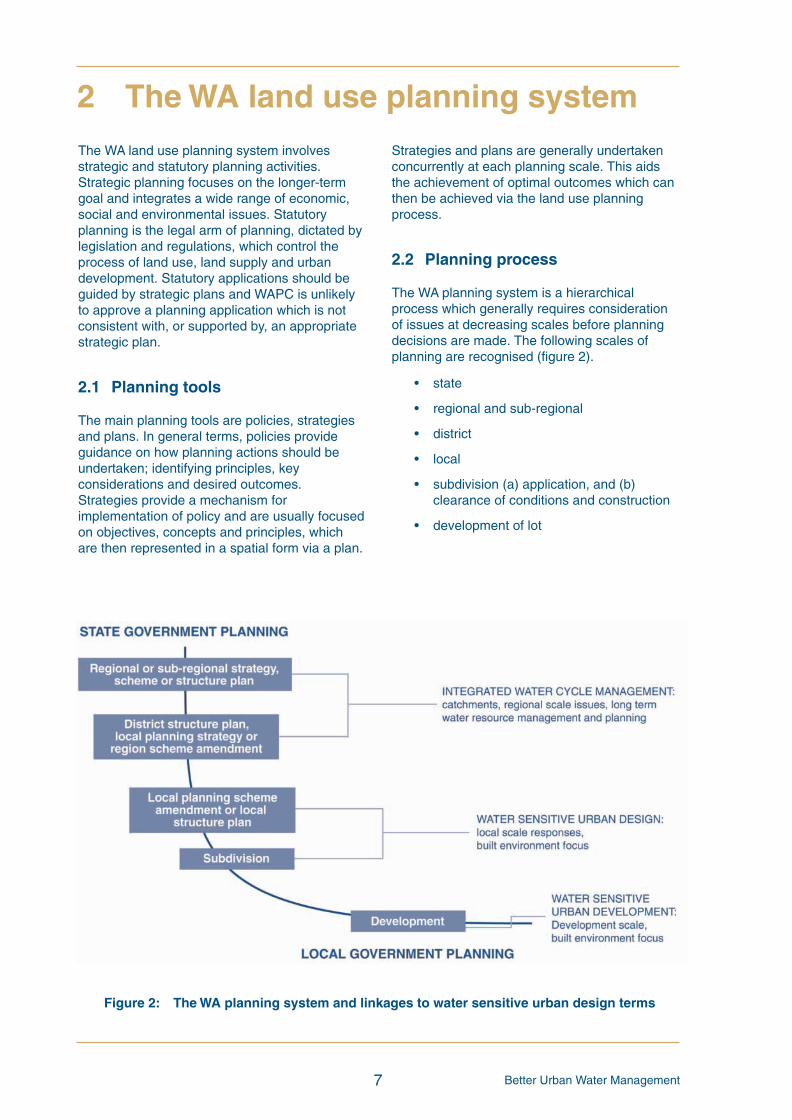
Figure 2: The WA planning system and linkages to water-sensitive urbandesign terms 7
Figure 3: The water planning framework, as depicted in the State Water Plan 13
Figure 4: Integrating water planning with land planning processes 14
Table 1: Summary of the planning process for achieving integrated water cyclemanagement and the accountability for each stage viii
Table 2: Scales of the land use planning system and relevant planning tools 8
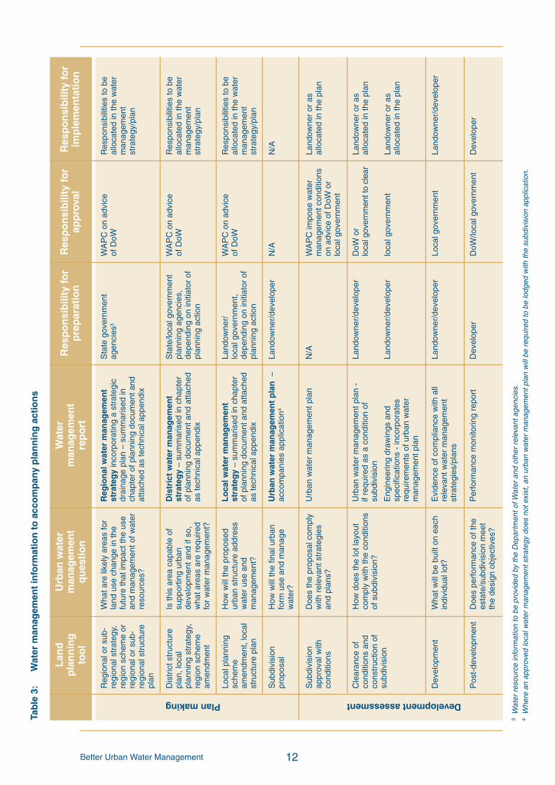
Table 3: Water management information to accompany planning actions 12
Appendix 1: Checklists to aid the preparation of water managementstrategy documents 39
xiv
BUWMdoc:Layout 1 21/10/08 2:47 PM Page xiv

Better Urban Water Management
Most areas proposed for future development inthe Perth, Peel and the South-West regionshave significant water resource managementissues. Integrated water cycle management hasbeen proposed as the most effective way tomanage these resources in an urbandevelopment context, to achieve more efficientand effective use of water and better outcomesfor the environment and urban form.
Better Urban Water Management provides aprocess for achieving better management ofurban water through the application of integratedwater cycle management via the planningsystem of Western Australia.
1.1 Integrated water cyclemanagement
The urban water cycle should be managed as asingle system in which all urban water flows arerecognised as a potential resource and wherethe interconnectedness of water supply,groundwater, stormwater, wastewater, flooding,water quality, wetlands, watercourses, estuariesand coastal waters is recognised. Waterefficiency, re-use and recycling are integralcomponents of total water cycle management.
The National Water Commission has definedintegrated urban water cycle management as:
“The integration of water supply, sewerageand stormwater, so that water is usedoptimally within a catchment resource, stateand national policy context. It promotes thecoordinated planning, development andmanagement of water, land and relatedresources (including energy use) that arelinked to urban areas and the application ofwater-sensitive urban design principles inthe built urban environment.”
This is depicted in Figure 1 (from the NationalWater Initiative).
As outlined in State Planning Policy 2.9 WaterResources (Government of WA, 2006), the keyprinciples of integrated water cycle managementare:
1. consideration of all water resources,including wastewater, in water planning;
2. integration of water and land use planning;
3. the sustainable and equitable use of allwater sources, having consideration of theneeds of all water users, including thecommunity, industry and the environment;
1
1 Introduction
Figure 1: Managing water resources in an urban development context(Source: Adapted from National Water Commission, 2007)
BUWMdoc:Layout 1 21/10/08 2:47 PM Page 1
Better Urban Water Management
4. integration of human water use and naturalwater processes; and
5. a whole-of-catchment integration of naturalresource use and management.
Achievement of integrated urban watermanagement may be facilitated through theuse of water sensitive urban design techniquesemployed during planning, design andconstruction of urban developments. Thisdesign, developed in Western Australia in the1980s for urban planning and design, providesa framework for minimising the impact ofurbanisation on the natural water cycle. Itaddresses water quality, water quantity andwater conservation, together with other socialand environmental objectives.
General objectives of water sensitive urbandesign are (adapted from the StormwaterManagement Manual for WA, 2004-2007):
1. To manage a water regime.
• Maintain appropriate aquifer levels,recharge and surface watercharacteristics in accordance withassigned beneficial uses;
• Manage groundwater rechargesustainably;
• Prevent flood damage in developedareas; and
• Prevent excessive erosion of waterways,slopes and banks.
2. To maintain and, where possible, enhancewater quality.
• Minimise waterborne sediment loading;
• Protect riparian vegetation;
• Minimise the export of pollutants such asphosphorus and nitrogen to surface orgroundwater;
• Prevent groundwater acidificationprocesses; and
• Minimise the export and impact ofpollution from sewerage.
3. To encourage water conservation.
• Minimise the import and use of schemewater;
• Promote the sustainable use of rainwater;
• Promote the sustainable re-use andrecycling of wastewater;
• Reduce irrigation requirements; and
• Promote opportunities for localisedsupply.
4. To maintain and, where possible, enhancewater-related environmental values; and
5. To enhance water-related recreational andcultural values.
Principles of stormwater management as acomponent of water sensitive urban design areto (adapted from the Stormwater ManagementManual for WA, 2004-2007):
• Protect natural systems – protect andenhance natural water systems and theirhydrological regimes in urbandevelopments;
• Integrate stormwater treatment into thelandscape – use stormwater in thelandscape by incorporating multi-usecorridors that maximise the visual andrecreational amenity of developments;
• Protect water quality – protect fromdraining from urban development andminimise outputs of phosphorous,nitrogen and other pollutants;
• Manage run-off and peak flows – reducepeak flows from urban developments byusing local detention measures andminimising impervious areas; and
• Add value while minimising developmentcosts – minimise the drainageinfrastructure cost of development.
1.2 Policy basis
The State Government has recognised the needfor integrated water cycle management andwater sensitive urban design to better integrateland and water planning through policystatements such as:
• State Water Plan (2007)
• State Water Strategy (2003)
2
BUWMdoc:Layout 1 21/10/08 2:47 PM Page 2
Better Urban Water Management
• Government Response to the IrrigationReview (2005)
• A Blueprint for Water Reform in WesternAustralia (2006)
• Draft Healthy Rivers Action Plan (SRT,2006)
• State Planning Policy 2 Environmentand Natural Resources (2003)
• State Planning Policy 2.9 WaterResources (2006)
• State Planing Policy 2.10 Swan CanningRiver System (2006)
• Planning Bulletin 64 Acid Sulfate Soils(2003)
• Planning Bulletin 92 Urban WaterManagement (2008)
The State Water Strategy (Government of WA,2003) identifies the importance of strategicplanning for water resources, together with theneed for an increased focus on total water cyclemanagement and water sensitive urban designto improve the management of stormwater andincrease the efficiency of the use of water.
1.3 Design objectives for watersensitive urban design
The following design criteria are to be used as aguide for development of the urban watermanagement system for strategic planning,subdivision and development, unless otherspecific objectives have been defined in otherapproved water management plans/strategies.Demonstration of compliance with these designobjectives may be through appropriate computermodelling or other assessment methodsacceptable to DoW.
Water Conservation – and efficiency
Principle
No potable water should be used outside ofhomes and buildings with the use of water to beas efficient as possible.
Design objectives
Consumption target for water of 100kL/person/yr, (State Water Plan target) includingnot more than 40-60 kL/person/yr scheme water.
Water quantity management
Principle
Post-development annual discharge volume andpeak flow be maintained relative to pre-development conditions, unless otherwiseestablished through determination of ecologicalwater requirements for sensitive environments.
Criteria
Ecological Protection - For the critical one yearaverage recurrence interval (ARI) event, thepost-development discharge volume and peakflow rates shall be maintained relative to pre-development conditions in all parts of thecatchment. Where there are identified impactson significant ecosystems, maintain or restoredesirable environmental flows and/orhydrological cycles as specified by DoW.
Flood Management - Manage the catchmentrun-off for up to the 1 in 100 year ARI event inthe development area to pre-development peakflows, unless otherwise indicated in an approvedstrategy or as negotiated with the relevantdrainage service provider.
Water quality management
Principle
Maintain surface and ground water quality atpre-development levels (winter concentrations)and, if possible, improve the quality of waterleaving the development area to maintain andrestore ecological systems in the sub-catchmentin which the development is located.
Criteria
Contaminated sites - To be managed inaccordance with the Contaminated Sites Act2003.
All other land - If the pollutant outputs ofdevelopment (measured or modelledconcentrations) exceed catchment ambientconditions, the proponent shall achieve waterquality improvements in the development areaor, alternatively, arrange equivalent water quality
3
BUWMdoc:Layout 1 21/10/08 2:47 PM Page 3
Better Urban Water Management
improvement offsets inside the catchment. Ifthese conditions have not been determined, thedevelopment should meet relevant water qualityguidelines stipulated in the National WaterQuality Management Strategy (ANZECC andARMCANZ, 2000).
Drainage - Ensure that all run-off contained inthe drainage infrastructure network receivestreatment prior to discharge to a receivingenvironment consistent with the StormwaterManagement Manual.
In addition, all outflows from subsoils shouldreceive treatment prior to discharge to thestormwater system.
Stormwater modelling criteria
If it is proposed to use a stormwater modellingtool to demonstrate compliance with designobjectives, the following design modellingparameters are recommended.
As compared to a development that does notactively manage stormwater quality:
• At least 80 per cent reduction of totalsuspended solids
• At least 60 per cent reduction of totalphosphorus
• At least 45 per cent reduction of totalnitrogen
• At least 70 per cent reduction of grosspollutants
Disease vector and nuisance insectmanagement
To reduce health risks from mosquitoes,retention and detention treatments should bedesigned to ensure that between the months ofNovember and May, detained immobilestormwater is fully infiltrated in a time period notexceeding 96 hours.
Permanent water bodies are discouraged, butwhere accepted by DoW, must be designed tomaximise predation of mosquito larvae by nativefauna to the satisfaction of the local governmenton advice of the Departments of Water andHealth.
1.4 Planning and integrated watercycle management
The planning system has a significant role toplay in the achievement of total water cyclemanagement and water sensitive urban designvia strategic planning and the statutoryapprovals process. Better urban watermanagement can be achieved through capacitybuilding and assessing new development toensure the principles and practices of integratedwater cycle management are incorporated intothe design and development of new urban andredevelopment areas. The consideration ofwater issues must be integrated with otherplanning and development matters, includingnatural resource management issues, so thatland and water planning are undertakenconcurrently, rather than independently andconsecutively. The consideration of water shouldbe founded on sustainability principles, where acomprehensive range of issues is assessedusing a triple-bottom-line approach.
State Planning Policy 2.9 Water Resources(Government of WA, 2006) requires land useplanning to contribute to the protection and wisemanagement of water resources by ensuringlocal and regional land use planning strategies,structure plans, schemes, subdivisions, stratasubdivision and development applications takeinto account total water cycle management andwater sensitive urban design principles (outlinedin schedule 4). It also ensures that developmentis consistent with current best managementpractices and best planning practices for thesustainable use of water resources, particularlystormwater, which is currently defined by thecontent of State Planning Policy 2.9 WaterResources and the Stormwater ManagementManual for Western Australia. LiveableNeighbourhoods (WAPC, 2007) defines bestplanning practices for urban water managementand includes specific requirements in element 5.Element 4 of Liveable Neighbourhoods alsocontains guidance on integrating stormwater intopublic parkland.
This document is focused on one element ofconsideration – water. The purpose of thisdocument is to demonstrate how theconsideration of water resources can beintegrated into the land use planning system toensure best practice urban water management
4
BUWMdoc:Layout 1 21/10/08 2:47 PM Page 4
Better Urban Water Management
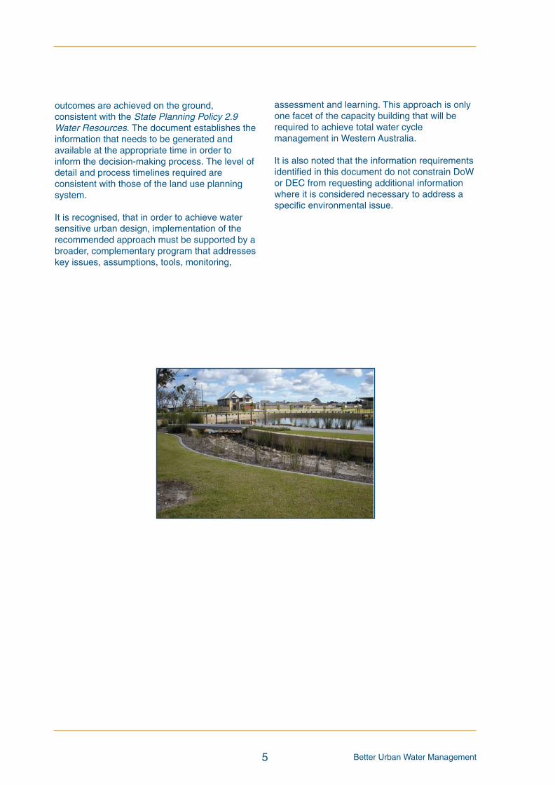
outcomes are achieved on the ground,consistent with the State Planning Policy 2.9Water Resources. The document establishes theinformation that needs to be generated andavailable at the appropriate time in order toinform the decision-making process. The level ofdetail and process timelines required areconsistent with those of the land use planningsystem.
It is recognised, that in order to achieve watersensitive urban design, implementation of therecommended approach must be supported by abroader, complementary program that addresseskey issues, assumptions, tools, monitoring,
5
assessment and learning. This approach is onlyone facet of the capacity building that will berequired to achieve total water cyclemanagement in Western Australia.
It is also noted that the information requirementsidentified in this document do not constrain DoWor DEC from requesting additional informationwhere it is considered necessary to address aspecific environmental issue.
BUWMdoc:Layout 1 21/10/08 2:47 PM Page 5
Better Urban Water Management 6
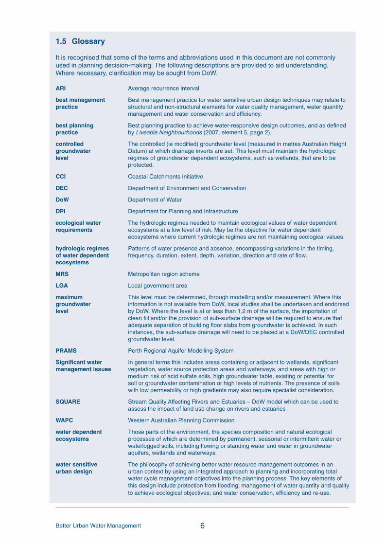
1.5 Glossary
It is recognised that some of the terms and abbreviations used in this document are not commonlyused in planning decision-making. The following descriptions are provided to aid understanding.Where necessary, clarification may be sought from DoW.
ARI Average recurrence interval
best management Best management practice for water sensitive urban design techniques may relate topractice structural and non-structural elements for water quality management, water quantity
management and water conservation and efficiency.
best planning Best planning practice to achieve water-responsive design outcomes, and as definedpractice by Liveable Neighbourhoods (2007, element 5, page 2).
controlled The controlled (ie modified) groundwater level (measured in metres Australian Heightgroundwater Datum) at which drainage inverts are set. This level must maintain the hydrologiclevel regimes of groundwater dependent ecosystems, such as wetlands, that are to be
protected.
CCI Coastal Catchments Initiative
DEC Department of Environment and Conservation
DoW Department of Water
DPI Department for Planning and Infrastructure
ecological water The hydrologic regimes needed to maintain ecological values of water dependentrequirements ecosystems at a low level of risk. May be the objective for water dependent
ecosystems where current hydrologic regimes are not maintaining ecological values.
hydrologic regimes Patterns of water presence and absence, encompassing variations in the timing,of water dependent frequency, duration, extent, depth, variation, direction and rate of flow.ecosystems
MRS Metropolitan region scheme
LGA Local government area
maximum This level must be determined, through modelling and/or measurement. Where thisgroundwater information is not available from DoW, local studies shall be undertaken and endorsedlevel by DoW. Where the level is at or less than 1.2 m of the surface, the importation of
clean fill and/or the provision of sub-surface drainage will be required to ensure thatadequate separation of building floor slabs from groundwater is achieved. In suchinstances, the sub-surface drainage will need to be placed at a DoW/DEC controlledgroundwater level.
PRAMS Perth Regional Aquifer Modelling System
Significant water In general terms this includes areas containing or adjacent to wetlands, significantmanagement issues vegetation, water source protection areas and waterways, and areas with high or
medium risk of acid sulfate soils, high groundwater table, existing or potential forsoil or groundwater contamination or high levels of nutrients. The presence of soilswith low permeability or high gradients may also require specialist consideration.
SQUARE Stream Quality Affecting Rivers and Estuaries – DoW model which can be used toassess the impact of land use change on rivers and estuaries
WAPC Western Australian Planning Commission
water dependent Those parts of the environment, the species composition and natural ecologicalecosystems processes of which are determined by permanent, seasonal or intermittent water or
waterlogged soils, including flowing or standing water and water in groundwateraquifers, wetlands and waterways.
water sensitive The philosophy of achieving better water resource management outcomes in anurban design urban context by using an integrated approach to planning and incorporating total
water cycle management objectives into the planning process. The key elements ofthis design include protection from flooding; management of water quantity and qualityto achieve ecological objectives; and water conservation, efficiency and re-use.
BUWMdoc:Layout 1 21/10/08 2:47 PM Page 6
Better Urban Water Management
The WA land use planning system involvesstrategic and statutory planning activities.Strategic planning focuses on the longer-termgoal and integrates a wide range of economic,social and environmental issues. Statutoryplanning is the legal arm of planning, dictated bylegislation and regulations, which control theprocess of land use, land supply and urbandevelopment. Statutory applications should beguided by strategic plans and WAPC is unlikelyto approve a planning application which is notconsistent with, or supported by, an appropriatestrategic plan.
2.1 Planning tools
The main planning tools are policies, strategiesand plans. In general terms, policies provideguidance on how planning actions should beundertaken; identifying principles, keyconsiderations and desired outcomes.Strategies provide a mechanism forimplementation of policy and are usually focusedon objectives, concepts and principles, whichare then represented in a spatial form via a plan.
Strategies and plans are generally undertakenconcurrently at each planning scale. This aidsthe achievement of optimal outcomes which canthen be achieved via the land use planningprocess.
2.2 Planning process
The WA planning system is a hierarchicalprocess which generally requires considerationof issues at decreasing scales before planningdecisions are made. The following scales ofplanning are recognised (figure 2).
• state
• regional and sub-regional
• district
• local
• subdivision (a) application, and (b)clearance of conditions and construction
• development of lot
7
2 TheWA land use planning system
Figure 2: TheWA planning system and linkages to water sensitive urban design terms
BUWMdoc:Layout 1 21/10/08 2:47 PM Page 7

Better Urban Water Management
Ideally, the planning process commences at thestate level and becomes more detailed as itprogresses through regional, district and localplanning to subdivision, through to constructionof the subdivision and subsequent lots (housingor development). This is depicted in figure 2which links the planning stages of the WAsystem with the terminology proposed by theNational Water Initiative (figure 1).
The stage of planning is generally indicated bythe area of coverage (scale) and correspondingplanning tool (table 2), although it is recognisedthat individual interpretations may vary from this.The planning stage is also representative of the
type of planning decision being made, asevidenced by the planning tools which are usedat different stages of the planning system. Therange of planning tools are identified in table 2and discussed in more detail in sections 2.2.1 to2.2.6, as well as in sections 4.1 to 4.8.
2.2.1 State level
Direction for future land use and development ofWestern Australia is provided by the StatePlanning Policy 1 State Planning Framework.This framework sets out the general principlesfor planning and development and bringstogether existing state and regional policies,
8
Indicative Strategic Statutoryarea of planning planningcoverage tool tool
Planning Responsibilitystage/scale for approval
1. Regional andsub-regionalplanning
2. Districtplanning
3. Localplanning
4. Stage a:application forsubdivision
Stage b:construction ofsubdivision
6. Development
WAPC
WAPC
WAPC/local government
WAPC
WAPC/local government/DPI
Local government
Regional/sub-regionalstrategy, regional/sub-regional structure plan
District structure planDevelopment guide planLocal planning strategy
Local structure plan/local area plan/outline developmentplan
Detailed area plan
>1 Localgovernmentarea (LGA)
Generally > 300ha (may not bein inner metroareas), may be>1 LGA
< 300 ha
Large > 20 haSmall < 20 ha
Lot
Table 2: Scales of the land use planning system and relevant planning tools.
Region scheme
Region schemeamendmentLocal planning scheme
Local planning schemeamendmentLocal structure plan/local area plan/outline developmentplan
Subdivision applicationwith conditionsDetailed area plan
Clearance of conditionsIssuing of title
Developmentapplication (sometimes)Building licenceDeveloper covenantLocal planning policyLocal laws
BUWMdoc:Layout 1 21/10/08 2:47 PM Page 8
Better Urban Water Management
strategies and guidelines into a central andcomprehensive framework. It provides a contextfor spatial planning and decision-making by theWAPC, local governments and other responsibleauthorities. In particular, it informs theseauthorities of those aspects of state and regionalpolicy which are to be taken into account, andgiven effect to in order to ensure integrateddecision-making across all aspects of planning.It includes the State Planning Strategy (WAPC,1997) which identifies a vision for the State in2029 and provides a planning response to thechallenges and changes likely to be faced in thefuture.
2.2.2 Regional and sub-regional planning
Regional level planningis generally “high level”strategic planning,which provides abroadscale frameworkfor development of anarea in the medium tolong term (5 to 10+years). Regional orsub-regional land useplanning is usuallyfacilitated by thepreparation of aregional strategy orregional structure plan.These strategies provide the broad frameworkfor planning at the regional and sub-regionallevel and the strategic context for local planningschemes and region schemes. Regionalstrategies identify water management resourcesand issues of regional significance which can beused to underpin planning controls in region andlocal schemes.
Region schemes provide the statutorymechanism to implement regional strategies,coordinate the provision of major infrastructureand set aside areas for regional open space andother community purposes. The reservation ofland for public space or catchment protection isfundamental to protecting and managingsignificant water resources and acquiring landfor public use and enjoyment.
Although Liveable Neighbourhoods (WAPC,2007) groups regional structure plans withdistrict structure plans, the approach outlined inthis document proposes to distinguish between
them. Regional structure plans are generallyprepared by state government and generallycover more than one local government area.They provide regional guidance in areas whereno region scheme exists.
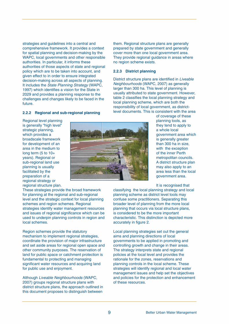
2.2.3 District planning
District structure plans are identified in LiveableNeighbourhoods (WAPC, 2007) as generallylarger than 300 ha. This level of planning isusually attributed to state government. However,table 2 classifies the local planning strategy andlocal planning scheme, which are both theresponsibility of local government, as district-level documents. This is consistent with the area
of coverage of theseplanning tools, asthey tend to apply toa whole localgovernment area whichis generally greaterthan 300 ha in size,with the exceptionof the inner Perthmetropolitan councils.A district structure planmay also apply to anarea less than the localgovernment area.
It is recognised thatclassifying the local planning strategy and localplanning scheme as district level tools mayconfuse some practitioners. Separating thisbroader level of planning from the more localplanning that occurs via local structure plans,is considered to be the more importantcharacteristic. This distinction is depicted moreaccurately in figure 2.
Local planning strategies set out the generalaims and planning directions of localgovernments to be applied in promoting andcontrolling growth and change in their areas.The strategy interprets state and regionalpolicies at the local level and provides therationale for the zones, reservations andplanning controls in the local scheme. Thesestrategies will identify regional and local watermanagement issues and help set the objectivesand policies for the protection and enhancementof these resources.
9
BUWMdoc:Layout 1 21/10/08 2:47 PM Page 9

Better Urban Water Management
Local planningschemes provide thestatutorymechanisms toimplement strategiesthrough zonings,reservations andplanning controls.These schemes mayapply to all or part ofa local governmentarea and arechanged through anamendment processwhere supported by strategic planning and thelocal government.
2.2.4 Local planning
Planning at the local level is guided by the“higher level” strategic planning. This level ofdetail is enhanced via local structure plans andoutline development plans, which provide thejustification for zones and reserves representedin local planning schemes. They also provideguidance for the future subdivision of land.
2.2.5 Subdivision
The WAPC is responsible for subdivisionapproval. The careful assessment anddetermination of planning and subdivisionapplications is important in ensuring state,regional and local objectives for themanagement of water are met and plans andpolicies put into place.
Subdivision is a two stage process; applicationfor subdivision approval, followed by the issuingof titles following clearance of any subdivisionconditions. Each phase is recognised distinctlyin the document as different agencies areusually responsible for the approvals.
Subdivision applications are accompanied by aplan of subdivision which outlines the detail of lotsizes, streets, public open space and otherpoints of detail. Occasionally this detail is furtherenhanced by detailed area plans which may beprepared for specific areas of a subdivision.Preparation of structure plans and subdivisionapplications should be guided by the objectivesand requirements of Liveable Neighbourhoods(WAPC, 2007).
Following preliminaryapproval of asubdivision application(with or withoutconditions), applicationwill be made by thelandowner for newtitles. These will begranted only after allconditions, if any, havebeen satisfied. Thisusually requires theapproval of both thedetailed engineering
designs for services and roads, and theirsubsequent construction.
2.2.6 Development
Planning at the lot level usually involves thedesign and construction of a dwelling or building.In some instances, this may be controlled by thelocal government via development application,particularly for industrial and commercialbuildings. Few local governments requireplanning approval for a single house orresidence. Building approval is likely to be arequirement and this may provide theopportunity for compliance with developerbuilding covenants, local planning policies orlocal laws.
Applications for single or grouped dwellings,which are located partly in or abutting the SwanRiver Trust Development control area, requiredevelopment approval in accordance withClause 30A of the Metropolitan Region Scheme(MRS).
10
BUWMdoc:Layout 1 21/10/08 2:48 PM Page 10

Better Urban Water Management
The approach outlined in Better Urban WaterManagement should be applied to both newgreenfield and urban renewal projects whereresidential, commercial, industrial and ruralresidential uses and development are proposed,including in rural townsite areas. It is notintended to apply in brownfield or infillcircumstances or to small scale subdivision ordevelopment proposals unless significant watermanagement issues are present.
This document outlines the specific actionsrecommended at each of the six key stages ofplanning. It also establishes the relevant watermanagement report in which this information willbe presented.
It is proposed that reports are appended to therelevant planning reports and a summaryprovided as a chapter of the planning report. Thename of each type of water management reportis proposed, consistent with the respectiveplanning report (table 3). These documentsshould not be confused with water planningdocuments listed in the State Water Plan(Government of WA, 2007) (section 3.1).
The information and investigations required tosupport each water management strategy andplan are detailed in the following sections. Thisinformation, together with an indication of currentresponsibility for the action, is summarised intable 1. Due to the nature of the investigationsand information, it is recommended that all watermanagement strategies and the urban watermanagement plans are prepared and approvedby suitably qualified personnel. In particular,hydrological and hydraulic analyses or design ofdrainage assets is to be undertaken by a designengineer or engineering firm. The designengineer is a person qualified to be a charteredprofessional engineer and an engineering firmis an organisation which primarily employsengineers.
It is recognised that further changes may berequired to structures and governance toachieve efficient planning and management ofwater resources in WA in the future. These andother matters associated with implementation ofthe framework, are being addressed by relevantgovernment agencies.
Guidance on the contents of the watermanagement strategies and plans is provided inappendix 1, which contains checklists to aid thepreparation of each document. The checklistsmay also be used as indicative chapterheadings.
Further site-specific advice regardinginvestigations and content should be soughtfrom the DoW, DEC, Water Corporation or therelevant local government, where necessary.DoW will also provide advice to DPI and localgovernment, consistent with the approachoutlined in this document, regarding theadequacy of each water management strategyand plan as part of the planning referral process.
11
3 Applying the approach
BUWMdoc:Layout 1 21/10/08 2:48 PM Page 11
Better Urban Water Management 12
Land
Urban
water
Water
planning
managem
ent
managem
ent
tool
question
report
Stategovernment
agencies
3
State/localgovernm
ent
planning
agencies,
dependingon
initiatorof
planning
action
Landow
ner/
localgovernm
ent,
dependingon
initiatorof
planning
action
Landow
ner/developer
N/A
Landow
ner/developer
Landow
ner/developer
Landow
ner/developer
Developer
Regionalwatermanagem
ent
strategyincorporatingastrategic
drainage
plan
–summarised
inchapterofplanning
documentand
attached
astechnicalappendix
Districtwatermanagem
ent
strategy–summarised
inchapter
ofplanning
documentand
attached
astechnicalappendix
Localwatermanagem
ent
strategy–summarised
inchapter
ofplanning
documentand
attached
astechnicalappendix
Urban
watermanagem
entplan–
accompanies
application4
Urban
watermanagem
entplan
Urban
watermanagem
entplan-
ifrequiredas
acondition
ofsubdivision
Engineeringdraw
ings
and
specifications
-incorporates
requirementsofurbanwater
managem
entplan
Evidenceofcompliancewith
all
relevantwatermanagem
ent
strategies/plans
Performance
monitoringreport
Whatarelikelyareasfor
land
usechange
inthe
futurethatimpacttheuse
andmanagem
entofw
ater
resources?
Isthisarea
capableof
supportingurban
developm
entand
ifso,
whatareas
arerequired
forwatermanagem
ent?
How
willtheproposed
urbanstructureaddress
wateruseand
managem
ent?
How
willthefinalurban
form
useandmanage
water?
Doestheproposalcomply
with
relevantstrategies
andplans?
How
does
thelotlayout
complywith
theconditions
ofsubdivision?
Whatw
illbe
builton
each
individuallot?
Doesperformance
ofthe
estate/subdivision
meet
thedesign
objectives?
Regionalorsub-
regionalstrategy,
region
schemeor
regionalorsub-
regionalstructure
plan
Districtstructure
plan,local
planning
strategy,
region
scheme
amendm
ent
Localplanning
scheme
amendm
ent,local
structureplan
Subdivision
proposal
Subdivision
approvalwith
conditions
Clearance
ofconditionsand
constructionof
subdivision
Development
Post-developm
ent
WAPCon
advice
ofDoW
WAPCon
advice
ofDoW
WAPCon
advice
ofDoW
N/A
WAPCimpose
water
managem
entconditions
onadvice
ofDoW
orlocalgovernm
ent
DoW
orlocalgovernm
enttoclear
localgovernm
ent
Localgovernm
ent
DoW
/localgovernm
ent
Responsibilitiestobe
allocatedinthewater
managem
ent
strategy/plan
Responsibilitiestobe
allocatedinthewater
managem
ent
strategy/plan
Responsibilitiestobe
allocatedinthewater
managem
ent
strategy/plan
N/A
Landow
neroras
allocatedintheplan
Landow
neroras
allocatedintheplan
Landow
neroras
allocatedintheplan
Landow
ner/developer
Developer
DevelopmentassessmentPlanmaking
Table3:
Watermanagem
entinformationtoaccompanyplanningactions
3WaterresourceinformationtobeprovidedbytheDepartmentofWaterandotherrelevantagencies.
4Whereanapprovedlocalwatermanagementstrategydoesnotexist,anurbanwatermanagementplanwillberequiredtobelodgedwiththesubdivisionapplication.
Responsibilityfor
Responsibilityfor
Responsibilityfor
preparation
approval
implementation
BUWMdoc:Layout 1 21/10/08 2:48 PM Page 12
Better Urban Water Management
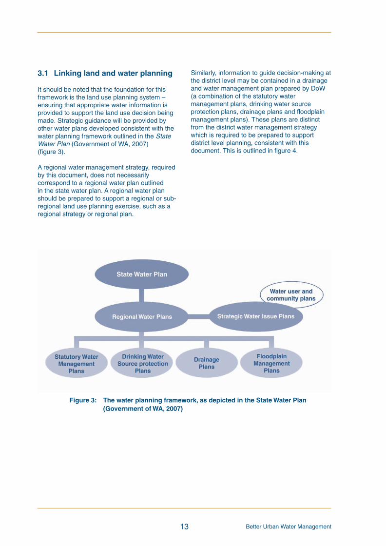
3.1 Linking land and water planning
It should be noted that the foundation for thisframework is the land use planning system –ensuring that appropriate water information isprovided to support the land use decision beingmade. Strategic guidance will be provided byother water plans developed consistent with thewater planning framework outlined in the StateWater Plan (Government of WA, 2007)(figure 3).
A regional water management strategy, requiredby this document, does not necessarilycorrespond to a regional water plan outlinedin the state water plan. A regional water planshould be prepared to support a regional or sub-regional land use planning exercise, such as aregional strategy or regional plan.
13
Figure 3: The water planning framework, as depicted in the StateWater Plan(Government ofWA, 2007)
Similarly, information to guide decision-making atthe district level may be contained in a drainageand water management plan prepared by DoW(a combination of the statutory watermanagement plans, drinking water sourceprotection plans, drainage plans and floodplainmanagement plans). These plans are distinctfrom the district water management strategywhich is required to be prepared to supportdistrict level planning, consistent with thisdocument. This is outlined in figure 4.
BUWMdoc:Layout 1 21/10/08 2:48 PM Page 13

Better Urban Water Management 14
Figure 4: Integrating water planning with land planning processes
BUWMdoc:Layout 1 21/10/08 2:48 PM Page 14

Better Urban Water Management
3.2 Founding principles
Founding principles of the approach outlined inthis document provide guidance on how it shouldbe applied. These principles are:
• Informed decision-making – land useplanning decision-making should bebased on an appropriate level ofinformation;
• Relevance – only issues that are relevantto the site and its surrounds requireinvestigation and discussion, recognisingthat the planning process may not occurin an orderly fashion and that a practicalapproach should be applied whereregional/district-level information islacking, particularly in areas ofdevelopment pressure; and
• Risk management – relevant issuesshould be investigated at a scaleconsistent with land use planningdecision-making and to an extent thataddresses the level of significance of theissue and possible risk to the communityand environment.
3.2.1 Informed decision-making
The process of investigation, from the regionalscale through to the lot level, has been designedto ensure that appropriate information isprovided at the particular stage to inform thetype of decision being made. At the regionalscale, the planning decision should consider theareas likely for land use change in the future andhow the land use change would impact the useand management of water resources. At thedistrict scale, the decision is about whether theland is appropriate to be developed, ie zoned forurban (or other) purposes at some stage in thefuture. At the local scale, the planning decisionshould consider the urban form and how it willimpact water resources and achieve stateddesign objectives and at the lot level, it is abouthow the building and landscaping results inbetter management and use of water resources.The process proposed in this document aims toensure that planning decisions at all levels andscales are founded on adequate information(table 3).
3.2.2 Relevance
This document recommends investigations ofvarying nature and scale at each of the stages ofplanning. It is recognised that although somerequirements are stated, the actual nature and
extent of investigation will depend on the specificsite conditions. Only those matters which arerelevant to the site and surrounds need beaddressed in each document.
The findings of investigations and analysisundertaken for previous planning stages shouldbe used as the basis for further investigation atsubsequent stages. The actions are not intendedto be repeated, rather built on and appropriate tothe scale of the planning action being taken andresponsive to the environmental conditions ofthe site.
The complete process depicted in figure 4 is the“ideal” case, as it describes the actions thatshould be undertaken where limited or noplanning or development has occurred in thepast, or the timing is such that a regional reviewof land use and future development is to beinitiated. It is recognised that this is generallyunlikely to be the case, and consequently aflexible approach to implementation of thisstrategy will be required.
Where some planning has occurred, particularlywhere urban zoning exists, the expectation isthat sufficient information will be gathered toaddress significant water management issues toan appropriate level of detail to support theplanning decision.
15
BUWMdoc:Layout 1 21/10/08 2:48 PM Page 15

Better Urban Water Management
3.2.3 Risk management
The approach outlined in this document aims toensure that key issues are identified as early inthe planning process as possible. For thoseissues unable to be resolved early, but which arenot considered “fatal flaws”, a process should bedeveloped which will ensure the issues areaddressed at a subsequent stage and to anappropriate level of detail. Any issue identified asa potentially fatal flaw should be addressed atthe immediate stage.
As a guide, wherepreliminary investigationssuggest an enhanced levelof risk to the environment,community or waterresource, more detailedinvestigations aresuggested and the level ofattention paid to an issueshould correspond to theassociated level of riskand/or significance.Simplistically, eachmanagement plan shouldidentify significant waterresources and assets aswell as areas of risk (“theunknowns”) and addressthem if the information isavailable, or propose astrategy to address them ata later stage if appropriate.
Issues should not bedeferred until thesubdivision stage. By the time a project hasbeen through regional, district and local structureplanning processes, the issues should havebeen fundamentally addressed and should notrequire resolution at the subdivision stage.
In summary, the key aspects to consider whenapplying this approach are:
• the need for flexibility and practicality inapplication, particularly in areas ofexisting urban zoning;
• to provide information in support of theplanning decision being made;
16
• to consider water-related issues in anoverall sustainability context, where allissues are considered collectively toensure the best overall outcome;
• to highlight issues which should beaddressed at later stages; and
• the scale and nature of the work shouldbe a direct response to the specificissues of the site and the type ofdevelopment proposed.
(courtesy of Swan River Trust)
BUWMdoc:Layout 1 21/10/08 2:48 PM Page 16
Better Urban Water Management17
The proposed process for integrating total watercycle management and water sensitive urbandesign with the planning system is depicted infigure 4. It must be noted that this figure is onlyindicative of the process. It recognises thatalthough the ideal process would be to start withregional planning and to work through thesystem in a timely manner, this does not alwaysoccur. Where the preceding documents have notbeen prepared, or where the information is notavailable, there is a need to apply therecommended approach in a flexible manner,so that appropriate information is provided tosupport the planning decision being made.Information is likely to inform other planningactions at larger as well as smaller scales. Thefollowing sections outline the work required toaddress water issues at each planning stage.
4.1 Stage 1: Regional and sub-regional land andwater planning
A regional or sub-regional land use planningexercise must have consideration of the totalwater cycle and involve a degree of regionalwater planning. This includes identification andmapping of the appropriate surface water/rivercatchments to ensure that a catchmentmanagement approach is facilitated. Acatchment map should be included in theregional structure plan report or strategy.
When a significant change in land use is beingconsidered as part of regional or sub-regionalland use planning, ie where there is pressure fordevelopment, the State Government togetherwith local government should undertakenecessary investigations and analysis(modelling) to allow assessment of the potentialimpact of the proposed land use change on thewater resources of the catchment (eg usingDoW’s SQUARE model). This assessmentshould provide a key input to the final land useplan for the area and should be one of the firststeps in the planning process to ascertainwhether the land is suitable for development.This assessment is currently available in thePeel-Harvey coastal catchment and is being
developed as part of a further FederalGovernment Coastal Catchment Initiative forboth the Swan-Canning and Vasse-Geographecoastal catchments.
Where no modelling tool is available, land likelyto be rezoned should be identified, havingconsideration of existing water resourceinformation, and a commitment made as to howthe necessary water management informationwill be obtained and considered as part of theplanning process.
It is important to note the interrelatedness of thegroundwater and surface water in many parts ofWestern Australia, particularly on the SwanCoastal Plain. In order to address this linkage,a regional (catchment) water balance should beestablished which calculates all water availablein the catchment and allocates it to existinguses, eg environmental and human uses suchas drinking water and irrigation. This will enablea preliminary assessment of how much water willbe available for use subsequent to developmentand aid in the understanding of hydrologicalregimes of water dependent environments tobe protected. It will also provide a preliminaryindication of opportunities for non-drinking watersources for fit-for-purpose uses. The DoW’sregional water plans may also provide this typeof information.
Regional groundwater investigations shouldconsider the range of groundwater levels likelyto result from climate scenarios, including wet,long-term average and dry sequences.A groundwater model is likely to be requiredto undertake this assessment, supported byavailable groundwater monitoring data.This information should be used to aid theinvestigation of the hydrological regime of waterdependent environments, including surfacewater and groundwater dependent ecosystems.It should also inform the setting of any controlledgroundwater level, and preliminary assessmentof the general drainage strategy, including theneed for subsoil drainage and land fillrequirements. Decisions on these issues areneeded as input to development of a strategicdrainage plan for the area.
4 Process to integrate watermanagement into the planningsystem
BUWMdoc:Layout 1 21/10/08 2:48 PM Page 17
Better Urban Water Management 18
It is anticipated that the regional surface andgroundwater investigations, including mappingof the catchment and regionally significant waterdependent environments, will be undertaken bythe relevant state government agency (DoW andDEC respectively), as part of preparation of aregional water plan. For further information onthese plans, refer to the State Water Plan(Government of WA, 2007). Where regionalwater plans have been prepared, they shouldprovide the key input for water planning at aregional level. Further modelling of the results ofthe investigative work, as outlined in the planmay need to occur to provide benchmarks forfuture planning and development. Where a planhas not been prepared, wetland mapping mayneed to be undertaken or reviewed for inclusionin the regional water management strategy.
Natural resource management regional groupsmay be able to provide information (eg South-West, Peel-Harvey and Swan CatchmentCouncils). These groups’ regional strategiescontain information on the natural resources in aregion and propose targets for theirmanagement. Work undertaken by naturalresource management groups is likely to supportboth regional and district water planning.Opportunities exist to align their projects withwater resource information needs through thenatural resource management investmentplanning process.
The regional water management strategy,associated with a regional or sub-regional landuse planning exercise, should:
• recognise the principles, objectives andrequirements of total water cyclemanagement as outlined in StatePlanning Policy 2.9 Water Resources(Government of WA, 2006), LiveableNeighbourhoods (WAPC, 2007) and theStormwater Management Manual for WA,including the decision process forstormwater management (DoW, 2004-2007);
• scope the opportunities for achievingintegrated solutions to regional planningissues and commit to a process ofintegrated assessment and consideration;
• propose local and regional catchmentmanagement objectives and preliminarydesign objectives for all elements of thetotal water cycle. Guidance should beobtained from any DoW regional waterplan. Generic design criteria arecontained in section 1.3. These shouldbe applied in the absence of specificguidance from DoW and DEC;
• undertake necessary groundwater andsurface water monitoring to providesufficient information to build the regionalpicture and inform the land useevaluation;
• identify and map water resources,including estuaries, waterways, wetlands,groundwater and surface water protectionareas, floodplains and foreshores. Alsoidentify areas of native vegetation,environmentally significant areas andexisting drainage networks, consistentwith the requirements of LiveableNeighbourhoods (WAPC, 2007);
• map the surface and groundwatercatchments and sub-catchments at ascale consistent with the proposed plan,and where supported by the land usescenario, use the boundaries as a basisfor defining planning precincts;
• undertake a desktop analysis of past landuse with the potential for contamination,including high levels of nutrients andother contaminants, to inform the landuse evaluation;
BUWMdoc:Layout 1 21/10/08 2:48 PM Page 18

Better Urban Water Management19
• assess water sources for drinking waterand other water needs, identifying anyexisting or future proclaimed watersource catchments. Consider synergieswith management of stormwater,groundwater and wastewater for supplyof fit-for-purpose needs. Identify optionsfor water re-use and commence feasibilityassessment. Assess major infrastructureneeds to maximise the opportunities forachieving integrated water cyclemanagement. Work together with therelevant water service provider whenundertaking water supply and wastewaterplanning. For further guidance seeDeveloping Alternative Water Supplies inthe Perth Metropolitan Area Series(Water Corporation, 2007);
• evaluate land use change scenarios toavoid or minimise significant surface andgroundwater quality and quantity impacts.The use of a computer modelling tool is
Surface andgroundwater mapping,monitoring andmodelling
Desktop historical landuse assessment
Water balancemodelling –catchment level
• Identify and map surface and groundwater catchments and/or sub-catchments,water dependent environments, including watercourses, wetlands, nativevegetation, environmentally significant areas and existing drainage networks.
• Identify areas to be protected for conservation purposes.
• Identify baseline pre-development conditions to facilitate assessment of theproposed land use scenario, including groundwater levels and flow direction,natural or constructed drains and/or overland flow paths, wetlands andgroundwater and surface water quality conditions at the regional (broad) level.
• Identify existing and past land use with the potential for contamination of soiland/or groundwater, including high levels of nutrients and toxicants.
• Identify land having a high risk of acid sulfate soil occurrence consistent withPlanning Bulletin 64 (WAPC, 2003).
• Determine pre-development sub-catchment water balance to inform the landuse scenario assessment, and identification of options for reducing the need toimport drinking water.
• Ensure linkages with infrastructure planning programs to optimise opportunitiesfor fit-for-purpose water usage.
supported at this stage. The final land usescenario should deliver a water qualityoutcome consistent with relevantobjectives;
• depict the location of environmentallysignificant areas, future conservationreserves, multi-use open space corridors,urban bushland belts and greenways,waterway corridors and wetlands to beprotected for conservation; and
• identify future surface and groundwaterquality and quantity, and ecologicalmonitoring required, including theidentification of responsibilities andrequired timing, to support more detailedplanning, particularly the urbanisation ofareas consistent with the assessed landuse scenario.
Information needed to develop a regional water management strategy includes:
BUWMdoc:Layout 1 21/10/08 2:48 PM Page 19
Better Urban Water Management 20
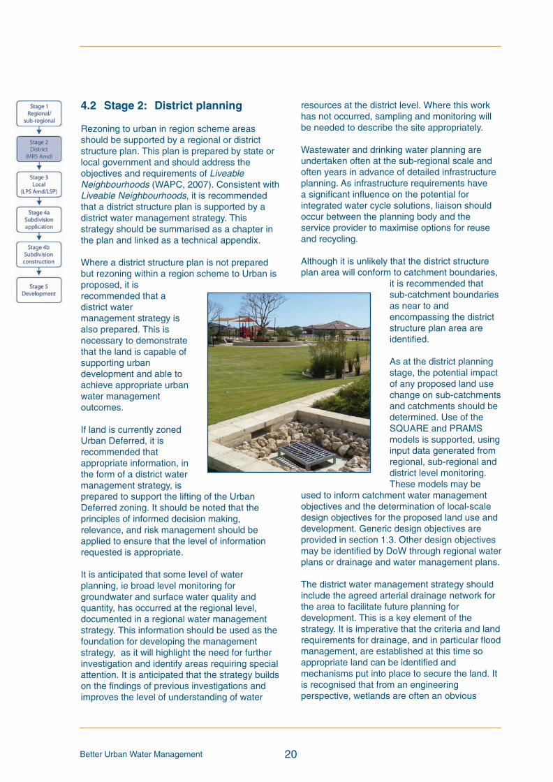
4.2 Stage 2: District planning
Rezoning to urban in region scheme areasshould be supported by a regional or districtstructure plan. This plan is prepared by state orlocal government and should address theobjectives and requirements of LiveableNeighbourhoods (WAPC, 2007). Consistent withLiveable Neighbourhoods, it is recommendedthat a district structure plan is supported by adistrict water management strategy. Thisstrategy should be summarised as a chapter inthe plan and linked as a technical appendix.
Where a district structure plan is not preparedbut rezoning within a region scheme to Urban isproposed, it isrecommended that adistrict watermanagement strategy isalso prepared. This isnecessary to demonstratethat the land is capable ofsupporting urbandevelopment and able toachieve appropriate urbanwater managementoutcomes.
If land is currently zonedUrban Deferred, it isrecommended thatappropriate information, inthe form of a district watermanagement strategy, isprepared to support the lifting of the UrbanDeferred zoning. It should be noted that theprinciples of informed decision making,relevance, and risk management should beapplied to ensure that the level of informationrequested is appropriate.
It is anticipated that some level of waterplanning, ie broad level monitoring forgroundwater and surface water quality andquantity, has occurred at the regional level,documented in a regional water managementstrategy. This information should be used as thefoundation for developing the managementstrategy, as it will highlight the need for furtherinvestigation and identify areas requiring specialattention. It is anticipated that the strategy buildson the findings of previous investigations andimproves the level of understanding of water
resources at the district level. Where this workhas not occurred, sampling and monitoring willbe needed to describe the site appropriately.
Wastewater and drinking water planning areundertaken often at the sub-regional scale andoften years in advance of detailed infrastructureplanning. As infrastructure requirements havea significant influence on the potential forintegrated water cycle solutions, liaison shouldoccur between the planning body and theservice provider to maximise options for reuseand recycling.
Although it is unlikely that the district structureplan area will conform to catchment boundaries,
it is recommended thatsub-catchment boundariesas near to andencompassing the districtstructure plan area areidentified.
As at the district planningstage, the potential impactof any proposed land usechange on sub-catchmentsand catchments should bedetermined. Use of theSQUARE and PRAMSmodels is supported, usinginput data generated fromregional, sub-regional anddistrict level monitoring.These models may be
used to inform catchment water managementobjectives and the determination of local-scaledesign objectives for the proposed land use anddevelopment. Generic design objectives areprovided in section 1.3. Other design objectivesmay be identified by DoW through regional waterplans or drainage and water management plans.
The district water management strategy shouldinclude the agreed arterial drainage network forthe area to facilitate future planning fordevelopment. This is a key element of thestrategy. It is imperative that the criteria and landrequirements for drainage, and in particular floodmanagement, are established at this time soappropriate land can be identified andmechanisms put into place to secure the land. Itis recognised that from an engineeringperspective, wetlands are often an obvious
BUWMdoc:Layout 1 21/10/08 2:48 PM Page 20
Better Urban Water Management21
choice as land for flood storage. Thereforewetlands to be protected, as well as their buffersand hydrological regimes, need to be identifiedprior to identifying land for flood storage, so thatwetlands are not considered for flood storagebeyond their natural regime.
The district water management strategy,supported by findings at the regional and sub-regional level, should:
• recognise the principles, objectives andrequirements of total water cyclemanagement as outlined in the StatePlanning Policy 2.9 Water Resources(Government of WA, 2006), LiveableNeighbourhoods (WAPC, 2007) and theStormwater Management Manual for WA,including the decision process forstormwater management (DoW, 2004-2007);
• state the water quantity and qualitymanagement objectives to be achieved,which address all elements of the totalwater cycle. Guidance is provided insection 1.3;
• broadly describe issues likely to influencethe water management strategy in thestudy area due to existing infrastructure,existing land uses, possible groundwaterpollution plumes and groundwatercapture zones of significant wetlands andother water dependent ecosystems;
• where necessary, undertake moredetailed desktop assessment of past landuse with the potential for contamination,including high levels of nutrients;
• identify areas affected, or potentiallyaffected, by acid sulfate soils;
• discuss potential water sources fordrinking water and other uses, includingirrigation of public open space, havingconsideration of impacts of use/allocationand infrastructure and managementrequirements, highlighting the preferredoptions for supply of non-potable waterfor fit-for-purpose use and givingconsideration to major infrastructureneeds. For further guidance seeDeveloping Alternative Water Suppliesin the Perth Metropolitan Area Series(Water Corporation, 2007);
• report broadscale ecological andsurface and groundwater investigations(monitoring of at least 18 months,including two winters required forgreenfield areas and unmodifiedecosystems – this may be provided bycomprehensive regional monitoringwhere available), modelling andanalysis to provide:
- hydrogeological parameters of thestudy area and relevant catchments,including groundwater levelfluctuations over time and regionalgroundwater flow directions;
- an assessment of regionalgroundwater quality, including residentcatchment and aquifer conditions;
- the hydrological regimes (ecologicalwater requirements) of waterdependent ecosystems to be protectedso that they can be maintained; and
- an assessment of the recommendedland use scenario based on the aboveelements and any suggestedmodifications;
• provide an arterial drainage plan whichidentifies 100 year flow paths and levels,peak flow rates and storagerequirements. This should include adiscussion of appropriate (and likely)stormwater best management practiceoptions to better manage water quantityand quality, derived from the StormwaterManagement Manual for WesternAustralia;
• identify specific issues/areas likely torequire specialised investigation andmanagement at later stages of planning;
• demonstrate understanding ofappropriate water sensitive urban designbest management practices, including forpotable and non-potable water usage, asdefined in the Stormwater ManagementManual for Western Australia (chapter 4),and likely best planning practices to beutilised in the study area;
• provide strategies and recommendationsfor planning precincts to guide andcontrol land uses and development wherenecessary;
BUWMdoc:Layout 1 21/10/08 2:48 PM Page 21
Identify pre- and post-development water balances at the district-level scale toinform the determination of hydrologic regimes of water dependent ecosystemsto be protected and options for use of potable and non-potable water sources.Identify future infrastructure requirements, options and necessary approvals.For further guidance see Developing Alternative Water Supplies in the PerthMetropolitan Area Series (Water Corporation, 2007).
• Monitoring of ecological health and hydrological regime of water dependentenvironments to be protected.
• Determination of hydrologic regimes (ecological water requirements andenvironmental water provisions if necessary) of water dependent environmentsto be protected, and an indicative buffer. Refer to Guidleines for ecologicalwater requirements for urban water management currently being developed bythe DoW for further information.
• Where necessary, further identification and assessment of potentiallycontaminated sites or areas where high nutrients are likely to be found ingroundwater.
• Assessment for presence of acid sulfate soils consistent with PlanningBulletin 64 (WAPC, 2003).
• Assess superficial/surficial groundwater quantity and quality.
• Determine need for controlling the groundwater level and/or to import fill.
• Identify an approach that avoids impacts on water dependent environmentsto be protected.
• Identify potential for short-term or long-term mobilisation of nutrients andcontaminants.
• Mapping of existing natural and/or constructed drainage system andfloodplains.
• Identification of arterial drainage network required to support development,including modelling of 100 year flow paths, levels and storages.
• Demonstration that potential impacts from development on surface waterdependent environments to be protected have been avoided or minimised.Demonstrate that any potential impacts will not have a significantenvironmental impact.
Better Urban Water Management 22
• recommend strategies andresponsibilities for local ecological,surface water and groundwatermonitoring, both pre- and post-development, including data analysis,presentation and reporting mechanisms;and
• recommend an implementationframework identifying funding andongoing maintenance responsibilities,including monitoring and technical reviewof the district-level strategy.
Work required to support the recommendationsin the district water management strategyincludes:
Water balancemodelling – broadscale
Hydrological regime ofwater dependentecosystems andecological health
Desktop historical landuse assessment
Groundwater monitoringand modelling (mainlyfor high watertableareas)
Surface watermonitoring andmodelling
It is not considered appropriate for land to berezoned to urban without completion of thedistrict water management strategy, howeverminor amendments supported by a reduced levelof information may be acceptable on advice ofDoW and other relevant agencies, includingDEC.
Additional guidance on the contents of a districtwater management strategy is provided in thechecklist in appendix 1.
BUWMdoc:Layout 1 21/10/08 2:48 PM Page 22
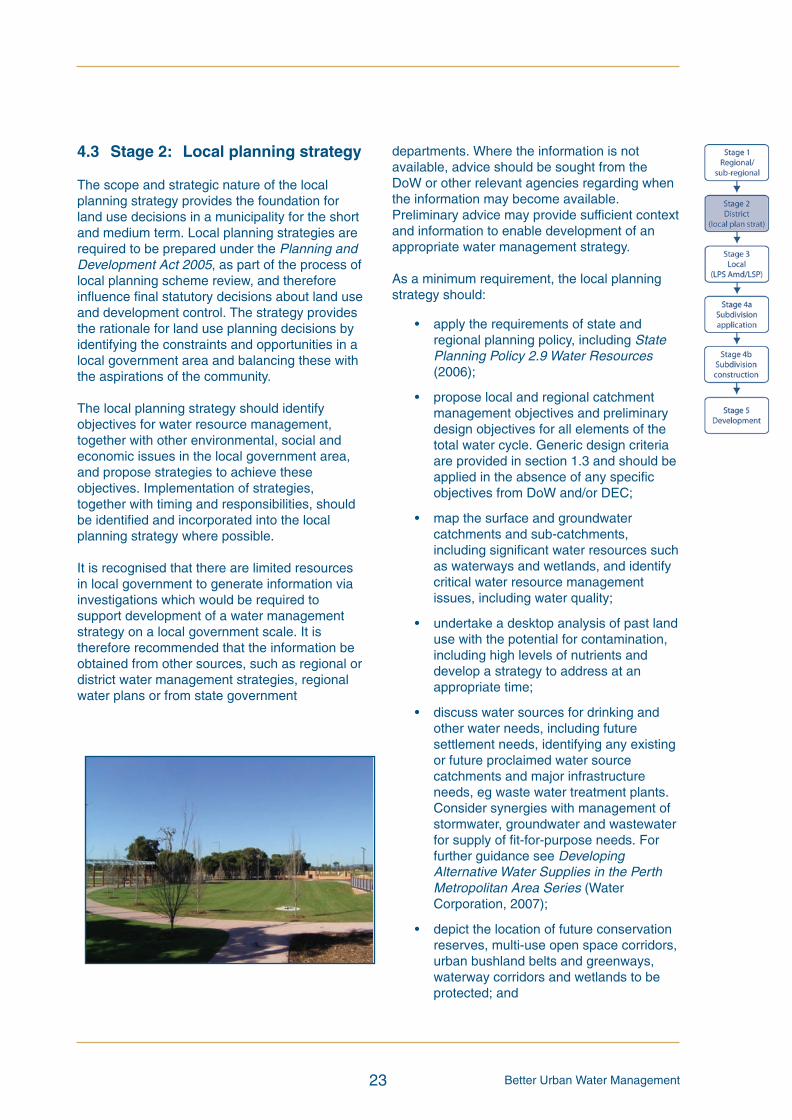
Better Urban Water Management23
4.3 Stage 2: Local planning strategy
The scope and strategic nature of the localplanning strategy provides the foundation forland use decisions in a municipality for the shortand medium term. Local planning strategies arerequired to be prepared under the Planning andDevelopment Act 2005, as part of the process oflocal planning scheme review, and thereforeinfluence final statutory decisions about land useand development control. The strategy providesthe rationale for land use planning decisions byidentifying the constraints and opportunities in alocal government area and balancing these withthe aspirations of the community.
The local planning strategy should identifyobjectives for water resource management,together with other environmental, social andeconomic issues in the local government area,and propose strategies to achieve theseobjectives. Implementation of strategies,together with timing and responsibilities, shouldbe identified and incorporated into the localplanning strategy where possible.
It is recognised that there are limited resourcesin local government to generate information viainvestigations which would be required tosupport development of a water managementstrategy on a local government scale. It istherefore recommended that the information beobtained from other sources, such as regional ordistrict water management strategies, regionalwater plans or from state government
departments. Where the information is notavailable, advice should be sought from theDoW or other relevant agencies regarding whenthe information may become available.Preliminary advice may provide sufficient contextand information to enable development of anappropriate water management strategy.
As a minimum requirement, the local planningstrategy should:
• apply the requirements of state andregional planning policy, including StatePlanning Policy 2.9 Water Resources(2006);
• propose local and regional catchmentmanagement objectives and preliminarydesign objectives for all elements of thetotal water cycle. Generic design criteriaare provided in section 1.3 and should beapplied in the absence of any specificobjectives from DoW and/or DEC;
• map the surface and groundwatercatchments and sub-catchments,including significant water resources suchas waterways and wetlands, and identifycritical water resource managementissues, including water quality;
• undertake a desktop analysis of past landuse with the potential for contamination,including high levels of nutrients anddevelop a strategy to address at anappropriate time;
• discuss water sources for drinking andother water needs, including futuresettlement needs, identifying any existingor future proclaimed water sourcecatchments and major infrastructureneeds, eg waste water treatment plants.Consider synergies with management ofstormwater, groundwater and wastewaterfor supply of fit-for-purpose needs. Forfurther guidance see DevelopingAlternative Water Supplies in the PerthMetropolitan Area Series (WaterCorporation, 2007);
• depict the location of future conservationreserves, multi-use open space corridors,urban bushland belts and greenways,waterway corridors and wetlands to beprotected; and
BUWMdoc:Layout 1 21/10/08 2:48 PM Page 23

Better Urban Water Management 24
• propose a strategy to ensure that surfaceand groundwater quality and quantityinformation is available at an appropriatetime to inform future land use planningdecisions.
Work required to support the recommendationsin the local planning strategy includes:
Surface andgroundwater mapping
Desktop historical landuse assessment
• Map surface and groundwater catchments and/or sub-catchments, includingwater source protection areas.
• Show water dependent environments (eg wetlands, watercourses, estuaries),regionally significant vegetation/ habitat to be protected and indicative buffers.
• Identify existing and past land use with the potential for contamination of soiland/or groundwater, including high levels of nutrients.
• Identify land having a high risk of acid sulfate soils consistent with PlanningBulletin 64 (WAPC, 2003).
Where supported by a regional or district watermanagement strategy, the local planningstrategy may address water resourcemanagement in more detail, providing anindication of current conditions, identifying riskareas and making recommendations for futureaction. Where a regional planning strategy/structure plan has not been undertaken, a localgovernment may wish the strategy to addressthe issues identified in section 4.2, to provideguidance necessary for future local-levelplanning consistent with the local planningstrategy.
BUWMdoc:Layout 1 21/10/08 2:48 PM Page 24
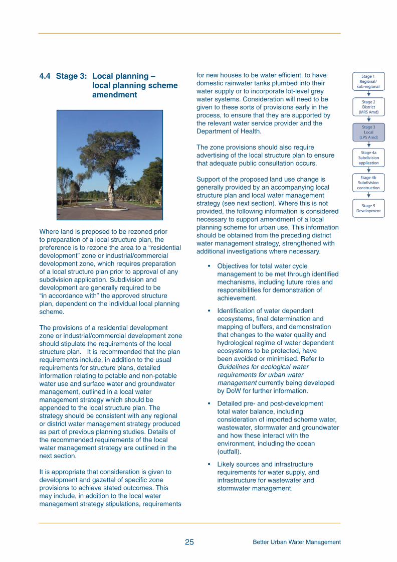
Better Urban Water Management25
4.4 Stage 3: Local planning –local planning schemeamendment
Where land is proposed to be rezoned priorto preparation of a local structure plan, thepreference is to rezone the area to a “residentialdevelopment” zone or industrial/commercialdevelopment zone, which requires preparationof a local structure plan prior to approval of anysubdivision application. Subdivision anddevelopment are generally required to be“in accordance with” the approved structureplan, dependent on the individual local planningscheme.
The provisions of a residential developmentzone or industrial/commercial development zoneshould stipulate the requirements of the localstructure plan. It is recommended that the planrequirements include, in addition to the usualrequirements for structure plans, detailedinformation relating to potable and non-potablewater use and surface water and groundwatermanagement, outlined in a local watermanagement strategy which should beappended to the local structure plan. Thestrategy should be consistent with any regionalor district water management strategy producedas part of previous planning studies. Details ofthe recommended requirements of the localwater management strategy are outlined in thenext section.
It is appropriate that consideration is given todevelopment and gazettal of specific zoneprovisions to achieve stated outcomes. Thismay include, in addition to the local watermanagement strategy stipulations, requirements
for new houses to be water efficient, to havedomestic rainwater tanks plumbed into theirwater supply or to incorporate lot-level greywater systems. Consideration will need to begiven to these sorts of provisions early in theprocess, to ensure that they are supported bythe relevant water service provider and theDepartment of Health.
The zone provisions should also requireadvertising of the local structure plan to ensurethat adequate public consultation occurs.
Support of the proposed land use change isgenerally provided by an accompanying localstructure plan and local water managementstrategy (see next section). Where this is notprovided, the following information is considerednecessary to support amendment of a localplanning scheme for urban use. This informationshould be obtained from the preceding districtwater management strategy, strengthened withadditional investigations where necessary.
• Objectives for total water cyclemanagement to be met through identifiedmechanisms, including future roles andresponsibilities for demonstration ofachievement.
• Identification of water dependentecosystems, final determination andmapping of buffers, and demonstrationthat changes to the water quality andhydrological regime of water dependentecosystems to be protected, havebeen avoided or minimised. Refer toGuidelines for ecological waterrequirements for urban watermanagement currently being developedby DoW for further information.
• Detailed pre- and post-developmenttotal water balance, includingconsideration of imported scheme water,wastewater, stormwater and groundwaterand how these interact with theenvironment, including the ocean(outfall).
• Likely sources and infrastructurerequirements for water supply, andinfrastructure for wastewater andstormwater management.
BUWMdoc:Layout 1 21/10/08 2:48 PM Page 25

Better Urban Water Management 26
• Discussion of existing superficial/surficialgroundwater quality and quantity basedon a refinement of the regional/districtlevel information. It is anticipated thatpreliminary site investigative work isundertaken including geotechnicalinvestigation and groundwater sampling.
• A more detailed assessment of past landuse in high-risk areas, including soil typesand nutrient pathways.
• Description of existing stormwatermanagement infrastructure and naturalsystems (including wetlands), and itsimpact on groundwater levels.
• Identification of the capacity of thereceiving infrastructure and downstreamenvironment to adapt to the post-development water balance, ensuringpre-development conditions aremaintained or improved in waterdependent environments to be protected.
• Broad assessment of any requirement forland form modification (fill) based on theabove points, including an approach thatavoids impacts on water-dependentenvironments to be protected.
• Description of how the development willmeet the criteria in the arterial drainageplan (or DoW drainage and watermanagement plan), supported byadditional information indicating landrequirements for flood management andhow stormwater quality will be addressed.
• Issues to be addressed through localstructure planning, subdivision anddevelopment.
BUWMdoc:Layout 1 21/10/08 2:48 PM Page 26

Better Urban Water Management27
4.5 Stage 3: Local planning –local structure plan
The local structure plan is a key document whichguides the nature and form of development of anarea. It provides the rationale for developmentand is a good indication of the developer’sintentions for the area. The plan is required toprovide detailed information regarding sitecharacteristics and the context of the area. Italso outlines constraints and opportunitiesassociated with the site, and proposesmechanisms to deliver the identified outcomes.Detailed guidance on the expected contents of alocal structure plan is contained in the modelscheme text provisions on structure plans.
As outlined in section 4.4, the provisions of theresidential, commercial or industrial developmentzone should require the local structure plan toincorporate a local water management strategy,consistent with any regional or district watermanagement strategy. The informationcontained in the preceding regional/districtwater management strategy should provide thefoundation for development of the local watermanagement strategy, including identificationof areas requiring specialised investigation.The findings and recommendations of theregional/district water management strategyshould be acknowledged in the local watermanagement strategy.
The local water management strategy shouldaddress the following:
• principles, objectives and requirementsfor total water cycle management asoutlined in the State Planning Policy 2.9
Water Resources (WAPC, 2006),Liveable Neighbourhoods (WAPC, 2007)and the Stormwater ManagementManual for WA, including the decisionprocess for stormwater management(DoW, 2004-2007);
• existing site characteristics such asgeology, hydrogeology and groundwatercharacteristics in more detail than theregional or district strategies. It isanticipated that preliminary siteinvestigations are completed includinggeotechnical analysis and surface andgroundwater sampling to identify siteconditions which have relevance to thewater management design;
• site constraints and opportunities (suchas water dependent environments,remnant vegetation, landscape andlandform), identifying the critical issuesand how they are proposed to bemanaged;
• demonstration of the capacity of the landto sustain the proposed land usesincluding any management responsesrequired to address:
- the likely extent and severity of acidsulfate soils;
- potential impacts on surface andgroundwater quality and quantity;
- potential impacts on ecosystems andbiodiversity;
- potential impacts on existing land usesin the vicinity;
- any likely engineering constraints andimpacts on infrastructure; and
- cumulative impacts.
BUWMdoc:Layout 1 21/10/08 2:48 PM Page 27
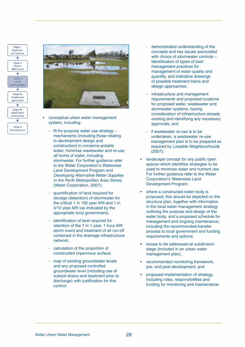
Better Urban Water Management 28
• conceptual urban water managementsystem, including:
- fit-for-purpose water use strategy –mechanisms (including those relatingto development design andconstruction) to conserve potablewater, minimise wastewater and re-useall forms of water, includingstormwater. For further guidance referto the Water Corporation’s WaterwiseLand Development Program andDeveloping Alternative Water Suppliesin the Perth Metropolitan Area Series,(Water Corporation, 2007);
- quantification of land required forstorage (detention) of stormwater forthe critical 1 in 100 year ARI and 1 in5/10 year ARI (as indicated by theappropriate local government);
- identification of land required forretention of the 1 in 1 year, 1 hour ARIstorm event and treatment of all run-offcontained in the drainage infrastructurenetwork;
- calculation of the proportion ofconstructed impervious surface;
- map of existing groundwater levelsand any proposed controlledgroundwater level (including use ofsubsoil drains and treatment prior todischarge) with justification for thiscontrol;
- demonstrated understanding of theconcepts and key issues associatedwith choice of stormwater controls –identification of types of bestmanagement practices formanagement of water quality andquantity, and indicative drawingsof possible treatment trains anddesign approaches;
- infrastructure and managementrequirements and proposed locationsfor proposed water, wastewater andstormwater systems, havingconsideration of infrastructure alreadyexisting and identifying any necessaryapprovals; and
- if wastewater re-use is to beundertaken, a wastewater re-usemanagement plan is to be prepared asrequired by Liveable Neighbourhoods(2007);
• landscape concept for any public openspaces which identifies strategies to beused to minimise water and nutrient use.For further guidance refer to the WaterCorporation’s Waterwise LandDevelopment Program;
• where a constructed water body isproposed, this should be depicted on thestructure plan, together with informationin the local water management strategyoutlining the purpose and design of thewater body, and a proposed schedule formanagement and ongoing maintenance,including the recommended transferprocess to local government and fundingrequirements and options;
• issues to be addressed at subdivisionstage (included in an urban watermanagement plan);
• recommended monitoring framework,pre- and post-development; and
• proposed implementation of strategy,including roles, responsibilities andfunding for monitoring and maintenance.
BUWMdoc:Layout 1 21/10/08 2:48 PM Page 28
Identify pre- and post-development water balances to inform the assessment ofoptions for reducing the need to import potable water through consideration of fit-for-purpose use (eg toilet flushing, laundry, hot water and ex-house). Considerapprovals required to achieve desired options. For further guidance see DevelopingAlternative Water Supplies in the Perth Metropolitan Area Series (WaterCorporation, 2007).
• Consider findings of district water management strategy (or DoW drainage andwater management plan) and provide more detailed assessment wherenecessary.
• Show buffers of wetlands and waterways to be protected.
• Continue monitoring of ecological health and hydrological regime of waterdependent environments to be protected. Demonstrate that the predevelopmentscenario of these environments will be maintained post development. Where anychanges to the hydrological regime are proposed, this should be demonstratedconsistent with the Guidelines for ecological water requirements for urban watermanagement currently being developed by DoW.
• Discussion of previous land use and likely impacts on the quality of surface run-off and shallow groundwater, and how this will be addressed by the proposedsystem, including further site ground truthing.
• Determine the areas of high-risk acid sulfate soils and potential acid sulfate soilsconsistent with Planning Bulletin 64 (WAPC, 2003). Where these areas exist,identify an appropriate management strategy to address them.
• Identify the current state of the resource at the local level, based on siteinvestigations, including quality, direction of flow and levels.
• Demonstrate that potential impacts to groundwater and water dependentenvironments to be protected are avoided or minimised. Demonstrate that anypotential impacts will not have a significant environmental impact. Where anychanges to the hydrological regime are proposed, this should be demonstratedconsistent with the Guidelines for ecological water requirements for urban watermanagement currently being developed by DoW.
• Assess potential for short-term mobilisation of nutrients and contaminantsresulting from development works as well as long-term impacts on groundwaterquality from development. Where necessary, identify pollutant pathways.
• Demonstrate need for controlled groundwater levels or subsoil drainage whereproposed, identifying likely changes in groundwater levels.
• Explore potential for use of shallow groundwater for a non-potable source.
• Floodplain and wetland modelling to determine minimum building levels, setbacksfor development, and receiving water levels.
• Flow monitoring of existing surface water streams to establish currentrequirement.
• Identify how to manage post-development flows to meet catchment target flows.
• Drainage modelling to determine the detailed land requirements and flood waysneeded to cope with major and minor storms (1 in 1 year, 1 in 5/10 year and 1 in100 year), based on the receiving environment’s requirements and or designcriteria provided in an endorsed water management strategy or plan.
• Establish acceptability of location of surface water flow paths (streams) andfloodwater storage areas (floodplains) in consultation with drainage serviceprovider.
• Identify and address potential impacts on surface water dependent ecosystems tobe protected. Demonstrate that any potential impacts will not have a significantenvironmental impact. Where any changes to the hydrological regime areproposed, this should be demonstrated consistent with the Guidelines forecological water requirements for urban developments currently being developedby DoW.
• Identify the current quality of any surface water flows.
• Identify current quantity of flows which will be required to establish pre-development requirements, ie 1 in 1 year flows.
Better Urban Water Management29
Water balancemodelling
Water dependentecosystems andecological health
Desktop historical landuse assessment
Groundwater monitoringand modelling(primarily for highwatertable areas)
Surface water modelling
Monitoring of flows inexisting streams ordrainage systems
Work required to support the recommendations in the localwater management strategy (where relevant) includes:
BUWMdoc:Layout 1 21/10/08 2:48 PM Page 29

Better Urban Water Management 30
In greenfield areas and unmodified catchmentsincluding those with environmental assets,at least 12 months monitoring is suggested toestablish accurate baselines and to supportrecommendations, particularly for groundwaterlevels, although 18 months, including two wintersis preferred. This should be achievable in theusual planning timeframes where a monitoringprogram is established when commencingdevelopment of the plan. It should be noted thatmonitoring requirements are to be appropriatefor the conditions of the catchment. Wherecatchments are highly modified and artificiallycontrolled, an accurate description of thoseconditions is likely to be sufficient, on adviceof DoW.
Where the local structure plan is not advertisedin conjunction with the local planning schemeamendment, the provisions of the zone shouldrequire that the local structure plan andaccompanying water management strategy isadvertised prior to adoption. This ensures thatappropriate feedback can be received fromspecialist agencies to ensure that the measuresproposed in the local structure plan and watermanagement strategy are adequate andconsistent with their requirements.
Work required to identify local conditions shouldbe undertaken by the landowner/developer(table 1). Where an area has fragmentedownership, it is likely that the most effective andefficient outcome would be achieved if thisprogram was coordinated by the localgovernment, with an agreed mechanism orarrangement between landowners for fundingof the study. Where local government budgetspermit, the work may be pre-funded by the localgovernment, with costs recouped throughdevelopment contributions schemes.A coordinated approach by several land ownersto employ suitably qualified professionals toundertake the work would also be effective.
Further guidance on how to address urban watermanagement at local structure plan stage iscontained in DoW’s guidelines for developinga local water management strategy (DoW, inpreparation) Liveable Neighbourhoods (WAPC,2007) and DoW’s Stormwater ManagementManual for WA (2004-2007), including thedecision process which forms part of the manual.The local water management strategy checklistin appendix 1 may provide additional guidanceon the contents of the document.
Example groundwater plan (courtesy of the Department of Water)
BUWMdoc:Layout 1 21/10/08 2:48 PM Page 30

Better Urban Water Management31
4.6 Stage 4a: Application forsubdivision
Large subdivisions should be supported by anurban water management plan, as should smallsubdivisions in priority catchments or wherethere are significant risks to water resources.This plan should be undertaken instead of theconventional drainage and nutrient managementplan.
An urban water management plan is notgenerally required to support subdivision ininfill/brownfield areas, unless the development islikely to impact on significant water resources.Subdivision or development in thesecircumstances should be consistent with theprinciples of State Planning Policy 2.9 WaterResources (WAPC, 2006) and the StormwaterManagement Manual for WA, including thedecision process which forms part of the manual(DoW, 2004-2007).
The urban water management plan is largely anextension of the local water managementstrategy, as it provides the detail to the designproposed in the local structure plan. The planshould address:
• compliance with the design objectivesand other requirements as outlined in thelocal water management strategy.Demonstration of compliance withspecified criteria and objectives should beachieved through appropriateassessment tools, calculations orassessments, to the satisfaction of DoW;
• site context – adjacent land use, soilprofile, linkages between neighbouringlots, environmentally significant areasand buffers;
• agreed and approved measures toachieve water conservation andefficiencies of use, including non-potablesupply. All approvals, designs, controls,management and operation of theproposed system must be outlined;
• management of groundwater levels andany proposed dewatering, includingmaintenance of ecosystem health.Proposals should demonstrate that thepredevelopment hydrological regime of
water dependent ecosystems to beprotected will be maintained. Thefollowing figures should be included:
- existing surface level, existinggroundwater levels; and
- final surface level, final groundwaterlevels (amount of fill required);
• management of groundwatercontamination “hot spots” and otherspecific site conditions, including acidsulfate soils and the potential for andmanagement of increased export ofcontaminants;
• detailed stormwater management design,including the size, location and design ofpublic open space areas; integratingmajor and minor flood managementcapability; and area of directly connectedimpervious surface. This will includemaps of areas inundated in 1 year, 5 yearand 100 year ARI events, informationoutlining required storages, invert levels,top water and peak flow levels, andinformation required to ensure integrationwith upstream and downstream systems.Where infrastructure provision is to bestaged, this should be indicated;
• locations (mapped) and details ofstructural and non-structural bestmanagement practices to beimplemented, including their maintenancerequirements, expected performance andagreed ongoing managementarrangements, including costs;
• management measures to beimplemented to achieve protection ofwaterways, wetlands (and their buffers),remnant vegetation and ecologicallinkages;
• strategies to minimise the use andapplication of nutrients in the subdivisionon public and private open space. Forfurther guidance refer to the WaterCorporation’s Waterwise LandDevelopment Program;
• detailed information supporting thepurpose, design and management of anyproposed constructed water body,including an assessment of lifecycle costs(including replacement);
BUWMdoc:Layout 1 21/10/08 2:48 PM Page 31

Better Urban Water Management 32
• management of subdivisional works toprevent or ameliorate erosion (wind andwater), sedimentation and turbidity (toensure no impact on significantenvironments, maintenance of anyinstalled best management practices andmanagement of any dewatering at theconstruction stage of development);
• management of disease vector andnuisance insects such as mosquitoes andmidges;
• monitoring program and/or contribution;and
Management of waterdependent ecosystems
Site investigations
Groundwater monitoringand modelling
Surface water modelling
Conservation andefficient use of drinkingwater
• Show buffers for wetlands and waterways to be protected.
• Continue monitoring of pre-development ecological health and hydrologicalregime of water dependent ecosystems to be protected so that accuratebaselines can be determined.
• Reference to a detailed survey of flora and fauna undertaken at an appropriatetime to support management requirements proposed in the local structure plan.
• More detailed soil and site characteristics including infiltration capacity based onfurther site investigations, particularly in areas with significant water resources orissues.
• Further field investigations for contamination or acid sulfate soils where required,consistent with DEC guidelines.
• Identify nutrient levels and pollutant pathways relating to background levels andcontamination/nutrient hot spots.
• Map groundwater level contours – existing and proposed.
• Identify floor level heights and fill requirements.
• If proposed, outline subsoil drainage strategy, including avoidance andmanagement of impacts on water dependent ecosystems and treatment ofsubsoil drainage water, prior to discharge to the surface water system. Thesubsoil drainage strategy should also address areas with nutrient-richgroundwater.
• Identify groundwater recharge rates.
• Demonstrate how post-development flows will meet catchment criteria.
• Modelling of up to 1 in 1 year ARI event to determine capability forretention/detention and water quality treatment, where/if required.
• Modelling of ”minor” and ”major” stormwater systems to identify and size flowpaths (via pipes or overland flow) and required flood detention volumes.
• Refinement of 1 in 100 year floodway if required.
• Where non-potable water supply is proposed, detailed modelling of site waterbalance and demonstration of sustainable sources for non-potable, fit-for-purposeuse (eg toilet flushing, laundry, hot water and ex-house). Any strategy shouldhave the necessary approvals and agreements in place.
• Strategy for irrigation and nutrient management of public open spaces tomaximise water reuse and minimise potable water use and application ofnutrients.
• Alternative strategies to achieve water conservation objectives, includingagreements and implementation mechanisms and expected performance.
Work required to support the urban watermanagement plan includes:
BUWMdoc:Layout 1 21/10/08 2:48 PM Page 32
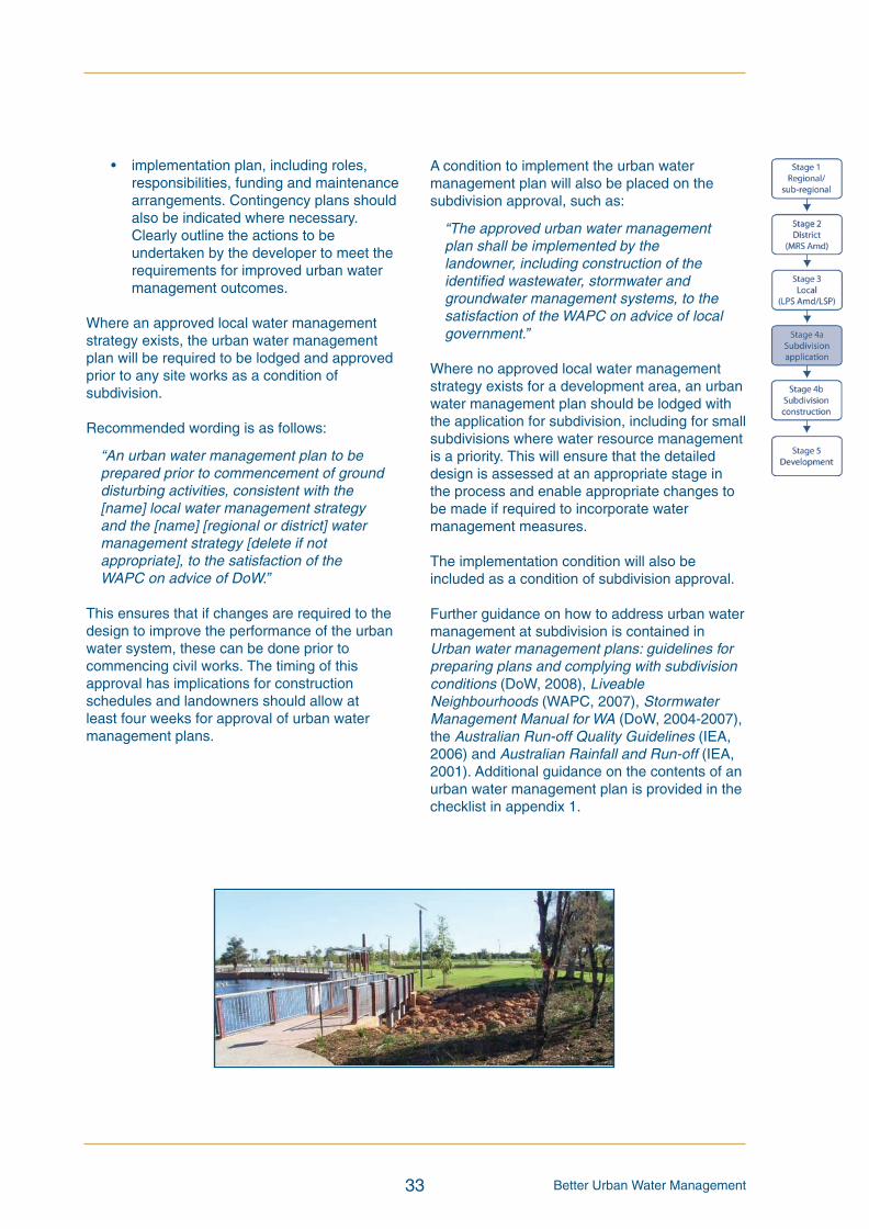
Better Urban Water Management33
• implementation plan, including roles,responsibilities, funding and maintenancearrangements. Contingency plans shouldalso be indicated where necessary.Clearly outline the actions to beundertaken by the developer to meet therequirements for improved urban watermanagement outcomes.
Where an approved local water managementstrategy exists, the urban water managementplan will be required to be lodged and approvedprior to any site works as a condition ofsubdivision.
Recommended wording is as follows:
“An urban water management plan to beprepared prior to commencement of grounddisturbing activities, consistent with the[name] local water management strategyand the [name] [regional or district] watermanagement strategy [delete if notappropriate], to the satisfaction of theWAPC on advice of DoW.”
This ensures that if changes are required to thedesign to improve the performance of the urbanwater system, these can be done prior tocommencing civil works. The timing of thisapproval has implications for constructionschedules and landowners should allow atleast four weeks for approval of urban watermanagement plans.
A condition to implement the urban watermanagement plan will also be placed on thesubdivision approval, such as:
“The approved urban water managementplan shall be implemented by thelandowner, including construction of theidentified wastewater, stormwater andgroundwater management systems, to thesatisfaction of the WAPC on advice of localgovernment.”
Where no approved local water managementstrategy exists for a development area, an urbanwater management plan should be lodged withthe application for subdivision, including for smallsubdivisions where water resource managementis a priority. This will ensure that the detaileddesign is assessed at an appropriate stage inthe process and enable appropriate changes tobe made if required to incorporate watermanagement measures.
The implementation condition will also beincluded as a condition of subdivision approval.
Further guidance on how to address urban watermanagement at subdivision is contained inUrban water management plans: guidelines forpreparing plans and complying with subdivisionconditions (DoW, 2008), LiveableNeighbourhoods (WAPC, 2007), StormwaterManagement Manual for WA (DoW, 2004-2007),the Australian Run-off Quality Guidelines (IEA,2006) and Australian Rainfall and Run-off (IEA,2001). Additional guidance on the contents of anurban water management plan is provided in thechecklist in appendix 1.
BUWMdoc:Layout 1 21/10/08 2:48 PM Page 33
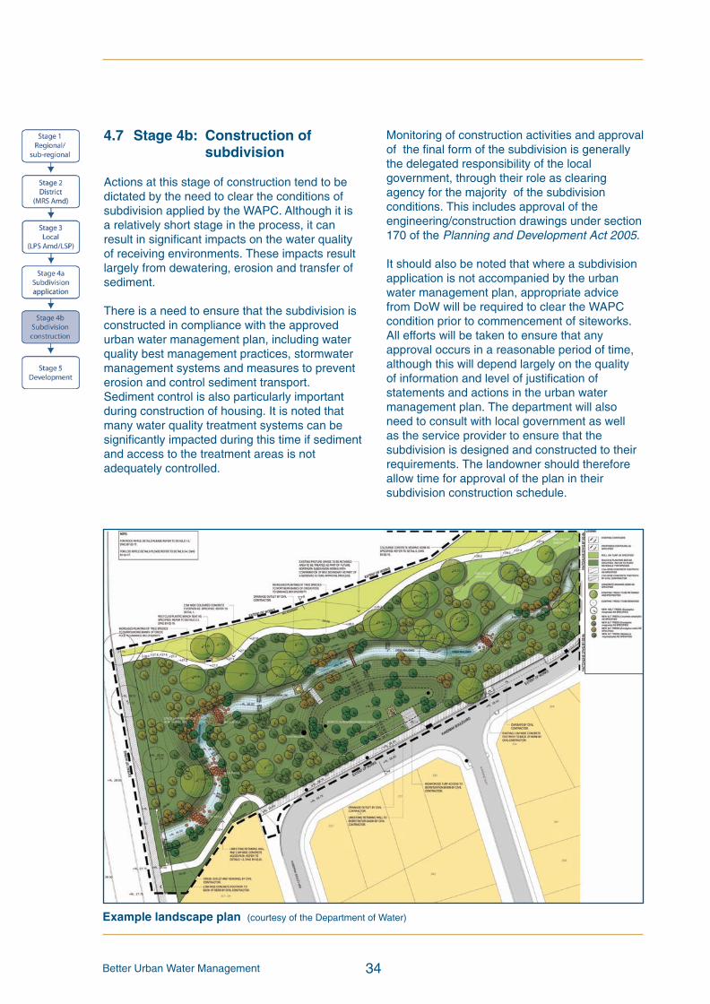
Better Urban Water Management 34
4.7 Stage 4b: Construction ofsubdivision
Actions at this stage of construction tend to bedictated by the need to clear the conditions ofsubdivision applied by the WAPC. Although it isa relatively short stage in the process, it canresult in significant impacts on the water qualityof receiving environments. These impacts resultlargely from dewatering, erosion and transfer ofsediment.
There is a need to ensure that the subdivision isconstructed in compliance with the approvedurban water management plan, including waterquality best management practices, stormwatermanagement systems and measures to preventerosion and control sediment transport.Sediment control is also particularly importantduring construction of housing. It is noted thatmany water quality treatment systems can besignificantly impacted during this time if sedimentand access to the treatment areas is notadequately controlled.
Monitoring of construction activities and approvalof the final form of the subdivision is generallythe delegated responsibility of the localgovernment, through their role as clearingagency for the majority of the subdivisionconditions. This includes approval of theengineering/construction drawings under section170 of the Planning and Development Act 2005.
It should also be noted that where a subdivisionapplication is not accompanied by the urbanwater management plan, appropriate advicefrom DoW will be required to clear the WAPCcondition prior to commencement of siteworks.All efforts will be taken to ensure that anyapproval occurs in a reasonable period of time,although this will depend largely on the qualityof information and level of justification ofstatements and actions in the urban watermanagement plan. The department will alsoneed to consult with local government as wellas the service provider to ensure that thesubdivision is designed and constructed to theirrequirements. The landowner should thereforeallow time for approval of the plan in theirsubdivision construction schedule.
Example landscape plan (courtesy of the Department of Water)
BUWMdoc:Layout 1 21/10/08 2:48 PM Page 34
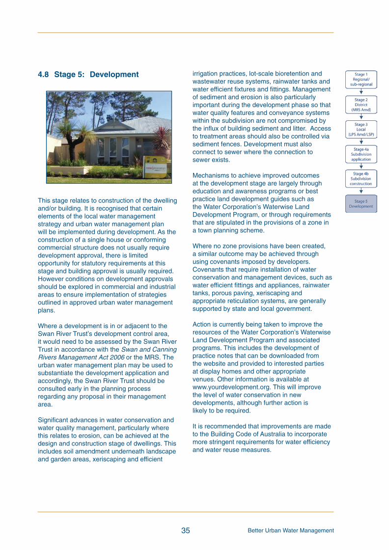
Better Urban Water Management35
4.8 Stage 5: Development
This stage relates to construction of the dwellingand/or building. It is recognised that certainelements of the local water managementstrategy and urban water management planwill be implemented during development. As theconstruction of a single house or conformingcommercial structure does not usually requiredevelopment approval, there is limitedopportunity for statutory requirements at thisstage and building approval is usually required.However conditions on development approvalsshould be explored in commercial and industrialareas to ensure implementation of strategiesoutlined in approved urban water managementplans.
Where a development is in or adjacent to theSwan River Trust’s development control area,it would need to be assessed by the Swan RiverTrust in accordance with the Swan and CanningRivers Management Act 2006 or the MRS. Theurban water management plan may be used tosubstantiate the development application andaccordingly, the Swan River Trust should beconsulted early in the planning processregarding any proposal in their managementarea.
Significant advances in water conservation andwater quality management, particularly wherethis relates to erosion, can be achieved at thedesign and construction stage of dwellings. Thisincludes soil amendment underneath landscapeand garden areas, xeriscaping and efficient
irrigation practices, lot-scale bioretention andwastewater reuse systems, rainwater tanks andwater efficient fixtures and fittings. Managementof sediment and erosion is also particularlyimportant during the development phase so thatwater quality features and conveyance systemswithin the subdivision are not compromised bythe influx of building sediment and litter. Accessto treatment areas should also be controlled viasediment fences. Development must alsoconnect to sewer where the connection tosewer exists.
Mechanisms to achieve improved outcomesat the development stage are largely througheducation and awareness programs or bestpractice land development guides such asthe Water Corporation’s Waterwise LandDevelopment Program, or through requirementsthat are stipulated in the provisions of a zone ina town planning scheme.
Where no zone provisions have been created,a similar outcome may be achieved throughusing covenants imposed by developers.Covenants that require installation of waterconservation and management devices, such aswater efficient fittings and appliances, rainwatertanks, porous paving, xeriscaping andappropriate reticulation systems, are generallysupported by state and local government.
Action is currently being taken to improve theresources of the Water Corporation’s WaterwiseLand Development Program and associatedprograms. This includes the development ofpractice notes that can be downloaded fromthe website and provided to interested partiesat display homes and other appropriatevenues. Other information is available atwww.yourdevelopment.org. This will improvethe level of water conservation in newdevelopments, although further action islikely to be required.
It is recommended that improvements are madeto the Building Code of Australia to incorporatemore stringent requirements for water efficiencyand water reuse measures.
BUWMdoc:Layout 1 21/10/08 2:48 PM Page 35
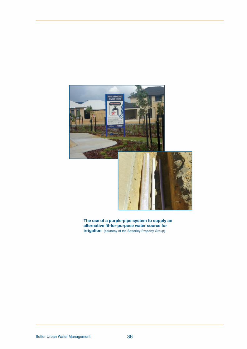
Better Urban Water Management 36
The use of a purple-pipe system to supply analternative fit-for-purpose water source forirrigation (courtesy of the Satterley Property Group)
BUWMdoc:Layout 1 21/10/08 2:48 PM Page 36

Better Urban Water Management37
5 References
Australian and New Zealand Environment and Conservation Council and Agriculture and ResourceManagement Council of Australia and New Zealand, 2000, National Water Quality ManagementStrategy, Australian and New Zealand Environment and Conservation Council, Canberra.
Department of Water, 2004-2007, Stormwater Management Manual for Western Australia,Department of Water, Perth, Western Australia.
Department of Water, (In prep), Developing a local water management strategy, Department of Water,Perth, Western Australia.
Department of Water, (In prep), Guidelines for ecological water requirements for urban watermanagement, Department of Water, Perth, Western Australia.
Department of Water, 2008, Urban water management plans: guidelines for preparing plans andcomplying with subdivision conditions, Department of Water, Perth, Western Australia.
Government of Western Australia, 2007, State Water Plan, Department of the Premier and Cabinet,Perth, Western Australia.
Government of Western Australia, 2006, A Blueprint for Water Reform in Western Australia: FinalAdvice to the Western Australian Government, Water Reform Implementation Committee,Perth, Western Australia.
Government of Western Australia, 2006, State Planning Policy 2.9 Water Resources,Western Australian Planning Commission, Perth, Western Australia.
Government of Western Australia, 2006, State Planning Policy 2.10 Swan Canning River System,Western Australian Planning Commission, Perth, Western Australia.
Government of Western Australia, 2005, Governments Response to the Report of the IrrigationReview Steering Committee, Department of the Premier and Cabinet, Perth, Western Australia.
Government of Western Australia, 2003, State Water Strategy, Department of the Premier andCabinet, Perth, Western Australia.
Government of Western Australia, 2006, State Planning Policy 1 State Planning Framework Policy,Western Australian Planning Commission, Perth, Western Australia.
Government of Western Australia, 2003, State Planning Policy 2 Environment and Natural Resources,Western Australian Planning Commission, Perth, Western Australia.
Government of Western Australia, 2003, State Planning Policy 2.7 Public Drinking Water SourcePolicy, Western Australian Planning Commission, Perth, Western Australia.
Institution of Engineers, Australia, 2001, Australian Rainfall and Run-off, 3rd Edition, Institution ofEngineers, Canberra, Australian Capital Territory.
Institution of Engineers Australia, 2006, Australian Run-off Quality: A guide to water sensitive urbandesign, Institution of Engineers Australia, Melbourne, Victoria.
Swan River Trust, 2006, Draft Healthy Rivers Action Plan, Swan River Trust, Perth, Western Australia.
BUWMdoc:Layout 1 21/10/08 2:48 PM Page 37
Better Urban Water Management 38
Western Australian Planning Commission, 1997, State Planning Strategy, Western Australian PlanningCommission, Perth, Western Australia.
Western Australian Planning Commission, 2003, Planning Bulletin 64 Acid Sulfate Soils, WesternAustralian Planning Commission, Perth, Western Australia.
Western Australian Planning Commission, 2007, Liveable Neighbourhoods: a Western AustralianGovernment sustainable cities initiative, Western Australian Planning Commission, Perth, WesternAustralia.
Western Australian Planning Commission, 2008, Planning Bulletin 92 Urban Water Management,Western Australian Planning Commission, Perth, Western Australia.
Water Corporation, 2007, Developing Alternative Water Supplies in the Perth Metropolitan AreaSeries, Water Corporation website.
BUWMdoc:Layout 1 21/10/08 2:48 PM Page 38
Better Urban Water Management39
Appendix 1: Checklists to aid thepreparation of water managementstrategy documents
BUWMdoc:Layout 1 21/10/08 2:48 PM Page 39

Regional water management strategy item Status Comments/proposal
Introduction and background
Understanding of integrated water cycle management
Vision, principles and objectives
Policy background
The regional plan area
Pre-development environment (described and mapped) – location andtopography, climate, soils, environmental assets and receivingenvironments, existing surface water and groundwater characteristics,catchment boundaries, existing land uses, areas requiring specialattention
Previous studies/existing information, including anyDoW water plans
Information gaps
Design and performance criteria
Whole of catchment targets – potable water use, stormwater qualityand quantity (including flood management), groundwater quality andquantity and wastewater and water re-use
Sub-catchment targets as above
Analysis of development impacts and options
Regional water balance and sources of water for various uses (fit forpurpose). Consider infrastructure needs and options
Historical land use assessment – contamination, acid sulfate soils,nutrients
Scenarios assessed by SQUARE and advice provided by DoW
Response to findings of assessment
Proposed land use scenario
Water management strategy
Post-development regional water balance and considerations
Fit-for-purpose water use and allocation strategy
Environmental asset (wetlands, waterways, remnant vegetation etc)management – identify and protect
Water conservation and water use efficiency strategy
Wastewater management and infrastructure planning needs
Surface water management strategy – flood plain management,strategic drainage plan, regional structural requirements
Groundwater management strategy
Nutrient management strategy
Implementation
Monitoring, auditing and reporting
Structure planning
Subdivision
Development
Community consultation
Assessment and review
Resourcing requirements and commitments
Information collation and transfer
Checklist for integrated water cycle management assessment of regional/sub-regional strategy,region scheme or regional/sub-regional structure plan
1. Tick the status column for items for which information is provided.
2. Enter N/A in the status column if the item is not appropriate and enter the reason in thecomments column.
3. Provide brief comments on any relevant issues.
4. Provide brief description of any proposed best management practices, eg. multi-use corridors,community based-social marketing, water re-use proposals.
BUWMdoc:Layout 1 21/10/08 2:48 PM Page 40

Better Urban Water Management41
District water management strategy item Status Comments/proposal
Introduction
Principles and objectives
Previous studies and recommendations
Design and management objectives
Design objectives for potable water use, stormwater quality andquantity (including flood management), groundwater quality andquantity, wastewater and water re-use
Pre-development environment
Site characteristics – opportunities, constraints, areas requiringspecialised investigation and management – discussed and mapped
Hydrologic information – previous work, recent investigations,groundwater levels, flow and availability, groundwater and surfacewater quality identified and mapped, environmental water requirementsidentified, including waterway/wetland buffers
Analysis of development impacts and options
Assessment of proposed land use scenario by DoW (SQUARE)
Response to assessment
Strategies and recommendations for planning precincts to guide andcontrol land uses and development where necessary.
Fit-for-purpose water source planning
Site water balance
Allocation of water for all types of uses, including discussion of options
Infrastructure (potable, non-potable, wastewater) – existing andrequired
Water management strategy
Drinking water conservation and efficiency of water use
Surface water management strategy – flood management (flow paths,flow rates and levels at control points), conceptual stormwatermanagement system, best planning practices, appropriate bestmanagement practices
Groundwater management strategy – groundwater contours, levelsand quality, allocation availability
Wastewater management strategy
Implementation framework
Considerations and requirements for local planning
Monitoring – pre-development, post-development, data analysis,presentation and reporting mechanisms
Technical review
Funding and ongoing maintenance responsibilities
Checklist for integrated water cycle management assessment of local planning strategy districtstructure plan or region scheme amendment
1. Tick the status column for items for which information is provided.
2. Enter N/A in the status column if the item is not appropriate and enter the reason in thecomments column.
3. Provide brief comments on any relevant issues.
4. Provide brief description of any proposed best management practices, eg. multi-use corridors,community based-social marketing, water re-use proposals.
BUWMdoc:Layout 1 21/10/08 2:48 PM Page 41
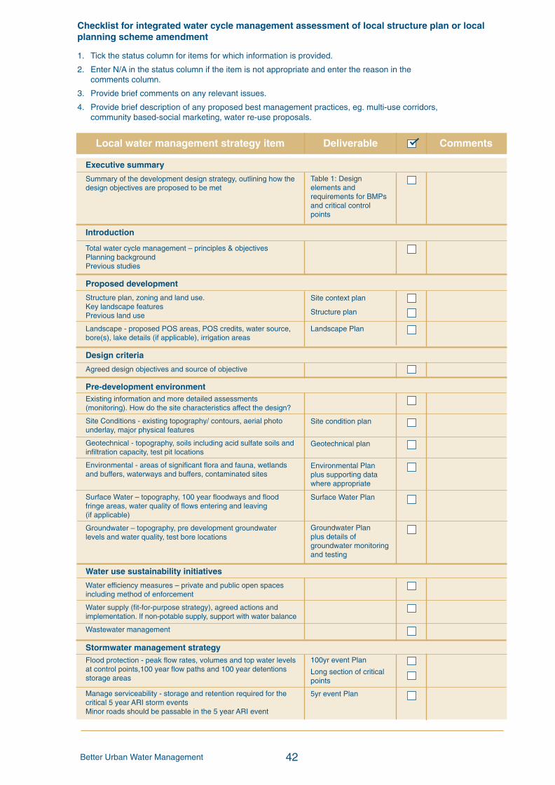
Better Urban Water Management 42
Table 1: Designelements andrequirements for BMPsand critical controlpoints
Site context plan
Structure plan
Landscape Plan
Site condition plan
Geotechnical plan
Environmental Planplus supporting datawhere appropriate
Surface Water Plan
Groundwater Planplus details ofgroundwater monitoringand testing
100yr event Plan
Long section of criticalpoints
5yr event Plan
Local water management strategy item Deliverable Comments
Executive summary
Summary of the development design strategy, outlining how thedesign objectives are proposed to be met
Introduction
Total water cycle management – principles & objectivesPlanning backgroundPrevious studies
Proposed development
Structure plan, zoning and land use.Key landscape featuresPrevious land use
Landscape - proposed POS areas, POS credits, water source,bore(s), lake details (if applicable), irrigation areas
Design criteria
Agreed design objectives and source of objective
Pre-development environmentExisting information and more detailed assessments(monitoring). How do the site characteristics affect the design?
Site Conditions - existing topography/ contours, aerial photounderlay, major physical features
Geotechnical - topography, soils including acid sulfate soils andinfiltration capacity, test pit locations
Environmental - areas of significant flora and fauna, wetlandsand buffers, waterways and buffers, contaminated sites
Surface Water – topography, 100 year floodways and floodfringe areas, water quality of flows entering and leaving(if applicable)
Groundwater – topography, pre development groundwaterlevels and water quality, test bore locations
Water use sustainability initiatives
Water efficiency measures – private and public open spacesincluding method of enforcement
Water supply (fit-for-purpose strategy), agreed actions andimplementation. If non-potable supply, support with water balance
Wastewater management
Stormwater management strategyFlood protection - peak flow rates, volumes and top water levelsat control points,100 year flow paths and 100 year detentionsstorage areas
Manage serviceability - storage and retention required for thecritical 5 year ARI storm eventsMinor roads should be passable in the 5 year ARI event
Checklist for integrated water cycle management assessment of local structure plan or localplanning scheme amendment
1. Tick the status column for items for which information is provided.
2. Enter N/A in the status column if the item is not appropriate and enter the reason in thecomments column.
3. Provide brief comments on any relevant issues.
4. Provide brief description of any proposed best management practices, eg. multi-use corridors,community based-social marketing, water re-use proposals.
BUWMdoc:Layout 1 21/10/08 2:48 PM Page 42

Better Urban Water Management43
1yr event plan
Typical cross sections
Groundwater/subsoilPlan
Local water management strategy item Deliverable Comments
Protect ecology – detention areas for the 1 yr 1 hr ARI event,areas for water quality treatment and types of (includingindicative locations for) agreed structural and non-structural bestmanagement practices and treatment trains. Protection ofwaterways, wetlands (and their buffers), remnant vegetation andecological linkages
Groundwater management strategy
Post development groundwater levels, fill requirements(including existing and likely final surface levels), outlet controls,and subsoils areas/exclusion zones
Actions to address acid sulfate soils or contamination
The next stage – subdivision and urban watermanagement plans
Content and coverage of future urban water management plansto be completed at subdivision. Include areas where furtherinvestigations are required prior to detailed design.
Monitoring
Recommended future monitoring plan including timing,frequency, locations and parameters, together witharrangements for ongoing actions
Implementation
Developer commitments
Roles, responsibilities, funding for implementation
Review
BUWMdoc:Layout 1 21/10/08 2:48 PM Page 43
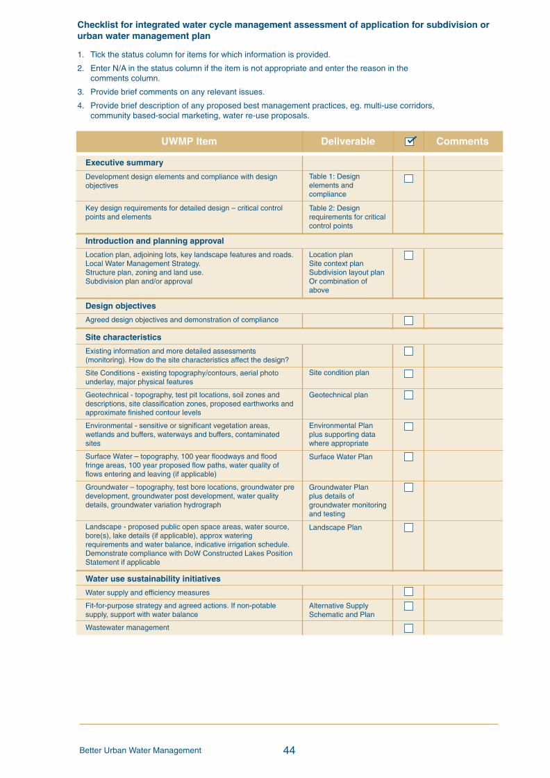
Better Urban Water Management 44
UWMP Item Deliverable Comments
Checklist for integrated water cycle management assessment of application for subdivision orurban water management plan
1. Tick the status column for items for which information is provided.
2. Enter N/A in the status column if the item is not appropriate and enter the reason in thecomments column.
3. Provide brief comments on any relevant issues.
4. Provide brief description of any proposed best management practices, eg. multi-use corridors,community based-social marketing, water re-use proposals.
Table 1: Designelements andcompliance
Table 2: Designrequirements for criticalcontrol points
Location planSite context planSubdivision layout planOr combination ofabove
Site condition plan
Geotechnical plan
Environmental Planplus supporting datawhere appropriate
Surface Water Plan
Groundwater Planplus details ofgroundwater monitoringand testing
Landscape Plan
Alternative SupplySchematic and Plan
Executive summary
Development design elements and compliance with designobjectives
Key design requirements for detailed design – critical controlpoints and elements
Introduction and planning approval
Location plan, adjoining lots, key landscape features and roads.Local Water Management Strategy.Structure plan, zoning and land use.Subdivision plan and/or approval
Design objectives
Agreed design objectives and demonstration of compliance
Site characteristics
Existing information and more detailed assessments(monitoring). How do the site characteristics affect the design?
Site Conditions - existing topography/contours, aerial photounderlay, major physical features
Geotechnical - topography, test pit locations, soil zones anddescriptions, site classification zones, proposed earthworks andapproximate finished contour levels
Environmental - sensitive or significant vegetation areas,wetlands and buffers, waterways and buffers, contaminatedsites
Surface Water – topography, 100 year floodways and floodfringe areas, 100 year proposed flow paths, water quality offlows entering and leaving (if applicable)
Groundwater – topography, test bore locations, groundwater predevelopment, groundwater post development, water qualitydetails, groundwater variation hydrograph
Landscape - proposed public open space areas, water source,bore(s), lake details (if applicable), approx wateringrequirements and water balance, indicative irrigation schedule.Demonstrate compliance with DoW Constructed Lakes PositionStatement if applicable
Water use sustainability initiatives
Water supply and efficiency measures
Fit-for-purpose strategy and agreed actions. If non-potablesupply, support with water balance
Wastewater management
BUWMdoc:Layout 1 21/10/08 2:48 PM Page 44
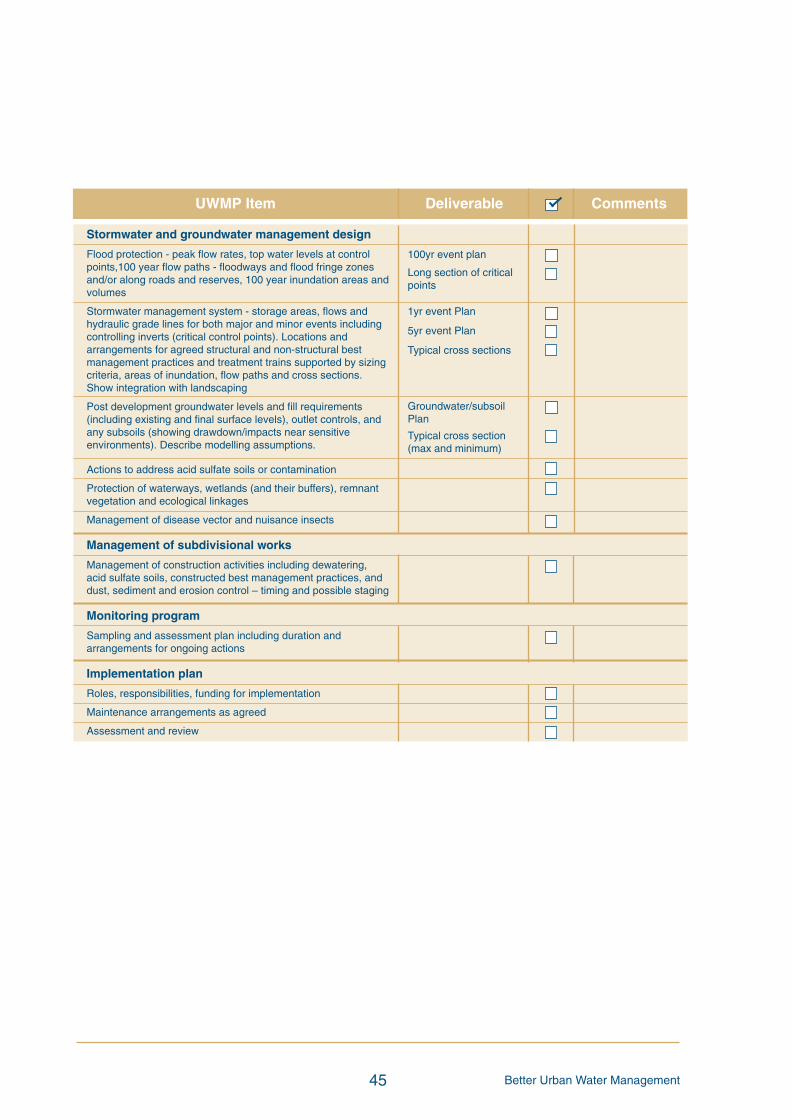
Better Urban Water Management45
UWMP Item Deliverable Comments
100yr event plan
Long section of criticalpoints
1yr event Plan
5yr event Plan
Typical cross sections
Groundwater/subsoilPlan
Typical cross section(max and minimum)
Stormwater and groundwater management design
Flood protection - peak flow rates, top water levels at controlpoints,100 year flow paths - floodways and flood fringe zonesand/or along roads and reserves, 100 year inundation areas andvolumes
Stormwater management system - storage areas, flows andhydraulic grade lines for both major and minor events includingcontrolling inverts (critical control points). Locations andarrangements for agreed structural and non-structural bestmanagement practices and treatment trains supported by sizingcriteria, areas of inundation, flow paths and cross sections.Show integration with landscaping
Post development groundwater levels and fill requirements(including existing and final surface levels), outlet controls, andany subsoils (showing drawdown/impacts near sensitiveenvironments). Describe modelling assumptions.
Actions to address acid sulfate soils or contamination
Protection of waterways, wetlands (and their buffers), remnantvegetation and ecological linkages
Management of disease vector and nuisance insects
Management of subdivisional works
Management of construction activities including dewatering,acid sulfate soils, constructed best management practices, anddust, sediment and erosion control – timing and possible staging
Monitoring program
Sampling and assessment plan including duration andarrangements for ongoing actions
Implementation plan
Roles, responsibilities, funding for implementation
Maintenance arrangements as agreed
Assessment and review
BUWMdoc:Layout 1 21/10/08 2:48 PM Page 45