Ben 1-64 Claims
20
GEOLOGICAL AND GEOCHEMICAL ASSESSMENT REPORT for the Ben 1-64 Claims N.T.S. 131'29' WEST (LONGITUDE), 63'42' NORTH (LATITUDE) Mayo Mining Division Yukon Territory AUTHOR. B.A.Lueek CO-AUTHOR: Zoran Pudar WORK PERFORMED: JULY 25 to JULY 30.1996
Transcript of Ben 1-64 Claims

GEOLOGICAL AND GEOCHEMICAL ASSESSMENT REPORT
for the
Ben 1-64 Claims
N.T.S.
131'29' WEST (LONGITUDE), 63'42' NORTH (LATITUDE)
Mayo Mining Division
Yukon Territory
AUTHOR. B.A.Lueek CO-AUTHOR: Zoran Pudar
WORK PERFORMED: JULY 25 to JULY 30.1996


Table of Contents
Introduction
summary
Location Access and Physiography
Regional Geology and Mineralization
Local Geology
Previous Work
1996 Work Program
Conclusions and Recommendations
1996 Expenditures
Proposed Expenditures
Statement of Qualifications
Statement of Qualifications
Appendix (assay sheets)
Table of Figures
F&J Location Map
Fie. 2 Gold-Anomaly Map
Fie. Claim Map
Fig. Geology Map with sample sites
311
313
(in pocket)
,(in pocket)

INTRODUCTION
The Ben 1-64 Claims, record numbers YB65613 TO YB65676 are located in the
Mayo M i n g Division of the Yukon Territory, on map sheet 105 0-11. The claim
groups are situated in mountainous terrain approximately 12.5 kilometres east of the
confluence of Old Cabin Creek A d Rogue River. The claims are owned 100% by 75Acon
Gold Cop.
Previous geological mapping in the area indicates a Cretaceous granodiorite
which is intrusive into a sequence comprising predominantly Hadrynian and Cambrian
green and red shales with dark green and brown basic volcanic and volcanic-clastic rocks
(see Open File 205, June 1974, G.S.C. Ottawa). The intrusion is cut by pyrite-pyrrhotite
quartz veins with a thin (1 -2 mm) K-feldspar alteration envelope. These veins are n~ostly
1 cm wide.
SUMMARY
Geologic mapping on the Cabin Creek claim blocks has established the presence
of medium-grained granodiorite-synite intrusive stocks which are cut by pyrite-pyrrhotite
quartz veins. This geochemically anomalous region hosts significant potential for a
major gold deposit of the 'Fort Knox Type' associated with Tombstone Suite Intrusives.
A relationship exists between the Cabin Creek granodiorites and nearby gold-1ocalif.ies in
the Yukon (i.e. Dublin Gulch) in that the genesis of gold-bearing veins is attributed to
nearby Cretaceous plutons, (D. Templeman - Kluit, Yukon - Geology and Exploration

LEGEND - \ TOMBSTONE SUITE PLUTONIC BELT
HESS RIVER GOLD PROJECT YUKON GOLD~:ORP. -
HESS RIVER PROJECT MAY0 MINING DISTRICT, YUKON
LOCATION MAP

-7 FAULT (THRUST)
90-95 PERCENTILE AU IN SlLT
(7 +95 PERCENTILE AU IN SlLT
KILOMETRES
HESS RIVER P'FLOJECT MAY0 MINING DISTRICT, YUKON
GOLD ANOMALIES - M M . lssl AS SHOWN -

1979-80, Dept. of Indian and Northern Affairs, Whitehorse - pg 23). All of the gluton is
covered by the Ben 1-64 claims.
LOCATION. ACCESS and PHYSIOGRAPHY
The claims are located in the Mayo Mining Division of the Yukon Territory, NTS
105 0-3. The claim groups are situated in mountainous terrain approximately 12.5
kilometres east of the confluence of Old Cabin Creek and Rogue River. The nearest road
is the Can01 Road passing through MacMillan Pass about 87 km to the southeast.
Access to the property is hampered by extremely rugged terrain. Fixed-wing float
planes can land either at Arrowhead Lake (16 km to the east) or Emerald Lake (20 km to
the south east). From these lakes access is by helicopter. The property can also be
reached by helicopter from Plata Air Strip which can handle aircraft up to size of a DC-3.
The property is located 45 km from Plata camp (see Figure 2). Contract helicopters are
also available from Ross River.
The property lies within the Hess Mountains, just north of the Rogue Kange.
Topographic relief is spectacular and varies between 1,000 m and 2,100 m AMSL. The
northeastern half of the property is dominated by a series of steep sided ridges
surrounding a number of cirques. Most slopes are largely talus covered while cirque
floors consist of scattered rubble piles and boulder fields. Rock slides occur frequently
during the summer months. Most of the property is situated above the tree line.

RlEGIONAL GEOLOGY and MINERALIZATION
The Cabin Creek claim block are located within the Selwyn Basin and covers
Cretaceous granodiorite-synite stocks which intrude Lower Cambrian to Silurian
sedimentary rocks. These sedimentary rocks consist of maroon and green argillite, grey
and white quartzites, quartz pebble conglomerates, black shales and cherts.
The Selwyn basin hosts the Fort Knox deposit, an intrusive hosted gold deposit of
large tonnage and low grade. This deposit occurs in Alaska within a region of the S~:lwyn
Basin that has been offset to the northwest by the Tintina Trench. Intrusive bodies occur
throughout the Selwyn Basin in the Yukon, and stocks are often associated with gold
mineralization. The Brewery Creek deposit, 550 kilometres to the northwest, is largely
intrusive hosted and hosts in excess of 17 million tons of .056 opt Au. Another
significant intrusive hosted deposit occurs at Dublin Gulch, some 350 kilometres to the
northeast, where a geological reserve of 100,000,000 tomes of 2.032 OPT Au ha: been
delineated (23 million ounces gold).
LOCAL GEOLOGY
Litholoev
The oldest rocks underlying the claims are sedimentary rocks (argillite, siltit(:, fine
grained quartzite) and volcanic rocks (lapili and lithic tuffs) of the Devonian Eiyland
group. The tuffs are bleached yellow with white, pale blue and tan angular fragments

forming a distinctive yellow band in areal view. These rocks are intruded by a ~ioti te
syenite-granodiorite pluton of the Cretaceous Tombstone suite. Up to 40% biotite and
minor hornblende are the dominant mafic minerals. The amount of quartz ranges from 0
to 10%. Several rafts of sedimentary rocks occur within the intrusives near the contacts.
Margins of the sedimentary rocks are locally homfelsed into a fine grained b1ac:k mass.
The western contact area of the pluton includes a large skarn area, approxima1:ely 100
metres by 50 metres, exposed mainly as a large cliff face. Numerous aplitic dykes: up to
10 cm wide, as well as quartz veins, are located mostly within a strong cleavage: zone
within the pluton.
Mineralom and alteration
Two types of mineralization have been recognized on the claims:
I ) Mineralized ~uartz veins Although not exposed in outcrop, this vein msterial
has been sampled in talus, proving to be auriferous. Quartz and minor calcite veins
contain up to 10% arsenopyrite and 5% pyrite. These veins appear to be related to shear
zones in which they occur. Abundance of these veins is limited to two occurrenl:es, and
have no significant width or strike length.
2)Skarn. hornfels Mineralization within the skarn consists mainly of pgrrhotite
and magnetite in calcite rich matrix and massive pyrrhotite. Minor amounts of pyrite,
chalcopyrite and smithsonite have been observed in float material. Textures of the skarn
vary from banded, to brecciated to fine grained homogeneous. The hornfels is typically

fine grained dark gray to black with various amounts of fine disseminated pyrite,
pyrrhotite and trace of chalcopyrite.
Local sheeted quartz vein stockworks are located in areas of strong cleavage
within the pluton. These veins are generally not mineralized, except for minor amounts
of pyrite and or pyrrhotite. Pyrrhotite is more common interstitially within the
syenitelgranodiorite, mostly in areas of quartz veining and skarning.
Structure
The granodiorite-syenite pluton occupies a roughly circular area 2.5 km in
diameter, covering most of the claim block. It intrudes the Hyland group sedimmtary
rocks, which generally dip moderately towards the northwest.
At the southwestern contact, the skarn and hornfelsed sediments occupy im north
trending area of more than 400 metres by 150 metres.
A prominent fracture set occurs within the intrusive in the form of' strong
cleavage, locally veined with quartz and aplitic dykes. These fractures trend on average
at 040187NW.
PREVIOUS WORK
In the winter of 1981 stream silt and concentrate samples collected in p v i o u s
exploration programs by Union Carbide Exploration Corp. in the Niddery Lake Area
(NTS 105 0) were analyzed for gold, silver, copper and molybdenum. A number of sites

anomalous in precious metals were detected with the highest anomalous stream
geochemisty originating from the vicinity of the Cabin Creek granodiorite.
A follow-up prospecting and sampling program was initiated in the 1981 summer
field season. Exploration at Cabin Creek located a number of arsenopyrite vein:; with
gold values of up to 0.654 ozkon. On the basis of these results and competitor activity
(Agip, Cominco, Archer Cathro) in the area, 185 claims were staked in late July and mid-
August of 198 1.
In 1995, field program was conducted by Yukon Gold Corp. and consisted of
geological mapping, prospecting, rock chip and soil sampling of the Cabin Cree:k claim
blocks. Only part of the intrusion was prospected and many geochemically anomalous
areas have not yet been well sampled. Soil sampling was done to confirm the pre:sence of
mineralization on the claim blocks. The samples were dried, screened and pulvt:rized,
and fire assayed for gold to a detection unit of 5 ppb. The samples yielded gold vahes up
to 0.173 opt.
The 1996 EXPLORATION PROGRAM
In 1996, field program was consisted of geological mapping, prospecting and sampling of
only the part of the Ben claims. The exploration program had to confirm the pre:sence of
significant gold mineralization and to delineate a source of the high gold anomaly.
During the season, a total of 18 samples were collected. The samples were collected in
the south region of property, in both the intrusion and sediments. Samples were dried,
screened and pulverized to approximately -150 mesh and analyzed for gold to a d.eiection

unit of 5 ppb. Only a portion of samples (5) have been analyzed for gold plus 36
elements. The samples have been analyzed in Northern Analytical Labs, Whitehorse.
The samples yielded gold values ranging from 5 ppb to 1.35 g/T Au. Sample locations
are shown on the geological map (Figure 4) and sample assays are listed in the Appendix.
No drill target has been outlined an the Cabin Creek zones although a large
coincident gold and arsenic anomaly is present on them.
CONCLUSIONS and RECOMMENDATIONS
The Ben claim blocks host poorly explored gold mineralization, which h s . been
partially delineated by rock sampling in 1995 and 1996 exploration programs. The
targets are a large, low grade, disseminated or stockwork gold deposit hosted tly the
intrusive rocks and mineralized skarn and hornfels. The presence of a large scale gold
and arsenic anomaly on the Ben claims indicates the potential for the discovery o:f bulk
tonnage gold mineralization on these claims.
It is recommended that more detailed prospecting and sampling be caried out
within and surrounding the pluton in order to delineate mineralized zones. Helicopter
support is required for this program.

EXPENDITURES (STATEMENT OF COSTS)
-,
Geologist - 6mandays days at $300.00/day ' $1,800.00 Crew Foreman - 6 days at $250.00/day $1,500.00
1 Prospector - 6 days at $200.00/day $1,200.00 Helicopter 5 Hrs. @ $1000/Hr. $5,000.00 Camp costs - flagging-tents-food-etc.-6 $ 450.00
mandays at $75.00/manday Air-transportation $3,000.00 1 Report and Drafting $7,000.00 .
Assays - 18 samples @ $25/sample $ 450.00 Total $20,400.00 - -
Personnel:
Brian Lueck; 607 Berry St., Coquitlam, B. C., V3J 6C2
Marco Van Wermeskerken, 1210-675 W. Hastings, Van., B.C.
Zoran Pudar, 207-6730 Willingdon Ave., Burnaby, B.C., V5H 2V8
Tom Morgan, General Delivery, Dawson City, Yukon
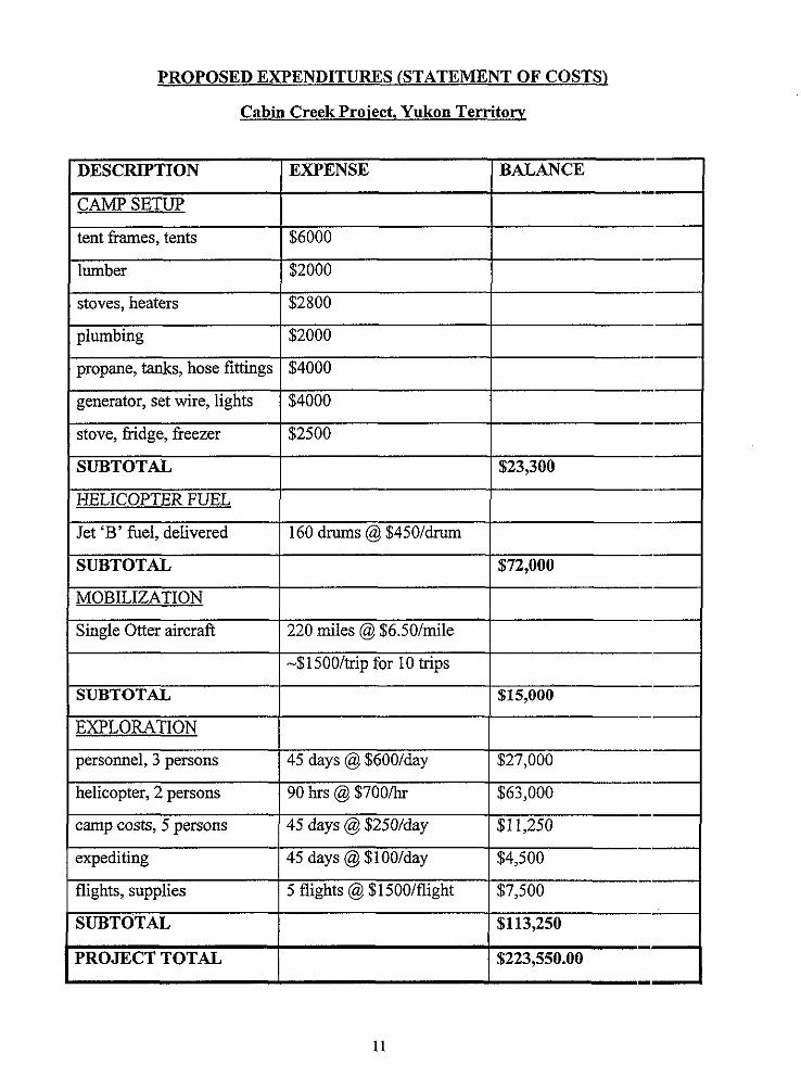
PROPOSED EXPENDITURES (STATEMENT OF COSTS)
Cabin Creek Proiect, Yukon Territorv
1 DESCRIPTION
CAMP SETUP
1 tent frames, tents
I lumber
stoves, heaters
plumbing
propane, tanks, hose fittings
generator, set wire, lights
stove, fridge, freezer
SUBTOTAL
I EXPENSE BALANCE
HELICOPTER FUEL
Jet 'B' fuel, delivered
SUBTOTAL
MOBILIZATION
Single Otter aircraft
SUBTOTAL
EXPLORATION
personnel, 3 persons
helicopter, 2 persons
camp costs, 5 persons
expediting
flights, supplies
SUBTOTAL
PROJECT TOTAL
160 drums @ $450/dnun
220 miles @ $6.50/mile
-$1500/trip for 10 trips
45 days @ $600/day
90 hrs @ $7OO/hr
$72,000
$15,000
$27,000
$63,000
45 days @ $250/day
45 days @ $100/day
5 flights @ $1500/flight
$11,250
$4,500
$7,500
$113,250
$223,550.00

Statement of Qualijications:
I, Brian A. Lueck, of the City of Coquitlam, British Columbia, do hereby (certify
that:
1. I am a graduate of the University of British Columbia and posses a B. Sc.
(honours) in Geology.
2. I have been employed as a consulting geologist or a government geologist
since June of 1985.
3. I am currently enrolled in a M. Sc. program in geology at U. B. C.
4. I am a member in good standing of The Association of Professional Engineers
and Geoscientists of the Province of British Columbia, and am currently
registered as a P. Geo.
5. I have been present on the property and have reviewed the data and
inspected the field work and I believe this report to be an accurate reflection of
the work performed on the property during 1996.

Statement of Qualzjications:
I, Zoran Pudar, of the City of Burnaby, British Columbia, do hereby certify that:
1. I am a graduate of the University of Tuzla, Yugoslavia and posses a EL Sc. in
Geology.
2. I have been employed as a exploration geologist since August of 1987 and as a
consulting geologist in Canada since October of 1995.
3. I am co-author of this report which is based on personal examination of the
property. I have reviewed the data and I believe this report to be an accurate
reflection of the work performed on the property during 1996.
Zoran Pudar
Exploration G:eologist

APPENDIX