Beaverkill Unit Management Plan
62
Division of Operations Bureau of Recreation __________________________________________ Beaverkill Public Campground Unit Management Plan FINAL Town of Rockland, Sullivan County, New York _____________________________________________ OCTOBER 2020 New York State Department of Environmental Conservation Division of Operations, 3 rd Floor 625 Broadway, Albany, NY12233 Governor ANDREW M. CUOMO Commissioner BASIL SEGGOS
Transcript of Beaverkill Unit Management Plan

Division of Operations Bureau of Recreation
__________________________________________
Beaverkill Public Campground
Unit Management Plan
FINAL
Town of Rockland, Sullivan County, New York
_____________________________________________
OCTOBER 2020
New York State Department of Environmental Conservation Division of Operations, 3rd Floor
625 Broadway, Albany, NY12233
Governor ANDREW M. CUOMO Commissioner BASIL SEGGOS


i
BEAVERKILL PUBLIC CAMPGROUND
SITE SPECIFIC - VOLUME II
UNIT MANAGEMENT PLAN
NOTE: Volume I is a generic plan that contains an overview, environmental setting, goals,
policy, management, and impact assessment criteria, which pertains universally and in common to all
Adirondack and Catskill public campgrounds and special day-use classified intensive-use areas. Volume
II is a site-specific document containing inventories of physical, biological, and human-made features,
along with specific management actions for the individual site. Volume III contains support data in the
form of an appendix to Volumes I and II.
Unit management plans (UMPs) are prepared by the New York State Department of
Environmental Conservation to cover the next ten-year management period. The final UMP is
completed according to guidelines and criteria set forth in the Catskill Park State Land Master Plan.
This UMP has been prepared by Department of Environmental Conservation Region 3 staff for
review. All comments and/or information related to this UMP should be forwarded to Jessie Swinehart,
with a copy to Josh Houghton, Division of Operations, Albany.
For information, contact Michael Buzzelli, Campground Program Manager, New York State
Department of Environmental Conservation, 625 Broadway, Albany, NY 12233, telephone 518-457-
2500.

ii
SUMMARY
BEAVERKILL PUBLIC CAMPGROUND
UNIT MANAGEMENT PLAN
In keeping with constitutional provisions criteria referenced in the Catskill Park State Land
Master Plan (CPSLMP) and Department of Environmental Conservation (DEC) management policy for
Forest Preserve state-owned lands, DEC has established a management plan for the ten (10) year
operation of the Beaverkill Public Campground.
Goals include the management of recreation programs to ensure the protection of natural
resources according to Environmental Conservation Law (ECL); offer recreational opportunities for
state residents; ensure that revenues equal operating costs for the portion of the program covered by user
fees; and enhance economic benefits to local communities and the state.
To help meet these goals, contingent upon funding, the 11 management actions below are being
proposed.
*Prioritized projects to be completed when funding becomes available
Proposed Management Actions* • Reconstruct comfort station #6 to include showers
• Construct an entrance booth at the day use area
• Rehabilitate comfort station #1
• Expand day use and construct a new pavilion
• Pave sections of roads in the camping loop
• Relocate campsites
• Demolish unused buildings and infrastructure
• Bury overhead lines in the day use area
• Plant trees and shrubs
• Perform restoration work to historic sites
• Improve existing trails and create a trail connection to the Wild Forest

iii
Beneficial effects of proposed actions include: compliance with state health codes, maintenance
of physical plant investment, and modernization of facilities. These improvements should enhance users’
recreational experiences, contribute to public safety, and provide conditions in a setting and on a scale in
harmony with the character of the Catskill Park.
Determination of conformance to criteria established in the Catskill Park State Land Master Plan
(CPSLMP) includes: determining whether proposed activities
• Avoid alterations of wetlands and topography
• Limit vegetative clearing
• Preserve the area’s scenic natural resources
• Contain an adequate assessment of actual and projected public use
Mitigation measures to minimize the environmental impacts have been considered. All
construction projects will minimize tree removal to reduce clearing and maintain the facility’s wooded
appearance. Architectural designs will be selected to achieve a harmonious blending with the character
of the recreation area and surrounding forest. Seeding and mulching of construction sites will readily
reestablish vegetation and effectively stabilize soil. Adjacent forest cover will not be altered. Project
proposals concentrate on improving and updating facilities to accommodate present peak-use periods
rather than projected visitor increases.
Various alternative actions were considered. Public concerns, adverse effects on local
communities, and uncontrolled use of state lands would sharply increase if recreation planning and
management efforts were reduced or dissolved. Current care, custody, and control preclude selection of
alternatives at this time.
iv
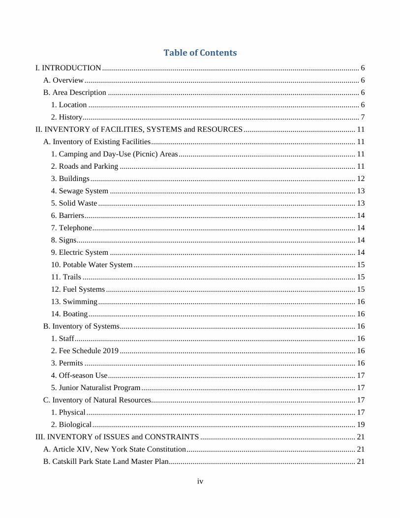
Table of Contents I. INTRODUCTION ................................................................................................................................... 6
A. Overview ............................................................................................................................................ 6
B. Area Description ................................................................................................................................ 6
1. Location .......................................................................................................................................... 6
2. History............................................................................................................................................. 7
II. INVENTORY of FACILITIES, SYSTEMS and RESOURCES ......................................................... 11
A. Inventory of Existing Facilities ........................................................................................................ 11
1. Camping and Day-Use (Picnic) Areas .......................................................................................... 11
2. Roads and Parking ........................................................................................................................ 11
3. Buildings ....................................................................................................................................... 12
4. Sewage System ............................................................................................................................. 13
5. Solid Waste ................................................................................................................................... 13
6. Barriers .......................................................................................................................................... 14
7. Telephone ...................................................................................................................................... 14
8. Signs .............................................................................................................................................. 14
9. Electric System ............................................................................................................................. 14
10. Potable Water System ................................................................................................................. 15
11. Trails ........................................................................................................................................... 15
12. Fuel Systems ............................................................................................................................... 15
13. Swimming ................................................................................................................................... 16
14. Boating ........................................................................................................................................ 16
B. Inventory of Systems ........................................................................................................................ 16
1. Staff ............................................................................................................................................... 16
2. Fee Schedule 2019 ........................................................................................................................ 16
3. Permits .......................................................................................................................................... 16
4. Off-season Use .............................................................................................................................. 17
5. Junior Naturalist Program ............................................................................................................. 17
C. Inventory of Natural Resources........................................................................................................ 17
1. Physical ......................................................................................................................................... 17
2. Biological ...................................................................................................................................... 19
III. INVENTORY of ISSUES and CONSTRAINTS ............................................................................... 21
A. Article XIV, New York State Constitution ...................................................................................... 21
B. Catskill Park State Land Master Plan ............................................................................................... 21

v
C. Environmental Conservation Laws .................................................................................................. 21
D. Campground Generic Plan/EIS ........................................................................................................ 21
E. Recreation Program Goals ................................................................................................................ 21
F. Public Use ......................................................................................................................................... 22
1. Inventory of Public Use ................................................................................................................ 22
2. Carrying Capacity ......................................................................................................................... 23
IV. PROPOSED MANAGEMENT ACTIONS ........................................................................................ 30
1. Reconstruct and expand comfort station #6 to include a shower facility ......................................... 30
2. Construct an entrance booth at day use area ..................................................................................... 31
3. Rehabilitate comfort station #1 ......................................................................................................... 31
4. Expand day use and construct pavilion ............................................................................................. 31
5. Pave sections of roads in the camping loop ...................................................................................... 32
6. Relocate campsites ............................................................................................................................ 32
7. Demolish unused buildings and infrastructure ................................................................................. 32
8. Bury overhead lines in the day use area ............................................................................................ 32
9. Plant trees and shrubs........................................................................................................................ 33
10. Restoration work to historic sites .................................................................................................... 33
11. Improve existing trails and create a trail connection to Wild Forest .............................................. 33
V. EXHIBIT INDEX ................................................................................................................................ 35

I. INTRODUCTION
6
I. INTRODUCTION
A. Overview
Beaverkill Campground is a state-owned public campground operated by the Department of
Environmental Conservation (DEC) within the Catskill Park. It is located and managed within the
DEC Region 3 – New Paltz office working circle. The facility is located on the famous Beaverkill
trout fishing stream, a tributary to the Delaware River that flows through the entire developed length
of the site. An historic covered bridge, originally constructed in 1865, is listed on the National
Register of Historic Places and spans the stream on the town road. The facility consists of 267 total
acres of forest preserve lands, with 36 developed acres in the camping area and six acres developed
in the day-use area. The Beaverkill stream is the attraction for most visitors, both for fishing
opportunities and its pleasant scenery. Campground amenities include 52 tent and trailer sites with
picnic tables and fireplaces, and a picnic area with tables and grills. There are flush toilets, hot
showers, a pay phone, a trailer dump station, a recycling center, and firewood for sale.
Area attractions are numerous. The Catskill Fish Hatchery, located about 15 miles away, is open
to the public. Shopping centers, restaurants, and theaters are within 15 miles in Liberty, Livingston
Manor, and the surrounding area. North of the campground there are thousands of acres of Forest
Preserve lands where hiking trails, fishing access sites and undeveloped recreational opportunities
exist. Historic attractions include the D&H Canal Locks; Fort Delaware; Minisink Battleground
Memorial Park; Stone Arch Bridge Historic Park; and the Sullivan County Historical Museum, Art
and Cultural Center. There are several historic bridges in the vicinity including the historic Roebling
Suspension Bridge which spans the Scenic and Recreational Upper Delaware River, a unit of the
National Park system at Minisink Ford.
Guidelines for management of the campground are based on its classification as an intensive-
use area in the Catskill Park State Land Master Plan (CPSLMP).
B. Area Description 1. Location
The campground is located on Berry Brook Road, six miles north of Livingston Manor and 0.3
miles west of Sullivan County Route 151 in the Town of Rockland, Sullivan County.

I. INTRODUCTION
7
2. History
The modern history of Beaverkill Campground is similar to that of much of the Catskill region.
In 1707, Major Johannes Hardenberg, a merchant in Kingston, NY, purchased the tract of land now
known as the Hardenberg Patent from local Native Americans for the sum of 60 pounds. This immense
parcel included all of what is today known as Sullivan County, as well as much of Delaware, Ulster, and
Greene counties. In 1749, the patent (i.e., land title) was divided into "Great Lots" apportioned among
eight proprietors. These Great Lots were further subdivided into tracts and divisions of various sizes.
Beaverkill Campground is located within what’s referred to as Great Lot #5, Township 5 on portions of
lots 382, 393, 394, 406, 409 and 410. Campground lands are also referred to on some real property
maps as the Overing Tract and the Tannery Lot.
The first settlers in what would become the Town of Rockland were farmers. They found
Iroquois living to the north, Algonquins to the south, and the Lenni Lenapes located in the region as
well. At first, these pioneers had trails for transportation instead of roads. The biggest trail was the Sun
Trail, which ran from the Hudson River to the East Branch of the Delaware River. Other trails included
the Berry Brook Trail, Beaverkill Trail, Mary Smith Trail, and Cross Mountain Trail. Around the year
1815, John Hunter acquired 29,700 acres, and employed workers to improve access, by cutting and
grading the Sun Trail into a road, further opening up settlement opportunities in the Beaverkill, Craig-E-
Claire, Turnwood, and Rockland area.
Settlement upon these lands was slow due to the landowners’ practice of leasing their lands to
farmers via perpetual leases rather than selling the land outright, known as the Dutch Patroon System.
The Livingstons, who at first owned about half the town, required the lands to be leased for three
generations with the following terms: free for the first three years after date of the lease, the fourth year
at the rate of five bushels of wheat per hundred acres, the fifth year 10 bushels per hundred acres, after
which and during the remainder of the lease, 15 bushels per hundred acres. This system persisted for
several decades, and eventually resulted in the “Anti Rent Wars.” In 1846, the New York Constitution
added provisions for tenant’s rights, abolishing feudal tenures and outlawing leases lasting longer than
12 years.
The plentiful supply of hemlock trees and water power spurred further development in the area
and throughout the Catskill region. Water power was utilized to grind hemlock bark and extract the
tannin for use in processing leather. According to J. H. French’s Gazetteer of the State, in 1885 there
were 40 tanneries in Sullivan County doing a $2 million in business. In 1832, Henry W. Ellsworth

I. INTRODUCTION
8
constructed a tannery at the settlement of Beaverkill, near where the Beaverkill Campground day use
parking lot is located today. According to author Michael Kudish, thousands of hemlocks were cut down
and peeled of their bark annually, and by the late 1880s, all but the most inaccessible hemlock stands
had been cut. Although some hemlock wood was utilized for bridge planking or other local uses, it is
estimated that 95 percent of the debarked, fallen trees were left to rot in the woods.
Other wood-using industries also had an important impact on the area. Trees were cut and the
logs were lashed together to form rafts to float down the Willowemoc and Beaverkill rivers to the
Delaware at East Branch, where they were made into larger rafts for the trip down the Delaware River to
Trenton and Philadelphia. Saw mills also operated in Lew Beach, Beaverkill, Craigie Clair, and Lake
Waneta. The Sherwood Mill at Livingston Manor, which produced table legs, Indian Clubs (a physical
fitness tool), dumbbells, and baseball bats, became a major wood-using mill in the region. Until 1900,
all Spaulding baseball bats were made at Sherwood's plant.
The Industrial Revolution generated a need for certain chemicals used principally in the
manufacture of woolen cloth. In the mid-1800s, a technique for making these chemicals by distilling
hardwoods was introduced in the U.S. from Scotland. The acid factory business was well suited to the
Catskills, as it required an abundance of hardwood timber as a raw material, large quantities of water to
cool the distillation machinery, and unskilled labor to harvest the raw material and work in the plants.
Heavy demands for wood chemicals during World War I brought a temporary boom to the industry,
which at its peak, consumed 100,000 cords of wood annually, and employed 3,000 men in Delaware
County and western Sullivan County. However, German scientists, working under the pressures of war,
developed a synthetic substitute for the chemicals, which were in great demand. While some factories
survived after this new technique by the end of World War II only a handful of plants were left.
Improvements in transportation also spurred further settlement and the beginning of the tourism
business. In 1865, a 98-foot single span covered bridge was built to traverse the Beaverkill, providing
the only crossing into the rest of the town and county for residents living on the river’s north side. On
October 3, 2007, the Beaverkill Covered Bridge was listed on the State and National Registers of
Historic Places, and today, it is one of only four covered bridges still standing in Sullivan County.
Development of the New York and Oswego Midland Railroad in 1873, later known as the New York,
Ontario and Western Railroad, not only opened the area to visiting fisherman, hunters, and other
recreationalists, it actively encouraged its development. As Austin Francis noted in his book Catskill
Rivers, the railroads created an accessible remoteness. In 1878, railroad management had 1,500,000

I. INTRODUCTION
9
brook trout and a large number of Lake and California trout distributed throughout the region. More
trout were stocked in successive years and, in 1891, J. C. Anderson, a passenger agent for the Ontario
and Western Railroad made an application to the State Fish Commission for 600,000 trout fry. That
same year, a bill to establish a fish hatchery in Sullivan County passed in the State Assembly and is said
to have led to the creation of the Catskill (DeBruce) Hatchery on Mongaup Creek. In his book To the
Mountains by Rail, Manville Wakefield credits the Ontario and Western Railroad management with
laying the groundwork for what has become one of the classic trout fishing regions in the world.
Wakefield also speculated on the creation of the Beaverkill Campground. On August 9, 1923, a
young Boy Scout from Liberty, bound for a vacation day's enjoyment, was dismayed to see the lower
Willowemoc's surface dotted with innumerable dead fish floating downstream. An investigating
theorized that some sort of poison had been released from the acid factory at Willowemoc. It’s not
known if the negative publicity the county received from this was a factor, but two months later, the
Beaverkill tannery farm was purchased to be preserved as a state park and campsite area.
As early as 1885, as the available timber and certain markets for timber started to become
exhausted, landowners began to sell their lands or ownership reverted to the state due to delinquent tax
payments. With the establishment of the State Forest Preserve in 1885 and the Catskill Park in 1905, the
state began to consolidate lands within the blue line delineating the Catskill Park. In 1927 and 1928, 23
acres of lands that were part of the Tannery farm, 30 acres of lands known as the Overing tract, and 45
acres of Lot 382 were purchased with money from a land acquisition Bond Act approved by New York
voters in the 1924 general election.
In 1931, the campground consisted of 10 fireplaces, a camping area, and bathhouses near the
covered bridge pool. During the next eight years, the Civilian Conservation Corps (CCC) program
expanded the campground by building 30 individual campsites featuring fireplaces and tables. Stone
walls were constructed along the river’s edge, as along with picnic facilities, stairs, and railings in the
day use area near the former tannery site. The CCC camp included land on both the east and west sides
of the covered bridge, with the CCC cabin office on the river’s west side. A crew portrait taken in 1939
shows 44 men and their supervisors who were employed at the site. When the CCC camp was disbanded
in 1939, the cabin was moved through the covered bridge to the east side of the river, where it is today.
Using funds from the Park and Recreation Land Acquisition Bond Act of 1960, significant
additions were made to the unit, including 170 acres of lands south of the developed campground in

10
1964 and .56 acres in the vicinity of the day use parking lot in 1978, bringing the total campground
lands to its current 267 acres.
Year Campground Improvement
1928 Picnic tables and fireplaces placed on the north side of the Beaverkill
1930’s CCC developed campsites on both sides of Beaverkill. Eventually there were 97
campsites.
1964 164 acres south of the developed facility added to campground
1966 Rehabilitation of facility septic systems
1968 A garage constructed
1969 Comfort stations #3,4, and 5 constructed
1972 Comfort station #2 constructed
1975 Trailer dump station constructed
1978 .56 acres near the day use parking lot are added to campground
1985 Shower building and comfort station #1 are constructed
1996 Flooded sites along stream are repaired and regraded
2000 Rehabilitation of the sewage system. New septic tanks at dump station, comfort stations
3&6, and the lifeguard cabin.
2006 Sites #1–43 abandoned due to persistent flooding
2017 Rehabilitation of the facility’s water system
2017 Rehabilitation of the covered bridge

II. INVENTORY of FACILITIES, SYSTEMS and RESOURCES
11
II. INVENTORY of FACILITIES, SYSTEMS and RESOURCES
A. Inventory of Existing Facilities
1. Camping and Day-Use (Picnic) Areas
Existing Camping and Day-Use Facilities
Camping Area Day-Use Area
• 52 Campsites
• 52 Picnic Tables
• 52 Fireplaces
• 8 Spigots
• Design Capacity – 312 people
(52 sites x 6 persons)
• 1.2 Acres
• 10 Picnic Tables
• 7 Grills
• 4 Spigots
• Design Capacity – 60 people
(10 tables x 6 persons)
2. Roads and Parking
DEC-maintained roads consist of 0.2 miles of gravel surface and 1.0 miles of blacktop
surface. One-way roads range from 8-10 feet in width, while two-way roads range up to 20 feet
in width. At the time of this inventory, the paved portions of the campground roads were in fair
condition and the gravel roads were in poor condition. There are also four 24" culverts and one
36" x 48" culvert for drainage purposes.
There are two parking areas in the day use area. A 240’ x 45’ parking area near the
covered bridge provides parking for picnickers and anglers. The lot capacity is 16 cars. A second
120’ x 45’ lot is located near the shower building and provides parking for campers using the
shower facilities, as well as picnickers and anglers. The lot capacity is 8 cars.
A foot path, 3,175 feet in length, connects the camping area to the covered bridge day-
use area. A second footpath, 1,350 feet in length, provides access to the south shore of the
Beaverkill, starting at the shower building.
A direct route from the facility supervisor's registration control booth to the camping area
requires crossing the covered bridge. Due to their size, many larger camper/motor homes cannot
pass through the bridge and must use an alternative route to access the campground entrance.
Some control problems develop as these vehicles take Berry Brook Rd., an 1,800 ft., town of

II. INVENTORY of FACILITIES, SYSTEMS and RESOURCES
12
Rockland road that passes through the campground, which allows them to bypass the control
booth and access the campground at numerous locations.
Bridges and Culverts
Bridges Culverts
• Covered vehicle bridge over the
Beaverkill connecting campground to day
use area.
Owned by Town of Rockland
Maintained by Sullivan County
• Drainage under campground roads (4)
3. Buildings
MMS # Building Name/Function Location/Description/
Use
Size Condition Year
Built
(001) Caretakers cabin (old) Near bridge 687 sf Poor 1934
(002) Garage Behind supervisor cabin 925 sf Fair 1968
(007) Comfort station #1 Near day-use parking area 255 sf Not in use 1985
(008) Shower building Near day-use parking area 1,024 sf Fair 1984
(009) Comfort station #2 On island 374 sf Not in use 1972
(010) Comfort station #3 Near old site #25 255 sf Not in use 1969
(012) Comfort station #4 Near old site #6 255 sf Not in use 1933
(013) Comfort station #5 Near campsite #50 374 sf Poor 1969
(016) Comfort station #6 Near campsite #60 374 sf Fair 1969
(017) Caretakers cabin (new) Near entrance gate 860 sf Good 1993
(018) Ticket Booth (campground) Near entrance gate 92 sf Good 1993
(019) Spring house Near river 36 sf Not in Use 1934
(020) Recycle Center Near site #96 400 sf Good 1995
(021) Reservoir Near road 225 sf Not in use 1934
Chlorination building Near site #96 299 sf Good 2015
Numbers in parentheses are building numbers assigned in the Maintenance Management System (MMS) Building Inventory.
Building condition rating from (MMS) building inspection report based on inspection conducted November 20, 2018.

II. INVENTORY of FACILITIES, SYSTEMS and RESOURCES
13
4. Sewage System
Effluent from the old and new caretaker’s cabins, shower building, and comfort station #6 flows
by gravity to adjacent septic tanks and tile fields. Effluent from comfort station #5, the trailer dump
station, and recycle center flow by gravity to adjacent septic tanks and then to a 4,000 sq. ft. centralized
tile field in the camping loop. Comfort stations 1-4 and a lift station near comfort station #4 are not in
service. The SPDES DEC permit #NY0164950 issued for this campground lists a 6,580 gal/day
hydraulic flow limit. (See Exhibit 5)
MMS# Building Description Septic Tank Size
(gallons)
Leach Field
(sq. ft)
Fixtures
(001) Caretaker’s cabin (old) 1,000 600 1T, 2S, 1SH
(007) Comfort station #1 * 1,000 720 6T,2S
(008) Shower building 5,000 gal 2,040 8T, 4S, 8SH
(009) Comfort station #2 * 2,000 500 8T,2S
(010) Comfort station #3 * 1,000 Central field 8T,2S
(012) Comfort station #4 * 2 X 1,000 Central field 8T,2S
(013) Comfort station #5 2 X 1,000 Central field 8T, 2S
(016) Comfort station #6 2 X 1,000 1,000 8T, 2S
(017) Caretakers cabin (new) 1,000 Unknown 1T, 2S, 1SH
(020) Recycle center 2,000 Central field 1S
Dump station 2,000 Central field faucet
Numbers in parentheses are building numbers assigned in the MMS Building Inventory. T=toilet or urinal, S=sink, SH=shower, * - Building not in use
5. Solid Waste
The campground has a recycle center where campers can leave garbage and recyclables.
Garbage is picked up under contract by Thompson Sanitation Corporation. DEC staff transport the
recyclables to the Town of Rockland transfer station. All day-use and camping areas are managed under
the carry-in, carry-out policy. Appropriate signs have been erected to inform the public, and a brochure
is issued to campers and day-users.
II. INVENTORY of FACILITIES, SYSTEMS and RESOURCES
14
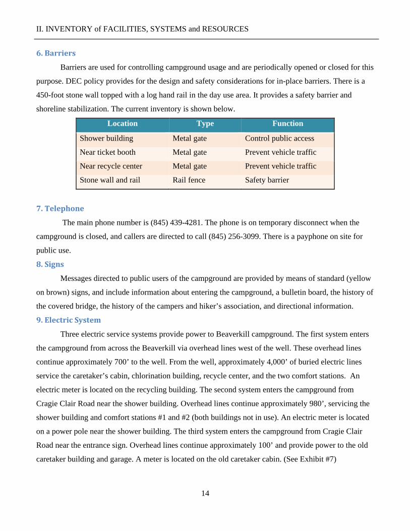
6. Barriers
Barriers are used for controlling campground usage and are periodically opened or closed for this
purpose. DEC policy provides for the design and safety considerations for in-place barriers. There is a
450-foot stone wall topped with a log hand rail in the day use area. It provides a safety barrier and
shoreline stabilization. The current inventory is shown below.
Location Type Function
Shower building Metal gate Control public access
Near ticket booth Metal gate Prevent vehicle traffic
Near recycle center Metal gate Prevent vehicle traffic
Stone wall and rail Rail fence Safety barrier
7. Telephone
The main phone number is (845) 439-4281. The phone is on temporary disconnect when the
campground is closed, and callers are directed to call (845) 256-3099. There is a payphone on site for
public use.
8. Signs
Messages directed to public users of the campground are provided by means of standard (yellow
on brown) signs, and include information about entering the campground, a bulletin board, the history of
the covered bridge, the history of the campers and hiker’s association, and directional information.
9. Electric System
Three electric service systems provide power to Beaverkill campground. The first system enters
the campground from across the Beaverkill via overhead lines west of the well. These overhead lines
continue approximately 700’ to the well. From the well, approximately 4,000’ of buried electric lines
service the caretaker’s cabin, chlorination building, recycle center, and the two comfort stations. An
electric meter is located on the recycling building. The second system enters the campground from
Cragie Clair Road near the shower building. Overhead lines continue approximately 980’, servicing the
shower building and comfort stations #1 and #2 (both buildings not in use). An electric meter is located
on a power pole near the shower building. The third system enters the campground from Cragie Clair
Road near the entrance sign. Overhead lines continue approximately 100’ and provide power to the old
caretaker building and garage. A meter is located on the old caretaker cabin. (See Exhibit #7)

II. INVENTORY of FACILITIES, SYSTEMS and RESOURCES
15
10. Potable Water System
In 2017, a contract for a new water pumping system included a submersible pump, chlorine
metering system, storage tanks, booster pumps, bladder tanks, and connections to the existing water
distribution piping. The existing water treatment building near the well was demolished, and the new
equipment was installed in an existing building near the recycling center. A second well located on the
island was decommissioned, and new waterline was directionally bored under the Beaverkill to connect
to existing waterlines that service the day use facilities. The new 3hp well pump yields 45gpm. There
are 1.6 miles of water line distributing water to 12 water spigots, 2 comfort stations, the shower
building, two staff cabins, and a trailer dump station. A spring house and reservoir located near the
covered bridge are not in service. Old water lines and spigots taken out of service remain on the
property. (See Exhibit #6)
11. Trails
There are .85 miles of trails within the campground, connecting the camping area to the day use
area and a trail along the Beaverkill, downstream from the day use area. While there are no hiking trails
leading directly from Beaverkill Campground, the 27,800-acre Delaware Wild Forest is located just a
few miles to the north. This Wild Forest features more than 35 miles of hiking trails, including the
Finger Lakes Trail, and more than 20 miles of snowmobile trails. To the east lies the 14,800-acre
Willowemoc Wild Forest, which includes a 40-mile trail network that provides access to six ponds and a
world-class trout stream, the Willowemoc Creek. Although hilly, the terrain is not as rugged as the
Catskill High Peaks. The Willowemoc Wild Forest has the most expansive snowmobile system in the
Catskills.
Distances to nearby trailheads include Huggins Lake (3 miles), Pelnor Hollow Trail (4 miles),
and the Mary Smith Trail (5 miles). Waneta Lake, which lies two miles south of the campground, has an
accessible fishing pier that offers good fishing opportunities. The lake also offers car-top boating and
picnicking, with an accessible picnic table and parking area.
12. Fuel Systems
Propane tanks located near the caretaker’s cabin provide fuel for that cabin, as well as the
assistant caretaker’s cabin and the shower building. Annual fuel use is about 345 gallons.

II. INVENTORY of FACILITIES, SYSTEMS and RESOURCES
16
13. Swimming
There is no swimming area at Beaverkill Campground. Campers are permitted to use the beach at
Little Pond Campground, located eight miles away, or at Mongaup Pond, located 16 miles away.
14. Boating
The Beaverkill contains more whitewater than flat stretches and has limited put-in and take-out
locations. There are several small ponds and lakes in the vicinity suitable for paddling. Canoes and
kayaks can be rented at Little Pond or Mongaup Pond campgrounds.
B. Inventory of Systems
1. Staff
Total Position Title
1 Conservation Recreation Facilities Supervisor II
1 Facilities Operation Assistant 1
2 Park and Recreation Aides
1 Conservation Security Worker
2. Fee Schedule 2019
Daily Fees
2019 Open Dates: May 17-Sep 2
Camping/night – NYS Residents $20.00
Camping/night – Non-Residents $25.00
Day Use - Auto $6.00
Day Use - Walk-In $2.00
Day Use - Bus $35.00
Day Use - Motorcycle $4.00
Firewood – per bundle $9.00
3. Permits
Peddling permits may be issued annually for firewood and camper supplies. Each vendor is
charged a fee of $2.00 multiplied by the number of campsites. No permits were issued in 2019.

II. INVENTORY of FACILITIES, SYSTEMS and RESOURCES
17
4. Off-season Use
Camping is not permitted when the campground is closed. A gate above the ticket booth is
closed during the off-season, and vehicles are not permitted to enter the camping portion of the facility.
The campground roads may be used for cross-country skiing, hiking, birdwatching, nature photography,
and similar pursuits. The parking lot in the day use area near the Beaverkill is open in the spring and
provides fishing access to the stream. There are no services when the campground is closed.
5. Junior Naturalist Program
The Junior Naturalist Journal is an activity book that gives children the opportunity to test their
environmental knowledge, while teaching them about New York State's environment. Children aged 5
through can request a Junior Naturalist Journal from campground staff. When the journal is completed,
a child can bring it to the appropriate DEC staff person, who reviews the journal and will give the child
a Junior Naturalist patch. This program was offered the 2019 camping season, but is dependent on
funding being available, and may not be offered every year.
C. Inventory of Natural Resources
1. Physical
a. Elevation
Elevation of the Beaverkill Campground varies from a minimum of 1,410 feet along the
Beaverkill River at the western boundary to a maximum of 1,725 feet along Beaverkill Road on the
eastern boundary. (See Exhibit 2.)
b. Water
The Beaver Kill, sometimes written as the Beaverkill or Beaverkill River, is a tributary of
the East Branch Delaware River, a main tributary of the Delaware River, and is approximately 44
miles in length. The river drains a 300-square-mile area of the Catskill Mountains and has long
been celebrated as one of the most famous trout streams in the United States. Its preservation
helped establish many of the basic conservation principles of rivers in the United States. The river
forms the southern boundary for ⅔ of a mile on the western portion of the campground, flows
within the boundary for ⅔ of a mile in the center portion of the campground, and forms the
southern boundary for ½ of a mile on the eastern portion of the campground. The outlet of Waneta
Lake flows through the campground for approximately ¾ miles and enters the Beaverkill on the
south bank upstream from the campsites. (See Exhibit 2)

II. INVENTORY of FACILITIES, SYSTEMS and RESOURCES
18
c. Wetlands
Wetlands are inventoried, mapped, and protected by DEC under Article 24 of the Environmental
Conservation Law. The National Wetlands Inventory within the campground boundary includes 1.7
acres of forested/shrub wetland on an island upstream of the campsites, a small portion of a 2.5-acre
forested/shrub wetland located along the Beaverkill upstream of the campground, 1.3 acres of freshwater
emergent wetland south of the day-use area and 0.9-linear miles of Riverine Wetland, including the
entire length of the Beaverkill within the campground. Projects that alter or adversely affect the
wetlands, or any sewage disposal system within 100 feet of the wetland, requires a permit from DEC. In
addition, DEC will be consulted to determine whether a permit is needed prior to site disturbance in or
adjacent to designated wetland areas. (See Exhibit 9)
d. Soils
Soil associations and drainage classes found within the boundary of Beaverkill Campground are
listed below. (See Exhibit 11)
Soil Type Drainage Class Notes
Swartswood and Lackawanna soils, steep, very stony Well drained Not prime farmland
Wellsboro and Wurtsboro soils, strongly sloping,
extremely stony
Moderately well
drained
Not prime farmland
Barbour loam Well drained Prime farmland
Bash silt loam Poorly drained Prime farmland if
drained
Fluvaquents-Udifluvents complex Poorly drained Frequently flooded
Lackawanna channery loam, 15 to 25 percent slopes Well drained Not prime farmland
Arnot-Rock outcrop complex, 35 to 70 percent slopes Excessively drained Not prime farmland
Tunkhannock and Otisville soils, steep Well drained Prime farmland
Tunkhannock gravelly loam, 0 to 3 percent slopes Well drained Prime farmland
Wellsboro gravelly loam, 3 to 8 percent slopes Moderately well
drained
Prime farmland
Morris loam, 8 to 15 percent slopes Somewhat poorly
drained
Prime farmland

II. INVENTORY of FACILITIES, SYSTEMS and RESOURCES
19
2. Biological
a. Forest Type
There are three forest cover types present in the campground: northern hardwoods, pioneer
hardwoods, and plantation.
The major tree species in the northern hardwoods type are sugar maple, beech, yellow birch,
hemlock, black cherry, white ash, and red maple. Tree sizes vary from pole to saw timber.
The pioneer hardwoods stands occur on abandoned agricultural land in various stages of
succession, reverting back into forest lands. This growth varies anywhere from semi-open brush fields to
pole-size stands of trees. Major species found in this type are apple, red maple, sugar maple, black
cherry, shadbush, thorn apple, aspen, white ash, hornbeam, and white pine.
Two major plantations are found on the campgrounds. Near the entrance to the camping area,
there is a 60+ year old plantation comprised mainly of Norway spruce, with small areas of white pine
and scotch pine. Another plantation composed of red pine and Norway spruce can be found near the
Beaverkill United Methodist Church on Craigie Clair Road. A small area of larger sized white pine is
located in the picnic area.
b. Unique Vegetation
The New York Natural Heritage Program keeps track of the status of the state's rare flowering
plants, conifers, ferns and fern allies, and mosses. Northern Monkswood (Aconitum noveboracensea), an
endangered vascular plant, has previously been identified in an area along the Beaverkill, east of the
campground, but an extensive search in 2012 did not locate any of these plants.
c. Wildlife
The area is located within the Catskill Peaks and Delaware Hills ecological zone, and the wildlife
found here are similar to those in other areas of southeastern New York State. The northern hardwood
forest favors black bear, snowshoe hare, wild turkey, gray squirrel, raccoon, and porcupine. Early
successional species, such as white-tailed deer: cottontail rabbit and ruffed grouse occur, but at lower
elevation, flatter terrain, and more diverse vegetation. Breeding species of birds include the pileated
woodpecker, yellow-bellied sapsucker, red-breasted. nuthatch, eastern phoebe, ovenbird, sparrows, and
warblers. For more information, refer to the Willowemoc – Long Pond Wild Forest unit management
plan available on the DEC website. Hunting and the discharge of firearms are prohibited within the
campground.

II. INVENTORY of FACILITIES, SYSTEMS and RESOURCES
20
d. Fisheries
The Beaverkill stream, passing through the campground, with its C(T) classification - best use
for fishing, trout, represents one of the most popular trout streams in the Catskill Park region. Chemical
conditions are considered very satisfactory for the support of aquatic life. The approximately two miles
of stream that flow through the campground provide some of the only public fishing available on the
upper Beaverkill, downstream of the Forest Preserve.
The Beaverkill is divided into the upper and lower sections at the confluence with the
Willowemoc Creek in Roscoe, NY. Both sections support wild brown trout. The upper section of the
river supports a wild brook trout population that increases as you move upstream towards the
headwaters. Rainbow trout are also scattered throughout the watershed as a result of both natural
reproduction and non-DEC stockings in private sections of the river. DEC annually stocks over 18,000
brown trout in the Beaverkill and seasonal anadromous runs of American shad are reported in some
years from the lower section. Fishing for trout is permitted by regulation from April 1 to November 30.
Some special regulations apply.

III. INVENTORY of ISSUES and CONSTRAINTS
21
III. INVENTORY of ISSUES and CONSTRAINTS
A. Article XIV, New York State Constitution Article XIV of the NY State Constitution provides, in part, that “the lands of the state, now
owned or hereafter acquired, constituting the Forest Preserve as now fixed by law, shall be forever kept
as wild forest lands. They shall not be leased, sold or exchanged, or taken by any corporation, public or
private, nor shall the timber thereon be sold, removed, or destroyed.”
B. Catskill Park State Land Master Plan
The Catskill Park State Land Master Plan (CPSLMP) requires that all campgrounds and day use
areas to be of a rustic nature. Natural materials will be used to the fullest extent possible in the
construction so as to blend with the Catskill environment. These constraints are further described in
Volume I of the generic UMP/EIS.
C. Environmental Conservation Laws The management plan has been developed within the constraints set forth by the Environmental
Conservation Law (ECL), Rules and Regulations of the State of New York, and established policies and
procedures for the administration of the lands involved.
D. Campground Generic Plan/EIS The management plan has been developed within the constraints set forth by the Generic Unit
Management Plan/Environmental Impact Statement (GUMP/EIS), and contains an overview,
environmental setting, goals, policy, management, and impact assessment criteria which pertain
universally and in common to all Adirondack and Catskill public campgrounds and special day use
classified intensive use areas.
E. Recreation Program Goals
• Manage recreation programs in a manner that ensures protection of natural resources according
to the Environmental Conservation Law, Article XIV of the New York State Constitution, and
the Adirondack and Catskill Parks State Land Master Plans.
• Offer recreational opportunities for state residents.
• Ensure that revenues equal operating costs for that portion of the program covered by user fees.
• Manage the program to enhance economic benefits to local communities and the state.

III. INVENTORY of ISSUES and CONSTRAINTS
22
F. Public Use
1. Inventory of Public Use
Attendance numbers are a combination of camper days (the number of campers multiplied by the
number of nights spent) and day use (the number of people using the beach, day use areas, or just
visiting), but not staying overnight. The five-year trend in camping attendance indicates stable levels of
visitation with some fluctuation possibly related to weather. The current camping attendance is
significantly lower than the 15,257 camper visits recorded in 1994, prior to the closure of 63 campsites
in the low-lying areas of the campground. The average length of stay is 2.4 nights and the average party
size is 2.9 persons. Most Beaverkill campers are from New York State (72%) and New Jersey (18%),
with strong representation from lower Hudson Valley area, as well as New York City and Long Island.
(See Exhibit 12)
Day use attendance for the most recent five
year period indicates widely fluctuating totals due to
multiple causes. While weather plays a major role in
day use attendance, with no control booth at the
entrance of the day use area, collection of fees is
inconsistent. The reported attendance numbers are
lower than the true attendance. Recent increases are
due partly to increased staff efforts to collect fees.
Anecdotal reports from campground staff indicate
attendance has also increased since a permit system was implemented at the Blue Hole swimming area
in July of 2018. Campground use during winter months is from the use of roads for walking or skiing.
Currently, there is no way to accurately track usage because no permits are required or issued for off-
season use, nor is staff on site to monitor use.
a. Attendance Trends Beaverkill Attendance Year Camping Day Use Total
2019 6,749 4,142 10,891
2018 6,119 1,812 7,931
2017 5,652 1,024 6,676
2016 7,118 1,153 8,271
2015 6,702 2,259 8,961
Average 6,468 2,078 8,546

III. INVENTORY of ISSUES and CONSTRAINTS
23
b. Revenue Trends
Revenues are important because
they are used to offset the campground’s
annual operating costs. Operating costs
for Beaverkill average $56,871 annually.
The operating budget allocation is, in part,
based on revenues generated from
camping and other service fees, as well as
economic conditions for the geographic
area. Camping revenue comes from the
rental of the 52 campsites, and generally shows some variability, which is tied to attendance fluctuation,
fee increases, length of the camping season, and weather events. The nightly camping rate at Beaverkill
Campground has been $20.00 since 2017. In 2011, an additional $5.00 fee per night was instituted for
non-state residents. Camping revenue has been fairly static at the campground over the last five-year
period. Day use revenue is derived from park entrance fees. Miscellaneous revenue comes from a
combination of firewood sales and Empire Passport sales. Total day use revenue has increased in the
past two seasons. Firewood sales were instituted in 2015, after regulations were put in place limiting the
transport of firewood over 50 miles to reduce the spread of invasive species.
2. Carrying Capacity
Beaverkill Campground facilities should be operated within the physical, biological, and social
carrying capacity of the site. Operation within these limits will grant continued character and integrity to
intensive recreational use at this location and will ensure that public use is conditioned within the
campground’s carrying capacity.
a. Physical Design
The following is an analysis of existing design capacities compared to NYS Department of
Health codes and DEC’s design standards. The existing design capacity for the 52 campsites is 6 persons
per site or 312 persons total. The day use design capacity is 6 persons per picnic table x 10 tables, or 60
persons total.
The table below compares calculated capacity needs with currently available capacity and notes
deficiencies. The proposed management actions for this facility are aimed at addressing these
deficiencies. While the number of toilets and sinks is adequate for the day use area, the distance to the
Beaverkill Revenue Year Camping Day Use Misc Total
2019 $48,735 $4,313 $8,665 $61,713
2018 $45,975 $2,888 $7,594 $56,457
2017 $46,280 $1,748 $5,751 $53,779
2016 $47,955 $1,710 $8,558 $58,223
2015 $47,955 $2,259 $8,810 $59,024
Average $47,380 $2,584 $7,875 $57,839

III. INVENTORY of ISSUES and CONSTRAINTS
24
bathroom (in shower building) exceeds 500’. Utility sinks are needed in the camping loop to provide a
sanitary and convenient location for cleaning and wastewater disposal.
Facility Infrastructure Capacity Analysis Facility Description Design Standard* Calculated
Need
Currently
Available
Deficiency
Campsites 1,250 sf/site 1,250 sf/site 1,250 sf/site None
Trailer dumping station 1 for every 100 sites 1 1 None
Potable water supply 55 gal/day/site
5 gal/day/picnicker
2,860 gal
300 gal
64,800 gal
None
None
Water spigots 1/10 campsites
1/60 picnickers
6
1
8
4
0
0
Sinks (within 500’) 1 for every 15 campsites
1 for every 60 picnickers
5
1
4
4
1
0 1
Toilets/Urinals
(within 500')
2 for every 10 sites
2 for every 60 picnickers
6
2
16
8
0
2 1
Utility sinks Conveniently located 2 0 2
Showers 2 for every 25 sites 3 8 0
*DEC design standards meet or exceed NYS Health Department codes. 1 – The distance from some of the day use areas to the bathroom (in shower building) exceeds 500’.
b. Biological Carrying Capacity
Many campsites have been in continuous use since the campground opened, and, depending on
site design and level of occupancy, they are showing their age in loss of vegetation screening, soil
compaction, drainage issues, and site amenity needs. To address these concerns, a program-wide
campsite restoration project is underway to evaluate the condition and needs of each facility, including
all 6,000 campsites maintained in DEC’s campgrounds. In most cases, sites that require restoration work
will be removed from use for two camping seasons. At Beaverkill campground, sites 81 & 94 were
selected and restored during the 2017/2018 season, and site 85 has been selected for the 2018/2019
season. Restoration work will include:
• Planting trees and shrubs
• Replacing lost soils
• Regrading sites

III. INVENTORY of ISSUES and CONSTRAINTS
25
• Improving drainage
• Evaluating the design and size of campsites
• Replacing deteriorated tables and fireplaces
During the winter, this campground is closed for camping and receives little use, as previously
noted. In the camping season, most vehicular traffic occurs on paved surfaces, which helps limit soil
compaction, rutting, and erosion. Hazardous trees are regularly removed (in accordance with established
policy), and natural regeneration and the replanting and growth of residual trees compensate for any
losses.
c. Social Carrying Capacity
Annual camper surveys have been conducted at each campground since 1996. Campers have
been asked to rate their camping experiences on a scale from unacceptable to excellent. Based on
responses received over the last five years, this campground appears to be generally operating within an
acceptable social carrying capacity at current attendance levels. In the 2018 survey, campers were
invited to provide any additional comments or suggestions they had about their visit. A total of 28
comments were received, with 14 comments commending the staff for being helpful, 3 comments citing
the lack of maintenance in the shower building and bathrooms, and 8 single comments about noise, a
slow check-in process, trees needing trimming, a request for a longer camping season, the fireplace
needing repair, and an eroded campsite. The low number of respondents in the 2019 survey (10) makes
it difficult to draw conclusions on camper concerns and satisfaction.
Additional impacts associated with planned campground objectives and actions are identified
and discussed in the Generic Unit Management Plan Volume I. The table below summarizes survey
statistics over the past five years.
Beaverkill Camper Survey Year Number of
Respondents
Good or
Excellent Rating
2019 10 60%
2018 48 75%
2017 110 87%
2016 141 92%
2015 127 86%

III. INVENTORY of ISSUES and CONSTRAINTS
26
D. Unique Ecosystems, Historical
No significant unique ecosystems have been identified or are known to exist at this campground.
The New York State Archaeological Site Locations Map indicates that archaeological resources may be
present in the vicinity of the day use area. Prior to site disturbance of any construction affiliated with
this management plan, the nature and extent of archaeological resources in the project area, if any, will
be investigated. If it appears that any aspect of the project will cause changes, beneficial or adverse, all
reasonable and prudent alternatives will be considered together with feasible plans to avoid and/or
mitigate adverse impacts on the property. The agency preservation officer has been provided a copy of
this plan to review, in keeping with the New York State Historic Preservation Act of 1980.
The Beaverkill Covered Bridge is listed in the State and National Registers of Historic Places.
As such, state agency actions related to the bridge are subject to the provisions of the New York State
Historic Preservation Act (SHPA) and its implementing regulations (Article 14, PRHPL and 9 NYCRR
Part 428). Any state agency undertaking repairs or maintenance that meet the definition of undertaking
found in NYCRR Part 428.4 shall undertake consultation with OPRHP as required by SHPA. DEC shall
be included as a party to any such consultation.
DEC worked with the Open Space Institute (OSI) through its Alliance for New York State Parks
program as well as the Friends of Beaverkill, who developed a Concept Plan for improvements to the
landscape and cultural interpretation at the greater Beaverkill landscape and the Beaverkill Covered
Bridge Landing. The report was undertaken by W Architecture and Landscape Architecture, LLC in
2015. Many of the recommendations in the concept plan, entitled “Covered Bridge Landing at
Beaverkill” were included in the revised UMP.
E. Adjacent Lands
The campground boundary totals 5.2 miles, 95% of which is bordered by private lands. The
Beaverkill Stream bisects the campground and private lands for 1.1 miles of the 1.9 miles it flows past
campground lands. There are 10 private parcels on the north boundary totaling 1.6 miles. Berry Brook
Road bisects the campground and private parcels on the north for 0.6 mile. There are 10 private parcels
on the east boundary totaling 1.9 miles. Campsite Road bisects the campground and private parcels for
0.3 mile on the east. To the south are three private parcels totaling 1.3 miles, and the 14,800-acre
Willowemoc Wild Forest borders the campground for 0.3 mile. To the west are two private parcels

III. INVENTORY of ISSUES and CONSTRAINTS
27
totaling 0.2 mile. There are two inholdings. A 1.1-acre private parcel and the 1.7-acre Beaverkill
Cemetery are both located on Craigie Clair Road within the boundaries of Beaverkill Campground.
The campground provides employment for local residents, and their wages are largely spent at
local businesses. Various supplies and materials needed for campground maintenance are also frequently
purchased locally. Local contractors, including plumbers, electricians, carpenters, masons, and others,
are also used at times.
F. Invasive Species
DEC is concerned about the threat of invasive species at Beaverkill is, both for their destructive
effect on our environment and the associated financial drain on revenue and resources.
One common way many insect pests are moved around the country, beyond their natural rate of
spread based on biology and flight potential, is on firewood carried by campers, hunters, and other forest
users. Infested firewood may come from trees killed by insect pests and could inadvertently spread these
pests to new areas when the wood is transported by campground users. DEC regulation 6 CRR-NY Part
192.5 prohibits the import of firewood into New York unless it has been heat treated to kill pests, and
limits the transport of untreated firewood to less than 50 miles from its source.
DEC’s goal, in collaboration with other agencies and interested groups, is to establish a
documented inventory of invasive species by location within the campground. Once an inventory is
established, staff implements a management program to help contain and possibly eradicate, further
growth of these species.
In 2016, in partnership with the Open Space Institute and the Friends of Beaverkill Community,
the Excelsior Conservation Corp identified Japanese knot weed and multiflora and worked to remove
these invasive plants from the campground.
H. ADA Accessibility Guidelines
The Americans with Disabilities Act (ADA), along with the Architectural Barriers Act of 1968
(ABA) and the Rehabilitation Act of 1973, Title V, Section 504, have a profound effect on the manner
by which people with disabilities are afforded equality in their recreational pursuits. The ADA is a
comprehensive law prohibiting discrimination against people with disabilities in employment practices,
use of public transportation, use of telecommunication facilities, and use of public accommodations.
Consistent with ADA requirements, DEC incorporates accessibility for people with disabilities
into siting, planning, construction, and alteration of recreational facilities and assets supporting them.

III. INVENTORY of ISSUES and CONSTRAINTS
28
In addition, Title II of the ADA requires, in part, that services, programs, and activities of the
Department, when viewed in their entirety, are readily accessible to and usable by people with
disabilities. DEC is not required to take any action that would result in a fundamental alteration to the
nature of the service, program or activity, or would present an undue financial or administrative burden.
When accommodating access to a program, DEC is not necessarily required to make each existing
facility and asset accessible, as long as the program is accessible by the other means or at a different
facility.
This plan incorporates an inventory of all the recreational facilities and assets on the unit or area,
and an assessment of the programs, services, and facilities provided, to determine the level of
accessibility. In conducting this assessment, DEC employs guidelines which ensure that programs are
accessible, and that buildings, facilities, and vehicles, are accessible to individuals with disabilities in
terms of architecture and design, transportation, and communication.
For outdoor recreational facilities not covered under the current ADA standards, DEC will use
standards provided under the Architectural Barriers Act to lend credibility to the assessment result and
to offer protection to the natural resource.
All new facilities or parts of facilities that are constructed for public use are to be accessible to
people with disabilities. Full compliance is not required where DEC can demonstrate that it is
structurally impracticable to meet the requirements. (See Text of 28 CRF § 35.151 (a)(b) below).
Compliance is still required for parts of the facility that can be made accessible to the extent that it is not
structurally impracticable, and for people with various types of disabilities.
A record of accessibility determination is kept with the work planning record. Any new facilities,
assets, and accessibility improvements to existing facilities or assets proposed in this plan are identified
in the section containing proposed management actions.
28 CFR § 35.151 (a)(b)
(a) Design and Construction.
(1) Each facility or part of a facility constructed by, on behalf of, or for the use of
a public entity shall be designed and constructed in such a manner that the
facility or part of facility is readily accessible to and usable by individuals
with disabilities, if the construction was commenced after January 26, 1992.

IV. PROPOSED MANAGEMENT ACTIONS
29
(2) There are exceptions for structural impracticability:
“(i) Full compliance with the requirements of this section is not
required where a public entity can demonstrate that it is structurally
impracticable only in those rare circumstances when the unique
characteristics of terrain prevent the incorporation of accessible features.
(ii) If full compliance with this section would be structurally impracticable,
compliance with this section is required to the extent that it is not structurally
impracticable. In that case, any portion of the facility that can be made accessible
shall be made accessible to the extent that it is not structurally impracticable.
(iii) If providing accessibility in conformance with this section to
individuals with certain disabilities (e.g., those who use wheelchairs) would be
structurally impracticable, accessibility shall nonetheless be ensured to persons
with other types of disabilities, (e.g., those who use crutches or who have sight,
hearing, or mental impairments) in accordance with this section.”
(b) Alterations.
(1) Each facility or part of facility altered by, on behalf of, or for the use of a public
entity in a manner that affects or could affect the usability of the facility or part of the
facility shall, to the maximum extent feasible, be altered in such manner that the
altered portion of the facility is readily accessible to and usable by individuals with
disabilities, if the alteration was commenced after January 26, 1992.
For further information contact DEC’s ADA Coordinator at [email protected].
Inventory of Accessible Facilities
Campsites None
Comfort Stations #6
Shower Building In day use area

IV. PROPOSED MANAGEMENT ACTIONS
30
IV. PROPOSED MANAGEMENT ACTIONS
The management actions below are proposed for the next 10 years and will be completed as staff
and funding allow.
Proposed Management Actions Management Actions Cost
1. Reconstruct comfort station #6 to include showers $500,000
2. Construct an entrance booth at the day use area $ 50,000
3 Rehabilitate comfort station #1 $ 60,000
4. Expand the day use and construct a pavilion $150,000
5. Pave sections of roads in the camping loop $100,000
6. Relocate campsites $10,000
7. Demolish unused buildings and infrastructure $100,000
8. Bury overhead lines in the day use area $60,000
9. Plant trees and shrubs $5,000
10. Perform restoration work to historic sites $50,000
11. Improve existing trails and create a trail connection to Wild Forest $15,000
These actions reflect the need to modernize facilities and comply with health and safety codes,
and user needs. They will also provide universal access to the campground and improve the efficiency of
its management. Implementation of the proposed actions will reduce operating costs and generate
revenues for DEC. Prioritization of management actions will be based on the availability of funding and
health and safety concerns.
1. Reconstruct and expand comfort station #6 to include a shower facility The current shower building at Beaverkill Campground was constructed in 1984 and is in fair
condition. Its location in the day use area requires most campers to drive one mile to utilize it.
Additionally, the low overhead clearance and weight limit of the covered bridge require many patrons
with large vehicles to make a 12-mile round-trip to avoid crossing the bridge. This management action
proposes the reconstruction of comfort station #6, centrally located in the camping loop, to replace the

IV. PROPOSED MANAGEMENT ACTIONS
31
existing building with an ADA-compliant structure, with showers adequate for the entire campground.
Two parking spaces will be constructed for people with disabilities adjacent to building. The building
will also include an exterior utility sink that will allow campers to wash dishes.
2. Construct an entrance booth at day use area The day use facility does not have a control booth, which is resulting in an unknown loss of
revenue, visitors parking in non-designated places, and overcrowding on many days. Asking patrons to
drive to the campground entrance booth to pay an entry fee has proven to be problematic, even when
staff is assigned to manage visitation in the day use area. As noted in the public use section of this plan,
staff report an increase in day use visitation since a permit system was instituted at the Blue Hole. This
management action proposes constructing an entrance booth that will be staffed to ensure day users are
paying the required fee, the facility complies with required design capacities, and reported attendance
numbers are accurate.
3. Rehabilitate comfort station #1 Currently, day use patrons must utilize the shower building for restrooms. The distance from
some of the picnic areas to the shower building exceeds 500 feet, the maximum distance allowable
under Department of Health guidelines. Comfort station #1, built in 1985, has been closed for several
years, but is central to the entire existing day use area. A new septic tank and tile field servicing the
building was constructed in 2000. This management action proposes to rehabilitate the building with
modern, energy-efficient fixtures that comply with ADA requirements. In conjunction with management
action #1, the shower building will be removed upon completion of comfort station #6 upgrades.
4. Expand day use and construct pavilion
Camping on the island at Beaverkill was discontinued after flooding in 2006. Unlike the low-
lying campsites that were permanently closed on the north side of the river, the area subject to flooding
on the island is limited to the road crossing of the high-water channel. The island is a scenic, forested
area with existing roads, a comfort station, and utilities. This management action proposes to rehabilitate
comfort station #2 with modern energy-efficient fixtures, and to comply with current ADA
requirements. A new septic tank and tile field servicing the building was constructed in 2000. A pavilion
will be constructed in the open area to the southeast of the comfort station. Portions of the campground

IV. PROPOSED MANAGEMENT ACTIONS
32
loop road will be rehabilitated, and a 10-15 car parking lot will be constructed near the comfort station
and pavilion. Water spigots will be added and connected to the existing waterline. Picnic tables and
grills will be scattered throughout the area. Since this area will not be utilized overnight, staff will be
available to manage an evacuation if weather conditions threaten a high-water event.
5. Pave sections of roads in the camping loop
Existing roads and parking areas at Beaverkill are in fair condition, but several unpaved sections
result in potholes, mud, and a constant need for repairs. This management action proposes to pave the
center road in the camping loop, as well as unpaved sections west of comfort station #6. Paving of
approximately 1,600’ of existing roads will reduce maintenance needs and improve safety for driving,
cycling, and walking.
6. Relocate campsites Several of the campsites along the Beaverkill are small and provide little site separation. This
management action proposes closing site #79 and utilizing the space to enlarge adjacent sites #77 and
#81. Additionally, the proposed action would close site #91 and utilize the space to enlarge adjacent
sites #90 and #92. The closures will result in improved parking, larger camping pads, and greater site
separation. This management action also proposes constructing two new walk-in sites near comfort
station #5. Parking will be provided near the trailer dump station, and short trails will lead to the sites.
7. Demolish unused buildings and infrastructure This UMP has identified several buildings and infrastructure that have been taken out of service,
with no plans to utilize them in the future. This management action proposes demolishing these facilities
and restoring the sites, including grading, seeding, and plantings. The list of structures includes the
reservoir building, spring house, comfort stations #3 and #4, the lift station, and several spigots and
overhead lines in the former camping area. Additionally, upon the completion of the replacement of
comfort station #6 and rehabilitation of comfort station #1, the shower building can be added to the list.
8. Bury overhead lines in the day use area Most of the electric lines in the camping loop at Beaverkill are underground. There are 1,050 feet
of overhead lines in the day use area. Like all campgrounds in the forest preserve, they are subject to

IV. PROPOSED MANAGEMENT ACTIONS
33
damage from heavy storms with strong winds and lightning strikes. The overhead lines are in constant
need of maintenance and have required emergency repairs several times, which cuts off power at the
facilities for extended periods. Additionally, over time the lines have had many splice repairs that further
weaken their durability. This management action proposes to bury the 1,050 feet of overhead power
lines in the day use area.
9. Plant trees and shrubs New trees and shrubs are required to replace those lost due to removal of hazardous trees, and to
establish trees in high-traffic areas where natural regeneration is unlikely to occur. Tree species will be
selected that are both native to the area and will provide needed shading and screening. This
management action is an ongoing process, and the work identified will be conducted over the life of the
plan. Particular attention will be paid to improving vegetative cover in the day use area in order to
provide shade to visitors and improve the visual buffer from other locations.
10. Restoration work to historic sites Some of the work completed by the CCC years ago is now in poor condition, including
pathways, railings, stone stairs, and stone retaining walls along the river’s edge, and repairs are needed.
This management action proposes to make repairs to restore these facilities as much as possible to the
original finished work of the CCC. This action also includes marking the location of the old tannery site,
providing interpretive information explaining the history of the site. In addition, the action would mark
the location and provide interpretive information at other CCC worksites on the campground property.
Plans for this work should be done in consultation with the Friends Group associated with the covered
bridge landing at Beaverkill. If funding or additional assistance becomes available, restoration of the
original caretaker’s cabin could be completed as well. In conjunction with the above restoration work,
DEC will pursue nomination of the facility to the National Register of Historic Places.
11. Improve existing trails and create a trail connection to Wild Forest
This management action proposed the following trail improvements within the campground:
1. Currently, there is no clear access to the river between campsites in the camping loop. Along
with the proposed closures of campsites #79 and #91, access to the river through these former
sites will be marked. Access to the river will also be marked west of site #70.

IV. PROPOSED MANAGEMENT ACTIONS
34
2. The abandoned campsite road and trail between the recycle center and the covered bridge
will be marked.
3. In conjunction with future updates of the Willowemoc Wild Forest UMP, a connector trail
leading south from the Intensive Use Area to the Wild Forest will be considered.
4. Existing trails on the south side of the river will be cleared, where needed, and marked as an
interpretive trail to tell the stories associated with history of the Beaverkill, developing the
following themes:
• The industrial history, including tanning and logging;
• The tourism history, including hotels and resorts;
• Trout fishing on the Beaverkill;
• The Civilian Conservation Corps; and
• The environment, including flora and fauna, and conservation work accomplished by
environmental groups in the Catskills.
Work would include erecting interpretive panels and highlighting key sites that illustrate the
narrative.

V. EXHIBIT INDEX
35
V. EXHIBIT INDEX
Exhibit Index Exhibit #1 – Beaverkill Campground Location Map
Exhibit #2 – Beaverkill Campground Topography Map
Exhibit #3 - Beaverkill Campground Orthoimagery Map
Exhibit #4 – Beaverkill Existing Facilities Map
Exhibit #5 – Beaverkill Campground Sewer System
Exhibit #6 – Beaverkill Campground Water System
Exhibit #7 – Beaverkill Campground Electric System
Exhibit #8 – Beaverkill Campground Forest Cover Map
Exhibit #9 – Beaverkill Visitor Demographic Map
Exhibit #10 – Beaverkill Campground Campsite Occupancy
Exhibit #11 – Beaverkill Campground Soils Map
Exhibit #12 – Beaverkill Campground Wetlands Map
Exhibit #13 – Beaverkill Management Action Map
Exhibit #14 – Beaverkill Campground Photos
Exhibit #15 – Public Comment Response

Beaverkill CampgroundExhibit # 1 - Location Map
CatskillPark
0 5 102.5Miles
BeaverkillCampground
S u l l i v a n C o u n t y
D e l a w a r e C o u n t y
U l s t e r C o u n t y
Roscoe Livingston Manor
LibertyMay 2019
BeaverkillCampground
Grahamsville
Downsville.
30
.17
.52
.206
.30
C a t s k i l l P a r k
.28
Margaretville
Lewbeach

Beaverkill CampgroundExhibit #2 - Beaverkill Topography
1600
1700
1500
1800
19002000
2100
1900
2000 2100Catskill
Park
0 0.25 0.50.125Miles
B e a v e r k i l l C a m p g r o u n d I n t e n s i v e U s e A r e a
May 2019
BeaverkillCampground
C l e a r L a k e
Clear Lake Rd
Cragie Clair Rd
Berry Brook RdCampsite Rd
Beav
erkil
l Rd
1700
1900
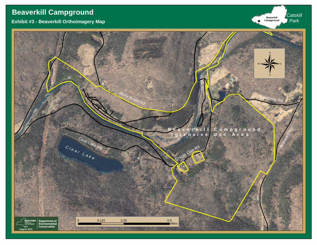
Beaverkill CampgroundExhibit #3 - Beaverkill Orthoimagery Map
CatskillPark
B e a v e r k i l l C a m p g r o u n d I n t e n s i v e U s e A r e a
August 2019
BeaverkillCampground
C l e a r L a k e
Clear Lake Rd
Cragie Clair Rd
Berry Brook RdCampsite Rd
Beav
erkil
l Rd
0 0.25 0.50.125Miles
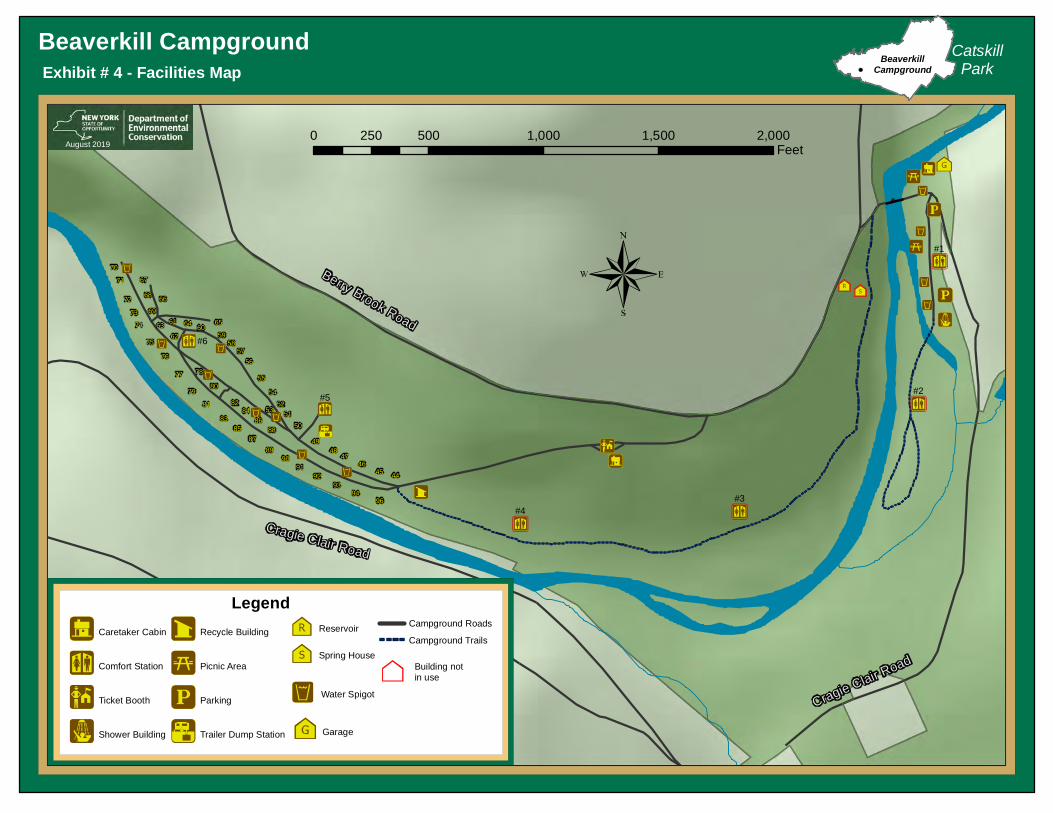
Beaverkill CampgroundExhibit # 4 - Facilities Map
86
82
68
74
89
55
84
7877
67
72
96
47
93
48
92
5152
88
53
61
70
46
94
50
54
56
85
58
71
83
59
66
80
81
62
6973
4591
57
65
79
64
76
63
44
49
90
87
60
75
CatskillPark
August 2017
BeaverkillCampground
Trail
0 560 1,120280Feet
S t o n y C l o v e C r e e k
Legend
August 2019
Caretaker Cabin
Comfort Station
Ticket Booth
Shower Building
Recycle Building
Picnic Area
Parking
Trailer Dump Station
Reservoir
Spring House
Campground Roads
Campground Trails
Berry Brook Road
Cragie Clair Road
Cragie Clair Road
Water Spigot
0 500 1,000 1,500 2,000250Feet
Garage
Building notin use
#6
#5
#4#3
#2
#1

Beaverkill CampgroundExhibit # 5 - Sewage System Map
86
82
68
74
89
55
84
7877
67
72
96
47
93
48
92
5152
88
53
61
70
46
94
50
54
56
85
58
71
83
59
66
80
81
62
6973
4591
57
65
79
64
76
63
44
49
90
87
60
75
CatskillPark
August 2017
BeaverkillCampground
Trail
0 560 1,120280Feet
S t o n y C l o v e C r e e k
Legend
August 2019
Caretaker Cabin
Comfort Station
Ticket Booth
Shower Building
Recycle Building
Picnic Area
Parking
Trailer Dump Station
Berry Brook Road
Cragie Clair Road
Cragie Clair RoadSeptic Tank
0 500 1,000 1,500 2,000250Feet
Garage Building notin use
#2
#1
#3#4
#5
#6
Tile Field
Gravity Sewer Line

Beaverkill CampgroundExhibit # 6 - Water System Map
86
82
68
74
89
55
84
7877
67
72
96
47
93
48
92
5152
88
53
61
70
46
94
50
54
56
85
58
71
83
59
66
80
81
62
6973
4591
57
65
79
64
76
63
44
49
90
87
60
75
CatskillPark
August 2017
BeaverkillCampground
Trail
0 560 1,120280Feet
S t o n y C l o v e C r e e k
Legend
August 2019
Comfort Station
Caretaker Cabin
Shower Building
Recycle Building
Ticket Booth
Trailer Dump Station
Picnic Area
Parking
Reservoir
Spring House
Well
Chlorination Building
Berry Brook Road
Cragie Clair Road
Cragie Clair Road
Water Spigot
0 500 1,000 1,500 2,000250Feet
GarageBuilding notin use
#6
#5
#4#3
#2
#1
Water Line

Beaverkill CampgroundExhibit # 7 - Electric System Map
86
82
68
74
89
55
84
7877
67
72
96
47
93
48
92
5152
88
53
61
70
46
94
50
54
56
85
58
71
83
59
66
80
81
62
6973
4591
57
65
79
64
76
63
44
49
90
87
60
75
CatskillPark
August 2017
BeaverkillCampground
Trail
0 560 1,120280Feet
S t o n y C l o v e C r e e k
Legend
August 2019
Comfort Station
Caretaker Cabin
Ticket Booth
Shower Building
Recycle Building
Picnic Area
Parking
Overhead Electric
Buried Electric
Berry Brook Road
Cragie Clair Road
Cragie Clair Road
0 500 1,000 1,500 2,000250Feet
Garage Building notin use
#6
#5
#4#3
#2
#1
Main Line In
Main Line In
Main Line In
Chlorination Building

Beaverkill CampgroundExhibit # 8 - Forest Cover Map
CatskillPark
®
BeaverkillCampground
June 2019
LegendSn owm
obile
Trail
C7
BB u c k P o n dLegend
Pioneer Hardwoods
Northern Hardwoods
Spruce Plantation0 1,500 3,000750
Feet

3
0
0
0
0
30
0
0
0
0 6
0
6
0
9
43
9
0
12
0
0
0
00
34
310
40
0 19
0
37
0
3
204
235
93
25 12
40
12
343
127
90
53
711
31
102
37
22
12
290
77
176
136
102
603420158
124355
Beaverkill
Beaverkill CampgroundExhibit # 9 - Camper Demographics 2019
CatskillParkBeaverkill
Campground
Camper Attendance
Produced by NYS DEC, Operations 2019
0
1 - 25
26 - 50
51 - 200
201 - 711
New York 4,709 New Jersey 966 Pennsylvania 218 Massachusetts 167 Virginia 110 Connecticut 89 Maryland 78 Colorado 54 Florida 42 New Hampshire 30 Vermont 30 Other 256
6,749

Beaverkill CampgroundExhibit #10 - Campsite Occupancy 2019
CatskillPark
Limekiln LakeCampground
H a m i l t o n C o .
He rk i
m e r C
o .
Indain Lake
Newcomb
Average Occupancy 41% Average Weekend Occupancy 75%
BeaverkillCampground
September 2019
0
10
20
30
40
50
60
Numb
er Of
Campsi
tes Oc
cupied
Camping Date
Beaverkill CampgroundOccupied Campsites 2019

Beaverkill CampgroundExhibit #11 - Beaverkill Soils
CatskillPark
0 0.25 0.50.125Miles
BeaverkillCampground
C l e a r L a k e
Campground Boundary
June 2019
Sn owm
obile
Trail
C7BB u c k
P o n dLegendLoam
Silt loam
Gravely loam
Lackawanna channery loam
Hawksnest-Mongaup loams
Water
Palms Muck
Arnot-Lordstown complex
Hawksnest-Mongaup-Rock outcrop complex
Tunkhannock and Otisville
Arnot-Rock outcrop complex
Swartswood and Lackawanna
Wellsboro and Wurtsboro
Fluvaquents-Udifluvents complex

Beaverkill CampgroundExhibit #12 - Beaverkill Wetlands
CatskillPark
0 0.25 0.50.125Miles
BeaverkillCampground
C l e a r L a k e
Beaverkill Campground
June 2019
Sn owm
obile
Trail
C7BB u c k
P o n dLegendFreshwater Emergent Wetlands
Riverine Wetland
Freshwater Pond
Freshwater Forested/Shrub Wetland

a
Beaverkill CampgroundExhibit # 13 - Management Actions Map
86
82
68
74
89
55
84
7877
67
72
96
47
93
48
92
5152
88
53
61
70
46
94
50
54
56
85
58
71
83
59
66
80
81
62
6973
4591
57
65
79
64
76
63
44
49
90
87
60
75
CatskillPark
August 2017
BeaverkillCampground
Trail
0 560 1,120280Feet
S t o n y C l o v e C r e e k
Legend
November 2019
Caretaker Cabin
Comfort Station
Ticket Booth
Shower Building
Recycle Building
Picnic Area
Parking
Trailer Dump Station
Reservoir
Spring House
Campground Roads
Campground Trails
Berry Brook Road
Cragie Clair Road
Cragie Clair Road
Water Spigot
0 500 1,000 1,500 2,000250Feet
Garage
Building notin use
#6
#5
#4#3
#2
#11. Reconstruct comfort station #6
2. Construct entrance booth
3. Rehabilitate comfort station #1
4. Expand day use and construct pavilion
a5. Pave sections of roads in camping loop
6. Relocate campsites
x7. Demolish buildings
7. Demolish buildings
8. Bury overhead lines
9. Plant trees and shrubs
10. Restoration work
a11. Trail Improvements
a11. Trail Improvements

Exhibit 14
Beaverkill Photos

Caretaker CabinEntrance Booth
Ass’t Caretaker Cabin Garage

Comfort Station #2 (not in use)Comfort Station #1 (not in use)
Comfort Station #3 (not in use) Comfort Station #4 (not in use)

Comfort Station #6
Comfort Station #6
Comfort Station #5

Shower BuildingChlorination Building
Recycle Center Trailer Dump Station

Camping Area
Day Use Area Day Use Area
Camping Area

Potential Pavilion Site
Reservoir (not in use) Spring House (not in use)
Potential Walk In Campsite
Exhibit 15 Response to public comments The Department held a public comment period from March 10 -April 15, 2020. During
that time, one written comment and 120 survey responses were received. A summary of each
survey question is presented below. A strong majority of public responses were postive across
survey questions. In review of open/narrative reponses, two common topics emereged,
reestablish camping within closed sections of the facility and concerns regarding campsite
density. The Departments response to these two topics is outined below.
Public desire for camping to be reestablished in closed sections of the facility due to
flooding. The health and safety of the public is paramount for the Department. Upon review of the
closed sections, the Department does not consider those areas safe for overnight camping. The
potential for future flooding is high and has been exaserbated by previous flood damage and
changes to stream channel morphology. In addition to the public safety, continual repair to flood
damaged infrastructure would be cost prohibitive and would prevent expenditures on other
facility improvements Further, steps have and will continue to be taken to remove legacy
infrastructure from within the floodplain as outlined in management action 7.
With that said, and as a result of the aformentioned review, the area on the east side of the
river and south of the current day use area can be safely used for day use and is outlined in
management action 4.
Public concerns regarding campsite density.
Although all campsites within the facility meet DOH standards, the Department will seek
to address campsite density in several ways; including campsite relocation, improved vegetative
screening and campsite restoration. Management action 6 details the relocation of several
campsites to decrease existing site density and also provide a new “walk-in” camping alternative
within the faclitiy Management action 9 details Department efforts to increase vegetative
screening throughout the facility and Sec III.b details the campsite restoration efforts througout
the facility.

Q1 Reconstruct and expand Comfort Station #6 to include showers
Answered: 120 Skipped: 0
Strongly agree
Agree
Neither agreenor disagree
Disagree
Stronglydisagree
0% 10% 20% 30% 40% 50% 60% 70% 80% 90% 100%
Q2 Construct an entrance booth at Day Use Area
Answered: 120 Skipped: 0
Strongly agree
Agree
Neither agreenor disagree
Disagree
Stronglydisagree
0% 10% 20% 30% 40% 50% 60% 70% 80% 90% 100%
Q3 Rehabilitate Comfort Station #1Answered: 119 Skipped: 1
Strongly agree
Agree
Neither agreenor disagree
Disagree
Stronglydisagree
0% 10% 20% 30% 40% 50% 60% 70% 80% 90% 100%
Q4 Expand Day Use Area & construct pavilion
Answered: 120 Skipped: 0
Strongly agree
Agree
Neither agreenor disagree
Disagree
Stronglydisagree
0% 10% 20% 30% 40% 50% 60% 70% 80% 90% 100%
Q5 Pave campground roads
Answered: 120 Skipped: 0
Strongly agree
Agree
Neither agreenor disagree
Disagree
Stronglydisagree
0% 10% 20% 30% 40% 50% 60% 70% 80% 90% 100%
Q6 Create two remote campsites(relocated from main camping area)
Answered: 119 Skipped: 1
Strongly agree
Agree
Neither agree
nor disagree
Disagree
Strongly
disagree
0% 10% 20% 30% 40% 50% 60% 70% 80% 90% 100%
Survey Response Summary

Q7 Demolish unused buildings and infrastructure Answered: 120 Skipped: 0
Strongly agree
Agree
Neither agreenor disagree
Disagree
Stronglydisagree
0% 10% 20% 30% 40% 50% 60% 70% 80% 90% 100%
Q8 Bury overhead power-lines in Day Use Area
Answered: 120 Skipped: 0
Strongly agree
Agree
Neither agreenor disagree
Disagree
Stronglydisagree
0% 10% 20% 30% 40% 50% 60% 70% 80% 90% 100%
Q9 Plant trees and shrubs throughout facility
Answered: 120 Skipped: 0
Strongly agree
Agree
Neither agreenor disagree
Disagree
Stronglydisagree
0% 10% 20% 30% 40% 50% 60% 70% 80% 90% 100%
Q10 Restoration of various points of historical interest
Answered: 120 Skipped: 0
Strongly agree
Agree
Neither agreenor disagree
Disagree
Stronglydisagree
0% 10% 20% 30% 40% 50% 60% 70% 80% 90% 100%
Q11 Improve existing trails & create trail-connection to Willowemoc Wild Forest
Answered: 120 Skipped: 0
Strongly agree
Agree
Neither agree
nor disagree
Disagree
Strongly
disagree
0% 10% 20% 30% 40% 50% 60% 70% 80% 90% 100%
Q12 What recreational opportunities bring you to this facility? (select all that apply)
Answered: 119 Skipped: 1
Camping
Fishing
Picnicking
Enjoying Nature
Hiking
HistoricalInterests
Other (pleasespecify)
0% 10% 20% 30% 40% 50% 60% 70% 80% 90% 100%

Q13 How many times have you camped at this facility?
Answered: 112 Skipped: 8
Once
More than once, but less than five
More than five
0% 10% 20% 30% 40% 50% 60% 70% 80% 90% 100%
Q14 What type of camping equipment do you typically use?
Answered: 117 Skipped: 3
Tent
Trailer
RV
Other (pleasespecify)
0% 10% 20% 30% 40% 50% 60% 70% 80% 90% 100%
Q15 Do you plan on camping at this facility again?
Answered: 119 Skipped: 1
Yes
No
Undecided
0% 10% 20% 30% 40% 50% 60% 70% 80% 90% 100%
Q16 How many times have you visited the facility just for day use this year?
Answered: 103 Skipped: 17
Once
More than once, but less than five
More than five
0% 10% 20% 30% 40% 50% 60% 70% 80% 90% 100%