Bear Paw Pipeline Project Additional Information Request · (NSE) that identified a need for...
80
Bear Paw Pipeline Project – Additional Information Request Prepared for: Bear Paw Pipeline Corporation Inc. 1969 Upper Water Street, Suite 1903 Halifax, NS B3J 1M5 Prepared by: Stantec Consulting Ltd. 102 - 40 Highfield Park Drive Dartmouth, NS B3A 0A3 Document No. BP-NSE-R-1003 Project No. 121413598 October 26, 2016
Transcript of Bear Paw Pipeline Project Additional Information Request · (NSE) that identified a need for...

Bear Paw Pipeline Project –
Additional Information Request
Prepared for:
Bear Paw Pipeline Corporation Inc.
1969 Upper Water Street, Suite 1903
Halifax, NS B3J 1M5
Prepared by:
Stantec Consulting Ltd.
102 - 40 Highfield Park Drive
Dartmouth, NS B3A 0A3
Document No. BP-NSE-R-1003
Project No. 121413598
October 26, 2016

This page is intentionally left blank.

BEAR PAW PIPELINE PROJECT – ADDITIONAL INFORMATION REQUEST REPORT
October 26, 2016
i
Table of Contents
EXECUTIVE SUMMARY ............................................................................................................. IV
ABBREVIATIONS ........................................................................................................................ V
1.0 INTRODUCTION ............................................................................................................. 1
1.1 BACKGROUND .................................................................................................................. 1
1.2 SCOPE OF THE ADDITIONAL INFORMATION REQUEST .................................................. 1
1.3 OVERVIEW OF METHODS.................................................................................................. 4
2.0 OVERVIEW OF PROJECT PLANNING AND ENVIRONMENTAL MANAGEMENT ............. 9
2.1 ADAPTIVE MANAGEMENT ................................................................................................ 9
2.2 ENGINEERING, ENVIRONMENTAL MANAGEMENT, AND REGULATORY
CONSULTATION ............................................................................................................... 11
2.3 ENVIRONMENTAL PROTECTION PLANNING ................................................................. 12
3.0 VEGETATION AND WETLANDS .................................................................................... 14
3.1 METHODS ......................................................................................................................... 14 3.1.1 Vascular Plant Surveys ................................................................................. 14 3.1.2 Lichen Surveys ............................................................................................... 17 3.1.3 Wetland Surveys ........................................................................................... 17
3.2 RESULTS ............................................................................................................................. 18 3.2.1 Vegetation Communities ............................................................................ 18 3.2.2 Species of Conservation Interest ................................................................ 21 3.2.3 Wetland Surveys ........................................................................................... 25
3.3 MITIGATION AND FOLLOW-UP ....................................................................................... 27 3.3.1 Mitigation ....................................................................................................... 27 3.3.2 Follow-up Monitoring.................................................................................... 31
4.0 BIRDS AND BIRD HABITAT ............................................................................................ 33
4.1 METHODS ......................................................................................................................... 33 4.1.1 Point Counts .................................................................................................. 33 4.1.2 Species at Risk Surveys ................................................................................. 39
4.2 RESULTS ............................................................................................................................. 41
4.3 MITIGATION AND FOLLOW-UP ....................................................................................... 48
5.0 HERPTILES (WOOD TURTLES) ........................................................................................ 50
5.1 METHODS ......................................................................................................................... 50 5.1.1 Wood Turtle Basking Survey Methods ........................................................ 50 5.1.2 Habitat Characterization Methods ............................................................ 51
5.2 RESULTS ............................................................................................................................. 52 5.2.1 Wood Turtle Observations ........................................................................... 52 5.2.2 Wood Turtle Habitat ..................................................................................... 55
5.3 MITIGATION AND FOLLOW-UP ....................................................................................... 56

BEAR PAW PIPELINE PROJECT – ADDITIONAL INFORMATION REQUEST REPORT
October 26, 2016
ii
5.3.1 Mitigation ....................................................................................................... 56 5.3.2 Follow Up and Monitoring ........................................................................... 59
6.0 NOVA SCOTIA MAINLAND MOOSE ........................................................................... 60
6.1 REGULATORY CONTEXT .................................................................................................. 60
6.2 CONSTRUCTION AND OPERATION REQUIREMENTS .................................................... 61
6.3 WORK COMPLETED IN SUPPORT OF THE ENVIRONMENTAL ASSESSMENT ................. 61
6.4 COMMITMENT TO ADDITIONAL PRE-CONSTRUCTION SURVEYS ................................ 62
6.5 MOOSE HABITAT MANAGEMENT PLANNING ............................................................... 62 6.5.1 Communication and Planning ................................................................... 63 6.5.2 Avoidance of Disturbance .......................................................................... 63 6.5.3 Reduction of Disturbance ........................................................................... 63 6.5.4 Mitigation Planning....................................................................................... 64 6.5.5 Mitigation Implementation .......................................................................... 66 6.5.6 Monitoring and Follow Up ........................................................................... 66 6.5.7 Adaptive Management .............................................................................. 66
7.0 BROOK FLOATER .......................................................................................................... 67
8.0 CONCLUSION .............................................................................................................. 68
9.0 CLOSURE ...................................................................................................................... 69
10.0 REFERENCES ................................................................................................................. 70
10.1 LITERATURE ....................................................................................................................... 70
10.2 PERSONAL COMMUNICATION ...................................................................................... 72
LIST OF TABLES
Table 1.1 Concordance with the Environmental Assessment Regulations ................... 2
Table 3.1 Vascular Plant SOCI Observed in 2016 ............................................................ 21
Table 3.2 Species of Conservation Interest Identified during the 2016 Field
Surveys .................................................................................................................. 24
Table 3.3 Wetland Classes (and Type, for Swamps) Surveyed in the
Assessment Corridor in 2016 .............................................................................. 26
Table 3.4 Summary of Mitigation for Vegetation and Wetlands (adapted
from Section 5.5.6 of the EA Report) ................................................................ 27
Table 4.1 Number of Breeding Bird Point Count Stations completed in each
Land Cover Class ................................................................................................ 37
Table 4.2 Bird SOCI Observed ............................................................................................ 42
Table 4.3 Abundance, Habitat Association and General Distribution of Bird
SOCI ...................................................................................................................... 44
Table 4.4 Species Richness within Land Cover Classes .................................................. 47
Table 4.5 Summary of Mitigation for Wildlife and Wildlife Habitat (birds)
(adapted from Section 5.6.6 of the EA Report) ............................................. 48

BEAR PAW PIPELINE PROJECT – ADDITIONAL INFORMATION REQUEST REPORT
October 26, 2016
iii
Table 5.1 Summary of Mitigation for Wildlife and Wildlife Habitat (wood
turtles) (adapted from Section 5.6.6 of the EA Report) ................................ 56
Table 6.1 Summary of Mitigation for Moose and Moose Habitat (adapted
from Section 5.6.6.5 of the EA Report) ............................................................. 64
LIST OF FIGURES
Figure 1.1 Project Location.................................................................................................... 5
Figure 1.2 Project Overview .................................................................................................. 7
Figure 2.1 Adaptive Management .................................................................................... 10
Figure 3.1 Overall Field Effort - 2016 Wetland and Vascular Plant Surveys................... 15
Figure 3.2 Overall Field Effort - 2015/2016 Lichen Surveys ............................................... 19
Figure 4.1 Overall Field Effort - 2016 Bird Surveys .............................................................. 35
Figure 5.1 Wood Turtle Observations, Habitat, and Wetlands of Special
Significance ......................................................................................................... 53
LIST OF APPENDICES
Appendix A Nocturnal Owl Survey Report
Appendix B Standard Mitigation
Appendix C Vegetation and Wetlands
Appendix D Birds and Bird Habitat
Appendix E Wood Turtle Photos
Appendix F Wildlife Species of Conservation Interest Mapbook

BEAR PAW PIPELINE PROJECT – ADDITIONAL INFORMATION REQUEST REPORT
October 26, 2016
iv
EXECUTIVE SUMMARY
Bear Paw Pipeline Corporation Inc. (Bear Paw Pipeline, the Proponent) registered the Bear Paw
Pipeline Project (the Project) on March 30, 2016, in accordance with Part IV of the Nova Scotia
Environment Act. The purpose of the Project is to construct and operate a 62.5 km high-pressure
steel natural gas pipeline from Goldboro, Nova Scotia to the future location of the Bear Head
LNG liquefied natural gas export facility in Richmond County, Nova Scotia. Bear Paw will
interconnect the M&NP mainline, offshore gas and other supplies near Goldboro. The pipeline
corridor will parallel an existing pipeline right-of-way (RoW) wherever possible. The Project
includes a compressor facility to deliver natural gas at pressure to Bear Head LNG.
The purpose of this report is to provide additional baseline information to assist the Nova Scotia
Department of Natural Resources (NSDNR) and other regulatory authorities in their review of the
Project environmental assessment. This report has been specifically prepared in response to the
memorandum dated May 16, 2016 received from the Nova Scotia Department of Environment
(NSE) that identified a need for additional biophysical information related to birds, herptiles
(i.e., wood turtle), lichens, vascular plants, wetlands, and mainland moose.
Additional surveys completed in 2016 include: vascular plant surveys; lichen surveys; wetland
surveys; breeding bird surveys (point count and species at risk surveys); and herptile surveys.
These surveys were conducted on Crown land and previously inaccessible privately owned
properties. Results of the field surveys include:
24 migratory bird species of conservation interest were identified
2 wood turtles were recorded at the Salmon River
373 species of vegetation were recorded, including ten species of conservation interest
2 lichen species at risk and 2 lichen species of conservation interest were identified
64 wetlands were delineated and assessed for wetland function
3 wetlands were identified as being wetlands of special significance based on their
association with wood turtle habitat
The report summarizes mitigation proposed in the EA Report and where appropriate additional
mitigation is proposed. Monitoring and follow-up recommendations from the EA have also been
updated where appropriate.
In consideration of the mitigation commitments detailed in the EA Report, additional mitigation,
and the monitoring and follow-up commitments made herein, the conclusions made in the EA
on the significance of residual environmental effects are unchanged.

BEAR PAW PIPELINE PROJECT – ADDITIONAL INFORMATION REQUEST REPORT
October 26, 2016
v
Abbreviations
AC CDC Atlantic Canada Conservation Data Centre
COSEWIC Committee on the Status of Endangered Wildlife in Canada
CWS Canadian Wildlife Service
EC Environment Canada
LAA Local Assessment Area
MBBA Maritime Breeding Bird Atlas
MBCA Migratory Birds Convention Act
NS ESA Nova Scotia Endangered Species Act
NSDNR Nova Scotia Department of Natural Resources
NSE Nova Scotia Environment
RoW right-of-way
SAR Species at Risk
SARA Species at Risk Act
SOCI species of conservation interest

This page is intentionally left blank.

BEAR PAW PIPELINE PROJECT – ADDITIONAL INFORMATION REQUEST REPORT
Introduction
October 26, 2016
1
1.0 INTRODUCTION
1.1 BACKGROUND
Bear Paw Pipeline Corporation Inc. (Bear Paw Pipeline, the Proponent) registered the Bear Paw
Pipeline Project (the Project) on March 30, 2016, in accordance with Part IV of the Nova Scotia
Environment Act. The purpose of the Project is to construct and operate a 62.5 km high-pressure
steel natural gas pipeline from Goldboro Nova Scotia to the future location of the Bear Head
LNG liquefied natural gas export facility in Richmond County, Nova Scotia (Figure 1.1). Bear Paw
will interconnect the M&NP mainline, offshore gas and other supplies near Goldboro. The
pipeline corridor will parallel an existing pipeline right-of-way (RoW) wherever possible. The
Project includes a compressor facility to deliver natural gas at pressure to Bear Head LNG. A
Project overview figure is provided as Figure 1.2.
1.2 SCOPE OF THE ADDITIONAL INFORMATION REQUEST
Following a submission of the Environmental Assessment (EA) Report (Stantec 2016) for the
Project, a memorandum dated May 16, 2016 was received from the Nova Scotia Department of
Environment (NSE) that identified a need for additional biophysical information. In particular, the
memorandum indicated that the Wildlife Division of the Nova Scotia Department of Natural
Resources (NSDNR) required additional information to support their review of the EA for the
Project. The memorandum indicated that “Field work must be designed with methods and
techniques that are seasonally timed to ensure optimal detectability for the species, habitats
and taxonomic groups of organisms in question.” Specific considerations identified in the
memorandum related to the need for additional baseline biophysical surveys on crown and
private lands for birds, lichen, wetlands and vegetation, and moose.
The purpose of this report is to provide additional baseline information in support of the EA
Report. In particular, additional information is provided for birds, herptiles (i.e., wood turtle
[Glyptemys insculpta]), lichens, and vascular plants. No field surveys have been conducted for
mainland moose (Alces americanus) in relation to this additional information report. However, as
reviewed with NSDNR, Section 6 includes an enhanced discussion on moose and moose habitat
management planning, which includes additional commitments for mitigation, pre-construction
field surveys, and ongoing regulatory engagement.
Table 1.1 provides an updated concordance of the EA Report and Additional Information
Request with the Environmental Assessment Regulations.

BEAR PAW PIPELINE PROJECT – ADDITIONAL INFORMATION REQUEST REPORT
Introduction
October 26, 2016
2
Table 1.1 Concordance with the Environmental Assessment Regulations
Requirement EA Report Section Reference
Additional Information
Request Report Section
Reference
the name of the undertaking Executive Summary Executive Summary
the location of the
undertaking
1.1 Project Overview Executive Summary /
1.1 – Background
the name, address, signature,
and identification of the
proponent including the
name of the Chief Executive
Officer and contact persons
1.3 Identification of the Proponent
the nature of the undertaking 1.1 Project Overview
1.2 Purpose and Need for the
Undertaking
2.0 Project Description
1.1 – Background
the purpose and need of the
undertaking
1.2 Purpose and Need for the
Undertaking
the proposed construction
and operation schedules
2.7 Project Schedule
a description of the
undertaking
2.0 Project Description
environmental baseline
information
1.6 Environmental Setting
5.1.4 – Atmospheric Environment
5.2.4 – Freshwater Environment
5.3.4 – Groundwater Environment
5.4.4 – Marine Environment
5.5.4 – Vegetation and Wetlands
5.6.4 – Wildlife and Wildlife Habitat
5.7.4 – Traditional Land and Resource Use
5.8.4 – Land and Resource Use
5.9.4 – Heritage Resources
3.0 – Vegetation and
Wetlands
4.0 – Birds and Bird Habitat
5.0 – Herptiles (Wood
Turtles)
6.0 – Nova Scotia Mainland
Moose
Appendix A – Nocturnal
Owl Survey Report
all steps taken or proposed
by the proponent to identify
and address the concerns of
the public and aboriginal
people
3.0 Stakeholder Consultation and
Aboriginal Engagement
a list of all concerns
regarding the undertaking
expressed by the public and
aboriginal people
3.0 Stakeholder Consultation and
Aboriginal Engagement
a list of approvals which will
be required and other forms
of authorization and the
sources of any public funding.
1.1 Project Overview

BEAR PAW PIPELINE PROJECT – ADDITIONAL INFORMATION REQUEST REPORT
Introduction
October 26, 2016
3
Table 1.1 Concordance with the Environmental Assessment Regulations
Requirement EA Report Section Reference
Additional Information
Request Report Section
Reference
the location of the proposed
undertaking and the nature
and sensitivity of the
surrounding area
1.1 Project Overview
1.6 Environmental Setting
1.1 – Background
the size, scope and
complexity of the proposed
undertaking
4.1 Scope of the Assessment 1.2 – Scope of the
Additional Information
Request
concerns expressed by the
public and aboriginal people
about the adverse effects or
the environmental effects of
the proposed undertaking
3.0 Stakeholder Consultation and
Aboriginal Engagement
steps taken by the
proponent to address
environmental concerns
expressed by the public and
aboriginal people
3.0 Stakeholder Consultation and
Aboriginal Engagement
potential and known
adverse effects or
environmental effects of the
proposed undertaking,
including identifying any
effects on species at risk,
species of conservation
concern and their habitats
5.1.5 – Atmospheric Environment
5.2.5– Freshwater Environment
5.3.5 – Groundwater Environment
5.4.5 – Marine Environment
5.5.5 – Vegetation and Wetlands
5.6.5 – Wildlife and Wildlife Habitat
5.7.5 – Traditional Land and Resource Use
5.8.5 – Land and Resource Use
5.9.5 – Heritage Resources
project schedules where
applicable
2.7 Project Schedule
planned or existing land use in
the area of the undertaking
5.8 Land and Resource Use
other undertakings in the area 6.0 Other Undertakings in the Area
whether compliance with
licenses, certificates, permits,
approvals or other
documents of authorization
required by law will mitigate
the environmental effects
5.1.7 – Atmospheric Environment
5.2.7– Freshwater Environment
5.3.7 – Groundwater Environment
5.4.7 – Marine Environment
5.5.7 – Vegetation and Wetlands
5.6.7 – Wildlife and Wildlife Habitat
5.7.7 – Traditional Land and Resource Use
5.8.7 – Land and Resource Use
5.9.7 – Heritage Resources
3.0 – Vegetation and
Wetlands
4.0 – Birds and Bird Habitat
5.0 – Herptiles (Wood
Turtles)
6.0 – Nova Scotia Mainland
Moose
7.0 – Brook Floater

BEAR PAW PIPELINE PROJECT – ADDITIONAL INFORMATION REQUEST REPORT
Introduction
October 26, 2016
4
1.3 OVERVIEW OF METHODS
Additional baseline surveys were completed to document use of the assessment corridor by
Species at Risk (SAR) and other species of conservation interest (SOCI) and employ the use of
general census techniques (e.g., point counts) and more species-specific methods. SOCI are
defined as those:
listed under the Nova Scotia Endangered Species Act (NS ESA) or Schedule 1 of the federal
Species at Risk Act (SARA) as being either endangered, threatened, vulnerable, or of special
concern (i.e., Species at Risk)
listed in Schedule 2 or 3 of SARA
not yet listed under provincial or federal legislations but identified by the Committee on the
Status of Endangered Wildlife in Canada (COSEWIC) as being either endangered,
threatened, or of special concern
listed by the NSDNR (2014) to be at risk, may be at risk, or sensitive to human activities or
natural events
ranked as S1, S2, or S3 by the AC CDC (2014)
Additional baseline studies conducted in support of the Project, and summarized in this
document, include those directed at breeding birds, vascular plants, lichens, and wood turtle. In
addition, surveys for nocturnal raptors and the mainland moose have also been conducted
since filing of the EA Report. A copy of the nocturnal owl survey report is available as
Appendix A, and a report on the spring moose pellet group survey undertaken by Stantec
Consulting Ltd. was submitted to NSDNR under separate cover.

!
IsaacsHarbour
IsaacsHarbour
North
CoddlesHarbour
Upper NewHarbourStormont
Goldboro
Seal Harbour
MiddleManchester Port
Shoreham
MacPhersonLake
CooksCove
DortsCove
GlenkeenSouth
Manchester
Manchester
MilfordHaven
Havendale
GuysboroughIntervale
Guysborough
WestRoachvale
Roachvale
Sunnyville
Lundy
TracadieRoad
NorthOgden
Boylston
Ogden
SandPoint
PortRichmond
Port MalcolmPirateHarbour
SteepCreek
MiddleMelford
Lincolnville
PortHawkesbury
Port Bickerton
New Harbour
Larrys River
Port Felix
Queensport
Point Tupper
Eugenes Brook
Isaacs
Harbo
urRiv
er New Harbour River
ClamHarbour Rive r
St.Francis Harbour River
Roman Valley River
SalmonR iver
Tor Bay
Chedabucto Bay
Strait of Canso
Milford HavenRiver
Gold Brook
West Brook
Country Harbour
Isaacs Harbour
NorthBranch
Lake
BonnetLake
CooeycoffLake
GooseHarbour
Lake
OceanLake
LoonLake
LawlorLake
LandrieLake
EnglandsLake
UV344
UV211
UV316
£¤4 £¤4
£¤16
£¤16
£¤104
£¤104£¤105
Bear Head LNGTerminal Site
($$¯
NAD 1983 UTM Zone 20N
0 3.5 7 10.5 14
Kilometres
DRAFT - For In
ternal Use Only
Project ComponentsAssessment CorridorCompressor Station
ST NS_121413598-064 REV0
V:\1214\active\121413xxx\121413598_bear_head_lng_pipeline\geomatics\mapping\mxd\EIA\1-Introductioin\ST NS_121413598-064_Fig1_1_Overview.mxd cshupe
Disclaimer: This map is for illustrative purposes to support this project; questions can be directed to the issuing agency.Note: Crown lands shown is limited to parcels within a relevant distance of the project.
Project Location
Figure 1.1BEAR PAW PIPELINE PROJECT
Sources: Base data provided by the Government of Canada and Nova Scotia. Service Layer Credits: Sources: Esri, HERE, DeLorme, USGS, Intermap,increment P Corp., NRCAN, Esri Japan, METI, Esri China (Hong Kong), Esri (Thailand), MapmyIndia, © OpenStreetMap contributors, and the GIS UserCommunity
Atlantic Ocean
ProjectLocation

BEAR PAW PIPELINE PROJECT – ADDITIONAL INFORMATION REQUEST REPORT
Introduction
October 26, 2016
6
This page is intentionally left blank.

>
>
>
>
>
>
>
>
>
>
>
>
>
>
>
>
>
>
>
>
>
>
> > >
>
>
>
> >
>
> >
>
!
!!
!
!!
!
!
!
!
!
!
!
!
!
!
!
!
!
!
!
!
!
!
!
!
!
!
!
!
!
!
Chedabucto Bay
CountryHarbour Isa
acs Harb
our
Milfo
rdHa
venRiv
er
£¤16
!(344
!(316
!(316
Larrys River Rd
New Harbour - Lundy Rd
SouthRiverLakeRd
£¤16
!(344
SalmonRi v er
Guysborough
Sunnyville
CooksCoveLundy
NewHarbour
NewHarbourEast
NewHarbourWest
Upper NewHarbour
CoddlesHarbour
DrumHead
SealHarbour
Goldboro
IsaacsHarbour
IsaacsHarbourNorth
Roachvale
MiddleCountryHarbour
Sable Offshore Energy Project (SOEP)Gas Plant
Sable Offshore Energy Project (SOEP) Gas Line
Compressor Station
Deep PanukePipeline
M&NP Mainline
M&NP andSOEP Lateral
Ogden Round LakeWilderness Area
BonnettLake Barrens
Wilderness Area
1 km
5 km
10 km
15 km
20 km
25 km30 km
Loon LakeNature
ReserveChedabucto Fault
Nature Reserve(Pending)
Guysborough HeadlandsWilderness Area
(Pending)
Isaacs Harbour RiverWilderness Area
(Pending)
($
$¯
DRAFT - For In
ternal Use Only
Project Components>
Kilometre Post (Approximate Distancefrom Origin)Assessment CorridorCompressor Station
Map FeaturesPrimary AccessLocal AccessExisting PipelineWatercourse
WaterbodyWetlandProvincial Wetlands of SpecialSignificance
Parks and Protected AreasDesignatedPending Designation
Deer Wintering AreasNon-Designated Rail Corridors/TrailIndustrialCrown Land
V:\1214\active\121413xxx\121413598_bear_head_lng_pipeline\geomatics\mapping\mxd\EIA\1-Introductioin\ST NS_121413598-110_2pg_Project_Overview.mxd cshupe
NAD 1983 UTM Zone 20N ST NS_121413598-110
Disclaimer: This map is for illustrative purposes to support this project; questions can be directed to the issuing agency.
Map 1 of 2
Project OverviewSources: Base data provided by the Government of Canada and Nova Scotia.Wetlands shown are a combination of data provided by Nova Scotia Dept. of Natural Resources, and wetlands inerpreted/delineated by Stanec.
BEAR PAW PIPELINE PROJECT
0 1.5 3 4.5 6
Kilometres
Project Location
Nova Scotia
CapeBreton
Atlantic Ocean
ChedebuctoBay
St. GeorgesBay
Figure 1.2

This page is intentionally left blank.

BEAR PAW PIPELINE PROJECT – ADDITIONAL INFORMATION REQUEST REPORT
Overview of Project Planning and Environmental Management
October 26, 2016
9
2.0 OVERVIEW OF PROJECT PLANNING AND
ENVIRONMENTAL MANAGEMENT
As described in Section 2.6 of the EA Report, environmental protection has been integrated into
the Project as a key feature throughout Project planning. In particular, the pipeline has been
routed to parallel an existing pipeline RoW, and avoid known sensitive environmental areas
wherever practical. Standard best management practices and mitigation presented in the
EA Report is provided in Appendix B.
Bear Paw Pipeline has worked closely with regulatory officials throughout the EA process in the
identification of important environmental features, study design, and in the review of results and
mitigation development.
2.1 ADAPTIVE MANAGEMENT
The principles of adaptive management reflect the importance and challenges of approaching
development in an environmentally responsible manner. Development planning cannot be
isolated from environmental planning, and these processes inform each other as the information
supporting each increases. This results in the important understanding that good development
and good planning must remain adaptive. This principle is also reflected in the ongoing
regulatory consultation discussed in Section 2.2. Figure 2.1 is an interpretation of adaptive
management as it has been applied to this specific project, and these principles are repeated
in the discussion of environmental management throughout this document.

BEAR PAW PIPELINE PROJECT – ADDITIONAL INFORMATION REQUEST REPORT
Overview of Project Planning and Environmental Management
October 26, 2016
10
Figure 2.1 Adaptive Management
The adaptive management approach for Bear Paw begins with early engagement and
planning, and this continues throughout the adaptive management process. Route selection for
Bear Paw first aims to avoid disturbance in sensitive areas where possible, and if these areas
cannot be avoided, ways to reduce the footprint of disturbance are considered. Both
avoidance and reduction of disturbance are based on site-specific knowledge gathered in the
field, and these aspects of adaptive management will continue from planning stages through to
construction and operation. Mitigation planning is used to further minimize the potential of
negative effects, and will consider industry standards. The implementation of these mitigation
measures will be monitored in the field throughout construction and operation, and further
mitigation measures will be considered in response to problems encountered. Lastly, Bear Paw
will implement a follow-up and monitoring program for the field verification of assumptions
made in the EA Report, and efficacy of mitigation implemented for the Project consistent with
industry practices.

BEAR PAW PIPELINE PROJECT – ADDITIONAL INFORMATION REQUEST REPORT
Overview of Project Planning and Environmental Management
October 26, 2016
11
2.2 ENGINEERING, ENVIRONMENTAL MANAGEMENT, AND
REGULATORY CONSULTATION
Since the conceptualization of the Project, Bear Paw Pipeline has initiated early and ongoing
communication with First Nations, regulatory authorities and the public. As detailed in the EA
Report, numerous meetings have been held with regulatory agencies to seek input on
environmental constraint identification, study design, and mitigation options. This process has
continued in the development of this report with meetings held on the following topics:
discussion of the additional information request, including timing requirements and survey
design expectations
regulatory input to the definition and mitigation requirements for wetlands of special
significance
options for future moose field surveys and mitigation
review and input on moose mitigation commitments
wood turtle survey design, results of the surveys, and mitigation options
lichen survey design, results of the surveys, and mitigation options
These discussions had a direct impact on the design of the field surveys undertaken in support of
this report, and directly influenced the mitigation commitments that are made herein.
Furthermore, these discussions have cemented Bear Paw Pipeline’s ongoing commitment to
work collaboratively with the appropriate regulatory authorities in the development of the
Project, according to the principles of adaptive management. More specifically, the detailed
design process, which includes the development of the EPP either concurrently or as a precursor
to the detailed design, will provide the next major milestone for regulatory involvement.
Consultation with regulators will continue through this process.
Detailed engineering design incorporates field survey and geotechnical data to further refine
the location of the pipeline and facilities within the assessment corridor, as well as the related
technology (e.g., materials selection, compressor technology). Primary inputs at this stage of the
project include:
additional geotechnical and survey data
environmental constraints identified through the EA process
mitigation commitments from the EA process
conditions of approval on the EA
regulatory input to meeting the requirements of the conditions of approval, which will
include design-based decisions as well as approval of the EPP document

BEAR PAW PIPELINE PROJECT – ADDITIONAL INFORMATION REQUEST REPORT
Overview of Project Planning and Environmental Management
October 26, 2016
12
2.3 ENVIRONMENTAL PROTECTION PLANNING
As committed to in the EA Report, a Project-specific EPP will be prepared. The purpose of the
EPP is to:
identify the company’s commitments to reduce environmental effects in general and to
meet specific regulatory commitments
document environmental concerns and appropriate protection measures associated with
construction and operation activities
provide concise and clear instructions for contractors and inspectors regarding procedures
for protecting the environment and reducing potential environmental effects
provide a reference document for planning and conducting specific activities that may
have an effect on the environment
function as a training document and guide for environmental education and orientation;
detail reporting and communication requirements
communicate changes in the program through the revision process
A draft table of contents for the project-specific EPP is shown below, the final contents of the EPP
will be developed with input from the appropriate regulatory authorities including, but not
limited to NSE, NSDNR, Transport Canada (TC), and Department of Fisheries and Oceans (DFO):

BEAR PAW PIPELINE PROJECT – ADDITIONAL INFORMATION REQUEST REPORT
Overview of Project Planning and Environmental Management
October 26, 2016
13
Environmental Protection Plan Table of Contents
1.0 Introduction
1.1 Bear Paw Pipeline Corporation Inc.’s Commitment to Environment, Health and Safety
1.2 Purpose of the EPP
1.3 Scope of the EPP
1.4 Organization of the EPP
1.5 Maintenance of the EPP
2.0 Summary of Regulatory Requirements
3.0 Responsibilities and Training
3.1 Roles and Responsibilities
3.2 Training and Orientation Requirements
4.0 Summary of Key Environmental Issues and Environmentally Sensitive Areas
5.0 Environmental Protection Procedures
5.1 Right of Way Preparation
5.2 Erosion Control
5.3 Watercourse Protection
5.4 Wetland Protection
5.5 Right of Way Restoration
5.6 Right of Way Maintenance
6.0 Environmental Monitoring and Inspection
6.1 Environmental Compliance Monitoring
7.0 Management and Mitigation Planning
7.1 Waste Management Plan
7.2 Sulphide Bearing Materials Management Plan
7.3 GHG Management Plan
7.4 Air emission management plan
7.5 Erosion and Sediment Control Plan
7.6 Moose Habitat Management Plan
7.7 Wood Turtle Habitat Management Plan
7.8 Bird Nest Mitigation Plan
8.0 Contingency Plans
8.1 Hazardous materials spill contingency plan
8.2 Chance find contingency plan – wood turtles
8.3 Heritage Resource Contingency Plan
9.0 Complaint Resolution Program
10.0 Contact List and Incident Reporting
10.1 Contact List
10.2 Incident Reporting Procedures

BEAR PAW PIPELINE PROJECT – ADDITIONAL INFORMATION REQUEST REPORT
Vegetation and Wetlands
October 26, 2016
14
3.0 VEGETATION AND WETLANDS
Vegetation surveys were conducted to supplement the data collected in 2015.
3.1 METHODS
The objectives of the vegetation and wetland surveys were to:
Record early flowering species that may not have been observed during the vascular plant
surveys conducted on Crown lands in September, 2015.
Conduct early summer vascular plant surveys on accessible private lands based on
identification of areas of high priority.
Perform wetland delineations and obtain information on wetland function on private lands
where permission has been granted to access them.
Perform surveys for boreal felt lichen (Erioderma pedicellatum) and other lichen SOCI on
Crown lands and accessible private lands based on lichen habitat modeling.
Additional information on the site selection and field methods used for the surveys is provided in
the following sections.
3.1.1 Vascular Plant Surveys
Vegetation surveys were conducted on Crown and private lands between June 10 and July 14,
2016 as well as on private lands along the Milford Haven River and Strait of Canso on September
2, 2016 to obtain information on plant communities and SOCI (Figure 3.1). Vegetation surveys
were conducted to detect species that would have senesced prior to the September 2015
vegetation surveys. Wetlands and mature hardwood stands have the highest potential to
contain spring ephemeral species so these areas were the primary targets for surveys. A total of
21 priority survey sites were identified on Crown lands for targeted surveys, all of which were
surveyed. Additional areas and vegetation types (particularly wetlands) were investigated as
botanists transited between target areas. In addition to surveys on Crown lands, vegetation
surveys were conducted within approximately 13 km of private land. Prior to surveys, a modeling
exercise was conducted to identify areas on accessible private lands with relatively high
potential to support SOCI. Nine sites were visited during June or July surveys. Four additional sites,
located along the coastlines of the Straight of Canso and the Milford Haven River (eastern
crossing option), were surveyed in September because of the potential for these areas to
provide habitat for plant SOCI that are only reliably identified late in the growing season
(e.g., Suaeda spp.).

!
"/
"/
"/
"/"/
"/"/
"/
"/"/
"/
"/
"/"/
"/ "/"/
"/"/ "/"/"/"/"/"/
"/
"/"/
"/"/
"/ "/
IsaacsHarbour
IsaacsHarbour
North
CoddlesHarbour
Upper NewHarbourStormont
Goldboro
Seal Harbour
MiddleManchester Port
Shoreham
MacPhersonLake
CooksCove
DortsCove
GlenkeenSouth
Manchester
Manchester
MilfordHaven
Havendale
GuysboroughIntervale
Guysborough
WestRoachvale
Roachvale
Sunnyville
Lundy
TracadieRoad
NorthOgden
Boylston
Ogden
SandPoint
PortRichmond
Port MalcolmPirateHarbour
SteepCreek
MiddleMelford
Lincolnville
PortHawkesbury
Port Bickerton
New Harbour
Larrys River
Port Felix
Queensport
Point Tupper
Eugenes Brook
Isaacs
Harbo
urRiv
er New Harbour River
ClamHarbour Rive r
St.Francis Harbour River
Roman Valley River
SalmonR iver
Tor Bay
Chedabucto Bay
Strait of Canso
Milford HavenRiver
Gold Brook
West Brook
Country Harbour
Isaacs Harbour
NorthBranch
Lake
BonnetLake
CooeycoffLake
GooseHarbour
Lake
OceanLake
LoonLake
LawlorLake
LandrieLake
EnglandsLake
UV344
UV211
UV316
£¤4 £¤4
£¤16
£¤16
£¤104
£¤104£¤105
Bear Head LNGTerminal Site
($$¯
NAD 1983 UTM Zone 20N
0 3.5 7 10.5 14
Kilometres
DRAFT - For In
ternal Use Only
Study Features"/ Vegetation Survey Site (2016)
Area Surveyed (2016)Project Components
Assessment CorridorCompressor Station
Map FeaturesCrown Land (Surveyed in 2015)
ST NS_121413598-122 REV0
V:\1214\active\121413xxx\121413598_bear_head_lng_pipeline\geomatics\mapping\mxd\EIA_2016Addendum\ST NS_121413598_122_VegWetland_LoE.mxd cshupe
Disclaimer: This map is for illustrative purposes to support this project; questions can be directed to the issuing agency.Note: Crown lands shown are limited to parcels within a relevant distance of the project.
Overall Field Effort - 2016 Wetland and Vascular Plant Surveys
Figure 3.1BEAR PAW PIPELINE PROJECT
Sources: Base data provided by the Government of Canada and Nova Scotia. Service Layer Credits: Sources: Esri, HERE, DeLorme, USGS, Intermap,increment P Corp., NRCAN, Esri Japan, METI, Esri China (Hong Kong), Esri (Thailand), MapmyIndia, © OpenStreetMap contributors, and the GIS UserCommunity
Atlantic Ocean
ProjectLocation

BEAR PAW PIPELINE PROJECT – ADDITIONAL INFORMATION REQUEST REPORT
Vegetation and Wetlands
October 26, 2016
16
This page is intentionally left blank.

BEAR PAW PIPELINE PROJECT – ADDITIONAL INFORMATION REQUEST REPORT
Vegetation and Wetlands
October 26, 2016
17
Vegetation surveys were completed through floristic habitat sampling (described in Newmaster
et al. 2005) throughout vegetation communities within the assessment corridor. Where
encountered, the locations of SOCI were recorded along with information on population size
and associated habitat conditions. Descriptions for new or distinct vegetation communities
(i.e., not identified during 2015 surveys) were recorded where encountered. Descriptions
included the dominant species in the tree, shrub and ground vegetation strata. Trees are
defined as tree species greater than 5 cm in diameter at breast height (DBH); shrubs are tree
species less than 5 cm DBH, or woody vegetation greater than 50 cm in height; and ground
vegetation is defined as woody plants less than 50 cm in height, or non-woody species.
3.1.2 Lichen Surveys
Lichen surveys were conducted on Crown and private lands between August 22 and 25, 2016 to
obtain information on SOCI, including boreal felt lichen and other cyanolichens. Incidental
observations of vascular plant SOCI were also recorded. Potential habitat for lichen SOCI habitat
was identified in areas of Crown and private lands which supported:
areas within the assessment corridor which had not been previously surveyed for lichens but
for which the provincial boreal felt lichen model (NSE 2010) indicated potential for boreal felt
lichen
forested wetlands (as identified through 2015 field and desktop delineations)
hardwood and mixedwood upland forest polygons with maturity classes of mature,
overmature, or uneven
Priority areas were identified as those areas which supported concentrations of potential lichen
SOCI habitat. Areas surveyed for lichen in 2015 and 2016 are shown on Figure 3.2. During the
surveys, experienced lichenologists evaluated the potential of habitat to support lichen and
documented the occurrence of this species and other cyanolichens of conservation interest.
Incidental observations of vascular plant and bryophyte SOCI were also recorded during these
surveys.
3.1.3 Wetland Surveys
Wetland surveys were completed along more than 13 km of private lands within the assessment
corridor between June 27th and July 14th, 2016 (Figure 3.1). During these surveys, areas meeting
the definition of a wetland as outlined by the Nova Scotia Environment Act were delineated in
the field following principles outlined by the US Army Corps of Engineers (1987) and classified
according to the Canadian Wetland Classification System (NWWG 1997). This system classifies
wetlands to three levels: class, form/subform, and type. The wetland class places a wetland into
one of five categories based on the overall nature of the wetland environment, such as whether
the wetland soils are primarily mineral or organic (i.e., peat), their association with groundwater,
and whether or not they are dominated by woody plants over 1 m in height. Wetland classes
include bog, fen, swamp, marsh, and shallow water. Form and subform indicate the physical
morphology and hydrological characteristics of the wetland. Wetland type distinguishes
wetland communities based on one of eight groups of dominant vegetation (NWWG 1997).
Geographic coordinates were recorded for wetland boundaries.

BEAR PAW PIPELINE PROJECT – ADDITIONAL INFORMATION REQUEST REPORT
Vegetation and Wetlands
October 26, 2016
18
Information on the functional characteristics of surveyed wetlands was obtained using a
simplified variation of the NovaWET method developed by NSE (2011b). The full NovaWET
method consists of a field component and a desktop component of analysis for each wetland.
The approach focused on collecting information that is obtained through a site visit, such as
dominant species and habitat for SAR or other SOCI. Vegetation and wetland surveys were
generally conducted concurrently on private lands. Surveys for bird SOCI were conducted as
part of a larger breeding bird survey, which included targeted surveys for SAR in association with
wetlands (Section 4.1 provides additional detail).
3.2 RESULTS
3.2.1 Vegetation Communities
Forest and wetland vegetation communities observed during 2016 surveys were generally
consistent with those observed in 2015, as described in Section 5.5 of the EA Report (Stantec
2016). Of exception, several wetlands were observed which contained relatively unique
vegetation communities. Some of these occurrences were associated with relatively nutrient rich
conditions whereas others reflected the influence of historical human activities. A general
description of these occurrences is provided below.
Whereas the majority of wetland vegetation within the assessment corridor is dominated by
species which are indicative of acidic and nutrient-poor conditions, several wetlands were
encountered in 2016 that were relatively nutrient-rich. In particular, the vegetation within a
wetland located on the south side of Godfrey Brook (Map 10, Appendix C) indicated that it was
relatively nutrient-rich. The wetland may be characterized as a tall shrub swamp and occurred
on a boulder field that would be seasonally flooded by the brook in spring, but which is relatively
dry for much of the year. The wetland was described as supporting both relatively “dry” and
“wet” tall-shrub dominated communities. Beaked hazel (Corylus cornuta), mountain maple
(Acer spicatum), and chokecherry (Prunus virginiana) provided a well-developed tall shrub
strata within the drier portions of the swamp; with ground vegetation being dominated by
evergreen wood fern (Dryopteris intermedia), dwarf red raspberry (Rubus pubescens), tall
meadow-rue (Thalictrum pubescens), spotted jewelweed (Impatiens capensis), rough-stemmed
goldenrod (Solidago rugosa), and ostrich fern (Matteuccia struthiopteris). Wetter areas of the
wetland were dominated by speckled alder (Alnus incana) with scattered occurrences of black
elderberry (Sambucus nigra ssp. canadensis) and a well-developed herbaceous layer
comprised of bluejoint reed grass (Calamagrostis canadensis), rough-stemmed goldenrod,
sensitive fern (Onoclea sensibilis), spotted jewelweed, and common lady fern (Athyrium filix-
femina). One plant SOCI, fringed blue aster (Symphyotrichum ciliolatum), was recorded in
association with this wetland. Relatively nutrient-rich conditions were encountered within other
wetlands in the general vicinity of Godfrey Brook such as within a mixedwood drainageway
swamp located to the immediate south; within riparian habitats along portions of the Salmon
River (Map 8, Appendix C); and within a wetland characterized as a graminoid slope fen,
located to the immediate north of the Salmon River (Map 9, Appendix C).

!
!!!!!!!!!!!!!!!!!!!!!!!!!!!!!!!!!!!!!!!!!!!!!!!!!!!!!!!!!
!!!!!!!!!!!!!!!!!!!!!!!!!!!!!!
!!!!!!!!!!!!!!!!!!!!!!!!!!!!!!!!!!!!!!!!!!!!!!!!!!!!!!!!!!!!!!!!!!!!!!!!!!!!!!!!!!!!!!!!!!!!!!!!!!!!!!!!!!!!
!!!!!!!!!!!!!!!!!!!!!!!!!!!!!!!!!!!!!!!!!!!!!!!!!!!!!!!!!!!!!!!!!!!!!!!!!!!!!!!!!!!!!!!!!!!!!!!!!!!!!!!!!!!!!!!!!!!!!!!!!!!!!!!!!!!!!!!!!!!!!!!!!!!!!!!!!!!!!!!!!!!!!!!!!!!!!!!!!!!!!!!!!!!!!!!!!!!!!!!!!
!!!!!!!!!!!!!!!!!!!!!!!!!!!!!!!!!!!!!!!!!!!!!!!!!!!!!!!!!!!!!!!!!!!!!!!!!!!!!!!!!!!!!!!!!!!!!!!!!!!!!!!!!!!!!!!!!!!!!!!!!!!!!!!!!!!!!!!!!!!!!!!!!!!!!!!!!!!!!!!!!!!!!!!!!!!!!!!!!!!!!!!!!!!!!!!!!!!!!!!!!!!!!!!!!!!!!!!!!!!!!!!!!!!!!!!!!!!!!!!!!!!!!!!!!!!!!!!!!!!!!!!!!!!!!!!!!!!!!!!!!!!!!!!!!!!!!!!!!!!!!!!!!!!!!!!!!!!!!!!!!!!!!!!!!!!!!!!!!!!!!!!!!!!!!!!!!!!!!!!!!!!!!!!!!!!!!!!!!!!!!!!!!!!!!!!!!!!!!!!!!!!!!!!!!!!!!!!!!!!!!!!!!!!!!!!!!!!!!!!!!!!!!!!!!!!!!!!!!!!!!!!!!!!!!!!!!!!!!!!!!!!!!!!!!!!!!!!!!!!!!!!!!!!!!!!!!!!!!!!!!!!!!!!!!!!!!!!!!!!!!!!!!!!!!!!!!!!!!!!!!!
!!!!!!!!!!!!!!!!!!!!!!!!!!!!!!!!!!!!!!!!!!!!!!!!!!!!!!!!!!!!!!!!!!!!!!!!!!!!!!!!!!!!!!!!!!!!!!!!!!!!!!!!!!!!!!!!!!!!!!!!!!!!!!!!!!!!!!!!!!!!!!!!!!!!!!!!!!!!!!!!!!!!!!!!!!!!!!!!!!!!!!!!!!!!!!!!!!!!!!!!!!!!!!!!!!!!!!!!!!!!!!!!!!!!!!!!!!!!!!!!!!!!!!!!!!!!!!!!!!!!!!!!!!!!!!!!!!!!!!!!!!!!!!!!!!!!!!!!!!!!!!!!!!!!!!!!!!!!!!!!!!!!!!!!!!!!!!!!!!!!!!!
!!!!!!!!!!!!!!!!!!!!!!!!!!!!!!!!!!!!!!!!!!!!!!!!!!!!!!!!!!!!!!!!!!!!!!!!!!!!!!!!!!!!!!!!!!!
!!!!!!!!!!!!!!!!!!!!!!!!!!!!!!!!!!!!!!!!!!!!!!!!!!!!!!!!!!!!!!!!!!!!!!!!!!!!!!!!!!!!!!!!!!!!!!!!!!!!!!!!!!!!!!!!!!!!!!!!!!!!!!!!!!!!!!!!!!!!!!!!!!!!!!!!!!!!!!!!
!!!!!!!!!!!!!!!!!!!!!!!!!!!!!!!!!!!!!!!!!!!!!!!!!!!!!!!!!!!!!!!!!!!!!!!!!!!!!!!!!!!!!!!!!!!!!!!!!!!!!!!!!!!!!!!!!!!!!!!!!!!!!!!!!!!!!!!!!!!!!!!!!!!!!!!!!!!!!!!!!!
!!!!!!!!!!!!!!!!!!!!!!!!!!!!!!!!!!!!!!!!!!!!!!!!!!!!!!!!!!!!!!!!!!!!!!!!!!!!!!!!!!!!!!!!!!!!!!!!!!!!!!!!!!!!!!!!!!!!!!!!!!!!!!!!!!!!!!!!!!!!!!
!!!!!!!!!!!!!!!!!!!!!!!!!!!!!!!!!!!!!!!!!!!!!!!!!!!!!!!!!!!!!!!!!!!!!!!!!!!!!!!!!!!!!!!!!!!!!!!!!!!!!!!!!!!!!!!!!!!!!!!!!!!!!!
!!!!!!!!!!!!!!!!!!!!!!!!!!!!!!!!!!!!!!!!!!!!!!!!!!!!!!!!!!!!!!!!!!!!!!!!!!!!!!!!!!!!!!!!!!!!!!!!!!!!!!!!!!!!!!!!!!!!!!!!!!!!!!!!
!!!!!!!!!!!!!!!!!!!!!!!!!!!!!!!!!!!!!!!!!!!!!!!!!!!!!!!!!!!!!!!!!!!!!!!!!!!!!!!!!!!!!!!!!!!!!!!!!!!!!!!!!!!!!!!!!!!!!!!!!!!!!!!!!!!!!!!!!!!!!!!!!!!!!!!!!!!!!!!!!!!!!!!!!!!!!!!!!!!!!!!!!!!!!!!!!!!!!!!!!!!!
!!!!!!!!!!!!!!!!!!!!!!!!!!!!!!!!!!!!!!!!!!!!!!!!!!!!!!!!!!!!!!!!!!!!!!!!!!!!!!!!!!!!!!!!!!!!!!!!!!!!!!!!!!!!!!!!!!!!!!!!!!!!!!!!!!!!!!!!!!!!!!!!!!!!!!!!!!!!!!!!!!!!!!!!!!!!!!!!!!!!!!!!!!!!!!!!!!!!!!!!!!!!!!!!!!!!!!!!!!!!!!!!!!!!!!!!!!!!!!!!!!!!!!!!!!!!!!!!!!!!!!!!!!!!!!!!!!!!!!!!!!!!!!!!!!!!!!!!!!!!!!!!!!!!!!!!!!!!!!!!!!!!!
!!!!!!!!!!!!!!!!!!!!!!!!!!!!!!!!!!!!!!!!!!!!!!!!!!!!!!!!!!!!!!!!!!!!!!!!!!!!!!!!!!!!!!!!!!!!!!!!!!!!!
!!!!!!!!!!!!!!!!!!!!!!!!!!!!!!!!!!!!!!!!!!!!!!!!!!!!!!!!!!!!!!!!!!!!!!!!!!!!!!!!!!!!!!!!!!!!!!!!!!!!!!!!!!!!!!!!!!!!!!!!!!!!!!!!!!!!!!!!!!!!!!!!!!!!!!!!!!!!!!!!!!!!!!!!!!!!!!!!!!!!!!!!!!!!!!!!!!!!!!!!
!!!!!!!!!!!!!!!!!!!!!!!!!!!!!!!!!!!!!!!!!!!!!!!!!!!!!!!!!!!!!!!!!!!!!!!!!!!!!!!!!!!!!!!!!!!!!!!!!!!!!!!!!!!!!
!
!
!
!!!!
!
!!
!!!
!!!!!
!!
!
!
!
!
!
!
!!
!
!
!
IsaacsHarbour
IsaacsHarbour
North
CoddlesHarbour
Upper NewHarbourStormont
Goldboro
Seal Harbour
MiddleManchester Port
Shoreham
MacPhersonLake
CooksCove
DortsCove
GlenkeenSouth
Manchester
Manchester
MilfordHaven
Havendale
GuysboroughIntervale
Guysborough
WestRoachvale
Roachvale
Sunnyville
Lundy
TracadieRoad
NorthOgden
Boylston
Ogden
SandPoint
PortRichmond
Port MalcolmPirateHarbour
SteepCreek
MiddleMelford
Lincolnville
PortHawkesbury
Port Bickerton
New Harbour
Larrys River
Port Felix
Queensport
Point Tupper
Eugenes Brook
Isaacs
Harbo
urRiv
er New Harbour River
ClamHarbour Rive r
St.Francis Harbour River
Roman Valley River
SalmonR iver
Tor Bay
Chedabucto Bay
Strait of Canso
Milford HavenRiver
Gold Brook
West Brook
Country Harbour
Isaacs Harbour
NorthBranch
Lake
BonnetLake
CooeycoffLake
GooseHarbour
Lake
OceanLake
LoonLake
LawlorLake
LandrieLake
EnglandsLake
UV344
UV211
UV316
£¤4 £¤4
£¤16
£¤16
£¤104
£¤104£¤105
Bear Head LNGTerminal Site
($$¯
NAD 1983 UTM Zone 20N
0 3 6 9 12 15
Kilometres
DRAFT - For In
ternal Use Only
Study FeaturesLichen Survey Track (2015/2016)
Project ComponentsAssessment CorridorCompressor Station
Map FeaturesCrown Land
ST NS_121413598-127 REV0
V:\1214\active\121413xxx\121413598_bear_head_lng_pipeline\geomatics\mapping\mxd\EIA_2016Addendum\ST NS_121413598_127_LichenSurvey_LoE.mxd cshupe
Disclaimer: This map is for illustrative purposes to support this project; questions can be directed to the issuing agency.Note: Crown lands shown are limited to parcels within a relevant distance of the project.
Overall Field Effort - 2015/2016 Lichen Surveys
Figure 3BEAR PAW PIPELINE PROJECT
Sources: Base data provided by the Government of Canada and Nova Scotia. Service Layer Credits: Sources: Esri, HERE, DeLorme, USGS, Intermap,increment P Corp., NRCAN, Esri Japan, METI, Esri China (Hong Kong), Esri (Thailand), MapmyIndia, © OpenStreetMap contributors, and the GIS UserCommunity
Atlantic Ocean
ProjectLocation

BEAR PAW PIPELINE PROJECT – ADDITIONAL INFORMATION REQUEST REPORT
Vegetation and Wetlands
October 26, 2016
20
This page is intentionally left blank.
BEAR PAW PIPELINE PROJECT – ADDITIONAL INFORMATION REQUEST REPORT
Vegetation and Wetlands
October 26, 2016
21
Several swamps encountered during 2016 were recovering from human disturbances as a result
of commercial forestry activities and were in a relatively early stage of successional
development. Although these wetlands are likely to have had well-developed tree layers, this
strata was typically reduced because of clearing activities and / or hydrological modifications.
The vegetation composition within these swamps varied considerably but they were typically
dominated by varying amounts of shrubs, forbs and graminoids. Most have been classified as
shrub-dominated swamps. Wetlands that were recovering from human disturbances occurred
throughout the extent of the assessment corridor and were observed in association with old
quarry activities, areas that had been grubbed for power lines, ditches, and recent logging
activity.
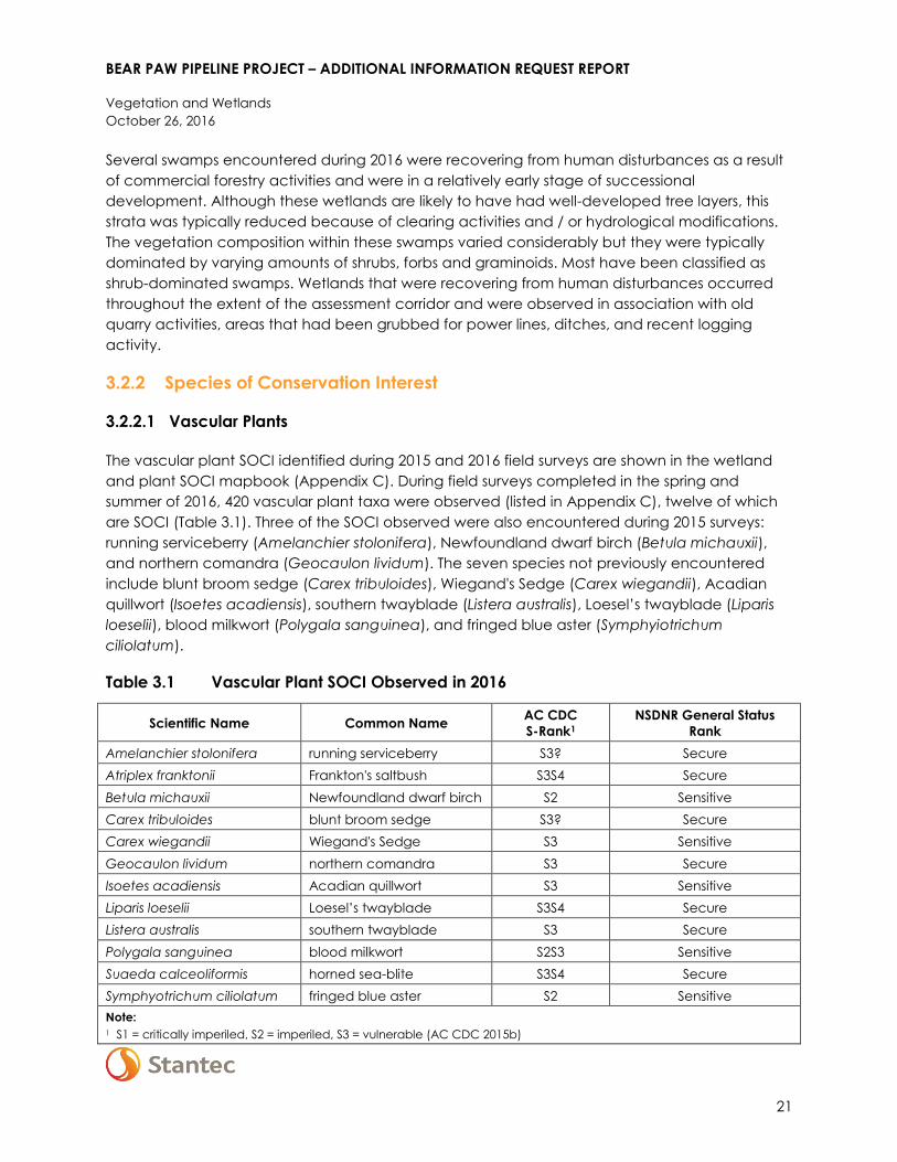
3.2.2 Species of Conservation Interest
3.2.2.1 Vascular Plants
The vascular plant SOCI identified during 2015 and 2016 field surveys are shown in the wetland
and plant SOCI mapbook (Appendix C). During field surveys completed in the spring and
summer of 2016, 420 vascular plant taxa were observed (listed in Appendix C), twelve of which
are SOCI (Table 3.1). Three of the SOCI observed were also encountered during 2015 surveys:
running serviceberry (Amelanchier stolonifera), Newfoundland dwarf birch (Betula michauxii),
and northern comandra (Geocaulon lividum). The seven species not previously encountered
include blunt broom sedge (Carex tribuloides), Wiegand's Sedge (Carex wiegandii), Acadian
quillwort (Isoetes acadiensis), southern twayblade (Listera australis), Loesel’s twayblade (Liparis
loeselii), blood milkwort (Polygala sanguinea), and fringed blue aster (Symphyiotrichum
ciliolatum).
Table 3.1 Vascular Plant SOCI Observed in 2016
Scientific Name Common Name AC CDC
S-Rank1
NSDNR General Status
Rank
Amelanchier stolonifera running serviceberry S3? Secure
Atriplex franktonii Frankton's saltbush S3S4 Secure
Betula michauxii Newfoundland dwarf birch S2 Sensitive
Carex tribuloides blunt broom sedge S3? Secure
Carex wiegandii Wiegand's Sedge S3 Sensitive
Geocaulon lividum northern comandra S3 Secure
Isoetes acadiensis Acadian quillwort S3 Sensitive
Liparis loeselii Loesel’s twayblade S3S4 Secure
Listera australis southern twayblade S3 Secure
Polygala sanguinea blood milkwort S2S3 Sensitive
Suaeda calceoliformis horned sea-blite S3S4 Secure
Symphyotrichum ciliolatum fringed blue aster S2 Sensitive
Note:
1 S1 = critically imperiled, S2 = imperiled, S3 = vulnerable (AC CDC 2015b)

BEAR PAW PIPELINE PROJECT – ADDITIONAL INFORMATION REQUEST REPORT
Vegetation and Wetlands
October 26, 2016
22
Running serviceberry is a shrub that is generally found in sandy areas, rocky barren ground and
boggy depressions (Zinck 1998). Although its provincial population is considered secure by
NSDNR (2014), it has been assigned a rank of S3? by the AC CDC (2014), indicating it may be
considered vulnerable, but its population status is poorly understood (AC CDC 2015a).
Uncertainty regarding its distribution and abundance is likely related to difficulty in identifying
species of the genus Amelanchier, and the fact that they frequently hybridize. Running
serviceberry was encountered within a bog near the central portion of the route in 2016 (Map 8,
Appendix C), and was also recorded at two locations near Carter’s Lake in 2015 (Stantec 2016).
Frankton’s saltbush is a halophytic forb that is typically found in salt marshes, brackish marshes
and along seashores (Zinck 1998). This species was observed to be scattered along the both the
north and south shores of the Strait of Canso (Maps 20 and 21, Appendix C) during September
surveys.
Newfoundland dwarf birch was found in the large Gold Brook wetland complex near the SOEP
Gas Plant in 2016 (Map 1, Appendix C), which is the same area it was encountered in 2015. At
this location, Newfoundland dwarf birch was found growing near the edge of a fen
characterized by a sphagnum moss mat that was punctuated by a variety of graminoids and
forbs. Additional information on the abundance and habitat conditions of this species at this site
may be obtained from the EA Report (Stantec 2016).
Blunt broom sedge is associated with swales and wet woods (Zinck 1998) and was encountered
within a mixedwood forest at the toe of slope on the north side of the Salmon River in 2016
(Map 8, Appendix C). Several clumps of this species were observed scattered amongst the
mixedwood forest of this location, which was comprised of a mixture of red maple (Acer
rubrum), yellow birch (Betula alleghaniensis), paper birch (Betula papyrifera), and scattered
white spruce (Picea glauca).
Wiegand's Sedge is reported as being associated with “boggy and peaty soils, conifer and alder
swamps” within Nova Scotia (Zinck 1998) and was encountered on the Cape Breton side of the
Straight of Canso (Map 21, Appendix C). Several plants were observed scattered in a coniferous
treed drainageway swamp at this location. The tree canopy of this swamp was composed of
Black spruce (Picea mariana) and tamarack (Larix laricina) which was otherwise dominated by
nearly continuous carpet of peatmoss (Sphagnum spp.), a moderately developed shrub layer
comprised of regenerating trees and ericaceous shrubs, and a herbaceous layer dominated by
cinnamon fern (Osmunda cinnamomea).
Northern comandra is an herb that is typically found in association with “sterile soils and damp
sands, in acid or peaty locations” of the province (Zinck 1998). This species was encountered at
two locations during 2016. Approximately 11 plants were found at the southern end of the route
in association with hummocks of a bog (Map 1, Appendix C) and a relatively large population of
approximately 300 plants was observed in association with barrens at the northern end near the
St. Francis Harbour River (Map 17, Appendix C). Northern comandra was recorded at three
locations in the Local Assessment Area (LAA) during 2015 surveys, all of which were in the

BEAR PAW PIPELINE PROJECT – ADDITIONAL INFORMATION REQUEST REPORT
Vegetation and Wetlands
October 26, 2016
23
general vicinity of Carters Lake (Stantec 2016). Addition historical records for this species are
known from the vicinity of Carters Lake, as well as from a bog near the SOEP Gas Plant and near
Port Hawkesbury (Stantec 2016).
Acadian quillwort is a small aquatic forb that has been reported to occur in association with
“water up to 1 m deep, bordering lakes or ponds, and occasionally along rivers” (Zinck 1998).
This species was encountered within waters along the north side of the Salmon River in 2016
(Map 8, Appendix C) where it was associated with a substrate consisting of sand mixed in with a
gravel-cobble matrix. Although only recorded in one location, this species is probably more
common along the shore of the Salmon River and in similarly sheltered areas than the distribution
of current records indicate.
Southern twayblade is a small orchid that is typically associated with the shaded sphagnum
moss of bogs or treed swamps (Zinck 1998). This species is only visible above ground for several
weeks during early summer (mostly in June) and then it senesces. This species was encountered
within swamp habitat at five locations during 2016 field surveys, all of which were in the same
general vicinity near the central portion of the route (Maps 7 and 8, Appendix C). This species
has been historically recorded in the vicinity of the study area near Eight Mile Lake and on Cape
Breton (Stantec 2016). Due to its small stature and the short period within which it may be
observed, southern twayblade is likely to occur elsewhere within the study area.
Horned sea-blite is a small prostrate forb found in association with salt marshes and sandy
beaches (Zinck 1998) of the province. One horned sea-blite plant was observed on the south
side of the Milford Haven River during September surveys (Map 13, Appendix C).
Fringed blue aster is known from scattered locations within the province where it is associated
with “open fields, lawns, and the edges of woods” (Zinck 1998). During 2016 field surveys, this
species was encountered at one location near Godfrey Brook (Map 10, Appendix C). Although
not typically associated with wetland habitats, the fringed blue aster was observed at the edge
of a tall shrub dominated swamp. This wetland occurred on a boulderfield that would be
seasonally flooded by the brook in spring, but which is relatively dry throughout the majority of
the growing season as water levels within the brook subside. The vegetative composition of this
area indicated that the wetland was relatively nutrient-rich; with dominant plants including
mountain maple, beaked hazel, chokecherry, evergreen wood fern, spotted jewelweed, dwarf
red raspberry, tall meadow-rue, rough-stemmed goldenrod, and ostrich fern.
Blood milkwort is typically found in infertile acidic fields, on roadsides, damp slopes, and open
woods (Zinck 1998). This species was found on the existing pipeline RoW near the inflow to Little
Beech Hill Lake (Map 4, Appendix C).
Loesel’s twayblade is associated with wet open habitats including bogs, peaty meadows, moist
ditches, cobbly lake shores, the margins of ponds and bogs, as well as behind coastal barrier
beaches (Zinck 1998). During the 2016 field surveys Loesel’s twayblade was found on a poorly
drained area of existing pipeline RoW near West Lake (Map 18, Appendix C).

BEAR PAW PIPELINE PROJECT – ADDITIONAL INFORMATION REQUEST REPORT
Vegetation and Wetlands
October 26, 2016
24
3.2.2.2 Lichen
The non-vascular plant SOCI identified during 2015 and 2016 field surveys are shown in in the
wetland and plant SOCI mapbook (Appendix C). A total of 38 non-vascular plants were
recorded during 2016 field surveys (listed in Appendix C), five of which are SOCI.
Two of the lichens encountered are SAR: frosted glass-whiskers (Sclerophora peronella), blue-felt
lichen (Degelia plumbea). The three remaining SOCI include two lichens and one bryophyte:
waterside rockshag lichen (Ephebe lanata), tree pelt lichen (Peltigera collina), and Warnstorf’s
peat moss (Sphagnum warnstorfii). Boreal felt lichen – Atlantic population, was not observed
during targeted surveys.
Table 3.2 Species of Conservation Interest Identified during the 2016 Field Surveys
Scientific Name Common Name AC CDC
S-Rank1
NSDNR General
Status Rank SARA / NS ESA
Degelia plumbea blue felt lichen S3 Secure
Special Concern
(SARA), Vulnerable
(NSESA)
Ephebe lanata waterside rockshag
lichen S3 Sensitive
Peltigera collina tree pelt lichen S2? Sensitive
Sclerophora peronella frosted glass-whiskers S1? na Special Concern
(SARA)
Sphagnum warnstorfii Warnstorf's Peat Moss S2S3 Sensitive
Note:
1 S1 = critically imperiled, S2 = imperiled, S3 = vulnerable (AC CDC 2015b); updated S-Ranks for frosted glass whiskers,
blue felt lichen, waterside rockshag lichen provided by T. Neily (pers. comm. 2016)
Frosted glass-whiskers is a stubble lichen that is typically found in sheltered crevices in exposed
heartwood of hardwood trees. It is also occasionally found growing on the bark of hardwood
trees. It is most often found on red maples but is occasionally found on other hardwood species.
Frosted glass-whiskers is sensitive to low temperatures and humidity and as such its distribution is
limited to cool, humid, mature hardwood forests. In Canada, frosted glass-whiskers is currently
only known from Nova Scotia. As of 2015, 13 populations of frosted glass-whiskers have been
recorded in Nova Scotia (Government of Canada 2016). This species is listed as a species of
special concern under Schedule 1 of the SARA. It is not listed under the NS ESA. The AC CDC lists
frosted glass-whiskers as S1? (i.e., critically imperiled but status uncertain). Frosted glass-whiskers is
found at one location near the St. Francis Harbour River (Map 17, Appendix C), where it was
growing on a yellow birch (Betula alleghaniensis).
Blue felt lichen is a foliose epiphytic cyanolichen that grows on hardwood trees in cool, humid
coastal forests. In Nova Scotia, blue felt lichen is typically found in upland and poorly drained
areas near the coast that are dominated by red maple (Acer rubrum). This species prefers areas
where temperatures are cool in the summer and mild in winter, that receive high quantities of

BEAR PAW PIPELINE PROJECT – ADDITIONAL INFORMATION REQUEST REPORT
Vegetation and Wetlands
October 26, 2016
25
rain throughout the year, and that are exposed to frequent fog (COSEWIC 2010). Red maples
are the most frequently used host tree; however, other species including sugar maple (Acer
saccharum), white ash (Fraxinus americana) and yellow birch may occasionally be hosts for this
species. As of 2010 there were 100 known populations of blue felt lichen in Canada. Eighty-eight
of these populations are found in Nova Scotia. Blue felt lichen is listed as vulnerable under the NS
ESA and although it is not listed under Schedule 1 of the SARA, it is designated as a species of
special concern by COSEWIC. The AC CDC lists this species as S3 (vulnerable). Blue felt lichen
was found at four locations during the 2016 field surveys, all of which were located near the
northern end of the proposed pipeline route. Two sites were found to the east of Carters Lake
(Map 19, Appendix C) and one site was found near the St. Francis Harbour River (18,
Appendix C). The fourth site was located near West Lake (Map 18, Appendix C). Blue felt lichen
was associated with mature hardwoods and red maple in all of these areas. AC CDC records
indicate that blue felt lichen has also been observed near the southern end of the proposed
pipeline route (Map 3, Appendix B).
Waterside rockshag lichen is a fruiticose cyanolichen that grows on rocks in streams and along
lake shores. It typically occurs on acidic rocks that are frequently wetted by stream or lake
water. It can also be found growing on rocks wetted by groundwater seepage or spray from
waterfalls. Waterside rockshag lichen is listed at a sensitive species by NSDNR and the AC CDC
ranks this species as S3 indicating that it is vulnerable in Nova Scotia. This species was found on a
rock in the St. Francis Harbour River (Map 17, Appendix B).
Tree pelt lichen is a foliose epiphytic cyanolichen. It occurs on a variety of substrates including
moss covered soil, humus over boulders and on the mossy bark of trees and rotting logs (Hale
1979). It is typically found in moist habitats in coastal areas. Tree pelt lichen is listed as sensitive by
NSDNR and as S2? By AC CDC, indicating that it is believed to be imperiled in Nova Scotia but
the status rank is uncertain. Tree pelt lichen was found at three locations during the 2016 field
survey. Two tree pelt lichens were found on red maples while the third was found on a sugar
maple. All of the 2016 records occurred at the northern end of the proposed pipeline route. One
site was located approximately a kilometer north of the Clam Harbour River (Map 16, Appendix
C). The remaining two sites were found near West Lake (Map 18, Appendix C). In 2015, two
other tree pelt lichen sites were also found near West Lake (Map 18, Appendix C). AC CDC
records identified a sixth tree pelt lichen site at the southern end of the proposed pipeline route
approximately one kilometer northeast of the gas plant site (Map 1, Appendix C).
An incidental observation of the bryophyte Warnstorf’s peat moss was also recorded during 2016
field surveys, and is ranked as S2S3 by the AC CDC (2014) and as sensitive by NSDNR (2014). This
species is typically found in minerotrophic fens. Warnstorf’s peat moss was found in a wetland
near West Lake (Map 18, Appendix C).
3.2.3 Wetland Surveys
The locations of wetlands identified in 2015 and 2016 are shown in the wetland and plant SOCI
mapbook (Appendix C). A total of 64 wetlands, accounting for 37.4 ha, were identified during

BEAR PAW PIPELINE PROJECT – ADDITIONAL INFORMATION REQUEST REPORT
Vegetation and Wetlands
October 26, 2016
26
the 2016 surveys (Table 3.3). Wetland classes identified during the 2016 field surveys include
swamp, bog, fen, marsh and shallow water (Table 3.3). Swamps accounted for the majority of
wetland area within the assessment corridor (approximately 88.5%); with softwood-treed,
mixedwood treed, and shrub-dominated types being particularly abundant. The dominant
vegetation type was not identified for two swamps which were recovering from recent human
disturbances, but these areas were dominated by herbaceous plants. The cover of treed bog,
open bog, fen, and marsh were relatively similar; all of which accounted for between 2.5% and
3.0% of the 2016 wetland study area; but the shallow water wetland class occupied less than 1%
of the total wetland area (Table 3.3).
Table 3.3 Wetland Classes (and Type, for Swamps) Surveyed in the Assessment
Corridor in 2016
Wetland Class (Type) # of Occurences1 Area
Area (ha) Percent (%)
Hardwood Treed Swamp 3 0.3 0.8
Mixedwood Treed Swamp 14 4.3 11.6
Softwood Treed Swamp 28 19.8 53.0
Shrub Swamp 16 8.2 21.8
Swamp (other) 2 0.5 1.3
Treed Bog 3 1.1 3.0
Bog 1 0.9 2.5
Fen 2 1.0 2.7
Marsh 7 0.9 2.5
Shallow Water 1 0.3 0.8
All 2016 Wetlands 64 37.4 100.0
Note: 1 Some wetlands were comprised of multiple classes or types
The functions provided by the 2016 wetlands are similar to those discussed in relation to the
various wetland types in Section 5.5 of the EA Report (Stantec 2016).
Results of vegetation and wildlife field surveys were used to identify Wetlands of Special
Significance (WSS) within the assessment corridor as follows, with guidance received from NSE (K.
Hilchey, pers. comm. 2016):
Wetlands along the Salmon River were classified as WSS because they are likely to be
considered to provide critical habitat for the wood turtle, as defined under the Recovery
Strategy for the Wood Turtle (Glyptemys insculpta) in Canada (Environment Canada 2016).
This includes any wetlands within 200 m of the high water mark of the Salmon River that may
be classified as alder thicket / swale, swamp, bog, wet meadow, beaver pond, oxbow /
perennial pool, or vernal pool (Environment Canada 2016).
Wetlands that supported vascular plant or lichen SAR records were considered WSS.

BEAR PAW PIPELINE PROJECT – ADDITIONAL INFORMATION REQUEST REPORT
Vegetation and Wetlands
October 26, 2016
27
Three wetlands were classified as WSS because they were adjacent or in close proximity
(i.e., within 200 m) to the Salmon River, which is known to support wood turtles. One of these
wetlands, located on the southern side of the river, is comprised of graminoid dominated
riparian marsh and an area of shallow water that forms a backwater and provides potential
wood turtle hibernation habitat. Another WSS, located on the north side of the river, is comprised
of a tall shrub and mixedwood swamp and provides potential wood turtle foraging habitat. A
mixedwood treed basin swamp approximately 120 m from the river was also classified as a WSS
because it is within 200 m of the river and may therefore classify as wood turtle critical habitat.
No lichen SAR were observed in association with wetlands. Although signs of mainland moose
and several bird SAR were also observed in association with wetlands (i.e., Canada Warbler,
Rusty Blackbird, and Olive-sided Flycatcher) these observations were not used to identify WSS
following guidance from NSE.
3.3 MITIGATION AND FOLLOW-UP
3.3.1 Mitigation
Mitigation measures to reduce the environmental effects of the Project on vegetation and
wetlands were identified in Section 5.5.6 of the EA Report and are reproduced below in Table
3.4. Standard mitigation measures listed in Section 2.5.3 of the EA report is included as Appendix
B to this document. Locations for site-specific mitigation will be outlined in the EPP following
detailed routing and in consultation with the appropriate regulatory authorities in consideration
of the following criteria:
rarity, status, or function of SOCI or wetland under consideration
ecology of SOCI under consideration
hydrological conditions of wetland under consideration
location of SOCI or wetland relative to the PDA
alternatives to current design
temporary or permanent mitigation
public or landowner support (e.g., existing use/ownership)
Table 3.4 Summary of Mitigation for Vegetation and Wetlands (adapted from
Section 5.5.6 of the EA Report)
Effect Mitigation
Change in SOCI Reduce physical disturbance to SOCI through detailed routing during detailed
engineering.
Develop mitigation plans for unavoidable effects on SOCI in consultation with
regulators. Mitigation measures may include collecting, propagating or
transplanting seeds or live plants.
Use snow fencing and signage in areas of SOCI to protect plant occurrences near
disturbance activities. If protecting the occurrence is not practical, temporarily
cover the site with snow (given the season), geofabric and padding, flex net,
swamp mats, or equivalent.

BEAR PAW PIPELINE PROJECT – ADDITIONAL INFORMATION REQUEST REPORT
Vegetation and Wetlands
October 26, 2016
28
Table 3.4 Summary of Mitigation for Vegetation and Wetlands (adapted from
Section 5.5.6 of the EA Report)
Effect Mitigation
Inform users of access restrictions in the vicinity of fenced sites.
Restrict the general application of herbicide near SOCI. Spot spraying, wicking,
mowing, or hand-picking are acceptable measures for integrated vegetation
management in these areas.
If agreements can be reached, use the existing pipeline RoW for temporarily
storing topsoil and subsoil.
Reduce grading in native vegetation communities.
Install cross ditches and berms on moderately steep and steep slopes in non-
agricultural areas to prevent runoff along the RoW and subsequent erosion.
In areas with native vegetation, allow for natural regeneration, or seed as
directed by the appropriate Land Administrator on Crown lands. Natural recovery
is the preferred method of reclamation on level terrain where erosion is not
expected. Where appropriate, natural regeneration may be supplemented with
seed harvested from the area, or through the salvage and transplantation of sod
and plants.
Use bio-stabilization measures such as willow staking and erosion control blankets
to reclaim riparian areas, as appropriate.
Where practical, leave stumps in place, particularly on stream banks, to provide
surface stability.
All equipment must arrive at the site clean and free of soil or vegetative debris.
Equipment will be inspected by the Environmental Inspector(s), or designate.
Change in Wetland
Area or Function
Reduce physical disturbance to wetlands through detailed routing during
detailed engineering.
Progressive rehabilitation practices will focus on restoring topography, hydrology
and vegetation in disturbed wetland areas where practicable, to reduce
permanent loss.
Reduce the removal of vegetation in wetlands to the extent possible.
Conduct ground level cutting, mowing and mulching of wetland vegetation
instead of grubbing, wherever practical.
Salvage and store wetland organic layer separately from upland topsoil.
Direct grading away from wetlands.
Reduce grading within wetlands.
Do not use wetlands as temporary workspaces, unless required for site-specific
purposes.
When working on saturated soils during non-frozen ground conditions to reduce
compaction and admixing, use equipment and techniques that distribute ground
pressure (e.g., swamp mats, geofabric and padding, corduroy).
Use ditch plugs or similar water control structures in the trench at either end of
wetland crossings where there is the potential of water migration along the
trench.
Replace trench material as soon as practicable, and re-establish preconstruction
contours within wetland boundary to re-establish drainage patterns.
Install berms, cross ditches, or silt fences between wetlands and disturbed areas
when deemed necessary by the Environmental Inspector(s).
Use natural re-vegetation for wetlands.
Per NSE requirements, compensate for residual losses of wetland area in the PDA
through the enhancement, restoration, or creation of wetland habitat, as may be
arranged through agreement with a third party wetland compensation provider.

BEAR PAW PIPELINE PROJECT – ADDITIONAL INFORMATION REQUEST REPORT
Vegetation and Wetlands
October 26, 2016
29
As described in Section 2, NSE and NSDNR will be involved in the development of appropriate
site-specific mitigation.
Additional mitigation measures recommended as a result of the 2016 field surveys are discussed
below with respect to lichen species and WSS.
3.3.1.1 Wetlands of Special Significance
As discussed in Section 3.2.3, critical wood turtle habitat as defined under SARA was identified at
the Salmon River, in association with wood turtle observations. The wetlands in this area are also
designated as WSS, due to the presence of wood turtles.
As stated in the Nova Scotia Wetlands Policy, the primary objective of the Policy is, “…to
manage human activity in or near wetlands, with the goal of no loss in Wetlands of Special
Significance and the goal of preventing net loss in area and function for other wetlands”.
In keeping with the Policy, Bear Paw Pipeline Corporation’s approach to reducing
environmental interactions, including with wetlands and Wetlands of Special Significance, is
based on the following principles (additional details are provided below):
avoidance
reduction of disturbance
mitigation and monitoring
compensation
Avoidance
In keeping with the goals of the Policy, the the Project has been routed to capitalize on the
presence of existing linear infrastructure in the area (i.e., the existing M&NP and Exxon Mobil
pipeline RoW), thereby reducing landscape fragmentation. The area of disturbance may be
further reduced through the development of agreements with adjacent pipeline operators to
use the existing pipeline RoW for temporarily storing topsoil and subsoil.
In addition to this, preliminary pipeline routing has taken known environmental constraints into
consideration through the use of Light Detection and Ranging (LiDAR), orthophotos, and field
work. At the time that the existing RoW was routed, care was taken through micro-routing to
avoid wetlands and other sensitive features on the landscape. The preferred construction
method at Salmon River is Horizontal Directional Drilling (HDD); however, this construction
technique cannot be confirmed until additional geotechnical investigations and more detailed
engineering is completed.
Reduction of Disturbed Area
Disturbance in wetlands areas will be reduced through the application of the mitigation
measures described below (e.g., limiting area disturbance through micro-routing; limiting ground
disturbance such as grubbing and stripping to the area of the trench; limiting on-site activity in

BEAR PAW PIPELINE PROJECT – ADDITIONAL INFORMATION REQUEST REPORT
Vegetation and Wetlands
October 26, 2016
30
wetlands and protecting wetlands soils by working in frozen conditions or the use of mats and
corduroy). In addition, efforts will be made to reach agreements with adjacent owners of the
existing RoW to use a portion of the existing pipeline RoW for temporarily storing topsoil and
subsoil, in consideration of operational and safety requirements of the existing operation.
Mitigation and Monitoring
The mitigation measures presented in Table 3.4 are generally related to the stabilization of soils
and consequent reduction in erosion and sedimentation, and the maintenance of hydraulic
connectivity within wetlands post construction.
Wetland areas will be flagged ahead of construction, and WSS will be uniquely marked.
Construction in WSS will be carried out in frozen ground conditions whenever possible although
this may not be feasible for all locations. Where frozen ground construction cannot be
accommodated, various methods will be used to protect wetland soils from operating
equipment such as wetland mats. The area of disturbance in all wetlands will be limited, with
controlled access to the area to reduce the amount of equipment traffic on these sites. The
cleared width of RoW within the wetlands of special significance will be reduced to the extent
possible for constructability, safety, and operational requirements. The area of grubbing will be
limited to the trench width within wetlands. Various erosion and sediment control techniques will
be used to control water flow during construction (e.g., trench water management; directing
surface water flow through erosion control devices). Wetland soils will be managed on site
through the development of a Soil Erosion Contingency Plan and Wet Soils Contingency Plan.
Materials will be removed from the trench and stored on site, and will be replaced in their
original order in order to reduce the likelihood of an interruption of water flow across the
operational trench. Wetland contours will be reestablished during construction through
contouring so that on-site drainage patterns are not changed.
In addition to the mitigation measures presented in Table 3.4, the following more specific
mitigation will be applied to all construction activities in wetlands.
A pump will be installed as required to dewater open trenches in a manner that maintains
existing drainage patterns.
Trench water will be pumped onto a stable sediment filtering device or management areas
and will not be permitted to flow directly into a watercourse or wetland.
Where appropriate, sediment control fences will be installed and maintained along the
edges of exposed soil within wetlands.
Grubbing in wetlands will be delayed until necessary for construction access, and limited to
the trench width.
Grubbing will include the removal of the upper ~30 cm of vegetated topsoil from the
wetland area within the trench width to be set aside for salvaging during restoration.
Soils will be stored in such a way as to avoid the mixing of topsoil with sub-surface soils;
Subsurface materials excavated during trenching in wetlands will be stored outside of the
wetland where possible.
Materials for backfilling trenches after pipeline installation will be stored along the corridor or
in a temporary work area a minimum of 30 m from wetland boundaries where practical.

BEAR PAW PIPELINE PROJECT – ADDITIONAL INFORMATION REQUEST REPORT
Vegetation and Wetlands
October 26, 2016
31
Backfilling will be done as soon as possible following pipeline installation.
Trench material and vegetated topsoil will be replaced in a way that reduces the mixing or
loss of materials.
All temporary drainage devices will be removed after construction to restore hydrology.
Vegetated topsoil material will be replaced in the same wetland where it was removed.
Temporary access through wetlands will be removed or altered after construction to allow
wetland functionality and protection.
These commitments will be included in the project-specific EPP and presented in contractor
training. Work within WSS will be monitored during construction.
3.3.1.2 Lichen
In addition to standard mitigation and mitigation practices specific to vegetation and wetlands
described above, there are occurrences of lichen SAR and SOCI that warrant special attention.
The current alignment was carefully chosen based on proximity to the existing RoW, in
consideration of known environmental constraints (e.g., wetland, rare plants), as well as
constructability considerations. Wherever possible, the lichen occurrences will be avoided
through detailed routing during design, and micro-routing on the ground. Lichen-bearing trees
will be buffered as much as feasible during construction, in consideration that any micro-routing
decisions could impact other lichen or other environmentally sensitive receptors.
In cases where lichen cannot be avoided or appropriately buffered, Bear Paw Pipeline will work
with NSDNR on alternative mitigation through the detailed design phase and routing, as
described in Section 2. This may include identification of priority-trees based on the health and
abundance of the species. Specimen samples may also be collected for cataloguing.
3.3.2 Follow-up Monitoring
3.3.2.1 Wetlands of Special Significance
Construction within WSS, if required, will be monitored.
Wetlands will be monitored post-construction to record any changes to wetland function as a
result of construction, and operation and maintenance activities by choosing a subset of the
wetlands to represent the different wetland types affected. Monitoring will focus on wetland
function, based on the functional assessments carried out in support of the EA and this
Additional Information Request Report. Monitoring in WSS will focus on the characteristics that
define the wetland as having special significance (e.g., habitat for SAR).
Per NSE requirements, compensation will be sought for permanent residual losses of wetland
area in the PDA through the enhancement, restoration, or creation of wetland habitat, as may
be arranged through agreement with a third party wetland compensation provider.

BEAR PAW PIPELINE PROJECT – ADDITIONAL INFORMATION REQUEST REPORT
Vegetation and Wetlands
October 26, 2016
32
3.3.2.2 Lichen
Lichen occurrences will be monitored post-construction to record any changes to health and
abundance. The frequency and duration of monitoring will be determined in consultation with
NSDNR.
BEAR PAW PIPELINE PROJECT – ADDITIONAL INFORMATION REQUEST REPORT
Birds and Bird Habitat
October 26, 2016
33
4.0 BIRDS AND BIRD HABITAT
Bird surveys were not undertaken in 2015 due to seasonal constraints. Therefore, these surveys
were planned and undertaken in 2016 on both private and Crown land, according to the
methods below.
4.1 METHODS
Breeding bird surveys were conducted in the spring of 2016 to document bird communities
within the LAA. Particular effort was made to document the presence of SAR and other SOCI.
Objectives of the breeding bird survey program were to:
collect information that can be used to document relative breeding bird densities and
species richness by land cover type
systematically and incidentally record observations of SAR and other SOCI
gather presence / not detected information on SAR within wetlands
Information on the use of the assessment corridor by breeding birds was obtained through a
variety of survey techniques, including:
point count surveys
incidental observations of SAR and other SOCI
dedicated surveys for SAR, including wetland passerines, nightjars, and short-eared Owls
(Asio flammeus)
The entire length of the Project was walked and observations of SAR and SOCI were recorded
when detected. Where access to private lands was not granted, surveyors listened-in from the
adjacent existing pipeline RoW to obtain information on SAR and SOCI. Prior to surveys, areas
with high potential to support SAR were identified based on knowledge or the study area and
reference to historical species record. Effort was also dedicated to identifying raptor nests during
these surveys.
Additional information on the point count and SAR survey methodologies is provided below.
4.1.1 Point Counts
As recommended by Environment Canada (CWS 2007; Hanson et al. 2009), surveys were
designed to determine which species regularly use the area for breeding purposes and to
obtain measures of their abundance in association with particular land cover types. Point counts
were used for these objectives - particularly for obtaining information on breeding songbirds and
other passerines. Point count sites were distributed to obtain representative sampling in each
major land cover type using data on vegetation structure and composition (i.e., forest cover
and maturity) from the NSDNR (2015) and wetland delineations conducted for the Project within

BEAR PAW PIPELINE PROJECT – ADDITIONAL INFORMATION REQUEST REPORT
Birds and Bird Habitat
October 26, 2016
34
the assessment corridor. Site locations were randomly identified within mapped land cover types
on Crown and private lands, including those that have high potential to support bird species of
conservation concern (i.e., areas supporting mature stands of timber, riparian areas and
wetlands). Site locations were constrained to be at least 75 m away from the edges of mapped
land cover units, but have also been placed along an existing pipeline Row in order to
characterize bird assemblages for linear features. Additional point counts were manually added
in locations to target important or under-represented land cover types, particularly wetlands
(i.e., in some cases the center of these point counts were placed < 75 m away from mapped
land cover boundaries). In addition to surveys along the pipeline route itself, two point counts
were conducted within the footprint of the compressor station.
A total of 143 point count sites, representing 11 land cover classes, were surveyed (Figure 4.1,
Table 4.1). The land cover classes were derived from NSDNR land cover mapping, as presented
in Section 5.6 of the EA Report (Stantec 2016), but some classes were grouped. Upland forest
types were amalgamated based on age class in order to reduce the number of land cover
classes. For each forest type (hardwood, softwood and mixedwood), two age classes,
‘regeneration – young’ and ‘immature – pole’, were combined to form ‘regeneration – pole’.
Similarly, the age classes ‘uneven’ and ‘mature – overmature’ were combined to form ‘mature -
overmature and uneven’. These groupings allowed for a greater selection of point count
locations in the landscape, which is highly fragmented by logging activities, while maintaining
important forest structural characteristics. Wetlands were classified into one of two classes: open
peatlands (including bogs and fens) and treed/shrub-dominated wetlands (typically swamps).
Marshes and shallow water wetlands in the LAA were too small to accommodate point counts,
and were generally associated with the existing RoW. In order to capture information on SOCI
use of these features, marshes and shallow water wetlands were visited in the field and
incidental data was collected.
At each point count site, the numbers of birds heard or observed over a ten minute period were
recorded. Specific data recorded for each observation include the species, distance from the
observer, angle from survey location, breeding evidence encountered, the type of observations
(i.e., visual, auditory, fly-over), whether an observation was of a pair, and other notes on
behavior when applicable. Other information collected during the surveys included the
location, survey time, temperature, wind speed using the Beaufort scale, wind direction, cloud
cover, visibility, and habitat type (including approximate stand age and height, where
applicable. Each point count was surveyed once during the breeding season.
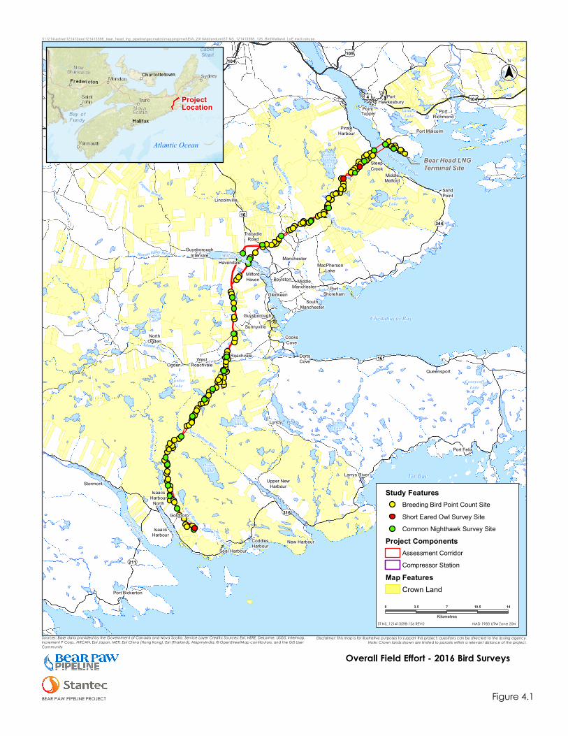
!
IsaacsHarbour
IsaacsHarbour
North
CoddlesHarbour
Upper NewHarbourStormont
Goldboro
Seal Harbour
MiddleManchester Port
Shoreham
MacPhersonLake
CooksCove
DortsCove
GlenkeenSouth
Manchester
Manchester
MilfordHaven
Havendale
GuysboroughIntervale
Guysborough
WestRoachvale
Roachvale
Sunnyville
Lundy
TracadieRoad
NorthOgden
Boylston
Ogden
SandPoint
PortRichmond
Port MalcolmPirateHarbour
SteepCreek
MiddleMelford
Lincolnville
PortHawkesbury
Port Bickerton
New Harbour
Larrys River
Port Felix
Queensport
Point Tupper
Eugenes Brook
Isaacs
Harbo
urRiv
er New Harbour River
ClamHarbour Rive r
St.Francis Harbour River
Roman Valley River
SalmonR iver
Tor Bay
Chedabucto Bay
Strait of Canso
Milford HavenRiver
Gold Brook
West Brook
Country Harbour
Isaacs Harbour
NorthBranch
Lake
BonnetLake
CooeycoffLake
GooseHarbour
Lake
OceanLake
LoonLake
LawlorLake
LandrieLake
EnglandsLake
UV344
UV211
UV316
£¤4 £¤4
£¤16
£¤16
£¤104
£¤104£¤105
Bear Head LNGTerminal Site
($$¯
NAD 1983 UTM Zone 20N
0 3.5 7 10.5 14
Kilometres
DRAFT - For In
ternal Use Only
Study FeaturesBreeding Bird Point Count SiteShort Eared Owl Survey SiteCommon Nighthawk Survey Site
Project ComponentsAssessment CorridorCompressor Station
Map FeaturesCrown Land
ST NS_121413598-126 REV0
V:\1214\active\121413xxx\121413598_bear_head_lng_pipeline\geomatics\mapping\mxd\EIA_2016Addendum\ST NS_121413598_126_BirdWetland_LoE.mxd cshupe
Disclaimer: This map is for illustrative purposes to support this project; questions can be directed to the issuing agency.Note: Crown lands shown are limited to parcels within a relevant distance of the project.
Overall Field Effort - 2016 Bird Surveys
Figure 4.1BEAR PAW PIPELINE PROJECT
Sources: Base data provided by the Government of Canada and Nova Scotia. Service Layer Credits: Sources: Esri, HERE, DeLorme, USGS, Intermap,increment P Corp., NRCAN, Esri Japan, METI, Esri China (Hong Kong), Esri (Thailand), MapmyIndia, © OpenStreetMap contributors, and the GIS UserCommunity
Atlantic Ocean
ProjectLocation

BEAR PAW PIPELINE PROJECT – ADDITIONAL INFORMATION REQUEST REPORT
Birds and Bird Habitat
October 26, 2016
36
This page is intentionally left blank.

BEAR PAW PIPELINE PROJECT – ADDITIONAL INFORMATION REQUEST REPORT
Birds and Bird Habitat
October 26, 2016
37
Table 4.1 Number of Breeding Bird Point Count Stations completed in each Land Cover Class
Land Cover Class
Point Counts Percent of Total Land
Cover in LAA (%)1Number Completed
Percent of Total
Point Counts (%)
Forest
Mature – Overmature and Uneven Hardwood 4 2.8 2.9
Mature – Overmature and Uneven Softwood 9 6.3 8.4
Mature– Overmature and Uneven Mixedwood 10 7.0 4.8
Regeneration – Pole Hardwood 11 7.7 7.4
Regeneration – Pole Softwood 24 16.8 26.4
Regeneration – Pole Mixedwood 12 8.4 11.7
Forestry Other 14 9.8 11.5
Wetland Open Peatland (Bogs and Fens) 6 4.2 6.3
Treed/Shrub Wetland 22 15.4 7.6
Other Developed 2 1.4 2.3
Corridor 29 20.3 1.4
Total 143 100 90.7
Note:
1 Additional land classes identified in the LAA include open water, marsh, shallow water wetland, unknown wetland, barren, beach, agriculture and other
non-forest. These classes make up the remaining 9.3% of total land cover.

BEAR PAW PIPELINE PROJECT – ADDITIONAL INFORMATION REQUEST REPORT
Birds and Bird Habitat
October 26, 2016
38
4.1.1.1 Field Methods
Breeding bird surveys were conducted between June 9 and July 7, 2016. Weather conditions
greatly influence the level of bird activity/song, as well as the observer’s ability to detect birds.
As such, breeding bird surveys were delayed or suspended if the temperature was below
0° Celsius, sustained wind was above Beaufort 3 (>20 km/h), visibility (due to fog) was less than
50 m, or precipitation was any heavier than light, intermittent drizzle (CWS 2007). Surveys began
at sunrise and continued until approximately 10:00 a.m.
The protocol used was based on a modified fixed-radius point count sampling procedure
(Bibby et al. 2000). At each site, the procedure below was followed:
Upon arrival, observers waited for 2 minutes to let effects of disturbance subside. This time
was used to record location, weather, and habitat data. Birds observed during this period,
but not during the actual count, were recorded as incidentals, as were those encountered
during the approach or departure from the point (but not observed during the count itself).
A silent 10-minute survey was conducted, identifying all birds by sight and sound. Effort was
concentrated on the 100 m radius around the point of observation, but observations beyond
this distance were also recorded, particularly for SOCI.
At each point count site, the numbers of birds heard or observed over a ten minute period were
recorded. Observers recorded the following information for all point counts: date, names of
observers, time, weather conditions (temperature, % cloud cover, Beaufort wind scale, visibility,
and precipitation), location, general habitat conditions, and species observed. Although the
point counts targeted breeding birds, non-breeding bird observations were also recorded. Birds
documented as flyovers or otherwise not using the study area as nesting habitat were indicated
as such at the time of observation. These birds were later excluded from habitat associations.
For each bird observed, information was collected on sex (male, female, or unknown); age
(adult, juvenile, or unknown); whether it was seen, heard, or both; distance from the observer;
and highest observed breeding evidence. Additional information on behaviour was recorded
for all birds where applicable. Specific effort was made to capture information relating to
breeding status (e.g., carrying food, incubating, distraction display).
4.1.1.2 Analyses
Songbird data collected using point counts were used to estimate densities of species (number
of territories / 100 ha) within individual land cover types and to calculate their species richness.
For these analyses, only data for birds recorded within 100 m of the center of point counts were
used, with observations recorded farther away being treated as incidental observations.
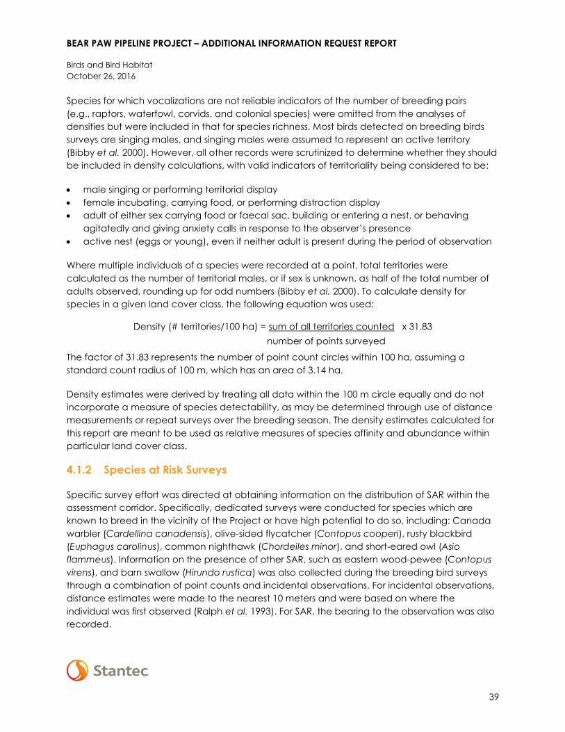
BEAR PAW PIPELINE PROJECT – ADDITIONAL INFORMATION REQUEST REPORT
Birds and Bird Habitat
October 26, 2016
39
Species for which vocalizations are not reliable indicators of the number of breeding pairs
(e.g., raptors, waterfowl, corvids, and colonial species) were omitted from the analyses of
densities but were included in that for species richness. Most birds detected on breeding birds
surveys are singing males, and singing males were assumed to represent an active territory
(Bibby et al. 2000). However, all other records were scrutinized to determine whether they should
be included in density calculations, with valid indicators of territoriality being considered to be:
male singing or performing territorial display
female incubating, carrying food, or performing distraction display
adult of either sex carrying food or faecal sac, building or entering a nest, or behaving
agitatedly and giving anxiety calls in response to the observer’s presence
active nest (eggs or young), even if neither adult is present during the period of observation
Where multiple individuals of a species were recorded at a point, total territories were
calculated as the number of territorial males, or if sex is unknown, as half of the total number of
adults observed, rounding up for odd numbers (Bibby et al. 2000). To calculate density for
species in a given land cover class, the following equation was used:
Density (# territories/100 ha) = sum of all territories counted x 31.83
number of points surveyed
The factor of 31.83 represents the number of point count circles within 100 ha, assuming a
standard count radius of 100 m, which has an area of 3.14 ha.
Density estimates were derived by treating all data within the 100 m circle equally and do not
incorporate a measure of species detectability, as may be determined through use of distance
measurements or repeat surveys over the breeding season. The density estimates calculated for
this report are meant to be used as relative measures of species affinity and abundance within
particular land cover class.
4.1.2 Species at Risk Surveys
Specific survey effort was directed at obtaining information on the distribution of SAR within the
assessment corridor. Specifically, dedicated surveys were conducted for species which are
known to breed in the vicinity of the Project or have high potential to do so, including: Canada
warbler (Cardellina canadensis), olive-sided flycatcher (Contopus cooperi), rusty blackbird
(Euphagus carolinus), common nighthawk (Chordeiles minor), and short-eared owl (Asio
flammeus). Information on the presence of other SAR, such as eastern wood-pewee (Contopus
virens), and barn swallow (Hirundo rustica) was also collected during the breeding bird surveys
through a combination of point counts and incidental observations. For incidental observations,
distance estimates were made to the nearest 10 meters and were based on where the
individual was first observed (Ralph et al. 1993). For SAR, the bearing to the observation was also
recorded.

BEAR PAW PIPELINE PROJECT – ADDITIONAL INFORMATION REQUEST REPORT
Birds and Bird Habitat
October 26, 2016
40
4.1.2.1 Wetland Passerines
Several passerine SAR are known or have high potential to occur in association with wetlands in
the assessment corridor. In particular, results of the wetland functional assessment surveys
conducted in support of the Project in 2015 indicate that potentially suitable SAR habitat is
present within at least 46 of the field-delineated wetlands (i.e., on Crown lands), including for
Canada warbler (19 wetlands), olive-sided flycatcher (30 wetlands), and rusty blackbird
(7 wetlands). Information on the presence of these species was obtained by visiting each of the
wetlands identified as having potential to support SAR. Incidental observations of SAR and other
birds were recorded during each of the wetland surveys. In addition to SAR surveys for field-
delineated wetlands (i.e., which occur on Crown lands), areas on private lands with high
potential to support SAR (wetland passerine and otherwise) were identified through a review of
historical records and desktop imagery and are were visited during the bird surveys to the extent
possible (i.e., where private land access was not granted, observations were being made by
listening-in from the adjacent pipeline RoW).
4.1.2.2 Common Nighthawk and other Nightjars
A total of 29 surveys for common nighthawk and other nightjars were conducted within the LAA
(Figure 4.1). These surveys were performed near areas that have high potential to provide
breeding opportunities for this species. Common nighthawk nesting habitat is extremely diverse
compared to many other migratory birds. Survey locations were determined based on the
availability of potentially suitable breeding habitat and site access (survey sites were located on
roads). In particular, clear-cuts, agricultural lands, barrens, non-productive forest, disturbed
areas of mining and quarry operations, rock outcrops, and other open environments were
considered to provide potentially suitable ground-nesting opportunities for this species.
Roadside surveys were conducted between June 13 and June 23, 2016 using a modified version
of the newly released Canadian Nightjar Survey Protocol (CWS 2016). Nightjar surveys began
approximately 30 minutes before sunset continued until up to two hours after sunset. As weather
conditions can greatly influence the level of nightjar activity, and may also affect the ability of
observers to detect them, surveys were delayed or suspended if sustained wind was above
Beaufort 3 (>20 km/h) or if there was any precipitation.
Common nighthawk survey methodology followed that outlined by CWS (2016) but included the
use of playback. The survey consists of a 6-minute silent listening period at each station, followed
by two minutes of playbacks, and two minutes of silent listening (i.e., 10 minutes total). Surveyors
recorded the period during the survey in which any observations of common nighthawks were
made (i.e., first three minutes, second three minutes, 2- minute playback, or last 2 minutes),
information on their behaviour, evidence of breeding status, and location (i.e., distance and
angle from the observation point) was recorded. Visual or auditory observations of other SOCI
were also recorded during these surveys.

BEAR PAW PIPELINE PROJECT – ADDITIONAL INFORMATION REQUEST REPORT
Birds and Bird Habitat
October 26, 2016
41
4.1.2.3 Short-Eared Owl
A total of three short-eared owl surveys were conducted within the LAA (Figure 4.1). Potential
breeding habitat for short-eared owls was identified with reference to historical observations for
this species and aerial imagery. Surveys were conducted in late June (i.e., between June 20 and
June 23, 2016), which overlaps with the time period when activities for provisioning young are
expected to be greatest and followed the general methodology outlined in short-eared owl
occupancy, detectability and habitat use across seasons on Amherst Island and Wolfe Island in
eastern Ontario (Keyes 2011). Point counts were located along the edge of potentially
appropriate habitat (e.g., large open bogs in the Carters Lake area and near the Goldboro gas
plant site). Surveys began 60 minutes before sunset and finished 30 minutes following sunset.
Visual point counts of 10 minute duration were used to survey a 180° range. Surveys were not
conducted during sustained windy conditions greater than three on the Beaufort scale and / or
heavy precipitation.
4.2 RESULTS
Field surveys conducted for the Project identified 24 migratory bird SOCI as occurring within the
study area (Table 4.2). The locations of observed migratory bird SOCI are shown in the wildlife
SOCI mapbook (Appendix D). The most frequently encountered SOCI included ruby-crowned
kinglet (Regulus calendula), golden-crowned kinglet (Regulus satrapa) and yellow-bellied
flycatcher (Empidonax flaviventris) (Table 4.3). Of the 24 species identified, six are considered
SAR: common nighthawk, olive-sided flycatcher, Canada warbler, rusty blackbird, Eastern-wood
pewee, and barn swallow. Canada warbler was the most commonly encountered SAR, with a
total of 49 records (Table 4.3). No short-eared owls were observed. Further information on the
distribution and abundance of migratory bird SOCI encountered during field surveys is provided
below in Table 4.3, and in Appendix D.

BEAR PAW PIPELINE PROJECT – ADDITIONAL INFORMATION REQUEST REPORT
Birds and Bird Habitat
October 26, 2016
42
Table 4.2 Bird SOCI Observed
Common Name Scientific Name SARA COSEWIC NS ESA NSDNR General
Status Rank AC CDC S-Rank
Common Loon Gavia immer Not at Risk May Be At Risk S3B,S4N
American Bittern Botaurus lentiginosus Sensitive S3S4B
Northern Goshawk Accipiter gentilis Not at Risk Secure S3S4
Greater Yellowlegs Tringa melanoleuca Sensitive S3B,S5M
Spotted Sandpiper Actitis macularius Sensitive S3S4B
Wilson's Snipe Gallinago delicata Sensitive S3S4B
Common Nighthawk Chordeiles minor Threatened Threatened Threatened At Risk S3B
Black-backed
Woodpecker Picoides arcticus Sensitive S3S4
Olive-sided Flycatcher Contopus cooperi Threatened Threatened Threatened At Risk S3B
Eastern Wood-Pewee Contopus virens Special
Concern Vulnerable Sensitive S3S4B
Yellow-bellied
Flycatcher Empidonax flaviventris Sensitive S3S4B
Tree Swallow Tachycineta bicolor Sensitive S4B
Barn Swallow Hirundo rustica Threatened Endangered At Risk S3B
Gray Jay Perisoreus canadensis Sensitive S3S4
Boreal Chickadee Poecile hudsonicus Sensitive S3
Golden-crowned
Kinglet Regulus satrapa Sensitive S4
Ruby-crowned Kinglet Regulus calendula Sensitive S4B
Gray Catbird Dumetella
carolinensis May Be At Risk S3B
Tennessee Warbler Oreothlypis peregrina Sensitive S3S4B

BEAR PAW PIPELINE PROJECT – ADDITIONAL INFORMATION REQUEST REPORT
Birds and Bird Habitat
October 26, 2016
43
Table 4.2 Bird SOCI Observed
Common Name Scientific Name SARA COSEWIC NS ESA NSDNR General
Status Rank AC CDC S-Rank
Blackpoll Warbler Setophaga striata Sensitive S3S4B
Wilson's Warbler Cardellina pusilla Sensitive S3S4B
Canada Warbler Cardellina
canadensis Threatened Threatened Endangered At Risk S3B
Rusty Blackbird Euphagus carolinus Special
Concern
Special
Concern Endangered May Be At Risk S2S3B
Pine Grosbeak Pinicola enucleator May Be At Risk S3?B,S5N
Atlantic Canada Conservation Data Centre
S1 = Critically imperiled in the province because of extreme rarity (often 5 or fewer occurrences). May be especially vulnerable to extirpation.
S2 = Imperiled in the province because of rarity due to very restricted range, very few populations (6 to 20 occurrences or few remaining individuals). May be
vulnerable to extirpation due to rarity or other factors.
S3 = Vulnerable - Vulnerable in the province due to a restricted range, relatively few populations (often 80 or fewer).
S4 = Uncommon but not rare; some cause for long-term concern due to declines or other factors (80+ occurrences).
S5 = Common, widespread, and abundant in the province.
‘-‘ = Not included in AC CDC species list.
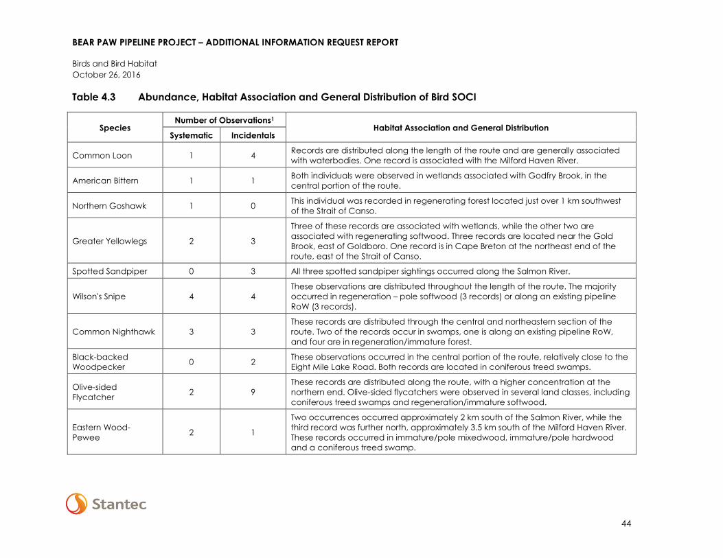
BEAR PAW PIPELINE PROJECT – ADDITIONAL INFORMATION REQUEST REPORT
Birds and Bird Habitat
October 26, 2016
44
Table 4.3 Abundance, Habitat Association and General Distribution of Bird SOCI
Species Number of Observations1
Habitat Association and General Distribution Systematic Incidentals
Common Loon 1 4 Records are distributed along the length of the route and are generally associated
with waterbodies. One record is associated with the Milford Haven River.
American Bittern 1 1 Both individuals were observed in wetlands associated with Godfry Brook, in the
central portion of the route.
Northern Goshawk 1 0 This individual was recorded in regenerating forest located just over 1 km southwest
of the Strait of Canso.
Greater Yellowlegs 2 3
Three of these records are associated with wetlands, while the other two are
associated with regenerating softwood. Three records are located near the Gold
Brook, east of Goldboro. One record is in Cape Breton at the northeast end of the
route, east of the Strait of Canso.
Spotted Sandpiper 0 3 All three spotted sandpiper sightings occurred along the Salmon River.
Wilson's Snipe 4 4
These observations are distributed throughout the length of the route. The majority
occurred in regeneration – pole softwood (3 records) or along an existing pipeline
RoW (3 records).
Common Nighthawk 3 3
These records are distributed through the central and northeastern section of the
route. Two of the records occur in swamps, one is along an existing pipeline RoW,
and four are in regeneration/immature forest.
Black-backed
Woodpecker 0 2
These observations occurred in the central portion of the route, relatively close to the
Eight Mile Lake Road. Both records are located in coniferous treed swamps.
Olive-sided
Flycatcher 2 9
These records are distributed along the route, with a higher concentration at the
northern end. Olive-sided flycatchers were observed in several land classes, including
coniferous treed swamps and regeneration/immature softwood.
Eastern Wood-
Pewee 2 1
Two occurrences occurred approximately 2 km south of the Salmon River, while the
third record was further north, approximately 3.5 km south of the Milford Haven River.
These records occurred in immature/pole mixedwood, immature/pole hardwood
and a coniferous treed swamp.
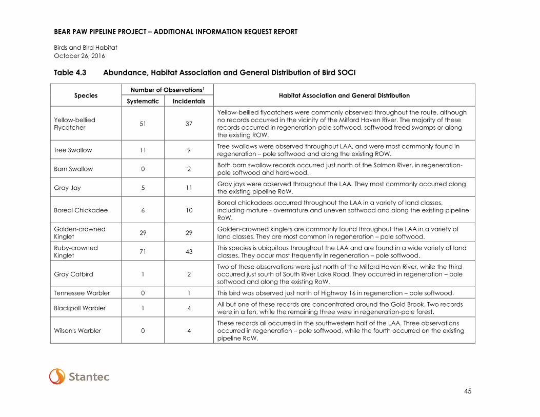
BEAR PAW PIPELINE PROJECT – ADDITIONAL INFORMATION REQUEST REPORT
Birds and Bird Habitat
October 26, 2016
45
Table 4.3 Abundance, Habitat Association and General Distribution of Bird SOCI
Species Number of Observations1
Habitat Association and General Distribution Systematic Incidentals
Yellow-bellied
Flycatcher 51 37
Yellow-bellied flycatchers were commonly observed throughout the route, although
no records occurred in the vicinity of the Milford Haven River. The majority of these
records occurred in regeneration-pole softwood, softwood treed swamps or along
the existing ROW.
Tree Swallow 11 9 Tree swallows were observed throughout LAA, and were most commonly found in
regeneration – pole softwood and along the existing ROW.
Barn Swallow 0 2 Both barn swallow records occurred just north of the Salmon River, in regeneration-
pole softwood and hardwood.
Gray Jay 5 11 Gray jays were observed throughout the LAA. They most commonly occurred along
the existing pipeline RoW.
Boreal Chickadee 6 10
Boreal chickadees occurred throughout the LAA in a variety of land classes,
including mature - overmature and uneven softwood and along the existing pipeline
RoW.
Golden-crowned
Kinglet 29 29
Golden-crowned kinglets are commonly found throughout the LAA in a variety of
land classes. They are most common in regeneration – pole softwood.
Ruby-crowned
Kinglet 71 43
This species is ubiquitous throughout the LAA and are found in a wide variety of land
classes. They occur most frequently in regeneration – pole softwood.
Gray Catbird 1 2
Two of these observations were just north of the Milford Haven River, while the third
occurred just south of South River Lake Road. They occurred in regeneration – pole
softwood and along the existing RoW.
Tennessee Warbler 0 1 This bird was observed just north of Highway 16 in regeneration – pole softwood.
Blackpoll Warbler 1 4 All but one of these records are concentrated around the Gold Brook. Two records
were in a fen, while the remaining three were in regeneration-pole forest.
Wilson's Warbler 0 4
These records all occurred in the southwestern half of the LAA. Three observations
occurred in regeneration – pole softwood, while the fourth occurred on the existing
pipeline RoW.

BEAR PAW PIPELINE PROJECT – ADDITIONAL INFORMATION REQUEST REPORT
Birds and Bird Habitat
October 26, 2016
46
Table 4.3 Abundance, Habitat Association and General Distribution of Bird SOCI
Species Number of Observations1
Habitat Association and General Distribution Systematic Incidentals
Canada Warbler 12 37
Canada warblers were observed throughout the LAA wherever suitable habitat
occurred. The majority of these records occurred in coniferous treed swamps or
regeneration – pole softwood.
Rusty Blackbird 1 5 These records were distributed between the Eight Mile Road and the Strait of Canso.
Three observations occurred in wetlands.
Pine Grosbeak 1 1 One record occurred just north of Eight Mile Road in a swamp. The other record
occurred off Pirate Harbour Road in mature – overmature softwood.
Note:
1 Multiple records of some SOCI were obtained in close proximity to one another during surveys and because it was not possible to know if individual birds
were counted more than once, some of these are likely duplicates and the numbers presented in this table likely over-represent the occurrences of some
SOCIs.
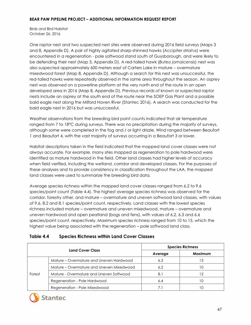
BEAR PAW PIPELINE PROJECT – ADDITIONAL INFORMATION REQUEST REPORT
Birds and Bird Habitat
October 26, 2016
47
One raptor nest and two suspected nest sites were observed during 2016 field surveys (Maps 3
and 8, Appendix D). A pair of highly agitated sharp-shinned hawks (Accipiter striatus) were
encountered in a regeneration - pole softwood stand south of Guysborough, and were likely to
be defending their nest (Map 3, Appendix D). A red-tailed hawk (Buteo jamaicensis) nest was
also suspected approximately 600 meters east of Carters Lake in mature – overmature
mixedwood forest (Map 8, Appendix D). Although a search for this nest was unsuccessful, the
red-tailed hawks were repeatedly observed in the same area throughout the season. An osprey
nest was observed on a powerline platform at the very north end of the route in an open
developed area in 2016 (Map 8, Appendix D). Previous records of known or suspected raptor
nests include an osprey at the south end of the route near the SOEP Gas Plant and a possible
bald eagle nest along the Milford Haven River (Stantec 2016). A search was conducted for the
bald eagle nest in 2016 but was unsuccessful.
Weather observations from the breeding bird point counts indicated that air temperature
ranged from 7 to 18°C during surveys. There was no precipitation during the majority of surveys,
although some were completed in the fog and / or light drizzle. Wind ranged between Beaufort
1 and Beaufort 4, with the vast majority of surveys occurring in a Beaufort 3 or lower.
Habitat descriptions taken in the field indicated that the mapped land cover classes were not
always accurate. For example, many sites mapped as regeneration to pole hardwood were
identified as mature hardwood in the field. Other land classes had higher levels of accuracy
when field verified, including the wetland, corridor and developed classes. For the purposes of
these analyses and to provide consistency in classification throughout the LAA, the mapped
land classes were used to summarize the breeding bird data.
Average species richness within the mapped land cover classes ranged from 6.2 to 9.6
species/point count (Table 4.4). The highest average species richness was observed for the
corridor, forestry other, and mature – overmature and uneven softwood land classes, with values
of 9.6, 8.2 and 8.1 species/point count, respectively. Land classes with the lowest species
richness included mature – overmature and uneven mixedwood, mature – overmature and
uneven hardwood and open peatland (bogs and fens), with values of 6.2, 6.3 and 6.6
species/point count, respectively. Maximum species richness ranged from 10 to 15, which the
highest value being associated with the regeneration – pole softwood land class.
Table 4.4 Species Richness within Land Cover Classes
Land Cover Class Species Richness
Average Maximum
Mature – Overmature and Uneven Hardwood 6.3 13
Mature – Overmature and Uneven Mixedwood 6.2 10
Forest Mature - Overmature and Uneven Softwood 8.1 12
Regeneration - Pole Hardwood 6.4 10
Regeneration - Pole Mixedwood 7.1 10

BEAR PAW PIPELINE PROJECT – ADDITIONAL INFORMATION REQUEST REPORT
Birds and Bird Habitat
October 26, 2016
48
Table 4.4 Species Richness within Land Cover Classes
Land Cover Class Species Richness
Average Maximum
Forest Regeneration - Pole Softwood 8.0 15
Forestry Other 8.2 13
Wetland Open Peatland (Bogs and Fens) 6.2 12
Treed/shrub Wetland 7.9 13
Other Corridor 9.6 14
Developed 7.5 14
Density results were calculated for each species per land cover class. These results are
presented in Appendix D. Densities ranged from 0 to 49.2 territories/100 ha (for ovenbird
(Seiurus aurocapilla) in regeneration to pole hardwood). The density results indicate that some
species are found in a variety of habitat types and may be considered generalists, such as
American redstart (Setophaga ruticilla), black-throated green warbler (Setophaga virens),
magnolia warbler (Setophaga magnolia) and white-throated sparrow (Zonotrichia albicollis).
Conversely, other species were observed to have much more limited habitat preferences, such
as pine grosbeak (Pinicola enucleator) (found only in mature – overmature and uneven
softwood) and swamp sparrow (Melospiza georgiana) (found primarily in wetlands).
4.3 MITIGATION AND FOLLOW-UP
Mitigation to reduce the environmental effects of the Project on wildlife and wildlife habitat
(including birds) was identified in Section 5.6.6 of the EA Report – the mitigation that is specific to
birds and bird habitat is reproduced below in Table 4.5. Standard mitigation measures listed in
Section 2.5.3 of the EA report is included as Appendix B to this document.
Table 4.5 Summary of Mitigation for Wildlife and Wildlife Habitat (birds)
(adapted from Section 5.6.6 of the EA Report)
Effect Mitigation Measures
Change in
Habitat
Availability
Change in
Habitat
Connectivity
Change in
Mortality Risk
Conduct vegetation disturbance activities outside of the breeding season for
migratory birds (April 1 to August 31; Environment Canada 2014) during both
construction (e.g., vegetation clearing) and operations (e.g., vegetation
management). Where this is not possible, develop a Bird Nest Mitigation Plan (prior to
construction) in consultation with Environment Canada and provincial regulators.
Include this plan in the final EPP.
General wildlife habitat management mitigation is also protective of bird habitat:
Reduce the area of direct habitat disturbance by:
o Reducing the operational RoW width to 10 m with natural regeneration, where
feasible, in areas where important wildlife habitat has been identified ((i.e., summer
foraging, thermoregulation habitat; moose shelter)

BEAR PAW PIPELINE PROJECT – ADDITIONAL INFORMATION REQUEST REPORT
Birds and Bird Habitat
October 26, 2016
49
Table 4.5 Summary of Mitigation for Wildlife and Wildlife Habitat (birds)
(adapted from Section 5.6.6 of the EA Report)
Effect Mitigation Measures
Allow full vegetation regeneration (natural and active regeneration methods will be
identified in the EPP) within the RoW, leaving a 10 m controlled vegetation regrowth
width across the pipeline ditch, where important wildlife habitat has been identified:
o Bank restoration and shrub staking at watercourse crossings to restore vegetation,
reduce human use of access roads and trails, and reduce line-of-sight.
o Provide line-of-sight breaks via vegetation regeneration and management and
through use of berms to reduce human use of access roads and trails.
o Berms may be considered at access control points along the RoW where coarse
woody debris and excavator mounding treatments are not practical.
o Permit regeneration across sections of the RoW and plan three year rotational
clearing pending consideration of pipeline integrity, safe operation, and regulatory
approval.
Reduce indirect loss of habitat / sensory disturbance through traffic management:
o adhere to posted speed limits;
o use of multi-passenger vehicles for the transport of crews to and from job sites;
o install signage where specific wildlife concerns have been identified.
Facilitate habitat restoration by reducing surface disturbance and soil stripping in
sensitive areas during construction:
o work in frozen-ground conditions where feasible; and
o use matting to protect soil and vegetation from compaction by heavy equipment.
Monitor the open cut for trapped wildlife before the daily start of construction, or prior
to resuming work after a shutdown, and remove wildlife before startup.
Reduce potential for interactions with wildlife through traffic management
Reduce potential for interactions with wildlife by limiting site access
No new mitigation or follow-up measures have been recommended as a result of 2016 field
surveys.
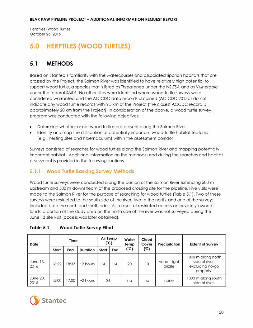
BEAR PAW PIPELINE PROJECT – ADDITIONAL INFORMATION REQUEST REPORT
Herptiles (Wood Turtles)
October 26, 2016
50
5.0 HERPTILES (WOOD TURTLES)
5.1 METHODS
Based on Stantec’s familiarity with the watercourses and associated riparian habitats that are
crossed by the Project, the Salmon River was identified to have relatively high potential to
support wood turtle, a species that is listed as Threatened under the NS ESA and as Vulnerable
under the federal SARA. No other sites were identified where wood turtle surveys were
considered warranted and the AC CDC data records obtained (AC CDC 2015b) do not
indicate any wood turtle records within 5 km of the Project (the closest ACCDC record is
approximately 20 km from the Project). In consideration of the above, a wood turtle survey
program was conducted with the following objectives:
Determine whether or not wood turtles are present along the Salmon River
Identify and map the distribution of potentially important wood turtle habitat features
(e.g., nesting sites and hibernaculum) within the assessment corridor
Surveys consisted of searches for wood turtles along the Salmon River and mapping potentially
important habitat. Additional information on the methods used during the searches and habitat
assessment is provided in the following sections.
5.1.1 Wood Turtle Basking Survey Methods
Wood turtle surveys were conducted along the portion of the Salmon River extending 500 m
upstream and 500 m downstream of the proposed crossing site for the pipeline. Five visits were
made to the Salmon River for the purpose of searching for wood turtles (Table 5.1). Two of these
surveys were restricted to the south side of the river, two to the north, and one of the surveys
included both the north and south sides. As a result of restricted access on privately-owned
lands, a portion of the study area on the north side of the river was not surveyed during the
June 13 site visit (access was later obtained).
Table 5.1 Wood Turtle Survey Effort
Date Time
Air Temp
(°C) Water
Temp
(°C)
Cloud
Cover
(%)
Precipitation Extent of Survey
Start End Duration Start End
June 13,
2016 16:22 18:33 ~2 hours 14 14 20 10
none - light
drizzle
1000 m along north
side of river,
excluding no-go
property.
June 20,
2016 15:00 17:00 ~2 hours 261 na na none
1000 m along south
side of river.

BEAR PAW PIPELINE PROJECT – ADDITIONAL INFORMATION REQUEST REPORT
Herptiles (Wood Turtles)
October 26, 2016
51
Table 5.1 Wood Turtle Survey Effort
Date Time
Air Temp
(°C) Water
Temp
(°C)
Cloud
Cover
(%)
Precipitation Extent of Survey
Start End Duration Start End
June 21,
2016 15:30 17:30 ~2 hours 23 na 19 50 none
1000 m along north
side of river.
June 23,
2016 14:30 16:40 ~2 hours 201 na na none
1000 m along south
side of river.
June 28,
2016 13:00 18:30
~5.5
hours 26 24 24 10 none
1000 m along north
and south sides of
river.
Note:
1 Temperature obtained from historical data for Guysborough
Survey methods followed regional guidance documents and research. Protocols primarily
followed those outlined in the Coordinated Monitoring Strategy for Wood Turtles (Glyptemys
insculpta) in the Northeastern United States (Massachusetts Cooperative Fish and Wildlife
Research Unit and the Northeast Wood Turtle Working Group 2013), with regional
recommendations for timing and weather based on Flanagan et al. (2013) and additional
suggestions by NSDNR (M. Pulsifer, pers. comm. 2016):
Surveys were completed during daylight hours when air temperatures were 10 – 25 °C.
Surveys were conducted by teams of at least two people. The most experienced person for
each survey was identified as the “lead observer” (observer #1); this person had right of way
to walk the stream in front of other observers.
Observers maintained independent tracks (turtles observed by one observer should not be
visible to the other observer) with observer #1 surveying where they wants to (i.e., based on
experience to maximize the detection rate).
Turtles were searched for on land proximal to the watercourse and where practical, in areas
of shallow water. Observers primarily surveyed within 20 m of the stream bank, but explored
farther afield in association with riparian features, such as backwaters.
The number and location of all wood turtle observations were recorded. Photographs were
taken of each encountered turtle and preferentially included a lateral head shot and
limbs/tail, as well as obvious injuries or deformities.
5.1.2 Habitat Characterization Methods
Wood turtle habitat surveys were conducted to identify the presence of potentially important
nesting and hibernation sites, and to characterize the quality of foraging habitat. In general, the
habitat characterization included a consideration of the:
types of vegetation present adjacent to the watercourse (foraging habitat)
presence of plant and animal species indicative of rich riparian habitats (foraging habitat)

BEAR PAW PIPELINE PROJECT – ADDITIONAL INFORMATION REQUEST REPORT
Herptiles (Wood Turtles)
October 26, 2016
52
Type of substrate present on the bottom of the watercourse (hibernation habitat)
water depth in the portion of the watercourse located within the survey area (hibernation
habitat)
presence of backwater pools and large rocks and sunken logs (hibernation habitat)
presence of depositional beaches including the substrate type and vegetation cover
associated with these beaches (nesting habitat)
presence of disturbed areas such as gravel pits and road beds with substrates suitable for
nesting (nesting habitat)
Particular attention was given to the identification of potential nesting and hibernaculum sites
within and adjacent to the assessment corridor. Potentially suitable nesting habitat was
identified as un-vegetated areas comprised of a sand-gravel matrix that were above the
regular high water mark. Potentially suitable hibernation habitat was identified as deep pools
(>40 cm based on White 2013) not associated with fast flowing waters or substrates comprised of
coarse (i.e., cobble or boulder) materials; and which ideally included cover objects such as
woody debris. A variety of vegetation types were considered potentially appropriate for wood
turtle foraging purposes, including riparian meadows, shrub thickets, and deciduous and
mixedwood forests.
5.2 RESULTS
5.2.1 Wood Turtle Observations
Wood turtles were observed on two occasions during field surveys; both observations being of
single turtles on the north side of the river (Figure 5.1), approximately 175 m apart. On June 13,
2016, a female wood turtle was encountered within a riparian meadow dominated by rough-
stemmed goldenrod (Solidago rugosa), fringed black bindweed (Polygonum cilinode), nodding
sedge (Carex gynandra), red raspberry (Rubus idaeus), avens (Geum sp.), Virginia clematis
(Clematis virginiana), and Virginia rose (Rosa virginiana). The carapace of this individual was
estimated to be 14 cm in width, 21 cm in length, and had over 37 slightly worn annuli. The
meadow in which this turtle was encountered is directly adjacent to an open area of sand-
gravel beach that is considered to provide potential nesting habitat (Figure 5.1). Another female
wood turtle was observed in association with a vegetated gravel bar on June 21, 2016 and was
estimated to have a carapace measuring approximately 13.3 cm in width, 19.5 cm in length,
and had over 17 slightly worn annuli. Neither of the wood turtles were notched or showed
evidence of physical injuries. The turtles were observed by the same individual, who also
counted the annuli. Although there is subjectivity involved in counting annuli, it is likely that these
observations represent two distinct individuals. Photos of the observed wood turtles are provided
in Appendix E.

[
[
Horto
n Broo
k
($$¯
Study Features[¶ Wood Turtle Observation
Potential Hibernation HabitatPotential Nesting HabitatWetland of Special Significance
Project ComponentsAssessment Corridor
V:\1214\active\121413xxx\121413598_bear_head_lng_pipeline\geomatics\mapping\mxd\EIA_2016Addendum\ST NS_121413598_121_WoodTurtle_Observations.mxd cshupe
NAD 1983 UTM Zone 20N ST NS_121413598-121
Disclaimer: This map is for illustrative purposes to support this project; questions can be directed to the issuing agency. Not intended for navigation or detailed engineering/build purposes.Note: Water depth at time of survey (not corrected to any vertical benchmark, reference or datum).
Figure 5.1
Wood Turtle Observations, Habitat, and Wetlands of Special Significance
Sources: Base data provided by the Government of Canada and Nova Scotia. Service Layer Credits: Sources: Esri, HERE, DeLorme, USGS, Intermap, increment P Corp., NRCAN, Esri Japan, METI, Esri China (Hong Kong), Esri (Thailand), MapmyIndia, © OpenStreetMap contributors, and the GIS User Community
BEAR PAW PIPELINE PROJECT
0 25 50 75 100
Distance in Metres
_̂Salmon RiverCrossing Location
Project Location
Chedabucto Bay
Nova Scotia
Atlantic Ocean
St GeorgesBay Cape
Breton
S a l m o n R i v e r

This page is intentionally left blank.

BEAR PAW PIPELINE PROJECT – ADDITIONAL INFORMATION REQUEST REPORT
Herptiles (Wood Turtles)
October 26, 2016
55
5.2.2 Wood Turtle Habitat
Nesting Habitat
The majority of beach present along the shoreline of the Salmon River is dominated by a gravel-
cobble matrix and is therefore largely unsuitable for wood turtle nesting purposes. However, one
exposed area comprised of a sand-gravel matrix was encountered within the study area along
the river. This area is located upstream of the assessment corridor on the north side of the river
and occurs in proximity to an old logging road and the existing pipeline crossing (Figure 5.1). This
area was observed to have several holes in it that may have been dug by wood turtles for
nesting purposes (i.e., as test holes for egg-laying purposes). Other sand areas encountered
along the shore of the Salmon River were well-vegetated and therefore unsuitable for nesting
purposes. Several holes were also encountered in an area supporting a matrix of sand-gravel
material along the western shoulder of an old road, approximately 60 m to the north of the river
and within the assessment corridor (Figure 5.1). An abundance of exposed sand was observed
along the bank of the same road further to the northeast but was considered unlikely to provide
suitable wood turtle nesting habitat as a result of the steep angle of the bank.
Hibernation Habitat
The majority of the portion of the Salmon River within the study area does not provide suitable
wood turtle hibernation habitat as a result of its shallow and fast-flowing waters, and cobble
substrate. However, a backwater is present on the south side of the river within the assessment
corridor and provides relatively good potential hibernation habitat (Figure 5.1) Waters within this
backwater exceeded 40 cm in areas and were underlain by a substrate of fine sediment. A
small watercourse enters the backwater at its western end and contributes to the value of this
area as potential hibernation habitat. Another backwater, located on the north side of the river
upstream of the assessment corridor was generally considered to have limited value as
hibernation habitat. It was observed to be too shallow to support wood turtle hibernation
habitat, with the exception of small pools at its eastern end. During high water events water flow
through the back water may be sufficient to dislodge wood turtles attempting to hibernate at
this location. Additional potential wood turtle hibernation habitat was limited to undercut banks
found along a portion of the south bank of the river, located upstream of the assessment
corridor opposite an island and the aforementioned backwater (Figure 5.1). However, this area
may be considered to only provide marginal potential habitat because it is subject to strong
currents and may at times be exposed above water levels in winter.
Foraging Habitat
The quality of wood turtle foraging habitat along the portion of the Salmon River within the study
area is varied but the area does provide relatively good quality foraging opportunities.
Vegetation along the north side of the river in particular is fairly nutrient-rich and comprised of a
mixture of open and closed canopy meadow, shrub thicket, and mixedwood forest. In contrast,

BEAR PAW PIPELINE PROJECT – ADDITIONAL INFORMATION REQUEST REPORT
Herptiles (Wood Turtles)
October 26, 2016
56
much of the south side of the river provides limited foraging opportunities because it is
dominated by a steep coniferous-dominated forest slope, with little floodplain habitat.
As outlined in the Recovery Strategy for the Wood Turtle (Glyptemys insculpta) in Canada
(Environment Canada 2016), critical habitat for this species is identified using two criteria: habitat
occupancy and habitat suitability. Habitat suitability includes consideration of all aspects of the
wood turtle’s life cycle and critical habitat for this species is subdivided according to life cycle
considerations (e.g., nesting, overwintering). Although not confirmed, it is likely that the wood
turtles observed are different individuals; which would satisfy the following occupancy criteria
used in partial identification of critical wood turtle habitat: “when a minimum of two distinct
Wood Turtle individuals have been observed in any year within the last 40 years” (Environment
Canada 2016). Although confirmed nesting or hibernation sites were not identified during
surveys, critical wood turtle habitat would occur in portions of the main stream up to the high
water mark and extend 2000 m upstream and downstream from wood turtle records
(Environment Canada 2016). Critical habitat also encompasses those areas of the adjacent
lands up to 200 m from the watercourse that may be classified as waterbodies, wetlands,
deciduous and / or mixedwood forest, beaches, riverbanks or other areas with bare ground
(Environment Canada 2016).
5.3 MITIGATION AND FOLLOW-UP
5.3.1 Mitigation
Mitigation to reduce the environmental effects of the Project on wildlife and wildlife habitat, and
vegetation and wetlands is relevant to the protection of wood turtles and wood turtle habitat.
Relevant mitigation from Sections 5.5.6 and 5.6.6 of the EA Report is presented in Table 5.1.
Standard mitigation measures listed in Section 2.5.3 of the EA report are included as Appendix B
to this document. New mitigation for wood turtles is discussed below Table 5.2.
Table 5.1 Summary of Mitigation for Wildlife and Wildlife Habitat (wood turtles)
(adapted from Section 5.6.6 of the EA Report)
Effect Mitigation
Change in
Habitat
Availability
Change in
Habitat
Connectivity
Change in
Mortality Risk
General wildlife habitat management mitigation is also protective of wood turtle
habitat:
Reduce the area of direct habitat disturbance by:
o Reducing the operational RoW width to 10 m with natural regeneration, where
feasible, in areas where important wildlife habitat has been identified
(i.e., summer foraging, thermoregulation habitat; moose shelter)
Allow full vegetation regeneration (natural and active regeneration methods will be
identified in the EPP) within the RoW, leaving a 10 m controlled vegetation regrowth
width across the pipeline ditch, where important wildlife habitat has been identified:
o Bank restoration and shrub staking at watercourse crossings to restore vegetation,
reduce human use of access roads and trails, and reduce line-of-sight.

BEAR PAW PIPELINE PROJECT – ADDITIONAL INFORMATION REQUEST REPORT
Herptiles (Wood Turtles)
October 26, 2016
57
Table 5.1 Summary of Mitigation for Wildlife and Wildlife Habitat (wood turtles)
(adapted from Section 5.6.6 of the EA Report)
Effect Mitigation
o Provide line-of-sight breaks via vegetation regeneration and management and
through use of berms to reduce human use of access roads and trails.
o Berms may be considered at access control points along the RoW where coarse
woody debris and excavator mounding treatments are not practical.
o Permit regeneration across sections of the RoW and plan three year rotational
clearing pending consideration of pipeline integrity, safe operation, and
regulatory approval.
Reduce indirect loss of habitat / sensory disturbance through traffic management:
o adhere to posted speed limits;
o use of multi-passenger vehicles for the transport of crews to and from job sites;
o install signage where specific wildlife concerns have been identified.
Facilitate habitat restoration by reducing surface disturbance and soil stripping in
sensitive areas during construction:
o work in frozen-ground conditions where feasible; and
o use matting to protect soil and vegetation from compaction by heavy
equipment.
Monitor the open cut for trapped wildlife before the daily start of construction, or
prior to resuming work after a shutdown, and remove wildlife before startup.
Reduce potential for interactions with wildlife through traffic management
Reduce potential for interactions with wildlife by limiting site access
Additional mitigation specific to wood turtles recommended as a result of 2016 field surveys is
presented below.
The results of wood turtle surveys have identified critical habitat, as defined in the Recovery
Strategy for the Wood Turtle in Canada (Environment Canada 2016), in the portion of the
assessment corridor at the Salmon River crossing. The preferred mitigation to reduce potential
effects to critical habitat for wood turtles at Salmon River is to avoid surface ground disturbance
in this area through the use of HDD. HDD is the preferred watercourse crossing method for the
Salmon River, however a final determination of feasibility will be made pending additional
surveys (e.g., topographic surveys, geotechnical testing). Therefore, as a contingency in the
event that HDD is not feasible, the following mitigation would be implemented to reduce
potential effects of the Project on wood turtles and wood turtle habitat at the Salmon River
crossing.
Mitigation for Wetlands of Special Significance: Wetlands associated with wood turtle habitat
are considered significant under the provincial wetlands policy. Section 3.3 of this report details
the proposed mitigation for construction within WSS.

BEAR PAW PIPELINE PROJECT – ADDITIONAL INFORMATION REQUEST REPORT
Herptiles (Wood Turtles)
October 26, 2016
58
Avoidance through Micro-routing: Should HDD be determined not to be feasible, pipeline
routing across the Salmon River will be micro-routed to avoid known nesting, hibernation, and
foraging habitats where feasible in consideration of other environmental and constructability
constraints.
Timing Restrictions: If an open cut (constructed in dry conditions) is required at the Salmon River,
timing restrictions would be established to reduce potential effects during critical life stages for
wood turtles. Restrictions pertaining to some of these life cycles are provided below, and would
be further refined in consultation with NSDNR and DFO, where the timing restrictions for working
near water for the purposes of the reduction of harm to fish may contradict those for the wood
turtle:
Overwintering – Work within potential hibernation habitat will not occur between October
and the end of April.
Breeding, basking and foraging- where practical, construction or operation of equipment
will not occur near potential wood turtle nesting sites (i.e., sand and gravel beaches,
disturbed areas with coarse grained soil) from April through to October, which is the period
when these activities are known to occur. If construction is required during this window due
to other timing restriction (e.g., wood turtle hibernation, Fisheries Act restrictions), NSDNR will
be consulted to develop a plan to reduce potential effects on this species.
Site-Rehabilitation: Areas of ground disturbance near the Salmon River will be rehabilitated
following construction. A pre-construction survey will be completed to document existing
conditions (i.e., topography, hydrology, vegetation, and soil conditions) and a site-rehabilitation
plan will be developed prior to ground disturbance. The site rehabilitation plan will include
requirements for follow-up monitoring (discussed further below).
Other Considerations: In addition to the timing restrictions, the following mitigation will be
included in the wood turtle management plan as part of the EPP.
Erosion and sediment control plans will consider important wood turtle habitat to reduce the
potential for siltation in areas where turtles are known to overwinter.
Temporary watercourse crossing locations will be chosen in advance to avoid disturbance of
wood turtles and will not be located within 100 m upstream and downstream of potential
nesting sites from April to October.
Wet areas (e.g., wetlands, seepages, vernal pools, ephemeral streams) should be flagged
and avoided by machinery and onsite travel.
Where practical, brush piles should be left to provide cover in cutover areas.
In addition to training for all workers (described below), an environmental inspector with will
be located on site for all construction activities within 200 m of the high water mark of
Salmon River.

BEAR PAW PIPELINE PROJECT – ADDITIONAL INFORMATION REQUEST REPORT
Herptiles (Wood Turtles)
October 26, 2016
59
Wood Turtle Management Plan and Training: A wood turtle management plan will be
implemented for all construction activities near the Salmon River. This plan will include site-
specific mitigation and timing restrictions as well as on-site monitoring requirements, and a wood
turtle chance discovery plan. This plan will include required training, as part of EPP training, for all
construction personnel on how to identify wood turtles, and response procedures to be followed
if a wood turtle is discovered within the construction area.
5.3.2 Follow Up and Monitoring
Habitat for wood turtles will be monitored post-construction to record any changes to habitat,
especially in areas that are important for specific life cycles (e.g. hibernation, nesting). Follow-up
monitoring will take place periodically, as determined in consultation with NSDNR, following site-
rehabilitation to verify that vegetation has re-established as planned and that habitat is
transitioning towards pre-construction conditions.

BEAR PAW PIPELINE PROJECT – ADDITIONAL INFORMATION REQUEST REPORT
Nova Scotia Mainland Moose
October 26, 2016
60
6.0 NOVA SCOTIA MAINLAND MOOSE
Bear Paw Pipeline recognizes the mainland moose as an important and protected species in
Nova Scotia. In the preparation of the Class I environmental assessment and this report, Bear
Paw Pipeline has strived to address the conservation and protection of this species in a
responsible manner that is consistent with the Recovery Plan for Moose in Mainland Nova Scotia
(NSDNR 2007). It is also recognized that Bear Paw Pipeline will have ongoing obligations with
respect to this species as the project progresses to detailed engineering, routing, and the
preparation of the EPP, which will include a Moose Habitat Management Plan (MHMP).
The goals of the following sections are to:
reference the regulatory context for moose management and protection
articulate construction and operational requirements
summarize work completed to date in support of the EA Report
expand on the mitigation proposal set forth in the EA Report
acknowledge the results of the evaluation and confirm the commitment to further work as
an integral part of adaptive management planning
6.1 REGULATORY CONTEXT
The Nova Scotia Endangered Species Act is the key legislation by which species in Nova Scotia
are identified for protection and management. This work is coordinated by the Wildlife Division of
NSDNR.
Mainland moose was designated in 2003 as Endangered. The mainland population is small and
is declining. This is occurring as a result of several complex and poorly understood, but
interrelated, factors including the following (NSDNR 2007):
disease
habitat loss and fragmentation
poaching
vehicular collisions
climate change
deficiencies in trace elements and/or elevated levels of these elements and how they
interact with one another
The stated goal of the provincial Action Plan for the Recovery of the Mainland Moose is to
maintain populations within their current range. This range includes the inland areas of
Guysborough County, where moose numbers are known to be low. The recovery objectives
include maintaining and enhancing current populations and habitat; mitigating threats to
recovery; and identifying research priorities.

BEAR PAW PIPELINE PROJECT – ADDITIONAL INFORMATION REQUEST REPORT
Nova Scotia Mainland Moose
October 26, 2016
61
The Act’s provision prohibits destroying or disturbing core habitat, which is defined as habitat
that is essential for the long-term survival and recovery of the endangered or threatened
species. Core habitat as defined under the Act has not been identified to date within the
boundaries of the assessment area for any wildlife species at risk, including moose.
6.2 CONSTRUCTION AND OPERATION REQUIREMENTS
Construction activities will require a cleared RoW width of approximately 35 m. This space is
required to provide workspace for personnel and equipment; laydown areas for materials; and
safe access. Bear Paw Pipeline is in discussions with the two existing pipeline operators to
potentially reduce the distance between the existing and new RoW’s. This may allow for the
existing cleared RoW to be used to accommodate some of the activities described above,
which could reduce the clearing-width requirement for Bear Paw during construction, in some
areas.
Regulations governing pipelines do not prescribe vegetation management requirements such as
maintained RoW widths or how such areas should be reclaimed or maintained. The Pipeline
Regulations state that the RoW and temporary work areas, ‘…shall be restored to a condition
similar to the surrounding environment…”. The Canadian Standards Association (CSA Z662)
states that where the easement permits, vegetation and RoWs should be controlled, ‘…to
maintain clear visibility from the air and provide ready access for maintenance crews”.
It is imperative that the pipeline operator has access over the pipeline ditch to conduct regular
maintenance and integrity inspections. This is critical for maintaining pipeline safety, which
translates to the stakeholders, the public and employees.
6.3 WORK COMPLETED IN SUPPORT OF THE ENVIRONMENTAL
ASSESSMENT
In the preparation of the environmental assessment, and in consultation with NSE and NSDNR,
Bear Paw has undertaken the following activities to assess potential project interactions with
moose and moose habitat. These activities also support the identification of mitigation and
establish baseline conditions for an adaptive Moose Habitat Management Plan for the Project:
consulted with expert ungulate ecologists and pipeline experts
designed mitigation into the project such as the reduction of habitat fragmentation by
paralleling as closely as practical the existing pipeline RoW
compiled and analysed data from available provincial databases including moose
observational data from NSDNR
executed field programs as were practical:
o incidental observations of moose sign were recorded during field surveys undertaken in
support of vegetation, wetlands and aquatic programs in the summer and fall of 2015
and the summer of 2016

BEAR PAW PIPELINE PROJECT – ADDITIONAL INFORMATION REQUEST REPORT
Nova Scotia Mainland Moose
October 26, 2016
62
o transect surveys were conducted in December, 2015
o spring pellet surveys were undertaken in April, 2016
There is no indication from the information collected to indicate that moose prefer one location
over another. However, information on moose habitat and the available data on moose related
observations is presented in the moose and moose habitat mapbook (Appendix F) and
represents areas where moose habitat mitigation may be best implemented – this is further
discussed below.
6.4 COMMITMENT TO ADDITIONAL PRE-CONSTRUCTION SURVEYS
Through discussion with NSDNR, the need for additional data on moose habitat and moose-
usage of the assessment corridor and adjacent areas was identified. Bear Paw is committed to
undertaking additional moose surveys ahead of construction, which will support the
development of the MHMP through the identification of key areas for RoW width management,
and access control.
Details of these surveys will be determine through ongoing discussion with NSDNR, but will
comprise the following survey-types:
• winter track survey
• spring pellet survey
6.5 MOOSE HABITAT MANAGEMENT PLANNING
As discussed in Section 2.1, Bear Paw is approaching environmental management for this Project
from the perspective of adaptive management. The sections below detail how this approach is
being applied in a practical manner to moose habitat management.
BEAR PAW PIPELINE PROJECT – ADDITIONAL INFORMATION REQUEST REPORT
Nova Scotia Mainland Moose
October 26, 2016
63
Moose Habitat Management Plan Table of Contents
1.0 INTRODUCTION
1.1 BACKGROUND
1.2 REGULATORY CONTEXT
1.3 GOALS AND OBJECTIVES
1.4 ROLES AND RESPONSIBILITIES
1.5 ADAPTIVE MANAGEMENT APPROACH
2.0 MITIGATION TOOLBOX
2.1 CONSTRUCTION
2.2 OPERATION
3.0 IDENTIFICATION OF HIGH PRIORITY AREAS
3.1 IMPORTANT HABITAT
3.2 MOOSE USAGE OF THE CORRIDOR
4.0 SITE SPECIFIC ENVIRONMENTAL MANAGEMENT
4.1 SITE-SPECIFIC MOOSE HABITAT MANAGEMENT PLANS (CONSTRUCTION)
4.2 SITE-SPECIFIC MOOSE HABITAT MANAGEMENT PLANS (OPERATION)
5.0 MONITORING AND FOLLOW-UP
5.1 FIELD SURVEYS
5.2 REPORTING
5.3 ADAPTIVE MANAGEMENT RECOMMENDATIONS
6.5.1 Communication and Planning
Bear Paw Pipeline is committed to continuing dialogue with regulators and experts. Moose and
moose habitat management will be an ongoing concern for the life of the Project; therefore
Bear Paw Pipeline plans to work collaboratively with NSE and NSDNR through the steps outlined
here for construction and operation activities.
6.5.2 Avoidance of Disturbance
The first principle of protecting environmentally sensitive features is to avoid direct disturbance
where possible. This principle has been followed through the initial placement of the assessment
corridor next to the existing RoW. The initial routing exercise located the assessment corridor as
close as possible to the existing RoW, while considering other environmentally sensitive features
such as wetlands, as well as topographic, constructability, and operational safety
considerations.
6.5.3 Reduction of Disturbance
The information gathered in support of the EA as described in Section 6.3 above and shown in
the moose and moose habitat mapbook (Appendix F), as well as future surveys to be

BEAR PAW PIPELINE PROJECT – ADDITIONAL INFORMATION REQUEST REPORT
Nova Scotia Mainland Moose
October 26, 2016
64
undertaken, will support efforts to avoid important habitat during detailed design and micro-
routing.
6.5.4 Mitigation Planning
There are a number of best management practices that can be used to reduce the potential
effects of the Project on moose and moose habitat. These were presented in the EA Report and
are summarized in Table 6.1. The application of mitigation requires the combination of an
industry-tested and acceptable mitigation toolkit with knowledge of the landscape to meet
defined goals and objectives.
It will be critical to have NSDNR’s input in to the application of mitigation, which w ill occur during
the development of the Project-specific EPP and associated Moose Habitat Management Plan.
Table 6.1 Summary of Mitigation for Moose and Moose Habitat (adapted from
Section 5.6.6.5 of the EA Report)
Effect Mitigation
Change in
Habitat
Availability
Reduce the area of direct habitat disturbance by:
o Reducing the operational RoW width to 10 m with natural regeneration, where
feasible, only in areas where important wildlife habitat has been identified
(i.e., summer foraging, thermoregulation habitat; moose shelter)
Allow full vegetation regeneration (natural and active regeneration methods will be
identified in the EPP) within the RoW, leaving a 10 m controlled vegetation regrowth
width across the pipeline ditch, where important wildlife habitat has been identified:
o Bank restoration and shrub staking at watercourse crossings to restore vegetation,
reduce human use of access roads and trails, and reduce line-of-sight.
o Provide line-of-sight breaks via vegetation regeneration and management and
through use of berms to reduce human use of access roads and trails.
o Berms may be considered at access control points along the RoW where coarse
woody debris and excavator mounding treatments are not practical.
o Permit regeneration across sections of the RoW and plan three year rotational
clearing pending consideration of pipeline integrity, safe operation, and
regulatory approval.
Reduce indirect loss of habitat / sensory disturbance through access management:
o use existing access for construction and operation (i.e., reduce temporary
access), where possible;
o increase public awareness through signage to reduce human use of access
roads and trails;
o use gates to reduce human use of access roads with landowner permissions;
o deactivate temporary roads to reduce access created by Bear Paw;
o use excavator mounding to restore vegetation and reduce human use of access
roads with landowner permission;
o rollback slash/woody debris.
Reduce indirect loss of habitat / sensory disturbance through traffic management:
o adhere to posted speed limits;
o use of multi-passenger vehicles for the transport of crews to and from job sites;
o install signage where specific wildlife concerns have been identified.

BEAR PAW PIPELINE PROJECT – ADDITIONAL INFORMATION REQUEST REPORT
Nova Scotia Mainland Moose
October 26, 2016
65
Table 6.1 Summary of Mitigation for Moose and Moose Habitat (adapted from
Section 5.6.6.5 of the EA Report)
Effect Mitigation
Facilitate habitat restoration by reducing surface disturbance and soil stripping in
sensitive areas during construction:
o work in frozen-ground conditions where feasible; and
o use matting to protect soil and vegetation from compaction by heavy
equipment.
Reduce sensory disturbance in areas of potentially important moose habitat:
o maintain vegetation buffer in areas adjacent to potentially important moose
habitat; and
o reduce, if possible, construction and maintenance activities during periods when
moose are observed proximate to construction.
Provide Human-Wildlife Conflict training to personnel, including information on
effectively managing human-moose interactions.
Change in
Habitat
Connectivity
Reduce the area of direct habitat disturbance by:
o Reducing the operational RoW width to 10 m with natural regeneration where
feasible, only in areas where important wildlife habitat has been identified
(i.e., summer foraging, thermoregulation habitat; moose shelter)
Allow full vegetation regeneration (natural and active regeneration methods will be
identified in the Moose Management Plan) within the RoW, leaving a 10 m
controlled vegetation regrowth width across the pipeline ditch, where important
wildlife habitat has been identified:
o Bank restoration and shrub staking at watercourse crossings to restore vegetation,
reduce human use of access roads and trails, and reduce line-of-sight.
o Provide line-of-sight breaks via vegetation regeneration and management and
through use of berms to reduce human use of access roads and trails.
o Berms may be considered at access control points along the RoW where coarse
woody debris and excavator mounding treatments are not practical.
o Permit natural vegetation regeneration across sections of the RoW and plan a
three year rotational clearing pending consideration of pipeline integrity, safe
operation, and regulatory approval.
Provide line-of-sight breaks via vegetation regeneration and management and
through use of berms to reduce human use of access roads and trails. Berms may
be considered at access control points along the RoW where coarse woody debris
and excavator mounding treatments are not practical.
Change in
Mortality Risk
Monitor the open cut for trapped wildlife before the daily start of construction, or
prior to resuming work after a shutdown, and remove wildlife before startup.
Reduce potential for interactions with wildlife through traffic management (refer to
mitigation items identified under Change in Habitat Availability).
Reduce potential for interactions with wildlife by limiting site access (refer to
mitigation items identified under Change in Habitat Availability).
Avoid planting species preferred by white-tailed deer to avoid interspecific food
competition and increased parasite transmission between moose and deer.
Avoid attracting black bears to the RoW by avoiding planting preferred forage
species. This could be most effective during the calving season when predation of
calves can restrict populations of moose in areas of low population density.
Provide human-wildlife conflict training to personnel.

BEAR PAW PIPELINE PROJECT – ADDITIONAL INFORMATION REQUEST REPORT
Nova Scotia Mainland Moose
October 26, 2016
66
Bear Paw will build on the mitigation commitments discussed in the EA Report through discussion
with NSE and NSDNR, and the development of the MHMP. Field based observational data will
play an important role in determining the appropriate areas for directed moose habitat
mitigation.
6.5.5 Mitigation Implementation
Moose habitat management mitigation will be implemented through detailed routing of the
pipeline; construction management and monitoring; operational maintenance; and monitoring
and follow-up. These commitments will be solidified through the development of the Project-
specific EPP, and the MHMP. Site-specific Environmental Protection Plans and alignment sheets
will show the details of moose habitat management, such as the example provided in the EA
Report, which is attached (Appendix F).
6.5.6 Monitoring and Follow Up
A monitoring and follow up program will be developed for moose and moose habitat. The
details of this plan will depend on the results of the pre-construction surveys, as well as the final
location and type of mitigation that is implemented. The monitoring and follow-up commitments
will be developed in consultation with NSDNR through the development of the MHMP.
6.5.7 Adaptive Management
Moose habitat management will be ongoing for the life of the Project. As mitigation is
implemented, and the results of monitoring and follow-up are reported, there will be ongoing
opportunities to refine and improve on the mitigation tools. The ability to adjust mitigation based
on results is an important components of environmental management, and will be part of the
planning process reflected in the MHMP.

BEAR PAW PIPELINE PROJECT – ADDITIONAL INFORMATION REQUEST REPORT
Brook Floater
October 26, 2016
67
7.0 BROOK FLOATER
During discussion with NSDNR, the potential for Alismidonta varicose (brook floater) to be present
in the Salmon River was noted. This potential was known during the field surveys undertaken in
2015.
A field assessment of the Salmon River water crossing was conducted on September 24, 2015 by
an experienced aquatic field biologist (B.Sc.) and environmental technician. Weather station
data and onsite observations indicated that weather conditions were within ideal parameters
for conducting a visual survey of fish and fish habitat (including mussels) along the
approximately 650 m length of river identified for assessment. Water levels contributed to an
often smooth water surface, and were safely and easily traversed with a mean channel depth
of 0.29 m and a maximum depth of 0.62 m. Mean velocity was calculated to be 0.32 m/sec.
Field surveys were undertaken according to Stantec field protocols for freshwater fish and fish
habitat assessment, which are developed based on federal and provincial requirements.
Although no brook floaters were observed at the time of the surveys, given the observed habitat
the potential remains for this species to be present during construction activities.
In general, standard mitigation (Appendix B), and mitigation specific to working in watercourses
is considered sufficient for the protection of this species. However, should a trenched
watercourse crossing be required at the Salmon River, the following additional mitigation will be
applied:
Fish rescues carried out ahead of in-water work will include the brook floater, which if
observed, will be relocated to nearby suitable habitat, in consultation with NSDNR.

BEAR PAW PIPELINE PROJECT – ADDITIONAL INFORMATION REQUEST REPORT
Conclusion
October 26, 2016
68
8.0 CONCLUSION
The report summarizes mitigation proposed in the EA Report. New mitigation and follow-up and
monitoring measures have been proposed for wood turtles, wetlands of special significance,
and lichen.
The discussion of moose and moose habitat management planning includes specific
commitments for ongoing consultation with NSDNR in the development of mitigation, and the
MHMP, as well as commitments to undertake pre-construction field surveys.
In consideration of the mitigation commitments detailed in the EA Report, and the additional
mitigation, monitoring and follow-up commitments made herein, results of the assessment of
residual environmental effects presented in the EA are unchanged.

BEAR PAW PIPELINE PROJECT – ADDITIONAL INFORMATION REQUEST REPORT
Closure
October 26, 2016
69
9.0 CLOSURE
This document entitled Bear Paw Pipeline Project – Additional Information Request Report was
prepared by Stantec Consulting Ltd. (“Stantec”) for the account of Bear Paw Pipeline Inc. (the
“Client”). Any reliance on this document by any third party is strictly prohibited. The material in it
reflects Stantec’s professional judgment in light of the scope, schedule and other limitations
stated in the document and in the contract between Stantec and the Client. The opinions in the
document are based on conditions and information existing at the time the document was
published and do not take into account any subsequent changes. In preparing the document,
Stantec did not verify information supplied to it by others. Any use which a third party makes of
this document is the responsibility of such third party. Such third party agrees that Stantec shall
not be responsible for costs or damages of any kind, if any, suffered by it or any other third party
as a result of decisions made or actions taken based on this document.

BEAR PAW PIPELINE PROJECT – ADDITIONAL INFORMATION REQUEST REPORT
References
October 26, 2016
70
10.0 REFERENCES
10.1 LITERATURE
AC CDC (Atlantic Canada Conservation Data Centre). 2014. Species Ranks. Updated
December 2014. Accessed December 2015.
AC CDC (Atlantic Canada Conservation Data Centre). 2015a. Understanding Ranks. Available
at: http://www.accdc.com/enNew/rank-definitions.html. Updated 2015. Accessed:
December 2015.
AC CDC (Atlantic Canada Conservation Data Centre). 2015b. Data Report 5393: Guysborough,
NS. Prepared July 8, 2015.
Bibby, C.J., N.D. Burgess, D.A. Hill, and S. Mustoe. 2000. Bird Census Techniques. Second Edition.
Academic Press, London.
COSEWIC (Committee on the Status of Endangered Wildlife in Canada). 2010. COSEWIC
Assessment and Status Report on the Blue Felt Lichen Degelia plumbea in Canada.
Committee on the Status of Endangered Wildlife in Canada. Ottawa x + 42 pp.
CWS (Canadian Wildlife Service). 2007. Instructions for conducting the Breeding Bird Survey.
Environment Canada: http://www.cws-scf.ec.gc.ca/nwrc-
cnrf/default.asp?lang=EN&n=5EE0ADBA-1.
CWS (Canadian Wildlife Service). 2016. Canadian Nightjar Survey Protocol. Draft – April 2016.
Environment Canada. 2016. Recovery Strategy for the Wood Turtle (Glyptemys insculpta) in
Canada [Proposed]. Species at Risk Act Recovery Strategy Series. Environment Canada,
Ottawa. v + 48 pp.
Flanagan, M., V. Roy-McDougall, G. Forbes and G. Forbes. 2013. Survey methodology for the
detection of Wood Turtles (Glyptemys insculpta). Canadian Field-Naturalist 127: 216-223.
Government of Canada. 2016. Species at Risk Public Registry. Available at: http:
//www.sararegistry.gc.ca/species.
Hale, M.E. 1979. How to Know the Lichens. Second Edition. The Pictured Key Nature Series, Wm.
C. Brown Co. Publishers, Dubuque, Iowa.
Hanson, A., I. Goudie, A. Lang, C. Gjerdrum, R. Cotter, and G. Donaldson. 2009 A framework for
the scientific assessment of potential Project impacts on birds. Canadian Wildlife Service
Technical Report Series No. 508. Atlantic Region. 61 pp.

BEAR PAW PIPELINE PROJECT – ADDITIONAL INFORMATION REQUEST REPORT
References
October 26, 2016
71
Keyes, K. L. 2011. Geographic and habitat fidelity in the short-eared owl (Asio flammeus). Thesis,
Macdonald Campus, McGill University, Montreal, Canada.
Massachusetts Cooperative Fish and Wildlife Research Unit and the Northeast Wood Turtle
Working Group. 2013. Coordinated Monitoring Strategy for Wood Turtles (Glyptemys
insculpta) in the Northeastern United States. Available at:
http://northeastturtles.org/NE/GLIN.html.
Newmaster, S.G., R.J. Belland, A. Arsenault, D.H. Vitt, T.R. Stephens. 2005. The ones we left behind:
Comparing plot sampling and floristic habitat sampling for estimating bryophyte diversity.
Diversity and Distributions 11(1): 57-72.
NSDNR (Nova Scotia Department of Natural Resources). 2007a. Recovery Plan for Moose (Alces
alces americana) in Mainland Nova Scotia. Available online at:
http://www.novascotia.ca/natr/wildlife/large-mammals/mainlandmoose.asp. Last
accessed December, 2015.
NSDNR (Nova Scotia Department of Natural Resources). 2014. General Status Ranks of Wild
Species in Nova Scotia. Available online at: http://novascotia.ca/natr/wildlife/genstatus/
Accessed December 2015.
NSDNR (Nova Scotia Department of Natural Resources). 2015. Forest Inventory Data. Forest
Imagery from 1993+. Inventory Data. Renewable Resources Branch. Based on aerial
photography and satellite
NSE (Nova Scotia Environment). 2010. Boreal Felt Lichen predictive Habitat Model GIS Shapefile.
Obtained from NSE July 2010.
NSE (Nova Scotia Environment). 2011a. Nova Scotia Wetland Conservation Policy. Available at:
http://www.novascotia.ca/nse/wetland/conservation.policy.asp.
NSE (Nova Scotia Environment). 2011b. Nova Scotia Wetland Evaluation Technique (NovaWET).
Version 3.0.
NWWG (National Wetlands Working Group). 1997. The Canadian Wetland Classification System.
Second Edition. Wetlands Research Centre. University of Waterloo, Waterloo, ON.
Ralph, C.J., G.R. Geupel, P. Pyle, T.E. Martin, D.F. DeSante. 1993. Handbook of field methods for
monitoring landbirds. Gen. Tech. Rep. PSWGTR-144. Albany, CA: Pacific Southwest
Research Station, Forest Service, U.S. Department of Agriculture; 41 p.
Stantec. 2016. Bear Paw Pipeline Environmental Assessment. Report prepared by Stantec
Consulting Ltd. for the Bear Paw Pipeline Corporation Inc.

BEAR PAW PIPELINE PROJECT – ADDITIONAL INFORMATION REQUEST REPORT
References
October 26, 2016
72
US Army Corps of Engineers. 1987. Wetlands Delineation Manual. Technical Report Y-87-1.
White, T.B. 2013. In the Cold and Near the Edge: Hypoxia Tolerance, Seasonal Site Fidelity, and
Communal Hibernation in a Peripheral Population of Wood Turtles (Glyptemys insculpta).
M.Sc. Thesis, Acadia University.
Zinck, M. 1998. Roland’s Flora of Nova Scotia. Nova Scotia Museum. Halifax, NS.
10.2 PERSONAL COMMUNICATION
NSDNR (Nova Scotia Department of Natural Resources). 2016. Personal communication with
Mark Pulsifer in June 2016 regarding proposed wood turtle surveys along the Salmon River
to support the Bear Paw Project.
Neily, T. 2016. Personal communication with Tom Neily in August 2016 regarding results of the
lichen surveys conducted in support of the Bear Paw Project, and updated S-Ranks for
lichen SOCI.
NSE (Nova Scotia Environment). 2016. Personal communication with Krista Hilchey (Wetland
Program Coordinator) in August 2016 regarding interpretation of Wetlands of Special
Significance for the Bear Paw Project.