Beachy Head to Selsey Bill SMP
153
Transcript of Beachy Head to Selsey Bill SMP
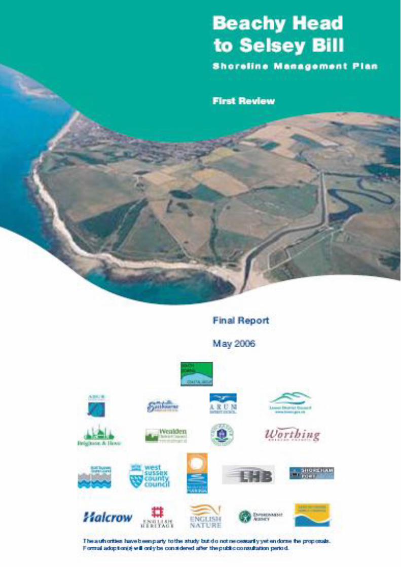
Beachy Head to Selsey Bill Shoreline Management Plan Final Document - 2006
1 INTRODUCTION .............................................................................................................................. 1
1.1 THE SHORELINE MANAGEMENT PLAN ................................................................................. 1
1.1.1 Guiding Principles .............................................................................................................. 1
1.1.2 Objectives .......................................................................................................................... 2
1.1.3 The SMP policies ............................................................................................................... 3
1.2 STRUCTURE OF THE SMP ...................................................................................................... 3
1.2.1 The Management Plan ...................................................................................................... 3
1.2.2 The Supporting Documents ............................................................................................... 4
1.3 THE PLAN DEVELOPMENT PROCESS ................................................................................... 5
1.3.1 Revision of the SMP .......................................................................................................... 5
1.3.2 Production of the 2006 SMP .............................................................................................. 6
2 ENVIRONMENTAL ASSESSMENT: MEETING THE REQUIREMENTS OF A SEA ...................... 8
2.1 BACKGROUND .......................................................................................................................... 8
2.2 THE CONTEXT OF THE SMP ................................................................................................. 10
2.3 THE EXISTING ENVIRONMENT ............................................................................................. 10
2.4 ENVIRONMENTAL OBJECTIVES ........................................................................................... 10
2.5 IDENTIFICATION AND REVIEW OF ALTERNATIVE POLICY SCENARIOS ......................... 11
2.6 THE ENVIRONMENTAL EFFECTS OF THE PLAN ................................................................ 12
2.7 STAKEHOLDER ENGAGEMENT ............................................................................................ 12
2.8 MONITORING REQUIREMENTS ............................................................................................ 13
3 BASIS FOR DEVELOPMENT OF THE PLAN ............................................................................... 14
3.1 HISTORICAL PERSPECTIVE .................................................................................................. 14
3.2 SUSTAINABLE POLICY........................................................................................................... 14
Beachy Head to Selsey Bill Shoreline Management Plan Final Document - 2006
3.2.1 Coastal Processes and Coastal Defence ........................................................................ 14
3.2.2 Economic Sustainability ................................................................................................... 17
3.2.3 Environmental Sustainability ............................................................................................ 18
4 THE PREFERRED PLAN .............................................................................................................. 21
4.1 PLAN FOR BALANCED SUSTAINABILITY ............................................................................. 21
4.1.1 Sustainable Management ................................................................................................ 21
4.1.2 Beachy Head to Newhaven Harbour ............................................................................... 22
4.1.3 Newhaven to Brighton Marina ......................................................................................... 22
4.1.4 Brighton Marina to Littlehampton ..................................................................................... 24
4.1.5 Littlehampton Harbour to Selsey Bill ............................................................................... 25
4.2 PREDICTED IMPLICATIONS OF THE PREFERRED POLICIES ........................................... 27
4.2.1 Implications for Property and Land Use .......................................................................... 27
4.2.2 Implications for Nature Conservation .............................................................................. 28
4.2.3 Implications for Landscape .............................................................................................. 29
4.2.4 Implications for the Historic Environment ........................................................................ 29
4.2.5 Implications for Amenity and Recreational use ............................................................... 30
4.3 MANAGING THE CHANGE ..................................................................................................... 30
4.3.1 Recommendations ........................................................................................................... 30
5 POLICY STATEMENTS ................................................................................................................... 4
5.1 INTRODUCTION ........................................................................................................................ 4
5.2 CONTENT .................................................................................................................................. 4
5.2.1 Policy units ......................................................................................................................... 5
6 ACTION PLAN (Action Plan is a stand alone document)
Beachy Head to Selsey Bill Shoreline Management Plan Final Document - 2006
1
1 INTRODUCTION
1.1 THE SHORELINE MANAGEMENT PLAN
A Shoreline Management Plan (SMP) provides a large-scale assessment of the risks associated with
coastal evolution and presents a policy framework to address these risks in a sustainable manner with
respect to people and to the developed, historic and natural environment. In doing so, an SMP is a
high-level document that forms an important part of the Department for Environment, Food and Rural
Affairs (Defra) strategy for flood and coastal defence (Defra, 2001).
This document provides the first revision to the original Selsey Bill to Beachy Head (South Downs)
SMP adopted in 1997. Figure 1.1 shows the area covered by the South Downs SMP.
1.1.1 Guiding Principles
The SMP is a non-statutory, policy document for coastal flood and erosion risk management planning.
It takes account of other existing planning initiatives and legislative requirements, and is intended to
inform wider strategic planning1. The SMP does not set policy for anything other than coastal defence
management.
The SMP promotes management policies for the coastline into the 22nd Century, to achieve long-term
objectives, while being technically sustainable, environmentally acceptable and economically viable. It
is, however, recognised that given the difference between short and long term objectives, changes to
management policy in the short term may be unacceptable. Thus, the SMP provides a step by step
management change for meeting objectives with appropriate management change, i.e. a „route map‟
for decision makers to move from the present situation towards the future.
The policies that comprise this Plan have been defined through the development and review of
shoreline management objectives, representing both the immediate and longer term requirements of
stakeholders, for all aspects of the coastal environment. Together with a thorough understanding of
the coastal processes operating on the shoreline, these objectives provide a thorough basis upon
which to appraise the benefits and impacts of alternative policies, both locally and Plan area wide. In
this way, the selection of policy takes equal account of all relevant features in identifying the best
sustainable management solutions.
1 The planning reforms under the Planning and Compulsory Purchase Act 2004 identify a requirement for
Regional Spatial Strategies (the new regional level statutory planning document) and Local Development
Documents (the new local level statutory planning document). These are required to contribute to the
achievement of sustainable development and are supported by a range of government planning policy advice and
guidance, in particular Planning Policy Statements (PPSs) and their predecessors Planning Policy Guidance
Notes (PPGs). Under the Act, Regional Planning Guidance for the South-East (RPG9) is being replaced by the
South East Plan, which was approved by the Regional Assembly and submitted to the minister in March 2006.
The South East Plan adopts a whole-catchment approach to water management and acknowledges the links
between biodiversity and water quality, flood and erosion risk management. Policies NRM6: Coastal Management
and NRM3: Sustainable Flood Risk Management are relevant, with Policy NRM6 advocating an integrated
approach to coastal planning and management. These policies require local planning authorities to take account
of SMPs both during the preparation of their Local Development Documents and in the determination of planning
applications.
Beachy Head to Selsey Bill Shoreline Management Plan Final Document - 2006
2
The original SMP for the Beachy Head to Selsey Bill (South Downs) coastline (identified as coastal
process sub-cell 4d in a 1994 study for MAFF, now Defra) was one of the first to be completed in
England or Wales. Since that time many lessons have been learned. Reviews funded by Defra (2001,
2003) have examined the strengths and weaknesses of various Plans and revised guidance has been
issued. Some of this guidance is targeted at achieving greater consistency in the assessments and
presentation of these Plans, but there are more fundamental issues that have been identified, which
this and other SMPs must address.
One significant issue is the inappropriateness of certain policies which, when tested in more detail with
a view to being implemented, may be found to be unacceptable or impossible to justify either
economically or technically. It is therefore important that the SMP is realistic, given known legislation
and constraints, both human and natural, and not promise what cannot be delivered. There will be no
value in a long-term Plan which has policies that are driven by short-term politics and cannot be
justified once implementation is considered several years in the future. Equally, whilst the affordability
of each policy has been considered (Appendix H – Economics) in a broad brush fashion, the Plan‟s
adoption by the local authorities involved does not represent a commitment to fund their
implementation; similarly the adoption of a particular policy does not guarantee that funding (from any
route) will be available. Ultimately, the economic worth of policy implementation must be considered in
the context of budgetary constraints (whether private or government funding), and it cannot be
guaranteed that budgets will be available for all policies. The Coastal Defence Strategies, which come
after this Plan will examine in much greater detail the economic viability of the policies set out herein.
A system of Outcome Measures is in place to assess nationally the priority of each scheme put
forward against national targets set by central Government; this is only possible once an outline
scheme has been produced, making available costings and benefits in greater detail than examined in
the Plan – this is outside the scope of the SMP.
The SMP must also remain flexible enough to adapt to changes in legislation, politics and social
attitudes. The SMP therefore considers objectives, policy setting and management requirements for
three main epochs; the present day, the medium-term and the long-term, corresponding broadly to
time periods of 0 to 20 years, 20 to 50 years and 50 to 100 years respectively. There is a need to have
a long-term sustainable vision, which may change with time, but the Plan should be used to
demonstrate that defence decisions made today are not detrimental to achievement of that vision.
1.1.2 Objectives
The objectives of the SMP are as follows:
to define, in general terms, the risks to people and the developed, historic and natural
environment of coastal evolution within the SMP area over the next century
to identify the preferred policies for managing those risks
to identify the consequences of implementing the preferred policies
to inform planners, developers and others of the risks of coastal evolution and of the preferred
policies when considering future development of the shoreline, land use changes and wider
strategic planning
Beachy Head to Selsey Bill Shoreline Management Plan Final Document - 2006
3
to comply with international and national nature conservation legislation and biodiversity
obligations
to set out procedures for monitoring the effectiveness of the SMP policies
to highlight areas where knowledge gaps exist.
1.1.3 The SMP policies
The shoreline management policies considered are those defined by Defra (2001):
Hold the line maintain or upgrade the level of protection provided by defences.
Advance the line build new defences seaward of the existing defence line.
Managed realignment allowing retreat of the shoreline, with management to control or limit
movement
No active intervention a decision not to invest in providing or maintaining defences.
Further details of these policies are provided in Section 2.5.
1.2 STRUCTURE OF THE SMP
This SMP is the result of numerous studies and assessments performed over a period of time. To
cater for the widest readership, the SMP is presented in two parts:
the management plan
a series of supporting documents presented as appendices to the management plan.
1.2.1 The Management Plan
The management plan sets out the preferred policies for managing the risks of coastal evolution over
the next century. It is intended for general readership and is the main tool for communicating
intentions. Whilst the justification for decisions is presented, it does not provide all of the information
behind the recommendations, this being contained in the supporting documents.
The management plan is presented in six parts:
Section 1(this part) gives details on the principles, structure and background to its development.
Section 2 presents the basis for meeting the requirements of the EU Council Directive
2001/42/EC on the assessment of the effects of certain plans and programmes on the
environment (the Strategic Environmental Assessment Directive).
Section 3 presents the basis for development of the management plan, describing the concepts
of sustainable policy and providing an understanding of the constraints and limitations
on adopting certain policies.
Beachy Head to Selsey Bill Shoreline Management Plan Final Document - 2006
4
Section 4 presents a broad overview of the preferred policies, discussing their rationale,
implications and requirements to implement and manage them.
Section 5 provides a series of statements that give details of how the policies might be
implemented and the local implications of these policies in terms of: management
activities; property, built assets and land use; landscape; nature conservation; historic
environment; and amenity and recreational use.
Section 6 provides an action plan which is a programme for future activities that are required to
progress the plan between now and its next review.
Although it is expected that many readers will focus upon the local details in Section 5, it is important
to recognise that the SMP is produced for the South Downs coast as a whole, considering issues
beyond specific locations. Therefore, these statements must be read in the context of the wider-scale
issues and policy implications, as reported in Sections 2, 3 and 4 and the appendices to the Plan.
1.2.2 The Supporting Documents
The supporting documents provide all of the background information to the management Plan. These
are provided to ensure that there is clarity in the decision-making process and that the rationale
behind the policies being promoted is both transparent and auditable.
This information is largely of a technical nature and is provided in eight parts and two databases:
Appendix A: SMP Development: This reports the history of development of the SMP, describing
more fully the policy decision-making process.
Appendix B: Stakeholder Engagement: Stakeholders have had an important role in shaping the
plan. All communications from the stakeholder process are provided here, together with
information arising from the consultation process.
Appendix C: Baseline Process Understanding: Includes baseline coastal process report, defence
assessment, No Active Intervention (NAI) and With Present Management (WPM) assessments
and summarises data used in the assessments. It also includes the assessment of breaching
through the Medmerry Barrier.
Appendix D: Thematic Studies: This report identifies and evaluates the environmental features of
the coastline (human, natural, historical and landscape) in terms of their significance and how
these need to be accommodated by the SMP.
Appendix E: Issues & Objective Evaluation: Provides information on the issues and objectives
identified as part of the Plan development, including an appraisal of their importance.
Appendix F: Initial Policy Appraisal and Scenario Definition: The impacts of a range of policy
scenarios upon shoreline evolution have been evaluated, which has formed a key part of
determining the acceptable sustainable policies and their combination into „scenarios‟ for testing.
Beachy Head to Selsey Bill Shoreline Management Plan Final Document - 2006
5
Appendix G: Preferred Policy Scenario Testing: A summary of the assessment and appraisal of
the preferred policies, via (i) assessment of shoreline interactions and response against preferred
policy; and (ii) assessment and achievement of the objectives against the baseline scenario (No
Active Intervention) and the preferred policies. The assessments are based on the findings of
Appendices E and F.
Appendix H: Economic Appraisal and Sensitivity Testing: This report provides a high-level
assessment of the economic justification of each preferred policy, which is reported in terms of
“justified”, “not justified” and “marginal”.
Appendix I: Meta-database and Bibliographic database: All supporting information used to develop
the SMP is referenced for future examination and retrieval.
These documents are presented on a CD provided at the back of the Shoreline Management Plan.
1.3 THE PLAN DEVELOPMENT PROCESS
1.3.1 Revision of the SMP
The original Selsey Bill to Beachy Head (South Downs) SMP was adopted in 1997. Part of the SMP
process is to regularly review and update the SMP, as necessary, taking account of new information
and knowledge gained in the interim. This is the first revision to the South Downs SMP and has taken
account of:
latest studies (e.g. Futurecoast, climate change) and mapping (Environment Agency Indicative
Flood Mapping)2
issues identified by most recent defence planning (i.e. 5 coastal defence strategy plans which
have now been produced to cover most of the SMP area between Selsey Bill and Beachy
Head)
changes in legislation (e.g. the EU Habitats and Birds Directives)
changes in national defence planning requirements (e.g. the need to consider 100 year
timescales in future planning, modifications to economic evaluation criteria, etc.)
the results of coastal monitoring activities.
Further reviews will be carried out in future years, when deemed necessary. Future reviews may
include changes to policies, particularly in light of more detailed studies of the coastline.
2 Please note 2003 maps have been used during the development of this plan. The Environment
Agency continually updates the flood map plans. To see the latest, please go to www.environment-
agency.gov.uk
Beachy Head to Selsey Bill Shoreline Management Plan Final Document - 2006
6
This plan does not account for proposed developments, only those that were constructed or were
being progressed during the time that the SMP was being developed. At the time of writing, there are
a number of proposed developments for the South Downs frontage, including:
Brighton and Hove Waste Water Treatment Works (Southern Water) – proposal for new outfalls
at Friars Bay and a combined storm water overflow (CSO) at Black Rock
Shoreham Port – land reclamation to the east of the harbour entrance
Worthing marine development
Regeneration of Littlehampton Harbour
Bognor Regis Marina.
The potential impacts that these will have on the coastline will be examined in the next review of the
SMP. However, this does not stop these proceeding ahead of the next SMP review if it can be shown
that they are sustainable and do not have adverse impacts on the adjacent sections of coastline.
1.3.2 Production of the 2006 SMP
Development of this revision of the SMP has been led by a project management group comprising
selected members of the South Downs Coastal Group, including technical officers and representatives
from Arun District Council, West Sussex County Council, Worthing Borough Council, Brighton and
Hove City Council, the Environment Agency, English Nature and Defra.
The SMP process has involved up to 150 stakeholders who where kept informed of the SMP review
and their views sought throughout the process. Up to 40 stakeholders participated at key decision-
making points through the formation of a Key Stakeholder Forum (KSF). Meetings with the KSF have
been held to help to identify and understand the issues, review the objectives and set direction for
appropriate management scenarios, and to review and comment upon the preferred plan policies.
The SMP is based upon information gathered largely between January and September 2003 and
provided by numerous parties contacted during this period.
The main activities in producing the SMP have been:
development and analysis of issues and objectives for various locations, assets and themes
thematic reviews, reporting upon human, historic and natural environmental features and
issues, evaluating these to determine the relative importance of objectives
analysis of coastal processes and coastal evolution for baseline cases of not defending and
continuing to defend the coastline as at present
agreement of objectives with the Key Stakeholders, to determine possible policy scenarios
development of policy scenarios based on key objectives and primary drivers (agreed with the
Key Stakeholders) for sections of the frontage
Beachy Head to Selsey Bill Shoreline Management Plan Final Document - 2006
7
examination of the coastal evolution in response to these scenarios and assessment of the
implications for the human, historic and natural environment
determination of the preferred plan and policies through review with the Key Stakeholders,
prior to compiling the SMP document
consultation on the proposed plan and policies
consideration of consultation responses and finalisation of the SMP for formal adoption
adoption of the SMP by the local authorities and dissemination.
Beachy Head to Selsey Bill Shoreline Management Plan Final Document - 2006
8
2 ENVIRONMENTAL ASSESSMENT: MEETING THE REQUIREMENTS OF
A SEA
2.1 BACKGROUND
Directive 2001/42/EC of the European Parliament (the Strategic Environmental Assessment Directive),
and the associated Environmental Assessment of Plans and Programmes Regulations 2004, requires
that a Strategic Environmental Assessment (SEA) be carried out for certain plans and programmes
that are required by legislative, regulatory or administrative provisions. The objective of the SEA
Directive is to: “Provide for a high level of protection of the environment and to contribute to the
integration of environmental considerations into the preparation and adoption of plans and
programmes with a view to promoting sustainable development” (Article 1 of the SEA Directive). The
Directive is therefore intended to ensure that environmental considerations are incorporated into
decision making, alongside other economic and social considerations, in an integrated way, during the
development of plans and programmes.
Although SMPs are not required to be prepared by legislative, regulatory or administrative provisions,
they do set a framework for future development and have much in common with the kind of plans and
programmes for which the Directive is designed. Therefore, with the intention of pursuing best practice
in environmental matters, Defra has recommended that the SMPs should broadly comply with the
requirements of the Directive.
The Directive outlines the SEA procedure as follows:
Preparing an Environmental Report which identifies the environmental baseline, environmental
protection objectives and indicators, alternatives and the likely significant effect of the draft plan
Carrying out consultation on the draft plan and the Environmental Report
Taking into account the Environmental Report and results of consultation in decision making
Providing information when the plan is adopted and showing how the results of the SEA have
been taken into account.
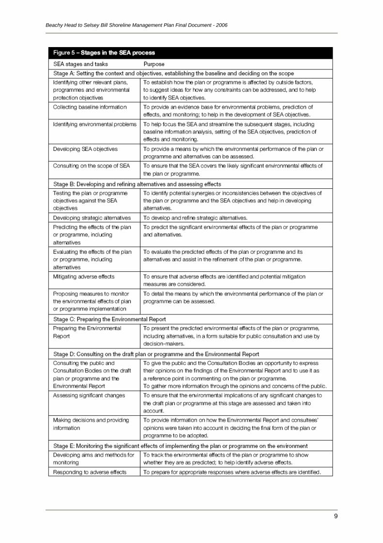
A more detailed list of SEA stages and tasks, and their purpose, is shown in the table overleaf, which
is taken from “A Practical Guide to the Strategic Environmental Assessment Directive” published by
the Office of the Deputy Prime Minister (http://www.odpm.gov.uk/index.asp?id=1143289).
Although an Environmental Report has not been produced, the following sections identify how the
Beachy Head to Selsey Bill SMP broadly achieves the requirements of the 2004 SEA Regulations.
The text is sub-divided into sections representing the key requirements of the Regulations and
identifies the parts of the SMP in which the relevant information is presented.
Beachy Head to Selsey Bill Shoreline Management Plan Final Document - 2006
9
Beachy Head to Selsey Bill Shoreline Management Plan Final Document - 2006
10
2.2 THE CONTEXT OF THE SMP
A Shoreline Management Plan (SMP) provides a large-scale assessment of the risks associated with
coastal evolution and presents a policy framework to address these risks in a sustainable manner with
respect to people and to the developed, historic and natural environment. The SMP is a non-statutory,
policy document for coastal flood and erosion risk management planning. It takes account of other
existing planning initiatives and legislative requirements and is intended to inform wider strategic
planning. It does not set policy for anything other than coastal flood and erosion risk management.
Full details of the procedure followed in development of the SMP are set out in Appendix A.
2.3 THE EXISTING ENVIRONMENT
The coastline covered by this plan has a rich diversity in its physical form, human usage and natural
environment: including cliffs of both habitat and geological interest, low-lying plains fronted by dunes
and beaches, towns and villages along the coastal fringe and areas of agricultural land. This
combination of assets creates a coastline of great value, with a tourism economy of regional
importance.
The current state of the environment is described in the „Thematic Review‟, presented in Appendix D.
This identifies the key features of the natural and human environment of the coastline and includes
commentary on the characteristics, status, relevant designations and importance of the features and
the „benefits‟ they provide to the wider community. The benefits assessment is provided in support of
the definition of objectives.
In addition to the review of the natural and human environment, the extent and nature of existing
coastal defence structures and management practices are presented in Appendix C along with an
assessment of shoreline dynamics and interactions, which identifies the contemporary physical form of
the coastline and the natural processes operating upon it.
2.4 ENVIRONMENTAL OBJECTIVES
An integral part of the SMP development process has been the identification of issues and definition of
objectives for future management of the shoreline. This was based upon an understanding of the
existing environment, the aspirations of stakeholders and an understanding of the likely evolution of
the shoreline under a hypothetical scenario of „No Active Intervention‟ (Appendix C), which identifies
the likely physical evolution of the coast without any future defence management and hence the
potential risks to shoreline features. These objectives include all relevant plans, policies, etc,
associated with the existing management framework, including all identified opportunities for
environmental enhancements.
The definition and appraisal of objectives has formed the focus of engagement with stakeholders
during development of the SMP (as identified in Appendix B). The full list of issues and objectives
defined for this SMP are presented in Appendix E.
Appendix G includes consideration of how the objectives, and hence the „environment‟, would be
affected under the preferred policy scenarios for each frontage, with consideration of international and
Beachy Head to Selsey Bill Shoreline Management Plan Final Document - 2006
11
national designations and obligations and biodiversity. Section 5 of this document also details
consideration of the potential environmental effects of the preferred policies.
2.5 IDENTIFICATION AND REVIEW OF ALTERNATIVE POLICY SCENARIOS
The SMP considers four generic policies for shoreline management:
Hold the Line
Advance the Line
Managed Realignment
No Active Intervention
These are defined in the following box.
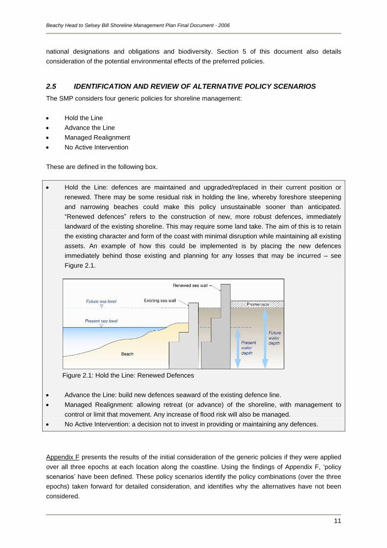
Hold the Line: defences are maintained and upgraded/replaced in their current position or
renewed. There may be some residual risk in holding the line, whereby foreshore steepening
and narrowing beaches could make this policy unsustainable sooner than anticipated.
“Renewed defences” refers to the construction of new, more robust defences, immediately
landward of the existing shoreline. This may require some land take. The aim of this is to retain
the existing character and form of the coast with minimal disruption while maintaining all existing
assets. An example of how this could be implemented is by placing the new defences
immediately behind those existing and planning for any losses that may be incurred – see
Figure 2.1.
Figure 2.1: Hold the Line: Renewed Defences
Advance the Line: build new defences seaward of the existing defence line.
Managed Realignment: allowing retreat (or advance) of the shoreline, with management to
control or limit that movement. Any increase of flood risk will also be managed.
No Active Intervention: a decision not to invest in providing or maintaining any defences.
Appendix F presents the results of the initial consideration of the generic policies if they were applied
over all three epochs at each location along the coastline. Using the findings of Appendix F, „policy
scenarios‟ have been defined. These policy scenarios identify the policy combinations (over the three
epochs) taken forward for detailed consideration, and identifies why the alternatives have not been
considered.
Beachy Head to Selsey Bill Shoreline Management Plan Final Document - 2006
12
The „policy scenarios‟ have then been appraised to assess the likely future evolution of the shoreline,
from which the environmental impacts have been identified. An assessment of shoreline interactions
and response for the preferred scenarios is presented in Appendix G. The results of this assessment,
in terms of risks to coastal features, were then used to appraise the achievement of objectives for the
preferred policy scenarios. This is reported in the issues and objectives table in Appendix G.
2.6 THE ENVIRONMENTAL EFFECTS OF THE PLAN
Based upon the output from the testing of policy scenarios, the preferred policy scenario has been
defined. The preferred policy scenario for the whole coastline differs along its length, so to
accommodate this, 27 Policy Units have been defined and a Policy Statement developed for each
Policy Unit.
The Policy Statements present the preferred policy scenario for each Unit, identifying its justification
and how it will be achieved over the 100 year period. They also present the detailed implications of the
policies and identify any mitigation measures that would be required in order to implement the policy.
Section 4 of this document includes the „Plan for Balanced Sustainability‟ (Section 4.1), defining the
broad environmental impacts of the plan based upon the appraisal of the objectives. This Section also
presents the „Predicted Implications of the Preferred Policies‟ (Section 4.2) under thematic headings.
The Policy Statements for the 27 individual Policy Units are presented in Section 5. Each Statement
presents the Preferred Plan for the Unit identifying its justification, and then presents the preferred
policies to achieve the Plan over the 100 year period. The detailed implications of the policies are
presented and any mitigation measures that would be required in order to implement the policy
identified.
2.7 STAKEHOLDER ENGAGEMENT
Stakeholders have been involved in the SMP appraisal process primarily through the formation of a
Key Stakeholders Forum (KSF). This involvement has:
been undertaken throughout development of the SMP;
given stakeholders an opportunity to comment on the environmental appraisal of options;
allowed representations made by the stakeholders to be taken into account in the selection of
policy options; and
given the public the opportunity to comment on the preferred policies.
The KSF included representatives from, amongst others, local authorities, nature conservation bodies,
industry and heritage organisations. Elected Members were also involved in reviewing the preferred
policies prior to public consultation. In this way, the views of those whom the SMP policies affect were
involved in its development, ensuring that all relevant issues were considered and all interests
represented.
Full details of all stages of stakeholder engagement undertaken during development of the SMP are
presented in Appendix B.
Beachy Head to Selsey Bill Shoreline Management Plan Final Document - 2006
13
2.8 MONITORING REQUIREMENTS
Where the preferred policies for any Policy Unit have specific monitoring/study requirements to clarify
uncertainties, this is identified in the relevant „Policy Unit Statement‟ (Section 5). Detailed monitoring
could be undertaken within the existing South-East Strategic Regional Coastal Monitoring Programme
or undertaken as part of coastal defence strategy studies. The latter will also define mitigation
requirements.
Beachy Head to Selsey Bill Shoreline Management Plan Final Document - 2006
14
3 BASIS FOR DEVELOPMENT OF THE PLAN
3.1 HISTORICAL PERSPECTIVE
The shoreline throughout much of the area covered by this SMP is retreating and has been doing so
for centuries. Man has sought to limit this natural process, which has been taking place as sea levels
have slowly risen and land levels have gradually dropped, the latter being the ongoing, very long-term
consequences of the last ice-age. The erosion seen today therefore is nothing new. Flooding is also
nothing new; prior to the major east coast floods of 1953 there had been numerous breaches along
this coastline at Pagham, Elmer, Ferring and through the tidal river Ouse at Lewes.
There are well recorded losses of communities along the coast in the past few hundred years, which
are evidence of this long-term natural change; these include Cudlow (south of Climping), parts of
Middleton, including the church, and a number of houses and tidal mills around the Selsey Bill area.
Clearly at one time these communities were situated inland, but today that same point now lies some
distance off the present shoreline.
These events all took place well before the shorelines were defended to the extent they are at present,
or before other activities such as dredging were taking place. Therefore, although humans may have
impacted upon the change occurring at the shoreline, they have not caused it. Equally, there is no
reason to suggest that this natural change is not still taking place, nor that we should assume that it
will not continue to take place in the future. Human intervention will not halt this natural process;
coastal defence works carried out over the last century have not prevented natural change from
occurring, they have simply delayed its full implications from being felt. Coastal defence works are one
approach to resisting erosion and shoreline retreat, but it is only sustainable for a limited time. The
decision to be made now is how we are going to manage this shoreline change in the future.
3.2 SUSTAINABLE POLICY
3.2.1 Coastal Processes and Coastal Defence
Climate Change
The coastline is undergoing constant change due to large scale impacts of climate change, namely
sea level rise, and the day-to-day effects of waves and tidal currents. It is the implications of climate
change that will determine sustainable shoreline management into the future.
Sea level attained a level close to its present position about 5,000 years ago, and the modern
hydrodynamic regime has been operating since that time. The role of sea level rise in shoreline
evolution is thought to have been limited over the last 2,000 years, due to the low rates of change
(averaging less than a millimetre per year), but we are now entering a period of accelerating sea level
rise, which could result in the destabilisation of present coastal systems.
Recent climate studies have indicated that there are significant changes occurring within our climate;
with bigger storms, increasing rainfall and rising sea levels. The amount of physical change for any
one length of coast depends on the degree of exposure of the coast and the underlying geology.
Increasing rainfall in between longer periods of drier weather can lead to increased weathering of cliff
Beachy Head to Selsey Bill Shoreline Management Plan Final Document - 2006
15
faces, with potentially more cutback of chalk cliff face due to massive failure along internal joints (as
per Beachy Head). These changes have usually taken place over long historical periods and many
examples exist where settlements have been lost through erosion (e.g. Cudlow).
It is extremely important that the long-term policies in the SMP recognise these future issues and
reflect likely future constraints to management planning. Thus, the SMP acts as early warning to those
other plans and initiatives that are vital to the communities and infrastructure within the coastal zone.
Changes at the coast
We are also now living with a reduced resource of sediment on many of our coasts, as the sediment
supply associated with the onshore transport of offshore sediments has diminished. This problem has
been particularly exacerbated on this frontage where there is very limited contemporary sediment feed
into, what is, a relict beach (one that receives no fresh supply of sediment), and upon which there has
been substantial development.
As already discussed, the erosion of the shoreline is nothing new; this is an ongoing process, but we
are more aware of it than in the past. However, it is not just the shoreline that is naturally changing,
but the whole coastal system, i.e. the backshore, beach and nearshore (sub-tidal) zone. Along much
of the South Downs coastline, this movement is occurring in a landward direction as sea levels rise
and the shoreline responds to the increase in energy reaching it from the sea. This process is called
transgression. Although attention is focussed upon the shoreline position, this process also produces
a deepening of the seabed at any particular point. That change in seabed level is evidenced by
narrower and steeper beaches along a lot of the frontage. Lost sandy and shingle beaches (e.g. at
Middleton) associated with large sea defences are typical of the effects of accelerating sea level rise.
Had the lost settlements of Middleton been defended at that time, this would not have prevented the
same extent of foreshore lowering at those locations, i.e. they would today stand adjacent to very
deep water. We should not expect the future to be any different and, as such, the foreshore level at
existing defence locations may be anticipated to be much lower than present beach levels. Indeed,
accelerated sea-level rise will increase the speed of change.
If we choose to continue to defend our shorelines in the same locations that we do at present, then the
size of the defences will need to alter considerably; one consequence of deeper water is much larger
waves at the defence. Defences will need to be wider to remain stable against bigger waves, have
deeper foundations to cope with falling beach levels, and be greater in height to limit the amount of
water passing over the top of them in storms.
Sediment movement
The alongshore movement of sediment brought onshore from the offshore sources at Selsey Bill is
essential to supply beaches locally and further a field. The limited cliff erosion to the east provides
very little material locally and is insufficient to add to the local protection of the frontage. Beaches
provide a natural form of defence that reacts to storm waves; they do not prevent further erosion but
do help to limit and control the rate at which it takes place, so a wide and high beach offers greater
protection than a low and narrow one. Shingle beaches are especially dynamic, thus helping to reduce
the erosive impact of waves upon the shoreline. They also help to provide environmentally important
habitats. Along the South Downs SMP frontage groynes have been used extensively and are found
along most beaches from Selsey Bill to Brighton Marina; offshore breakwaters at Elmer also retain
Beachy Head to Selsey Bill Shoreline Management Plan Final Document - 2006
16
shingle that is carried eastwards along the foreshore by littoral drift (alongshore transport). The
implementation of these and other management practices along virtually the entire coastline has led to
a progressive denudation of sediment along downdrift frontages, causing narrowing and steepening of
the foreshore and exposure of the upper shore and its defences to increased wave attack. Beach
replenishment and recycling practices have been used as a method to reduce the rate at which this
shoreline change is taking place.
A shoreline sediment system allowed to behave naturally without any disruption is considered to be
sustainable. In some areas of the UK it can be demonstrated that long lengths of seemingly isolated
coastline actually form one connected sediment system and that sediment movement from one source
provides material to many locations further downdrift. Therefore, interference with the system at any
point along the coast can have detrimental and sometimes unpredictable impacts considerable
distances away.
However, the lack of sediment linkage along the South Downs SMP coastline due to the lack of
contemporary sediment input to the west and the heavily defended nature of the shoreline means that
the impact of any sediment interruption is significantly reduced in terms of consequence. This is not to
say that defences cannot be introduced without creating adverse effect, rather that defence
management needs to work with these processes and limit problems at other locations. In fact there
has been a notable increase in beach widths along short sections of the South Downs coastline in the
recent past, relating to more focused management of the coastline using softer engineering
techniques, e.g. sediment recycling. However, it is thought that due to the relict nature of the shingle,
these beach width increases are largely linked to sand and not shingle inputs.
Defence impacts
In general, there is less acceptance of coastal change than in the past and it is apparent, through the
developments of SMPs and strategy studies, that there is often a public misconception that coastal
change can be halted though engineering works. There is often a demand to continue to “hold the
existing defence line”, in order to protect assets, but this is coupled with an expectation that the
shoreline will continue to look exactly as it does now. Due to the dynamic nature of our shoreline, this
is incorrect in many, if not most, instances.
The South Downs SMP coastline is heavily defended along both its low-lying frontages to the west
and the cliffs to the east. The defences used along this coastline comprise mainly linear seawalls at
the rear of shingle beaches which are, in turn, generally groyned to retain the beach material. In some
locations the shingle beaches (retained by groynes) are the only means of defence to towns (for
example Worthing and Rustington). Along the cliff frontages in the east of the SMP area, the base of
cliffs and part of the wave cut platforms are protected from erosion through linear defences, limiting
any erosion of the cliff edge. If the cliff edge were to erode, however, this could be the source of local
beach building material leading to the development of a natural form of protection for the cliffs.
If we were to continue to defend the coastline into the future as we have done in the past, the long-
term picture would be one of a very fragmented shoreline, characterised by a series of concreted
headlands with embayments and tidal inlets in between. Seawalls would result in a series of large
promontories, in some cases extending 100 to 200m out from the adjacent (undefended) eroded
shoreline by the end of the century. These promontories would be highly exposed to waves in deep
Beachy Head to Selsey Bill Shoreline Management Plan Final Document - 2006
17
water, requiring much more substantial defences to be constructed. These defences would also need
to be extended landward to prevent outflanking of the present seawalls. There would be no beaches
present along these frontages and the groynes would have become redundant; water will remain
present at the structures at all times. The Middleton frontage today provides a good example of how
some of the defended frontages within the South Downs SMP area might look in the future.
It must be recognised that, in the very long term, continuing to defend such stretches of shoreline may
be technically unsustainable and consideration should be given to relocation, or mitigation for loss of
assets.
3.2.2 Economic Sustainability
One of the difficulties facing us, as a nation, is the cost of continuing to protect shorelines to the extent
that we do at present. Many of the defences that exist today have been the result of reactive
management without consideration of the long-term consequences, including financial commitment.
Studies over the past few years have established that the cost of maintaining all existing defences is
already likely to be at least 50% more than present expenditure levels. In simple terms this means that
either more money needs to be invested in coastal defence, or defence expenditure has to be
prioritised. Whilst the first option would clearly be the preference of those living or owning land along
the coast, this has to be put into the context of how the general UK taxpayer wishes to see their
money used. Given that the cost of providing defences that are both effective and stable currently
averages between £3 million and £5 million per kilometre, the number of privately owned properties
that can be protected for this investment has to be weighed up against how else that money could be
used, for example in education, health and other social benefits.
Furthermore, because of the climate changes being predicted, which will accelerate the natural
changes already taking place, these recent studies have also established that the equivalent cost of
providing a defence will increase during the next century to between 2 and 4 times the present cost,
excluding inflation or other factors, i.e. in excess of £6 million to £10 million per kilometre.
Consequently, those areas where the UK taxpayer is prepared to continue to fund defence may well
become even more selective and the threshold of when an area is not longer defended could well
shift. Whilst it is not known how attitudes might change, it is not unreasonable to assume that future
policy-makers will be more inclined to resist investing considerable sums in protecting property in high
risk areas, such as the coast, if there are substantially cheaper options, such as constructing new
properties further inland.
It is extremely important that the long-term policies in the SMP recognise these future issues and
reflect likely future constraints. Failure to do so would not ensure future protection; rather it would give
a false impression of a future shoreline management scenario that could not be justified and would fail
to be implemented once funding was sought.
The implications of these national financial constraints are that protection is most likely to be focussed
upon larger conurbations and towns, where the highest level of benefit is achieved for the investment
made, i.e. more properties can be protected per pound of investment. The consequence is that rural
communities will more often be affected, but from a national funding perspective, i.e. best use of the
taxpayer‟s money, this makes economic sense.
Beachy Head to Selsey Bill Shoreline Management Plan Final Document - 2006
18
3.2.3 Environmental Sustainability
Environmental sustainability is difficult to define as it depends upon social attitudes, which are
constantly changing.
Historically, communities at risk from coastal erosion relocated, recognising that they were unable to
resist change. In more recent times many coastal defences have been built without regard for the
impacts upon the natural environment. Today, because we have improved technology, we are less
prepared to accept change, in the belief that we can resist nature. Inevitably attitudes will continue to
alter; analyses of possible „futures‟ are already taking place (the Foresight programme run by the
Office of Science and Technology), considering the implications for many aspects of life, including
approaches to flooding and erosion under different scenarios. It is not possible to predict how attitudes
will change in the future; therefore the SMP is based upon existing criteria and constraints, whilst
recognising that these may alter over time to accommodate changing social attitudes.
Quality of life depends on both the natural environment and the human environment, which are
discussed below.
Natural environment
The forces of nature have created a variety of landforms and habitats around the South Downs
coastline. The special quality of the natural habitats and geological/ geomorphological features on this
coast is recognised in a number of national and international designations (protected under statutory
international and national legislation) as well as regional and local planning policies.
There is a legal requirement to consider the implications of any „plan or „project‟ that may impact on a
Special Protection Area for Birds (SPA) or a Special Area for Conservation (SAC), through the
European Union Habitats Directive (Council Directive 92/43/EEC) and Birds Directive (Council
Directive 79/409/EEC). The Defra High Level Targets for Flood and Coastal Defence (Target 4 –
Biodiversity) also require all local councils and other operating authorities to:
avoid damage to environmental interest
ensure no net loss to habitats covered by Biodiversity Action Plans
seek opportunities for environmental enhancement
monitor any changes to habitats, including contributions to SSSI/SPA conservation targets, loss
and gain of habitats, and to keep records.
A key requirement for the SMP is therefore to promote the maintenance of biodiversity or
enhancement, through identifying biodiversity opportunities.
Coastal management can have a significant impact on habitats and landforms, both directly and
indirectly. In places, coastal defences may be detrimental to nature conservation interests, e.g. those
seen along the cliff frontage east of Brighton Marina producing coastal squeeze, but in other locations
defences may protect the interest of a site, e.g. freshwater sites behind the shore. Coastal habitats
may also form the coastal defence, e.g. the spit complex at Pagham Harbour. Therefore, coastal
management decisions need to be made through consideration of both nature conservation and risk
management.
Beachy Head to Selsey Bill Shoreline Management Plan Final Document - 2006
19
Although the conservation of ecological features in a changing environment remains important in
terms of environmental sustainability, future management of the coast needs to allow habitats and
features to respond and adjust to change, such as accelerated sea level rise. It is recognised that true
coastal habitats cannot always be protected in situ because a large element of their ecological interest
derives from their dynamic nature and this is important to ensure the continued functionality of any
habitat. This poses a particular challenge for nature conservation and shifts the emphasis from site
„preservation‟ to „conservation‟. English Nature is actively seeking to ensure that coastal erosion and
flood risk management proposals are designed to ensure that SSSIs are conserved and, where
possible, enhancement opportunities that benefit ecology and geology are implemented, whilst also
allowing the coast to remain naturally dynamic. Under Section 28G of the Countryside and Rights of
Way Act 2000, English Nature is provided with the responsibility and power to safeguard England‟s
finest and most vulnerable wildlife and geological features. Therefore, accommodating the objectives
of environmental bodies, such as English Nature, and future shoreline change requires flexibility in the
assessment of nature conservation issues, possibly looking beyond the designation boundaries to
consider wider scale or longer term benefits.
The SMP also needs to consider opportunities for enhancing biodiversity throughout the SMP area,
not just at designated sites. English Nature has published a Research Report (No 565), “Identifying
Biodiversity Opportunities to Inform SMP Review” that includes proposals for the environmental
enhancement of the East and West Sussex shoreline. Where possible, the opportunities identified
within the report have been taken into consideration in the selection of the preferred policies to enable
operating authorities to make progress with implementing the UK Biodiversity Action Plan and local
Biodiversity Action Plans. There are several areas along the SMP frontage where biodiversity
opportunities can be taken, e.g. allowing more natural coastal processes to take place along the
stretches of low-lying areas at Climping (HR Wallingford, 2004), and exposure of the wave cut
platforms along the cliff frontage east of Brighton Marina. This, however, needs to be balanced against
the socio-economic objectives for the area and engineering feasibility to deliver long term sustainable
management.
Human (socio-economic) environment
The human environment covers such aspects as land use (both current and future), heritage and
landscape (which may be both natural and man-made).
(i) Land-use:
Historically, development of the coast has taken place unconstrained. Planning Policy Guidance 20
(PPG20) identifies that approximately 30% of the coastline of England and Wales is developed;
however, much of this development took place before the introduction of the Town and Country
Planning Act, 1947. Growth of built development, both commercial and residential, within the coastal
zone over the centuries has increasingly required engineering works to defend properties against the
risk of erosion and flooding. However, continued construction of hard-engineered coastal and flood
defences to protect development may not be economically sustainable in the long-term (see Section
3.2.2. Local Development Frameworks now identify the need for „sustainable development‟ and
although the exact definition of this is uncertain, it recognises that opportunities for development on
the coast are limited due to the risk of flooding, erosion, land instability and conservation policies (as
discussed above). The PPG20 states that in the coastal zone, development plan policies should not
normally permit development which does not require a coastal location.
Beachy Head to Selsey Bill Shoreline Management Plan Final Document - 2006
20
Tourism/ recreation is one land-use that can require a coastal location and although the popularity of
many British seaside resorts has declined in recent years, seaside tourism often still represents a
substantial part of the local economy. In particular, the city of Brighton and Hove is the top destination
for visitors from London with a vibrant international and multi-cultural community. It is also a commuter
town for London. The towns of Worthing and Shoreham have particular attractions including an
increasing retirement community in addition to Blue Flag beaches. Bognor Regis has numerous tourist
attractions including the pier and the popular Butlins Southcoast World resort. Thus, the impacts of
policy on the tourism industry need to be carefully considered.
In addition to the tourist industry, there are a number of other commercial interests along the coast.
These tend to be concentrated in the larger towns such as Littlehampton, Worthing, Brighton and
Shoreham. The continuation of these industries is essential to sustain the economy of the region as a
whole.
The coastal strip also represents an important recreational and amenity resource; many activities rely
on the presence of a beach or access to the sea. Although assets to landward of current defences and
access routes may be protected through maintaining existing defences, it must be recognised that
continuing such defence practices would, in the longer term, result in a significant alteration in the
nature of the coast, with large concrete seawall structures, narrow beaches and limited access.
(ii) Heritage:
Heritage features are valuable for a number of reasons (English Heritage, 2003):
they are evidence of past human activity
they provide a sense of place (or roots) and community identity
they contribute to the landscape aesthetics and quality
they may represent an economic asset due to their tourism interest.
These assets are unique and, if destroyed, they can not be recreated; therefore they are vulnerable to
any coastal erosion. Conversely, the very process of coastal erosion is uncovering sites of historical
interest. Only a few sites are protected by statutory law, but many more are recognised as being of
high importance. Government advice in PPG15 and PPG16 promotes the preservation of important
heritage sites, wherever practicable. However, due to the dynamic nature of our coastlines, this is not
always possible, or sustainable. Therefore, each site must be considered as an individual site and
balanced against other objectives at that location.
(iii) Landscape:
Part of the South Downs coast, including Beachy Head, is designated as an Area of Outstanding
Natural Beauty (AONB) in order to sustain this unique landscape by protecting the landscape and
enhancing recreational opportunities in the area. There are now plans to include much of the area,
including Beachy Head, in the South Downs national park. However, in general, landscape is difficult
to value objectively as it is a mixture of the natural environment and social and cultural history.
Therefore, defining a sustainable landscape is usually dependent upon the human and natural
environment factors discussed above.
Beachy Head to Selsey Bill Shoreline Management Plan Final Document - 2006
21
4 THE PREFERRED PLAN
4.1 PLAN FOR BALANCED SUSTAINABILITY
The SMP is built upon the aim of achieving balanced sustainability, i.e. it considers people, nature,
historic and economic realities.
The proposed short term (first epoch-up to 20 years) policies for the South Downs SMP coastline
provide a high degree of compliance with objectives to protect existing communities against flooding
and erosion. The preferred long-term policies promote greater sustainability for parts of the shoreline
and focus on sustaining and possibly enhancing the natural character of this coast. Long-term policies
that continue to defend the shoreline in the present-day manner would produce a change in the nature
of the coast, with a prominence of large concrete seawall structures and fewer beaches. However
there is the social-economic justification to maintain these defences in the short to medium term, with
opportunities to optimise management techniques to sustain those coastal assets important to the
community in the longer term.
The rationale behind the proposed policies is explained in the following sections of text, which
consider the SMP area as a whole. Details of the preferred policies for individual locations are
provided by the individual Policy Statements in Section 5.
4.1.1 Sustainable Management
One of the main objectives in developing a Shoreline Management Plan is the definition of sustainable
long term management policies for the coast. In Defra‟s Procedural Guidance for the Production of
Shoreline Management Plans this is defined as avoiding “as far as possible, tying future generations
into inflexible and expensive options for defence” (Defra, 2001). Given sea level rise predictions, this
would generally best be achieved through the creation of a naturally functioning coast, allowed to
move landwards or seawards at rates dictated by the natural processes of waves and tides.
However, on the South Downs coast the long history of intervention to reduce flooding and erosion
risks to developments means that the shoreline is generally today in an „unnatural‟ form and position,
and one which would not necessarily revert to „naturally functioning‟ if simply allowed to operate
unmanaged from now on. Indeed, it is likely that for much of the SMP coastline, the removal/failure of
defences would result in the breakdown of beaches, with little or no barrier to erosion and flooding for
some time. In reality, due to the extensive defences along this shoreline protecting high density, urban
developments in a low lying area, sediment is not free to move along the coastline, such that it is
almost a completely man made frontage, with little opportunity to use natural coastal processes as a
means of managing the shoreline. The consequences of these actions, given the extent of
development of the coast, would be catastrophic in socio-economic terms, as thousands of homes and
businesses lie within the potential risk areas.
As such, it is the social and economic sustainability of the SMP area which drives policy selection for
the majority of this coastline; however, policies to adopt a more „natural‟ shoreline in the long-term
have been identified where feasible.
Beachy Head to Selsey Bill Shoreline Management Plan Final Document - 2006
22
4.1.2 Beachy Head to Newhaven Harbour
Beachy Head to Newhaven Harbour is an Area of Outstanding Natural Beauty, rich in historical
heritage with numerous important environmental sites. The shoreline is characterised by cliffs rising to
the east of Seaford and broken only by the Cuckmere and Ouse River valleys. The dry valley at Birling
Gap is comprised of rocks of a less resistant nature, which has resulted in cliff erosion taking place at
a faster rate than in adjacent areas. The coastal area is largely undeveloped with the exception of the
small town of Seaford and small settlements at Cuckmere and Birling Gap. This frontage is
characterised by low rates of sediment transport and it is proposed to allow dynamic coastal
processes to continue as before, enhancing and maintaining the landscape quality.
The importance of the natural landscape and biodiversity of the natural environment are the overriding
drivers for the management policy along this part of the frontage, namely one of No Active Intervention
with the exception of Cuckmere Haven and the Seaford Town Frontage. This policy benefits the
natural environment, exposing cliff face to ongoing natural evolution and thereby allowing exposure
and access to geological assets.
Cuckmere Haven and its valley is a geologically and biologically important area (designated a SSSI),
as well as being of significant amenity value. The long-term policy of No Active Intervention for this
frontage is to allow dynamic process to resume, sustaining these natural assets by no longer
maintaining the existing defences and allowing them to fail. However, it is recommended that
Managed Realignment be the policy set in the short term to allow necessary management measures,
such as maintaining the west training wall and continuation of the beach re-cycling, while further
studies are undertaken on managing the transition to a frontage that will be free to respond to
changing coastal conditions. This is a change from the first SMP which recommended a short term
policy of Hold the Line with a move to a managed realignment policy within 10 years. This review
builds on those policy recommendations through the promotion of the managed realignment policy in
the short term.
Seaford Town is a small seaside resort that supports some tourist economy in the area. Due to lack of
sediment linkages along the frontage, the management policy of Hold the Line will have limited impact
up and down drift. This is sustainable in the long term by continuing with the present practice of
recycling material from the beaches at Seaford Beach to Tide Mills; or replenishing the beach possibly
using recycled dredged material from the River Ouse.
Newhaven and the Ouse Valley sustain a major harbour development, with a wide trained channel
and prominent breakwater; a large number of residential and commercial properties and infrastructure
exists within the flood area of this Policy Unit. The long-term policy for this Unit is to „Hold the Line‟ in
order to protect the existing assets.
4.1.3 Newhaven to Brighton Marina
This reach of shoreline is characterised by chalk cliffs which are heavily developed with assets such
as the A259 coast road and the residential developments at Rottingdean, Saltdean, and Peacehaven.
There is also the associated support infrastructure integral to the region and the community as a
whole. To the east is Newhaven harbour, with Brighton Marina to the west.
Beachy Head to Selsey Bill Shoreline Management Plan Final Document - 2006
23
Increasing intensity, duration and frequency of rainfall resulting from climate change (as discussed in
Section 3.2.1) in between longer periods of drier weather can lead to increased weathering of cliff
faces, with potentially more cutback of the chalk cliff face due to massive failure along internal joints
(as per Beachy Head). If weathering of the cliffs increases as expected with climate change, there will
be difficult long term choices to be faced after 2050. This will be between, on one hand, accepting the
loss of valuable cliff top property and infrastructure assets and the considerable cost of replacing them
elsewhere or, on the other hand, accepting the significant environmental impacts and considerable
financial costs of sustaining them. No detailed analysis of the costs and benefits of these two
approaches is possible at this stage as the data for robust management decisions to be made is
presently unavailable. Thus, a programme of monitor, manage and review is inherent to the future
management of this frontage.
West of Newhaven at Peacehaven Heights, the cliffs are relatively undeveloped and the cliff base is
fronted by a wide and healthy beach held in place, in part, by the Newhaven Harbour breakwater. The
cliffs are prone to rapid weathering in wet conditions and as the climate changes this is likely to
accelerate in future. This will lead to cliff top retreat and the need to consider long term relocation of
mobile assets, for example the mobile homes in the Downland Caravan Park.
The longstanding policy on this frontage, from Newhaven Western Breakwater to Peacehaven Heights
has been No Active Intervention for the immediate to medium term and Managed Realignment for the
long-term and, because of the environmental value and the absence of any significant fixed assets at
risk there, the No Active Intervention policy should remain in the short to medium term. Given the
current understanding of the pressure on the foreshore due to sea level rise, the preferred long-term
technical policy is to manage the realignment of the coast by allowing natural processes along the cliff
face, but to maintain a terminal structure at the eastern end to hold the beach in place, thus protecting
Newhaven Port. The current harbour breakwater acts in this manner at present, but should it not be
maintained, an alternative will be needed to sustain the existing beaches that limit marine erosion of
the frontage.
For the remaining length of frontage to the west up to Brighton Marina, the majority of the frontage is
currently protected from marine erosion by substantial defences. These defences act to slow cliff top
recession but do not stop it, since ongoing weathering of the cliff face, leading to cliff top retreat, is still
a serious issue along this frontage. The current defences offer some protection to the important
infrastructure links and to cliff top properties but they cannot hold the cliff top line indefinitely. In
addition, there are significantly important natural environmental assets that are dependent on the
ongoing erosion and exposure of the cliff base that are currently impeded by the presence of these
defences. With the predicted sea level change expected in the longer term, bigger and more robust
defences will be needed to limit marine erosion and slow cliff top recession; this may be more
technically difficult and increasingly expensive to undertake.
Current estimates of erosion used in this analysis are based on numerous studies including
Futurecoast, the previous SMP and coastal strategy studies for this stretch of coastline. Based on
these sources, the rates of cliff top recession could range from 10 to 60 metres cliff top recession in
places in 100 years. The mechanism of failure is generally localised and occurs in discrete events.
The extent and frequency of these events is expected to increase based on current knowledge of
climate change impacts. In order to inform on how to manage these risks in the 50 to 100 year epoch,
Beachy Head to Selsey Bill Shoreline Management Plan Final Document - 2006
24
further study into the actual erosion occurring along the frontage should be undertaken, with detailed
monitoring of the cliff face and more geological investigation in place. With a good database of cliff top
movement records, and a better understanding of the geology and how it is being affected by climate
change, detailed site specific data will enable identification of areas at risk and lead to confident
management policy decisions. In addition, measures within the planning framework could be taken to
sustain key assets such as the A259 (and any associated infrastructure).
In the short to medium term (the first 50 years) it is recommended that holding the cliff base is the
more appropriate policy, managing and sustaining the existing defences to limit the impact of coastal
processes on the marine erosion of the cliff base. While this offers some protection to those cliff top
assets, they are still at risk from cliff erosion due to weathering of the cliff face.
Given the increasing impact of climate change, coupled with the cliff face weathering that is inherent to
the environmental value of this coastal frontage, a long term technically feasible and environmentally
acceptable management practice for these cliffs (given the current legislative requirements) balanced
against sustaining the communities and infrastructure has to be developed. This can be planned for
through an in-depth understanding of the weathering and erosion mechanisms (informed by ongoing
monitoring) occurring along this frontage and how this is likely to increase due to climate change.
Thus, it is recommended that appropriate detailed monitoring of the cliff movement is undertaken for
the short to medium term. For the longer term this data will allow accurate predictions for the future
cliff top erosion to be made and inform plans for change in managing those erosion risks to the cliff top
assets.
4.1.4 Brighton Marina to Littlehampton
This shoreline is developed along its length and comprised of four key urban areas including the
urbanised part of the City of Brighton and Hove and the three towns of Shoreham, Worthing and
Littlehampton. The seafront is, in part, industrialised, for example by Shoreham Port, while Brighton
and Hove combines residential areas with a significant tourist industry. The main aspect of this
frontage is almost entirely urban with a predominantly residential character. Other than residential
properties and roads, major infrastructure on or behind the frontage is limited to the harbours at
Littlehampton and Shoreham-by-Sea which are integral to the economy of the area.
The only sediment feed along this frontage is a limited amount released from updrift. There is nominal
onshore movement and any sediment from updrift sources is trapped on the heavily groyned beaches.
There are significant seawalls along this frontage and while the long-term plan is to protect the assets
of Brighton and Hove City, there will be significant losses of beach due to sea level rise. There is
certainly the justification to maintain the defences in the long-term, however, there will be significant
visual changes to the frontage, with higher, more robust defences required and narrower disappearing
beaches. Shoreham and its port is located on potentially significant supplies of shingle being sited on
spits which could, if re-exposed, supply natural re-worked sediment supplies to the Brighton frontage.
This would be a short term pulse of material into the system and is probably not sustainable in the
long term.
The coast between Brighton and Littlehampton is low lying, with limited sediment input and linkage
along the frontage, and is susceptible to significant flood risk. The main defence along this section is
the shingle beach which if not maintained will be susceptible to breaches, increasing in frequency,
Beachy Head to Selsey Bill Shoreline Management Plan Final Document - 2006
25
particularly in the longer term. This will lead to loss of properties and important historical assets, and
flood damage to many more. Thus, there is justification, economically, to maintain defences and hold
the line. However, to maintain this Hold the Line policy in the longer term, linear hard defences would
need to be maintained along the frontage with significant lengths of new defences constructed where
at present only a beach offers protection from flood damage and erosion losses. Given the nature of
sea level rise, these defences will become significantly large structures associated with narrower
beaches, which would have an impact on the tourist and coastal industries in this area.
There may be some losses to the natural environment in this area following this long-term plan of
protecting those existing social and economic assets. The shingle beaches will narrow and any
vegetation that could be sustained along here would be lost. Widewater lagoon would experience
more frequent saline intrusion, which could change the characteristics of the lagoon.
4.1.5 Littlehampton Harbour to Selsey Bill
This particular length of frontage is a mixture of the urban areas of Bognor Regis, Middleton-on-Sea
and Selsey interspersed with a few open areas. These urban areas rely on tourism as the main
economy for the region; however, they also provide other important services for the local community.
The natural behaviour of this coastline is largely influenced and constrained by past management
practices and the presence of coastal defences, which are essential to protect the variety assets at
risk. Along the developed frontages of Middleton, Bognor and Selsey, the long term plan is to maintain
the defences and Hold the Line. However, due to the alignment of the frontage the sediment drift rates
are quite high and there has been increasing beach drawdown, exposing the defences. It is expected
that this may increase with the effects of sea level rise. As a consequence of this, significantly more
robust hard defences will be needed along the frontage in the long-term where previously
management of the existing beaches may have been adequate, which will lead to the narrowing and
ultimately loss of the beach strip. While this may not be acceptable in terms of loss of amenity and
recreational value, there are significant residential assets at risk which exist right up to the coastal
strip which would be lost in the medium term should the defence be allowed to fail.
This policy will also lead to losses to natural habitats such as Bognor Reef SSSI. These features, in
particular stable vegetated shingle, are significant nationally and of high importance but would be lost
under a policy of holding the line. This may be environmentally unacceptable and, in certain
circumstances, action may be required to offset the loss of such habitats through habitat creation
initiatives.
Selsey is an important local holiday and tourist centre. It is also a critical geomorphological site acting
as a control to the coastline to the east. While seawalls and embankments have fixed the landward
limits of the beaches, the foreshore has narrowed and will continue to do so, increasing the risk and
frequency of breaching. Whilst not in the study area, breaching of the Medmerry Shingle Barrier, in
Bracklesham Bay, could result in large scale flooding of the Manhood Peninsula and the formation of
Selsey Bill as an island. Thus, a management policy that holds the linear frontage in its current
position will protect those assets at risk in Selsey, though the loss of the beach as an amenity would
occur in the long-term. Foreshore lowering that would be associated with this management policy
would re-expose notifiable geological features (inter-glacial deposits and associated fossils) that are of
national importance.
Beachy Head to Selsey Bill Shoreline Management Plan Final Document - 2006
26
Where the section of the frontage is not so developed, opportunities to benefit environmental
biodiversity (and enable action to meet Defra High Level Target 4 – Biodiversity) through management
policy change that can be technically sustainable in the longer term can be gained. By sustaining a
more naturally functioning beach at Climping, which has European importance for its populations of
protected bird species, valuable areas of vegetated shingle and sand dunes could function naturally,
recreating nationally scarce habitat. While this naturally functioning system would release less
material, significant quantities would still bypass downdrift, benefiting the beaches to the east. By
following this long-term plan of managed realignment to a more naturally functioning coastline, a
number of residential properties would be at risk, along with the Scheduled Ancient Monument of
Littlehampton Fort. Steps may be needed to mitigate for these losses within the 100 year time epoch.
Implementation of this policy may be affected by legal agreements covering the sea defences of part
of this frontage.
Pagham Harbour is designated as an SPA, Ramsar site, SSSI and LNR for the diverse habitats and
species that it supports and its geomorphological interests. Not only is it an important natural habitat, it
also supports significant tourist revenue to the area with over 100,000 visitors annually to the reserve
and local beaches. In addition, there are significant historical assets in this area, with the Scheduled
Ancient Monuments of Becket‟s Barn to the north of Pagham Lagoon and Church Norton Earthworks
and Priory. All are threatened by local flooding or erosion.
Pagham Harbour is regarded as an important coastal feature acting as a sink for much of the updrift
sediment supply. Material that does bypass the mouth of Pagham Harbour, however, supplies the
downdrift frontages to the east. Historically, the spits at the entrance to Pagham Harbour have shown
great instability, with phases of extension and breaching, and the channel mouth has switched
positions from north to south. It has most recently been stabilised by the new cut, training works (early
1960s) and coastal defence activities. Within the sheltered conditions of the harbour, the inner harbour
bed, mudflat and saltmarsh have been accreting in the long-term, however, some recent (1956-2001)
losses have been experienced (English Nature CHaMP, 2003) demonstrating that careful
management of this important site is critical to sustaining the international designations already
accorded to the area and meeting the criteria set within the Habitats Directive.
The careful management of this area is crucial to sustaining not only the important natural habitat and
historical heritage at the site, but in also ensuring that sediment interruption is limited, to maintain the
down drift beaches at Aldwick and Bognor Regis. To ensure that the most suitable policy was
developed for this coastline, a separate study was carried out specifically for the SMP to assess the
impacts of flooding that could occur between Pagham Harbour and Medmerry under a do-nothing
scenario. The findings of this study are presented in Appendix C. Sea level rise could cause rollback
of the spits with an increased risk of inundation of the backshore tidal flats and marshes if they are not
managed to some degree. If the spits are not maintained in their current position, the natural response
of the shingle barrier at this location would be to continue to roll back causing the loss of significant
residential assets as well as an undetermined effect on the inner harbour habitats. English Nature
(2003) has added to this, suggesting that the low lying and reclaimed land around Medmerry could be
subsequently flooded from Pagham, to form a new tidal channel, and Selsey Bill would form an island.
New habitats of mudflats and saltmarsh would form at the head of the tidal channels. There is no
reason why such radical and active management should not be taken, as has been done in the past.
Beachy Head to Selsey Bill Shoreline Management Plan Final Document - 2006
27
Pagham Harbour itself has been subject to land reclamation in the late 19th Century to create grazing
land from inter-tidal habitats by building a sea wall across the harbour mouth.
It is recognised that not enough is known about the effects of realignment in the harbour given the
varying factors that could affect this important environmental asset. The management policy in the
short term is to manage the alignment of the spits through, for example, some limited rollback of the
southern spit (possibly through recharge of the back of the southern spit) and maintaining the current
harbour entrance using the existing training wall. This would allow time for any monitoring of changes
to habitat under this re-alignment policy to be undertaken, isolating cause and effect and allowing
future management decisions to be taken based on robust data sets. For example, re-alignment at
Church Norton could affect the “The Severals”, which are freshwater lagoons and reedbeds within the
SPA, and compensation maybe needed elsewhere. In the longer term, decisions can be made, based
on further study, on the likely impact of removing the training wall, moving towards a more dynamically
functioning and self sustaining coastline.
4.2 PREDICTED IMPLICATIONS OF THE PREFERRED POLICIES
In the longer term, there will come a point when it can no longer be justified, in economic, technical
and environmental terms, to prevent coastal erosion and flooding given the nature of the almost
closed sediment transport mechanisms along this frontage. Although in places we may not have
reached this stage, we need to begin planning for this situation. Accepting that it is not possible or
justified to continue to provide defences to the extent nationally that we have in the past century, the
implications of this are presented below.
Direct comparison is made between the proposed policies and a No Active Intervention approach -
this being the position if no money was spent on coastal defence. This comparison defines the
benefits of the proposed policies.
The whole coastline, with the exception of the Shoreham Port frontage (Policy Unit ref 4d13) and the
Aldwick Bay area (Policy Unit ref 4d24) falls under the jurisdiction of either the relevant local authority
or the Environment Agency; a further exception is Brighton Marina, which is not considered within this
Plan. The preferred policy for both Policy Unit Refs 4d13 and 4d24 (so called 3rd
party defences) is to
Hold the Line; These policies do not vary from the current practise and as such there is no need for
„change management‟.
4.2.1 Implications for Property and Land Use
For much of the South Downs coastline the preferred policy is to maintain existing defences where
economically viable in the long term. This is to minimise loss of property and assets along this mainly
developed coastline. However, for some significant sections of the coast, a change in management
policy has been identified for the longer term where a hold the line policy will be neither economically
viable, technically sustainable, nor environmentally acceptable. The SMP has identified areas where a
more naturally functioning coastline would be to the benefit of the natural environment, however, there
are potential losses of assets should this policy be implemented. The key areas of management
change are Cuckmere Haven, Seaford (Tide Mills), Newhaven to Brighton Marina, Littlehampton to
Atherington (also known as Climping Gap) and Selsey East Beach, where the long term technical
sustainability of a hold the line policy is questionable and where biodiversity opportunities can be
Beachy Head to Selsey Bill Shoreline Management Plan Final Document - 2006
28
taken to meet national targets. These management policy changes are based on comprehensive
consideration of multiple factors, including scientific fact and best technical knowledge. In situations
where communities may be affected, it is critical to manage expectations and account for resistance to
implementation of these policies.
For the preferred policies, the total loss of housing through the whole SMP up to year 2025, i.e. the
end of the 1st epoch, is up to 15 houses and possibly 1 commercial property. This compares to the no
active intervention baseline, when losses are slightly increased to 16 houses and possibly 10
commercial properties.
By year 2055, housing losses as a result of coastal erosion will total between 20 and 30, with
cumulative losses of between 65 and 70 houses by the year 2105. This compares to the no active
intervention baseline, when cumulative house losses could be up to 900 by 2055, and over 2,500 by
2105 if the protection measures were not afforded, i.e. the preferred policies deliver protection to well
over 2300 „at risk‟ properties over the next 100 years. Similarly, the commercial losses under the
preferred policies would increase by up to 10 by 2105, compared to the no active intervention baseline
when losses could be up to 180 and 790 respectively. Consequently, the preferred policies also
provide for protection to approximately 770 „at risk‟ commercial properties over the next 100 years.
These figures relate to losses through coastal erosion only. As part of the frontage is very low lying, a
breach though defences could lead to wide spread flooding, with over 19,000 residential properties
and over 3,700 businesses at risk from flood damage.
Tourism is an important economic sector, with key centres at Brighton and Hove, Shoreham,
Worthing, Littlehampton and Bognor Regis. Along these frontages there will be losses of up 35
properties and some re-routing of major infrastructure will be required in the longer term under this
Shoreline Management Plan. While the preferred policy for many of these areas is to hold the line in
the long term, there may be a detrimental impact on tourism through loss of beaches at Bognor Regis
and Middleton. Along the limited and relatively undeveloped frontages such as Climping Gap some
properties will be lost due to coastal erosion in the medium term, but the preferred policy includes
provision for management of the retreat at some of these locations. This could allow for relocation or
mitigation measures to be implemented should there be the mechanisms to do so.
Agriculture and grazing also represents a share of the local economy and along the coast there are
various grades of agricultural land. Along much of the South Downs coast, these are in the
undeveloped stretches between the towns, where there is insufficient economic justification for
maintaining or constructing defences, which would also be technically inappropriate. Under the
preferred policies there will be loss of approximately 100 hectares by year 2105. This is comparable to
a no active intervention policy under which predicted losses are over 400 hectares by 2105.
4.2.2 Implications for Nature Conservation
Along the Pagham and Aldwick frontage, the shingle beaches are designated under national and
international legislation for their conservation interests and have associated biodiversity targets, which
include that dynamic processes be allowed to occur and that the vegetated shingle be conserved.
Both these targets will be met by the preferred policies, which allow the shingle beach to naturally
function as it is accreting. There may be some losses associated with sea level rise as the frontage
reacts to increasing pressure.
Beachy Head to Selsey Bill Shoreline Management Plan Final Document - 2006
29
To the east of Brighton, the coast is characterised by high cliffs, which support a diverse range of
invertebrate and maritime plant communities as well as being nationally important for their geology
and geomorphology. There is also a biodiversity target associated with the littoral and sub-littoral chalk
platforms that support hard rock marine communities. The preferred policy of recommending
management change to allow managed cliff retreat at this location should provide for continued
exposure of these platforms, which are likely to be revealed as the cliffs retreat in response to sea
level rise. The management change cannot, however, combat the potential submergence of these
areas as a result of accelerated sea level rise in the long-term.
To the west of Littlehampton training walls, there are areas of nationally significant dune habitat.
These are designated both for the habitats that they support and for their morphological interest, which
in part, is dependent upon a dynamic system; one of the Biodiversity Targets is to allow natural
processes to operate. Part of the dune system is currently protected from erosion by the west training
wall of the River Arun and therefore any change in policy along this frontage may result in some loss
of this habitat. There is some uncertainty with respect to how the dunes may respond particularly if the
golf course was not relocated to allow the dunes to roll back freely. However, it is possible that they
would not roll back but instead would be eroded and lost. Therefore, it has been recommended that
studies of beach-dune response are undertaken prior to the implementation of a retreated defence line
policy.
Careful management of Pagham Harbour is needed to sustain the designated habitats already in
place, while managing for the impact of sea level rise. The conflicting objectives of a more dynamically
functioning coastline coupled with conserving existing habitat will rely on the adoption of the
appropriate management policy. By making step changes based on analysis of monitoring data,
changes to management policy can be made slowly, with limited impact on the habitat.
4.2.3 Implications for Landscape
The preferred long-term policies in this SMP are intended to sustain the current dense urban areas
through proactive management of the existing beaches, recognising that new linear defences may be
needed in the longer term. However, opportunities for forming a free functioning natural coastline in
limited areas have been taken, to create a more natural coastal landscape and reducing piecemeal
man-made structures on the beach. This is more beneficial to the landscape than a policy of defending
the whole coastline, which would involve construction of new, more substantial defences. However, it
is recognised that loss of some coastal properties, to which the AONB designation refers, may affect
the quality of the landscape should they be of special character.
4.2.4 Implications for the Historic Environment
There are a wide range of heritage sites along the coast and many more of these will be protected
through the preferred policies than would survive a no active intervention policy. Many features are
retained and protected through the preferred policies, however, there are three possible significant
losses in the longer term:
Castle Hill Fort, Military Fort and Lunette Battery at Newhaven;
the Belle Tout lighthouse at Beachy Head;
Seaford Head Camp; and
Littlehampton Fort.
Beachy Head to Selsey Bill Shoreline Management Plan Final Document - 2006
30
Other potential losses include Cuckmere Haven Second World War defences, nationally important
archaeological remains and monuments at Belle Tout enclosure, Peacehaven Cliffs, Pagham Harbour,
Church Norton and Selsey Bill.
Many of the listed buildings within the South Downs SMP area are located within the towns of Bognor
Regis, Littlehampton, Worthing and Shoreham, and in the City of Brighton and Hove, all of which
would be protected, under the preferred policies.
4.2.5 Implications for Amenity and Recreational use
The coast is an important area for tourist and recreation use, with key interests concentrated along the
coastal strip and at Brighton. Under the preferred long-term policies, the key centres of tourism and
recreation of Brighton and Hove, Shoreham, Worthing, Littlehampton and Bognor Regis will continue
to be protected to maintain assets currently protected by the existing defences. However, this will be
at the expense of beaches along these frontages, which are unlikely to be retained as the frontages
become more prominent and therefore more exposed. The promenades along these sections will also
become more exposed and less accessible.
Although in the long term there are losses of beach expected from rising sea levels and coastal
squeeze, there will also be potential access issues, with existing accesses to the beach often being
lost or becoming redundant. There is potential, and in some places a necessity due to safety issues,
for these to be re-established if funding is available.
4.3 MANAGING THE CHANGE
The consequences of the long-term management policies and the inevitability of having to change
past policies cannot be overstated. By continuing to defend the coastline by following the same
approach that has been taken in the past, is unsustainable in the very long-term for particular
frontages and it is unrealistic to present proposed policies that indicate continued defence of an area
where this is unlikely to be sustainable or economically justifiable.
To achieve this change will, however, require consideration of the consequences at various levels of
planning and government. There will be matters that need to be debated at a national level, as the
issues that have been identified by this Shoreline Management Plan will exist several times over
around the UK. It is not possible to achieve complete sustainability from all perspectives and quite
probably national policies will need to be developed to help resolve the dichotomies.
4.3.1 Recommendations
It is expected that implementing this Shoreline Management Plan may require changes at local
planning, regional and national government levels. At a time when regions are being charged with
increasing the national housing stock, there may need to be compensatory provisions made to offset
the losses that will result from this Plan and others. These provisions may, for example, include
making other land available for building. Regional planning needs to consider the messages being
delivered by this Plan, and ensure that future proposals for regional development and investment are
made accordingly. Such planning needs to be looking beyond the current 20 year horizon.
Beachy Head to Selsey Bill Shoreline Management Plan Final Document - 2006
31
Local planning should consider the risks identified in this Shoreline Management Plan and avoid
approving development in areas at risk of flooding and erosion. Local planning also needs to consider
that relocation of displaced people and property may require land to be made available within the
same settlements to maintain the same level of community and may need to become increasingly
flexible to enable this. Locations for new developments may need to be identified.
In the short-term the need to ensure that conservation interests within designated sites or in the wider
environment are appropriately addressed by coastal management should be done in a way that
engages the public and involves local communities in finding long-term solutions to issue. To help
deliver this objective English Nature has published a Maritime Strategy entitled „Our coasts and seas:
making space for people, industry and wildlife‟, available from the English Nature website.
To accommodate retreat and loss of property and assets, whether due to coastal erosion or flooding,
local operating authorities will need to develop action plans. These will need to address the removal of
buildings and other cliff-top facilities well in advance of their loss to erosion. The plans for relocation of
people also need to be established and clear for all affected. However, mitigation measures do not fall
solely upon national and local government and should not be read as such within this Plan. Business
and commercial enterprises will need to establish the measures that they need to take to address the
changes that will take place in the future. This includes providers of services and utilities, which will
need to make provision for this long-term change when upgrading or replacing existing facilities in the
shorter term. They should also consider how they will relocate facilities that will become lost to erosion
or flooding and the need to provide for relocated communities. Other parties needing to consider
mitigation measures will be the local highways authorities and bodies responsible for local amenities
(including churches, golf clubs, etc).
Private land and property owners will also need to consider how they will deal with these changes.
The terms of the Acts under which the operating authorities work confer only “permissive powers” and,
as such, there is currently no general obligation on the part of operating authorities or national
government to assure protection against flooding or erosion. There is no reason at present to assume
that this will change in the future or that individual losses would be recompensed from central funds.
However, the Shoreline Management Plan provides a long lead time for the changes that will take
place, which in general will not happen now, but will occur at some point in the future. To manage
these changes effectively and appropriately, the approach put forward in this SMP needs to be
considered now, not in several decades time. Refer to the Action Plan in Section 6.
A good example of this would be the caravan park near Newhaven; the owners of the park have taken
on board the policies and have the ability within their ownership to „roll back‟ the Park to ensure safe
continuity of the business.
4.3.2 Policy changes from SMP1 to SMP2
The following Table sets out the policies for each unit – it should be noted that there has been some
changes to Policy Unit boundaries; thus the policies shown are aligned as far as practicable in tabular
form: reference should be made to the detail of the policy units for each Plan to find the precise
boundaries
Beachy Head to Selsey Bill Shoreline Management Plan Final Document - 2006
1
SMP 1 SMP 2
Unit Location Policy Unit Location Policy Epoch 1 Policy Epoch 2 Policy Epoch 3
1 Selsey Bill Hold the Line
27 Selsey Bill Hold the Line Hold the Line Hold the Line
26 Church Norton to Selsey
East Beach
Managed
Realignment
Managed
Realignment
Managed
Realignment
2 Pagham Harbour Hold the Line 25 Pagham Harbour to Church
Norton
Managed
Realignment
Managed
Realignment
Managed
Realignment
3 Pagham /West Bognor Do Nothing 24 Aldwick to Pagham Hold the Line Hold the Line Hold the Line
4 Bognor to Elmer Hold the Line
23 Felpham to Aldwick Hold the Line Hold the Line Hold the Line
22 Middleton Hold the Line Hold the Line Hold the Line
5 Elmer B/water Hold the Line 21 Elmer Hold the Line Hold the Line Hold the Line
6 Elmer to Littlehampton
Harbour Hold the Line 20 Littlehampton to Poole Place
Managed
Realignment
Managed
Realignment
Managed
Realignment
7 Littlehampton Hold the Line 19 River Arun Hold the Line Hold the Line Hold the Line
8a Littlehampton to Goring Hold the Line 18 Angmering to Littlehampton Hold the Line Hold the Line Hold the Line
8b Worthing to Lancing Hold the Line 17 Kingston / Ferring Hold the Line Hold the Line Hold the Line
Beachy Head to Selsey Bill Shoreline Management Plan Final Document - 2006
2
9a Lancing to Shoreham
Harbour Hold the Line 16 Worthing to Goring
Hold the Line Hold the Line Hold the Line
9b Shoreham to Aldrington Hold the Line 15 Shoreham to Worthing Hold the Line Hold the Line Hold the Line
10 W.Hove to Brighton
Marina Hold the Line
14 River Adur Hold the Line Hold the Line Hold the Line
13 Shoreham Harbour Hold the Line Hold the Line Hold the Line
11 Brighton Marina Hold the Line 12 B Marina to Portslade Hold the Line Hold the Line Hold the Line
12 Marina to Telscombe Hold the Line 11 Rottingdean to B Marina Hold Cliff base Hold Cliff base Monitor, Manage
& Review
13a Telscombe Hold the Line 10 Saltdean to Rottingdean Hold Cliff base Hold Cliff base Monitor, Manage
& Review
13b Peacehaven Hold the Line 9 Telscombe No Active
Intervention
No Active
Intervention
No Active
Intervention
14 Peacehaven to Harbour
Heights Do Nothing 8 Peacehaven
Hold Cliff base Hold Cliff base Monitor, Manage
& Review
15a Newhaven Harbour Hold the Line
7 Newhaven to Peacehaven No Active
Intervention
No Active
Intervention
Managed
Realignment
6 Newhaven & Ouse Hold the Line Hold the Line Hold the Line
Beachy Head to Selsey Bill Shoreline Management Plan Final Document - 2006
3
15b Tide Mills to Seaford Hold the Line
5 Seaford (Tide Mills) No Active
Intervention
Managed
Realignment
Managed
Realignment
4 Seaford Hold the Line Hold the Line Hold the Line
16 Seaford Head Do Nothing 3 Seaford Head No Active
Intervention
No Active
Intervention
No Active
Intervention
17 Cuckmere Haven Hold the Line 2 Cuckmere Haven Managed
Realignment
No Active
Intervention
No Active
Intervention
18a Cuckmere to Birling Gap Do Nothing
Beachy Head to Cuckmere No Active
Intervention
No Active
Intervention
No Active
Intervention
18b Birling Gap Do Nothing 1
18c Birling to Beachy Head &
Holywell Do Nothing
Beachy Head to Selsey Bill Shoreline Management Plan Final Document - 2006
The above provides the local details in respect of the SMP-wide policy presented in the preceding sections of this Plan document. These details must be read in the context of the wider-scale issues and policy implications, as reported therein.
5 POLICY STATEMENTS
5.1 INTRODUCTION
This section contains a series of statements presenting the preferred policies and implications for
individual locations. Each statement refers to a Policy Unit (as defined in Section 2.7). These are to
provide local detail to support the overall SMP presented in Section 4, and consider locally-specific
issues and objectives, which are presented in Appendix E. Consequently, these statements must be
read in conjunction with those wider objectives and in the context of the wider-scale issues and policy
implications as reported therein.
5.2 CONTENT
Each Policy Statement contains the following:
Location reference This provides the general name used for reference to each policy unit and a
number identifier which is sequential along the shoreline from east to west (to accord with a new
national notation).
Summary of the SMP recommendations and justification This is a statement summarising the
Plan for the location and describing the rationale behind it. These statements focus upon the long-term
policy but also note any different short-term requirements.
Preferred policies This describes the preferred policies and activities to be adopted in the short,
medium, and long-term. In this respect, “immediate” is broadly representative of the next 20 years,
“Medium-term” 20 to 50 years, and “Long-term” 50 to 100 plus years. These timescales should not be
taken as definitive, however, but should instead be considered as phases in the management of a
location.
Predicted implications of the preferred policies for this location This table summarises the
consequences at this location only resulting from the preferred policies. These are categorised as
“Property & Land Use”, “Nature Conservation”, Landscape”, “Historic Environment” and “Amenity &
Recreational Use”, and correspond with information being entered into the national database of SMPs.
The implications have been assessed for the situation by years 2025, 2055 and 2105, again to provide
a nationally consistent picture.
Maps The maps show the indicative erosion that is expected to occur under a preferred option of no
active intervention or managed realignment. 2003 indicative flood plain maps have been used. The
reader should note that these are continually updated by the Environment Agency.
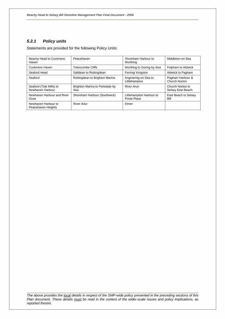
Beachy Head to Selsey Bill Shoreline Management Plan Final Document - 2006
The above provides the local details in respect of the SMP-wide policy presented in the preceding sections of this Plan document. These details must be read in the context of the wider-scale issues and policy implications, as reported therein.
5.2.1 Policy units
Statements are provided for the following Policy Units:
Beachy Head to Cuckmere Haven
Peacehaven Shoreham Harbour to Worthing
Middleton-on-Sea
Cuckmere Haven Telescombe Cliffs Worthing to Goring-by-Sea Felpham to Aldwick
Seaford Head Saltdean to Rottingdean Ferring/ Kingston Aldwick to Pagham
Seaford Rottingdean to Brighton Marina Angmering-on-Sea to Littlehampton
Pagham Harbour & Church Norton
Seaford (Tide Mills) to Newhaven Harbour
Brighton Marina to Portslade by Sea
River Arun Church Norton to Selsey East Beach
Newhaven Harbour and River Ouse
Shoreham Harbour (Southwick) Littlehampton Harbour to Poole Place
East Beach to Selsey Bill
Newhaven Harbour to Peacehaven Heights
River Adur Elmer
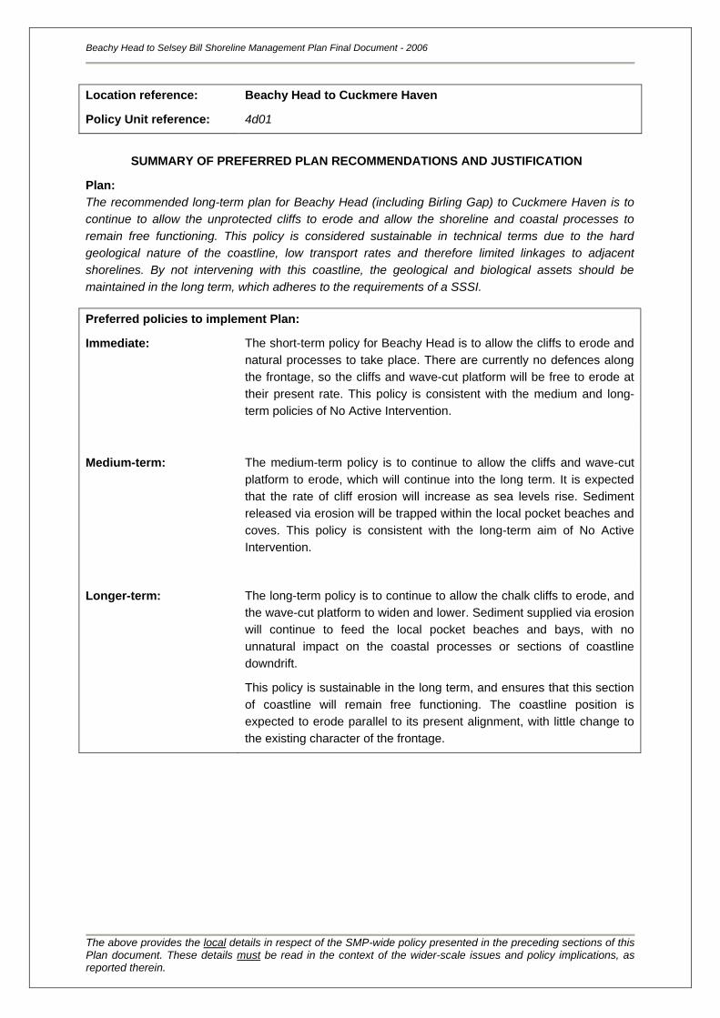
Beachy Head to Selsey Bill Shoreline Management Plan Final Document - 2006
The above provides the local details in respect of the SMP-wide policy presented in the preceding sections of this Plan document. These details must be read in the context of the wider-scale issues and policy implications, as reported therein.
Location reference:
Policy Unit reference:
Beachy Head to Cuckmere Haven
4d01
SUMMARY OF PREFERRED PLAN RECOMMENDATIONS AND JUSTIFICATION
Plan:
The recommended long-term plan for Beachy Head (including Birling Gap) to Cuckmere Haven is to
continue to allow the unprotected cliffs to erode and allow the shoreline and coastal processes to
remain free functioning. This policy is considered sustainable in technical terms due to the hard
geological nature of the coastline, low transport rates and therefore limited linkages to adjacent
shorelines. By not intervening with this coastline, the geological and biological assets should be
maintained in the long term, which adheres to the requirements of a SSSI.
Preferred policies to implement Plan:
Immediate: The short-term policy for Beachy Head is to allow the cliffs to erode and
natural processes to take place. There are currently no defences along
the frontage, so the cliffs and wave-cut platform will be free to erode at
their present rate. This policy is consistent with the medium and long-
term policies of No Active Intervention.
Medium-term: The medium-term policy is to continue to allow the cliffs and wave-cut
platform to erode, which will continue into the long term. It is expected
that the rate of cliff erosion will increase as sea levels rise. Sediment
released via erosion will be trapped within the local pocket beaches and
coves. This policy is consistent with the long-term aim of No Active
Intervention.
Longer-term: The long-term policy is to continue to allow the chalk cliffs to erode, and
the wave-cut platform to widen and lower. Sediment supplied via erosion
will continue to feed the local pocket beaches and bays, with no
unnatural impact on the coastal processes or sections of coastline
downdrift.
This policy is sustainable in the long term, and ensures that this section
of coastline will remain free functioning. The coastline position is
expected to erode parallel to its present alignment, with little change to
the existing character of the frontage.
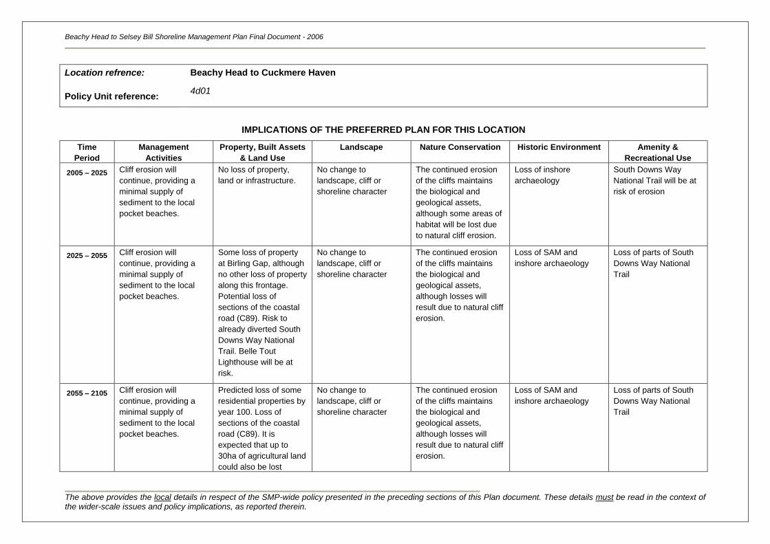
Beachy Head to Selsey Bill Shoreline Management Plan Final Document - 2006
The above provides the local details in respect of the SMP-wide policy presented in the preceding sections of this Plan document. These details must be read in the context of the wider-scale issues and policy implications, as reported therein.
Location refrence:
Policy Unit reference:
Beachy Head to Cuckmere Haven
4d01
IMPLICATIONS OF THE PREFERRED PLAN FOR THIS LOCATION
Time
Period
Management
Activities
Property, Built Assets
& Land Use
Landscape Nature Conservation Historic Environment Amenity &
Recreational Use
2005 – 2025
Cliff erosion will
continue, providing a
minimal supply of
sediment to the local
pocket beaches.
No loss of property,
land or infrastructure.
No change to
landscape, cliff or
shoreline character
The continued erosion
of the cliffs maintains
the biological and
geological assets,
although some areas of
habitat will be lost due
to natural cliff erosion.
Loss of inshore
archaeology
South Downs Way
National Trail will be at
risk of erosion
2025 – 2055 Cliff erosion will
continue, providing a
minimal supply of
sediment to the local
pocket beaches.
Some loss of property
at Birling Gap, although
no other loss of property
along this frontage.
Potential loss of
sections of the coastal
road (C89). Risk to
already diverted South
Downs Way National
Trail. Belle Tout
Lighthouse will be at
risk.
No change to
landscape, cliff or
shoreline character
The continued erosion
of the cliffs maintains
the biological and
geological assets,
although losses will
result due to natural cliff
erosion.
Loss of SAM and
inshore archaeology
Loss of parts of South
Downs Way National
Trail
2055 – 2105 Cliff erosion will
continue, providing a
minimal supply of
sediment to the local
pocket beaches.
Predicted loss of some
residential properties by
year 100. Loss of
sections of the coastal
road (C89). It is
expected that up to
30ha of agricultural land
could also be lost
No change to
landscape, cliff or
shoreline character
The continued erosion
of the cliffs maintains
the biological and
geological assets,
although losses will
result due to natural cliff
erosion.
Loss of SAM and
inshore archaeology
Loss of parts of South
Downs Way National
Trail
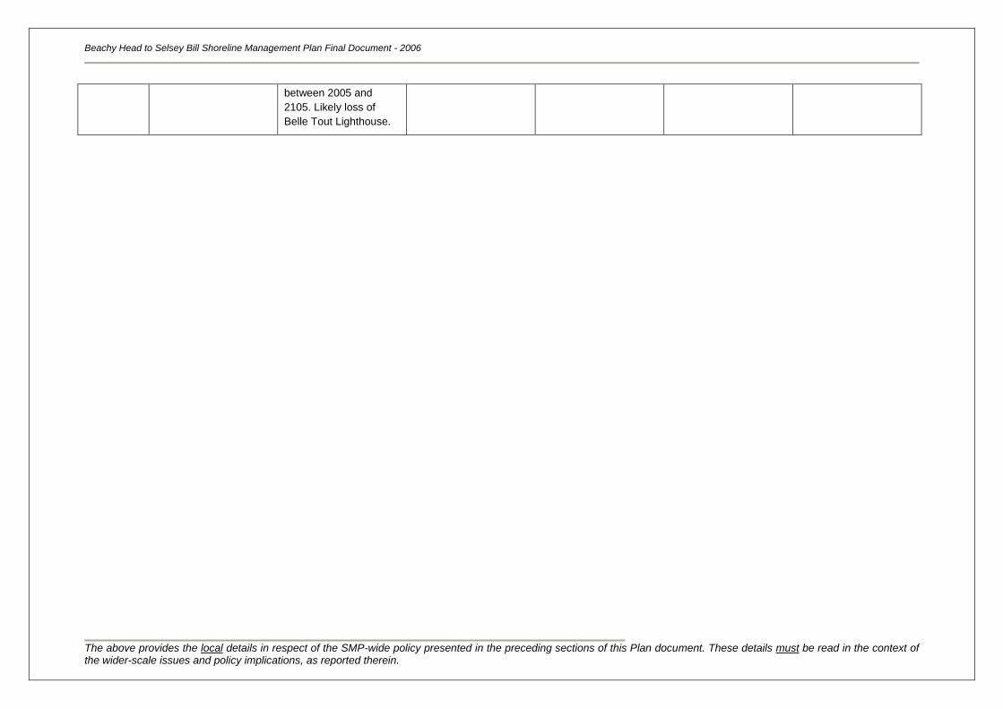
Beachy Head to Selsey Bill Shoreline Management Plan Final Document - 2006
The above provides the local details in respect of the SMP-wide policy presented in the preceding sections of this Plan document. These details must be read in the context of the wider-scale issues and policy implications, as reported therein.
between 2005 and
2105. Likely loss of
Belle Tout Lighthouse.
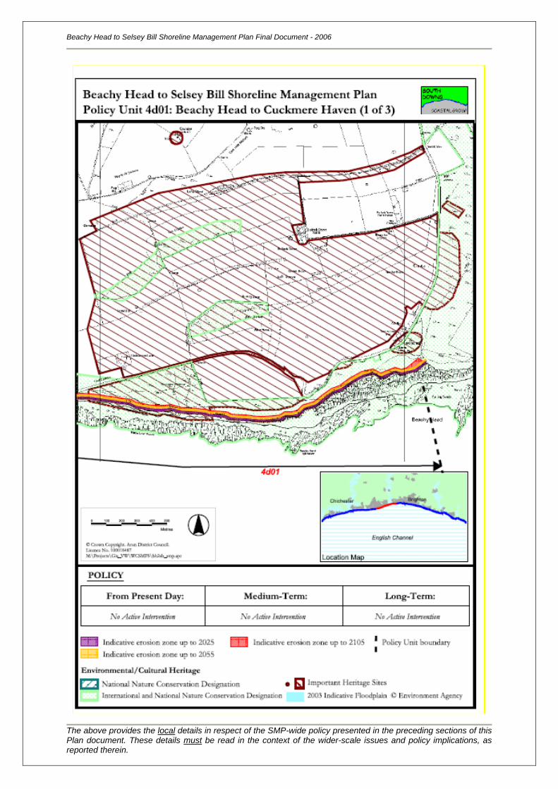
Beachy Head to Selsey Bill Shoreline Management Plan Final Document - 2006
The above provides the local details in respect of the SMP-wide policy presented in the preceding sections of this Plan document. These details must be read in the context of the wider-scale issues and policy implications, as reported therein.
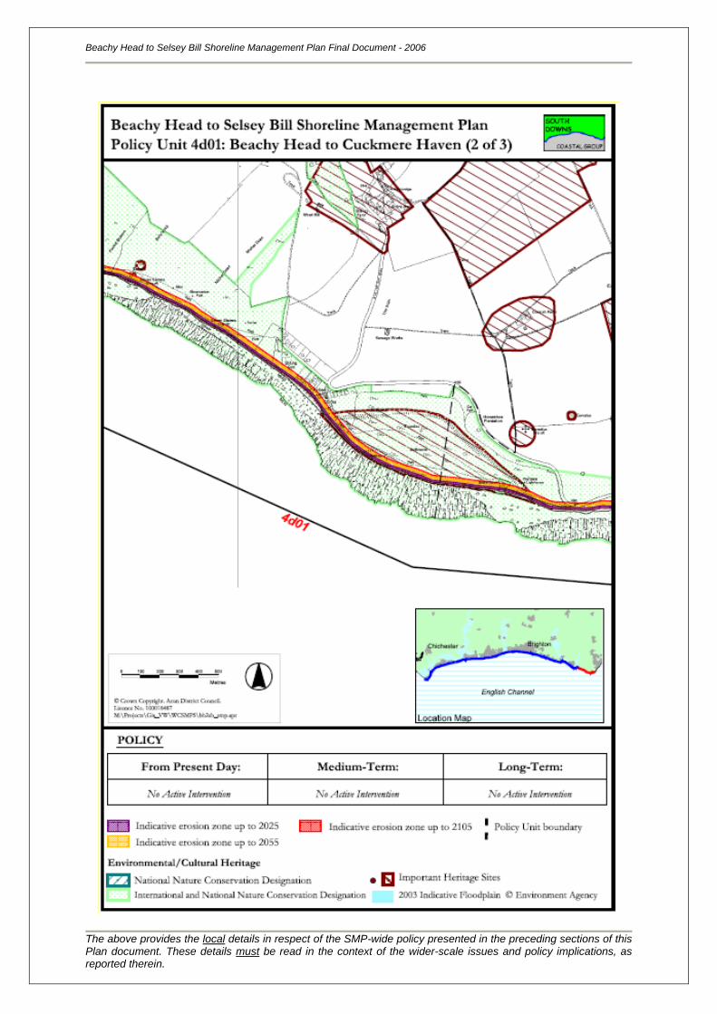
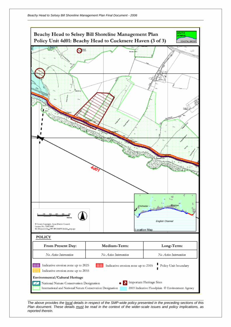
Location reference:
Policy Unit reference:
Cuckmere Haven
4d02
SUMMARY OF PREFERRED PLAN RECOMMENDATIONS AND JUSTIFICATION
Plan:
The recommended long-term plan for Cuckmere Haven is to allow natural processes to determine
shoreline behaviour and re-create a self-sustaining system. This may be achieved by managing the
realignment of the coastline in the immediate term only, but in a way that the outcome is not
detrimental to the long term aims.
Cuckmere Haven is of national importance (SSSI, AONB and a HC) and this policy is therefore
considered to be technically sustainable. This policy needs to be considered in relation to impacts
upstream, within the estuary and further studies will be required for the management and
implementation of this long-term policy, e.g. the issues of planning, renewed defences for the A259
and necessary footpath diversions.
Preferred policies to implement Plan:
Immediate:
The policy for this frontage is to manage the existing defences with
decreasing investment to enable the coastline to realign and allow the
creation of a naturally functioning estuary and mouth. This will prepare
the coastline for the medium and long term policy of no active
intervention. Existing management practices on the coastal frontage,
including recycling of beach material and maintenance of the training
walls at the mouth of the river, should be continued for the present time
whilst further studies of the Cuckmere estuary are completed.
Medium-term: Subject to the implementation of the Immediate policy, the medium-term
policy for this area is No Active Intervention.
The entrance to the estuary would follow a cycle of breaching and
resealing and the estuary mouth and channel would return to its pre-
trained/managed, wider form. The spits would begin to realign to their
pre-trained form by migrating landwards and the beaches would widen
and lower.
The growth and renewal of intertidal habitat would continue through the
medium-term.
Through this policy of No Active Intervention the Cuckmere coastline will
be free to continually evolve as a self-sustaining system.
Longer-term: The long-term policy is to continue to allow natural cyclic processes to
take place. The formation of the tidal inlet is expected to change,
although this policy is sustainable in the long term. It ensures that
Cuckmere Haven will be a free functioning system, with a wide
distribution of well developed intertidal habitats.
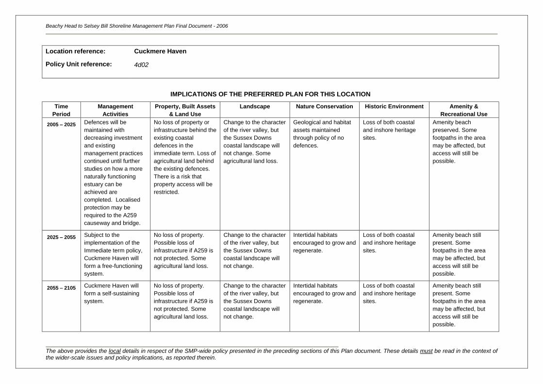
Beachy Head to Selsey Bill Shoreline Management Plan Final Document - 2006
The above provides the local details in respect of the SMP-wide policy presented in the preceding sections of this Plan document. These details must be read in the context of the wider-scale issues and policy implications, as reported therein.
Location reference:
Policy Unit reference:
Cuckmere Haven
4d02
IMPLICATIONS OF THE PREFERRED PLAN FOR THIS LOCATION
Time
Period
Management
Activities
Property, Built Assets
& Land Use
Landscape Nature Conservation Historic Environment Amenity &
Recreational Use
2005 – 2025
Defences will be
maintained with
decreasing investment
and existing
management practices
continued until further
studies on how a more
naturally functioning
estuary can be
achieved are
completed. Localised
protection may be
required to the A259
causeway and bridge.
No loss of property or
infrastructure behind the
existing coastal
defences in the
immediate term. Loss of
agricultural land behind
the existing defences.
There is a risk that
property access will be
restricted.
Change to the character
of the river valley, but
the Sussex Downs
coastal landscape will
not change. Some
agricultural land loss.
Geological and habitat
assets maintained
through policy of no
defences.
Loss of both coastal
and inshore heritage
sites.
Amenity beach
preserved. Some
footpaths in the area
may be affected, but
access will still be
possible.
2025 – 2055 Subject to the
implementation of the
Immediate term policy,
Cuckmere Haven will
form a free-functioning
system.
No loss of property.
Possible loss of
infrastructure if A259 is
not protected. Some
agricultural land loss.
Change to the character
of the river valley, but
the Sussex Downs
coastal landscape will
not change.
Intertidal habitats
encouraged to grow and
regenerate.
Loss of both coastal
and inshore heritage
sites.
Amenity beach still
present. Some
footpaths in the area
may be affected, but
access will still be
possible.
2055 – 2105 Cuckmere Haven will
form a self-sustaining
system.
No loss of property.
Possible loss of
infrastructure if A259 is
not protected. Some
agricultural land loss.
Change to the character
of the river valley, but
the Sussex Downs
coastal landscape will
not change.
Intertidal habitats
encouraged to grow and
regenerate.
Loss of both coastal
and inshore heritage
sites.
Amenity beach still
present. Some
footpaths in the area
may be affected, but
access will still be
possible.
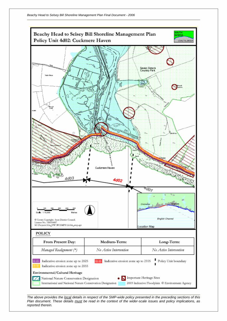
Beachy Head to Selsey Bill Shoreline Management Plan Final Document - 2006
The above provides the local details in respect of the SMP-wide policy presented in the preceding sections of this Plan document. These details must be read in the context of the wider-scale issues and policy implications, as reported therein.
Location reference:
Policy Unit reference:
Seaford Head
4d03
SUMMARY OF PREFERRED PLAN RECOMMENDATIONS AND JUSTIFICATION
Plan:
The recommended long-term plan for Seaford Head is to continue to allow the unprotected cliffs to
erode and allow the shoreline and coastal processes to remain free functioning. Seaford Head is of
high environmental importance (SSSI, AONB and a HC) and this policy is therefore considered to be
sustainable as it will allow the cliffs to function naturally. Erosion losses will be minimal due to hard
geology of the shoreline, and since rates of erosion, sediment feed and transportation along this
frontage are low, this policy will have a nominal impact on the adjacent frontage.
Preferred policies to implement Plan:
Immediate: The short-term policy for Seaford Head is no active intervention. The
gabions at Hope Gap would no longer be maintained and their
effectiveness will reduce throughout the immediate period. There are
currently no defences elsewhere along the frontage, so the cliffs and
wave-cut platform will be free to erode at their present rate. This policy is
consistent with the medium and long-term policies of No Active
Intervention.
Medium-term: The medium-term policy is to continue to allow the cliffs and wave-cut
platform to erode, which will continue into the long term. It is expected
that the rate of cliff erosion will increase as sea levels rise. Sediment
released via erosion will be trapped within the local pocket beaches and
coves.
Longer-term: The long-term policy is to continue to allow the chalk cliffs to erode, and
the wave-cut platform to widen and lower. Sediment supplied via erosion
will continue to feed the local pocket beaches and bays, with no
unnatural impact on the coastal processes or sections of coastline
downdrift.
This policy is sustainable in the long term, and ensures that this section
of coastline will remain free functioning. The coastline position is
expected to erode parallel to its present alignment, with little change to
the existing character of the frontage. Allowing the cliffs to erode meets
the requirements of a SSSI, by allowing natural processes to take place,
and the geological and biological assets along the frontage to remain
free functioning.
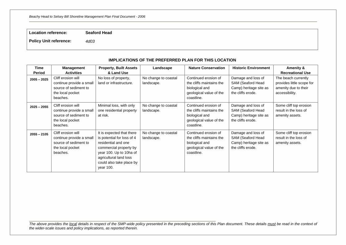
Beachy Head to Selsey Bill Shoreline Management Plan Final Document - 2006
The above provides the local details in respect of the SMP-wide policy presented in the preceding sections of this Plan document. These details must be read in the context of the wider-scale issues and policy implications, as reported therein.
Location reference:
Policy Unit reference:
Seaford Head
4d03
IMPLICATIONS OF THE PREFERRED PLAN FOR THIS LOCATION
Time
Period
Management
Activities
Property, Built Assets
& Land Use
Landscape Nature Conservation Historic Environment Amenity &
Recreational Use
2005 – 2025
Cliff erosion will
continue provide a small
source of sediment to
the local pocket
beaches.
No loss of property,
land or infrastructure.
No change to coastal
landscape.
Continued erosion of
the cliffs maintains the
biological and
geological value of the
coastline.
Damage and loss of
SAM (Seaford Head
Camp) heritage site as
the cliffs erode.
The beach currently
provides little scope for
amenity due to their
accessibility.
2025 – 2055 Cliff erosion will
continue provide a small
source of sediment to
the local pocket
beaches.
Minimal loss, with only
one residential property
at risk.
No change to coastal
landscape.
Continued erosion of
the cliffs maintains the
biological and
geological value of the
coastline.
Damage and loss of
SAM (Seaford Head
Camp) heritage site as
the cliffs erode.
Some cliff top erosion
result in the loss of
amenity assets.
2055 – 2105 Cliff erosion will
continue provide a small
source of sediment to
the local pocket
beaches.
It is expected that there
is potential for loss of 4
residential and one
commercial property by
year 100. Up to 10ha of
agricultural land loss
could also take place by
year 100.
No change to coastal
landscape.
Continued erosion of
the cliffs maintains the
biological and
geological value of the
coastline.
Damage and loss of
SAM (Seaford Head
Camp) heritage site as
the cliffs erode.
Some cliff top erosion
result in the loss of
amenity assets.

Beachy Head to Selsey Bill Shoreline Management Plan Final Document - 2006
The above provides the local details in respect of the SMP-wide policy presented in the preceding sections of this Plan document. These details must be read in the context of the wider-scale issues and policy implications, as reported therein.
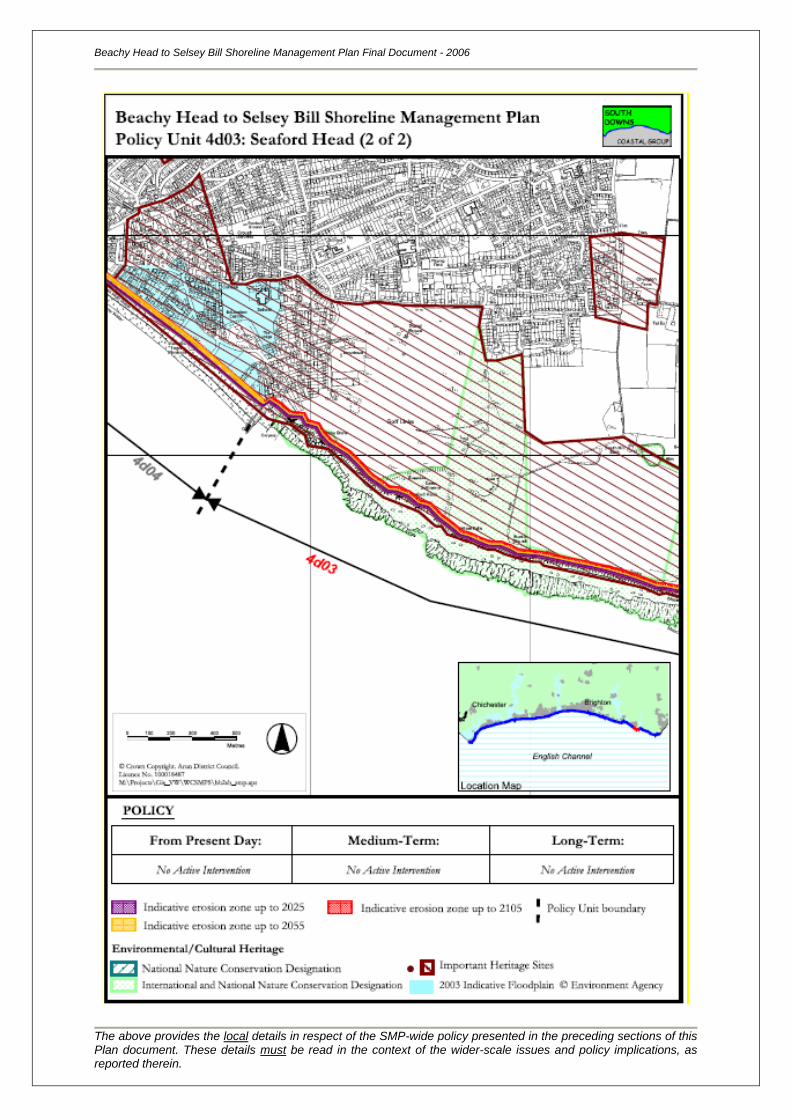
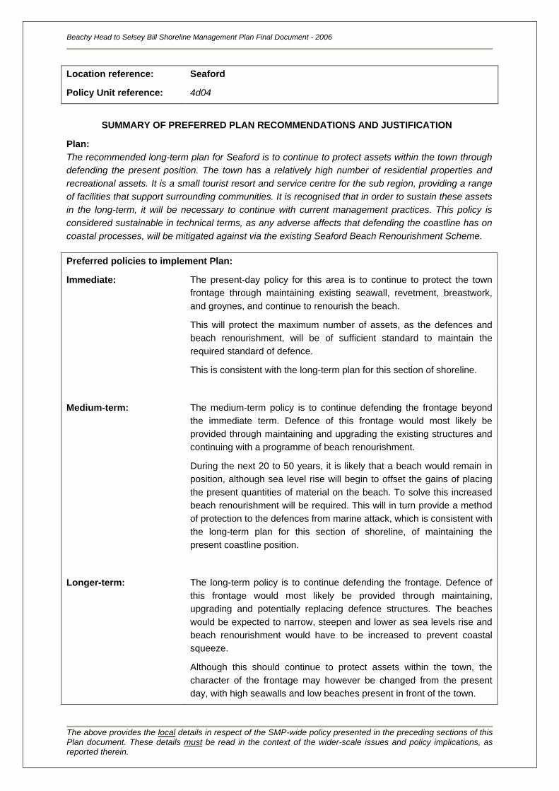
Location reference:
Policy Unit reference:
Seaford
4d04
SUMMARY OF PREFERRED PLAN RECOMMENDATIONS AND JUSTIFICATION
Plan:
The recommended long-term plan for Seaford is to continue to protect assets within the town through
defending the present position. The town has a relatively high number of residential properties and
recreational assets. It is a small tourist resort and service centre for the sub region, providing a range
of facilities that support surrounding communities. It is recognised that in order to sustain these assets
in the long-term, it will be necessary to continue with current management practices. This policy is
considered sustainable in technical terms, as any adverse affects that defending the coastline has on
coastal processes, will be mitigated against via the existing Seaford Beach Renourishment Scheme.
Preferred policies to implement Plan:
Immediate: The present-day policy for this area is to continue to protect the town
frontage through maintaining existing seawall, revetment, breastwork,
and groynes, and continue to renourish the beach.
This will protect the maximum number of assets, as the defences and
beach renourishment, will be of sufficient standard to maintain the
required standard of defence.
This is consistent with the long-term plan for this section of shoreline.
Medium-term: The medium-term policy is to continue defending the frontage beyond
the immediate term. Defence of this frontage would most likely be
provided through maintaining and upgrading the existing structures and
continuing with a programme of beach renourishment.
During the next 20 to 50 years, it is likely that a beach would remain in
position, although sea level rise will begin to offset the gains of placing
the present quantities of material on the beach. To solve this increased
beach renourishment will be required. This will in turn provide a method
of protection to the defences from marine attack, which is consistent with
the long-term plan for this section of shoreline, of maintaining the
present coastline position.
Longer-term: The long-term policy is to continue defending the frontage. Defence of
this frontage would most likely be provided through maintaining,
upgrading and potentially replacing defence structures. The beaches
would be expected to narrow, steepen and lower as sea levels rise and
beach renourishment would have to be increased to prevent coastal
squeeze.
Although this should continue to protect assets within the town, the
character of the frontage may however be changed from the present
day, with high seawalls and low beaches present in front of the town.
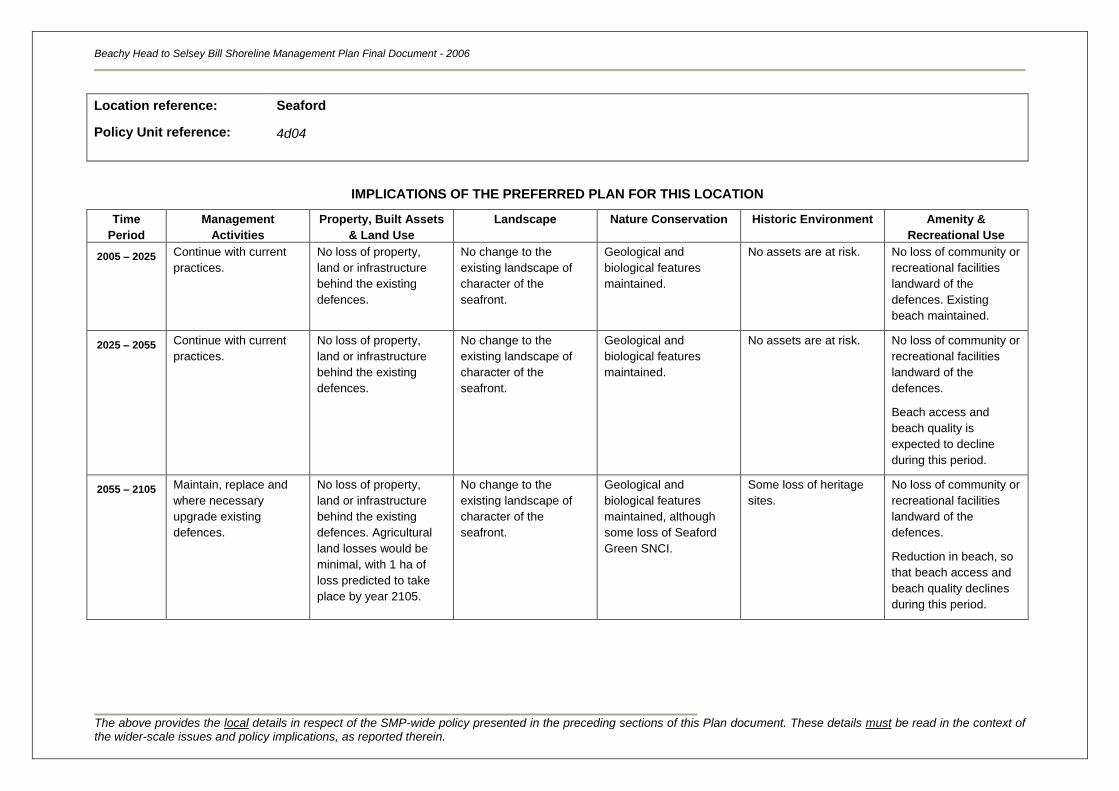
Beachy Head to Selsey Bill Shoreline Management Plan Final Document - 2006
The above provides the local details in respect of the SMP-wide policy presented in the preceding sections of this Plan document. These details must be read in the context of the wider-scale issues and policy implications, as reported therein.
Location reference:
Policy Unit reference:
Seaford
4d04
IMPLICATIONS OF THE PREFERRED PLAN FOR THIS LOCATION
Time
Period
Management
Activities
Property, Built Assets
& Land Use
Landscape Nature Conservation Historic Environment Amenity &
Recreational Use
2005 – 2025
Continue with current
practices.
No loss of property,
land or infrastructure
behind the existing
defences.
No change to the
existing landscape of
character of the
seafront.
Geological and
biological features
maintained.
No assets are at risk. No loss of community or
recreational facilities
landward of the
defences. Existing
beach maintained.
2025 – 2055 Continue with current
practices.
No loss of property,
land or infrastructure
behind the existing
defences.
No change to the
existing landscape of
character of the
seafront.
Geological and
biological features
maintained.
No assets are at risk. No loss of community or
recreational facilities
landward of the
defences.
Beach access and
beach quality is
expected to decline
during this period.
2055 – 2105 Maintain, replace and
where necessary
upgrade existing
defences.
No loss of property,
land or infrastructure
behind the existing
defences. Agricultural
land losses would be
minimal, with 1 ha of
loss predicted to take
place by year 2105.
No change to the
existing landscape of
character of the
seafront.
Geological and
biological features
maintained, although
some loss of Seaford
Green SNCI.
Some loss of heritage
sites.
No loss of community or
recreational facilities
landward of the
defences.
Reduction in beach, so
that beach access and
beach quality declines
during this period.
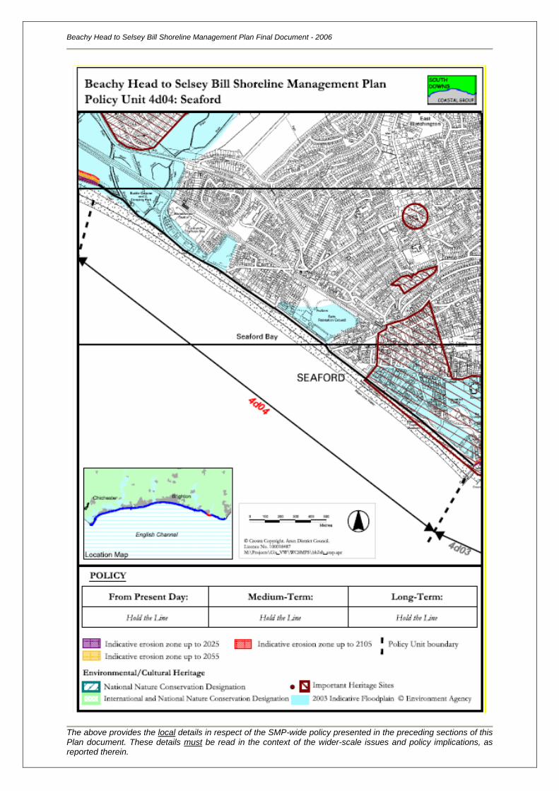
Beachy Head to Selsey Bill Shoreline Management Plan Final Document - 2006
The above provides the local details in respect of the SMP-wide policy presented in the preceding sections of this Plan document. These details must be read in the context of the wider-scale issues and policy implications, as reported therein.
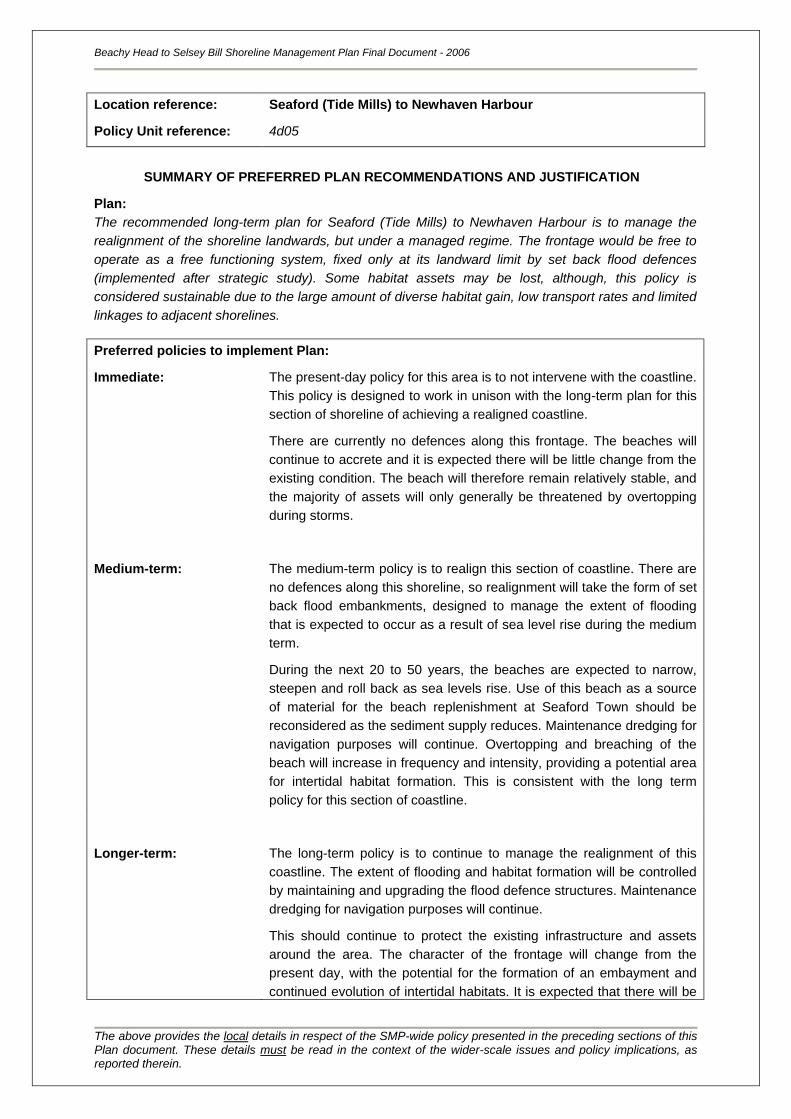
Location reference:
Policy Unit reference:
Seaford (Tide Mills) to Newhaven Harbour
4d05
SUMMARY OF PREFERRED PLAN RECOMMENDATIONS AND JUSTIFICATION
Plan:
The recommended long-term plan for Seaford (Tide Mills) to Newhaven Harbour is to manage the
realignment of the shoreline landwards, but under a managed regime. The frontage would be free to
operate as a free functioning system, fixed only at its landward limit by set back flood defences
(implemented after strategic study). Some habitat assets may be lost, although, this policy is
considered sustainable due to the large amount of diverse habitat gain, low transport rates and limited
linkages to adjacent shorelines.
Preferred policies to implement Plan:
Immediate: The present-day policy for this area is to not intervene with the coastline.
This policy is designed to work in unison with the long-term plan for this
section of shoreline of achieving a realigned coastline.
There are currently no defences along this frontage. The beaches will
continue to accrete and it is expected there will be little change from the
existing condition. The beach will therefore remain relatively stable, and
the majority of assets will only generally be threatened by overtopping
during storms.
Medium-term: The medium-term policy is to realign this section of coastline. There are
no defences along this shoreline, so realignment will take the form of set
back flood embankments, designed to manage the extent of flooding
that is expected to occur as a result of sea level rise during the medium
term.
During the next 20 to 50 years, the beaches are expected to narrow,
steepen and roll back as sea levels rise. Use of this beach as a source
of material for the beach replenishment at Seaford Town should be
reconsidered as the sediment supply reduces. Maintenance dredging for
navigation purposes will continue. Overtopping and breaching of the
beach will increase in frequency and intensity, providing a potential area
for intertidal habitat formation. This is consistent with the long term
policy for this section of coastline.
Longer-term: The long-term policy is to continue to manage the realignment of this
coastline. The extent of flooding and habitat formation will be controlled
by maintaining and upgrading the flood defence structures. Maintenance
dredging for navigation purposes will continue.
This should continue to protect the existing infrastructure and assets
around the area. The character of the frontage will change from the
present day, with the potential for the formation of an embayment and
continued evolution of intertidal habitats. It is expected that there will be
Beachy Head to Selsey Bill Shoreline Management Plan Final Document - 2006
The above provides the local details in respect of the SMP-wide policy presented in the preceding sections of this Plan document. These details must be read in the context of the wider-scale issues and policy implications, as reported therein.
some loss of the peripheral intertidal habitat over the longer term as it
becomes squeezed against the flood defences with sea level rise.
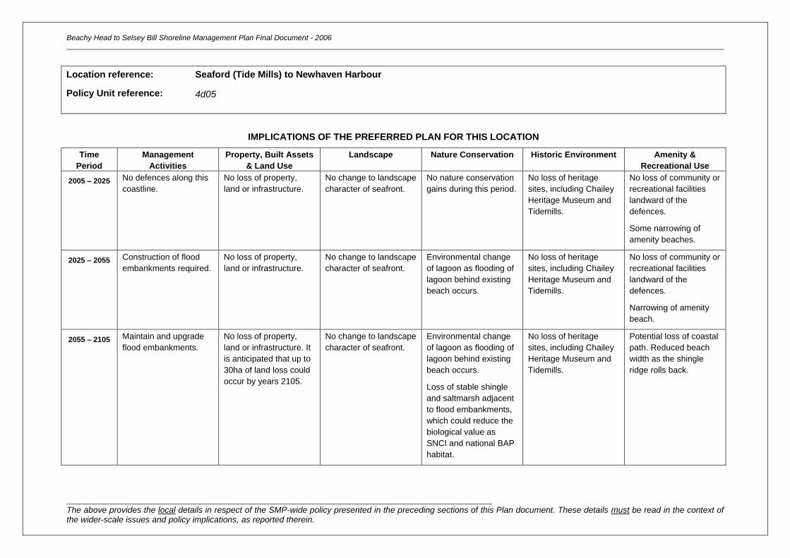
Beachy Head to Selsey Bill Shoreline Management Plan Final Document - 2006
The above provides the local details in respect of the SMP-wide policy presented in the preceding sections of this Plan document. These details must be read in the context of the wider-scale issues and policy implications, as reported therein.
Location reference:
Policy Unit reference:
Seaford (Tide Mills) to Newhaven Harbour
4d05
IMPLICATIONS OF THE PREFERRED PLAN FOR THIS LOCATION
Time
Period
Management
Activities
Property, Built Assets
& Land Use
Landscape Nature Conservation Historic Environment Amenity &
Recreational Use
2005 – 2025
No defences along this
coastline.
No loss of property,
land or infrastructure.
No change to landscape
character of seafront.
No nature conservation
gains during this period.
No loss of heritage
sites, including Chailey
Heritage Museum and
Tidemills.
No loss of community or
recreational facilities
landward of the
defences.
Some narrowing of
amenity beaches.
2025 – 2055 Construction of flood
embankments required.
No loss of property,
land or infrastructure.
No change to landscape
character of seafront.
Environmental change
of lagoon as flooding of
lagoon behind existing
beach occurs.
No loss of heritage
sites, including Chailey
Heritage Museum and
Tidemills.
No loss of community or
recreational facilities
landward of the
defences.
Narrowing of amenity
beach.
2055 – 2105 Maintain and upgrade
flood embankments.
No loss of property,
land or infrastructure. It
is anticipated that up to
30ha of land loss could
occur by years 2105.
No change to landscape
character of seafront.
Environmental change
of lagoon as flooding of
lagoon behind existing
beach occurs.
Loss of stable shingle
and saltmarsh adjacent
to flood embankments,
which could reduce the
biological value as
SNCI and national BAP
habitat.
No loss of heritage
sites, including Chailey
Heritage Museum and
Tidemills.
Potential loss of coastal
path. Reduced beach
width as the shingle
ridge rolls back.
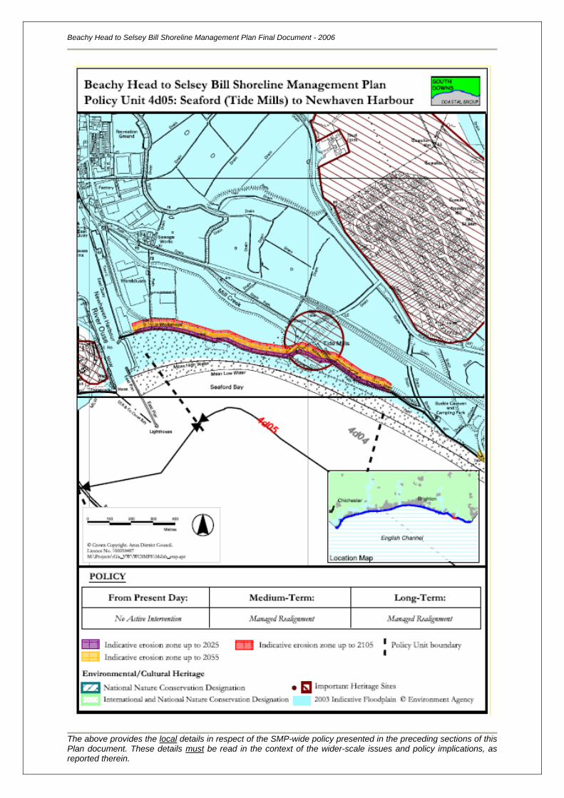
Beachy Head to Selsey Bill Shoreline Management Plan Final Document - 2006
The above provides the local details in respect of the SMP-wide policy presented in the preceding sections of this Plan document. These details must be read in the context of the wider-scale issues and policy implications, as reported therein.
Location reference:
Policy Unit reference:
Newhaven Harbour and River Ouse
4d06
SUMMARY OF PREFERRED PLAN RECOMMENDATIONS AND JUSTIFICATION
Plan:
The recommended long-term plan for Newhaven Harbour and the mouth of the River Ouse is to
continue to protect assets within the town through defending the present position. The harbour
supports an international port and related industries, and is an important source of employment for the
local area. The town itself is a key service centre for the sub region, providing a range of facilities and
recreational amenities and the Ouse Valley is important for it environmental wealth. It is therefore
recognised that in order to sustain the existing socio-economics of this area and the sediment
transport linkages, current management practices must continue.
Preferred policies to implement Plan:
Immediate: The present-day policy for this area is to continue to fix the position of
the harbour mouth and protect this and the frontage at the mouth of the
River Ouse by maintaining existing seawall and breakwaters. This
policy does not include the banks of the River Ouse. Maintenance
dredging for navigation purposes and recycling of sediment across the
harbour mouth to Tide Mills will continue.
This will protect the maximum number of assets, but over this period
beaches will start to become narrower and defences more exposed.
This is consistent with the long-term plan for this section of shoreline.
Medium-term: The medium-term policy is to continue defending the frontage beyond
the immediate term. Maintenance dredging of the main channel for
navigation purposes will continue.
During the next 20 to 50 years, the frontage would be lacking a
protective foreshore and the seawall, breakwaters and quaysides will be
subject to increased marine wave exposure as sea levels rise. Defence
of this frontage would most likely be provided through maintaining,
upgrading and replacing structures.
Longer-term: The long-term policy is to continue defending the frontage. Defence of
this frontage would most likely be provided through maintaining,
replacing and upgrading seawall, breakwaters and quaysides.
Maintenance dredging for navigation will continue.
However, although this should continue to protect assets within the
town, the character of the frontage may however be changed from the
present day, with high seawalls and low beaches present in front of the
town.
Beachy Head to Selsey Bill Shoreline Management Plan Final Document - 2006
The above provides the local details in respect of the SMP-wide policy presented in the preceding sections of this Plan document. These details must be read in the context of the wider-scale issues and policy implications, as reported therein.
Location reference:
Policy Unit reference:
Newhaven Harbour and River Ouse
4d06
IMPLICATIONS OF THE PREFERRED PLAN FOR THIS LOCATION
Time
Period
Management
Activities
Property, Built Assets
& Land Use
Landscape Nature Conservation Historic Environment Amenity &
Recreational Use
2005 – 2025
Continue with current
management practices.
No loss of property,
land or infrastructure
behind the existing
defences.
No change to landscape
or seafront character.
There are no
environmental or habitat
gains.
No loss of heritage
sites.
No loss of existing
recreational facilities.
2025 – 2055 Continue with current
management practices.
No loss of property,
land or infrastructure
behind the existing
defences.
No change to landscape
or seafront character.
There are no
environmental or habitat
gains.
Historical assets on the
foreshore could be lost /
damaged (due to sea
level rise &
construction).
No loss of existing
recreational facilities.
2055 – 2105 Increase engineering
and management
practices.
No loss of property,
land or infrastructure
behind the existing
defences. Agricultural
land loss is minimal (in
the region of 0.1ha).
No change to landscape
or seafront character.
There are no
environmental or habitat
gains.
Historical assets on the
foreshore could be lost /
damaged (due to sea
level rise &
construction).
No loss of existing
recreational facilities.
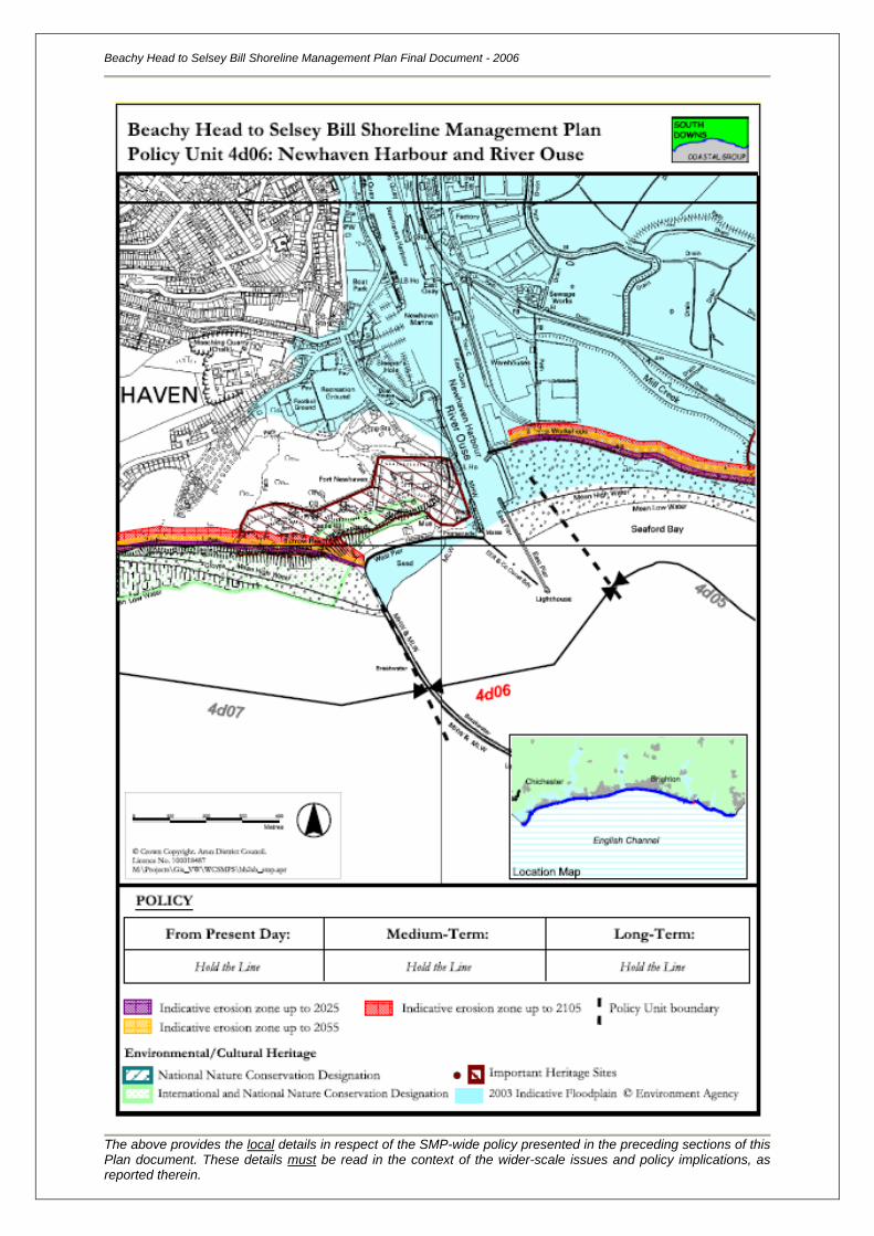
Beachy Head to Selsey Bill Shoreline Management Plan Final Document - 2006
The above provides the local details in respect of the SMP-wide policy presented in the preceding sections of this Plan document. These details must be read in the context of the wider-scale issues and policy implications, as reported therein.
Location reference:
Policy Unit reference:
Newhaven Harbour to Peacehaven Heights
4d07
SUMMARY OF PREFERRED PLAN RECOMMENDATIONS AND JUSTIFICATION
Plan:
The recommended long-term plan for Newhaven Harbour to Peacehaven Heights is to manage the
realignment of the coastline. The frontage is dominated by high cliffs, that are of great geological value
(SSSI, GCRS, RIGS), but is also rich in environmental and archaeological assets. There are some
assets along this frontage that will be at risk to coastal erosion, but could be relocated. This policy is
considered sustainable in the long-term as the unprotected cliffs will be free to erode and the shoreline
and coastal processes will remain free functioning, whilst the harbour and other built assets will be
protected.
Preferred policies to implement Plan:
Immediate: The present-day policy for this area is to continue to allow the cliffs to
erode, but continue to maintain a terminal structure (the harbour
breakwater acts as such at present) that holds the beach in front. This
will protect the maximum number of assets, and it is expected that the
beach will continue to accrete in the lee of the Newhaven Harbour
breakwater.
The policy for this coastline is devised of a series of stages, and the
policy for the immediate term is designed to work in conjunction with the
long-term plan for this section of shoreline.
Medium-term: The medium-term policy is to continue to allow the cliffs and wave-cut
platform in the west to erode, but to manage the realignment of the
coastline where assets are at risk through maintaining some sort of
terminal structure fulfilled by harbour breakwater at present.
Sediment released via erosion will be trapped within the local pocket
beaches and coves, or supply the beach in the lee of the Newhaven
Harbour Breakwater. It is expected that the rate of cliff erosion will
increase as sea levels rise, threatening the integrity of the assets that
line the cliff top (OS Reference: TV443998).
This policy is consistent with the long-term aim of No Active Intervention.
Longer-term: The long-term policy is to continue to allow the cliffs to erode naturally,
but to manage the frontage where assets are at risk. The harbour
entrance training walls, breakwater and any new defence structures
would be maintained, replaced and upgraded where necessary.
The beach to the west of the breakwater is expected to accrete, and the
assets at risk protected, although the character of the cliffs may be
changed from the present day, with seawalls fronted by low beaches.
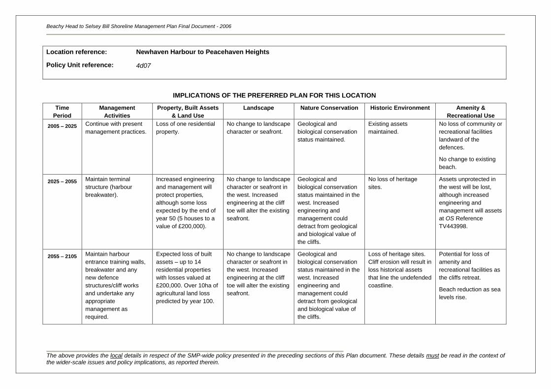
Beachy Head to Selsey Bill Shoreline Management Plan Final Document - 2006
The above provides the local details in respect of the SMP-wide policy presented in the preceding sections of this Plan document. These details must be read in the context of the wider-scale issues and policy implications, as reported therein.
Location reference:
Policy Unit reference:
Newhaven Harbour to Peacehaven Heights
4d07
IMPLICATIONS OF THE PREFERRED PLAN FOR THIS LOCATION
Time
Period
Management
Activities
Property, Built Assets
& Land Use
Landscape Nature Conservation Historic Environment Amenity &
Recreational Use
2005 – 2025
Continue with present
management practices.
Loss of one residential
property.
No change to landscape
character or seafront.
Geological and
biological conservation
status maintained.
Existing assets
maintained.
No loss of community or
recreational facilities
landward of the
defences.
No change to existing
beach.
2025 – 2055 Maintain terminal
structure (harbour
breakwater).
Increased engineering
and management will
protect properties,
although some loss
expected by the end of
year 50 (5 houses to a
value of £200,000).
No change to landscape
character or seafront in
the west. Increased
engineering at the cliff
toe will alter the existing
seafront.
Geological and
biological conservation
status maintained in the
west. Increased
engineering and
management could
detract from geological
and biological value of
the cliffs.
No loss of heritage
sites.
Assets unprotected in
the west will be lost,
although increased
engineering and
management will assets
at OS Reference
TV443998.
2055 – 2105 Maintain harbour
entrance training walls,
breakwater and any
new defence
structures/cliff works
and undertake any
appropriate
management as
required.
Expected loss of built
assets – up to 14
residential properties
with losses valued at
£200,000. Over 10ha of
agricultural land loss
predicted by year 100.
No change to landscape
character or seafront in
the west. Increased
engineering at the cliff
toe will alter the existing
seafront.
Geological and
biological conservation
status maintained in the
west. Increased
engineering and
management could
detract from geological
and biological value of
the cliffs.
Loss of heritage sites.
Cliff erosion will result in
loss historical assets
that line the undefended
coastline.
Potential for loss of
amenity and
recreational facilities as
the cliffs retreat.
Beach reduction as sea
levels rise.
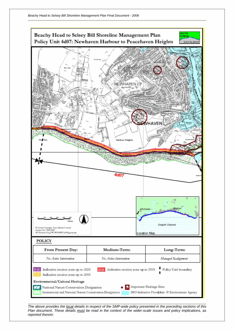
Beachy Head to Selsey Bill Shoreline Management Plan Final Document - 2006
The above provides the local details in respect of the SMP-wide policy presented in the preceding sections of this Plan document. These details must be read in the context of the wider-scale issues and policy implications, as reported therein.
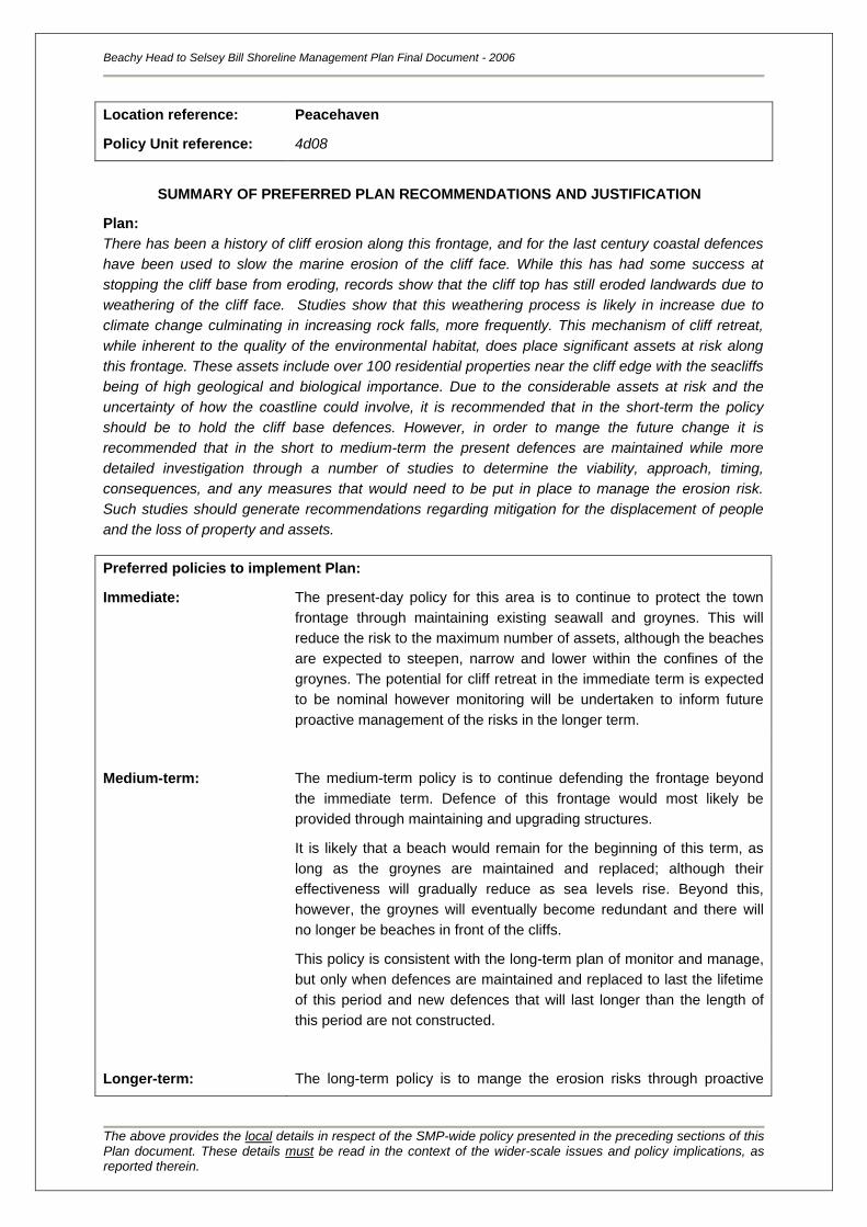
Location reference:
Policy Unit reference:
Peacehaven
4d08
SUMMARY OF PREFERRED PLAN RECOMMENDATIONS AND JUSTIFICATION
Plan:
There has been a history of cliff erosion along this frontage, and for the last century coastal defences
have been used to slow the marine erosion of the cliff face. While this has had some success at
stopping the cliff base from eroding, records show that the cliff top has still eroded landwards due to
weathering of the cliff face. Studies show that this weathering process is likely in increase due to
climate change culminating in increasing rock falls, more frequently. This mechanism of cliff retreat,
while inherent to the quality of the environmental habitat, does place significant assets at risk along
this frontage. These assets include over 100 residential properties near the cliff edge with the seacliffs
being of high geological and biological importance. Due to the considerable assets at risk and the
uncertainty of how the coastline could involve, it is recommended that in the short-term the policy
should be to hold the cliff base defences. However, in order to mange the future change it is
recommended that in the short to medium-term the present defences are maintained while more
detailed investigation through a number of studies to determine the viability, approach, timing,
consequences, and any measures that would need to be put in place to manage the erosion risk.
Such studies should generate recommendations regarding mitigation for the displacement of people
and the loss of property and assets.
Preferred policies to implement Plan:
Immediate: The present-day policy for this area is to continue to protect the town
frontage through maintaining existing seawall and groynes. This will
reduce the risk to the maximum number of assets, although the beaches
are expected to steepen, narrow and lower within the confines of the
groynes. The potential for cliff retreat in the immediate term is expected
to be nominal however monitoring will be undertaken to inform future
proactive management of the risks in the longer term.
Medium-term: The medium-term policy is to continue defending the frontage beyond
the immediate term. Defence of this frontage would most likely be
provided through maintaining and upgrading structures.
It is likely that a beach would remain for the beginning of this term, as
long as the groynes are maintained and replaced; although their
effectiveness will gradually reduce as sea levels rise. Beyond this,
however, the groynes will eventually become redundant and there will
no longer be beaches in front of the cliffs.
This policy is consistent with the long-term plan of monitor and manage,
but only when defences are maintained and replaced to last the lifetime
of this period and new defences that will last longer than the length of
this period are not constructed.
Longer-term: The long-term policy is to mange the erosion risks through proactive
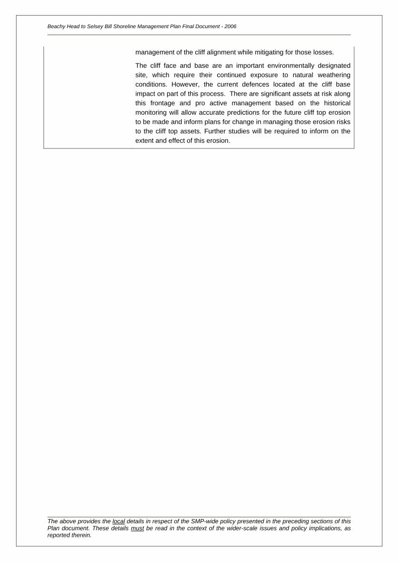
Beachy Head to Selsey Bill Shoreline Management Plan Final Document - 2006
The above provides the local details in respect of the SMP-wide policy presented in the preceding sections of this Plan document. These details must be read in the context of the wider-scale issues and policy implications, as reported therein.
management of the cliff alignment while mitigating for those losses.
The cliff face and base are an important environmentally designated
site, which require their continued exposure to natural weathering
conditions. However, the current defences located at the cliff base
impact on part of this process. There are significant assets at risk along
this frontage and pro active management based on the historical
monitoring will allow accurate predictions for the future cliff top erosion
to be made and inform plans for change in managing those erosion risks
to the cliff top assets. Further studies will be required to inform on the
extent and effect of this erosion.
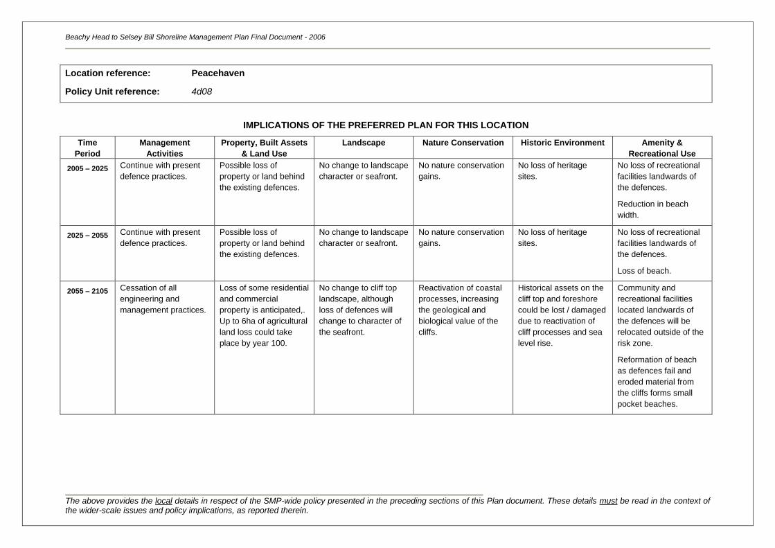
Beachy Head to Selsey Bill Shoreline Management Plan Final Document - 2006
The above provides the local details in respect of the SMP-wide policy presented in the preceding sections of this Plan document. These details must be read in the context of the wider-scale issues and policy implications, as reported therein.
Location reference:
Policy Unit reference:
Peacehaven
4d08
IMPLICATIONS OF THE PREFERRED PLAN FOR THIS LOCATION
Time
Period
Management
Activities
Property, Built Assets
& Land Use
Landscape Nature Conservation Historic Environment Amenity &
Recreational Use
2005 – 2025
Continue with present
defence practices.
Possible loss of
property or land behind
the existing defences.
No change to landscape
character or seafront.
No nature conservation
gains.
No loss of heritage
sites.
No loss of recreational
facilities landwards of
the defences.
Reduction in beach
width.
2025 – 2055 Continue with present
defence practices.
Possible loss of
property or land behind
the existing defences.
No change to landscape
character or seafront.
No nature conservation
gains.
No loss of heritage
sites.
No loss of recreational
facilities landwards of
the defences.
Loss of beach.
2055 – 2105 Cessation of all
engineering and
management practices.
Loss of some residential
and commercial
property is anticipated,.
Up to 6ha of agricultural
land loss could take
place by year 100.
No change to cliff top
landscape, although
loss of defences will
change to character of
the seafront.
Reactivation of coastal
processes, increasing
the geological and
biological value of the
cliffs.
Historical assets on the
cliff top and foreshore
could be lost / damaged
due to reactivation of
cliff processes and sea
level rise.
Community and
recreational facilities
located landwards of
the defences will be
relocated outside of the
risk zone.
Reformation of beach
as defences fail and
eroded material from
the cliffs forms small
pocket beaches.
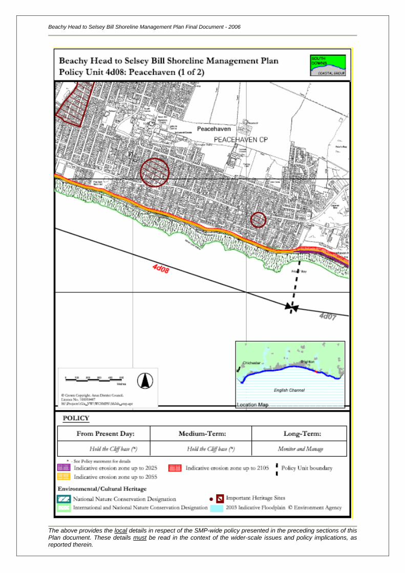
Beachy Head to Selsey Bill Shoreline Management Plan Final Document - 2006
The above provides the local details in respect of the SMP-wide policy presented in the preceding sections of this Plan document. These details must be read in the context of the wider-scale issues and policy implications, as reported therein.
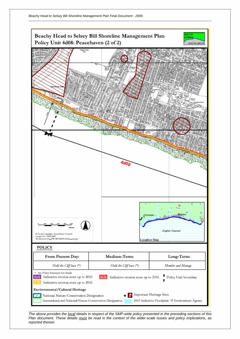
Location reference:
Policy Unit reference:
Telscombe Cliffs
4d09
SUMMARY OF PREFERRED PLAN RECOMMENDATIONS AND JUSTIFICATION
Plan:
The recommended long-term plan for Telscombe Cliffs is to sustain a naturally functioning coastline in
the long term, but manage the Portabello Marine Treatment Works through appropriate management
of its current position in the immediate and medium term. The outfall provides an important service to
the local community and sub region. This is considered to be sustainable in technical terms, naturally
due to low transport rates and, therefore, limited linkages to adjacent shorelines.
Preferred policies to implement Plan:
Immediate: The present-day policy for this area is to continue to protect the outfall
through maintaining the concrete seawall and groynes. Elsewhere, there
are currently no defences along the frontage, so the cliffs and wave-cut
platform will be free to erode at their present rate. This is consistent with
the medium-term plan for this section of shoreline, but will not impact on
the implementation of the long-term policy.
Medium-term: The medium-term policy is to continue to allow the cliffs and wave-cut
platform to erode, which will continue into the long term, but protect the
Portabello Marine Treatment Works. Defence of the outfall would most
likely be provided through maintaining and upgrading structures. It would
not be compliant with the long-term plan to replace or build new
structures that would survive beyond the medium term.
During the next 20 to 50 years, it is expected that the rate of cliff erosion
will increase as sea levels rise. Sediment released via erosion will be
trapped within the local pocket beaches and coves.
Longer-term: The long-term policy is managed realignment, by allowing the defences
that protect Portobello Marine Treatment Works to fail. The Marine
Treatment Works would be relocated landward in alignment with the
cliffs. Re-routing of infrastructure would be required, with some cliff
stabilisation/ monitoring to slow erosion.
Elsewhere along the frontage, the chalk cliffs would be allowed to erode,
and the wave-cut platform to widen and lower. Sediment supplied via
erosion will continue to feed the local pocket beaches and bays, with no
unnatural impact on the coastal processes or sections of coastline
downdrift.
This policy is sustainable in the long term, and ensures that this section
of coastline will remain free functioning. The coastline position is
expected to erode parallel to its present alignment, with little change to
the existing character of the frontage.
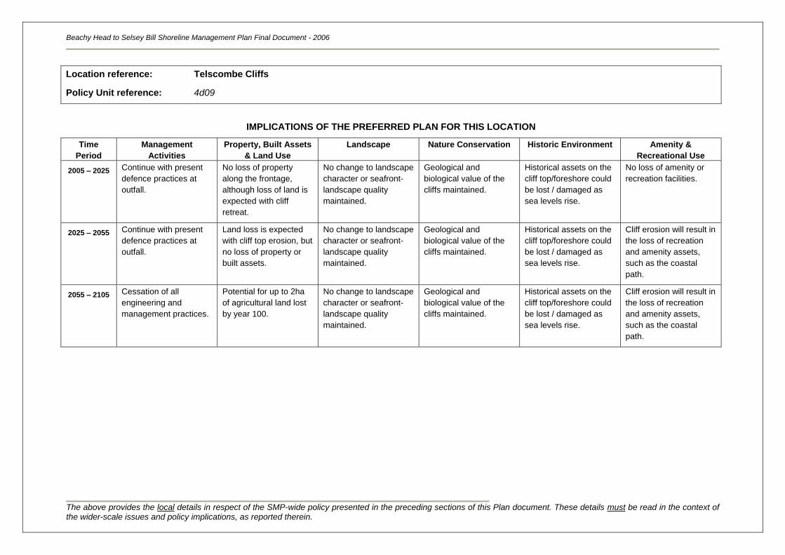
Beachy Head to Selsey Bill Shoreline Management Plan Final Document - 2006
The above provides the local details in respect of the SMP-wide policy presented in the preceding sections of this Plan document. These details must be read in the context of the wider-scale issues and policy implications, as reported therein.
Location reference:
Policy Unit reference:
Telscombe Cliffs
4d09
IMPLICATIONS OF THE PREFERRED PLAN FOR THIS LOCATION
Time
Period
Management
Activities
Property, Built Assets
& Land Use
Landscape Nature Conservation Historic Environment Amenity &
Recreational Use
2005 – 2025
Continue with present
defence practices at
outfall.
No loss of property
along the frontage,
although loss of land is
expected with cliff
retreat.
No change to landscape
character or seafront-
landscape quality
maintained.
Geological and
biological value of the
cliffs maintained.
Historical assets on the
cliff top/foreshore could
be lost / damaged as
sea levels rise.
No loss of amenity or
recreation facilities.
2025 – 2055 Continue with present
defence practices at
outfall.
Land loss is expected
with cliff top erosion, but
no loss of property or
built assets.
No change to landscape
character or seafront-
landscape quality
maintained.
Geological and
biological value of the
cliffs maintained.
Historical assets on the
cliff top/foreshore could
be lost / damaged as
sea levels rise.
Cliff erosion will result in
the loss of recreation
and amenity assets,
such as the coastal
path.
2055 – 2105 Cessation of all
engineering and
management practices.
Potential for up to 2ha
of agricultural land lost
by year 100.
No change to landscape
character or seafront-
landscape quality
maintained.
Geological and
biological value of the
cliffs maintained.
Historical assets on the
cliff top/foreshore could
be lost / damaged as
sea levels rise.
Cliff erosion will result in
the loss of recreation
and amenity assets,
such as the coastal
path.
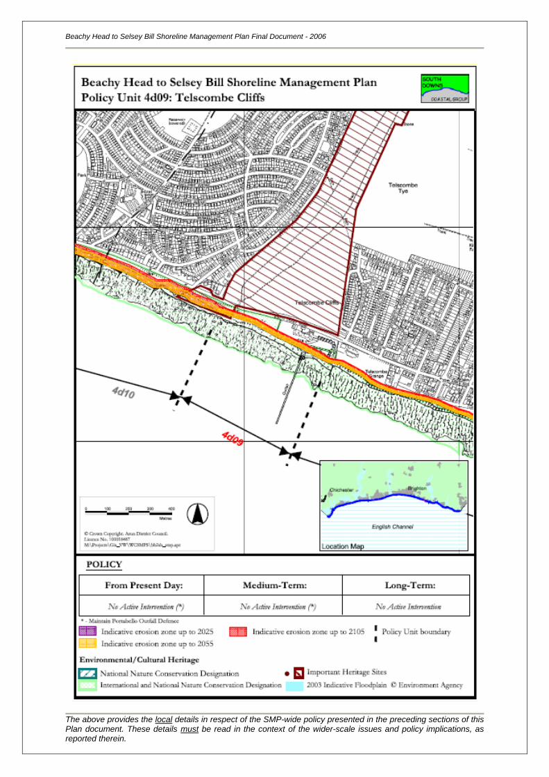
Beachy Head to Selsey Bill Shoreline Management Plan Final Document - 2006
The above provides the local details in respect of the SMP-wide policy presented in the preceding sections of this Plan document. These details must be read in the context of the wider-scale issues and policy implications, as reported therein.
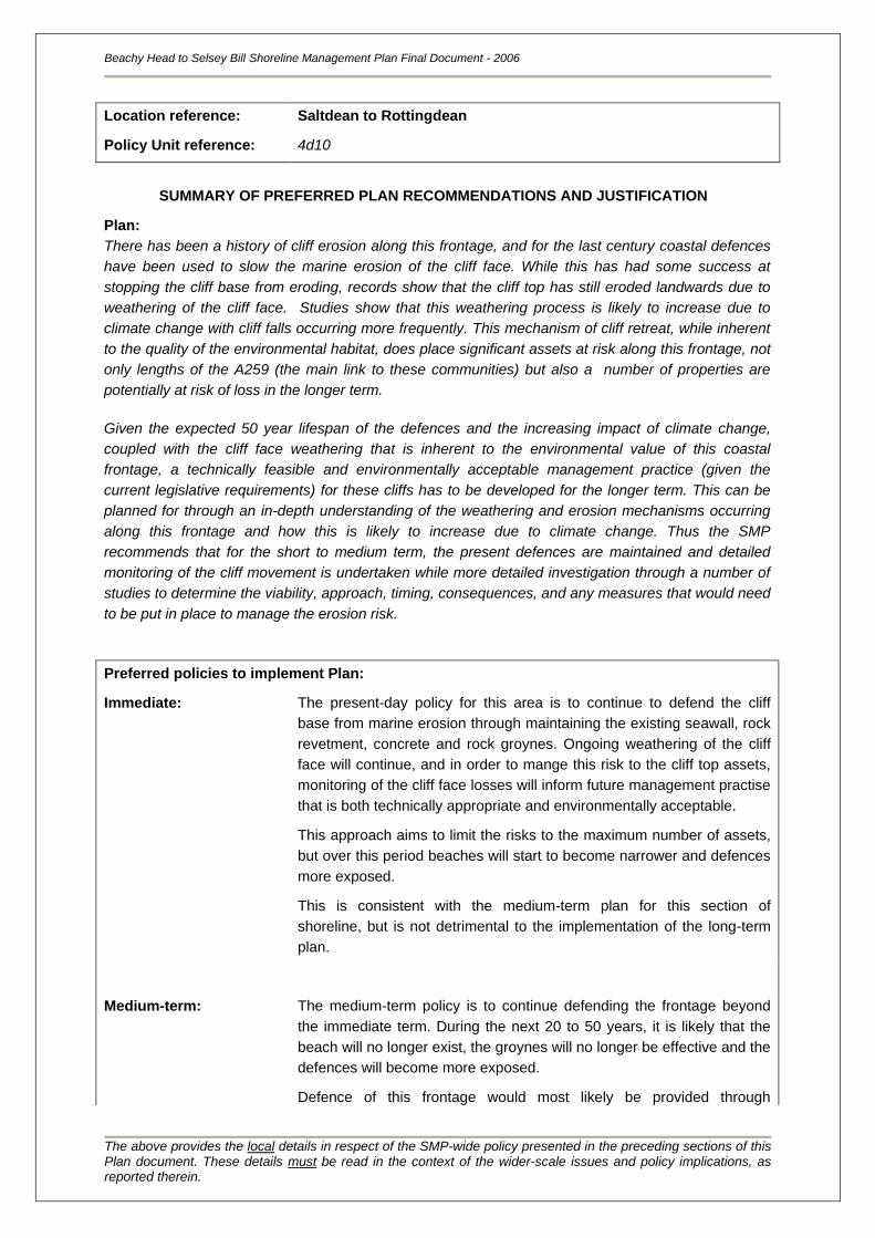
Location reference:
Policy Unit reference:
Saltdean to Rottingdean
4d10
SUMMARY OF PREFERRED PLAN RECOMMENDATIONS AND JUSTIFICATION
Plan:
There has been a history of cliff erosion along this frontage, and for the last century coastal defences
have been used to slow the marine erosion of the cliff face. While this has had some success at
stopping the cliff base from eroding, records show that the cliff top has still eroded landwards due to
weathering of the cliff face. Studies show that this weathering process is likely to increase due to
climate change with cliff falls occurring more frequently. This mechanism of cliff retreat, while inherent
to the quality of the environmental habitat, does place significant assets at risk along this frontage, not
only lengths of the A259 (the main link to these communities) but also a number of properties are
potentially at risk of loss in the longer term.
Given the expected 50 year lifespan of the defences and the increasing impact of climate change,
coupled with the cliff face weathering that is inherent to the environmental value of this coastal
frontage, a technically feasible and environmentally acceptable management practice (given the
current legislative requirements) for these cliffs has to be developed for the longer term. This can be
planned for through an in-depth understanding of the weathering and erosion mechanisms occurring
along this frontage and how this is likely to increase due to climate change. Thus the SMP
recommends that for the short to medium term, the present defences are maintained and detailed
monitoring of the cliff movement is undertaken while more detailed investigation through a number of
studies to determine the viability, approach, timing, consequences, and any measures that would need
to be put in place to manage the erosion risk.
Preferred policies to implement Plan:
Immediate: The present-day policy for this area is to continue to defend the cliff
base from marine erosion through maintaining the existing seawall, rock
revetment, concrete and rock groynes. Ongoing weathering of the cliff
face will continue, and in order to mange this risk to the cliff top assets,
monitoring of the cliff face losses will inform future management practise
that is both technically appropriate and environmentally acceptable.
This approach aims to limit the risks to the maximum number of assets,
but over this period beaches will start to become narrower and defences
more exposed.
This is consistent with the medium-term plan for this section of
shoreline, but is not detrimental to the implementation of the long-term
plan.
Medium-term: The medium-term policy is to continue defending the frontage beyond
the immediate term. During the next 20 to 50 years, it is likely that the
beach will no longer exist, the groynes will no longer be effective and the
defences will become more exposed.
Defence of this frontage would most likely be provided through
Beachy Head to Selsey Bill Shoreline Management Plan Final Document - 2006
The above provides the local details in respect of the SMP-wide policy presented in the preceding sections of this Plan document. These details must be read in the context of the wider-scale issues and policy implications, as reported therein.
maintaining and where necessary upgrading defences. This is
consistent with the medium-term plan for this section of shoreline.
Monitoring of the cliff face weathering will inform the longer term
management of the frontage.
Longer-term: The cliff face and base are important environmentally designated sites,
which require their continued exposure to natural weathering conditions.
However, the current defences located at the cliff base impact on part of
this process. There are significant assets at risk along this frontage and
pro active management based on the historical monitoring will allow
accurate predictions for the future cliff top erosion to be made and
inform plans for change in managing those erosion risks to the cliff top
assets. Properties may still be at risk of loss along the cliff top, in
addition to lengths of the A259, as the cliff top recedes. Further studies
will be required to inform on the extent and effect of this erosion.
Beachy Head to Selsey Bill Shoreline Management Plan Final Document - 2006
The above provides the local details in respect of the SMP-wide policy presented in the preceding sections of this Plan document. These details must be read in the context of the wider-scale issues and policy implications, as reported therein.
Location reference:
Policy Unit reference:
Saltdean to Rottingdean
4d10
IMPLICATIONS OF THE PREFERRED PLAN FOR THIS LOCATION
Time
Period
Management
Activities
Property, Built Assets
& Land Use
Landscape Nature Conservation Historic Environment Amenity &
Recreational Use
2005 – 2025
Continue with current
management practices.
No loss of property or
land behind the existing
defences.
No change to landscape
character or seafront.
No nature conservation
gains, although natural
habitat maintained.
No loss of heritage sites
landwards or seaward
of the defences.
No loss of community or
recreational facilities
landward of the
defences.
Beach width would
decline.
2025 – 2055 Continue with current
management practices.
No loss of property or
land behind the existing
defences.
No change to landscape
character or seafront.
No nature conservation
gains, although natural
habitat maintained.
Heritage assets on the
foreshore could be lost /
damaged (due to sea
level rise &
construction).
No loss of community or
recreational facilities
landward of the
defences.
Loss of beach,
compromising safe
access to the
promenade.
2055 – 2105 Monitor, manage and
review
Potential for increased
risk to property and
A259.
Without defences, the
seafront will be altered;
however there will be no
overall change to the
quality of the landscape.
Reactivation of cliff
erosion will affect the
geological and
biological value of the
habitats and
conservation areas.
Heritage assets on the
cliff top/foreshore could
be lost / damaged as
cliff erosion is reinstated
and sea levels rise.
Amenity and
recreational assets on
the cliff top/foreshore
could be lost / damaged
as cliff erosion is
reinstated and sea
levels rise.
Beachy Head to Selsey Bill Shoreline Management Plan Final Document - 2006
The above provides the local details in respect of the SMP-wide policy presented in the preceding sections of this Plan document. These details must be read in the context of the wider-scale issues and policy implications, as reported therein.
Location reference:
Policy Unit reference:
Rottingdean to Brighton Marina
4d11
SUMMARY OF PREFERRED PLAN RECOMMENDATIONS AND JUSTIFICATION
Plan:
In the short to medium term (the first 50 years) the SMP recommends holding the cliff base is the
more appropriate policy as managing and sustaining the existing defences will offer some protection to
those cliff top assets (roads, properties and services) at risk. However, given the expected 50 year
lifespan of the defences, coupled with the cliff face weathering mechanisms and impact of climate
change, a technically feasible and environmentally acceptable management practice for these cliffs
has to be developed for the longer term. Through appropriate monitoring of cliff top erosion
mechanisms, informed decisions can be made on how to manage those risks can be made.
Thus the SMP recommends that for the short to medium term, the present defences are maintained.
There should also be a detailed programme of monitoring and investigation so as to determine the
viability, approach, timing and consequences of any measures that would need to be put in place to
manage the erosion risk in the long term.
Preferred policies to implement Plan:
Immediate: The present-day policy for this area is to continue to defend the cliff
base through maintaining the existing seawall, rock revetment and
concrete/rock groynes.
This will limit cliff base erosion offering some protection to cliff top
assets, but over this period beaches will start to become narrower and
defences more exposed.
A detailed monitoring and reporting regime will inform on how and where
cliff face weathering is occurring and provide data upon which proactive
management practices can be developed that is both technically
appropriate and environmentally acceptable.
This is consistent with the long-term plan for this section of shoreline.
Medium-term: The medium-term policy is to continue defending and monitoring the
frontage beyond the immediate term. Defence of this frontage would
most likely be provided through maintaining and where necessary
upgrading new defences.
This is consistent with the medium-term plan for this section of
shoreline.
During the next 20 to 50 years, it is likely that the beach will no longer
exist and the defences would be even more exposed. This period will
instead be used to plan for future management of the cliff top alignment.
Longer-term: This length of relatively open frontage does have one major asset, the
A259 which is at risk from cliff top recession. There are also a mains and
gas sewer located within the cliffs and significant heritage features to the
Beachy Head to Selsey Bill Shoreline Management Plan Final Document - 2006
The above provides the local details in respect of the SMP-wide policy presented in the preceding sections of this Plan document. These details must be read in the context of the wider-scale issues and policy implications, as reported therein.
east of this „unit‟. Given the expected 50 year lifespan of the defences,
coupled with the cliff face weathering mechanisms and impact of climate
change, a view on replacing those defences or providing an alternative
form of cliff management that would meet the equally important
environmental objectives has to be considered. This could be achieved
in the long term, by managing the impact of cliff top recession on those
assets, while also maintaining important environmental assets. Further
studies will be required to inform on these issues.
Beachy Head to Selsey Bill Shoreline Management Plan Final Document - 2006
The above provides the local details in respect of the SMP-wide policy presented in the preceding sections of this Plan document. These details must be read in the context of the wider-scale issues and policy implications, as reported therein.
Location reference:
Policy Unit reference:
Rottingdean to Brighton Marina
4d11
IMPLICATIONS OF THE PREFERRED PLAN FOR THIS LOCATION
Time
Period
Management
Activities
Property, Built Assets
& Land Use
Landscape Nature Conservation Historic Environment Amenity &
Recreational Use
2005 – 2025
Continue with current
management practices.
No loss of property or
land behind the existing
defences. Reduced risk
to property and A259.
No change to landscape
character or seafront.
No nature conservation
gains, although natural
habitat maintained.
No loss of heritage sites
landwards or seaward
of the defences.
No loss of community or
recreational facilities
landward of the
defences.
Beach width would
decline.
2025 – 2055 Continue with current
management practices.
No loss of property or
land behind the existing
defences. Reduced risk
to property and A259.
No change to landscape
character or seafront.
No nature conservation
gains, although natural
habitat maintained.
Heritage assets on the
foreshore could be lost /
damaged (due to sea
level rise &
construction).
No loss of community or
recreational facilities
landward of the
defences. Loss of
beach, compromising
safe access to the
promenade.
2055 – 2105 Monitor, manage and
review approach.
Potential risk to property
and A259, Potential for
up to 10ha of
agricultural land loss by
year 2105.
Without defences, the
seafront will be altered;
however there will be no
overall change to the
quality of the landscape.
Reactivation of cliff
erosion will improve the
geological and
biological value of the
habitats and
conservation areas.
Heritage assets on the
cliff top/foreshore could
be lost / damaged as
cliff erosion is reinstated
and sea levels rise.
Amenity and
recreational assets on
the cliff top/foreshore
could be lost / damaged
as cliff erosion is
reinstated and sea
levels rise.
Beachy Head to Selsey Bill Shoreline Management Plan Final Document - 2006
The above provides the local details in respect of the SMP-wide policy presented in the preceding sections of this Plan document. These details must be read in the context of the wider-scale issues and policy implications, as reported therein.
Beachy Head to Selsey Bill Shoreline Management Plan Final Document - 2006
The above provides the local details in respect of the SMP-wide policy presented in the preceding sections of this Plan document. These details must be read in the context of the wider-scale issues and policy implications, as reported therein.
Location reference:
Policy Unit reference:
Brighton Marina to Portslade-by-Sea
4d12
SUMMARY OF PREFERRED PLAN RECOMMENDATIONS AND JUSTIFICATION
Plan:
The recommended long-term plan for Brighton Marina to Portslade-by-Sea is to continue to protect
assets within the towns along this frontage through holding the line, defending the present position;
the towns along this frontage are key tourist resorts and service centres for the sub region, providing a
range of facilities that support surrounding communities, whilst the marina is an important economic
and recreational facility for the local area. This policy is sustainable in the long-term as it protects an
area of high economic and environmental value. Low transport rates and limited linkages to adjacent
shorelines means that this policy is also technically sustainable.
Preferred policies to implement Plan:
Immediate: The present-day policy for this area is to continue to protect the town
frontage through maintaining the seawalls, rubble defences, rock
groynes, concrete groynes, timber groynes and bypassing/recyling; and
the Brighton Marina structures (breakwaters, sheet-piled walls, artificial
shingle beach).
This will protect the maximum number of assets, but over this period
beaches will start to become narrower and defences more exposed.
This is consistent with the long-term plan for this section of shoreline.
Medium-term: The medium-term policy is to continue defending the frontage beyond
the immediate term. Defence of this frontage would most likely be
provided through maintaining, upgrading and replacing structures, and
introducing beach recycling and renourishment to this coastline.
During the next 20 to 50 years, it is likely that a beach would remain as
long eroded material would be artificially replaced, although their
effectiveness may gradually reduce as sea levels rise.
This is consistent with the long-term plan for this section of shoreline.
Longer-term: The long-term policy is to continue defending the frontage. Defence of
this frontage would most likely be provided through maintaining,
replacing and upgrading seawall structures. Beach recycling and
renourishment would continue, as long as it remains technically feasible.
Beachy Head to Selsey Bill Shoreline Management Plan Final Document - 2006
The above provides the local details in respect of the SMP-wide policy presented in the preceding sections of this Plan document. These details must be read in the context of the wider-scale issues and policy implications, as reported therein.
Location reference:
Policy Unit reference:
Brighton Marina to Portslade-by-Sea
4d12
IMPLICATIONS OF THE PREFERRED PLAN FOR THIS LOCATION
Time
Period
Management
Activities
Property, Built Assets
& Land Use
Landscape Nature Conservation Historic Environment Amenity &
Recreational Use
2005 – 2025
Continue with current
management practices.
No loss of property or
land behind the existing
defences.
No change to landscape
character or seafront.
The existing habitats
are maintained.
No loss of heritage sites
landward of the
defences.
No loss of community or
recreational facilities
landwards of the
defences.
Some narrowing of the
beaches.
2025 – 2055 Continue with current
management practices.
No loss of property or
land behind the existing
defences.
No change to landscape
character or seafront.
The existing habitats
are maintained.
No loss of heritage sites
landward of the
defences.
No loss of community or
recreational facilities
landwards of the
defences.
Narrow beach.
2055 – 2105 Renewed defences. No loss of property,
however some land
behind the existing
defences may be
required for the
construction of renewed
defences.
No change to
landscape, although
potential change to
seafront as defences
are renewed.
The existing habitats
are maintained.
Increased engineering
has an adverse effect
on habitat development
and diversity
No loss of heritage sites
landward of the
defences.
Potential threat to
inshore archaeology as
defences are renewed.
No loss of community or
recreational facilities
landwards of the
defences, but potential
loss of promenade as
defences are renewed.
Reformation of a wider
beach.
Beachy Head to Selsey Bill Shoreline Management Plan Final Document - 2006
The above provides the local details in respect of the SMP-wide policy presented in the preceding sections of this Plan document. These details must be read in the context of the wider-scale issues and policy implications, as reported therein.
Beachy Head to Selsey Bill Shoreline Management Final Document - 2006
The above provides the local details in respect of the SMP-wide policy presented in the preceding sections of this Plan document. These details must be read in the context of the wider-scale issues and policy implications, as reported therein.
Location reference:
Policy Unit reference:
Shoreham Harbour (Southwick)
4d13
SUMMARY OF PREFERRED PLAN RECOMMENDATIONS AND JUSTIFICATION
Plan:
The recommended long-term plan for Shoreham Harbour (Southwick) is to continue to protect the
harbour and the assets that surround it through defending the present coastline position. The harbour
is a key commercial port and of high socio-economic importance. There are a high number of assets
surrounding the harbour including Shoreham Power Station, residential properties and recreational
facilities. This policy is considered to be sustainable in the long-term as it protects an area of high
commercial and economic value. It is recognised that it will only be technically sustainable if sediment
bypassing across the harbour entrance continues.
Preferred policies to implement Plan:
Immediate: The present-day policy for this area is to continue to protect the harbour
town frontage through maintaining the existing steel sheet-piled wall,
revetment, splash wall, east pier and eastern harbour breakwater (all at
the harbour entrance). Sediment bypassing across the harbour entrance
would continue.
This will protect the maximum number of assets, but over this period
beaches will start to become narrower and defences more exposed.
This is consistent with the long-term plan for this section of shoreline.
Medium-term: The medium-term policy is to continue defending the frontage beyond
the immediate term. Defence of this frontage would most likely be
provided through maintaining, replacing and upgrading structures and by
providing new defences between those existing to prevent embayments
occurring.
During the next 20 to 50 years, it is likely that a beach would continue to
narrow as sea levels rise and they become squeezed against the
defences behind. Defences may need to be raised or renewed (refer to
Section 2.6.2 for definition), which will be consistent with the long-term
plan for this section of shoreline.
Longer-term: The long-term policy is to continue defending the frontage. Defence of
this frontage would most likely be provided through maintaining,
replacing and upgrading the existing and renewed structures.
However, although this should continue to protect assets within the
town, the character of the frontage may however be changed from the
present day, with high seawalls and low beaches present in front of the
existing assets.
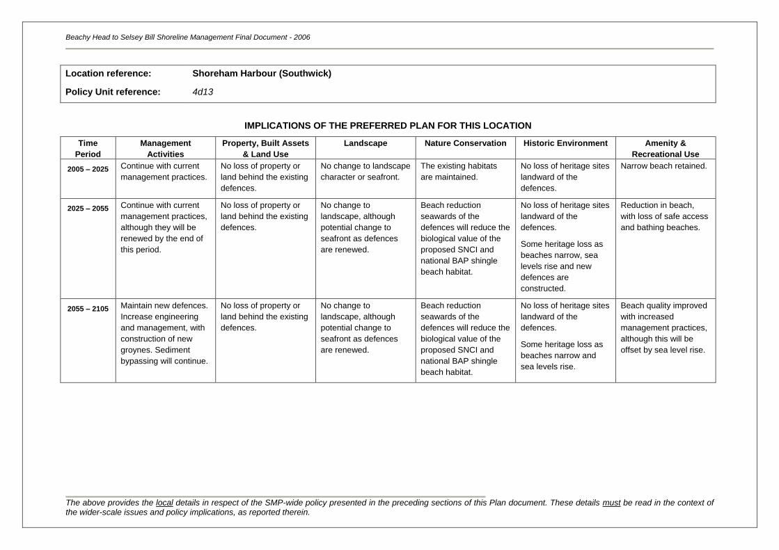
Beachy Head to Selsey Bill Shoreline Management Final Document - 2006
The above provides the local details in respect of the SMP-wide policy presented in the preceding sections of this Plan document. These details must be read in the context of the wider-scale issues and policy implications, as reported therein.
Location reference:
Policy Unit reference:
Shoreham Harbour (Southwick)
4d13
IMPLICATIONS OF THE PREFERRED PLAN FOR THIS LOCATION
Time
Period
Management
Activities
Property, Built Assets
& Land Use
Landscape Nature Conservation Historic Environment Amenity &
Recreational Use
2005 – 2025
Continue with current
management practices.
No loss of property or
land behind the existing
defences.
No change to landscape
character or seafront.
The existing habitats
are maintained.
No loss of heritage sites
landward of the
defences.
Narrow beach retained.
2025 – 2055 Continue with current
management practices,
although they will be
renewed by the end of
this period.
No loss of property or
land behind the existing
defences.
No change to
landscape, although
potential change to
seafront as defences
are renewed.
Beach reduction
seawards of the
defences will reduce the
biological value of the
proposed SNCI and
national BAP shingle
beach habitat.
No loss of heritage sites
landward of the
defences.
Some heritage loss as
beaches narrow, sea
levels rise and new
defences are
constructed.
Reduction in beach,
with loss of safe access
and bathing beaches.
2055 – 2105 Maintain new defences.
Increase engineering
and management, with
construction of new
groynes. Sediment
bypassing will continue.
No loss of property or
land behind the existing
defences.
No change to
landscape, although
potential change to
seafront as defences
are renewed.
Beach reduction
seawards of the
defences will reduce the
biological value of the
proposed SNCI and
national BAP shingle
beach habitat.
No loss of heritage sites
landward of the
defences.
Some heritage loss as
beaches narrow and
sea levels rise.
Beach quality improved
with increased
management practices,
although this will be
offset by sea level rise.
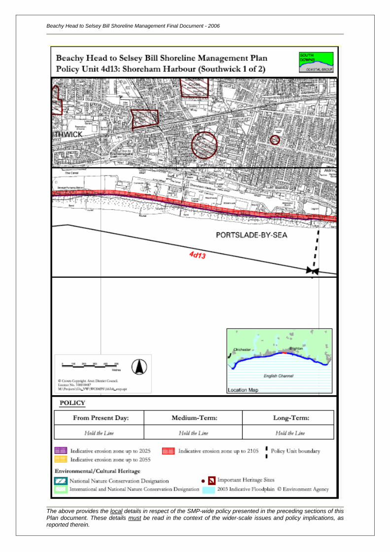
Beachy Head to Selsey Bill Shoreline Management Final Document - 2006
The above provides the local details in respect of the SMP-wide policy presented in the preceding sections of this Plan document. These details must be read in the context of the wider-scale issues and policy implications, as reported therein.
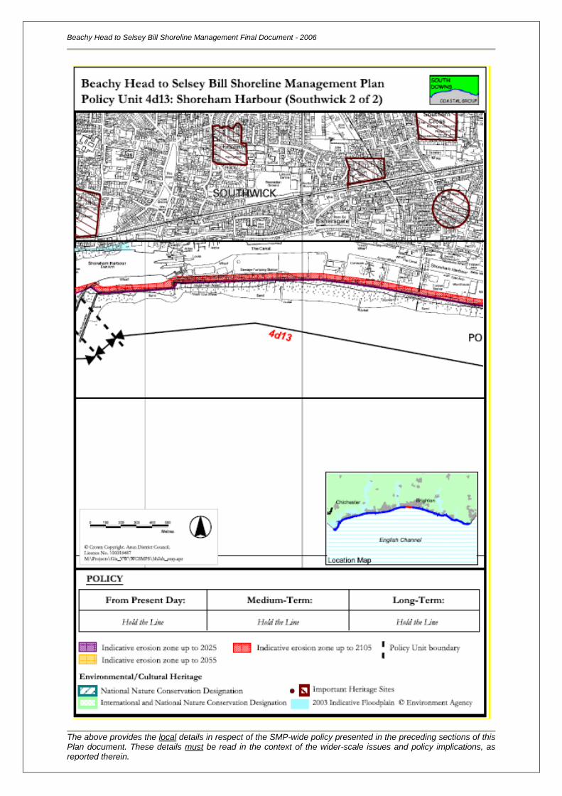
Location reference:
Policy Unit reference:
River Adur
4d14
SUMMARY OF PREFERRED PLAN RECOMMENDATIONS AND JUSTIFICATION
Plan:
The recommended long-term plan for the mouth of the River Adur is to continue to protect assets
through holding the line, defending the present position. Within the valley, there are a high number of
residential and commercial properties, and the towns along its length provide a range of facilities that
support the surrounding communities. The river and valley are of high environmental value and a key
tourist resort for the sub region. It is recognised that in order to achieve a sustainable coastline, these
assets will need to be protected at the cost of natural processes.
Preferred policies to implement Plan:
Immediate: The present-day policy for this area is to continue to protect the frontage
through maintaining the existing river walls and embankments.
This is consistent with the long-term plan for this section of shoreline.
Medium-term: The medium-term policy is to continue defending the frontage beyond
the immediate term. Defence of this frontage would most likely be
provided through maintaining existing river walls and embankments, and
upgrade them if required.
This is consistent with the long-term plan for this section of shoreline.
Longer-term: The long-term policy is to continue defending the frontage. Defence of
this frontage would most likely be provided through maintaining,
replacing and upgrading the river walls and embankments. Construction
of new defences would be required if it is no longer technically feasible
to maintain the existing defences.
Although this policy should continue to protect assets within the valley,
the character of the frontage may however be changed from the present
day, with new defences and low beaches present in from the towns.
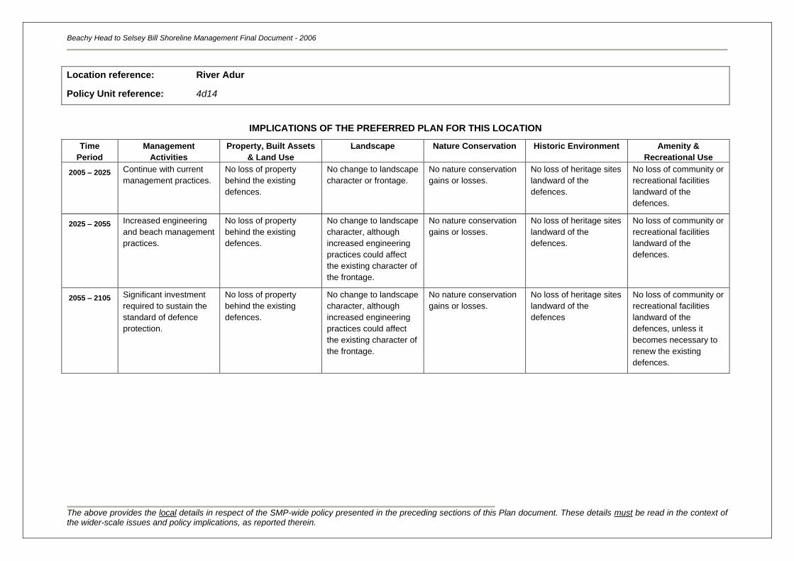
Beachy Head to Selsey Bill Shoreline Management Final Document - 2006
The above provides the local details in respect of the SMP-wide policy presented in the preceding sections of this Plan document. These details must be read in the context of the wider-scale issues and policy implications, as reported therein.
Location reference:
Policy Unit reference:
River Adur
4d14
IMPLICATIONS OF THE PREFERRED PLAN FOR THIS LOCATION
Time
Period
Management
Activities
Property, Built Assets
& Land Use
Landscape Nature Conservation Historic Environment Amenity &
Recreational Use
2005 – 2025
Continue with current
management practices.
No loss of property
behind the existing
defences.
No change to landscape
character or frontage.
No nature conservation
gains or losses.
No loss of heritage sites
landward of the
defences.
No loss of community or
recreational facilities
landward of the
defences.
2025 – 2055 Increased engineering
and beach management
practices.
No loss of property
behind the existing
defences.
No change to landscape
character, although
increased engineering
practices could affect
the existing character of
the frontage.
No nature conservation
gains or losses.
No loss of heritage sites
landward of the
defences.
No loss of community or
recreational facilities
landward of the
defences.
2055 – 2105 Significant investment
required to sustain the
standard of defence
protection.
No loss of property
behind the existing
defences.
No change to landscape
character, although
increased engineering
practices could affect
the existing character of
the frontage.
No nature conservation
gains or losses.
No loss of heritage sites
landward of the
defences
No loss of community or
recreational facilities
landward of the
defences, unless it
becomes necessary to
renew the existing
defences.
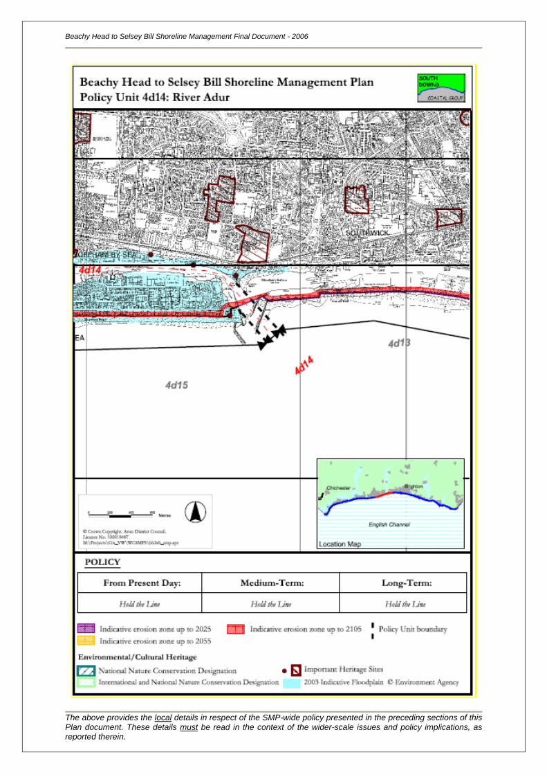
Beachy Head to Selsey Bill Shoreline Management Final Document - 2006
The above provides the local details in respect of the SMP-wide policy presented in the preceding sections of this Plan document. These details must be read in the context of the wider-scale issues and policy implications, as reported therein.
Location reference:
Policy Unit reference:
Shoreham Harbour to Worthing
4d15
SUMMARY OF PREFERRED PLAN RECOMMENDATIONS AND JUSTIFICATION
Plan:
The recommended long-term plan for Shoreham Harbour (River Adur) to Worthing is to continue to
protect assets along the frontage through holding the line, defending the present position. The urban
areas of Shoreham-by-Sea, Lancing and Sompting are key tourist resorts and service centres for the
sub region, providing a range of amenities and recreational facilities that support the surrounding
communities. The area also supports a high number of environmental and historical assets. This
policy is sustainable in the long-term as it protects an area of high economic and environmental value.
It is recognised that in order to achieve this, there would be minimal change to current management
practices, but there may be an alteration to the existing sediment transport links.
Preferred policies to implement Plan:
Immediate: The present-day policy for this area is to continue to protect the town
frontage through maintaining and upgrading the existing sections of
seawall, revetment breastwork and groynes. The western harbour
breakwater would also be maintained. Renourishment at Lancing and
bypassing across the harbour entrance would continue.
This will protect the maximum number of assets from both flood damage
and erosion loss, but over this period beaches will start to become
narrower and defences more exposed. This is consistent with the long-
term plan for this section of shoreline.
Medium-term: The medium-term policy is to continue defending the frontage beyond
the immediate term. Defence of this frontage would most likely be
provided through maintaining, replacing and upgrading structures.
During the next 20 to 50 years, it is likely that a beach would remain as
long as the groynes are maintained and replaced, although their
effectiveness will gradually reduce as sea levels rise and the beaches
narrow. Embayments could form between defended and undefended
sections of coastline. Beyond this, however, the groynes will eventually
become redundant and there will no longer be beaches in front of parts
of the town.
Longer-term: The long-term policy is to continue defending the frontage. Defence of
this frontage would most likely be provided by replacing the existing
structures, but at a renewed location; embayment formation would
cease and the coastline would return to a more linear form. The western
harbour breakwater or alternative terminal structure would be
maintained and renourishment at Lancing and bypassing across the
harbour entrance would continue.
Although this policy should continue to protect assets within the town,
Beachy Head to Selsey Bill Shoreline Management Final Document - 2006
The above provides the local details in respect of the SMP-wide policy presented in the preceding sections of this Plan document. These details must be read in the context of the wider-scale issues and policy implications, as reported therein.
the character of the frontage may however be changed from the present
day with low beaches present in front of the town. In addition the
characteristics of the saline Widewater lagoon may change due to
increased saline incursions.
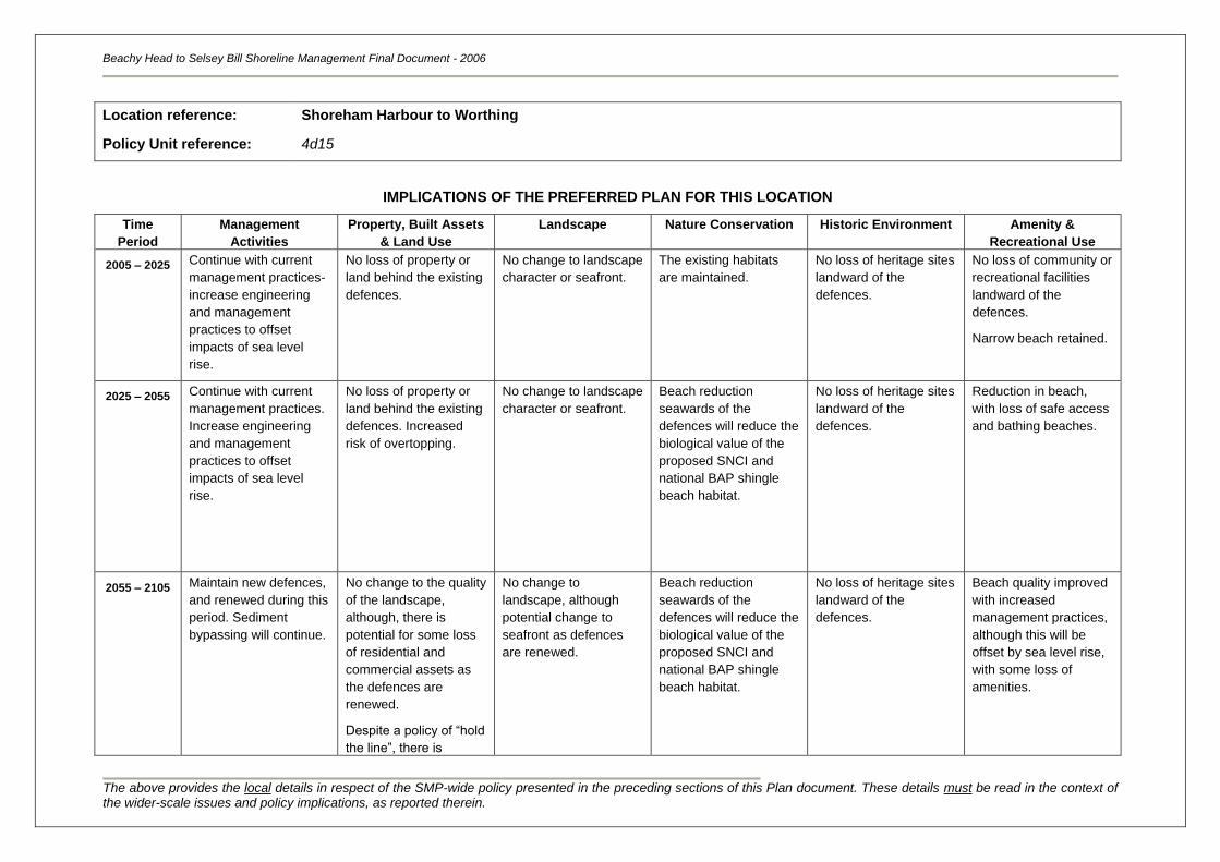
Beachy Head to Selsey Bill Shoreline Management Final Document - 2006
The above provides the local details in respect of the SMP-wide policy presented in the preceding sections of this Plan document. These details must be read in the context of the wider-scale issues and policy implications, as reported therein.
Location reference:
Policy Unit reference:
Shoreham Harbour to Worthing
4d15
IMPLICATIONS OF THE PREFERRED PLAN FOR THIS LOCATION
Time
Period
Management
Activities
Property, Built Assets
& Land Use
Landscape Nature Conservation Historic Environment Amenity &
Recreational Use
2005 – 2025
Continue with current
management practices-
increase engineering
and management
practices to offset
impacts of sea level
rise.
No loss of property or
land behind the existing
defences.
No change to landscape
character or seafront.
The existing habitats
are maintained.
No loss of heritage sites
landward of the
defences.
No loss of community or
recreational facilities
landward of the
defences.
Narrow beach retained.
2025 – 2055 Continue with current
management practices.
Increase engineering
and management
practices to offset
impacts of sea level
rise.
No loss of property or
land behind the existing
defences. Increased
risk of overtopping.
No change to landscape
character or seafront.
Beach reduction
seawards of the
defences will reduce the
biological value of the
proposed SNCI and
national BAP shingle
beach habitat.
No loss of heritage sites
landward of the
defences.
Reduction in beach,
with loss of safe access
and bathing beaches.
2055 – 2105 Maintain new defences,
and renewed during this
period. Sediment
bypassing will continue.
No change to the quality
of the landscape,
although, there is
potential for some loss
of residential and
commercial assets as
the defences are
renewed.
Despite a policy of “hold
the line”, there is
No change to
landscape, although
potential change to
seafront as defences
are renewed.
Beach reduction
seawards of the
defences will reduce the
biological value of the
proposed SNCI and
national BAP shingle
beach habitat.
No loss of heritage sites
landward of the
defences.
Beach quality improved
with increased
management practices,
although this will be
offset by sea level rise,
with some loss of
amenities.
Beachy Head to Selsey Bill Shoreline Management Final Document - 2006
The above provides the local details in respect of the SMP-wide policy presented in the preceding sections of this Plan document. These details must be read in the context of the wider-scale issues and policy implications, as reported therein.
potential for an
increased risk of
overtopping.
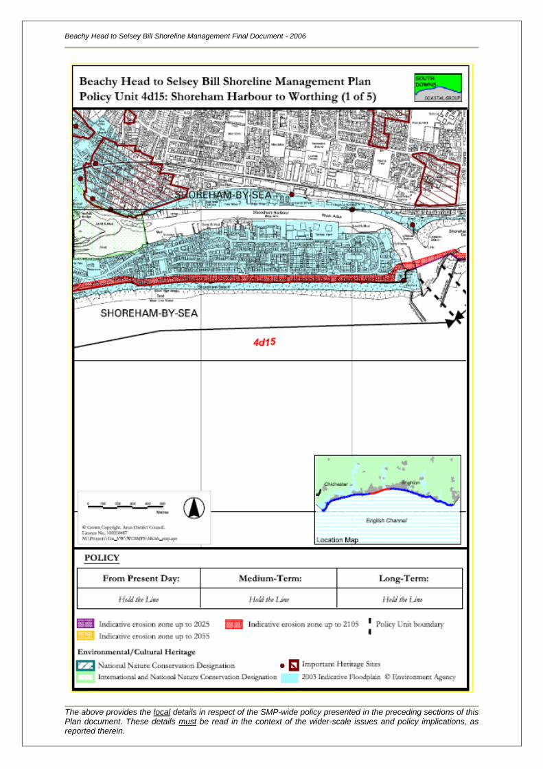
Beachy Head to Selsey Bill Shoreline Management Final Document - 2006
The above provides the local details in respect of the SMP-wide policy presented in the preceding sections of this Plan document. These details must be read in the context of the wider-scale issues and policy implications, as reported therein.
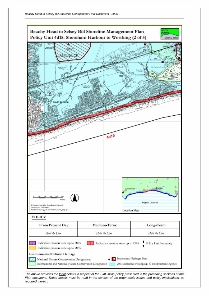
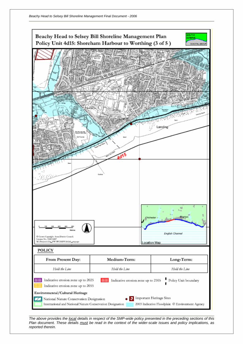
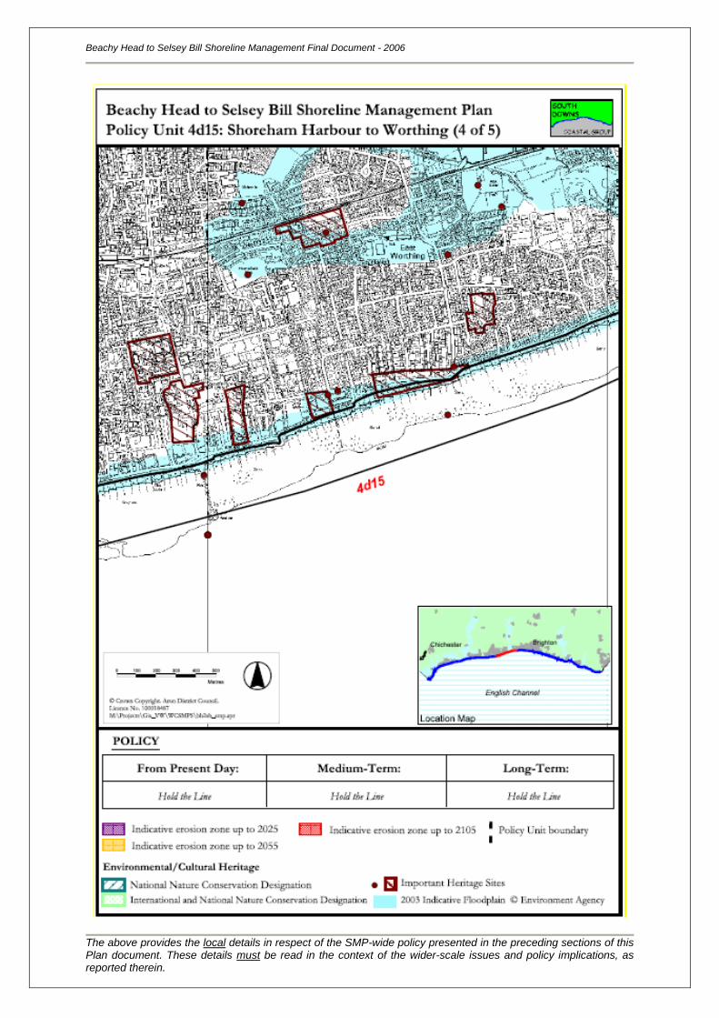
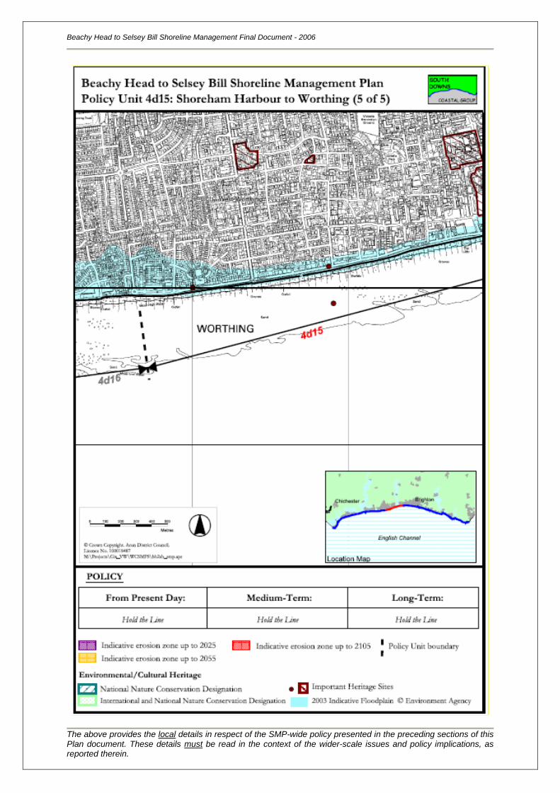
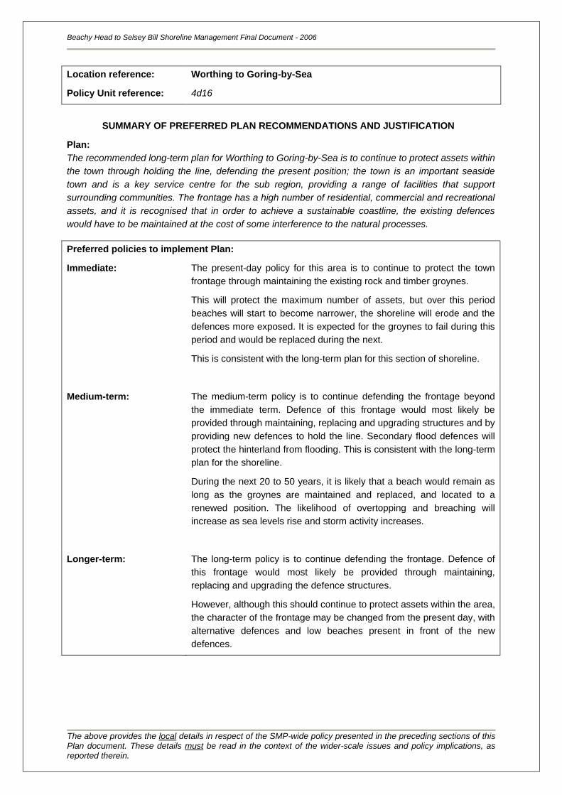
Location reference:
Policy Unit reference:
Worthing to Goring-by-Sea
4d16
SUMMARY OF PREFERRED PLAN RECOMMENDATIONS AND JUSTIFICATION
Plan:
The recommended long-term plan for Worthing to Goring-by-Sea is to continue to protect assets within
the town through holding the line, defending the present position; the town is an important seaside
town and is a key service centre for the sub region, providing a range of facilities that support
surrounding communities. The frontage has a high number of residential, commercial and recreational
assets, and it is recognised that in order to achieve a sustainable coastline, the existing defences
would have to be maintained at the cost of some interference to the natural processes.
Preferred policies to implement Plan:
Immediate: The present-day policy for this area is to continue to protect the town
frontage through maintaining the existing rock and timber groynes.
This will protect the maximum number of assets, but over this period
beaches will start to become narrower, the shoreline will erode and the
defences more exposed. It is expected for the groynes to fail during this
period and would be replaced during the next.
This is consistent with the long-term plan for this section of shoreline.
Medium-term: The medium-term policy is to continue defending the frontage beyond
the immediate term. Defence of this frontage would most likely be
provided through maintaining, replacing and upgrading structures and by
providing new defences to hold the line. Secondary flood defences will
protect the hinterland from flooding. This is consistent with the long-term
plan for the shoreline.
During the next 20 to 50 years, it is likely that a beach would remain as
long as the groynes are maintained and replaced, and located to a
renewed position. The likelihood of overtopping and breaching will
increase as sea levels rise and storm activity increases.
Longer-term: The long-term policy is to continue defending the frontage. Defence of
this frontage would most likely be provided through maintaining,
replacing and upgrading the defence structures.
However, although this should continue to protect assets within the area,
the character of the frontage may be changed from the present day, with
alternative defences and low beaches present in front of the new
defences.
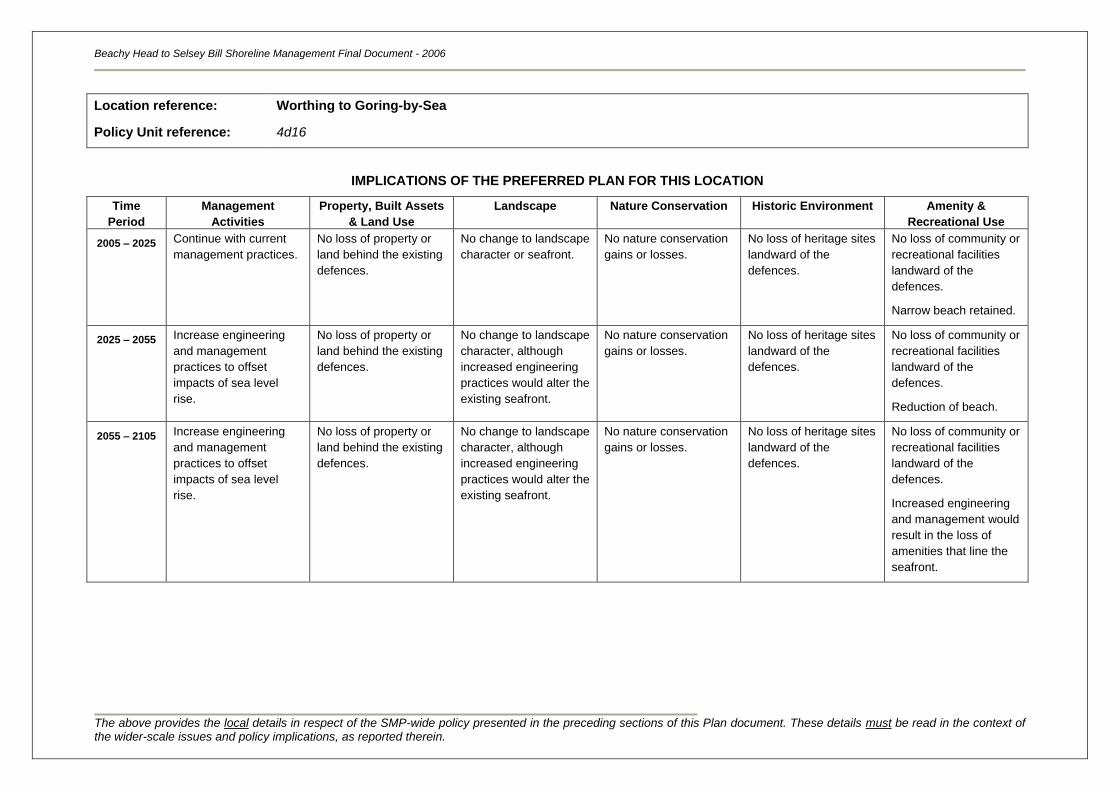
Beachy Head to Selsey Bill Shoreline Management Final Document - 2006
The above provides the local details in respect of the SMP-wide policy presented in the preceding sections of this Plan document. These details must be read in the context of the wider-scale issues and policy implications, as reported therein.
Location reference:
Policy Unit reference:
Worthing to Goring-by-Sea
4d16
IMPLICATIONS OF THE PREFERRED PLAN FOR THIS LOCATION
Time
Period
Management
Activities
Property, Built Assets
& Land Use
Landscape Nature Conservation Historic Environment Amenity &
Recreational Use
2005 – 2025
Continue with current
management practices.
No loss of property or
land behind the existing
defences.
No change to landscape
character or seafront.
No nature conservation
gains or losses.
No loss of heritage sites
landward of the
defences.
No loss of community or
recreational facilities
landward of the
defences.
Narrow beach retained.
2025 – 2055 Increase engineering
and management
practices to offset
impacts of sea level
rise.
No loss of property or
land behind the existing
defences.
No change to landscape
character, although
increased engineering
practices would alter the
existing seafront.
No nature conservation
gains or losses.
No loss of heritage sites
landward of the
defences.
No loss of community or
recreational facilities
landward of the
defences.
Reduction of beach.
2055 – 2105 Increase engineering
and management
practices to offset
impacts of sea level
rise.
No loss of property or
land behind the existing
defences.
No change to landscape
character, although
increased engineering
practices would alter the
existing seafront.
No nature conservation
gains or losses.
No loss of heritage sites
landward of the
defences.
No loss of community or
recreational facilities
landward of the
defences.
Increased engineering
and management would
result in the loss of
amenities that line the
seafront.
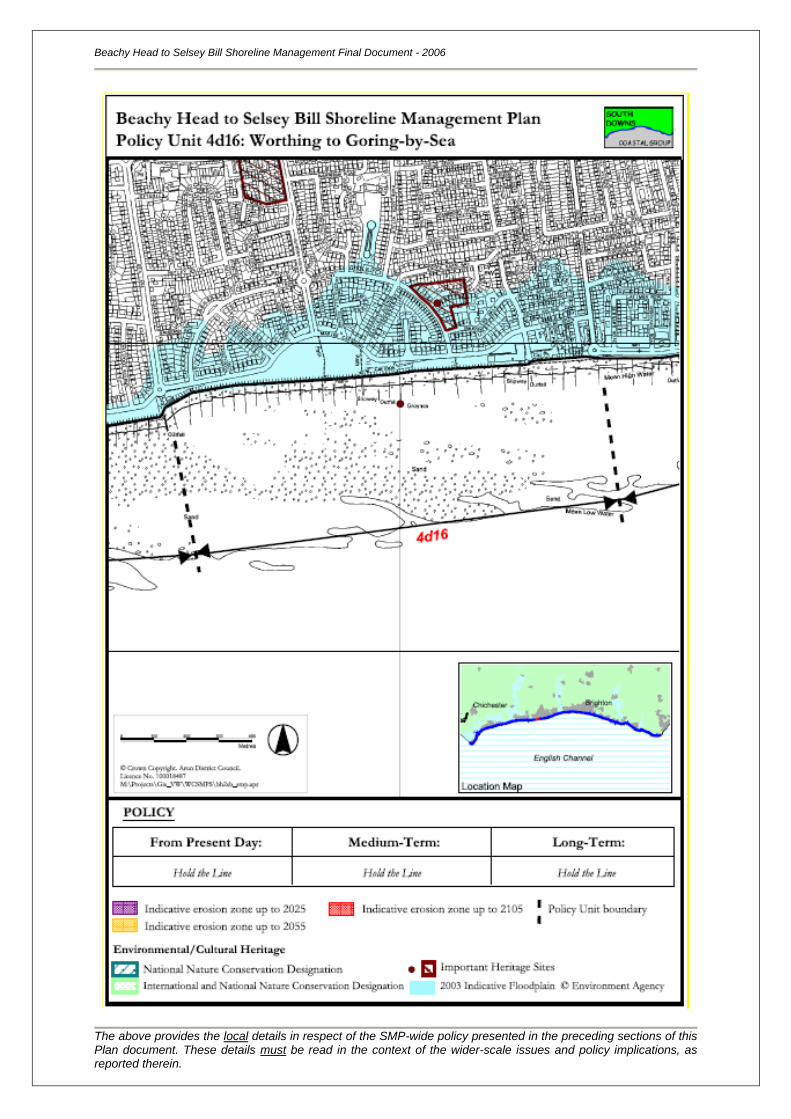
Beachy Head to Selsey Bill Shoreline Management Final Document - 2006
The above provides the local details in respect of the SMP-wide policy presented in the preceding sections of this Plan document. These details must be read in the context of the wider-scale issues and policy implications, as reported therein.
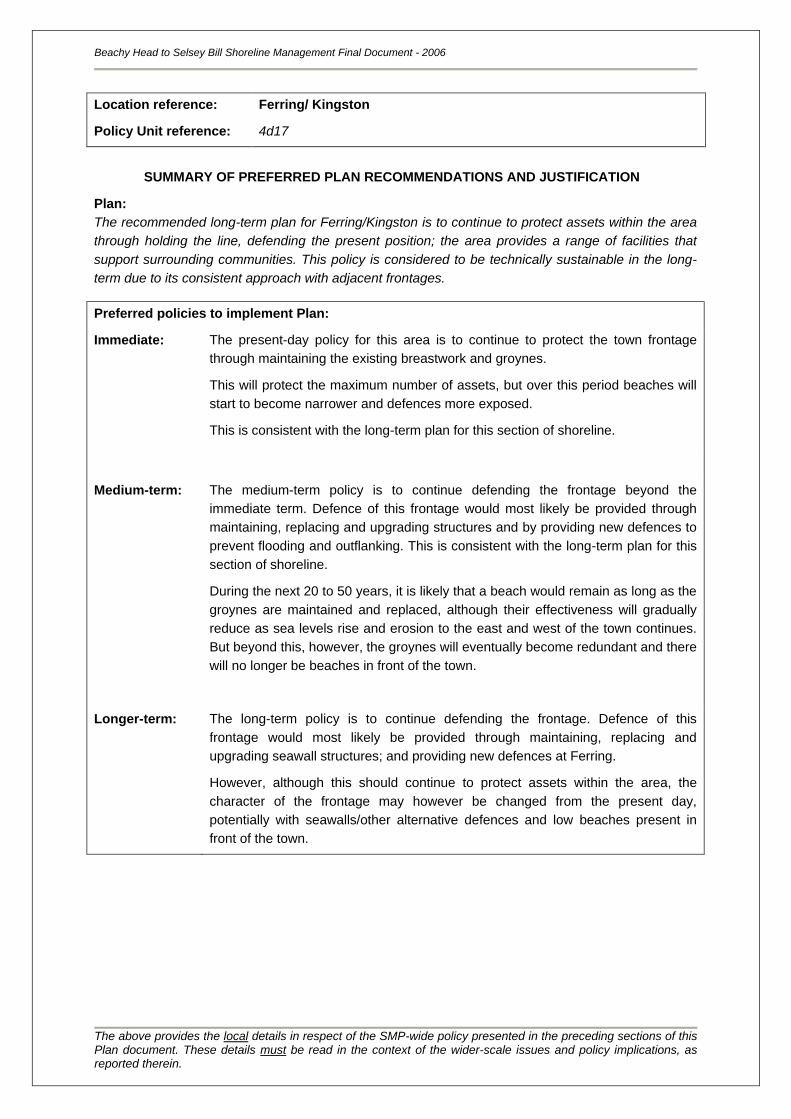
Location reference:
Policy Unit reference:
Ferring/ Kingston
4d17
SUMMARY OF PREFERRED PLAN RECOMMENDATIONS AND JUSTIFICATION
Plan:
The recommended long-term plan for Ferring/Kingston is to continue to protect assets within the area
through holding the line, defending the present position; the area provides a range of facilities that
support surrounding communities. This policy is considered to be technically sustainable in the long-
term due to its consistent approach with adjacent frontages.
Preferred policies to implement Plan:
Immediate: The present-day policy for this area is to continue to protect the town frontage
through maintaining the existing breastwork and groynes.
This will protect the maximum number of assets, but over this period beaches will
start to become narrower and defences more exposed.
This is consistent with the long-term plan for this section of shoreline.
Medium-term: The medium-term policy is to continue defending the frontage beyond the
immediate term. Defence of this frontage would most likely be provided through
maintaining, replacing and upgrading structures and by providing new defences to
prevent flooding and outflanking. This is consistent with the long-term plan for this
section of shoreline.
During the next 20 to 50 years, it is likely that a beach would remain as long as the
groynes are maintained and replaced, although their effectiveness will gradually
reduce as sea levels rise and erosion to the east and west of the town continues.
But beyond this, however, the groynes will eventually become redundant and there
will no longer be beaches in front of the town.
Longer-term: The long-term policy is to continue defending the frontage. Defence of this
frontage would most likely be provided through maintaining, replacing and
upgrading seawall structures; and providing new defences at Ferring.
However, although this should continue to protect assets within the area, the
character of the frontage may however be changed from the present day,
potentially with seawalls/other alternative defences and low beaches present in
front of the town.
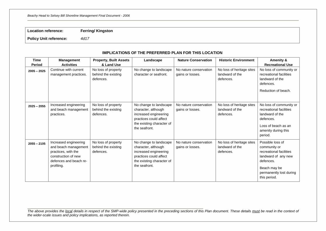
Beachy Head to Selsey Bill Shoreline Management Final Document - 2006
The above provides the local details in respect of the SMP-wide policy presented in the preceding sections of this Plan document. These details must be read in the context of the wider-scale issues and policy implications, as reported therein.
Location reference:
Policy Unit reference:
Ferring/ Kingston
4d17
IMPLICATIONS OF THE PREFERRED PLAN FOR THIS LOCATION
Time
Period
Management
Activities
Property, Built Assets
& Land Use
Landscape Nature Conservation Historic Environment Amenity &
Recreational Use
2005 – 2025
Continue with current
management practices.
No loss of property
behind the existing
defences.
No change to landscape
character or seafront.
No nature conservation
gains or losses.
No loss of heritage sites
landward of the
defences.
No loss of community or
recreational facilities
landward of the
defences.
Reduction of beach.
2025 – 2055 Increased engineering
and beach management
practices.
No loss of property
behind the existing
defences.
No change to landscape
character, although
increased engineering
practices could affect
the existing character of
the seafront.
No nature conservation
gains or losses.
No loss of heritage sites
landward of the
defences.
No loss of community or
recreational facilities
landward of the
defences.
Loss of beach as an
amenity during this
period.
2055 – 2105 Increased engineering
and beach management
practices, with the
construction of new
defences and beach re-
profiling.
No loss of property
behind the existing
defences.
No change to landscape
character, although
increased engineering
practices could affect
the existing character of
the seafront.
No nature conservation
gains or losses.
No loss of heritage sites
landward of the
defences.
Possible loss of
community or
recreational facilities
landward of any new
defences.
Beach may be
permanently lost during
this period.
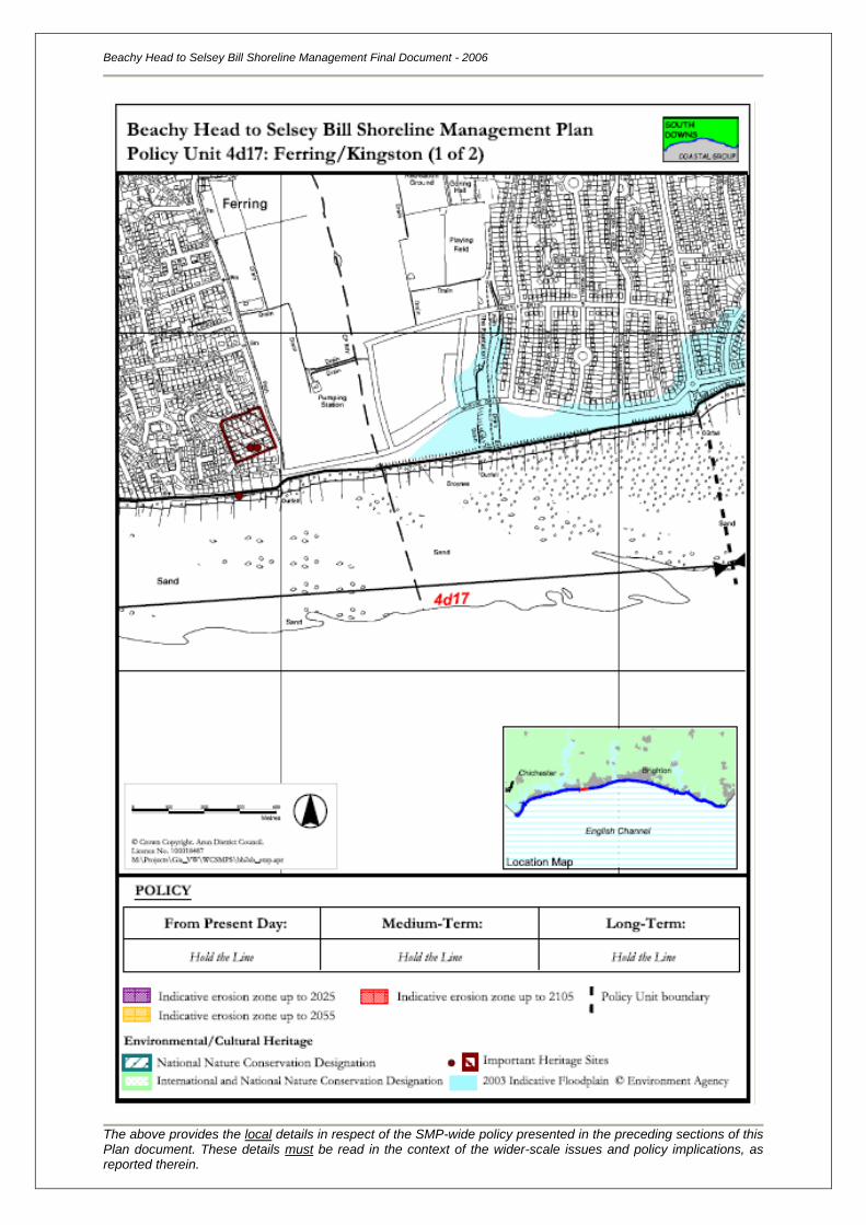
Beachy Head to Selsey Bill Shoreline Management Final Document - 2006
The above provides the local details in respect of the SMP-wide policy presented in the preceding sections of this Plan document. These details must be read in the context of the wider-scale issues and policy implications, as reported therein.
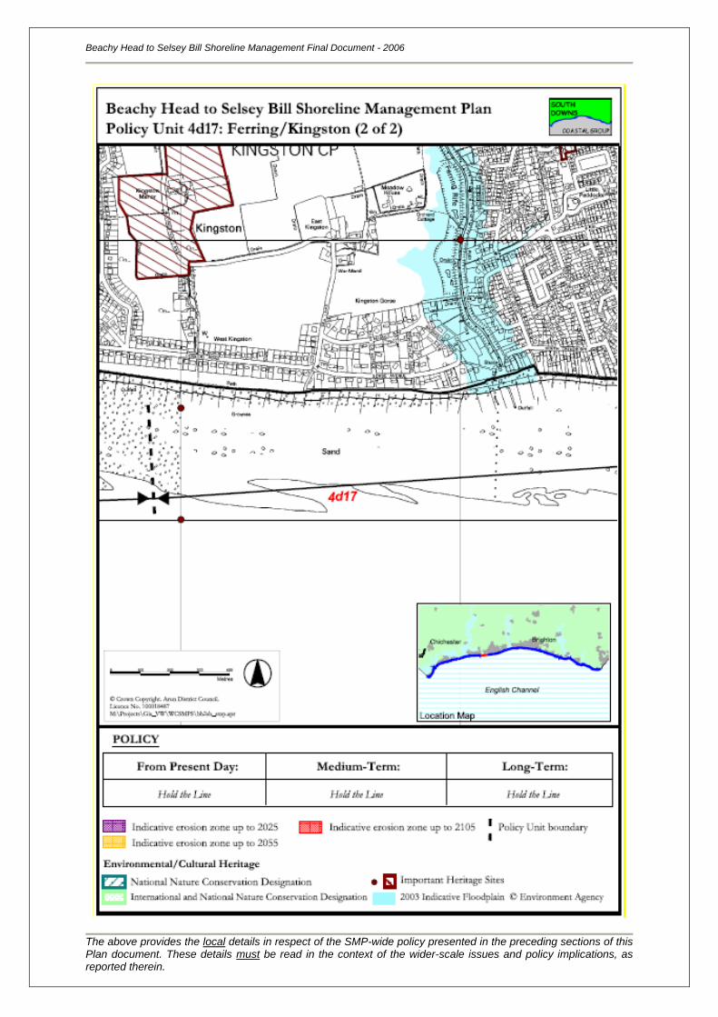
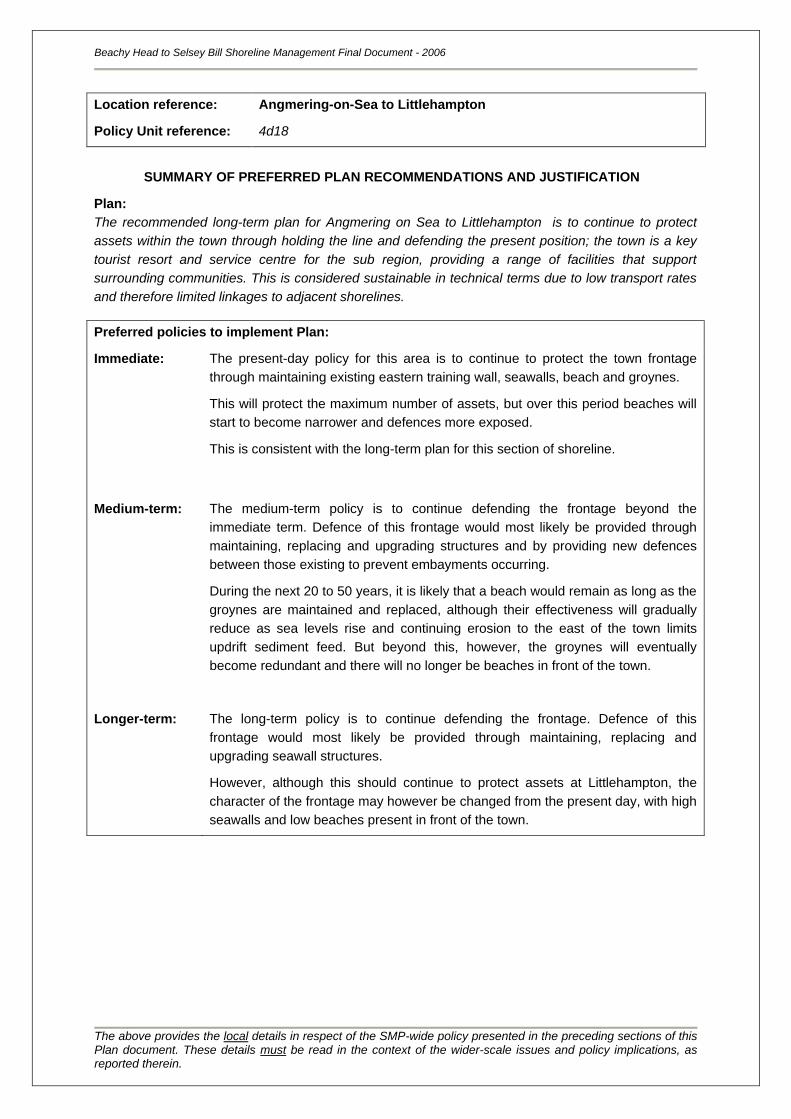
Location reference:
Policy Unit reference:
Angmering-on-Sea to Littlehampton
4d18
SUMMARY OF PREFERRED PLAN RECOMMENDATIONS AND JUSTIFICATION
Plan:
The recommended long-term plan for Angmering on Sea to Littlehampton is to continue to protect
assets within the town through holding the line and defending the present position; the town is a key
tourist resort and service centre for the sub region, providing a range of facilities that support
surrounding communities. This is considered sustainable in technical terms due to low transport rates
and therefore limited linkages to adjacent shorelines.
Preferred policies to implement Plan:
Immediate: The present-day policy for this area is to continue to protect the town frontage
through maintaining existing eastern training wall, seawalls, beach and groynes.
This will protect the maximum number of assets, but over this period beaches will
start to become narrower and defences more exposed.
This is consistent with the long-term plan for this section of shoreline.
Medium-term: The medium-term policy is to continue defending the frontage beyond the
immediate term. Defence of this frontage would most likely be provided through
maintaining, replacing and upgrading structures and by providing new defences
between those existing to prevent embayments occurring.
During the next 20 to 50 years, it is likely that a beach would remain as long as the
groynes are maintained and replaced, although their effectiveness will gradually
reduce as sea levels rise and continuing erosion to the east of the town limits
updrift sediment feed. But beyond this, however, the groynes will eventually
become redundant and there will no longer be beaches in front of the town.
Longer-term: The long-term policy is to continue defending the frontage. Defence of this
frontage would most likely be provided through maintaining, replacing and
upgrading seawall structures.
However, although this should continue to protect assets at Littlehampton, the
character of the frontage may however be changed from the present day, with high
seawalls and low beaches present in front of the town.
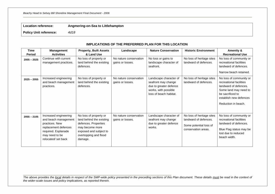
Beachy Head to Selsey Bill Shoreline Management Final Document - 2006
The above provides the local details in respect of the SMP-wide policy presented in the preceding sections of this Plan document. These details must be read in the context of the wider-scale issues and policy implications, as reported therein.
Location reference:
Policy Unit reference:
Angmering-on-Sea to Littlehampton
4d18
IMPLICATIONS OF THE PREFERRED PLAN FOR THIS LOCATION
Time
Period
Management
Activities
Property, Built Assets
& Land Use
Landscape Nature Conservation Historic Environment Amenity &
Recreational Use
2005 – 2025
Continue with current
management practices.
No loss of property or
land behind the existing
defences.
No nature conservation
gains or losses.
No loss or gains to
landscape character of
seafront.
No loss of heritage sites
landward of defences.
No loss of community or
recreational facilities
landward of defences.
Narrow beach retained.
2025 – 2055 Increased engineering
and beach management
practices.
No loss of property or
land behind the existing
defences.
No nature conservation
gains or losses.
Landscape character of
seafront may change
due to greater defence
works, with possible
loss of beach habitat.
No loss of heritage sites
landward of defences.
No loss of community or
recreational facilities
landward of defences.
Some land may need to
be sacrificed to
establish new defences
Reduction in beach.
2055 – 2105 Increased engineering
and beach management
practices. New
replacement defences
required. Esplanade
may need to be
relocated/ set back
No loss of property or
land behind the existing
defences. Properties
may become more
exposed and subject to
overtopping and flood
damage.
No nature conservation
gains or losses.
Landscape character of
seafront may change
due to greater defence
works.
No loss of heritage sites
landward of defences.
Some potential loss of
conservation areas.
No loss of community or
recreational facilities
landward of defences.
Blue Flag status may be
lost due to reduced
beach width.
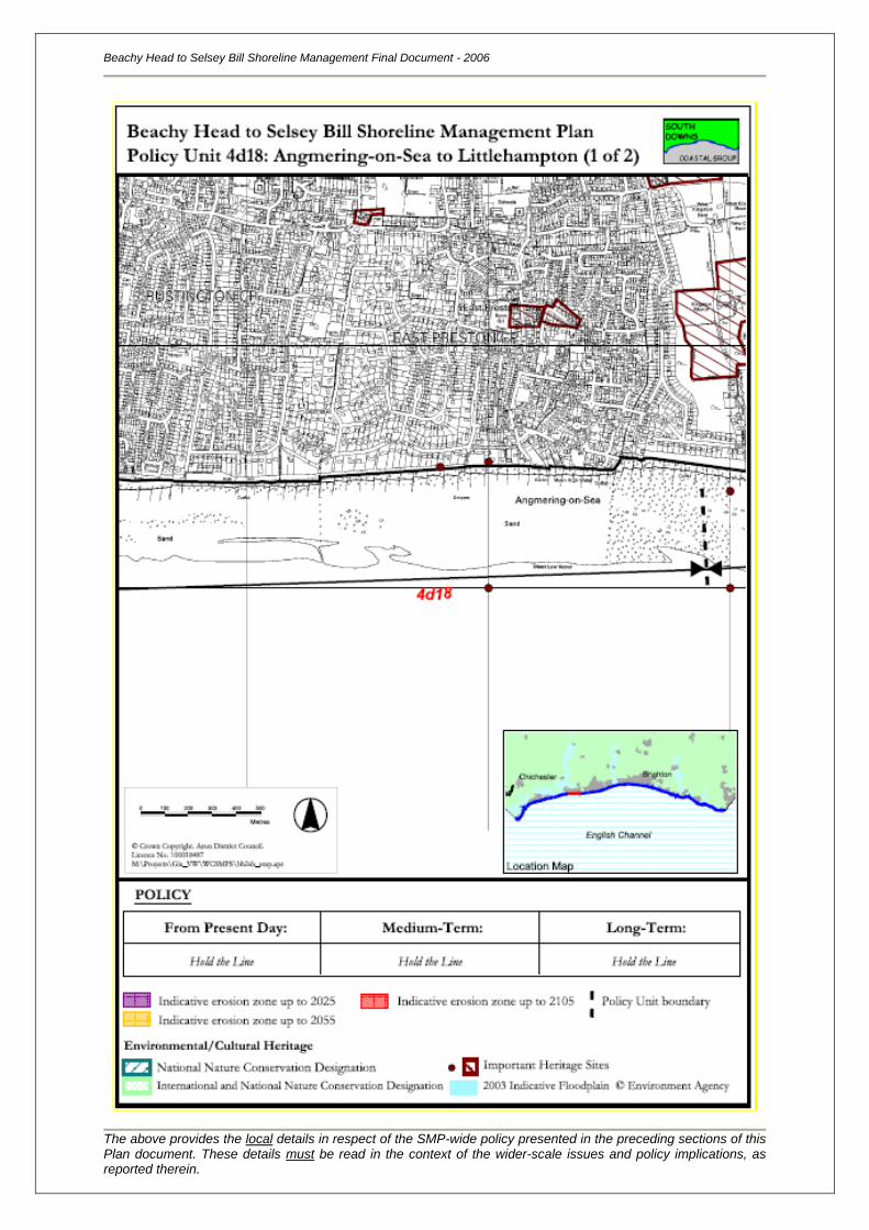
Beachy Head to Selsey Bill Shoreline Management Final Document - 2006
The above provides the local details in respect of the SMP-wide policy presented in the preceding sections of this Plan document. These details must be read in the context of the wider-scale issues and policy implications, as reported therein.
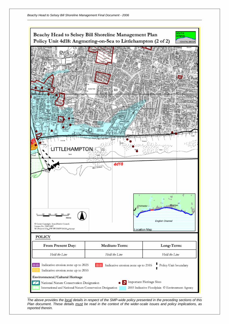
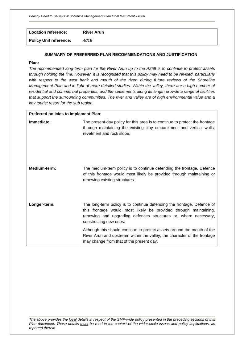
Beachy Head to Selsey Bill Shoreline Management Plan Final Document - 2006
The above provides the local details in respect of the SMP-wide policy presented in the preceding sections of this Plan document. These details must be read in the context of the wider-scale issues and policy implications, as reported therein.
Location reference:
Policy Unit reference:
River Arun
4d19
SUMMARY OF PREFERRED PLAN RECOMMENDATIONS AND JUSTIFICATION
Plan:
The recommended long-term plan for the River Arun up to the A259 is to continue to protect assets
through holding the line. However, it is recognised that this policy may need to be revised, particularly
with respect to the west bank and mouth of the river, during future reviews of the Shoreline
Management Plan and in light of more detailed studies. Within the valley, there are a high number of
residential and commercial properties, and the settlements along its length provide a range of facilities
that support the surrounding communities. The river and valley are of high environmental value and a
key tourist resort for the sub region.
Preferred policies to implement Plan:
Immediate: The present-day policy for this area is to continue to protect the frontage
through maintaining the existing clay embankment and vertical walls,
revetment and rock slope.
Medium-term: The medium-term policy is to continue defending the frontage. Defence
of this frontage would most likely be provided through maintaining or
renewing existing structures.
Longer-term: The long-term policy is to continue defending the frontage. Defence of
this frontage would most likely be provided through maintaining,
renewing and upgrading defences structures or, where necessary,
constructing new ones.
Although this should continue to protect assets around the mouth of the
River Arun and upstream within the valley, the character of the frontage
may change from that of the present day.
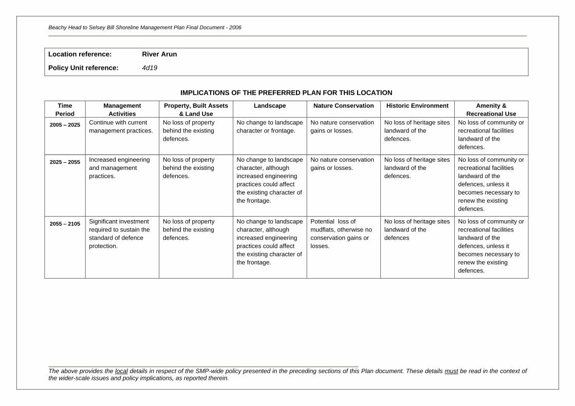
Beachy Head to Selsey Bill Shoreline Management Plan Final Document - 2006
The above provides the local details in respect of the SMP-wide policy presented in the preceding sections of this Plan document. These details must be read in the context of the wider-scale issues and policy implications, as reported therein.
Location reference:
Policy Unit reference:
River Arun
4d19
IMPLICATIONS OF THE PREFERRED PLAN FOR THIS LOCATION
Time
Period
Management
Activities
Property, Built Assets
& Land Use
Landscape Nature Conservation Historic Environment Amenity &
Recreational Use
2005 – 2025
Continue with current
management practices.
No loss of property
behind the existing
defences.
No change to landscape
character or frontage.
No nature conservation
gains or losses.
No loss of heritage sites
landward of the
defences.
No loss of community or
recreational facilities
landward of the
defences.
2025 – 2055 Increased engineering
and management
practices.
No loss of property
behind the existing
defences.
No change to landscape
character, although
increased engineering
practices could affect
the existing character of
the frontage.
No nature conservation
gains or losses.
No loss of heritage sites
landward of the
defences.
No loss of community or
recreational facilities
landward of the
defences, unless it
becomes necessary to
renew the existing
defences.
2055 – 2105 Significant investment
required to sustain the
standard of defence
protection.
No loss of property
behind the existing
defences.
No change to landscape
character, although
increased engineering
practices could affect
the existing character of
the frontage.
Potential loss of
mudflats, otherwise no
conservation gains or
losses.
No loss of heritage sites
landward of the
defences
No loss of community or
recreational facilities
landward of the
defences, unless it
becomes necessary to
renew the existing
defences.
Beachy Head to Selsey Bill Shoreline Management Plan Final Document - 2006
The above provides the local details in respect of the SMP-wide policy presented in the preceding sections of this Plan document. These details must be read in the context of the wider-scale issues and policy implications, as reported therein.
Location reference:
Policy Unit reference:
Littlehampton Harbour to Poole Place
4d20
SUMMARY OF PREFERRED PLAN RECOMMENDATIONS AND JUSTIFICATION
Plan:
The recommended long-term plan for Littlehampton Harbour to Poole Place is to allow the coastline to
realign to a more naturally functioning system, whilst continuing to provide flood defence to the large
hinterland floodplain. The area behind the dunes/defences is naturally low-lying, and is of high
environmental importance; there are a few properties immediately behind the dunes/defences,
including one isolated property at Poole Place. There are also some link roads to isolated buildings,
but otherwise the land is agricultural. However, the low-lying area extends to the residential
settlements of Climping, Littlehampton (west bank of the River Arun) and Ford, resulting in an
extensive floodplain. The harbour is an important asset, both for the local economy and recreation. It
is recognised that this section of coastline provides an opportunity for environmental enhancements
and this could be achieved through a managed realignment policy and a more naturally functioning
coastline. This policy is considered to be sustainable in the long-term, but on the basis that overall
flood defence is maintained to the large floodplain, whilst also adhering to the requirements to
conserve the SSSI. Implementation of this policy may be affected by legal agreements on part of this
frontage.
Preferred policies to implement Plan:
Immediate: The present-day policy for this area is to begin to realign the coastline
landwards in a proactive manner. This may be achieved by either
reconfiguring the primary defences to create a number of larger, swash-
aligned bays, or allowing the existing primary defences to roll back/fail
and the shoreline to erode whilst maintaining flood defence to the
hinterland by constructing secondary defences. The coastline will be
fixed in position to the east and west in accordance the policies for those
adjacent Policy Units. A new linear defence/flood embankment may
need to be constructed at Poole Place to prevent erosion and
outflanking of the flood defences at Elmer. Periodic recycling or
renourishment of the beach may be required. As the coastline realigns,
intertidal habitat will develop through the natural roll back/breaching of
the shingle beach and through dune rollback east of Climping. The exact
nature of shoreline response and the managed realignment works to be
implemented will be the subject of further studies.
This is consistent with the long-term plan for this section of shoreline,
and will help with its implementation throughout the medium term.
Medium-term: The medium-term policy is to continue to realign the coastline, but in a
managed way. The reconfigured primary defences or secondary
defences will require maintenance. Periodic recycling or renourishment
of the beach may be required. The aim of this policy is to work towards
achieving a more naturally functioning coastline. The coastline will be
fixed at its eastern and western ends as described above. As the
shoreline realigns the intertidal habitat will develop further.
Beachy Head to Selsey Bill Shoreline Management Plan Final Document - 2006
The above provides the local details in respect of the SMP-wide policy presented in the preceding sections of this Plan document. These details must be read in the context of the wider-scale issues and policy implications, as reported therein.
Longer-term: The long-term policy is to continue to realign the coastline, but in a
managed way. The reconfigured primary defences or secondary
defences will require maintenance. Periodic recycling or renourishment
of the beach may be required. As in the medium term, the coastline will
be fixed at its eastern and western ends, but will principally be free
functioning in between. It is expected that the intertidal habitat will be
well-established.
Beachy Head to Selsey Bill Shoreline Management Plan Final Document - 2006
The above provides the local details in respect of the SMP-wide policy presented in the preceding sections of this Plan document. These details must be read in the context of the wider-scale issues and policy implications, as reported therein.
Location reference:
Policy Unit reference:
Littlehampton Harbour to Poole Place
4d20
IMPLICATIONS OF THE PREFERRED PLAN FOR THIS LOCATION
Time
Period
Management
Activities
Property, Built Assets
& Land Use
Landscape Nature Conservation Historic Environment Amenity &
Recreational Use
2005 – 2025
Reconfigure the primary
defences along the
frontage or allow the
primary defences to roll-
back/fail and construct
new secondary
defences to promote
realignment of the
shore. If necessary,
construct a new access
road to The Mill and a
new flood
embankment/defence at
Poole Place to prevent
outflanking of defences
to the west. Periodic
recycling or
renourishment of the
beach may be required.
Implementation of this
policy may be affected
by legal agreements
covering part of this
frontage.
There is a risk of
flooding to property at
Atherington and
flooding/erosion of land.
No change to landscape
character, although a
switch in management
practices may alter the
balance of terrestrial to
intertidal habitat along
the frontage.
Potential loss of sand
dunes, but return to a
more free-functioning
coastal system, which
should maintain the
biological value as
SSSI, SNCI, LNR and
national (vegetated
shingle) or local (sand
dune) BAP habitats.
No loss of heritage sites
landward of defences.
No loss of community,
but may be some loss
of recreational facilities.
2025 – 2055 Maintain reconfigured
primary/secondary
defences. Periodic
recycling or
There is a risk of
flooding to property at
Atherington and
flooding/erosion of land.
No change to landscape
character, although a
switch in management
practices may alter the
Potential loss of sand
dunes, but return to a
more free-functioning
coastal system, which
No loss of heritage sites
landward of defences.
No loss of community,
but may be some loss
of recreational facilities.
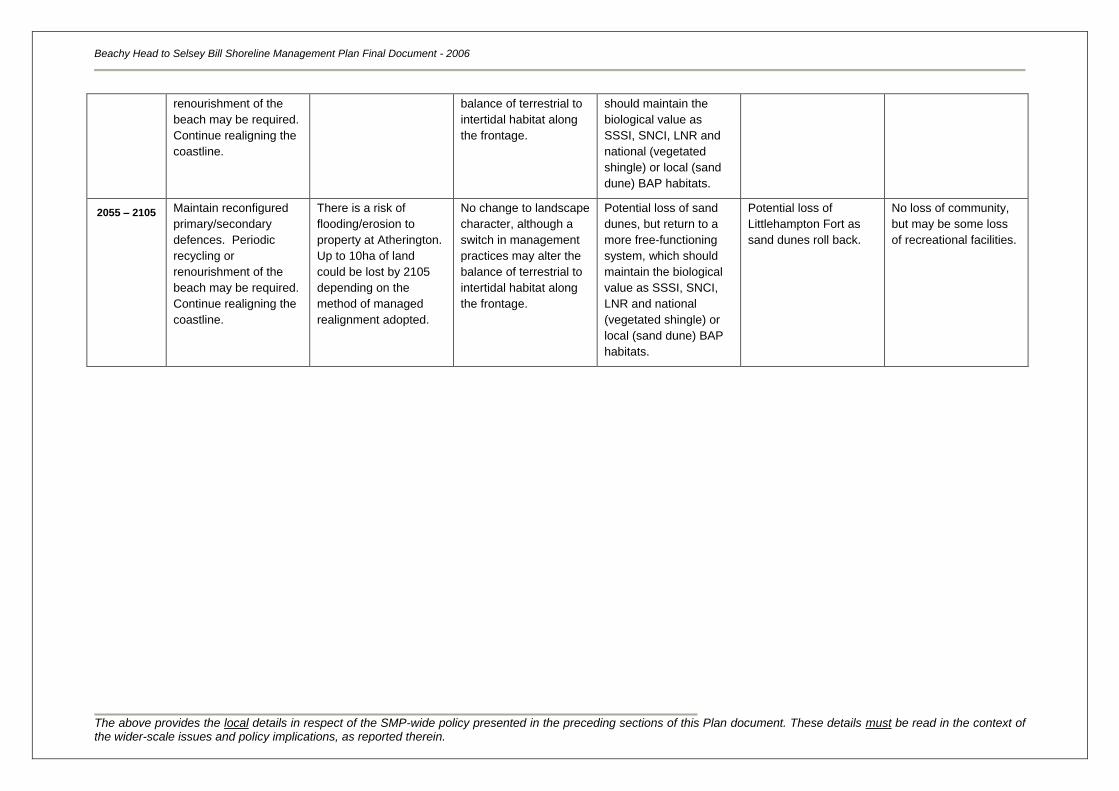
Beachy Head to Selsey Bill Shoreline Management Plan Final Document - 2006
The above provides the local details in respect of the SMP-wide policy presented in the preceding sections of this Plan document. These details must be read in the context of the wider-scale issues and policy implications, as reported therein.
renourishment of the
beach may be required.
Continue realigning the
coastline.
balance of terrestrial to
intertidal habitat along
the frontage.
should maintain the
biological value as
SSSI, SNCI, LNR and
national (vegetated
shingle) or local (sand
dune) BAP habitats.
2055 – 2105 Maintain reconfigured
primary/secondary
defences. Periodic
recycling or
renourishment of the
beach may be required.
Continue realigning the
coastline.
There is a risk of
flooding/erosion to
property at Atherington.
Up to 10ha of land
could be lost by 2105
depending on the
method of managed
realignment adopted.
No change to landscape
character, although a
switch in management
practices may alter the
balance of terrestrial to
intertidal habitat along
the frontage.
Potential loss of sand
dunes, but return to a
more free-functioning
system, which should
maintain the biological
value as SSSI, SNCI,
LNR and national
(vegetated shingle) or
local (sand dune) BAP
habitats.
Potential loss of
Littlehampton Fort as
sand dunes roll back.
No loss of community,
but may be some loss
of recreational facilities.
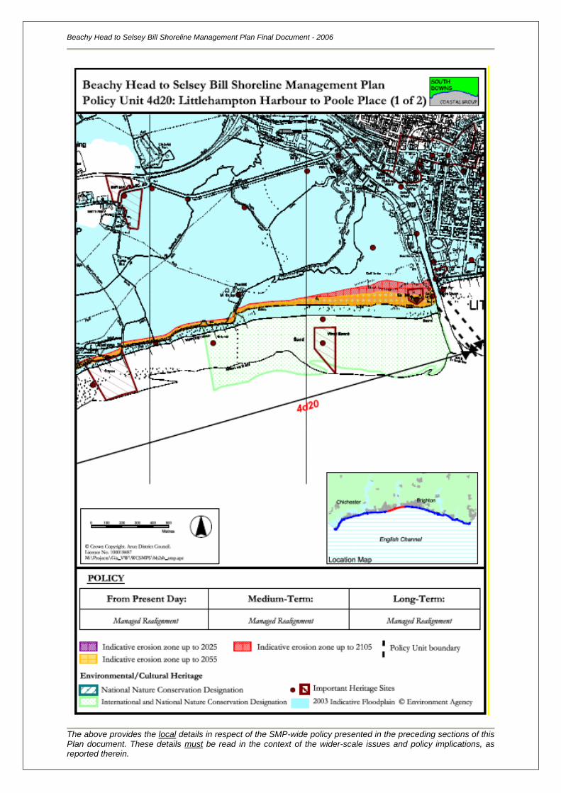
Beachy Head to Selsey Bill Shoreline Management Plan Final Document - 2006
The above provides the local details in respect of the SMP-wide policy presented in the preceding sections of this Plan document. These details must be read in the context of the wider-scale issues and policy implications, as reported therein.
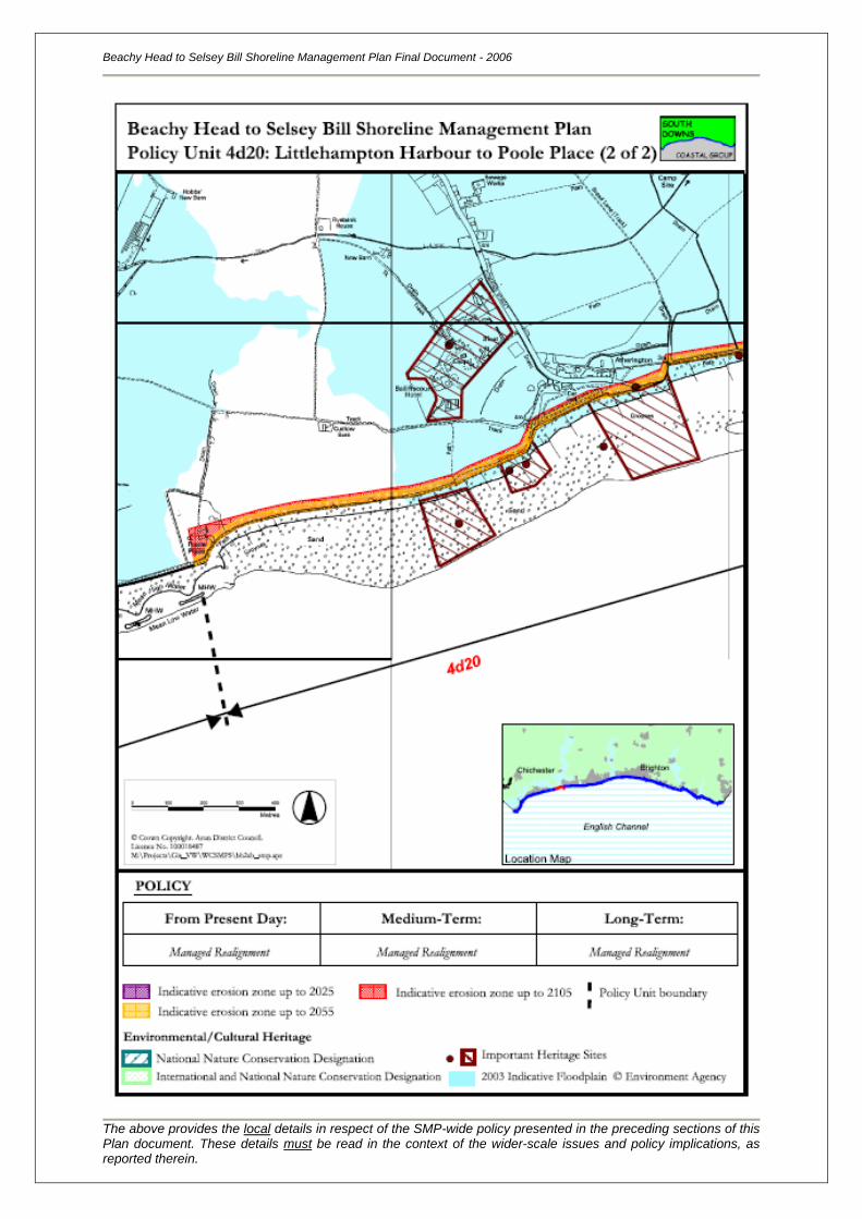
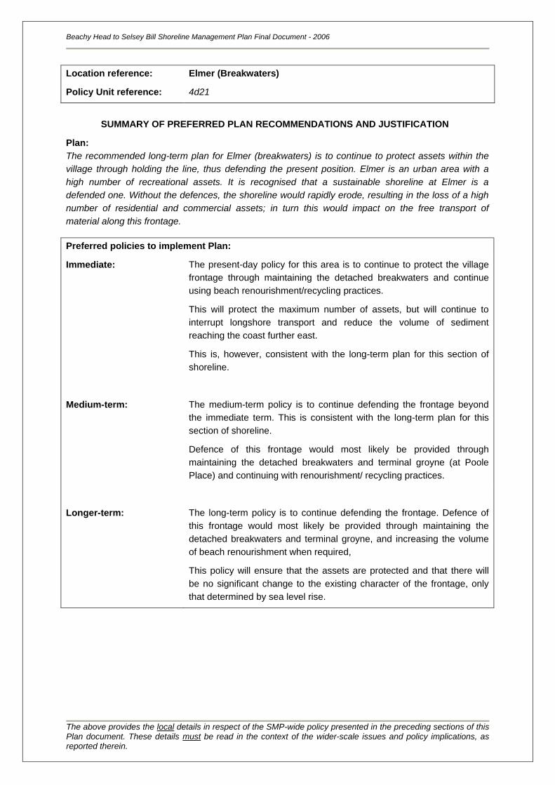
Location reference:
Policy Unit reference:
Elmer (Breakwaters)
4d21
SUMMARY OF PREFERRED PLAN RECOMMENDATIONS AND JUSTIFICATION
Plan:
The recommended long-term plan for Elmer (breakwaters) is to continue to protect assets within the
village through holding the line, thus defending the present position. Elmer is an urban area with a
high number of recreational assets. It is recognised that a sustainable shoreline at Elmer is a
defended one. Without the defences, the shoreline would rapidly erode, resulting in the loss of a high
number of residential and commercial assets; in turn this would impact on the free transport of
material along this frontage.
Preferred policies to implement Plan:
Immediate: The present-day policy for this area is to continue to protect the village
frontage through maintaining the detached breakwaters and continue
using beach renourishment/recycling practices.
This will protect the maximum number of assets, but will continue to
interrupt longshore transport and reduce the volume of sediment
reaching the coast further east.
This is, however, consistent with the long-term plan for this section of
shoreline.
Medium-term: The medium-term policy is to continue defending the frontage beyond
the immediate term. This is consistent with the long-term plan for this
section of shoreline.
Defence of this frontage would most likely be provided through
maintaining the detached breakwaters and terminal groyne (at Poole
Place) and continuing with renourishment/ recycling practices.
Longer-term: The long-term policy is to continue defending the frontage. Defence of
this frontage would most likely be provided through maintaining the
detached breakwaters and terminal groyne, and increasing the volume
of beach renourishment when required,
This policy will ensure that the assets are protected and that there will
be no significant change to the existing character of the frontage, only
that determined by sea level rise.
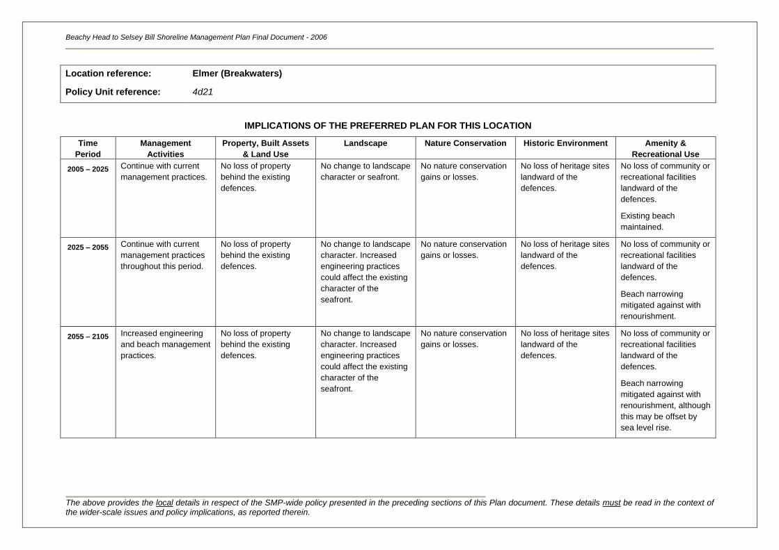
Beachy Head to Selsey Bill Shoreline Management Plan Final Document - 2006
The above provides the local details in respect of the SMP-wide policy presented in the preceding sections of this Plan document. These details must be read in the context of the wider-scale issues and policy implications, as reported therein.
Location reference:
Policy Unit reference:
Elmer (Breakwaters)
4d21
IMPLICATIONS OF THE PREFERRED PLAN FOR THIS LOCATION
Time
Period
Management
Activities
Property, Built Assets
& Land Use
Landscape Nature Conservation Historic Environment Amenity &
Recreational Use
2005 – 2025
Continue with current
management practices.
No loss of property
behind the existing
defences.
No change to landscape
character or seafront.
No nature conservation
gains or losses.
No loss of heritage sites
landward of the
defences.
No loss of community or
recreational facilities
landward of the
defences.
Existing beach
maintained.
2025 – 2055 Continue with current
management practices
throughout this period.
No loss of property
behind the existing
defences.
No change to landscape
character. Increased
engineering practices
could affect the existing
character of the
seafront.
No nature conservation
gains or losses.
No loss of heritage sites
landward of the
defences.
No loss of community or
recreational facilities
landward of the
defences.
Beach narrowing
mitigated against with
renourishment.
2055 – 2105 Increased engineering
and beach management
practices.
No loss of property
behind the existing
defences.
No change to landscape
character. Increased
engineering practices
could affect the existing
character of the
seafront.
No nature conservation
gains or losses.
No loss of heritage sites
landward of the
defences.
No loss of community or
recreational facilities
landward of the
defences.
Beach narrowing
mitigated against with
renourishment, although
this may be offset by
sea level rise.
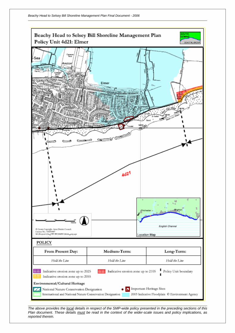
Beachy Head to Selsey Bill Shoreline Management Plan Final Document - 2006
The above provides the local details in respect of the SMP-wide policy presented in the preceding sections of this Plan document. These details must be read in the context of the wider-scale issues and policy implications, as reported therein.
Location reference:
Policy Unit reference:
Middleton-on-Sea
4d22
SUMMARY OF PREFERRED PLAN RECOMMENDATIONS AND JUSTIFICATION
Plan:
The recommended long-term plan for Middleton-on-Sea (Southdean) to Middleton-on-Sea (west) is to
continue to protect assets within the village through holding the line. Middleton-on-Sea is an urban
area, with a high density of residential properties and a large-scale infrastructure network, as well as
an abundance of recreational assets. The village provides a range of facilities that support surrounding
communities; and this policy is therefore considered sustainable in socio-economic terms.
Preferred policies to implement Plan:
Immediate: The present-day policy for this area is to continue to maintain the
shoreline in its present position. The seawall and timber groynes would
function adequately throughout this period, protecting the frontage and
the maximum number of assets. This policy is consistent with the long-
term plan of Hold the Line.
Medium-term: The medium-term policy is to continue defending the frontage beyond
the immediate term. Defence of this frontage would most likely be
provided through maintaining, replacing and upgrading the seawall and
groynes, although new structures may be required to prevent beach loss
at Middleton Point.
This will affect the existing character of the coastline, but will protect the
assets of Middleton, which is compliant with the long-term policy for this
coastline.
Longer-term: The long-term policy is to continue to maintain the present shoreline
position by defending the frontage. This will be achieved through
maintenance and upgrading of the existing seawall, and by constructing
renewed defences, including a seawall and groynes, at Middleton Point.
The character of this frontage will change over the longer term, with a
switch to a coastline that is dominated by hard defences. It will become
increasingly difficult to maintain a beach in front of the seawall as sea
levels rise and there is insufficient sediment supply to maintain the
beaches. Despite the loss of amenity beaches, this policy is considered
to be sustainable both due to the value of the assets at risk to erosion
and flooding, and due to the limited impact on the sediment transport
regime at this location.
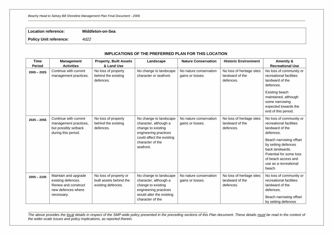
Beachy Head to Selsey Bill Shoreline Management Plan Final Document - 2006
The above provides the local details in respect of the SMP-wide policy presented in the preceding sections of this Plan document. These details must be read in the context of the wider-scale issues and policy implications, as reported therein.
Location reference:
Policy Unit reference:
Middleton-on-Sea
4d22
IMPLICATIONS OF THE PREFERRED PLAN FOR THIS LOCATION
Time
Period
Management
Activities
Property, Built Assets
& Land Use
Landscape Nature Conservation Historic Environment Amenity &
Recreational Use
2005 – 2025
Continue with current
management practices.
No loss of property
behind the existing
defences.
No change to landscape
character or seafront.
No nature conservation
gains or losses.
No loss of heritage sites
landward of the
defences.
No loss of community or
recreational facilities
landward of the
defences.
Existing beach
maintained, although
some narrowing
expected towards the
end of this period.
2025 – 2055 Continue with current
management practices,
but possibly setback
during this period.
No loss of property
behind the existing
defences.
No change to landscape
character, although a
change to existing
engineering practices
could affect the existing
character of the
seafront.
No nature conservation
gains or losses.
No loss of heritage sites
landward of the
defences.
No loss of community or
recreational facilities
landward of the
defences.
Beach narrowing offset
by setting defences
back landwards.
Potential for some loss
of beach access and
use as a recreational
beach.
2055 – 2105 Maintain and upgrade
existing defences.
Renew and construct
new defences where
necessary.
No loss of property or
built assets behind the
existing defences.
No change to landscape
character, although a
change to existing
engineering practices
would alter the existing
character of the
No nature conservation
gains or losses.
No loss of heritage sites
landward of the
defences.
No loss of community or
recreational facilities
landward of the
defences.
Beach narrowing offset
by setting defences
Beachy Head to Selsey Bill Shoreline Management Plan Final Document - 2006
The above provides the local details in respect of the SMP-wide policy presented in the preceding sections of this Plan document. These details must be read in the context of the wider-scale issues and policy implications, as reported therein.
seafront. back landwards.
Potential for some loss
of beach access and
use as a recreational
beach.
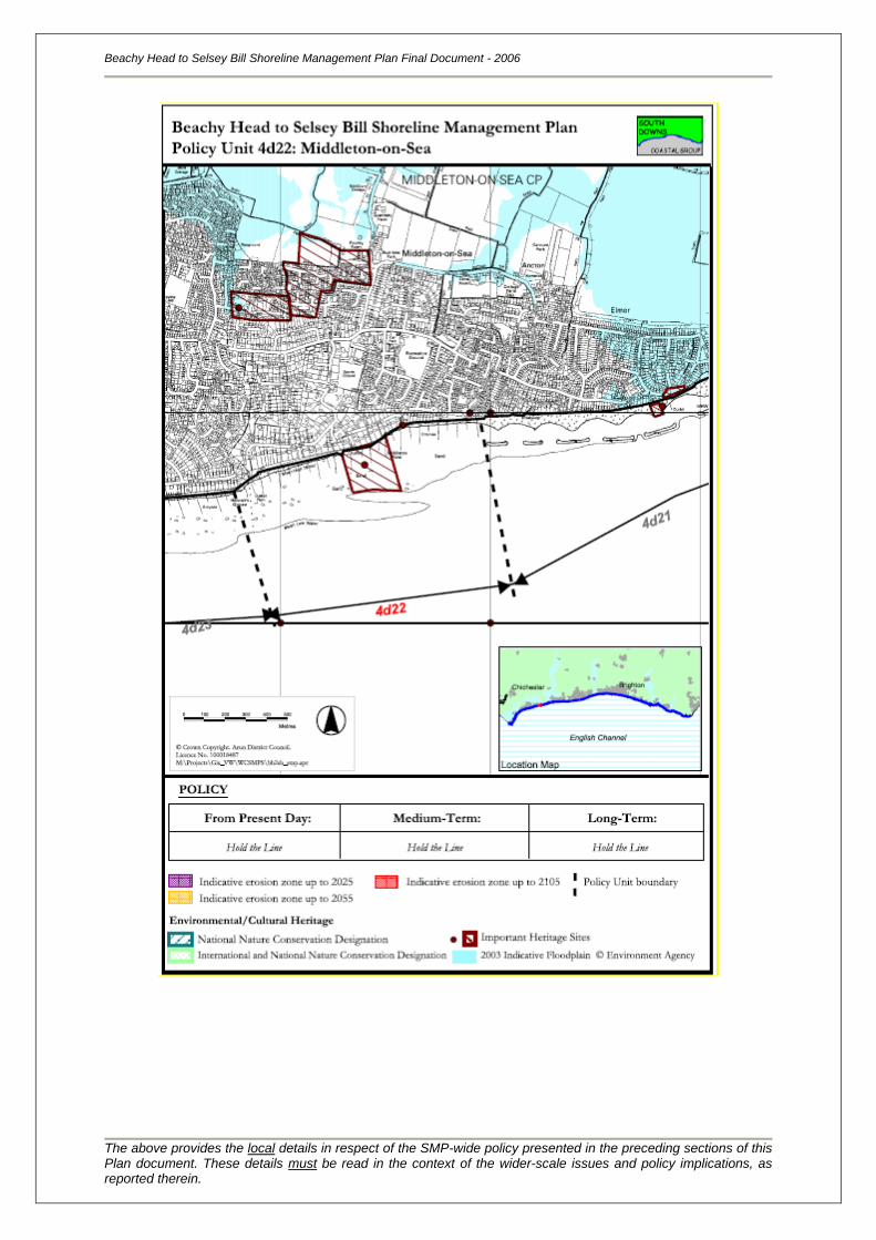
Beachy Head to Selsey Bill Shoreline Management Plan Final Document - 2006
The above provides the local details in respect of the SMP-wide policy presented in the preceding sections of this Plan document. These details must be read in the context of the wider-scale issues and policy implications, as reported therein.
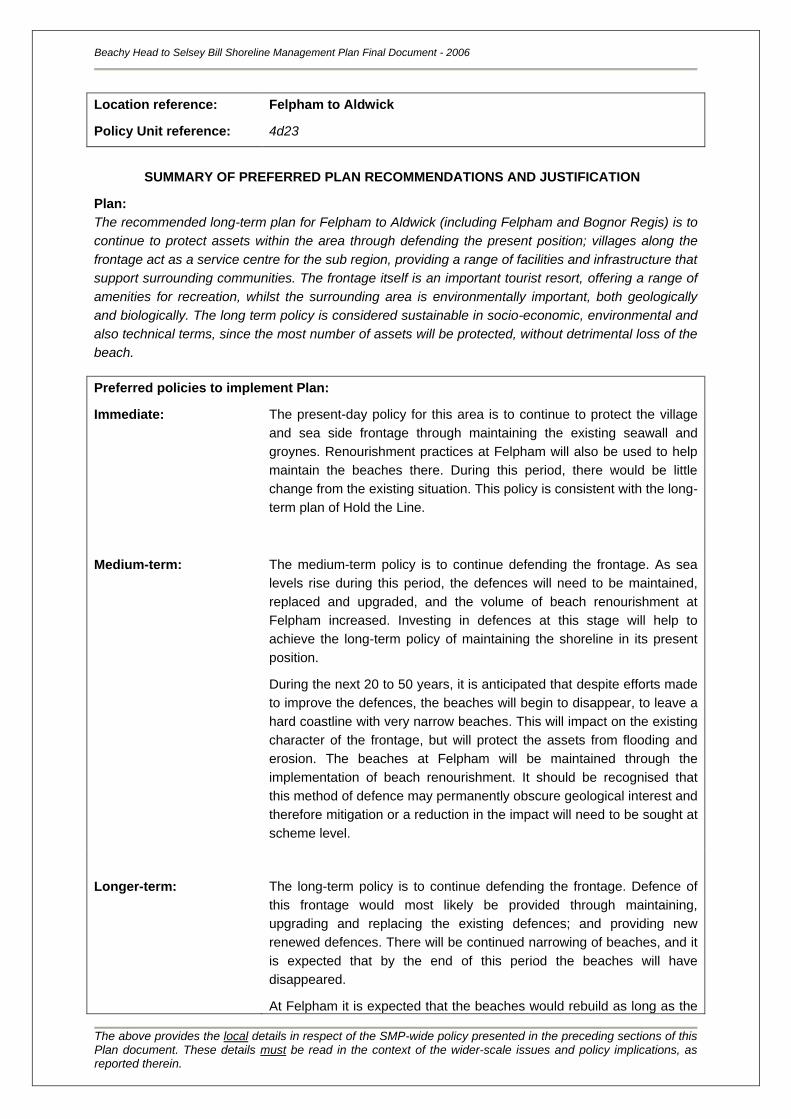
Location reference:
Policy Unit reference:
Felpham to Aldwick
4d23
SUMMARY OF PREFERRED PLAN RECOMMENDATIONS AND JUSTIFICATION
Plan:
The recommended long-term plan for Felpham to Aldwick (including Felpham and Bognor Regis) is to
continue to protect assets within the area through defending the present position; villages along the
frontage act as a service centre for the sub region, providing a range of facilities and infrastructure that
support surrounding communities. The frontage itself is an important tourist resort, offering a range of
amenities for recreation, whilst the surrounding area is environmentally important, both geologically
and biologically. The long term policy is considered sustainable in socio-economic, environmental and
also technical terms, since the most number of assets will be protected, without detrimental loss of the
beach.
Preferred policies to implement Plan:
Immediate: The present-day policy for this area is to continue to protect the village
and sea side frontage through maintaining the existing seawall and
groynes. Renourishment practices at Felpham will also be used to help
maintain the beaches there. During this period, there would be little
change from the existing situation. This policy is consistent with the long-
term plan of Hold the Line.
Medium-term: The medium-term policy is to continue defending the frontage. As sea
levels rise during this period, the defences will need to be maintained,
replaced and upgraded, and the volume of beach renourishment at
Felpham increased. Investing in defences at this stage will help to
achieve the long-term policy of maintaining the shoreline in its present
position.
During the next 20 to 50 years, it is anticipated that despite efforts made
to improve the defences, the beaches will begin to disappear, to leave a
hard coastline with very narrow beaches. This will impact on the existing
character of the frontage, but will protect the assets from flooding and
erosion. The beaches at Felpham will be maintained through the
implementation of beach renourishment. It should be recognised that
this method of defence may permanently obscure geological interest and
therefore mitigation or a reduction in the impact will need to be sought at
scheme level.
Longer-term: The long-term policy is to continue defending the frontage. Defence of
this frontage would most likely be provided through maintaining,
upgrading and replacing the existing defences; and providing new
renewed defences. There will be continued narrowing of beaches, and it
is expected that by the end of this period the beaches will have
disappeared.
At Felpham it is expected that the beaches would rebuild as long as the
Beachy Head to Selsey Bill Shoreline Management Plan Final Document - 2006
The above provides the local details in respect of the SMP-wide policy presented in the preceding sections of this Plan document. These details must be read in the context of the wider-scale issues and policy implications, as reported therein.
existing groynes are replaced with new groynes. Increased
renourishment at Felpham would be needed to sustain beach levels. It
should be recognised that this method of defence may permanently
obscure geological interest and therefore mitigation or a reduction in the
impact will need to be sought at scheme level.
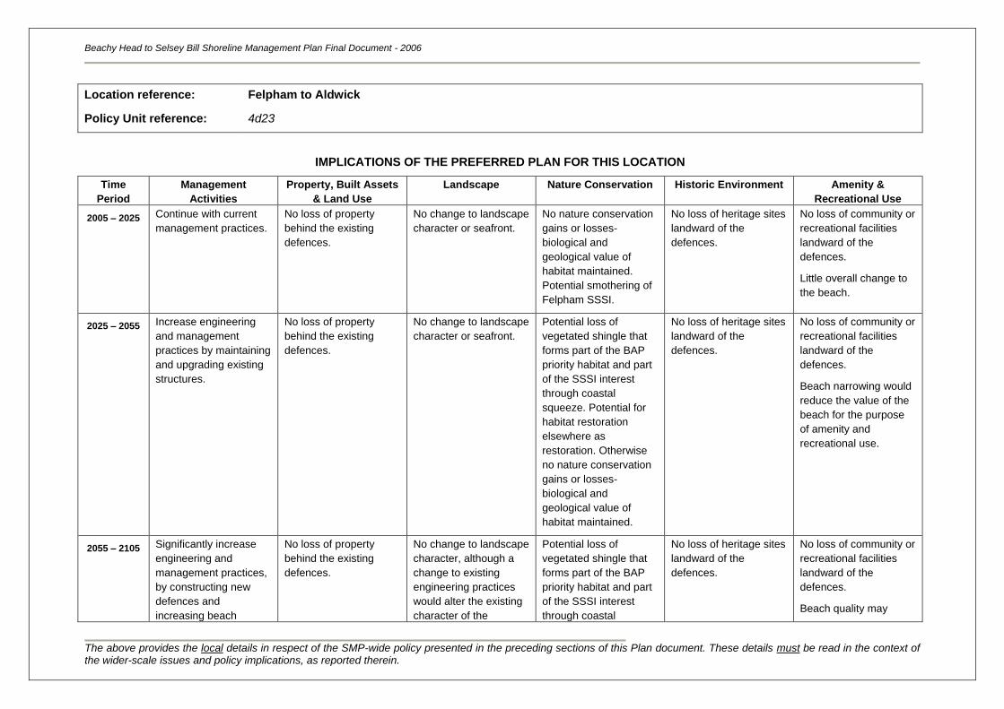
Beachy Head to Selsey Bill Shoreline Management Plan Final Document - 2006
The above provides the local details in respect of the SMP-wide policy presented in the preceding sections of this Plan document. These details must be read in the context of the wider-scale issues and policy implications, as reported therein.
Location reference:
Policy Unit reference:
Felpham to Aldwick
4d23
IMPLICATIONS OF THE PREFERRED PLAN FOR THIS LOCATION
Time
Period
Management
Activities
Property, Built Assets
& Land Use
Landscape Nature Conservation Historic Environment Amenity &
Recreational Use
2005 – 2025
Continue with current
management practices.
No loss of property
behind the existing
defences.
No change to landscape
character or seafront.
No nature conservation
gains or losses-
biological and
geological value of
habitat maintained.
Potential smothering of
Felpham SSSI.
No loss of heritage sites
landward of the
defences.
No loss of community or
recreational facilities
landward of the
defences.
Little overall change to
the beach.
2025 – 2055 Increase engineering
and management
practices by maintaining
and upgrading existing
structures.
No loss of property
behind the existing
defences.
No change to landscape
character or seafront.
Potential loss of
vegetated shingle that
forms part of the BAP
priority habitat and part
of the SSSI interest
through coastal
squeeze. Potential for
habitat restoration
elsewhere as
restoration. Otherwise
no nature conservation
gains or losses-
biological and
geological value of
habitat maintained.
No loss of heritage sites
landward of the
defences.
No loss of community or
recreational facilities
landward of the
defences.
Beach narrowing would
reduce the value of the
beach for the purpose
of amenity and
recreational use.
2055 – 2105 Significantly increase
engineering and
management practices,
by constructing new
defences and
increasing beach
No loss of property
behind the existing
defences.
No change to landscape
character, although a
change to existing
engineering practices
would alter the existing
character of the
Potential loss of
vegetated shingle that
forms part of the BAP
priority habitat and part
of the SSSI interest
through coastal
No loss of heritage sites
landward of the
defences.
No loss of community or
recreational facilities
landward of the
defences.
Beach quality may
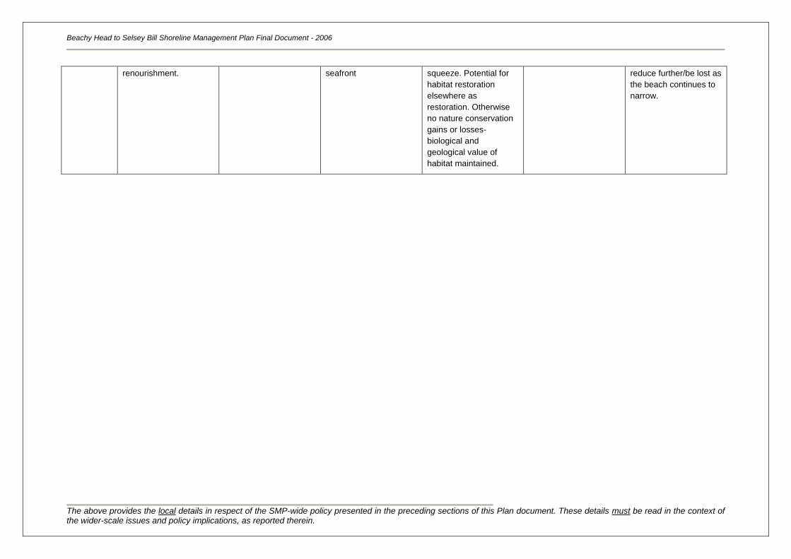
Beachy Head to Selsey Bill Shoreline Management Plan Final Document - 2006
The above provides the local details in respect of the SMP-wide policy presented in the preceding sections of this Plan document. These details must be read in the context of the wider-scale issues and policy implications, as reported therein.
renourishment. seafront squeeze. Potential for
habitat restoration
elsewhere as
restoration. Otherwise
no nature conservation
gains or losses-
biological and
geological value of
habitat maintained.
reduce further/be lost as
the beach continues to
narrow.
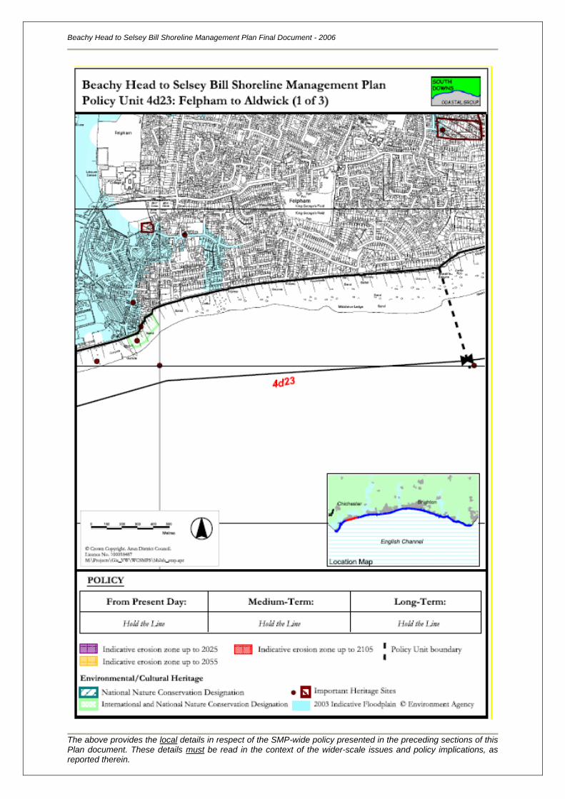
Beachy Head to Selsey Bill Shoreline Management Plan Final Document - 2006
The above provides the local details in respect of the SMP-wide policy presented in the preceding sections of this Plan document. These details must be read in the context of the wider-scale issues and policy implications, as reported therein.
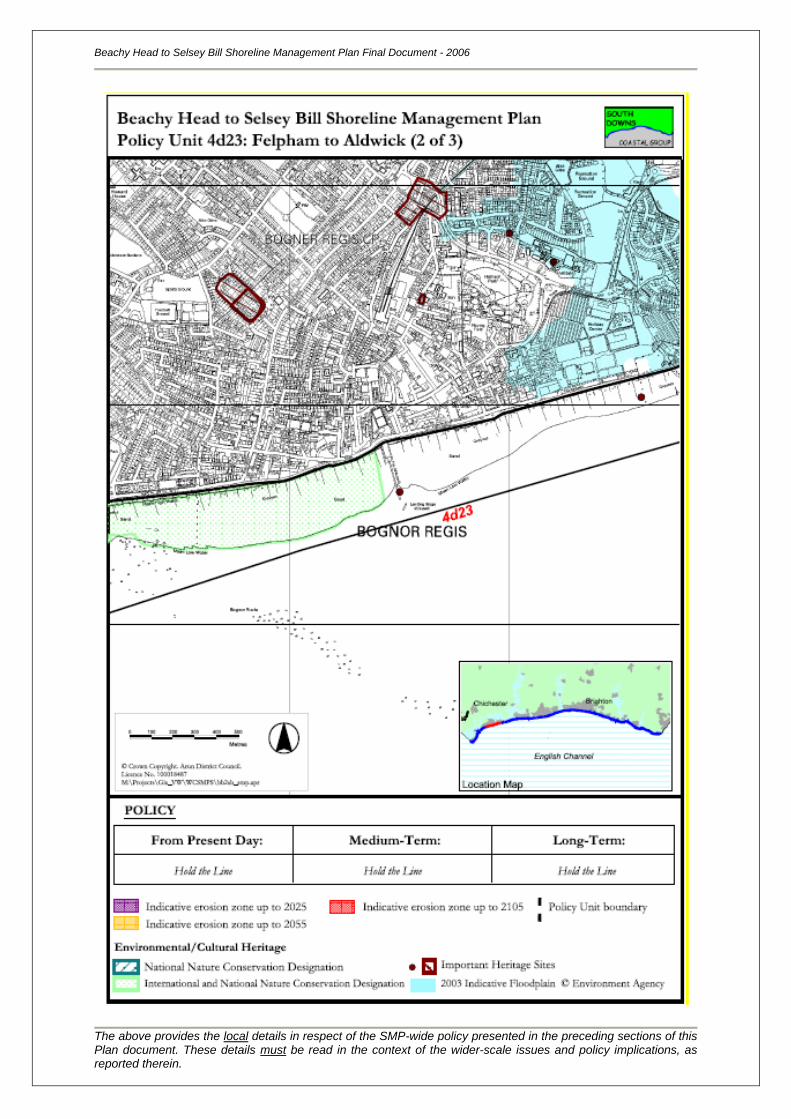
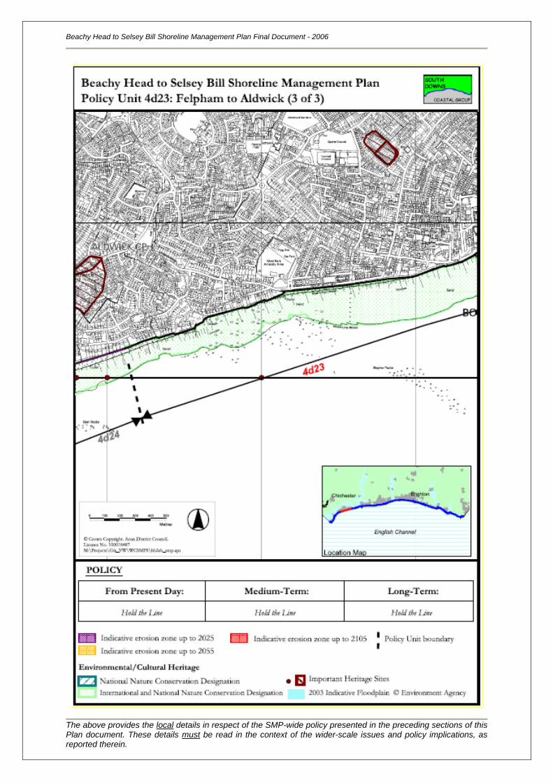
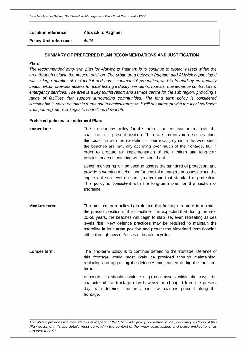
Location reference:
Policy Unit reference:
Aldwick to Pagham
4d24
SUMMARY OF PREFERRED PLAN RECOMMENDATIONS AND JUSTIFICATION
Plan:
The recommended long-term plan for Aldwick to Pagham is to continue to protect assets within the
area through holding the present position. The urban area between Pagham and Aldwick is populated
with a large number of residential and some commercial properties, and is fronted by an amenity
beach, which provides access for local fishing industry, residents, tourists, maintenance contractors &
emergency services. The area is a key tourist resort and service centre for the sub region, providing a
range of facilities that support surrounding communities. The long term policy is considered
sustainable in socio-economic terms and technical terms as it will not interrupt with the local sediment
transport regime or linkages to shorelines downdrift.
Preferred policies to implement Plan:
Immediate: The present-day policy for this area is to continue to maintain the
coastline in its present position. There are currently no defences along
this coastline with the exception of four rock groynes in the west since
the beaches are naturally accreting over much of the frontage, but in
order to prepare for implementation of the medium and long-term
policies, beach monitoring will be carried out.
Beach monitoring will be used to assess the standard of protection, and
provide a warning mechanism for coastal managers to assess when the
impacts of sea level rise are greater than that standard of protection.
This policy is consistent with the long-term plan for this section of
shoreline.
Medium-term: The medium-term policy is to defend the frontage in order to maintain
the present position of the coastline. It is expected that during the next
20-50 years, the beaches will begin to stabilise, even retreating as sea
levels rise. New defence practices may be required to maintain the
shoreline in its current position and protect the hinterland from flooding
either through new defences or beach recycling.
Longer-term: The long-term policy is to continue defending the frontage. Defence of
this frontage would most likely be provided through maintaining,
replacing and upgrading the defences constructed during the medium-
term.
Although this should continue to protect assets within the town, the
character of the frontage may however be changed from the present
day, with defence structures and low beaches present along the
frontage.
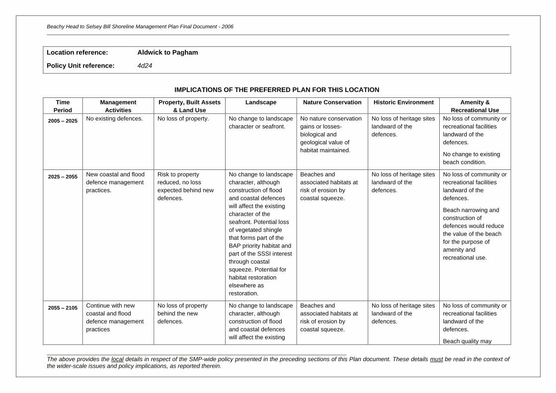
Beachy Head to Selsey Bill Shoreline Management Plan Final Document - 2006
The above provides the local details in respect of the SMP-wide policy presented in the preceding sections of this Plan document. These details must be read in the context of the wider-scale issues and policy implications, as reported therein.
Location reference:
Policy Unit reference:
Aldwick to Pagham
4d24
IMPLICATIONS OF THE PREFERRED PLAN FOR THIS LOCATION
Time
Period
Management
Activities
Property, Built Assets
& Land Use
Landscape Nature Conservation Historic Environment Amenity &
Recreational Use
2005 – 2025
No existing defences. No loss of property. No change to landscape
character or seafront.
No nature conservation
gains or losses-
biological and
geological value of
habitat maintained.
No loss of heritage sites
landward of the
defences.
No loss of community or
recreational facilities
landward of the
defences.
No change to existing
beach condition.
2025 – 2055 New coastal and flood
defence management
practices.
Risk to property
reduced, no loss
expected behind new
defences.
No change to landscape
character, although
construction of flood
and coastal defences
will affect the existing
character of the
seafront. Potential loss
of vegetated shingle
that forms part of the
BAP priority habitat and
part of the SSSI interest
through coastal
squeeze. Potential for
habitat restoration
elsewhere as
restoration.
Beaches and
associated habitats at
risk of erosion by
coastal squeeze.
No loss of heritage sites
landward of the
defences.
No loss of community or
recreational facilities
landward of the
defences.
Beach narrowing and
construction of
defences would reduce
the value of the beach
for the purpose of
amenity and
recreational use.
2055 – 2105 Continue with new
coastal and flood
defence management
practices
No loss of property
behind the new
defences.
No change to landscape
character, although
construction of flood
and coastal defences
will affect the existing
Beaches and
associated habitats at
risk of erosion by
coastal squeeze.
No loss of heritage sites
landward of the
defences.
No loss of community or
recreational facilities
landward of the
defences.
Beach quality may
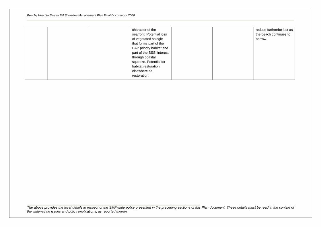
Beachy Head to Selsey Bill Shoreline Management Plan Final Document - 2006
The above provides the local details in respect of the SMP-wide policy presented in the preceding sections of this Plan document. These details must be read in the context of the wider-scale issues and policy implications, as reported therein.
character of the
seafront. Potential loss
of vegetated shingle
that forms part of the
BAP priority habitat and
part of the SSSI interest
through coastal
squeeze. Potential for
habitat restoration
elsewhere as
restoration.
reduce further/be lost as
the beach continues to
narrow.
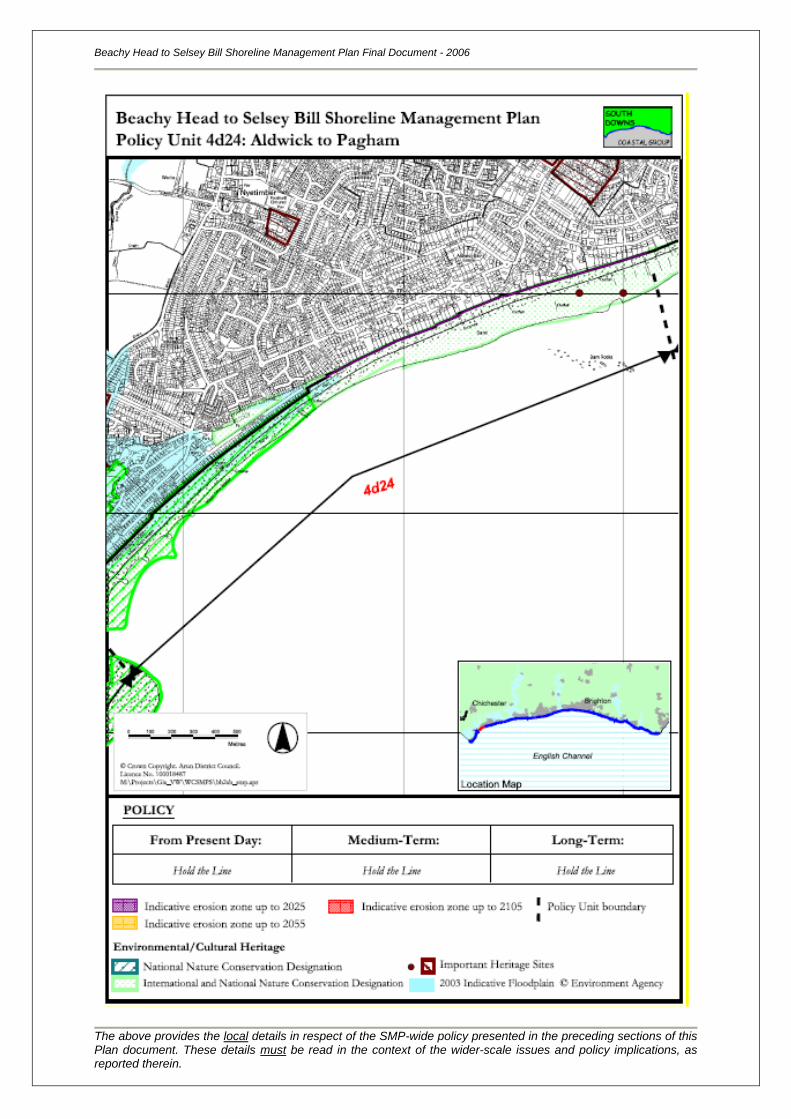
Beachy Head to Selsey Bill Shoreline Management Plan Final Document - 2006
The above provides the local details in respect of the SMP-wide policy presented in the preceding sections of this Plan document. These details must be read in the context of the wider-scale issues and policy implications, as reported therein.
Location reference:
Policy Unit reference:
Pagham to Church Norton
4d25
SUMMARY OF PREFERRED PLAN RECOMMENDATIONS AND JUSTIFICATION
Plan:
The recommended long-term plan for Pagham (Pagham Harbour, south and north spit inclusive) to
Selsey East Beach is to achieve a more naturally functioning coastline. The harbour is an area of
national and international conservation importance and some lengths of this coastline are currently
protected by management practices. Therefore any future management policy will need to incorporate
the objective to move towards a more naturally functioning coastal frontage, whilst also considering
the way in which the coastline is currently managed. In order to meet these objectives without
detrimental impact on the designated habitats careful management of any policy change is critical to
the long term plan of a more naturally free functioning process.
Preferred policies to implement Plan:
Immediate: The present day policy is to manage the realignment of the coastal
frontage through a series of management practices that will help to
achieve the medium-term/long-term policy of creating a more naturally
functioning system. In order to do this, it is expected that the training
wall will be maintained, thus holding the northern spit in its present
alignment. Along the southern spit, the groynes could be allowed to fail,
thus promoting natural rollback of the spit. This may be further
encouraged through removing material from the front of the beach (and
the surrounding shingle banks) and placing it to the rear of the spit if
appropriate.
Throughout this period, constant habitat and coastal process monitoring
should take place (perhaps as part of a strategic monitoring program).
The existing inner harbour flood defences could need to be maintained
and possibly upgraded based on the impacts of sea level rise.
Medium-term: The medium-term policy is to begin to realign this frontage, in order to
achieve a more naturally/dynamic functioning system. It is unsure as yet
on how this could be achieved, suffice it to comment that it will involve a
change to the configuration of defences in the harbour, The impact
different harbour entrance locations may have (based on spit
movements and future breaches) is unknown and can only be
determined through detailed study using robust analysis of past
experience, data sets and research. Another issue is the resulting
additional reworking of sediment fed from updrift sources that may now
be trapped within the Pagham system that has until recently bypassed
the harbour and sustained the existing beaches along the Aldwick
frontage. Any implementation here must be technically sustainable and
have limited and manageable impact on the beaches downdrift.
The existing flood defences are likely to become inadequate and an
opportunity to relocate flood embankments to mitigate for the impact of
sea level rise is preferable, using existing land forms such as the
Beachy Head to Selsey Bill Shoreline Management Plan Final Document - 2006
The above provides the local details in respect of the SMP-wide policy presented in the preceding sections of this Plan document. These details must be read in the context of the wider-scale issues and policy implications, as reported therein.
embankment upon which the B2145 is sited.
As part of the policy at Church Norton, secondary flood defences may
need to be constructed, to avoid any danger of breaching or inundation
to the properties or historical monuments here as a result of managed
realignment at Pagham Harbour.
Longer-term: The long-term policy is to continue to realign this frontage, in order to
achieve a more naturally functioning system. The way in which this is
completed depends on the outcome of future studies
This policy is considered to be sustainable in the long-term, as it
reduces the amount of engineering and management intervention
required, but does raise questions about the sustainability of the
designated habitats. It‟s not necessarily a loss of habitat, rather a
change and increase in differing habitats in the areas that could occur.
Pagham harbour and its environs do provide a prime location for habitat
recreation in terms of compensatory habitat from other locations within
the area. However further assessment will be needed.
Beachy Head to Selsey Bill Shoreline Management Plan Final Document - 2006
The above provides the local details in respect of the SMP-wide policy presented in the preceding sections of this Plan document. These details must be read in the context of the wider-scale issues and policy implications, as reported therein.
Location reference:
Policy Unit reference:
Pagham to Church Norton
4d25
IMPLICATIONS OF THE PREFERRED PLAN FOR THIS LOCATION
Time
Period
Management
Activities
Property, Built Assets
& Land Use
Landscape Nature Conservation Historic Environment Amenity &
Recreational Use
2005 – 2025
Maintain existing
practices along the
northern spit.
Alterations to
management practices
along southern spit.
Shingle rollback may
result in some loss of
the beach along the
southern spit, although
there will be no loss of
residential or
commercial property.
No change to
landscape. Some
change to seafront
along southern spit as
groynes fail and the
shingle beach is made
wider on its landward
side.
Increased conservation
gain along southern
spit, as defences are
removed and the
shingle is free to roll
back. No conservation
gains or losses along
the northern spit.
No loss of heritage sits
landwards of the
defences, although
impacts on sub tidal
foreshore and wetland
archaeological sites
should be investigated
and provisions made for
mitigation.
Some change to the
existing beach width
along the southern spit.
Beach along northern
spit retained.
2025 – 2055 Prepare the coastline
and defences to
achieve a more
naturally functioning
system.
No loss of property or
land behind the existing
defences.
Change to landscape,
although quality
maintained.
Increased biological and
conservation gain, with
removal of defences.
No loss of heritage sits
landwards of the
defences, although
impacts on sub tidal
foreshore and wetland
archaeological sites
should be investigated
and provisions made for
mitigation.
Some loss of
community /recreational
facilities as the coastline
is realigned and sea
levels rise.
2055 – 2105 This is dependent on
the outcome of future
studies.
No loss of property or
land behind the existing
defences. Up to 10ha of
agricultural land could
however, be lost by
year 2105.
Change to landscape,
although quality
maintained.
Increased biological and
conservation gain, with
removal of defences.
No loss of heritage sits
landwards of the
defences, although
impacts on sub tidal
foreshore and wetland
archaeological sites
should be investigated
and provisions made for
mitigation.
Some loss of
community /recreational
facilities as the coastline
is realigned and sea
levels rise.
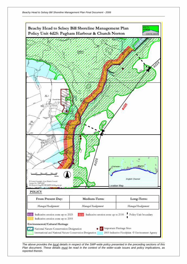
Beachy Head to Selsey Bill Shoreline Management Plan Final Document - 2006
The above provides the local details in respect of the SMP-wide policy presented in the preceding sections of this Plan document. These details must be read in the context of the wider-scale issues and policy implications, as reported therein.
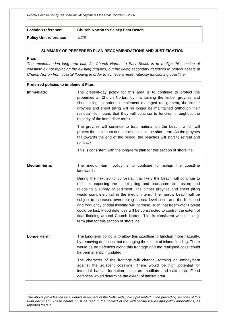
Location reference:
Policy Unit reference:
Church Norton to Selsey East Beach
4d26
SUMMARY OF PREFERRED PLAN RECOMMENDATIONS AND JUSTIFICATION
Plan:
The recommended long-term plan for Church Norton to East Beach is to realign this section of
coastline by not replacing the existing groynes, but providing secondary defences to protect assets at
Church Norton from coastal flooding in order to achieve a more naturally functioning coastline.
Preferred policies to implement Plan:
Immediate: The present-day policy for this area is to continue to protect the
properties at Church Norton, by maintaining the timber groynes and
sheet piling. In order to implement managed realignment, the timber
groynes and sheet piling will no longer be maintained (although their
residual life means that they will continue to function throughout the
majority of the immediate term).
The groynes will continue to trap material on the beach, which will
protect the maximum number of assets in the short term. As the groynes
fail towards the end of the period, the beaches will start to retreat and
roll back.
This is consistent with the long-term plan for this section of shoreline.
Medium-term: The medium-term policy is to continue to realign the coastline
landwards.
During the next 20 to 50 years, it is likely the beach will continue to
rollback, exposing the sheet piling and backshore to erosion; and
releasing a supply of sediment. The timber groynes and sheet piling
would completely fail in the medium term. The narrow beach will be
subject to increased overtopping as sea levels rise, and the likelihood
and frequency of tidal flooding will increase, such that freshwater Habitat
could be lost. Flood defences will be constructed to control the extent of
tidal flooding around Church Norton. This is consistent with the long-
term plan for this section of shoreline.
Longer-term: The long-term policy is to allow this coastline to function more naturally,
by removing defences, but managing the extent of inland flooding. There
would be no defences along this frontage and the realigned coast could
be permanently inundated.
The character of the frontage will change, forming an embayment
against the adjacent coastline. There would be high potential for
intertidal habitat formation, such as mudflats and saltmarsh. Flood
defences would determine the extent of habitat area.
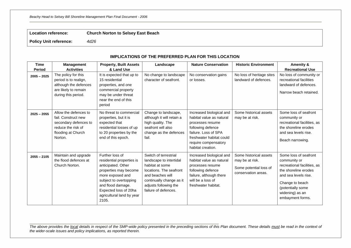
Beachy Head to Selsey Bill Shoreline Management Plan Final Document - 2006
The above provides the local details in respect of the SMP-wide policy presented in the preceding sections of this Plan document. These details must be read in the context of the wider-scale issues and policy implications, as reported therein.
Location reference:
Policy Unit reference:
Church Norton to Selsey East Beach
4d26
IMPLICATIONS OF THE PREFERRED PLAN FOR THIS LOCATION
Time
Period
Management
Activities
Property, Built Assets
& Land Use
Landscape Nature Conservation Historic Environment Amenity &
Recreational Use
2005 – 2025
The policy for this
period is to realign,
although the defences
are likely to remain
during this period.
It is expected that up to
15 residential
properties, and one
commercial property
may be under threat
near the end of this
period
No change to landscape
character of seafront.
No conservation gains
or losses.
No loss of heritage sites
landward of defences.
No loss of community or
recreational facilities
landward of defences.
Narrow beach retained.
2025 – 2055 Allow the defences to
fail. Construct new
secondary defences to
reduce the risk of
flooding at Church
Norton.
No threat to commercial
properties, but it is
expected that
residential losses of up
to 20 properties by the
end of this epoch.
Change to landscape,
although it will retain a
high quality. The
seafront will also
change as the defences
fail.
Increased biological and
habitat value as natural
processes resume
following defence
failure. Loss of SPA
freshwater habitat could
require compensatory
habitat creation.
Some historical assets
may be at risk.
Some loss of seafront
community or
recreational facilities, as
the shoreline erodes
and sea levels rise.
Beach narrowing.
2055 – 2105 Maintain and upgrade
the flood defences at
Church Norton.
Further loss of
residential properties is
anticipated. Other
properties may become
more exposed and
subject to overtopping
and flood damage.
Expected loss of 20ha
agricultural land by year
2105.
Switch of terrestrial
landscape to intertidal
habitat at some
locations. The seafront
and beaches will
continually change as it
adjusts following the
failure of defences.
Increased biological and
habitat value as natural
processes resume
following defence
failure, although there
will be a loss of
freshwater habitat.
Some historical assets
may be at risk.
Some potential loss of
conservation areas.
Some loss of seafront
community or
recreational facilities, as
the shoreline erodes
and sea levels rise.
Change to beach
(potentially some
widening) as an
embayment forms.
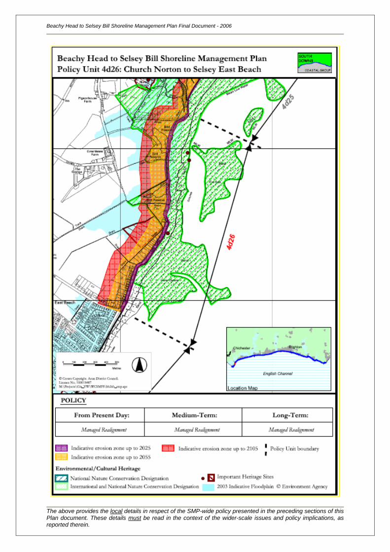
Beachy Head to Selsey Bill Shoreline Management Plan Final Document - 2006
The above provides the local details in respect of the SMP-wide policy presented in the preceding sections of this Plan document. These details must be read in the context of the wider-scale issues and policy implications, as reported therein.
Location reference:
Policy Unit reference:
East Beach to Selsey Bill
4d27
SUMMARY OF PREFERRED PLAN RECOMMENDATIONS AND JUSTIFICATION
Plan:
The recommended long-term plan for East Beach to Selsey Bill is to continue to protect assets within
the town through defending the present position; the town is a key tourist resort with recreational and
amenity assets.
Selsey Bill is also a key geomorphological hold point for the frontage and still acts as a control on the
development of the shoreline to the east and west The clay headland of Selsey Bill shelters the
coastline to the immediate east from the predominant south-westerly storms although overtopping by
storm waves occurs at some locations. Kirk Arrow Spit and Mixon Reef are key nearshore
geomorphological features which lie approximately 2-3km offshore of Selsey Bill and help to hold the
clay headland of Selsey Bill in its present position and are a source of material. Submerged shingle
deposits of the Inner Owers that exist around Selsey Bill, periodically feed the shoreline in the vicinity
of Selsey Bill which supplies the whole subcell. It is important therefore that the supply of sediment is
unimpeded by management policy practices.
Preferred policies to implement Plan:
Immediate: The present-day policy for this area is to continue to protect the town
frontage through maintaining existing seawalls and groynes.
This will protect the maximum number of assets, but over this period
beaches will start to become narrower and defences more exposed.
This is consistent with the long-term plan for this section of shoreline.
Medium-term: The medium-term policy is to continue defending the frontage beyond
the immediate term. Defence of this frontage would most likely be
provided through maintaining and upgrading the existing structures.
During the next 20 to 50 years, it is likely that a beach would continue to
narrow, steepen and lower, and the effectiveness of the groynes will
gradually reduce as sea levels rise. Beyond this, the groynes will
eventually become redundant and there will no longer be beaches in
front of the town. An increased commitment to maintaining the seawall
would be required. Onshore sediment input from existing sources is
likely to diminish with sea level rise, and beach management practices
may be constrained.
Longer-term: The long-term policy is to continue defending the frontage. Defence of
this frontage would most likely be provided by replacing the existing
seawall and groynes; maintaining and upgrading them throughout the
longer term in addition to beach replenishment/ recycling of suitable
sources.
Although this should continue to protect assets within the town, the
Beachy Head to Selsey Bill Shoreline Management Plan Final Document - 2006
The above provides the local details in respect of the SMP-wide policy presented in the preceding sections of this Plan document. These details must be read in the context of the wider-scale issues and policy implications, as reported therein.
character of the frontage may however be changed from the present
day, with higher seawalls and low beaches present in front of the town.
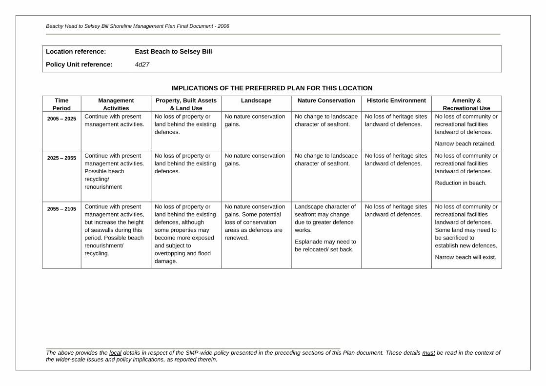
Beachy Head to Selsey Bill Shoreline Management Plan Final Document - 2006
The above provides the local details in respect of the SMP-wide policy presented in the preceding sections of this Plan document. These details must be read in the context of the wider-scale issues and policy implications, as reported therein.
Location reference:
Policy Unit reference:
East Beach to Selsey Bill
4d27
IMPLICATIONS OF THE PREFERRED PLAN FOR THIS LOCATION
Time
Period
Management
Activities
Property, Built Assets
& Land Use
Landscape Nature Conservation Historic Environment Amenity &
Recreational Use
2005 – 2025
Continue with present
management activities.
No loss of property or
land behind the existing
defences.
No nature conservation
gains.
No change to landscape
character of seafront.
No loss of heritage sites
landward of defences.
No loss of community or
recreational facilities
landward of defences.
Narrow beach retained.
2025 – 2055 Continue with present
management activities.
Possible beach
recycling/
renourishment
No loss of property or
land behind the existing
defences.
No nature conservation
gains.
No change to landscape
character of seafront.
No loss of heritage sites
landward of defences.
No loss of community or
recreational facilities
landward of defences.
Reduction in beach.
2055 – 2105 Continue with present
management activities,
but increase the height
of seawalls during this
period. Possible beach
renourishment/
recycling.
No loss of property or
land behind the existing
defences, although
some properties may
become more exposed
and subject to
overtopping and flood
damage.
No nature conservation
gains. Some potential
loss of conservation
areas as defences are
renewed.
Landscape character of
seafront may change
due to greater defence
works.
Esplanade may need to
be relocated/ set back.
No loss of heritage sites
landward of defences.
No loss of community or
recreational facilities
landward of defences.
Some land may need to
be sacrificed to
establish new defences.
Narrow beach will exist.
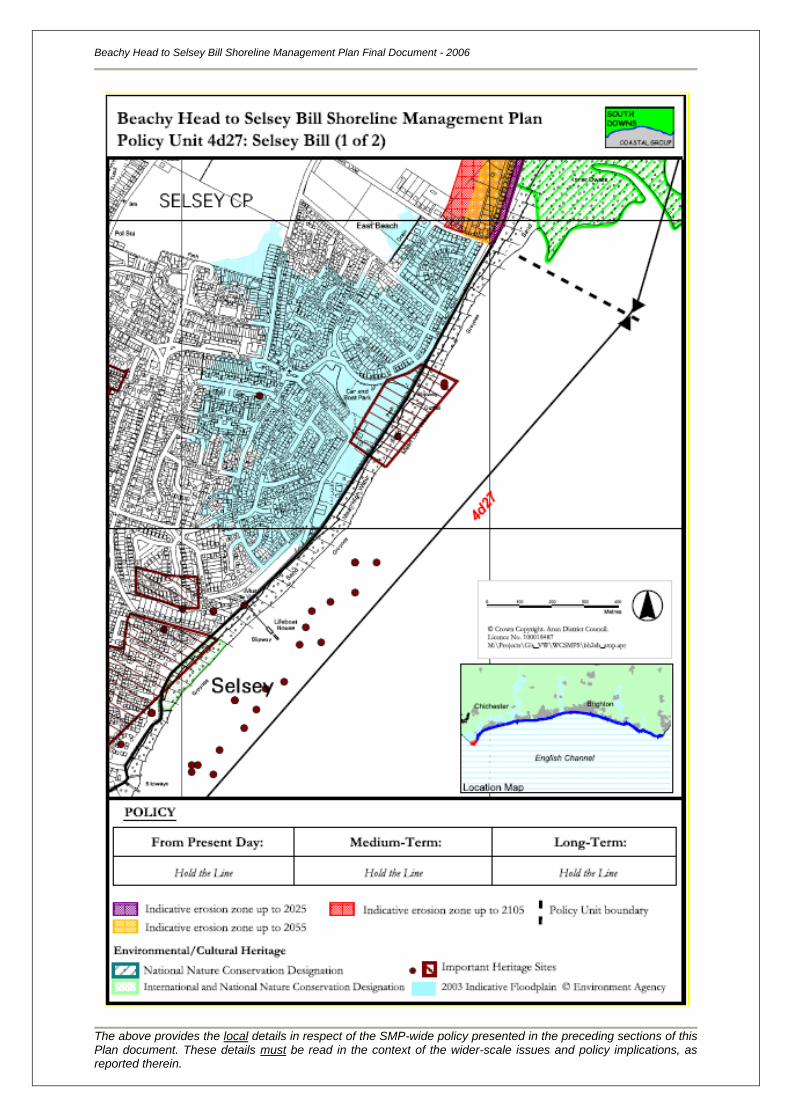
Beachy Head to Selsey Bill Shoreline Management Plan Final Document - 2006
The above provides the local details in respect of the SMP-wide policy presented in the preceding sections of this Plan document. These details must be read in the context of the wider-scale issues and policy implications, as reported therein.
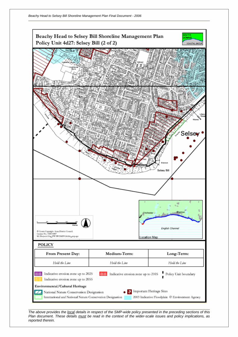

119