BBeellaauu NNaattiioonnaall MMuusseeuumm
24
B B B e e e l l l a a a u u u N N N a a a t t t i i i o o o n n n a a a l l l M M M u u u s s s e e e u u u m m m
Transcript of BBeellaauu NNaattiioonnaall MMuusseeuumm

BBBeeelllaaauuu NNNaaatttiiiooonnnaaalll MMMuuussseeeuuummm
HHiiss ssiiggnnaattuurree iiss tthhee bbeeaauuttyy ooff tthhiinnggss
~~ RRoobbiinnssoonn JJeeffffeerrss
USP Library Cataloguing-in-Publication Data State of Palau's Birds 2012 / Alan R. Olsen and Milang Eberdong, editors. – Koror,
Republic of Palau : Belau National Museum, 2013.
22 p: 1 col. ill. ; 22 x 28 cm.
ISBN xxx-xxx-xxxx--
1. Birds – Palau. I. Olsen, Alan R. II. Eberdong, Milang. III. Belau National Museum.
QL694.P2S77 2012 598.29966
Bridled Tern Bedebedechakl
Sterna anaethetus

Natural History Section Belau National Museum
State of Palau's Birds 20123rd Annual Report of the
National Program for Monitoring Forest and Coastal Birds

IInnttrroodduuccttiioonn:: TThhee IImmppoorrttaannccee ooff PPaallaauu''ss BBiirrddss aanndd BBiiooddiivveerrssiittyy
From sea to land, from land to sea; And heave round earth, a living chain of interwoven agency ~ Goethe's Faust
Growth of the National Program
Bird diversity is an important indicator of overall biodiversity. The National Program for Monitoring Forest and Coastal Birds provides an infrastructure for monitoring bird diversity throughout Palau. In 2012, the national program added four new sites to its network of bird monitoring stations, which now numbers 21 stations. The new stations are located in forest habitats at Ollei, Ngerkebesang and Ulong and a coastal habitat at Ngarchelong. On the map at left, active forest stations are indicated by yellow stars and active coastal stations by blue stars. Fourteen of the 21 stations are located in protected terrestrial or marine conservation areas while the others are placed in unprotected areas to serve as references for monitoring protected areas. Additional stations are planned for central Babeldaob (Koksai), Peleliu, Angaur and Kayangel in the near future.
Yellow = Terrestrial Blue = Coastal
National Program for Monitoring Forest and Coastal Birds Terrestrial and coastal monitoring stations
Stations at Protected Conservation Areas Ngarchelong - Ollei State park Ngaraard - Choll State beach Ngaraard - Ngerchokl PAN terrestrial site Ngardmau - Waterfall Trail Eco-Theme Park Ngiwal - Ngemai Marine protected area Ngaremlengui - Ngermeskang PAN terrestrial site (Bird Sanctuary) Ngaremlengui - Bkulengriil Marine protected area Melekeok - Lake Ngardok PAN terrestrial site (RAMSAR wetland) Ngatpang - Pier Marine protected area Aimeliik - Ngerderar Watershed conservation area Airai - Ngerikiil IWRM watershed conservation area Koror - Ngerkebesang Private nature reserve Koror - Ngermalk State park and conservation area Koror - Ulong Island World Heritage Site

Ancient rock art at Long Island Park
IInnttrroodduuccttiioonn:: TThhee IImmppoorrttaannccee ooff PPaallaauu''ss BBiirrddss aanndd BBiiooddiivveerrssiittyy
CCoommmmuunniittyy AAwwaarreenneessss -- BBiirrddwwaattcchhiinngg aatt LLoonngg IIssllaanndd PPaarrkk
LLoonngg IIssllaanndd PPaarrkk aanndd CCoonnsseerrvvaattiioonn AArreeaa iiss aann ooffffiicciiaall mmoonniittoorriinngg ssttaattiioonn ffoorr tthhee NNaattiioonnaall PPrrooggrraamm ffoorr MMoonniittoorriinngg FFoorreesstt aanndd CCooaassttaall BBiirrddss aanndd aann eexxcceelllleenntt,, aacccceessssiibbllee vveennuuee ffoorr pprroommoottiinngg ccoommmmuunniittyy aawwaarreenneessss ooff tthhee iimmppoorrttaannccee ooff bbiirrddss.. IInn NNoovveemmbbeerr 22001122,, BBeellaauu NNaattiioonnaall MMuusseeuumm iinn ppaarrttnneerrsshhiipp wwiitthh KKoorroorr SSttaattee GGoovveerrnnmmeenntt llaauunncchheedd aa ccoommmmuunniittyy bbiirrddwwaattcchhiinngg aaccttiivviittyy aatt tthhee ppaarrkk oonn tthhee ffiirrsstt SSaattuurrddaayy ooff eevveerryy mmoonntthh.. LLooccaall rreessiiddeennttss aanndd ttoouurriissttss ccaann mmiinnggllee wwiitthh pprrooffeessssiioonnaall oorrnniitthhoollooggiissttss aanndd ccoonnsseerrvvaattiioonniissttss ttoo oobbsseerrvvee aanndd lleeaarrnn aabboouutt tthhee rriicchh ddiivveerrssiittyy ooff ffoorreesstt aanndd ccooaassttaall bbiirrddss ffoouunndd iinn tthhee ppaarrkk.. TThhee ppaarrkk iiss ooppeenn ttoo tthhee ppuubblliicc ffrroomm ddaawwnn uunnttiill dduusskk aanndd ffeeaattuurreess ootthheerr nnaattuurraall,, ccuullttuurraall aanndd rreeccrreeaattiioonnaall aattttrraaccttiioonnss iinn aaddddiittiioonn ttoo bbiirrddwwaattcchhiinngg..

SSttaattee ooff PPaallaauu''ss BBiirrddss:: WWhhaatt WWee KKnnooww AAbboouutt tthhee CChhaannggiinngg SSttaattee ooff BBiirrddss iinn PPaallaauu
Species Accumulation Curve: Resident Forest-Dependent BirdsNgerikiil IWRM Watershed (2007 - 2012)
5
10
15
20
25
30
35
Cum
ulat
ive
No.
Spp
.
Ngerikiil IWRM Project
As a participant in the UNDP Palau Integrated Water Resource Management (IWRM) initiative, Belau National Museum through the National Program for Monitoring Forest and Coastal Birds provides monitoring data for the Ngerikiiil Watershed, which is the source of municipal water for the people of Koror and Airai States. Bird monitoring data is gathered from the upper Ngerikiil River Basin; Lower Ngerikiil River Basin and Ngerimel Reservoir. The chief environmental indicator is bird species richness. Ngerikiil watershed system is relatively rich in terms of bird species diversity with 25 resident species of forest-dependent birds. The chart below summarizes the bird species richness data collected as of 2012, with standard statistical estimators of bird diversity; the Incidence-based Coverage Estimator (ICE) and the Chao 2 biodiversity estimator. The values of both statistics indicate that the species richness estimate of 25 species is reliable at the 95% confidence level.
01 2 3 4 5 6 7 8 9 10 11 12 13 14 15 16 17 18 19 20 21 22 23 24 25 26
Sample No.
Cumulative No. SpeciesICE MeanChao 2 Mean
SSttaattee ooff PPaallaauu''ss BBiirrddss:: WWhhaatt WWee KKnnooww AAbboouutt tthhee CChhaannggiinngg SSttaattee ooff BBiirrddss iinn PPaallaauu
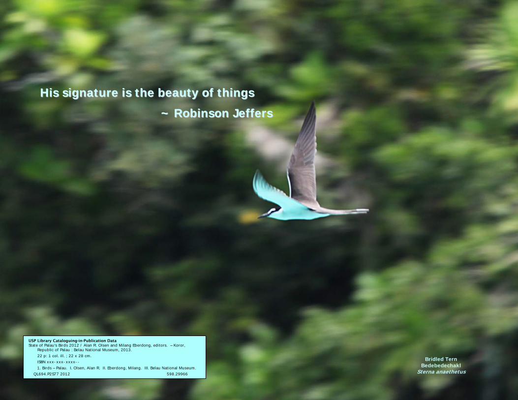
Bird Diversity of the Upper and Lower Ngerikiil Watershed and Ngerimel Reservoir
Bird Species Richness of the Ngerikiil Watershed System Bird Species Upper Basin Lower Basin Ngerimel Palau Fruit-Dove x x x Micronesian Starling x x x Palau Flycatcher x x x Palau Bush-Warbler x x x Palau Swiftlet x x x Morningbird x x x Dusky White-eye x x x Micronesian Honeyeater x x x Palau Ground-Dove x White-breasted Woodswallow x White-tailed Tropicbird x x Cicadabird x x x Citrine White-eye x Collared Kingfisher x x x Micronesian Kingfisher x x Palau Fantail x x x Micronesian Imperial-Pigeon x Black Noddy x x x Nicobar Pigeon x x Buff-banded Rail x x Palau Owl x White Tern x x x Slaty-legged Crake x Rufous Night-Heron x Purple Swamphen x
Total No. Species 22 19 14
The overall bird diversity (25 species) of the Ngerikiil watershed is relatively rich, ranking the conservation priority of the area in the top 10th percentile of terrestrial forests in Palau. Monitoring the watershed is important from a biodiversity conservation point of view and from a water quality perspective.
The species richness table (left) for Ngerikiil shows that different sectors of the watershed system support different arrays of bird species. Rare species such as the Palau Ground-Dove, White-breasted Woodswallow, Micronesian Imperial-Pigeon and Palau Owl occur only in the undisturbed upper river basin. The lower basin supports several bird species that are associated with the agricultural areas and aquaculture ponds that are located in the lower basin including the Slaty-legged Crake, Rufous Night-Heron and Purple Swamphen. This means that several data bases and field tracking stations are needed to monitor ecological changes in a watershed system as large and complex as Ngerikiil.

SSttaattee ooff PPaallaauu''ss BBiirrddss:: WWhhaatt WWee KKnnooww AAbboouutt tthhee CChhaannggiinngg SSttaattee ooff BBiirrddss iinn PPaallaauu
PALAU MEGAPODE ~ Assessment the Status of an Endangered Species in the Rock Islands
In 2012, the Rock Islands Southern Lagoon Conservation Area in the state of Koror was inscribed as Palau's first and, so far, only UNESCO World Heritage Site based on a combination of cultural, scenic and biodiversity criteria. The Rock Islands are a primary breeding ground for a rare bird, the Palau Megapode. In response to the UNESCO World Heritage inscription, a partnership of Belau National Museum, Palau Conservation Society and Koror State Government launched a comprehensive assessment of the status of the Palau Megapode in the World Heritage Site. The assessment was supported by a grant from the Royal Forest and Bird Protection Society of New Zealand through the BirdLife International Community Conservation Fund. The following pages summarize the results of the assessment. The Natural History Gallery at Belau National Museum features an exhibition of the full results of the megapode assessment.
An Unusual, Rare and Endangered Bird
Megapodes are a family of 22 species of chicken-like birds that are found in Australia, the Philippines and several regions of Oceania including Micronesia. The Palau Megapode (picture) is an endemic subspecies of the Micronesian Megapode and is the largest native terrestrial bird in Palau. The only other subspecies of the Micronesian Megapode is found in the northern Marianna islands. The total number of Micronesian Megapodes left in the world is an estimated 1,300 to 1,700 birds. Due to their low populations and restricted ranges, both subspecies are listed as Endangered by the IUCN and BirdLife International.
Palau Megapode Bekai
Megapodius laperouse senex

SSttaattee ooff PPaallaauu''ss BBiirrddss:: WWhhaatt WWee KKnnooww AAbboouutt tthhee CChhaannggiinngg SSttaattee ooff BBiirrddss iinn PPaallaauu
Megapode Nesting Mounds
Palau Megapodes live in the low-lying coastal forests inland from many of the beaches that dot the rock islands landscape. Their breeding grounds are typically located in forested areas with a full canopy. On the shady floor of the forest, megapodes build earthen nesting mounds to protect their eggs. The center of the mound contains a core of fallen leaves and other organic matter that serve as a compost pile to create warmth for incubating the eggs. The core is covered with soil, sand or coral rubble to complete its construction. Breeding and nest-building is a year-round activity for megapodes. A nesting mound may remain active over many years and the accumulated soil or sand can reach impressive proportions. The exceptionally large nesting mound pictured below is over six feet tall and has been in continual use for many years.
During the incubation period, parent birds actively tend their nesting mound by removing or adding soil to maintain the incubation temperature inside the mound. When the eggs finally hatch, the chicks are on their own - having to dig their way out of the mound and begin looking for food without any help from their parents.
Megapodes are notoriously difficult to monitor because they tend to hide in the dense forest. An alternative technique is to monitor nesting mounds, which are comparatively easy to locate and monitor. During the recent assessment, museum scientists documented mound locations as well as bird activity in order to provide a more complete picture of the status of the Palau Megapode in the rock islands.
SSttaattee ooff PPaallaauu''ss BBiirrddss:: WWhhaatt WWee KKnnooww AAbboouutt tthhee CChhaannggiinngg SSttaattee ooff BBiirrddss iinn PPaallaauu
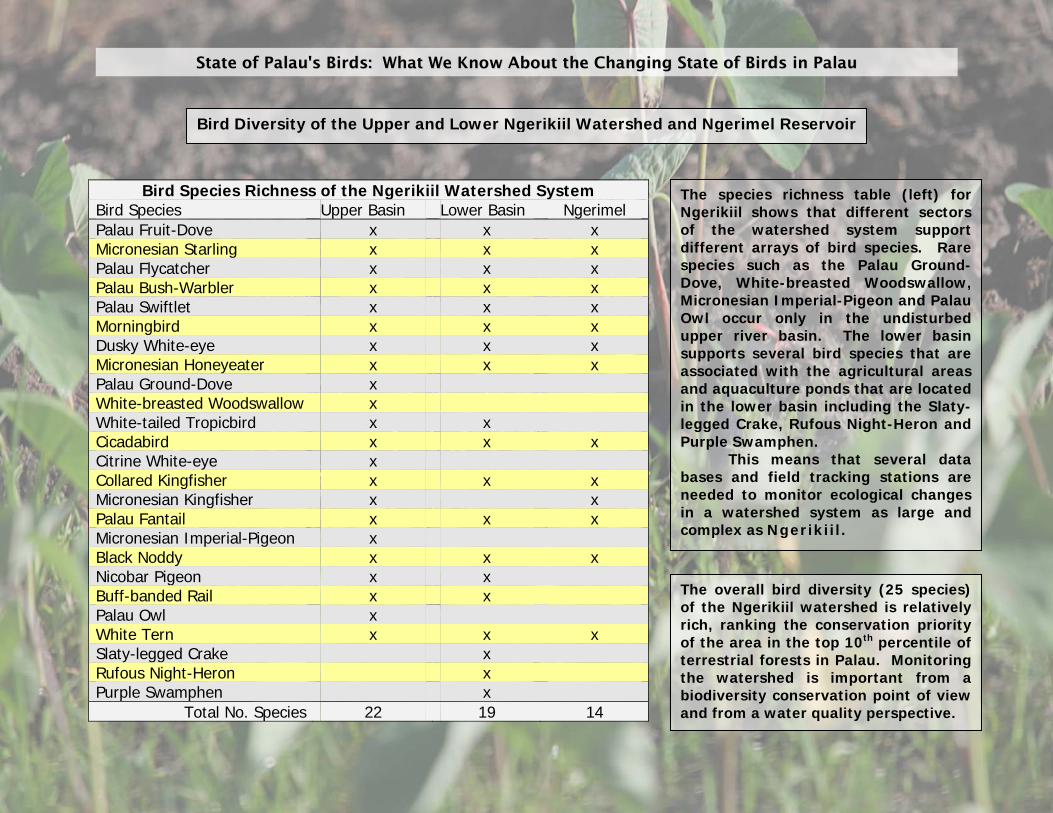
Results of the Assessment of the Status of the Palau Megapode in the Rock Islands
The megapode assessment team visited over 50 potential megapode sites in the Rock Islands to count birds and nesting mounds. Approximately half of the sites had megapodes and/or their nesting mounds. A total of 172 megapodes were seen or heard during the assessment however; a statistical analysis of the data estimated the total megapode population of the World Heritage Site at 230 and 280 birds, which is approximately 15% of the global population of Micronesian Megapodes and which qualifies the World Heritage Site as a megapode hotspot. The table 1 summarizes megapode counts at each rock island assessment locality. Nesting mounds were mapped and classified as "active" if there was evidence of megapodes tending a mound or "inactive" if a mound appeared abandoned. The table 2 summarizes the number and status of the megapode nesting mounds that were found at each rock island locality during the assessment. The satellite map on the facing page shows the location of each active nesting mound found during the assessment.
Table 2 MEGAPODE NESTING MOUNDS
Locality Active Inactive Total Pct ActiveBailechesengel 8 8 16 50.00 Belual a Kelat 1 3 4 25.00 Betikl 0 1 1 0.00 Cheleu 12 21 33 36.36 Dmasech 15 7 22 68.18 Euidelcholl 2 5 7 28.57 Iuolomekang 2 2 4 50.00 Kisaks 0 2 2 0.00 Kmekumer 4 2 6 66.67 Lilblau 5 3 8 62.50 Mariar 1 6 7 14.29 Moir 1 0 1 100.00 Ngchus 0 3 3 0.00 Ngeanges 4 7 11 36.36 Ngebedangel 2 0 2 100.00 Ngerechong 14 13 27 51.85 Ngeremdiu 1 2 3 33.33 Ngerengchol 2 2 4 50.00 Ngeroblobang 7 3 10 70.00 Ngidech 1 1 2 50.00 Ngis 2 1 3 66.67 Ulong 8 18 26 30.77 Totals 92 110 202 45.54
Table 1 MEGAPODE COUNTS
Locality Count Babelomekang 3 Bailechesengel 8 Cheleu 30 Dmasech 23 Euidelcholl 5 Ioulomekang 4 Kmekumer 2 Lilblau 9 Mariar 1 Moir 1 Ngchus 2 Ngeanges 8 Ngebedangel 2 Ngchelobel 4 Ngerechong 32 Ngeremdiu 2 Ngerengchol 2 Ngermeaus 1 Ngeroblobang 5 Ulong 28 Total 172
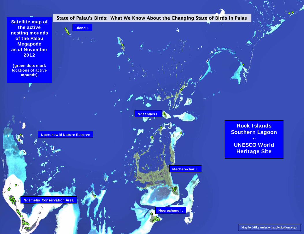
SSttaattee ooff PPaallaauu''ss BBiirrddss:: WWhhaatt WWee KKnnooww AAbboouutt tthhee CChhaannggiinngg SSttaattee ooff BBiirrddss iinn PPaallaauu
Satellite map of the active
nesting mounds of the Palau Megapode
as of November 2012
(green dots mark locations of active
mounds)
Ulong I.
Ngeanges I.
Rock Islands Southern Lagoon
~ UNESCO World Heritage Site
Ngerukewid Nature Reserve
Mecherechar I.
Ngemelis Conservation Area
Ngerechong I.
Map by Mike Aulerio ([email protected])

SSttaattee ooff PPaallaauu''ss BBiirrddss:: WWhhaatt WWee KKnnooww AAbboouutt tthhee CChhaannggiinngg SSttaattee ooff BBiirrddss iinn PPaallaauu
Immediate Threats to the Survival of the Palau Megapode
Typhoons
A related threat is inundation of nesting mounds and destruction of habitat by typhoons. The formerly active nesting mound pictured at right was inundated by the tidal surge from Supertyphoon Bopha (December 2012) and subsequently abandoned by the megapodes that built it. A post-typhoon assessment by Belau National Museum and Palau Conservation Society estimated that up to 10% of the active nesting mounds in the Rock Island Southern Lagoon World Heritage Site may have been lost to Typhoon Bopha. In addition, the forest canopy above at least one breeding ground site was destroyed by typhoon winds and the site with all its nesting mounds was totally abandoned by the megapodes.
Climate Change
The chief threat to the survival of the Palau Megapode is rising sea levels from global warming due to climate change. Exceptionally high tides from rising sea levels threaten to erode away coastal nesting mounds and eventually flood the low-lying beachfront forests where the megapode breeding grounds are located. This threat is already evident in the active nesting mound pictured at left, which is partly eroded from exceptionally high tides. As the sea level continues to rise, the tides will become progressively higher and destroy or flood an increasing number of nesting mounds until none are left.

SSttaattee ooff PPaallaauu''ss BBiirrddss:: WWhhaatt WWee KKnnooww AAbboouutt tthhee CChhaannggiinngg SSttaattee ooff BBiirrddss iinn PPaallaauu
Megapode Assessment Team (l. to r.)
Tiffany Harrison - Koror State Government Heather Ketebengang - Palau Conservation Society Chen Po-hao - Taiwan ICDF/Koror State Government Godines Ngiltii - Palau Conservation Society Milang Eberdong - Belau National Museum Alan R. Olsen - Belau National Museum
Koror State Rangers
The Koror State Rangers organization and the Honorable Yositaka Adachi (center), Governor of the State of Koror, provided top-notch assistance and support for the megapode assessment project.
For more information about the Rock Islands Southern Lagoon World Heritage Site contact Koror State Rangers Telephone: 488-2150 Email: [email protected] or [email protected]
PPrreessssuurree:: MMoonniittoorriinngg CChhaannggeess iinn BBiirrdd DDiivveerrssiittyy
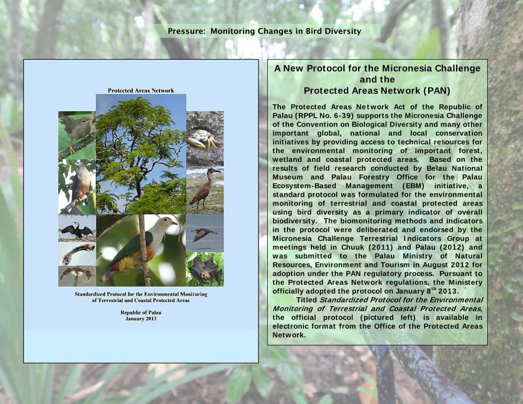
A New Protocol for the Micronesia Challenge and the
Protected Areas Network (PAN)
The Protected Areas Network Act of the Republic of Palau (RPPL No. 6-39) supports the Micronesia Challenge of the Convention on Biological Diversity and many other important global, national and local conservation initiatives by providing access to technical resources for the environmental monitoring of important forest, wetland and coastal protected areas. Based on the results of field research conducted by Belau National Museum and Palau Forestry Office for the Palau Ecosystem-Based Management (EBM) initiative, a standard protocol was formulated for the environmental monitoring of terrestrial and coastal protected areas using bird diversity as a primary indicator of overall biodiversity. The biomonitoring methods and indicators in the protocol were deliberated and endorsed by the Micronesia Challenge Terrestrial Indicators Group at meetings held in Chuuk (2011) and Palau (2012) and was submitted to the Palau Ministry of Natural Resources, Environment and Tourism in August 2012 for adoption under the PAN regulatory process. Pursuant to the Protected Areas Network regulations, the Ministery officially adopted the protocol on January 8th 2013.
Titled Standardized Protocol for the Environmental Monitoring of Terrestrial and Coastal Protected Areas, the official protocol (pictured left) is available in electronic format from the Office of the Protected Areas Network.
RReessppoonnssee:: WWhhaatt IIss BBeeiinngg DDoonnee ttoo IImmpprroovvee tthhee SSttaattuuss ooff BBiirrddss
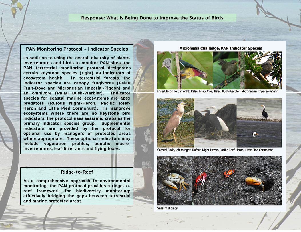
PAN Monitoring Protocol ~ Indicator Species
In addition to using the overall diversity of plants, invertebrates and birds to monitor PAN sites, the PAN terrestrial monitoring protocol designates certain keystone species (right) as indicators of ecosystem health. In terrestrial forests, the indicator species are canopy frugivores (Palau Fruit-Dove and Micronesian Imperial-Pigeon) and an omnivore (Palau Bush-Warbler). Indicator species for coastal marine ecosystems are apex predators (Rufous Night-Heron, Pacific Reef-Heron and Little Pied Cormorant). In mangrove ecosystems where there are no keystone bird indicators, the protocol uses sesarmid crabs as the primary indicator species group. Supplemental indicators are provided by the protocol for optional use by managers of protected areas where appropriate. These optional indicators may include vegetation profiles, aquatic macro-invertebrates, leaf-litter ants and flying foxes.
Ridge-to-Reef
As a comprehensive approach to environmental monitoring, the PAN protocol provides a ridge-to-reef framework for biodiversity monitoring; effectively bridging the gaps between terrestrial and marine protected areas.

RReessppoonnssee:: WWhhaatt IIss BBeeiinngg DDoonnee ttoo IImmpprroovvee tthhee SSttaattuuss ooff BBiirrddss
The Rufous Night-Heron, Nycticorax caledonicus pelewensis, is a regional endemic subspecies found in Palau and the Federated States of Micronesia. When its coastal feeding grounds are covered by seawater at high tide, night-herons congregate with other coastal birds at inland sites (pictured left) to wait for the next low tide.
RUFOUS NIGHT - HERON (MELABAOB) ~ Assessment of a Coastal Indicator Species
In June 2012, the National Program for Monitoring Forest and Coastal Birds conducted a population assessment of the Rufous Night-Heron, a resident bird that serves as a primary indicator species for monitoring coastal habitats. Over a four-day period, night-herons were counted at various coastal locations (map) during low tide when the birds can be seen foraging on exposed tidal flats. This first-time assessment of the Rufous Night-Heron in Palau estimated that Palau's total population of Rufous Night-Herons is approximately 1,200 adult birds. The results of the assessment were submitted to Wetlands International for inclusion in that organization's global database to be published in an upcoming edition of the Waterbird Population Estimates, a global project for monitoring change in bird populations.

RReessppoonnssee:: WWhhaatt IIss BBeeiinngg DDoonnee ttoo IImmpprroovvee tthhee SSttaattuuss ooff BBiirrddss
Rufous Night-Heron adult Choll hamlet, Ngaraard
Rufous Night-Heron adult (breeding plumage)
Ngiwal
Monitoring Coastal Marine Resources Coastal monitoring is important not only for the management of marine resources but also because over half of the bird species in Palau depend on the bounty of the sea for food and survival. The Rufous Night-Heron is an excellent indicator of the biological richness of marine coastal waters because the species is attracted to areas with bountiful food ~ fish, crabs and other marine invertebrates. Coastal areas with rich, pristine waters may attract up to 60 or 70 night-herons at low tide while areas that are impacted by silt or pollution attract few or no night-herons. Monitoring night-herons in marine protected areas provides an early warning system for detecting and measuring change in the richness of the coastal waters to the benefit of both people and birds, who share the abundant marine resources of Palau.
Rufous Night-Heron adult, hunting for food in a tidal flat
Rufous Night-Heron juvenile, waiting for the next low tide

Guardian of Coastal Marine Resources
Rufous Night-Heron Melabaob
Nycticorax caledonicus pelewensis

White-tailed Tropicbird Dudek
Phaethon lepturus
GGAALLLLEERRYY OOFF CCOOMMMMOONN BBIIRRDDSS OOFF TTHHEE RROOCCKK IISSLLAANNDD SSOOUUTTHHEERRNN LLAAGGOOOONN WWOORRLLDD HHEERRIITTAAGGEE SSIITTEE


Common Seabirds of the Rock Islands Southern Lagoon World Heritage Site
Rear - Greater Crested Tern Roall
Sterna bergii
Black-naped Tern Kerkirs
Sterna sumatrana
Front - Black Noddy Bedaoch
Anous minutus
Bridled Tern Bedebedechakl
Sterna anaethetus
Brown Noddy Mechadelbedaoch
Anous stolidus

Acknowledgements
This report was made possible through the support of:
Board of Trustees of the Belau National Museum Office of the President of the Republic of Palau Ministry of Community and Cultural Affairs Ministry of Natural Resources, Environment and Tourism and the Protected Areas Network Koror State Government, Department of Conservation and Law Enforcement and the Koror State Rangers
Palau Conservation Society: Umai Basilius BirdLife International: Mark O’Brien The Nature Conservancy: Umiich Sengebau, Mike Aulerio Birdwatchers: Murako Belibei, Robert Brinks, Rob Davis, Rob Heinsohn, Angelica Olsen, Aurora Olsen, Angelina Smaserui-Olsen
Financial support was generously provided by the Marisla Foundation via the Global Greengrants Fund; the Royal Forest and Bird Protection Society of New Zealand via the BirdLife international Community Conservation Fund; and by Canada Fund, the David and Lucile Packard Foundation and the Palau Integrated Water Resource Management Project (UNDP). Thank you. Research described in this report was conducted by Belau National Museum for the National Program for Monitoring Forest and Coastal Birds and for the Palau Ecosystem-Based Management (EBM) Initiative.
Graphic Design: Ian C. Auacay Bird Photographers: Alan R. Olsen, Milang Eberdong, Chen Po-hao, Heather Ketebengang, Belinda Newman
Editors: Alan R. Olsen and Milang Eberdong
((MMeeggaappooddee ttrraacckkss,, UUlloonngg II..))
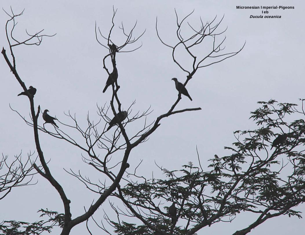
Micronesian Imperial-Pigeons Ieb
Ducula oceanica