Basic Documents No. 2amc.namem.gov.mn/juram/wmo/16.pdfP.O. Box 2300 Fax: +41 (0) 22 730 81 17...
276
Technical Regulations Basic Documents No. 2 Volume II – Meteorological Service for International Air Navigation 2018 edition WMO-No. 49 WEATHER CLIMATE WATER
Transcript of Basic Documents No. 2amc.namem.gov.mn/juram/wmo/16.pdfP.O. Box 2300 Fax: +41 (0) 22 730 81 17...

Technical Regulations
Basic Documents No. 2
Volume II – Meteorological Service for International Air Navigation
2018 edition
WMO-No. 49
WEA
THER
CLI
MAT
E W
ATER

Technical Regulations
Basic Documents No. 2
Volume II – Meteorological Service for International Air Navigation
WMO-No. 49
2018 edition

EDITORIAL NOTE
The following typographical practice has been followed: Standard practices and procedures have been printed in bold. Recommended practices and procedures have been printed in regular font. Notes have been printed in smaller type.
METEOTERM, the WMO terminology database, may be consulted at http://public.wmo.int/en/resources/meteoterm.
Readers who copy hyperlinks by selecting them in the text should be aware that additional spaces may appear immediately following http://, https://, ftp://, mailto:, and after slashes (/), dashes (-), periods (.) and unbroken sequences of characters (letters and numbers). These spaces should be removed from the pasted URL. The correct URL is displayed when hovering over the link or when clicking on the link and then copying it from the browser.
WMO-No. 49
© World Meteorological Organization, 2018
The right of publication in print, electronic and any other form and in any language is reserved by WMO. Short extracts from WMO publications may be reproduced without authorization, provided that the complete source is clearly indicated. Editorial correspondence and requests to publish, reproduce or translate this publication in part or in whole should be addressed to:
Chair, Publications BoardWorld Meteorological Organization (WMO)7 bis, avenue de la Paix Tel.: +41 (0) 22 730 84 03P.O. Box 2300 Fax: +41 (0) 22 730 81 17CH-1211 Geneva 2, Switzerland Email: [email protected]
ISBN 978-92-63-10049-8
NOTE
The designations employed in WMO publications and the presentation of material in this publication do not imply the expression of any opinion whatsoever on the part of WMO concerning the legal status of any country, territory, city or area, or of its authorities, or concerning the delimitation of its frontiers or boundaries.
The mention of specific companies or products does not imply that they are endorsed or recommended by WMO in preference to others of a similar nature which are not mentioned or advertised.

PUBLICATION REVISION TRACK RECORD
Date Part/chapter/ section Purpose of amendment Proposed by Approved by


GENERAL PROVISIONS . . . . . . . . . . . . . . . . . . . . . . . . . . . . . . . . . . . . . . . . . . . . . . . . . . . . . . . . . . ix
PART I . INTERNATIONAL STANDARDS AND RECOMMENDED PRACTICES: CORE STANDARDS AND RECOMMENDED PRACTICES . . . . . . . . . . . . . . . . . . . . . . . 1
1 . DEFINITIONS . . . . . . . . . . . . . . . . . . . . . . . . . . . . . . . . . . . . . . . . . . . . . . . . . . . . . . . . . . . . . . 11.1 Definitions . . . . . . . . . . . . . . . . . . . . . . . . . . . . . . . . . . . . . . . . . . . . . . . . . . . . . . . . . . . . 11.2 Terms used with a limited meaning . . . . . . . . . . . . . . . . . . . . . . . . . . . . . . . . . . . . . . . 7
2 . GENERAL PROVISIONS . . . . . . . . . . . . . . . . . . . . . . . . . . . . . . . . . . . . . . . . . . . . . . . . . . . . . 82.1 Objective, determination and provision of meteorological service . . . . . . . . . . . . . 82.2 Supply, use, quality management and interpretation of meteorological information 82.3 Notifications required from operators . . . . . . . . . . . . . . . . . . . . . . . . . . . . . . . . . . . . . 10
3 . GLOBAL SYSTEMS, SUPPORTING CENTRES AND METEOROLOGICAL OFFICES . . . . 113.1 World area forecast system . . . . . . . . . . . . . . . . . . . . . . . . . . . . . . . . . . . . . . . . . . . . . . 113.2 World area forecast centres . . . . . . . . . . . . . . . . . . . . . . . . . . . . . . . . . . . . . . . . . . . . . 113.3 Aerodrome meteorological offices . . . . . . . . . . . . . . . . . . . . . . . . . . . . . . . . . . . . . . . . 123.4 Meteorological watch offices . . . . . . . . . . . . . . . . . . . . . . . . . . . . . . . . . . . . . . . . . . . . 123.5 Volcanic ash advisory centres . . . . . . . . . . . . . . . . . . . . . . . . . . . . . . . . . . . . . . . . . . . . 133.6 Member volcano observatories . . . . . . . . . . . . . . . . . . . . . . . . . . . . . . . . . . . . . . . . . . 143.7 Tropical cyclone advisory centres . . . . . . . . . . . . . . . . . . . . . . . . . . . . . . . . . . . . . . . . 143.8 Space weather centres (SWXC) . . . . . . . . . . . . . . . . . . . . . . . . . . . . . . . . . . . . . . . . . . 15
4 . METEOROLOGICAL OBSERVATIONS AND REPORTS . . . . . . . . . . . . . . . . . . . . . . . . . . . . 154.1 Aeronautical meteorological stations and observations . . . . . . . . . . . . . . . . . . . . . . 164.2 Agreement between meteorological authorities and air traffic services
authorities . . . . . . . . . . . . . . . . . . . . . . . . . . . . . . . . . . . . . . . . . . . . . . . . . . . . . . . . . . . . 174.3 Routine observations and reports . . . . . . . . . . . . . . . . . . . . . . . . . . . . . . . . . . . . . . . . 174.4 Special observations and reports . . . . . . . . . . . . . . . . . . . . . . . . . . . . . . . . . . . . . . . . . 184.5 Contents of reports . . . . . . . . . . . . . . . . . . . . . . . . . . . . . . . . . . . . . . . . . . . . . . . . . . . . 184.6 Observing and reporting meteorological elements . . . . . . . . . . . . . . . . . . . . . . . . . 19
4.6.1 Surface wind . . . . . . . . . . . . . . . . . . . . . . . . . . . . . . . . . . . . . . . . . . . . . . . . 194.6.2 Visibility . . . . . . . . . . . . . . . . . . . . . . . . . . . . . . . . . . . . . . . . . . . . . . . . . . . . 194.6.3 Runway visual range . . . . . . . . . . . . . . . . . . . . . . . . . . . . . . . . . . . . . . . . . . 194.6.4 Present weather . . . . . . . . . . . . . . . . . . . . . . . . . . . . . . . . . . . . . . . . . . . . . . 204.6.5 Clouds . . . . . . . . . . . . . . . . . . . . . . . . . . . . . . . . . . . . . . . . . . . . . . . . . . . . . . 204.6.6 Air temperature and dewpoint temperature . . . . . . . . . . . . . . . . . . . . . . 204.6.7 Atmospheric pressure . . . . . . . . . . . . . . . . . . . . . . . . . . . . . . . . . . . . . . . . . 204.6.8 Supplementary information . . . . . . . . . . . . . . . . . . . . . . . . . . . . . . . . . . . . 21
4.7 Reporting meteorological information from automatic observing systems . . . . . 214.8 Observations and reports of volcanic activity . . . . . . . . . . . . . . . . . . . . . . . . . . . . . . 21
5 . AIRCRAFT OBSERVATIONS AND REPORTS . . . . . . . . . . . . . . . . . . . . . . . . . . . . . . . . . . . . 215.1 Obligations of Members . . . . . . . . . . . . . . . . . . . . . . . . . . . . . . . . . . . . . . . . . . . . . . . . 225.2 Types of aircraft observations . . . . . . . . . . . . . . . . . . . . . . . . . . . . . . . . . . . . . . . . . . . . 225.3 Routine aircraft observations – designation . . . . . . . . . . . . . . . . . . . . . . . . . . . . . . . . 225.4 Routine aircraft observations – exemptions . . . . . . . . . . . . . . . . . . . . . . . . . . . . . . . . 225.5 Special aircraft observations . . . . . . . . . . . . . . . . . . . . . . . . . . . . . . . . . . . . . . . . . . . . . 225.6 Other non-routine aircraft observations . . . . . . . . . . . . . . . . . . . . . . . . . . . . . . . . . . . 235.7 Reporting of aircraft observations during flight . . . . . . . . . . . . . . . . . . . . . . . . . . . . 235.8 Relay of air-reports by air traffic services units . . . . . . . . . . . . . . . . . . . . . . . . . . . . . . 235.9 Recording and post-flight reporting of aircraft observations of volcanic activity . 23
Page
CONTENTS

6 . FORECASTS . . . . . . . . . . . . . . . . . . . . . . . . . . . . . . . . . . . . . . . . . . . . . . . . . . . . . . . . . . . . . . . 246.1 Use of forecasts . . . . . . . . . . . . . . . . . . . . . . . . . . . . . . . . . . . . . . . . . . . . . . . . . . . . . . . . 246.2 Aerodrome forecasts . . . . . . . . . . . . . . . . . . . . . . . . . . . . . . . . . . . . . . . . . . . . . . . . . . . 246.3 Landing forecasts . . . . . . . . . . . . . . . . . . . . . . . . . . . . . . . . . . . . . . . . . . . . . . . . . . . . . . 256.4 Forecasts for take-off . . . . . . . . . . . . . . . . . . . . . . . . . . . . . . . . . . . . . . . . . . . . . . . . . . . 256.5 Area forecasts for low-level flights . . . . . . . . . . . . . . . . . . . . . . . . . . . . . . . . . . . . . . . . 25
7 . SIGMET AND AIRMET INFORMATION, AERODROME WARNINGS AND WIND SHEAR WARNINGS AND ALERTS . . . . . . . . . . . . . . . . . . . . . . . . . . . . . . . . . . . . . . . 267.1 SIGMET information . . . . . . . . . . . . . . . . . . . . . . . . . . . . . . . . . . . . . . . . . . . . . . . . . . . 267.2 AIRMET information . . . . . . . . . . . . . . . . . . . . . . . . . . . . . . . . . . . . . . . . . . . . . . . . . . . 267.3 Aerodrome warnings . . . . . . . . . . . . . . . . . . . . . . . . . . . . . . . . . . . . . . . . . . . . . . . . . . . 277.4 Wind shear warnings and alerts . . . . . . . . . . . . . . . . . . . . . . . . . . . . . . . . . . . . . . . . . . 27
8 . AERONAUTICAL CLIMATOLOGICAL INFORMATION . . . . . . . . . . . . . . . . . . . . . . . . . . . 278.1 General provisions . . . . . . . . . . . . . . . . . . . . . . . . . . . . . . . . . . . . . . . . . . . . . . . . . . . . . 288.2 Aerodrome climatological tables . . . . . . . . . . . . . . . . . . . . . . . . . . . . . . . . . . . . . . . . . 288.3 Aerodrome climatological summaries . . . . . . . . . . . . . . . . . . . . . . . . . . . . . . . . . . . . . 288.4 Copies of meteorological observational data . . . . . . . . . . . . . . . . . . . . . . . . . . . . . . . 28
9 . SERVICE FOR OPERATORS AND FLIGHT CREW MEMBERS . . . . . . . . . . . . . . . . . . . . . . . 289.1 General provisions . . . . . . . . . . . . . . . . . . . . . . . . . . . . . . . . . . . . . . . . . . . . . . . . . . . . . 299.2 Briefing, consultation and display . . . . . . . . . . . . . . . . . . . . . . . . . . . . . . . . . . . . . . . . 309.3 Flight documentation . . . . . . . . . . . . . . . . . . . . . . . . . . . . . . . . . . . . . . . . . . . . . . . . . . 319.4 Automated pre-flight information systems for briefing, consultation,
flight planning and flight documentation . . . . . . . . . . . . . . . . . . . . . . . . . . . . . . . . . 329.5 Information for aircraft in flight . . . . . . . . . . . . . . . . . . . . . . . . . . . . . . . . . . . . . . . . . . 32
10 . INFORMATION FOR AIR TRAFFIC SERVICES, SEARCH AND RESCUE SERVICES AND AERONAUTICAL INFORMATION SERVICES . . . . . . . . . . . . . . . . . . . . . . 3210.1 Information for air traffic services units . . . . . . . . . . . . . . . . . . . . . . . . . . . . . . . . . . . . 3210.2 Information for search and rescue services units . . . . . . . . . . . . . . . . . . . . . . . . . . . . 3310.3 Information for aeronautical information services units . . . . . . . . . . . . . . . . . . . . . . 33
11 . REQUIREMENTS FOR AND USE OF COMMUNICATIONS . . . . . . . . . . . . . . . . . . . . . . . . 3311.1 Requirements for communications . . . . . . . . . . . . . . . . . . . . . . . . . . . . . . . . . . . . . . . 3311.2 Use of aeronautical fixed service communications and the public
Internet – meteorological bulletins . . . . . . . . . . . . . . . . . . . . . . . . . . . . . . . . . . . . . . . 3511.3 Use of aeronautical fixed service communications – world area forecast
system products . . . . . . . . . . . . . . . . . . . . . . . . . . . . . . . . . . . . . . . . . . . . . . . . . . . . . . . 3511.4 Use of aeronautical mobile service communications . . . . . . . . . . . . . . . . . . . . . . . . 3511.5 Use of aeronautical data link service – contents of D-VOLMET . . . . . . . . . . . . . . . . 3511.6 Use of aeronautical broadcasting service– contents of VOLMET broadcasts . . . . . 35
PART II . INTERNATIONAL STANDARDS AND RECOMMENDED PRACTICES: APPENDICES AND ATTACHMENTS . . . . . . . . . . . . . . . . . . . . . . . . . . . . . . . . . . . . . . . . 36
APPENDIX 1 . FLIGHT DOCUMENTATION – MODEL CHARTS AND FORMS . . . . . . . . . . . . . 36
APPENDIX 2 . TECHNICAL SPECIFICATIONS RELATED TO GLOBAL SYSTEMS, SUPPORTING CENTRES AND METEOROLOGICAL OFFICES . . . . . . . . . . . . . . . . . . . . . . . . . . 50
APPENDIX 3 . TECHNICAL SPECIFICATIONS RELATED TO METEOROLOGICAL OBSERVATIONS AND REPORTS . . . . . . . . . . . . . . . . . . . . . . . . . . . . . . . . . . . . . . . . . . . . . . . . . . 68
vi METEOROLOGICAL SERVICE FOR INTERNATIONAL AIR NAVIGATION
Page

APPENDIX 4 . TECHNICAL SPECIFICATIONS RELATED TO AIRCRAFT OBSERVATIONS AND REPORTS . . . . . . . . . . . . . . . . . . . . . . . . . . . . . . . . . . . . . . . . . . . . . . . . . . 98
APPENDIX 5 . TECHNICAL SPECIFICATIONS RELATED TO FORECASTS . . . . . . . . . . . . . . . . . 105
APPENDIX 6 . TECHNICAL SPECIFICATIONS RELATED TO SIGMET AND AIRMET INFORMATION, AERODROME WARNINGS AND WIND SHEAR WARNINGS AND ALERTS 123
APPENDIX 7 . TECHNICAL SPECIFICATIONS RELATED TO AERONAUTICAL CLIMATOLOGICAL INFORMATION . . . . . . . . . . . . . . . . . . . . . . . . . . . . . . . . . . . . . . . . . . . . . . . 143
APPENDIX 8 . TECHNICAL SPECIFICATIONS RELATED TO SERVICE FOR OPERATORS AND FLIGHT CREW MEMBERS . . . . . . . . . . . . . . . . . . . . . . . . . . . . . . . . . . . . . . . 145
APPENDIX 9 . TECHNICAL SPECIFICATIONS RELATED TO INFORMATION FOR AIR TRAFFIC SERVICES, SEARCH AND RESCUE SERVICES AND AERONAUTICAL INFORMATION SERVICES . . . . . . . . . . . . . . . . . . . . . . . . . . . . . . . . . . . . . . . . . . . . . . . . . . . . . . . . 154
APPENDIX 10 . TECHNICAL SPECIFICATIONS RELATED TO REQUIREMENTS FOR AND USE OF COMMUNICATIONS . . . . . . . . . . . . . . . . . . . . . . . . . . . . . . . . . . . . . . . . . . . . . . . . 158
ATTACHMENT A . OPERATIONALLY DESIRABLE ACCURACY OF MEASUREMENT OR OBSERVATION . . . . . . . . . . . . . . . . . . . . . . . . . . . . . . . . . . . . . . . . . . . . . . . . . . . . . . . . . . . . . . 162
ATTACHMENT B . OPERATIONALLY DESIRABLE ACCURACY OF FORECASTS . . . . . . . . . . . 163
ATTACHMENT C . SELECTED CRITERIA APPLICABLE TO AERODROME REPORTS . . . . . . . . 165
ATTACHMENT D . CONVERSION OF INSTRUMENTED READINGS INTO RUNWAY VISUAL RANGE AND VISIBILITY . . . . . . . . . . . . . . . . . . . . . . . . . . . . . . . . . . . . . . . . . . . . . . . . . . 167
ATTACHMENT E . SPATIAL RANGES AND RESOLUTIONS FOR SPACE WEATHER ADVISORY INFORMATION . . . . . . . . . . . . . . . . . . . . . . . . . . . . . . . . . . . . . . . . . . . . . . . . . . . . . . 169
PART III . AERONAUTICAL CLIMATOLOGY . . . . . . . . . . . . . . . . . . . . . . . . . . . . . . . . . . 170
1 . GENERAL PROVISIONS . . . . . . . . . . . . . . . . . . . . . . . . . . . . . . . . . . . . . . . . . . . . . . . . . . . . . 170
2 . AERODROME CLIMATOLOGICAL TABLES . . . . . . . . . . . . . . . . . . . . . . . . . . . . . . . . . . . . . 170
3 . AERODROME CLIMATOLOGICAL SUMMARIES . . . . . . . . . . . . . . . . . . . . . . . . . . . . . . . . 171
ATTACHMENT . AERODROME CLIMATOLOGY SUMMARY – TABULAR FORMS . . . . . . . . . . 172
PART IV . FORMAT AND PREPARATION OF FLIGHT DOCUMENTATION . . . . . . . . . 178
1 . FLIGHT DOCUMENTATION . . . . . . . . . . . . . . . . . . . . . . . . . . . . . . . . . . . . . . . . . . . . . . . . . 178
2 . PREPARATION OF FLIGHT DOCUMENTATION . . . . . . . . . . . . . . . . . . . . . . . . . . . . . . . . . 1782.1 General . . . . . . . . . . . . . . . . . . . . . . . . . . . . . . . . . . . . . . . . . . . . . . . . . . . . . . . . . . . . . . 178
3 . CHARTS PREPARED BY WORLD AREA FORECAST CENTRES . . . . . . . . . . . . . . . . . . . . . 1783.1 General . . . . . . . . . . . . . . . . . . . . . . . . . . . . . . . . . . . . . . . . . . . . . . . . . . . . . . . . . . . . . . 1783.2 Map bases and projections . . . . . . . . . . . . . . . . . . . . . . . . . . . . . . . . . . . . . . . . . . . . . . 1793.3 Contents of charts . . . . . . . . . . . . . . . . . . . . . . . . . . . . . . . . . . . . . . . . . . . . . . . . . . . . . 179
viiCONTENTS
Page

4 . COMPLETION OF MODELS . . . . . . . . . . . . . . . . . . . . . . . . . . . . . . . . . . . . . . . . . . . . . . . . . . 1814.1 Model A: OPMET information . . . . . . . . . . . . . . . . . . . . . . . . . . . . . . . . . . . . . . . . . . . 1814.2 Model IS: upper wind and upper-air temperature chart for standard
isobaric surface . . . . . . . . . . . . . . . . . . . . . . . . . . . . . . . . . . . . . . . . . . . . . . . . . . . . . . . . 1814.3 Models SWH, SWM and SWL: significant weather charts . . . . . . . . . . . . . . . . . . . . 1814.4 Model TCG: tropical cyclone advisory information in graphical format . . . . . . . . . 1834.5 Model VAG: volcanic ash advisory information in graphical format . . . . . . . . . . . . 1834.6 Model STC: SIGMET for tropical cyclone in graphical format . . . . . . . . . . . . . . . . . 1834.7 Model SVA: SIGMET for volcanic ash in graphical format . . . . . . . . . . . . . . . . . . . . . 1844.8 Model SGE: SIGMET for phenomena other than tropical cyclone and
volcanic ash in graphical format . . . . . . . . . . . . . . . . . . . . . . . . . . . . . . . . . . . . . . . . . 1844.9 Model SN: sheet of notations used in flight documentation . . . . . . . . . . . . . . . . . . 184
viii METEOROLOGICAL SERVICE FOR INTERNATIONAL AIR NAVIGATION
Page

GENERAL PROVISIONS
1. The Technical Regulations (WMO-No. 49) of the World Meteorological Organization are presented in three volumes:
Volume I – General meteorological standards and recommended practices Volume II – Meteorological service for international air navigation Volume III – Hydrology
Purpose of the Technical Regulations
2. The Technical Regulations are determined by the World Meteorological Congress in accordance with Article 8 (d) of the Convention.
3. These Regulations are designed:
(a) To facilitate cooperation in meteorology and hydrology among Members;
(b) To meet, in the most effective manner, specific needs in the various fields of application of meteorology and operational hydrology in the international sphere;
(c) To ensure adequate uniformity and standardization in the practices and procedures employed in achieving (a) and (b) above.
Types of Regulations
4. The Technical Regulations comprise standard practices and procedures and recommended practices and procedures.
5. The definitions of these two types of Regulations are as follows:
The standard practices and procedures:
(a) Shall be the practices and procedures that Members are required to follow or implement;
(b) Shall have the status of requirements in a technical resolution in respect of which Article 9 (b) of the Convention is applicable;
(c) Shall invariably be distinguished by the use of the term shall in the English text, and by suitable equivalent terms in the Arabic, Chinese, French, Russian and Spanish texts.
The recommended practices and procedures:
(a) Shall be the practices and procedures with which Members are urged to comply;
(b) Shall have the status of recommendations to Members, to which Article 9 (b) of the Convention shall not be applied;
(c) Shall be distinguished by the use of the term should in the English text (except where otherwise provided by decision of Congress) and by suitable equivalent terms in the Arabic, Chinese, French, Russian and Spanish texts.
6. In accordance with the above definitions, Members shall do their utmost to implement the standard practices and procedures. In accordance with Article 9 (b) of the Convention and in conformity with Regulation 128 of the General Regulations, Members shall formally notify the Secretary-General, in writing, of their intention to apply the standard practices and procedures of the Technical Regulations, except those for which they have lodged a specific

deviation. Members shall also inform the Secretary-General, at least three months in advance, of any change in the degree of their implementation of a standard practice or procedure as previously notified and the effective date of the change.
7. Members are urged to comply with recommended practices and procedures, but it is not necessary to notify the Secretary-General of non-observance except with regard to practices and procedures contained in Volume II.
8. In order to clarify the status of the various Regulations, the standard practices and procedures are distinguished from the recommended practices and procedures by a difference in typographical practice, as indicated in the editorial note.
Status of annexes and appendices
9. The following annexes to the Technical Regulations (Volumes I to III), also called Manuals, are published separately and contain regulatory material having the status of standard and/or recommended practices and procedures:
I International Cloud Atlas (WMO-No. 407) – Manual on the Observation of Clouds and Other Meteors, sections 1, 2.1.1, 2.1.4, 2.1.5, 2.2.2, 1 to 4 in 2.3.1 to 2.3.10 (for example, 2.3.1.1, 2.3.1.2, etc.), 2.8.2, 2.8.3, 2.8.5, 3.1 and the definitions (in grey-shaded boxes) of 3.2;
II Manual on Codes (WMO-No. 306), Volume I;III Manual on the Global Telecommunication System (WMO-No. 386);IV Manual on the Global Data-processing and Forecasting System (WMO-No. 485);V Manual on the Global Observing System (WMO-No. 544), Volume I;VI Manual on Marine Meteorological Services (WMO-No. 558), Volume I;VII Manual on the WMO Information System (WMO-No. 1060);VIII Manual on the WMO Integrated Global Observing System (WMO-No. 1160).
These annexes (Manuals) are established by decision of Congress and are intended to facilitate the application of Technical Regulations to specific fields. Annexes may contain both standard and recommended practices and procedures.
10. Texts called appendices, appearing in the Technical Regulations or in an annex to the Technical Regulations, have the same status as the Regulations to which they refer.
Status of notes and attachments
11. Certain notes (preceded by the indication “Note”) are included in the Technical Regulations for explanatory purposes; they may, for instance, refer to relevant WMO Guides and publications. These notes do not have the status of Technical Regulations.
12. The Technical Regulations may also include attachments, which usually contain detailed guidelines related to standard and recommended practices and procedures. Attachments, however, do not have regulatory status.
Updating of the Technical Regulations and their annexes (Manuals)
13. The Technical Regulations are updated, as necessary, in the light of developments in meteorology and hydrology and related techniques, and in the application of meteorology and operational hydrology. Certain principles previously agreed upon by Congress and applied in the selection of material for inclusion in the Technical Regulations are reproduced below. These principles provide guidance for constituent bodies, in particular technical commissions, when dealing with matters pertaining to the Technical Regulations:
(a) Technical commissions should not recommend that a Regulation be a standard practice unless it is supported by a strong majority;
x METEOROLOGICAL SERVICE FOR INTERNATIONAL AIR NAVIGATION

GENERAL PROVISIONS
(b) Technical Regulations should contain appropriate instructions to Members regarding implementation of the provision in question;
(c) No major changes should be made to the Technical Regulations without consulting the appropriate technical commissions;
(d) Any amendments to the Technical Regulations submitted by Members or by constituent bodies should be communicated to all Members at least three months before they are submitted to Congress.
14. Amendments to the Technical Regulations – as a rule – are approved by Congress.
15. If a recommendation for an amendment is made by a session of the appropriate technical commission and if the new regulation needs to be implemented before the next session of Congress, the Executive Council may, on behalf of the Organization, approve the amendment in accordance with Article 14 (c) of the Convention. Amendments to annexes to the Technical Regulations proposed by the appropriate technical commissions are normally approved by the Executive Council.
16. If a recommendation for an amendment is made by the appropriate technical commission and the implementation of the new regulation is urgent, the President of the Organization may, on behalf of the Executive Council, take action as provided by Regulation 9 (5) of the General Regulations.
Note: A simple (fast-track) procedure may be used for amendments to technical specifications in Annexes II (Manual on Codes (WMO-No. 306)), III (Manual on the Global Telecommunication System (WMO-No. 386)), IV (Manual on the Global Data-processing and Forecasting System (WMO-No. 485)), V (Manual on the Global Observing System (WMO-No. 544)), VII (Manual on the WMO Information System (WMO-No. 1060)) and VIII (Manual on the WMO Integrated Global Observing System (WMO-No. 1160)). Application of the simple (fast-track) procedure is defined in the appendix to these General Provisions.
17. After each session of Congress (every four years), a new edition of the Technical Regulations, including the amendments approved by Congress, is issued. With regard to the amendments between sessions of Congress, Volumes I and III of the Technical Regulations are updated, as necessary, upon approval of changes thereto by the Executive Council. The Technical Regulations updated as a result of an approved amendment by the Executive Council are considered a new update of the current edition. The material in Volume II is prepared by the World Meteorological Organization and the International Civil Aviation Organization working in close cooperation, in accordance with the Working Arrangements agreed by these Organizations. In order to ensure consistency between Volume II and Annex 3 to the Convention on International Civil Aviation – Meteorological Service for International Air Navigation, the issuance of amendments to Volume II is synchronized with the respective amendments to Annex 3 by the International Civil Aviation Organization.
Note: Editions are identified by the year of the respective session of Congress whereas updates are identified by the year of approval by the Executive Council, for example “Updated in 2012”.
WMO Guides
18. In addition to the Technical Regulations, appropriate Guides are published by the Organization. They describe practices, procedures and specifications which Members are invited to follow or implement in establishing and conducting their arrangements for compliance with the Technical Regulations, and in otherwise developing meteorological and hydrological services in their respective countries. The Guides are updated, as necessary, in the light of scientific and
xi

technological developments in hydrometeorology, climatology and their applications. The technical commissions are responsible for the selection of material to be included in the Guides. These Guides and their subsequent amendments shall be considered by the Executive Council.
xii METEOROLOGICAL SERVICE FOR INTERNATIONAL AIR NAVIGATION

GENERAL PROVISIONS
APPENDIX. PROCEDURES FOR AMENDING WMO MANUALS AND GUIDES THAT ARE THE RESPONSIBILITY OF THE COMMISSION FOR BASIC SYSTEMS
1. DESIGNATION OF RESPONSIBLE COMMITTEES
The Commission for Basic Systems (CBS) shall, for each Manual and Guide, designate one of its Open Programme Area Groups (OPAGs) as being responsible for that Manual and its associated technical guides. The Open Programme Area Group may choose to designate one of its Expert Teams as the designated committee for managing changes to all or part of that Manual; if no Expert Team is designated, the Implementation Coordination Team for the OPAG takes on the role of the designated committee.
2. GENERAL VALIDATION AND IMPLEMENTATION PROCEDURES
2.1 Proposal of amendments
Amendments to a Manual or a Guide managed by CBS shall be proposed in writing to the Secretariat. The proposal shall specify the needs, purposes and requirements and include information on a contact point for technical matters.
2.2 Drafting recommendation
The designated committee for the relevant part of a Manual or a Guide, supported by the Secretariat, shall validate the stated requirement (unless it is consequential to an amendment to the WMO Technical Regulations) and develop a draft recommendation to respond to the requirement, as appropriate.
2.3 Procedures for approval
After a draft recommendation of the designated committee is validated in accordance with the procedure given in section 7 below, depending on the type of amendments, the designated committee should select one of the following procedures for the approval of the amendments:
(a) Simple (fast-track) procedure (see section 3 below);
(b) Standard (adoption of amendments between CBS sessions) procedure (see section 4 below);
(c) Complex (adoption of amendments during CBS sessions) procedure (see section 5 below).
2.4 Date of implementation
The designated committee should define an implementation date in order to give WMO Members sufficient time to implement the amendments after the date of notification. For procedures other than the simple (fast-track) one, if the time between the date of notification and implementation date is less than six months, the designated committee shall document the reasons for its decision.
xiii

2.5 Urgent introduction
Regardless of the above procedures, as an exceptional measure, the following procedure accommodates urgent user needs to introduce elements in lists of technical details, or to correct errors:
(a) A draft recommendation developed by the designated committee shall be validated according to the steps defined in section 7 below;
(b) The draft recommendation for pre-operational use of a list entry, which can be used in operational data and products, shall be approved by the chairperson of the designated committee and the chairperson of the responsible OPAG, and the president of CBS. A listing of pre-operational list entries is kept online on the WMO web server;
(c) Pre-operational list entries shall then be submitted for approval by one of the procedures in 2.3 above for operational use;
(d) Any version numbers associated with the technical implementation should be incremented at the least significant level.
2.6 Issuing updated version
Once amendments to a Manual or a Guide are adopted, an updated version of the relevant part of the Manual shall be issued in the languages agreed for its publication. The Secretariat shall inform all Members of the availability of a new updated version of that part at the date of notification mentioned in 2.4 above. If amendments are not incorporated into the published text of the relevant Manual or Guide at the time of the amendment, there should be a mechanism to publish the amendments at the time of their implementation and to retain a permanent record of the sequence of amendments.
3. SIMPLE (FAST-TRACK) PROCEDURE
3.1 Scope
The simple (fast-track) procedure shall be used only for changes to components of the Manual that have been designated and marked as “technical specifications to which the simple (fast-track) procedure for the approval of amendments may be applied”.
Note: An example would be the addition of code list items in the Manual on Codes (WMO-No. 306).
3.2 Endorsement
Draft recommendations developed by the responsible committee, including a date for implementation of the amendments, shall be submitted to the chairperson of the relevant OPAG for endorsement.
3.3 Approval
3.3.1 Minor adjustments
Correcting typographical errors in descriptive text is considered a minor adjustment, and will be done by the Secretariat in consultation with the president of CBS. See Figure 1.
xiv METEOROLOGICAL SERVICE FOR INTERNATIONAL AIR NAVIGATION

GENERAL PROVISIONS
President of CBS (in consultation
with presidents of technical commissions)
Designatedcommittee Chairperson of OPAG
Figure 1 . Adoption of amendments to a Manual by minor adjustment
3.3.2 Other types of amendments
For other types of amendments, the English version of the draft recommendation, including a date of implementation, should be distributed to the focal points for matters concerning the relevant Manual for comments, with a deadline of two months for the reply. It should then be submitted to the president of CBS for consultation with presidents of technical commissions affected by the change. If endorsed by the president of CBS, the change should be passed to the President of WMO for consideration and adoption on behalf of the Executive Council (EC).
3.3.3 Frequency
The implementation of amendments approved through the simple (fast-track) procedure can be twice a year in May and November. See Figure 2.
4. STANDARD (ADOPTION OF AMENDMENTS BETWEEN CBS SESSIONS) PROCEDURE
4.1 Scope
The standard (adoption of amendments between CBS sessions) procedure shall be used for changes that have an operational impact on those Members who do not wish to exploit the change, but that have only minor financial impact, or that are required to implement changes in the Technical Regulations (WMO-No. 49), Volume II – Meteorological Service for International Air Navigation.
4.2 Approval of draft recommendations
For the direct adoption of amendments between CBS sessions, the draft recommendation developed by the designated committee, including a date of implementation of the amendments, shall be submitted to the chairperson of the responsible OPAG and president and vice-president of CBS for approval. The president of CBS shall consult with the presidents of technical commissions affected by the change. In the case of recommendations in response
xv
Focal points for matters concerning the Manual
President of CBS (in consultation with
presidents of technical commissions) and then to
the President of WMO
Chairperson of OPAG
Designatedcommittee
Figure 2 . Adoption of amendments to a Manual by simple (fast-track) procedure

to changes in the Technical Regulations (WMO-No. 49), Volume II – Meteorological Service for International Air Navigation, the president of CBS shall consult with the president of the Commission for Aeronautical Meteorology.
4.3 Circulation to Members
Upon approval of the president of CBS, the Secretariat sends the recommendation to all Members, in the languages in which the Manual is published, including a date of implementation of the amendments, for comments to be submitted within two months following the dispatch of the amendments. If the recommendation is sent to Members via electronic mail, there shall be public announcement of the amendment process including dates, for example by WMO Operational Newsletter on the WMO website, to ensure all relevant Members are informed.
4.4 Agreement
Those Members not having replied within the two months following the dispatch of the amendments are implicitly considered as having agreed with the amendments.
4.5 Coordination
Members are invited to designate a focal point responsible to discuss any comments/disagreements with the designated committee. If the discussion between the designated committee and the focal point cannot result in an agreement on a specific amendment by a Member, this amendment will be reconsidered by the designated committee. If a Member cannot agree that the financial or operational impact is minor, the redrafted amendment shall be approved by the complex (adoption of amendments during CBS sessions) procedure described in section 5 below.
4.6 Notification
Once amendments are agreed by Members, and after consultation with the chairperson of the responsible OPAG, the vice-president of CBS and the president of CBS (who should consult with presidents of other commissions affected by the change), the Secretariat notifies at the same time the Members and the members of the Executive Council of the approved amendments and of the date of their implementation. See Figure 3.
Designatedcommittee
Agreed by WMO
Members
WMO Members
and EC informed
Chairperson of OPAGand president/
vice-president of CBSin consultation with
presidents of technical commissions
Figure 3 . Adoption of amendments between CBS sessions
xvi METEOROLOGICAL SERVICE FOR INTERNATIONAL AIR NAVIGATION

GENERAL PROVISIONS
5. COMPLEX (ADOPTION OF AMENDMENTS DURING CBS SESSIONS) PROCEDURE
5.1 Scope
The complex (adoption of amendments during CBS sessions) procedure shall be used for changes for which the simple (fast-track) procedure or standard (adoption of amendments between CBS sessions) procedure cannot be applied.
5.2 Procedure
For the adoption of amendments during CBS sessions, the designated committee submits its recommendation, including a date of implementation of the amendments, to the Implementation Coordination Team of the responsible Open Programme Area Group. The recommendation is then passed to the presidents of technical commissions affected by the change for consultation, and to a CBS session that shall be invited to consider comments submitted by presidents of technical commissions. The document for the CBS session shall be distributed not later than 45 days before the opening of the session. Following the CBS session, the recommendation shall then be submitted to a session of the Executive Council for decision. See Figure 4.
6. PROCEDURE FOR THE CORRECTION OF EXISTING MANUAL CONTENTS
6.1 Correcting errors in items within Manuals
Where a minor error in the specification of an item that defines elements within a Manual is found, for example, a typing error or an incomplete definition, the item shall be amended and re-published. Any version numbers associated with items edited as a result of the change should be incremented at their lowest level of significance. If, however, the change has an impact on the meaning of the item, then a new item should be created and the existing (erroneous) item marked as deprecated. This situation is considered a minor adjustment according to 3.3.1 above.
Note: An example of an item for which this type of change applies is a code list entry for the Table Driven Code Forms or WMO Core Metadata Profile, in which the description contains typographical errors that can be corrected without changing the meaning of the description.
Consultpresidents of
technicalcommissions a ected by the change
EC session
CBS session
Meeting of Implementation
Coordination Team of
responsible OPAG
Designatedcommittee
Figure 4 . Adoption of amendments during CBS sessions
xvii

6.2 Correcting an error in the specification of how conformance with the requirements of the Manual can be checked
If an erroneous specification of a conformance-checking rule is found, the preferred approach is to add a new specification using the simple (fast-track) procedure or standard (adoption of amendments between CBS sessions) procedure. The new conformance-checking rule should be used instead of the old. An appropriate explanation shall be added to the description of the conformance-checking rule to clarify the practice along with the date of the change.
Note: An example of such a change would be correcting a conformance-checking rule in the WMO Core Metadata Profile.
6.3 Submission of corrections to errors
Such changes shall be submitted through the simple (fast-track) procedure.
7. VALIDATION PROCEDURE
7.1 Documentation of need and purpose
The need for, and the purpose of, the proposal for changes should be documented.
7.2 Documentation of result
This documentation shall include the results of validation testing of the proposal as described in 7.3 below.
7.3 Testing with relevant applications
For changes that have an impact on automated processing systems, the extent of the testing required before validation should be decided by the designated committee on a case-by-case basis, depending on the nature of the change. Changes involving a relatively high risk and/or impact on the systems should be tested by the use of at least two independently developed tool sets and two independent centres. In that case, results should be made available to the designated committee with a view to verifying the technical specifications.
xviii METEOROLOGICAL SERVICE FOR INTERNATIONAL AIR NAVIGATION

PART I. INTERNATIONAL STANDARDS AND RECOMMENDED PRACTICES: CORE STANDARDS AND RECOMMENDED PRACTICES
1. DEFINITIONS
Note: The designation (RR) in these definitions indicates a definition which has been extracted from the Radio Regulations of the International Telecommunication Union (ITU) (see the ICAO Handbook on Radio Frequency Spectrum Requirements for Civil Aviation including Statement of Approved ICAO Policies (Doc 9718)).
1.1 Definitions
When the following terms are used in Parts I and II, they have the following meanings:
Aerodrome . A defined area on land or water (including any buildings, installations and equipment) intended to be used either wholly or in part for the arrival, departure and surface movement of aircraft.
Aerodrome climatological summary . Concise summary of specified meteorological elements at an aerodrome, based on statistical data.
Aerodrome climatological table . Table providing statistical data on the observed occurrence of one or more meteorological elements at an aerodrome.
Aerodrome control tower . A unit established to provide air traffic control service to aerodrome traffic.
Aerodrome elevation . The elevation of the highest point of the landing area.
Aerodrome meteorological office . An office designated to provide meteorological service for aerodromes serving international air navigation.
Aerodrome reference point . The designated geographical location of an aerodrome.
Aeronautical fixed service (AFS) . A telecommunication service between specified fixed points provided primarily for the safety of air navigation and for the regular, efficient and economical operation of air services.
Aeronautical fixed telecommunication network (AFTN) . A worldwide system of aeronautical fixed circuits provided, as part of the aeronautical fixed service, for the exchange of messages and/or digital data between aeronautical fixed stations having the same or compatible communications characteristics.
Aeronautical meteorological station . A station designated to make observations and meteorological reports for use in international air navigation.
Aeronautical mobile service (RR S1 .32) . A mobile service between aeronautical stations and aircraft stations, or between aircraft stations, in which survival craft stations may participate; emergency position-indicating radio beacon stations may also participate in this service on designated distress and emergency frequencies.
Aeronautical telecommunication station . A station in the aeronautical telecommunication service.
Aircraft . Any machine that can derive support in the atmosphere from the reactions of the air other than the reactions of the air against the Earth’s surface.

Aircraft observation . The evaluation of one or more meteorological elements made from an aircraft in flight.
AIRMET information . Information issued by a meteorological watch office concerning the occurrence or expected occurrence of specified en-route weather phenomena which may affect the safety of low-level aircraft operations and which was not already included in the forecast issued for low-level flights in the flight information region concerned or sub-area thereof.
Air-report . A report from an aircraft in flight prepared in conformity with requirements for position, and operational and/or meteorological reporting.
Note: Details of the AIREP form are given in the ICAO Procedures for Air Navigation Services – Air Traffic Management (PANS-ATM, Doc 4444).
Air traffic services unit . A generic term meaning variously, air traffic control unit, flight information centre or air traffic services reporting office.
Alternate aerodrome . An aerodrome to which an aircraft may proceed when it becomes either impossible or inadvisable to proceed to or to land at the aerodrome of intended landing where the necessary services and facilities are available, where aircraft performance requirements can be met and which is operational at the expected time of use. Alternate aerodromes include the following:
Take-off alternate. An alternate aerodrome at which an aircraft would be able to land should this become necessary shortly after take-off and it is not possible to use the aerodrome of departure.
En-route alternate. An alternate aerodrome at which an aircraft would be able to land in the event that a diversion becomes necessary while en route.
Destination alternate. An alternate aerodrome at which an aircraft would be able to land should it become either impossible or inadvisable to land at the aerodrome of intended landing.
Note: The aerodrome from which a flight departs may also be an en-route or a destination alternate aerodrome for that flight.
Altitude . The vertical distance of a level, a point or an object considered as a point, measured from mean sea level (MSL).
Approach control unit . A unit established to provide air traffic control service to controlled flights arriving at, or departing from, one or more aerodromes.
Appropriate ATS authority . The relevant authority designated by the Member responsible for providing air traffic services in the airspace concerned.
Area control centre (ACC) . A unit established to provide air traffic control service to controlled flights in control areas under its jurisdiction.
Area navigation (RNAV) . A method of navigation which permits aircraft operations on any desired flight path within the coverage of ground- or space-based navigation aids or within the limits of the capability of self-contained aids, or a combination of these.
Note: Area navigation includes performance-based navigation as well as other operations that do not meet the definition of performance-based navigation.
2 METEOROLOGICAL SERVICE FOR INTERNATIONAL AIR NAVIGATION

PART I. INTERNATIONAL STANDARDS AND RECOMMENDED PRACTICES: CORE STANDARDS AND RECOMMENDED PRACTICES
Automatic dependent surveillance – contract (ADS-C) . A means by which the terms of an ADS-C agreement will be exchanged between the ground system and the aircraft, via a data link, specifying under what conditions ADS-C reports would be initiated, and what data would be contained in the reports.
Note: The abbreviated term “ADS contract” is commonly used to refer to ADS event contract, ADS demand contract, ADS periodic contract or an emergency mode.
Briefing . Oral commentary on existing and/or expected meteorological conditions.
Cloud of operational significance . A cloud with the height of cloud base below 1 500 m (5 000 ft) or below the highest minimum sector altitude, whichever is greater, or a cumulonimbus cloud or a towering cumulus cloud at any height.
Consultation . Discussion with a meteorologist or another qualified person of existing and/or expected meteorological conditions relating to flight operations; a discussion includes answers to questions.
Control area (CTA) . A controlled airspace extending upwards from a specified limit above the Earth.
Cruising level . A level maintained during a significant portion of a flight.
Elevation . The vertical distance of a point or a level, on or affixed to the surface of the Earth, measured from mean sea level.
Extended-range operation . Any flight by an aeroplane with two turbine engines where the flight time at the one engine inoperative cruise speed (in ISA and still air conditions), from a point on the route to an adequate alternate aerodrome, is greater than the threshold time approved by the Member of the Operator.
Flight crew member . A licensed crew member charged with duties essential to the operation of an aircraft during a flight duty period.
Flight documentation . Written or printed documents, including charts or forms, containing meteorological information for a flight.
Flight information centre (FIC) . A unit established to provide flight information service and alerting service.
Flight information region (FIR) . An airspace of defined dimensions within which flight information service and alerting service are provided.
Flight level . A surface of constant atmospheric pressure which is related to a specific pressure datum, 1 013.2 hectopascals (hPa), and is separated from other such surfaces by specific pressure intervals.
Notes:1. A pressure type altimeter calibrated in accordance with the Standard Atmosphere:
(a) When set to a QNH altimeter setting, will indicate altitude;(b) When set to a QFE altimeter setting, will indicate height above the QFE reference datum;(c) When set to a pressure of 1 013.2 hPa, may be used to indicate flight levels.
2. The terms “height” and “altitude”, used in Note 1, indicate altimetric rather than geometric heights and altitudes.
Forecast . A statement of expected meteorological conditions for a specified time or period, and for a specified area or portion of airspace.
3

GAMET area forecast . An area forecast in abbreviated plain language for low-level flights for a flight information region or sub-area thereof, prepared by the meteorological office designated by the meteorological authority concerned and exchanged with meteorological offices in adjacent flight information regions, as agreed between the meteorological authorities concerned.
Grid-point data in digital form . Computer-processed meteorological data for a set of regularly spaced points on a chart, for transmission from a meteorological computer to another computer in a code form suitable for automated use.
Note: In most cases, such data are transmitted on medium- or high-speed telecommunications channels.
Height . The vertical distance of a level, a point or an object considered as a point, measured from a specified datum.
Human Factors principles . Principles which apply to aeronautical design, certification, training, operations and maintenance and which seek safe interface between the human and other system components by proper consideration to human performance.
ICAO meteorological information exchange model (IWXXM) . A data model for representing aeronautical meteorological information.
International airways volcano watch (IAVW) . International arrangements for monitoring and providing warnings to aircraft of volcanic ash in the atmosphere.
Note: The IAVW is based on the cooperation of aviation and non-aviation operational units using information derived from observing sources and networks that are provided by Members. The watch is coordinated by ICAO with the cooperation of other international organizations concerned.
Level . A generic term relating to the vertical position of an aircraft in flight and meaning variously height, altitude or flight level.
Member volcano observatory . A volcano observatory, designated by regional air navigation agreement, to monitor active or potentially active volcanoes within a Member State or Member Territory and to provide information on volcanic activity to its associated area control centre/flight information centre, meteorological watch office and volcanic ash advisory centre.
Note: ICAO defines this as State volcano observatory.
Meteorological authority . The authority providing or arranging for the provision of meteorological service for international air navigation on behalf of a Member.
Meteorological bulletin . A text comprising meteorological information preceded by an appropriate heading.
Meteorological information . Meteorological report, analysis, forecast and any other statement relating to existing or expected meteorological conditions.
Meteorological office . An office designated to provide meteorological service for international air navigation.
Meteorological report . A statement of observed meteorological conditions related to a specified time and location.
Meteorological satellite . An artificial Earth satellite making meteorological observations and transmitting these observations to Earth.
4 METEOROLOGICAL SERVICE FOR INTERNATIONAL AIR NAVIGATION

PART I. INTERNATIONAL STANDARDS AND RECOMMENDED PRACTICES: CORE STANDARDS AND RECOMMENDED PRACTICES
Meteorological watch office (MWO) . An office designated to provide information concerning the occurrence or expected occurrence of specified en-route weather and other phenomena in the atmosphere that may affect the safety of aircraft operations within its specified area of responsibility.
Minimum sector altitude . The lowest altitude which may be used which will provide a minimum clearance of 300 m (1 000 ft) above all objects located in an area contained within a sector of a circle of 46 km (25 NM) radius centred on a radio aid to navigation.
Navigation specification . A set of aircraft and flight crew requirements needed to support performance-based navigation operations within a defined airspace. There are two kinds of navigation specifications:
Required navigation performance (RNP) specification. A navigation specification based on area navigation that includes the requirement for performance monitoring and alerting, designated by the prefix RNP, for example, RNP 4, RNP APCH.
Area navigation (RNAV) specification. A navigation specification based on area navigation that does not include the requirement for performance monitoring and alerting, designated by the prefix RNAV, for example, RNAV 5, RNAV 1.
Note: The ICAO Performance-based Navigation (PBN) Manual (Doc 9613), Volume II, contains detailed guidance on navigation specifications.
Observation (meteorological) . The evaluation of one or more meteorological elements.
Operational control . The exercise of authority over the initiation, continuation, diversion or termination of a flight in the interest of the safety of the aircraft and the regularity and efficiency of the flight.
Operational flight plan . The operator’s plan for the safe conduct of the flight based on considerations of aeroplane performance, other operating limitations and relevant expected conditions on the route to be followed and at the aerodromes concerned.
Operational planning . The planning of flight operations by an operator.
Operator . The person, organization or enterprise engaged in, or offering to engage in, an aircraft operation.
Performance-based navigation (PBN) . Area navigation based on performance requirements for aircraft operating along an ATS route, on an instrument approach procedure or in a designated airspace.
Note: Performance requirements are expressed in navigation specification (RNAV specification, RNP specification) in terms of accuracy, integrity, continuity, availability and functionality needed for the proposed operation in the context of a particular airspace concept.
Pilot-in-command . The pilot designated by the operator, or in the case of general aviation, the owner, as being in command and charged with the safe conduct of a flight.
Prevailing visibility . The greatest visibility value, observed in accordance with the definition of “visibility”, which is reached within at least half the horizon circle or within at least half of the surface of the aerodrome. These areas could comprise contiguous or non-contiguous sectors.
Note: This value may be assessed by human observation and/or instrumented systems. When instruments are installed, they are used to obtain the best estimate of the prevailing visibility.
Prognostic chart . A forecast of a specified meteorological element(s) for a specified time or period and a specified surface or portion of airspace, depicted graphically on a chart.
5
Quality assurance . Part of quality management focused on providing confidence that quality requirements will be fulfilled (ISO 90001).
Quality control . Part of quality management focused on fulfilling quality requirements (ISO 90001).
Quality management . Coordinated activities to direct and control an organization with regard to quality (ISO 90001).
Regional air navigation agreement . Agreement approved by the Council of ICAO normally on the advice of a regional air navigation meeting.
Reporting point . A specified geographical location in relation to which the position of an aircraft can be reported.
Rescue coordination centre . A unit responsible for promoting efficient organization of search and rescue services and for coordinating the conduct of search and rescue operations within a search and rescue region.
Runway . A defined rectangular area on a land aerodrome prepared for the landing and take-off of aircraft.
Runway visual range (RVR) . The range over which the pilot of an aircraft on the centre line of a runway can see the runway surface markings or the lights delineating the runway or identifying its centre line.
Search and rescue services unit . A generic term meaning, as the case may be, rescue coordination centre, rescue subcentre or alerting post.
SIGMET information . Information issued by a meteorological watch office concerning the occurrence or expected occurrence of specified en-route weather and other phenomena in the atmosphere that may affect the safety of aircraft operations.
Space weather centre (SWXC) . A centre designated to monitor and provide advisory information on space weather phenomena expected to affect high-frequency radio communications, communications via satellite, GNSS-based navigation and surveillance systems and/or pose a radiation risk to aircraft occupants.
Note: A space weather centre is designated as global and/or regional.
Standard isobaric surface . An isobaric surface used on a worldwide basis for representing and analysing the conditions in the atmosphere.
Threshold . The beginning of that portion of the runway usable for landing.
Touchdown zone . The portion of a runway, beyond the threshold, where it is intended landing aeroplanes first contact the runway.
Tropical cyclone . Generic term for a non-frontal synoptic-scale cyclone originating over tropical or subtropical waters with organized convection and definite cyclonic surface wind circulation.
Tropical cyclone advisory centre (TCAC) . A meteorological centre designated by regional air navigation agreement to provide advisory information to meteorological watch offices, world area forecast centres and international OPMET databanks regarding the position, forecast direction and speed of movement, central pressure and maximum surface wind of tropical cyclones.
1 ISO Standard 9000 – Quality Management Systems – Fundamentals and Vocabulary.
6 METEOROLOGICAL SERVICE FOR INTERNATIONAL AIR NAVIGATION

PART I. INTERNATIONAL STANDARDS AND RECOMMENDED PRACTICES: CORE STANDARDS AND RECOMMENDED PRACTICES
Upper-air chart . A meteorological chart relating to a specified upper-air surface or layer of the atmosphere.
Visibility . Visibility for aeronautical purposes is the greater of:
(a) The greatest distance at which a black object of suitable dimensions, situated near the ground, can be seen and recognized when observed against a bright background;
(b) The greatest distance at which lights in the vicinity of 1 000 candelas can be seen and identified against an unlit background.
Note: The two distances have different values in air of a given extinction coefficient, and the latter (b) varies with the background illumination. The former (a) is represented by the meteorological optical range (MOR).
Volcanic ash advisory centre (VAAC) . A meteorological centre designated by regional air navigation agreement to provide advisory information to meteorological watch offices, area control centres, flight information centres, world area forecast centres and international OPMET databanks regarding the lateral and vertical extent and forecast movement of volcanic ash in the atmosphere following volcanic eruptions.
VOLMET . Meteorological information for aircraft in flight.
Data link-VOLMET (D-VOLMET). Provision of current aerodrome routine meteorological reports (METAR) and aerodrome special meteorological reports (SPECI), aerodrome forecasts (TAF), SIGMET, special air-reports not covered by a SIGMET and, where available, AIRMET via data link.
VOLMET broadcast. Provision, as appropriate, of current METAR, SPECI, TAF and SIGMET by means of continuous and repetitive voice broadcasts.
World area forecast centre (WAFC) . A meteorological centre designated to prepare and issue significant weather forecasts and upper-air forecasts in digital form on a global basis direct to Members using the aeronautical fixed service Internet-based services.
World area forecast system (WAFS) . A worldwide system by which world area forecast centres provide aeronautical meteorological en-route forecasts in uniform standardized formats.
1.2 Terms used with a limited meaning
For the purpose of Parts I and II, the following terms are used with a limited meaning as indicated below:
(a) To avoid confusion in respect of the term “service” between the Meteorological Service considered as an administrative entity and the service which is provided, “meteorological authority” is used for the former and “service” for the latter;
(b) “Provide” is used solely in connection with the provision of service;
(c) “Issue” is used solely in connection with cases where the obligation specifically extends to sending out the information to a user;
(d) “Make available” is used solely in connection with cases where the obligation ends with making the information accessible to a user; and
(e) “Supply” is used solely in connection with cases where either (c) or (d) applies.
7

2. GENERAL PROVISIONS
Introductory Note 1. It is recognized that the provisions of Parts I and II with respect to meteorological information are subject to the understanding that the obligation of a Member is for the supply of meteorological information and that the responsibility for the use made of such information is that of the user.
Introductory Note 2. (This note appears only in ICAO Annex 3, as it applies only to ICAO Contracting States.)
Introductory Note 3. (This note appears only in ICAO Annex 3, as it applies only to ICAO Contracting States.)
2.1 Objective, determination and provision of meteorological service
2.1.1 The objective of meteorological service for international air navigation shall be to contribute towards the safety, regularity and efficiency of international air navigation .
2.1.2 This objective shall be achieved by supplying the following users: operators, flight crew members, air traffic services units, search and rescue services units, airport managements and others concerned with the conduct or development of international air navigation with the meteorological information necessary for the performance of their respective functions .
2.1.3 Each Member shall determine the meteorological service which it will provide to meet the needs of international air navigation . This determination shall be made in accordance with the provisions of Parts I and II and in accordance with regional air navigation agreement; it shall include the determination of the meteorological service to be provided for international air navigation over international waters and other areas which lie outside the territory of the Member concerned .
2.1.4 Each Member shall designate the authority, hereinafter referred to as the meteorological authority, to provide or to arrange for the provision of meteorological service for international air navigation on its behalf . Details of the meteorological authority so designated shall be included in the State aeronautical information publication, in accordance with ICAO Annex 15, Chapter 5 .
Note: Detailed specifications concerning presentation and contents of the aeronautical information publication is provided in the ICAO Procedures for Air Navigation Services – Aeronautical Information Management (PANS-AIM, Doc 10066), Appendix 2.
2.1.5 Each Member shall ensure that the designated meteorological authority complies with the requirements of WMO in respect of qualifications, competencies, education and training of meteorological personnel providing service for international air navigation .
Note: Requirements concerning the qualifications, competencies, education and training of meteorological personnel in aeronautical meteorology are given in the Technical Regulations (WMO-No. 49), Volume I – General Meteorological Standards and Recommended Practices, Part V – Qualifications and competencies of personnel involved in the provision of meteorological (weather and climate) and hydrological services, Part VI – Education and training of meteorological personnel, and Appendix A – Basic Instruction Packages.
2.2 Supply, use, quality management and interpretation of meteorological information
2.2.1 Close liaison shall be maintained between those concerned with the supply and those concerned with the use of meteorological information on matters which affect the provision of meteorological service for international air navigation .
8 METEOROLOGICAL SERVICE FOR INTERNATIONAL AIR NAVIGATION

PART I. INTERNATIONAL STANDARDS AND RECOMMENDED PRACTICES: CORE STANDARDS AND RECOMMENDED PRACTICES
2.2.2 Each Member shall ensure that the designated meteorological authority referred to in 2 .1 .4 above establishes and implements a properly organized quality system comprising procedures, processes and resources necessary to provide for the quality management of the meteorological information to be supplied to the users listed in 2 .1 .2 above .
2.2.3 [Recommendation] The quality system established in accordance with 2.2.2 above should be in conformity with the International Organization for Standardization (ISO) 9000 series of quality assurance standards and should be certified by an approved organization.
Note: The ISO 9000 series of quality assurance standards provide a basic framework for the development of a quality assurance programme. The details of a successful programme are to be formulated by each State and in most cases are unique to the State organization. Guidance on the establishment and implementation of a quality system is given in the Guide to the Quality Management System for the Provision of Meteorological Service for International Air Navigation (WMO-No. 1001).
2.2.4 [Recommendation] The quality system should provide the users with assurance that the meteorological information supplied complies with the stated requirements in terms of the geographical and spatial coverage, format and content, time and frequency of issuance and period of validity, as well as the accuracy of measurements, observations and forecasts. When the quality system indicates that meteorological information to be supplied to the users does not comply with the stated requirements, and automatic error correction procedures are not appropriate, such information should not be supplied to the users unless it is validated with the originator.
Note: Requirements concerning the geographical and spatial coverage, format and content, time and frequency of issuance and period of validity of meteorological information to be supplied to aeronautical users are given in 3, 4, 6, 7, 8, 9 and 10 and in Part II, Appendices 2, 3, 5, 6, 7, 8 and 9, and the relevant ICAO regional air navigation plans. Guidance concerning the accuracy of measurement and observation, and accuracy of forecasts is given in Part II, Attachments A and B, respectively.
2.2.5 [Recommendation] In regard to the exchange of meteorological information for operational purposes, the quality system should include verification and validation procedures and resources for monitoring adherence to the prescribed transmission schedules for individual messages and/or bulletins required to be exchanged, and the times of their filing for transmission. The quality system should be capable of detecting excessive transit times of messages and bulletins received.
Note: Requirements concerning the exchange of operational meteorological information are given in 11 and in Part II, Appendix 10.
2.2.6 Demonstration of compliance of the quality system applied shall be by audit . If non-conformity of the system is identified, action shall be initiated to determine and correct the cause . All audit observations shall be evidenced and properly documented .
2.2.7 Owing to the variability of meteorological elements in space and time, to limitations of observing techniques and to limitations caused by the definitions of some of the elements, the specific value of any of the elements given in a report shall be understood by the recipient to be the best approximation of the actual conditions at the time of observation .
Note: Guidance on the operationally desirable accuracy of measurement or observation is given in Part II, Attachment A.
2.2.8 Owing to the variability of meteorological elements in space and time, to limitations of forecasting techniques and to limitations caused by the definitions of some of the elements, the specific value of any of the elements given in a forecast shall be understood by the recipient to be the most probable value which the element is likely to assume during the period of the forecast . Similarly, when the time of occurrence or change of an element is given in a forecast, this time shall be understood to be the most probable time .
9

Note: Guidance on the operationally desirable accuracy of forecasts is given in Part II, Attachment B.
2.2.9 The meteorological information supplied to the users listed in 2 .1 .2 above shall be consistent with Human Factors principles and shall be in forms which require a minimum of interpretation by these users, as specified below .
Note: Guidance material on the application of Human Factors principles can be found in the ICAO Human Factors Training Manual (Doc 9683).
2.3 Notifications required from operators
2.3.1 An operator requiring meteorological service or changes in existing meteorological service shall notify, sufficiently in advance, the meteorological authority or the aerodrome meteorological office concerned . The minimum amount of advance notice required shall be as agreed between the meteorological authority or aerodrome meteorological office and the operator concerned .
2.3.2 The meteorological authority shall be notified by the operator requiring service when:
(a) New routes or new types of operations are planned;
(b) Changes of a lasting character are to be made in scheduled operations; and
(c) Other changes, affecting the provision of meteorological service, are planned .
Such information shall contain all details necessary for the planning of appropriate arrangements by the meteorological authority .
2.3.3 The operator or a flight crew member shall ensure that, where required by the meteorological authority in consultation with users, the aerodrome meteorological office concerned is notified:
(a) Of flight schedules;
(b) When non-scheduled flights are to be operated; and
(c) When flights are delayed, advanced or cancelled .
2.3.4 [Recommendation] The notification to the aerodrome meteorological office of individual flights should contain the following information except that, in the case of scheduled flights, the requirement for some or all of this information may be waived as agreed between the aerodrome meteorological office and the operator concerned:
(a) Aerodrome of departure and estimated time of departure;
(b) Destination and estimated time of arrival;
(c) Route to be flown and estimated times of arrival at, and departure from, any intermediate aerodrome(s);
(d) Alternate aerodromes needed to complete the operational flight plan and taken from the relevant list contained in the ICAO regional air navigation plan;
(e) Cruising level;
(f) Type of flight, whether under visual or instrument flight rules;
(g) Type of meteorological information requested for a flight crew member, whether flight documentation and/or briefing or consultation; and
10 METEOROLOGICAL SERVICE FOR INTERNATIONAL AIR NAVIGATION

PART I. INTERNATIONAL STANDARDS AND RECOMMENDED PRACTICES: CORE STANDARDS AND RECOMMENDED PRACTICES
(h) Time(s) at which briefing, consultation and/or flight documentation are required.
3. GLOBAL SYSTEMS, SUPPORTING CENTRES AND METEOROLOGICAL OFFICES
Note: Technical specifications and detailed criteria related to 3 are given in Part II, Appendix 2.
3.1 World area forecast system
The objective of the world area forecast system (WAFS) shall be to supply meteorological authorities and other users with global aeronautical meteorological en-route forecasts in digital form . This objective shall be achieved through a comprehensive, integrated, worldwide and, as far as practicable, uniform system, and in a cost-effective manner, taking full advantage of evolving technologies .
3.2 World area forecast centres
3.2.1 A Member, having accepted the responsibility for providing a world area forecast centre (WAFC) within the framework of the WAFS, shall arrange for that centre:
(a) To prepare gridded global forecasts of:(i) Upper wind;(ii) Upper-air temperature and humidity;(iii) Geopotential altitude of flight levels;(iv) Flight level and temperature of tropopause; (v) Direction, speed and flight level of maximum wind;(vi) Cumulonimbus clouds;(vii) Icing; and(viii) Turbulence;
(b) To prepare global forecasts of significant weather (SIGWX) phenomena;
(c) To issue the forecasts referred to in (a) and (b) in digital form to meteorological authorities and other users, as approved by the Member on advice from the meteorological authority;
(d) To receive information concerning the release of radioactive materials into the atmosphere from its associated WMO regional specialized meteorological centre (RSMC) for the provision of transport model products for radiological environmental emergency response, in order to include the information in SIGWX forecasts; and
(e) To establish and maintain contact with volcanic ash advisory centres (VAACs) for the exchange of information on volcanic activity in order to coordinate the inclusion of information on volcanic eruptions in SIGWX forecasts .
3.2.2 In case of interruption of the operation of a WAFC, its functions shall be carried out by the other WAFC .
Note: Backup procedures to be used in case of interruption of the operation of a WAFC are updated by the ICAO Meteorology Panel (METP) as necessary; the latest revision can be found on the ICAO METP website.
11

3.3 Aerodrome meteorological offices
3.3.1 Each Member shall establish one or more aerodrome and/or other meteorological offices which shall be adequate for the provision of the meteorological service required to satisfy the needs of international air navigation .
3.3.2 An aerodrome meteorological office shall carry out all or some of the following functions as necessary to meet the needs of flight operations at the aerodrome:
(a) Prepare and/or obtain forecasts and other relevant information for flights with which it is concerned; the extent of its responsibilities to prepare forecasts shall be related to the local availability and use of en-route and aerodrome forecast material received from other offices;
(b) Prepare and/or obtain forecasts of local meteorological conditions;
(c) Maintain a continuous survey of meteorological conditions over the aerodromes for which it is designated to prepare forecasts;
(d) Provide briefing, consultation and flight documentation to flight crew members and/or other flight operations personnel;
(e) Supply other meteorological information to aeronautical users;
(f) Display the available meteorological information;
(g) Exchange meteorological information with other aerodrome meteorological offices; and
(h) Supply information received on pre-eruption volcanic activity, a volcanic eruption or volcanic ash cloud, to its associated air traffic services unit, aeronautical information service unit and meteorological watch office (MWO) as agreed between the meteorological, aeronautical information service and ATS authorities concerned .
3.3.3 The aerodromes for which landing forecasts are required shall be determined by regional air navigation agreement .
3.3.4 For an aerodrome without an aerodrome meteorological office located at the aerodrome:
(a) The meteorological authority concerned shall designate one or more aerodrome meteorological office(s) to supply meteorological information as required; and
(b) The competent authorities shall establish means by which such information can be supplied to the aerodromes concerned .
3.4 Meteorological watch offices
3.4.1 A Member, having accepted the responsibility for providing air traffic services within a flight information region (FIR) or a control area (CTA), shall establish, in accordance with regional air navigation agreement, one or more MWOs, or arrange for another Member to do so .
Note: Guidance on the bilateral or multilateral arrangements between Members for the provision of MWO services, including for cooperation and delegation, can be found in the ICAO Manual of Aeronautical Meteorological Practice (Doc 8896).
12 METEOROLOGICAL SERVICE FOR INTERNATIONAL AIR NAVIGATION

PART I. INTERNATIONAL STANDARDS AND RECOMMENDED PRACTICES: CORE STANDARDS AND RECOMMENDED PRACTICES
3.4.2 An MWO shall:
(a) Maintain continuous watch over meteorological conditions affecting flight operations within its area of responsibility;
(b) Prepare SIGMET and other information relating to its area of responsibility;
(c) Supply SIGMET information and, as required, other meteorological information to associated air traffic services units;
(d) Disseminate SIGMET information;
(e) When required by regional air navigation agreement, in accordance with 7 .2 .1 below:(i) Prepare AIRMET information related to its area of responsibility;(ii) Supply AIRMET information to associated air traffic services units; and(iii) Disseminate AIRMET information;
(f) Supply information received on pre-eruption volcanic activity, a volcanic eruption and volcanic ash cloud for which a SIGMET has not already been issued, to its associated area control centre (ACC)/flight information centre (FIC), as agreed between the meteorological and ATS authorities concerned, and to its associated VAAC as determined by regional air navigation agreement; and
(g) Supply information received concerning the release of radioactive materials into the atmosphere, in the area for which it maintains watch or adjacent areas, to its associated ACC/FIC, as agreed between the meteorological and ATS authorities concerned, and to aeronautical information service units, as agreed between the meteorological and appropriate civil aviation authorities concerned . The information shall comprise location, date and time of the release, and forecast trajectories of the radioactive materials .
Note: The information is provided by RSMCs for the provision of transport model products for radiological environmental emergency response, at the request of the delegated authority of the Member in which the radioactive material was released into the atmosphere, or the International Atomic Energy Agency (IAEA). The information is sent by the RSMC to a single contact point of the National Meteorological Service of each Member. This contact point has the responsibility of redistributing the RSMC products within the Member concerned. Furthermore, the information is provided by IAEA to the RSMC co-located with VAAC London (designated as the focal point) which in turn notifies the ACCs/FICs concerned about the release.
3.4.3 [Recommendation] The boundaries of the area over which meteorological watch is to be maintained by an MWO should be coincident with the boundaries of an FIR or a CTA or a combination of FIRs and/or CTAs.
3.5 Volcanic ash advisory centres
3.5.1 A Member, having accepted the responsibility for providing a VAAC within the framework of the international airways volcano watch, shall arrange for that centre to respond to a notification that a volcano has erupted or is expected to erupt, or that volcanic ash is reported in its area of responsibility, by:
(a) Monitoring relevant geostationary and polar-orbiting satellite data and, where available, relevant ground-based and airborne data, to detect the existence and extent of volcanic ash in the atmosphere in the area concerned;
Note: Relevant ground-based and airborne data include data derived from Doppler weather radar, ceilometers, lidar and passive infrared sensors.
(b) Activating the volcanic ash numerical trajectory/dispersion model in order to forecast the movement of any ash “cloud” which has been detected or reported;
13

Note: The numerical model may be its own or, by agreement, that of another VAAC.
(c) Issuing advisory information regarding the extent and forecast movement of the volcanic ash “cloud” to:(i) MWOs, ACCs and FICs serving FIRs in its area of responsibility which may be
affected;(ii) Other VAACs whose areas of responsibility may be affected;(iii) WAFCs, international OPMET databanks, international NOTAM offices, and centres
designated by regional air navigation agreement for the operation of aeronautical fixed service Internet-based services; and
(iv) Operators requiring the advisory information through the AFTN address provided specifically for this purpose; and
Note: The AFTN address to be used by the VAACs is given in the ICAO Handbook on the International Airways Volcano Watch (IAVW) – Operational Procedures and Contact List (Doc 9766) which is available on the ICAO website.
(d) Issuing updated advisory information to the MWOs, ACCs, FICs and VAACs referred to in (c), as necessary, but at least every six hours until such time as:(i) The volcanic ash “cloud” is no longer identifiable from satellite data and, where
available, ground-based and airborne data;(ii) No further reports of volcanic ash are received from the area; and(iii) No further eruptions of the volcano are reported .
3.5.2 VAACs shall maintain a 24-hour watch .
3.5.3 In case of interruption of the operation of a VAAC, its functions shall be carried out by another VAAC or another meteorological centre, as designated by the VAAC Provider State concerned .
Note: Backup procedures to be used in case of interruption of the operation of a VAAC are included in the ICAO Handbook on the International Airways Volcano Watch (IAVW) – Operational Procedures and Contact List (Doc 9766).
3.6 Member volcano observatories
Members with active or potentially active volcanoes shall arrange that Member volcano observatories monitor these volcanoes and when observing:
(a) Significant pre-eruption volcanic activity, or a cessation thereof;
(b) A volcanic eruption, or a cessation thereof; and/or
(c) Volcanic ash in the atmosphere;
shall send this information as quickly as practicable to their associated ACC/FIC, MWO and VAAC .
Notes:1. Pre-eruption volcanic activity in this context means unusual and/or increasing volcanic activity which could
presage a volcanic eruption.2. The ICAO Handbook on the International Airways Volcano Watch (IAVW) – Operational Procedures and Contact List
(Doc 9766) contains guidance material about active or potentially active volcanoes.
3.7 Tropical cyclone advisory centres
A Member having accepted the responsibility for providing a tropical cyclone advisory centre (TCAC) shall arrange for that centre to:
14 METEOROLOGICAL SERVICE FOR INTERNATIONAL AIR NAVIGATION

PART I. INTERNATIONAL STANDARDS AND RECOMMENDED PRACTICES: CORE STANDARDS AND RECOMMENDED PRACTICES
(a) Monitor the development of tropical cyclones in its area of responsibility, using geostationary and polar-orbiting satellite data, radar data and other meteorological information;
(b) Issue advisory information concerning the position of the cyclone centre, its direction and speed of movement, central pressure and maximum surface wind near the centre, in abbreviated plain language to:(i) MWOs in its area of responsibility;(ii) Other TCACs whose areas of responsibility may be affected; and(iii) WAFCs, international OPMET databanks, and centres designated by regional air
navigation agreement for the operation of aeronautical fixed service Internet-based services; and
(c) Issue updated advisory information to MWOs for each tropical cyclone, as necessary, but at least every six hours .
3.8 Space weather centres (SWXC)
3.8.1 A Member, having accepted the responsibility for providing a SWXC, shall arrange for that centre to monitor and provide advisory information on space weather phenomena in its area of responsibility by arranging for that centre to:
(a) Monitor relevant ground-based, airborne and space-based observations to detect, and predict when possible, the existence of space weather phenomena that have an impact in the following areas:(i) High frequency (HF) radio communications;(ii) Communications via satellite;(iii) GNSS-based navigation and surveillance; and(iv) Radiation exposure at flight levels;
(b) Issue advisory information regarding the extent, severity and duration of the space weather phenomena that have an impact referred to in (a); and
(c) Supply the advisory information referred to in (b) to:(i) Area control centres, flight information centres and aerodrome meteorological
offices in its area of responsibility which may be affected;(ii) Other SWXCs; and(iii) International OPMET databanks, international NOTAM offices and aeronautical
fixed service Internet-based services .
3.8.2 SWXC shall maintain a 24-hour watch .
3.8.3 In case of interruption of the operation of a SWXC, its functions shall be carried out by another SWXC or another centre, as designated by the SWXC Provider Member concerned .
Note: Guidance on the provision of space weather advisory information, including the ICAO-designated provider(s) of space weather advisory information, is provided in the ICAO Manual on Space Weather Information in Support of International Air Navigation (Doc 10100).
4. METEOROLOGICAL OBSERVATIONS AND REPORTS
Note: Technical specifications and detailed criteria related to 4 are given in Part II, Appendix 3.
15

4.1 Aeronautical meteorological stations and observations
4.1.1 Each Member shall establish, at aerodromes in its territory, such aeronautical meteorological stations as it determines to be necessary . An aeronautical meteorological station may be a separate station or may be combined with a synoptic station .
Note: Aeronautical meteorological stations may include sensors installed outside the aerodrome, where considered justified, by the meteorological authority to ensure the compliance of meteorological service for international air navigation with the provisions of Parts I and II.
4.1.2 [Recommendation] Each Member should establish, or arrange for the establishment of, aeronautical meteorological stations on offshore structures or at other points of significance in support of helicopter operations to offshore structures, if required by regional air navigation agreement.
4.1.3 Aeronautical meteorological stations shall make routine observations at fixed intervals . At aerodromes, the routine observations shall be supplemented by special observations whenever specified changes occur in respect of surface wind, visibility, runway visual range, present weather, clouds and/or air temperature .
4.1.4 Each Member shall arrange for its aeronautical meteorological stations to be inspected at sufficiently frequent intervals to ensure that a high standard of observation is maintained, that instruments and all their indicators are functioning correctly, and that the exposure of the instruments has not changed significantly .
Note: Guidance on the inspection of aeronautical meteorological stations including the frequency of inspections is given in the ICAO Manual on Automatic Meteorological Observing Systems at Aerodromes (Doc 9837).
4.1.5 At aerodromes with runways intended for Category II and III instrument approach and landing operations, automated equipment for measuring or assessing, as appropriate, and for monitoring and remote indicating of surface wind, visibility, runway visual range, height of cloud base, air and dewpoint temperatures and atmospheric pressure shall be installed to support approach and landing and take-off operations . These devices shall be integrated automatic systems for acquisition, processing, dissemination and display in real time of the meteorological parameters affecting landing and take-off operations . The design of integrated automatic systems shall observe Human Factors principles and include backup procedures .
Notes:1. Categories of precision approach and landing operations are defined in ICAO Annex 6, Part I.2. Guidance material on the application of Human Factors principles can be found in the ICAO Human Factors Training
Manual (Doc 9683).
4.1.6 [Recommendation] At aerodromes with runways intended for Category I instrument approach and landing operations, automated equipment for measuring or assessing, as appropriate, and for monitoring and remote indicating of surface wind, visibility, runway visual range, height of cloud base, air and dewpoint temperatures and atmospheric pressure should be installed to support approach and landing and take-off operations. These devices should be integrated automatic systems for acquisition, processing, dissemination and display in real time of the meteorological parameters affecting landing and take-off operations. The design of integrated automatic systems should observe Human Factors principles and include backup procedures.
4.1.7 [Recommendation] Where an integrated semi-automatic system is used for the dissemination/display of meteorological information, it should be capable of accepting the manual insertion of data covering those meteorological elements which cannot be observed by automatic means.
16 METEOROLOGICAL SERVICE FOR INTERNATIONAL AIR NAVIGATION

PART I. INTERNATIONAL STANDARDS AND RECOMMENDED PRACTICES: CORE STANDARDS AND RECOMMENDED PRACTICES
4.1.8 The observations shall form the basis for the preparation of reports to be disseminated at the aerodrome of origin and of reports to be disseminated beyond the aerodrome of origin .
4.2 Agreement between meteorological authorities and air traffic services authorities
[Recommendation] An agreement between the meteorological authority and the appropriate ATS authority should be established to cover, among other things:
(a) The provision in air traffic services units of displays related to integrated automatic systems;
(b) The calibration and maintenance of these displays/ instruments;
(c) The use to be made of these displays/instruments by air traffic services personnel;
(d) As and where necessary, supplementary visual observations (for example, of meteorological phenomena of operational significance in the climb-out and approach areas) if and when made by air traffic services personnel to update or supplement the information supplied by the meteorological station;
(e) Meteorological information obtained from aircraft taking off or landing (for example, on wind shear); and
(f) If available, meteorological information obtained from ground weather radar.
Note: Guidance on the subject of coordination between ATS and aeronautical meteorological services is contained in the ICAO Manual on Coordination between Air Traffic Services, Aeronautical Information Services and Aeronautical Meteorological Services (Doc 9377).
4.3 Routine observations and reports
4.3.1 At aerodromes, routine observations shall be made throughout the 24 hours of each day, unless otherwise agreed between the meteorological authority, the appropriate ATS authority and the operator concerned . Such observations shall be made at intervals of one hour or, if so determined by regional air navigation agreement, at intervals of one half-hour . At other aeronautical meteorological stations, such observations shall be made as determined by the meteorological authority taking into account the requirements of air traffic services units and aircraft operations .
4.3.2 Reports of routine observations shall be issued as:
(a) Local routine reports, only for dissemination at the aerodrome of origin (intended for arriving and departing aircraft); and
(b) METAR for dissemination beyond the aerodrome of origin (mainly intended for flight planning, VOLMET broadcasts and D-VOLMET) .
Note: Meteorological information used in ATIS (voice-ATIS and D-ATIS) is to be extracted from the local routine report, in accordance with ICAO Annex 11, 4.3.6.1 (g).
4.3.3 At aerodromes that are not operational throughout 24 hours in accordance with 4 .3 .1 above, METAR shall be issued prior to the aerodrome resuming operations in accordance with regional air navigation agreement .
17

4.4 Special observations and reports
4.4.1 A list of criteria for special observations shall be established by the meteorological authority, in consultation with the appropriate ATS authority, operators and others concerned .
4.4.2 Reports of special observations shall be issued as:
(a) Local special reports, only for dissemination at the aerodrome of origin (intended for arriving and departing aircraft); and
(b) SPECI for dissemination beyond the aerodrome of origin (mainly intended for flight planning, VOLMET broadcasts and D-VOLMET) unless METAR are issued at half-hourly intervals .
Note: Meteorological information used in ATIS (voice-ATIS and D-ATIS) is to be extracted from the local special report, in accordance with ICAO Annex 11, 4.3.6.1 (g).
4.4.3 At aerodromes that are not operational throughout 24 hours in accordance with 4 .3 .1 above, following the resumption of the issuance of METAR, SPECI shall be issued, as necessary .
4.5 Contents of reports
4.5.1 Local routine reports, local special reports, METAR and SPECI shall contain the following elements in the order indicated:
(a) Identification of the type of report;
(b) Location indicator;
(c) Time of the observation;
(d) Identification of an automated or missing report, when applicable;
(e) Surface wind direction and speed;
(f) Visibility;
(g) Runway visual range, when applicable;
(h) Present weather;
(i) Cloud amount, cloud type (only for cumulonimbus and towering cumulus clouds) and height of cloud base or, where measured, vertical visibility;
(j) Air temperature and dewpoint temperature; and
(k) QNH and, when applicable, QFE (QFE included only in local routine and special reports) .
Note: The location indicators referred to under (b) and their significations are published in ICAO Location Indicators (Doc 7910).
4.5.2 [Recommendation] In addition to elements listed under 4.5.1 (a) to (k) above, local routine reports, local special reports, METAR and SPECI should contain supplementary information to be placed after element (k) above.
4.5.3 Optional elements included under supplementary information shall be included in METAR and SPECI in accordance with regional air navigation agreement .
18 METEOROLOGICAL SERVICE FOR INTERNATIONAL AIR NAVIGATION

PART I. INTERNATIONAL STANDARDS AND RECOMMENDED PRACTICES: CORE STANDARDS AND RECOMMENDED PRACTICES
4.6 Observing and reporting meteorological elements
4.6.1 Surface wind
4.6.1.1 The mean direction and the mean speed of the surface wind shall be measured, as well as significant variations of the wind direction and speed, and reported in degrees true and metres per second (or knots), respectively .
4.6.1.2 [Recommendation] When local routine and special reports are used for departing aircraft, the surface wind observations for these reports should be representative of conditions along the runway; when local routine and special reports are used for arriving aircraft, the surface wind observations for these reports should be representative of the touchdown zone.
4.6.1.3 [Recommendation] For METAR and SPECI, the surface wind observations should be representative of conditions above the whole runway where there is only one runway and the whole runway complex where there is more than one runway.
4.6.2 Visibility
4.6.2.1 The visibility as defined in 1 above shall be measured or observed, and reported in metres or kilometres .
Note: Guidance on the conversion of instrument readings into visibility is given in Part II, Attachment D.
4.6.2.2 [Recommendation] When local routine and special reports are used for departing aircraft, the visibility observations for these reports should be representative of conditions along the runway; when local routine and special reports are used for arriving aircraft, the visibility observations for these reports should be representative of the touchdown zone of the runway.
4.6.2.3 [Recommendation] For METAR and SPECI, the visibility observations should be representative of the aerodrome.
4.6.3 Runway visual range
Note: Guidance on the subject of runway visual range is contained in the ICAO Manual of Runway Visual Range Observing and Reporting Practices (Doc 9328).
4.6.3.1 Runway visual range as defined in 1 above shall be assessed on all runways intended for Category II and III instrument approach and landing operations .
4.6.3.2 [Recommendation] Runway visual range as defined in 1 above should be assessed on all runways intended for use during periods of reduced visibility, including:
(a) Precision approach runways intended for Category I instrument approach and landing operations; and
(b) Runways used for take-off and having high-intensity edge lights and/or centre line lights.
Note: Precision approach runways are defined in ICAO Annex 14, Volume I, Chapter 1, under “Instrument runway”.
4.6.3.3 The runway visual range, assessed in accordance with 4 .6 .3 .1 and 4 .6 .3 .2 above, shall be reported in metres throughout periods when either the visibility or the runway visual range is less than 1 500 m .
4.6.3.4 Runway visual range assessments shall be representative of:
(a) The touchdown zone of the runway intended for non-precision or Category I instrument approach and landing operations;
19

(b) The touchdown zone and the mid-point of the runway intended for Category II instrument approach and landing operations; and
(c) The touchdown zone, the mid-point and stop-end of the runway intended for Category III instrument approach and landing operations .
4.6.3.5 The units providing air traffic service and aeronautical information service for an aerodrome shall be kept informed without delay of changes in the serviceability status of the automated equipment used for assessing runway visual range .
4.6.4 Present weather
4.6.4.1 The present weather occurring at the aerodrome shall be observed and reported as necessary . The following present weather phenomena shall be identified, as a minimum: rain, drizzle, snow and freezing precipitation (including intensity thereof), haze, mist, fog, freezing fog and thunderstorms (including thunderstorms in the vicinity) .
4.6.4.2 [Recommendation] For local routine and special reports, the present weather information should be representative of conditions at the aerodrome.
4.6.4.3 [Recommendation] For METAR and SPECI, the present weather information should be representative of conditions at the aerodrome and, for certain specified present weather phenomena, in its vicinity.
4.6.5 Clouds
4.6.5.1 Cloud amount, cloud type and height of cloud base shall be observed and reported as necessary to describe the clouds of operational significance . When the sky is obscured, vertical visibility shall be observed and reported, where measured, in lieu of cloud amount, cloud type and height of cloud base . The height of cloud base and vertical visibility shall be reported in metres (or feet) .
4.6.5.2 [Recommendation] Cloud observations for local routine and special reports should be representative of the runway threshold(s) in use.
4.6.5.3 [Recommendation] Cloud observations for METAR and SPECI should be representative of the aerodrome and its vicinity.
4.6.6 Air temperature and dewpoint temperature
4.6.6.1 The air temperature and the dewpoint temperature shall be measured and reported in degrees Celsius .
4.6.6.2 [Recommendation] Observations of air temperature and dewpoint temperature for local routine reports, local special reports, METAR and SPECI should be representative of the whole runway complex.
4.6.7 Atmospheric pressure
The atmospheric pressure shall be measured and QNH and QFE values shall be computed and reported in hectopascals .
20 METEOROLOGICAL SERVICE FOR INTERNATIONAL AIR NAVIGATION

PART I. INTERNATIONAL STANDARDS AND RECOMMENDED PRACTICES: CORE STANDARDS AND RECOMMENDED PRACTICES
4.6.8 Supplementary information
[Recommendation] Observations made at aerodromes should include the available supplementary information concerning significant meteorological conditions, particularly those in the approach and climb-out areas. Where practicable, the information should identify the location of the meteorological condition.
4.7 Reporting meteorological information from automatic observing systems
4.7.1 [Recommendation] METAR and SPECI from automatic observing systems should be used by Members in a position to do so during non-operational hours of the aerodrome, and during operational hours of the aerodrome as determined by the meteorological authority in consultation with users based on the availability and efficient use of personnel.
Note: Guidance on the use of automatic meteorological observing systems is given in the ICAO Manual on Automatic Meteorological Observing Systems at Aerodromes (Doc 9837).
4.7.2 [Recommendation] Local routine and special reports from automatic observing systems should be used by Members in a position to do so during operational hours of the aerodrome as determined by the meteorological authority in consultation with users based on the availability and efficient use of personnel.
4.7.3 Local routine reports, local special reports, METAR and SPECI from automatic observing systems shall be identified with the word “AUTO” .
4.8 Observations and reports of volcanic activity
[Recommendation] The occurrence of pre-eruption volcanic activity, volcanic eruptions and volcanic ash cloud should be reported without delay to the associated air traffic services unit, aeronautical information services unit and meteorological watch office. The report should be made in the form of a volcanic activity report comprising the following information in the order indicated:
(a) Message type, VOLCANIC ACTIVITY REPORT;
(b) Station identifier, location indicator or name of station;
(c) Date/time of message;
(d) Location of volcano and name if known; and
(e) Concise description of event including, as appropriate, level of intensity of volcanic activity, occurrence of an eruption and its date and time, and the existence of a volcanic ash cloud in the area together with direction of ash cloud movement and height.
Note: Pre-eruption volcanic activity in this context means unusual and/or increasing volcanic activity which could presage a volcanic eruption.
5. AIRCRAFT OBSERVATIONS AND REPORTS
Note: Technical specifications and detailed criteria related to 5 are given in Part II, Appendix 4.
21

5.1 Obligations of Members
Each Member shall arrange, according to the provisions of 5, for observations to be made by aircraft of its registry operating on international air routes and for the recording and reporting of these observations .
5.2 Types of aircraft observations
The following aircraft observations shall be made:
(a) Routine aircraft observations during en-route and climb-out phases of the flight; and
(b) Special and other non-routine aircraft observations during any phase of the flight .
5.3 Routine aircraft observations – designation
5.3.1 [Recommendation] When air-ground data link is used and automatic dependent surveillance – contract (ADS-C) or secondary surveillance radar (SSR) Mode S is being applied, automated routine observations should be made every 15 minutes during the en-route phase and every 30 seconds during the climb-out phase for the first 10 minutes of the flight.
5.3.2 [Recommendation] For helicopter operations to and from aerodromes on offshore structures, routine observations should be made from helicopters at points and times as agreed between the meteorological authorities and the helicopter operators concerned.
5.3.3 In the case of air routes with high-density air traffic (for example organized tracks), an aircraft from among the aircraft operating at each flight level shall be designated, at approximately hourly intervals, to make routine observations in accordance with 5 .3 .1 above . The designation procedures shall be in accordance with regional air navigation agreement .
5.3.4 In the case of the requirement to report during the climb-out phase, an aircraft shall be designated, at approximately hourly intervals, at each aerodrome to make routine observations in accordance with 5 .3 .1 above .
5.4 Routine aircraft observations – exemptions
Aircraft not equipped with air-ground data link shall be exempted from making routine aircraft observations .
5.5 Special aircraft observations
Special observations shall be made by all aircraft whenever the following conditions are encountered or observed:
(a) Moderate or severe turbulence; or
(b) Moderate or severe icing; or
(c) Severe mountain wave; or
(d) Thunderstorms, without hail, that are obscured, embedded, widespread or in squall lines; or
(e) Thunderstorms, with hail, that are obscured, embedded, widespread or in squall lines; or
22 METEOROLOGICAL SERVICE FOR INTERNATIONAL AIR NAVIGATION

PART I. INTERNATIONAL STANDARDS AND RECOMMENDED PRACTICES: CORE STANDARDS AND RECOMMENDED PRACTICES
(f) Heavy duststorm or heavy sandstorm; or
(g) Volcanic ash cloud; or
(h) Pre-eruption volcanic activity or a volcanic eruption; or
Note: Pre-eruption volcanic activity in this context means unusual and/or increasing volcanic activity which could presage a volcanic eruption.
(i) As of 5 November 2020, runway braking action encountered is not as good as reported .
5.6 Other non-routine aircraft observations
When other meteorological conditions not listed under 5 .5 above, for example wind shear, are encountered and which, in the opinion of the pilot-in-command, may affect the safety or markedly affect the efficiency of other aircraft operations, the pilot-in-command shall advise the appropriate air traffic services unit as soon as practicable .
Note: Icing, turbulence and, to a large extent, wind shear are elements which, for the time being, cannot be satisfactorily observed from the ground and for which in most cases aircraft observations represent the only available evidence.
5.7 Reporting of aircraft observations during flight
5.7.1 Aircraft observations shall be reported by air-ground data link . Where air-ground data link is not available or appropriate, special and other non-routine aircraft observations during flight shall be reported by voice communications .
5.7.2 Aircraft observations shall be reported during flight at the time the observation is made or as soon thereafter as is practicable .
5.7.3 Aircraft observations shall be reported as air-reports .
5.8 Relay of air-reports by air traffic services units
The meteorological authority concerned shall make arrangements with the appropriate ATS authority to ensure that, on receipt by the air traffic services units of:
(a) Special air-reports by voice communications, the air traffic services units relay them without delay to their associated meteorological watch office; and
(b) Routine and special air-reports by data link communications, the air traffic services units relay them without delay to their associated meteorological watch office, the WAFCs and the centres designated by regional air navigation agreement for the operation of aeronautical fixed service Internet-based services .
5.9 Recording and post-flight reporting of aircraft observations of volcanic activity
Special aircraft observations of pre-eruption volcanic activity, a volcanic eruption or volcanic ash cloud shall be recorded on the special air-report of volcanic activity form . A copy of the form shall be included with the flight documentation provided to flights operating on routes which, in the opinion of the meteorological authority concerned, could be affected by volcanic ash clouds .
23

6. FORECASTS
Note: Technical specifications and detailed criteria related to 6 are given in Part II, Appendix 5.
6.1 Use of forecasts
The issue of a new forecast by an aerodrome meteorological office, such as a routine aerodrome forecast, shall be understood to cancel automatically any forecast of the same type previously issued for the same place and for the same period of validity or part thereof .
6.2 Aerodrome forecasts
6.2.1 An aerodrome forecast shall be prepared, in accordance with regional air navigation agreement, by the aerodrome meteorological office designated by the meteorological authority concerned .
Note: The aerodromes for which aerodrome forecasts are to be prepared and the period of validity of these forecasts are listed in the relevant facilities and services implementation document (FASID).
6.2.2 An aerodrome forecast shall be issued at a specified time not earlier than one hour prior to the beginning of its validity period and consist of a concise statement of the expected meteorological conditions at an aerodrome for a specified period .
6.2.3 Aerodrome forecasts and amendments thereto shall be issued as TAF and include the following information in the order indicated:
(a) Identification of the type of forecast;
(b) Location indicator;
(c) Time of issue of forecast;
(d) Identification of a missing forecast, when applicable;
(e) Date and period of validity of forecast;
(f) Identification of a cancelled forecast, when applicable;
(g) Surface wind;
(h) Visibility;
(i) Weather;
(j) Cloud; and
(k) Expected significant changes to one or more of these elements during the period of validity .
Optional elements shall be included in TAF in accordance with regional air navigation agreement .
Note: The visibility included in TAF refers to the forecast prevailing visibility.
6.2.4 Aerodrome meteorological offices preparing TAF shall keep the forecasts under continuous review and, when necessary, shall issue amendments promptly . The length of the forecast messages and the number of changes indicated in the forecast shall be kept to a minimum .
24 METEOROLOGICAL SERVICE FOR INTERNATIONAL AIR NAVIGATION

PART I. INTERNATIONAL STANDARDS AND RECOMMENDED PRACTICES: CORE STANDARDS AND RECOMMENDED PRACTICES
Note: Guidance on methods to keep TAF under continuous review is given in Chapter 3 of the ICAO Manual of Aeronautical Meteorological Practice (Doc 8896).
6.2.5 TAF that cannot be kept under continuous review shall be cancelled .
6.2.6 [Recommendation] The period of validity of a routine TAF should be not less than 6 hours and not more than 30 hours; the period of validity should be determined by regional air navigation agreement. Routine TAF valid for less than 12 hours should be issued every 3 hours and those valid for 12 to 30 hours should be issued every 6 hours.
6.2.7 When issuing TAF, aerodrome meteorological offices shall ensure that not more than one TAF is valid at an aerodrome at any given time .
6.3 Landing forecasts
6.3.1 A landing forecast shall be prepared by the aerodrome meteorological office designated by the meteorological authority concerned as determined by regional air navigation agreement; such forecasts are intended to meet the requirements of local users and of aircraft within about one hour’s flying time from the aerodrome .
6.3.2 Landing forecasts shall be prepared in the form of a trend forecast .
6.3.3 A trend forecast shall consist of a concise statement of the expected significant changes in the meteorological conditions at that aerodrome to be appended to a local routine report, local special report, METAR or SPECI . The period of validity of a trend forecast shall be two hours from the time of the report which forms part of the landing forecast .
6.4 Forecasts for take-off
6.4.1 A forecast for take-off shall be prepared by the aerodrome meteorological office designated by the meteorological authority concerned as agreed between the meteorological authority and the operators concerned .
6.4.2 [Recommendation] A forecast for take-off should refer to a specified period of time and should contain information on expected conditions over the runway complex in regard to surface wind direction and speed and any variations thereof, temperature, pressure (QNH), and any other elements as agreed locally.
6.4.3 [Recommendation] A forecast for take-off should be supplied to operators and flight crew members on request within the three hours before the expected time of departure.
6.4.4 [Recommendation] Aerodrome meteorological offices preparing forecasts for take-off should keep the forecasts under continuous review and, when necessary, should issue amendments promptly.
6.5 Area forecasts for low-level flights
6.5.1 When the density of traffic operating below flight level 100 (or up to flight level 150 in mountainous areas, or higher, where necessary) warrants the routine issue and dissemination of area forecasts for such operations, the frequency of issue, the form and the fixed time or period of validity of those forecasts and the criteria for amendments thereto shall be determined by the meteorological authority in consultation with the users .
6.5.2 When the density of traffic operating below flight level 100 warrants the issuance of AIRMET information in accordance with 7 .2 .1 below, area forecasts for such operations shall be prepared in a format as agreed between the meteorological authorities in the Member States and/or Member Territories concerned . When abbreviated plain language is used, the forecast shall be prepared as a GAMET area forecast, employing approved ICAO
25

abbreviations and numerical values; when chart form is used, the forecast shall be prepared as a combination of forecasts of upper wind and upper-air temperature, and of SIGWX phenomena . The area forecasts shall be issued to cover the layer between the ground and flight level 100 (or up to flight level 150 in mountainous areas, or higher, where necessary) and shall contain information on en-route weather phenomena hazardous to low-level flights, in support of the issuance of AIRMET information, and additional information required by low-level flights .
6.5.3 Area forecasts for low-level flights prepared in support of the issuance of AIRMET information shall be issued every six hours for a period of validity of six hours and transmitted to meteorological watch offices and/or aerodrome meteorological offices concerned not later than one hour prior to the beginning of their validity period .
7. SIGMET AND AIRMET INFORMATION, AERODROME WARNINGS AND WIND SHEAR WARNINGS AND ALERTS
Note: Technical specifications and detailed criteria related to 7 are given in Part II, Appendix 6.
7.1 SIGMET information
7.1.1 SIGMET information shall be issued by a meteorological watch office and shall give a concise description in abbreviated plain language concerning the occurrence or expected occurrence of specified en-route weather and other phenomena in the atmosphere that may affect the safety of aircraft operations, and of the development of those phenomena in time and space .
7.1.2 SIGMET information shall be cancelled when the phenomena are no longer occurring or are no longer expected to occur in the area .
7.1.3 The period of validity of a SIGMET message shall be not more than four hours . In the special case of SIGMET messages for volcanic ash cloud and tropical cyclones, the period of validity shall be extended up to six hours .
7.1.4 [Recommendation] SIGMET messages concerning volcanic ash cloud and tropical cyclones should be based on advisory information provided by VAACs and TCACs, respectively, designated by regional air navigation agreement.
7.1.5 Close coordination shall be maintained between the meteorological watch office and the associated area control centre/flight information centre to ensure that information on volcanic ash included in SIGMET and NOTAM messages is consistent .
7.1.6 SIGMET messages shall be issued not more than 4 hours before the commencement of the period of validity . In the special case of SIGMET messages for volcanic ash cloud and tropical cyclones, these messages shall be issued as soon as practicable but not more than 12 hours before the commencement of the period of validity . SIGMET messages for volcanic ash and tropical cyclones shall be updated at least every 6 hours .
7.2 AIRMET information
7.2.1 AIRMET information shall be issued by a meteorological watch office in accordance with regional air navigation agreement, taking into account the density of air traffic operating below flight level 100 . AIRMET information shall give a concise description in abbreviated plain language concerning the occurrence and/or expected occurrence of specified en-route weather phenomena, which have not been included in the area forecast for low-level flights issued in accordance with 6 .5 above and which may affect the safety of low-level flights, and of the development of those phenomena in time and space .
26 METEOROLOGICAL SERVICE FOR INTERNATIONAL AIR NAVIGATION

PART I. INTERNATIONAL STANDARDS AND RECOMMENDED PRACTICES: CORE STANDARDS AND RECOMMENDED PRACTICES
7.2.2 AIRMET information shall be cancelled when the phenomena are no longer occurring or are no longer expected to occur in the area .
7.2.3 The period of validity of an AIRMET message shall be not more than four hours .
7.3 Aerodrome warnings
7.3.1 Aerodrome warnings shall be issued by the aerodrome meteorological office designated by the meteorological authority concerned and shall give concise information of meteorological conditions which could adversely affect aircraft on the ground, including parked aircraft, and the aerodrome facilities and services .
7.3.2 [Recommendation] Aerodrome warnings should be cancelled when the conditions are no longer occurring and/or no longer expected to occur at the aerodrome.
7.4 Wind shear warnings and alerts
Note: Guidance on the subject is contained in the ICAO Manual on Low-level Wind Shear (Doc 9817). Wind shear alerts are expected to complement wind shear warnings and together are intended to enhance situational awareness of wind shear.
7.4.1 Wind shear warnings shall be prepared by the aerodrome meteorological office designated by the meteorological authority concerned for aerodromes where wind shear is considered a factor, in accordance with local arrangements with the appropriate air traffic services unit and the operators concerned . Wind shear warnings shall give concise information on the observed or expected existence of wind shear which could adversely affect aircraft on the approach path or take-off path or during circling approach between runway level and 500 m (1 600 ft) above that level and aircraft on the runway during the landing roll or take-off run . Where local topography has been shown to produce significant wind shears at heights in excess of 500 m (1 600 ft) above runway level, then 500 m (1 600 ft) shall not be considered restrictive .
7.4.2 [Recommendation] Wind shear warnings for arriving aircraft and/or departing aircraft should be cancelled when aircraft reports indicate that wind shear no longer exists or, alternatively, after an agreed elapsed time. The criteria for the cancellation of a wind shear warning should be defined locally for each aerodrome, as agreed between the meteorological authority, the appropriate ATS authority and the operators concerned.
7.4.3 At aerodromes where wind shear is detected by automated, ground-based, wind shear remote-sensing or detection equipment, wind shear alerts generated by these systems shall be issued . Wind shear alerts shall give concise, up-to-date information related to the observed existence of wind shear involving a headwind/tailwind change of 7 .5 m/s (15 kt) or more which could adversely affect aircraft on the final approach path or initial take-off path and aircraft on the runway during the landing roll or take-off run .
7.4.4 [Recommendation] Wind shear alerts should be updated at least every minute. The wind shear alert should be cancelled as soon as the headwind/tailwind change falls below 7.5 m/s (15 kt).
8. AERONAUTICAL CLIMATOLOGICAL INFORMATION
Note: Technical specifications and detailed criteria related to 8 are given in Part II, Appendix 7.
27

8.1 General provisions
Note: In cases where it is impracticable to meet the requirements for aeronautical climatological information on a national basis, the collection, processing and storage of observational data may be effected through computer facilities available for international use, and the responsibility for the preparation of the required aeronautical climatological information may be delegated as agreed between the meteorological authorities concerned.
8.1.1 Aeronautical climatological information required for the planning of flight operations shall be prepared in the form of aerodrome climatological tables and aerodrome climatological summaries . Such information shall be supplied to aeronautical users as agreed between the meteorological authority and the user concerned .
Note: Climatological data required for aerodrome planning purposes are set out in ICAO Annex 14, Volume I, 3.1.4 and Attachment A.
8.1.2 [Recommendation] Aeronautical climatological information should normally be based on observations made over a period of at least five years and the period should be indicated in the information supplied.
8.1.3 [Recommendation] Climatological data related to sites for new aerodromes and to additional runways at existing aerodromes should be collected starting as early as possible before the commissioning of those aerodromes or runways.
8.2 Aerodrome climatological tables
[Recommendation] Each Member should make arrangements for collecting and retaining the necessary observational data and have the capability:
(a) To prepare aerodrome climatological tables for each regular and alternate international aerodrome within its territory; and
(b) To make available such climatological tables to an aeronautical user within a time period as agreed between the meteorological authority and the user concerned.
8.3 Aerodrome climatological summaries
[Recommendation] Aerodrome climatological summaries should follow the procedures prescribed by WMO. Where computer facilities are available to store, process and retrieve the information, the summaries should be published or otherwise made available to aeronautical users on request. Where such computer facilities are not available, the summaries should be prepared using the models specified by WMO and should be published and kept up to date as necessary.
8.4 Copies of meteorological observational data
Each meteorological authority, on request and to the extent practicable, shall make available to any other meteorological authority, to operators and to others concerned with the application of meteorology to international air navigation, meteorological observational data required for research, investigation or operational analysis .
9. SERVICE FOR OPERATORS AND FLIGHT CREW MEMBERS
Note: Technical specifications and detailed criteria related to 9 are given in Part II, Appendix 8.
28 METEOROLOGICAL SERVICE FOR INTERNATIONAL AIR NAVIGATION

PART I. INTERNATIONAL STANDARDS AND RECOMMENDED PRACTICES: CORE STANDARDS AND RECOMMENDED PRACTICES
9.1 General provisions
9.1.1 Meteorological information shall be supplied to operators and flight crew members for:
(a) Pre-flight planning by operators;
(b) In-flight replanning by operators using centralized operational control of flight operations;
(c) Use by flight crew members before departure; and
(d) Aircraft in flight .
9.1.2 Meteorological information supplied to operators and flight crew members shall cover the flight in respect of time, altitude and geographical extent . Accordingly, the information shall relate to appropriate fixed times, or periods of time, and shall extend to the aerodrome of intended landing, also covering the meteorological conditions expected between the aerodrome of intended landing and alternate aerodromes designated by the operator .
9.1.3 Meteorological information supplied to operators and flight crew members shall be up to date and include the following information, as agreed between the meteorological authority and the operators concerned:
(a) Forecasts of:(i) Upper winds and upper-air temperature;(ii) Upper-air humidity;(iii) Geopotential altitude of flight levels;(iv) Flight level and temperature of tropopause;(v) Direction, speed and flight level of maximum wind;(vi) SIGWX phenomena; and(vii) Cumulonimbus clouds, icing and turbulence;
Notes:1. Forecasts of upper-air humidity and geopotential altitude of flight levels are used only in automatic flight
planning and need not be displayed.2. Forecasts of cumulonimbus clouds, icing and turbulence are intended to be processed and, if necessary,
visualized according to the specific thresholds relevant to user operations.
(b) METAR or SPECI (including trend forecasts as issued in accordance with regional air navigation agreement) for the aerodromes of departure and intended landing, and for take-off, en-route and destination alternate aerodromes;
(c) TAF or amended TAF for the aerodromes of departure and intended landing, and for take-off, en-route and destination alternate aerodromes;
(d) Forecasts for take-off;
(e) SIGMET information and appropriate special air-reports relevant to the whole route;
Note: Appropriate special air-reports will be those not already used in the preparation of SIGMET.
(f) Volcanic ash and tropical cyclone advisory information relevant to the whole route;
(g) As determined by regional air navigation agreement, GAMET area forecasts and/or area forecasts for low-level flights in chart form prepared in support of the issuance of AIRMET information, and AIRMET information for low-level flights relevant to the whole route;
29

(h) Aerodrome warnings for the local aerodrome;
(i) Meteorological satellite images;
(j) Ground-based weather radar information; and
(k) Space weather advisory information relevant to the whole route .
9.1.4 Forecasts listed under 9 .1 .3 (a) above shall be generated from the digital forecasts provided by the WAFCs whenever these forecasts cover the intended flight path in respect of time, altitude and geographical extent, unless otherwise agreed between the meteorological authority and the operator concerned .
9.1.5 When forecasts are identified as being originated by the WAFCs, no modifications shall be made to their meteorological content .
9.1.6 Charts generated from the digital forecasts provided by the WAFCs shall be made available, as required by operators, for fixed areas of coverage as shown in Part II, Appendix 8, Figures A8-1, A8-2 and A8-3 .
9.1.7 When forecasts of upper wind and upper-air temperature listed under 9 .1 .3 (a) (i) above are supplied in chart form, they shall be fixed time prognostic charts for flight levels as specified in Part II, Appendix 2, 1 .2 .2 (a) . When forecasts of SIGWX phenomena listed under 9 .1 .3 (a) (vi) above are supplied in chart form, they shall be fixed time prognostic charts for an atmospheric layer limited by flight levels as specified in Part II, Appendix 2, 1 .3 .2 and Appendix 5, 4 .3 .2 .
9.1.8 The forecasts of upper wind and upper-air temperature and of SIGWX phenomena above flight level 100 requested for pre-flight planning and in-flight replanning by the operator shall be supplied as soon as they become available, but not later than three hours before departure . Other meteorological information requested for pre-flight planning and in-flight replanning by the operator shall be supplied as soon as is practicable .
9.1.9 When necessary, the meteorological authority of the Member providing service for operators and flight crew members shall initiate coordinating action with the meteorological authorities of other Members with a view to obtaining from them the reports and/or forecasts required .
9.1.10 Meteorological information shall be supplied to operators and flight crew members at the location to be determined by the meteorological authority, after consultation with the operators concerned and at the time agreed between the aerodrome meteorological office and the operator concerned . The service for pre-flight planning shall be confined to flights originating within the territory of the Member concerned . At an aerodrome without an aerodrome meteorological office at the aerodrome, arrangements for the supply of meteorological information shall be as agreed between the meteorological authority and the operator concerned .
9.2 Briefing, consultation and display
Note: The requirements for the use of automated pre-flight information systems in providing briefing, consultation and display are given in 9.4 below.
9.2.1 Briefing and/or consultation shall be provided, on request, to flight crew members and/or other flight operations personnel . Its purpose shall be to supply the latest available information on existing and expected meteorological conditions along the route to be flown, at the aerodrome of intended landing, alternate aerodromes and other aerodromes as relevant, either to explain and amplify the information contained in the flight documentation, or as agreed between the meteorological authority and the operator concerned, in lieu of flight documentation .
30 METEOROLOGICAL SERVICE FOR INTERNATIONAL AIR NAVIGATION

PART I. INTERNATIONAL STANDARDS AND RECOMMENDED PRACTICES: CORE STANDARDS AND RECOMMENDED PRACTICES
9.2.2 Meteorological information used for briefing, consultation and display shall include any or all of the information listed in 9 .1 .3 above .
9.2.3 If the aerodrome meteorological office expresses an opinion on the development of the meteorological conditions at an aerodrome which differs appreciably from the aerodrome forecast included in the flight documentation, the attention of flight crew members shall be drawn to the divergence . The portion of the briefing dealing with the divergence shall be recorded at the time of briefing and this record shall be made available to the operator .
9.2.4 The required briefing, consultation, display and/or flight documentation shall normally be provided by the aerodrome meteorological office associated with the aerodrome of departure . At an aerodrome where these services are not available, arrangements to meet the requirements of flight crew members shall be as agreed between the meteorological authority and the operator concerned . In exceptional circumstances, such as an undue delay, the aerodrome meteorological office associated with the aerodrome shall provide or, if that is not practicable, arrange for the provision of a new briefing, consultation and/or flight documentation, as necessary .
9.2.5 [Recommendation] The flight crew member and/or other flight operations personnel for whom briefing, consultation and/or flight documentation has been requested should visit the aerodrome meteorological office at the time agreed between the aerodrome meteorological office and the operator concerned. Where local circumstances at an aerodrome make personal briefing or consultation impracticable, the aerodrome meteorological office should provide those services by telephone or other suitable telecommunications facilities.
9.3 Flight documentation
Note: The requirements for the use of automated pre-flight information systems in providing flight documentation are given in 9.4 below.
9.3.1 Flight documentation to be made available shall comprise information listed under 9 .1 .3 (a) (i) and (vi), (b), (c), (e), (f) and, if appropriate, (g) and (k) above . However, flight documentation for flights of two hours’ duration or less, after a short stop or turnaround, shall be limited to the information operationally needed, as agreed between the meteorological authority and the operator concerned, but in all cases it shall at least comprise information on 9 .1 .3 (b) (c), (e), (f) and, if appropriate, (g) and (k) above .
9.3.2 Whenever it becomes apparent that the meteorological information to be included in the flight documentation will differ materially from that made available for pre-flight planning and in-flight replanning, the operator shall be advised immediately and, if practicable, be supplied with the revised information as agreed between the operator and the aerodrome meteorological office concerned .
9.3.3 [Recommendation] In cases where a need for amendment arises after the flight documentation has been supplied, and before take-off of the aircraft, the aerodrome meteorological office should, as agreed locally, issue the necessary amendment or updated information to the operator or to the local air traffic services unit, for transmission to the aircraft.
9.3.4 The meteorological authority shall retain information supplied to flight crew members, either as printed copies or in computer files, for a period of at least 30 days from the date of issue . This information shall be made available, on request, for inquiries or investigations and, for these purposes, shall be retained until the inquiry or investigation is completed .
31

9.4 Automated pre-flight information systems for briefing, consultation, flight planning and flight documentation
9.4.1 Where the meteorological authority uses automated pre-flight information systems to supply and display meteorological information to operators and flight crew members for self-briefing, flight planning and flight documentation purposes, the information supplied and displayed shall comply with the relevant provisions in 9 .1 to 9 .3 above, inclusive .
9.4.2 [Recommendation] Automated pre-flight information systems providing for a harmonized, common point of access to meteorological information and aeronautical information services information by operators, flight crew members and other aeronautical personnel concerned should be as agreed between the meteorological authority and the civil aviation authority or the agency to which the authority to provide service has been delegated in accordance with ICAO Annex 15, 2.1.1 (c).
Note: The meteorological and aeronautical information services information concerned are specified in 9.1 to 9.3 above and Part II, Appendix 8, and in the ICAO Procedures for Air Navigation Services – Aeronautical Information Management (PANS-AIM, Doc 10066), 5.5, respectively.
9.4.3 Where automated pre-flight information systems are used to provide for a harmonized, common point of access to meteorological information and aeronautical information services information by operators, flight crew members and other aeronautical personnel concerned, the meteorological authority concerned shall remain responsible for the quality control and quality management of meteorological information provided by means of such systems in accordance with 2 .2 .2 above .
Note: The responsibilities relating to aeronautical information services information and the quality assurance of the information are given in ICAO Annex 15, Chapters 1, 2 and 3.
9.5 Information for aircraft in flight
9.5.1 Meteorological information for use by aircraft in flight shall be supplied by an aerodrome meteorological office or meteorological watch office to its associated air traffic services unit and through D-VOLMET or VOLMET broadcasts as determined by regional air navigation agreement . Meteorological information for planning by the operator for aircraft in flight shall be supplied on request, as agreed between the meteorological authority or authorities and the operator concerned .
9.5.2 Meteorological information for use by aircraft in flight shall be supplied to air traffic services units in accordance with the specifications of 10 below .
9.5.3 Meteorological information shall be supplied through D-VOLMET or VOLMET broadcasts in accordance with the specifications of 11 below .
10. INFORMATION FOR AIR TRAFFIC SERVICES, SEARCH AND RESCUE SERVICES AND AERONAUTICAL INFORMATION SERVICES
Note: Technical specifications and detailed criteria related to 10 are given in Part II, Appendix 9.
10.1 Information for air traffic services units
10.1.1 The meteorological authority shall designate an aerodrome meteorological office or meteorological watch office to be associated with each air traffic services unit .
32 METEOROLOGICAL SERVICE FOR INTERNATIONAL AIR NAVIGATION

PART I. INTERNATIONAL STANDARDS AND RECOMMENDED PRACTICES: CORE STANDARDS AND RECOMMENDED PRACTICES
The associated aerodrome meteorological office or meteorological watch office shall, after coordination with the air traffic services unit, supply, or arrange for the supply of, up-to-date meteorological information to the unit as necessary for the conduct of its functions .
10.1.2 [Recommendation] An aerodrome meteorological office should be associated with an aerodrome control tower or approach control unit for the provision of meteorological information.
10.1.3 A meteorological watch office shall be associated with a flight information centre or an area control centre for the provision of meteorological information .
10.1.4 [Recommendation] Where, owing to local circumstances, it is convenient for the duties of an associated aerodrome meteorological office or meteorological watch office to be shared between two or more aerodrome meteorological offices or meteorological watch offices, the division of responsibility should be determined by the meteorological authority in consultation with the appropriate ATS authority.
10.1.5 Any meteorological information requested by an air traffic services unit in connection with an aircraft emergency shall be supplied as rapidly as possible .
10.2 Information for search and rescue services units
Aerodrome meteorological offices or meteorological watch offices designated by the meteorological authority in accordance with regional air navigation agreement shall supply search and rescue services units with the meteorological information they require in a form established by mutual agreement . For that purpose, the designated aerodrome meteorological office or meteorological watch office shall maintain liaison with the search and rescue services unit throughout a search and rescue operation .
10.3 Information for aeronautical information services units
The meteorological authority, in coordination with the appropriate civil aviation authority, shall arrange for the supply of up-to-date meteorological information to relevant aeronautical information services units, as necessary, for the conduct of their functions .
11. REQUIREMENTS FOR AND USE OF COMMUNICATIONS
Notes:1. Technical specifications and detailed criteria related to 11 are given in Part II, Appendix 10.2. It is recognized that it is for each Member to decide upon its own internal organization and responsibility for
implementing the telecommunications facilities referred to in 11.
11.1 Requirements for communications
11.1.1 Suitable telecommunications facilities shall be made available to permit aerodrome meteorological offices and, as necessary, aeronautical meteorological stations to supply the required meteorological information to air traffic services units on the aerodromes for which those offices and stations are responsible, and in particular to aerodrome control towers, approach control units and the aeronautical telecommunications stations serving these aerodromes .
11.1.2 Suitable telecommunications facilities shall be made available to permit meteorological watch offices to supply the required meteorological information to air traffic services and search and rescue services units in respect of the flight information regions,
33

control areas and search and rescue regions for which those offices are responsible, and in particular to flight information centres, area control centres and rescue coordination centres and the associated aeronautical telecommunications stations .
11.1.3 Suitable telecommunications facilities shall be made available to permit world area forecast centres to supply the required world area forecast system products to aerodrome meteorological offices, meteorological authorities and other users .
11.1.4 Telecommunications facilities between aerodrome meteorological offices and, as necessary, aeronautical meteorological stations and aerodrome control towers or approach control units shall permit communications by direct speech, the speed with which the communications can be established being such that the required points may normally be contacted within approximately 15 seconds .
11.1.5 [Recommendation] Telecommunications facilities between aerodrome meteorological offices or meteorological watch offices and flight information centres, area control centres, rescue coordination centres and aeronautical telecommunications stations should permit:
(a) Communications by direct speech, the speed with which the communications can be established being such that the required points may normally be contacted within approximately 15 seconds; and
(b) Printed communications, when a record is required by the recipients; the message transit time should not exceed five minutes.
Note: In 11.1.4 and 11.1.5 above, “approximately 15 seconds” refers to telephony communications involving switchboard operation and “five minutes” refers to printed communications involving retransmission.
11.1.6 [Recommendation] The telecommunications facilities required in accordance with 11.1.4 and 11.1.5 above should be supplemented, as and where necessary, by other forms of visual or audio communications, for example closed-circuit television or separate information processing systems.
11.1.7 [Recommendation] As agreed between the meteorological authority and the operators concerned, provision should be made to enable operators to establish suitable telecommunications facilities for obtaining meteorological information from aerodrome meteorological offices or other appropriate sources.
11.1.8 Suitable telecommunications facilities shall be made available to permit meteorological offices to exchange operational meteorological information with other meteorological offices .
11.1.9 [Recommendation] The telecommunications facilities used for the exchange of operational meteorological information should be the aeronautical fixed service or, for the exchange of non-time-critical operational meteorological information, the public Internet, subject to availability, satisfactory operation and bilateral/multilateral and/or regional air navigation agreements.
Notes:1. Aeronautical fixed service Internet-based services, operated by the world area forecast centres, providing for
global coverage are used to support the global exchanges of operational meteorological information.2. Guidance material on non-time-critical operational meteorological information and relevant aspects of the public
Internet is provided in the ICAO Guidelines on the Use of the Public Internet for Aeronautical Applications (Doc 9855).
34 METEOROLOGICAL SERVICE FOR INTERNATIONAL AIR NAVIGATION

PART I. INTERNATIONAL STANDARDS AND RECOMMENDED PRACTICES: CORE STANDARDS AND RECOMMENDED PRACTICES
11.2 Use of aeronautical fixed service communications and the public Internet – meteorological bulletins
Meteorological bulletins containing operational meteorological information to be transmitted via the aeronautical fixed service or the public Internet shall be originated by the appropriate meteorological office or aeronautical meteorological station .
Note: Meteorological bulletins containing operational meteorological information authorized for transmission via the aeronautical fixed service are listed in ICAO Annex 10, Volume II, Chapter 4, together with the relevant priorities and priority indicators.
11.3 Use of aeronautical fixed service communications – world area forecast system products
[Recommendation] World area forecast system products in digital form should be transmitted using binary data communications techniques. The method and channels used for the dissemination of the products should be as determined by regional air navigation agreement.
11.4 Use of aeronautical mobile service communications
The content and format of meteorological information transmitted to aircraft and by aircraft shall be consistent with the provisions of these Technical Regulations .
11.5 Use of aeronautical data link service – contents of D-VOLMET
D-VOLMET shall contain current METAR and SPECI, together with trend forecasts where available, TAF and SIGMET, special air-reports not covered by a SIGMET and, where available, AIRMET .
Note: The requirement to provide METAR and SPECI may be met by the data link flight information service (D-FIS) application entitled “Data link-aerodrome routine meteorological report (D-METAR) service”; the requirement to provide TAF may be met by the D-FIS application entitled “Data link-aerodrome forecast (D-TAF) service”; and the requirement to provide SIGMET and AIRMET messages may be met by the D-FIS application entitled “Data link-SIGMET (D-SIGMET) service”. The details of these data link services are specified in the ICAO Manual of Air Traffic Services Data Link Applications (Doc 9694).
11.6 Use of aeronautical broadcasting service– contents of VOLMET broadcasts
11.6.1 Continuous VOLMET broadcasts, normally on very high frequencies (VHF), shall contain current METAR and SPECI, together with trend forecasts where available .
11.6.2 Scheduled VOLMET broadcasts, normally on high frequencies (HF), shall contain current METAR and SPECI, together with trend forecasts where available and, where so determined by regional air navigation agreement, TAF and SIGMET .
35

PART II. INTERNATIONAL STANDARDS AND RECOMMENDED PRACTICES: APPENDICES AND ATTACHMENTS
APPENDIX 1. FLIGHT DOCUMENTATION – MODEL CHARTS AND FORMS
(See Part I, 9 and Part IV)
MODEL A OPMET information
MODEL IS Upper wind and upper-air temperature chart for standard isobaric surface Example 1. Arrows, feathers and pennants (Mercator projection) Example 2. Arrows, feathers and pennants (Polar stereographic projection)
MODEL SWH Significant weather chart (high level) Example. Polar stereographic projection (showing the jet stream vertical extent)
MODEL SWM Significant weather chart (medium level)
MODEL SWL Significant weather chart (low level) Example 1 Example 2
MODEL TCG Tropical cyclone advisory information in graphical format
MODEL VAG Volcanic ash advisory information in graphical format
MODEL STC SIGMET for tropical cyclone in graphical format
MODEL SVA SIGMET for volcanic ash in graphical format
MODEL SGE SIGMET for phenomena other than tropical cyclone and volcanic ash in graphical format
MODEL SN Sheet of notations used in flight documentation
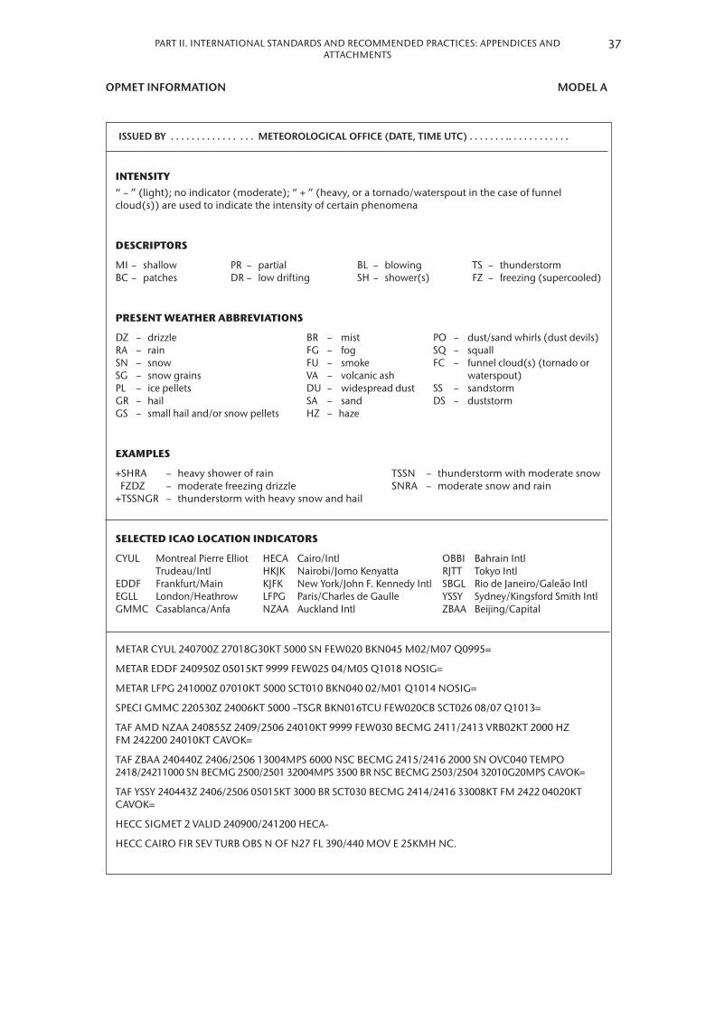
PART II. INTERNATIONAL STANDARDS AND RECOMMENDED PRACTICES: APPENDICES AND ATTACHMENTS
OPMET INFORMATION MODEL A
ISSUED BY . . . . . . . . . . . . . . . . METEOROLOGICAL OFFICE (DATE, TIME UTC) . . . . . . . .. . . . . . . . . . . .
INTENSITY“ – ” (light); no indicator (moderate); “ + ” (heavy, or a tornado/waterspout in the case of funnel cloud(s)) are used to indicate the intensity of certain phenomena
DESCRIPTORS
MI – shallow PR – partial BL – blowing TS – thunderstormBC – patches DR – low drifting SH – shower(s) FZ – freezing (supercooled)
PRESENT WEATHER ABBREVIATIONS
DZ – drizzle BR – mist PO – dust/sand whirls (dust devils)RA – rain FG – fog SQ – squallSN – snow FU – smoke FC – funnel cloud(s) (tornado orSG – snow grains VA – volcanic ash waterspout)PL – ice pellets DU – widespread dust SS – sandstormGR – hail SA – sand DS – duststormGS – small hail and/or snow pellets HZ – haze
EXAMPLES
+SHRA – heavy shower of rain TSSN – thunderstorm with moderate snow FZDZ – moderate freezing drizzle SNRA – moderate snow and rain+TSSNGR – thunderstorm with heavy snow and hail
SELECTED ICAO LOCATION INDICATORS
CYUL Montreal Pierre Elliot HECA Cairo/Intl OBBI Bahrain Intl Trudeau/Intl HKJK Nairobi/Jomo Kenyatta RJTT Tokyo IntlEDDF Frankfurt/Main KJFK New York/John F. Kennedy Intl SBGL Rio de Janeiro/Galeão IntlEGLL London/Heathrow LFPG Paris/Charles de Gaulle YSSY Sydney/Kingsford Smith IntlGMMC Casablanca/Anfa NZAA Auckland Intl ZBAA Beijing/Capital
METAR CYUL 240700Z 27018G30KT 5000 SN FEW020 BKN045 M02/M07 Q0995=
METAR EDDF 240950Z 05015KT 9999 FEW025 04/M05 Q1018 NOSIG=
METAR LFPG 241000Z 07010KT 5000 SCT010 BKN040 02/M01 Q1014 NOSIG=
SPECI GMMC 220530Z 24006KT 5000 –TSGR BKN016TCU FEW020CB SCT026 08/07 Q1013=
TAF AMD NZAA 240855Z 2409/2506 24010KT 9999 FEW030 BECMG 2411/2413 VRB02KT 2000 HZ FM 242200 24010KT CAVOK=
TAF ZBAA 240440Z 2406/2506 13004MPS 6000 NSC BECMG 2415/2416 2000 SN OVC040 TEMPO 2418/24211000 SN BECMG 2500/2501 32004MPS 3500 BR NSC BECMG 2503/2504 32010G20MPS CAVOK=
TAF YSSY 240443Z 2406/2506 05015KT 3000 BR SCT030 BECMG 2414/2416 33008KT FM 2422 04020KT CAVOK=
HECC SIGMET 2 VALID 240900/241200 HECA-
HECC CAIRO FIR SEV TURB OBS N OF N27 FL 390/440 MOV E 25KMH NC.
37

UPPER WIND AND UPPER-AIR TEMPERATURE CHART FOR MODEL IS STANDARD ISOBARIC SURFACE Example 1. Arrows, feathers and pennants (Mercator projection)
ISSU
ED B
Y W
AFC
. . .
. . .
. . .
. . .
. . .
.PR
OVI
DED
BY
. . .
. . .
. . .
. . .
. . .
. . .
.W
IND
/TEM
PER
ATU
REFL
. . .
. . .
. . .
. . .
. . .
. . .
. . .
. . .
. .
FIXE
D T
IME
PRO
GN
OST
IC C
HA
RTVA
LID
XX
UTC
XX
XX
X X
XX
XBA
SED
ON
. . .
. . U
TC D
ATA
ON
. . .
Uni
ts u
sed:
kno
ts; d
egre
es C
elsi
usTe
mp
erat
ures
neg
ativ
e un
less
p
refix
ed b
y a
+ or
PS
38 METEOROLOGICAL SERVICE FOR INTERNATIONAL AIR NAVIGATION

PART II. INTERNATIONAL STANDARDS AND RECOMMENDED PRACTICES: APPENDICES AND ATTACHMENTS
UPPER WIND AND UPPER-AIR TEMPERATURE CHART FOR MODEL IS STANDARD ISOBARIC SURFACE Example 2. Arrows, feathers and pennants (Polar stereographic projection)
ISSU
ED B
Y W
AFC
. .
. .
. .
. .
. .
. .
. .
. .
PRO
VID
ED B
Y .
. .
. .
. .
. .
. .
. .
. .
.
WIN
D/T
EMPE
RAT
URE
FL .
. .
. .
. .
. .
. .
. .
. .
. .
. .
. .
. .
. F
IXED
TI
ME
PRO
GN
OST
IC C
HA
RTVA
LID
XX
UTC
XX
XX
X X
XX
XBA
SED
ON
. . .
. . U
TC D
ATA
ON
. . .
Uni
ts u
sed:
kno
ts; d
egre
es C
elsi
usTe
mp
erat
ures
neg
ativ
e un
less
p
refix
ed b
y a
+ or
PS
39

SIGNIFICANT WEATHER CHART (HIGH LEVEL) MODEL SWH Example. Polar stereographic projection (showing the jet stream vertical extent)
ISO
LEM
BD
CB
320
XX
X
Etn
aN
374
2 E
0150
0
H 530
250 L
An
atah
anN
1624
E14
548
ISSU
ED B
Y W
AFC
. . .
. . .
. . .
. . .
. . .
.
PRO
VID
ED B
Y . .
. . .
. . .
. . .
. . .
. . .
. FI
XED
TIM
E PR
OG
NO
STIC
CH
ART
IC
AO
ARE
A G
SIG
WX
FL 2
50–6
30
VALI
D X
X U
TC X
X X
XX
XX
XX
CB
IMPL
IES
TS, G
R, M
OD
OR
SEV
TURB
AN
D IC
E
UN
ITS
USE
D: H
EIG
HTS
IN F
LIG
HT
LEVE
LS
CH
ECK
SIG
MET
, AD
IVSO
RIES
FO
R TC
AN
D V
A, A
ND
A
SHTA
M A
ND
NO
TAM
FO
R VA
CAT
ARE
AS
1 2 3
370
260
380
250
360
250
PGC
E 06
. . .
. . .
.
. . .
. .
40 METEOROLOGICAL SERVICE FOR INTERNATIONAL AIR NAVIGATION

PART II. INTERNATIONAL STANDARDS AND RECOMMENDED PRACTICES: APPENDICES AND ATTACHMENTS
SIGNIFICANT WEATHER CHART (MEDIUM LEVEL) MODEL SWM
N37
42 E
0150
0
180
XX
X
PGN
E 15
. . .
. . .
.
. . .
. .
ISSU
ED B
Y W
AFC
. . .
. . .
. . .
. . .
. . .
. .
PRO
VID
ED B
Y . .
. . .
. . .
. . .
. . .
. . .
. . .
FIXE
D T
IME
PRO
GN
OST
IC C
HA
RTIC
AO A
REA
NAT
SIG
WX
FL 1
00–2
50VA
LID
XX
UTC
XX
XXX
XXXX
CB
IMPL
IES
TS, G
R, M
OD
OR
SEV
TURB
AN
D IC
EU
NIT
S U
SED
: H
EIG
HTS
IN F
LIG
HT
LEVE
LSC
HEC
K SI
GM
ET, A
DVI
SORI
ES F
OR
TC A
ND
VA
, AN
D A
SHTA
M A
ND
N
OTA
M F
OR
VA
41

SIGNIFICANT WEATHER CHART (LOW LEVEL) MODEL SWL Example 1
XXX010
XXX008
ISSUED BY . . . . . . . . . . . . . . . . . . . .FIXED TIME PROGNOSTIC CHARTSIGWX SFC – 10 000 FTVALID . . . . UTC . . . . 20 . . . .CB implies thunderstorm, moderate or severe turbulence, icing and hail.Units used: knots; visibility in metres or kilometres; altitude in hectofeet above mean sea level.
42 METEOROLOGICAL SERVICE FOR INTERNATIONAL AIR NAVIGATION

PART II. INTERNATIONAL STANDARDS AND RECOMMENDED PRACTICES: APPENDICES AND ATTACHMENTS
SIGNIFICANT WEATHER CHART (LOW LEVEL) MODEL SWL Example 2
FIX
ED T
IME
PRO
GN
OST
IC C
HA
RT
V
ALI
D …
……
……
……
……
U
TC …
……
……
……
20
……
B
ASE
D O
N …
……
……
U
TC D
ATA
ON
……
……
……
……
……
VARI
AN
TV
ISSI
GN
IFIC
AN
T W
EATH
ERC
LOU
D, T
URB
ULE
NC
E, IC
ING
0°C
ARE
A A
SC
T C
U 0
25/0
8050
ISO
L B
KN C
U 0
15/X
XX
050
/XXX
ARE
A B
OVC
LYR
ST
NS
015/
XXX
050
/XXX
50O
CN
L40
00H
EAVY
RA
INEM
BD C
B 00
8/XX
X
ISO
L10
00TH
UN
DER
STO
RM
ARE
A C
BKN
to O
VC S
T SC
010
/040
100
LCA
SO
UTH
CO
T H
ILLS
2000
DRI
ZZLE
OVC
ST
SC 0
03/0
50
ARE
A D
OVC
LYR
SC
NS
010/
XXX
90LC
A N
ORT
H45
00RA
INO
VC L
YR S
T N
S 00
5/XX
X 0
90/X
XX
ARE
A E
SCT
SC 0
20/0
3040
LCA
LA
ND
0500
FOG
ARE
A F
2000
MIS
TBK
N to
OVC
ST
002/
010
30LC
A C
OT
HIL
LS02
00FO
GO
VC S
T SF
C/0
15
ARE
A G
4500
RAIN
OVC
CU
SC
NS
010/
XXX
030
/XXX
30LC
A N
ORT
H05
00FO
GO
VC S
T SF
C/0
10
ARE
A J
SCT
CU
SC
030
/050
40LC
A H
ILLS
NO
RTH
BLW
070
SIG
WX
SFC
– 1
0 0
00
FT
ISSU
ED B
Y .
. . .
. . .
. . .
. . .
. . .
AT
. . .
. . .
UTC
REM
ARK
S:EA
ST T
O N
E G
ALE
S SH
ETLA
ND
TO
HEB
RID
ES -
SEVE
RE M
OU
NTA
IN W
AVES
NW
SC
OTL
AN
D –
FOG
PAT
CH
ES E
AST
AN
GLI
A –
WD
SPR
FOG
OVE
R N
ORT
H F
RAN
CE,
BEL
GIU
M A
ND
TH
E N
ETH
ERLA
ND
S
Not
es:
1.
Pres
sure
in h
Pa a
nd s
pee
ds
in k
nots
.2.
V
is in
m in
clud
ed if
less
than
5 0
00 m
. im
plie
s vi
s 20
0 m
or l
ess.
3.
Alt
itud
e in
hec
tofe
et a
bov
e M
SL X
XX
= ab
ove
10 0
00 ft
.4.
C
B im
plie
s M
OD
/SEV
icin
g, t
urb
ulen
ce a
nd th
und
erst
orm
.5.
O
nly
sig
nific
ant w
eath
er a
nd/o
r wea
ther
phe
nom
ena
caus
ing
visi
bili
ty
red
ucti
on b
elow
5 0
00 m
incl
uded
.
43

TROPICAL CYCLONE ADVISORY INFORMATION IN MODEL TCG GRAPHICAL FORMAT
TROPICAL CYCLONE ADVISORY
DTG: 20050922/1200ZTCAC: MIAMITC: JULIETTENR: 22PSN: N2350 W08500MOV: W 12KTC: 945 HPAMAX WIND: 120KT RMK: NILNXT ADVISORY: 20050922/1600Z
FRQ CBGALE FORCE WIND
231200ZMAX WIND 130KT
230600ZMAX WIND 125KT
230000ZMAX WIND 125KT
221800ZMAX WIND 135KT
12KT
CB TOPSFL 450
20°
25°
20°
25°
–90° –75°–80°–85°
–90° –75°–80°–85°–95°
44 METEOROLOGICAL SERVICE FOR INTERNATIONAL AIR NAVIGATION

PART II. INTERNATIONAL STANDARDS AND RECOMMENDED PRACTICES: APPENDICES AND ATTACHMENTS
VOLCANIC ASH ADVISORY INFORMATION IN GRAPHICAL FORMAT MODEL VAG
VOLCANIC ASH ADVISORYDTG: 20080923/0130ZVAAC: TOKYOVOLCANO: KARYMSKY 1000-13AREA: RUSSIAN FEDERATIONSUMMIT ELEV: 1536MADVISORY NR: 2008/4INFO SOURCE: MTSAT-1R, KVERT KEMSDAVIATION COLOUR CODE: REDERUPTION DETAILS: ERUPTED AT 20080923/0000Z FL300 REPORTEDRMK: LATEST REP FM KVERT (0120Z) INDICATES ERUPTION HAS CEASEDTWO DISPERSING VA CLD ARE EVIDENT ON SATELLITE IMAGERYNXT ADVISORY: 20080923/0730Z
SFC/FL270
FL150/320FL150/300
SFC/FL360
SFC/FL180
NO VA EXP
SFC/FL360
23/1300Z 23/1900Z
23/0700Z23/0100Z
SFC/FL200
140°E 150°E 160°E 170°E 180°E 140°E 150°E 160°E 170°E 180°E
140°E 150°E 160°E 170°E 180°E 140°E 150°E 160°E 170°E 180°E
50°N
60°N
50°N
60°N
50°N
60°N
50°N
60°N
45

SIGMET FOR TROPICAL CYCLONE IN GRAPHICAL FORMAT MODEL STC
25°
24°
23°
22°
21°
20°
19°
18°
17°
16°
15°
14°
25°
24°
23°
22°
21°
20°
19°
18°
17°
16°
15°
14°
107° 108° 109° 110° 111° 115°114°113°112° 116° 117° 118° 119° 120°
107° 108° 109° 110° 111° 115°114°113°112° 116° 117° 118° 119° 120°
Note: Fictitious FIR.
YUCC SIGMET B3VALID 152320/160300 YUDO
OBS 2100Z
BDRY of FRQ CB
46 METEOROLOGICAL SERVICE FOR INTERNATIONAL AIR NAVIGATION
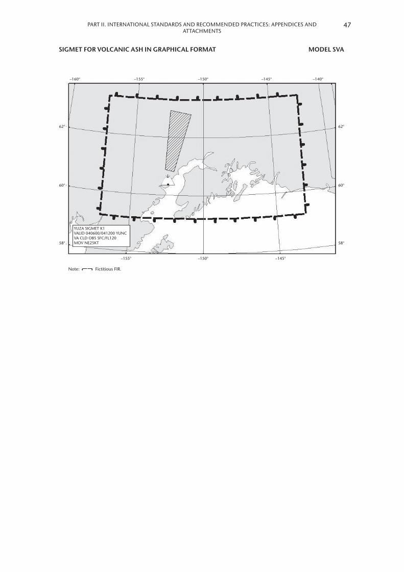
PART II. INTERNATIONAL STANDARDS AND RECOMMENDED PRACTICES: APPENDICES AND ATTACHMENTS
SIGMET FOR VOLCANIC ASH IN GRAPHICAL FORMAT MODEL SVA
YUZA SIGMET K1VALID 040600/041200 YUNCVA CLD OBS SFC/FL120MOV NE25KT
Note: Fictitious FIR.
62°
60°
58° 58°
60°
62°
–155° –150° –145°
–155° –150° –145°–160° –140°
47

SIGMET FOR PHENOMENA OTHER THAN TROPICAL CYCLONE MODEL SGE AND VOLCANIC ASH IN GRAPHICAL FORMAT
0220
30
40
FL
280/
380
WK
N
–10
–12
–14
–16
–18
–20
–22
–24
–26
–28
–30
–32
–34
–36
–38
–40
–42
–44
YMM
M S
IGM
ET 1
VALI
D 0
2203
0/03
0030
YM
MC
108
110
120
118
116
114
112
130
128
126
124
122
140
138
136
134
132
150
148
146
144
142
158
156
154
152
160
48 METEOROLOGICAL SERVICE FOR INTERNATIONAL AIR NAVIGATION

PART II. INTERNATIONAL STANDARDS AND RECOMMENDED PRACTICES: APPENDICES AND ATTACHMENTS
SHEET OF NOTATIONS USED IN FLIGHT DOCUMENTATION MODEL SN
49
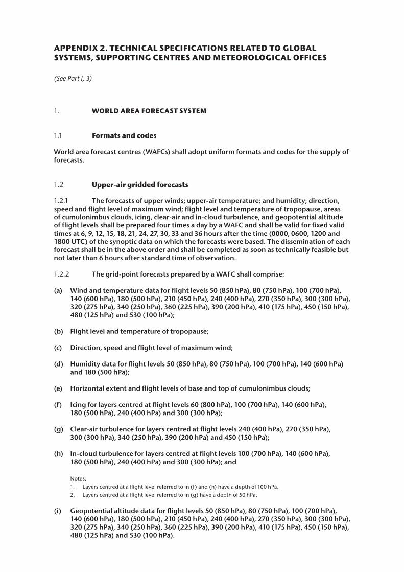
APPENDIX 2. TECHNICAL SPECIFICATIONS RELATED TO GLOBAL SYSTEMS, SUPPORTING CENTRES AND METEOROLOGICAL OFFICES
(See Part I, 3)
1. WORLD AREA FORECAST SYSTEM
1.1 Formats and codes
World area forecast centres (WAFCs) shall adopt uniform formats and codes for the supply of forecasts .
1.2 Upper-air gridded forecasts
1.2.1 The forecasts of upper winds; upper-air temperature; and humidity; direction, speed and flight level of maximum wind; flight level and temperature of tropopause, areas of cumulonimbus clouds, icing, clear-air and in-cloud turbulence, and geopotential altitude of flight levels shall be prepared four times a day by a WAFC and shall be valid for fixed valid times at 6, 9, 12, 15, 18, 21, 24, 27, 30, 33 and 36 hours after the time (0000, 0600, 1200 and 1800 UTC) of the synoptic data on which the forecasts were based . The dissemination of each forecast shall be in the above order and shall be completed as soon as technically feasible but not later than 6 hours after standard time of observation .
1.2.2 The grid-point forecasts prepared by a WAFC shall comprise:
(a) Wind and temperature data for flight levels 50 (850 hPa), 80 (750 hPa), 100 (700 hPa), 140 (600 hPa), 180 (500 hPa), 210 (450 hPa), 240 (400 hPa), 270 (350 hPa), 300 (300 hPa), 320 (275 hPa), 340 (250 hPa), 360 (225 hPa), 390 (200 hPa), 410 (175 hPa), 450 (150 hPa), 480 (125 hPa) and 530 (100 hPa);
(b) Flight level and temperature of tropopause;
(c) Direction, speed and flight level of maximum wind;
(d) Humidity data for flight levels 50 (850 hPa), 80 (750 hPa), 100 (700 hPa), 140 (600 hPa) and 180 (500 hPa);
(e) Horizontal extent and flight levels of base and top of cumulonimbus clouds;
(f) Icing for layers centred at flight levels 60 (800 hPa), 100 (700 hPa), 140 (600 hPa), 180 (500 hPa), 240 (400 hPa) and 300 (300 hPa);
(g) Clear-air turbulence for layers centred at flight levels 240 (400 hPa), 270 (350 hPa), 300 (300 hPa), 340 (250 hPa), 390 (200 hPa) and 450 (150 hPa);
(h) In-cloud turbulence for layers centred at flight levels 100 (700 hPa), 140 (600 hPa), 180 (500 hPa), 240 (400 hPa) and 300 (300 hPa); and
Notes:1. Layers centred at a flight level referred to in (f) and (h) have a depth of 100 hPa.2. Layers centred at a flight level referred to in (g) have a depth of 50 hPa.
(i) Geopotential altitude data for flight levels 50 (850 hPa), 80 (750 hPa), 100 (700 hPa), 140 (600 hPa), 180 (500 hPa), 210 (450 hPa), 240 (400 hPa), 270 (350 hPa), 300 (300 hPa), 320 (275 hPa), 340 (250 hPa), 360 (225 hPa), 390 (200 hPa), 410 (175 hPa), 450 (150 hPa), 480 (125 hPa) and 530 (100 hPa) .

PART II. INTERNATIONAL STANDARDS AND RECOMMENDED PRACTICES: APPENDICES AND ATTACHMENTS
1.2.3 The foregoing grid-point forecasts shall be issued by a WAFC in binary code form using the GRIB code form prescribed by WMO .
Note: The GRIB code form is contained in the Manual on Codes (WMO-No. 306), Volume I.2, Part B – Binary Codes.
1.2.4 The foregoing grid-point forecasts shall be prepared by a WAFC in a regular grid with a horizontal resolution of 1 .25° of latitude and longitude .
1.3 Significant weather (SIGWX) forecasts
1.3.1 General provisions
1.3.1.1 Forecasts of significant en-route weather phenomena shall be prepared as SIGWX forecasts four times a day by a WAFC and shall be valid for fixed valid times at 24 hours after the time (0000, 0600, 1200 and 1800 UTC) of the synoptic data on which the forecasts were based . The dissemination of each forecast shall be completed as soon as technically feasible but not later than 9 hours after standard time of observation .
1.3.1.2 SIGWX forecasts shall be issued in binary code form, using the BUFR code form prescribed by WMO .
Note: The BUFR code form is contained in the Manual on Codes (WMO-No. 306), Volume I.2, Part B – Binary Codes.
1.3.2 Types of SIGWX forecasts
SIGWX forecasts shall be issued as high-level SIGWX forecasts for flight levels between 250 and 630 .
Note: Medium-level SIGWX forecasts for flight levels between 100 and 250 for limited geographical areas will continue to be issued until such time that flight documentation to be generated from the gridded forecasts of cumulonimbus clouds, icing and turbulence fully meets user requirements.
1.3.3 Items included in SIGWX forecasts
SIGWX forecasts shall include the following items:
(a) Tropical cyclone provided that the maximum of the 10-minute mean surface wind speed is expected to reach or exceed 17 m/s (34 kt);
(b) Several squall lines;
(c) Moderate or severe turbulence (in cloud or clear-air);
(d) Moderate or severe icing;
(e) Widespread sandstorm/duststorm;
(f) Cumulonimbus clouds associated with thunderstorms and with (a) to (e);
Note: Non-convective cloud areas associated with in-cloud moderate or severe turbulence and/or moderate or severe icing are to be included in the SIGWX forecasts.
(g) Flight level of tropopause;
(h) Jet streams;
51

(i) Information on the location of volcanic eruptions that are producing ash clouds of significance to aircraft operations, comprising: volcanic eruption symbol at the location of the volcano and, in a separate text box on the chart, the volcanic eruption symbol, the name of the volcano (if known) and the latitude/longitude of the eruption . In addition, the legend of SIGWX charts should indicate “CHECK SIGMET, ADVISORIES FOR TC AND VA, AND ASHTAM AND NOTAM FOR VA”; and
(j) Information on the location of a release of radioactive materials into the atmosphere of significance to aircraft operations, comprising: the radioactive materials in the atmosphere symbol at the location of the release and, in a separate text box on the chart, the radioactive materials in the atmosphere symbol, latitude/longitude of the site of the release, and (if known) the name of site of the radioactive source . In addition, the legend of SIGWX charts on which a release of radiation is indicated should contain “CHECK SIGMET AND NOTAM FOR RDOACT CLD” .
Notes:1. Medium-level SIGWX forecasts include all the items above. 2. Items to be included in low-level SIGWX forecasts (i.e. flight levels below 100) are included in Appendix 5.
1.3.4 Criteria for including items in SIGWX forecasts
The following criteria shall be applied for SIGWX forecasts:
(a) Items (a) to (f) in 1 .3 .3 above shall only be included if expected to occur between the lower and upper levels of the SIGWX forecast;
(b) The abbreviation “CB” shall only be included when it refers to the occurrence or expected occurrence of cumulonimbus clouds:(i) Affecting an area with a maximum spatial coverage of 50 per cent or more of the
area concerned;(ii) Along a line with little or no space between individual clouds; or(iii) Embedded in cloud layers or concealed by haze;
(c) The inclusion of “CB” shall be understood to include all weather phenomena normally associated with cumulonimbus clouds, i .e . thunderstorm, moderate or severe icing, moderate or severe turbulence and hail;
(d) Where a volcanic eruption or a release of radioactive materials into the atmosphere warrants the inclusion of the volcanic eruption symbol or the radioactive materials in the atmosphere symbol in SIGWX forecasts, the symbols shall be included on SIGWX forecasts irrespective of the height to which the ash column or radioactive material is reported or expected to reach; and
(e) In the case of co-incident or the partial overlapping of items (a), (i) and (j) in 1 .3 .3 above, the highest priority shall be given to item (i), followed by items (j) and (a) . The item with the highest priority shall be placed at the location of the event, and an arrow shall be used to link the location of the other item(s) to its associated symbol or text box .
52 METEOROLOGICAL SERVICE FOR INTERNATIONAL AIR NAVIGATION

PART II. INTERNATIONAL STANDARDS AND RECOMMENDED PRACTICES: APPENDICES AND ATTACHMENTS
2. AERODROME METEOROLOGICAL OFFICES
2.1 Use of world area forecast system (WAFS) products
2.1.1 Aerodrome meteorological offices shall use WAFS forecasts issued by the WAFCs in the preparation of flight documentation, whenever these forecasts cover the intended flight path in respect of time, altitude and geographical extent, unless otherwise agreed between the meteorological authority and the operator concerned .
2.1.2 In order to ensure uniformity and standardization of flight documentation, the WAFS GRIB and BUFR data received shall be decoded into standard WAFS charts in accordance with relevant provisions in these Technical Regulations, and the meteorological content and identification of the originator of the WAFS forecasts shall not be amended .
2.2 Notification of WAFC concerning significant discrepancies
Aerodrome meteorological offices using WAFS BUFR data shall notify the WAFC concerned immediately if significant discrepancies are detected or reported in respect of WAFS SIGWX forecasts concerning:
(a) Icing, turbulence, cumulonimbus clouds that are obscured, frequent, embedded or occurring at a squall line, and sandstorms/duststorms; and
(b) Volcanic eruptions or a release of radioactive materials into the atmosphere, of significance to aircraft operations .
The WAFC receiving the message shall acknowledge its receipt to the originator, together with a brief comment on the report and any action taken, using the same means of communication employed by the originator .
Note: Guidance on reporting significant discrepancies is provided in the ICAO Manual of Aeronautical Meteorological Practice (Doc 8896).
3. VOLCANIC ASH ADVISORY CENTRES
3.1 Volcanic ash advisory information
3.1.1 The advisory information on volcanic ash issued in abbreviated plain language, using approved ICAO abbreviations and numerical values of self-explanatory nature, shall be in accordance with the template shown in Table A2-1 . When no approved ICAO abbreviations are available, English plain language text, to be kept to a minimum, shall be used .
3.1.2 [Recommendation] Until 4 November 2020, volcanic ash advisory information should be disseminated in IWXXM GML form in addition to the dissemination of this advisory information in accordance with 3.1.1 above.
3.1.2 As of 5 November 2020, volcanic ash advisory information shall be disseminated in IWXXM GML form in addition to the dissemination of this advisory information in accordance with 3 .1 .1 above .
Note: The technical specifications for IWXXM are contained in the Manual on Codes (WMO-No. 306), Volume I.3, Part D – Representations Derived from Data Models. Guidance on the implementation of IWXXM is provided in the ICAO Manual on the Digital Exchange of Aeronautical Meteorological Information (Doc 10003).
53

3.1.3 The volcanic ash advisory information listed in Table A2-1, when prepared in graphical format, shall be as specified in Appendix 1 and issued using the portable network graphics (PNG) format .
4. MEMBER VOLCANO OBSERVATORIES
4.1 Information from Member volcano observatories
[Recommendation] The information required to be sent by Member volcano observatories to their associated area control centres (ACCs)/flight information centres (FICs), meteorological watch office (MWO) and VAAC should comprise:
(a) For significant pre-eruption volcanic activity: the date/time (UTC) of report; name and, if known, number of the volcano; location (latitude/longitude) and; description of volcanic activity; and
(b) For volcanic eruption: the date/time (UTC) of report and time of eruption (UTC) if different from time of report; name and, if known, number of the volcano; location (latitude/longitude); and description of the eruption including whether an ash column was ejected and, if so, an estimate of height of ash column and the extent of any visible volcanic ash cloud, during and following an eruption; and
(c) For volcanic eruption cessation: the date/time (UTC) of report and time of eruption cessation (UTC); name and, if known, number of the volcano; and location (latitude/longitude).
Notes:1. Pre-eruption volcanic activity in this context means unusual and/or increasing volcanic activity which could
presage a volcanic eruption.2. The Member volcano observatories may use the Volcano Observatory Notice for Aviation (VONA) format to send
information to their associated ACCs/FICs, MWO and VAAC. The VONA format is included in the ICAO Handbook on the International Airways Volcano Watch (IAVW) – Operational Procedures and Contact List (Doc 9766) which is available on the ICAO website.
5. TROPICAL CYCLONE ADVISORY CENTRES
5.1 Tropical cyclone advisory information
5.1.1 The advisory information on tropical cyclones shall be issued for tropical cyclones when the maximum of the 10-minute mean surface wind speed is expected to reach or exceed 17 m/s (34 kt) during the period covered by the advisory .
5.1.2 The advisory information on tropical cyclones disseminated in abbreviated plain language, using approved ICAO abbreviations and numerical values of self-explanatory nature, shall be in accordance with the template shown in Table A2-2 .
5.1.3 [Recommendation] Until 4 November 2020, tropical cyclone advisory information should be disseminated in IWXXM GML form in addition to the dissemination of this advisory information in accordance with 5.1.2 above.
5.1.3 As of 5 November 2020, tropical cyclone advisory centres shall disseminate tropical cyclone advisory information in IWXXM GML form in addition to the dissemination of this advisory information in abbreviated plain language in accordance with 5 .1 .2 above .
54 METEOROLOGICAL SERVICE FOR INTERNATIONAL AIR NAVIGATION

PART II. INTERNATIONAL STANDARDS AND RECOMMENDED PRACTICES: APPENDICES AND ATTACHMENTS
Note: The technical specifications for IWXXM are contained in the Manual on Codes (WMO-No. 306), Volume I.3, Part D – Representations Derived from Data Models. Guidance on the implementation of IWXXM is provided in the ICAO Manual on the Digital Exchange of Aeronautical Meteorological Information (Doc 10003).
5.1.4 The tropical cyclone advisory information listed in Table A2-2, when prepared in graphical format, shall be as specified in Appendix 1 and issued using the PNG format .
6. SPACE WEATHER CENTRES
6.1 Space weather advisory information
6.1.1 [Recommendation] Advisory information on space weather should be issued in abbreviated plain language, using approved ICAO abbreviations and numerical values of self-explanatory nature, and should be in accordance with the template shown in Table A2-3. When no approved ICAO abbreviations are available, English plain language text, to be kept to a minimum, should be used.
6.1.2 [Recommendation] As of 7 November 2019 and until 4 November 2020, space weather advisory information should be disseminated in IWXXM GML form, in addition to the dissemination of space weather advisory information in abbreviated plain language in accordance with 6.1.1 above.
6.1.2 As of 5 November 2020, space weather advisory information shall be disseminated in IWXXM GML form, in addition to the dissemination of this advisory information in abbreviated plain language in accordance with 6 .1 .1 above .
Note. The technical specifications for IWXXM are contained in the Manual on Codes (WMO-No. 306), Volume I.3, Part D — Representations Derived from Data Models. Guidance on the implementation of IWXXM is provided in the ICAO Manual on the Digital Exchange of Aeronautical Meteorological Information (Doc 10003).
6.1.3 [Recommendation] One or more of the following space weather effects should be included in the space weather advisory information, using their respective abbreviations as indicated below:
– HF communications (propagation, absorption) HF COM– Communications via satellite (propagation, absorption) SATCOM– GNSS-based navigation and surveillance (degradation) GNSS– Radiation at flight levels (increased exposure) RADIATION
6.1.4 [Recommendation] The following intensities should be included in space weather advisory information, using their respective abbreviations as indicated below:
– Moderate MOD– Severe SEV
Note. Guidance on the use of these intensities is provided in the ICAO Manual on Space Weather Information in Support of International Air Navigation (Doc 10100).
6.1.5 [Recommendation] Updated advisory information on space weather phenomena should be issued as necessary but at least every six hours until such time as the space weather phenomena are no longer detected and/or are no longer expected to have an impact.
55

METEOROLOGICAL SERVICE FOR INTERNATIONAL AIR NAVIGATION56
Table A2-1. Template for advisory message for volcanic ash
Key: MOC=
====
inclusion mandatory, part of every message;inclusion optional;inclusion conditional, included whenever applicable;a double line indicates that the text following it should be placed on the subsequent line.
Notes:1. The ranges and resolutions for the numerical elements included in advisory messages for volcanic ash are shown
in Appendix 6, Table A6-4.2. The explanations for the abbreviations can be found in the ICAO Procedures for Air Navigation Services – ICAO
Abbreviations and Codes (PANS-ABC, Doc 8400).3. Inclusion of a colon after each element heading is mandatory.4. The numbers 1 to 19 are included only for clarity and are not part of the advisory message, as shown in the
examples.
Element Detailed content Template(s) Examples
1 Identification of the type of message (M)
Type of message VA ADVISORY VA ADVISORY
2 Status indicator (C)1
Indicator of test or exercise
STATUS TEST or EXER STATUS: TEST
EXER
3 Time of origin (M)
Year, month, day and time in UTC
DTG: nnnnnnnn/nnnnZ DTG: 20080923/0130Z
4 Name of VAAC (M)
Name of VAAC VAAC: nnnnnnnnnnnn VAAC: TOKYO
5 Name of volcano (M)
Name and IAVCEI2
number of volcano
VOLCANO: nnnnnnnnnnnnnnnnnnnnnn [nnnnnn] or UNKNOWN or UNNAMED
VOLCANO: KARYMSKY 1000-13 UNNAMED
6 Location of volcano (M)
Location of volcano in degrees and minutes
PSN: Nnnnn or Snnnn Wnnnnn or Ennnnn or UNKNOWN
PSN: N5403 E15927 UNKNOWN
7 State or region (M)
State, or region if ash is not reported over a State
AREA: nnnnnnnnnnnnnnnn AREA: RUSSIAN FEDERATION
8 Summit elevation (M)
Summit elevation in m (or ft)
SUMMIT ELEV: nnnnM (or nnnnnFT) SUMMIT ELEV:
1536M
9 Advisory number (M)
Year in full and message number (separate sequence for each volcano)
ADVISORY NR: nnnn/[n][n][n]n ADVISORY NR:
2008/4
10 Information source (M)
Information source using free text
INFO SOURCE: Free text up to 32 characters INFO SOURCE:
MTSAT-1R KVERT KEMSD
11 Colour code (O)
Aviation colour code AVIATION COLOUR CODE:
RED or ORANGE or YELLOW or GREEN or UNKNOWN or NOT GIVEN or NIL
AVIATION COLOUR CODE:
RED
12 Eruption details (M)
Eruption details (including date/time of eruption(s))
ERUPTION DETAILS:
Free text up to 64 characters or UNKNOWN
ERUPTION DETAILS:
ERUPTION AT 20080923/0000Z FL300 REPORTED
13 Time of observation (or estimation) of ash (M)
Day and time (in UTC) of observation (or estimation) of volcanic ash
OBS (or EST) VA DTG:
nn/nnnnZ OBS VA DTG: 23/0100Z

57PART II. INTERNATIONAL STANDARDS AND RECOMMENDED PRACTICES: APPENDICES AND ATTACHMENTS
Element Detailed content Template(s) Examples
14 Observed or estimated ash cloud (M)
Horizontal (in degrees and minutes) and vertical extent at the time of observation of the observed or estimated ash cloud or, if the base is unknown, the top of the observed or estimated ash cloud;
Movement of the observed or estimated ash cloud
OBS VA CLD or EST VA CLD:
TOP FLnnn or SFC/FLnnn or FLnnn/nnn [nnKM WID LINE3 BTN (nnNM WID LINE BTN)] Nnn[nn] or Snn[nn] Wnnn[nn] or Ennn[nn] – Nnn[nn] or Snn[nn] Wnnn[nn] or Ennn[nn][ – Nnn[nn] or Snn[nn] Wnnn[nn] or Ennn[nn] – Nnn[nn] or Snn[nn] Wnnn[nn] or Ennn[nn] – Nnn[nn] or Snn[nn] Wnnn[nn] or Ennn[nn]] MOV N nnKMH (or KT) or MOV NE nnKMH (or KT) or MOV E nnKMH (or KT) or MOV SE nnKMH (or KT) or MOV S nnKMH (or KT) or MOV SW nnKMH (or KT) or MOV W nnKMH (or KT) or MOV NW nnKMH (or KT)4 or VA NOT IDENTIFIABLE FM SATELLITE DATA WIND FLnnn/nnn nnn/nn[n]MPS (or KT)5 or WIND FLnnn/nnn VRBnnMPS (or KT) or WIND SFC/FLnnn nnn/nn[n]MPS (or KT) or WIND SFC/FLnnn VRBnnMPS (or KT)
OBS VA CLD: FL250/300 N5400 E15930 – N5400 E16100 – N5300 E15945 MOV SE 20KT SFC/FL200 N5130 E16130 – N5130 E16230 – N5230 E16230 – N5230 E16130 MOV SE 15KT
TOP FL240 MOV W 40KMH
VA NOT IDENTIFIABLE FM SATELLITE DATA WIND FL050/070 180/12MPS
15 Forecast height and position of the ash clouds (+6 HR) (M)
Day and time (in UTC) (6 hours from the “Time of observation (or estimation) of ash” given in item 13 above);
Forecast height and position (in degrees and minutes) for each cloud mass for that fixed valid time
FCST VA CLD +6 HR:
nn/nnnnZ SFC or FLnnn/[FL]nnn [nnKM WID LINE3 BTN (nnNM WID LINE BTN)] Nnn[nn] or Snn[nn] Wnnn[nn] or Ennn[nn] – Nnn[nn] or Snn[nn] Wnnn[nn] or Ennn[nn][ – Nnn[nn] or Snn[nn] Wnnn[nn] or Ennn[nn] – Nnn[nn] or Snn[nn] Wnnn[nn] or Ennn[nn] – Nnn[nn] or Snn[nn] Wnnn[nn] or Ennn[nn]]4 or NO VA EXP or NOT AVBL or NOT PROVIDED
FCST VA CLD +6 HR:
23/0700Z FL250/350 N5130 E16030 – N5130 E16230 – N5330 E16230 – N5330 E16030 SFC/FL180 N4830 E16330 – N4830 E16630 – N5130 E16630 – N5130 E16330
NO VA EXP
NOT AVBL
NOT PROVIDED

METEOROLOGICAL SERVICE FOR INTERNATIONAL AIR NAVIGATION58
Element Detailed content Template(s) Examples
16 Forecast height and position of the ash clouds (+12 HR) (M)
Day and time (in UTC) (12 hours from the “Time of observation (or estimation) of ash” given in item 13 above);
Forecast height and position (in degrees and minutes) for each cloud mass for that fixed valid time
FCST VA CLD +12 HR:
nn/nnnnZ SFC or FLnnn/[FL]nnn [nnKM WID LINE3 BTN (nnNM WID LINE BTN)] Nnn[nn] or Snn[nn] Wnnn[nn] or Ennn[nn] – Nnn[nn] or Snn[nn] Wnnn[nn] or Ennn[nn][ – Nnn[nn] or Snn[nn] Wnnn[nn] or Ennn[nn] – Nnn[nn] or Snn[nn] Wnnn[nn] or Ennn[nn] – Nnn[nn] or Snn[nn] Wnnn[nn] or Ennn[nn]]4 or NO VA EXP or NOT AVBL or NOT PROVIDED
FCST VA CLD +12 HR:
23/1300Z SFC/FL270 N4830 E16130 – N4830 E16600 – N5300 E16600 – N5300 E16130
NO VA EXP
NOT AVBL
NOT PROVIDED
17 Forecast height and position of the ash clouds (+18 HR) (M)
Day and time (in UTC) (18 hours from the “Time of observation (or estimation) of ash” given in item 13 above);
Forecast height and position (in degrees and minutes) for each cloud mass for that fixed valid time
FCST VA CLD +18 HR:
nn/nnnnZ SFC or FLnnn/[FL]nnn
[nnKM WID LINE3 BTN (nnNM WID LINE BTN)] Nnn[nn] or Snn[nn] Wnnn[nn] or Ennn[nn] – Nnn[nn] or Snn[nn] Wnnn[nn] or Ennn[nn][ – Nnn[nn] or Snn[nn] Wnnn[nn] or Ennn[nn] – Nnn[nn] or Snn[nn] Wnnn[nn] or Ennn[nn] – Nnn[nn] or Snn[nn] Wnnn[nn] or Ennn[nn]]4 or NO VA EXP or NOT AVBL or NOT PROVIDED
FCST VA CLD +18 HR:
23/1900Z
NO VA EXP
NOT AVBL
NOT PROVIDED
18 Remarks (M) Remarks, as necessary
RMK: Free text up to 256 characters or NIL
RMK: LATEST REP FM KVERT (0120Z) INDICATES ERUPTION HAS CEASED. TWO DISPERSING VA CLD ARE EVIDENT ON SATELLITE IMAGERY
NIL
19 Next advisory (M)
Year, month, day and time in UTC
NXT ADVISORY:
nnnnnnnn/nnnnZ or NO LATER THAN nnnnnnnn/nnnnZ or NO FURTHER ADVISORIES or WILL BE ISSUED BY nnnnnnnn/nnnnZ
NXT ADVISORY:
20080923/0730Z
NO LATER THAN nnnnnnnn/nnnnZ
NO FURTHER ADVISORIES
WILL BE ISSUED BY nnnnnnnn/nnnnZ
Notes:1. Used only when the message issued to indicate that a test or an exercise is taking place. When the word “TEST” or
the abbreviation “EXER” is included, the message may contain information that should not be used operationally or will otherwise end immediately after the word “TEST”. [Applicable 7 November 2019]
2. International Association of Volcanology and Chemistry of the Earth’s Interior (IAVCEI).3. A straight line between two points drawn on a map in the Mercator projection or a straight line between two
points which crosses lines of longitude at a constant angle.4. Up to 4 selected layers.5. If ash reported (e.g. AIREP) but not identifiable from satellite data.
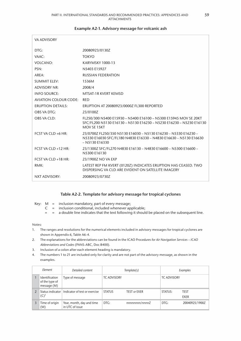
59PART II. INTERNATIONAL STANDARDS AND RECOMMENDED PRACTICES: APPENDICES AND ATTACHMENTS
Example A2-1. Advisory message for volcanic ash
VA ADVISORY
DTG: 20080923/0130Z
VAAC: TOKYO
VOLCANO: KARYMSKY 1000-13
PSN: N5403 E15927
AREA: RUSSIAN FEDERATION
SUMMIT ELEV: 1536M
ADVISORY NR: 2008/4
INFO SOURCE: MTSAT-1R KVERT KEMSD
AVIATION COLOUR CODE: RED
ERUPTION DETAILS: ERUPTION AT 20080923/0000Z FL300 REPORTED
OBS VA DTG: 23/0100Z
OBS VA CLD: FL250/300 N5400 E15930 – N5400 E16100 – N5300 E15945 MOV SE 20KT SFC/FL200 N5130 E16130 – N5130 E16230 – N5230 E16230 – N5230 E16130 MOV SE 15KT
FCST VA CLD +6 HR: 23/0700Z FL250/350 N5130 E16030 – N5130 E16230 – N5330 E16230 – N5330 E16030 SFC/FL180 N4830 E16330 – N4830 E16630 – N5130 E16630 – N5130 E16330
FCST VA CLD +12 HR: 23/1300Z SFC/FL270 N4830 E16130 – N4830 E16600 – N5300 E16600 – N5300 E16130
FCST VA CLD +18 HR: 23/1900Z NO VA EXP
RMK: LATEST REP FM KVERT (0120Z) INDICATES ERUPTION HAS CEASED. TWO DISPERSING VA CLD ARE EVIDENT ON SATELLITE IMAGERY
NXT ADVISORY: 20080923/0730Z
Table A2-2. Template for advisory message for tropical cyclones
Key: MC=
===
inclusion mandatory, part of every message;inclusion conditional, included whenever applicable;a double line indicates that the text following it should be placed on the subsequent line.
Notes:1. The ranges and resolutions for the numerical elements included in advisory messages for tropical cyclones are
shown in Appendix 6, Table A6-4.2. The explanations for the abbreviations can be found in the ICAO Procedures for Air Navigation Services – ICAO
Abbreviations and Codes (PANS-ABC, Doc 8400).3. Inclusion of a colon after each element heading is mandatory.4. The numbers 1 to 21 are included only for clarity and are not part of the advisory message, as shown in the
examples.
Element Detailed content Template(s) Examples
1 Identification of the type of message (M)
Type of message TC ADVISORY TC ADVISORY
2 Status indicator (C)1
Indicator of test or exercise STATUS TEST or EXER STATUS: TEST
EXER
3 Time of origin (M)
Year, month, day and time in UTC of issue
DTG: nnnnnnnn/nnnnZ DTG: 20040925/1900Z

METEOROLOGICAL SERVICE FOR INTERNATIONAL AIR NAVIGATION60
Element Detailed content Template(s) Examples
4 Name of TCAC (M)
Name of TCAC (location indicator or full name)
TCAC: nnnn or nnnnnnnnnn TCAC:: YUFO2
MIAMI
5 Name of tropical cyclone (M)
Name of tropical cyclone or “NN” for unnamed tropical cyclone
TC: nnnnnnnnnnnn or NN TC: GLORIA
6 Advisory number (M)
Year in full and message number (separate sequence for each cyclone)
ADVISORY NR nnnn/[n][n][n]n ADVISORY NR 2004/13
7 Observed position of the centre (M)
Day and time (in UTC) and position of the centre of the tropical cyclone (in degrees and minutes)
OBS PSN: nn/nnnnZ Nnn[nn] or Snn[nn] Wnnn[nn] or Ennn[nn]
OBS PSN: 25/1800Z N2706 W07306
8 Observed CB cloud3 (C)
Location of CB cloud (referring to latitude and longitude (in degrees and minutes)) and vertical extent (flight level)
CB: WI nnnKM (or nnnNM) OF TC CENTRE or WI4 Nnn[nn] or Snn[nn] Wnnn[nn] or Ennn[nn] – Nnn[nn] or Snn[nn] Wnnn[nn] or Ennn[nn] – Nnn[nn] or Snn[nn] Wnnn[nn] or Ennn[nn] – [Nnn[nn] or Snn[nn] Wnnn[nn] or Ennn[nn] – Nnn[nn] or Snn[nn] Wnnn[nn] or Ennn[nn]] and TOP [ABV or BLW] FLnnn
CB WI 250NM OF TC CENTRE TOP FL500
9 Direction and speed of movement (M)
Direction and speed of movement given in sixteen compass points and km/h (or kt), respectively, or stationary (< 2 km/h (1 kt))
MOV: N nnKMH (or KT) or NNE nnKMH (or KT) or NE nnKMH (or KT) or ENE nnKMH (or KT) or E nnKMH (or KT) or ESE nnKMH (or KT) or SE nnKMH (or KT) or SSE nnKMH (or KT) or S nnKMH (or KT) or SSW nnKMH (or KT) or SW nnKMH (or KT) or WSW nnKMH (or KT) or W nnKMH (or KT) or WNW nnKMH (or KT) or NW nnKMH (or KT) or NNW nnKMH (or KT) or STNR
MOV: NW 20KMH
10 Central pressure (M)
Central pressure (in hPa) C: nnnHPA C: 965HPA
11 Maximum surface wind (M)
Maximum surface wind near the centre (mean over 10 minutes, in m/s (or kt))
MAX WIND: nn[n]MPS (or nn[n]KT)
MAX WIND: 22MPS
12 Forecast of centre position (+6 HR) (M)
Day and time (in UTC) (6 hours from the “DTG” given in item 3 above);
Forecast position (in degrees and minutes) of the centre of the tropical cyclone
FCST PSN +6 HR:
nn/nnnnZ Nnn[nn] or Snn[nn] Wnnn[nn] or Ennn[nn]
FCST PSN +6 HR:
25/2200Z N2748 W07350
13 Forecast of maximum surface wind (+6 HR) (M)
Forecast of maximum surface wind (6 hours after the “DTG” given in item 3 above)
FCST MAX WIND +6 HR:
nn[n]MPS (or nn[n]KT)
FCST MAX WIND +6 HR:
22MPS

61PART II. INTERNATIONAL STANDARDS AND RECOMMENDED PRACTICES: APPENDICES AND ATTACHMENTS
Element Detailed content Template(s) Examples
14 Forecast of centre position (+12 HR) (M)
Day and time (in UTC) (12 hours from the “DTG” given in item 3 above);
Forecast position (in degrees and minutes) of the centre of the tropical cyclone
FCST PSN +12 HR:
nn/nnnnZ Nnn[nn] or Snn[nn] Wnnn[nn] or Ennn[nn]
FCST PSN +12 HR:
26/0400Z N2830 W07430
15 Forecast of maximum surface wind (+12 HR) (M)
Forecast of maximum surface wind (12 hours after the “DTG” given in item 3 above)
FCST MAX WIND +12 HR:
nn[n]MPS (or nn[n]KT)
FCST MAX WIND +12 HR:
22MPS
16 Forecast of centre position (+18 HR) (M)
Day and time (in UTC) (18 hours from the “DTG” given in item 3 above);
Forecast position (in degrees and minutes) of the centre of the tropical cyclone
FCST PSN +18 HR:
nn/nnnnZ Nnn[nn] or Snn[nn] Wnnn[nn] or Ennn[nn]
FCST PSN +18 HR:
26/1000Z N2852 W07500
17 Forecast of maximum surface wind (+18 HR) (M)
Forecast of maximum surface wind (18 hours after the “DTG” given in item 3 above)
FCST MAX WIND +18 HR:
nn[n]MPS (or nn[n]KT)
FCST MAX WIND +18 HR:
21MPS
18 Forecast of centre position (+24 HR) (M)
Day and time (in UTC) (24 hours from the “DTG” given in item 3 above);
Forecast position (in degrees and minutes) of the centre of the tropical cyclone
FCST PSN +24 HR:
nn/nnnnZ Nnn[nn] or Snn[nn] Wnnn[nn] or Ennn[nn]
FCST PSN +24 HR:
26/1600Z N2912 W07530
19 Forecast of maximum surface wind (+24 HR) (M)
Forecast of maximum surface wind (24 hours after the “DTG” given in item 3 above)
FCST MAX WIND +24 HR:
nn[n]MPS (or nn[n]KT)
FCST MAX WIND +24 HR:
20MPS
20 Remarks (M) Remarks, as necessary RMK: Free text up to 256 characters or NIL
RMK: NIL
21 Expected time of issuance of next advisory (M)
Expected year, month, day and time (in UTC) of issuance of next advisory
NXT MSG: [BFR] nnnnnnnn/nnnnZ or NO MSG EXP
NXT MSG: 20040925/2000Z
Notes:1. Used only when the message issued to indicate that a test or an exercise is taking place. When the word “TEST” or
the abbreviation “EXER” is included, the message may contain information that should not be used operationally or will otherwise end immediately after the word “TEST”. [Applicable 7 November 2019]
2. Fictitious location.3. In the case of CB clouds associated with a tropical cyclone covering more than one area within the area of
responsibility, this element can be repeated, as necessary.4. The number of coordinates should be kept to a minimum and should not normally exceed seven.
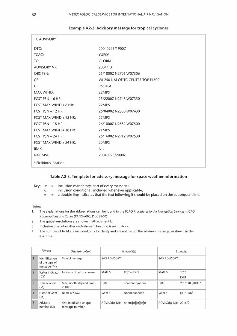
METEOROLOGICAL SERVICE FOR INTERNATIONAL AIR NAVIGATION62
Example A2-2. Advisory message for tropical cyclones
TC ADVISORY
DTG: 20040925/1900Z
TCAC: YUFO*
TC: GLORIA
ADVISORY NR: 2004/13
OBS PSN: 25/1800Z N2706 W07306
CB: WI 250 NM OF TC CENTRE TOP FL500
C: 965HPA
MAX WIND: 22MPS
FCST PSN + 6 HR: 25/2200Z N2748 W07350
FCST MAX WIND + 6 HR: 22MPS
FCST PSN + 12 HR: 26/0400Z N2830 W07430
FCST MAX WIND + 12 HR: 22MPS
FCST PSN + 18 HR: 26/1000Z N2852 W07500
FCST MAX WIND + 18 HR: 21MPS
FCST PSN + 24 HR: 26/1600Z N2912 W07530
FCST MAX WIND + 24 HR: 20MPS
RMK: NIL
NXT MSG: 20040925/2000Z
* Fictitious location
Table A2-3. Template for advisory message for space weather information
Key: MC=
===
inclusion mandatory, part of every message;inclusion conditional, included whenever applicable;a double line indicates that the text following it should be placed on the subsequent line.
Notes:1. The explanations for the abbreviations can be found in the ICAO Procedures for Air Navigation Services – ICAO
Abbreviations and Codes (PANS-ABC, Doc 8400).2. The spatial resolutions are shown in Attachment E.3. Inclusion of a colon after each element heading is mandatory.4. The numbers 1 to 14 are included only for clarity and are not part of the advisory message, as shown in the
examples.
Element Detailed content Template(s) Examples
1 Identification of the type of message (M)
Type of message SWX ADVISORY SWX ADVISORY
2 Status indicator (C)1
Indicator of test or exercise STATUS: TEST or EXER STATUS: TEST
EXER
3 Time of origin (M)
Year, month, day and time in UTC
DTG: nnnnnnnn/nnnnZ DTG: 20161108/0100Z
4 Name of SWXC (M)
Name of SWXC SWXC: Nnnnnnnnnnnn SWXC: DONLON2
5 Advisory number (M)
Year in full and unique message number
ADVISORY NR: nnnn/[n][n][n]n ADVISORY NR: 2016/2

63PART II. INTERNATIONAL STANDARDS AND RECOMMENDED PRACTICES: APPENDICES AND ATTACHMENTS
Element Detailed content Template(s) Examples
6 Number of advisory being replaced (C)
Number of the previously issued advisory being replaced
NR RPLC: nnnn/[n][n][n]n NR RPLC: 2016/1
7 Space weather effect and intensity (M)
Effect and intensity of the space weather phenomena
SWX EFFECT: HF COM MOD or SEV or SATCOM MOD or SEV or GNSS MOD or SEVor HF COM MOD or SEV AND GNSS MOD or SEV or RADIATION1 MOD or SEV
SWX EFFECT: HF COM MOD
SATCOM SEV
GNSS SEV
HF COM MOD AND GNSS MOD
RADIATION MOD
8 Time of observed or expected extent of space weather phenomena (M)
Day and time in UTC of observed phenomena (or forecast if phenomena have yet to occur)
Horizontal extent3 (latitude bands and longitude in degrees) and/or altitude of space weather phenomena
OBS (or FCST) SWX:
nn/nnnnZ DAYLIGHT SIDE or HNH and/or MNH and/or EQN and/or EQS and/or MSH and/or HSH Wnnn(nn) or Ennn(nn) – Wnnn(nn) or Ennn(nn) and/or ABV FLnnn or FLnnn – nnn or Nnn[nn] or Snn[nn] Wnnn[nn] or Ennn[nn] – Nnn[nn] or Snn[nn] Wnnn[nn] or Ennn[nn] – Nnn[nn] or Snn[nn] Wnnn[nn] or Ennn[nn] – [Nnn[nn] or Snn[nn] Wnnn[nn] or Ennn[nn] – Nnn[nn] or Snn[nn] Wnnn[nn] or Ennn[nn]] or NO SWX EXP
OBS SWX: 08/0700Z DAYLIGHT SIDE
08/0700Z HNH HSH E18000 – W18000
08/0700Z HNH HSH W18000 –W09000 ABV FL350
9 Forecast of the phenomena (+6 HR) (M)
Day and time (in UTC) (6 hours from the time given in item 8, rounded to the next full hour);
Forecast extent and/or altitude of the space weather phenomena for that fixed valid time
FCST SWX +6 HR:
nn/nnnnZ DAYLIGHT SIDE or HNH and/or MNH and/or EQN and/or EQS and/or MSH and/or HSH Wnnn(nn) or Ennn(nn) – Wnnn(nn) or Ennn(nn) and/or ABV FLnnn or FLnnn –nnn or Nnn[nn] or Snn[nn] Wnnn[nn] or Ennn[nn] – Nnn[nn] or Snn[nn] Wnnn[nn] or Ennn[nn] – Nnn[nn] or Snn[nn] Wnnn[nn] or Ennn[nn] – [Nnn[nn] or Snn[nn] Wnnn[nn] or Ennn[nn] – Nnn[nn] or Snn[nn] Wnnn[nn] or Ennn[nn]] or NO SWX EXP or NOT AVBL
FCST SWX +6 HR:
08/0700Z DAYLIGHT SIDE
08/0700Z HNH HSH W18000 – W09000 ABV FL350
08/0700Z HNH HSH E18000 – W18000

METEOROLOGICAL SERVICE FOR INTERNATIONAL AIR NAVIGATION64
Element Detailed content Template(s) Examples
10 Forecast of the phenomena (+12 HR) (M)
Day and time (in UTC) (12 hours from the time given in item 8, rounded to the next full hour);
Forecast extent and/or altitude of the space weather phenomena for that fixed valid time
FCST SWX +12 HR:
nn/nnnnZ DAYLIGHT SIDE or HNH and/or MNH and/or EQN and/or EQS and/or MSH and/or HSH Wnnn(nn) or Ennn(nn) – Wnnn(nn) or Ennn(nn) and/or ABV FLnnn or FLnnn –nnn or Nnn[nn] or Snn[nn] Wnnn[nn] or Ennn[nn] – Nnn[nn] or Snn[nn] Wnnn[nn] or Ennn[nn] – Nnn[nn] or Snn[nn] Wnnn[nn] or Ennn[nn] – [Nnn[nn] or Snn[nn] Wnnn[nn] or Ennn[nn] – Nnn[nn] or Snn[nn] Wnnn[nn] or Ennn[nn]] or NO SWX EXP or NOT AVBL
FCST SWX +12 HR:
08/1300Z DAYLIGHT SIDE
08/1300Z HNH HSH W18000 – W09000 ABV FL350
08/1300Z HNH HSH E18000 – W18000
11 Forecast of the phenomena (+18 HR) (M)
Day and time (in UTC) (18 hours from the time given in item 8, rounded to the next full hour);
Forecast extent and/or altitude of the space weather phenomena for that fixed valid time
FCST SWX +18 HR:
nn/nnnnZ DAYLIGHT SIDE or HNH and/or MNH and/or EQN and/or EQS and/or MSH and/or HSH Wnnn(nn) or Ennn(nn) – Wnnn(nn) or Ennn(nn) and/or ABV FLnnn or FLnnn –nnn or Nnn[nn] or Snn[nn] Wnnn[nn] or Ennn[nn] – Nnn[nn] or Snn[nn] Wnnn[nn] or Ennn[nn] – Nnn[nn] or Snn[nn] Wnnn[nn] or Ennn[nn] – [Nnn[nn] or Snn[nn] Wnnn[nn] or Ennn[nn] – Nnn[nn] or Snn[nn] Wnnn[nn] or Ennn[nn]] or NO SWX EXP or NOT AVBL
FCST SWX +18 HR:
08/1900Z DAYLIGHT SIDE
08/1900Z HNH HSH W18000 – W09000 ABV FL350
08/1900Z HNH HSH E18000 – W18000
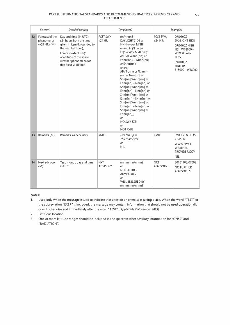
65PART II. INTERNATIONAL STANDARDS AND RECOMMENDED PRACTICES: APPENDICES AND ATTACHMENTS
Element Detailed content Template(s) Examples
12 Forecast of the phenomena (+24 HR) (M)
Day and time (in UTC) (24 hours from the time given in item 8, rounded to the next full hour);
Forecast extent and/or altitude of the space weather phenomena for that fixed valid time
FCST SWX +24 HR:
nn/nnnnZ DAYLIGHT SIDE or HNH and/or MNH and/or EQN and/or EQS and/or MSH and/or HSH Wnnn(nn) or Ennn(nn) – Wnnn(nn) or Ennn(nn) and/or ABV FLnnn or FLnnn –nnn or Nnn[nn] or Snn[nn] Wnnn[nn] or Ennn[nn] – Nnn[nn] or Snn[nn] Wnnn[nn] or Ennn[nn] – Nnn[nn] or Snn[nn] Wnnn[nn] or Ennn[nn] – [Nnn[nn] or Snn[nn] Wnnn[nn] or Ennn[nn] – Nnn[nn] or Snn[nn] Wnnn[nn] or Ennn[nn]] or NO SWX EXP or NOT AVBL
FCST SWX +24 HR:
09/0100Z DAYLIGHT SIDE
09/0100Z HNH HSH W18000 – W09000 ABV FL350
09/0100Z HNH HSH E18000 – W18000
13 Remarks (M) Remarks, as necessary RMK : Free text up to 256 characters or NIL
RMK: SWX EVENT HAS CEASED
WWW.SPACE WEATHER PROVIDER.GOV
NIL
14 Next advisory (M)
Year, month, day and time in UTC
NXT ADVISORY:
nnnnnnnn/nnnnZ or NO FURTHER ADVISORIES or WILL BE ISSUED BY nnnnnnnn/nnnnZ
NXT ADVISORY:
20161108/0700Z
NO FURTHER ADVISORIES
Notes:1. Used only when the message issued to indicate that a test or an exercise is taking place. When the word “TEST” or
the abbreviation “EXER” is included, the message may contain information that should not be used operationally or will otherwise end immediately after the word “TEST”. [Applicable 7 November 2019]
2. Fictitious location.3. One or more latitude ranges should be included in the space weather advisory information for “GNSS” and
“RADIATION”.

METEOROLOGICAL SERVICE FOR INTERNATIONAL AIR NAVIGATION66
Example A2-3. Space weather advisory message (GNSS and HF COM effects)
SWX ADVISORY
DTG: 20161108/0100Z
SWXC: DONLON*
ADVISORY NR: 2016/2
NR RPLC: 2016/1
SWX EFFECT: HF COM MOD AND GNSS MOD
OBS SWX: 08/0100Z HNH HSH E18000 – W18000
FCST SWX +6 HR: 08/0700Z HNH HSH E18000 – W18000
FCST SWX +12 HR: 08/1300Z HNH HSH E18000 – W18000
FCST SWX +18 HR: 08/1900Z HNH HSH E18000 – W18000
FCST SWX +24 HR: 09/0100Z NO SWX EXP
RMK: LOW LVL GEOMAGNETIC STORMING CAUSING INCREASED AURORAL ACT AND SUBSEQUENT MOD DEGRADATION OF GNSS AND HF COM AVBL IN THE AURORAL ZONE. THIS STORMING EXP TO SUBSIDE IN THE FCST PERIOD. SEE WWW.SPACEWEATHERPROVIDER.WEB
NXT ADVISORY: NO FURTHER ADVISORIES
* Fictitious location
Example A2-4. Space weather advisory message (RADIATION effects)
SWX ADVISORY
DTG: 20161108/0100Z
SWXC: DONLON*
ADVISORY NR: 2016/2
NR RPLC: 2016/1
SWX EFFECT: RADIATION MOD
FCST SWX: 08/0100Z HNH HSH E18000 – W18000 ABV FL350
FCST SWX +6 HR: 08/0700Z HNH HSH E18000 – W18000 ABV FL350
FCST SWX +12 HR: 08/1300Z HNH HSH E18000 – W18000 ABV FL350
FCST SWX +18 HR: 08/1900Z HNH HSH E18000 – W18000 ABV FL350
FCST SWX +24 HR: 09/0100Z NO SWX EXP
RMK: RADIATION LVL EXCEEDED 100 PCT OF BACKGROUND LVL AT FL350 AND ABV. THE CURRENT EVENT HAS PEAKED AND LVL SLW RTN TO BACKGROUND LVL. SEE WWW.SPACEWEATHERPROVIDER.WEB
NXT ADVISORY: NO FURTHER ADVISORIES
* Fictitious location

67PART II. INTERNATIONAL STANDARDS AND RECOMMENDED PRACTICES: APPENDICES AND ATTACHMENTS
Example A2-5. Space weather advisory message (HF COM effects)
SWX ADVISORY
DTG: 20161108/0100Z
SWXC: DONLON*
ADVISORY NR: 2016/1
SWX EFFECT: HF COM SEV
OBS SWX: 08/0100Z DAYLIGHT SIDE
FCST SWX +6 HR: 08/0700Z DAYLIGHT SIDE
FCST SWX +12 HR: 08/1300Z DAYLIGHT SIDE
FCST SWX +18 HR: 08/1900Z DAYLIGHT SIDE
FCST SWX +24 HR: 09/0100Z DAYLIGHT SIDE
RMK: PERIODIC HF COM ABSORPTION OBS AND LIKELY TO CONT IN THE NEAR TERM. CMPL AND PERIODIC LOSS OF HF ON THE SUNLIT SIDE OF THE EARTH EXP. CONT HF COM DEGRADATION LIKELY OVER THE NXT 7 DAYS. SEE WWW.SPACEWEATHERPROVIDER.WEB
NXT ADVISORY: 20161108/0700Z
* Fictitious location

APPENDIX 3. TECHNICAL SPECIFICATIONS RELATED TO METEOROLOGICAL OBSERVATIONS AND REPORTS
(See Part I, 4)
1. GENERAL PROVISIONS RELATED TO METEOROLOGICAL OBSERVATIONS
1.1 [Recommendation] The meteorological instruments used at an aerodrome should be situated in such a way as to supply data which are representative of the area for which the measurements are required.
Note: Specifications concerning the siting of equipment and installations on operational areas, aimed at reducing the hazard to aircraft to a minimum, are contained in ICAO Annex 14, Volume I, Chapter 9.
1.2 [Recommendation] Meteorological instruments at aeronautical meteorological stations should be exposed, operated and maintained in accordance with the practices, procedures and specifications promulgated by WMO.
1.3 [Recommendation] The observers at an aerodrome should be located, in so far as is practicable, so as to supply data which are representative of the area for which the observations are required.
1.4 [Recommendation] Where automated equipment forms part of an integrated semi-automatic observing system, displays of data which are made available to the local air traffic services units should be a subset of, and displayed parallel to, those available in the local meteorological service unit. In those displays, each meteorological element should be annotated to identify, as appropriate, the locations for which the element is representative.
2. GENERAL CRITERIA RELATED TO METEOROLOGICAL REPORTS
2.1 Format of meteorological reports
2.1.1 Local routine and special reports shall be issued in abbreviated plain language, in accordance with the template shown in Table A3-1 .
2.1.2 METAR and SPECI shall be issued in accordance with the template shown in Table A3-2 and disseminated in the METAR and SPECI code forms prescribed by WMO .
Note: The METAR and SPECI code forms are contained in the Manual on Codes (WMO-No. 306), Volume I.1, Part A – Alphanumeric Codes.
2.1.3 [Recommendation] Until 4 November 2020, METAR and SPECI should be disseminated in IWXXM GML form in addition to the dissemination of the METAR and SPECI in accordance with 2.1.2 above.
2.1.3 As of 5 November 2020, METAR and SPECI shall be disseminated in IWXXM GML form in addition to the dissemination of the METAR and SPECI in accordance with 2 .1 .2 above .
Note: The technical specifications for IWXXM are contained in the Manual on Codes (WMO-No. 306), Volume I.3, Part D – Representations Derived from Data Models. Guidance on the implementation of IWXXM is provided in the ICAO Manual on the Digital Exchange of Aeronautical Meteorological Information (Doc 10003).

PART II. INTERNATIONAL STANDARDS AND RECOMMENDED PRACTICES: APPENDICES AND ATTACHMENTS
2.2 Use of CAVOK
When the following conditions occur simultaneously at the time of observation:
(a) Visibility, 10 km or more, and the lowest visibility is not reported;
Notes:1. In local routine and special reports, visibility refers to the value(s) to be reported in accordance with 4.2.4.2
and 4.2.4.3 below; in METAR and SPECI, visibility refers to the value(s) to be reported in accordance with 4.2.4.4 below.
2. The lowest visibility is reported in accordance with 4.2.4.4 (a) below.
(b) No cloud of operational significance; and
(c) No weather of significance to aviation as given in 4 .4 .2 .3, 4 .4 .2 .5 and 4 .4 .2 .6 below;
information on visibility, runway visual range, present weather and cloud amount, cloud type and height of cloud base shall be replaced in all meteorological reports by the term “CAVOK” .
2.3 Criteria for issuance of local special reports and SPECI
2.3.1 The list of criteria for the issuance of local special reports shall include the following:
(a) Those values which most closely correspond with the operating minima of the operators using the aerodrome;
(b) Those values which satisfy other local requirements of the air traffic services units and of the operators;
(c) An increase in air temperature of 2°C or more from that given in the latest report, or an alternative threshold value as agreed between the meteorological authority, the appropriate ATS authority and the operators concerned;
(d) The available supplementary information concerning the occurrence of significant meteorological conditions in the approach and climb-out areas as given in Table A3-1;
(e) When noise abatement procedures are applied in accordance with the ICAO Procedures for Air Navigation Services – Air Traffic Management (PANS-ATM, Doc 4444) and the variation from the mean surface wind speed (gusts) has changed by 2 .5 m/s (5 kt) or more from that at the time of the latest report, the mean speed before and/or after the change being 7 .5 m/s (15 kt) or more; and
(f) Those values which constitute criteria for SPECI .
2.3.2 Where required in accordance with Part I, 4 .4 .2 (b), SPECI shall be issued whenever changes in accordance with the following criteria occur:
(a) When the mean surface wind direction has changed by 60° or more from that given in the latest report, the mean speed before and/or after the change being 5 m/s (10 kt) or more;
(b) When the mean surface wind speed has changed by 5 m/s (10 kt) or more from that given in the latest report;
(c) When the variation from the mean surface wind speed (gusts) has changed by 5 m/s (10 kt) or more from that at the time of the latest report, the mean speed before and/or after the change being 7 .5 m/s (15 kt) or more;
69

(d) When the onset, cessation or change in intensity of any of the following weather phenomena occurs:(i) Freezing precipitation;(ii) Moderate or heavy precipitation (including showers thereof);(iii) Thunderstorm (with precipitation);
(e) When the onset or cessation of any of the following weather phenomena occurs: (i) Freezing fog;(ii) Thunderstorm (without precipitation);
(f) When the amount of a cloud layer below 450 m (1 500 ft) changes:(i) From SCT or less to BKN or OVC; or(ii) From BKN or OVC to SCT or less .
2.3.3 [Recommendation] Where required in accordance with Part I, 4.4.2 (b), SPECI should be issued whenever changes in accordance with the following criteria occur:
(a) When the wind changes through values of operational significance. The threshold values should be established by the meteorological authority in consultation with the appropriate ATS authority and the operators concerned, taking into account changes in the wind which would:(i) Require a change in runway(s) in use; and(ii) Indicate that the runway tailwind and crosswind components have changed through
values representing the main operating limits for typical aircraft operating at the aerodrome;
(b) When the visibility is improving and changes to, or passes through, one or more of the following values, or when the visibility is deteriorating and passes through one or more of the following values:(i) 800, 1 500 or 3 000 m; and(ii) 5 000 m, in cases where significant numbers of flights are operated in accordance with
the visual flight rules;
Notes:1. In local special reports, visibility refers to the value(s) to be reported in accordance with 4.2.4.2 and 4.2.4.3
below; in SPECI, visibility refers to the value(s) to be reported in accordance with 4.2.4.4 below.2. Visibility refers to “prevailing visibility” except in the case where only the lowest visibility is reported in
accordance with 4.2.4.4 (b) below.
(c) When the runway visual range is improving and changes to, or passes through, one or more of the following values, or when the runway visual range is deteriorating and passes through one or more of the following values: 50, 175, 300, 550 or 800 m;
(d) When the onset, cessation or change in intensity of any of the following weather phenomena occurs:(i) Duststorm;(ii) Sandstorm;(iii) Funnel cloud (tornado or waterspout);
(e) When the onset or cessation of any of the following weather phenomena occurs:(i) Low drifting dust, sand or snow;(ii) Blowing dust, sand or snow;(iii) Squall;
(f) When the height of base of the lowest cloud layer of BKN or OVC extent is lifting and changes to, or passes through, one or more of the following values, or when the height of base of the lowest cloud layer of BKN or OVC extent is lowering and passes through one or more of the following values:
70 METEOROLOGICAL SERVICE FOR INTERNATIONAL AIR NAVIGATION

PART II. INTERNATIONAL STANDARDS AND RECOMMENDED PRACTICES: APPENDICES AND ATTACHMENTS
(i) 30, 60, 150 or 300 m (100, 200, 500 or 1000 ft); and(ii) 450 m (1 500 ft), in cases where significant numbers of flights are operated in
accordance with the visual flight rules;
(g) When the sky is obscured and the vertical visibility is improving and changes to, or passes through, one or more of the following values, or when the vertical visibility is deteriorating and passes through one or more of the following values: 30, 60, 150 or 300 m (100, 200, 500 or 1 000 ft); and
(h) Any other criteria based on local aerodrome operating minima, as agreed between the meteorological authority and the operators concerned.
Note: Other criteria based on local aerodrome operating minima are to be considered in parallel with similar criteria for the inclusion of change groups and for the amendment of TAF developed in response to Appendix 5, 1.3.2 (j).
2.3.4 When a deterioration of one weather element is accompanied by an improvement in another element, a single SPECI shall be issued; it shall then be treated as a deterioration report .
3. DISSEMINATION OF METEOROLOGICAL REPORTS
3.1 METAR and SPECI
3.1.1 METAR and SPECI shall be disseminated to international OPMET databanks and the centres designated by regional air navigation agreement for the operation of aeronautical fixed service Internet-based services, in accordance with regional air navigation agreement .
3.1.2 METAR and SPECI shall be disseminated to other aerodromes in accordance with regional air navigation agreement .
3.1.3 SPECI representing deterioration in conditions shall be disseminated immediately after the observation . A SPECI representing a deterioration of one weather element and an improvement in another element shall be disseminated immediately after the observation .
3.1.4 [Recommendation] A SPECI representing an improvement in conditions should be disseminated only after the improvement has been maintained for 10 minutes; it should be amended before dissemination, if necessary, to indicate the conditions prevailing at the end of that 10-minute period.
3.2 Local routine and special reports
3.2.1 Local routine reports shall be transmitted to local air traffic services units and shall be made available to the operators and to other users at the aerodrome .
3.2.2 Local special reports shall be transmitted to local air traffic services units as soon as the specified conditions occur . However, as agreed between the meteorological authority and the appropriate ATS authority, they need not be issued in respect of:
(a) Any element for which there is in the local air traffic services unit a display corresponding to the one in the meteorological station, and where arrangements are in force for the use of this display to update information included in local routine and special reports; and
71

(b) Runway visual range, when all changes of one or more steps on the reporting scale in use are being reported to the local air traffic services unit by an observer on the aerodrome .
Local special reports shall also be made available to the operators and to other users at the aerodrome .
4. OBSERVING AND REPORTING OF METEOROLOGICAL ELEMENTS
Note: Selected criteria applicable to meteorological information referred to under 4.1 to 4.8 below for inclusion in aerodrome reports are given in tabular form in Attachment C.
4.1 Surface wind
4.1.1 Siting
4.1.1.1 [Recommendation] Surface wind should be observed at a height of 10 ± 1 m (30 ± 3 ft) above the ground.
4.1.1.2 [Recommendation] Representative surface wind observations should be obtained by the use of sensors appropriately sited. Sensors for surface wind observations for local routine and special reports should be sited to give the best practicable indication of conditions along the runway and touchdown zones. At aerodromes where topography or prevalent weather conditions cause significant differences in surface wind at various sections of the runway, additional sensors should be provided.
Note: Since, in practice, the surface wind cannot be measured directly on the runway, surface wind observations for take-off and landing are expected to be the best practicable indication of the winds which an aircraft will encounter during take-off and landing.
4.1.2 Displays
4.1.2.1 Surface wind displays relating to each sensor shall be located in the meteorological station with corresponding displays in the appropriate air traffic services units . The displays in the meteorological station and in the air traffic services units shall relate to the same sensors, and where separate sensors are required as specified in 4 .1 .1 .2 above, the displays shall be clearly marked to identify the runway and section of runway monitored by each sensor .
4.1.2.2 [Recommendation] The mean values of, and significant variations in, the surface wind direction and speed for each sensor should be derived and displayed by automated equipment.
4.1.3 Averaging
4.1.3.1 The averaging period for surface wind observations shall be:
(a) Two minutes for local routine and special reports and for wind displays in air traffic services units; and
(b) Ten minutes for METAR and SPECI, except that when the 10-minute period includes a marked discontinuity in the wind direction and/or speed, only data occurring after the discontinuity shall be used for obtaining mean values; hence, the time interval in these circumstances shall be correspondingly reduced .
72 METEOROLOGICAL SERVICE FOR INTERNATIONAL AIR NAVIGATION

PART II. INTERNATIONAL STANDARDS AND RECOMMENDED PRACTICES: APPENDICES AND ATTACHMENTS
Note: A marked discontinuity occurs when there is an abrupt and sustained change in wind direction of 30° or more, with a wind speed of 5 m/s (10 kt) before or after the change, or a change in wind speed of 5 m/s (10 kt) or more, lasting at least two minutes.
4.1.3.2 [Recommendation] The averaging period for measuring variations from the mean wind speed (gusts) reported in accordance with 4.1.5.2 (c) below should be three seconds for local routine reports, local special reports, METAR, SPECI and wind displays used for depicting variations from the mean wind speed (gusts) in air traffic services units.
4.1.4 Accuracy of measurement
[Recommendation] The reported direction and speed of the mean surface wind, as well as variations from the mean surface wind, should meet the operationally desirable accuracy of measurement as given in Attachment A.
4.1.5 Reporting
4.1.5.1 In local routine reports, local special reports, METAR and SPECI, the surface wind direction and speed shall be reported in steps of 10 degrees true and 1 metre per second (or 1 knot), respectively . Any observed value which does not fit the reporting scale in use shall be rounded to the nearest step in the scale .
4.1.5.2 In local routine reports, local special reports, METAR and SPECI:
(a) The units of measurement used for the wind speed shall be indicated;
(b) Variations from the mean wind direction during the past 10 minutes shall be reported as follows, if the total variation is 60° or more:(i) When the total variation is 60° or more and less than 180° and the wind speed
is 1 .5 m/s (3 kt) or more, such directional variations shall be reported as the two extreme directions between which the surface wind has varied;
(ii) When the total variation is 60° or more and less than 180° and the wind speed is less than 1 .5 m/s (3 kt), the wind direction shall be reported as variable with no mean wind direction; or
(iii) When the total variation is 180° or more, the wind direction shall be reported as variable with no mean wind direction;
(c) Variations from the mean wind speed (gusts) during the past 10 minutes shall be reported when the maximum wind speed exceeds the mean speed by:(i) 2 .5 m/s (5 kt) or more in local routine and special reports when noise abatement
procedures are applied in accordance with the ICAO Procedures for Air Navigation Services – Air Traffic Management (PANS-ATM, Doc 4444); or
(ii) 5 m/s (10 kt) or more otherwise;
(d) When a wind speed of less than 0 .5 m/s (1 kt) is reported, it shall be indicated as calm;
(e) When a wind speed of 50 m/s (100 kt) or more is reported, it shall be indicated to be more than 49 m/s (99 kt); and
(f) When the 10-minute period includes a marked discontinuity in the wind direction and/or speed, only variations from the mean wind direction and mean wind speed occurring since the discontinuity shall be reported .
Note: See note under 4.1.3.1 above.
73

4.1.5.3 In local routine and special reports:
(a) If the surface wind is observed from more than one location along the runway, the locations for which these values are representative shall be indicated;
(b) When there is more than one runway in use and the surface wind related to these runways is observed, the available wind values for each runway shall be given, and the runways to which the values refer shall be reported;
(c) When variations from the mean wind direction are reported in accordance with 4 .1 .5 .2 (b) (ii) above, the two extreme directions between which the surface wind has varied shall be reported; and
(d) When variations from the mean speed (gusts) are reported in accordance with 4 .1 .5 .2 (c) above, they shall be reported as the maximum and minimum values of the wind speed attained .
4.1.5.4 In METAR and SPECI, when variations from the mean wind speed (gusts) are reported in accordance with 4 .1 .5 .2 (c) above, the maximum value of the wind speed attained shall be reported .
4.2 Visibility
4.2.1 Siting
4.2.1.1 [Recommendation] When instrumented systems are used for the measurement of visibility, the visibility should be measured at a height of approximately 2.5 m (7.5 ft) above the runway.
4.2.1.2 [Recommendation] When instrumented systems are used for the measurement of visibility, representative visibility observations should be obtained by the use of sensors appropriately sited. Sensors for visibility observations for local routine and special reports should be sited to give the best practicable indications of visibility along the runway and touchdown zone.
4.2.2 Displays
[Recommendation] When instrumented systems are used for the measurement of visibility, visibility displays relating to each sensor should be located in the meteorological station with corresponding displays in the appropriate air traffic services units. The displays in the meteorological station and in the air traffic services units should relate to the same sensors, and where separate sensors are required as specified in 4.2.1 above, the displays should be clearly marked to identify the area, e.g. runway and section of runway, monitored by each sensor.
4.2.3 Averaging
[Recommendation] When instrumented systems are used for the measurement of visibility, their output should be updated at least every 60 seconds to permit provision of current representative values. The averaging period should be:
(a) One minute for local routine and special reports and for visibility displays in air traffic services units; and
(b) Ten minutes for METAR and SPECI except that when the 10-minute period immediately preceding the observation includes a marked discontinuity in the visibility, only those values occurring after the discontinuity should be used for obtaining mean values.
74 METEOROLOGICAL SERVICE FOR INTERNATIONAL AIR NAVIGATION

PART II. INTERNATIONAL STANDARDS AND RECOMMENDED PRACTICES: APPENDICES AND ATTACHMENTS
Note: A marked discontinuity occurs when there is an abrupt and sustained change in visibility, lasting at least two minutes, which reaches or passes through criteria for the issuance of SPECI reports given in 2.3 above.
4.2.4 Reporting
4.2.4.1 In local routine reports, local special reports, METAR and SPECI, the visibility shall be reported in steps of 50 m when it is less than 800 m; in steps of 100 m when it is 800 m or more but less than 5 km; in kilometre steps when it is 5 km or more but less than 10 km; and as 10 km when it is 10 km or more, except when the conditions for the use of CAVOK apply . Any observed value which does not fit the reporting scale in use shall be rounded down to the nearest lower step in the scale .
Note: Specifications concerning the use of CAVOK are given in 2.2 above.
4.2.4.2 In local routine and special reports, visibility along the runway(s) shall be reported together with the units of measurement used to indicate visibility .
4.2.4.3 [Recommendation] In local routine and special reports, when instrumented systems are used for the measurement of visibility:
(a) If the visibility is observed from more than one location along the runway as specified in Part I, 4.6.2.2, the values representative of the touchdown zone should be reported first, followed, as necessary, by the values representative of the mid-point and stop-end of the runway, and the locations for which these values are representative should be indicated; and
(b) When there is more than one runway in use and the visibility is observed related to these runways, the available visibility values for each runway should be reported, and the runways to which the values refer should be indicated.
4.2.4.4 [Recommendation] In METAR and SPECI, visibility should be reported as prevailing visibility, as defined in Part I, 1. When the visibility is not the same in different directions and
(a) When the lowest visibility is different from the prevailing visibility, and (i) less than 1 500 m or (ii) less than 50 per cent of the prevailing visibility and less than 5 000 m, the lowest visibility observed should also be reported and, when possible, its general direction in relation to the aerodrome reference point indicated by reference to one of the eight points of the compass. If the lowest visibility is observed in more than one direction, then the most operationally significant direction should be reported; and
(b) When the visibility is fluctuating rapidly and the prevailing visibility cannot be determined, only the lowest visibility should be reported, with no indication of direction.
4.3 Runway visual range
4.3.1 Siting
4.3.1.1 [Recommendation] Runway visual range should be assessed at a height of approximately 2.5 m (7.5 ft) above the runway for instrumented systems or assessed at a height of approximately 5 m (15 ft) above the runway by a human observer.
4.3.1.2 [Recommendation] Runway visual range should be assessed at a lateral distance from the runway centre line of not more than 120 m. The site for observations to be representative of the touchdown zone should be located about 300 m along the runway from the threshold. The sites for observations to be representative of the mid-point and stop-end of the runway should be located at a distance of 1 000 to 1 500 m along the runway from the threshold and at a distance of about 300 m from the other end of the runway. The exact position
75

of these sites and, if necessary, additional sites should be decided after considering aeronautical, meteorological and climatological factors such as long runways, swamps and other fog-prone areas.
4.3.2 Instrumented systems
Note: Since accuracy can vary from one instrument design to another, performance characteristics are to be checked before selecting an instrument for assessing runway visual range. The calibration of a forward-scatter meter has to be traceable and verifiable to a transmissometer standard, the accuracy of which has been verified over the intended operational range. Guidance on the use of transmissometers and forward-scatter meters in instrumented runway visual range systems is given in the ICAO Manual of Runway Visual Range Observing and Reporting Practices (Doc 9328).
4.3.2.1 Instrumented systems based on transmissometers or forward-scatter meters shall be used to assess runway visual range on runways intended for Category II and III instrument approach and landing operations .
4.3.2.2 [Recommendation] Instrumented systems based on transmissometers or forward-scatter meters should be used to assess runway visual range on runways intended for Category I instrument approach and landing operations.
4.3.3 Display
4.3.3.1 Where runway visual range is determined by instrumented systems, one display or more, if required, shall be located in the meteorological station with corresponding displays in the appropriate air traffic services units . The displays in the meteorological station and in the air traffic services units shall be related to the same sensors, and where separate sensors are required as specified in 4 .3 .1 .2 above, the displays shall be clearly marked to identify the runway and section of runway monitored by each sensor .
4.3.3.2 [Recommendation] Where runway visual range is determined by human observers, runway visual range should be reported to the appropriate local air traffic services units, whenever there is a change in the value to be reported in accordance with the reporting scale (except where the provisions of 3.2.2 (a) or (b) above apply). The transmission of such reports should normally be completed within 15 seconds after the termination of the observation.
4.3.4 Averaging
Where instrumented systems are used for the assessment of runway visual range, their output shall be updated at least every 60 seconds to permit the provision of current, representative values . The averaging period for runway visual range values shall be:
(a) One minute for local routine and special reports and for runway visual range displays in air traffic services units; and
(b) Ten minutes for METAR and SPECI, except that when the 10-minute period immediately preceding the observation includes a marked discontinuity in runway visual range values, only those values occurring after the discontinuity shall be used for obtaining mean values .
Note: A marked discontinuity occurs when there is an abrupt and sustained change in runway visual range, lasting at least two minutes, which reaches or passes through the values 800, 550, 300 and 175 m.
76 METEOROLOGICAL SERVICE FOR INTERNATIONAL AIR NAVIGATION

PART II. INTERNATIONAL STANDARDS AND RECOMMENDED PRACTICES: APPENDICES AND ATTACHMENTS
4.3.5 Runway light intensity
[Recommendation] When instrumented systems are used for the assessment of runway visual range, computations should be made separately for each available runway. For local routine and special reports, the light intensity to be used for the computation should be:
(a) For a runway with the lights switched on and a light intensity of more than 3 per cent of the maximum light intensity available, the light intensity actually in use on that runway;
(b) For a runway with the lights switched on and a light intensity of 3 per cent or less of the maximum light intensity available, the optimum light intensity that would be appropriate for operational use in the prevailing conditions; and
(c) For a runway with lights switched off (or at the lowest setting pending the resumption of operations), the optimum light intensity that would be appropriate for operational use in the prevailing conditions.
In METAR and SPECI, the runway visual range should be based on the maximum light intensity available on the runway.
Note: Guidance on the conversion of instrumented readings into runway visual range is given in Attachment D.
4.3.6 Reporting
4.3.6.1 In local routine reports, local special reports, METAR and SPECI, the runway visual range shall be reported in steps of 25 m when it is less than 400 m; in steps of 50 m when it is between 400 m and 800 m; and in steps of 100 m when it is more than 800 m . Any observed value which does not fit the reporting scale in use shall be rounded down to the nearest lower step in the scale .
4.3.6.2 [Recommendation] Fifty metres should be considered the lower limit and 2 000 m the upper limit for runway visual range. Outside of these limits, local routine reports, local special reports, METAR and SPECI should merely indicate that the runway visual range is less than 50 m or more than 2 000 m.
4.3.6.3 In local routine reports, local special reports, METAR and SPECI:
(a) When runway visual range is above the maximum value that can be determined by the system in use, it shall be reported using the abbreviation “ABV” in local routine and special reports, and the abbreviation “P” in METAR and SPECI, followed by the maximum value that can be determined by the system; and
(b) When the runway visual range is below the minimum value that can be determined by the system in use, it shall be reported using the abbreviation “BLW” in local routine and special reports and the abbreviation “M” in METAR and SPECI, followed by the minimum value that can be determined by the system .
4.3.6.4 In local routine and special reports:
(a) The units of measurement used shall be included;
(b) If runway visual range is observed from only one location along the runway, i .e . the touchdown zone, it shall be included without any indication of location;
(c) If the runway visual range is observed from more than one location along the runway, the value representative of the touchdown zone shall be reported first, followed by the values representative of the mid-point and stop-end and the locations for which these values are representative shall be indicated; and
77

(d) When there is more than one runway in use, the available runway visual range values for each runway shall be reported and the runways to which the values refer shall be indicated .
4.3.6.5 [Recommendation] In METAR and SPECI:
(a) Only the value representative of the touchdown zone should be reported and no indication of location on the runway should be included; and
(b) Where there is more than one runway available for landing, touchdown zone runway visual range values should be included for all such runways, up to a maximum of four, and the runways to which the values refer should be indicated.
4.3.6.6 [Recommendation] In METAR and SPECI when instrumented systems are used for the assessment of runway visual range, the variations in runway visual range during the 10-minute period immediately preceding the observation should be included if the runway visual range values during the 10-minute period have shown a distinct tendency, such that the mean during the first 5 minutes varies by 100 m or more from the mean during the second 5 minutes of the period. When the variation of the runway visual range values shows an upward or downward tendency, this should be indicated by the abbreviation “U” or “D”, respectively. In circumstances when actual fluctuations during the 10-minute period show no distinct tendency, this should be indicated using the abbreviation “N”. When indications of tendency are not available, no abbreviations should be included.
4.4 Present weather
4.4.1 Siting
[Recommendation] When instrumented systems are used for observing present weather phenomena listed under 4.4.2.3 and 4.4.2.4 below, representative information should be obtained by the use of sensors appropriately sited.
4.4.2 Reporting
4.4.2.1 In local routine and special reports, observed present weather phenomena shall be reported in terms of type and characteristics and qualified with respect to intensity, as appropriate .
4.4.2.2 In METAR and SPECI, observed present weather phenomena shall be reported in terms of type and characteristics and qualified with respect to intensity or proximity to the aerodrome, as appropriate .
4.4.2.3 [Recommendation] In local routine reports, local special reports, METAR and SPECI, the following types of present weather phenomena should be reported, using their respective abbreviations and relevant criteria, as appropriate:
(a) PrecipitationDrizzle DZRain RASnow SNSnow grains SGIce pellets PLHail GR– Reported when diameter of largest hailstones is 5 mm or moreSmall hail and/or snow pellets GS– Reported when diameter of largest hailstones is less than 5 mm
78 METEOROLOGICAL SERVICE FOR INTERNATIONAL AIR NAVIGATION

PART II. INTERNATIONAL STANDARDS AND RECOMMENDED PRACTICES: APPENDICES AND ATTACHMENTS
(b) Obscurations (hydrometeors)Fog FG– Reported when visibility is less than 1 000 m, except when qualified by “MI”, “BC”, “PR” or “VC” (see 4.4.2.6 and 4.4.2.8 below)Mist BR– Reported when visibility is at least 1 000 m but not more than 5 000 m
(c) Obscurations (lithometeors)– The following should be used only when the obscuration consists predominantly of lithometeors and the visibility is 5 000 m or less except “SA” when qualified by “DR” (see 4.4.2.6 below) and volcanic ash.Sand SADust (widespread) DUHaze HZSmoke FUVolcanic ash VA
(d) Other phenomenaDust/sand whirls (dust devils) POSquall SQFunnel cloud (tornado or waterspout) FCDuststorm DSSandstorm SS
4.4.2.4 [Recommendation] In automated local routine reports, local special reports, METAR and SPECI, in addition to the precipitation types listed under 4.4.2.3 (a) above, the abbreviation UP should be used for unidentified precipitation when the type of precipitation cannot be identified by the automatic observing system.
4.4.2.5 In local routine reports, local special reports, METAR and SPECI, the following characteristics of present weather phenomena, as necessary, shall be reported, using their respective abbreviations and relevant criteria, as appropriate:
Thunderstorm TS– Used to report a thunderstorm with precipitation in accordance with
the templates shown in Tables A3-1 and A3-2 . When thunder is heard or lightning is detected at the aerodrome during the 10-minute period preceding the time of observation but no precipitation is observed at the aerodrome, the abbreviation “TS” shall be used without qualification .
Freezing FZ– Supercooled water droplets or precipitation, used with types of present
weather phenomena in accordance with the templates shown in Tables A3-1 and A3-2 .
Note: At aerodromes with human observers, lightning detection equipment may supplement human observations. For aerodromes with automatic observing systems, guidance on the use of lightning detection equipment intended for thunderstorm reporting is given in the ICAO Manual on Automatic Meteorological Observing Systems at Aerodromes (Doc 9837).
4.4.2.6 [Recommendation] In local routine reports, local special reports, METAR and SPECI, the following characteristics of present weather phenomena, as necessary, should be reported, using their respective abbreviations and relevant criteria, as appropriate:
Shower SH– Used to report showers in accordance with the templates shown in
Tables A3-1 and A3-2. Showers observed in the vicinity of the aerodrome (see 4.4.2.8 below) should be reported as “VCSH” without regarding type or intensity of precipitation.
79
Blowing BL– Used in accordance with the templates shown in Tables A3-1 and A3-2 with
types of present weather phenomena raised by the wind to a height of 2 m (6 ft) or more above the ground.
Low drifting DR– Used in accordance with the templates shown in Tables A3-1 and A3-2
with types of present weather phenomena raised by the wind to less than 2 m (6 ft) above ground level.
Shallow MILess than 2 m (6 ft) above ground level.
Patches BC– Fog patches randomly covering the aerodrome.
Partial PR– A substantial part of the aerodrome covered by fog while the remainder is
clear.
4.4.2.7 [Recommendation] In automated local routine reports, local special reports, METAR and SPECI, when showers (SH) referred to in 4.4.2.6 above cannot be determined based upon a method that takes account of the presence of convective cloud, the precipitation should not be characterized by SH.
4.4.2.8 [Recommendation] In local routine reports, local special reports, METAR and SPECI, the relevant intensity or, as appropriate, the proximity to the aerodrome of the reported present weather phenomena should be indicated as follows:
(local routine and special reports) (METAR and SPECI)
Light FBL –
Moderate MOD (no indication)
Heavy HVY +
Used with types of present weather phenomena in accordance with the templates shown in Tables A3-1 and A3-2. Light intensity should be indicated only for precipitation.
Vicinity VC– Between approximately 8 and 16 km of the aerodrome reference point and
used only in METAR and SPECI with present weather in accordance with the template shown in Table A3-2 when not reported under 4.4.2.5 and 4.4.2.6 above.
4.4.2.9 In local routine reports, local special reports, METAR and SPECI:
(a) One or more, up to a maximum of three, of the present weather abbreviations given in 4 .4 .2 .3 and 4 .4 .2 .4 above shall be used, as necessary, together with an indication, where appropriate, of the characteristics given in 4 .4 .2 .5 and 4 .4 .2 .6 above and intensity or proximity to the aerodrome given in 4 .4 .2 .8 above, so as to convey a complete description of the present weather of significance to flight operations;
(b) The indication of intensity or proximity, as appropriate, shall be reported first followed respectively by the characteristics and the type of weather phenomena; and
(c) Where two different types of weather are observed, they shall be reported in two separate groups, where the intensity or proximity indicator refers to the weather phenomenon which follows the indicator . However, different types of precipitation
80 METEOROLOGICAL SERVICE FOR INTERNATIONAL AIR NAVIGATION

PART II. INTERNATIONAL STANDARDS AND RECOMMENDED PRACTICES: APPENDICES AND ATTACHMENTS
occurring at the time of observation shall be reported as one single group with the dominant type of precipitation reported first and preceded by only one intensity qualifier which refers to the intensity of the total precipitation .
4.4.2.10 [Recommendation] In automated local routine reports, local special reports, METAR and SPECI, the present weather should be replaced by “//” when the present weather cannot be observed by the automatic observing system due to a temporary failure of the system/sensor.
4.5 Clouds
4.5.1 Siting
[Recommendation] When instrumented systems are used for the measurement of the cloud amount and the height of cloud base, representative observations should be obtained by the use of sensors appropriately sited. For local routine and special reports, in the case of aerodromes with precision approach runways, sensors for cloud amount and height of cloud base should be sited to give the best practicable indications of the cloud amount and height of cloud base at the threshold of the runway in use. For that purpose, a sensor should be installed at a distance of less than 1 200 m (4 000 ft) before the landing threshold.
4.5.2 Display
[Recommendation] When automated equipment is used for the measurement of the height of cloud base, height of cloud base display(s) should be located in the meteorological station with corresponding display(s) in the appropriate air traffic services units. The displays in the meteorological station and in the air traffic services units should relate to the same sensor, and where separate sensors are required as specified in 4.5.1 above, the displays should clearly identify the area monitored by each sensor.
4.5.3 Reference level
The height of cloud base shall be reported above aerodrome elevation . When a precision approach runway is in use which has a threshold elevation 15 m (50 ft) or more below the aerodrome elevation, local arrangements shall be made in order that the height of cloud bases reported to arriving aircraft shall refer to the threshold elevation . In the case of reports from offshore structures, the height of cloud base shall be given above mean sea level .
4.5.4 Reporting
4.5.4.1 In local routine reports, local special reports, METAR and SPECI, the height of cloud base shall be reported in steps of 30 m (100 ft) up to 3 000 m (10 000 ft) .
4.5.4.2 [Recommendation] At aerodromes where low-visibility procedures are established for approach and landing, as agreed between the meteorological authority and the appropriate ATS authority, in local routine and special reports the height of cloud base should be reported in steps of 15 m (50 ft) up to and including 90 m (300 ft) and in steps of 30 m (100 ft) between 90 m (300 ft) and 3 000 m (10 000 ft), and the vertical visibility in steps of 15 m (50 ft) up to and including 90 m (300 ft) and in steps of 30 m (100 ft) between 90 m (300 ft) and 600 m (2 000 ft).
4.5.4.3 [Recommendation] In local routine reports, local special reports, METAR and SPECI:
(a) Cloud amount should be reported using the abbreviations “FEW” (1 to 2 oktas), “SCT” (3 to 4 oktas), “BKN” (5 to 7 oktas) or “OVC” (8 oktas);
81

(b) Cumulonimbus clouds and towering cumulus clouds should be indicated as “CB” and “TCU”, respectively;
(c) The vertical visibility should be reported in steps of 30 m (100 ft) up to 600 m (2 000 ft);
(d) If there are no clouds of operational significance and no restriction on vertical visibility and the abbreviation “CAVOK” is not appropriate, the abbreviation “NSC” should be used;
(e) When several layers or masses of cloud of operational significance are observed, their amount and height of cloud base should be reported in increasing order of the height of cloud base, and in accordance with the following criteria:(i) The lowest layer or mass, regardless of amount to be reported as FEW, SCT, BKN or
OVC as appropriate;(ii) The next layer or mass, covering more than 2/8 to be reported as SCT, BKN or OVC as
appropriate;(iii) The next higher layer or mass, covering more than 4/8 to be reported as BKN or OVC
as appropriate; and(iv) Cumulonimbus and/or towering cumulus clouds, whenever observed and not
reported in (i) to (iii) above;
(f) When the cloud base is diffuse or ragged or fluctuating rapidly, the minimum height of cloud base, or cloud fragments, should be reported; and
(g) When an individual layer (mass) of cloud is composed of cumulonimbus and towering cumulus clouds with a common cloud base, the type of cloud should be reported as cumulonimbus only.
Note: Towering cumulus indicates cumulus congestus clouds of great vertical extent.
4.5.4.4 Any observed value in 4 .5 .4 .1, 4 .5 .4 .2 and 4 .5 .4 .3 (c) above which does not fit the reporting scale in use shall be rounded down to the nearest lower step in the scale .
4.5.4.5 In local routine and special reports:
(a) The units of measurement used for the height of cloud base and vertical visibility shall be indicated; and
(b) When there is more than one runway in use and the heights of cloud bases are observed by instruments for these runways, the available heights of cloud bases for each runway shall be reported and the runways to which the values refer shall be indicated .
4.5.4.6 [Recommendation] In automated local routine reports, local special reports, METAR and SPECI:
(a) When the cloud type cannot be observed by the automatic observing system, the cloud type in each cloud group should be replaced by “///”;
(b) When no clouds are detected by the automatic observing system, it should be indicated by using the abbreviation “NCD”;
(c) When cumulonimbus clouds or towering cumulus clouds are detected by the automatic observing system and the cloud amount and/or the height of cloud base cannot be observed, the cloud amount and/or the height of cloud base should be replaced by “///”; and
(d) The vertical visibility should be replaced by “///” when the sky is obscured and the value of the vertical visibility cannot be determined by the automatic observing system due to a temporary failure of the system/sensor.
82 METEOROLOGICAL SERVICE FOR INTERNATIONAL AIR NAVIGATION

PART II. INTERNATIONAL STANDARDS AND RECOMMENDED PRACTICES: APPENDICES AND ATTACHMENTS
4.6 Air temperature and dewpoint temperature
4.6.1 Display
[Recommendation] When automated equipment is used for the measurement of air temperature and dewpoint temperature, air temperature and dewpoint temperature displays should be located in the meteorological station with corresponding displays in the appropriate air traffic services units. The displays in the meteorological station and in the air traffic services units should relate to the same sensors.
4.6.2 Reporting
4.6.2.1 In local routine reports, local special reports, METAR and SPECI, the air temperature and the dewpoint temperature shall be reported in steps of whole degrees Celsius . Any observed value which does not fit the reporting scale in use shall be rounded to the nearest whole degree Celsius, with observed values involving 0 .5° rounded up to the next higher whole degree Celsius .
4.6.2.2 In local routine reports, local special reports, METAR and SPECI, a temperature below 0°C shall be identified .
4.7 Atmospheric pressure
4.7.1 Display
When automated equipment is used for the measurement of atmospheric pressure, QNH and, if required in accordance with 4 .7 .3 .2 (b) below, QFE displays relating to the barometer shall be located in the meteorological station with corresponding displays in the appropriate air traffic services units . When QFE values are displayed for more than one runway, as specified in 4 .7 .3 .2 (d) below, the displays shall be clearly marked to identify the runway to which the QFE value displayed refers .
4.7.2 Reference level
[Recommendation] The reference level for the computation of QFE should be the aerodrome elevation. For non-precision approach runways, the thresholds of which are 2 m (7 ft) or more below the aerodrome elevation, and for precision approach runways, the QFE, if required, should refer to the relevant threshold elevation.
4.7.3 Reporting
4.7.3.1 For local routine reports, local special reports, METAR and SPECI, QNH and QFE shall be computed in tenths of hectopascals and reported therein in steps of whole hectopascals, using four digits . Any observed value which does not fit the reporting scale in use shall be rounded down to the nearest lower whole hectopascal .
4.7.3.2 In local routine and special reports:
(a) QNH shall be included;
(b) QFE shall be included if required by users or as agreed between the meteorological authority, the appropriate ATS authority and the operators concerned, on a regular basis;
83

(c) The units of measurement used for QNH and QFE values shall be included; and
(d) If QFE values are required for more than one runway, the required QFE values for each runway shall be reported and the runways to which the values refer shall be indicated .
4.7.3.3 In METAR and SPECI only, QNH values shall be included .
4.8 Supplementary information
4.8.1 Reporting
4.8.1.1 [Recommendation] In local routine reports, local special reports, METAR and SPECI, the following recent weather phenomena, i.e. weather phenomena observed at the aerodrome during the period since the last issued routine report or last hour, whichever is the shorter, but not at the time of observation, should be reported, up to a maximum of three groups, in accordance with the templates shown in Tables A3-1 and A3-2, in the supplementary information:
– Freezing precipitation– Moderate or heavy precipitation (including showers thereof)– Blowing snow– Duststorm, sandstorm– Thunderstorm– Funnel cloud (tornado or waterspout)– Volcanic ash
Note: The meteorological authority, in consultation with users, may agree not to provide recent weather information where SPECI are issued.
4.8.1.2 [Recommendation] In local routine and special reports, the following significant meteorological conditions, or combinations thereof, should be reported in supplementary information:
– Cumulonimbus clouds CB– Thunderstorm TS– Moderate or severe turbulence MOD TURB, SEV TURB– Wind shear WS– Hail GR– Severe squall line SEV SQL– Moderate or severe icing MOD ICE, SEV ICE– Freezing precipitation FZDZ, FZRA– Severe mountain waves SEV MTW– Duststorm, sandstorm DS, SS– Blowing snow BLSN– Funnel cloud (tornado or waterspout) FC
The location of the condition should be indicated. Where necessary, additional information should be included using abbreviated plain language.
4.8.1.3 [Recommendation] In automated local routine reports, local special reports, METAR and SPECI, in addition to the recent weather phenomena listed under 4.8.1.1 above, recent unknown precipitation should be reported in accordance with the template shown in Table A3-2 when the type of precipitation cannot be identified by the automatic observing system.
Note: The meteorological authority, in consultation with users, may agree not to provide recent weather information where SPECI are issued.
84 METEOROLOGICAL SERVICE FOR INTERNATIONAL AIR NAVIGATION
PART II. INTERNATIONAL STANDARDS AND RECOMMENDED PRACTICES: APPENDICES AND ATTACHMENTS
4.8.1.4 [Recommendation] In METAR and SPECI, where local circumstances so warrant, information on wind shear should be added.
Note: The local circumstances referred to in 4.8.1.4 above include, but are not necessarily limited to, wind shear of a non-transitory nature such as might be associated with low-level temperature inversions or local topography.
4.8.1.5 [Recommendation] Until 4 November 2020, in METAR and SPECI, the following information should be included in the supplementary information, in accordance with regional air navigation agreement:
(a) Information on sea-surface temperature and the state of the sea or the significant wave height from aeronautical meteorological stations established on offshore structures in support of helicopter operations; and
(b) Information on the state of the runway provided by the appropriate airport authority.
Notes:1. The state of the sea is specified in the Manual on Codes (WMO-No. 306), Volume I.1, Part A – Alphanumeric Codes,
Code table 3700.2. The state of the runway is specified in the Manual on Codes (WMO-No. 306), Volume I.1, Part A – Alphanumeric
Codes, Code tables 0366, 0519, 0919 and 1079.
4.8.1.6 [Recommendation] As of 5 November 2020, in METAR and SPECI, information on sea-surface temperature, and the state of the sea or the significant wave height, from aeronautical meteorological stations established on offshore structures in support of helicopter operations should be included in the supplementary information, in accordance with regional air navigation agreement.
Note. The state of the sea is specified in the Manual on Codes (WMO-No. 306), Volume I.1, Part A — Alphanumeric Codes, Code Table 3700.
85

METEOROLOGICAL SERVICE FOR INTERNATIONAL AIR NAVIGATION86
Table A3-1. Template for the local routine (MET REPORT) and local special (SPECIAL) reports
Key: MCO
===
inclusion mandatory, part of every message;inclusion conditional, dependent on meteorological conditions;inclusion optional.
Notes:1. The ranges and resolutions for the numerical elements included in the local routine and special reports are shown
in Table A3-4 of this appendix. 2. The explanations for the abbreviations can be found in the ICAO Procedures for Air Navigation Services – ICAO
Abbreviations and Codes (PANS-ABC, Doc 8400).
Element as specified in Part I, 4 Detailed content Template(s) Examples
Identification of the type of report (M)
Type of report MET REPORT or SPECIAL MET REPORT SPECIAL
Location indicator (M)
ICAO location indicator (M)
nnnn YUDO1
Time of the observation (M)
Day and actual time of the observation in UTC
nnnnnnZ 221630Z
Identification of an automated report (C)
Automated report identifier (C)
AUTO AUTO
Surface wind (M) Name of the element (M)
WIND WIND 240/4MPS (WIND 240/8KT) WIND RWY 18 TDZ 190/6MPS (WIND RWY 18 TDZ 190/12KT) WIND VRB1MPS WIND CALM (WIND VRB2KT) WIND VRB BTN 350/ AND 050/1MPS (WIND VRB BTN 350/ AND 050/2KT) WIND 270/ABV49MPS (WIND 270/ABV99KT) WIND 120/3MPS MAX9 MNM2 (WIND 120/6KT MAX18 MNM4) WIND 020/5MPS VRB BTN 350/ AND 070/ (WIND 020/10KT VRB BTN 350/ AND 070/) WIND RWY 14R MID 140/6MPS (WIND RWY 14R MID 140/12KT) WIND RWY 27 TDZ 240/8MPS MAX14 MNM5 END 250/7MPS (WIND RWY 27 TDZ 240/16KT MAX28 MNM10 END 250/14KT)
Runway (O)2 RWY nn[L] or RWY nn[C] or RWY nn[R]
Runway section (O)3 TDZ
Wind direction (M) nnn/ VRB BTN nnn/ AND nnn/ or VRB
C
A
L
MWind speed (M) [ABV]n[n][n]MPS (or [ABV]n[n]KT)
Significant speed variations (C)4
MAX[ABV]nn[n] MNMn[n]
Significant directional variations (C)5
VRB BTN nnn/ AND nnn/
–
Runway section (O)3 MID
Wind direction (O)3 nnn/ VRB BTN nnn/ AND nnn/ or VRB
C
A
L
MWind speed (O)3 [ABV]n[n][n]MPS (or [ABV]n[n]KT)
Significant speed variations (C)4
MAX[ABV]nn[n] MNMn[n]
Significant directional variations (C)5
VRB BTN nnn/ AND nnn/
–
Runway section (O)3 END
Wind direction (O)3 nnn/ VRB BTN nnn/ AND nnn/ or VRB
C
A
L
MWind speed (O)3 ABV]n[n][n]MPS (or [ABV]n[n]KT)
Significant speed variations (C)4
MAX[ABV]nn[n] MNMn[n]
Significant directional variations (C)5
VRB BTN nnn/ AND nnn/
–

87PART II. INTERNATIONAL STANDARDS AND RECOMMENDED PRACTICES: APPENDICES AND ATTACHMENTS
Element as specified in Part I, 4 Detailed content Template(s) Examples
Visibility (M) Name of the element (M)
VIS C
A
V
O
K
VIS 350M CAVOK VIS 7KM VIS 10KM VIS RWY 09 TDZ 800M END 1200M VIS RWY 18 TDZ 6KM RWY 27 TDZ 4000M
Runway (O)2 RWY nn[L] or RWY nn[C] or RWY nn[R]
Runway section (O)3 TDZ
Visibility (M) n[n][n][n]M or n[n]KM
Runway section (O)3 MID
Visibility (O)3 n[n][n][n]M or n[n]KM
Runway section (O)3 END
Visibility (O)3 n[n][n][n]M or n[n]KM
Runway visual range (C)6
Name of the element (M)
RVR RVR RWY 32 400M RVR RWY 20 1600M RVR RWY 10L BLW 50M RVR RWY 14 ABV 2000M RVR RWY 10 BLW 150M RVR RWY 12 ABV 1200M RVR RWY 12 TDZ 1100M MID ABV 1400M RVR RWY 16 TDZ 600M MID 500M END 400M RVR RWY 26 500M RWY 20 800M
Runway (C)7 RWY nn[L] or RWY nn[C] or RWY nn[R]
Runway section (C)8 TDZ
Runway visual range (M)
[ABV or BLW] nn[n][n]M
Runway section (C)8 MID
Runway visual range (C)8
[ABV or BLW] nn[n][n]M
Runway section (C)8 END
Runway visual range (C)8
[ABV or BLW] nn[n][n]M
Present weather (C)9, 10
Intensity of present weather (C)9
FBL or MOD or HVY
–
Characteristics and type of present weather (C)9, 11
DZ or RA or SN or SG or PL or DS or SS or FZDZ or FZUP12 or FC13 or FZRA or SHGR or SHGS or SHRA or SHSN or SHUP12 or TSGR or TSGS or TSRA or TSSN or TSUP12 or UP12
FG or BR or SA or DU or HZ or FU or VA or SQ or PO or TS or BCFG or BLDU or BLSA or BLSN or DRDU or DRSA or DRSN or FZFG or MIFG or PRFG or //12
MOD RA HVY TSRA HVY DZ FBL SN HZ FG VA MIFG HVY TSRASN FBL SNRA FBL DZ FG HVY SHSN BLSN HVY TSUP //

METEOROLOGICAL SERVICE FOR INTERNATIONAL AIR NAVIGATION88
Element as specified in Part I, 4 Detailed content Template(s) Examples
Cloud (M)14 Name of the element (M)
CLD CLD NSC CLD SCT 300M OVC 600M (CLD SCT 1000FT OVC 2000FT) CLD OBSC VER VIS 150M (CLD OBSC VER VIS 500FT) CLD BKN TCU 270M (CLD BKN TCU 900FT) CLD RWY 08R BKN 60M RWY 26 BKN 90M (CLD RWY 08R BKN 200FT RWY 26 BKN 300FT) CLD /// CB ///M (CLD /// CB ///FT) CLD /// CB 400M (CLD /// CB 1200FT) CLD NCD
Runway (O)2 RWY nn[L] or RWY nn[C] or RWY nn[R]
Cloud amount (M) or vertical visibility (O)9
FEW or SCT or BKN or OVC or ///12
OBSC NSC or NCD12
Cloud type (C)9 CB or TCU or ///12
–
Height of cloud base or the value of vertical visibility (C)9
n[n][n][n]M (or n[n][n][n]FT) or ///M (or ///FT)12
[VER VIS n[n][n]M (or VER VIS n[n][n][n]FT)] or VER VIS ///M (or VER VIS ///FT)12
Air temperature (M)
Name of the element (M)
T T17 TMS08
Air temperature (M) [MS]nn
Dewpoint temperature (M)
Name of the element (M)
DP DP15 DPMS18
Dewpoint temperature (M)
[MS]nn
Pressure values (M) Name of the element (M)
QNH QNH 0995HPAQNH 1009HPA
QNH 1022HPA QFE 1001HPA QNH 0987HPA QFE RWY 18 0956HPA RWY 24 0955HPA
QNH (M) nnnnHPA
Name of the element (O)
QFE
QFE (O) [RWY nn[L] or RWY nn[C] or RWY nn[R]] nnnnHPA [RWY nn[L] or RWY nn[C] or RWY nn[R] nnnnHPA]
Supplementary information (C)9
Significant meteorological phenomena (C)9
CB or TS or MOD TURB or SEV TURB or WS or GR or SEV SQL or MOD ICE or SEV ICE or FZDZ or FZRA or SEV MTW or SS or DS or BLSN or FC15
FC IN APCH WS IN APCH 60M-WIND 360/13MPS WS RWY 12 REFZRA CB IN CLIMB-OUT RETSRA
Location of the phenomena (C)9
IN APCH [n[n][n][n]M-WIND nnn/n[n]MPS] or IN CLIMB-OUT [n[n][n][n]M-WIND nnn/n[n]MPS] (IN APCH [n[n][n][n]FT-WIND nnn/n[n]KT] or IN CLIMB-OUT [n[n][n][n]FT-WIND nnn/n[n]KT]) or RWY nn[L] or RWY nn[C] or RWY nn[R]
Recent weather (C)9, 10
RERASN or REFZDZ or REFZRA or REDZ or RE[SH]RA or RE[SH]SN or RESG or RESHGR or RESHGS or REBLSN or RESS or REDS or RETSRA or RETSSN or RETSGR or RETSGS or REFC or REPL or REUP12 or REFZUP12 or RETSUP12 or RESHUP12 or REVA or RETS

89PART II. INTERNATIONAL STANDARDS AND RECOMMENDED PRACTICES: APPENDICES AND ATTACHMENTS
Element as specified in Part I, 4 Detailed content Template(s) Examples
Trend forecast (O)16
Name of the element (M)
TREND TREND NOSIG TREND BECMG FEW 600M (TREND BECMG FEW 2000FT)
TREND TEMPO 250/18MPS MAX25 (TREND TEMPO 250/36KT MAX50) TREND BECMG AT1800 VIS 10KM NSW TREND BECMG TL1700 VIS 800M FG TREND BECMG FM1030 TL1130 CAVOK TREND TEMPO TL1200 VIS 600M BECMG AT1230 VIS 8KM NSW CLD NSC TREND TEMPO FM0300 TL0430 MOD FZRA TREND BECMG FM1900 VIS 500M HVY SNRA TREND BECMG FM1100 MOD SN TEMPO FM1130 BLSN TREND BECMG AT1130 CLD OVC 300M (TREND BECMG AT1130 CLD OVC 1000FT) TREND TEMPO TL1530 HVY SHRA CLD BKN CB 360M (TREND TEMPO TL1530 HVY SHRA CLD BKN CB 1200FT)
Change indicator (M)17
NOSIG BECMG or TEMPO
Period of change (C)9
FMnnnn and/or TLnnnn or ATnnnn
Wind (C)9 nnn/[ABV]n[n][n]MPS [MAX[ABV]nn[n]] (or nnn/[ABV]n[n]KT [MAX[ABV]nn])
Visibility (C)9 VIS n[n][n][n]M or VIS n[n]KM
C
A
V
O
K
Weather phenomenon: intensity (C)9
FBL or MOD or HVY
– NSW
Weather phenomenon: characteristics and type (C)9, 10, 11
DZ or RA or SN or SG or PL or DS or SS or FZDZ or FZRA or SHGR or SHGS or SHRA or SHSN or TSGR or TSGS or TSRA or TSSN
FG or BR or SA or DU or HZ or FU or VA or SQ or PO or FC or TS or BCFG or BLDU or BLSA or BLSN or DRDU or DRSA or DRSN or FZFG or MIFG or PRFG
Name of the element (C)9
CLD
Cloud amount and vertical visibility (C)9, 14
FEW or SCT or BKN or OVC
OBSC NSC
Cloud type (C)9, 14 CB or TCU
–
Height of cloud base or the value of vertical visibility (C)9, 14
n[n][n][n]M (or n[n][n][n]FT)
[VER VIS n[n][n]M (or VER VIS n[n][n][n]FT)]
Notes:1. Fictitious location.2. Optional values for one or more runways.3. Optional values for one or more sections of the runway.4. To be included in accordance with 4.1.5.2 (c) in this appendix.5. To be included in accordance with 4.1.5.2 (b) (i) in this appendix.6. To be included if visibility or runway visual range < 1 500 m.7. To be included in accordance with 4.3.6.4 (d) in this appendix.8. To be included in accordance with 4.3.6.4 (c) in this appendix.9. To be included whenever applicable.10. One or more, up to a maximum of three groups, in accordance with 4.4.2.9 (a) and 4.8.1.1 in this appendix, and
with Appendix 5, 2.2.4.3.

METEOROLOGICAL SERVICE FOR INTERNATIONAL AIR NAVIGATION90
11. Precipitation types listed under 4.4.2.3 (a) in this appendix may be combined in accordance with 4.4.2.9 (c) in this appendix and with Appendix 5, 2.2.4.1. Only moderate or heavy precipitation to be indicated in trend forecasts in accordance with Appendix 5, 2.2.4.1.
12. For automated reports only.13. Heavy used to indicate tornado or waterspout; moderate used to indicate funnel cloud not reaching the ground.14. Up to four cloud layers in accordance with 4.5.4.3 (e) in this appendix.15. Abbreviated plain language may be used in accordance with 4.8.1.2 in this appendix.16. To be included in accordance with Part I, 6.3.2.17. Number of change indicators to be kept to a minimum in accordance with Appendix 5, 2.2.1, normally not
exceeding three groups.
Table A3-2. Template for METAR and SPECI
Key: MCO
===
inclusion mandatory, part of every message;inclusion conditional, dependent on meteorological conditions or method of observation;inclusion optional.
Notes:1. The ranges and resolutions for the numerical elements included in METAR and SPECI are shown in Table A3-5 of
this appendix.2. The explanations for the abbreviations can be found in the ICAO Procedures for Air Navigation Services – ICAO
Abbreviations and Codes (PANS-ABC, Doc 8400).
Element as specified in Part I, 4 Detailed content Template(s) Examples
Identification of the type of report (M)
Type of report (M) METAR, METAR COR, SPECI or SPECI COR METAR METAR COR SPECI
Location indicator (M)
ICAO location indicator (M)
nnnn YUDO1
Time of the observation (M)
Day and actual time of the observation in UTC (M)
nnnnnnZ 221630Z
Identification of an automated or missing report (C)2
Automated or missing report identifier (C)
AUTO or NIL AUTO NIL
END OF METAR IF THE REPORT IS MISSING.
Surface wind (M) Wind direction (M) nnn VRB 24004MPS VRB01MPS (24008KT) (VRB02KT) 19006MPS (19012KT) 00000MPS (00000KT) 140P49MPS (140P99KT) 12003G09MPS (12006G18KT) 24008G14MPS (24016G28KT) 02005MPS 350V070 (02010KT 350V070)
Wind speed (M) [P]nn[n]
Significant speed variations (C)3
G[P]nn[n]
Units of measurement (M) MPS (or KT)
Significant directional variations (C)4
nnnVnnn –
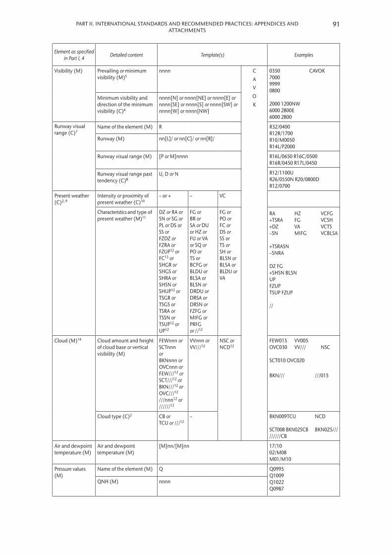
91PART II. INTERNATIONAL STANDARDS AND RECOMMENDED PRACTICES: APPENDICES AND ATTACHMENTS
Element as specified in Part I, 4 Detailed content Template(s) Examples
Visibility (M) Prevailing or minimum visibility (M)5
nnnn C
A
V
O
K
0350 CAVOK 7000 9999 0800 2000 1200NW 6000 2800E 6000 2800
Minimum visibility and direction of the minimum visibility (C)6
nnnn[N] or nnnn[NE] or nnnn[E] or nnnn[SE] or nnnn[S] or nnnn[SW] or nnnn[W] or nnnn[NW]
Runway visual range (C)7
Name of the element (M) R R32/0400 R12R/1700 R10/M0050 R14L/P2000
Runway (M) nn[L]/ or nn[C]/ or nn[R]/
Runway visual range (M) [P or M]nnnn R16L/0650 R16C/0500 R16R/0450 R17L/0450
R12/1100U R26/0550N R20/0800D R12/0700
Runway visual range past tendency (C)8
U, D or N
Present weather (C)2, 9
Intensity or proximity of present weather (C)10
– or + – VC
Characteristics and type of present weather (M)11
DZ or RA or SN or SG or PL or DS or SS or FZDZ or FZRA or FZUP12 or FC13 or SHGR or SHGS or SHRA or SHSN or SHUP12 or TSGR or TSGS or TSRA or TSSN or TSUP12 or UP12
FG or BR or SA or DU or HZ or FU or VA or SQ or PO or TS or BCFG or BLDU or BLSA or BLSN or DRDU or DRSA or DRSN or FZFG or MIFG or PRFG or //12
FG or PO or FC or DS or SS or TS or SH or BLSN or BLSA or BLDU or VA
RA HZ VCFG +TSRA FG VCSH +DZ VA VCTS –SN MIFG VCBLSA +TSRASN –SNRA DZ FG +SHSN BLSN UP FZUP TSUP FZUP //
Cloud (M)14 Cloud amount and height of cloud base or vertical visibility (M)
FEWnnn or SCTnnn or BKNnnn or OVCnnn or FEW///12 or SCT///12 or BKN///12 or OVC///12 ///nnn12 or //////12
VVnnn or VV///12
NSC or NCD12
FEW015 VV005 OVC030 VV/// NSC SCT010 OVC020
BKN/// ///015
Cloud type (C)2 CB or TCU or ///12
– BKN009TCU NCD SCT008 BKN025CB BKN025/// //////CB
Air and dewpoint temperature (M)
Air and dewpoint temperature (M)
[M]nn/[M]nn 17/10 02/M08 M01/M10
Pressure values (M)
Name of the element (M) Q Q0995 Q1009 Q1022 Q0987
QNH (M) nnnn

METEOROLOGICAL SERVICE FOR INTERNATIONAL AIR NAVIGATION92
Element as specified in Part I, 4 Detailed content Template(s) Examples
Supplementary information (C)
Recent weather (C)2, 9 RERASN or REFZDZ or REFZRA or REDZ or RE[SH]RA or RE[SH]SN or RESG or RESHGR or RESHGS or REBLSN or RESS or REDS or RETSRA or RETSSN or RETSGR or RETSGS or RETS or REFC or REVA or REPL or REUP12 or REFZUP12 or RETSUP12 or RESHUP12
REFZRA RETSRA
Wind shear (C)2 WS Rnn[L] or WS Rnn[C] or WS Rnn[R] or WS ALL RWY
WS R03 WS ALL RWY WS R18C
Sea-surface temperature and state of the sea or significant wave height (C)15
W[M]nn/Sn or W[M]nn/Hn[n][n] W15/S2 W12/H75
State of the runway (C)16
Runway designator (M)
Rnn[L]/ or Rnn[C]/ or Rnn[R]/ R/SNOCLO R99/421594 R/SNOCLO R14L/CLRD//Runway
deposits (M)n or / CLRD//
Extent of runway contamination (M)
n or /
Depth of deposit (M)
nn or //
Friction coefficient or braking action (M)
nn or //
Trend forecast (O)17
Change indicator (M)18 NOSIG BECMG or TEMPO NOSIG BECMG FEW020
TEMPO 25018G25MPS (TEMPO 25036G50KT) BECMG FM1030 TL1130 CAVOK BECMG TL1700 0800 FG BECMG AT1800 9000 NSW BECMG FM1900 0500 +SNRA BECMG FM1100 SN TEMPO FM1130 BLSN TEMPO FM0330 TL0430 FZRA TEMPO TL1200 0600 BECMG AT1200 8000 NSW NSC BECMG AT1130 OVC010 TEMPO TL1530 +SHRA BKN012CB
Period of change (C)2 FMnnnn and/or TLnnnn or ATnnnn
Wind (C)2 nnn[P]nn[n][G[P]nn[n]]MPS (or nnn[P]nn[G[P]nn]KT)
Prevailing visibility (C)2 nnnn C
A
V
O
K
Weather phenomenon: intensity (C)10
– or + – N
S
W

93PART II. INTERNATIONAL STANDARDS AND RECOMMENDED PRACTICES: APPENDICES AND ATTACHMENTS
Element as specified in Part I, 4 Detailed content Template(s) Examples
Weather phenomenon: characteristics and type (C)2, 9, 11
DZ or RA or SN or SG or PL or DS or SS or FZDZ or FZRA or SHGR or SHGS or SHRA or SHSN or TSGR or TSGS or TSRA or TSSN
FG or BR or SA or DU or HZ or FU or VA or SQ or PO or FC or TS or BCFG or BLDU or BLSA or BLSN or DRDU or DRSA or DRSN or FZFG or MIFG or PRFG
Cloud amount and height of cloud base or vertical visibility (C)2, 14
FEWnnn or SCTnnn or BKNnnn or OVCnnn
VVnnn or VV///
N
S
C
Cloud type (C)2, 14 CB or TCU
–
Notes:1. Fictitious location.2. To be included whenever applicable.3. To be included in accordance with 4.1.5.2 (c) in this appendix.4. To be included in accordance with 4.1.5.2 (b) (i) in this appendix.5. To be included in accordance with 4.2.4.4 (b) in this appendix.6. To be included in accordance with 4.2.4.4 (a) in this appendix.7. To be included if visibility or runway visual range < 1 500 m; for up to a maximum of four runways in accordance
with 4.3.6.5 (b) in this appendix.8. To be included in accordance with 4.3.6.6 in this appendix.9. One or more, up to a maximum of three groups, in accordance with 4.4.2.9 (a) and 4.8.1.1 and with Appendix 5,
2.2.4.1.10. To be included whenever applicable; no qualifier for moderate intensity in accordance with 4.4.2.8 in this
appendix.11. Precipitation types listed under 4.4.2.3 (a) in this appendix may be combined in accordance with 4.4.2.9 (c) in this
appendix and with Appendix 5, 2.2.4.1. Only moderate or heavy precipitation to be indicated in trend forecasts in accordance with Appendix 5, 2.2.4.1.
12. For automated reports only.13. Heavy used to indicate tornado or waterspout; moderate (no qualifier) to indicate funnel cloud not reaching the
ground. 14. Up to four cloud layers in accordance with 4.5.4.3 (e) in this appendix.15. To be included in accordance with 4.8.1.5 (a) in this appendix.16. To be included in accordance with 4.8.1.5 (b) in this appendix until 4 November 2020.17. To be included in accordance with Part I, 6.3.2.18. Number of change indicators to be kept to a minimum in accordance with Appendix 5, 2.2.1, normally not
exceeding three groups.

METEOROLOGICAL SERVICE FOR INTERNATIONAL AIR NAVIGATION94
Table A3-3. Use of change indicators in trend forecasts
Change indicator
Time indicator and period Meaning
NOSIG – No significant changes are forecast
BECMG FMn1n1n1n1 TLn2n2n2n2 The change is forecast to
Commence at n1n1n1n1 UTC and be completed by n2n2n2n2 UTC
TLnnnn Commence at the beginning of the trend forecast period and be completed by nnnn UTC
FMnnnn Commence at nnnn UTC and be completed by the end of the trend forecast period
ATnnnn Occur at nnnn UTC (specified time)
– (a) Commence at the beginning of the trend forecast period and be completed by the end of the trend forecast period; or
(b) The time is uncertain
TEMPO FMn1n1n1n1 TLn2n2n2n2 Temporary fluctuations are forecast to
Commence at n1n1n1n1 UTC and cease by n2n2n2n2 UTC
TLnnnn Commence at the beginning of the trend forecast period and cease by nnnn UTC
FMnnnn Commence at nnnn UTC and cease by the end of the trend forecast period
– Commence at the beginning of the trend forecast period and cease by the end of the trend forecast period
Table A3-4. Ranges and resolutions for the numerical elements included in local reports
Element as specified in Part I, 4 Range Resolution
Runway: (no units) 01 – 36 1
Wind direction: °true 010 – 360 10
Wind speed: MPSKT
1 – 99*1 – 199*
11
Visibility: MM
KMKM
0 – 750800 – 4 900
5 – 910 –
50100
10 (fixed value: 10 KM)
Runway visual range: MMM
0 – 375400 – 750
800 – 2 000
2550
100
Vertical visibility: MMFTFT
0 – 75**90 – 6000 – 250**
300 – 2 000
153050
100
Clouds: height of cloud base: M M FT
FT
0 – 75**90 – 3 0000 – 250**
300 – 10 000
153050
100
Air temperature; dewpoint temperature: °C –80 – +60 1
QNH; QFE: hPa 0500 – 1 100 1
* There is no aeronautical requirement to report surface wind speeds of 50 m/s (100 kt) or more; however, provision has been made for reporting wind speeds up to 99 m/s (199 kt) for non-aeronautical purposes, as necessary.
** Under circumstances as specified in 4.5.4.2 in this appendix; otherwise a resolution of 30 m (100 ft) is to be used.

95PART II. INTERNATIONAL STANDARDS AND RECOMMENDED PRACTICES: APPENDICES AND ATTACHMENTS
Table A3-5. Ranges and resolutions for the numerical elements included in METAR and SPECI
Element as specified in Part I, 4 Range Resolution
Runway: (no units) 01 – 36 1
Wind direction: °true 000 – 360 10
Wind speed: MPSKT
00 – 99*00 – 199*
11
Visibility: MMMM
0000 – 07500800 – 4 9005 000 – 9 000
10 000 –
50100
1 0000 (fixed value: 9 999)
Runway visual range: MMM
0000 – 03750400 – 07500800 – 2 000
2550
100
Vertical visibility: 30’s M (100’s FT) 000 – 020 1
Clouds: height of cloud base: 30’s M (100’s FT) 000 – 100 1
Air temperature; dewpoint temperature: °C –80 – +60 1
QNH: hPa 0850 – 1 100 1
Sea-surface temperature: °C –10 – +40 1
State of the sea: (no units) 0 – 9 1
Significant wave height: M 0 – 999 0.1
State of the runway [Until 4 November 2020]
Runway designator: (no units) 01 – 36; 88; 99 1
Runway deposits: (no units) 0 – 9 1
Extent of runway contamination: (no units) 1; 2; 5; 9 –
Depth of deposit: (no units) 00 – 90; 92 – 99 1
Friction coefficient/braking action: (no units) 00 – 95; 99 1
* There is no aeronautical requirement to report surface wind speeds of 50 m/s (100 kt) or more; however, provision has been made for reporting wind speeds up to 99 m/s (199 kt) for non-aeronautical purposes, as necessary.

METEOROLOGICAL SERVICE FOR INTERNATIONAL AIR NAVIGATION96
Example A3-1. Routine report
(a) Local routine report (same location and weather conditions as METAR):
MET REPORT YUDO 221630Z WIND 240/4MPS VIS 600M RVR RWY 12 TDZ 1000M MOD DZ FG CLD SCT 300M OVC 600M T17 DP16 QNH 1018HPA TREND BECMG TL1700 VIS 800M FG BECMG AT1800 VIS 10KM NSW
(b) METAR for YUDO (Donlon/International)*:
METAR YUDO 221630Z 24004MPS 0600 R12/1000U DZ FG SCT010 OVC020 17/16 Q1018 BECMG TL1700 0800 FG BECMG AT1800 9999 NSW
Meaning of both reports:Routine report for Donlon/International* issued on the 22nd of the month at 1630 UTC; surface wind direction 240 degrees; wind speed 4 metres per second; visibility (along the runway(s) in the local routine report; prevailing visibility in METAR) 600 metres; runway visual range representative of the touchdown zone for runway 12 is 1 000 metres and the runway visual range values have shown an upward tendency during previous 10 minutes (runway visual range tendency to be included in METAR only); and moderate drizzle and fog; scattered cloud at 300 metres; overcast at 600 metres; air temperature 17 degrees Celsius; dewpoint temperature 16 degrees Celsius; QNH 1 018 hectopascals; trend during next 2 hours, visibility (along the runway(s) in the local routine report; prevailing visibility in METAR) becoming 800 metres in fog by 1700 UTC; at 1800 UTC visibility (along the runway(s) in the local routine report; prevailing visibility in METAR) becoming 10 kilometres or more and nil significant weather.
Note: In this example, the primary units “metre per second” and “metre” were used for wind speed and height of cloud base, respectively. However, in accordance with ICAO Annex 5, the corresponding non-SI alternative units “knot” and “foot” may be used instead.________
* Fictitious location
Example A3-2. Special report
(a) Local special report (same location and weather conditions as SPECI):
SPECIAL YUDO 151115Z WIND 050/25KT MAX37 MNM10 VIS 1200M RVR RWY 05 ABV 1800M HVY TSRA CLD BKN CB 500FT T25 DP22 QNH 1008HPA TREND TEMPO TL1200 VIS 600M BECMG AT1200 VIS 8KM NSW NSC
(b) SPECI for YUDO (Donlon/International)*:
SPECI YUDO 151115Z 05025G37KT 3000 1200NE+TSRA BKN005CB 25/22 Q1008 TEMPO TL1200 0600 BECMG AT1200 8000 NSW NSC
Meaning of both reports:Special report for Donlon/International* issued on the 15th of the month at 1115 UTC; surface wind direction 050 degrees; wind speed 25 knots gusting between 10 and 37 knots (minimum wind speed not to be included in SPECI) visibility 1 200 metres (along the runway(s) in the local special report); prevailing visibility 3 000 metres (in SPECI) with minimum visibility 1 200 metres to north east (directional variations to be included in SPECI only); runway visual range above 1 800 metres on runway 05 (runway visual range not required in SPECI with prevailing visibility of 3 000 metres); thunderstorm with heavy rain; broken cumulonimbus cloud at 500 feet; air temperature 25 degrees Celsius; dewpoint temperature 22 degrees Celsius; QNH 1 008 hectopascals; trend during next 2 hours, visibility (along the runway(s) in the local special report; prevailing visibility in SPECI) temporarily 600 metres from 1115 to 1200, becoming at 1200 UTC visibility (along the runway(s) in the local special report; prevailing visibility in SPECI) 8 kilometres, thunderstorm ceases and nil significant weather and nil significant cloud.
Note: In this example, the non-SI alternative units “knot” and “foot” were used for wind speed and height of cloud base, respectively. However, in accordance with ICAO Annex 5, the corresponding primary units “metre per second” and “metre” may be used instead.________
* Fictitious location

97PART II. INTERNATIONAL STANDARDS AND RECOMMENDED PRACTICES: APPENDICES AND ATTACHMENTS
Example A3-3. Volcanic activity report
VOLCANIC ACTIVITY REPORT YUSB* 231500 MT TROJEEN* VOLCANO N5605 W12652 ERUPTED 231445 LARGE ASH CLOUD EXTENDING TO APPROX 30000 FEET MOVING SW
Meaning:Volcanic activity report issued by Siby/Bistock meteorological station at 1500 UTC on the 23rd of the month. Mt Trojeen volcano 56 degrees 5 minutes north 126 degrees 52 minutes west erupted at 1445 UTC on the 23rd; a large ash cloud was observed extending to approximately 30 000 feet and moving in a south-westerly direction.
________* Fictitious location

APPENDIX 4. TECHNICAL SPECIFICATIONS RELATED TO AIRCRAFT OBSERVATIONS AND REPORTS
(See Part I, 5)
1. CONTENTS OF AIR-REPORTS
1.1 Routine air-reports by air-ground data link
1.1.1 When air ground data link is used and automatic dependent surveillance – contract (ADS-C) or SSR Mode S is being applied, the elements contained in routine air reports shall be:
Message type designatorAircraft identification
Data block 1Latitude LongitudeLevel Time
Data block 2Wind directionWind speedWind quality flagAir temperatureTurbulence (if available)Humidity (if available)
Note: When ADS-C or SSR Mode S is being applied, the requirements of routine air-reports may be met by the combination of the basic ADS-C/SSR Mode S data block (data block 1) and the meteorological information data block (data block 2), available from ADS-C or SSR Mode S reports. The ADS-C message format is specified in the ICAO Procedures for Air Navigation Services – Air Traffic Management (PANS-ATM, Doc 4444), 4.11.4 and Chapter 13 and the SSR Mode S message format is specified in ICAO Annex 10, Volume III, Part I, Chapter 5.
1.1.2 When air-ground data link is used while ADS-C and SSR Mode S are not being applied, the elements contained in routine reports shall be:
Message type designator
Section 1 (Position information)Aircraft identificationPosition or latitude and longitudeTimeFlight level or altitudeNext position and time overEnsuing significant point
Section 2 (Operational information)Estimated time of arrivalEndurance
Section 3 (Meteorological information)Air temperatureWind directionWind speed

PART II. INTERNATIONAL STANDARDS AND RECOMMENDED PRACTICES: APPENDICES AND ATTACHMENTS
TurbulenceAircraft icingHumidity (if available)
Note: When air-ground data link is used while ADS-C and SSR Mode S are not being applied, the requirements of routine air-reports may be met by the controller-pilot data link communication (CPDLC) application entitled “Position report”. The details of this data link application are specified in the ICAO Manual of Air Traffic Services Data Link Applications (Doc 9694) and in ICAO Annex 10, Volume III, Part I.
1.2 Special air-reports by air-ground data link
When air-ground data link is used, the elements contained in special air-reports shall be:
Message type designatorAircraft identification
Data block 1LatitudeLongitudeLevelTime
Data block 2Wind directionWind speedWind quality flagAir temperatureTurbulence (if available)Humidity (if available)
Data block 3 Condition prompting the issuance of a special air-report (one condition to be selected
from the list presented in Table A4-1) .
Notes: 1. The requirements of special air-reports may be met by the data link flight information service (D-FIS) application
entitled “Special air-report service”. The details of this data link application are specified in the ICAO Manual of Air Traffic Services Data Link Applications (Doc 9694).
2. In the case of a special air-report of pre-eruption volcanic activity, volcanic eruption or volcanic ash cloud, additional requirements are indicated in 4.2 below.
1.3 Special air-reports by voice communications
When voice communications are used, the elements contained in special air-reports shall be:
Message type designator
Section 1 (Position information)Aircraft identificationPosition or latitude and longitudeTimeLevel or range of levels
Section 3 (Meteorological information) Condition prompting the issuance of a special air-report, to be selected from the list
presented in Table A4-1 .
99

Notes:1. Air-reports are considered routine by default. The message type designator for special air-reports is specified in the
ICAO Procedures for Air Navigation Services – Air Traffic Management (PANS-ATM, Doc 4444), Appendix 1.2. In the case of a special air-report of pre-eruption volcanic activity, volcanic eruption or volcanic ash cloud,
additional requirements are indicated in 4.2 below.
2. CRITERIA FOR REPORTING
2.1 General
When air-ground data link is used, the wind direction, wind speed, wind quality flag, air temperature, turbulence and humidity included in air-reports shall be reported in accordance with the following criteria .
2.2 Wind direction
The wind direction shall be reported in terms of degrees true, rounded to the nearest whole degree .
2.3 Wind speed
The wind speed shall be reported in metres per second or knots, rounded to the nearest 1 m/s (1 knot) . The units of measurement used for the wind speed shall be indicated .
2.4 Wind quality flag
The wind quality flag shall be reported as 0 when the roll angle is less than 5 degrees and as 1 when the roll angle is 5 degrees or more .
2.5 Air temperature
The air temperature shall be reported to the nearest tenth of a degree Celsius .
2.6 Turbulence
The turbulence shall be reported in terms of the cube root of the eddy dissipation rate (EDR) .
2.6.1 Routine air-reports
The turbulence shall be reported during the en-route phase of the flight and shall refer to the 15-minute period immediately preceding the observation . Both the average and peak value of turbulence, together with the time of occurrence of the peak value to the nearest minute, shall be observed . The average and peak values shall be reported in terms of the cube root of EDR . The time of occurrence of the peak value shall be reported as indicated in Table A4-2 . The turbulence shall be reported during the climb-out phase for the first 10 minutes of the flight and shall refer to the 30-second period immediately preceding the observation . The peak value of turbulence shall be observed .
100 METEOROLOGICAL SERVICE FOR INTERNATIONAL AIR NAVIGATION
PART II. INTERNATIONAL STANDARDS AND RECOMMENDED PRACTICES: APPENDICES AND ATTACHMENTS
2.6.2 Interpretation of the turbulence report
Turbulence shall be considered:
(a) Severe when the peak value of the cube root of EDR exceeds 0 .7;
(b) Moderate when the peak value of the cube root of EDR is above 0 .4 and below or equal to 0 .7;
(c) Light when the peak value of the cube root of EDR is above 0 .1 and below or equal to 0 .4; and
(d) Nil when the peak value of the cube root of EDR is below or equal to 0 .1 .
Note: The EDR is an aircraft-independent measure of turbulence. However, the relationship between the EDR value and the perception of turbulence is a function of aircraft type, and the mass, altitude, configuration and airspeed of the aircraft. The EDR values given above describe the severity levels for a medium-sized transport aircraft under typical en-route conditions (i.e. altitude, airspeed and weight).
2.6.3 Special air-reports
Special air-reports on turbulence shall be made during any phase of the flight whenever the peak value of the cube root of EDR exceeds 0 .4 . The special air-report on turbulence shall be made with reference to the one-minute period immediately preceding the observation . Both the average and peak value of turbulence shall be observed . The average and peak values shall be reported in terms of the cube root of EDR . Special air-reports shall be issued every minute until such time as the peak values of the cube root of EDR fall below 0 .4 .
2.7 Humidity
The humidity shall be reported as the relative humidity, rounded to the nearest whole per cent .
Note: The ranges and resolutions for the meteorological elements included in air-reports are shown in Table A4-3.
3. EXCHANGE OF AIR-REPORTS
3.1 Responsibilities of the meteorological watch offices
3.1.1 The meteorological watch office shall transmit without delay the special air-reports received by voice communications to the world area forecast centres (WAFCs) and the centres designated by regional air navigation agreement for the operation of aeronautical fixed service Internet-based services .
3.1.2 The meteorological watch office shall transmit without delay special air-reports of pre-eruption volcanic activity, a volcanic eruption or volcanic ash cloud received to the associated volcanic ash advisory centres .
3.1.3 When a special air-report is received at the meteorological watch office but the forecaster considers that the phenomenon causing the report is not expected to persist and, therefore, does not warrant issuance of a SIGMET, the special air-report shall be disseminated in the same way that SIGMET messages are disseminated in accordance with Appendix 6, 1 .2 .1, i .e . to meteorological watch offices, WAFCs, and other meteorological offices in accordance with regional air navigation agreement .
101

Note: The template used for special air-reports which are uplinked to aircraft in flight is in Appendix 6, Table A6-1B.
3.2 Responsibilities of world area forecast centres
Air-reports received at WAFCs shall be further disseminated as basic meteorological data .
Note: The dissemination of basic meteorological data is normally carried out on the WMO Global Telecommunication System.
3.3 Supplementary dissemination of air-reports
[Recommendation] Where supplementary dissemination of air-reports is required to satisfy special aeronautical or meteorological requirements, such dissemination should be arranged and agreed between the meteorological authorities concerned.
3.4 Format of air-reports
Air-reports shall be exchanged in the format in which they are received .
4. SPECIFIC PROVISIONS RELATED TO REPORTING WIND SHEAR AND VOLCANIC ASH
4.1 Reporting of wind shear
4.1.1 [Recommendation] When reporting aircraft observations of wind shear encountered during the climb-out and approach phases of flight, the aircraft type should be included.
4.1.2 [Recommendation] Where wind shear conditions in the climb-out or approach phases of flight were reported or forecast but not encountered, the pilot-in-command should advise the appropriate air traffic services unit as soon as practicable unless the pilot-in-command is aware that the appropriate air traffic services unit has already been so advised by a preceding aircraft.
4.2 Post-flight reporting of volcanic activity
Note: The detailed instructions for recording and reporting volcanic activity observations are given in the ICAO Procedures for Air Navigation Services – Air Traffic Management (PANS-ATM, Doc 4444), Appendix 1.
4.2.1 On arrival of a flight at an aerodrome, the completed report of volcanic activity shall be delivered by the operator or a flight crew member, without delay, to the aerodrome meteorological office, or if such office is not easily accessible to arriving flight crew members, the completed form shall be dealt with in accordance with local arrangements made by the meteorological authority and the operator .
4.2.2 The completed report of volcanic activity received by an aerodrome meteorological office shall be transmitted without delay to the meteorological watch office responsible for the provision of meteorological watch for the flight information region in which the volcanic activity was observed .
102 METEOROLOGICAL SERVICE FOR INTERNATIONAL AIR NAVIGATION

103PART II. INTERNATIONAL STANDARDS AND RECOMMENDED PRACTICES: APPENDICES AND ATTACHMENTS
Table A4-1. Template for the special air-report (downlink)
Key: MC
==
inclusion mandatory, part of every message;inclusion conditional; included whenever available.
Note: Message to be prompted by the pilot-in-command. Currently only the condition “SEV TURB” can be automated (see 2.6.3 in this appendix).
Element as specified in Part I, 5 Detailed content Template(s) Examples
Message type designator (M) Type of air-report (M) ARS ARS
Aircraft identification (M) Aircraft radiotelephony call sign (M) nnnnnn VA812
DATA BLOCK 1
Latitude (M) Latitude in degrees and minutes (M) Nnnnn or Snnnn S4506
Longitude (M) Longitude in degrees and minutes (M) Wnnnnn or Ennnnn E01056
Level (M) Flight level (M) FLnnn or FLnnn to FLnnn FL330 FL280 to FL310
Time (M) Time of occurrence in hours and minutes (M) OBS AT nnnnZ OBS AT 1216Z
DATA BLOCK 2
Wind direction (M) Wind direction in degrees true (M) nnn/ 262/
Wind speed (M) Wind speed in metres per second (or knots) (M)
nnnMPS (or nnnKT) 040MPS (080KT)
Wind quality flag (M) Wind quality flag (M) n 1
Air temperature (M) Air temperature in tenths of degrees C (M) T[M]nnn T127 TM455
Turbulence (C) Turbulence in hundredths of m2/3 s–1 and the time of occurrence of the peak value (C)1
EDRnnn/nn EDR064/08
Humidity (C) Relative humidity in per cent (C) RHnnn RH054
DATA BLOCK 3
Condition prompting the issuance of a special air-report (M)
SEV TURB [EDRnnn]2 or SEV ICE or SEV MTW or TS GR3 or TS3 or HVY SS4 or VA CLD [FLnnn/nnn] or VA5 [MT nnnnnnnnnnnnnnnnnnnn] or MOD TURB [EDRnnn]2 or MOD ICE
SEV TURB EDR076 VA CLD FL050/100
Notes:1. The time of occurrence to be reported in accordance with Table A4-2.2. The turbulence to be reported in accordance with 2.6.3 in this appendix.3. Obscured, embedded or widespread thunderstorms or thunderstorms in squall lines.4. Duststorm or sandstorm.5. Pre-eruption volcanic activity or a volcanic eruption.

METEOROLOGICAL SERVICE FOR INTERNATIONAL AIR NAVIGATION104
Table A4-2. Time of occurrence of the peak value to be reported
Peak value of turbulence occurring during the one-minute period . . . . . . minutes prior to the observation
Value to be reported
0 – 1 0
1 – 2 1
2 – 3 2
... ...
13 –14 13
14 – 15 14
No timing information available 15
Table A4-3. Ranges and resolutions for the meteorological elements included in air-reports
Element as specified in Part I, 5 Range Resolution
Wind direction: °true 000 – 360 1
Wind speed: MPSKT
00 – 12500 – 250
11
Wind quality flag: (index)* 0 – 1 1
Air temperature: °C –80 – +60 0.1
Turbulence: routine air-report: m2/3 s–1
(time of occurrence)*0 – 2
0 – 150.01
1
Turbulence: special air-report: m2/3 s–1 0 – 2 0.01
Humidity: % 0 – 100 1
* Non-dimensional

APPENDIX 5. TECHNICAL SPECIFICATIONS RELATED TO FORECASTS
(See Part I, 6)
1. CRITERIA RELATED TO TAF
1.1 TAF format
1.1.1 TAF shall be issued in accordance with the template shown in Table A5-1 and disseminated in the TAF code form prescribed by WMO .
Note: The TAF code form is contained in the Manual on Codes (WMO-No. 306), Volume I.1, Part A – Alphanumeric Codes.
1.1.2 [Recommendation] Until 4 November 2020, TAF should be disseminated in IWXXM GML form in addition to the dissemination of the TAF in accordance with 1.1.1 above.
1.1.2 As of 5 November 2020, TAF shall be disseminated in IWXXM GML form in addition to the dissemination of the TAF in accordance with 1 .1 .1 above .
Note: The technical specifications for IWXXM are contained in the Manual on Codes (WMO-No. 306), Volume I.3, Part D – Representations Derived from Data Models. Guidance on the implementation of IWXXM is provided in the ICAO Manual on the Digital Exchange of Aeronautical Meteorological Information (Doc 10003).
1.2 Inclusion of meteorological elements in TAF
Note: Guidance on operationally desirable accuracy of forecasts is given in Attachment B.
1.2.1 Surface wind
In forecasting surface wind, the expected prevailing direction shall be given . When it is not possible to forecast a prevailing surface wind direction due to its expected variability, for example, during light wind conditions (less than 1 .5 m/s (3 kt)) or thunderstorms, the forecast wind direction shall be indicated as variable using “VRB” . When the wind is forecast to be less than 0 .5 m/s (1 kt), the forecast wind speed shall be indicated as calm . When the forecast maximum speed (gust) exceeds the forecast mean wind speed by 5 m/s (10 kt) or more, the forecast maximum wind speed shall be indicated . When a wind speed of 50 m/s (100 kt) or more is forecast, it shall be indicated to be more than 49 m/s (99 kt) .
1.2.2 Visibility
[Recommendation] When the visibility is forecast to be less than 800 m, it should be expressed in steps of 50 m; when it is forecast to be 800 m or more but less than 5 km, in steps of 100 m; 5 km or more but less than 10 km, in kilometre steps; and when it is forecast to be 10 km or more, it should be expressed as 10 km, except when conditions of CAVOK are forecast to apply. The prevailing visibility should be forecast. When visibility is forecast to vary in different directions and the prevailing visibility cannot be forecast, the lowest forecast visibility should be given.
1.2.3 Weather phenomena
One or more, up to a maximum of three, of the following weather phenomena or combinations thereof, together with their characteristics and, where appropriate, intensity, shall be forecast if they are expected to occur at the aerodrome:

– Freezing precipitation;– Freezing fog;– Moderate or heavy precipitation (including showers thereof);– Low drifting dust, sand or snow;– Blowing dust, sand or snow;– Duststorm;– Sandstorm;– Thunderstorm (with or without precipitation);– Squall;– Funnel cloud (tornado or waterspout);– Other weather phenomena given in Appendix 3, 4 .4 .2 .3, as agreed between the
meteorological authority, the appropriate ATS authority and the operators concerned .
The expected end of occurrence of those phenomena shall be indicated by the abbreviation “NSW” .
1.2.4 Cloud
[Recommendation] Cloud amount should be forecast using the abbreviations “FEW”, “SCT”, “BKN” or “OVC” as necessary. When it is expected that the sky will remain or become obscured and clouds cannot be forecast and information on vertical visibility is available at the aerodrome, the vertical visibility should be forecast in the form “VV” followed by the forecast value of the vertical visibility. When several layers or masses of cloud are forecast, their amount and height of base should be included in the following order:
(a) The lowest layer or mass regardless of amount, to be forecast as FEW, SCT, BKN or OVC as appropriate;
(b) The next layer or mass covering more than 2/8, to be forecast as SCT, BKN or OVC as appropriate;
(c) The next higher layer or mass covering more than 4/8, to be forecast as BKN or OVC as appropriate; and
(d) Cumulonimbus clouds and/or towering cumulus clouds, whenever forecast and not already included under (a) to (c).
Cloud information should be limited to cloud of operational significance; when no cloud of operational significance is forecast, and “CAVOK” is not appropriate, the abbreviation “NSC” should be used.
1.2.5 Temperature
[Recommendation] When forecast temperatures are included in accordance with regional air navigation agreement, the maximum and minimum temperatures expected to occur during the period of validity of the TAF should be given, together with their corresponding times of occurrence.
1.3 Use of change groups
Note: Guidance on the use of change and time indicators in TAF is given in Table A5-2.
1.3.1 The criteria used for the inclusion of change groups in TAF or for the amendment of TAF shall be based on any of the following weather phenomena or combinations thereof being forecast to begin or end or change in intensity:
106 METEOROLOGICAL SERVICE FOR INTERNATIONAL AIR NAVIGATION

PART II. INTERNATIONAL STANDARDS AND RECOMMENDED PRACTICES: APPENDICES AND ATTACHMENTS
– Freezing fog;– Freezing precipitation;– Moderate or heavy precipitation (including showers);– Thunderstorm;– Duststorm;– Sandstorm .
1.3.2 [Recommendation] The criteria used for the inclusion of change groups in TAF or for the amendment of TAF should be based on the following:
(a) When the mean surface wind direction is forecast to change by 60° or more, the mean speed before and/or after the change being 5 m/s (10 kt) or more;
(b) When the mean surface wind speed is forecast to change by 5 m/s (10 kt) or more;
(c) When the variation from the mean surface wind speed (gusts) is forecast to change by 5 m/s (10 kt) or more, the mean speed before and/or after the change being 7.5 m/s (15 kt) or more;
(d) When the surface wind is forecast to change through values of operational significance. The threshold values should be established by the meteorological authority in consultation with the appropriate ATS authority and the operators concerned, taking into account changes in the wind which would:(i) Require a change in runway(s) in use; and(ii) Indicate that the runway tailwind and crosswind components will change through
values representing the main operating limits for typical aircraft operating at the aerodrome;
(e) When the visibility is forecast to improve and change to or pass through one or more of the following values, or when the visibility is forecast to deteriorate and pass through one or more of the following values:(i) 150, 350, 600, 800, 1 500 or 3 000 m; or(ii) 5 000 m in cases where significant numbers of flights are operated in accordance with
the visual flight rules;
(f) When any of the following weather phenomena or combinations thereof are forecast to begin or end:(i) Low drifting dust, sand or snow;(ii) Blowing dust, sand or snow;(iii) Squall;(iv) Funnel cloud (tornado or waterspout);
(g) When the height of base of the lowest layer or mass of cloud of BKN or OVC extent is forecast to lift and change to or pass through one or more of the following values, or when the height of the lowest layer or mass of cloud of BKN or OVC extent is forecast to lower and pass through one or more of the following values:(i) 30, 60, 150 or 300 m (100, 200, 500 or 1 000 ft); or(ii) 450 m (1 500 ft) in cases where significant numbers of flights are operated in
accordance with the visual flight rules;
(h) When the amount of a layer or mass of cloud below 450 m (1 500 ft) is forecast to change:(i) From NSC, FEW or SCT to BKN or OVC; or(ii) From BKN or OVC to NSC, FEW or SCT;
(i) When the vertical visibility is forecast to improve and change to or pass through one or more of the following values, or when the vertical visibility is forecast to deteriorate and pass through one or more of the following values: 30, 60, 150 or 300 m (100, 200, 500 or 1 000 ft); and
107

(j) Any other criteria based on local aerodrome operating minima, as agreed between the meteorological authority and the operators concerned.
Note: Other criteria based on local aerodrome operating minima are to be considered in parallel with similar criteria for the issuance of SPECI developed in response to Appendix 3, 2.3.3 (h).
1.3.3 [Recommendation] When a change in any of the elements given in Part I, 6.2.3 is required to be indicated in accordance with the criteria given in 1.3.2 above, the change indicators “BECMG” or “TEMPO” should be used followed by the time period during which the change is expected to occur. The time period should be indicated as the beginning and end of the period in whole hours UTC. Only those elements for which a significant change is expected should be included following a change indicator. However, in the case of significant changes in respect of cloud, all cloud groups, including layers or masses not expected to change, should be indicated.
1.3.4 [Recommendation] The change indicator “BECMG” and the associated time group should be used to describe changes where the meteorological conditions are expected to reach or pass through specified threshold values at a regular or irregular rate and at an unspecified time during the time period. The time period should normally not exceed two hours but in any case should not exceed four hours.
1.3.5 [Recommendation] The change indicator “TEMPO” and the associated time group should be used to describe expected frequent or infrequent temporary fluctuations in the meteorological conditions which reach or pass specified threshold values and last for a period of less than one hour in each instance and, in the aggregate, cover less than one half of the forecast period during which the fluctuations are expected to occur. If the temporary fluctuation is expected to last one hour or longer, the change group “BECMG” should be used in accordance with 1.3.4 above or the validity period should be subdivided in accordance with 1.3.6 below.
1.3.6 [Recommendation] Where one set of prevailing weather conditions is expected to change significantly and more or less completely to a different set of conditions, the period of validity should be subdivided into self-contained periods using the abbreviation “FM” followed immediately by a six-figure time group in days, hours and minutes UTC indicating the time the change is expected to occur. The subdivided period following the abbreviation “FM” should be self-contained and all forecast conditions given before the abbreviation should be superseded by those following the abbreviation.
1.4 Use of probability groups
[Recommendation] The probability of occurrence of an alternative value of a forecast element or elements should be indicated, as necessary, by use of the abbreviation “PROB” followed by the probability in tens of per cent and the time period during which the alternative value(s) is (are) expected to apply. The probability information should be placed after the element or elements forecast and be followed by the alternative value of the element or elements. The probability of a forecast of temporary fluctuations in meteorological conditions should be indicated, as necessary, by use of the abbreviation “PROB” followed by the probability in tens of per cent, placed before the change indicator “TEMPO” and associated time group. A probability of an alternative value or change of less than 30 per cent should not be considered sufficiently significant to be indicated. A probability of an alternative value or change of 50 per cent or more, for aviation purposes, should not be considered a probability but instead should be indicated, as necessary, by use of the change indicators “BECMG” or “TEMPO” or by subdivision of the validity period using the abbreviation “FM”. The probability group should not be used to qualify the change indicator “BECMG” nor the time indicator “FM”.
1.5 Numbers of change and probability groups
[Recommendation] The number of change and probability groups should be kept to a minimum and should not normally exceed five groups.
108 METEOROLOGICAL SERVICE FOR INTERNATIONAL AIR NAVIGATION

PART II. INTERNATIONAL STANDARDS AND RECOMMENDED PRACTICES: APPENDICES AND ATTACHMENTS
1.6 Dissemination of TAF
TAF and amendments thereto shall be disseminated to international OPMET databanks and the centres designated by regional air navigation agreement for the operation of aeronautical fixed service Internet-based services, in accordance with regional air navigation agreement .
2. CRITERIA RELATED TO TREND FORECASTS
2.1 Format of trend forecasts
Trend forecasts shall be issued in accordance with the templates shown in Appendix 3, Tables A3–1 and A3-2 . The units and scales used in the trend forecast shall be the same as those used in the report to which it is appended .
Note: Examples of trend forecasts are given in Appendix 3.
2.2 Inclusion of meteorological elements in trend forecasts
2.2.1 General provisions
The trend forecast shall indicate significant changes in respect of one or more of the elements: surface wind, visibility, weather and clouds . Only those elements shall be included for which a significant change is expected . However, in the case of significant changes in respect of cloud, all cloud groups, including layers or masses not expected to change, shall be indicated . In the case of a significant change in visibility, the phenomenon causing the reduction of visibility shall also be indicated . When no change is expected to occur, this shall be indicated by the term “NOSIG” .
2.2.2 Surface wind
The trend forecast shall indicate changes in the surface wind which involve:
(a) A change in the mean wind direction of 60° or more, the mean speed before and/or after the change being 5 m/s (10 kt) or more;
(b) A change in mean wind speed of 5 m/s (10 kt) or more; and
(c) Changes in the wind through values of operational significance . The threshold values shall be established by the meteorological authority in consultation with the appropriate ATS authority and the operators concerned, taking into account changes in the wind which would:(i) Require a change in runway(s) in use; and(ii) Indicate that the runway tailwind and crosswind components will change through
values representing the main operating limits of typical aircraft operating at the aerodrome .
2.2.3 Visibility
When the visibility is expected to improve and change to or pass through one or more of the following values, or when the visibility is expected to deteriorate and pass through one or more of the following values: 150, 350, 600, 800, 1 500 or 3 000 m, the trend forecast shall
109

indicate the change . When significant numbers of flights are conducted in accordance with the visual flight rules, the forecast shall additionally indicate changes to or passing through 5 000 m .
Note: In trend forecasts appended to local routine and special reports, visibility refers to the forecast visibility along the runway(s); in trend forecasts appended to METAR and SPECI, visibility refers to the forecast prevailing visibility.
2.2.4 Weather phenomena
2.2.4.1 The trend forecast shall indicate the expected onset, cessation or change in intensity of one or more of the following weather phenomena or combinations thereof:
– Freezing precipitation;– Moderate or heavy precipitation (including showers);– Thunderstorm (with precipitation);– Duststorm;– Sandstorm;– Other weather phenomena given in Appendix 3, 4 .4 .2 .3, as agreed between the
meteorological authority, the appropriate ATS authority and the operators concerned .
2.2.4.2 The trend forecast shall indicate the expected onset or cessation of one or more of the following weather phenomena or combinations thereof:
– Freezing fog;– Low drifting dust, sand or snow;– Blowing dust, sand or snow;– Thunderstorm (without precipitation);– Squall;– Funnel cloud (tornado or waterspout) .
2.2.4.3 The total number of phenomena reported in 2 .2 .4 .1 and 2 .2 .4 .2 above shall not exceed three .
2.2.4.4 The expected end of occurrence of the weather phenomena shall be indicated by the abbreviation “NSW” .
2.2.5 Clouds
When the height of the base of a cloud layer of BKN or OVC extent is expected to lift and change to or pass through one or more of the following values, or when the height of the base of a cloud layer of BKN or OVC extent is expected to lower and pass through one or more of the following values: 30, 60, 150, 300 and 450 m (100, 200, 500, 1 000 and 1 500 ft), the trend forecast shall indicate the change . When the height of the base of a cloud layer is below or is expected to fall below or rise above 450 m (1 500 ft), the trend forecast shall also indicate changes in cloud amount from FEW, or SCT increasing to BKN or OVC, or changes from BKN or OVC decreasing to FEW or SCT . When no clouds of operational significance are forecast and “CAVOK” is not appropriate, the abbreviation “NSC” shall be used .
2.2.6 Vertical visibility
When the sky is expected to remain or become obscured and vertical visibility observations are available at the aerodrome, and the vertical visibility is forecast to improve and change to or pass through one or more of the following values, or when the vertical visibility is forecast to deteriorate and pass through one or more of the following values: 30, 60, 150 or 300 m (100, 200, 500 or 1 000 ft), the trend forecast shall indicate the change .
110 METEOROLOGICAL SERVICE FOR INTERNATIONAL AIR NAVIGATION
PART II. INTERNATIONAL STANDARDS AND RECOMMENDED PRACTICES: APPENDICES AND ATTACHMENTS
2.2.7 Additional criteria
Criteria for the indication of changes based on local aerodrome operating minima, additional to those specified in 2 .2 .2 to 2 .2 .6 above, shall be used as agreed between the meteorological authority and the operator concerned .
2.3 Use of change groups
Note: Guidance on the use of change indicators in trend forecasts is given in Appendix 3, Table A3-3.
2.3.1 When a change is expected to occur, the trend forecast shall begin with one of the change indicators “BECMG” or “TEMPO” .
2.3.2 The change indicator “BECMG” shall be used to describe forecast changes where the meteorological conditions are expected to reach or pass through specified values at a regular or irregular rate . The period during which, or the time at which, the change is forecast to occur shall be indicated, using the abbreviations “FM”, “TL” or “AT”, as appropriate, each followed by a time group in hours and minutes . When the change is forecast to begin and end wholly within the trend forecast period, the beginning and end of the change shall be indicated by using the abbreviations “FM” and “TL”, respectively, with their associated time groups . When the change is forecast to commence at the beginning of the trend forecast period but be completed before the end of that period, the abbreviation “FM” and its associated time group shall be omitted and only “TL” and its associated time group shall be used . When the change is forecast to begin during the trend forecast period and be completed at the end of that period, the abbreviation “TL” and its associated time group shall be omitted and only “FM” and its associated time group shall be used . When the change is forecast to occur at a specified time during the trend forecast period, the abbreviation “AT” followed by its associated time group shall be used . When the change is forecast to commence at the beginning of the trend forecast period and be completed by the end of that period or when the change is forecast to occur within the trend forecast period but the time is uncertain, the abbreviations “FM”, “TL” or “AT” and their associated time groups shall be omitted and the change indicator “BECMG” shall be used alone .
2.3.3 The change indicator “TEMPO” shall be used to describe forecast temporary fluctuations in the meteorological conditions which reach or pass specified values and last for a period of less than one hour in each instance and, in the aggregate, cover less than one half of the period during which the fluctuations are forecast to occur . The period during which the temporary fluctuations are forecast to occur shall be indicated, using the abbreviations “FM” and/or “TL”, as appropriate, each followed by a time group in hours and minutes . When the period of temporary fluctuations in the meteorological conditions is forecast to begin and end wholly within the trend forecast period, the beginning and end of the period of temporary fluctuations shall be indicated by using the abbreviations “FM” and “TL”, respectively, with their associated time groups . When the period of temporary fluctuations is forecast to commence at the beginning of the trend forecast period but cease before the end of that period, the abbreviation “FM” and its associated time group shall be omitted and only “TL” and its associated time group shall be used . When the period of temporary fluctuations is forecast to begin during the trend forecast period and cease by the end of that period, the abbreviation “TL” and its associated time group shall be omitted and only “FM” and its associated time group shall be used . When the period of temporary fluctuations is forecast to commence at the beginning of the trend forecast period and cease by the end of that period, both abbreviations “FM” and “TL” and their associated time groups shall be omitted and the change indicator “TEMPO” shall be used alone .
2.4 Use of the probability indicator
The indicator “PROB” shall not be used in trend forecasts .
111

3. CRITERIA RELATED TO FORECASTS FOR TAKE-OFF
3.1 Format of forecasts for take-off
[Recommendation] The format of the forecast should be as agreed between the meteorological authority and the operator concerned. The order of the elements and the terminology, units and scales used in forecasts for take-off should be the same as those used in reports for the same aerodrome.
3.2 Amendments to forecasts for take-off
[Recommendation] The criteria for the issuance of amendments to forecasts for take-off for surface wind direction and speed, temperature and pressure and any other elements agreed locally should be agreed between the meteorological authority and the operators concerned. The criteria should be consistent with the corresponding criteria for special reports established for the aerodrome in accordance with Appendix 3, 2.3.1.
4. CRITERIA RELATED TO AREA FORECASTS FOR LOW-LEVEL FLIGHTS
4.1 Format and content of GAMET area forecasts
When prepared in GAMET format, area forecasts shall contain two sections: Section I related to information on en-route weather phenomena hazardous to low-level flights, prepared in support of the issuance of AIRMET information, and Section II related to additional information required by low-level flights . The content and order of elements in a GAMET area forecast, when prepared, shall be in accordance with the template shown in Table A5-3 . Additional elements in Section II shall be included in accordance with regional air navigation agreement . Elements which are already covered by a SIGMET message shall be omitted from GAMET area forecasts .
4.2 Amendments to GAMET area forecasts
When a weather phenomenon hazardous to low-level flights has been included in the GAMET area forecast and the phenomenon forecast does not occur, or is no longer forecast, a GAMET AMD shall be issued, amending only the weather element concerned .
Note: Specifications regarding the issuance of AIRMET information amending the area forecast in respect of weather phenomena hazardous for low-level flights are given in Appendix 6.
4.3 Content of area forecasts for low-level flights in chart form
4.3.1 When chart form is used for area forecasts for low-level flights, the forecast of upper wind and upper-air temperature shall be issued for points separated by no more than 500 km (300 NM) and for at least the following altitudes: 600, 1 500 and 3 000 m (2 000, 5 000 and 10 000 ft), and 4 500 m (15 000 ft) in mountainous areas .
4.3.2 When chart form is used for area forecasts for low-level flights, the forecast of SIGWX phenomena shall be issued as low-level SIGWX forecast for flight levels up to 100 (or up to flight level 150 in mountainous areas, or higher, where necessary) . Low-level SIGWX forecasts shall include the following items:
(a) The phenomena warranting the issuance of a SIGMET as given in Appendix 6 and which are expected to affect low-level flights; and
112 METEOROLOGICAL SERVICE FOR INTERNATIONAL AIR NAVIGATION

PART II. INTERNATIONAL STANDARDS AND RECOMMENDED PRACTICES: APPENDICES AND ATTACHMENTS
(b) The elements in area forecasts for low-level flights as given in Table A5-3 except elements concerning:(i) Upper wind and upper-air temperature; and(ii) Forecast QNH .
Note: Guidance on the use of terms “ISOL”, “OCNL” and “FRQ” referring to cumulonimbus and towering cumulus clouds, and thunderstorms is given in Appendix 6.
4.4 Exchange of area forecasts for low-level flights
Area forecasts for low-level flights prepared in support of the issuance of AIRMET information shall be exchanged between aerodrome meteorological offices and/or meteorological watch offices responsible for the issuance of flight documentation for low-level flights in the flight information regions concerned .
113

METEOROLOGICAL SERVICE FOR INTERNATIONAL AIR NAVIGATION114
Table A5-1. Template for TAF
Key: MCO
===
inclusion mandatory, part of every message;inclusion conditional, dependent on meteorological conditions or method of observation;inclusion optional.
Notes:1. The ranges and resolutions for the numerical elements included in TAF are shown in Table A5-4 of this appendix.2. The explanations for the abbreviations can be found in the ICAO Procedures for Air Navigation Services – ICAO
Abbreviations and Codes (PANS-ABC, Doc 8400).
Element as specified in Part I, 6 Detailed content Template(s) Examples
Identification of the type of forecast (M)
Type of forecast (M) TAF or TAF AMD or TAF COR TAF TAF AMD
Location indicator (M)
ICAO location indicator (M) nnnn YUDO1
Time of issue of forecast (M)
Day and time of issue of the forecast in UTC (M)
nnnnnnZ 160000Z
Identification of a missing forecast (C)
Missing forecast identifier (C) NIL NIL
END OF TAF IF THE FORECAST IS MISSING.
Days and period of validity of forecast (M)
Days and period of the validity of the forecast in UTC (M)
nnnn/nnnn 0812/0918
Identification of a cancelled forecast (C)
Cancelled forecast identifier (C) CNL CNL
END OF TAF IF THE FORECAST IS CANCELLED.
Surface wind (M) Wind direction (M) nnn or VRB2 24004MPS; VRB01MPS (24008KT); (VRB02KT) 19005MPS (19010KT) 00000MPS (00000KT) 140P49MPS (140P99KT) 12003G09MPS (12006G18KT) 24008G14MPS (24016G28KT)
Wind speed (M) [P]nn[n]
Significant speed variations (C)3
G[P]nn[n]
Units of measurement (M) MPS (or KT)

115PART II. INTERNATIONAL STANDARDS AND RECOMMENDED PRACTICES: APPENDICES AND ATTACHMENTS
Element as specified in Part I, 6 Detailed content Template(s) Examples
Visibility (M) Prevailing visibility (M) nnnn C
A
V
O
K
0350 CAVOK 7000 9000 9999
Weather (C)4, 5 Intensity of weather phenomena (C)6
– or + — RA HZ +TSRA FG –FZDZ PRFG
+TSRASN
SNRA FG
Characteristics and type of weather phenomena (C)7
DZ or RA or SN or SG or PL or DS or SS or FZDZ or FZRA or SHGR or SHGS or SHRA or SHSN or TSGR or TSGS or TSRA or TSSN
FG or BR or SA or DU or HZ or FU or VA or SQ or PO or FC or TS or BCFG or BLDU or BLSA or BLSN or DRDU or DRSA or DRSN or FZFG or MIFG or PRFG
Cloud (M)8 Cloud amount and height of base or vertical visibility (M)
FEWnnn or SCTnnn or BKNnnn or OVCnnn
VVnnn or VV///
NSC FEW010 VV005 OVC020 VV/// NSC SCT005 BKN012 SCT008 BKN025CBCloud type (C)4 CB or TCU —
Temperature (O)9 Name of the element (M) TX TX25/1013Z TN09/1005Z TX05/2112Z TNM02/2103ZMaximum temperature (M) [M]nn/
Day and time of occurrence of the maximum temperature (M)
nnnnZ
Name of the element (M) TN
Minimum temperature (M) [M]nn/
Day and time of occurrence of the minimum temperature (M)
nnnnZ
Expected significant changes to one or more of the above elements during the period of validity (C)4, 10
Change or probability indicator (M)
PROB30 [TEMPO] or PROB40 [TEMPO] or BECMG or TEMPO or FM
TEMPO 0815/0818 25017G25MPS (TEMPO 0815/0818 25034G50KT) TEMPO 2212/2214 17006G13MPS 1000 TSRA SCT010CB BKN020 (TEMPO 2212/2214 17012G26KT 1000 TSRA SCT010CB BKN020)
Period of occurrence or change (M)
nnnn/nnnn or nnnnnn11
Wind (C)4 nnn[P]nn[n][G[P]nn[n]]MPS or VRBnnMPS (or nnn[P]nn[G[P]nn]KT or VRBnnKT)

METEOROLOGICAL SERVICE FOR INTERNATIONAL AIR NAVIGATION116
Element as specified in Part I, 6 Detailed content Template(s) Examples
Prevailing visibility (C)4 nnnn C
A
V
O
K
BECMG 3010/3011 00000MPS 2400 OVC010 (BECMG 3010/3011 00000KT 2400 OVC010) PROB30 1412/1414 0800 FG BECMG 1412/1414 RA TEMPO 2503/2504 FZRA TEMPO 0612/0615 BLSN PROB40 TEMPO 2923/3001 0500 FG
Weather phenomenon: intensity (C)6
– or + — NSW
Weather phenomenon: characteristics and type (C)4, 7
DZ or RA or SN or SG or PL or DS or SS or FZDZ or FZRA or SHGR or SHGS or SHRA or SHSN or TSGR or TSGS or TSRA or TSSN
FG or BR or SA or DU or HZ or FU or VA or SQ or PO or FC or TS or BCFG or BLDU or BLSA or BLSN or DRDU or DRSA or DRSN or FZFG or MIFG or PRFG
Cloud amount and height of base or vertical visibility (C)4
FEWnnn or SCTnnn or BKNnnn or OVCnnn
VVnnn or VV///
NSC FM051230 15015KMH 9999 BKN020 (FM051230 15008KT 9999 BKN020) BECMG 1618/1620 8000 NSW NSC BECMG 2306/2308 SCT015CB BKN020
Cloud type (C)4 CB or TCU —
Notes:1. Fictitious location.2. To be used in accordance with 1.2.1 in this appendix.3. To be included in accordance with 1.2.1 in this appendix.4. To be included whenever applicable.5. One or more, up to a maximum of three, groups in accordance with 1.2.3 in this appendix.6. To be included whenever applicable in accordance with 1.2.3 in this appendix. No qualifier for moderate intensity.7. Weather phenomena to be included in accordance with 1.2.3 in this appendix.8. Up to four cloud layers in accordance with 1.2.4 in this appendix.9. To be included in accordance with 1.2.5 in this appendix, consisting of up to a maximum of four temperatures
(two maximum temperatures and two minimum temperatures).10. To be included in accordance with 1.3, 1.4, and 1.5 in this appendix.11. To be used with FM only.
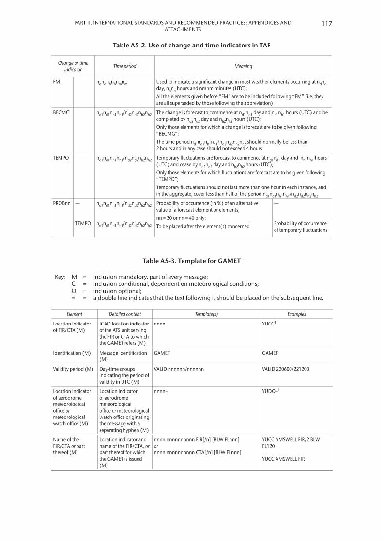
117PART II. INTERNATIONAL STANDARDS AND RECOMMENDED PRACTICES: APPENDICES AND ATTACHMENTS
Table A5-2. Use of change and time indicators in TAF
Change or time indicator Time period Meaning
FM ndndnhnhnmnm Used to indicate a significant change in most weather elements occurring at ndnd day, nhnh hours and nmnm minutes (UTC);
All the elements given before “FM” are to be included following “FM” (i.e. they are all superseded by those following the abbreviation)
BECMG nd1nd1nh1nh1/nd2nd2nh2nh2 The change is forecast to commence at nd1nd1 day and nh1nh1 hours (UTC) and be completed by nd2nd2 day and nh2nh2 hours (UTC);
Only those elements for which a change is forecast are to be given following “BECMG”;
The time period nd1nd1nh1nh1/nd2nd2nh2nh2 should normally be less than 2 hours and in any case should not exceed 4 hours
TEMPO nd1nd1nh1nh1/nd2nd2nh2nh2 Temporary fluctuations are forecast to commence at nd1nd1 day and nh1nh1 hours (UTC) and cease by nd2nd2 day and nh2nh2 hours (UTC);
Only those elements for which fluctuations are forecast are to be given following “TEMPO”;
Temporary fluctuations should not last more than one hour in each instance, and in the aggregate, cover less than half of the period nd1nd1nh1nh1/nd2nd2nh2nh2
PROBnn — nd1nd1nh1nh1/nd2nd2nh2nh2 Probability of occurrence (in %) of an alternative value of a forecast element or elements;
nn = 30 or nn = 40 only;
To be placed after the element(s) concerned
—
TEMPO nd1nd1nh1nh1/nd2nd2nh2nh2 Probability of occurrence of temporary fluctuations
Table A5-3. Template for GAMET
Key: MCO=
====
inclusion mandatory, part of every message;inclusion conditional, dependent on meteorological conditions;inclusion optional;a double line indicates that the text following it should be placed on the subsequent line.
Element Detailed content Template(s) Examples
Location indicator of FIR/CTA (M)
ICAO location indicator of the ATS unit serving the FIR or CTA to which the GAMET refers (M)
nnnn YUCC1
Identification (M) Message identification (M)
GAMET GAMET
Validity period (M) Day-time groups indicating the period of validity in UTC (M)
VALID nnnnnn/nnnnnn VALID 220600/221200
Location indicator of aerodrome meteorological office or meteorological watch office (M)
Location indicator of aerodrome meteorological office or meteorological watch office originating the message with a separating hyphen (M)
nnnn– YUDO–1
Name of the FIR/CTA or part thereof (M)
Location indicator and name of the FIR/CTA, or part thereof for which the GAMET is issued (M)
nnnn nnnnnnnnnn FIR[/n] [BLW FLnnn] or nnnn nnnnnnnnnn CTA[/n] [BLW FLnnn]
YUCC AMSWELL FIR/2 BLW FL120 YUCC AMSWELL FIR

METEOROLOGICAL SERVICE FOR INTERNATIONAL AIR NAVIGATION118
Element Detailed contentTemplate(s)
ExamplesIdentifier and time Location Content
Indicator for the beginning of Section I (M)
Indicator to identify the beginning of Section I (M)
SECN I SECN I
Surface wind (C) Widespread surface wind exceeding 15 m/s (30 kt)
SFC WIND: [nn/nn]
[N OF Nnn or Snn] or [S OF Nnn or Snn] or [W OF Wnnn or Ennn] or [E OF Wnnn or Ennn] or [nnnnnnnnnn]2
nnn/[n]nnMPS (or nnn/[n]nnKT)
SFC WIND: 10/12 310/16MPS SFC WIND: E OF W110 050/40KT
Surface visibility (C) Widespread surface visibility below 5 000 m including the weather phenomena causing the reduction in visibility
SFC VIS: [nn/nn]
nnnnM FG or BR or SA or DU or HZ or FU or VA or PO or DS or SS or DZ or RA or SN or SG or FC or GR or GS or PL or SQ
SFC VIS: 06/08 N OF N51 3000M BR
Significant weather (C)
Significant weather conditions encompassing thunderstorms, heavy sandstorm and duststorm, and volcanic ash
SIGWX: [nn/nn]
ISOL TS or OCNL TS or FRQ TS or OBSC TS or EMBD TS or HVY DS or HVY SS or SQL TS or ISOL TSGR or OCNL TSGR or FRQ TSGR or OBSC TSGR or EMBD TSGR or SQL TSGR or VA
SIGWX: 11/12 ISOL TS SIGWX: 12/14 S OF N35 HVY SS
Mountain obscuration (C)
Mountain obscuration MT OBSC: [nn/nn]
nnnnnnnnnn2 MT OBSC: S OF N48 MT PASSES
Cloud (C) Widespread areas of broken or overcast cloud with height of base less than 300 m (1 000 ft) above ground level (AGL) or above mean sea level (AMSL) and/or any occurrence of cumulonimbus (CB) or towering cumulus (TCU) clouds
SIG CLD: [nn/nn]
BKN or OVC [n]nnn/[n]nnnM (or [n]nnn/[n]nnnFT) AGL or AMSL ISOL or OCNL or FRQ or OBSC or EMBD CB3 or TCU3 [n]nnn/[n]nnnM (or [n]nnn/[n]nnnFT) AGL or AMSL
SIG CLD: 06/09 N OF N51 OVC 800/1100FT AGL 10/12 ISOL TCU 1200/8000FT AGL
Icing (C) Icing (except for that occurring in convective clouds and for severe icing for which a SIGMET message has already been issued)
ICE: [nn/nn]
MOD FLnnn/nnn or MOD ABV FLnnn or SEV FLnnn/nnn or SEV ABV FLnnn
ICE: MOD FL050/080
Turbulence (C) Turbulence (except for that occurring in convective clouds and for severe turbulence for which a SIGMET message has already been issued)
TURB: [nn/nn]
MOD FLnnn/nnn or MOD ABV FLnnn or SEV FLnnn/nnn or SEV ABV FLnnn
TURB: MOD ABV FL090

119PART II. INTERNATIONAL STANDARDS AND RECOMMENDED PRACTICES: APPENDICES AND ATTACHMENTS
Element Detailed contentTemplate(s)
ExamplesIdentifier and time Location Content
Mountain wave (C) Mountain wave (except for severe mountain wave for which a SIGMET message has already been issued)
MTW: [nn/nn]
MOD FLnnn/nnn or MOD ABV FLnnn or SEV FLnnn/nnn or SEV ABV FLnnn
MTW: N OF N63 MOD ABV FL080
SIGMET (C) SIGMET messages applicable to the FIR/CTA concerned or a sub-area thereof, for which the area forecast is valid
SIGMET APPLICABLE:
— [n][n]n4 SIGMET APPLICABLE: 3, A5, B06
or HAZARDOUS WX NIL (C)5 HAZARDOUS WX NIL HAZARDOUS WX NIL
Indicator for the beginning of Section II (M)
Indicator to identify the beginning of Section II (M)
SECN II SECN II
Pressure centres and fronts (M)
Pressure centres and fronts and their expected movements and developments
PSYS: [nn] Nnnnn or Snnnn Wnnnnn or Ennnnn or Nnnnn or Snnnn Wnnnnn or Ennnnn TO Nnnnn or Snnnn Wnnnnn or Ennnnn
L [n]nnnHPA or H [n]nnnHPA or FRONT or NIL
PSYS: 06 N5130 E01000 L 1004HPA MOV NE 25KT WKN
— MOV N or MOV NE or MOV E or MOV SE or MOV S or MOV SW or MOV W or MOV NW nnKMH (or nnKT) WKN or NC or INTSF
Upper winds and temperatures (M)
Upper wind and upper-air temperatures for at least the following altitudes: 600, 1 500 and 3 000 m (2 000, 5 000 and 10 000 ft)
WIND/T: Nnnnn or Snnnn Wnnnnn or Ennnnn or [N OF Nnn or Snn] or [S OF Nnn or Snn] or [W OF Wnnn or Ennn] or [E OF Wnnn or Ennn] or [nnnnnnnnnn]2
[n]nnnM (or [n]nnnFT) nnn/[n]nnMPS (or nnn/[n]nnKT) PSnn or MSnn
WIND/T: 2000FT N5500 W01000 270/18MPS PS03 5000FT N5500 W01000 250/20MPS MS02 10000FT N5500 W01000 240/22MPS MS11
Cloud (M) Cloud information not included in Section I giving type, height of base and top above ground level (AGL) or above mean sea level (AMSL)
CLD: [nn/nn]
FEW or SCT or BKN or OVC ST or SC or CU or AS or AC or NS [n]nnn/[n]nnn M (or [n]nnn/[n]nnnFT) AGL or AMSL or NIL
CLD: BKN SC 2500/8000FT AGL CLD: NIL
Freezing level (M) Height indication of 0 °C level(s) above ground level (AGL) or above mean sea level (AMSL), if lower than the top of the airspace for which the forecast is supplied
FZLVL: [ABV] [n]nnnFT AGL or AMSL
FZLVL: 3000FT AGL

METEOROLOGICAL SERVICE FOR INTERNATIONAL AIR NAVIGATION120
Element Detailed contentTemplate(s)
ExamplesIdentifier and time Location Content
Forecast QNH (M) Forecast lowest QNH during the period of validity
MNM QNH: [n]nnnHPA MNM QNH: 1004HPA
Sea-surface temperature and state of the sea (O)
Sea-surface temperature and state of the sea if required by regional air navigation agreement
SEA: Tnn HGT [n]nM SEA: T15 HGT 5M
Volcanic eruptions (M)
Name of volcano VA: nnnnnnnnnn or NIL
VA: ETNA VA: NIL
Notes:1. Fictitious location.2. Free text describing well-known geographical locations should be kept to a minimum.3. The location of the CB and/or TCU should be specified in addition to any widespread areas of broken or overcast
cloud as given in the example.4. List as necessary, with comma separating.5. When no elements are included in Section I.
Table A5-4. Ranges and resolutions for the numerical elements included in TAF
Element as specified in Part I, 6 Range Resolution
Wind direction: °true 000 – 360 10
Wind speed: MPSKT
00 – 99*00 – 199*
11
Visibility: MMMM
0000 – 07500800 – 4 9005 000 – 9 000
10 000 –
50100
1 0000 (fixed value: 9 999)
Vertical visibility: 30’s M (100’s FT) 000 – 020 1
Cloud: height of cloud base: 30’s M (100’s FT) 000 – 100 1
Air temperature (maximum and minimum): °C –80 – +60 1
* There is no aeronautical requirement to report surface wind speeds of 50 m/s (100 kt) or more; however, provision has been made for reporting wind speeds up to 99 m/s (199 kt) for non-aeronautical purposes, as necessary.

121PART II. INTERNATIONAL STANDARDS AND RECOMMENDED PRACTICES: APPENDICES AND ATTACHMENTS
Example A5-1. TAF
TAF for YUDO (Donlon/International)*:
TAF YUDO 151800Z 1600/1618 13005MPS 9000 BKN020 BECMG 1606/1608 SCT015CB BKN020 TEMPO 1608/1612 17006G12MPS 1000 TSRA SCT010CB BKN020 FM161230 15004MPS 9999 BKN020
Meaning of the forecast:TAF for Donlon/International* issued on the 15th of the month at 1800 UTC valid from 0000 UTC to 1800 UTC on the 16th of the month; surface wind direction 130 degrees; wind speed 5 metres per second; visibility 9 kilometres; broken cloud at 600 metres; becoming between 0600 UTC and 0800 UTC on the 16th of the month, scattered cumulonimbus cloud at 450 metres and broken cloud at 600 metres; temporarily between 0800 UTC and 1200 UTC on the 16th of the month surface wind direction 170 degrees; wind speed 6 metres per second gusting to 12 metres per second; visibility 1 000 metres in a thunderstorm with moderate rain, scattered cumulonimbus cloud at 300 metres and broken cloud at 600 metres; from 1230 UTC on the 16th of the month surface wind direction 150 degrees; wind speed 4 metres per second; visibility 10 kilometres or more; and broken cloud at 600 metres.
Note: In this example, the primary units “metre per second” and “metre” were used for wind speed and height of cloud base, respectively. However, in accordance with ICAO Annex 5, the corresponding non-SI alternative units “knot” and “foot” may be used instead.
_______* Fictitious location
Example A5-2. Cancellation of TAF
Cancellation of TAF for YUDO (Donlon/International)*:
TAF AMD YUDO 161500Z 1600/1618 CNL
Meaning of the forecast:Amended TAF for Donlon/International* issued on the 16th of the month at 1500 UTC cancelling the previously issued TAF valid from 0000 UTC to 1800 UTC on the 16th of the month.
_______* Fictitious location

METEOROLOGICAL SERVICE FOR INTERNATIONAL AIR NAVIGATION122
Example A5-3. GAMET area forecast
YUCC GAMET VALID 220600/221200 YUDO–
YUCC AMSWELL FIR/2 BLW FL120
SECN I
SFC WIND: 10/12 310/16MPS
SFC VIS: 06/08 N OF N51 3000M BR
SIGWX: 11/12 ISOL TS
SIG CLD: 06/09 N OF N51 OVC 800/1100FT AGL 10/12 ISOL TCU 1200/8000FT AGL
ICE: MOD FL050/080
TURB: MOD ABV FL090
SIGMET APPLICABLE: 3,5
SECN II
PSYS: 06 N5130 E01000 L 1004HPA MOV NE 25KT WKN
WIND/T: 2000FT N5500 W01000 270/18MPS PS03 5000FT N5500 W01000 250/20MPS MS02 10000FT N5500 W01000 240/22MPS MS11
CLD: BKN SC 2500/8000FT AGL
FZLVL: 3000FT AGL
MNM QNH: 1004HPA
SEA: T15 HGT 5M
VA: NIL
Meaning: An area forecast for low-level flights (GAMET) issued for sub-area two of the Amswell* flight information region (identified by YUCC Amswell area control centre) for below flight level 120 by the Donlon/International* aerodrome meteorological office (YUDO); the message is valid from 0600 UTC to 1200 UTC on the 22nd of the month.
Section I:
Surface wind speed and direction:
Between 1000 UTC and 1200 UTC surface wind direction 310 degrees; wind speed 16 metres per second
Surface visibility: Between 0600 UTC and 0800 UTC north of 51 degrees north 3 000 metres (due to mist)
Significant weather phenomena:
Between 1100 UTC and 1200 UTC isolated thunderstorms without hail
Significant clouds: Between 0600 UTC and 0900 UTC north of 51 degrees north overcast base 800, top 1 100 feet above ground level; between 1000 UTC and 1200 UTC isolated towering cumulus base 1 200, top 8 000 feet above ground level
Icing: Moderate between flight level 050 and 080
Turbulence: Moderate above flight level 090 (at least up to flight level 120)
SIGMET messages: 3 and 5 applicable to the validity period and sub-area concerned
Section II:
Pressure systems: At 0600 UTC low pressure of 1 004 hectopascals at 51.5 degrees north 10.0 degrees east, expected to move north-eastwards at 25 knots and to weaken
Winds and temperatures:
At 2 000 feet above ground level at 55 degrees north 10 degrees west wind direction 270 degrees, wind speed 18 metres per second, temperature plus 3 degrees Celsius; at 5 000 feet above ground level at 55 degrees north 10 degrees west wind direction 250 degrees, wind speed 20 metres per second, temperature minus 2 degrees Celsius; at 10 000 feet above ground level at 55 degrees north 10 degrees west wind direction 240 degrees, wind speed 22 metres per second, temperature minus 11 degrees Celsius
Clouds: Broken stratocumulus, base 2 500 feet, top 8 000 feet above ground level
Freezing level: 3 000 feet above ground level
Minimum QNH: 1 004 hectopascals
Sea: Surface temperature 15 degrees Celsius; and state of the sea 5 metres
Volcanic ash: Nil______* Fictitious location

APPENDIX 6. TECHNICAL SPECIFICATIONS RELATED TO SIGMET AND AIRMET INFORMATION, AERODROME WARNINGS AND WIND SHEAR WARNINGS AND ALERTS
(See Part I, 7)
Note: Data type designators to be used in abbreviated headings for SIGMET, AIRMET, tropical cyclone and volcanic ash advisory messages are given in the Manual on the Global Telecommunication System (WMO-No. 386).
1. SPECIFICATIONS RELATED TO SIGMET INFORMATION
1.1 Format of SIGMET messages
1.1.1 The content and order of elements in a SIGMET message shall be in accordance with the template shown in Table A6-1A .
1.1.2 Messages containing SIGMET information shall be identified as “SIGMET” .
1.1.3 The sequence number referred to in the template in Table A6-1A shall correspond with the number of SIGMET messages issued for the flight information region (FIR) since 0001 UTC on the day concerned . The meteorological watch offices whose area of responsibility encompasses more than one FIR and/or control area (CTA) shall issue separate SIGMET messages for each FIR and/or CTA within their area of responsibility .
1.1.4 In accordance with the template in Table A6-1A, only one of the following phenomena shall be included in a SIGMET message, using the abbreviations as indicated below:
At cruising levels (irrespective of altitude):
Thunderstorm– Obscured OBSC TS– Embedded EMBD TS– Frequent FRQ TS– Squall line SQL TS– Obscured with hail OBSC TSGR– Embedded with hail EMBD TSGR– Frequent, with hail FRQ TSGR– Squall line with hail SQL TSGR
Tropical cyclone– Tropical cyclone with 10-minute
mean surface wind speed of 17 m/s (34 kt) or more
TC (+ cyclone name)
Turbulence– Severe turbulence SEV TURB
Icing– Severe icing SEV ICE– Severe icing due to freezing rain SEV ICE (FZRA)
Mountain wave– Severe mountain wave SEV MTW
Duststorm– Heavy duststorm HVY DS
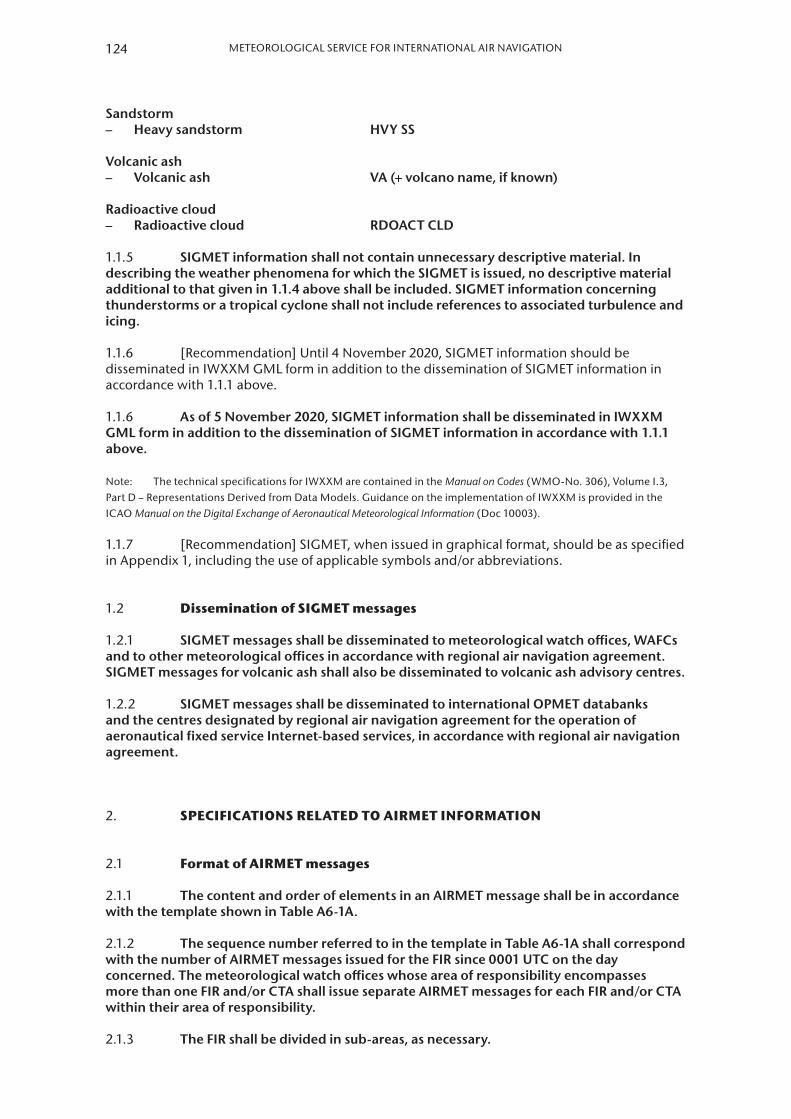
Sandstorm– Heavy sandstorm HVY SS
Volcanic ash– Volcanic ash VA (+ volcano name, if known)
Radioactive cloud– Radioactive cloud RDOACT CLD
1.1.5 SIGMET information shall not contain unnecessary descriptive material . In describing the weather phenomena for which the SIGMET is issued, no descriptive material additional to that given in 1 .1 .4 above shall be included . SIGMET information concerning thunderstorms or a tropical cyclone shall not include references to associated turbulence and icing .
1.1.6 [Recommendation] Until 4 November 2020, SIGMET information should be disseminated in IWXXM GML form in addition to the dissemination of SIGMET information in accordance with 1.1.1 above.
1.1.6 As of 5 November 2020, SIGMET information shall be disseminated in IWXXM GML form in addition to the dissemination of SIGMET information in accordance with 1 .1 .1 above .
Note: The technical specifications for IWXXM are contained in the Manual on Codes (WMO-No. 306), Volume I.3, Part D – Representations Derived from Data Models. Guidance on the implementation of IWXXM is provided in the ICAO Manual on the Digital Exchange of Aeronautical Meteorological Information (Doc 10003).
1.1.7 [Recommendation] SIGMET, when issued in graphical format, should be as specified in Appendix 1, including the use of applicable symbols and/or abbreviations.
1.2 Dissemination of SIGMET messages
1.2.1 SIGMET messages shall be disseminated to meteorological watch offices, WAFCs and to other meteorological offices in accordance with regional air navigation agreement . SIGMET messages for volcanic ash shall also be disseminated to volcanic ash advisory centres .
1.2.2 SIGMET messages shall be disseminated to international OPMET databanks and the centres designated by regional air navigation agreement for the operation of aeronautical fixed service Internet-based services, in accordance with regional air navigation agreement .
2. SPECIFICATIONS RELATED TO AIRMET INFORMATION
2.1 Format of AIRMET messages
2.1.1 The content and order of elements in an AIRMET message shall be in accordance with the template shown in Table A6-1A .
2.1.2 The sequence number referred to in the template in Table A6-1A shall correspond with the number of AIRMET messages issued for the FIR since 0001 UTC on the day concerned . The meteorological watch offices whose area of responsibility encompasses more than one FIR and/or CTA shall issue separate AIRMET messages for each FIR and/or CTA within their area of responsibility .
2.1.3 The FIR shall be divided in sub-areas, as necessary .
124 METEOROLOGICAL SERVICE FOR INTERNATIONAL AIR NAVIGATION
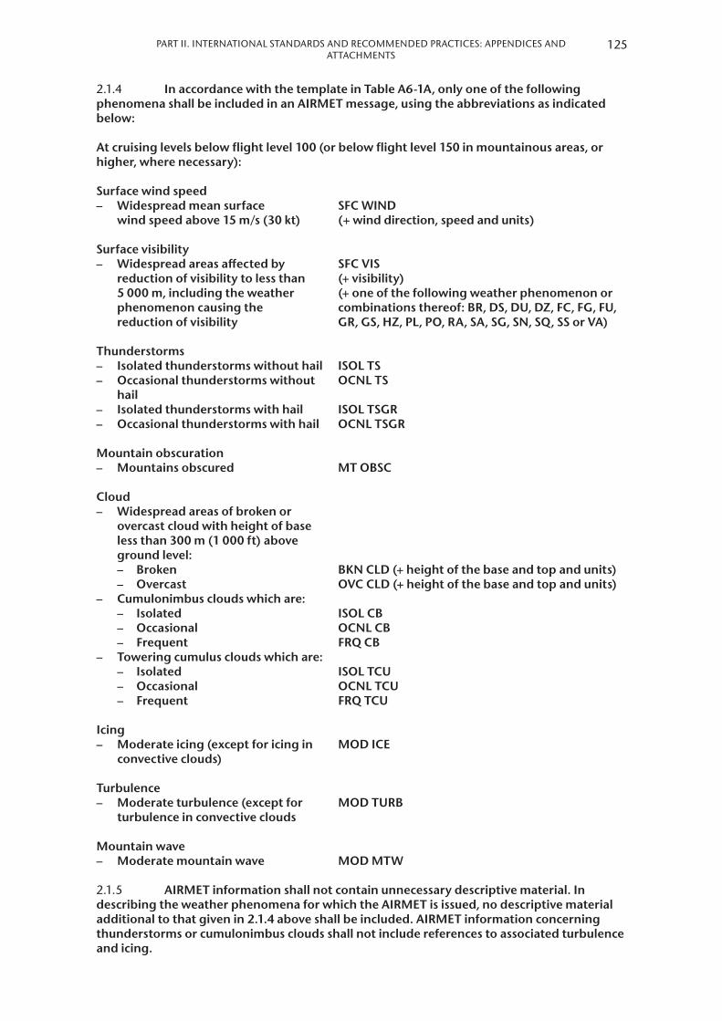
PART II. INTERNATIONAL STANDARDS AND RECOMMENDED PRACTICES: APPENDICES AND ATTACHMENTS
2.1.4 In accordance with the template in Table A6-1A, only one of the following phenomena shall be included in an AIRMET message, using the abbreviations as indicated below:
At cruising levels below flight level 100 (or below flight level 150 in mountainous areas, or higher, where necessary):
Surface wind speed– Widespread mean surface
wind speed above 15 m/s (30 kt)
Surface visibility– Widespread areas affected by
reduction of visibility to less than 5 000 m, including the weather phenomenon causing the reduction of visibility
SFC WIND (+ wind direction, speed and units)
SFC VIS (+ visibility) (+ one of the following weather phenomenon or combinations thereof: BR, DS, DU, DZ, FC, FG, FU, GR, GS, HZ, PL, PO, RA, SA, SG, SN, SQ, SS or VA)
Thunderstorms– Isolated thunderstorms without hail ISOL TS– Occasional thunderstorms without
hailOCNL TS
– Isolated thunderstorms with hail ISOL TSGR– Occasional thunderstorms with hail OCNL TSGR
Mountain obscuration– Mountains obscured MT OBSC
Cloud– Widespread areas of broken or
overcast cloud with height of baseless than 300 m (1 000 ft) aboveground level:– Broken BKN CLD (+ height of the base and top and units)– Overcast OVC CLD (+ height of the base and top and units)
– Cumulonimbus clouds which are:– Isolated ISOL CB– Occasional OCNL CB– Frequent FRQ CB
– Towering cumulus clouds which are:– Isolated ISOL TCU– Occasional OCNL TCU– Frequent FRQ TCU
Icing– Moderate icing (except for icing in
convective clouds)MOD ICE
Turbulence– Moderate turbulence (except for
turbulence in convective cloudsMOD TURB
Mountain wave– Moderate mountain wave MOD MTW
2.1.5 AIRMET information shall not contain unnecessary descriptive material . In describing the weather phenomena for which the AIRMET is issued, no descriptive material additional to that given in 2 .1 .4 above shall be included . AIRMET information concerning thunderstorms or cumulonimbus clouds shall not include references to associated turbulence and icing .
125

Note: The specifications for SIGMET information which is also applicable to low-level flights are given in 1.1.4 above.
2.1.6 [Recommendation] Until 4 November 2020, AIRMET information should be disseminated in IWXXM GML form in addition to the dissemination of AIRMET information in accordance with 2.1.1 above.
2.1.6 As of 5 November 2020, AIRMET information shall be disseminated in IWXXM GML form in addition to the dissemination of AIRMET information in accordance with 2 .1 .1 above .
Note: The technical specifications for IWXXM are contained in the Manual on Codes (WMO-No. 306), Volume I.3, Part D – Representations Derived from Data Models. Guidance on the implementation of IWXXM is provided in the ICAO Manual on the Digital Exchange of Aeronautical Meteorological Information (Doc 10003).
2.2 Dissemination of AIRMET messages
2.2.1 [Recommendation] AIRMET messages should be disseminated to meteorological watch offices in adjacent FIRs and to other meteorological watch offices or aerodrome meteorological offices, as agreed between the meteorological authorities concerned.
2.2.2 [Recommendation] AIRMET messages should be transmitted to international operational meteorological databanks and the centres designated by regional air navigation agreement for the operation of aeronautical fixed service Internet-based services, in accordance with regional air navigation agreement.
3. SPECIFICATIONS RELATED TO SPECIAL AIR-REPORTS
Note: This appendix deals with the uplink of special air-reports. The general specifications related to special air-reports are in Appendix 4.
3.1 [Recommendation] Special air-reports should be uplinked for 60 minutes after their issuance.
3.2 [Recommendation] Information on wind and temperature included in automated special air-reports should not be uplinked to other aircraft in flight.
4. DETAILED CRITERIA RELATED TO SIGMET AND AIRMET MESSAGES AND SPECIAL AIR-REPORTS (UPLINK)
4.1 Identification of the flight information region
[Recommendation] In cases where the airspace is divided into an FIR and an upper flight information region (UIR), the SIGMET should be identified by the location indicator of the air traffic services unit serving the FIR.
Note: The SIGMET message applies to the whole airspace within the lateral limits of the FIR, i.e. to the FIR and to the UIR. The particular areas and/or flight levels affected by the meteorological phenomena causing the issuance of the SIGMET are given in the text of the message.
4.2 Criteria related to phenomena included in SIGMET and AIRMET messages and special air-reports (uplink)
4.2.1 [Recommendation] An area of thunderstorms and cumulonimbus clouds should be considered:
126 METEOROLOGICAL SERVICE FOR INTERNATIONAL AIR NAVIGATION
PART II. INTERNATIONAL STANDARDS AND RECOMMENDED PRACTICES: APPENDICES AND ATTACHMENTS
(a) Obscured (OBSC) if it is obscured by haze or smoke or cannot be readily seen due to darkness;
(b) Embedded (EMBD) if it is embedded within cloud layers and cannot be readily recognized;
(c) Isolated (ISOL) if it consists of individual features which affect, or are forecast to affect, an area with a maximum spatial coverage less than 50 per cent of the area concerned (at a fixed time or during the period of validity); and
(d) Occasional (OCNL) if it consists of well-separated features which affect, or are forecast to affect, an area with a maximum spatial coverage between 50 and 75 per cent of the area concerned (at a fixed time or during the period of validity).
4.2.2 [Recommendation] An area of thunderstorms should be considered frequent (FRQ) if within that area there is little or no separation between adjacent thunderstorms with a maximum spatial coverage greater than 75 per cent of the area affected, or forecast to be affected, by the phenomenon (at a fixed time or during the period of validity).
4.2.3 [Recommendation] Squall line (SQL) should indicate a thunderstorm along a line with little or no space between individual clouds.
4.2.4 [Recommendation] Hail (GR) should be used as a further description of the thunderstorm, as necessary.
4.2.5 [Recommendation] Severe and moderate turbulence (TURB) should refer only to low-level turbulence associated with strong surface winds; rotor streaming; or turbulence whether in cloud or not in cloud (CAT). Turbulence should not be used in connection with convective clouds.
4.2.6 Turbulence shall be considered:
(a) Severe whenever the peak value of the cube root of EDR exceeds 0 .7; and
(b) Moderate whenever the peak value of the cube root of EDR is above 0 .4 and below or equal to 0 .7 .
4.2.7 [Recommendation] Severe and moderate icing (ICE) should refer to icing in other than convective clouds. Freezing rain (FZRA) should refer to severe icing conditions caused by freezing rain.
4.2.8 [Recommendation] A mountain wave (MTW) should be considered:
(a) Severe whenever an accompanying downdraft of 3.0 m/s (600 ft/min) or more and/or severe turbulence is observed or forecast; and
(b) Moderate whenever an accompanying downdraft of 1.75–3.0 m/s (350–600 ft/min) and/or moderate turbulence is observed or forecast.
4.2.9 [Recommendation] Sandstorm/duststorm should be considered:
(a) Heavy whenever the visibility is below 200 m and the sky is obscured; and
(b) Moderate whenever the visibility is:(i) Below 200 m and the sky is not obscured; or(ii) Between 200 m and 600 m.
127

5. SPECIFICATIONS RELATED TO AERODROME WARNINGS
5.1 Format and dissemination of aerodrome warnings
5.1.1 The aerodrome warnings shall be issued in accordance with the template in Table A6-2 where required by operators or aerodrome services, and shall be disseminated in accordance with local arrangements to those concerned .
5.1.2 The sequence number referred to in the template in Table A6-2 shall correspond with the number of aerodrome warnings issued for the aerodrome since 0001 UTC on the day concerned .
5.1.3 [Recommendation] In accordance with the template in Table A6-2, aerodrome warnings should relate to the occurrence or expected occurrence of one or more of the following phenomena:
– Tropical cyclone (to be included if the 10-minute mean surface wind speed at the aerodrome is expected to be 17 m/s (34 kt) or more);
– Thunderstorm;– Hail;– Snow (including the expected or observed snow accumulation);– Freezing precipitation;– Hoar frost or rime;– Sandstorm;– Duststorm;– Rising sand or dust;– Strong surface wind and gusts;– Squall;– Frost;– Volcanic ash;– Tsunami;– Volcanic ash deposition;– Toxic chemicals;– Other phenomena as agreed locally.
Note: Aerodrome warnings related to the occurrence or expected occurrence of tsunami are not required where a national public safety plan for tsunami is integrated with the “at risk” aerodrome concerned.
5.1.4 [Recommendation] The use of text additional to the abbreviations listed in the template in Table A6-2 should be kept to a minimum. The additional text should be prepared in abbreviated plain language using approved ICAO abbreviations and numerical values. If no ICAO approved abbreviations are available, English plain language text should be used.
5.2 Quantitative criteria for aerodrome warnings
[Recommendation] When quantitative criteria are necessary for the issue of aerodrome warnings covering, for example, the expected maximum wind speed or the expected total snowfall, the criteria used should be as agreed between the aerodrome meteorological office and the users concerned.
6. SPECIFICATIONS RELATED TO WIND SHEAR WARNINGS
6.1 Detection of wind shear
[Recommendation] Evidence of the existence of wind shear should be derived from:
128 METEOROLOGICAL SERVICE FOR INTERNATIONAL AIR NAVIGATION

PART II. INTERNATIONAL STANDARDS AND RECOMMENDED PRACTICES: APPENDICES AND ATTACHMENTS
(a) Ground-based, wind shear remote-sensing equipment, for example, Doppler radar;
(b) Ground-based, wind shear detection equipment, for example, a system of surface wind and/or pressure sensors located in an array monitoring a specific runway or runways and associated approach and departure paths;
(c) Aircraft observations during the climb-out or approach phases of flight to be made in accordance with Part I, 5; or
(d) Other meteorological information, for example, from appropriate sensors located on existing masts or towers in the vicinity of the aerodrome or nearby areas of high ground.
Note: Wind shear conditions are normally associated with the following phenomena:– Thunderstorms, microbursts, funnel cloud (tornado or waterspout) and gust fronts;– Frontal surfaces;– Strong surface winds coupled with local topography;– Sea breeze fronts;– Mountain waves (including low-level rotors in the terminal area);– Low-level temperature inversions.
6.2 Format and dissemination of wind shear warnings and alerts
Note: Information on wind shear is also to be included as supplementary information in local routine reports, local special reports, METAR and SPECI in accordance with the templates in Appendix 3, Tables A3-1 and A3-2.
6.2.1 The wind shear warnings shall be issued in accordance with the template in Table A6-3 and shall be disseminated in accordance with local arrangements to those concerned .
6.2.2 The sequence number referred to in the template in Table A6-3 shall correspond with the number of wind shear warnings issued for the aerodrome since 0001 UTC on the day concerned .
6.2.3 [Recommendation] The use of text additional to the abbreviations listed in the template in Table A6-3 should be kept to a minimum. The additional text should be prepared in abbreviated plain language using approved ICAO abbreviations and numerical values. If no ICAO approved abbreviations are available, English plain language text should be used.
6.2.4 [Recommendation] When an aircraft report is used to prepare a wind shear warning, or to confirm a warning previously issued, the corresponding aircraft report, including the aircraft type, should be disseminated unchanged in accordance with local arrangements to those concerned.
Notes:1. Following reported encounters by both arriving and departing aircraft, two different wind shear warnings may
exist: one for arriving aircraft and one for departing aircraft.2. Specifications for reporting the intensity of wind shear are still undergoing development. It is recognized,
however, that pilots, when reporting wind shear, may use the qualifying terms “moderate”, “strong” or “severe”, based to a large extent on their subjective assessment of the intensity of the wind shear encountered.
6.2.5 The wind shear alerts shall be disseminated from automated, ground-based, wind shear remote-sensing or detection equipment in accordance with local arrangements to those concerned .
6.2.6 [Recommendation] Where microbursts are observed, reported by pilots or detected by ground-based, wind shear detection or remote-sensing equipment, the wind shear warning and wind shear alert should include a specific reference to microburst.
129

6.2.7 Where information from ground-based, wind shear detection or remote-sensing equipment is used to prepare a wind shear alert, the alert shall, if practicable, relate to specific sections of the runway and distances along the approach path or take-off path as agreed between the meteorological authority, the appropriate ATS authority and the operators concerned .
130 METEOROLOGICAL SERVICE FOR INTERNATIONAL AIR NAVIGATION

131PART II. INTERNATIONAL STANDARDS AND RECOMMENDED PRACTICES: APPENDICES AND ATTACHMENTS
Table A6-1A. Template for SIGMET and AIRMET messages
Key: MC=
===
inclusion mandatory, part of every message;inclusion conditional, included whenever applicable;a double line indicates that the text following it should be placed on the subsequent line.
Notes:1. The ranges and resolutions for the numerical elements included in SIGMET/AIRMET messages are shown in
Table A6-4 of this appendix.2. In accordance with 1.1.5 and 2.1.5 in this appendix, severe or moderate icing and severe or moderate turbulence
(SEV ICE, MOD ICE, SEV TURB, MOD TURB) associated with thunderstorms, cumulonimbus clouds or tropical cyclones should not be included.
Element Detailed content SIGMET template AIRMET template SIGMET message examples
AIRMET message examples
Location indicator of FIR/CTA (M)1
ICAO location indicator of the ATS unit serving the FIR or CTA to which the SIGMET/AIRMET refers
nnnn YUCC2 YUDD2
Identification (M) Message identification and sequence number3
SIGMET [n][n]n AIRMET [n][n]n SIGMET 1 SIGMET 01 SIGMET A01
AIRMET 9 AIRMET 19 AIRMET B19
Validity period (M)
Day-time groups indicating the period of validity in UTC
VALID nnnnnn/nnnnnn VALID 010000/010400 VALID 221215/221600 VALID 101520/101800 VALID 251600/252200 VALID 152000/160000 VALID 192300/200300
Location indicator of MWO (M)
Location indicator of MWO originating the message with a separating hyphen
nnnn– YUDO–2 YUSO–2
Name of the FIR/CTA (M)
Location indicator and name of the FIR/CTA4 for which the SIGMET/AIRMET is issued
nnnn nnnnnnnnnn FIR or UIR or FIR/UIR or nnnn nnnnnnnnnn CTA
nnnn nnnnnnnnnn FIR[/n]
YUCC AMSWELL FIR2 YUDD SHANLON FIR/UIR2
UIR
FIR/UIR YUDD SHANLON CTA2
YUCC AMSWELL FIR/22
YUDD SHANLON FIR2
IF THE SIGMET OR AIRMET MESSAGE IS TO BE CANCELLED, SEE DETAILS AT THE END OF THE TEMPLATE.
Status indicator (C)5
Indicator of test or exercise
TEST or EXER TEST or EXER TEST EXER
TEST EXER

METEOROLOGICAL SERVICE FOR INTERNATIONAL AIR NAVIGATION132
Element Detailed content SIGMET template AIRMET template SIGMET message examples
AIRMET message examples
Phenomenon (M)6
Description of phenomenon causing the issuance of SIGMET/AIRMET
OBSC7 TS[GR8] EMBD9 TS[GR8] FRQ10 TS[GR8] SQL11 TS[GR8] TC nnnnnnnnnn PSN Nnn[nn] or Snn[nn] Wnnn[nn] or Ennn[nn] CB or TC NN12 PSN Nnn[nn] or Snn[nn] Wnnn[nn] or Ennn[nn] CB SEV TURB13 SEV ICE14 SEV ICE (FZRA)14 SEV MTW15 HVY DS HVY SS [VA ERUPTION] [MT nnnnnnnnnn] [PSN Nnn[nn] or Snn[nn] Ennn[nn] or Wnnn[nn]] VA CLD RDOACT CLD
SFC WIND nnn/nn[n]MPS (or SFC WIND nnn/nn[n]KT) SFC VIS [n][n]nnM (nn)16 ISOL17 TS[GR8] OCNL18 TS[GR8] MT OBSC BKN CLD nnn/[ABV][n]nnnM (or BKN CLD [n]nnn/[ABV] [n]nnnnFT) or BKN CLD SFC/[ABV][n]nnnM (or BKN CLD SFC/[ABV] [n]nnnnFT) OVC CLD nnn/[ABV][n]nnnM (or OVC CLD [n]nnn/[ABV] [n]nnnnFT) or OVC CLD SFC/[ABV][n]nnnM (or OVC CLD SFC/[ABV] [n]nnnnFT) ISOL17 CB19 OCNL18 CB19 FRQ10 CB19 ISOL17 TCU19 OCNL18 TCU19 FRQ10 TCU19 MOD TURB13 MOD ICE14 MOD MTW15
OBSC TS OBSC TSGR EMBD TS EMBD TSGR FRQ TS FRQ TSGR SQL TS SQL TSGR TC GLORIA PSN N10 W060 CB TC NN PSN S2030 E06030 CB SEV TURB SEV ICE SEV ICE (FZRA) SEV MTW HVY DS HVY SS VA ERUPTION MT ASHVAL2 PSN S15 E073 VA CLD RDOACT CLD
SFC WIND 040/40MPS SFC WIND 310/20KT SFC VIS 1500M (BR) ISOL TS ISOL TSGR OCNL TS OCNL TSGR MT OBSC BKN CLD 120/900M BKN CLD 400/3000FT BKN CLD 1000/5000FT BKN CLD SFC/3000M BKN CLD SFC/ABV10000FT OVC CLD 270/ABV3000M OVC CLD 900/ABV10000FT OVC CLD 1000/5000FT OVC CLD SFC/3000M OVC CLD SFC/ABV10000FT ISOL CB OCNL CB FRQ CB ISOL TCU OCNL TCU FRQ TCU MOD TURB MOD ICE MOD MTW
Observed or forecast phenomenon (M)
Indication whether the information is observed and expected to continue, or forecast
OBS [AT nnnnZ] or FCST [AT nnnnZ]
OBS OBS AT 1210Z FCST FCST AT 1815Z
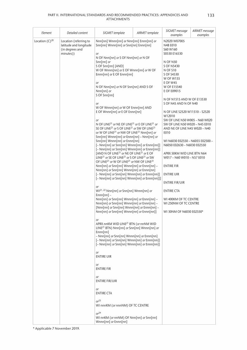
133PART II. INTERNATIONAL STANDARDS AND RECOMMENDED PRACTICES: APPENDICES AND ATTACHMENTS
Element Detailed content SIGMET template AIRMET template SIGMET message examples
AIRMET message examples
Location (C)20 Location (referring to latitude and longitude (in degrees and minutes))
Nnn[nn] Wnnn[nn] or Nnn[nn] Ennn[nn] or Snn[nn] Wnnn[nn] or Snn[nn] Ennn[nn] or N OF Nnn[nn] or S OF Nnn[nn] or N OF Snn[nn] or S OF Snn[nn] [AND] W OF Wnnn[nn] or E OF Wnnn[nn] or W OF Ennn[nn] or E OF Ennn[nn] or N OF Nnn[nn] or N OF Snn[nn] AND S OF Nnn[nn] or S OF Snn[nn] or W OF Wnnn[nn] or W OF Ennn[nn] AND E OF Wnnn[nn] or E OF Ennn[nn] or N OF LINE21 or NE OF LINE21 or E OF LINE21 or SE OF LINE21 or S OF LINE21 or SW OF LINE21 or W OF LINE21 or NW OF LINE21 Nnn[nn] or Snn[nn] Wnnn[nn] or Ennn[nn] – Nnn[nn] or Snn[nn] Wnnn[nn] or Ennn[nn] [– Nnn[nn] or Snn[nn] Wnnn[nn] or Ennn[nn]] [– Nnn[nn] or Snn[nn] Wnnn[nn] or Ennn[nn]] [AND N OF LINE21 or NE OF LINE21 or E OF LINE21 or SE OF LINE21 or S OF LINE21 or SW OF LINE21 or W OF LINE21 or NW OF LINE21 Nnn[nn] or Snn[nn] Wnnn[nn] or Ennn[nn] – Nnn[nn] or Snn[nn] Wnnn[nn] or Ennn[nn] [– Nnn[nn] or Snn[nn] Wnnn[nn] or Ennn[nn]] [– Nnn[nn] or Snn[nn] Wnnn[nn] or Ennn[nn]]] or WI21, 22 Nnn[nn] or Snn[nn] Wnnn[nn] or Ennn[nn] – Nnn[nn] or Snn[nn] Wnnn[nn] or Ennn[nn] – Nnn[nn] or Snn[nn] Wnnn[nn] or Ennn[nn] – [Nnn[nn] or Snn[nn] Wnnn[nn] or Ennn[nn] – Nnn[nn] or Snn[nn] Wnnn[nn] or Ennn[nn]] or APRX nnKM WID LINE21 BTN (or nnNM WID LINE21 BTN) Nnn[nn] or Snn[nn] Wnnn[nn] or Ennn[nn] – Nnn[nn] or Snn[nn] Wnnn[nn] or Ennn[nn] [– Nnn[nn] or Snn[nn] Wnnn[nn] or Ennn[nn]] [– Nnn[nn] or Snn[nn] Wnnn[nn] or Ennn[nn]] or ENTIRE UIR or ENTIRE FIR or ENTIRE FIR/UIR or ENTIRE CTA or 23 WI nnnKM (or nnnNM) OF TC CENTRE or 24 WI nnKM (or nnNM) OF Nnn[nn] or Snn[nn] Wnnn[nn] or Ennn[nn]
N2020 W07005 N48 E010 S60 W160 S0530 E16530 N OF N50 S OF N5430 N OF S10 S OF S4530 W OF W155 E OF W45 W OF E15540 E OF E09015 N OF N1515 AND W OF E13530 S OF N45 AND N OF N40 N OF LINE S2520 W11510 – S2520 W12010 SW OF LINE N50 W005 – N60 W020 SW OF LINE N50 W020 – N45 E010 AND NE OF LINE N45 W020 – N40 E010 WI N6030 E02550 – N6055 E02500 – N6050 E02630 – N6030 E02550 APRX 50KM WID LINE BTN N64 W017 – N60 W010 – N57 E010 ENTIRE FIR ENTIRE UIR ENTIRE FIR/UIR ENTIRE CTA WI 400KM OF TC CENTRE WI 250NM OF TC CENTRE WI 30NM OF N6030 E02550*
* Applicable 7 November 2019.

METEOROLOGICAL SERVICE FOR INTERNATIONAL AIR NAVIGATION134
Element Detailed content SIGMET template AIRMET template SIGMET message examples
AIRMET message examples
Level (C)20, 24 Flight level or altitude [SFC/]FLnnn or [SFC/]nnnnM (or [SFC/][n]nnnnFT) or FLnnn/nnn or TOP FLnnn or [TOP] ABV FLnnn or (or [TOP] ABV[n]nnnnFT) [nnnn/]nnnnM (or [[n]nnnn/][n]nnnnFT) or [nnnnM/]FLnnn (or [[n]nnnnFT/]FLnnn) or 23 TOP [ABV or BLW] FLnnn
FL180 SFC/FL070 SFC/3000M SFC/10000FT FL050/080 TOP FL390 ABV FL250 TOP ABV FL100 ABV 7000FT TOP ABV 9000FT TOP ABV 10000FT 3000M 2000/3000M 8000FT 6000/12000FT 2000M/FL150 10000FT/FL250 TOP FL500 TOP ABV FL500 TOP BLW FL450
Movement or expected movement (C)20, 25
Movement or expected movement (direction and speed) with reference to one of the sixteen points of compass, or stationary
MOV N [nnKMH] or MOV NNE [nnKMH] or MOV NE [nnKMH] or MOV ENE [nnKMH] or MOV E [nnKMH] or MOV ESE [nnKMH] or MOV SE [nnKMH] or MOV SSE [nnKMH] or MOV S [nnKMH] or MOV SSW [nnKMH] or MOV SW [nnKMH] or MOV WSW [nnKMH] or MOV W [nnKMH] or MOV WNW [nnKMH] or MOV NW [nnKMH] or MOV NNW [nnKMH] (or MOV N [nnKT] or MOV NNE [nnKT] or MOV NE [nnKT] or MOV ENE [nnKT] or MOV E [nnKT] or MOV ESE [nnKT] or MOV SE [nnKT] or MOV SSE [nnKT] or MOV S [nnKT] or MOV SSW [nnKT] or MOV SW [nnKT] or MOV WSW [nnKT] or MOV W [nnKT] or MOV WNW [nnKT] or MOV NW [nnKT] or MOV NNW [nnKT]) or STNR
MOV SE MOV NNW MOV E 40KMH MOV E 20KT MOV WSW 20KT STNR
Changes in intensity (C)20
Expected changes in intensity
INTSF or WKN or NC
INTSF WKN NC
Forecast time (C)25
Indication of the forecast time of phenomenon
FCST AT nnnnZ — FCST AT 2200Z —
TC forecast position (C)23
Forecast position of TC centre at the end of the validity period of the SIGMET message
TC CENTRE PSN Nnn[nn] or Snn[nn] or Wnnn[nn] or Ennn[nn]
— TC CENTRE PSN N1030 TC CENTRE PSNE1600015
—
Forecast position (C)20, 25, 26
Forecast position of phenomenon at the end of the validity period of the SIGMET message
Nnn[nn] Ennn[nn] or Snn[nn] Wnnn[nn] or Snn[nn] Ennn[nn] or N OF Nnn[nn] or S OF Nnn[nn] or N OF Snn[nn] or S OF Snn[nn] [AND] W OF Wnnn[nn] or E OF Wnnn[nn] or W OF Ennn[nn] or E OF Ennn[nn]
— N30 W170 N OF N30 S OF S50 AND W OF E170 S OF N46 AND N OF N39 NE OF LINE N35 W020 – N45 W040
—

135PART II. INTERNATIONAL STANDARDS AND RECOMMENDED PRACTICES: APPENDICES AND ATTACHMENTS
Element Detailed content SIGMET template AIRMET template SIGMET message examples
AIRMET message examples
or N OF Nnn[nn] or N OF Snn[nn] AND S OF Nnn[nn] or S OF Snn[nn] or W OF Wnnn[nn] or W OF Ennn[nn] AND E OF Wnnn[nn] or E OF Ennn[nn]
or N OF LINE21 or NE OF LINE21 or E OF LINE21 or SE OF LINE21 or S OF LINE21 or SW OF LINE21 or W OF LINE21 or NW OF LINE21 Nnn[nn] or Snn[nn] Wnnn[nn] or Ennn[nn] – Nnn[nn] or Snn[nn] Wnnn[nn] or Ennn[nn]
[– Nnn[nn] or Snn[nn] Wnnn[nn] or Ennn[nn]] [AND N OF LINE21 or NE OF LINE21 or E OF LINE21 or SE OF LINE21 or S OF LINE21 or SW OF LINE21 or W OF LINE21 or NW OF LINE21 Nnn[nn] or Snn[nn] Wnnn[nn] or Ennn[nn] – Nnn[nn] or Snn[nn] Wnnn[nn] or Ennn[nn] [– Nnn[nn] or Snn[nn] Wnnn[nn] or Ennn[nn]]]
or WI21, 22 Nnn[nn] or Snn[nn] Wnnn[nn] or Ennn[nn] – Nnn[nn] or Snn[nn] Wnnn[nn] or Ennn[nn] – Nnn[nn] or Snn[nn] Wnnn[nn] or Ennn[nn] – Nnn[nn] or Snn[nn] Wnnn[nn] or Ennn[nn] or APRX nnKM WID LINE21 BTN (nnNM WID LINE21 BTN) Nnn[nn] or Snn[nn] Wnnn[nn] or Ennn[nn] – Nnn[nn] or Snn[nn] Wnnn[nn] or Ennn[nn] [– Nnn[nn] or Snn[nn] Wnnn[nn] or Ennn[nn]] [ – Nnn[nn] or Snn[nn] Wnnn[nn] or Ennn[nn]]
SW OF LINE N48 W020 – N43 E010 AND NE OF LINE N43 W020 – N38 E010 WI N20 W090 – N05 W090 – N10 W100 – N20 W100 – N20 W090 APRX 50KM WID LINE BTN N64 W017 – N57 W005 – N55 E010 – N55 E030 ENTIRE FIR ENTIRE UIR ENTIRE FIR/UIR ENTIRE CTA NO VA EXP WI 30KM OF N6030 E02550*
* Applicable 7 November 2019.

METEOROLOGICAL SERVICE FOR INTERNATIONAL AIR NAVIGATION136
Element Detailed content SIGMET template AIRMET template SIGMET message examples
AIRMET message examples
or ENTIRE FIR or ENTIRE UIR or ENTIRE FIR/UIR or ENTIRE CTA or 27 NO VA EXP or 24 WI nnKM (or nnNM) OF Nnn[nn] or Snn[nn]Wnnn[nn] or Ennn[nn]
Repetition of elements (C)28
Repetition of elements included in a SIGMET message for volcanic ash cloud or tropical cyclone
[AND]28 — AND —
OR
Cancellation of SIGMET/AIRMET (C)29
Cancellation of SIGMET/AIRMET referring to its identification
CNL SIGMET [n][n]n nnnnnn/nnnnnn or 27 CNL SIGMET [n][n]n nnnnnn/nnnnnn VA MOV TO nnnn FIR
CNL AIRMET [n][n]n nnnnnn/nnnnnn
CNL SIGMET 2 101200/101600 CNL SIGMET A13 251030/251430 VA MOV TO YUDO FIR2
CNL AIRMET 05 151520/151800
Notes:1. See 4.1 in this appendix.2. Fictitious location.3. In accordance with 1.1.3 and 2.1.2 in this appendix.4. See 2.1.3 in this appendix.5. Used only when the message issued to indicate that a test or an exercise is taking place. When the word “TEST” or
the abbreviation “EXER” is included, the message may contain information that should not be used operationally or will otherwise end immediately after the word “TEST”. [Applicable 7 November 2019]
6. In accordance with 1.1.4 and 2.1.4 in this appendix.7. In accordance with 4.2.1 (a) in this appendix.8. In accordance with 4.2.4 in this appendix.9. In accordance with 4.2.1 (b) in this appendix.10. In accordance with 4.2.2 in this appendix.11. In accordance with 4.2.3 in this appendix.12. Used for unnamed tropical cyclones.13. In accordance with 4.2.5 and 4.2.6 in this appendix.14. In accordance with 4.2.7 in this appendix.15. In accordance with 4.2.8 in this appendix.16. In accordance with 2.1.4 in this appendix.17. In accordance with 4.2.1 (c) in this appendix18 In accordance with 4.2.1 (d) in this appendix.19. The use of cumulonimbus (CB) and towering cumulus (TCU) is restricted to AIRMETs in accordance with 2.1.4 in
this appendix.20. In the case of volcanic ash cloud or cumulonimbus clouds associated with a tropical cyclone covering more than
one area within the FIR, these elements can be repeated, as necessary.21. A straight line is to be used between two points drawn on a map in the Mercator projection or between two
points which crosses lines of longitude at a constant angle.

137PART II. INTERNATIONAL STANDARDS AND RECOMMENDED PRACTICES: APPENDICES AND ATTACHMENTS
22. The number of coordinates should be kept to a minimum and should not normally exceed seven.23. Only for SIGMET messages for tropical cyclones.24. Only for SIGMET messages for radioactive cloud. When detailed information on the release is not available, a
radius of up to 30 kilometres (or 16 nautical miles) from the source may be applied; and a vertical extent from surface (SFC) to the upper limit of the flight information region/upper flight information region (FIR/UIR) or control area (CTA) is to be applied. [Applicable 7 November 2019]
25. The elements “forecast time” and “forecast position” are not to be used in conjunction with the element “movement or expected movement”.
26. The levels of the phen26omena remain fixed throughout the forecast period.27. Only for SIGMET messages for volcanic ash.28. To be used for two volcanic ash clouds or two centres of tropical cyclones simultaneously affecting the FIR concerned.29. End of the message (as the SIGMET/AIRMET message is being cancelled).
Table A6-1B. Template for special air-reports (uplink)
Key: MC=
===
inclusion mandatory, part of every message;inclusion conditional, included whenever applicable;a double line indicates that the text following it should be placed on the subsequent line.
Note: The ranges and resolutions for the numerical elements included in special air-reports are shown in Table A6-4 of this appendix.
Element Detailed content Template1,2 Examples
Identification (M) Message identification ARS ARS
Aircraft identification (M) Aircraft radiotelephony call sign nnnnnn VA8123
Observed phenomenon (M)
Description of observed phenomenon causing the issuance of the special air-report4
TS TSGR SEV TURB SEV ICE SEV MTW HVY SS VA CLD VA [MT nnnnnnnnnn] MOD TURB MOD ICE
TS TSGR SEV TURB SEV ICE SEV MTW HVY SS VA CLD VA VA MT ASHVAL5 MOD TURB MOD ICE
Observation time (M) Time of observation of observed phenomenon
OBS AT nnnnZ OBS AT 1210Z
Location (C) Location (referring to latitude and longitude (in degrees and minutes)) of observed phenomenon
NnnnnWnnnnn or NnnnnEnnnnn or SnnnnWnnnnn or SnnnnEnnnnn
N2020W07005 S4812E01036
Level (C) Flight level or altitude of observed phenomenon
FLnnn or FLnnn/nnn or nnnnM (or [n]nnnnFT)
FL390 FL180/210 3000M 12000FT
Notes:1. No wind and temperature to be uplinked to other aircraft in flight in accordance with 3.2 in this appendix.2. See 3.1 in this appendix.3. Fictitious call sign.4. In the case of special air-report for volcanic ash cloud, the vertical extent (if observed) and name of the volcano (if
known) can be used.5. Fictitious location.

METEOROLOGICAL SERVICE FOR INTERNATIONAL AIR NAVIGATION138
Table A6-2. Template for aerodrome warnings
Key: MC
==
inclusion mandatory, part of every message;inclusion conditional, included whenever applicable.
Notes:1. The ranges and resolutions for the numerical elements included in aerodrome warnings are shown in Table A6-4
of this appendix.2. The explanations for the abbreviations can be found in the ICAO Procedures for Air Navigation Services – ICAO
Abbreviations and Codes (PANS-ABC, Doc 8400).
Element Detailed content Templates Examples
Location indicator of the aerodrome (M)
Location indicator of the aerodrome
nnnn YUCC1
Identification of the type of message (M)
Type of message and sequence number
AD WRNG [n]n AD WRNG 2
Validity period (M) Day and time of validity period in UTC
VALID nnnnnn/nnnnnn VALID 211230/211530
IF THE AERODROME WARNING IS TO BE CANCELLED, SEE DETAILS AT THE END OF THE TEMPLATE.
Phenomenon (M)2 Description of phenomenon causing the issuance of the aerodrome warning
TC3 nnnnnnnnnn or [HVY] TS or GR or [HVY] SN [nnCM]3 or [HVY] FZRA or [HVY] FZDZ or RIME4 or [HVY] SS or [HVY] DS or SA or DU or SFC WSPD nn[n]MPS MAX nn[n] (SFC WSPD nn[n]KT MAX nn[n]) or SFC WIND nnn/nn[n]MPS MAX nn[n] (SFC WIND nnn/nn[n]KT MAX nn[n]) or SQ or FROST or TSUNAMI or VA[DEPO] or TOX CHEM or Free text up to 32 characters5
TC ANDREW HVY SN 25CM SFC WSPD 20MPS MAX 30 VA TSUNAMI
Observed or forecast phenomenon (M)
Indication whether the information is observed and expected to continue, or forecast
OBS [AT nnnnZ] or FCST
OBS AT 1200Z OBS
Changes in intensity (C) Expected changes in intensity INTSF or WKN or NC
WKN
OR
Cancellation of aerodrome warning6
Cancellation of aerodrome warning referring to its identification
CNL AD WRNG [n]n nnnnnn/nnnnnn
CNL AD WRNG 2 211230/2115306
Notes:1. Fictitious location.2. One phenomenon or a combination thereof, in accordance with 5.1.3 in this appendix.3. In accordance with 5.1.3 in this appendix.4. Hoar frost or rime in accordance with 5.1.3 in this appendix.5. In accordance with 5.1.4 in this appendix.6. End of the message (as the aerodrome warning is being cancelled).

139PART II. INTERNATIONAL STANDARDS AND RECOMMENDED PRACTICES: APPENDICES AND ATTACHMENTS
Table A6-3. Template for wind shear warnings
Key: MC
==
inclusion mandatory, part of every message;inclusion conditional, included whenever applicable.
Notes:1. The ranges and resolutions for the numerical elements included in aerodrome warnings are shown in Table A6-4
of this appendix.2. The explanations for the abbreviations can be found in the ICAO Procedures for Air Navigation Services – ICAO
Abbreviations and Codes (PANS-ABC, Doc 8400).
Element Detailed content Template(s) Examples
Location indicator of the aerodrome (M)
Location indicator of the aerodrome
nnnn YUCC1
Identification of the type of message (M)
Type of message and sequence number
WS WRNG [n]n WS WRNG 1
Time of origin and validity period (M)
Day and time of issue and, where applicable, validity period in UTC
nnnnnn [VALID TL nnnnnn] or [VALID nnnnnn/nnnnnn]
211230 VALID TL 211330 221200 VALID 221215/221315
IF THE WIND SHEAR WARNING IS TO BE CANCELLED, SEE DETAILS AT THE END OF THE TEMPLATE.
Phenomenon (M) Identification of the phenomenon and its location
[MOD] or [SEV] WS IN APCH or [MOD] or [SEV] WS [APCH] RWYnnn or [MOD] or [SEV] WS IN CLIMB-OUT or [MOD] or [SEV] WS CLIMB-OUT RWYnnn or MBST IN APCH or MBST [APCH] RWYnnn or MBST IN CLIMB-OUT or MBST CLIMB-OUT RWYnnn
WS APCH RWY12 MOD WS RWY34 WS IN CLIMB-OUT MBST APCH RWY26 MBST IN CLIMB-OUT
Observed, reported or forecast phenomenon (M)
Identification whether the phenomenon is observed or reported and expected to continue, or forecast
REP AT nnnn nnnnnnnn or OBS [AT nnnn] or FCST
REP AT 1510 B747 OBS AT 1205 FCST
Details of the phenomenon (C)2
Description of phenomenon causing the issuance of the wind shear warning
SFC WIND: nnn/nnMPS (or nnn/nnKT) nnnM (nnnFT)-WIND: nnn/nnMPS (or nnn/nnKT) or nnKMH (or nnKT) LOSS nnKM (or nnNM) FNA RWYnn or nnKMH (or nnKT) GAIN nnKM (or nnNM) FNA RWYnn
SFC WIND: 320/5MPS 60M-WIND: 360/13MPS (SFC WIND: 320/10KT 200FT-WIND: 360/26KT) 60KMH LOSS 4KM FNA RWY13 (30KT LOSS 2NM FNA RWY13)
OR
Cancellation of wind shear warning3
Cancellation of wind shear warning referring to its identification
CNL WS WRNG [n]n nnnnnn/nnnnnn CNL WS WRNG 1 211230/2113303
Notes:1. Fictitious location.2. Additional provisions in 6.2.3 in this appendix.3. End of the message (as the wind shear warning is being cancelled).

METEOROLOGICAL SERVICE FOR INTERNATIONAL AIR NAVIGATION140
Table A6-4. Ranges and resolutions for the numerical elements included in volcanic ash and tropical cyclone advisory messages, SIGMET/AIRMET
messages and aerodrome and wind shear warnings
Element as specified in Appendices 2 and 6 Range Resolution
Summit elevation: MFT
000 – 8 100000 – 27 000
11
Advisory number: for VA (index)*for TC (index)*
000 – 2 00000 –99
11
Maximum surface wind: MPSKT
00 – 9900 – 199
11
Central pressure: hPa 850 – 1 050 1
Surface wind speed: MPSKT
15 – 4930 – 99
11
Surface visibility: MM
0000 – 07500800 – 5 000
50100
Cloud: height of base: MFT
000 – 300000 – 1 000
30100
Cloud: height of top: MMFTFT
000 – 2 9703 000 – 20 000
000 – 9 90010 000 – 60 000
30300100
1 000
Latitudes: ° (degrees)‘ (minutes)
00 – 9000 – 60
11
Longitudes: ° (degrees)‘ (minutes)
000 – 18000 – 60
11
Flight levels: 000 – 650 10
Movement: KMHKT
0 – 3000 – 150
105
* Non-dimensional
Example A6-1. SIGMET and AIRMET message and the corresponding cancellations
SIGMET Cancellation of SIGMET
YUDD SIGMET 2 VALID 101200/101600 YUSO –YUDD SHANLON FIR/UIR OBSC TS FCSTS OF N54 AND E OF W012 TOP FL390 MOV E 20KT WKN
YUDD SIGMET 3 VALID 101345/101600 YUSO –YUDD SHANLON FIR/UIR CNL SIGMET 2 101200/101600
AIRMET Cancellation of AIRMET
YUDD AIRMET 1 VALID 151520/151800 YUSO –YUDD SHANLON FIR ISOL TS OBSN OF S50 TOP ABV FL100 STNR WKN
YUDD AIRMET 2 VALID 151650/151800 YUSO –YUDD SHANLON FIR CNL AIRMET 1 151520/151800

141PART II. INTERNATIONAL STANDARDS AND RECOMMENDED PRACTICES: APPENDICES AND ATTACHMENTS
Example A6-2. SIGMET message for tropical cyclone
YUCC SIGMET 3 VALID 251600/252200 YUDO –YUCC AMSWELL FIR TC GLORIA PSN N2706 W07306 CB OBS AT 1600Z WI 250NM OF TC CENTRE TOP FL500 NC FCST AT 2200Z TC CENTRE PSN N2740 W07345
Meaning:The third SIGMET message issued for the AMSWELL* flight information region (identified by YUCC Amswell area control centre) by the Donlon/International* meteorological watch office (YUDO) since 0001 UTC; the message is valid from 1600 UTC to 2200 UTC on the 25th of the month; tropical cyclone Gloria at 27 degrees 6 minutes north and 73 degrees 6 minutes west; cumulonimbus was observed at 1600 UTC within 250 nautical miles of the centre of the tropical cyclone with top at flight level 500; no changes in intensity are expected; at 2200 UTC the centre of the tropical cyclone is forecast to be located at 27 degrees 40 minutes north and 73 degrees 45 minutes west.
________* Fictitious location
Example A6-3. SIGMET message for volcanic ash
YUDD SIGMET 2 VALID 211100/211700 YUSO –YUDD SHANLON FIR/UIR VA ERUPTION MT ASHVAL PSN S1500 E07348 VA CLD OBS AT 1100Z APRX 50KM WID LINE BTN S1500 E07348 – S1530 E07642 FL310/450 INTSF FCST AT 1700Z APRX 50KM WID LINE BTN S1506 E07500 – S1518 E08112 – S1712 E08330
Meaning:The second SIGMET message issued for the SHANLON* flight information region (identified by YUDD Shanlon area control centre/upper flight information region) by the Shanlon/International* meteorological watch office (YUSO) since 0001 UTC; the message is valid from 1100 UTC to 1700 UTC on the 21st of the month; volcanic ash eruption of Mount Ashval* located at 15 degrees south and 73 degrees 48 minutes east; volcanic ash cloud observed at 1100 UTC in an approximately 50-km-wide line between 15 degrees south and 73 degrees 48 minutes east, and 15 degrees 30 minutes south and 76 degrees 42 minutes east; between flight levels 310 and 450, intensifying at 1700 UTC the volcanic ash cloud is forecast to be located in an approximately 50-km-wide line between 15 degrees 6 minutes south and 75 degrees east, 15 degrees 18 minutes south and 81 degrees 12 minutes east, and 17 degrees 12 minutes south and 83 degrees 30 minutes east.
________* Fictitious location

METEOROLOGICAL SERVICE FOR INTERNATIONAL AIR NAVIGATION142
Example A6-4. SIGMET message for radioactive cloud
YUCC SIGMET 2 VALID 201200/201600 YUDO –YUCC AMSWELL FIR RDOACT CLD OBS AT 1155Z WI S5000 W14000 – S5000 W13800 – S5200 W13800 – S5200 W14000 – S5000 W14000 SFC/FL100 WKN FCST AT 1600Z WI S5200 W14000 – S5200 W13800 – S5300 W13800 – S5300 W14000 – S5200 W14000
Meaning:The second SIGMET message issued for the AMSWELL* flight information region (identified by YUCC Amswell area control centre) by the Donlon/International* meteorological watch office (YUDO) since 0001 UTC; the message is valid from 1200 UTC to 1600 UTC on the 20th of the month; radioactive cloud was observed at 1155 UTC within an area bounded by 50 degrees 0 minutes south 140 degrees 0 minutes west to 50 degrees 0 minutes south 138 degrees 0 minutes west to 52 degrees 0 minutes south 138 degrees 0 minutes west to 52 degrees 0 minutes south 140 degrees 0 minutes west to 50 degrees 0 minutes south 140 degrees 0 minutes west and between the surface and flight level 100; the radioactive cloud is expected to weaken in intensity; at 1600 UTC the radioactive cloud is forecast to be located within an area bounded by 52 degrees 0 minutes south 140 degrees 0 minutes west to 52 degrees 0 minutes south 138 degrees 0 minutes west to 53 degrees 0 minutes south 138 degrees 0 minutes west to 53 degrees 0 minutes south 140 degrees 0 minutes west to 52 degrees 0 minutes south 140 degrees 0 minutes west.
________* Fictitious location
Example A6-5. SIGMET message for severe turbulence
YUCC SIGMET 5 VALID 221215/221600 YUDO –YUCC AMSWELL FIR SEV TURB OBS AT 1210Z N2020 W07005 FL250 INTSF FCST AT 1600Z S OF N2020 AND E OF W06950
Meaning:The fifth SIGMET message issued for the AMSWELL* flight information region (identified by YUCC Amswell area control centre) by the Donlon/International* meteorological watch office (YUDO) since 0001 UTC; the message is valid from 1215 UTC to 1600 UTC on the 22nd of the month; severe turbulence was observed at 1210 UTC 20 degrees 20 minutes north and 70 degrees 5 minutes west at flight level 250; the turbulence is expected to strengthen in intensity; at 1600 UTC the severe turbulence is forecast to be located south of 20 degrees 20 minutes north and east of 69 degrees 50 minutes west.
________* Fictitious location
Example A6-6. AIRMET message for moderate mountain wave
YUCC AIRMET 2 VALID 221215/221600 YUDO –YUCC AMSWELL FIR MOD MTW OBS AT 1205Z N48 E010 FL080 STNR NC
Meaning:The second AIRMET message issued for the AMSWELL* flight information region (identified by YUCC Amswell area control centre) by the Donlon/International* meteorological watch office (YUDO) since 0001 UTC; the message is valid from 1215 UTC to 1600 UTC on the 22nd of the month; moderate mountain wave was observed at 1205 UTC at 48 degrees north and 10 degrees east at flight level 080; the mountain wave is expected to remain stationary and not to undergo any changes in intensity.
________* Fictitious location
APPENDIX 7. TECHNICAL SPECIFICATIONS RELATED TO AERONAUTICAL CLIMATOLOGICAL INFORMATION
(See Part I, 8)
1. PROCESSING OF AERONAUTICAL CLIMATOLOGICAL INFORMATION
[Recommendation] Meteorological observations for regular and alternate aerodromes should be collected, processed and stored in a form suitable for the preparation of aerodrome climatological information.
2. EXCHANGE OF AERONAUTICAL CLIMATOLOGICAL INFORMATION
[Recommendation] Aeronautical climatological information should be exchanged on request between meteorological authorities. Operators and other aeronautical users desiring such information should normally apply to the meteorological authority responsible for its preparation.
3. CONTENT OF AERONAUTICAL CLIMATOLOGICAL INFORMATION
3.1 Aerodrome climatological tables
3.1.1 [Recommendation] An aerodrome climatological table should give as applicable:
(a) Mean values and variations therefrom, including maximum and minimum values, of meteorological elements (for example, of air temperature); and/or
(b) The frequency of occurrence of present weather phenomena affecting flight operations at the aerodrome (for example, of sandstorms); and/or
(c) The frequency of occurrence of specified values of one, or of a combination of two or more, elements (for example, of a combination of low visibility and low cloud).
3.1.2 [Recommendation] Aerodrome climatological tables should include information required for the preparation of aerodrome climatological summaries in accordance with 3.2 below.
3.2 Aerodrome climatological summaries
[Recommendation] Aerodrome climatological summaries should cover:
(a) Frequencies of the occurrence of runway visual range/visibility and/or height of the base of the lowest cloud layer of BKN or OVC extent below specified values at specified times;
(b) Frequencies of visibility below specified values at specified times;
(c) Frequencies of the height of the base of the lowest cloud layer of BKN or OVC extent below specified values at specified times;
(d) Frequencies of occurrence of concurrent wind direction and speed within specified ranges;
(e) Frequencies of surface temperature in specified ranges of 5°C at specified times; and
(f) Mean values and variations therefrom, including maximum and minimum values of meteorological elements required for operational planning purposes, including take-off performance calculations.
Note: Models of climatological summaries related to (a) to (e) above are given in Part III.
144 METEOROLOGICAL SERVICE FOR INTERNATIONAL AIR NAVIGATION

APPENDIX 8. TECHNICAL SPECIFICATIONS RELATED TO SERVICE FOR OPERATORS AND FLIGHT CREW MEMBERS
(See Part I, 9)
Note: Specifications related to flight documentation (including the model charts and forms) are given in Appendix 1.
1. MEANS OF SUPPLY AND FORMAT OF METEOROLOGICAL INFORMATION
1.1 Meteorological information shall be supplied to operators and flight crew members by one or more of the following, as agreed between the meteorological authority and the operator concerned, and with the order shown below not implying priorities:
(a) Written or printed material, including specified charts and forms;
(b) Data in digital form;
(c) Briefing;
(d) Consultation;
(e) Display; or
(f) In lieu of (a) to (e), by means of an automated pre-flight information system providing self-briefing and flight documentation facilities while retaining access by operators and aircrew members to consultation, as necessary, with the aerodrome meteorological office, in accordance with 5 .1 below .
1.2 The meteorological authority, in consultation with the operator, shall determine:
(a) The type and format of meteorological information to be supplied; and
(b) Methods and means of supplying that information .
1.3 [Recommendation] On request by the operator, the meteorological information supplied for flight planning should include data for the determination of the lowest usable flight level.
2. SPECIFICATIONS RELATED TO INFORMATION FOR PRE-FLIGHT PLANNING AND IN-FLIGHT REPLANNING
2.1 Format of upper-air gridded information
Upper-air gridded information supplied by the world area forecast centres (WAFCs) for pre-flight and in-flight replanning shall be in the GRIB code form .
Note: The GRIB code form is contained in the Manual on Codes (WMO-No. 306), Volume I.2, Part B – Binary Codes.
2.2 Format of information on significant weather
Information on significant weather supplied by WAFCs for pre-flight and in-flight replanning shall be in the BUFR code form .

Note: The BUFR code form is contained in the Manual on Codes (WMO-No. 306), Volume I.2, Part B – Binary Codes.
2.3 Specific needs of helicopter operations
[Recommendation] Meteorological information for pre-flight planning and in-flight replanning by operators of helicopters flying to offshore structures should include data covering the layers from sea level to flight level 100. Particular mention should be made of the expected surface visibility, the amount, type (where available), base and tops of cloud below flight level 100, sea state and sea-surface temperature, mean sea-level pressure, and the occurrence and expected occurrence of turbulence and icing, as determined by regional air navigation agreement.
3. SPECIFICATIONS RELATED TO BRIEFING AND CONSULTATION
3.1 Information required to be displayed
[Recommendation] The material displayed should be readily accessible to the flight crew members or other flight operations personnel concerned.
4. SPECIFICATIONS RELATED TO FLIGHT DOCUMENTATION
4.1 Presentation of information
4.1.1 The flight documentation related to forecasts of upper wind and upper-air temperature and SIGWX phenomena shall be presented in the form of charts . For low-level flights, alternatively, GAMET area forecasts shall be used .
Note: Models of charts and forms for use in the preparation of flight documentation are given in Appendix 1. These models and methods for their completion are developed by WMO on the basis of relevant operational requirements stated by the International Civil Aviation Organization.
4.1.2 [Recommendation] The flight documentation related to concatenated route-specific upper wind and upper-air temperature forecasts should be provided as agreed between the meteorological authority and the operator concerned.
Note: Guidance on the design, formulation and use of concatenated charts is given in the ICAO Manual of Aeronautical Meteorological Practice (Doc 8896).
4.1.3 METAR and SPECI (including trend forecasts as issued in accordance with regional air navigation agreement), TAF, GAMET, SIGMET and AIRMET, volcanic ash, tropical cyclone and space weather advisory information shall be presented in accordance with the templates in Appendices 1, 2, 3, 5 and 6 . Such meteorological information received from other meteorological offices shall be included in flight documentation without change .
Note: Examples of the form of presentation of METAR/SPECI and TAF are given in Appendix 1.
4.1.4 [Recommendation] The location indicators and the abbreviations used should be explained in the flight documentation.
4.1.5 [Recommendation] The forms and the legend of charts included in flight documentation should be printed in English, French, Russian or Spanish. Where appropriate, approved abbreviations should be used. The units employed for each element should be indicated; they should be in accordance with ICAO Annex 5.
146 METEOROLOGICAL SERVICE FOR INTERNATIONAL AIR NAVIGATION

PART II. INTERNATIONAL STANDARDS AND RECOMMENDED PRACTICES: APPENDICES AND ATTACHMENTS
4.2 Charts in flight documentation
4.2.1 Characteristics of charts
4.2.1.1 [Recommendation] Charts included in flight documentation should have a high standard of clarity and legibility and should have the following physical characteristics:
(a) For convenience, the largest size of charts should be about 42 x 30 cm (standard size A3) and the smallest size should be about 21 x 30 cm (standard size A4). The choice between these sizes should depend on the route lengths and the amount of detail that needs to be given in the charts as agreed between the meteorological authorities and the users concerned;
(b) Major geographical features, such as coastlines, major rivers and lakes should be depicted in a way that makes them easily recognizable;
(c) For charts prepared by computer, meteorological data should take preference over basic chart information, the former cancelling the latter wherever they overlap;
(d) Major aerodromes should be shown as a dot and identified by the first letter of the name of the city the aerodrome serves as given in Table AOP of the relevant ICAO regional air navigation plan;
(e) A geographical grid should be shown with meridians and parallels represented by dotted lines at each 10° latitude and longitude; dots should be spaced one degree apart;
(f) Latitude and longitude values should be indicated at various points throughout the charts (i.e. not only at the edges); and
(g) Labels on the charts for flight documentation should be clear and simple and should present the name of the world area forecast centre or, for non-world area forecast system (WAFS) products, the originating centre, the type of chart, date and valid time and, if necessary, the types of units used in an unambiguous way.
4.2.1.2 Meteorological information included in flight documentation shall be represented as follows:
(a) Winds on charts shall be depicted by arrows with feathers and shaded pennants on a sufficiently dense grid;
(b) Temperatures shall be depicted by figures on a sufficiently dense grid;
(c) Wind and temperature data selected from the data sets received from a world area forecast centre shall be depicted in a sufficiently dense latitude/longitude grid; and
(d) Wind arrows shall take precedence over temperatures and either shall take precedence over chart background .
4.2.1.3 [Recommendation] For short-haul flights, charts should be prepared covering limited areas at a scale of 1:15 x 106 as required.
4.2.2 Set of charts to be provided
4.2.2.1 The minimum number of charts for flights between flight level 250 and flight level 630 shall include a high-level SIGWX chart (flight level 250 to flight level 630) and a forecast 250 hPa wind and temperature chart . The actual charts provided for pre-flight and in-flight planning and for flight documentation shall be as agreed between meteorological authorities and users concerned .
147

4.2.2.2 Charts to be provided shall be generated from the digital forecasts provided by the WAFCs whenever these forecasts cover the intended flight path in respect of time, altitude and geographical extent, unless otherwise agreed between the meteorological authority and the operator concerned .
4.2.3 Height indications
In flight documentation, height indications shall be given as follows:
(a) All references to en-route meteorological conditions, such as height indications of upper winds, turbulence or bases and tops of clouds, shall preferably be expressed in flight levels; they may also be expressed in pressure, altitude or, for low-level flights, height above ground level; and
(b) All references to aerodrome meteorological conditions, such as height indications of the bases of clouds, shall be expressed in height above the aerodrome elevation .
4.3 Specifications related to low-level flights
4.3.1 In chart form
[Recommendation] Where the forecasts are supplied in chart form, flight documentation for low-level flights, including those in accordance with the visual flight rules, operating up to flight level 100 (or up to flight level 150 in mountainous areas or higher, where necessary), should contain the following as appropriate to the flight:
(a) Information from relevant SIGMET and AIRMET messages;
(b) Upper wind and upper-air temperature charts as given in Appendix 5, 4.3.1; and
(c) Significant weather charts as given in Appendix 5, 4.3.2.
4.3.2 In abbreviated plain language
[Recommendation] Where the forecasts are not supplied in chart form, flight documentation for low-level flights, including those in accordance with the visual flight rules, operating up to flight level 100 (up to flight level 150 in mountainous areas or higher, where necessary), should contain the following information as appropriate to the flight:
(a) SIGMET and AIRMET information; and
(b) GAMET area forecasts.
Note: An example of the GAMET area forecast is given in Appendix 5.
148 METEOROLOGICAL SERVICE FOR INTERNATIONAL AIR NAVIGATION

PART II. INTERNATIONAL STANDARDS AND RECOMMENDED PRACTICES: APPENDICES AND ATTACHMENTS
5. SPECIFICATIONS RELATED TO AUTOMATED PRE-FLIGHT INFORMATION SYSTEMS FOR BRIEFING, CONSULTATION, FLIGHT PLANNING AND FLIGHT DOCUMENTATION
5.1 Access to the systems
Automated pre-flight information systems providing self-briefing facilities shall provide for access by operators and flight crew members to consultation, as necessary, with an aerodrome meteorological office by telephone or other suitable telecommunications means .
5.2 Detailed specifications of the systems
[Recommendation] Automated pre-flight information systems for the supply of meteorological information for self-briefing, pre-flight planning and flight documentation should:
(a) Provide for the continuous and timely updating of the system database and monitoring of the validity and integrity of the meteorological information stored;
(b) Permit access to the system by operators and flight crew members and also by other aeronautical users concerned through suitable telecommunications means;
(c) Use access and interrogation procedures based on abbreviated plain language and, as appropriate, ICAO location indicators, and aeronautical meteorological code data type designators prescribed by WMO, or based on a menu-driven user interface, or other appropriate mechanisms as agreed between the meteorological authority and the operators concerned; and
(d) Provide for rapid response to a user request for information.
Note: ICAO abbreviations and codes and location indicators are given respectively in the ICAO Procedures for Air Navigation Services – ICAO Abbreviations and Codes (PANS-ABC, Doc 8400) and ICAO Location Indicators (Doc 7910). Aeronautical meteorological code data type designators are given in the Manual on the Global Telecommunication System (WMO-No 386).
6. SPECIFICATIONS RELATED TO INFORMATION FOR AIRCRAFT IN FLIGHT
6.1 Supply of information requested by an aircraft in flight
[Recommendation] If an aircraft in flight requests meteorological information, the aerodrome meteorological office or meteorological watch office which receives the request should arrange to supply the information with the assistance, if necessary, of another aerodrome meteorological office or meteorological watch office.
6.2 Information for in-flight planning by the operator
[Recommendation] Meteorological information for planning by the operator for aircraft in flight should be supplied during the period of the flight and should normally consist of any or all of the following:
(a) METAR and SPECI (including trend forecasts as issued in accordance with regional air navigation agreement);
(b) TAF and amended TAF;
149

(c) SIGMET and AIRMET information and special air-reports relevant to the flight, unless the latter have been the subject of a SIGMET message;
(d) Upper wind and upper-air temperature information;
(e) Volcanic ash and tropical cyclone advisory information relevant to the flight; and
(f) Other meteorological information in alphanumeric or graphical form as agreed between the meteorological authority and the operator concerned.
Note: Guidance on the display of graphical information in the cockpit is provided in the ICAO Manual of Aeronautical Meteorological Practice (Doc 8896).
150 METEOROLOGICAL SERVICE FOR INTERNATIONAL AIR NAVIGATION
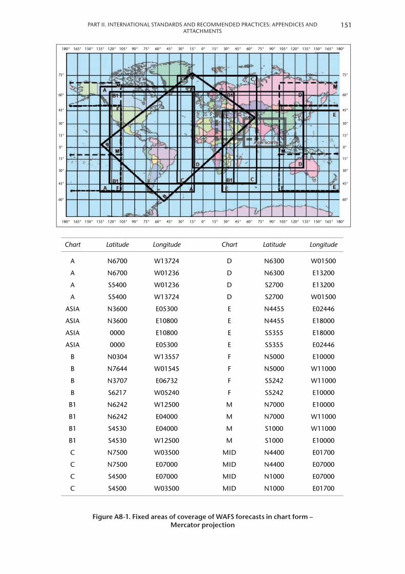
PART II. INTERNATIONAL STANDARDS AND RECOMMENDED PRACTICES: APPENDICES AND ATTACHMENTS
180° 165° 150° 135° 120° 105° 90° 75° 60° 45° 30° 15° 0° 15° 30° 45° 60° 75° 90° 105° 120° 135° 150° 165° 180°
60°
45°
30°
15°
75°
60°
45°
30°
15°
0°
60°
45°
30°
15°
75°
60°
45°
30°
15°
0°
180° 165° 150° 135° 120° 105° 90° 75° 60° 45° 30° 15° 0° 15° 30° 45° 60° 75° 90° 105° 120° 135° 150° 165° 180°
Chart Latitude Longitude Chart Latitude Longitude
A N6700 W13724 D N6300 W01500
A N6700 W01236 D N6300 E13200
A S5400 W01236 D S2700 E13200
A S5400 W13724 D S2700 W01500
ASIA N3600 E05300 E N4455 E02446
ASIA N3600 E10800 E N4455 E18000
ASIA 0000 E10800 E S5355 E18000
ASIA 0000 E05300 E S5355 E02446
B N0304 W13557 F N5000 E10000
B N7644 W01545 F N5000 W11000
B N3707 E06732 F S5242 W11000
B S6217 W05240 F S5242 E10000
B1 N6242 W12500 M N7000 E10000
B1 N6242 E04000 M N7000 W11000
B1 S4530 E04000 M S1000 W11000
B1 S4530 W12500 M S1000 E10000
C N7500 W03500 MID N4400 E01700
C N7500 E07000 MID N4400 E07000
C S4500 E07000 MID N1000 E07000
C S4500 W03500 MID N1000 E01700
Figure A8-1 . Fixed areas of coverage of WAFS forecasts in chart form – Mercator projection
151

25°S
20°S
15°S
10°S
10°S
15°S
20°S
25°S
30°S
25°S
20°S
20°S
25°S
30°S
40°W 35°W 30°W 25°W 20°W 15°W 10°W 5°W 0° 5°E 10°E 15°E 20°E 25°E 30°E 35°E 40°E 45°E
140°W 145°W 150°W 155°W 160°W 165°W 170°W175°W 180° 175°E 170°E 165°E 160°E 145°E 140°E 135°E155°E 150°E
Chart Latitude Longitude Chart Latitude Longitude
EUR N4633 W05634 I N1912 E11130
EUR N5842 E06824 I N3330 W06012
EUR N2621 E03325 I N0126 W12327
EUR N2123 W02136 I S0647 E16601
G N3552 W02822 L N1205 E11449
G N1341 E15711 L N1518 E04500
G S0916 E10651 L N2020 W06900
G S0048 E03447 L N1413 W14338
H N3127 W14836 NAT N4439 W10143
H N2411 E05645 NAT N5042 E06017
H S0127 W00651 NAT N1938 E00957
H N0133 W07902 NAT N1711 W05406
Figure A8-2 . Fixed areas of coverage of WAFS forecasts in chart form – Polar stereographic projection (northern hemisphere)
152 METEOROLOGICAL SERVICE FOR INTERNATIONAL AIR NAVIGATION

PART II. INTERNATIONAL STANDARDS AND RECOMMENDED PRACTICES: APPENDICES AND ATTACHMENTS
135°W 140°W 145°W 150°W 155°W 160°W 165°W 170°W 175°W 180° 175°E 170°E 165°E 160°E 155°E 150°E 145°E 140°E 135°E
25°N
20°N
15°N
15°N
20°N
25°N20°N
15°N
10°N
5°N
5°N
10°N
15°N
20°N
45°W 40°W 35°W 30°W 25°W 20°W 15°W 10°W 5°W 0° 5°E 10°E 15°E 20°E 25°E 30°E 35°E 40°E 45°E
Chart Latitude Longitude
J S0318 W17812
J N0037 W10032
J S2000 W03400
J S2806 E10717
K N1255 E05549
K N0642 E12905
K S2744 W16841
K S1105 E00317
Figure A8-3 . Fixed areas of coverage of WAFS forecasts in chart form – Polar stereographic projection (southern hemisphere)
153

APPENDIX 9. TECHNICAL SPECIFICATIONS RELATED TO INFORMATION FOR AIR TRAFFIC SERVICES, SEARCH AND RESCUE SERVICES AND AERONAUTICAL INFORMATION SERVICES
(See Part I, 10)
1. INFORMATION TO BE PROVIDED FOR AIR TRAFFIC SERVICES UNITS
1.1 List of information for the aerodrome control tower
The following meteorological information shall be supplied, as necessary, to an aerodrome control tower by its associated aerodrome meteorological office:
(a) Local routine reports, local special reports, METAR, SPECI, TAF, trend forecasts and amendments thereto, for the aerodrome concerned;
(b) SIGMET and AIRMET information, wind shear warnings and alerts and aerodrome warnings;
(c) Any additional meteorological information agreed upon locally, such as forecasts of surface wind for the determination of possible runway changes;
(d) Information received on volcanic ash cloud, for which a SIGMET has not already been issued, as agreed between the meteorological and ATS authorities concerned; and
(e) Information received on pre-eruption volcanic activity and/or a volcanic eruption as agreed between the meteorological and ATS authorities concerned .
1.2 List of information for the approach control unit
The following meteorological information shall be supplied, as necessary, to an approach control unit by its associated aerodrome meteorological office:
(a) Local routine reports, local special reports, METAR, SPECI, TAF, trend forecasts and amendments thereto, for the aerodrome(s) with which the approach control unit is concerned;
(b) SIGMET and AIRMET information, wind shear warnings and alerts and appropriate special air-reports for the airspace with which the approach control unit is concerned and aerodrome warnings;
(c) Any additional meteorological information agreed upon locally;
(d) Information received on volcanic ash cloud, for which a SIGMET has not already been issued, as agreed between the meteorological and ATS authorities concerned; and
(e) Information received on pre-eruption volcanic activity and/or a volcanic eruption as agreed between the meteorological and ATS authorities concerned .
1.3 List of information for the area control centre and flight information centre
The following meteorological information shall be supplied, as necessary, to an area control centre or a flight information centre by its associated meteorological watch office:

PART II. INTERNATIONAL STANDARDS AND RECOMMENDED PRACTICES: APPENDICES AND ATTACHMENTS
(a) METAR and SPECI, including current pressure data for aerodromes and other locations, TAF and trend forecasts, and amendments thereto, covering the flight information region (FIR) or the control area (CTA) and, if required by the flight information centre (FIC) or area control centre (ACC), covering aerodromes in neighbouring FIRs, as determined by regional air navigation agreement;
(b) Forecasts of upper winds, upper-air temperatures and significant en-route weather phenomena and amendments thereto, particularly those which are likely to make operation under visual flight rules impracticable, SIGMET and AIRMET information and appropriate special air-reports for the FIR or CTA and, if determined by regional air navigation agreement and required by the FIC or ACC, for neighbouring FIRs;
(c) Any other meteorological information required by the FIC or ACC to meet requests from aircraft in flight; if the information requested is not available in the associated meteorological watch office (MWO), that office shall request the assistance of another meteorological office in supplying it;
(d) Information received on volcanic ash cloud, for which a SIGMET has not already been issued, as agreed between the meteorological and ATS authorities concerned;
(e) Information received concerning the release of radioactive material into the atmosphere, as agreed between the meteorological and ATS authorities concerned;
(f) Tropical cyclone advisory information issued by a tropical cyclone advisory centre in its area of responsibility;
(g) Volcanic ash advisory information issued by a volcanic ash advisory centre in its area of responsibility; and
(h) Information received on pre-eruption volcanic activity and/or a volcanic eruption as agreed between the meteorological and ATS authorities concerned .
1.4 Supply of information to aeronautical telecommunications stations
Where necessary for flight information purposes, current meteorological reports and forecasts shall be supplied to designated aeronautical telecommunication stations . A copy of such information shall be forwarded, if required, to the FIC or ACC .
1.5 Format of information
1.5.1 [Recommendation] Local routine reports, local special reports, METAR, SPECI, TAF, trend forecasts, SIGMET and AIRMET information, upper wind and upper-air temperature forecasts and amendments thereto should be supplied to air traffic services units in the form in which they are prepared, disseminated to other aerodrome meteorological offices or MWOs, or received from other aerodrome meteorological offices or MWOs, unless otherwise agreed locally.
1.5.2 [Recommendation] When computer-processed upper-air data for grid points are made available to air traffic services units in digital form for use by air traffic services computers, the contents, format and transmission arrangements should be as agreed between the meteorological authority and the appropriate ATS authority. The data should normally be supplied as soon as is practicable after the processing of the forecasts has been completed.
155
2. INFORMATION TO BE PROVIDED FOR SEARCH AND RESCUE SERVICES UNITS
2.1 List of information
Information to be supplied to rescue coordination centres shall include the meteorological conditions that existed in the last known position of a missing aircraft and along the intended route of that aircraft with particular reference to:
(a) Significant en-route weather phenomena;
(b) Cloud amount and type, particularly cumulonimbus; height indications of bases and tops;
(c) Visibility and phenomena reducing visibility;
(d) Surface wind and upper wind;
(e) State of ground, in particular, any snow cover or flooding;
(f) Sea-surface temperature, state of the sea, ice cover, if any, and ocean currents, if relevant to the search area; and
(g) Sea-level pressure data .
2.2 Information to be provided on request
2.2.1 [Recommendation] On request from the rescue coordination centre, the designated aerodrome meteorological office or MWO should arrange to obtain details of the flight documentation which was supplied to the missing aircraft, together with any amendments to the forecast which were transmitted to the aircraft in flight.
2.2.2 [Recommendation] To facilitate search and rescue operations, the designated aerodrome meteorological office or MWO should, on request, supply:
(a) Complete and detailed information on the current and forecast meteorological conditions in the search area; and
(b) Current and forecast conditions en route, covering flights by search aircraft from, and returning to, the aerodrome from which the search is being conducted.
2.2.3 [Recommendation] On request from the rescue coordination centre, the designated aerodrome meteorological office or MWO should supply or arrange for the supply of meteorological information required by ships undertaking search and rescue operations.
3. INFORMATION TO BE PROVIDED FOR AERONAUTICAL INFORMATION SERVICES UNITS
3.1 List of information
The following information shall be supplied, as necessary, to an aeronautical information services unit:
(a) Information on meteorological service for international air navigation, intended for inclusion in the aeronautical information publication(s) concerned;
156 METEOROLOGICAL SERVICE FOR INTERNATIONAL AIR NAVIGATION
PART II. INTERNATIONAL STANDARDS AND RECOMMENDED PRACTICES: APPENDICES AND ATTACHMENTS
Note: Details of this information are given in the ICAO Procedures for Air Navigation Services – Aeronautical Information Management (PANS-AIM, Doc 10066), Appendix 3, Part 1, GEN 3.5 and Part 3, AD 2.2, 2.11, 3.2 and 3.11.
(b) Information necessary for the preparation of NOTAM or ASHTAM including, in particular, information on:
(i) The establishment, withdrawal and significant changes in operation of aeronautical meteorological services . This information is required to be provided to the aeronautical information services unit sufficiently in advance of the effective date to permit issuance of NOTAM in compliance with ICAO Annex 15, 6 .3 .2 .2 and 6 .3 .2 .3;
(ii) The occurrence of volcanic activity; and
Note: The specific information required is given in Part I, 3.3.2 and 4.8.
(iii) Release of radioactive materials into the atmosphere, as agreed between the meteorological and appropriate civil aviation authorities concerned; and
Note: The specific information required is given in Part I, 3.4.2 (g).
(c) Information necessary for the preparation of aeronautical information circulars including, in particular, information on:
(i) Expected important changes in aeronautical meteorological procedures, services and facilities provided; and
(ii) Effect of certain weather phenomena on aircraft operations .
157

APPENDIX 10. TECHNICAL SPECIFICATIONS RELATED TO REQUIREMENTS FOR AND USE OF COMMUNICATIONS
(See Part I, 11)
1. SPECIFIC REQUIREMENTS FOR COMMUNICATIONS
1.1 Required transit times of meteorological information
AFTN messages and bulletins containing operational meteorological information shall achieve transit times of less than five minutes, unless otherwise determined to be lower by regional air navigation agreement .
1.2 Grid-point data for ATS and operators
1.2.1 [Recommendation] When upper-air data for grid points in digital form are made available for use by air traffic services computers, the transmission arrangements should be as agreed between the meteorological authority and the appropriate ATS authority.
1.2.2 [Recommendation] When upper-air data for grid points in digital form are made available to operators for flight planning by computer, the transmission arrangements should be as agreed between the world area forecast centre concerned, the meteorological authority and the operators concerned.
2. USE OF AERONAUTICAL FIXED SERVICE COMMUNICATIONS AND THE PUBLIC INTERNET
2.1 Meteorological bulletins in alphanumeric format
2.1.1 Composition of bulletins
[Recommendation] Whenever possible, exchanges of operational meteorological information should be made in consolidated bulletins of the same types of meteorological information.
2.1.2 Filing times of bulletins
[Recommendation] Meteorological bulletins required for scheduled transmissions should be filed regularly and at the prescribed scheduled times. METAR should be filed for transmission not later than five minutes after the actual time of observation. TAF should be filed for transmission not earlier than one hour prior to the beginning of their validity period.
2.1.3 Heading of bulletins
Meteorological bulletins containing operational meteorological information to be transmitted via the aeronautical fixed service or the public Internet shall contain a heading consisting of:
(a) An identifier of four letters and two figures;

PART II. INTERNATIONAL STANDARDS AND RECOMMENDED PRACTICES: APPENDICES AND ATTACHMENTS
(b) The ICAO four-letter location indicator corresponding to the geographical location of the meteorological office originating or compiling the meteorological bulletin;
(c) A day-time group; and
(d) If required, a three-letter indicator .
Notes:1. Detailed specifications on format and contents of the heading are given in the Manual on the Global
Telecommunication System (WMO-No. 386) and are reproduced in the ICAO Manual of Aeronautical Meteorological Practice (Doc 8896).
2. ICAO location indicators are listed in ICAO Location Indicators (Doc 7910).
2.1.4 Structure of bulletins
Meteorological bulletins containing operational meteorological information to be transmitted via the AFTN shall be encapsulated in the text part of the AFTN message format .
2.2 World area forecast system (WAFS) products
2.2.1 Telecommunications for the supply of WAFS products
[Recommendation] The telecommunications facilities used for the supply of WAFS products should be the aeronautical fixed service or the public Internet.
2.2.2 Quality requirements for charts
[Recommendation] Where WAFS products are disseminated in chart form, the quality of the charts received should be such as to permit reproduction in a sufficiently legible form for flight planning and documentation. Charts received should be legible over 95 per cent of their area.
2.2.3 Quality requirements for transmissions
[Recommendation] Transmissions should be such as to ensure that their interruption should not exceed 10 minutes during any period of six hours.
2.2.4 Heading of bulletins containing WAFS products
Meteorological bulletins containing WAFS products in digital form to be transmitted via aeronautical fixed service or the public Internet shall contain a heading as given in 2 .1 .3 above .
3. USE OF AERONAUTICAL MOBILE SERVICE COMMUNICATIONS
3.1 Content and format of meteorological messages
3.1.1 The content and format of reports, forecasts and SIGMET information transmitted to aircraft shall be consistent with the provisions of Part I, 4, 6 and 7 .
159

3.1.2 The content and format of air-reports transmitted by aircraft shall be consistent with the provisions of Part I, 5 and of the ICAO Procedures for Air Navigation Services – Air Traffic Management (PANS-ATM, Doc 4444), Appendix 1 .
3.2 Content and format of meteorological bulletins
The substance of a meteorological bulletin transmitted via the aeronautical mobile service shall remain unchanged from that contained in the bulletin as originated .
4. USE OF AERONAUTICAL DATA LINK SERVICE – D-VOLMET
4.1 Detailed content of meteorological information available for D-VOLMET
4.1.1 The aerodromes for which METAR, SPECI and TAF are to be available for uplink to aircraft in flight shall be determined by regional air navigation agreement .
4.1.2 The flight information regions (FIRs) for which SIGMET and AIRMET messages are to be available for uplink to aircraft in flight shall be determined by regional air navigation agreement .
4.2 Criteria related to information to be available for D-VOLMET
4.2.1 [Recommendation] The latest available METAR, SPECI and TAF, and valid SIGMET and AIRMET, should be used for uplink to aircraft in flight.
4.2.2 [Recommendation] TAF included in the D-VOLMET should be amended as necessary to ensure that a forecast, when made available for uplink to aircraft in flight, reflects the latest opinion of the aerodrome meteorological office concerned.
4.2.3 [Recommendation] If no SIGMET message is valid for an FIR, an indication of “NIL SIGMET” should be included in the D-VOLMET.
4.3 Format of information to be available for D-VOLMET
The content and format of reports, forecasts and SIGMET and AIRMET information included in D-VOLMET shall be consistent with the provisions of Part I, 4, 6 and 7 .
5. USE OF AERONAUTICAL BROADCASTING SERVICE – VOLMET BROADCASTS
5.1 Detailed content of meteorological information to be included in VOLMET broadcasts
5.1.1 The aerodromes for which METAR, SPECI and TAF are to be included in VOLMET broadcasts, the sequence in which they are to be transmitted and the broadcast time shall be determined by regional air navigation agreement .
5.1.2 The FIRs for which SIGMET messages are to be included in scheduled VOLMET broadcasts shall be determined by regional air navigation agreement . Where this is done, the SIGMET message shall be transmitted at the beginning of the broadcast or of a five-minute time block .
160 METEOROLOGICAL SERVICE FOR INTERNATIONAL AIR NAVIGATION

PART II. INTERNATIONAL STANDARDS AND RECOMMENDED PRACTICES: APPENDICES AND ATTACHMENTS
5.2 Criteria related to information to be included in VOLMET broadcasts
5.2.1 [Recommendation] When a report has not arrived from an aerodrome in time for a broadcast, the latest available report should be included in the broadcast, together with the time of observation.
5.2.2 [Recommendation] TAF included in scheduled VOLMET broadcasts should be amended as necessary to ensure that a forecast, when transmitted, reflects the latest opinion of the aerodrome meteorological office concerned.
5.2.3 [Recommendation] Where SIGMET messages are included in scheduled VOLMET broadcasts, an indication of “NIL SIGMET” should be transmitted if no SIGMET message is valid for the FIRs concerned.
5.3 Format of information to be included in VOLMET broadcasts
5.3.1 The content and format of reports, forecasts and SIGMET information included in VOLMET broadcasts shall be consistent with the provisions of Part I, 4, 6 and 7 .
5.3.2 [Recommendation] VOLMET broadcasts should use standard radiotelephony phraseologies.
Note: Guidance on the standard radiotelephony phraseologies to be used in VOLMET broadcasts is given in the ICAO Manual on Coordination between Air Traffic Services, Aeronautical Information Services and Aeronautical Meteorological Services (Doc 9377), Appendix 1.
161

ATTACHMENT A. OPERATIONALLY DESIRABLE ACCURACY OF MEASUREMENT OR OBSERVATION
Note: The guidance contained in this table relates to Part I, 2.2 – Supply, use, quality management and interpretation of meteorological information, in particular to 2.2.7, and 4 – Meteorological observations and reports.
Element to be observed Operationally desirable accuracy of measurement or observation*
Mean surface wind Direction: ± 10° Speed: ± 0.5 m/s (1 kt) up to 5 m/s (10 kt) ± 10% above 5 m/s (10 kt)
Variations from the mean surface wind ± 1 m/s (2 kt), in terms of longitudinal and lateral components
Visibility ± 50 m up to 600 m ± 10% between 600 m and 1 500 m ± 20% above 1 500 m
Runway visual range ± 10 m up to 400 m ± 25 m between 400 m and 800 m ± 10% above 800 m
Cloud amount ± 1 okta
Cloud height ± 10 m (33 ft) up to 100 m (330 ft) ± 10% above 100 m (330 ft)
Air temperature and dewpoint temperature
± 1°C
Pressure value (QNH, QFE) ± 0.5 hPa
* The operationally desirable accuracy is not intended as an operational requirement; it is to be understood as a goal that has been expressed by the operators.
Note: Guidance on the uncertainties of measurement or observation can be found in the Guide to Meteorological Instruments and Methods of Observation (WMO-No. 8).
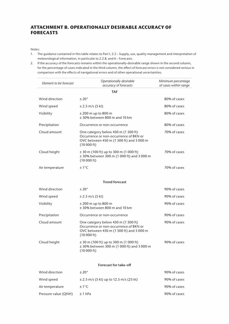
ATTACHMENT B. OPERATIONALLY DESIRABLE ACCURACY OF FORECASTS
Notes:1. The guidance contained in this table relates to Part I, 2.2 – Supply, use, quality management and interpretation of
meteorological information, in particular to 2.2.8, and 6 – Forecasts.2. If the accuracy of the forecasts remains within the operationally-desirable range shown in the second column,
for the percentage of cases indicated in the third column, the effect of forecast errors is not considered serious in comparison with the effects of navigational errors and of other operational uncertainties.
Element to be forecast Operationally desirable accuracy of forecasts
Minimum percentage of cases within range
TAF
Wind direction ± 20° 80% of cases
Wind speed ± 2.5 m/s (5 kt) 80% of cases
Visibility ± 200 m up to 800 m ± 30% between 800 m and 10 km
80% of cases
Precipitation Occurrence or non-occurrence 80% of cases
Cloud amount One category below 450 m (1 500 ft) Occurrence or non-occurrence of BKN or OVC between 450 m (1 500 ft) and 3 000 m (10 000 ft)
70% of cases
Cloud height ± 30 m (100 ft) up to 300 m (1 000 ft) ± 30% between 300 m (1 000 ft) and 3 000 m (10 000 ft)
70% of cases
Air temperature ± 1°C 70% of cases
Trend forecast
Wind direction ± 20° 90% of cases
Wind speed ± 2.5 m/s (5 kt) 90% of cases
Visibility ± 200 m up to 800 m± 30% between 800 m and 10 km
90% of cases
Precipitation Occurrence or non-occurrence 90% of cases
Cloud amount One category below 450 m (1 500 ft) Occurrence or non-occurrence of BKN or OVC between 450 m (1 500 ft) and 3 000 m (10 000 ft)
90% of cases
Cloud height ± 30 m (100 ft) up to 300 m (1 000 ft) ± 30% between 300 m (1 000 ft) and 3 000 m (10 000 ft)
90% of cases
Forecast for take-off
Wind direction ± 20° 90% of cases
Wind speed ± 2.5 m/s (5 kt) up to 12.5 m/s (25 kt) 90% of cases
Air temperature ± 1°C 90% of cases
Pressure value (QNH) ± 1 hPa 90% of cases
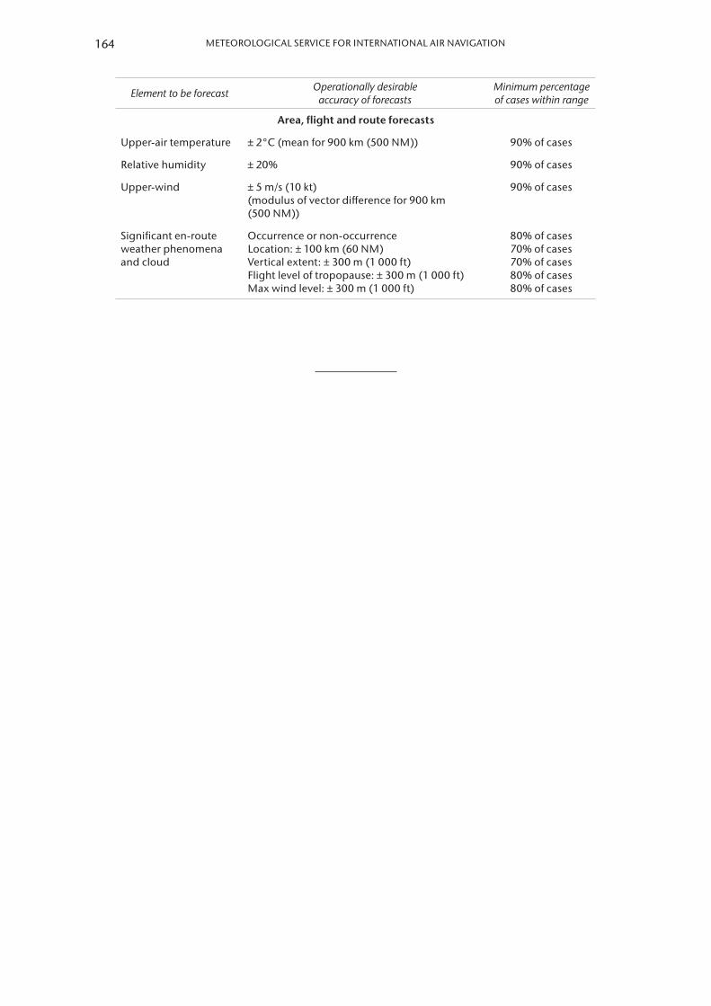
Element to be forecast Operationally desirable accuracy of forecasts
Minimum percentage of cases within range
Area, flight and route forecasts
Upper-air temperature ± 2°C (mean for 900 km (500 NM)) 90% of cases
Relative humidity ± 20% 90% of cases
Upper-wind ± 5 m/s (10 kt) (modulus of vector difference for 900 km (500 NM))
90% of cases
Significant en-route weather phenomena and cloud
Occurrence or non-occurrence Location: ± 100 km (60 NM) Vertical extent: ± 300 m (1 000 ft) Flight level of tropopause: ± 300 m (1 000 ft) Max wind level: ± 300 m (1 000 ft)
80% of cases 70% of cases 70% of cases 80% of cases 80% of cases
164 METEOROLOGICAL SERVICE FOR INTERNATIONAL AIR NAVIGATION

ATTACHMENT C. SELECTED CRITERIA APPLICABLE TO AERODROME REPORTS
(The guidance in this table relates to Part I, 4 and to Appendix 3.)
Surface wind Visibility (VIS)
Runway visual range 1
Presentweather
Cloud
Temperature Pressure (QNH, QFE)Supplementary
information
A B C (OBS TIME)
Amount Type 2 –10 –5 (Time, MIN)
Specifications
Directional variations 3Speed
variations 3 Directional variations 4 Past tendency 5
No general
criteria
applicable
to all
the WX
phenomena
(for specific
criteria, see
Appendix 3,
4.4.2)
Layers reported if coverage
Identification
No criteria
Parameters
reported
Updated
if changes
> agreed
magnitude
Parameter to
be included
≥ 60° and < 180°
≥ 180°Exceeding
the mean
speed by
≥ 5 m/s
(10 kt)
General
rule
Special cases
Minimum VIS ≠
prevailing VIS| R
– 5(AB) – R
– 5(BC) |
Lowest
layer
Next
layer >
Next
higher
layer >
CB6 or
TCU
Mean speed
Minimum VIS
< 1 500 m
or < 0.5 ×
prevailing VIS
VIS
fluctuating and
prevailing
VIS cannot be
determined< 100 m ≥ 100 m
< 1.5 m/s
(3 kt)
≥ 1.5 m/s
(3 kt)
Local routine
and special
report
2/10 min 7 2/10 min 7 2 min 10 min 8 1 min 1 min
Always 2/8 4/8 AlwaysCB
TCU
QNH
QFE10Yes All11VRB + 2
extreme
directions
Mean + 2
extreme
directions
VRB (no
extremes)
Minimum
and
maximum
speed
VIS along
the
runway(s)
N/A N/A N/A9
METAR/SPECI
10 min 10 min 10 min 10 min 8 10 min
Prevailing VIS
and minimum
VIS +
direction
Minimum
VIS
10 min
Upward (“U”) or
downward (“D”) Always 2/8 4/8 AlwaysCB
TCUQNH No
Recent WX of
operational
significance
and wind
shear12
VRB (no
extremes)
Mean +
2 extreme
directions
VRB (no
extremes)
Maximum
speed
Prevailing
VIS
No tendency
observed (“N”)
No tendency available, the
tendency is to be omitted
Relevant
reporting
scales for all
messages
Direction in three figures rounded
to the nearest 10 degrees
(Degrees 1–4 down,
degrees 5–9 up)
Speed in
1 m/s
or 1 kt
Speed
< 0.5 m/s
(1 kt)
indicated as
CALM
If
VIS < 800 m
800 m ≤ VIS < 5 000 m
5 000 m ≤ VIS < 10 km
VIS ≥ 10 km
Step applicable
: 50 m
: 100 m
: 1 km
: None, given as
10 km or covered
under CAVOK
If Step applicable
RVR < 400 m : 25 m
400 m ≤ RVR ≤ 800 m : 50 m
800 m < RVR < 2 000 m : 100 m13
N/A If
Base ≤ 3 000 m (10 000 ft)
(Reference level: Aerodrome
elevation14 or mean sea level
for offshore structures)
Step applicable
: 30 m (100 ft)
Rounded
to whole
degrees:
up for
decimal 5
In whole hPa15
rounded down for
decimals 1–9
N/A

Notes:1. Considered for the past 10 minutes (exception: if the 10-minute period includes a marked discontinuity
(i.e. runway visual range changes or passes 175, 300, 550 or 800 m, lasting ≥ 2 minutes), only data after the discontinuity to be used). A simple diagrammatic convention is used to illustrate those parts of the 10-minute period prior to the observation relevant to runway visual range criteria, i.e. AB, BC and AC.
2. Layer composed of CB and TCU with a common base should be reported as “CB”.3. Considered for the past 10 minutes (exception: if the 10-minute period includes a marked discontinuity (i.e. the
direction changes ≥ 30° with a speed ≥ 5 m/s or the speed changes ≥ 5 m/s lasting ≥ 2 minutes), only data after the discontinuity to be used).
4. If several directions, the most operationally significant direction used.5. Let R 5(AB) = five-minute mean runway visual range value during period AB and R 5(BC) = five-minute mean runway
visual range value during period BC.6. CB (cumulonimbus) and TCU (towering cumulus = cumulus congestus of great vertical extent) if not already
indicated as one of the other layers.7. Time averaging, for mean values and, if applicable, referring period for extreme values, indicated in the upper left-
hand corner.8. According to the Manual on Codes (WMO-No. 306), Volume I.1, Part A – Alphanumeric Codes, paragraph 15.5.5, “It
is recommended that the wind measuring systems should be such that peak gusts should represent a three-second average.”
9. N/A = not applicable.10. QFE is to be included if required. Reference elevation for QFE should be aerodrome elevation except for precision
approach runways and non-precision approach runways with threshold ≥ 2 m (7 ft) below or above aerodrome elevation, where the reference level should be the relevant threshold elevation.
11. As listed in Appendix 3, 4.8.12. Also sea-surface temperature and state of the sea or the significant wave height from offshore structures in
accordance with regional air navigation agreement.13. Report if RVR and/or VIS < 1 500 m, limits for assessments 50 and 2 000 m.14. For landing at aerodromes with precision approach runways and with the threshold elevation ≥ 15 m below the
aerodrome elevation, the threshold elevation to be used as a reference.15. Measured in 0.1 hPa.
166 METEOROLOGICAL SERVICE FOR INTERNATIONAL AIR NAVIGATION

ATTACHMENT D. CONVERSION OF INSTRUMENTED READINGS INTO RUNWAY VISUAL RANGE AND VISIBILITY
(See Appendix 3, 4.3.5)
1. The conversion of instrumented readings into runway visual range and visibility is based on Koschmieder’s Law or Allard’s Law, depending on whether the pilot can be expected to obtain main visual guidance from the runway and its markings or from the runway lights. In the interest of standardization in runway visual range assessments, this attachment provides guidance on the use and application of the main conversion factors to be used in these computations.
2. In Koschmieder’s Law, one of the factors to be taken into account is the pilot contrast threshold. The agreed constant to be used for this is 0.05 (dimensionless).
3. In Allard’s Law, the corresponding factor is the illumination threshold. This is not a constant, but a continuous function dependent on the background luminance. The agreed relationship to be used in instrumented systems with continuous adjustment of the illumination threshold by a background luminance sensor is shown by the curve in Figure D-1. The use of a continuous function which approximates the step function such as displayed in Figure D-1 is preferred, due to its higher accuracy, to the stepped relationship described in paragraph 4 below.
4. In instrumented systems without continuous adjustment of the illumination threshold, the use of four equally spaced illumination threshold values with agreed corresponding background luminance ranges is convenient but will reduce accuracy. The four values are shown in Figure D-1 in the form of a step function; they are tabulated in Table D-1 for greater clarity.
Notes:1. Information and guidance material on the runway lights to be used for assessment of runway visual range are
contained in the ICAO Manual of Runway Visual Range Observing and Reporting Practices (Doc 9328).2. In accordance with the definition of visibility for aeronautical purposes, the intensity of lights to be used for the
assessment of visibility is in the vicinity of 1 000 cd.
10–2
10–3
10–4
10–5
10–6
10–710 100 1 000 10 0001 100 000
Illum
inat
ion
thre
shol
d (l
x)
Background luminance (cd/m2)
Bright day
Normal day
Intermediate
Night
log (ET) =0.57 log (B) + 0.05 [log(B)]2 – 6.66
Figure D-1 . Relationship between the illumination threshold ET (lx) and background luminance B (cd/m2)

Table D–1 . Illumination threshold steps
Condition Illumination threshold (lx)
Background luminance (cd/m2)
Night 8 x 10⁻⁷ ≤ 50
Intermediate 10–5 51–999
Normal day 10–4 1 000–12 000
Bright day (sunlit fog) 10–3 > 12 000
168 METEOROLOGICAL SERVICE FOR INTERNATIONAL AIR NAVIGATION

ATTACHMENT E. SPATIAL RANGES AND RESOLUTIONS FOR SPACE WEATHER ADVISORY INFORMATION
(See Appendix 2, 6.1)
Element to be forecast Range Resolution
Flight level affected by radiation 250–600 30
Longitudes for advisories (degrees) 000–180 15
Latitudes for advisories (degrees) 00–90 10
Latitude banks for advisories: High latitudes northern hemisphere (HNH) N9000–N6000
30
Middle latitudes northern hemisphere (MNH) N6000–N3000
Equatorial latitudes northern hemisphere (EQN) N3000–N0000
Equatorial latitudes southern hemisphere (EQS) S0000–S3000
Middle latitudes southern hemisphere (MSH) S3000–S6000
High latitudes southern hemisphere (HSH) S6000–S9000

PART III. AERONAUTICAL CLIMATOLOGY
1. GENERAL PROVISIONS
1.1 Aeronautical climatological information should be based on observations made over a period of at least five consecutive years and that period should be indicated in the information supplied. The period should be updated or extended by the addition of more recent data as soon as practicable.
1.2 Meteorological observations for regular and alternate aerodromes should be collected, processed and stored in a form suit-able for the preparation of aerodrome climatological information in any form or forms and within the time period as agreed between the meteorological authority and the aeronautical user or users.
Note: As it is possible for the collection, processing and storage of observational data to be effected by computer facilities available for international use, in cases where it is impracticable to meet the requirements for aeronautical climatological information on a national basis, the responsibility for the preparation of the required aeronautical climatological information may be delegated by agreement between the meteorological authorities concerned.
1.3 Aerodrome climatological tables and summaries should contain information on the location, height and exposure of the sensors from which the observations are derived.
1.4 Aerodrome climatological tables and summaries should contain information regarding the total number of observations and the observing times on which they are based.
2. AERODROME CLIMATOLOGICAL TABLES
2.1 Aerodrome climatological tables should be prepared in a form suitable to meet the specific request of the aeronautical user. Where appropriate, the layout for the climatological tables may follow the models for the climatological summaries.
2.2 Aerodrome climatological tables should be supplied for specified intervals as agreed between the meteorological authority and the aeronautical user. Aerodrome climatological tables may include the following information:
– Frequencies of specified wind directions and speeds at 10 m above runway level;– Frequencies of specified range of runway visual range/visibility;– Mean number of days with occurrence of specified weather phenomena, for example,
sandstorms, fog, freezing rain, thunderstorms;– Frequencies of specified range of the height of the operationally significant cloud base;– Frequencies of specified range intervals of surface temperatures; and– Mean atmospheric pressure at aerodrome level.
Upon request, frequencies of simultaneous occurrence of specified values of two or more of the elements listed above may be provided to meet user requirements.
Notes:1. Climatological information on low visibility conditions should be based on measurements of RVR for those
aerodromes where such observations are required under Part I, 4.6.3.2.2. Procedures governing light intensity settings and other particulars used for the RVR assessment should be
specified.

PART III. AERONAUTICAL CLIMATOLOGY
3. AERODROME CLIMATOLOGICAL SUMMARIES
3.1 Aerodrome climatological summaries should, in general, follow the format of the models given in the attachment hereto.
3.2 Aerodrome climatological summaries should include the following information on meteorological conditions at an aerodrome:
– Frequencies (per cent) of the occurrence of runway visual range/visibility (both in metres) and/or height of the base of the lowest cloud layer (in metres) of BKN or OVC extent below specified values at specified times (Model A);
– Frequencies (per cent) of visibility below specified values (in metres) at specified times (Model B);
– Frequencies (per cent) of the height of the base (in metres) of the lowest cloud layer of BKN or OVC extent below specified values at specified times (Model C);
– Frequencies of occurrence of concurrent wind direction (in 30° sectors) and speed within specified ranges (Model D);
– Frequencies (per cent) of surface temperature (screen) in specified ranges of 5°C at specified times (Model E);
– Mean values and variations therefrom, including maximum and minimum values of meteorological elements required for operational planning purposes including take-off calculations (no model included).
171

ATTACHMENT. AERODROME CLIMATOLOGY SUMMARY – TABULAR FORMS
MODEL A Frequencies (per cent) of the occurrence of runway visual range/visibility (both in metres) and/or height of the base of the lowest cloud layer (in metres) of BKN or OVC extent below specified values at specified times
MODEL B Frequencies (per cent) of visibility below specified values (in metres) at specified times
MODEL C Frequencies (per cent) of the height of the base (in metres) of the lowest cloud layer of BKN or OVC extent below specified values at specified times
MODEL D Frequencies of occurrence of concurrent wind direction (in 30° sectors) and speed within specified ranges
MODEL E Frequencies (per cent) of surface temperature (screen) in specified ranges of 5°C at specified times

PART III. AERONAUTICAL CLIMATOLOGY
AERODROME CLIMATOLOGICAL SUMMARY TABULAR FORM
MODEL A
AERODROME: _________ RWY (TDZ): ________ MONTH: ________ PERIOD OF RECORD: _________
TOTAL NUMBER OF OBSERVATIONS: _____________
LATITUDE: _____________ LONGITUDE: _____________ ELEVATION ABOVE MSL: __________M
FREQUENCIES (PER CENT) OF THE OCCURRENCE OF RUNWAY VISUAL RANGE/VISIBILITY (BOTH IN METRES) AND/OR HEIGHT OF THE BASE OF THE
LOWEST CLOUD LAYER (IN METRES) OF BKN OR OVC EXTENT BELOW SPECIFIED VALUES AT SPECIFIED TIMES
TIME (UTC)
RVR/HS VIS/HS
< 50 < 200 < 350 < 550 < 1 500 < 800 < 1 500 < 3 000 < 8 000
– – < 30 (100 ft)
< 60 (200 ft)
< 90 (300 ft)
< 60 (200 ft)
< 150 (500 ft)
< 300 (1 000 ft)
< 600 (2 000 ft)
0000
0030
0100
0130
0200
0230
0300
•
•
•
•
•
•
•
•
•
•
2200
2230
2300
2330
TOTAL
REMARKS
173

AERODROME CLIMATOLOGICAL SUMMARY TABULAR FORM
MODEL B
AERODROME:_____________ MONTH: _____________ PERIOD OF RECORD: _________
TOTAL NUMBER OF OBSERVATIONS: _____________
LATITUDE: _____________ LONGITUDE: _____________ ELEVATION ABOVE MSL: __________M
FREQUENCIES (PER CENT) OF VISIBILITY BELOW SPECIFIED VALUES (IN METRES) AT SPECIFIED TIMES
TIME (UTC)
VISIBILITY
< 200 < 400 < 600 < 800 < 1 500 < 3 000 < 5 000 < 8 000
00
01
02
03
•
•
•
•
•
•
•
•
•
•
22
23
MEAN
Note: Frequencies at three-hourly intervals may suffice to describe the main climatological features.
174 METEOROLOGICAL SERVICE FOR INTERNATIONAL AIR NAVIGATION

PART III. AERONAUTICAL CLIMATOLOGY
AERODROME CLIMATOLOGICAL SUMMARY TABULAR FORM
MODEL C
AERODROME:_____________ MONTH: _____________ PERIOD OF RECORD: _________
TOTAL NUMBER OF OBSERVATIONS: _____________
LATITUDE: _____________ LONGITUDE: _____________ ELEVATION ABOVE MSL: __________M
FREQUENCIES (PER CENT) OF THE HEIGHT OF THE BASE (IN METRES) OF THE LOWEST CLOUD LAYER OF BKN OR OVC EXTENT BELOW SPECIFIED VALUES AT SPECIFIED TIMES
TIME (UTC)
HS
< 30 (100 ft)
< 60 (200 ft)
< 90 (300 ft)
< 150 (500 ft)
< 300 (1 000 ft)
< 450 (1 500 ft)
00
01
02
03
•
•
•
•
•
•
•
•
•
•
22
23
MEAN
Note: Frequencies at three-hourly intervals may suffice to describe the main climatological features.
175

AERODROME CLIMATOLOGICAL SUMMARY TABULAR FORM
MODEL D
AERODROME:_____________ MONTH: _____________ PERIOD OF RECORD: _________
TOTAL NUMBER OF OBSERVATIONS: _____________ OBSERVING TIME: _____________
LATITUDE: _____________ LONGITUDE: _____________ ELEVATION ABOVE MSL: __________M
FREQUENCIES OF OCCURRENCE OF CONCURRENT WIND DIRECTION (IN 30° SECTORS) AND SPEED WITHIN SPECIFIED RANGES
WIND DIRECTION
WIND SPEED (KT)
1–5 6–10 11–15 16–20 21–25 26–30 31–35 36–40 41–45 46–50 > 50 TOTAL
CALM
VARIABLE
35–36–01
02–03–04
05–06–07
08–09–10
11–12–13
14–15–16
17–18–19
20–21–22
23–24–25
26–27–28
29–30–31
32–33–34
TOTAL
176 METEOROLOGICAL SERVICE FOR INTERNATIONAL AIR NAVIGATION

PART III. AERONAUTICAL CLIMATOLOGY
AERODROME CLIMATOLOGICAL SUMMARY TABULAR FORM
MODEL E
AERODROME:_____________ MONTH: _____________ PERIOD OF RECORD: _________
TOTAL NUMBER OF OBSERVATIONS: _____________
LATITUDE: _____________ LONGITUDE: _____________ ELEVATION ABOVE MSL: __________M
FREQUENCIES (PER CENT) OF SURFACE TEMPERATURE (SCREEN) IN SPECIFIED RANGES OF 5 °C AT SPECIFIED TIMES
TIME (UTC)
TEMPERATURE
–10 – –5 –5–0 0–5 5–10 10–15 15–20 20–25 25–30 ...........
00
01
02
03
•
•
•
•
•
•
•
•
•
•
22
23
MEAN
Notes:1. The range 5–10 comprises the values 5.0 to 9.9 inclusive.2. Frequencies at three-hourly intervals may suffice to describe the main climatological features.
177

PART IV. FORMAT AND PREPARATION OF FLIGHT DOCUMENTATION
1. FLIGHT DOCUMENTATION
1.1 Flight documentation to be provided in accordance with Part I, 9.3 should be prepared as set out in 2 below to ensure worldwide standardization.
1.2 Model charts and forms used in flight documentation are reproduced in Part II, Appendix 1.
2. PREPARATION OF FLIGHT DOCUMENTATION
2.1 General
2.1.1 Documentation must be clear and legible.
2.1.2 Information identifying the forecast areas, sections of routes, aerodromes, units used, validity dates and times, flight levels or other height indication, types of charts and in the case of wind and temperature and volcanic ash forecasts, dates and times of observation on which the prognosis is based, should be inserted in the appropriate spaces provided on each form.
2.1.3 Only those meteorological abbreviations which are approved by ICAO and WMO should be used in completing the documents. Other aeronautical abbreviations used should be those approved by ICAO.
2.1.4 A range of values should be indicated by giving the limits separated by a hyphen except that, in cases where a minus follows the hyphen, the hyphen must be replaced by the word “to”.
2.1.5 When a meteorological office has to prepare charts which are normally received from a world area forecast centre (WAFC), it should apply the provisions given in 3 below.
2.1.6 Projections and scales of weather charts used for the preparation of flight documentation should be selected in accordance with international recommendations promulgated by WMO.
3. CHARTS PREPARED BY WORLD AREA FORECAST CENTRES
3.1 General
3.1.1 Charts based on forecasts issued by world area forecast centres should be prepared with map bases and projections as prescribed in 3.2 below.
3.1.2 Charts should be fixed-time prognostic charts.
3.1.3 Charts should be clearly identified in accordance with 2.1.2 above and include the name of the issuing world area forecast centre.

PART IV. FORMAT AND PREPARATION OF FLIGHT DOCUMENTATION
3.2 Map bases and projections
3.2.1 Map bases should have:
(a) Latitude indicated by dotted lines at 10° intervals;
(b) Longitude indicated by dotted lines at 10° intervals from the equator to 80° latitude and at 90° longitude intervals from 80° latitude to the Pole;
(c) The intersection of latitude and longitude lines at the intervening 5° intervals optionally marked by a cross where this adds to the clarity of the chart;
(d) The dots comprising the latitude lines at intervals of:(i) 1° of longitude for 10° latitude lines from the equator to 60° (in the case of polar
stereographic projection);(ii) 5° of longitude for latitudes 70° and 80°;
(e) The dots comprising the longitude lines at intervals of 1° of latitude from the equator to 80°;
(f) Latitude and longitude values clearly indicated at various points throughout the chart (i.e. not only at the edges);
(g) Major geographical features depicted in a way that makes them easily recognizable;
(h) Major aerodromes indicated, where practicable, as a dot and identified by the first letter of the name of the city the aerodrome serves as given in Table AOP of the relevant ICAO regional air navigation plan.
Note: Meteorological data should take precedence over chart background.
3.2.2 Projections used in middle and high latitudes should be polar stereographic true at 60° latitude. In low-latitude regions, the Mercator projection true at 22.5°N and 22.5°S should be used. When a forecast embraces high and low latitudes, the projection appropriate to the larger portion of the area should be adopted.
3.3 Contents of charts
3.3.1 Forms of presentation:
(a) Symbols used in models to present significant weather should be selected from Table IV.1 (a) or (b) as appropriate;
(b) Symbols used in models to present fronts and convergence zones and other features should be selected from Table IV.2;
(c) Height indication1 on significant weather charts is normally restricted to the limits of the chart, for example FL 100 and FL 250. However, in agreement with operators, values outside the chart limits may be included when appropriate. In particular, the symbol for volcanic eruption should appear on all charts, irrespective of the height of the observed or forecast ash cloud.
3.3.2 In charts based on forecasts issued by world area forecast centres, wind direction and speed should be depicted by arrows with feathers and shaded pennants.
1 Height indication: See Part II, Appendix 8, 4.2.3.
179

Table IV.1
(a) Significant weather (in accordance with Part II, Appendix 2, 1.3.2 and 1.3.3)
Tropical cyclone Moderate aircraft icing
Severe squall line Severe aircraft icing
Moderate turbulence Widespread sandstorm or duststorm
Severe turbulence Volcanic eruption
(b) Significant weather (in accordance with Part II, Appendix 5, 4.3)
Tropical cyclone Widespread fog
Severe squall line Drizzle
Moderate turbulence Rain
Severe turbulence Snow
Mountain waves Shower
Moderate aircraft icing Widespread blowing snow
Severe aircraft icing Severe sand or dust haze
Hail Widespread sandstorm or duststorm
Volcanic eruption Widespread haze
Freezing precipitationa Widespread mist
Radioactive materials in the atmosphere Widespread smoke
Mountain obscuration
a The symbol is used for supercooled precipitation but not for precipitation that is transformed into ice coming into contact with an aircraft which is at a very low temperature.
Note: Where the abbreviation CB is used it should refer to only those thunderstorms which warrant the issuance of a SIGMET as given in Part II, Appendix 6, 1.1.4.
Table IV.2
Cold front at the surface Tropopause high
Warm front at the surface Tropopause low
Occluded front at the surface Tropopause level
Quasi-stationary front at the surface Freezing level
Convergence line Position, speed and level of maximum wind (see Table IV.3)
Intertropical convergence zonea State of the sea
Widespread strong surface windb Sea-surface temperature
a The separation of the two lines gives a qualitative representation of the width of the zone; the hatched lines may be added to indicate areas of activity.
b This symbol refers to widespread surface wind speeds exceeding 16 m/s (30 kt).
Table IV.3 (in accordance with 4.3.11)
Wind arrows indicate the maximum wind in jet and the flight level at which it occurs. If the maximum wind speed is 60 m/s (120 kt) or more, the flight levels between which winds are greater than 40 m/s (80 kt) is placed below the maximum wind level. In the example, winds are greater than 40 m/s (80 kt) between FL 220 and FL 400. The heavy line delineating the jet axis begins/ends at the points where a wind speed of 40 m/s (80 kt) is forecast.
18
10
40
FL 270
180 METEOROLOGICAL SERVICE FOR INTERNATIONAL AIR NAVIGATION

PART IV. FORMAT AND PREPARATION OF FLIGHT DOCUMENTATION
4. COMPLETION OF MODELS
Note: The model charts and forms are shown in Part II, Appendix 1.
4.1 Model A: OPMET information
4.1.1 Model A consists of the direct reproduction of METARs, TAFs and SIGMETs as received. Obvious transmission errors should be corrected before reproduction, where possible.
4.1.2 An appropriate selection of ICAO location indicators and abbreviations for weather phenomena should be compiled by meteorological authorities concerned, to accompany flight documentation. The location indicators should preferably be in alphabetical order.
4.1.3 SIGMET is a warning information and hence it is of the highest priority, and is prepared in abbreviated plain language.
4.2 Model IS: upper wind and upper-air temperature chart for standard isobaric surface
4.2.1 Charts for depicting upper winds and temperatures included in flight documentation should be prognostic charts for fixed-times of validity and for fixed flight levels clearly indicated on the label of the charts.
4.2.2 Heights indicated on the chart should be expressed as flight levels.
4.2.3 Wind direction and speed should be depicted on charts by arrows with feathers and shaded pennants, with a sufficiently dense grid.
4.2.4 Air temperature at selected grid points of a sufficient density should be indicated by insertion of the value of the temperature in whole degrees Celsius. Labels on upper-level charts should state that all temperatures are negative, except those which are preceded by the appropriate indicator for positive values (+).
4.2.5 The information depicted on wind and temperature charts should be at grid points that coincide with the relevant grid points in the digital data received from a WAFC.
4.3 Models SWH, SWM and SWL: significant weather charts
4.3.1 Models SWH, SWM and SWL are charts of significant weather. Model SWH is used to depict expected significant weather phenomena above FL 250. Model SWM is used to depict expected significant weather phenomena between FL 100 and FL 250. Model SWL is used to depict expected significant weather phenomena below FL 100. The layer of the atmosphere to which the chart refers should be clearly indicated on the chart. The symbols used to depict expected significant weather phenomena should be selected from Table IV.1 (a) for Models SWH and SWM and from Table IV.1 (b) for Model SWL.
4.3.2 The heights on SWH and SWM charts should be expressed in flight levels. The heights used on SWL charts should be expressed as altitudes in metres or feet (hectofeet) as appropriate. The heights for the levels between which a phenomenon is expected to occur should be given with the value for the lower level being placed underneath that for the higher level.
4.3.3 The types and surface plan positions of fronts (and in tropical regions, convergence zones) with which en-route significant weather is associated should be represented using symbols selected from Table IV.2. Arrows should be placed at suitable intervals along the front
181

giving the direction of expected movement of the front with a figure to indicate the expected mean speed of movement in knots or in kilometres per hour during the period from three hours before to three hours after the validity time.
4.3.4 On SWL charts only, the positions of centres of high- and low-pressure systems should be represented by a cross and the letter H or L, respectively, together with the values of the central pressure in hectopascals (hPa). The expected movement of pressure centres should be indicated by an arrow in the direction of the movement with a figure to indicate the expected mean speed of movement in knots or in kilometres per hour during the period from three hours before to three hours after the validity time.
4.3.5 The boundaries of the areas of significant weather should be indicated on the chart by a scalloped line, except for areas of clear air turbulence, which should be delineated by a broken line.
Note: For clarity, the clear air turbulence area may be marked by a figure inside a square relating to a legend on a margin of the chart to explain the intensity and the vertical extent of the turbulence.
4.3.6 On SWL charts, the height of the 0°C isotherm, when it falls within the applicable vertical range of the chart, should be indicated either by the insertion at selected points of its height, preceded by 0° within small rectangles, or by means of dashed contour lines at appropriately spaced height intervals. The height of the 0°C isotherm should be indicated by altitude.
4.3.7 On SWH charts, cumulonimbus (CB) clouds are included if they are ISOL EMBD (isolated embedded), OCNL EMBD (occasional embedded), FRQ (frequent) or FRQ EMBD (frequent embedded).
4.3.8 In addition to the provisions of 4.3.7 above, on SWM charts clouds associated with any of the significant weather phenomena listed in Table IV.1 (a) in the layer FL 100 to FL 250 should be indicated using the abbreviations FEW (few), SCT (scattered), BKN (broken) and OVC (overcast) for 1–2 oktas, 3–4 oktas, 5–7 oktas and 8 oktas, respectively.
4.3.9 On SWL and SWM charts all cumulonimbus clouds should be indicated using the following abbreviations:
ISOL: an area of individual cumulonimbus and/or thunderstorms with a maximum spatial coverage less than 50 per cent of the area forecast to be affected;
OCNL: an area of well-separated cumulonimbus and/or thunderstorms with a maximum spatial coverage between 50 and 75 per cent of the area forecast to be affected;
FRQ: an area of thunderstorms within which there is little or no separation between adjacent thunderstorms with a maximum spatial coverage greater than 75 per cent of the area forecast to be affected.
The abbreviation EMBD (embedded) may be added to any one of these three abbreviations to indicate cumulonimbus clouds that are embedded within cloud layers and cannot readily be recognized. These embedded CBs may or may not be protruding from the layer. On SWL charts, all other clouds should be depicted using the abbreviations FEW (few), SCT (scattered), BKN (broken) and OVC (overcast) for 1–2 oktas, 3–4 oktas, 5–7 oktas and 8 oktas, respectively. Type of cloud should be indicated in conformity with WMO Code table 0500 but, where appropriate, the abbreviation LYR (layer or layered) may be used instead.
4.3.10 On charts SWH and SWM as appropriate, the heights of the tropopause, except for low and high points of the tropopause topography, should be indicated by flight levels in small rectangles. The number of insertions should be sufficient to indicate strong gradients of tropopause height. Low and high points of the tropopause topography should be indicated by the letters L or H, respectively, inside the appropriate pentagon as shown in Table IV.2 and model SN.
182 METEOROLOGICAL SERVICE FOR INTERNATIONAL AIR NAVIGATION
PART IV. FORMAT AND PREPARATION OF FLIGHT DOCUMENTATION
4.3.11 On charts SWH, and SWM as appropriate, the orientation of the axis of the jet stream should be indicated by a single heavy line, broken at suitable intervals to show the speed of the maximum wind, by means of arrows with feathers and shaded pennants followed by the flight level (with the prefix FL) of the maximum wind.
Notes:1. The heavy line delineating the jet axis begins/ends at the points where a wind speed of 160 kilometres per
hour/80 knots is forecast.2. Wind arrows along the jet axis should depict the absolute speed of the maximum wind together with the
indication of level at suitable intervals. Significant changes of speed and/or level of maximum wind (for example change in maximum wind of 20 knots, change in flight level of 3 000 feet or less if practicable) are denoted by a double bar perpendicular to the jet axis (see Table IV.3).
3. The vertical extent of the jet stream is indicated (in flight level) below the flight level, for example FL 270, accompanied by +20/–30 indicating that the height of the jet extends from FL 240 to FL 290.
4.4 Model TCG: tropical cyclone advisory information in graphical format
4.4.1 Model TCG should be used to present information on the name of the tropical cyclone (NN to be used if unnamed), position of the centre, direction and speed indicated by an arrow in the direction of the movement, forecast of centre position and maximum surface wind at +6 hours, +12 hours, +18 hours and +24 hours.
4.4.2 Model TCG should also depict the area of gale force winds around the cyclone. Areas covered by cumulonimbus clouds with their tops can also be shown using small boxes. Extra information about the cyclone, tropical cyclone advisory centre and time of the next advisory, as well as remarks, is set out in the chart.
4.5 Model VAG: volcanic ash advisory information in graphical format
4.5.1 Model VAG should be used to present information on the forecast transport and dispersion of a volcanic ash cloud.
4.5.2 Model VAG should consist of a set of four charts on one page, used to depict the horizontal transport and dispersion of a volcanic ash cloud at various layers of the atmosphere. The top left chart depicts the estimated or observed layers showing the time of the observation, the top right chart the +6 h forecast, and the two bottom charts the +12 h and +18 h forecasts, the reference time being the observation time, regardless of eruption time. The layer of the atmosphere to which each polygon refers should be clearly indicated in flight levels in each chart. Extra information about the volcano, time of eruption, information source, etc. is given in the text set out below the charts.
4.5.3 The validity time of the forecast should be clearly marked on each set of charts and should consist of the date and the time in UTC.
4.5.4 The symbols used to depict the volcanic ash cloud and the volcano producing it should be selected from Table IV.1, including the name and IAVCEI reference number of the volcano where known.
4.6 Model STC: SIGMET for tropical cyclone in graphical format
4.6.1 Model STC should be used to present SIGMET information on tropical cyclones on the observed and the six-hour forecast position of the tropical cyclone in graphical format.
4.6.2 Model STC should consist of a chart depicting the observed or estimated position clearly marked and the observed and the six-hour forecast position of the tropical cyclone. The validity time of the forecast, that is the date and time in UTC, and the sequence number of the SIGMET should be clearly marked on the chart.
183

4.6.3 The symbols used to depict the tropical cyclone and its forecast positions should be selected from Table IV.1.
4.7 Model SVA: SIGMET for volcanic ash in graphical format
4.7.1 Model SVA should be used to present SIGMET information on the observed and the six-hour forecast transport and dispersion of volcanic ash cloud in graphical format.
4.7.2 Model SVA should consist of a chart depicting the observed or estimated position clearly marked and the observed and the six-hour forecast position of volcanic ash cloud in the layers of atmosphere affected. The validity time of the forecast, that is the date and time in UTC, and the sequence number of the SIGMET should be clearly marked on the chart.
4.7.3 The symbols used to depict the volcanic ash cloud and the volcano producing it should be selected from Table IV.1.
4.8 Model SGE: SIGMET for phenomena other than tropical cyclone and volcanic ash in graphical format
4.8.1 Model SGE should be used to present SIGMET information on the forecast position for phenomena other than tropical cyclone and volcanic ash in graphical format.
4.8.2 Model SGE should consist of a chart depicting the observed position clearly marked and the observed and the six-hour forecast position of the phenomena concerned. The validity time of the forecast, that is the date and time in UTC, and the sequence number of the SIGMET should be clearly marked on the chart. Indication of the intensity or its expected change and/or movement should be included.
4.8.3 The symbols used to depict the phenomena should be selected from Table IV.1.
4.9 Model SN: sheet of notations used in flight documentation
Model SN is a sheet of the relevant notations used in flight documentation and should be supplied with flight documentation as required.
184 METEOROLOGICAL SERVICE FOR INTERNATIONAL AIR NAVIGATION

JN 1
8505
For more information, please contact:
World Meteorological Organization7 bis, avenue de la Paix – P.O. Box 2300 – CH 1211 Geneva 2 – Switzerland
Communication and Public Affairs Office
Tel.: +41 (0) 22 730 83 14/15 – Fax: +41 (0) 22 730 80 27
Email: [email protected]
public.wmo.int

Technical Regulations
Basic Documents No. 2
Volume I – General Meteorological Standards and Recommended Practices
2019 edition
WMO-No. 49
WEA
THER
CLI
MAT
E W
ATER


Technical Regulations
Basic Documents No. 2
Volume I – General Meteorological Standards and Recommended Practices
WMO-No. 49
2019 edition

EDITORIAL NOTE
The following typographical practice has been followed: Standard practices and procedures have been printed in bold. Recommended practices and procedures have been printed in regular font. Notes have been printed in smaller type.
METEOTERM, the WMO terminology database, may be consulted at http://public.wmo.int/en/resources/meteoterm.
Readers who copy hyperlinks by selecting them in the text should be aware that additional spaces may appear immediately following http://, https://, ftp://, mailto:, and after slashes (/), dashes (-), periods (.) and unbroken sequences of characters (letters and numbers). These spaces should be removed from the pasted URL. The correct URL is displayed when hovering over the link or when clicking on the link and then copying it from the browser.
WMO-No. 49
© World Meteorological Organization, 2019
The right of publication in print, electronic and any other form and in any language is reserved by WMO. Short extracts from WMO publications may be reproduced without authorization, provided that the complete source is clearly indicated. Editorial correspondence and requests to publish, reproduce or translate this publication in part or in whole should be addressed to:
Chair, Publications BoardWorld Meteorological Organization (WMO)7 bis, avenue de la Paix Tel.: +41 (0) 22 730 84 03P.O. Box 2300 Fax: +41 (0) 22 730 81 17CH-1211 Geneva 2, Switzerland Email: [email protected]
ISBN 978-92-63-10049-8
NOTE
The designations employed in WMO publications and the presentation of material in this publication do not imply the expression of any opinion whatsoever on the part of WMO concerning the legal status of any country, territory, city or area, or of its authorities, or concerning the delimitation of its frontiers or boundaries.
The mention of specific companies or products does not imply that they are endorsed or recommended by WMO in preference to others of a similar nature which are not mentioned or advertised.

PUBLICATION REVISION TRACK RECORD
Date Part/chap‑ter/section Purpose of amendment Proposed by Approved by


GENERAL PROVISIONS . . . . . . . . . . . . . . . . . . . . . . . . . . . . . . . . . . . . . . . . . . . . . . . . . . . . . . . . . . ix
DEFINITIONS . . . . . . . . . . . . . . . . . . . . . . . . . . . . . . . . . . . . . . . . . . . . . . . . . . . . . . . . . . . . . . . . . . xiii
PART I . THE WMO INTEGRATED GLOBAL OBSERVING SYSTEM . . . . . . . . . . . . . . . . . . . . . . 11. INTRODUCTION . . . . . . . . . . . . . . . . . . . . . . . . . . . . . . . . . . . . . . . . . . . . . . . . . . . . . . . . . . . 1
1.1 Purpose and scope . . . . . . . . . . . . . . . . . . . . . . . . . . . . . . . . . . . . . . . . . . . . . . . . . . . 11.2 WIGOS component observing systems . . . . . . . . . . . . . . . . . . . . . . . . . . . . . . . . . . 1
1.2.1 The Global Observing System of the World Weather Watch . . . . . . . 21.2.2 The observing component of the Global Atmosphere Watch . . . . . . 21.2.3 The WMO Hydrological Observing System . . . . . . . . . . . . . . . . . . . . . 21.2.4 The observing component of the Global Cryosphere Watch . . . . . . . 2
1.3 Collaboration with partners responsible for co-sponsored and non-WMO observing systems . . . . . . . . . . . . . . . . . . . . . . . . . . . . . . . . . . . . . . . . . 3
1.4 Governance and management . . . . . . . . . . . . . . . . . . . . . . . . . . . . . . . . . . . . . . . . . 32. COMMON ATTRIBUTES OF WIGOS COMPONENT SYSTEMS . . . . . . . . . . . . . . . . . . . . . . 3
2.1 Requirements . . . . . . . . . . . . . . . . . . . . . . . . . . . . . . . . . . . . . . . . . . . . . . . . . . . . . . . 32.2 Design, planning and evolution . . . . . . . . . . . . . . . . . . . . . . . . . . . . . . . . . . . . . . . . 32.3 Instrumentation and methods of observation . . . . . . . . . . . . . . . . . . . . . . . . . . . . 32.4 Operation . . . . . . . . . . . . . . . . . . . . . . . . . . . . . . . . . . . . . . . . . . . . . . . . . . . . . . . . . . 4
2.4.1 General requirements . . . . . . . . . . . . . . . . . . . . . . . . . . . . . . . . . . . . . . . 42.4.2 Observations . . . . . . . . . . . . . . . . . . . . . . . . . . . . . . . . . . . . . . . . . . . . . . . 42.4.3 Performance . . . . . . . . . . . . . . . . . . . . . . . . . . . . . . . . . . . . . . . . . . . . . . . 42.4.4 Quality control . . . . . . . . . . . . . . . . . . . . . . . . . . . . . . . . . . . . . . . . . . . . . 52.4.5 Calibration . . . . . . . . . . . . . . . . . . . . . . . . . . . . . . . . . . . . . . . . . . . . . . . . 5
2.5 Observational metadata . . . . . . . . . . . . . . . . . . . . . . . . . . . . . . . . . . . . . . . . . . . . . . 52.6 Quality management . . . . . . . . . . . . . . . . . . . . . . . . . . . . . . . . . . . . . . . . . . . . . . . . . 52.7 Capacity development in support of WIGOS . . . . . . . . . . . . . . . . . . . . . . . . . . . . . 5
2.7.1 General . . . . . . . . . . . . . . . . . . . . . . . . . . . . . . . . . . . . . . . . . . . . . . . . . . . 52.7.2 Education and training . . . . . . . . . . . . . . . . . . . . . . . . . . . . . . . . . . . . . . 52.7.3 Infrastructural capacity development . . . . . . . . . . . . . . . . . . . . . . . . . . 6
3. ATTRIBUTES SPECIFIC TO THE SURFACE-BASED SUBSYSTEM OF WIGOS . . . . . . . . . . . . . 63.1 Requirements . . . . . . . . . . . . . . . . . . . . . . . . . . . . . . . . . . . . . . . . . . . . . . . . . . . . . . . 6
3.1.1 General . . . . . . . . . . . . . . . . . . . . . . . . . . . . . . . . . . . . . . . . . . . . . . . . . . . 63.1.2 Observational requirements . . . . . . . . . . . . . . . . . . . . . . . . . . . . . . . . . . 6
3.2 Design, planning and evolution . . . . . . . . . . . . . . . . . . . . . . . . . . . . . . . . . . . . . . . . 63.2.1 General . . . . . . . . . . . . . . . . . . . . . . . . . . . . . . . . . . . . . . . . . . . . . . . . . . . 6
3.3 Instrumentation and methods of observation . . . . . . . . . . . . . . . . . . . . . . . . . . . . 73.4 Operation . . . . . . . . . . . . . . . . . . . . . . . . . . . . . . . . . . . . . . . . . . . . . . . . . . . . . . . . . . 7
4. ATTRIBUTES SPECIFIC TO THE SPACE-BASED SUBSYSTEM OF WIGOS . . . . . . . . . . . . . . . 74.1 Scope, purpose and operation of the space-based subsystem . . . . . . . . . . . . . . . 7
4.1.1 General . . . . . . . . . . . . . . . . . . . . . . . . . . . . . . . . . . . . . . . . . . . . . . . . . . . 74.1.2 Observational requirements . . . . . . . . . . . . . . . . . . . . . . . . . . . . . . . . . . 7
5. ATTRIBUTES SPECIFIC TO THE GLOBAL OBSERVING SYSTEM OF THE WORLD WEATHER WATCH . . . . . . . . . . . . . . . . . . . . . . . . . . . . . . . . . . . . . . . . . . . . . . . . . . . . . . . . . . . 8
6. ATTRIBUTES SPECIFIC TO THE OBSERVING COMPONENT OF THE GLOBAL ATMOSPHERE WATCH . . . . . . . . . . . . . . . . . . . . . . . . . . . . . . . . . . . . . . . . . . . . . . . . . . . . . . . 9
7. ATTRIBUTES SPECIFIC TO THE WMO HYDROLOGICAL OBSERVING SYSTEM . . . . . . . . . 98. ATTRIBUTES SPECIFIC TO THE OBSERVING COMPONENT OF THE GLOBAL
CRYOSPHERE WATCH . . . . . . . . . . . . . . . . . . . . . . . . . . . . . . . . . . . . . . . . . . . . . . . . . . . . . . . . 10
PART II . THE WMO INFORMATION SYSTEM . . . . . . . . . . . . . . . . . . . . . . . . . . . . . . . . . . . . . . . 111. INTRODUCTION . . . . . . . . . . . . . . . . . . . . . . . . . . . . . . . . . . . . . . . . . . . . . . . . . . . . . . . . . . . 11
1.1 Purpose and scope . . . . . . . . . . . . . . . . . . . . . . . . . . . . . . . . . . . . . . . . . . . . . . . . . . . 111.2 Organization . . . . . . . . . . . . . . . . . . . . . . . . . . . . . . . . . . . . . . . . . . . . . . . . . . . . . . . . 11
Page
CONTENTS

1.3 Responsibilities . . . . . . . . . . . . . . . . . . . . . . . . . . . . . . . . . . . . . . . . . . . . . . . . . . . . . . 121.4 Practices, procedures and specifications . . . . . . . . . . . . . . . . . . . . . . . . . . . . . . . . . 12
2. INTERNATIONAL DATA REPRESENTATION AND CODES . . . . . . . . . . . . . . . . . . . . . . . . . . . 132.1 General – Code forms . . . . . . . . . . . . . . . . . . . . . . . . . . . . . . . . . . . . . . . . . . . . . . . . 132.2 Symbolic words, groups and letters . . . . . . . . . . . . . . . . . . . . . . . . . . . . . . . . . . . . . 132.3 Code figures . . . . . . . . . . . . . . . . . . . . . . . . . . . . . . . . . . . . . . . . . . . . . . . . . . . . . . . . 13
PART III . DATA PROCESSING AND FORECASTING . . . . . . . . . . . . . . . . . . . . . . . . . . . . . . . . . . 141. GLOBAL DATA-PROCESSING AND FORECASTING SYSTEM . . . . . . . . . . . . . . . . . . . . . . . . 14
1.1 Purpose and scope . . . . . . . . . . . . . . . . . . . . . . . . . . . . . . . . . . . . . . . . . . . . . . . . . . . 141.2 Organization . . . . . . . . . . . . . . . . . . . . . . . . . . . . . . . . . . . . . . . . . . . . . . . . . . . . . . . . 141.3 Functions and responsibilities of centres . . . . . . . . . . . . . . . . . . . . . . . . . . . . . . . . . 15
1.3.1 National Meteorological Centres . . . . . . . . . . . . . . . . . . . . . . . . . . . . . . 151.3.2 Regional Specialized Meteorological Centres . . . . . . . . . . . . . . . . . . . . 151.3.3 World Meteorological Centres . . . . . . . . . . . . . . . . . . . . . . . . . . . . . . . . 161.3.4 Regional Specialized Meteorological Centre Networks . . . . . . . . . . . . 16
1.4 Practices, procedures and specifications . . . . . . . . . . . . . . . . . . . . . . . . . . . . . . . . . 16
PART IV . METEOROLOGICAL, HYDROLOGICAL AND CLIMATOLOGICAL SERVICES . . . . . 171. METEOROLOGICAL SERVICES FOR MARINE ACTIVITIES . . . . . . . . . . . . . . . . . . . . . . . . . . 17
1.1 General . . . . . . . . . . . . . . . . . . . . . . . . . . . . . . . . . . . . . . . . . . . . . . . . . . . . . . . . . . . . 171.2 Marine meteorological services for the high seas, in particular to
support the Worldwide Met-Ocean Information and Warning Service . . . . . . . 171.2.1 General . . . . . . . . . . . . . . . . . . . . . . . . . . . . . . . . . . . . . . . . . . . . . . . . . . . 171.2.2 Principles and procedures . . . . . . . . . . . . . . . . . . . . . . . . . . . . . . . . . . . . 18
1.3 Marine meteorological services for coastal, offshore and local areas . . . . . . . . . 181.3.1 General . . . . . . . . . . . . . . . . . . . . . . . . . . . . . . . . . . . . . . . . . . . . . . . . . . . 181.3.2 Coordination with neighbouring countries . . . . . . . . . . . . . . . . . . . . . 181.3.3 Coordination with services for the high seas . . . . . . . . . . . . . . . . . . . . 181.3.4 Principles and procedures . . . . . . . . . . . . . . . . . . . . . . . . . . . . . . . . . . . . 18
1.4 Support services for search and rescue . . . . . . . . . . . . . . . . . . . . . . . . . . . . . . . . . . 181.4.1 General . . . . . . . . . . . . . . . . . . . . . . . . . . . . . . . . . . . . . . . . . . . . . . . . . . . 181.4.2 Principles and procedures . . . . . . . . . . . . . . . . . . . . . . . . . . . . . . . . . . . . 19
1.5 Support to the Worldwide Navigational Warning Service . . . . . . . . . . . . . . . . . . 191.5.1 General . . . . . . . . . . . . . . . . . . . . . . . . . . . . . . . . . . . . . . . . . . . . . . . . . . . 191.5.2 Guidance . . . . . . . . . . . . . . . . . . . . . . . . . . . . . . . . . . . . . . . . . . . . . . . . . . 19
1.6 Support services for marine environmental emergency response . . . . . . . . . . . 191.6.1 General . . . . . . . . . . . . . . . . . . . . . . . . . . . . . . . . . . . . . . . . . . . . . . . . . . . 191.6.2 Procedures . . . . . . . . . . . . . . . . . . . . . . . . . . . . . . . . . . . . . . . . . . . . . . . . 20
1.7 Training in marine meteorology . . . . . . . . . . . . . . . . . . . . . . . . . . . . . . . . . . . . . . . . 201.7.1 General . . . . . . . . . . . . . . . . . . . . . . . . . . . . . . . . . . . . . . . . . . . . . . . . . . . 201.7.2 Principles and procedures . . . . . . . . . . . . . . . . . . . . . . . . . . . . . . . . . . . 20
1.8 Marine meteorological services for marine climatology . . . . . . . . . . . . . . . . . . . . 201.8.1 General . . . . . . . . . . . . . . . . . . . . . . . . . . . . . . . . . . . . . . . . . . . . . . . . . . . 201.8.2 Guidance . . . . . . . . . . . . . . . . . . . . . . . . . . . . . . . . . . . . . . . . . . . . . . . . . 21
2. METEOROLOGICAL SERVICES FOR AGRICULTURE . . . . . . . . . . . . . . . . . . . . . . . . . . . . . . . 212.1 Presentation of agricultural meteorological data . . . . . . . . . . . . . . . . . . . . . . . . . . 21
2.1.1 Publication of agricultural meteorological data . . . . . . . . . . . . . . . . . . 212.2 Agricultural meteorological reports . . . . . . . . . . . . . . . . . . . . . . . . . . . . . . . . . . . . . 22
2.2.1 Crop-weather reports . . . . . . . . . . . . . . . . . . . . . . . . . . . . . . . . . . . . . . . 222.3 Forecasts for agriculture . . . . . . . . . . . . . . . . . . . . . . . . . . . . . . . . . . . . . . . . . . . . . . 22
2.3.1 Forecasting programme . . . . . . . . . . . . . . . . . . . . . . . . . . . . . . . . . . . . . 223. METEOROLOGICAL SERVICES FOR INTERNATIONAL AIR NAVIGATION . . . . . . . . . . . . . 224. HYDROLOGICAL SERVICES . . . . . . . . . . . . . . . . . . . . . . . . . . . . . . . . . . . . . . . . . . . . . . . . . . . 235. PUBLIC WEATHER SERVICES . . . . . . . . . . . . . . . . . . . . . . . . . . . . . . . . . . . . . . . . . . . . . . . . . . 23
5.1 General . . . . . . . . . . . . . . . . . . . . . . . . . . . . . . . . . . . . . . . . . . . . . . . . . . . . . . . . . . . . 23
vi TECHNICAL REGULATIONS
Page

5.2 Public weather service delivery . . . . . . . . . . . . . . . . . . . . . . . . . . . . . . . . . . . . . . . . . 235.2.1 User focus . . . . . . . . . . . . . . . . . . . . . . . . . . . . . . . . . . . . . . . . . . . . . . . . . 235.2.2 Quality . . . . . . . . . . . . . . . . . . . . . . . . . . . . . . . . . . . . . . . . . . . . . . . . . . . . 235.2.3 Dissemination and communication of products . . . . . . . . . . . . . . . . . 235.2.4 Preparation of warnings . . . . . . . . . . . . . . . . . . . . . . . . . . . . . . . . . . . . . 245.2.5 Socioeconomic benefits of meteorological and hydrological
services . . . . . . . . . . . . . . . . . . . . . . . . . . . . . . . . . . . . . . . . . . . . . . . . . . . 245.2.6 Public education and outreach . . . . . . . . . . . . . . . . . . . . . . . . . . . . . . . . 24
5.3 Organization . . . . . . . . . . . . . . . . . . . . . . . . . . . . . . . . . . . . . . . . . . . . . . . . . . . . . . . . 245.4 Competency . . . . . . . . . . . . . . . . . . . . . . . . . . . . . . . . . . . . . . . . . . . . . . . . . . . . . . . . 24
PART V . QUALIFICATIONS AND COMPETENCIES OF PERSONNEL INVOLVED IN THE PROVISION OF METEOROLOGICAL (WEATHER AND CLIMATE) AND HYDROLOGICAL SERVICES . . . . . . . . . . . . . . . . . . . . . . . . . . . . . . . . . . . . . . . . . . . . . . . . . . . . . . 251. QUALIFICATIONS AND COMPETENCIES . . . . . . . . . . . . . . . . . . . . . . . . . . . . . . . . . . . . . . . . 25
1.1 General . . . . . . . . . . . . . . . . . . . . . . . . . . . . . . . . . . . . . . . . . . . . . . . . . . . . . . . . . . . . 251.2 Personnel providing aeronautical meteorological services . . . . . . . . . . . . . . . . . . 25
1.2.1 Qualifications . . . . . . . . . . . . . . . . . . . . . . . . . . . . . . . . . . . . . . . . . . . . . . 251.2.2 Competencies . . . . . . . . . . . . . . . . . . . . . . . . . . . . . . . . . . . . . . . . . . . . . . 26
1.3 Personnel providing education and training for meteorological, hydrological and climate services . . . . . . . . . . . . . . . . . . . . . . . . . . . . . . . . . . . . . . . 261.3.1 Qualifications . . . . . . . . . . . . . . . . . . . . . . . . . . . . . . . . . . . . . . . . . . . . . . 261.3.2 Competencies . . . . . . . . . . . . . . . . . . . . . . . . . . . . . . . . . . . . . . . . . . . . . . 26
1.4 Personnel supporting the WMO Information System . . . . . . . . . . . . . . . . . . . . . . 271.4.1 Qualifications . . . . . . . . . . . . . . . . . . . . . . . . . . . . . . . . . . . . . . . . . . . . . . 271.4.2 Competencies . . . . . . . . . . . . . . . . . . . . . . . . . . . . . . . . . . . . . . . . . . . . . . 27
1.5 Personnel providing climate services . . . . . . . . . . . . . . . . . . . . . . . . . . . . . . . . . . . . 271.5.1 Qualifications . . . . . . . . . . . . . . . . . . . . . . . . . . . . . . . . . . . . . . . . . . . . . . 271.5.2 Competencies . . . . . . . . . . . . . . . . . . . . . . . . . . . . . . . . . . . . . . . . . . . . . . 28
1.6 Personnel providing marine meteorological services . . . . . . . . . . . . . . . . . . . . . . 281.6.1 Qualifications . . . . . . . . . . . . . . . . . . . . . . . . . . . . . . . . . . . . . . . . . . . . . . 281.6.2 Competencies . . . . . . . . . . . . . . . . . . . . . . . . . . . . . . . . . . . . . . . . . . . . . . 28
1.7 Personnel providing public weather services . . . . . . . . . . . . . . . . . . . . . . . . . . . . . 291.7.1 Qualifications . . . . . . . . . . . . . . . . . . . . . . . . . . . . . . . . . . . . . . . . . . . . . . 291.7.2 Competencies . . . . . . . . . . . . . . . . . . . . . . . . . . . . . . . . . . . . . . . . . . . . . . 29
1.8 Personnel responsible for instruments, observations, and observing programmes and networks . . . . . . . . . . . . . . . . . . . . . . . . . . . . . . . . . . . . . . . . . . . . 301.8.1 Qualifications . . . . . . . . . . . . . . . . . . . . . . . . . . . . . . . . . . . . . . . . . . . . . . 301.8.2 Competencies . . . . . . . . . . . . . . . . . . . . . . . . . . . . . . . . . . . . . . . . . . . . . . 30
PART VI . EDUCATION AND TRAINING OF METEOROLOGICAL PERSONNEL . . . . . . . . . . . 331. EDUCATION AND TRAINING REQUIREMENTS . . . . . . . . . . . . . . . . . . . . . . . . . . . . . . . . . . 33
1.1 General . . . . . . . . . . . . . . . . . . . . . . . . . . . . . . . . . . . . . . . . . . . . . . . . . . . . . . . . . . . . 331.2 Categories of personnel . . . . . . . . . . . . . . . . . . . . . . . . . . . . . . . . . . . . . . . . . . . . . . . 331.3 The Basic Instruction Package for Meteorologists . . . . . . . . . . . . . . . . . . . . . . . . . 331.4 The Basic Instruction Package for Meteorological Technicians . . . . . . . . . . . . . . 331.5 Meteorological education and training facilities . . . . . . . . . . . . . . . . . . . . . . . . . . 331.6 Status of meteorological personnel . . . . . . . . . . . . . . . . . . . . . . . . . . . . . . . . . . . . . 35
PART VII . QUALITY MANAGEMENT . . . . . . . . . . . . . . . . . . . . . . . . . . . . . . . . . . . . . . . . . . . . . . . 361. QUALITY MANAGEMENT SYSTEMS . . . . . . . . . . . . . . . . . . . . . . . . . . . . . . . . . . . . . . . . . . . . 36
1.1 General . . . . . . . . . . . . . . . . . . . . . . . . . . . . . . . . . . . . . . . . . . . . . . . . . . . . . . . . . . . . 361.2 World Meteorological Organization international centres and facilities. . . . . . . 361.3 Establishing a quality management system . . . . . . . . . . . . . . . . . . . . . . . . . . . . . . 361.4 Recognition of compliance of a quality management system . . . . . . . . . . . . . . . 37
viiCONTENTS
Page

ANNEX. AUDIT PROCESSES . . . . . . . . . . . . . . . . . . . . . . . . . . . . . . . . . . . . . . . . . . . . . . . . . . . . . .38
APPENDIX A . BASIC INSTRUCTION PACKAGES . . . . . . . . . . . . . . . . . . . . . . . . . . . . . . . . . . . . 421. BASIC INSTRUCTION PACKAGE FOR METEOROLOGISTS . . . . . . . . . . . . . . . . . . . . . . . . . 42
1.1 General . . . . . . . . . . . . . . . . . . . . . . . . . . . . . . . . . . . . . . . . . . . . . . . . . . . . . . . . . . . . 421.2 Components of the Basic Instruction Package for Meteorologists . . . . . . . . . . . 42
1.2.1 Foundation topics . . . . . . . . . . . . . . . . . . . . . . . . . . . . . . . . . . . . . . . . . . 421.2.2 Physical meteorology . . . . . . . . . . . . . . . . . . . . . . . . . . . . . . . . . . . . . . . 431.2.3 Dynamic meteorology . . . . . . . . . . . . . . . . . . . . . . . . . . . . . . . . . . . . . . . 431.2.4 Synoptic and mesoscale meteorology . . . . . . . . . . . . . . . . . . . . . . . . . . 431.2.5 Climatology . . . . . . . . . . . . . . . . . . . . . . . . . . . . . . . . . . . . . . . . . . . . . . . 44
2. BASIC INSTRUCTION PACKAGE FOR METEOROLOGICAL TECHNICIANS . . . . . . . . . . . . 442.1 General . . . . . . . . . . . . . . . . . . . . . . . . . . . . . . . . . . . . . . . . . . . . . . . . . . . . . . . . . . . . 442.2 Components of the Basic Instruction Package for Meteorological Technicians . 45
2.2.1 Foundation topics . . . . . . . . . . . . . . . . . . . . . . . . . . . . . . . . . . . . . . . . . . 452.2.2 Basic physical and dynamic meteorology . . . . . . . . . . . . . . . . . . . . . . . 452.2.3 Basic synoptic and mesoscale meteorology . . . . . . . . . . . . . . . . . . . . . 452.2.4 Basic climatology . . . . . . . . . . . . . . . . . . . . . . . . . . . . . . . . . . . . . . . . . . . 452.2.5 Meteorological instruments and methods of observation . . . . . . . . . 45
APPENDIX B . CRITERIA FOR THE DESIGNATION OF WMO REGIONAL TRAINING CENTRES . . . . . . . . . . . . . . . . . . . . . . . . . . . . . . . . . . . . . . . . . . . . . . . . . . . . . . . . . . . . . . . . . . . . . . 47
viii TECHNICAL REGULATIONS
Page
GENERAL PROVISIONS
1. The Technical Regulations (WMO-No. 49) of the World Meteorological Organization are presented in three volumes:
Volume I – General meteorological standards and recommended practices Volume II – Meteorological service for international air navigation Volume III – Hydrology.
Purpose of the Technical Regulations
2. The Technical Regulations are determined by the World Meteorological Congress in accordance with Article 8 (d) of the Convention.
3. These Regulations are designed:
(a) To facilitate cooperation in meteorology and hydrology among Members;
(b) To meet, in the most effective manner, specific needs in the various fields of application of meteorology and operational hydrology in the international sphere;
(c) To ensure adequate uniformity and standardization in the practices and procedures employed in achieving (a) and (b) above.
Types of Regulations
4. The Technical Regulations comprise standard practices and procedures, recommended practices and procedures, and references to constants, definitions, formulas and specifications.
5. The characteristics of these three types of Regulations are as follows:
The standard practices and procedures:
(a) Shall be the practices and procedures that Members are required to follow or implement;
(b) Shall have the status of requirements in a technical resolution in respect of which Article 9 (b) of the Convention is applicable;
(c) Shall invariably be distinguished by the use of the term shall in the English text, and by suitable equivalent terms in the Arabic, Chinese, French, Russian and Spanish texts.
The recommended practices and procedures:
(a) Shall be the practices and procedures with which Members are urged to comply;
(b) Shall have the status of recommendations to Members, to which Article 9 (b) of the Convention shall not be applied;
(c) Shall be distinguished by the use of the term should in the English text (except where otherwise provided by decision of Congress) and by suitable equivalent terms in the Arabic, Chinese, French, Russian and Spanish texts.
References to constants, definitions, formulas and specifications:
Members should use the definitions, formulas, values of constants and specifications indicated in the relevant Guides published by the Organization.

6. In accordance with the above definitions, Members shall do their utmost to implement the standard practices and procedures. In accordance with Article 9 (b) of the Convention and in conformity with Regulation 101 of the General Regulations, Members shall formally notify the Secretary-General, in writing, of their intention to apply the standard practices and procedures of the Technical Regulations, except those for which they have lodged a specific deviation. Members shall also inform the Secretary-General, at least three months in advance, of any change in the degree of their implementation of a standard practice or procedure as previously notified and the effective date of the change.
7. Members are urged to comply with recommended practices and procedures, but it is not necessary to notify the Secretary-General of non-observance except with regard to practices and procedures contained in Volume II.
8. In order to clarify the status of the various Regulations, the standard practices and procedures are distinguished from the recommended practices and procedures by a difference in typographical practice, as indicated in the editorial note.
Status of annexes and appendices
9. The following annexes to the Technical Regulations (Volumes I to III), also called Manuals, are published separately and contain regulatory material. They are established by decision of Congress and are intended to facilitate the application of Technical Regulations to specific fields. Manuals may contain both standard and recommended practices and procedures:
I International Cloud Atlas (WMO-No. 407) – Manual on the Observation of Clouds and Other Meteors, sections 1, 2.1.1, 2.1.4, 2.1.5, 2.2.2, 1 to 4 in 2.3.1 to 2.3.10 (for example, 2.3.1.1, 2.3.1.2, etc.), 2.8.2, 2.8.3, 2.8.5, 3.1 and the definitions (in grey-shaded boxes) of 3.2;
II Manual on Codes (WMO-No. 306), Volume I;III Manual on the Global Telecommunication System (WMO-No. 386);IV Manual on the Global Data‑processing and Forecasting System (WMO-No. 485);VI Manual on Marine Meteorological Services (WMO-No. 558), Volume I;VII Manual on the WMO Information System (WMO-No. 1060);VIII Manual on the WMO Integrated Global Observing System (WMO-No. 1160);IX Manual on the High‑quality Global Data Management Framework for Climate (WMO-No. 1238).
10. Texts called appendices, appearing in the Technical Regulations or in an annex to the Technical Regulations, have the same status as the Regulations to which they refer.
Status of notes and attachments
11. Certain notes (preceded by the indication “Note”) are included in the Technical Regulations for explanatory purposes; they may, for instance, refer to relevant WMO Guides and publications. These notes do not have the status of Technical Regulations.
12. The Technical Regulations may also include attachments, which usually contain detailed guidelines related to standard and recommended practices and procedures. Attachments, however, do not have regulatory status.
Updating of the Technical Regulations and their annexes (Manuals)
13. The Technical Regulations are updated, as necessary, in the light of developments in meteorology and hydrology and related techniques, and in the application of meteorology and operational hydrology. Certain principles previously agreed upon by Congress and applied in the selection of material for inclusion in the Technical Regulations are reproduced below. These principles provide guidance for constituent bodies, in particular technical commissions, when dealing with matters pertaining to the Technical Regulations:
x TECHNICAL REGULATIONS

GENERAL PROVISIONS
(a) Technical commissions should not recommend that a Regulation be a standard practice unless it is supported by a strong majority;
(b) Technical Regulations should contain appropriate instructions to Members regarding implementation of the provision in question;
(c) No major changes should be made to the Technical Regulations without consulting the appropriate technical commissions;
(d) Any amendments to the Technical Regulations submitted by Members or by constituent bodies should be communicated to all Members at least three months before they are submitted to Congress.
14. Amendments to the Technical Regulations – as a rule – are approved by Congress.
15. If a recommendation for an amendment is made by a session of the appropriate technical commission and if the new regulation needs to be implemented before the next session of Congress, the Executive Council may, on behalf of the Organization, approve the amendment in accordance with Article 14 (c) of the Convention. Amendments to annexes to the Technical Regulations proposed by the appropriate technical commissions are normally approved by the Executive Council.
16. If a recommendation for an amendment is made by the appropriate technical commission and the implementation of the new regulation is urgent, the President of the Organization may, on behalf of the Executive Council, take action as provided by Regulation 8 (5) of the General Regulations.
Note: A simple (fast-track) procedure may be used for amendments to technical specifications in Annexes II (Manual on Codes (WMO-No. 306)), III (Manual on the Global Telecommunication System (WMO-No. 386)), IV (Manual on the Global Data‑processing and Forecasting System (WMO-No. 485)), VII (Manual on the WMO Information System (WMO-No. 1060) and VIII (Manual on the WMO Integrated Global Observing System (WMO-No. 1160)). Application of the simple (fast-track) procedure is defined in those Annexes.
17. After each session of Congress (every four years), a new edition of the Technical Regulations, including the amendments approved by Congress, is issued. With regard to the amendments between sessions of Congress, Volumes I and III of the Technical Regulations are updated, as necessary, upon approval of changes thereto by the Executive Council. The Technical Regulations updated as a result of an approved amendment by the Executive Council are considered a new update of the current edition. The material in Volume II is prepared by the World Meteorological Organization and the International Civil Aviation Organization working in close cooperation, in accordance with the Working Arrangements agreed by these Organizations. In order to ensure consistency between Volume II and Annex 3 to the Convention on International Civil Aviation – Meteorological Service for International Air Navigation, the issuance of amendments to Volume II is synchronized with the respective amendments to Annex 3 by the International Civil Aviation Organization.
Note: Editions are identified by the year of the respective session of Congress whereas updates are identified by the year of approval by the Executive Council, for example “Updated in 2018”.
WMO Guides
18. In addition to the Technical Regulations, appropriate Guides are published by the Organization. They describe practices, procedures and specifications which Members are invited to follow or implement in establishing and conducting their arrangements for compliance with the Technical Regulations, and in otherwise developing meteorological and hydrological services in their respective countries. The Guides are updated, as necessary, in the light of scientific and
xi

technological developments in hydrometeorology, climatology and their applications. The technical commissions are responsible for the selection of material to be included in the Guides. These Guides and their subsequent amendments shall be considered by the Executive Council.
xii TECHNICAL REGULATIONS

DEFINITIONS
A definition does not have independent status but is an essential part of each standard and recommended practice in which the term is used, since a change in the meaning of the term would affect the specification. The following terms, when used in Volume I of the Technical Regulations, have the meanings given below.
Note: Other definitions may be found in Annex II (Manual on Codes (WMO-No. 306)), Annex III (Manual on the Global Telecommunication System (WMO-No. 386)), Annex IV (Manual on the Global Data‑processing and Forecasting System (WMO-No. 485)), Annex VIII (Manual on the WMO Integrated Global Observing System (WMO-No. 1160)) and other WMO publications.
Aircraft meteorological station . A meteorological station situated on an aircraft.
Bulk density . The ratio of mass to volume of an undisturbed sample of oven-dried soil expressed in grams per cubic centimetre.
Calibration (rating) . (1) The experimental determination of the relationship between the quantity to be measured and the indication of the instrument, device or process that measures it; (2) the process of relating the indicated response of an instrument to its actuating signal or to the true value obtained independently; it is usually carried out at several points in the instrument's measurement range.
Certification of compliance . Certification is achieved through audit by an accredited external (third party) conformity-assessment body.
Climatological data . Various types of data – instrumental, proxy or historical – which constitute the major source of climate study and theory.
Climatological record . Any record made of meteorological events in alphanumerical, graphical or map form.
Climatological standard normals . Averages of climatological data computed for the following consecutive periods of 30 years: 1 January 1981–31 December 2010, 1 January 1991–31 December 2020, and so forth.
Note: When data are not continuous, adjusted normals may be computed.
Compatibility . A state in which two things are able to exist and be used together without problems or conflict.
Competency . The knowledge, skills and behaviours required to perform specific tasks in the fulfilment of a job responsibility.
Note: Competencies are often acquired and assessed on the job or through a variety of training opportunities.
Cryosphere . A component of the Earth system that contains ice, including solid precipitation, snow, glaciers and ice caps, ice sheets, ice shelves, icebergs, sea ice, lake ice, river ice, permafrost, and seasonally frozen ground, or even “dry” material in the case of permafrost. The cryosphere includes elements on or beneath the Earth’s surface or that are measured at the surface in the case of solid precipitation. It therefore excludes ice clouds.
Customer (in a quality management system context) . Within WMO, “clients” and “customers” are generally referred to as “users”. However, the International Organization for Standardization (ISO) family of standards exclusively uses the term “customers”.
Discovery metadata . Metadata consistent with the standard that is used within WMO Information System (WIS) for discovery of information shared through WIS.

Field capacity . Water content that a given soil reaches and maintains after it has been thoroughly wetted and allowed to drain freely for a day or two.
Geostationary Earth Orbit (GEO) . Satellites in geostationary Earth orbits are often referred to as GEOs.
Geostationary satellite . A meteorological satellite orbiting the Earth at an altitude of approximately 36 000 km with the same angular velocity as the Earth and within the equatorial plane, thus providing nearly continuous information in an area within a range of about 50° from a fixed sub-satellite point at the Equator.
Global Climate Observing System (GCOS) . A long-term, user-driven operational system capable of providing the comprehensive observations required for monitoring the climate system, detecting climate change and assessing its impacts, and improving understanding, modelling and prediction of the climate system.
Global Cryosphere Watch (GCW) Surface Observing Network . A network of stations that observe one or more components of the cryosphere and follow GCW best practices.
Global Data-processing and Forecasting System (GDPFS) . The coordinated global system of centres operating under established arrangements to analyse, forecast, process, store and retrieve meteorological, climatological, hydrological, oceanographic and environmental-related information.
Global Observing System (GOS) . The coordinated system of methods, techniques and facilities for making observations on a worldwide scale within the framework of the World Weather Watch (WWW).
Global Telecommunication System (GTS) . The coordinated global system of telecommunication facilities and arrangements for the rapid collection, exchange and distribution of observations and processed information within the framework of WWW.
Height . The vertical distance of a level, a point or an object considered as a point, measured from a specified datum.
Note: The datum may be specified in the relevant publication, either in the main text or in an explanatory note.
In situ observation . An observation made by a device that is in physical or direct contact with the object or phenomenon under study.
Interoperability . The ability of diverse systems to work together.
Level I data . In general, these data are instrument readings expressed in appropriate physical units; they are referred to using geographical coordinates. They require conversion to the normal meteorological and other variables of the physical environment. Level I data are in many cases obtained from the processing of electrical signals such as voltages, referred to as raw data.
Level II data . The data recognized as meteorological or other variables of the physical environment. They may be obtained directly from instruments (as is the case for many simple instruments) or derived from Level I data.
Meteorological analysis (Analysis) . A statement of analysed meteorological conditions for a specified time or period, and for a specified area or portion of airspace.
Meteorological bulletin . A text comprising meteorological information preceded by an appropriate heading.
Meteorological forecast (Forecast) . A statement of expected meteorological conditions for a specified time or period, and for a specified area or portion of airspace.
xiv TECHNICAL REGULATIONS

DEFINITIONS
Meteorological message . A message comprising a single meteorological bulletin, preceded by a starting line and followed by end-of-message signals.
Note: Details on the starting line, the end-of-message signals and the structure of a meteorological bulletin are contained in Annex III (Manual on the Global Telecommunication System (WMO-No. 386)), Part II, chapter 2.
Meteorological observation . The evaluation or measurement of one or more meteorological elements.
Meteorological observing station (Meteorological station) . A place where meteorological observations are made with the approval of the WMO Member or Members concerned.
Meteorological report (Report) . A statement of observed meteorological conditions related to a specified time and location.
Meteorological satellite . An artificial Earth satellite making meteorological observations and transmitting them to Earth.
Meteorological technician . A person who has successfully completed the requirements of the Basic Instruction Package for Meteorological Technicians.
Meteorologist . A person who has successfully completed the requirements of the Basic Instruction Package for Meteorologists at university degree level.
National Meteorological Centre (NMC) . A centre responsible for carrying out required functions to meet the national and international requirements and commitments of the Member under the GDPFS.
Near-real-time observation . An observation that is available to a user soon after it has been completed.
Note: The time lags considered to be “real-time”, “near-real-time” or "non-real-time" are different in different situations and depend on several factors. A near-real-time observation is essentially a real-time observation with an identifiable delay which reduces its value to some users.
Nephanalysis . The graphical depiction of analysed cloud data on a geographical map.
Non-real-time observation . An observation that is not available to a user immediately or soon after it has been completed, but some time later. It informs the user of conditions that prevailed at an earlier time.
Note: The time lags considered to be “real-time”, “near-real-time” or "non-real-time" are different in different situations and depend on several factors such as the user application, the dissemination method, intervening quality control or other processing steps, the frequency and sampling time of the observation and the variability of the physical element observed.
Normals . Period averages computed for a uniform and relatively long period comprising at least three consecutive ten-year periods.
Observation . The evaluation of one or more elements of the physical environment.
Note: Observations are Level II data and may be obtained directly or derived.
Observational data . The result of the evaluation of one or more elements of the physical environment.
Observational metadata . Descriptive data about observational data and/or observing stations/platforms: information that is needed to assess and interpret observations or to support design and management of observing systems and networks.
xv

Observing network . More than one observing station/platform, acting together to provide a coordinated set of observations.
Observing station/platform . A place where observations are made; this refers to all types of observing station and platform, whether surface-based or space-based, on land, sea, lake or river, or in the air, fixed or mobile, and making in-situ or remote observations, using one or more sensors, instruments or types of observation.
Note: The owner and operator of an observing platform may be a National Meteorological and/or Hydrological Service, another agency or organization (governmental, non-governmental or commercial) or an individual.
Observing system . One or more stations/platforms, acting together to provide a coordinated set of observations.
Note: This definition is generic. For specific observing systems, such as GOS and GCOS, see the relevant definition in this section.
Operational personnel . Personnel involved in the production and provision of services (for example, meteorological, hydrological, climatological and related services) and decision support information intended for users including the general public.
Period averages . Averages of climatological data computed for any period of at least ten years starting on 1 January of a year ending with the digit 1.
Permanent wilting point . The point reached by a plant when the moisture content of the soil is reduced and the plant wilts and does not recover its turgidity when placed in a humid atmosphere.
Products and services . For the purposes of the ISO 9000 family of standards, any reference to products also includes services.
Prognosis . A representation of the future state of the atmosphere.
Note: This representation can be obtained from the integration of a numerical prediction model, from the judgment of a forecaster, or from any other appropriate method or combination of several methods.
Qualification . The minimum core knowledge, usually acquired through education, required to enter a profession.
Note: Qualifications are frequently based on successful completion of a formal course of study or examination through an institution endorsed for such purposes at the national level (for example, a university).
Quality . Quality is defined by ISO as “the degree to which a set of inherent characteristics fulfils requirements”.
Note: There are many definitions and interpretations of “quality”; however, all have one element in common – the perception of the extent to which a product or service meets the expectations of customers. It should be noted that “quality” has no explicit meaning unless it is related to a specific set of requirements.
Quality assurance . Activities undertaken to instil confidence that quality requirements have been met. It involves the systematic monitoring and evaluation of the processes associated with the generation of a product or service.
Quality control . Activities undertaken to ensure that quality requirements have been fulfilled prior to the dissemination of a product or the delivery of a service.
Quality management . A process that focuses not only on the quality of the product but also on the means to achieve it and is centred on the following four activities: quality planning, quality control, quality assurance and quality improvement.
xvi TECHNICAL REGULATIONS

DEFINITIONS
Quality management system (QMS) . The organizational structure, procedures, processes and resources needed to ensure the delivery of an organization’s products and services.
Note: The QMS terminology, vocabulary and definitions used within these Technical Regulations are those of ISO and, in particular, ISO 9000:2015 – Quality management systems – Fundamentals and vocabulary. They are also taken from the Guide to the Implementation of Quality Management Systems for National Meteorological and Hydrological Services and Other Relevant Service Providers (WMO-No. 1100) and ISO 9001:2015 – Quality management systems – Requirements.
Radar wind profiler observation . A vertical profile of the horizontal wind vector and, under some conditions, the vertical wind component, determined by transmitting radar signals and analysing the information contained in the backscattered electromagnetic wave using system-specific data-processing techniques.
Radar wind profiler station . A surface-based station at which radar wind profiler observations are made.
Real-time observation . An observation that is available to a user immediately after it has been completed. It informs the user of the current conditions.
Note: The time lags considered to be “real-time”, “near-real-time” or "non-real-time" are different in different situations and depend on several factors such as the user application, the dissemination method, intervening quality control or other processing steps, the frequency and sampling time of the observation and the variability of the physical element observed.
Reanalysis data . Data obtained by reanalysis – a method for constructing a high-quality record of past climate conditions by combining observations with model information.
Regional Basic Observing Network (RBON) . A network of surface-based meteorological, hydrological and related observing stations/platforms defined and adopted by the responsible WMO regional association or by the Executive Council/World Meteorological Congress.
Regional Specialized Meteorological Centre (RSMC) . A centre that specializes in an activity of the GDPFS with the primary purpose of providing tailored-made information and products to serve users in a particular area of activity.
Regional Specialized Meteorological Centre Network . An association of RSMCs participating in an identified activity of GDPFS.
Regional Training Centre (RTC) . A national education and training institution, or group of institutions, recognized by Congress or the Executive Council (following recommendation of the relevant WMO regional association) as (a) providing education and training opportunities for WMO Members in the Region, particularly staff of National Meteorological and Hydrological Services; (b) providing advice and assistance on education and training to other WMO Members; and (c) promoting education and training opportunities in weather, water and climate for WMO Members.
Remote sensing . Observations made by a device that is not in physical or direct contact with the object or phenomenon under study.
Satellite system . A space system using one or more artificial satellites orbiting the Earth.
Space-based subsystem . A complementary part of the Global Observing System composed of near-polar orbiting meteorological satellites and geostationary satellites.
Standard isobaric surface . An isobaric surface used on a worldwide basis for representing and analysing the conditions in the atmosphere.
Surface observation . An observation, other than an upper-air observation, made on the Earth’s surface.
xvii

Surface land observation . An observation, other than an upper-air observation, made at an observing station situated on land.
Surface land station . A station at which surface land observations are made.
Surface marine observation . An observation, other than an upper-air or subsurface observation, made at an observing station situated at a marine location.
Surface marine station . A station at which surface marine observations are made.
Upper-air observation . An observation made in the free atmosphere either directly or indirectly.
Upper-air station . A surface location from which upper-air observations are made.
Validation (in a QMS context) . Validation in quality management terms focuses on the product or services provided post their delivery. That is, the provider validates that the product or service met the identified needs of the customer.
Verification (in a QMS context) . In general, verification is considered by WMO Members as a post-delivery activity. However, in quality management terms a product is verified prior to delivery. That is, it meets all the specified requirements for that product or service in terms of content.
Weather chart . A geographical map on which meteorological conditions or elements are represented by figures, symbols or isopleths.
Weather radar observation . Evaluation of atmospheric characteristics obtained by transmitting electromagnetic waves (radar signals) and analysing the information reflected from the targets in the sample volume.
Note: Such an evaluation is typically repeated over a sequence of samples, as determined by the scan strategy, and reported as a spatially continuous dataset.
Weather radar station . A surface-based station at which weather radar observations are made.
WMO Hydrological Observing System (WHOS). A combination of hydrological data, models and tools used for decision-making in water resources management, in operational applications as well as in research and education.
WMO Integrated Global Observing System (WIGOS). A framework for all WMO observing systems including WMO contributions to co-sponsored observing systems in support of all WMO Programmes and activities.
WMO observing station/platform . Any observing station/platform with a WMO identifier.
WMO observing system . Any observing system that consists of WMO observing stations/ platforms.
World Meteorological Centre (WMC) . A centre of the GDPFS that has the primary purpose of issuing meteorological analyses and prognoses, including probabilistic information and long-range forecasts on a global scale.
World Weather Watch . The worldwide, coordinated, dynamic system of meteorological facilities and services provided by Members to ensure that all Members obtain the
xviii TECHNICAL REGULATIONS

DEFINITIONS
meteorological information they require both for operational work and for research. The essential elements of WWW are: GOS, part of the GDPFS dealing with meteorological analyses and prognoses, and GTS.
xix


PART I. THE WMO INTEGRATED GLOBAL OBSERVING SYSTEM
1. INTRODUCTION
1.1 Purpose and scope
1.1.1 The WMO Integrated Global Observing System (WIGOS) shall be a framework for all WMO observing systems and for WMO contributions to co-sponsored observing systems in support of all WMO Programmes and activities .
Note: The co-sponsored observing systems are the Global Climate Observing System (GCOS) and the Global Ocean Observing System (GOOS), which are joint undertakings of WMO and the Intergovernmental Oceanographic Commission (IOC) of the United Nations Educational, Scientific and Cultural Organization (UNESCO), the United Nations Environment Programme (UNEP) and the International Science Council.
1.1.2 The WMO Integrated Global Observing System shall facilitate the use by WMO Members of observations from systems that are owned, managed and operated by a diverse array of organizations and programmes .
1.1.3 The principal purpose of WIGOS shall be to meet the evolving requirements of Members for observations .
Note: The assessment of requirements and plans to meet them come under the Rolling Review of Requirements (RRR) in accordance with Annex VIII (Manual on the WMO Integrated Global Observing System (WMO-No. 1160)), section 2.2.
1.1.4 Within WIGOS, Members shall collaborate to advance the state of observing systems, their compatibility and the worldwide exchange of observations .
Note: Additional benefits will emerge as the concept is adopted by entities beyond WMO and its partner organizations.
1.1.5 Members should enhance collaboration and cooperation amongst meteorological, hydrological, marine and oceanographic services and related academic and research institutions at the national level, in order to meet the goal set out in 1.1.3.
1.1.6 The WMO Integrated Global Observing System shall focus on the integration of governance and management functions, mechanisms and activities to be accomplished by contributing observing systems at a global, regional and national level .
1.2 WIGOS component observing systems
The component observing systems of WIGOS shall comprise the Global Observing System (GOS) of the World Weather Watch (WWW) Programme, the observing component of the Global Atmosphere Watch (GAW) Programme, the WMO Hydrological Observing System (WHOS) of the Hydrology and Water Resources Programme and the observing component of the Global Cryosphere Watch (GCW), including their surface-based and space-based components .
Note: The above component systems include all WMO contributions to the co-sponsored systems, to the Global Framework for Climate Services (GFCS) and to the Global Earth Observation System of Systems (GEOSS).

1.2.1 The Global Observing System of the World Weather Watch
The Global Observing System shall be a coordinated system of networks of observing stations and platforms, including methods, techniques, facilities and arrangements for making observations on a worldwide scale, and shall be one of the main components of the WWW Programme .
1.2.2 The observing component of the Global Atmosphere Watch
The Global Atmosphere Watch shall be a coordinated system of networks of observing stations, methods, techniques, facilities and arrangements encompassing the many monitoring activities and scientific assessments devoted to the investigation of the changing chemical composition and physical characteristics of the global atmosphere .
1.2.3 The WMO Hydrological Observing System
1.2.3.1 The WMO Hydrological Observing System shall comprise hydrological observations, and shall include the World Hydrological Cycle Observing System (WHYCOS), which is intended to improve basic observation activities, strengthen international cooperation and promote the free exchange of data in the field of hydrology .
Note: The composition of WMO hydrological observations is provided in Technical Regulations (WMO-No. 49), Volume III – Hydrology, Chapter D.1.2.
1.2.3.2 The purpose of WHOS shall be to provide real-time and historical hydrological data received from participating National Meteorological and Hydrological Services .
1.2.3.3 Members providing hydrological observations to WHOS shall operate in accordance with the procedures and practices set out in the present volume, Part I, sections 2, 3, 4 and 7 .
1.2.4 The observing component of the Global Cryosphere Watch
1.2.4.1 The observing component of the Global Cryosphere Watch (GCW), which includes the GCW Surface Observing Network, shall be a coordinated system of observing stations and platforms, methods, techniques, facilities and arrangements encompassing monitoring activities and related scientific assessments of the cryosphere .
1.2.4.2 The purpose of the GCW shall be to provide observational data, information and analyses related to the past, current and future state of the cryosphere, from the local to the global scale, to improve understanding of its behaviour, of its interactions with other components of the Earth system, and of impacts on society .
1.2.4.3 Members providing cryospheric observations for international exchange shall operate their observing stations and platforms in accordance with the Technical Regulations .
Notes:1. For more information, see the GCW Implementation Plan available at http:// globalcryospherewatch .org/
reference/documents/.2. Existing cryosphere observing programmes include those carried out within WMO, the co-sponsored programmes
(GCOS and GOOS), and programmes coordinated by other entities, such as the International Permafrost Association (IPA), the World Glacier Monitoring Service – a service of the International Association of Cryospheric Sciences (IACS), the Scientific Committee for Antarctic Research (SCAR), the Global Precipitation Climatology Centre (GPCC), and the US National Snow and Ice Data Center (NSIDC).
2 TECHNICAL REGULATIONS

PART I. THE WMO INTEGRATED GLOBAL OBSERVING SYSTEM
1.3 Collaboration with partners responsible for co‑sponsored and non‑WMO observing systems
1.3.1 Members shall support the collaboration between WMO and its international partners responsible for co-sponsored and non-WMO observing systems .
1.3.2 Members should implement cooperation and coordination arrangements at the national level amongst those bodies that contribute to GFCS, GCOS, GOOS, GEOSS and other relevant observing systems.
Note: Such arrangements will at least enable good communication amongst the relevant bodies, for example, through meetings or newsletters. Further examples of national arrangements will be given in the Guide to the WMO Integrated Global Observing System (WMO-No. 1165).
1.4 Governance and management
1.4.1 Members shall implement their national observing systems and manage their evolution in accordance with the relevant policies, practices and procedures adopted by WMO, including those specified in the Technical Regulations (WMO-No . 49), Volumes I–III, and in Annex VIII (Manual on the WMO Integrated Global Observing System (WMO-No . 1160)) .
Notes: 1. The implementation of WIGOS is an integrating activity for all WMO and co-sponsored observing systems: it
supports all WMO Programmes and activities. The World Meteorological Congress, the Executive Council and regional associations, supported by their respective working bodies, have a governing role in the implementation of WIGOS. Technical aspects of WIGOS implementation are guided by the technical commissions.
2. The provision by Members of sufficient resources, including competent staff, is a prerequisite for successful implementation of WIGOS.
2. COMMON ATTRIBUTES OF WIGOS COMPONENT SYSTEMS
2.1 Requirements
Members shall establish, operate and maintain their national observing systems to address observational requirements in an integrated, coordinated and sustainable manner .
2.2 Design, planning and evolution
2.2.1 Members shall ensure that global and regional plans adopted by WMO are considered when they are planning the evolution of their national observing systems .
2.2.2 Members shall maintain close coordination with their national telecommunication authorities to register their radio frequencies for adequate protection and to defend the availability of frequencies for all WIGOS component observing systems .
2.3 Instrumentation and methods of observation
Note: Standard and recommended practices and procedures with respect to instruments and methods of observation across and within all WIGOS component observing systems are detailed in Annex VIII (Manual on the WMO Integrated Global Observing System (WMO-No 1160)).
3

2.4 Operation
2.4.1 General requirements
2.4.1.1 Members shall ensure the continuity of operation and the availability of observations generated by the observing systems under their responsibility .
2.4.1.2 Members shall ensure that proper safety practices and procedures for operation of observing systems are specified, documented and utilized .
Note: Safety practices and procedures are intended to ensure the welfare of staff while promoting overall efficiency and effectiveness of the NMHS. Such practices and procedures conform to national laws, regulations and requirements for occupational health and safety.
2.4.1.3 Members shall report observational data as observed variables, defined in Annex VIII (Manual on the WMO Integrated Global Observing System (WMO-No . 1160)) . The data shall be expressed in environmental quantities in accordance with the standards of the International System of Units (SI) .
Note: While observations are Level II data, in some circumstances it may also be valuable to record and share Level I data, from which the observations were derived. A further description of some of these circumstances is provided in Annex VIII (Manual on the WMO Integrated Global Observing System (WMO No. 1160)) and related guidance material.
2.4.2 Observations
2.4.2.1 Members shall ensure overall availability of observations for all WMO application areas in accordance with the Regulations laid out in this volume and in Annex VIII (Manual on the WMO Integrated Global Observing System (WMO-No . 1160)) .
Note: The WMO application areas are detailed in Annex VIII (Manual on the WMO Integrated Global Observing System (WMO-No. 1160)), Appendix 2.3.
2.4.2.2 Members should place special emphasis on meeting the requirements of numerical weather prediction since many application areas depend on it.
2.4.2.3 Members should pay special attention to climate monitoring, including the observational requirements of GFCS.
Note: The Global Framework for Climate Services, which has five components, i.e. the User Interface Platform, the Climate Services Information System, Observations and Monitoring, Research, Modelling and Prediction, and Capacity Development, described in the annexes to the Implementation Plan of the Global Framework for Climate Services, provides the observational requirements to be addressed.
2.4.2.4 Members should ensure timely, quality-assured, quality-controlled and well-documented, compatible long-term observations in accordance with the practices and procedures specified in these Technical Regulations and in Annex VIII (Manual on the WMO Integrated Global Observing System (WMO-No. 1160)).
Note: Further guidance and technical specifications and details are given in the Guide to Instruments and Methods of Observation (WMO-No. 8), the Guide to Climatological Practices (WMO-No. 100), the Guide to Hydrological Practices (WMO-No. 168), Volume I, and the Guide to the Global Observing System (WMO-No. 488).
2.4.3 Performance
2.4.3.1 Members shall continuously monitor the performance of their observing systems .
4 TECHNICAL REGULATIONS

PART I. THE WMO INTEGRATED GLOBAL OBSERVING SYSTEM
2.4.3.2 Members should maintain records of performance monitoring as part of their quality management system, for auditing purposes, where appropriate, in accordance with section 2.6 of these Technical Regulations and Annex VIII (Manual on the WMO Integrated Global Observing System (WMO-No. 1160)), section 2.6.
Note: Technical specifications and details are given in the Guide to Instruments and Methods of Observation (WMO-No. 8), the Guide to Climatological Practices (WMO-No. 100), the Guide to Hydrological Practices (WMO-No. 168), Volume I, and the Guide to the Global Observing System (WMO-No. 488).
2.4.4 Quality control
2.4.4.1 Members shall ensure that all WMO observations under their responsibility are subject to quality control .
2.4.4.2 Members not able to implement quality control on their own should establish agreements with other Members, or appropriate regional or global organization, to perform the necessary quality control on their behalf.
2.4.5 Calibration
Members shall perform calibration of their systems and instruments traceable to an international standard in accordance with Annex VIII (Manual on the WMO Integrated Global Observing System (WMO-No . 1160)) .
2.5 Observational metadata
Members shall record, retain and make available internationally the observational metadata as specified in Annex VIII (Manual on the WMO Integrated Global Observing System (WMO-No . 1160)), section 2 .5 .
2.6 Quality management
With regard to the quality of WIGOS observations and observational metadata, Members shall comply with the standard and recommended practices and procedures detailed in this volume of the Technical Regulations and in Annex VIII (Manual on the WMO Integrated Global Observing System (WMO-No . 1160)), section 2 .6 .
2.7 Capacity development in support of WIGOS
2.7.1 General
Members should include in their capacity development programme activities to support sustainability and evolution of their observing systems and compliance with the Technical Regulations.
Note: Guidance on approaches to capacity development can be found in WMO Capacity Development Strategy and Implementation Plan (WMO-No. 1133). Such guidance includes consideration of institutional, infrastructural and procedural capacity and human resources.
2.7.2 Education and training
Members shall ensure that personnel involved in carrying out WIGOS-related activities are educated and trained to comply with the WIGOS standard and recommended practices and procedures .
5

Note: Extensive provisions applicable to the education and training of personnel are defined in Part V and Part VI of the present volume of the Technical Regulations and in the Guide to the Implementation of Education and Training Standards in Meteorology and Hydrology (WMO-No. 1083), Volume I.
2.7.3 Infrastructural capacity development
Members should regularly review their observing infrastructure and pursue capacity development activities to upgrade it, as required, to address the priorities for evolution of observing systems identified through the RRR process as well as any additional national priorities.
Note: Details on the RRR process, the WMO application areas and the resulting priorities for evolution of observing systems are given in Annex VIII (Manual on the WMO Integrated Global Observing System (WMO-No. 1160)), section 2.2 and Appendix 2.3.
3. ATTRIBUTES SPECIFIC TO THE SURFACE‑BASED SUBSYSTEM OF WIGOS
3.1 Requirements
3.1.1 General
3.1.1.1 The WIGOS surface-based subsystem shall be composed of stations and platforms within the component networks (i .e . GOS, GAW, GCW and WHOS) as described in Annex VIII (Manual on the WMO Integrated Global Observing System (WMO-No . 1160)) .
3.1.1.2 Members should establish and operate their surface-based subsystem as a single composite system of observing stations and platforms.
3.1.2 Observational requirements
Members shall establish, operate and maintain surface-based observing systems to meet the requirements of the WMO application areas, in accordance with Annex VIII (Manual on the WMO Integrated Global Observing System (WMO-No . 1160)), section 2 .1 .
3.2 Design, planning and evolution
3.2.1 General
3.2.1.1 Members shall plan, implement, operate and maintain national networks and observing programmes on the basis of the standard and recommended practices and procedures as stated in the Technical Regulations, including Annex VIII (Manual on the WMO Integrated Global Observing System (WMO-No . 1160)) .
Note: Members are urged to take into account various plans and strategies developed by WMO for WIGOS and its component observing systems.
3.2.1.2 Members should adopt a composite approach to their networks, with observations from a range of sources, including NMHSs and other government agencies, academic and research institutes, the commercial sector and the public.
Notes:1. A composite approach here means using various types of observing system or source of observations to deliver a
combined set of observations.2. In all cases, users are to judge the suitability of observations for their intended application through assessment
of available metadata, which includes the identification of the source. Annex VIII (Manual on the WMO Integrated Global Observing System (WMO-No. 1160)), section 2.5, describes the required metadata.
6 TECHNICAL REGULATIONS

PART I. THE WMO INTEGRATED GLOBAL OBSERVING SYSTEM
3.2.1.3 Members shall establish and manage Regional Basic Observing Networks (RBON) in their respective Region(s) and the Antarctic .
Note: The Regional Basic Observing Network is a subset of the surface-based component of WIGOS that provides observations for international exchange to address the requirements of WMO application areas. It is described further in the Manual on the WMO Integrated Global Observing System (WMO-No. 1160), section 3.2.3.
3.3 Instrumentation and methods of observation
Note: Standard and recommended practices and procedures with respect to instruments and methods of observation for all WIGOS surface-based subsystems are specified in the Technical Regulations, Volumes I–III, and detailed in Annex VIII (Manual on the WMO Integrated Global Observing System (WMO-No. 1160)).
3.4 Operation
Members should ensure that operators of observing systems comply with the Technical Regulations, Volumes I–III, and Annex VIII (Manual on the WMO Integrated Global Observing System (WMO-No. 1160)).
Note: System operators are generally, but not always, NMHSs or other organizations within WMO Member countries.
4. ATTRIBUTES SPECIFIC TO THE SPACE‑BASED SUBSYSTEM OF WIGOS
4.1 Scope, purpose and operation of the space‑based subsystem
4.1.1 General
Note: Space-based observations are a fundamental asset for meteorology, climatology and hydrology, for both operational and research applications.
4.1.2 Observational requirements
4.1.2.1 Satellite operators shall establish, operate, maintain and ensure the continuation of satellite systems, providing observational information as specified in Annex VIII (Manual on the WMO Integrated Global Observing System (WMO-No . 1160)) .
Notes:1. The term “satellite operators” is used in this volume to refer to Members or a coordinated group of Members
operating environmental satellites.2. A coordinated group of Members operating environmental satellites is a group of Members acting jointly to
operate one or more satellites through an international space agency such as the European Space Agency or the European Organisation for the Exploitation of Meteorological Satellites (EUMETSAT).
4.1.2.2 To ensure global coverage and contingency support, and to meet further requirements, as stated in Annex VIII (Manual on the WMO Integrated Global Observing System (WMO-No . 1160)), satellite operators shall cooperate, and arrange an optimal constellation of satellite systems, including but not restricted to near-polar orbiting and geostationary platforms .
Note: These requirements are compiled through the RRR process (see the Manual on the WMO Integrated Global Observing System (WMO-No. 1160), section 2.2.4) and are expressed in terms of coverage, continuity, resolution, uncertainty, frequency and observational variables.
7

4.1.2.3 Satellite operators shall process observational data as specified in Annex VIII (Manual on the WMO Integrated Global Observing System (WMO-No . 1160)), and shall do so in a timely manner for dissemination in near-real time .
4.1.2.4 Satellite operators shall report data as observed variables, defined in Annex VIII (Manual on the WMO Integrated Global Observing System (WMO-No . 1160)) . The data shall be expressed in environmental quantities in accordance with the International System of Units (SI) standards .
5. ATTRIBUTES SPECIFIC TO THE GLOBAL OBSERVING SYSTEM OF THE WORLD WEATHER WATCH
5.1 The purpose of GOS shall be to provide the meteorological and related environmental observations from all parts of the globe that are required by Members for operational and research purposes .
5.2 The Global Observing System shall be a coordinated system of methods, techniques and facilities for making observations on a worldwide scale and shall be one of the main components of the World Weather Watch .
5.3 The Global Observing System shall be composed of integrated subsystems: the surface-based subsystem and the space-based subsystem .
5.4 The surface-based subsystem shall address the requirements of the WMO application areas associated with the WWW, by providing surface-based meteorological observations from the following types of observing station/platform:
(a) Surface land stations;
(b) Surface marine stations;
(c) Upper-air stations;
(d) Aircraft meteorological stations;
(e) Radar wind profiler stations;
(f) Weather radar stations .
Note: The requirements to be met by these observations include those of weather forecasting, climatology, agricultural meteorology and aeronautical meteorology, with application areas increasing over time as meteorological science and operations evolve. Further details are provided in Annex VIII (Manual on the WMO Integrated Global Observing System (WMO-No. 1160)).
5.5 The space-based subsystem shall be composed of three elements: (a) a space segment; (b) an associated ground segment for data reception, dissemination and stewardship; and (c) a user segment .
5.6 The Global Observing System shall be established and operated in accordance with the provisions set out in Annex VIII (Manual on the WMO Integrated Global Observing System (WMO-No . 1160)), and in Annex I (International Cloud Atlas: Manual on the Observation of Clouds and Other Meteors (WMO-No . 407)) .
8 TECHNICAL REGULATIONS

PART I. THE WMO INTEGRATED GLOBAL OBSERVING SYSTEM
6. ATTRIBUTES SPECIFIC TO THE OBSERVING COMPONENT OF THE GLOBAL ATMOSPHERE WATCH
6.1 The purpose of GAW shall be to:
(a) Reduce environmental risks to society, and meet the requirements of environmental conventions;
(b) Strengthen the capabilities of Members to predict climate, weather and air quality;
(c) Contribute to scientific assessments in support of environmental policy;
through:
(i) Maintaining and applying global, long-term observations of the chemical composition and selected physical characteristics of the atmosphere;
(ii) Emphasizing quality assurance and quality control;
(iii) Delivering integrated products and services of relevance to users .
6.2 Members shall develop and implement the GAW observing network in accordance with the provisions set out in Annex VIII (Manual on the WMO Integrated Global Observing System (WMO-No . 1160)), section 6 .
6.3 Members shall carry out the GAW observations in accordance with the provisions set out in Annex VIII (Manual on the WMO Integrated Global Observing System (WMO-No . 1160)), section 6 .
Notes:1. Members may perform observations of any of the parameters included in the GAW focal areas: ozone, greenhouse
gases, reactive gases, aerosols, UV radiation and precipitation chemistry, using observation modes such as in situ observation, vertical distribution and total column.
2. Members may use different platforms, for example, fixed stations, mobile platforms and remote sensing, to perform atmospheric composition measurements.
6.4 Members shall register their contribution in the GAW Station Information System (GAWSIS) and submit their observations to the relevant world data centre .
Note: The world data centres are listed at http:// www .wmo .int/ gaw and https:// gawsis .meteoswiss .ch.
7. ATTRIBUTES SPECIFIC TO THE WMO HYDROLOGICAL OBSERVING SYSTEM
7.1 The purpose of WHOS shall be to provide the hydrological observing component in fulfilment of the WIGOS objective by facilitating online access to already available real-time and historical data, drawing from the hydrological information systems of Members that make their data available on a free and unrestricted basis .
7.2 The WMO Hydrological Observing System shall be a coordinated system of methods, techniques and facilities for making hydrological observations on a worldwide scale .
7.3 Members shall develop and implement WHOS, and obtain hydrological observations in accordance with the provisions set out in Annex VIII (Manual on the WMO Integrated Global Observing System (WMO-No . 1160)) .
9
8. ATTRIBUTES SPECIFIC TO THE OBSERVING COMPONENT OF THE GLOBAL CRYOSPHERE WATCH
8.1 The purpose of the GCW observing component shall be to provide observations and other information on the cryosphere, from the local to the global scale, and to improve understanding of its behaviour, interactions with other components of the Earth system, and impacts on society .
8.2 The observing component of the GCW shall be a coordinated system of observing stations and platforms, methods, techniques, facilities and arrangements, encompassing monitoring activities and related scientific assessments of the cryosphere .
8.3 Members shall develop and implement the GCW surface observing network in accordance with the provisions set out in Annex VIII (Manual on the WMO Integrated Global Observing System (WMO-No . 1160)) .
10 TECHNICAL REGULATIONS

PART II. THE WMO INFORMATION SYSTEM
1. INTRODUCTION
1.1 Purpose and scope
Note: WMO recognizes that its mission in weather, climate, water and related environmental issues depends upon the collection, distribution and open sharing of information, often using rapid and highly reliable methods. The WMO Information System is a key tool for optimizing the efficiency and effectiveness of WMO.
1.1.1 The WMO Information System shall:
(a) Be used for the collection and sharing of information for all WMO and related international programmes;
(b) Provide a flexible and extensible data management and data communication structure that allows the participating centres to enhance their capabilities as their national and international responsibilities grow;
(c) Make use of international standards for relevant practices, procedures and specifications .
1.1.2 The basic engineering principles adopted for the WMO Information System data communication networks shall provide for the integration of global, regional and national data communication systems to ensure transmission of the required information within the specified acceptable time delays .
1.2 Organization
1.2.1 The WMO Information System shall be organized primarily by data management functions and shall also incorporate the required information exchange functions . The WMO Global Telecommunication System shall be incorporated into the WMO Information System and be operated as part of it .
1.2.2 Centres participating in the WMO Information System shall be categorized as follows:
(a) Global Information System Centres;
(b) Data Collection or Production Centres;
(c) National Centres .
1.2.3 On the basis of the recommendations of the Commission for Basic Systems, coordinated with relevant technical commissions and regional associations, as appropriate, the Congress and Executive Council shall:
(a) Consider the designation of Global Information System Centres and Data Collection or Production Centres;
(b) Regularly review previously designated Global Information System Centres and Data Collection or Production Centres, and reconsider their designation .
1.2.4 Members shall designate National Centres .

1.2.5 The WMO Information System functions and operation shall be based on catalogues that contain metadata for data and products available across WMO, and metadata describing dissemination and access options . These catalogues shall be maintained by WMO Information System Centres .
1.2.6 Members operating Global Information System Centres shall:
(a) Provide comprehensive search of catalogues, through collaboration amongst all Global Information System Centres;
(b) Provide access to and disseminate WMO data and products intended for global exchange;
(c) Be associated with Data Collection or Production Centres and National Centres within their area of responsibility .
1.2.7 Members operating Data Collection or Production Centres shall:
(a) Use WMO Information System to collect, disseminate, provide access to and store relevant regional or programme-specific data and products;
(b) Maintain catalogues of their holdings and services, and provide appropriate parts of these catalogues to the Global Information System Centres to ensure a comprehensive catalogue of WMO Information System holdings .
1.2.8 Members operating National Centres shall:
(a) Use the WMO Information System to provide data and products in accordance with their programme responsibilities;
(b) Provide associated metadata to other WMO Information System Centres as part of the comprehensive catalogue of WMO Information System holdings .
1.2.9 Members operating Global Information System Centres, Data Collection or Production Centres and National Centres shall monitor the performance of the WMO Information System .
1.2.10 The WMO Information System shall feature data communication network management that includes dedicated data network services, especially for mission-critical information exchange, and public data network services such as the Internet, to ensure the efficiency and effectiveness of the required information exchange .
1.3 Responsibilities
1.3.1 Members operating Global Information System Centres, Data Collection or Production Centres, and National Centres shall ensure that all appropriate measures are taken for the installation and good functioning of their centres and of the required data communication systems and services, in relation to their needs and the roles which they have accepted .
1.3.2 Members shall ensure that their national information collecting systems allow not only national but also international needs to be met .
1.4 Practices, procedures and specifications
1.4.1 The WMO Information System data management and information exchange functions shall be established and operated in accordance with the practices, procedures and specifications set out in Annex VII (Manual on the WMO Information System (WMO-No . 1060)) .
12 TECHNICAL REGULATIONS

PART II. WMO INFORMATION SYSTEM
1.4.2 The Global Telecommunication System shall be operated in accordance with the practices, procedures and specifications set out in Annex III (Manual on the Global Telecommunication System (WMO-No . 386)) .
Note: The Manual on the WMO Information System (WMO-No. 1060) complements the Manual on the Global Telecommunication System (WMO-No. 386). The latter will eventually be replaced by the Manual on the WMO Information System which will incorporate the relevant material.
2. INTERNATIONAL DATA REPRESENTATION AND CODES
2.1 General – Code forms
Coded information exchanged for international purposes shall be in the appropriate international code forms specified in Annex II (Manual on Codes (WMO-No . 306)), Volume I .
Note: Coded information intended exclusively for exchange between two Members may be in other forms by bilateral agreement.
2.2 Symbolic words, groups and letters
2.2.1 The symbolic words, groups and letters (or groups of letters) used in international code forms and their meanings or specifications shall be as given in Annex II (Manual on Codes (WMO-No . 306)), Volume I .
2.2.2 Symbolic words, groups and letters (or groups of letters) required for regional or national purposes only shall be selected so as not to duplicate those used in international code forms .
2.3 Code figures
Specifications of code figures (code tables) used in international code forms, mentioned in this Part under section 2 .1, shall be as given in Annex II (Manual on Codes (WMO-No . 306)), Volume I .
13

PART III. DATA PROCESSING AND FORECASTING
1. GLOBAL DATA‑PROCESSING AND FORECASTING SYSTEM
1.1 Purpose and scope
1.1.1 The Global Data-processing and Forecasting System (GDPFS) shall:
(a) Be a world-wide network of operational centres operated by WMO Members;
(b) Make operationally available, among WMO Members and relevant international organizations, agreed products and services for applications related to weather, climate, water and the environment;
(c) Enable scientific and technological advances made in meteorology and related fields to be accessible to and exploitable by WMO Members;
(d) Support all WMO Programmes and related programmes of other international organizations in accordance with decisions of the Organization .
1.1.2 The GDPFS shall be systematically designed in accordance with Members’ needs and their ability to contribute to, and benefit from, the system in an efficient manner and with a minimum of duplication .
1.1.3 The GDPFS shall be established and operated in accordance with procedures and practices set out in Annex IV (Manual on the Global Data-processing and Forecasting System (WMO-No . 485)) .
1.2 Organization
1.2.1 The GDPFS shall be organized in such a way as to ensure the discharge of the required operational data-processing and forecasting functions . It shall also incorporate real-time and non-real-time functions .
1.2.2 The GDPFS shall be organized as a three-tier system of activities as follows:
(a) General-purpose activities;
(b) Specialized activities;
(c) Non-real-time activities .
1.2.3 The GDPFS shall be structured as a three-level system composed of:
(a) National Meteorological Centres (NMCs);
(b) Regional Specialized Meteorological Centres (RSMCs);
(c) World Meteorological Centres (WMCs) .
1.2.4 Each Member shall designate an NMC .
1.2.5 The WMCs, RSMCs and RSMC Networks shall be designated by a decision of the World Meteorological Congress or the WMO Executive Council . The designation of such centres shall include the specification of the activity/function (or activities/functions) to be carried out .
PART III. DATA PROCESSING AND FORECASTING
1.2.6 An association of centres constituted to undertake an identified RSMC activity shall be designated as an RSMC Network .
Note: Details of the designation process and procedure are specified in Annex IV (Manual on the Global Data‑processing and Forecasting System (WMO-No. 485)).
1.2.7 The performance of WMCs, RSMCs and RSMC Networks should be regularly reviewed by relevant WMO bodies.
1.2.8 Any deficiencies or non-conformities with requirements identified during the performance review should be resolved immediately by the responsible Member. The designation of a centre should be reconsidered in case of systematic deficiencies or non-compliance with the requirements.
Note: Details of the performance assessment procedure for WMCs, RSMCs and RSMC Networks are given in Annex IV (Manual on the Global Data‑processing and Forecasting System (WMO-No. 485)).
1.2.9 The functions and operation of GDPFS shall be based on catalogues provided by Members operating WMCs, RSMCs and RSMC Networks on their websites . The catalogues shall contain the technical characteristics of the operational systems and products these centres deliver across WMO, and the metadata describing dissemination and access options as part of the WMO Information System (WIS) . GDPFS centres shall be linked to WIS .
Note: Standard procedures and recommended practices with respect to metadata description are specified in Annex VII (Manual on the WMO Information System (WMO-No. 1060)).
1.3 Functions and responsibilities of centres
1.3.1 National Meteorological Centres
1.3.1.1 An NMC shall carry out functions to meet the national and international requirements of the Member concerned .
Note: To fulfil their national and international obligations, NMCs need to be adequately staffed and equipped to enable them to play their part in the World Weather Watch system.
1.3.1.2 The functions of an NMC shall include preparation of forecasts and warnings at all ranges necessary to meet the requirements of the Member .
1.3.1.3 Depending on the context, other activities of an NMC should include the production of:
(a) Special-application products, including climate and environmental quality-monitoring and prediction products;
(b) Non-real-time climate-related products.
1.3.2 Regional Specialized Meteorological Centres
A Member, having accepted the responsibility for providing an RSMC, shall arrange for this centre to carry out operationally at least one of the general-purpose or specialized activities .
Note: A list of general-purpose and specialized activities is given in Annex IV (Manual on the Global Data‑processing and Forecasting System (WMO-No. 485)).
15

1.3.3 World Meteorological Centres
A Member, having accepted the responsibility for providing a WMC, shall arrange for this centre to carry out at least the following activities:
(a) Global deterministic numerical weather prediction;
(b) Global ensemble numerical weather prediction;
(c) Global numerical long-range prediction .
1.3.4 Regional Specialized Meteorological Centre Networks
1.3.4.1 An RSMC Network shall follow the same specifications and adhere to the same criteria and commitments as individual RSMCs carrying out the same activity .
1.3.4.2 Appropriate documentation shall be produced and made available by Members having accepted the responsibility to contribute to the RSMC Network to distribute the tasks and responsibilities among the participating RSMCs . A unique focal point shall be designated to answer requests from users of the RSMC Network products .
Note: Details on the real-time and non-real-time functions of WMCs, RSMCs, NMCs and RSMC Networks are given in Annex IV (Manual on the Global Data‑processing and Forecasting System (WMO-No. 485)).
1.3.5 Members operating NMCs, RSMCs and WMCs shall:
(a) Monitor their performance and provide information about the current implementation of their systems;
(b) Report non-compliance between the mandatory minimum specifications and their actual implementation to the WMO Secretariat; if this non-compliance is expected to persist for more than two months, a schedule for returning to compliance shall be provided .
1.3.6 Members operating WMCs, RSMCs and RSMC Networks shall provide guidance information, including training materials, on the interpretation, performance characteristics, strengths and limitations of their products .
1.4 Practices, procedures and specifications
Members operating NMCs, RSMCs, WMCs and RSMC Networks shall maintain the standardized weather forecasting process, including the use of units, graphical representation of observations, analyses and forecasts .
Note: The description of the standardized weather forecasting process (including units, graphical representation of observations, analyses and forecasts) is specified in Annex IV (Manual on the Global Data‑processing and Forecasting System (WMO-No. 485)).
16 TECHNICAL REGULATIONS

PART IV. METEOROLOGICAL, HYDROLOGICAL AND CLIMATOLOGICAL SERVICES
1. METEOROLOGICAL SERVICES FOR MARINE ACTIVITIES
Note: Detailed guidance is given in the Guide to Marine Meteorological Services (WMO-No. 471). Requirements concerning the qualifications, competencies, education and training of meteorological personnel in marine meteorology are given in the Technical Regulations (WMO-No. 49), Volume I, Parts V and VI, and in Appendix A .
1.1 General
1.1.1 The objective of a marine meteorological service shall be to contribute to the safety, regularity and efficiency of:
(a) International shipping, fishing and other marine activities on the high seas;
(b) Various activities that take place in coastal and offshore areas, ports, lakes and on the coast .
1.1.2 This objective shall be achieved by making available to marine users at sea or on the coast the required marine meteorological and related geophysical information to the extent technically possible .
1.1.3 Members with Marine Meteorological Services shall provide, to the extent possible, maritime users with the meteorological and related oceanographic information (warnings, forecasts, charts, expert advice and climatological data) required for safe navigation and efficient operations, using adequate modes of dissemination . The Services shall provide guidance and training in a coherent manner .
1.1.4 The marine meteorological and related oceanographic and geophysical information shall be provided in accordance with internationally or regionally established procedures and standards, in order to achieve the required uniformity .
1.2 Marine meteorological services for the high seas, in particular to support the Worldwide Met‑Ocean Information and Warning Service
1.2.1 General
1.2.1.1 Marine meteorological services for the high seas are part of the International Maritime Organization (IMO)/WMO Worldwide Met-Ocean Information and Warning Service (WWMIWS) disseminated to Safety of Life at Sea (SOLAS1) ships through the Global Maritime Distress Safety System (GMDSS).
Marine meteorological services shall include the provision of:
(a) Meteorological warnings;
(b) Marine forecasts;
(c) Sea-ice information services .
1 International Convention for the Safety of Life at Sea (SOLAS)

1.2.1.2 Marine meteorological services shall be disseminated on approved satellite service provider platforms and NAVTEX in accordance with the GMDSS Master Plan .
1.2.2 Principles and procedures
Preparation and issuing of marine meteorological services for the high seas are guided by six principles and several procedures, as outlined in Annex VI (Manual on Marine Meteorological Services (WMO-No. 558)), Volume I, Part I.
1.3 Marine meteorological services for coastal, offshore and local areas
1.3.1 General
1.3.1.1 Marine meteorological services are important for operation and management of vessel traffic in ports and harbours and in coastal areas (for both international and national communities). Services are also required for people living right on the coast, who are subject to frequent marine and weather hazards such as winds, gales and coastal inundation.
1.3.1.2 Members should ensure rapid dissemination of information, in particular warnings, by means appropriate for the users, including existing and emerging communication technologies.
1.3.2 Coordination with neighbouring countries
Members should coordinate services for coastal, offshore and local areas, wherever possible, with those of neighbouring countries.
1.3.3 Coordination with services for the high seas
1.3.3.1 Members shall ensure that coastal, offshore and local services do not conflict with those for high seas, in accordance with the procedures laid out in Annex VI (Manual on Marine Meteorological Services (WMO-No . 558)), Volume I, Part I .
1.3.3.2 Members responsible for METAREA coordination shall ensure that services are coordinated nationally and internationally in accordance with the procedures described in Annex VI (Manual on Marine Meteorological Services (WMO-No . 558)), Volume I, Part I .
1.3.4 Principles and procedures
The principles and procedures for the provision of marine meteorological services for coastal, offshore and local areas are described in Annex VI (Manual on Marine Meteorological Services (WMO-No. 558)), Volume I, Part II.
1.4 Support services for search and rescue
1.4.1 General
1.4.1.1 Members should prepare meteorological services in support of search and rescue (SAR) following internationally specified requirements.
1.4.1.2 Under GMDSS, Joint Rescue Coordination Centres (JRCCs) are responsible for coordinating search and rescue of ships in distress in each NAVAREA. The success of a search and rescue operation depends to a large extent on the meteorological information available to the JRCC.
18 TECHNICAL REGULATIONS

PART IV. METEOROLOGICAL, HYDROLOGICAL AND CLIMATOLOGICAL SERVICES
1.4.1.3 Requirements for maritime SAR services are contained in the IAMSAR Manual – International Aeronautical and Maritime Search and Rescue Manual, jointly issued by the International Civil Aviation Organization (ICAO) and IMO.
1.4.2 Principles and procedures
1.4.2.1 Members should prepare meteorological services in support of SAR as a high priority for timely response, taking into account the specific requirements for both aircraft and maritime operations.
1.4.2.2 Members shall provide meteorological services for SAR in accordance with national overall coordination procedures for SAR, taking into account the international recommendations and the requirements in force .
1.4.2.3 The procedures for the provision of marine meteorological services to support maritime search and rescue are described in Annex VI (Manual on Marine Meteorological Services (WMO-No. 558)), Volume I, Part III.
1.5 Support to the Worldwide Navigational Warning Service
1.5.1 General
1.5.1.1. Maritime safety information is disseminated in accordance with IMO Resolution A.705(17) – Promulgation of maritime safety information, as amended. Navigational warnings are issued under the auspices of the International Hydrographic Organization (IHO)/IMO Worldwide Navigational Warning Service (WWNWS) in accordance with IMO Resolution A.706(17) – World-wide Navigational Warning Service, as amended.
1.5.1.2 Navigational warnings are issued in accordance with the International Convention for the Safety of Life at Sea (SOLAS), Chapter V, Regulation 4 – Navigational warnings, and carry information that may have a direct bearing on the safety of life at sea. Some of the subjects of concern for navigational warnings rely on NMHS sources. Appropriate coordination and information-sharing agreements should be established with NAVAREA coordinators to facilitate an effective warning service.
1.5.1.3 The IMO/WMO Worldwide Met-Ocean Information and Warning Service shall have the capability to provide relevant metocean information as input to NAVAREA warnings issued by NAVAREA coordinators .
1.5.1.4 Members shall issue navigational warnings in response to international requirements .
1.5.2 Guidance
Guidance for the provision of support to WWNWS is provided in Annex VI (Manual on Marine Meteorological Services (WMO-No. 558)), Volume I, Part IV.
1.6 Support services for marine environmental emergency response
1.6.1 General
1.6.1.1 Incidents involving the spilling of oil or other pollutants constitute a hazard for coastal areas and communities. Actions needed to contain the area of pollution, to minimize its effects and to clean up the affected area require specific meteorological services. Such pollution
19

incidents usually call for immediate action, and it is essential that prior arrangements be made between the meteorological service and the pollution control authority so that the NMHS can be alerted and the required information provided with minimum delay.
1.6.1.2 There are a number of IMO conventions and resolutions concerned with the prevention of pollution at sea. The main one is the International Convention for the Prevention of Pollution from Ships (MARPOL Convention).
1.6.1.3 The Global Data-processing and Forecasting System (GDPFS) shall be a framework to help develop and enhance the capacity of Members to provide a consistent level of metocean and drift information in the event of a range of marine environmental incidents .
1.6.1.4 Members should provide specialized services at the request of national response agencies.
1.6.2 Procedures
The procedure for the provision of support to marine environmental emergency response is explained in Annex VI (Manual on Marine Meteorological Services (WMO-No. 558)), Volume I, Part V.
1.7 Training in marine meteorology
1.7.1 General
1.7.1.1 Marine meteorological personnel require training both in general and marine meteorology up to the various standards required for their particular tasks.
1.7.1.2 The types of personnel requiring training in marine meteorology are:
(a) Meteorological personnel engaged in observational, forecasting and climatological duties for marine purposes;
(b) Port Meteorological Officers (PMOs);
(c) Seafarers.
1.7.2 Principles and procedures
The principles and procedures governing the training of all classes of meteorological personnel engaged in marine meteorological activities, together with PMOs and seafarers, are described in Annex VI (Manual on Marine Meteorological Services (WMO-No. 558)), Volume I, Part VI.
1.8 Marine meteorological services for marine climatology
1.8.1 General
1.8.1.1 Marine climatology today provides data, information and products about marine meteorological conditions to a wide range of research and science applications in support of industry and national interests in coastal and offshore regions.
1.8.1.2 General information on the purpose of marine climatology and societal applications can be found in the Manual on Marine Meteorological Services (WMO-No. 558), Volume I, Part VII. In addition, a comprehensive account of the uses of marine climatology can be found in the
20 TECHNICAL REGULATIONS

PART IV. METEOROLOGICAL, HYDROLOGICAL AND CLIMATOLOGICAL SERVICES
Guide to the Applications of Marine Climatology (WMO-No. 781) and in that Guide’s dynamic part, Advances in the Applications of Marine Climatology, JCOMM Technical Report No. 13 (WMO/TD-No. 1081).
1.8.2 Guidance
1.8.2.1 To obtain the highest quality climate data and products, Members contributing to the Marine Climate Data System should closely follow, or propose where not available, appropriate international standards and best practices. These should be applicable to the full range of marine meteorological and oceanographic data-processing activities, including data rescue and collection, and quality control, documentation, archiving, distribution and mirroring of data, metadata and products.
1.8.2.2 An explanation of services for marine climatology is given in Annex VI (Manual on Marine Meteorological Services (WMO-No. 558)), Volume I, Part VII.
2. METEOROLOGICAL SERVICES FOR AGRICULTURE
Note: In addition to the regulations contained in this chapter, detailed advice is given in the Guide to Agricultural Meteorological Practices (WMO-No. 134).
2.1 Presentation of agricultural meteorological data
2.1.1 Publication of agricultural meteorological data
2.1.1.1 Each Member should periodically publish its agricultural meteorological data, when the need for this information is not met by other climatological publications, and should make them available to users.
2.1.1.2 Published agricultural meteorological data should include the following:
(a) Frequency, duration and threshold values of the different elements;
(b) Mean values and such statistical parameters (standard deviation, mean error, quintiles, etc.) as are necessary for determining the probability of different values.
2.1.1.3 Published soil-temperature data should include information concerning:
(a) Soil type;
(b) Soil cover and surface management;
(c) Degree and direction of slope of ground.
Whenever possible, the following information should also be included with published soil-temperature data:
(a) Physical soil constants such as bulk density, thermal conductivity at field capacity and moisture content at field capacity;
(b) Level of water table if it is within five metres of the surface.
2.1.1.4 When soil-moisture data are published, the following information should be given:
(a) Soil type;
21

(b) Soil cover;
(c) Physical constants of the soil, including bulk density, moisture content at field capacity and moisture content at permanent wilting point.
2.1.1.5 Published potential or actual evapotranspiration data should include:
(a) Short description of equipment or method used;
(b) Type of soil in the area of observation;
(c) Vegetation cover and surrounding conditions.
2.2 Agricultural meteorological reports
2.2.1 Crop‑weather reports
2.2.1.1 Members should arrange for reports on weather development and state of crops and pastures (crop-weather reports) to be prepared and issued at intervals of five, seven or ten days, or at longer intervals, as convenient.
2.2.1.2 The contents of crop-weather reports should include the following:
(a) State of development and prospects of principal crops;
(b) Favourable and unfavourable weather factors;
(c) Data on significant meteorological elements or derived parameters.
2.3 Forecasts for agriculture
2.3.1 Forecasting programme
2.3.1.1 Members should ensure that special forecasts are issued for agricultural purposes.
2.3.1.2 The forecasting programme for agricultural purposes should include:
(a) Regular and detailed forecasts for agriculturists and foresters and seasonal to interannual predictions of the likelihood of climatic anomalies, including temperature, rainfall and other climate variables, specifying local variations in weather to the greatest possible extent;
(b) Forecasts related to the selection of the most favourable weather conditions for preparing the soil, planting, cultivating and harvesting crops, and for other agricultural operations;
(c) Forecasts for the control of crop and animal pests and diseases;
(d) Warnings of hazardous weather conditions such as hail, frost, droughts, floods, gales, tornadoes and tropical cyclones.
3. METEOROLOGICAL SERVICES FOR INTERNATIONAL AIR NAVIGATION
Note: Regulations concerning meteorological services for international air navigation are to be found in Technical Regulations (WMO-No. 49), Volume II.
22 TECHNICAL REGULATIONS

PART IV. METEOROLOGICAL, HYDROLOGICAL AND CLIMATOLOGICAL SERVICES
4. HYDROLOGICAL SERVICES
Note: Regulations concerning hydrological services are to be found in Technical Regulations (WMO-No. 49), Volume III (currently under review by the Commission for Hydrology).
5. PUBLIC WEATHER SERVICES
5.1 General
5.1.1 Members should provide public weather services to cover:
(a) Forecasts and related services in the areas of weather, climate and water to aid citizens in their day-to-day activities;
(b) Warnings of high-impact weather and extremes of climate, and other information to government authorities as appropriate in pursuance of their mission to protect the lives, livelihoods and property of the citizens.
5.1.2 The purpose of public weather services provided by Members should be to support decision-making related to:
(a) Protection of life, livelihood and property;
(b) Welfare and well-being of the population;
(c) Social and economic development in response to the wide spectrum of requirements of the public and weather-sensitive user groups.
5.2 Public weather service delivery
5.2.1 User focus
Members should identify users and understand their needs for weather, climate, water and environmental-related information in their decision-making practices. Close coordination should be maintained with users and effective feedback mechanisms should be established.
5.2.2 Quality
Members should establish a properly organized quality management system (QMS) comprising the procedures, processes and resources necessary to provide for public weather services of sustainable quality and level to be supplied to users.
Note: Quality management systems in conformity with ISO 9000 standards are considered as good practice.
5.2.3 Dissemination and communication of products
Members should ensure preparation and timely dissemination, to relevant users, of public weather information, including warning information concerning occurrence and evolution of severe weather phenomena. Such information should be fit for purpose for integration into decision-making processes and procedures related to the protection of life and property and the general welfare of the public.
23
5.2.4 Preparation of warnings
5.2.4.1 Warning information intended for decision-making related to protection of life, livelihood and property should be provided by bodies designated and mandated by government.
5.2.4.2 Members should provide warning information through the implementation of an early warning system.
5.2.4.3 Warning information should incorporate, to the extent possible, information about impacts of weather hazards on individuals and communities.
5.2.5 Socioeconomic benefits of meteorological and hydrological services
Members should perform socioeconomic benefit assessments to both measure and demonstrate the value of their services to the public and other users.
5.2.6 Public education and outreach
Members should engage in education, awareness and preparedness activities aimed at helping citizens make the best use of forecast and warning information, understand the potential threats of high-impact weather and extremes of climate, and be aware of the appropriate mitigating actions.
5.3 Organization
Members should ensure that their National Meteorological and Hydrological Services (NMHSs) are properly equipped to provide essential public weather services and especially warnings of severe weather.
5.4 Competency
Members should ensure that the competency requirement of personnel engaged in the provision of public weather services is in accordance with the requirements indicated in Part V of the present publication.
24 TECHNICAL REGULATIONS
PART V. QUALIFICATIONS AND COMPETENCIES OF PERSONNEL INVOLVED IN THE PROVISION OF METEOROLOGICAL (WEATHER AND CLIMATE) AND HYDROLOGICAL SERVICES
1. QUALIFICATIONS AND COMPETENCIES
1.1 General
1.1.1 The qualifications and competencies required of personnel involved in the provision of meteorological, hydrological, climatological and related services should be established by Members in accordance with sections 1.2–1.8.
Notes:1. A specific qualification is typically acquired once and remains valid throughout a person’s career.2. Qualifications and competencies for personnel in additional service areas will be developed in due course and
subsequently included in this chapter.
1.1.2 Members should keep records of the qualifications of all personnel involved in the provision of meteorological, hydrological, climatological and related services.
1.1.3 Members should decide, in light of their national circumstances, whether higher or more specific qualification requirements than those described in sections 1.2–1.8 should be established for certain categories of operational personnel.
1.1.4 Competency of Members’ personnel should be demonstrated through job performance and assessed through competency assessment procedures, as appropriate.
Note: Guidance on competency implementation procedures is provided in Guide to Competency (WMO-No. 1205).
1.1.5 Members should establish competency assessment procedures for different categories of operational personnel; competency assessments should be repeated at regular intervals defined by the quality management practice of each Member.
1.1.6 Members should implement WMO competencies for personnel taking due account of their local conditions, regulations, requirements and procedures.
Note: Top-level competencies only are included in the Technical Regulations, while more detailed second-level competencies are provided in additional guidance material, as noted. National adaptations of the WMO competencies will require careful consideration of the applicability of second-level information.
1.1.7 Members should ensure that their operational personnel undertake continuous professional development to maintain competence.
1.2 Personnel providing aeronautical meteorological services
1.2.1 Qualifications
1.2.1.1 Members shall ensure, taking into consideration the area and airspace of responsibility; the impact of meteorological phenomena and parameters on aviation operations; aviation user requirements; international regulations and local procedures and priorities, that an aeronautical meteorological forecaster has successfully completed the Basic Instruction Package for Meteorologists as defined in Appendix A .
1.2.1.2 Members should decide whether their national circumstances require specific qualifications of aeronautical meteorological observers.

1.2.2 Competencies
Note: See the education and training section at https:// www .wmo .int/ aemp/ implementation _areas for access to additional guidance, including second-level competency information. The competency standards for aeronautical meteorological personnel are maintained by the Commission for Aeronautical Meteorology.
1.2.2.1 Aeronautical meteorological forecaster
Members shall ensure that for the area and airspace of responsibility, given the impact of meteorological phenomena and parameters on aviation operations, and in compliance with aviation user requirements, international regulations and local procedures and priorities, an aeronautical meteorological forecaster is able to:
(a) Analyse and monitor continually the weather situation;
(b) Forecast aeronautical meteorological phenomena and parameters;
(c) Warn of hazardous phenomena;
(d) Ensure the quality of meteorological information and services;
(e) Communicate meteorological information to internal and external users .
1.2.2.2 Aeronautical meteorological observer
Members shall ensure that for the area and airspace of responsibility, given the impact of meteorological phenomena and parameters on aviation operations, and in compliance with aviation user requirements, international regulations and local procedures and priorities, an aeronautical meteorological observer is able to:
(a) Monitor continually the weather situation;
(b) Observe and record aeronautical meteorological phenomena and parameters;
(c) Ensure the quality of system performance and of meteorological information;
(d) Communicate meteorological information to internal and external users .
1.3 Personnel providing education and training for meteorological, hydrological and climate services
1.3.1 Qualifications
Members should define, in light of their national circumstances, the specific qualifications required of personnel providing education and training in meteorology, hydrology and climatology.
1.3.2 Competencies
Note: See Guidelines for Trainers in Meteorological, Hydrological and Climate Services (WMO-No. 1114) for additional guidance, including second-level competency information. The competency standards for providers of education and training for meteorological, hydrological and climate services are maintained by the Executive Council Panel of Experts on Education and Training.
Members should ensure that institutions providing education and training for meteorological, hydrological and climate services have the personnel and resources to:
26 TECHNICAL REGULATIONS

PART V. QUALIFICATIONS AND COMPETENCIES OF PERSONNEL INVOLVED IN THE PROVISION OF METEOROLOGICAL AND HYDROLOGICAL SERVICES
(a) Analyse the organizational context and manage the training processes;
(b) Identify learning needs and specify learning outcomes;
(c) Determine a learning solution;
(d) Design and develop learning activities and resources;
(e) Deliver training and manage the learning event;
(f) Assess learning and evaluate the learning process.
Note: The performance criteria and knowledge requirements that support the competencies should be customized based on the particular context of an organization.
1.4 Personnel supporting the WMO Information System
1.4.1 Qualifications
Members should define, in light of their national circumstances, the specific qualifications re-quired of personnel supporting WIS.
1.4.2 Competencies
Note: The competency framework for personnel supporting WIS, including second-level information, can be found in the Manual on the WMO Information System (WMO-No. 1060), Appendix E, and in the Guide to the WMO Information System (WMO-No. 1061), Appendix A. The competency standards for WIS personnel are maintained by the Commission for Basic Systems.
1.4.2.1 The provision of WIS services within NMHSs or related services might be accomplished by a variety of skilled personnel, including project managers, engineers, technicians and information technology staff. Third-party organizations, such as universities, international and regional institutions and centres, private sector companies and other providers might also supply data, products and information for the WIS service(s).
1.4.2.2 Members should ensure that institutions providing WIS services have the personnel and resources to:
(a) Manage the physical infrastructure;
(b) Manage the operational applications;
(c) Manage the data flow;
(d) Manage data discovery;
(e) Manage interaction among WIS centres;
(f) Manage external user interactions;
(g) Manage the operational service.
1.5 Personnel providing climate services
1.5.1 Qualifications
Members should define, in light of their national circumstances, the specific qualifications required of personnel providing climate services.
27

1.5.2 Competencies
Note: See Guidelines for Assessment of Competencies for Provision of Climate Services (in preparation) for additional guidance, including second-level competency information. The competency standards for climate services provision are maintained by the Commission for Climatology.
In a given institution, the list of the competencies to be met and the associated performance criteria would be determined by its infrastructural capacity. Competencies falling in the areas of quality of climate information and services as well as communication of climatological information to users are considered cross-cutting and should be met, at least at basic levels, by all institutions providing climate services.
Note: The competency framework is conditioned by:(a) The organizational mission and priorities, and stakeholder requirements;(b) The way in which internal and external personnel are engaged in the provision of climate services;(c) The available resources and capabilities (financial, human and technical);(d) National and institutional legislation, rules, organizational structure, policies and procedures;(e) WMO guidelines, policies and procedures for climate data and products;(f) The dominant weather and climate influences, and extremes experienced.
1.5.2.1 Competencies and associated performance criteria:
(a) Creating and managing climate data sets;
(b) Deriving products from climate data;
(c) Creating and/or interpreting climate forecasts, climate projections and model output;
(d) Ensuring the quality of climate information and services;
(e) Communicating climatological information to users.
1.6 Personnel providing marine meteorological services
1.6.1 Qualifications
Members should ensure that a marine weather forecaster has successfully completed the Basic Instruction Package for Meteorologists as defined in Appendix A.
1.6.2 Competencies
Note: See the WMO Marine Weather Forecaster Competence Standards Framework for additional guidance, including second-level competency information. The competency standards for marine weather forecasters are maintained by the WMO-IOC Joint Technical Commission for Oceanography and Marine Meteorology.
Members should ensure that for the given area of responsibility, in consideration of the impact of meteorological phenomena, variables and parameters on marine operations, and in compliance with marine user requirements, international regulations, local procedures and priorities, a marine weather forecaster is able to:
(a) Analyse and monitor continually the marine weather situation;
(b) Forecast marine weather phenomena, variables and parameters;
(c) Warn of hazardous marine meteorological phenomena;
(d) Ensure the quality of marine meteorological information and services;
28 TECHNICAL REGULATIONS

PART V. QUALIFICATIONS AND COMPETENCIES OF PERSONNEL INVOLVED IN THE PROVISION OF METEOROLOGICAL AND HYDROLOGICAL SERVICES
(e) Communicate marine meteorological information to internal and external users.
1.7 Personnel providing public weather services
1.7.1 Qualifications
A public weather services forecaster should have successfully completed the Basic Instructional Package for Meteorologists as defined in Appendix A.
1.7.2 Competencies
Note: See Resolution 15 (EC-70) – Amendments to Technical Regulations (WMO-No. 49), Volume I, Part V, particularly its Annex 1, for additional guidance, including second-level competency information. The Competency Standards for Public Weather Services Delivery are maintained by the Commission for Basic Systems.
1.7.2.1 Public weather forecaster
Members should ensure that for the nationally defined public weather services areas of responsibility, meteorological and hydrological impacts on society, and meteorological and hydrological user requirements, local procedures and priorities, a public weather forecaster is able to:
(a) Analyse and monitor continually the evolving meteorological and hydrological situation;
(b) Forecast meteorological and hydrological phenomena and parameters;
(c) Warn of hazardous meteorological and hydrological phenomena;
(d) Communicate meteorological and hydrological information to internal and external users;
(e) Ensure the quality of meteorological and hydrological information and services.
1.7.2.2 Public weather broadcasters and communicators
Members should ensure that for the geographical areas of responsibility, meteorological and hydrological impacts on society, and meteorological and hydrological user requirements, local procedures and priorities, a public weather broadcaster and communicator is able to:
(a) Maintain awareness of the evolving meteorological and/or hydrological situation, updated forecasts and warnings, and impacts of anticipated conditions;
(b) Assemble meteorological and hydrological information that meet user needs for communication and delivery;
(c) Communicate meteorological and hydrological information and potential impacts via broadcast and other media;
(d) Ensure the quality of meteorological and hydrological information and services.
29

1.7.2.3 Persons engaged in the development and delivery of meteorological and hydrological products and services
Members should ensure that for the nationally defined areas of responsibility, meteorological and hydrological impacts on society, and meteorological and hydrological user requirements, local procedures and priorities, a person engaged in the development and delivery of meteorological and hydrological products and services is able to:
(a) Maintain awareness of developments in technology, and science which facilitate the development and improvement of products and services to meet user requirements;
(b) Develop applications, products and services that meet user requirements;
(c) Develop and manage relationships with users and other stakeholders, in particular through providing documentation and delivering training on new products and services;
(d) Ensure the quality of meteorological and hydrological information and services.
1.7.2.4 Public weather services advisor supporting disaster prevention and mitigation and other user services
Members should ensure that for the nationally defined public weather service areas of responsibility, meteorological and hydrological impacts on society, and meteorological and hydrological societal requirements, local procedures and priorities, a public weather services advisor supporting disaster prevention and mitigation and other user services is able to:
(a) Monitor continually the evolving meteorological and hydrological situation, updated forecasts and warnings, and impacts of anticipated conditions;
(b) Develop and adopt procedures and services to meet user needs and facilitate impact assessments;
(c) Develop and manage relationships with disaster prevention and mitigation users and other stakeholders;
(d) Communicate meteorological and hydrological information and potential impacts to internal and external users and engage in outreach activities;
(e) Ensure the quality of meteorological and hydrological information and services.
1.8 Personnel responsible for instruments, observations, and observing programmes and networks
1.8.1 Qualifications
Members should define, in light of their national circumstances, the specific qualifications required of personnel performing meteorological observations; installing, maintaining and calibrating instrumentation; and managing observing programmes and networks.
1.8.2 Competencies
Note: See the Guide to Instruments and Methods of Observation (WMO-No. 8), Volume V, Chapter 5 and its annexes, for additional guidance, including second-level competency information. The competency standards for personnel performing meteorological observations, installing and maintaining instrumentation, performing instrument calibrations, and managing observing programmes and networks are maintained by the Commission for Instruments and Methods of Observation, and, in the case of the last mentioned standard, in consultation with the Commission for Basic Systems.
30 TECHNICAL REGULATIONS

PART V. QUALIFICATIONS AND COMPETENCIES OF PERSONNEL INVOLVED IN THE PROVISION OF METEOROLOGICAL AND HYDROLOGICAL SERVICES
1.8.2.1 Personnel performing meteorological observations
1.8.2.1.1 Members should ensure that institutions providing meteorological observations have the personnel and resources to:
(a) Monitor the meteorological situation;
(b) Perform a surface observation;
(c) Perform a balloon-borne upper air observation;
(d) Utilize remote sensing technology in making observations;
(e) Monitor the performance of instruments and systems;
(f) Maintain the quality of observational information;
(g) Maintain a safe work environment.
1.8.2.2 Personnel installing and maintaining instrumentation
1.8.2.2.1 Members should ensure that institutions installing and maintaining instrumentation have the personnel and resources to:
(a) Install instruments and communications systems;
(b) Maintain instrument and system performance;
(c) Diagnose faults;
(d) Repair faulty instruments and systems;
(e) Maintain a safe work environment.
1 .8 .2 .3 Personnel performing instrument calibrations
1.8.2.3.1 Members should ensure that institutions providing instrument calibration services have the personnel and resources to:
(a) Calibrate instruments;
(b) Check instrument performance;
(c) Manage the laboratory work programme;
(d) Manage the laboratory infrastructure;
(e) Develop and maintain standard operating procedures;
(f) Manage the archiving* of data and records;
(g) Maintain a safe work environment and laboratory security.
Note: *“Archiving” in this context is the function of storing, keeping secure and ensuring discoverability, accessibility and retrievability of data and information.
31

1.8.2.4 Personnel managing observing programmes and networks
1.8.2.4.1 Members should ensure that institutions managing observing programmes and networks have the personnel and resources to:
(a) Plan the observing programme;
(b) Procure equipment;
(c) Select and acquire sites;
(d) Install network components;
(e) Manage the network operation;
(f) Manage the observing programme.
32 TECHNICAL REGULATIONS

PART VI. EDUCATION AND TRAINING OF METEOROLOGICAL PERSONNEL
1. EDUCATION AND TRAINING REQUIREMENTS
1.1 General
1.1.1 Each Member shall ensure that, in the fulfilment of its national and international responsibilities as prescribed in other chapters of these Technical Regulations, the personnel involved are educated and trained to the standards recognized by WMO for their respective duties . The education and training requirements shall apply both to initial recruitment and to continuing professional development and be in line with advances in science and technology, changing service requirements and responsibilities, and the ongoing need for refresher training .
Note: The education standards are outlined below and job specific competencies are included in the relevant chapters of these Technical Regulations.
1.1.2 Members should maintain records of the education and training of their personnel as part of their quality management system (QMS), for their human resource development activities and for auditing purposes, where appropriate, in accordance with the Guide to the Implementation of Education and Training Standards in Meteorology and Hydrology (WMO-No. 1083), Volume I.
1.2 Categories of personnel
The meteorological personnel shall be classified as follows:
(a) Meteorologist;(b) Meteorological technician .
Note: The definitions of “meteorologist” and “meteorological technician” are given in the Definitions section of this volume.
1.3 The Basic Instruction Package for Meteorologists
The Basic Instruction Package for Meteorologists, as defined in Appendix A, shall be used by Members to ensure that the meteorological personnel in the category Meteorologist are provided with a robust and broad range of knowledge of atmospheric phenomena and processes, together with skills related to the application of this knowledge .
1.4 The Basic Instruction Package for Meteorological Technicians
The Basic Instruction Package for Meteorological Technicians, as defined in Appendix A, shall be used by Members to ensure that the meteorological personnel in the category Meteorological Technician are provided with basic knowledge of atmospheric phenomena and processes, together with skills related to the application of this knowledge .
1.5 Meteorological education and training facilities
1.5.1 Members should endeavour to provide national facilities, or participate in regional facilities, for the education and training of their personnel.

1.5.2 As not all national training facilities are recognized as regional training facilities, the criteria given in Appendix B to this volume apply to each institution designated as being part of a WMO Regional Training Centre (RTC). Each of those institutions is referred to as an RTC component.
Note: In recognizing, reconfirming and managing an RTC component, the regional association, the Permanent Representative of the host country, the Director of the RTC component and the Coordinator of the RTC with multiple components take shared responsibility for the performance and ongoing status of the institution(s) as an RTC. Guidance on the roles and responsibilities of each of the parties is provided in Guide to the Management and Operation of WMO Regional Training Centres and Other Training Institutions (WMO-No. 1169).
Regional association
– Prioritize education and training needs of the regional association and communicate them to the RTCs at least every four years;
– Keep abreast of the activities and plans of each RTC and its components through the annual report they provide;
– Provide RTCs, Members and the Secretary-General with feedback on whether the RTCs are meeting the needs of the regional association;
– Contribute to quadrennial reviews of the RTCs arranged by the Executive Council in order to address the extent to which the RTCs are meeting the identified education and training needs of the regional association;
– At each session of the regional association, recommend RTCs to the WMO Executive Council for possible confirmation, based on performance against the established criteria;
– Promote the activities and use of the RTCs by members of the regional association;
– Seek funding and resource opportunities to support and expand the work of the RTCs in addressing the education and training needs of the regional association.
Permanent Representative of the host country
– Inform the Secretary-General and the regional association of the contact details of the Coordinator of an RTC and the Director of an RTC component and of any changes thereto;
– Where the RTC is made up of multiple components, ensure ongoing communication and coordination between the components to maximize education and training opportunities for Members;
– Facilitate coordination between the RTC and the regional association concerned regarding regional education and training needs, funding and resource opportunities;
– Promote the resourcing of the RTC through support from government and other national and international funding bodies;
– Provide the regional association and the Secretary-General with annual reports about the RTC’s activities in the previous 12 months and its plans for the next 12 months with an outlook for future years;
– Collaborate with other Permanent Representatives hosting RTCs to promote collaboration between the RTCs;
– Oversee and act as an advocate for the RTC to (a) comply with national and WMO standards and guidelines and (b) keep pace with evolving technological and educational developments.
34 TECHNICAL REGULATIONS

PART VI. EDUCATION AND TRAINING OF METEOROLOGICAL PERSONNEL
Director of an RTC component
– Monitor and plan the activities of the RTC component in accordance with the expressed education and training needs of the regional association;
– For vocational training activities, use processes within the RTC component that are consistent with ISO 29990:2010, Learning services for non‑formal education and training – Basic requirements for service providers;
– Monitor the skills and capabilities of the RTC staff informing the appropriate authorities of the requirements to develop and maintain the professional and training expertise of staff and to ensure the availability and maintenance of an adequate infrastructure for training and for information and communications technology;
– Submit to the Permanent Representative annual reports about the activities of the RTC component in the previous 12 months and plans for the next 12 months with an outlook for future years;
– Inform Members, through regular communication, of the benefits of the services offered by the RTC component and provide them with easy access to the RTC’s education and training programme and contact information;
– Work with other RTC components to (a) coordinate activities and (b) share resources and experience in addressing regional education and training needs;
– Seek additional funding and resource opportunities to expand the ability of the RTC component to address the regional education and training needs.
Coordinator of an RTC with multiple components
– Coordinate the overall activities of the RTC components in accordance with the expressed education and training needs of the regional association;
– Coordinate preparation of annual reports about the RTC’s activities in the previous 12 months and plans for the next 12 months with an outlook for future years, for submission to the Permanent Representative;
– Coordinate arrangements for (a) promoting and providing information about the RTC’s services to Members through regular communication, and (b) the sharing of resources and experience among the RTC components in addressing regional education and training needs;
– Ensure that the RTC components collaborate and that each is apprised of the other’s education and training activities;
– Support the RTC components in seeking additional funding and resource opportunities to expand the ability of the RTC to address the regional education and training needs.
1.6 Status of meteorological personnel
Each Member should ensure that meteorological personnel referred to in 1.1.1 above are accorded status, conditions of service and general recognition within that country commensurate with the technical and other qualifications required for the fulfilment of their respective duties.
35

PART VII. QUALITY MANAGEMENT
1. QUALITY MANAGEMENT SYSTEMS
Note: The Guide to the Implementation of Quality Management Systems for National Meteorological and Hydrological Services and Other Relevant Service Providers (WMO-No. 1100) contains detailed guidance on the provision of meteorological, hydrological and climatological services within the framework of ISO 9001:2015 – Quality management systems – Requirements.
1.1 General
Members should ensure that their organizations responsible for the provision of meteorological, hydrological, climatological or other environmental services establish and implement a properly organized quality management system (QMS), comprising procedures, processes and resources needed to provide for the quality management of the information and services to be delivered to users.
Note: Additional requirements for quality management in the provision of meteorological services to international air navigation are given in Technical Regulations (WMO-No. 49), Volume II – Meteorological Service for International Air Navigation.
1.2 World Meteorological Organization international centres and facilities
Members undertaking to host either global or regional centres, or facilities on behalf of WMO Programmes should establish and implement a QMS that covers the entire scope of services for which the centre or facility has been designated. Compliance requirements for related services shall be defined by the programme responsible for the functions and services being provided. Certification of such compliance should follow the principles defined in section 1.4.3 below.
1.3 Establishing a quality management system
1.3.1 The QMS established in accordance with 1.1 above should:
(a) Demonstrate the commitment of the organization’s leadership to a quality management approach to the delivery of its products and services;
(b) Clearly identify the organization’s role within the environment (national and international) in which it operates;
(c) Establish a quality policy that:
(i) Supports the organization’s strategic direction and objectives;
(ii) Commits to meeting stakeholder needs;
(iii) Promotes continual improvement;
(d) Clearly articulate roles and responsibilities within the organization;
(e) Adopt a risk-based approach to the organization’s activities;
(f) Have plans and associated objectives and performance indicators;

PART VII. QUALITY MANAGEMENT
(g) Be appropriately resourced to ensure the viability and long-term sustainability of the QMS;
(h) Ensure that all staff are competent to undertake their roles and, as appropriate, implement specific competence frameworks;
(i) Adhere to internationally recognized document control procedures and practices;
(j) Have a strong customer focus through effective communication and sound planning practices to meet the identified needs of customers;
(k) Establish verification and validation activities to ensure that the outputs meet the identified needs of customers and users;
(l) Monitor, measure, analyse and evaluate the QMS through a rigorous audit schedule and regular reviews by management;
(m) Promote a culture within the organization of continual improvement.
1.3.2 The QMS established in accordance with 1.1 above should provide customers with assurance that the products and services provided comply with the stated requirements in terms of geographical and spatial coverage, format and content, time and frequency of issuance and period of validity, as well as with the required accuracy of measurements, observations and forecasts.
Note: Such requirements are normally included in relevant service-level agreements, contracts or other frameworks that establish the provider/customer relationship.
1.4 Recognition of compliance of a quality management system
1.4.1 A QMS established in accordance with 1.1 above should be in conformity with the current standard, ISO 9001:2015 – Quality management systems – Requirements.
Note: The ISO 9001:2015 standard provides an internationally recognized framework for QMSs.
1.4.2 Demonstration of compliance of the QMS, centre or service should be by audit. All audits should be performed by qualified quality management auditors, and should be appropriately documented and retained. If non-conformities are identified during audit, remedial action should be initiated to determine and correct the cause.
Note: Additional guidance on the methodology and procedures for internal and external audits relating to the quality management system is provided in the Guide to the Implementation of Quality Management Systems for National Meteorological and Hydrological Services and other Relevant Service Providers (WMO-No. 1100).
1.4.3 Audits conducted within the WMO operational centre certification process shall be along the lines defined in the annex to this paragraph .
1.4.4 An ISO 9001 certificate of compliance issued by an appropriately accredited conformity assessment body, covering the information and services provided, should be considered as sufficient demonstration of compliance of the established QMS.
37

ANNEX. AUDIT PROCESSES
(See Part VII, 1.4.3)
1. INTRODUCTION
The audit processes for certifying centres or services include a full-scope audit and a limited-scope audit.
The responsibility for full- or limited-scope audit belongs to the body in charge of the activity of the centre or service.
Note: The typical cases where a full-scope audit could apply include:1. The first audit of a new centre or a centre delivering new services;2. An audit scheduled by the responsible body to be full-scope;3. Where a full-scope audit is required;4. The centre failed a previous audit.
The typical cases where a limited-scope audit could apply include:1. A recurring audit of an existing centre or service;2. Where the schedule may not allow a full-scope audit to be performed by a certain deadline;3. When a recent full-scope audit has been undertaken;4. To review any follow-up actions from a previous audit.
2. THE GENERIC AUDIT PROCESS
Introduction
1. The generic demonstration and reporting process for assessment and auditing of any WMO Member’s centre is based on the experience of the WMO initial audit programme.
2. At a high level, the audit process consists of four phases:
Phase 1: Notification/request to audit a centre, accompanied by a completed self-assessment questionnaire;
Phase 2: Pre-audit capability assessment;
Phase 3: Audit and validation by the audit and certification team;
Phase 4: Audit report and recommendation.
3. This process assumes that the audit and certification team has been previously informed of the intention to certify one or more centres by the body responsible for the activity of the centre or service.
4. Phase 3 of the audit process will be carried out on-site or off-site, according to the needs of the responsible body. The audit period is defined by the responsible body, but it should not exceed two days, excluding auditor travel time to and from the audit site in case of on-site audit.

ANNEX. GENERIC AUDIT PROCESSES
5. The audit and certification team will conduct the audits in accordance with the guidelines published by the International Organization for Standardization (ISO) in ISO 19011:2018: Guidelines for auditing management systems.
In particular, the following audit principles apply:
(a) Integrity, fair representation, due professional care, confidentiality, independence, use of an evidence- and risk-based approach;
(b) Geographic diversity (ensuring that auditors do not audit centres within their country) to ensure the necessary impartiality of audit teams.
6. The entire audit process, including all documentation, site assessments, discussions and reporting, is to be conducted in English.
7. Audits will be undertaken by audit teams consisting of at least two persons: a lead auditor with audit experience and a subject matter expert.
PHASE 1: Notification/request to audit a centre, accompanied by a completed self-assessment questionnaire
1. Phase 1 commences when the audit and certification team receives a formal request, via the Secretary-General, from a centre’s Permanent Representative with WMO to undertake the audit of that centre. Such a request will be accompanied by all relevant contact point information to allow the team to liaise with the centre management and experts.
2. The centre will also provide a completed self-assessment questionnaire that gives preliminary evidence of the centre’s capabilities, based upon the audit criteria provided by the centre’s system owner.
3. The self-assessment information should be provided in English, in a style that can be easily understood by an auditor, avoiding the use of highly technical language unless it is necessary.
4. The audit and certification team, in consultation with the system owner’s group responsible for the activity of the centre or service, will assign a team of auditors, with the lead auditor being responsible for ensuring that each audit delivers clear and concise findings upon which informed decisions can be made.
5. Since the transparency of the audit process is key to ensuring a successful audit, all participants in the process need to understand their role and responsibilities. To ensure clarity, the process should be clearly set out, and the documentation provided to all stakeholders should include:
(a) The audit objective;
(b) The audit process;
(c) The applicable guiding principles found in ISO 19011:2018;
(d) Information concerning the composition of the audit team, including their contact details and relevant skills, experience and competence;
(e) Confirmation that all documentation needed for the audit is in place.
In case of an on-site audit, the following items will be included:
(a) Documentation (including security and health and safety requirements) enabling the auditors to visit all sites and facilities required by the audit;
39

(b) Details of what expenses are being met by the host organization;
(c) Confirmation that the host organization will provide logistical support to facilitate auditor travel arrangements, including assistance with visa applications as required.
PHASE 2: Pre-audit capability assessment
1. Phase 2 commences with the audit team undertaking an assessment of the information provided by the centre in its self-assessment questionnaire.
2. The auditors will advise the centre whether the self-assessment information is sufficient for the audit team to move to the third phase.
3. Should further information be required to make this initial assessment, the audit team will correspond with the candidate centre’s point(s) of contact to request such information, or to clarify specific matters, to the audit team’s own satisfaction.
4. Should the audit team not receive sufficient information to complete the pre-audit assessment, the team will advise the centre and the system owner’s group responsible for the activity of the centre or service that a site assessment should not take place, with an explanation of the reasons for that recommendation.
5. Should such a situation occur, the audit team will move to Phase 3 only if sufficient preliminary evidence is subsequently supplied, again to the satisfaction of the audit team.
PHASE 3: Audit and validation by the audit and certification team
1. Phase 3 commences with assessment and audit by the audit team to verify the centre’s capabilities against the predetermined assessment criteria.
2. In line with professional audit practice, the assessment will commence with a formal opening meeting, during which the audit team provides an overview of its activities, and it will finish with a formal closing meeting, at which the team informally presents a short summary of its findings and its provisional assessment.
3. The auditors will then undertake the assessment and audit by means of discussion, interviews, review of documents and/or records, and observation of appropriate operational functions. They will apply predetermined assessment criteria, and will gather evidence to assess whether the centre has in place the necessary means of compliance with the audit criteria.
4. Certain tests or simulations may also be requested by the audit team or suggested by the candidate centre to verify the correct operation of a system or application.
5. It should be noted that the audit team may not be able to assess all organizational, technical or scientific aspects of the centre’s programme during the audit, but may, at its discretion, selectively sample particular aspects of the operation to support its assessment of the centre’s capability.
6. The audit team will base its conclusions solely on the evidence collected during the assessment, and will determine whether the centre is:
(a) Compliant: the centre has demonstrated to the satisfaction of the audit team that, at the time of observation, it already fulfils the relevant assessment criteria without any qualification;
(b) Compliant, but with qualification: the centre has demonstrated to the satisfaction of the audit team that, at the time of observation, it fulfils the relevant assessment criteria, but with qualification; the qualification will be in the form of a concise statement;
40 TECHNICAL REGULATIONS

ANNEX. GENERIC AUDIT PROCESSES
(c) Not compliant: the centre has not demonstrated to the satisfaction of the audit team that, at the time of observation, it fulfils the relevant assessment criteria.
PHASE 4: Audit report and recommendation
1. Phase 4 commences at the end of Phase 3 with the preparation of the audit report and its submission to the appropriate WMO body, ideally within five business days of returning from the audit, but no more than one month from return.
2. The report will provide additional detail on the strengths, weaknesses, opportunities for improvement, non-compliance and areas of concern, as well as recommendations based on the overall assessment of the centre.
3. The report will be confidential, available only to the centre being audited and to authorized individuals within WMO and the responsible body.
4. The body responsible for the activity of the centre or service will finalize each audit report and will forward it to its own predefined distribution list, including the centre or site audited.
5. Evidence collected during the site assessments and audits will be forwarded to the WMO Secretariat. Any hard or soft copies held by the auditors will be destroyed or deleted.
41

APPENDIX A. BASIC INSTRUCTION PACKAGES
(See Part V, 1.2.1.1, and Part VI, 1.3 and 1.4)
1. BASIC INSTRUCTION PACKAGE FOR METEOROLOGISTS
1.1 General
1.1.1 To satisfy the requirements of the Basic Instruction Package for Meteorologists, Members shall ensure that the meteorological personnel achieve the following learning outcomes:
(a) The acquisition of knowledge concerning physical principles and atmospheric interactions, methods of measurement and data analysis, behaviour of weather systems (through the synthesis of current weather data with conceptual models), and the general circulation of the atmosphere and climate variations;
(b) The ability to apply knowledge based on the use of scientific reasoning to solve problems in atmospheric science and to participate in the analysis, prediction and communication of the impacts of weather and climate on society .
Note: It is intended that satisfying the requirements of the Basic Instruction Package for Meteorologists will provide meteorological personnel with the knowledge, skills and confidence to develop their expertise and with a basis for further specialization.
1.1.2 Members shall ensure that meteorologists wishing to work in areas such as weather analysis and forecasting, climate modelling and prediction, and research and development, undertake further education and training to meet the specialized job competencies in these areas . In addition, Members shall ensure that meteorologists enhance their knowledge and skills by participating in continuous professional development throughout their careers .
Note: The requirements of the Basic Instruction Package for Meteorologists will usually be satisfied through the successful completion of a university degree in meteorology or a postgraduate programme of study in meteorology following a university degree that includes the foundation topics in mathematics and physics – such topics are typically covered in science, applied science, engineering or computational courses. Where this is not the case, educational institutions will have to demonstrate that their programme of study provides the characteristic learning outcomes associated with a university degree course.
1.1.3 Members should take the lead in consulting with the appropriate national and regional bodies to define the academic qualifications required of meteorologists in their country. Members should also work with their national education and training establishments to ensure that meteorological graduates achieve all the learning outcomes of the Basic Instruction Package for Meteorologists as part of the academic qualification.
1.2 Components of the Basic Instruction Package for Meteorologists
Note: The aim is to ensure that a meteorologist has the underlying knowledge and expertise that supports the learning outcomes associated with physical meteorology, dynamic meteorology and numerical weather prediction, synoptic and mesoscale meteorology, and climatology.
1.2.1 Foundation topics
Members shall ensure that a meteorologist is able to:

APPENDIX A. BASIC INSTRUCTION PACKAGES
(a) Demonstrate the knowledge of mathematics and physics that is required to successfully complete the meteorological components of the Basic Instruction Package for Meteorologists;
(b) Demonstrate the knowledge of other sciences and related topics that complements the meteorological expertise covered in the Basic Instruction Package for Meteorologists;
(c) Analyse and utilize data, and communicate and present information .
1.2.2 Physical meteorology
Members shall ensure that a meteorologist is able to:
(a) Explain the structure and composition of the atmosphere, the processes affecting the radiative transfer in the atmosphere and global energy balance, and the causes of optical phenomena in the atmosphere;
(b) Apply the laws of thermodynamics to atmospheric processes, use a thermodynamic diagram to assess the properties and stability of the atmosphere, identify the effect of water on thermodynamic processes and explain the processes leading to the formation of water droplets, clouds, precipitation and electrical phenomena;
(c) Use knowledge of turbulence and surface energy exchanges to explain the structure and characteristics of the atmospheric boundary layer and the behaviour of contaminants;
(d) Compare, contrast and explain the physical principles used in conventional instruments to make surface and upper-air measurements of atmospheric parameters, and explain the common sources of error and uncertainty and the importance of applying standards and using best practices;
(e) Describe the range of meteorological data obtained from remote-sensing systems, explain how radiation measurements are made and the processes by which atmospheric data are derived from those measurements, and outline the uses and limitations of remote-sensing data .
1.2.3 Dynamic meteorology
Members shall ensure that a meteorologist is able to:
(a) Explain the physical basis of the equations of motion in terms of forces and frames of reference, apply scale analysis to identify the dynamic processes in balanced flows, describe the characteristics of balanced flows, and use the equations of motion to explain quasi-geostrophy, ageostrophy, and the structure and propagation of waves in the atmosphere;
(b) Describe and explain the scientific basis, characteristics and limitations of numerical weather prediction for short-, medium- and long-range forecasting, and explain the applications of numerical weather prediction .
1.2.4 Synoptic and mesoscale meteorology
Members shall ensure that a meteorologist is able to:
(a) Use physical and dynamical reasoning to describe and explain the formation, evolution and characteristics (including extreme or hazardous weather conditions)
43

of synoptic-scale weather systems in mid-latitude and polar regions and in tropical regions, and assess the limitations of theories and conceptual models of these weather systems;
(b) Use physical and dynamical reasoning to describe and explain the formation, evolution and characteristics (including extreme or hazardous weather conditions) of convective and mesoscale phenomena, and assess the limitations of theories and conceptual models of these phenomena;
(c) Monitor and observe the weather situation, and use real-time or historical data, including satellite and radar data, to prepare analyses and basic forecasts;
(d) Describe service delivery in terms of the nature, use and benefits of the key products and services, including warnings and assessment of weather-related risks .
1.2.5 Climatology
Members shall ensure that a meteorologist is able to:
(a) Describe and explain the Earth’s general circulation and climate system in terms of the physical and dynamical processes that are involved, and describe the key products and services based on climate information and their inherent uncertainty and use;
(b) Apply physical and dynamical reasoning to explain the mechanisms responsible for climate variability and climate change (including the influence of human activity); describe the impacts in terms of possible changes to the global circulation, primary weather elements and potential effects on society; outline the adaptation and mitigation strategies that might be applied; and describe the application of climate models .
2. BASIC INSTRUCTION PACKAGE FOR METEOROLOGICAL TECHNICIANS
2.1 General
2.1.1 To satisfy the requirements of the Basic Instruction Package for Meteorological Technicians, Members shall ensure that the meteorological personnel achieve the following learning outcomes:
(a) The acquisition of basic knowledge concerning physical principles and atmospheric interactions, methods of measurement and data analysis, a basic description of weather systems, and a basic description of the general circulation of the atmosphere and climate variations;
(b) The ability to apply basic knowledge to observe and monitor the atmosphere and interpret commonly used meteorological diagrams and products .
Note: It is intended that satisfying the requirements of the Basic Instruction Package for Meteorological Technicians will provide meteorological personnel with the knowledge, skills and confidence to develop their expertise and with a basis for further specialization.
2.1.2 Members shall ensure that meteorological technicians wishing to work in areas such as weather observation, climate monitoring, network management, and provision of meteorological information and products to users, undertake further education and training to meet the specialized job competencies in these areas . In addition, Members shall ensure that meteorological technicians enhance their knowledge and skills by participating in continuous professional development throughout their careers .
44 TECHNICAL REGULATIONS

APPENDIX A. BASIC INSTRUCTION PACKAGES
Note: The requirements of the Basic Instruction Package for Meteorological Technicians will be usually satisfied through the successful completion of a post-secondary programme of study at an establishment such as a training institution of a National Meteorological and Hydrological Service or college of further education.
2.2 Components of the Basic Instruction Package for Meteorological Technicians
Note: The aim is to ensure that a meteorological technician has the underlying knowledge and expertise that supports the learning outcomes associated with basic physical and dynamic meteorology, basic synoptic meteorology, basic climatology, and meteorological instruments and methods of observation.
2.2.1 Foundation topics
Members shall ensure that a meteorological technician is able to:
(a) Demonstrate the knowledge of mathematics and physics that is required to successfully complete the meteorological components of the Basic Instruction Package for Meteorological Technicians;
(b) Demonstrate the knowledge of other sciences and related topics that complements the meteorological expertise covered in the Basic Instruction Package for Meteorological Technicians;
(c) Analyse and utilize data, and communicate and present information .
2.2.2 Basic physical and dynamic meteorology
Members shall ensure that a meteorological technician is able to:
(a) Explain the basic physical and dynamic processes that take place in the atmosphere;
(b) Explain the physical principles used in instruments to measure atmospheric parameters .
2.2.3 Basic synoptic and mesoscale meteorology
Members shall ensure that a meteorological technician is able to:
(a) Describe the formation, evolution and characteristics of synoptic-scale and mesoscale tropical, mid-latitude and polar weather systems, and analyse weather observations;
(b) Describe the forecast process and the use made of the associated products and services .
2.2.4 Basic climatology
Members shall ensure that a meteorological technician is able to:
(a) Describe the general circulation of the atmosphere and the processes leading to climate variability and change;
(b) Describe the use made of products and services based on climate information .
2.2.5 Meteorological instruments and methods of observation
Members shall ensure that a meteorological technician is able to:
45

(a) Explain the physical principles used in instruments to measure atmospheric parameters;
(b) Make basic weather observations .
46 TECHNICAL REGULATIONS

APPENDIX B. CRITERIA FOR THE DESIGNATION OF WMO REGIONAL TRAINING CENTRES
(See Part VI, 1.5.2)
A Regional Training Centre (RTC) is a national education and training institution, or group of institutions, recognized by Congress or the Executive Council (following recommendation of the relevant WMO regional association(s) as:
(a) Providing education and training opportunities for WMO Members in the Region, particularly staff of National Meteorological and Hydrological Services (NMHSs);
(b) Providing advice and assistance on education and training to WMO Members;
(c) Promoting education and training opportunities in weather, water and climate for WMO Members.
These activities are undertaken in accordance with WMO regulations and guidelines. An institute supported by several Members to provide such services could also be recommended by the relevant regional association as an RTC.
Each institution forming part of an RTC is considered to be an RTC component.
When a Member proposes an institution or a group of institutions to the relevant regional association for recommendation as an RTC, the proposal shall meet the following criteria:
(a) An RTC or its component is established only to meet the expressed requirements of more than half of the Members of the regional association that cannot be met by existing resources;
(b) An RTC or its component is designed to meet the requirements of the Region, as expressed in a decision of the regional association and recorded in a resolution or statement in the general summary of the abridged final report of the regional association session . However, it is recognized that some RTCs or their components might also take on a broader international remit;
(c) The RTC is located within the Region concerned, its location decided by the Executive Council in the light of the recommendation of the regional association, the advice of the relevant technical commission and the Executive Council Panel of Experts on Education and Training, and the comments of the Secretary-General .
A Member hosting the institution to be designated as an RTC component shall ensure it has the human and financial resources and facilities to satisfy the following:
Identifying learning needs:
The RTC component has processes in place to gain information about the education and training needs of the Region .
Designing the learning service:
– The RTC component selects methods of learning that respond to the aims and requirements of the curriculum and learning outcomes, and are appropriate for the learners;
– The RTC component ensures that its courses of instruction and other activities, such as delivering or developing e-learning, running off-site activities and providing advice or support, are carried out in a way that is consistent with the standards and guidance material issued by WMO;

– The RTC component provides courses and other resources and activities that address the expressed education and training needs of the Region .
Delivering the learning service:
– The RTC component demonstrates that, during the previous four years, it has contributed to meeting the education and training needs identified by the regional association;
– The RTC component delivers training: (a) with competent instructors in terms of their scientific/technical ability and training expertise; and (b) in an environment that is conducive to learning, with adequate learning resources, buildings, information and communication technology systems and training facilities .
Assessing learning and evaluating the learning service:
– The RTC component assesses the knowledge and competency of students, documents this information in a fashion suitable for a recognized quality management system, and provides students with a record of the education and training that has been successfully completed;
– The RTC component has processes for measuring the effectiveness and quality of the learning service, including obtaining feedback from stakeholders .
Administering and managing the learning service:
– The RTC component has adequate arrangements for administration, governance, planning, staffing, continuous professional development, reporting and self-assessment;
– If the RTC component has no national accreditation as a provider of vocational training, it can demonstrate that it carries out its training activities in accordance with the requirements of ISO 29990:2010;
– The RTC component produces an annual report on activities carried out in the previous twelve months, and on its plan for the next 12 months with an outlook for future years;
– The RTC component is: (a) open to students from all countries in the Region and, subject to availability of resources, to interested countries in other Regions; and (b) has appropriate services in place to support international/regional students .
48 TECHNICAL REGULATIONS

JN 1
9116
3
For more information, please contact:
World Meteorological Organization7 bis, avenue de la Paix – P.O. Box 2300 – CH 1211 Geneva 2 – Switzerland
Communication and Public Affairs Office
Tel.: +41 (0) 22 730 87 40/83 14 – Fax: +41 (0) 22 730 80 27
Email: [email protected]
public.wmo.int


![INTERNATIONAL COMPETITIVE BIDDING (ICB) · IN FAIZ ABAD (CENTER), ARGU, JURAM AND YAFTAL -E-PAYEEN DISTRICTS OF BADAKHSHAN ROVINCE OF AFGHANISTAN]2. For this contract, the Borrower](https://static.fdocuments.us/doc/165x107/5f4c51997044543a734438d2/international-competitive-bidding-icb-in-faiz-abad-center-argu-juram-and-yaftal.jpg)