Application of satellite nadir altimetry for forecasting river flow in transboundary rivers

BANGLADESH: TRANSBOUNDARY RIVERS
PROBLEMS AND PROSPECTS
by
Md. Jahid Hossain Jahangir
Executive Engineer
Joint Rivers Commission, Bangladesh
Presented at the Expert Scoping Workshop on quantifying the benefits of transboundary water cooperation
6-7 June 2013, Amsterdam, the Netherlands

BANGLADESH

Total area of Bangladesh: 147,570 km2
Population: about 146.60 million
80% of the population live in rural areas
The Topography of Bangladesh is generally flat. Most of the areas lie within 20m above MSL
80% floodplains, terraces 8% & 12% hills
River and inland water bodies: 6.7 %
Forest Cover: 17%
Bangladesh enjoys a sub-tropical monsoon climate. Out of six seasons in a year, summer, monsoon and winter are predominate.
Temperature in winter falls as low as 5º C , during summer the mean is about 30ºC and occasionally rises above 40º C.
Normal annual rainfall: 1200 mm in the extreme west and as high as 5800 mm in the northeast. About 80% occurs in monsoon (Jun-Oct)
GENERAL INFORMATION ON BANGLADESH

Socio-economic aspects
Agriculture support the vast majority of Bangladesh population, accounting for 32% of GDP, 13% of exports, and 60% of employment.
Net cultivable area (NCA) is 8.53 Mha
Irrigable area is 7.56 Mha.
5.00 Mha is currently irrigated
Present cropping intensity is 183%.
Of the total NCA, 35% is single cropped, 49% double cropped and 16% triple cropped.

WATER AVAILABILTIES AND DEMANDS
Total water resources in Bangladesh including ground
water : about 1297 BCM
Cross border surface water inflow: 1124 BCM
More than 80% occurs during monsoon when
Bangladesh does not need so much (Jun-Oct)
Availability during dry season (Jan-Apr) is only 88 BCM
while it needs 147 BCM
Being the lowest riparian of the Major Himalayan
Rivers, Bangladesh has no control over the huge cross-
boundary flows and because of flat topography it also
can not store the huge monsoon water

Transboundary
Rivers of
Bangladesh

Bangladesh is a great delta formed by the three
mighty Himalayan Rivers: the Ganges, the
Brahmaputra and the Meghna.
There are more than 400 rivers in Bangladesh,
most of which are tributaries/distributaries of
these three mighty rivers.
Out of 400 rivers, 57 are trans-boundary.
54 enter from India and 3 from Myanmar.

Bangladesh and India, like history and heritage
also share the flows of more than fifty rivers
which are common to the two countries.
Bangladesh faces floods during the wet season
and scarcity of water during dry season.

The Ganges, the Brahmaputra and the Meghna River systems drain a total catchment area of about 1.72 million sq km through Bangladesh into the Bay of Bengal.
Out of this large catchment area, only 7%
lies within Bangladesh.
The other co-riparian countries are India,
Nepal, Bhutan and China.

GANGES BASIN 1,087,300 sq.km.
BRAHMAPUTRA BASIN 552,000 sq.km.
MEGHNA BASIN 82,000 sq.km.

Rivers
Total
Catchment
Area
(Sq. Km.)
Catchment Area (Sq.Km.)
India Nepal Bhutan China Bangladesh
Brahmaputra 552000 195000 - 47000 270900 39100
Ganges 1087300 860000 147480 - 33520 46300
Meghna 82000 47000 - - - 35000
1721300
(100%)
1102000
(64.02%)
147480
(8.57%)
47000
(2.73%)
304420
(17.69%)
120400
(7%)
Catchment Areas of Major Rivers

Brahmaputra Ganges Meghna
Length of river (km) 2,900 2,500 912
Length within
Bangladesh (km)
260 240 452
Highest recorded
discharge (cumec)
102,534
at Bahaurabad
(1998)
76,000
at Hardinge Bridge
(1987)
19,800 At Bhairab Bazar
Lowest recorded
discharge (cumec)
2,860
at Bahadurabad
(1971)
2675
at Hardinge Bridge
(1993)
Tidal
Main Features of the Major Rivers

Ganges, Brahmaputra and Meghna Rivers


Ganges River
The Ganges rises from the Gangotri glacier in the
Himalayan at an elevation of about 7010 meter near
the Indo-China border.
The length of the main river is about 2500 km.
The rivers from Nepal contribute about 71% of the
dry season flows and 41% of the total annual flows
of the Ganges.
The Ganges Basin has an area of 1087300 sq.km.
spread over India (860000 sq.km), Nepal (147480
sq.km.), China (33520 sq.km) and Bangladesh (46300
sq.km).

Treaty on Sharing of The Ganges Waters
12 December, 1996
A Treaty for sharing the Ganges waters at Farakka was signed between Bangladesh and India in December 12, 1996 for a period of 30 years.

Main Features of the Treaty
Treaty is for 30 years covering the period 01 January to 31 May each
year with sharing to an agreed formula
Availability at Farakka Share of India Share of Bangladesh
70,000 cusecs or less 50% 50%
70,000 - 75,000 cusecs Balance of flow 35,000 cusecs
75,000 cusecs or more 40,000 cusecs Balance of flow
Subject to the condition that India and Bangladesh each shall
receive guaranteed 35,000 cusecs of water in alternate three
10-day periods during the period March 11 to May 10.

The Treaty has provided an opportunity to Bangladesh for development and management of it’s land and water resources in the Ganges dependant areas of the country by building a barrage across the Ganges.

Brahmaputra River
Originates in the northern slopes of the Himalayan range.
Catchment lying in China, Bhutan, India and Bangladesh.
Rising in Tibet (China) at an elevation of 5,150 meters.
Total length: 2,900 km
In Bangladesh: 270 km
Total catchment area of 552,000 sq. km
China 270,900 sq.km
Bhutan 47,000 sq. km
India 195,000 sq.km
Bangladesh 39,100 sq. km (7.08%)


Meghna/Barak River
The Barak, headstream of the Meghna rises in the hills of Manipur
in India. Near the Indo-Bangladesh border, the Barak bifurcates
into two: the Surma and the Kushiyara.
The Surma and Kushiyara again join together near Ajmiriganj in
Bangladesh.
The combined flow takes the name of Meghna at this point and
then flows in a south-westerly direction to meet the Padma at
Chandpur. It drains the hills of Assam, Meghalaya and Tripura
States in India and the north-eastern part of Bangladesh.
The total catchment area of Barak/Meghna is 82,000‘ sq.km
India: 47,000 sq.km
Bangladesh: 35,000 sq. km
About 43% of this total catchment area lies in Bangladesh.


OPPORTUNITIES OF JOINT COLLABORATION AND
BENEFITS SHARING
Hydro-power generation
Augmentation of dry season flows
Flood moderation
River erosion
Fisheries
Forestry
Navigation
Environment

POTENTIALS
Hydropower (flat country, almost no potential)
Flow augmentation during dry season
(no storage, no potential)
Flood management: Two-third (2/3) of the area of
Bangladesh would be flood free

Hydropower Potential of Eastern Himalayan Region (Ganges, Brahmaputra, Meghna/Barak)
Nepal 42,000 MW so far identified
(theoretical potential 83,000 MW)
Bhutan 23,000 MW
India 76000 MW (Eastern Himalayan
Region only)
Nepal’s theoretical hydro potential has been assessed
as 83,000
Projects of about 43,000 MW have so far been identified

Flow Augmentation
To augment the Ganges flows, the tributaries in Nepal
are the most effective sources as their dry season and
annual contributions at Farakka are 71 and 41 percent
respectively.
Ganges Basin: about 5325 cumec
Brahmaputra Basin: about 4250 cumec (not well
quantified)
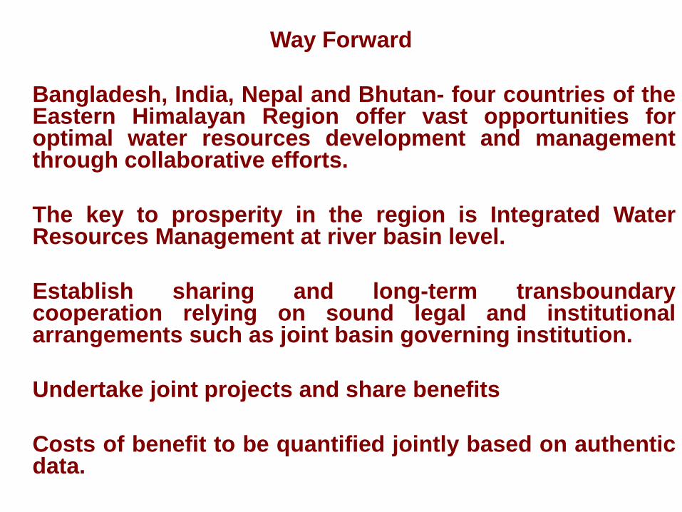
Way Forward
Bangladesh, India, Nepal and Bhutan- four countries of the Eastern Himalayan Region offer vast opportunities for optimal water resources development and management through collaborative efforts.
The key to prosperity in the region is Integrated Water Resources Management at river basin level.
Establish sharing and long-term transboundary cooperation relying on sound legal and institutional arrangements such as joint basin governing institution.
Undertake joint projects and share benefits
Costs of benefit to be quantified jointly based on authentic data.

THANK YOU


![Transboundary Work Group on Pathogen Impairments in the ...gato-docs.its.txstate.edu/the-rivers-institute/Intro-Eric.pdf · Microsoft PowerPoint - Intro-Eric.ppt [Compatibility Mode]](https://static.fdocuments.us/doc/165x107/5f52689021ea2856d945d287/transboundary-work-group-on-pathogen-impairments-in-the-gato-docsits-microsoft.jpg)