Bahir Libo Small Scale Diversion Irrigation Project ...
33
Bahir Libo Small Scale Diversion Irrigation Project, Geological and Geo-technical Study Report ADSWE, IRRIGATION & DRAINAGE P.O. BOX: 1921 TEL: 058--218--06--38/10 23 FAX: 058--218-0550/0560
Transcript of Bahir Libo Small Scale Diversion Irrigation Project ...

Bahir Libo Small Scale Diversion Irrigation Project, Geological and Geo-technical Study Report
ADSWE, IRRIGATION & DRAINAGE P.O. BOX: 1921 TEL: 058--218--06--38/10 23 FAX: 058--218-0550/0560

Bahir Libo Small Scale Diversion Irrigation Project, Geological and Geo-technical Study Report
ADSWE, IRRIGATION & DRAINAGE P.O. BOX: 1921 TEL: 058--218--06--38/10 23 FAX: 058--218-0550/0560
Table of Contents 1.Introduction ............................................................................................................................................... 4
1.2 General ................................................................................................................................................ 6
1.2 Objectives ........................................................................................................................................... 8
1.3Methodologies and Approaches .......................................................................................................... 9
1.4 Materials Used .................................................................................................................................... 9
2. Geology of the Study Area ...................................................................................................................... 13
2.1 Regional Geology .............................................................................................................................. 13
2.3 Local Geology .................................................................................................................................... 15
2.3.1 Basaltic Agglomerate ................................................................................................................. 15
2.3.2 Unconsolidated Deposit ............................................................................................................. 15
3. Seismicity Condition of the Area ............................................................................................................. 16
4. Engineering Geological and Geo-technical Investigation ....................................................................... 18
4.1 Headwork Site ............................................................................................................................... 18
4.1.2 Left Bank and Right Bank ........................................................................................................... 18
4.1.3 Stream Bed ................................................................................................................................. 19
4.2 Main Canal Route .............................................................................................................................. 21
4.3 Natural Construction Materials ........................................................................................................ 25
4.3.1 Rock Quarry ................................................................................................................................ 25
4.3.3 Fine Aggregates .......................................................................................................................... 26
4.3.4 Canal Fill Material ...................................................................................................................... 28
ANNEXTURE - 1 TEST PIT LOGS ................................................................................................................... 30
ANNEXTURE-2 LABORATORY TEST RESULTS .............................................................................................. 33
Bahir Libo Small Scale Diversion Irrigation Project, Geological and Geo-technical Study Report
ADSWE, IRRIGATION & DRAINAGE P.O. BOX: 1921 TEL: 058--218--06--38/10 23 FAX: 058--218-0550/0560
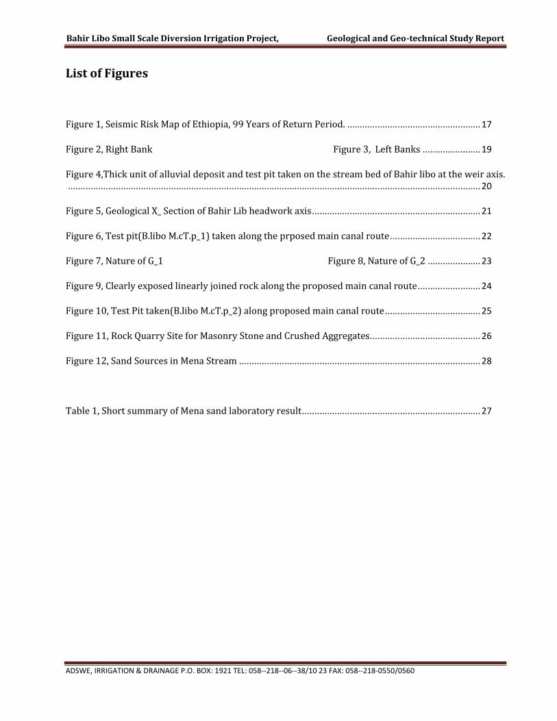
List of Figures
Figure 1, Seismic Risk Map of Ethiopia, 99 Years of Return Period. ..................................................... 17
Figure 2, Right Bank Figure 3, Left Banks ....................... 19
Figure 4,Thick unit of alluvial deposit and test pit taken on the stream bed of Bahir libo at the weir axis. .................................................................................................................................................................... 20
Figure 5, Geological X_ Section of Bahir Lib headwork axis ................................................................... 21
Figure 6, Test pit(B.libo M.cT.p_1) taken along the prposed main canal route .................................... 22
Figure 7, Nature of G_1 Figure 8, Nature of G_2 ..................... 23
Figure 9, Clearly exposed linearly joined rock along the proposed main canal route ......................... 24
Figure 10, Test Pit taken(B.libo M.cT.p_2) along proposed main canal route ...................................... 25
Figure 11, Rock Quarry Site for Masonry Stone and Crushed Aggregates ............................................ 26
Figure 12, Sand Sources in Mena Stream ................................................................................................ 28
Table 1, Short summary of Mena sand laboratory result ....................................................................... 27

Bahir Libo Small Scale Diversion Irrigation Project, Geological and Geo-technical Study Report
ADSWE, IRRIGATION & DRAINAGE P.O. BOX: 1921 TEL: 058--218--06--38/10 23 FAX: 058--218-0550/0560
BAHIR LIBO SMALL SCALE IRRIGATION PROJECT
Volume II: ENGINEERING GEOLOGY
Sept, 2016
Bahir Dar
Client: Amhara National Regional State Water, Irrigation And Energy Development Bureau
(BoWIED)
Address:
P. O. Box: 88
Telephone: 0528-200853/855
Fax: 251-08-20-65-68/204676/202040
Consultant: Amhara Design & Supervision Works Enterprise
(ADSWE)
Address:
P. O. Box: 1921
Telephone: +251-582-181023/ 180638/181201/181254
Fax :( 058) 2180550/ (058) 2180560
E-mail: amhara [email protected]
Bahir Dar, Ethiopia
Bahir Libo Small Scale Diversion Irrigation Project, Geological and Geo-technical Study Report
ADSWE, IRRIGATION & DRAINAGE P.O. BOX: 1921 TEL: 058--218--06--38/10 23 FAX: 058--218-0550/0560
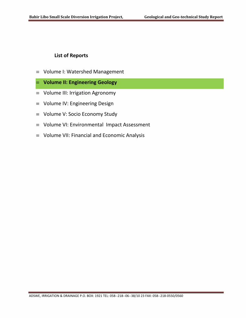
List of Reports
Volume I: Watershed Management
Volume II: Engineering Geology
Volume III: Irrigation Agronomy
Volume IV: Engineering Design
Volume V: Socio Economy Study
Volume VI: Environmental Impact Assessment
Volume VII: Financial and Economic Analysis

Bahir Libo Small Scale Diversion Irrigation Project, Geological and Geo-technical Study Report
ADSWE, IRRIGATION & DRAINAGE P.O. BOX: 1921 TEL: 058--218--06--38/10 23 FAX: 058--218-0550/0560 Page 6
1.Introduction
1.2 General
The study and design work of Bahir Libo Small Scale Irrigation Project is being carried out
by Amhara Design and supervision works Enterprise (ADSWE). The owner of the project is
Amhara Region Bureau of Water, Irrigation and Energy Resource development.
It is known that agriculture is the back bone of our economy. Hence to maximize
agricultural production for the domestic use and to supplement industry lead economy,
irrigation is the non-alternate option. So, it will assist rain fed agriculture and alleviate the
impact of recurrent draught in the country. This can be achieved by working together with
the community, local and international NGOs and the government organizations so as to
use all the available resources efficiently and bring significant change.
Amhara design and supervision Works Enterprise (ADSWE) is established to do its part in
the study, design and supervision of water structures, in the area of land use and water
shed management, irrigation and water supply of the region as well as the country. ADSWE
has assigned a multidisciplinary qualified professional crew to study and design on the
Irrigation projects.
The project Woreda, East Belesa Woreda, is one of the draught prone Woreda in the
Amhara Region. Bahir Libo Small Scale Irrigation Project is designed based on the client’s
requirement to address the beneficiaries demand. It is believed that this irrigation project
will change the living standard of that society in supplementary irrigation as well as in full
irrigation system. Technical, environmental and socio economic issues are well addressed
by the respective disciplinary. The potential beneficiaries’ show their interest in the
execution of the project and the scheme after execution is supposed to be handed over to
the farmers cooperatives for operation and maintenance of canal system and water
regulation.

Bahir Libo Small Scale Diversion Irrigation Project, Geological and Geo-technical Study Report
ADSWE, IRRIGATION & DRAINAGE P.O. BOX: 1921 TEL: 058--218--06--38/10 23 FAX: 058--218-0550/0560 Page 7
For the design of various stable and cost effective engineering structures in different parts
of the project, the areas were investigated to gather engineering geological and
geotechnical input data. This engineering geological feasibility study was carried out from
April 7 to 15, 2008EC.
Geotechnical investigations are performed to evaluate those geologic, and soil conditions
that affect the safety, cost effectiveness, design and excavation of the proposed project. The
fact that insufficient, faulty interpretation of results, or failure to portray results in a clearly
understandable manner may contribute to inappropriate designs, delay in construction
schedules, costly construction modifications, use of sub-standard borrow material,
environmental damage to the site, post construction remedial work and even failure of a
structure and subsequent litigation. Hence, geotechnical investigation is usually thought of
as the backbone of engineering structure design.
Investigations performed to determine the geologic setting of the project include the
geology (nature and behavior of rock materials), soil and rock behaviors, and seismic
conditions. This parameters influence the construction site selection through the control of
the characteristics of the foundation soil and rocks, geotechnical conditions, project safety,
design, and construction, critical geomorphic processes and source of natural construction
materials.
Based on the above facts, the site selection criteria and factors that should be taken in to
account in studying the diversion site are as listed below:
Nature of subsurface material at the diversion axis and potential cannel route with the
fact that they should be sound and resistant to bear the load imposed by the weight of
the overlying materials, including the structures to be built.
Suitability (shape and depth) and stability of the valley slopes at the abutment and
capability to bear the lateral pressure imposed by the nearby soil material.
Nature of the abutment ground material in reaction with water (solution resistant rock,
soil, or nature of clay material).
Uniformity of geological formations, geological structures and their continuity.

Bahir Libo Small Scale Diversion Irrigation Project, Geological and Geo-technical Study Report
ADSWE, IRRIGATION & DRAINAGE P.O. BOX: 1921 TEL: 058--218--06--38/10 23 FAX: 058--218-0550/0560 Page 8
Topographic conditions of the river both upstream and downstream of the anticipated
weir axis.
Relation of the anticipated diversion axis with the potential canal route and the
available command area.
Availability and quality of naturally occurring construction materials within an
economically justified distance from the project site.
1.2 Objectives
The study is focused to give sufficient pertinent information on the geologic formations and
their suitability for proposed construction. Consequently, the specific objectives to be
addressed within this study are:
Developing overall approach on the geological parameters through investigation of
surface and subsurface geological conditions of the site to provide geotechnical inputs
needed for the design of the diversion structure and main canal, so that the project
becomes cost effective, durable and socially acceptable.
Explaining the local geology and developing findings to the rock units and structural
patterns on the context of the local area of interest.
Locating the specific sites for the construction of the headwork and potential canal
routes, which are resolute on the basis of:
Determining the geotechnical conditions of the headwork axis and potential canal
routes.
Defining the distribution of formations in space.
Suitability of the land and stability of the foundation material for the construction
and establishment of stable water tight zone.
Strength, workability and permeability of the existing formations.
Providing pertinent and reasonable information for post survey data analysis in the
design and construction of the proposed structures.
Bahir Libo Small Scale Diversion Irrigation Project, Geological and Geo-technical Study Report
ADSWE, IRRIGATION & DRAINAGE P.O. BOX: 1921 TEL: 058--218--06--38/10 23 FAX: 058--218-0550/0560 Page 9
Determining the qualities and identifying the sources of naturally available
construction materials within an economically feasible distance from the construction
site.
Defining ground water condition and its influence on the structures.
1.3Methodologies and Approaches
A technical and systematic procedure of geotechnical investigation includes:-
Taking Test pits and augur holes along the potential canal routes, headwork axis, and
taking representative samples from them for laboratory testing,
Observing surfaces, river cuts and gully exposures to identify the nature of lithological
units and their depositional history by making geological traverses.
Making several options both upstream and downstream of the headwork axis to select
the best diversion site and include maximum irrigable command area, so that the
project will be cost effective, durable and sanctioned by the local communities.
1.4 Materials Used
To facilitate the geotechnical feasibility study assigned for the project work and to address
the objectives set for it, the following materials were used during field investigation.
Measuring Tape meter
Handheld GPS
Digital camera and Sample Bags.
1.5 Location and Accessibility
The project area is located in East Belesa Woreda of North Gondar Zone, Amhara Region.
The head work site and command area are located in same kebele, Goga Kebele. The head
work site is located in sheha Got.

Bahir Libo Small Scale Diversion Irrigation Project, Geological and Geo-technical Study Report
ADSWE, IRRIGATION & DRAINAGE P.O. BOX: 1921 TEL: 058--218--06--38/10 23 FAX: 058--218-0550/0560 Page 10
The project Head work site is accessible by vehicle via 85km asphalt road from the regional
city Bahir Dar through Addis Zemen, 84km all weather road from Addis Zemen to Guhal,
East Belesa Wereda capital town and 30km all weather road from Guhala to Project Kebele.
The head work site and the Main command area is not accessible by road but on foot. The
head work is 3km far from the access road.
The geographic coordinate of the position of the head work site is 411036 Easting,
1376602m Northing, and 1647m Altitude in UTM_ADINDAN Coordinate system. The
command area lays between 11376444.837 & 1378190.97 North and between 410939.737
& 413920.18 Easting. (See fig 1.1 & 1.2). The command elevation also ranges from 1660.4
to 1598.5.

Bahir Libo Small Scale Diversion Irrigation Project, Geological and Geo-technical Study Report
ADSWE, IRRIGATION & DRAINAGE P.O. BOX: 1921 TEL: 058--218--06--38/10 23 FAX: 058--218-0550/0560 Page 11
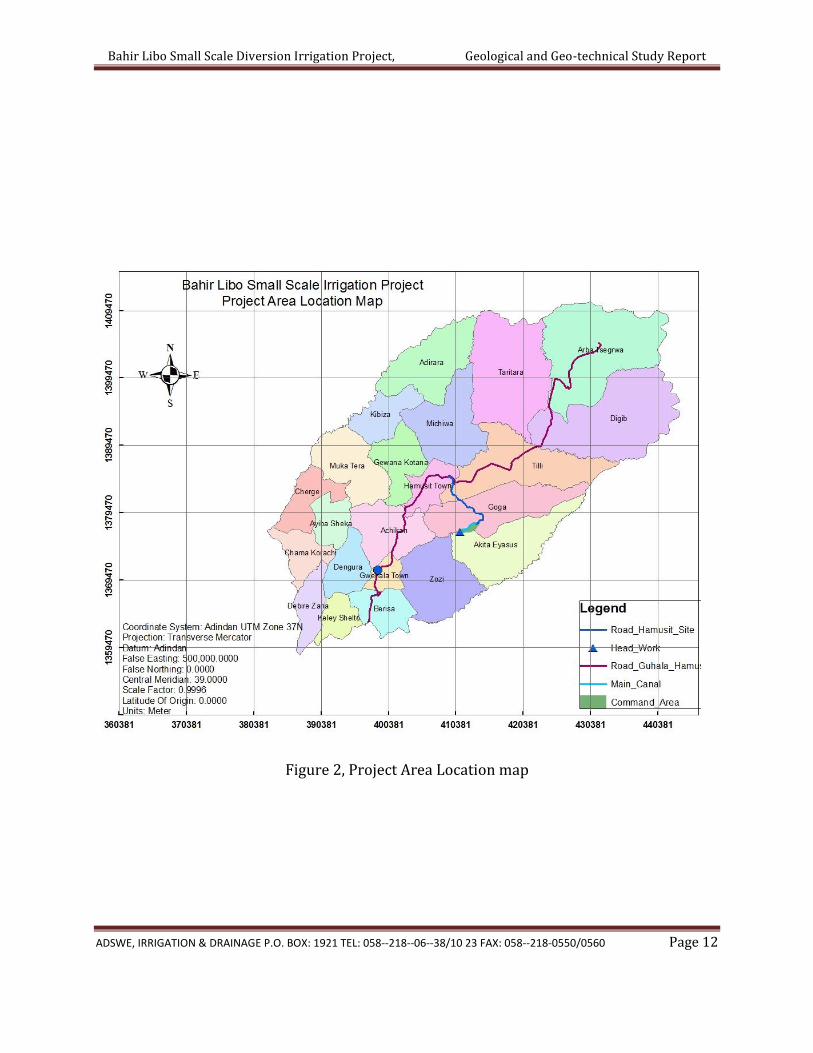
Figure 1,Project Woreda Location map
Bahir Libo Small Scale Diversion Irrigation Project, Geological and Geo-technical Study Report
ADSWE, IRRIGATION & DRAINAGE P.O. BOX: 1921 TEL: 058--218--06--38/10 23 FAX: 058--218-0550/0560 Page 12
Figure 2, Project Area Location map
Bahir Libo Small Scale Diversion Irrigation Project, Geological and Geo-technical Study Report
ADSWE, IRRIGATION & DRAINAGE P.O. BOX: 1921 TEL: 058--218--06--38/10 23 FAX: 058--218-0550/0560 Page 13
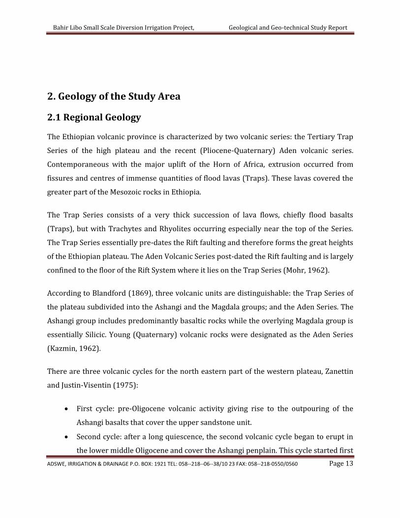
2. Geology of the Study Area
2.1 Regional Geology
The Ethiopian volcanic province is characterized by two volcanic series: the Tertiary Trap
Series of the high plateau and the recent (Pliocene-Quaternary) Aden volcanic series.
Contemporaneous with the major uplift of the Horn of Africa, extrusion occurred from
fissures and centres of immense quantities of flood lavas (Traps). These lavas covered the
greater part of the Mesozoic rocks in Ethiopia.
The Trap Series consists of a very thick succession of lava flows, chiefly flood basalts
(Traps), but with Trachytes and Rhyolites occurring especially near the top of the Series.
The Trap Series essentially pre-dates the Rift faulting and therefore forms the great heights
of the Ethiopian plateau. The Aden Volcanic Series post-dated the Rift faulting and is largely
confined to the floor of the Rift System where it lies on the Trap Series (Mohr, 1962).
According to Blandford (1869), three volcanic units are distinguishable: the Trap Series of
the plateau subdivided into the Ashangi and the Magdala groups; and the Aden Series. The
Ashangi group includes predominantly basaltic rocks while the overlying Magdala group is
essentially Silicic. Young (Quaternary) volcanic rocks were designated as the Aden Series
(Kazmin, 1962).
There are three volcanic cycles for the north eastern part of the western plateau, Zanettin
and Justin-Visentin (1975):
First cycle: pre-Oligocene volcanic activity giving rise to the outpouring of the
Ashangi basalts that cover the upper sandstone unit.
Second cycle: after a long quiescence, the second volcanic cycle began to erupt in
the lower middle Oligocene and cover the Ashangi penplain. This cycle started first

Bahir Libo Small Scale Diversion Irrigation Project, Geological and Geo-technical Study Report
ADSWE, IRRIGATION & DRAINAGE P.O. BOX: 1921 TEL: 058--218--06--38/10 23 FAX: 058--218-0550/0560 Page 14
with flood basalts (Aiba basalts) and later with large quantities of ignimbrites
(alkaline rhyolites and trachytes) with variable quantities of interbedded basalts,
collectively known as the Alaji rhyolites. This cycle culminated in the emission of
large quantities of basalt, termed Tarmaber basalts, that cover most of the Alaji
rhiolites.
The third cycle is confined more to the rift and its periphery and also to the Lake
Tana Area of Plio-Pleiostocene age.
The Trap Series, consisting of Asahngi, Aiba, Alaji and Tarmaber formations, make up the
regional rock units from bottom to top in the north eastern part of the western plateau.
The Ashangi formation is tholeiitic and/or basalts (Zenettin et al., 1978). The Aiba basalts,
which overlie the lower Ashangi basalts unconformably, are transitional between tholeiitic
and alkaline basalts. The Alagi rhyolites and basalts, which are a product of fissural
volcanism, are dominantly Silicic and are made up of alkaline rhyolites and Sodic
ignimbrites intercalated with variable quantities of transitional basalts. Tarmaber basalts
are products of central eruption and are alkaline in composition.
The Tarmaber Series consists of lenticular basalts with a large amount of tuffs, scoriaceous
lava flows and typical red paleosoils (Merla et al., 1973). The Tarmaber basalt is a thick
sequence that reaches 1,000 m and when thicker, characterizes volcanic centres such as
Guna Terara. The Tarmaber basalts, which directly overlie the Ashangi basalts (in
northwestern Ethiopia), mark the Tertiary volcanic cycle in the region. Based on a few
sections from the eastern and southern part of the plateau, the above was assumed to be
valid until recent times for the entire western plateau. However, according to the recent
works of Pik et al. (1998), this stratigraphy is not valid for the whole north western
plateau. Furthermore, field observations of the group on well exposed escarpments suggest
the existence of a continuous lava sequence from the base to the top of the plateau, rather
than the piling of two or more successive and stratigraphically distinct units as suggested
for the north eastern part of the plateau.

Bahir Libo Small Scale Diversion Irrigation Project, Geological and Geo-technical Study Report
ADSWE, IRRIGATION & DRAINAGE P.O. BOX: 1921 TEL: 058--218--06--38/10 23 FAX: 058--218-0550/0560 Page 15
Based on this recent study in the north western plateau, from samples collected from
bottom to top of the lava pile in a section located north eastern of Gondar (near the study
area), the lavas mostly consist of basalts, except on the top of the plateau, where ignimbrite
tuffs, a few metres thick, are exposed.
2.3 Local Geology
The geology of the study area is characterized by unconsolidated deposit and basaltic
agglomerate. Brief description of these geological units is presented in the following
section.
2.3.1 Basaltic Agglomerate
The major part of the study area is covered with basaltic agglomerate rock type. It is
predominantly exposed at the left and right banks and the surrounding ridges near the
headwork site. It is mainly found as blocky form. However, in few localities namely in the
left and right banks, closely to widely spaced joints has been observed.
2.3.2 Unconsolidated Deposit
Most part of the stream bed are covered with unconsolidated deposit. The deposit has been
classified as alluvial on the basis of its origin.

Bahir Libo Small Scale Diversion Irrigation Project, Geological and Geo-technical Study Report
ADSWE, IRRIGATION & DRAINAGE P.O. BOX: 1921 TEL: 058--218--06--38/10 23 FAX: 058--218-0550/0560 Page 16
3. Seismicity Condition of the Area
Earthquake is the result of a sudden release of energy in the earth’s crust that creates
seismic waves. The seismicity of an area refers to the frequency, type and size of
earthquakes experienced over a long period of time.
To construct effective and long-lasting hydraulic structures, assessments on susceptibility
to seismic hazards are fundamental issues. Therefore, the degree of seismicity of the area
should be taken in to account with great emphasis as an important design parameter by
evaluating the seismic nature of the area from history and records of previous earthquakes
and knowledge of local geology. However the seismic susceptibility study is usually made
with the application of secondary data from the national geophysics and geo-observatory
data sources. The most famous edition in the Ethiopian context is the seismic susceptibility
map of the country by Laike Mariam Asfaw, 1986. According to the seismic hazard map of
Ethiopia, the country has been subdivided in to five seismic Zones as: Zone (o), Zone (1),
Zone (2), Zone (3) and Zone (4), the no hazard, the low hazard, the moderate hazard, the
higher hazard and the highest hazard zones, respectively.

Bahir Libo Small Scale Diversion Irrigation Project, Geological and Geo-technical Study Report
ADSWE, IRRIGATION & DRAINAGE P.O. BOX: 1921 TEL: 058--218--06--38/10 23 FAX: 058--218-0550/0560 Page 17
Figure 3, Seismic Risk Map of Ethiopia, 99 Years of Return Period.
Bahir Libo Project Site

Bahir Libo Small Scale Diversion Irrigation Project, Geological and Geo-technical Study Report
ADSWE, IRRIGATION & DRAINAGE P.O. BOX: 1921 TEL: 058--218--06--38/10 23 FAX: 058--218-0550/0560 Page 18
4. Engineering Geological and Geo-technical Investigation
This part emphasizes on the details of engineering geology and geo-technical aspects of the
project focusing on strength and permeability characteristics of the underlying formations
over which proposed structures lies, mainly at headwork and along main canal route. In
addition to this, required natural construction materials' source areas and their suitability
conditions are discussed.
4.1 Headwork Site
For this project a simple weir diversion structure has been proposed for diverting the
water to the main canal. The headwork site geological surface and subsurface conditions
have been investigated based on the nature of the proposed structure. At the site and
immediate vicinity, the stream flows along moderate slope course and its bed is mainly
covered with thick layer of all sized recently deposited alluvial sediment. Such deposit
covers from bank to bank in downstream and upstream direction. On the other hand, the
right banks of the stream at the headwork site are made up of different geologic materials;
Both banks have well defined vertical well with moderately to highly weathered and
jointed basaltic agglomerate. This nature extend both in upstream and downstream
direction. Detail geologic nature of the banks, and bed of the stream along the headwork
axis and immediate vicinity are described and their potential geotechnical influence on the
proposed structures also discerned/detected below, with remedial measures.
4.1.2 Left Bank and Right Bank
The engineering geological foundation conditions at both banks are nearly similar, except
variation in extent or dimensions of the rock units. It has steep slope nearly vertical well defined
rock banks. The surfaces of both banks are covered with moderately to highly weathered and
jointed rock. These rock has a characteristic of light yellowish color coarse grain basaltic

Bahir Libo Small Scale Diversion Irrigation Project, Geological and Geo-technical Study Report
ADSWE, IRRIGATION & DRAINAGE P.O. BOX: 1921 TEL: 058--218--06--38/10 23 FAX: 058--218-0550/0560 Page 19
agglomerate. These rock unit have steep slope nature with widely spaced joints with maximum
opening of 2cm. Beside to its jointed nature it undergoes moderately to highly weathering stage.
on the right bank, it has up to 5m height while in the left bank it reaches up to 8m. At about 7m
upstream, the stream channel minder with a bank of highly jointed and weathered nature. Hence
both banks are unstable and loss forming small caves. These weak and pervious banks are need
protection work in the headwork site up to 20m in upstream and downstream direction.
Figure 4, Right Bank Figure 5, Left Banks
4.1.3 Stream Bed
At the proposed headwork site the stream bed or course is well defined, nearly straight,
and minder at about 7m upstream from headwork site. Along the weir axis, the bed is
made up of one major geologic materials, as seen from surface observation. These are all
sized recently deposited alluvial deposit.
On the proposed weir axis and some kilometer upstream and downstream test the stream
had covered with thick unit of transported sediment. At the foundation test pit was taken
(B.Libo Fo.T.p_1), but due to in flow of water through these thick sediment test was

Bahir Libo Small Scale Diversion Irrigation Project, Geological and Geo-technical Study Report
ADSWE, IRRIGATION & DRAINAGE P.O. BOX: 1921 TEL: 058--218--06--38/10 23 FAX: 058--218-0550/0560 Page 20
interrupted at shallow depth (0.5m). Due to these generally the structure are founded on
these thick alluvial sediment. Hence from test pit taken on the foundation area, sample are
taken to ADSWE soil laboratory for gradation test.
Figure 6,Thick unit of alluvial deposit and test pit taken on the stream bed of Bahir libo at the weir axis.
Since the structure are founded on these thick alluvial deposit, effective grain size (Silt
Factor) for such deposit are taken 3mm from gradation test of foundation sample.

Bahir Libo Small Scale Diversion Irrigation Project, Geological and Geo-technical Study Report
ADSWE, IRRIGATION & DRAINAGE P.O. BOX: 1921 TEL: 058--218--06--38/10 23 FAX: 058--218-0550/0560 Page 21
Figure 7, Geological X_ Section of Bahir Lib headwork axis
4.2 Main Canal Route
For this particular project, the main canal route has length of about 3.5km. Within this
length, the canal passes different geologic materials, which varies both surfacially and to
depth. The distribution of the geologic materials with respect to the canal route, and their
characteristics, especially permeability, stability and workability have been investigated
during the field work using both visual inspection and subsurface by taking test pit. About
2 test pit (B.libo M.cT.p_1 and B.libo M.cT.p_2) and Augur hole were bored at places where
there is geologic variation and no surface natural exposures/cuts are not found.
From simple visual examination of the route, two geological materials have been identified
at different reaches. The materials are:-

Bahir Libo Small Scale Diversion Irrigation Project, Geological and Geo-technical Study Report
ADSWE, IRRIGATION & DRAINAGE P.O. BOX: 1921 TEL: 058--218--06--38/10 23 FAX: 058--218-0550/0560 Page 22
a. Thin layer of silty Clayey
b. Moderately to highly weathered rock
The distribution of these materials along the main canal and their geotechnical properties,
especially permeability, and workability are described below from the outlet point to end.
Hence for this project, a main canal has been proposed in the left side of the diversion structure.
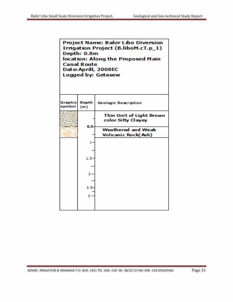
From about out let to about chainage 1+480m, the ground is characterized by
relatively thin layer of Silty clayey soil (which ranges from 0.4 to 0.6m), as it can be
seen from test pit taken(B.libo M.cT.p_1) . The soil has light brown color. It is dry in
all depth. The soil possesses medium plasticity, with stiff consistency. Under this
unit highly friable weathered ash had encounter (see in test pit log ANXXTURE 1). It
had whitish color with pervious nature. This portion of the main canal route is a
farmland having moderate slope. Since the top soil is removed during excavation
and the rout lies on the underlying pervious rock, the canal should be designed as
lined.
Figure 8, Test pit(B.libo M.cT.p_1) taken along the proposed main canal route
On the above chainage (From out let up to a chainage of 1+480) there are two
gullies (G_1 and G_2) found on 417m and 805m from headwork site respectively.

Bahir Libo Small Scale Diversion Irrigation Project, Geological and Geo-technical Study Report
ADSWE, IRRIGATION & DRAINAGE P.O. BOX: 1921 TEL: 058--218--06--38/10 23 FAX: 058--218-0550/0560 Page 23
They have similar geological nature at the stream bed, with recently deposited
alluvial sediment dominantly fine sand and silt. The width of G_1 are wide and very
short bank relatively to G2. Banks of both gullies are light brown color, weak silty
clayey soil. The thickness of these soil in G-2 reach up to maximum of 1m as easily
see from natural cut. under that weathered and fragmented volcanic rock are
expected.
Figure 9, Nature of G_1 Figure 10, Nature of G_2
From chainage 1+480 up to 1+592m, the route pass on clearly exposed dark gray
color highly jointed rock. These rock have very narrowly spaced linearly aligned
joints with very tight opening. Hence these jointed rock have pervious nature
proposed main canal route along the chainage should be lined probably in masonry.

Bahir Libo Small Scale Diversion Irrigation Project, Geological and Geo-technical Study Report
ADSWE, IRRIGATION & DRAINAGE P.O. BOX: 1921 TEL: 058--218--06--38/10 23 FAX: 058--218-0550/0560 Page 24
Figure 11, Clearly exposed linearly joined rock along the proposed main canal route
From chainage 1+592m up to End, the ground is characterized by relatively Thin
layer of dark brown color Clay soil (average thickness of 0.9m), as it can be seen
from test pit taken(B.libo M.cT.p_2) . The soil has dark brown color. It is dry in all
depth. The soil possesses medium to highly plasticity. Under this unit highly
weathered and jointed rock had encounter (see in test pit log ANXXTURE 1). It had
dark gray color with pervious nature. This portion of the main canal route have
moderate slope and Since the top soil is removed during excavation and the rout
lies on the underlying pervious rock, the canal should be designed as lined.

Bahir Libo Small Scale Diversion Irrigation Project, Geological and Geo-technical Study Report
ADSWE, IRRIGATION & DRAINAGE P.O. BOX: 1921 TEL: 058--218--06--38/10 23 FAX: 058--218-0550/0560 Page 25
Figure 12, Test Pit taken(B.libo M.cT.p_2) along proposed main canal route
4.3 Natural Construction Materials
During the site investigation, natural construction materials required for the construction
of the various proposed engineering structures at the headwork and within the farmland
have been assessed, and possible quarry sites and borrow areas have been identified
within the vicinity of the area as much as possible. In addition to the identification, the
quality, quantity, accessibility condition and ownership of each proposed production sites
have also been studied and described in this report; on separate sub-sections below. The
natural materials required for the construction of the proposed hydraulic structures
include rock for masonry stones, aggregates (both coarse and fine), impervious soil for fill
and/or lining, backfill soil, and water.
4.3.1 Rock Quarry
Quarry site that can be used for production of rock for masonry stone and crushed coarse
aggregates has been assessed during the field work session within the vicinity of the
project area at economic distance for hauling. One possible quarry site has been identified

Bahir Libo Small Scale Diversion Irrigation Project, Geological and Geo-technical Study Report
ADSWE, IRRIGATION & DRAINAGE P.O. BOX: 1921 TEL: 058--218--06--38/10 23 FAX: 058--218-0550/0560 Page 26
within left side/bank of the headwork to about 200m and 650m downstream following a
continuous ridge bordering the left side of Bahir Libo stream. The rock is located in the
same Kebele, at Zenaboch and Sheha “Got” to the project respectively.
Figure 13, Rock Quarry Site for Masonry Stone and Crushed Aggregates
Naturally, this rock is strong as it is generally fresh except very thin cover of weathered
zones, which need to be removed during rock dressing and before crushing From this site,
rock of different sizes can be produced; ranging from large boulders to coarse gravels that
masonry stone and coarse aggregate can be produced easily.
4.3.3 Fine Aggregates
Borrow areas for fine aggregate or natural sand have been assessed starting from the
project stream itself. Natural deposits of such materials couldn’t be found when assessed
within the beds of the stream in the project area; rather very coarser sediments and rock
exposures are found covering almost the entire bed of the Bahir Libo stream. Seeing to this
nature of the stream, other distant streams have been explored to identify the best source
areas for fine aggregate or natural sand that can be used for this particular project. During

Bahir Libo Small Scale Diversion Irrigation Project, Geological and Geo-technical Study Report
ADSWE, IRRIGATION & DRAINAGE P.O. BOX: 1921 TEL: 058--218--06--38/10 23 FAX: 058--218-0550/0560 Page 27
exploration of this natural sand, at a distant one stream was identified as a possible source
of fine sand. The stream is known as ‘Mena’. It is located at about 90km from the project
site, within Arbay belesa Woreda
Both visual investigation and laboratory testing of the sand deposit found in the proposed
area have been done. It has more than 60% of sand with almost nil percent of silt and clay
even if it has significant percent of Gravel. In the area good quantity, which suffices the
need of this project, is available. The deposit is dominated by sand sized transported
alluvial sediments, though some amount over sizes are also observed. The individual grains
of sand are mainly originated from basalt rock and reveals high crushing resistant that the
sand has good quality in this respect.
The samples have been analyzed at Amhara Design and Supervision material Testing
laboratory to characterize the gradation of the sand deposit. According to these laboratory
test results (See Annexture-2).
Table 1, Short summary of Mena sand laboratory result
Sand Sources Mena Pump_sample_1 Mena Pump_Sample_2
Gravel 37.69 20.05
Coarse Sand 58.32 61.14
Fine Sand 3.38 16.35
Silt and Clay 0.61 2.46

Bahir Libo Small Scale Diversion Irrigation Project, Geological and Geo-technical Study Report
ADSWE, IRRIGATION & DRAINAGE P.O. BOX: 1921 TEL: 058--218--06--38/10 23 FAX: 058--218-0550/0560 Page 28
Figure 14, Sand Sources in Mena Stream
4.3.4 Canal Fill Material
Along the main canal route, there are some places where the original ground level is lower
than the designed canal bed level (CBL). In this case the OGL need to be filled till at least to
the CBL. For such fill, natural fine grained soil material having low to medium plasticity,
non-expansive and impervious is required. For this project such soil material
source/borrow area is identified at about Tire kebele at about 1.8km from the headwork
Specific Got of Bisrako
From visual examination of the borrow area, the soil has reddish brown color, and
composed of dominantly Clay with Gravel. It is residual soil having low plasticity and low
liquid limit. It is non expansive soil.
According to the Unified Soil Classification System, the soil group lies in Low plastic Clay
(CL). Such soil type possesses a maximum dry density (MDD) lies within 1.80gm/cc, and
the associated optimum moisture content (OMC) 17.53%. The construction of the fill can be
then done using these parameters

Bahir Libo Small Scale Diversion Irrigation Project, Geological and Geo-technical Study Report
ADSWE, IRRIGATION & DRAINAGE P.O. BOX: 1921 TEL: 058--218--06--38/10 23 FAX: 058--218-0550/0560 Page 29
Bahir Libo Small Scale Diversion Irrigation Project, Geological and Geo-technical Study Report
ADSWE, IRRIGATION & DRAINAGE P.O. BOX: 1921 TEL: 058--218--06--38/10 23 FAX: 058--218-0550/0560 Page 30
ANNEXTURE - 1 TEST PIT LOGS
Bahir Libo Small Scale Diversion Irrigation Project, Geological and Geo-technical Study Report
ADSWE, IRRIGATION & DRAINAGE P.O. BOX: 1921 TEL: 058--218--06--38/10 23 FAX: 058--218-0550/0560 Page 31

Bahir Libo Small Scale Diversion Irrigation Project, Geological and Geo-technical Study Report
ADSWE, IRRIGATION & DRAINAGE P.O. BOX: 1921 TEL: 058--218--06--38/10 23 FAX: 058--218-0550/0560 Page 32
Bahir Libo Small Scale Diversion Irrigation Project, Geological and Geo-technical Study Report
ADSWE, IRRIGATION & DRAINAGE P.O. BOX: 1921 TEL: 058--218--06--38/10 23 FAX: 058--218-0550/0560 Page 33
ANNEXTURE-2 LABORATORY TEST RESULTS