Lajas Valley Agricultural Reserve Farm Inventory of the Guánica ...

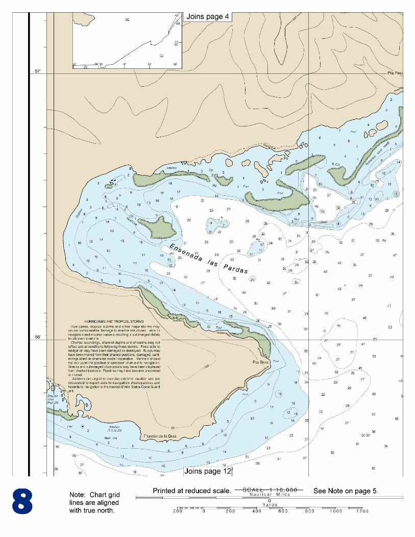
BookletChart™ Bahía de Guánica NOAA Chart 25679
A reduced-scale NOAA nautical chart for small boaters When possible, use the full-size NOAA chart for navigation.

2
Published by the National Oceanic and Atmospheric Administration
National Ocean Service Office of Coast Survey
www.NauticalCharts.NOAA.gov 888-990-NOAA
What are Nautical Charts?
Nautical charts are a fundamental tool of marine navigation. They show water depths, obstructions, buoys, other aids to navigation, and much more. The information is shown in a way that promotes safe and efficient navigation. Chart carriage is mandatory on the commercial ships that carry America’s commerce. They are also used on every Navy and Coast Guard ship, fishing and passenger vessels, and are widely carried by recreational boaters.
What is a BookletChart?
This BookletChart is made to help recreational boaters locate themselves on the water. It has been reduced in scale for convenience, but otherwise contains all the information of the full-scale nautical chart. The bar scales have also been reduced, and are accurate when used to measure distances in this BookletChart. See the Note at the bottom of page 5 for the reduction in scale applied to this chart.
Whenever possible, use the official, full scale NOAA nautical chart for navigation. Nautical chart sales agents are listed on the Internet at http://www.NauticalCharts.NOAA.gov.
This BookletChart does NOT fulfill chart carriage requirements for regulated commercial vessels under Titles 33 and 44 of the Code of Federal Regulations.
Notice to Mariners Correction Status
This BookletChart has been updated for chart corrections published in the U.S. Coast Guard Local Notice to Mariners, the National Geospatial Intelligence Agency Weekly Notice to Mariners, and, where applicable, the Canadian Coast Guard Notice to Mariners. Additional chart corrections have been made by NOAA in advance of their publication in a Notice to Mariners. The last Notices to Mariners applied to this chart are listed in the Note at the bottom of page 7. Coast Pilot excerpts are not being corrected.
For latest Coast Pilot excerpt visit the Office of Coast Survey website at http://www.nauticalcharts.noaa.gov/nsd/searchbychart.php?chart=25679.
(Selected Excerpts from Coast Pilot) Bahia de Guanica, 16 miles E of Cabo Rojo Light, is small but one of the best hurricane harbors in Puerto Rico. The bay is protected by the steep, high, and wooded shores on the E and W sides. Large vessels call to load fertilizer, sugar, and molasses at the ports of Guanica and Ensenada. Prominent features.–An abandoned light-house tower on Punta Meseta is prominent in the daytime. Power transmission towers located on either side of the channel and a
39-foot water tower NW of Punta Meseta are visible from seaward. Once inside the harbor, the most prominent objects are: two stacks at
the sugar mill, a cupola at a large house near the sugar mill, and a fixed crane at the fertilizer wharf 0.5 mile N of Punta Meseta. Channels.–Bahia de Guanica is entered through a buoyed approach channel, about 0.8 mile SE of Punta Brea (17°56.0'N., 66°55.2'W.), thence through a privately dredged channel, marked by a 354°30' lighted range and buoys, which leads to a turning basin on the E side of the bay, and thence to the sugar mill at the W end of the bay. In 1970, the controlling depths in the dredged channel were 26 feet to the turning basin, thence 21 feet in the N half, and 27 feet in the S half of the channel to the W end of the bay. An overhead power cable with a clearance of 150 feet crosses the channel about 0.4 mile inside the entrance. Anchorages.–The usual anchorage is 0.6 mile E of the sugar mill pier in depths of 20 to 28 feet, although vessels may anchor any place in the bay according to draft. The bottom is soft and holding ground is good, except in the entrance. Small fishing boats anchor off Playa de Guanica. Dangers.–Cayos de Cana Gorda, 2 miles E of the entrance to Bahia de Guanica, extend 0.8 mile SW from Punta Ballena. They are low, covered with mangrove, and do not show well from seaward. Reefs partly bare at low water surround them to a distance of 0.3 mile. Arrecife Coral, a mile E of the entrance, is an extensive coral reef partly bare at low water. The W end of the reef is nearly a mile SE from Punta Meseta. Foul ground is between it, the N shore, and Cayos de Cana Gorda. Corona La Laja, 0.9 mile S of Punta Meseta, is about 0.2 mile in diameter with 8 to 17 feet over it; the sea seldom breaks on the shoal. A ridge with depths of 22 to 24 feet extends over 0.3 mile W of the shoal almost to the buoyed channel. On the W side of the entrance, a shoal with 11-foot and 12-foot spots extends 0.2 mile SE of Punta Brea. A detached shoal, 0.6 mile NE of Punta Brea, has depths of 20 to 29 feet near the W side of the entrance channel. Other spots with depths of 25 to 28 feet are near the limits of the channel leading into the bay. A 29-foot depth is between entrance Buoys 2 and 3, and 24-foot depths are about 0.85 mile SE of the buoys. Ensenada las Pardas, an open bay N of Punta Brea, is fringed with reefs, mostly bare at low water on which the sea breaks; the reefs make out as much as 0.4 mile from the shore. Pilotage, Bahia de Guanica.–See Pilotage, Puerto Rico (indexed as such) early this chapter. Pilots from Bahia de Guayanilla serve Bahia de Guanica. Vessels are usually boarded 0.5 mile S of the entrance buoy. Pilots may be contacted on 2182 and 2738 kHz. Several hours’ notice must be given to allow the pilot to come from Guayanilla. Quarantine, customs, immigration, and agricultural quarantine.–(See chapter 3, Vessel Arrival Inspections, and Appendix A for addresses.) Quarantine is enforced in accordance with regulations of the U.S. Public Health Service. (See Public Health Service, chapter 1.) Guanica is a customs port of entry. Harbor regulations.–Local regulations are enforced by a Commonwealth Captain of the Port whose office is near Playa de Guanica.
U.S. Coast Guard Rescue Coordination Center 24 hour Regional Contact for Emergencies
RCC New Orleans Commander
8th CG District (504) 589-6225 New Orleans, LA
G
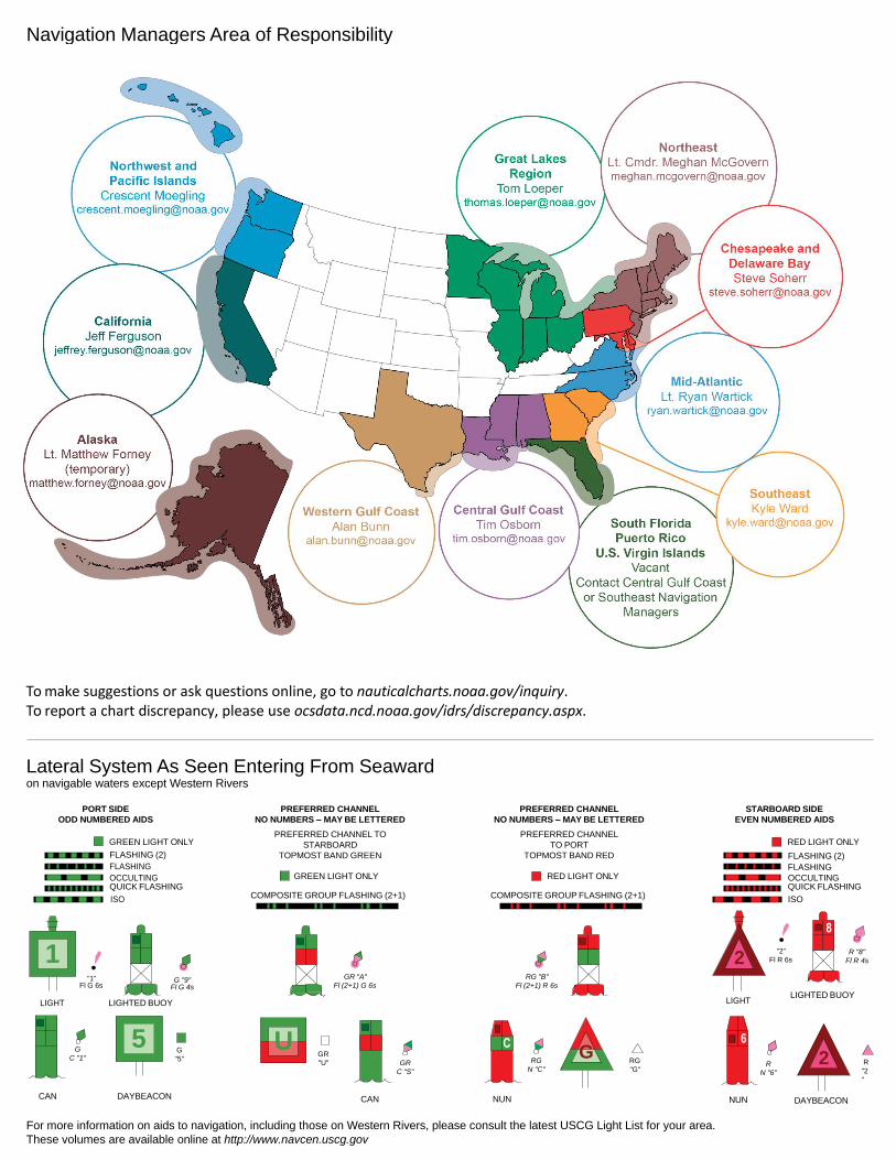
NOAA’s navigation managers serve as ambassadors to the maritime community. They help identify navigational challenges facing professional and recreational mariners, and provide NOAA resources and information for safe navigation. For additional information, please visit nauticalcharts.noaa.gov/service/navmanagers
To make suggestions or ask questions online, go to nauticalcharts.noaa.gov/inquiry. To report a chart discrepancy, please use ocsdata.ncd.noaa.gov/idrs/discrepancy.aspx.
Lateral System As Seen Entering From Seaward on navigable waters except Western Rivers
PORT SIDE
ODD NUMBERED AIDS
GREEN LIGHT ONLY
FLASHING (2)
PREFERRED CHANNEL
NO NUMBERS – MAY BE LETTERED
PREFERRED CHANNEL TO
STARBOARD
TOPMOST BAND GREEN
PREFERRED CHANNEL
NO NUMBERS – MAY BE LETTERED
PREFERRED CHANNEL
TO PORT
TOPMOST BAND RED
STARBOARD SIDE
EVEN NUMBERED AIDS
RED LIGHT ONLY
FLASHING (2)
FLASHING FLASHING
OCCULTING GREEN LIGHT ONLY RED LIGHT ONLY OCCULTING QUICK FLASHING QUICK FLASHING
ISO COMPOSITE GROUP FLASHING (2+1) COMPOSITE GROUP FLASHING (2+1) ISO
"1"
Fl G 6s
G "9"
Fl G 4s
GR "A"
Fl (2+1) G 6s
RG "B"
Fl (2+1) R 6s
"2"
Fl R 6s
8
R "8"
Fl R 4s
LIGHT
G
C "1"
LIGHTED BUOY
G
"5"
GR
"U"
GR
C "S"
RG
N "C"
RG
"G"
LIGHT
6
R
N "6"
LIGHTED BUOY
R
"2
"
CAN DAYBEACON
CAN NUN NUN
DAYBEACON
For more information on aids to navigation, including those on Western Rivers, please consult the latest USCG Light List for your area.
These volumes are available online at http://www.navcen.uscg.gov
Navigation Managers Area of Responsibility
Northeast
Lt. Meghan McGovern
Northwest and
Pacific Islands
Crescent Moegling
Great Lakes Region
Tom Loeper
Chesapeake and
Delaware Bay
Steve Soherr
California
Jeff Ferguson
[email protected] Mid-Atlantic
Lt. Ryan Wartick
Alaska
Lt. Timothy M. Smith
Western Gulf Coast
Alan Bunn
Central Gulf Coast
Tim Osborn
[email protected] South Florida
Puerto Rico
U.S. Virgin Islands
Michael Henderson
Southeast
Kyle Ward
2
2 C U 5
1


VHF Marine Radio channels for use on the waterways:Channel 6 – Inter-ship safety communications.Channel 9 – Communications between boats and ship-to-coast.Channel 13 – Navigation purposes at bridges, locks, and harbors.Channel 16 – Emergency, distress and safety calls to Coast Guard and others, and to initiate calls to other
vessels. Contact the other vessel, agree to another channel, and then switch.Channel 22A – Calls between the Coast Guard and the public. Severe weather warnings, hazards to navigation and safety warnings are broadcast here.Channels 68, 69, 71, 72 and 78A – Recreational boat channels.
Getting and Giving Help — Signal other boaters using visual distress signals (flares, orange flag, lights, arm signals); whistles; horns; and on your VHF radio. You are required by law to help boaters in trouble. Respond to distress signals, but do not endanger yourself.
EMERGENCY INFORMATION
Distress Call Procedures
• Make sure radio is on.• Select Channel 16.• Press/Hold the transmit button.• Clearly say: “MAYDAY, MAYDAY, MAYDAY.”• Also give: Vessel Name and/or Description;Position and/or Location; Nature of Emergency; Number of People on Board.• Release transmit button.• Wait for 10 seconds — If no responseRepeat MAYDAY call.
HAVE ALL PERSONS PUT ON LIFE JACKETS!
This Booklet chart has been designed for duplex printing (printed on front and back of one sheet). If a duplex option is not available on your printer, you may print each sheet and arrange them back-to-back to allow for the proper layout when viewing.
QR
Quick ReferencesNautical chart related products and information - http://www.nauticalcharts.noaa.gov
Interactive chart catalog - http://www.charts.noaa.gov/InteractiveCatalog/nrnc.shtmlReport a chart discrepancy - http://ocsdata.ncd.noaa.gov/idrs/discrepancy.aspx
Chart and chart related inquiries and comments - http://ocsdata.ncd.noaa.gov/idrs/inquiry.aspx?frompage=ContactUs
Chart updates (LNM and NM corrections) - http://www.nauticalcharts.noaa.gov/mcd/updates/LNM_NM.html
Coast Pilot online - http://www.nauticalcharts.noaa.gov/nsd/cpdownload.htm
Tides and Currents - http://tidesandcurrents.noaa.gov
Marine Forecasts - http://www.nws.noaa.gov/om/marine/home.htm
National Data Buoy Center - http://www.ndbc.noaa.gov/
NowCoast web portal for coastal conditions - http://www.nowcoast.noaa.gov/
National Weather Service - http://www.weather.gov/
National Hurrican Center - http://www.nhc.noaa.gov/
Pacific Tsunami Warning Center - http://ptwc.weather.gov/
Contact Us - http://www.nauticalcharts.noaa.gov/staff/contact.htm
NOAA’s Office of Coast Survey The Nation’s Chartmaker
For the latest news from Coast Survey, follow @NOAAcharts
NOAA Weather Radio All Hazards (NWR) is a nationwide network of radio stations broadcasting continuous weather information directly from the nearest National Weather Service office. NWR broadcasts official Weather Service warnings, watches, forecasts and other hazard information 24 hours a day, 7 days a week. http://www.nws.noaa.gov/nwr/