Babergh and Mid Suffolk Joint Local Plan
155
November 2020 Babergh and Mid Suffolk Joint Local Plan Pre-Submission (Reg19) Document
Transcript of Babergh and Mid Suffolk Joint Local Plan
November 2020
Babergh and Mid Suffolk Joint Local Plan Pre-Submission (Reg19) Document

Joint Local Plan – Pre-Submission (Reg 19) – November 20202
Joint Local Plan – Pre-Submission (Reg 19) – November 2020 3
Table of ContentsTABLE OF CONTENTS 3
FOREWORD 4
01 - INTRODUCTION 5
02 - BABERGH & MID SUFFOLK PROFILE, CONTEXT & KEY ISSUES 8
Part 1 – OBJECTIVES AND STRATEGIC POLICIES 12
03 - VISION AND OBJECTIVES 14
KEY DIAGRAM 16
04 - IMPLEMENTATION 18
05 - DUTY TO COOPERATE 19
06 - HOUSING NEEDS & REQUIREMENTS 26
07 - AFFORDABLE HOUSING 29
08 - SETTLEMENT HIERARCHY 33
09 - SPATIAL DISTRIBUTION 40
10 - THE ECONOMY – TOURISM 50
11 - STRATEGIC INFRASTRUCTURE 52
12 - PROTECTION AND MANAGEMENT OF THE ENVIRONMENT 54
PART 2 – LOCAL POLICIES 60
13 LOCAL POLICIES – HOUSING 62
14 LOCAL POLICIES – ECONOMY 83
15 LOCAL POLICIES – ENVIRONMENT 89
KEY EVIDENCE DOCUMENTS 119
GLOSSARY 120
APPENDIX 01 - HOUSING TRAJECTORY 128
APPENDIX 02 - MONITORING FRAMEWORK 133
APPENDIX 03 - SCHEDULE OF SUPERSEDED POLICIES 138
PART 3 – PLACE AND ALLOCATIONS POLICIES 156
APPENDIX 04 - TOWN CENTRE MAPS 158
BABERGH DISTRICT COUNCIL PLACE MAPS AND POLICIES 164
MID SUFFOLK DISTRICT COUNCIL PLACE MAPS AND POLICIES 326
POLICIES MAP KEY 512
Joint Local Plan – Pre-Submission (Reg 19) – November 20204
The Babergh and Mid Suffolk Joint Local Plan provides a framework for shaping our communities and guiding future development over the period to 2037. This Plan provides a
clear understanding of where growth is directed to go and how development will be encouraged, whilst recognising the need to safeguard our rich historic and natural environments.
Both Councils acknowledge the requirement to deliver the right type of homes, of the right tenure in the right place, meeting housing targets set by Government and need from anticipated population growth. The Plan will secure suitable and sustainable development and provide the necessary infrastructure to enable our communities to thrive, grow, be healthy, active, and self-sufficient.
We must ensure our districts’ environment is protected and enhanced, focussing on combatting climate change and achieving biodiversity net gain. Our Councils have an ambition to be carbon neutral by 2030 and continue to encourage sustainable transport, including more cycling and walking. The Plan also seeks to help strengthen the local economy by encouraging the development of business growth and inward investment – revitalising our town centres and offering opportunities for tourism.
An up to date set of planning policies and development site allocations in sustainable locations is a sound foundation on which to achieve these ambitions.
To date there have been two rounds of public consultation on the Joint Local Plan, one in 2017 and the other in 2019. The many thousands of representations we received from residents, local businesses and our communities have been carefully considered and, together with updated evidence, have informed this Draft Joint Local Plan in the context of an ever-changing national policy environment.
We are now publishing this Joint Local Plan and are inviting representations over a six-week period on its legal compliance and soundness. The Plan, with all duly made representations, will then go to the Inspector who will examine it to consider it has been positively prepared and is justified, effective and consistent with national policy.
To find out more please visit our websites at https://www.babergh.gov.uk/planning/planning-policy/new-joint-local-plan/ or https://www.midsuffolk.gov.uk/planning/planning-policy/new-joint-local-plan/; you can also e-mail us at [email protected] or phone 0300 123 4000 (option 5 then option 4).
November 2020
Foreword
Cllr Clive Arthey Cabinet Member for PlanningBabergh District Council
Cllr David BurnCabinet Member for PlanningMid Suffolk District Council
01.01 The Babergh and Mid Suffolk Joint Local Plan (hereafter referred to as ‘the Plan’) is an important document which will provide the strategy for the growth of Babergh and Mid Suffolk. It will set out the strategy for development up to 2037, including land allocations. Once adopted, the Plan will replace the existing local planning policies for both Babergh and Mid Suffolk.
Why do we need a Plan for Babergh and Mid Suffolk?01.02 Planning involves weighing up economic,
social and environmental factors to achieve the most balanced and sustainable way forward.
01.03 The current development planning system was established through the Planning and Compulsory Purchase Act 2004 and subsequent amendments, such as the Localism Act 2011 which introduced neighbourhood plans. The national approach to planning policy matters is set out principally in the new National Planning Policy Framework (NPPF 2019) and Planning Practice Guidance, but also within documents covering specific topics such as the Marine Policy Statement and Planning Policy for Travellers Sites.
01.04 The NPPF 2019 sets a presumption in favour of sustainable development, requiring that local planning authorities plan positively to meet the development needs of their area. The Plan policies for Babergh and Mid Suffolk will sit alongside the NPPF 2019, and where appropriate, supplement policies based upon local circumstances.
01.05 In accordance with Section 38(6) of the Planning and Compulsory Purchase Act (2004) the policies and allocations set out in the Development Plan, once adopted, will provide the primary consideration in
determining applications, unless material considerations indicate otherwise.
Babergh and Mid Suffolk’s Current Development Plan01.06 The current Development Plan for
Babergh consists of the saved policies of the Babergh Local Plan, Alteration No. 2 (2006), the Babergh Local Plan (2011 – 2031) Core Strategy and Policies (2014) and the ‘made’ (adopted) neighbourhood plans1. For Mid Suffolk, the Development Plan comprises the saved policies of the Mid Suffolk District Local Plan (1998), the First Alteration to the Mid Suffolk Local Plan (2006), the Mid Suffolk District Core Strategy Development plan Document (2008), and the Mid Suffolk District Core Strategy Focused Review (2012), the Stowmarket Area Action Plan Mid Suffolk’s New Style Local Plan (2013) and the ‘made’ (adopted) Neighbourhood Plans2. The Minerals Core Strategy (incorporating Development Control Policies) (2008), the Minerals Specific Site Allocation Plan (2009), and the Waste Core Strategy Development Plan Document (2011) produced by Suffolk County Council (SCC) also form part of the Development Plan. The Plan will replace the Local Plans and alterations (saved policies), the Core Strategies, and the Stowmarket Area Action Plan.
01.07 When made (adopted), any new Neighbourhood Plans shall also become part of the development plan and shall be considered alongside the Plan when determining planning applications. Neighbourhood Plan groups have an opportunity to work with the relevant District Council in order to share information and bring sites forward for allocation where they would assist to meet the levels of growth in the Plan.
Joint Local Plan – Pre-Submission (Reg 19) – November 2020 5
01 Introduction
1 https://www.babergh.gov.uk/planning/neighbourhood-planning/2 https://www.midsuffolk.gov.uk/planning/neighbourhood-planning/
The Joint Local Plan 01.08 The Plan will set out planning policies to
set the context for protecting the Districts’ valuable natural and built environment and ensure that new development is delivered in a sustainable way.
01.09 The Plan is primarily based upon and in conformity with national planning policy and legislation, whilst having full regard to relevant strategic and locally significant matters.
Why do we need a Plan to deliver growth?01.10 In accordance with the NPPF
standard methodology, the Plan must accommodate identified housing needs along with employment and community facilities and services in Babergh and Mid Suffolk respectively. The Plan will set out a strategy to accommodate this in full in accordance with national policy requirements. Preventing growth across the two Districts is not an option. Levels of housing need in the area are high and new homes will have to be provided to meet this need.
01.11 Rates of annual housing delivery in Babergh and Mid Suffolk have been approximately 20% below the levels of current delivery since 2014/15. From 2018 onwards, the annual rate of housing to be delivered has also increased by around 30%-40% in each council area, compounding delivery issues. A ‘plan led’ approach is fundamental to shaping future delivery and provides a mechanism to coordinate the delivery of infrastructure necessary to support growth. Development should be planned to secure the delivery of key infrastructure projects across the County, such as the improvements to the A14 network, as well as localised infrastructure schemes within communities.
The Plan 01.12. The Plan will be set out in 3 parts: I. Part 1 – Objectives and Strategic Policies II. Part 2 – Non Strategic Delivery Policies III. Part 3 – Non Strategic Place and Allocation Policies.
01.13. Part 1 sets out the strategic policies to address Babergh and Mid Suffolk’s priorities for the development and use of land by establishing the overall strategy for the pattern, scale and quality of development (and any relevant cross boundary issues). The policies will make sufficient provision for:
a) Housing (including affordable) employment, retail, leisure and other commercial development;
b) Infrastructure; and c) Conservation and enhancement of the
natural, built and historic environment, including landscapes and green infrastructure, and planning measures to address climate change mitigation and adaption.
01.14 Part 2 will include more detailed policies for management and delivery of types of development and Part 3 detailed policies for specific places and neighbourhoods. This includes new housing and land allocations, provision of infrastructure and community facilities (such as schools, healthcare and cultural facilities) at a local level, establishing design and construction principles, conserving and enhancing the natural and historic environment and setting out development management policies.
01.15 The Plan will articulate policies to influence delivery across four priority areas that district councillors have identified will have the most positive impact on that future:• Housing;• Economy;• Environment;• Healthy Communities & Infrastructure.
Joint Local Plan – Pre-Submission (Reg 19) – November 20206
01.16 The Councils of Babergh and Mid Suffolk, as the Local Planning Authorities, need to work with a large number of organisations and individuals to produce a local plan and determine planning applications. Alongside working with infrastructure providers and the New Anglia Local Enterprise Partnership, Babergh and Mid Suffolk District Councils work closely with the other local authorities across Suffolk, including with the County Council.
01.17 Viability is a factor which has a significant role and influence over planning policies and development proposals. The Plan has to be deliverable. This means that the cost of meeting the requirements of policies, combined with the costs of meeting national requirements, such as building regulations, and local infrastructure need to be assessed and factored into the emergence of all policy proposals and allocations.
Delivery & Places01.18 The Plan will have a focus upon managing
the delivery of sustainable development which supports the areas’ economic growth ambitions; the important rich historical and natural environment; the extensive network of existing communities; and enables development through facilitating the delivery of infrastructure.
01.19 The Plan will have regard to emerging neighbourhood plans being prepared in the District and will provide a context for new neighbourhood plans to be prepared against.
Joint Local Plan – Pre-Submission (Reg 19) – November 2020 7
Joint Local Plan – Pre-Submission (Reg 19) – November 20208
02 Babergh & Mid Suffolk Profile, Context & Key IssuesContext02.01 Babergh and Mid Suffolk are
predominantly rural districts covering the geographical centre of Suffolk, running from the boundary with Essex in the south to the boundary with Norfolk in the north. This covers a total area of approximately 1463 square kilometres.
02.02 Babergh and Mid Suffolk Councils work collectively to deliver shared priorities, as set out in the Joint Corporate Plan (2019 – 2027). The main priority areas are the economy, environment, housing, wellbeing, communities and customers. The Plan provides the mechanism to enable the delivery of the spatial elements of the vision and priorities.
Profile02.03 The population of Babergh District is
87,740; Mid Suffolk population is 96,731 (Census, 2011). Across Babergh and Mid Suffolk, more than half the population live in villages and rural areas. In combination, both districts have six main centres; which include Eye, Needham Market and Stowmarket in Mid Suffolk; Pinewood, Hadleigh and Sudbury in Babergh. The historic market towns are surrounded by a rural hinterland comprising 198 rural parishes.
02.04 Babergh and Mid Suffolk are heavily influenced by large centres of population with Ipswich in the east, Bury St Edmunds in the west, Diss and Harleston in the north. This is reinforced by the area’s strategic transport connectivity with main road and rail links including the A12/A14/A140 main roads from London to Felixstowe and Cambridge, together with main line rail links from London, to Cambridge and Norwich and a strategic
link for freight traffic from Felixstowe to Nuneaton in the Midlands. A large portion of Mid Suffolk has direct access to the A14 and the main line railway between London/Ipswich/Norwich and Cambridge. Babergh has less accessibility with a smaller proportion of its area served directly by the east A12 and north by the A14 and no main line railway stations.
Joint Local Plan – Pre-Submission (Reg 19) – November 2020 9
i. Delivering Housing Significant numbers of new homes need to be planned for over the Plan period along with employment and community facilities and services in Babergh and Mid Suffolk respectively.
ii. Achieving an Uplift in Delivery Rates of annual housing delivery in Babergh and Mid Suffolk have been consistently below target. The number of homes to be delivered per annum has increased with the application of the Standard Methodology, which means that from 2018 onwards the annual rate of housing to be delivered has also increased by around 40% in each council. The revised uplift in housing numbers compounds the challenges of delivery.
iii. A Growing & Ageing Population By 2036 the population in Babergh is expected to grow by around 7,300 people in Babergh and by approximately 9,300 people in Mid Suffolk, an increase of 8% and 9.2% respectively3. The increasing age of the population is a significant factor contributing to the overall level of population growth. Both Districts have an ageing population with 45 to 59-year olds representing the single largest age group at present. In addition, a significant percentage of the population are aged 65 years or older (26.2% in Babergh and 24.5% in Mid Suffolk)4. Babergh and Mid Suffolk also have a relatively long-life expectancy at about 81 years for males and about 84 years for females. As the population ages, there will be different demands on housing, infrastructure, services and facilities.
iv. High Levels of Housing Need and a Poor Affordability House prices on average are approximately 11 times above the average earnings of residents in Babergh and approximately 9 times above the average earnings in Mid Suffolk and rural parts of the Districts are unaffordable for many5.
Key Social Issues
3 ONS 2016-based population projections4 ONS 2016-based population projections5 ONS Affordability Ratio - March 2020
Joint Local Plan – Pre-Submission (Reg 19) – November 202010
i. Improving Business Growth and Productivity Babergh and Mid Suffolk have below average productivity levels, skills and attainment levels, and earnings are lower than average levels.
ii. Economic Base The economic base is diverse. Projected growth sectors in the area include tourism; creative industries; food production, construction and related services; hospitality/ leisure.
iii. Further diversification of the economic base and encouraging investment in infrastructure, skills and innovation is a priority.
iv. Employment levels and projections Babergh recorded a decline in the total employment rate to 68.3% relating to the population between 16 and 64 years (working age) over the past couple of years. This decline is likely to continue as the working-age population is expected to fall. Mid Suffolk recorded a small increase of the average percentage of the total employment rate to 80.5%. A 9.3% increase in jobs is projected in Babergh and 14.7% in Mid Suffolk increase from 2014 – 2036, which represents a slow down when compared with past trends. The overall growth in jobs is expected to be driven by growth in the Professional and Business Services.
v. Town centre occupation The vacancy rates in town centres in Babergh & Mid Suffolk are below the national average. However, it is acknowledged that there is a need to enhance the town centres.
Key Economic Issues
Joint Local Plan – Pre-Submission (Reg 19) – November 2020 11
Key Environmental Issues
i. Environmental Assets The Districts have a rich historic natural environment (including archaeology), with a number of protected areas such as Sites of Special Scientific Interest (SSSI) sites, Special Protection Areas (SPAs) and Areas of Outstanding Natural Beauty (AONBs). There are a number of priority habitats / species identified as being in an adverse condition. The rural areas of both districts contain biodiversity importance. Babergh is part of the Suffolk Coast and Heaths AONB and Dedham Vale and Stour Valley AONB. Suffolk Coasts and Heaths AONB have extended their boundary which includes significant areas north of the River Stour. Cross Street Sudbury is identified as an Air Quality Management Area and the 2016 Air Quality Annual Status Report sets out approach to reduce nitrogen dioxide concentration. Both districts have a high volume of Grade 3 Agricultural Land and limited available previously developed land. Recycling performance is currently lower than the County average in both districts.
ii. Heritage Assets Babergh and Mid Suffolk are rich in heritage assets (including settings). In Babergh there are 29 designated conservation areas, 2,985 listed buildings, 34 scheduled monuments and 5 registered parks and gardens which represent about 20% of the estimated 13,700 designated Heritage Assets in Suffolk. In Mid Suffolk there are 31 designated conservation areas, 3,419 listed buildings, 36 scheduled monuments and 2 registered parks and gardens, which represents more than a quarter of all Heritage Assets in Suffolk6. There are also non-designated heritage assets and opportunities to address Heritage at risk.
iii. Climate Change There is a national requirement to future proof against climate change including reducing carbon emissions, diversifying energy provision and using sustainable construction and design methods and promote sustainable modes of transport. For Babergh and Mid Suffolk, there is a particular need to introduce measures that address water scarcity. There is also a need to improve ground water quality, potable water supply and the wastewater infrastructure.
6 Historic England May 2016, Heritage Counts, April 2014.

PART 1
Joint Local Plan – Pre-Submission (Reg 19) – November 202012

Joint Local Plan – Pre-Submission (Reg 19) – November 2020 13
OBJECTIVES AND STRATEGIC POLICIES
Joint Local Plan – Pre-Submission (Reg 19) – November 202014
Vision for Babergh and Mid Suffolk
By 2037, Babergh and Mid Suffolk Districts will have transitioned to a low carbon future, with the ambition to be carbon neutral by 2030. Significant growth will have occurred, embedding the principles of sustainable development, balancing social, economic and environmental issues.
Major new housebuilding will have taken place, including the delivery of affordable housing for first time buyers and those on low incomes, whilst recognising the Districts have an ageing population. Strategic employment sites will be protected, and their proposed expansion supported in principle to ensure jobs are retained locally and created where opportunities exist, allowing businesses to expand and new businesses to invest in the area.
There will be enhanced biodiversity through the delivery of measurable net gains across the Districts, supported by an identified ecological network. The historic and landscape character of the Districts will be apparent with development being sensitive to this character and applying good design principles.
There will be a clear vision for the towns of Hadleigh and Sudbury in Babergh, and for Eye, Needham Market, and Stowmarket in Mid Suffolk. Many communities will have adopted neighbourhood plans, adding locally to the decision-making process.
A significant amount of growth will have taken place within the strategic transport corridors, recognising the opportunities that exist to move around the area and the relationship with the wider housing market area and functional economic area.
Infrastructure including education, health and transport will have been delivered, including school extensions, expanded health facilities and more opportunities for walking, cycling and use of public transport, as communities grow with active and healthy futures.
03.01 The Plan sets the spatial vision of the place that Babergh and Mid Suffolk will become by 2037, based upon the following key priorities:• Enabling sustainable economic growth;• Enhancing and protecting the
environment;• Delivering appropriate housing; and• Supporting strong and healthy
communities & delivering Infrastructure.
03.02 To contribute to the delivery of the vision and priority areas, the Plan will set out an ambitious growth agenda. This will prioritise the infrastructure investment required to deliver the growth ambitions and will identify the locations for delivering the necessary housing, employment and recreational growth and development.
03 Vision and Objectives
Objectives03.03. The objectives for the Plan are as follows:
Housing:i. Delivery of the right types of homes, of
the right tenure in the right place meeting need.
Economy: ii. Encourage the development of
employment sites and other business growth, of the right type, in the right place and encourage investment in infrastructure, skills and innovation in order to increase productivity.
iii. To encourage inward investment to the Districts, by supporting infrastructure improvements that will enable the continued growth of The Port of Felixstowe and strengthen the Districts’ links to The Port of Felixstowe and the rest of the UK.
Environment: iv. To protect and enhance environmental
assets (including designated sites, landscapes, heritage, biodiversity net gains, green spaces, air and water quality, and river corridors) for current and future generations.
v. Ensure new development avoids areas of flood risk and reduces future flood risk.
vi. To reduce the drivers of climate change as much as possible from a social, economic and environmental perspective, with the ambition to be carbon neutral by 2030.
Healthy Communities & Infrastructure: vii. To enable all communities to thrive,
grow, be healthy, active and self-sufficient through supporting the provision of the necessary infrastructure, and encouraging more sustainable travel.
viii. To support communities to deliver plans and projects at the district and neighbourhood levels, specifically providing opportunities for the District Councils supporting communities on the development on neighbourhood plans.
ix. To work with the communities of Hadleigh and Sudbury in Babergh and Eye, Needham Market and Stowmarket in Mid Suffolk in the development of a vision and strategy for these towns.
Joint Local Plan – Pre-Submission (Reg 19) – November 2020 15
Joint Local Plan – Pre-Submission (Reg 19) – November 202016
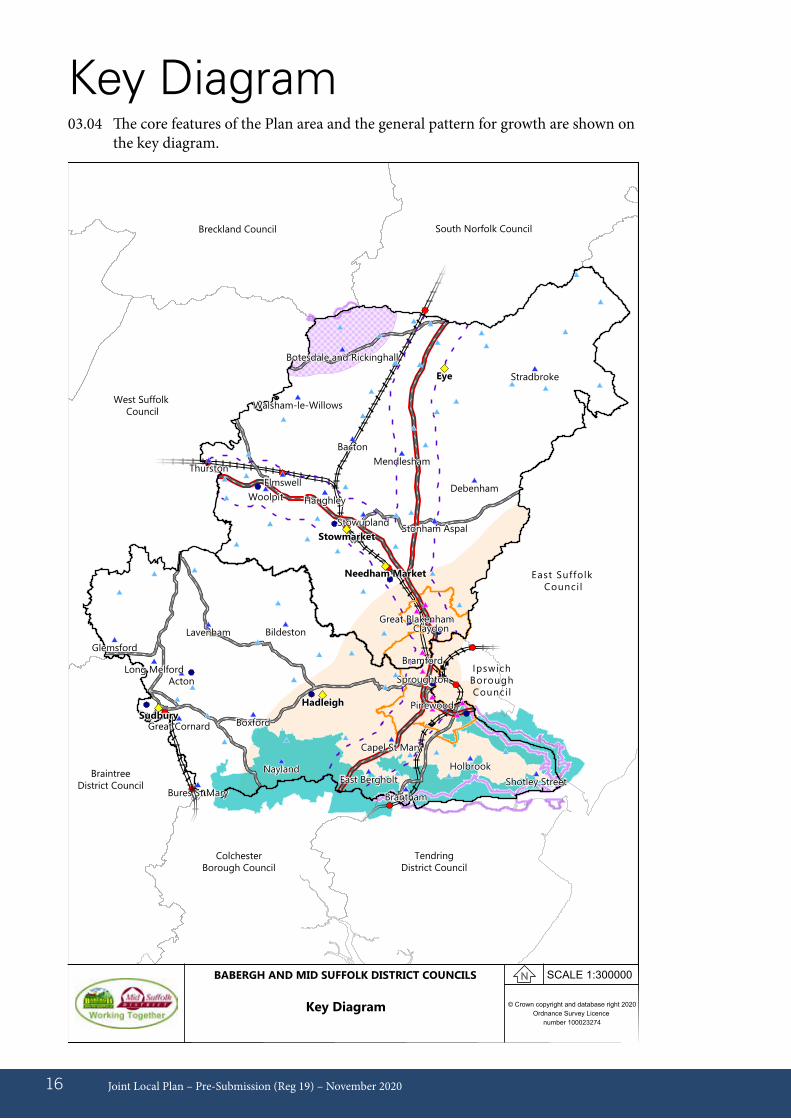
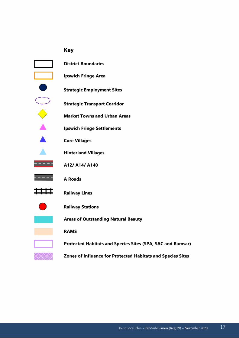
03.04 The core features of the Plan area and the general pattern for growth are shown on the key diagram.
Key Diagram
Had le ighSudbury
P inewood
SproughtonActon
B ildeston
Boxford
BranthamBures St M ary
Cape l St M ary
East Bergho lt
G lem sford
G reat Cornard
Ho lbrook
Lavenham
Long M e lford
Nay landShotley Street
Bram ford
C laydonG reat B lakenham
Bacton
Botesda le and R ick ingha ll
DebenhamE lm swe ll
Haugh ley
M end lesham
Stonham Aspa lStowup land
Stradbroke
Thurston
W alsham -le-W illow s
W oo lp it
Eye
Needham M arket
Stowm arket
© Crown copyright and database right 2020Ordnance Survey Licence
number 100023274
SCALE 1:300000BABERGH AND MID SUFFOLK DISTRICT COUNCILS
Key Diagram
East Suffolk Council
Ipswich BoroughCouncil
Tendring District Council
Colchester Borough Council
Braintree District Council
West Suffolk Council
Breckland Council South Norfolk Council
Joint Local Plan – Pre-Submission (Reg 19) – November 2020 17
Key
District Boundaries
Ipswich Fringe Area
Strategic Employment Sites
Strategic Transport Corridor
Market Towns and Urban Areas
Ipswich Fringe Settlements
Core Villages
Hinterland Villages
A12/ A14/ A140
A Roads
Railway Lines
Railway Stations
Areas of Outstanding Natural Beauty
RAMS
Protected Habitats and Species Sites (SPA, SAC and Ramsar)
Zones of Influence for Protected Habitats and Species Sites
04.01 In accordance with national planning legislation, the adopted planning policies in Babergh and Mid Suffolk districts will be kept under review at least every 5 years. A review of the planning policies will consider whether all, or specific parts, of the suite of policies are in need of amendment. For example, in order to update for consistency with relevant national planning policies, where identified local development needs change significantly or where policies are not performing as intended.
04.02 The Councils will adopt a ‘plan, monitor, manage’ approach where key information regarding the Plan (such as housing delivery), and other planning document production progress will be reported in the Annual Monitoring Report (AMR). The requirements for the AMR are found in the Town & Country (Local Planning) (England) Regulations (as amended)7.
04.03 In order to assess the performance and impacts of the Plan, a monitoring framework of indicators/data will be set out covering housing, economic and environmental issues. Data will include information which the Councils collect themselves as well as key data which is collected and reported on by other key bodies.
04.04 The following related sections are set out in the Appendices to the Plan
Appendix 01 – Housing trajectory
Appendix 02 – Monitoring framework
Appendix 03 – Schedule of superseded policies
Joint Local Plan – Pre-Submission (Reg 19) – November 202018
04 – Implementation
7 http://www.legislation.gov.uk/uksi/2012/767/regulation/34/made

What is the Duty to Cooperate?05.01 The Duty to Cooperate is applied to local
planning authorities by Section 110 of the Localism Act 2011 and requires the Councils to apply the Duty to Cooperate in relation to planning of sustainable development. It is a prerequisite test for the Examination of Local Plan production.
05.02 Section 3 of the National Planning Policy Framework (NPPF) (February 2019) sets out a Local Planning Authority’s approach to plan-making. Paragraph 17 identifies that ‘The development plan must include strategic policies to address each local planning authority’s priorities for the development and use of land in its area’8. Paragraph 20 goes on to state that the ‘Strategic policies should set out an overall strategy for the pattern, scale and quality of development, and make sufficient provision for:
a) housing (including affordable housing), employment, retail, leisure and other commercial development;
b) infrastructure for transport, telecommunications, security, waste management, water supply, wastewater, flood risk and coastal change management, and the provision of minerals and energy (including heat);
c) community facilities (such as health, education and cultural infrastructure); and
d) conservation and enhancement of the natural, built and historic environment, including landscapes and green infrastructure, and planning measures to address climate change mitigation and adaptation.’9
05.03 National planning policy in the NPPF (paragraph 27) also identifies that strategic policy-making authorities should maintain one or more statements of common ground to document the cross-boundary matters being addressed and the process in cooperating to address these. Further information regarding the Duty to Cooperate can be found on the Government national planning practice guidance website at https://www.gov.uk/guidance/plan-making.
What are we cooperating on?05.04 The full list of bodies in the Duty to
Cooperate is set out in Part 2 of the Town and Country Planning (Local Planning) (England) Regulations 2012.
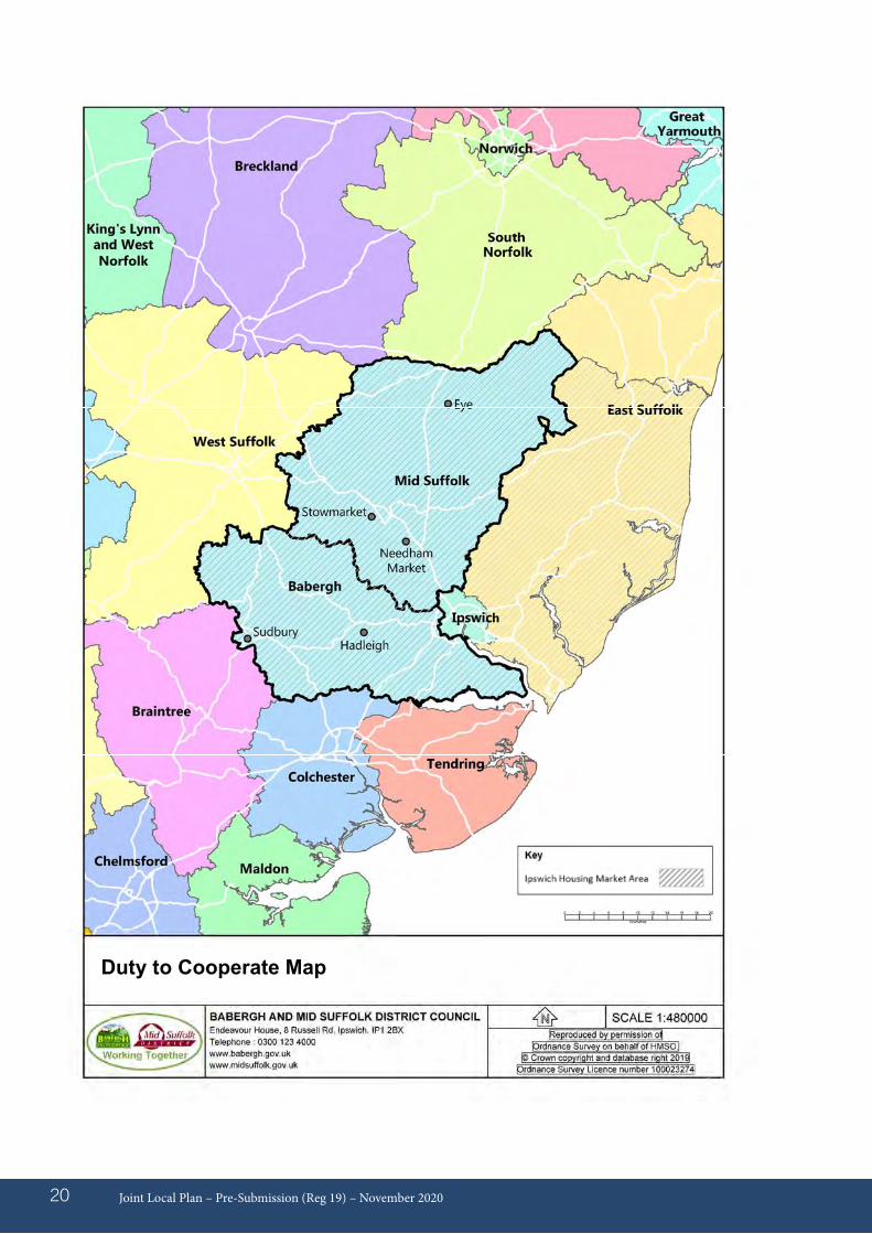
05.05 The Councils in the Ipswich Housing Market Area (HMA), namely Babergh District Council, East Suffolk Council (formerly Suffolk Coastal District Council), Ipswich Borough Council, and Mid Suffolk District Council already have a long history of cooperation on strategic planning matters. The planning area of the Ipswich HMA is also known as the Ipswich Strategic Planning Area (ISPA).
Joint Local Plan – Pre-Submission (Reg 19) – November 2020 19
05 - Duty to Cooperate
8 Section 19(1B-1E) of the Planning and Compulsory Purchase Act 2004 cited in the National Planning Policy Framework (NPPF) (February 2019), paragraph 17, p. 89 NPPF (February 2019), paragraph 20, p. 9
Joint Local Plan – Pre-Submission (Reg 19) – November 202020Joint Local Plan - Preferred Options (Reg 18) - July 201918
Duty to Cooperate Map
05.06 However, the geographical context of Babergh and Mid Suffolk Districts means that the Districts need to be mindful of any potential cross-boundary matters that arise with Braintree District Council, Colchester Borough Council and Tendring District Council to the south, East Suffolk (formerly Waveney District Council) to the east, West Suffolk (formerly St Edmundsbury Borough Council) to the west, and Breckland and South Norfolk Councils to the north. These also include Essex County Council
and Norfolk County Council alongside Suffolk County Council (SCC).
05.07 A summary of the current key issues and identified partners which the Councils are cooperating with is identified in Table 1 below. As the Plan (and other neighbouring Local Plans) develop, there may be additional key issues which also need to be considered.
Joint Local Plan – Pre-Submission (Reg 19) – November 2020 21
Table 1 – Duty to Cooperate Key Issues
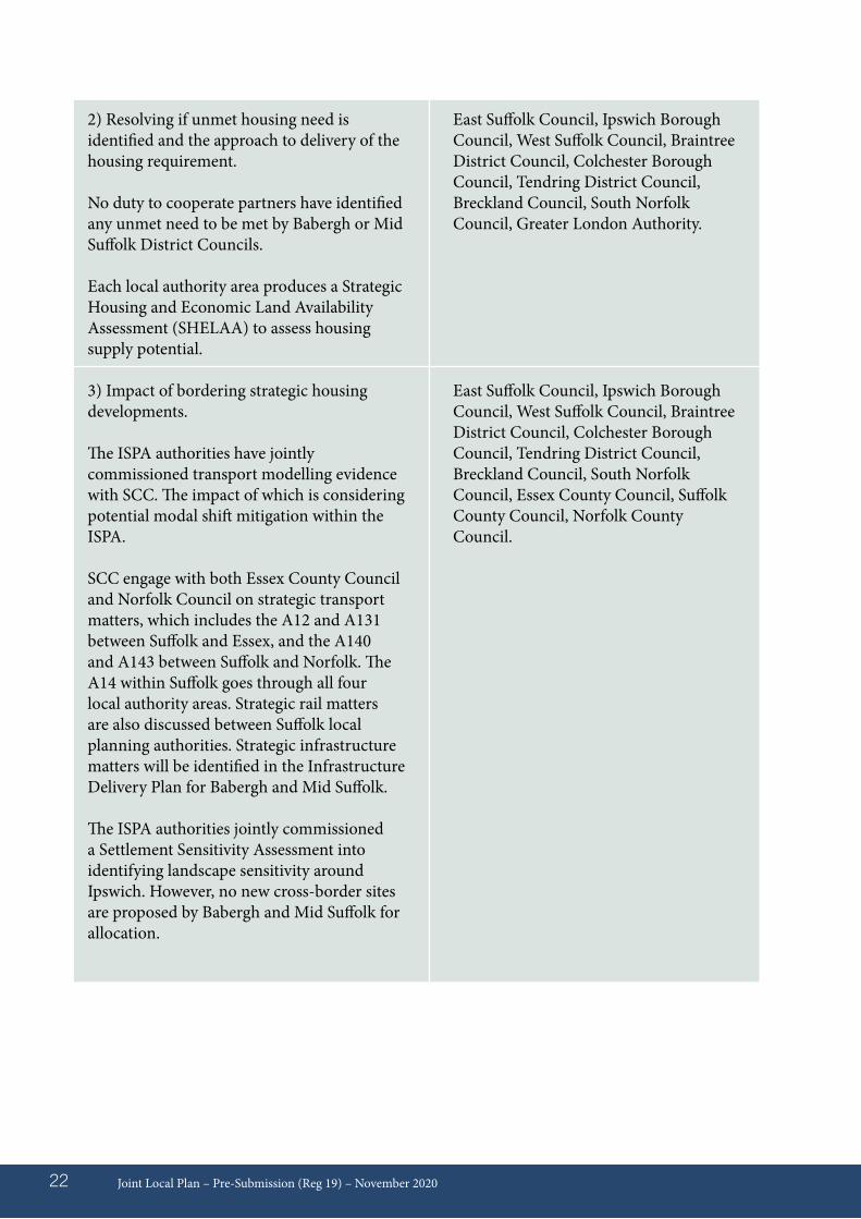
1) Defining housing market area and objectively assessed need (OAN).
Ipswich Housing Market Area (HMA) defined in Strategic Housing Market Assessment as including the whole of Babergh District, Ipswich Borough, Mid Suffolk District and Suffolk Coastal District (now part of East Suffolk Council). This corresponds with the Ipswich Strategic Planning Area (ISPA).
The Government introduced a standard method for calculating local housing need in 2018, which identifies a minimum local housing need per local authority area.
Provision for Gypsies and Travellers to be met, identified in the Gypsy, Traveller, Travelling Showpeople and Boat Dwellers Accommodations Need Assessment (May 2017) for the Ipswich HMA authorities.
The Strategic Housing Market Assessment Part 2 identified the size, type and tenure of housing needed, including the need for affordable housing, and this document was updated for the Ipswich HMA authorities in January 2019.
Key Planning Issue
Housing
Key Duty to Cooperate Partners
East Suffolk Council, Ipswich Borough Council, West Suffolk Council, Braintree District Council, Colchester Borough Council, Tendring District Council, Breckland Council, South Norfolk Council, Greater London Authority.
Joint Local Plan – Pre-Submission (Reg 19) – November 202022
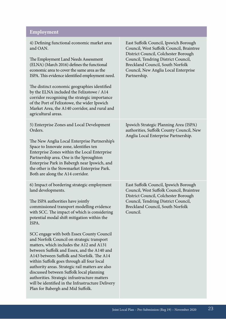
2) Resolving if unmet housing need is identified and the approach to delivery of the housing requirement.
No duty to cooperate partners have identified any unmet need to be met by Babergh or Mid Suffolk District Councils.
Each local authority area produces a Strategic Housing and Economic Land Availability Assessment (SHELAA) to assess housing supply potential.
3) Impact of bordering strategic housing developments.
The ISPA authorities have jointly commissioned transport modelling evidence with SCC. The impact of which is considering potential modal shift mitigation within the ISPA.
SCC engage with both Essex County Council and Norfolk Council on strategic transport matters, which includes the A12 and A131 between Suffolk and Essex, and the A140 and A143 between Suffolk and Norfolk. The A14 within Suffolk goes through all four local authority areas. Strategic rail matters are also discussed between Suffolk local planning authorities. Strategic infrastructure matters will be identified in the Infrastructure Delivery Plan for Babergh and Mid Suffolk.
The ISPA authorities jointly commissioned a Settlement Sensitivity Assessment into identifying landscape sensitivity around Ipswich. However, no new cross-border sites are proposed by Babergh and Mid Suffolk for allocation.
East Suffolk Council, Ipswich Borough Council, West Suffolk Council, Braintree District Council, Colchester Borough Council, Tendring District Council, Breckland Council, South Norfolk Council, Greater London Authority.
East Suffolk Council, Ipswich Borough Council, West Suffolk Council, Braintree District Council, Colchester Borough Council, Tendring District Council, Breckland Council, South Norfolk Council, Essex County Council, Suffolk County Council, Norfolk County Council.
Joint Local Plan – Pre-Submission (Reg 19) – November 2020 23
4) Defining functional economic market area and OAN.
The Employment Land Needs Assessment (ELNA) (March 2016) defines the functional economic area to cover the same area as the ISPA. This evidence identified employment need.
The distinct economic geographies identified by the ELNA included the Felixstowe / A14 corridor recognising the strategic importance of the Port of Felixstowe, the wider Ipswich Market Area, the A140 corridor, and rural and agricultural areas.
5) Enterprise Zones and Local Development Orders.
The New Anglia Local Enterprise Partnership’s Space to Innovate zone, identifies ten Enterprise Zones within the Local Enterprise Partnership area. One is the Sproughton Enterprise Park in Babergh near Ipswich, and the other is the Stowmarket Enterprise Park. Both are along the A14 corridor.
6) Impact of bordering strategic employment land developments.
The ISPA authorities have jointly commissioned transport modelling evidence with SCC. The impact of which is considering potential modal shift mitigation within the ISPA.
SCC engage with both Essex County Council and Norfolk Council on strategic transport matters, which includes the A12 and A131 between Suffolk and Essex, and the A140 and A143 between Suffolk and Norfolk. The A14 within Suffolk goes through all four local authority areas. Strategic rail matters are also discussed between Suffolk local planning authorities. Strategic infrastructure matters will be identified in the Infrastructure Delivery Plan for Babergh and Mid Suffolk.
Employment
East Suffolk Council, Ipswich Borough Council, West Suffolk Council, Braintree District Council, Colchester Borough Council, Tendring District Council, Breckland Council, South Norfolk Council, New Anglia Local Enterprise Partnership.
Ipswich Strategic Planning Area (ISPA) authorities, Suffolk County Council, New Anglia Local Enterprise Partnership.
East Suffolk Council, Ipswich Borough Council, West Suffolk Council, Braintree District Council, Colchester Borough Council, Tendring District Council, Breckland Council, South Norfolk Council.
Joint Local Plan – Pre-Submission (Reg 19) – November 202024
Ipswich Strategic Planning Area (ISPA) authorities, New Anglia Local Enterprise Partnership.
Retail, leisure & other commercial
7) Enhancement and regeneration of retail centres.
Acknowledgement of the role of Ipswich town centre within the Functional Economic Area.
Infrastructure provision
8) Provision and enhancement of strategic infrastructure improvements.
Strategic infrastructure provision to be identified through the Infrastructure Delivery Plan, in particular education, health, wastewater infrastructure and transport matters.
Ipswich Strategic Planning Area (ISPA) authorities, Suffolk County Council, Essex County Council, Norfolk County Council, Highways England, Office of Rail and Road, Network Rail, Local Train Operator, West Suffolk Clinical Commissioning Group, Ipswich and East Suffolk Clinical Commissioning Group, Environment Agency, Anglia Water and Essex and Suffolk Water.
Environmental protection
9) Conservation and enhancement of natural and historic environment, including cross-boundary climate change matters.
A Suffolk Coast recreational disturbance avoidance and mitigation strategy has been developed between the ISPA authorities and the entire East Suffolk Council areas.
Ipswich Strategic Planning Area (ISPA) authorities, Suffolk County Council, Natural England, Historic England, Environment Agency and Marine Management Organisation.
The ISPA authorities jointly commissioned a Settlement Sensitivity Assessment into identifying landscape sensitivity around Ipswich. However, no new cross-border sites are proposed by Babergh and Mid Suffolk for allocation.
How are we going to Cooperate?05.08 The Councils are cooperating on many
of the key, relevant issues such as jointly commissioning strategic evidence and sharing consistent assessment methodologies with the other planning authorities in the Ipswich Housing Market Area.
05.09 The Ipswich HMA planning authorities meet regularly through the Ipswich Strategic Planning Area Board, and have published a signed Statement of Common Ground, which identifies potential cross-boundary matters to be addressed within the Ipswich Housing Market Area. SCC and Natural England are also both signatories to the Statement of Common Ground. This Statement of Common Ground will be updated as each Local Plan within the HMA proceeds to adoption. A further Statement of Common Ground will be produced with those planning authorities outside of the Ipswich HMA as the plan proceeds to adoption.
05.10. Cooperation has taken place with infrastructure providers in preparing the Infrastructure Delivery Plan, in particular covering the key strategic infrastructure matters of education, health and transport. The Councils have also engaged with all partners through the preparation of the Plan.
Joint Local Plan – Pre-Submission (Reg 19) – November 2020 25
Policy background and explanation06.01 National planning policy requires that
local planning authorities produce Local Plans to meet, as a minimum, the identified future housing needs in the Plan area, as well as cooperate with neighbouring local planning authorities to meet the overall needs of the identified Housing Market Area (HMA) as a whole. The relevant HMA for the Babergh and Mid Suffolk area is known as the Ipswich HMA which consists of the entire districts of Babergh, Ipswich, Mid Suffolk and the area of the former Suffolk Coastal District Council (now part of East Suffolk District Council).
06.02 To determine the minimum number of homes needed, the National Planning Policy Framework (NPPF) requires that strategic policies should be informed by a
local housing need assessment, conducted using the Government’s standard methodology for calculating local housing need10. The methodology is made up of a calculation involving key, publicly available data from Office for National Statistics (ONS) on household growth projections and local housing affordability ratios.
06.03 Babergh and Mid Suffolk have undertaken to produce a joint Plan document with many common policies, although the identified development needs and monitoring of performance will be undertaken and recorded for each respective local authority district area. The baseline year of the Plan is April 2018, with the Plan end date of March 2037 (19 years). Using the standard methodology, the local housing need for Babergh and Mid Suffolk is as follows:
Joint Local Plan – Pre-Submission (Reg 19) – November 202026
06 - Housing Needs & Requirements
Babergh 7,904 416 Mid Suffolk 10,165 535
Local Authority Standard Method Total Annual Local Housing (2018 – 2037) Need Target
06.04 The local housing need represents a ‘starting point’ in identifying housing requirements for Babergh and Mid Suffolk. There are a number of other factors to consider when setting the housing requirement. The Strategic Housing and Economic Land Availability Assessment (SHELAA) indicates that there is a sufficient supply of land to meet the housing need set out in the standard methodology. National Planning Practice Guidance sets out that there may be circumstances where additional growth may be required. However, it is important to understand the likelihood
of higher levels of growth being delivered. The local housing need figures produced by the Government’s standard methodology is significantly higher (approx. 30%-40%) than the current levels of housing delivery. This Plan aims to set out a proactive approach which can significantly boost the supply of housing land and delivery in the district, consistent with Government policy.
06.05 Babergh and Mid Suffolk are planning to meet their full identified local housing needs. Unmet housing need has not been identified to Babergh and Mid Suffolk
10 https://www.gov.uk/guidance/housing-and-economic-development-needs-assessments
by any neighbouring authorities, either within the Ipswich HMA or beyond. An Ipswich Strategic Planning Area (ISPA) statement of common ground is agreed between authorities in the Ipswich HMA detailing a process to follow should unmet needs become identified. Should it be determined through the plan making process that another authority within the ISPA is unable to meet its minimum housing need, the Councils will, under the duty to co-operate, work collaboratively to determine whether
housing development needs that cannot be met wholly within a particular area, could be met elsewhere. An agreement to seek to accommodate unmet housing need would trigger an immediate review of the strategic policies of this Plan.
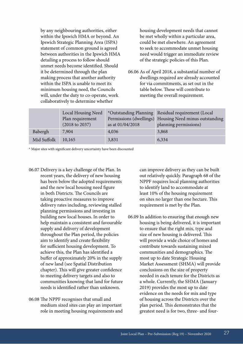
06.06 As of April 2018, a substantial number of dwellings required are already accounted for via commitments, as set out in the table below. These will contribute to meeting the overall requirement.
Joint Local Plan – Pre-Submission (Reg 19) – November 2020 27
Residual requirement (Local Housing Need minus outstanding planning permissions)3,868
6,334
*Outstanding Planning Permissions (dwellings) as at 01/04/20184,036
3,831
Local Housing Need Plan requirement (2018 to 2037)7,904
10,165
Babergh
Mid Suffolk
* Major sites with significant delivery uncertainty have been discounted
06.07 Delivery is a key challenge of the Plan. In recent years, the delivery of new housing has been below the adopted requirements and the new local housing need figure in both Districts. The Councils are taking proactive measures to improve delivery rates including, reviewing stalled planning permissions and investing in building new local houses. In order to help maintain a consistent and favourable supply and delivery of development throughout the Plan period, the policies aim to identify and create flexibility for sufficient housing development. To achieve this, the Plan has identified a buffer of approximately 20% in the supply of new land (see Spatial Distribution chapter). This will give greater confidence to meeting delivery targets and also to communities knowing that land for future needs is identified rather than unknown.
06.08 The NPPF recognises that small and medium sized sites can play an important role in meeting housing requirements and
can improve delivery as they can be built out relatively quickly. Paragraph 68 of the NPPF requires local planning authorities to identify land to accommodate at least 10% of the housing requirement on sites no larger than one hectare. This requirement is met by the Plan.
06.09 In addition to ensuring that enough new housing is being delivered, it is important to ensure that the right mix, type and size of new housing is delivered. This will provide a wide choice of homes and contribute towards sustaining mixed communities and demographics. The most up to date Strategic Housing Market Assessment (SHMA) will provide conclusions on the size of property needed in each tenure for the Districts as a whole. Currently, the SHMA (January 2019) provides the most up to date evidence on the needs for mix and type of housing across the Districts over the plan period. This demonstrates that the greatest need is for two, three- and four-
Joint Local Plan – Pre-Submission (Reg 19) – November 202028
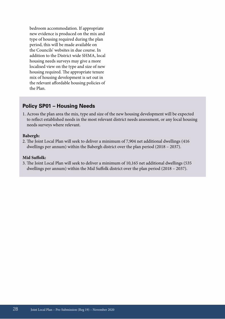
Policy SP01 – Housing Needs1. Across the plan area the mix, type and size of the new housing development will be expected
to reflect established needs in the most relevant district needs assessment, or any local housing needs surveys where relevant.
Babergh:2. The Joint Local Plan will seek to deliver a minimum of 7,904 net additional dwellings (416
dwellings per annum) within the Babergh district over the plan period (2018 – 2037).
Mid Suffolk:3. The Joint Local Plan will seek to deliver a minimum of 10,165 net additional dwellings (535
dwellings per annum) within the Mid Suffolk district over the plan period (2018 – 2037).
bedroom accommodation. If appropriate new evidence is produced on the mix and type of housing required during the plan period, this will be made available on the Councils’ websites in due course. In addition to the District wide SHMA, local housing needs surveys may give a more localised view on the type and size of new housing required. The appropriate tenure mix of housing development is set out in the relevant affordable housing policies of the Plan.
Policy background and explanation07.01 This planning policy reflects the size,
type and tenure of housing needed for different people in the community. Affordable housing is an identified need within Babergh and Mid Suffolk Districts as required by Paragraph 61 of the NPPF (2019).
07.02 Affordable housing is housing for sale or rent, for those whose needs are not met by the market, which includes housing that provides a subsidised route to home ownership and/or is for essential local workers. Annex 2 of the NPPF (2019) sets out the definition of affordable housing and is split into the following four main categories: affordable housing for rent, starter homes, discounted market sale housing and other affordable routes to home ownership.
07.03 High house prices across Babergh and Mid Suffolk Districts mean that it is difficult for people to purchase or rent a house on the open market. The evidence based SHMA (January 2019) establishes Babergh and Mid Suffolk are within the Ipswich Housing Market Area (HMA). The 2014-based local housing need identifies the overall affordable housing requirement over the plan period is as follows:
Babergh District11
07.04 The demographic projections identify there is estimated to be a total of 47,198 households that will be resident in Babergh in 2036. This is 1,203 more
than the previous SHMA evidence of September 2017. The household type breakdown is as follows: one person 30.3%, Couple with no children 35.1%, Couple with child/children 20.0%, Lone parent 8.1% and other12 6.4%. The figures indicate that the number of ‘other’ households are expected to increase the most in Babergh (albeit from a low base), followed by lone parent households. The number of couples with children is projected to remain largely unchanged.
07.05 For Babergh, the overall profile of affordable housing appropriate to meet the population over the plan period derived from Local Housing Need is: 13.3% of housing to be Affordable Rented and 13.5% affordable home ownership (of which 6.8% could be Shared Ownership and 6.7% Starter Homes demand rather than requirement13) reflecting the mix of housing that would best address the needs of the local population. However, this does not take into account the funding that will be available to help provide subsidised housing, and government policy on the level of funding fluctuates within the national spending review process.
07.06 The table overleaf shows the tenure & size profile required in Babergh.
Joint Local Plan – Pre-Submission (Reg 19) – November 2020 29
07 Affordable Housing
11 Data based on 2014-based LHN (Local Housing Need) (SHMA January 2019)12 Other households include multi-generational households, student households, households of unrelated people sharing accommodation as well as other groups.13 The SHMA (January 2019) identified people currently occupying private rented sector who may be potential purchasers (known as potential demand) of starter homes/discount market, but is currently not a requirement. More information from the government is due on this.
Mid Suffolk District14
07.07 The demographic projections identify there is estimated to be a total of 53,855 households that will be resident in Mid Suffolk in 2036. This is 2,355 more than the previous SHMA evidence of September 2017. The household type breakdown is as follows: one person 27.6%, Couple with no children 37.4%, Couple with child/children 21.9%, Lone parent 8.3% and other15 4.8%. The figures indicate that the number of lone parent households are expected to increase the most in Mid Suffolk, followed by ‘other’ households. Couples with children are projected to record the smallest rise.
07.08 For Mid Suffolk the overall profile of affordable housing appropriate to meet the population over the plan period derived from Local Housing Need is: 12.7% of housing to be Affordable Rented and 10.0% affordable home ownership (of
which 5.8% could be Shared Ownership and 4.2% Starter Homes demand rather than requirement16) reflects the mix of housing that would best address the needs of the local population. But this does not take into account the funding that will be available to help provide subsidised housing, and government policy on the level of funding fluctuates with the national spending review process.
07.09 The table opposite shows the tenure & size profile required in Mid Suffolk.
Joint Local Plan – Pre-Submission (Reg 19) – November 202030
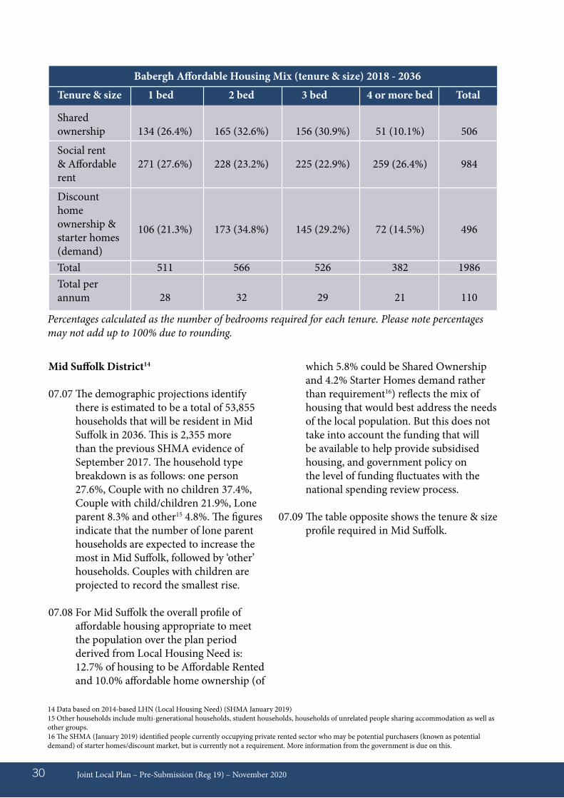
Babergh Affordable Housing Mix (tenure & size) 2018 - 2036
Tenure & size 1 bed 2 bed 3 bed 4 or more bed Total
Shared ownership
Social rent & Affordable rent
Discount home ownership & starter homes (demand)TotalTotal per annum
134 (26.4%)
271 (27.6%)
106 (21.3%)
511
28
165 (32.6%)
228 (23.2%)
173 (34.8%)
566
32
156 (30.9%)
225 (22.9%)
145 (29.2%)
526
29
51 (10.1%)
259 (26.4%)
72 (14.5%)
382
21
506
984
496
1986
110
Percentages calculated as the number of bedrooms required for each tenure. Please note percentages may not add up to 100% due to rounding.
14 Data based on 2014-based LHN (Local Housing Need) (SHMA January 2019)15 Other households include multi-generational households, student households, households of unrelated people sharing accommodation as well as other groups.16 The SHMA (January 2019) identified people currently occupying private rented sector who may be potential purchasers (known as potential demand) of starter homes/discount market, but is currently not a requirement. More information from the government is due on this.
07.10 Where viability assessments are submitted the Council will expect applicants to clearly set out all of the assumptions and evidence behind the assumption that go into the appraisal. The supply of information must be presented on an open book basis using the Homes and Communities Agency Development Appraisal Tool (DAT model)17 including the calculation of residual land value and any cash-flow analysis. There must be no hidden calculations or assumptions in any model or appraisal. Viability assessments will be made publicly available. For the implementation of exceptional circumstances reference must be made to the development management policy on Affordable Housing.
07.11 Development appraisals must include details of the proposed scheme including site area, residential unit numbers, number of habitable rooms, unit size, density and the split between the proposed tenures. Floorspace figures must also be provided for residential
uses (gross internal area) by tenure, and non-residential uses in gross internal area (GIA) and net internal area (NIA). Information should be provided relating to the target market of the development and proposed specification, which should be consistent with assumed costs and values. Details of the assumed development programme and the timing of costs and income inputs should be provided.
Joint Local Plan – Final Draft (Reg 19) – November 2020 31
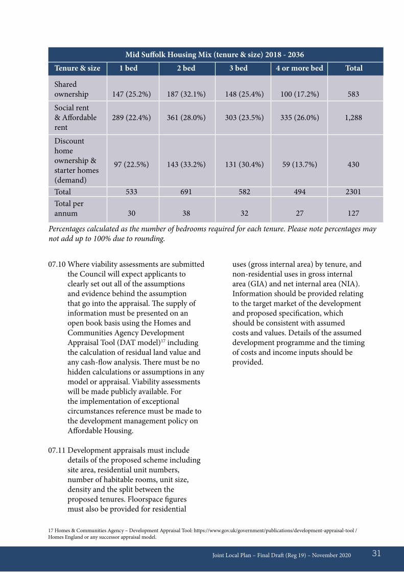
Mid Suffolk Housing Mix (tenure & size) 2018 - 2036
Tenure & size 1 bed 2 bed 3 bed 4 or more bed Total
Shared ownership
Social rent & Affordable rent
Discount home ownership & starter homes (demand)TotalTotal per annum
147 (25.2%)
289 (22.4%)
97 (22.5%)
533
30
187 (32.1%)
361 (28.0%)
143 (33.2%)
691
38
148 (25.4%)
303 (23.5%)
131 (30.4%)
582
32
100 (17.2%)
335 (26.0%)
59 (13.7%)
494
27
583
1,288
430
2301
127
Percentages calculated as the number of bedrooms required for each tenure. Please note percentages may not add up to 100% due to rounding.
17 Homes & Communities Agency – Development Appraisal Tool: https://www.gov.uk/government/publications/development-appraisal-tool / Homes England or any successor appraisal model.
Joint Local Plan – Final Draft (Reg 19) – November 202032
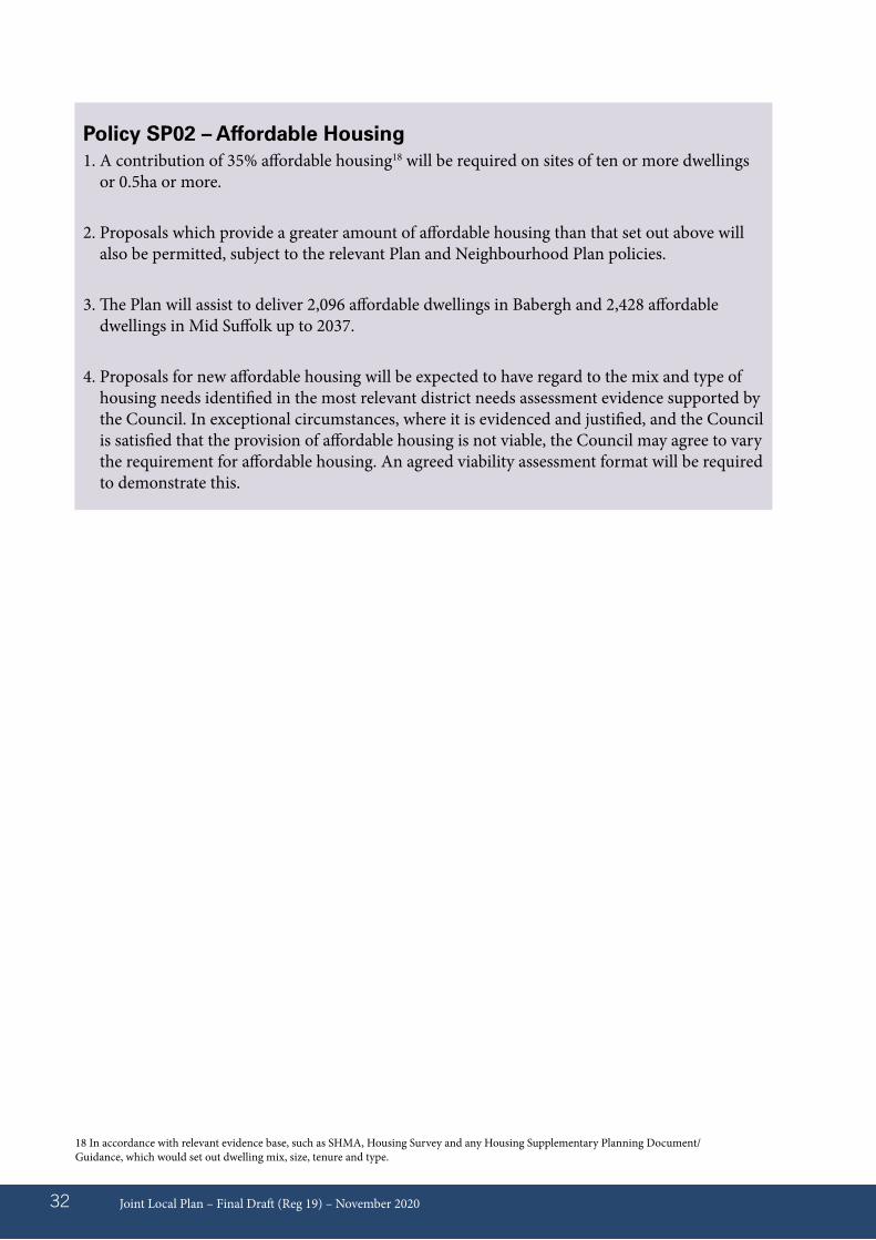
Policy SP02 – Affordable Housing1. A contribution of 35% affordable housing18 will be required on sites of ten or more dwellings
or 0.5ha or more.
2. Proposals which provide a greater amount of affordable housing than that set out above will also be permitted, subject to the relevant Plan and Neighbourhood Plan policies.
3. The Plan will assist to deliver 2,096 affordable dwellings in Babergh and 2,428 affordable dwellings in Mid Suffolk up to 2037.
4. Proposals for new affordable housing will be expected to have regard to the mix and type of housing needs identified in the most relevant district needs assessment evidence supported by the Council. In exceptional circumstances, where it is evidenced and justified, and the Council is satisfied that the provision of affordable housing is not viable, the Council may agree to vary the requirement for affordable housing. An agreed viability assessment format will be required to demonstrate this.
18 In accordance with relevant evidence base, such as SHMA, Housing Survey and any Housing Supplementary Planning Document/Guidance, which would set out dwelling mix, size, tenure and type.
Policy background and explanation08.01 In considering the broad locations for
new development, national planning policy requires that sustainable development be applied through balancing social, economic and environmental objectives. Development needs to be accommodated in settlements where the need to travel can be reduced, through good access to facilities and services and where significant adverse impacts can be avoided or mitigated. In combination with the spatial distribution, the settlement hierarchy acts as a useful tool to enable these objectives to be met.
08.02 The Babergh and Mid Suffolk Ipswich fringe areas have historically been strategic designations, as growth areas in recognition of the cross-boundary influence of the county town of Ipswich as a regional service centre. This strategic area will remain in the Babergh and Mid Suffolk Joint Local Plan. Similarly, settlements previously identified as Urban Areas and Market Towns in the previous adopted development plans, will continue to be identified as such. This is in recognition of the significant service and facility provision they make to the wider catchment area.
08.03 A weighted scoring system has been used to indicate the relative sustainability of villages, by identifying Core Villages, Hinterland Villages and Hamlets Villages. Due to the dispersed nature of some settlements in Babergh and Mid Suffolk, the settlement hierarchy assesses the sustainability of settlements themselves, rather than the wider parish. Settlements that do not have ten or more well related dwellings have not been identified in the settlement hierarchy. Such settlements are
addressed in the Hamlets and Clusters of Development in the Countryside policy.
08.04 Each category of settlements will be required to contribute towards the future growth of the Districts. It is important that development is proportionate to the provision of services and facilities within those settlements, and as such, the Ipswich Fringe, Market Towns/Urban Areas and Core Villages categories will take the largest levels of growth. The settlement hierarchy needs to be considered in combination with the Spatial Distribution. However, all settlements within each category are not equal, and there will be some variance in levels of growth dependent upon a number of factors, including the availability of suitable development sites, infrastructure capacity and considerations of the built and natural environment.
Joint Local Plan – Final Draft (Reg 19) – November 2020 33
08 Settlement Hierarchy
Joint Local Plan – Final Draft (Reg 19) – November 202034
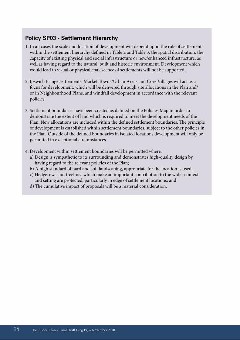
Policy SP03 - Settlement Hierarchy1. In all cases the scale and location of development will depend upon the role of settlements
within the settlement hierarchy defined in Table 2 and Table 3, the spatial distribution, the capacity of existing physical and social infrastructure or new/enhanced infrastructure, as well as having regard to the natural, built and historic environment. Development which would lead to visual or physical coalescence of settlements will not be supported.
2. Ipswich Fringe settlements, Market Towns/Urban Areas and Core Villages will act as a focus for development, which will be delivered through site allocations in the Plan and/or in Neighbourhood Plans, and windfall development in accordance with the relevant policies.
3. Settlement boundaries have been created as defined on the Policies Map in order to demonstrate the extent of land which is required to meet the development needs of the Plan. New allocations are included within the defined settlement boundaries. The principle of development is established within settlement boundaries, subject to the other policies in the Plan. Outside of the defined boundaries in isolated locations development will only be permitted in exceptional circumstances.
4. Development within settlement boundaries will be permitted where:a) Design is sympathetic to its surrounding and demonstrates high-quality design by
having regard to the relevant policies of the Plan;b) A high standard of hard and soft landscaping, appropriate for the location is used;c) Hedgerows and treelines which make an important contribution to the wider context
and setting are protected, particularly in edge of settlement locations; andd) The cumulative impact of proposals will be a material consideration.
Joint Local Plan – Final Draft (Reg 19) – November 2020 35
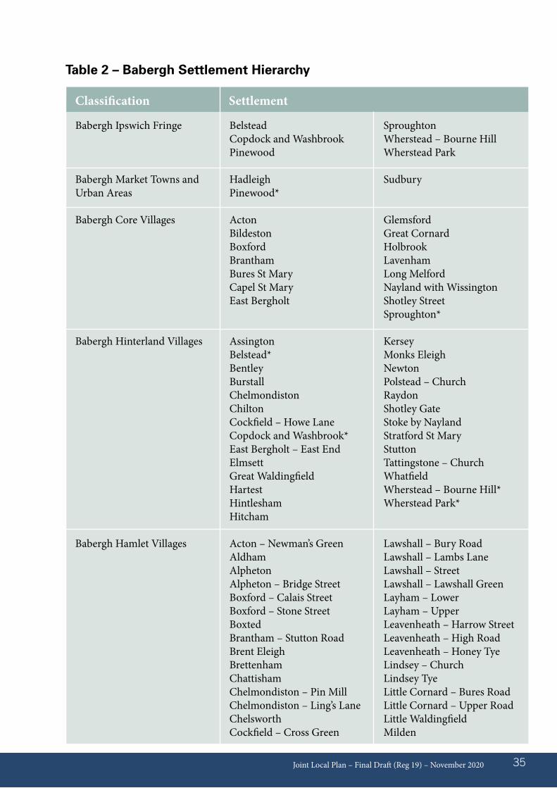
Table 2 – Babergh Settlement Hierarchy
Babergh Ipswich Fringe
Babergh Market Towns and Urban Areas
Babergh Core Villages
Babergh Hinterland Villages
Babergh Hamlet Villages
BelsteadCopdock and WashbrookPinewood
HadleighPinewood*
ActonBildestonBoxfordBranthamBures St MaryCapel St MaryEast Bergholt
AssingtonBelstead*BentleyBurstall Chelmondiston ChiltonCockfield – Howe LaneCopdock and Washbrook*East Bergholt – East EndElmsettGreat WaldingfieldHartestHintlesham Hitcham
Acton – Newman’s GreenAldham AlphetonAlpheton – Bridge StreetBoxford – Calais StreetBoxford – Stone StreetBoxtedBrantham – Stutton RoadBrent Eleigh Brettenham ChattishamChelmondiston – Pin MillChelmondiston – Ling’s LaneChelsworth Cockfield – Cross Green
SproughtonWherstead – Bourne HillWherstead Park
Sudbury
GlemsfordGreat CornardHolbrookLavenhamLong MelfordNayland with WissingtonShotley StreetSproughton*
KerseyMonks EleighNewtonPolstead – ChurchRaydonShotley GateStoke by NaylandStratford St MaryStuttonTattingstone – ChurchWhatfieldWherstead – Bourne Hill*Wherstead Park*
Lawshall – Bury RoadLawshall – Lambs LaneLawshall – StreetLawshall – Lawshall GreenLayham – LowerLayham – UpperLeavenheath – Harrow StreetLeavenheath – High RoadLeavenheath – Honey TyeLindsey – ChurchLindsey TyeLittle Cornard – Bures RoadLittle Cornard – Upper RoadLittle WaldingfieldMilden
Classification Settlement
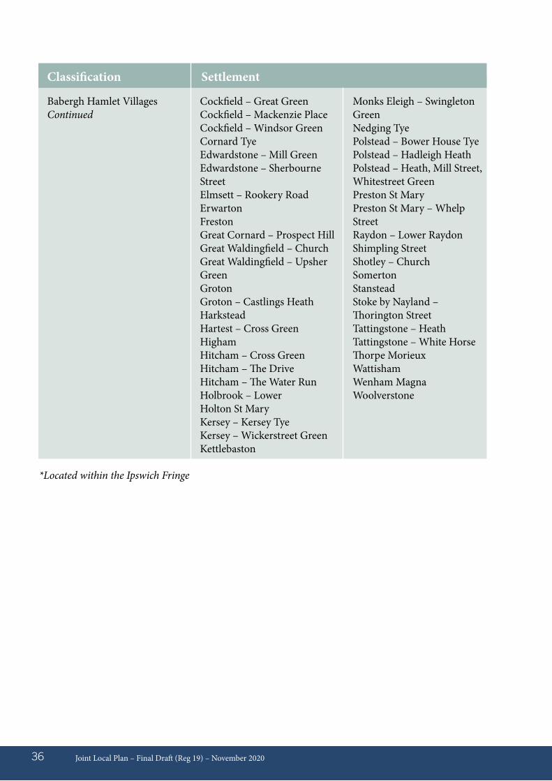
Joint Local Plan – Final Draft (Reg 19) – November 202036
Cockfield – Great GreenCockfield – Mackenzie PlaceCockfield – Windsor GreenCornard TyeEdwardstone – Mill GreenEdwardstone – Sherbourne StreetElmsett – Rookery RoadErwartonFrestonGreat Cornard – Prospect HillGreat Waldingfield – ChurchGreat Waldingfield – Upsher GreenGrotonGroton – Castlings HeathHarksteadHartest – Cross GreenHighamHitcham – Cross GreenHitcham – The DriveHitcham – The Water RunHolbrook – LowerHolton St MaryKersey – Kersey TyeKersey – Wickerstreet GreenKettlebaston
Monks Eleigh – Swingleton GreenNedging TyePolstead – Bower House TyePolstead – Hadleigh HeathPolstead – Heath, Mill Street, Whitestreet GreenPreston St MaryPreston St Mary – Whelp StreetRaydon – Lower RaydonShimpling StreetShotley – ChurchSomertonStansteadStoke by Nayland – Thorington StreetTattingstone – HeathTattingstone – White HorseThorpe MorieuxWattishamWenham MagnaWoolverstone
Classification Settlement
Babergh Hamlet VillagesContinued
*Located within the Ipswich Fringe

Joint Local Plan – Final Draft (Reg 19) – November 2020 37
Table 03 - Mid Suffolk Settlement Hierarchy
Mid Suffolk Ipswich Fringe
Mid Suffolk Market Towns and Urban Areas
Mid Suffolk Core Villages
Mid Suffolk Hinterland Villages
Barham – Sandy LaneBarham – Bell’s Cross RoadBramfordClaydon with part Barham
Eye Needham Market
BactonBotesdale and RickinghallBramford*Claydon with part Barham*DebenhamElmswellHaughley
Badwell AshBarham - Sandy Lane*BarkingBeytonBromeCoddenhamCombsCreeting St Mary Earl Stonham - Forward GreenFelshamFinninghamFressingfieldGislinghamGreat Blakenham*Great FinboroughHenleyHessettHorhamHoxne - Cross Street/ Heckfield GreenHoxne - Low StreetLaxfieldMellis
Great BlakenhamGreat Blakenham – Old Bell HouseWhitton
Stowmarket
MendleshamStowuplandStradbrokeThurstonWalsham-le-WillowsWoolpit
Mendham - ChurchMetfieldNortonOccoldOld NewtonOnehousePalgraveRattlesdenRedgraveSomershamStonham AspalStonham ParvaStustonThorndonThwaiteTostockWattisham AirfieldWetheringsett-Cum- Brockford - ChurchWhitton*WorthamYaxley
Classification Settlement
Joint Local Plan – Pre-Submission (Reg 19) – November 202038
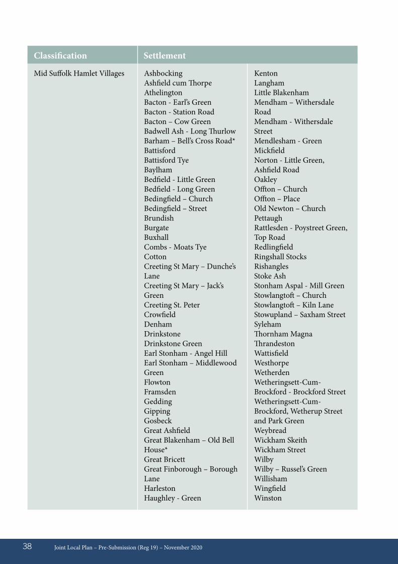
Mid Suffolk Hamlet Villages AshbockingAshfield cum ThorpeAthelingtonBacton - Earl’s GreenBacton - Station RoadBacton – Cow GreenBadwell Ash - Long ThurlowBarham – Bell’s Cross Road*BattisfordBattisford TyeBaylhamBedfield - Little GreenBedfield - Long GreenBedingfield – ChurchBedingfield – StreetBrundishBurgateBuxhallCombs - Moats TyeCottonCreeting St Mary – Dunche’s LaneCreeting St Mary – Jack’s GreenCreeting St. PeterCrowfieldDenhamDrinkstoneDrinkstone GreenEarl Stonham - Angel HillEarl Stonham – Middlewood GreenFlowtonFramsdenGeddingGippingGosbeckGreat AshfieldGreat Blakenham – Old Bell House*Great BricettGreat Finborough – Borough LaneHarlestonHaughley - Green
KentonLanghamLittle BlakenhamMendham – Withersdale RoadMendham - Withersdale StreetMendlesham - GreenMickfieldNorton - Little Green, Ashfield RoadOakleyOffton – ChurchOffton – Place Old Newton – Church PettaughRattlesden - Poystreet Green, Top RoadRedlingfieldRingshall StocksRishanglesStoke AshStonham Aspal - Mill GreenStowlangtoft – ChurchStowlangtoft – Kiln LaneStowupland – Saxham StreetSylehamThornham MagnaThrandestonWattisfieldWesthorpeWetherdenWetheringsett-Cum-Brockford - Brockford StreetWetheringsett-Cum- Brockford, Wetherup Street and Park GreenWeybreadWickham SkeithWickham StreetWilbyWilby – Russel’s GreenWillishamWingfieldWinston
Classification Settlement
Joint Local Plan – Pre-Submission (Reg 19) – November 2020 39
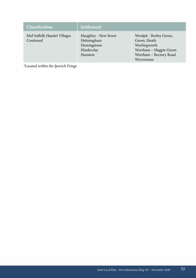
Haughley - New StreetHelminghamHemingstoneHinderclayHunston
Woolpit - Borley Green, Green, HeathWorlingworth Wortham – Magpie GreenWortham – Rectory Road Wyverstone
Classification Settlement
*Located within the Ipswich Fringe
Mid Suffolk Hamlet VillagesContinued
Context09.01 The Councils need to plan the right
locations to meet the identified local housing and economic needs across the district areas. Growth has many key benefits, including the securing of greater local investment, adapting and enhancing the local environment to modern living contexts, creating local job opportunities and ensuring local people have suitable and affordable homes to live in.
Housing09.02 Since the 2001 Census, both Districts have
delivered housing growth predominantly in the rural areas (approximately 60%). In recent years, both Babergh and Mid Suffolk Districts have experienced difficulty in meeting the identified housing targets for the respective areas and have had a limited number of allocated sites. The Councils are working to address this, including the production of an ‘Action Plan’ to focus upon the timely delivery of new housing. This Plan has identified a supply of development from April 2018 up to March 2037. In constructing the spatial distribution of this Plan, the Councils have been mindful of the inherent market strengths within the area and have sought to ensure that the most suitable and deliverable sites are proposed. In many instances, this requires the complex alignment with infrastructure improvement programmes and investment to ensure that growth is planned in a sustainable manner.
09.03 A significant number of Neighbourhood Plans (NPs) are emerging throughout the Plan area, with a range of local issues and objectives being planned for. The District Councils have produced minimum housing requirement figures
for these areas to assist the NP groups in the formation and progression of those plans. In identifying the respective NP requirement figures, the Councils have been mindful of their duty to ensure that the overall district Plan requirement figures can be met.
09.04 Planning permissions yet to be completed as of 1st April 2018 are counted, leaving a residual amount to be found from new development locations. The total housing numbers in the Plan have been identified by combining the outstanding dwellings with planning permissions as of 1st April 2018, with new development locations set out in the Plan.
09.05 Cumulatively, allocations of importance to delivery of the Plan (in particular key infrastructure delivery and meeting local housing need) will be attributed to new housing growth in the following criteria:• Key sites in the Ipswich Fringe• Settlements along the A14/mainline
railway corridor (Mid Suffolk)• Settlements along the A12/mainline
railway corridor (Babergh)• Settlements requiring new school and/or
healthcare sites.
09.06 The transport corridors of the A12, A14, A140 and railway lines within the area have a strong effect upon market forces and demand for both housing and employment land. Compatible growth along these areas can help to reduce the need to travel by ensuring closer location of where people live, relative to shops, services and employment. However, Babergh and Mid Suffolk are both rural districts, with a wide variety of settlement types and it is important that all communities throughout the area are helped to maintain vitality and services.
Joint Local Plan – Pre-Submission (Reg 19) – November 202040
09 Spatial Distribution
Consistent with national planning policy, this Plan seeks to create flexibility and diversity with policies for appropriate rural growth.
Spatial approach09.07 The spatial distribution of housing set out
in this Plan seeks to secure a balance to growth in the strategic transport corridor areas, as well as ensuring that other market towns and rural communities’ benefit from appropriate growth. A diversity of site sizes and locations are proposed which will help to maintain delivery at the scale to meet district targets. The Councils will closely monitor the ongoing annual delivery rates of housing across the Plan area and will take appropriate, pro-active action, if it is required to address delivery performance issues.
09.08 The specific new development locations are identified on the Policies Maps at the end of the document. The new development locations have been identified with consideration to consultation responses, the availability and deliverability of sites, the preferred spatial distribution pattern, the sensitivities and constraints of the area (eg. flood zones, heritage features and landscape designations etc) and the infrastructure capacity and opportunities (eg. schools and healthcare etc). Sites judged to perform best overall against the above criteria and evidence base outcomes have been proposed in this document.
09.09 Windfall sites are defined as sites not specifically identified in the development plan. As evidenced in the latest Annual Monitoring Report19, in the last four years, the volume of windfall dwelling completions has been significant, with a total of approximately 600 dwellings in Babergh and approximately 1,000 dwellings in Mid Suffolk. In addition
to the supply of housing land identified in the Plan, the Councils have also included an allowance for new ‘windfall’ development of 500 dwellings (28 dwellings per annum) for each district. This is considered a measured and reasonable allowance given the recent historic rates of windfall and abundance of new allocations identified in the Plan.
09.10 Whilst a new settlement approach has been discounted in this Plan, the Councils are mindful to give consideration to the longer term prospect of planning for a new settlement at the Plan review (due to be undertaken within 5 years of this Plan adoption). Some of the key criteria for the broad location of a new settlement would likely include:
a. Significant land for a genuine discrete new settlement, or the realistic prospect for transformational development, both in nature and scale, of an existing settlement;
b. Opportunities for significant re-use of brownfield land;
c. Opportunities for improvement and integration of strategic transport routes;
d. Accessibility to job concentrations, or the realistic prospect for significant new employment land located with new homes; and
e. Opportunities to optimise new infrastructure delivery.
Joint Local Plan – Pre-Submission (Reg 19) – November 2020 41
19 https://www.babergh.gov.uk/planning/planning-policy/evidence-base/annual-monitoring-report-amr/
Joint Local Plan – Pre-Submission (Reg 19) – November 202042
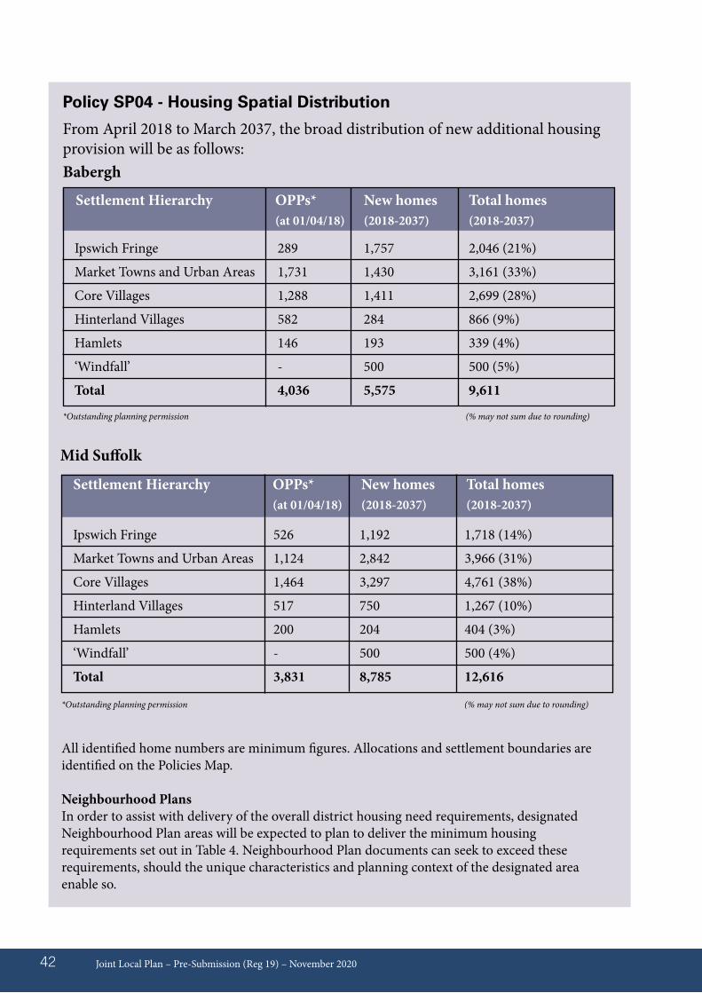
Policy SP04 - Housing Spatial Distribution
From April 2018 to March 2037, the broad distribution of new additional housing provision will be as follows: Babergh
Settlement Hierarchy OPPs* New homes Total homes (at 01/04/18) (2018-2037) (2018-2037)
Ipswich Fringe 289 1,757 2,046 (21%)
Market Towns and Urban Areas 1,731 1,430 3,161 (33%)
Core Villages 1,288 1,411 2,699 (28%)
Hinterland Villages 582 284 866 (9%)
Hamlets 146 193 339 (4%)
‘Windfall’ - 500 500 (5%)
Total 4,036 5,575 9,611
*Outstanding planning permission (% may not sum due to rounding)
Mid Suffolk
Ipswich Fringe
Market Towns and Urban Areas
Core Villages
Hinterland Villages
Hamlets
‘Windfall’
Total
526 1,192 1,718 (14%)
1,124 2,842 3,966 (31%)
1,464 3,297 4,761 (38%)
517 750 1,267 (10%)
200 204 404 (3%)
- 500 500 (4%)
3,831 8,785 12,616
Settlement Hierarchy OPPs* New homes Total homes (at 01/04/18) (2018-2037) (2018-2037)
All identified home numbers are minimum figures. Allocations and settlement boundaries are identified on the Policies Map.
Neighbourhood PlansIn order to assist with delivery of the overall district housing need requirements, designated Neighbourhood Plan areas will be expected to plan to deliver the minimum housing requirements set out in Table 4. Neighbourhood Plan documents can seek to exceed these requirements, should the unique characteristics and planning context of the designated area enable so.
*Outstanding planning permission (% may not sum due to rounding)
Joint Local Plan – Pre-Submission (Reg 19) – November 2020 43
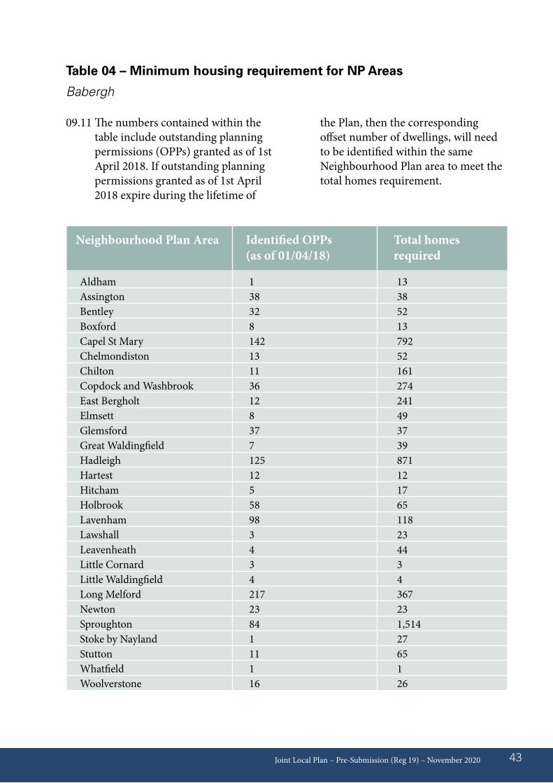
Table 04 – Minimum housing requirement for NP Areas
Babergh
Neighbourhood Plan Area Identified OPPs Total homes (as of 01/04/18) required
Aldham 1 13 Assington 38 38 Bentley 32 52 Boxford 8 13 Capel St Mary 142 792 Chelmondiston 13 52 Chilton 11 161 Copdock and Washbrook 36 274 East Bergholt 12 241 Elmsett 8 49 Glemsford 37 37 Great Waldingfield 7 39 Hadleigh 125 871 Hartest 12 12 Hitcham 5 17 Holbrook 58 65 Lavenham 98 118 Lawshall 3 23 Leavenheath 4 44 Little Cornard 3 3 Little Waldingfield 4 4 Long Melford 217 367 Newton 23 23 Sproughton 84 1,514 Stoke by Nayland 1 27 Stutton 11 65 Whatfield 1 1 Woolverstone 16 26
09.11 The numbers contained within the table include outstanding planning permissions (OPPs) granted as of 1st April 2018. If outstanding planning permissions granted as of 1st April 2018 expire during the lifetime of
the Plan, then the corresponding offset number of dwellings, will need to be identified within the same Neighbourhood Plan area to meet the total homes requirement.
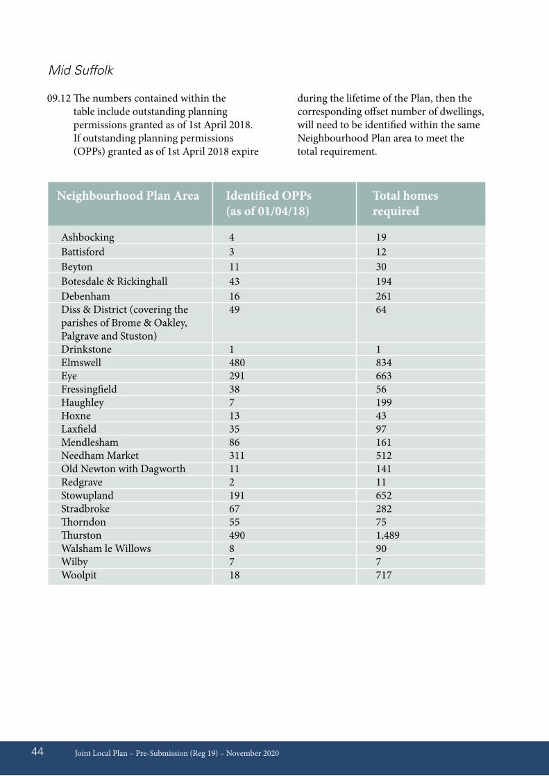
09.12 The numbers contained within the table include outstanding planning permissions granted as of 1st April 2018. If outstanding planning permissions (OPPs) granted as of 1st April 2018 expire
during the lifetime of the Plan, then the corresponding offset number of dwellings, will need to be identified within the same Neighbourhood Plan area to meet the total requirement.
Joint Local Plan – Pre-Submission (Reg 19) – November 202044
Mid Suffolk
Neighbourhood Plan Area Identified OPPs Total homes (as of 01/04/18) required
Ashbocking 4 19 Battisford 3 12 Beyton 11 30 Botesdale & Rickinghall 43 194 Debenham 16 261 Diss & District (covering the 49 64 parishes of Brome & Oakley, Palgrave and Stuston) Drinkstone 1 1 Elmswell 480 834 Eye 291 663 Fressingfield 38 56 Haughley 7 199 Hoxne 13 43 Laxfield 35 97 Mendlesham 86 161 Needham Market 311 512 Old Newton with Dagworth 11 141 Redgrave 2 11 Stowupland 191 652 Stradbroke 67 282 Thorndon 55 75 Thurston 490 1,489 Walsham le Willows 8 90 Wilby 7 7 Woolpit 18 717
EconomicEconomic Growth
09.13 Babergh and Mid Suffolk District Council’s support a strong, responsive and competitive economy, by supporting economic activity and encouraging investment in skills and innovation in order to drive and increase productivity (Joint Strategic Plan 2016 – 18 / Open for Business, Economic Strategy, 2018).
09.14 Overall, the Lichfields Sector Needs Assessment (2017) indicates that Babergh and Mid Suffolk have modest net additional employment land requirements. In quantitative terms, there is considered to be adequate land to meet baseline objectively assessed need (OAN) over the plan period, given the modest baseline forecast in both areas. The allocations are predominantly on the former Sproughton Sugar Beet site / Sproughton Enterprise Park and the Stowmarket Mill Lane/Gateway 14 site, supported by small parcels of available land across the Districts’ identified employment locations along the strategic transport corridors, a number of which have planning permission. Planning permissions yet to be completed as of 1st April 2018 have been assumed, leaving a residual amount to be found from new development locations
09.15 However, whilst the baseline land forecast indicates modest land requirements over the Plan period, it is important that there is flexibility to meet the changing demands of the economy, there is a general qualitative need to improve premises options and update or replace ageing stock to meet modern energy efficiency performance demands, architectural attractiveness and premises format needs. Availability of sites with good infrastructure in road, rail, and high-speed broadband and 5G is important for maintaining economic prosperity. The future prosperity of the Districts is dependant upon the diversity of available employment land and, where possible,
retaining the existing economic base. This is not necessarily in terms of maintaining a land area, but rather being flexible in securing business retention and expansion in challenging economic circumstances.
09.16 Flexibility to accommodate net strategic growth on strategic employment sites is essential to securing the future prosperity of the area. There are 9 main Strategic employment areas:• Stowmarket• Sudbury• Villages around Ipswich (Claydon & Great
Blakenham, Sproughton, Wherstead)• Acton• Eye• Hadleigh• Needham Market• Raydon• Woolpit
09.17 It is important that the flexibility to enable economic investment is balanced with the need to safeguard the network of sites, which have a central role in supporting economic activity across Babergh and Mid Suffolk. Proposals for net additional land must demonstrably enhance overall economic position and will not jeopardise the ongoing retention of the existing employment uses. There is a need to ensure that employment opportunities exist throughout the Districts’ villages, to help to create sustainable communities and reduce the rate of out-commuting. The economic importance of supporting the retention of a network of medium and small-scale clusters; both the larger single user occupied and the clusters of local businesses that provide local employment opportunities throughout the villages. Cumulatively these sites ensure the economic sustainability of Babergh and Mid Suffolk. Detailed policies to address the protection in the diversity in the type, scale and location of employment sites are set out in Part 2.
Joint Local Plan – Pre-Submission (Reg 19) – November 2020 45
09.18 With the aim of supporting key employment sectors in the locality there are 3 enterprise zones designated across Babergh and Mid Suffolk:
1. Stowmarket Enterprise Park, Gateway 14, Mill Lane - a designated Enterprise Zone (EZ) site that extends to approximately 52 ha, of which 34 ha is developable land. The Enterprise Park sits within Gateway 14. The EZ site is also a designated Food Enterprise Zone (FEZ). This designated Enterprise Zone site will focus upon providing serviced employment land for development focussed upon business and employment use and distribution.
2. Sproughton Enterprise Park - The site is around 52 hectares and lies on the western edge of the Ipswich built up area. The site is allocated for employment uses in the current Babergh Core Strategy. The previously developed area is estimated to be in the region of 35.5ha, and the EZ is 14ha.
3. The Orwell Food Enterprise Zone at Wherstead, offers business incentives to businesses in the food and beverage industries.
Policy background and explanationContext09.19 Babergh and Mid Suffolk are located
within the Ipswich Economic Area (IEA), along with Ipswich and Suffolk Coastal (now part of East Suffolk). Within the IEA, the A14 road and rail corridor is the main arterial route for goods between Europe and the distribution warehouses in the English midlands. The corridor also aligns with the key commercial property market in the IEA from Felixstowe westwards to Stowmarket (Lichfields, 2017). The Cambridge Economic Area adjoins further to the west at Bury St Edmunds. The A140 and A12 also provide key arterial routes for the movement of goods and business activity. Elsewhere
in the IEA the commercial centres of Hadleigh and Sudbury contain localised markets. Rural and agricultural areas make up the rest of the IEA with 11,300 square kilometres (or 4,366 square miles) classified as rural representing 94% of the total area (Lichfields, 2017).
09.20 Spatially in Mid Suffolk, commercial activity is concentrated in and around the A14 corridor. The largest hub is at Stowmarket, followed by Needham Market, Great Blakenham and Claydon. The District’s industrial market is relatively strong within Stowmarket, particularly focussed on manufacturing, distribution and logistics activity (Lichfields, 2017) including Muntons, PPG, Bacton Transport and Truck East. There is also a major employment hub on the former WWII airfield site at Eye to the north of the District which hosts manufacturers, wholesalers and agriculture businesses. Villages such as Mendlesham and Woolpit accommodate industrial estate employment. Outside the main centres, the majority of rural employment sites in Mid Suffolk are relatively small and have grown organically in the location to serve local needs.
09.21 Babergh District is also largely rural in nature, with the economic hubs located in the market towns of Sudbury and Hadleigh. Employment is concentrated around the Ipswich administrative area at Copdock Interchange Retail Park and Farthing Road Industrial Estate (Sproughton). Many smaller settlements contain clusters of businesses, such as at Bildeston. There are clusters of tourism businesses at Lavenham and Long Melford. The remainder of the District comprises rural businesses with diverse property needs.
09.22 The approach set out in the Plan seeks to maintain the geographical range and diversity of employment land across the
Joint Local Plan – Pre-Submission (Reg 19) – November 202046
District areas, whilst also recognising that there is a need for policy flexibility to enable the demands of future economic needs and investment to be accommodated. A balance must be struck between safeguarding existing sites, which are vital to the area, whilst supporting new investment, which will enhance the overall economic base.
09.23 Across Babergh and Mid Suffolk employment sites tend to comprise of the following:
Strategic Employment Locations• These employment sites are of strategic
importance to the District wide economy. They are functioning well and will remain the main core of industrial land and premises within the Districts. The business estates in these areas are generally operating at capacity.
• Sudbury, Hadleigh, Acton, Claydon and Great Blakenham, Sproughton, Wherstead, Stowmarket, Needham Market, Woolpit & Eye.
• Within the Strategic sites are three (Food) Enterprise Zones: Sproughton Sugar Beet Regeneration site, Mill Lane/Gateway14 Stowmarket, and at Wherstead.
09.24 Strategic Regeneration opportunities are provided at the former Sugar Beet Factory at Sproughton and Brantham Regeneration Site in the South of Babergh; both of which have a long-established industrial heritage.
Business and Enterprise Hubs• Cumulatively important, the hubs
provide a network of over 100 smaller sites are dispersed throughout the Districts, providing lower-cost premises to SME businesses in the many small settlements.
• Clusters containing multiple, often self supporting businesses.
• Often converted from agricultural use these areas have developed organically over time.
Joint Local Plan – Pre-Submission (Reg 19) – November 2020 47
Joint Local Plan – Pre-Submission (Reg 19) – November 202048
Policy SP05 – Employment Land1) In order to support and encourage sustainable economic growth and ensure a continuous
range and diversity of sites and premises are available to meet current and potential future economic needs the strategic employment sites (as identified on the policies map) shall be protected and their proposed expansion supported in principle:a) Stowmarket - Charles Industrial Estate; Gipping Employment Corridor; Mill Laneb) Sudbury – Chilton Industrial Estate, Delphi Site Churchfield Road (part Chilton parish)
and Northern Road; Wood Hall Business Parkc) Villages around Ipswich
a) Claydon & Great Blakenham – Gipping and Claydon Business Parkb) Wherstead – Wherstead Business Parkc) Sproughton – Former Sugar Beet Factory Site; Farthing Road Industrial Estate
d) Acton – Bull Lanee) Eye – Eye Airfieldf) Hadleigh – Lady Laneg) Needham Market – Lion Barnh) Raydon – Notley Enterprise Parki) Woolpit – Lady’s Well; Lawn Farm; Brickworks; Woolpit Business Park
2) The ongoing economic led regeneration at Brantham and at the Former Sproughton Sugar Beet Factory regeneration sites is supported. Development at the Brantham site must be sensitive to the estuarine/coastal location, which is in close proximity to the AONB, in relation to landscape, biodiversity, potentially flood risk, and, where relevant, the historic environment. This site could offer significant potential for biodiversity net gain as well as landscape improvements to reflect its location close to the AONB and coast. Similarly, regeneration at the Former Sproughton Sugar Beet Factory, must be sensitive to landscape, biodiversity (with consideration given to potential for biodiversity new gain) and heritage assets and sensitivity.
3) Existing employment uses should be retained. These sites will generally be expected to continue to provide for local employment over the plan period. If sites are to be redeveloped for alternative non-employment uses, the alternative provision (a “land swap”) and / or contributions to enable alternative employment provision must be secured.
4) Applications for full flexibility or for a single or flexible use involving one or more of the uses within Class E on the strategic employment sites will be considered on their individual merits. This will apply to all unimplemented extant relevant permissions (prior to September 2020) whether in full or in part. Prior to submission applicants should engage with the Local Planning Authority (LPA) to agree the required assessment work in support of any proposal.
5) In determining applications for new employment development weight shall be given to proposals which make provision for skills and training packages which are supported by the LPA.
6) To ensure a deliverable supply of employment sites to meet accommodate the changing needs of the economy, development of net additional employment uses along the strategic transport corridors (A12, A14 and A140) shall be supported in principle, subject to:
Joint Local Plan – Pre-Submission (Reg 19) – November 2020 49
a. The applicant demonstrates that any proposal is deliverable and would enhance provision which can not be accommodated on existing employment sites;
b. All proposals demonstrate adequate highway capacity and access. There must be included sufficient off-road parking for the use on site to the satisfaction of the LPA;
c. All proposals ensure provision of accessibility to public transport, including walking and cycling provision
d. The site design and layout must be sensitive to the surroundings, including any landscape, heritage and biodiversity assets;
e. Prioritisation must be given to development on brownfield PDL.f. All new buildings must demonstrate high-quality design, by having regard to the relevant
policies of the Plan.
RetailTown centres, Retail & Leisure
09.25 As Babergh and Mid Suffolk are largely rural Districts, the towns and core villages within them serve an important function in the provision of shopping, employment and leisure opportunities. However, there is also a substantial influence of neighbouring major retail centres Ipswich, Bury St Edmunds and Colchester which are located just outside the Plan area. The Councils’ Retail and Town Centres Study (2015) has been used to identify the strengths, opportunities of key retail centres and the capacity for further retail and commercial leisure development in the Plan area.
09.26 In order to maintain the vitality and viability of existing town and retail centres, new retail, leisure and community
facilities will be directed sequentially to the towns in Babergh and Mid Suffolk and to the core and hinterland villages as defined in the settlement hierarchy.
09.27 The sequential approach ensures retail development will be in sustainable locations with good means of accessibility supported by regular public transportation. Where proposals are in out of town locations, developers will be required to provide evidence to justify location by demonstrating there are no suitable alternative sites within or adjacent to a town centre.
09.28 A number of town centres fall within Conservation Areas where a number of Listed Buildings are present therefore development proposals will need to take into consideration the effect it may have on the townscape.
20 Town centre uses include retail development (including warehouse clubs and factory outlet centres), leisure, entertainment and more intensive sport and recreation uses (including cinemas, restaurants, drive through restaurants, bars and pubs, nightclubs, casinos, culture and tourism development (including theatres, museums, galleries and concert halls, hotels and conference facilities) [NPPF, 2019].
Policy SP06 – Retail and Town Centre Use1) Proposals for new retail and town centre uses20 in the Plan area should be supported in
the defined town centre areas. Settlements with a defined area are in Sudbury, Hadleigh, Stowmarket, Needham Market, Eye and Debenham.
2) A sequential test should be provided for retail and town centre uses proposed outside of the defined town centre areas.
3) In order to protect and enhance the historic environment of the settlements, development proposals will need to demonstrate they have been designed with the setting and townscape taken into consideration.
Policy background and explanation10.01 NPPF paragraph 83 – To support
sustainable rural tourism and leisure developments which respect the character of the countryside.
10.02 The Tourism Sector is an important part of the Suffolk economy. Babergh and Mid Suffolk Districts are located strategically across southern and central Suffolk. They include Constable Country bordering into Essex, the Shotley Peninsula, the wool towns (including Lavenham, Kersey, Polstead and Hadleigh), as well as the Heart of Suffolk which contains Hadleigh, Needham Market, Stowmarket, Debenham and Sudbury.
10.03 Sustaining the tourism sector is essential for the Suffolk economy. Tourism in Babergh has an estimated worth of £188 million and provides 3,067 full-time equivalent (FTE) jobs (11% of all employment in the district). In Mid Suffolk, it is worth around £167million and provides 2,767 FTE jobs (9% of employment in the district) [Destination Research, the Economic Impact of Tourism, 2016].
10.04 Individual tourism and leisure facilities of strategic significance include:• Needham Lake;• Gainsborough’s House; and,• The Museum of East Anglian Life.
10.05 Based on the heritage and agricultural origins of the area there are specialist clusters based on heritage, food and drinks with clusters of businesses located such as Muntons, Aspall, Copella and Jimmy’s Farm. Specialist related events are also held around the stately halls of Helmingham, Melford and Kentwell Halls. Both Districts are rich with
heritage assets and rural landscapes. Heritage/landscape-led tourism which seeks to bring back disused or under–used heritage assets into appropriate productive use or that enables the enhancement and protection of the landscape character is encouraged.
10.06 In order to support the unique tourism offerings of the facilities, each are designated for tourism related purposes where the development and expansion of uses which enhance their tourism and leisure offer is supported in principle, where appropriate in the scale, character and nature of their locality.
10.07 Babergh District recognises the Dedham Vale AONB and Suffolk Coast and Heaths AONB as important to the tourism sector. The Dedham Vale AONB Management Plan 2016 and The Suffolk Coast and Heaths AONB Management Plan 2018 both acknowledge a key quality of the AONB is its ability to link economic well-being and the landscape, with a flourishing tourism industry, which draws on the natural beauty, tranquillity and historic assets within the AONB.
10.08 The National Planning Policy Framework encourages development of tourism initiatives in rural locations, provided the character of the countryside is respected, and pollution and other adverse effects on the local and natural environments are minimised. Sustainable tourism, as advocated in the adopted AONB Management Plans, is strongly supported in the implementation of tourism development throughout Babergh, but with particular regard to the AONBs.
10.09 In order to ensure tourism can be sustainable, facility proposals that are adapted to meet existing and
Joint Local Plan – Pre-Submission (Reg 19) – November 202050
10 The Economy - Tourism
potential climate change issues and can demonstrate a contribution to climate change mitigation (such as access by other modes of transport other than the car) will be supported.
10.10 In terms of commercial leisure capacity, the 2015 study identifies capacity for 4 new cinema screens in both districts. In 2018, The Regal Theatre in Stowmarket received a grant form Mid Suffolk District Council to fund two additional cinema screens. There is also an increasing demand for gyms, and it is recommended
that additional capacity could be supported in town centres, along with small scale ten pin bowling provision in the longer term.
10.11 To encourage visitors to support the economy of the Districts, the 2015 study identified the need to explore potential family attractions and provide greater sustainable connectivity from the train stations to desirable destinations and attractions, through bespoke walking and cycle ways.
Joint Local Plan – Pre-Submission (Reg 19) – November 2020 51
Policy SP07 – Tourism1) Settlements across Babergh and Mid Suffolk, many of which contain historic assets, tourism
and leisure facilities, play an important role within the Districts. New development that supports this role will be encouraged, where appropriate in the scale, character and nature of their locality.
2) Historic, recreational and landscape-based tourism proposals that demonstrate protection and enhancement of heritage, the environment and landscape assets will be actively encouraged.
3) All tourism and leisure proposals will be required to demonstrate how they contribute to climate change adaption and mitigation.
4) All proposals for development should comply with other policies in the Plan.
Policy background and explanation11.01 The provision of infrastructure is
fundamental to maintaining the quality of life, the prosperity and environmental credentials of the area. It is essential that any future growth and development is supported by infrastructure to meet the needs of the population, businesses and the wider community. There are a wide range of infrastructure types necessary at both a local and strategic level. It is critical that the strategic and cumulative infrastructure needs are considered and addressed at a strategic district wide level. This will then inform how individual developments can contribute and support the delivery of such strategic infrastructure, as well as understanding the more localised and scheme specific infrastructure capacity issues and needs.
11.02 The key strategic infrastructure projects relevant to the Plan area include key transport improvements, a schools expansion programme, environmental protection of internationally important environmental designations in and around the Plan area, improvements to digital infrastructure and the water supply and treatment network. A comprehensive list of all strategic and local infrastructure is set out in the Babergh and Mid Suffolk Infrastructure Delivery Plan.
11.03 Across Suffolk and beyond, there are strong aspirations towards the delivery of key infrastructure projects, some of which will cross over administrative local authority boundaries. As such, development in the Ipswich Strategic Planning Area (ISPA) is predicted to add significant strain on the transport network. Therefore, a Transport Mitigation Strategy, which provides a package of transport measures, has been
identified to reduce vehicle movements arising from new development and existing communities.
11.04 The overall strategy for the pattern, scale and quality of development as set out in Joint Local Plan has been informed by the provision of existing capacity and the deliverability of new infrastructure provision. Further information on the assessment of infrastructure is set out in the Babergh and Mid Suffolk Infrastructure Delivery Plan (IDP).
11.05 To support the delivery of growth across Babergh and Mid Suffolk, the Councils will continue to work with service providers, statutory bodies and neighbouring authorities to ensure support for the timely delivery of the required infrastructure throughout the Plan period.
11.06 Monitoring of infrastructure delivery and re-assessment of infrastructure requirements will be undertaken regularly.
11.07 All allocation sites must have a project level HRA if they are within the zone of influence of protected habitats sites. Where relevant, project level Habitat Regulation Assessments (HRA), Construction Environment Management Plans (CEMP) and lighting design schemes for planning applications will be required.
Joint Local Plan – Pre-Submission (Reg 19) – November 202052
11 Strategic Infrastructure
Community Infrastructure11.08 Community infrastructure is vital
to ensuring that settlements of all scales can thrive and function in more sustainable ways. The role of community infrastructure such as healthcare, early years and primary education, and cultural infrastructure, is typically of a more localised nature, but the cumulative impact of deficits can be severe on a wide area.
11.09 Many communities within the Babergh and Mid Suffolk area need improvements to community infrastructure, to support the overall and proposed distribution of growth. The Infrastructure Delivery Plan has identified which improvements to community infrastructure are required throughout the lifetime of the Plan. Development must have regard to this, to ensure that appropriate and sustainable development can be
supported. The allocations made in the Plan are accompanied by a clear list of infrastructure requirements, which are considered necessary to bring them forward for development and have been subject to suitable viability testing.
Joint Local Plan – Pre-Submission (Reg 19) – November 2020 53
Policy SP08 – Strategic Infrastructure Provision1) The Councils will work with the relevant partners in supporting and enabling the delivery of
key strategic infrastructure projects21 affecting the plan area which include:
a. Transportation improvements (including modal shift) to the strategic infrastructure along the A12 and A14 corridors, and the delivery of the Ipswich Strategic Planning Area Transport Mitigation Strategy to mitigate cumulative transport and air quality impacts.
b. A district wide education expansion programme to match projected population growth.c. Protected Habitats Mitigation Zones.d. Upgrade from 2025 to the Hartismere water supply infrastructure network.e. Improvements to digital technology infrastructure.
2) All development will also need to make provision for appropriate contributions towards community infrastructure, where the relevant locality to the development proposal has been identified through the Infrastructure Delivery Plan.
3) The required infrastructure will be provided through a combination of Community Infrastructure Levy (CIL), Planning Obligations, Developer Contributions and where appropriate funding assistance from the Councils / other provider organisations.
21 Detailed information on strategic infrastructure projects are set out in the most recently published Babergh and Mid Suffolk Infrastructure Delivery Plan.
Strategic Issues12.01 The aims of the Plan are to ensure
sustainable development can be achieved, whilst supporting the objective to contribute to protecting and enhancing our natural, built and historic environment. This includes making effective use of land, helping to improve biodiversity, using natural resources prudently, minimising waste and pollution, and mitigating and adapting to climate change, including a low carbon economy NPPF (2019) para 8.
12.02 To protect and manage the environment the Councils will employ a hierarchical approach of avoidance, mitigation and compensation.
NATURAL AND LOCAL ENVIRONMENT
12.03 The NPPF advocates that local plans should contribute to and enhance the natural and local environment (NPPF para.170). A framework of policies supports this strategic approach:
a. Environmental Protectionb. Biodiversityc. Landscaped. Historic Environmente. Change of use of Land
ENVIRONMENTAL PROTECTION
12.04 Babergh and Mid Suffolk have a rich and varied natural environment, including rivers and estuaries, open spaces and countryside, but some local resources are under pressure.
12.05 Environmental protection measure provides a managed policy framework
which is adaptable and can respond to pressures through measures such as prevention, management, mitigation or adaptation from flood risk, water resources, land resources, pollution and climate change.
GREEN INFRASTRUCTURE
12.06 All components of the green infrastructure network must be managed at a strategic level to ensure cross cutting and cumulative issues and impacts are effectively managed at a strategic level. This includes natural components, such as biodiversity, geodiversity and landscape, as well assets within settlements, including historic assets, green spaces and recreational areas.
BIODIVERSITY & GEODIVERSITY
12.07 Local sites of biodiversity and geodiversity value are identified in this Plan to ensure consideration can be given to the level of protection provided to these local sites – including County Wildlife Sites, County Geodiversity Sites, Local Nature Reserves and priority species and habitats.
LANDSCAPE
12.08 In districts, such as Babergh and Mid Suffolk, future development must be managed to respect the key features and local distinctiveness.
12.09 Along with Areas of Outstanding Natural Beauty (AONB), Sites of Scientific Interest (SSSI) and Conservation Areas, there are also less well known features that makes all landscape character areas significant and worthy of protection. It is
Joint Local Plan – Pre-Submission (Reg 19) – November 202054
12 Protection & Management of the Environment
important to recognise these elements, in order to balance interests and consider potential impacts in the future, as well as, to identify any further management or guidance which may be required that goes beyond the boundaries of defined designations covered by legislation. Furthermore, in cases where mitigation measures are necessary, it may help inform the type of measures which could be appropriate.
12.10 There are approximately 16 identified Landscape Characters within Babergh and Mid Suffolk. Babergh makes a valuable and varied contribution to this, with the Suffolk Coasts and Heaths AONB and Dedham Vale AONB, including the Stour Valley, covering a considerable part of the district. Legislation provides protection and guidance within these areas and both have Management Groups providing a robust framework for management of challenges facing these areas in the future.
THE HISTORIC ENVIRONMENT
12.11 The importance of heritage assets to the historic character and distinctive appearance of both districts should not be underestimated. The historic environment is a precious resource valued by residents, visitors and local businesses, and the attractive historic character of many of the villages and wealth of traditional buildings is the focus of a healthy and growing tourism sector.
12.12 To continue to conserve and enhance the heritage assets throughout the district, for the benefit of all to enjoy. To enrich the quality of life through learning from local historic knowledge and thereby ensure assets are safeguarded for future generations.
CROSS BOUNDARY MITIGATION FOR PROTECTED HABITATS SITES
12.13 Protection for internationally and nationally protected sites is established in legislation. In producing the Plan, consideration can be given to the level of protection to afford to local sites of biodiversity and geodiversity value including County Wildlife Sites, County Geodiversity Sites and priority habitats and species.
12.14 Through previous Habitats Regulations Assessments, there has been recognition of the sensitivity of the internationally protected Habitat Sites and the potential for significant effects arising from increased recreational disturbance related to new housing development. Babergh, Ipswich, Mid Suffolk, Suffolk Coastal and Waveney Councils (now East Suffolk Council) are taking a joined-up approach to mitigating these impacts. For Babergh and Mid Suffolk, these relate to the Stour and Orwell and Deben estuaries. The Councils have produced a Suffolk Coast Recreational disturbance Avoidance and Mitigation Strategy (RAMS), which identifies and costs the measures necessary to mitigate recreational and leisure impacts and confirms how they will be funded. The intention of the strategy is to avoid adverse effects on the integrity of the Habitats Sites, in combination with other plans and projects, over the lifetime of the Plan.
12.15 Strategic projects may require joint working by public bodies, to ensure the requirements of the Habitat Regulations are met.
Joint Local Plan – Pre-Submission (Reg 19) – November 2020 55

Joint Local Plan – Pre-Submission (Reg 19) – November 202056
© Crown copyright and database right 2020 Ordnance Survey Licence number 100023274
SCALE 1:300000
Kilometres
0 2 4 6 8 10 12 14 16 18 20
BABERGH AND MID SUFFOLK DISTRICT COUNCILS
Protected Habitats Mitigation Zones
12.16 To the north and north west of the Plan area, there are other internationally designated sites in Mid Suffolk, as well as in neighbouring authorities. Proposals for development will need to consider these designations, particularly where they are identified within the relevant Impact Risk Zones and Protected Habitats Sites Mitigation Zone.
12.17 Development that falls within the Impact Risk Zones for Redgrave & Lopham Fens SAC & Ramsar and Waveney & Lt Ouse Valley Fens SAC will trigger consultation with Natural England.
12.18 The Councils will continue to work with other authorities throughout the Plan period, to ensure that the Protected
Habitats Sites Mitigation Zone, strategy and mitigation measures are kept under review in partnership with Natural England and other stakeholders.
12.19 The Councils are also currently working in a county-wide partnership on a cross-boundary project, to identify wildlife corridor networks. This will be used as baseline data for creating, protecting and enhancing wildlife corridors and to support biodiversity net gain requirements.
12.20 Monitoring of biodiversity net gain will be undertaken annually on a District level, in line with government requirements.
Joint Local Plan – Pre-Submission (Reg 19) – November 2020 57
Policy SP09 – Enhancement and Management of the Environment1) The Council will require development to support the enhancement and management of the
natural and local environment and networks of green infrastructure, including: landscape; biodiversity, geodiversity and the historic environment and historic landscapes through detailed development management policies set out in the Plan, including environmental protection measures, such as biodiversity net gain and sustainable urban drainage systems.
Cross-boundary mitigation of effects on Protected Habitats Sites
2) Development that creates new dwelling(s) within the identified Protected Habitats Sites Mitigation Zone will be required to make appropriate contributions through legal agreements towards management projects and/or monitoring of visitor pressure and urban effects on Habitats Sites and be compliant with the HRA Recreational disturbance and Avoidance Mitigation Strategy. Development will otherwise need to submit separate evidence of compliance with the Habitats Regulations Assessment regarding predicted impacts upon relevant designated sites.
3) All development proposals will be required to support and contribute to the Councils’ project to maintain, enhance and protect biodiversity net gain, the networks of habitats and green infrastructure.
Climate Change12.21 The Plan aims to future proof all
development from the impact of climate change, by supporting the transition to a low carbon future in a changing climate, taking full account of flood risk and coastal change is a national core planning principle. This should underpin both plan-making and decision-taking (NPPF Para. 20). The Plan seeks to meet these aims through a combination of Climate Change policies, including issues on sustainable construction, design, energy, flood risk and water management.
12.22 Mitigation means to reduce or delay the impact of climate change, by reducing the flow of greenhouse gases into the atmosphere, either by reducing the burning of fossil fuels or enhancing stores that accumulate and store gases such as oceans, forests and soil. Adaption means to adapt life in a changing climate with the goal to reduce our vulnerability to harmful effects of climate change.
12.23 The Plan recognises that both Babergh and Mid Suffolk District Councils support the County-wide aim for a zero carbon/ carbon neutral future by 2030, and the policies within provide the framework to achieve this aim.
Joint Local Plan – Pre-Submission (Reg 19) – November 202058

Joint Local Plan – Pre-Submission (Reg 19) – November 2020 59
Policy SP10 – Climate Change1. The Councils will:
a. Require all developments to take a proactive approach to mitigate and adapt to climate change, taking into account the long-term implications for flood risk, coastal change, water supply, biodiversity and landscapes and visual impacts, and the risk of extreme winter and summer temperatures; overheating from rising temperatures; Proactive approaches may include sustainable construction techniques that regulate building temperatures, tree planting and shelter in public realms including public transport nodes and stops and biodiversity net gain.
b. Require a sequential risk-based approach taking into account future-proofing measures for impacts of flooding;
c. Encourage and promote the principle of Holistic Water Management;d. Encourage and support innovative approaches to sustainable design;e. Require proactive approaches and identify opportunities to deliver decentralised energy
systems powered by a renewable or low carbon source and associated infrastructure, including community-led initiatives.

Joint Local Plan – Pre-Submission (Reg 19) – November 202060
PART 2

Joint Local Plan – Pre-Submission (Reg 19) – November 2020 61
LOCAL POLICIES(Development Management policies)
LP01 - Hamlets and Clusters of development in the countrysidePolicy background and explanation13.01 Sustainable development is at the heart of
planning. The location of development is a critical determinant on its sustainability and has a significant effect on the extent to which it contributes socially, economically and environmentally.
13.02 Paragraph 78 of the NPPF states that “To promote sustainable development in rural areas, housing should be located where it will enhance or maintain the vitality of rural communities. Planning policies should identify opportunities for villages to grow and thrive, especially where this will support local services. Where there are groups of smaller settlements, development in one village may support services in a village nearby.”
13.03 Within the rural areas of Babergh and Mid Suffolk there are many small, dispersed communities and clusters of houses. Whilst they do not have the level of services and facilities to support larger scale new housing, some small-scale development may be appropriate in order to achieve the ambitions of NPPF paragraph 78 (above). This will also help meet the Councils’ objective to support strong and healthy communities, by enabling people to stay within their communities.
13.04 It is known the Districts have an ageing population with physical disabilities. Therefore, there is an identified need to meet future housing demands regarding accessible and adaptable dwellings. This windfall policy will support the delivery of M4(2) standards, along with other measures set out in the Plan.
Joint Local Plan – Pre-Submission (Reg 19) – November 202062
13 Local Policies - Housing
Policy LP01 – Windfall development in hamlets and dwellings clusters1. Proposals for windfall development within dwelling clusters22 and/or a defined hamlet may be
acceptable, subject to all the following criteria applied:
a) It would not be detrimental to the character and appearance of the settlement, landscape (including the AONB), residential amenity or any heritage, environmental or community assets.
b) It would not result in consolidating sporadic or ribbon development or result in loss of gaps between settlements resulting in coalescence. The cumulative impact of the proposal on the location, context and infrastructure is considered acceptable.
c) The scale of development is infill only for a single dwelling and or pair of semi detached dwellings.
d) Special regard shall be given to development proposals preserving and enhancing the AONB and to protecting and enhancing biodiversity and geodiversity affected by the proposal.
e) All new development will be expected to minimise dependence on fossil fuels and make the fullest contribution to the mitigation of climate change through implementation of sustainable construction practices and renewable energy technologies.
22 A dwelling cluster is defined as a nucleus of at least 10 dwellings adjacent to or fronting an existing adopted highway with no settlement boundary. For the avoidance of doubt and in the interest of good planning small clusters are referred to as hamlets
LP02 - Residential AnnexesPolicy background and explanation13.05 The creation of an annexe to an existing
dwelling, whether the main dwelling is located inside, or outside settlement boundaries can often create a useful facility for the support and care of family members.
13.06 A residential annexe should therefore be designed to ensure the planning unit/ dwelling curtilage, as a whole, provides genuinely flexible subordinate ancillary accommodation that can be adapted and re-adapted to meet the changing needs of family circumstances over time. This should include the option of absorbing the annexe back into the main dwelling accommodation if necessary, by the same or future occupiers.
13.07 To meet these requirements, rather than create a separate dwelling unit, it is essential that the main dwelling and annexe accommodation are directly physically and/or functionally connected, and have a close spatial relationship with shared facilities and space.
13.08 Unduly large or detached annexes can prove an economic and practical liability
when vacated or when the property changes ownership. This leads to pressure for the annexe to be severed and let separately from the main dwelling. This can create sub-standard accommodation with inadequate standards of access, amenity and space, which is unacceptable in planning terms.
13.09 Householder permitted development rights may allow the siting of caravans and mobile homes within the curtilage of an existing dwelling, under certain conditions and subject to any restrictions23. The installation of caravans and mobile homes may be approved for use as annexe accommodation, where considered appropriate and acceptable when assessed and adequately justified. Such approvals will be subject to a condition or legal agreement, which restricts occupation to meet the specific need identified. It may also be necessary to impose a time limit and or any other necessary restrictive conditions. Additional accommodation within existing dwelling curtilages is generally contrary to policy of the Local Planning Authority. However, genuine, evidenced and justified exemptions can be recognised for special family and or personal circumstances identified.
Joint Local Plan – Pre-Submission (Reg 19) – November 2020 63
23 Such as immediate family/personal consent that may be in place.
Policy LP02 - Residential Annexes1. Proposals for residential annexe accommodation attached to the main dwelling may be
considered favourably, providing the proposal is designed so that it can continue to be used as an ancillary and subordinate part to the main dwelling, without creating an independent dwelling and/or separate planning unit at present or in the future.
2. An annexe proposal not attached to the main dwelling must be subordinate in scale, form and mass from the main dwelling, and must contain a physical and/or functional link to the main dwelling, thereby ensuring an ancillary relationship with the main dwelling.
3. Equally, the proposal must not create significant material consideration24 issues for the main dwelling or proposed annexe, when assessed against other relevant policies.
24 Material consideration examples (but not limited to), impact on residential amenity, light, noise, odour, smoke, dust, privacy, visual impacts, overbearing, overshadowing, scale, form, mass, design, material and any other pollutants.
LP03 - Residential Extensions and ConversionsPolicy background and explanation13.10 Dwellings can be adaptable to meet the
changing requirements of occupiers. It is often popular to extend or convert residential properties, rather than move residence. Equally, extensions and conversions to residential dwellings can create diversity and flexibility in housing stock in sustainable locations, in addition to meeting occupier needs. The Local Planning Authority will need to assess such proposals to buildings and the adjoining curtilage, to ensure the proposal does not create unacceptable layout, design, amenity, access, parking or any other environmental or social impacts.
13.11 All proposals are advised to have regard to any existing Supplementary Planning documents or guidance endorsed by the Local Planning Authority on good quality design principles and standards.
13.12 The LPA may impose conditions and / or remove permitted development rights to make the development acceptable in planning terms. For example, removing permitted development rights to insert new windows and erect additional outbuildings to protect the amenities of neighbouring occupiers.
13.13 New residential development can be achieved through the sub-division of large dwellings or the conversion of ancillary buildings within settlement boundaries (see Policy: Replacement dwellings and additional dwellings on sub-divided plots within settlement boundaries). It should also be noted, for planning applications for the conversion, extension or other development that involves alterations to the roof-space, there may be a need to carry out bat surveys and possibly surveys for other protected species depending on the specific nature of the proposal.
Joint Local Plan – Pre-Submission (Reg 19) – November 202064
4. Where a proposal harms heritage assets the local planning authority will resist the proposal.
5. The proposal would not cause the felling of or any damage to any significant trees and hedgerows that contribute to the environmental quality and visual amenity benefits of the locality.
6. Proposals that are considered acceptable are required to minimise dependence on fossil fuels and make the fullest contribution to the mitigation of climate change through adopting a sustainable approach to energy use (see sustainable construction and design policy).
7. Where applicable, proposals must protect and enhance biodiversity and geodiversity affected by the development.
8. Where such annexe proposal is considered acceptable planning agreement will be imposed to restrict occupation of the annexe to person(s) related or similarly linked (such as immediate family related or lawful relationship) to the occupants of the main dwelling. When considered necessary by the LPA the requirement for a legal agreement may be necessary to make the development acceptable in planning terms and or the removal of permitted development rights.
Policy LP02 - Residential Annexes continued
Joint Local Plan – Pre-Submission (Reg 19) – November 2020 65
Policy LP03 - Residential Extensions and Conversions1) Proposals for development within the curtilage of existing dwellings, extensions to existing
dwellings or conversions within residential dwelling curtilage may be permitted providing they;
a) Are in keeping with the size, scale, mass, design and materials of the existing dwelling and wider setting.
b) Will not result in over-development of the plot or within the curtilage or create an incongruous impact. The cumulative effects of a number of extensions or conversions to the existing dwelling or dwelling curtilage will be regarded as a material consideration.
c) Incorporate good quality design which maintains or enhances the character and appearance of the building, street scene and surroundings and reflects and respects the relationship of the site and its context setting and those of any adjoining properties.
d) Will not materially, unacceptably or detrimentally affect the amenities of neighbouring properties or adversely affect neighbouring commercial uses.
e) Would not cause the felling of or any damage to any significant trees and hedgerows that contribute to the environmental quality and visual amenity benefits of the locality. Ecology/biodiversity may be a material consideration as part of the assessment.
f) Have safe vehicular access, and sufficient space remains available to park vehicles in the curtilage of the dwelling. Consideration will be given to any relevant parking standards that may need to be taken into consideration.
g) Where a proposal affects and harms a heritage asset the local planning authority will resist the proposal.
LP04 - Replacement Dwellings In The Countryside (Outside of Settlement Boundaries)Policy background and explanation13.14 This policy sets the criteria for
replacement dwellings outside settlement boundaries within the countryside. This policy has a direct interlinking relationship with policy on residential extensions and conversions, which is referred to in this replacement dwelling policy.
13.15 Replacement dwellings and extensions within the countryside (outside of settlement boundaries) can gradually change and have an individually and
cumulative adverse impact on the rural character of the countryside over a period of time. This is contrary to strategic aims and policies to balance and maintain the social and environmental aspects within sustainable development and environmental policies. The sub-division of plots in the countryside could create new dwellings in the countryside contrary to the aims of the Plan and national planning policy, unless there is an exceptional circumstance (for example, residential annexe accommodation and rural exception site).
13.16 Proposals to extend residential curtilage of an existing dwelling onto agricultural land or other uses of land in the countryside for an enlarged garden, amenity land or other use is considered under policy on change in use of land.
13.17 All proposals are advised to have regard to any existing Supplementary Planning documents or guidance by the Local Planning Authority on good quality design principles and standards.
13.18 The LPA may impose appropriate conditions or in necessary circumstances
remove permitted development rights to make the development acceptable in planning terms. For example, removing permitted development rights to insert new windows and erect additional outbuildings to protect the amenities of neighbouring occupiers.
LP05 - Replacement Dwellings and Additional Dwellings on Sub-Divided Plots Within Settlement BoundariesPolicy background and explanation13.19 This policy sets the criteria for
replacement dwellings inside settlement
boundaries. This policy has a direct interlinking relationship with Policy on Residential Extensions and Conversions, which is referred to in this policy.
13.20 Proposals to extend residential curtilage of an existing dwelling onto agricultural land or other uses of land in the countryside for an enlarged garden, amenity land or other use is considered under policy on change in use of land.
Joint Local Plan – Pre-Submission (Reg 19) – November 202066
Policy LP04 - Replacement Dwellings In The Countryside (Outside of Settlement Boundaries)1. Proposals to replace an existing dwelling in the countryside or the conversion/erection of
ancillary buildings or boundary treatments for such dwelling, may be permitted providing the proposal complies with policy (Residential extensions and conversions policy) criteria and in addition:
a. The design, size, scale, mass and materials of the resultant development must be compatible to the area’s character and appearance and no more visually intrusive to that of the original dwelling to be replaced and must not significantly urbanise the plot or property curtilage.
b. The proposal must be well designed, sensitively integrated and respect any heritage value of the area including setting value.
c. The existing dwelling to be replaced must not be a listed building or a building of historic or architectural importance and merit or a non-designated heritage asset.
d. There must not be any increase in the number of dwellings on the site. If the proposal incorporates any increase in dwellings on the site consideration will need to be made to the Hamlets and Clusters of development in the countryside policy and settlement hierarchy policy.
e. The proposal must not take place on the best and most versatile agricultural land.f. The original dwelling must have a lawful permanent residential use and be capable of
residential occupation in its current condition and form before any acceptable approved alteration.
Joint Local Plan – Pre-Submission (Reg 19) – November 2020 67
Policy LP05 – Replacement Dwellings and Additional Dwellings on Sub-Divided Plots Within Settlement Boundaries1) Within settlement boundaries, proposals to replace existing dwellings and sub-divide
existing residential plots and garden curtilages to create a new dwelling providing the proposal complies with policy (Residential extensions and conversions policy) criteria the proposal will be permitted. Specifically, the proposal must provide and maintain:
a. Good quality design that maintains and enhances the character and appearance of existing buildings, street scene and surrounding context.
b. The proposal must not have unacceptable impact on the amenities of neighbouring occupiers or other properties.
c. Acceptable private amenity and utility space compatible with the area’s context.d. Acceptable access and parking.e. Acceptable levels of amenity with reasonable access to light, privacy, free from
unacceptable noise, odour, smoke, dust, light or any other pollutants and impacts.f. The proposal must not result in inappropriate sub-division of plots/curtilages that would
be out of keeping with existing context.g. The proposal must not harm a listed building and/or its setting.
13.21 In general terms, replacement of existing dwellings and sub-division of existing residential plots within settlement boundaries does provide a regular source of housing supply in sustainable locations and contributes to the effective and efficient use of land. When considering proposals for replacement and additional dwellings on existing residential plots within settlement boundaries the LPA will need to assess layout, design, scale, amenity and how this relates to spatial context and surroundings.
13.22 All proposals are advised to have regard to any existing Supplementary Planning documents or guidance by the LPA on good quality design principles and standards.
13.23 The LPA may impose appropriate conditions or in necessary circumstances remove permitted development rights to make the development acceptable in planning terms. For example, removing permitted development rights to insert new windows to protect the amenities of neighbouring occupiers.
LP06 - Scheme composition and LP07- Supported and Special Needs HousingPolicy background and explanation13.24 The National Planning Policy Framework
encourages planning policy for different housing groups in the community to reflect different size, type and tenure
of housing needs for a range of people including but not limited to families with children, older people, people with disabilities, travellers, people who rent their home and people wishing to commission or build their own home.
13.25 All housing proposals must help contribute to a range of dwelling types and bedroom spaces to meet the requirements of different households as identified through evidence within the Strategic Housing Market Assessment
(SHMA) (May 2017 and January 2019 update). The SHMA data for the Ipswich Housing Market Area is a key piece of data to identify the housing needs across the districts.
13.26 Other evidence of local housing needs may include the housing register or needs survey carried out by communities, such as parish/town councils, neighbourhood planning groups or other organisations. This would be considered alongside the SHMA evidence base document that sets the needs at the District level. Any alternative assessment of local need would need to be viewed in the context that new housing development is contributing to the district wide need and not just to the needs of the parish/town where the development is proposed.
13.27 This policy is to ensure development meets a set of identified local needs within the Districts. It is also to ensure that supported and special needs housing is provided in an appropriate manner, so that it contributes to the quality of life for its residents and meet wider sustainable development requirements. Supported and special needs housing includes accommodating care for older, disabled or vulnerable people and care leavers, people with learning difficulties, mental illness and physical disabilities.
13.28 The SHMA indicates the population of older persons is currently 26.2% in Babergh and 24.8% in Mid Suffolk. The OAN projections indicate the population aged 65 or over is going to increase dramatically by 57.8%The Councils have recognised this need through the adopted25 in the Ipswich Housing Market Area over the plan period. Joint Homes Strategy, in that the specific population forecasts for both districts show the increase in over 65s is 20% over 20 years.
In addition to the older population predicted to rise, it is also expected that a growing number of households will include one or more persons with a disability, and more households with people living with long-term health conditions.
13.29 There is a Building Regulation standard in force relating to accessible dwellings, which sets standards in relation to accessible and adaptable dwellings (Part M4(2)) and wheelchair accessibility dwellings (Part M4(3)), which are over and above the minimum requirements27. LPAs can apply these standards, by incorporating a requirement within their planning policies. The SHMA identifies that there will be an increase of people across the Districts during the Plan period.
13.30 The SHMA27 recognises that there is an increasing need for the provision of older people accommodation; 1369 additional specialist units will be needed in Babergh comprising of 1125 sheltered housing, 106 enhanced sheltered housing, 138 extra care housing. is also an additional requirement for registered care (nursing and residential care homes). The SHMA identifies there will be a requirement for 1591 people in Babergh, which means an additional 572 registered care accommodation will be required over the plan period.
13.31 There is also a recognised trend within the SHMA28 increasing need for the provision of older people accommodation; 1005 additional specialist units will be needed in Mid Suffolk comprising of 755 sheltered housing, 73 enhanced sheltered housing, 176 extra care housing. There is also an additional requirement for registered care (nursing and residential care homes). The SHMA identifies there
Joint Local Plan – Pre-Submission (Reg 19) – November 202068
25 Strategic Housing Market Assessment, Section 6 (May 2017)26 Part M4(2) and Part M4(3) are references to the relevant Building Regulations Approved Documents.27 Strategic Housing Market Assessment, Appendix 6 (January 2019)28 Strategic Housing Market Assessment Appendix 6 (January 2019)
will be a requirement for 1670 people in Mid Suffolk, which means an additional 1004 registered care accommodation will be required over the plan period.
13.32 It is also recognised that the numbers and type of specialised accommodation needed may depend on changes in patterns of demand and expectations it includes the following types of accommodation: residential institutions with care, including residential and nursing care homes; housing with care and support, including sheltered, enhanced sheltered or extra care housing; and, other housing identified for those with specific housing-related care or support needs, such as physical or sensory disabled people, people with learning difficulties, care leavers or people with mental health support needs. SCC are developing further accommodation typologies to respond to future care needs. It is considered suitable to plan towards this target currently with the knowledge that accommodation to be delivered should not be too prescriptive.
13.33 The requirements for supported and special needs housing will need to comply with the technical housing standards, which is a national document that sets out the government’s nationally described space standard29. This material consideration is also interlinked with design and amenity. Further local requirements regarding the link between spacing standards, design and amenity can be found in Policy - Design & Residential Amenity.
13.34 Opportunities should be taken to integrate older persons housing into the community, in order to address potential issues of isolation and to promote inclusivity. For example, older persons housing on sites that are well related to schools, community centres or other
focal points can help to create integrated communities. The Suffolk Healthy Ageing Needs Assessment (2018) identifies tackling social isolation and loneliness as one if its recommendations. There is a particular need for older and vulnerable people to have opportunities to access sustainable transport and modes of travel other than the car.
13.35 To achieve a greater mix of housing types, all developments of ten units or more or sites of 0.5ha or more residential units, will be expected to provide a mix of house types and sizes. The Council will expect applicants to relate needs to the SHMA and/or to an assessment of local need, where the methodology and scope for this is either adopted via a neighbourhood plan or agreed with the Council.
13.36 Neighbourhood Plans may wish to identify specific localised needs for certain types of dwellings where supported by evidence, gathered through a local housing needs assessment, which is supported by the Council. There are also other or complementary mechanisms in which communities can deliver the homes needed in the local community, for example, through the establishment of a Community Land Trust.
13.37 This policy applies to all sites and proposals which individually or as part of a wider or contiguous site, that could accommodate a level of development that would meet the needs of different housing groups.
Joint Local Plan – Pre-Submission (Reg 19) – November 2020 69
29 Technical housing standards – national described space standard (March 2015)
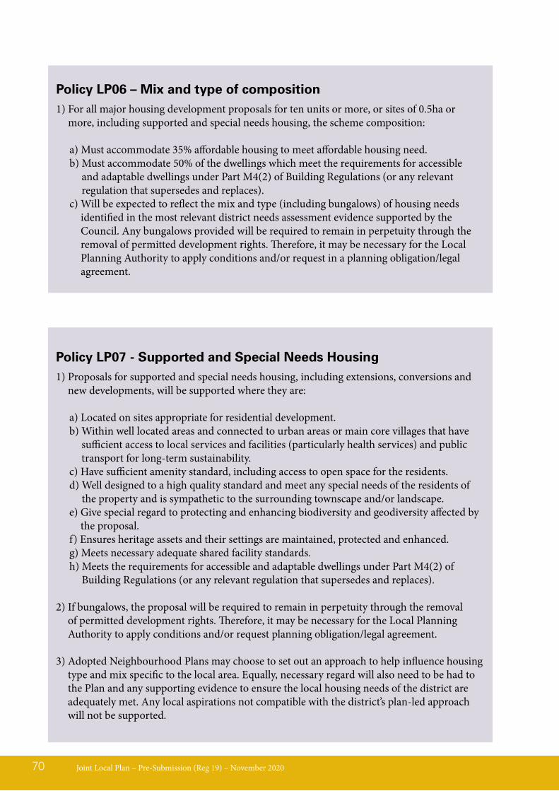
Joint Local Plan – Pre-Submission (Reg 19) – November 202070
Policy LP06 – Mix and type of composition1) For all major housing development proposals for ten units or more, or sites of 0.5ha or
more, including supported and special needs housing, the scheme composition:
a) Must accommodate 35% affordable housing to meet affordable housing need.b) Must accommodate 50% of the dwellings which meet the requirements for accessible
and adaptable dwellings under Part M4(2) of Building Regulations (or any relevant regulation that supersedes and replaces).
c) Will be expected to reflect the mix and type (including bungalows) of housing needs identified in the most relevant district needs assessment evidence supported by the Council. Any bungalows provided will be required to remain in perpetuity through the removal of permitted development rights. Therefore, it may be necessary for the Local Planning Authority to apply conditions and/or request in a planning obligation/legal agreement.
Policy LP07 - Supported and Special Needs Housing1) Proposals for supported and special needs housing, including extensions, conversions and
new developments, will be supported where they are:
a) Located on sites appropriate for residential development.b) Within well located areas and connected to urban areas or main core villages that have
sufficient access to local services and facilities (particularly health services) and public transport for long-term sustainability.
c) Have sufficient amenity standard, including access to open space for the residents.d) Well designed to a high quality standard and meet any special needs of the residents of
the property and is sympathetic to the surrounding townscape and/or landscape.e) Give special regard to protecting and enhancing biodiversity and geodiversity affected by
the proposal.f) Ensures heritage assets and their settings are maintained, protected and enhanced.g) Meets necessary adequate shared facility standards.h) Meets the requirements for accessible and adaptable dwellings under Part M4(2) of
Building Regulations (or any relevant regulation that supersedes and replaces).
2) If bungalows, the proposal will be required to remain in perpetuity through the removal of permitted development rights. Therefore, it may be necessary for the Local Planning Authority to apply conditions and/or request planning obligation/legal agreement.
3) Adopted Neighbourhood Plans may choose to set out an approach to help influence housing type and mix specific to the local area. Equally, necessary regard will also need to be had to the Plan and any supporting evidence to ensure the local housing needs of the district are adequately met. Any local aspirations not compatible with the district’s plan-led approach will not be supported.
LP08 - Affordable HousingPolicy background and explanation13.38 The Strategic Housing Market Assessment
(SHMA) – Part 1 and 2 (May 2017) and subsequent SHMA (2014-based Local Housing Need) evidence base updated data January 2019 is a joint evidence base document between Babergh DC, Mid Suffolk DC, Suffolk Coastal DC, Waveney DC (now East Suffolk) and Ipswich BC that (amongst other matters) provides the evidence to justify the need and requirement for affordable housing. Planning policy reflects the size, type and tenure of housing needed for different people in the community and affordable housing is an identified need within Babergh and Mid Suffolk Districts as required by Paragraph 61 of the NPPF.
13.39 The evidence and information within the strategic Housing Needs & Requirements Policy provides the local affordable housing need calculations setting out the mix and composition within the Babergh and Mid Suffolk Districts. The data identifies a total potential demand of 495 discount home ownership/starter homes dwellings in Babergh, and 430 discount home ownership/starter homes dwellings in Mid Suffolk. The provisions for discount home ownership and starter homes must not be made at the expense of shared ownership and social /affordable rent provision.
13.40 In exceptional circumstances30, where proposals are not able to meet the requirements for affordable housing for viability reasons, and to ensure that development can still come forward and overall housing delivery is not compromised, the Council may agree
to alter the requirements subject to this being demonstrated through a comprehensive viability assessment, to the Council’s satisfaction. Before reducing the overall provision of affordable housing, the tenure and type of affordable housing should be first adjusted to secure viability and best meet the housing needs.
13.41 Local need for affordable housing may be identified through a local housing needs survey (LHNS)31. Developers are encouraged to work closely with the Council’s Strategic Housing team at pre-application stage to ensure appropriate evidence is provided with any planning application.
13.42 Babergh and Mid Suffolk Councils will encourage new homes to be delivered through community-led housing vehicles such as Community Land Trusts (CLT’s), co-operatives or co-housing groups which address a local housing need. The Plan recognises that community-led development can be beneficial for local communities and may be an appropriate ‘exception’ to development on the edge of settlements or in the countryside. Proposals of any scale will need to demonstrate an appropriate mix which links to identified local needs, with such needs perhaps identified via a local survey.
Joint Local Plan – Pre-Submission (Reg 19) – November 2020 71
30 Sites and proposals such as brownfield, rural exception site as an example. But, this is not an exhaustive list of circumstances and does not mean exceptional circumstances are always acceptable in all other planning terms when assessed as a comprehensive balanced proposal.31 The term local need refers to affordable housing needs arising within a parish area that meet the needs of applicants with a defined local connection to that parish.
Joint Local Plan – Pre-Submission (Reg 19) – November 202072
Policy LP08 – Affordable, community led and rural exception housing1. Affordable housing:
a) Is expected to be delivered on-site, unless it can be demonstrated in exceptional circumstances, that it is not feasible or practical to provide the units on site in which case it may be agreed that a commuted sum could be paid towards off-site affordable housing provision.
b) Should be tenure blind when being designed and integrated within a development that contains other types of housing (for example, market housing).
c) Must be upheld by avoiding proposals that create artificial or contrived subdivision of a site to circumvent requirements. If there is reasonable expectation of adjoining land coming forward for housing development, the Council will take account of the whole contiguous site area when calculating what affordable housing is required. Affordable housing will also be sought where a site is capable of accommodating the stated requirement thresholds.
d) The Local Planning Authority will use planning obligations or legal agreements to secure and deliver affordable housing to ensure the benefit of affordable housing will be enjoyed by successive occupiers. Where affordable housing cannot be secured in perpetuity, it will be expected for the funds to be ringfenced for reinvestment back into affordable housing provision32.
2. Community Led Housing proposals must demonstrate that:
a) The scheme was initiated by, and is being led by a legitimate local community group such as a Parish Council or Community Land Trust; and
b) The scheme has general community support, with evidence of meaningful public engagement.
3. Rural Exception Housing
Up to 35% of market housing on rural exception sites will be supported, only where it is financially necessary in order to secure and deliver additional local affordable housing. A financial appraisal must be submitted to evidence the need for open market housing to cross-subsidise affordable housing on the rural exception site.
32 The Housing supplementary planning document will detail what would be expected for types of schemes that could not be secured in perpetuity. For example, but not limited to Right to Buy legislation, shared ownership dwellings, shared equity, discount market sales (linked to clawback in some cases).
LP09 - Provision for Gypsy and Traveller and Travelling ShowpeoplePolicy background and explanation13.43 National planning policy for Gypsies and
Travellers is set out in Planning Policy for Traveller Sites (2015) and requires planning authorities to use their evidence to plan positively to meet the needs of Gypsies and Travellers and Travelling Showpeople.
13.44 Gypsies and Travellers are defined for planning purposes within the Planning Policy for Travellers Sites (2015) as:
‘Persons of nomadic habit of life whatever their race or origin, including such persons who on grounds only of their own or their family’s or dependants’ educational or health needs or old age have ceased to travel temporarily, but excluding members of an organised group of travelling showpeople or circus people travelling together as such.
In determining whether persons are ‘gypsies and travellers’ for the purposes of this planning policy, consideration should be given to the following issues amongst other relevant matters:
a) whether they previously led a nomadic habit of life
b) the reasons for ceasing their nomadic habit of life
c) whether there is an intention of living a nomadic habit of life in the future, and if so, how soon and in what circumstances.’
13.45 Travelling Showpeople are defined within the Planning Policy for Travellers Sites (2015) as:
‘Members of a group organised for the purposes of holding fairs, circuses or shows (whether or not travelling together as such). This includes such persons who on the grounds of their own or their family’s or dependants’ more localised pattern of
trading, educational or health needs or old age have ceased to travel temporarily, but excludes Gypsies and Travellers as defined above.’
13.46 All allocated sites must have a project level HRA if they are within the zone of influence of coastal habitat sites. This will also identify whether allocated sites will result in a likely significant effect to functionally linked land and water quality, and will determining whether further mitigation is required. Where relevant, project level Habitat Regulation Assessments (HRA), Construction Environment Management Plans (CEMP) and lighting design schemes will be required for planning applications.
13.47 The jointly commissioned Ipswich Housing Market Area Gypsy, Traveller, Travelling Showpeople and Boat Dwellers Accommodation Needs Assessment (ANA) (May 2017) identifies for Gypsy and Traveller provision Babergh is in need for 1 permanent Gypsy and Traveller pitch and Mid Suffolk is in need for 9 permanent Gypsy and Traveller pitches in the Plan period (a pitch is an area on a site developed for a family unit to live). Each authority is to meet the needs in respect of Gypsy and Traveller accommodation within their own areas.
13.48 The following data shows existing Gypsy and Traveller data since 2016, which includes Gypsy, Traveller and Travelling Showpeople. All of which is in private ownership.
Joint Local Plan – Pre-Submission (Reg 19) – November 2020 73
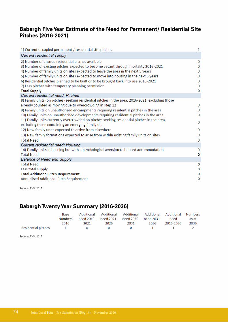
Babergh Five Year Estimate of the Need for Permanent/ Residential Site Pitches (2016-2021)
Joint Local Plan – Pre-Submission (Reg 19) – November 202074
Source: ANA 2017
Babergh Twenty Year Summary (2016-2036)
Source: ANA 2017
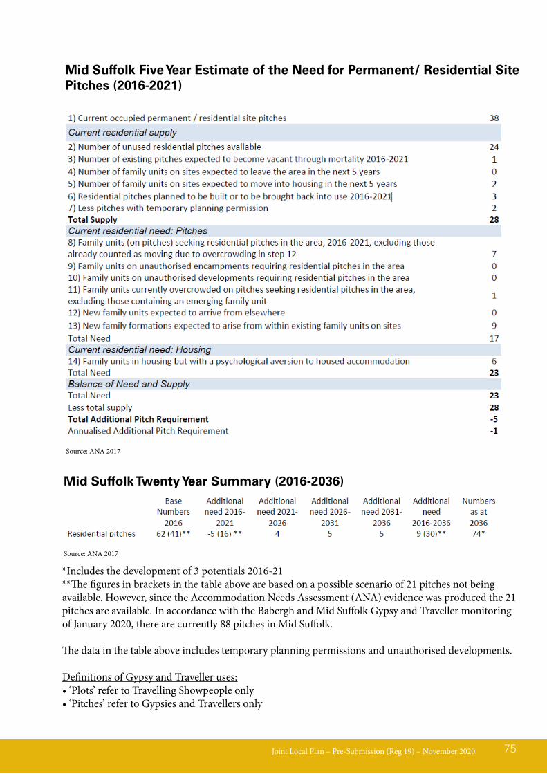
Joint Local Plan – Pre-Submission (Reg 19) – November 2020 75
Mid Suffolk Five Year Estimate of the Need for Permanent/ Residential Site Pitches (2016-2021)
Source: ANA 2017
Mid Suffolk Twenty Year Summary (2016-2036)
Source: ANA 2017
*Includes the development of 3 potentials 2016-21**The figures in brackets in the table above are based on a possible scenario of 21 pitches not being available. However, since the Accommodation Needs Assessment (ANA) evidence was produced the 21 pitches are available. In accordance with the Babergh and Mid Suffolk Gypsy and Traveller monitoring of January 2020, there are currently 88 pitches in Mid Suffolk.
The data in the table above includes temporary planning permissions and unauthorised developments.
Definitions of Gypsy and Traveller uses:• ‘Plots’ refer to Travelling Showpeople only• ‘Pitches’ refer to Gypsies and Travellers only
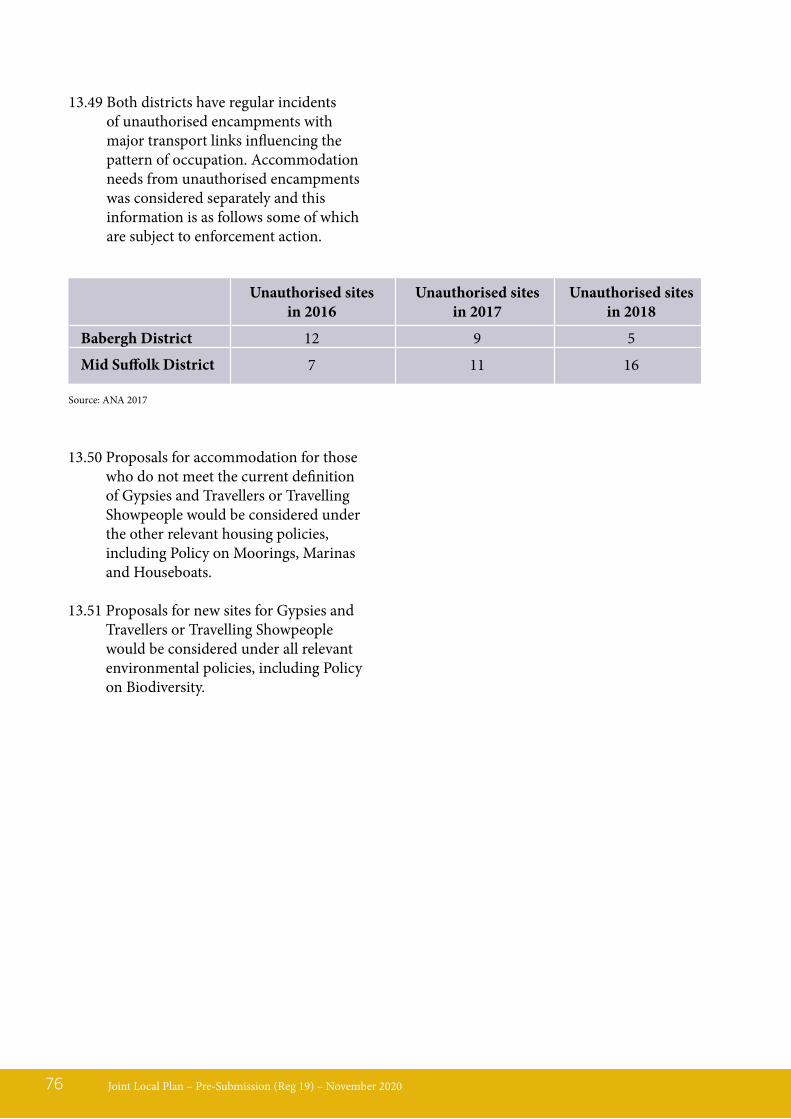
13.50 Proposals for accommodation for those who do not meet the current definition of Gypsies and Travellers or Travelling Showpeople would be considered under the other relevant housing policies, including Policy on Moorings, Marinas and Houseboats.
13.51 Proposals for new sites for Gypsies and Travellers or Travelling Showpeople would be considered under all relevant environmental policies, including Policy on Biodiversity.
Joint Local Plan – Pre-Submission (Reg 19) – November 202076
13.49 Both districts have regular incidents of unauthorised encampments with major transport links influencing the pattern of occupation. Accommodation needs from unauthorised encampments was considered separately and this information is as follows some of which are subject to enforcement action.
Unauthorised sites in 2016
12
7
Babergh District
Mid Suffolk District
Unauthorised sites in 2017
9
11
Unauthorised sites in 2018
5
16
Source: ANA 2017
Joint Local Plan – Pre-Submission (Reg 19) – November 2020 77
Policy LP09 – Provision for Gypsy and Traveller and Travelling Showpeople1. The Councils will work with partner agencies to identify suitable permanent and transit
pitches to meet the needs identified in an up to date needs assessment.
2. The principle for Traveller development will be considered as with other residential development in other policies*, and having regard to the following considerations:
a. The need for pitches in the District as evidenced in an up to date needs assessment, and the availability of deliverable sites. The site choice must be the result of a sequential search. Land ownership limitations are not a reason to justify selection above other sustainability criteria;
b. The site shall not dominate the nearest settled community;c. The site is well related to local services and facilities (particularly medical services and
schools), preferably by means other than the private vehicle (e.g. car);d. The site is designed with regard to established design guidance documents and best practice;e. The proposal must not cause any detrimental affects to amenity. For example (but not
limited to) noise, light and water pollution.f. Special regard shall be given to protecting and enhancing landscape, biodiversity and
geodiversity affected by the proposal.g. Any employment use on the site is compatible with residential and local amenity;h. The proposal must ensure heritage assets and their settings are maintained, protected and
enhanced where the opportunity arises.i. The proposal must not result in loss of best and most versatile agricultural land.
3. The Council will prepare a project level Habitat Regulation Assessment (HRA) to assess the likely impacts from development if proposed sites are situated within the SSSI zone of influence of Habitat Sites.
4. Conditions will normally be applied to limit the number of pitches/plots on the site, or to safeguard occupancy by the Gypsy/Traveller community.
* Neighbourhood Plans may allocate sites for Gypsy and Traveller use.

LP10 – Moorings, Marinas & HouseboatsPolicy background and explanation13.52 The Councils will work with partner
agencies to identify suitable moorings to meet the needs identified in an up to date needs assessment. An area of the mooring is shown on the Policies Map at Pin Mill Chelmondiston, Woolverstone, Shotley and Fox’s at Wherstead.
13.53 There is a need to protect the special landscape and ecological characteristics of these internationally important areas and as a result, Babergh District Council will need to prepare a project-level HRA, Construction Environment Management
Plan (CEMP) and lighting design schemes to assess the likely impacts from development.
13.54 Water-based and associated land-based facilities of an appropriate scale will only be permitted on the Stour and Orwell estuaries where these are compatible with; landscape characteristics, biodiversity, agriculture, access and river safety constraints. A sustainable development approach will be of the utmost importance on both estuaries.
13.55 Many activities that take place in or over the marine plan area require a marine licence. Early consultation with the Marine Management Organisation is recommended for appropriate proposals.
Joint Local Plan – Pre-Submission (Reg 19) – November 202078
LP10 - Moorings, Marinas and Houseboats1. Outside of the defined moorings and marinas located at Pin Mill, Woolverstone, Shotley and
Fox’s at Wherstead, there will be no introduction or extension of moorings, marinas and houseboats or the ancillary land based activities across the Stour and Orwell estuaries SPA and Ramsar site (Suffolk Coast RAMS zone of influence).
2. Within the defined moorings and marinas, planning permission will only be granted if all of the following criteria are met to the satisfaction of the LPA:a) The proposal will not result in any adverse effect (either through construction and or
operation) on the integrity of the Stour and Orwell SPA and Ramsar sites and the Suffolk Coast and Heath AONB. If planning permission is granted a CEMP must be agreed prior to commencement of development to demonstrate mitigation of construction impacts.
b) The proposal must demonstrate appropriate measures to ensure there is no risk of deterioration in Water Framework Directive (WFD) status for the River Stour and Orwell.
3. A project level HRA will be required for each houseboat planning application and all proposals will need to demonstrate acceptable environmental protection measures and a Construction and Environment Management Plan will be required.a) If planning permission is granted a Construction Environment Management Plan
must be agreed prior to commencement of development to demonstrate mitigation of construction impacts.
b) Additionally, for houseboat proposals within the defined area of Pin Mill, Chelmondiston:i. The total number of houseboats is no greater than 28 units.ii. The vessels must be river worthy and capable of floatingiii. Access must be via a jettyiv. The boat is secured to the access jetty and or a mooring post.v. The applicant enters into a legal agreement for the removal of any vessel that becomes
unfit for habitation or is abandoned.
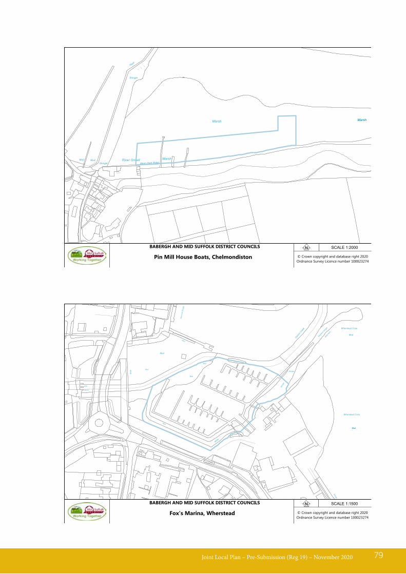
Joint Local Plan – Pre-Submission (Reg 19) – November 2020 79
© Crown copyright and database right 2020Ordnance Survey Licence number 100023274
MudShingle Mean High Water
MarshMud River Orwell
Marsh
Hard
Shingle
MarshMarsh
SCALE 1:2000
Pin Mill House Boats, Chelmondiston
BABERGH AND MID SUFFOLK DISTRICT COUNCILS
© Crown copyright and database right 2020Ordnance Survey Licence number 100023274
MHW
Mud
Sluice
NTL
Mud
MH
W
Mud
Mud
Shing
le
Sand
and
Shin
gle
Mud
Hard
Shingle
Ostrich
Creek Wherstead Ooze
Boat H
ard
Mud
Sand an
d Shingle
Wherstead Ooze
Shingle
MudMud
SCALE 1:1500
Fox's Marina, Wherstead
BABERGH AND MID SUFFOLK DISTRICT COUNCILS
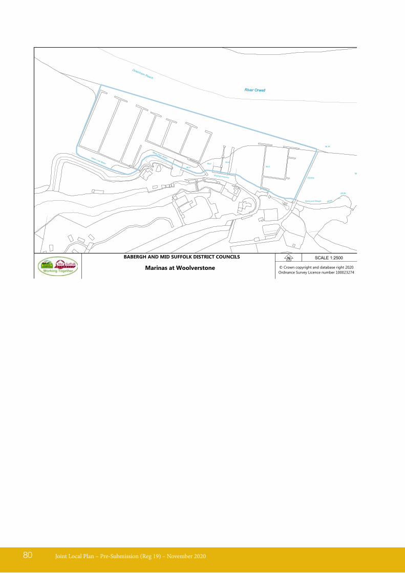
Joint Local Plan – Pre-Submission (Reg 19) – November 202080
© Crown copyright and database right 2020Ordnance Survey Licence number 100023274
MLW
Mud
Mean Low Water
MHW
MHWSand
Mean High Water
Mud
MudMud
Slipway
Sand and Shingle
Mud
Sloping masonry
Downham Reach
River OrwellRiver Orwell
SCALE 1:2500
Marinas at Woolverstone
BABERGH AND MID SUFFOLK DISTRICT COUNCILS
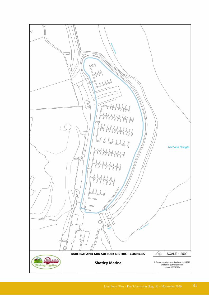
Joint Local Plan – Pre-Submission (Reg 19) – November 2020 81
MLW
Mean
High
Water
Mean Low Water
Mud and Shingle
© Crown copyright and database right 2020Ordnance Survey Licence
number 100023274
SCALE 1:2500BABERGH AND MID SUFFOLK DISTRICT COUNCILS
Shotley Marina
LP11 - Self-Build and Custom-BuildPolicy background and explanation13.56 The Self Build and Custom Housebuilding
Act 2015 requires LPAs to keep a register of people who are interested in building their own homes. NPPF para. 61 states that LPAs should plan for the needs of those wishing to build their own homes. The Council has set up a self-build register, to understand the level of interest and demand in plots for self-build / custom build across the Districts. As of April 2018, there were 164 people on the self-build register, all with a variety of land and locational requirements.
Joint Local Plan – Pre-Submission (Reg 19) – November 202082
Policy LP11 - Self-Build and Custom-Build1. The Councils will support proposals for self-build/custom-build housing or proposals that
make a proportion of serviced dwelling plots available for sale to self-builders or custom builders, on appropriate sites and where in compliance with all other relevant policies of this Plan.
2. Special protection must be given to the landscape, biodiversity and the historic environment.
3. The proposal must not cause significant harm to residential amenity.
4. The proposal must minimise the impact of development on climate change and will be expected to minimise dependence on fossil fuels and make the fullest contribution to the mitigation of climate change through implementation of sustainable construction practices and renewable energy technologies.
LP12 - Employment DevelopmentPolicy background and explanation14.01 In the 2019 NPPF, chapter 6 ‘Building
a strong, competitive economy’ is clear when it sets out “Significant weight should be placed on the need to support economic growth and productivity, taking into account both local business needs and wider opportunities for development.”
14.02 The purpose of this section is to provide a planning framework which;
I. Encourages development of employment sites and other business growth, of the right type, in the right place and encourage investment in skills and innovation in order to increase productivity.
II. Encourage inward investment to the Districts by supporting infrastructure improvements that will enable the continued growth of the Port of Felixstowe and strengthen the Districts’ links to the Port of Felixstowe and the rest of the UK.
III. Supports the tourism sector as one of the key drivers of economic growth.
IV. Provides sufficient flexibility to be responsive to changing behaviours, innovation and sectoral advancements to enable business to be competitive and improve productivity.
Supporting A Prosperous Economy
14.03 Alongside the major strategic employment sites located in the towns, Ipswich Fringe and along the transport corridors, the rural economy also plays a fundamentally important role in the
prosperity of the Districts as a whole, and the vitality of local communities. Many of the rural employment sites have grown organically over time responding to changes in demand and will inevitably continue to change. The aim of the Plan is to provide a framework to effectively manage development requirements for employment land.
14.04 The policy on small scale employment and flexible working practices recognises the importance of micro and Small and Medium-sized Enterprises (SME) scale of businesses in the two districts, where their predominantly rural nature means it offers benefits such as where these can thrive in the home. It seeks to accommodate Micro and SME operators positively by making provision for small scale employment and flexible working practices in appropriate locations. The provision to enable remote working, in particular through telecommunications connectivity, will be addressed in the contributions, infrastructure and services policy.
Joint Local Plan – Pre-Submission (Reg 19) – November 2020 83
14 Local Policies - Economy
LP13 - Safeguarding Economic OpportunitiesPolicy background and explanation
Ensuring an Adequate Supply of Land and Premises for Economic Growth
14.05 The policy for ensuring an adequate supply of land and premises for economic growth aims to ensure that a continuous range and diversity of appropriate employment sites and premises are available throughout the
plan period. The Councils consider that availability of employment opportunities – particularly in rural areas – is essential to maintain sustainable communities. The loss of individual premises or land in employment use in itself may not appear to be significant, but the cumulative loss of several such units can be damaging to the local economic resilience. The policy seeks to retain viable employment use on existing employment premises, but also enable other commercial uses, such as small scale retail, services and other facilities.
Joint Local Plan – Pre-Submission (Reg 19) – November 202084
Policy LP12 - Employment Development1. Proposals for employment use must:
a. Be sensitive to the surroundings, including any residential and other amenity, landscape and heritage assets;
b. Demonstrates high-quality sustainable design;c. Minimise impact from development on climate change through the implementation of
sustainable construction practices and /or renewable energy technologies;d. Maximise the use of sustainable and active modes of transport through footpath and cycle
route improvements as part of development, or to be sited where it can be easily accessed by public transport;
e. Provide adequate servicing, access and off-road parking for its type, mix, use and location;f. Where necessary, provide contributions to the enhancement of the digital infrastructure
network;g. Have good highway access and not have severe impact on highway network;h. Protect and enhance biodiversity and geodiversity affected by the development.
2. Applications for full flexibility or for a single or flexible use involving one or more of the uses within Class E on the strategic employment sites will be considered on their individual merits. This will apply to all unimplemented extant relevant permissions (prior to September 2020) whether in full or in part. Prior to submission applicants should engage with the LPA to agree the required assessment work in support of any proposal.
3. Change of use to small scale employment use, predominantly residential curtilage, is supported where:a. There is no direct sales from the site;b. The direct and indirect effects of the scale of the business activity, including the
employment of non-residents at the business, must remain incidental to the overall use of the site for residential purposes;
c. The hours of operation are compatible with residential use; andd. The business does not involve significant noise, dust, fumes or other emissions, outdoor
storage or frequent delivery/collection (more than twice daily) which could adversely affect local amenity.

14.06 Overall, the Council expects that employment land and premises will remain in employment use throughout the plan period. Where a business is unable to make premises work viably, this does not mean that the premises is inherently unsuitable for employment use as an alternative operator or another business use may be able to operate successfully from the premises.
14.07 The policy aims to achieve a balance between ensuring there is sufficient choice in the employment land and premises market over the long term and being proportionate in the type and level of evidence required to support a change of use of small premises.
14.08 On some sites it may be appropriate to undertake a “land swap” whereby employment land/premises can be redeveloped with another use and the employment uses can be developed elsewhere on a new site. This could be beneficial for businesses to provide modern premises, and it could be beneficial for local amenity if employment uses were relocated away from residential areas. Where a land swap is agreed, the Council will require demonstrable economic benefit to the locality in terms of retention and enhancement of economic opportunities.
Joint Local Plan – Pre-Submission (Reg 19) – November 2020 85
Policy LP13 - Safeguarding Economic Opportunities1. In order to protect the operation of existing businesses, proposals for development in the
vicinity of land and premises in lawful business, commercial and employment activity may only be approved where such activity would not be compromised through amenity conflicts arising from the proposed development.
2. The Councils shall resist the loss of identified employment sites, as well as other land and premises in lawful employment/commercial use. Proposals that would lead to the full or partial loss of employment sites or premises will be required to demonstrate:a) That the possibility of re-using or redeveloping the land for other commercial, employment, business or community uses33 have been explored by a period of sustained marketing for 6 months by an independent qualified assessor. This must be undertaken at a realistic asking price, on a range of terms and in an appropriate format. The approach for the marketing campaign must be agreed by the Development Management case officer from the outset;b) The proposal would not give rise to amenity conflicts with existing or proposed employment uses/activities in the vicinity of the site.
3. Where relocation of an employment use is proposed which would result in full or partial loss of the existing employment site to an alternative use the proposer will need to demonstrate that there would be an overriding environmental or community benefit from redevelopment or change to another business or community use, which outweighs the benefit of the current employment use continuing. In this situation the Council may also seek contributions to help offset the economic impact of the loss of business opportunities. Contributions may include any combination of:a) Alternative land or premises;b) Financial contributions towards infrastructure installations to enable the delivery of replacement employment premises on Strategic Employment Sites;c) Financial contributions towards skills, training and qualifications for displaced employees.
33 Community uses - includes facilities, services and infrastructure that can be easily accessible and used by the community
LP14 - Retail and Town Centres
14.09 The aim of the policy is to promote competitive town centre environments that provide customer choice and a town centre offer. It is also aimed at supporting the viability and vitality of town centres in the Babergh and Mid Suffolk districts.
14.10 In accordance with the NPPF a threshold of 2,500m2 has been set for requiring retail and leisure development outside of town centres, which are not in accordance with an up to date plan, to provide an impact assessment. The level of detail to be included in the impact assessment should be proportionate to the scale and type of proposal and should be agreed between the Council and applicant on a case-by-case basis. Furthermore, in dealing with such applications (regardless of its size) paragraph 86 and 87 of the NPPF states that Local Planning
Authorities should apply a sequential test to focus main town centre uses in town centres, then in edge of centre locations and only if suitable sites are not available (or expected to become available within a reasonable period) should out of centre sites be considered. The primary frontages and town centre boundaries for Hadleigh, Stowmarket and Sudbury are set out in the relevant Policies Maps.
14.11 To maintain and improve the vitality and viability of the town centres a mix of uses will be supported whilst safeguarding retail uses. These types of uses could include but are not limited to: “above the shop” homes; leisure and cultural activity including support for evening economy and improvements to the public realm, such as tree planting and green infrastructure. Proposals that implement adaption measures to combat climate change will be encouraged.
Joint Local Plan – Pre-Submission (Reg 19) – November 202086
Policy LP14 - Town Centre and retail1. Within Town Centre Boundaries consideration is given to ensuring that development
proposals do not eliminate separate access arrangements to upper floorspace, which could be used for residential, community or employment uses.
2. To maintain vitality and viability of town centres, proposals;a. That include ‘above the shop’ homes, and/or a mix of retail and other leisure and cultural
activity, including support for the evening economy, and improvements to the public realm (such as tree planting and green infrastructure) will be encouraged.
b. That ensure new and existing open spaces, community facilities, including meeting places that are accessible to all will be supported in principle.
3. Out of Town Centre Applications Where an application for Class E (retail and leisure development outside of town centre boundaries), is in excess of 2,500m² an impact assessment will be required. A sequential test in accordance with the NPPF will be applied for any applications for main town centre uses. Applications which would have a significant adverse impact on the vitality and viability of nearby centres will not be supported.
LP15 - Tourism and Leisure
14.12 The NPPF para 83. states the Local Plan should enable sustainable rural tourism and leisure developments which respect the character of the countryside.
14.13 The Plan seeks to provide a diverse range of accommodation across the District to cater for the tourist demand. Tourist accommodation particularly that which is in permanent buildings can sometimes come under pressure to be occupied for full time residential use. New tourism accommodation should therefore be restricted by planning conditions and/or legal agreements so that it is retained for the benefit of the tourism economy and not lost to residential use. Planning conditions will limit the occupation of new self-catering tourist accommodation units to a continuous period of 28 days by one person or persons within one calendar year. The owners/operators of the accommodation will be required to maintain an up to-date Register of all lettings, which shall include the names and addresses of all those persons occupying the units during each letting. The Register will be required to be made available at all reasonable times to the Local Planning Authority.
14.14 Proposals to remove holiday occupancy must include appropriate evidence where it can be fully and satisfactorily demonstrated that there is no demand for the tourist accommodation. Marketing evidence must be provided with details on:I. why the property is being marketed;II. the location, links to transport
networks and general setting;III. advertising methods – particulars
should be set out in a bespoke, well-designed brochure with professional photos. Evidence of advertisements in both local and national publications/ online advertisement and/ or targeted mailing will be demonstrated;
IV. guide price/rent; andV. guide terms.
14.15 Proposals for tourism and tourist accommodation development needs to consider all environmentally sensitive characteristics of both districts. This includes but is not limited to: future proofing all development from the impact of climate change; protecting and enhancing heritage assets and their setting and protecting and enhancing biodiversity and geodiversity, as a result of development.
Joint Local Plan – Pre-Submission (Reg 19) – November 2020 87
Policy LP15 - Tourism and Leisure1. Proposals for new tourism and leisure facilities, or improvements/extensions to existing
facilities, will be supported where proposal(s):a) Enhance the district’s ability to attract and cater for visitors, increase local employment
opportunities and provide for environmental improvements;b) Improve the range, quality and accessibility of facilities;c) Are accessible by public transport and facilitates walking and cycling;d) Includes facilities which are open to the wider community, to enhance both accessibility
and the range of facilities available;e) Uses brownfield land and or avoids the best and most versatile agricultural land.f) Enhances the vitality and viability of settlement centres.g) Protects the landscape, biodiversity and the historic environment.
LP16 – Countryside Tourist Accommodation
Joint Local Plan – Pre-Submission (Reg 19) – November 202088
2. In addition to the criteria above, proposals in the countryside may be supported where the proposal:a) Increases access, enjoyment and interpretation of the countryside, appropriately,
sensitively and sustainably;b) Provides appropriate parking and access and ensures the associated traffic movement
would not compromise highway safety;c) Improves accessibility for existing settlements, which are not well served by public
transport;d) Reflects the intrinsic quality and respects the character of the countryside by having
regard to the Councils Landscape Guidance and any other relevant documents endorsed by the LPA;
e) The proposal must follow a hierarchy of seeking firstly to avoid impacts, mitigate for impacts so as to make them insignificant on the local ecology, biodiversity, trees and hedgerows, or as a last resort compensate for losses that cannot be avoided or mitigated for;
f) Is of an appropriate scale for their context; andg) Safeguarding and where possible enhancing the historic interest of the asset including its
setting.
Policy LP15 - Tourism and Leisure continued
Policy LP16 - Countryside Tourist Accommodation1. In rural locations applications for new tourist accommodation will be considered on an
exceptional basis. In addition, applications must:a. Demonstrate an overriding business need to be in that location.b. Be sympathetic to the character of the area and meet environmental standards;c. Protect and enhance heritage assets and their setting;d. Protect and enhance biodiversity and geodiversity as a a result of development;e. Minimise the impact of development on climate change, through sustainable construction
practices and/or renewable energy technologies; andf. Be accessible by a range of transport modes.
2. In addition to criterion at 1 (a – f) proposals to extend or upgrade tourism facilities must provide a balanced mix of economic, social and environmental benefits. New tourism development will be controlled by planning conditions which take account of the individual business models and or locational ecological impacts.
3. The Councils will only support the removal of a holiday occupancy condition if evidence is provided that there is no demand for the ongoing use of the tourist accommodation, as evidenced by a sustained marketing for 6 months.
LP17 - Environmental ProtectionPolicy background and explanation15.01 The aim of this policy is to ensure that
all developments are environmentally sustainable and will seek to prevent and mitigate against adverse environmental impacts and climate change, irrespective of the size of the development. Development proposals must take into account a broad range of environmental issues such as air quality, water consumption and quality, drainage, sewerage, energy, noise, light, waste, contamination, design and building materials.
15.02 Land and air pollution are subject to regulatory controls under Environmental Health Legislation including the Environmental Protection Act 1990, Pollution Prevention Act 1999 and the Environment Act 1995. Applications within an Air Quality Management Area (AQMA) and all major planning applications, may be required to submit an air quality impact assessment to assess and quantify the impact on local air quality and to identify appropriate mitigation measures to ensure that development is acceptable on the grounds of air quality. Contributions may also be required towards the cost of air quality mitigation measures.
15.03 Lighting needs to be appropriate for the design and scale of development and location. It is important lighting is designed to illuminate the target only and not detract from the night sky’s natural state and thereby avoid light pollution and its associated impact on wildlife.
15.04 In line with the National Planning Policy Framework the Plan seeks to protect high quality agricultural land where possible. Whilst in some cases meeting wider objectives will necessitate the loss of agricultural land, particularly considering the relatively limited amount of brownfield land available for development in the Districts, the policy seeks to ensure that loss of agricultural land is a consideration.
15.05 The Plan will encourage proposals that help bring contaminated sites into productive use. Where a site is affected by contamination, responsibility for securing safe development rests with the developer and/or landowner.
15.06 Where it is anticipated that contamination may be present near or on a proposed development area a precautionary approach is essential to ensure there is no unacceptable risk to health, or to the environment or amenity. The applicant will be required to demonstrate by way of adequate site investigation information, prepared by a competent person, that there is no unacceptable risk to health, or the environment and where unacceptable contamination is found there will be a requirement for mitigation/remediation/verification, as agreed with the Councils.
15.07 Where appropriate potentially contaminated land should be investigated and remediated prior to development and/or during construction to a level appropriate to its proposed use. Where mitigation / remediation cannot be satisfactorily achieved development will be refused.
Joint Local Plan – Pre-Submission (Reg 19) – November 2020 89
15 Local Policies - Environment
Joint Local Plan – Pre-Submission (Reg 19) – November 202090
Policy LP17 - Environmental ProtectionTo protect the environment all developments must have regard to the following:
1. LANDEfficient and Effective Use of Resources/Land
a. Development on previously developed land will be prioritised, where appropriate, to minimise the loss of the best and most versatile agricultural land. where development needs to take place on greenfield land, avoidance of the best and most versatile agriculture land should be prioritised.
b. Development will contribute towards making more efficient use or re-use of existing resources and reducing the lifecycle impact of materials used in construction.
c. Development proposals must not prejudice the ability of future allocated sites to come forward by, for example, restricting or blocking access to services such as water, gas, electricity, drainage, the free flow of air, water and daylight
Land Contamination and Instabilityd. Where necessary, development will include measures to remediate land affected by
contamination and locate development safely away from any hazardous source.e. Where necessary, development will include measures to address land instability issues
where identified.
These measures must be compatible with the relevant National and International Standards.
2. POLLUTIONPollution and Environmental Amenitya. Prevent, or where not practicable, reduce all forms of possible pollution including, but not
limited to; air, land, ground and surface water, odour, noise, light and any other general amenity, including public amenity and visual amenity impacts. This must be demonstrated to the satisfaction of the LPA by the impact assessments where appropriate.
b. Amenity impacts are avoided where it is located adjacent to or close to existing uses with the potential to have amenity impacts. This would include an assessment of any identified amenity impacts and how the continued operation of existing use(s) would not be prejudiced.
3. WATERa. Development will be required to comply with the relevant SCC Construction Surface Water
Management Plan.b. Development proposals will need to demonstrate it protects and enhances groundwater,
surface water features and must not lead to a deterioration in the quality of the environment to help achieve the objectives34 of the Water Framework Directive.
34 Refer to The Water Environment (Water Framework Directive) (England and Wales) Regulations 2017 (or relevant updates)
LP18 - Biodiversity and GeodiversityPolicy background and explanation15.08 The NPPF advocates that local plans
should contribute to and enhance the natural and local environment by protecting and enhancing sites of biodiversity or geological value and minimising impacts on and providing measurable net gains for biodiversity.
15.09 The level of protection to be afforded to Special Protection Areas (SPAs), Ramsar and Special Areas of Conservation (SACs) and Ramsar sites is set out in the UK Habitats Regulations. To summarise, proposals that would result in significant effects on these sites, either alone or in combination with other plans and projects, should be refused, unless mitigation measures can be applied to avoid adverse effects on site integrity. Only in exceptional circumstances where there are ‘imperative reasons of overriding public interest’ would development that causes harm to a SPA, SAC or Ramsar sites be permitted.
15.10 Sites of Special Scientific Interest (SSSIs) are protected through the Wildlife and Countryside Act 1981 (as amended). The NPPF states that development on land within or outside of an SSSI likely to have an adverse effect on an SSSI should not normally be permitted. An exception should only be made where the public benefits of development clearly outweigh the impacts.
15.11 Priority species and habitats are identified by the UK post-2010 Biodiversity Framework. The NERC Act 2006 requires the Secretary of State to publish a list of habitats and species which are of principal importance for the conservation of biodiversity in England. Known as the Section 41 list, this should be used to guide decision makers in implementing their duty under Section 40 of the NERC
act to have regard to the conservation of biodiversity in England when carrying out their normal functions: England Biodiversity Strategy 2020, Biodiversity Net Gain initiative and DEFRA biodiversity Metric Calculator is designed to assess changes to biodiversity value as a result of development or land changes and can be an essential method to ensure net gains are achieved.
15.12 In order to meet the biodiversity net gain initiative, development proposals will be required to meet a minimum of 10% increase or in line with Government requirements.
15.13 At the local level, designations in Babergh and Mid Suffolk comprise of County Wildlife Sites, County Geodiversity Sites/Regionally Important Geological and Geomorphological Sites.
15.14 In producing the Plan consideration can be given to the level of protection to afford to local sites of biodiversity and geodiversity value including Local Nature Reserves, County Wildlife Sites, County Geodiversity Sites and priority habitats and species.
15.15 To create, protect and enhance ecological networks, the NPPF advises that biodiversity should be conserved and enhanced at a landscape-scale.
15.16 The Babergh Green Infrastructure Strategy (2012) identifies potential wildlife corridors (river and green corridors) that would benefit from enhancement. Suffolk Nature Strategy identifies a large area of Babergh and the south of Mid Suffolk as ‘South Suffolk ancient woodland clusters’ which is one of the areas of principal importance for landscape-scale conservation in Suffolk, along with the two AONBs. Work to deliver an up to date Babergh and Mid Suffolk Joint Green Infrastructure Strategy is to be undertaken.
Joint Local Plan – Pre-Submission (Reg 19) – November 2020 91
15.17 Green infrastructure refers to a network of spaces and linkages that are generally valued for their wildlife, geological, landscape or historic importance and may also have recreational value and help reduce flood risk. Although often important in their own right, when considered as a holistic network they provide much greater benefits. Emphasising the importance of green infrastructure creation, protection and enhancement, ensures an improved and healthy environment that is available for present and future communities. These improvements can include reducing vulnerability and increase resilience to extreme weather events and flooding through measures such as SuDs and green roofs for example.
15.18 The Joint Local Plan, therefore, seeks to ensure that all new development secures high standards of design and green infrastructure which creates attractive and sustainable places where people want to live and spend time. Networks of green infrastructure should be provided across new developments linking with existing networks of open space.
15.19 Protection for internationally and nationally protected sites is established in legislation. In producing the Plan consideration can also be given to the level of protection to afford to local sites of biodiversity and geodiversity value including County Wildlife Sites, County Geodiversity Sites, Local Nature Reserves and Priority habitats and species.
15.20 Through previous Habitats Regulations Assessments there has been recognition of the sensitivity of the internationally protected sites and the potential for significant effects arising from increased recreational disturbance related to new housing development.
15.21 Enhancement for biodiversity could include; watercourse improvements (such as along river corridors and undisturbed river banks) to benefit biodiversity and improve water quality, habitat creation, wildlife links (including as part of green or blue infrastructure) and building design which creates wildlife habitat (e.g. green roofs, hedgehog friendly fencing, bird, insect and/or bat boxes) relevant to local conservation priorities.
Joint Local Plan – Pre-Submission (Reg 19) – November 202092
Policy LP18 - Biodiversity & Geodiversity1) All development should follow a hierarchy of seeking firstly to; enhance habitats, avoid
impacts, mitigate against harmful impacts, or as a last resort compensate for losses that cannot be avoided or mitigated for. Adherence to the hierarchy should be demonstrated.
2) Development should:a) Protect designated and, where known, potentially designated sites. Proposed development
which is likely to have an adverse impact upon designated and potential designated sites, or that will result in the loss or deterioration of irreplaceable biodiversity or geological features or habitats (such as ancient woodland and veteran/ancient trees) will not be supported.
b) Protect and improve sites of geological value and in particular geological sites of international, national and local significance.
c) Conserve, restore and contribute to the enhancement of biodiversity and geological conservation interests including priority habitats and species. Enhancement for biodiversity should be commensurate with the scale of development.
LP19 - LandscapePolicy background and explanation15.22 The landscape and the historic
environment have a strong inter-relationship, as the character of the landscape is influenced by its historic environment, as well as traditional villages and historic townscapes. Equally, the landscape can be important to the setting of a historic asset.
15.23 Parts of Babergh lie within the designated landscapes of The Dedham Vale Area of Outstanding Natural Beauty (AONB) and the Suffolk Coast and Heaths AONB, however, all landscape whether designated or not, has its own character, sense of place and local values. These include areas with uninterrupted or panoramic views of surrounding landscapes, landmarks and
distinctive field patterns with associated hedges, woodlands and corpse of trees, as well as areas of tranquillity, dark skies and strong rural character.
15.24 Landscape character assessments of the area have been carried out and provide information on the different landscape character types of the area36. These assessments recognises particular characteristics, qualities and features of landscapes to provide an understanding of distinct sense of place and sensitivities to development and change. They will be used as a basis to guide decisions about whether development is appropriate in the landscape and provide a framework for the provision of appropriate landscape mitigation and enhancement.
15.25 Where development may be visually prominent or adversely affect landscape character, production of a Landscape and
Joint Local Plan – Pre-Submission (Reg 19) – November 2020 93
35 Legislation including but not exclusively - The Conservation of Habitats and Species Regulations (2017), the Wildlife and Countryside Act (1981), the Protection of Badgers Act (1992), and listed as Priority Habitats and Species (s41 Natural Environment and Rural Communities Act (2006)
d) Plan positively for the creation, protection, enhancement and management of local networks of biodiversity with wildlife corridors that connect areas. Where possible, link to existing green infrastructure networks and areas identified by local partnerships for habitat restoration or creation so that these ecological networks will be more resilient to current and future pressures.
e) Identify and pursue opportunities for securing measurable net gains, equivalent of a minimum 10% increase, for biodiversity. Where biodiversity assets cannot be retained or enhanced on site, the Councils will support ‘biodiversity offsetting’ to deliver a net gain in biodiversity off-site in accordance with adopted protocols.
f) Apply additional measures to assist with the recovery of species listed on S41 of the NERC Act 2006.
3) Development which would have an adverse impact on species protected by legislation35, or subsequent legislation, will not be permitted unless there is no alternative and the local planning authority is satisfied that suitable measures have been taken to:
a. Reduce disturbance to a minimum; andb. Maintain the population identified on site;c. Provide adequate alternative habitats to sustain at least the current levels of population.
4) Where appropriate, the local planning authority will use planning obligations and/or planning conditions to achieve appropriate mitigation and/or compensatory measures and to ensure that any potential harm is kept to a minimum.
36 Landscape Character Types as defined in The National Character Area’s and The Landscape Character Assessments.
Visual Impact Assessment, a strategic landscape masterplan and/or a landscape management plan detailing mitigation proposal may be required.
15.26 The Plan seeks to protect and enhance the landscape, taking account of its natural beauty, characteristics and features of natural, archaeological or historic interest. All new development proposals need to ensure it responds to and reinforces the local distinctiveness of the area in scale, form, design, materials and location.
Joint Local Plan – Pre-Submission (Reg 19) – November 202094
Policy LP19 - Landscape1. To protect and enhance landscape character development must:
a. Integrate positively with the existing landscape character of the area and reinforce the local distinctiveness and identity of individual settlements.
b. Proposals must be sensitive to their landscape and visual amenity impacts (including on dark skies and tranquil areas); subject to siting, design, lighting, use of materials and colour, along with the associated mitigation measures;
c. Enhance and protect landscape character and values and heritage assets such as; locally characteristic landscape features, for example by use of materials which complement the local individual landscape character, archaeological and historic patterns of settlement and land use37 and designations; being demonstrably informed by local guidance, in particular the Council’s Joint Landscape Guidance, the Suffolk Landscape Character Assessment and Settlement Sensitivity Assessment.
d. Consider the topographical cumulative impact on landscape sensitivity.
2. Where significant landscape or visual impacts are likely to occur, for example for larger development proposals, a Landscape and Visual Impact Assessment (LVIA) or Landscape Appraisal should be prepared. This should identify ways of avoiding, reducing and mitigating any adverse effects and opportunities for enhancement.
37 Landscape Character Types as defined in The National Character Area’s and The Landscape Character Assessments.
LP20 - Area of Outstanding Natural Beauty
15.27 Babergh and Mid Suffolk have a diverse landscape character, with parts of Babergh lying within Dedham Vale AONB and the Suffolk Coast and Heaths AONB. Adjoining the Dedham Vale Area of Outstanding Natural Beauty is an area defined as the Stour Valley Project extending beyond Sudbury and into West Suffolk. The Suffolk Coast and Heaths AONB also has a project area which encompasses the Shotley Peninsula These project areas, however, do not currently benefit from the same protection as an AONB.
15.28 The protection of AONB’s is not just the land within the designation, but also to its setting. In line with The National Planning Policy Framework great weight is given to conserving and enhancing the landscape and scenic beauty in the AONB and the conservation and enhancement of wildlife and cultural heritage are important considerations.
Joint Local Plan – Pre-Submission (Reg 19) – November 2020 95
Policy LP20 – Area of Outstanding Natural Beauty1. The Councils will support development in or near the AONBs that:
a. Conserves and enhances the landscape and scenic beauty;b. Integrates positively with the character of the area and reinforces local distinctiveness of
the AONB;c. Are sensitive to their landscape and visual impacts (including on dark skies and tranquil
areas); subject to siting, design, lighting, use of materials and colour, along with the associated mitigation measures;
d. Supports the provision and maintenance of local services and facilities and assets (including affordable housing), so long as it is commensurate with the character and objectives of the AONB;
e. Demonstrates special regard to proposals that enhance and protect landscape character and values and heritage assets in the AONB such as; locally characteristic landscape features, for example by use of materials which complement the local individual landscape character, archaeological and historic patterns of settlement and land use and designations.
2. Tourism and visitor related development within the AONB will be supported where it reflects the intrinsic quality and respects the character of the AONB and demonstrates the proposal has been informed by all relevant local guidance and the relevant AONB Management Plan38 which includes the AONB and identified Project Area.
38 Management Plan includes but not exclusively; Dedham Vale AONB and Stour Valley Project Management Plan and Suffolk Coast & Heaths AONB
LP21 - The Historic EnvironmentPolicy background and explanation15.29 Babergh and Mid Suffolk have a
considerable wealth of historic settlements and buildings which contribute to the area’s distinctiveness and make it an attractive place to live and work. The Planning (Listed Buildings and Conservation Areas) Act, 1990 contains statutory provisions relating to the management of the historic environment however local authorities may develop policies through their local plans. The NPPF advocates that local plans should set out a positive approach to the conservation and enjoyment of the historic environment, including heritage assets most at risk.
15.30 Heritage Assets are defined by the NPPF as ‘A building, monument, site, place, area or landscape identified as having a degree of significance meriting consideration in planning decisions, because of its heritage interest’. It includes nationally designated heritage assets, other non-designated heritage assets and sites of potential archaeological interest.
15.31 The designated heritage assets in Babergh and Mid Suffolk comprise of some 7,000 listed buildings, 60 Conservation Areas, 72 Scheduled Ancient Monuments and 7 Registered Parks and Gardens. In addition, there are other buildings and features which make an important contribution to the character and appearance of the area. These may not
be of sufficient quality to be designated as a heritage asset but are important in reinforcing a sense of local identify. An Historic Environment Record is maintained by SCC, which includes details of local archaeological sites and finds, historic buildings and historic landscapes.
15.32 Some designated heritage assets are known to be at risk through neglect and decay, or vulnerable to becoming so. The authorities will continue to monitor Heritage at Risk and will work with Historic England and other bodies to secure appropriate solutions.
15.33 In exceptional circumstances, permission may be granted for development which would not normally be acceptable in order to secure the long-term future of the designated asset. This is known as ‘enabling development’ and should only be carried out as a last resort in line with the guidance produced by Historic England.
15.34 Proposals which physically affect Scheduled Monuments require Scheduled Monument Consents in addition to any planning permission and/or listed building consent required. Applications for Scheduled Monument Consents must be made to the Secretary of State for Digital, Culture, Media and Sport before any work may be carried out which might affect a monument either above or below ground level. Further information on the application process for Scheduled Monument Consent is available on Historic England’s website39.
Joint Local Plan – Pre-Submission (Reg 19) – November 202096
39 https://historicengland.org.uk/advice/planning/consents/smc/
Policy LP21 - The Historic Environment1. Where an application potentially affects heritage assets40, the Councils will:
a. Depending on the nature of the works/development proposed, require the applicant to submit a heritage statement that demonstrates:
40 Including Scheduled Monuments
Joint Local Plan – Pre-Submission (Reg 19) – November 2020 97
41 Planning Listed Building and Conservation Area Act 1990, Sections 16, 66 and 72.
i. The significance of the heritage asset is appropriately understood (statement of significance);
ii. The potential impacts on the heritage asset’s significance, including the contribution made by setting, are understood (impact assessment);
iii. That the proposal has been fully justified in light of the significance and impact identified above (statement of justification);
iv. If relevant, that the proposal has considered how preservation in situ of archaeological assets can be achieved through the design of the site;
v. An effective conservation strategy, including details of recording, mitigation, repair, preservation, protection and management as appropriate;
b. Where development includes (or has the potential to include) heritage assets with archaeological interest, an appropriate desk-based assessment and, where necessary, a field evaluation by a suitably qualified person is required.
2. The Councils will support:a. The re-use/ redevelopment of a heritage asset, including Heritage at Risk, where it would
represent optimal viable use, including assets in isolated locations, and the proposal preserves the building, its setting and any features which form part of the building’s special interest and complies with the relevant policies of the Plan;
b. Development proposals that contribute to local distinctiveness, respecting the built form and scale of the heritage asset, through the use of appropriate design and materials;
c. Proposals to enhance the environmental performance of heritage assets, where the special characteristics of the heritage asset are safeguarded and a sensitive approach to design and specification ensures that the significance of the asset is not compromised by inappropriate interventions.
3. In order to safeguard and enhance the historic environment, harm to heritage assets should be avoided in the first instance. Only where harm cannot be avoided should mitigation be considered. When considering applications where a level of harm is identified to heritage assets (including historic landscapes) the Councils will:a. Have regard (or Special Regard where appropriate) to the historic environment and take
account of the contribution any designated or non-designated heritage assets makes to the character of the area and its sense of place. All designated and non-designated heritage assets must be preserved, enhanced or conserved in accordance with statutory tests41 and their significance, including consideration of any contribution made to that significance by their setting; and
b. Have regard to the planning balance whilst considering the extent of harm and significance of the asset in accordance with the relevant national policies.
4. Proposals which potentially affect heritage assets should have regard to all relevant Historic England Advice and Guidance.
5. Where development is otherwise considered acceptable, planning conditions/obligations will be used to:a. Secure an appropriate programme of archaeological investigation, recording, reporting,
archiving, publication, and community involvement; to advance public understanding of the significance of any heritage assets to be lost (wholly or in part); and to make this evidence and any archive generated publicly accessible.
LP22 - Change in Land Use for Equestrian or other animal/rural land base usesPolicy background and explanation15.35 Proposals to increase or extend residential
garden land by the change in use of land can have a significant impact on the environment, especially when there is an impact on best and most versatile agricultural land or there are adverse effects on the landscape character and setting of the locality. The impact of such a change is likely to be unacceptable. Designated constraints, local guidance and supplementary planning documents will provide detailed information and guidance for assessing landscape impacts of such proposal.
15.36 The National Planning Policy Framework is clear economic diversification and a high-quality environment have to be pursued together. Both of which are mutually dependant and supportive and are the essence in achieving sustainable development. This also means diversification of the rural economy should not be at the expense of the environment or productive agricultural land or the best and most versatile land. Any proposals in relation to legislation associated or connected with the Department for Environment Food & Rural Affairs will be considered proportionately along with the consideration of positive approaches to manage land for agriculture, conservation or recreational purposes. Long-term sustainability of any proposal will need to be considered especially if the proposal is to develop agricultural land. It is often the case once land is developed the restoration of natural habitats or landscape enhancement features is expensive to create.
15.37 The Local Planning Authority will not encourage new industrial development to intrude into the rural environment
away from settlements. The operation of industrial development often requires necessary access to materials, support services, markets, clients and labour, which are often not available in rural locations without creating sustainability issues, intensification and cumulative impacts to the rural road/lane networks/highway. Proposals to change the use of agricultural land from existing redundant buildings to recreation, leisure or tourism-based activity may be suitable subject to proportionately balanced assessment of environmental harm and any other appropriate policies that may relevant to such proposal.
15.38 Proposed changes in use arising from the diversification of farm enterprises/businesses may be acceptable providing the proposal does not adversely impact on the social, environmental or economic aspects of the existing farm. In particular, the proposed diversification must not place unreasonable restrictions on the farm that could jeopardize its viability as a result of the development permitted after the farm was established. Equally any proposal must not detrimentally affect neighbouring amenity, proposals must be compatible with the protection of the countryside with regard to landscape, ecology, biodiversity, natural resources and intrinsic recreational value. The proposal must not unreasonably or unnecessary result in the loss of best and most versatile agricultural land or productive agricultural land, the proposal must not create excessive traffic intensification resulting in cumulative impacts or traffic safety issues.
15.39 The Local Planning Authority will expect the use of existing buildings to be considered in the first instance where proposals require the provision of new or more floor space. Any acceptable new buildings must be ancillary to and used solely in connection with the existing farm enterprises/business to meet the operational needs. Condition(s) may be necessary for the Local Planning Authority to apply.
Joint Local Plan – Pre-Submission (Reg 19) – November 202098
Joint Local Plan – Pre-Submission (Reg 19) – November 2020 99
Policy LP22 – Change in Land Use for Equestrian or Other Animal/Rural Land Base Uses1. The change in use of land for equestrian uses or other animal/rural land based uses in the
countryside, including the erection of buildings and equipment for equestrian or other animal husbandry/rural land based uses may be permitted subject to:a. There must be clearly established existing functional* need which relates to a full time
worker or one who is primarily employed in equestrian or other animal/rural land based uses.
b. The location, size and scale of the site must be appropriate and necessary for the proposal in question.
c. The site must be sensitively sited to protect the amenity of the locality from an environmental and social perspective.
d. The layout, size, scale, design, materials and siting of any proposed building or equipment (including lighting and means of enclosure) must not create serious adverse impact on the natural and local environment or the appearance of the locality. Proposals should re-use existing buildings first where appropriate and any new buildings should be located in or adjacent to an existing group of buildings to have minimal impact within the landscape.
e. There being no significant detriment to amenity in terms of noise, odour, light or any other forms of pollution and disturbance.
f. The proposal must include a satisfactory scheme for the disposal of waste (if appropriate).g. The proposal must integrate with existing features and respect and enhance the character
of the surrounding landscape/area through sensitive integration.h. The proposal must protect and enhance any existing heritage assets and their settings.i. The proposal must not adversely affect or damage any significant trees and hedgerows that
contribute to the environmental quality and visual amenity benefits of the rural location;j. The proposal must not create significant detriment to biodiversity, geodiversity or the
interlinked surroundings;k. The proposal should not result in the loss of best and most versatile agricultural land and
it can be demonstrated to the satisfaction of the Local Planning Authority that there are no suitable alternative sites on lower grade land.
l. The proposal must not cause any adverse impacts to highways safety.
2. Where a new equine or other related animal husbandry/rural land based business use is proposed and residential accommodation is proposed. Proposals must demonstrate a proven essential and necessary need to sufficiently justify new rural residential accommodation in the countryside to the Local Planning Authorities satisfaction. In particular, such proposals will be expected to demonstrate, justify and evidence;a. The essential need for rural residential accommodation is appropriate to be located in the
isolated and/or remote and/or detached rural countryside;b. There are no other surrounding building(s) or nearby reasonable residential
accommodation to serve the proposal;c. There is permitted temporary accommodation in place for 1 year serving the business and
has been the main residence and there are no other permanent residence in association or connection;
d. There is a proven essential and necessary need for new residential accommodation to serve the equine or other related animal husbandry/rural land based business;
e. There is proportionate, necessary and sound viable business evidence to demonstrate the equine or other related animal husbandry/rural land based business has been
LP23 – Agricultural land to residential garden land
Joint Local Plan – Pre-Submission (Reg 19) – November 2020100
in continuous sound viable operation for more than 3 years, and there is a proven sustainable business;
f. The finances of the equine or other related animal husbandry/rural land based business are directly in relation to the proven essential and necessary need for new residential accommodation;
g. There are no material considerations to prevent new residentialaccommodation in the location proposed.
h. The proposal must not cause any adverse impacts to highway safety.
3) Where such proposal is considered acceptable, the proposed landscaping and boundary treatments must achieve a rural rather than urban or suburban character. Permitted Development Rights will be removed. The Local Planning Authority may impose planning conditions and planning obligations/legal agreement to make the development acceptable in planning terms.
* *A functional test is necessary to establish whether it is essential for the proper functioning of the enterprise for one or more workers to be readily available at most times. Such a requirement might arise, for example, if workers are needed to be on hand day and night:(i) in case animals or agricultural processes require essential care at short notice; (ii) to deal quickly with emergencies that could otherwise cause serious loss of crops or products, for example, by frost damage or the failure of automatic systems.
Policy LP22 – Change in Land Use for Equestrian or Other Animal/Rural Land Base Uses continued
Policy LP23 – Agricultural Land To Residential Garden Land1. The change in use of agricultural land to residential garden land or land ancillary to a
residential dwelling may be permitted subject to:a. The location, size and scale of the proposal would not have an adverse impact on the
landscape characteristics and biodiversity of the locality;b. The proposal would not result in the irreversible loss of best and most versatile agricultural
land;c. The site must not intrude into the open countryside, or result in the loss of trees and
hedgerows which contribute to the character of the area;d. The site must not threaten designated or Priority Habitats Sites or threaten the viability of
farm holdings due to the breaking up of agricultural land;e. The proposal must not be or become unacceptably intrusive through intensification and
therefore damaging to the character of the countryside setting or nearby residential setting;f. There must be no significant adverse impact on public rights of way or the areas of urban/
rural transition that provides the setting of settlements in the countryside; andg. In all cases the Local Planning Authority will consider the possible cumulative impacts of
separate individual changes as a material consideration.
2. Where such proposal is considered acceptable, the proposed landscaping and boundary treatments must achieve a rural rather than urban or suburban character. Permitted Development Rights will be removed.
3. The Local Planning Authority may impose planning conditions and planning obligations/legal agreement to make the development acceptable in planning terms.
LP24 - New Agricultural/Rural Buildings in the CountrysidePolicy background and explanation15.40 The NPPF encourages and supports a
prosperous rural economy and to ensure the natural environment is protected and enhanced.
15.41 The National Planning Policy Framework requires that new development can be integrated effectively with existing businesses. Proposals for new agricultural/commercial/business activity and facilities should not place unreasonable restrictions on existing agricultural/commercial/business as a result of the new proposal. Therefore, often to prevent conflicts of uses and impacts to existing agricultural business operation any agricultural diversification proposal must be ancillary/subsidiary component of the main farm enterprise/existing business operation and is to contribute to the continuing viability of the agricultural/rural business as a whole.
15.42 Suitably and sustainable located new buildings for where appropriate ancillary/subsidiary use in connection with existing agricultural/rural business may be favoured where it can be demonstrated that such uses would not create or cause significant levels of traffic, particularly lorries/HGV’s on rural roads. The proposal must not adversely impact on character and landscape of the area, ecology and biodiversity; and must not have any significant impacts on any listed buildings, listed building settings, including any existing buildings that may be curtilage listed. All agricultural applications must include environmental protection measures, a Construction Environment Management Plan (CEMP) and demonstrate that relevant guidance for pollution prevention (GPPs – Netregs.
org.uk) will be adhered to throughout the development.
15.43 Proposals must ensure the location, design and scale of the proposal does not have a significant adverse effect on the character and appearance of the locality; must not cause any significant amenity impacts; must avoid adverse effects to site integrity to Habitats Sites via reductions in air or water quality; and must not cause any conflict of uses through any impacts on existing rural commercial activity/business. All allocation sites must have a project level HRA if they are within the zone of influence of protected habitats sites. Where relevant, project level Habitat Regulation Assessments (HRA), CEMP (as stipulated above) and lighting design schemes for planning applications will be required.
15.44 It is recognised there has been an increase in intensified farming activity within rural areas, which has seen the increase of large commercial buildings within the countryside. Equally, it is also recognised there is a need to manage effectively agricultural related development within the countryside. To ensure the fine balance between ensuring a prosperous rural economy and ensuring the rural countryside character and environment is maintained, protected and enhanced. Not all locations in the countryside will be considered suitable or sustainable for new buildings and uses due to sustainability objectives of the Plan.
15.45 Proposals for new isolated, remote and detached buildings away from settlements and clustered development will be resisted. Unless it can be justified and evidenced in terms of sustainable development objectives of the Plan.
Joint Local Plan – Pre-Submission (Reg 19) – November 2020 101
LP25 - Sustainable Construction and DesignPolicy background and explanation15.46 The NPPF (Para.148) states that the
Plan should help shape places in ways that contribute to radical reductions in greenhouse gas emissions, minimise vulnerability and improve resilience.
15.47 The NPPF advocates good design whilst optimising the potential of the site for the use of alternative heat and energy initiatives.
15.48 The Plan supports proposals for sustainable construction and design providing that development proposals are sympathetic to local character and history, including the visual impact upon surrounding built environment and landscape setting.
15.49 The NPPF urges that Local Planning Authorities should recognise the responsibility of all communities to contribute to energy generation from renewable or low carbon sources.
15.50 Whilst the planning system has a role to play in delivering sustainability in buildings, construction methods and the energy performance of buildings are primarily addressed via Building Regulations. Nevertheless, the March 2015 Ministerial Statement enables local planning authorities to require energy efficiency standards that exceed Building Regulations provided these do not exceed the requirements of the Level 4 of the former Code for Sustainable Homes. This equates to around a 20% improvement in CO2 emissions performance above the Target Emission Rate of the 2013 Edition of the 2010 Building Regulations.
15.51 The Plan expects and actively supports developers to explore innovative ways to cut CO2 emissions.
15.52 Other technical standards to improve sustainability were introduced by the Government in October 2015 through the introduction of optional water efficiency Building Regulation standards. Both the Essex & Suffolk Water and Anglian Water areas are classified as experiencing ‘serious’ water stress (www.gov.uk/government/publications/water-stressed-
Joint Local Plan – Pre-Submission (Reg 19) – November 2020102
Policy LP24 – New agricultural/Rural buildings in the Countryside1. There must be appropriate justification and demonstrable evidence for any new proposals
which are remote, isolated or detached within the countryside. Not all locations in the coun-tryside will be considered suitable or sustainable for new buildings and/or uses.
2. All relevant planning applications will be subject to the following considerations:a) The suitability and sustainability of the location proposed (including access and sur-
rounding road networks).b) The nature of any proposal in the locality and its relationship and impacts with sur-
roundings (including but not limited to landscape, design and amenity, habitats sites and protected species, heritage assets and their settings).
c) To be compatible with the purpose, function and relationship to any existing agricultural farm and/or business.
d) Proposals within rural areas must provide safe access. It must be demonstrated that such proposal would not cause significant levels of traffic, particularly lorries/HGV’s on rural roads.
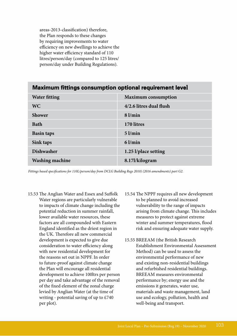
areas-2013-classification) therefore, the Plan responds to these changes by requiring improvements to water efficiency on new dwellings to achieve the higher water efficiency standard of 110 litres/person/day (compared to 125 litres/person/day under Building Regulations).
Joint Local Plan – Pre-Submission (Reg 19) – November 2020 103
Fittings based specifications for 110L/person/day from DCLG Building Regs 2010) (2016 amendments) part G2.
Maximum fittings consumption optional requirement level Water fitting Maximum consumption
WC 4/2.6 litres dual flush
Shower 8 l/min
Bath 170 litres
Basin taps 5 l/min
Sink taps 6 l/min
Dishwasher 1.25 l/place setting
Washing machine 8.17l/kilogram
Maximum fittings consumption optional requirement level
15.53 The Anglian Water and Essex and Suffolk Water regions are particularly vulnerable to impacts of climate change including the potential reduction in summer rainfall, lower available water resources, these factors are all compounded with Eastern England identified as the driest region in the UK. Therefore all new commercial development is expected to give due consideration to water efficiency along with new residential development for the reasons set out in NPPF. In order to future-proof against climate change the Plan will encourage all residential development to achieve 100ltrs per person per day and take advantage of the removal of the fixed element of the zonal charge levied by Anglian Water (at the time of writing - potential saving of up to £740 per plot).
15.54 The NPPF requires all new development to be planned to avoid increased vulnerability to the range of impacts arising from climate change. This includes measures to protect against extreme winter and summer temperatures, flood risk and ensuring adequate water supply.
15.55 BREEAM (the British Research Establishment Environmental Assessment Method) can be used to assess the environmental performance of new and existing non-residential buildings and refurbished residential buildings. BREEAM measures environmental performance by; energy use and the emissions it generates, water use, materials and waste management, land use and ecology, pollution, health and well-being and transport.
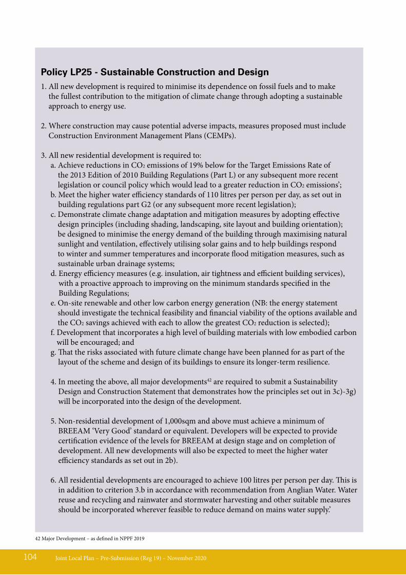
Joint Local Plan – Pre-Submission (Reg 19) – November 2020104
Policy LP25 - Sustainable Construction and Design1. All new development is required to minimise its dependence on fossil fuels and to make
the fullest contribution to the mitigation of climate change through adopting a sustainable approach to energy use.
2. Where construction may cause potential adverse impacts, measures proposed must include Construction Environment Management Plans (CEMPs).
3. All new residential development is required to:a. Achieve reductions in CO2 emissions of 19% below for the Target Emissions Rate of
the 2013 Edition of 2010 Building Regulations (Part L) or any subsequent more recent legislation or council policy which would lead to a greater reduction in CO2 emissions’;
b. Meet the higher water efficiency standards of 110 litres per person per day, as set out in building regulations part G2 (or any subsequent more recent legislation);
c. Demonstrate climate change adaptation and mitigation measures by adopting effective design principles (including shading, landscaping, site layout and building orientation); be designed to minimise the energy demand of the building through maximising natural sunlight and ventilation, effectively utilising solar gains and to help buildings respond to winter and summer temperatures and incorporate flood mitigation measures, such as sustainable urban drainage systems;
d. Energy efficiency measures (e.g. insulation, air tightness and efficient building services), with a proactive approach to improving on the minimum standards specified in the Building Regulations;
e. On-site renewable and other low carbon energy generation (NB: the energy statement should investigate the technical feasibility and financial viability of the options available and the CO2 savings achieved with each to allow the greatest CO2 reduction is selected);
f. Development that incorporates a high level of building materials with low embodied carbon will be encouraged; and
g. That the risks associated with future climate change have been planned for as part of the layout of the scheme and design of its buildings to ensure its longer-term resilience.
4. In meeting the above, all major developments42 are required to submit a Sustainability Design and Construction Statement that demonstrates how the principles set out in 3c)-3g) will be incorporated into the design of the development.
5. Non-residential development of 1,000sqm and above must achieve a minimum of BREEAM ‘Very Good’ standard or equivalent. Developers will be expected to provide certification evidence of the levels for BREEAM at design stage and on completion of development. All new developments will also be expected to meet the higher water efficiency standards as set out in 2b).
6. All residential developments are encouraged to achieve 100 litres per person per day. This is in addition to criterion 3.b in accordance with recommendation from Anglian Water. Water reuse and recycling and rainwater and stormwater harvesting and other suitable measures should be incorporated wherever feasible to reduce demand on mains water supply.’
42 Major Development – as defined in NPPF 2019
LP26 - Design and Residential AmenityPolicy background and explanation15.56 Good design is a key aspect of sustainable
development and has the potential to maintain and enhance existing environments. It can also have benefits in terms of the health of residents and community safety. The Plan provides a framework to promote high quality, well designed developments, and good quality housing. In order to achieve this aim, applicants should work collaboratively with the Councils at an early stage. In determining applications regard will be
given to the ‘Suffolk Design Guide for Residential Areas’, and any other relevant local design codes and documents endorsed by the Councils, where appropriate.
15.57 In addition, dwellings built to adapt to and accommodate the needs of the occupier over their lifetime can facilitate choice, help meet the needs of an ageing population and improve quality of life.
15.58 The Plan seeks new dwellings to be designed to meet these needs using the Building for Life Standard or other similar design standards or equivalent replacement standards, as appropriate.
Joint Local Plan – Pre-Submission (Reg 19) – November 2020 105
Policy LP26 - Design and Residential Amenity1. All new development must be of high-quality design, with a clear vision as to the positive
contribution the development will make to its context. As appropriate to the scale and nature of the development, proposals must:a. Respond to and safeguard the existing character/context;b. Create character and interest;c. High quality design and architecture with climate change adaptation should be in all
development design. Adaptation could include to protect against extreme weather events including heat and excessive rain;
d. Be designed for health, amenity, well-being and safety;e. Meet Space Standards43; andf. Where relevant and necessary ensure design and amenity accommodates for the ageing
population in accordance with M4(2) standards.
2. In order to achieve this development proposals shall:a. Respond to the wider townscape/landscapes and safeguarding the historic assets/
environment and natural and built features of merit;b. Be compatible/harmonious with its location and appropriate in terms of scale, mass, form,
siting, design, materials, texture and colour in relation to the surrounding area;c. Protect and retain important natural features such as trees or hedgerows during and post
construction;d. Create/reinforce a strong design to the public realm incorporating visual signatures (e.g.
signage, hard landscaping, public art);e. Include good practice in design incorporating design principles such as active frontages/
edges, permeability, strong street composition and connectivity. Schemes of exceptional design and /or development within a sensitive area/ landscape will be required to undertake a design review to test this and adherence to Building for Life Criteria;
43 Applicable for residential development as set out in the Government’s Technical Housing Standards – Nationally Described Space Standards (as amended).

LP27 - Energy Sources, Storage and DistributionPolicy background and explanation15.59 The National Policy Framework (NPPF)
proposes that “the planning system should support the transition to a low carbon future in a changing climate. Paragraph 152 of the NPPF states that Local Planning Authorities should support community-led initiatives for renewable and low carbon energy.
15.60 The policy on Energy Sources, Storage and Distribution is aimed at encouraging and facilitating the development of renewable energy in the Babergh and Mid Suffolk Districts. This is in line with national policy stating that planning plays a key role in helping shape places to secure radical reductions in greenhouse gas emissions, minimising vulnerability and providing resilience to the impacts
of climate change, as well as supporting the delivery of renewable and low carbon energy and associated infrastructure. This is central to the economic, social and environmental dimensions of sustainable development. The NPPF urges that Local Planning Authorities should recognise the responsibility of all communities to contribute to energy generation from renewable or low carbon sources.
15.61 The Plan supports proposals for renewable energy development providing that any identified potential harm on Special Protection Areas, Special Areas of Conservation, Sites of Special Scientific Interest, AONB designations or Local Wildlife Designations can be effectively mitigated.
15.62 The Plan seeks to support proposals for low carbon energy systems especially where networks can be expanded to accommodate new and existing developments over time. Networks could
Joint Local Plan – Pre-Submission (Reg 19) – November 2020106
f. Incorporate high levels of soft landscaping, street trees and public open space that creates, and connects to, green infrastructure and networks;
g. Prioritising movement by foot, bicycle and public transport, including linkages to create/contribute to a ‘walkable neighbourhood’;
h. Design-out crime and create an environment for people to feel safe, and has a strong community focus;
i. Protect the health and amenity of occupiers and surrounding uses by avoiding development that is overlooking, overbearing, results in a loss of daylight, and/or unacceptable levels of light pollution, noise, vibration, odour, emissions and dust; Including any other amenity issues;
j. Provide a reasonable standard of accommodation for future occupants in terms of privacy and adequate facilities such as bin storage (including recycling and re-use bins), secure cycle storage and garden space;
k. Where appropriate demonstrate that the design considers the needs of disabled people and an ageing population and follow Dementia-Friendly Design principles43.
3. All developments must also demonstrate that they conform with the design principles in any design documents endorsed by the LPA, Neighbourhood Plans and/or village design statements. Development which fails to maintain and improve the quality and character of the area will not be supported.
43 https://www.rtpi.org.uk/media/2213533/dementia_and_town_planning_final.compressed.pdf
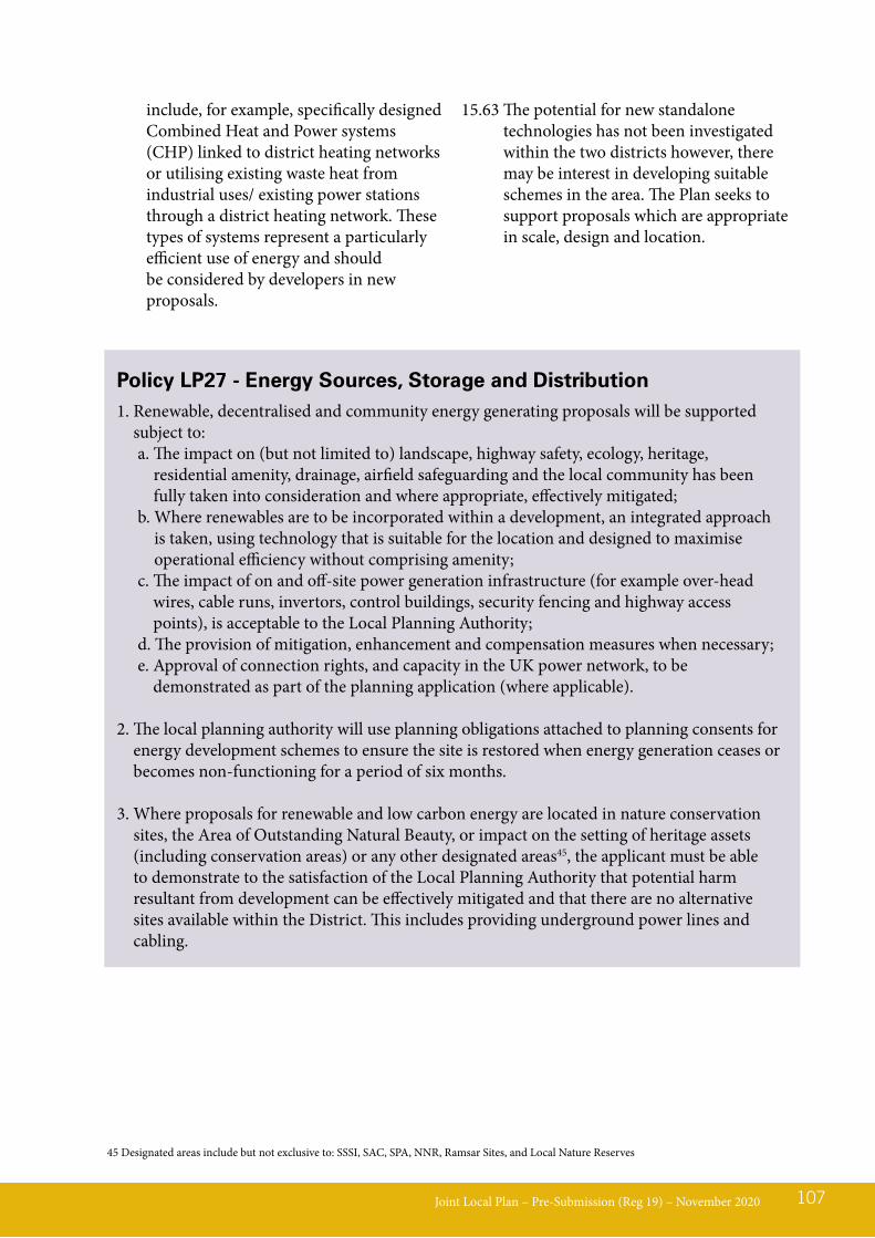
include, for example, specifically designed Combined Heat and Power systems (CHP) linked to district heating networks or utilising existing waste heat from industrial uses/ existing power stations through a district heating network. These types of systems represent a particularly efficient use of energy and should be considered by developers in new proposals.
15.63 The potential for new standalone technologies has not been investigated within the two districts however, there may be interest in developing suitable schemes in the area. The Plan seeks to support proposals which are appropriate in scale, design and location.
Joint Local Plan – Pre-Submission (Reg 19) – November 2020 107
Policy LP27 - Energy Sources, Storage and Distribution1. Renewable, decentralised and community energy generating proposals will be supported
subject to:a. The impact on (but not limited to) landscape, highway safety, ecology, heritage,
residential amenity, drainage, airfield safeguarding and the local community has been fully taken into consideration and where appropriate, effectively mitigated;
b. Where renewables are to be incorporated within a development, an integrated approach is taken, using technology that is suitable for the location and designed to maximise operational efficiency without comprising amenity;
c. The impact of on and off-site power generation infrastructure (for example over-head wires, cable runs, invertors, control buildings, security fencing and highway access points), is acceptable to the Local Planning Authority;
d. The provision of mitigation, enhancement and compensation measures when necessary;e. Approval of connection rights, and capacity in the UK power network, to be
demonstrated as part of the planning application (where applicable).
2. The local planning authority will use planning obligations attached to planning consents for energy development schemes to ensure the site is restored when energy generation ceases or becomes non-functioning for a period of six months.
3. Where proposals for renewable and low carbon energy are located in nature conservation sites, the Area of Outstanding Natural Beauty, or impact on the setting of heritage assets (including conservation areas) or any other designated areas45, the applicant must be able to demonstrate to the satisfaction of the Local Planning Authority that potential harm resultant from development can be effectively mitigated and that there are no alternative sites available within the District. This includes providing underground power lines and cabling.
45 Designated areas include but not exclusive to: SSSI, SAC, SPA, NNR, Ramsar Sites, and Local Nature Reserves

LP28 - Water resources and infrastructure
15.64 Water is a key resource in the area which has recognised issues. Due to water being imported from elsewhere in the country, there must be effective and reliable water systems in place to reduce any harms associated with droughts, ranging from small scale water inefficiencies to large-scale ones. Water quality is also a recognised issue where plans and strategies are seeking to improve the baseline position. The Environment Agency has published national guidance on ground water protection and is the relevant statutory environmental body on water matters.
15.65 As part of the Government’s Water Abstraction Plan (2017), in May 2018, Suffolk was designated as a pilot catchment area for testing innovative approaches to reforming water abstraction. Suffolk’s Holistic Management Approach links all aspects of water management to develop new ways of delivering flood alleviation, to provide more reliable water resources for all users and to improve water based ecosystems and water quality.
15.66 The two operating water companies in Babergh and Mid Suffolk areas are Anglian Water, and Essex & Suffolk Water - the areas are classified as experiencing serious water stress. The relevant authority for liaison with waste water treatment and capacity within the foul sewerage network is Anglian Water. Applicants should refer to these companies for further information and guidance on relevant water network policies and adoption handbooks.
15.67 It is essential that new development makes efficient use of water resources and where possible and necessary, contributes to water quality enhancements. Water
recycling measures should be applied such as rainwater harvesting and grey water recycling. Appropriate Sustainable Drainage Systems (SuDS) can also contribute to water quality through filtration. Early consideration should be given to the potential to use SuDS to identify when/where the use of such technologies is feasible and to also identify which type of SuDS is most appropriate to local site conditions. Further information on local SuDS guidance can be found in the Suffolk Flood Risk Management Strategy.
15.68 In line with Environment Agency guidance further attention should be given to the importance of geomorphological impacts on rivers. Developments which often use hard engineering and culverts along river corridors often lead to a reduction of wildlife value due to an un-natural change in watercourse function which can also lead to flooding. The Environment Agency will therefore only approve an application to culvert a watercourse if there is no reasonably practicable alternative or if the detrimental effects of culverting would be so minor that they would not justify a more costly alternative. In all cases where it is appropriate to do so adequate mitigation must be provided for damage caused. Wherever practical the Environment Agency will seek to have culverted watercourses restored to open channels.
Joint Local Plan – Pre-Submission (Reg 19) – November 2020108

LP29 - Flood risk and vulnerability
15.69 The National Planning Policy Framework sets out what the planning and flood risk requirements are for local authorities in producing Local Plans and for decision taking on planning applications. Incidents of flooding are expected to increase due to the effects of climate change. The sources of flooding can vary and include rivers and streams, the sea, surface water, groundwater and drainage systems. The Strategic Flood Risk Assessment is a key evidence document to identify and manage flood risk from all sources across the Plan area.
15.70 Whilst neither of the districts have major flood risk areas there is a small section of estuary which is threatened by coastal erosion on the Shotley Peninsular and there are areas across both districts which suffer from localised flooding. Localised flooding is mainly a result of surface water flooding which has potential to be addressed through measures to improve drainage channels.
15.71 The general approach to flood risk is to seek to direct development away from the areas at highest risk or where this is unavoidable, that development is made safe for its lifetime without increasing flood risk elsewhere. Applicants are required to have regard to the relevant
Joint Local Plan – Pre-Submission (Reg 19) – November 2020 109
Policy LP28– Water resources and infrastructureDevelopment will be supported where it:
1. Conforms to the principle of Holistic Water Management including the use of appropriate water efficiency and re-use measures, together with surface water drainage which provides community and environmental benefits;
2. Considers its impact on water resources and the capacity of water supply infrastructure, taking into account the effects of climate change;
3. Demonstrates the applicant has consulted with the relevant authority regarding wastewater treatment and that capacity within the foul sewerage network and receiving water recycling centre is available or can be made available in time to serve the development.
4. Separates foul and surface water flows wherever possible.
5. Complies with the relevant statutory environmental body policy on culverts.
6. The proposal will not result in any adverse effect (either through construction and or operation) on the integrity of the Stour and Orwell SPA and Ramsar and the Suffolk Coast and Heath AONB.
7. All proposals must demonstrate Environmental Policies measures and will require a CEMP to be agreed prior commencement.
Strategic Flood Risk Assessment when proposing development. Where necessary, a site specific flood risk assessment should be carried out. The sequential test set out in national planning policy should be followed.
15.72 Early consideration should be given to the potential to use SuDS to identify when/where the use of such technologies is feasible and to also identify which type of SuDS is most appropriate to local site conditions. The Lead Local Flood
Authority is SCC. Further information on local SuDS guidance can be found in the Suffolk Flood Risk Management Strategy.
COASTAL CHANGE
15.73 The Essex and South Suffolk Shoreline Management Plan 2 (2010) identifies an area in Babergh within which development should be restricted due to pressure from coastal erosion. This relates to the eastern section of Babergh known as the Shotley Peninsula, along the estuary.
Joint Local Plan – Pre-Submission (Reg 19) – November 2020110
Policy LP29 – Flood risk and vulnerabilityProposals for new development can be approved where:1. The Strategic Flood Risk Assessment, as a starting point, has been used to assess whether the
proposal is at risk of flooding and any impact of the proposal on flood risk. Other available flooding evidence should also be considered where it is relevant and/or is more up to date;
2. In areas at medium or high risk from flooding, it has been soundly demonstrated that the new development or intensification of development, can be made safe for its lifetime without increasing flooding elsewhere. This includes the ‘sequential test’; where needed the ‘exception test’ and also a site specific flood risk assessment.
3. Mitigation is provided against existing and potential flood risks throughout the life of the development (including fluvial, surface, coastal and sewer flooding) through application of a sequential approach to flood risk, the implementation of Sustainable Drainage Systems (SuDS), and risks to ground or surface water quality.
4. Above ground, appropriate SuDS are incorporated within new developments wherever possible, and take opportunities to provide multifunctional benefits, including biodiversity, landscape, amenity and water quality enhancement.
5. Proposals are submitted appropriate to the scale of development detailing how on-site surface water drainage will be managed so as to not cause, or increase flooding elsewhere. This includes the cumulative impact of minor developments.
6. Opportunities to provide betterment of greenfield runoff rates to reduce the overall risk of flooding, have been provided wherever possible.
7. In circumstances requiring surface water management measures (including rain water harvesting and greywater recycling), adequate mitigation which avoids any risks and/or detrimental impacts are provided to the Lead Local Flood Authority.
8. Further details of maintenance and adoption by an appropriate body are provided at application stage.
9. There is no site conflict with areas identified as vulnerable to coastal erosion.
LP30 - Designated Open SpacesPolicy background and explanation16.01 Access to high quality open spaces and
opportunities for sport and recreation makes an important contribution to the health and wellbeing of communities. Furthermore, open spaces can play an important historical, environmental and local amenity role. The protection of designated open spaces (as defined by the Policies Maps, includes allotments, amenity green space, accessible natural green space and sports and recreation facilities) is given by the Councils in the interest of maintaining distinctive, attractive, healthy and functional places. The Councils Open Space Assessment (2019) examines existing and projected needs for open space, sport and recreation provision with the Districts. The study identifies that the majority of parishes in Babergh and Mid Suffolk have some form of open space deficit. Therefore, the Plan places priority on protecting high quality open spaces, especially where there is an existing shortfall of supply in that locality. However, this study does not take into account the rural nature of the Districts, which includes access to the countryside and natural green spaces via a national network of Public Rights of Way.
16.02 This policy seeks to offer protection to designated open spaces as defined on the proposal maps.
16.03 Open spaces includes:• Allotments which are valuable community
spaces which offer people opportunities for food production.
• Amenity green space is defined as spaces which are open to free and spontaneous use by the public but are not formally managed for a specific function such as a park or playing field; nor managed as a natural or semi-natural habitat.
• Sports and recreational facilities include (but are not limited to) parks and gardens, outdoor sports facilities, play spaces and formalised sports clubs’ space (such as playing pitches and golf courses).
• Accessible natural green space covers a variety of partly or wholly accessible spaces including meadows, woodland and copses all of which share a trait of having natural characteristics and wildlife value, but which are also open to public use and enjoyment. Individually or collectively all of these spaces can contribute to the overall visual amenity of an area.
16.04 Neighbourhood Plans can designate Local Green Spaces in accordance with the criteria set out in paragraphs 99 to 101 of the National Planning Policy Framework.
16.05 However, it is not the intention of the policy to stifle change or growth, particularly where such change is in the interests of the space or the users of the space. Therefore, there is flexibility within the policy that allows appropriate development, change of use, land swap and other options that could result in enhanced amenity green space provision (of all typologies).
16.06 Proposals for the total or partial loss of open space(s) must provide sufficient evidence to demonstrate that an open space is surplus to requirements. It is expected that this is supported by sufficient engagement with the local community.
Joint Local Plan – Pre-Submission (Reg 19) – November 2020 111
16 Local Policies - Healthy Communities & Infrastructure
16.07 There is also the need to ensure that open space (of all types) is incorporated into new development, but particularly on sites of 1 hectare or more. This does not necessarily mean formal play areas, as the flexible policy requires consideration of the most suitable open space to meet local needs and aspirations. Where suitable the Councils will also seek open space provision as part of non-residential uses of 1 hectare or more. This will normally be required to be provided on the development site itself, but in appropriate cases off-site provision may be agreed by the LPA. The acceptability of off-site open space provision will be dependant on its proximity and accessibility to the community it serves.
Joint Local Plan – Pre-Submission (Reg 19) – November 2020112
Policy LP30 - Designated Open Spaces1. The total or partial loss of designated open spaces46 (as defined on the Policies Maps) may be
permitted where:a. The development will support the enjoyment and functionality of the space, be sensitive
to its character and function and would not result in detrimental impacts on local amenity or distinctiveness;
b. The space is demonstrably no longer performing a role as a functional or visual public amenity, or is surplus to requirements;
c. An alternative space of equal or greater quality, accessibility and quantity can be provided to serve the communities’ needs; or
d. The development is for alternative sports and recreation provision, and the applicant can evidence that the benefits of the new provision clearly outweigh the loss of the current or former use.
e. Proposals improve the biodiversity interest of designated open space, including as part of wider ecological networks, and improve accessibility for all.
2. Developments in excess of 1 hectare will be required to provide on-site open space provision to meet identified needs/deficits, unless there is a Council preference to make improvements to existing open space within the locality in an equally or more accessible location than the proposed development.
3. Open space provision is to be provided in line with the open space standards identified in the Open Space Assessment (as amended).
46 Including those identified in ‘made’ Neighbourhood Plans
LP31 - Services and Facilities Within the Community – Provision / RetentionPolicy background and explanation16.08 The aim of the policy is to support and
safeguard key services and facilities within the Districts, which play an important role within the community.
16.09 While it is not the intention of this policy to protect facilities which are not economically viable or feasible (either in its current or future form), the loss of
community facilities must be justified. This needs to be demonstrated through submission of evidence as identified in the policy. This required evidence must be agreed through discussion with the LPA to ensure that consultation is considered appropriate and robust.
16.10 For the purpose of this policy community services and facilities include: village and public halls, community centres, places of worship, cinemas, libraries, leisure centres, museums, public houses, restaurants, cafés, convenience shops, banks, building societies, and post offices. Schools and healthcare facilities are addressed in separate policies in this Plan.
Joint Local Plan – Pre-Submission (Reg 19) – November 2020 113
Policy LP31 - Services and Facilities Within the Community1. Provision of New Facilities
a. Proposals for new community services and facilities or improving existing facilities will be supported where the proposal is well related to and meets the needs of the local community, would reduce the need to travel to other settlements. The facility should be a proportionate scale to the settlement and would not adversely affect existing facilities. Proposals, particularly those located in the countryside, must demonstrate evidence of the community need for / benefits of the new facilities and good accessibility to the community to be served.
b. Development should be of a high-quality development and sympathetic to the surrounding landscape and townscape, with no adverse effects on heritage assets and their settings.
c. To minimise the impact of development on climate change, sustainable construction practices and/or renewable energy technologies should be incorporated into proposals.
2. Loss of facilitiesDevelopment involving or comprising of the loss of an existing community facility, service or a premises, which is currently or last used to provide such use, will only be permitted if either;
a. Compensatory provision of an alternative or improved facility will be, provided in an equally accessible or improved location; or
b. The applicant can sufficiently demonstrate that the service or facility is not viable or valued by the community, either in its current or future form and is not needed for an alternative community use.
3. Evidence to demonstrate that a service or facility is not viable, either in its current or future form should be agreed with the Council in advance (before being gathered) and should include:
a. A sustained marketing period of 6 months, undertaken at a realistic asking price and on a range of terms and in an appropriate format by an independent qualified assessor; and
b. Regard to any material considerations, designations or adopted plans for the area.
4. Conversion of community facilities or premises into residential dwelling(s) will only be permitted where it complies with the relevant Plan policies.
LP32 - Safe, Sustainable and Active TransportPolicy background and explanation16.11 This policy has aims to ensure
accessibility for all and to deliver sustainable development. It also seeks to provide a suitable policy framework for more detailed considerations of planning around transport and accessibility.
16.12 The National Planning Policy Framework states that developments that will generate significant amounts of traffic should provide a travel plan, to set out measures to facilitate sustainable modes of transport. SCC have produced new guidance for Travel Plans, for use as a material planning consideration. Furthermore, the National Planning Policy Framework, paragraph 34 states that:- ‘Plans should set out the contributions expected from development. This should include setting out the levels and types of affordable housing provision required, along with other infrastructure (such as that needed for education, health, transport, flood and water management, green and digital infrastructure).
16.13 With regards to home to school transport contributions are already being secured through the planning process, where relevant to the development. This is done in accordance with the Department for
Education (DfE) publication ‘Securing developer contributions for education’ (April 2019), which should be read in conjunction with the Planning Practice Guidance (PPG) advice on planning obligations (revised March 2019). Paragraph 19 of the DfE guidance. It is therefore appropriate for the policy to require development contributions to provide for home to school transport where necessary.
16.14 The health benefits of ‘Active Transport’ are widely understood and supported, as such Sport England have recently published ‘Active Design’ which seeks to promote sport and physical activity in new and existing developments, to create an active environment, through designing and adapting where we live to encourage activity in everyday lives.
16.15 In relation to Public Rights of Ways, the County Council are also preparing a new strategy, “Rights of Way Improvement Plan: Green Access Strategy, which will also need to be considered in light of development proposals.
16.16 Future alternative transport solutions (such as driverless and autonomous vehicle technology) which for example will be used in the future as an alternative to taxis or public transport. Although not specifically covered within the policy, they are measures which would be encouraged as they develop in the future.
Joint Local Plan – Pre-Submission (Reg 19) – November 2020114
Policy LP32 - Safe, Sustainable and Active Transport1. Development proposals that are expected to, or likely to cause a significant increase in
transport movements:a. Will be required to provide a travel plan in accordance with the County / National
Guidance47 to mitigate the highway impact of development and help maximise sustainable transport;
b. Should also be supported by a transport statement or transport assessment. As indicative thresholds a transport statement will be required for residential developments between 50 and 80 dwellings and a transport assessment should accompany residential developments
47 Such as Suffolk Travel Plan Guidance and any National Government Transport Guidance
LP33 - Managing Infrastructure ProvisionPolicy background and explanation16.17 Infrastructure is defined on the Council’s
Community Infrastructure Levy (CIL) CIL Position Statements and the supporting Infrastructure Delivery Plan (IPD). The provision of infrastructure is fundamental to maintaining quality of life, economic prosperity and the environmental assets of the districts. The aim of this policy is to secure an
appropriate level of infrastructure, including developer contributions and obligations. Applicants will be expected to demonstrate that existing, planned and / or committed infrastructure is sufficient to accommodate development.
16.18 There are a wide range of infrastructure types including transport, telecommunications, security, green infrastructure, waste management, water supply, waste water, flood and coastal change management, minerals, energy supply as well as community facilities (such as health, education,
Joint Local Plan – Pre-Submission (Reg 19) – November 2020 115
of over 80 dwellings, however other circumstances will also be considered. Non-residential development will be considered on a case by case basis.
2. All developments are to maximise the uptake in sustainable and active transport in accordance with the transport hierarchy. This will prioritise the following modes of transport in order – walking, cycling, public transport and car sharing. Where possible, active travel to be tied in with the green infrastructure network thereby providing additional positive effects for access to green spaces and wildlife habitats.
3. Proposals for all development shall, where relevant, incorporate:a. Pedestrian routes suitable for disabled persons and those with impaired mobility;b. Cyclists facilities, including routes, secure and covered cycle parking, showers and
changing facilities;c. Public transport, such as new or revised services, and physical measures such as bus
stops, improvements to bus and railway stations, and access to bus and railway stations to reduce dependency on private vehicles;
d. Incentives to use sustainable modes of transport;e. Linkages to existing pedestrian and cycle networks;f. Enhancement to the Public Rights of Way network and protection of the existing
network;g. Facilities to allow for multi-modal interchanges;h. Access to car park facilities in accordance with the relevant parking guidance48;i. Electric vehicle charging in line with current parking guidance;j. Servicing and emergency vehicles; andk. Sustainable modes of transport for freight.
4. Development will be expected to contribute to the delivery of sustainable transport strategies for managing the cumulative impacts of growth.
5. Where necessary development will be expected to provide home to school transport contributions.
48 Currently the Suffolk Guidance for Parking (updated May 2019)
police, emergency services and cultural infrastructure). The Councils have worked closely with infrastructure providers to ascertain infrastructure requirements related to growth planned in the Plan and will continue to work with service providers, statutory bodies and neighbouring authorities to ensure the timely and coordinated delivery of infrastructure. The Infrastructure Delivery Plan (IDP) provides an up to date position on known infrastructure capacity and requirements.
16.19 In the event that essential infrastructure cannot be appropriately delivered to support new development, this policy will be used to restrict development from being commenced or, in certain cases, from being permitted, in the absence of proven infrastructure capacity. In cases where the cumulative impact of schemes on strategic infrastructure could prevent schemes being developed, a coordinated approach will be used to pool resources to address requirements and where this cannot be achieved the policy of restriction shall apply.
Joint Local Plan – Pre-Submission (Reg 19) – November 2020116
Policy LP33 - Managing Infrastructure Provision1. When determining planning applications, adequate regard must be given to the Council’s
latest Infrastructure Delivery Plan and consultation responses received from infrastructure providers. All new development must be supported by, and have good access to, all necessary infrastructure49. Planning permission will only be granted if it can be demonstrated that there is, or will be, sufficient infrastructure capacity to support and meet the necessary infrastructure requirements arising from the proposed development.
2. Development proposals must consider all of the infrastructure implications of a scheme, including existing commitments to infrastructure provision at the time of application submission and determination, and cumulative impacts if the proposal forms one of a number of growth projects in a locality and or infrastructure catchment area.
3. Conditions or planning obligations, as part of a package or combination of infrastructure delivery measures, will be required for relevant proposals.
4. Applicants must demonstrate that adequate consideration has been given to the timing and level of infrastructure provision to the satisfaction of the LPA and relevant infrastructure providers. As such, development may need to be phased either spatially or sequentially to ensure the provision of infrastructure in a timely manner. Restrictions on planning permissions and or/ planning obligations may be used to secure satisfactory phasing arrangement.
49 Infrastructure includes all infrastructure as identified in the Infrastructure Delivery Plan
LP34 - Health and Education ProvisionPolicy background and explanation16.20 New development must provide for
the educational needs of new residents. Educational needs include provision for early years, primary, secondary and post 16 education as well as Special Educational Needs. The NPPF (paragraph 94) sets out that importance should be placed on the need to provide new school places. It also states that local planning authorities should take a proactive, positive and collaborative approach to meeting this requirement, giving weight to the need to create, expand or alter schools. This involve both the expansion of existing schools where feasible and identification of opportunities to create new schools. Further to the above, paragraph 104 of the NPPF states that, in relation to education facilities, planning policies should minimise the number and length of journeys. Therefore, early years settings and schools will aim to be placed in the best possible location to promote sustainable modes of travel and enable good access.
16.21 The Councils have worked closely with SCC through the IDP to identify the educational requirements needed to accommodate growth in the Plan. The IDP highlights that in order to accommodate planned growth, a combination of school expansions and new schools will be required. The Councils will support the creation of well-designed new schools. The delivery of new schools and school expansions is important for the delivery of the Plan, and as such they are to be protected for that use. Similarly, with high demand for school places within the Districts it is important that existing educational facilities are offered a level of protection.
16.22 Similarly, the Council has worked closely with the relevant healthcare providers to establish the required health provision for the lifetime of the Plan. This includes meeting the needs of the identified ageing population in the Plan area. Whilst taking account of changing models of current and future healthcare provision, it is assumed that the ongoing healthcare needs of the population will need to be met at a level deemed acceptable by the relevant healthcare providers, on a continuous basis.
Joint Local Plan – Pre-Submission (Reg 19) – November 2020 117
Policy LP34 – Health and Education Provision1. Sites proposed, or in current health and educational use, will be protected for that use. The
change of use, or re-development of educational establishments and their grounds, will not be permitted unless:
a. It can be clearly demonstrated that the use of the site is genuinely redundant and the same use is not viable, or community use(s) can be found;
b. Satisfactory alternative and improved facilities will be provided; andc. For educational uses, the area of the site to be redeveloped is genuinely in excess of
Government guidelines for playing field provision, taking into account future educational projections.
2. Further to the above, in order to prevent land-locking of schools, development adjacent to existing schools should not compromise the ability of the school to expand to an appropriate size in the future.
LP35 - Developer Contributions and Planning ObligationsPolicy background and explanation16.23 The aim of the policy is to provide
a policy framework for securing an appropriate level of infrastructure, including developer contributions and obligations. Applicants will be expected to demonstrate that existing, planned and/or committed infrastructure is sufficient to accommodate new development proposals.
16.24 Planning obligations are legally binding agreements entered into between a Local Planning Authority and a developer, which are intended to make development acceptable that would otherwise be unacceptable. Used effectively, planning obligations can increase the quality of development, however they must be reasonable and proportionate and directly relevant to planning and the proposed development.
16.25 The Councils have Community Infrastructure Levy (CIL) in place. This means that some types of new development must make a payment which will be used to fund infrastructure required to support development in the District. The amount of levy payable depends upon the size type and location of the new development. A portion of CIL is also paid to the relevant Parish Councils in which development takes places. However, CIL cannot be the single source of funding for infrastructure. This is because certain types of infrastructure (such as new primary schools) need to be delivered through section 106 planning obligations.
Joint Local Plan – Pre-Submission (Reg 19) – November 2020118
3. The Councils will respond positively to and support appropriate and well-designed applications regarding the creation of new health and/or education facilities, and extensions to existing facilities. The Council will be supportive of proposals that enable dual use of new facilities within school grounds which can also be used by the community and agreed under a Community Use Agreement. As expressed in the NPPF, the Council will apply the presumption in favour of the development. The Councils will engage in pre-application discussions with promoters to develop a collaborative approach to suitable applications, and ensure that early years settings and schools are placed in the best possible location to promote sustainable modes of travel and enable good access. Where necessary, the Councils will utilise planning obligations to help to mitigate any adverse impacts of an educational development and assist in delivering development that has a positive impact on the community.
Policy LP34 – Health and Education Provision continued
Key Evidence Documents
An up to date list of key documents which will provide the evidence base for the Joint Local Plan is available on the Councils website: https://www.babergh.gov.uk/planning/planning-policy/evidence-base/current-evidence/ and https://www.midsuffolk.gov.uk/planning/planning-policy/evidence-base/current-evidence/
Joint Local Plan – Pre-Submission (Reg 19) – November 2020 119
Policy LP35 - Developer Contributions and Planning Obligations1. The required infrastructure will be provided through a combination of Community
Infrastructure Levy (CIL), Planning Obligations, Developer Contributions.
2. When making planning decisions, regard will be given to the Infrastructure Delivery Plan, the consultation responses received from infrastructure providers and the associated Plan evidence base. Applicants are required to mitigate the additional impacts their development will place on infrastructure through Planning Obligations and Community Infrastructure Levy (CIL) contributions.
3. The delivery of planned growth set out in The Plan is dependent upon the availability of infrastructure to support it. The required infrastructure will be provided through a combination of Community Infrastructure Levy (CIL), Planning Obligations, Developer Contributions and where appropriate funding assistance from the Councils / other provider organisations. Planning applications will be expected to include appropriate infrastructure provision.
4. Applicants shall adhere to the relevant documents endorsed by the Council detailing the types and priorities of infrastructure provision required for the districts.

Accessible and adaptable dwellingsAccessible and adaptable dwellings were introduced by the Government through revisions to the Building Regulations in 2015, as one of a suite of ‘optional’ standards that can be required through planning policy. Part M4(2) of the Building Regulations sets out the specifications for accessible and adaptable dwellings.
Affordable HousingAffordable housing is defined in the National Planning Policy Framework (2019) as:
“housing for sale or rent, for those whose needs are not met by the market (including housing that provides a subsidised route to home ownership and/or is for essential local workers); and which complies with one or more of the following definitions:
a. Affordable housing for rent: meets all of the following conditions: (a) the rent is set in accordance with the Government’s rent policy for Social Rent or Affordable Rent, or is at least 20% below local market rents (including service charges where applicable); (b) the landlord is a registered provider, except where it is included as part of a Build to Rent scheme (in which case the landlord need not be a registered provider); and (c) it includes provisions to remain at an affordable price for future eligible households, or for the subsidy to be recycled for alternative affordable housing provision. For Build to Rent schemes affordable housing for rent is expected to be the normal form of affordable housing provision (and, in this context, is known as Affordable Private Rent).
b. Starter homes: is as specified in Sections 2 and 3 of the Housing and Planning Act 2016 and any secondary legislation made under these sections. The definition of a starter home should reflect the meaning set out in statute and any such secondary
legislation at the time of plan-preparation or decision-making. Where secondary legislation has the effect of limiting a household’s eligibility to purchase a starter home to those with a particular maximum level of household income, those restrictions should be used.
c. Discounted market sales housing: is that sold at a discount of at least 20% below local market value. Eligibility is determined with regard to local incomes and local house prices. Provisions should be in place to ensure housing remains at a discount for future eligible households.
d. Other affordable routes to home ownership: is housing provided for sale that provides a route to ownership for those who could not achieve home ownership through the market. It includes shared ownership, relevant equity loans, other low cost homes for sale (at a price equivalent to at least 20% below local market value) and rent to buy (which includes a period of intermediate rent). Where public grant funding is provided, there should be provisions for the homes to remain at an affordable price for future eligible households, or for any receipts to be recycled for alternative affordable housing provision, or refunded to Government or the relevant authority specified in the funding agreement.”
Area of Outstanding Natural BeautyAn Area of Outstanding Natural Beauty (AONB) is designated by Natural England. The purpose of designation is to conserve and enhance the natural beauty of the area.
BREEAMBREEAM is a method of assessing the sustainability of new non-residential buildings and conversions of existing buildings. Buildings are assessed against a number of sustainability criteria including energy, water use, waste
Joint Local Plan – Pre-Submission (Reg 19) – November 2020120
Glossary
management and procurement, and can be awarded one of six – unclassified, pass, good, very good, excellent or outstanding. A BREEAM assessment can be carried out at the design stage.
Building for LifeBuilding for Life is a Government-endorsed tool for assessing the design quality of neighbourhoods and homes, and the latest version is Building for Life 12. To achieve Built for Life accreditation, using a traffic light approach a development must score 9 ‘greens’ from a set of 12 questions which revolve around ‘integration into the neighbourhood’, ‘creating a place’ and ‘street and home’.
Building RegulationsBuilding Regulations are set by the Government through ‘Approved Documents’ and cover the construction and alterations to Buildings. Whilst Building Regulations approval is separate to planning permission, planning policies can require certain ‘optional’ (higher specification) Building Regulations to be applied.
Community Infrastructure LevyThe Community Infrastructure Levy (CIL) was introduced in legislation in 2010 and enables planning authorities to set a ‘levy’ on new development in order to secure the infrastructure needed. Babergh and Mid Suffolk District Councils adopted CIL in 2016. The Charging Schedules set out the rate of CIL that will be charged for different types of development, dependant upon location. The broad categories of infrastructure that CIL will be spent on are set out by the Councils in their Regulation 123 List.
Community usesFacilities, services and infrastructure that can be easily accessible and used by the community.
County Geodiversity SitesGeodiversity is defined by the NPPF as the range of rocks, minerals, fossils and landforms. County Geodiversity Sites (CGS) are non-
statutory designations identified for their geological interest.
County Wildlife SitesCounty Wildlife Sites are identified by the County Wildlife Site Panel. They are a non-statutory designation, with protection afforded through the planning system and via approaches to land management.
Custom BuildThe Self-build and Custom Housebuilding Act 2015 requires authorities to keep a register of individuals and associations of individuals who are seeking to acquire serviced plots of land in the authority’s area in order to build houses for those individuals to occupy as homes. Through the Plan the Councils have the opportunity to set out what constitutes a custom build house for the purposes of planning.
Development PlanThe Development Plan comprises any Development Plan Documents that have been adopted in relation to the area.
The Development plan also includes adopted Minerals and Waste plans, which are produced by SCC. Section 38(6) of the Planning and Compulsory Purchase Act 2004 states that decisions ‘must be taken in accordance with the Development Plan unless material considerations indicate otherwise’. Once adopted, the Joint Local Plan will be the Development Plan for Babergh and Mid Suffolk, alongside ‘made’ Neighbourhood Plans.
Duty to Co-operateThe Duty to Co-operate was introduced through the Localism Act 2011. It places a duty on local planning authorities to co-operate with other specified bodies in relation to strategic matters.
East of England Forecasting ModelThe East of England Forecasting Model (EEFM) is managed by Cambridgeshire Econometricsand Cambridgeshire County Council, on behalf of local authorities across
Joint Local Plan – Pre-Submission (Reg 19) – November 2020 121

the East of England. The model provides jobs forecasts and associated demographic and housing forecasts. The latest EEFM run was published in August 2016.
Edge of CentreEdge of Centre is defined for retail purposes in the National Planning Policy Framework as being a location which is well connected and up to 300m from the Primary Shopping Area. For office development, this includes locations outside the town centre but within 500 metres of a public transport interchange. In determining whether a site falls within the definition of edge of centre, account should be taken of local circumstances.
Employment Land Needs AssessmentThe Employment Land Needs Assessment (ELNA) was commissioned by Babergh and Mid Suffolk District Councils along with Ipswich Borough Council, Suffolk Coastal District Council and Waveney District Council to define the Functional Economic Area and identify the qualitative and quantitative need for employment land across the Districts. The ELNA was based upon the 2015 East of England Forecasting Model jobs forecasts and was published in 2016.
Employment Land Supply AssessmentThe Employment Land Supply Assessment (ELSA) was commissioned by Babergh and Mid Suffolk District Councils along with Ipswich Borough Council and Suffolk Coastal District Council (now part of East Suffolk) to assess the sites that were put forward for employment uses as part of the call for sites process.
Exception TestIn relation to flood risk, in instances where the sequential test has been followed but it is not possible to locate development in an area of lower flood risk, the Exception Test may be applied. For the Exception Test to be passed it must be demonstrated that the development provides wider sustainability benefits to the community that outweigh flood risk, informed by a Strategic Flood Risk Assessment where
one has been prepared; and a site-specific flood risk assessment must demonstrate that the development will be safe for its lifetime taking account of the vulnerability of tis users, without increasing flood risk elsewhere and where possible will reduce flood risk overall.
Functional Economic AreaThe Functional Economic Area is established in the Employment Land Needs Assessment. It is based upon analysis of travel to work areas, housing market areas and commercial property market areas. Babergh and Mid Suffolk sit within the Ipswich Functional Economic Area along with Ipswich and Suffolk Coastal.
Green InfrastructureGreen Infrastructure is defined by the NPPF as a network of multi-functional green space, urban and rural, which is capable of delivering a wide range of environmental and quality of life benefits for local communities.
Habitats Regulations AssessmentA Habitats Regulations Assessment is an assessment carried out under the Habitats Directive (Council Directive 92/43/EEC on the conservation of natural habitats and of wild fauna and flora). The Directive requires that any plan or project not directly connected with or necessary to the management of a European protected site but likely to have a significant effect thereon, either individually or in combination with other plans or projects, shall be subject to appropriate assessment of its implications for the site in view of the site’s conservation objectives. As part of the production of the Plan a Habitats Regulations Assessment has been carried out.
Haven Gateway / Haven Gateway PartnershipBabergh and Mid Suffolk District Councils are both part of the Haven Gateway Partnership. The Partnership provides a framework through which to promote the Haven Gateway sub-region, which is centred around the Ports of Felixstowe and Harwich.
Joint Local Plan – Pre-Submission (Reg 19) – November 2020122
HouseboatA houseboat is defined for the purposes of VAT as being a floating decked structure which:
a) is designed or adapted for use solely as a place of permanent habitation;
b) does not have the means of, and which is not capable of being readily adapted for, self-propulsion.
Heritage AssetsHeritage assets are defined by the NPPF as “a building, monument, site, place, area or landscape identified as having a degree of significance meriting consideration in planning decisions, because of its heritage interest. It includes designated heritage assets and assets identified by the local planning authority (including local listing).”
Housing Market AreaThe Housing Market Area is an area which is reasonably self-contained in relation to migration (housing moves) and commuting. The Housing Market Area for Babergh and Mid Suffolk has been defined through the Strategic Housing Market Assessment and also comprises the areas covered by Ipswich Borough Council and part of East Suffolk Council (former Suffolk Coastal area).
Ipswich Strategic Planning Area (ISPA)The Ipswich Strategic Planning Area includes the whole area of Babergh District, Mid Suffolk District, Ipswich Borough and part of East Suffolk Council (former Suffolk Coastal Area). A map of the area is provided in the document.
Infrastructure Delivery PlanAn Infrastructure Delivery Plan (IDP) sets out then infrastructure required in an area, when it will be provided and how it will be funded. An IDP has been produced to support and evidence the infrastructure requirements of the Plan.
Joint Strategic PlanThe Councils’ Joint Strategic Plan was produced in 2013/14 and refreshed in 2016. The Joint Strategic Plan sets out a framework for delivering the Councils’ services over the period 2016 – 2020.
Local Development SchemeThe Local Development Scheme sets out the formal local planning documents the Councils intend to produce together with stages and timetable for their production.
Local Green SpaceLocal Green Spaces are green areas of particular importance to local communities, and where development can be ruled out other than in very special circumstances. The NPPF states that Local Green Space must be in reasonably close proximity to the community it serves; be demonstrably special to a local community and hold particular local significance (for example because of its beauty, historic significance, recreational value, tranquillity or richness of its wildlife); and be local in character and not an extensive tract of land.
Major DevelopmentAs defined in the NPPF (2019): For housing, development where 10 or more homes will be provided, or the site has an area of 0.5 hectares or more. For non-residential development it means additional floorspace of 1,000m2 or more, or a site of 1 hectare or more, or as otherwise provided in the Town and Country Planning (Development Management Procedure) (England) Order 2015. Other than for the specific purposes of paragraphs 172 and 173 in this Framework
National Planning Policy FrameworkThe revised National Planning Policy Framework (NPPF) was published by the Department of Communities and Local Government in February 2019, replacing the previous NPPF published in March 2012, and revised in July 2018. It is the key piece of national planning policy and is supported by guidance in the form of the Planning Practice Guidance. In considering whether a Local Plan is ‘sound’, through the Examination process, the Councils will need to be able to demonstrate that the plan accords with the policies within the NPPF.
Joint Local Plan – Pre-Submission (Reg 19) – November 2020 123
Neighbourhood PlanThe Localism Act 2011 introduced a power for communities to produce a Neighbourhood Plan which gives communities an opportunity to shape and influence development in their area. ‘Made’ Neighbourhood Plans form part of the Development Plan. For an up to date list of Neighbourhood Plans in the Districts please see the Councils’ websites.
New Anglia Local Enterprise PartnershipThe New Anglia Local Enterprise Partnership (NALEP) is a business-led collaboration between private, public and education sectors covering the whole of Suffolk and Norfolk. The NALEP is funded by Government and in turn provides funding and support for growing the local economy. The NALEP published a Strategic Economic Plan (SEP) in 2014. The SEP identifies five ‘high impact’ sectors for targeting support – Advanced manufacturing and engineering, agri-tech, energy, ICT/digital culture and life sciences. It also identifies growth locations which include Stowmarket in Mid Suffolk and Sudbury in Babergh. The New Anglia LEP have developed a new Economic Strategy, the delivery of which will act alongside the delivery of the new Plan.
Non-Designated Heritage AssetAs defined in the Planning Practice Guidance para.38Non-designated heritage assets are buildings, monuments, sites, places, areas or landscapes identified by plan-making bodies as having a degree of heritage significance meriting consideration in planning decisions but which do not meet the criteria for designated heritage assets.
Objectively Assessed NeedThe term Objectively Assessed Need (OAN) relates to the need for housing. The OAN has been established through the Government’s Standard Methodology. The OAN is the ‘starting point’ for setting the housing requirement in the Plan.
Out of centreA location which is outside of the defined town centre and not capable of being described as ‘edge of centre’.
Permanent Gypsy and Traveller SiteA permanent Gypsy and Traveller Site is one which is intended for permanent residential use, rather than for temporary transit or short stay stopping purposes.
Planning Practice GuidanceThe Planning Practice Guidance accompanies the national planning policy set out in the NPPF. It provides guidance on how local planning authorities should apply the policies contained in the NPPF, or other planning-related statements of national policy or legislation. It is web-based and is updated periodically.
Planning ObligationsThe NPPF defines planning obligations as a legally enforceable obligation entered into under section 106 of the Town and Country Planning Act 1990 to mitigate the impacts of a development proposal. They are commonly known as Section 106 agreements. Section 122 of the Community Infrastructure Levy Regulations 2010 (as amended) states that a planning obligation may only constitute a reason for granting planning permission for the development is the obligation is:
(a) necessary to make the development acceptable in planning terms;
(b) directly related to the development; and(c) fairly and reasonably related in scale and
kind to the development.
Primary Shopping AreaDefined area where retail development is concentrated (comprising the primary and secondary shopping frontages). The Babergh and Mid Suffolk Joint Retail and Town Centres Study provides recommendations in relation to the extent of the Primary Shopping Areas.
Joint Local Plan – Pre-Submission (Reg 19) – November 2020124

Primary Shopping FrontagePrimary Shopping Frontage includes a high proportion of retail uses. These have been defined through the Babergh and Mid Suffolk Joint Retail and Town Centres Study.
RAMSBabergh, Ipswich, Mid Suffolk, Suffolk Coastal and Waveney Councils (now East Suffolk Council) are taking a joined-up approach to facilitate development whilst at the same time adequately protect Habitats/European wildlife sites (European Sites) along the Suffolk Coast, from harm, mitigating the potential for significant effects arising from increased recreational disturbance related to new housing development. For Babergh and Mid Suffolk these relate to the Stour and Orwell river and Deben estuaries. The Councils have produced a Suffolk Coast Recreational disturbance Avoidance and Mitigation Strategy (RAMS) whichl identifies and cost the measures necessary to mitigate recreational and leisure impacts and confirm how they will be funded. The intention of the strategy is to avoid adverse effects on the integrity of the Habitats Sites in combination with other plans and projects, over the lifetime of the Plan.
RamsarRamsar sites are wetlands of international importance designated under the Ramsar Convention. An assessment of potential effects arising through the production of the Plan is undertaken through carrying out a Habitats Regulations Assessment.
Regionally Important Geological and Geomorphological SitesGeodiversity is defined by the NPPF as the range of rocks, minerals, fossils and landforms. Regionally Important Geological and Geomorphological Sites (RIGS) are non-statutory designations identified for their geological interest.
Sector Needs AssessmentThe Sector Needs Assessment (SNA) (part of the ELSA commission) updates the qualitative
and quantitative need for employment land provided in the ELNA based on the 2016 East of England Forecasting Model and identifies the spatial requirements related to the needs of employment sectors.
Self BuildThe Self-Build and Custom Housebuilding Act 2015 requires the authorities to keep a register of individuals and associations of individuals who are seeking to acquire serviced plots of land in the authority’s area in order to build houses for those individuals to occupy as homes. Self-build is defined for the purposes of the Community Infrastructure Levy as as all homes built or commissioned by individuals or groups of individuals for their own use, either by building the home on their own or working with builders.
Sequential Test (flooding)The Sequential Test in relation to flooding seeks to ensure that development is located away from areas of higher flood risk where possible. For the purposes of plan-making, the Strategic Flood Risk Assessment should be used to steer development to lower flood risk areas. Where the Sequential Test concludes that there are not sufficient sites in a suitable lower risk flood zone(s), it may be necessary to apply the Exception Test. The acceptability of flood zones to development depends upon the vulnerability of the proposed use.
Sequential Test (retail)The Sequential Test for retail uses is established in national planning policy. The National Planning Policy Framework requires the sequential test to be applied in relation to applications for main town centre uses that are not within a town centre. Locations within town centres should be considered first, followed by edge of centre locations and finally out of centre locations.
Settlement hierarchyThe settlement hierarchy categorises settlements based upon their role in terms of levels of service provision.
Joint Local Plan – Pre-Submission (Reg 19) – November 2020 125
Site of Special Scientific InterestSites of Special Scientific Interest are protected areas designated by Natural England under the Wildlife and Countryside Act 1981. Sites are designated for either wildlife or geological interest.
Special Area of ConservationSpecial Areas of Conservation are habitats protected under the Habitats Directive (Council Directive 92/43/EEC on the conservation of natural habitats and of wild fauna and flora). An assessment of potential effects arising through the production of the Plan is undertaken through carrying out a Habitats Regulations Assessment.
Special Protection AreaSpecial Areas of Conservation are habitats of importance for bird species protected under the Habitats Directive (Council Directive 92/43/EEC on the conservation of natural habitats and of wild fauna and flora). An assessment of potential effects arising through the production of the Plan is undertaken through carrying out a Habitats Regulations Assessment.
Starter HomesUnder The Housing and Planning act 2016 a Starter Home:
a. is a new dwelling,b. is available for purchase by qualifying first-time buyers only,c. is to be sold at a discount of at least 20% of the market value,d. is to be sold for less than the price cap, ande. is subject to any restrictions on sale or letting specified in regulations made by the Secretary of State.
The price cap outside of London is set at £250,000, and a qualifying first time buyer must be at least 23 years old but under the age of 40.
The Housing White Paper (February 2017) includes a number of proposals in relation to Starter Homes including requiring households to have an income of less that £80,000, requiring some or all of the discount to be
repaid if the home is sold within 15 years and including Starter Homes within the definition of affordable housing.
Strategic Housing and Economic Land Availability AssessmentThe Strategic Housing and Economic Land Availability Assessment (SHELAA) is an assessment of land availability which identifies a future supply of land which is suitable, available and achievable for housing and economic development uses over the plan period. The SHELAA is a key piece of evidence from which sites will be selected for allocation through the process of producing The Plan. Sites put forward through the Call for Sites which have been assessed as suitable, available and achievable will be incorporated in the SHELAA.
Strategic Housing Market AssessmentThe Strategic Housing Market Assessment (SHMA) is a key piece of evidence and is required by the National Planning Policy Framework. The Strategic Housing Market Assessment identifies the Objectively Assessed Need for housing (OAN) and the mix and type of housing, including affordable housing, required over the plan period.
Structure PlanStructure Plans formed part of the Development Plan until the introduction of now-abolished Regional Spatial Strategies under the Planning and Compulsory Act 2004. The 2001 Suffolk Structure Plan was the final Structure Plan to cover Babergh and Mid Suffolk but is no longer in force.
Town CentreThe Town Centres are defined areas which are characterised by offering a range of main town centre uses, which include retail, leisure, cultural and office uses.
Transit Gypsy and Traveller SiteA Transit Site (also known as a Short Stay Stopping Site) is a site intended for use by Gypsies and Travellers for a short amount of time whilst travelling. The length of continuous
Joint Local Plan – Pre-Submission (Reg 19) – November 2020126
stay on a Transit Site is limited to a maximum of 12 weeks.
Travelling Showpeople’s YardA Travelling Showpeople’s Yard is the location at which Travelling Showpeople have their permanent residence and will usually include space for storage of equipment.
Use classesUse classes are defined in the Town and Country Planning (Use Classes) Order 1987 (as amended) and from 1st September 2020 are defined as:
Class B2 – General industryClass B8 – Storage and distributionClass C1 – HotelsClass C2 – Residential institutionsClass C2a – Secure residential institutionsClass C3 – Dwelling housesClass C4 – Houses in multi occupationClass E – Commercial, business and service (shops, financial and professional services, food and drink, business, non-residential institutions - part, assembly and leisure -part)Class F1 – Learning and non-residential institutionsClass F2 – Local community usesSui generis – uses which do not fall within the specific use classes above.
Wheelchair accessible dwellingsWheelchair accessible dwellings were introduced by the Government through revisions to the Building Regulations in 2015, as one of a suite of ‘optional’ standards that can be required through planning policy. Part M4(3) of the Building Regulations sets out the specifications for wheelchair accessible dwellings.
Joint Local Plan – Pre-Submission (Reg 19) – November 2020 127
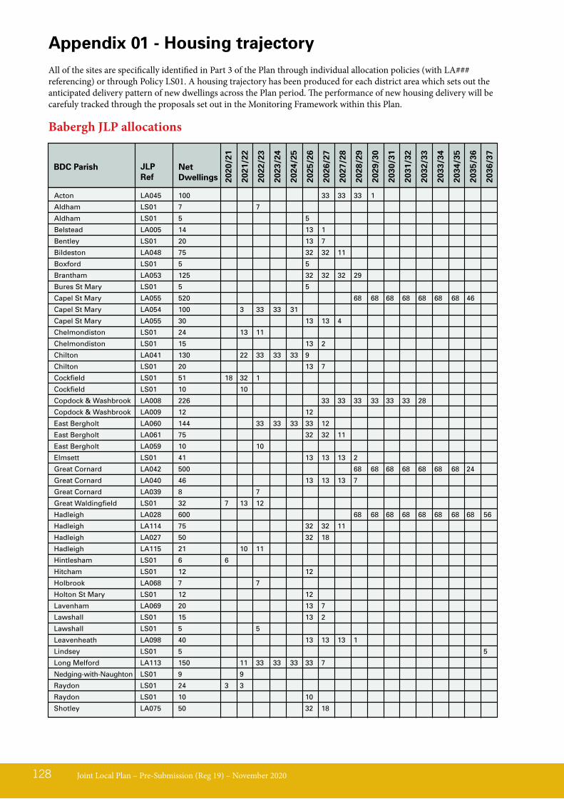
Joint Local Plan – Pre-Submission (Reg 19) – November 2020128
Acton LA045 100 33 33 33 1
Aldham LS01 7 7
Aldham LS01 5 5
Belstead LA005 14 13 1
Bentley LS01 20 13 7
Bildeston LA048 75 32 32 11
Boxford LS01 5 5
Brantham LA053 125 32 32 32 29
Bures St Mary LS01 5 5
Capel St Mary LA055 520 68 68 68 68 68 68 68 46
Capel St Mary LA054 100 3 33 33 31
Capel St Mary LA055 30 13 13 4
Chelmondiston LS01 24 13 11
Chelmondiston LS01 15 13 2
Chilton LA041 130 22 33 33 33 9
Chilton LS01 20 13 7
Cockfield LS01 51 18 32 1
Cockfield LS01 10 10
Copdock & Washbrook LA008 226 33 33 33 33 33 33 28
Copdock & Washbrook LA009 12 12
East Bergholt LA060 144 33 33 33 33 12
East Bergholt LA061 75 32 32 11
East Bergholt LA059 10 10
Elmsett LS01 41 13 13 13 2
Great Cornard LA042 500 68 68 68 68 68 68 68 24
Great Cornard LA040 46 13 13 13 7
Great Cornard LA039 8 7
Great Waldingfield LS01 32 7 13 12
Hadleigh LA028 600 68 68 68 68 68 68 68 68 56
Hadleigh LA114 75 32 32 11
Hadleigh LA027 50 32 18
Hadleigh LA115 21 10 11
Hintlesham LS01 6 6
Hitcham LS01 12 12
Holbrook LA068 7 7
Holton St Mary LS01 12 12
Lavenham LA069 20 13 7
Lawshall LS01 15 13 2
Lawshall LS01 5 5
Leavenheath LA098 40 13 13 13 1
Lindsey LS01 5 5
Long Melford LA113 150 11 33 33 33 33 7
Nedging-with-Naughton LS01 9 9
Raydon LS01 24 3 3
Raydon LS01 10 10
Shotley LA075 50 32 18
Appendix 01 - Housing trajectoryAll of the sites are specifically identified in Part 3 of the Plan through individual allocation policies (with LA### referencing) or through Policy LS01. A housing trajectory has been produced for each district area which sets out the anticipated delivery pattern of new dwellings across the Plan period. The performance of new housing delivery will be carefuly tracked through the proposals set out in the Monitoring Framework within this Plan.
2020
/21
2021
/22
2022
/23
2023
/24
2024
/25
2025
/26
2026
/27
2027
/28
2028
/29
2029
/30
2030
/31
2031
/32
2032
/33
2033
/34
2034
/35
2035
/36
2036
/37
Net Dwellings
Babergh JLP allocations
BDC Parish JLP Ref
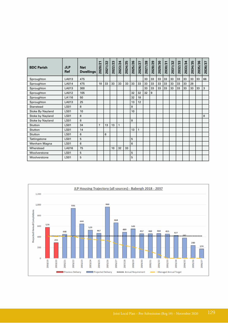
Joint Local Plan – Pre-Submission (Reg 19) – November 2020 129
Sproughton LA013 475 33 33 33 33 33 33 33 33 33 66
Sproughton LA014 475 18 33 33 33 33 33 33 33 33 33 33 33 33 33 28
Sproughton LA013 300 33 33 33 33 33 33 33 33 33 3
Sproughton LA012 105 32 32 32 9
Sproughton LA116 50 32 18
Sproughton LA013 25 13 12
Stanstead LS01 8 8
Stoke By Nayland LS01 10 10
Stoke by Nayland LS01 8 8
Stoke by Nayland LS01 8 8
Stutton LS01 34 7 13 13 1
Stutton LS01 14 13 1
Stutton LS01 6 6
Tattingstone LS01 5 5
Wenham Magna LS01 6 6
Wherstead LA016 75 10 32 33
Woolverstone LS01 5 5
Woolverstone LS01 5 5
2020
/21
2021
/22
2022
/23
2023
/24
2024
/25
2025
/26
2026
/27
2027
/28
2028
/29
2029
/30
2030
/31
2031
/32
2032
/33
2033
/34
2034
/35
2035
/36
2036
/37
Net Dwellings
BDC Parish JLP Ref
Joint Local Plan – Pre-Submission (Reg 19) – November 2020130
Ashbocking LS01 15 13 2
Bacton LA106 85 5 32 32 16
Bacton LA105 81 32 32 17
Bacton LA047 51 32 19
Bacton LA046 50 32 18
Badwell Ash LS01 52 32 20
Badwell Ash LS01 33 13 13 7
Badwell Ash LS01 21 4 13 4
Badwell Ash LS01 13 13
Badwell Ash LS01 10 10
Badwell Ash LS01 5 5
Barham LA001 325 33 33 33 33 33 33 33 33 33 28
Barham LA002 270 33 33 33 33 33 33 33 33 6
Barham LA119 20 13 7
Barking LS01 10 10
Battisford LS01 9 9
Beyton LS01 10 10
Beyton LS01 9 9
Botesdale & Rickinghall LA052 69 32 32 5
Botesdale & Rickinghall LA050 42 13 13 13 3
Botesdale & Rickinghall LA049 40 8 32
Bramford LA007 190 33 33 33 33 33 25
Bramford LA006 100 33 33 33 1
Bramford LA107 14 13 1
Brome & Oakley LS01 10 10
Brome & Oakley LS01 5 5
Claydon LA003 75 32 32 11
Combs LS01 5 5
Cotton LS01 5 5
Creeting St Mary LS01 43 13 13 13 4
Creeting St Mary LS01 5 5
Debenham LA057 140 33 33 33 33 7
Debenham LA058 87 32 32 23
Debenham LA056 18 13 5
Elmswell LA062 106 11 33 33 29
Elmswell LA066 100 33 33 33 1
Elmswell LA064 60 32 30
Elmswell LA065 50 32 18
Elmswell LA063 38 13 13 12
Eye LA109 174 33 33 33 33 33 9
Eye LA020 80 32 32 16
Eye LA111 72 32 32 8
Eye LA110 34 13 13 8
Eye LA021 12 12
Finningham LS01 10 10
Finningham LS01 10 10
Fressingfield LS01 18 13 5
Great Blakenham LA010 8 8
Great Bricett LS01 51 32 19
Great Finborough LS01 21 7
Haughley LA067 98 8 33 33 24
Haughley LA104 65 13 32 20
Haughley LA117 29 13 13 3
Henley LS01 45 13 13 13 6
Hessett LS01 5 5
2020
/21
2021
/22
2022
/23
2023
/24
2024
/25
2025
/26
2026
/27
2027
/28
2028
/29
2029
/30
2030
/31
2031
/32
2032
/33
2033
/34
2034
/35
2035
/36
2036
/37
Net Dwellings
MSDC ParishJLP Site Ref
Mid Suffolk JLP allocations
Joint Local Plan – Pre-Submission (Reg 19) – November 2020 131
Hoxne LS01 30 13 13 4
Laxfield LS01 49 13 13 13 11
Laxfield LS01 13 11 2
Mellis LS01 5 5
Mendham LS01 6 6
Mendlesham LA073 75 32 32 11
Metfield LS01 25 25
Needham Market LA030 66 32 32 2
Needham Market LA032 64 12 16 30 6
Needham Market LA031 41 9 13 13 6
Needham Market LA032 30 12 16 2
Norton LS01 8 8
Old Newton LS01 64 32 32
Old Newton LS01 56 33 23
Old Newton LS01 10 10
Onehouse LS01 10 10
Pettaugh LS01 10 10
Rattlesden LS01 22 4 13 5
Rattlesden LS01 8 8
Redgrave LS01 9 9
Somersham LS01 30 13 13 4
Stoke Ash LS01 8 8
Stonham Aspal LA076 35 13 13 9
Stonham Earl LS01 20 13 7
Stonham Parva LS01 5 5
Stonham Parva LS01 5 5
Stowmarket LA034 600 68 68 68 68 68 68 68 68 56
Stowmarket LA035 575 68 68 68 68 68 68 68 68 31
Stowmarket LA036 300 10 30 30 36 36 36 36 36 36 14
Stowmarket LA036 100 33 33 33 1
Stowmarket LA033 68 32 32 4
Stowmarket LA112 60 32 28
Stowmarket LA037 40 13 13 13 1
Stowmarket LA038 25 13 12
Stowupland LA078 300 33 33 33 33 33 33 33 33 33 3
Stowupland LA100 143 30 30 30 30 23
Stowupland LA077 18 13 5
Stradbroke LA080 75 32 32 11
Stradbroke LA082 60 32 31
Stradbroke LA081 45 13 13 13 6
Stradbroke LA083 35 13 13 9
Thorndon LS01 20 13 7
Thurston LA088 250 33 33 33 33 33 33 33 19
Thurston LA089 200 33 33 33 33 33 33 2
Thurston LA087 200 33 33 33 33 33 33 2
Thurston LA090 129 25 30 30 30 14
Thurston LA086 110 33 33 33 11
Thurston LA084 64 32 32
Thurston LA085 25 13 13
Thurston LA118 15 13 2
Thurston LA103 6 6
Thwaite LS01 10 10
Thwaite LS01 5 5
Tostock LS01 5 5
Walsham-le-Willows LA091 60 16 32 12
2020
/21
2021
/22
2022
/23
2023
/24
2024
/25
2025
/26
2026
/27
2027
/28
2028
/29
2029
/30
2030
/31
2031
/32
2032
/33
2033
/34
2034
/35
2035
/36
2036
/37
Net Dwellings
MSDC ParishJLP Site Ref
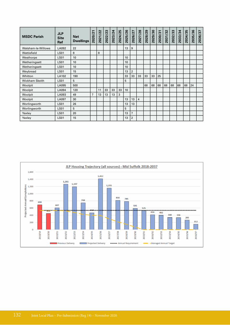
Joint Local Plan – Pre-Submission (Reg 19) – November 2020132
Walsham-le-Willows LA092 22 13 9
Wattisfield LS01 8 8
Westhorpe LS01 10 10
Wetheringsett LS01 10 10
Wetheringsett LS01 10 10
Weybread LS01 15 13 2
Whitton LA102 190 33 33 33 33 33 25
Wickham Skeith LS01 5 5
Woolpit LA095 500 68 68 68 68 68 68 68 24
Woolpit LA094 120 11 33 33 33 10
Woolpit LA093 49 7 13 13 13 3
Woolpit LA097 30 13 13 4
Worlingworth LS01 26 13 13
Worlingworth LS01 5 5
Yaxley LS01 20 13 7
Yaxley LS01 15 13 2
2020
/21
2021
/22
2022
/23
2023
/24
2024
/25
2025
/26
2026
/27
2027
/28
2028
/29
2029
/30
2030
/31
2031
/32
2032
/33
2033
/34
2034
/35
2035
/36
2036
/37
Net Dwellings
MSDC ParishJLP Site Ref
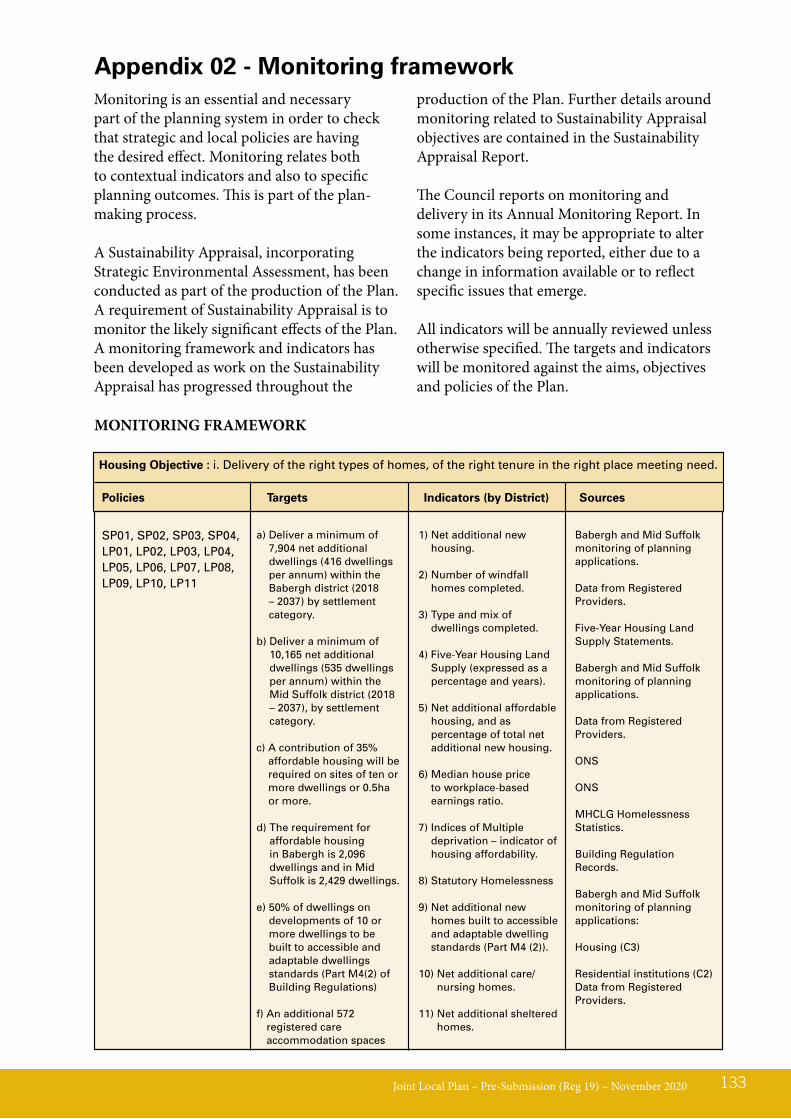
Joint Local Plan – Pre-Submission (Reg 19) – November 2020 133
Monitoring is an essential and necessary part of the planning system in order to check that strategic and local policies are having the desired effect. Monitoring relates both to contextual indicators and also to specific planning outcomes. This is part of the plan-making process.
A Sustainability Appraisal, incorporating Strategic Environmental Assessment, has been conducted as part of the production of the Plan. A requirement of Sustainability Appraisal is to monitor the likely significant effects of the Plan. A monitoring framework and indicators has been developed as work on the Sustainability Appraisal has progressed throughout the
production of the Plan. Further details around monitoring related to Sustainability Appraisal objectives are contained in the Sustainability Appraisal Report.
The Council reports on monitoring and delivery in its Annual Monitoring Report. In some instances, it may be appropriate to alter the indicators being reported, either due to a change in information available or to reflect specific issues that emerge.
All indicators will be annually reviewed unless otherwise specified. The targets and indicators will be monitored against the aims, objectives and policies of the Plan.
Appendix 02 - Monitoring framework
MONITORING FRAMEWORK
Housing Objective : i. Delivery of the right types of homes, of the right tenure in the right place meeting need.
Policies Targets Indicators (by District) Sources
SP01, SP02, SP03, SP04,LP01, LP02, LP03, LP04, LP05, LP06, LP07, LP08, LP09, LP10, LP11
a) Deliver a minimum of 7,904 net additional dwellings (416 dwellings per annum) within the Babergh district (2018 – 2037) by settlement category.
b) Deliver a minimum of 10,165 net additional dwellings (535 dwellings per annum) within the Mid Suffolk district (2018 – 2037), by settlement category.
c) A contribution of 35% affordable housing will be required on sites of ten or more dwellings or 0.5ha or more.
d) The requirement for affordable housing in Babergh is 2,096 dwellings and in Mid Suffolk is 2,429 dwellings.
e) 50% of dwellings on developments of 10 or more dwellings to be built to accessible and adaptable dwellings standards (Part M4(2) of Building Regulations)
f) An additional 572 registered care accommodation spaces
1) Net additional new housing.
2) Number of windfall homes completed.
3) Type and mix of dwellings completed.
4) Five-Year Housing Land Supply (expressed as a percentage and years).
5) Net additional affordable housing, and as percentage of total net additional new housing.
6) Median house price to workplace-based earnings ratio.
7) Indices of Multiple deprivation – indicator of housing affordability.
8) Statutory Homelessness
9) Net additional new homes built to accessible and adaptable dwelling standards (Part M4 (2)).
10) Net additional care/nursing homes.
11) Net additional sheltered homes.
Babergh and Mid Suffolk monitoring of planning applications.
Data from Registered Providers.
Five-Year Housing Land Supply Statements.
Babergh and Mid Suffolk monitoring of planning applications.
Data from Registered Providers.
ONS
ONS
MHCLG Homelessness Statistics.
Building Regulation Records.
Babergh and Mid Suffolk monitoring of planning applications:
Housing (C3)
Residential institutions (C2)Data from Registered Providers.
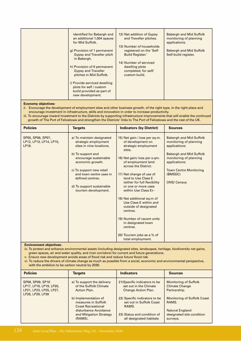
Joint Local Plan – Pre-Submission (Reg 19) – November 2020134
identified for Babergh and an additional 1,004 spaces for Mid Suffolk.
g) Provision of 1 permanent Gypsy and Traveller pitch in Babergh.
h) Provision of 9 permanent Gypsy and Traveller pitches in Mid Suffolk.
i) Provide serviced dwelling plots for self / custom build provided as part of new development.
12) Net addition of Gypsy and Traveller pitches.
13) Number of households registered on the ‘Self-Build Register.’
14) Number of serviced dwelling plots completed, for self/custom build.
Babergh and Mid Suffolk monitoring of planning applications.
Babergh and Mid Suffolk Self-build register.
Economy objectives:ii. Encourage the development of employment sites and other business growth, of the right type, in the right place and
encourage investment in infrastructure, skills and innovation in order to increase productivity.iii. To encourage inward investment to the Districts by supporting infrastructure improvements that will enable the continued
growth of The Port of Felixstowe and strengthen the Districts’ links to The Port of Felixstowe and the rest of the UK.
a) To maintain designated strategic employment sites in nine locations.
b) To support and encourage sustainable economic growth.
c) To support new retail and town centre uses in defined centres.
d) To support sustainable tourism development.
15) Net gain / loss per sq.m. of development on strategic employment sites.
16) Net gain/ loss per s.qm. of employment land across the District.
17) Net change of use of land to Use Class E (either for full flexibility or one or more uses within Use Class E)–
18) Net additional sq.m of Use Class E within and outside of designated centres.
19) Number of vacant units in designated town centres.
20) Tourism jobs as a % of total employment.
Babergh and Mid Suffolk monitoring of planning applications:
Babergh and Mid Suffolk monitoring of planning applications:
Town Centre Monitoring (BMSDC)
ONS/ Census
SP05, SP06, SP07,LP12, LP13, LP14, LP15, LP16.
Policies Targets Indicators (by District) Sources
Environment objectives:iv. To protect and enhance environmental assets (including designated sites, landscapes, heritage, biodiversity net gains,
green spaces, air and water quality, and river corridors) for current and future generations.v. Ensure new development avoids areas of flood risk and reduce future flood risk.vi. To reduce the drivers of climate change as much as possible from a social, economic and environmental perspective,
with the ambition to be carbon neutral by 2030.
a) To support the delivery of the Suffolk Climate Action Plan.
b) Implementation of measures in Suffolk Coast Recreational disturbance Avoidance and Mitigation Strategy (RAMS).
21) Specific indicators to be set out in the Climate Change Action Plan.
22) Specific indicators to be set out in Suffolk Coast RAMS.
23) Status and condition of all designated habitats
Monitoring of Suffolk Climate Change Partnership.
Monitoring of Suffolk Coast RAMS.
Natural England designated site condition surveys.
SP08, SP09, SP10LP17, LP18, LP19, LP20, LP21, LP23, LP25, LP27, LP28, LP29, LP30
Policies Targets Indicators Sources
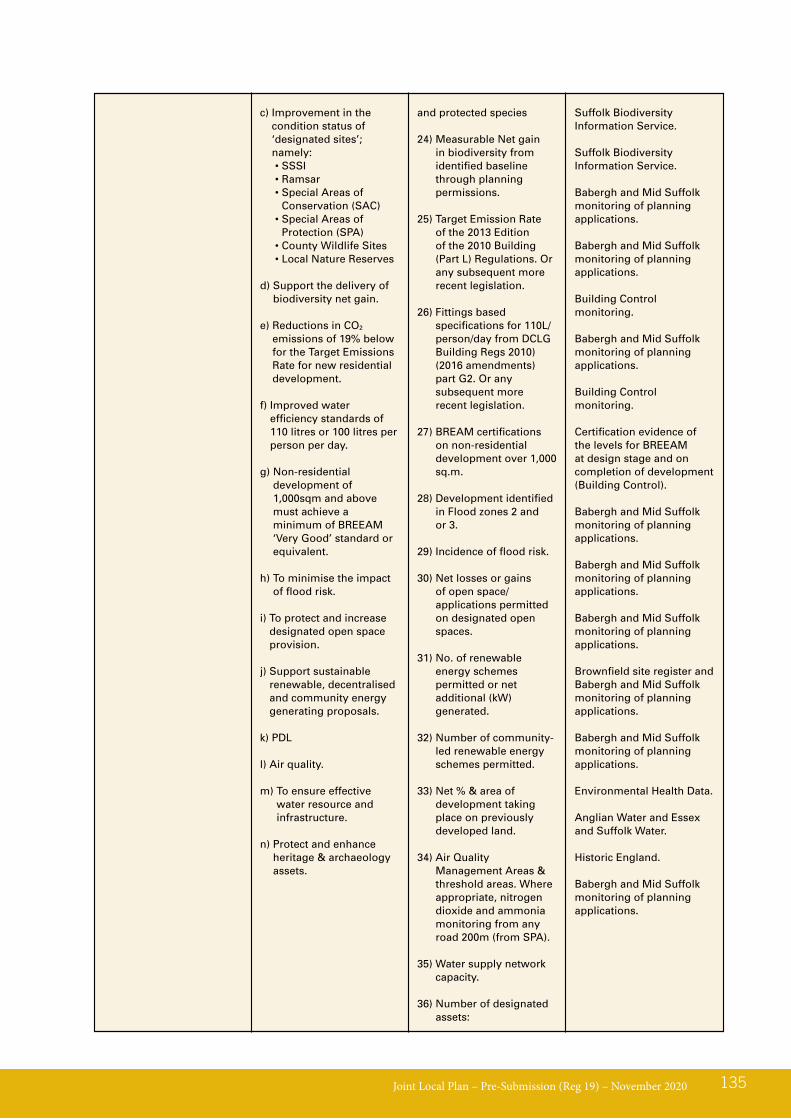
Joint Local Plan – Pre-Submission (Reg 19) – November 2020 135
and protected species
24) Measurable Net gain in biodiversity from identified baseline through planning permissions.
25) Target Emission Rate of the 2013 Edition of the 2010 Building (Part L) Regulations. Or any subsequent more recent legislation.
26) Fittings based specifications for 110L/person/day from DCLG Building Regs 2010) (2016 amendments) part G2. Or any subsequent more recent legislation.
27) BREAM certifications on non-residential development over 1,000 sq.m.
28) Development identified in Flood zones 2 and or 3.
29) Incidence of flood risk.
30) Net losses or gains of open space/ applications permitted on designated open spaces.
31) No. of renewable energy schemes permitted or net additional (kW) generated.
32) Number of community-led renewable energy schemes permitted.
33) Net % & area of development taking place on previously developed land.
34) Air Quality Management Areas & threshold areas. Where appropriate, nitrogen dioxide and ammonia monitoring from any road 200m (from SPA).
35) Water supply network capacity.
36) Number of designated assets:
Suffolk Biodiversity Information Service.
Suffolk Biodiversity Information Service.
Babergh and Mid Suffolk monitoring of planning applications.
Babergh and Mid Suffolk monitoring of planning applications.
Building Control monitoring.
Babergh and Mid Suffolk monitoring of planning applications.
Building Control monitoring.
Certification evidence of the levels for BREEAM at design stage and on completion of development (Building Control).
Babergh and Mid Suffolk monitoring of planning applications.
Babergh and Mid Suffolk monitoring of planning applications.
Babergh and Mid Suffolk monitoring of planning applications.
Brownfield site register and Babergh and Mid Suffolk monitoring of planning applications.
Babergh and Mid Suffolk monitoring of planning applications.
Environmental Health Data.
Anglian Water and Essex and Suffolk Water.
Historic England.
Babergh and Mid Suffolk monitoring of planning applications.
c) Improvement in the condition status of ‘designated sites’; namely:• SSSI• Ramsar• Special Areas of
Conservation (SAC)• Special Areas of
Protection (SPA)• County Wildlife Sites• Local Nature Reserves
d) Support the delivery of biodiversity net gain.
e) Reductions in CO2 emissions of 19% below for the Target Emissions Rate for new residential development.
f) Improved water efficiency standards of 110 litres or 100 litres per person per day.
g) Non-residential development of 1,000sqm and above must achieve a minimum of BREEAM ‘Very Good’ standard or equivalent.
h) To minimise the impact of flood risk.
i) To protect and increase designated open space provision.
j) Support sustainable renewable, decentralised and community energy generating proposals.
k) PDL
l) Air quality.
m) To ensure effective water resource and infrastructure.
n) Protect and enhance heritage & archaeology assets.
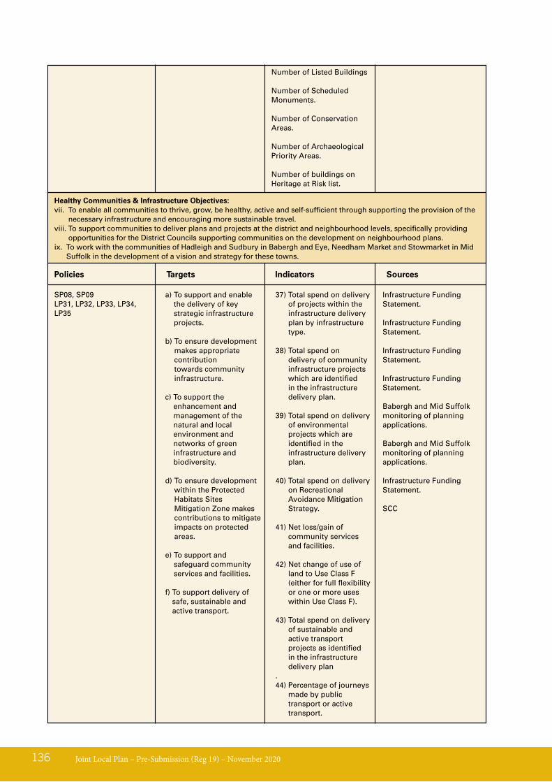
Joint Local Plan – Pre-Submission (Reg 19) – November 2020136
a) To support and enable the delivery of key strategic infrastructure projects.
b) To ensure development makes appropriate contribution towards community infrastructure.
c) To support the enhancement and management of the natural and local environment and networks of green infrastructure and biodiversity.
d) To ensure development within the Protected Habitats Sites Mitigation Zone makes contributions to mitigate impacts on protected areas.
e) To support and safeguard community services and facilities.
f) To support delivery of safe, sustainable and active transport.
Number of Listed Buildings
Number of Scheduled Monuments.
Number of Conservation Areas.
Number of Archaeological Priority Areas.
Number of buildings on Heritage at Risk list.
Infrastructure Funding Statement.
Infrastructure Funding Statement.
Infrastructure Funding Statement.
Infrastructure Funding Statement.
Babergh and Mid Suffolk monitoring of planning applications.
Babergh and Mid Suffolk monitoring of planning applications.
Infrastructure Funding Statement.
SCC
SP08, SP09LP31, LP32, LP33, LP34, LP35
Healthy Communities & Infrastructure Objectives:vii. To enable all communities to thrive, grow, be healthy, active and self-sufficient through supporting the provision of the
necessary infrastructure and encouraging more sustainable travel.viii. To support communities to deliver plans and projects at the district and neighbourhood levels, specifically providing
opportunities for the District Councils supporting communities on the development on neighbourhood plans.ix. To work with the communities of Hadleigh and Sudbury in Babergh and Eye, Needham Market and Stowmarket in Mid
Suffolk in the development of a vision and strategy for these towns.
Policies Targets Indicators Sources
37) Total spend on delivery of projects within the infrastructure delivery plan by infrastructure type.
38) Total spend on delivery of community infrastructure projects which are identified in the infrastructure delivery plan.
39) Total spend on delivery of environmental projects which are identified in the infrastructure delivery plan.
40) Total spend on delivery on Recreational Avoidance Mitigation Strategy.
41) Net loss/gain of community services and facilities.
42) Net change of use of land to Use Class F (either for full flexibility or one or more uses within Use Class F).
43) Total spend on delivery of sustainable and active transport projects as identified in the infrastructure delivery plan
.44) Percentage of journeys
made by public transport or active transport.

Joint Local Plan – Pre-Submission (Reg 19) – November 2020 137
Site Allocations Targets Indicators Sources
Deliver a minimum of 7,904 net additional dwellings (416 dwellings per annum) within the Babergh district (2018 – 2037).
Deliver a minimum of 10,165 net additional dwellings (535 dwellings per annum) within the Mid Suffolk district (2018 – 2037).
45) Number of dwellings completed.
46) LA allocations committed, commenced and completed.
47) Monitoring of windfall committed, commenced and completed.
Babergh and Mid Suffolk monitoring of planning applications.
Performance will be regularly monitored for annual housing completions and 5 year for housing land supply assessments.
All site allocations identified in JLP.
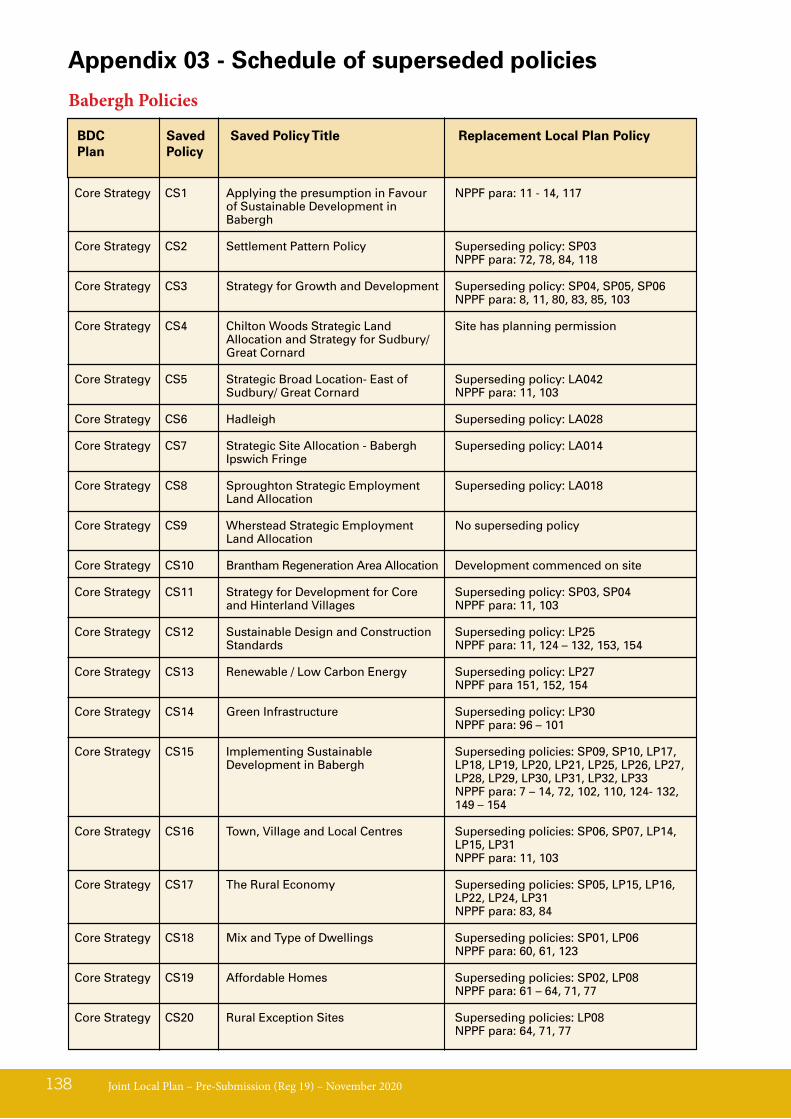
Joint Local Plan – Pre-Submission (Reg 19) – November 2020138
Appendix 03 - Schedule of superseded policies
Babergh Policies
BDCPlan
Replacement Local Plan PolicySaved Policy
Saved Policy Title
Core Strategy CS1 Applying the presumption in Favour NPPF para: 11 - 14, 117 of Sustainable Development in Babergh
Core Strategy CS2 Settlement Pattern Policy Superseding policy: SP03 NPPF para: 72, 78, 84, 118
Core Strategy CS3 Strategy for Growth and Development Superseding policy: SP04, SP05, SP06 NPPF para: 8, 11, 80, 83, 85, 103
Core Strategy CS4 Chilton Woods Strategic Land Site has planning permission Allocation and Strategy for Sudbury/ Great Cornard
Core Strategy CS5 Strategic Broad Location- East of Superseding policy: LA042 Sudbury/ Great Cornard NPPF para: 11, 103
Core Strategy CS6 Hadleigh Superseding policy: LA028
Core Strategy CS7 Strategic Site Allocation - Babergh Superseding policy: LA014 Ipswich Fringe
Core Strategy CS8 Sproughton Strategic Employment Superseding policy: LA018 Land Allocation
Core Strategy CS9 Wherstead Strategic Employment No superseding policy Land Allocation
Core Strategy CS10 Brantham Regeneration Area Allocation Development commenced on site
Core Strategy CS11 Strategy for Development for Core Superseding policy: SP03, SP04 and Hinterland Villages NPPF para: 11, 103
Core Strategy CS12 Sustainable Design and Construction Superseding policy: LP25 Standards NPPF para: 11, 124 – 132, 153, 154
Core Strategy CS13 Renewable / Low Carbon Energy Superseding policy: LP27 NPPF para 151, 152, 154
Core Strategy CS14 Green Infrastructure Superseding policy: LP30 NPPF para: 96 – 101
Core Strategy CS15 Implementing Sustainable Superseding policies: SP09, SP10, LP17, Development in Babergh LP18, LP19, LP20, LP21, LP25, LP26, LP27,
LP28, LP29, LP30, LP31, LP32, LP33 NPPF para: 7 – 14, 72, 102, 110, 124- 132, 149 – 154
Core Strategy CS16 Town, Village and Local Centres Superseding policies: SP06, SP07, LP14, LP15, LP31
NPPF para: 11, 103
Core Strategy CS17 The Rural Economy Superseding policies: SP05, LP15, LP16, LP22, LP24, LP31
NPPF para: 83, 84
Core Strategy CS18 Mix and Type of Dwellings Superseding policies: SP01, LP06 NPPF para: 60, 61, 123
Core Strategy CS19 Affordable Homes Superseding policies: SP02, LP08 NPPF para: 61 – 64, 71, 77
Core Strategy CS20 Rural Exception Sites Superseding policies: LP08 NPPF para: 64, 71, 77
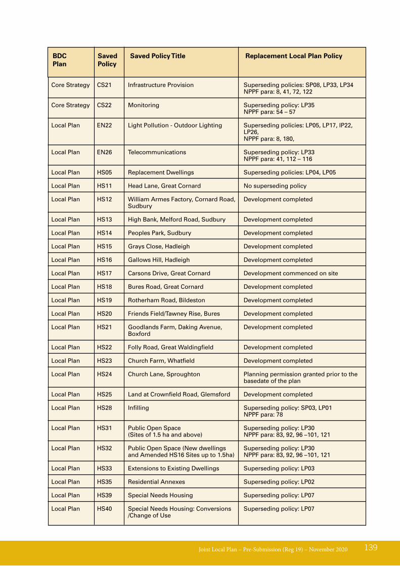
Joint Local Plan – Pre-Submission (Reg 19) – November 2020 139
BDCPlan
Replacement Local Plan PolicySaved Policy
Saved Policy Title
Core Strategy CS21 Infrastructure Provision Superseding policies: SP08, LP33, LP34 NPPF para: 8, 41, 72, 122
Core Strategy CS22 Monitoring Superseding policy: LP35 NPPF para: 54 – 57 Local Plan EN22 Light Pollution - Outdoor Lighting Superseding policies: LP05, LP17, lP22, LP26,
NPPF para: 8, 180,
Local Plan EN26 Telecommunications Superseding policy: LP33 NPPF para: 41, 112 – 116
Local Plan HS05 Replacement Dwellings Superseding policies: LP04, LP05
Local Plan HS11 Head Lane, Great Cornard No superseding policy
Local Plan HS12 William Armes Factory, Cornard Road, Development completed Sudbury
Local Plan HS13 High Bank, Melford Road, Sudbury Development completed
Local Plan HS14 Peoples Park, Sudbury Development completed
Local Plan HS15 Grays Close, Hadleigh Development completed
Local Plan HS16 Gallows Hill, Hadleigh Development completed
Local Plan HS17 Carsons Drive, Great Cornard Development commenced on site
Local Plan HS18 Bures Road, Great Cornard Development completed
Local Plan HS19 Rotherham Road, Bildeston Development completed
Local Plan HS20 Friends Field/Tawney Rise, Bures Development completed
Local Plan HS21 Goodlands Farm, Daking Avenue, Development completed Boxford
Local Plan HS22 Folly Road, Great Waldingfield Development completed
Local Plan HS23 Church Farm, Whatfield Development completed
Local Plan HS24 Church Lane, Sproughton Planning permission granted prior to the basedate of the plan
Local Plan HS25 Land at Crownfield Road, Glemsford Development completed
Local Plan HS28 Infilling Superseding policy: SP03, LP01 NPPF para: 78
Local Plan HS31 Public Open Space Superseding policy: LP30 (Sites of 1.5 ha and above) NPPF para: 83, 92, 96 –101, 121
Local Plan HS32 Public Open Space (New dwellings Superseding policy: LP30 and Amended HS16 Sites up to 1.5ha) NPPF para: 83, 92, 96 –101, 121
Local Plan HS33 Extensions to Existing Dwellings Superseding policy: LP03
Local Plan HS35 Residential Annexes Superseding policy: LP02
Local Plan HS39 Special Needs Housing Superseding policy: LP07
Local Plan HS40 Special Needs Housing: Conversions Superseding policy: LP07 /Change of Use
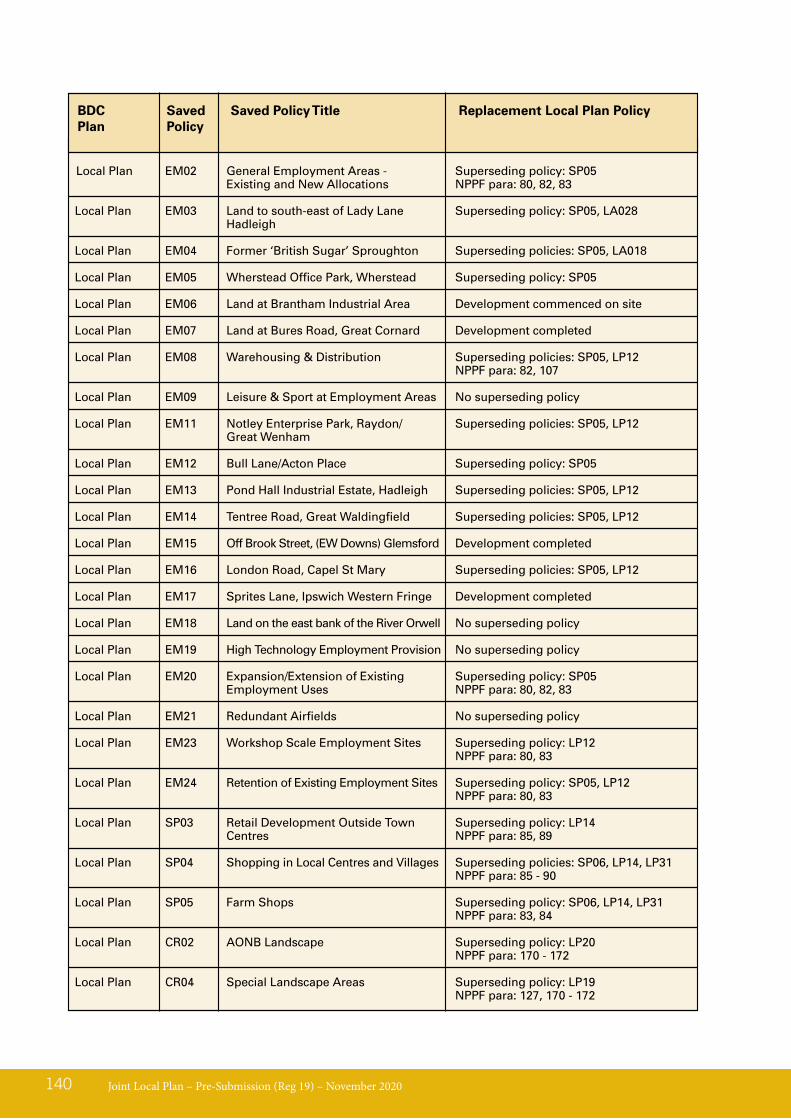
Joint Local Plan – Pre-Submission (Reg 19) – November 2020140
BDCPlan
Replacement Local Plan PolicySaved Policy
Saved Policy Title
Local Plan EM02 General Employment Areas - Superseding policy: SP05 Existing and New Allocations NPPF para: 80, 82, 83
Local Plan EM03 Land to south-east of Lady Lane Superseding policy: SP05, LA028 Hadleigh
Local Plan EM04 Former ‘British Sugar’ Sproughton Superseding policies: SP05, LA018
Local Plan EM05 Wherstead Office Park, Wherstead Superseding policy: SP05
Local Plan EM06 Land at Brantham Industrial Area Development commenced on site Local Plan EM07 Land at Bures Road, Great Cornard Development completed
Local Plan EM08 Warehousing & Distribution Superseding policies: SP05, LP12 NPPF para: 82, 107
Local Plan EM09 Leisure & Sport at Employment Areas No superseding policy
Local Plan EM11 Notley Enterprise Park, Raydon/ Superseding policies: SP05, LP12 Great Wenham
Local Plan EM12 Bull Lane/Acton Place Superseding policy: SP05
Local Plan EM13 Pond Hall Industrial Estate, Hadleigh Superseding policies: SP05, LP12
Local Plan EM14 Tentree Road, Great Waldingfield Superseding policies: SP05, LP12
Local Plan EM15 Off Brook Street, (EW Downs) Glemsford Development completed
Local Plan EM16 London Road, Capel St Mary Superseding policies: SP05, LP12
Local Plan EM17 Sprites Lane, Ipswich Western Fringe Development completed
Local Plan EM18 Land on the east bank of the River Orwell No superseding policy
Local Plan EM19 High Technology Employment Provision No superseding policy
Local Plan EM20 Expansion/Extension of Existing Superseding policy: SP05 Employment Uses NPPF para: 80, 82, 83
Local Plan EM21 Redundant Airfields No superseding policy
Local Plan EM23 Workshop Scale Employment Sites Superseding policy: LP12 NPPF para: 80, 83 Local Plan EM24 Retention of Existing Employment Sites Superseding policy: SP05, LP12 NPPF para: 80, 83
Local Plan SP03 Retail Development Outside Town Superseding policy: LP14 Centres NPPF para: 85, 89
Local Plan SP04 Shopping in Local Centres and Villages Superseding policies: SP06, LP14, LP31 NPPF para: 85 - 90
Local Plan SP05 Farm Shops Superseding policy: SP06, LP14, LP31 NPPF para: 83, 84
Local Plan CR02 AONB Landscape Superseding policy: LP20 NPPF para: 170 - 172
Local Plan CR04 Special Landscape Areas Superseding policy: LP19 NPPF para: 127, 170 - 172
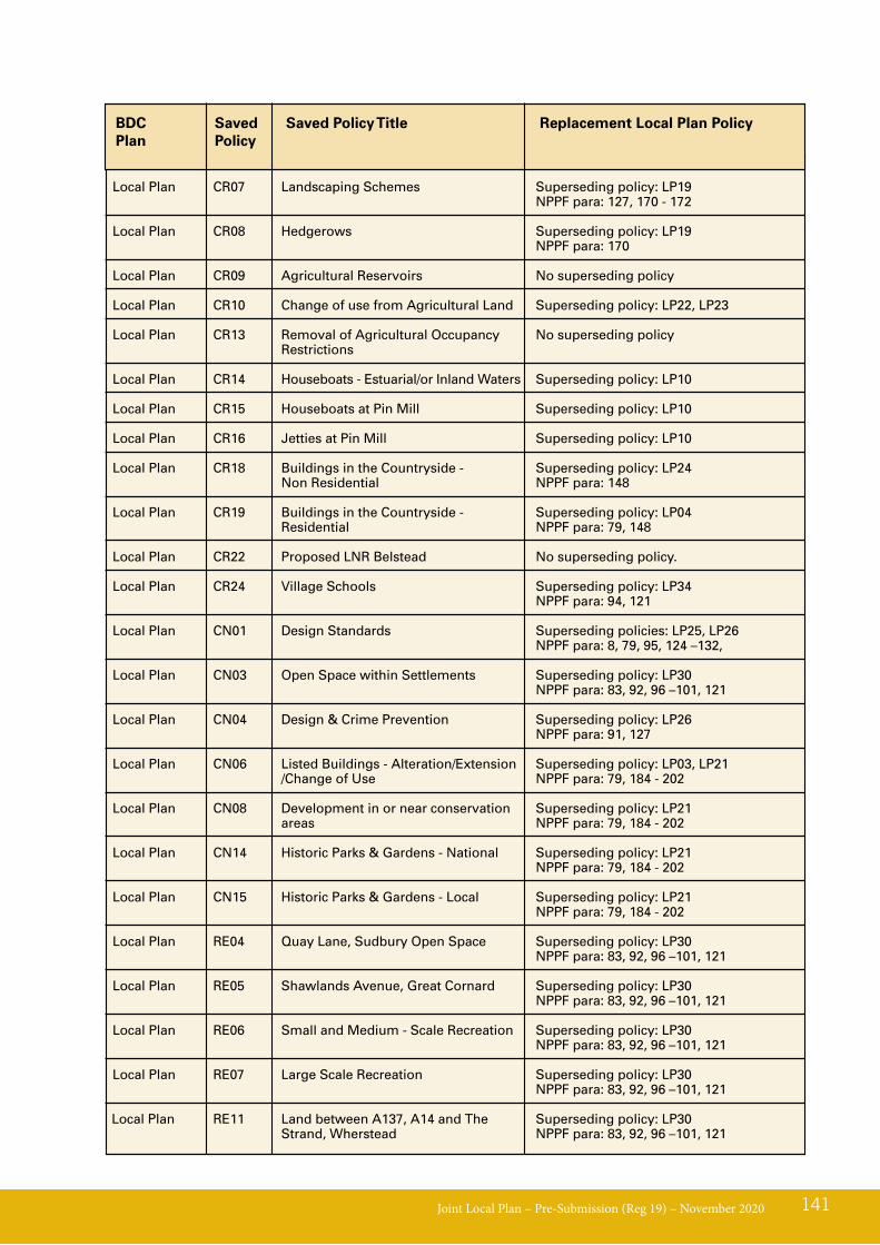
Joint Local Plan – Pre-Submission (Reg 19) – November 2020 141
BDCPlan
Replacement Local Plan PolicySaved Policy
Saved Policy Title
Local Plan CR07 Landscaping Schemes Superseding policy: LP19 NPPF para: 127, 170 - 172
Local Plan CR08 Hedgerows Superseding policy: LP19 NPPF para: 170
Local Plan CR09 Agricultural Reservoirs No superseding policy
Local Plan CR10 Change of use from Agricultural Land Superseding policy: LP22, LP23
Local Plan CR13 Removal of Agricultural Occupancy No superseding policy Restrictions
Local Plan CR14 Houseboats - Estuarial/or Inland Waters Superseding policy: LP10
Local Plan CR15 Houseboats at Pin Mill Superseding policy: LP10
Local Plan CR16 Jetties at Pin Mill Superseding policy: LP10
Local Plan CR18 Buildings in the Countryside - Superseding policy: LP24 Non Residential NPPF para: 148
Local Plan CR19 Buildings in the Countryside - Superseding policy: LP04 Residential NPPF para: 79, 148
Local Plan CR22 Proposed LNR Belstead No superseding policy.
Local Plan CR24 Village Schools Superseding policy: LP34 NPPF para: 94, 121
Local Plan CN01 Design Standards Superseding policies: LP25, LP26 NPPF para: 8, 79, 95, 124 –132,
Local Plan CN03 Open Space within Settlements Superseding policy: LP30 NPPF para: 83, 92, 96 –101, 121
Local Plan CN04 Design & Crime Prevention Superseding policy: LP26 NPPF para: 91, 127
Local Plan CN06 Listed Buildings - Alteration/Extension Superseding policy: LP03, LP21 /Change of Use NPPF para: 79, 184 - 202
Local Plan CN08 Development in or near conservation Superseding policy: LP21 areas NPPF para: 79, 184 - 202
Local Plan CN14 Historic Parks & Gardens - National Superseding policy: LP21 NPPF para: 79, 184 - 202
Local Plan CN15 Historic Parks & Gardens - Local Superseding policy: LP21 NPPF para: 79, 184 - 202
Local Plan RE04 Quay Lane, Sudbury Open Space Superseding policy: LP30 NPPF para: 83, 92, 96 –101, 121
Local Plan RE05 Shawlands Avenue, Great Cornard Superseding policy: LP30 NPPF para: 83, 92, 96 –101, 121
Local Plan RE06 Small and Medium - Scale Recreation Superseding policy: LP30 NPPF para: 83, 92, 96 –101, 121
Local Plan RE07 Large Scale Recreation Superseding policy: LP30 NPPF para: 83, 92, 96 –101, 121 Local Plan RE11 Land between A137, A14 and The Superseding policy: LP30 Strand, Wherstead NPPF para: 83, 92, 96 –101, 121
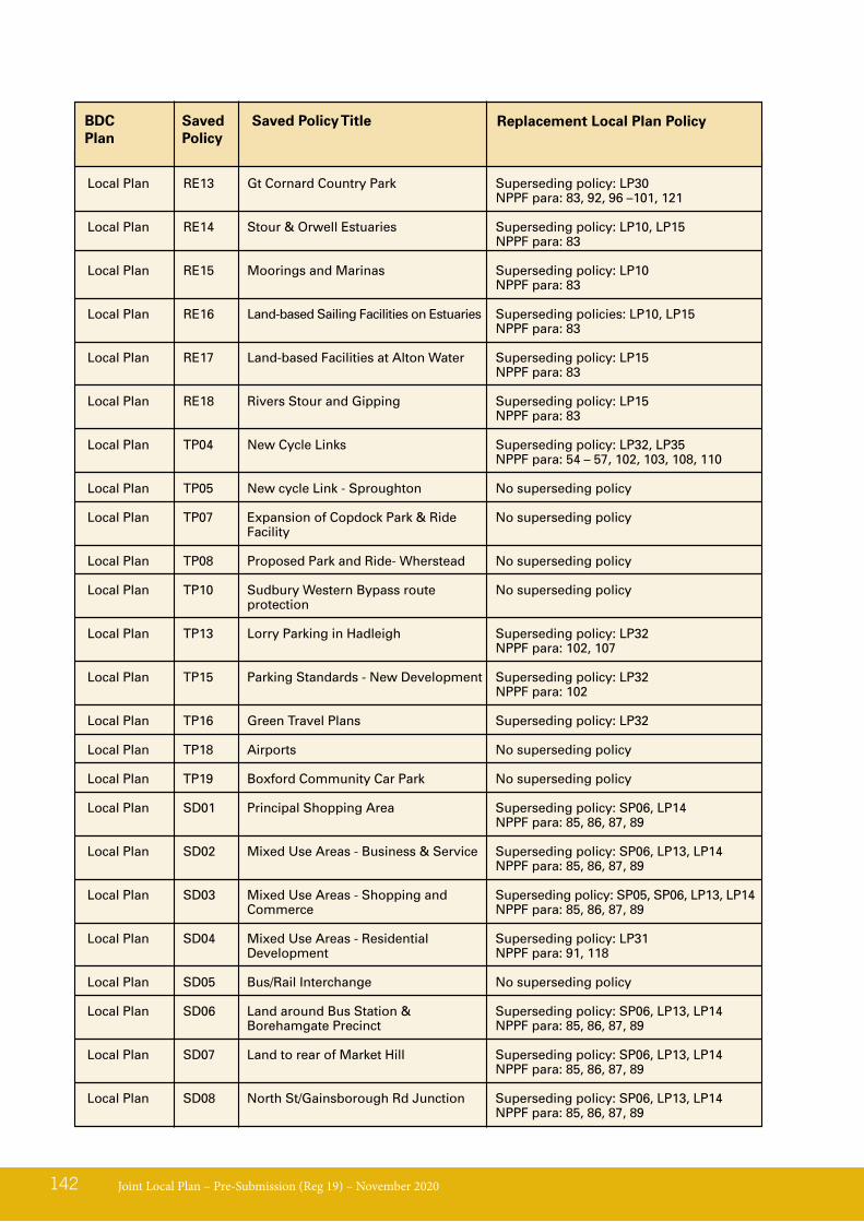
Joint Local Plan – Pre-Submission (Reg 19) – November 2020142
BDCPlan
Saved Policy
Saved Policy Title
Local Plan RE13 Gt Cornard Country Park Superseding policy: LP30 NPPF para: 83, 92, 96 –101, 121
Local Plan RE14 Stour & Orwell Estuaries Superseding policy: LP10, LP15 NPPF para: 83 Local Plan RE15 Moorings and Marinas Superseding policy: LP10 NPPF para: 83
Local Plan RE16 Land-based Sailing Facilities on Estuaries Superseding policies: LP10, LP15 NPPF para: 83
Local Plan RE17 Land-based Facilities at Alton Water Superseding policy: LP15 NPPF para: 83
Local Plan RE18 Rivers Stour and Gipping Superseding policy: LP15 NPPF para: 83 Local Plan TP04 New Cycle Links Superseding policy: LP32, LP35 NPPF para: 54 – 57, 102, 103, 108, 110
Local Plan TP05 New cycle Link - Sproughton No superseding policy
Local Plan TP07 Expansion of Copdock Park & Ride No superseding policy Facility
Local Plan TP08 Proposed Park and Ride- Wherstead No superseding policy
Local Plan TP10 Sudbury Western Bypass route No superseding policy protection
Local Plan TP13 Lorry Parking in Hadleigh Superseding policy: LP32 NPPF para: 102, 107
Local Plan TP15 Parking Standards - New Development Superseding policy: LP32 NPPF para: 102
Local Plan TP16 Green Travel Plans Superseding policy: LP32 Local Plan TP18 Airports No superseding policy
Local Plan TP19 Boxford Community Car Park No superseding policy
Local Plan SD01 Principal Shopping Area Superseding policy: SP06, LP14 NPPF para: 85, 86, 87, 89
Local Plan SD02 Mixed Use Areas - Business & Service Superseding policy: SP06, LP13, LP14 NPPF para: 85, 86, 87, 89
Local Plan SD03 Mixed Use Areas - Shopping and Superseding policy: SP05, SP06, LP13, LP14 Commerce NPPF para: 85, 86, 87, 89
Local Plan SD04 Mixed Use Areas - Residential Superseding policy: LP31 Development NPPF para: 91, 118
Local Plan SD05 Bus/Rail Interchange No superseding policy
Local Plan SD06 Land around Bus Station & Superseding policy: SP06, LP13, LP14 Borehamgate Precinct NPPF para: 85, 86, 87, 89
Local Plan SD07 Land to rear of Market Hill Superseding policy: SP06, LP13, LP14 NPPF para: 85, 86, 87, 89
Local Plan SD08 North St/Gainsborough Rd Junction Superseding policy: SP06, LP13, LP14 NPPF para: 85, 86, 87, 89
Replacement Local Plan Policy
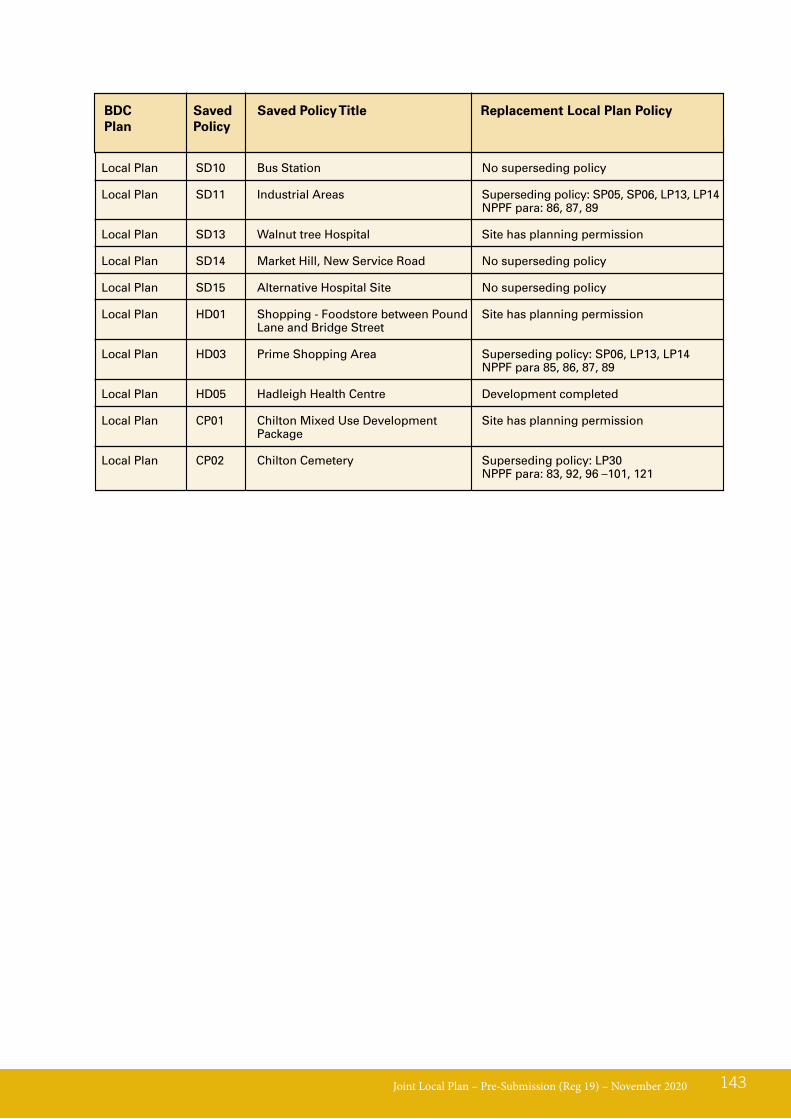
Joint Local Plan – Pre-Submission (Reg 19) – November 2020 143
BDCPlan
Saved Policy
Saved Policy Title
Local Plan SD10 Bus Station No superseding policy
Local Plan SD11 Industrial Areas Superseding policy: SP05, SP06, LP13, LP14 NPPF para: 86, 87, 89
Local Plan SD13 Walnut tree Hospital Site has planning permission
Local Plan SD14 Market Hill, New Service Road No superseding policy
Local Plan SD15 Alternative Hospital Site No superseding policy
Local Plan HD01 Shopping - Foodstore between Pound Site has planning permission Lane and Bridge Street
Local Plan HD03 Prime Shopping Area Superseding policy: SP06, LP13, LP14 NPPF para 85, 86, 87, 89
Local Plan HD05 Hadleigh Health Centre Development completed
Local Plan CP01 Chilton Mixed Use Development Site has planning permission Package
Local Plan CP02 Chilton Cemetery Superseding policy: LP30 NPPF para: 83, 92, 96 –101, 121
Replacement Local Plan Policy
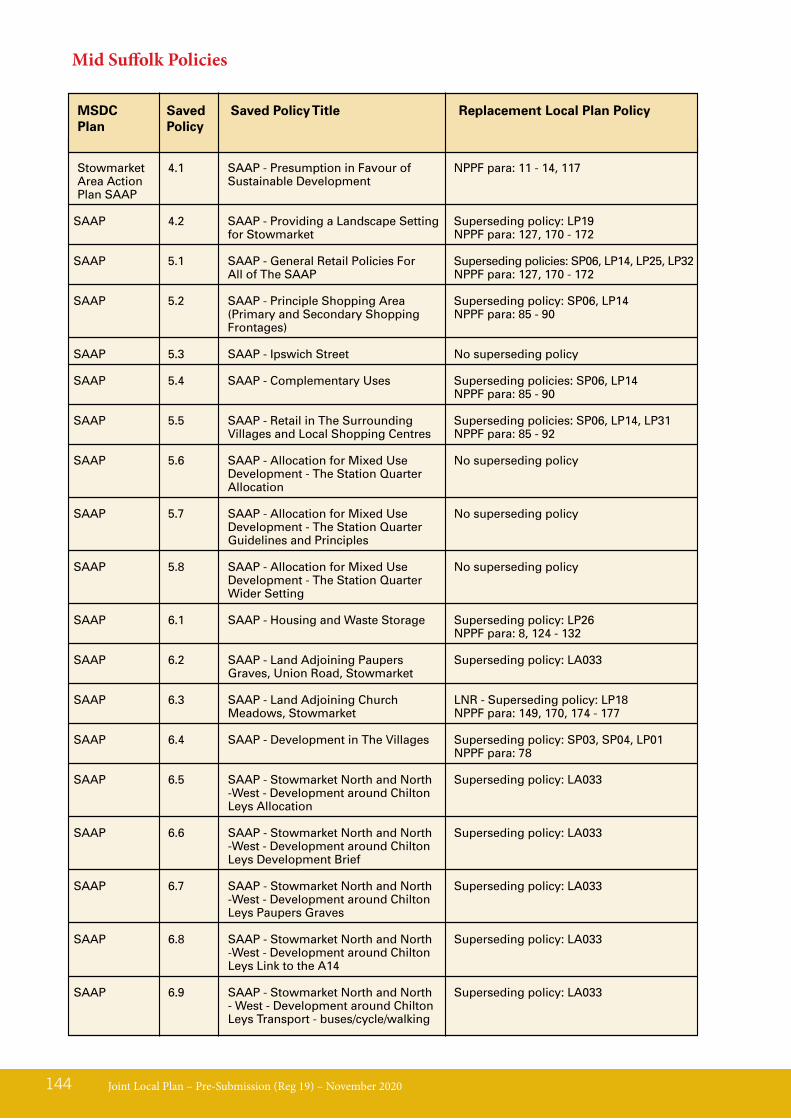
Joint Local Plan – Pre-Submission (Reg 19) – November 2020144
MSDCPlan
Replacement Local Plan PolicySaved Policy
Saved Policy Title
Stowmarket 4.1 SAAP - Presumption in Favour of NPPF para: 11 - 14, 117 Area Action Sustainable Development Plan SAAP
SAAP 4.2 SAAP - Providing a Landscape Setting Superseding policy: LP19 for Stowmarket NPPF para: 127, 170 - 172
SAAP 5.1 SAAP - General Retail Policies For Superseding policies: SP06, LP14, LP25, LP32 All of The SAAP NPPF para: 127, 170 - 172
SAAP 5.2 SAAP - Principle Shopping Area Superseding policy: SP06, LP14 (Primary and Secondary Shopping NPPF para: 85 - 90 Frontages)
SAAP 5.3 SAAP - Ipswich Street No superseding policy
SAAP 5.4 SAAP - Complementary Uses Superseding policies: SP06, LP14 NPPF para: 85 - 90
SAAP 5.5 SAAP - Retail in The Surrounding Superseding policies: SP06, LP14, LP31 Villages and Local Shopping Centres NPPF para: 85 - 92
SAAP 5.6 SAAP - Allocation for Mixed Use No superseding policy Development - The Station Quarter Allocation
SAAP 5.7 SAAP - Allocation for Mixed Use No superseding policy Development - The Station Quarter Guidelines and Principles
SAAP 5.8 SAAP - Allocation for Mixed Use No superseding policy Development - The Station Quarter Wider Setting
SAAP 6.1 SAAP - Housing and Waste Storage Superseding policy: LP26 NPPF para: 8, 124 - 132
SAAP 6.2 SAAP - Land Adjoining Paupers Superseding policy: LA033 Graves, Union Road, Stowmarket
SAAP 6.3 SAAP - Land Adjoining Church LNR - Superseding policy: LP18 Meadows, Stowmarket NPPF para: 149, 170, 174 - 177
SAAP 6.4 SAAP - Development in The Villages Superseding policy: SP03, SP04, LP01 NPPF para: 78
SAAP 6.5 SAAP - Stowmarket North and North Superseding policy: LA033 -West - Development around Chilton Leys Allocation
SAAP 6.6 SAAP - Stowmarket North and North Superseding policy: LA033 -West - Development around Chilton Leys Development Brief
SAAP 6.7 SAAP - Stowmarket North and North Superseding policy: LA033 -West - Development around Chilton Leys Paupers Graves
SAAP 6.8 SAAP - Stowmarket North and North Superseding policy: LA033 -West - Development around Chilton Leys Link to the A14
SAAP 6.9 SAAP - Stowmarket North and North Superseding policy: LA033 - West - Development around Chilton Leys Transport - buses/cycle/walking
Mid Suffolk Policies
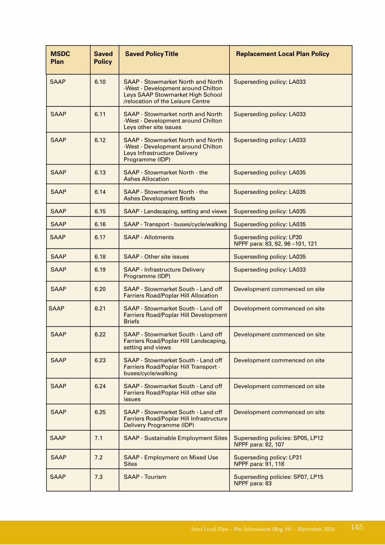
Joint Local Plan – Pre-Submission (Reg 19) – November 2020 145
MSDCPlan
Replacement Local Plan PolicySaved Policy
Saved Policy Title
SAAP 6.10 SAAP - Stowmarket North and North Superseding policy: LA033 -West - Development around Chilton Leys SAAP Stowmarket High School /relocation of the Leisure Centre
SAAP 6.11 SAAP - Stowmarket north and North Superseding policy: LA033 -West - Development around Chilton Leys other site issues
SAAP 6.12 SAAP - Stowmarket North and North Superseding policy: LA033 -West - Development around Chilton Leys Infrastructure Delivery Programme (IDP)
SAAP 6.13 SAAP - Stowmarket North - the Superseding policy: LA035 Ashes Allocation
SAAP 6.14 SAAP - Stowmarket North - the Superseding policy: LA035 Ashes Development Briefs
SAAP 6.15 SAAP - Landscaping, setting and views Superseding policy: LA035
SAAP 6.16 SAAP - Transport - buses/cycle/walking Superseding policy: LA035
SAAP 6.17 SAAP - Allotments Superseding policy: LP30 NPPF para: 83, 92, 96 –101, 121
SAAP 6.18 SAAP - Other site issues Superseding policy: LA035
SAAP 6.19 SAAP - Infrastructure Delivery Superseding policy: LA033 Programme (IDP)
SAAP 6.20 SAAP - Stowmarket South - Land off Development commenced on site Farriers Road/Poplar Hill Allocation
SAAP 6.21 SAAP - Stowmarket South - Land off Development commenced on site Farriers Road/Poplar Hill Development Briefs
SAAP 6.22 SAAP - Stowmarket South - Land off Development commenced on site Farriers Road/Poplar Hill Landscaping, setting and views
SAAP 6.23 SAAP - Stowmarket South - Land off Development commenced on site Farriers Road/Poplar Hill Transport - buses/cycle/walking
SAAP 6.24 SAAP - Stowmarket South - Land off Development commenced on site Farriers Road/Poplar Hill other site issues
SAAP 6.25 SAAP - Stowmarket South - Land off Development commenced on site Farriers Road/Poplar Hill Infrastructure Delivery Programme (IDP)
SAAP 7.1 SAAP - Sustainable Employment Sites Superseding policies: SP05, LP12 NPPF para: 82, 107
SAAP 7.2 SAAP - Employment on Mixed Use Superseding policy: LP31 Sites NPPF para: 91, 118
SAAP 7.3 SAAP - Tourism Superseding policies: SP07, LP15 NPPF para: 83
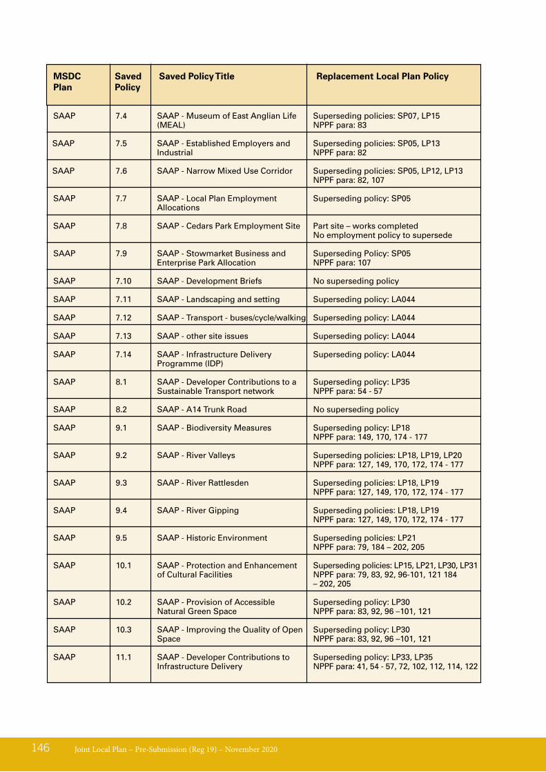
Joint Local Plan – Pre-Submission (Reg 19) – November 2020146
MSDCPlan
Replacement Local Plan PolicySaved Policy
Saved Policy Title
SAAP 7.4 SAAP - Museum of East Anglian Life Superseding policies: SP07, LP15 (MEAL) NPPF para: 83
SAAP 7.5 SAAP - Established Employers and Superseding policies: SP05, LP13 Industrial NPPF para: 82
SAAP 7.6 SAAP - Narrow Mixed Use Corridor Superseding policies: SP05, LP12, LP13 NPPF para: 82, 107
SAAP 7.7 SAAP - Local Plan Employment Superseding policy: SP05 Allocations
SAAP 7.8 SAAP - Cedars Park Employment Site Part site – works completed No employment policy to supersede
SAAP 7.9 SAAP - Stowmarket Business and Superseding Policy: SP05 Enterprise Park Allocation NPPF para: 107
SAAP 7.10 SAAP - Development Briefs No superseding policy SAAP 7.11 SAAP - Landscaping and setting Superseding policy: LA044
SAAP 7.12 SAAP - Transport - buses/cycle/walking Superseding policy: LA044
SAAP 7.13 SAAP - other site issues Superseding policy: LA044
SAAP 7.14 SAAP - Infrastructure Delivery Superseding policy: LA044 Programme (IDP)
SAAP 8.1 SAAP - Developer Contributions to a Superseding policy: LP35 Sustainable Transport network NPPF para: 54 - 57
SAAP 8.2 SAAP - A14 Trunk Road No superseding policy
SAAP 9.1 SAAP - Biodiversity Measures Superseding policy: LP18 NPPF para: 149, 170, 174 - 177
SAAP 9.2 SAAP - River Valleys Superseding policies: LP18, LP19, LP20 NPPF para: 127, 149, 170, 172, 174 - 177
SAAP 9.3 SAAP - River Rattlesden Superseding policies: LP18, LP19 NPPF para: 127, 149, 170, 172, 174 - 177
SAAP 9.4 SAAP - River Gipping Superseding policies: LP18, LP19 NPPF para: 127, 149, 170, 172, 174 - 177
SAAP 9.5 SAAP - Historic Environment Superseding policies: LP21 NPPF para: 79, 184 – 202, 205
SAAP 10.1 SAAP - Protection and Enhancement Superseding policies: LP15, LP21, LP30, LP31 of Cultural Facilities NPPF para: 79, 83, 92, 96-101, 121 184 – 202, 205
SAAP 10.2 SAAP - Provision of Accessible Superseding policy: LP30 Natural Green Space NPPF para: 83, 92, 96 –101, 121
SAAP 10.3 SAAP - Improving the Quality of Open Superseding policy: LP30 Space NPPF para: 83, 92, 96 –101, 121
SAAP 11.1 SAAP - Developer Contributions to Superseding policy: LP33, LP35 Infrastructure Delivery NPPF para: 41, 54 - 57, 72, 102, 112, 114, 122
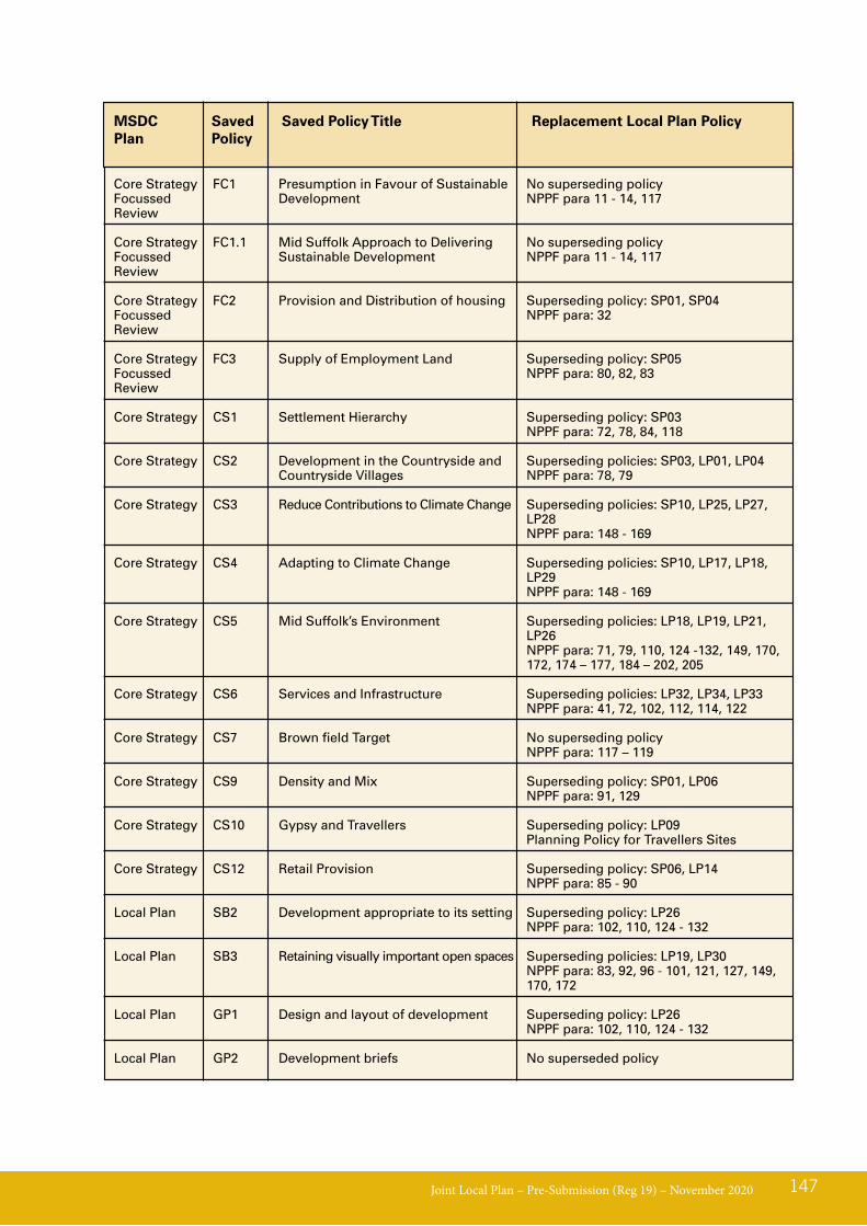
Joint Local Plan – Pre-Submission (Reg 19) – November 2020 147
MSDCPlan
Replacement Local Plan PolicySaved Policy
Saved Policy Title
Core Strategy FC1 Presumption in Favour of Sustainable No superseding policy Focussed Development NPPF para 11 - 14, 117 Review
Core Strategy FC1.1 Mid Suffolk Approach to Delivering No superseding policy Focussed Sustainable Development NPPF para 11 - 14, 117 Review
Core Strategy FC2 Provision and Distribution of housing Superseding policy: SP01, SP04 Focussed NPPF para: 32 Review
Core Strategy FC3 Supply of Employment Land Superseding policy: SP05 Focussed NPPF para: 80, 82, 83 Review
Core Strategy CS1 Settlement Hierarchy Superseding policy: SP03 NPPF para: 72, 78, 84, 118
Core Strategy CS2 Development in the Countryside and Superseding policies: SP03, LP01, LP04 Countryside Villages NPPF para: 78, 79
Core Strategy CS3 Reduce Contributions to Climate Change Superseding policies: SP10, LP25, LP27, LP28
NPPF para: 148 - 169
Core Strategy CS4 Adapting to Climate Change Superseding policies: SP10, LP17, LP18, LP29
NPPF para: 148 - 169
Core Strategy CS5 Mid Suffolk’s Environment Superseding policies: LP18, LP19, LP21, LP26
NPPF para: 71, 79, 110, 124 -132, 149, 170, 172, 174 – 177, 184 – 202, 205
Core Strategy CS6 Services and Infrastructure Superseding policies: LP32, LP34, LP33 NPPF para: 41, 72, 102, 112, 114, 122
Core Strategy CS7 Brown field Target No superseding policy NPPF para: 117 – 119
Core Strategy CS9 Density and Mix Superseding policy: SP01, LP06 NPPF para: 91, 129
Core Strategy CS10 Gypsy and Travellers Superseding policy: LP09 Planning Policy for Travellers Sites
Core Strategy CS12 Retail Provision Superseding policy: SP06, LP14 NPPF para: 85 - 90
Local Plan SB2 Development appropriate to its setting Superseding policy: LP26 NPPF para: 102, 110, 124 - 132
Local Plan SB3 Retaining visually important open spaces Superseding policies: LP19, LP30 NPPF para: 83, 92, 96 - 101, 121, 127, 149, 170, 172
Local Plan GP1 Design and layout of development Superseding policy: LP26 NPPF para: 102, 110, 124 - 132
Local Plan GP2 Development briefs No superseded policy
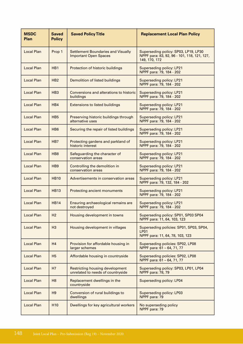
Joint Local Plan – Pre-Submission (Reg 19) – November 2020148
MSDCPlan
Replacement Local Plan PolicySaved Policy
Saved Policy Title
Local Plan Prop 1 Settlement Boundaries and Visually Superseding policy: SP03, LP19, LP30 Important Open Spaces NPPF para: 83, 92, 96 - 101, 118, 121, 127, 149, 170, 172
Local Plan HB1 Protection of historic buildings Superseding policy: LP21 NPPF para: 79, 184 - 202
Local Plan HB2 Demolition of listed buildings Superseding policy: LP21 NPPF para: 79, 184 - 202
Local Plan HB3 Conversions and alterations to historic Superseding policy: LP21 buildings NPPF para: 79, 184 - 202
Local Plan HB4 Extensions to listed buildings Superseding policy: LP21 NPPF para: 79, 184 - 202
Local Plan HB5 Preserving historic buildings through Superseding policy: LP21 alternative uses NPPF para: 79, 184 - 202
Local Plan HB6 Securing the repair of listed buildings Superseding policy: LP21 NPPF para: 79, 184 - 202
Local Plan HB7 Protecting gardens and parkland of Superseding policy: LP21 historic interest NPPF para: 79, 184 - 202
Local Plan HB8 Safeguarding the character of Superseding policy: LP21 conservation areas NPPF para: 79, 184 - 202
Local Plan HB9 Controlling the demolition in Superseding policy: LP21 conservation areas NPPF para: 79, 184 - 202
Local Plan HB10 Advertisements in conservation areas Superseding policy: LP21 NPPF para: 79, 132, 184 - 202
Local Plan HB13 Protecting ancient monuments Superseding policy: LP21 NPPF para: 79, 184 - 202
Local Plan HB14 Ensuring archaeological remains are Superseding policy: LP21 not destroyed NPPF para: 79, 184 - 202
Local Plan H2 Housing development in towns Superseding policy: SP01, SP03 SP04 NPPF para: 11, 64, 103, 123
Local Plan H3 Housing development in villages Superseding policies: SP01, SP03, SP04, LP01
NPPF para: 11, 64, 78, 103, 123
Local Plan H4 Provision for affordable housing in Superseding policies: SP02, LP08 larger schemes NPPF para: 61 – 64, 71, 77
Local Plan H5 Affordable housing in countryside Superseding policies: SP02, LP08 NPPF para: 61 – 64, 71, 77
Local Plan H7 Restricting housing development Superseding policy: SP03, LP01, LP04 unrelated to needs of countryside NPPF para: 78, 79
Local Plan H8 Replacement dwellings in the Superseding policy: LP04 countryside
Local Plan H9 Conversion of rural buildings to Superseding policy: LP03 dwellings NPPF para: 79
Local Plan H10 Dwellings for key agricultural workers No superseding policy NPPF para: 79
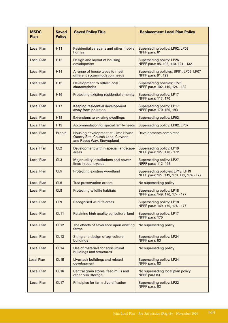
Joint Local Plan – Pre-Submission (Reg 19) – November 2020 149
MSDCPlan
Replacement Local Plan PolicySaved Policy
Saved Policy Title
Local Plan H11 Residential caravans and other mobile Superseding policy: LP02, LP09 homes NPPF para: 61
Local Plan H13 Design and layout of housing Superseding policy: LP26 development NPPF para: 95, 102, 110, 124 - 132
Local Plan H14 A range of house types to meet Superseding policies: SP01, LP06, LP07 different accommodation needs NPPF para: 91, 129
Local Plan H15 Development to reflect local Superseding policies: LP26 characteristics NPPF para: 102, 110, 124 - 132
Local Plan H16 Protecting existing residential amenity Superseding policy: LP17 NPPF para: 117, 170
Local Plan H17 Keeping residential development Superseding policy: LP17 away from pollution NPPF para: 170, 180, 183
Local Plan H18 Extensions to existing dwellings Superseding policy: LP03
Local Plan H19 Accommodation for special family needs Superseding policy: LP02, LP07
Local Plan Prop.5 Housing development at: Lime House Developments completed Quarry Site, Church Lane, Claydon and Reeds Way, Stowupland
Local Plan CL2 Development within special landscape Superseding policy: LP19 areas NPPF para: 127, 170 - 172
Local Plan CL3 Major utility installations and power Superseding policy: LP27 lines in countryside NPPF para: 112- 116
Local Plan CL5 Protecting existing woodland Superseding policies: LP18, LP19 NPPF para: 127, 149, 170, 172, 174 - 177
Local Plan CL6 Tree preservation orders No superseding policy
Local Plan CL8 Protecting wildlife habitats Superseding policy: LP18 NPPF para: 149, 170, 174 - 177
Local Plan CL9 Recognised wildlife areas Superseding policy: LP18 NPPF para: 149, 170, 174 - 177
Local Plan CL11 Retaining high quality agricultural land Superseding policy: LP17 NPPF para: 170
Local Plan CL12 The effects of severance upon existing No superseding policy farms
Local Plan CL13 Siting and design of agricultural Superseding policy: LP24 buildings NPPF para: 83
Local Plan CL14 Use of materials for agricultural No superseding policy buildings and structures
Local Plan CL15 Livestock buildings and related Superseding policy: LP24 development NPPF para: 83
Local Plan CL16 Central grain stores, feed mills and No superseding local plan policy other bulk storage NPPF para 83
Local Plan CL17 Principles for farm diversification Superseding policy: LP22 NPPF para: 83
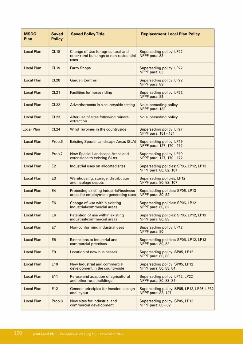
Joint Local Plan – Pre-Submission (Reg 19) – November 2020150
MSDCPlan
Replacement Local Plan PolicySaved Policy
Saved Policy Title
Local Plan CL18 Change of Use for agricultural and Superseding policy: LP22 other rural buildings to non-residential NPPF para: 83 uses
Local Plan CL19 Farm Shops Superseding policy: LP22 NPPF para: 83
Local Plan CL20 Garden Centres Superseding policy: LP22 NPPF para: 83
Local Plan CL21 Facilities for horse riding Superseding policy: LP22 NPPF para: 83
Local Plan CL22 Advertisements in a countryside setting No superseding policy NPPF para: 132
Local Plan CL23 After use of sites following mineral No superseding policy extraction
Local Plan CL24 Wind Turbines in the countryside Superseding policy: LP27 NPPF para: 151 - 154
Local Plan Prop.6 Existing Special Landscape Areas (SLA) Superseding policy: LP19 NPPF para: 127, 170 - 172
Local Plan Prop.7 New Special Landscape Areas and Superseding policy: LP19 extensions to existing SLAs NPPF para: 127, 170 - 172
Local Plan E2 Industrial uses on allocated sites Superseding policies: SP05, LP12, LP13 NPPF para: 80, 82, 107
Local Plan E3 Warehousing, storage, distribution Superseding policies: LP12 and haulage depots NPPF para: 80, 82, 107
Local Plan E4 Protecting existing industrial/business Superseding policies: SP05, LP13 areas for employment generating uses NPPF para: 80, 82
Local Plan E5 Change of Use within existing Superseding policies: SP05, LP12 industrial/commercial areas NPPF para: 80, 82
Local Plan E6 Retention of use within existing Superseding policies: SP05, LP12, LP13 industrial/commercial areas NPPF para: 80, 83
Local Plan E7 Non-conforming industrial uses Superseding policy: LP12 NPPF para: 80
Local Plan E8 Extensions to industrial and Superseding policies: SP05, LP12, LP13 commercial premises NPPF para: 80, 82
Local Plan E9 Location of new businesses Superseding policy: SP05, LP12 NPPF para: 80, 83
Local Plan E10 New Industrial and commercial Superseding policy: SP05, LP12 development in the countryside NPPF para: 80, 83, 84
Local Plan E11 Re-use and adaption of agricultural Superseding policy: LP12, LP22 and other rural buildings NPPF para: 80, 83, 84
Local Plan E12 General principles for location, design Superseding policy: SP05, LP12, LP26, LP32 and layout NPPF para: 83, 127
Local Plan Prop.8 New sites for industrial and Superseding policy: SP05, LP12 commercial development NPPF para: 80 - 82
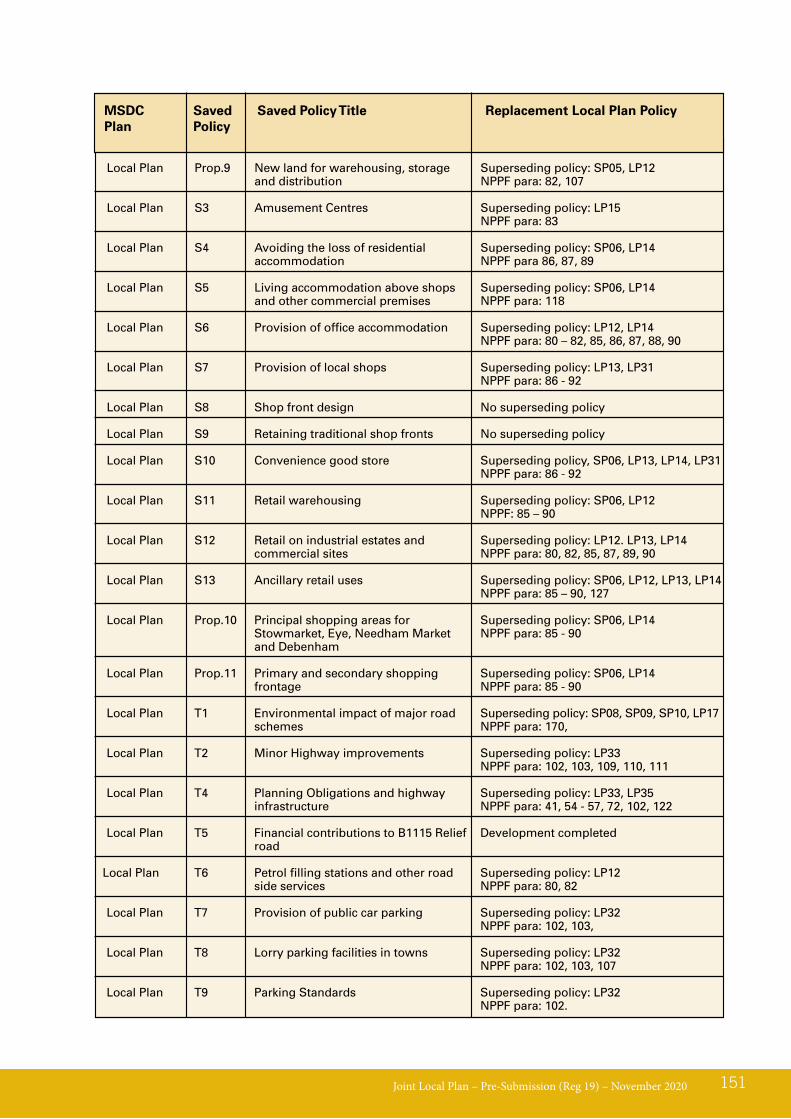
Joint Local Plan – Pre-Submission (Reg 19) – November 2020 151
MSDCPlan
Replacement Local Plan PolicySaved Policy
Saved Policy Title
Local Plan Prop.9 New land for warehousing, storage Superseding policy: SP05, LP12 and distribution NPPF para: 82, 107
Local Plan S3 Amusement Centres Superseding policy: LP15 NPPF para: 83
Local Plan S4 Avoiding the loss of residential Superseding policy: SP06, LP14 accommodation NPPF para 86, 87, 89
Local Plan S5 Living accommodation above shops Superseding policy: SP06, LP14 and other commercial premises NPPF para: 118
Local Plan S6 Provision of office accommodation Superseding policy: LP12, LP14 NPPF para: 80 – 82, 85, 86, 87, 88, 90
Local Plan S7 Provision of local shops Superseding policy: LP13, LP31 NPPF para: 86 - 92 Local Plan S8 Shop front design No superseding policy
Local Plan S9 Retaining traditional shop fronts No superseding policy
Local Plan S10 Convenience good store Superseding policy, SP06, LP13, LP14, LP31 NPPF para: 86 - 92
Local Plan S11 Retail warehousing Superseding policy: SP06, LP12 NPPF: 85 – 90
Local Plan S12 Retail on industrial estates and Superseding policy: LP12. LP13, LP14 commercial sites NPPF para: 80, 82, 85, 87, 89, 90
Local Plan S13 Ancillary retail uses Superseding policy: SP06, LP12, LP13, LP14 NPPF para: 85 – 90, 127
Local Plan Prop.10 Principal shopping areas for Superseding policy: SP06, LP14 Stowmarket, Eye, Needham Market NPPF para: 85 - 90 and Debenham
Local Plan Prop.11 Primary and secondary shopping Superseding policy: SP06, LP14 frontage NPPF para: 85 - 90
Local Plan T1 Environmental impact of major road Superseding policy: SP08, SP09, SP10, LP17 schemes NPPF para: 170,
Local Plan T2 Minor Highway improvements Superseding policy: LP33 NPPF para: 102, 103, 109, 110, 111 Local Plan T4 Planning Obligations and highway Superseding policy: LP33, LP35 infrastructure NPPF para: 41, 54 - 57, 72, 102, 122
Local Plan T5 Financial contributions to B1115 Relief Development completed road
Local Plan T6 Petrol filling stations and other road Superseding policy: LP12 side services NPPF para: 80, 82
Local Plan T7 Provision of public car parking Superseding policy: LP32 NPPF para: 102, 103,
Local Plan T8 Lorry parking facilities in towns Superseding policy: LP32 NPPF para: 102, 103, 107
Local Plan T9 Parking Standards Superseding policy: LP32 NPPF para: 102.
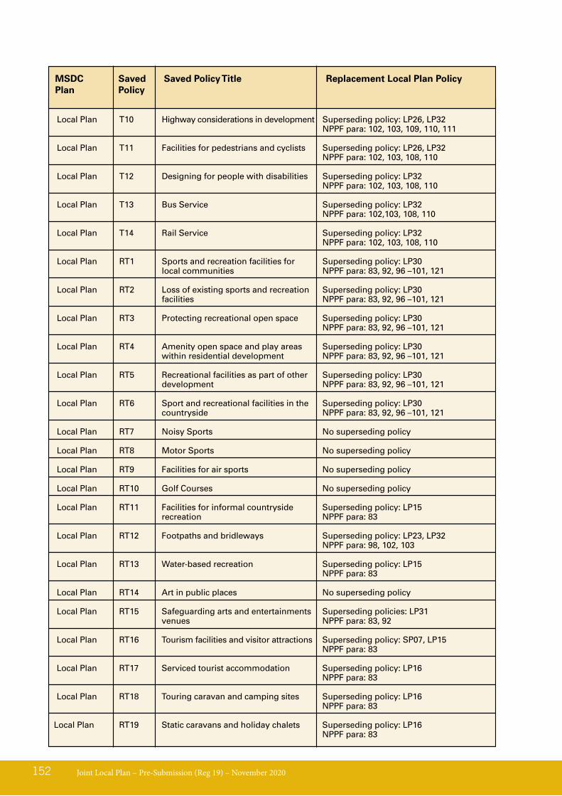
Joint Local Plan – Pre-Submission (Reg 19) – November 2020152
MSDCPlan
Replacement Local Plan PolicySaved Policy
Saved Policy Title
Local Plan T10 Highway considerations in development Superseding policy: LP26, LP32 NPPF para: 102, 103, 109, 110, 111
Local Plan T11 Facilities for pedestrians and cyclists Superseding policy: LP26, LP32 NPPF para: 102, 103, 108, 110
Local Plan T12 Designing for people with disabilities Superseding policy: LP32 NPPF para: 102, 103, 108, 110
Local Plan T13 Bus Service Superseding policy: LP32 NPPF para: 102,103, 108, 110
Local Plan T14 Rail Service Superseding policy: LP32 NPPF para: 102, 103, 108, 110
Local Plan RT1 Sports and recreation facilities for Superseding policy: LP30 local communities NPPF para: 83, 92, 96 –101, 121
Local Plan RT2 Loss of existing sports and recreation Superseding policy: LP30 facilities NPPF para: 83, 92, 96 –101, 121
Local Plan RT3 Protecting recreational open space Superseding policy: LP30 NPPF para: 83, 92, 96 –101, 121
Local Plan RT4 Amenity open space and play areas Superseding policy: LP30 within residential development NPPF para: 83, 92, 96 –101, 121
Local Plan RT5 Recreational facilities as part of other Superseding policy: LP30 development NPPF para: 83, 92, 96 –101, 121
Local Plan RT6 Sport and recreational facilities in the Superseding policy: LP30 countryside NPPF para: 83, 92, 96 –101, 121
Local Plan RT7 Noisy Sports No superseding policy
Local Plan RT8 Motor Sports No superseding policy
Local Plan RT9 Facilities for air sports No superseding policy
Local Plan RT10 Golf Courses No superseding policy
Local Plan RT11 Facilities for informal countryside Superseding policy: LP15 recreation NPPF para: 83
Local Plan RT12 Footpaths and bridleways Superseding policy: LP23, LP32 NPPF para: 98, 102, 103
Local Plan RT13 Water-based recreation Superseding policy: LP15 NPPF para: 83
Local Plan RT14 Art in public places No superseding policy
Local Plan RT15 Safeguarding arts and entertainments Superseding policies: LP31 venues NPPF para: 83, 92
Local Plan RT16 Tourism facilities and visitor attractions Superseding policy: SP07, LP15 NPPF para: 83
Local Plan RT17 Serviced tourist accommodation Superseding policy: LP16 NPPF para: 83
Local Plan RT18 Touring caravan and camping sites Superseding policy: LP16 NPPF para: 83
Local Plan RT19 Static caravans and holiday chalets Superseding policy: LP16 NPPF para: 83
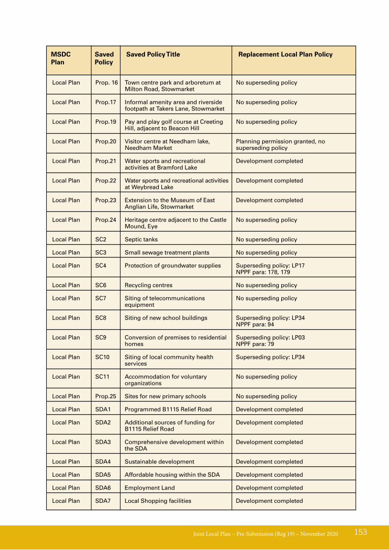
Joint Local Plan – Pre-Submission (Reg 19) – November 2020 153
MSDCPlan
Replacement Local Plan PolicySaved Policy
Saved Policy Title
Local Plan Prop. 16 Town centre park and arboretum at No superseding policy Milton Road, Stowmarket
Local Plan Prop.17 Informal amenity area and riverside No superseding policy footpath at Takers Lane, Stowmarket
Local Plan Prop.19 Pay and play golf course at Creeting No superseding policy Hill, adjacent to Beacon Hill
Local Plan Prop.20 Visitor centre at Needham lake, Planning permission granted, no Needham Market superseding policy
Local Plan Prop.21 Water sports and recreational Development completed activities at Bramford Lake
Local Plan Prop.22 Water sports and recreational activities Development completed at Weybread Lake
Local Plan Prop.23 Extension to the Museum of East Development completed Anglian Life, Stowmarket
Local Plan Prop.24 Heritage centre adjacent to the Castle No superseding policy Mound, Eye
Local Plan SC2 Septic tanks No superseding policy
Local Plan SC3 Small sewage treatment plants No superseding policy
Local Plan SC4 Protection of groundwater supplies Superseding policy: LP17 NPPF para: 178, 179
Local Plan SC6 Recycling centres No superseding policy
Local Plan SC7 Siting of telecommunications No superseding policy equipment
Local Plan SC8 Siting of new school buildings Superseding policy: LP34 NPPF para: 94
Local Plan SC9 Conversion of premises to residential Superseding policy: LP03 homes NPPF para: 79
Local Plan SC10 Siting of local community health Superseding policy: LP34 services
Local Plan SC11 Accommodation for voluntary No superseding policy organizations
Local Plan Prop.25 Sites for new primary schools No superseding policy
Local Plan SDA1 Programmed B1115 Relief Road Development completed
Local Plan SDA2 Additional sources of funding for Development completed B1115 Relief Road
Local Plan SDA3 Comprehensive development within Development completed the SDA
Local Plan SDA4 Sustainable development Development completed
Local Plan SDA5 Affordable housing within the SDA Development completed
Local Plan SDA6 Employment Land Development completed
Local Plan SDA7 Local Shopping facilities Development completed

Joint Local Plan – Pre-Submission (Reg 19) – November 2020154
MSDCPlan
Replacement Local Plan PolicySaved Policy
Saved Policy Title
Local Plan SDA8 Principle issues to be included in Development completed SDA obligations
Local Plan Prop.26 1,000 Houses in the SDA Development completed
Local Plan Prop.27 Land at Stowmarket is allocated as a Development completed strategic development area

Joint Local Plan – Pre-Submission (Reg 19) – November 2020 155