
b i s h op’s stortf or d WAterspACe & LAndsCApe strAteGY
64
A VISION FOR THE FUTURE B I S H O P ’ S S T O R T F O R D WATERSPACE & LANDSCAPE STRATEGY February 2009
Transcript of b i s h op’s stortf or d WAterspACe & LAndsCApe strAteGY

Bishop’s Stortford Waterspace & Landscape Strategy 1
A v i s i o n f o r t h e f u t u r e b i s h o p ’ s s t o r t f o r d W At e r s p A C e & L A n d s C A p e s t r At e G Y
february 2009

Bishop’s Stortford Waterspace & Landscape Strategy 2
introduction 3
The study area map 4
resource review 5
planning framework 6 Regional and Local Planning Policy The relevant policies relating to the River Stort through Bishop’s Stortford 6 Other supporting strategies & stakeholders 7 Bishop’s Stortford Town Council 8 EA Roles and Responsibilities 8 Sustrans 8
river use and Amenity 9 Boating and River Cruises 9 Walking, Cycling and Passive Recreation 10 Canoeing 12 Angling 13
biodiversity 14 The Hertfordshire Biodiversity Action Plan (Herts and Middlesex Wildlife Trust, revised March 2006) 15 Stort Valley Feasibility Study April 2007 15 River Banks through Bishop’s Stortford 15
heritage 16 Designations 17 Moorings/Basins 17 Bank and towpath treatments 17 Boundary treatment 17
operational issues 18 Management of the Waterspace 18 Environmental Code of Practice 18 Towpath Management 19 Influences on the Guidelines 19 Health & Safety 19
Landscape Character 21
Sworder’s Fields and Waytemore Castle 22 Mill Site 24 Jackson Square Phase 1 26 Station Road Entrance 27 Cinema Complex 28 Anchor Street 29 New Stort Bridge 30 Goods Yard Site 32 London Road 33 95 London Road 35 South Mill Lock 36
Introduction
Contents
delivery Mechanisms 37
Conservation and Community 38 Marketing and Branding 40
design Guidelines 41
Overview 42 Active Waterfronts 43 Character and Environment 45 Access and Safety 50
the Way forward 53
Action Plan: Waterspace and Recreation 54 Action Plan: Education, Interpretation and Signage 56 Action Plan: Biodiversity 57
Appendix 1 59
river people/ Consultation 60 Environmental/Biodiversity 60 Local Group Issue 60 Recreation/Leisure/Boating Group 61
bibliography 62
3Bishop’s Stortford Waterspace & Landscape Strategy
Introduction
introduction
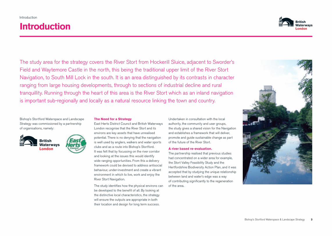
The study area for the strategy covers the River Stort from Hockerill Sluice, adjacent to Sworder’s Field and Waytemore Castle in the north, this being the traditional upper limit of the River Stort Navigation, to South Mill Lock in the south. It is an area distinguished by its contrasts in character ranging from large housing developments, through to sections of industrial decline and rural tranquillity. Running through the heart of this area is the River Stort which as an inland navigation is important sub-regionally and locally as a natural resource linking the town and country.
Bishop’s Stortford Waterspace and Landscape Strategy was commissioned by a partnership of organisations, namely:
the need for a strategyEast Herts District Council and British Waterways London recognise that the River Stort and its environs are key assets that have unrealised potential. There is no denying that the navigation is well used by anglers, walkers and water sports clubs and as a route into Bishop’s Stortford. It was felt that by focussing on the river corridor and looking at the issues this would identify wide ranging opportunities. From this a delivery framework could be devised to address antisocial behaviour, under-investment and create a vibrant environment in which to live, work and enjoy the River Stort Navigation.
The study identifies how the physical environs can be developed to the benefit of all. By looking at the distinctive local characteristics, the strategy will ensure the outputs are appropriate in both their location and design for long term success.
Undertaken in consultation with the local authority, the community and user groups, the study gives a shared vision for the Navigation and establishes a framework that will deliver, promote and guide sustainable change as part of the future of the River Stort.
A river based re-evaluation. The partnership realised that previous studies had concentrated on a wider area for example, the Stort Valley Feasibility Study and the Hertfordshire Biodiversity Action Plan, and it was accepted that by studying the unique relationship between land and water’s edge was a way of contributing significantly to the regeneration of the area.

4Bishop’s Stortford Waterspace & Landscape Strategy
Introduction
study area maps
Jackson square phase 1 (p26)
sworder’s fields and Waytemore Castle (p22)
Mill site (p24)
station road entrance (p27)
Cinema Complex (p28)
Anchor street (p29)
stort bridge (p30)
Goods Yard site (p32)
London road (p33–35)
south Mill Lock (p36)

Bishop’s Stortford Waterspace & Landscape Strategy
resource review

Bishop’s Stortford Waterspace & Landscape Strategy 6
Resource Review
planning framework
relevant to this strategy some of the guidance notes and statements are contained in:
PPS 7 - Sustainable Development in Rural Areas which seeks to improve the quality of local environments, whilst protecting valued landscapes and natural resources.
PPS 9 - Biodiversity and Geological Conservation which sets out policies on the protection of biodiversity and geological conservation through the planning system.
PPS 25 - Development and Flood Risk which sets out Government policy on development and flood risk.
PPG 17 - Open Space, Sport and Recreation in which reference is made to linear open spaces such as inland waterways which provide opportunities for informal recreation and water recreation.
PPS 12 – Local Spatial Planning encourages LPA involvement with key stakeholders like British Waterways in the preparation of policy documents.
PPG 13 – Transport refers to the role of the inland waterways in the integration of transport and land use planning.
regional and Local planning policyThe East of England Plan or the Revision to the Regional Spatial Strategy for the East of England, which was published in May 2008, sets out the regional strategy for planning and development in the East of England to the year 2021. It covers economic development, housing, the environment, transport, waste management, culture, sport and recreation, mineral extraction and more.
the relevant policies relating the to river stort through bishop’s stortford are:
part two – settlement planning. section 11. bishop’s stortford • 11.1.4‘protectandenhancetheRiverStortand
encourage its use for nature conservation, recreation, transport and other appropriate uses’
• 11.14.1TownCentreSitesforRedevelopment
bis 102 (c) the form of new development should
improve and complete open areas in the townscape and strengthen and enhance pedestrian and cycling movement in the town. Routes should be established between the town, the river, shopping areas, car parks and passenger transport stops/interchange;
2 (d) new development should respect and take into account both the amenity and the recreational and leisure potential of the river frontage, and should aim to integrate public use of the riverside with the day to day activities of the town. Consideration should be given to the provision of a new mooring basin;
2 (e) new public spaces should be created to provide comfortable and attractive destinations for pedestrians in the town;
bis 11The Goods Yard/John Dyde Training College Site states: a comprehensive development comprising a mixture of town centre uses will be acceptable including residential; leisure; public house/restaurant and/or hotel; retailing including some food retailing; boating and mooring basin and uses falling within class B1 of the Use Classes Order 1987 (as amended).
bis 12Residential development of around 100 dwellings, including up to 40% affordable housing in accordance with policies HSG 3 and HSG 4, taking into account the amenity potential of the River frontage and the proximity of the town centre, and particularly opportunities to enhance pedestrian and cycle links between this site and the town centre.
national planning policy
The Government’s Planning Statements and Guidance notes (PPS’s and PPG’s) set out the national planning framework within which local planning authorities are required to draw up their development plans and take decisions on individual applications to secure these objectives.

Resource Review
Bishop’s Stortford Waterspace & Landscape Strategy 7
planning framework continued
British Waterways is accountable in England and Wales to Defra, the organisation works in partnership with a broad range of public, private and voluntary sector partners to unlock the potential of the waterways for leisure use, regeneration, sustainable transport and wildlife.
Now approaching their 250th anniversary the nation’s historic waterways are today used and enjoyed by more people than at any other time in their history and are the focus for new regeneration initiatives in towns and cities across Britain. British Waterways is currently leading on around £60m worth of waterway restorations and is involved in approximately £11.7billion (2007/08 Annual Report) worth of waterside regeneration nationwide.
British Waterways London (BWL) cares for 100 miles of canals and rivers and 110 acres of docks. It is involved in a wide number of urban and rural regeneration initiatives including the restoration of the waterways in London’s Olympic Park and a major mixed-used redevelopment of Wood Wharf in Docklands.
BWL has worked with the Fieldfare Trust to produce‘WaterwayAccessforAllPolicyandDesign Guidance’ to direct design proposals, specifically in the context of the waterway environment.The‘WaterwayAccessforAll’project covers the needs of people with all types of disability, including people with hearing, sight and learning difficulties, as well as those with mobility disabilities.
Waterways and Development Plans (shown above) is a document produced by British Waterways in 2003 to encourage the integration of the inland waterways of England and Wales into the development plan system. A further aim is to ensure that Local Development Documents (LDD’s) which will replace structure plans, unitary development plans and local plans, not only protect waterways and related waterspaces from inappropriate development, but also encourage their use and unlock their potential. It encourages local planning authorities to identify waterways and their associated corridors, and major waterside sites, as priorities or the focus for future detailed action plans and topic plans.
other supporting strategies and stakeholders
Waterways for tomorrow June 2000. This document produced by the DETR, stated that:
’To unlock and maximise the potential of waterways, there is a need to develop the partnered approach to regeneration and to treat the waterway as a multifunctional space’
in addition, the Government wants to:
• Encouragetheirimprovement,developmentandrestoration, wherever possible in partnership between public, private and voluntary sectors
• Promotethewaterwaysasacatalystforurbanand rural regeneration
• Encouragepeopletomakeuseoftheinlandwaterways for leisure and recreation, tourism and sport
• Supporttheprotection,conservationandenhancement of the waterways’ heritage and their built natural environment, and the use of the waterways as an educational resource
• Supporttheprovisionofpassengerboatservices on the inland waterways, wherever practical and economic
• Encouragethetransferoffreightfromroadstowater-bourne transport where this is practical, economic and environmentally desirable
• Supportthedevelopmentoftheinlandwaterways through the planning system
british Waterways supporting documents
British waterways is the not-for-dividend public corporation responsible for the care of the nation’s 2,200-mile network of canals, rivers, reservoirs and docks.
Resource Review
planning framework continued
Bishop’s Stortford Waterspace & Landscape Strategy 8
bishop’s stortford town Council The key objectives of the Town Council are:
• MaketheTownCentreabetterandmoreprosperous place
• Createanaccessible,safeandhighqualityenvironment for the benefit of residents, traders and visitors
• EnhanceBishop’sStortford’svitalityandviability by attracting investment and businesses, which reflect and build on Bishop’s Stortford’s identity as a heritage market town
• Encourageeventsandactivities,whichwillraisethe image of the Town and promote it as an attractive, lively place to which people will want to visit and return
• Co-ordinatetheeffortsofthepublicandprivatesectors and the community to work in partnership for the benefit of Bishop’s Stortford Town Centre
These will be the underlying principles which will provide the direction for The Council and the actions of the initiative and the Town Centre Manager over the next year.
planning a future for the inland Waterways: A Good practice Guide’ (december 2001) The Inland Waterways Amenity Advisory Council (IWAAC – a statutory advisory body to Government and British Waterways) prepared this Guide following the Government’s invitation in Waterways for Tomorrow to prepare “a good practice document… explaining the contribution that inland waterways can make to regeneration and other projects, and highlighting examples of good planning”. It was published jointly with Defra and DTLR.
The Guide is aimed at all those likely to be involved with waterway projects including local authorities, Regional Development Agencies, navigation authorities, private developers, and the voluntary sector. It aims to show the role which each partner can play in shaping policy and implementing projects to ensure that the full potential of the waterways is realised.
environment Agency roles and responsibilitiesThe Environment Agency was set up by the Environment Act 1995 and is a non-departmental public body, largely sponsored by the Department for Environment, Food and Rural Affairs (DEFRA). The Environment Agency’s prime responsibilities include flood risk management, tackling pollution incidents, reducing industry’s impact on the environment, restoring and improving rivers, coastal waters, contaminated land, and wildlife habitats.
The Environment Agency also advises on sustainable drainage, water conservation and management, planning issues, nature conservation and waste management.
sustransThis sustainable transport charity works on practical projects so people can choose to travel in ways that benefit their health and the environment. They have been involved with the construction of many paths along disused railways and canal towpaths to encourage increases in cycling, walking and disabled access. Sustrans is very keen to see a high quality route along the River Stort corridor through Bishop’s Stortford and improved access to and along the towpath. They are currently preparing plans for new paths in Sworder’s Field, including a new bridge over the railway as well as new links from Twyford Road and Twyford Bury Lane to the towpath. In addition, they are hoping to see access improvements along the Stort corridor as part of future developments.

Resource Review
Bishop’s Stortford Waterspace & Landscape Strategy 9
river use and amenities
The River Stort through Bishop’s Stortford is a recognised location for;
boating and river Cruises•
Walking, Cycling and • passive recreation
Canoeing•
Angling•
boating and river CruisesThere are approximately 1500 boats moored on the Rivers Lee and Stort. Privately owned vessels cruise the navigations. There are 10 visitor moorings at the head of the navigation with sanitary facilities.
There are currently no established operators of river cruises on the River Stort in the vicinity of Bishop’s Stortford.
There is though an opportunity for an operator at the new trip boat mooring designed to complement the Jackson Square development. (See page 26)
The nearest cruising restaurant service, Annie’s Launch is based at Parndon Mill in Harlow. The vessel can be chartered for private hire functions along the River Stort carrying a maximum of 12 passengers.
A cruise service would prove a popular attraction and could be well used at weekends and holidays, providing an accessible means for people to experience the river first hand. As a tourist facility, a cruise provides the opportunity for visitors to discover a more rural aspect of the Stort.
Annie’s Launch
Resource Review
Bishop’s Stortford Waterspace & Landscape Strategy 10
river use and amenities continued
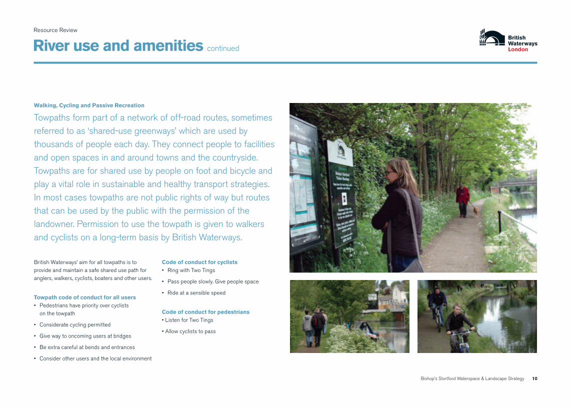
British Waterways’ aim for all towpaths is to provide and maintain a safe shared use path for anglers, walkers, cyclists, boaters and other users.
towpath code of conduct for all users• Pedestrianshavepriorityovercyclists
on the towpath
• Consideratecyclingpermitted
• Givewaytooncomingusersatbridges
• Beextracarefulatbendsandentrances
• Considerotherusersandthelocalenvironment
Code of conduct for cyclists• RingwithTwoTings
• Passpeopleslowly.Givepeoplespace
• Rideatasensiblespeed
Code of conduct for pedestrians•ListenforTwoTings
•Allowcycliststopass
Walking, Cycling and passive recreation
Towpaths form part of a network of off-road routes, sometimes referredtoas‘shared-usegreenways’whichareusedbythousands of people each day. They connect people to facilities and open spaces in and around towns and the countryside. Towpaths are for shared use by people on foot and bicycle and play a vital role in sustainable and healthy transport strategies. In most cases towpaths are not public rights of way but routes that can be used by the public with the permission of the landowner. Permission to use the towpath is given to walkers and cyclists on a long-term basis by British Waterways.

Resource Review
river use and amenities
Bishop’s Stortford Waterspace & Landscape Strategy 11
East Herts District Council has produced a Bishop’s Stortford Strategy Public Consultation document to encourage people to use their cars less and make cycling and walking easier. It incorporates:
• animprovedpedestrianroutefromthestationto the shops
• proposalsforwideningthebridge on Station Road
• alandmarkpedestrianandcyclebridgeacrossthe River Stort
• towncentrepedestrianisation
• cyclefacilitiesinanumberofkeytowncentrelocations and new residential developments
Aside from the facility and resource that the river environment provides, a major influence on recreational use rests with the accessibility of the river. Restrictions to access can present a real barrier, not just in a physical sense but in terms of users overall perception of the waterspace.
The River Stort corridor is a valuable environment for recreational pursuits. As a linear open green space it links countryside and town, providing an accessible resource for the population of Bishop’s Stortford Town, Thorley Parish, Sawbridgeworth and Harlow.
Because of the built up nature of the town the river is in many cases well screened by development and often not visible to users. While this can be positive in instances, this characteristic reinforces the need for regular clear and well sign posted access.
East Herts District Council and British Waterways are committed to improving access to the river towpath through a series of improved access links in the town and in the wider countryside.
The improvements of the towpaths should lead to the creation of a wider network of access opportunities. The potential for encouraging defined and circular walks needs to be more fully explored, with opportunities for marketing the River Stort as an avenue for walks and pursuits.

Resource Review
Bishop’s Stortford Waterspace & Landscape Strategy 12
river use and amenities continued
Canoeing
The document “Planning Policies for Sport: A Land Use Planning Policy Statement on Behalf of Sport” produced by Sport England (November 1999) states that British Waterways’ estate can accommodate a wide range of‘recognised’watersportandinformalrecreational activities. For example, river navigations and canals can support canoeing and rowing.
In Bishop’s Stortford, excellent facilities exists for canoeing at Bishop’s Stortford Canoe Club, below South Mill Lock.
The club competes in marathon and sprint racing in kayak and Canadian canoes as well as some other branches of paddlesport.
However, insufficient suitable launch points for canoeing exist elsewhere through the study area. These could be provided at a number of locations through Section 106 (s106) contributions relating to development sites or possible sports funding grants. These types of improvement works could go hand in hand with developing water skills training at key locations, for example, associated with a Mill Site development or as part of ancillary works associated with the new Stort Bridge, or as extra facilities at the Bishop’s Stortford Canoe Club.
Bishop’s Stortford Canoe Club.

Resource Review
Bishop’s Stortford Waterspace & Landscape Strategy 13
river use and amenities continued
AnglingIn December 2005, a major step was taken to ensure a solid future for angling on Britain’s canals.
Following a process of consultation between British Waterways and representatives of the National Association of Fisheries and Angling Consultatives (NAFAC) and the National Federation of Anglers (NFA), representatives signeduptoan‘on-line’anglingandfisheries’policy document.
The key features of the policy are:
• Thecreationoflocalanglingandfisheriesplansto be written for each BW unit by November 2006, in collaboration with angling representatives;
• Theestablishmentofanetworkofcommunication at national and local level, including regular formal and informal contact to ensure progress is being made;
• Allpartieswillworktogethertodeliver the benefits.
• Buildawayforwardtoimprovetheanglingexperience and the number of anglers using our waters;
• Engagewithanglingstakeholdersand;
• Increaseknowledgeandunderstandingofangling and fisheries with BW staff in London.
Bishop’s Stortford and District Angling Society fish in this section of the Stort. Current events held include the Lea and Stort Cup and River Stort Pike matches. The fish species that are present include roach, pike, perch, chub and carp.
Anglers are often environmentalists, who aid British Waterways London to manage nature conservation, monitor and report on security/ vandalism issues by providing helpful and timely information.
British Waterways London (BWL) welcomes angling on its canals and endeavours to raise the profile of angling, and consider angling and fisheries in day to day maintenance and development programmes.
Concrete protection to outfall could be improved to create a disabled fishing platform adjacent to the former John Dyde College/Anchor Street site
Ideas for disabled fishing platforms

Resource Review
Bishop’s Stortford Waterspace & Landscape Strategy 14
biodiversity
The River Stort valley hosts many sites of national and local nature conservation importance, along its entire length.
There are sections of the corridor, principally within the urban area of Bishop’s Stortford which support very little wildlife habitat. In these areas the need is not for conservation but for creation of new habitats as sites are regenerated, incorporating biodiversity objectives into the wider development framework.
Wetland habitats (excluding open water and marshy grassland) cover only 34.3 hectares, less than 1% of the land area of the district (East Herts). This significantly increases the value of these distinctive sites for wetland mammals making habitat conservation and enhancement imperative. (White GJ and Pearce H, May 2007: Habitat Enhancement for Wetland Mammals in the Upper Stort Valley. HMWT)
the hertfordshire biodiversity Action plan (herts and Middlesex Wildlife trust, revised March 2006)“The Stort; the canalised main river is now severely degraded but the backwaters retain much of value… however, the river corridor remains a key wetland complex… depends on water supply from the Stort and thus the entire stretch of river between Bishop’s Stortford and the confluence with the Lee (14 1/2 miles) is important”.
This document has a vision for creating a “necklace” of inter-connected wetland sites along the river valley to benefit a range of habitats and species such as:
• Wetlands(rivers,streams,springs,openwater,fen, marsh, reedbed, swamp, wet grassland, alder woodland).
• Neutral/marshygrassland
• Watervole–sightingsrecordedtothenorth of Bishop’s Stortford.
• Natterer’sbat–feedoverwater.
• Otter–sightingsrecordednorthandsouth of Bishop’s Stortford; therefore, they must pass through the town.
• Greatcrestednewt.
The River Stort is arguably the most important landscape feature within the strategy area but its ecological value is also very important.

Resource Review
Bishop’s Stortford Waterspace & Landscape Strategy 15
biodiversity continued
The soft banks should be retained wherever they exist and enhanced with the installation of a coir roll at the water’s edge. These should be maintained as a narrow strip (300-500mm) so as not to impact on the navigation but they would provide valuable habitats for birds which frequent the channel and water voles which have been seen near London Road Bridge. It would also help to merge the soft steep bank as the plants would provide some height to mask the bank from the water’s edge. The area of bank between the water and the towpath could be enhanced by sowing a wildflower seed mix, this should be conservation grade grasses and flowers which require an infrequent cutting regime.
Additional structures should be installed to perch over the waterway as a replacement for the branches that were removed.
stort valley feasibility study April 2007:This study was commissioned by Harlow District Council as part of its ongoing regeneration, which included a Green Infrastructure Plan.
The Bishop’s Stortford Waterspace and Landscape Strategy area is just north of the Stort Valley Feasibility Study area. However, the two areas should be seen to complement each other; indeed they have very similar objectives, namely:
• Ecologyandlandscapeenhancement
• Landmanagementopportunities
• Historicenvironmentenhancement
• Socialinclusionandpublicaccess
• Recreationalopportunities
• Planninganddevelopment.
river banks through bishop’s stortfordSome sections of the navigation through the study area support extensive bank side trees including alder and willows and shrubs including hawthorn which provide a valuable habitat for birds and many species of invertebrates. They also offer potential lying up sites for Otters.
In the urban environment where trees are not established it would be beneficial to install structures on the water’s edge to enable birds such as kingfishers to perch.
In addition, locations for kingfisher boxes could be around the bridge at London Road where the bank is very high and within the new steel bank profile.
Bat and bird boxes should also be installed to provide some habitat as there are few mature trees in the area. Bat bricks or boxes could also be installed beneath the bridges.
Watervole
Kingfisher

Resource Review
Bishop’s Stortford Waterspace & Landscape Strategy 16
biodiversity

Bishop’s Stortford Waterspace & Landscape Strategy 17
Resource Review
heritage
Go to this web address for further information: www.castleuk.net/castle_lists_east_anglia/167/waytemorecastle.htm
“Waytemore Castle is a Norman stone motte and bailey fortress, founded by Maurice, Bishop of London. The massive rectangular motte, supports fragments of a 12th century inner ward, of which a small tower and curtain wall survive. Strengthened over the centuries, it was used as a royal residence, a fortress and a prison by the various Bishops of London. In Castle Gardens, wet ditches with a stone revetment give the layout of the large bailey”.

Resource Review
Bishop’s Stortford Waterspace & Landscape Strategy 18
heritage continued
designationsThe study area is not designated as a Conservation Area and the only listed buildings adjacent to the river are The Waytemore Castle (Grade I), the War memorial (Grade II) within the park to the north of the Causeway; and the Malthouse complex on South street (3 separate Grade II structures) on the offside. The area is not recognised as an archaeological priority area, nor a historic park, but the widening and deepening of the existing waterway or the installation of a new basin in this vicinity would most likely require an archaeological desk base assessment and possibly further investigations subject to the proposed location.
Moorings/basinsVarious locations for the provision of additional moorings including the creation of a new basin within the grounds of Waytemore Castle Park north of the Causeway are being considered in this strategy.
The castle retains 12th century remains including a small tower and curtain wall and is a site of great historic interest.
An alternative location for a new basin is proposed just south of the The Causeway, opposite the newly restored crane. This location would not represent any issues in terms of historic remains and features. The mooring of boats in this location would be beneficial to animate the river navigation.
bank and towpath treatmentsThe towpath is currently surfaced with tarmac all the way to the London Road. After that junction, a soft treatment of wood chippings gives a more rural feel to the river path. However, in order to safely accommodate a greater level of use by both pedestrians and cyclists, a more robust path specification will be required. For example, a recycled crushed concrete sub-base layer with a top dressing of granite. The tarmac section would gain from being upgraded with a more sympathetic surface treatment.
At a number of locations trees have grown on the edge of the river bank between the water and the towpath. Traditionally trees would not have been allowed to grow along the water’s edge as it would have hindered the pulling of barges by horses. Although these trees now contribute to the character of the area it would be preferable for historic reasons to encourage trees to grow on the back edge of the towpath away from the water where space allows or on the offside (non towpath side) of the river. At the same time the trees currently growing between the river’s edge and the towpath would be gradually removed.
The bank has in some locations been reinforced with steel sheet piling. This is unfortunate as the soft bank helps to visually distinguish the river navigation from a canal. This is especially regrettable at the site developed by the former Atkins & Cripps site as the steel trenches are highly visible from some distance and are incongruous in this location.
boundary treatmentThe boundary treatment of the study area currently varies from high walls, railings, brick walls, buildings set back at various distance from the towpath and wider areas of vegetation of various heights and density. There is a risk of losing the enclosure and historic significance given by the various boundary treatments along the towpath with developments taking advantage of the river environment and treating the boundary in a similar manner. A strategy to assess and encourage retention of interesting or historically significant sections of boundary treatment should be put in place.

Resource Review
Bishop’s Stortford Waterspace & Landscape Strategy 19
operational issues
Management of the WaterspaceThere are a range of operational and asset management issues that effect the navigation. These warrant explanation since they directly affect the activities that can take place along the river, as well as impacting on river wildlife habitats, flooding and health and safety.
The management of the River Stort is undertaken by British Waterways London in the context of its defined statutory duties, using a number of national management systems and mechanisms that embody standards and criteria relevant to British Waterways’ 2200 mile network of canals and rivers throughout Britain.
Asset ManagementBritish Waterways Asset Management Process defines a framework to manage BW assets and to help provide the services required by BW customers and the protection expected by BW neighbours.
The aim is to maintain and operate the assets as efficiently and effectively as possible in order to ensure the continued serviceability and safe operation of the canals and navigations whilst providing best value for customers, partners and other stakeholders.
The key management operations are:
navigation•
Water control, management and monitoring•
dredging•
bank protection•
Agricultural/ vegetation Management•
infrastructure and asset repair, maintenance •and replacement
Customer care•
British Waterways Work Boat

Resource Review
Bishop’s Stortford Waterspace & Landscape Strategy 20
operational issues continued
environmental Code of practiceAll British Waterways work is set within the context of an Environmental Code of Practice that defines the statutory context and a structural approach to identifying potential impacts on the waterway environment.
towpath ManagementTowpath management is a key issue for British Waterways. The grasses and flowers on our towpaths are generally managed by implementing a mowing regime designed to ensure that our towpaths are safe and enjoyable places to be.
British Waterways aim to maintain a short vegetation profile 0.5m either side of the towpath edge but create opportunities for moorings and access for all our visitors throughout the growing season. We aim to carry out a single clearance cut a year to waters edge to maintain the views and visitor interaction with the open water of the channel.
LegislationThere are various legal influences on how we manage our towpaths, including the Transport Act 1968, health and safety legislation, British Waterways Acts and the Countryside and Rights of Way Act 2000, which has a particular influence over our management of Sites of Special Scientific Interest (SSSI). In addition, British Waterways are committed to ensuring a high standard of work in providing a safe environment, whilst seeking biodiversity gain wherever appropriate.
health & safetyHealth and safety is a major consideration; a well-used urban towpath clearly needs more intensive management than a remote rural towpath. Thoughtful vegetation management can reduce risk to visitors; for example, cutting vegetation can expose hazards such as steep embankments and trip hazards, alternatively tall vegetation can be used as a natural barrier. In areas of greater visitor use such as at formal moorings and around benches, mowing and vegetation management will also need to address nettles, thistles and brambles. Extra mowing is considered in certain locations where there is a need to maintain sight lines particularly on bends and at approaches to locks, bridges and narrows
The aquatic margin should be retained and not cut except at key points such as moorings or when woody vegetation is an issue. Good hedgerow management can allow grassy margins to extend whilst creating a more effective boundary of high wildlife value.

Bishop’s Stortford Waterspace & Landscape Strategy
Landscape character

22Bishop’s Stortford Waterspace & Landscape Strategy
Landscape Character
Waytemore Castle
Sworder’s FieldThe Causeway
Jackson SquarePhase 1
Mill Site
Jackson Square Phase 2
Station road
Rhodes Museum
New StortBridge
Anchor Street
Cinema Complex
London Road
South Mill Lock
FormerAtkinsand CrippsSite
Goods Yard Site
sworder’s field and Waytemore Castle
The recreational area between the railway line and the river is named Sworder’s Field in memory of past town resident, Herbert Sworder.
The site incorporates two skate facilities, a multi-purpose goal/sports facility, three small youth shelters, a trim trail, slide and swings. There is also a large area of open space which is used for outdoor games. At the southern end of the field is a play area for younger children and a paddling pool. This whole area is very popular, well used and extremely well maintained which reflects its close proximity to the town centre. The parkland associated with this section of the River Stort has a very distinctive character, while the river section through Sworder’s Fields has an overriding rural and naturalised quality, the more ornamental landscapes of the parkland, castle grounds and play facilities are in sharp contrast. The field is the venue for the Town’s annual summer fun day, which follows the carnival and
hosts a circus and a fair each year. The castle, parkland hedgerows and park war memorial provide landmark features with mown grass areas and mature amenity planting defining the overall scheme.
In 2005 following discussions with both the Town and District Councils, British Waterways presented the idea of creating a significant visitor destination in the Sworder’s Fields location for boaters, visitors and local residents in the form of a new mooring basin.
An initial scheme proposal was submitted for funding in late 2005, to the Department of Communities and Local Government (DCLG) although this was unsuccessful.
Despite there being significant interest in establishing an improved visitor destination at the terminus of the River Stort Navigation, this proposal is not currently being pursued.
Key aspects:
Area of historic significance to the town •
Waytemore Castle landmark feature•
vibrant and active area for recreation•
Attractive and naturalised riverside footpath • through playing fields and castle grounds
visitor destination•

23Bishop’s Stortford Waterspace & Landscape Strategy
Landscape Character
sworder’s field and Waytemore Castle continued
One concern was regarding the proposals for a mooring facility in Sworder’s fields and the consequent loss of open space which would impact on the annual summer fun day. So a scheme was put forward by the Town Council to relocate the play area for younger children where the tennis courts are in the castle grounds and create a mooring basin closer to the Causeway, thereby taking up less area of Sworder’s Fields recreation ground.
The moorings could comprise a mix of boats including historic craft, educational vessels, fully accessible trip boats as well as leisure and possibly a few residential boats. This business could be supported by a cafe and information centre which could also include a day boat hire business for hourly rental of boats which would enable people to discover the River Stort by boat. There would also be a provision for boaters facilities (i.e. electricity, water, rubbish and sewerage discharge at this point).
In May 2007 East Herts District Council and British Waterways hosted a workshop with local businesses, interested parties and Council Members to understand the issues and aspirations that people have for the River Stort through Bishop’s Stortford.
Toilets
Tennis Courts
Amenities Hut Café, Educational, Toilets FacilitiesPlay Area
Outline mooring basin scheme put forward by Town Council
Outline mooring basin scheme 2005

24Bishop’s Stortford Waterspace & Landscape Strategy
Landscape Character
Mill site
Key aspects:
enclosed urban river setting of varied land use •and townscape quality
Mill site and river located opposite town centre • redevelopment
Continued potential for riverside development•
derelict properties detract from river • character, potential for sensitive and appropriate re-development
The character of Bishop’s Stortford riverfront in this location reflects its struggle for a new identity – the development opportunities that have already been realised have undoubtedly raised the profile of the riverfront, but the urban fabric still fails to fully embrace the river.
The Mill Site therefore is a key site with significant potential for riverside regeneration. A vibrant new facility could be generated with the regeneration of the original mill site adjacent to the attractive and historic setting of Riverside House Registry Office.
Waytemore Castle
Sworder’s FieldThe Causeway
Jackson SquarePhase 1
Mill Site
Jackson Square Phase 2
Station road
Rhodes Museum
New StortBridge
Anchor Street
Cinema Complex
London Road
South Mill Lock
FormerAtkinsand CrippsSite
Goods Yard Site
This makes the Mill Site a good location for a mooring basin, as it could be fully integrated into a mixed – use development.
From an ecological perspective, a marina located here within a new development would reduce the impact on the chalk stream which runs through the park as a significant amount of dredging along with tree management on the bank sides would be required if a marina was located in Sworder’s Field.

25Bishop’s Stortford Waterspace & Landscape Strategy
Landscape Character
Mill site continued
Terminus of River Stort NavigationRefurbished crane on Jackson Square Phase 1
Riverside House Registry Office

26Bishop’s Stortford Waterspace & Landscape Strategy
Landscape Character
Jackson square – phase 1
Key aspects:
use of high quality • contemporary materials
Careful conservation and integration • of existing historic features into new development schemes
development of inlet for trip • boat mooring
Current visitor destination • for river cruisesThe new Jackson Square development provides a marked transition point orgatewayfromthegreenerrivervalleylandscapecharacterofSworder‘sFields to a more developed urban setting for Bishop’s Stortford. Today’s waterfront is now a mix of retail, commercial and residential led regeneration initiatives that have altered the character of this river landscape. The townscape has begun to re-engage and redefine its relationship with the River Stort, and now provides the backdrop to create an even more exciting riverside tourist destination if the Mill site development could build on the urban regeneration started at Jackson Square.
Waytemore Castle
Sworder’s FieldThe Causeway
Jackson SquarePhase 1
Mill Site
Jackson Square Phase 2
Station road
Rhodes Museum
New StortBridge
Anchor Street
Cinema Complex
London Road
South Mill Lock
FormerAtkinsand CrippsSite
Goods Yard Site
Jackson Square Phase 1 residential development with waterway wall treatment and refurbished crane
New trip boat mooring with disabled access

27Bishop’s Stortford Waterspace & Landscape Strategy
Landscape Character
station road entrance
Key aspects:
• british Waterways’ requirement for secure operational parking for maintenance of the facilities building and the river
Access characterised by clutter • and ad-hoc placing of equipment
A more appropriate solution could be • achieved through a co-ordinated design and implementation strategy
This area is characterised by a mix of unrelated materials and a feeling that it has been developed in a piecemeal fashion. A holistic and consistent approach to surfacing, furniture details, barriers and signage could help create a small scale, but high quality riverside public space, where all users could enjoy the peace and tranquility.
Consideration should be given to opening up bridge parapets and installing under bridge lighting to improve views and safety as this area tends to attract anti-socialbehaviourparticularlyattheweekend.A‘gatewayfeature’toactas a marker to the riverside and facilities would identify the waterway from Station Road.
StationRoad‘Gateway’proposedimprovements
ExistingStationRoad‘Gateway’
StationRoad‘Gateway’proposedentrancefeatures
Existing Station Road Entrance

28Bishop’s Stortford Waterspace & Landscape Strategy
Landscape Character
Cinema complex
Key aspects:
imposing cinema complex turns • its back on the river
Continued climate for riverside • development
Missed opportunity to create vibrant • public/ waterside realm
This section of riverside is characterised by undeveloped/ derelict properties that detract from the river on the non towpath side and a high retaining wall which extends the length of the section. Above and beyond this wall is the building which turns its back on the river. The retaining wall has been subjected to vandalism and graffiti and large shrubs have been planted to avoid this. This action in itself has created hidden corners which creates a sense of foreboding.
Steps exist up to a terrace area leading from the towpath but there is much more potential to create vibrant and inclusive public spaces along the riverside with café facilities spilling out of the building onto the waterside. The spaces around buildings should be distinctive, reflect the character of the waterside and not be treated like a left over forgotten area.
Concertina doors and a canopy to the cinema building would open up and articulate the facade, perhaps with circular steps to create more inclusive public realm.
For site location refer to map on page 26
Existing siteProposed cinema complex development

29Bishop’s Stortford Waterspace & Landscape Strategy
Landscape Character
Anchor street/former John dyde College site
Key aspects:
Austere modern housing development•
Attempt to create useable open • space edge to riverside
Close proximity to town centre • and new shopping complex
tranquil and secluded river edge • despite the proximity to extensive housing developments
The landscape character created here opens the river corridor out to allow for informal recreation and some effort has been made to create a more natural edge between towpath and housing. The orientation of the blocks helps to create open squares that take advantage of river proximity and views but more care is needed in the design and maintenance of these spaces to bring a better scale to the development and riverside, therefore encouraging better usage.
Drainage outfalls on the waterside edge could be adapted to create useful disabled access platforms as illustrated.
For site location refer to map on page 26
Anchor Street residential development Cinema complex adjacent to Anchor Street development

30Bishop’s Stortford Waterspace & Landscape Strategy
Landscape Character
New Stort Bridge
new stort bridge
Key aspects:
flanked to the north by new housing •
Key location for linking railway station, • town centre and the rhodes Centre
important open space in attractive • setting adjacent to the Maltings and the river
The recent construction and installation of a replacement bridge over the River Stort has dramatically changed the landscape character of the river adjacent to the Maltings. Previously this location marked the beginning of a more rural landscape character on the towpath side. This replacement bridge has provided greater accessibility to residents and strengthens the link between riverside and town, the Rhodes Centre and the railway station. The necessary clearance of vegetation to allow bridge construction would benefit from a sensitive soft landscape scheme which integrates public realm and highlights this pivotal access point to the river.
Existing pipe across waterway

31Bishop’s Stortford Waterspace & Landscape Strategy
Landscape Character
new stort bridge continued
Environmental improvements to Stort Bridge areas
Waytemore Castle
Sworder’s FieldThe Causeway
Jackson SquarePhase 1
Mill Site
Jackson Square Phase 2
Station road
Rhodes Museum
New StortBridge
Anchor Street
Cinema Complex
London Road
South Mill Lock
FormerAtkinsand CrippsSite
Goods Yard Site
Possible enhancements to pipe crossing waterway

32Bishop’s Stortford Waterspace & Landscape Strategy
Landscape Character
Goods Yard site
Key aspects:
high landscape • and ecological quality along length of site
A highly secluded • section of river corridor within the study area
The river meanders through a predominantly rural section, enclosed by sylvan vegetated woodland margins aligned with native scrub and copses, largely undisturbed by built development. This section is a valuable asset for the town, although pressures for residential and business development present potential impacts on the river environment that require consideration and management e.g. additional litter, managing different users. Controlled development will ensure the special qualities of the river landscape are conserved and enhanced. Opportunities exist to provide high quality public realm along this section of waterway as an integral part of the development of the Goods Yard site, which should include well designed access points, seating, surfacing and signage.
Waytemore Castle
Sworder’s FieldThe Causeway
Jackson SquarePhase 1
Mill Site
Jackson Square Phase 2
Station road
Rhodes Museum
New StortBridge
Anchor Street
Cinema Complex
London Road
South Mill Lock
FormerAtkinsand CrippsSite
Goods Yard Site
Illustrative Goods Yard scheme

33Bishop’s Stortford Waterspace & Landscape Strategy
Landscape Character
London road
Key aspects:
towpath severed by fast road •and blind corner
uneven levels and dilapidated • fencing details
Lack of directional and • interpretative signage
London Road divides the town’s riverscape and the rural riverscape by abruptly severing it in two. The towpath surface changes to highlight this fact and development begins to feel more rural albeit only on the towpath side. Some joining of the two strands is needed by way of co-ordinated surface materials and signage which will give some relevance and highlight theriver‘sexistencefromtheroad.
Waytemore Castle
Sworder’s FieldThe Causeway
Jackson SquarePhase 1
Mill Site
Jackson Square Phase 2
Station road
Rhodes Museum
New StortBridge
Anchor Street
Cinema Complex
London Road
South Mill Lock
FormerAtkinsand CrippsSite
Goods Yard Site

34Bishop’s Stortford Waterspace & Landscape Strategy
Landscape Character
London road continued
These sketches identify various towpath treatments that could be adopted

35Bishop’s Stortford Waterspace & Landscape Strategy
Landscape Character
The steel sheet piles constructed on the off side are extremely intrusive. The small parcel of land opposite the towpath entrance should be planted up with scrub and native shrub species. The steel sheet piles should be treated to minimise their impact by the use of timber cladding and trailing plants. There may be an opportunity to attract kingfishers into the piled faces as well.
95 London road
Key aspects:
intrusive sheet piled retaining wall •recently completed
Loss of valuable mature tree and • scrub cover
Large brick built development and • car parking adjacent to waterway wall
rural enclosed character retained • on towpath south of London road
opportunity for operational • craft mooring

36Bishop’s Stortford Waterspace & Landscape Strategy
Landscape Character
south Mill Lock
Waytemore Castle
Sworder’s FieldThe Causeway
Jackson SquarePhase 1
Mill Site
Jackson Square Phase 2
Station road
Rhodes Museum
New StortBridge
Anchor Street
Cinema Complex
London Road
South Mill Lock
FormerAtkinsand CrippsSite
Goods Yard Site
Key aspects:
open character with • attractive views across fields
Attractive group of • canal buildings and structures
Well managed moorings • and activity around lock
The pleasant and peaceful character of the lock side could not be more different from the bustle of the town centre. This is the only lock side in the study and it is enclosed by vegetation which then opens out to attractive views across the fields below the lock looking south. The lock itself has no lock quadrants and general improvements to the fabric of the lock side would be appropriate. Thebottomgatebalancebeamsrequire‘heelgrips’. The lower and top lock landings require improvement works which should include widening of the towpath in the vicinity of the lock landings for ease of access.
As this is the final lock on the River Stort, there isanopportunityto‘celebrate’itslocationmore. it would therefore be an ideal place for interpretation boards and a map with directions to the town centre and its facilities.

Bishop’s Stortford Waterspace & Landscape Strategy
delivery mechanisms

38Bishop’s Stortford Waterspace & Landscape Strategy
Delivery Mechanisms
Conservation and community
education• Thedevelopmentofa‘Waterwise’programme
for schools in the area
implementation projects• Programmeofworksfortowpath,accesspoints
and gateway environmental improvements
• Fishingplatformsforpeoplewithdisabilities
• Additionalbutwellmanagedpubliclaunchpoints and public, water based facilities for river users within the town
signage• Integratedsignagestrategytoconsolidate
the riverside walking and cycling routes along the study length
• Interpretationtrailforheritageandecology e.g. historic crane, navigation stone, sites of wildlife importance and species activity
• Developmentofapublicisedandsignpostedroute between the Rhodes museum and community centre, riverside and station using the new Stort bridge
An important part of this strategy has been to identify what is of significance in terms of ecology, heritage, recreation and town or landscape character.
Conservation and CommunityIn addition, the public participation events have ascertained what the people living locally and who use the river feel is significant. It is key therefore to show how what is valued or sensitive can be included in the implementation of schemes for the area without compromising those very qualities.
Regeneration without including the community in the process is less likely to be sustainable, will lack wider ownership and not bring about the wholesale change that is so needed.
The strategy seeks to influence policy from a river perspective so that regeneration projects can be developed within a co-ordinated framework.
suggested projects that would benefit the community:
planning• Undertake‘planningforreal’exercisesonkey
waterside regeneration sites or thematic issues e.g. interpretation, safety, crime and vegetation management
• Developaco-ordinatedapproachtodevelopment and marketing of the waterways, with private, public and voluntary interests working together to achieve a vision through development of a focus group
Leisure• ExtensionofBishop’sStortfordRiverside
Festival
• WaterwayopendaysandboattripsexploringBishop’s Stortford’s heritage and ecology
Bishop’s Stortford Riverside Festival

39Bishop’s Stortford Waterspace & Landscape Strategy
Delivery Mechanisms
Conservation and community continued

40Bishop’s Stortford Waterspace & Landscape Strategy
Marketing and brandingDelivery Mechanisms
‘river stort park’The idea of a river park is not intended in its most traditional sense. The River Stort should have no formal‘parkboundaries’butbeconsideredasacontinuous recreational resource that connects through urban, semi-rural and rural sections, with one maintenance plan for the whole area. Thetranquilsectionsofthe‘ruralStort’warrantspecial treatment in terms of conserving the rural identity of this river length though access is still encouraged.
‘river Gateways’These locations are intended as first point contact destinations. e.g. London Road, Station Road and the Causeway.
‘discovery districts’These could be an integrated series of trails that reveal the culture and conservation of Bishop’s Stortford and the River Stort.
public ArtThere could be a variety of initiatives but a public art strategy should be promoted, possibly developed with local consultation through the Greenheart Partnership and delivered through community involvement.
Careful provision and siting of public art or its integration as part of development can fulfill many roles:
• Creationofasenseofplaceandlocalidentity,interpretation of river history and spirit
• Actasacatalysttoeducation
• Promotionoftheriverenvironmentto passers-by
• Givetheriveraprominentroleintermsofcommunity involvement
An important part of this strategy has been to identify what is of significance in terms of ecology, heritage, recreation and town or landscape character.
signage and interpretationLocation and facilities signage and interpretation along the length of the river corridor are hap-hazard or non-existent. Many facilities and linking routes are not clearly sign-posted, making the user unaware of the recreational opportunities available to them.
It is clear that the river corridor is in need of a co-ordinated signage strategy. Key requirements must include:
• Creationofasenseofplaceandlocalidentity,interpretation of river history and spirit
• Awellconsideredhierarchyofdiscreetandlegible signage types
• Locationofsignageinthemostlogicalandappropriate locations
• Achievingthecorrectbalanceofinformationprovision
The British Waterways Corporate Identity Manual addresses the above for the majority of canal and navigation signage. The manual sets out specific signage for operational use and safety that are familiar to the waterway network in general. There is however scope to instill a distinctive local identity within this aspect of signage.

Bishop’s Stortford Waterspace & Landscape Strategy
design guidelines

42Bishop’s Stortford Waterspace & Landscape Strategy
overviewDesign Guidelines
The following design and development guidelines establish a set of principles which provide a framework for landowners, developers, planners and stakeholders to ensure a consistent approach to design and development with the River Stort as the central focus.
These guidelines could be used as supplementary planning documents and assist in the preparation of development plan policies, development briefs and planning briefs as well as determining planning applications and the formulation of conditions or planning obligations.
• Therivershouldbethestartingpointforconsideration of the development and use of the water and waterside land
• Treattheriverasamenity,commercial,recreational, working and managed spaces
• Protectandpromotetheamenityvalueoftheriver through careful design of the public realm
• Ensurenewriversidedevelopmentconsidersopportunities for water based uses such as commercial (floating restaurants, business barges, retail boats etc.)
• Ensureriversidedevelopmentsafeguards and supports provision of residential and visitor moorings, freight, trade and all recreational activities
• Incorporateriversidepathsandwaterspaceitself into waterside schemes to ensure vitality, good pedestrian and cycle accessibility and circulation within, but to and from riverside
• Recognisethatsitingandorientationofnewdevelopment, appropriate boundary treatment and access issues are often different for the riverside path side to the offside
• Enhanceandpreservethedistinctbutvariedcharacter of the river which often extends beyond the immediate boundary to create a distinctive visual envelope
• Thedevelopmentshouldcontributetotheenhancement of the environmental quality of the river corridor. Access and riverside path improvements should form an integral part of any waterside site development proposals.
The River Stort through Bishop’s Stortford is a strategic asset for the town. It links communities, businesses, attractions and open space, and should be viewed as an important integral and functional space for transport, recreation and commercial uses that need to be linked to the wider area.
43Bishop’s Stortford Waterspace & Landscape Strategy
overview continued
Design Guidelines
44Bishop’s Stortford Waterspace & Landscape Strategy
Design Guidelines
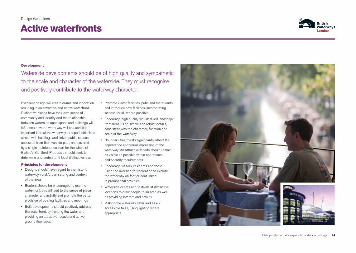
Active waterfronts
development
Waterside developments should be of high quality and sympathetic to the scale and character of the waterside. They must recognise and positively contribute to the waterway character.
Excellent design will create drama and innovation resulting in an attractive and active waterfront.Distinctive places have their own sense of community and identity and the relationship between waterside open space and buildings will influence how the waterway will be used. It is importanttotreatthewaterwayasa‘pedestrianisedstreet’ with buildings and linked public spaces accessed from the riverside path, and covered by a single maintenance plan for the whole of Bishop’s Stortford. Proposals should seek to determine and understand local distinctiveness.
principles for development• Designsshouldhaveregardtothehistoric
waterway, rural/urban setting and context of the area
• Boatersshouldbeencouragedtousethewaterfront, this will add to the sense of place, character and activity and promote the better provision of boating facilities and moorings
• Builtdevelopmentsshouldpositivelyaddressthe waterfront, by fronting the water and providing an attractive façade and active ground floor uses
• Promotevisitorfacilities,pubsandrestaurantsand introduce new facilities, incorporating ‘accessforall’wherepossible
• Encouragehighqualitywelldetailedlandscapetreatment, using simple and robust details, consistent with the character, function and scale of the waterway
• Boundarytreatmentssignificantlyaffecttheappearance and visual impression of the waterway. An attractive facade should remain as visible as possible within operational and security requirements
• Encouragevisitors,residentsandthose using the riverside for recreation to explore the waterway on foot or boat linked to promotional activities
• Watersideeventsandfestivalsatdistinctivelocations to draw people to an area as well as providing interest and activity
• Makingthewaterwaysaferandeasilyaccessible to all, using lighting where appropriate.

45Bishop’s Stortford Waterspace & Landscape Strategy
Design Guidelines
Active waterfronts continued
Waterside spaces
The different types of adjacent land use contribute to the environmental quality of the waterway corridor. All waterside spaces contribute to and impact on the state of the waterway and careful site planning and landscape design will be expected.
principles for Waterside spaces• Opportunitiesmayexisttocreatepocketparks,
lunchtime spaces for employees or waterside promenades in association with leisure and retail developments
• Itisimportanttoprovideavarietyofopenspaces, kick about areas, and areas for wildlife to establish and thrive
• Highqualitytraditionalmaterialsshouldbeused whether the area is accessible to the public or not
• Thelocationofopenspaceshouldbechosento make good use of the positive waterside features within the site and its surroundings
• Considerationshouldbegiventothecreationand management of small scale public spaces, through the realignment of boundaries and via the improvement of pockets of publicly owned land. Whenever possible, these should be linked with the waterside path to form a network of urban green spaces and connecting footpaths
• Spacesaroundbuildingsshouldbedistinctiveand allow visual and physical access to the waterside. Views over and along the waterway should be given due consideration when designing external spaces and frontages
• Openspacesshouldreflectthecharacter of the waterside and surrounding development
• Wheresecurityisrequired,itshouldbebotheffective and provide a positive feature
• Goodmaintenanceandmanagementisvitaltothe long term success and a well designed, and correctly managed scheme will have a positive effect on the waterway and its surroundings.
Opportunity to create vibrant open space at Station Road by the cinema complex

46Bishop’s Stortford Waterspace & Landscape Strategy
Design Guidelines
Character and environment
Waterside furniture and surfacing
The public realm is frequently characterised by clutter, bins, benches, bollards and signposts and the pedestrian can be marginalised or ignored. A more appropriate solution can be achieved through a co-ordinated design, implementation, and maintenance strategy.
The design of furniture should carefully reflect waterway character, it should be robust and securely installed, preferably using below ground fixing.
principles for furniture and surfacing• Seatingisdesirableinmanywatersidelocations
particularly near attractive views or popular meeting places. An inappropriate location or design can lead to loitering, or general misuse, careful design details should always be considered
• Lightingmaywellbeappropriateintheurbansections associated with restaurants, pubs etc. or alongside urban moorings as a safety measure. Lighting should meet a clearly identified need whilst avoiding intrusion from glare, vandalism and maintenance problems
• Lightfittingsareseenmostlyindaylight, so should be of an appropriate scale and style. Simple, robust designs are preferred and over ornate, replica lamps should be avoided. Where possible, lighting should be attached to existing buildings or walls rather than columns
• Lightpollutionisanimportantconsideration,but situations where lighting might be used near to the waterway include
- busy public waterfronts and waterside path routes which require an after dark use
- permanent moorings and basins
- bridges on urban sections, under and above
- security aspect
- highlighting urban landmark buildings and features
- light as art
- festivals, events and celebrations

47Bishop’s Stortford Waterspace & Landscape Strategy
Design Guidelines
Character and environment continued
principles for furniture and surfacing• Signsshouldbekepttoaminimumandwherepossibletheyshouldnotbe
free standing if there is already a nearby structure on which they can be attached and still be viewed easily. It is important that where signs are used they are designed in a style that is appropriate to the character of the waterway. Advice should be sought for specific guidance on the design, location and use of signage
• Vehicleandmotorcyclebarriersmaybeintroducedatkeyaccesspoints.Although bollards, gates, or s-shaped barriers allow free flow of pedestrian traffic, they deter access for selected user groups. Where possible barriers should be attached to adjacent structures to prevent bikers driving/cycling around the side
• Surfacingisakeyelementofanynewschemeandshouldrelatetoitsuseand location. Materials such as brick, yorkstone, stone cobbles and setts and gravel are traditionally associated with the waterway. Their use is to be encouraged in helping to conserve waterway heritage and particular in conservation areas, near listed structures or buildings. Traditional bonding patterns and mortar mixes should be used where possible
• brickpavinghastraditionallybeenusedwherestonewasnotreadilyavailable for areas of more intensive use wharfs, bridge ramps, etc. Bonding patterns should reflect the simple utilitarian character of the historic waterway environment and avoid decorative paving patterns
• concreteblockpavingcanbeusefulandcosteffectiveonlargerareas of paving where use of original materials is less critical and away from the critical waterway public realm. Care should be taken to choose a product that complements original materials in colour and texture and is sympathetic with the historic character and fabric of the waterway corridor.
48Bishop’s Stortford Waterspace & Landscape Strategy
Design Guidelines
Character and environment continued
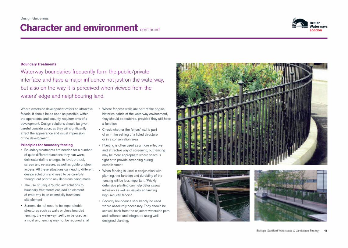
boundary treatments
Waterway boundaries frequently form the public/private interface and have a major influence not just on the waterway, but also on the way it is perceived when viewed from the waters’ edge and neighbouring land.
Where waterside development offers an attractive facade, it should be as open as possible, within the operational and security requirements of a development. Design solutions should be given careful consideration, as they will significantly affect the appearance and visual impression of the development.
principles for boundary fencing• Boundarytreatmentsareneededforanumber
of quite different functions they can warn, delineate, define changes in level, protect, screen and re-assure, as well as guide or steer access. All these situations can lead to different design solutions and need to be carefully thought out prior to any decisions being made
• Theuseofunique‘publicart’solutionstoboundary treatments can add an element of creativity to an essentially functional site element
• Screensdonotneedtobeimpenetrablestructures such as walls or close boarded fencing, the waterway itself can be used as a moat and fencing may not be required at all
• Wherefences/wallsarepartoftheoriginalhistorical fabric of the waterway environment, they should be restored, provided they still have a function
• Checkwhetherthefence/wallispart of or in the setting of a listed structure or in a conservation area
• Plantingisoftenusedasamoreeffective and attractive way of screening, but fencing may be more appropriate where space is tight or to provide screening during establishment
• Whenfencingisusedinconjunctionwithplanting, the function and durability of the fencingwillbelessimportant.‘Prickly’defensive planting can help deter casual intrusion as well as visually enhancing high security fencing
• Securityboundariesshouldonlybeused where absolutely necessary. They should be set well back from the adjacent waterside path and softened and integrated using well designed planting.

49Bishop’s Stortford Waterspace & Landscape Strategy
Design Guidelines
Character and environment continued
planting
The waterway network is ecologically very valuable and forms a corridor of biodiversity, which brings wildlife into the heart of urban areas.
New development should seek to contribute to this unique waterway environment and new planting should complement existing landscapes and create viable areas for habitat development. Planting creates a natural ambiance whilst also providing a level of natural security, but must be appropriate to its location, i.e. contemporary development requires a different treatment to a rural stretch of waterway.
principles for planting• Speciesshouldberobust,inkeepingwith
the local character, indigenous to the region, and in accordance with the Biodiversity Action Plan proposals
• Plantingschemesshouldbeboldandsimpleand designed for future low maintenance and management
• On-goingmaintenanceisvitaltothe success of a landscape scheme and a maintenance agreement should be in place prior to planting works commencing on site. Lack of maintenance will quickly result in a lack of respect and accelerated deterioration of a scheme
• Plantingshouldnotbeconsideredwhere it will damage the existing waterway
• Carefulconsiderationmustbegiventotheeventual mature size of trees, especially in proximity to built structures and the water’s edge (significant damage can be caused by root damage)
• Plantingshouldtakeaccountofundergroundand overhead services
• Wheneverpossibleindustrialsitesanddepotsshould be screened with substantial tree or tall shrub planting
• Plantingisanessentialfeatureofthewatersideenvironment in contributing to safety and protecting boundaries i.e. prickly plants can discourage illegal access into buildings and over fences. Used in association with buildings, plants can also mask boundaries and enclose seating area and access points
• Securityfencesshouldbelocatedwithin or behind waterside planting
• Existingvegetationshouldberetainedandincorporated into new waterside schemes. Certain existing trees may be protected by a TPO or lie within a Conservation Area and will therefore require consultation with the local authority prior to any works being undertaken

50Bishop’s Stortford Waterspace & Landscape Strategy
Design Guidelines
Access and safety
Water safety
Water provides a distinctive feature and attraction but brings with it inherent safety issues. Preventing access to the waterway is impractical and unreasonable and key objectives are to therefore make users aware of any risks whilst designing out or minimising hazards.
Safety issues should be considered at the outset of any project and be fully incorporated at the design stage.
principles for Water safety• Theuseofthewatersidebythegeneralpublic
must be carefully assessed in terms of the number, the activity and the level of responsibility or supervision of those who may be reasonably anticipated to use the area
• Watersidebarriersshouldonlybeusedwherethere is a high risk of falling into the water or where there is restricted space along the waterside and they should be designed to avoid visual intrusion or clutter
• Levelchanges,whichpresentasafetyhazard,should have railings or bollards and chains to a consistent approved design
• Fewbarriersneedtobehigherthan1.2m and should ensure views across the water are not restricted
• Someremovablerailingsandpostsshould be incorporated to allow maintenance of the waterway wall or mooring equipment as required
• Safetysignsshouldbesimplebutgivesufficient information to be of benefit to the users and be aimed at the appropriate user
To ensure that there is a safe environment for both waterway users and the general public a User Safety Assessment should be carried out. It should consider:
• thelikelyriskandhazardsthatmightbeencountered by users and how they can be eliminated or minimised through planning and design
• preventativemeasurestoreducerisks and hazards
• meansofsummoningassistancefrom and access for the emergency services
• appropriatedesigndetailsandsignage to satisfy regulations and requirements
• designandimplementationofselfhelp rescue equipment

51Bishop’s Stortford Waterspace & Landscape Strategy
Design Guidelines
principles for Crime prevention• Crimepreventionshouldbeaddressedat
the outset of all waterside development and enhancement schemes to enable full consideration to be given to safety and security. The measures implemented should be both non-intrusive and fully integrated
• Newdevelopmentwhenconceivedanddesigned carefully can also make a very positive contribution to crime prevention on or along the waterway
• Thescaleoftheproposedbuiltformisanimportantfactorincreatinga‘comfortable’waterside environment that does not overpower the site user or make them feel in any way unsafe
• Lightingwhereasiteisusedforlegitimatepurposes e.g. commuting after dark from the train station to residential area or into the town centre
• Alldevelopmentproposalsshouldconsider the following design issues:
• Increasedvisualsurveillancebyencouragingpedestrian generating activity along the waterfront
• Ensureexternalworksaredetailedtobe secure and vandal proof particularly from the waterside path side
• Locatebuildingsandopenspacetooverlookthe waterway and provide natural surveillance
• Establishgoodpedestriancirculationwithplenty of illuminated access points
.
Choice of materials, careful selection of site furniture and materials and good maintenance can help to reduce crime and vandalism. The following points should be considered:
• Avoideasilydismantledmaterialsandusebelowground fixtures for benches, bollards and lighting
• Usefireresistantmaterialswherepossible and appropriate
• Usebacklessseatingwithintermediatearmrests to avoid loitering and inappropriate use
• Considerusinggraffitiresistantsurfacessuch as textured walls or graffiti resistant paint
• Installwallmountedlightingtotheoffsideofthenavigation out of reach of potential offenders
• Managementregimesshouldincludesuchoperations as graffiti clearance, litter removal and replacement and repair of damaged structures
• Aprogrammeforreplacementofdamagedorvandalised plant material should be put in place.
Access and safety continued
Crime prevention
The unique qualities of the built and natural heritage of the waterway corridor means that measures to improve site security and safety should be tailored to meet the specific requirements of each individual site.

52Bishop’s Stortford Waterspace & Landscape Strategy
Design Guidelines
Access and safety continued

Bishop’s Stortford Waterspace & Landscape Strategy
the Way forward

54Bishop’s Stortford Waterspace & Landscape Strategy
The Way Forward
Action plan: Waterspace and recreation
proposal timescale Lead partner supporting partner Comments/Costs
improving Access Develop environmental and access improvement Medium term schemes at: •TheCauseway BWL Section106contributions, Various •StationRoad EHDC BWL,EHDC •NewStortBridgeplantingscheme EHDC •LondonRoad BWL
Introduce new shared use riverside footpath Medium term BWL Section 106 contributions, with third party maintenance agreements. EHDC, Sustrans and private developers ££££
Introduce new footpaths linking to river corridor. Medium term EHDC, HCC Various partners Various
developing boating opportunities Existing Moorings – develop better facilities as necessary Medium term BWL Private Developers, ££ and build capacity. BWL, EHDC
Carry out feasibility study to identify where new mooring berths can be created between Sworder’s Field and London Road.
Introduce new trip boat locations as stand alone projects Medium term BWL Private Developers, ££ or linked to medium term developments at: BWL, EHDC •TheMaltings/NewStortBridge •SouthMillLock
Install new lock landing at South Mill Lock Short term BWL Bishop’s Stortford Canoe club £££ to improve access for boaters and canoeists.
Key: Short term – under 2 years Medium term – 2-5 years Long term – 5 or more years £ = £0 to £5,000 ££ = £5,000 to £20,000 £££ = £20,000 to £100,000 ££££ = £100,000+
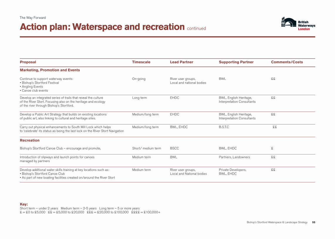
55Bishop’s Stortford Waterspace & Landscape Strategy
The Way Forward
Action plan: Waterspace and recreation continued
proposal timescale Lead partner supporting partner Comments/Costs
Marketing, promotion and events Continue to support waterway events: On-going River user groups, BWL ££ •Bishop’sStortfordFestival Localandnationalbodies •AnglingEvents •Canoeclubevents
Develop an integrated series of trails that reveal the culture Long term EHDC BWL, English Heritage, ££ of the River Stort. Focusing also on the heritage and ecology Interpretation Consultants of the river through Bishop’s Stortford.
Develop a Public Art Strategy that builds on existing locations Medium/long term EHDC BWL, English Heritage, ££ of public art, also linking to cultural and heritage sites. Interpretation Consultants
Carry out physical enhancements to South Mill Lock which helps Medium/long term BWL, EHDC B.S.T.C ££ to‘celebrate’itsstatusasbeingthelastlockontheRiverStortNavigation
recreation Bishop’s Stortford Canoe Club – encourage and promote, Short/ medium term BSCC BWL, EHDC £
Introduction of slipways and launch points for canoes Medium term BWL Partners, Landowners ££ managed by partners
Develop additional water skills training at key locations such as: Medium term River user groups, Private Developers, ££ •Bishop’sStortfordCanoeClub LocalandNationalbodies BWL,EHDC •Aspartofnewboatingfacilitiescreatedon/aroundtheRiverStort
Key: Short term – under 2 years Medium term – 2-5 years Long term – 5 or more years £ = £0 to £5,000 ££ = £5,000 to £20,000 £££ = £20,000 to £100,000 ££££ = £100,000+

56Bishop’s Stortford Waterspace & Landscape Strategy
The Way Forward
Action plan: education, interpretation and signage
proposal timescale Lead partner supporting partner Comments/Costs
education, interpretation and signage Education – produce activity and key resources pack Short/ medium term BWL Private Developer, EHDC £ for teachers on water skills and activities
Appoint interpretation consultant to develop concept of river Short/ medium term EHDC BWL, Interpretation Consultants, ££ park interpretative themes and locations for interpretation Private Developer
Protect and conserve significant heritage features that Short/ medium term EHDC BWL, English Heritage Unknown underpin any future river culture strategy: •WaytemoreCastle •Sworder’sField •MillSite •TheMaltings •Rivercrane,puddingstoneandplaque •SouthMillLockandCottage
Introduce co-ordinated signage project. Short/ medium term Bishop’s Stortford Town Council EHDC, BWL £££
Key: Short term – under 2 years Medium term – 2-5 years Long term – 5 or more years £ = £0 to £5,000 ££ = £5,000 to £20,000 £££ = £20,000 to £100,000 ££££ = £100,000+

57Bishop’s Stortford Waterspace & Landscape Strategy
The Way Forward
Action plan: biodiversity
proposal timescale Lead partner supporting partner Comments/Costs
biodiversity Native planting schemes to reinforce river character Short/medium term Natural England, Landowners, BWL ££ and enhance biodiversity designed with regard to BW vegetation Local wildlife trusts, EHDC management guidelines and towpath cutting regimes.
Joint management of wetland and dry land habitats that require Natural England, Landowners, BWL ££ long term establishment and conservation programme. Local wildlife trusts, EHDC
Introduction of animal ramps at required locations. Short term BWL Natural England, Landowners, £ Local community, EHDC
Emergent fringe consolidation in locations where river bank Short/medium term BWL Natural England, £ is gently sloping or shallows occur. Will require low key Local community, EHDC bio-engineered solution to protect from wave wash.
River bank conservation. Bio-engineered reconstruction to Medium term Natural England, Landowners, Unkown timescalses include marginal planting and re-seeding of bank using seed Local community, EHDC, BWL £ from local provenance: •FormerGoodsYardsite BWL •AnchorStreetsite EHDC •JacksonSquarePhase2 PrivateDeveloper Aspartofdevelopment
River hedgerow management: Short/medium term Landowners Natural England, ££ •FormerGoodsYardsite Localcommunity,BWL, •TowpathsidesouthofLondonRoad EHDC •NorthofSouthMillLock

58Bishop’s Stortford Waterspace & Landscape Strategy
Action plan: biodiversity continued
The Way Forward
proposal timescale Lead partner supporting partner Comments/Costs
biodiversity (continued) River hedgerow management: Short/medium term Landowners Natural England, ££ •FormerGoodsYardsite Localwildlifetrusts, •TowpathsidesouthofLondonRoad BWL,EHDC •NorthofSouthMillLock
Protected species- actions to promote and protect species Short term EHDC Natural England, ££ and their habitats. Local community, BWL
Additional fish spawning grounds. Medium/long term BWL EA £
Site specific well designed sustainable urban drainage systems, EHDC Natural England, Landowners, ££ e.g. with reed beds allied to development sites could offer Local community, BWL significant habitat gains or mitigation.
Key: Short term – under 2 years Medium term – 2-5 years Long term – 5 or more years £ = £0 to £5,000 ££ = £5,000 to £20,000 £££ = £20,000 to £100,000 ££££ = £100,000+

Bishop’s Stortford Waterspace & Landscape Strategy
Appendix 1 – river people/consultation

bishop’s stortford Workshop 22nd May 2007
A consultation meeting was held on 22nd May 2007 at The Rhodes Centre in Bishop’s Stortford to capture views from the local community and businesses based in the vicinity.
The following topics were discussed and the issues raised are recorded in this Appendix.
environmental/biodiversity
Local issues
recreation/Leisure/boating
environmental/biodiversity Group towpath issues • Maintenance/improvements-whopays? • Section106moniese.g.JohnDydeSite • SouthofLondonRoad
Wildlife • maintenanceofnatural/nativevegetation • greenroofs
drainage/ run off • musthaveinnovativewaysofdealing with swales/suds • partofGoodsYardSite
new pedestrian /Cycle bridge • mustbevisitorattraction • linktostation
Goods Yard site • developmentschemestilltobesubmitted • Integrationofdevelopmentintoarea • takenoticeofStrategy • empowermentofallEHDCofficers
Local issues Group Castle • beachreplicate/regenerate • weir–reinstatemoat • marina-andfacilitiesadjacenttotheCauseway
Causeway • accesstotowpathgatewayfeatureandlink with Jackson Square e.g. pedestrian bridge to towpath side • signageandinterpretationimportant • moremooringsadjacenttoJacksonSquare
station road • environmentalimprovements • cinemahasopportunitiesforleisure
London road • signageandinterpretatione.g.Rushemead • betteraccesse.g.TwyfordLock • morebenchessouthoftheweir
Goods Yard site • keysite
towpath • narrow-cyclingissues
feature boats • JacksonSquare • litterissues
recreation/ Leisure/ boating Group
Appendix 1
river people/consultation
Bishop’s Stortford Waterspace & Landscape Strategy 60

Appendix 1
Bishop’s Stortford Waterspace & Landscape Strategy 61
river people/consultation continued
directional signage • lackofdirectionalsignage(transport interchange and from visitor moorings)
boating issues • largeno.boatsin5mileradiusbut1.5hr cruise not a good trip in Summer • Bishop’sStortfordcurrentlynotproviding enough of an attraction to boaters • treerootsprecludesafemooring/tooshallow • noisedisturbanceformooredboats • dieselnotreadilyavailableonStort (only at Hallingbury) • inaccessiblesectionofRiveraboveCauseway • potentialfornewmooringsonoffsideatthe Maltings although some security issues
towpath • verynarrowtowpathinplaces • missedopportunityinwideningriverside paths in places • poortowpathsurfaceataccessand entrance points • improverampedaccessonnorth of Station Road • improvecrossingofCauseway to Sworder’s Field
severance • routescutoffatmajorroadse.g.Causeway and Station Road
flour Mill site • opportunityforimprovedwatersidefrontage• couldprovideshorttermmoorings • needstobecarefullymanagedtoavoid abuse by airport travellers
rhodes Centre • potentialforgreateruseoftheCentre for special events to attract river users
trip boat • linkedtorailwaydayoutdeals • Dayboathiree.g.skiffs
Leaking Weir • aboveSouthMillLock-inlowflowwater goes under capstones-technical assessment needed
List of Attendees
Alison Young East Herts District Council (Development control)
Colin Woodward East Herts District Council
Steve Wilson East Herts District Council
David Thorogood East Herts District Council
Christine Ross Bishop’s Stortford and District Footpaths Assoc.
Anthony Robbins Thorley Parish Council
Pauline Riley Stort Boat Club
Graham Riley Stort Boat Club
Les Pinnell former Bishop’s Stortford Town Council Councillor
Will O’Neill East Herts District Council
Angela Marshall Bishop’s Stortford Civic Federation
Mark Kingsland East Herts District Council
Tim Hagyard East Herts District Council (Development Control)
Calvin Horner Bishop’s Stortford Town Council
Janine Garner Bishop’s Stortford Town Centre Management
Ralph Gilbert East Herts District Council
Mione Goldspink East Herts District Council
Graham Goodall Hertfordshire Biological Records Centre
Kenneth Coyne East Herts District Council
Robert Baines Thorley Parish Council
Robbie Barrett Stort Boat Club
Sue Barrett Stort Boat Club
Tony Beckwith Green Heart Partnership
Dudley Blake Stortford Boats
Nigel Brigham Sustrans
Allen Burlton East Herts District Council
Angela Aldam Bishop’s Stortford Canoe Club

62Bishop’s Stortford Waterspace & Landscape Strategy
bibliography
British Waterways, February 2003, Waterways and Development Plans.
British Waterways London and the Metropolitan Police, May 2002, Under Lock and Quay: A Guide to Waterside Development and Improvement in London.
DETR, June 2000, Waterways for Tomorrow.Fieldfare Trust and British Waterways, March 2003, Waterway Access for All – Policy and Design Guidance.
Government Office for the East of England, 12 May 2008, The East of England Plan, the Revision to the Regional Spatial Strategy for the East of England.
Harlow District Council, April 2007, Stort Valley Feasibility Study.
Herts and Middlesex Wildlife Trust, March 2006, A Biodiversity Action Plan for Hertfordshire.
Inland Waterways Amenity Advisory Council, December 2001, Planning a Future for the Inland Waterways: A Good Practice Guide.
Sport England, November 1999, Planning Policies for Sport: A Land Use Planning Policy Statement.
White GJ and Pearce H, Herts and Middlesex Wildlife Trust, May 2007, Habitat Enhancement for Wetland Mammals in the Upper Stort Valley.


BW London 1 Sheldon Square, Paddington Central, London W2 6TT
T 020 7985 7200 F 020 7985 7201
enquiries.london@ britishwaterways.co.uk
E [email protected] www.britishwaterways.co.uk
www.waterscape.com, your online guide to Britain’s canals, rivers and lakes.