B Figure XX -- EX IST NGZO
1
TOWN OF EAST GREENWICH TOWN OF COVENTRY CITY OF WARWICK CITY OF CRANSTON Natick Lippitt Phenix Artic Crompton Centerville Paw t u x e t R i v e r ( S o u th Bra nc h ) P a w t u x et R i ve r (Nor th Bra nch) Natick Pond Matteson's Pond Crompton Pond Remington Pond MAIN ST I 95 I 295 QUAKER LN CENTERVILLE RD LEGRIS AV DIVISION RD TOLL GATE RD COWESETT AV COWESETT RD DIVISION ST PROVIDENCE ST TIOGUE AV WASHINGTON ST W WARWICK AV E MAIN ST EAST AV BALD HILL RD I 295 I 95 PROVIDENCE ST MH 2/16 ´ 0 0.5 Mile Figure XX -- EXISTING ZONING WEST WARWICK COMPREHENSIVE COMMUNITY PLAN Disclaimer: This map is not the product of a Professional Land Survey. It was created by Mapping and Planning Services for general reference, informational, planning and guidance use, and is not a legally authoritative source as to the location of natural or manmade features. Proper interpretation of this map may require the assistance of appropriate professional services. The Town of West Warwick nor MPS makes no warranty, express or implied, related to the spatial accuracy, reliability, completeness, or currentness of this map. Source: West Warwick GIS Zoning (2015). ZONING DISTRICTS R6 -- Residential, mininium 6,000 sq ft R7.5 -- Residential, minimum 7,500 sq ft R8 -- Residential, minimum 8,000 sq ft R10 -- Residential, minimum 10,000 sq ft CI -- Commercial / Industrial VC -- Village Commercial B -- Business BP -- Business Park ADCD -- Arctic Design Control District DCD -- Natick Design Control District MRU -- Mill Reuse OD -- Office Park Overlay MAJOR ROADS PARCEL LINES (2014) PONDS, OPEN WATER STREAMS (Includes Last Amendment XXXX, XX, 20XX)
Transcript of B Figure XX -- EX IST NGZO
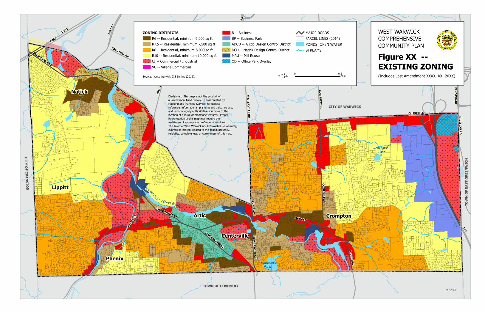
TOW
N OF
EAST
GRE
ENW
ICH
TOWN OF COVENTRY
CITY OF WARWICK
CITY OF CRANSTON
Natick
Lippitt
Phenix
Artic Crompton
Centerville
Pawtuxet Riv er ( South Branch)
Pawtuxet R ive r (North Branch)
Natick Pond
Matteson's Pond
Crompton Pond
Remington Pond
MAIN ST
I 95
I 295
QUAKER LN
CENTERVILLE RDLEGRIS AV
DIVISION RD
TOLL
GAT
E RD
COWESETT AV
COWESETT RD
DIVI
SION
ST
PROVIDENCE ST
TIOGUE AV
WASHINGTON ST
W W
ARWICK AV
E MAIN
ST
EAST
AV
BALD HILL RD
I 295
I 95
PROVIDENCE ST
MH 2/16´ 0 0.5Mile
Figure XX -- EXISTING ZONING
WEST WARWICK COMPREHENSIVE COMMUNITY PLAN
Disclaimer: This map is not the product of a Professional Land Survey. It was created by Mapping and Planning Services for general reference, informational, planning and guidance use, and is not a legally authoritative source as to the location of natural or manmade features. Proper interpretation of this map may require the assistance of appropriate professional services. The Town of West Warwick nor MPS makes no warranty, express or implied, related to the spatial accuracy, reliability, completeness, or currentness of this map.
Source: West Warwick GIS Zoning (2015).
ZONING DISTRICTSR6 -- Residential, mininium 6,000 sq ftR7.5 -- Residential, minimum 7,500 sq ftR8 -- Residential, minimum 8,000 sq ftR10 -- Residential, minimum 10,000 sq ftCI -- Commercial / IndustrialVC -- Village Commercial
B -- BusinessBP -- Business ParkADCD -- Arctic Design Control DistrictDCD -- Natick Design Control DistrictMRU -- Mill ReuseOD -- Office Park Overlay
MAJOR ROADSPARCEL LINES (2014)PONDS, OPEN WATERSTREAMS
(Includes Last Amendment XXXX, XX, 20XX)


![INDEX SEMINUM 2019 · 18. O Amaranthus-hybrid 'Hopi Red Dye' XX-0-TEBLI-00588 19. O Chenopodium quinoa Willd. 'Faro' XX-0-TEBLI-01812 [ex BG Marburg, GERMANY] 20. G Pleuropetalum](https://static.fdocuments.us/doc/165x107/5f0e53227e708231d43eb165/index-seminum-2019-18-o-amaranthus-hybrid-hopi-red-dye-xx-0-tebli-00588-19-o.jpg)